
Holland Township City Zoning Code
PART II
ZONING DISTRICTS
Sec. 2.1 - Zoning districts.
The township is divided into the following zoning districts:
Table 2.1 Zoning Districts
Sec. 2.2 - Zoning map.
The location and boundaries of the zoning districts are established as shown upon a map entitled "Zoning Map of Holland Charter Township," as amended from time to time. The zoning map shall be kept on public display at the township hall.
Sec. 2.3 - Interpretation of zoning district boundaries.
A.
Map interpretation. Where uncertainty exists as to the boundaries of zoning districts shown on the zoning map, the following rules of construction and interpretation shall apply:
1.
Boundaries indicated as approximately following the centerlines of streets or alleys shall be construed to follow such centerlines.
2.
Boundaries indicated as approximately following platted lot lines shall be construed as following those lot lines.
3.
Boundaries indicated as approximately following township boundaries shall be construed as following township boundaries.
4.
Boundaries indicated as following the shorelines of lakes, rivers, creeks or lake, river, or creek beds shall be construed as following such shoreline, and in the event of natural change in the location of a shoreline, shall be construed as moving with such shoreline.
5.
Lines parallel to streets without indication of depth from the street line shall be construed as having a depth of 150 feet from the center of the street right-of-way.
6.
Boundaries indicated as approximately following property lines, section lines, or other lines of the government survey shall be construed as following such property lines as of the effective date of this ordinance or applicable amendment.
B.
Areas not included within a zoning district. In every case where land has not been specifically included within a zoning district, the land shall be included in the agricultural zoning district. In the case of land annexed to the township, such land shall be included in the zoning district which most closely approximates the zoning applicable to such land prior to its annexation.
C.
Zoning of vacated areas. Whenever any street, alley, or other public way is vacated by official action, the zoning district adjoining each side of such public way shall automatically be extended to the center of such vacation, and all area included shall be subject to all applicable regulations of the district in which it is located.
D.
Boundaries dividing a lot of record. Where a zoning boundary line divides a property, each use, building, and structure on the lot of record shall comply with the requirements of the applicable district for where it is placed on the property.
Sec. 2.4 - Similar land use determination.
A.
Intent. Since every potential land use cannot be addressed in the zoning ordinance, each district may accommodate similar uses, as referenced in this section.
B.
Determination. All applications for a use not specifically addressed in a zoning district, or inquiries concerning a use, shall be submitted to the zoning administrator for review and a determination.
1.
Factors. The zoning administrator shall base the determination on the following factors:
a.
The proposed use is not listed as a permitted or special land use in any other zoning district.
b.
The use is consistent with the district purpose.
c.
The use is similar to other allowed uses relative to its character, scale, and overall compatibility.
d.
The use is not expected to create objectionable impacts to public health, safety, and welfare if it were established in the applicable zoning district.
e.
The use would not be more appropriate within a different zoning district.
2.
Zoning board of appeals. The zoning administrator may, in their sole discretion, submit a proposed use to the zoning board of appeals for a similar use determination if consideration of the review factors does not lead to a clear conclusion.
C.
Compliance. If a proposed use is determined to be similar to a permitted use within the district, the similar use shall comply with all the standards or requirements associated with the permitted use. If the named use is a special land use within the applicable zoning district, the similar use shall be reviewed and approved per the applicable requirements for the named use.
D.
Determination. The determination of whether a proposed use is similar to another listed use shall be considered as an interpretation of the use regulations and is not determined to be a use variance. Once a use has been determined to be similar, it shall be specifically determined to be the named use with which it shares similarities.
E.
Prohibited use. If a use is not specifically listed anywhere in this ordinance and is not determined to be similar to any other specifically listed uses, the use is prohibited.
F.
Accessory uses. Accessory uses are permitted in conjunction with all permitted and special land uses. The administrator shall review and determine allowable accessory uses to ensure they are customarily associated with the permitted or special land use and are incidental and subordinate to the principal use.
Sec. 3.1 - Intent and purpose.
This article outlines the agricultural zoning district and contains basic information pertaining to the land use regulation and spatial requirements for buildings and lots of record.
A.
Agricultural district (AG). The AG district is primarily intended for large tracts of land used for farming or which are idle. It is not intended for any use except agricultural, very low-density, single-family residential use, and other specialized rural uses requiring large tracts of land.
Sec. 3.2 - Schedule of uses.
Land and/or buildings in the agricultural district shall only be used in accordance with Table 3.2.
A.
Permitted use (P). This use is authorized by-right, subject to all other applicable provisions of the Zoning Ordinance.
B.
Special land use (S). This use is subject to review and permitting in accordance with article 15.
C.
Other. See referenced section for additional requirements.
Table 3.2 Schedule of Uses: Agricultural District
(Ord. No. 602, § 1, 12-5-2019)
Sec. 3.3 - Spatial requirements.
All lots of record shall meet the minimum area and width requirements of Table 3.3A. New lots of record shall not be created, except in conformance with these requirements. All placement of buildings shall conform to the minimum spatial and dimensional requirements listed in Table 3.3B.
Table 3.3A Lot Requirements: Agricultural District
1 Non-residential means any permitted or special land use that is not a dwelling.
Table 3.3B Principal Building Requirements: Agricultural District
2 Non-residential means any permitted or special land use that is not a dwelling. Agricultural buildings shall require an affidavit stating that use will be limited to agricultural purposes.
Sec. 4.1 - Intent and purpose.
This article outlines the residential zoning districts and contains basic information pertaining to the land use regulation and spatial requirements for buildings and lots of record.
A.
Low density residential district (R-1). The R-1 district is the most restrictive residential zoning district and is primarily intended for single-family dwellings, and certain assembly and educational facilities.
B.
Moderate density residential district (R-2). The R-2 district is primarily intended for single-family dwellings and two-family dwellings.
C.
Medium density residential district (R-2A). The R-2A district is primarily intended for single-family dwellings, two-family dwellings and apartments in a more limited scale.
D.
High density residential district (R-3). The R-3 district is primarily intended for two-family and multiple-family dwellings.
Sec. 4.2 - Schedule of uses.
Land and/or buildings in the residential districts shall only be used in accordance with Table 4.2.
A.
Permitted use (P). This use is authorized by-right, subject to all other applicable provisions of the zoning ordinance.
B.
Special land use (S). This use is subject to review and permitting in accordance with article 15.
C.
Not permitted. A blank cell indicates that a use is not permitted.
D.
Other requirements. See referenced section for additional requirements.
Table 4.2 Schedule of Uses: Residential Districts
(Ord. No. 602, § 2, 12-5-2019; Ord. No. 647, § 1, 9-7-2023)
Sec. 4.3 - Spatial requirements.
All lots of record shall meet the minimum area and width requirements of Table 4.3A. New lots of record shall not be created, except in conformance with these requirements. All placement of buildings shall conform to the minimum spatial and dimensional requirements listed in Table 4.3B.
Table 4.3A Lot Requirements: Residential Districts
Table 4.3B Principal Building Requirements: Residential Districts
1 Non-residential means any permitted or special land use that is not a dwelling.
(Ord. No. 596, § 1, 8-15-2019)
Sec. 5.1 - Intent and purpose.
This article outlines the commercial and office zoning districts and contains basic information pertaining to the land use regulation and spatial requirements for buildings and lots of record.
A.
Neighborhood commercial district (C-1). The C-1 district is primarily intended for neighborhood convenience shopping where retail business or service establishments supply commodities or perform services to meet the daily needs of the neighborhood.
B.
Community commercial district (C-2). The C-2 district is primarily intended for a general commercial district containing uses which include the sale of commodities or performance of services for the entire community.
C.
Highway commercial district (C-3). The C-3 district is primarily intended for lands located adjacent to or near interstate highways, expressways, or other major thoroughfares.
D.
Office and service district (O-S). The O-S district is primarily intended to provide a location for office parks, office services, institutional facilities, research laboratories, and similar facilities which, while needing easy access to and from major traffic routes, are noncommercial and nonindustrial in character.
Sec. 5.2 - Schedule of uses.
Land and/or buildings in the commercial and office districts shall only be used in accordance with Table 5.2.
A.
Permitted use (P). This use is authorized by-right, subject to all other applicable provisions of the zoning ordinance.
B.
Special land use (S). This use is subject to review and permitting in accordance with article 15.
C.
Not permitted. A blank cell indicates that a use is not permitted.
D.
Other Requirements. See referenced section for additional requirements.
Table 5.2 Schedule of Uses: Commercial and Office Districts
(Ord. No. 602, § 3, 12-5-2019; Ord. No. 657, § 1, 3-20-2025)
Sec. 5.3 - Spatial Requirements
All lots of record shall meet the minimum area and width requirements of Table 5.3A. New lots of record shall not be created, except in conformance with these requirements. All placement of buildings shall conform to the minimum spatial and dimensional requirements listed in Table 5.3B.
Table 5.3A Lot Requirements: Commercial and Office Districts
Table 5.3B Principal and Accessory Building Requirements: Commercial and Office Districts
1 Upper portions and upper stories of buildings over 35 ft. in height shall be subject to a greater setback. This does not apply to exceptions described in section 8.6B.
(Ord. No. 657, § 2, 3-20-2025)
Sec. 6.1 - Intent and purpose.
This article outlines the industrial zoning districts and contains basic information pertaining to the land use regulation and spatial requirements for buildings and lots of record.
A.
Light industrial district (I-1). The I-1 district is primarily intended to provide a location for industrial concerns and activities, and for facilities and operations involved in business, industrial, scientific and technological research, development and related testing, and production activities. This zoning district is not intended to provide a location for heavy manufacturing and processing of raw materials.
B.
General industrial district (I-2). The I-2 district is primarily intended to provide a location for the manufacture, compounding, assembling or treatment of articles or materials including the processing of raw materials and heavy manufacturing.
Sec. 6.2 - Schedule of uses.
Land and/or buildings in the industrial districts shall only be used in accordance with Table 6.2.
A.
Permitted use (P). This use is authorized by-right, subject to all other applicable provisions of the zoning ordinance.
B.
Special land use (S). This use is subject to review and permitting in accordance with article 15.
C.
Not permitted. A blank cell indicates that a use is not permitted.
D.
Other requirements. See referenced section for additional requirements.
Table 6.2 Schedule of Uses: Industrial Districts
(Ord. No. 657, § 3, 3-20-2025)
Sec. 6.3 - Spatial requirements.
All lots of record shall meet the minimum area and width requirements of Table 6.3A. New lots of record shall not be created, except in conformance with these requirements. All placement of buildings shall conform to the minimum spatial and dimensional requirements listed in Table 6.3B.
Table 6.3A Lot Requirements: Industrial Districts
Table 6.3B Principal and Accessory Building Requirements: Industrial Districts
Sec. 7.1 - Intent and purpose.
A.
Applicability. This article outlines the overlay districts and contains basic information pertaining to the land use regulation and spatial requirements for buildings and lots of record. An overlay zoning district is applied over one or more previously established "base" zoning districts, establishing additional or stricter standards, or may be more permissive, than the requirements of the underlying base zoning district.
B.
Floodplain overlay district (FP). The FP permits agricultural and recreational uses but prohibits any type of residential, commercial, or industrial use. It is intended to be applied to those areas along the lakes, rivers, and streams, or other designated areas subject to flood inundation.
C.
Gateway overlay district (GW). The GW zoning district is intended to establish regulations pertaining to land uses adjacent to gateways. The regulations specifically pertain to community signs and community art which will strengthen the overall visual identity of the township. The GW is comprised of gateways that create a sense of arrival and connection to the township, and establish the township's image and initial impression. The location of the GW has been determined by selecting key transportation corridors based on the following factors: Location of the jurisdictional boundaries, current and anticipated traffic volumes along those corridors, and current and planned land uses adjacent to the corridors.
D.
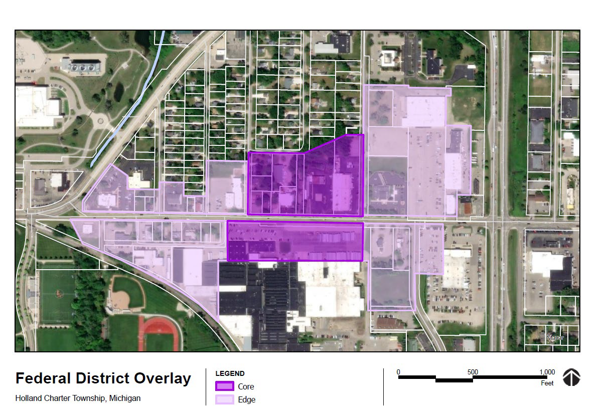
Federal district overlay district (FD). The FD zoning district is intended to accommodate a more compact development pattern along the 8th Street corridor where a mixture of connected uses encourage a pedestrian-oriented environment that is an attractive, vibrant place creating nodes of activity for visitors and residents alike. Retail, restaurants, and other permitted commercial activities should be located to create a complementary concentration of uses within buildings at the street level where shop entries and window displays invite exploration within the district. Residential and non-retail office uses may co-exist on the second floor with higher floors being dedicated to a collection of residential dwellings with distinctive balconies and terraces that are subtly placed between the canopies of street trees. The overlay shall be divided into two sub-districts, which are designated on the overlay map:
1.
Core: The core district is intended to create a walkable business district and gathering place for the federal district neighborhood.
2.
Edge: The edge district is intended to allow for flexible redevelopment, including the provision of additional housing, while improving the pedestrian environment on 8th Street.
(Ord. No. 648, § 1, 12-21-2023)
Sec. 7.2 - Floodplain overlay district.
A.
Applicability. The boundaries of the FP overlay district will vary and are subject to changes to the National Flood Insurance Program (NFIP) mapping within the township and any applicable letter of map amendment (LOMA) or letter of map revision (LOMR).
B.
Use restrictions. Land, buildings, or structures in the FP may be used for the following purposes only:
1.
Agriculture, farm, buildings and roadside stands, subject to the same conditions, restrictions, and requirements as are provided in the AG zoning district.
2.
Boat landings, docks, or mooring for pleasure or fishing boats only; provided, however, that the boat landings, docks, or moorings shall be utilized by the land owner only and shall not be leased or otherwise made available to other persons.
3.
Parks, golf courses, playgrounds, fair grounds, community centers, and other recreational facilities which are both owned and operated by a governmental agency. Private recreational facilities and uses of this nature are permitted when authorized by the planning commission as a special land use. In considering such authorization, the planning commission shall consider the following standards, in addition to the standards in section 15.3:
a.
The necessity for the proposed use for the surrounding neighborhood;
b.
The proximity of the proposed use to adjoining properties, specifically including proximity to occupied dwellings;
c.
The size, nature, and character of the proposed use;
d.
Potential traffic congestion which might be occasioned by the proposed use;
e.
Parking facilities to be provided for the proposed use; and
f.
The effect of the proposed use on adjoining properties and the surrounding neighborhood.
4.
No building or structure shall be erected or used for dwelling purposes.
C.
Construction requirements. All buildings and structures shall be designed and constructed to have a low flood damage potential. Buildings and structures shall be erected so as to offer the minimum obstruction to floodwaters by construction with the longitudinal axis parallel to the direction of flood flow and by placement on the same flood flow lines as adjoining buildings and structures. All buildings and structures shall be firmly anchored to prevent damage to other buildings and structures and restricted bridge openings and stream cross sections.
Sec. 7.3 - Gateway overlay district.
A.
Applicability. The applicable area includes the rights-of-way of the following key transportation corridors, plus 75 feet on both sides of the boundaries of the key transportation corridors. This GW does not change the underlying zoning district of the property. The following is a description of the key transportation corridors:
1.
US-31 from Ransom Street to New Holland Street.
2.
US-31 from East 8th Street to Lakewood Boulevard.
3.
Chicago Drive from US-31 to Fairbanks Avenue/City of Holland jurisdictional boundary.
4.
Chicago Drive from the City of Zeeland jurisdictional boundary to Burton Drive.
5.
Business Loop 196 from 106th Avenue/Paw Paw Drive to City of Zeeland jurisdictional boundary.
6.
112th Avenue from Business Loop 196 to East Lakewood Boulevard/Chicago Drive.
7.
River Avenue from the City of Holland jurisdictional boundary to Lakewood Boulevard.
8.
Douglas Avenue from North Division Ave/Park Township jurisdictional boundary to Aniline Avenue.
9.
120th Avenue from Chicago Drive to East Lakewood Boulevard.
10.
Butternut Drive from 144th Avenue/Park Township jurisdictional boundary to Riley Street.
11.
Riley Street from 144th Avenue/Park Township jurisdictional boundary to Butternut Drive.
12.
144th Avenue extending 600 feet south from the New Holland Street/Olive Township jurisdictional boundary.
13.
120th Avenue extending 600 feet south from the New Holland Street/Olive Township jurisdictional boundary.
14.
96th Avenue extending 600 feet south from the New Holland Street/Olive Township jurisdictional boundary.
15.
Adams Street from 96th Avenue/Zeeland Charter Township jurisdictional boundary to 104th Avenue.
16.
96th Avenue extending 600 feet north from the Ottogan Street/Fillmore Township jurisdictional boundary.
B.
Additional permitted uses. In addition to the uses authorized by the underlying zoning district, the following uses are also permitted:
1.
Community art; and
2.
Community signs.
C.
Procedures. An application for site plan review shall be submitted in accordance with article 14, for any community art or community sign. The planning commission shall conduct a preliminary review and hold a public hearing to consider each application. notice of this public hearing shall be in accordance with section 18.4. Upon receipt of the planning commission's report and recommendation, the township board shall review the proposed use and grant or deny the request on the basis of the same standards considered by the planning commission.
D.
Standards of approval. The planning commission shall consider the following standards in making its report and recommendation to the township board:
1.
Whether the proposed use is consistent with and promotes the intent and purpose of this ordinance;
2.
Whether the proposed use is compatible with adjacent uses of land and the natural environment; and
3.
Whether the proposed use is consistent with the public health, safety, and welfare of the township.
E.
Requirements.
1.
Community signs. Community signs shall be required to meet all standards of article 13, with the exception of the following:
a.
Community signs may be located within the public right-of-way if approval is obtained from the Ottawa County Road Commission.
b.
Community signs may not exceed 75 square feet in area.
c.
Community signs may display sponsorship names of organizations or individuals, but may not contain commercial messages, words, logos, trademarks, or graphic representations of any person, product, or service for the purpose of advertising, other than to simply identify the organization or individual as a sponsor.
d.
Electronic changeable message signs are not permitted under this section.
e.
Community signs shall not count against the signs that are permitted in the underlying zoning district.
2.
Community art. Community art installments are subject to the following requirements:
a.
Community art may be located within the public right-of-way if approval is obtained from the Ottawa County Road Commission.
b.
Community art shall not be considered a building or structure.
c.
Community art shall not be constructed or located in a manner that would cause a hazard to vehicle or pedestrian traffic, including, without limiting the foregoing, visual hazard caused by flashing lights or glare where the visual hazard impairs vision or is unreasonably distracting.
d.
Lighting used in conjunction with community art shall not shine directly on adjoining property or any street.
Sec. 7.4 - Federal district overlay district.
A.
Applicability. All establishment of new land uses, the construction of new structures, including additions, within the overlay shall abide by the requirements of the overlay. For all regulations included in this section, the overlay shall supersede the underlying zoning district. For all regulations not specifically included in this section, the standards of the underlying zoning district shall apply.
B.
Impact on existing uses and structures. Change of use alone shall not trigger the requirements of sections D-O below. Any structure existing at the time of the adoption of this overlay may be rebuilt, repaired, or remodeled if damaged as described in section 20.9.
C.
Land uses. The table below shows the permitted land uses, and land uses allowable by special use permit, within the overlay. Multiple uses shall be permitted on a single lot, provided all requirements of the overlay, and this section generally, are met. No non-residential use shall be located on a higher floor than a residential use in the same building.
Permitted use (P). This use is authorized by-right, subject to all other applicable provisions of the zoning ordinance.
Special land use (S). This use is subject to review and permitting in accordance with article 15.
Not permitted. A blank cell indicates that a use is not permitted.
Other requirements. See referenced section for additional requirements.
D.
Residential units.
1.
Density. There shall be no limit to the number of residential units on a given parcel, provided that all requirements of this overlay, including, but not limited to, setbacks, building height, and minimum dwelling unit size, are met.
2.
Size. The minimum size of a dwelling unit in the overlay shall be consistent with the R-3 district, as shown in Table 4.3B.
E.
First story use. Within the edge district, all land uses listed in section c may be located on the first story of a building. Within the core district, the residential exclusion zone, described below, shall apply.
1.
Residential exclusion zone definition. The residential exclusion zone shall exist on the ground floor of the building, and shall extend for the entire width of the building, and from the front wall back to a line 25 percent of the distance between the front wall and back wall. The "front wall" shall be considered the wall facing the primary front lot line. For buildings with an irregular or inconsistent front wall, the residential exclusion zone shall apply along all front walls. Construction requirements.
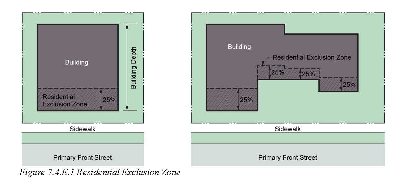
2.
Prohibited uses in the residential exclusion zone. No dwelling unit shall be established, partially or completely, within the residential exclusion zone.
3.
Permitted accessory uses in the residential exclusion zone. The residential exclusion zone may include accessory uses to residential units elsewhere in the building, such as a lobby, gathering space, recreation space, reception area, resident service space, or exercise space.
4.
Exemption. Buildings located, in their entirety, 200 feet or more from the 8th Street right-of-way shall be exempt from the residential exclusion zone requirement.
F.
First story façade transparency requirement.
1.
Core district. At least 60 percent of the area of the first story façade, and at least 40 percent of each upper story facade, facing the primary front lot line, must be glass windows and doors.
2.
Edge district. At least 40 percent of the area of the first story façade, and at least 40 percent of each upper story facade, facing the primary front lot line, must be glass windows and doors.
G.
Façade base building materials. At least two feet at the bottom of each exterior wall must be a water resistant, hard surface such as brick, masonry, or other cement-based cast product. Wood and vinyl shall not be deemed to meet this standard. Other materials may be approved by the township.
H.
Dimensional requirements.
1.
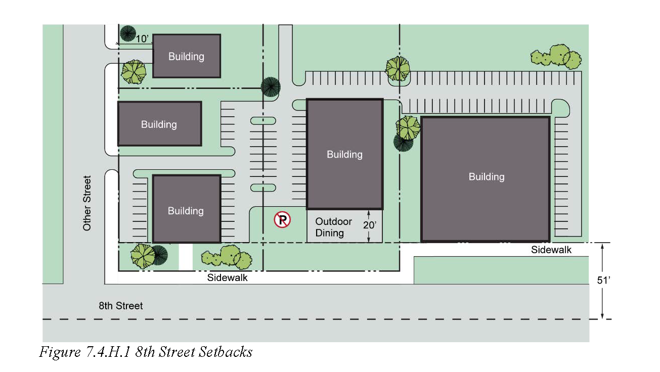
Front setback.
a.
For all lots abutting 8th Street, the building setback from 8th Street shall be 51 feet from the centerline of the right-of-way. The load-bearing element of the building closest to 8th Street must be exactly 51 feet from the right-of-way centerline.
i.
Private walkway. If the required setback creates 10 feet or more of space between the right-of-way line and the front of the building, a walkway shall be created between the public sidewalk and the front door.
ii.
Outdoor dining option—Core only. In the core district, the front of the building may be set back an additional 20 feet to create a space for outdoor dining. The space must be landscaped, paved with decorative block or similar treatment as approved by the township. It must also be surrounded by a decorative knee wall or fence 30 inches in height. The decorative knee wall or fence may have gates for access from the public sidewalk or other parts of the site.
b.
The setback from all streets other than 8th Street shall be no larger than ten feet.
c.
The township may allow maximum front setbacks to be exceeded if necessary to accommodate existing utility easements.
d.
Parking setback line. The parking setback line shall be defined as a straight line, even with the load bearing element of the principal building that is closest to 8th Street, and extending across the entire width of the lot. No parking shall be established closer to any street than the parking setback line.
2.
Side setback. For all lots abutting 8th Street, the building setback from at least one side lot line shall be zero feet. The building setback on the opposite side of the lot, if the building is not built to the lot line, shall be no more than necessary to accommodate a driveway, pedestrian sidewalk (at least five feet in width), and any required landscape buffer.
3.
Rear setback.
a.
Adjacent to a residential zoning district: The minimum rear setback shall be 30 feet.
b.
Not adjacent to a residential zoning district: The minimum rear setback shall be ten feet.
4.
Building coverage. The area of a lot covered by buildings shall not exceed 80 percent.
5.
Building height. The maximum building height, in feet, shall be consistent with the C-2 district as described in Table 5.3B. Within the allowable building height, the following habitable stories requirements must be met.
a.
Determination of number of habitable stories. A story shall be defined as habitable indoor space with a floor and a ceiling. A building level dedicated entirely to parking shall not be considered a habitable story, and shall not count towards the minimum and maximum standards in subsections b and c.
b.
Minimum number of habitable stories:
i.
Core: Three.
ii.
Edge: Two.
c.
Maximum number of habitable stories: Four.
d.
Minimum first story height: The first story shall have a floor-to-floor height of at least 12 feet.
e.
Fourth story step-back: The fourth story shall step back at least ten feet (as measured from the front wall of the first story) to reduce the massing of the building along the street.
I.
Residential amenities. All sites within the overlay containing more than one residential dwelling unit (including renovations to buildings existing before the adoption of the overlay) must contain at least two of the following:
1.
Balconies. Balconies that project four to six feet from the wall of the building and are accessible from residential dwelling units. Balconies may project into the front setback provided they are at least 14 feet above grade. The required fourth story step-back shall not be considered a balcony.
2.
Rooftop patio. Rooftop patio space that is either accessible from all of the dwelling units, or included as part of a restaurant. This space could be on the open rooftop created by the required fourth story step-back, or could be at the very top of the building.
3.
Ground level patio. An outdoor, ground level patio, which may be restricted to residents only, or may serve as outdoor dining space for a restaurant.
4.
Green space. Preserving or providing at least ten percent of the lot as natural, landscaped, and/or recreational space for the enjoyment of the residents. Examples of recreation space include, but are not limited to a swimming pool, fitness equipment, playground, or sport courts.
J.
Access management. Lots in the overlay shall make reasonable efforts to provide drive aisle connections to all adjoining lots that are also in the overlay, and to provide cross access agreements allowing for ingress and egress to all connected lots. Such agreements shall be subject to review and approval by the township during the site plan approval process.
1.
Core district driveway prohibition. For improved pedestrian circulation and safety, no new driveway from 8th Street shall be established within the core district and the township may require the closure of an existing driveway and/or may require a new driveway to be connected to a street other than 8th Street.
a.
Exception to prohibition. In the event that the lot in question does not border a public road other than 8th Street and efforts to create a cross access connection and shared driveway have failed, the driveway prohibition shall be waived by the township.
2.
Edge district driveway placement. Within the edge district, no new driveway from 8th Street shall be established fewer than 150 feet from another driveway or street intersection and the township may require the closure of an existing driveway and/or may require a new driveway to be constructed in a conforming location.
a.
Exception to prohibition. In the event that the lot in question does not border a public road other than 8th Street and efforts to create a cross access connection and shared driveway have failed, the driveway spacing requirement shall be waived by the township.
K.
Sidewalks. If they do not already exist, six foot minimum width concrete sidewalks shall be constructed along all public roads within the overlay, and shall thereafter be maintained by the adjacent property owner.
L.
Parking. The parking requirements in article 10 shall apply within the overlay, except as stated below:
1.
The minimum number of parking spaces for residential dwelling units shall be:
a.
Core: One space per dwelling unit.
b.
Edge: One and a half spaces per dwelling unit.
2.
The maximum number of parking spaces on any lot shall be 150 percent of the minimum parking required by this section.
3.
On-street parking spaces may be constructed, at the expense of the applicant, and with the permission of the road commission. On-street parking spaces constructed in conjunction with a development within the overlay shall count towards the minimum parking requirement for that development.
4.
Bicycle parking. Bicycle parking (including racks, lockers, or other security measures) shall be provided for at least one bicycle per five automobile parking spaces included on the site. The bicycle parking may be indoors, but a storage room that is not specifically designed for bicycles shall not count for this requirement.
M.
Signage. The sign regulations of article 13 shall apply, except at described below.
1.
Ground signs shall be no larger than 32 square feet and no taller than six feet.
2.
Each business with an entrance facing the primary front lot line shall be permitted to have a projecting sign.
a.
The projecting signs shall not exceed six feet in area.
b.
The projecting signs shall not exceed three feet in height
c.
The projecting signs shall not project farther than 36 inches from the face of the building and shall not project into the right-of-way.
d.
The bottom of the projecting signs must be at least eight feet above grade.
N.
Landscaping. The landscaping regulations of article 11 shall apply to the site, except as described below and elsewhere in this section.
1.
Front yard landscaping exceptions:
a.
If the required front building setback creates ten feet or more of space between the right-of-way line and the front of the building, and the area is not occupied by an outdoor dining area, the landscaping described in section 11.6 shall be installed between the building and the sidewalk or street when planting within the right-of-way is approved by the Ottawa County Road Commission.
2.
Buffers exceptions:
a.
Between a lot within the overlay and any abutting lot in a residential zoning district, Buffer Type A as described in section 11.7.B shall be established, except that the berm option shall not be permitted in the overlay, and the width of the required buffer zone shall be 20 feet.
b.
Between lots within the overlay, no side yard buffer shall be required adjacent to buildings utilizing a building setback of five feet or less, or where shared parking lots or drive aisles are proposed along the lot line in question.
c.
Between lots within the overlay, no rear yard buffer shall be required where shared parking lots or drive aisles are proposed along the lot line in question.
3.
Parking lot landscaping exemptions:
a.
Lots serving a principal use within the overlay with 24 spaces or fewer shall be exempt from the parking lot landscaping requirements in section 11.9.
b.
Covered or underground parking shall not be subject to the requirements of section 11.9, and shall not be counted when determining requirements under section 11.9.
O.
Lighting. The lighting regulations of article 12 shall apply to the site, except that the planning commission may require a decorative lamp-post design, to be determined in conjunction with the utility provider, to be used, in order to create a unified theme for light fixtures within the overlay.
1.
If required by the planning commission for some or all light fixtures on a given site, the decorative design requirement shall supersede all light fixture design requirements in article 12.
2.
This section shall not be construed to exempt light levels within the overlay, or on lots abutting the overlay, from standards governing light levels, light trespass, or glare.
(Ord. No. 648, § 2, 12-21-2023)