
Hooper City Zoning Code
CHAPTER 6
SUBDIVISION REGULATIONS
10-6-1 Purpose
- The purpose of this Chapter is to provide uniform standards for the subdivision of property, to protect property, and to protect the health, safety, and general welfare of the people of Hooper City.
10-6-2 Applicability
- This Chapter shall apply to the subdivision of all property within the incorporated area of Hooper City.
- No plat or any instrument passing title to any portion of a plat, shall be offered for recording unless approved in accord with the regulations of this Title.
- It shall be unlawful to make a subdivision of property until the requirements of this Chapter are satisfied.
- Exceptions: The following divisions of property shall not constitute a subdivision:
- A property boundary adjustment in accord with HCC 10-4B and as defined in HCC 10-1A-1.
- A court decree dividing a lot or parcel of land into separate, distinct ownership in the distribution of property as allowed by Utah law. Also see HCC 10-4A-20.
- The division of property as a result of condemnation, as defined and allowed in the Utah Code.
- The expansion or acquisition of street rights-of-way by a public highway agency.
- Abutting parcels that qualify as an exception to the contiguous parcel regulation as set forth in HCC 10-4A-9.
10-6-3 Process
- Concept Conference:
The applicant may request an optional Concept Conference with the City. The Concept Conference is designed to provide the applicant with a means of understanding regulations, policies, and procedures prior to any formal submission of a project, and to review the applicant’s proposal.
The Concept Conference will be scheduled only at the request of the applicant and following the receipt by the City of the applicable fees. The Conference is intended as a means of discussing the feasibility of the project and to assist the applicant in learning the City’s subdivision and site plan review process. - All applications and fees, as set forth in HCC 10-5, shall be submitted to the City on forms provided by the City
- A digital format of the plat may be required by the City Engineer.
- The preliminary plat application for subdivisions in an overlay zone shall contain any additional reports or materials required by HCC 10-3.
- If an applicant or owner intends to or is required to complete the final platting of the subdivision in phases, the proposed phasing shall be submitted with the application as set forth in HCC 10-6-4.2 paragraph B.
- The Planning Commission and City Council shall apply the design standards listed in HCC 10-6A, the required improvements listed in HCC 10-6B, standard regulations applying to all subdivisions listed in HCC 10-4A, the Hooper City Development Standards and Specification, and the findings listed in HCC 10-6-5 to review the proposed plat.
- For preliminary and final plats, the Commission shall forward a recommendation to the City Council as set forth in HCC 10-5-3.
- A decision of the City Council on a plat shall be final as to all matters set forth in said plat. This decision may be appealed under the regulations of this Title and the Utah State Code.
- Following City Council approval of a preliminary plat, the owner may cause the subdivision, or any phase thereof, to be surveyed and a final plat prepared for submittal to the Planning Commission and the City Council. The City Council shall approve a final plat within 24 months of the City Council’s approval of the preliminary plat or the preliminary plat approval shall become null and void.
- The applicant or owner may apply for a time extension, as set forth in HCC 10-5-6, if needed to extend the time allowed to approve the final plat or phase of a final plat, if applicable.
- Any lot created through an approved subdivision application and duly recorded plat shall thereafter be considered a platted lot.
- No subdivision plat or dedication, or any instrument passing title to any portion thereof, shall be offered for recording unless approved in accord with the regulations of this Title.
- No building permit shall be issued on any property being considered in the subdivision process until 1) the final plat has been recorded, 2) sufficient funds have been deposited for all required public improvements, 3) Assessor’s parcel numbers have been assigned, and 4) all public improvements have been constructed and approved by the City per HCC 10-6B-5.
10-6-4.1 Minor Subdivision Of Property
- A minor subdivision is a subdivision of up to three (3) lots where no new roadways are created. To qualify for a minor subdivision, the property must be located in a residential zone and the parcel shall have been lawfully created and qualified for further subdivision. Once a lot has been created by this process, it is no longer eligible for further subdivision under the minor subdivision provision.
- An application for a minor subdivision approval shall follow the application requirements of a standard subdivision except that the applicant will not be required to separately prepare a preliminary plat. A minor subdivision may receive recommendation for plat approval during a Planning Commission meeting and plat approval during a City Council meeting if all of the subdivision requirements of this Title have been satisfied. The Plat and drawing specifications for minor subdivisions are the same as those for a standard subdivision as provided in this section.
- The City Council and Planning Commission may approve a subdivision of one lot without a plat, by certifying in writing that:
- The city has provided notice as required by ordinance; and
- The proposed subdivision:
- is not traversed by the mapped lines of a proposed street as shown in the general plan and does not require the dedication of any land for street or other public purposes;
- has had a record of survey completed;
- has been approved by the culinary water authority and the sanitary sewer authority;
- is located in a zoned area that allows the lot;
- conforms to all applicable land use ordinances or has properly received a variance from the requirements of an otherwise conflicting and applicable land use ordinance; and
- creates a lot with a previously existing home on the lot.
- The City’s Certificate of Approval must accompany the documents recorded with the county recorder.
- The remaining parcel cannot be used as a building lot without complying with the subdivision requirements of the city.
10-6-4.2 Preliminary Plat Specifications
- Submission Requirements:
- Copies of all documents shown in the Preliminary Plat Checklist below shall be officially submitted to the City Planning Department by the Subdivider or authorized representative at least 30 days prior to the date of the Planning Commission Meeting during which the Subdivision may be considered for Preliminary Plat approval. If the City Planning Department deems that any required document listed in the Preliminary Plat Checklist has not been submitted, the subdivision will not be noticed on the Planning Commission agenda.
- Phase Development:
- The platting of subdivisions containing more than twenty-five (25) lots shall be done in phases, except as provided in paragraph B,5. Each phase shall consist of the number of lots which can be completely developed with both off-site and on-site improvements within a two (2) year period, or twenty-five (25) lots, whichever is larger. Off-site improvements are construed to be those improvements required by this section. On-site improvements shall be construed to mean the full or partial construction, to include footings, or placement of the dwelling and its appurtenant improvements on each lot. The development of the subdivision shall be in an orderly manner and in such a way that the phases will be contiguous, the required improvements will be continuous, and all of the said off-site improvements will be made available for the full, effective and practical use and enjoyment thereof by the lessees or grantees of any of the lands subdivided within the time hereinafter specified.
- A Phasing Plan shall be submitted that will include the number of units or parcels to be developed in each phase and the approximate timing of each phase, the timing on construction of public improvements and subdivision amenities to serve each phase whether on or off site, and the relationship between the public improvements in the current subdivision and contiguous land previously subdivided and yet to be subdivided. A developer may request a revision of the phasing plan, which may be necessary due to such conditions as changing market conditions, inclement weather or other factors.
- For phased development, submit Utility Master Plan drawings for culinary water, secondary water, sanitary sewer, land drainage and storm drainage showing how the entire development will be served. Submit written evidence of preliminary review and approval from utility companies regarding proposed Utility Master Plan drawings. Submit existing site topography and preliminary lot and street grading and drainage plan.
- When the off-site improvements have been one hundred (100) percent completed, or funds deposited for completion, within the boundaries of the recorded plat and approved by the City engineer, and the on-site improvements as defined in paragraph B,1, are sixty (60) percent completed, the subdivider may receive final approval for the next phase of the proposed development in accordance with the rules and regulations of this subdivision ordinance.
- A plat including more than twenty-five (25) lots will be accepted only upon the submission of qualified evidence indicating that the market absorption rate is such, and the financial ability of the subdivider is such that the off-site improvements for all lots in such plat will be completed within two (2) years.
- Plat Requirements and Preliminary Plat Checklist Items:
- One (1) copy of a Subdivision Application for Approval, application fees, and all required supporting documents defined in paragraphs D and E.
- Three (3) 24” x 36” black on white or blue on white prints of the preliminary plat and construction drawings and two (2) 11” x 17” copies of the preliminary plat of such quality and resolution that all detail in the drawing is readily discernable.
- Drawing Specifications:
- All mapped information shall be prepared in a neat and legible manner and drawn to a scale of not more than 100 feet to the inch. A smaller scale or different size may be used for large developments with prior written approval from the City Planning Department. Limits of the drawing shall include an area not less than 100 feet beyond boundaries of the proposed development. The accuracy of location of alignments, boundaries and monuments shall be certified by a registered land surveyor licensed to do such work in the State of Utah. Boundary problems shall be resolved and non-buildable remnant properties are prohibited. A workmanlike execution of the Plat shall be made in every detail. A poorly drawn or illegible Plat is sufficient cause for rejection.
- Preliminary Plat: The following data shall be submitted as part of the Preliminary Plat submission:
- Name of development.
- Name, address, and telephone number of owner, developer, and engineer.
- True north arrow, name of municipality, section, township and range, and date.
- Vicinity map showing the proposed subdivision’s location in the City, and a list of names of neighboring subdivisions, owners of abutting properties, and City streets. This should include an area not less than 100 feet beyond the boundaries of the proposed development.
- Tie to all controlling survey corners or monumentation.
- Dimensions of property and all lots (including area in square feet), drawn accurately to scale and total acreage of entire proposed subdivision.
- Lots numbered consecutively
- The minimum setbacks from the front, the side and the rear property lines.
- Existing buildings, parks, cemeteries, bridges and other manmade features, drawn accurately to scale and showing uses and type of construction.
- Adjoining buildings and uses.
- Proposed layout of public and private street system, including designations and street right-of-way lines, street centerlines and street names (all new names cleared through the City Engineer). Show right-of-way width from centerline for each street or other right-of-way.
- Easements and rights-of-way.
- Location of percolation test pits and test logs, if septic tanks are proposed for the lots.
- Sites, if any, to be reserved or dedicated for parks, schools, churches, or other public or private uses.
- 100 foot no-build setback from the centerline of the Hooper and Howard Sloughs. Where required by the City Planning Department and approved by the City Council, the “no-build” area shall be designated as “public open space” and dedicated to the City for future parks and trails.
- Grading and Drainage Study and Plan:
- Provide a Drainage Study and a Grading and Drainage Plan as required by HCC 10-4A. No preliminary plat will be accepted which does not specifically address grading and drainage issues including street and lot grading and drainage, potential impacts to the development from upstream and adjacent properties, and impact on and adequacy of downstream facilities and properties.
- Preliminary Roadway and Utility Plan and Profile construction drawings for new and existing streets showing the following:
- North arrow, road and lot layout, and subdivision name.
- Location of existing and proposed curb, gutter and sidewalk.
- Location of existing edge of asphalt surfacing.
- Location of proposed paved areas, including entrances and exits, and walkways.
- All existing and proposed utilities and improvements pertaining to streets, culinary water, secondary water, sanitary sewer, storm water, subsurface drains, fire protection, lighting, signage, and other proposed utilities. Include plan and profile drawings for roads and applicable utilities. (Note: Detailed design of structures is not required for a preliminary plat.)
- The culinary water system is operated and maintained by either the Hooper Water Improvement District or the Taylor-West Weber Water Improvement District. Culinary water system approval shall be through the applicable entity.
- The secondary water system is operated and maintained by either the Hooper Irrigation Company or the Roy Water Conservancy Sub-district. Secondary water system approval shall be through the applicable entity.
- The sewer system is operated and maintained by Hooper City. Unless specifically exempted by ordinance, all subdivisions shall be required to tie to the existing City sewer system. Vacuum sewer shall be provided in the subdivision unless the City’s Sanitary Sewer Master Plan allows for an alternative.
- All new subdivisions shall be required to install a land drain system if basements (lowest floor slab of the structure lower than existing ground level) are to be constructed. Structures with basements shall be required to have a sump pump that ties to a footing drain and the footing drain shall tie to the land drain system.
- For subdivisions being proposed in flood-prone areas or areas along the sloughs or other waterways, the City Council may impose a “lowest slab” elevation, below which no structure will be permitted to install a floor slab.
- Location and dimensions of all utility easements.
- 6-foot chain link or other non-climbable separation fences between land uses. The City Council may waive this requirement in a minor subdivision or where the same entity owns the adjoining properties that have different land uses.
- 6-foot high chain link fence along canals or ditches carrying more than 5 cfs.
- Preliminary Slough Parkway Development Plan: If the subdivision includes a portion of the Hooper or Howard Slough to be dedicated as Slough Parkway, submit a slough parkway development plan in accordance with the City’s slough development standards.
- Required Supporting Documents:
- Stamped, addressed envelopes for all residents within 600 feet of the proposed subdivision for the purpose of public notification by the City, or a 4’x4’ or greater sign clearly addressing the proposed action, in a print quality that will give notice to people passing by, as defined in HCC 10-5A-4 paragraph B.
- Proposed phasing plan, if multiple phases are planned.
- Soils report for all proposed development except in the case of a minor subdivision. Soils reports for minor subdivisions shall be submitted when required by the City Planning Department or City Engineer
- Any required agreements with adjacent property owners regarding boundaries, ditches, drainage, shared utilities, access, or other matters pertinent to subdivision approval.
- Copy of proposed codes, covenants and restrictions, if applicable.
- For subdivisions proposing on-site wastewater treatment systems, final Letter of Approval for septic systems from Weber-Morgan County Health Department.
- Letter of Preliminary Approval for culinary water from Hooper Water Improvement District (or applicable culinary water district).
- Letter of Preliminary Approval for secondary water from Hooper Irrigation Company (or applicable secondary water purveyor).
- Letter of Approval from Weber County Fire Marshall for fire hydrant placement, fire flows, emergency vehicle access and turn-around, and other issues.
- Letter from each other utility company involved stating that they have reviewed the plan and are setting forth their comments concerning the extent of services and the design of utility easements.
- Letter of Preliminary Approval from Roy City, West Haven City, or other municipality sharing a boundary with the proposed development.
- For subdivisions with any boundary shared with a Utah Department of Transportation (UDOT) road, submit written evidence that UDOT has reviewed the subdivision plans and is in agreement with the proposed plan. Approval of the State Right-of-Way Engineer must be obtained for items such as location of curb, gutter and sidewalk, location and number of curb entrances, turning and deceleration lanes, lane striping, etc. On City streets, the approval for location and number of curb entrances must be received from the City Engineer.
- Any other information as may be useful or necessary for the meaningful review of the project. Additional information may be requested based upon the nature of the project or the site.
- Outside Entity Preliminary Plat Approval: All outside entities described above must be contacted directly by the applicant. Written approval must be received by the Department before the Preliminary Plat will be considered complete. The City Planning Department may require that the applicant contact other entities if, in the opinion of the Department, the entity may be affected by the application and comments by the entity will ensure a thorough analysis of the application. It shall be the applicant’s responsibility to ensure that written approval from these other entities are received in a timely manner. Written approval must be received by the City Planning Department before the Preliminary Plat will be considered complete.
- Review Procedure – Preliminary Plat:
- Once all items on the Preliminary Plat Checklist have been completed and the subdivision is submitted for Preliminary Plat approval and associated fees have been received, the proposal will be placed on the Planning Commission’s list of unscheduled items. Items are placed on the list in order of the date a complete application is received by the City Planning Department. The Planning Commission may choose, at its discretion, to limit the number of applications reviewed at each Planning Commission meeting.
- The City Planning Department, including City Engineer, shall have ten (10) days to review the application and respond in writing with a list of missing or incomplete items.
- After receiving corrections from the applicant, if necessary, the City Staff shall notice the application on an upcoming Planning Commission agenda as an agenda item. The applicant’s corrections must be received at least 10 days prior to the upcoming Planning Commission meeting for the applicant to be noticed on the agenda.
- Each comment, question or correction on the City Planning Department’s memorandum must be responded to in writing, either on revised plans or in other type-written correspondence from the applicant. Any Department comment not addressed in this manner will render the submittal incomplete and the application will not be included on the Planning Commission agenda.
- At a public meeting, the Planning Commission shall evaluate the submittal, comments and Staff Report, and recommend approval, recommend approval with conditions, or deny the Preliminary Plat. The Planning Commission may also continue the application for further study. The Planning Commission’s decision shall be based on evidence presented by Staff, the applicant, conditions, if any, placed on the subdivision during Concept Conference and/or public comments, compliance with City ordinances, regulations, policies, master plans and other guidelines. If the Planning Commission denies the Preliminary Plat, no further review of the proposed subdivision shall be made by the City and a new Preliminary Plat submittal shall be required to re-initiate the subdivision process.
- The City Staff shall prepare a report of the Planning Commission findings and recommendations and forward the report on to the City Council. The applicant must make any additions and/or corrections to the Preliminary Plat required by the Planning Commission and submit new and/or revised documents to the City Planning Department at least ten (10) days prior to the upcoming City Council meeting in order to be noticed on the agenda.
- At a public hearing, the City Council shall evaluate the Planning Commission’s recommendations, other comments, and Staff Report, and approve, approve with conditions, or deny the Preliminary Plat. The City Council may also continue the application for further study and/or send comments back to the Planning Commission for consideration. The City Council’s decision shall be based on evidence presented by Staff, the applicant, conditions, if any, placed on the subdivision during Concept Conference and/or public comments, Planning Commission comments and recommendations, compliance with City ordinances, regulations, policies, master plans and other guidelines. If the City Council denies the Preliminary Plat, no further review of the proposed subdivision shall be made by the City and a new Preliminary Plat submittal shall be required to re-initiate the subdivision process.
10-6-4.3 Final Plat Specifications
The final plat shall be prepared as provided by, and include the items required by, Utah Code 10-9 Part 8 and related State law, and the following additional requirements:
- Submission Requirements:
- Copies of all documents shown in the Final Plat Checklist below shall be officially submitted to the City Planning Department by the subdivider or his authorized representative at least 30 days prior to the date of the Planning Commission Meeting during which the Subdivision may be considered for Final Plat approval. If the City Planning Department deems that any required document listed in the Final Plat Checklist has not been submitted, the subdivision will not be noticed on the Planning Commission agenda.
- Final Plats shall be submitted for approval within twenty-four (24) months of the date a Preliminary Plat has been approved by the City Council. No Final Plat submission can be accepted which has exceeded this time lapse period, unless an extension of time has been granted by the City Council upon written request of the subdivider. Any plat submitted for which Preliminary Plat approval has been given in excess of twenty-four (24) months previous and for which no time extension has been granted shall be considered by the Planning Commission as a new Preliminary Plat.
- For phased development, Final Plat approval shall be considered phase-by-phase based upon the Phasing Plan approved during the Preliminary Plat process and the timing for submittal defined in HCC 10-6-4.2 paragraph B. The Final Plat requirements and Checklist described below shall be followed for each phase of the subdivision submitted for Final Plat approval.
- Plat Requirements and Final Plat Checklist:
- The Final Plat submission shall conform in all major respects to the Preliminary Plat as previously reviewed and approved by the City Council and shall incorporate all modifications required in its review. The City Council may, however, approve a Final Plat which has been modified to reflect improvements in design or changes which have occurred in its natural surroundings and environment since the time of the Preliminary Plat review and approval.
- Final Plat shall be submitted in phases, except as provided in HCC 10-6-4.1 paragraph B.
- One (1) copy of all required supporting documents and application fees shall be submitted.
- The original Final Plat drawing and three (3) 24”x36” of black on white or blue on white prints and two (2) 11”x17” copies of the final plat along with three (3) 24”x36” of black on white or blue on white prints of the construction drawings, of such quality and resolution that all detail in the drawing is readily discernible, shall be submitted at the time of submittal of the final plat.
- One digital copy on CD of final plat and final construction drawings in AutoCAD .dwg format.
- Drawing Requirements:
The Final Plat drawing shall have the following standards:- The plat shall be prepared and certification made as to its accuracy by a registered land surveyor licensed to do such work in the state of Utah. A workmanlike execution of the plat shall be made in every detail. A poorly-drawn or illegible plat is sufficient cause for its rejection.
- The original Final Plat shall be delineated in permanent ink on original Mylar. Sepia copies of original mylars are not acceptable.
- The drawing page(s) shall show exterior boundary and property lines, right-of-way lines, streets, street islands, existing and new easements, all accurately dimensioned with bearings to the nearest one second and distances to the nearest one-hundredth (1/100) of a foot. The dimensions shall provide a minimum lot and boundary survey closure of 1:10,000.
- Permanent monuments, magnetically detectable, marked in accordance with Utah Code § 17-23-17(5), shall be set for all the following:
- All lot corners and exterior boundary corners.
- Street centerline angle points, point of curvatures (PCs), point of tangencys (PTs), intersecting street centerlines, and radius points for cul-de-sacs.
- In such cases where the placement of a required monument at its proper location is impractical, it is permissible to set a reference monument close by the point, and if such monument is set its location shall be properly shown on the plat of survey. When conditions warrant setting a monument on an offset, the location shall be selected so the monument lies on a line of the survey or on the prolongation of such line. Offsets should not be in fractional feet unless a physical obstruction affects their location. (Utah Council of Land Surveyors Model Standard of Practice for Boundary Surveys Section 6)
- The plat shall show:
- At least 2 primary control points, officially recognized by the County Surveyor and ties to such control points. Primary control points must be public land survey corners or officially recognized corners. Corner Perpetuation and Filing recording instrument numbers shall be shown.
- The approved street names.
- Location, dimensions, and purpose of any easements.
- Location, description, and size of monuments that are found.
- Name of subdivision, astronomic north arrow and basis thereof, and date
- Name and address of owner or owners of record
- Total acreage of subdivision; total number of lots
- Ownership, range, section (and quarter section if portion)
- Graphic scale
- All blocks and all lots within each block shall be consecutively numbered.
- Owner’s certificate containing a statement of reservation of easements and private roads. Private roads may be shown as a lot or an easement.
- The right-of-way width from centerline of each street or other right-of-way.
- Name and location of abutting subdivisions and parcels.
- Excepted parcels shall be marked "Not included in this subdivision" and the boundary completely indicated by bearings and distances.
- The bearings, distances and curve data of all perimeter boundary lines shall be indicated outside the boundary line, not inside with the lot dimensions. When the plat is bounded by an irregular shore line or a body of water, the bearings and distances of a closing meander traverse should be given and a notation made that the plat includes all land to the water's edge or otherwise.
- On curved boundaries and all curves in the plat, sufficient data shall be given to enable the reestablishment of the curves on the ground. This curve data shall include the following for circular curves:
- radius of curve
- central angle
- tangent
- arc length
- All lands within the boundaries of the plat shall be accounted for either as lots, walkways, streets, alleys, or as excepted parcels.
- All dimensions of irregularly-shaped lots shall be indicated in each lot.
- All bearings and lengths shall be given for all lot lines, except that bearings and lengths need not be given for interior lot lines where the bearings and lengths are the same as those of both end lot lines.
- Parcels not contiguous shall not be included in one plat, nor shall more than one plat be made on the same sheet. Contiguous parcels owned by different parties may be embraced in one plat, provided that all owners join in the dedication and acknowledgment.
- Lengths shall be shown to hundredths of a foot, and angles and bearings shall be shown to seconds of arc.
- The following certificates and approvals shall appear on the final plat:
- Owner’s Certificate.
- Licensed Land Surveyor’s Certificate. The surveyor making a plat shall certify on the plat that it conforms to these survey regulations and to all applicable state laws and that the monuments described in it have been placed as described. He shall affix his name and seal.
- Weber-Morgan Counties Health Department, if applicable.
- Applicable Culinary Water District
- Applicable Secondary Water Company or District
- City Attorney
- City Engineer
- Include the following exact language below the City Engineer’s signature on the final plat: “I hereby certify that this office has examined this plat and it is correct in accordance with information on file in this office.”
- Mayor
- Include a place below the Mayor’s signature for the City Recorder to attest.
- City Council Chairman
- Supporting Documents:
The following documents shall be submitted with the Final Plat drawing and be considered a part of the submission:- Final construction drawings including the lot grading and drainage plan and roadway drainage and utility plan showing layout, profile and detailed design of roads, bridges, culverts, sewers, detention basins with landscaping plans and other drainage structures. Construction drawings must be stamped by a professional civil engineer licensed to practice in the State of Utah.
- An exact copy of a certificate of a title insurance company or attorney which shall set forth the names of all property owners included in the plat and shall include a list of all mortgages, judgments, liens, easements, contracts and agreements of record in the County which shall affect the property covered by such plats. If the opinion of title discloses any of the above, then at the option of the City Council the holders or owners of such mortgages, judgments, liens, easements, contracts, or agreements shall be required to join in and approve the application before the Plat shall be acted upon by the Planning Commission.
- Where a portion of an existing easement is contiguous to a proposed easement or right-of-way of a new subdivision, proof of the dedication of the existing easement or right-of-way acceptable to the Planning Commission must be submitted.
- Where the subdivider is to dedicate land for schools, roads, parks, or other public purposes, a letter of intent is required from the public agency receiving the dedication, agreeing to such dedication and stating how applicable improvement standards will be met. When land within a subdivision is to be purchased by a public agency for public use, a letter of intention to purchase shall be required.
- Signed easements and/or agreements with adjacent property owners for necessary off-site facilities or other matters pertinent to the subdivision, if not already submitted.
- Signed codes, restrictions and covenants.
- Letter of Final Approval for culinary water from Hooper Water Improvement District (or applicable culinary water district).
- Letter of Final Approval for secondary water from Hooper Irrigation Company (or applicable secondary water purveyor). Note: A letter of “conditional” final approval may be submitted at this stage of the process. However, the Final Plat shall not be signed by the City Engineer until a Letter of Final Approval is received.
- If the subdivision layout has changed since Preliminary Plat approval was granted, obtain a final Letter of Approval from Weber County Fire Marshall for fire hydrant placement, fire flows, emergency vehicle access, and other issues.
- Letter of Final Approval from Roy City, West Haven City, or other municipality sharing a boundary with the proposed subdivision.
- Letter of Final Approval from UDOT for subdivisions with any boundary shared with a Utah Department of Transportation (UDOT) road.
- Letter of Final Approval from all outside entities requiring approval as directed by the Planning Commission.
- Storm Water Pollution Prevention Plan As required by laws of the State of Utah, submit a Storm Water Pollution Prevention Plan for each project (subdivision or subdivision phase, if phasing is required), and copies of State permits received.
- Final Slough Parkway Development Plan (where applicable)
- Any other information as may be useful or necessary for the meaningful review of the project. Additional information may be requested based on the nature of the project or the site.
- The Final Plat shall include the following notation: Important Notice Many areas in Hooper have ground water problems due to a seasonally high (fluctuating) water table. There are also areas where soil conditions may warrant additional construction measures. Approval of this plat does not constitute representation by Hooper City that buildings at any specified elevation will solve ground water problems or that soils are suitable for construction. Solution of water or soil problems is the sole responsibility of the permit applicant and property owner.
- Signing the Final Mylar Plat:
Before the Final Mylar Plat is signed by the City Engineer and others, the following items shall be completed:- Submit Itemized construction cost estimate for use by the City Engineer in creating the Escrow Estimate.
- Sign a Development Agreement outlining the proposed agreements made between the City and the subdivider during both the Preliminary and Final Plat phases and itemizing any costs or reimbursements discussed. The Development Agreement shall be signed before the Final Plat is signed.
- Pay applicable sign fees and inspection fees.
- Review Procedures - Final Plat:
- Once all items on the Final Plat Checklist have been completed and the subdivision is submitted for Final Plat Approval, and associated review fees paid, the proposal will be placed on the Planning Commission’s list of unscheduled items. Items are placed on the list in order of the date that a complete application is received by the City Planning Department. The Planning Commission may choose, at its discretion, to limit the number of applications reviewed at each Planning Commission meeting.
- The City Planning Department, including City Engineer, City Attorney and Staff shall have ten (10) days to review the application and respond to the applicant with a list of missing or incomplete items.
- After receiving corrections from the applicant, if necessary, the City Planning Department shall notice the application on an upcoming Planning Commission agenda as an agenda item. The applicant’s corrections must be received at least 10 days prior to the upcoming Planning Commission meeting for the applicant to be noticed on the agenda. Each item on the City Planning Department’s memorandum must be responded to in writing, either on revised plans or in other type-written correspondence from the applicant. Any Department comment not addressed in this manner will deem the submittal incomplete and the application will not be included on the Planning Commission agenda.
- The City Staff shall prepare and forward to the Planning Commission members a staff report on the submittal at least five (5) days prior to the Planning Commission meeting, which includes all agency and City Staff comments and recommendations.
- At a public meeting, the Planning Commission shall evaluate the submittal, comments and Staff Report, and recommend approval, recommend approval with conditions, or deny the Final Plat. The Planning Commission may also continue the application for further study. The Planning Commission’s decision shall be based on evidence presented by Staff, the applicant, conditions, if any, placed on the subdivision during Concept Conference and/or public comments, Preliminary Plat approval, compliance with City ordinances, regulations, policies, master plans and other guidelines. If the Planning Commission denies the Final Plat, no further review of the proposed subdivision shall be made by the City and a new Final Plat submittal shall be required to re-initiate the subdivision process.
- The City Staff shall prepare a report of the Planning Commission findings and recommendations and forward the report on to the City Council. The applicant must make any additions and/or corrections to the Final Plat required by the Planning Commission and submit new and/or revised documents to the City Staff at least ten (10) days prior to the upcoming City Council meeting in order to be noticed on the agenda.
- At a public meeting, the City Council shall evaluate the Planning Commission’s recommendations, comments and Staff Report, and approve, approve with conditions, or deny the Final Plat. The City Council may also continue the application for further study and/or send comments back to the Planning Commission for consideration. The City Council’s decision shall be based on evidence presented by Staff, the applicant, conditions, if any, placed on the subdivision during Concept Conference and/or public comments, Preliminary Plat approval, Planning Commission comments and recommendations, compliance with City ordinances, regulations, policies, master plans and other guidelines. If the City Council denies the Final Plat, no further review of the proposed subdivision shall be made by the City and a new Final Plat submittal shall be required to re-initiate the subdivision process.
- Once a Final Plat has been reviewed, but prior to signing of the Final Mylar Plat, the subdivider shall enter into an Escrow Agreement acceptable to the City as security to ensure completion of all improvements required to be installed in the subdivision. The amount of the Escrow Agreement shall be based upon the City Engineer’s review and approval of the subdivider’s construction estimate.
- The Plat shall then be reviewed and signed by the City Engineer, City Attorney, Mayor and others as indicated in the ordinances. The subdivider shall be responsible to obtain signatures, if so directed by the City staff.
- Recording Final Plat:
- The subdivider shall pay the expenses of plat recording and shall provide the city with a copy of the recorded plat for the city’s records.
- The County Clerk and Recorder shall furnish the subdivider with a receipt, upon filing for the Final Plat.
10-6-4.4 Remaining Parcel
When a division of property leaves a remaining area of 5.00 acres or greater, that is not to be included as part of the subdivision, then the remaining property will be described by metes and bounds description on the subdivision plat with the note; “Remaining Agricultural Parcel, Not Approved for Development.” This description can be made from survey or prepared from existing records. If the description is prepared from records, then this shall be so stated.
10-6-4.5 Site Plan Specifications
- Submittal Requirements:
- Copies of all documents shown in the Non-Residential Site Plan Checklist below shall be officially submitted to the City Planning Department by the developer or authorized representative at least 30 days prior to the date of the Planning Commission Meeting during which the development may be considered for Site Plan approval. If the City Planning Department deems that any required document listed in the Site Plan Checklist has not been submitted, the subdivision will not be noticed on the Planning Commission agenda.
- The site plan shall be professionally designed and drafted, and stamped by a professional civil engineer licensed to practice in the State of Utah.
- Site Plan and Drawing Specifications and Non-Residential Site Plan Checklist:
- One (1) copy of all required supporting documents and application fees shall be submitted.
- An exact copy of a certificate of a title insurance company or attorney which shall set forth the names of all property owners included in the plat and shall include a list of all mortgages, judgments, liens, easements, contracts and agreements of record in the County which shall affect the property covered by such plats. If the opinion of title discloses any of the above, then at the option of the City Council the holders or owners of such mortgages, judgments, liens, easements, contracts, or agreements shall be required to join in and approve the application before the Site Plan shall be acted upon by the Planning Commission.
- Traffic Impact Analysis, when required by City Engineer
- Soils report for all proposed development
- Stamped, addressed envelopes for all residents within 600 feet of the proposed subdivision for the purpose of public notification by the City.
- The original Site Plan drawing and three (3) 24”x36” of black on white or blue on white prints and one (1) 11”x17” copy of the site plan along with three (3) 24”x36” of black on white or blue on white prints and one (1) 11”x17” copy of any other applicable construction drawings, of such quality and resolution that all detail in the drawing is readily discernible, shall be submitted at the time of submittal of the final plat.
- One digital copy on CD of preliminary plat in AutoCAD.dwg format.
- Site Plan Drawing Requirements:
- Name of development.
- Name, address, and telephone number of owner, developer, and engineer.
- True north arrow, name of municipality, section, township and range, and date.
- Vicinity map showing the proposed site’s location in the City.
- Names of neighboring subdivisions, owners of abutting properties, and City streets. This should include an area not less than 100 feet beyond the boundaries of the proposed development.
- Tie to all controlling survey corners or monumentation.
- Lot line dimensions.
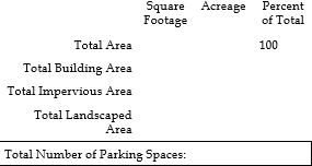
- Tabulation Table in the following format:
- Streets: Names and locations of fronting streets and dimensions of public streets, private streets, and driveways.
- Buildings: Footprints of existing and proposed buildings and structures including a notation of each building’s main finished floor height above grade.
- Building elevation: show height dimension & types of materials proposed.
- Sewer & Water: Location and size of existing and proposed sewer lines and manholes, storm drains and manholes, water supply main valves, water lines, culverts, etc.
- Fire Protection: existing and proposed fire protection devices within the tract and within two 200 feet of the boundaries of the proposed development. Identify required fire department apparatus access roads and proposed fire hydrant locations, as well as UBC specified construction type.
- Other Utilities: Location of existing and proposed power, natural gas, telephone and other applicable utility services.
- Drive accesses: location & dimensions & distances to property lines of existing & proposed.
- Curbs, gutters and sidewalks: location, dimension of existing and proposed.
- Location and number of parking stalls, loading areas, and docks, if applicable.
- Parking spaces: 9' x 18' minimum; locations, dimensions & number of spaces. Include parking stalls for Americans with Disabilities I.A.W. ANSI A117.1-1992. Minimum Van size: 16 feet wide by 18 feet long, one required. Minimum for all other ADA stalls: 13' X 18'.
- Fences: locations, heights, & types of materials of existing and proposed.
- Signs: location and description (dimensions, distance to property lines, and type of lighting (direct or indirect)) of existing and proposed signs.
- Loading areas.
- Solid waste disposal: show location and enclose with sight obscuring fence.
- Exterior display areas.
- Exterior storage areas.
- Exterior Lighting: location and type.
- Grading and Drainage Plan in accordance with HCC 10-4 including contour map drawn at 1-foot intervals and enough elevation data to show existing and proposed grades & the location & type of inlet boxes, etc. To be approved by the City Engineer prior to Planning Commission review.
- Storm Water Pollution Prevention Plan:
As required by the laws of the State of Utah and in accordance with the City’s Storm Water Ordinance, submit a Sediment and Erosion Control Plan for each project (subdivision or subdivision phase, if phasing is required). - Landscape plan: detailed with specific types & locations of plants; underground, automatic sprinkling system required; required trees.
- Traffic Circulation Plan.
- Any necessary agreements with adjacent property owners regarding boundaries, storm drainage, shared utilities, access, or other matters pertinent to subdivision approval.
- Letter of Approval for culinary water from Hooper Water Improvement District (or applicable culinary water district).
- Letter of Approval for secondary water from Hooper Irrigation Company (or applicable secondary water purveyor).
- Letter of Approval from Weber County Fire Marshall for fire hydrant placement, fire flows, emergency vehicle access and other issues.
- Letter from each other utility company involved stating that they have reviewed the plan and are setting forth their comments concerning the extent of services and the design of utility easements.
- Letter of Approval from Roy City, West Haven City, or other municipality sharing a boundary with the proposed development.
- For developments with any boundary shared with a Utah Department of Transportation (UDOT) road, submit written evidence that UDOT has reviewed the subdivision plans and is in agreement with the proposed plan. Approval of the State Right-of-Way Engineer must be obtained for items such as location of curb, gutter and sidewalk, location and number of curb entrances, turning and deceleration lanes, etc. On City streets, the approval of the location and number of curb entrances must be received from the City Engineer.
- Outside Entity Site Plan Approval:
All outside entities described above must be contacted directly by the applicant. Written approval must be received by the Department before the Site Plan will be considered complete. The City Planning Department may require that the applicant contact other entities if, in the opinion of the Department, the entity may be affected by the application and comments by the entity will ensure a thorough analysis of the application. It shall be the applicant’s responsibility to ensure that written approval from these other entities are received in a timely manner. Written approval must be received by the City Planning Department before the Site Plan will be considered complete. - Review Procedure:
- Once all items on the Site Plan Checklist have been completed and the development is submitted for Site Plan Approval, and associated review fees paid, the proposal will be placed on the Planning Commission’s list of unscheduled items. Items are placed on the list in order of the date that a complete application is received by the City Planning Department. The Planning Commission may choose, at its discretion, to limit the number of applications reviewed at each Planning Commission meeting.
- The City Planning Department, including City Engineer, shall have ten (10) days to review the application and respond to the applicant with a list of missing or incomplete items.
- After receiving corrections from the applicant, if necessary, the City Staff shall notice the application on an upcoming Planning Commission agenda as an agenda item. The corrections must be received at least 10 days prior to the upcoming Planning Commission meeting for the applicant to be noticed on the agenda. Each comment, question or correction on the City Planning Department’s memorandum must be responded to in writing, either on revised plans or in other type-written correspondence from the applicant. Any Department comment not addressed in this manner will render the submittal incomplete and the application will not be included on the Planning Commission agenda.
- At a public meeting, the Planning Commission shall evaluate the submittal, comments and Staff Report, and recommend approval, recommend approval with conditions, or deny the Site Plan. The Planning Commission may also continue the application for further study. The Planning Commission’s decision shall be based on evidence presented by Staff, the applicant, conditions, if any, placed on the site during Concept Conference and/or public comments, compliance with City ordinances, regulations, policies, master plans and other guidelines. If the Planning Commission denies the Site Plan, no further review of the proposed site shall be made by the City and a new Site Plan submittal shall be required to re-initiate the site plan process.
- The City Staff shall prepare a report of the Planning Commission findings and recommendations and forward the report on to the City Council. The applicant must make any additions and/or corrections to the Site Plan required by the Planning Commission and submit new and/or revised documents to the city Staff at least ten (10) days prior to the upcoming City Council meeting in order to be noticed on the agenda.
- At a public hearing, the City Council shall evaluate the Planning Commission’s recommendations, public comments, comments and Staff Report, and approve, approve with conditions, or deny the Site Plan. The City Council may also continue the application for further study and/or send comments back to the Planning Commission for consideration. The City Council’s decision shall be based on evidence presented by Staff, the applicant, conditions, if any, placed on the site during Concept Conference and/or public comments, Planning Commission comments and recommendations, compliance with City ordinances, regulations, policies, master plans and other guidelines. If the City Council denies the Site Plan, no further review of the proposed site shall be made by the City and a new Site Plan submittal shall be required to re-initiate the site plan process.
10-6-5 Required Findings
- Preliminary Plat:
- The design conforms to the standards established in HCC 10-6A and other applicable sections of this Title;
- The design complies with the required improvements established in HCC 10-6B and other applicable sections of this Title;
- If applicable, the proposed subdivision complies with the standards of an applicable overlay zone as set forth in HCC 10-3;
- The design conforms to the topography and natural landscape features and shows consideration for the location and function of land uses and structures to achieve this purpose;
- The development would not cause undue damage, hazard, or nuisance to persons or property in the vicinity;
- The internal street system is designed for the efficient and safe flow of vehicles and pedestrians without having a disruptive influence upon the activities and functions contained within the proposed subdivision, nor placing an undue burden upon existing transportation and other public services in the surrounding area;
- Community facilities such as parks, recreational, and dedicated open space areas are functionally related to all dwelling units and are easily accessible via pedestrian and/or bicycle pathways;
- The proposal complies with the dimension standards set forth in this Title for the applicable zone; and
- The overall plan is in conformance with the applicable General and Master Plan(s), Future Acquisition Maps, Area of City Impact ordinances including applicable subdivision regulations, and other pertinent ordinances.
- Final Plat:
- The final plat is in substantial conformance with the preliminary plat; and
- All conditions of the approved preliminary plat have been met.
10-6-6 Vacation, Total Or Partial, Of A Recorded Subdivision Plat
An applicant or owner may petition the City Council for a total or partial vacation of a recorded subdivision plat, including easements. Vacation shall be processed in accord with the regulations set forth in Utah Code § 10-9-808 and recorded in accord with the regulations set forth in Utah Code § 10-9-804.
10-6A-1 General
- These standards shall be followed in all subdivisions regulated by this Title. In addition to these standards, all subdivisions shall meet the design standards of the applicable zone.
- Adequate means for eliminating unsuitable conditions must be approved by the City Engineer in order to develop property that has been designated in the applicable General or master plan, in the natural features analysis, or elsewhere, as being unsuitable for development because of flood threat, poorly drained areas, high ground water, steep slopes, rock formation, buried pipelines, or other similar conditions likely to be encountered.
- The limits of the subdivision shall encompass the full extent of the owner’s lot or contiguous parcels, as herein defined. If platting in phases, no reserved parcels shall be allowed; all remainder areas shall be platted as lots that meet the minimum dimensional standards for the zone in which they are located.
- The decision-making body may require modifications where, in its opinion, site planning has not sufficiently addressed the existing natural features.
10-6A-2 Blocks
- The length, widths, and shapes of blocks shall be determined with due regard to:
- Provision of adequate building sites suitable to the special needs of the type of use contemplated including the base zone requirements as to property sizes and dimensions.
- Needs for convenient access, circulation, control, and safety of street traffic. The number of intersecting streets with arterials of all classes shall be held to a minimum.
- The limitations and opportunities of topography.
- Blocks shall have sufficient width to provide for two (2) tiers of lots of appropriate depths. Exceptions to this prescribed block width shall be permitted in blocks adjacent to major streets, or waterways. The lengths, widths and shapes of blocks shall be appropriate for the locality and the type of development contemplated. Block lengths in residential areas should not exceed one thousand two hundred (1,200) feet or twelve (12) times the minimum lot width required in the zone, whichever is greater, nor be less than four hundred (400) feet in length. When practicable, blocks along major arterials and collector streets shall be not less than one thousand (1,000) feet in length. In long blocks the City may require the reservation of an easement through the block to accommodate utilities, drainage facilities, or pedestrian traffic.
- Pedestrian access rights-of-way not less than 10 feet wide, may be required for walkways through or across a block when deemed desirable to provide circulation, or access to schools, playgrounds, shopping centers, transportation, and other community facilities. Said access right-of-way shall be a separate platted lot.
10-6A-3 Lots
- The property size, width, depth, shape, and orientation, and the minimum structure setback lines shall be appropriate for the location of the subdivision and for the type of development and use contemplated.
- Lot Improvements and Arrangements:
The lot arrangement shall be such that here will be no foreseeable difficulties, for reasons of topography or other conditions, in securing building permits to build on all lots in compliance with the Uniform Building Code, this Title, and in providing reasonable driveway access to buildings on such lots from a dedicated public street.
If deemed necessary by the City Planning Department, building sites shall be designed which minimize disturbance of existing vegetation. - Lot Dimensions:
Lot dimensions shall comply with the minimum standards found in HCC 10-2. Where lots are more than double the minimum required area for the zone, the Planning Commission may require that such lots be arranged so as to allow further subdivision and the opening of future streets that would be necessary to serve such potential lots, all in compliance with this Title and these regulations. In general, side lot lines shall be at right angles to street lines (or radial to curving street lines) unless a variation from this requirement would result in a better street or lot plan. Dimensions of corner lots shall be large enough to allow for construction of buildings, observing the minimum setbacks from both streets. - Double Frontage Lots and Access to Lots:
Double frontage and reversed frontage lots shall be avoided except where necessary to provide separation of residential development from traffic arterials or to overcome specific disadvantages of topography and orientation. - Lots shall not, in general, derive access exclusively from an arterial or collector street. Where driveway access from an arterial or collector street may be necessary for several adjoining lots, the Planning Commission may require that such lots be served by a combined access drive in order to limit possible traffic hazard on such street. Where possible, driveways shall be designed and arranged so as to avoid requiring vehicles to back into traffic on arterial or collector streets.
- Through lots shall be avoided except to separate developments from arterial streets or to overcome topographic restrictions. A screening easement or common area lot having a minimum width of 10 feet shall be provided along the arterial streets. If unavoidable, one of the frontages shall be restricted from access.
- Frontage for lots on a cul-de-sac turnaround shall be measured at the front setback line of the lot.
- Frontage for lots on a knuckle with a landscaped street island separating the through traffic, shall be measured 50 feet back from the front property line along the arc parallel to the right of way of the knuckle.
10-6A-4 Lot Grading And Drainage
- Final Grading: No certificate of occupancy shall be issued until final grading has been completed in accordance with the subdivision or building permit approval. Unless approved by the Public Works Director, topsoil should not be removed from the site or used as spoil, but will be redistributed to proved suitable soils for vegetation. Slope stabilization and erosion control, as determined necessary by the City Engineer, will also be required to be installed according to the approved specification.
- Lot Drainage: Lots shall be laid out to provide positive drainage away from all buildings in accordance with the Uniform Building Code and individual lot drainage shall be coordinated with the general storm drainage pattern of the area. Drainage shall be designed to avoid concentration of storm water drainage from any lot to adjacent lots.
10-6A-5 Access
- All lots shall have access that complies with the regulations of HCC 10-4A-3. The arrangement, character, extent, and location of all streets shall conform to the comprehensive plan or portions thereof, and shall be considered in their relation to existing and planned streets, topographic conditions, and in their appropriate relation to the proposed uses of the property to be served by such streets.
- Where a subdivision borders a railroad right-of-way or limited access highway right-of-way, a street approximately parallel to such right-of-way, at a distance suitable for appropriate use of the intervening property may be required.
- Street layout shall be planned to facilitate future development of abutting areas and the entire neighborhood, and shall provide for adequate access to abutting lands.
10-6A-6 Alleys
- Alleys may be provided in residential, commercial, and industrial zones as recommended by the Commission and approved by the City Council.
- The width of an alley shall be not less than 20 feet and shall be paved its entire width.
- Alley intersections and sharp changes in alignment shall be avoided, but where necessary, corners shall be cut off sufficiently to permit safe vehicular movement.
- Dead-end alleys shall be prohibited.
10-6A-7 Easements
- There shall be easements provided for utilities, drainage, and irrigation abutting to all public street right-of-way and subdivision boundaries, and where considered necessary, centered on the interior property lines. Said easements shall have a minimum width of 10 feet.
- Where a subdivision is transversed by a watercourse, appropriate easements shall be provided.
- Where topographical or other conditions make it impractical to include utilities these easements, perpetual unobstructed easements at least twenty (20) feet in width shall be provided with satisfactory access to the road. All easements shall be indicated on the plat.
- Where necessary to ensure proper access and maintenance, easement widths shall be increased as required by the City Engineer.
10-6A-8 Watercourses
- There shall be a minimum structural setback of 100 feet from the centerline of all natural watercourses.
- Fences shall be a minimum of 30 feet from the outer edge of any natural watercourse.
10-6A-9 Flood Hazard Overlay Zone
All proposed subdivisions in a flood hazard overlay zone shall comply with the requirements of HCC 10-3.
10-6A-10 Other Utilities
Utility facilities including but not limited to gas, electric power, telephone, and cable TV, shall be located underground in new subdivisions when underground location does not violate safety standards of the particular utility and underground location does not impose any potential additional maintenance burden on the City as determined by the City Council. Underground service connections for water and sewer shall be installed to the street property line of each platted lot at the expense of the subdivider and shall be marked on the surface, as shall casings or conduits for all other underground utilities as determined by the City Engineer.
10-6A-11 Roads, Streets And Driveways
All road, street and driveway layout and design is subject to approval of the City. All roads, streets and driveways in subdivisions shall meet the applicable requirements of the Engineering Standards available from the City. All subdivisions shall have frontage on and access to an existing public road or street.
- Grading and Improvement Plan: Roads, streets and driveways shall be graded and improved in conformance with the Hooper City Development Standards and Specifications as adopted and shall be approved as to design by the City. All Construction Drawings are required to be submitted prior to Final Plat approval. Prior to Final Plat approval the City shall make the determination as to whether each road, street or driveway is to be public or private. Such status shall be shown on the plat. At present it is the intention of the City for all subdivision streets to be dedicated public streets. However, if private streets are approved, they must be constructed to meet all requirements of public streets in the event the City is required to maintain the streets in the future.
- Topography and Arrangement: Roads, streets or driveways shall be related appropriately to the topography. All streets shall be designed to access as many building sites at, or above, the grade of the roads and streets whenever possible. Grades of roads, streets and driveways shall conform as closely as possible to the original topography with all cut and fill sections adequately stabilized and revegetated. Large cut and fill sections shall be avoided.
All roads and streets shall be properly integrated with the proposed system of thoroughfares and dedicated rights-of-way as established in the General Plan and Zoning Map. Streets shall be laid out to permit efficient drainage and utility systems, and to require the minimum number of streets necessary to provide convenient and safe access to property.
A rectangular gridiron street pattern should generally be adhered to, but the use of curvilinear streets and cul-de-sacs, shall be encouraged where such use will result in a more desirable layout.
Proposed streets shall be extended to the boundary lines of the property to be subdivided, unless prevented by topography or other physical conditions, or unless in the opinion of the Planning Commission and City Council such and extension is not necessary or desirable for the coordination of the layout of the subdivision with existing development or future development of adjacent property.
The arrangement of roads and streets shall provide for the continuation of principal access between adjacent properties when such continuation is necessary for convenient movement of traffic, effective safety protection, efficient provision of utilities, and where such continuation is in accordance with the General Plan. If the adjacent property is undeveloped and the road or street is proposed as a temporary dead-end road or street, the right-of-way shall be extended to the property line. A temporary turnaround shall be provided on all temporary dead-end roads or streets, with the notation on the Final Plat that land outside the normal road or street right-of-way shall revert to adjacent owners when the road or street is continued. The Planning Commission or City Council may limit the length of temporary dead-end roads in accordance with the design standards of these regulations.
Where a road or street does not extend to the boundary of the subdivision and its continuation is not required by the Planning Commission or the City Council for access to adjoining property, its terminus shall normally not be nearer than fifty (50) feet to such boundary. However, the Planning Commission or City
Council may require the reservation of an appropriate easement to accommodate drainage facilities, pedestrian traffic, snow removal/ storage or utilities.
A cul-de-sac turnaround shall be provided at the end of a permanent dead-end road or street in accordance with Hooper City Development Standards and Specifications. For greater convenience to traffic and more effective police and fire protection, permanent dead-end roads or streets shall, in general, be limited in length to six hundred (600) feet. Cul-de-sac length may be extended for unique circumstances upon obtaining an exception from the City Council. - Ingress and Egress: In order to provide adequate emergency access to and from the development and proper circulation, two points of ingress and egress will be required in all subdivisions with the following exceptions:
- Any subdivision where two points of ingress and egress are not reasonable and with no more than thirty (30) dwelling units.
- Subdivisions, which will be served by more than one point of ingress and egress in the future, may receive approval for more than thirty (30) dwelling units provided that no more than thirty (30) dwelling units are constructed until a second point of ingress and egress is provided, and so indicated on the Final Plat.
- One point of ingress to serve more than thirty (30) dwelling units may be allowed when there is no feasible or practical way to provide two points of access and the single access is approved by all applicable public and emergency service agencies.
- In no case will ingress and egress requirements be less than those recommended by applicable public and emergency service agencies.
- Access to Highway, Arterial or Collector Streets: Where a subdivision borders on or contains an existing or proposed highway, arterial or collector, the Planning Commission may require that access to such streets be limited by one of the following means:
- The subdivision lots back onto the highway, arterial or collector and front onto a parallel local street with no direct access to the primary arterial or collector, and screening provided by a strip of land along the rear property line of such lots.
- A cul-de-sac or short loop road entered from and designed generally at right angles to such a parallel street, with the rear lines of their terminal lots backing onto the highway, arterial or collector roadway.
- Road and Street Regulatory Signs: The applicant shall erect or post acceptable guarantees ensuring placement of road and street signs required by the City Engineer. All signs shall be installed before issuance of certificates of occupancy for any residence on the streets approved. Road and street name signs are to be placed at all intersections within and abutting the subdivision, the type, design and location of which to be approved by the City Engineer. Street signs shall be designed according to City Specifications and Standards.
- General Design Standards: In order to provide for roads, streets and driveways in suitable locations, with proper width, and improvements to accommodate prospective traffic and afford satisfactory access to police, fire fighting, snow removal, sanitation, and road-maintenance equipment, and to compose a convenient circulation system and avoid undue hardships to adjoining properties, the design standards for roads, streets and driveways are hereby required to be in compliance with the Hooper City Development Standards and Specifications, and the General Plan, as adopted, or determined by the City Engineer, or Planning Commission. Generally, road, street and driveway standards are as follows:
- Intersections: Streets shall be laid out to intersect as near as possible at right angles. A proposed intersection of two (2) new streets at an angle within ten (10) degrees of perpendicular is required. An oblique street should be curved approaching an intersection and should be approximately at right angles for at least one hundred (100) feet. Not more than two (2) street shall intersect at any one point unless specifically approved by the Planning Commission and City Engineer. Proposed new intersections along one side of an existing street shall, wherever practical, coincide with any intersections on the opposite side of the street. Street jogs with center-line offsets of less than one hundred and fifty (150) feet shall not be permitted. Where streets intersect major streets, their alignment shall be continuous. Intersections of major roads or streets shall be at least eight hundred (800) feet apart. The cross-slopes on all streets, including intersections, shall be three (3) percent or less.
- Exception: When circumstances peculiar to the property exist, or if it is in the best interest of preserving the natural environment and when approved by the applicable public agencies, an exception to these road, street or driveway standards may be granted by the City Council.
10-6B-1 Owner's Responsibility
The owner is responsible to complete the improvements required by this Article and any additional improvements that may be required as a condition of approval.
10-6B-2 Monument Requirements
The owner shall comply with the requirements of Utah Code and any work required shall be verified by the County Surveyor prior to certification of the plat. Monuments in the field shall agree with those shown on the plat at the time of inspection. The regulations of such sections as to monuments, stakes, and other markings shall be considered minimum requirements, and the County Surveyor may establish higher standards.
10-6B-3 Streets And Other Improvements
Prior to acceptance and signing of any final plat, completion of the following requirements shall be financially provided for as set out in HCC 10-6B-4 paragraph A:
- Public streets shall be acceptable to the City of Hooper or appropriate state or county jurisdiction.
- All new developments shall have adequate sewage facilities as provided for in HCC 10-4A-26 or the plat shall have a sanitary restriction as approved by the appropriate health authority.
- Storm water facilities and drainage improvements shall be approved by the City Engineer.
- Street lights shall be designed to comply with the lighting regulations set forth in HCC 10-4E.
10-6B-4 Sureties, Bonds, Escrow Agreements And Accounts
- In order to guarantee completion of the required minimum street and other improvements required by HCC 10-6B-3, or any portion thereof, the owner shall deposit the funds necessary for completion of such improvements with the City in escrow.
- The owner shall deposit with the City in escrow an amount as determined by the City Engineer based partially upon owner-furnished cost estimates, necessary to cover the total costs associated with the proposed development, plus a 10% contingency.
- The escrow shall be held in an interest-bearing escrow account in a qualified financial institution. The escrow account shall be credited to the said subdivider, owner, or developer. The interest shall be available to the City in the case of default or breach of the development agreement. If the improvements are successfully completed, the principal and interest shall be refunded to the developer, provided, however, that the City is entitled to retain up to one percent of the account to cover the cost of administering the escrow.
- Escrow funds shall be released at the end of each month based upon a detailed draw request from the owner submitted by the 15th day of the month. Funds will only be released when an entire pay item in the escrow estimate is completed, tested, inspected and conditionally accepted by the City. The Public Works Director shall have authority to approve or reject items in the submitted draw requests on the basis of the construction status in the development. Payment to the owner for approved pay items in the submitted draw request shall be made by the last day of the month during which the approval is given.
- Upon completion of all required improvements in the subdivision, the owner shall notify the City in writing of such completion and shall submit as-built plans, stamped by a licensed engineer. The City shall have all final improvements inspected and shall respond to the owner in writing indicating approval or rejection of such final improvements setting forth the reasons for any rejections. Upon final acceptance of said improvements, the City shall release any remaining escrow or other security within 15 days, with the exception of the contingency, which is released following the completion of the warranty period. For the purpose of the final release, the term “acceptance” is deemed to mean when said improvements are accepted by and taken over for operation and maintenance by the City or other governing body which is responsible for maintaining and operating such improvements.
- The City shall accept public improvements installed by the owner or developer which meet the following conditions:
- The completed improvements comply with the City’s design standards and have been constructed in accordance with the development specifications and per the approved plans.
- All final inspections required by this article and by the City’s development standards and specification have been completed and the improvements were found to be acceptable.
- The owner or developer has prepared and submitted three (3) stamped sets of plans that accurately depict the improvements as actually built (as-builts).
- The owner or developer, by appropriate instrument, has conveyed to the appropriate governmental entity good title, free of liens, to all public improvements for which the governmental entity is responsible for operation and maintenance. Any required easement shall be deeded to the appropriate governmental entity by instrument approved in form by the City Attorney and bearing acceptance on behalf of the appropriate entity. The owner or developer shall furbish a copy of the recorded receipt prior to the final escrow or other security release.
- Bonds for wastewater collection, wastewater treatment systems, and/or community water systems shall be deposited with the appropriate health authority in accord with Utah Code.
10-6B-5 Issuance Of Building Permits And Certificates Of Occupancy
- The following requirements shall be met prior to issuance of any building permit
within a subdivision:
- All required fencing installed as a condition of subdivision approval in compliance with this Ordinance;
- The water system installed, with fire protection, inspected, tested and fully operational (no combustible materials shall be delivered to a site until this is completed);
- All sewer and drainage systems installed, inspected, tested and fully operational;
- The secondary water system installed, inspected and tested;
- All required curb and gutter installed;
- A minimum of 8 inches of roadbase in place, graded and compacted;
- All lots within the subdivision rough graded so that weeds and other vegetation can be maintained by the contractor.
- The developer shall, at the time of street dedication, escrow a sum determined by the City Engineer for the necessary improvements to be installed in accordance with all approvals of the City Council, Planning Commission, City Engineer, all affected government agencies, City departments and public utilities.
- The following requirements shall be met prior to the issuance of a certificate of occupancy for any building in the subdivision:
- All underground off-site improvements properly installed and operational as approved by Hooper City, an affected government agency and all affected utility companies.
- All required asphalt or concrete hard surface roadway installed and completed throughout the entire phase in which the dwelling is located in accordance with Hooper City design standards. In the event that hard surface cannot be properly installed due to weather related circumstances, the developer or owner may petition the City Council for conditional occupancy providing the following guidelines are met:
- Curb and gutter, sidewalk and roadbase installed in accordance with Hooper City design standards.
- Developer must maintain all roadbase surfaces providing for adequate vehicular accessibility and that the developers provide for services which will not be available due to the absence of paving.
- Required asphalt or concrete hard surface roadway shall be installed and completed as soon as weather related circumstances change or as directed by Hooper City.
- Developer or Owner shall not sell any portion of an approved development without informing, in writing, the prospective buyer or builder that a building and occupancy permit may not be obtained until the above requirements are met.
- At the time a building permit is requested on any new construction, the individual requesting the permit will place $1,000.00 for a single family residence, or $10.00 per linear foot of frontage for all other new building construction, in escrow with the City to be held in an escrow account to ensure that during the construction and landscaping process no damage is caused to any of the frontage improvements on the building lot. Frontage improvements include, but are not limited to, curb, gutter, sidewalk, driveway, water, sewer and utility connections. The amount of the required escrow may be adjusted by the City Council by resolution. Prior to the City issuing an occupancy permit or issuing a certification of completion of landscaping (whichever is later) for the property for which the escrow is being held or one year after actual occupancy, the City will make an inspection of the frontage improvements and in the event any of the improvements have been damaged, the owner will be given thirty (30) days to make the necessary repairs. If the improvements are not repaired within the thirty-day period, the City will utilize the escrow money to make the repairs. If, upon inspection, all improvements are intact and no damage has occurred, the City will release the escrowed amount within thirty (30) days of certification from the City Inspector that the improvements have not been damaged.