
Hortonville Village
City Zoning Code
City Zoning Code
ARTICLE III
DISTRICTS AND DISTRICT REGULATIONS
Sec. 44-62. - Districts.
Thirteen zoning districts (11 regular and two overlay) are provided in the village as follows:
(1)
Regular districts.
a.
Single-family residence (R1).
b.
Two-family residence (R2).
c.
Multiple-family residence (R3).
d.
General commercial (C1).
e.
Highway commercial (C2).
f.
Light industrial (I1).
g.
General industrial (I2).
h.
Agricultural district (A).
i.
Conservancy district (W).
j.
Downtown zoning district (D).
k.
Public institutional district (PI).
(2)
Overlay districts.
a.
Planned unit development district (PD).
b.
Groundwater protection district (GW).
(Code 1989, § 17.15; Ord. No. O-2-21, 10-7-2021)
Sec. 44-63. - Official map.
The official zoning map, as amended from time to time, is an integral part of this chapter. The single official copy of this map, entitled "Hortonville, Wisconsin, Official Zoning Map," together with a copy of this chapter, shall be kept at the office of the village clerk-treasurer and shall be certified by the village president and attested by the village clerk-treasurer. Any changes in zoning district boundaries shall be recorded on the map. No such change shall be effective until so recorded and until a certified and attested certificate describing the change is filed with the map.
(Code 1989, § 17.16)
Sec. 44-64. - District boundaries.
(a)
The district boundaries are either streets or alleys, unless otherwise shown, and where the designation on the map indicates that the various districts are approximately bounded by a street or alley line, such street or alley line shall be construed to be the district boundary line.
(b)
Where the district boundaries are not otherwise indicated and where the property has been or may hereafter be divided into blocks and lots, the district boundaries shall be construed to be lot lines and where the designations on the map are approximately bounded by lot lines, such lot lines shall be construed to be the boundary of the street.
(c)
In un-subdivided property, the district boundary shown on the map shall be determined by the use of the scale shown on such map.
(Code 1989, § 17.17)
Sec. 44-65. - Single-Family Residence District (R1).
(a)
Intent. The R1 district is intended to provide a quiet, pleasant, and relatively spacious living area protected from traffic hazards and intrusion of incompatible land uses.
(b)
Permitted uses. The following uses of land are permitted in the R1 district:
(1)
Single-family dwellings.
(2)
Churches and all affiliated uses, all schools, libraries, and hospitals, water storage facilities, cemeteries and related structures.
(3)
Public buildings, except sewage plants, garbage incinerators, warehouses, garages, shops, and storage yards.
(4)
Public parks, playgrounds and recreational and community center buildings and grounds.
(5)
Telephone buildings, exchanges, and lines, and transformer stations, excepting service garages, storage yards and microwave radio relay structures, unless their location is approved by the planning and zoning commission.
(6)
Unlighted signs and bulletin boards of up to four square feet for advertisements for a lease or sale of the premises and 24 square feet (lighted or unlighted) for public or religious announcements or for premises identification for churches, schools, libraries, hospitals, water storage facilities, cemeteries, professional offices and related structures, provided that all such signs must be located directly on the premises involved and at least 15 feet from the nearest sidewalk or street. There shall be a height limit of no more than five feet for any sign of such square footage and there is, further, a limit of one such sign per property; if a church, school, library, hospital, water storage facility, cemetery, professional office or other related structure shows a need for additional signage, each sign must total no more than up to four square feet.
(7)
One detached private garage or accessory building.
(8)
Uses customarily incidental to any of the uses in this subsection (b), provided that no such use generates traffic or noise that would create a public or private nuisance.
(c)
Conditional uses. Conditional uses in the R1 district are customary home occupations, multiple-family residences, and hospitals and clinics.
(d)
Area, height, yard, and parking requirements.
R1 District Area, Height, Yard and Parking Requirements
(Code 1989, § 17.18; Ord. No. O-1-23, 1-12-2023; Ord. No O-4-23, 6-1-2023)
Sec. 44-66. - Two-Family Residence District (R2).
(a)
Intent. The R2 district is intended to provide a pleasant, suitable location for duplex residences.
(b)
Permitted uses. Any use permitted in the R1 district and two-family dwellings are permitted uses in the R2 district.
(c)
Area, height, yard, and parking requirements.
R2 District Area, Height, Yard and Parking Requirements
(Code 1989, § 17.19)
Sec. 44-67. - Multiple-Family Residence District (R3).
(a)
Intent. The R3 district is intended to provide a living area that is pleasant, but not as spacious as the R1 or R2 districts.
(b)
Permitted uses. The following uses of land are permitted:
(1)
Any use permitted in the R2 district.
(2)
Multifamily dwellings.
(3)
Charitable institutions, rest homes, and private, nonprofit clubs and lodges.
(4)
Storage garages provided they are at least 75 feet from the front lot line and 30 feet from the side lot lines and provided that the property includes at least 2,000 square feet of lot area for each vehicle stored.
(c)
Area, height, yard, and parking requirements.
R3 District Area, Height, Yard and Parking Requirements
(Code 1989, § 17.20)
Sec. 44-68. - General Commercial District (C1).
(a)
Intent. The C1 district is intended to provide an area for the business and commercial needs of the community.
(b)
Permitted uses. The following uses are permitted in the C1 district:
(1)
Appliance dealers.
(2)
Art, gift, jewelry, and notion shops.
(3)
Bakeries (retail) and candy, confectionery, and ice cream stores.
(4)
Barbershops, beauty parlors and other personal, business, or repair services (non-automotive).
(5)
Banks and other financial institutions.
(6)
Offices, including clinics (medical) and other professional offices, real estate, insurance, utilities, telephone and telegraph offices and post offices.
(7)
Clothing and dry goods stores.
(8)
Drugstores and pharmacies.
(9)
Florist shops.
(10)
Retail fruit, vegetable, meat and fish markets, grocery stores, delicatessens, and supermarkets.
(11)
Furniture, hardware, and department stores.
(12)
Lunchrooms and cafes.
(13)
Liquor stores.
(14)
Music, radio, and television stores.
(15)
Newsstands and soda fountains.
(16)
Parking lots.
(17)
Photography studios.
(18)
Residences as long as they are not to the front of the structure on street level, are not visible to anyone entering into the storefront area and the residence makes up less than 50 percent of the total square footage of the structure.
(19)
Sport shops.
(20)
Temporary structures.
(21)
Variety stores.
(22)
Clubs, fraternal organizations, and lodges operated for a profit.
(23)
Other uses similar to or customarily incidental to any of the uses listed in this subsection (b).
(c)
Conditional uses. Conditional uses in the C1 district include automotive sales and service, farm implement sales and service, and adult establishments defined in section 44-2.
(d)
Area, height, yard, and parking requirements.
C1 District Area, Height, Yard and Parking Requirements
(Code 1989, § 17.21)
Sec. 44-69. - Highway Commercial District (C2).
(a)
Intent. The C2 district is intended to provide for the orderly and attractive growth and development of commercial establishments that create an aesthetically pleasing and cohesive design that is tailored to provide for uses that require highway frontage, visual exposure, and serve the needs of vehicle-oriented traffic.
(b)
Permitted uses. The following uses are permitted in the C2 district:
(1)
Department stores.
(2)
Discount stores.
(3)
Gift stores.
(4)
Drive-in restaurants.
(5)
Motels/hotels.
(6)
Recreational establishments (drive-in theaters, golf or baseball driving ranges, archery fields, miniature golf, and similar uses).
(7)
Restaurants.
(8)
Service stations.
(9)
Shopping centers.
(10)
Supermarkets.
(11)
Tourist information/hospitality centers.
(12)
Personal services (barbershops, accountants, attorneys, healthcare, insurance, office).
(13)
Sport shops.
(14)
Drugstores/pharmacies.
(c)
Conditional uses. The following are conditional uses in the C2 district:
(1)
Automotive sales and service.
(2)
Automotive parts sales.
(3)
Lumberyards.
(4)
Greenhouses.
(5)
Feed and seed stores.
(6)
Farm machinery and equipment sales.
(7)
Building supply stores.
(8)
Plant nurseries.
(d)
Area, height, yard, and parking requirements.
C2 District Area, Height, Yard and Parking Requirements
(Code 1989, § 17.22; Ord. of 9-5-2016)
Sec. 44-70. - Light Industrial District (I1).
(a)
Intent. The I1 district is intended to provide for industrial and manufacturing uses in areas separated from other sections of the village.
(b)
Permitted uses. The following uses are permitted in the I1 district:
(1)
Any industrial use may be permitted, except those that are dangerous or generate a high degree of noise, smoke, traffic or air or water pollution that would create a public or private nuisance.
(2)
Certain specialized activities, including:
a.
Drive-in establishments serving food or beverages for consumption on the premises.
b.
Motels, motor lodges, and inns.
c.
Vehicle sales, service, washing and repair stations and garages. All gasoline pumps are to be at least 30 feet from any existing or proposed street line.
d.
Recreational establishments, including drive-in theaters, golf or baseball driving ranges, archery fields, miniature golf courses and similar uses.
e.
Automotive and farm implement sales and service, seed, feed and farm supply sales, lumberyards, warehousing, motor carrier facilities and related operations.
f.
A dwelling unit for either a caretaker or superintendent if the light industrial use requires constant supervision.
g.
Uses clearly similar in character or customarily incident to any of the uses listed in this subsection (b).
(3)
All uses proposed for this district are subject to the provisions of article II of this chapter.
(4)
All other uses are prohibited.
(c)
Area, height, yard, and parking requirements.
I1 District Area, Height, Yard and Parking Requirements
(Code 1989, § 17.23)
Sec. 44-71. - General Industrial District (I2).
(a)
Intent and permitted uses. The I2 district provides land for all uses permitted in the I1 district plus those industries which normally include the use of heavy machinery and may require outdoor storage areas for raw materials or finished products, provided such storage is enclosed by a suitable screening fence. Residential uses are prohibited, except that a dwelling unit may be provided for a caretaker or superintendent if the industrial use requires constant supervision. All uses proposed for this district are subject to the provisions of article II of this chapter.
(b)
Area, height, yard, and parking requirements.
I2 District Area, Height, Yard and Parking Requirements
(Code 1989, § 17.24)
Sec. 44-72. - Agricultural District (A).
(a)
Intent. The intent of the A district is to allow the development of small-scale farming activities characterized by the mixed crop of the traditional "family farm" along with residential growth. This district can be located in those areas where the occurrence of scattered urban uses are likely to occur. However, farming is to be recognized as the dominant activity of the area.
(b)
Permitted uses. The following uses are permitted in the I2 district:
(1)
Farming and dairying, provided that buildings in which farm animals are kept shall be at least 100 feet from the nearest residential or commercial district.
(2)
Forestry, grazing, hatcheries, nurseries, orchards, paddocks, poultry raising, stables and truck farming.
(3)
In-season roadside stands for the sale of farm products produced on the premises and up to two unlighted signs not larger than eight square feet, each advertising such sale.
(4)
Fur farms, kennels, insect breeding facilities, greenhouses and other agricultural uses that may cause noxious odors or noise or create health or sanitation hazards are permitted, but only with written permission of the village board on the recommendation of the planning and zoning commission, pursuant to the procedures prescribed for zoning amendments by Wis. Stats. § 62.23.
(5)
Farm dwellings for those resident owners and workers actually engaged in the principal permitted uses.
(6)
Uses customarily incidental to any of the uses listed in this subsection (b), including residential use.
(c)
Conditional uses. The following are conditional uses in the I2 district:
(1)
Churches, schools, cemeteries, community parks and recreation areas, public and semi-public buildings, communications towers, water storage and sewage disposal facilities and power stations, provided they are enclosed by an eight-foot or more protective, screened fence.
(2)
Single-family residences, provided they are located on five-acre or more tracts and that soils analysis indicates a suitability for private sewer and water systems.
(3)
Sanitary landfill and related operations, provided sufficient setback, screening and protective fencing are provided.
(d)
Area, height, and yard requirements.
I2 District Area, Height and Yard Requirements
(Code 1989, § 17.25)
Sec. 44-73. - Agri-Business District (A1).
(a)
Intent. The intent of the A1 district is to identify and to establish those areas suited to the economics of large-scale agricultural uses. In turn, the value of this land is to be maintained by protecting these areas from the intrusion of urban uses. The location of this district should encompass sufficient acreage where soil characteristics or existing operations will facilitate extensive production of crops; forest products; livestock, poultry, and their products; and dairy products. The intent of the A1 district is to help conserve farming areas and prevent uncontrolled, uneconomical spread of residential development which results in excessive costs to the community for premature provision of essential public improvements and services, such as sewer and water lines.
(b)
Permitted uses. The following uses are permitted in the A1 district:
(1)
Dairying, forestry, livestock raising, pasturage for grazing, fur farms, beekeeping, fish farms and hatcheries, orchards, greenhouses, plant nurseries, floriculture, sod farming, paddocks, poultry raising, stables, truck farming and viticulture.
(2)
In-season roadside stands for the sale of farm products produced on the premises and up to two unlighted signs not larger than eight square feet, each advertising such sale.
(3)
Fur farms, kennels, insect breeding facilities, greenhouses and other agricultural uses that may cause noxious odors or noise or create health or sanitation hazards are permitted, but only with written permission of the village board on the recommendation of the planning and zoning commission pursuant to the procedures prescribed for zoning amendments by Wis. Stats. § 62.23.
(4)
Farm dwellings for those resident owners and workers actually engaged in the principal permitted uses.
(5)
Uses customarily incidental to any of the uses of this subsection (b), including residential use.
(c)
Conditional uses. The following are conditional uses in the A1 district:
(1)
Churches, schools, cemeteries, community parks and recreation areas, public and semi-public buildings, communications towers, water storage and sewage disposal facilities and power stations, provided they are enclosed by an eight-foot or more protective, screened fence.
(2)
Single-family residences, provided they are located on 35-acre or more tracts and that soils analysis indicates suitability for private sewer and water systems.
(d)
Area, height, and yard requirements.
A1 District Area, Height and Yard Requirements
(Code 1989, § 17.25A; Ord. of 2-15-2001)
Sec. 44-74. - Conservancy District (W).
(a)
Intent. The W district is intended to preserve the natural state of scenic areas in the community; to prevent uncontrolled, uneconomical spread of residential development; and to help discourage intensive development of marginal lands so as to prevent potential hazards to public and private property.
(b)
Permitted uses. The following uses are permitted in the W district:
(1)
Management of forestry, wildlife, and fish.
(2)
Harvesting of wild crops, such as marsh hay, ferns, moss, berries, tree fruits, and tree seeds.
(3)
Hunting, fishing, and trapping.
(4)
Dams, power stations and transmission lines and water storage facilities.
(5)
Gravel or sand pits and quarries, including the washing and grading of products.
(6)
Parks and general recreational areas.
(7)
Uses similar and customarily incidental to any of the uses listed in this subsection (b).
(c)
Conditional uses. The following are conditional uses in the W district:
(1)
Sewage disposal plants.
(2)
Water storage and pumping facilities.
(3)
Golf courses.
(4)
Seasonal, public camping grounds.
(d)
Setback, lot size, etc. The minimum side and rear yard setback for accessory buildings is five feet.
(Code 1989, § 17.26)
Sec. 44-76. - Public institutional district (PI).
(a)
Purpose. The P-I district is intended to provide for public and institutional uses and buildings, utilized by the community, and to provide open space standards where necessary for the protection of adjacent residential properties.
(b)
Principal permitted uses. The following principal uses are permitted as of right in the P-I district:
Public and semi-public uses
• Educational institution; business, technical or vocational school
• Educational institution; college or university
• Educational institution; elementary school, junior high school, or high school
• Governmental facility
• Hospital
• Non-profit/religious institution
• Public parks or playgrounds
• Recreation facility, non-profit
• Day care, group, when located and operated in an educational institution, place of worship or semi-public building
(c)
Accessory uses. Accessory uses in the P-I district may include:
(1)
The accessory uses, buildings and structures are permitted conditional use as of right in the P-I district.
(2)
Fences and walls are to be six feet in height and subject to conditional use permit/appeal for higher height. Fences and walls are also allowed to be placed on the lot line.
(d)
Temporary uses and structures. Temporary uses and structures specified in ordinance may be permitted in the P-I district.
(e)
Site plan. Prior to obtaining a building permit on any land in the P-I district, a site plan shall be required. Site plan review and approval.
(f)
Signs. All new sign permits will go through the conditional use process.
(g)
Parking and landscape standards. Off-street parking and loading requirements are set forth in off-street parking and loading standards (one space for every 200 square feet of floor area). Landscaping requirements are set forth in landscaping and screening standards.
(h)
Development standards. The space limits applicable in the P-I district are as follows:
(1)
Minimum lot area: None.
(2)
Maximum lot coverage: Seventy percent.
(3)
Minimum lot width: None.
(4)
Minimum front yard: Five feet plus an additional one foot for each two feet that the building or structure exceeds 35 feet in height.
(5)
Minimum rear yard: Five feet plus an additional one foot for each two feet that the building or structure exceeds 35 feet in height.
(6)
Minimum side yard: Five feet plus an additional one foot for each two feet that the building or structure exceeds 35 feet in height.
(7)
Maximum building height: Sixty feet.
(Ord. No. O-2-21, 10-7-2021)
Sec. 44-92. - Purpose.
The purpose of the planned unit development district is to promote creative and efficient use of the land by providing design flexibility in the application of the provisions of a primary zoning district by providing an overlay district within any of the primary zoning districts. The planned unit development provisions are intended to:
(1)
Protect natural features in private, common, or public open space.
(2)
Improve the efficiency of public streets and utilities.
(3)
Provide transitions in land use in keeping with the character of adjacent land use, or improve the arrangement of structures, facilities, and amenities on a site for both private and public benefit.
(Code 1989, § 17.27(1))
Sec. 44-93. - Designation.
All planned unit development districts shall be designated on the official zoning map of the village and in the legal description of the property to be overlayed.
(Code 1989, § 17.27(2))
Sec. 44-94. - Uses.
All principal, provisional, conditional, and accessory uses allowed in the primary zoning district are permitted in the planned unit development district subject to the provisions of the primary zoning district and as specified on an approved development plan.
(Code 1989, § 17.27(3))
Sec. 44-95. - Applicability.
All applicable primary zoning district provisions, other than use restrictions, are superseded by the approval of a preliminary development plan by the village board. The approved preliminary development plan establishes the provisions. The preliminary or final development plan shall govern and take precedence over primary zoning district provisions. However, no preliminary or final development plan shall be approved by the village board which, for the total land area of the planned development:
(1)
Exceeds maximum coverage area of a lot by more than 30 percent;
(2)
Reduces minimum lot area and lot width by more than 25 percent of the applicable district provision; and
(3)
Reduces minimum setback in an industrial primary zoning district from a property line adjoining a residential primary zoning district. The approval of a final development plan subject to the provisions of the planned unit development district shall satisfy the requirements for final site and building plan approval in all primary and overlay zoning districts.
(Code 1989, § 17.27(5))
Sec. 44-96. - Applicable procedure.
Prior to an applicant's request for rezoning, or submission of a preliminary development plan, a pre-PUD application meeting is required between the applicant and village staff. At this time the appropriate application procedures, requirements and applicable Code provisions will be reviewed and explained. Prior to the issuance of any permits for development within a planned unit development district, a rezoning of planned unit development district shall be adopted by the village board, a preliminary development plan shall be approved by the village board, and a final development plan shall be approved by the village board according to the procedure provided in this division.
(Code 1989, § 17.27(6)(intro. ¶))
Sec. 44-97. - Preliminary development plan.
(a)
Content.
(1)
The applicant shall submit preliminary development plans, which include the following:
a.
A location map which indicates existing and future land uses.
b.
Maps of existing and proposed site features and uses at a scale specified by the zoning administrator which indicates topography in two-foot contours; building outlines; location of significant vegetation; location of streets, drives, and parking areas; and other significant features.
c.
Drawings of all proposed structure elevations including signs.
d.
A preliminary circulation plan indicating pedestrian and vehicular movement systems. This plan shall also include service access for receiving material and trash removal.
e.
A preliminary drainage, grading, utility and erosion control plan.
f.
A written report which indicates covenants or agreements which will influence the use and maintenance of the proposed development, describes the analysis of site conditions and development objectives which have resulted in the planned unit development proposal, and includes a statement of which primary zoning district provisions are being modified by the planned unit development.
g.
A shift of density or intensity plan, if applicable.
h.
A wetlands identification plan which identifies all wetlands on the property where development is proposed.
i.
Any other information deemed necessary by the zoning administrator in order to evaluate plans.
(2)
Five copies of the information listed in subsection (a)(1) of this section shall be submitted plus one reduced set no larger than 8.5 inches by 11 inches.
(b)
For village-initiated rezoning to planned unit development districts, the preliminary development plan may consist of any information deemed necessary to identify and protect the public interest.
(c)
The purpose of the preliminary development plan is to establish the intent, density, and intensity for a proposed development. The applicant shall submit a preliminary development plan to the zoning administrator together with an application for rezoning to the planned unit development district. The planning and zoning commission shall conduct an informal public hearing, to consider the rezoning request, and to consider a recommendation for approval or disapproval of a preliminary development plan. At this public hearing, the planning and zoning commission shall receive a report from the zoning administrator recommending approval, disapproval, or approval with specified modifications. Upon due consideration the planning and zoning commission shall recommend to the village board, by a two-thirds vote of the entire commission, approval or disapproval of the rezoning, or approval of the preliminary development plan, or disapproval of the preliminary development plan, or approval of the preliminary development plan with specified modification.
(d)
Following planning and zoning commission recommendation, the village board shall hold a public hearing for consideration of the rezoning request and a public hearing, in accordance with the law, for consideration of a preliminary development plan. At this public hearing, the village board shall receive the recommendation from the planning and zoning commission and a report from the zoning administrator. Upon due consideration, the village board shall, by a two-thirds vote of the entire board, approve or disapprove the rezoning, or approve the preliminary development plan, or disapprove the preliminary development plan, or approve a preliminary development plan with specified modifications. Any preliminary plan approval and rezoning shall be valid for one year from the date of the approval. If the applicant fails to obtain final development approval within that time period, the preliminary plan and rezoning approval shall be automatically deemed null and void.
(Code 1989, § 17.27(6)(a))
Sec. 44-98. - Final development plan.
(a)
Content.
(1)
The applicant shall submit final development plans, which include the following information:
a.
A location map which indicates existing and future land uses.
b.
Maps of existing and proposed site features and uses at a scale specified by the zoning administrator which indicate topography in two-foot contours; building outlines; location of significant vegetation; location of streets, drives and parking areas; and other significant features.
c.
Detailed drawings of all proposed structure elevations, including scaled elevations of all signs. Samples of all proposed materials which will be used on the exterior of structures may be required with the elevation drawings.
d.
Proposed floor plans for all floor levels.
e.
A landscape plan indicating tree and shrub species, luminaire location, type and height, and provisions for plant material watering.
f.
A final circulation plan indicating pedestrian and vehicular movement systems. This plan shall also include service access for receiving and trash removal.
g.
A final drainage, grading, utility and erosion control plan.
h.
A written report which indicates covenants or agreements which will influence the use and maintenance of the proposed development, describes the analysis of site conditions and development objectives which have resulted in the planned unit development proposal, and includes a statement of which primary zoning district provisions are being modified by the planned unit development.
i.
A shift of density or intensity plan, if applicable.
j.
Any other information deemed necessary by the village board in order to evaluate plans.
(2)
Five copies of the information listed in subsection (a)(1) of this section shall be submitted, plus one reduced set no larger than 8.5 inches by 11 inches.
(b)
The purpose of the final development plan is to establish a detailed development plan for a proposed development. Following approval of final development plans by the village board, a permit for development within the planned unit development district may be issued. The applicant shall submit a final development plan to the zoning administrator. The planning and zoning commission shall conduct an informal public hearing to consider a recommendation for approval or disapproval of a final development plan. At this public hearing, the planning and zoning commission shall receive a report from the zoning administrator recommending approval, disapproval, or approval with specified modifications. The planning and zoning commission shall determine that the proposed final development plan is in substantial conformance with the approved preliminary development plan. Upon due consideration, the planning and zoning commission shall recommend to the village board, by a two-thirds vote of the entire commission, approval of the final development plan, or disapproval of the final development plan, or approval of the final development plan with specified modifications.
(c)
Following planning and zoning commission recommendation, the village board shall hold a public hearing in accordance with the law, for consideration of a final development plan. At this public hearing, the village board shall receive the recommendation from the planning and zoning commission and a report from the zoning administrator. Upon due consideration, the village board shall, by a two-thirds vote of the entire board, approve the final development plan, or disapprove the final development plan, or approve the final development plan with specified modifications. If the village board disapproves the final development plan, the preliminary development plan previously considered and approved by the village shall also be considered disapproved by the village board as of the same date.
(d)
The planning and zoning commission and the village board shall find the following by a two-thirds vote of the entire body, prior to the approval of preliminary development plans or final development building plans:
(1)
The planned unit development is not in conflict with the comprehensive plan.
(2)
The planned unit development is not in conflict with any adopted district plan.
(3)
The planned unit development is not in conflict with the intent of the primary zoning district.
(4)
The planned unit development is not in conflict with other applicable provisions of this Code.
(5)
The planned unit development or unit thereof is of sufficient size, composition, and arrangement that its construction, marketing, and operation is feasible as a complete unit without dependence upon any subsequent unit.
(6)
The planned unit development will not create an excessive burden on parks, schools, streets, and other public facilities and utilities which are proposed to serve the planned unit development.
(7)
The planned unit development will not have an undue and adverse impact on the reasonable enjoyment of the neighborhood property.
(8)
That any variation from strict application of the primary zoning district provisions in the planned unit development is not in conflict with the intent of the planned unit development district and is justified by the design of the proposed development.
(Code 1989, § 17.27(6)(b))
Sec. 44-99. - Administration may approve certain minor changes.
The zoning administrator may approve minor changes to final development plans adopted by the village board, provided that the changes do not involve an increase in floor area of structures or number of dwelling units, a change in exterior building material, or an alteration of any condition attached or modification to the final development plan made by the village board. A major change to a final development plan which is at variance with any standards of this Code or is less restrictive than any conditions of approval for the initial final development plan shall require approval by a two-thirds vote of all members of the village board.
(Code 1989, § 17.27(6)(c); Ord. of 3-2-2000)
Sec. 44-127. - Purpose.
(a)
Village residents depend exclusively on groundwater for a safe drinking water supply. Certain land use practices and activities can seriously threaten or degrade groundwater quality. The purpose of this division is to institute land use regulations and restrictions to protect the village's municipal water supply, and to promote the health, safety and general welfare of the residents of the village.
(b)
This division institutes land use regulations and restrictions in the groundwater protection overlay district in order to protect the portion of the recharge area for the village wells that lies within the village limits. The recharge area for the village wells is that land area which contributes water to the village wells by infiltration of water into the subsurface and movement with groundwater toward the wells.
(c)
It is further intended that the groundwater protection overlay district shall be operated in conjunction with the regulations governing the underlying zoning districts and other overlay districts in the subject area. Uses permitted by such other districts, but subject to the provisions of this division, may not be undertaken unless they are also permitted by the terms of this division. In the event of conflicting standards between the underlying zoning and this division, the more restrictive will apply. If conditional use permits are required for both this overlay district and the underlying zoning district for a proposed use, the processing of the two permits shall be treated separately under the terms applicable to each district.
(d)
The boundaries of the groundwater protection overlay district are incorporated into and shown on the village zoning map.
(Code 1989, § 17.29(1))
Sec. 44-128. - Principal permitted uses.
Uses within the groundwater protection overlay district must be permitted uses in the underlying zoning district as well as in this overlay district. The following are permitted uses within the groundwater protection overlay district provided the separation distances set forth in section 44-131 are maintained. Uses not listed are to be considered prohibited uses.
(1)
Parks, provided there is no on-site waste disposal or fuel storage tank facilities associated with this use.
(2)
Playgrounds.
(3)
Wildlife, natural and woodland areas.
(4)
Non-motorized trails, such as bike, skiing, nature, and fitness trails.
(5)
Municipally sewered residential development, free of:
a.
Underground storage tanks containing flammable and combustible liquid; and
b.
Above-ground storage tanks larger than 20 gallons in size, containing flammable and combustible liquid other than heating oil or propane.
(6)
Municipally sewered business development zoned C-1 or C-2 except for the following uses:
a.
Above-ground storage tanks larger than 20 gallons in size, containing flammable and combustible liquid other than heating oil or propane.
b.
Chemical manufacturers (Standard Industrial Classification Major Group 28).
c.
Dry cleaning and diaper services.
d.
Equipment, motor vehicle or small engine repair shop/services.
e.
Farms and construction.
f.
Fertilizer, herbicide or pesticide dealer, transfer, or storage facilities.
g.
Gas stations.
h.
Holding ponds, lagoons, or industrial waste storage areas.
i.
Mining, including metallic, sand, gravel, aggregate or other.
j.
Salvage yards or junkyards.
k.
Stormwater infiltration ponds without pretreatment.
l.
Underground storage tanks containing flammable and combustible liquid.
m.
Wells, private, production, injection or other (excluding groundwater monitoring wells).
(7)
Single-family residences with a private on-site sewage treatment system receiving less than 12,000 gallons per day, which meets the county and state health standards for the effluent, and is in conformance with Wis. Admin. Code ch. SPS 383.
(8)
Any other use determined by the village board to be similar in nature to the listed items in this section.
(9)
Agricultural uses in accordance with the county land conservation department's best management practices guidelines.
(Code 1989, § 17.29(3))
Sec. 44-129. - Conditional uses.
(a)
In addition to permitted and prohibited uses, this section identifies the requirements for getting approval of certain conditional (or provisional) uses. If an activity is not identified as permitted or prohibited, a conditional use permit may be needed for that activity. This section identifies the requirements for getting approval for a conditional use not otherwise allowed. This section could also be called other permitted uses.
(b)
The uses listed section 44-128(6) are conditional uses. Although they are conditional uses, the presumption is that these uses are disfavored and that a conditional use permit will not be granted unless conditions may be imposed that will ensure to a reasonable degree of certainty to the village's satisfaction that the groundwater will be protected. An application for a conditional use permit shall be processed in accordance with section 44-132.
(Code 1989, § 17.29(4))
Sec. 44-130. - Prohibited uses.
All uses not expressly identified as permitted or conditional uses are prohibited within the groundwater protection overlay district. No use variances shall be granted.
(Code 1989, § 17.29(5))
Sec. 44-131. - Separation distances from well.
Uses within the groundwater protection overlay district shall maintain the following minimum separation distances as specified in Wis. Admin. Code § NR 811.12(5):
(1)
Ten feet between a well and an emergency or standby power system that is operated by the same facility which operates the well and that has a double-wall above-ground storage tank with continuous electronic interstitial leakage monitoring. These facilities shall meet the installation requirements of Wis. Admin. Code § ATCP 93.260 and receive written approval from the department of safety and professional services or its designated local program operator under Wis. Admin. Code § ATCP 93.110.
(2)
50 feet between a well and a storm sewer main or a sanitary sewer main where the sanitary sewer main is constructed of water main class materials and joints. Gravity sanitary sewers shall be successfully air pressure tested in place. The air pressure test shall meet or exceed the requirements of the four psi low pressure air test for plastic gravity sewer lines found in the latest edition of Standard Specifications for Sewer and Water Construction in Wisconsin. Force mains shall be successfully pressure tested with water to meet the AWWA C600 pressure and leakage testing requirements for one hour at 125 percent of the pump shut-off head.
(3)
200 feet between a well and any sanitary sewer main not constructed of water main class materials, sanitary sewer manhole, lift station, one- or two-family residential heating fuel oil underground storage tank or above-ground storage tank or private on-site wastewater treatment system (POWTS) treatment tank or holding tank component and associated piping.
(4)
300 feet between a well field and any farm underground storage tank system or other underground storage tank system with double wall and with electronic interstitial monitoring for the system, which means the tank and any piping connected to it. These installations shall meet the most restrictive installation requirements of Wis. Admin. Code § ATCP 93.260 and receive written approval from the department of safety and professional services or its designated local program operator under Wis. Admin. Code § ATCP 93.110. These requirements apply to tanks containing gasoline, diesel, bio-diesel, ethanol, other alternative fuel, fuel oil, petroleum products, motor fuel, burner fuel, lubricant, waste oil, or hazardous substances.
(5)
300 feet between a well and any farm above-ground storage tank with double wall, or single-wall tank with other secondary containment and under a canopy; other above-ground storage tank system with double wall, or single-wall tank with secondary containment and under a canopy and with electronic interstitial monitoring for a double-wall tank or electronic leakage monitoring for a single-wall tank secondary containment structure. These installations shall meet the most restrictive installation requirements of Wis. Admin. Code § ATCP 93.260, and receive written approval from the department of commerce or its designated local program operator under Wis. Admin. Code § ATCP 93.110. These requirements apply to tanks containing gasoline, diesel, bio-diesel, ethanol, other alternative fuel, fuel oil, petroleum products, motor fuel, burner fuel, lubricant, waste oil, or hazardous substances.
(6)
400 feet between a well and a POWTS dispersal component with a design capacity of less than 12,000 gallons per day, a cemetery or a stormwater retention or detention pond.
(7)
600 feet between a well field and any farm underground storage tank system or other underground storage tank system with double wall and with electronic interstitial monitoring for the system, which means the tank and any piping connected to it; any farm above-ground storage tank with double wall, or single-wall tank with other secondary containment and under a canopy or other above-ground storage tank system with double wall, or single-wall tank with secondary containment and under a canopy; and with electronic interstitial monitoring for a double-wall tank or electronic leakage monitoring for a single-wall tank secondary containment structure. These installations shall meet the standard double-wall tank or single-wall tank secondary containment installation requirements of Wis. Admin. Code § ATCP 93.260 and receive written approval from the department of safety and professional services or its designated local program operator under Wis. Admin. Code § ATCP 93.110. These requirements apply to tanks containing gasoline, diesel, bio- diesel, ethanol, other alternative fuel, fuel oil, petroleum products, motor fuel, burner fuel, lubricant, waste oil, or hazardous substances.
(8)
1,000 feet between a well field and land application of municipal, commercial, or industrial waste; the boundaries of a land spreading facility for spreading of petroleum-contaminated soil regulated under state administrative regulations while that facility is in operation; agricultural, industrial , commercial or municipal wastewater treatment plant treatment units, lagoons, or storage structures; manure stacks or storage structures; or POWTS dispersal component with a design capacity of 12,000 gallons per day or more.
(9)
1,200 feet between a well field and any solid waste storage, transportation, transfer, incineration, air curtain destructor, processing, wood burning, one-time disposal or small demolition facility; sanitary landfill; any property with residual groundwater contamination that exceeds Wis. Admin. Code ch. NR 140, enforcement standards; coal storage area; salt or deicing material storage area; any single-wall farm underground storage tank or single-wall farm above-ground storage tank or other single-wall underground storage tank or above-ground storage tank that has or has not received written approval from the department of safety and professional services or its designated local program operator under Wis. Admin. Code § ATCP 93.110 for a single-wall tank installation. These requirements apply to tanks containing gasoline, diesel, bio-diesel, ethanol, other alternative fuel, fuel oil, petroleum products, motor fuel, burner fuel, lubricant, waste oil, or hazardous substances; and bulk pesticide or fertilizer handling or storage facilities.
(Code 1989, § 17.29(6))
Sec. 44-132. - Conditional use applications.
(a)
Required application materials. Each application for a conditional use permit under this section shall include the following:
(1)
A statement with supporting evidence showing that the use seeking the proposed conditional use shall conform to the standards set forth in subsection (c) of this section.
(2)
An operational plan or other documentation which describes in detail the use, activities, and structures proposed.
(3)
An operational safety plan, which details the operational procedures for material processes and containment, best management practices, stormwater runoff management, and groundwater monitoring as required.
(4)
A contingency plan which addresses in detail the actions that will be taken should a contamination event caused by the proposed use, activities, or structures occur.
(5)
An environmental risk assessment report prepared by a licensed environmental professional which details the risk to, and potential impact of, the proposed use, activities, and structures on groundwater quality.
(6)
Additional information deemed necessary to determine and provide for enforcement of this division may be required.
(7)
Pre-payment of the required fee.
(b)
Referral to planning and zoning commission: A properly filed application shall be referred to the planning and zoning commission for its review and recommendation. The commission shall review the application and make its recommendation, if any. The commission shall forward the recommendations to the village board. Upon receipt of the recommendations of the commission, the village board shall hold a public hearing.
(c)
Standards for conditional use. The village board shall apply the following factors:
(1)
The village's responsibility, as a public water supplier, to protect and preserve the health, safety, and welfare of its citizens.
(2)
The degree to which the proposed land use practice, activity, or facility may threaten or degrade groundwater quality in the village or the village's recharge area.
(3)
The economic hardship which may be faced by the landowner if the application is denied.
(4)
The availability of alternative options to the applicant, and the cost, effect, and extent of availability of such alternative options.
(5)
The proximity of the applicant's property to other potential sources of contamination.
(6)
The existing condition of the village's groundwater, public water wells and well fields, and the vulnerability to further contamination.
(7)
The direction of flow of groundwater and other factors in the area of the applicant's property which may affect the speed of the groundwater flow, including topography, depth of soil, extent of aquifer, depth to water table, and location of private wells.
(8)
Any other hydrogeological data or information which is available from any public or private agency or organization.
(9)
The potential benefit, both economic and social, from the approval of the applicant's request for a permit.
(d)
Types of conditions which the board may require. The village board may stipulate conditions and restrictions, including but not limited to the following:
(1)
A requirement for periodic environmental and safety sampling, testing, and reporting to establish the continued protection of the public water supply. The village may require an application to install one or more groundwater monitoring wells, at the expense of the applicant;
(2)
The establishment of safety structures to prevent groundwater contamination;
(3)
The establishment of an operational safety plan to define processes and procedures for material containment, operations monitoring, best management practices, and stormwater runoff management to prevent groundwater contamination;
(4)
Written policies and procedures for reporting and cleaning up any spill of a hazardous material;
(5)
The provision of copies of all federal, state, and local facility operation approval or certificates, and on-going environmental monitoring results to the village;
(6)
A written agreement pursuant to which the applicant agrees to be held financially responsible for all environmental cleanup costs in the event of groundwater contamination;
(7)
Bonds or securities satisfactory to the village for future monitoring and cleanup costs if groundwater contamination occurs in the future.
The foregoing conditions are listed for illustration purposes and are not exclusive.
(e)
Transfers of interest in property. Conditional use permits issued under this division are non-transferable to successor owners of the property subject to the permit without the express written consent of the village board. The village board may set conditions and restrictions on the transfer, including, but not limited to, a stipulation that the permit shall not be transferred unless the new owner expressly and in writing assumes the same terms, if any, for personal liability as were required of the former owner in the conditional use permit to be transferred. The village board may also stipulate as a condition of the transfer that the new owner provide assurances and guarantees deemed satisfactory by the village in its sole discretion that the new owner has at least the same means and ability, including, but not limited to, insurance to pay potential liabilities as were required of the former owner in the conditional use permit. Written permission shall be obtained prior to the voluntary transfer of the subject property. When an involuntary transfer occurs, the new owner, trustee, or other successor to an interest in the real property shall apply to the village within 60 days for permission to continue the use granted by the conditional use permit.
(f)
Payment of costs. The applicant shall be solely and exclusively responsible for any and all costs associated with the application. The conditional use permit will become effective only after any costs incurred by the village during the conditional use application review process and billed to the applicant are paid by the applicant. Those costs may include:
(1)
The village's expenses, including consultant's and attorney's fees, if any, associated with the review at the invoiced amount plus administrative costs.
(2)
The cost of an environmental impact study if so required by the village or its designee.
(3)
The cost of groundwater monitoring or groundwater wells if required by the village or its designee.
(4)
The costs of an appraisal for the property or other property evaluation expense if required by the village or its designee.
(Code 1989, § 17.29(7))
Sec. 44-133. - Existing nonconforming uses.
Nonconforming uses lawfully in existence within the groundwater protection overlay district at the adoption of the ordinance from which this division is derived may continue to exist in the form and scope in which they existed at that time subject to the following provisions:
(1)
Existing facilities shall provide copies of all federal, state, and local facility operation approvals or certificate and on-going environmental monitoring results to the village.
(2)
Existing facilities shall replace equipment or expand in a manner that improves the existing environmental and safety technologies already in existence.
In the event a lawful nonconforming use poses a direct hazard to the village's public water supply, the village may take any action permitted by law to abate the hazard.
(Code 1989, § 17.29(8))
Sec. 44-134. - No acceptance of liability by village.
Nothing in this division shall be construed to imply that the village has accepted any of an owner or operator's liability if a facility or use, whether permitted as of right or pursuant to a conditional use permit, contaminates groundwater in any aquifer.
(Code 1989, § 17.29(9))
Sec. 44-135. - Enforcement and penalties.
(a)
In the event an individual or facility causes the release of any contaminants which endanger the groundwater protection overlay district, the individual/facility causing the release shall immediately cease and desist, and provide cleanup satisfactory to the village.
(b)
The individual/facility shall be responsible for all costs of cleanup and the village consultant fees at the invoice amount plus administrative costs for oversight, review and documentation, which includes all the cost of village employees' time associated in any way with the cleanup, the cost of village equipment employed and the cost of mileage reimbursed to the village employees attributed to the cleanup.
(c)
Following any such discharge, the village may require additional test monitoring or other requirements as outlined in sections 44-133 and 44-134.
(d)
Violations. It is unlawful to construct or use any structure, land, or water in violation of this division. Any person who is specifically damaged by such violations may institute appropriate action or proceeding to enjoin a violation of this division.
(e)
Penalties. Any person, firm or corporation who fails to comply with the provisions of this division shall, upon conviction thereof, forfeit not less than $100.00 or more than $5,000.00 plus the costs of the prosecution for each violation, and in default of payment of such forfeiture and costs, shall be imprisoned until payment thereof, but not exceeding 30 days, or, in the alternative, shall have such costs added to his real estate property tax bill as a lien against the property. Each day a violation exists or continues shall constitute a separate offense.
(Code 1989, § 17.29(10))
Sec. 44-218. - Purpose.
The purpose of this division is to enumerate those special instances where the terms of this chapter may be waived or modified without variance or conditional use permit, or where special requirements are placed upon use, property or structure.
(Code 1989, § 17.28(intro. ¶))
Sec. 44-219. - Yard regulations.
For the following yard regulations, measurements shall be taken from the nearest point of a building to the lot line in question, subject to the following:
(1)
Cornices, canopies, and eaves may extend into the required setback a distance not to exceed four feet.
(2)
Open fire escapes may extend into the required yard setback a distance not to exceed four feet.
(3)
A landing place or uncovered porch may extend into the required yard setback a distance of six feet, provided the floor is not higher than three feet above grade. An open railing of no higher than four feet may be placed around the structure.
(4)
Heat pumps, air conditioning units, or similar equipment may extend into the required yard setback a distance not to exceed four feet.
(5)
Solar collection units may extend into the required yard setback a distance not to exceed six feet.
(6)
The above architectural features may extend into any required yard setback; however, covered or finished additions may not extend into any required yard or the shoreland setback distance from the ordinary high water mark of navigable water as regulated by the village's flood prevention and protection and shoreland and wetland zoning regulations.
(7)
On double frontage lots, the required front yard shall be provided on both street sides.
(8)
In subdivided areas within residential districts, whenever block frontage is more than half developed with residences having less setback than required, the setback shall be determined by the following rule: The front setback line of a proposed structure shall be the line between principal structures on adjacent lots. If within the block no principal structure exists to one side of the proposed structure, a structure is assumed to exist at the required setback lines.
(Code 1989, § 17.28(1))
Sec. 44-220. - Area requirements.
No lot shall be so reduced so that the area of the lot or the dimensions of a required open space shall be smaller than 30 percent as prescribed in sections 44-5 and 44-6.
(Code 1989, § 17.28(2))
Sec. 44-221. - Height regulations.
The district height limitations stipulated elsewhere in this chapter may be exceeded as follows:
(1)
Uninhabited architectural projections such as spires, belfries, parapet walls, cupolas, domes, flues and chimneys shall not exceed in their height the distance from the nearest lot line.
(2)
Commercial communications structures, such as radio and television transmission towers or microwave relay towers using guywires for support, shall meet the district setback requirements as measured from the ground anchors.
(3)
Essential services and utilities, including, but not limited to, water towers, electrical power and communication transmission lines, are exempt for the height limitations of this chapter.
(Code 1989, § 17.28(3))
Sec. 44-222. - Fences.
(a)
For reasons of suitability, aesthetics, and public safety, conditional use permits shall be required for all fences except simple chain-link fences without barbed wire or electrical charge, split or decorative rail fences and picket fences.
(b)
Fences shall not be located in any recorded easement without the written consent of the entity controlling the easement. If the easement is controlled by the Village the property owner must sign a permission agreement that will be recorded by the register of deeds.
(c)
Fences in residential districts shall not exceed six feet in height on the side and rear yards, and can be placed on the lot line.
(d)
Fences located in the front yard setback area:
(1)
All Fences located within the front yard setback area shall be a minimum of 50 percent open to vision through the fence equally distributed throughout the fence length
(2)
No boundary or aesthetic fence or wall including a hedge or row planting shall be permitted in excess of four feet in the front yard setback area visual clearance requirements of section 44-7 and shall not impede any driveway or sidewalk.
(3)
Exceptions if the fence is located on a double frontage lot where there is an access restriction on one frontage then that frontage with access restriction may be treated as a side or rear yard for fence placement, but shall still follow section 44-222(d)(1).
(e)
Fences in the shoreland and floodplain districts are allowed within 75 feet of the normal high water mark if they are open fences.
(f)
Fences may be located in all yards in commercial and industrial districts. Fences located in the front yard shall be approved by the planning and zoning commission prior to the issuance of a permit. Fences installed in commercial and industrial districts shall not exceed six feet in height, except when required to enclose outside storage areas and when approved by the planning and zoning commission. Fencing constructed to enclose outside storage areas shall comply with the conditions of use in the village business park covenants.
(g)
It shall be the responsibility of the property owner in any district wishing to construct a fence or barrier between an adjacent property to locate the correct property stakes. If the property stakes are missing, it will be the responsibility of the property owner constructing the barrier to have the property stakes installed by a registered surveyor. All costs shall be borne by the property owner installing the barrier.
(h)
The finished side of the fence, as deemed by the building inspector, shall face the adjacent property and the posts should be placed in the interior of the fence.
(i)
The property owner shall be required to maintain the fence in a safe and suitable condition and the yard from the fence to the property line.
(j)
Permit required. No barrier shall be constructed without a permit having been issued by the building inspector. Application for the permit shall be made at the village administration office. The fee for the permit shall be established by the village board.
(Code 1989, § 17.28(4); Ord. No. O-3-21, 10-21-2021; Ord. No. O-2-24, 1-18-2024)
Sec. 44-223. - Private recreational facilities.
The following rules and regulations shall apply to private recreational facilities allowed as accessory uses and structures in the R1, R2, R3, and A districts:
(1)
Private swimming pools. For private swimming pools, the pool, pump, and filter shall not be located closer than ten feet to any property line or 50 feet from a street right-of-way. No electrical power lines shall be located over or under the pool, pump, and filter.
(2)
Nothing in this division shall be construed as to prohibit the installation of basketball equipment in a driveway area within the R1, R2, R3 and A districts in accordance with district requirements.
(Code 1989, § 17.28(5))
Sec. 44-224. - Travel trailers, recreational vehicles, and buses for habitation.
Travel trailers, recreational vehicles, buses or bus bodies, cargo containers, railroad cars, truck vans, converted manufactured homes and similar manufactured recreational shelters shall not be used for habitation in any district unless such use is permitted as a permitted or conditional use. The storage of travel trailers, recreational vehicles or buses is not permitted unless there is a principal structure and use on the property. Other than the driveway area, such vehicles shall not be stored within the front yard or road right-of-way.
(Code 1989, § 17.28(6))
Sec. 44-225. - Accessory structure in the absence of a principal use.
The placement of a private garage or structure in the absence of a principal residence is allowed under the following conditions:
(1)
A principal residence shall be constructed on the property within two years.
(2)
The use of the structure is permitted as an accessory use such as storage of lumber and supplies for the construction of the principal residence, motor vehicles or maintenance machinery for the lot if subsections (1) and (3) of this section are determined to be underway/in progress.
(3)
Sanitary (if required by village ordinance) and building permits for principal residences have been issued by the village.
(Code 1989, § 17.28(7))
Sec. 44-226. - Family day care homes.
The placement of day care homes in the R1, R2, R3 and A districts are allowed as permitted uses where licensed by the state department of health and social services and where care is provided for not more than eight children. Centers with more than eight children shall require a conditional use permit.
(Code 1989, § 17.28(8))
Sec. 44-227. - Home occupations.
(a)
The purpose of this section is to establish and initiate standards under which home occupations may be conducted so that such home occupations may not undermine the general intent and the specific purposes of the residential districts.
(b)
As deemed appropriate by the zoning administrator, home occupations shall be allowed without permit in the agricultural district and residential districts.
(c)
Home occupations not requiring a conditional use permit shall be subject to the following standards:
(1)
No person shall be employed other than residents of the dwelling.
(2)
No commodity shall be sold on the premises other than those produced on the premises.
(3)
The occupation shall be conducted wholly within the dwelling or an accessory building.
(4)
Floor area devoted to the occupation shall not exceed 15 percent of the total ground area occupied by buildings on the lot.
(5)
The occupation shall not be objectionable due to noise, hours of operation, traffic, electrical interference, etc.
(6)
There shall be no signs other than those allowed by this chapter in residential districts.
(7)
There shall be no display or evidence apparent from the exterior of the lot that the premises are being used for any purpose other than that of a residence.
(Code 1989, § 17.28(9))
Sec. 44-154. - Intent.
The intent of the downtown zoning district is to foster development that:
(1)
Promotes orderly development and redevelopment of the downtown area;
(2)
Recognizes the downtown as a unique and historical space;
(3)
Mixes land uses that create thriving economic development and community gatherings;
(4)
Incorporates natural landscape features;
(5)
Recognizes walkability as an important feature.
(Code 1989, § 17.30(1))
Sec. 44-155. - Uses.
The following uses are allowed as permitted or conditional uses in the downtown zoning district:
Downtown Zoning District Permitted and Conditional Uses
(Code 1989, § 17.30(2); Ord. No. O-07-24, 7-18-2024)
Sec. 44-156. - Area, height, yard and parking requirements.
Downtown Zoning District Area, Height, Yard and Parking Requirements
(Code 1989, § 17.30(3); Ord. No. O-07-23, 7-20-2023)
Sec. 44-157. - Design guidelines.
The following design guidelines apply in the downtown zoning district:
(1)
Building materials. Storefronts shall include brick and stone. Commercial grade building materials are required. Building materials should be replaced when they become faded or otherwise in disrepair.
(2)
Building colors. Historic colors are encouraged.
(3)
Roofs. Parapet storefront walls are encouraged.
(4)
Lighting. Building lighting using historic-looking fixtures is encouraged.
(5)
Dumpsters. Dumpsters shall be located in an enclosed structure in the rear yard. The structure shall be constructed of commercial-grade building materials.
(Code 1989, § 17.30(4))
Sec. 44-182. - General standards.
The following general standards shall apply to signs in the downtown zoning district:
(1)
Right-of-way. Private signs are prohibited within the public right-of-way or easements. Awning, projecting, marquee, and sidewalk signs are excluded from this regulation if they follow location requirements noted in this subdivision.
(2)
Building materials. All signs must be constructed of quality, industry-accepted sign materials.
(3)
Landscaping. All permanent freestanding signs shall incorporate a landscaped base.
(4)
Maintenance. Signs shall be kept in good maintenance. Owners of faded or damaged signs or signs in disrepair will be contacted and repairs will be required within 15 calendar days.
(5)
Lighting. Signs that have external illumination, whether the lighting is mounted above or below the sign face or panel, shall have lighting fixtures or luminaires that are fully shielded. Illuminated panel lighting is not allowed.
(Code 1989, § 17.30(5)(a)(1)—(5))
Sec. 44-183. - Measurement of sign area.
Sign measurement area for signs in the downtown zoning district shall be calculated by the edge of the sign board/back. Where signage does not have a sign board/back or for odd-shaped signs, the area of lettering or symbols shall be calculated. The applicant shall submit dimensions as part of the sign permit process.
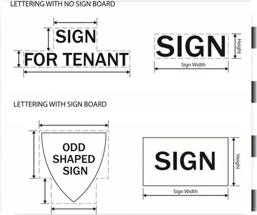
(Code 1989, § 17.30(5)(a)(6))
Sec. 44-184. - Street frontage.
Street frontage is defined as a side of the property that faces a public street. Corner lots have two street frontages.
(Code 1989, § 17.30(5)(a)(7))
Sec. 44-185. - Permanent signs.
A sign permit is required for all permanent signs in the downtown zoning district. A total number of signs per property are regulated. See sign size and location table for dimension requirements.
(1)
Total permanent signs allowed per property:
(2)
Permanent sign types, size (per face) and location requirements.
(Code 1989, § 17.30(5)(b))
Sec. 44-186. - Temporary signs.
A sign permit is required for all temporary signs in the downtown zoning district. See sign size and location table for dimension requirements.
(1)
Total temporary signs allowed per property:
(2)
Temporary sign types, size, and location requirements.
(Code 1989, § 17.30(5)(c))
Sec. 44-187. - Signs not requiring a permit.
A sign permit is not required for the signs listed in this section. See sign size and location table for dimension requirements.
(1)
Total signs allowed per property:
| Sign Type | Number of Signs Allowed in Downtown District |
|---|---|
| Signs not requiring a permit | |
| Construction sign | Only during the duration of work; must be removed within 5 calendar days of work ending |
| Government sign | As needed |
| Political sign | See Wis. Stats. § 12.04 |
| Real estate | 1 per property |
| Yard sign | 1 per property |
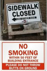
| Warning signs | As needed |
 | |
| Window signs |
May not exceed 25 percent of window area of a street
frontage |
 | |
(2)
Size requirements for signs not requiring a permit.
(Code 1989, § 17.30(5)(d)(1))
Sec. 44-188. - Prohibited signs.
The following signs are expressly prohibited in the downtown zoning district, unless otherwise stated in these regulations:
(1)
Abandoned sign. Any sign that is not well maintained for a consecutive 120 calendar day period or that is not fully supported by the structure designed to support the sign for a consecutive 120 calendar day period.
(2)
Absence of permit. Any sign requiring a permit for which a permit has not been issued.
(3)
Air-activated/inflatable signs. Any sign that uses air to maintain that sign or cause movement of the sign.
(4)
Billboards. A sign that directs attention to a business, commodity, service, or entertainment conducted, sold or offered at a location other than the premises on which the sign is located.
(5)
Electronic message center. A sign with a fixed or changing display/message composed of a series of lights that may be changed through electronic means.
(6)
Interference. No sign may be erected that, by reason of position, shape or color, would interfere in any way with the proper functioning or purpose of a traffic sign or signal.
(7)
Lighting. Use of revolving beacons, beamed lights or similar devices that would so distract automobile traffic as to constitute a safety hazard.
(8)
Near street intersections. There shall be no flashing or revolving sign in the front setback area or within 125 feet of a street intersection. No flashing or revolving signs are permitted in windows.
(9)
Non-professional signs. No sign shall be hand painted in a non-professional or "amateur" manner.
(10)
Parked vehicle. Any sign on a motor vehicle, trailer, farm implement or other mobile equipment, which is parked in a position visible to traffic on a public road for a period longer than six days in a 60-calendar-day period.
(11)
Safety hazards. Any sign that, because of its location, animation or other action, is deemed to jeopardize public safety.
(12)
Simulated emergency signs. Any sign that is similar to or attempts to replicate police, fire or other emergency services.
(13)
Simulated traffic signs. Any sign that is similar to or attempts to replicate traffic signs.
(Code 1989, § 17.30(5)(d)(2))
Sec. 44-189. - Permit procedure.
(a)
Except as otherwise provided in this chapter, no signs shall hereafter be located, erected, moved, reconstructed, extended, enlarged, converted, or structurally altered without a sign permit, and without being in conformity with the provisions of this chapter. The sign shall also meet all other structural requirements of other applicable codes and ordinances of the village.
(b)
Any person desiring to place, erect, alter or relocate a sign, except an exempt sign, shall make application to the building inspector and shall provide in writing the following information:
(1)
The name, address, and telephone number of the applicant.
(2)
The name, address, and telephone number of the owner of the premises upon which the sign is to be attached or erected.
(3)
The street number and street name or parcel number of the land upon which the sign is to be attached or erected.
(4)
A clear and legible scale drawing of the proposed sign and a map of the lot or parcel of land on which it is to be erected, showing the intended location on the site.
(5)
The basic materials to be used in the construction of the sign.
(6)
The name, address, and telephone number of the owner/user of the sign if he is neither the applicant nor the owner of the premises on which the sign is to be attached or erected.
(7)
A description of all electrical equipment if the sign is to be lighted or illuminated.
(8)
If work is to be performed by a professional contractor, the name, address and telephone number of such contractor and a certificate giving proof of adequate insurance held by the contractor.
(9)
Such other information as the building inspector may require in order to indicate compliance with this chapter and all other ordinances of the village.
(c)
If the sign permit is denied by the building inspector, he shall give written notice of the denial to the applicant, together with a brief statement of the reasons for denial. Such notice shall be within ten working days of the application.
(Code 1989, § 17.30(5)(e))
Sec. 44-190. - Existing signs.
All signs permanently erected, put up, installed, or constructed prior to August 2, 2018, which were in compliance with the regulations in effect immediately prior to that time and which are not in compliance with the provisions of these regulations shall be deemed a legal nonconforming sign. A legal nonconforming sign may remain in place until such a time as it is:
(1)
Removed or structurally changed;
(2)
Damaged to the extent of more than 50 percent of its replacement value at the time of the damage;
(3)
In a state of disrepair or is a hazard as determined by the building inspector.
In the event of any of the conditions listed in this section, the sign shall be removed or replaced with a sign conforming with these regulations.
(Code 1989, § 17.30(5)(f))

