
Island County Unincorporated
City Zoning Code
City Zoning Code
CHAPTER 17
03 - Island County Zoning Code
Appendices[3]
Note— Copies of appendices "B" and "C," together with the zoning atlas, may be obtained from the Island County Planning Department.
17.03.010 - Authority.
This chapter shall be known as the Island County Zoning Code and is hereby adopted under the authority of Chapters 36.70, 36.70A, 36.70B, 36.70C, 39.34, 43.21C, 58.17, 76.09, 84.33, and 84.34 [RCW].
(Ord. C-123-98 [PLG-037-98], September 29, 1998, vol. 43, p. 6; accepted by Res. C-133-98 [PLG-043-98], October 19, 1998, vol. 43, p. 38)
17.03.020 - Purpose.
The purpose of the Island County Zoning Code is to divide the county into land use zones with standards within each zone for the use of Island County's land resources which will:
A.
Implement the comprehensive plan of Island County;
B.
Achieve better use of Island County's land resources;
C.
Provide for the orderly planned use of Island County's land resources and contain urban growth within urban growth areas;
D.
Permit developments which will provide a desirable and stable economic environment consistent with the rural character of Island County;
E.
Permit flexibility that will encourage a more creative approach in the development of land, while ensuring the retention and use of the county's open spaces, farm and forest lands;
F.
Ensure that the provision of public facilities and services to support allowed uses and densities is planned in an orderly and predictable manner;
G.
Protect the public health, safety and general welfare of the residents of Island County;
H.
Provide incentives to land owners who wish to protect and preserve certain identified lands;
I.
Protect the fundamental and inalienable right of the residents of Island County to a healthy environment and the reasonable use of their property;
J.
Provide a means for every resident of Island County to participate fairly and equitably in the land use decision making process and contribute to the preservation and enhancement of the environment;
K.
Encourage in-fill of undeveloped residential lands consistent with limits imposed by ecological constraints;
L.
Provide opportunities and incentives to help both large and small farm and forest land owners to continue their farm or forest operations;
M.
Provide both employment and housing opportunities so that county residents can both live and work in the county;
N.
Designate logical outer boundaries and contain existing areas of more intensive rural development;
O.
Permit a broad range of development design opportunities with flexibility to encourage more creativity in balancing the needs of environmental protection with the accommodation of future growth;
P.
Provide for timely and predictable regulatory review processes which are proportional in scale, time and cost, to the scope and scale and costs of proposed development actions;
Q.
Provide predictability so that landowners can make appropriate and reasonable use of their land;
R.
Protect the county's environmental resources; and
S.
Ensure that archaeological resources are protected as required by state statutes, the county's comprehensive plan and the implementation of development regulations.
(Ord. C-123-98 [PLG-037-98], September 29, 1998, vol. 43, p. 6; accepted by Res. C-133-98 [PLG-043-98], October 19, 1998, vol. 43, p. 38)
17.03.030 - User guide.
A.
Three (3) different sections of the Zoning Code need to be consulted to understand what land use activity can be conducted in the county.
1.
Turn to the applicable zone classification. You will find both permitted and conditional uses. For properties within the Freeland NMUGA, refer to chapter 17.06 for permitted and conditional uses.
2.
Once you have located your intended use, check the definition section for the definition of special terms, section 17.03.040.
3.
Check to see if special conditions or land use standards are applicable to the use. You will find these standards in the land use standards section 17.03.180. For properties within the Freeland NMUGA, refer to the standards in sections 17.06.300—17.06.350.
a.
If you find no special standards for a listed use, then none are expressly required by this Zoning Code.
b.
Though not typically used, site specific conditions may be imposed to address impacts of a proposal.
c.
Other chapters of title 17 may also require compliance.
(i)
Chapter 17.02B, critical areas, and chapter 17.05 shoreline use regulations, may impose special standards and in some cases limit uses otherwise allowed by the Zoning Code. For example, chapter 17.05 provides for and establishes standards for some specific shoreline uses.
(ii)
Other titles of the Island County Code may also need to be consulted as well, such as Health (title 8), Land development standards (title 11), Public works (title 13), Buildings and construction (title 14) and Planning and subdivisions (title 16).
B.
A user may wish to consult the Island County Comprehensive Plan and the Freeland Subarea Plan to understand the applicable goals and policies. Under state law, the Zoning Code must be consistent with, and implement the comprehensive plan. Therefore, if a conflict between the plan and the Zoning Code arises, the plan will control. Any other conflict will be resolved by applying the more stringent Code standard.
C.
Three (3) summary charts are included in this chapter listing uses covered expressly by the Zoning Code: section 17.03.035A, Agricultural and forest uses; section 17.03.035B, Rural uses; and section 17.03.035C, Rural non-residential uses. Do not assume, because a use is not listed that it is prohibited. Through Code interpretation, section 17.03.190, the Planning Director is authorized to determine the appropriate classification for uses not listed expressly in the Zoning Code.
(Ord. C-123-98 [PLG-037-98], September 29, 1998, vol. 43, p. 6; accepted by Res. C-133-98 [PLG-043-98], October 19, 1998, vol. 43, p. 38; amended by Ord. C-136-98 [PLG-042-98], November 9, 1998, vol. 43, p. 65; amended by Ord. C-63-99 (CD-01-99), June 21, 1999, vol. 43, p. 338)
(Ord. No. C-75-14 [PLG-006-14], Exh. E, 9-22-2014; Ord. No. C-86-17 [PLG-009-17], Exh. A, 8-15-2017; Ord. No. C-49-19 [PLG-004-19], Exh. D, 6-18-2019; Ord. No. C-35-25 [PLG-005-25], Exh. A, 7-8-2025)
Editor's note— This section, as originally adopted, included a statement that capitalized words and phrases used to identify terms defined in this or other chapters. Because the capitalization convention was applied inconsistently throughout the Island County Code, and to be consistent with the conventions used by other state and local codes, defined terms are no longer capitalized in this Code. This change was authorized on February 26, 2015, pursuant to section 1.04.030.
17.03.035 - Use tables.
A.
How to use these tables. These tables are intended to assist you in identifying allowable uses within the zoning districts of Island County. These tables will also provide applicable information about permit types, land use decision types, and conditions and limitations for specific land uses at various levels of intensity. Table Components include:
• Permit Types, Conditional Uses, and Prohibited Uses
• Decision Types
• Footnotes and References
• APZ Allowed Uses
1.
Permit Types: This section represents all prescriptive uses allowed in one (1) or more zoning districts that have been adopted into the Island County Zoning Code. Each table will have a list of uses that intersect with each zoning district, outlining whether the use is permitted, requiring a type one (1) review process or conditional, requiring a Type II or Type III review process. You will notice that some uses are both permitted and conditional and still other uses are listed as both a Type II and a Type III decision. This means that land use standards other than zoning will dictate if and how the use may be established. For definitions see section 17.03.040.
2.
Permitted Uses (P/I): Uses labeled as "P/I" are reviewed as a Type I Ministerial decision pursuant to chapter 16.19.
3.
Conditional Uses (C/II or C/III): Uses labeled as "C/II or C/III" require a site plan approval pursuant to chapter 16.15 and are required to be processed as an Administrative (Type II) or Quasi-Judicial (Type III) decision pursuant to chapter 16.19. The land use standards that may govern the siting of the specific use which is found in section 17.03.180.
4.
Prohibited Uses (x): Uses expressly prohibited by this chapter are depicted with an "x". Urban Growth Areas: Expressly prohibited uses are not shown in the use table. These uses will remain listed within each the specific zoning district.
5.
Decision Types: In the consolidated tables, each permit type will have an associated decision type. The decision type refers to the type of review process required for a specific use. A detailed description of the land use decision process can be found in chapter 16.19.
I = Type I permitted use—Ministerial decision.
II = Type II conditional use—Administrative decision.
III = Type III conditional use—Hearing Examiner decision.
IV = Type IV conditional use—Requires Board of County Commissioners approval.
6.
Footnotes and References: Each table has related Footnotes and References. These identify or reference any additional standards or conditions associated with a specific use. Standards can be limitations and/or thresholds that trigger requirements for higher levels of review. Conditions outline criteria that must be met in order for a specific use to be allowed in a certain zoning district.
a.
Footnote: The table footnotes state any additional standard or condition for a particular use that is not found in any other section or chapter of this code. The number of a footnote will always correspond with a number in the table.
b.
Reference: The reference column show relevant sections of code that contain additional standards or conditions for the use. The references will cite specific sections related to a specific use. These sections may outline limitations, threshold triggers for higher levels of review, and/or other additional criteria associated with the use.
7.
Aircraft Accident Potential Zone (APZ): A section of each table is dedicated to uses allowed within the Accident Potential Zone (APZ). Within the APZ section there are three (3) separate zones: Clear Zone, APZ I, and APZ II. Within the consolidated land use tables each APZ zone will intersect with each of the listed uses showing if the use is allowed, not allowed or unlisted.
a.
Allowed Uses: A use that is allowed in a specific section of the APZ will show a "Yes" at the intersection point of the use and the zone.
b.
Not Allowed Uses: A use that is not allowed within a specific section of the APZ will show a "No" at the intersection of the use and the zone.
c.
UGA APZ: The APZ table for the Urban Growth Area was not consolidated into the comprehensive use table, and can be found in the APZ land use standards (section 17.03.180.Z.2).
8.
Unlisted Uses:
a.
All uses not explicitly allowed or explicitly prohibited will be considered an unlisted use. All unlisted uses should be classified into an allowed or not allowed use through a code interpretation pursuant to section 17.03.190.
b.
APZ: Any use that has an asterisk under the APZ section is considered unlisted. These uses were not identified or considered at the time the Accident Potential Zone was adopted into Island County Code. Unlisted uses shall follow the zoning code interpretation process (section 17.03.190) with consideration of the most recent AICUZ Study Update for Naval Air Station Whidbey Island's Ault Field and Outlying Landing Field Coupeville.
B.
Rural Lands Use Table. Uses in the Rural (R), Rural Agriculture (RA), Rural Forest (RF), Commercial Agriculture (CA), and Parks (PK) zoning districts shall be as shown in Table 17.03.035.B.
C.
Rural Areas of More Intensive Development (RAID) Use Table. Uses in the RAID zoning districts - Rural Residential (RR), Rural Center (RC), Rural Village (RV), Rural Service (RS), Camano Gateway Village (CGV), Airport (AP), and Light Manufacturing (LM) - shall be as shown in Table 17.03.035.C.
Editor's note— Ord. No. C-18-22, as adopted on May 3, 2022, included clerical and numbering errors in Table 17.03.035.C - RAID Uses. The list of Table Notes in the last row of the RAID Uses Table had been renumbered in Ord. No. C-18-22 because Note 5 was stricken and Notes 6 - 21 were renumbered. The corresponding references to those Table Notes in the operative cells in the RAID Uses Table were erroneously not renumbered. The Code Reviser, pursuant to authority granted in ICC 1.04.030, has renumbered the references in the cells of the table to correspond to the appropriate and intended Table Notes.
D.
Municipal Urban Growth Areas Use Table. Uses for properties in the Oak Harbor and Langley Urban Growth Areas, but not incorporated into the city limits, shall be as shown in Table 17.03.035.D; properties in the Oak Harbor Residential (OH-R), Oak Harbor Industrial (OH-I), Oak Harbor Highway Service Commercial (OH-HSC), Oak Harbor Planned Business Park (OH-PBP), Oak Harbor Planned Industrial Park (OH-PIP), and UGA Langley (UGA-L) zoning districts For uses inside the Freeland Non-Municipal Urban Growth Area, see chapter 17.06.
(Ord. No. C-53-19 [PLG-005-19], Exh. A, 6-25-2019; Ord. No. C-93-19 [PLG-011-19], Exh. A, 10-8-2019; Ord. No. C-18-22 [PLG-002-21], Exh. A, 5-3-2022; Ord. No. C-79-23 [PLG-003-23], Exh. A, 11-28-2023; Ord. No. C-35-25, [PLG-005-25], Exh. A, 7-8-2025)
Editor's note— Ord. No. C-53-19 [PLG-005-19], Exh. A, adopted June 25, 2019, enacted new provisions to read as herein set out and repealed former §§ 17.03.035A—17.03.035E, which pertained to permitted and conditional uses in the Rural Agriculture and Commercial Agriculture Zones; Rural Forest Zone; Rural Residential Zone; Rural Zone; Rural Center, Rural Village and Rural Service Zone. See the Code Comparative Table for a complete derivation.
17.03.040 - Definitions.
Unless expressly noted otherwise, words and phrases that appear in this chapter shall be given the meaning attributed to them by this section, other chapters of title 17, or chapters contained in title 16. When not inconsistent with the context, words used in the present tense shall include the future; the singular shall include the plural and the plural the singular; the word "shall" is always mandatory and the words "may" and "should" indicate a use of discretion in making a decision. Unless otherwise noted, the words and phrases defined in this section shall apply, unless a more specific definition is provided in another title or chapter of Island County Code.
Accessory dwelling unit (ADU), attached means separate living quarters contained within the primary residence which include provisions for sleeping, cooking (including an oven, range, or stovetop), and sanitation. An attached ADU is subject to the requirements and conditions provided in section 17.03.180.
Accessory dwelling unit (ADU), Detached means a dwelling unit, situated on the same parcel as a single family dwelling, shares a common access point with the single family dwelling and which cannot be segregated or separately sold, transferred, given, or otherwise conveyed unless the lot is of sufficient size to meet base density and other County Code requirements. Detached ADUs do not include recreational vehicles, travel trailers, park model homes, or tiny homes on wheels. A detached ADU is subject to the requirements and conditions provided in section 17.03.180
Accessory use or building means a use, structure or building customarily considered to be incidental to or secondary to a permitted use or an approved conditional use on the property or on adjacent properties under the same ownership. Examples of accessory buildings or structures include, but are not limited to, sheds, shops, garages, greenhouses, barns, detached ADU's, etc. Examples of accessory uses include home occupation and bed and breakfast room in the Rural Zone and office and food service in the Light Manufacturing Zone.
Adjacent property means properties which share all or part of a common lot line.
Adult family home means a regular family abode of a person or persons who are providing personal care, room, and board to more than one (1) but not more than four (4) adults who are not related by blood or marriage to the person or persons providing the services; except that a maximum of six (6) adults may be permitted if DSHS determines that the home is of adequate size and the home and the provider are capable of meeting standards and qualifications set forth in chapter 18.22 Langley Municipal Code.
Affordability covenant means a recorded legal restriction that runs with the land and imposes a limitation on rental or sale of a dwelling unit which has been used by an owner to secure the approval of bonus density for affordable housing.
Affordable housing means attached or detached dwelling units committed by recorded affordability covenant to allow renters or owners with a median income less than eighty (80) percent of Island County median income, as established by the U.S. Census, to spend no more than thirty (30) percent of gross income on housing costs.
Aggrieved person means a qualified person who uses the county's administrative appeal process to appeal a decision of the county, pursuant to chapter 16.19.
Agricultural/farm use means the current use of land for the primary purpose of raising, harvesting and/or selling crops or the feeding, breeding, management and/or sale of, or the production of, livestock, poultry, fish, fur-bearing animals or honeybees or for dairying and/or the sale of dairy products or any other agricultural or horticultural use or animal husbandry or any combination thereof. Farm use includes the preparation and storage of the products raised on such land for human use and animal use and disposal by marketing or otherwise. Farm use also includes the growing and selling of ornamental shrubs, Christmas trees and similar nursery stock.
Agricultural processing means a facility located on a farm unit for the processing of farm crops grown in Island County. The building established for the processing facility shall not exceed:
a.
In the Commercial Agriculture Zone—40,000 square feet of floor area exclusive of the floor area designated for preparation, storage or other farm use or devote more than 40,000 square feet to the processing activities within another building supporting farm uses; or
b.
In the Rural Agriculture Zone—5,000 square feet of floor area exclusive of the floor area designated for preparation, storage or other farm use or devote more than 5,000 square feet to the processing activities within another building supporting farm uses.
A commercial activity in conjunction with farm use includes, but is not limited to, processing facilities which convert harvested agricultural crops from their natural state into new products, i.e., drying, freezing, canning, crushing, barreling, fermenting, distilling etc. In addition, the preparation and storage of a product which includes significant amounts of agricultural crops not raised by the operator of the storage facility shall also be considered an agricultural processing facility.
Agricultural Zone, Commercial means the zoning classification applied to certain designated lands of long term commercial significance in order to protect and encourage their long term productive use.
Agriculture Zone, Rural means the zoning classification applied to certain designated lands of local importance in order to protect and encourage their long term productive use.
Aircraft Accident Potential Zone (APZ) means areas based on historical accident and operations data throughout the military and the application of margins of safety within those areas if an accident were to occur.
There are three (3) types of Accident Potential Zones:
a.
Clear Zone. The trapezoidal area lying immediately beyond the end of the runway and outward along the extended runway centerline for a distance of 3,000 feet. For U.S. Navy and Marine Corps installations, the dimensions are 1,500 feet wide at the runway threshold and 2,284 feet wide at the outer edge;
b.
APZ-I. The rectangular area beyond the Clear Zone, which has a measurable potential for aircraft accidents relative to the Clear Zone. APZ-I is typically 3,000 feet wide by 5,000 feet long and may be rectangular or curved to conform to the shape of the predominant flight track; and
c.
APZ-II. The rectangular area beyond APZ-I, which has a measurable potential for aircraft accidents relative to APZ-I or the Clear Zone. The dimensions of APZ-II are typically 3,000 feet wide by 7,000 feet long, and, like APZ-I, may be curved to correspond with the predominant flight track. In following the predominant flight, of takeoff and landing, its area connects APZ-I to APZ-I to make a full "race track" pattern or "loop."
Aircraft Approach and Departure Zone. (Reserved.)
Aircraft Noise Impact Zone. (Reserved.)
Airport means commercial and military air fields and aircraft support facilities. Does not include ultra-light landing strips, heliports or seaplane landing sites.
Airport facilities means the runway(s), control tower, administrative offices, waiting rooms and other facilities normally associated with an airport.
Airport support facilities means the covered areas and enclosed structures used for housing, sale and repair of aircraft; freight movement facilities; flight training schools; restaurants serving air passengers; car rental facilities and accessory uses normally associated with an airport.
Airport Zone means the zoning classification applied to non-military airports, existing as of July 1, 1990 and defined by logical outer boundaries.
Alley means any way or thoroughfare shown on the face of a recorded subdivision which provides alternate access to a lot.
Alteration, boundary line means any change to the boundaries of lots within a recorded final short plat or final plat which does not qualify as a boundary line adjustment, lot combination, boundary line correction, withdrawal or vacation; any change in easements or areas dedicated to the public; or, any change in conditions of approval of such a plat.
Alteration of a critical area means as defined in chapter 17.02B, as such chapters may be amended.
Animal shelter means a facility which is operated to shelter, rescue, and find homes for homeless animals and to educate the community on humane and responsible animal care.
Applicant means any person who files an application subject to review under titles 16 or 17 who is either the person(s) identified in the assessor's records as the owner of the property on which the proposed activity would be located or the authorized agent of such person.
Application means the information required to complete the review of a land use permit.
Archaeological object means an object that comprises the physical evidence of an indigenous culture including material remains of past human life including monuments, symbols, tools, facilities and technological by-products.
Archaeological resources means any material remains of human life or activities which are of archaeological interest, including all sites, objects, structures, artifacts, implements, and locations of prehistorical or archaeological interest, including, but not limited to, those pertaining to prehistoric and historic American Indian or aboriginal burials, campsites, dwellings, and habitation sites, including rock shelters and caves, their artifacts and implements of culture such as projectile points, arrowheads, skeletal remains, grave goods, basketry, pestles, mauls and grinding stones, knives, scrapers, rock carvings and paintings, and other implements and artifacts of any material.
Archaeological site means a geographic locality in Washington, including, but not limited to, submerged and submersible lands and the bed of the sea within the state jurisdiction, that contains archaeological objects.
Area-wide rezone means the rezoning of lots under separate ownership or non-contiguous lots.
Art studio means establishment for the preparation, display, and sale of artwork, jewelry, furniture, sculpture, pottery, and related items or the practice, instruction, or performance of the fine arts such as, but not limited to, vocal or instrumental music, dance, or writing.
Articulation means an emphasis of architectural elements (like windows, balconies, entries, etc.) that create a complementary pattern or rhythm, dividing large buildings into smaller identifiable pieces. See section 17.06.330.C.1 for articulation standards within the Freeland NMUGA.
Articulation interval means the measure of articulation; the distance before architectural elements repeat. See section 17.06.330.C.1 for articulation standards within the Freeland NMUGA.
Artifact means a usually simple object showing human workmanship or modification, including, but not limited to, a tool, ornament, and by-products of tool-making.
Artisan workshop means an establishment for the creation of individually crafted artwork, jewelry, furniture, sculpture, pottery, and related items. Includes limited small-scale light manufacturing such as stone work or welding for sculpture, furnaces for glass blowing, kilns for pottery, or similar activities and the related storage of necessary raw materials. May include an art studio use within the workshop.
Attached describes dwelling units that share a common roof or are joined by a common roof.
Average tree height means typical height of the existing tree skyline within a one hundred fifty-foot radius of the facility site. The height of trees used to screen the tower and not all trees within the one hundred fifty-foot radius are the trees to be considered.
Base density means the maximum number of dwelling units other than ADUs permitted outright by a particular land use classification.
Bed and breakfast inn means overnight tourist lodging facilities providing sleeping accommodations in not more than six (6) guest rooms.
Bed and breakfast room means overnight tourist lodging facilities functioning as an accessory use to a detached single family dwelling unit providing sleeping accommodations in not more than two (2) guest rooms or one (1) attached or detached ADU.
Block means a group of lots, tracts, or parcels within well-defined and fixed boundaries.
Board means the Board of Island County Commissioners.
Boundary line adjustment means the adjustment of boundary lines between platted or unplatted lots or both, which creates no additional lot, or which creates no additional lot that contains insufficient area and dimension to meet minimum requirements for width and area for a building site. The combination of two (2) or more lots where no public dedication is modified, is a lot combination and is not a boundary line adjustment.
Box sign means a sign enclosed by a case with internal illumination and plastic facing. The plastic facing shall utilize a solid dark colored background with light colored lettering.
Brewery means an establishment where beer and/or malt liquor are manufactured or licensed under RCW 66.24.240 (domestic brewery) or RCW 66.24.244 (microbrewery) by the State of Washington.
Buffer means a separation designed to absorb potential conflicts between differing land uses, or to protect critical areas or significant natural features. Generally, buffers shall be left in a natural state, or, if necessary, may be supplemented by landscaping and are used so that structures, uses and roads, when site conditions permit, are screened from adjacent properties or public or private roads external to the lot or parcel.
Building means any structure used or intended for supporting or sheltering any use or occupancy (UBC definition).
Build-to line refers to the location of the building façade on a lot, running parallel to the front property line without further setback. The line at which the building frontage must sit.
Build-to percentage means the percentage of the building façade/frontage that must be built at the build-to line.
Bungalow court means a building type with a grouping of three (3) or more detached buildings arranged to share a courtyard with pedestrian access to the buildings from the courtyard and fronting street(s). The courtyard is intended to be an outdoor room that can be seen from the public realm. Each building may accommodate up to four (4) dwellings or non-residential uses in either a live-work configuration or as solely commercial/retail space facing the primary street, as allowed by the zone.
Camping means erecting a tent or shelter or arranging bedding or other for the purpose of, or in such a way as will permit remaining overnight, or parking a trailer, camper, or other vehicle for the purpose of remaining overnight.
Centerline of roadway means the centerline of the road or street is the as-built center of a road or street.
Certificate of title means a certificate from a title company identifying the record owner(s) of property and any person or entity having a legal interest in the property.
Channel lighting means a sign where each letter is an individual sign and each letter is internally illuminated.
Character means the special physical characteristics of a structure or area that set it apart from its surroundings and contributes to its individuality. The image and perception of a community as defined by its built environment, streetscapes, landscaping, natural features and open spaces, and types and size of housing and how those elements relate to the public realm.
Church or building of worship means a building or buildings intended for religious worship including ancillary activity and improvements such as religious education, assembly rooms, kitchen, reading room, recreation hall and may include a residence for church staff. This definition does not include schools devoted primarily to nonreligious education.
Cidery means an establishment licensed under RCW 66.24.170 by the State of Washington to manufacture or produce cider. Such facilities may include additional product-related uses such as orchards, cellars or similar product-storage areas, tasting rooms, and sales as authorized by state law, and sales of merchandise related to products available for tours and tastings.
Cidery, rural means a cidery permitted in the rural area in accordance with section 17.03.180.DD.1.
Clusters or cluster design means a development design technique that concentrates buildings in specific areas on a site to allow the remaining land to be used for open space including community area.
Co-location means the use of a single support structure by more than one (1) wireless service provider where appropriate, and/or placement of up to two (2) support structures for co-location on a specific site. This may include shared facilities with ICOM or public safety emergency communication equipment.
Commercial means a business use or activity involving retail or wholesale marketing of goods and services. Examples of commercial uses include offices and retail shops.
Communication, small cell means a wireless communication antenna that is three (3) cubic feet or less space with associated equipment of twenty-eight (28) cubic feet or less. Small cell structures are defined by FCC rule 1.1312(e)(2) as it exists or is amended (at publication of this ordinance, defined as fifty (50) feet or less in height and no more than ten (10) percent higher than its existing height or that of adjacent structures). [Note: Small cell is also commonly referred to as 5G wireless technology.]
Communication tower means any structure designed and constructed primarily for the purpose of supporting one (1) or more antennas, including self-supporting lattice towers, guy towers, or mono-pole towers. The term encompasses personal wireless service facilities including radio and television transmission towers, microwave towers, common-carrier towers, cellular telephone towers or personal communications services towers.
Community area means the area set aside for use by all residents of a subdivision or PRD including clubhouses, recreational facilities, common storage areas, well sites and sanitary facilities.
Compatible means to exist harmoniously together; in agreement; congruous.
Composting means the biological degradation and transformation of organic solid waste under controlled conditions designed to promote decomposition. Natural decay of organic solid waste under uncontrolled conditions is not composting.
Composting facility means a facility or site that treats solid waste by composting.
Concealment technology means the use of both existing and future technology through which a wireless communication facility (WCF) is designed to resemble an object that is not a WCF and which is typically present in the environment.
Conditional use means a use or structure that may be allowed in a zone, but because it may have significant impacts on permitted uses is subject to review for compatibility with existing and anticipated future permitted uses and compliance with the standards of this chapter and any other applicable provisions. All conditional uses require approval of a site plan pursuant to chapter 16.15 and are discretionary decisions classified as administrative (Type II) or quasi-judicial (Type III) under chapter 16.19.
Conservation easement means the recorded legal document, voluntarily executed by a property owner, that limits or restricts the use of a portion of a property and is binding on successive owners of the property.
Contiguous means land adjoining and touching other property including lands separated from each other by private road or private right-of-way.
Cottage housing means a multi-family housing style with one (1) or more clusters of small housing units arranged in and around a common open space. Units are typically detached, but may have two (2) attached units.
Country inn means overnight tourist lodging facilities providing sleeping accommodations in a rural area, with not more than forty (40) guest rooms. Related ancillary uses may include restaurant and conference facilities for up to seventy-five (75) participants.
Courtyard apartment or courtyard building means a structure where the building is designed to give the appearance of a large house comprised of attached units arranged to share one (1) or more courtyards, where the building will typically be built to the outermost allowed boundaries (minimum setback or at the build-to line) with internally defined courtyards. Pedestrian access to the building's entrances is from the courtyard and/or fronting street(s). The courtyard is intended to be an outdoor room that can be seen from the adjacent public realm. Courtyard buildings may accommodate multi-family and/or non-residential uses in either a live-work configuration or as solely commercial/retail space facing the primary street, as allowed by the zoning district.
Covered open air walkways means a roofed open passage that provides pedestrian connection between individual structures, which may include features such as pillars, posts and railings, but shall not contain walls, with the exception of primarily transparent walls for weather protection (e.g., glass or plexi-glass).
Cultural center means cultural centers include but are not limited to art galleries, archeological center, libraries, museums, musical and live theater.
Cutoff light fixture means an outdoor light fixture shielded in such a manner that all 100 percent light emitted by the fixture, either directly from the lamp or indirectly from the fixture, is projected below the horizontal plane ninety (90) degrees.
Day care means a facility maintained under public or private auspices and licensed by the state for the purpose of providing care, assistance and/or training for persons (children or adults) not related to the caregiver. The care is provided for less than twenty-four (24) hours during one (1) day.
Day care center means care provided for more than twelve (12) persons.
Day care center (small) means family-home care provided for seven (7) to twelve (12) persons not related to the caregiver.
Day care nursery means family-home care provided for up to six (6) persons not related to the caregiver. A day care nursery is considered to be a home occupation and must meet the standards for home occupation.
Dedication means the deliberate appropriation of land by an owner for any general and public uses, reserving to himself no other rights than such as are compatible with the full exercise and enjoyment of the public uses to which the property has been devoted. Acceptance of a dedication by the county is evidenced by the recording of a final plat or short plat.
Distillery means an establishment licensed under RCW 66.24.140 (distillery) and RCW 66.24.145 (craft distillery) in accordance with standards set forth in Title 66 RCW. Such facilities may include additional product-related uses such as orchards, cellars or similar product-storage areas, tasting rooms, and sales as authorized by state law, and sales of merchandise related to products available for tours and tastings.
Distillery, rural means a distillery permitted in the rural area in accordance with section 17.03.180.DD.1.
Duplex means a dwelling unit designed exclusively for occupancy by two (2) families living independently of each other, doing their own cooking, and containing two (2) dwelling units. Such dwelling units have a common roof or the dwelling units are joined by a common roof. A single family dwelling unit with an attached guest cottage is not considered a duplex.
Dwelling unit means any building, or portion thereof which contains living facilities for not more than one (1) family. Living facilities include provisions for sleeping, cooking, and sanitation, as required by Island County. Dwelling unit includes site built homes, mobile/manufactured homes, modular homes, duplexes, triplexes and fourplexes. Recreational vehicles are not dwelling units.
Earned development unit means the dwelling unit or fraction thereof that is granted a farm or forest owner after approval by the board of a farm or forest management plan.
Eating and drinking establishment means a retail sales and service use in which food and/or beverages are prepared and sold at retail for immediate consumption, either inside or outside the structure and on or off the lot containing the establishment.
Emergency service communications means any Sheriff, fire, emergency, and/or medical wireless communication of radio frequency (RF) signals through electromagnetic energy.
Entertainment uses means a commercial use in which recreational, athletic, and/or cultural opportunities are provided for the general public, either as participants or spectators. Examples include, but are not limited to, theaters, live music, dancing, lecture halls, and indoor or outdoor sports and games.
Equestrian center means uncovered and covered facilities operated either as a farm use or a commercial boarding, training, teaching, breeding and rental of horses including facilities for shows and competitive events.
Essential public facilities means those facilities that provide a service to the public and are required to support basic social needs in the community, region and state and to implement the comprehensive plan but are typically difficult to site because they may require an extremely large amount of acreage, and additionally may have aesthetic issues that may not meet standards for rural character; and may create exceptionally high impacts from the amounts and type of transportation, excessive noise, odor, lighting and glare, and may involve unusually high security measures. Essential public facilities include, but are not limited to airports, military installations, state educational facilities, state or regional transportation facilities, state and local correctional facilities, solid waste-handling facilities, and large in-patient facilities including substance-abuse facilities, mental health facilities, group homes, septage collection and treatment, public school facilities, and sewage treatment facilities. Throughput transmission facilities, major utilities, and communication towers are not essential public facilities. Essential public facilities fall into the two (2) following classifications:
a.
Class A facilities. These facilities serve a large region or the state and generally must locate in the rural area because they require extremely large sites and must be located away from centers of population due to their associated impacts and required security measures. They will likely have major impacts on the site and surrounding area due to changes to the natural landscape and vegetation at the time of site development and from the associated size of the use, and levels of traffic, noise, odors, lighting, and other factors during operation. These facilities include, but are not limited to regional transportation facilities, such as regional airports, state correction facilities, and state educational facilities.
b.
Class B facilities. These facilities serve the county, a small region, or a neighborhood and generally need to be located near the populations they serve. These facilities include but are not limited to solid waste-handling facilities, septage collection and treatment, public school facilities, sewage treatment facilities, group homes, including assisted living facilities, and large inpatient facilities (e.g., substance abuse facilities, and mental health facilities).
Event means an organized gathering or series of gatherings, held indoors or outdoors, on public property or private property that is open to the public, or limited to invited guests. Events may be either incidental to the primary use of the property or may be the primary use permitted in accordance with this section.
Existing means unless otherwise expressly stated, existing or vested on the effective date of this chapter, December 1, 1998.
Existing building means a structure, or portion thereof, which meets the definition of existing and was lawfully erected and maintained including those which, because of the enactment of this chapter, no longer conforms to the land use standards or use regulations of the zone in which it is located.
Existing lot means a lot or parcel of land which meets the definition of existing and was also of record and lawfully established and maintained including those which, because of the enactment of this chapter, no longer conforms to the land use standards or use regulations of the zone in which it is located.
Existing master planned resort means a resort that was in existence on July 1, 1990 and that met the definition of an existing master planned resort at that time. The resort is developed, in whole or in part, as a significantly self contained and integrated development that includes short-term visitor accommodations associated with a range of indoor and outdoor recreational facilities within the property boundaries in a setting of significant natural amenities. An existing resort may include other permanent residential uses, conference facilities, and commercial activities supporting the resort, but only if these uses are integrated into and consistent with the on-site recreational nature of the resort.
Existing use means a use which meets the definition of existing and was lawfully established and maintained including those which, because of the enactment of this chapter, no longer conforms to the land use standards or use regulations of the zone in which it is located.
External lot means a lot to which an access easement is attached.
Façade means the exterior wall of a building that is set along a frontage line. It consists of the entire building front or street wall face of a building extending from the grade of the building to the top of the parapet or eaves and the entire width of the building elevation.
Facilities providing personal wireless services means unstaffed facilities that are used for the transmission or reception, or both, of wireless communication services including, but not necessarily limited to, antenna arrays, transmission cables, equipment shelters, and support structures.
Family means as used in this chapter, an individual, two (2) or more persons related by blood, marriage, adoption or similar legal relationship, or a group of not more than six (6) persons who need not be so related, plus domestic staff employed for services on the premises, living together as a single housekeeping unit in one (1) dwelling unit. The definition of family shall apply regardless of whether any member of such group receives outside services for mental, emotional, or physical disability.
Farm/forest management plan means a master plan for an entire farm or forest unit approved by the board. The plan establishes both the planned location for earned development units, allowed rural land uses and the specific actions to be taken by the county to strengthen and enhance the economic viability of the farm or forest unit.
Farm or forest unit means lots, tracts or parcels of land that are actively managed in agricultural or forest uses and that are in one (1) contiguous ownership.
Farm produce stand and forest products stand means a building or structure which is used for the primary purpose of selling farm produce, forest products or hand made products, but which may also be used for the sale of other farm or forest related goods and certain food service products.
Farm use means the current employment of land for the purpose of obtaining a profit in money by raising, harvesting and selling crops or the feeding, breeding, management and sale of, or the produce of, livestock, poultry, fur-bearing animals or honeybees or for dairying and the sale of dairy products or any other agricultural or horticultural use or animal husbandry or any combination thereof. "Farm use" also includes;
a.
The current employment of land for the purpose of stabling or training equines including but not limited to providing riding lessons, training clinics and schooling shows;
b.
The preparation, storage and disposal by marketing or otherwise of the products or by-products raised on such land for human or animal use;
c.
The propagation, cultivation, maintenance and harvesting of aquatic species and bird and animal species to the extent allowed by the rules adopted by the State Fish and Wildlife Commission; and
d.
Farm use includes the on-site construction and maintenance of equipment and facilities used for the activities described in the subsection.
Farm worker housing means residential structures which are required for farm operators, employees, or family members of the operator or owner who are employed on the farm. These structures may be mobile homes, dormitories, or single-family dwellings. One (1) of the adults living in the home must make over fifty (50) percent of his or her gross income from the farming operation or be a caretaker of the farm.
Farmer's market means a structure or site used for the temporary gathering of persons offering for retail sale to the public local farm produce, plants, and seeds; private label canned, dried, or bottled foods; homemade food products such as bread and pastries; ornamental shrubs, potted plants, and similar nursery stock; and locally harvested products. A farmer's market is a temporary seasonal outlet for local area farmers, crafters and food processors to sell their wares directly to the consumer, usually occurring on a weekly or less occasional basis.
Fast-food restaurant means an eating and drinking establishment, in which the manner of preparation, packaging and service of the product enables and/or encourages its consumption outside the restaurant, and which has most of the following characteristics: quick food service is offered and sales transactions are completed within a very short time period; food is already prepared and held for service, or able to be prepared quickly; the menu is limited, but usually includes a main course and beverages; food is generally served in disposable wrappings or containers, with disposable utensils; and/or orders are not generally taken at a customer's table. In addition, a fast food restaurant does not serve alcohol of any type.
Feedstock means organic material used in the composting process, which may include yard waste, animal waste, municipal solid waste, other specialty wastes, which are grouped into four (4) categories referenced below.
Type 1 feedstocks means source separated yard and garden wastes, wood wastes, agriculture crop residues, wax-coated cardboard, pre-consumer vegetative food wastes, other similar source separated materials that the Island County Health Department determines to have a comparable low level of risk in hazardous substances, human pathogens, and physical contaminants.
Type 2 feedstocks means manure and bedding from herbivorous animals that the Island County Health Department determines to have a comparable low level of risk in hazardous substances and physical contaminants when compared to Type 1 feedstock.
Type 3 feedstocks means source separated food wastes or other similar source-separated materials that the Island County Health Department determines to have a comparable low level of risk in hazardous substances and physical contaminants, but are likely to have high levels of human pathogens.
Type 4 feedstocks means mixed municipal solid wastes, post collection separated or processed solid wastes, industrial solid wastes, industrial biological treatment sludges, or other similar compostable materials that the Island County Health Department determines to have a comparable high level of risk in hazardous substances, human pathogens and physical contaminants.
Final plat means the final drawing of the subdivision and dedication prepared for filing of record with the Island County Auditor, and containing all elements and requirements set forth in this chapter.
Floor area ratio (FAR) means the ratio between the gross floor area and the square feet of the parcel or lot area.
Food processing means the preparation, processing, canning and/or packaging of food products for human consumption. Examples of activities included are bakeries, dairy product processing, fruit and vegetable canning, and miscellaneous food preparation from raw products, including catering services that are independent from food stores or restaurants. Does not include rendering plants and facilities that slaughter animals.
Food truck means a licensed vehicle from which food is sold at temporary sites. Workers work inside the food truck but the public stays outside. A food truck is no more than 8.5 feet wide and has at least one (1) of the following: an electrical system, a water or drain system, or a propane gas system. A food truck with attached trailer hitch, trailer, or other extension (i.e. for a bar-b-que or grill) must not exceed forty (40) feet in length.
Food truck court means any lot, or part of a lot, that is used primarily for more than one (1) food truck to operate.
Footcandle (FC) or (VFC) means a unit of measurement that shows the quantity of light received on a surface, and defined as one (1) lumen per square foot of area illuminated. Footcandle or FC is a general term for all types of illumination, while vertical footcandles (VFC) refers only to illumination being produced on a vertical surface (facade of a building) or passing over a property line (spill light/light trespass). Footcandles shall be measured by a photometer.
Forest use means the current use of land for the primary purpose of growing, harvesting, managing and sale of forest products in accordance with the Washington Forest Practices Act (Chapter 76.09 RCW) and regulations adopted pursuant thereto. See Agricultural/farm use.
Forest Zone, Rural means the zoning classification applied to certain designated lands to protect and encourage long term productive use of Island County's forest lands of local importance.
Forestry processing means a facility for the primary processing of forest products. These facilities are intended to be only portable and temporary in nature. The primary processing of a forest product, as used in this chapter, means the use of a portable chipper or stud mill or other similar methods of initial treatment of a forest product in order to enable its shipment to market. Forest products, as used in this section, means timber grown upon a parcel of land or contiguous land where the temporary processing facility is located. The facility shall not be placed on a permanent foundation and shall be removed at the conclusion of the forest operation requiring its use.
Foster home means a home licensed and regulated by the state and classified by the state as a foster home, providing care and guidance for not more than three (3) unrelated juveniles.
Fourplex means a dwelling unit, or portion thereof, designed for occupancy by four (4) families living independently of each other, doing their own cooking and containing four (4) dwelling units. Such dwelling units have a common roof or the dwelling units are joined by a common roof.
Frontage means the area between a building façade and the vehicular lanes, inclusive of its built and planted components.
Full cutoff light fixture means an outdoor light fixture shielded in such a manner that all (100%) light emitted by the fixture, either directly from the lamp or indirectly from the fixture, is projected below the horizontal plane (90°) and where and the luminous intensity at or above a vertical angle of eighty (80) degrees does not exceed ten (10) percent.
Full visual screen means the use of any combination of landscaping, wall, and/or fence where the materials chosen, and placement of those materials, intended to exclude visual contact between uses and to create a strong impression of spatial separation during all seasons of the year. The screening shall be considered to be a full view visual screen at maturity if there are no openings greater than one (1) square foot and no less than eighty (80) percent opacity per eight (8) linear feet of screening from the ground to a height of at least six (6) feet [note: 100 percent opacity is a complete blockage of all visibility through an object, such as through a solid masonry wall].
Government services means administrative, clerical, or public contact offices of a government agency, public or private utility, including postal facilities, together with storage and maintenance of vehicles and equipment.
Governmental services—Rural. "Rural governmental services" or "rural services" include those public services and public facilities historically and typically delivered at an intensity usually found in rural areas, and may include domestic water systems, fire and police protection services, transportation and public transit services, and other public utilities associated with rural development and normally not associated with urban areas. Rural services do not include storm or sanitary sewers, except as otherwise authorized by RCW 36.70A.110(4).
Governmental services—Urban. "Urban governmental services" or "urban services" include those public services and public facilities at an intensity historically and typically provided in cities, specifically including storm and sanitary sewer systems, domestic water systems, street cleaning services, fire and police protection services, public transit services, and other public utilities associated with urban areas and normally not associated with rural areas.
Grinding means operation to allow the commercial grinding of stumps and other storm, construction, and yard debris. Grinding operations are accessory to a primary use and may be temporary or permanent in nature.
Gross floor area means the total area in square feet of all floors of a structure measured from exterior walls, except that the following shall not be included in the calculation of gross floor area as it pertains to a structure:
a.
Open courtyards, decks, porches and roof overhangs; and
b.
Structures that provide spaces for mechanical equipment associated with a pump house, generator, hot water tank, heating systems, etc.; and
c.
Any space where the floor to ceiling height is less than five (5) feet; and
d.
Any space that meets the definition of a basement pursuant to the Uniform Building Code.
Group home means a facility licensed by the state, including assisted living facilities, which provides twenty-four (24) hour care and residence (permanent or transient) for persons. Such facilities shall include, but not be limited to, providing care to persons in need because of developmental disability, mental or emotional disorders, physical disability, abuse of drugs, abuse of alcohol, or impaired capacity for independent living.
Gun club and shooting range means a facility established for the purpose of recreational shooting, including, but not limited to, archery, target, and skeet shooting and may also include organized tournaments.
Health care services means services provided directly to patients, including, but not limited to, a hospital, clinic, health care provider's office, health maintenance organization, diagnostic or treatment center, neuropsychiatric or mental health facility, hospice, or nursing home. Offices for physicians, dentists or chiropractors including medical/dental laboratories are included within this definition.
Height, building shall be defined and measured as provided by the most recent edition of the International Building Code (IBC) and the International Residential Code (IRC).
Helipads means areas for the landing and take-off of rotary-wing aircraft, but not adequate for landing of fixed-wing aircraft.
Home industry means a business activity of a scale greater than home occupation but which is still incidental to and secondary to the residential use.
Home occupation means a business activity or use of a small scale which is incidental to and secondary to the residential use and is conducted on the parcel or within the dwelling unit or an accessory structure owned by the operator of the home occupation.
Hotel or Motel means an overnight lodging establishment containing seven (7) or more guest rooms in which lodging is offered for compensation. Related ancillary uses may include, but shall not be limited to, conference facilities and meeting rooms, restaurants and banquet facilities, and recreational facilities such as a swimming pool, spa, and fitness center.
Impervious surface means a surface area that prevents or impedes infiltration of water into the soil mantle; retards the infiltration of water into the soil mantle such that it causes water to run off the surface in greater quantities or at a greater rate of flow than under natural conditions. Common impervious surfaces include roof tops, walkways, patios, driveways, parking lots or storage areas, concrete or asphalt paving, gravel roads, packed earthen materials, and oiled surfaces. Open, uncovered retention/detention facilities are not considered impervious surfaces.
Impervious surface ratio means a measure of the intensity of land use, determined by dividing the total of all impervious surfaces on a site by the gross site area.
Infiltration means the downward movement or seepage of water from the surface to the subsoil and/or groundwater. The infiltration rate is expressed in terms of inches per hour.
Infiltration facility means a structure or area that allows stormwater runoff to gradually seep into the ground (e.g. pervious pavement, pervious pavers, rain gardens, water resource zones, French drains, seepage pits, infiltration basins, dry wells, perforated pipes).
Institutional describes the use of a structure to provide public services such as churches, schools, day care/group homes, utilities and fire stations. Generally, institutional uses are owned and/or operated by a public or non-profit agency.
Interfere means to impede or hinder other uses; infringe upon; encroach.
Junk means any manufactured good, appliance, fixture, furniture, machinery, personal property or any other thing or part thereof, whether of value or valueless, that is demolished, discarded, dismantled, partially dismantled, dilapidated, or so worn and deteriorated that there is no longer remaining any capability for use in the manner for which it was originally manufactured.
Junk and/or salvage yard means an open area where scrap materials are bought, sold, exchanged, recycled, stored, disassembled or handled, including, but not limited to, scrap iron and other metals, paper, rags, rubber tires, bottles and such other worn out or discarded material as can be turned to some use, but which cannot be used again for the purpose for which it was originally intended. A sanitary landfill, refuse, transfer station, drop box facility for waste disposal, or recycling center shall not be considered a "junkyard and/or salvage yard" when operated by a governmental agency or other institution.
Junk vehicle means any vehicle meeting the following requirements:
a.
Is apparently inoperable; or
b.
Is without valid, current registration plate or license tabs; and
c.
Is extensively damaged, including but not limited to any of the following: a damaged window or windshield, or missing wheels, tires, motor, or transmission; or
d.
Has an approximate fair market value equal only to the approximate value of the scrap in it.
Kennel means the boarding, breeding, keeping or training places or the keeping or raising of five (5) or more household pets, at least six (6) months of age, which are owned by persons other than the owner of the property, may be permitted as a home industry. A kennel shall not include animal hospitals or veterinary clinics.
Land division means the segregation of a parcel of land into smaller parcels or lots, including short subdivisions and subdivisions.
Landscaping means any combination of living plants, such as trees, shrubs, vines, ground grass, natural substances such as rock, stone, bark chips or shavings, and structural features, including, but not limited to, fountains, reflecting pools, outdoor art work, and benches.
Lattice support structure means a guyed or self-supporting multi-sided, open metal frame structure used to support telecommunication equipment.
Light manufacturing means a business use or activity at a scale greater than home industry involving manufacturing, fabrication, assembly, warehousing and/or storage.
Light Manufacturing Zone means the zoning classification applied to nonresidential areas that are composed primarily of existing light manufacturing uses and governmental services uses, Existing as of July 1, 1990 and defined by logical outer boundaries.
Livestock means domestic animals, fish and fowl of types customarily raised or kept on farms for profit or other commercial purposes, but not including household pets such as dogs, cats, birds, etc.
Livestock, large means livestock including horses, cows, alpacas, ostrich, emu, llamas, goats, sheep and buffalo.
Livestock, small means types of goats and horses commonly referred to as pygmy, dwarf, or miniature, typically weighing less than 150 pounds and all domestic or barnyard poultry.
Live-work unit means a mixed-use building type integrating a housing unit and working space, occupied and utilized by a single household, in a structure that has been designed or structurally modified to accommodate joint residential occupancy and work activity. There is an internal connection between the housing unit and the work space. The housing unit includes a complete kitchen space and sanitary facilities in compliance with the Building Code and the working space is reserved for, and regularly used by, one (1) or more occupants of the unit.
Logical outer boundary means a term described in RCW 36.70A.070 and used by Island County to define the permanent outer limit of the Rural Residential, Rural Center, Rural Village, Rural Service, Light Manufacturing and Airport Zones.
Lot means a fractional part of divided lands having fixed boundaries and being of sufficient area and dimension to meet minimum zoning requirements for width and area. The term shall include tracts or parcels, including existing tracts or parcels. Lot as used in this chapter shall include both a standard section subdivision and also the corresponding equivalent fractional part of a section, for example, 1/128 of a section shall also mean five (5) acres.
Lot area/lot size means the total land area within the lot lines. Gross lot area shall include any land area required to be dedicated for public right-of-way or public open space, and/or donated for such purposes. Tidelands (land seaward of the ordinary high tide line), whether privately or publicly owned, shall not be included in the calculation of lot area. However, privately owned shorelands (non-tidal) should be included in such calculation.
Lot combination means the combination of two (2) or more lots where no public dedication is modified.
Lot, corner means a lot abutting on two (2) or more streets, other than an alley, at their intersections.
Lot, interior means a lot other than a corner lot.
Lot line means the property line bounding a lot.
Lot line, front means the property line separating the lot from the street. In the case where the lot does not front directly upon a street, that lot line towards which most houses in the immediate area face, or the line most parallel to the road from which access is provided.
Lot line, rear means a property line which is opposite and most distant from the front lot line. In the case of an irregular, triangular, or other shaped lot, a line ten (10) feet in length, within the lot, parallel to and at a maximum distance from the front lot line.
Lot line, side means any lot line not a front or rear lot line.
Lot, through means any lot having "frontage" on two (2) streets or roads, other than an alley, providing said streets or roads do not intersect at the lot line and the lot is not a corner lot.
Lot width means the average horizontal distance between the side lot or parcel lines, calculated by dividing the lot area measured in square feet by the length of the lot (i.e., the distance between the front and rear property lines measured in feet).
Lumen is the unit used to measure the total amount of light that is produced by a light source/lamp. All light sources reduce in lumen output the longer that they are operated. "Initial lumens" is a term defined as the amount of light output from a lamp when it is new. "Mean lumens" is a term defined as the average lumen output of a lamp over its life, and is the lumen value utilized in the proper design of lighting systems. A lumen is a unit of standard measurement used to describe how much light is contained in a certain area.
Manufactured home means a single-family dwelling unit built according to the Department of Housing and Urban Development Manufactured Home Construction and Safety Standards Act, which is a national, preemptive building code. A manufactured home also:
• Includes plumbing, heating, air conditioning, and electrical systems;
• Is built on a permanent chassis; and
• Can be transported in one (1) or more sections with each section at least eight (8) feet wide and forty (40) feet long when transported; or when installed on the site is 320 square feet or greater (see RCW 46.04.302).
Marijuana means all or part of the plant cannabis, whether growing or not, with a THC concentration, as defined in RCW 69.50.010(ii), greater than 0.3 percent on a dry weight basis; the seeds thereof, the resin extracted from any part of the plant, and every compound, manufacture, salt derivative, mixture or preparation of the plant, its seeds or resin. The term does not include the mature stalks of the plant, fiber produced from the stalks, oil or cake made from the seeds of the plant, any other compound, manufacture, salt, derivative mixture or preparation of the mature stalks (except the resin extracted therefrom), fiber, oil or cake or the sterilized seed of the plant which is incapable of germination.
Marijuana-infused products means products that contain marijuana or marijuana extracts and are intended for human use. The term "marijuana-infused products" does not include useable marijuana.
Marijuana licensee means any person or entity that holds a marijuana license, or any person or entity who is a true party of interest in a marijuana license, as outlined in WAC 314-55-035.
Marijuana manufacture means the production, preparation, propagation, compounding, conversion, or processing of a controlled substance, either directly or indirectly or by extraction from substances of natural origin, or independently by means of chemical synthesis, or by a combination of extraction and chemical synthesis, and includes any packaging or repackaging of the substance or labeling or relabeling of its container. The term does not include the preparation, compounding, packaging, repackaging, labeling, or relabeling of a controlled substance:
a.
By a medical professional/practitioner or designated provider (as defined by Chapter 69.51A RCW) as an incident to administering or dispensing of a controlled substance in the course of the medical professional/practitioner's professional practice; or
b.
By a medical professional/practitioner or designated provider (as defined by Chapter 69.51A RCW), or by the medical professional/practitioner's authorized agent under the practitioner's supervision, for the purpose of, or as an incident to, research, teaching, or chemical analysis and not for sale.
Marijuana processor means a person licensed by the State Liquor Control Board to process marijuana into useable marijuana and marijuana-infused products, package and label useable marijuana and marijuana-infused products for sale in retail outlets, and sell useable marijuana and marijuana-infused products at wholesale to marijuana retailers.
Marijuana producer means a person licensed by the State Liquor Control Board to produce and sell marijuana at wholesale to marijuana processors and other marijuana producers.
Marijuana retailer means a person licensed by the State Liquor Control Board to sell useable marijuana and marijuana-infused products in a retail outlet.
Mini storage means structures containing separate self-service storage spaces that are leased or rented as individual units.
Mining waste means accumulations of waste material and overburden placed on the land surface, whether above or below water.
Mixed use means a development with multiple functions within the same building (either stacked units and/or shared walls) or in multiple buildings on a single lot (integrated by building design, adjacency, site plan/layout, and circulation patterns). It may or may not include a residential component. Typically, a mixed use structure may have non-residential uses at street level with residential uses on the second floor.
Mixed use area means specific areas established pursuant to RCW 36.70A.070 [4] as areas of more intensive development. The Rural Center, Rural Village and Rural Service Zone are used for these areas. Commonly referred to as a RAID.
Mobile home means a factory-built dwelling unit built prior to June 15, 1976, to standards other than the HUD Code, and acceptable under applicable state codes in effect at the time of construction or introduction of the home into the state. Mobile homes have not been built since the introduction of the HUD Manufactured Home Construction and Safety Standards Act. For the purposes of this chapter references to manufactured homes include mobile homes.
Mobile/manufactured home park means a tract of land under the ownership or management of one (1) person, firm or corporation where three (3) or more spaces are provided solely for the placement of mobile/manufactured homes for residential purposes. A mobile/ manufactured home park shall not include PRDs or subdivisions, recreational vehicle parks or the placement of mobile/manufactured homes as authorized through a temporary use permit.
Modular housing means a dwelling unit, other than a manufactured home, constructed on-site composed of components substantially assembled in a manufacturing plant and transported to the building site for final assembly on a permanent foundation. Modular housing meets all of the following requirements: is designed only for erection or installation on a site-built permanent foundation; is not designed to be moved once erected or installed; and is designed and manufactured to comply with a nationally recognized model building code or an equivalent local code, or with a state or local modular building code recognized as generally equivalent to building codes for site-built housing. For land use purposes, a modular dwelling unit is considered the same as a site-built dwelling unit.
Mono-pole means a self supported structure composed of a single spire used to support telecommunication equipment.
Multi-family means five (5) or more residential dwelling units in one (1) building or in building(s) joined by common walls. Multi-family housing does not include attached dwelling units in a PRD, duplexes, triplexes or fourplexes.
Non-residential describes the use of a structure for commercial, institutional, light manufacturing or similar uses. Non-residential is not used to characterize agricultural/farm or forest uses.
Non-residential areas means specific areas established pursuant to RCW 36.70A.070 as areas of more intensive development. The Light Manufacturing and Airport Zones are used for these areas. Commonly referred to as a RAID.
Nursing or convalescent home means an establishment licensed by the state which provides full time care for three (3) or more chronically ill, aged or infirm persons. Such care shall not include surgical, obstetrical or acute illness services which are customarily provided in hospitals.
Office means structures used by individuals, firms or organizations providing professional, executive, management, or administrative services, such as architectural, computer software consulting, data management, engineering, interior design, graphic design, real estate, insurance, investment, and law offices.
One ownership means all contiguous property owned by the same owner.
On site consumption means putting of liquor to any use on the premises, whether by drinking or otherwise, as an adjunct to wholesale or retail sales, including the sampling or tasting of wine, cider, spirits, or beer. It does not include the ingestion of alcohol by wine, cider, spirits, or beer producers as part of the production process.
Open space means areas of a site designated and permanently committed by conservation easement as undisturbed areas or community area; committed to community use or committed to farm or forest use. Examples of open space include undisturbed natural areas such as slopes and wetlands, buffer areas whether landscaped or in native vegetation, and pastures or gardens. Open space may also be used for passive activities such as trails. Well sites and septic drainfields located in designated open space areas will be considered community area and are allowed in open space, subject to certain limitations imposed by chapter 16.17.
Open space ratio means a measure of the intensity of land use, determined by dividing the total of all open space areas contained within a site by the gross site area.
Overburden means soil, rock or other materials that lie above a mineral deposit.
Overnight lodging means a commercial establishment consisting of cabins and/or motel and hotel units intended for temporary use by the traveling public. See also "Bed and breakfast room, inns, country inns and guest houses."
Owner means any person or persons, having legal right or interest such as a fee owner, contract purchaser, mortgagor or mortgagee, option or optionee, and beneficiary or grantor of a trust or deed of trust, but not including the grantee of an easement.
Parcel means a legal division or segregation of land including an assessor's parcel established by the assessor and assigned numbers for assessment purposes. See definition of "Lot."
Park trailer or park model trailer means a recreational travel trailer designed to be used with temporary connections to utilities necessary for operation of installed fixtures and appliances. The trailer's gross area shall not exceed 400 square feet when in the setup mode. Park trailer or park model trailer excludes a mobile home and is not a dwelling unit.
Parking facility - public or commercial means a parking lot or structure operated by the County, a local improvement district, or a private entity providing parking for public or private patrons. Does not include towing impound and storage facilities.
Parking structure means a building containing two (2) or more stories of parking.
Parks Zone means the zoning classification applied to certain designated lands intended for public service and recreational activities.
Passive use park means a park featuring passive recreation pursuits such as interpretive programs and trail systems which take advantage of geological, biological or scenic resources located within the park, but not including recreational facilities such as swimming pools, gyms and playing fields.
Pedestrian-oriented means a built environment that caters to—and is designed around—the pedestrian experience. Design elements have an emphasis primarily on the sidewalk, how a building relates to the sidewalk (building frontage), and on pedestrian access to the site and building, rather than on auto access and parking areas. The density, layout, and infrastructure encourages walking and biking, including short setbacks, front porches, sidewalks, and pathways. The scale and relationship between the dimensions of a building or building element, street, outdoor space, or streetscape element, is designed taking into account the perceptions and walking speed of a typical pedestrian.
Pedestrian-oriented open space (PED) means publicly accessible spaces that enliven the pedestrian environment by providing opportunities for outdoor dining, socializing, and/or relaxing, and that provide visual amenities that can contribute to the character of the neighborhood.
Pedestrian pathway or passage means a pedestrian connector, open or roofed, that passes between buildings to provide shortcuts through long blocks and/or connect rear parking areas to building frontages and are free from vehicular traffic.
Permitted use means a use or structure allowed by right in a zone subject to the limitations and standards of this chapter. Permitted uses are classified as ministerial decisions under chapter 16.19.
Person means an individual (regardless of relationship or legal capacity), limited liability company, partnership, corporation, association, unincorporated organization, trust, or any other legal or commercial entity, including a joint venture or other such affiliated ownership.
Personal wireless services means any federally licensed personal wireless service.
Planned residential development (PRD) means a cluster residential project approved by the board pursuant to chapter 16.17. A PRD may include detached or attached dwelling units.
Planning Department means the Island County Department of Planning and Community Development.
Planning Director means the Planning Director of Island County, Washington, or his or her authorized representative.
Preliminary plat means a neat and approximate drawing of a proposed short subdivision or subdivision showing the general layout of streets and alleys, lots, blocks and other elements of a subdivision consistent with the requirements of this title. The preliminary plat shall be the basis for the approval or disapproval of the general layout of a short subdivision or subdivision.
Prohibited use means a use that is expressly prohibited by this chapter. Unlisted uses will be classified through Code interpretations (section 17.03.190) and are not necessarily prohibited.
Public realm means outdoor areas of the built environment intended to be accessible to, and used by, the general public. It comprises the streets, sidewalks, open spaces, and other outdoor places that do not require permission to access.
RAID means an area of more intensive rural development established pursuant to RCW 36.70A.070. See also the definitions of "Mixed use non-residential and residential areas."
Real estate sales office means a building, mobile/manufactured home or other premises temporarily used for the sale of the real property and located within the long subdivision or planned residential development it is authorized to sell.
Reasonable use means the logical or rational use of a specific parcel of land which a person can be expected to conduct or maintain fairly or appropriately under the specific circumstances, considering the size of the lot, the type or use or structure proposed and similar uses and structures in the general vicinity of the lot, that are permitted uses consistent with and conforming to current regulations.
Reclamation means the combined process of land treatment that minimizes disruption or alteration of groundwater movement, water quality degradation, air pollution, damage to aquatic or wildlife habitat, flooding, erosion, sedimentation, and other adverse effects from surface mining operations, including adverse surface effects incidental to underground mines, so that mined lands are reclaimed to a usable condition which is readily adaptable for future permitted land uses, and so that adverse impacts on groundwater resources are mitigated, and no danger to public health or safety is created. The process may extend to affected lands, and may require backfilling, grading, resoiling, revegetation, soil compaction, erosion and sedimental control, stabilization, restoration of groundwater recharge areas, or other measures.
Recreation area or use means areas of a site and facilities designated and permanently committed for the active use of the project residents or the general public. Examples of recreation areas include clubhouses, swimming pools, playgrounds, community beaches, boat launches, golf courses, tennis courts, exercise or walking paths.
Recreation small-scale means an isolated use that relies on a rural location or setting and complies with the land use standards set forth in section 17.03.180.
Recreational vehicle means any over-the-road trailer, pickup camper or other wheeled mobile unit, with or without motive power, which is designed or converted for temporary human occupancy and licensed or eligible to be licensed as either a motor home, recreational trailer, camper, or other mobile unit by the State of Washington, Department of Licensing, or similar units eligible to be licensed by another state. Recreational vehicles are not dwelling units.
Research and development means establishments primarily engaged in medical, industrial or scientific research, including product testing.
Residential describes the use of a structure by a family as a dwelling unit and may also include home occupation, accessory uses, or structures. Residential is also used to describe a geographic area where permitted uses are typically residential in character.
Residential areas means specific areas established pursuant to RCW 36.70A.070 as areas of more intensive development. The Rural Residential Zone is used for these areas, commonly referred to as a RAID.
Retail sales means establishments engaged in retail sales of goods, including, but not limited to, the retail sale of merchandise not specifically listed under another use classification. This classification includes, but is not limited to, department stores, clothing stores, furniture stores, pharmacies, hardware stores, nurseries, office supply stores and other similar uses.
Retail services means establishments engaged in the sale of services directly to the consumer including, but not limited to, video stores, laundry and dry cleaning and other similar uses.
RF engineer means a professional engineer licensed in Washington, with a degree in electrical engineering, and demonstrated accreditation and experience with wireless communication technology as determined by the director.
Road, private means any easement, parcel, or right-of-way created to provide access that is not a public road.
Road, public means a road maintained by the State of Washington, by a city, or by Island County, regardless of whether the right-of-way was acquired by deed, dedication or prescriptive easement.
Roof-mounted means mounted on the roof of a building.
Rural Center Zone means the zoning classification applied to non-residential areas that are forty (40) acres or larger in size and contain a predominant pattern of development existing as of July 1, 1990, defined by logical outer boundaries.
Rural character, from RCW 36.70A.030(14), refers to the patterns of land use and development established by a county in the rural element of its comprehensive plan:
a.
In which open space, the natural landscape, and vegetation predominate over the built environment;
b.
That foster traditional rural lifestyles, rural-based economies, and opportunities to both live and work in rural areas;
c.
That provide visual landscapes that are traditionally found in rural areas and communities;
d.
That are compatible with the use of the land by wildlife and for fish and wildlife habitat;
e.
That reduce the inappropriate conversion of undeveloped land into sprawling, low-density development;
f.
That generally do not require the extension of urban governmental services; and
g.
That are consistent with the protection of natural surface water flows and ground water and surface water recharge and discharge areas.
Rural commercial events means events occurring at a specific site ten (10) times or less in a given year and includes but is not limited to events where there is compensation to the property owner and/or where there is an agreement between a private individual or a group and the property owner. Rural commercial events are incidental and subordinate to the primary use on a parcel and include activities such as music/entertainment events (with or without amplified sound), receptions, meetings, weddings, and other advertised events.
Rural event center means a permanently established facility in a rural location and setting that operates on a continuous basis to accommodate the temporary assembly of people for special functions such as reunions, weddings, seminars and special instruction, ceremonies, receptions, and picnics. The sites take advantage of special rural characteristics such as natural features, historic structures and landscapes, special views, open vistas, or a secluded pastoral locale.
Rural Residential Zone means the zoning classification applied to residential areas where the predominant pattern of development existing as of July 1, 1990 is at a density greater than the base density permitted in the Rural Zone, defined by logical outer boundaries.
Rural Service Zone means the zoning classification applied to existing, isolated non-residential uses, authorized by RCW 36.70A.070, defined by logical outer boundaries.
Rural Village Zone means the zoning classification applied to non-residential areas that are less than forty (40) acres in size that contain a predominant pattern of development existing as of July 1, 1990, defined by logical outer boundaries.
Rural Zone means the principal zone of Island County providing a variety of living and working opportunities, uses and rural lifestyles at a variety of densities.
School means a building where persons regularly assemble for the purpose of instruction or education together with the playgrounds, stadia and other structures or grounds used in conjunction with the school. The term school is limited to public and private schools used for primary or secondary education, in which regular kindergarten or grades one (1) through twelve (12) classes are taught or special educational facilities in which students who have physical or learning disabilities receive specialized education in lieu of attending regular classes in kindergarten or any of the grades one (1) through twelve (12).
School site means a proposed school site that is owned by a public school district that has either been identified by a siting study prepared by the school district and that has been incorporated in the comprehensive plan land use element as a land useful for public purpose or was owned by the school district at the date of adoption of this chapter.
Screen or screening means a method of visually or acoustically shielding or obscuring one (1) use from another by fencing, walls, berms, natural vegetation, landscaping, or any combination thereof.
Senior retirement facility means a residential facility designed for and occupied by at least one (1) person per unit who is sixty-five (65) years or older, whose occupants are able to live independently and without twenty-four-hour supervision, and providing centralized services for the residents, including but not limited to meals, housekeeping, and transportation. Individual cooking facilities are not provided and personal vehicles are discouraged.
Setback means the required minimum horizontal distance between every structure and the lot lines and/or centerline of any abutting road.
Short plat means the map or representation of a short subdivision submitted for final approval and recording showing thereon the division of a tract or parcel into lots, blocks, streets, or other divisions.
Short subdivision means the division of land into four (4) or fewer lots, tracts or parcels for the purpose of development, sale, lease, transfer, gift, or other conveyance, approved pursuant to chapter 16.06, often referred to as a "short plat".
Side-mounted means mounted on the side of a building or water tank.
Sign means any object, device, display or structure, or part thereof, situated outdoors or indoors, which is used to advertise, identify, display, direct or attract attention to an object, person, institution, organization, business, product, service, event, or location by any means, including words, letters, figures, design, symbols, fixtures, colors, illumination, or projected images. Signs do not include national or state flags, window displays, graffiti, athletic scoreboards, or the official announcements or signs of local, state, or federal government.
Sign, abandoned means any sign or sign structure which bears no sign or copy for a period of six (6) consecutive months, or for on site signs that display for a period of six (6) consecutive months, information which incorrectly identifies the business, owner, lessor, or principal activity conducted on the site. Abandoned sign shall also mean any sign on which proper maintenance is not being done; any on site sign on a parcel that has been vacant or unoccupied for six (6) months or more; or any sign which pertains to a time, event, or purpose which no longer applies, regardless of the message or lack of message.
Sign, agriculture means an on-premise sign advertising agricultural and agro-tourism businesses and products.
Sign, agriculture directional means an off-premise sign consisting of a single vertical post with attached horizontal blades which are used solely for the purpose of directing persons to agricultural and agro-tourism businesses in different premises from where the sign is located. The Planning Department shall maintain a handout illustrating examples of agricultural directional signs.
Sign, animated or moving means any sign or part of a sign which changes physical position by any movement, scrolling, or rotation or which gives the visual impression of such movement or rotation.
Sign, area means the area of a sign as computed in section 17.03.180.R.7.e.
Sign, community identification means signs which identify city or town boundaries within Island County, directional signs to those communities, a significant entrance to the county (ferry landings, bridges, etc.), or significant institutional or public facilities such as schools, post offices, NAS Whidbey, OLF, parks, and similar signs.
Sign, complex means a sign which identifies more than one (1) business or office in a single multi-tenant building or group of buildings. Complex signs are typically found at shopping centers, office complexes or other multi-tenant developments.
Sign, construction means a temporary sign erected on the premises on which construction is taking place, during the period of such construction, indicating the names of the architects, engineers, landscape architects, contractors, or similar artisans, and the owners, financial supporters, sponsors, and similar individuals or firms having a role or interest with respect to the structure or project.
Sign, directional on-premise means signs limited to directional messages, principally for pedestrian or vehicular traffic on a site, such as "one-way," "drive-thru," "entrance," and "exit," as well as "no trespassing," "no dumping," and "no parking" provided they do not exceed two (2) square feet; signs that identify essential public needs (i.e., restrooms, entrance, exit, telephone, etc.); and other information warning signs, which shall not exceed three (3) square feet in area.
Sign, fixed means any sign affixed to a building.
Sign, flashing means any directly or indirectly illuminated sign which exhibits changing natural or artificial light or color effects by any means whatsoever.
Sign, freestanding means any non-movable sign not affixed to a building except sandwich signs which conform to the requirements of this chapter.
Sign, governmental means a sign erected and maintained pursuant to and in discharge of any governmental functions, or required by law, ordinance, or other governmental regulation.
Sign, holiday decoration means temporary signs, in the nature of decorations, clearly incidental to and customarily and commonly associated with any national, local or religious holiday.
Sign, monument means a freestanding sign whose structural system is that other than a pole(s), column(s), or post(s) or other similar type structural system. Monument signs may also be referred to as ground signs.
Sign, multi-tenant means a sign which identifies more than one (1) business or office in a single multi-tenant building or group of buildings. Multi-tenant signs are typically found at shopping centers or office complexes.
Sign, off-premise means a sign which directs attention to a business, commodity, service, or entertainment conducted, sold or offered at a location other than the premises on which the sign is located.
Sign, pole means a sign that is mounted on a freestanding pole(s) or other support structure so that the bottom edge of the sign is six (6) feet or more above grade.
Sign, political means a temporary sign announcing or supporting political candidates or issues in connection with any national, state, or local election.
Sign, portable means a sign that is not permanent or affixed to a building, structure, or the ground. Portable signs also include any sign which is manifestly designed to be transportable, including transportation by trailer or on its own wheels, even though the wheels of such sign may be removed and the remaining chassis or support, constructed without wheels, is converted to an A or T frame sign, or attached temporarily or permanently to the ground, since this characteristic is based on the design of such a sign. It is characteristic of such a portable sign that the space provided for advertising matter consists of a changeable copy sign.
Sign, public use means a sign that provides information for a public purpose, benefiting no specific property, person, corporation or firm directly, and established by a governmental agency.
Sign, real estate means a sign pertaining to the sale or lease of the premises, or a portion of the premises, on which the sign is located.
Sign, sandwich means any sign, double or single-faced, which is portable and may readily be moved from place to place.
Sign, special event or temporary means a sign or advertising display constructed of cloth, canvas, fabric, plywood, or other light material and designed or intended to be displayed for a short period of time. This definition includes signs advertising private sales of personal property such as "house sales," "garage sales," "rummage sales," and the like or private not-for-profit events such as picnics, carnivals, bazaars, game nights, art fairs, craft shows, and Christmas tree sales.
Sign, subdivision means a sign identifying the entrance to a subdivision or planned residential community.
Sign, unpermitted means a sign which has been erected or placed without a permit.
Sign, wall graphics means painted signs that constitute commercial advertising (Note: Painted murals are not defined as wall graphic signs).
Sign, warning means signs limited to messages of warning, danger, or caution signs.
Sign, way finding means government signs directing persons to facilities open to the public and authorized by the Washington State Department of Transportation.
Significant tree means a healthy evergreen or deciduous tree, twelve (12) inches in diameter or greater, measured four (4) feet above existing grade.
Single-family dwelling means a building designed or used for residential purposes by not more than one (1) family and containing one (1) dwelling unit. A mobile home or mobile/manufactured home, including a modular home, shall be considered a single-family dwelling. See also "Accessory dwelling unit (ADU), detached, duplex and triplex" and the definition of "Attached." Unless otherwise specified, all single family dwellings are detached dwellings units.
Site plan means a site plan approved by the board pursuant to chapter 16.15.
Site-specific rezone means the rezoning of contiguous lots under the same ownership
Small cell technology means a short-range mobile phone communications technology consisting of low-powered radio access nodes or base stations that operate in a spectrum range of ten (10) meters to two (2) kilometers. The term small cell includes femtocells (primarily residential/neighborhood uses), picocells (primarily used for businesses), and microcells (primarily used for outdoors or public spaces).
Small scale means of a size or intensity which has minor impacts on the surrounding area and which makes minor demands on existing public facilities and services.
Sound equipment means equipment including loud speakers, public address system, amplification system, or other sound producing devices using any sound amplifier that is part of or connected to any speaker system or any other sound source, when operated.
Special review district means an area established by the board upon petition by property owners who require more specific land use control than is afforded by this chapter and other existing land development standards.
Special events means an event occurring at a single location annually or more frequently but in no case more than five (5) times a year. Special events include, but are not be limited to, advertised special events such as outdoor concerts, auctions, model hobby events, glider flights, hot air balloon rides, parachute events, motor boat races, carnivals, or circuses.
Specialty instructional facility means a facility of education not intended for K-12 education, instead primarily devoted to some other form of education. These facilities can be two (2) different scales, home occupation or commercial business. Examples of a specialty instructional facility as a home occupation include an art studio that provides lessons or small group (fewer than ten (10) people per session) musical instrument instruction or language classes. Examples of a specialty instructional facility as a commercial business include martial arts schools, satellite centers of a community college, or driving instruction.
Step-back means a change in upper story building height at a specified distance behind the setback line, with the building height determined by zoning district or zoning overlay (e.g. view corridor overlay).
Storage, outdoor means an outdoor area used for the storage of tools, equipment, vehicles and materials, including construction contractor storage yards. Outdoor storage associated with retail uses such as lumber, building supplies and topsoil are considered accessory retail uses allowed in zones that permit retail sales and services.
Structure means in accordance with the Uniform Building Code (UBC), that which is built or constructed, an edifice or a building of any kind, or any piece of work artificially built up or composed of parts joined together in some definite manner.
Subdivision means the division of land into five (5) or more lots approved pursuant to chapter 16.06, often referred to as a "long plat".
Support structure means a structure designed and constructed specifically to support a wireless communication antenna array, and may include a mono-pole, self supporting (lattice) tower, guy-wire support tower and other similar structures. Any device which is used to attach an attached wireless communication facility to an existing building or structure shall be excluded from the definition of and regulations applicable to support structure.
Surface mining means all, or any part of, the process involved in the mining of minerals, peat or topsoil by removing overburden and mining directly from the deposits, open-pit mining of deposits naturally exposed, quarrying, or surface work incident to an underground mine. Surface mining shall exclude excavations or grading associated with the operation of a borrow pit for farm or forest road construction or maintenance on-site or on contiguous property used for farm or forestry uses.
Tasting room means a dedicated space for the education, samplings, and retail sales of beverages of a winery, cidery, or distillery operating in accordance with RCW 66.24. A tasting room may also include sales of related regional food and/or gift items. Tasting rooms shall be clearly incidental and subordinate to the primary operation of the associated winery, cidery or distillery as a production or manufacturing facility. The primary focus of the tasting room shall be public education and the marketing, and sale of the beverage produced or manufactured by the winery, cidery, or distillery.
Tasting room, remote means a tasting room associated with a licensed winery or cidery, licensed by the State of Washington, operating at a location separate from any of its own production or manufacturing sites in accordance with the standards set forth in RCW 66.24.
Temporary use means a use specified in section 17.03.180 requiring no permanent improvements and conducted for a limited duration.
Throughput transmission facility means any facility subject to the jurisdiction of the Energy Facility Site Evaluation Council pursuant to Chapter 80.50 RCW.
Tourist use, small-scale means an isolated use that relies on a rural location or setting and complies with the land use standards set forth in section 17.03.180.
Townhouse [means] a row of three (3) or more attached single family dwellings. Each unit has its own front entryway.
Tract means a parcel of land which is created for purposes of common ownership and use by two (2) or more property owners, an association or government entity and is reserved for specifically designated functions. Tracts shall be lettered A, B, C, etc.
Transom window means a window or series of windows placed above a beam separating a door and/or storefront windows. Transom windows are often placed above a canopy or marquee to emit extra daylight into a commercial space.
Trellis means a frame supporting open latticework used as a screen or a support for growing vines or plants.
Triplex means a dwelling unit, or portion thereof, designed for occupancy by three (3) families living independently of each other, doing their own cooking and containing three (3) dwelling units. Such dwelling units have a common roof or the dwelling units are joined by a common roof.
Use means the purpose or activity for which land or any structure thereon is designed, arranged, occupied or maintained.
Utilities, major means public facilities that serve a broad geographic area of the county. Major utilities include generating plants, privately owned refuse collection and transfer stations, processing, recycling or disposal facilities, electrical transmission substations, electrical and gas transmission lines, and similar facilities of public agencies or utilities. Major utilities do not include a throughput transmission facility or communication tower.
Utilities, minor means public facilities that serve a localized geographic area of the county. Minor utilities include utility facilities that are necessary to support established uses and involve only minor structures such as, telephone switching facilities, electrical distribution substations, electrical and gas distribution lines and pumphouses. Minor utilities do not include throughput transmission facilities or communication tower.
Vacation means the elimination of a subdivision or short subdivision or removal of lots or dedicated lands therefrom after recording of the final plat or short plat and after sale of any lots within the land division.
Vehicle includes every device capable of being moved upon a public highway and in, upon, or by which any persons or property is or may be transported or drawn upon a public highway, including bicycles and motorcycles. The term does not include devices other than bicycles moved by human or animal power or used exclusively upon stationary rails or tracks.
Vermicomposting means the controlled and managed process by which live worms convert organic residues into dark, fertile, granular excrement.
Vertical building modulation refers to the recess or projection of vertical walls of a building face and roofline, within specified intervals of building width and depth, as a means of breaking up the apparent bulk of a structure's continuous exterior walls.
Veterinary clinic means a facility operated by a veterinarian, who is licensed by the State of Washington, for the prevention, cure, or alleviation of disease and injury in animals.
Villa apartment means a multi-family building with the appearance of a large house, containing up to eight (8) units. The building has a central lobby that provides access to each individual unit. On-site open space is provided through individual patios in addition to the rear yard.
Warehouse means a building or portion of a building used for short-term storage in preparation for rerouting or reshipment, or used in connection with an industrial activity, where incoming and outgoing shipments are a continuing operation or a building or portion of a building used for long-term storage of items where incoming and outgoing traffic is intermittent and which requires minimal employee activity.
Water resource zone means an area of a site that is designed as a stormwater infiltration facility.
Whip antenna means an antenna that is cylindrical in shape up to twenty (20) feet in height.
Winery means an establishment licensed under RCW 66.24.170 by the State of Washington to manufacture or produce wine. Such facilities may include additional product-related uses such as vineyards, wine cellars or similar product-storage areas, tasting rooms, and sales as authorized by state law, and sales of merchandise related to products available for tours and tastings.
Winery, rural means winery permitted in the rural area in accordance with section 17.03.180DD.1.
Wireless communication antenna array includes one (1) or more rods, panels, discs or similar devices used for the transmission or reception of radio frequency (RF) signals through electromagnetic energy. Wireless communication antenna array examples may include the omni-directional antenna (whip), a directional antenna (panel) and/or a parabolic antenna (dish).
Wireless communication facility means any unstaffed facility used for the transmission and/or reception of radio frequency (RF) signals through electromagnetic energy. This usually consists of an equipment shelter or cabinet, a support tower or structure used to achieve the necessary elevation, and the antenna array.
Wireless communication support structure means a structure specifically designed to support a wireless communication antenna array. This may include a mono-pole structure, lattice structure or building.
Withdrawal means the elimination of a subdivision or short subdivision after recording of the final plat or short plat before sale of any lots within the land division.
Yard means an open space, other than a court, on the lot on which a building is situated lying between the front, rear, or side wall of a building and the nearest lot line.
Yard, front means a yard abutting a street and measured at right angles to the front lot line from the nearest point on a building or structure.
Yard, rear means a yard measured at right angles to the rear lot line to the nearest point of a building or structure. On a through lot or corner lot, the rear yard shall be the yard opposite the front yard.
Yard, side means a yard between the front and rear yard measured at right angles from the side lot line to the nearest point of a building or structure.
Yard, street rear means on a through lot, a yard adjacent to a street and measured at right angles to the rear lot line from the nearest point on a building or structure.
Yard, street side means on a corner lot, a yard adjacent to a street between the front yard and the rear lot line measured at right angles from the side lot line to the nearest point of a building.
Zone means the zoning designation of a lot, parcel or tract shown in the Island County Zoning Atlas.
Zoning atlas[5] means the official maps that depict the zone classifications established by the Zoning Code and the Freeland Zoning Code. The zoning atlas is maintained by the Planning Director.
(Ord. C-123-98 [PLG-037-98], September 29, 1998, vol. 43, p. 6; accepted by Res. C-133-98 [PLG-043-98], October 19, 1998, vol. 43, p. 38; amended by Ord. C-136-98 [PLG-042-98], November 9, 1998, vol. 43, p. 65; amended by Ord. C-63-99 (CD-01-99), June 21, 1999, vol. 43, p. 338; amended by Ord. C-100-99 [PLG-026-99], August 23, 1999, vol. 43, p. 442; amended by Ord. C-98-99 [PLG-025-99], October 4, 1999, vol. 44, p. 21; amended by Ord. C-122-99 [PLG-044-99], November 1, 1999, vol. 44, p. 79; amended by Ord. C-125-99 [PLG-031-99], December 6, 1999, vol. 44, p. 207; amended by Ord. C-124-99 [PLG-030-99], March 6, 2000, vol. 44, p. 326; amended by Ord. C-118-99 [PLG-001-99], March 20, 2000, vol. 44, p. 340; amended by Ord. C-135-99 [PLG-042-99], April 10, 2000, vol. 44, p. 389, amendment effective October 12, 2000 when the October 12, 2000 Growth Management Hearings Board Final Decision and Order, Case Number 98-2-0023c, approved the 5-acre minimum lot size in the Rural (R) Zone; amended by Ord. C-161-01 [PLG-021-01], January 7, 2002, vol. 46, p. 85; amended by Ord. C-93-02 [PLG-016-02], December 16, 2002, vol. 46, p. 411; amended by Ord. C-94-02 [PLG-017-02], December 16, 2002, vol. 46, p. 413; amended by Ord. C-41-04 (PLG-030-03), April 12, 2004, vol. 2004, p. 105; amended by Ord. C-48-04 (PLG-037-03), April 12, 2004, vol. 2004, p. 111; amended by Ord. C-85-05 [PLG-018-04], July 25, 2005, vol. 2005, p. 236; amended by Ord. C-97-06 [PLG-010-06], August 21, 2006, vol. 2006, p. 247; amended by Ord. C-87-07 [PLG-017-07], March 10, 2008, vol. 2008, p. 105; amended by Ord. C-102-09 [PLG-015-09], September 22, 2009, vol. 2009, p. 436; amended by Ord. C-157-09, January 4, 2010, vol. 2010, p. 2; amended by Ord. C-111-11 [PLG-009-11], November 14, 2011, vol. 2011, p. 210; amended by Ord. C-146-12 [PLG-009-12], December 18, 2012, vol. 2012, p. 202)
(Ord. No. C-40-14 [PLG-002-14], Exh. A, 5-5-2014; Ord. No. C-75-14 [PLG-006-14], Exh. E, 9-22-2014; Ord. C-140-16 [PLG-012-16], Exh. A, 12-13-2016; Ord. No. C-12-17 [PLG-001-17], Exh. A, 2-7-2017; Ord. No. C-86-18[PLG-005-18], Exh. A, 9-4-2018; Ord. No. C-127-18[PLG-008-18], Exh. A, 12-11-2018; Ord. No. C-49-19 [PLG-004-19], Exh. D, 6-18-2019; Ord. No. C-18-22 [PLG-002-21], Exh. A, 5-3-2022)
Editor's note— This section, as originally adopted, included a statement that capitalized words and phrases used to identify terms defined in this or other chapters. Because the capitalization convention was applied inconsistently throughout the Island County Code, and to be consistent with the conventions used by other state and local codes, defined terms are no longer capitalized in this Code. This change was authorized on February 26, 2015, pursuant to section 1.04.030.
Editor's note— The reference to RCW 36.70.A.070 in this chapter reflects a typographical error and is corrected as shown above.
--- (5) ---
Editor's note— The zoning atlas may be obtained from the Island County Planning Department.
17.03.050 - Zoning classifications and overlays.
A.
Establishment. Island County is hereby divided into zoning classifications of such number and character as are necessary to achieve compatible land uses within each zone and implement the comprehensive plan. For purposes of this chapter, zoning classifications shall be as follows: Rural (R), Rural Residential (RR), Rural Agriculture (RA), Commercial Agriculture (CA), Rural Forest (RF), Rural Center (RC), Rural Village (RV), Rural Service (RS), Airport (AP), Light Manufacturing (LM) and Special Review District (SD). Zoning classifications for the Freeland Non-Municipal Urban Growth Area are established in section 17.06.100.
B.
Scope. Within the zoning classifications established by this chapter, no building or structure shall be erected, reconstructed, altered, enlarged or relocated, no lot or parcel shall be created, used or developed and no building or structure shall be used except in compliance with this chapter.
C.
Maps of zoning classifications, shoreline environments and overlays.
1.
Zoning classifications established by this chapter are bounded and defined as shown on the official zoning maps contained in the zoning atlas [6] of Island County, which together with all explanatory materials contained thereon, are hereby made a part of this chapter. The zoning atlas shall also identify approved surface mining operations and lands that have been designated mineral lands of long term commercial significance.
2.
There shall be only one (1) official zoning atlas, in a eight and one-half by eleven (8½ × 11) format containing, at a scale of approximately one (1) inch = 400 feet, all of the official maps that depict and delineate zone classifications. The zoning atlas shall be maintained by the Planning Director and shall be modified promptly to reflect amendments enacted by the county pursuant to the procedures established in this chapter and chapter 16.19. Prior to the effective date of this chapter, one (1) copy of a series of maps at a scale of one (1) inch = 1,000 feet shall be filed with the Island County Auditor to illustrate the zoning atlas. Thereafter, an updated map shall be filed with the auditor annually.
3.
Specific source maps for zoning classifications include:
a.
Island County Soil Survey, Soil Conservation Service, (Scale one (1) inch = 2,640 feet), August, 1958, Agriculture.
b.
Productivity, Operability Overlay, Wash. State Department of Natural Resources, (Scale one (1) inch = 1,000 feet), prepared for Wash. Department of Revenue for private forest land grading to implement Chapter 187, Laws of 1974.
c.
1997 aerial photographs prepared by Walker and Associates.
4.
Certain areas have also been mapped as overlay zones. Generally, except for the potential UGA Expansion Area Overlay these areas are defined and regulated by chapter 17.02B. Shoreline areas are also subject to additional regulations and mapped shoreline environment designations. Uses in these areas are governed by chapter 17.05A.
5.
Designation criteria have been established for certain zone classifications. These written criteria control when there is a conflict between the criteria and the zone depicted in the zoning atlas.
D.
Interpretation of boundaries. The following rules shall be used to determine the precise location of any zone boundary shown on the official zoning map of Island County:
1.
Boundaries shown as following or approximately following the limits of any city or town shall be construed as following such limits.
2.
Boundaries shown as following or approximately following streets shall be construed to follow the centerlines of such streets.
3.
Boundary lines which follow or approximately follow platted lot lines, assessor's parcel property lines or other established property boundaries shall be construed as following such lines.
4.
Boundaries shown as following or approximately following section lines, half-section lines, or quarter-section lines shall be construed as following such lines.
5.
Boundaries shown as following or approximately following shorelines of any lakes or Puget Sound shall be construed to follow the mean high waterlines of such bodies of water, and, in the event of change in the mean high waterline, shall be construed as moving with the actual mean high waterline.
6.
Boundaries shown as following or approximately following the centerlines of streams, rivers, or other continuously flowing water courses shall be construed as following the channel centerline of such water courses taken at mean low water, and, in the event of a natural change in the location of such streams, rivers, or other water courses, the zone boundary shall be construed as moving with the channel centerline.
7.
Boundaries shown as separated from, and parallel or approximately parallel to, any of the features listed in paragraphs D.1. through 6. above shall be construed to be parallel to such features and at such distances therefrom as are shown on the map.
8.
Boundaries should be delineated to avoid dividing a lot or parcel into more than one (1) zone.
9.
Boundaries for airport and aircraft safety. All areas of a parcel located within an Aircraft Accident Potential Zone (APZ) shall be subject to the limitations imposed by this chapter.
E.
Conflict resolution. If any provision of this chapter conflicts with any other provision of this chapter or any other ordinance adopted by the Island County Board of Commissioners, the more stringent requirement, regulation, restriction standard or limitation shall apply.
F.
Prior approvals and pending applications for approval.
1.
Incomplete applications. All pending applications filed prior to the effective date of this chapter that have not been determined to be complete, shall comply with this chapter and titles 11 and 16 as amended.
2.
Complete applications. All pending applications filed prior to the effective date of this chapter that have been determined to be complete shall be processed under the critical areas ordinance in effect at the time, as modified by interim application procedures, and unamended titles 11 and 16.
3.
Applications granted preliminary approval. All site plan, PRD, and NR Floating Zone applications granted preliminary approval prior to the effective date of this chapter, shall be granted final approval, if final approval is required, upon compliance with conditions of preliminary approval and shall comply with unamended titles 11 and 16.
4.
Approved projects. Both projects and applications for site plan or NR Floating Zones granted final approval prior to the effective date shall comply with all conditions of approval, even if such conditions conflict with chapter 17.03 or 17.06, as applicable, or titles 11 and 16 as amended.
5.
Pending applications. At the request of the applicant, pending applications covered by subsection G.2. or 3., may be reviewed under chapter 17.03 or 17.06, as applicable, so long as the application complies with titles 11 and 16 as amended.
6.
Contract rezones and conditional uses. Existing buildings and existing uses established based on contract rezones or conditional use approval granted prior to January 1, 1985, shall comply with the provisions of section 17.03.230 or 17.06.250. All other contract rezones and conditional uses shall comply with chapter 17.03 or 17.06, as applicable.
7.
Transfer of development rights.
a.
Applications for use approval to establish a receiving property for transfer of development rights granted preliminary or final approval prior to the effective date of this chapter shall continue to be recognized provided the receiving property complies with chapter 17.02B.
b.
At the request of an owner, the county will approve the extinguishment, on a proportional basis, of a conservation easement associated with unused certificates of development rights.
(Ord. C-123-98 [PLG-037-98], September 29, 1998, vol. 43, p. 6; accepted by Res. C-133-98 [PLG-043-98], October 19, 1998, vol. 43, p. 38; amended by Ord. C-136-98 [PLG-042-98], November 9, 1998, vol. 43, p. 65; amended by Ord. C-93-99 [PLG-022-99], August 23, 1999, vol. 43, p. 427; amended by [Ord.] C-105-99 [PLG-034-99], September 27, 1999, vol. 44, p. 12; amended by Ord. C-87-07 [PLG-017-07], March 10, 2008, vol. 2008, p. 105)
(Ord. No. C-75-14 [PLG-006-14], Exh. E, 9-22-2014; Ord. No. C-86-17 [PLG-009-17], Exh. A, 8-15-2017; Ord. No. C-49-19 [PLG-004-19], Exh. D, 6-18-2019)
Editor's note— The zoning atlas may be obtained from the Island County Planning Department.
17.03.060 - Rural (R) Zone.[7]
The Rural Zone is the principal land use classification for Island County. Limitations on density and uses are designed to provide for a variety of rural lifestyles and to ensure compatible uses.
A.
Designation criteria and areas. Parcels that meet the following criteria qualify as Rural land and shall be classified in the Rural classification:
1.
The lot, tract or parcel is unsuited for higher density residential development.
2.
The lot, tract or parcel is outside of UGAs and RAIDs.
3.
The lot, tract or parcel is predominantly defined by rural character.
4.
The lot, tract or parcel is a buffer between CA, RA or RF, and urban uses.
B.
Lot/density. Lot/density requirements shall be as follows:
1.
Minimum lot size shall be five (5) acres. Base density shall be one (1) dwelling unit per five (5) gross acres.
2.
Lot size averaging may be permitted for subdivisions or short subdivisions, that are ten (10) acres or larger in size, provided that no lot may be less than two and one-half (2½) acres in size; no more than three (3) lots may be created that are less than five (5) acres in size; and the average base density for the subdivision or short subdivision is not less than one (1) dwelling unit per five (5) gross acres.
3.
For lots, tracts or parcels twenty (20) acres or larger in size the base density may be increased as specified in section 17.03.180.E. through the approval of a PRD pursuant to chapter 16.17, with fractional units rounded upward to the next whole number.
4.
For a PRD located within the unincorporated portion of an urban growth area, the base density may be increased up to 200 percent.
5.
For lots legally created prior to or after effective date of this chapter, variations of ten (10) percent in the five (5) acre lot size may be allowed to account for special site features, unusual topography or similar factors that make strict adherence to minimum lot size impractical. Gross lot area shall include any land area that has been donated for public right-of-way or public open space.
6.
Existing lots with more than one (1) existing single family dwelling unit legally established prior to the effective date of this chapter, that are under ten (10) acres in size, may be divided so each dwelling unit is on a separate lot.
7.
A division of land into lots, tracts or parcels that are less than three (3) acres is permitted, when the lot(s) are or will be used for the purpose of establishing a site for construction and operation of consumer-owned or investor-owned electric utility facilities as they are defined in section 16.06.030.K. Divisions of lands fulfilling these requirements shall not be subject to the subdivision and short subdivision provisions of chapter 16.06 and shall be recorded in accordance with Chapter 58.09 RCW. Base density requirements shall continue to apply for purposes of residential development to any lots, tracts, or parcels created pursuant to this provision.
C.
Setbacks. Unless otherwise provided in this chapter, setback requirements shall be as follows:
1.
Setbacks for single family detached dwelling units, mobile/manufactured homes and accessory buildings are specified in section 17.03.180.S.
2.
For a PRD or site plan, the setback may be modified by the approving authority in its action on the PRD application, pursuant to section 17.03.180.S.
3.
For permitted or conditional uses adjacent to lands classified RA, CA, RF, AP or a surface mining operation:
a.
The setback requirements of this section may be increased to ensure that such uses do not interfere with permitted uses allowed in the RA, CA, RF, AP Zone or a surface mining operation; and
b.
A notation shall be placed on the face of any plat, short plat, PRD or building permit(s) and included in documents of conveyance and any recorded covenants as provided in chapter 16.25.
D.
Height. Maximum building height shall not exceed thirty-five (35) feet. Chimneys, smokestacks, fire or parapet walls, ADA-required elevator shafts, flagpoles, utility lines and poles, water tanks, skylights, silos, communication sending and receiving devices, HVAC and similar equipment, and spires associated with places of worship are exempt from height requirements.
(Ord. C-123-98 [PLG-037-98], September 29, 1998, vol. 43, p. 6; accepted by Res. C-133-98 [PLG-043-98], October 19, 1998, vol. 43, p. 8; amended by Ord. C-136-98 [PLG-042-98], November 9, 1998, vol. 43, p. 65; amended by Ord. C-63-99 (CD-01-99), June 21, 1999, vol. 43, p. 338; amended by Ord. C-134-99 [PLG-041-99], November 23, 1999, vol. 44, p. 185; amended by Ord. C-117-08 [PLG-016-08], November 10, 2008, vol. 2008, p. 387; amended by Ord. C-97-09 [PLG-014-09], September 14, 2009, vol. 2009, p. 415; amended by Ord. C-129-09 [PLG-018-09], November 16, 2009, vol. 2009, p. 521; amended by Ord. C-157-09, January 4, 2010, vol. 2010, p. 2)
(Ord. No. C-40-14 [PLG-002-14], Exh. A, 5-5-2014; Ord. C-140-16 [PLG-012-16], Exh. A, 12-13-2016; Ord. No. C-12-17 [PLG-001-17], Exh. A, 2-7-2017; Ord. No. C-86-18[PLG-005-18], Exh. A, 9-4-2018; Ord. No. C-127-18[PLG-008-18], Exh. A, 12-11-2018; Ord. No. C-53-19 [PLG-005-19], Exh. A, 6-25-2019)
Editor's note— See the Interim Official Control for the Freeland Non-Municipal Urban Growth Area, Ordinance C-57-08 [PLG 007-08], May 19, 2008, for permitted uses and conditional uses in the Freeland Non-Municipal Urban Growth Area.
17.03.070 - Rural Residential (RR) Zone.[8]
The purpose of the Rural Residential Zone is to define the logical outer boundary of a pattern of development and density that is more intensive than the density permitted in the R Zone.
A.
Designation criteria and areas. Areas with a predominant pattern of development and density existing on July 1, 1990 that is greater than the base density permitted in the R Zone may be designated RR when the criteria set forth below are met. The areas designated Rural Residential are listed in section 17.03.075 and depicted in the zoning atlas. Specific conditions can be found in Appendix A.
1.
Subdivisions, short subdivisions and PRDs created prior to July 1, 1990:
a.
With an average lot size less than two and one-half (2.5) acres;
b.
That exceed ten (10) lots with water system hook-ups;
c.
If created prior to 1966 must be at least forty (40) percent developed and adjacent to higher density development.
2.
Subdivisions and short subdivisions created after July 1, 1990 may be included that are adjacent to areas defined by designation criterion 1 and form a logical outer boundary.
3.
Parcels may be included that are adjacent to or between areas defined by designation criterion 1. and 2., considering the need to preserve the character of existing natural neighborhoods and communities; physical boundaries such as roads, land forms and contours and water bodies; the need to prevent abnormally irregular boundaries; and, to use approved water and sewer service systems so that low density sprawl is avoided.
B.
Lot/density. Lot/density requirements shall be as follows:
1.
Base density, shall be the average of existing densities contained within the boundaries of the named area, as set forth in section 17.03.075.
2.
Minimum lot size shall be: as set forth in section 17.03.075 or the minimum lot size required by county health requirements, whichever is larger.
3.
Lot size averaging may be permitted for subdivisions or short subdivisions provided that the average density shall not exceed the base density established pursuant to subsection 1. above and the lot size shall not be less than the lot size required by county health requirements.
4.
A division of land into lots, tracts or parcels that are less than three (3) acres is permitted, when the lot(s) are or will be used for the purpose of establishing a site for construction and operation of consumer-owned or investor-owned electric utility facilities as they are defined in section 16.06.030.K. Divisions of lands fulfilling these requirements shall not be subject to the subdivision and short subdivision provisions of chapter 16.06 and shall be recorded in accordance with Chapter 58.09 RCW. Base density requirements shall continue to apply for purposes of residential development to any lots, tracts, or parcels created pursuant to this provision.
C.
Setbacks and lot dimensions. Unless otherwise provided in this chapter, setback requirements shall be as follows:
1.
Setbacks for single family detached dwelling units, mobile/manufactured homes, and accessory buildings are specified in section 17.03.180.S.
2.
Minimum lot width shall be sixty (60) feet.
3.
For permitted or conditional uses adjacent to lands classified RA, CA, RF, AP or a surface mining operation:
a.
The setback requirements of this section may be increased to ensure that such uses do not interfere with permitted uses allowed in the RA, CA, RF, AP Zone or a surface mining operation; and
b.
A notation shall be placed on the face of any plat, short plat, PRD or building permit(s) and included in documents of conveyance and any recorded covenants as provided in chapter 16.25.
D.
Height. Maximum building height shall not exceed thirty-five (35) feet. Chimneys, smokestacks, fire or parapet walls, ADA-required elevator shafts, flagpoles, utility lines and poles, water tanks, skylights, silos, communication sending and receiving devices, HVAC and similar equipment, and spires associated with places of worship are exempt from height requirements.
(Ord. C-123-98 [PLG-037-98], September 29, 1998, vol. 43, p. 6; accepted by Res. C-133-98 [PLG-043-98], October 19, 1998, vol. 43, p. 38; amended by Ord. C-136-98 [PLG-042-98], November 9, 1998, vol. 43, p. 65; amended by Ord. C-63-99 (CD-01-99), June 21, 1999, vol. 43, p. 338; amended by Ord. C-44-00 [PLG-011-00], June 5, 2000, vol. 44, p. 429, readopted June 19, 2000, vol. 44, p. 446; amended by Ord. C-86-05 [PLG-019-04], July 25, 2005, vol. 2005, p. 237; amended by Ord. C-117-08 [PLG-016-08], November 10, 2008, vol. 2008, p. 387; amended by Ord. C-97-09 (PLG-014-09), September 14, 2009, vol. 2009, p. 415; amended by Ord. C-129-09 [PLG-018-09], November 16, 2009, vol. 2009, p. 521)
(Ord. No. C-40-14 [PLG-002-14], Exh. A, 5-5-2014; Ord. C-140-16 [PLG-012-16], Exh. A, 12-13-2016; Ord. No. C-127-18[PLG-008-18], Exh. A, 12-11-2018; Ord. No. C-53-19 [PLG-005-19], Exh. A, 6-25-2019; Ord. No. C-18-22 [PLG-002-21], Exh. A, 5-3-2022)
Editor's note— See the Interim Official Control for the Freeland Non-Municipal Urban Growth Area, Ordinance C-31-10 [PLG 001-10], April 26, 2010, for permitted uses and conditional uses in the Freeland Non-Municipal Urban Growth Area.
17.03.072 - Parks (PK) Zone.
The purpose of the Parks Zone is to implement the parks and recreation element of the Island County Comprehensive Plan. The zone is further intended to ensure the continued public provision of a variety of services, optimizing public investments, conserving recreation, critical areas and open space resources. Uses and activities allowed in the Parks Zone are intended to provide services and recreation opportunities for local residents as well as visitors to the county while preserving, promoting or enhancing natural lands, open spaces and critical areas.
A.
Designation criteria and areas. Parcels that meet the following criteria qualify as Park land and shall be classified in the Park classification:
1.
Existing or planned neighborhood and community parks.
2.
The lot, tract or parcel offers special natural resource-based recreational opportunities, such as: Federal, State and local regionally important parks and recreation areas, islands, federal wilderness areas, wildlife refuges, lakes, reservoirs, creeks, streams, river corridors, shorelines and areas with prominent views.
3.
The lot, tract or parcel contains significant historic, archaeological, scenic, cultural or unique natural features.
4.
The lot, tract or parcel contains significant natural processes, wetlands, tidal actions or unusual landscape features such as cliffs and bluffs.
B.
Lot/density. The minimum lot size shall be consistent with the area required to meet the building setbacks, lot coverage, open space and development standards of this zone.
C.
Setbacks. Setbacks shall be consistent for single family dwelling setback requirements specified in section 17.03.180.S. Setbacks may be increased by the director to ensure that permitted and conditional uses do not interfere with adjacent permitted uses.
D.
Height. Maximum building height shall not exceed thirty-five (35) feet. Chimneys, smokestacks, parapet walls, ADA required elevator shafts, flagpoles, utility lines and poles, water tanks, skylights shall not be included in the thirty-five (35) feet.
E.
Lot coverage. Impervious surface and building coverage for development in the Park Zone shall comply with the standards set forth in section 17.03.180.S.1. for non-residential uses in the R, RA, RF and CA Zones.
F.
Open space. At least seventy-five (75) percent of any parcel shall be utilized as open space.
G.
A landscape plan for all permitted, accessory, or conditional uses shall be submitted to the director for approval.
H.
The director may impose additional requirements as deemed necessary to ensure compatibility between any permitted, accessory, or conditional use.
(Ord. C-93-02 [PLG-016-02], December 16, 2002, vol. 46, p. 411)
(Ord. C-140-16 [PLG-012-16], Exh. A, 12-13-2016; Ord. No. C-127-18[PLG-008-18], Exh. A, 12-11-2018; Ord. No. C-49-19 [PLG-004-19], Exh. D, 6-18-2019; Ord. No. C-53-19 [PLG-005-19], Exh. A, 6-25-2019)
17.03.075 - Residential areas of more intensive rural development.
(Ord. C-123-98 [PLG-037-98], September 29, 1998, vol. 43, p. 6; accepted by Res. C-133-98 [PLG-043-98], October 19, 1998, vol. 43, p. 38; amended by Ord. C-95-99 [PLG-017-99], August 23, 1999, vol. 43, p. 440, effective November 23, 1999, upon the November 23, 1999 Growth Management Hearings Board Compliance Hearing Order, Case Number 98-2-0023c, with the exception of West Beach and Bayview RAIDs which are still subject to invalidity; amended by Ord. C-02-00 [PLG-003-00], February 7, 2000, vol. 44, p. 277, effective March 15, 2000, upon the March 15, 2000 Growth Management Hearings Board Compliance Order and Lifting of Invalidity on West Beach and Bayview RAIDs, Case Number 98-2-0023c; amended by Ord. C-50-00 [PLG-013-00], June 5, 2000, vol. 44, p. 435, effective June 30, 2000; amended by Ord. C-117-00 [ PLG-033-00], December 11, 2000, vol. 45, p. 114); Ord. No. C-49-19 [PLG-004-19], Exh. D, 6-18-2019)
_____
17.03.080 - Urban growth areas (UGAs).
A.
As required by RCW 36.70A.110, and as provided for in countywide planning policies, urban growth areas and joint planning areas have been established with Oak Harbor, Coupeville and Langley and a non-municipal urban growth area (NMUGA) and a future planning area has been established at Freeland. These areas are depicted in the zoning atlas and Appendix B. [15]
B.
Municipal land use designations shall be shown in the zoning atlas as potential zones and these UGAs shall be referred to as municipal UGAs.
C.
For unincorporated land within a municipal UGA, specific development regulations for the UGA will be established by interlocal agreement between the county and each municipality. Until these agreements are adopted the following regulations shall apply into unincorporated land within municipal UGAs.
1.
On lots and parcels under twenty (20) acres, a land division or building permit application for residential uses may be made so long as the lot layout, location of streets, other improvements and building sites do not preclude future development consistent with the applicable potential zone. The application must be accompanied by a site plan showing ultimate development of the lot or parcel.
2.
All permitted or conditional uses allowed in the Rural Zone are authorized except the platting of parcels twenty (20) acres or larger for residential use shall occur only through the approval of a PRD pursuant to chapter 16.17. For such PRD approvals, the following special standards are applicable:
a.
Lot size shall not exceed 12,500 square feet or the minimum lot size required by County Health Department requirements.
b.
The standard density bonus shall be increased from 100 percent to 200 percent.
c.
The required open space will be treated as an urban reserve and may be developed at the density permitted by a city or town after annexation or at the densities permitted by the potential zone upon provision of municipal water and sewer services. Prior to transfer of title of any parcel or lot created by the PRD, the use of open space as urban reserve shall be disclosed to all purchasers of properties within the PRD.
(Ord. C-123-98 [PLG-037-98], September 29, 1998, vol. 43, p. 6; accepted by Res. C-133-98 [PLG-043-98], October 19, 1998, vol. 43, p. 38; amended by Ord. C-136-98 [PLG-042-98], November 9, 1998, vol. 43, p. 65)
(Ord. No. C-49-19 [PLG-004-19], Exh. D, 6-18-2019)
17.03.081 - Oak Harbor—Residential (OH-R) Zone.
The purpose of the Oak Harbor Residential Zone (OH-R) is to provide for the residential development of the lands inside the City of Oak Harbor's Municipal Urban Growth Area at densities and uses that will provide for the efficient provision of municipal water and sewer services.
A.
Prohibited uses.
1.
Helipads; and
2.
Marijuana producer, processor and retailer as defined in this chapter and subject to section 17.03.180.BB.
B.
Designation criteria and areas.
1.
Areas within the designated boundaries of the Oak Harbor Municipal Urban Growth Area.
C.
Lot/density. Lot/density requirements shall be as follows:
1.
Base density, shall be one (1) d.u. per five (5) acres.
2.
A density of up to three (3) dwelling units per five (5) acres is allowed provided that the public sewer, water and stormwater facilities conforming to City of Oak Harbor utility plans and design standards are installed or, installation is secured by a bond or other form of approved security along the frontage of the portion of the property to be developed under this provision.
3.
For land divisions approved after the execution of the Oak Harbor Interlocal Agreement, lot sizes for single family detached dwellings shall be established pursuant to the potential municipal zoning classification except in no event shall lot size exceed 15,000 square feet and lot clustering shall be required when necessary to carry out this provision.
D.
Setbacks and lot dimensions. Setback requirements shall be as follows:
1.
Street or front yard: Twenty (20) feet;
2.
Side yard: Twelve (12) feet on one side and five (5) feet on the other side;
3.
Minimum side yard along the flanking street of a corner lot: Fifteen (15) feet;
4.
Rear yard: Twenty (20) feet.
E.
Maximum height. Maximum height shall be thirty (30) feet.
(Ord. C-122-99 [PLG-044-99], November 1, 1999, vol. 44, p. 79)
(Ord. No. C-40-14 [PLG-002-14], Exh. A, 5-5-2014; Ord. No. C-53-19 [PLG-005-19], Exh. A, 6-25-2019)
17.03.082 - Oak Harbor—Industrial (OH-I) Zone.
The OH-I district is intended to accommodate certain industrial structures and uses having physical and operational characteristics, which might adversely affect adjoining residential and commercial uses. Regulations are designed to permit those industrial uses that can be operated in a clean, quiet and safe manner compatible with adjoining land uses.
A.
Prohibited uses. No building, structure or premise or a portion thereof, established after the effective date of this chapter, shall be used for human habitation, permanent, transient or temporary except as quarters for a caretaker, guard or other person whose permanent residency on the premises is required for operational safety or protective purposes.
B.
Designation criteria and areas. Areas designated potential industrial on the Island County Future Land Use Map. Specific areas are also designated as Industrial on the 1998 Oak Harbor Comprehensive Plan Land Use Element Map.
C.
Lot/density. Lot size requirements shall be the minimum lot size required by County Health Department requirements.
D.
Setback and height. Setback and height requirements shall be as follows:
1.
Minimum lot area: No limitation.
2.
Minimum lot width: No limitation.
3.
Minimum lot depth: No limitation.
4.
Minimum front yard: Thirty-five (35) feet.
5.
Minimum side yard: No limitation, except when abutting a residentially zoned property then ten (10) feet each. For corner lots, a side yard abutting a public street shall be thirty-five (35) feet except that the director may approve a setback reduction of not less than twenty (20) feet or the established building line on adjoining property, whichever is greater.
6.
Minimum rear yard: No limitation except when abutting a public street, then thirty-five (35) feet.
7.
Maximum building height: Thirty-five (35) feet.
8.
Maximum lot coverage: No limitation.
E.
Land use standards. All projects shall comply with applicable use standards of section 17.03.180 unless modified by this section; critical area standards, chapter 17.02B; and Island County AICUZ Standards.
(Ord. C-122-99 [PLG-044-99], November 1, 1999, vol. 44, p. 79; amended by Ord. C-157-09, January 4, 2010, vol. 2010, p. 2)
(Ord. No. C-40-14 [PLG-002-14], Exh. A, 5-5-2014; Ord. No. C-75-14 [PLG-006-14], Exh. E, 9-22-2014; Ord. No. C-86-17 [PLG-009-17], Exh. A, 8-15-2017; Ord. No. C-53-19 [PLG-005-19], Exh. A, 6-25-2019)
17.03.083 - Oak Harbor—Highway Service Commercial (OH-HSC) Zone.
The Highway Service Commercial Zone (OH-HSC) is intended to permit the establishment of facilities within the Oak Harbor Municipal Urban Growth Area oriented toward uses dependent upon highway location. It is intended that such districts should be placed at locations providing the highest degree of usefulness to the traveling public and maintain an attractive, functional and safe highway corridor within the Oak Harbor UGA.
A.
Prohibited uses.
1.
Junk and salvage yards;
2.
Single family dwelling units.
B.
Designation criteria and areas. Areas designated as potential industrial lands on the Island County Future Land Use Map in the Oak Harbor UGA. Specific areas are also designated as Highway Service Commercial on the 1998 Oak Harbor Comprehensive Plan Land Use Element Map.
C.
Lot/density. Minimum lot size shall be the minimum lot size required by County Health Department requirements provided that no residence for a caretaker, guard or other person whose permanent residency on the premises is required for operational safety of protective purposes shall be erected, maintained or enlarged on a lot which is less than 6,000 square feet.
D.
Setbacks and heights. Setback and height requirements shall be as follows:
1.
Front setback shall be thirty-five (35) feet.
2.
There is no side setback except as follows:
3.
Along side lot lines abutting residentially zoned property there shall be a ten-foot setback.
4.
For corner lots the side setback shall be fifteen (15) feet unless modified by section 17.03.180.S.6.
5.
There is no minimum rear setback except where abutting a street. In the case of a lot where the rear lot line abuts a street the rear setback shall be fifteen (15) feet.
6.
Maximum building height shall be thirty-five (35) feet.
7.
There is no restriction as to the amount of lot which may be covered.
E.
Land use standards. All projects shall comply with applicable use standards of section 17.03.180 unless modified by this section; critical area standards, chapter 17.02B; and Island County AICUZ Standards.
(Ord. C-122-99 [PLG-044-99], November 1, 1999, vol. 44, p. 79)
(Ord. No. C-75-14 [PLG-006-14], Exh. E, 9-22-2014; Ord. No. C-86-17 [PLG-009-17], Exh. A, 8-15-2017; Ord. No. C-53-19 [PLG-005-19], Exh. A, 6-25-2019)
17.03.084 - Oak Harbor—Planned Business Park (OH-PBP) Zone.
The purpose and intent of the Planned Business Park is to:
1.
Allow the development of larger-scaled master planned developments related to businesses;
2.
Preserve or create environmental amenities superior to those generally found in conventional developments;
3.
Encourage comprehensive planning of large business park sites in order to create a park like environment;
4.
Preserve to the greatest possible extent the natural characteristics of the land, including topography, significant natural vegetation, waterways, views, etc.;
5.
Establish development standards which provide compatibility with surrounding residential, commercial or other developments and offer protection from blight;
6.
Provide for maximum efficiency in the layout of streets, utility networks, open space, landscaping requirements and other public improvements;
7.
Provide a guide for developers, county and city officials and the Planning Commission in meeting the purpose and provisions of this section.
A.
Uses not shown in Table 17.03.035.D. Uses similar to, or related to, or compatible with those listed or described in Table 17.03.035.D are permitted upon a finding by the Planning Director that a proposed use does not conflict with the intent of this section or the policies of the Oak Harbor Comprehensive Plan. The criteria for such finding of similarity, relationship or compatibility shall include, but is not limited to the following:
1.
The proposed use will not unreasonably adversely impact surrounding uses;
2.
The development standards for permitted uses can be met by the proposed use; and
3.
Impacts, such as traffic, noise and air quality will not be significantly different than those generated by permitted uses.
B.
Prohibited uses.
1.
All uses or activities which would require extraordinary equipment, devices or technology for the control of odors, dust, fumes, smoke, noise or other wastes and/or byproducts which, if uncontrolled, would contaminate the environment to a degree unacceptable by contemporary community standards; or which would exceed the acceptable limits established by competent and recognized public and quasi-public agencies for the protection of industrial and/or environmental health. Such uses include, but are not limited to the following:
a.
Manufacturing involving outdoor storage;
b.
Manufacture or storage of explosives;
c.
Stockyards, dairies, slaughterhouses, rendering plants, canneries, breweries, wineries and other agricultural industries;
d.
Petroleum refineries;
e.
Bulk fuel storage, unless stored in tanks and accessory to a permitted use occur on the same lot;
f.
Truck parking, repair and maintenance unless accessory to a permitted use located on the same lot;
g.
Cement manufacturing;
h.
Blast furnaces;
i.
Smelting;
j.
Drop forge industries;
k.
Fertilizer manufacture;
l.
Sanitary landfills;
m.
Waste to energy facilities;
n.
Solid waste transfer stations;
o.
Sewage treatment plants;
p.
Lumber, pulp or paper mills;
q.
Cargo container storage; and
r.
Asphalt or concrete batch plant.
2.
Single family or multi-family residences.
C.
Lot/density. Lot densities shall be as follows:
1.
Minimum site acreage for the development of a new Planned Business Park district—Twenty (20) acres.
2.
Minimum area for an existing lot or for a lot within a Planned Business Park plat district—Two and one-half (2.5) acres unless, as provided in a binding site plan, it may be less.
3.
Minimum lot width—100 feet.
4.
Minimum lot depth—200 feet.
5.
Minimum area for a subdivision plat is ten (10) acres which must be coordinated with the surrounding properties such as circulation, access, pedestrian and bike paths.
D.
Building setbacks, building heights and site coverage. In a Planned Business Park district, all buildings and structures, except for fencing, shall meet the following minimum setback requirements:
1.
Front yard—Thirty (30) feet. In cases where no parking or service occurs between the face of the building and the street, the front yard may be reduced to fifteen (15) feet.
2.
Interior side yards—Fifteen (15) feet or zero (0) as established by master plan.
3.
Corner lot abutting a street—Thirty (30) feet. In cases where no parking or service occurs between the face of the building and the street, the side yard may be reduced to twenty (20) feet.
4.
Rear yard, fifteen (15) feet or zero (0) as established by master plan.
5.
When abutting any residential zoned property or any area planned for residential uses under the Oak Harbor Comprehensive Plan, the minimum setback shall be fifty (50) feet.
6.
Permitted building height is determined by the distance the building is separated from any Residential Zone, or from any area designated in the Oak Harbor Comprehensive Plan for residential uses, as follow:
a.
Less than 100 feet—Thirty-five (35) feet in height.
b.
One hundred one (101) feet and above—Fifty (50) feet in height.
c.
Two hundred (200) feet and above—Sixty-five (65) feet in height.
7.
The maximum building coverage shall not exceed forty (40) percent of the total lot area.
E.
Designation criteria. Areas designated as potential industrial lands on the Island County Future Land Use Map in the Goldie Road area of the Oak Harbor Joint Planning Area are designated as Planned Business Park on the 1998 Oak Harbor Comprehensive Plan Land Use Element Map.
F.
Loading areas.
1.
Truck loading and maneuvering areas shall not be located within the required building setback areas.
2.
Truck loading and unloading shall not be permitted on streets.
3.
Truck loading and unloading areas, parking and maneuvering areas shall be screened by a sign-obscuring fence eight (8) feet in height, except when stored materials cannot be seen from any public roadway or from surrounding properties.
G.
Land use standards. All projects shall comply with applicable use standards of section 17.03.180 unless modified by this section; critical area standards, chapter 17.02B; and Island County AICUZ Standards.
(Ord. C-122-99 [PLG-044-99], November 1, 1999, vol. 44, p. 79)
(Ord. C-75-14 [PLG-006-14], Exh. E, 9-22-2014; Ord. No. C-86-17 [PLG-009-17], Exh. A, 8-15-2017; Ord. No. C-53-19 [PLG-005-19], Exh. A, 6-25-2019)
17.03.085 - Urban Growth Area—Langley (UGA-L) Zone.
The purpose of the Urban Growth Area—Langley Zone (UGA-L) is to provide for the development of the lands inside the City of Langley's Municipal Urban Growth Area at densities and uses that will provide for the efficient provision of municipal water and sewer services.
A.
Prohibited uses.
1.
Helipads; and
2.
Marijuana producer, processor and retailer as defined in this chapter and subject to section 17.03.180.BB.
B.
Designation criteria and areas. Areas within the designated boundaries of the Langley Municipal Urban Growth Area.
C.
Lot/density. Lot/density requirements shall be as follows:
1.
Base density, shall be one (1) dwelling unit (d.u.) per five (5) acres;
2.
A density of up to three (3) dwelling units per five (5) acres is allowed provided that the public sewer, water and stormwater facilities conforming to City of Langley utility plans and design standards are installed or, installation is secured by a bond or other form of approved security along the frontage of the portion of the property to be developed under this provision; and
3.
For land divisions approved after the execution of the Langley Interlocal Agreement, lot sizes for single family detached dwellings shall be established pursuant to the potential municipal zoning classification except in no event shall lot size exceed 15,000 square feet and lot clustering shall be required when necessary to carry out this provision.
D.
Setbacks and lot dimensions. Setback requirements shall be as follows:
1.
Street or front yard: Twenty (20) feet;
2.
Side yard: Five (5) feet on each side; and
3.
Rear yard: Twenty-five (25) feet.
E.
Maximum height. Maximum height shall be thirty (30) feet. The maximum height for accessory structures shall be fifteen (15) feet.
(Ord. C-100-99 [PLG-026-99], August 23, 1999, vol. 43, p. 442)
(Ord. No. C-40-14 [PLG-002-14], Exh. A, 5-5-2014; Ord. No. C-53-19 [PLG-005-19], Exh. A, 6-25-2019)
17.03.086 - Oak Harbor—Planned Industrial Park (OH-PIP) Zone.
The purpose and intent of the OH-PIP is to:
1.
Encourage comprehensive planning of large industrial sites in order to create a park-like environment;
2.
Preserve or create environmental amenities superior to those generally found in conventional industrial developments;
3.
Preserve to the greatest possible extent the natural characteristics of the land, including topography, a portion of significant natural vegetation, waterways, views, etc.;
4.
Establish development standards which provide compatibility with surrounding residential, commercial or other developments and offer protection from industrial blight;
5.
Provide for maximum efficiency in the layout of streets, utility networks, open space, landscaping requirements and other public improvements;
6.
Provide a guide for developers and city officials in meeting the purpose and provisions of this section.
A.
Uses not shown in Table 17.03.035.D. Uses similar to, or related to, or compatible with those listed or described in Table 17.03.035.D are permitted upon a finding by the Planning Director that a proposed use does not conflict with the intent of this section or the policies of the Oak Harbor Comprehensive Plan. The criteria for such finding of similarity, relationship or compatibility shall include, but not be limited to the following:
1.
The proposed use will not unreasonably adversely impact surrounding uses;
2.
The development standards for permitted uses can be met by the proposed use; and
3.
Impacts, such as traffic, noise and air quality will not be significantly different than those generated by permitted uses.
B.
Prohibited uses.
1.
All uses or activities which would require extraordinary equipment, devices or technology for the control of odors, dust, fumes, smoke, noise or other wastes and/or byproducts which, if uncontrolled, would contaminate the environment to a degree unacceptable by contemporary community standards; or which would exceed the acceptable limits established by competent and recognized public and quasi-public agencies for the protection of industrial and/or environmental health. Such uses include but are not limited to the following:
a.
Manufacture or storage of explosives;
b.
Stockyards, dairies, slaughterhouses, rendering plants, canneries, breweries, wineries and other agricultural industries;
c.
Petroleum refineries;
d.
Cement manufacturing;
e.
Blast furnaces;
f.
Smelting;
g.
Drop forge industries;
h.
Sanitary landfills;
i.
Waste to energy facilities;
j.
Sewage treatment plants; and
k.
Lumber, pulp or paper mills.
2.
Single family or multi-family residences.
C.
Designation criteria and areas. Areas designated as potential industrial on the Island County Future Land Use Map in the Goldie Road area of the Oak Harbor Joint Planning Area. Specific areas depicted in the Future Land Use Map as Light Industrial - PIP and zoning atlas as UGAI classified lands.
D.
Lot/density and setback.
1.
In a Planned Industrial Park district, the following minimum site requirements shall apply:
a.
Minimum site area for the development of a new Planned Industrial Park plat—Five (5) acres.
b.
Minimum lot area—20,000 square feet, except where there is a binding site plan.
c.
Minimum lot width—100 feet.
d.
Minimum lot depth—100 feet.
2.
The maximum building coverage shall not exceed forty (40) percent of the total lot area.
3.
In a Planned Industrial Park district, all buildings and structures, except for fencing, shall meet the following minimum setback requirements:
a.
Front yard—Thirty (30) feet. In cases where no parking or service occurs between the face of the building and the street, the front yard may be reduced to twenty (20) feet.
b.
Interior side yards—Fifteen (15) feet.
c.
Corner lot side yard abutting a street—Thirty (30) feet. In cases where no parking or service occurs between the face of the building and the street, the side yard may be reduced to fifteen (15) feet.
d.
Rear yard—Fifteen (15) feet.
e.
When abutting any residential-zoned property or any area planned for residential uses under the Oak Harbor Comprehensive Plan, the minimum setback shall be fifty (50) feet.
f.
Parking is allowed in setbacks.
E.
Building heights. Permitted building height is determined by the distance the building is separated from any Residential Zone, or from any area designated in the zoning atlas or adopted future land use map for residential uses, as follows:
1.
Less than 100 feet—Thirty-five (35) feet in height;
2.
One hundred one (101) feet and above—Fifty (50) feet in height + ten (10) feet for mechanical equipment; and
3.
Two hundred feet (200) and above—Sixty-five (65) feet in height + ten (10) feet for mechanical equipment.
F.
Outdoor storage.
1.
Outdoor storage shall not be allowed within the required building setback areas.
2.
All outdoor storage areas shall not be visible from public rights-of-way or private streets.
3.
All outdoor storage areas shall be screened from public view through landscaping, walls, and/or fencing.
4.
In no event shall materials be stacked or stored higher or to exceed the height of the screening wall or fence, eight (8) feet maximum.
G.
Land use standards. All projects shall comply with applicable use standards of section 17.03.180 unless modified by this section; Critical area standards, chapter 17.02B; and Island County AICUZ Standards.
(Ord. C-122-99 [PLG-044-99], November 1, 1999, vol. 44, p. 79; amended by Ord. C-157-09, January 4, 2010, vol. 2010, p. 2)
(Ord. No. C-40-14 [PLG-002-14], Exh. A, 5-5-2014; Ord. No. C-75-14 [PLG-006-14], Exh. E, 9-22-2014; Ord. No. C-86-17 [PLG-009-17], Exh. A, 8-15-2017; Ord. No. C-53-19 [PLG-005-19], Exh. A, 6-25-2019)
17.03.090 - Rural Agriculture (RA) Zone.
The primary purpose of the Rural Agriculture (RA) Zone is to protect and encourage the long term productive use of Island County's agricultural land resources of local importance. It is established to identify geographic areas where commercial farming practices can be conducted in an efficient and effective manner; and to help maximize the productivity of the lands so classified. Secondarily, lands classified RA provide scenic open space, wildlife habitat and watershed management to the extent such use is consistent with the primary purposes of the zone.
A.
Designation criteria. Parcels that meet the following criteria qualify as Rural Agricultural land and shall be classified in the Rural Agricultural classification:
1.
The lot tract or parcel is at least ten (10) acres; or smaller contiguous lots owned by the same owner that, in combination, are at least ten (10) acres in size;
2.
The lot, tract or parcel was classified in the open agricultural tax classification or, if withdrawn, all taxes, interest and penalties were not paid in full as of June 2, 1999; and
3.
The lot, tract or parcel is not classified CA or located in a UGA or RAID.
B.
Lot/density. Lot or density requirements shall be as follows:
1.
Minimum lot size shall be ten (10) acres. Base density shall be one (1) dwelling unit per ten (10) gross acres of site area.
2.
For a PRD ten (10) acres or larger in size, the minimum lot size may be modified to an average density of one (1) dwelling unit per ten (10) gross acres of site area.
3.
Earned development units may be used, lot size may be decreased and density may be increased pursuant to an adopted management plan by boundary line adjustment, short subdivision, subdivision or PRD.
4.
For legally created existing lots, each lot may be sold, leased or transferred. Provided that, said lot, if it still meets the designation criteria set forth in section 17.03.090.C., said lot shall continue to be used for RA permitted or conditional uses.
5.
The lot size limitation set forth above shall not apply when:
a.
The new lot is to be sold, exchanged or transferred through a boundary line adjustment pursuant to chapter 16.06 to an adjacent RF, CA or RA property owner who will continue to maintain permitted and conditional uses; or
b.
An existing lot is proposed to be modified through a boundary line adjustment and will not subsequently be further modified in size or used in combination with unregulated subdivision such that new lots are created that are less than the required minimum lot size.
6.
For lots created pursuant to this section, a notation advising of the lot creation in compliance with chapter 16.25 will be recorded and placed on the face of the boundary line adjustment, short plat, plat, or PRD.
7.
A division of land into lots, tracts or parcels that are less than three (3) acres is permitted, when the lot(s) are or will be used for the purpose of establishing a site for construction and operation of consumer-owned or investor-owned electric utility facilities as they are defined in section 16.06.030.K. Divisions of lands fulfilling these requirements shall not be subject to the subdivision and short subdivision provisions of chapter 16.06 and shall be recorded in accordance with Chapter 58.09 RCW. Base density requirements shall continue to apply for purposes of residential development to any lots, tracts, or parcels created pursuant to this provision.
C.
Setbacks. Unless otherwise provided in this chapter, setback requirements shall be as follows:
1.
Setbacks are specified in section 17.03.180.S.
2.
Reduced setbacks may be approved when necessary to minimize impact on resource land pursuant to section 17.03.180.S.
3.
For permitted or conditional uses adjacent to lands classified AP or a surface mining operation:
a.
The setback requirements of this section may be increased to ensure that such uses do not interfere with permitted uses allowed in the AP Zone or a surface mining operation; and
b.
A notation shall be placed on the face of any plat, short plat, PRD or building permit(s) and included in documents of conveyance and any recorded covenants as provided in chapter 16.25.
D.
Height. Maximum building height shall not exceed thirty-five (35) feet. Chimneys, smokestacks, fire or parapet walls, ADA-required elevator shafts, flagpoles, utility lines and poles, water tanks, skylights, silos, communication sending and receiving devices, HVAC and similar equipment, and spires associated with places of worship are exempt from height requirements.
(Ord. C-123-98 [PLG-037-98], September 29, 1998, vol. 43, p. 6; accepted by Res. C-133-98 [PLG-043-98], October 19, 1998, vol. 43, p. 38; amended by Ord. C-63-99 (CD-01-99), June 21, 1999, vol. 43, p. 338; amended by [Ord.] C-105-99 [PLG-034-99], September 27, 1999, vol. 44, p. 12, amendment to 17.03.090.B.3 and 4, 17.03.090.C.1, 2 and 3, 17.03.090.D.1 and 2, and 17.03.090.B.1.g) and G. effective November 23, 1999, when the November 23, 1999 Growth Management Hearings Board Compliance Hearing Order, Case Number 98-2-0023c, found compliance with the GMA in the Rural Agriculture Zone; amended by Ord. C-44-00 [PLG-011-00], June 5, 2000, vol. 44, p. 429, readopted June 19, 2000, vol. 44, p. 446; amended by Ord. C-94-02 [PLG-017-02], December 16, 2002, vol. 46, p. 413; amended by Ord. C-117-08 [PLG-016-08], November 10, 2008, vol. 2008, p. 387; amended by Ord. C-97-09 [PLG-014-09], September 14, 2009, vol. 2009, p. 415; amended by Ord. C-129-09 [PLG-018-09], November 16, 2009, vol. 2009, p. 521; amended by Ord. C-130-09 [PLG-020-09], November 16, 2009, vol. 2009, p. 522)
(Ord. No. C-40-14 [PLG-002-14], Exh. A, 5-5-2014; Ord. C-140-16 [PLG-012-16], Exh. A, 12-13-2016; Ord. No. C-86-18[PLG-005-18], Exh. A, 9-4-2018; Ord. No. C-127-18[PLG-008-18], Exh. A, 12-11-2018; Ord. No. C-53-19 [PLG-005-19], Exh. A, 6-25-2019)
17.03.100 - Commercial Agriculture (CA) Zone.
The primary purpose of the Commercial Agriculture (CA) Zone is to protect and encourage the long term commercially productive use of Island County's agricultural resource lands of long term commercial significance that have been designated pursuant to RCW 36.70A.170. It is established to identify geographic areas where a combination of soil, and topography allow commercial farming practices to be conducted in an efficient and effective manner; to help maximize the productivity of the lands so classified; to protect farming operations from interference by non-farmers; and to maintain agricultural land areas for agriculture use free from conflicting non-farm uses. Otherwise, the purposes of the zoning classification are the same as the RA Zone.
A.
Designation criteria. Parcels that meet the following criteria qualify as resource agricultural land and shall be classified in the Commercial Agriculture classification:
1.
The lot, tract or parcel is at least twenty (20) acres in size or smaller contiguous lots owned by the same owner that, in combination, are at least twenty (20) acres in size; and
2.
At least twenty-five (25) percent of the lot, tract or parcel is composed of prime soils; and
3.
The lot, tract or parcel as of June 2, 1999, is classified in the open agriculture tax program or if withdrawn, all taxes, interest and penalties were not paid in full as of June 2, 1999; and
4.
The lot, tract or parcel is not located within a drainage or diking district or otherwise protected by dikes, UGA, RAID, state park or owned by the Navy.
B.
Lot/density.
1.
Minimum lot size shall be twenty (20) acres. Base density shall be one (1) dwelling unit per twenty (20) acres of gross site area.
2.
For a PRD twenty (20) acres or larger in size, the minimum lot size may be modified to an average density of one (1) dwelling unit per twenty (20) gross acres of site area.
3.
Earned development units may be used, lot size may be decreased and density may be increased pursuant to an adopted management plan by boundary line adjustment, short subdivision, subdivision or PRD.
4.
For legally created existing lots, each lot may be sold, leased or transferred. Provided that, if it still meets designation criteria set forth in section 17.03.100.D., said lot shall continue to be used for CA permitted or conditional uses.
5.
The lot size limitation set forth above shall not apply when:
a.
The new lot is to be sold, exchanged or transferred through boundary line adjustment pursuant to chapter 16.06 to an adjacent RF, CA or RA property owner who will continue to maintain permitted or conditional uses; or
b.
An existing lot is proposed to be modified through a boundary line adjustment and will not subsequently be further modified in size or used in combination with unregulated subdivision such that new lots are created that are less than the required minimum lot size.
6.
For lots created pursuant to this section, a notation advising of the lot creation in compliance with chapter 16.25 will be recorded and placed on the face of the boundary line adjustment, short plat, plat, or PRD.
7.
A division of land into lots, tracts or parcels that are less than three (3) acres is permitted, when the lot(s) are or will be used for the purpose of establishing a site for construction and operation of consumer-owned or investor-owned electric utility facilities as they are defined in section 16.06.030.K. Divisions of lands fulfilling these requirements shall not be subject to the subdivision and short subdivision provisions of chapter 16.06 and shall be recorded in accordance with Chapter 58.09 RCW. Base density requirements shall continue to apply for purposes of residential development to any lots, tracts, or parcels created pursuant to this provision.
C.
Setbacks.
1.
Setbacks are specified in section 17.03.180.S.
2.
Reduced setbacks may be approved when necessary to minimize impact on resource land pursuant to section 17.03.180.S.
3.
For permitted or conditional uses adjacent to lands classified AP or a surface mining operation:
a.
The setback requirements of this section may be increased to ensure that such uses do not interfere with permitted uses allowed in the AP Zone or a surface mining operation; and
b.
A notation shall be placed on the face of any plat, short plat, PRD or building permit(s) and included in documents of conveyance and any recorded covenants as provided in chapter 16.25.
D.
Height. Maximum building height shall not exceed thirty-five (35) feet. Chimneys, smokestacks, fire or parapet walls, ADA-required elevator shafts, flagpoles, utility lines and poles, water tanks, skylights, silos, communication sending and receiving devices, HVAC and similar equipment, and spires associated with places of worship are exempt from height requirements.
(Ord. C-123-98 [PLG-037-98], September 29, 1998, vol. 43, p. 6; accepted by Res. C-133-98 [PLG-043-98], October 19, 1998, vol. 43, p. 38; amended by Ord. C-63-99 (CD-01-99), June 21, 1999, vol. 43, p. 338; amended by [Ord.] C-105-99 [PLG-034-99], September 27, 1999, vol. 44, p. 12; amended by Ord. C-98-99 [PLG-025-99], October 4, 1999, vol. 44, p. 21; amended by Ord. C-44-00 [PLG-011-00], June 5, 2000, vol. 44, p. 429, readopted June 19, 2000, vol. 44, p. 446; amended by Ord. C-117-08 [PLG-016-08], November 10, 2008, vol. 2008, p. 387; amended by Ord. C-97-09 [PLG-014-09], September 14, 2009, vol. 2009, p. 415; amended by Ord. C-129-09 [PLG-018-09], November 16, 2009, vol. 2009, p. 521; amended by Ord. No. C-40-14 [PLG-002-14], Exh. A, 5-5-2014)
(Ord. No. C-43-16[PLG-002-16], Exh. A, 5-3-2016; Ord. No. C-86-18[PLG-005-18], Exh. A, 9-4-2018; Ord. No. C-127-18[PLG-008-18], Exh. A, 12-11-2018; Ord. No. C-53-19 [PLG-005-19], Exh. A, 6-25-2019)
Editor's note— Section 17.03.100.A.22, "Events deemed a Type I land use decision in section 17.03.180.EE" was renumbered by the Code Reviser to correctly read section 17.03.100.A.22, and not section 17.03.100.A.19, as set in Ord. No. C-127-18.
17.03.110 - Rural Forest (RF) Zone.
The primary purpose of the Rural Forest (RF) Zone is to protect and encourage the long term productive use of Island County's forest land resources of local significance. It is established to identify geographical areas where commercial forest management practices can be conducted in an efficient manner; and to help maximize the productivity of the land so classified. Secondarily, lands classified RF provide recreation opportunities, scenic open space, wildlife habitat and watershed management to the extent such use is consistent with the primary purposes of the zone.
A.
Designation criteria. Parcels that meet the following criteria qualify as rural forest land and shall be classified in the Rural Forest classification:
1.
The lot, tract or parcel is at least twenty (20) acres in size, owned by the county, state or federal government and managed for forest use; or
2.
The lot tract or parcel is in a single ownership of at least twenty (20) acres; or smaller contiguous lots owned by the same owner that, in combination, are at least twenty (20) acres in size; and
3.
The lot, tract or parcel was classified in the classified or designated forest tax classification, or, if withdrawn, all taxes, interest and penalties were not paid in full as of the effective date of this chapter.
B.
Lot/density. Lot requirements shall be as follows:
1.
Minimum tract or parcel size shall be ten (10) acres. Base density shall be one (1) dwelling unit per ten (10) gross acres of site.
2.
For lots, tracts or parcels twenty (20) acres or larger in size the base density may be increased as specified in section 17.03.180.E. through the approval of a PRD pursuant to chapter 16.17 with fractional units rounded upward to the next whole number.
3.
For legally created existing lots, each lot, may be sold or transferred. Provided that, if it still meets the designation criteria set forth in section 17.03.110.C., said lot shall continue to be used for RF permitted or conditional uses.
4.
The lot size limitation set forth above shall not apply when:
a.
The new lot is to be sold, exchanged or transferred through boundary line adjustment pursuant to chapter 16.06 to an adjacent RF, CA or RA property owner who will continue to maintain permitted or conditional uses; or
b.
An existing lot is proposed to be modified through a boundary line adjustment and will not subsequently be further modified in size or used in combination with unregulated subdivision such that new lots are created that are less than the required minimum lot size.
5.
For lots created pursuant to this section, a notation advising of the lot creation in compliance with chapter 16.25 will be recorded and placed on the face of the boundary line adjustment, short plat, plat, or PRD.
6.
A division of land into lots, tracts or parcels that are less than three (3) acres is permitted, when the lot(s) are or will be used for the purpose of establishing a site for construction and operation of consumer-owned or investor-owned electric utility facilities as they are defined in section 16.06.030.K. Divisions of lands fulfilling these requirements shall not be subject to the subdivision and short subdivision provisions of chapter 16.06 and shall be recorded in accordance with Chapter 58.09 RCW. Base density requirements shall continue to apply for purposes of residential development to any lots, tracts, or parcels created pursuant to this provision.
C.
Setbacks. Unless otherwise provided in this chapter, setback requirements shall be as follows:
1.
Setbacks are specified in section 17.03.180.S.
2.
Reduced setbacks may be approved when necessary to minimize impact on resource land pursuant to section 17.03.180.S.
3.
For permitted or conditional uses adjacent to lands classified AP or a surface mining operation:
a.
The setback requirements of this section may be increased to ensure that such uses do not interfere with permitted uses allowed in the AP Zone or a surface mining operation; and
b.
A notation shall be placed on the face of any plat, short plat, PRD or building permit(s) and included in documents of conveyance and any recorded covenants as provided in chapter 16.25.
D.
Height. Maximum building height shall not exceed thirty-five (35) feet. Chimneys, smokestacks, fire or parapet walls, ADA-required elevator shafts, flagpoles, utility lines and poles, water tanks, skylights, silos, communication sending and receiving devices, HVAC and similar equipment, and spires associated with places of worship are exempt from height requirements.
(Ord. C-123-98 [PLG-037-98], September 29, 1998, vol. 43, p. 6; accepted by Res. C-133-98 [PLG-043-98], October 19, 1998, vol. 43, p. 38; amended by Ord. C-136-98 [PLG-042-98], November 9, 1998, vol. 43, p. 65; amended by Ord. C-63-99 (CD-01-99), June 21, 1999, vol. 43, p. 338; amended by Ord. C-98-99 [PLG-025-99], October 4, 1999, vol. 44, p. 21; amended by Ord. C-133-99 [PLG-040-99], November 23, 1999, vol. 44, p. 183; amended by Ord. C-44-00 [PLG-011-00], June 5, 2000, vol. 44, p. 429, readopted June 19, 2000, vol. 44, p. 446; amended by Ord. C-117-08 [PLG-016-08], November 10, 2008, vol. 2008, p. 387; amended by Ord. C-97-09 [PLG-014-09], September 14, 2009, vol. 2009, p. 415; amended by Ord. C-129-09 [PLG-018-09], November 16, 2009, vol. 2009, p. 521; amended by Ord. C-130-09 [PLG-020-09], November 16, 2009, vol. 2009, p. 522)
(Ord. No. C-40-14 [PLG-002-14], Exh. A, 5-5-2014; Ord. C-140-16 [PLG-012-16], Exh. A, 12-13-2016; Ord. No. C-127-18[PLG-008-18], Exh. A, 12-11-2018; Ord. No. C-53-19 [PLG-005-19], Exh. A, 6-25-2019)
17.03.120 - Rural Center (RC) Zone.[9]
The Rural Center (RC) Zone is applied to existing areas of intense non-residential and mixed-use development and encompasses the logical outer boundary of the existing pattern of development.
This zone permits a range of commercial, light manufacturing and multi-family uses that serve a broad geographic area. Mixed-use structures are encouraged. All uses within a rural center must comply with land use standards, including non-residential design landscape and screening guidelines set forth in ICC 17.03.180.P. Rural areas of more intense development (RAID) must also comply with the table in Appendix A establishing specific standards for each RAID listed in Appendix A. In certain instances, the specific RAID standards are more restrictive than general zoning standards. (See Appendix A at the end of chapter 17.03.)
A.
Designation criteria and areas. Areas with a predominant pattern of mixed-use development existing on July 1, 1990 may be designated RC when all of criteria set forth below are met. Specific areas are listed in section 17.03.155 and depicted in the zoning atlas. Specific conditions can be found in Appendix A:
1.
Parcels served by an approved public water system; and
2.
Contain multi-family residential and non-residential uses legally established prior to July 1, 1990; and
3.
In combination with other parcels, are at least forty (40) acres or larger in size; and
4.
Parcels that are adjacent to or between areas defined by designation criteria No. 2 that establish a logical outer boundary for the RC Zone.
B.
Lot/density. Lot and density requirements shall be as follows:
1.
Minimum lot size shall be the minimum lot size required by County Health Department requirements.
2.
Maximum residential density shall be the maximum permitted by County Health Department requirements.
C.
Setbacks and height. Setback and height requirements shall be as follows:
1.
Front yard setback—None. See section 17.03.180.S.
2.
Side and rear yard setback—Minimum ten (10) feet.
3.
Height—Three (3) stories not to exceed forty (40) feet, excluding rooftop mechanical equipment.
(Ord. C-123-98 [PLG-037-98], September 29, 1998, vol. 43, p. 6; accepted by Res. C-133-98 [PLG-043-98], October 19, 1998, vol. 43, p. 38; amended by Ord. C-136-98 [PLG-042-98], November 9, 1998, vol. 43, p. 65; amended by Ord. C-63-99 (CD-01-99), June 21, 1999, vol. 43, p. 338; amended by Ord. C-125-99 [PLG-031-99], December 6, 1999, vol. 44, p. 207; amended by Ord. C-44-00 [PLG-011-00], June 5, 2000, vol. 44, p. 429, readopted June 19, 2000, vol. 44, p. 446; amended by Ord. C-117-08 [PLG-016-08], November 10, 2008, vol. 2008, p. 387; amended by Ord. C-97-09 [PLG-014-09], September 14, 2009, vol. 2009, p. 415; amended by Ord. C-157-09, January 4, 2010, vol. 2010, p. 2)
(Ord. No. C-40-14 [PLG-002-14], Exh. A, 5-5-2014; Ord. No. C-44-16[PLG-003-16], Exh. A, 5-3-2016; Ord. No. C-12-17 [PLG-001-17], Exh. A, 2-7-2017; Ord. No. C-86-18[PLG-005-18], Exh. A, 9-4-2018; Ord. No. C-127-18[PLG-008-18], Exh. A, 12-11-2018; Ord. No. C-53-19 [PLG-005-19], Exh. A, 6-25-2019; Ord. No. C-35-25 [PLG-005-25] Exh. A, 7-8-2025)
Editor's note— See the Interim Official Control for the Freeland Non-Municipal Urban Growth Area, Ordinance C-31-10 [PLG 001-10], April 26, 2010, for permitted uses, conditional uses, and prohibited uses in the Freeland Non-Municipal Urban Growth Area.
17.03.130 - Rural Village (RV) Zone.
The Rural Village (RV) Zone is applied to existing areas of mixed-use or intense non-residential or commercial development and encompasses the logical outer boundary of the existing pattern of mixed-use or non-residential development located on a state highway or county arterial. This zone permits a range of commercial services that are limited in scale, intensity and size that typically serve a localized geographic area. Mixed-use structures are encouraged. All uses within a Rural Village must comply with land use standards, including non-residential design, landscape and screening guidelines set forth in section 17.03.180.
A.
Designation criteria and areas. Areas with a predominant pattern of mixed-use or non-residential development existing on July 1, 1990 may be designated RV when all of the following criteria set forth are met. Specific areas are listed in section 17.03.155 and depicted in the zoning atlas. Specific conditions can be found in Appendix A.
1.
Parcels served by an approved public or private water system; and
2.
Contain predominantly non-residential or mixed-uses legally established prior to July 1, 1990; and
3.
In combination are five (5) acres or larger in size; and
4.
Parcels that are adjacent to or between areas defined by designation criteria No. 2 that establish a logical outer boundary for the RV Zone; and
5.
The designation shall primarily be located on the periphery of residential neighborhoods; and
6.
Areas are generally located along highways, major arterials and collector roads.
B.
Lot/density. Lot size requirements shall be the minimum lot size required by County Health Department requirements.
C.
Setback and height. Setback and height requirements shall be as follows:
1.
Front yard setback—Maximum fifty (50) feet.
2.
Side and rear yard setback—Minimum ten (10) feet.
3.
Height—Two (2) stories not to exceed thirty (30) feet excluding rooftop mechanical equipment.
(Ord. C-123-98 [PLG-037-98], September 29, 1998, vol. 43, p. 6; accepted by Res. C-133-98 [PLG-043-98], October 19, 1998, vol. 43, p. 38; amended by Ord. C-136-98 [PLG-042-98], November 9, 1998, vol. 43, p. 65; amended by Ord. C-125-99 [PLG-031-99], December 6, 1999, vol. 44, p. 207; amended by Ord. C-44-00 [PLG-011-00], June 5, 2000, vol. 44, p. 429, readopted June 19, 2000, vol. 44, p. 446; amended by Ord. C-117-08 [PLG-016-08], November 10, 2008, vol. 2008, p. 387; amended by Ord. C-97-09 [PLG-014-09], September 14, 2009, vol. 2009, p. 415)
(Ord. No. C-40-14 [PLG-002-14], Exh. A, 5-5-2014; Ord. C-140-16 [PLG-012-16], Exh. A, 12-13-2016; Ord. No. C-86-18 [PLG-005-18], Exh. A, 9-4-2018; Ord. No. C-127-18 [PLG-008-18], Exh. A, 12-11-2018; Ord. No. C-53-19 [PLG-005-19], Exh. A, 6-25-2019; Ord. No. C-35-25 [PLG-005-25], Exh. A, 7-8-2025)
17.03.135 - Camano Gateway Village (CGV) Zone.
The Camano Gateway Village (CGV) Zone is applied to the Camano Gateway and Terry's Corner existing areas of mixed use, non-residential or commercial development. This zone permits a range of uses that are limited in scale, intensity and size that provide commercial services to local residents and uses that support local commerce.
A.
Designation criteria. Areas with a predominant pattern of mixed use or non-residential development existing on July 1, 1990 may be designated CGV when all of the following criteria are met. (Specific areas are listed in section 17.03.155 and depicted in the zoning atlas):
1.
Parcels served by an approved public or private water system;
2.
Contain predominantly non-residential uses legally established prior to July 1, 1990;
3.
In combination are five (5) acres or larger in size;
4.
Parcels that are adjacent to or between areas defined by designation criterion No. 2 that establish a logical outer boundary for the CGV Zone; and
5.
Existing areas of clustered commercial development that are located along the SR 532 corridor to Camano Island.
B.
Lot/density/intensity.
1.
The minimum lot size in the CGV Zone is 21,780 square feet (one-half-acre); however, residential units that are part of a mixed use development may create lot sizes that allow each unit to be on its own separate parcel, e.g., zero (0) lot line.
2.
Mixed use development shall not exceed a density of three (3) dwelling units per acre.
3.
Overnight lodging shall not exceed twenty (20) rooms per acre.
4.
Individual structures shall not exceed 10,000 square feet of gross floor area, except for fire stations and overnight lodging.
5.
Multiple structures and multiple permitted and conditional uses may be allowed on a single parcel.
C.
Setbacks and height.
1.
Front yard setback—Maximum fifty (50) feet and minimum ten (10) feet from public roads. Structures with a ten-foot front yard setback shall be limited to eighty (80) percent of the lot width, exclusive of required side yard setbacks. Exceptions to setback standards can be made for parking if a plan is proposed that can preserve the unique natural beauty and character of the county by meeting the parking standards listed in section 17.03.180.Q.
2.
Side and rear yard setback—Minimum ten (10) feet.
3.
Structures that are located on the same parcel must be separated by a minimum of twenty-five (25) feet except that:
a.
Individual structures may be connected via covered open air walkways, provided that two-story structures may not be connected on both stories on the same side; and
b.
Covered open air walkways may provide pedestrian connection between individual structures irrespective of whether they are on the same parcels and do not have to meet any of the property line setback requirements.
4.
Height—Two (2) stories not to exceed thirty-five (35) feet, excluding roof top mechanical equipment, elevator shafts, features that are designed to hide roof top mechanical equipment, railings, umbrellas, vegetation or roof top accessories that promote green roof technology and the use of roof top gathering space. Other exceptions to the height standard can be made for non-useable roof top structures that enhance architectural creativity and preserve rural character.
D.
Utilities.
1.
The following stormwater standards shall be met:
a.
All stormwater shall be collected and treated on site using low impact development best management practices when feasible (i.e., rain gardens), as outlined in chapter 11.03, Stormwater and surface water, and the Low Impact Development Technical Guidance Manual for Puget Sound, as they currently exist or are hereafter amended. Where the Island County Engineer has determined on-site soil conditions are incompatible for absorption, mitigation measures for alternative treatment systems may be approved by the county engineer in compliance with current Island County Code; and
b.
The post-development volume and rate of stormwater runoff shall not exceed the pre-development volume and rate of stormwater runoff;
2.
The source of potable water shall be evaluated pursuant to the requirements of title 8 of the Island County Code and the requirements of Washington State Statute. Environmental review shall incorporate consideration of the impacts associated with drawing potable water from an off-site location and distributing it to a different site. This evaluation shall include impacts that may be associated with drawing from one (1) aquifer and distributing in another aquifer or drawing water within one (1) watershed and distributing in a different watershed.
3.
Where utilities such as stormwater detention ponds or drain fields are proposed to be located off-site, for the parcel where the utility is proposed, public notice shall be provided in the same manner as the associated development proposal. If the proposed commercial activity has not yet been noticed, or the application has not yet been submitted, the proposed off-site drain field shall be considered a Type II decision pursuant to chapter 16.19. The non-residential landscaping standards outlined in section 17.03.180.P. for non-residential uses shall be applied consistent with the underlying zoning classification of the proposed off-site utility, and shall also include an associated maintenance plan that includes provisions that ensure the long term success of landscaping.
(Ord. C-102-09 [PLG-015-09], September 22, 2009, vol. 2009, p. 436)
(Ord. No. C-40-14 [PLG-002-14], Exh. A, 5-5-2014; Ord. C-140-16 [PLG-012-16], Exh. A, 12-13-2016; Ord. No. C-86-18 [PLG-005-18], Exh. A, 9-4-2018; Ord. No. C-127-18 [PLG-008-18], Exh. A, 12-11-2018; Ord. No. C-53-19 [PLG-005-19], Exh. A, 6-25-2019; Ord. No. C-35-25 [PLG-005-25], Exh. A, 7-8-2025)
17.03.140 - Rural Service (RS) Zone.
The Rural Service (RS) Zone is applied to isolated existing mixed-use, retail or retail service businesses located in the Rural Zone that typically are not permitted or conditional uses in that zone. This zone permits a very limited range of mixed-use or non residential uses that provide convenience shopping and services to a localized geographic area. Mixed-use structures are encouraged. All uses within a Rural Service Zone must comply with land use standards, including non-residential, landscape and screening design guidelines set forth in section 17.03.180.
A.
Designation criteria and areas. Isolated mixed-use or non-residential uses on lots less than two and one-half (2.5) acres existing on July 1, 1990 may be designated RS. Specific areas are listed in section 17.03.155 and depicted in the zoning atlas. Specific conditions can be found in Appendix A.
B.
Lot/density. Lot size requirements shall be the minimum lot size required by County Health Department requirements but shall not exceed two and one-half (2.5) acres.
C.
Setbacks and height. Setback and height requirements shall be as follows:
1.
Setbacks—Minimum ten (10) feet.
2.
Height—Two (2) stories not to exceed thirty-five (35) feet, excluding rooftop mechanical equipment, elevator shafts, features that are designed to hide roof top mechanical equipment, railings, umbrellas, vegetation or rooftop accessories that promote green roof technology, and the use of rooftop gathering space. Other exceptions to the height standard can be made for non-useable rooftop structures that enhance architectural creativity and preserve rural character.
(Ord. C-123-98 [PLG-037-98], September 29, 1998, vol. 43, p. 6; accepted by Res. C-133-98 [PLG-043-98], October 19, 1998, vol. 43, p. 38; amended by Ord. C-136-98 [PLG-042-98], November 9, 1998, vol. 43, p. 65; amended by Ord. C-137-99 [PLG-046-99], November 15, 1999, vol. 44, p. 131; amended by Ord. C-44-00 [PLG-011-00], June 5, 2000, vol. 44, p. 429, readopted June 19, 2000, vol. 44, p. 446; amended by Ord. C-117-08 [PLG-016-08], November 10, 2008, vol. 2008, p. 387; amended by Ord. C-97-09 [PLG-014-09], September 14, 2009, vol. 2009, p. 415)
(Ord. No. C-40-14 [PLG-002-14], Exh. A, 5-5-2014; Ord. No. C-86-18 [PLG-005-18], Exh. A, 9-4-2018; Ord. No. C-127-18 [PLG-008-18], Exh. A, 12-11-2018; Ord. No. C-53-19 [PLG-005-19], Exh. A, 6-25-2019; Ord. No. C-79-23 [PLG-003-23], Exh. A, 11-28-2023)
17.03.145 - Light Manufacturing (LM) Zone.
The Light Manufacturing Zone is applied to existing areas of non-residential use that do not meet the designation criteria for the RC, RV or RS Zones. The Camano Annex and SR 20 (South of Coupeville) industrial area are both designated LM Zones. All uses within the LM Zone must comply with land use standards set forth in section 17.03.180.
A.
Designation criteria and areas. Areas with a predominant pattern of non-residential development existing on July 1, 1990 may be designated LM when the criteria set forth in section 17.03.130 are met and have direct access to a state highway or county arterial. Specific areas are listed in section 17.03.155 and depicted in the zoning atlas.
1.
Areas where light industrial or business activity would not conflict with and may support conservation of Commercial Agriculture, Rural Forest or Rural Agriculture lands.
2.
Areas unsuited for, and well buffered from, residential and rural communities having adequate space for greenbelt screening, supportive parking and transport facilities.
B.
Lot/density. Lot size requirements shall be the minimum lot size required by County Health Department requirements.
C.
Setback and height. Setback and height requirements shall be the same as those set forth in section 17.03.130. Larger setbacks may be required to screen structures and other improvements so that visibility is obscured from state highways.
(Ord. C-123-98 [PLG-037-98], September 29, 1998, vol. 43, p. 6; accepted by Res. C-133-98 [PLG-043-98], October 19, 1998, vol. 43, p. 38; amended by Ord. C-136-98 [PLG-042-98], November 9, 1998, vol. 43, p. 65; amended by Ord. C-137-99 [PLG-046-99], November 15, 1999, vol. 44, p. 131; amended by Ord. C-44-00 [PLG-011-00], June 5, 2000, vol. 44, p. 429, readopted June 19, 2000, vol. 44, p. 446; amended by Ord. C-117-08 [PLG-016-08], November 10, 2008, vol. 2008, p. 387; amended by Ord. C-97-09 [PLG-014-09], September 14, 2009, vol. 2009, p. 415; amended by Ord. C-157-09, January 4, 2010, vol. 2010, p. 2)
(Ord. No. C-40-14 [PLG-002-14], Exh. A, 5-5-2014; Ord. C-140-16 [PLG-012-16], Exh. A, 12-13-2016; Ord. No. C-53-19 [PLG-005-19], Exh. A, 6-25-2019)
17.03.150 - Airport (AP) Zone.
The Airport (AP) Zone is applied to existing non-military airports. This zone allows airport related uses and other non-residential uses that are compatible with airport operations. The airport, aviation support activities and accessory uses are treated as essential public facilities. All uses within the AP Zone must comply with land use standards set forth in section 17.03.180.
A.
Designation criteria and areas. Areas that encompass a non-military airport existing on July 1, 1990 may be designated AP when the criteria set forth below are met. Specific areas are listed in section 17.03.155 and depicted in the zoning atlas.
1.
Parcels containing airport, support and accessory facilities legally established prior to July 1, 1990; and
2.
Parcels that are adjacent to areas defined by designation criteria No. 1 that establish a logical outer boundary for the AP Zone; and
3.
Recognize historical development patterns as the foundation for the designation of Airport Areas.
B.
Lot/density. Lot size requirements shall be the minimum lot size required by County Health Department requirements.
C.
Setback and height. (Reserved.)
(Ord. C-123-98 [PLG-037-98], September 29, 1998, vol. 43, p. 6; accepted by Res. C-133-98 [PLG-043-98], October 19, 1998, vol. 43, p. 38; amended by Ord. C-136-98 [PLG-042-98], November 9, 1998, vol. 43, p. 65; amended by Ord. C-44-00 [PLG-011-00], June 5, 2000, vol. 44, p. 429, readopted June 19, 2000, vol. 44, p. 446; amended by Ord. C-117-08 [PLG-016-08], November 10, 2008, vol. 2008, p. 387, amended by Ord. C-97-09 [PLG-014-09], September 14, 2009, vol. 2009, p. 415; amended by Ord. C-157-09, January 4, 2010, vol. 2010, p. 2)
(Ord. No. C-40-14 [PLG-002-14], Exh. A, 5-5-2014; Ord. C-140-16 [PLG-012-16], Exh. A, 12-13-2016; Ord. No. C-86-18 [PLG-005-18], Exh. A, 9-4-2018; Ord. No. C-127-18 [PLG-008-18], Exh. A, 12-11-2018; Ord. No. C-53-19 [PLG-005-19], Exh. A, 6-25-2019)
17.03.155 - Mixed-use and non-residential areas of more intensive rural development.
17.03.155A
Mixed Use Areas of More Intensive
Rural Development
17.03.155B
Non-Residential Areas of More Intensive
Rural Development
(Ord. C-123-98 [PLG-037-98], September 29, 1998, vol. 43, p. 6; accepted by Res. C-133-98 [PLG-043-98], October 19, 1998, vol. 43, p. 38; amended by Ord. C-136-98 [PLG-042-98], November 9, 1998, vol. 43, p. 65; amended by Ord. C-102-09 [PLG-015-09], September 22, 2009, vol. 2009, p. 436)
(Ord. No. C-49-19 [PLG-004-19], Exh. D, 6-18-2019; Ord. No. C-79-23 [PLG-003-23], Exh. A, 11-28-2023; Ord. No. C-35-25 [PLG-005-25], Exh. A, 7-8-2025)
Editor's note— The reference to "Camano County Club" in this chapter reflects a typographical error and is corrected as shown above.
17.03.160 - Special Review District.
A.
Purpose. The Special Review District (SD) zoning classification is applied to large properties at least 150 acres in size, in single public ownership or owned and/or managed by a non-profit organization that, because of unique site or use characteristics, do not readily fit in any other zoning classification. It is used to establish special standards to protect lands and structures that have historical, archaeological or environmental significance while allowing a unique combination of uses that enhance, conserve or highlight these features of significance.
B.
Application requirements. The application for approval of a Special Review District designation shall be a master plan for the long-term development of the property to be included in the classification. The master plan shall contain the information required for a site plan set forth in chapter 16.15, unless modified by the Planning Director pursuant to chapter 16.15. Because of the long-term nature of the master plan it may not be possible to provide all of the detail called for by chapter 16.15.
C.
Review process. The review process for a Special Review District shall be the review process set forth in chapter 16.19 for a Type IV decision.
D.
Standards. The site plan approval criteria set forth in chapter 16.15 shall be applied to a master plan for a Special Review District. In addition, the proposed uses may be approved only upon determining that features of historical, archaeological or environmental significance will be enhanced, conserved or highlighted. Further, reasonable conditions may be required to ensure that the proposed master plan protects rural character. Unless waived or modified by the board in its approval, the land use standards set forth in section 17.03.180 shall apply to all uses. The following standards shall also apply:
1.
The land area that is included in the acreage calculation must consist of land that is either physically or functionally connected to the primary use of the site. The applicant must demonstrate one (1) of the following:
a.
All 150 acres are contiguous; or
b.
For any land that is not contiguous, it must be demonstrated that there is an interdependence between the primary use(s) and the use of the non-contiguous property. The applicant shall describe the relationship between any properties that are not contiguous, why they are binding upon each other, and why it is necessary that the non-contiguous property must be included in order to achieve the purpose, goals and objectives of the master plan beyond merely meeting the minimum acreage requirement.
2.
The 150 acres may consist of any upland areas as well as any areas that consist of critical areas and their buffers as established in chapter 17.02B.
E.
Time limit. The term of the master plan will be established by the board in its approval, including the matters that may be modified administratively through a Type II review process and those that will require further review and approval utilizing the Type IV review process.
(Ord. C-123-98 [PLG-037-98], September 29, 1998, vol. 43, p. 6; accepted by Res. C-133-98 [PLG-043-98], October 19, 1998, vol. 43, p. 38; amended by Ord. C-136-98 [PLG-042-98], November 9, 1998, vol. 43, p. 65; amended by Ord. C-49-04 [PLG-038-03], April 12, 2004, vol. 2004, p. 111)
(Ord. No. C-75-14 [PLG-006-14], Exh. E, 9-22-2014; Ord. No. C-86-17 [PLG-009-17], Exh. A, 8-15-2017)
17.03.161 - Pacific Rim Institute (SD-PRI) Zone.
The Pacific Rim Institute (SD-PRI) Zone is applied to a 175-acre site in Central Whidbey that is owned and operated by the Pacific Rim Institute. This zone allows for development and specific uses that have been approved through the adoption of a master plan. The purpose and intent of the master plan is to provide long term protection to environmentally, historically and archaeologically significant lands while allowing uses, activities and development that will enhance, conserve or highlight these features of significance.
All permitted and conditional uses shall comply with the applicable land use standards of section 17.03.180. For those land use standards that are addressed in the approved master plan, standards in the master plan shall be applicable. For those uses that are not specifically listed as permitted or conditional and are not specifically identified in the master plan, the Planning Director shall have the authority to make Code interpretations pursuant to section 17.03.190. All development shall adhere to critical area regulations as they are prescribed in chapter 17.02B.
A.
Permitted uses. These uses, activities and standards have been approved through and are subject to the master plan. These uses are processed as Type I decisions pursuant to chapter 16.19.
1.
Educational instruction of up to 100 university or college level students by up to twelve (12) professors and teachers;
2.
Environmental education and services for local schools, interested parties and the general public;
3.
Summer cabins to be used as temporary dormitory housing for university level students, faculty and scientists;
4.
Residential facilities for up to twelve (12) professors and their immediate family members;
5.
Faculty offices;
6.
Activities associated with restoration and enhancement of the native landscape, provided that any controlled burns shall be done according to a fire management plan approved by the Island County Planning and Community Development Department and any other agencies with jurisdiction;
7.
Seed and native plant production and distribution;
8.
An auditorium;
9.
Multipurpose room and offices;
10.
Environmental laboratories;
11.
Student gathering place;
12.
Storage for vehicle and farm machinery;
13.
Superintendent residence;
14.
Library;
15.
Herbarium;
16.
Kitchen;
17.
Greenhouse;
18.
Restrooms, shower houses, washer and dryer facilities;
19.
Permanent parking facilities for up to twenty-five (25) vehicles, together with temporary parking facilities (e.g. mowed field) for special events;
20.
All other uses, activities and structures that are approved in the master plan or identified in the associated site plan.
B.
Conditional uses.
1.
Processed as Type II decisions pursuant to chapter 16.19:
a.
Any use that is not specifically listed as a permitted use but that is consistent with the goals and policies of the master plan;
b.
Any structure that exceeds ten (10) percent of the gross square footage as has been identified in the approved master plan or associated site plan;
c.
Any new structure that is 500 square feet or smaller that is not identified in the master plan or associated site plan;
d.
Any increase of impervious surface that exceeds ten (10) percent of the gross square footage as has been identified in the approved master plan or associated site plan;
e.
Timber harvest that proposes removal of twenty-five (25) percent or less of the total timbered areas, provided that tree cutting for purposes of removing dead, diseased or dangerous trees or any operation that would be classified as a Class I forest practices permit shall be considered a permitted use.
2.
Processed as an annual review amendment decision pursuant to chapter 16.26:
a.
Any structure that exceeds fifty (50) percent of the gross square footage as has been identified in the approved master plan or associated site plan;
b.
Any structure greater than 500 square feet in size that is not identified in the master plan or associated site plan;
c.
Any structure that exceeds the total cumulative gross square footage of all buildings combined that is allowed in the master plan;
d.
Any increase in impervious surface that exceeds fifty (50) percent of the gross square footage as has been identified in the approved master plan or associated site plan;
e.
Timber harvest that proposes removal of greater than twenty-five (25) percent of the total timbered area;
f.
Subdivision of land;
g.
Expansion of student body and/or staffing levels of faculty;
h.
Any other type of amendment to the master plan.
C.
Setbacks and height. Unless otherwise provided in the master plan, setback and height requirements shall be as follows:
1.
Setbacks for all structures shall be a minimum of fifty (50) feet from all property lines that are adjacent to this site.
2.
Setbacks for all structures shall be a minimum of five (5) feet from those interior parcel lines within the boundary of this site.
3.
Setbacks for all new structures or additions to existing structures, excluding signs, shall be a minimum of fifty (50) feet from the edge of the right-of-way of any public roads.
4.
No structure shall exceed thirty-five (35) feet in height, provided that the variance process set forth in this chapter shall be applicable to this site.
(Ord. C-166-01 [PLG-027-01], January 7, 2002, vol. 46, p. 80)
(Ord. C-75-14 [PLG-006-14], Exh. E, 9-22-2014; Ord. C-140-16 [PLG-012-16], Exh. A, 12-13-2016; Ord. No. C-86-17 [PLG-009-17], Exh. A, 8-15-2017)
Editor's note— Ord. C-140-16 [PLG-012-16], Exh. A, adopted Dec. 13, 2016, changed the title of § 17.03.161 from "Au Sable Institute (SD-ASI) Zone" to read as herein set out.
17.03.162 - Casey Conference Center (SD-CCC) Zone (Repealed).
(Section 17.03.162, Casey Conference Center (SD-CCC) Zone, Ord. C-92-02 [PLG-015-02], December 16, 2002, vol. 46, p. 424, repealed by Ord. C-08-04, February 23, 2004, vol. 2004, p. 53)
17.03.163 - Greenbank Farm Port Tract (SR-GF) Zone.
The Greenbank Farm Port Tract (SR-GF) Zone ("the Greenbank Farm") is applied to a 151-acre site in Central Whidbey Island that is owned and operated by the Port of Coupeville. The Greenbank Farm is a landmark site on Whidbey Island that continues to act as a vital working farm, scenic recreation site, marketplace for locally produced products and center for community activities while striving to maintain the core commitment of promoting sustainable and renewable agriculture and development practices. The Greenbank Farm is further committed to ongoing efforts to promote economic development and tourism in accordance with an interlocal agreement with Island County dated September 15, 1997. The Greenbank Farm has been designated as a Special Review District in order to provide a predictable and orderly set of regulations that will direct and guide the future use of the property.
The Greenbank Farm contributes to the rich rural and scenic qualities of Central Whidbey Island. The agricultural, pastoral and historical setting provides significant aesthetic, economic and cultural value to the residents of Island County. It is a goal of the Island County Comprehensive Plan to support and promote tourism in Island County as a way of encouraging economic development and business incubator uses. The Port of Coupeville is currently achieving this goal and desires to continue to do so. The goals of the SR-GF Zone are to ensure that the farm can continue to operate in a flexible, economically viable and productive manner while ensuring that the rural, agricultural, historical and scenic qualities are preserved.
This zone allows for development and specific uses that have been approved through the adoption of a master plan. All permitted and conditional uses shall comply with the land use standards of section 17.03.180 unless otherwise directed in this section or the master plan. If there is a conflict between standards of this section or with standards in other sections of this chapter, the master plan shall prevail. For those uses that are not specifically listed as permitted or conditional and are not specifically identified in the master plan, the Planning Director shall have the authority to make Code interpretations pursuant to section 17.03.190. All development shall adhere to the critical area regulations as they are prescribed in chapter 17.02B, the land development standards of title 11 and all other applicable regulations. The SR-GF Zone includes four (4) subdesignations; Area 1 is Agriculture, Area 2 is Recreation, Area 3 is Commercial and Area 4 is Environmentally Sensitive.
A.
Area 1—Agriculture.
1.
Permitted uses. These uses, activities and standards have been approved through and are subject to the master plan. These uses are processed as Type I decisions pursuant to chapter 16.19.
a.
Agriculture, pursuant to agricultural best management practices;
b.
Agricultural buildings with a footprint that is equal to or less than 1,000 square feet;
c.
Organic farming, pursuant to Washington State organic crop production standards;
d.
Grazing;
e.
Greenhouses;
f.
Fences;
g.
Trails; and
h.
Park-n-ride, provided that the surface shall not be impervious and that the landscaping and screening standards of chapter 17.03 are adhered to.
2.
Conditional uses. These uses, activities and standards shall be processed as Type II decisions pursuant to chapter 16.19.
a.
Agricultural buildings with a footprint that is greater than 1,000 square feet and equal to or less than 1,500 square feet.
3.
Prohibited uses.
a.
Agricultural buildings with a footprint that is greater than 1,500 square feet;
b.
Cumulative building footprint of all agricultural buildings combined that exceed 3,000 square feet;
c.
Residential structures;
d.
Commercial structures;
e.
Uses permitted in Area 2 and Area 3, except for fences, trails, and a park-n-ride, which are permitted;
f.
Surface mining;
g.
Septic drainfields; and
h.
Camping.
B.
Area 2—Recreation.
1.
Permitted uses. These uses, activities and standards have been approved through and are subject to the master plan. These uses are processed as Type I decisions pursuant to chapter 16.19.
a.
Benches and other similar resting areas and view spots;
b.
Trails;
c.
Picnic areas, including up to two (2) gazebos and similar shelter areas that do not exceed 200 square feet each;
d.
View spots, interpretive areas and unmanned information kiosks;
e.
Passive recreational activities;
f.
Fences; and
g.
Temporary uses that are incidental to a primary temporary use permitted under Area 3. Temporary uses do not include structures rather they are uses and activities that support a use that is allowed in Area 3.
2.
Prohibited uses.
a.
Structures other than fences, gazebos or benches that are not directly related and incidental to the use of this area as open space. Structures that serve a commercial function shall not qualify as directly related and incidental to the use of this area as open space;
b.
Camping;
c.
Temporary tents, booths, etc.;
d.
Use of motor vehicles other than farm or maintenance equipment;
e.
Agriculture, including livestock; and
f.
Uses permitted in Area 1 and Area 3 other than fences, gazebos and benches.
C.
Area 3—Commercial.
1.
Permitted uses. These uses, activities and standards have been approved through and are subject to the master plan. These uses are processed as Type I decisions pursuant to chapter 16.19.
a.
New structures that are used for uses that are listed as permitted or conditional under this section provided that individual structures are limited to 5,000 square feet of building footprint;
b.
Additions to existing structures or replacement of existing structures provided that they do not exceed a ten-percent expansion over the building footprint as it exists on the effective date of this chapter and for which this provision may only be applied one (1) time for each structure for the life of the structure; provided, that the ten-percent limitation shall not apply to access ramps and other related improvements required to satisfy minimum ADA requirements;
c.
Camping for overnight festival use but only for use by sponsors/vendors of the festival and not for use by attendees or members of the general public;
d.
Classrooms;
e.
Meeting halls provided that meeting halls shall not exceed a maximum capacity of 250 people and the aggregate of all meeting halls shall not exceed 500 people;
f.
Fuel storage;
g.
Tourist information center;
h.
Hostel, not to exceed capacity for ten (10) individuals;
i.
Arts centers, including indoor/outdoor performing arts center;
j.
Retail and wholesale stores;
k.
Residential not to exceed two (2) dwelling units;
l.
Marketplace for local goods, e.g., farmer's market, flea markets, however, they shall not be subject to the farm produce stands and seasonal farmer's markets of section 17.03.180.H.;
m.
Food and/or beverage retail services;
n.
Commercial kitchen;
o.
Community events, indoor concerts, weddings, arts and craft shows, receptions for up to 400 people;
p.
Up to six (6) festivals or outdoor concerts per year that are in excess of 400 attendees but that do not exceed four (4) days in duration and 4,000 people per day;
q.
School, subject to the school standards of chapter 17.03;
r.
Park-n-ride, provided that the surface shall not be impervious and that the landscaping and screening standards of chapter 17.03 are adhered to; and
s.
Administrative offices for businesses operating at the Greenbank Farm, for the Port of Coupeville and for other non-profit and public organizations.
2.
Conditional uses. These uses shall be processed as Type II decisions pursuant to chapter 16.19.
a.
Any use that is not specifically listed as permitted or prohibited.
3.
Prohibited uses.
a.
New structures with a building footprint that is greater than 5,000 square feet;
b.
Cumulative building footprint of new structures that exceed 10,000 square feet; and
c.
Expansions of existing structures beyond ten (10) percent of the gross floor area of the structure as it existed on the effective date of this chapter.
D.
Area 4—Environmentally sensitive.
1.
Permitted uses. These uses, activities and standards have been approved through and are subject to the master plan. These uses are processed as Type I decisions pursuant to chapter 16.19, however, additional permit requirements may be necessary pursuant to the critical areas regulations set forth in chapter 17.02B. Prior to conducting any activity or establishing any use in this area, the provisions of chapter 17.02B, shall be satisfied and adhered to.
a.
Low impact trails and recreational uses;
b.
Birding platforms; and
c.
Interpretive areas.
2.
Prohibited uses.
a.
Any structure, uses or activity that does not meet the standards of chapter 17.02B, the critical areas regulations;
b.
Agriculture is prohibited within a regulated critical area or its buffer; and
c.
Camping.
E.
Annual review amendments. Any amendment to the master plan, the comprehensive plan or to this chapter shall be processed as an annual review amendment pursuant to chapter 16.26.
F.
Setbacks and heights.
1.
Setbacks from designated critical areas shall comply with buffer and setback provisions of chapter 17.02B.
2.
Setbacks from property lines for all new structures shall be a minimum of fifty (50) feet.
3.
Setbacks from property lines for all existing structures shall either be a minimum of fifty (50) feet or if an existing structure is already located within the setback of fifty (50) feet the degree of nonconformity shall not be increased.
4.
Setbacks for all new structures or additions to existing structures, excluding signs and fences, shall be a minimum of 300 feet from the edge of the right-of-way of State Highway 525 and fifty (50) feet from the edge of the right-of-way of any other public roads.
5.
No new agricultural, commercial or residential building or additions to existing structures shall exceed thirty-five (35) feet in height, provided that the variance process set forth in this chapter shall be applicable to this site.
G.
Development standards.
1.
The SR-GF Zone is not subject to the parking requirements of section 17.03.180.Q. Parking requirements are set forth as indicated on the site plan in the master plan and shall be separated as follows:
a.
Temporary and overflow parking and shall only be used to accommodate parking requirements associated with festivals and events that are permitted under subsection C. of this chapter; and
b.
Permanent parking which shall be used to support all other permitted and conditional uses.
2.
The SR-GF Zone is not subject to the site coverage requirements of section 17.03.180.S. Site coverage ratios shall be as follows:
a.
Maximum impervious surface—Ten (10) percent within the commercial area (subsection C. of this chapter);
b.
Minimum open space—The Special Review District has limited development potential to the commercial area which accounts for approximately seventeen (17) percent of the site. Therefore, approximately eighty-three (83) percent of the Special Review District is devoted primarily to recreational activities, agricultural activities or in a state of environmental preservation;
c.
Maximum building coverage—Based on the amount of square footage allowed in Area 1, Area 2, Area 3 and Area 4.
3.
Development in the SR-GF Zone shall comply with the general standards for nonresidential use of section 17.03.180.A., except that subsections G.1. and 2. shall not apply.
4.
Signage standards shall be the same as those set forth in the following subsections of section 17.03.180.R.:
a.
Subsections 2.a. through 2.d.;
b.
Subsections 2.g.(ii) through 2.g.(v); and
c.
Subsections 3, 4 and 6.
5.
Lighting shall comply with the standards set forth in section 17.03.180.R.
6.
Building design shall comply with the following standards set forth in section 17.03.180.P.:
a.
Subsection 1.;
b.
Subsection 3.a.; and
c.
Subsections 3.b.(i) through 3.b.(iv).
(Ord. C-91-02 [PLG-014-02], December 16, 2002, vol. 46, p. 408; amended by Ord. C-123-13, December 23, 2013, vol. 2013, p. 230)
(Ord. No. C-75-14 [PLG-006-14], Exh. E, 9-22-2014; Ord. No. C-86-17 [PLG-009-17], Exh. A, 8-15-2017)
17.03.164 - Keystone Farm and Forest Preserve (SR-KP) Zone.
The Keystone Farm and Forest Preserve (SR-KP) zone ("Keystone Preserve") is applied to a 216-acre site in central Whidbey Island ("Keystone Preserve") that is owned and operated by the Whidbey Camano Land Trust ("land trust"). The Keystone Preserve enables the land trust to have its office on the property along with the infrastructure needed to offer the public a wide range of educational and recreational opportunities in an inspirational setting. These opportunities include, but are not limited to, public demonstration areas related to conservation, climate resilience, regenerative agriculture, public tours and other recreational learning opportunities, farm incubator experiences, school field trips, research and access to recreational trails, and a long stretch of open beach that was not previously accessible to the public. The Keystone Preserve special review district provides a predictable and consistent set of rules that will guide the future use of the preserve and protect the property's significant environmental, historical, and archaeological resources while allowing uses, activities and development that will provide a multitude of community and conservation benefits.
The Keystone Preserve contributes to the healthy ecological function of the site's feeder bluffs, marine nearshore habitat, and upland prairie and forest habitats. These important areas support migration and feeding for Puget Sound salmon, as well as habitat for numerous fish and bird species. Restoration projects will help return the Keystone Preserve to a more natural state. Of the two hundred sixteen (216) acres, no more than six (6) percent (13-acres) will be covered by impervious surfaces, allowing for natural recharge of the aquifer.
The land trust has two (2) guiding principles for the Keystone Preserve:
Nature sustains us. People are nurtured by access to and experiences in healthy natural spaces. Provide adequate, meaningful, active, and inclusive learning opportunities and experiences in nature to engage and empower the community's relationship with the lands and waters to build a thriving, diverse community that supports a healthy and natural world.
Healthy natural systems are resilient. Protect, steward, and restore the long-term ecological health of the upland and marine ecosystems on and adjacent to Keystone Preserve for future generations. Healthy natural systems mitigate the impacts of climate change, reduce the risk of wildfire, buffer the community from storms, maintain clean air and safe drinking water supplies, ensure adequate pollination, provide habitat and connections for fish and wildlife, and retain soils necessary for a safe and sustainable local food supply.
This zone allows for development and specific uses that have been approved through the adoption of a master plan. All permitted and conditional uses shall comply with the Land Use Standards of Island County Code 17.03.180 unless otherwise directed in this section, Island County Code 17.03.164, or the master plan. If there is a conflict between standards of this section or with standards in other sections of this chapter, the master plan shall prevail. For those uses that are not specifically listed as permitted or conditional and are not specifically identified in the master plan, the Planning Director shall have the authority to make Code interpretations pursuant to Island County Code 17.03.190. All development shall adhere to the critical area regulations as they are prescribed in chapter 17.02B Island County Code, the Shoreline Master Program Regulations and Procedures in chapter 17.05A Island County Code, the Land Development Standards of Title 11 Island County Code and all other applicable regulations. Nothing in this section shall exempt any activities or developments from permits otherwise required. The SR-KP zone includes three (3) sub-designations: Area 1 is Natural, Area 2 is Farmland, and Area 3 is the Conservation Center.
A.
Permitted uses and improvements in all areas of the SR-KP zone.
1.
Permitted uses:
a.
Public use of trails;
b.
Maintenance, restoration, and enhancement of natural resources;
c.
Motorized vehicles and equipment approved by the land trust, or authorized lessee, necessary to steward, manage, grow, maintain, restore, and enhance permitted uses and activities in each area;
d.
Non-commercial biochar production and distribution, including the use of fixed and mobile kilns; and
e.
Land trust approved scientific research and monitoring, public recreation, education, and outreach activities.
2.
Permitted improvements:
a.
Maintenance, repair, and enhancement of existing and permitted improvements;
b.
Utilities necessary to serve permitted improvements, including water, power, fuel, communication lines, and septic;
c.
Recreation trails, non-motorized and unpaved, except that Americans with Disabilities Act (ADA) designated trails may be paved for accessibility;
d.
Installation of equipment for scientific research and monitoring with footprints of less than one hundred (100) square feet. Larger installations require a Type I decision pursuant to chapter 16.19 Island County Code;
e.
Roof and wall mounted energy generation equipment and facilities permanently installed on structures where energy generation is not the primary purpose and use of the structure. Mounting energy generation equipment on structures with the primary purpose of energy generation requires a Type I decision pursuant to chapter 16.19 Island County Code;
f.
Ground mounted and mobile energy generation equipment and facilities when the footprint of the equipment is no more than two hundred (200) square feet and the height is less than twenty (20) feet. Ground mounted and mobile energy generation equipment exceeding these limits requires a Type I decision pursuant to chapter 16.19 Island County Code; and
g.
Energy generation equipment and facilities that use imported fuel or feedstocks require a Type I decision pursuant to chapter 16.19 Island County Code.
3.
Minor improvements, including installation, replacement, and maintenance of:
a.
Fences;
b.
Open corrals;
c.
Head gates;
d.
Trellises;
e.
Hayracks;
f.
Ditches;
g.
Culverts;
h.
Stock tanks;
i.
Bio-char kilns;
j.
Woodchippers and other similar equipment;
k.
Picnic tables;
l.
Outdoor art installations;
m.
Signs;
n.
Kiosks;
o.
Benches;
p.
Wildlife ponds/swales; and
q.
Birdhouses, bat boxes, and other similar scale wildlife enhancements.
4.
Temporary improvements, left in place for no more than four (4) consecutive days, except as related to education event camping, including:
a.
Tents;
b.
Booths;
c.
Tables and chairs;
d.
Food trucks; and
e.
Chemical toilets.
B.
Prohibited in all areas of the SR-KP zone.
1.
Subdivision of Keystone Preserve.
C.
Area 1 - Natural.
The focus of the natural area is to enhance natural ecological functions and systems, increase carbon sequestration capacity and climate resilience, increase surface water retention, restore and enhance fish and wildlife habitat (both on the upland and in the adjacent marine system) and connect people to the land through appropriate outdoor activities.
1.
Permitted uses and improvements. These uses, activities and standards have been approved through and are subject to the master plan. These uses are exempt from permitting pursuant to this section unless otherwise noted below.
a.
Public education, research, recreation, and outreach activities;
b.
Hiking, beach walking, swimming, and fishing;
c.
Existing and ongoing agricultural use of the sixteen (16) acres along the blufftop and stream until native plant restoration begins;
d.
Natural resources management activities including maintenance, restoration, enhancement, and expansion of natural systems, including but not limited to:
(i)
Forest restoration;
(ii)
Native plant restoration;
(iii)
Stream restoration;
(iv)
Shoreline restoration;
(v)
Wetland restoration;
(vi)
Invasive species removal;
(vii)
Trail construction and maintenance; and
(viii)
Restoration monitoring.
D.
Area 2 - Farmland.
The focus in the farmland area is to implement climate resilient, regenerative agricultural practices to build the health of the soils, increase carbon sequestration capacity, enhance and diversify local food production and security, and complement the surrounding ecological restoration work.
1.
Permitted uses and improvements. These uses, activities and standards have been approved through and are subject to the master plan. These uses are exempt from permitting pursuant to this section unless otherwise noted below.
a.
Public education, tours, field trips, and on-site demonstrations;
b.
Special events require a Type I decision pursuant to chapter 16.19 Island County Code;
c.
Commercial and noncommercial agriculture, including:
(i)
Production of produce, fruit, grain, hay, straw, and seed;
(ii)
Horticultural, viticultural, and floricultural activities;
(iii)
Fruit and nut orchards;
(iv)
Beekeeping;
(v)
Breeding and raising of livestock and poultry; and
(vi)
Other similar agricultural activities.
d.
Relocation and/or replacement of existing windmill, provided height does not increase, requires a Type I decision pursuant to chapter 16.19 Island County Code;
e.
Mobile animal sheds and poultry tractors;
f.
Gathering area for agricultural activities; and
2.
Improvements allowed only in the eastern portion of the south field:
a.
Compost and material storage;
b.
Greenhouses and hoop houses;
c.
Wash/pack and storage sheds; and
d.
A new irrigation well with a wellhouse.
E.
Area 3 - Conservation Center.
The Conservation Center will contain the majority of the proposed new, permanent development, including all significant structures except for the proposed permitted improvements in the south field of the farmland area, and minor and temporary improvements per this section.
1.
Permitted uses. These uses, activities and standards have been approved through and are subject to the master plan. These uses are exempt from permitting pursuant to this section unless otherwise noted below.
a.
Nonprofit offices;
b.
Conservation use;
c.
Public outreach and education uses;
d.
Public recreational uses;
e.
Natural resources uses;
f.
Agricultural uses and operations, including a native plant nursery;
g.
Motorized vehicles and equipment used to steward, manage, maintain, restore, and enhance the Keystone Preserve;
h.
Permeable overflow parking area next to main parking lot;
i.
Office building with community and educational meeting space, and employee and ADA accessible parking lot;
j.
Commercial and residential septic system(s) with drain field(s) located within Keystone Preserve;
k.
Repair, maintenance, and replacement of existing domestic water well and well house, including any new well, well house, water storage, and/or associated equipment;
l.
Electric vehicle charging stations;
m.
Commercial kitchen;
n.
Public restrooms;
o.
Marketplace for local goods, e.g., farmers market, flea markets, however, they shall not be subject to the farm produce stands and seasonal farmer's markets of Island County Code 17.03.180.H;
p.
Prepackaged food sales, and food and drink sales from on-site production;
q.
Education pavilion;
r.
Picnic areas including an open grass area with improvements for outdoor gatherings;
s.
Outdoor kitchen;
t.
Existing caretaker house with attached shed, utilities, and parking area, and replacement in the same area are exempt from permitting under this section, however replacement in an alternate location requires a Type I decision pursuant to chapter 16.19 Island County Code;
u.
Stewardship building with workshop area and parking area;
v.
Agricultural improvements such as;
(i)
Agricultural buildings;
(1)
Barns;
(2)
Meat processing;
(3)
Equipment and vehicle storage;
(4)
Produce and seed cleaning and packing; and
(5)
Sheds.
(ii)
Office; and
(iii)
Storage facilities.
(1)
Dry storage;
(2)
Cold storage; and
(3)
Frozen storage.
w.
Compost and material storage;
x.
Fuel storage facilities require a Type I decision pursuant to chapter 16.19 Island County Code, however incidental storage of fuel related to operations is exempt from permitting;
z.
Weather station; and
aa.
Event camping for educational groups requires a Type I decision pursuant to chapter 16.19 Island County Code.
2.
Conditional uses. These uses shall be processed as Type II decisions pursuant to chapter 16.19 Island County Code.
a.
Up to twelve (12) units of natural resources and/or farm worker housing with utilities and parking area.
F.
Annual review amendments. Any amendment to the master plan, the Comprehensive Plan, or to this section shall be processed as an annual review amendment pursuant to chapter 16.26 Island County Code.
G.
Setbacks and heights.
1.
Setbacks from designated critical areas shall comply with buffer and setback provisions of chapter 17.02B Island County Code.
2.
Setbacks from external property lines for all structures shall be a minimum of fifty (50) feet.
3.
Setbacks for all new structures or additions to existing structures, excluding the minor improvements as found in ICC 17.03.164.a.3, shall be a minimum of three hundred (300) feet from the edge of the right-of-way of state highway 525 and fifty (50) feet from the edge of the right-of-way of any other public roads.
4.
If an existing structure is already located within the above setbacks, the degree of nonconformity shall not be increased.
5.
No new agricultural, commercial or residential building(s) or addition(s) to existing structure(s) shall exceed thirty-five (35) feet in height, provided that the variance process set forth in this chapter shall be applicable to this site.
H.
Development standards.
1.
The SR-KP Zone is not subject to the parking requirements of Island County Code 17.03.180.Q. Parking requirements are set forth as indicated on the site plan in the master plan and shall be separated as follows:
a.
Temporary and overflow parking shall only be used to accommodate parking requirements associated with events as allowed under this section; and
b.
Permanent parking which shall be used to support all other permitted and conditional uses.
2.
The SR-KP Zone is not subject to the site coverage requirements of Island County Code 17.03.180.S. Site coverage ratios shall be as follows:
a.
Maximum impervious surface - six (6) percent of the total area of the Keystone Preserve, provided that minor improvements as found in Island County Code 17.03.164.A.2.e shall not count against the six (6) percent total.
3.
Except for permitted roads, utilities, minor improvements as found in Island County Code 17.03.164.A.3, and temporary improvements as found in Island County Code 17.03.164.A.4, all development, unless approved by Island County as a Type II decision, shall be located at least:
a.
700 feet from the shoreline;
b.
1,200 feet from State Highway 525;
c.
750 feet from Admirals Cove plats 1, 2, and 7; and
d.
1,400 from the Seacrest Plat.
4.
The mass of larger buildings should be broken up into separate parts to give the appearance of a group of buildings rather than one large building. Buildings will be designed to be generally horizontal in form in order to be less conspicuous.
5.
Trees and other vegetation shall be used to soften the appearance of buildings.
6.
Wood is to be the preferred primary exterior material, but fiber cement products may be used if the appearance is substantially similar. Concrete and concrete blocks may be used only as foundation materials unless sided with wood or fiber cement products.
7.
Darker earth tones on new building exteriors and roofs shall be used. All metal roofs shall have darker, minimally reflective colors and finishes.
8.
All exterior lighting shall meet the definition of "dark sky friendly" (having fully shielded light fixtures that emit no light upward and use "soft white" light bulbs to minimize blue light emission) and comply with the outdoor lighting standards set forth in Island County Code 17.03.180.R.11.
9.
Designated parking areas shall be located behind buildings when possible, and be screened with landscaping to minimize views from Admiralty Inlet.
10.
Development in the SR-KP Zone shall comply with the General Standards for Nonresidential Use of Island County Code 17.03.180.A, except that subsections 1 and 2 shall not apply.
11.
Signage standards shall be the same as those set forth in the following subsections of Island County Code 17.03.180.R:
a.
Subsections 7.a through 7.d;
b.
Subsections 7.g through 7.i; and
c.
Subsection 8, 9 and 10.d.
12.
Building design shall comply with the following standards set forth in Island County Code 17.03.180 D:
a.
Subsection 1;
b.
Subsection 3.a; and
c.
Subsection 3.b(i) through 3.b(iv).
(Ord. No. C-27-25, Exh. D(Exh. A), 5-6-2025)
17.03.170 - Potential UGA expansion area overlay. (Reserved)
(Ord. C-123-98 [PLG-037-98], September 29, 1998, vol. 43, p. 6; accepted by Res. C-133-98 [PLG-043-98], October 19, 1998, vol. 43, p. 38; amended by Ord. C-136-98 [PLG-042-98], November 9, 1998, vol. 43, p. 65)
17.03.180 - Land use standards.
To view a PDF of this section, please click here.
The land use standards contained in this section supplement the general land use regulations of this chapter and the specific development standards contained in other chapters of the Island County Code.
A.
General standards for nonresidential uses in the Rural, Rural Residential, Rural Forest, Rural Agriculture and Commercial Agriculture Zones.
1.
On Rural Agriculture, Rural Forest, or Commercial Agricultural lands, the maximum area of nonresidential development which is not related to agricultural or forestry uses, processing, and activities shall be less than two (2) acres per twenty (20) acres of land which comprise the farm or forest unit, regardless of the assigned density. This restriction does not apply to surface mines in the Rural Agriculture or Rural Forest Zones. Surface mines are prohibited in the Commercial Agriculture Zone.
2.
Except for those essential public facilities for which alternative requirements are stated herein, structures and uses shall comply with lighting, site coverage and non-residential design and screening guidelines set forth in this section.
3.
Smoke, toxic gases, and emissions. Emissions shall comply with the regulations of the Northwest Air Pollution Control Authority.
4.
Dust and dirt. Emissions of fugitive dust, dirt, fly ash, or other airborne solids shall comply with the requirements of the Northwest Air Pollution Control Authority and all Washington state and federal standards as currently exist or as may be amended.
5.
Vibration. Ground vibration inherently and/or recurrently generated from use and/or equipment, other than vehicles, shall not be perceptible without instruments at any point beyond the property boundary in which such use is located.
6
Glare, heat and other radiation. Activities which may create offensive glare, heat, electromagnetic and other radiation shall be conducted and contained in an enclosed building, unless otherwise mitigated.
7.
Odors. The emission of obnoxious odors of any kind beyond the lot boundaries is prohibited. Particular industries may be required to present comprehensive statements of measures to be taken for elimination of obnoxious odors for department staff review before approvals are granted.
8.
Liquid wastes. Emission of liquid wastes shall require an industrial waste discharge permit issued by the Washington State Department of Ecology or the Federal Environmental Protection Agency.
9.
Solid wastes. Procedures for the collection, control, and disposal of any solid wastes peculiar to the industrial operation shall be approved by the Island County Health and Public Works Departments prior to the issuance of any permits and shall meet all standards of the State Department of Ecology.
10.
Water supply/waste disposal/surface water. Water supply, waste disposal, including sewage, and surface water shall meet applicable federal, state and county standards, provided that, no dangerous or hazardous wastes may be discharged into surface or groundwater.
11.
Utilities. To the extent feasible, all onsite utilities shall be located underground.
12.
Noise emissions shall not exceed levels as established by WAC 173-60-040. More restrictive standards may be established for specific NR uses in the Rural, Rural Residential, Rural Agriculture, Rural Forest, or Commercial Agricultural Zones.
13.
For any use the county shall impose such reasonable conditions as are found necessary to ensure that the proposed activity is compatible with the character of surrounding permitted uses.
B.
Bed and breakfast.
1.
Bed and breakfast inns (three (3) to six (6) rooms) may be established in the Rural, Rural Agricultural, Rural Forest, Commercial Agricultural Zones provided that:
a.
Minimum parcel size shall be two and one-half (2.5) acres;
b.
A site plan is approved pursuant to chapter 16.15;
c.
There shall be no more than six (6) attached or detached guest rooms;
d.
The owner shall be domiciled in the single family dwelling unit;
e.
No more than two (2) full-time non-family member employees;
f.
Bed and breakfast inns in Commercial Agricultural or Rural Agricultural zoned parcels shall be:
(i)
Located so as to minimize the amount of agricultural land loss and shall not be located on prime soils;
(ii)
Clearly subordinate to the agricultural activities on site.
2.
Bed and breakfast rooms may be established outright in any single family dwelling unit or detached ADU, provided the gross square footage of the detached ADU, including the bed and breakfast room, does not exceed 1,200 square feet, in any Rural, Rural Residential, Rural Forest, Rural Agriculture, or Commercial Agriculture Zones provided that:
a.
The owner is domiciled within the single family dwelling unit;
b.
No more than two (2) bedrooms or attached or detached guest rooms, are devoted to the bed and breakfast on the parcel;
3.
For either type of bed and breakfast facility the county shall impose such reasonable conditions as may be found necessary to ensure that the operation of the bed and breakfast use does not disrupt adjacent dwelling units including:
a.
For bed and breakfast facilities the use of the lot for single family residential purposes is the predominant use;
b.
Parking of vehicles shall be accommodated on the premises in conformance with this section;
c.
Accommodations shall not require the extension of public sewer and water services. On-site sewage disposal systems and water supplies shall be adequate to support the facility; and
d.
Service of meals for bed and breakfast facilities shall be limited to registered guests only.
e.
Bed and breakfast facilities shall comply with the non-residential rural design, landscape, open space, screening, buffering, signage, and lighting standards set forth in this section.
4.
All bed and breakfast facilities shall be registered with the Island County Health Department to assure that Health Department standards are met.
C.
Mini storage. Mini storage in the Non-Residential Zones are subject to the requirements of chapter 16.15 and the non-residential design, landscape and screening guidelines of this chapter. Mini storage may be established in the Rural Zone provided that:
1.
A site plan is approved pursuant to chapter 16.15.
2.
The parcel is at least ten (10) acres in size.
3.
All mini storage facilities shall take primary access, in order of priority, off a county arterial, county collector road, or state highway.
4.
The total aggregate gross area of the footprints of all building foundations shall not exceed 17,000 square feet for parcels less than twenty (20) acres in size, and 25,000 square feet for parcels twenty (20) acres or greater.
5.
There shall be a 100-foot setback from all roads, and a fifty-foot setback from all property lines. With the exception of the caretaker residence, security fencing, and the primary driveway that serves the facility, no structures, buildings, gravel, pavement or any other physical improvement is permitted within these setbacks. Vegetation may be modified if it is necessary to achieve better screening. All structures shall be screened in conformance with section 17.03.180.P.
6.
Outside storage shall be limited to boats, recreational vehicles, and similar vehicles.
7.
Mini storage shall be limited to dead storage. The whole facility shall be fully screened. If new landscaping is proposed as part of the screening of the facility, the new landscaping shall provide full screening within five (5) years. If full screening is not achieved within five (5) years, the facility shall be subject to closure until landscaping achieves a level where it provides full screening.
8.
An occupied on-site caretaker residence shall be required. The caretaker residence shall be located at the main entrance, shall be designed to look like a house and shall be used as one (1) of the methods for screening the facility. The caretaker does not need to be the owner of the facility. This will be the only single family residence located on the parcel.
9.
There shall be only one (1) access from each adjacent road.
10.
The facility shall comply with the non-residential rural design, landscape, open space, screening, buffering, signage, and lighting standards set forth in this section.
11.
Exterior video surveillance equipment and an alarm system must be installed on the premises to monitor all storage lockers and outdoor storage.
12.
Security fencing shall be installed around the perimeter of the mini storage facility and shall include a security gate that allows restricted access to the site. Fencing shall be designed and located in a manner that is subtle in appearance. This may be achieved by providing landscaping or natural vegetation on exterior of the fence, by providing dark brown or black vinyl coating to metal fences, and/or by utilizing natural materials such as wood.
13.
Stormwater generated from impervious surfaces shall be collected and managed on site. Infiltration shall be utilized when soil conditions make it possible.
14.
The guidelines for what is permitted within individual storage units shall be established through a plan that is approved by the Island County Health Department. Signage shall be posted in multiple conspicuous locations within the facility that informs customers that they are prohibited from storing hazardous and dangerous materials.
15.
Hours of operation shall be restricted from 6:00 a.m. to 10:00 p.m.
16.
Individual storage units may not be used by tenants to conduct a business. Tenants shall be notified of this restriction through a signed contract with the mini storage facility operator.
D.
Country inns. Country inns (seven (7) to forty (40) rooms) may be established in the Rural Zone provided that:
1.
The proposed parcel size is at least:
a.
Seven (7) to twenty (20) rooms—Ten (10) acres.
b.
Twenty-one (21) to thirty (30) rooms—Fifteen (15) acres.
c.
Thirty-one (31) to forty (40) rooms—Twenty (20) acres.
2.
A site plan is approved pursuant to chapter 16.15.
3.
Country inns, twenty (20) or less rooms in size, do not require a community meeting pursuant to chapter 16.19.
4.
Country inns shall comply with the non-residential rural design, landscape, open space, screening, buffering, signage, and lighting standards set forth in this section.
5.
No more than one (1) country inn or bed and breakfast room or bed and breakfast inn operation per contiguous ownership.
6.
Minimum structural setback (including parking area) shall be established by use of the supplemental setback provisions of this section.
7.
When a proposed country inn is for an existing structure that cannot meet the required setbacks, the decision making authority may adjust setbacks, subject to the applicant demonstrating compatibility with the rural environment.
8.
All country inns shall take primary access, in order of priority, off a county arterial, county collector road highway, or state highway.
E.
Density bonus system.
1.
The density bonus system is designed to provide incentives for cluster development in order to:
a.
Reserve opportunities for future urban development;
b.
Provide permanent preservation of open space, critical areas, wildlife habitat and natural lands; and
c.
Protect agricultural and forest resource lands.
2.
Bonus densities are as follows:
_____
* Note the UGA PRD open space is treated as an urban reserved.
3.
In acting on a request for bonus densities, the director or hearing examiner, as appropriate, may, in order to ensure protection of critical areas and RA, RF, CA and AP lands, require the clusters to be located away from such critical areas and lands or may increase buffers around the critical areas and lands.
4.
The use of density bonuses is authorized through the approval of a PRD pursuant to chapter 16.17. Specific open space and site lay-out standards are established in that chapter. See also section 17.03.180.R. for site coverage requirements when density bonuses are used.
5.
The PRD bonus density will be calculated based on the size in acres of the open space area committed in a perpetual conservation easement with fractional units rounded upward.
6.
Density bonus for a parcel is calculated as follows:
7.
Allowed density is calculated as follows:
_____
F.
Earned development units. An owner of CA zoned property may be allocated earned development units upon approval of a farm management plan. EDUs may be located and used on R, RA, RF or CA zoned properties as specified in an approved management plan and provided the following standards are met:
1.
EDUs shall be allocated only after a conservation easement for the CA zoned parcel is recorded encompassing at least eighty-five (85) percent of the parcel and when the term of the easement is in perpetuity.
2.
EDUs may be added to base density and shall be allocated at the rate of 0.20 EDU per acre of conservation easement.
3.
EDUs may be used on no more than fifteen (15) percent of the parcel and may not be used on lands containing prime agricultural soils. Prime agricultural soils are soils that have the best combination of physical and chemical characteristics for producing food, feed, food production related storage, fiber and oilseed crops and that is available for these uses. Prime agricultural soils have the combination of soil properties, growing season, and moisture supply needed to produce sustained high yields of crops in an economic manner if it is treated and managed according to acceptable farming methods. Upon approval of a management plan the area(s) allocated EDUs zoned CA will be reclassified RA subject to the restrictions imposed by the management plan.
4.
EDUs may be allocated only to lands zoned R, RA, or CA held in one (1) ownership as of the date of approval of the management plan.
5.
EDUs may also be used on R, RA, or CA lands acquired after approval of the management plan so long as the land area of the conservation easement never is less than eighty-five (85) percent as specified above and the management plan is amended to include these lands.
6.
After the farm management plan has been approved, lots created for single family residential use through the use of EDUs shall:
a.
Be established using the applicable land division process provided for in chapter 16.06; and
b.
Comply with the applicable standards found in titles 8, 11, 13, 16 and 17.
7.
Upon approval of the farm management plan by the board, that portion of land where the EDUs have been allocated may be sold or transferred but may not be used in combination with any density bonuses. On R and RA lands, use of residential EDUs may not exceed a density greater than 100 percent of base density.
8.
EDUs may be used for residential or non-residential uses as follows:
a.
Single family residential—One (1) EDU per lot;
b.
Non-residential:
(i)
Campground—One (1) EDU per acre;
(ii)
Boat launches—One (1) EDU per lot;
(iii)
Country inn—One (1) EDU per 2,500 s.f. of gross floor area;
(iv)
Churches—One (1) EDU per 2,500 s.f. of gross floor area;
(v)
Gun clubs and shooting ranges—One (1) EDU per acre;
(vi)
Fire stations—One (1) EDU per lot;
(vii)
Mini storage—One (1) EDU per 2,500 s.f. of gross floor area;
(viii)
Restaurants—One (1) EDU per 2,500 s.f. of gross floor area;
(ix)
Model hobby parks—One (1) EDU per lot.
9.
The use of residential EDUs must be in clusters and the location of both residential and non-residential EDUs must be buffered to protect CA and RF lands and to ensure compatibility with the rural character of surrounding permitted uses. Further, EDUs must be served by rural governmental services and the future need for urban governmental services must be precluded.
10.
Should action by the county or another governmental agency render allocated EDUs unusable, then the county shall reconvey all or a portion of the conservation easement that has been conveyed to the county, proportioned in area to the number of allocated EDUs that have been rendered unusable. With the specific location of the proportioned area to be reconveyed to be determined by the property owner.
G.
Farm management plan. Upon the request of a farm, the board may approve a master plan for the long term management of a parcel designated CA. The plan shall be processed as a Type IV decision pursuant to chapter 16.19. The plan:
1.
Shall establish the general location for the use of earned development units.
2.
Shall identify the action(s) or uses to be permitted by the county to enhance the commercial viability of the parcel.
3.
Shall identify the prime soils contained in the parcel designated CA.
4.
Shall identify the area to be protected by conservation easement and describe how the plan will conserve productive lands.
5.
A farm management plan may be approved only if the conservation easement is in perpetuity and covers at least eight-five (85) percent of the parcel(s) subject to the management plan.
6.
Shall be recorded with the auditor and run with the land.
7.
Shall be approved upon finding that the plan enhances the commercial viability of the farm parcel and that the plan will conserve prime agricultural soils.
H.
Farm produce stands, seasonal farmer's markets, and forest product stands. Farm produce stands and forest products stands may be established outright in the Rural Agriculture, Commercial Agriculture and Rural Forest Zones. Seasonal farmer's markets may be established as temporary use in the Rural, Rural Agriculture, and Commercial Agriculture Zones subject to the requirements of this chapter.
1.
Farm produce, seasonal farmer's market and forest products stands shall meet the land use standards of this chapter and the following requirements:
a.
The structures are designed and used for the sale of farm crops or forest products grown/processed on farms/forest land in the local area;
b.
The structure is no greater than 2,500 gross square feet in size in the RA or RF Zones;
c.
No less than seventy (70) percent of the gross square feet of selling space shall be for perishable farm produce and plants, forest products, products made or assembled by the owner and operator of the stand, private label foods, and seeds, books related to farm and/or rural life, locally made or harvested products and traditional hand-made products;
d.
No more than thirty (30) percent of the gross square feet of selling space may be used for the sale of items generally associated with retail sales of non-local farm or forestry products;
e.
The farm produce, seasonal farmer's markets or forest products stand does not include structures designed for occupancy as a residence;
f.
The activities at a farm produce, seasonal farmer's market or forest product stand are limited to promotion and sale of products and educational activities directly related to agriculture and forestry; and
g.
Farm produce, seasonal farmer's market and forest products stands shall comply with the non-residential rural design, landscape, open space, screening, buffering, signage, and lighting standards set forth in this section.
I.
Accessory dwelling units (ADUs), attached and detached.
1.
A detached ADU or an attached ADU may be established in the Rural, Rural Residential, Rural Agriculture, Rural Forest, and Commercial Agriculture Zones.
2.
No more than one (1) ADU, attached or detached, shall be allowed per single family dwelling unit.
3.
Addresses for ADUs shall be assigned in accordance with section 14.04A.120.I.
4.
All ADUs are subject to applicable Health Department standards for potable water verification and sewage disposal per Chapters 8.09 and 8.07D.
5.
The applicant must apply for a building permit for an ADU to be established as a legal use. All ADUs shall comply with applicable building, fire, and health and safety codes.
6.
Detached ADU. In order to encourage the provision of a variety of housing options, a detached ADU may be established as a permitted use in the Rural, Rural Residential, Rural Agriculture, Rural Forest, and Commercial Agriculture Zones, subject to the following criteria:
a.
No more than one (1) ADU, attached or detached, shall be allowed per single family dwelling unit.
b.
A permit application for an attached or detached ADU must be in the name of the owner of the lot or parcel.
c.
No individual shall receive more than one (1) detached ADU permit per calendar year not to include consultants or agents acting on the behalf of individuals.
d.
A detached ADU shall not exceed 1,200 square feet of gross floor area.
e.
A detached ADU must share a common access, from the public right-of-way, with the single family dwelling to which it is an accessory dwelling.
f.
No home occupation or home industry shall be permitted for the residents of the detached ADU.
g.
Detached ADUs cannot be segregated or separately sold, transferred, given or otherwise conveyed unless the lot is of sufficient size to meet base density and other County Code requirements.
h.
No more than thirty-five (35) building permits for detached ADUs shall be issued by the county each calendar year for properties located outside of urban growth areas.
i.
The detached ADU area shall be calculated pursuant to the description provided for in the definition of gross floor area located in section 17.03.040. However, when measuring gross floor area for a detached ADU, garage/shop space that is not living space shall not be counted in the overall floor area calculation. Internal access to any garage/shop space may be permitted provided any future conversions shall comply with the adopted detached ADU requirements.
j.
A detached ADU is allowed within PRDs, provided all the criteria of section 17.03.180.I.6 is met.
k.
The detached ADU must be setback no more than 100 feet from the primary residence, or be located where the environmental impact is the least, and maintain the rural character.
7.
Attached ADU. In order to encourage the provision of a variety of housing options, attached ADUs may be established as a permitted use in the Rural, Rural Residential, Rural Agriculture, Rural Forest, and Commercial Agriculture Zones, subject to the following criteria:
a.
No more than one (1) ADU, attached or detached, shall be allowed per single family dwelling unit;
b.
No home occupation or home industry shall be permitted for the residents of the attached ADU;
c.
An attached ADU shall be no greater than 1,000 interior square feet;
d.
An attached ADU may be created through:
(i)
Internal conversion within an existing single family dwelling;
(ii)
The addition of new square footage to the existing single family dwelling; or
(iii)
Inclusion in the development plans for, or as part of, the construction of a new single-family dwelling unit.
e.
An attached ADU may have an internal access connection provided between the main dwelling and the ADU.
f.
An attached ADU is allowed within a PRD, provided all the criteria of section 17.03.180.I.7 is met.
g.
Atached ADUs cannot be segregated or separately sold, transferred, given or otherwise conveyed unless the lot is of sufficient size to meet base density and other County Code requirements.
J.
Home industry—Purpose and standards. To provide for small-scale commercial or industrial activities on Rural, Rural Agricultural, Rural Forest, or Commercial Agricultural zoned parcels, accessory to the primary residential/agricultural/forestry use. The scale of the proposals to be considered through this mechanism is typically greater than could be accommodated as a home occupation. Uses that are larger than a home industry must locate in a nonresidential zone.
1.
The following list of uses is not intended to be exhaustive, but rather is intended to be illustrative of the types of uses which the approval authority may consider:
a.
Antique shops;
b.
Art or photography studios;
c.
Auto repair with a maximum of two (2) service bays;
d.
Blacksmith shop;
e.
Construction office;
f.
Furniture repair or refinishing;
g.
Portable lumber mill;
h.
Small day care center;
i.
Kennel;
j.
Pottery shop;
k.
Woodworking shop;
l.
Bed and breakfast inn;
m.
Winery without a tasting room;
n.
Cidery without a tasting room;
o.
Distillery without a tasting room; and
p.
Brewery or micro-brewery without on-site consumption.
2.
A home industry shall meet the requirements of this chapter and the following standards:
a.
In order to establish a new home industry the property owner shall sign an agreement that:
(i)
Acknowledges the requirements of this section; and
(ii)
Agrees that the home industry will be discontinued or brought into strict conformance with the requirements of this section upon notification from the director of any violation of this section.
(iii)
The owner(s) of a home industry shall certify compliance with conditions of approval.
(iv)
When the business no longer complies with the criteria established above and the conditions included in any approval, the business shall relocate to a zoning classification which would permit the activity. Such conditions shall be recorded by the owner against the title of the property with the Island County Auditor.
b.
Minimum parcel size shall be two and one-half (2.5) acres gross site area if no more than two (2) full time, non-family employees are employed on site; otherwise the minimum parcel size shall be five (5) acres.
c.
A site plan is approved pursuant to chapter 16.15.
d.
To qualify as a Type II application, no more than two (2) full-time non-family member employees who reside off the subject property may be employed on-site. More than a total of five (5) full-time employees who reside off the subject property and either work on-site or report to work on-site is prohibited.
e.
More than one (1) home industry may be authorized on a single parcel provided that the total number of employees and gross square feet is not exceeded.
f.
The owner(s) of the business(es) shall be a full-time resident of the lot, tract or parcel proposed for the home industry, except in the Commercial Agricultural Zone where the owner shall be a full-time resident of the contiguous ownership in the vicinity.
g.
No on-site direct retail sales of products not produced on-site are allowed, except for antiques.
h.
All activity related to the conduct of the business or industry shall be conducted within an enclosed structure unless totally screened from view, as approved on the site plan. The outside storage of vehicles, supplies, or materials shall be justification for the imposition of additional requirements as a condition of site plan approval.
i.
A Type II application shall be limited fifty (50) percent of the gross floor area of the dwelling unit but no greater than 800 square feet. A Type III application, shall be required for activities greater than 800 square feet or fifty (50) percent of the gross floor area of the dwelling unit limit but less than a maximum 4,000 square feet gross floor area. Properties which are ten (10) acres or greater may exceed the 4,000 square foot maximum allowable area, provided that the use complies with all applicable county standards.
j.
More restrictive noise standards may be established for specific NR uses in the Rural, Rural Residential, Rural Agriculture, Rural Forest, or Commercial Agricultural Zones.
k.
There shall be no external evidence of any incidental commercial activities taking place within the building.
l.
Only those buildings or areas specifically approved by the county may be used in the conduct of the business.
m.
All home industry activities, parking areas and structures shall be totally screened from the view of adjacent properties, using landscaping, fencing, the retention of native vegetation, or a combination thereof.
n.
The minimum building setback for nonresidential structures from all property lines is fifty (50) feet, which may be increased at the discretion of the approving authority to specific minimize impacts.
o.
Home industries shall comply with the non-residential rural design, landscape, open space, screening, buffering, signage, parking, and lighting standards set forth in this section.
p.
For any home industries the county shall impose such reasonable conditions as may be found necessary to ensure that the activity or use does not disrupt adjacent permitted uses.
K.
Home occupation standards. Home occupations are accessory to the primary residential use and are permitted in any dwelling unit or accessory structure.
1.
The following list of uses is not intended to be exhaustive, but rather is intended to be illustrative of the types of uses:
a.
Artists, photographer and sculptors;
b.
Authors and composers;
c.
Dressmakers, seamstresses and tailors;
d.
Day care nursery;
e.
Home crafts, such as model making, rug weaving, lapidary work, woodworking and ceramics;
f.
Office facility of a minister, rabbi, priest or other similar person associated with a religious organization;
g.
Business office facility of a salesman, sales representative or manufacturer's representative, architect, artist, broker, dentist, physician, engineer, planner, landscape architect, public relations practitioner, instructor in music, arts and crafts, insurance agent, land surveyor, lawyer, musician, real estate agent or typist;
h.
Classes of specialized instruction;
i.
Barbershops and beauty parlors;
j.
Bed and breakfast rooms;
k.
Winery without a tasting room;
l.
Cidery without a tasting room;
m.
Distillery without a tasting room; and
n.
Brewery or micro-brewery without on-site consumption.
2.
A home occupation shall meet the requirements of this chapter and the following standards:
a.
Is clearly incidental and secondary to the use of the property for residential purposes.
b.
May be conducted in the principle dwelling unit or accessory structure.
c.
The area devoted to the home occupation does not exceed fifty (50) percent of the gross floor area of the dwelling unit or 800 square feet, whichever is less. The home occupation may be located in an attached or detached structure.
d.
More than one (1) home occupation may be authorized on a single parcel provided that the total gross square feet and number of employees are not exceeded.
e.
The business must be owned and operated only by full-time residents of the parcel on which the proposed use is being requested.
f.
Has neither outside storage nor other exterior indication of the home occupation or variation from the residential character of the property.
g.
Retail sales are limited to products and services produced on the subject premises or items accessory to a service (i.e., hair care products for beauty salon).
h.
No mechanical equipment shall be used that is not customarily used for residential uses.
i.
For non-farm home occupation, no outdoor storage of goods or materials shall be permitted.
j.
The proposed use shall not generate traffic in excess of that normally generated by typical uses found within the particular zone.
k.
The home occupation does not employ on-site or report to work on-site, more than one (1) full time person other than those of the immediate resident family.
l.
There is no external or internal alteration affecting the character of the dwelling unit or accessory buildings.
m.
Home occupations shall comply with the non-residential rural design, landscape, open space, screening, buffering, signage, parking, and lighting standards set forth in this section.
n.
For any home occupation the county shall impose such reasonable conditions as may be found necessary to ensure that the activity or use does not disrupt adjacent permitted uses.
L.
Institutional uses. Institutional uses may be established as permitted or conditional uses as specifically enumerated in the applicable zone. Provisions shall be made for multi-modal access including transit access or transit stops, and include provisions for non-motorized access to the development as appropriate for the nature and scale of the project. An institutional use shall meet the requirements of this chapter and the following standards:
1.
Churches in the RR, R, RF, and RA Zones.
a.
The proposed parcel is at least two and one-half (2.5) acres in size.
b.
Churches in the RR Zone must be located adjacent to a mixed use rural center RAID or non-municipal UGA.
c.
Churches that are limited to a seating capacity of no more than 150 or fewer persons or a 2,000-square foot assembly area are not subject to the community meeting requirements of chapter 16.19.
d.
A site plan is approved pursuant to chapter 16.15.
e.
Churches shall comply with the non-residential rural design, landscape, open space, screening, buffering, signage, parking, and lighting standards set forth in this section.
f.
All churches shall take primary access, in order of priority, off a county arterial, county collector road highway, or state highway.
g.
One (1) single family dwelling located in conjunction with a church shall be considered an accessory structure and comply with the provisions governing residential uses of the zone in which it is located.
h.
The facilities, including parking and accessory structures, shall not be located on lands identified prime agricultural soils.
2.
Schools.
a.
See table [17.03.180.L.2.a.].
(i)
Schools of thirty-six (36) to 1,000 students. Site plan review of a school designed for thirty-six (36) to 1,000 students shall be a Type III decision pursuant to chapter 16.19 Island County Code.
(1)
Buildings setback—Fifty (50) feet from all property lines.
(2)
Playgrounds setback—Ten (10) feet from all property lines.
(3)
Playgrounds setback—Fifty (50) feet from all roads, excluding interior circulation.
(4)
Access shall only be via a county arterial or county collector road.
(5)
Shall be exempt from the residential/agricultural style requirement of section 17.03.180.P.1.a. Island County Code.
(6)
Natural habitat must be retained and incorporated into the instructional facilities to the extent practical.
(7)
Schools of thirty-six (36) to 1,000 students shall provide delineated safe pedestrian access on school property adjacent to public roads.
(8)
Prior to submittal of a site plan review application, the applicant shall coordinate with Island Transit to determine the appropriate location and facilities for a public transit stop(s) adjacent to or on the proposed school site. These public transit stops must be included on the site plan.
(9)
Minimum lot size: The minimum acreage of the site should be five (5) usable acres and one (1) additional usable acre for each 100 students or portion thereof of projected maximum enrollment plus an additional five (5) usable acres if the school contains any grade above grade six (6). A district may consider the use of a site that is less than the minimum usable acreage provided that:
(A)
The health and safety of the students will not be in jeopardy;
(B)
The internal spaces within the proposed facility will be adequate for the proposed educational program;
(C)
The neighborhood in which the school facility is or will be situated will not be detrimentally impacted by lack of parking for students, employees, and the public; and
(D)
The physical education and recreational program requirements will be met.
(ii)
Schools of seven (7) to thirty-five (35) students. Site plan review of a school designed seven (7) to thirty-five (35) students shall be a Type II decision pursuant to chapter 16.19 Island County Code, unless any one (1) standard exceeds the threshold for Type II decisions, thereby making it a Type III decision pursuant to chapter 16.19 Island County Code.
(1)
Fifty (50) feet of undisturbed buffer shall be maintained along all property lines not fronting roads.
(2)
Building setback from property lines—Fifty (50) feet.
(3)
Playground setback from property lines—Ten (10) feet.
(4)
Playground setback from roads—Seventy-five (75) feet
(iii)
All schools shall comply with the following provisions:
(1)
A site plan must be approved pursuant to chapter 16.15 Island County Code.
(2)
Schools shall comply with all applicable local, state, and federal regulations concerning educational facilities and programs.
(3)
Schools shall comply with the non-residential rural design, landscape, screening, buffering, signage, parking, and lighting standards set forth elsewhere in chapter 17.03, if such standards are not set forth in this section.
(4)
Schools shall comply with the height requirements of the underlying zone.
(5)
Off-street pickup and drop-off spaces shall be provided commensurate with the number of individuals served by the facility so that the neighborhood will not be adversely impacted or children endangered. Areas for school bus pickup and drop-off must be separate from areas for automobile pickup and drop-off.
(6)
Screening shall be provided in the form of plantings, walls, berms, or fencing of such a nature and density as proscribed in the non-residential design guidelines as a condition of issuance of a building permit. Particular attention shall be paid towards maximum screening along those property lines that are adjacent to R and RR zoned lands.
17.03.180.L.2.a.
3.
Water tank in the R and RR Zone.
a.
For water tank over thirty-two (32) feet in height or diameter, a site plan is approved pursuant to chapter 16.15;
b.
The water tank will be set back from property lines a distance equal to one-half (½) the height of the water tank; and
c.
Landscape and lighting standards set forth in section 17.03.180 are met; except that the approving authority may modify the screening/buffering requirements when the water tank is proposed for siting on existing lots owned by the water purveyor or existing lots occupied by an existing water system facility.
4.
Day care nurseries and group homes are permitted uses in the R, RR, RA, RF, or CA Zones and shall comply with the following standards:
a.
The following land use standards listed here in this subsection a. apply only to group homes:
(i)
Is clearly incidental and secondary to the use of the property for residential purposes.
(ii)
May be conducted in the principal dwelling unit or accessory structure.
(iii)
The business must be owned and operated only by full-time residents of the parcel on which the proposed use is being requested.
(iv)
Has neither outside storage nor other exterior indication of the business or variation from the residential character of the property, with the exception that a single 2 ft. X 3 ft. sign may be placed on the exterior wall of the dwelling or within the front yard, which identifies the proposed use.
(v)
No outdoor storage of goods or materials shall be permitted.
(vi)
There is no external or internal alteration affecting the character of the dwelling unit or accessory buildings.
b.
The following land use standards apply both to day care nurseries and group homes:
(i)
Off-street pickup and delivery spaces shall be provided commensurate with the number of individuals served by the facility so that the neighborhood will not be adversely impacted or children endangered.
(ii)
When such a use is located in or adjacent to an existing residential use, screening in the form of plantings, walls, or fencing shall be provided of such a nature and density as determined by the director as a condition of issuance of a building permit.
(iii)
Shall be located so as to minimize the amount of agricultural land loss and shall not be located on prime soils.
(iv)
Day care nurseries shall comply with the non-residential rural design, landscape, open space, screening, buffering, signage, parking, and lighting standards set forth in this section.
(v)
For any group home or day care nursery the county shall impose such reasonable conditions as may be found necessary to ensure that the activity or use does not disrupt adjacent permitted uses.
5.
Small day care center (seven (7) to twelve (12) persons) or group homes (seven (7) to twelve (12) persons) in the Rural, Rural Residential, Rural Agricultural, Rural Forest, or Commercial Agricultural Zones:
a.
The proposed parcel is at least two and one-half (2.5) acres;
b.
All small day care centers or group homes shall take primary access, in order of priority, off a county arterial, county collector road highway, or state highway;
c.
Conducted on the parcel on which the caregiver resides;
d.
Equipment used in the day care operations shall comply with all building setback requirements;
e.
An off-street area shall be provided for vehicles to drop off and pick up of users;
f.
No structural or decorative alteration is allowed which would alter the residential character of an existing residential structure used as a day care;
g.
Shall be located so as to minimize the amount of agricultural land loss and shall not be located on prime soils; and
h.
Small day care centers and group homes shall comply with the non-residential rural design, landscape, open space, screening, buffering, signage, parking, and lighting standards set forth in this section.
6.
Day care center (greater than twelve (12) persons) or group homes (greater than twelve (12) persons) are permitted in the Rural Center and Rural Village Zones and shall comply with the following standards:
a.
As required by this chapter, a site plan is approved pursuant to chapter 16.15.
b.
Access is provided directly to a public road.
c.
Structures shall comply with the landscape, lighting, site coverage, and non-residential design, landscape and screening guidelines set forth in section 17.03.180.P.
7.
Utilities. (Reserved)
8.
Communication towers.
a.
Purpose. In addition to implementing the general purposes of the comprehensive plan and zoning ordinance, this communication facilities section is intended to:
(i)
Provide for a wide range of locations and options for wireless communication providers while minimizing the visual impacts to surrounding properties and broader viewscapes associated with wireless communication facilities;
(ii)
Encourage creative approaches in designing and locating wireless communication facilities to be compatible with land uses in the area;
(iii)
Require, to the extent possible, co-location of antennas, support structures and related equipment for wireless communication providers, public service communications, and emergency service communications.
b.
General requirements. A land use permit for a communication tower shall become null, void and non-renewable if the facility is not constructed and placed into service within one (1) year of the date of the issuance of the permit. A new permit will be required for subsequent use of the site.
(i)
The county shall be notified of changes in ownership of a communication tower within ninety (90) days.
(ii)
All communication towers shall comply with state and local mechanical, electrical and building codes, FCC requirements, FAA requirements (including FAR Part 77 "Objects Affecting Navigable Airspace").
(iii)
All communication towers must comply with the seismic and wind safety standards specified in the Uniform Building Code.
(iv)
No on-premises storage of material or equipment shall be allowed other than that used in the operation and maintenance of the wireless communication facility.
c.
Permit requirements.
(i)
Roof-mounted wireless communication antenna arrays that do not project more than ten (10) feet above the height of a legal building, measured at any point along the roof shall be reviewed as a Type I decision pursuant to chapter 16.19 in all zones. All roof-mounted arrays must be fully camouflaged using a decorative chimney structure or a similar technique that fully conceals the array.
(ii)
Side-mounted wireless communication antenna arrays that do not project more than forty-two (42) inches away from a building's facade may be permitted as follows:
(1)
If located in a Non-Residential Zone it may extend twenty (20) feet above the mounting bracket and shall be appropriately camouflaged to blend with its surroundings and permitted as a Type I permit pursuant to section 16.19. In no case shall an array project into an easement, driveway or setback.
(2)
Facilities located in all other zones may extend ten (10) feet above the mounting bracket and shall be camouflaged using a decorative chimney structure or a similar technique that fully hides the array. These facilities shall be reviewed as a Type I permit pursuant to section 16.19 and in no case shall an array project into an easement, driveway or setback.
(iii)
The placement of whip antennas or flush mount arrays on existing structures such as power poles, light poles for street and parking lots, and light standards for recreational fields is the preferred option. The existing structure may be replaced with a similar diameter pole not exceeding one and one-half (1.5) times the height of the original pole. The pole extension may not exceed the diameter of the pole at the mounting point. Setback and site coverage requirements of chapter 17.03 shall not apply to these projects. If the project meets these standards it shall be processed as a Type I application pursuant to chapter 16.19 in all zones.
(iv)
Wireless communication facilities utilizing one (1) mono-pole structure shall be reviewed as a Type II decision pursuant to section 16.19 in all zones except the Rural Residential Zone. Mono-pole facilities in the Rural Residential Zone shall be reviewed as a Type III decision pursuant to section 16.19.
(v)
Any wireless communication facility with lights or signals on the tower shall be reviewed as a Type III decision pursuant to section 16.19.
(vi)
Any other wireless communication facility not described in this section shall be reviewed as a Type III decision pursuant to section 16.19.
(vii)
All Type II and Type III applications shall be subject to the community meeting requirements listed in section 16.19.050.
(viii)
Prior to permit approval, a signed copy of the FAA Form 7460-1 must be submitted to the county if the facility is located within five (5) miles of any airport. The county may incorporate comments provided in the FAA Form 7460-1 into its decision as conditions.
d.
Exemptions. All of the following are exempt from the regulations of this section:
(i)
Emergency or routine repairs or routine maintenance of previously approved facilities, or replacement of transmitters, antennas, or other components of previously approved facilities which do not create a significant adverse change in visual impact or an increase in radio frequency emissions levels;
(ii)
Amateur and citizen band transmitters and antennas;
(iii)
Two-way communication transmitters used on a temporary basis (less than ninety (90) days) by "911" emergency services, including fire, police, and emergency aid or ambulance services.
e.
Existing communication towers. All existing communication towers shall be subject to the provision of section 17.03.230.F.
f.
Electromagnetic field/radio-frequency radiation standards. Installation of a wireless communication facility shall conform to standards required by the Federal Communication Commission's (FCC) regulations and the Telecommunications Act of 1996.
g.
Screening and siting standards. Every effort shall be made by the applicant to locate towers within an area of mature tall trees or clearly demonstrate why that is not possible. Communication towers and associated structures shall be surrounded by existing mature native vegetation equal to the required setbacks. The setback area shall be contained in a recorded buffer retention agreement with provisions to preserve the screen trees.
The wireless communication facility shall not protrude more than forty-five (45) feet above the surrounding average tree height and average tree height shall equal or exceed two-thirds (⅔) of the overall height of the tower. For example, a ninety-foot communication facility would have to be sited in an area where the average tree height was at least sixty (60) feet. Topping is allowed to maintain this dimension. Excessive topping shall be grounds for permit revocation.
Where siting among a dense stand of mature trees is not possible concealment technology shall be employed. All landscaping required shall be maintained to promote normal and healthy growth. The county may require installation of additional vegetation if needed to effectively screen the base of the facility as needed to ensure visual compatibility with surrounding property.
h.
Height and setback standards. Communication towers in the Rural Residential Zone may not exceed sixty (60) feet above ground level. All new communication towers shall maintain a setback on all sides equal to the total height of the tower or a fifty-foot minimum setback on all sides measured from property boundaries whichever is greater. The setback may be achieved by recording a mutually agreed easement with neighboring property owners. The county may reduce the setback requirements in those cases where a site has been found that will provide excellent visual compatibility with surrounding properties without the need for the required setback.
i.
Co-location. Existing communication towers within the intended service area shall provide for co-location unless the tower is not structurally or technologically feasible for co-location or is not made available at a market rate cost or the site is not made available for sale or lease by the landowner.
(i)
Applicants shall demonstrate a good faith effort to co-locate with other carriers by:
(1)
Contacting all the other licensed carriers for wireless communications within the intended service area.
(2)
Sharing information necessary to determine if co-location is feasible under the design configuration most accommodating to co-location.
(3)
In the event co-location is found to be feasible, the applicant shall utilize the existing facility.
(4)
The county may deny a land use permit if the applicant does not demonstrate a good faith effort to co-locate on an existing facility.
(ii)
Communication towers permitted under this chapter shall design the facility to accommodate co-location. The following provisions shall apply:
(1)
All new communication towers shall accommodate co-location for two (2) additional carriers. If this is not possible a detailed technical analysis must be submitted demonstrating why co-location is not possible. Island County may deny a project for a communication tower if co-location is not provided.
(2)
An owner of a communication tower approved under this chapter may not deny a wireless provider the ability to co-locate on their facility at a fair market rate or at another cost basis agreed to by the affected parties.
(3)
In the event co-location is found to be not feasible, a detailed written statement or report demonstrating the reasons for the unfeasibility shall be prepared by the applicant. The county and the applicant may retain a mutually acceptable technical expert in the field of RF engineering to review the applicant's unfeasibility report. The technical expert will provide comments on the unfeasibility report and provide comments on how the facility could be designed to accommodate co-location if possible. The cost for such a technical expert will be at the expense of the applicant.
j.
Facility color. Communication towers and related equipment facilities shall be in colors visually compatible with their surrounding. The color shall be determined through the permit process to help ensure the facility blends with its surroundings. If the facility penetrates (FAR) Part 77 airspace then the color may be prescribed by the FAA to address air traffic safety concerns. Wooden poles are not required to be painted.
k.
Signage. No signs shall be permitted on towers except those required by state or federal laws. One (1) non-illuminated identification sign listing 24-hour emergency telephone numbers shall be required per development site.
l.
Security barrier. Communication Towers and associated structures shall be surrounded by fencing for the security of the facility and the aesthetics of the surrounding area. Fencing shall be at least six (6) feet high and the lighting shall comply with the lighting standards of chapter 17.03. The county may require a solid wooden fence face if needed to help ensure visual compatibility.
m.
Lights and signals. No lights or signals shall be permitted on towers unless required by the FCC or the FAA. All building-mounted lighting and aerial-mounted lighting, shall be shielded so that the direct illumination is confined to the property boundaries of the sight source unless such shielding is prohibited by the FAA or other federal or state authority. If lighting is required on the tower it shall be designed so that it, to the full extent possible, minimizes impacts on neighboring property. Unless otherwise required by federal or state authorities tower mounted lights shall be intermittent rather than steady.
n.
Noise. No equipment shall be operated so as to produce noise in violation of the maximum noise levels set forth in WAC 173-60.
o.
Special application requirements. All Type I, II and III applications shall provide all minimum application requirements listed in section 16.15.040 and the following:
(i)
Vicinity map at a scale of one (1) inch equals forty (40) feet showing the following:
(1)
Property lines for the subject property and all properties within 300 feet of the subject property;
(2)
If the applicant has purchased an easement or is leasing a portion of a site owned in fee simple by a third party, the boundaries of the easement or leased area shall be shown;
(3)
Structures located on all properties shown on the vicinity map;
(4)
Location of all public and private roads;
(5)
If the site is owned fee simple by the applicant a statement of intent on whether excess space on the site will be leased;
(6)
Proof of ownership of the proposed site or authorization to utilize it;
(7)
Copies of lease agreements, and/or easements.
(ii)
Siting elevations or views at-grade from the north, south, east and west. Elevations shall be at either one-quarter-inch equals one (1) foot or one-eighth-inch equals one (1) foot scale and show the following:
(1)
Antennas, mounts and equipment cabinet(s);
(2)
Security barrier. If the security barrier will block views of the wireless facility, the barrier drawing shall be cut away to show the view behind the barrier; and
(3)
Grade changes, or cuts and fills, to be shown as original grade and new grade line.
(4)
A cross section of the facility shall be provided showing locations and apparatus associated with co-location as required.
(iii)
Design submittals.
(1)
Appearance shown by photographs of the subject property on one (1) or more superimposition of a scaled representation of the tower. The scaled representation shall include the antennas, mounts, equipment cabinets and security barrier, if any;
(2)
Landscape plan including existing trees and shrubs and proposed trees and shrubs to be added, identified by size of specimen at installation and species; and
(3)
Maintenance specifications and projected maintenance schedule.
p.
Criteria for approval. All Type II and III applications shall meet the following review criteria:
(i)
All applications shall meet the requirements of this chapter except for the site coverage/open space requirements specified in section 17.03.180; and
(ii)
All applications shall meet the requirements applicable to a communication tower facility that are listed in section 16.15.060 (Criteria for approval); and
(iii)
Prior to permit approval all applications shall be accompanied with a completed Federal Aviation Regulation (FAR) 7460-1 Airspace Form with applicable agency comments if the facility is located within five (5) miles of any airport. The county may incorporate comments provided in the (FAR) Part 77 Airspace Form into its decision as conditions; and
(iv)
A location shall be found that will to the extent possible allow the facility to blend with and not substantially disturb the visual character of its setting; and
(v)
The silhouette of the personal wireless facility shall be reduced to accommodate minimum visual impact. The latest technology related to the system utilized by the provider shall be utilized to reduce the silhouette, height, noise and general visual impact of the facility; and
(vi)
When there is a technical disagreement relating to location, height or related issues the county and the applicant may retain a mutually acceptable technical expert in the field of RF engineering to provide technical advice to the county on the proposal. The cost for such a technical expert will be at the expense of the applicant; and
(vii)
Carriers shall employ bird warning devices/flight diverters on all facilities extending above the average tree height. Applications shall include specifications of such devices including proposed mounting locations.
q.
If technology should change and communication towers become obsolete, and the use of the tower abandoned or discontinued the applicant shall remove all structures and buildings within 180 days of the abandonment or discontinuation of use.
9.
Fire stations.
a.
The minimum lot size shall be five (5) acres for all fire stations having more than two (2) bays or having 4,000 square feet or more of gross floor area and site plan review of these fire stations shall be processed as a Type II decision pursuant to chapter 16.19. There shall be no minimum lot size for fire stations of one (1) or two (2) bays and smaller than 4,000 square feet of gross floor area and these fire stations shall be processed as a Type I decision pursuant to chapter 16.19.
b.
A site plan must be approved pursuant to chapter 16.15. A letter stating that co-location of police facilities has been discussed with the Island County Sheriff and must be attached to the site plan application. If co-location is not planned, then the reasons for that determination must be enumerated in the attached letter.
c.
Primary access for emergency use of station equipment must be to and from a county arterial, county collector road highway, or state highway. If a fire station abuts more than one (1) road type, then all access shall be via the higher class of road, when practical, i.e. if a fire station abuts a county arterial and a county collector, then all access shall be via the county arterial.
d.
A signal must be located at the primary access to control traffic during emergency responses.
e.
Fire stations shall comply with the non-residential rural design, landscape, open space, screening, buffering, signage, parking, and lighting standards set forth in this chapter, unless noted in this section.
f.
Fire station design and layout should be "layered" in order to integrate buffering into the station design and layout. Vehicle bays shall be closest to the road and farthest from adjacent properties. Residential or dormitory facilities shall be located closest to adjacent properties. Meeting rooms, offices, or other similar facilities shall be located between the two (2) other primary uses of the fire station.
g.
Any building from which fire-fighting equipment emerges onto a street shall have a minimum setback of thirty-five (35) feet from such street.
h.
Within the Camano Gateway Village (CGV) Zone the following alternative standards shall apply:
(i)
Fire stations may include storage facilities, maintenance facilities, administrative facilities, temporary emergency housing, meeting room facilities, communications towers, and training towers; and
(ii)
Fire stations that exceed the square footage standard for permitted uses, or that exceed the standard height limit of the CGV Zone, or that include a helipad will be processed as a Type II conditional use; and
(iii)
There is no minimum lot size for fire stations in the CGV Zone; and
(iv)
The maximum building size shall be 20,000 square feet; and
(v)
The maximum height of communication towers shall be 100 feet; and
(vi)
The maximum height of training towers shall be fifty (50) feet; and
(vii)
The maximum size of a helipad shall be 1,000 square feet; and
(viii)
For fire stations that exceed 4,000 square feet, or that exceed the standard height limit, or that include a helipad, more rigorous architectural and landscaping standards shall be required that help mitigate the visual impact of these features; and
(ix)
Alternative site coverage ratios may be applied through the site plan review permit process. Low impact development, on-site infiltration, or other methods to mitigate impacts of more impervious surface, less open space, and increased building coverage must be included and reviewed through the site plan review process.
10.
Kennels and animal shelters are subject to the following standards:
a.
The minimum parcel size shall be five (5) acres.
b.
All kennels, runs and other facilities shall be designed, constructed, and located on the site in a manner that will minimize the adverse effects upon the surrounding properties. Among the factors that shall be considered are the relationship of the use to the topography, natural and planted horticultural screening, the direction and intensity of the prevailing winds, the relationship and location of residences and public facilities on nearby properties, and other similar factors.
c.
Animals being kept on the premises shall be allowed outside only between the hours of 7:00 a.m. and 7:00 p.m.
d.
Animals shall be sheltered in suitable, noise attenuating, clean structures.
e.
All waste shall be disposed of in a sanitary manner as approved by the Island County Health Department.
f.
If animals are kept or let outside unleashed, they shall be kept in a fenced and screened enclosure.
g.
Kennels and animal shelters shall comply with the non-residential rural design, landscape, open space, screening, buffering, signage, parking, and lighting standards set forth in this section.
h.
Visual screening, increased setback, increased lot size and other conditions may be required by the approval authority taking into account safety, noise and odor factors.
M.
Outdoor storage of junk and junk vehicles. The purpose of this subsection is to expand the county's authority to regulate outdoor storage of junk and junk vehicles. Controlling outdoor storage of junk and eliminating junk vehicles from view will help preserve the safety and rural character and maintain the esthetic value of our neighborhoods in Island County. This subsection shall be liberally construed to implement its purpose.
1.
Outdoor storage of junk vehicles may be permitted in association with, and secondary to, a legally established permitted use. In order for outdoor storage of junk vehicles to be considered secondary the following standards shall be adhered to:
a.
Not more than one (1) junk vehicle may be placed or situated on a parcel that is one (1) acre or less in size.
b.
Not more than two (2) junk vehicles may be placed or situated on parcels that are one (1) to five (5) acres in size.
c.
Not more than five (5) junk vehicles may be placed or situated on a parcel that is greater than five (5) acres in size.
d.
Junk vehicles shall have all batteries and fluids properly removed and disposed of to protect the groundwater supply pursuant to applicable Island County Health Department regulations.
2.
Outdoor storage of junk is subject to the following standards:
a.
Outdoor storage of junk is permitted at a scale and intensity that is commonly associated with, and secondary to, a legally established permitted use; or
b.
At a scale and intensity that exceeds what is commonly associated with and secondary to a permitted use, which may be permitted if all items are completely screened from view through the use of berms, landscaping, fencing and/or existing native vegetation.
3.
The following are exceptions to the above standards:
a.
Storage of junk and/or junk vehicles which is completely enclosed within a legally constructed building.
b.
Outdoor storage of junk vehicles may exceed the thresholds established in subsection M.1. above provided that:
(i)
It is secondary to a legally established permitted use, including agricultural equipment; and
(ii)
All vehicles are completely screened from view through the use of berms, landscaping, fencing and/or existing native vegetation;
c.
Outdoor storage of junk and/or junk vehicles or parts thereof which are stored or parked in a lawful manner on private property in connection with a business of a licensed dismantler or licensed vehicle dealer that is a legally established permitted or conditional use and is fully screened.
N.
Mobile homes.
1.
Mobile/manufactured homes in the Rural Residential Zone and on lots smaller than two and one-half (2.5) acres in the Rural Zone shall meet the requirements of this chapter and the following standards:
a.
The size, construction, siting, and other features of the mobile/manufactured home shall be compatible with the surrounding residential properties by meeting the following minimum standards:
(i)
The mobile/manufactured home shall be of double or multi-sectioned construction, provided that a single-wide mobile/manufactured home shall be allowed within an existing mobile/manufactured home park and/or as a replacement to an existing single-wide unit which was legally installed on the same individual lot;
(ii)
Roof pitch shall be not less than a two and one-half (2.5) foot rise for each twelve (12) feet of horizontal run; and
(iii)
Roof construction shall be of non-reflective materials.
b.
Mobile/manufactured homes shall be installed with full skirting which is compatible in material, color, and pattern with the siding of the mobile/manufactured home or by using a perimeter masonry foundation. This condition shall be met within thirty (30) days of placement of the mobile/manufactured home on a lot;
c.
All mobile/manufactured homes shall be placed on permanent foundations;
d.
Wheels and towing tongues shall be removed;
e.
All clearance and tail lights shall be removed; and
f.
All mobile/manufactured homes shall be provided with permanent electrical and plumbing connections and facilities and sewage disposal systems.
2.
Mobile/manufactured homes in all zones shall meet all of the standards and requirements of the State of Washington, Island County, and any other applicable government regulations in effect at the time of installation. The mobile/manufactured home shall bear an insignia issued by a state or federal regulatory agency indicating that the mobile/manufactured home complies with all applicable construction standards of the U.S. Department of Housing and Urban Development or that it passed a state systems inspection at the time it was constructed or has since passed a state alteration/fire safety inspection.
O.
Mobile/manufactured home parks. Mobile/manufactured home parks may be developed in the Rural Zone, processed as a Type III decision pursuant to chapter 16.19, on parcels ten (10) acres or larger in size but not greater than twenty (20) acres in size subject to the following standards:
1.
Maximum park density. Maximum density for mobile/manufactured home parks shall be one and one-half (1.5) dwelling units per acre.
2.
Roadways and multi-modal access. All interior roadways shall be built in accordance with the provisions of chapter 11.01 and access and circulation requirements of section 17.03.180.Q.6.
3.
Setbacks. All mobile/manufactured homes within a park, together with their additions, appurtenant structures, accessory structures and other structures on the site, excluding fences, shall meet the roadway setback requirements of this chapter and the structure separation criteria of chapter 8.03A, provided that carports, garages and/or personal storage units may abut a mobile/manufactured home. The side and rear yard setback shall be fifty (50) feet from the exterior boundary of the park and shall apply to all structures.
4.
Minimum space per mobile/manufactured home.
a.
Single-wide units—3,200 square feet.
b.
Double-wide units—4,300 square feet.
c.
Triple-wide units—5,400 square feet.
5.
Installation requirements. All homes sited in mobile/manufactured home parks shall meet the installation requirements of chapter 14.01A and the requirements of sections 17.03.180.N.1.b. and 17.03.180.N.2.
6.
Landscaping/buffering/perimeter requirements. Landscaping in accordance with an approved detailed landscape plan shall include the following as necessary to assure visual compatibility with surrounding uses:
a.
Berms for noise screening;
b.
A minimum fifty-foot-wide planting strip of evergreen trees and shrubs along the exterior site boundary;
c.
Where abutting a county roadway, the planting strip shall be a minimum of fifty (50) feet wide, provided that a minimum twenty-five-foot strip may be considered sufficient when it can be demonstrated that, with earth sculpturing and recontouring, the development is adequately buffered;
d.
Proposed interior plantings of native vegetative species;
e.
Those areas to be preserved in their natural state; and
f.
Proposed fencing.
7.
Community recreation/open space. All mobile/manufactured home parks shall reserve a minimum of thirty-five (35) percent of the site area for common, functional open space. The planting strips required in [subsection] O.6., above, shall not be counted as open space. Open space may include community recreational areas and facilities such as playgrounds and swimming pools.
8.
Individual storage sheds. Individual storage units are encouraged in mobile/manufactured home parks. No outside storage of household item and equipment shall be permitted within a park. It shall be the responsibility of the park management to ensure compliance with this requirement.
9.
Bulk storage and parking for RVs, boats, trailers, etc. A bulk storage/parking area shall be provided within a mobile/manufactured home park. A minimum of 300 square feet of space, exclusive of driveways, shall be provided for every ten (10) home spaces. Said area shall be separated from all other parking facilities, shall be provided with some means of security and shall be visually screened with a vegetative buffer or fence. The requirements of this subsection may be waived by the hearing examiner when the mobile/manufactured home park developer/owner agrees to prohibit the storage of such items within the park.
10.
Laundry facilities. Such facilities shall be provided pursuant to section 8.03A.040.I.
11.
Parking requirements. Parking spaces shall be provided in compliance with the requirements of this chapter, provided that off-street guest parking shall also be provided at the ratio of one (1) parking space for each four (4) mobile/manufactured home spaces and shall be distributed for convenient access to all spaces. Such parking may be provided by a parking lane and/or separated parking areas.
12.
Lighting. Adequate lighting shall be provided to illuminate streets, driveways and walkways for the safe movement of pedestrians and vehicles.
13.
Signage. All signs in a mobile/manufactured home park shall comply with the requirements of this chapter.
14.
Utilities. All water, sewer, electrical and communication service lines shall be located underground.
15.
No home occupation or home industries shall be conducted within a mobile/manufactured home park.
P.
Non-residential design, landscape and screening guidelines. The guidelines set forth in this section apply to all non-residential buildings, including institutional uses and essential public facilities in the R, RR, RA, RF, CA, RC, RV, CGV and RS Zones. Unless otherwise specified, the standards are intended as general guidelines to ensure that a proposal is visually compatible with adjacent uses. The purpose of these guidelines is to protect and enhance rural character. Visual compatibility shall be achieved by building or structural design, landscaping, site modifications such as berms or any combination thereof. In the R, RR, RA, RF, and CA Zones, the applicant has the option of complying fully with building design standards or totally screening the development from the view of adjacent properties and shoreline and roadway vistas. These guidelines are illustrated in Appendix C [11] to this chapter.
1.
Building design in the R, RR, RA, RF, and CA Zones:
a.
Buildings shall be designed to appear similar in height, size, placement, style, materials, color and design to residential or agricultural structures, except that for essential public facilities the approving authority may waive design requirements as determined by the approving authority to be necessary and appropriate to the type and location of the essential public facility.
b.
Bright or brilliant colors shall not be used. Materials used for exterior surfaces of all structures shall blend in color, hue and tone with the characteristics of the surrounding natural terrain to avoid high contrast.
c.
Structures of varying heights clustered together are preferred to one (1) large structure or the repetition of structural design.
d.
Maximum building height is thirty-five (35) feet (excluding existing structures). Chimneys, smokestacks, fire or parapet walls, ADA-required elevator shafts, flagpoles, utility lines and poles, skylights, communication sending and receiving devices, HVAC and similar equipment, and spires associated with places of worship are exempt from height requirements.
e.
Large doors and blank walls visible from the adjacent public road or adjoining private property shall be avoided. Windows, wall modulation, materials of varying texture and landscaping shall be used to break up blank walls.
2.
Building design in the RC, RV, CVG and RS Zones:
a.
Buildings should use weather protection such as awnings or porches, large windows and clearly defined doorways.
b.
The appearance of buildings should be of painted or natural wood, or materials that simulate wood, with sloped roofs, with regularly spaced windows with contrasting trim. Buildings of stucco and fake mansard roofs that dominate the structure are discouraged.
c.
Mixed use buildings are encouraged and second floors devoted to residential or non-residential uses that are different than ground floor uses are preferred.
d.
Street front blank walls should be avoided.
e.
Building design requirements specific to the CGV Zone:
(i)
Where no roof top gardens, roofscape and enhanced roof top design are incorporated, flat roofs with parapets or railings may be used; and
(ii)
Street front blank walls shall be avoided by architectural techniques that break up the facade.
3.
Landscaping, buffering, and screening in the R, RR, RA, RF, and CA Zones:
a.
The section prescribes the purposes and standards for screening and buffering. These goals are:
(i)
To preserve and enhance the natural environment and aesthetic qualities of the county;
(ii)
To preserve and enhance the appearance, character and value of surrounding properties;
(iii)
To minimize the visual impacts of developed parking areas;
(iv)
To provide cover, corridors, and habitat for wildlife;
(v)
To minimize the negative impacts of erosion, noise and air pollution, wind and glare; and
(vi)
To ensure the following:
(1)
Compatibility of non-residential uses with residential uses;
(2)
Buffers between incompatible land uses;
(3)
Screening of objectionable light;
(4)
Softening of building masses;
(5)
To attenuate and contain noise;
(6)
Preserving privacy;
(7)
Attractive appearance along county roads; and
(8)
Enhancement of the quality of life and general welfare.
b.
Landscape and screening in the R, RR, RA, RF, and CA zones:
(i)
Regional native vegetation should be retained to the extent possible and also used to supplement existing vegetation.
(ii)
Berms are encouraged if needed to screen non-residential structures and parking lots from adjacent properties or public roads.
(iii)
Buffers adjacent to public roads and/or overhead utilities shall be increased in size to ensure that the buffer width is maintained where the right-of-way of the adjoining public roadway is less than the standard specified in chapter 11.01 and when either the public agency does not purchase the additional right-of-way or the applicant does not dedicate the additional right-of-way in conformance with chapter 11.01.
(iv)
Existing regional native vegetation and additional landscaping as needed should screen security fencing visible from public roads.
(v)
Completion of all landscape plans shall be assured as follows:
(1)
The applicant may post a surety bond or provide other financial assurances, equal to 200 percent of the estimated cost of materials and installation, or may enter into other implementation agreements as are approved by the director.
(2)
Release of any surety for completion of landscaping shall not occur until a final landscape inspection, and a plan completion sign-off has been made by the director. Any portion of the landscaping not completed in accordance with the approved landscaping plan shall be cause for the plan not to be signed and/or cause for the surety to be used by the county to complete the installation.
(3)
At such time as the design is agreed upon by the applicant and the director, both shall sign the site design, attesting to that agreement.
(4)
At such time as the landscape improvements have been completed in accordance with the approved plan, the applicant shall notify the director thereof, and upon satisfactory inspection, the director shall sign and date the plan, attesting to its completion.
(vi)
Landscape maintenance.
(1)
Dead or dying vegetation must be replaced immediately or if in winter, within the next planting season; and
(2)
Landscape structures in disrepair or destroyed must be repaired or replaced to serve original purpose.
c.
Rural character buffer [in] the R, RR, RA, RF, and CA Zones. For NR uses/structures a "full screen" that functions as a complete visual barrier shall be provided, if the applicant chooses full screening in lieu of complete conformance to the design requirements of this section.
d.
Screening may be combined with design to achieve visual compatibility. A project must be screened with native vegetation, landforms, natural features, and undisturbed open space to ensure that the proposed non-residential structures and activity are compatible with the character of surrounding permitted uses. Landscaping may be required for privacy, visual screening, sound deadening, appearance enhancement or other purposes determined desirable by the director for the purpose of insuring compatibility of the proposed use with that of existing and anticipated future uses in the zone.
4.
Landscaped and screening in the RC, RV, CGV and RS Zones:
a.
Open storage, trash or recycling areas shall be screened by fencing and/or landscaping.
b.
Parking lots of ten (10) vehicles or more shall contain internal planting islands with landscaping and street trees at the rate of one (1) tree per four (4) parking spaces.
c.
Landscaping including street trees spaced no further than ten (10) feet on center shall be required in all front and side yards between the structures and for parking areas and the abutting public road.
d.
Benches or seating areas in setbacks are encouraged.
e.
Landscaping and screening requirements specific to the CGV Zone:
(i)
Street (sidewalk) scape of brick or stone inlayed paving and landscaping placed in undulating or standard areas in setbacks are encouraged.
(ii)
Roof top and ground level mechanical equipment shall be visually screened with either man-made enclosures or landscaping.
(iii)
Non-native invasive species shall not be permitted.
5.
Screening: When no specific screening requirements are established in this chapter, any project must be screened with landscaping, landforms, natural features, undisturbed open space areas and/or fences to ensure that the proposed activity, structures and use are compatible with the character of surrounding permitted uses.
6.
Significant tree retention in the OH-I, OH-HSC, OH-PBP, OH-PIP, and non-residential development, short subdivision and subdivision in the OH-R Zones shall meet the following standards:
a.
Applicants should retain fifteen (15) percent of the significant trees found on the property except for those trees found in building footprints, access roads, parking areas and utility lines trenches. Applicants should give attention to the following:
(1)
Preservation of significant trees along the perimeter of the property; and
(2)
Preservation of significant trees near or adjacent to critical areas; and
(3)
Preservation of significant trees, which create a distinctive skyline, feature; and
(4)
Preservation of Garry Oak Trees; and
(5)
Trees that may constitute a safety hazard should be removed; and
(6)
Special attention shall be given to the preservation of significant trees on properties identified in the 1995 Oak Harbor Comprehensive Plan, Environmental Element, Woodlands Map.
b.
An inventory of significant trees shall be submitted with all applications for subdivision, short subdivision or site plan review.
7.
Landscaping screening and buffering in the OH-I, OH-HSC, OH-PBP and OH-PIP Zones shall meet the following standards:
a.
Open storage, trash or recycling areas shall be screened by fencing and/or landscaping; and
b.
Landscaping including street trees spaced no further than twenty (20) feet on center shall be required in all front yards and the abutting public road; and
c.
Buffers between industrial zones and adjacent residential properties shall be planted along the common boundary. The plantings should include coniferous shrubs, trees and native vegetation. Fencing may be incorporated to help ensure an effective visual buffer.
8.
Landscaping for OH-I, OH-PIP, OH-PBP and OH-HSC lands abutting Goldie Road and Oak Harbor Road shall meet the following standards:
a.
A twenty-foot landscape setback shall be established; and
b.
The area between the property line and drainage swale shall be planted with low profile foliage; and
c.
The landscape area shall be planted with a mixture of native evergreen trees containing a variety of species, colors and textures for a year-round green attractive appearance; and
d.
If the landscape buffer setback does not have existing significant vegetation, the buffer will be planted with native evergreen trees. If deciduous trees are desired they may be planted at a rate of two (2) evergreen to one (1) deciduous tree; and
e.
Maximum spacing of trees shall be ten (10) feet on center or equivalent grouping or equivalent as determined by site and existing conditions; and
f.
Roadway and intersection requirements shall prevail if a conflict arises with the landscape standards listed herein.
Q.
Parking, access, and circulation.
1.
Off-street parking, loading and unloading: In all zones space for the off-street storage and parking of vehicles shall be reserved and improved for use at the time any building or structure is erected, enlarged, or expanded in height or ground coverage. Provision shall also be made when an existing use or structure is modified, altered or changed such that the number of required parking spaces is increased by more than ten (10) percent over the number required by the use or building prior to the change or alteration.
2.
Minimum requirements: Unless otherwise provided, the minimum required off-street parking spaces for allowed uses, exclusive of employee parking spaces, shall be as follows:
a.
Single-family, mobile/manufactured home, duplexes, and triplexes: Two (2) spaces for each dwelling unit.
b.
Business or professional offices, medical or dental clinics: One (1) space for each 250 square feet of gross floor area.
c.
Church, mortuary, funeral home: One (1) space for each six (6) seats in the chapel or nave.
d.
Bowling alleys: Two (2) spaces for each lane.
e.
Dance hall, place of assembly and exhibition halls without fixed seats: One (1) space for each 100 square feet of gross floor area.
f.
Attached or detached ADUs: One (1) space.
g.
Food stores, drug stores, and neighborhood shopping centers: If gross floor area is less than 3,000 square feet, one (1) space for each 300 square feet of gross floor area; if gross floor area is 3,000 square feet or more, one (1) space for each 300 square feet of gross floor area.
h.
Country inns, hotels and motels: One (1) space for each room or suite plus required spaces for any restaurant, assembly rooms or other associated uses.
i.
Hospitals, sanitariums, convalescent homes, nursing homes and rest homes: One (1) space for every three (3) patient beds.
j.
Furniture, appliance, hardware stores, household equipment, personal service, clothing, and other retail stores: One (1) space for each 400 square feet of gross floor area and a minimum of four (4) spaces.
k.
Eating and drinking establishments serving both inside and outside the building: One (1) space for each 150 square feet of gross floor area.
l.
Bed and breakfast room and inns: Two (2) spaces plus one (1) space per guest room.
m.
Skating rinks and other commercial recreation uses: One (1) space for each 150 square feet of gross floor area.
n.
Wholesale stores, warehouses, storage buildings, motor vehicles, or machinery sales: One (1) space for each employee with a minimum of four (4) spaces.
o.
Mixed-use: The sum of the requirements for the various uses computed separately.
p.
Multifamily and fourplexes: One and one-half (1.5) spaces per dwelling unit.
q.
Entertainment: One (1) space for each 300 square feet of gross floor area.
r.
Light manufacturing: One (1) space for each 1,000 square feet of gross floor area.
s.
Schools: This rule does not apply to schools of less than thirty-six (36) students. Schools, except high schools, shall provide a number of parking spaces at least equal to twenty-five (25) percent of the school's student capacity. High schools shall provide a number of parking spaces at least equal to fifty (50) percent of the school's student capacity. Schools are limited to a maximum amount of parking spaces equal to 110 percent of the minimum parking required for the school. Consideration shall be given to use of pervious surfaces for parking areas.
t.
Unspecified uses: In the case of a use not specifically mentioned in this section, the Planning Director shall establish the minimum number of spaces for off-street parking facilities.
u.
Shared parking: Joint use of parking facilities is encouraged and when two (2) or more uses share parking, the Planning Director may modify parking requirements based on parking demand studies prepared by an applicant.
3.
Location of parking spaces: Required off-street parking spaces shall be located as follows:
a.
For any type of dwelling unit: On the same lot with the building or use to be served.
b.
For any other use except one (1) served by an approved joint-use parking facility: On the same lot with, or not more than 300 feet from the building or use to be served.
c.
In the RC Zone, when feasible, parking shall be located in the rear yard.
d.
In the RV Zone, when feasible, parking shall be located in the rear or side yard except one (1) internal circulation road with one (1) perpendicular row of parking is allowed in the front yard.
e.
In the RS, LM and AP Zones parking shall be located adjacent to the permitted use when feasible.
4.
Standards: Any parking facility for ten (10) or more vehicles shall be developed in accordance with the following requirements:
a.
The parking facility shall be surfaced, graded and drained so as to dispose of surface water to the satisfaction of the county engineer, and shall be maintained in good condition, repair and free of weeds, dust, trash, and debris.
b.
The location and design of all entrances and exits on public roads shall be approved by the county engineer.
c.
Each parking space for a standard size car shall have a minimum area of 162 square feet, and a minimum width of nine (9) feet. Each space for a compact car shall have a minimum area of 128 square feet and a minimum width of eight (8) feet. Spaces for the compact cars shall not exceed thirty (30) percent of the total spaces, and shall be distributed throughout the parking facility.
d.
Parking lots in the R, RA, RF and CA Zones may be gravel.
e.
In the RC and RV Zones, shared driveways are encouraged and drive through lanes are discouraged.
f.
In all zones, if county road access is available to the lot, tract or parcel no driveway connection shall be permitted to a state highway.
5.
Within the Camano Gateway Village (CGV) Zone, parking shall not be located between the structures and public roads or adjacent properties that are not zoned for commercial use unless the following criteria can be met:
a.
A plan is approved that utilizes natural features for screening the surface area of parking lots from all public roads and adjacent properties that are not zoned for commercial use. Topography and landscaping shall be utilized to achieve this standard and the form shall be designed to appear natural rather than man-made. This standard does not apply to paved walking trails, sidewalks, patios or entryways.
b.
Parking between structures and public roads or adjacent properties that are not zoned commercial shall not exceed one (1) drive aisle with parking spaces on both sides of the aisle.
c.
The area located on the interior of the site is designated and utilized as community gathering space, e.g., benches, tables, attractive landscaping, porches, walking trails, art, etc.
d.
Where the conditions of the site do not make it possible to achieve these standards, landscaping shall be utilized to fully screen the parking area.
6.
Loading and unloading: Each commercial or industrial use, public or semi-public building or use, or school larger than thirty-five (35) students, shall provide space, either inside or outside a building, for the loading and the unloading of goods and materials. Such space shall have a minimum width of ten (10) feet, a minimum length of twenty-five (25) feet and, if covered, a minimum height of fifteen (15) feet. Such space shall be provided with access to an alley, or a street and shall be screened from adjoining non-commercial, non-industrial uses and public rights-of-way.
7.
Access and circulation: Design or configure the project or site plan so that:
a.
Vehicular access is designed and located to minimize interference with traffic flow on adjacent roads;
b.
Access points to the site do not interfere with access to adjacent and nearby properties;
c.
Interior roads are designed to minimize conflicts between pedestrian and vehicular circulation;
d.
Interior roadways and parking areas shall be designed so there are not conflicts between the maneuvering areas for the parking spaces and the major circulation through the site;
e.
For projects located along existing transit routes, consideration shall be given to multi-modal access including, transit stops, transit access and nonmotorized access and facilities, as appropriate to the nature and scale of the project;
f.
Driveways, roads and parking areas shall be designed so exiting vehicles are not required to back out into a public or private road that is external to the site plan; and
g.
Loading bays and docks shall not require truck traffic to cross high pedestrian or vehicular traffic.
R.
Signs and outdoor lighting standards. This section regulates outdoor lighting as well the construction, erection, maintenance, illumination, type, size, number, and locations of signs in order to protect the health, safety, property, and welfare of the public as well as to protect the rural character of Island County.
1.
Signs—Purpose and intent. Signs are a necessary element for business visibility and viability. Signs should be visible to motorists but should be non-obtrusive and reflective of the rural character of Island County. The sign regulations established in this section are designed and intended to promote the following principles:
a.
Utilize signs as a means of communication for the convenience of the public, while simultaneously preventing their over concentration, improper placement, or excessive size;
b.
Minimize the possible adverse effects of signs on nearby public or private property;
c.
Protect and enhance the rural character of the county by requiring new and replacement signs to be:
(i)
Compatible with their surroundings; and
(ii)
An integral component of the style and character of the building to which each sign relates; and
(iii)
Appropriate to the type of activity to which they pertain; and
(iv)
Protective of the view of the night sky; and
(v)
Expressive of the identity of the individual proprietors or of the community as a whole; and
(vi)
Appropriately sized for its context; and
d.
Promote the fair and consistent enforcement of these sign and lighting standards.
2.
Applicability. The provisions of this section shall apply to all zones within unincorporated Island County unless otherwise stated.
3.
Exemptions. The following sign types are exempt from the requirements of this section:
a.
Agricultural signs indicating farm products for sale, such as "eggs for sale," "hay for sale," signs identifying the type of crops being grown, or signs advertising produce stands. Such signs shall not exceed nine (9) square feet in sign area, shall not be illuminated, and must meet all general standards for signs;
b.
Construction signs, provided they are associated with an active permit, do not exceed thirty-two (32) square feet in sign area, and are removed immediately upon issuance of a certificate of occupancy or certificate of completion;
c.
Directional on-premise signs, provided they do not exceed two (2) square feet in sign area;
d.
Flags, emblems, or insignias of governmental units or non-profit organizations;
e.
Governmental signs, including way finding signs authorized by the Washington State Department of Transportation;
f.
Holiday and seasonal decoration signs;
g.
House numbers;
h.
Memorial signs or tablets, names of buildings, stained glass windows, and dates of erection when cut into the surface of the facade of the building or when projecting not more than two (2) inches;
i.
Murals and artistic expressions, provided they do not constitute commercial advertising that would otherwise be prohibited or require a sign permit under these regulations;
j.
Political signs in accordance with state law;
k.
Public and legal notice signs;
l.
Real estate signs not exceeding nine (9) square feet in sign area, provided such signs are posted on the property advertised for sale, rent, or lease;
m.
Sandwich signs in the following zoning districts: RC, RV, RS, LM, OH-I, OH-HSC, OH-PBP, OH-PIP, and AP provided they do not exceed six (6) square feet in sign area, and are not placed in the public right-of-way. Only one (1) exempt sandwich sign is permitted for each business;
n.
Signs required by law;
o.
Signs of public utility companies indicating danger or which serve as an aid to public safety or which show the location of underground facilities or of public telephones;
p.
Special event or temporary signs for periods not to exceed thirty (30) calendar days, after which they must be removed, and not for more than one (1) thirty-day period in any calendar year. All special event and temporary signs are required to obtain a temporary sign permit to verify and monitor the above time restrictions;
q.
Temporary construction signs, provided they do not exceed thirty-two (32) square feet in sign area, are located on the site for which a valid permit is active, do not exceed one (1) sign per permitted project, and are removed immediately upon issuance of a certificate of occupancy or certificate of completion;
r.
Traffic signs, traffic control devices, and signals; and
s.
Window signs and other signs located wholly within an enclosed building, including neon "open signs" and other similar interior signs.
4.
Prohibited signs. The following sign types are prohibited:
a.
Animated signs and signs that move, flash, or strobe;
b.
Electronic messaging center signs;
c.
Neon signs on the exterior of any building or structure;
d.
Off-premise signs, except as expressly permitted by this chapter;
e.
Pole signs, either new or replacement, that exceed eighteen (18) feet in height or the height of the building associated with the sign, whichever is less;
f.
Portable signs, except as expressly permitted as temporary signs by this chapter;
g.
Signs causing a traffic hazard. Signs shall not for any reason impair, interfere with the view of, or be confused with any emergency vehicle lighting, or interfere with, mislead, or confuse traffic;
h.
Signs in waterways, unless otherwise permitted by law or Island County Code;
i.
Signs mounted on roofs, except those as expressly permitted by this chapter;
j.
Signs within roadway or driveway visibility triangles; and
k.
Unpermitted signs. Any temporary or permanent sign which was erected without a valid permit.
5.
Permit required—County. All new or replacement signs that are not exempt from the requirements of this section shall require a building permit. Signs may also be reviewed and approved in conjunction with a site plan review application. The county may impose such reasonable conditions and standards as may be found necessary to ensure that signs and lighting are compatible with the definition of "rural character" and the requirements of this section.
6.
Permit required—State. All signs along state highways within Island County are also subject to sign regulations and permit requirements established by the State of Washington. Property owners and sign installers should familiarize themselves with these requirements. See Chapter 468-66 Washington Administrative Code.
7.
General standards for all signs.
a.
Abandoned signs.
(i)
The county shall reserve the right to remove or require the removal of an abandoned sign or existing (i.e., nonconforming) signs, as described in subsection R.9. below, when their useful life has ended.
(ii)
In the event that a business ceases operation, all signs shall be removed within ninety (90) days of closing its doors to the public.
b.
Design.
(i)
Each sign structure, exclusive of the sign copy, shall be architecturally integrated with the building that houses the advertised activity; considering form, color, and building materials.
(ii)
Fluorescent colors and reflective surfaces in the background area of the sign are prohibited.
c.
Illumination.
(i)
In the Rural Center, Rural Village, Rural Service, and Camano Gateway Village Zones, signs may be either internally illuminated or externally illuminated. In all other zones signs that are illuminated shall be illuminated by external lighting fixtures only.
(ii)
Lighting fixtures shall be pointed downward and angled toward the sign.
(iii)
Lighting fixtures shall be shielded to prevent light pollution from projecting onto neighboring properties and roadways.
(iv)
Light projection shall be stationary.
(v)
Light bulbs and tubes shall not be visible from adjacent properties or roadways.
(vi)
The intensity of lighting shall not exceed that necessary to illuminate and make legible a sign from the adjacent right-of-way.
d.
Maintenance of signs.
(i)
Signs shall be maintained in the same condition as when the sign was installed. Normal wear and tear of aged signs shall be repaired when they detract from the visible quality of the sign, as determined by the Planning Director. When signs are repaired, all repair work must be done in a manner that is consistent with the approved sign permit and the requirements of this section.
(ii)
Any sign determined by the Planning Director to be a hazard to the health, safety, and welfare of the public by reason of inadequate maintenance, dilapidation, or electrical malfunction shall be remedied by the owner of the sign within fourteen (14) days of notification by the county.
e.
Measurement of sign area.
(i)
The area of a sign shall be computed by measuring the entire extent of the sign copy and including any logos or corporate trademarks, as enclosed by the smallest square, triangle, rectangle, or combination thereof.
(ii)
Signs painted on buildings shall be measured by the smallest polygon enclosing all of the letters and symbols of the sign.
(iii)
Any support structures, boarding trims, and decorative embellishments will not be counted against total sign area as long as these support structures, boarding trims, or decorative embellishments are proportionately scaled to the size of the sign and copy, as determined by the Planning Director.
(iv)
The practice of measuring individual letters or rows of text on a sign is not an allowable methodology for measurement of sign area.
f.
Measurement of sign height.
(i)
The height of a sign structure shall mean the vertical distance from the finished grade at the base of the sign to the top of the highest component of the sign, exclusive of any on-site fill, mounding, landscaping, or excavating solely for the purpose of locating the sign.
(ii)
When the land slopes downward in elevation from an adjoining roadway, the maximum sign height will be measured from the nearest edge of the adjoining roadway. Any sign support structure below the elevation of the adjoining roadway will not be counted toward the measurement of sign height.
g.
Placement.
(i)
No sign shall be placed within a public right-of-way unless specifically authorized by Island County in accordance with section 12.24.020.
(ii)
Signs attached to buildings shall not exceed the height of the building or structure to which they are attached.
(iii)
Signs attached to a building shall not extend above or beyond the eave, rake, or parapet line of the wall on which it is mounted.
(iv)
Any sign projecting beyond six (6) inches from a perpendicular wall shall be at least six (6) feet, eight (8) inches above grade.
(v)
No more than one (1) free standing sign may be located on the property, except for multi-tenant premises, where no more than two (2) free standing signs are allowable. Sandwich signs, pursuant to section 17.03.180.R.3.m., are not considered free standing signs for purposes of this chapter.
h.
Size and height. The maximum sign area and height is set forth in the table below:
i.
Variations for superior design. Signs that do not comply with the design and dimensional requirements set forth in this chapter may be approved, if the applicant can demonstrate to the sole discretion of the Planning Director, that the proposed sign represents a superior design for the sign and site in question. Any applicant proposing such a sign must receive a written determination of a superior design from the Planning Director, following a pre-application conference, and prior to submitting any associated land use or building permit for such a sign.
8.
Agriculture directional signs—Special provisions. The purpose of this subsection is to allow for off-premise signage for certain uses while preventing a proliferation of signs from diminishing the rural character of the county. In addition to the provisions of this section, agriculture directional signs shall conform to the following standards of this subsection:
a.
Agriculture directional signs may be permitted only in conjunction with the following lawful and legally established uses:
(i)
Bed and breakfast inns;
(ii)
Farm produce stands, farmer's markets, and forest product stands;
(iii)
Home industries;
(iv)
Home occupations;
(v)
Wineries and craft distilleries;
(vi)
Rural event centers;
(vii)
Nurseries; and
(viii)
Any other use listed as a permitted or conditional use in the Rural, Rural Agriculture, Commercial Agriculture, or Rural Forest Zones.
b.
Joint use of agriculture directional signs is required, as follows:
(i)
Agriculture directional signs must be designed to accommodate directional blades for at least four (4) different businesses;
(ii)
The owner or initial installer of an agriculture directional sign must allow additional businesses to affix their directional blades to the sign post for a reasonable and proportional share of the original construction cost; and
(iii)
Failure to adhere to this provision may result in revocation of the sign permit by the Planning Director.
c.
Placement of agricultural directional signs shall be as follows:
(i)
Agriculture directional signs shall not be permitted within any urban growth area or designated rural area of intense development (RAID);
(ii)
Agriculture directional signs shall not be placed within sight-triangles;
(iii)
No more than one (1) agriculture directional sign may be placed on any given lot, tract, parcel, or site;
(iv)
No more than one (1) agriculture directional sign shall be utilized by any business on agriculture directional signs that are placed along Highways 525, 20, and 532;
(v)
Agriculture directional signs shall only be permitted at intersections of public rights-of-way and at the intersections of a public right-of-way and the entrance to the premise on which a permitted use is located; and
(vi)
Only one (1) agriculture directional sign shall be permitted per intersection of a public right-of-way and the intersection of a public right-of-way and the entrance to the premises on which a permitted use is located.
d.
Agriculture directional signs shall not exceed eight (8) feet in height and each individual blade shall not exceed a dimension of six (6) inches in height by thirty-six (36) inches in width.
e.
Agriculture directional signs shall be made primarily of wood.
f.
Agriculture directional signs shall not be illuminated.
g.
The Planning Department shall maintain a handout illustrating examples of agricultural directional signs that conform to the standards of this section.
9.
Existing signs.
a.
All signs that lawfully existed prior to the date of this chapter amendment that do not comply with the provisions of this chapter shall come into compliance when:
(i)
The sign is relocated; or
(ii)
More than fifty (50) percent of the sign structure is damaged, replaced, or repaired, altered, or changed in any way from its original condition.
b.
When the plastic panel of a lawfully existing sign is no longer utilized, any replacement panel facing shall utilize a solid dark colored background with light colored lettering.
c.
Normal maintenance such as cleaning, painting, and light bulb replacement is allowed outright, so long as the maintenance does not modify or alter the sign structure in any way. "Normal maintenance" does not include any of the items contained in subsection (a) or (b) of this section.
10.
Specific use or zoning district sign standards—Purpose and intent. The purpose of this section is to prescribe additional standards for the placement, design, color, illumination, height, and size of all signs in certain zoning districts or signs associated with specific land uses. These requirements are established in order to protect the unique natural beauty and rural character of the county, the county's primary assets, to promote compatibility amongst land uses, and to mitigate or ameliorate possible adverse impacts of signs. The county may impose such reasonable conditions and standards as may be found necessary to ensure that signs and lighting are compatible with the character of surrounding permitted uses.
a.
Freeland Non-Municipal Urban Growth Area (Freeland NMUGA)—Special sign provisions. Until such time as specific development regulations are adopted for the Freeland NMUGA, the following standards shall apply:
(i)
Signs located in areas of the Freeland NMUGA zoned Rural Center (RC) shall utilize the standards applicable to the Camano Gateway Village (CGV) Zone;
(ii)
Signs located in all other areas of the Freeland NMUGA shall be consistent with the standards applicable to the underlying zoning designation; and
(iii)
Upon adoption of specific development regulations for the Freeland NMUGA, all new or replacement signs shall comply with the Freeland NMUGA regulations.
b.
Ebey's Landing National Historical Reserve—Special sign provisions. All signs within Ebey's Landing National Historical Reserve must comply with the design guidelines for signs in the reserve and be installed in accordance with a certificate of appropriateness for the sign(s).
c.
Master planned resorts. All signs for master plan resorts (e.g., Camp Casey) shall be consistent with the approved master plan for the resort.
d.
Special review districts. All signs located in special review districts (e.g., Au Sable Institute, Greenbank Farm) shall be consistent with the approved master plan for the special review district, or in the absence of applicable sign regulations or standards in the approved master plan, the requirements of this section.
e.
Camano Gateway Village (CGV) Zone. All new or replacement signs shall meet the following conditions unless it is a public use sign:
(i)
For individual businesses that are not located within a commercial complex:
(1)
Signs shall be limited to monument and goal post style signs. No individual sign can exceed thirty-two (32) square feet. Total square footage of signs shall be limited to seventy (70) square feet;
(2)
Where a development would benefit from having two (2) monument or goal post style signs, one (1) sign shall be limited to twenty-four (24) square feet and the second sign shall be limited to twelve (12) square feet;
(3)
Where a property has two (2) monument and goal post signs, they shall be prohibited from being located along the same public road. Signs located at the corner of an intersection are not subject to this standard. The corner of an intersection is defined by drawing an equilateral triangle where each side is forty (40) feet. The starting point for drawing the triangle is where the rights-of-way for two (2) roads intersect;
(4)
For vehicular access points where there are no monument or goal post signs proposed, signs are limited to directional entry and exit information which shall not exceed two (2) square feet per sign. For vehicular access points where a monument or goal post sign is proposed, directional information shall be placed on the same sign, but shall not be counted towards the square footage described in subsections (1) and (2);
(5)
Pole signs are prohibited;
(6)
The business shall be allowed an additional twenty (20) square feet of sign area that may be affixed to the structure in which the business is located and shall not exceed the height of the building or structure to which they are attached by more than four (4) feet;
(7)
[Signs] shall be limited to twelve (12) feet in height, as measured from the crown of the adjoining roadway, plus an additional three (3) feet for the crown of the sign. Crowns may include artwork, designs, and logos, but may not include the name of the business;
(8)
Each sign shall be architecturally integrated with existing or proposed structures, considering form, color, and building materials;
(9)
When illuminated from above or below, the light source must be shielded to avoid spill-over of light onto adjacent properties, public roads, or into the night sky;
(10)
When signs are not illuminated from above or below, lighting shall utilize channel lighting technology, box signs, lettering, or panel signs;
(11)
Whether fixed or portable, flashing signs, moving light signs and off-premise signs are prohibited (except time-temperature-date signs);
(12)
Signs in windows such as logos, "Open," "Beer," etc. do not count toward the allowed sign area; and
(13)
In the event that a business ceases operation, all signs shall be removed within ninety (90) days of closing its doors to the public.
(ii)
For a commercial complex:
(1)
Each complex shall identify a primary sign which shall be a monument or goal post style sign. The primary sign shall not exceed forty (40) square feet in size except that complexes with more than five (5) businesses are allowed an additional four (4) square feet of sign area per business. The primary sign may be located anywhere on the property;
(2)
Each complex may also identify a secondary or tertiary monument or goal post style sign which shall not exceed thirty (30) square feet in size. The secondary and tertiary signs shall be located at vehicular access points;
(3)
Other than signs described in subsections (5), (7), (9), and (14) below, no additional signs are permitted;
(4)
Where a property has multiple monument and goal post signs, they shall be prohibited from being located along the same public road. Signs located at the corner of an intersection are not subject to this standard. The corner of an intersection is defined by drawing an equilateral triangle where each side is forty (40) feet. The starting point for drawing the triangle is where the rights-of-way for two (2) roads intersect;
(5)
For vehicular access points where there are no monument or goal post signs proposed, signs are limited to directional entry and exit information which shall not exceed two (2) square feet per sign. For vehicular access points where a monument or goal post sign is proposed, directional information shall be placed on the same sign, but shall not be counted towards the square footage described in subsections (1) and (2) above;
(6)
Pole signs are prohibited;
(7)
Each individual business within the complex is allowed an additional twenty (20) square feet that may be affixed to the structure in which the business is located;
(8)
Signs shall be limited to twelve (12) feet in height, as measured from the crown of the adjoining roadway, plus an additional three (3) feet for the crown of the sign. Crowns may include artwork, designs, and logos, but may not include the name of the business;
(9)
Directional signs that advertise individual businesses and provide directional information are permitted at each pedestrian or bike path entrance. Such signs shall be at a pedestrian scale and limited to four (4) inches by eighteen (18) inches in size, per business;
(10)
Each sign shall be architecturally integrated with existing or proposed structures, considering form, color, and building materials;
(11)
When illuminated from above or below, the light source must be shielded to avoid spill-over of light onto adjacent properties, public roads, or into the night sky;
(12)
When signs are not illuminated from above or below, lighting shall utilize channel lighting technology, box signs, lettering or panel signs;
(13)
Whether fixed or portable, flashing signs, moving light signs and off-premise signs are prohibited (except time-temperature-date signs);
(14)
Signs in windows such as logos, "Open," "Beer," etc. do not count toward the allowed sign area; and
(15)
In the event that a business ceases operation, all signs shall be removed within ninety (90) days of closing its doors to the public.
11.
Outdoor lighting—Purpose and intent. The purpose of this subsection is to provide outdoor lighting standards to ensure compatibility with neighboring uses while preserving the overall rural character of the county and the visibility of the night sky.
a.
Applicability. The provisions of this subsection shall apply to all zones within unincorporated Island County.
b.
Exemptions. The following lighting fixtures are exempt from the requirements of this section:
(i)
Holiday and seasonal decorative lighting fixtures;
(ii)
Lighting 800 lumens or less;
(iii)
Indoor lighting provided no light projects directly out a window or other opening;
(iv)
Lighting equipment in swimming pools, spas, fountains, and other water features;
(v)
Lighting for public athletic fields, fairgrounds, and approved temporary special events;
(vi)
Lighting used for architectural or landscaping purposes provided that the light is aimed and controlled so that light is confined, as much as possible, to the objects that are intended to be lit, and does not project or cause unreasonable glare onto neighboring properties, rights-of-way, critical areas, or the night sky;
(vii)
Lighting fixtures and standards required by federal, state, or county agencies;
(viii)
Lighting fixtures used by law enforcement, fire and rescue, the State Department of Transportation or other emergency response agencies to perform emergency or construction repair work or to perform nighttime road construction on thoroughfares;
(ix)
Moving vehicle lights;
(x)
Navigation lights (i.e., radio/television towers, airports, docks, piers, buoys, lighthouses);
(xi)
Normal low intensity residential lighting fixtures that are attached to a dwelling unit, detached ADU or accessory building. For purposes of interpreting this section, normal low intensity residential lighting fixtures do not include flood lamps, lighting fixtures intended to illuminate large areas, or lighting fixtures which project a focused light onto neighboring properties and roads (whether public or private);
(xii)
Projection equipment for outdoor movie theaters and outdoor movie events;
(xiii)
Street lights for public rights-of-way; and
(xiv)
Traffic control signals and devices.
c.
Prohibited lighting. The following lighting fixtures and types are prohibited:
(i)
Lighting that projects directly onto neighboring properties, rights-of-way, waterways, critical areas, or the night sky; and
(ii)
Lights that blink, flash, or are of unusual brightness or intensity.
d.
General lighting standards.
(i)
Lighting fixtures must be either full cut-off, fully shielded, flush mounted, or hooded and oriented towards the ground.
(ii)
Lighting fixtures, whether attached to a building or pole, must meet the setback requirements of the applicable zone.
(iii)
Pole mounted light fixtures shall not exceed the building height requirements of the applicable zone.
(iv)
Light trespass and glare onto neighboring properties, rights-of-way, waterways, critical areas, and the night sky shall be minimized through shielding of the light fixtures, use of frosted bulbs, peripheral landscaping or fencing, or another effective method.
S.
Site coverage and setbacks.
1.
Site coverage. Lot or parcel site coverage is established by a ratio percentage based on the gross site area of the property. Specific coverage ratios are as follows:
Site Coverage Ratios
2.
Within the Camano Gateway Village (CGV) Zone, the following standards shall apply:
a.
Building coverage ratios may be expanded by twenty-five (25) percent for structures that incorporate green roof tops. The twenty-five (25) percent multiplier is calculated in square feet and is applied to the square footage of green roof top (a 5,000-square-foot building with 1,000 square feet of green roof top would qualify for a 250 square foot increase in coverage [1,000 × .25 = 250]). In order to qualify for this standard, the roof top garden shall be designed and engineered using acceptable and current low impact development techniques. When the building coverage multiplier is triggered, restrictions and conditions shall be recorded on the title of property. At a minimum, the restrictions and conditions will describe the reasons for granting a building coverage increase and the requirement to maintain the applicable low impact development feature(s).
b.
Pervious pavement used for walkways and parking is calculated as one-half (½) of the total impervious surface coverage ratio.
c.
Open spaces in the CGV Zone must be functional community space that offers walkways, courtyards, gardens, benches or other park-like features that promote community gathering. Open space must be visible, accessible and functional.
d.
Site coverage calculations can be achieved on a lot by lot basis, or on a project scale where coverage ratios are calculated over multiple lots.
e.
These ratios can be modified through the use of innovative low impact development practices.
3.
Setbacks/yard requirements for the Rural and Rural Residential Zones.
a.
The front yard, street rear yard, and street side yard setbacks shall be based upon the classification/function of the abutting public or private road(s) and access easements as follows:
b.
All setbacks measured from the property line or edge or right-of-way whichever is greater.
c.
The setback, side yard and rear yard requirements for new lots may be reduced when necessary to account for lot topography, critical areas or wildlife habitat with any reduction based on the factors set forth in subsection S.4. below.
d.
Side and rear yard in the RR Zone and for existing lots in the R, RA and RF Zones—Five (5) feet.
e.
Side and rear yard - for new lots or parcels in the R, RA, and RF Zones—Fifty (50) feet.
f.
Private utility easements—Zero (0) feet.
g.
Private access easements serving no more than one (1) external lot—Zero (0) feet.
h.
Alleys—Ten (10) feet.
i.
Projections from buildings/overhangs—Eighteen (18) inches into the setback area.
_____
4.
Building setbacks for the RC, RV, CGV, RS, LM and AP Zones.
a.
b.
Building setbacks for the side yard in the Rural Village (RV) and the Rural Center (RC) Zones may be reduced to zero (0) on one (1) side provided that:
(i)
Buildings that are constructed with a zero (0) lot line setback shall be designed to incorporate variations in height, materials, style, or colors or a combination thereof, and
(ii)
Two (2) or more buildings that are constructed with a zero (0) lot line setback adjacent to one another shall be placed at varying street setbacks to allow for an undulating facade, and
(iii)
Projects shall conform to the design guidelines set forth in chapter 17.03 Appendix C. [13]
c.
The maximum front yard setback in the Light Manufacturing (LM) and Rural Village (RV) Zone may be eliminated provided that the area between the structure(s) and the front yard is fully vegetated with either landscaping or native vegetation, provided that trails, walkways, plazas or other similar uses may be permitted.
_____
5.
Supplemental setback and height requirements. Where no specific setbacks and building heights are established in this chapter, the spacing between buildings and property lines and the maximum height of buildings will be established on a case-by-case basis. Factors considered by the county in establishing setbacks and height include:
a.
The typical spacing of buildings on surrounding properties;
b.
Visual compatibility;
c.
Solar access of adjacent structures;
d.
View obstruction;
e.
Fire and safety;
f.
Roadway and intersection sight distance; and
g.
Land forms and natural resources.
6.
Sight distance setbacks.
a.
Sight triangle. The clear vision area shall be established as a triangle with one (1) angle formed at the intersection of the front and street side yard lot lines. The sides of the triangle forming the corner angle shall each be thirty (30) feet in length measured from the apex of the angle. The base or third side of the triangle shall be a straight line connecting the ends of the two (2) sides.
b.
Clear vision areas. A clear vision area shall be maintained on all corner lots, including lots at the intersections of roads with alleys and with railroads. The clear vision area shall contain no planting, fence, wall, structure, or permanent or temporary obstruction exceeding two and one-half (2.5) feet in height, measured from the top of the curb or, where no curb exists, from the established roadway center line grade, except that trees exceeding this height may be located in this area, provided all branches and foliage are removed to a height of eight (8) feet above grade.
c.
If sight distance setbacks conflict with setbacks otherwise established in this chapter, the more restrictive shall prevail.
7.
General exceptions to setback requirements:
a.
Setbacks in excess of those established by this chapter may be required in conformance with restrictive covenants. This determination shall be made by the property owner. Note: Island County does not enforce restrictive covenants.
b.
The required street setback of a dwelling unit need not exceed the existing or probable average of the street setbacks of dwelling units on all lots in the same zone within 100 feet on both sides of the proposed dwelling unit and on the same side of the street. On vacant lots within the same zone and within 100 feet of the lot being developed, standard yard setback requirements shall be used in determining the average.
c.
Administrative reductions for dwelling units and accessory structures:
(i)
The Planning Director may administratively reduce the street setback requirements up to ten (10) percent except that any modifications to setbacks where additional roadway right-of-way is being sought must be submitted to the county engineer for his recommendation. Additionally, the Planning Director may administratively reduce the yard setback requirements up to thirty (30) percent. Such reductions must be based upon the standards of section 17.03.210.D.
(ii)
The Planning Director may administratively reduce street setbacks by averaging setbacks of existing dwelling units.
(iii)
Setback reductions shall be processed as a Type II decision pursuant to chapter 16.19.
d.
Projections from buildings.
(i)
Architectural features such as cornices, eaves, canopies, sunshades, gutters, chimneys and flues shall not project into any required yard setback more than eighteen (18) inches.
(ii)
Decks built on the ground at grade level shall not be subject to setback requirements.
e.
Fences, retaining walls and similar structures may be built on the property line.
8.
Special shoreline setbacks.
a.
The standard shoreline setback for dwelling units shall be fifty (50) feet landward of the OHWM except for the conservancy and natural environments, where the setback shall be seventy-five (75) feet landward of the OHWM.
b.
A greater setback may be required if necessary to comply with the grading, geologically hazardous area, erosion control and drainage requirements of chapter 11.02 and chapter 11.03 and/or the critical areas regulations contained in chapter 17.02B.
c.
For the purpose of accommodating shoreline views within existing developed areas. Setbacks for residential uses may be reduced consistent with the following:
(i)
Where there are existing principal residences that encroach on the established setback within 240 feet of either side of the proposed building footprint, the required setback for the proposed structure may be reduced by review and approval of the Shoreline Administrator. In such cases, the setback of the proposed residential structures may be reduced to the average of the setbacks of the existing adjacent principal residences.
(ii)
In those instances where only one (1) existing principal residence is within 240 feet of either side of the proposed building site, the setback of the proposed structure may be reduced (with approval of the administrator) to the average of the setbacks for the existing adjacent principal residence and the applicable setback for the adjacent vacant parcel.
(iii)
The reduced setbacks applied above shall not be less than twenty-five (25) feet landward of the OHWM except for the natural and conservancy environments, where the minimum shall be fifty (50) feet, unless required to comply with the setback requirements of this chapter and chapter 17.02B.
T.
Small-scale recreation and tourist uses. Small-scale recreational and tourist uses may be conducted in the Rural Zone upon approval of a site plan pursuant to chapter 16.15, processed as Type II or Type III decision pursuant to chapter 16.19.
1.
The following uses illustrate small-scale recreation or tourist uses:
a.
Golf courses including clubhouses and other support facilities not exceeding eighteen (18) holes, provided that any associated residential development shall comply with the requirements of the Rural Zone.
b.
Equestrian centers.
c.
Restaurants with indoor dining facilities that do not exceed a total of forty (40) seats, including outdoor seating, and not greater than 5,000 square feet of gross floor area. A fast food restaurant or drive-through food service is prohibited.
d.
Model hobby parks and sites on parcels ten (10) acres or larger in size that are zoned Rural.
e.
Recreational aerial activities such as balloon rides, glider and parachute events.
2.
A small-scale recreation or tourist use shall meet the land use standards of this chapter and the following requirements:
a.
A site plan is approved pursuant to chapter 16.15;
b.
Unless a larger tract size is specified above, minimum lot size shall be five (5) acres, except for rural event centers as specified in subsection T.8. below; except smaller existing legally established lots with direct access to a state highway may also be used for tourist or recreation uses;
c.
Only those buildings or areas specifically approved by the county may be used in the conduct of the business;
d.
Parking shall be contained on-site and provided in conformance with this section;
e.
All activities shall be screened for the view of adjacent residential uses and set back from all property lines at least fifty (50) feet;
f.
All small-scale recreation or tourist uses shall take primary access, in order of priority, off a county arterial, county collector road highway, or state highway;
g.
Structures shall comply with the landscape, lighting, signage, site coverage, and non-residential design, landscape and screening guidelines set forth in this section; and
h.
For any small-scale recreation or tourist use, the county shall impose such reasonable conditions as are found necessary to ensure that the activity or use does not disrupt the character of any surrounding permitted uses.
3.
Golf courses.
a.
A site plan is approved pursuant to chapter 16.15. Nine (9) or eighteen (18) hole par 3 golf courses are Type II decisions. Regulation eighteen (18) hole golf courses are Type III decisions.
b.
Golf courses are prohibited in the CA Zone.
c.
Applications for a golf course must be accompanied by a design plan and best management practices plan. The design plan shall minimize the use of pesticides, herbicides, fertilizers, and ground water by the type and placement of appropriate vegetative materials and other means. The use of pesticides, herbicides, or fertilizers that are known to leach into groundwater are prohibited. The best management practices plan shall include monitoring procedures and an integrated management plan. Once approved by the county, the management plan shall be a condition of project approval and failure to comply with the approved plan shall be grounds for revocation of the permit.
d.
Accessory uses to golf courses shall be limited to those either necessary for the operation and maintenance of the course, or those which provide goods or services customarily provided to golfers at a golf course. Accessory uses may include parking, maintenance facilities, cart storage and repair, clubhouse, restrooms, lockers and showers, food and beverage service, excluding alcoholic beverages, pro shop, and practice or driving range. Accessory uses do not include sporting facilities unrelated to golf, such as swimming pools, tennis courts, weight rooms, or commercial uses oriented to persons other than golf course patrons.
e.
Accessory uses shall be limited in size and orientation to serve the needs of golf course patrons.
f.
Accessory uses which provide commercial services, such as food and beverage service and pro shop, shall be located in the main clubhouse and not in a separate building.
g.
Setbacks. No occupied building accessory to a golf course shall be located within 100 feet of any property line.
h.
Parking. No off-street parking or loading area shall be permitted within fifty (50) feet of a side and rear property.
4.
Park or campground.
a.
The use of any parcel for an RV/campground park and any modifications to an existing RV/campground park shall comply with the following standards and requirements:
(i)
The minimum parcel area for an RV/campground park shall be five (5) acres. The maximum parcel size is ten (10) acres;
(ii)
The maximum density of RV/campground spaces shall not exceed three (3) per acre of gross land area;
(iii)
The site shall be predominated by native forest which shall constitute the open space;
(iv)
No RV shall be located anywhere but in an RV space and only one (1) RV shall be located within any RV space;
(v)
The only structures or vehicles which may be placed in an RV space, other than storage structures provided by the management of the park, are one (1) RV and one (1) motor vehicle;
(vi)
No RV shall remain in an RV park for a period of more than four (4) months;
(vii)
The minimum width for a parcel containing an RV park shall be 300 feet, except that portions of the parcel intended only for general vehicular entrances and exits may be as narrow as fifty (50) feet;
(viii)
Commercial services are prohibited;
(ix)
No part of any RV/campground park shall be used for the parking or storage of any heavy equipment;
(x)
No home occupation or business shall be operated from an RV/campground park except for the resident manager; and
(xi)
A responsible caretaker, owner, or manager shall be placed in charge of any RV/campground park to keep all grounds, facilities and equipment in a clean, orderly, and sanitary condition, and shall be answerable to the owner for any violation of the provisions of this or any other ordinance.
b.
Layout and design specifications. The following layout and design specifications shall apply to any RV/campground park:
(i)
A buffer area shall be provided immediately within all boundaries. The required buffer area shall be a minimum of 100 feet in depth within all boundaries common to a R, RR, RA, RF, or CA zoned property or public streets. Variable width buffers may be considered based upon topography and design considerations;
(ii)
No RV or camp site may be located within a buffer area;
(iii)
No building or structure may be erected or placed within a buffer area, except a sign or fence;
(iv)
No refuse-disposal area shall be located within a buffer area;
(v)
No plant materials may be deposited or removed within a buffer area except as a part of a recognized landscaping scheme or except for emergency access;
(vi)
Only roads which cross the buffer are as close to right angles as practicable and connect directly with the road system contained within the remainder of the park shall be permitted within a buffer area; no road shall traverse the buffer area and give direct access from any public road to any RV space or camp site;
(vii)
The road system shall comply with the standards and specifications for road construction pursuant to chapter 11.01;
(viii)
At least one (1) off-street parking space shall be provided for each RV space and camp site. Grouped parking spaces shall be located within 150 feet of the RV spaces served;
(ix)
Each RV space shall have sufficient unobstructed access to, or frontage on, an RV park road, so as to permit the movement of RVs;
(x)
No structural addition to any RV shall be permitted;
(xi)
All refuse containers shall have an animal-proof lid and shall be maintained in a clean and sanitary condition. Garbage and refuse shall be disposed of in such a manner to control flies, rodents and odors;
(xii)
All utilities, including electrical power and telephone lines, shall be installed underground;
(xiii)
All roads, walkways, grouped-bay parking and service areas shall be provided with lighting adequate to ensure the safety of vehicular and pedestrian traffic;
(xiv)
Central comfort stations and similar central facilities may be permitted.
5.
Equestrian center—Uncovered and covered facilities for commercial boarding, training, teaching, breeding or rental of horses including facilities for shows and competitive events, and riding trails. An equestrian center may be permitted when the following standards are met:
a.
A site plan is approved pursuant to chapter 16.15. An uncovered arena facility with associated boarding facilities for no more than twenty (20) horses shall be processed as a Type II application. An equestrian center with a proposed covered arena facility shall be processed as a Type III application;
b.
All setbacks to the stable structure (does not include facilities for riding, training or exercising horses, such as a riding arena) shall be at least fifty (50) feet from any property line and 100 feet from any existing residence, except the owner's dwelling(s);
c.
Facilities for riding, training or exercising horses shall be at least twenty-five (25) feet from any property line and at least 100 feet from any existing residence except the owner's dwelling(s);
d.
Riding trails are not considered riding, training or exercising facilities and are not subject to this standard;
e.
The approving authority may impose conditions of approval to mitigate any adverse impacts which may result from granting the reduced setback;
f.
An animal waste management [plan] shall accompany the application. The plan shall be prepared in consultation with the NRCS, conservation district, or similar agency;
g.
Adequate parking, traffic management, and dust management shall be provided for horse shows with stables with more than twenty (20) stalls;
h.
Public address systems using loud speakers shall only be used between 10:00 a.m. and 8:00 p.m.;
i.
A tack shop may be provided when it is only for the use of owners of horses boarded at the stable or event participants; and
j.
A caretaker's dwelling is considered a farm-worker's dwelling.
6.
Outdoor shooting ranges are subject to the following standards:
a.
Shall be located, designed, constructed and operated to prevent the likelihood of discharge of ammunition beyond the boundaries of the parcel where they occur;
b.
The National Rifle Association's Range Manual shall be consulted and used in the development and operation of ranges; as well as the safety recommendations for outdoor shooting ranges;
c.
Warning and trespass signs advising of the range operation shall be placed on the perimeter of the property at intervals no greater than fifty (50) feet; and
d.
The shooting areas shall be surrounded by an eight-foot-high noise barrier in the form of an earth berm or wall, or be located in a minimal eight-foot-deep depression.
7.
Recreational aerial activities may be approved as a small scale recreation use in all zones except RR upon approval of a site plan processed as a Type II decision, provided the following standards are met:
a.
No permanent structures or improvements are required to carry-out the activity;
b.
The proposal will comply with all FAA regulations;
c.
For recreational aerial activities on CA zoned land the proposal will not remove lands from agricultural production or substantially interfere directly or indirectly with the continued agricultural use of the parcel; and
d.
Minimum lot size may be increased by the county based on the site area required to safely undertake the activity.
U.
Surface mining. The purpose of this subsection is to protect from encroachment reserves of nonrenewable resources and minimize increases in costs of new construction. Also the purpose of this chapter is to establish standards which minimize the impacts of extractive operations upon surrounding properties by: ensuring adequate review of operating aspects of extractive sites; requiring project phasing on large sites to minimize environmental impacts; and requiring minimum site areas large enough to provide setbacks and mitigations necessary to protect environmental quality. Surface mining is prohibited in the Commercial Agriculture Zone.
1.
Application requirements. Applications will be reviewed through the site plan review process as a Type III application set forth in chapter 16.15. If the proposed surface mine is not identified on the Mineral Resource Lands Map E of the comprehensive plan, an annual review amendment application shall be submitted concurrently with the site plan review application. If the project is granted site plan approval prior to being added to Map E the applicant may develop the project pursuant to site plan review conditions and does not have to wait for the comprehensive plan amendment. In addition to the information required by chapters 8.09 and 16.15, the applicant must provide the following information:
a.
The application shall include:
(i)
A report prepared by a professional geologist which shall include at least the following information:
(1)
Types of materials present on the site;
(2)
Approximate quantity and quality of each material;
(3)
Approximate lateral extent of deposit(s);
(4)
Approximate depth of deposit(s); and
(5)
Approximate depth of overburden;
(ii)
Location and names of all streams, roads, utility lines, and pipelines on or immediately adjacent to the property;
(iii)
Location of all structures including wells within 1,000 feet of the boundary of the property, owners of record of such structures, and purposes for which each structure is used;
(iv)
Proposed location of the mine, waste dumps, sediment basins, stockpiles, structures, roads, utilities or other permanent or temporary facilities used in surface mining;
(v)
The name(s) and address(es) of the operator(s);
(vi)
The method of extraction and processing, including disposition of overburden and/or topsoil;
(vii)
Estimated type and volume of extraction;
(viii)
Typical cross section showing the extent of overburden, extent and type of resources and water table at the time of application;
(ix)
A visual impact analysis and the general landscape/buffering plan shall show measures to be taken to screen the surface mining from view;
(x)
Proposed primary travel routes to be used to transport the mined material to processing plants or markets away from the property;
(xi)
A reclamation plan which shall include, but not necessarily be limited to:
(1)
A map or plan, a timetable and description of the proposed reclamation including grading, final slope angles, highwall reduction, benching and terracing of slopes, slope stabilization and revegetation where applicable, and erosion control;
(2)
Description of topsoil stripping and conservation during storage and replacement;
(3)
Plan and description of anticipated final topography, water impoundments, and artificial lakes on the property;
(4)
Description of plans for disposition of surface structures, roads, and related facilities after cessation of mining;
(5)
A plan for disposal or treatment of any harmful or toxic materials found in any formations penetrated by the surface mining or produced during the processing on the property, and of chemicals or materials used during the surface mining;
(6)
The estimated cost of reclamation for the total project; and
(7)
A timetable of the commencement, duration, and cessation of surface mining.
(xii)
Such other information as the director finds necessary to determine the nature of the operation and the effect on the surrounding area.
2.
Standards—Siting and phasing.
a.
The minimum site area of an extractive operation shall be ten (10) acres of contiguous area including the area required for setbacks and buffering.
b.
The minimum site area of a processing operation shall be twenty (20) acres of contiguous area including the area required for setbacks and buffering.
c.
Extractive operations on sites larger than twenty (20) acres shall occur in phases to minimize environmental impacts. The size of each phase shall be determined during the review process.
d.
Extraction and processing may not be located closer than 500 feet to any rural residential lands.
3.
Standards—Reclamation.
a.
General requirements. Reclamation of mined lands shall be carried out in accordance with the requirements of this section, the approved reclamation plan, and Chapter 78.44 RCW. The operator shall guarantee all reclamation work accomplished for a period of two (2) years or such greater period as may be determined necessary by the hearing examiner to assure the permanency of any or all physical reclamation features.
b.
Progressive reclamation. Reclamation of mined areas shall take place as soon as practical following completion of surface mining at successive locations within the mining site as specified by the hearing examiner in the approval of the reclamation plan.
c.
Disposal of overburden and mining waste.
(i)
Permanent piles or dumps of overburden and mining waste placed on the land surface shall be made stable, shall not block natural drainage without provision for diversion, shall have an overall smooth or even profile and, where practical, shall be placed in the least visible location.
(ii)
Overburden and mining waste placed below the existing or potential groundwater level shall not reduce the transmissivity or area through which water may flow unless equivalent transmissivity or area, as determined by a qualified hydrologist at the applicant's cost and approved by the county engineer, has been provided elsewhere.
d.
Drainage, erosion and sediment control.
(i)
Any temporary stream or watershed diversion shall be restored in final reclamation unless determined unnecessary by the hearing examiner, based on recommendation of the County engineer. Stream diversions shall comply with the critical area requirements of chapter 17.02B.
(ii)
Grading and revegetation shall be designed and carried out to minimize erosion, provide for drainage to natural outlets or interior basins designed for water storage. Revegetation shall reflect surrounding native plant communities.
(iii)
Silt basins which will store water during periods of surface runoff shall be equipped with sediment control and removal facilities and protected spillways designed to minimize erosion when such basins have outlet to lower ground.
(iv)
Final grading and drainage shall be designed in a manner to prevent discharge of sediment above natural levels existent prior to surface mining.
(v)
Upon reclamation, no condition shall remain which will or could lead to the degradation of water quality.
e.
Final slope gradient. Final slopes shall be of such gradient as necessary to provide for slope stability, maintenance of required vegetation, public safety and the control of drainage, as may be determined by an engineering analysis of soils and geologic conditions and by taking into account future permitted uses of the site. Final slopes shall not:
(i)
Be incompatible with future permitted uses;
(ii)
Be hazardous to persons that may use the site under future permitted uses; and
(iii)
Reduce the effectiveness of revegetation and erosion control measures where such are necessary.
In no event shall the steepness of slopes exceed the angle of repose as determined by an engineering analysis of the slope stability.
f.
Back-filling and grading. Back-filled and graded areas shall be compacted to avoid excessive settlement and to the degree necessary, accommodate future permitted uses. If future permitted uses of the site include structures for human occupancy, fill placement shall conform to the Uniform Building Code except that alternate methods of back-filling and grading may be used when incorporated in the approved reclamation plan. Material used in refilling shall be of a quality suitable to prevent contamination and pollution of groundwater.
g.
Resoiling. Resoiling shall be accomplished in the following manner: coarse, hard material shall be graded and covered with a layer of finer material or weathered mining waste and a soil layer then placed on this prepared surface. Where quantities of available soils are inadequate to provide cover, regionally native materials should be upgraded to the extent feasible for this purpose.
h.
Revegetation. All permanently exposed lands that have been denuded by surface mining shall be revegetated consistent with the surrounding native plant community.
i.
Ponds, lakes or bodies of water created as a feature of the reclamation plan shall be approved by the county.
j.
Processing plants, buildings, structures and equipment shall be removed from the property within one (1) year of completion of surface mining unless such plants, buildings or structures are an integral part of the reclamation plan.
k.
Upon completion or discontinuance of surface mining the operator shall file with the Planning Department a reclamation report which shall comply with the requirements of this subsection.
4.
Standards—Operation.
a.
Setbacks for mineral and aggregate processing activities:
(i)
Two hundred feet to a property line, not owned by the applicant. The setback may be fulfilled in total or in part by an easement controlled by the applicant. Said easement to be specific to its purpose and to be recorded in Island [County] against the title of the property; and
(ii)
Four hundred feet to any existing residential structure on the date of application.
b.
Setbacks for mineral extraction and all other activities, including haul routes:
(i)
A minimum of fifty (50) feet to a property line not owned by the applicant.
(ii)
The setback may be fulfilled in total or in part by an easement controlled by the applicant. Said easement to be specific to its purpose and to be recorded in Island [County] against the title of the property.
(iii)
The setback may be reduced or eliminated if the adjoining parcel is an operating or permitted surface mine, if joint reclamation plans have been developed.
(iv)
Setbacks may be increased by the hearing examiner when necessary to screen and buffer adjacent uses, to protect lateral support of adjacent properties or public rights-of-way.
c.
Screening of operations:
(i)
All existing native vegetation and topographic features which would provide screening and which are within fifty (50) feet of the boundary of the proposed area of extraction are encouraged to be retained for screening;
(ii)
Methods of screening may include existing native vegetation and topographical features, landscape berms, hedges, trees, walls, fences or similar features. Any required screening shall be in place prior to commencement of the extraction activities;
(iii)
The approval authority shall grant exceptions to the screening requirements if:
(1)
The proposed extraction area is not visible from any key viewing areas and corridors identified in the visual analysis, or
(2)
Screening will be ineffective because of the topographic location of the site prevents visual access to the site, or
(3)
The area is part of the completed portion of a reclamation plan.
d.
Where the hearing examiner determines that surface mining may conflict with visual qualities that should be maintained for adjacent areas, such operations shall be screened by the operator by the planting and maintenance of appropriate landscape materials.
e.
Fencing. Prior to the commencement of surface mining, a fence shall be constructed enclosing the area authorized by permit to be excavated. The fence shall be located not less than ten (10) feet from the top edge of any exterior cut slope. Where excavation is authorized to proceed in stages, only the area excavated plus the area of the stage currently being excavated need be fenced. Fences shall be at least five and one-half (5.5) feet in height. Gates, the same height as the fence, shall be installed at all points of vehicular or pedestrian ingress and egress, and shall be kept locked when not in regular use. Warning and trespass signs advising of the extractive operation shall be placed on the perimeter of the property at intervals no greater than 200 feet.
f.
Use of explosives. No explosives shall be used except as authorized by the site plan approval. When authorized, the specific times of use shall be approved by the county.
g.
Use of chemicals or petroleum products. Any chemicals or petroleum products shall be used and stored in a manner that will prevent contamination and pollution of the groundwater.
h.
Drainage; water quality and conservation.
(i)
Any waters discharged from the site to adjacent lands, streams, or bodies of water or to any groundwater body shall meet all applicable water quality standards. Discharges of water to designated on-site settling ponds or desalting basins shall not be deemed to be in violation of this subsection solely on the basis of sediment content.
(ii)
Surface mining shall not lower the groundwater table of surrounding properties to a harmful level.
i.
Erosion, sedimentation and pollutant discharge.
(i)
During the period surface mining is being conducted, and prior to final reclamation of mined lands, measures may include the construction of properly designed retarding basins, settling ponds and other water treatment facilities, ditches, diking and revegetation of slopes. No discharge of sediment to off-site bodies of water shall be permitted that will result in higher concentrations of silt than existed in off-site waters prior to surface mining.
(ii)
Stockpiles of overburden and minerals shall be managed to minimize water and wind erosion.
(iii)
The removal of vegetation and overburden in advance of surface mining shall be kept to a minimum.
j.
Control of noise, dust and bright lights. All activities of surface mining and processing shall be conducted in a manner so that noise, dust and bright lights do not exceed levels compatible with the uses of adjacent lands as determined in the approval of the site plan.
k.
Salvage of topsoil. Topsoil for use in revegetation shall be stockpiled at the site of surface mining in an amount up to that necessary for progressive reclamation.
l.
Hours of operation. Hours during which surface mining and processing may be conducted shall be set to minimize conflict between the operations and other uses conducted in the immediate area.
m.
Roads and traffic safety. The county engineer may require the installation of traffic control and warning signs at intersections of private access roads with publicly maintained roads.
n.
All surface mining shall comply with the Washington State Surface Mining Act, Chapter 78.44 RCW.
o.
Other uses.
5.
Reclamation bond.
a.
The hearing examiner may require that the operator provide a bond or other security in an amount sufficient to cover the cost of reclamation of the property according to the approved reclamation plan. Provided that the county may accept a bond required by the Department of Natural Resources pursuant to the Washington State Surface Mining Act if he deems the amount of the bond adequate.
b.
The operator may file with the hearing examiner, a request for release of the bond or other security at such time as the operator believes that all reclamation has been satisfactorily completed on any or all of the property. Such request shall include a final reclamation report on the area for which the release of the bond is requested.
c.
The final reclamation report shall contain the following information:
(i)
A site plan drawn to a scale of not less than one (1) inch per twenty (20) feet or greater than 100 feet, depending on the size and complexity of the site as determined by the hearing examiner upon the recommendation of the director. This site plan shall show:
(1)
The topographic relief at five-foot intervals and natural features of the site;
(2)
Slopes;
(3)
Drainage patterns or systems; and
(4)
Structures and roads.
(ii)
Approved plan including topsoil disposition and thickness, revegetation, disposition of mining waste, structures, haulage and access roads, and sedimentation control practices.
(iii)
Such other pertinent information and maps as the hearing examiner may require to evaluate the completion of reclamation and the advisability of returning the operator's bond or other security.
Final release of the bond shall not occur until the operator files a final reclamation plan under the terms of this chapter.
d.
Upon receipt of a request for release of the bond, the county shall:
(i)
Inspect the property;
(ii)
Publish notice that the release of bond application is pending and that aggrieved parties may file complaints with the county against the release of bond;
(iii)
If the county finds that reclamation has been completed in compliance with the approved plan and all valid complaints have been satisfied, he shall recommend release of the appropriate amount of bond or other security; and
(iv)
If the reclamation is found to be unsatisfactory, the county shall deny release of bond or other security and shall identify the corrective action necessary for release of bond.
e.
Upon termination or discontinuance of mining for three (3) years, bankruptcy of the operator, or any occurrence which, in the opinion of the hearing examiner, jeopardizes reclamation of the site, the county may use all or part of the bond or other security to reclaim the site.
6.
The hearing examiner may place a time limit on the site plan approval or any phase thereof. Absent any specific time limitation, the site plan approval shall remain in effect as long as the excavation continues in compliance with the site plan approval. If operations are terminated, or discontinued for a period of three (3) years or more, the approval shall terminate except for reclamation of the site. The operator may request and the hearing examiner may grant, extensions of a time limitation provided that the surface mining is in compliance with all conditions and the approved reclamation plan.
V.
Temporary uses. The following temporary uses may be conducted upon temporary use approval. Each use shall meet the requirements of this chapter and the following standards:
1.
In all zones except RS and LM seasonal farmer's markets are subject to the following conditions:
a.
All uses shall be confined to the dates specified in the certificate of temporary use;
b.
Hours and duration of operation shall be confined to those specified in the certificate;
c.
The site shall be cleared of all debris at the end of the event and cleared of all temporary structures within thirty (30) days after the closing event. A cash bond, the sum of which is to be determined by the county engineer, or a signed contract with a disposal firm, shall be required as part of the application for a certificate of temporary use when determined necessary by the county engineer or Planning Director to ensure that the premises will be cleared of all debris during and after the event;
d.
Public parking for the exclusive use of the facility shall be provided, and an adequate driveway to the parking area subject to approval of the county engineer shall be maintained. The parking area shall be maintained in a dust-free manner. It shall be the responsibility of the applicant to provide all necessary traffic and parking control attendants in a manner approved by the Island County Sheriff's Office;
e.
Traffic control required by the Island County Sheriff's Office, the State Patrol or WSDOT shall be arranged by the applicant;
f.
A cash bond, the sum of which is to be determined by the county engineer, may be required to insure the repair of any damage to any public right-of-way as a result of the event;
g.
Adequate sanitation facilities shall be provided by the applicant; and
h.
Structures for seasonal farmer's markets are subject to the building design standards of this chapter for NR structures in the R, RR, RA, RF, and CA Zones.
2.
In all zones except Rural Residential, Christmas tree sales for a maximum period of forty-five (45) days, subject also to chapter 5.12.
3.
In all zones, contractor's office and construction equipment sheds where incidental to a construction project. The office or shed shall not contain sleeping or cooking accommodations and shall be removed at a time specified by the Planning Department, unless said permit is renewed by the Planning Director.
4.
In R and RR Zones, a temporary residence including a single-wide mobile/manufactured home may be authorized:
a.
When fire or natural disaster has rendered a dwelling unit unfit for human habitation; or
b.
During rehabilitation or remodeling of a dwelling unit or construction of a new dwelling unit;
c.
For a period not to exceed six (6) months. Provided that in the event of circumstances beyond the control of the owner, the Planning Director may extend the use for a period or periods not to exceed six (6) months. Application for the extension shall be made at least fifteen (15) days prior to expiration of the certificate of temporary use;
d.
The temporary structure shall be removed from the property upon issuance of any occupancy permit for the new or rehabilitated dwelling unit; and
e.
Mobile/manufactured homes shall meet the requirements of section 17.01.180.N.2. but shall not be placed on a permanent foundation and shall not be subject to section 17.03.180.N.1.
5.
In R and RR Zones, mobile/manufactured homes for relatives having a physical or mental infirmity.
a.
A mobile/manufactured home may be temporarily used by an infirm person incapable of maintaining a residence on a separate property, or by one (1) or more individuals caring for the infirm person;
b.
The mobile/manufactured home shall be occupied by a family member or designated caregiver of the occupants of the primary dwelling unit;
c.
A medical doctor, licensed by the State of Washington, shall state in writing that the infirm person is not physically or mentally capable of maintaining a separate residence;
d.
The infirmity must be due to physical or mental impairment. Financial hardship conditions, child care, and other convenience arrangements not relating to physical and mental impairment are not considered an infirm condition for which a permit can be issued;
e.
The mobile/manufactured home shall conform to all Island County ordinance requirements except requirements of the zone and except for sections 17.03.180.N.1.a., c. and d.;
f.
The applicant shall agree to move the mobile/manufactured home within forty-five (45) days after the unit has ceased to be used by the person for which the permit was issued. In any event, the mobile/manufactured home shall be removed from the premises by the day of the expiration of the permit, unless the permit has been renewed in conformance with this chapter; and
g.
A temporary mobile/manufactured home certificate is valid for one (1) year after the date of issuance and must be renewed on an annual basis. The Planning Department shall give the applicant not less than thirty (30) calendar days written notice of the pending expiration of the permit, advising that a renewal will be required. Failure to receive notification of pending expiration does not constitute an extension of time for the permit. A renewal permit shall not be granted until the applicant submits a certificate of infirmity from a Washington State licensed medical doctor which addresses section 17.03.180.V.5.c. and d. and until it is determined that all requirements of this chapter have been met.
W.
Scenic corridors. The purpose of the scenic corridor standards is to establish the general design guidelines for aesthetic improvements on the main entrance roadways to a city/town/non-municipal urban growth area. Existing significant trees and understory vegetation should be preserved that can be incorporated into the landscape design of development proposed along the designated scenic corridors. These standards are intended to result in development that provides a visual buffer between development and the road, and maintains a continuity of the city's/town's/non-municipal urban growth area design concepts and preserves existing natural vegetation.
1.
Langley Scenic Corridors within the urban growth and joint planning areas:
a.
The following county roads within the Langley urban growth and joint planning areas are designated scenic corridors:
(i)
Saratoga Road;
(ii)
Brooks Hill Road;
(iii)
Maxwelton Road;
(iv)
Langley Road;
(v)
Sandy Point Road;
(vi)
Coles Road; and
(vii)
Wilkinson Road.
b.
A minimum buffer/cutting preserve of thirty-five (35) feet in Rural Residential areas and in fifty (50) feet in Rural, Rural Forest, and Rural Agricultural areas shall be provided outside of the right-of-way on private or public property in conjunction with building permits for new structures, Class IV forest practices permits, conversion option harvest permits, short subdivisions, subdivisions, PRDs, and Type II and Type III conditional uses.
c.
For lots less than one (1) acre in size, the width of the buffer may be reduced as necessary to allow reasonable use of the property but under no circumstance shall the buffer be less than twenty (20) feet in width.
d.
Landscape treatment of such buffer/cutting preserves shall include the following:
(i)
Native growth. The retention and preservation of existing topography and undisturbed natural landscape materials.
(ii)
Natural plantings. The retention of suitable natural landscape materials supplemented with sodded berms and natural plant materials; i.e., non-flowing evergreens, deciduous and natural groundcover species. Minor modification of existing topography may be appropriate.
(iii)
Manicured. The removal of the majority of natural landscape materials, new land contouring, and re-vegetation with flowering species; i.e., perennials, annuals, rhododendrons, azaleas and groundcover.
e.
Any new landscape plantings within the buffer shall be placed in an informal manner to buffer the adjacent areas and supplement existing native vegetation. Groundcover shall be provided in all shrub planting areas. Whenever possible, native plant species should be used in new plantings.
f.
Where there is a significant grade change in the land adjacent to the road, appropriate landscaping and retaining structures may be used as necessary.
g.
Buffer widths specified herein shall be in addition to areas encumbered by utility easements and/or areas within thirty (30) feet of the as-built centerline of the county road.
2.
Oak Harbor Scenic Corridors. (Reserved).
3.
Coupeville Scenic Corridors:
a.
The purpose of the Coupeville Scenic Corridors is to protect existing stands of significant trees and understory vegetation outside the public right-of-way. The following roads within the Coupeville joint planning area as shown on Map B-1 of the Island County Comprehensive Plan as subarea 2 will be afforded additional standards listed herein:
(i)
State Route 20.
(ii)
Parker Road.
(iii)
Madrona Way.
b.
A minimum setback of fifty (50) feet is established where structures may not be constructed in subarea 2. The fifty-foot setback shall be measured outside of and adjacent to the right-of-way on private or public property, on each side of the identified roadways. For lots less than one (1) acre in size, the setback may be reduced as necessary to allow reasonable use of the property as a Type II Planning and Community Development Director decision pursuant to chapter 16.19. The setback shall not be reduced to less than twenty (20) feet unless it is necessary to achieve a reasonable use as defined in chapter 17.02B.
c.
Landscape preservation within the required setbacks include the following forms in order of preference:
(i)
Retain and preserve existing topography and natural landscape materials; or
(ii)
Retain natural landscape materials to the greatest extent possible. If the natural landscape needs to be disturbed the disturbed area should be supplemented with sodded berms and planted native species such as salal, snowberry, ocean spray or wild rose; or
(iii)
Leaving trees where practicable, retain as much of the native vegetation and natural contours as possible. Revegetate with flowering species such as perennials, annuals, rhododendrons, wild lilac, azaleas and groundcovers. If this option is exercised, new plantings should be informal in character and serve to complement nearby native vegetation.
4.
Non-municipal urban growth area scenic corridors. (Reserved).
X.
Composting and grinding. The purpose of this subsection is to provide a means to reduce the amount of recyclable material discarded in landfills and allow for a beneficial use of those materials. Composting and grinding facilities may be established as permitted or conditional uses as outlined below and upon approval of a site plan pursuant to chapter 16.15, processed as a Type II or Type III decision pursuant to chapter 16.19.
1.
Exemptions. The following are exempt from the regulations of this section although a solid waste handling permit from the Island County Health Department may be required:
a.
Home composting of material generated on-site by the occupants of a single family and multi-family residences including but not limited to kitchen food waste, leaf and garden material, grass clippings, and other yard debris;
b.
Composting of agricultural material generated and processed on-site in the Rural (R), Rural Agriculture (RA) and Commercial Agriculture (CA) Zones, on any size parcel where the primary use of the parcel is agricultural in nature, provided that agricultural composting is managed according to a farm management plan written in conjunction with a conservation district, a qualified engineer, or other agricultural professional able to certify that the plan meets applicable conservation practice standards in the Washington Field Office Technical Guide produced by the Natural Resources Conservation Service. Wholesale sales and delivery are permitted;
c.
Composting of material generated off-site and processed on-site, up to 1,000 cubic yards per year, when the processed material is used on-site. Allowed in the R, RA, and CA Zones on parcels where the primary use of the parcel is agricultural in nature;
d.
Composting of material in conjunction with the reclamation of a surface mine on any size parcel. Material may be generated on-site and up to 1,000 cubic yards of material generated off-site may be imported. May export up to 1,000 cubic yards of material per year. Sales are only allowed as the type authorized under the original permit for the surface mine;
e.
Composting of food waste generated on-site and composted in containers designed to prohibit vector attraction and prevent nuisance odor generation is permitted in all zones. Limited to ten (10) cubic yards of feedstock at any given time;
f.
Vermicomposting when used to process feedstock material that is generated on-site and operation is enclosed. Prohibited in the Rural Residential Zone and on parcels less than two and one-half (2.5) acres in the Rural Zone. No more than fifty (50) cubic yards of feedstock may be on-site at any given time;
g.
The sale of compost as an accessory use to a primary business such as a nursery or landscaping business in the R, RA, RF, RC, CA and OH-I Zones; and
h.
Composting associated with golf courses located in all zones. Processed yard debris may be imported on-site. On-site sales are not permitted at golf courses under this exemption.
2.
Composting. Composting facilities may be allowed as a conditional use, processed as a Type II decision as follows. A solid waste handling permit from the Island County Health Department may also be required:
a.
In the Rural (R) Zone, Rural Forest (RF), Rural Agriculture (RA) Zones and Commercial Agriculture (CA) Zones, composting of Type 1, Type 2 or Type 3 feedstocks for any operation not exempt in the previous section. Material may be obtained on-site or imported;
b.
Transfer stations for transfer of feedstock or finished compost. May be permitted on parcels two (2) acres or larger in size within R, RF, OH-I, LM, and AP Zones;
c.
Composting of material generated on-site or imported in conjunction with the reclamation of a surface mine on any size parcel and exporting more than 1,000 cubic yards of finished compost per year; and
d.
The processing and sale of compost as an accessory use to a nursery, landscaping business or other similar business including golf courses.
3.
The following compost facilities may be permitted as a Type III conditional use. A solid waste handling permit from the Island County Health Department may be required:
a.
The composting of Type 1, 2, 3, or 4 feedstocks that is administered as part of a solid waste handling facility; and
b.
Type 4 feedstocks may only be processed as a part of a solid waste handling facility.
4.
Production of substrate used solely on-site to grow mushrooms shall be prohibited.
5.
Any composting operation not mentioned within this section shall be prohibited.
6.
Siting standards for all facilities except those exemptions under [subsection] X.1.
a.
All open facilities must be fully screened, except those exemptions under section 17.03.180.X.1. Fencing may be required for safety purposes.
b.
Composting facilities shall have a minimum setback of 150 feet from all property boundaries. No part of the operation, including compost piles and feedstock shall be in the setback.
c.
The setback from a well on the subject property shall be 200 feet. If a well is located on a neighboring property, no operation should be within 500 linear feet of that well.
d.
No operation will be constructed within 250 feet of any combustible building or material.
e.
The facility shall provide full screening to prevent blowing of materials and to minimize noise and dust nuisances by providing a fully vegetated buffer and/or fencing.
f.
Those parcels that do not have existing vegetation for screening purposes may be subject to increased setbacks when necessary to screen and buffer adjacent uses.
g.
Operations within a fully enclosed structure may reduce the setback to fifty (50) feet.
h.
The minimum lot size for composting operations shall be ten (10) acres in all zones unless otherwise noted or exempted.
i.
When siting a facility the surrounding land uses and residential density shall be considered.
j.
Facilities shall comply with WAC 173-350 solid waste handling standards, including WAC 173-350-220 composting facilities and chapter 8.08B solid waste handling regulations.
k.
Shall comply with all land use standards contained within section 17.03.180.A.
l.
All structures shall comply with the non-residential rural design, landscape, open space, screening, buffering, parking, access, signage, and lighting standards set forth in this section.
m.
If a facility closes Island County shall be notified of the closure and the facility shall be properly abandoned within 180 days of the discontinuation of use pursuant to Health Department requirements.
n.
For any composting facility the county shall impose such reasonable conditions as may be found necessary to ensure that the activity or use does not disrupt or pose a nuisance to adjacent permitted uses.
o.
If the operation receives two (2) notices of violation for odor the operation will be given notice that any subsequent notice of violation for the same violation will require termination of the operation until the odor has been abated and meets all Island County regulations.
p.
Any facility unable to control nuisances such as noise, odor, dust, or vectors shall cease operations.
q.
Island County shall monitor the composting facilities on a regularly scheduled basis. Notice prior to inspection shall not be required nor given. If sampling of soils is required the facility operator shall be responsible for payment of testing and all additional compliance testing as required.
7.
Application requirements.
a.
All plans must be prepared and verified by a professional whose field of expertise is directly related.
b.
A facility management plan that includes monitoring, maintenance and reporting measures.
c.
A description of the facility and operating procedures including the following:
(i)
Types of materials to be composted;
(ii)
Source of material;
(iii)
Approximate quantity of material, approximate size of piles;
(iv)
Type of machinery to be used in operation;
(v)
Composting process/method to be used;
(vi)
Type of substances/products to be used in operation;
(vii)
Delivery method of material and types of containers used for delivery;
(viii)
Frequency of collection of material;
(ix)
Frequency of distribution of compost;
(x)
Projected length of time for storage of material;
(xi)
Hours of operation;
(xii)
Condition of materials when delivered to the site, such as pre-treatment of feedstock;
(xiii)
Scaled drawings of the facility including the location of the following:
(1)
Feedstock and finished product storage areas;
(2)
Compost processing areas;
(3)
Fixed equipment;
(4)
Buildings;
(5)
Leachate collection devices; and
(6)
Access roads and all delivery and pick up areas;
(xiv)
Proposed measures to control dust, odor, noise and equipment exhaust and ground water contamination/drainage;
(xv)
Safety, fire, and emergency plans; and
(xvi)
A neighbor relations plan describing how the owner or operator will manage complaints.
d.
Design specifications for compost pads, storm water run-off prevention systems, and leachate collection and conveyance systems, if required by chapter 8.08B.
e.
Public access roads designed to prevent traffic congestion, traffic hazards, dust, and noise pollution.
f.
A description of how wastes are to be handled on-site during the facility's active life and after closure.
g.
A description of how equipment, structures, and other systems are to be inspected and maintained, including the frequency of inspections and inspection log.
h.
Annual report, if required by the Health Department, must be submitted and contain at least the following:
(i)
Quantity of compost produced;
(ii)
Type of compost produced;
(iii)
Groundwater monitoring report; and
i.
Such other information as the director finds necessary to determine the nature of the operation and the effect on the surrounding area.
8.
Grinding—Operation to allow the commercial grinding of stumps and other storm, construction, and yard debris. Grinding operations may be temporary or permanent in nature. A solid waste handling permit from the Island County Health Department may be required.
a.
Exemptions. The following are exempt from the regulations of this section although a solid waste handling permit from the Island County Health Department may be required:
(i)
Grinding associated with residential activities, such as disposal of branches and stumps;
(ii)
Grinding associated with land development activities such as the clearing and/or grading of land; and
(iii)
Grinding as part of governmental activities associated with managing storm debris.
b.
Permitted use in conjunction with land use permits for surface mines, nurseries, landscaping businesses, golf courses, solid waste handling facilities and composting operations.
c.
Siting standards for all facilities except those exemptions under section 17.03.180.X.8.a.
(i)
Minimum lot size of five (5) acres unless otherwise stated.
(ii)
Grinding equipment shall be located no less than 100 feet away from the boundary of another zone designation or change in ownership.
(iii)
Shall comply with all land use standards contained within section 17.03.180.A.
(iv)
All structures shall comply with the non-residential rural design, landscape, open space, screening, buffering, parking, access, signage, and lighting standards set forth in this section.
Y.
Existing master planned resorts. Through the Type IV decision process, existing master planned resorts may be designated provided that future development and specific uses have been approved through the adoption of a master plan. The purpose and intent of the master plan is to provide long term protection to environmentally, historically and archaeologically significant lands, while allowing uses, activities and development that will enhance, conserve or highlight these features of significance. This section is established for the purpose of allowing existing master planned resorts to be recognized in the Island County Code thereby enabling existing resorts to carry out future development plans. In the absence of this section of County Code, uses that now qualify as an existing master planned resort were regulated under the provisions of the underlying zoning designation. Uses that qualify as an existing master planned resort do not conform to the underlying zoning designation and would therefore be subject to the existing uses section of this chapter found in section 17.03.230. The urban nature of existing master planned resorts as defined by RCW 36.70A.362 was not acknowledged or accommodated before the establishment of this section.
1.
Existing master planned resorts must adhere to the standards defined in RCW 36.70A.362.
a.
The master plan must show that the land is better suited, and has more long term importance, for the existing resort than for the commercial harvesting of timber or agricultural production, if located on land that would otherwise be designated as forest land or agricultural land under RCW 36.70.110 and 36.70A.170.
b.
A resort that was in existence on July 1, 1990 and that met the definition of an existing master planned resort at that time. The resort is developed, in whole or in part, as a significantly self contained and integrated development that includes short-term visitor accommodations associated with a range of indoor and outdoor recreational facilities within the property boundaries in a setting of significant natural amenities.
c.
An existing resort may include other permanent residential uses, conference facilities, and commercial activities supporting the resort, but only if these other uses are integrated into and consistent with the on-site recreational nature of the resort.
d.
No new urban or suburban land uses shall be allowed in the surrounding vicinity of the existing resort, except in areas otherwise designated for urban growth under RCW 36.70A.110 and 36.70A.362.
e.
The master plan for the existing master planned resort shall be consistent with standards, requirements, and provisions of chapter 17.02B.
f.
On-site and off-site infrastructure impacts shall be fully considered and mitigated.
g.
The county may allocate a portion of its twenty-year population projection, prepared by the office of financial management, to the master planned resort corresponding to the projected number of permanent residents within the master planned resort.
2.
A master plan shall demonstrate how the existing resort meets the requirements of section 17.03.180.G.1. and include the following:
a.
An inventory of the existing structures and land uses on the property where the proposed existing master planned resort exists.
b.
The goals that the owner(s) of the facility has for the existing master planned resort, including:
(i)
The owner's vision statement for the resort;
(ii)
The owner's future development goals and plans for the resort, including a statement on how the development goals and plans meet the vision statement for the resort.
c.
A comprehensive discussion of any planned upgrades or additions to existing structures on the property.
d.
A comprehensive discussion of any planned expansion of existing land uses on the property.
e.
A comprehensive discussion of any new structures or land uses planned for the property. New structures and land uses shall be indicated on a site plan of the property.
f.
A site plan using the criteria of chapter 16.15.
g.
A phasing plan that describes anticipated time frames for future expansions and/or redevelopment.
h.
A resource management plan that outlines management strategies for timber or agricultural lands and sensitive or threatened species as identified in chapter 17.02B.
3.
A resort seeking status as an existing master planned resort must have at least fifty (50) acres within the planning area.
4.
Approval of a master plan in no way shall be interpreted as final approval for a specific project. New structures and land uses, or changes to existing structures and land uses that are approved through the master plan must still follow the appropriate permit process and comply with all Island County development regulations in the Island County Code.
5.
Permitted uses within the existing master planned resort are for the purpose of serving the users of the resort. All existing and proposed uses shall be set forth in the master plan. Uses that support the operations of the facility that are required per RCW 36.70A.362, such as infrastructure necessary for the support and/or mitigation of the on-site and off-site impacts of the existing master planned resort, are implicitly allowed and do not require specific approval through this subsection. Examples of permitted uses within a master plan include the following:
a.
Staff housing;
b.
Retreat housing;
c.
Group housing;
d.
Multi-use building;
e.
Cabin;
f.
Classroom;
g.
Meeting space;
h.
Recreation building;
i.
Cafeteria;
j.
Teaching laboratory;
k.
Offices;
l.
Storage;
m.
Bathhouse;
n.
Restrooms;
o.
Swimming pool;
p.
Sports fields;
q.
Sports courts;
r.
Campground;
s.
Picnicking areas;
t.
Amphitheater;
u.
Trails;
v.
Scenic viewpoints;
w.
Interpretive shelter;
x.
Parking;
y.
Water tower, not to exceed forty (40) feet in height.
6.
The following shall be considered conditional uses and processed as a Type II decision:
a.
Any use or structure that exceeds the thresholds defined in the master plan, but is below the thresholds that trigger a master plan amendment per section 17.03.180.G.8.;
b.
Any use that is not specifically listed as a permitted use in the master plan but is consistent with the goals and policies of the master plan and will have no significant environmental impacts;
7.
Existing master planned resorts that fall within the Ebey's Landing Historical Reserve must comply with the special development requirements set forth in chapters 16.18 and 17.04;
8.
Amendments to the master plan. The following variations to the approved master plan shall be processed as annual review amendments pursuant to chapter 16.26;
a.
A variation that exceeds fifty (50) percent of the gross square-footage of any building approved in the master plan;
b.
Any structure that is not specifically identified in the master plan and that is not consistent with the goals and policies of the approved master plan;
c.
A variation that exceeds ten (10) percent of the aggregate gross square-footage of all buildings approved in the master plan;
d.
A variation that exceeds ten (10) percent of the aggregate gross square-footage of all impervious surfaces approved in the master plan;
e.
Any use that is not specifically listed as a permitted use in the master plan which would not be consistent with the goals and policies of the master plan;
f.
Removal of timber in areas not identified in the master plan, except for timber identified by a certified arborist as diseased, dead or a threat to an approved structure or improvement;
g.
Changes in use, addition of new uses or other actions that generate significant traffic impacts not previously addressed in the master plan;
h.
Changes to the boundaries of the facility; and
i.
Any other type of amendment to the master plan.
9.
Site development and use standards. The following site development and use standards, as provided in the master plan, shall apply to all development within an existing master planned resort:
a.
Building architectural style and envelope standards;
b.
Street and road standards;
c.
Parking standards;
d.
Tree retention standards;
e.
Buffer and use separation standards;
f.
Setback and height limits;
g.
Site coverage and development standards;
h.
View preservation standards; and
i.
Utility standards.
10.
Variances. Variances from the standards established in the master plan may be granted pursuant to the variance process provided in this chapter.
11.
Any use for which a definition already exists in this chapter shall not be designated as an existing master planned resort. For example, country inns are already defined within this chapter and therefore may not be designated as an existing master planned resort. This chapter is intended to support significantly self contained and integrated development that include short-term visitor accommodations associated with a range of indoor and outdoor recreational facilities within the property boundaries as per section 17.03.180.T., that until the establishment of this section have not been fully recognized or supported by the Island County Code or comprehensive plan.
12.
Existing master planned resorts shall not be located in the RC, RV, RS, LM, AP, or RR Zones.
_____
Z.
Aircraft Accident Potential Zone. The primary purpose of the Aircraft Accident Potential Zone (APZ) Overlay is to promote the public health, safety, and general welfare by minimizing the hazards incident to development in the immediate vicinity of aircraft paths of arrival and departure associated with NAS Whidbey.
1.
Table 17.03.035.D describes uses that may be established on non-UGA parcels that are located within Accident Potential Zones.
2.
Additional conditions of development:
a.
No subdivision of lands shall occur within the Clear Zone or APZ-I unless said lands contain more than one (1) existing single family dwelling unit legally established prior to the effective date of this chapter, in which case subdivision may be permitted so each dwelling unit is on a separate lot.
b.
For all utilities and communication development in APZ-I, no above ground transmission lines are permitted.
c.
For parcels completing farm management plans, earned development units (EDUs) may be earned on parcels located within APZ-I and APZ-II. However, those EDUs earned on parcels within the APZs may be allocated only to parcels outside of the APZs as consistent with section 17.03.180.F.
d.
No PRDs shall occur within the Clear Zone, APZ-I or APZ-II.
3.
The following table describes use that may be established within the Oak Harbor UGA on parcels located within Accident Potential Zones. If applicable, allowed uses indicate a maximum floor area ratio.
* Upon adoption of this chapter there were no UGA lands within the Clear Zone or APZ-I. In the future, if the UGA is expanded into the Clear Zone or APZ-I these uses and standards will need to be revised.
1 No
2 Yes, maximum FAR .56
3 Yes, maximum FAR .22
4 Only as permitted herein
5 Activity shall not produce smoke, glare, or involves explosives
a.
No new residential uses will be permitted.
b.
Existing residential uses are exempt.
c.
Density shall not exceed fifty (50) people per acre in APZ II or the FAR standard for the specific use. When density standards don't compliment one another, the more restrictive shall apply.
d.
For sites already developed to the maximum FAR, changes of use are permitted only in cases where the proposed new use has the same or more restrictive maximum FAR than the current use.
4.
Should dwelling units for farm workers be located on a subject property, the maximum density will be one (1) dwelling unit per acre.
5.
Designation criteria. All areas within any of the Aircraft Accident Potential Zones as delineated on Map C of the Island County Comprehensive Plan and defined in this chapter, shall be subject to the provisions of this chapter.
6.
All lands regulated by this subsection shall not exceed the land use and density recommendations as outlined in Table 6-3 of the AICUZ Study Update for Naval Air Station Whidbey Island's Ault Field and Outlying Landing Field Coupeville, Washington dated March 2005, unless allowed herein nor the standards of the policy plan and land use element.
7.
Exceptions. Through the conditional use process an applicant may review the AICUZ Study Update for Naval Air Station Whidbey Island's Ault Field and Outlying Landing Field Coupeville, Washington dated March 2005 and provide an analysis of the compatibility of the proposed use.
_____
AA.
Overnight lodging. Overnight lodging of up to forty (40) units may be established in the Camano Gateway Village (CGV) Zone provided the following standards are met:
1.
For applications that propose more than eight (8) units but less than twenty-one (21) units, the application will be processed as a Type II conditional use pursuant to chapter 16.19. For applications that propose twenty-one (21) or more units, the application will be processed as a Type III conditional use pursuant to chapter 16.19.
2.
When determining the total number of units for a project, the entire site will be considered with all units added up on each existing and/or proposed parcel to derive a cumulative total.
3.
The following building and site layout standards shall be met:
a.
Structures shall not exceed thirty-five (35) feet in height;
b.
Roofs shall either be flat or a minimum of 6:12 pitch;
c.
External walls shall be a minimum of four (4) feet and a maximum of forty-eight (48) feet in length;
d.
Architectural style and scale shall be consistent with the small-town, rural village character of Camano Island;
e.
The massing of buildings shall be mitigated through architectural design. Variation in height, architectural style, color and material shall be used to achieve this standard;
f.
Structures shall be designed to resemble a rural residential village community; and
g.
Structures and parking lots shall be set back a minimum of 200 feet from SR 532. Other allowed uses and structures are permitted within the 200-foot setback;
4.
The following sustainable building practices shall be incorporated into structures that contain overnight lodging:
a.
A minimum of twenty (20) percent of the non-landscaped areas shall utilize low-impact development techniques such as green roofs, pervious surfaces, rain gardens, etc. Rain gardens located within or adjacent to parking lots will count towards open space and can be used to meet the parking lot landscaping standards.
b.
An educational program shall be integrated into the development that provides information on the various low impact development techniques, sustainable development practices, and conservation programs that are in place.
c.
Hotels shall employ sustainable construction practices in the use of materials and products. Buildings shall achieve a LEED silver certification or other comparable standard.
5.
The following landscaping standards shall be met:
a.
Landscaping shall be designed with the intention of fully screening structures and parking lots from property lines that abut land that is not zoned for commercial use; and
b.
Landscaping shall be designed in a manner that focuses on three (3) vertical levels of vegetation. The three (3) vertical levels include low, medium and high.
(i)
Low level vegetation ranges from zero (0) to twelve (12) inches in height and includes ground cover such as grasses, groundcovers, flowers, etc. The purpose of low level vegetation is to provide pervious coverage of ground that is aesthetically pleasing.
(ii)
Medium level vegetation ranges from twelve (12) to forty-eight (48) inches and includes bushes and hedgerows. The purpose of medium level vegetation is to screen parking areas and provide structure underneath the canopy of deciduous trees or to infill between coniferous trees.
(iii)
High level vegetation is above forty-eight (48) inches in height and includes trees and tree canopy. The purpose of high level vegetation is to soften the appearance of buildings and to break up larger expanses of parking areas where landscaped islands are required.
6.
The following parking lot and traffic standards shall be met:
a.
Parking lots of more than ten (10) vehicles shall include internal landscaping islands. One (1) island shall be provided for every four (4) parking stalls. This standard shall not apply to the first ten (10) parking stalls (one (1) landscaped island is required for parking lots of between eleven (11) and fourteen (14) parking spaces, two (2) landscaped islands are required for parking lots of between fifteen (15) and eighteen (18) spaces, three (3) landscaped islands are required for parking lots of between nineteen (19) and twenty-two (22) spaces, etc.);
b.
Islands may either be isolated within a parking lot or they may be connected to other landscaped areas or walkways located on the periphery of a parking lot;
c.
Every island shall incorporate all three (3) vertical levels of vegetation described above;
d.
Landscaped islands shall be positioned in a manner that aids in the screening of parking areas. Because view corridors will exist between buildings and/or at vehicular access points, particular emphasis will be placed on how parking islands can soften the impact of viewing parking areas through these corridors;
e.
Additional screening can be achieved by placing medium and high level vegetation along property lines where a view corridor exists in a manner that eliminates the view corridor; and
f.
Peak hour trip reduction strategies shall be developed and employed. Strategies may include carpooling incentives, off-setting employee hours, secure bike storage, etc. Applications that are submitted must include a peak hour trip reduction plan for employees.
7.
The following potable water standards shall be met:
a.
Laundry services shall be consistent with the requirements of Island County Code chapter 8.07D and Island County Code chapter 8.09 as they currently exist or are hereafter amended; and
b.
Applicants shall provide a plan that demonstrates how a twenty (20) percent water reduction can be achieved. The reduction factor is to be calculated using the standard hotel/motel usage rates that are contained in county and/or state law as the starting point. Water reduction rates can be achieved through the use of low flow showers, faucets and toilets. A water usage monitoring program shall be established in order to ensure this standard is achieved. The monitoring program will also include a response strategy in the event that the standard is not achieved; and
c.
Proposals for overnight lodging shall be subject to the county's sea water intrusion policy. Applications shall include hydrogeologic analysis that evaluates the potential impacts on ground water recharge, sea water intrusion, and cumulative impact on the aquifer. Mitigation measures that enhance aquifer recharge shall be identified and employed in any approvals.
BB.
Recreational marijuana producer, processor and retailer. Marijuana manufacture and retail sales as defined in section 17.03.040 and as authorized in the State of Washington under Initiative 502 are subject to Washington Administrative Code 314-55, to be conducted in locations allowed pursuant to WAC 314-55-050, and where permitted in zoning districts subject to the following standards and processes pursuant to chapter 16.15: where designated as a Type I decision subject to the standards below; where designated as Type II or Type III decision, subject to the development standards below and site plan review pursuant to chapter 16.15. Permitted uses subject to SEPA will be processed at minimum as a Type II land use permit unless otherwise specified, and subject to chapter 16.15.
No part of this chapter is intended to or shall be deemed to conflict with federal law, including but not limited to, the Controlled Substances Act, 21 U.S.C. Section 800 et seq., the Uniform Controlled Substances Act (Chapter 69.50 RCW) nor to otherwise permit any activity that is prohibited under either Act, or any other local, state or federal law, statute, rule or regulation.
1.
Marijuana producers as defined in WAC 314-55 shall meet the land use standards of this chapter and be subject to the following land use decision procedures and standards:
a.
Type I: Tier I producer, including those in buildings less than 4,000 s.f. in size.
b.
Type II: Tier I producer in buildings more than 4,000 s.f. in size; a Tier II producer.
c.
Type II: Any Tier I or Tier II producer with processor license on same site.
d.
Type III: Any Tier III producer.
e.
Only those buildings or land areas specifically approved by the county may be used to conduct marijuana producer activities.
f.
Parking shall be contained on-site and provided in conformance with this section.
g.
Outdoor production, including all loading areas, shall be screened from the view of adjacent residential uses and set back from property lines no less than thirty (30) feet.
h.
Structures shall comply with the lighting, signage, site coverage, and non-residential landscape and screening guidelines set forth in section 17.03.180 unless otherwise subject to stricter site development standards of WAC 314-55.
i.
For any marijuana producing use, the county shall impose such reasonable conditions as are found necessary to ensure the use is compliant with WAC 314-55 and does not disrupt the character of any surrounding permitted uses.
j.
Consistent with WAC 314-55-015, marijuana production may not take place in a single family residence or other dwelling unit, or be authorized as a home occupation or industry.
k.
All security requirements of WAC 314-55-083 applicable to producers shall be required prior to final occupancy.
l.
All waste disposal must be in accordance with WAC 314-55-097 and chapter 8.08B.
2.
Marijuana processors, and those making marijuana-infused products as defined in WAC 314-55 shall meet the land use standards of this chapter and be subject to the following application procedures and standards:
a.
All processors shall be subject to Type II site plan review pursuant to chapter 16.15.
b.
Minimum lot dimension on any property(s) to be used for processing shall be an average of 275 feet in distance between any parallel or opposite lot lines.
c.
Only those buildings or land areas specifically approved by the county may be used to conduct marijuana processing activities. Processors shall indicate in the site plan application and building permit application if proposing to use methods, equipment, solvents, gases and mediums as identified in WAC 314-55-104.
d.
Parking shall be contained on-site and provided in conformance with this section.
e.
All outdoor processing activities and loading areas shall be screened from the view of adjacent residential uses and set back from property no less than thirty (30) feet.
f.
Structures shall comply with the lighting, signage, site coverage, and non-residential landscape and screening guidelines set forth in section 17.03.180 unless otherwise subject to stricter site development standards of WAC 314-55.
g.
For any marijuana processing use, the county shall impose such reasonable conditions as are found necessary to ensure the use is compliant with WAC 314-55 and does not disrupt the character of any surrounding permitted uses.
h.
Consistent with WAC 314-55-015, marijuana processing may not take place in a single family residence or other dwelling unit, or be authorized as a home occupation or industry.
i.
All security requirements of WAC 314-55-083 applicable to marijuana processors shall be required prior to final occupancy.
j.
All waste disposal must be in accordance with WAC 314-55-097 and chapter 8.08B.
3.
Marijuana retailers as defined in WAC 314-55 shall meet the land use standards of this chapter and be subject to the following application procedures and standards:
a.
All retailers shall be subject to Type II site plan review pursuant to chapter 16.15.
b.
Only those buildings specifically approved by the county may be used to conduct the business; no outdoor sales.
c.
Parking shall be contained on-site and provided in conformance with this section.
d.
Structures shall comply with the landscape, lighting, signage, site coverage, and non-residential landscape and screening guidelines set forth in section 17.03.180 unless otherwise subject to stricter site development standards of WAC 314-55.
e.
For any marijuana retail use, the county shall impose such reasonable conditions as are found necessary to ensure the use is compliant with WAC 314-55 and does not disrupt the character of any surrounding permitted uses.
f.
Consistent with WAC 314-55-015, marijuana retail sales may not take place in a single family residence or other dwelling unit, or be authorized as a home occupation or industry.
g.
All security requirements of WAC 314-55-083 applicable to retailers shall be required prior to final occupancy.
4.
Marijuana producers, processors and retailers as defined in WAC 314-55 and by section 17.03.040 may be subject to the design guidelines of chapter 17.04A if located within the Ebey's Landing National Historic Reserve.
5.
Marijuana producers, processors and retailers subject to this section and WAC 314-55 are prohibited in the Rural Residential (RR) and Oak Harbor—Residential (OH-R) Zones.
6.
The county will not approve any permit required for a marijuana producer, processor or retailer in a location where law enforcement access, without notice or cause, is limited.
CC.
Procedural requirements for essential public facilities.
Applications for essential public facilities. Applications for uses which qualify as essential public facilities are subject to the following requirements.
1.
In order to enable the director to determine the appropriate classification for the use, the prospective applicant shall provide the following to the county:
a.
A description of the proposed use including the size and types of proposed facilities, equipment, and structures and the number of employees and the potential number of people to be served.
b.
A description of the proposed site.
c.
A report detailing how the proposal is consistent with the local comprehensive plan and development regulations.
d.
A copy of the applicant's adopted comprehensive plan, or similar project planning document/market study and capital improvement program, for public facilities, in which the project is identified.
e.
Identification of the approximate geographic area within which the proposed use could potentially have adverse impacts such as increased traffic, public safety risks, noise, glare, emissions, or other environmental impacts.
2.
Class A facilities. The following requirements apply to those essential public facilities identified as Class A facilities by the director:
a.
At least ninety (90) days before the community meeting, the prospective applicant shall notify the affected public and jurisdictions of the general type and nature of the proposal, identify sites under consideration for accommodating the proposed facility, and identify opportunities to obtain information and comment to the county on the proposal.
b.
Applications for specific projects shall not be considered complete in the absence of proof of a published notice regarding the proposed project in a newspaper of general circulation in the affected area. This notice shall include the information described above and shall be published at least ninety (90) days prior to the community meeting.
c.
The applicant shall include with the application an analysis of the alternative sites considered for the proposed facility. Any proposal for siting an essential public facility in the rural forest or rural agriculture zone must demonstrate an overwhelming need for the specific site and the lack of reasonable alternatives. The alternative site analysis shall include the following:
(i)
An evaluation of the site's capability to meet basic siting criteria for the proposed facility, such as size, physical characteristics, access, and availability of necessary utilities and support services;
(ii)
An explanation of the need for the proposed facility in the proposed location;
(iii)
The site's relationship to the service area and the distribution of other similar public facilities within the service area or jurisdiction, whichever is larger;
(iv)
A general description of the relative environmental, traffic, and social impacts associated with locating the proposed facility at the alternative sites which meet the applicant's basic siting criteria. The applicant shall also identify proposed mitigation measures to alleviate or minimize significant potential impacts; and
(v)
The application shall also briefly describe the process used to identify and evaluate the alternative sites.
d.
The requirements of subsections 2.c(i), (ii) and (iii) above do not apply to the expansion of existing facilities when the individual or cumulative alterations will not increase the floor area or exterior improvement area by more than twenty-five (25) percent. The increase is measured from the time the use became a conditional use or the effective date of this chapter. For land-based facilities, such as regional airports, the requirements of subsections 2.c(i), (ii) and (iii) above do not apply to the expansion of existing facilities where the facility capacity (excluding accessory buildings) or gross land area, as of the effective date of this provision, is increased by less than twenty-five (25) percent.
3.
Class B facilities. The following requirements apply to those essential public facilities identified as Class B facilities by the director, except public schools that have an established school site as part of the land use element of the comprehensive plan:
a.
At least thirty (30) days before the community meeting, the prospective applicant shall notify the affected public and jurisdictions of the general type and nature of the proposal, identify sites under consideration for accommodating the proposed facility, and identify opportunities to obtain information and comment to the county on the proposal.
b.
Applications for specific projects shall not be considered complete in the absence of proof of a published notice regarding the proposed project in a newspaper of general circulation in the affected area. This notice shall include the information described above and shall be published at least thirty (30) days prior to the community meeting.
c.
The applicant shall include with the application an analysis of the alternative sites considered for the proposed facility. Any proposal for siting an essential public facility in the rural forest or rural agriculture zone must demonstrate an overwhelming need for the specific site and the lack of reasonable alternatives. This analysis shall include the following:
(i)
An evaluation of the site's capability to meet basic siting criteria for the proposed facility, such as size, physical characteristics, access, and availability of necessary utilities and support services;
(ii)
An explanation of the need for the proposed facility in the proposed location;
(iii)
The site's relationship to the service area and the distribution of other similar public facilities within the service area or jurisdiction, whichever is larger;
(iv)
A general description of the relative environmental, traffic, and social impacts associated with locating the proposed facility at the alternative sites which meet the applicant's basic siting criteria. The applicant shall also identify proposed mitigation measures to alleviate or minimize significant potential impacts; and
(v)
The application shall also briefly describe the process used to identify and evaluate the alternative sites.
d.
The requirements of subsections 3.c(i) and (ii) above do not apply to the expansion of existing facilities when the individual or cumulative alterations will not increase the floor area or exterior improvement area by more than twenty-five (25) percent. The increase is measured from the time the use became a conditional use or the effective date of this chapter. For land-based facilities, such as landfills, the requirements of subsections 3.c(i) and (ii) above do not apply to the expansion of existing facilities where the facility capacity (excluding accessory buildings) or gross land area, as of the effective date of this provision, is increased by less than sixty (60) percent. The increase is measured from the time the use became a conditional use or the effective date of this chapter.
_____
DD.
Rural Wineries, Cideries, and Distilleries (WCD) - may be established in the following districts upon approval of a site plan pursuant to chapter 16.15 and processed as Type I, II or Type III decision in accordance with the standards provided in this section.
1.
Zoning districts, minimum lot area and decision type.
2.
Setbacks.
a.
Minimum side yard and rear yard building and parking setbacks for all Rural WCD facilities adjacent to Rural and Rural Residential zoned property shall be fifty (50) feet.
i.
Where section 17.03.180.S. provides for a greater setback, the greater setback shall be observed.
ii.
Where a road separates the lot or parcel proposed for a Rural WCD facility and an adjacent lot or parcel zoned Rural or Rural Residential, the setback shall conform to the requirements set forth in 17.03.180.S.
iii.
A lesser setback may be considered if an enhanced buffer is provided along the property line that includes a full visual screen that includes a six (6) foot wall or fence with continuous landscaping screening components, including both shrubs and trees, consistent with the provisions of section 17.03.180.P.3., provided on the exterior side and visible to the neighboring property.
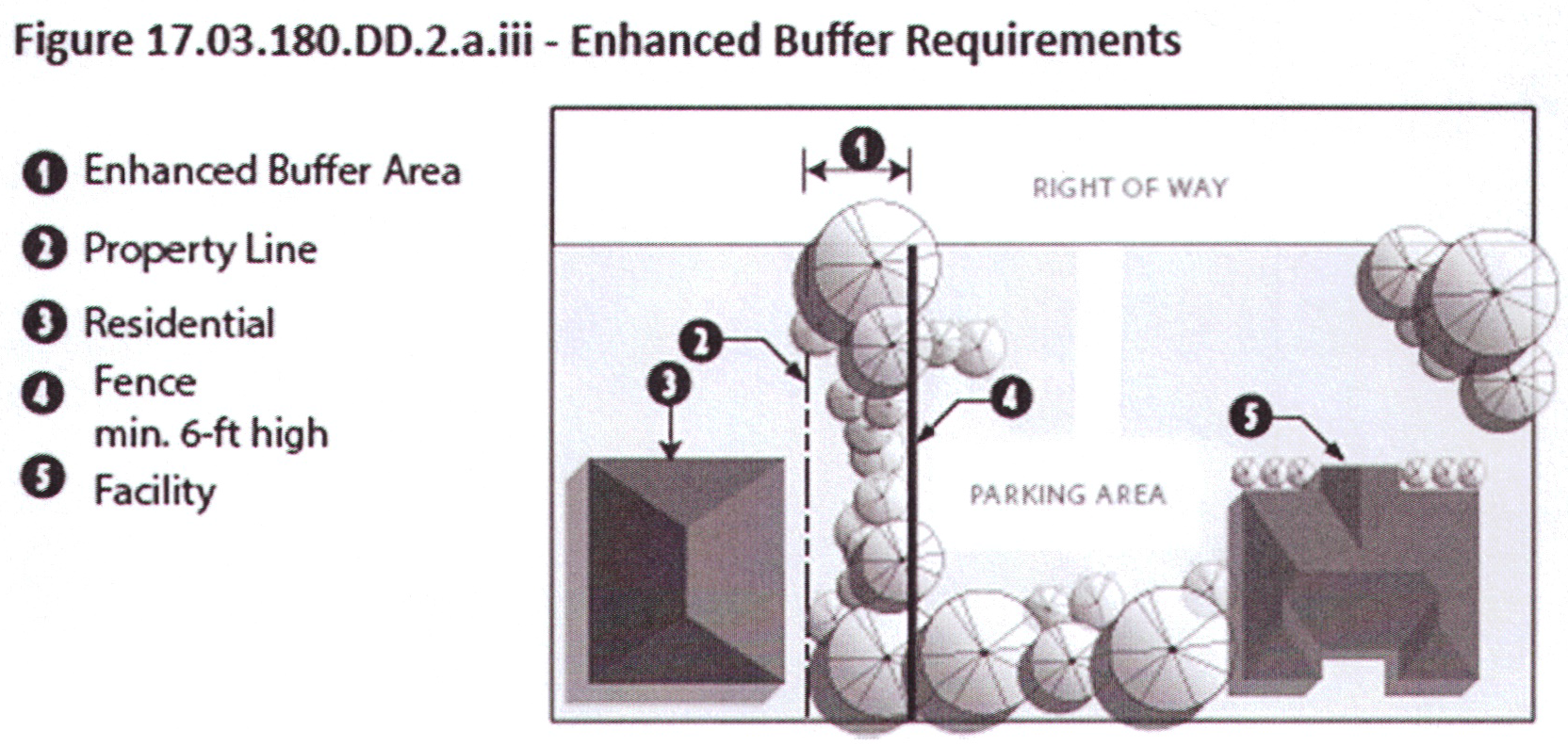
iv.
In no case shall the required setback be less than twenty (20) feet.
b.
Setback standards for lots or parcels adjacent to all other districts shall conform to the standards provided in section 17.03.180.S.
c.
All setbacks will be measured from property line, edge of easement, or right-of-way, whichever is greater.
d.
Where a Rural WCD facility is proposed for a lot or parcel adjacent to a CA or RA zoned lot or parcel, the Planning Director or Hearing Examiner may require an increased setback if an existing residential structure is located within 100 feet of the side or rear property line. This standard shall not apply where the proposed Rural WCD facility and the existing residential structure are separated by a road.
3.
Access.
a.
All new facilities, with approved tasting rooms, shall have adequate access from a state highway, county arterial, or county collector. A county local or private road may be approved by the County Engineer. Primary access, in order of priority, shall be off a state highway, county arterial, county collector, approved county local, or approved private road subject to the requirements of RCW 47.50, and WAC 468-52-040.
b.
When considering approval of local county roads, the County Engineer shall determine if the following standards have been met for the section of county local road from the proposed facility to the state highway or county arterial or collector road:
i.
That the local road, at a minimum, meets design standards for a twenty-five (25) mph fire lane per Appendix D of the International Fire Code. If the use warrants, at the discretion of the County Engineer, the local road could be required to meet design standards for a twenty-five (25) mph collector road;
ii.
That the road can safely manage the number of trips generated by the introduction of the new proposed use in a manner that ensures the continued safe and convenient use of the road; and
iii.
That a Transportation Concurrency review and approved Certificate be obtained as needed per chapter 11.04.
c.
When considering approval of private roads, the County Engineer shall determine if the following standards have been met for the section of private road from the proposed facility to the state highway or county road:
i.
That the private road, at a minimum, meets design standards for a twenty-five (25) mph fire lane per Appendix D of the International Fire Code (or current standard). If the use warrants, at the discretion of the County Engineer, the private road could be required to meet design standards for a twenty-five (25) mph collector road;
ii.
That the road can safely manage the number of trips generated by the introduction of the new proposed use in a manner that ensures the continued safe and convenient use of the road;
iii.
That a transportation concurrency review and approved certificate be obtained as needed per chapter 11.04;
iv.
If the private road accesses onto a county local road, the county local road must meet the requirements identified for county local roads in subsection 3.b; and
v.
If the proposed facility is located on a shared private road, the applicant must submit evidence of a legal right to use the road for the applied for use and intensity. The applicant must also present evidence that the shared private road will be maintained at least at the minimum standards described in the above paragraphs. This evidence of a legal right of access and maintenance must be publically recorded either before or immediately upon approval of the application. Notice of the application must be provided to owners of all property that share the private road or share a legal responsibility to maintain the road.
4.
Screening.
a.
General screening. Screening of non-residential uses shall be provided in accordance with section 17.03.180.P., Non-residential design, landscape, and screening guidelines.
b.
Parking screening required. All facility parking areas shall be screened from view from adjacent residential property in accordance with the requirements set forth in section 17.03.180.P.3. If full visual screen (wall or fence) is utilized, it must include continuous landscaping screening components (including both shrubs and trees) consistent with the provisions of section 17.03.180.P.3., provided on the exterior side where it is visible to the neighboring property.
c.
Where parking facilities are located 1,500 feet or more from the nearest residential structure or where topographic features such as hills, valleys, berms, ridges, or nonresidential structures are present between parking areas and residential structures, the Planning Director may waive required parking screening.
d.
The selected plant materials and configuration must provide a full yearlong visual screen within five (5) years of planting. This requirement will account for the size of materials and the growth rate.
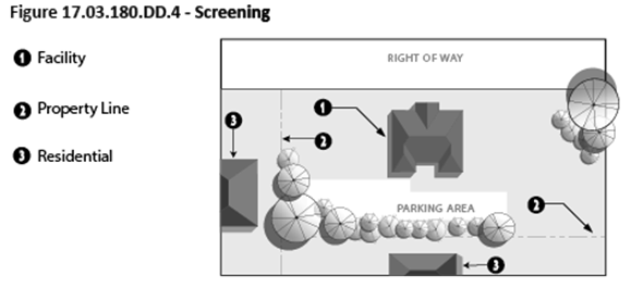
5.
Parking.
a.
Parking, access, and circulation shall be provided in accordance with standards set forth in section 17.03.180.Q. and shall be clearly identified and delineated on the site plan.
b.
Reinforced turf may be provided as an alternative parking surface subject to the approval of the County Engineer.
c.
All parking shall be contained on-site and shall be limited to areas identified as dedicated parking space on the approved site plan.
6.
Food service. Food service offering cooked-to-order food is prohibited except as part of an approved restaurant use in accordance with [section] 17.03.180.T. Table service, retail sales of cooked or prepared food or menu items are prohibited, except as noted below unless allowed in conjunction with an approved restaurant. Food service shall conform to Public Health Code regulations provided in title VIII, Health, welfare, and sanitation. Limited food service may be allowed in accordance with the following standards.
a.
Small food offerings such as crackers, nuts or other palate cleansers, featuring local foods and food products offered in conjunction with wine tasting.
b.
Prepared meals or appetizers featuring local foods and food products offered in conjunction with agricultural promotional events are permitted.
c.
Prepared meals or appetizers related to events permitted as part of an approved event permit, winemaker dinners, or small scale winery, cidery, or distillery promotional activities permitted in accordance with an approved land use permit and noise management plan (for outdoor events), shall be allowed.
d.
Retail sales of pre-packaged or assembled food not associated with an approved event, exempt gathering, or winemaker dinner are allowed in conjunction with wine tasting subject to the following limitations:
i.
Retail sales of pre-packaged or assembled food featuring local foods and food products shall be permitted only during tasting room hours.
ii.
Retail sales of assembled food may be provided for on-site consumption only.
iii.
No interior seating will be dedicated solely to the purpose of meal service.
iv.
No off-site signs advertising retail sales of pre-packaged food is permitted.
e.
All project signage shall conform to section 17.03.180.R.
7.
Landscaping/open space requirements:
a.
In addition to the requirements provided in section 17.03.180.P., Non-residential design, landscape, and screening guidelines, the following landscaping and open space requirements shall apply.
b.
A minimum of ten (10) percent of site must be designated landscaping and open space area. Open space areas may include perimeter landscaping areas and foundation planting areas and may include required screening identified in section 17.03.180.P. but does not include enhanced buffers provided in lieu of required setbacks under section 17.03.180.DD.2. Distilleries shall be exempt from the requirement to provide foundation plantings but must still meet the ten (10) percent landscaping and open space requirements. Existing (non-invasive) vegetation may be utilized to satisfy the requirements of this section.
c.
Site trees. Within the open space areas, one (1) large site tree will be required for every 10,000 square feet of the parcel/lot area.
i.
Medium trees may be substituted at a rate of two (2) medium trees for every required large tree.
ii.
Small trees may be substituted at a rate of three (3) small trees for every required large tree.
iii.
Deciduous trees shall be fully branched, have a minimum caliper of two (2) inches, as measured six (6) inches above the root ball, and have a minimum height of six (6) feet, measured from the treetop to the ground, at the time of planting.
iv.
Evergreen trees shall be fully branched and have a minimum of six (6) feet in height, measured from the treetop to the ground, at the time of planting.
v.
For the purposes of this section; tree sizes are classified according to the following:
d.
Required landscape buffer. Where facilities are located within 200 feet of property zoned R or RR, a minimum ten (10) foot wide landscape buffer is required at the property line between the facility or parking and the adjacent R or RR zoned property. The landscape buffer shall be provided in conformance with section 17.03.180.P.3. and may count toward the required minimum site landscape area required. Enhanced buffers provided in lieu of required setbacks under section 17.03.180.DD.2. may be utilized to satisfy this requirement but will not count toward the minimum ten (10) percent open space requirement.
e.
Foundation planting areas. Plantings around building foundations are required within a planting area six (6) feet in width along seventy (70) percent of the length of any facade visible from the public right-of-way. A medium or small tree shall be provided for every thirty (30) feet of building facade visible from the public right-of-way. Native shrubs may be substituted for trees at a ratio of ten (10) shrubs for every required tree but may not replace more than thirty (30) percent of the required trees. Foundation plantings may be utilized to satisfy the landscaping and open space requirements of this section.
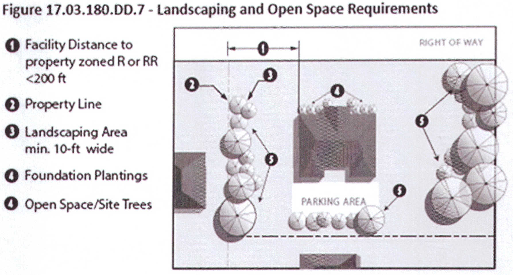
f.
Where a portion of the site is dedicated to agricultural production that is utilized in the production of wine or cider, the landscape requirements shall be limited to screening requirements provided in section 17.03.180.P. subject to the following minimum standards.
g.
The Planning Director or Hearing Examiner may approve alternative landscape plans where a lot is exceptionally narrow or shallow or contains unusual topographic conditions, but only when strict application would result in peculiar, exceptional, and undue hardship on the owner of such property.
8.
Events.
a.
For all wineries, cideries, and distilleries, trade-related functions, wine club events, winemaker dinners, and regional promotional events are part of the normal operations of a winery, cidery or distillery, as is the daily traffic associated with a tasting room. Capacity is limited by building occupancy and parking limitations. Outdoor events are allowed only with an approved noise management plan.
b.
Events not related to the operational and marketing aspects of the winery, cidery, or distillery such as weddings, receptions, and meetings/retreats, shall be limited to those permitted as part of an approved event permit.
9.
Noise management/outdoor amplification: Reserved.
10.
The Planning Director or Hearing Examiner may impose conditions such as increased setbacks, improved access, or other limitations and conditions found necessary to protect health, safety, and welfare, and to mitigate adverse impacts to surrounding properties due to the nature or character of the site or the facility.
EE.
Events.
1.
Applicability. The regulations set forth in this section shall apply to all new applications for special events, rural commercial events, and rural event centers.
a.
It is the intent of this section to:
i.
Provide a regulatory framework for approving event uses;
ii.
Replace the temporary event venue permit (TEVP) procedure established under Policy No. 002/13 (Revised August 5, 2015) with regulatory standards and procedures; and
iii.
Provide an opportunity for existing TEVP holders to come into compliance with new regulations recognizing the level of activity approved under an active TEVP.
b.
No new applications for temporary event venue permits (TEVP) under Policy No. 002/13 (Revised August 5, 2015) shall be accepted upon or after the effective date of this section.
c.
Holders of an approved TEVP issued under Policy No. 002/13 (Rev. 8/5/15), on the effective date of this section, may continue to operate under the approved TEVP until its date of expiration. Active TEVP permit holders may apply for one renewal of such permit upon its expiration, provided that the following conditions have been met:
i.
An active permit application has been submitted within six (6) months of the effective date of this section for either a rural commercial event permit or a rural event center permit; and
ii.
The applicant can show compliance with any conditions placed on the permit holder upon the original issuance of the TEVP, including but not limited to compliance with all applicable laws and regulations in place on the date of issuance, subject to subsection (e) below.
d.
Any original application for a new TEVP submitted (i.e. by an inactive or non-holder of a TEVP) but pending review prior to the effective date of this chapter may be approved subject to the conditions placed on active TEVP holders applying for renewal under (1)(c) above, except that any new permit issued shall not be eligible for renewal.
e.
Once a final decision has been issued to an applicant on a rural commercial event permit, rural event center, or renewal application for a TEVP allowed under this section, TEVPs will no longer be valid and will not be eligible for renewal by that applicant.
f.
In addition to the provisions provided [in] section 17.03.180.EE.1.c, if the application of the regulations contained in this section results in a more restrictive number of events than previously allowed to a permit holder under Policy No. 002/13 (Rev. 8/5/15) or requires that additional improvements be made as a condition of approval of the rural commercial event permit or rural event center permit, the Administrator may choose to allow, as part of his decision, a onetime extension of the TEVP, if the applicant can demonstrate that events have been scheduled and that those events can be verified by the Administrator. In no case, shall the total number of events exceed ten (10) for a calendar year.
2.
Special events, rural commercial events, and rural event centers shall be permitted in accordance with the following standards. The Administrator or Hearing Examiner may approve the existing zoning classification for applicants with an active approved permit issued under Policy No. 002/13 (Revised August 5, 2015) provided that no increase in intensity is proposed that is greater than that approved under Policy No. 002/13 (Revised August 5, 2015) or approved as part of a rural commercial event.
*Does not include set-up or take down
3.
Permit limitations. Event permits are limited to one (1) event type per parcel, lot, or site. No applicant may hold simultaneous permits for special events, rural commercial events, or rural event centers.
4.
Exceptions. The following events are exempt from the requirements of this section but must still comply with title VIII health, welfare, and sanitation and noise management best management practices identified in this section.
a.
Uses that are accessory to a single family residential use including private parties, family events, holiday gatherings, and similar activities that are not subject to an agreement between a private individual or a group and the property owner and where there is no direct or indirect compensation to the property owner.
b.
Events at a parcel where all necessary county land use approvals and permits have been obtained which allow the particular use (fairground, restaurants, parks, libraries, theatres, schools, churches, community halls, etc.)
c.
Industry wide events occurring on multiple business sites simultaneously such as artists' festivals, farm tours, and wine tours.
d.
Outdoor events where all necessary county land use and building approvals and permits have been obtained which allow the particular outdoor use (fairgrounds, parks, etc.).
e.
Small scale farm and agricultural educational events focused on locally grown products, including tours, workshops, and seminars. Small events associated with farmers markets, or seasonal farm sales are subject to section 17.03.180.H and 17.03.180.V.1 and therefore are exempt from this section.
f.
Events considered part of normal operations of a winery, cidery, or distillery as provided in section 17.03.180.DD.8.
5.
Site plan review. A site plan is required pursuant to chapter 16.15. In addition to the requirements of chapter 16.15, the following must be provided on the site plan:
a.
The location, size, type of any required screening or buffering anywhere on the site.
b.
Areas designated for portable sanitation facilities.
c.
Areas designated for other temporary structures such as tents, canopies, dancing platforms etc.
d.
All structures and grounds that will be used as part of the activities for a rural event center, rural commercial event, or special event, including the parking, shall be designated on the site plan and limited to those designated areas.
e.
The duration of functions allowed at a specific facility, including the maximum number of days and the hours of operation that shall be allowed shall be specified in the permit application.
6.
Maximum attendance. Attendees shall be limited to the number identified in the approved permit and site plan based on available on-site parking, existing and proposed (locations) of sanitation facilities, access, and the following table:
7.
Event facilities, structures, and site improvements.
a.
Only those buildings or areas specifically approved in the site plan may be used as event space.
b.
Structures used for events shall comply with building code regulations, the ADA rules, the WA State Handicap Code, fire separation and exiting requirements, and life/safety guidelines.
c.
Tents, canopies, and other similar temporary structures necessary for a commercial event may be allowed, provided all such structures are erected or placed on the subject parcel no more than two (2) days before the event and removed no more than two (2) days after the event. Alternatively, temporary structures may remain in place for up to ninety (90) days if they are fully screened from adjacent property owners.
d.
Structures shall comply with the landscape, lighting, signage, site coverage, and non- residential design, landscape, and screening guidelines set forth in this chapter.
e.
Adequate health facilities shall be approved by the IC Department of Public Health in accordance with title VIII and attendance shall be limited to capacity approved. This includes water, waste disposal, and solid waste disposal. The site shall be cleared of all debris at the end of each event.
8.
Noise management.
a.
Minimum requirements.
i.
Sound equipment is permitted within structures fully enclosed by a permanent wall and roof subject to noise management best management practices in this section.
ii.
In no case, shall the decibel level exceed 60dBA at the exterior boundaries of the property line of the event location.
b.
Noise management plan required. When sound equipment is utilized indoors and the facility is within 500 feet of a Rural Residential RAID or where outdoor events, with or without sound equipment, are anticipated, a noise management plan will be required for:
i.
Special event, rural commercial event, or rural event center permits; and
ii.
Permit holders with an existing approved assembly use (community hall, country inn, restaurant etc.) wishing to extend approved uses outdoors where land use and building approvals and permits have been limited to indoor assembly.
c.
For the purposes of this section outdoor events include events where bay doors and retractable sliding doors are open.
d.
Noise management plans for existing uses shall require a Type II land use approval.
e.
Noise management plan. The noise management plan must provide, at minimum, the following information:
i.
The expected sources of sound during events (types of equipment and sound during events).
ii.
For outside events, a description of the maximum number of attendees and anticipated frequency of outside events.
iii.
A site plan that provides location of the events, neighboring land-use details, location and orientation of stages and public address, and/or sound equipment.
iv.
A description of the type of sound equipment and location of sound equipment that will be utilized including maximum sound levels proposed.
v.
Utilization of sound equipment not provided at the venue to include sound equipment utilized by DJs or bands.
vi.
Steps that will be taken to minimize the risk of nuisance (see best management practices below).
vii.
Details of acoustic monitoring during the event.
viii.
Measures and provisions to be taken to avoid exceeding maximum decibel levels at the exterior property lines. This may include but is not limited to:
(1)
Berms, and
(2)
Fences or walls which include continuous landscaping screening components (including both shrubs and trees) consistent with the provisions of section 17.03.180.P.3, provided on the exterior side where it is visible to the neighboring property.
ix.
How complaints received before, during, and after the event will be addressed.
f.
Noise management plan minimum requirements.
i.
In no case shall outdoor sound equipment be allowed within 300 feet of a neighboring residential structure.
ii.
In no case, shall the decibel level exceed 60dBA at the exterior boundaries of the property line of the event location.
iii.
In no case shall fireworks be utilized in association with a rural event center or rural commercial event permit.
g.
Best management practices. The following best management practices should be referenced in developing your noise management plan:
9.
Notice. Proposed events permitted as part of a rural event center permit are exempt from the notice requirements of this section, however posting of such events is still a recommended best practice. Public notice or posting of all other events on either the lot, parcel, or site or on the venue webpage at least fourteen (14) days before the scheduled event is required if the following conditions are applicable:
a.
Proposed events are within 500 feet of a Rural Residential RAID; or
b.
Proposed events are within 200 feet of a residential structure.
10.
Special events. Special events include large scale events such as harvest festivals, outdoor concerts, auctions, model hobby events, glider flights, hot air balloon rides, parachute events, motor boat races, carnivals and circuses.
a.
Special events that propose entertainment, amusement, or assembly of persons, wherein the primary purpose will be the presentation of outdoor, live, or recorded musical entertainment and which may attract 100 or more persons shall be processed in coordination with the Island County Sheriff's Office pursuant to chapter 5.08.
b.
All uses shall be confined to the dates specified in the approved permit;
c.
Hours and duration of operation shall be confined to those specified on the approved permit;
d.
The site shall be cleared of all debris at the end of the event and cleared of all temporary structures within thirty (30) days after the closing event. A cash bond, the sum of which is to be determined by the county engineer, or a signed contract with a disposal firm, shall be required as part of the application for a special event when determined necessary by the county engineer or Planning Director to ensure that the premises will be cleared of all debris during and after the event;
e.
Parking. Public parking for the exclusive use of the facility shall be provided, and an adequate driveway to the parking area subject to approval of the county engineer shall be maintained. The parking area shall be maintained in a dust-free manner. It shall be the responsibility of the applicant to provide all necessary traffic and parking control attendants in a manner approved by the Island County Sheriff's Office;
f.
Traffic control required by the Island County Sheriff's Office, the State Patrol or WSDOT shall be arranged by the applicant;
g.
A cash bond, the sum of which is to be determined by the county engineer, may be required to insure the repair of any damage to any public right-of-way as a result of the event;
h.
All activities shall be set back from all property lines at least fifty (50) feet;
i.
Structures shall comply with the landscape, lighting, signage, site coverage, and non- residential design, landscape and screening guidelines set forth in this section; and
j.
For any event use, the county shall impose such reasonable conditions as are found necessary to ensure that the activity or use does not disrupt the character of any surrounding permitted uses.
k.
Access must be adequate for the scale and intensity of the proposed event. Special event locations must maintain an emergency vehicle access "fire lane" with a minimum width of twenty (20) feet, allowing emergency vehicle access to all areas of the event. Any event requiring traffic control measures on a state highway, shall be required to coordinate with the Washington State Department of Transportation.
l.
Reoccurring special events. Special events that occur annually such as cider festivals, flea markets, Tour de Whidbey, the Ragnar relay, and other concerts or annual festivals that meet the following conditions may be considered reoccurring special events and may [be] valid for a period of ten (10) years provided they meet the following conditions:
i.
A special event permit has been approved for the site;
ii.
The scale and scope of the event has not materially changed over time;
iii.
The applicant is to provide yearly notification to the Planning and Community Development Department if the number of attendees exceeds 150 and/or there will be an outdoor concert associated with the event; and
iv.
There have been no verified complaints that the special event has caused any new significant impacts that were not anticipated with the approved special event permit.
m.
Combined special event permit for multiple small-scale events.
i.
Applicability. An event organizer may choose to apply for a combined special event permit for small-scale events in lieu of submitting for a special event permit for each such individual event, subject to the requirements of this section. Events with an anticipated attendance of fifty (50) persons or more must apply for an individual special event permit. A combined special event permit may be approved for:
(1)
Multiple small-scale events at a single location, not more than three (3) a year;
(2)
Multiple small-scale events at multiple locations; or
(3)
A combination of the above.
ii.
Permit requirements.
(1)
Application must be submitted a minimum of thirty (30) days prior to the first event proposed under the permit application.
(2)
The application must include location, date, time, duration, and maximum anticipated attendance for each event.
(3)
Review will include, but not be limited to, septic and parking on-site capacity and provisions for additional capacity, if needed.
(4)
All outdoor events are subject to applicable noise management best practices (section 17.03.180.EE.8.e) and must be outside of all critical areas and their buffers.
11.
Rural commercial events.
a.
Minimum separation. Structures and grounds, including the parking area, that are used for event activities as part of the facility shall be adequately separated in accordance with the following:
i.
The separation shall be at least 200 feet from residences on adjacent parcels;
ii.
The separation shall be at least 500 feet from any Rural Residential RAID zoning district boundary; and
iii.
The minimum separations listed above may be reduced if the applicant can show that impacts are minimized by factors such as major changes in topography (drop offs, hills, etc.) areas of solid screening under the owner's control, or particular land forms. Solid screening in lieu of the full separation will only be considered if the following criteria is met: a six (6) foot wall or fence is provided with continuous landscaping screening components on the exterior side and visible to the neighboring property, including both shrubs and trees, consistent with the provisions of section 17.03.180.P.3. In no case shall the separation be less than 100 feet from residences on adjacent parcels and 300 feet from a Rural Residential RAID zoning district boundary. (See Figure 17.03.180.EE.12).
iv.
In reviewing applications for rural commercial events, the Administrator may approve a reduction in the minimum separation requirements for existing permanent structures and parking areas for applicants with an active approved permit issued under Policy No. 002/13 (Revised August 5, 2015) provided that no increase in intensity is proposed that is greater than that approved under Policy No. 002/13 (Revised August 5, 2015) or approved as part of a rural commercial event.
b.
Access.
i.
All new facilities shall have adequate access from a state highway, county arterial, or county collector. Primary access, in order of priority, shall be off a state highway (subject to the requirements of RCW 47.50, and WAC 468-52-040), county arterial, or county collector. A county local road may be approved by the county engineer.
ii.
When considering approval of county roads, the county engineer shall determine if the following standards have been met for all sections of county roads from the proposed facility to the state highway:
(1)
That the county road, at a minimum, meets design standards for a twenty-five (25) mph fire lane per Appendix D of the International Fire Code. If the use warrants, at the discretion of the county engineer, the county road could be required to meet design standards for a twenty-five (25) mph collector road;
(2)
That the road can safely manage the number of trips generated by the introduction of the new proposed use in a manner that ensures the continued safe and convenient use of the road; and
(3)
That a transportation concurrency review and approved certificate be obtained as needed per chapter 11.04.
iii.
In reviewing applications for rural commercial events, the Administrator or Hearing Examiner may approve existing access for applicants with an active approved permit issued under Policy No. 002/13 (Revised August 5, 2015) provided that no increase in intensity is proposed that is greater than that approved under Policy No. 002/13 (Revised August 5, 2015) or approved as part of a rural commercial event.
c.
Parking.
i.
Parking, access, and circulation shall be provided in accordance with standards set forth in section 17.03.180.Q and shall be clearly identified and delineated on the site plan.
ii.
Reinforced turf may be provided as an alternative parking surface subject to the approval of the county engineer.
iii.
Parking shall be provided at a rate of one (1) space for every two (2) guests.
iv.
All parking shall be contained on-site and shall be limited to areas identified as dedicated parking space on the approved site plan. The Administrator may consider off-site parking subject to the following conditions:
(1)
A minimum of fifty (50) percent of the required vehicle parking spaces are provided on-site.
(2)
All required handicap and bicycle parking spaces are provided on-site;
(3)
The site designated for off-site parking meets all the parking, access, and circulation standards set forth in section 17.03.180.Q.
(4)
Shuttle loading, unloading, and parking zones shall be clearly delineated and identified on the site plan.
(5)
The rural commercial event permit applicant has provided a signed agreement between the property owners that includes a calculation of the parking available and verification that the shared parking agreement does not create a deficiency for other uses that utilize that site for parking (as their required on-site parking and/or any previously executed shared parking agreement).
d.
Screening.
i.
General screening. Screening of non-residential uses shall be provided in accordance with section 17.03.180.P. non-residential design, landscape, and screening guidelines.
ii.
Parking screening required. All facility parking areas shall be screened from view from adjacent residential property in accordance with the requirements set forth in section 17.03.180.P.3. If a full visual screen (wall or fence) is utilized, it must include continuous landscaping screening components (including both shrubs and trees) consistent with the provisions of section 17.03.180.P.3., provided on the exterior side where it is visible to the neighboring property.
iii.
Where parking facilities are located 1,500 feet or more from the nearest residential structure or where topographic features such as hills, valleys, berms, ridges, or nonresidential structures are present between parking areas and residential structures, the Planning Director may waive required parking screening.
iv.
The selected plant materials and configuration must provide a full yearlong visual screen within five (5) years of planting. This requirement will account for the size of materials and the growth rate.
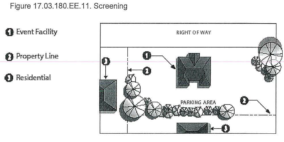
e.
Frequency of events. Rural commercial events shall be limited to ten (10) events per calendar year. During the months of June through September, not more than two (2) events may be held per month and no more frequently than two (2) consecutive weekends (Friday through Sunday). An applicant may request additional outdoor events for the months of June through September provided that they meet all of the following conditions:
i.
That structures and grounds, including the parking area, that are used as part of the facility, are separated at least 1,000 feet from all adjacent residential uses and structures on adjacent parcels;
ii.
That the subject lot, parcel, or site has an approved noise management plan that identifies such uses in accordance with the requirements set forth in this section.
f.
Exceptions. Events that are either completely contained indoors, or where there is no utilization of sound equipment, and where the number of attendees is equal to or less than thirty-five (35) percent of the maximum number of attendees approved for the rural commercial event site, will not be counted toward the allowable ten (10) events a year.
g.
Charitable events. Up to five (5) charitable events held for the specific purpose of benefitting a not-for-profit organization, exempt from federal income tax under section 501(c) of Title 26 of the United States Code, that meet one (1) of the following conditions will not be counted towards the maximum number of events allowed on a lot, parcel, or site:
i.
Events completely contained indoors in accordance with the noise management BMPs identified in this section; or
ii.
Events with outdoor components held during the months of October through May where the location has an approved noise management plan that identifies such potential uses.
12.
Rural event centers. The design, frequency, size, and location of each rural event center will be unique and must be determined on a case by case basis. The review must ensure adequate separation from adjacent uses to minimize potential impacts from factors such as the number of people, the noise, and the traffic; safe access from a major public road; and provision of basic infrastructure to ensure the public's health, safety and welfare. A rural event center may be allowed when the following standards and conditions are met:
a.
A facility for seventy-five (75) people and under is reviewed as a Type II decision. A facility for more than seventy-five (75) people shall be reviewed as a Type III decision and shall meet the requirements for a community meeting. All applications are subject to the requirement for a pre-application conference.
b.
Rural event centers are allowed in the Rural (R), Rural Forest (RF), and Rural Agriculture (RA) zoning districts as conditional uses.
i.
Rural Event Center in RA Zone. A rural event center is allowed in an RA Zone if the majority of the RA site remains available for agriculture uses.
ii.
Rural Event Center in RF Zone. A rural event center is allowed in an RF Zone subject to the following conditions:
(1)
The proposed lot, parcel, or site is compliant with the standards set forth in section 17.03.180 A General standards for nonresidential uses in the Rural, Rural Residential, Rural Forest, Rural Agriculture and Commercial Agriculture Zones.
(2)
A Timber Management Plan is on file with the County Tax Assessor if the lot, parcel, or site is Designated Forest Land per Chapter 84.34 RCW and such use will not impair or impede such plan.
(3)
The proposed use is compliant with section 17.03.270 Forest Practices.
(4)
The proposed use does not interfere with the efficient management or productivity of Forest Management Uses in accordance with ICC 17.03.110 A Rural Forest (RF) Zone.
c.
Minimum separation. Structures and grounds, including the parking area, that are used for event activities as part of the facility shall be adequately separated from all residences on adjacent parcels as follows:
i.
For relatively flat, open areas, the separation shall be at least 500 feet from residences on adjacent parcels;
ii.
For proposals adjacent to a Rural Residential RAID, the separation shall be at least 1,000 feet from the Rural Residential RAID zoning district boundary; and
iii.
The minimum separations listed above may be reduced if the applicant can show that impacts are minimized by factors such as major changes in topography (hills, valleys, berms, ridges, or nonresidential structures), by areas of solid screening under the owner's control, or by particular land forms. Solid screening in lieu of the full separation will only be considered if the following criteria is met: a six (6) foot wall or fence is provided with continuous landscaping screening components on the exterior side and visible to the neighboring property, including both shrubs and trees, consistent with the provisions of section 17.03.180.P.3. In no case shall the separation be less than 300 feet from residences on adjacent parcels and 500 feet from a Rural Residential RAID zoning district boundary. (See Figure 17.03.180.EE.12)
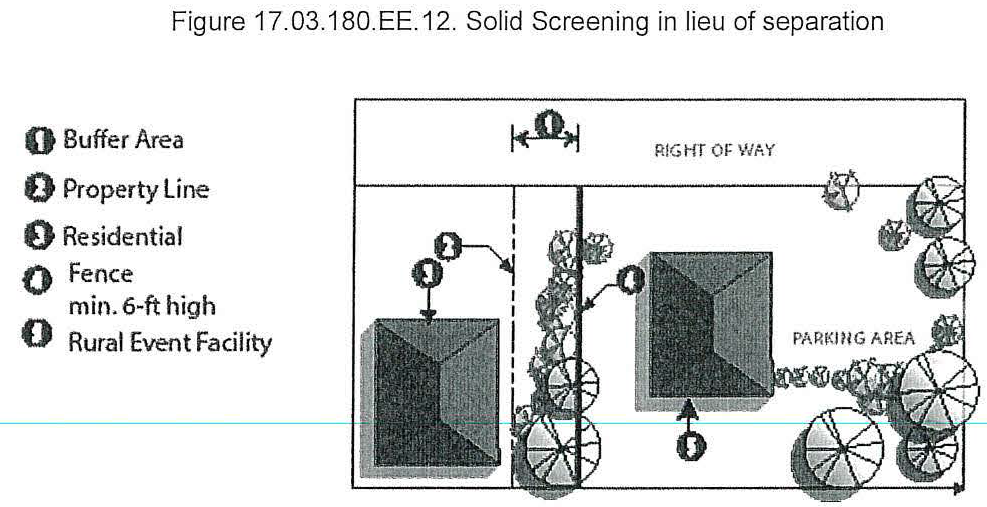
d.
Minimum area. It is likely that the total area that will be used as a rural event center will probably be relatively small; however, the required size of the parcel for each rural event center shall be determined by the following factors:
i.
The number, location, size, and width of the contiguous parcels in the ownership and/or control of the applicant; and
ii.
The location, size, and width of surrounding parcels that are zoned RA, CA, or RF. Future development, especially of residences, in these zones will be limited. Also, the area in these zones may serve to separate and buffer existing or future residences from potential impacts of the activities at the rural event center. A small parcel such as two and one-half (2.5) acres may be adequate if buffered by areas of these zones.
e.
Access.
i.
All new facilities shall have adequate access from a state highway, county arterial, or county collector. Primary access, in order of priority, shall be off a state highway (subject to the requirements of RCW 47.50, and WAC 468-52-040), county arterial, or county collector. A county local road may be approved by the county engineer.
ii.
When considering approval of county roads, the county engineer shall determine if the following standards have been met for the section of county road from the proposed facility to the state highway:
(1)
That the county road, at a minimum, meets design standards for a twenty-five (25) mph fire lane per Appendix D of the International Fire Code. If the use warrants, at the discretion of the county engineer, the county road could be required to meet design standards for a twenty-five (25) mph collector road;
(2)
That the road can safely manage the number of trips generated by the introduction of the new proposed use in a manner that ensures the continued safe and convenient use of the road; and
(3)
That a transportation concurrency review and approved certificate be obtained as needed per chapter 11.04.
f.
Parking.
i.
Parking, access, and circulation shall be provided in accordance with standards set forth in section 17.03.180.Q. and shall be clearly identified and delineated on the site plan.
ii.
Reinforced turf may be provided as an alternative parking surface subject to the approval of the county engineer.
iii.
All parking shall be contained on-site and shall be limited to areas identified as dedicated parking space on the approved site plan.
iv.
No off-street parking or loading area shall be permitted within fifty (50) feet of a side or rear property line.
v.
Parking shall be provided at a rate of one (1) space for every two (2) guests.
g.
Screening.
i.
General screening. Screening of non-residential uses shall be provided in accordance with section 17.03.180.P. non-residential design, landscape, and screening guidelines.
ii.
Parking screening required. All facility parking areas shall be screened from view from adjacent residential property in accordance with the requirements set forth in section 17.03.180.P.3. If a full visual screen (wall or fence) is utilized, it must include continuous landscaping screening components (including both shrubs and trees) consistent with the provisions of section 17.03.180.P.3., provided on the exterior side where it is visible to the neighboring property.
iii.
Where parking facilities are located 1,500 feet or more from the nearest residential structure or where topographic features such as hills, valleys, berms, ridges, or nonresidential structures are present between parking areas and residential structures, the Planning Director may waive required parking screening.
iv.
The selected plant materials and configuration must provide a full yearlong visual screen within five (5) years of planting. This requirement will account for the size of materials and the growth rate.
h.
Sleeping accommodations are allowed only in conjunction with an approved bed and breakfast inn or country inn.
i.
A rural event center located on the same site with an approved farmhouse style restaurant may be able to share the kitchen and the rest room facilities; however, the restaurant use may not use the rural event center facilities for an expanded food service area.
j.
The review of a proposed rural event center will determine limitations and conditions that would be necessary to protect the surrounding neighborhood from the impacts of the use. The following factors are some that shall be included:
i.
The size of the parcel;
ii.
The required separation between the use and adjacent uses;
iii.
The total number of people that may attend an event at a facility, except the number shall not exceed 200 people;
iv.
Set times when all outdoor activities must cease and all indoor activities may cease;
v.
A noise management plan shall be established in accordance with this section.
k.
A plan for traffic management shall be established. The Island County Sheriff's Office, the State Patrol, or WSDOT may require traffic control for events of a certain size. If so, the traffic control shall be arranged by the applicant.
(Ord. C-123-98 [PLG-037-98], September 29, 1998, vol. 43, p. 6; accepted by Res. C-133-98 [PLG-043-98], October 19, 1998, vol. 43, p. 38; amended by Ord. C-136-98 [PLG-042-98], November 9, 1998, vol. 43, p. 65; amended by Ord. C-63-99 [CD-01-99], June 21, 1999, vol. 43, p. 338; amended by Ord. C-93-99 [PLG-022-99], August 23, 1999, vol. 43, p. 427; amended by [Ord.] C-105-99 [PLG-034-99], September 27, 1999, vol. 44, p. 12; amended by Ord. C-113-99 [CD-02-99], October 11, 1999, vol. 44, p. 32; amended by Ord. C-122-99 [PLG-044-99], November 1, 1999, vol. 44, p. 79; amended by Ord. C-138-99 [PLG-047-99], November 22, 1999, vol. 44, p. 155; amended by Ord. C-133-99 [PLG-040-99], November 23, 1999, vol. 44, p. 183; amended by Ord. C-134-99 [PLG-041-99], November 23, 1999, vol. 44, p. 185; amended by Ord. C-124-99 [PLG-030-99], March 6, 2000, vol. 44, p. 326; amended by Ord. C-118-99 [PLG-001-99], March 20, 2000, vol. 44, p. 340; amended by Ord. C-30-00 [PLG-010-00], April 10, 2000, vol. 44, p. 386, amendment to sections 17.03.180.S.1. and 2. effective October 12, 2000 when the October 12, 2000 Growth Management Hearings Board Final Decision and Order, Case Number 98-2-0023c, approved the 5-acre minimum lot size in the Rural (R) Zone; amended by Ord. C-44-00 [PLG-011-00], June 5, 2000, vol. 44, p. 429, readopted June 19, 2000, vol. 44, p. 446; amended by Ord. C-165-01 [PLG-026-01, January 7, 2002, vol. 46, p. 91; amended by Ord. C-163-01 [PLG-024-01], January 7, 2002, vol. 46, p. 87; amended by Ord. C-161-01 [PLG-021-01], January 7, 2002, vol. 46, p. 85; amended by Ord. C-02-02 [PLG-029-01], January 28, 2002, vol. 46, p. 110; amended by Ord. C-59-02 [PLG-011-02], August 12, 2002, vol. 46, p. 292; amended by Ord. C-94-02 [PLG-017-02], December 16, 2002, vol. 46, p. 413; amended by Ord. C-41-04 [PLG-030-03], April 12, 2004, vol. 2004, p. 105; amended by Ord. C-45-04 [PLG-034-03], May 10, 2004, vol. 2004, p. 153; amended by Ord. C-47-04 [PLG-036-03], April 12, 2004, vol. 2004, p. 110; amended by Ord. C-48-04 [PLG-037-03], April 12, 2004, vol. 2004, p. 111; amended by Ord. C-85-05 [PLG-018-04], July 25, 2005, vol. 2005, p. 236; amended by Ord. C-86-05 [PLG-019-04], July 25, 2005, vol. 2005, p. 237; amended by Ord. C-97-06 [PLG-010-06], August 21, 2006, vol. 2006, p. 247; amended by Ord. C-87-07 [PLG-017-07], March 10, 2008, vol. 2008, p. 105; technical amendment made to Ord. C-87-07 by motion of the Board of Island County Commissioners, March 17, 2008, vol. 2008, p. 113; amended by Ord. C-41-09 [PLG-003-09], April 6, 2009, vol. 2009, p. 183; amended by Ord. C-102-09 [PLG-015-09], September 22, 2009, vol. 2009, p. 436; amended by Ord. C-157-09, January 4, 2010, vol. 2010, p. 2; amended by Ord. C-146-12 [PLG-009-12], December 18, 2012, vol. 2012, p. 202)
(Ord. No. C-40-14 [PLG-002-14], Exh. A, 5-5-2014; Ord. No. C-75-14 [PLG-006-14], Exh. E, 9-22-2014; Ord. No. C-43-16[PLG-002-16], Exh. A, 5-3-2016; Ord. C-140-16 [PLG-012-16], Exh. A, 12-13-2016; Ord. No. C-12-17 [PLG-001-17], Exh. A, 2-7-2017; Ord. No. C-86-17 [PLG-009-17], Exh. A, 8-15-2017; Ord. No. C-86-18[PLG-005-18], Exh. A, 9-4-2018; Ord. No. C-127-18[PLG-008-18], Exh. A, 12-11-2018; Ord. No. C-53-19 [PLG-005-19], Exh. A, 6-25-2019; Ord. No. C-93-19 [PLG-011-19], Exh. A, 10-8-2019; Ord. No. C-18-22 [PLG-002-21], Exh. A, 5-3-2022)
Editor's note— Section 17.03.180.1.f "Rural event centers" was clarified by the Code Reviser to correctly delete section 17.03.180.1.f "Rural event centers," and not section 17.03.180.1.g, as set in Ord. No. C-127-18.
_____
Editor's note— Appendix "C", "Illustrative Non-Residential Design Guidelines," may be obtained from the Island County Planning Department.
--- (12) ---
Editor's note— For a Rural PRD, the Impervious Surface Ratio is 50% and Open Space Ratio is 50% if a density bonus is used. See 17.03.180.E, Density Bonus System. The Open Space Ratio does not apply to a PRD that uses EDUs in the RA, RF or CA Zones. For a PRD in a UGA, the Impervious Surface Ratio is 25% and the Open Space Ratio is 75%.
--- (13) ---
Editor's note— A copy of Appendix C, "Illustrative Non-Residential Design Guidelines" may be obtained from the Island County Planning and Community Development Department.
17.03.190 - Code interpretation.
The Planning Director shall interpret by written decision the text of this chapter pursuant to the terms and conditions of this section.
A.
Purpose. This section provides a simple and expeditious method for clarifying ambiguities in the text of this chapter or classifying uses that are not expressly referenced. Broad latitude has been provided in the specific uses enumerated in each land use classification. Therefore, interpretation will be required, from time to time, to overcome inadvertent rigidities and limitations inherent whenever lists of specific uses are established. Prohibited uses are identified expressly. There is no presumption that a use that is not listed is or should be prohibited. Code interpretations are used to establish the proper classification of unnamed uses and allow for the formalization of other interpretations that may be required to effectively administer the Zoning Code. Code interpretation can be initiated by the county or requested by an owner.
B.
Application requirements. The application of an owner shall contain the following:
1.
A description of uses permitted by the present zoning classification which are most similar to the proposed use; and
2.
Documents, statements and other evidence demonstrating the proposed use will comply with all applicable standards established by this chapter.
3.
If applicable, the application shall also include the following:
a.
The name, location, street address, and legal description of the affected parcel or property, together with the names, addresses and telephone numbers of the applicant or applicants, the owners of record of the land, and any associated professional consultants such as architects or engineers;
b.
A description of the existing use or uses of the land and uses of any existing buildings;
c.
A description of each proposed use of land and buildings to be undertaken with the development;
d.
A general site plan drawn to a scale of not less than one (1) inch to twenty (20) feet and not greater than one (1) inch to 100 feet showing building envelopes, access, circulation (both vehicle and pedestrian), and open space or an application for site plan approval pursuant to chapter 16.15 or PRD approval pursuant to chapter 16.17; and
e.
A description of a schedule for phases of the project, should all proposed structures not be built at the same time.
C.
Review process. The review process for use interpretation shall be the review process set forth in chapter 16.19 for Type II decisions.
D.
Standards. Code interpretations shall be consistent with the comprehensive plan and the following standards:
1.
No interpretation shall allow the establishment of any use which was previously considered and rejected by the board.
2.
No interpretation shall permit a use otherwise expressly prohibited in the zone.
3.
No interpretation shall permit any use in any zone that is inconsistent with the stated purpose of the zone.
4.
No interpretation shall permit any use in a particular zone unless such use is substantially similar to other uses permitted in such zone considering:
a.
The activities involved in or equipment or materials employed in the use; and
b.
The effects of the use on the surrounding area, such as traffic impacts, noise, dust, odors, vibrations, lighting and glare.
5.
Any use permitted pursuant to this section shall comply with all applicable requirements and standards imposed by this chapter.
6.
Any interpretation shall be consistent with the findings adopted by the board in conjunction with this chapter.
E.
Time limit. Use interpretations shall remain in effect until modified by a subsequent Code interpretation or Code amendment.
F.
Applicability to chapter 17.02B. The procedures outlined in this section shall also be used to issue interpretations of chapter 17.02B, subject to any additional requirements or provisions set forth in section 17.02B.050.
(Ord. C-123-98 [PLG-037-98], September 29, 1998, vol. 43, p. 6; accepted by Res. C-133-98 [PLG-043-98], October 19, 1998, vol. 43, p. 38)
(Ord. No. C-75-14 [PLG-006-14], Exh. E, 9-22-2014)
17.03.200 - Temporary use approval.
The Planning Director shall authorize by administrative decision temporary uses pursuant to this section.
A.
Purpose. This section provides a process for authorizing certain uses or activities of a non-permanent nature for a limited duration.
B.
Application requirements. The application shall contain those requirements set forth in section 17.03.190.B.3.a. and d., and:
1.
A description of the proposed use, event or activity; and
2.
All information required by section 17.03.180.V.
C.
Review process. The review process for a certificate of temporary use shall be the review process set forth in chapter 16.19 for Type I decisions.
D.
Standards. Temporary uses shall be consistent with the standards set forth in section 17.03.180. For any temporary use the county shall impose such other reasonable conditions as are found necessary to ensure that the activity or use does not disrupt the character of any of the surrounding permitted uses.
E.
Time limit. Certificates of temporary use shall expire according to the terms set forth in the approval.
(Ord. C-123-98 [PLG-037-98], September 29, 1998, vol. 43, p. 6; accepted by Res. C-133-98 [PLG-043-98], October 19, 1998, vol. 43, p. 38; amended by Ord. C-63-99 [CD-01-99], June 21, 1999, vol. 43, p. 338; amended by Ord. C-44-00 [PLG-011-00], June 5, 2000, vol. 44, p. 429, readopted June 19, 2000, vol. 44, p. 446)
17.03.210 - Variances.
The Planning Director may authorize variances from the standards of this chapter and chapter 17.06 pursuant to this section.
A.
Purpose. The purpose of this section is to allow the county to consider requests to vary or adapt the strict application of any of the following provisions of this chapter:
1.
Setback requirements of this chapter or chapter 17.06, as applicable.
2.
Parking, signage and site coverage requirements of section 17.03.180 or chapter 17.06, as applicable.
3.
Height requirements of this chapter or chapter 17.06, as applicable.
4.
Tract or parcel size requirements when:
a.
The parcel to be divided was legally established prior to the effective date of this chapter or chapter 17.06, as applicable; and
b.
Use of the lot(s) to be created will comply with all terms and conditions of this chapter or chapter 17.06, as applicable, (other than lot size or setback) and will comply with other pertinent requirements of the Island County Code.
5.
A variance may be appropriate where a lot is exceptionally narrow or shallow or contains unusual topographic conditions, but only when strict application would result in peculiar, exceptional and undue hardship on the owner of such property.
6.
Site coverage ratios may be varied the minimum necessary to ensure the provision of adequate emergency services for the area proposed to be served.
7.
The performance and dimensional standards of chapter 17.02B.
B.
Application requirements. The application shall contain those requirements set forth in section 17.03.190.B.3.a. and d., and:
1.
A description of the specific modification from the terms of the chapter required; and
2.
A description of the reasons for the variance.
C.
Review process. The review process for variances shall be the review process set forth in chapter 16.19 for Type II decisions and for Type III decisions for height variances and critical areas variances issued pursuant to the provisions of chapter 17.02B.
D.
Standards. No variance shall be granted unless the county makes findings of fact showing that the following circumstances exist:
1.
For all variance requests, the applicant demonstrates, and the county finds that:
a.
The granting of the variance shall be consistent with the purpose and intent of this chapter and conditions shall be imposed to ensure compatibility with surrounding permitted uses.
b.
The granting of the variance will not permit the establishment of any use which is prohibited by this chapter.
c.
The granting of the variance will not impair or substantially diminish property values of surrounding neighborhood properties.
d.
The granting of the variance will not confer on the applicant any special privilege that is denied by this chapter to other lands or buildings in the same zoning classification.
e.
Any variation in setback and/or height is established based upon the factors set forth in section 17.03.180.S.4 or chapter 17.06, as applicable.
f.
The granting of the variance shall not knowingly harm, destroy, injure, damage, or deface any archaeological resource.
2.
For variance requests allowed pursuant to [subsections] A.1, A.2 parking and signage requirements, A.4, A.5 or A.6 of this section, the applicant demonstrates, and the county finds that the granting of the variance must be necessary for the reasonable use of the land or building and the variance as granted by the county is the minimum variance that will accomplish this purpose. The findings shall fully set forth the circumstances by which this chapter would deprive the applicant of a reasonable use of his land. Mere loss in value shall not justify a variance.
_____
3.
For variance requests allowed pursuant to [subsection] A.3 of this section, the applicant demonstrates, and the county finds that:
a.
For residential structures:
(i)
Any variation in height does not adversely impact the surrounding community. The following factors shall be considered:
(1)
Visual compatibility with the surrounding area;
(2)
Solar access of adjacent structures;
(3)
View obstruction;
(4)
Fire and safety;
(5)
Roadway and intersection sight distance;
(6)
Land forms and natural resources;
(a)
While forested land is a natural resource that can conceal structures thereby eliminating any impact on the surrounding community, consideration shall be given to the fact that timber can be removed from the site.
(b)
Structures that require a variance in height must fit within the existing natural landscape/viewscape and/or within the existing built environment.
(ii)
The pre-development grade of the site severely restricts the ability to conform with the applicable height standard, or
(iii)
A variation in height, combined with a significant increase in other standards set forth in this chapter, will enhance the compatibility of uses and views enjoyed by adjoining and potentially affected parcels. For example, a variation in height, coupled with an increased side yard setback may provide greater view potential for an adjoining lot by creating more open space in between structures. This standard shall only be utilized by parcels that meet the following criteria:
(1)
For those lots that are located entirely or partially within 200 feet of the shoreline and that are less than 100 feet wide, a variation in height may be permitted in conjunction with increased side yard setbacks as follows:
(2)
For those lots that are zoned Rural and do not meet the criteria set forth in subsection (1) of this section, a variation in height may be permitted in conjunction with sideyard setbacks as follows:
(iv)
Under no circumstance shall a residential structure be granted a variance that exceeds forty (40) feet in height.
(v)
Variances for residential structures shall only be granted if the roof is peaked with pitch not less than 4:12.
(vi)
In no case shall a variance be allowed to the View Corridor setback in section 17.06.150.
b.
For commercial structures:
(i)
A variance shall only be granted upon demonstration that there is a compelling economic need for exceeding the height standard, and
(ii)
A variance shall only be granted upon a finding that the benefits of allowing an increase in height exceed any negative impacts that may result, and
(iii)
A variance shall only be granted upon a finding that there will be a long-term economic benefit and/or significant expansion of the employment base.
4.
A site coverage variance is limited in that it can only be granted one (1) time. It is not the intent of this provision to allow for repeated variance requests and approvals which allow for the incremental expansion of uses. For variance requests allowed pursuant to [subsection] A.2, site coverage requirement of section 17.03.180 or section 17.06.100, as applicable, the applicant demonstrates, and the county finds that:
a.
For existing uses:
(i)
The variance is necessary to allow an existing use that already exceeds a site coverage standard to modify, expand or reconstruct pursuant to section 17.03.210. Existing uses may be allowed to exceed site coverage ratios by a factor of up to twenty-five (25) percent of the existing coverage ratio.
(ii)
To the extent that is feasible, other standards such as the open space ratio, setbacks and buffers, landscaping and screening, etc. shall be increased.
b.
For new uses:
(i)
The granting of any site coverage variance for building coverage shall only be allowed when the open space ratio is increased by a minimum factor of fifty (50) percent (e.g. square feet of open space that is required pursuant to section 17.03.180.S.x.5 or 17.06.330.B, as applicable).
(ii)
For site coverage variance to be granted, other standards that minimize the impact on surrounding properties shall be increased and applied. Standards that should be considered include significantly larger setbacks and buffers, more robust landscaping, increased levels of screening and other standards. The goal of significantly increasing other land use standards is to ensure that impacts to the surrounding community do not exceed impacts that would have occurred had the project been constructed in strict conformance with the site coverage standards in section 17.03.180.S or 17.06.100, as applicable.
c.
For all uses:
(i)
The granting of any site coverage variance must provide for a harmonious transition between surrounding uses.
(ii)
The granting of any site coverage variance for impervious surface shall only be allowed if it can be demonstrated that the post-development rate of surface water does not exceed the existing rate of pre-development surface water runoff.
(iii)
A site coverage variance for impervious surface must consider innovative technologies that improve on-site infiltration of surface water.
(iv)
A site coverage variance for impervious surface shall only be permitted if it can be demonstrated that the variation will not result in degradation of the surrounding community and the overall rural character.
d.
The granting of any site coverage variance for open space is prohibited.
5.
For critical areas variance requests allowed pursuant to [subsection] A.7. of this section, the applicant demonstrates, and the county finds that:
a.
The variance request is consistent with the general standards applicable to all variance requests pursuant to [subsection] D.1. of this section; and
b.
The variance request is consistent with the specific criteria applicable to critical areas variances set forth in chapter 17.02B.
(Ord. C-123-98 [PLG-037-98], September 29, 1998, vol. 43, p. 6; accepted by Res. C-133-98 [PLG-043-98], October 19, 1998, vol. 43, p. 38; amended by Ord. C-136-98 [PLG-042-98], November 9, 1998, vol. 43, p. 65; amended by Ord. C-63-99 [CD-01-99], June 21, 1999, vol. 43, p. 338; amended by Ord. C-162-01 [PLG-022-01], January 7, 2002, vol. 46, p. 78; amended by Ord. C-164-01 [PLG-025-01], January 7, 2002, vol. 46, p. 89 amended by Ord. C-25-02 [PLG-004-02], May 13, 2002, vol. 46, p. 212)
(Ord. No. C-75-14 [PLG-006-14], Exh. E, 9-22-2014; Ord. No. C-49-19 [PLG-004-19], Exh. D, 6-18-2019)
_____
17.03.220 - Zoning amendments.
An application for a zoning amendment shall be processed pursuant to this section except that properties within the Freeland NMUGA shall be processed pursuant to chapter 17.06.
A.
Purpose. This chapter provides for zoning classifications with broad latitude provided for uses within each zone. This section provides a process to apply for individual parcel zoning reclassifications when such zoning amendments are compliant with the Comprehensive Plan or Subarea Plan. Rezone requests that are area-wide in character or that are site-specific but not compliant with the Comprehensive Plan or Subarea Plan must be processed through the Comprehensive Plan amendment process pursuant to chapter 16.26.
B.
Application requirements. The application shall contain those requirements set forth in section 17.03.190.B.3.a. and:
1.
A description of the specific proposed amendment; and
2.
A description of the reasons for the amendment.
C.
Review process. The review process for site-specific zoning amendments that are compliant with the Comprehensive Plan or a Subarea Plan shall be as set forth below. All other zoning amendments shall only occur once per year on an annual basis and shall be processed as a Comprehensive Plan amendment, pursuant to chapter 16.26.
1.
Zoning reclassifications that are compliant with the Comprehensive Plan and occur within the land use designation "Rural Lands", as established in the Comprehensive Plan Future Land Use map, shall be processed as a Type III application and processed pursuant to section 16.19.170:
a.
Rural (R).
b.
Rural Forest (RF).
c.
Rural Agriculture (RA).
d.
Commercial Agriculture (CA).
e.
Parks (P).
2.
Zoning reclassification that are compliant with the Comprehensive Plan and occur within the land use designation "Mixed-Use RAIDS", as established in the Comprehensive Plan Land Use map, shall be processed as a Type III application and processed pursuant to chapter 16.19.170:
a.
Rural Center (RC).
b.
Rural Village (RV).
c.
Rural Service (RS).
d.
Camano Gateway Village (CGV).
III—Type III application pursuant to section 16.19.170
CPA—Comprehensive Plan Amendment, processed pursuant to chapter 16.26
X—Prohibited
D.
Standards. Standards for zoning amendments associated with resource lands are set forth below. All zoning amendment standards are also set by the designation criteria listed under each applicable zone.
1.
Reclassification from RF to R shall be granted if requested by the owner when the owner cannot make reasonable economic use of the parcel for commercial forestry, considering all relevant factors. Provided, that the determination of whether the owner can make reasonable economic use of the parcel for commercial forestry shall not involve consideration of the personal circumstances of any particular owner. Provided further, that reclassification from RF to R shall not be granted when the inability to make reasonable economic use of the parcel for commercial forestry is due to the action or inaction of the owner.
2.
Reclassification from R to RA or RF shall be granted if requested by the owner and the parcel is twenty (20) acres (ten (10) acres for RA) or larger in size upon finding that the uses allowed in the proposed classification will be compatible with surrounding permitted uses.
3.
Reclassification from R, RA or RF to CA shall be granted if requested by the owner and the parcel is ten (10) acres or larger in size, and the parcel classified in the open agriculture tax program or the owner demonstrates the parcel is eligible to be included in the open agriculture tax program.
4.
Reclassification from R, RA or RF to CA shall be granted if requested by the owner and the parcel is five (5) acres or larger in size and meets the standards set forth in subsection 3. above.
5.
Reclassification from CA to RA for lands not included in a farm management plan and RA to R shall be granted if requested by the owner upon finding that the owner cannot make reasonable agricultural use of the property if classified CA or RA, considering the factor contained in WAC 365-190-050 and where the inability to make commercial farm use of the property is not due to action or inaction of the owner. Factual information provided by the owner shall be given substantial weight.
E.
Time limit. After county action on an application, no new application for reclassification of the same property may be considered for one (1) year from the date of action.
(Ord. C-123-98 [PLG-037-98], September 29, 1998, vol. 43, p. 6; accepted by Res. C-133-98 [PLG-043-98], October 19, 1998, vol. 43, p. 38; amended by Ord. C-136-98 [PLG-042-98], November 9, 1998, vol. 43, p. 65; amended by [Ord.] C-105-99 [PLG-034-99], September 27, 1999, vol. 44, p. 12; amended by Ord. C-133-99 [PLG-040-99], vol. 44, p. 183, November 23, 1999, amendment to 17.03.220.D.1 effective October 12, 2000 when the October 12, 2000 Growth Management Hearings Board Final Decision and Order, Case Number 98-2-0023c, approved the 5-acre minimum lot size in the Rural (R) Zone)
(Ord. C-140-16 [PLG-012-16], Exh. A, 12-13-2016; Ord. No. C-49-19 [PLG-004-19], Exh. D, 6-18-2019)
17.03.230 - Existing uses.
The Planning Director shall act upon applications for certificates of zoning compliance pursuant to the terms and conditions of this section except that properties within the Freeland NMUGA are subject to standards pursuant to chapter 17.06.250.
A.
Purpose. This section provides a simple and expeditious process for establishing, upon request of a property owner, that a lot, use or structure lawfully existed prior to the effective date of this title or any of its amendments which would otherwise cause the lot, use, or structure to be out of compliance with this title. In addition, this section establishes the terms and conditions for continuing existing uses, structures and lots which were lawfully established prior to the effective date of this title or any of its amendments which would otherwise cause the lot, use, or structure to be out of compliance with this title and to allow existing businesses and uses to continue to operate even though the use is no longer permitted in the zone in which the use is located.
B.
Application requirements. The application shall contain those requirements set forth in sections 17.03.190.B.3.a. and b. and:
1.
A description of ways in which the lot, use or structure does not conform to this chapter; and
2.
Documents, photographs, statements and other evidence demonstrating that the lot, use or structure lawfully existed prior to the effective date of this chapter.
C.
Review process. The review process for a certificate of zoning compliance shall be the review process set forth in chapter 16.19 for Type II decisions.
D.
Standards.
1.
A legally established lot, use or structure that does not conform to the requirements of this chapter shall be deemed a legal existing lot, use or structure and may be continued, transferred or conveyed and/or used as if conforming.
2.
For existing legal lots, the Planning Director may, upon request of the property owner, incorporate in any certificate such conditions regarding land use standards for minimum tract or parcel size, site coverage, height and screening as are required to allow reasonable use of the lot while ensuring any permitted use is compatible with the character of surrounding permitted uses. Any variation in height shall be based upon the factors set forth in section 17.03.210.
3.
The burden of establishing that any lot, use or structure lawfully existed as of the effective date of this chapter shall, in all cases, rest with the owner and not with the county.
E.
Use of existing lot. Any permitted use authorized by this chapter shall be permitted on an existing legal lot provided that it complies with all sections of this chapter other than tract or parcel size or conditions imposed pursuant to subsection D. and other pertinent chapters of the Island County Code and state law.
1.
Adjustment of boundary lines to make legally established lots more useable is encouraged and may be made pursuant to chapter 16.06.
2.
A conforming use or structure located on a legally established existing lot may be expanded, enlarged or extended as if it were on a conforming lot as set forth in subsection H.
F.
Maintenance and repair of existing structure. Normal maintenance and incidental repair of existing legal structures shall be permitted, provided that it complies with all sections of this chapter and other pertinent chapters of the Island County Code.
G.
Reconstruction of existing structure. Reconstruction, restoration or repair of an existing legal structure shall be permitted in the following circumstance:
1.
When damaged by fire, flood, earthquake or other disaster, the building or structure as originally located may be rebuilt so long as the use of the property is not intensified thereby and rebuilding starts within three (3) years after the destruction. Adherence to the setbacks required by the current Code will be required where practicable. The three-year period may be extended by the Planning Director upon application and demonstration of need.
2.
When a building or structure no longer conforms to the requirements of this chapter by reason of a taking, purchase, required dedication, or by gift of property to a governmental agency, and such building or structure is destroyed to any extent up to total destruction after such taking, purchase, required dedication, or gift to a governmental agency, the building or structure may be rebuilt to the old building line so long as the use of the property is not intensified thereby and rebuilding starts within three (3) years after the destruction. The three-year period shall be extended by the Planning Director upon application and demonstration of need.
3.
If the existing use or structure was located partially or completely within a critical area, it shall be reconstructed, restored or repaired in a manner which will, to the extent feasible, allow it to comply with the applicable standards at chapter 17.02B.
4.
If the existing use or structure was located partially or completely within an archaeological site, it shall be reconstructed, restored or repaired in a manner which will, to the extent feasible, avoid further impacts to the archaeological resources contained therein.
H.
Expansion of existing use or structure and structural modifications. A legally established existing use or structure may be expanded, enlarged, or extended (including extension of hours of operation) provided the expansion conforms to land use standards set forth in section 17.03.180 for parking and setbacks; the height restrictions of the applicable zone; and the applicable critical area standards of chapter 17.02B., provided that this subsection does not apply to airports that are not zoned AP, gun clubs and shooting ranges or junk and/or salvage yards.
I.
Discontinuance of existing use. All legally established existing uses shall be encouraged to convert to a conforming use whenever possible and conformance shall be required when:
1.
The use or structure(s) within which the use is conducted is moved to another lot or structure unless the move is due to a county, municipal, state or federal project; or
2.
The use is terminated or discontinued for more than three (3) years.
J.
Existing certificates of zoning compliance. This new chapter does not alter or restrict existing certificates of zoning compliance issued pursuant to the critical areas ordinance in effect at the time, prior to the effective date of this chapter, and any determinations or interpretations contained in an existing certificate are not affected by this chapter.
K.
Applicability to chapter 17.02B. This section shall also apply to lots, uses, structures, and developments which are subject to the standards, requirements, and regulatory provisions of chapter 17.02B. For such lots, uses, structures, and developments, the following provisions shall apply in addition to the other provisions of this section:
1.
Lots, uses, structures, and developments which in whole or in part are not in conformance with the current standards or requirements set forth in chapter 17.02B, but which were legally established at a prior date, at which time they were in conformance with all applicable standards, and requirements in effect at the time of their inception shall be deemed a legally existing lot, use, structure, or development and may be used as if conforming.
2.
Lots, uses, structures, and developments which in whole or in part are not in conformance with the current standards or requirements set forth in chapter 17.02B and were not in conformance with the applicable standards and requirements at the time of their inception, or subsequent modification, shall be deemed an illegal lot, use, structure, or development. Such lots, uses, structures, and developments shall not be approved for any alteration or expansion and actions shall be taken to reach conformance with the current standards and requirements of chapter 17.02B.
3.
The burden of establishing that any lot, use, structure, or development was legally established in accordance with the applicable standards and requirements in effect at the time of its inception shall, in all cases, rest with the owner and not with the county.
4.
All modifications, expansions, and material alterations to a legally existing lot, use, structure, or development shall be consistent with the standards and provisions of chapter 17.02B.
(Ord. C-123-98 [PLG-037-98], September 29, 1998, vol. 43, p. 6; accepted by Res. C-133-98 [PLG-043-98], October 19, 1998, vol. 43, p. 38; amended by Ord. C-136-98 [PLG-042-98], November 9, 1998, vol. 43, p. 65)
(Ord. No. C-75-14 [PLG-006-14], Exh. E, 9-22-2014; Ord. No. C-86-17 [PLG-009-17], Exh. A, 8-15-2017; Ord. No. C-49-19 [PLG-004-19], Exh. D, 6-18-2019)
17.03.240 - Appeals.
All administrative or judicial appeals of decisions of the Planning Director pursuant to this chapter shall be as provided in chapter 16.19.
(Ord. C-123-98 [PLG-037-98], September 29, 1998, vol. 43, p. 6; accepted by Res. C-133-98 [PLG-043-98], October 19, 1998, vol. 43, p. 38)
17.03.250 - Citizen complaints.
A.
Written complaint/notice to owner. Any aggrieved person may file, on forms provided by the Planning Department, a written complaint with the Planning Director, alleging that a violation of this chapter has occurred or may occur. The citizen complaint process shall not apply to actions for which there are administrative and/or judicial appeals provided for in this chapter or other chapters of the Island County Code. Such complaint stating fully the causes and basis thereof shall be filed with the Planning Department. Notice of said complaint with a copy thereof shall be promptly mailed to the property owner of the subject property.
B.
Public hearing. Within thirty (30) days of the receipt of a complaint, the Planning Director shall schedule a hearing before the hearing examiner. The date of hearing shall be not more than sixty (60) days from the receipt of the complaint. The person filing the complaint shall have the burden of demonstrating that a violation has occurred or may occur.
C.
Examiner's decision. Within ten (10) working days of the conclusion of the public hearing, the examiner shall render a written decision. The examiner may in the decision, impose on the nonprevailing party the costs and expenses of the proceeding, including costs of both the prevailing party and the county.
(Ord. C-123-98 [PLG-037-98], September 29, 1998, vol. 43, p. 6; accepted by Res. C-133-98 [PLG-043-98], October 19, 1998, vol. 43, p. 38)
17.03.260 - Penalties and enforcement.
The Planning Director is charged with enforcement of the provisions of this chapter, chapter 17.02B, chapter 17.04, chapter 17.05A, chapter 16.06, chapter 16.14C, chapter 16.15, chapter 16.17, chapter 16.21, chapter 11.01, chapter 11.02, chapter 11.03, chapter 14.01A, and chapter 14.02A. It shall be unlawful for any person to construct, enlarge, alter, repair, move, demolish, use, occupy or maintain any use or cause the same to be done in violation of any of the provisions of this chapter, chapter 17.02B, chapter 17.04, chapter 17.05A, chapter 16.06, chapter 16.14C, chapter 16.15, chapter 16.17, chapter 16.21, chapter 11.01, chapter 11.02, chapter 11.03, chapter 14.01A, and chapter 14.02A. Any such violation is declared to be a public nuisance and shall be corrected by any reasonable and lawful means as provided in this section.
A.
Inspections.
1.
Whenever the Planning Director has reasonable cause to believe that a violation has been or is being committed, the Planning Director or his duly authorized inspector may enter any building, structure or property at any reasonable time to inspect the use and perform any duty conferred on the Planning Director by this chapter.
2.
If the building, structure or property is occupied, the Planning Director shall first present identification credentials, state the reason for the inspection and demand entry. If consent to enter is not given and the Planning Director has probable cause to believe that a criminal violation of county regulations has occurred, then he may make an inspection after first obtaining a search warrant.
3.
If the building, structure or property is not occupied, the Planning Director shall first make a reasonable effort to locate the owner or other person having control and request permission to enter. If he is unable to locate the owner or person having control, and he has probable cause to believe that a criminal violation of county regulations has occurred, he may make an inspection after first obtaining a search warrant.
4.
Island County Superior Court and District Court shall have jurisdiction to issue inspection warrants under Island County Land Use Codes.
B.
Cease and desist order. Whenever a continuing violation of this chapter, chapter 17.02B, chapter 17.04, chapter 17.05A, chapter 16.06, chapter 16.15, chapter 16.17, chapter 16.21, chapter 11.01, chapter 11.02, chapter 11.03, and chapter 14.01A, and chapter 14.02A, will materially impair the Planning Director's ability to secure compliance with said chapters, or when any person is proceeding in defiance of permit requirements issued in conjunction with said chapters, the Planning Director or his designee may issue a stop work order and the following provisions shall apply:
1.
A cease and desist order shall be posted on the property in a conspicuous place and/or served on the persons engaged in the activity.
2.
All cease and desist orders shall be mailed to the owner of the property by certified mail within one (1) working day of issuance to the owner of the property.
3.
A cease and desist order may only apply to that portion of the activity that is found to be in violation.
4.
It shall be unlawful and punishable as a Class 1 civil infraction under Chapter 7.80 [RCW] for any person to violate a cease and desist order. The Island County Planning Director and his designees, the Island County Sheriff and his deputies, and any other law enforcement officer are enforcement officers within the meaning of Chapter 7.80 RCW and shall have the authority to issue the infraction. This provision shall not limit any other authority of these persons.
5.
Only the Planning Director or his designee shall have the authority to withdraw a cease and desist order.
C.
Violators punishable by criminal fine and imprisonment. Any person willfully and knowingly violating any provision of the chapters referenced above or amendments thereto or any person willfully and knowingly aiding or abetting such violation is guilty of a misdemeanor and upon conviction shall be punished by a fine not to exceed one thousand dollars ($1,000.00) and/or imprisonment in the county jail for a term not to exceed ninety (90) days. Continued violation of the provisions of an issued enforcement order issued pursuant to subsection E. shall constitute notice. Each day such violation continues may be considered a separate offense.
D.
Violators punishable by civil penalties. The Planning Director may:
1.
Take appropriate informal action or institute a proceeding to require compliance with this chapter or to enjoin, correct or abate any acts or practices which constitute or will constitute a violation. When appropriate, the Planning Director is authorized to waive the permit and/or restoration requirements of this chapter as necessary to abate or correct a violation of a minor nature. If a violation can be remedied or abated through a permit process and the landowner agrees to submit all necessary applications, a period of up to forty-five (45) days shall be allowed for the landowner to make application for all necessary permits before an enforcement order may be issued.
2.
Issue an enforcement order pursuant to subsection E.;
3.
Abate the violation if corrective work is not commenced or completed within the time specified in an enforcement order;
4.
Suspend or revoke any approvals or permits issued for the same property and/or the property owner pursuant to this chapter, chapter 17.02B, chapter 17.04, chapter 17.05A, chapter 16.06, chapter 16.14C, chapter 16.15, chapter 16.17, chapter 16.21, chapter 11.01, chapter 11.02, chapter 11.03, chapter 14.01A, and chapter 14.02A. Unless the permit is required as a means to achieve compliance, the Planning Director may also suspend review of any pending permit applications and refuse to process any permit applications applied for through the aforementioned chapters until compliance is achieved; and
5.
File a lien against the property for costs of abatement and/or civil fines pursuant to subsection H.
E.
Administrative notice and order. Within twenty (20) days of discovery or receiving notice of a potential violation, the Planning Director shall make a determination of whether a violation has occurred, and, if there is a determination that a violation has occurred that cannot otherwise be abated pursuant to subsection D.1., issue an enforcement order. The Planning Director shall notify the complainant of his determination in writing.
Additionally, whenever the Planning Director has reason to believe that a use or condition exists in violation of this chapter and that violation will be most promptly and equitably terminated by an administrative proceeding, he may commence an administrative notice and order proceeding to cause assessment of a civil penalty, abatement or suspension of work or revocation of any approvals or permits issued pursuant to this chapter, chapter 11.01, chapter 11.02, chapter 11.03, chapter 14.01A, chapter 14.02A, chapter 16.06, chapter 16.14C, chapter 16.15, chapter 16.17, chapter 16.21, chapter 17.04, chapter 17.05A or chapter 17.02B.
1.
Enforcement order. The order may be issued without written or oral notice. The Planning Director shall cause the enforcement order to be directed to and served upon the property owner on whose property the violation exists, and/or operator of the source of the violation, and/or the person in possession of the property where the violation originates, and/or the person otherwise causing or responsible for the violation. In addition, the order may be posted on the subject property and may be filed in the office of the Island County Auditor. The order shall require immediate cessation of such work or activity and may temporarily suspend any approval or permit issued under this chapter, chapter 11.01, chapter 11.02, chapter 11.03, chapter 14.01A, chapter 14.02A, chapter 16.06, chapter 16.14C, chapter 16.15, chapter 16.17, chapter 16.21, chapter 17.04, chapter 17.05A or chapter 17.02B. The notice and order shall contain:
a.
The street address, when available, and a legal description of the real property;
b.
A statement that the Planning Director has found the person to be in violation of this chapter, a brief and concise description of the conditions found to be in violation, and a specific description of the procedure of appeal and to stay the hearing before the hearing examiner;
c.
A statement that the violator may be subject to a civil penalty up to five hundred dollars ($500.00) for each day that the violation continues and, if applicable, the conditions on which assessment of such civil penalty is contingent;
d.
An assessment of a civil penalty, if any, in an amount up to five thousand dollars ($5,000.00) for any critical areas or shoreline violation and up to one thousand dollars ($1,000.00) for any other violations which occurred prior to the issuance of the order;
e.
A statement of the corrective action required to be taken. If the Planning Director has determined that corrective work is required, the order shall require that all required permits be secured and the work be physically commenced and completed within such time as the Planning Director determines is reasonable under the circumstances;
f.
Statements advising that:
(i)
If any required work is not commenced or completed within the time specified, the Planning Director will proceed to abate the violation and cause the work to be done and charge the costs thereof as a lien against the property and any other property owned by the person in violation and as a personal obligation of any person in violation; and
(ii)
If any assessed civil penalty is not paid by the specified date, the Planning Director may commence proceedings to charge the amount of the penalty including interest from the date of entry of the order at the maximum rate permitted under RCW 19.52.020 on the date of entry of the order, as a lien against the property and as a personal obligation of any person in violation; and
g.
For unauthorized alterations of a critical area or critical area buffer, a description of the terms and conditions for restoration of the critical area or critical area buffer.
2.
Withdrawal. The Planning Director shall withdraw an order if compliance is achieved within ten (10) days of posting or service thereof. The director may withdraw an order if the applicable permit processes are commenced within thirty (30) days of the posting or service, and the Planning Director determines satisfactory progress is being made toward compliance. If the violation is subsequently continued or repeated, the Planning Director shall cause a second order to be served on persons engaged in any work or activity in violation of this chapter and may also cause the order to be posted on the subject property. The second order involving the same violation shall not be withdrawn.
3.
Appeal of enforcement order.
a.
An enforcement order, including a supplemental order, any assessed civil penalty, or both, may be appealed to the Island County Hearing Examiner within fourteen (14) calendar days of service on the person(s) to whom such order is directed, in accordance with the provisions of chapter 16.19. Lack of actual receipt of an enforcement order, served by certified mail, due to extraordinary circumstances, such as the alleged violator not receiving mail due to being on a trip or in the hospital, shall toll the time period for filing an appeal. The burden of proving such extraordinary circumstances is on the party making such a claim. The hearing before the hearing examiner may be stayed for a period not to exceed sixty (60) days for the purpose of negotiating an agreed order upon a written request from the alleged violator.
b.
The hearing examiner shall hold at least one (1) public hearing thereon as provided in section 16.13.100. The hearing examiner has the authority to reject or modify the enforcement order including the civil penalty. The burden of proof regarding commission of a violation is upon the Planning Director.
c.
The enforcement order shall become final upon issuance of the hearing examiner's written decision.
4.
Supplemental and agreed order. The Planning Director may at any time add to, rescind in part, or otherwise modify an enforcement order by causing a supplemental order to be served, pursuant to subsection E.1., on persons engaged in any work or activity in violation of this chapter. The supplemental order may also be posted on the subject property and may be filed in the office of the Island County Auditor. The Planning Director shall also have the authority to negotiate and modify the enforcement order and issue an agreed enforcement order signed by both the Planning Director and alleged violator consistent with the time frame specified in subsection E.3.a. above.
5.
Service. Service of the enforcement order shall be made upon all persons identified in the order either personally or by mailing a copy of such order by certified mail, postage prepaid, return receipt requested. If the address of any such person cannot reasonably be ascertained, a copy of the order shall be mailed to such person at the address of the location of the violation. The failure of any such person to receive such notice shall not affect the validity of any proceedings taken under this chapter. Service by certified mail in the manner provided in this section shall be effective five (5) calendar days after the date of postmark, unless postal records show actual receipt prior to that date. The order may be, but is not required to be, posted on the subject property.
F.
Violation of order. If, after any order has been duly issued by the Planning Director, or an order appealed to the hearing examiner has become final, the person to whom such order is directed fails, neglects, or refuses to obey such order, including refusal to pay a civil penalty assessed under such order, the Planning Director may:
1.
Cause such person to be prosecuted under the provisions of this section; and/or
2.
Institute any appropriate action to collect a civil penalty assessed under this section; and/or
3.
Abate the violation using the procedures of this section; and/or
4.
Pursue any other appropriate remedy at law or equity.
G.
Revocation of approvals or permits.
1.
Basis for revocation. The Planning Director may revoke any approval or permit issued under this chapter, chapter 11.01, chapter 11.02, chapter 11.03, chapter 14.01A, chapter 14.02A, chapter 16.06, chapter 16.14C, chapter 16.15, chapter 16.17, chapter 17.04, chapter 17.05A or chapter 17.02B until compliance is achieved for:
a.
Failure of the holder to comply with the requirements of such chapters; or
b.
Failure of the holder to comply with any order issued pursuant to this section; or
c.
Discovery by the Planning Director that an approval or a permit was issued in error or on the basis of incorrect information supplied to the county which was material to the decision or approval.
2.
Revocation process. Such approval or permit revocation shall be carried out as follows:
a.
A revocation notice and order shall be issued by the Planning Director in general conformance with the provisions of subsection E.1.;
b.
Within ten (10) calendar days following issuance of the revocation notice and order, a public hearing shall be scheduled before the hearing examiner;
c.
The revocation shall be final upon issuance of the hearing examiner's written decision; and
d.
A permit may be suspended by the Planning Director pending action by the hearing examiner.
H.
Lien. Following affirmative review by the hearing examiner, Island County shall have a lien for any civil penalty imposed or for the cost of any work of abatement done pursuant to this section, or both, against the real property on which the civil penalty was imposed or any of the work of abatement was performed.
The lien shall be subordinate to all existing special assessment liens previously imposed upon the same property and shall be superior to all other liens, except for state and county taxes, with which it shall be on a parity.
The board may cause a claim for lien to be filed for record with the auditor within ninety (90) days from the date the civil penalty is due or within ninety (90) days from the date of completion of the work or abatement performed by Island County pursuant to this section. The claim of lien shall contain the following:
1.
The authority for imposing a civil penalty or proceeding to abate the violation, or both;
2.
A brief description of the civil penalty imposed or the abatement work done, or both, including the violations charged and the duration thereof, the time the work is commenced and completed and the name of the persons or organizations performing the work;
3.
A legal description of the property to be charged with the lien;
4.
The name of the known or reputed owner; and
5.
The amount, including lawful and reasonable costs, for which the lien is claimed.
The lien may be foreclosed by a civil action in Island County Superior Court.
I.
Restoration.[14] Restoration shall be required for any unauthorized alteration of a critical area or critical area buffer. The purpose of restoration is to return the critical area or critical area buffer to the condition that predated the unauthorized alteration.
1.
Restoration plan. Except in those circumstances described below in subsection I.1.a., restoration shall be based on a specific plan.
a.
In the event that the Planning Director determines that an unauthorized alteration is unintentional, temporary in nature and that restoration will occur through natural revegetation within two (2) years from the date of the disturbance, the Planning Director shall establish restoration requirements including monitoring in a compliance letter.
b.
When a restoration plan is required, the plan shall be prepared by a qualified professional and shall include the following:
(i)
A description of the unauthorized alteration and the condition of the critical area or critical area buffer before alteration; and
(ii)
Measures necessary to restore the critical area or critical area buffer including grading and planting plans showing proposed post-construction topography, hydrologic patterns, spacing and distribution of plants species, actions to provide or improve habitat, size and type of proposed plant stock, irrigation and other information that is relevant to the proposed restoration; and
(iii)
A management plan that includes restoration goals, benchmarks and review criteria; site treatment measures for maintenance of the restoration, including but not limited to supplemental watering schedules and non-native/invasive vegetation management; and
(iv)
A monitoring plan that specifies the standards, photo points, time period and frequency of reports that will be used to determine whether the restoration is successful; and
(v)
A contingency plan that establishes the actions that will be taken should monitoring identify that the restoration is not successfully achieving the established benchmarks and standards within the established time periods.
c.
In preparing and approving the restoration plan, the applicant and the county may consult with the Department of Fish and Wildlife and the Department of Natural Resources and the Department of Ecology.
d.
The restoration plan shall be prepared at the violator's cost and shall be reviewed under the process set forth for Type II decisions in chapter 16.19. All restoration shall be consistent with the approved restoration plan.
2.
Restoration monitoring. All restoration projects will be monitored for a time period necessary to establish that the restoration is successful. When a restoration plan has been required, monitoring shall be conducted by a qualified professional. Generally monitoring will be required for five (5) growing seasons. The Planning Director shall have the authority to extend the monitoring time period for up to ten (10) years when a longer time period is needed due to the type or complexity of the restoration.
3.
Restoration bond. When a restoration plan is required for an unauthorized alteration, the Planning Director may require that the violator post a bond or other security in an amount sufficient to secure the successful completion of the restoration. The Planning Director may also establish such conditions as are needed to determine when the violator is in default for failing to carry-out or complete the restoration. After the hearing examiner determines that restoration has been successfully completed in compliance with approved plans and the monitoring period has expired, the bond or other security shall be released.
4.
Development moratorium. When a restoration plan is required for an unauthorized alteration, no development proposal for the property may be authorized or granted during the period of restoration. Provided that this subsection shall not apply to an owner who demonstrates by notarized affidavit that he/she is an innocent purchaser for value and had no actual or constructive notice of the violation.
(Ord. C-123-98 [PLG-037-98], September 29, 1998, vol. 43, p. 6; accepted by Res. C-133-98 [PLG-043-98], October 19, 1998, vol. 43, p. 38; amended by Ord. C-63-99 [CD-01-99], June 21, 1999, vol. 43, p. 338; amended by Ord. C-123-99 [PLG-028-99], December 6, 1999, vol. 44, p. 200; amended by Ord. C-94-00 [PLG-018-00], December 4, 2000, vol. 45, p. 97; amended by Ord. C-160-01 [PLG-020-01], January 7, 2002, vol. 46, p. 83; amended by Ord. C-75-04 [PLG-012-04], July 26, 2004, effective July 1, 2004, vol. 2004, p. 218; amended by Ord. C-84-05 [PLG-017-04], July 25, 2005, vol. 2005, p. 236; amended by Ord. C-02-08 [PLG-011-07], March 17, 2008, effective July 1, 2008, vol. 2008, p. 113)
(Ord. No. C-75-14 [PLG-006-14], Exh. E, 9-22-2014; Ord. No. C-86-17 [PLG-009-17], Exh. A, 8-15-2017; Ord. No. C-78-21 [PLG006-21], Exh. A, § 11, 12-14-2021)
Editor's note— Ord. C-150-05 [PLG-021-05], adopted May 15, 2006, vol. 2006, p. 163, is not yet in effect under the terms of the ordinance.
17.03.270 - Forest practices.
A.
Pursuant to RCW 76.09 the following standards shall apply to Class IV and Conversion Option Harvest Plans (COHP) forest practices conducted in Island County.
1.
The clearing and grading permit application shall contain a detailed site plan, drawn to a scale of no less than one (1) inch equals 200 feet. The site plan shall show the entire extent of the property proposed for timber harvest. The site plan shall also indicate the location of and extent of timber harvest areas and indication of whether the areas are to be thinned, harvested selectively, or clear-cut; identified or suspected wetlands; slopes in excess of thirty-five (35) percent grade; unstable slopes; shorelines, streams, drainage ways or other water features; existing and proposed roads; existing and proposed development on the subject property including utilities, septic systems, wells, structures, and existing cleared areas; and any other information necessary to evaluate the proposal.
2.
The grading permit application shall be reviewed for consistency with all applicable codes and ordinances of Island County including, but not limited to, chapters 11.02 (Land development standards), 16.14C (SEPA), 17.03 (Zoning) and 17.02B (Critical area regulations) of the Island County Code.
3.
When found consistent with the above requirements and upon completion of the SEPA review process, the clearing and grading permit shall be approved. Conditions shall be applied as necessary to ensure compliance with applicable regulations and ordinances.
4.
Upon clearing and grading permit approval, the county will notify the applicant and DNR that the county has no objection to forest practice permit application and issuance.
B.
Conditional uses. Prior to application to DNR for a Class IV-General or Class IV-Special forest practices permit for a property upon which a conditional use per chapter 17.03 is proposed, the applicant shall first obtain at least preliminary approval of the underlying permit application.
1.
For any conditional use for which a conversion forest practice permit is required, submittal of a SEPA environmental checklist, the materials and information listed in subsection A.1. and applicable fees shall also be required upon application, whether or not the underlying permit is subject to SEPA review.
2.
Upon granting of such preliminary approval of the underlying land use permit and a finding that SEPA review has been completed, the applicant and DNR shall be notified that the county has no objection to the forest practice permit application and issuance.
C.
Six-year moratorium per RCW 76.09. For any lands harvested under a non-conversion forest practices permit, or for any lands harvested without a permit when a forest practices permit was required, no development permits or approvals incompatible with continued forest use or production on the land and which involve or include physical conversion of the land from continued forest growth, shall be issued for a period of six (6) years from the date of forest practice permit application, except as provided for in this policy. Island County will place a permitting hold in the county permit tracking data base upon receipt of a notice of issuance of a non-conversion forest practice permit by the DNR.
1.
For lands cleared without a permit, the moratorium shall run for six (6) years from the date the un-permitted clearing was discovered by DNR or the county.
2.
For properties cleared without a forest practice permit and when DNR has notified Island County in writing that a forest practice permit was required, the county will place a permitting hold in the county permit tracking data base upon discovery of the unauthorized clearing.
3.
Moratorium not applicable: The above moratorium shall not be applicable to proposed short plats or short subdivisions only in the following cases:
a.
The property was harvested under an approved non-conversion forest practices permit and has been successfully reforested (as confirmed by the DNR or a reforestation plan or method has been approved by the DNR) pursuant to the original forest practice permit and no further harvesting of trees or clearing of replanted/re-forested areas will occur during what would otherwise be the period of the moratorium; and
b.
A commitment and disclosure is made by the owner/applicant on the face of the short plat or short subdivision that the land subject to the original forest practice permit will continue to be managed for forest production consistent with the provisions and conditions of said forest practice permit for the duration of the moratorium period, unless it is lifted pursuant to subsections D. or E. below or;
c.
When completion of the short plat or short subdivision process does not require development activity that is incompatible with continued forest use or production on the parcel or include physical conversion of the parcel from continued forest growth.
D.
Lifting of the moratorium for a single-family residence per RCW 76.09. For an application for construction of one (1) single-family residence or accessory structures, or both, or other normal appurtenant uses and development, any of which is incompatible with continued forest use or production on all or part of a single parcel and which involve or include physical conversion of the land from continued forest growth on a property subject to the moratorium established in subsection C., prior to the issuance of any development permits or approvals, a clearing and grading permit application shall be submitted and processed pursuant to subsection A. The proposed development and previous forest practice activity impacts shall be administratively reviewed through the clearing and grading permit application process, and may be approved when found consistent with applicable adopted codes, including, but not limited to critical area regulations of the county as may be applicable to the proposal.
As noted in RCW 76.09, in order to lift a development moratorium, Island County must confirm the condition of the land in question is in full compliance with county ordinances and regulations. If full compliance is not found, a mitigation plan to address violations of county ordinances or regulations must be required for the parcel in question. Required mitigation plans must be prepared by the landowner and approved by the county. Once approved, the mitigation plan must be implemented by the landowner. Mitigation measures that may be required include, but are not limited to, revegetation requirements to plant and maintain trees of sufficient maturity and appropriate species composition to restore critical area and buffer function or to be in compliance with applicable county regulations.
Approval of the clearing and grading permit as described above shall result in a lifting of the moratorium for the parcel of land in question and removal of the hold in the county permitting database.
E.
Lifting of the moratorium for developments other than a single-family residence per RCW 76.09. For development other than a single-family residence and appurtenances per subsection D. which involve or propose conversion, the standards (including all critical area regulations) and processes applicable to such development shall be fully applied.
As noted in RCW 76.09, in order to lift a development moratorium, Island County must confirm the condition of the land in question is in full compliance with county ordinances and regulations. If full compliance is not found, a mitigation plan to address violations of county ordinances or regulations must be required for the parcel in question. Required mitigation plans must be prepared by the landowner and approved by the county. Once approved, the mitigation plan must be implemented by the landowner. Mitigation measures that may be required include, but are not limited to, revegetation requirements to plant and maintain trees of sufficient maturity and appropriate species composition to restore critical area and buffer function or to be in compliance with applicable county regulations.
The matter of lifting any applicable moratorium for such development shall be determined by the Island County Hearing Examiner through an open record hearing as prescribed in chapter 16.19, after a complete application for the proposed development action has been submitted. The decision of the hearing examiner in such cases may be appealed to the Board of County Commissioners in a closed record appeal process.
F.
Public notice. Public notice, when required, for applications made pursuant to this policy shall be provided as specified in chapter 16.19.
G.
Appeals. Appeals of decisions made pursuant to this policy shall be filed in the manner and time frames specified in chapter 16.19.
(Ord. C-123-98 [PLG-037-98], September 29, 1998, vol. 43, p. 6; accepted by Res. C-133-98 [PLG-043-98], October 19, 1998, vol. 43, p. 38; amended by Ord. C-63-99 [CD-01-99], June 21, 1999, vol. 43, p. 338)
(Ord. No. C-75-14 [PLG-006-14], Exh. E, 9-22-2014; ; Ord. No. C-86-17 [PLG-009-17], Exh. A, 8-15-2017; Ord. No. C-27-18[PLG-001-18], Exh. A, 3-20-2018)
17.03.280 - Severability.
If any provision or provisions of this chapter or its/their application to any person or circumstances is held invalid, the remainder of this chapter or the application of the provision or provisions to other persons or circumstances shall not be affected.
(Ord. C-123-98 [PLG-037-98], September 29, 1998, vol. 43, p. 6; accepted by Res. C-133-98 [PLG-043-98], October 19, 1998, vol. 43, p. 38)
17.03.290 - Effective date.
The amendments to this chapter shall take effect on December 1, 1998 and shall apply to new applications submitted on or after that date and to incomplete applications filed prior to that date.
(Ord. C-123-98 [PLG-037-98], September 29, 1998, vol. 43, p. 6; accepted by Res. C-133-98 [PLG-043-98], October 19, 1998, vol. 43, p. 38)
Appendix A. - Rural Areas of Intensive Development (RAID)[15]
(Ord. No. C-12-17 [PLG-001-17], Exh. A, 2-7-2017; Ord. No. C-49-19 [PLG-004-19], Exh. D, 6-18-2019; Ord. No. C-79-23 [PLG-003-23], Exh. A, 11-28-2023)
Editor's note—Ord. No. C-12-17 [PLG-001-17], Exh. A, 2-7-2017, repealed former Appendix A and enacted new provisions as herein set out. Former Appendix A pertained to RAID and Rural Service Zone specific conditions, and derived from Ord. No. C-123-98 [PLG-037-98], adopted Sept. 29, 1998, vol. 43, p. 6; Res. No. C-133-98 [PLG-043-98], adopted Oct. 19, 1998, vol. 43, p. 38; Interim Ord. No. C-119-99 [PLG-032-99], adopted Nov. 8, 1999, vol. 44, p. 110; Ord. No. C-62-00 [PLG-015-00], adopted July 17, 2000, vol. 44, p. 469; Ord. No. C-104-00 [PLG-032-00], adopted Nov. 6, 2000, vol. 45, p. 64; and Ord. No. C-117-00 [PLG-033-00], adopted Dec. 11, 2000, vol. 45, p. 114.
Appendix B. - Urban growth areas and joint planning areas.
Urban Growth Areas and Joint Planning Areas maps for Oak Harbor, Coupeville, Langley, and Freeland can be found in the Island County Comprehensive Plan.
www.IslandCountyWA.gov/Planning/Pages/CompPlan.aspx
(Ord. No. C-49-19 [PLG-004-19], Exh. D, 6-18-2019)
Appendix C. - Illustrative non-residential design guidelines.[16]
Editor's note— See editor's note to Appendix B.