
Island County Unincorporated
City Zoning Code
City Zoning Code
CHAPTER 17
06 - Freeland Zoning Code
17.06.010 - Authority.
This chapter shall be known as the Freeland Zoning Code and is hereby adopted under the authority of chapters 36.70, 36.70A, 36.70B, 36.70C, 39.34, 43.21C, 58.17, 76.09, 84.33, and 84.34 RCW.
(Ord. No. C-49-19 [PLG-004-19], Exh. C, 6-18-2019)
17.06.020 - Purpose.
The community's vision for Freeland, as contained in the Freeland Subarea Plan, will be enacted through the implementation of development regulations which is to divide the Freeland Non-Municipal Urban Growth Area (NMUGA) into zoning districts with development standards for each district based on the character intended for each district.
A.
As a component of Island County Code, the purpose of these development regulations is to:
1.
Implement the Freeland Subarea Plan;
2.
Achieve better use of Freeland's land resources;
3.
Provide for the orderly and planned use of Freeland's land resources and contain urban growth within the NMUGA;
4.
Ensure that the provision of public facilities and services to support allowed uses and densities is planned in an orderly and predictable manner;
5.
Protect the public health, safety and general welfare of the residents of Freeland;
6.
Protect the fundamental and inalienable right of the residents of Freeland to a healthy environment and the reasonable use of their property;
7.
Provide a means for every resident of Freeland to participate fairly and equitably in the land use decision making process and contribute to the preservation and enhancement of the environment;
8.
Provide for timely and predictable regulatory review processes which are proportional in scale, time and cost, to the scope, scale, and costs of proposed development actions; and
9.
Provide predictability so that landowners can make appropriate and reasonable use of their land.
B.
The specific purpose of the Freeland NMUGA development regulations, above and beyond the purpose of the Island County Code, is also to:
1.
Permit managed growth of Freeland as a small village, supporting higher density services, development of Freeland's vibrant, healthy, mixed-use commercial core and diverse, affordable residential in-fill;
2.
Codify Freeland's long-term vision, as contained in the Freeland Subarea Plan, of reducing vehicular traffic by permitting development of a pedestrian-oriented downtown core surrounded by walkable residential neighborhoods served by a balance of transportation modes;
3.
Promote agency cooperation to develop innovative solutions to required changes in capital facilities, future growth management, and environmental stewardship; and
4.
Permit development which will provide a desirable and stable economic environment consistent with Freeland's vision of a vibrant and safe place to visit, learn, work, and live.
5.
Establish a phasing plan pursuant to WAC 365-196-320 and WAC 365-196-330 to allow for limited growth under septic conditions, ensure that development under septic does not hinder future urban densities, and provide criteria for transitions to ultimate urban densities.
(Ord. No. C-49-19 [PLG-004-19], Exh. C, 6-18-2019)
17.06.030 - User's guide.
Relationship to other development regulations and resolution of conflicts is pursuant to the following provisions.
A.
If not addressed herein, provisions in the Island County Code (ICC) titles 16 and 17 apply. This includes, but is not limited to, definitions and provisions for: code interpretations, temporary use approval, variances, appeals, citizen complaints, penalties and enforcement. For definitions, see section 17.03.040.
B.
An application for any permit, license, or approval submitted pursuant to this chapter is subject to the procedures and timelines established in title 16, planning and subdivisions.
C.
Construction in the Freeland NMUGA shall be subject to the Island County Building Code, chapter 14.01A.
D.
Except as otherwise provided herein and by applicable state or federal law, in the event of a conflict between the regulations of this chapter and any other regulations or requirements, the regulations imposed pursuant to this chapter will take precedence.
E.
If there are any conflicts within this chapter, the more restrictive regulations will apply.
(Ord. No. C-49-19 [PLG-004-19], Exh. C, 6-18-2019)
17.06.040 - Severability.
If any provision of this chapter or its application to any person or circumstances is held invalid, the remainder of this chapter or the application of the provision to other persons or circumstances will not be affected.
(Ord. No. C-49-19 [PLG-004-19], Exh. C, 6-18-2019)
17.06.050 - Effective date.
This chapter shall take effect on June 18, 2019, and shall apply to new applications submitted on or after that date and to incomplete applications filed prior to that date. Any subsequent amendments to this chapter shall likewise apply to new applications as of the effective date of the amending ordinance.
(Ord. No. C-49-19 [PLG-004-19], Exh. C, 6-18-2019)
_____
17.06.100 - ZONING DISTRICTS
A.
Establishment and purpose. The Freeland Subarea is defined by the boundaries of the Freeland Non-Municipal Urban Growth Area (NMUGA). The Freeland Subarea (Freeland NMUGA) is hereby divided into zoning districts ("districts") of such number and character as are necessary to achieve compatible land uses within each district and implement the Freeland Subarea Plan.
For the purposes of this chapter, zoning district classifications are as shown in Table 17.06.100.
| TABLE 17.06.100—FREELAND NMUGA ZONING DISTRICTS | |||
|---|---|---|---|
| DISTRICT | INTENT | ||
Residential Districts | Low Density Residential | • A larger lot residential district that serves as a transition between rural and urban areas. | |
| Medium Density Residential |
• To provide for a diversity of moderate density housing, as a transition between
low density residential and areas of more intense development, within walking distance
of the goods and services required for daily living.
• To allow for a variety of housing types, including courtyard apartments, bungalow courts, townhome, multiplex and live/work units (see table 17.06.210). • To promote a pedestrian-oriented pattern of development where dwelling units face the street with modest setbacks and garages/parking facilities are located to the side or rear of buildings. | ||
Village Core Districts | Business Village |
• To reinforce the area as the center of Freeland's economic, entertainment and community
activity, with shopping, cultural, entertainment, and civic destinations where community
can "come together".
• To emphasize a pedestrian-oriented environment via attractive sidewalks and internal walkways, vibrant storefronts, and carefully located parking and service elements. | |
| Business General | • To provide for employment and shopping destinations with a mix of office, retail, and restaurants in a development pattern that encourages walking and reinforces Freeland's small town character. | ||
| Non-Residential Mixed-Use |
• To provide for a diverse mix of commercial land uses including light manufacturing.
• To serve as a transition between residential and industrial zoning districts. | ||
| Light Industrial | • To provide for light industrial uses with buffer and screening standards to minimize impacts on the streetscape and adjacent properties. | ||
In addition to the zoning districts listed in Table 17.06.100, the Parks zoning district established by chapter 17.03 is also a permitted zoning district within the Freeland NMUGA.
B.
Zoning map and boundaries. The initial location and boundaries of the districts defined by this chapter are shown and delineated on zoning maps adopted by ordinance, and incorporated into the official county zoning atlas per section 17.03.050.C.1. Changes in the boundaries of the districts, including application or amendment of interim zoning, will be made by ordinance adopting or amending a zoning map per section 17.06.130. Zoning maps are available for public review at the Island County Planning Department during business hours and available online at: www.islandcountywa.gov.
(Ord. No. C-49-19 [PLG-004-19], Exh. C, 6-18-2019)
17.06.110 - Incremental growth provisions.
A.
Purpose. Phasing for Freeland densities, as outlined in this section, allows for slower growth conditions with septic and allowing for faster growth in the future if sewer is available, pursuant to WAC 365-196-330 and WAC 365-196-320.1(f). The use of on-site sewer systems within urban growth areas is appropriate in circumstances such as the Freeland NMUGA, installed and maintained pursuant to Island County Public Health codes found in title 8, where there is no negative effect on basic public health, safety and the environment; and the use of on-site sewer systems does not preclude development at urban densities.
On-site sewer systems are a transitional strategy that allows for slower growth under septic conditions. With development phasing in place, as outlined in this section, the community has the opportunity for more rapid growth once sewer becomes available to ensure that Freeland will be able to accommodate the population and employment allocated to the NMUGA. The provisions of this section also:
• Allows incremental growth that is predictable and requires minimal code updates to implement;
• Is responsive to the housing needs of the community as it grows and market conditions change; and
• Provides an effective tool for in-fill and redevelopment.
See section 1.4.4 of the Freeland Subarea Plan for additional information on scenario planning and phasing for Freeland.
B.
Phasing of urban densities. Densities provided in this chapter are potential densities. The regulations allow for limited, incremental growth under septic capacities until sewer is available (see Freeland Subarea Plan, section 1.4.3.1). A sewer system is necessary to fully implement the Subarea Plan and fully realize the maximum urban densities. Not all properties will have septic capacity that would allow for increasing their density from the previous rural RAID standards until and unless sewers become available. Implementation of urban densities shall be subject to the following provisions:
1.
Urban density allowances in this chapter are capped at septic capacity until sewer is available, with capacity as determined by the health official;
2.
As part of their permit application for new construction, the property owner must sign an acknowledgement that sewer is planned for Freeland and that they may be required to connect to sewer in the future; and
3.
A Future Development Plan will be required to protect future urban densities.
a.
A Future Development Plan will be required with each land use and building application. Such plan must illustrate the conceptual layout of lots, building sites, roadways, trails, open space, and other infrastructure or site features in conformance with the standards herein. Staff will review the proposal and any applicable Future Development Plan to ensure:
(i)
Buildings or lots are not in conflict with plans for future infrastructure (including roads, trails, and utilities) as approved in an adopted Comprehensive Plan, Capital Improvement Plan, Transportation Improvement Plan, Non-Motorized Trails Plan, or similar Plan adopted by the Board of Island County Commissioners; and
(ii)
The project is not developed in a manner that precludes future urban densities.
(1)
The plan must show how space is allocated to allow for potential development in the future that equals the minimum density for the zoning district.
(2)
Required usable open space and/or pedestrian-oriented open space must be calculated and the plan shall demonstrate available space to meet the required open space. Alternatives such as a green roof or water resource zone may be utilized for these calculations.
(3)
Required parking must be calculated and the plan shall demonstrate available space to meet all on-site parking minimums (including all required parking lot screening). A shared parking factor may be utilized for these calculations if applicable.
(4)
The Planning Director may approve an alternative to the minimum future density if site conditions limit potential future development (i.e. due to topography, critical areas, significant tree groves, etc.).
(5)
For cottage housing, where density is calculated at 0.5 per unit, the applicant may choose to use 1.0 per unit for this provision.
b.
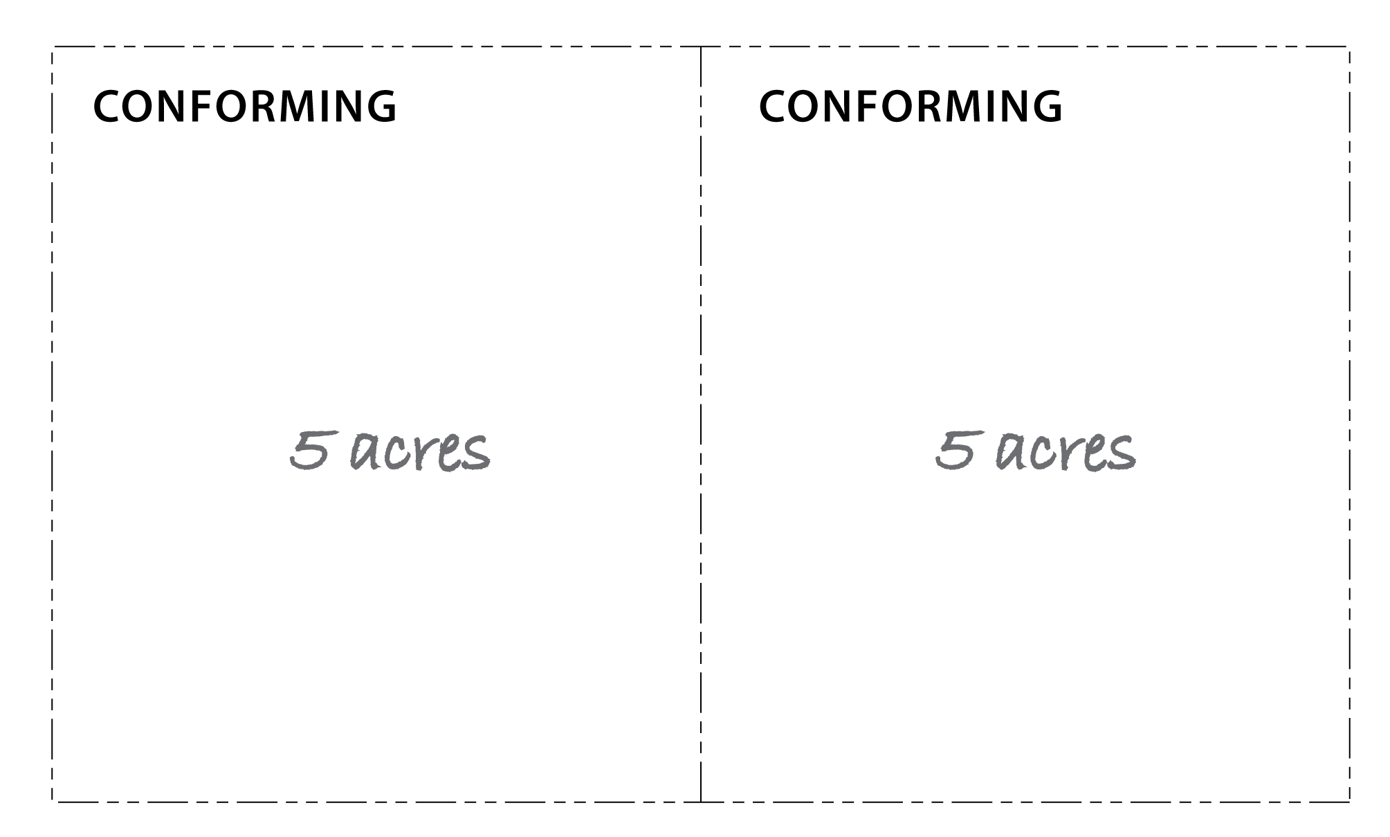
Figure 17.06.110.B.3 provides an example of a Future Development Plan for a parcel in the Medium Density zoning district, illustrating proposed lots under current septic capacity that conform to the Medium Density zoning district lot parameters. The concept includes common area for the drain field, which doubles as a reserve for future urban development that meets the district lot parameters.
| FIGURE 17.06.110.B.3 - EXAMPLE FUTURE DEVELOPMENT PLAN |
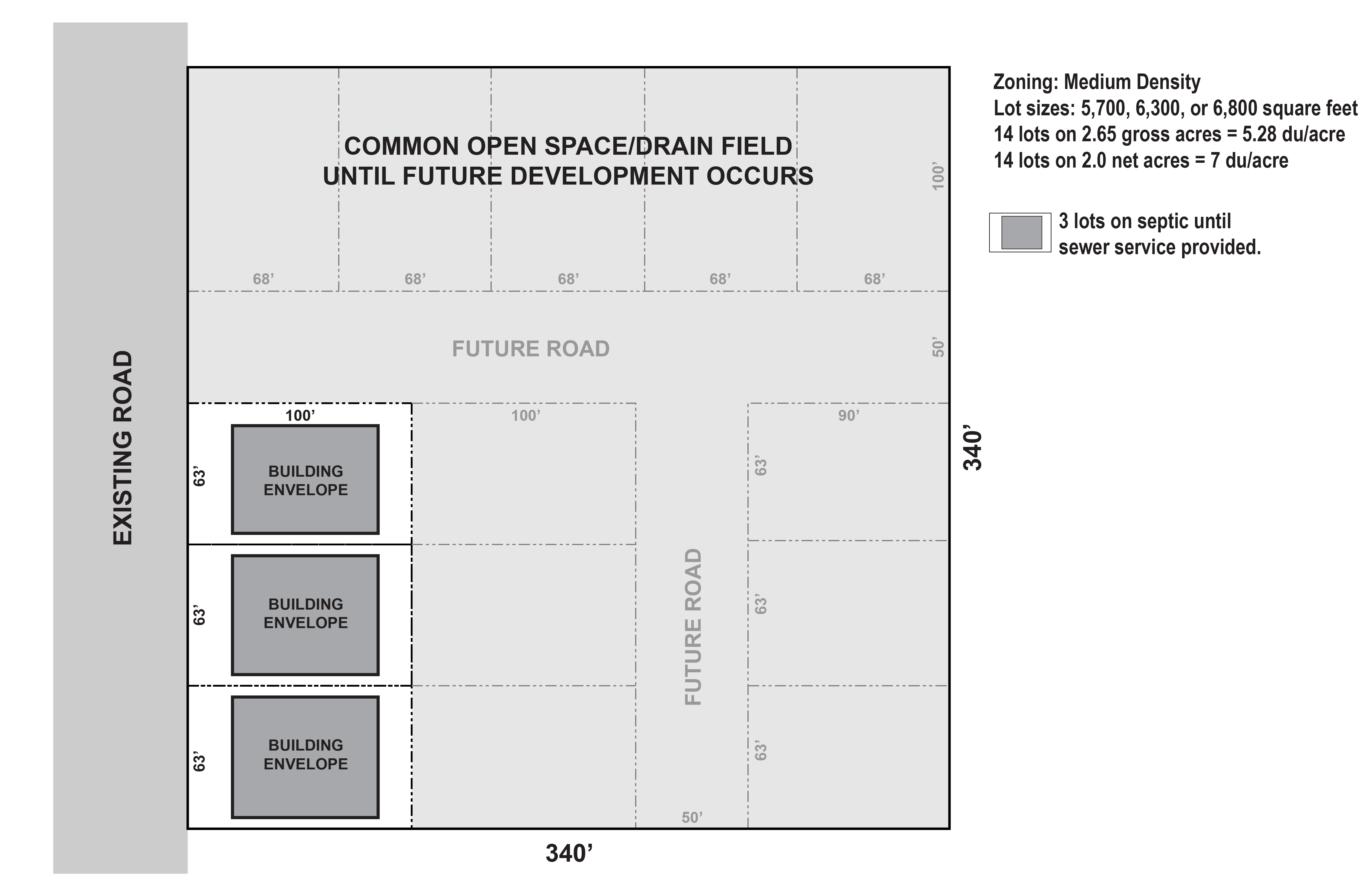 |
| Example: Assuming that this 2.65 acre parcel meets County Health Department standards for three (3) lots under site septic capacity, this site plan illustrates the location of those three (3) lots along with a concept plan in how the remainder of the parcel could be developed consistent with the lot parameters for the Medium Density zoning district. |
C.
Density shifts. If growth in Freeland is higher than anticipated and sewer is available, density shifts may be approved subject to the following conditions.
1.
Growth exceeds projections. If the population in the NMUGA exceeds eighty (80) percent of the twenty-year population projection for the current planning period and population growth is continuing at such a rate that indicates additional population capacity may be needed prior to the next periodic update.
2.
Limited locations. Density shifts are only available for parcels zoned Low Density or Medium Density where the front or side property line is adjacent to a Village Core zoning district (see section 17.06.120).
3.
Density cap. The maximum density shall be 150 percent of the base zoning district density.
4.
Sewer availability. Density shift shall only be allowed if sewer is utilized to serve the parcel.
Density shifts may be used in conjunction with transitional uses (see section 17.06.205) as a part of phasing of future growth to accommodate additional housing units, and shall be considered a reasonable measure for accommodating growth in lieu of expanding the boundary of the NMUGA.
(Ord. No. C-49-19 [PLG-004-19], Exh. C, 6-18-2019)
17.06.120 - Development standards by zoning district.
The development standards for Freeland NMUGA zoning districts are as shown in Table 17.06.120. All Parks zoning district development standards from chapter 17.03 shall apply to properties zoned Parks within the NMUGA.
| TABLE 17.06.120 - DEVELOPMENT STANDARDS BY ZONING DISTRICT | ||||||
|---|---|---|---|---|---|---|
| ZONING DISTRICTS | RESIDENTIAL DISTRICTS | VILLAGE CORE DISTRICTS | ||||
 |  |  |  |  |  | |
| RESIDENTIAL DENSITY | ||||||
| Minimum Density (1) | 2 du/a | 6 du/a | n/a | n/a | n/a | 0 |
| Maximum Potential Density (2) | 4 du/a | 12 du/a | None (3) | None (3) | None (3) | 0 |
| LOT SIZING(4) | ||||||
| Lot Area (min) | 10,000 sq. ft. | 5,000 sq. ft. for single family detached; per density standards for all others | None | None | None | None |
| Lot Area (max) (5) | per density standards | per density standards | None | None | None | None |
| Lot Width (min) | 60 ft. |
Single family:
40 ft. front loaded, 30 ft. alley loaded Multi-family and/or Mixed-Use: 80 ft. | 30 ft. | 60 ft. | 60 ft. | 60 ft. |
| BUILDING PLACEMENT AND MASSING | ||||||
| Lot Coverage | ||||||
| Max. Impervious Surface | n/a | n/a | 100% (7) | 70% | 70% | 70% |
| Max Lot Coverage, All Buildings (6) | 50% | 50% | 100% (7) | 50% | 50% | 50% |
| Setbacks(8,9) | ||||||
| Build-To Line | n/a | n/a | 0 ft. (12) | n/a | n/a | n/a |
| Build-To Percentage | n/a | n/a | Min 50% @ build-to line (13) | n/a | n/a | n/a |
| Front Yard (min) (8,10) | 20 ft. | 15 ft. | n/a | 10 ft. | 20 ft. | 20 ft. |
| Front Yard (max) | n/a | 25 ft. | 15 ft. (11) | n/a | n/a | n/a |
| Side Yard (min) | 5 ft. | 5 ft. | 0 ft./5 ft./15 ft. (14) | 5 ft./20 ft. (15) | 10 ft./20 ft. (15) | 5 ft./30 ft. (16) |
| Rear Yard (min) | 10 ft. | 10 ft. | 0 ft./5 ft./15 ft. (14) | 10 ft./20 ft. (15) | 10 ft./20 ft. (15) | 10 ft./30 ft. (16) |
| Garage (from ROW/from alley) (17) | 25 ft./20 ft. | 25 ft./20 ft. | 25 ft./20 ft. | 25 ft./20 ft. | 25 ft./20 ft. | |
| Building Height (max) | ||||||
| Outside of a View Corridor Area (18) | 25 ft./35 ft. | 35 ft. | 40 ft./45 ft. (19,20) | 35 ft. | 35 ft. | 35 ft. |
| Along a View Corridor Frontage (8) | 20 ft./30 ft. | 25 ft./35 ft. | n/a | 25 ft./35 ft. | 25 ft./35 ft. | 25 ft./35 ft. |
| Ground Floor Ceiling Height (min) | n/a | n/a | 14 ft. (21) | n/a | 14 ft. (21) | n/a |
| NOTES: | ||||||
| (1) Future Development Plan required to show how development under septic will not impede future urban densities. | ||||||
| (2) The maximum density is limited to County Health Department standards for septic until sewer is available, per section 17.06.110.B. See section 17.06.110.C for potential future Density Shift options. | ||||||
| (3) Maximum density for residential uses shall be determined by height limits, parking requirements, setbacks, septic capacity, and other development standards and permit approval criteria. Residential uses shall comply with the standards of section 17.06.320. | ||||||
| (4) Cottage housing developments are exempt from lot sizing standard provided the developments comply with the provisions of section 17.06.320.D and meet the zoning district density standards. | ||||||
| (5) Individual townhouses placed on fee-simple lots are exempt from the minimum lot area and width standards, provided the development complies with the district density standards and the provisions of section 17.06.320.E. | ||||||
| (6) For townhouse developments, site coverage is calculated for the whole development, not individual lots. | ||||||
| (7) Site coverage will be less than 100%, due to limitations of landscaping requirements and other provisions that will decrease the total potential site coverage. | ||||||
| (8) Additional setback and step-back requirements apply to properties adjacent to the Holmes Harbor View Corridor overlay and the State Highway 525 overlay, per section 17.06.140. | ||||||
| (9) See section 17.06.150 for general setback encroachment and building height exceptions. | ||||||
| (10) See section 17.06.670 for porch/covered entry encroachment allowance. | ||||||
| (11) Front yard setback applies to the portion of the façade that does not need to be at the Build-to line. Greater setbacks of up to twenty-five (25) feet may be approved by the Planning Director where the area between the sidewalk and the building meets the pedestrian-oriented open space standards in 17.06.510.D. | ||||||
| (12) Build-to line and percentage applies to Main St. and Harbor Ave. frontages only. | ||||||
| (13) Building façade sections at the build-to line shall be a minimum of 20 linear feet. For building façade sections greater than 50 linear feet, the Planning Director may approve one or more courtyard inset(s) where the inset depth is no greater than 10 ft. and the total inset length is no greater than 20% of the total building façade length. | ||||||
| (14) Side and rear yard setbacks are zero for windowless firewalls and 5 feet for walls with windows excepting that the setback shall be 15 feet where adjacent to Low Density and Medium Density districts. | ||||||
| (15) Side and rear yard setbacks shall be 20 feet where adjacent to Low Density and Medium Density districts. | ||||||
| (16) Side and rear yard setbacks shall be 30 feet where adjacent to Low Density and Medium Density districts. | ||||||
| (17) See section 17.06.550.I for garage placement and design standards. | ||||||
| (18) Increased height, if shown, is allowed only for structure or portions of a structure that is ≥ 40 ft. from all property lines. Increase height allowance does not apply to accessory structures. | ||||||
| (19) Building heights typically 40 feet; 45 feet is allowed for properties fronting along Main St. and Harbor Ave. | ||||||
| (20) The maximum building height may be increased by an additional 10 feet per section 17.06.150.C.1. | ||||||
| (21) Ground floor spaces shall have a minimum clear ceiling height of fourteen (14) feet, excepting single-family residential dwelling units and guest cottages. | ||||||
17.06.130 - Zoning amendments.
An application for a zoning amendment for a property within the Freeland NMUGA shall be processed pursuant to this section.
A.
Purpose. This section provides a process to apply for zoning reclassifications when such zoning amendments are compliant with the Freeland Subarea Plan. Zoning amendments that require a Comprehensive Plan Amendment shall only occur once per year on an annual basis and shall be a Comprehensive Plan amendment, processed as a Type IV decision pursuant to chapter 16.26.
B.
Application requirements. The application shall contain the following requirements:
1.
The name, location, street address, and legal description of the affected parcel or property, together with the names, addresses and telephone numbers of the applicant or applicants, the owners of record of the land, and any associated professional consultants such as architects or engineers;
2.
A description of the existing use or uses of the land and uses of any existing buildings;
3.
A description of the specific proposed amendment;
4.
A description of each proposed use of land and buildings to be undertaken with the development;
5.
A general site plan drawn to a scale of not less than one (1) inch to twenty (20) feet and not greater than one (1) inch to 100 feet showing building envelopes, access, circulation (both vehicle and pedestrian), and open space or an application for site plan approval pursuant to chapter 16.15 or PRD approval pursuant to chapter 16.17;
6.
A description of the reasons for the amendment; and
7.
A description of how the rezoning meets the criteria in section 17.06.130.D.
C.
Review process.
1.
Zoning amendments that are within the Freeland NMUGA shall be a Type III application and processed pursuant to section 16.19.170.
2.
Any expansion of the Freeland NMUGA boundary will also require a rezoning to a Freeland zoning district. The rezoning shall be processed concurrently with the Comprehensive Plan Amendment application for the boundary expansion; both applications shall be processed as a Type IV decision pursuant to chapter 16.26.
3.
A rezoning may also be reviewed and approved through the periodic review cycle for the Island County Comprehensive Plan and Freeland Subarea Plan process, per chapter 16.26.
D.
General criteria for evaluation of a Type III rezoning request. The Hearing Examiner shall recommend to the Board of Island County Commissioners the denial or approval of each application for an amendment to the official zoning maps based on consideration of the following general factors.
1.
Compatibility with the existing Freeland Subarea Plan.
2.
No zoning amendment will be approved where the requested zoning district is different from the zoning on surrounding properties, excepting the following:
a.
Where a property is zoned Low Density Residential and is immediately adjacent to Non-Residential Mixed-Use, the property may be considered for rezoning to either Medium Density Residential or Non-Residential Mixed-Use; and/or
b.
Reclassification to Low Density Residential (LD) shall only be allowed when applying Freeland zoning districts with an expansion of the NMUGA boundary. When expanding the NMUGA boundary, no Low Density Residential will be created along Hwy 525.
3.
The impact of the proposed zoning classification on available and projected traffic patterns, water and septic/sewer systems, and other public facilities and utilities.
4.
Rezoning shall not be approved in any of the following conditions.
a.
Rezoning would result in an increase in commercial traffic where such traffic must travel through residential districts (Low Density Residential and Medium Density Residential) to reach the parcel.
b.
Rezoning would result in the creation of a lot that cannot support the minimum density for the requested zoning district.
c.
Rezoning would result in a violation of policies in any element of the Comprehensive Plan, Freeland Subarea Plan, or elsewhere in the Island County Code, including, but not limited to the following:
(i)
Rezoning would create a non-conforming lot (size or setbacks);
(ii)
Rezoning would create more than one (1) zoning district on any tax parcel; and/or
(iii)
The rezoning would have an adverse impact on the View Corridors (see section 17.06.140.A).
d.
The request is to rezone to Light Industrial (LI).
E.
After county action on an application, no new application for reclassification of the same property may be submitted for one (1) year from the date of approval or denial.
(Ord. No. C-49-19 [PLG-004-19], Exh. C, 6-18-2019)
17.06.140 - Overlays.
Where there is a conflict between this section and other sections of this chapter, the overlay criteria contained in this section shall apply.
A.
Holmes Harbor View Corridors.
1.
Purpose.
a.
Ensure that views of Freeland and Holmes Harbor are preserved so that Freeland maintains its connection to nature while it develops.
b.
Ensure that there is diversity in the built environment and minimize repetitive patterns.
c.
Ensure that buildings fit within the context of the established built environment and do not impact the view corridor.
d.
Ensure that mature trees are a key element of the future viewshed without blocking sight lines along view corridors.
e.
Mitigate the negative visual impacts arising from the scale, bulk, and mass inherent to commercial buildings and centers.
2.
Applicability.
a.
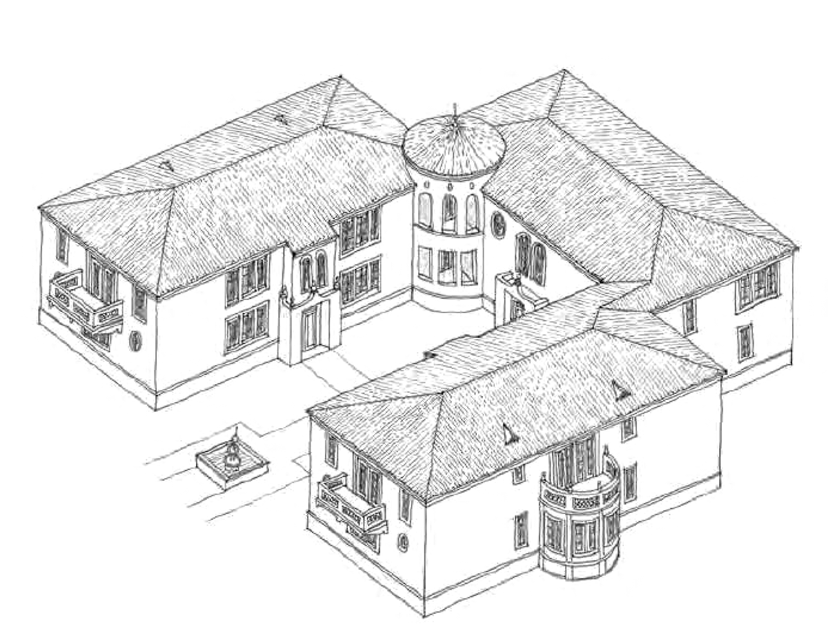
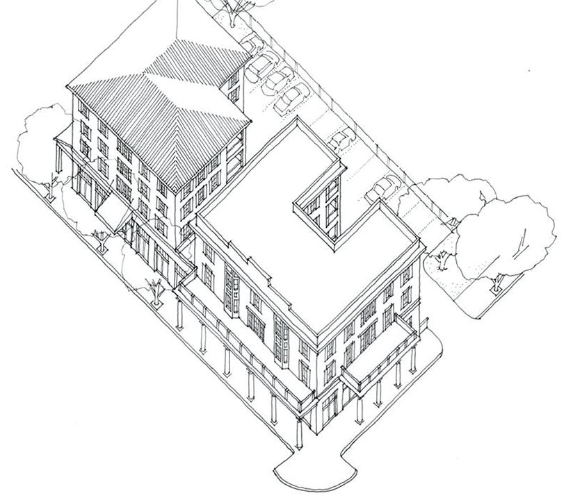
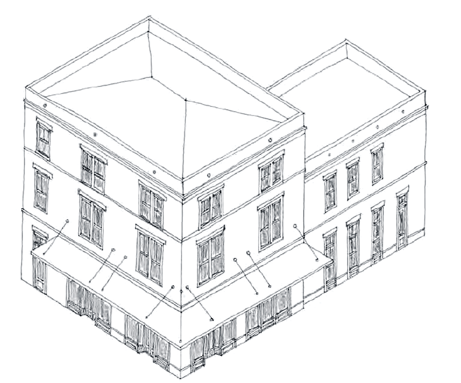
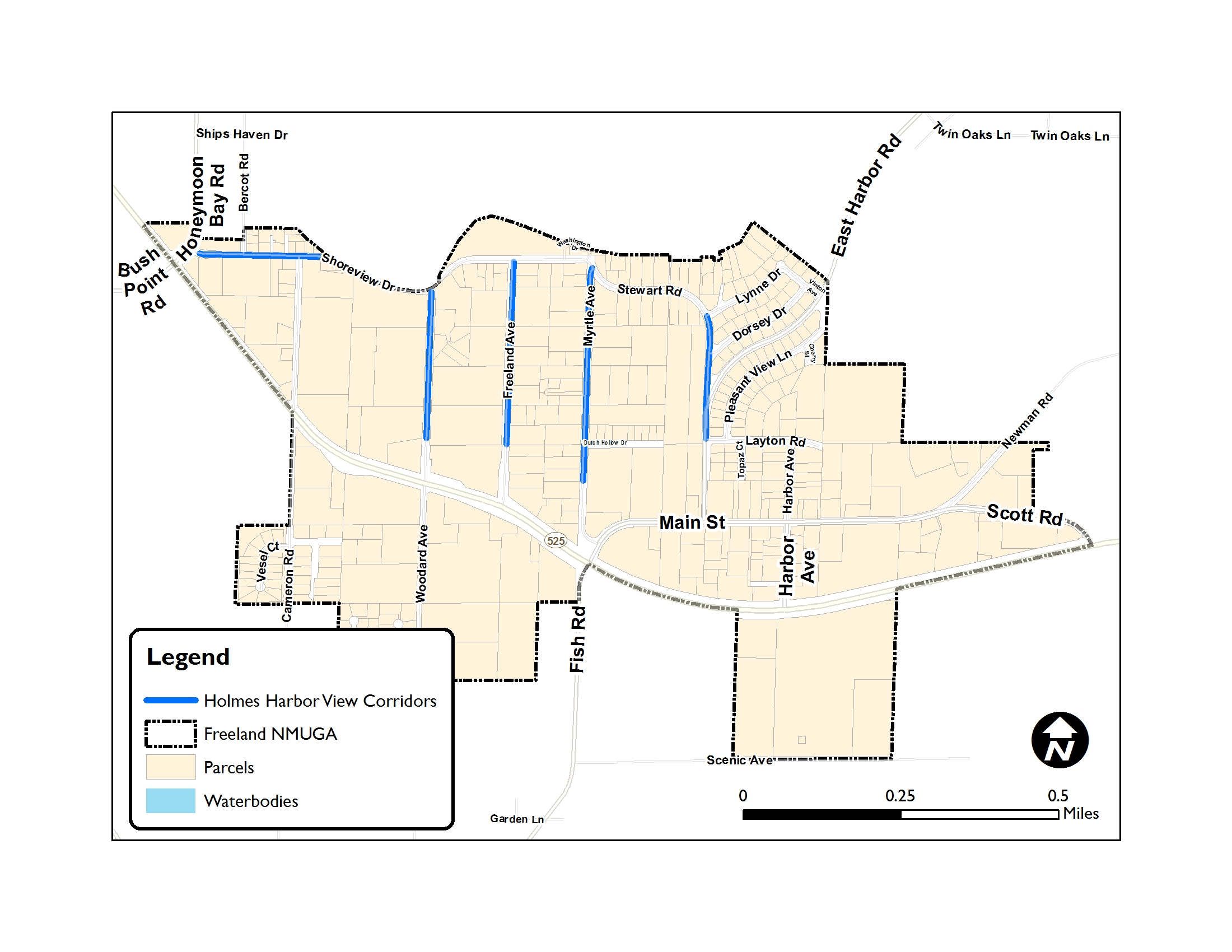
The Holmes Harbor View Corridors are along public rights-of-way identified in Figure 17.06.140.A. All properties adjacent to the designated corridors are subject to these standards.
| FIGURE 17.06.140.A - HOLMES HARBOR VIEW CORRIDORS |
 |
3.
Holmes Harbor View Corridor standards.
a.
Building design and placement.
(i)
Buildings shall be set back a minimum of thirty (30) feet from the street right-of-way of the adjoining view corridor.
(ii)
Avoid repetition within the viewshed. In order to achieve diversity within the viewshed the following design aspects of existing buildings located within 100 feet of the perimeter of the proposed development activity should be considered:
(1)
Roof color, roof style, roof line, roof pitch, and roof material.
(2)
Building color, height, and shape.
(3)
A light reflectivity value (LRV) no greater than thirty-five (35) percent for building and roof colors.
b.
Building height step back.
(i)
Height shall be limited for any portion of a building that is less than forty (40) feet from the property line along the view corridor, per Table 17.06.140.A.3.b.
(ii)
A green roof or rooftop deck may be utilized in the forty-foot step back area. Safety railings for these areas cannot extend above the building height limit except where railings have a transparency of ninety (90) percent or greater (i.e. glass, etc.) and shall not exceed a height of forty-eight (48) inches.
c.
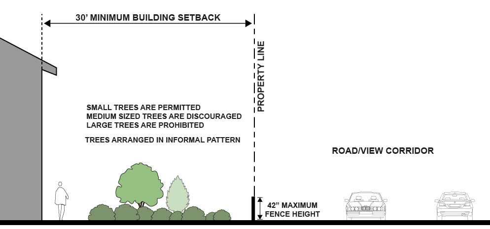
Landscaping. Informal arrangements of trees and plantings within the front yard are encouraged, with tree height not to exceed thirty (30) feet at maturity.
d.
Fences and hedges in the front yard shall be no more than forty-two (42) inches in height.
| FIGURE 17.06.140.A.3.D. - VIEW CORRIDORS SETBACKS AND LANDSCAPING STANDARDS |
|---|
 |
B.
State Highway 525 Overlay District.
1.
Purpose.
a.
To protect the rural character along State Highway 525, which has been officially designated as a scenic byway and limited access facility by the State of Washington; and
b.
Ensure that new development and land use activity located along State Highway 525 is carried out in a manner that maintains, promotes, and enhances the rural character of Island County.
2.
Applicability.
a.
This section establishes supplemental criteria for properties which have one (1) or more property lines bordering State Highway 525 right-of-way. Additional development criteria and requirements for landscaping, building setbacks and orientation, and commercial signage are applied in this area.
b.
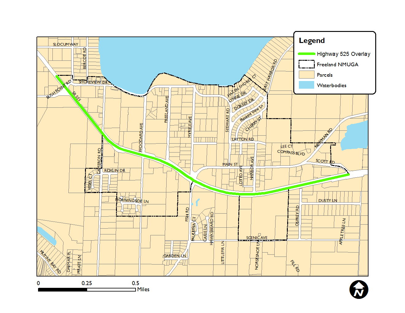
The extent of the overlay is established in Figure 17.06.140.B.2.
| FIGURE 17.06.140.B.2 - STATE HIGHWAY 525 OVERLAY |
|---|
 |
3.
Overlay standards.
a.
Building placement. Buildings shall be set back a minimum of thirty (30) feet from Highway 525 right-of-way.
b.
Building design.
(i)
Buildings are subject to the standards in section 17.06.600 and the following:
(ii)
For properties and/or structures that are located at the intersection of State Highway 525 and a public road, architectural features incorporated into the design of the building facing towards the highway and/or public road shall have the same level of architectural detail and articulation as the main façade of the building. Building façades that are screened from the highway by topography and/or landscaping screens are exempt from this design standard.
c.
Parking shall be set back a minimum of twenty (20) feet from State Highway 525 ROW.
d.
Landscaping.
(i)
Form. Landscaping along State Highway 525 is to follow meandering lines where trees and shrubs are varied in height, species, spacing, color, and shape. Repetition and linear forms are prohibited. Where berms are constructed, topography shall vary and the berm footprint must vary; avoid a strict rectilinear form except where screening is desired or required.
(ii)
Trees. One (1) three-inch caliper tree is required for every forty-five (45) linear feet of frontage. A mix of native deciduous and coniferous trees is required where the ratio of deciduous to coniferous shall be between 1:3 and 1:5.
(iii)
Open landscaping. For uses where visibility into the site and to buildings is desired by the applicant, utilize a mix of low level landscaping elements mixed with informal groupings of trees that add visual relief while maintaining desired visibility into the site.
(iv)
Landscape screening.
(1)
For parking areas visible from State Highway 525, a Type A landscape buffer (section 17.06.540.E.10) a minimum of twenty (20) feet wide is required, designed to achieve a full screen of the parking area within five (5) years.
(2)
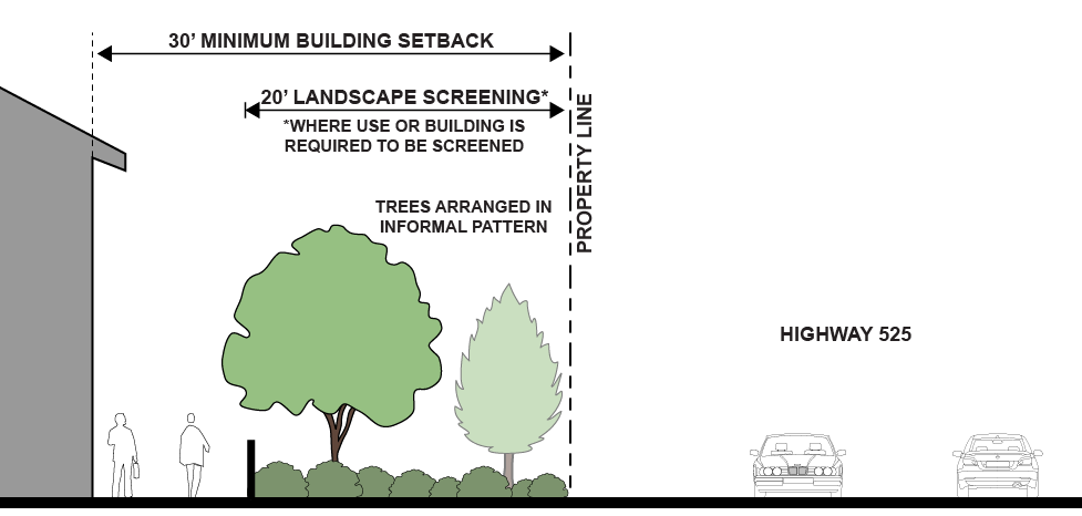
For buildings with blank walls (as defined in section 17.06.650) and for uses with outdoor storage, a Type A landscape buffer (section 17.06.540.E.10) a minimum of twenty (20) feet wide is required, designed to achieve a full screen of the first floor of a building within five (5) years, as shown in Figure 17.06.140.B.3.
| FIGURE 17.06.140.B.3 STATE HIGHWAY 525 OVERLAY LANDSCAPING REQUIREMENTS |
|---|
 |
e.
Signs.
(i)
Freestanding monument signs (section 17.06.560.C.2) within forty (40) feet of the Highway 525 right-of-way may be up to eighteen (18) feet high. Where there is a conflict between this provision and elsewhere in the code, this provision shall control.
(ii)
Signs shall be set back a minimum of ten (10) feet from the Highway 525 right-of-way.
(iii)
Signs visible from the highway are subject to the state Highway Advertising Control Act, Chapter 47.42 RCW and Chapter 468-66 WAC; only those signs permitted along the scenic system shall be erected or maintained. Where there is a conflict between this section and Chapter 47.42 RCW, the more restrictive shall apply.
(Ord. No. C-49-19 [PLG-004-19], Exh. C, 6-18-2019)
17.06.150 - Setback encroachments and height exceptions.
A.
Purpose. The following encroachments and exceptions are intended to provide specific exceptions to the district regulations set forth in section 17.06.120.
B.
Allowable building setback encroachments.
1.
General.
a.
Required building setbacks in all districts must be unobstructed and unoccupied from the ground to the sky except that the features listed herein are allowed to encroach into required setbacks as outlined in this section.
b.
In no case shall any encroachment exceed fifty (50) percent of the required building setback except as allowed per section 17.06.660.
c.
With the exception of accommodation for the disabled, no encroachment allowed by this section shall extend into a critical area and/or critical area buffer. Accommodation for the disabled may be allowed into a critical area buffer through a Reasonable Use Determination (chapter 17.02B).
d.
In no case shall any encroachment allowance in this section be considered a variance to impervious surface and site coverage maximums.
e.
In no case shall any encroachment allowance in this section be considered a variance to fire and building code requirements.
f.
In no case shall any encroachment allowance in this section be considered a variance from Shoreline setbacks and buffers required per chapter 17.05A.
2.
Accommodation for disabled. Wheelchair ramps, mechanical access devices, and other structures intended to facilitate access for the disabled may encroach into a required setback, provided they are not more than thirty-six (36) inches in height and remain five (5) feet from the front property line, two (2) feet from the side property line and ten (10) feet from the rear property line.
3.
Rain barrels and cisterns. Rain barrels and cisterns used for rainwater harvesting, and less than six (6) feet above finished grade, shall be allowed to encroach no more than five (5) feet into side and rear building setbacks.
4.
Uncovered and unenclosed decks and entry stairs. Only necessary support pillars not exceeding one (1) horizontal feet in thickness may be included. For all such decks and entry stairs, a safety railing not exceeding forty-two (42) inches in height may be allowed.
5.
Porch encroachment for single-family dwellings.
a.
A front porch that meets the design standards of section 17.06.670 may encroach into the front yard setback per the allowance in section 17.06.670.
b.
A front porch that does not meet the design standard of section 17.06.670 may encroach into the front yard setback per section 17.06.150.B.1.
c.
Any porch encroachment into the building setback shall not be more than a single story in height.
6.
Basement light-wells and access stairwells for single family dwellings. Basement light-wells and below-grade access stairways may encroach no more than four (4) feet into side and rear yard building setbacks, provided their retaining walls are situated at least three (3) feet from property lines and the encroachment area is a maximum of twenty (20) square feet. Above-grade railings or walls around such light-wells or access stairways that are forty-two (42) inches or less in height are also exempt from building setbacks.
7.
Other architectural features and appurtenant structures. The following architectural features and appurtenant structures may extend into any required front, side or rear yard setback, but less than a distance of three (3) feet to the property line. All Fire Code structural separation requirements shall apply and may limit encroachment opportunities.
| FIGURE 17.06.150.B.7 MINIMUM DISTANCE TO PROPERTY LINE FOR ANY SETBACK ENCROACHMENT |
|---|
 |
a.
Awnings, not to exceed two (2) feet.
b.
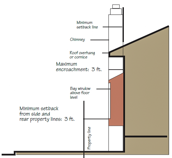
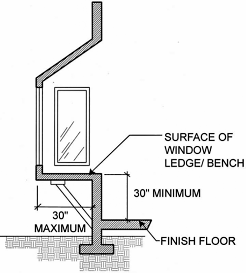
Bay windows, limited. For purposes of this section, the bay window must be supported by framing or underpinnings higher than the finished floor level, not creating additional floor area, and the vertical distance between the surface of the interior window ledge or bench and the finished floor must be thirty (30) inches or greater. Encroachment may not exceed two (2) feet.
| FIGURE 17.06.150.B.7.b - BAY WINDOW ENCROACHMENT ILLUSTRATION |
|---|
 |
c.
Chimneys.
d.
Overhanging roof, eave, gutter, cornice, or other similar architectural feature.
e.
Mechanical equipment, including heating and air conditioning units and heat pumps.
C.
Allowable Height Exceptions.
1.
The maximum building height in the Business Village district may be increased by an additional ten (10) feet if the development meets adopted County affordable housing criteria. The increased height is subject to Planning Director approval, and additional conditions may apply including, but not limited to, step-backs for upper floors and additional open space.
2.
Mechanical equipment, including solar panels, attic vents, heating and air conditioning units, heat pumps, and similar equipment may exceed the maximum building height by no more than four (4) feet.
3.
The maximum height of a chimney, weather vane, or other similar architectural embellishment mounted on a building and having a horizontal cross section of no more than twenty (20) square feet may exceed the maximum building height, provided that it does not exceed the height of the building on which it is mounted by more than five (5) feet.
4.
Steeples and clock towers, not to exceed twenty (20) feet above the maximum building height and a horizontal cross section of no more than eighty (80) square feet.
(Ord. No. C-49-19 [PLG-004-19], Exh. C, 6-18-2019)
17.06.200 - PERMITTED USES
A.
How to use the permitted use tables. The tables are intended to assist you in learning what uses may be established in the Freeland NMUGA zoning districts and the type of permit that may be required.
Within a table you will see a I, II, or III; these numbers indicate the type of land use decision that is required in order to establish the use. These land use decisions have the following meaning:
I = Type I permitted use—Ministerial decision.
II = Type II conditional use—Administrative decision.
III = Type III conditional use—Hearing Examiner decision.
B.
Relationship to other sections of Island County Code.
• The time period established for review of land use decisions shall be as provided by RCW 36.70B.080(1).
• Definitions of uses are found in section 17.03.040.
• For more information on land use decision processes, please refer to chapter 16.19.
(Ord. No. C-49-19 [PLG-004-19], Exh. C, 6-18-2019)
17.06.205 - Transitional uses.
A.
Purpose.
1.
To create distinct zoning districts with smooth transitions between districts.
2.
To provide for small commercial and live/work units that offer an opportunity for small local businesses that serve the neighborhood needs (small restaurant, doctor's office, etc.) in close proximity to residential areas without disrupting residential neighborhoods.
3.
To allow transitional uses to be utilized in lieu of zoning amendments to increase flexibility in the community while still protecting the integrity of the character of the existing neighborhoods.
4.
May be used in conjunction with density shifts (see section 17.06.110.C) as a part of phasing of future growth to accommodate additional housing units as a reasonable measure in lieu of expanding the boundary of the NMUGA.
B.
Limitations. Limitations on transitional uses are an important part of protecting the integrity of the character of the district. Limitations shall include locations where transitional uses are allowed and the types of uses that are allowed to transition.
1.
Locations of transitional uses. Transitional uses are only allowed at zoning district boundaries, either at an intersection or where the front or side property line of the lot is adjacent to a zoning district that allows the use. Non-contiguous transitions will not be permitted.
2.
Transitional uses.
a.
Transitional uses are limited to those specifically identified by note seven (7) on the use tables (section 17.06.210 and 17.06.220). A subset of the uses allowed in the more intense district are identified as allowed as transitional uses for the next district down in development intensity, as shown in the figure below:
| FIGURE 17.06.205.B.2.a TRANSITIONAL USES DETERMINED BY ADJACENT "SENDING" ZONING DISTRICT |
|---|
| "Sending" Parcel Zoning → "Receiving" Parcel Zoning |
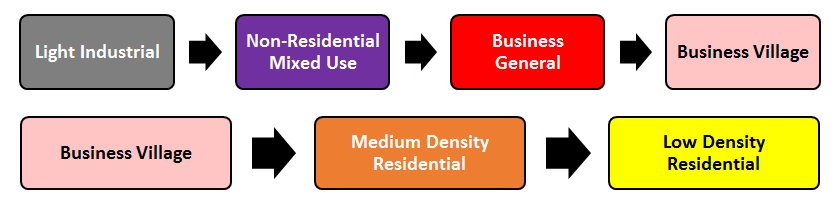 |
| NOTE: Uses "sent" to the receiving parcel as limited to those indicated by note 7 in the Use Tables 17.06.210 and 17.06.220. If the "sending" parcel is more than one step up the scale, see 17.06.205.B.2.b. |
b.
If a parcel meets the location qualifications of paragraph 1 of this sub-section, but the adjacent "sending" parcel is not zoned as the next district up the scale shown in Figure 17.06.205.B.2.a, but instead is zoned at a higher intensity district ("skipping" steps in the transition scale), transitional uses shall be allowed but shall be restricted to the uses that would be permitted if the adjacent sending parcel were zoned as the next district up the scale. See examples in Figure 17.06.205.B.2.b.
| FIGURE 17.06.205.B.2.b - EXAMPLES OF TRANSITIONAL USES "SKIPPING" A STEP | |
|---|---|
| Example 1: Where a Low Density Residential parcel is at a qualifying location, but is adjacent to Non-Residential Mixed Use, the transitional uses allowed shall be as if the adjacent "sending" parcel(s) were zoned as Medium Density Residential. | 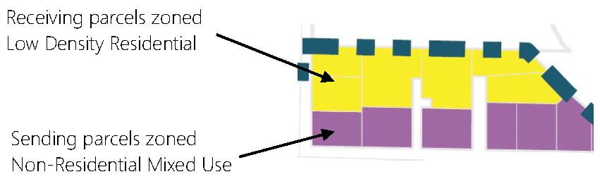 |
| Example 2: Where a Medium Density Residential parcel is at a qualifying location, but is adjacent to Business General, the transitional uses allowed shall be as if the adjacent "sending" parcel were zoned Business Village. |  |
c.
Transitional uses do not change the underlying zoning district requirements, including but not limited to building setback and building heights.
3.
The Planning Director may apply additional conditions to protect the neighboring uses, based on site constraints and existing uses on neighboring properties.
(Ord. No. C-49-19 [PLG-004-19], Exh. C, 6-18-2019)
17.06.210 - Residential uses.
See sections 17.06.500—17.06.580 for site design and sections 17.06.600—17.06.670 for building design standards.
| TABLE 17.06.210 RESIDENTIAL AND RESIDENTIAL ACCESSORY USES | ||||||||
|---|---|---|---|---|---|---|---|---|
Low Density Residential | Medium Density Residential | Business Village | Business General | Non-Residential Mixed-Use | Light Industrial | |||
| USE TYPE | LD | MD | BV | BG | NM | LI | RELATED CODE(S) | |
Single-Family |
Single Family, detached
(1 unit) | For Mobile Homes, see ICC 17.06.320.B | ||||||
|
Duplex (2 units)
| ||||||||
|
Single Family, attached
(3—4 units) |
Townhomes:
ICC 17.06.320.E | |||||||
| Manufactured home park | ICC 17.06.320.C | |||||||
Multi-Family |
Cottage housing
| ICC 17.06.320.D | ||||||
|
Multi-Family
(5+ units) | Includes courtyard, villa, and/or bungalow apartments | |||||||
| Mixed-Use Residential, small (1—4 units) | Includes live/work units | |||||||
|
Mixed-Use Residential
(5+ units) | ||||||||
Group Quarters | Residential Care Home |
Up to 6 clients:
ICC 17.06.350.C | ||||||
| Group Home/Adult Family Home | ICC 17.06.350.C | |||||||
|
Assisted Living/
Nursing Home | ||||||||
Accessory Uses and Structures |
Attached ADU
| ICC 17.06.320.A | ||||||
|
Detached ADU
| ICC 17.06.320.A | |||||||
|
Home Occupation
| ICC 17.06.310.A | |||||||
|
Home Industry
| ICC 17.06.310.B | |||||||
|
Accessory structures
| Garage, shed, shop, etc. | |||||||
| NOTES: (1) May be allowed as an accessory use only, subject to ICC 17.06.300—17.06.350. (2) Not allowed on Main Street or Harbor Avenue frontages. (3) Not allowed within 500 feet of Industrial (LI) district, unless developed in conjunction with an area employer for workforce housing. (4) Not allowed within 300 feet of a residential district (LD or MD) or existing residential use. (5) May be allowed as a component of a mixed-use development if fully integrated and the commercial component is developed at the same time as, or before, the residential; prohibited as a stand-alone use, unless developed in conjunction with an area employer for workforce housing. Mixed-use may be attached units or with residential in a separate building. In no case shall residential component have more square footage than the non-residential uses. (6) May be allowed as a component of a cluster development, under the PRD provisions in chapter 16.17 ICC. (7) May be allowed as a transitional use under the provisions of ICC 17.06.205. (8) Type II approval if SEPA required (per Chapter 43.21C RCW and 197-11 WAC), Type I approval if SEPA Exempt. (9) Number of bedrooms shall be limited by the septic/sewer capacity. | ||||||||
(Ord. No. C-49-19 [PLG-004-19], Exh. C, 6-18-2019; Ord. No. C-18-22 [PLG-002-21], Exh. A, 5-3-2022; Ord. No. C-46-25 Exh. A, 8-26-2025)
17.06.220 - Non-residential uses.
See also section 17.06.305 for general standards, sections 17.06.500—17.06.580 for site design standards, and sections 17.06.600—17.06.670 for building design standards.
| TABLE 17.06.220 NON-RESIDENTIAL USES | ||||||||
|---|---|---|---|---|---|---|---|---|
Low Density Residential | Medium Density Residential | Business Village | Business General | Non-Residential Mixed-Use | Light Industrial | |||
| USE TYPE | LD | MD | BV | BG | NM | LI | RELATED CODE(S) | |
Lodging |
Bed and Breakfast Room
|
1—2 guest rooms -
ICC 17.06.330.A.1 | ||||||
|
Bed and Breakfast Inn
|
3 to 6 guest rooms -
ICC 17.06.330.A.2 | |||||||
|
Emergency Shelter/
Transitional Housing |
In MD district:
Type Type | |||||||
|
Hotel/Motel
| 7 or more guest rooms - ICC 17.06.330.C | |||||||
Office |
Flex Office
| |||||||
|
Health Care Facilities
| ||||||||
|
Office Building
| ||||||||
Services |
Banks/Financial Institutions
| |||||||
|
Cultural Centers
| ||||||||
|
Day Care Center, Small
| (1) | ICC 17.06.350.C | ||||||
|
Day Care Center
| ICC 17.06.350.C | |||||||
|
Dry Cleaners
| ||||||||
|
Fuel Service
| ICC 17.06.340.G | |||||||
|
Churches/Schools
| ICC 17.06.350 | |||||||
|
Police/Fire Station
| ICC 17.06.350.D | |||||||
|
Kennels and animal shelters
| ICC 17.06.350.E | |||||||
Food Service |
Restaurant, no Drive-Thru
| |||||||
|
Restaurant, w/Drive-Thru
| ICC 17.06.540.D.5 | |||||||
|
Commercial Kitchen (Stand-Alone)
| ||||||||
|
Coffee Shops
| w/ or w/o Drive-Thru | |||||||
|
Farm Stand or Push Cart
| ||||||||
|
Food Truck
| ICC 17.06.340.E | |||||||
|
Food Truck Court>
| ICC 17.06.340.F | |||||||
|
Farmers Market
| ||||||||
|
Grocery Store
| ||||||||
Retail |
Artist Studio
| Non-habitable space | ||||||
|
Garden Center/Lumber Yard
| ||||||||
|
Marijuana, Retail Sales
| ICC 17.03.180.BB | |||||||
|
Retail Sales and Services
| Type | |||||||
Entertainment/Recreation | Bar/Nightclub/Remote Tasting Room | |||||||
|
Assembly/Event Center
| Type | |||||||
| Events | Not allowed in LD & MD Districts; ICC 17.06.340.D | |||||||
|
Outdoor Auditorium
| ||||||||
|
Community Center/Library/
Museum | ||||||||
|
Health Club/Gymnasium
| ||||||||
| Amusement, Indoor | Type | |||||||
| Amusement, Outdoor | Type ICC 17.06.340.A | |||||||
|
Theatre, Live
| ||||||||
| Water-Dependent Uses (Marina, Launch) | Per SMP - Chapter 17.05A ICC | |||||||
Manufacturing/Industrial |
Artisan Workshop
| ICC 17.06.340.B | ||||||
|
Automotive Repair
| ||||||||
| Boat Building, Repair, and Related Industry | ||||||||
|
Food Processing
| ||||||||
|
Winery/Cidery/Brewery/Distillery/Coffee Roaster
| ||||||||
|
Light Manufacturing
| ||||||||
|
Research and Development
| ||||||||
| Storage, Commercial or Mini-Storage | ICC 17.06.340.I | |||||||
| Storage, Outdoor | ICC 17.06.340.J | |||||||
| Warehousing and Distribution Centers | ||||||||
Utilities |
Communications, Small Cell
| |||||||
|
Communications Tower
| ICC 17.03.180.L.8 | |||||||
|
Essential Public Facilities
| ICC 16.19.060 | |||||||
|
Major Utilities
| ||||||||
|
Minor Utilities
| ||||||||
| Water Tank | ICC 17.06.350.H | |||||||
| NOTES: (1) May be allowed as an accessory use only, subject to ICC 17.06.300—17.06.350. (2) Not allowed on Main Street or Harbor Avenue frontages. (3) Not allowed within 500 feet of Industrial (LI) district. (4) Not allowed within 300 feet of a residential district (LD or MD) or an existing residential use. (5) May be allowed as a component of a mixed-use development (separate building or attached) if fully integrated and the commercial component is developed at the same time as, or before, the residential; prohibited as a stand-alone use. Mixed-use may be attached units or with residential in a separate building. In no case shall residential component have more square footage than the non-residential uses. (6) May be allowed as a component of a cluster development, under the PRD provisions in chapter 16.17 ICC. (7) May be allowed as a transitional use under the provisions of ICC 17.06.205. (8) Type II approval if SEPA required (per Chapter 43.21C RCW and 197-11 WAC), Type I approval if SEPA Exempt. (9) Number of bedrooms shall be limited by the septic/sewer capacity. (10) Per RCW 69.50.331, not allowed within 1,000 feet of an elementary or secondary school; playground; recreation center or facility; child care center; public park; public transit center; library; or any game arcade (where admission is not restricted to persons age twenty-one (21) or older). | ||||||||
(Ord. No. C-49-19 [PLG-004-19], Exh. C, 6-18-2019)
17.06.230 - Prohibited uses.
The following uses are prohibited within the Freeland NMUGA.
A.
Composting and grinding.
B.
Junk and/or salvage yard (includes outdoor storage of junk and/or junk vehicles).
C.
Marijuana, outdoor grow.
D.
Outdoor shooting Gallery/Gun Club.
E.
Non-residential structure greater than 50,000 square feet of gross floor area.
(Ord. No. C-49-19 [PLG-004-19], Exh. C, 6-18-2019)
17.06.240 - Temporary uses.
A.
Purpose. This section allows for the establishment of certain temporary uses of limited duration and events provided that such uses do not negatively affect adjacent properties, and provided that such uses are discontinued upon the expiration of a set time period. Temporary uses and events do not involve the construction or alteration of any permanent building or structure. The following temporary uses may be conducted upon temporary use approval. Each use shall meet the requirements of this chapter, the underlying zoning district, and the following standards. (For events, see section 17.06.340.D.)
B.
General standards.
1.
The temporary use, structure, or event shall not be detrimental to property or improvements in the surrounding area or to the public health, safety, or general welfare. The temporary use, structure, or event shall not have substantial adverse effects or noise impacts on nearby residential neighborhoods.
All uses shall be confined to the dates specified in the certificate of temporary use.
2.
Hours and duration of operation shall be confined to those specified in the certificate.
3.
The site shall be cleared of all debris at the end of the temporary use and cleared of all temporary structures within thirty (30) days after the termination of the temporary use. A cash bond, the sum of which is to be determined by the county engineer, or a signed contract with a disposal firm, shall be required as part of the application for a certificate of temporary use when determined necessary by the county engineer or Planning Director to ensure that the premises will be cleared of all debris during and after the use.
4.
Public parking for the exclusive use of the facility shall be provided, and an adequate driveway to the parking area subject to approval of the county engineer shall be maintained. The parking area shall be maintained in a dust-free manner. It shall be the responsibility of the applicant to provide all necessary traffic and parking control attendants in a manner approved by the Island County Sheriff's Office.
5.
Adequate sanitation facilities shall be provided by the applicant.
6.
Permanent alterations to the site to accommodate a temporary use, structure, or event are prohibited.
7.
The temporary use or structure shall not violate any applicable conditions of approval that applies to a principal use on the site.
8.
Undeveloped property. If the property is undeveloped, it shall contain sufficient land area to allow the temporary use, structure, or event to occur, as well as adequate land to accommodate any parking and traffic movement associated with the temporary use, without disturbing critical areas and their buffers.
9.
Developed property. If the property is developed, the temporary use, structure, or event must be located in an area that will not interfere with the normal operations of an existing approved principal use, and that will support the proposed temporary use without encroaching or creating a negative impact on existing buffers, open space, landscaping, traffic movements, pedestrian circulation, critical areas or their buffers, or parking space availability.
10.
Adequate off-street parking shall be provided to accommodate the proposed temporary use.
11.
Inspections. All inspections and permits required by applicable County departments and State agencies shall be approved by the appropriate person and/or agencies.
C.
Specific standards by use type.
1.
Seasonal farmer's markets. Structures for seasonal farmer's markets are subject to the building design standards of this chapter.
2.
Seasonal sales. Seasonal sales (i.e. trees or pumpkins) are allowed for a maximum period of forty-five (45) days, in all zoning districts except Low Density and Medium Density, subject to chapter 5.12.
3.
Temporary construction office and storage. In all zones, contractor's office and construction equipment sheds where incidental to a construction project. The office or shed shall not contain sleeping or cooking accommodations and shall be removed at a time specified by the Planning Department, unless said permit is renewed by the Planning Director.
4.
Temporary residence. In all zoning districts except Industrial and Business General, a temporary residence including a single-wide mobile/manufactured home may be authorized pursuant to the following standards.
a.
When fire or natural disaster has rendered a dwelling unit unfit for human habitation or during rehabilitation or remodeling of a dwelling unit or construction of a new dwelling unit.
b.
A Certificate of Temporary Use for a temporary residence shall be valid for a period not to exceed six (6) months.
(i)
Application for the extension of the temporary use must be made at least fifteen (15) days prior to expiration of the Certificate of Temporary Use.
(ii)
The Planning Director may extend the temporary use for a period or periods not to exceed an additional six (6) months provided that the circumstances requiring an extension are beyond the control of the owner.
(iii)
The temporary use shall not exceed three (3) years.
c.
The temporary structure shall be removed from the property upon issuance of any occupancy permit for the new or rehabilitated dwelling unit; and
d.
Mobile/manufactured homes shall meet the requirements of section 17.06.320.B.1, but shall not be placed on a permanent foundation and shall not be subject to the remaining provisions in section 17.06.320.B.
5.
Temporary caretaker residence. In Low Density and Medium Density zoning districts, mobile/manufactured homes may be allowed for relatives having a physical or mental infirmity.
a.
A mobile/manufactured home may be temporarily used by an infirm person incapable of maintaining a residence on a separate property, or by one (1) or more individuals caring for the infirm person.
b.
A medical doctor, licensed by the State of Washington, shall state in writing that the infirm person is not physically or mentally capable of maintaining a separate residence.
c.
The infirmity must be due to physical or mental impairment. Financial hardship conditions, child care, and other convenience arrangements not relating to physical and mental impairment are not considered an infirm condition for which a permit can be issued.
d.
Mobile/manufactured homes must conform to all Island County manufactured home requirements in section 17.06.320.B for permanent installations, except that these temporary units are exempted from section 17.06.320.B.2, 4 and 6.
e.
The applicant must remove the mobile/manufactured home within forty-five (45) days after the unit has ceased to be used by the person for which the permit was issued. In any event, the mobile/manufactured home shall be removed from the premises by the day of the expiration of the permit, unless the permit has been renewed in conformance with this chapter.
f.
A Certificate of Temporary Use for a temporary caretaker residence is valid for one (1) year after the date of issuance.
(i)
The Planning Department shall give the applicant not less than thirty (30) calendar days written notice of the pending expiration of the permit, advising that a renewal will be required for continued temporary use. Failure to receive notification of pending expiration does not constitute an extension of time for the permit.
(ii)
A renewal permit shall not be granted until it is determined that all requirements of this chapter have been met.
(iii)
The temporary use shall not exceed five (5) years. The Planning Director may approve a onetime extension of the temporary use, for no more than one (1) year, if an application for an attached or detached ADU (see section 17.06.320.A) has been submitted prior to the expiration of the Certificate of Temporary Use and/or if needed to complete construction of an attached or detached ADU.
(Ord. No. C-49-19 [PLG-004-19], Exh. C, 6-18-2019; Ord. No. C-18-22 [PLG-002-21], Exh. A, 5-3-2022)
17.06.250 - Non-conforming uses, structures, and lots.
A.
Purpose. The purpose of this section is to provide for those circumstances, uses, and lots which would not be consistent with regulations of this chapter but which enjoy rights of privilege based on their previous legal existence. The objective of this chapter is to set the terms by which all non-conforming uses, structures, and lots will ultimately be brought into compliance with the terms of this chapter as adopted and amended while retaining rights and privileges arising from previous legal existence. This section also sets standards that allow incremental growth towards compliance with this chapter while ensuring any reinvestment:
• Does not increase the nonconformity in relation to the setbacks and building height requirements;
• Enhances the pedestrian character of the district; and
• Does not impede future implementation of the standards of this chapter.
For non-conforming signs, see section 17.06.560.E.
B.
Determination of legal nonconforming status.
1.
To establish the legal nonconforming status of structures, uses of land, lot size, or signs, documentation shall be submitted to the Planning Department showing evidence of legally existing status through the Certificate of Zoning Compliance ("CZC") process set forth in section 17.03.230, as modified by this section. The CZC shall be waived in the following circumstances:
a.
The fee for the CZC shall be waived if the CZC application is submitted with a building or land use permit application, where a decision to grant the permit would result in a structure, use, lot and/or sign coming into greater conformance with this chapter.
b.
The fee for the CZC shall be waived for all applications within the NMUGA submitted prior to January 1, 2022.
2.
For any CZC issuance for existing legal lots, use, or structure, the Planning Director may incorporate conditions regarding land use standards for minimum tract or parcel size, site coverage, building height, screening, noise mitigation, and other site development standards as are required to allow continued non-conforming use of the lot while ensuring such use is compatible with the character of surrounding permitted uses. Any variation in building height shall be based upon the factors set forth in section 17.03.210.
3.
The burden of establishing that any lot, use, or structure lawfully existed as of the effective date or subsequent amendment of this chapter shall, in all cases, rest with the owner and not with the County.
4.
All uses, structures, lots, and signs established illegally and not in conformance with the provisions of this chapter are illegal and shall be brought into conformance with the provisions of this chapter. Such uses, structures, and lots shall not be approved for any alteration or expansion until and unless actions are taken to reach conformance with the current standards and requirements of this chapter.
5.
Nothing herein contained shall be construed as prohibiting the change in tenancy, ownership, or management of a legal non-conforming use provided such change is otherwise lawful.
_____
C.
Non-conforming uses.
1.
Criteria for legal non-conforming use and impacts on the continuance of non-conforming uses are shown in Table 17.06.250.C.1 below.
2.
Discontinuance of non-conforming uses.
a.
Any legal non-conforming use of land that has been abandoned for a period of three (3) years or more is conclusively deemed discontinued, abandoned and/or terminated, and shall lose its legal non-conforming rights and shall not be reestablished. Any future uses shall be in compliance with the current use regulations of the district in which it exists.
b.
Any non-conforming use that has been abandoned for a period of three (3) years or more is conclusively deemed discontinued, abandoned and/or terminated, and shall not be eligible to apply for a CZC.
c.
Any part of a building, structure, facility, or land occupied by a non-conforming use that is changed to or replaced by a use conforming to the provisions of this chapter shall not thereafter be used or occupied by a non-conforming use.
d.
Non-conforming outdoor uses, to include outdoor storage, must come into compliance with this chapter within three (3) years of the effective date of this chapter.
3.
Standards applicable to legal non-conforming uses. As a part of the CZC review process, the County will determine the zoning district that allows the use and is most similar to the zoning district in which the legal non-conforming use is located and apply the standards of that zoning district to the legal non-conforming use, if any apply (see section 17.06.120 and section 17.06.210-220).
D.
Non-conforming structures.
1.
Criteria for legal non-conforming structures and impacts on the alterations, repairs, additions, and remodels of non-conforming structures are shown in Table 17.06.250.D.1 below.
2.
Building additions and remodels.
a.
For building additions and remodels and associated site improvements, two (2) thresholds have been established to guide how the standards of this chapter are applied to such projects (see Table 17.06.250.D.2).
b.
Building additions in the Business Village zoning district.
(i)
Front addition. Any addition to the front of the building must comply with applicable block frontage and build-to requirements.
(ii)
Rear addition. Rear additions are permitted.
(iii)
Side additions. Side additions are not permitted unless the proposed work results in the building meeting the build-to requirements, if applicable. If no build-to requirements apply, side additions are permitted.
3.
New buildings where existing building remains in place.
a.
New buildings and associated improvements must comply with applicable block frontage, site planning, and building design elements.
b.
New buildings in the Business Village zoning district shall comply with the following standards. The primary intent is to allow incremental growth while ensuring that new buildings add to the pedestrian character of the district.
(i)
New building along the street frontage (between right-of-way and existing buildings). All new buildings must be placed in the build-to zone until the build-to zone percentage for the lot has been met (see section 17.06.120). Properties in the Business Village district with septic fields in the front of the building are exempt from this building placement standard until such time as sewer is available.
(ii)
New building at side or rear of existing building. New buildings are not permitted in the side or rear until the site has met the required build-to percentage or if the new building meets the build-to requirements. If no build-to requirements apply, new buildings are allowed at the side or rear of the existing building.
4.
Design alternatives for legal non-conforming structures (for additions, remodels, or new buildings added to the parcel).
a.
Design alternatives for site layout, setbacks, and/or screening standards may be approved by the Planning Director when the Director determines that:
(i)
The alternative would assist property owners with legal non-conforming lots or structures to gradually come into compliance with new regulations or the proposed alternative removes a barrier to reinvestment; and
(ii)
The alternative meets the intent of the standards; and
(iii)
The alternative is designed in a manner that ensures that new investments do not impede future implementation of the standards of this chapter.
b.
The Planning Director may approve a design alternative for site layout, setbacks, and/or screening standards to accommodate the requirements of the septic drainfield if the location of the septic drainfield is constrained. This design alternative option expires when sewer is available to serve the parcel.
c.
Pedestrian-Oriented Open Space (PED) Design Alternative.
(i)
In the Business Village and Medium Density Residential districts, the Planning Director may consider the use of Pedestrian-Oriented Open Space (PED) in lieu of meeting setback or build-to requirements in the following circumstances.
(1)
In the Business Village district, the Planning Director may approve the use of Pedestrian-Oriented Open Space (PED) in the build-to percentage area in lieu of some or all of the building addition meeting the build-to line and minimum build-to percentages.
(2)
In the Business Village district, for a new building proposed in the rear of a legal non-conforming structure, the Planning Director may approve the use of this PED design alternative in lieu of bringing the existing building up to the build-to percentage (where there are no modifications proposed to existing building).
(3)
In the Medium Density district, the Planning Director may consider this design alternative utilizing PED in lieu of building placement where the proposed building placement does not meet the maximum building setback.
(ii)
Design standards.
(1)
In order to be considered for approval by the Planning Director as a design alternative, the PED must provide a continuous connection from the sidewalk to the front of the building (e.g. no parking, etc., between the PED and the building).
(2)
PED area must average a minimum of eight (8) linear feet in width and provide an ADA compliant access along the entire path of travel from the sidewalk to the front entrance(s) of the building.
(3)
Pedestrian-oriented open space features are required (See section 17.06.510.C.2).
(4)
Any new building in the rear of the parcel that utilizes this alternative must be scaled and placed so that it is not visible from the public right-of-way (through limits to building height, size, and placement and/or through additional landscaping and screening). Street view elevations and perspective drawings will be required if this design alternative is proposed.
5.
Restoration of damage.
a.
A legal non-conforming structure that has been damaged by fire or other hazard may only be restored up to the current maximum height allowed in the district and within the building's existing footprint, per section 17.03.230.G, and only if restoration begins within three (3) years of the date the damage occurred.
b.
If fifty (50) percent or more of the length of a fence or screening on one (1) side of a lot is damaged by any cause and requires replacement or repair, the entire fence must be brought into compliance with the current requirements for fences and screening, section 17.06.540.
E.
Non-conforming lots.
1.
Permitted use authorized by this chapter may be permitted where a CZC has been issued for a legal non-conforming lot provided that the lot complies with all sections of this chapter other than tract or parcel size. Uses for the non-conforming lot may be limited by site conditions that do not allow for sufficient screening and other pertinent chapters of the Island County Code and state law.
2.
Adjustment of boundary lines for a non-conforming lot, to make it more useable and come into greater conformance with the standards of this chapter, is encouraged and may be made pursuant to chapter 16.06.
3.
To be legally buildable, a lot must be in compliance with the rules and regulations of the county Public Health Department requirements for septic systems (until sewer is available for the lot), title 8. Where there is a conflict between the provisions of this section and those rules of the County Health District, the more restrictive rules shall apply.
4.
New construction on any lot must meet all setbacks, height, and other construction requirements for the zoning district in which the non-conforming lot is located. Design alternatives for non-conforming lots are allowed per section 17.06.250.D.4 (the same alternatives allowed for non-conforming structures).
5.
A lot line adjustment shall be required prior to issuance of a development permit when:
a.
A non-conforming and conforming lot are adjacent, under common ownership, and a lot line adjustment will result in legal lots in conformance with area, building setbacks, and critical area regulations; or
b.
One (1) lot of two (2) or more adjacent lots under common ownership would be buildable only with a critical areas regulation reasonable use determination (per section 17.02B.310.C.2) and a lot line adjustment would result in legal and conforming lots that do not require such determination.
| FIGURE 17.06.250.E.5 - LOT LINE ADJUSTMENT REQUIRED |
|---|
| BEFORE: Two adjacent lots under one ownership, but one lot is undersized (non-conforming). |
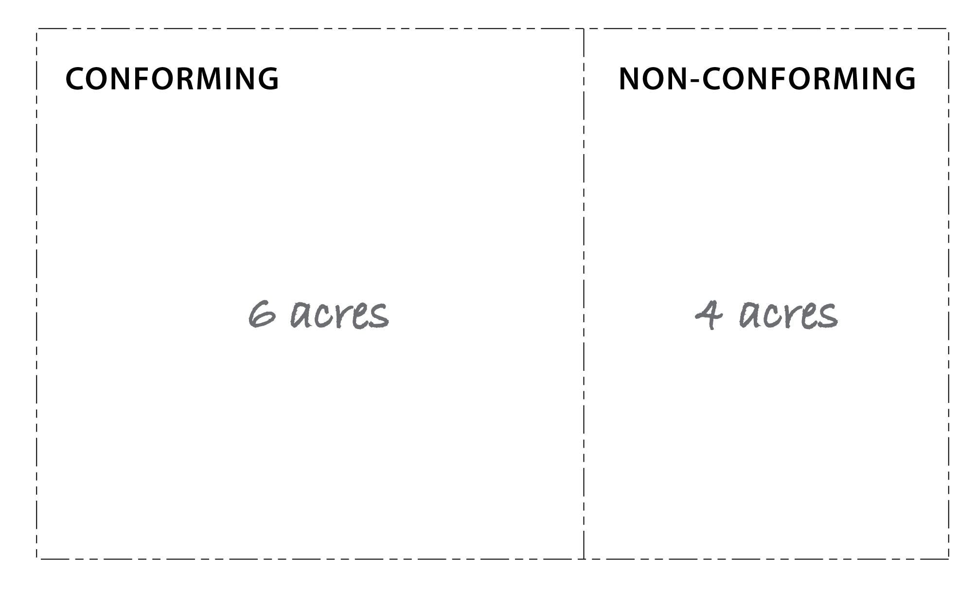 |
| AFTER: A lot line adjustment results in two conforming lots. |
>
 |
(Ord. No. C-49-19 [PLG-004-19], Exh. C, 6-18-2019)
17.06.300 - LAND USE STANDARDS
The land use standards contained in sections 17.06.305—17.06.350 supplement the general land use regulations and specific design standards of the zoning districts (section 17.06.210 and section 17.06.220).
(Ord. No. C-49-19 [PLG-004-19], Exh. C, 6-18-2019)
17.06.305 - General standards for non-residential uses.
A.
Smoke, toxic gases, and emissions. Emissions shall comply with the regulations of the Northwest Air Pollution Control Authority.
B.
Dust and dirt. Emissions of fugitive dust, dirt, fly ash, or other airborne solids shall comply with the requirements of the Northwest Air Pollution Control Authority and all Washington State and federal standards as currently exist or as may be amended.
C.
Vibration. Ground vibration inherently and/or recurrently generated from use and/or equipment, other than vehicles, shall not be perceptible without instruments at any point beyond the property boundary in which such use is located.
D.
Glare, heat and other radiation. Activities which may create offensive glare, heat, electromagnetic and other radiation shall be conducted and contained in an enclosed building, unless otherwise mitigated.
E.
Odors. The emission of obnoxious odors of any kind beyond the lot boundaries is prohibited. Particular industries may be required to present comprehensive statements of measures to be taken for elimination of obnoxious odors for department staff review before approvals are granted.
F.
Liquid wastes. Emission of liquid wastes shall require an industrial waste discharge permit issued by the Washington State Department of Ecology or the Federal Environmental Protection Agency.
G.
Solid wastes. Approval for procedures for the collection, control, and disposal of any solid wastes peculiar to the industrial operation must be obtained by the Island County Health and Public Works Departments prior to the issuance of any permits and the procedures shall meet all standards of the State Department of Ecology.
H.
Water supply/waste disposal/surface water. Water supply, waste disposal (including sewage), and surface water shall meet applicable federal, state, and county standards and be consistent with the Freeland Subarea Plan, provided that, no dangerous or hazardous wastes may be discharged into surface or groundwater.
I.
Utilities. To the extent feasible, all onsite utilities shall be located underground.
J.
Noise emissions shall not exceed levels as established by WAC 173-60-040. More restrictive standards may be established for specific non-residential uses.
K.
For any use, the County shall impose such reasonable conditions as are found necessary to ensure that the proposed activity is compatible with the character of surrounding permitted uses.
L.
All uses shall comply with the design, landscape, open space, screening, buffering, signage, and lighting standards set forth in this chapter.
M.
The number of parking spaces required shall be in conformance with section 17.03.180.Q.
(Ord. No. C-49-19 [PLG-004-19], Exh. C, 6-18-2019)
17.06.310 - Home based businesses.
A.
Home occupation. Home occupation uses are accessory to the primary residential use and may be allowed in any dwelling unit or accessory structure.
1.
The following list of uses is not intended to be exhaustive, but rather is intended to be illustrative of the types of uses:
| TABLE 17.06.310.A. - HOME OCCUPATION ALLOWED BY HOUSING UNIT TYPE | |||||
|---|---|---|---|---|---|
| Home Occupation Use | Single Family, detached (1 unit) | Single Family, attached (2—4 units) | Live/Work Units | Mixed-Use Residential Unit | Multi-Family |
| SFd | SFa | L/W | MXD | MF | |
|
Barbershops and beauty parlors
| |||||
|
Bed and breakfast rooms
| |||||
| Business office of a dentist, physician, architect, broker, engineer, planner, lawyer, real estate agent, or insurance agent | |||||
| Classes of specialized instruction or office for a musician or arts and crafts instruction, yoga or other personal fitness instruction for 1—6 persons | |||||
|
Day care nursery
| |||||
|
Dressmakers, seamstresses, and tailors
| |||||
| Individually crafted artwork with minimal noise, dust, smells and/or other impacts to neighbors, such as fine arts, sewing or knitted goods, and hand-woven articles. | |||||
| Individually crafted artwork with noise, dust, vibration, smells and/or other impacts, such as woodworking, sculpture, ceramics, leather craft, and photography dark rooms. (4) | |||||
| Office of a counselor, physician, psychologist or similar care provider where individualized client treatment occurs on-site | |||||
| Office of a minister, rabbi, priest, or similar person associated with a religious organization | |||||
|
School, 1—6 students
| |||||
|
(1) Allowed on the first floor only.
(2) Only allowed where there is direct access/entry to the unit (not allowed off an internal shared hallway). (3) Only allowed where unit is not sharing a common wall with an adjacent unit or property. (4) Provisions for containment of noise, dust, smells, and other impacts shall be provided. Where containment is impractical or not permissible (which may be the case in multi-family and mixed-use buildings), use shall be prohibited. | |||||
2.
A home occupation shall meet the requirements of this chapter and the standards of section 17.03.180.K.2 excepting that a resident that is not the property owner (either a relative or tenant) may be allowed a home occupation with written consent of the property owner (required at time of application).
B.
Home industry.
1.
Purpose. To provide for small-scale commercial or industrial activities accessory to the primary residential/agricultural/forestry use. The scale of the proposals to be considered through this mechanism is typically greater than what could be accommodated through a home occupation. Uses that are larger than a home industry must located in a zoning district that permits the intended use.
2.
Type of residential unit and the potential impact of uses on neighboring residential units shall be a consideration for approval. The following list of uses is not intended to be exhaustive, but rather is intended to be illustrative of the types of uses which the Planning Director may consider and the housing unit types where they are appropriate.
| TABLE 17.06.310.B. - HOME INDUSTRY ALLOWED BY HOUSING UNIT TYPE | |||||
|---|---|---|---|---|---|
| Home Occupation Use | Single Family, detached (1 unit) | Single Family, attached (2—4 units) | Live/Work Units | Mixed-Use Residential Unit | Multi-Family |
| SFd | SFa | L/W | MXD | MF | |
|
Antique shops
| |||||
|
Art or photography studios
| |||||
|
Blacksmith shop
| |||||
|
Construction office
| |||||
|
Furniture repair or refinishing
| |||||
|
School, 7—35 students
| |||||
|
Small day care center
| |||||
|
Pottery shop
| |||||
|
Woodworking shop
| |||||
|
(1) Allowed on the first floor only.
(2) Only allowed where there is direct access/entry to the unit (not allowed off an internal shared hallway). (3) Minimum parcel size of one-half (0.5) acres. (4) Only allowed where unit is not sharing a common wall with an adjacent unit or property. (5) Provisions for containment of noise, dust, smells, and other impacts shall be provided. Where containment is impractical or not permissible (which may be the case in multi-family and mixed-use buildings), use shall be prohibited. | |||||
3.
A home industry shall meet the requirements of this chapter and the standards in section 17.03.180.J.2 excepting that a resident that is not the property owner (either a relative or tenant) may be allowed a home occupation with written consent of the property owner (required at time of application).
(Ord. No. C-49-19 [PLG-004-19], Exh. C, 6-18-2019)
_____
17.06.320 - Additional standards for residential building types.
A.
Attached and Detached ADUs.
1.
No more than one (1) ADU, attached or detached, per single family dwelling unit.
2.
Vehicle access and parking.
a.
One (1) on-site parking space is required for the attached or detached ADU. The Planning Director may consider approval of on-street parking to meet this requirement in the following circumstances:
(i)
Required parking cannot be provided on-site, due to site constraints, and the on-site requirement would preclude the addition of an attached or detached ADU; and
(ii)
On-street parking is available in front of the lot; and
(iii)
The proposed on-street parking location would not impede safe pedestrian or vehicle travel in the right-of-way and/or to the residence.
b.
For front or side yard access, the attached or detached ADU must share a common driveway with the dwelling to which it is an accessory dwelling. A unit may be accessed off of an alleyway.
3.
The attached or detached ADU is subject to applicable Public Health standards for water and sewage disposal (title 8).
4.
Open space requirements are determined by the primary structure on the building. No additional private open space is required for an attached or detached ADU.
5.
Detached ADU.
a.
A permit application for detached ADU must be in the name of the owner of the lot or parcel.
b.
A detached ADU shall not exceed 1,200 square feet of gross floor area. When measuring gross floor area for a detached ADU, any associated garage/shop space that is not living space shall not be counted in the overall floor area calculation. In no case shall the building footprint of the detached ADU exceed the footprint of the main structure.
c.
The property owner must apply for a building permit for a detached ADU. A detached ADU shall comply with applicable building, fire, health, and safety codes.
d.
A detached ADU cannot be segregated or separately sold, transferred, given or otherwise conveyed unless the proposed new lot is of sufficient size to meet minimum lot size, base density, and other County Code requirements.
e.
A detached ADU does not need to provide a frontage type per section 17.06.430. A porch or stoops is encouraged for a detached ADU that faces and is visible to the right-of-way.
6.
Attached ADU. In order to encourage the provision of more housing options, attached ADUs may be established, subject to the following criteria.
a.
No home occupation or home industry shall be permitted for the residents of the attached ADU.
b.
An attached ADU shall be no greater than 1,000 square feet.
c.
An attached ADU may be created through:
(i)
Internal conversion within an existing single family dwelling;
(ii)
The addition of new square footage to the existing single family dwelling; or
(iii)
Inclusion in the development plans for, or as part of, the construction of a new single-family dwelling unit.
d.
An Attached ADU shall be located within an owner occupied primary residence.
e.
If an attached ADU extends beyond the footprint of the principal SF dwelling, it must be consistent with the architectural style, materials, and color(s) of the principal residence.
B.
Mobile/manufactured homes.
1.
Mobile/manufactured homes in all zones shall meet all of the standards and requirements of the State of Washington, Island County (chapter 8.03A), and any other applicable government regulations in effect at the time of installation. The mobile/manufactured home shall bear an insignia issued by a state or federal regulatory agency indicating that the mobile/manufactured home complies with all applicable construction standards of the U.S. Department of Housing and Urban Development or that it passed a state systems inspection at the time it was constructed or has since passed a state alteration/fire safety inspection.
2.
The size, construction, siting, and other features of the mobile/manufactured home shall be compatible with the surrounding residential properties by meeting the following minimum standards:
a.
The mobile/manufactured home shall be of double or multi-sectioned construction, provided that a single-wide mobile/manufactured home shall be allowed within an existing mobile/manufactured home park and/or as a replacement to an existing single-wide unit which was legally installed on the same individual lot;
b.
Roof pitch shall be not less than a two and one-half (2.5) foot rise for each twelve (12) feet of horizontal run; and
c.
Roof construction shall be of non-reflective materials.
3.
Within thirty (30) days of placement of the mobile/manufactured home on a lot, full skirting shall be installed which is compatible in material, color, and pattern with the siding of the mobile/manufactured home or by using a perimeter masonry foundation.
4.
All mobile/manufactured homes shall be placed on permanent foundations.
5.
Wheels and towing tongues shall be removed.
6.
All clearance and tail lights shall be removed.
7.
All mobile/manufactured homes shall be connected to permanent electrical and plumbing connections and facilities and sewage disposal systems. Sewage disposal systems connections may be provided to community septic systems (an individual system is not required).
C.
Mobile/manufactured home parks.
1.
Mobile/manufactured home parks may be developed on parcels no greater than five (5) acres in size, pursuant to chapter 8.03A.
2.
All interior roadways shall be built in accordance with the roadway and multi-modal access provisions of chapter 11.01 and the block design general standards in section 17.06.410.
3.
Setbacks.
a.
The side and rear yard setback shall be twenty-five (25) feet from the exterior boundary of the park and shall apply to all structures.
b.
For internal lot lines, the following setbacks shall apply:
(i)
Front: ten (10) feet.
(ii)
Garage/Carport: twenty (20) feet.
(iii)
Side: five (5) feet.
(iv)
Rear: five (5) feet.
4.
Minimum space per lot in a mobile/manufactured home park shall be as shown in Table 17.06.320.C.
5.
Installation requirements. All homes sited in mobile/manufactured home parks shall meet the installation requirements of chapter 14.01A and the requirements of section 17.06.320.B.1. and section 17.06.320.B.3.
6.
Landscaping in accordance with an approved detailed landscape plan shall include the following, as necessary, to assure visual compatibility with surrounding uses:
a.
Berms for noise screening;
b.
A minimum ten-foot-wide planting strip of evergreen trees and shrubs along the exterior site boundary;
c.
Where abutting a county roadway, the planting strip shall be a minimum of twenty (20) feet wide, provided that a minimum ten-foot strip may be considered sufficient when it can be demonstrated that, with earth sculpturing and re-contouring, the development is adequately buffered;
d.
Interior plantings of native vegetative species;
e.
Areas to be preserved in their natural state; and
f.
Fencing.
7.
Community recreation/open space.
a.
All mobile/manufactured home parks shall reserve a minimum of twenty-five (25) percent of the site area for common, functional open space. The planting strips required in subsection C.6., above, shall not be counted as open space.
b.
For sites greater than two (2) acres, the required open space shall be distributed throughout the development so that all residential lots are within 600 feet of an existing or proposed open space. An off-site public park or playground may be approved to meet this requirement where safe pedestrian access is available between the unit and the off-site facility and the access pathway is less than 600 linear feet from the lot to the parcel with the amenity.
c.
Open space may include community recreational areas and facilities such as playgrounds and swimming pools. Where an indoor community building is provided with meeting space, recreation, etc., the community building lot shall count as open space for this requirement (up to fifty (50) percent of the required open space).
8.
Individual storage units are encouraged in mobile/manufactured home parks. No outside storage of household item and equipment shall be permitted within a park. It shall be the responsibility of the park management to ensure compliance with this requirement.
9.
Bulk storage and parking for RVs, boats, trailers, etc. A bulk storage/parking area shall be provided within a mobile/manufactured home park. A minimum of 300 square feet of space, exclusive of driveways, shall be provided for every ten (10) home spaces. Said area shall be separated from all other parking facilities, shall be provided with some means of security, and shall be visually screened at the perimeter of the storage area with type S1 or S2 screening per section 17.06.540.E. The requirements of this subsection may be waived by the Planning Director when the mobile/manufactured home park developer/owner agrees to prohibit the storage of such items within the park.
10.
Laundry facilities shall be provided pursuant to section 8.03A.040.I.
11.
Parking spaces shall be provided in compliance with the requirements of section 17.03.180, provided that off-street guest parking shall also be provided at the ratio of one (1) parking space for each four (4) mobile/manufactured home spaces and shall be distributed for convenient access to all spaces. Such parking may be provided by a parking lane and/or separated parking areas.
12.
Adequate lighting shall be provided to illuminate streets, driveways and walkways for the safe movement of pedestrians and vehicles.
13.
All water, sewer, electrical, and communication service lines shall be located underground.
14.
Home occupation or home industries conducted within a mobile/manufactured home park are limited to the home occupation or home industries allowed in an attached single family housing unit pursuant to section 17.06.310.
D.
Cottage housing. Cottage housing developments are subject to the standards of the applicable zoning district (section 17.06.120), plus the supplemental standards set forth in Table 17.06.320.D below.
| TABLE 17.06.320.D - COTTAGE HOUSING STANDARDS | ||||
|---|---|---|---|---|
| Cottage Housing | Permitted: | |||
| 1. Description and Illustration | ||||
| "Cottage housing" refers to a multi-family housing style with one or more clusters of small housing units arranged in and around a common open space. Units are typically detached, but may have two attached units. | 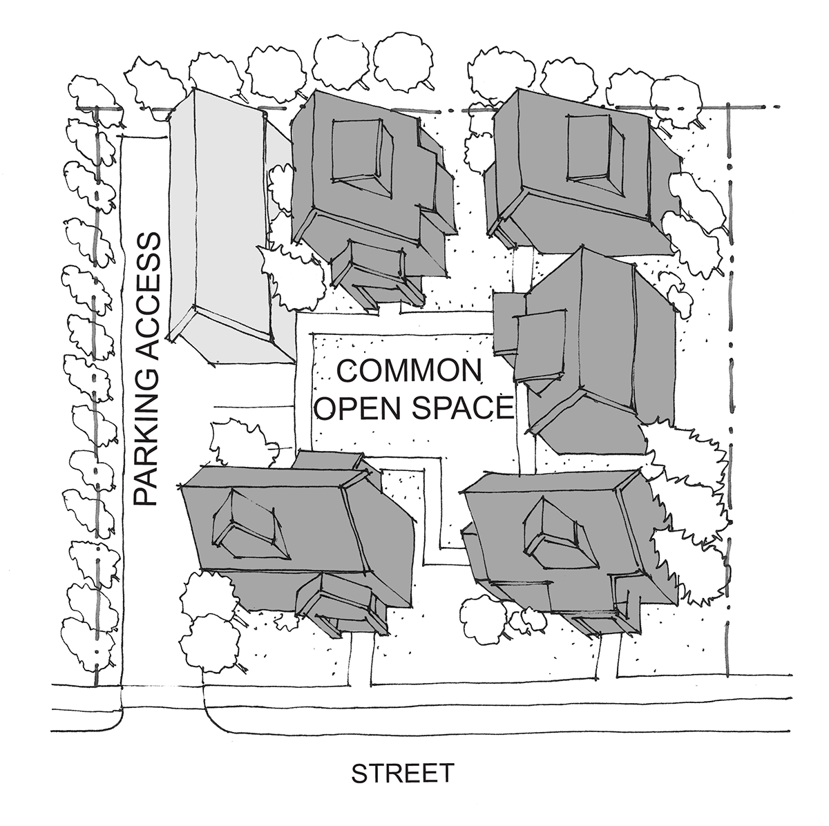 | |||
| 2. Key Standards | ||||
| Lot sizes and density bonus | Cottages are exempt from minimum lot area standards provided they comply with density and design standards herein. | |||
| Density |
Due to the smaller relative size of cottage units, each cottage shall be counted as
one-half a dwelling unit for the purpose of calculating density per applicable requirements
in ICC 17.06.120. For example, a cluster of 6 cottages are equal to 3 dwelling units for density calculation
purposes.
When preparing a Future Development Plan per ICC 17.06.110.C for a cottage housing development, the applicant may choose either 1 or 0.5 a dwelling unit per cottage for calculation of capacity for potential future units. | |||
| Minimum and maximum number of cottages | Min. of 4 cottages and a maximum of 12 cottages per cluster; no limit on the number of clusters provided all other standards are met. | |||
| Setbacks | Minimum required by applicable zoning district (see ICC 17.06.120); at least 10' separation between cottages. | |||
| Building height |
Cottages: 26 feet
Accessory structures: 18' | |||
| Building coverage | Minimum required by applicable zoning district (see ICC 17.06.120) | |||
| Impervious surface | Minimum required by applicable zoning district (see ICC 17.06.120) | |||
| Maximum footprint and square footage |
Max. footprint = 800 sf and Max. square feet = 1,200 sf
The largest sized cottage would have an 800 sf ground floor and a 400 sf second floor. | |||
| 3. Supplemental Standards | ||||
| Windows onto the street and common open space | Transparent windows and/or doors are required on at least 10 percent of the façades (all vertical surfaces) of all cottages facing the street and common open space(s). | |||
| Parking and driveway location and design |
a. Parking areas shall be located to the side or rear of cottage clusters and not
between the street and cottages. Parking is prohibited in the front and between cottages
b. Parking shall be located in clusters of not more than 5 adjoining spaces (except where adjacent to an alley). c. Garages or carports may be attached to individual cottages or detached, provided all other standards herein are met and the footprint of the ground floor, including garage/carport, does not exceed 1,000 square feet. Such garages/carports shall be located away from the common open spaces. | |||
Screening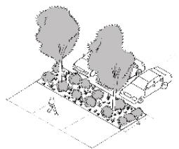 Example of required screening where parking is adjacent to the street (side of lot)
|
a. Screening shall be required at the property lines per Table 17.06.540.E.3. Required
landscaping and screening shall not count towards the required open space.
b. Parking and vehicular areas shall be screened from public street and adjacent residential uses by landscaping or architectural screens. For parking lots adjacent to the street, at least 10 feet wide Type C landscape buffer (see ICC 17.06.540.E.10) shall be provided between the sidewalk and the parking area (see image to the left). For parking lots along adjacent residential uses, at least 5 feet wide Type C landscape buffer (see ICC 17.06.540.E.10) shall be required at the property line. | |||
| Common open space requirements |
a. Minimum common open space shall be 400 sf per unit.
b. Open space shall abut at least 50 percent of the cottages in a cottage housing development. c. Open space shall have cottages abutting on at least 2 sides. d. Cottages shall be oriented around and have the main entry from the common open space. e. Cottages shall be within 60 feet walking distance of the common open space. f. Open space shall include at least one (1) courtyard, plaza, garden, or other central open space, accessible by all units. The dimensions of this central common open space shall be a minimum of 15 feet by 20 feet. g. A septic drain field may count towards up to 50% of the common open space requirement. | |||
| Required private open space | A minimum of 200 sf of private open space shall be required adjacent to each dwelling unit, for the exclusive use of the cottage resident(s). The space shall be usable (not on a steep slope), with no dimension less than 10 feet. | |||
| Porches |
Cottage façades facing the common open space or common pathway shall feature a roofed
porch at least 70 square feet in size with a minimum dimension of 7 feet on any side.
This shall count towards the required private open space.
A covered entry feature is required for cottage entrances facing a street. | |||
E.
Townhouses. Townhouses are subject to the standards per the applicable zoning district in section 17.06.120 plus the supplemental standards in Table 17.06.320.E below.
| TABLE 17.06.320.E - TOWNHOUSE STANDARDS | |||||||
|---|---|---|---|---|---|---|---|
| Townhouses | Permitted: | ||||||
| 1. Description and Illustration | |||||||
| A townhouse/townhome is a type of single family home that shares a common wall with at least one other home on one or more sides (three or more units). | 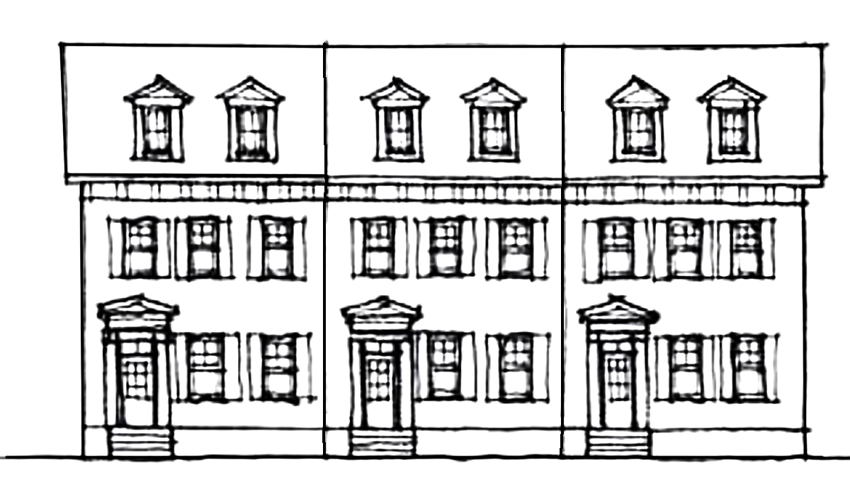 | ||||||
| 2. Design Standards | |||||||
| Site coverage | For townhouse developments, site coverage is calculated for the whole development, not individual lots. | ||||||
| Impervious surface | For townhouse developments, impervious surface is calculated for the whole development, not individual lots. | ||||||
| Useable open space | Townhouses must provide usable open space at least equal to 10 percent of the building living space, not counting automobile storage. The required open space may be provided by one or more of the following ways. | ||||||
| Common Open Space (≥50%) | |||||||
|
• Courtyard, plaza, garden, or other central open space, accessible by all units,
with a minimum area of 300 square feet. This space shall have landscaping, seating,
and/or other pedestrian-oriented open space amenities (ICC 17.06.510.C).
• Playground, sports courts, picnic area, community swimming pool or other space for passive or active recreation. | |||||||
| Other (<50%) | |||||||
|
• Usable private open space that is directly adjacent and accessible to dwelling units.
Such space must have minimum dimensions of at least 12 feet on all sides and be configured
to accommodate human activity such as outdoor eating, gardening, toddler play, etc.
Front setbacks may be used to meet this open space standard, provided they are defined
with a fence (e.g. a private yard).
• Balconies, private rooftop decks, and/or front porches. • Septic drain field. • Green roof and/or rain garden. • Water resource zones per ICC 17.06.520.H.4. | |||||||
| Relationship to the Street |
Any dwelling unit located within 10' of a front yard setback shall be oriented to
the street.
Each dwelling unit oriented to the street shall have an entrance on the street facing façade that incorporates a visually prominent porch or canopy (see block frontage options in ICC 17.06.430 and front porch encroachment standards in ICC 17.06.670). | ||||||
| Garage and driveway placement |
Where individual garages are provided, garages shall meet the standards in ICC 17.06.5503.I.
Where in-structure parking is utilized (either a tuck-under or structured garage), the parking shall not be visible from the right-of-way and shall comply with the standards of ICC 17.06.550.E.4. | ||||||
| Parking in Rear (off of an alley or shared driveway) | |||||||
|
• Required for buildings under 30 ft. wide
• Two car garage (side by side) are allowed | |||||||
| Parking in Front | |||||||
|
• Only allowed when the width of the building is 30 ft. or greater
• The driveway width shall be a minimum of 9 ft. and a maximum of 12 ft. • One car garage or tandem garage only, no two car garages • Must pair driveways or used a shared driveway | 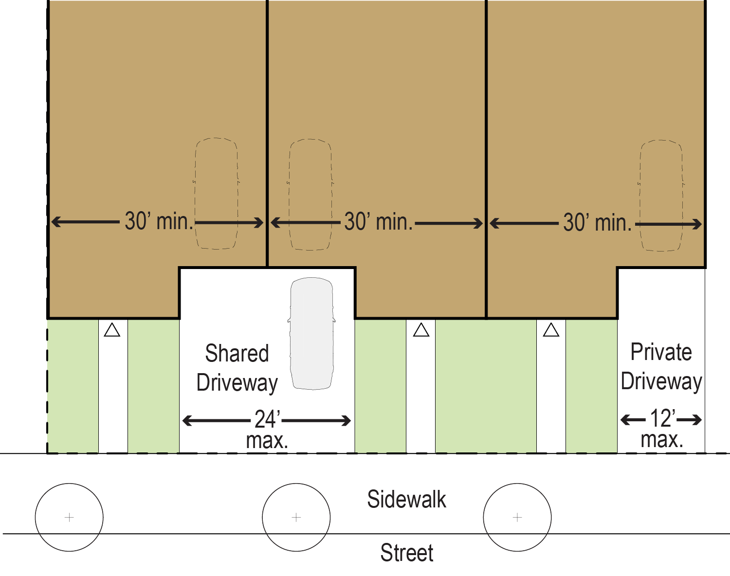 | ||||||
| Building design standards |
The minimum width of any townhome unit shall be 20 ft.
Buildings on corner lots shall be designed with two façades of equal architectural expression. Each townhouse dwelling shall be accessed by a separate front door. | ||||||
| Covered entry | Building façades must visually emphasize individual pedestrian entrances over private garages by using both of the following measures. | ||||||
|
• Enhance each pedestrian entry with a trellis, small porch, or other architectural
features that provides cover for a person entering the unit and a transitional space
between outside and inside the dwelling. For building façades facing the street, townhomes
must utilize block frontages per ICC 17.06.430.
• Provide a planted area in front of each pedestrian entry of at least 20 square feet in area, with no dimension less than 4 feet. | |||||||
| If primary pedestrian access is from an internal, private vehicular access drive, a covered entry feature is required for at least one building façade that faces the street (for each unit). | |||||||
(Ord. No. C-49-19 [PLG-004-19], Exh. C, 6-18-2019; Ord. No. C-18-22 [PLG-002-21], Exh. A, 5-3-2022)
17.06.330 - Overnight lodging.
A.
Bed and breakfast.
1.
Bed and breakfast rooms (one (1) to two (2) rooms) may be established outright in any single family dwelling unit or detached ADU where the gross square footage of the detached ADU or bed and breakfast room(s) does not exceed 1,200 square feet, and provided that:
a.
No more than two (2) bedrooms are devoted to the bed and breakfast on the parcel;
b.
The owner is domiciled within the single family dwelling unit; and
c.
The use of the lot for single family residential purposes is the predominant use.
2.
Bed and breakfast inns (three (3) to six (6) rooms) may be established provided that:
a.
Subject to and limited by public health requirements where the number of rooms is limited to the septic/sewer capacity;
b.
A site plan must be approved pursuant to chapter 16.15;
c.
There shall be no more than six (6) guest rooms;
d.
The owner or on-site manager shall be domiciled in the single family dwelling unit; and
e.
The use of the lot for single family residential purposes is the predominant use.
3.
Service of meals for bed and breakfast facilities shall be limited to registered guests only.
4.
For either type of bed and breakfast facility, the County shall impose such reasonable conditions as may be found necessary to ensure that the operation of the bed and breakfast use does not disrupt adjacent dwelling units.
5.
All bed and breakfast facilities shall be registered with the Island County Health Department to assure that Health Department standards are met.
6.
All bed and breakfast facilities shall be registered with the local fire district, including the number of beds, to ensure proper response in case of an emergency.
B.
Country inns (seven (7) to forty (40) rooms).
1.
A site plan must be approved pursuant to chapter 16.15.
2.
Country inns, twenty (20) or less rooms in size, do not require a community meeting pursuant to section 16.19.050.
3.
All country inns shall take primary access, in order of priority, off a county arterial, county collector road highway, or state highway.
4.
All country inns shall be registered with the Island County Health Department to assure that Health Department standards are met.
5.
All country inns shall be registered with the local fire district, including the number of beds, to ensure proper response in case of an emergency.
C.
Hotels and motels.
1.
A site plan must be approved pursuant to chapter 16.15.
2.
A minimum of twenty (20) percent of the non-landscaped areas shall utilize integrated stormwater management techniques such as green roofs, pervious surfaces (e.g. grasscrete, etc.), water resource zones, rain gardens, etc. Rain gardens located within or adjacent to parking lots will count towards open space and can be used to meet the parking lot landscaping standards.
3.
Landscaping shall be provided per section 17.06.520.
4.
Water use reduction. Applicants shall provide a plan that demonstrates how a twenty (20) percent water reduction can be achieved. The reduction factor is to be calculated using the standard hotel/motel usage rates that are contained in county and/or state law as the starting point. Water reduction rates can be achieved through the use of low flow showers, faucets and toilets. A water usage monitoring program shall be established in order to ensure this water use reduction standard is achieved. The monitoring program will also include a response strategy in the event that the standard is not achieved.
5.
Proposals for a hotel/motel must be tied into a public water system.
6.
All hotels and motels shall be registered with the Island County Health Department to assure that Health Department standards are met.
7.
All hotels and motels shall be registered with the local fire district, including the number of beds, to ensure proper response in case of an emergency.
(Ord. No. C-49-19 [PLG-004-19], Exh. C, 6-18-2019; Ord. No. C-18-22 [PLG-002-21], Exh. A, 5-3-2022)
17.06.340 - Commercial uses.
A.
Amusement, outdoor. Outdoor auditorium and amusement facilities shall comply with the following requirements.
1.
Buffers. Screening type shall be S2, S4, or S5, per section 17.06.540.E. Where adjacent to existing residential development, the required landscape buffer width shall be increased by an additional fifty (50) feet (for a total of sixty-five (65) feet or seventy (70) feet, depending on the type of adjacent residential use, per Table 17.06.540.E.9).
2.
Hours of operation. Outdoor operations shall be closed and exterior lighting turned off by 11:00 p.m.
3.
Noise management. A Noise Management Plan is required per section 17.03.180.EE.8.
B.
Artisan workshop.
1.
A site plan must be approved pursuant to chapter 16.15.
2.
Production utilizing noise and/or vibration generating mechanical equipment shall occur within a completely enclosed and properly ventilated area.
3.
In the Business Village district, production area utilizing mechanical equipment shall not exceed 3,000 square feet of floor area.
C.
Automotive repair.
1.
The use shall be located at least 250 feet from any existing residential development and/or the Low Density Residential and Rural zoning districts.
2.
Vehicles shall not be parked or stored as a source of parts or for the purpose of sale or lease/rent.
3.
Repair of all vehicles shall occur indoors. Temporary outdoor vehicle storage may be allowed in an outdoor vehicle storage area located behind or to the side of the principal structure, and completely screened (100 percent opacity) from public view using natural buffers, fencing, buildings, or a combination thereof, per section 17.06.340.E.
4.
All automobile parts and similar materials shall be stored within an enclosed building or in an outdoor storage area completely screened from view by an opaque or privacy fence per section 17.06.340.E.
5.
The use shall not include outdoor storage lots or impound yards for towed vehicles.
6.
Openings to repair bays shall not face ROWs and shall be designed to minimize visual intrusion onto adjoin properties.
7.
Vehicles that are repaired and are awaiting removal shall not be stored or parked for more than thirty (30) consecutive days unless the owner or operator of the establishment demonstrates steps have been taken to remove the vehicle from the premises using the appropriate legal means.
D.
Events.
1.
Block parties are allowed in all districts.
2.
Special events are allowed in all Village Core zoning districts and in the Parks zoning district, subject to section 17.03.180.EE.
3.
Indoor events are allowed in the Village Core zoning districts if contained within a building with an approved permit, with a Final Certificate of Occupancy, for the following uses (see Table 17.06.220):
a.
Entertainment/recreation uses;
b.
Hotel/motel;
c.
Group quarters;
d.
Cultural center;
e.
Churches or other similar buildings of worship;
f.
Schools;
g.
Police/Fire stations; and
h.
Restaurant.
4.
Where an approved site plan does not already allow outdoor events, and where indoor events are allowed in subsection 3 above, outdoor events may be approved with site plan review subject to section 17.03.180.EE. subsections 5, 7, 8 and 9.
E.
Food trucks.
1.
Food trucks may be allowed to operate on private property in all zones where food trucks are permitted with the permission of the property owner.
2.
Operation may be open to customers from 6:00 a.m. to 10:00 p.m.
3.
All food trucks must comply with Health and Sanitation requirements, per title 8.
F.
Food truck courts.
1.
Food truck courts may be allowed on private property in any of the Village Core zoning districts, with written permission from the property owner, but are not allowed within the right-of-way.
2.
A Type II permit is required.
3.
Site plan.
a.
A site plan must be approved pursuant to chapter 16.15.
b.
The number of spaces available for food trucks must be identified on the site plan.
c.
Food truck locations, drive aisles, and seating areas shall be designed and constructed in such a way that all areas can be accessed by emergency vehicles.
d.
Seating area with tables and chairs - one (1) table per truck minimum with at least four (4) chairs (or seating spaces if a picnic table or similar) per table.
4.
Required facilities and utilities.
a.
Electrical hookups must be provided to each food truck. Generators shall not be allowed unless such generator operates at less than sixty (60) decibels as measured ten (10) feet away.
b.
At least one (1) water tap must be provided and accessible to food trucks.
c.
Permanent restrooms facilities that comply with Health Department standards and accessibility standards. Facilities may be shared with permanent on-site structure if there is capacity.
d.
Permanent parking facilities must be provided (minimum of three (3) parking spots, with one (1) van accessible ADA spot).
5.
Operations.
a.
Mobile food court operators shall be responsible for properly disposing of refuse, recycling, trash, and litter generated by operations of the food trucks as would any business and shall have a contract for refuse and recycling removal.
b.
All food truck court operators are responsible for all lessee operations and ordinance compliance and are held responsible for all infractions.
c.
No events, including special events, festivals, concerts, farmers markets, flea markets, or meetings/gatherings of any kind, shall be held within the food truck court unless a permit is otherwise specifically approved for such an event. In no case shall any event block or otherwise hinder the use of the required parking and/or seating areas.
6.
Noise management. A Noise Management Plan is required per section 17.03.180.EE.8.
G.
Fuel service.
1.
Fuel service is permitted at the intersection of a county arterial, county collector road, or state highway.
2.
Fuel service is limited to a maximum of two (2) corners at an intersection with four (4) or more corners, and a maximum of one (1) corner for intersections with three (3) or fewer corners.
3.
A site plan must be approved pursuant to chapter 16.15.
4.
Orient car-wash openings away from public view where possible.
5.
Fuel pumps shall be located at least fifty (50) feet from a property line of a residential lot.
a.
For the purposes of this section, a residential lot means a lot on which a residential use is currently located, a lot zoned Low Density or Medium Density, or a lot designated as Rural Lands on the Comprehensive Plan Future Land Use Map.
b.
Fuel pumps do not have to meet the residential spacing requirement if a road separates the pumps from the residential lot.
6.
Site layout and architectural design shall be consistent with the character of the zoning district.
a.
To minimize the visual impact of the fuel pumps, fuel pumps should be placed to the side or interior of the lot, with buildings placed at the corner (on or near the setback line), as shown in Figure 17.06.340.G.6.a.
| FIGURE 17.06.340.G.6.a. - EXAMPLE OF FUEL PUMPS AT INTERIOR OF LOT | |
|---|---|
|
In this example, several design elements were used for the gas station to ensure the
character of the area was maintained - in site planning, building design, and utilizing
unique signage opportunities.
Site Planning • The fuel pumps were placed behind the building, on the interior of the lot. • Pervious pavers were used on the corner facing side of the building to provide an additional circulation option without exceeding the maximum impervious surface. Building Design • The building design is not gas-station specific, allowing for creative re-use of the site in the future. A second story allows for additional space that can be utilized in a myriad of ways: office, storage, or retail, etc. • Building materials were chosen to blend in with the character of the area. • A clock tower was added for increased visibility on the corner. Signage • The brand signage was placed on the clock tower at a height above the tree line to ensure maximum visibility from the intersection | 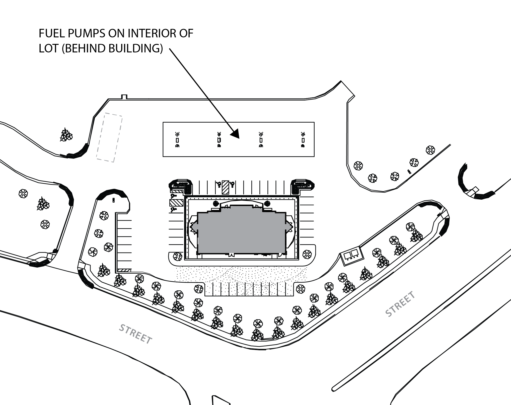 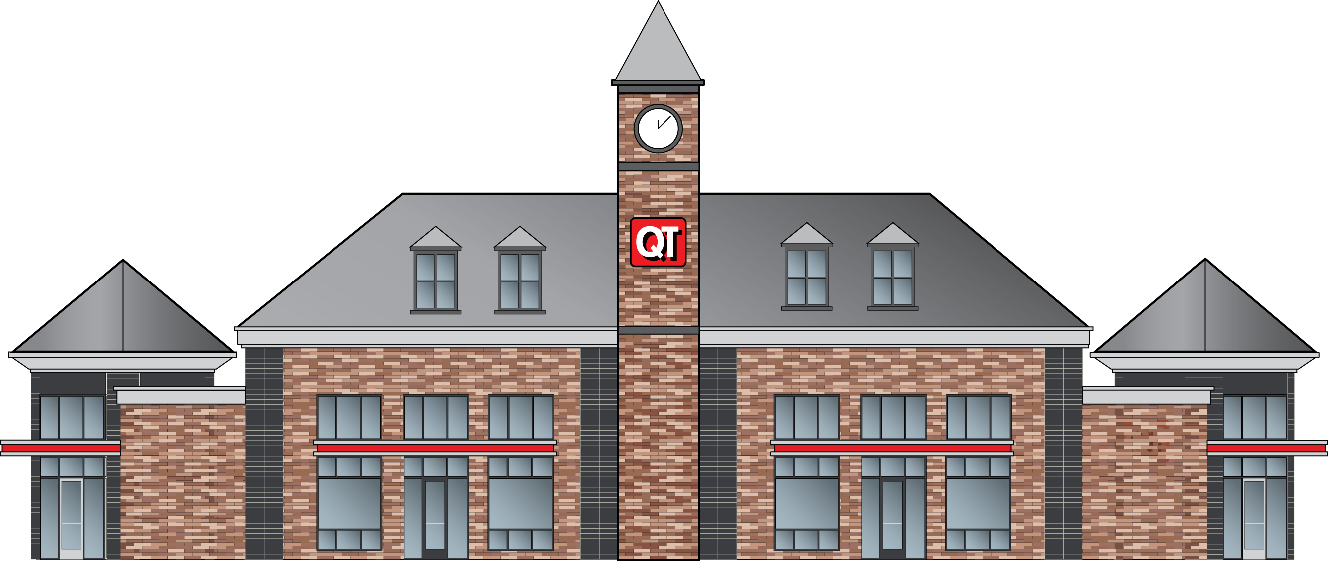 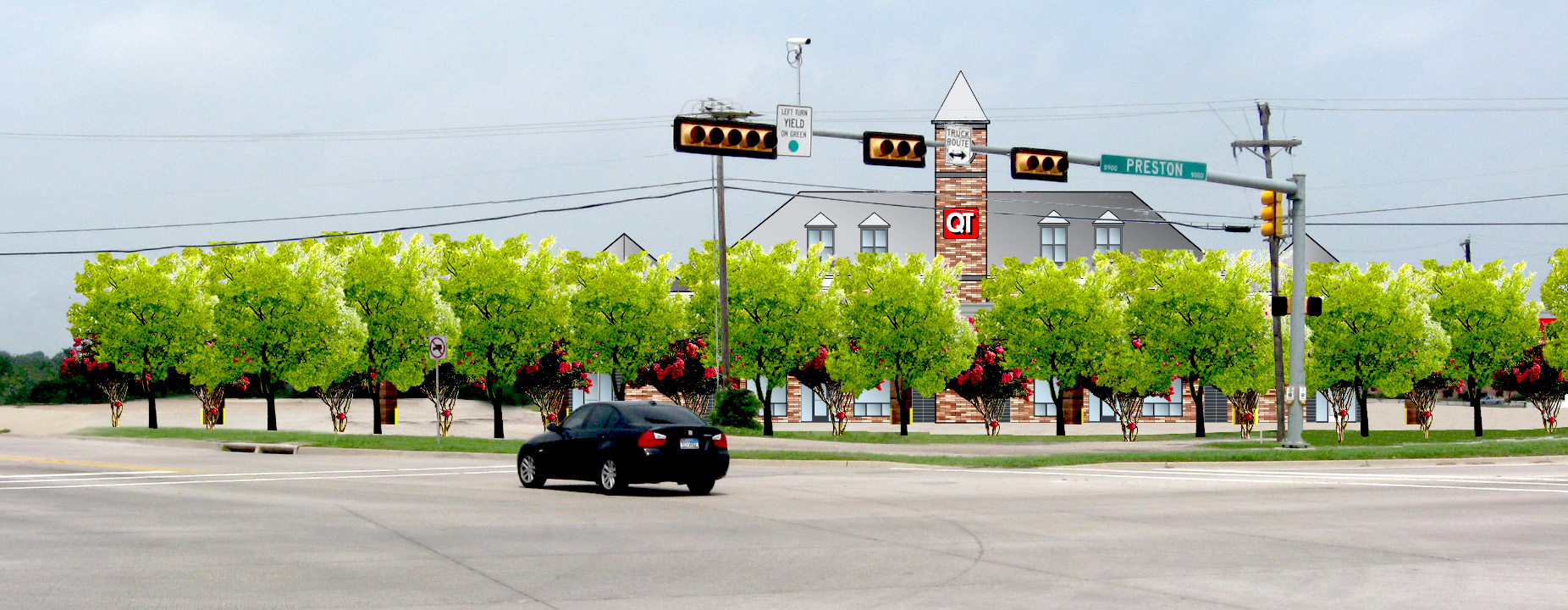 |
b.
All sides of a building shall express consistent architectural detail and character. All site walls, screen walls, pump island canopies, and other outdoor covered areas are to be architecturally integrated with the main building by using similar materials, colors, and/or detailing.
c.
Roofs of convenience stores and pump canopies shall be pitched.
| FIGURE 17.06.340.G.6.c CANOPY AND PUMP ISLAND DESIGN CHARACTERISTICS |
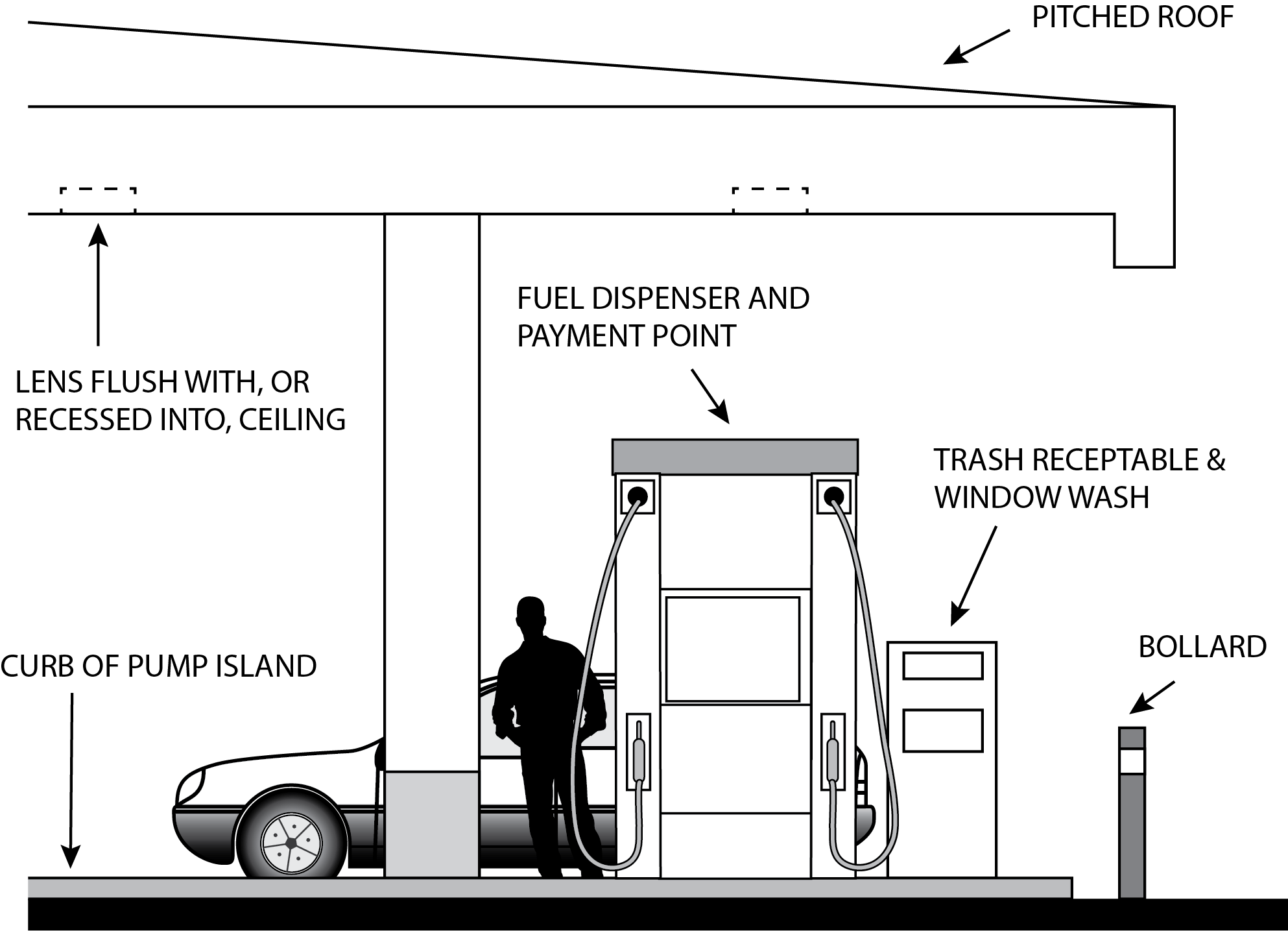 |
7.
Pump islands.
a.
No more than a maximum of eight (8) pumps may be permitted. This restriction shall not limit the number of fuel dispensers per pump island.
b.
Design of pump islands shall be architecturally consistent with other structures on-site using similar materials and/or architectural detailing.
c.
The color of the various components of the pump islands, including dispensers, and all appurtenances shall be consistent with the color of the main structure and are encouraged to be muted.
d.
Either a pump island curb or bollard is recommended for the protections of dispensing units.
8.
Canopy.
a.
The maximum length of the canopy shall not exceed 100 feet. For canopies over sixty (60) feet in length, the mass of the canopy shall be reduced by stepping its form or by dividing it into a set of smaller individual canopies with a maximum interval of thirty (30) feet (see articulation standards in section 17.06.610).
b.
Canopies shall meet the setback requirements for the principal structure.
c.
The clearance height of the canopy, measured from the finished grade to the lowest point on the canopy fascia, shall not exceed fourteen (14) feet. The maximum clearance height of the canopy may be increased to sixteen (16) feet where grade changes under the canopy necessitate the increase in height.
d.
The canopy shall be designed with a low profile section with a maximum height of three (3) feet. The overall height of canopies shall not exceed seventeen (17) feet from grade.
e.
The canopy band face shall be of a color consistent with the main structure or an accent color and may not be backlit. Applied bands of corporate color are discouraged.
f.
Canopy lighting shall be pursuant to the standards in section 17.06.570.H.2.
9.
Signage/corporate identification.
a.
Business identity, either by awnings, accent bands, paint, or other applied color schemes, signage, parapet details, or materials shall not be the dominant architectural feature. The architecture of the building should be appropriate for its location and use regardless of the business identity and viable for potential redevelopment.
b.
All signage should be architecturally integrated with their surroundings in terms of size, shape, and lighting so that they do not visually compete with architecture of the building and design of the site. Signs should be integrated such that they become a natural part of the building façade.
c.
When multiple corporations share one (1) site, signs shall use a shared design/identity for the property to the extent permitted by section 17.06.560 or be located and/or designed where signs do not visually compete with each other.
d.
Ground mounted monument signs are preferred over canopy fascia signs. Any signage on a canopy counts towards the overall signage of the site.
e.
Advertising signage at the pump islands apparatus are limited to oil company or convenience store name/logo. Safety and operational, and product labeling signs are allowable but must be scaled for the visibility of the immediate user only.
f.
Repetitious signage information on the same building frontage is to be avoided regardless of the sign area square footage allowed for by section 17.06.560.
10.
Car wash allowed as accessory use. A one-bay car wash may be allowed as an accessory use. The car wash shall meet the setbacks for the principal use and not exceed 900 square feet in area. The car wash bay shall not be oriented toward the public ROW. Car washes are required to have operational recycled water systems where a minimum of fifty (50) percent of water utilized is recycled.
H.
Livestock. [Reserved]
I.
Mini-storage.
1.
Site plan.
a.
A site plan must be approved pursuant to chapter 16.15.
b.
The total aggregate gross area of the footprints of all building foundations within a site shall not exceed 15,000 square feet.
c.
There shall be a one-hundred-foot setback from all roads, and a fifty-foot setback from all property lines. With the exception of any caretaker residence, security fencing, and the primary driveway that serves the facility, no structures, buildings, gravel, pavement, or any other physical improvement is permitted within these setbacks. Vegetation may be modified if it is necessary to achieve better screening (see section 17.06.540).
d.
A security wall shall be installed around the perimeter of the mini-storage facility and shall include a security gate that allows restricted access to the site. Fencing shall be designed and located in a manner that is subtle in appearance, with the required landscaping on exterior of the wall.
e.
The whole site shall be fully screened with a S4 or S5 screening, per section 17.06.540.E, with a Type A landscaping buffer per section 17.06.540.E.10, except that landscaping shall provide full visual screening within five (5) years. If full screening is not achieved within five (5) years, the facility shall be subject to closure until landscaping achieves a level where it provides full screening.
f.
There shall be only one (1) access from each adjacent road.
g.
Exterior video surveillance equipment and an alarm system must be installed on the premises to monitor all storage lockers and outdoor storage.
h.
Stormwater generated from impervious surfaces shall be collected and managed on site. Infiltration shall be utilized when soil conditions make it possible.
2.
Building standards.
a.
Garage doors serving individual storage units shall be perpendicular to a public or private street so as to not be visible from adjacent streets.
b.
With the exception of a structure used as a security guard or security quarters, the maximum height of a personal storage facility shall be twenty (20) feet.
3.
Uses.
a.
The only uses allowed on-site shall be the rental of storage bays and the pickup and deposit of goods or property in dead storage, and limited incidental sales of storage materials (e.g., boxes, tape).
b.
Individual storage units may not be used by tenants to conduct a business or as a dwelling unit. Storage bays shall not be used to manufacture, fabricate, or process goods, to service or repair vehicles, small engines or electrical equipment, or conduct similar repair activities, to conduct garage sales or retail sales of any kind, or to conduct any other commercial or industrial activity on the site. Tenants shall be notified of this restriction through a signed contract with the mini-storage facility operator.
c.
The guidelines for what is permitted within individual storage units shall be established through a plan that is approved by the Island County Health Department. There shall be no storage of toxic, hazardous, flammable, explosive or noxious materials. Signage shall be posted in multiple conspicuous locations within the facility that informs customers that they are prohibited from storing hazardous and dangerous materials.
d.
Outside storage shall be limited to recreational vehicles, travel trailers, dry storage of boats of the type customarily maintained by persons for their personal use may be allowed within a storage facility provided that the following standards are met:
(i)
No outdoor storage shall be visible from off-site.
(ii)
The storage shall occur only within a designated area that is clearly delineated.
(iii)
Outdoor storage areas shall be located to the rear of the principal structure.
e.
An occupied on-site caretaker residence or twenty-four-hour on-site security shall be required. The caretaker residence shall be located at the main entrance, shall be designed to look like a house and shall be used as one (1) of the methods for screening the facility. The caretaker does not need to be the owner of the facility. This will be the only single family residence located on the parcel.
4.
Hours of operation and access by tenants shall only be allowed from 6:00 a.m. to 10:00 p.m. PST.
J.
Outdoor storage.
1.
Outdoor storage areas may be permitted only as an accessory use in the zones identified in Table 17.06.220, and shall be limited to designated areas on a plan approved pursuant to chapter 16.15.
2.
Each outdoor storage area shall be incorporated into the overall design of the principal structure on the site. If the outdoor storage area is covered, then the covering shall include at least one (1) of the predominant exposed roofing colors on the primary structure.
3.
Goods stored.
a.
Goods stored in an outdoor storage area which are intended for re-sale (outdoor display) shall be limited to those sold on the premises as part of an associated, principal use. Storage for off-site business or residential uses is prohibited.
b.
Flammable liquids or gases in excess of 1,000 gallons shall be stored underground.
4.
Location.
a.
Outdoor storage areas shall be located at the rear of the principal structure.
b.
Outdoor storage shall not be allowed within the required building setback areas.
c.
No materials may be stored in areas intended for vehicular or pedestrian circulation.
5.
Outdoor storage areas shall be screened pursuant to section 17.06.540.D.5.
6.
Temporary storage containers. Temporary storage in shipping containers, semi-trailers, or similar temporary structures shall only be allowed for the following uses.
a.
Temporary storage accessory to a temporary use permit granted under section 17.06.240. Temporary storage containers must be removed upon expiration of the related temporary use permit.
b.
Temporary storage during the repair of fire damage or other natural disaster shall not exceed six (6) months. If a permit application has been submitted to repair the building and/or site, the Planning Director may approve the continued use of temporary storage; such use shall not exceed two (2) years or the expiration of a building permit to remedy the damage, whichever is sooner.
c.
Temporary storage for a grand opening or special event shall not exceed two (2) weeks.
d.
Temporary storage for residential use, such as those intended for facilitating a household relocation, shall not exceed two (2) weeks.
7.
Outdoor storage in the Business Village zoning district.
a.
Outdoor displays of merchandise may be immediately adjacent to the exterior of the principal building if merchandise is moved inside the building after close of business. A clear and unobstructed walkway of at least four (4) feet must be maintained along the display.
b.
Newspaper racks may be located adjacent to the exterior of the principal building. No additional freestanding units are permitted except as provided by the U.S. Postal Service.
c.
Donation drop boxes are not allowed.
8.
Outdoor storage or display in the Business General and Non-Residential Mixed-Use zoning districts.
a.
Self-service vending apparatus such as soft-drink machines, ATM machines, movie vending machines, and newspaper racks may be located adjacent to the exterior of the principal building. A clear and unobstructed walkway of at least four (4) feet must be maintained along the display. No additional freestanding units are permitted except as provided by the U.S. Postal Service.
b.
No other display, sales, leasing, or operation of merchandise outside of sales or rental areas for dealerships for trucks, cars, boats, motorcycles, mopeds, or bicycles are permitted unless such activity is visually screened from all streets and adjacent property lines of residentially zoned properties with a continuous Type A landscaping buffer (section 17.06.540.E.10).
K.
Recreational marijuana. Recreational marijuana uses shall comply with the standards and provisions of section 17.03.180.BB.
(Ord. No. C-49-19 [PLG-004-19], Exh. C, 6-18-2019)
17.06.350 - Institutional uses.
Institutional uses may be approved as permitted or conditional uses as specifically enumerated in the applicable zone. Provisions shall be made for multi-modal access including transit access or transit stops, and shall include provisions for non-motorized access to the development as appropriate for the nature and scale of the project. An institutional use shall meet the requirements of this chapter and the following standards.
A.
Churches or similar buildings of worship.
1.
A site plan must be approved pursuant to chapter 16.15.
2.
Such buildings are not subject to the community meeting requirements of section 16.19.050.
3.
Such buildings shall take primary access, in order of priority, off a county arterial, county collector road highway, or state highway.
4.
Such buildings shall comply with the non-residential rural design, landscape, open space, screening, buffering, signage, parking, and lighting standards set forth in this chapter.
5.
Buildings of worship in the Low Density Residential district are limited to a seating capacity of no more than 150 or a 2,000-square foot assembly area.
6.
Accessory uses.
(i)
One (1) single family dwelling located on the site that is used in conjunction with the building of worship shall be considered an accessory structure and comply with the provisions governing residential uses of the zone in which it is located.
(ii)
Meeting facilities/places of worship may include functionally related internal facilities such as kitchens, multi-purpose rooms, and offices. Places of worship may establish schools, day care centers, and on-site social programs such as, but not limited to, health care clinics, food banks, and safe parking programs. Such programs may be in the primary or in an accessory structure.
(iii)
Accessory uses must be not-for-profit.
(iv)
The sum of all primary and accessory structures may not exceed the site coverage and impervious surface limitations of the underlying zoning district. Additionally, the floor area of all accessory uses may not exceed the floor area of the principal building.
B.
Communication technology.
1.
Small cell technology shall be will be processed as a Type II conditional use in all Freeland zoning districts except where no new structure is required for installation it will be processed as a Type I permitted use. This may include mounting to an existing tower, pole, or building. If mounted to a building, all building setbacks and building height maximums apply.
2.
Communication towers shall comply with the standards and provisions of section 17.03.180.L.8.
C.
Day care nurseries and group homes. Conditions and standards for day care and group home facilities shall be as shown in Table 17.06.350.C below. For home occupation or home industry standards, if applicable, see also section 17.06.310.
D.
Fire stations.
1.
A site plan must be approved pursuant to chapter 16.15.
2.
Fire stations may include storage facilities, maintenance facilities, administrative facilities, temporary emergency housing, meeting room facilities, communications towers, and training towers.
3.
Primary access for emergency use of station equipment must be to and from a county arterial, county collector road highway, or state highway. If a fire station abuts more than one (1) road type, then all access shall be via the higher class of road, when practical, i.e. if a fire station abuts a county arterial and a county collector, then all access shall be via the county arterial.
4.
A signal must be located at the primary access to control traffic during emergency responses.
5.
Fire station design and layout should be "layered" in order to integrate buffering into the station design and layout. Vehicle bays shall be closest to the road and farthest from adjacent properties. Residential or dormitory facilities shall be located closest to adjacent properties. Meeting rooms, offices, or other similar facilities shall be located between the two (2) other primary uses of the fire station.
6.
Any building from which fire-fighting equipment emerges onto a street shall have a minimum setback of thirty-five (35) feet from such street.
7.
Fire stations that include a helipad will be processed as a Type III conditional use.
8.
Fire stations may exceed the standard height limit of the zoning district as follows:
a.
The maximum height of communication towers shall be 100 feet;
b.
The maximum height of training towers shall be fifty (50) feet; and
c.
The maximum size of a helipad shall be 1,000 square feet.
9.
The Planning Director may require additional screening and/or buffering if any of the following apply:
a.
Building exceeds 4,000 square feet, or
b.
Building exceeds the standard height limit, or
c.
Site includes a helipad.
10.
Alternative site coverage ratios may be applied through the site plan review permit process. Low impact development, on-site infiltration, or other methods to mitigate impacts of more impervious surface, less open space, and increased building coverage must be included and reviewed through the site plan review process.
E.
Kennels and animal shelters.
1.
A site plan must be approved pursuant to chapter 16.15.
2.
The minimum parcel size shall be two (2) acres.
3.
All kennels, runs, and other facilities shall be designed, constructed, and located on the site in a manner that will minimize the adverse effects upon the surrounding properties. Among the factors that shall be considered are the relationship of the use to the topography, natural and planted horticultural screening, the direction and intensity of the prevailing winds, the relationship and location of residences and public facilities on nearby properties, and other similar factors.
a.
Animals are limited to household pets.
b.
Animals being kept on the premises shall be allowed outside only between the hours of 7:00 a.m. and 7:00 p.m.
c.
Open runs or outdoor pens used to house animals shall be located a minimum of 100 feet from any adjacent residential lot.
d.
Outdoor areas shall not be located in the front yard.
e.
All outdoor areas shall have a type S3 or S4 screening, per section 17.06.540.E.
4.
Facilities must be soundproofed to minimize noise impacts to the surrounding properties. Animals shall be sheltered in suitable, clean structures.
5.
All waste shall be disposed of in a sanitary manner as approved by the Island County Health Department.
6.
Visual screening, increased setback, and other conditions may be required by the Planning Director, taking into account safety, noise and odor factors.
7.
Noise management. A noise management plan is required per section 10.03.180.EE.8.
F.
Schools.
1.
A site plan must be approved pursuant to chapter 16.15.
(i)
Site plan review of a school designed for seven (7) to thirty-five (35) students shall be a Type II decision.
(ii)
Site plan review of a school designed for thirty-six (36) to 1,000 students shall be a Type III decision pursuant to chapter 16.1.
2.
Schools shall comply with all applicable local, state, and federal regulations concerning educational facilities and programs.
3.
Schools shall comply with the non-residential rural design, landscape, screening, buffering, signage, parking, and lighting standards set forth elsewhere in chapter 17.06, if such standards are not set forth in this section.
4.
Schools shall comply with the height requirements of the underlying zone.
5.
Off-street pickup and drop-off spaces shall be provided commensurate with the number of individuals served by the facility so that the neighborhood will not be adversely impacted or children endangered. Areas for school bus pickup and drop-off must be separate from areas for automobile pickup and drop-off.
6.
Access shall only be via a state highway, county arterial, or county collector road.
7.
Natural habitat should be retained to the extent practical.
8.
Safe pedestrian access on school property adjacent to public roads shall be delineated on the site plan.
9.
Prior to submittal of a site plan review application, the applicant shall coordinate with Island Transit to determine the appropriate location and facilities for a public transit stop(s) within 300 feet, adjacent to, or on the proposed school site. These public transit stops must be included on the site plan if adjacent or on-site.
10.
All playground equipment shall be a minimum of fifty (50) feet from adjacent residential property lines on the rear or side yards, with a ten-foot Type C landscape buffer pursuant to [section] 17.06.540.E.10.
G.
Utilities. [Reserved]
H.
Water tank.
1.
For water tank over thirty-two (32) feet in height or diameter, a site plan is approved pursuant to chapter 16.15.
2.
The water tank will be set back from property lines a distance equal to one-half (½) the height of the water tank.
3.
The Planning Director may modify the screening/buffering requirements when the water tank is proposed for siting on existing lots owned by the water purveyor or existing lots occupied by an existing water system facility and is greater than 100 feet from the Low Density and Medium Density zoning districts.
(Ord. No. C-49-19 [PLG-004-19], Exh. C, 6-18-2019)
17.06.400 - BLOCK DESIGN STANDARDS
A.
Purpose.
1.
To promote the health, safety, and welfare of residents by providing safe and convenient travel through the community that facilitates pedestrian movement and multi-modal travel options. (LU 2.3.4)
2.
Ensure that development relates to and activates the street and meets community design objectives for a pedestrian-oriented village core. (LU 2.1, LU 6.2)
3.
To facilitate the dispersion of traffic and delivery of emergency services. (LU 2.3.4, LU 6.1)
4.
Protect critical areas while utilizing them as an asset to the community. (NR 1.2, NR 1.3, NR Goal 2)
5.
To ensure that the subdivision of land is orderly and encourages good urban design. (LU 1.4)
B.
Applicability.
1.
This section shall apply to all new construction and new plats.
2.
Block frontage requirements shall apply to building remodels and additions per section 17.06.250.D.2.
(Ord. No. C-49-19 [PLG-004-19], Exh. C, 6-18-2019)
17.06.410 - General standards.
A.
Blocks and block lengths.
1.
Street and lot designs shall be arranged so that they work with the constraints of the natural topography and critical areas to achieve:
a.
Blocks equal to or less than 400 feet in linear street length;
b.
Lots with viable building envelopes;
c.
Streets with reasonable and safe gradients;
d.
Adequate, manageable drainage facilities; and
e.
Connectivity with adjacent development wherever practical and possible.
2.
Block and streets interconnected to the maximum extent practical to create a walkable community.
a.
The Planning Director may approve a block length greater than 400 feet, but not to exceed 600 feet, if needed to address limitations based on site conditions.
b.
In the Business Village district, a pedestrian pathway is required pursuant to section 17.06.410.B for blocks greater than 400 feet.
3.
Grade breaks at the edge of a subdivision should be kept to less than two (2) vertical feet wherever possible. If this is not possible then lot depths at the subdivision edge shall be increased so that transitions are not abrupt.
B.
Pedestrian pathways.
1.
In the Business Village district, a pedestrian pathway is required for blocks greater than four hundred (400) feet in length. These are mid-block pedestrian-only passageways that break up block length and are intended to be primarily located perpendicular to where blocks are more than four hundred (400) feet long. Potential connection sites are shown on Figure 17.06.410.B.1. The Planning Director may approve an alternative location if the alternative provides an improved pedestrian access opportunity, improved public safety, or easier access to non-motorized trails.
| FIGURE 17.06.410.B.1 - MID-BLOCK CONNECTION LOCATION EXAMPLES. |
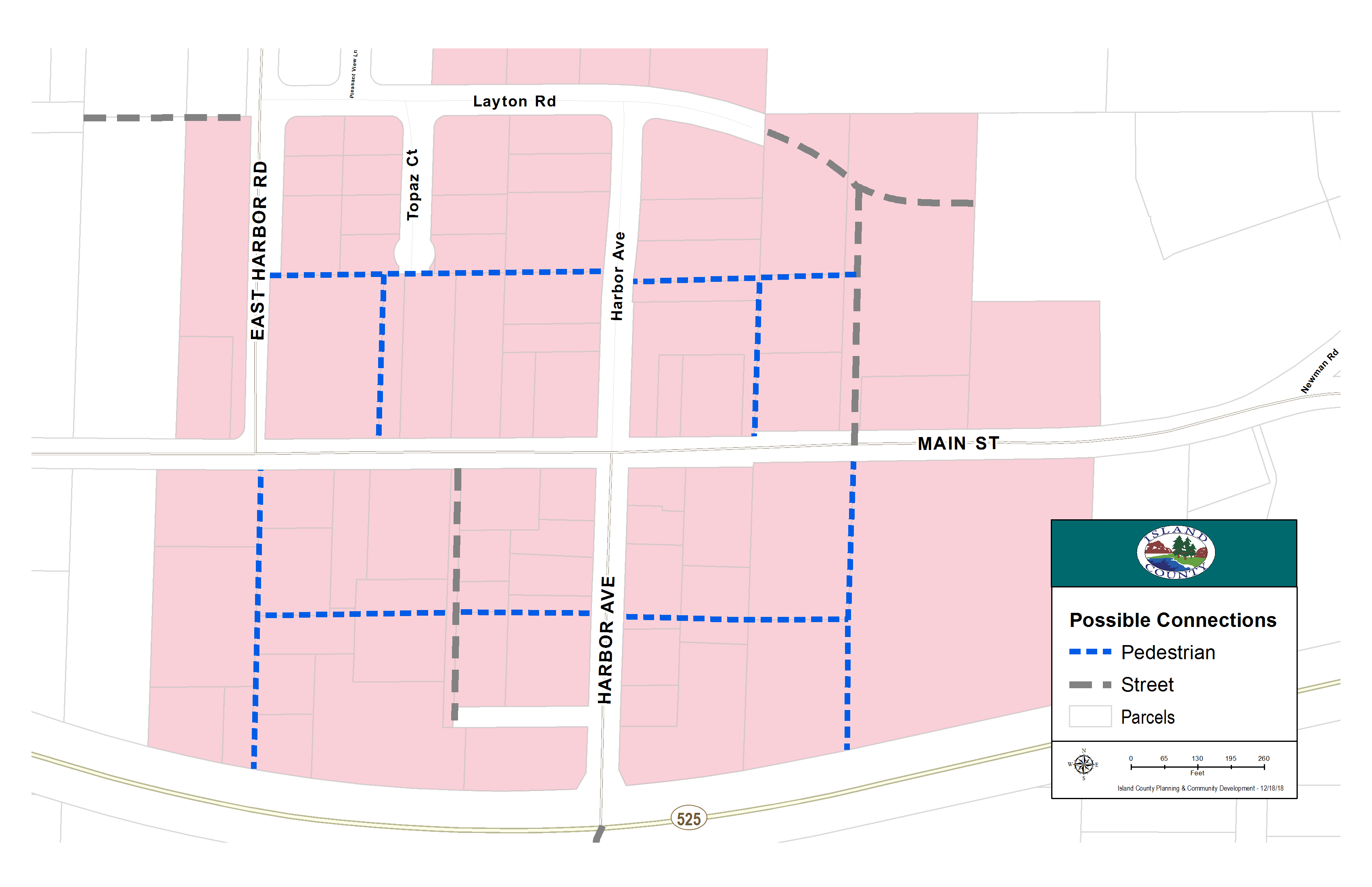 |
2.
These connections, where they not designed as a covered open air walkway integrated into the building structure, shall be placed within a tract or easement that has a minimum width of twenty (20) feet for single use paths or trail, and thirty (30) feet for multiple use corridors.
3.
The following elements are required for pedestrian pathways.
a.
Pedestrian pathways shall have a minimum width of ten (10) feet and paved walking surface(s) of either concrete or approved unit paving with a minimum width of eight (8) feet. The Planning Director may approve a narrower width if a historic pathway is utilized and additional width is limited due to site conditions if the historic pathway meets ADA standards (width, slope, etc.).
b.
Covered open air walkways shall have a minimum ceiling clearance height of fourteen (14) feet to ensure fire apparatus access.
c.
Pathways shall be physically and visually accessible from the adjacent street or major internal vehicle or pedestrian route. Pathways shall be in locations that the intended user can easily access and use, rather than simply left-over or undevelopable spaces where very little pedestrian traffic is anticipated.
d.
Pedestrian-scaled lighting (no more than fifteen (15) feet in height). Lighting may be on-site or building-mounted lighting.
e.
Sidewalk connections to pedestrian pathways shall be positioned in areas with significant pedestrian traffic to provide interest and security - such as adjacent to a building entry.
f.
Landscaping that adds visual or seasonal interest to the space.
| FIGURE 17.06.410.B.3 - EXAMPLES OF PEDESTRIAN PATHWAYS | |
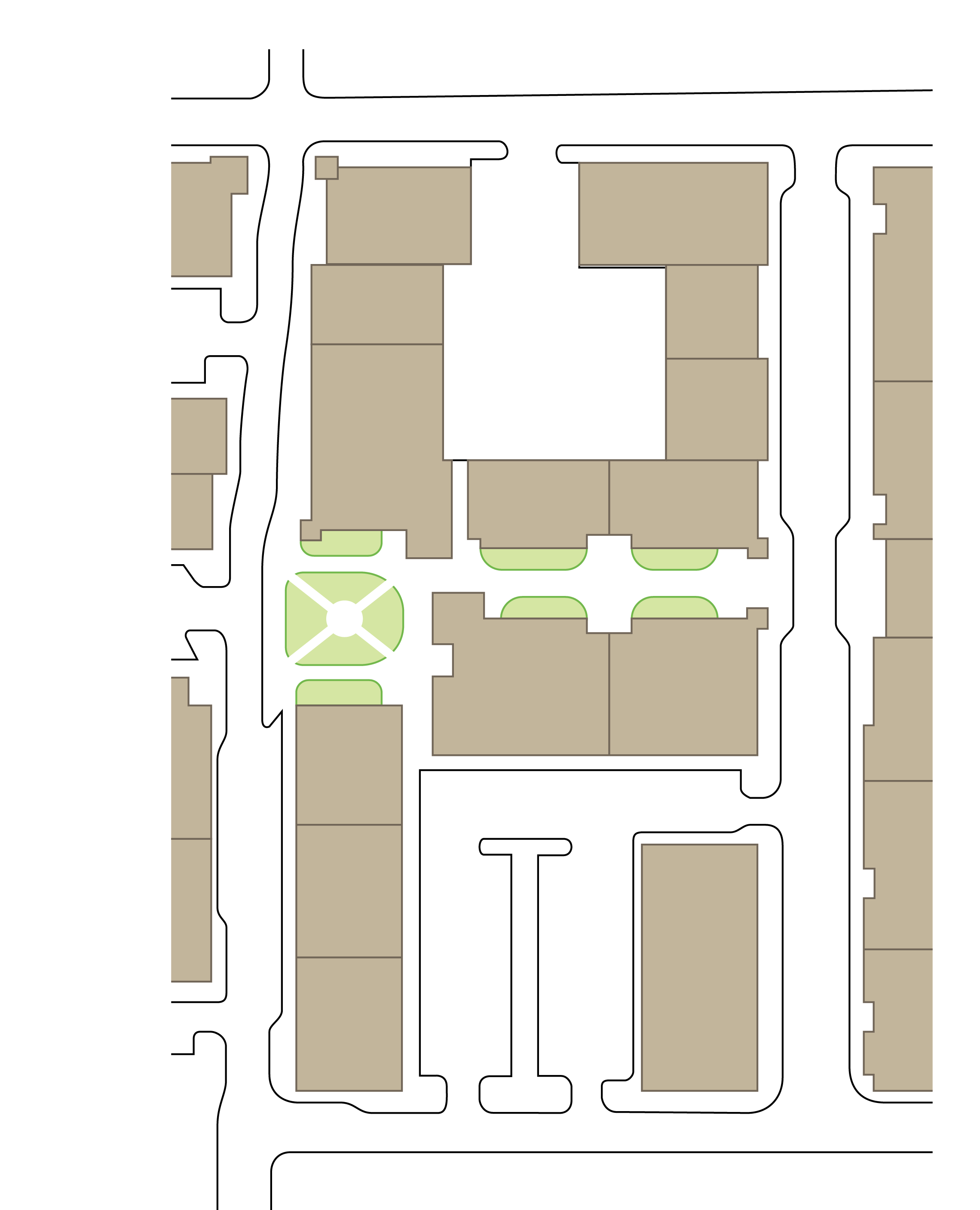 | 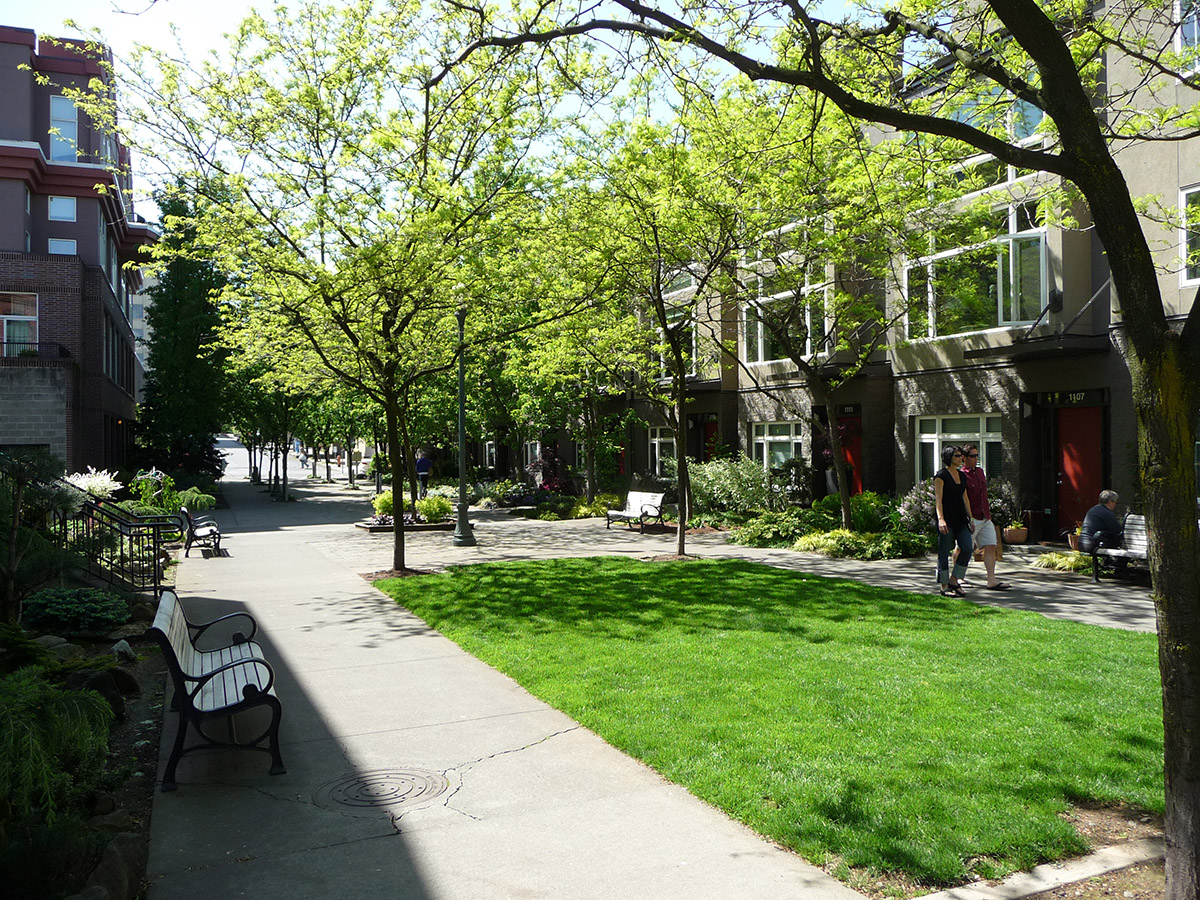 |
| The left image shows a plan view of a pedestrian pathway integrated with a pedestrian-oriented open space. The right image shows an example of a pedestrian pathway in a residential development. | |
 |  |
| Examples of pedestrian pathways in a non-residential setting. | |
4.
Structures bordering a pedestrian pathway must have a minimum separation of fifteen (15) feet between structures and feature transparent windows facing the pathway (at least fifteen (15) percent of the façade facing pathway).
5.
Pedestrian-Oriented Open Space features are required (See section 17.06.510.C.2). Pedestrian pathways installed pursuant to this section shall count towards any Usable Open Space (section 17.06.540.B.7) and Pedestrian-Oriented Open Space (section 17.06.510.C) requirements.
C.
Lot design.
1.
All residential lots shall have frontage on and access to a public street or private street in conformance with County code. All non-residential lots shall have frontage on and/or access to a public street or private street in conformance with County code.
2.
Lot types to avoid creating.
| FIGURE 17.06.410.C.2 - LOT TYPES TO AVOID | ||
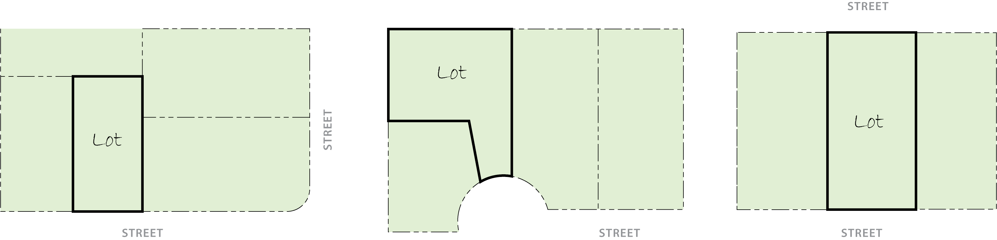 | ||
| Key Lot (adjacent corner lot w/direction change) | Flag Lot | Through Lot (double frontage) |
a.
Do not create corner lots that abut key lots. This may be waived where major terrain constraints and large critical areas are being preserved, subject to approval from the Planning Director.
b.
Flag lots shall be used sparingly in the layout of subdivisions. Where there are major critical areas, steep slopes, or other major natural features, and a street extension to provide frontage to every lot would result in significant cuts and fills, flag lots may be used to reduce the physical impact of providing access and utilities.
c.
Do not create through or double frontage lots. If lots are to be laid out with rear yards facing a street, landscape tracts shall be established along the street. The Planning Director may approve the creation of a through tract where historical street patterns or site conditions constrain the lot layout options.
3.
If unusual (multi-sided, non-rectangular, etc.) lot designs are proposed, the plat application shall include a setback exhibit to indicate the locations of all setbacks and yards on the lot, subject to the approval of Planning Director.
4.
Since corner lots have two (2) frontages they are more limited than other lots in providing usable private outdoor space. To compensate for this, it is recommended that corner lots be wider than the other typical lots in the subdivision, as follows:
a.
Lot sizes 4,500—6,500 square feet shall be five (5) feet wider.
b.
Lot sizes 6,600—12,000 square feet shall be seven (7) feet wider.
c.
Lot sizes 12,000—24,000 square feet shall be ten (10) feet wider.
d.
Lot sizes 25,000—45,000 square feet shall be fifteen (15) feet wider.
5.
Where a new residential plat abuts a non-residential use, one (1) or more of the following lot layout techniques shall be utilized:
a.
Provide a landscaped or open space buffer of at least twenty-five (25) feet in width and place the lots so that they 'side' on to this buffer.
b.
Use a local street as a physical separation between residential and non-residential lots.
c.
Any combination of techniques that avoid having active rear yard areas and bedroom areas in the residences exposed to the adjacent use.
d.
If there is a substantial open space separation (at least 100 feet in width) it may be acceptable to have rear yard areas directed toward the non-residential use.
e.
Wherever possible, functions such as detention basins, recreational facilities, common storage areas, and other such uses shall be used to provide buffering from adjacent non-residential uses.
6.
Relationship to natural areas and topography.
a.
Site planning should respond to the natural characteristics of a site such as topography/ drainage patterns, existing vegetation, and visual resources. Proposed development (i.e. buildings, parking, and other features) should be designed and adapted to the specific site as opposed to altering the character and form of the site to accommodate development.
b.
Design lots so that the buildable portion of a lot is accessed without having to cross a drainage way or critical area. In the unique situation where the building area of the lot cannot be designed to be accessed without crossing a drainage way or critical area, the Planning Director may approve an alternative lot design. When allowed, the developer of the lot(s) shall construct the crossing to access the buildable area of the lot with the infrastructure improvements.
c.
Where possible, lots should be laid out to front or side to natural areas that are commonly maintained as dedicated open space as illustrated in Figure 17.06.410.C.6. Lots should not be laid out to 'back' to such areas.
| FIGURE 17.06.410.C.6. - LOT LAYOUTS ADJACENT TO NATURAL AREAS | |
FACING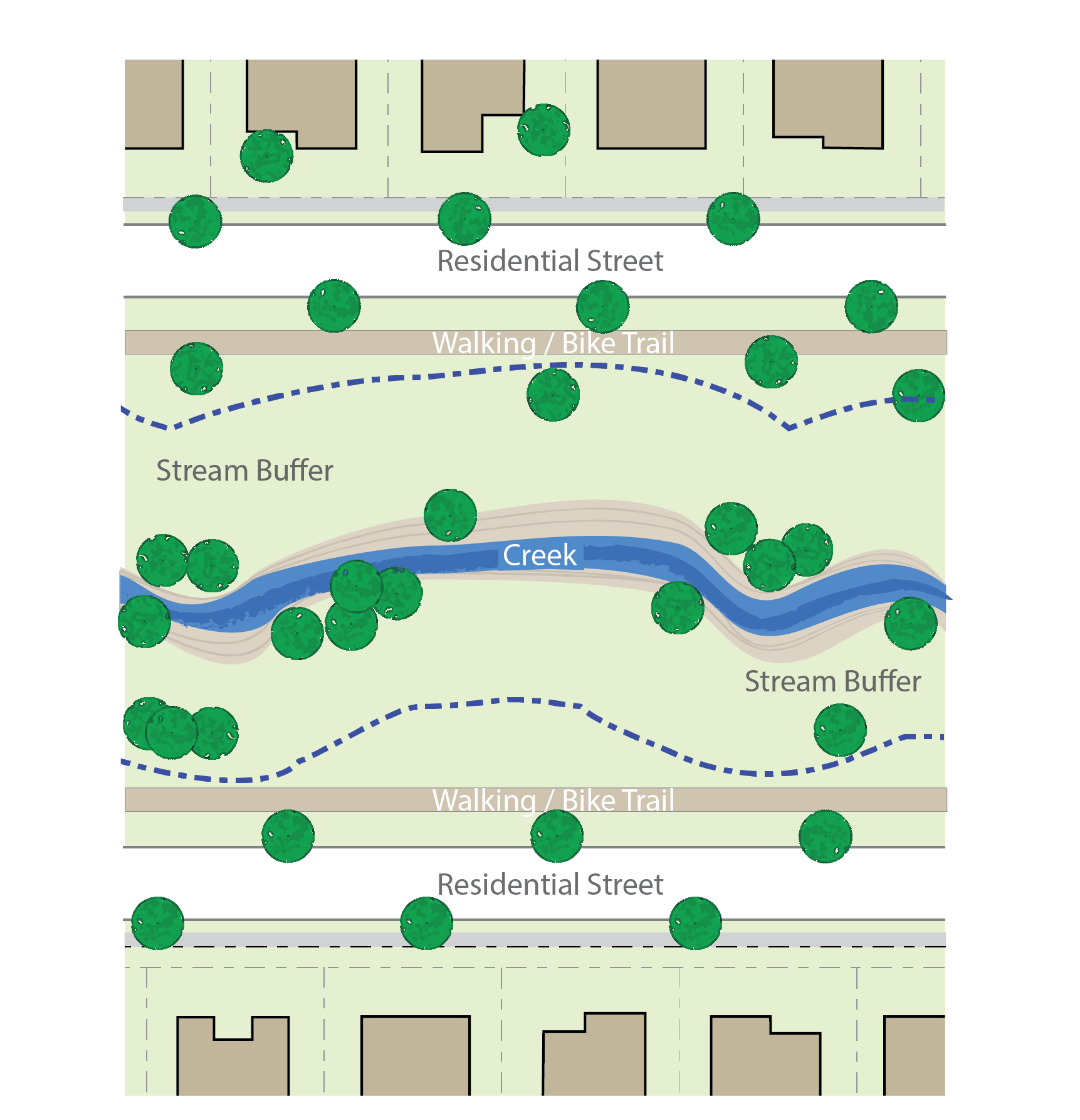 | SIDING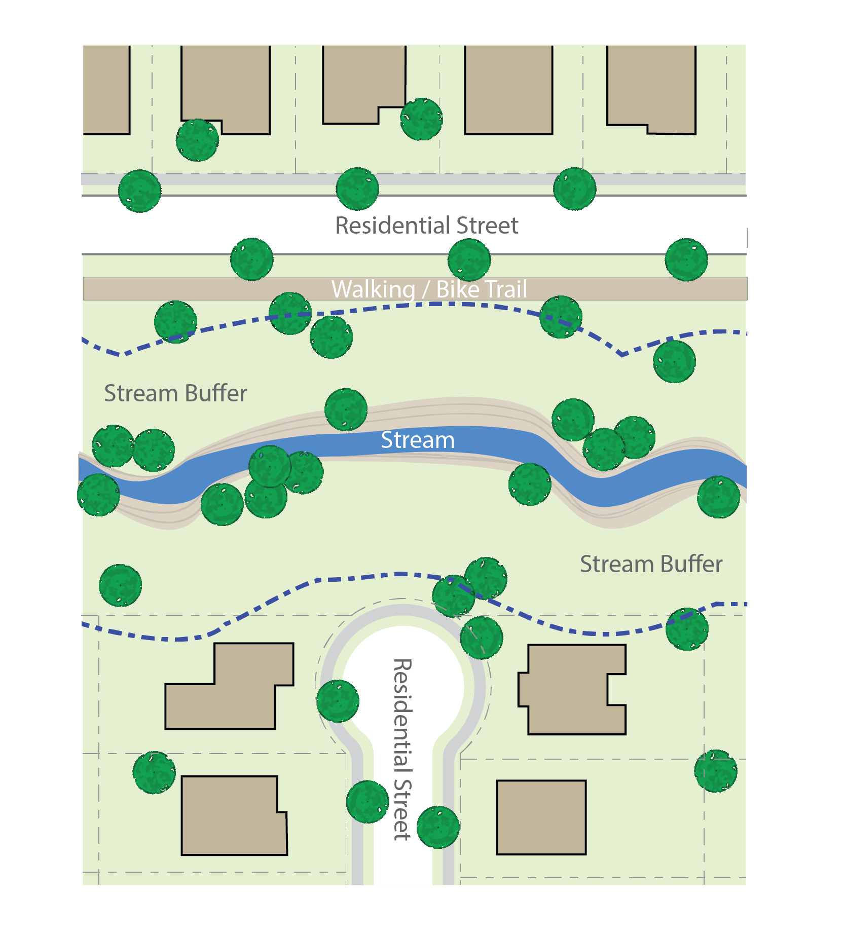 |
d.
To the extent possible locate site improvements to avoid significant stands of vegetation and/or mature native plants. If leaving vegetation in its original location is not feasible, qualified plant material should be salvaged and relocated on-site giving consideration to the plants' preferred growing conditions (i.e. south facing slope, soil type) with the purpose of enhancing its chance for survival.
e.
Project areas with the highest and the most superior quality of plants should receive a high priority for open space dedication.
D.
Street connectivity standards.
1.
Purpose. Street connectivity works jointly with the maximum block lengths to ensure walkable neighborhoods, but also helps with traffic circulation.
2.
Applicability. The street connectivity standards of this section shall apply to all long plats submitted after the effective date of this chapter.
3.
General standards.
a.
A proposed long plat shall provide multiple direct connections to and between destinations.
b.
To ensure future street connections where a proposed development abuts unplatted land or a future development phase of the same development, street stubs shall be provided to allow future access to all abutting properties or to logically extend the street system into the surrounding area. All street stubs shall be provided with temporary turn-around or culs-de-sac and the restoration and extension of the street shall be the responsibility of any future developer of the abutting land.
(i)
Streets within and contiguous to the subdivision shall be coordinated with other existing or planned streets within the general area as to location, widths, grades, and drainage. Such streets shall be aligned and coordinated with existing or planned streets in existing or future adjacent or contiguous to adjacent subdivisions. All streets, alleys, and pedestrian pathways in any subdivision or site plan shall connect to other streets and to existing and projected streets outside the proposed subdivision or other development.
(ii)
Street connections shall be spaced at intervals not to exceed 600 feet along each boundary that abuts potentially developable or redevelopable land. Blocks longer than 400 feet in length shall have a mid-block pedestrian pathway connecting adjacent blocks, as shown in Figure 17.06.410.D.3.
| FIGURE 17.06.410.D.3 - MID-BLOCK PEDESTRIAN PATHWAYS |
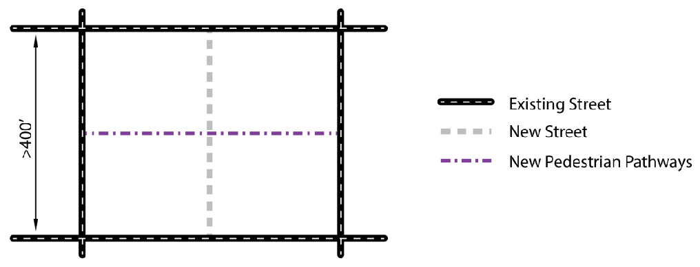 |
c.
Gated street entryways into residential developments shall be prohibited.
4.
Street connectivity index.
a.
The street network for all long plats shall have a minimum connectivity index of 1.4. The connectivity index is defined as the number of street links divided by the number of nodes and link ends (including culs-de-sac and sharp curves with fifteen (15) mph design speed or lower). See Figure 17.06.410.D.4.a for examples of calculating the street connectivity index.
| FIGURE 17.06.410.D.4.a - STREET CONNECTIVITY INDEX EXAMPLES |
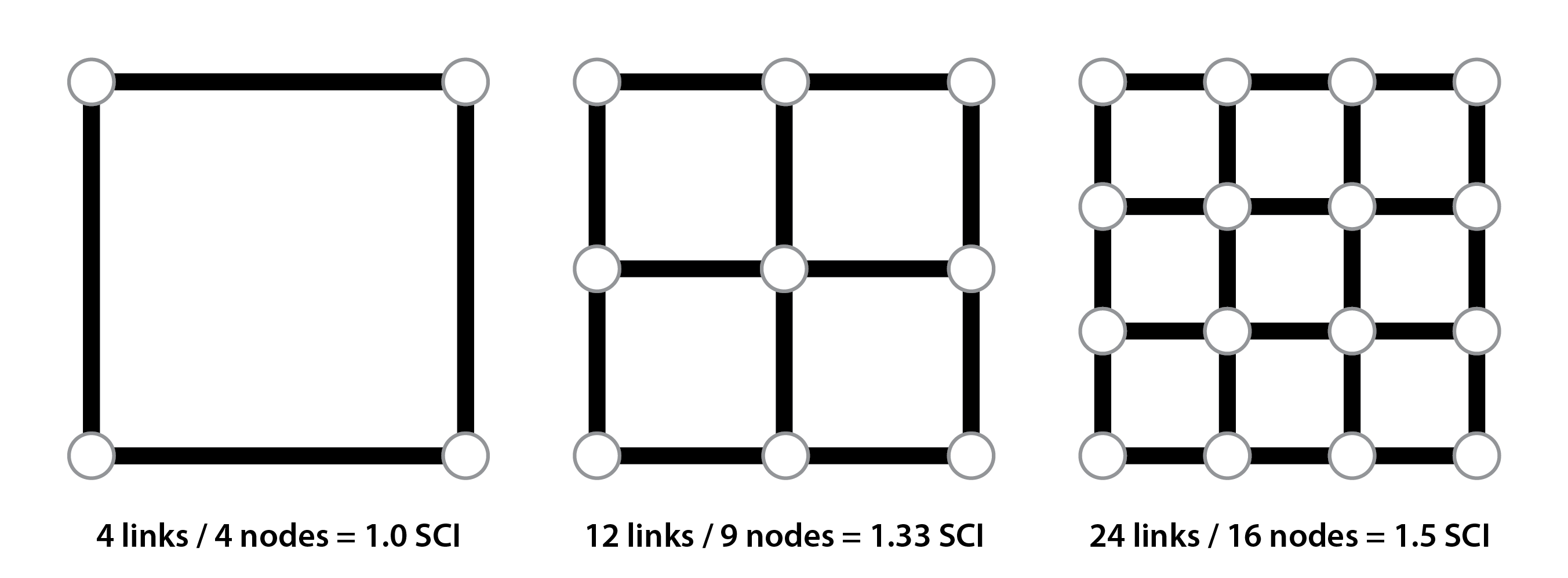 |
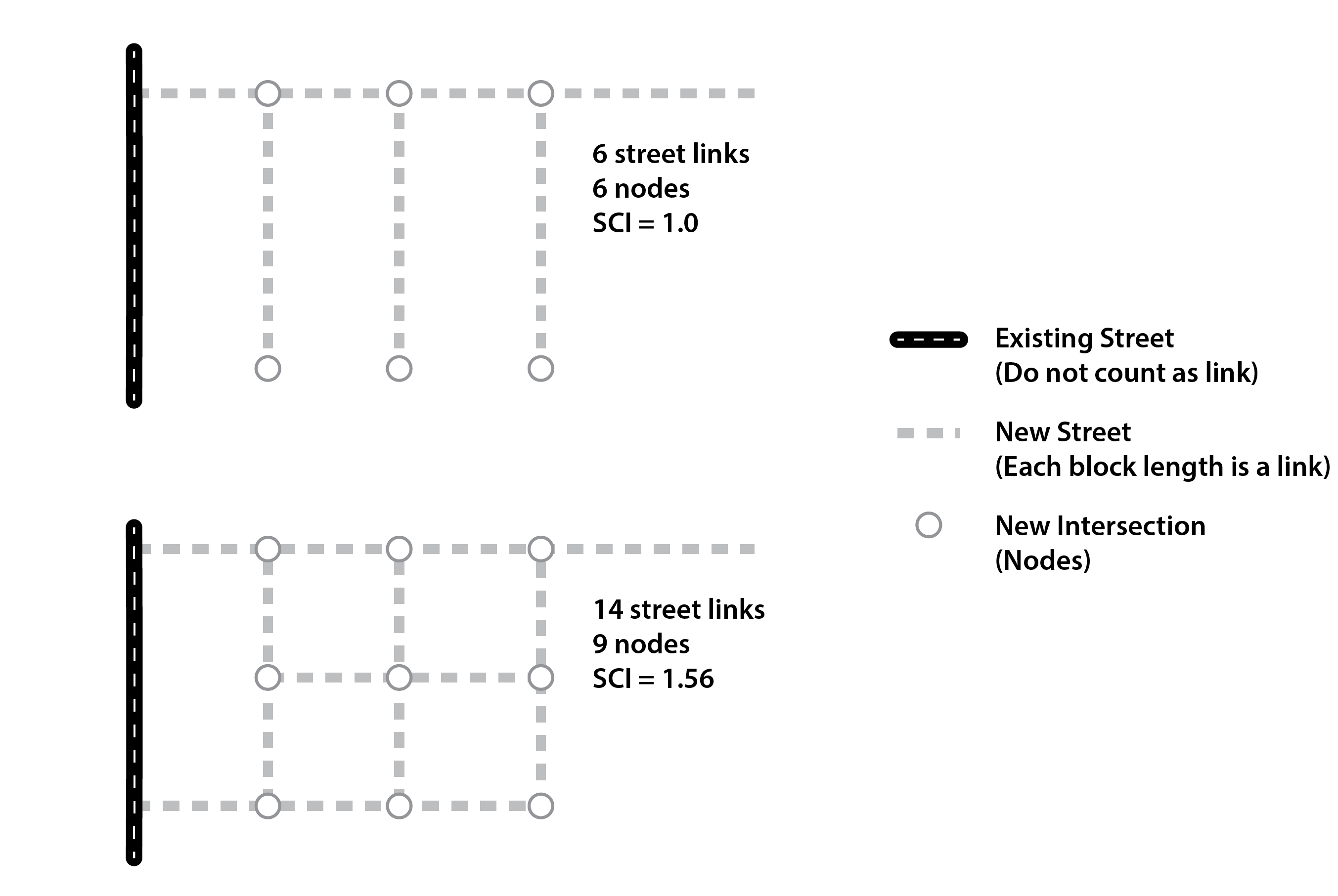 |
b.
A link is defined as a segment of road between two (2) intersections or from an intersection to a cul-de-sac/stub-out. This includes road segments leading from the adjoining roadway network.
c.
Nodes are defined as intersections and cul-de-sacs. They do not include the end of a stub-out at the property line or intersection with the adjoining roadway network.
d.
No dead-end streets shall be permitted except in cases where such streets are designed to connect with future streets on abutting land, in which case a temporary turnaround easement at the end of the street with a diameter of at least 100 feet must be dedicated and constructed.
e.
Culs-de-sac shall only be permitted if they are:
(i)
Less than 200 feet in length (see Figure 17.06.410.D.4.e(i) on how to measure cul-de-sac length); or
(ii)
Less than 400 feet in length and have a pedestrian pathway from the end of the cul-de-sac to another street, as shown in Figure 17.06.410.D.4.e.(ii).
| FIGURE 17.06.410.D.4.e.(i) MEASURING THE LENGTH OF A CUL-DE-SAC |
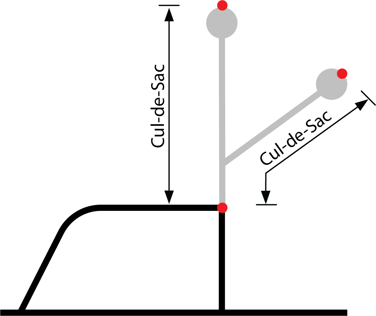 |
| FIGURE 17.06.410.D.4.e(ii) CUL-DE-SAC PEDESTRIAN CONNECTIVITY OPTIONS |
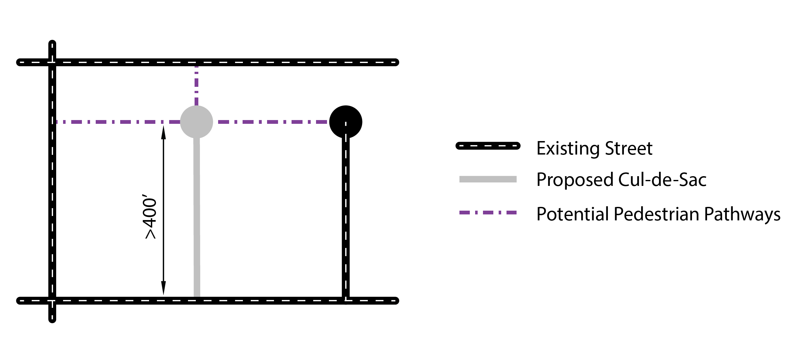 |
(Ord. No. C-49-19 [PLG-004-19], Exh. C, 6-18-2019)
17.06.430 - Block frontage types/standards.
A.
Purpose. This section identifies permitted block frontage types per zoning district, and provides design standards for each frontage type to ensure that development relates to the street and meets community design objectives. This section is strictly about the relationship between the building and the public right-of-way.
The arrangement and design of block frontages largely determines the character of the area and the quality of the pedestrian environment. These standards are intended to provide for a range of block frontage types that will reinforce the desired character of Freeland's streets and residential neighborhoods over time as areas develop and redevelop.
B.
Applicability. The provisions of this section shall apply to all development in Freeland. Table 17.06.430.D. describes which frontage types are allowed in which districts.
See also section 17.06.540 for fencing standards along street frontages and section 17.06.550 for parking location standards.
C.
About the transparency requirements. Each of the block frontage types include minimum transparency standards. The purpose of these transparency requirements are to maintain "eyes on the street" for safety of pedestrians and to create a more welcoming and interesting streetscape. Transparency also provides a good indication of the uses and activities that occur in buildings. Transparent windows and doors may be used to meet the transparency requirements. Glazed windows, where the visibility is obscured, do not count as transparent window areas.
The transparency zone referenced in the standards for block frontage types refers to the area of the street-facing façade of the building that is between thirty (30) inches and eight (8) feet above grade. For stoops, it refers to the area of the street-facing façade of the building that is between thirty (30) inches and eight (8) feet above the grade of the stoop.
| FIGURE 17.06.430.C - TRANSPARENCY ZONE LOCATION | |
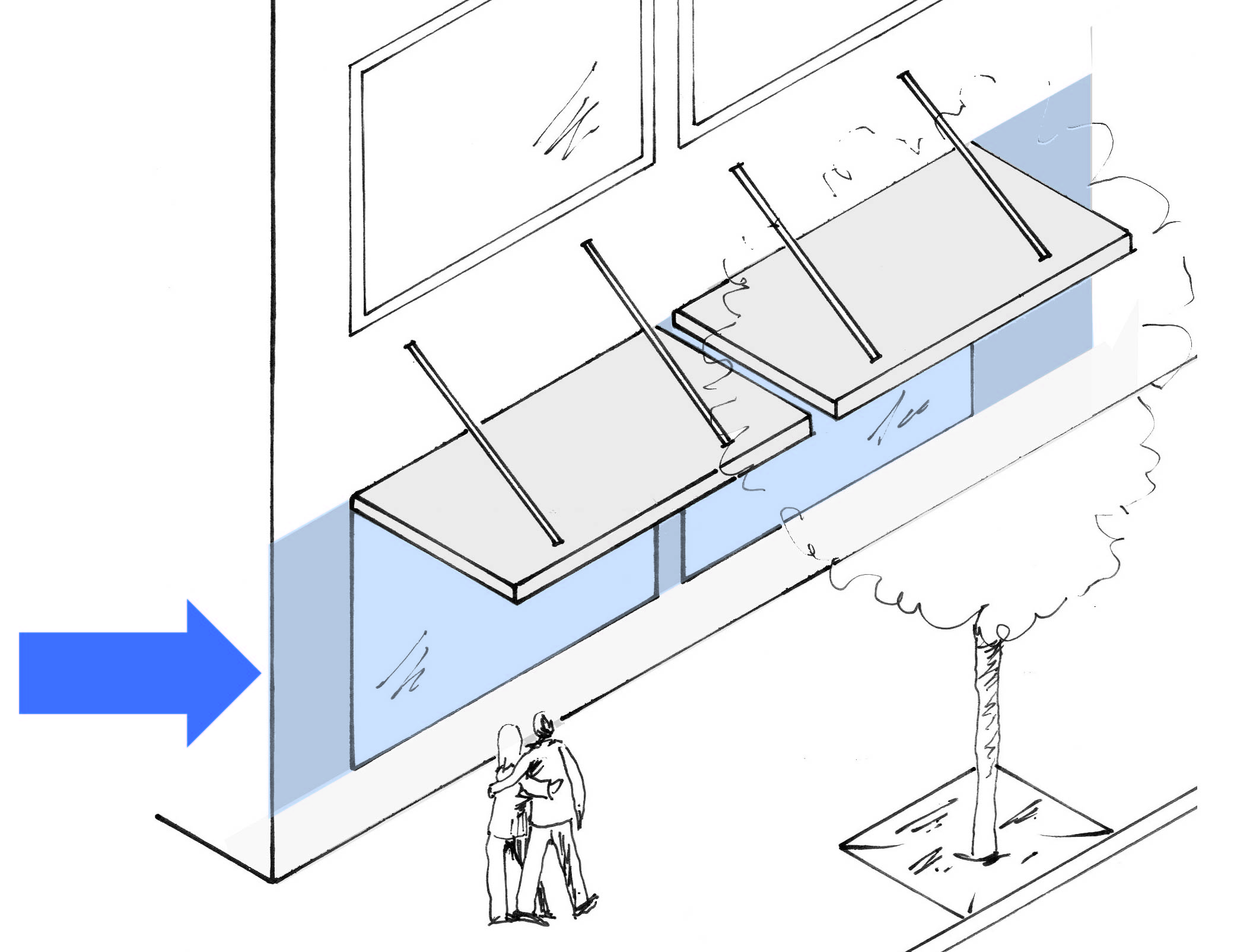 |
The shaded area (between 30" and 8' above the sidewalk) is the transparency zone.
For stoops and terrace yard frontage types, the transparency zone is between 30" and 8' above grade at the primary building entry. |
D.
Frontage types. Table 17.06.430.D describes which frontage types are allowed in which zones.
| TABLE 17.06.430.D - FRONTAGE TYPES ALLOWED | |||||||
|---|---|---|---|---|---|---|---|
| ● = Frontage type allowed in the district | |||||||
| Frontage Type | LD | MD | BV | BG | NM | LI | |
| Storefront Façades located adjacent to the sidewalk. | 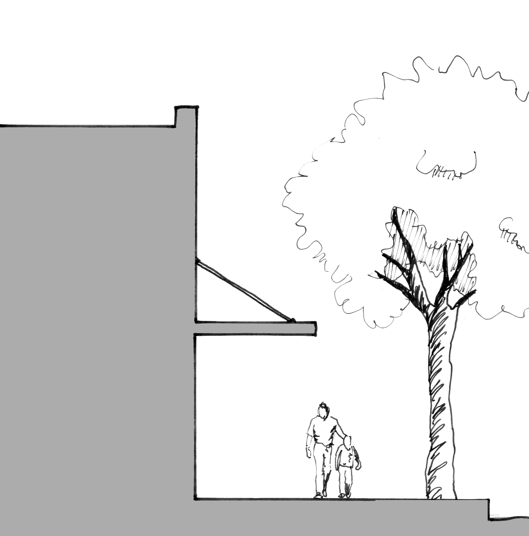 | ● | ● | ● | |||
| Stoop Elevated platform entry ways. | 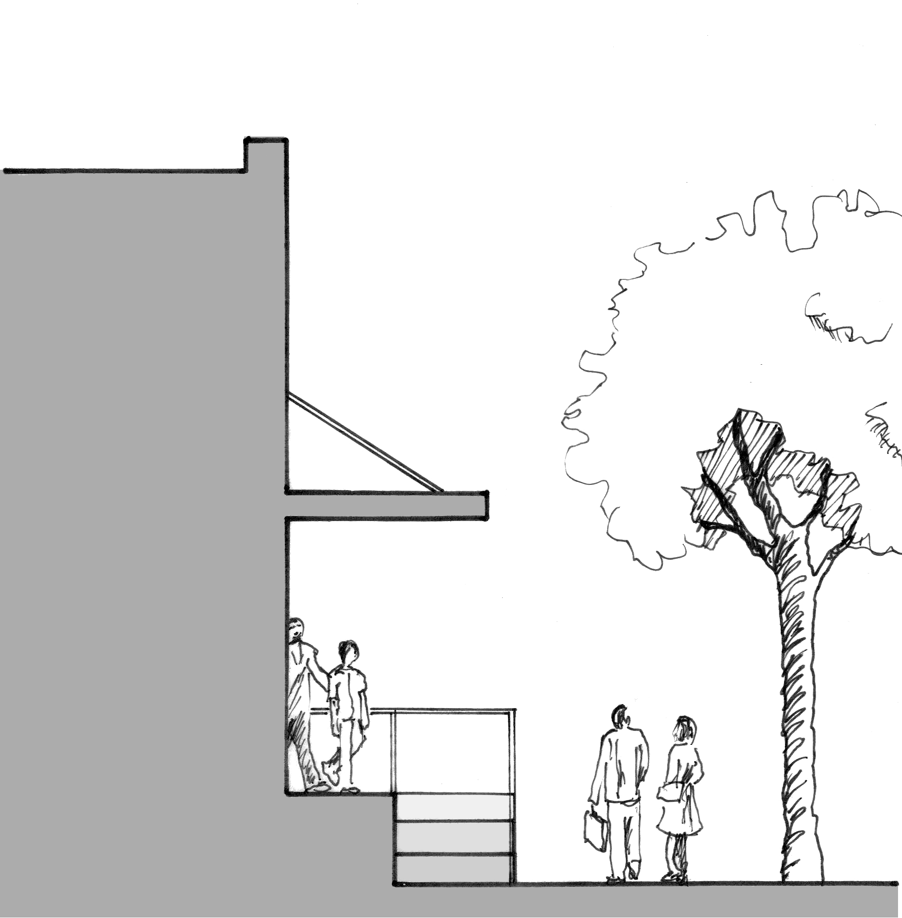 | ● (1) | ● | ● | |||
| Terraced Yard Raised lawns or gardens separated from the frontage line by a retaining wall. | 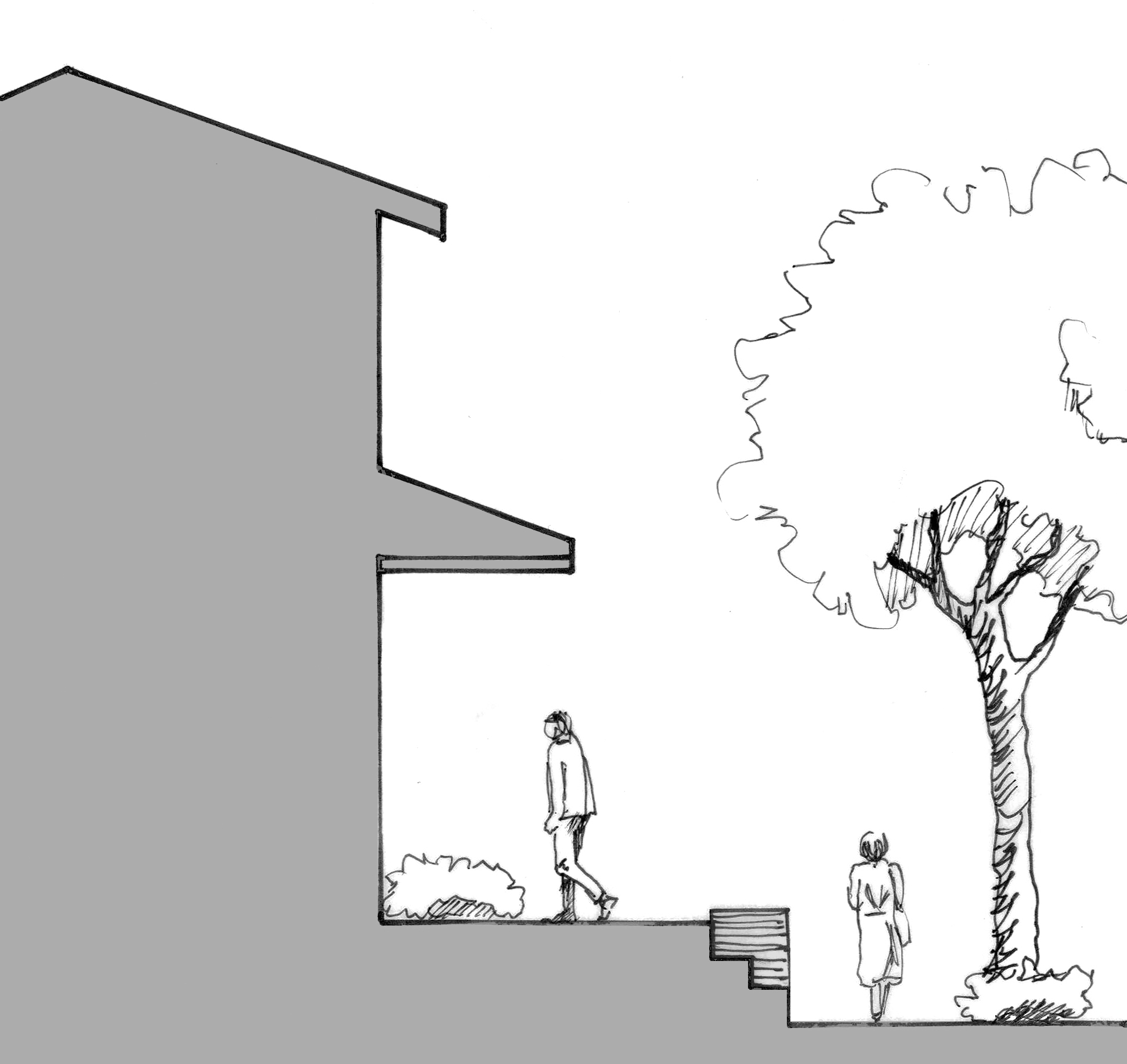 | ● (1) | ● | ● | ● | ● | |
| Fenced Yard Distinct separation between the public and private realms. | 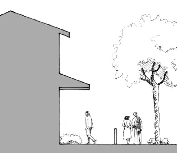 | ● | ● | ● | ● | ||
| Common Yard Visually continuous landscaped space along adjacent yards. | 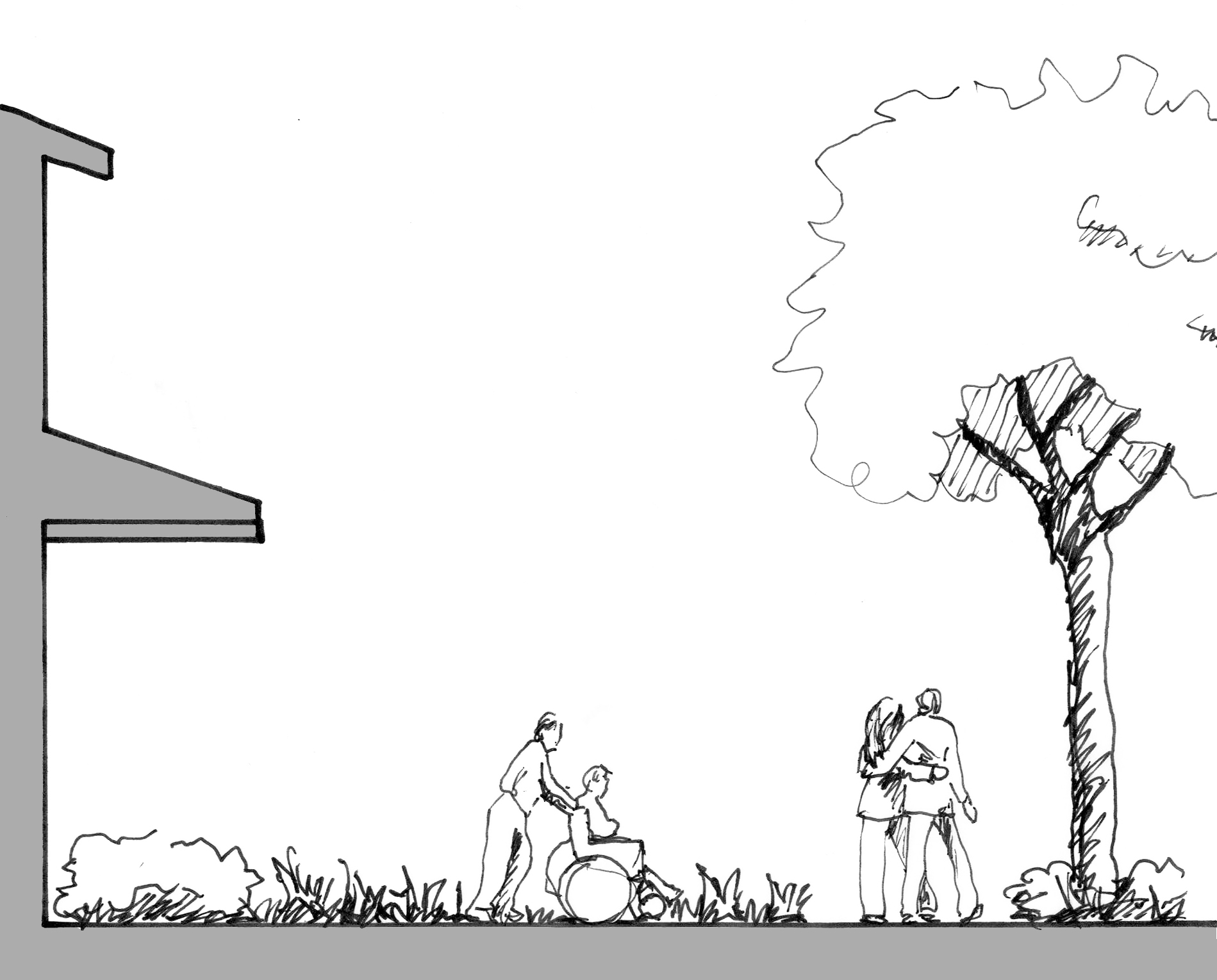 | ● | ● | ● (2) | ● | ● | ● |
| Notes (1) Allowed for Townhomes and Multi-family residential. (2) Not allowed on Main Street or Harbor Avenue frontages. | |||||||
E.
Alternative use of storefront frontage. Storefront frontage standards may also be used on private internal walkways or pedestrian pathways, pursuant to applicable standards in section 17.06.410.B.
F.
Frontage types standards. See Tables 17.06.430.F(1) through F(5) for the frontage standards.
| TABLE 17.06.430.F(1) - STOREFRONT STANDARDS | |||
|---|---|---|---|
| Storefronts are non-residential façades located adjacent to a public sidewalk. Design elements of storefronts are expected to encourage and allow for high pedestrian traffic. May also be used on private internal walkways or pedestrian pathways, pursuant to applicable standards in section 17.06.410.B. | Dimensions Weather Protection A = 5' deep minimum B = 8' above grade minimum Façade Transparency C = 65% transparency in the transparency zone Sidewalks 12' minimum between curb edge and storefront (area includes clear/buffer area with street trees), except where an adopted plan for a specific street dictates otherwise. Street trees must be in grates or planting beds. | ||
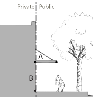 | 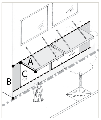 | ||
| Permitted Uses On Main Street and Harbor Avenue frontages, non-residential uses are required on ground floor building frontages, except for lobbies for residential uses. Ground floor ADA accessible units are allowed at the rear of the building. Design • Ground floor spaces must have a minimum depth of 20 feet. • An entrance that faces the sidewalk for each building and business is required. For corner buildings, entrances may face the street corner. • Weather protection is required along at least 60% of the façade, at least 5 feet deep, and placed at least 8 vertical feet above the sidewalk. Retractable awnings may be used to meet these requirements. • Façade transparency. Display windows may count for up to 50% of the transparency requirement provided they are at least 30 inches in depth to allow for changeable displays. Tack-on display cases shall not qualify as transparent window areas. | |||
| Storefront Examples | |||
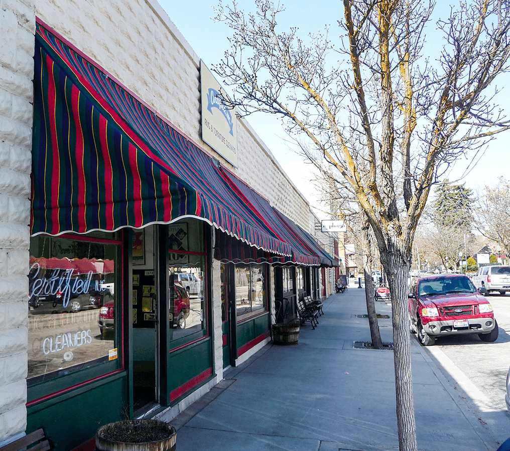 | 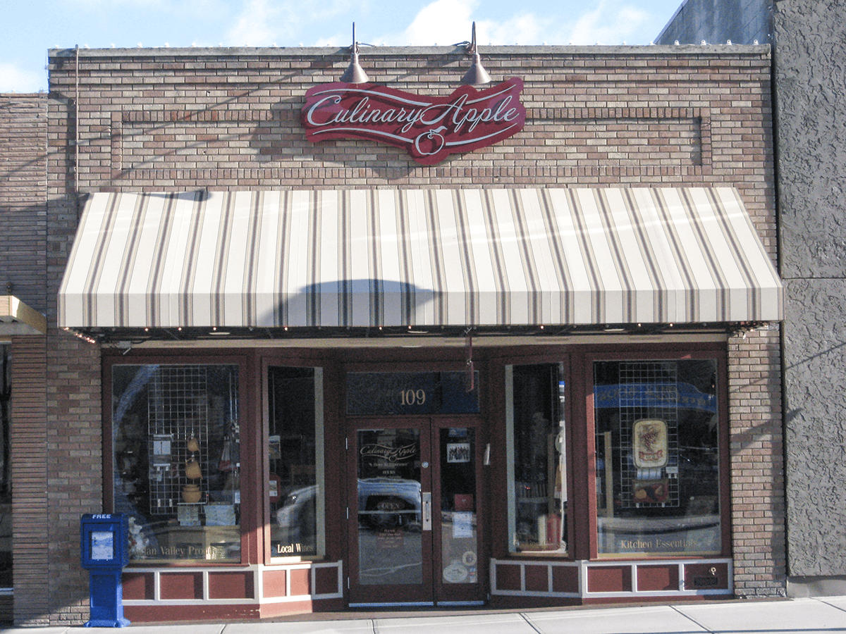 | ||
| TABLE 17.06.430.F(2) - STOOP STANDARDS | |||
|---|---|---|---|
| Stoops are elevated platform entryways situated close to the sidewalk. The stoop improves privacy for residential uses. | Dimensions Decorative Railing A = 42" tall and at least 50% transparent Platform B = 0"—36" tall C = at least 7' deep D = at least 7' wide Weather Protection E = at least 8' above platform F = at least 3' and shall not project into the right-of-way Façade Transparency Zone G = See details under "design" below | ||
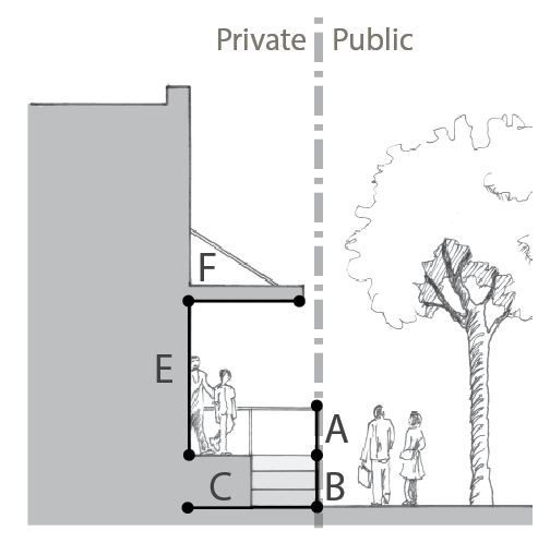 | 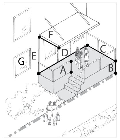 | ||
| Uses Permitted See section 17.06.200. Design • Building entries shall be visible from the street. • For sloping frontages, the Planning Director may allow flexibility with the dimensions of the stoop, provided the design meets the intent. • Weather protection at least 3 feet deep is required over entire span of all entries and placed at least 8 vertical feet above the platform. • Façade transparency for non-residential uses: At least 25% (50% min. for frontages on Main Street) • Façade transparency for residential uses: At least 15% | |||
| Stoop Examples | |||
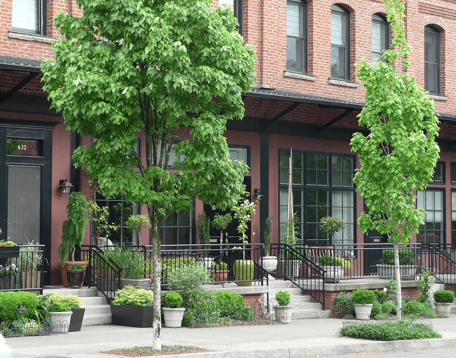 | 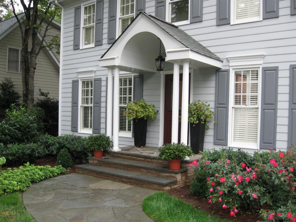 | ||
| TABLE 17.06.430.F(3) - TERRACED YARD STANDARDS | |||
|---|---|---|---|
| Terraced yards are raised lawns and/or gardens separated from the sidewalk by a retaining wall. | Dimensions Terrace Parameters A = 0"—36" high B = 10' deep min., or as set forth for the applicable zoning district Multiple terraces may be used provided each is separated by 2' wide planting beds. Weather Protection C = at least 3' deep, over building entries D = at least 8' above grade | ||
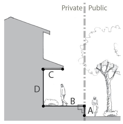 | 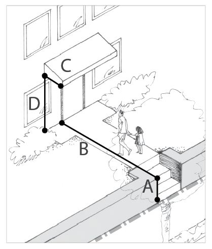 | ||
| Uses Permitted See section 17.06.200. Design • Building entries facing the street are encouraged. For multi-tenant buildings, at least one building entry visible and accessible from the street is required. • For sloping frontages, the Planning Director may allow flexibility with the height of the retaining wall. Retaining walls over 36" require engineering. • Façade transparency for non-residential uses: Within Business Village zoning district, 50% of the Transparency Zone*; within all other zoning districts, 15% of the Transparency Zone. • Façade transparency for residential uses: At least 10% of the entire residential façade for single family uses; at least 15% of the façade for all other housing types. * Minimum setbacks for non-residential uses may be reduced to 5 feet in the Business Village zoning district provided the façade transparency is at least 40%. This reduction is not applicable for frontages on Main Street. | |||
| Terraced Yard Examples | |||
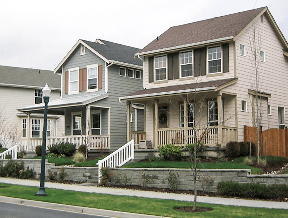 | 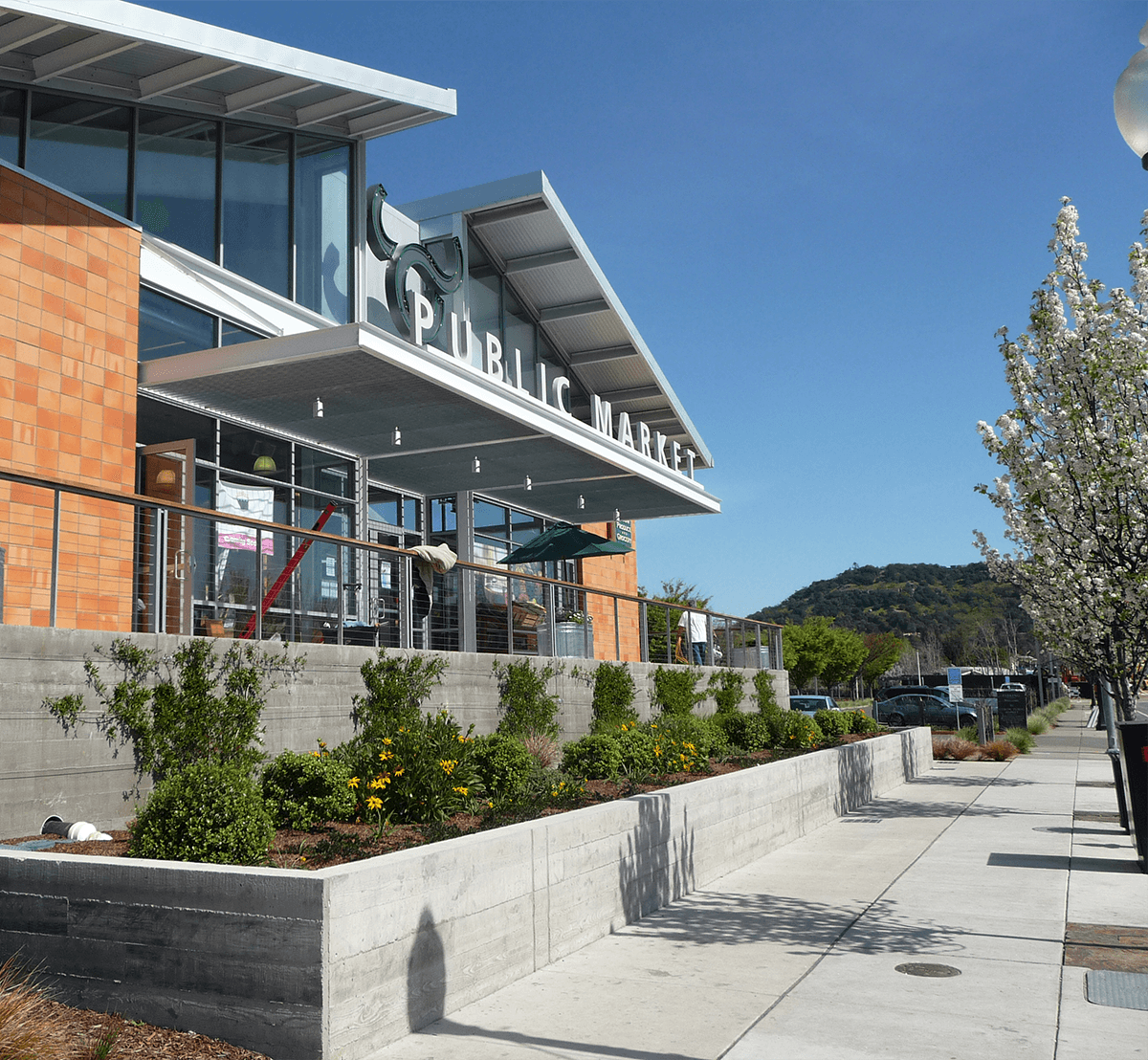 | ||
| TABLE 17.06.430.F(4) - FENCED YARD STANDARDS | |||
|---|---|---|---|
| Fenced yards clearly separate the public realm (sidewalks) from the private realm (residential or commercial use). | Dimensions Fence Setbacks A = see 17.06.360.D Fence Height B = see 17.06.360.D Weather Protection C = at least 3' deep, over building entries D = at least 8' above grade Building Setback E = 10' min. or as set forth in applicable zoning district* | ||
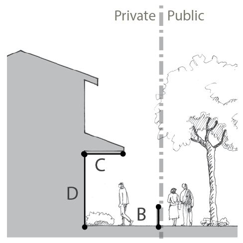 | 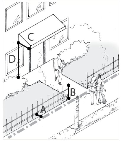 | ||
| Uses Permitted See section 17.06.200. Design • Building entries facing the street are encouraged. For multi-tenant buildings, at least one building entry visible and accessible from the street is required. • Landscaping along fenced frontages is essential to retain a desirable pedestrian environment, whether inside or outside of the fence line. • For fence setback, height, and landscaping, refer to section 17.06.360.D. • Façade transparency for non-residential uses: Within the Business Village zoning district, along 25% of the Transparency Zone*; within all other zoning district, along 15% of the Transparency Zone. • Façade transparency for residential uses: At least 10% of the entire residential façade for single family uses; at least 15% of the façade for all other housing types. * Minimum setbacks for non-residential uses may be reduced to 5 feet in the Business Village zoning district provided the façade transparency is at least 40%. This reduction is not applicable for frontages on Main Street. | |||
| Fenced Yard Examples | |||
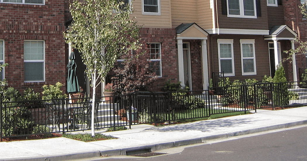 | 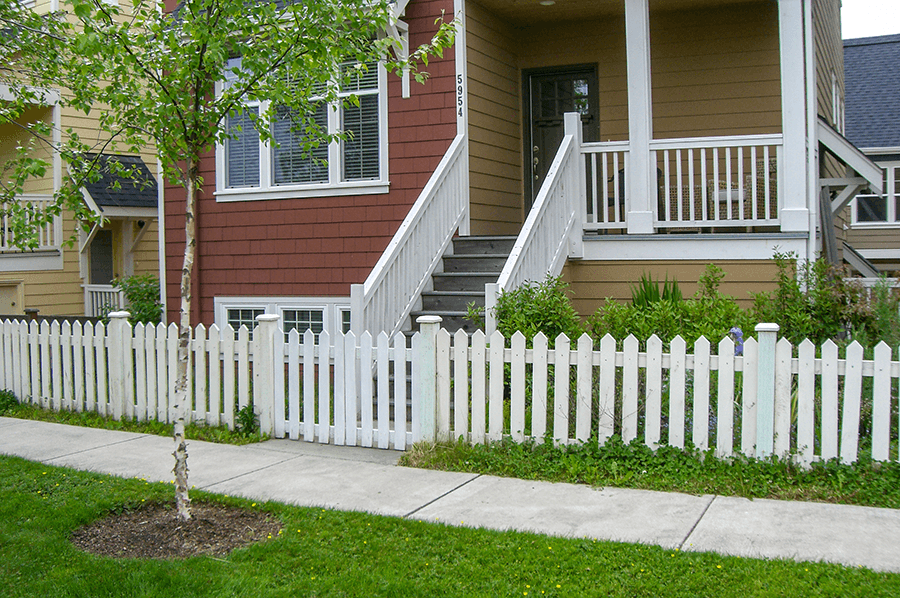 | ||
| TABLE 17.06.430.F(5) - COMMON YARD STANDARDS | |||
|---|---|---|---|
| Common yards refer to landscaped frontages along sidewalks. | Dimensions Weather Protection A = at least 3' B = at least 8' above grade Building Setback C = 10' min. or as set forth in applicable zoning district* | ||
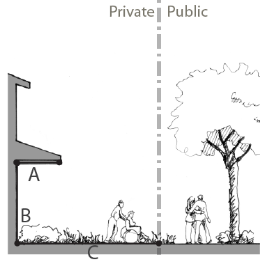 | 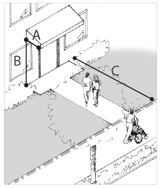 | ||
| Uses Permitted See section 17.06.200. Design • Building entries facing the street are encouraged. At least one building entry visible and accessible from the street is required. • Transparency for non-residential uses: Within the Business Village zoning district, along 25% of the Transparency Zone*; within all other zoning district, along 15% of the Transparency Zone. • For fence setback, height, and landscaping, refer to section 17.06.360.D. • Transparency for residential uses: At least 10% of the entire residential façade for Single Family uses; at least 15% of the façade for all other housing types. * Minimum setbacks for non-residential uses may be reduced to 5 feet in the Business Village zoning district provided the façade transparency is at least 40%. This reduction is not applicable for frontages on Main Street. | |||
| Common Yard Examples | |||
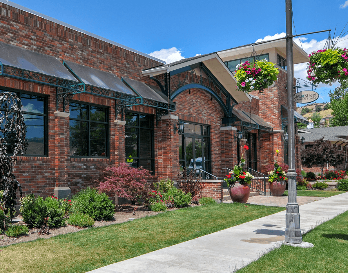 | 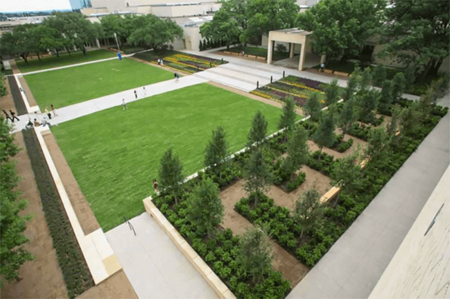 | ||
(Ord. No. C-49-19 [PLG-004-19], Exh. C, 6-18-2019)
17.06.500 - SITE DESIGN STANDARDS
A.
Purpose.
1.
Provide clear objectives for those embarking on the planning and design of development projects in the Freeland Subarea.
2.
Preserve and protect the public health, safety, and welfare of the citizens of Freeland.
3.
Ensure that new development is of high quality and beneficially contributes to Freeland's character.
4.
Ensure that new developments within Freeland are compatible with and enhance the character of Freeland.
5.
Promote an increase in walking and bicycling throughout Freeland.
6.
Maintain and enhance property values within Freeland.
B.
Design alternatives.
1.
This section provides for a number of specific development standards. Where design alternatives are discussed, they provide applicants with the option of proposing alternative design treatments provided such alternatives meet the "purpose" of the particular standard and any additional criteria set forth for the particular design alternative opportunity.
2.
Design alternatives are voluntary. This provision allows the flexibility for applicants to propose alternative designs on a voluntary basis, provided they meet the purpose of the standard and applicable criteria.
3.
Applicability. Design alternative opportunities are available only to those specific standards that allow for alternatives.
4.
Procedures. Permit applications that include design alternative requests go through the standard review procedures set forth in this section depending on the application type.
5.
Approval criteria. Project applicants must successfully demonstrate to the Planning Director how the proposed design alternative meets the purpose(s) of the standard and other applicable criteria that applies to the specific standard.
6.
Documentation. The Planning Director must document the reasons for approving all design alternatives (to be maintained with project application records) for the purpose of providing consistency in decision-making by the County.
(Ord. No. C-49-19 [PLG-004-19], Exh. C, 6-18-2019)
17.06.510 - Open space.
A.
Purpose.
1.
To enrich the pedestrian environment in Freeland.
2.
To provide accessible, safe, convenient, and usable on-site open space.
3.
To promote the health and welfare of residents by providing access to on-site and nearby open space for recreational activities, physical exercise, and/or gardening.
4.
To create usable open spaces that enhances residential and commercial development.
5.
The enhancement of the value to abutting or neighboring parks, forests, wild preserves, nature reservations or sanctuaries.
6.
To provide for pedestrian-oriented open space in conjunction with large scale commercial development.
7.
To create distinctive destinations that attract people and encourages social interaction.
8.
The conservation and enhancement of natural or scenic resources, including wildlife habitat.
B.
Open space credits.
1.
The installation of the alternatives identified in Table 17.06.510.B count as a credit towards the useable open space requirement of this section, where they meet the applicable conditions herein. Such open space may utilize one (1) or more of the following alternatives.
2.
The following shall not count towards the useable open space requirement:
a.
Property within the required setbacks excepting any additional front yard setback require for a view corridor per section 17.06.140.A;
b.
Vehicular paving;
c.
Required parking lot landscaping;
d.
Critical areas;
e.
Required landscape and/or screening buffers; and/or
f.
Utility easements.
C.
Useable open space requirements for non-residential and mixed-use developments.
1.
All non-residential development (excluding property within the Industrial District) shall provide usable open space for active and/or passive recreational uses.
2.
Surface requirements. No impervious surface will be allowed. The surface shall be one (1) of the following materials, or a combination of:
a.
Grass or reinforced turf; or
b.
Quality permeable materials subject to the approval of the Planning Director.
3.
All non-residential and mixed-use developments shall provide the applicable type of usable open space:
a.
Type A Usable Open Space - Single lot developments. All non-residential and mixed-use developments on a single lot shall provide a minimum of five (5) percent of the gross lot area as consolidated and usable open space.
b.
Type B Usable Open Space - Multi-lot developments. All non-residential and mixed-use developments containing more than one (1) lot shall provide a minimum of seven (7) percent of the gross lot area as usable open space. A minimum of fifty (50) percent of the required usable open space shall be consolidated open space (the open space may cross property lines). Consolidated open space will require an open space easement to be dedicated on a plat. This will ensure that if the property is sold, the new purchaser will be made aware of this encumbrance on the property.
| FIGURE 17.06.510.C.3.b - EXAMPLE OF CONSOLIDATED OPEN SPACE | |
|
Consolidated open space is achieved through site planning. Place open space areas
immediately adjacent to each other and design the space to appear to the public to
be one space.
In this multi-lot development example, the open spaces from all three lots were consolidated into pathways and courtyards. Pedestrian pathways and interior courtyards built at Pedestrian-Oriented Open Space standards count towards the usable open space requirements, with additional open space provided at in a courtyard at the rear. | 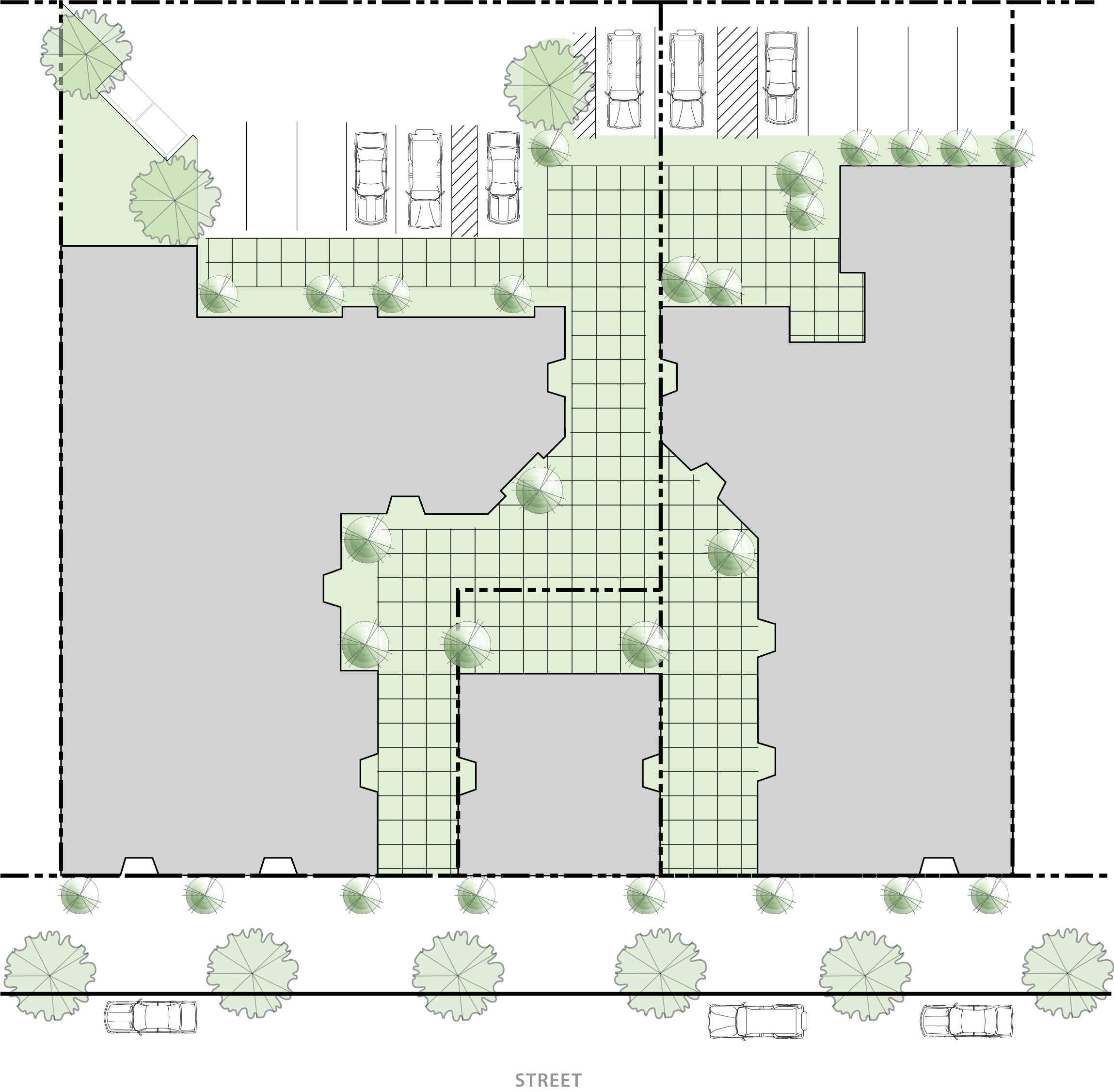 |
4.
Wherever possible, open space shall include the natural feature(s) of a site and building orientation shall address the natural feature(s) of the site (see subsection (E) of this section).
5.
All open space shall be owned and maintained by the property owner(s) or the property owners' association.
D.
Pedestrian-oriented open space.
1.
Pedestrian-oriented open space shall be provided for large scale non-residential uses in the Non-Residential Mixed Use, Business General, and Business Village zoning district. These spaces are intended to be publicly accessible spaces that enliven the pedestrian environment by providing opportunities for outdoor dining, socializing, relaxing, and visual amenities that contribute to the character of commercial areas.
a.
New development featuring buildings designed for non-residential use with at least 5,000 square feet of gross floor area shall provide pedestrian-oriented space equal to at least two (2) percent of the acreage of the site plus one (1) percent of the gross non-residential building floor area. Buildings used entirely for storage purposes are exempt from this standard (see example calculations in Table 17.06.510.D.1).
b.
The applicable open space(s) shall be maintained by the property owner.
2.
Pedestrian-oriented space design criteria.
a.
Where a sidewalk area is widened beyond minimum requirements by four (4) or more feet, only the extra width shall count as pedestrian-oriented open space. The additional sidewalk area may be used for outdoor dining and temporary display of retail goods.
b.
The following design elements are required for pedestrian-oriented open space.
(i)
Spaces shall be physically and visually accessible from the adjacent street or major internal vehicle or pedestrian route. Spaces shall be in locations that the intended user can easily access and use, rather than simply left-over or undevelopable spaces where very little pedestrian traffic is anticipated.
(ii)
Paved walking surfaces of either concrete or approved unit paving (crushed rock designs may be appropriate provided other design requirements are met).
(iii)
Pedestrian-scaled lighting (no more than fifteen (15) feet in height). Lighting may be on-site or building-mounted lighting, pursuant to section 17.06.570.
(iv)
For every sixty (60) square feet of plaza area or open space, seating areas must be provided and consist of at least three (3) linear feet of seating area (bench, ledge, etc.) or one (1) individual chair. This provision may be relaxed where there are provisions for movable seating that meet the purpose of the standard.
(v)
Spaces shall be positioned in areas with significant pedestrian traffic to provide interest and security - such as adjacent to a building entry.
(vi)
Landscaping that adds visual or seasonal interest to the space.
| FIGURE 17.06.510.D.2 - EXAMPLE OF PEDESTRIAN-ORIENTED OPEN SPACES | ||
|---|---|---|
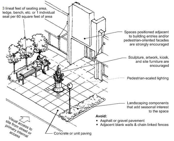 | ||
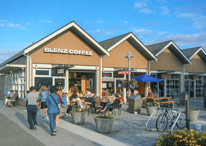 | 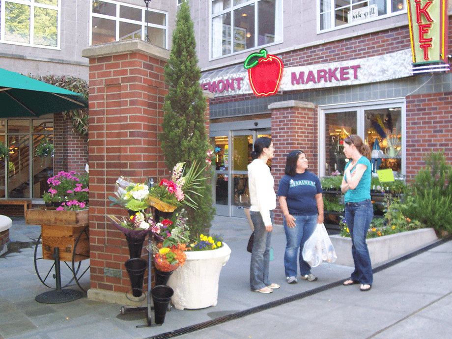 | 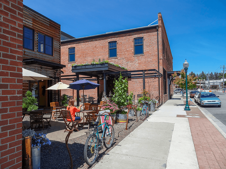 |
| Each of the examples are sited in visible spots adjacent to the sidewalk and feature adjacent storefronts that add visibility and activity to the space. These spaces also include landscaped elements, chairs and/or ledges for seating, and a range of design details that make the space welcoming and interesting. | ||
c.
The following features are encouraged in pedestrian-oriented spaces.
(i)
Pedestrian amenities such as a water feature, drinking fountain, and/or distinctive paving or artwork;
(ii)
Pedestrian-oriented façades on some or all buildings facing the space;
(iii)
Consolidation of open space by siting the pedestrian-oriented space adjacent and contiguous with open space from adjacent properties is encouraged where practical;
(iv)
A pedestrian pathway constructed of brick or concrete pavers a minimum of eight (8) feet in width traversing the consolidated open space with pedestrian lighting;
(v)
Plaza or courtyard covered with brick or concrete pavers; or
(vi)
Play equipment (e.g. a children's playground, checkers/chess set, or other activity area).
d.
The following features are prohibited within pedestrian-oriented space:
(i)
Asphalt, except where continuous asphalt paths intersect with the space;
(ii)
Adjacent chain link fences;
(iii)
Adjacent unscreened blank walls; and
(iv)
Adjacent dumpsters or service areas.
E.
Useable open space requirements for residential developments.
1.
Multi-family uses.
a.
All multi-family development, including multi-family portions of mixed use development, shall provide usable open space at least equal to ten (10) percent of the leasable floor area, not counting corridors, lobbies, etc. For example, for an eight-unit development where the units average 1,000 square feet, the minimum required open space shall be 800 square feet.
b.
Open space(s) shall be maintained by the property owner or property owners' association, where applicable.
c.
Open space shall be available to all residents and meet the requirements of section 17.06.510.F (i.e. courtyards, play areas, community gardens, or similar spaces) except that up to fifty (50) percent of the required open space may be provided by other forms of usable open space (e.g. private yards, etc.) when these spaces are located and designed to meet the purposes of these standards.
d.
Multi-family common open space design criteria.
(i)
Common open space includes landscaped courtyards, gardens with pathways, children's play areas, or other multi-purpose recreational and/or green spaces. Special requirements and recommendations for common open spaces include the following:
(1)
Required setback areas shall not count towards the open space requirement unless they are portions of a space that meets the dimensional and design requirements and guidelines set forth below;
(2)
No dimension shall be less than fifteen (15) feet in width;
(3)
Spaces (particularly children's play areas) shall be visible from at least some dwelling units and positioned near pedestrian activity;
(4)
Create a transitional space between public and private realms through the separation of common space from ground floor windows, automobile circulation, service areas and parking lots through the utilization of landscaping, low-level fencing, and/or other treatments that enhance safety and privacy (both for common open space and dwelling units); and/or
(5)
Spaces shall feature paths, landscaping, seating, lighting and other pedestrian amenities to make the area more functional and enjoyable.
(ii)
To the extent feasible, all required common open space shall be centrally located within the development.
(iii)
The required space may be dispersed throughout the multi-family complex or development, but no required space shall be less than 800 square feet in size.
2.
Single-family residential plats.
a.
Short plats. No additional common usable open space is required during the short plat process.
b.
Long plats. All development applications containing five (5) or more single-family lots shall provide recreational space as set forth in this section.
(i)
Amount of usable open space required. At least ten (10) percent of the gross acreage of any proposed single-family residential plat, binding site plan, site plan, or other development which includes five (5) or more single-family residential units, shall provide for active park space, passive park space, and/or trails by means of on-site parks, a fee in lieu, or some combination thereof.
(ii)
Open space ownership. Ownership of open space area shall be established consistent with one (1) of the following forms of ownership:
(1)
Common ownership. Open space may be held in common by a home or property owners' association or other similar organization. For the purposes of this section, ownership of and/or conservation easement being held by a land trust, or other similar conservancy organization, shall be considered common ownership. If this ownership pattern is selected, covenant, conditions, and/or restrictions shall be required; or
(2)
Public ownership. Designated open space areas shall not be required to be dedicated to the County or other public agency, and the owner shall not be required to permit public access to designated open space areas. However, if the owner offers to dedicate, the County, Park District, or other public agency may choose to accept ownership of open space. Consequently, upon approval and acceptance by the Board of Island County Commissioners, open space shall be dedicated to the public.
c.
Cluster developments, pursuant to chapter 16.17, are encouraged for all plats within the Potential Habitat Conservation Priority Areas identified in the Freeland Subarea Plan (Map L).
F.
Placement of open space.
1.
Wherever possible, the placement of open space should support the preservation of views to Holmes Harbor (see section 17.06.140). The required building setback area for properties along view corridors may be utilized to meet open space requirements if it meets the open space standards of this section. Views of Holmes Harbor from Hwy 525 should also be considered during the site planning process to utilize the placement of open space to preserve views.
2.
Placement should be adjacent to existing open space where possible and is a priority in Habitat Conservation Priority Areas shown on Map L of the Freeland Subarea Plan. Connect minor open space areas to create larger and more useful open space areas and wildlife corridors. Ensure access to open space whenever possible and feasible.
| FIGURE 17.06.510.F.2 - EXAMPLE OF CONNECTING ADJACENT OPEN SPACES | |
The new development (center lot) has been planned to enhance and expand an existing
adjacent open space and arcade. The site arrangement has also provided an opportunity
to incorporate a mid-block pedestrian pathway to improve pedestrian circulation and
access to parking.
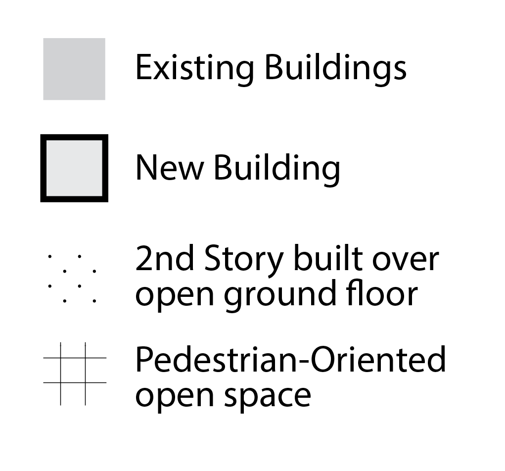 | 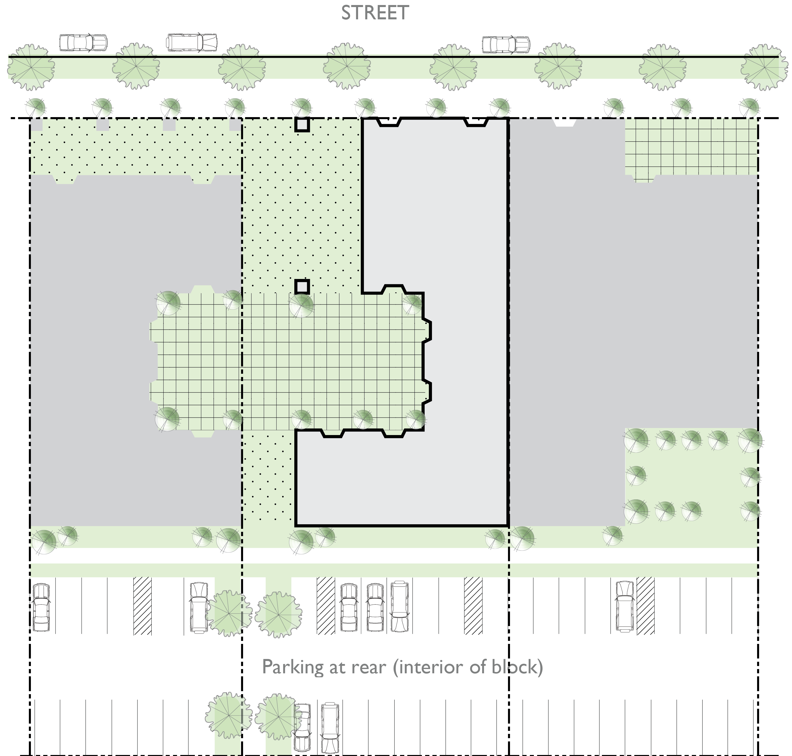 |
3.
Placement shall incorporate critical areas and their buffers.
a.
The site's critical area and their buffers shall be preserved and incorporated into the required open space. The feature(s) shall be defined and identified on the open space plan submitted with the site plan in accordance with section 17.06.510.H.
b.
The required open space containing the feature(s) shall provide amenities in accordance with section 17.06.510.F.
4.
Retention and detention ponds as open space.
a.
A detention and/or retention pond may count toward the required usable open space if it meets the following design requirements:
(i)
Meets engineering standards;
(ii)
Slope of the pond bank does not exceed three (3) percent; allowable to twenty-five (25) percent, but requires stone terracing for any slope exceeding three (3) percent. Terracing or the cutting of a sloped plane into a series of successively receding flat surfaces or platforms, shall have a maximum shelf depth of three (3) feet with maximum six-inch risers;
(iii)
Viewable from public areas and common space and accessible by the public and/or patrons;
(iv)
The water surface in the retention pond as measured at the normal pool elevations shall only account for a maximum of ten (10) percent of consolidated open space requirement;
(v)
Natural stone or brick veneer is required on headwalls, bridges, wall, culverts, retaining walls, and like structures;
(vi)
Is located between the building and the street or to the side of the building; and
(vii)
Meets the amenity requirements set forth in section 17.06.510.F.
b.
Detention pond amenities. Recreation facilities installed in a detention pond area (e.g. tennis or basketball courts) or playground structure may count towards the usable open space requirements if it meets the following requirements:
(i)
Facilities and equipment must be securely installed in a manner that will accommodate flooding when in use as a detention facility, including any seating, trash bins, and/or fencing;
(ii)
Must be installed on a permeable surface;
(iii)
Permeable surface must be maintained to the permeability of the surface at installation; and
(iv)
Must be accessible for use when not flooded.
5.
In the Low Density Residential zone, open space should enhance or retain Island character through the minimization of roadside disturbance of roadside vegetation.
G.
Open space amenities.
1.
In addition to the required amenities, a minimum of four (4) of the following amenities shall be incorporated within the required open space.
a.
Sculptures, and/or pedestrian entry monuments/gateways, as approved by the Planning Director. A pair of pedestrian entry monuments counts as one (1) amenity. A maximum of two (2) amenities may be counted from this category.
b.
Water features, excluding required retention/detention ponds. A maximum of one (1) water feature shall be counted towards an open space amenity.
c.
Shade structures such as pavilions or pergola (to be counted as two (2) amenities). A maximum of one (1) shade structure shall be counted towards an open space amenity.
d.
Raised planter beds with plants of seasonal color and/or native plants with brick and/or stone veneer (collectively count as one (1) amenity).
e.
Educational paths with plaques and monuments describing natural habitats and plant life of the surrounding area (collectively count as one (1) amenity).
g.
Other features as approved by the Planning Director.
2.
Position buildings so that the open space is used as an amenity, except where it is prudent or necessary to allow for future building expansion. Provide, if possible, outdoor seating and/or dining areas that face onto open space and have access to the open space.
H.
Timing of improvements. The construction of the required open space improvements:
a.
Shall be in conjunction with the development of the first lot and completed on or before the issuance of the certificate of occupancy; or
b.
May be deferred by the Planning Director in accordance with section 17.06.520.B.3.
I.
Open space plan.
1.
The applicant shall submit an open space plan with the site plan submittal for the all multi-family, mixed-use, and non-residential developments.
2.
The approval of the open space plan shall expire when the development plans expire, but the platted easements shall remain in effect. Should the location of open space change with a new site plan, then the platted easement shall be amended to reflect the revised location.
(Ord. No. C-49-19 [PLG-004-19], Exh. C, 6-18-2019)
17.06.520 - Landscaping.
A.
Purpose.
1.
To preserve and enhance the natural environment and aesthetic qualities of the Freeland Subarea.
2.
To preserve and enhance the appearance, character, safety, and value of surrounding properties.
3.
To provide cover, corridors, and habitat for wildlife.
4.
To ensure the attractive appearance along county roads.
5.
To enhancement of the quality of life and general welfare.
B.
Applicability.
1.
The provisions of this section shall apply to all development in the Freeland NMUGA excluding single-family developments of less than five (5) lots.
2.
Design alternatives.
a.
The Planning Director may consider alternative design in the Village Core zoning districts depending on the type of use, number of anticipated employees and customers, and the site's physical context.
b.
The Planning Directory may consider design alternatives for landscaping adjacent to a right-of-way if underground utilities conflict with the standards (where a tree may be too close to a water line, etc.).
3.
Temporary deferral. A certificate of occupancy shall not be issued for any use located on a lot(s) upon which screening and/or landscaping are required, unless such screening and landscaping are provided on said lot(s) as herein specified. This provision may be temporarily deferred by the Planning Director in cases where it is not reasonable for the developer to install certain species of plant material prior to occupancy due to the recommended planting season not occurring at an appropriate phase in construction. In such case, the time deadline for planting such materials shall be extended only to the nearest seasonal period suitable for planting such materials.
4.
Streetscape standards. [Reserved]
C.
Landscape plan.
1.
Landscape plans shall be required for all multi-family, mixed-use, non-residential, and single-family long plat development with the site plan application.
2.
Applications for development shall include a landscaping plan that describes and identifies areas where landscaping, screening, tree retention and community/open spaces are proposed. The plan shall include the following:
a.
Identification on the site plan of existing trees that are to be retained. A summary shall be provided that describes the type of each tree. The mature diameter of each tree canopy shall be shown on a scaled map, including trees located on adjacent properties that extend onto the property proposed for development.
b.
Identification on the site plan of proposed trees, shrubs, herbs, groundcover and other vegetation that is proposed. Information shall be provided that shows the type, size, quantity and location of each plant and tree species.
c.
A summary of the number of trees that are proposed and a description of how the tree canopy requirements are being met.
d.
A summary of the method(s) of irrigation.
D.
General landscaping provisions.
1.
Regional native vegetation should be retained to the extent possible and also used to supplement existing vegetation.
2.
Berms are encouraged if needed to screen non-residential structures and parking lots from adjacent properties or public roads. Berms shall be installed in a manner that does not impede pedestrian access.
3.
Buffers adjacent to public roads and/or overhead utilities shall be increased in size to ensure that the buffer width is maintained where the right-of-way of the adjoining public roadway is less than the standard specified in chapter 11.01 and when either the public agency does not purchase the additional right-of-way or the applicant does not dedicate the additional right-of-way in conformance with chapter 11.01.
4.
Completion of all landscape plans shall be assured as follows:
a.
The applicant may post a surety bond or provide other financial assurances, equal to 200 percent of the estimated cost of materials and installation, or may enter into other implementation agreements as are approved by the Planning Director.
b.
Release of any surety for completion of landscaping shall not occur until a final landscape inspection and a plan completion sign-off has been made by the Planning Director. Any portion of the landscaping not completed in accordance with the approved landscaping plan shall be cause for the plan not to be signed and/or cause for the surety to be used by the county to complete the installation.
c.
The landscape improvements shall be completed in accordance with the approved plan prior to issuance of final Certificate of Occupancy.
5.
Landscape maintenance.
a.
Dead or dying vegetation must be replaced immediately or if in winter, within the next planting season; and
b.
Landscape structures in disrepair or destroyed must be repaired or replaced to serve original purpose.
c.
To maximize pedestrian visibility and public safety, the selection, placement, and maintenance of landscape materials should be such that sight lines remain open and clear and places of concealment are not fostered. Trees and shrubs shall be trimmed and appropriately maintained to provide clear sight lines as shown in Table 17.06.520.D.5.
| TABLE 17.06.520.D.5 - LANDSCAPE SIGHT LINE CLEARANCE | |||
|---|---|---|---|
| Sight Line Clearance Zone (yellow area) | Applicable to all landscaping in and adjacent to pedestrian areas (sidewalks, parking lot pathways and landscape medians, etc.) and where otherwise required in this chapter | 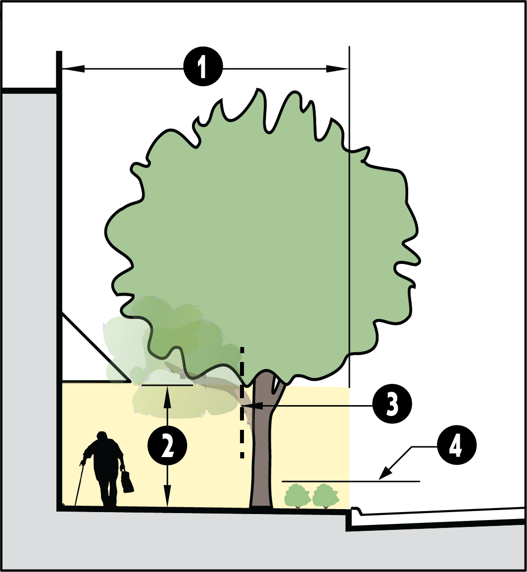 | |
|
Clearance Zone
height | 8 ft. clearance min. | ||
| Trees | Where the branch is in the clear zone and extends 6" or more from the trunk of the tree, prune lower branches | ||
| Shrubs | Keep shrubs trimmed at 3 ft. in height or less | ||
| NOTE: Plant material selection and placement in these areas will impact the level and cost of maintenance required and/or the visual impact of trimming/pruning on plant materials. | |||
6.
It is a higher priority to protect and maintain existing significant trees and/or groves in their present location than it is to establish new landscaped areas.
a.
Building, site, and landscaping shall be designed to first avoid or, if unavoidable, to limit the impacts to existing significant trees and/or groves with the goal of retention to the maximum extent practical for the site (without impacting the ability to develop the site).
b.
With the exception of the landscaping requirements for parking lots, retention of existing significant trees and/or groves can be utilized to meet the other landscape requirements outlined in this section.
7.
Landscaping design shall preserve necessary sight triangles at intersections so vegetation will not create a vehicular sight hazard.
E.
Plant material and installation standards.
1.
Native or non-invasive plant species. New landscaping materials shall include species native to the Puget Sound region or hardy, waterwise, and non-invasive species appropriate in the climatic conditions of the property (decorative annuals are an exception). Generally acceptable plant materials must be those identified as hardy in Zone 5 described in The Western Garden Book, Sunset Publishing Corporation (most recent edition) and may not include any plant materials identified as a Noxious Weed (chapter 17.10 RCW). The selection of plant species should include consideration of soil type and depth, the amount of maintenance required, spacing, exposure to sun and wind, the slope and contours of the site, compatibility with existing native vegetation preserved on the site, water conservation where needed, and the impact of landscaping on visibility of the site for purposes of public safety and surveillance.
2.
Tree standards and guidelines.
a.
Single-family residential (attached or detached) shall have a minimum of two (2) medium or large trees per lot (see Table 17.06.520.E.2.d).
b.
For multi-family, mixed-use, and non-residential developments, the required tree density shall be provided pursuant to Table 17.06.520.E.2.b (below).
c.
Because retention of any and all trees is encouraged, any and all existing healthy trees can be utilized to meet the tree density requirement except for trees that are retained because they are located within a steep slope, wetland, stream, or a critical area buffer. In addition, trees utilized for screening can be utilized to meet this requirement.
d.
Unless otherwise noted herein, required trees shall meet the following standards at the time of planting:
(i)
Required trees within parking areas and/or screening landscape buffers shall be a minimum caliper of two (2) inches (as measured six (6) inches above the root ball) and a minimum height of ten (10) feet at the time of planting.
(ii)
Required deciduous trees shall be fully branched, have a minimum caliper of one and one-half (1½) inches (as measured six (6) inches above the root ball), and a minimum height of six (6) feet at the time of planting.
(iii)
Required evergreen trees shall be fully branched and a minimum of six (6) feet in height, measured from the treetop to the ground, at the time of planting.
(iv)
If the Planning Director decides reducing the minimum size of trees will not detract from the desired effect of the trees, the minimum size of trees may be reduced if the applicant submits a written statement by a Washington state licensed landscape architect, landscape contractor, or arborist certifying that the reduction in size at planting will not decrease the likelihood the trees will survive.
(v)
Tree heights are defined as:
e.
A four-foot minimum trunk distance from concrete pavement, utility lines, screening walls, or others structures unless approved or otherwise noted shall be maintained. A six-foot minimum trunk distance shall be maintained from the back of the street curb.
3.
Shrub standard. Shrubs, except for ornamental grasses, shall be a minimum of one-gallon size at the time of planting.
4.
Ground cover standards and guidelines.
a.
Ground covers shall be planted and spaced to result in total coverage of the required landscape area within three (3) years, or as per recommendations by a Washington state licensed landscape architect or landscape contractor as follows:
(i)
Four-inch pots spaced at eighteen (18) inches on-center.
(ii)
One-gallon or greater sized containers at twenty-four (24) inches on-center.
b.
A reduction in the minimum pot/container size or bed of flowers may be allowed if certified by a Washington state licensed landscape architect or landscape contractor that the reduction shall not diminish the intended effect or the likelihood the plants will survive.
c.
Grass is acceptable as ground cover in landscaped areas, but generally not preferred for water conservation and maintenance purposes (lawn areas designed as play areas are an exception).
d.
Ground cover areas shall contain at least two (2) inches of composted organic material at finished grade.
5.
Tree and plant diversity.
a.
If there are more than eight (8) required trees, no more than forty (40) percent of them may be of one (1) species.
b.
If there are more than twenty-four (24) required trees, no more than twenty (20) percent of them may be of one (1) species.
c.
If there are more than twenty-four (24) required shrubs, no more than seventy-five (75) percent of them may be of one (1) species.
d.
The Planning Director may approve an alternative where trees are retained per section 17.06.520.E.2.c.
6.
Tree/shrub height and location.
a.
The landscape plan shall plan for the mature size of trees and major shrubs to avoid interference with windows, decks, lighting, pedestrian pathways, underground utilities, and the corner visibility triangle shown in Figure 17.06.520.E.6.
| FIGURE 17.06.520.E.6 - CORNER VISIBILITY TRIANGLE | |
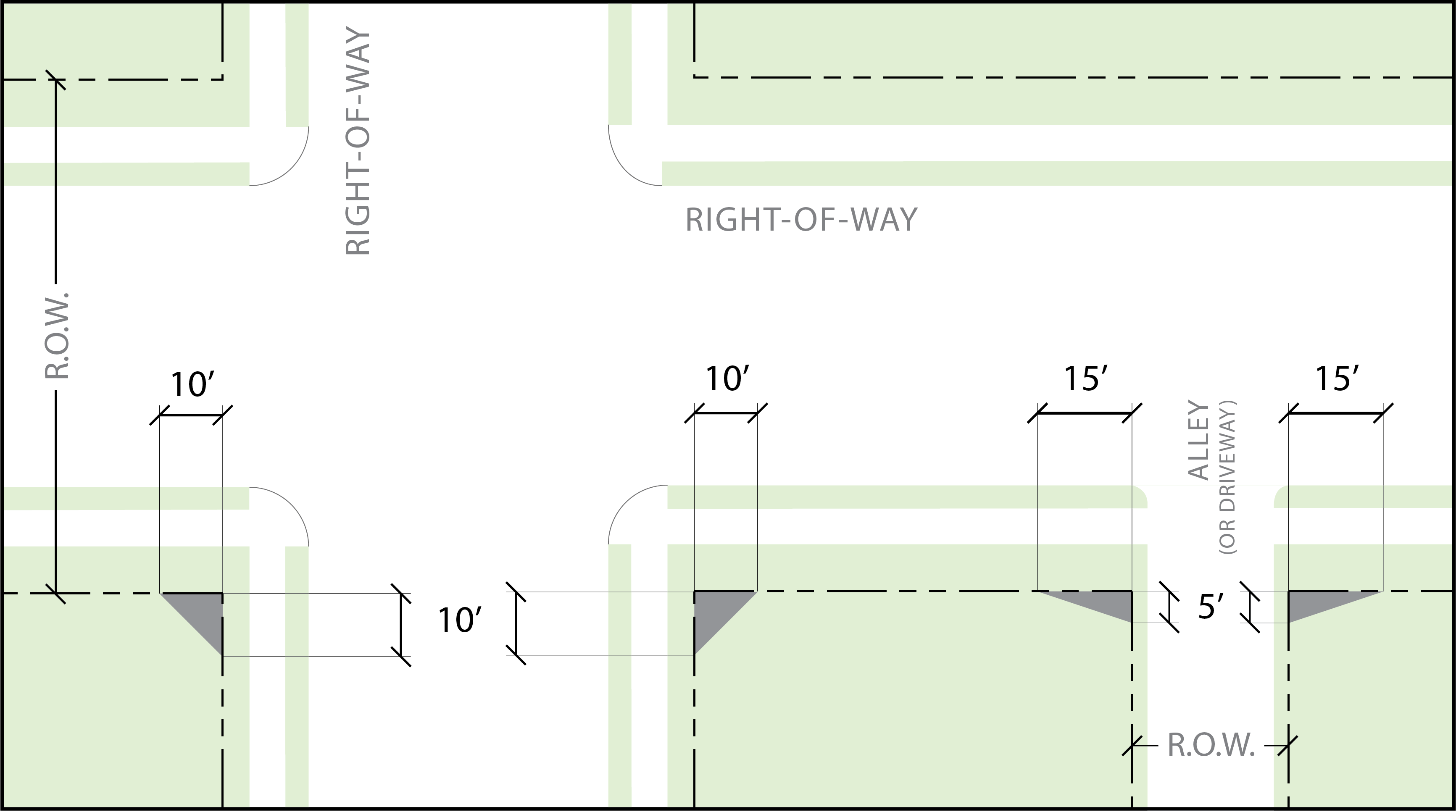 |
No vegetation or other obstructions higher than 24" allowed with clearance triangle.
No fencing allowed within clearance triangle. |
b.
Landscaping shall be designed and placed to meet any required screening per Table 17.06.540.E.
c.
Landscaping shall be designed and places to meet the landscaping clearance zone requirements in section 17.06.520.D.5.
7.
Landscape installation standards.
a.
Trees installed with façade landscaping or parking lot landscaping planted adjacent to the right-of-way shall be installed with structural soil or equivalent. Details of structural soil or equivalent shall be provided on the landscape plan.
b.
All required landscaping must be in-ground, except when in raised planters. Plant materials will be installed to current nursery industry standards.
c.
Plant materials must be properly supported to ensure survival. Support devices such as guy wires or stakes must not interfere with vehicular or pedestrian movement. Where support is necessary, stakes, guy wires or other measures must be removed as soon as the plant can support itself.
d.
Existing trees and plant materials to be retained shall be protected during construction, such as by use of chain link or other sturdy fence (to be removed after construction is completed) that is placed at the dripline of trees to be retained. Grading, topsoil storage, construction material storage, vehicles, and equipment shall not be allowed within the dripline of trees to be retained.
F.
Required landscape areas. All multi-family, mixed-use, and non-residential uses shall comply with the following landscape standards per Table 17.06.520.F.
G.
Façade landscape areas.
1.
Retail façade landscaping shall be provided as shown in Table 17.06.520.G.1.
| TABLE 17.06.520.G.1 - RETAIL FAÇADE | |||
| Sidewalk (1) |
10' min. to building w/ 6' min. unobstructed
If building is >100 ft. in length, 12' min. to building w/ 8' min. unobstructed | 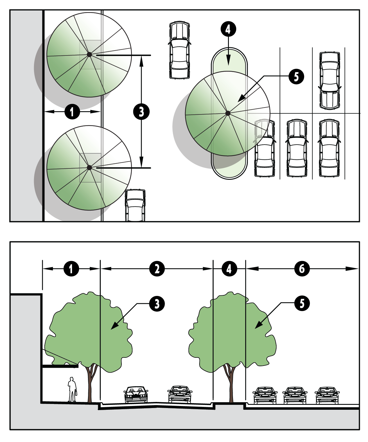 | |
|
Main drive
aisle (2) |
24' min. width
If parking provided at curb, must maintain 24' clearance for drive aisle. | ||
|
Façade
trees (1) |
30' on center
(3)
in grates or tree wells
(4)
Maintain landscape sight line clearance per ICC 17.03.520.D.5. | ||
|
Parking
island (2) |
9' min. width
Terminus of parking rows at main drive aisle | ||
|
Parking lot
trees (2) | Center in landscape | ||
| Parking rows (2) | |||
| NOTES: (1) Façade trees and sidewalk standards apply to façades facing the right-of-way, parking areas, pedestrian pathways (ICC 17.06.410.B), consolidated open space (ICC 17.06.510.C.3.b), and Pedestrian-Oriented Open Space (ICC 17.06.510.D). (2) ICC 17.06.550 parking lot standards and ICC 17.06.520.H for parking lot landscaping standards apply. (3) Structural soil or equivalent required per industry standard (provide details). (4) Not required for section where arcade is provided or hard awning (not fabric) extends over the sidewalk. | |||
2.
Office and non-retail commercial and mixed-use building façade landscaping shall be provided as shown in Table 17.06.520.G.2.
| TABLE 17.06.520.G.2 - OFFICE/NON-RETAIL FAÇADE | |||
| Façade (1) | 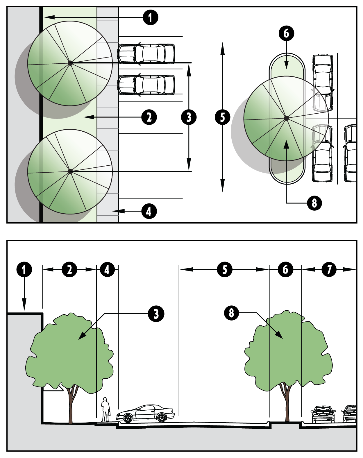 | ||
| Landscape area (2) |
15' min. adjacent to structure
Maintain landscape sight line clearance per ICC 17.03.520.D.5. | ||
|
Façade
trees (2) | 30' on center or as appropriate for species | ||
| Sidewalk (2) | 6' min. width | ||
|
Main drive
aisle (3) |
24' min. width
If parking provided at curb, must maintain 24' clearance for drive aisle. | ||
|
Parking
island (3) |
9' min. width
Terminus of parking rows along the main drive aisle; equal to 2 parking spaces | ||
| Parking lot (3) | |||
|
Parking lot
trees (3) | Center in landscape island | ||
| NOTES: (1) Offices in Mixed-Use buildings shall provide Retail Shopping Center Façade. (2) Landscape area, façade trees, and sidewalk standards apply to façades facing the right-of-way, parking areas, pedestrian pathways (ICC 17.06.410.B), consolidated open space (ICC 17.06.510.C.3.b), and Pedestrian-Oriented Open Space (ICC 17.06.510.D). (3) ICC 17.06.550 parking lot standards and ICC 17.06.520.H for parking lot landscaping standards apply. | |||
H.
Parking lot landscaping.
1.
Ceremonial drive parking lot landscaping shall be installed per Table 17.06.520.H.1.
| TABLE 17.06.520.H.1 - CEREMONIAL DRIVE | |||
| Landscape area | 10' min width | 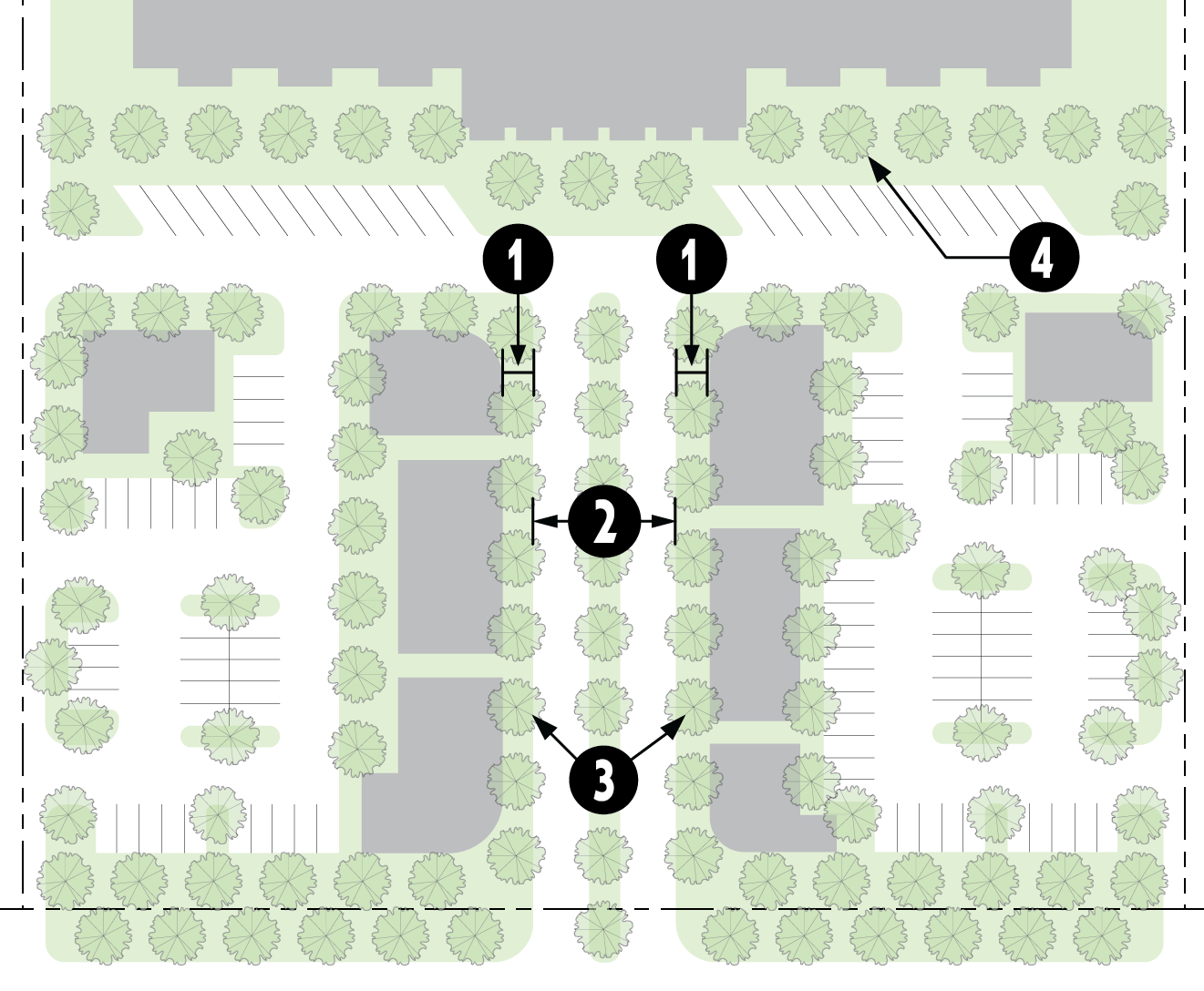 | |
|
Entry drive
aisle |
24' min. width; may include a landscape median as a water resource zone
On axis with building main entry | ||
| Ceremonial drive trees |
Spaced 30' on center or as appropriate for species;
For a length equal to that of the parking row(s) (1) Center in 10' wide landscape area on each side of ceremonial drive (3) | ||
| Façade trees |
Façade landscaping per ICC 17.06.520.G
(1)
Maintain landscape sight line clearance per ICC 17.03.520.D.5. | ||
|
(1) Structural soil or equivalent required per industry standard (provide details).
(2) Not required for section where arcade is provided or hard awning (not fabric) extends over the sidewalk. (3) With Planning Director approval, trees may be clustered and trees required by other landscaping sections may be clustered within a ceremonial drive. | |||
2.
Parking lot perimeters. Landscaping buffers, per section 17.06.540.E.11, shall be required in all front and side yards between the structures and parking areas as well as between the parking areas and the adjacent public street.
3.
Internal parking lot landscaping.
a.
General standards.
(i)
Landscaping islands internal to parking lots shall incorporate trees with the following spacing:
• One (1) large tree every 300 square feet or thirty (30) linear feet
• One (1) medium tree per 220 square feet or twenty-two (22) linear feet
• One (1) small tree per 150 square feet or fifteen (15) linear feet
(ii)
At least seventy (70) percent of the required deciduous trees must be large-maturing trees. Trees shall be maintained to maximize pedestrian visibility and access when planted near pathways (clear between three (3) feet and eight (8) feet in height).
(iii)
Trees and shrubs must be planted within fifteen (15) feet of the vehicular use area to count as parking lot landscaping.
(iv)
Shrubs should be installed a minimum of one (1) shrub per twenty (20) square feet and space no more than eight (8) feet apart.
(v)
Groundcover shall be planted at density to cover within three (3) years of planting.
(vi)
Plant diversity shall be provided per section 17.06.520.E.5.
(vii)
When a development contains twenty (20) or more parking spaces, fifty (50) percent of the trees and shrubs must be planted in islands or medians located within the parking lot. Planting trees in groups is encouraged to increase the total amount of planting area for roots to grow.
(viii)
Small maturing trees shall be planted where overhead utility lines would interfere with normal growth of medium or large trees.
(ix)
Parking lot landscaping islands must be at least six (6) feet deep and six (6) feet wide to be counted towards required parking lot landscaping calculations.
(x)
Rain gardens and swales may be integrated into required parking lot landscaping buffers and/or islands as Water Resource Zones, per section 17.06.520.H.4.
(xi)
Trees shall be planted where the tree trunk is aligned with parking stall lines to avoid damage from cars, as depicted in Figure 17.06.520.H.3.a.
| FIGURE 17.06.520.H.3.a TREE TRUNK ALIGNMENT WITH PARKING STALL LINES |
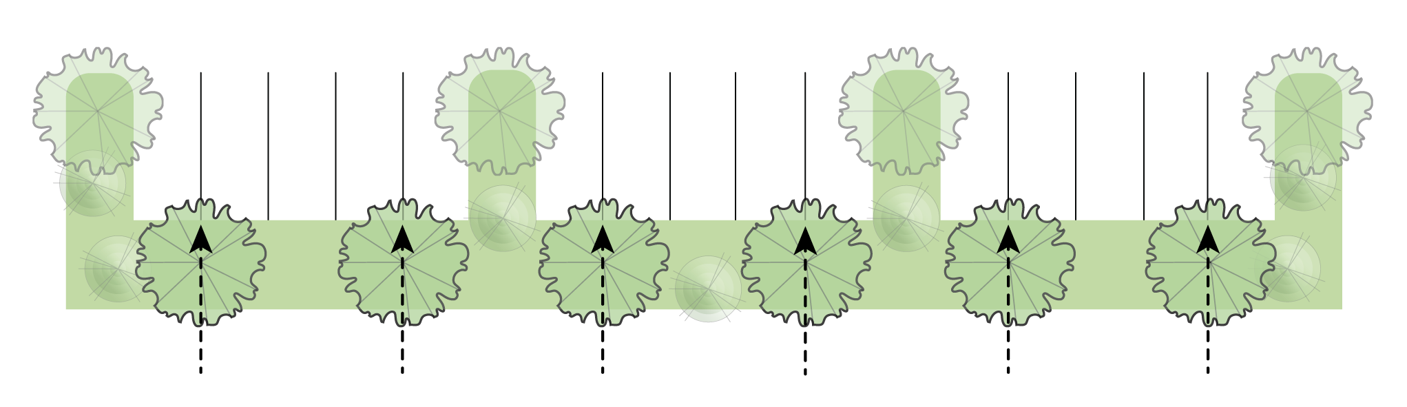 |
| Trees planted in parking lot medians and landscape isles shall be placed to align the tree trunk with the parking stall lines to avoid damage from cars. |
b.
Design alternatives to the internal parking lot landscaping standards will be considered provided the alternate landscaping design meets the purposes of the standards.
c.
Landscaping shall be required between the structures and parking areas pursuant to section 17.06.520.G.
d.
Parking lot landscaping islands.
(i)
Islands shall be spaced pursuant to the following table:
| TABLE 17.06.520.H.3.d(i) - LANDSCAPE ISLAND SPACING REQUIREMENTS | ||
|---|---|---|
| Surface Lot, at Rear | 1 space minimum every 20th parking space |  |
| Surface Lot, at Side | 1 space minimum every 12th space in other districts | 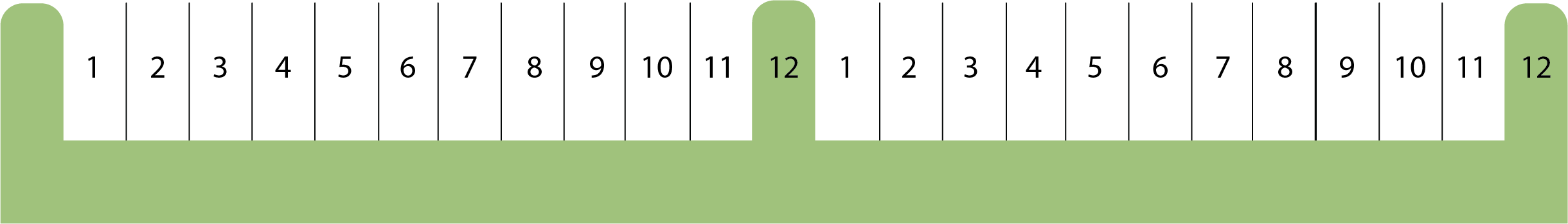 |
| 1 space minimum every 10th parking space in BV, BG, & NM districts | 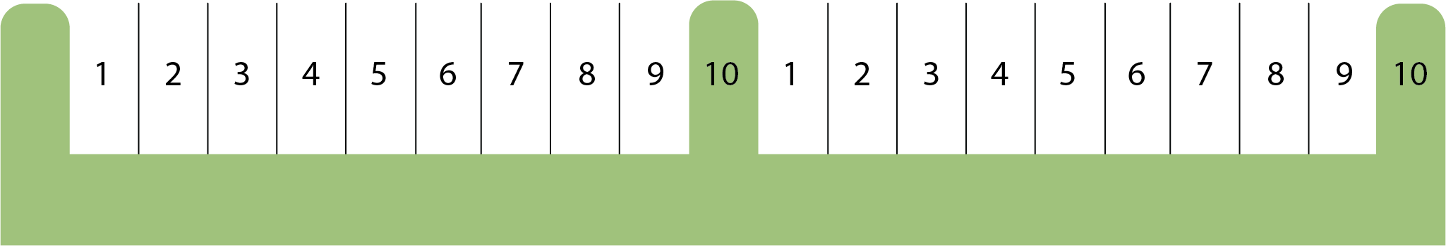 | |
| Surface Lot, at Front | 1 space minimum every 6th parking space | 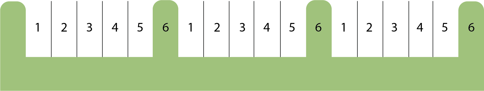 |
(ii)
Landscape islands shall be evenly distributed throughout the parking lot in order to provide an even tree canopy throughout the lot.
(iv)
Parking lot landscape islands shall consist of an area equal in size to a minimum of two (2) parking spaces end-to-end unless for a single row of parking where the area shall be equal to one (1) parking space.
| TABLE 17.06.520.H.3.d(iv) - MINIMUM LANDSCAPE ISLAND DIMENSIONS | ||
| Landscape median for double row parking | 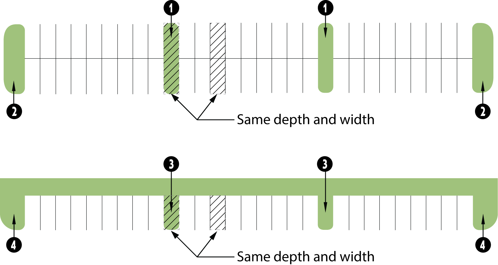 | |
| End cap median for double row parking | ||
| Landscape median for single row parking | ||
| End cap median for single row parking | ||
| NOTE: End cap median width shall be, at minimum, the same width as the parking stall. | ||
e.
Internal landscape medians.
(i)
Parking bays shall be broken up with landscaped islands and/or medians between rows to avoid long monotonous rows of parking.
(ii)
A landscape median Water Resource Zone (option 1) is encouraged for internal landscape medians.
(iii)
Pedestrian pathways may be installed that cross the width or travel the length of the planting medians.
4.
Water Resource Zones.
a.
Water Resource Zone (WRZ) Option One - Landscape Edge. Installation of WRZ Option 1 shall be per Table 17.06.520.H.4.a.
| TABLE 17.06.520.H.4.a WATER RESOURCE ZONE (WRZ) OPTION ONE - LANDSCAPE EDGE | |||
|
Landscape
buffer |
12' minimum width
(1)
Non-residential: minimum of 5% of the parking surface area, including drive isles Multi-family: minimum of 7% of the parking surface area, including drive isles | 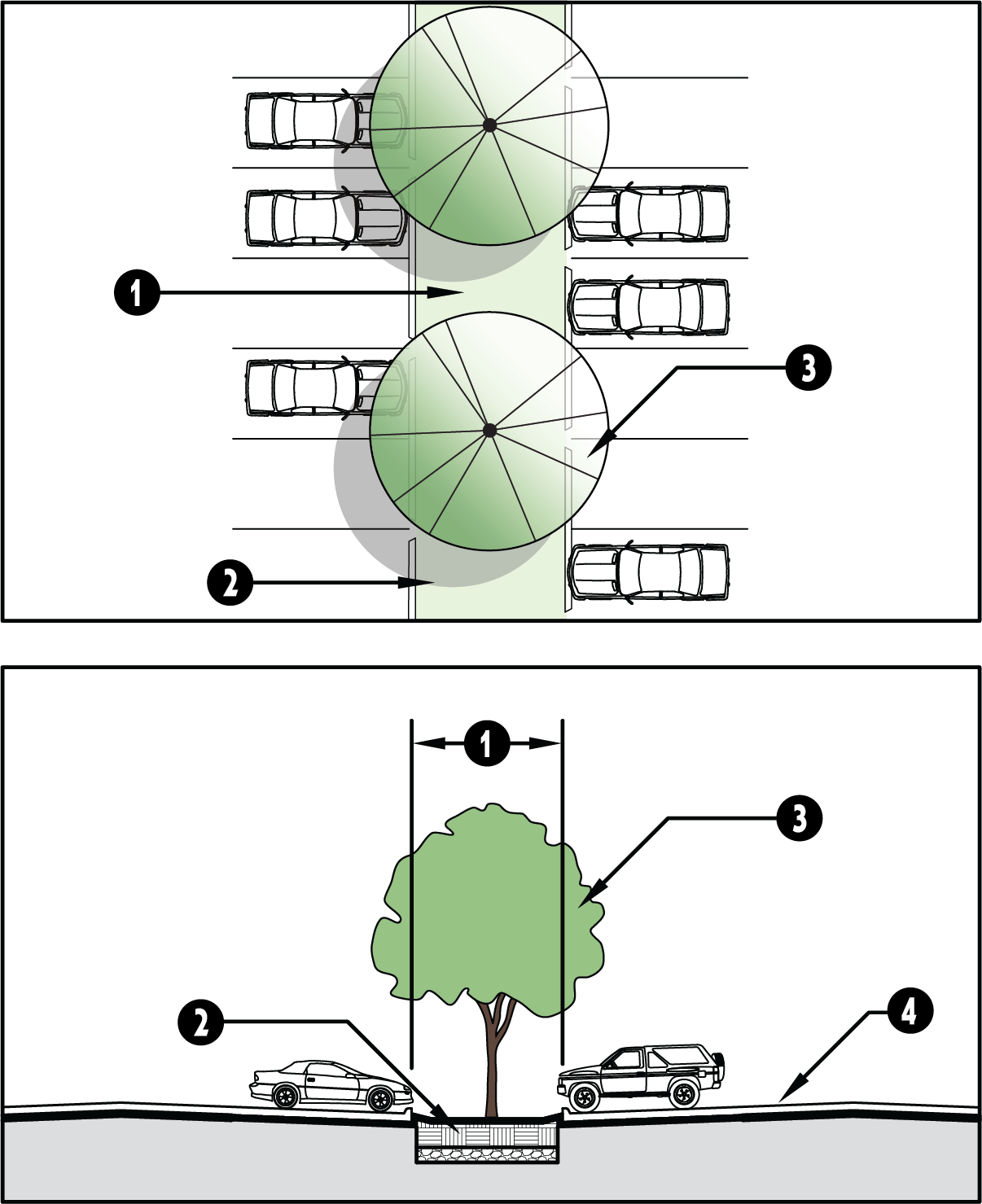 | |
|
Stormwater
Management | Engineered bioswale or bioretention | ||
| Trees |
Tree density per 17.06.520.H.3.1
Maintain landscape sight line clearance per ICC 17.03.520.D.5. | ||
| Parking lot |
Grade parking lot to drain towards landscape area.
Design with wheel stops or curb cuts to allow drainage into landscape buffer | ||
| (1) May be wider based on stormwater runoff and exclusive of detention basins | |||
b.
Water Resource Zone (WRZ) Option Two - Pervious Surface. Installation of WRZ Option 2 shall be per Table 17.06.520.H.4.b.
| TABLE 17.06.520.H.4.b WATER RESOURCE ZONE (WRZ) OPTION TWO - PERVIOUS SURFACE | |||
|
Pervious
pavers |
Non-residential: minimum of 5% of the parking surface area, including drive isles
Multi-family: minimum of 7% of the parking surface area, including drive isles | 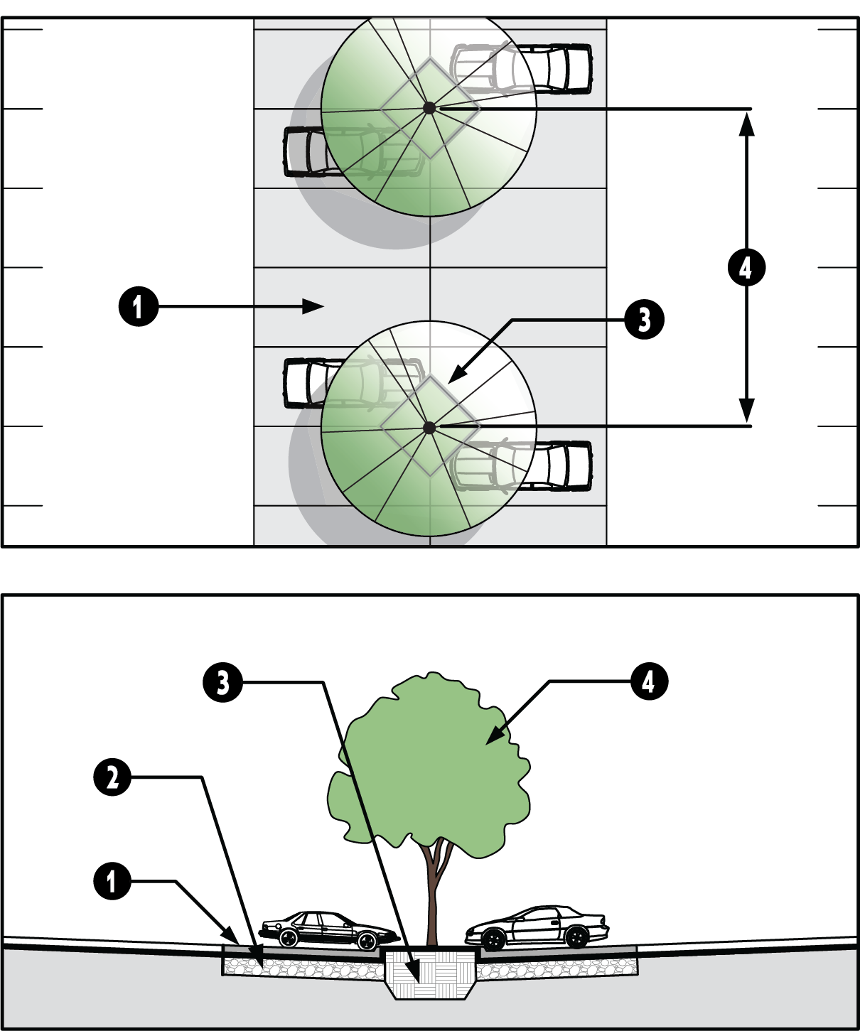 | |
|
Structural
soil |
Per industry standards (provide details)
Provide drainage and details in drainage plans | ||
| Small island | Less than 500 square feet | ||
| Trees |
Spacing at 36' on center
One per 500 square feet of the combined pervious paver area plus landscape island area Maintain landscape sight line clearance per ICC 17.03.520.D.5. | ||
(Ord. No. C-49-19 [PLG-004-19], Exh. C, 6-18-2019)
17.06.540 - Screening.
A.
Purpose.
1.
To preserve and enhance the appearance, character, safety, and value of properties in Freeland.
2.
To minimize the visual impacts of developed parking areas.
3.
To minimize the negative impacts of traffic, noise and air pollution, wind, and glare.
4.
To eliminate or lessen nuisances between incompatible adjacent land uses such as dirt, litter, noise, glare of lights, signs, and/or unsightly buildings or parking areas.
5.
To ensure the following:
a.
Compatibility of non-residential uses with residential uses;
b.
Screening of objectionable light without blocking essential lighting;
c.
Preserving privacy;
d.
Attractive appearance along county roads; and
e.
Enhancement of the quality of life and general welfare.
B.
Applicability.
1.
The provisions of this section shall apply to all non-residential and multi-family development in the Freeland NMUGA.
2.
All single family developments in the Freeland NMUGA are subject to section 17.06.540.E.1.c and section 17.06.540.F. Single-family developments with two (2) to four (4) units (duplex, etc.) are subject to the parking lot screening standards in section 17.06.540.E.11.
3.
Design alternatives. The Planning Director may waive or relax these provisions in the Village Core zoning districts depending on the type of use, number of anticipated employees and customers, and the site's physical context.
4.
For landscaping installation, a temporary deferral may be granted by the Planning Director pursuant to section 17.06.530.B.3.
C.
General standards.
1.
Security fencing visible from public roads shall be screened with native vegetation and additional landscaping as needed.
2.
Where mature trees and vegetation exists within the required buffer areas, the preservation of said mature trees and vegetation may be preferable to new plant materials or may be required to remain per the Shoreline Master Program. The Planning Director may apply supplemental buffer width and planting conditions to better ensure the survival of existing mature trees and/or augment existing plantings to meet the intent of the screening standards.
D.
Onsite required screening.
1.
Rooftop mechanical equipment. All rooftop mechanical equipment shall be organized, proportioned, detailed, screened, landscaped (with decks or terraces) and/or colored to be an integral element of the building and minimize visual impacts from the ground level of adjacent streets and properties per Figure 17.06.540.D.1. For example, screening features utilizing similar building materials and forms to blend with the architectural character of the building.
| FIGURE 17.06.540.D.1. - SCREENING EXAMPLES OF ROOFTOP MECHANICAL EQUIPMENT |
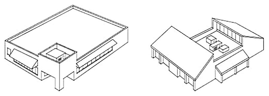 |
2.
Ground and building mounted mechanical equipment shall be screened from view per Figure 17.06.540.D.2.
| FIGURE 17.06.540.D.2. SCREENING GROUND AND BUILDING MOUNTED MECHANICAL EQUIPMENT | |
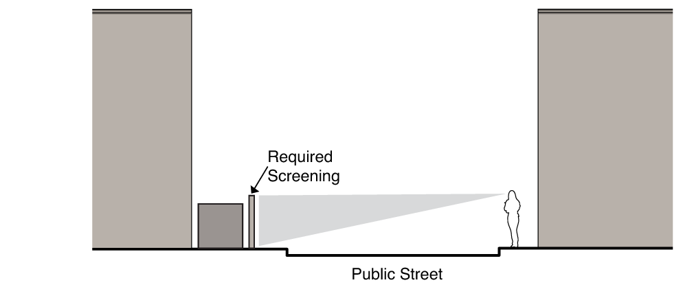 | 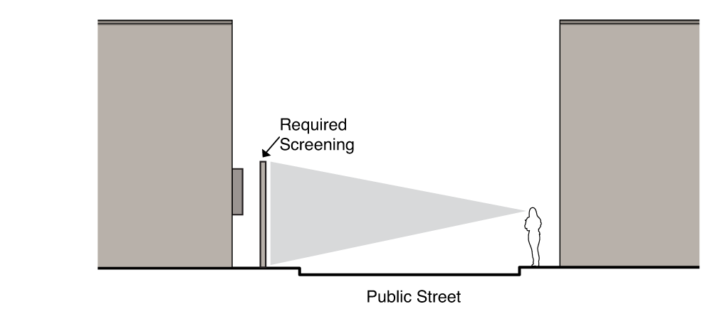 |
3.
Utility meters, electrical conduit, and other service utility apparatus. These elements shall be located and/or designed to minimize their visibility to the public. Project designers are strongly encouraged to coordinate with applicable service providers early in the design process to determine the best approach in meeting these standards. If such elements are mounted in a location visible from the street, pedestrian pathway, common open space, or shared auto courtyards, they shall be screened with vegetation or by architectural features. The Planning Director may approve an alternate screening method to ensure access to service utility apparatus.
4.
Service areas.
a.
All developments shall provide a designated spot for service elements (refuse and disposal).
b.
Service elements shall be located to minimize the negative visual, noise, odor, and physical impacts to the street environment, adjacent (on- and off-site) residents and pedestrian areas.
c.
Consider grouping or co-locating service areas, refuse collection facilities, and other like functions of adjoining development for the purpose of efficiency and better management of site impacts. Where adjoining functions are not compatible, provide adequate buffering to lessen the impacts to adjoining development.
d.
When refuse and service areas are visible from the sidewalk or adjacent properties, screen the elements with a six-foot screening wall per Figure 17.06.540.D.4. The screening wall shall be masonry and incorporate similar materials and architectural forms as the site's principal building.
| FIGURE 17.06.540.D.4. APPROPRIATE SERVICE AREA LOCATION AND ENCLOSURE EXAMPLE |
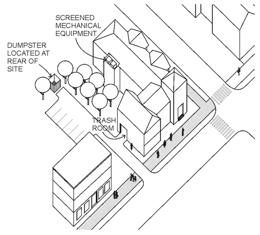 |
5.
Outdoor storage.
a.
No outdoor storage shall be visible from off-site.
b.
The storage shall occur only within a designated area that is clearly delineated on the site plan.
c.
Outdoor storage areas shall be located to the rear of the principal structure. The Planning Director may approve storage in the side yard if site conditions (such as critical areas or placement of existing buildings that will remain on site) limit storage location options.
d.
In no event shall materials be stacked or stored higher or to exceed the height of the screening wall or fence.
e.
All outdoor storage areas shall be screened from view from all property lines and adjacent rights-of-way through type S2, S4, or S5 screening type pursuant to section 17.06.540.E.
f.
Walls and fences shall incorporate at least one (1) of the predominant materials and one (1) of the predominant colors uses in the primary structure.
g.
Landscaping shall be installed on the exterior of the screening wall or fence pursuant to section 17.06.540.F.1.g.
6.
Drive-thru lanes shall be screened in accordance with the installation standards in Table 17.06.540.D.6. Alternative landscaping schemes may be permitted in the buffer provided help mitigate the visual impact of the drive-thru use on the streetscape environment.
| TABLE 17.06.540.D.6. - DRIVE-THRU SCREENING | |||
|
Drive-thru
lane | 12' min. width | 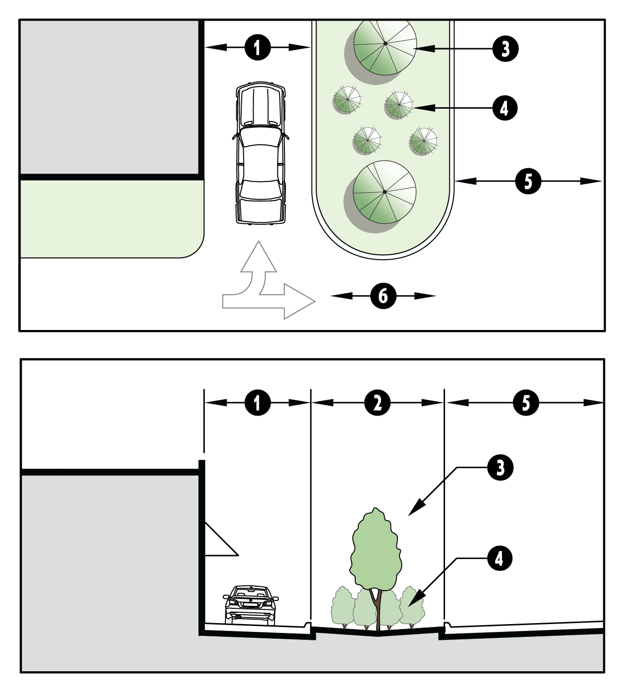 | |
|
Landscape
buffer |
5' min. width
(1)
May include Water Resource Zone | ||
| Trees | Small or medium ornamental trees spaced 15' on center | ||
|
Groundcover
and shrubs | Complete coverage of ornamental grass, herbaceous plants, and shrubs | ||
| Pavement | May drain to Water Resource Zone | ||
| Escape lane | Required | ||
| (1) If landscape buffer is located on the perimeter of the property, the perimeter landscaping may count towards this landscape buffer requirement. | |||
7.
Loading docks and service bay shall be screened in accordance with the installation standards in Table 17.06.540.D.7.
| TABLE 17.06.540.D.7. - LOADING DOCKS AND SERVICE BAY SCREENING | |||
| Maneuvering area | Varies | 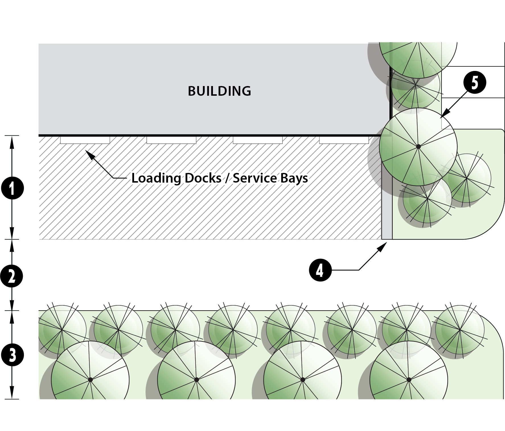 | |
| Access drive | 45' max. | ||
| Landscape buffer (1,2) |
25' min. buffer; 50' min. when adjacent to residential uses
One row of 5 gallon shrubs, spaced 3' on center. One row of medium trees, spaced 15' on center; 3" min. caliper at installation. | ||
| Wing wall | 8'—12' high screening wall | ||
|
Façade
landscape | Façade landscape, pursuant to ICC 17.06.520.G, shall extend in front of the wing wall |
(1)
Ornamental trees evenly interspersed between the medium trees may be substituted
for the shrubs.
(2) If landscape buffer is located on the perimeter of the property, the perimeter landscaping may count towards this landscape buffer requirement. | |
E.
Screening on property lines.
1.
General standards.
a.
Screening may overlap drainage and/or utility easements, with signed agreement by the easement holder; however, plantings shall not impede the flow of water within a drainage easement.
b.
Screening shall not be located on any portion of an existing or dedicated right-of-way.
c.
Single family residential development. Any residential use proposed adjacent to an existing non-residential use shall provide screening type S1, S2, or S4, with a minimum five-foot-wide Type C landscape buffer.
d.
Multi-family, mixed-use, and non-residential development shall provide screening along the common boundary line between land uses in accordance with this section.
e.
How to use the tables in this section.
(i)
Screening options and installation standards. Chose a screening option based on zoning district, per Table 17.06.540.E.2. Refer to Tables 17.06.540.E.3 thru 17.06.540.E.8 for the installation standards; where landscape buffers apply, the installation standards tables reference the buffer requirements in Tables 17.06.540.E.9 and 17.06.540.E.10.
(ii)
Landscape buffers. Landscaping elements of the screening types are determined by land use intensity, per Table 17.06.540.E.9. The installation standards of the various types of landscaping, Landscape Buffer Types A, B, and C, are in Table 17.06.540.E.10.
(iii)
Parking lot landscape buffers. All parking lots shall be screened per section 17.06.540.E.11.
2.
Screening types.
a.
Screening types shall be chosen from the allowed screening options indicated in Table 17.06.540.E.2 based on zoning district.
b.
Design alternatives.
(i)
Where the proposed development is a mixed-use, multi-family, or overnight lodging use, and the adjacent use is a public park, platted open space, or mixed-use development, the Planning Director may approve one (1) or more of the following design alternatives:
(1)
A required wall may be replaced with a pedestrian pathway per section 17.06.410.B; and/or
(2)
Required landscaped buffer area may be replaced with pedestrian-oriented open space per section 17.06.510.D.
(ii)
Where the minimum landscaping buffer width is greater than ten (10) feet and the screening type includes a solid masonry wall, the minimum landscape buffer width may be reduced by five (5) feet.
3.
For screening type S1, Living Screen, the installation standards in Tables 17.06.540.E.3 shall apply.
| TABLE 17.06.540.E.3. - LIVING SCREEN | |||
| Project Parcel | May drain to landscape buffer or Water Resource Zone | 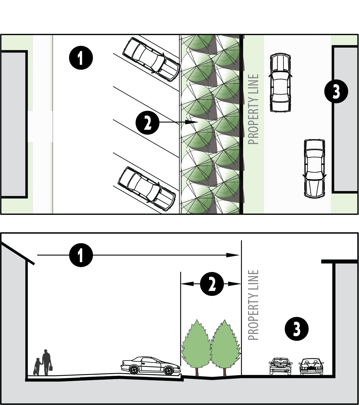 | |
|
Landscaped
buffer |
Landscape buffer Type A, B, or C required per ICC 17.06.540.E.9
Landscape installation standards per Table 17.06.540.E.10 May include Water Resource Zone | ||
|
Adjacent
property | Living screen shall not be approved when adjacent property is single-family residential | ||
4.
For screening type S2, Fence with Trees, the installation standards in Table 17.06.540.E.4 shall apply.
| TABLE 17.06.540.E.4. - FENCE WITH LANDSCAPING | |||
| Project Parcel | May drain to landscape buffer or Water Resource Zone | 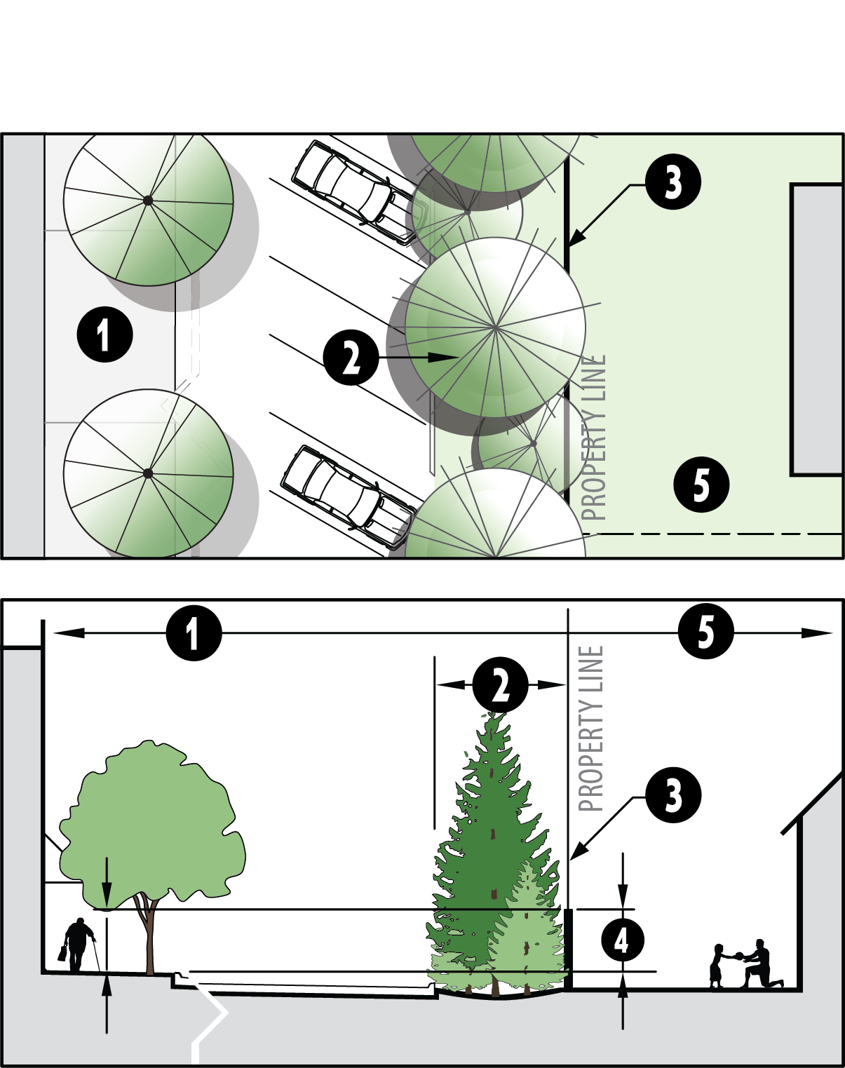 | |
|
Landscaped buffer
area |
Landscape buffer Type A, B, or C required per ICC 17.06.540.E.9
Landscape installation standards per Table 17.06.540.E.10 May include Water Resource Zone. | ||
| Fence | 6'—8' high, per ICC 17.06.540.F | ||
| Minimum screening from building entrance elevation | 6' min. vertical distance between bldg. entrance base floor elevation to top of fence when screening from an adjacent single-family use | ||
| Adjacent property | |||
5.
For screening type S3, Screening Wall with View Fence, the installation standards in Table 17.06.540.E.5 shall apply.
| TABLE 17.06.540.E.5. - SCREENING WALL WITH VIEW FENCE | ||||
| Project Parcel | May drain to landscape buffer or Water Resource Zone | 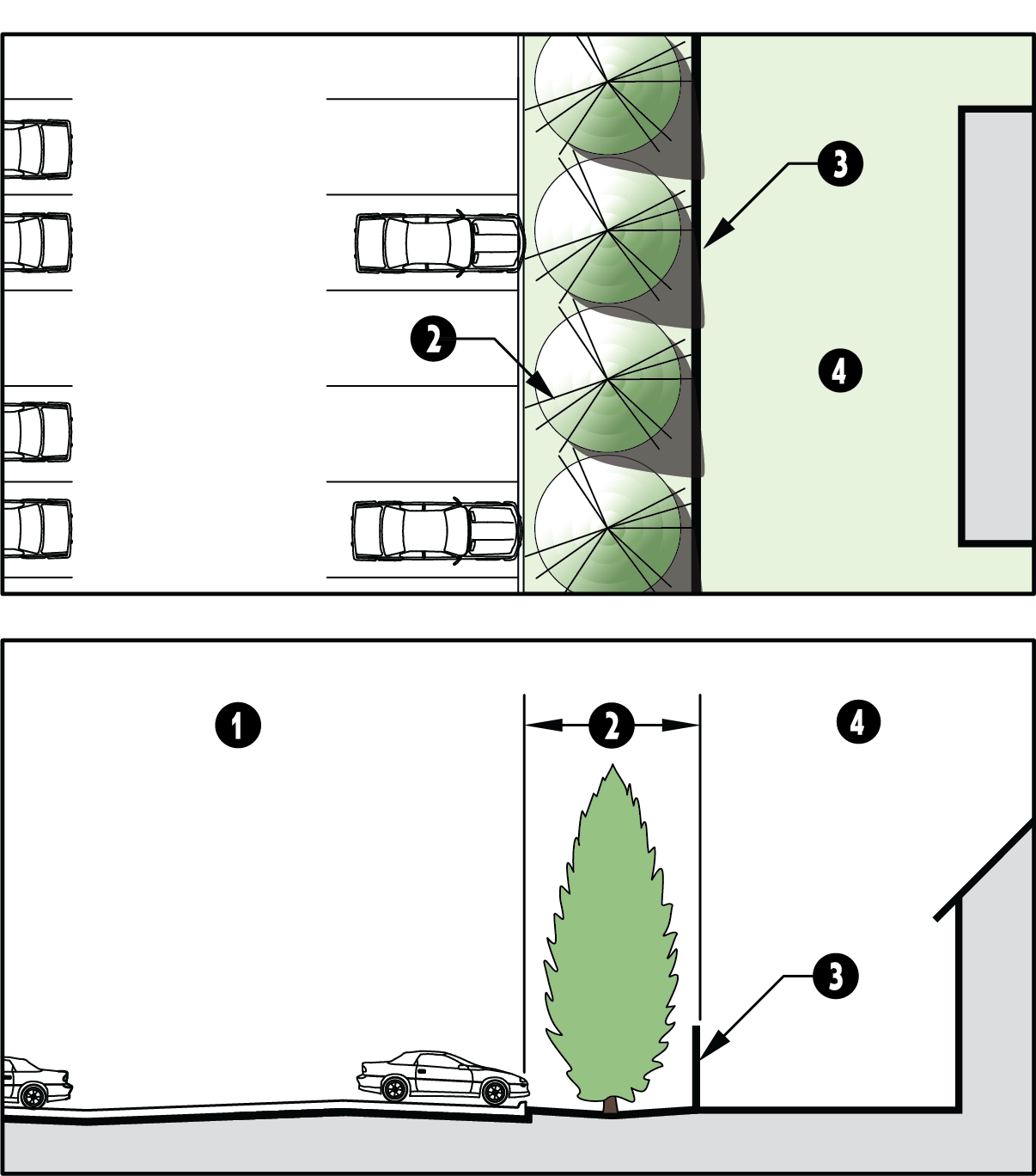 | ||
| Landscaped buffer area |
Landscape buffer Type A, B, or C required per ICC 17.06.540.E.9
Landscape installation standards per Table 17.06.540.E.10 May include Water Resource Zone | |||
| Wall |
6'—8' high with min. 70% transparency (e.g. 30% masonry and 70% tubular steel)
Per ICC 17.06.540.F Wall placement, and landscaping relationship to wall, per ICC 17.06.540.F.1.F | |||
| Adjacent property | ||||
| Examples of Elevation Details | Landscaped area | 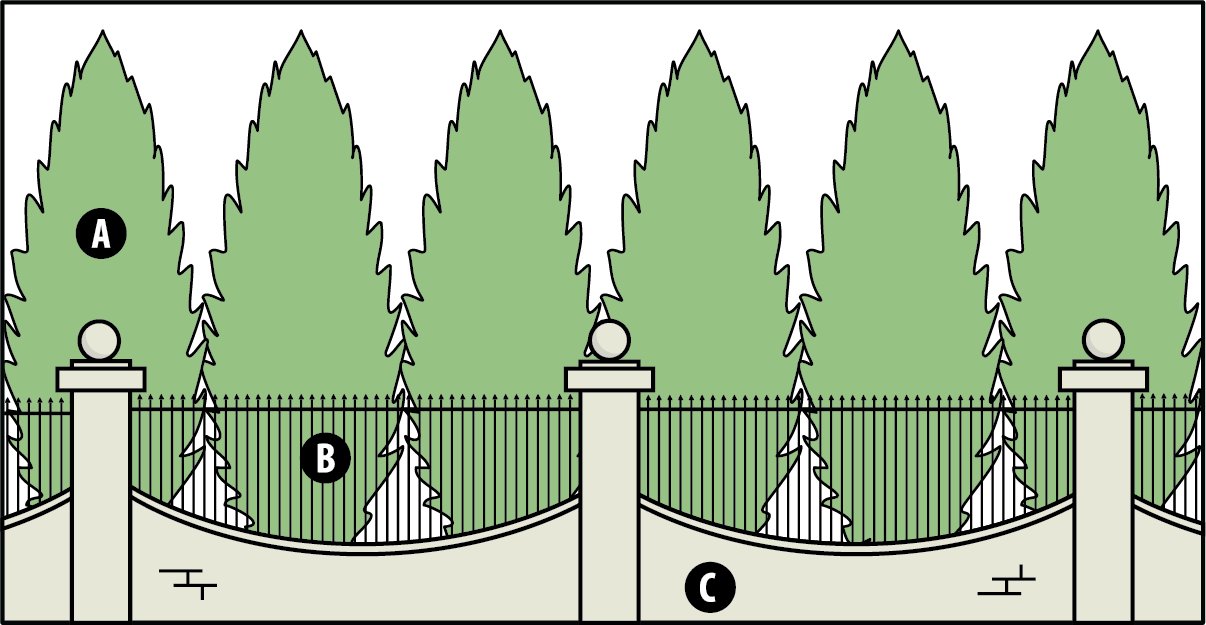 | ||
| View fence example | ||||
| Solid Wall | ||||
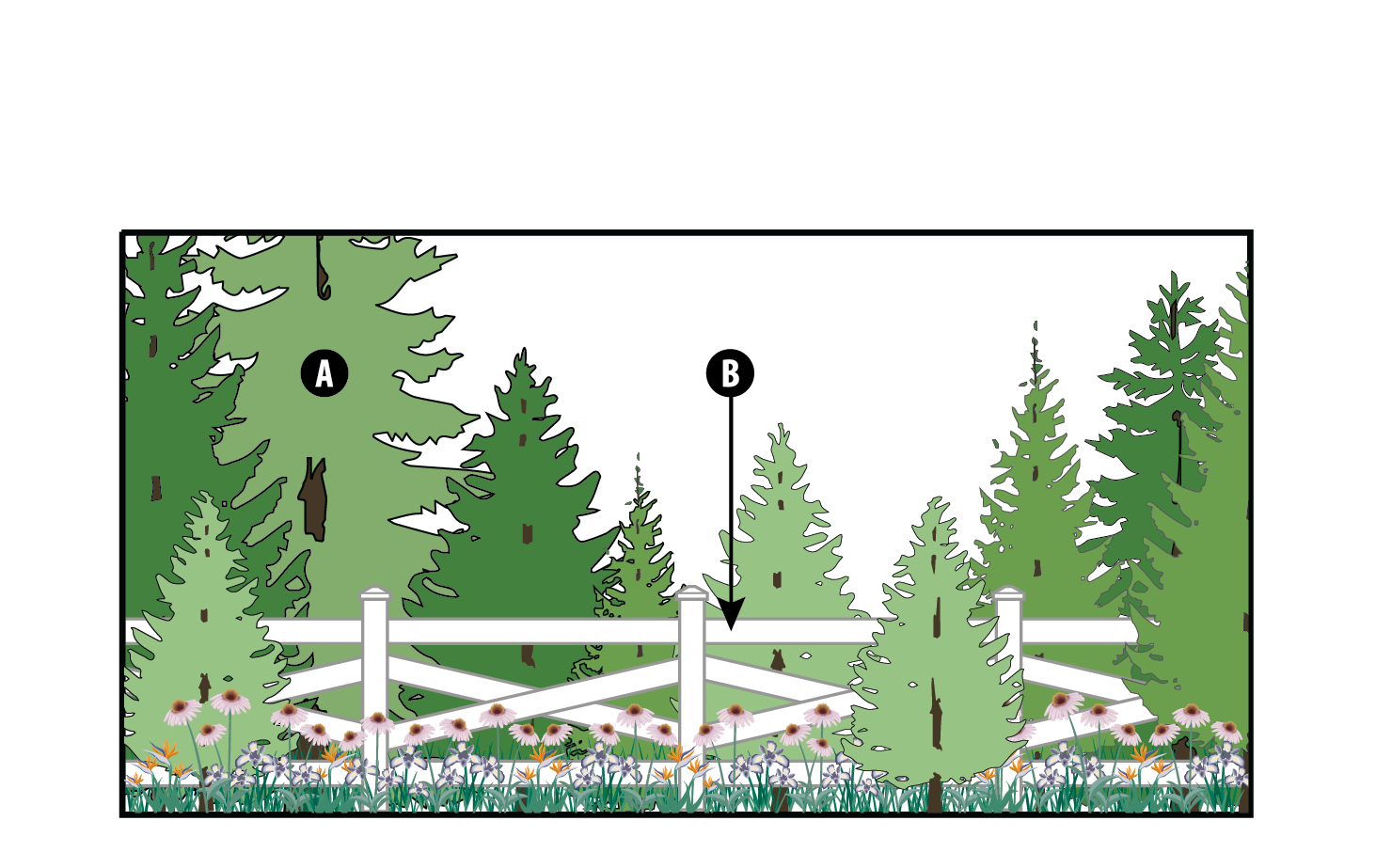 | ||||
6.
For screening type S4, Solid Screening Wall, the installation standards in Table 17.06.540.E.6 shall apply.
| TABLE 17.06.540.E.6. - SOLID SCREENING WALL | |||
| Landscaped buffer area |
Varies, per ICC 17.06.540.E.9
May include Water Resource Zone | 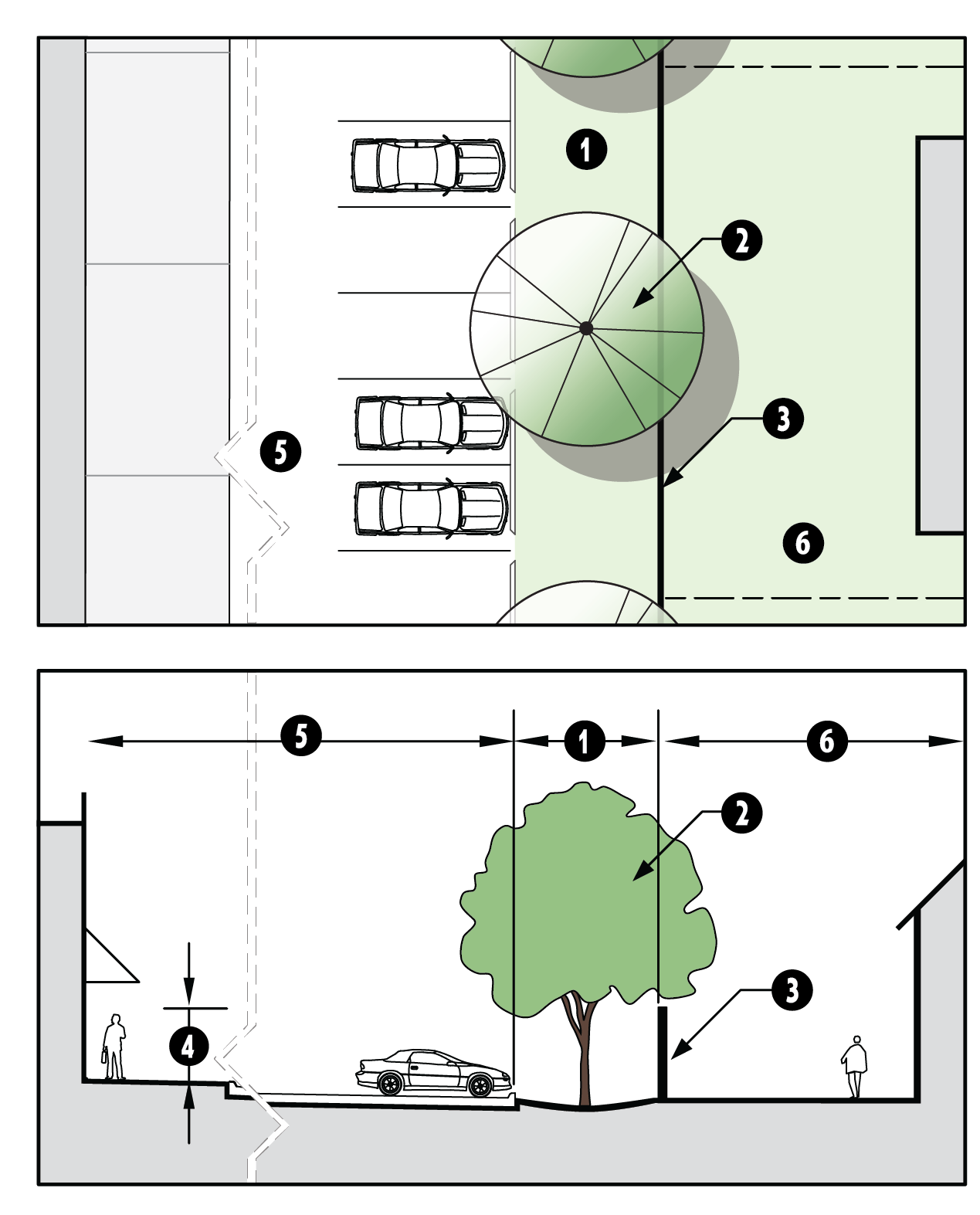 | |
| Trees | Per Table 17.06.540.E.10 | ||
| Wall |
6'—8' high, solid masonry
Per ICC 17.06.540.F | ||
| Vertical distance between bldg. entrance to top of wall elevation | 6' min. | ||
| Development area | Parking or other surface; may drain to Water Resource Zone | ||
| Adjacent property | |||
7.
For screening type S5, Screening Wall with Topographic Change, the installation standards in Table 17.06.540.E.7 shall apply.
| TABLE 17.06.540.E.7. - SCREENING WALL WITH TOPOGRAPHIC CHANGE | |||
| Development area | Parking or other surface | 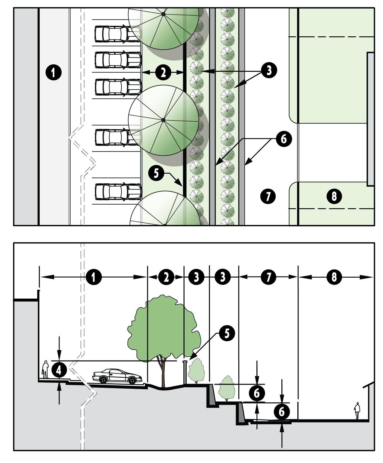 | |
| Landscaped buffer area (See also 17.06.520.D.6.) |
Width and installation standards varies by use, per ICC 17.06.540.E.9 and 17.06.540.E.10
May include Water Resource Zone | ||
| Terrace width |
8' max.
Plant with shrubs, vines, or groundcover | ||
| Vertical distance between building entrance to top of wall elevation | 6' min. | ||
|
Solid Masonry
Wall | 6' min/8' max height, per ICC 17.06.540.F or 17.06.540.E.2.b | ||
| Retaining wall | 6' max. - If calculations indicate a height greater than 6' is needed, an additional terrace is required | ||
| Alley (optional) | |||
| Adjacent property | |||
8.
Where a natural area exists either on the subject property or the adjacent property, screening type S6, Natural Feature with Enhanced Buffer, is encouraged. The installation standards in Tables 17.06.540.E.8 shall apply.
| TABLE 17.06.540.E.8. - STANDARDS FOR NATURAL AREAS WITH AN ENHANCED BUFFER | |||
| Natural feature | Critical areas and their buffers (1) | 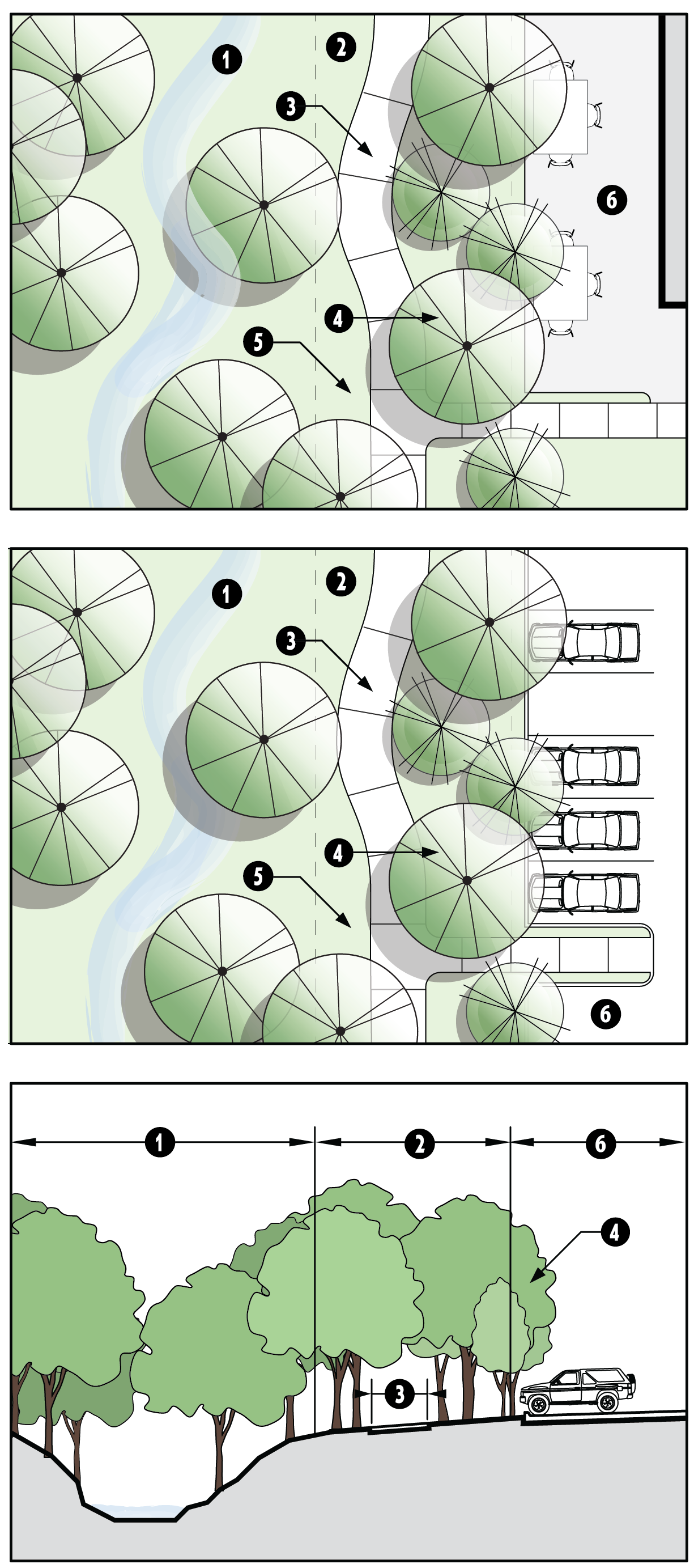 | |
| Enhanced buffer |
10 ft. min. wide Pedestrian-Oriented Open Space, per to ICC 17.06.510.D. See also
17.06.520.D.6.
Maintain landscape sight line clearance per ICC 17.03.520.D.5. | ||
| Trail (optional except where indicated on the Non-Motorized Trails Plan) |
6' wide trail may be in the required critical area buffer or in the enhanced buffer.
Any trails within a critical area and/or a required buffer shall be constructed with
minimum disruption to habitat.
(1)
Provide pedestrian connections from development to the trail. | ||
| Trees |
35% canopy coverage. Add trees where natural vegetation is not sufficient to meet
canopy coverage requirements. See also 17.06.520.D.6.
A min. of 30% of added trees shall be large trees, spaced 30' on center. | ||
| Groundcover | Appropriate native seed mix. | ||
| Development |
Where possible, buildings should be oriented to the open space as an amenity, pursuant
to ICC 17.06.510.E.
Grade impervious surface to drain to the natural drainage. Where parking adjacent to natural feature, design with wheel stops or curb cuts to allow drainage into landscape area. | ||
| (1) Critical area and their associated buffers are subject to the Critical Areas Ordinance, Chapter 17.02B ICC. | |||
9.
The width of the required landscaped buffer areas in Figures 17.06.540.E.3 thru 17.06.540.E.7 are determined by the proposed use. The planting selection and configuration will vary based on the screening needs, with high intensity uses requiring greater screening from lower intensity uses than those with a similar intensity. For the purpose of this section, width shall be measured from the property line inward.
In Table 17.06.540.E.9, find the row indicating the type of use proposed and then the column that represents the adjacent land use. Where new development is adjacent to vacant properties, screening shall be determined by the lowest intensity use allowed in the adjacent zoning district and the intensity scale in Table 17.06.540.E.9.
• An "X" indicates landscaping buffer is optional, excepting that parking lot screening shall apply, per section 17.06.540.E.11.
• A, B, and C refer to the minimum required landscaping to be included in the landscape buffer area, per Table 17.06.540.E.10.
• Where a number is in parenthesis below, it indicates a minimum buffer width (in feet) that differs from Table 17.06.540.E.10.
10.
Landscaped buffer installation types and installation standards are shown in Table 17.06.540.E.10.
11.
Screening type S7, Parking Lot Landscape Buffer.
a.
Landscape buffers shall be required for all parking lots adjacent to a public street. Type C landscape buffer (see section 17.06.540.E.10) shall be provided at a width equal to ten (10) feet or the minimum required building setback specified for the underlying zoning district, whichever is greater. For screening type S7, Parking Lot Landscape Buffer, the installation standards in Table 17.06.540.E.11.a shall apply.
| FIGURE 17.06.540.E.11.a - PARKING LOT SCREENING AT RIGHT-OF-WAY | |
|
A Type C landscape buffer per ICC 17.06.540.E.10
Width of buffer is a minimum of 10 ft. OR the front yard setback specified for the zoning district, whichever is greater. Design alternatives may be approved per ICC 17.06.540.E.11.b. In the Hwy 525 Overlay, refer to parking lot screening requirements in ICC 17.06.140.B.3.D. Maintain landscape sight line clearance per ICC 17.03.520.D.5 |  |
b.
Parking lot buffer design alternatives. For developments in the Non-Residential Mixed-Use (NM), Business General (BG), or Business Village (BV) zoning districts, the landscape buffer width may be reduced if one (1) of the two (2) following alternatives are utilized:
(i)
Alternative 1—Low wall. Provide a five-foot-wide planting bed that incorporates a continuous low wall (thirty (30) to thirty-six (36) inches tall). The planting bed shall be in front of the wall and feature Type C living screen (see section 17.06.540.E.3). The wall shall be constructed of brick, stone, decorative concrete or concrete block, or other permanent material that provides visual interest and helps to define the street edge; or
(ii)
Alternative 2—Raised planter. Provide an elevated planter which is a minimum of five (5) feet wide and between two (2) to three (3) feet in height. Ledges that are approximately twelve (12) inches in width are encouraged as they can double as a seating area. The planter must be constructed of masonry, concrete or other permanent material that effectively contrasts with the color of the sidewalk, and it must be planted with a mix that that provide seasonal interest through a combination of groundcovers, annuals, perennials, ornamental grasses, low shrubs, and/or small trees.
| FIGURE 17.06.540.E.11.b - PARKING LOT BUFFER DESIGN ALTERNATIVES FOR THE NM, BG, OR
BV ZONING DISTRICTS | |
| Alternative 1—Low Wall Low wall, with a height of a min. of 3 ft. and a max. of 4 ft. 5' wide Type C landscape buffer, installed per ICC 17.06.540.E.10, to the exterior of the wall. Maintain landscape sight line clearance per ICC 17.03.520.D.5. May incorporate a Water Resource Zone. | 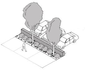 |
| Alternative 2—Raised Planter 5' wide raised planter with a height of a min. of 3 ft. and a max. of 4 ft. Planter materials for planter to meet Type C landscape standards per ICC 17.06.540.E.10 excepting that trees are not required. May incorporate a Water Resource Zone. Maintain landscape sight line clearance per ICC 17.03.520.D.5 | 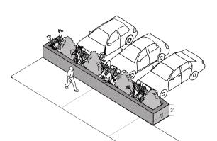 |
c.
Where surface parking lots are located along internal side property lines, a landscape buffer a minimum of five (5) feet a screening wall or fence a minimum of three (3) feet in height shall be required on the property line.
(i)
Screening wall or fence shall be built pursuant to the standards in section 17.06.540.F.
(ii)
Breaks in the fence/landscaping are permitted for internal pedestrian and vehicular connections between properties.
(iii)
Properties in the Non-Residential Mixed-Use, Business General, and Business Village zoning district with shared parking agreements with applicable adjacent neighbor(s) are exempt from screening wall requirement.
(iv)
The Planning Director may approve a design alternative to the buffer width if the alternative meets the purpose of the buffering standards in this section. In no case shall the landscaping buffer be less than a minimum of five (5) feet in width.
F.
Wall and fence standards.
1.
Design standards.
a.
Walls and fences shall be made of masonry (brick or stone), ornamental metal, or wood, or some combination of the three (3). The use of chain link, plastic, wire fencing and/or eco-blocks is prohibited.
b.
All required masonry screening walls shall be equally finished on both sides of the wall.
c.
The style, color, and material of the wall and/or fence shall be consistent within the development.
d.
When installed in a required screening wall or fence, gates shall be equal in height and screening characteristics to the wall or fence.
e.
No wall or fence shall be constructed within the corner visibility triangles for walls/fencing as shown in Figure 17.06.520.E.6.
f.
No wall or fence within the required front yard setback shall exceed four (4) feet in height, as shown in Figure 17.06.540.F.1.f.
| FIGURE 17.06.540.F.1.f - FENCE HEIGHT |
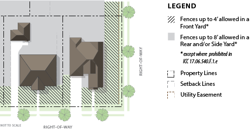 |
g.
Where screening is required for manufacturing, industrial, outdoor storage, or utility uses, a minimum of fifty (50) percent of the required landscaping shrubs and groundcover (per section 17.06.540.E.10) shall be installed on the exterior of the screening wall. Required trees may be installed on the interior or exterior of the wall.
| FIGURE 17.06.540.F.1.g - EXAMPLE OF LANDSCAPING ON BOTH THE INTERIOR AND EXTERIOR
OF A SOLID SCREENING WALL |
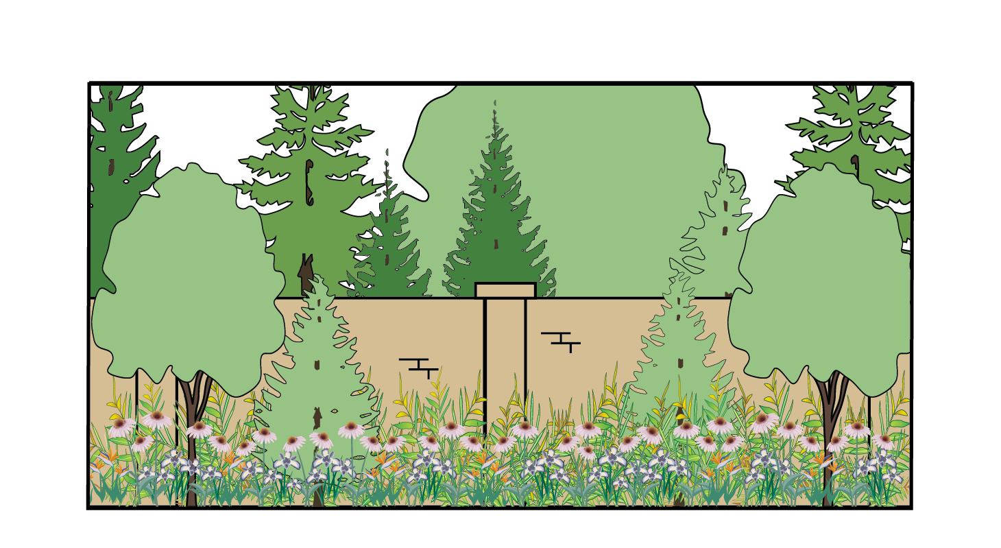 |
2.
Installation and maintenance.
a.
All required walls, fencing, and landscaping materials must be installed and completed prior to final acceptance of the project.
b.
The property owner shall maintain all screening fences, walls, and landscaping. If fifty (50) percent or more of an existing wall or fence is replaced, the current standards of this section shall apply.
c.
Repairs to existing walls will be allowed.
d.
Transition. Where a fence intersects a screening wall; and the heights differ, the fence or wall height shall transition over a distance of no less than twenty (20) feet, as shown in the example in Figure 17.06.540.F.2.d.
| FIGURE 17.06.540.F.2.d - WALL HEIGHT TRANSITIONS EXAMPLE |
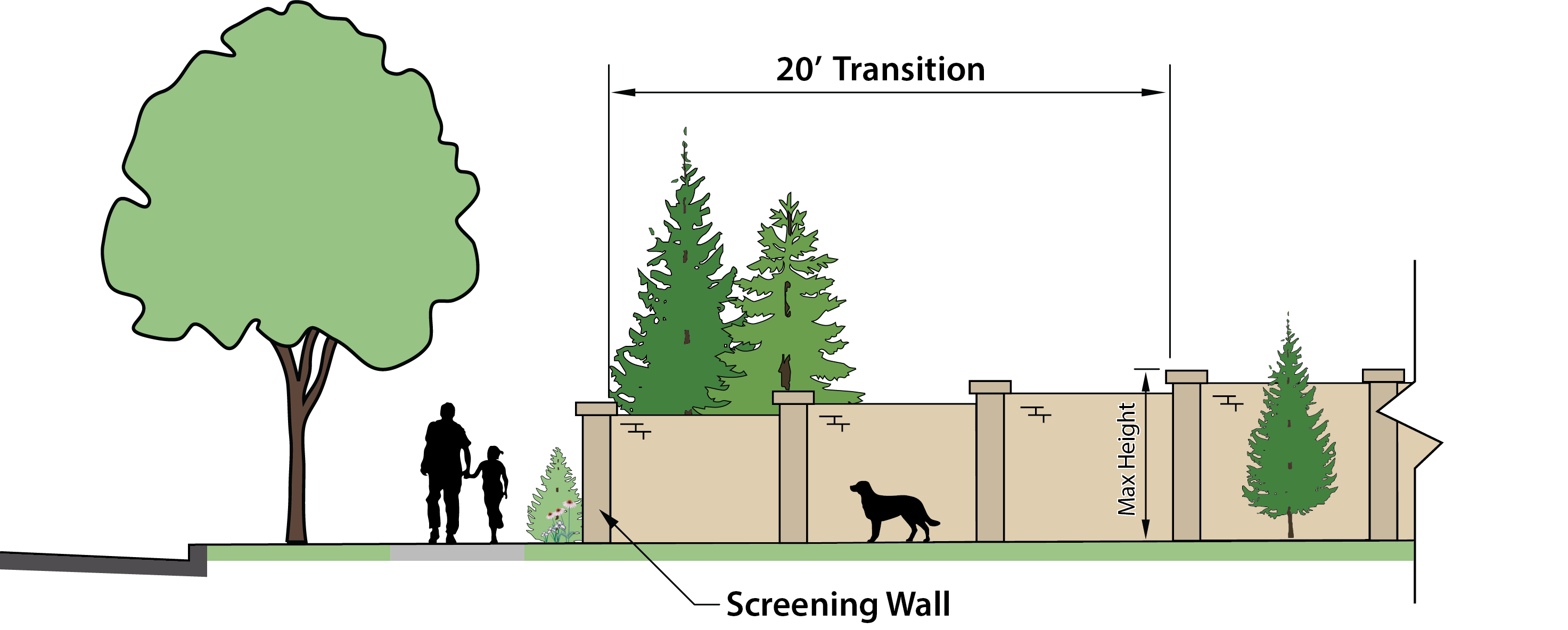 |
e.
All screen walls required by this chapter that are greater than twenty-four (24) feet in length shall be designed and constructed to break up the lineal expanse of such walls with a staggered centerline, pilasters, varying heights, the installation of plant materials on exterior of wall, or varying the landscaped area contours by creating berms to lessen the visual impact of the wall. See example in Figure 17.06.540.F.2.e.
| FIGURE 17.06.540.F.2.e EXAMPLE OF MINIMIZING IMPACT OF LONG SCREENING WALL |
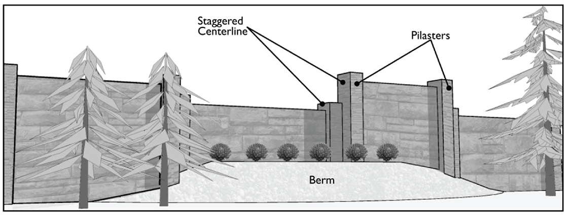 |
(Ord. No. C-49-19 [PLG-004-19], Exh. C, 6-18-2019)
17.06.550 - Parking and circulation.
A.
Purpose. The location and design of parking areas and circulation patterns largely determines the character of an area and the quality of the pedestrian environment. These standards are intended to provide for a range of parking types that will reinforce the desired character of Freeland's streets and residential neighborhoods as areas develop and redevelop over time.
The purpose of this section is to:
1.
Assure safe, convenient, and adequately sized parking facilities;
2.
Provide adequate parking for different land uses while recognizing that developed properties are likely to support a variety of different uses over time;
3.
Reduce demand for parking by encouraging alternative means of transportation;
4.
Increase pedestrian environment and mobility options by providing safe and clear connections between the sidewalk and adjacent uses, between businesses and/or structures, and through parking lots;
5.
Minimize conflicts with pedestrian and vehicle circulation and activity;
6.
Create a safe, convenient, and efficient network for vehicle circulation and parking;
7.
Enhance the visual character of interior access roads and pathways; and
8.
Minimize the visual impact of parking facilities from the sidewalk while maintaining safety.
B.
Applicability.
1.
The regulations of this section apply to all off-street parking areas in all zoning districts within the Freeland NMUGA. No building permit shall be issued until plans showing provisions for the required parking have been submitted and approved as conforming to the standards of this section.
2.
Space for the off-street storage and parking of vehicles and bicycles shall be reserved and improved for use at the time any building or structure is erected or enlarged as follows:
a.
When the building or site is expanded in height or acreage, pursuant to Table 17.06.250.D.2.a.; and
b.
When an existing use or structure is modified, altered, or changed such that the number of required parking spaces is increased by more than ten (10) percent over the number provided prior to the modification, alteration, or change, except where the additional required is five (5) or fewer spaces.
3.
How to use this section.
a.
Determine the number of parking spaces for vehicles and bicycles in subsection C. Where fraction space is calculated, round up after final calculation unless otherwise specified in the standard.
b.
Parking facility (lot and/or structure) locations are restricted as shown in subsection D.
c.
Parking lot design standards:
(i)
General standards in subsection E;
(ii)
Internal pedestrian circulation standards in subsection F; and
(iii)
Internal vehicle circulation standards in subsection G.
d.
Access and cross-access standards are in subsection H.
e.
Garage standards are in subsection I.
f.
Refer also to the following related standards:
(i)
Parking lot landscaping standards in Table 17.06.520.H;
(ii)
Landscaping between the structures and parking areas in section 17.06.520.G; and
(iii)
Parking lot screening from the right-of-way and adjacent lots in section 17.06.540.E.11.
C.
Required and maximum parking spaces.
1.
Refer to section 17.03.180.Q for calculating the minimum required off-street parking spaces by land use.
2.
The maximum number of off-street vehicle parking spaces shall be 150 percent of the minimum or twelve (12) spaces, whichever is greater. The maximum parking calculation shall not apply to community parking facilities (e.g., municipal parking lot/garage or park-and-ride, etc.). See examples of how to calculate parking minimum and maximums in Table 17.06.550.C.2.
3.
On-street parking (up to two (2) spaces) may count towards the required number of vehicle parking spaces for developments that require five (5) or less parking spaces except that all required handicap parking spaces must be provided on-site.
4.
Electric vehicle charging stations.
a.
Electric vehicle charging stations space(s) may be utilized in a maximum of fifty (50) percent of the non-handicapped vehicle parking spaces provided.
b.
Electric vehicle charging station space(s) may be utilized in handicapped spaces provided. Use of such spaces shall not be limited to electric vehicles.
c.
For maximum charging station calculations, where a fraction space is calculated, round down.
5.
Shared parking (optional).
a.
If adequate and available, off-site shared parking may be allowed for non-residential and mixed-use developments, subject to the following:
(i)
All required handicap and bicycle parking spaces are provided on-site;
(ii)
A minimum of twenty-five (25) percent of the required non-handicapped vehicle parking spaces, but no less than three (3) spaces, are provided on-site (where three (3) or fewer are required, all spaces must be on-site, except as provided in section 17.06.550.C.3);
(iii)
Adequate parking is provided within 500 feet of the main building entrance(s);
(iv)
Safe and accessible pedestrian pathways are available between the off-site parking and the main building entrance(s) and such pathway does not cross Hwy 525; and
(v)
A signed and recorded agreement between the property owners that includes a calculation of the parking available and verification that the shared parking agreement does not create a deficiency for other uses that utilize that site for parking (as their required on-site parking and/or any previously executed shared parking agreement).
b.
When sharing parking facilities between multiple uses, the adjusted minimum parking requirement shall be calculated as follows.
(i)
Determine the uses for both sites.
(1)
For parking facilities to be shared with four (4) or more uses (on or off-site), a parking study is required, per section 17.03.180.Q.2(u).
(2)
When two (2) or three (3) uses are involved, find the shared parking factor(s) in Table 17.06.550.C.5.b. For two uses, find the cell in the row for Use 1 and the column for Use 2. For three (3) uses you will also need to find the cell in the row for Use 1 and the column for Use 3.
(ii)
Determine the standard minimum parking space requirement for all uses, per section 17.03.180.Q.
(iii)
Divide the standard minimum by the shared parking factor (see example calculations in Table 17.06.550.C.5.c.).
c.
Shared parking factors from Table 17.06.550.C.5.b are to be utilized to calculate the adjusted minimum parking requirement per the examples in Table 17.06.550.C.5.c.
6.
Off-street bicycling parking spaces. Multi-family and non-residential developments shall provide for bicycle parking per the standards below.
a.
In any development required to provide ten (10) or more automobile parking spaces, the number of off-street bicycle parking spaces shall be equal to or greater than ten (10) percent of the automobile parking provided, with a minimum of two (2) outdoor bicycle spaces per development.
b.
Non-residential uses. Bicycle facilities for patrons shall be located within 100 feet of the main building entrance and located in safe, well-lit, visible areas that do not impede pedestrian or vehicle traffic flow.
c.
Residential uses. Bicycle facilities for residents shall be located within 100 feet of building or individual unit entrances and located on the ground level in safe, well-lit, visible areas that do not impede pedestrian or vehicle traffic flow. A minimum of two (2) outdoor spaces per development shall be provided.
d.
Bicycle parking hardware shall be installed according to its manufacturer's instructions, allowing adequate clearance for bicycles and their riders.
e.
Bicycle lockers (indoor and/or outdoor) available for residents and employees but not available to the public may count for up to, but no more than, fifty (50) percent of the required bicycle parking spaces.
D.
Parking facility locations. Table 17.06.550.D identifies permitted locations for parking facility, by zoning district, to ensure that development relates to the street and meets community design objectives for the district.
| TABLE 17.06.550.D - PARKING FACILITY BY TYPE | ||||||||
|---|---|---|---|---|---|---|---|---|
| ● = Parking facility type allowed, by zoning district | LD | MD | BV | BG | NM | LI | ||
| P1 | - Single Family Driveway Access to a single-family lot from the right-of-way or from an alley | 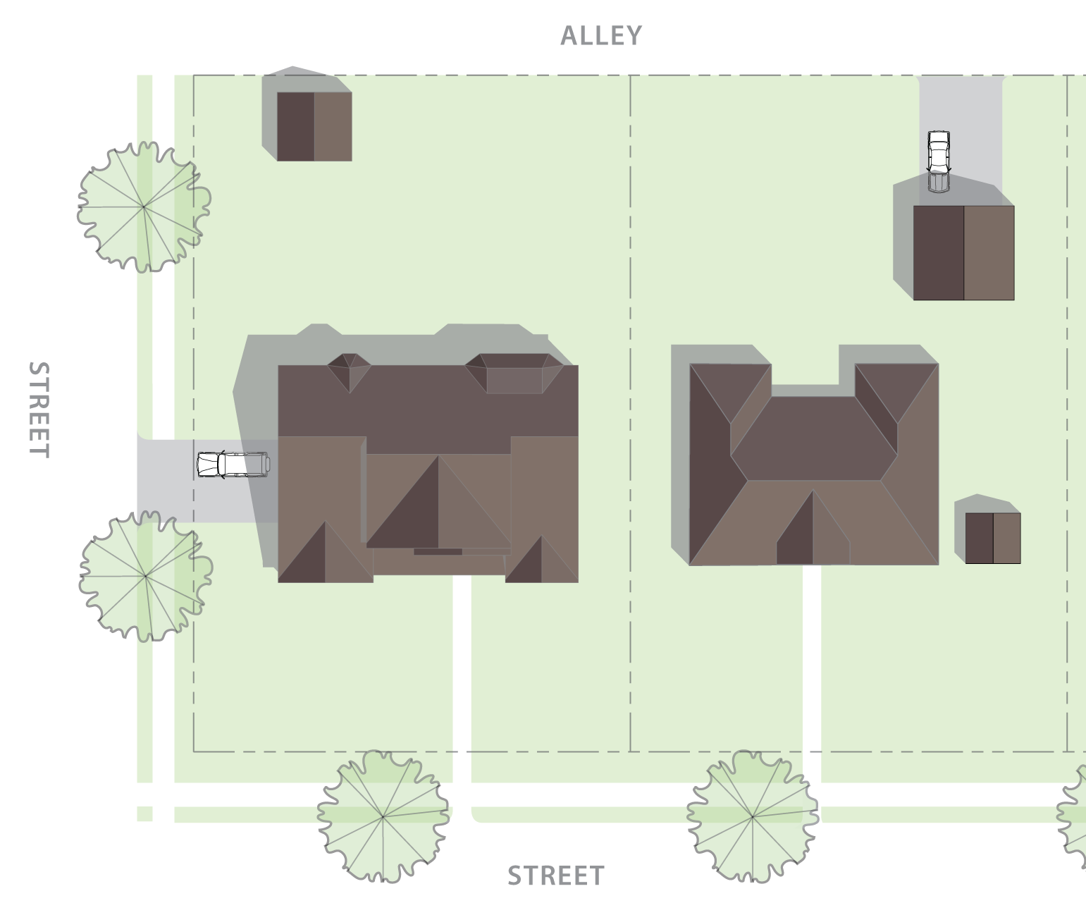 | ● | ● | ● (4) | |||
| P2 | - Surface Parking, Rear of Building Appropriate for a variety of uses and building types; more typically found in high pedestrian activity areas and districts with build-to lines. | 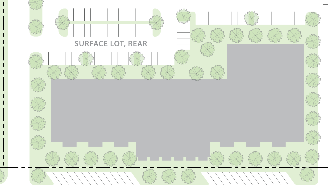 | ● (2) | ● | ● (5) | ● | ● | ● |
| P3 | - Surface Parking, Side of Building Appropriate for a variety of uses and building types. | 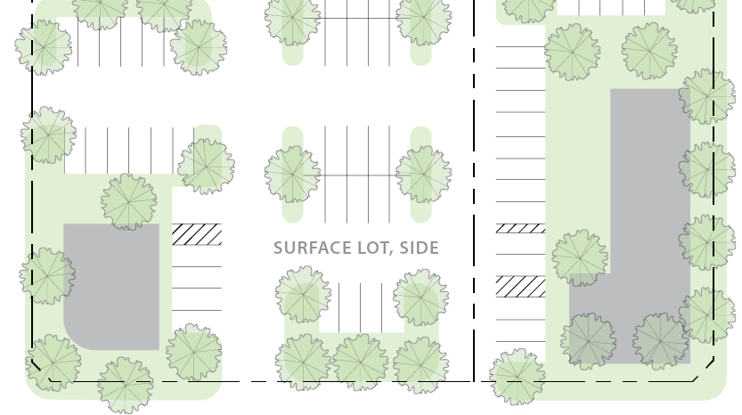 | ● (2) | ● | ● (6) | ● | ● | ● |
| P4 | - Surface Parking, Front of Lot Typically used in retail or mixed-use developments, may also be used for apartment complex or office. | 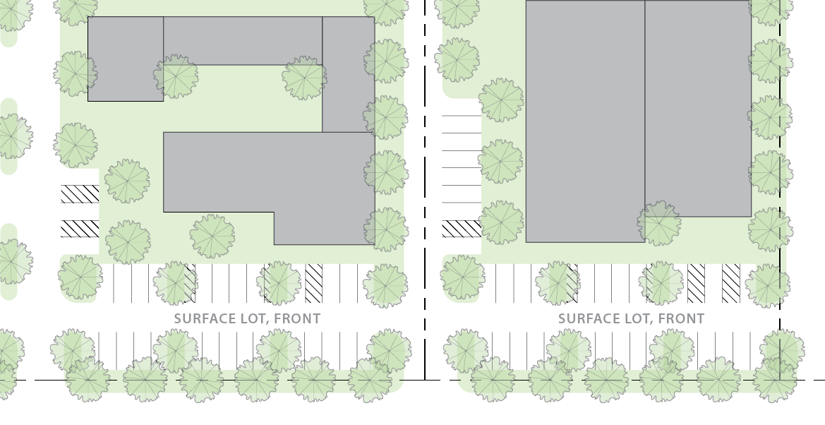 | ● (3) | ● (4) | ● | ● | ● | |
| P5 | - In-Structure Parking Facility(1) Parking located in a structure above-ground or below-ground. Typically used in retail or mixed-use developments, may also be used for apartment complex or office. | 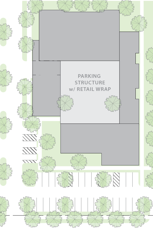 | ● | ● | ● | ● | ● | |
|
Notes:
1. Only allowed for retail, office, mixed-use, and/or multi-family developments. 2. Only allowed for transitional uses, per ICC 17.06.205, 17.06.210, and/or 17.06.220. 3. Not allowed for cottage housing. 4. Not allowed for frontages along Main Street and Harbor Avenue; allowed elsewhere in the Business Village zoning district. 5. Preferred surface parking type in the Business Village zoning district properties that front along Main Street and Harbor Avenue. 6. Side access in the Business Village lots fronting on Main Street and Harbor Avenue are allowed only where rear access lots are not feasible due to topography, property shape or size, or other contextual circumstances. | ||||||||
E.
General parking facility design and installation standards.
1.
Parking rows.
a.
Parking rows are encouraged to be aligned perpendicular to the main building.
b.
Parking rows shall be broken up with landscaped islands and/or medians between rows to avoid long monotonous rows of parking. The maximum number of spaces before a landscape island is required is based on parking lot location, per Table 17.06.520.H.3.d.
2.
Parking lot size. The maximum number of spaces in any one (1) area shall be eighty (80) spaces; for parcels with greater than eighty (80) parking spaces, the parking areas must be designed in such a way that they are in physically separated (e.g. one (1) area at side of building and one (1) area at the back; areas separated by a large landscaped median or open space).
3.
Parking along the right-of-way.
a.
For multi-building development, no more than fifty (50) percent of the block frontage may be parking and vehicular access.
b.
In the Business Village District, no more than sixty (60) linear feet of street frontage may be occupied by surface parking; parking greater that sixty (60) linear feet of frontage shall be broken up into groupings through the use of landscape area, building placement, pedestrian pathways, etc.
c.
In the Business General zoning district parking in front of the building shall be installed per the standards in Table 17.06.550.E.3.c.
| TABLE 17.06.550.E.3.c PARKING FACILITY P4 - SURFACE PARKING, FRONT OF LOT | |||
| Right-of-way |
P4 parking allowed only in NM, BG, and BV zoning districts
In BV, not allowed on Main Street and Harbor Avenue frontages | 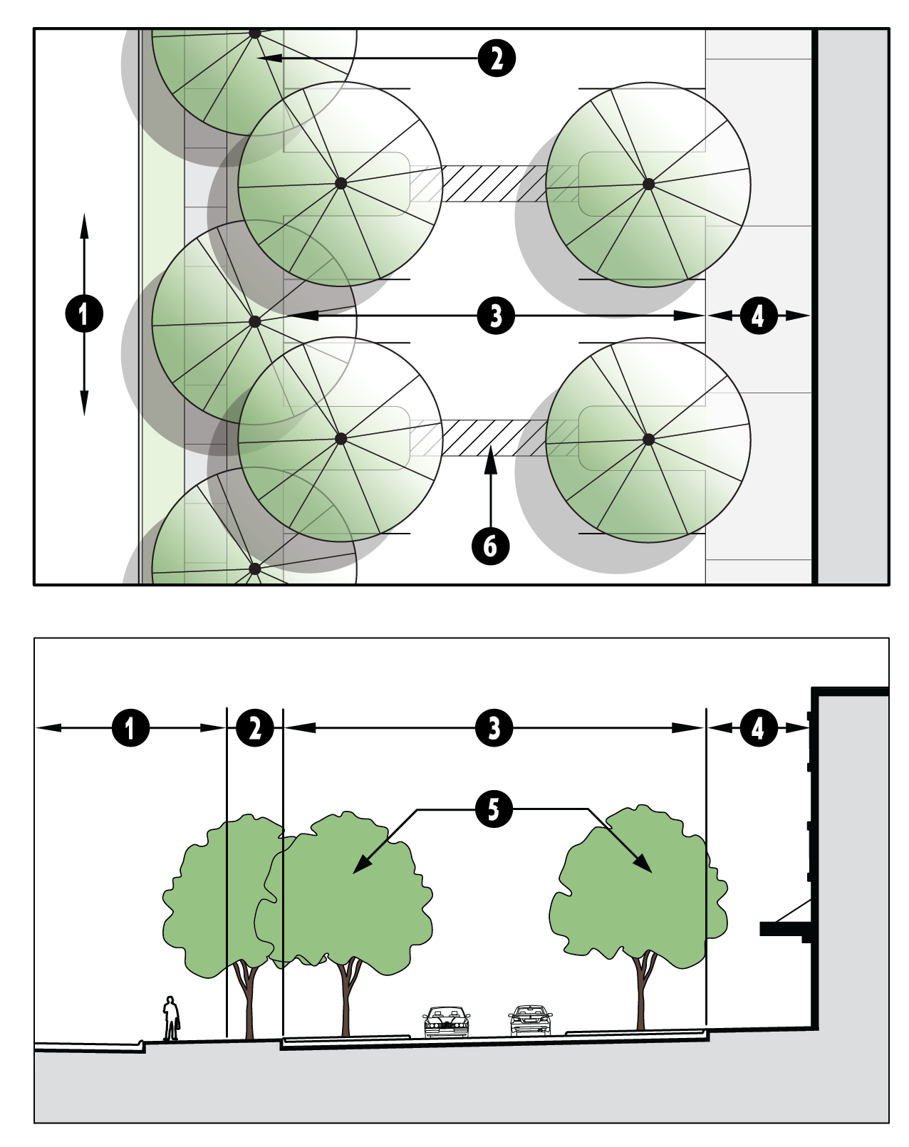 | |
| Landscape Buffer | Per ICC 17.06.540.E.11 | ||
| Parking aisle |
20' wide parking stalls with a 24' wide drive aisle
Parking may be single- or double-loaded; must be uniform within the development | ||
| Façade |
Façade sidewalk and landscaping per ICC 17.06.520.G
Pedestrian access from building to sidewalk along right-of-way per ICC 17.60.550.F | ||
| Landscaping space |
One 9' wide landscaping space at every 6
th
parking space
Landscape installation per ICC 17.06.520.H.3 Landscape sight line clearance per ICC 17.03.520.D.5 | ||
| Enhanced paving bands | Brick or concrete pavers, stamp pattern, raised pedestrian pathway, or other treatment that visually breaks up the pavement to reduce the visual impact and provide a more pedestrian-friendly environment | ||
4.
Structured parking facilities.
a.
Parking facility type P5, In-Structure Parking Facility, may be underground or above ground.
b.
Parking structures shall be on the interior of the building and/or lot. A minimum of eighty (80) percent of the linear length adjacent to a public right-of-way, pedestrian-oriented open space, and/or pedestrian pathway (or 100 percent if fronting to Main Street or Harbor Avenue) shall incorporate ground level uses that encourage pedestrian activity. Such uses could include retail, entertainment, office, restaurant, or residential uses (if allowed at that location). Transit stops and public restrooms could also be incorporated.
c.
For building façades adjacent to a public right-of-way, open space, pedestrian pathway, or non-motorized trail a vertical building modulation shall be provided per section 17.06.610 (option A or B only) excepting that no individual façade section facing a public right-of-way, pedestrian-oriented open space, and/or pedestrian pathway shall exceed sixty (60) linear feet.
d.
Design and articulate any exposed portions of parking structures adjacent to a public right-of-way, pedestrian-oriented open space, and/or pedestrian pathway to suggest the appearance of a habitable building. Where cars are visible from the exterior of the facility via "windows" in the parking structure, use screening elements to reduce the visual effects of parked cars and light spillage at night. Screening treatments could include tracery, ironwork, and/or landscaping.
| FIGURE 17.06.550.e.4 GOOD AND BAD EXAMPLES OF PARKING GARAGE ENTRANCEWAY DESIGN | ||
Good Design Examples | 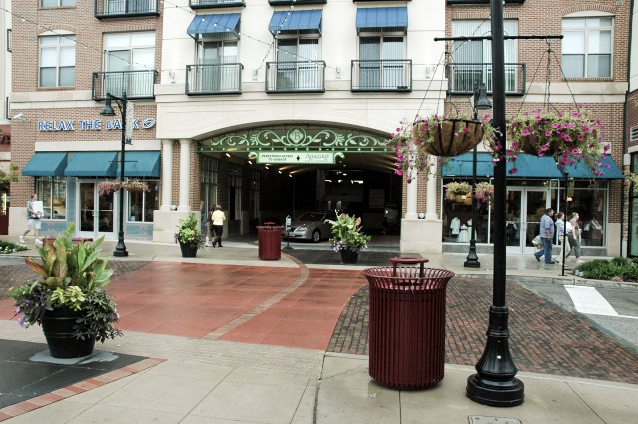 | 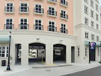 |
Examples of Poor Design (Do NOT do this!) | 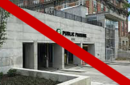 |  |
e.
Minimize the width and height of openings for automobile ingress and egress (openings must be designed for disabled access). Use architectural elements to divide the openings, minimize the appearance of structure utilities (e.g. ducts, vents, pipes, and lighting), and reduce other visual impacts on the streetscape.
f.
Eliminate glare and visibility of pole mounted light fixtures on upper decks of parking structures. Lights should be full cut-off and limited to fifteen (15) feet height above the surface of the deck and shall be located between internal parking rows rather than at the structure's perimeter.
g.
Safe, designated pedestrian pathways must be provided from the parking structure to the primary building entrances and to the sidewalk at the right-of-way. For developments with multiple structures, pedestrian pathways must also be provided between the parking structure and all main entrances of the buildings to be served by the structure.
h.
Façade landscaping shall be provided per Table 17.06.520.G.(2).
F.
Internal pedestrian circulation.
1.
All buildings shall have clear pedestrian access from the main building entrances to the sidewalk along the adjacent right-of-way(s).
2.
Sites with multiple businesses or buildings. Pedestrian paths or walkways connecting all businesses and the entries of multiple commercial buildings frequented by the public on the same development site shall be provided.
| FIGURE 17.06.550.F.2 EXAMPLE OF GOOD INTERNAL PEDESTRIAN CIRCULATION |
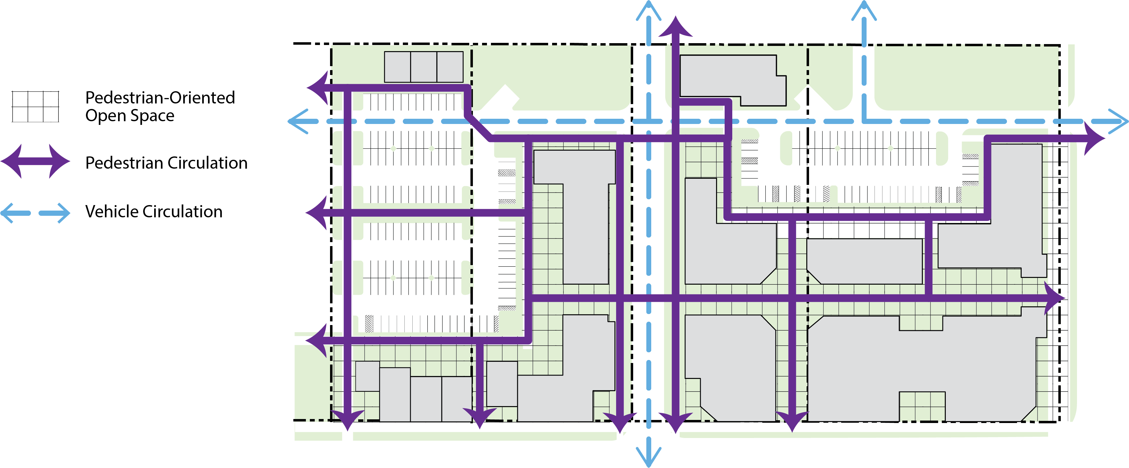 |
| Illustrating a good example of internal pedestrian circulation between streets, buildings, and through parking lots. Cross access easements and adjacent open space maximize circulation patterns and walkability. |
3.
Façade landscaping and sidewalks shall be installed pursuant to section 17.06.520.G.
4.
Parking lot pathways.
a.
Safe, designated pedestrian pathways must be provided from the parking lot to the primary building entrance.
b.
A hard-surfaced walkway with six (6) feet of unobstructed width shall be provided for safe walking areas through parking lots greater than sixty (60) linear feet (length and/or width).
| FIGURE 17.06.550.F.4 - PARKING LOT PATHWAY STANDARDS AND EXAMPLE |
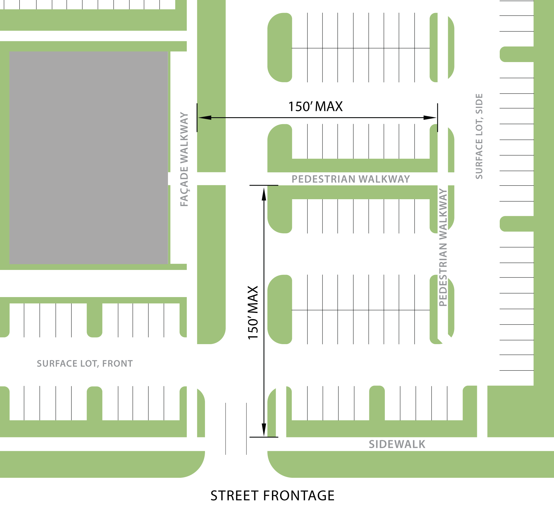 |
c.
A distance of less than 150 feet shall be maintained between pedestrian pathways in and adjacent to parking lots.
d.
Where pedestrian circulation paths intersect vehicular routes, a slight change in grade, paving material, textures, and/or color should be used to slow traffic and emphasize the area of conflict. Speed bumps/humps may not be used to satisfy this requirement.
e.
Landscaping elements and pedestrian-scaled lighting (maximum fifteen (15) feet in height) shall be used to clearly define pedestrian walkways or other pedestrian areas within the parking area.
5.
Loading spaces shall not cross or be immediately adjacent to pedestrian pathways.
6.
Loading turn-outs should be located so that waiting vehicles do not impede bicycle or pedestrian circulation.
G.
Internal vehicle circulation.
1.
Internal vehicular circulation standards. All developments shall provide a safe and convenient network of vehicular circulation that connects to the surrounding road/access network and provides the opportunity for future connections to adjacent parcels, where applicable.
2.
Drive-thru lanes.
a.
For the purpose of the block frontage standards in section 17.06.430, drive-thru lanes between a street and a building are considered a parking lot.
b.
Drive-thru windows are prohibited on street facing façades.
c.
Drive-thru lanes shall not restrict pedestrian access between the sidewalk and on-site buildings. Where pedestrian routes cross drive-through lanes, a crosswalk that is raised or features a change in texture and/or other treatment must be utilized to enhance the safety and visual appearance of the pedestrian crossing.
d.
Stacking lanes shall be a minimum of twelve (12) feet in width and provide for the stacking of at least five (5) vehicles. Drive-thru lanes shall have enough capacity to avoid stacking that extends into the public right-of-way. One (1) bypass lane, a minimum of ten (10) feet in width, shall be provided.
e.
Drive-thru elements should be architecturally integrated into the building rather than appearing to be applied or "stuck on" to the building. Drive-thru equipment should be included in the submittal package and in addition to any subsequent sign review packages. Menus and speakers shall not face the street.
f.
Drive-thru facilities should incorporate architectural coverings consistent with the design theme of the building. Lighting beneath canopies should be shielded and fully recessed to minimize glare.
g.
Conveyance systems used to connect remote drive through stations with the building (i.e. for bank teller drive-thru) should be architecturally incorporated or placed below grade.
h.
Screening shall be provided per section 17.06.540.D.6.
H.
Site access and cross-parcel circulation.
1.
Design or configure the project or site plan so that:
a.
Vehicular access is designed and located to minimize interference with traffic flow on adjacent roads;
b.
Access points to the site do not interfere with access to adjacent and nearby properties;
c.
Driveways, roads, and parking areas are designed so that exiting vehicles are not required to back out into a public or private road that is external to the site plan; and
d.
Access to adjacent neighborhoods is provided on at least one (1) side and/or rear property line.
2.
For projects located along existing transit routes, multi-modal access shall be provided as appropriate to the nature and scale of the project, including: transit stops, transit access, and non-motorized access and facilities.
3.
Access.
a.
Single family developments on individual lots (including duplexes, triplexes, and four-plexes) may have no more than one (1) driveway. In the Medium Density zoning district, each site is limited to one (1) driveway unless more are required for fire access.
b.
Where limited to one (10 driveway per paragraph 3.a above, the Planning Director may approve a design alternative for one (1) additional driveway based on site conditions, such as a corner lot or to accommodate a loop road circulation pattern or clustering to maximize open space. A design alternative for the number of access driveways permitted shall not include a waiver of any other requirements, including but not limited to driveway separation requirements, sight distance triangles, and site impervious surface maximums.
c.
In the Medium Density Residential and Business Village zoning districts, alley-loaded parking is preferred and is required for lots less than fifty-five (55) feet in width. Front-loaded parking is allowed where alley-loaded parking is not possible due to existing plats and road layouts.
d.
For corner sites, vehicle access to the parking lot is accessed from the lowest volume street unless required per sections 17.06.300—17.06.350.
e.
Side yard separation. The driveway slab shall be a minimum of twenty-four (24) inches from the property line (excluding shared driveway) and include a reinforced concrete turn-down for erosion control, as shown in Figure 17.06.550.H.3.e.
| FIGURE 17.06.550.H.3.e - SIDE YARD SEPARATION FOR DRIVEWAYS |
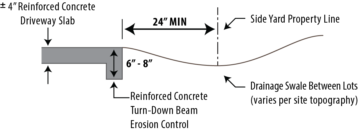 |
f.
Curb cuts flare points for driveways shall be a minimum of fifteen (15) feet from the flare point of the turning radius for an intersection, as shown in Figure 17.06.550.H.3.f. Turning radius is based on Public Works standard.
| FIGURE 17.06.550.H.3.f CORNER LOT MINIMUM DRIVEWAY DISTANCE TO INTERSECTION |
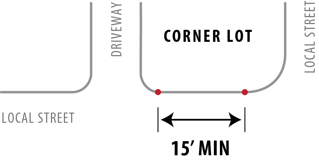 |
4.
Cross access.
a.
Shared driveways between adjacent properties are encouraged where feasible.
b.
For new commercial and mixed-use developments adjacent to existing commercial and mixed-use development, cross access connectivity between parcels shall be provided.
c.
All cross access and shared driveway agreements shall be implemented through a recorded cross access easement and shown on the plat, if applicable.
d.
If cross access is provided, ensure pedestrians and/or bicycle access is also provided, by sidewalks, bike paths, trails, or internal drive aisles.
e.
Internal circulation shall be configured to allow for future connectivity to any adjacent undeveloped sites.
I.
Garage standards.
1.
Purpose.
a.
To ensure enough clear space in front of the garage that a vehicle can be parked on the property without extending over the sidewalk area or otherwise into the right-of-way.
b.
To ensure adequate space for vehicular access to the garage.
c.
To minimize the appearance of the garage so that the entranceway takes precedence.
2.
Garage setback. The garage face shall be set back a minimum of twenty-five (25) feet from the property line, and shall not extend in front of the front building façade except in a J-swing configuration as shown below.
3.
J-Swing garage configuration standards.
a.
Garage doors facing a side property line (e.g. J-swing layout) shall have a minimum twenty-eight-foot distance between the garage face and the side property line, with, as shown in Figure 17.06.550.H.3.e and Figure 17.06.550.I.3.
b.
J-swing garage shall have a minimum of two (2) windows on the side of the garage facing the street. Window size, type, and style must be the same as other windows on the first floor of the building, with a minimum size of three-foot by five-foot.
| FIGURE 17.06.550.I.3 - J-SWING GARAGE LAYOUT STANDARDS | ||
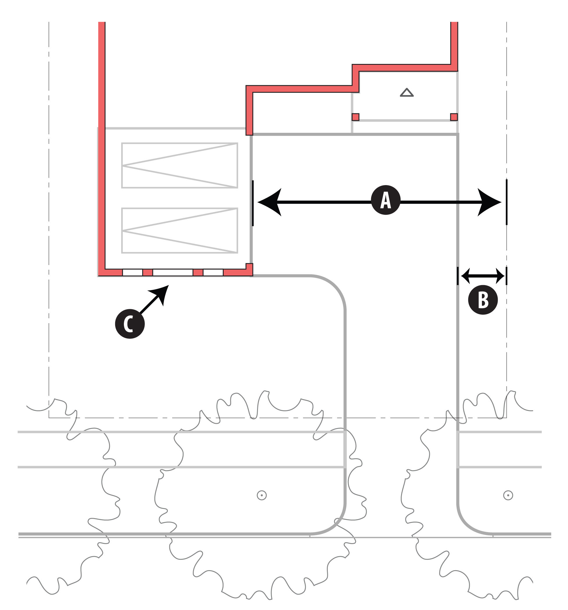 | ||
| = 28 ft. min. distance between face of garage and property line | ||
| = per ICC 17.06.550.H.3.e | ||
| = minimum of 2 windows on street-facing side of garage | ||
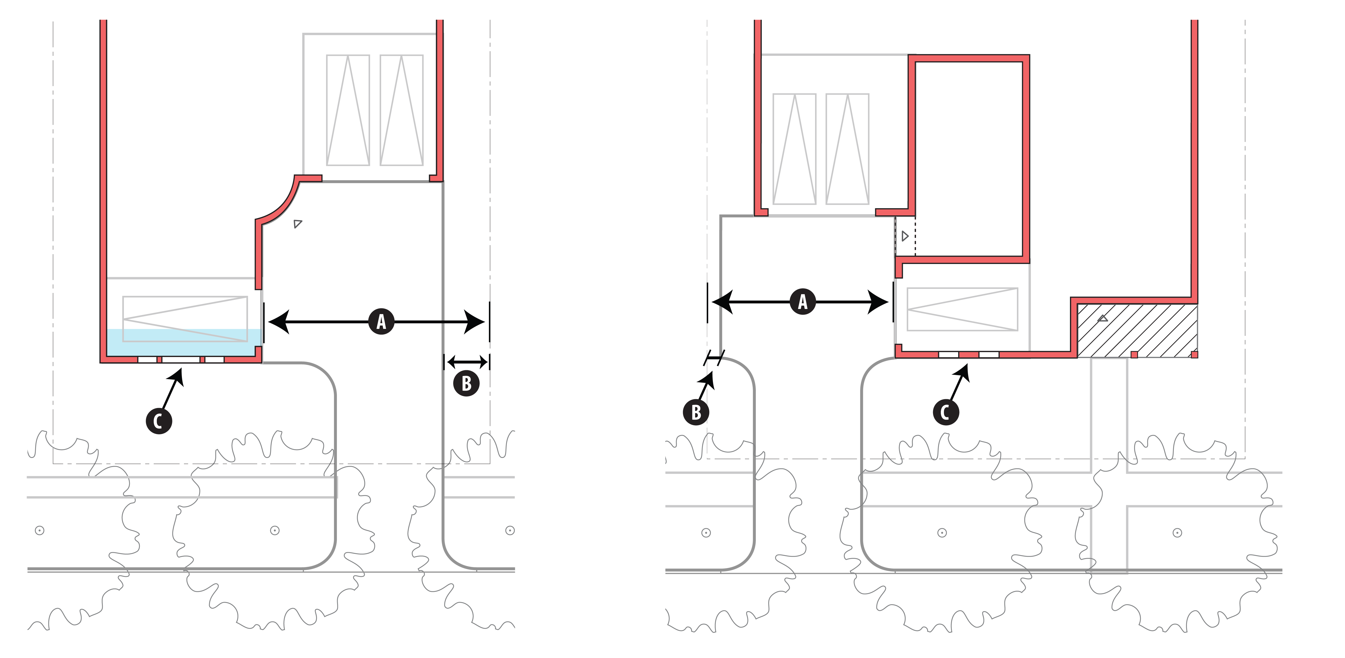 | ||
4.
Garage door clearance. Maintain a minimum of twenty-eight (28) feet clearance in front of the face of garage (between facing garage doors and/or between face of garage and any structure), as shown in Figure 17.06.550.I.4, to ensure room for car to enter the garage.
| FIGURE 17.06.550.I.4 - GARAGE DOOR CLEARANCE STANDARDS | |
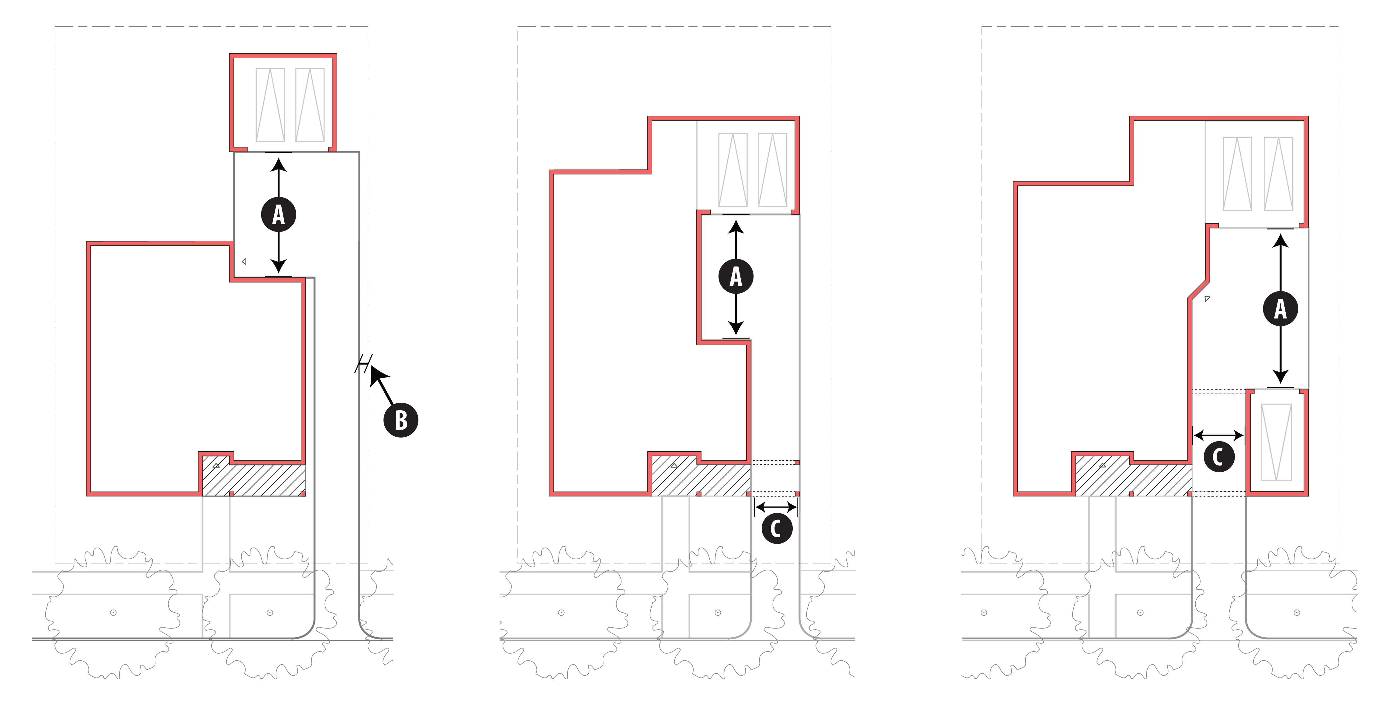 | |
| = 28 ft. min. clearance in front of the face of garage (between face of garage and any structure) | |
| = per ICC 17.06.550.K.3.E | |
| = 10 ft. min clearance for pass-through or porte-cochère | |
5.
Garage door standards for multi-family and mixed-use residential that offer individual garages. To decrease the prominence of garage doors and emphasize front entryways, the following strategies shall be used. Garage doors facing a public street shall include a minimum of three (3) of the following enhancements.
a.
Garage door recessed a minimum of twelve (12) inches from the garage face (e.g. when two-inch by six-inch framing is used, the stud plus a brick facing equals the twelve-inch minimum).
| FIGURE 17.06.550.I.5 - GARAGE DOOR RECESS STANDARDS |
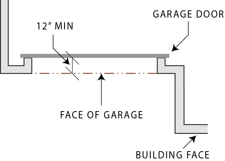 |
b.
Face of garage is set back a minimum of five (5) feet from the face of the building.
c.
Cedar or other wood clad doors.
d.
Double doors (where allowed).
e.
Decorative windows.
f.
Decorative hardware.
g.
Reveals and/or texture.
h.
Arbor.
i.
Color of the garage doors the same as the building or a darker, complementary color.
(Ord. No. C-49-19 [PLG-004-19], Exh. C, 6-18-2019)
17.06.560 - Signs.
A.
Purpose. It is the purpose of this section to supplement Island County Code sign regulations, section 17.03.180.R, with additional standards for the Freeland NMUGA, to:
1.
Promote a quality visual environment by establishing reasonable standards for the size, placement, height, and maintenance of signs; and
2.
Assure that signage is in harmony with the building design and character of the Freeland community.
B.
General regulations.
1.
Permit required.
a.
All new or replacement signs require a building permit. Signs design elements may be reviewed and approved in conjunction with a site plan review application. The county may impose such reasonable conditions and standards as may be found necessary to ensure that signs are compatible with the character of the Freeland NMUGA as adopted in the Freeland Subarea Plan and the requirements of this section.
b.
All signs along state highways within Island County are also subject to sign regulations and permit requirements established by the State of Washington. Property owners and sign installers should familiarize themselves with these requirements. See Chapter 468-66 WAC.
2.
Applicability.
a.
This section shall not regulate street signs, signs not visible from the public rights-of-way, or legal notices required by law excepting that all signs not visible from the public rights-of-way shall comply with the following:
(i)
External lighting shall be full-cutoff; and
(ii)
The maximum light level of any lighting feature cannot exceed 1.0 footcandles measured at the property line, except that where adjacent to Low Density or Medium Density zoning districts, the maximum light level cannot exceed 0.5 footcandles measured at that property line.
b.
Section 17.03.180.R shall apply except where specifically addressed in this chapter.
c.
This section shall apply as follows:
(i)
New signs in conjunction with new construction;
(ii)
When a sign is relocated to a different location;
(iii)
When more than fifty (50) percent of the structure is damaged, replaced, repaired, altered, or changed (excluding change of tenant or other surface change to sign that does not alter the structure size, shape, or dimensions);
(iv)
When any building or structure is erected or enlarged (expanded in height or ground coverage) by fifty (50) percent or by 4,000 square feet or greater, whichever is less, all signs on the property must comply with this section; and
(v)
For remodels and additions less than 4,000 square feet or less than fifty (50) percent, all signage related to the new areas are subject to this section (see Table 17.06.250.D.2.a.).
d.
Non-conforming signs.
(i)
Nonconforming signs shall be kept in good repair during the period the sign is used. Alterations or modifications to any non-conforming sign are prohibited, except for structural repair and maintenance resulting in the same size or shape.
(ii)
A requirement for a non-conforming sign to be removed or altered so as to comply with the requirements of this section may be imposed as a condition for the approval of a plat, permit, variance, or other discretionary development approval.
3.
No signs shall be placed in the corner visibility triangle (see Figure 17.06.520.E.6) and clear zones for driveways and intersections.
4.
Maintenance required. All signs, together with all of their supports, braces, guys, and anchors shall be maintained in good repair and in a safe, neat, clean, and attractive condition pursuant to section 17.03.180.R.7.d.
C.
Sign standards.
1.
Wall signs.
a.
Wall signs are flat signs, channel lettering, or three-dimensional signs which are painted or attached (parallel) to the wall of a building or structure.
b.
Wall signs are allowed on multi-family, mixed-use, and non-residential development in the Business Village, Business General, and Mixed-Use Non-Residential zoning districts.
c.
Wall signs must be proportional to the architectural features of the façade and shall not cover over significant architectural features, including windows, cornice lines, or columns.
d.
Maximum dimensions of wall signs.
(i)
Each individual business may have one (1) wall sign with a maximum area of twenty (20) square feet. For buildings on a corner lot, one (1) additional wall sign may be on the secondary frontage.
(ii)
The maximum wall sign width shall be twelve (12) feet.
(iii)
For multi-family developments, the maximum area shall be twenty-four (24) square feet or four (4) square feet per building and shall be limited to addressing and directional signs only.
2.
Freestanding signs.
a.
Freestanding signs shall not be taller than five (5) feet from grade except as noted in section 17.06.140.B.3.e for monuments signs in the 525 Overlay.
b.
Freestanding signs shall be located on the premises in which the business is located and placed in a manner that will not obstruct the view of signs on neighboring properties.
c.
There shall be a minimum separation of twenty (20) feet between freestanding signs.
d.
Freestanding signs may be placed within the required building setbacks except that they may not be placed within the sight-distance triangle or a public right-of-way.
e.
Table 17.06.560.C.2 below provides additional provisions for freestanding signs. Measurement of sign area shall be exclusive of the structural portions of the sign and non-signage areas (e.g. landscape planter, etc.).
| TABLE 17.06.560.C.2 - FREESTANDING SIGNS | |||
|---|---|---|---|
| Sign Type | Zoning Districts Allowed |
Supplemental Standards
(in addition to ICC 17.03.180.R) | |
| Monument signs | |||
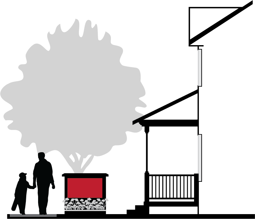 |
Height = 5 ft. max
Area = 20 sq. ft. max In the 525 overlay, monument signs are permitted up to 18 ft. in height (see ICC 17.06.140.B.3.e); signs shall not exceed a width of 5 ft. and a total area of 40 sq. ft. | ||
| Post and arm signs. | |||
Minor signs which are used to identify the address of a building, or to identify the
profession, family, organization, business, etc., occupying the building.
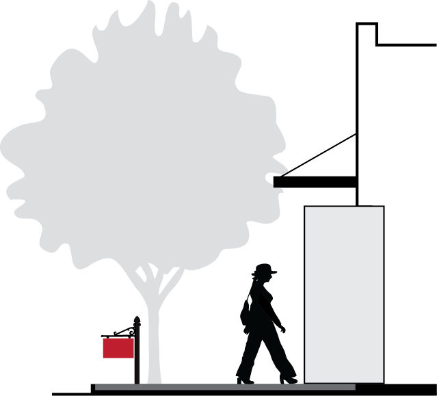 |
Height = 5 ft. max.
Area = 12 sq. ft. max. | ||
| Pylon signs. A freestanding sign mounted on two posts. | |||
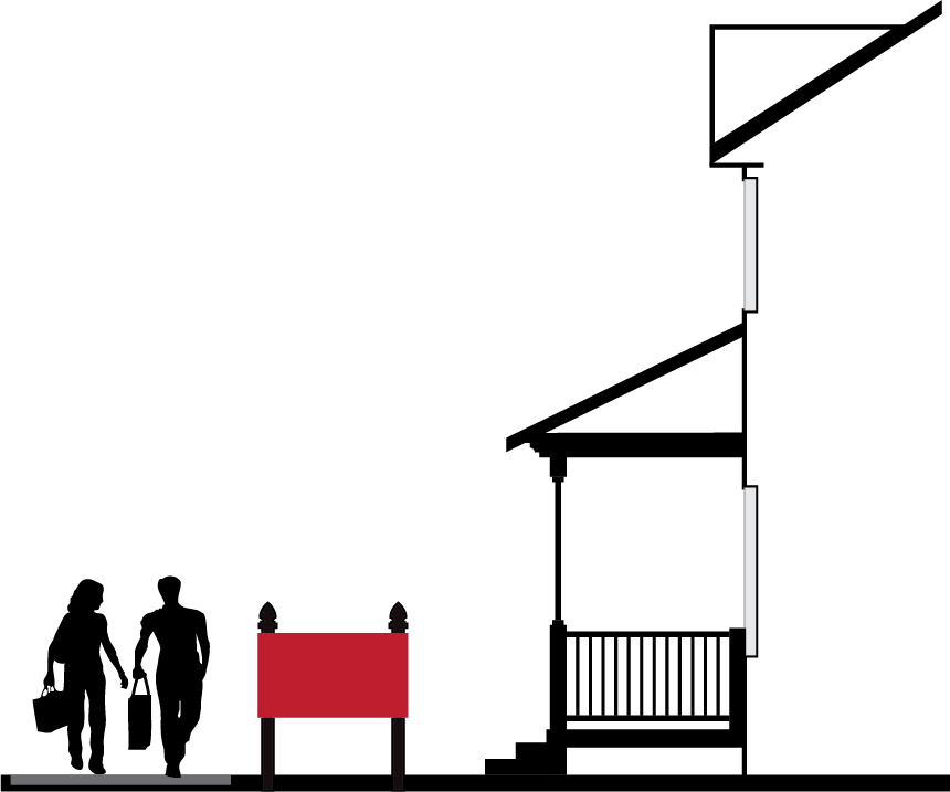 |
Height = 5 ft. max.
Area = 12 sq. ft. max. | ||
3.
Hanging and projecting signs.
a.
Hanging signs shall have seven and one-half (7.5) feet minimum vertical clearance between the bottom of the sign and the ground.
b.
The sign may project no further than eight (8) feet from the building.
c.
Hanging sings may encroach over a sidewalk, but must maintain a minimum of four (4) feet to the curb.
d.
Signs attached to buildings shall not exceed the height of the building or structure to which they are attached.
e.
Table 17.06.560.C.3 below provides additional provisions for hanging signs.
| TABLE 17.06.560.C.3. - HANGING AND PROJECTING SIGN STANDARDS | ||||
|---|---|---|---|---|
| SIGN TYPE | ZONES ALLOWED | STANDARDS | ||
| Hanging signs | ||||
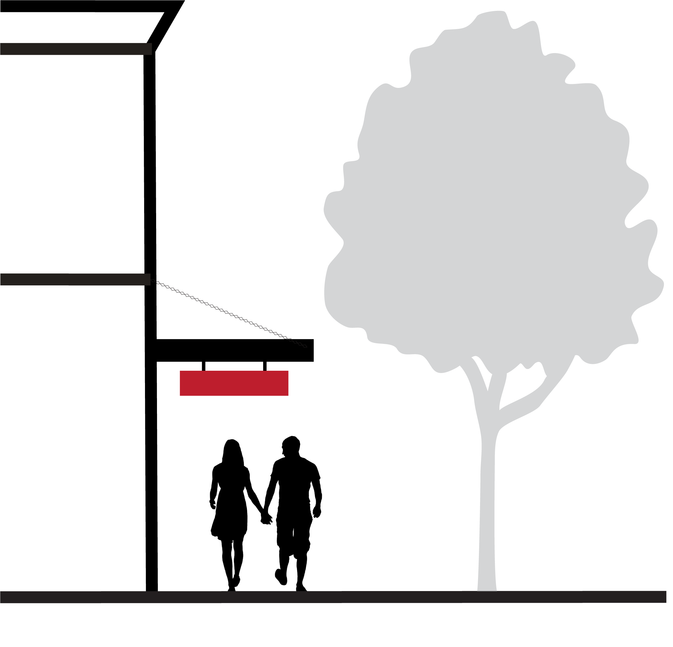 |
Area = 10 sq. ft. max.
Clearance = 7.5 ft. min. Maximum projection = 8 ft. Maximum width of sign = 6 ft. | |||
| Projecting signs | ||||
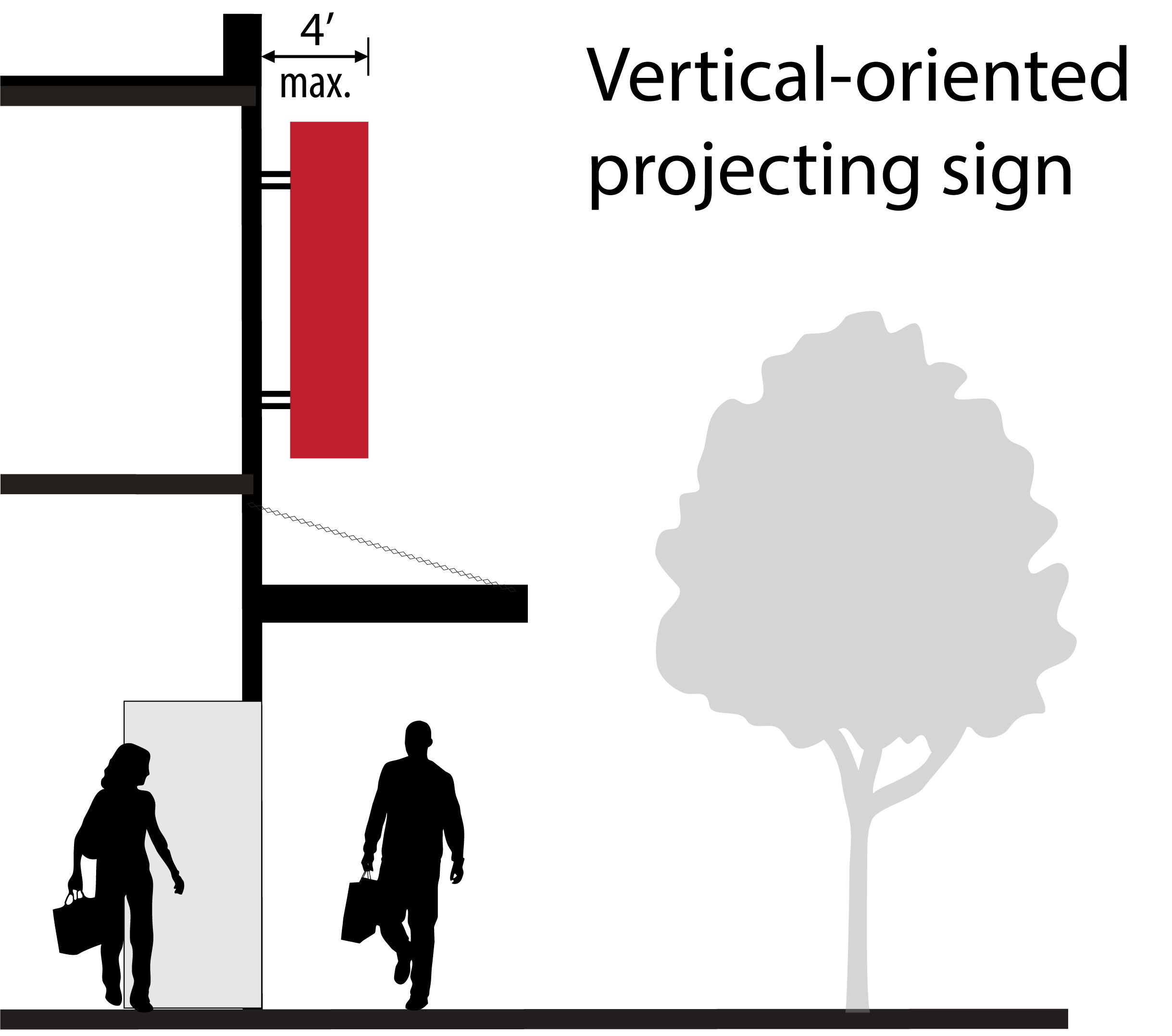 |
Area = 12 sq. ft. max.
Clearance = 7.5 ft. min. Maximum projection = 8 ft. | |||
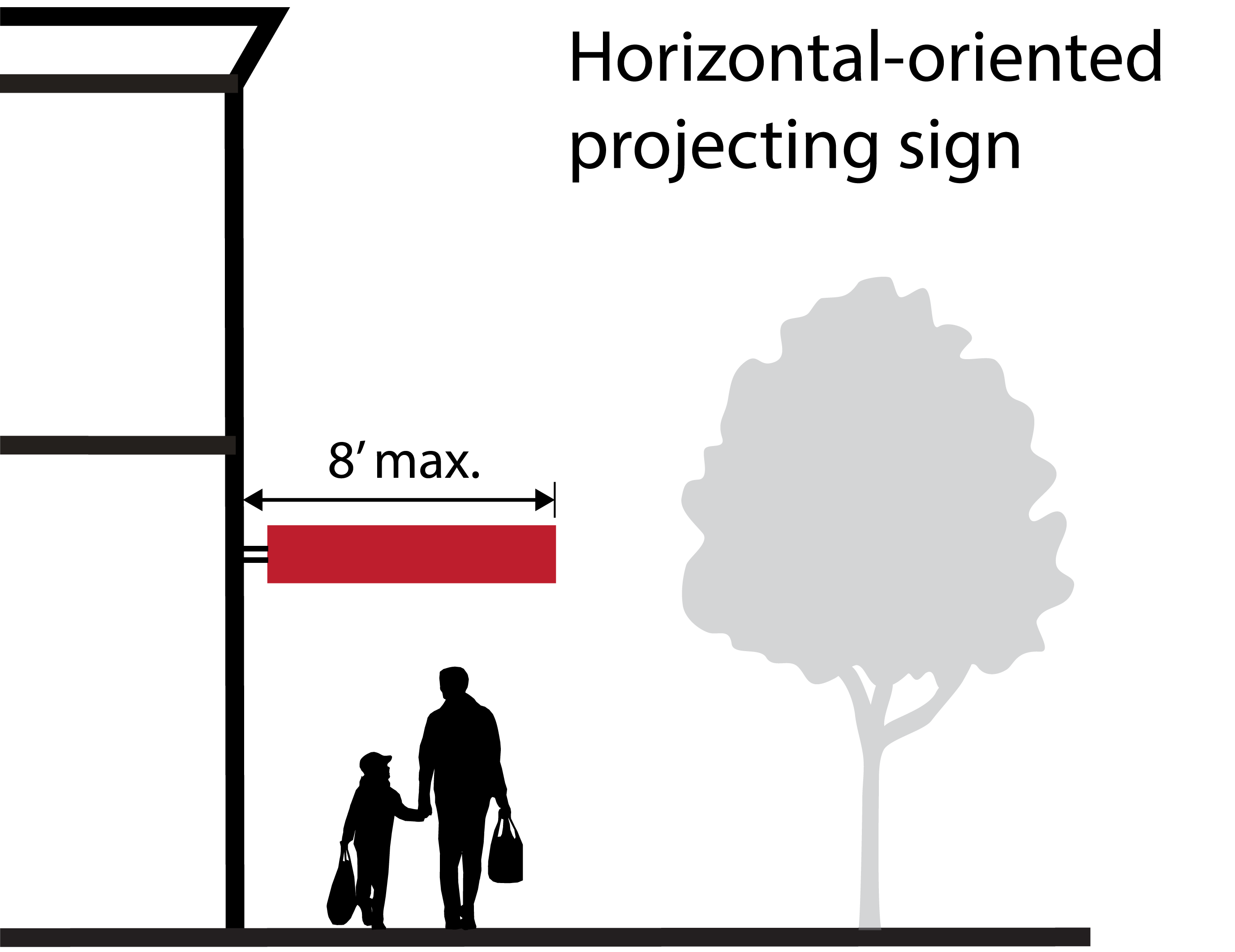 |
Maximum projection:
• Vertical-oriented = 4 ft. • Horizontal-oriented = 8 ft. | |||
4.
Portable signs.
a.
A-Frame signs standards shall be as shown in Table 17.06.560.C.4.
| TABLE 17.06.560.C.4 - A-FRAME SIGN STANDARDS | ||||||
| Sign type | 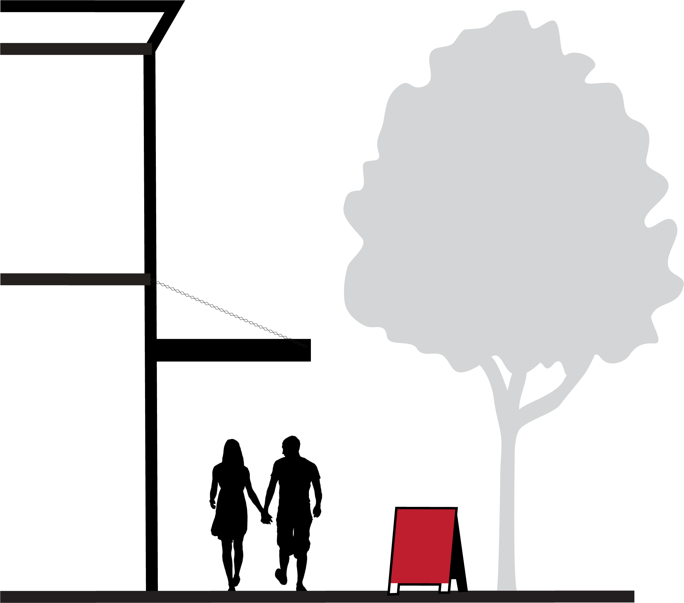 |  | ||||
| Zone Allowed | ||||||
| Display Hours | After the issuance of a Sign Permit, an A-frame Sign may be displayed only during the business hours of the permit holder. | |||||
| Maximum Dimensions |
• Area (per side): 12 sq. ft.; Height: 4 ft.; Width: 3 ft.
• Within the specified maximum dimensions, creative shapes that reflect the theme of the business are encouraged (i.e., ice cream shops may display a sign in the shape of an ice cream cone). | |||||
| Design |
• The sign must be constructed of materials that present a finished appearance (rough-cut
plywood is not acceptable).
• The sign lettering should be professionally painted or applied; a "yard sales" or "graffiti" look with hand painted or paint stenciled letters is not acceptable. • As a condition of a sign permit, any person erecting an A-frame sign shall indemnify and hold harmless the County and its officer, agents, and employees from any claim arising out of the placement of the sign on County property or rights-of-way. | |||||
| Placement |
• Minimum Distance between A-Frame signs: 10 ft.
• A maximum of one A-frame Sign may be placed per business or tenant on the property where the A-frame Sign is located. • Placement shall not interfere with vehicular traffic or cause a hazard; the sign shall not be placed in any median or within a utility or right-of-way easement. | |||||
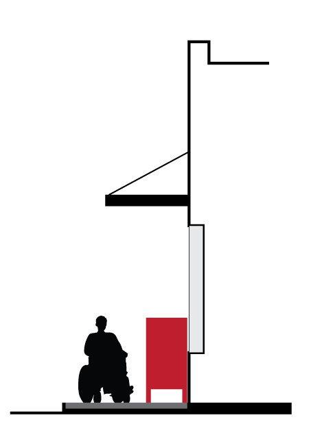 |
• Must be placed on a sidewalk or adjacent to a sidewalk.
• Must maintain an unobstructed pedestrian clearance of at least 4 feet in width at all times. • May be placed at edge of curb or at building face, but NOT in the middle of the sidewalk | 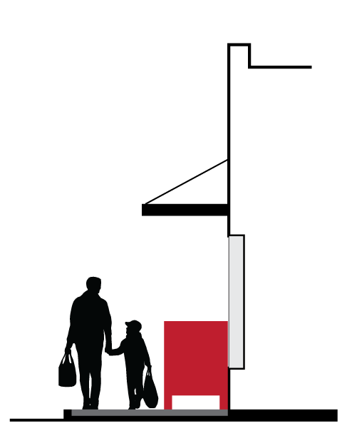 | 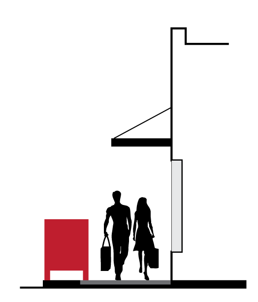 | |||
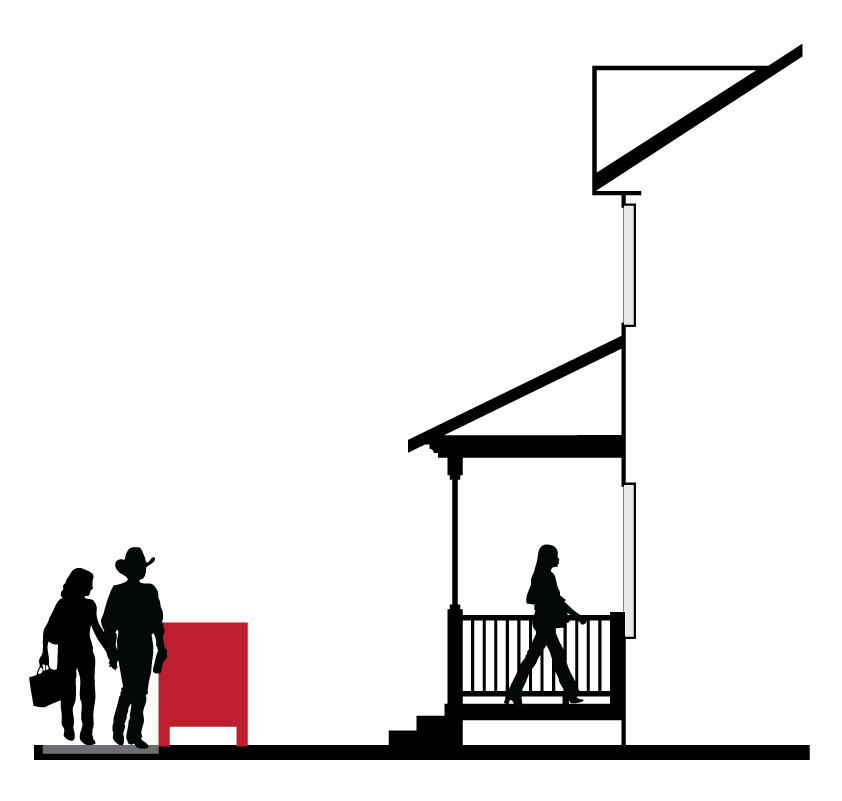 |
• For sidewalks with narrow widths, adjust sign dimensions to maintain 4-foot minimum
sidewalk clearance
• Where building is set back from the sidewalk, place sign immediately adjacent to sidewalk | 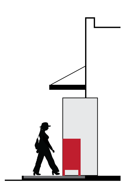 | 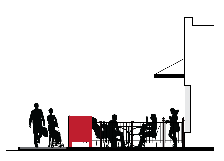 | |||
b.
Temporary signs. All temporary signs and standards not specified in this chapter are subject to applicable sign regulations contained in section 17.03.180.R.1.
5.
Externally illuminated signs.
a.
Upward-directed sign lighting is prohibited except for monument signs of equal to or less than five (5) feet in height, where the lighting is aimed directly at the sign with no spillover.
b.
External illumination for signs shall conform to the following standards:
(i)
Lighting fixtures shall be pointed downward and angled toward the sign;
(ii)
Lighting fixtures shall be shielded to prevent light pollution from projecting onto neighboring properties and roadways;
(iii)
Light projection shall be stationary;
(iv)
Light bulbs and tubes shall not be visible from adjacent properties or roadways; and
(v)
The intensity of lighting shall not exceed that necessary to illuminate and make sign content legible from the adjacent right-of-way.
6.
Design.
a.
Each sign structure, exclusive of the sign copy, shall be architecturally integrated with the building that houses the advertised activity; considering form, color, and building materials.
b.
Fluorescent colors and reflective surfaces in the background area of the sign are prohibited.
c.
Design alternatives. Signs that do not comply with the design and dimensional requirements set forth in this section may be approved at the sole discretion of the Planning Director if the applicant can demonstrate that the proposed sign represents a superior design for the sign and site in question. Any applicant proposing such a sign must receive a written determination from the Planning Director prior to submitting an application for any associated land use or building permit for such a sign.
D.
Prohibited sign types. In addition to the prohibited sign types listed in section 17.03.180.R.4, the following sign types are prohibited within the Freeland NMUGA.
1.
Pole signs.
2.
Billboards.
3.
Banners, streamers, strings of pennants, festoons of lights or balloons, clusters of flags, wind animated objects, searchlights, and similar devices except where permitted as temporary signs.
4.
Temporary signs located on or resting against a motor vehicle, trailer, bicycle, planter, or decorator card for the purpose of advertisement or directing people to the premises. Does not include permanent or temporary vehicle wraps, magnets, or similar signage that does not exceed the vehicle profile.
5.
Abandoned signs.
6.
Internally illuminated signs (including neon) visible to the public right-of-way and/or adjacent property.
(Ord. No. C-49-19 [PLG-004-19], Exh. C, 6-18-2019)
17.06.570 - Outdoor lighting.
A.
Purpose.
1.
To limit outdoor lighting to the minimum necessary for safety, security, utility, way-finding, enjoyment, and commerce.
2.
To minimize offsite impacts, such as light trespass (light and glare on adjacent properties), preserve the dark skies, protect natural habitats from the damage of artificial light, and provide a more pleasant and comfortable nighttime environment, without detracting from legitimate purposes of safety, security, utility, way-finding, and enjoyment.
3.
To encourage good lighting practices such that lighting systems are designed to conserve energy and money.
B.
Applicability.
1.
General. All outdoor artificial illuminating devices shall be installed in conformance with the provisions of this section.
a.
Outdoor light fixtures are defined as outdoor artificial illuminating devices, permanent or portable, used for illumination or advertisement. Such devices shall include, but are not limited to, search, spot, or flood lights for:
(i)
Building and structures;
(ii)
Parking lot lighting;
(iii)
Landscape lighting; and
(iv)
Recreational areas.
b.
The installation of site lighting, replacement of site lighting, and changes to existing light fixture wattage, type of fixture, mounting, or fixture location must be made in compliance with this section.
c.
All lighting shall be designed, located, installed and directed in such a manner to prevent objectionable light at and across property lines and to prevent glare at any location on or off the property.
d.
Lighting fixtures, excepting streetlights, shall not be placed within the sight distance triangle at driveways and intersections.
2.
Additions.
a.
When a building or site is renovated, any new or replaced outdoor light or lighting fixture must conform to the requirements of this section.
b.
When the gross improved site area is increased, the additional site area must conform to the lighting requirements of this section.
c.
When the gross improved site area is increased by more than fifty (50) percent or by 4,000 square feet or more, both the existing use and the additional site area must conform to the lighting requirements of this section.
3.
Change in use. A change in use unaccompanied by a remodel, addition, or other physical change to the property does not trigger application of this section.
4.
Repair and maintenance.
a.
Structural repair and maintenance resulting in the same size or shape of lighting fixture does not trigger application of this section.
b.
Routine maintenance, including changing the ballast, starter, photo control, fixture housing, lens and other required components, is allowed for all existing fixtures. When a light bulb replacement can bring the fixture into compliance with this section, when the bulb is replaced the new bulb shall comply with the standards of this section.
c.
When a fixture needs to be replaced, even if the replacement is a component of standard maintenance, the new fixture must comply with the standards of this section.
5.
Exemptions. These regulations are not applicable to public rights-of-way and the following uses:
a.
Indoor lighting provided no light projects directly out a window or other opening;
b.
Temporary lighting for theatrical, television, performance areas, and civic uses not to exceed a period of thirty (30) days;
c.
Holiday and seasonal decorative lighting fixtures;
d.
Underwater lighting in swimming pools and other water features;
e.
Lighting that is only used under emergency conditions;
f.
Low voltage landscape lighting controlled by an automatic device that is set to turn the lights off at one (1) hour after the site is closed to the public;
g.
Construction or emergency lighting provided such lighting is temporary and is discontinued immediately upon completion of the construction work or abatement of the emergency necessitating said lighting;
h.
Lighting for public monuments and statuary or public art installations;
i.
Lighting fixtures required by federal, state, or county agencies to meet safety standards;
j.
Projection equipment for outdoor movie theaters and outdoor movie events;
k.
Street lights for public rights-of-way and traffic control signals and devices; and
l.
Normal low intensity residential lighting fixtures that are attached to a dwelling unit, detached ADU or accessory building. For purposes of interpreting this exemption, normal low intensity residential lighting fixtures are typically shielded, do not include flood lamps and/or lighting fixtures intended to illuminate large areas, and do not include lighting fixtures which project a focused light onto neighboring properties and roads (whether public or private).
C.
Lamp types.
1.
Lamps shall be of a white or yellow/amber light source with a color-rendering index (CRI) greater than or equal to seventy (70) and a Kelvin rating below 4500K for commercial, and 3500K for residential.
a.
Where LED lighting is utilized, it shall be a warm-white or yellow LED (NBA LED, PCA LED, or true amber LED) or utilize a lens over the LED that eliminates all light energy below 480 nm. Utilize LED dimming technologies to dim or turn off lights when activity or traffic levels justify it.
b.
Where LED lighting is utilized in ecologically sensitive areas, True Amber LEDs are required. If amber lighting is not acceptable or available, the Planning Director may approve a design alternative with 2,200 K CCT warm-white LED solution.
2.
Outdoor lighting shall utilize energy-efficient fixtures/lamps and fixtures that minimize potential negative ecological impact.
3.
Lighting shall be consistent with the style of the building. All lighting fixtures shall be appropriate in scale, intensity and height to the use they are serving.
4.
Service connections for all freestanding lighting fixtures must be installed underground.
5.
Prohibited sources. The following light fixtures and sources cannot be used:
a.
Cobra-head-type fixtures;
b.
Temporary searchlights, laser lights, strobe lights, and other similar high-intensity narrow-beam fixtures or other outdoor lighting that flashes, blinks, alternates, or moves;
c.
Light sources that lack color correction or do not allow for uniform site lighting;
d.
Lighting fixture that projects directly onto neighboring properties, rights-of-way, waterways, critical areas, or the night sky, including indoor lighting that projects directly out a window or other opening and/or fixture placement/aim that allows the light element to be visible on neighboring properties; and
e.
Low pressure sodium and mercury vapor light sources.
D.
Light level measuring.
1.
Light levels are specified, calculated and measured in footcandles, lumens, or Kelvin unless otherwise specified. All footcandle values are maintained footcandles.
2.
Measurements are to be made at ground level, unless otherwise specified in this section, with the light-registering portion of the meter held parallel to the ground pointing up.
3.
Maximum light levels.
(i)
Lighting must be oriented to the interior of the property and not onto adjacent properties, streets or sidewalks.
(ii)
The average illumination level shall not exceed 1.5 footcandles for the illuminated non-residential areas and .55 footcandles for residential areas.
(iii)
The maximum light level of any light fixture cannot exceed 1.0 footcandles measured at the property line.
(iv)
Where adjacent to Low Density or Medium Density zoning districts, the maximum light level of any light fixture cannot exceed 0.5 footcandles measured at that property line.
(v)
The maximum light level shall not exceed 0.2 footcandles as a direct result of the on-site lighting measured five (5) feet beyond the property line.
(vi)
Exterior lighting installations shall be designed to avoid harsh contrasts in lighting levels.
E.
Fixtures and shielding.
1.
All site perimeter lighting located within fifty (50) feet of a single family residential property line, excluding bollards or other light fixtures of less than six (6) feet in height, shall possess house-side shielding.
2.
All light fixtures must be cutoff or full cutoff per Table 17.06.570.E.2(1), except as listed in paragraph (4) below.
| FIGURE 17.06.570.E.2(2) - CUTOFF CLASSIFICATIONS | |
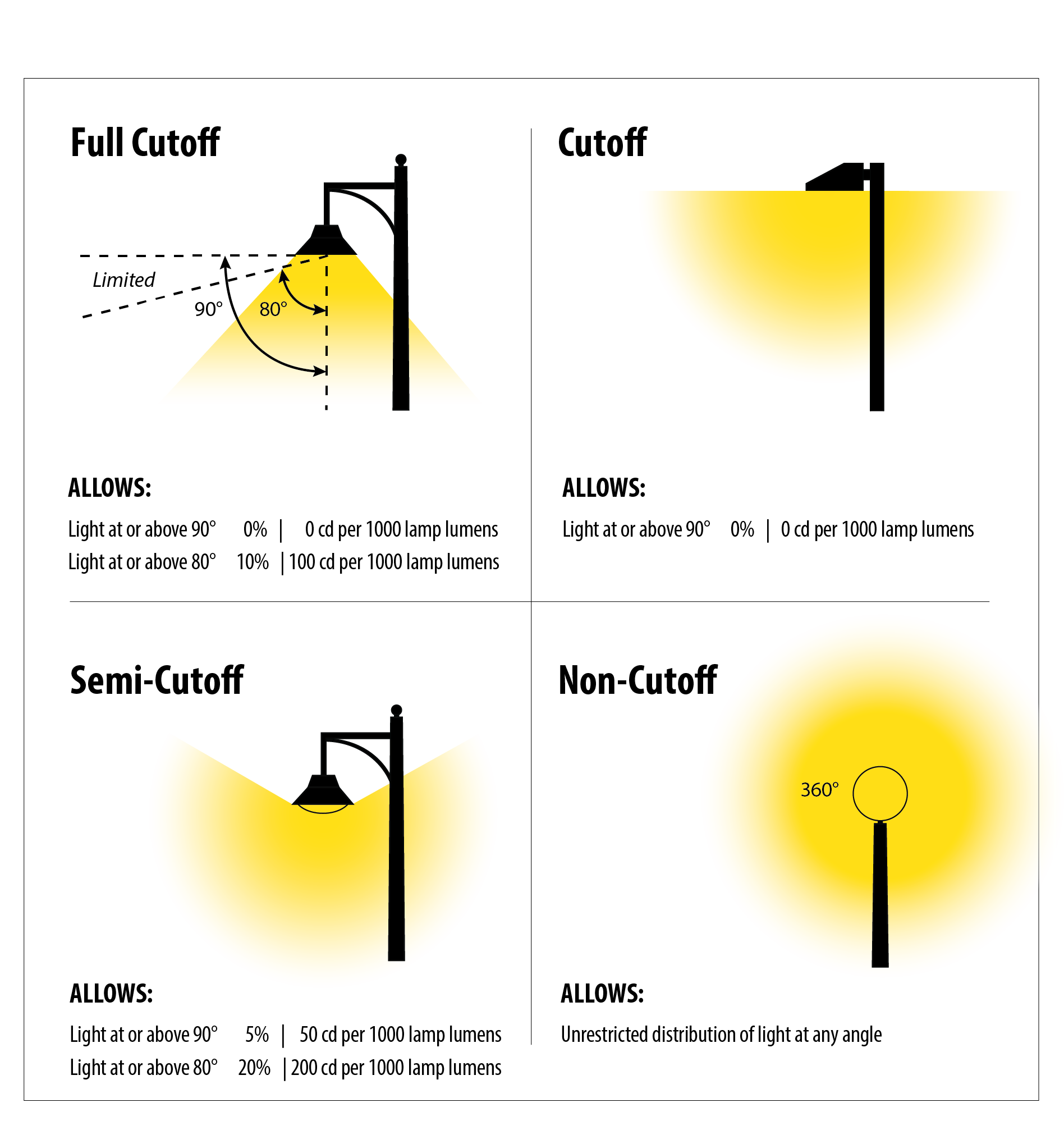 |
| FIGURE 17.06.570.E.2(3) - EXAMPLES OF CUTOFF AND FULL CUTOFF LIGHT FIXTURES |
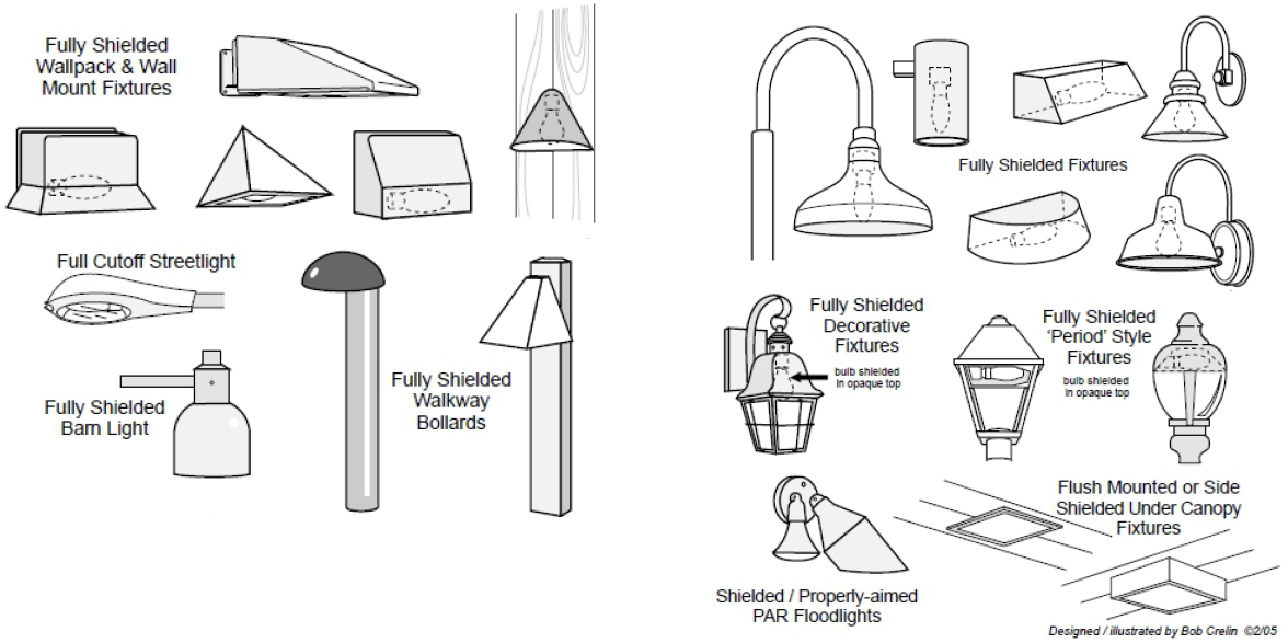 |
3.
Special care must be taken in selecting fixtures for buildings on hillsides, as even meeting the "horizontal angle" requirement is not sufficient to protect owners of properties lower than the hillside site. Non-clear glass and lamps with the lowest wattage or mean lumens possible help prevent light trespass.
4.
Semi-cutoff or non-cutoff fixtures (partially shielded or unshielded fixtures).
a.
Semi-cutoff fixtures can be used in pedestrian-oriented spaces, parking lots, and rights-of-way when the maximum initial lumens generated by each fixture is less than 3,000 initial lamp lumens and the light measurements comply with section 17.06.570.D.3.
b.
These fixtures generally feature vertical glass planes and must be coated with an internal white frosting to diffuse light. Globe-style fixtures shall not be allowed.
c.
Remodels, maintenance, and repairs subject to this section per section 17.06.570.B shall include the removal of non-cutoff fixtures regardless of location.
5.
Light trespass and glare onto neighboring Low Density or Medium Density zoned properties shall be minimized through shielding of the light fixtures, use of frosted bulbs, peripheral landscaping or fencing, building placement, or another effective method or combination of methods. Landscaping based screening must account for winter conditions of plant materials (year-round screening provided).
6.
Lighting of critical areas and buffers shall not be permitted. Light trespass and glare onto waterways and critical areas shall be minimized through shielding of the light fixtures, use of frosted bulbs, peripheral landscaping or fencing, or another effective method. Limited pathway safety lighting for trails through critical areas and buffers are allowed, subject to section 17.06.570.H.7.
7.
Vegetation and landscaping shall be maintained in a manner that does not obstruct lighting. For the purposes of this section, lighting obstruction is anything that limits the lighting purpose (i.e. lighting obstructed by vegetation growing up and around a fixture so that light does not reach the intended surface); it does not include living screen vegetation installed with the intension of screening light from neighboring properties.
8.
Illumination of landscaping shall utilize diffused or muted lighting, avoid glare, and minimize light trespass beyond landscaping onto neighboring properties, streets, or the night sky.
9.
Fixtures and lighting systems shall be maintained in good working order.
F.
Maximum fixture height.
| TABLE 17.06.570.F. - MAXIMUM FIXTURE HEIGHT | |
| Fixtures placed 50 feet or more from a Low Density or Medium Density district | |
|
25 feet max. pole height
OR height of the nearest building at its tallest point, whichever is less | 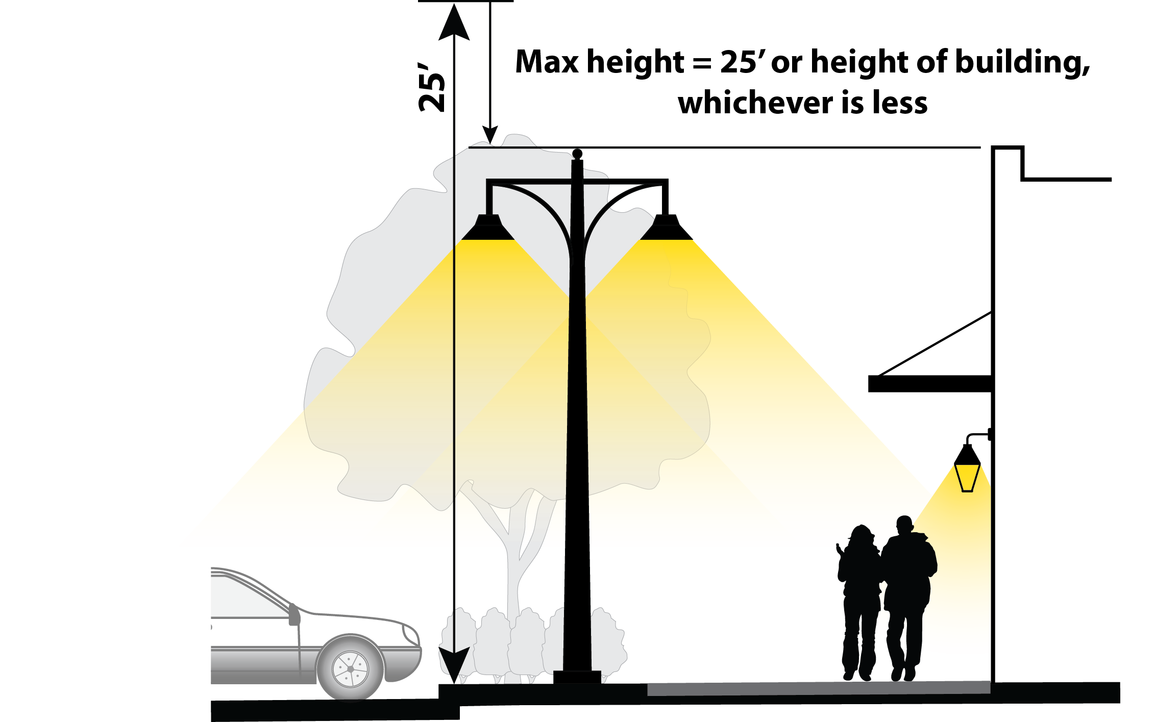 |
| 15 feet max. pole height in Semi-cutoff or non-cutoff |
>
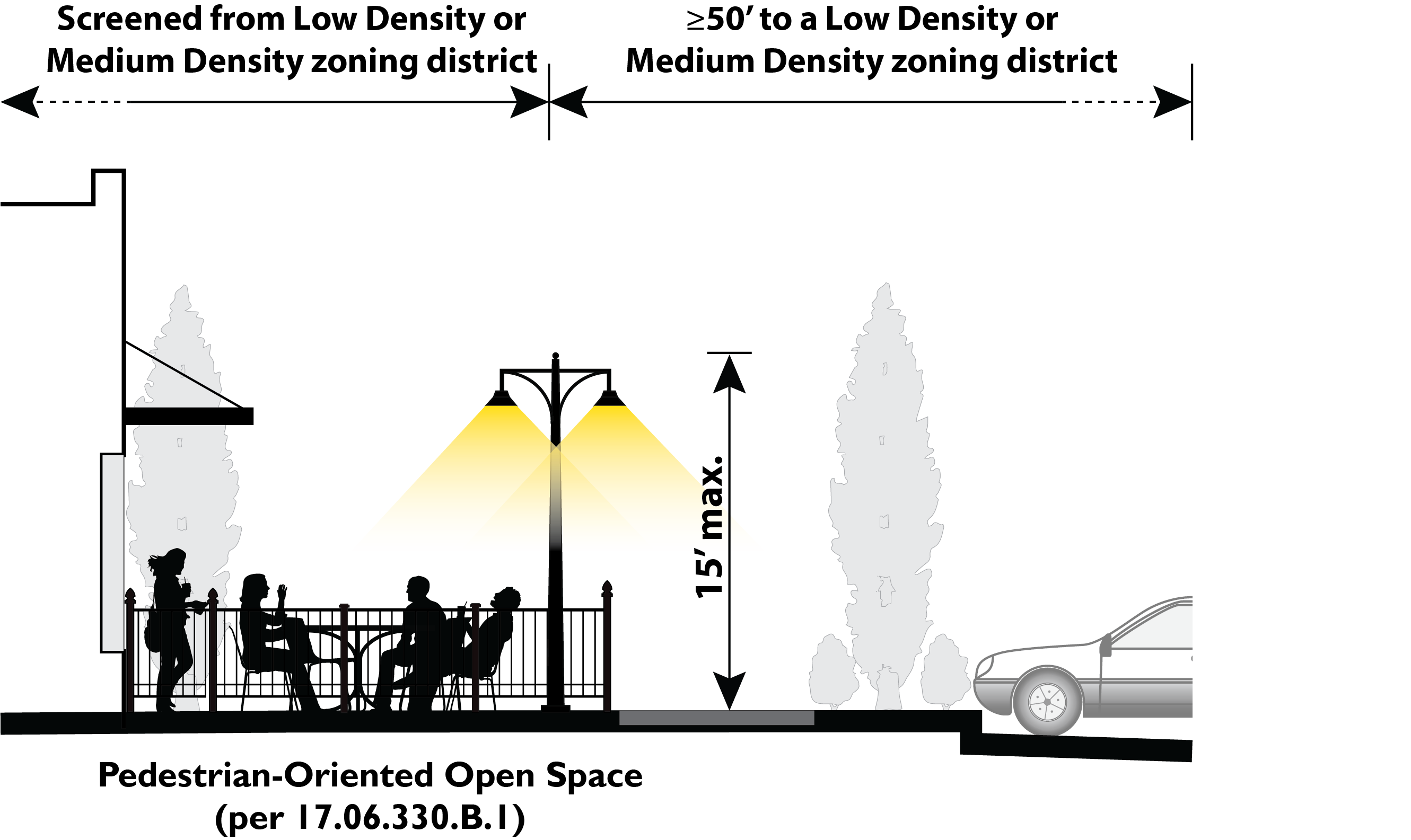 |
| Fixtures placed within 50 feet of, or inside the boundaries of, a Low Density or Medium Density zoning district | |
|
12 feet max. pole height for all lighting fixtures except in parking area (as shown
below)
Must be screened as per ICC 17.06.570.E Also applies to fixtures in pedestrian-oriented open space |
>
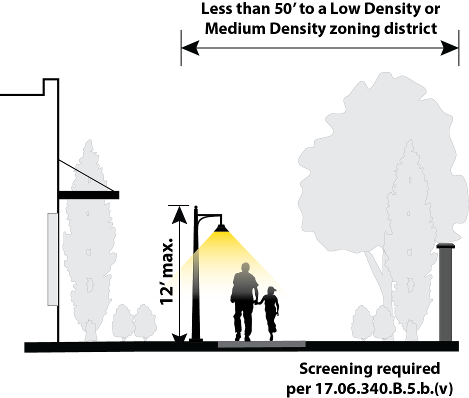 |
|
15 feet max. pole height in Parking Areas for Multi-Family and/or Mixed-Use
Must be screened as per ICC 17.06.570.E |
>
 |
G.
Hours of lighting.
1.
Except as otherwise stated in this section, all exterior lighting shall be required to be turned off or to be reduced by fifty (50) percent within one (1) hour after close of business, 10:00 p.m., or sunset, whichever is later, leaving only the lighting that is essential for site and building security (section 17.06.570.H.7).
a.
For purposes of this section, non-essential lighting shall include display lighting, aesthetic and sign lighting, lighting of landscape and architectural features, and may include parking lot lighting.
b.
Multi-family housing is only required to reduce the lighting located at common areas such as clubhouses, pool areas and playgrounds.
2.
To reduce overall energy consumption and eliminate unneeded lighting, exterior lighting installations shall include timers, dimmers, sensors, and/or photocell controllers that turn the lights off during daylight hours.
3.
Non-full-cutoff and non-fully shielded lights greater than seventy (70) watts that were installed prior to the adoption of the chapter are considered to be nonconforming, and shall possess an automatic control device that turns the lights off between sunset and sunrise.
H.
Specific standards by lighting type.
1.
Building lighting.
a.
Exterior building lighting should be used to accentuate the building design and pedestrian-oriented features. Highlight architectural details and features with lighting integrated into the building design. Lighting fixtures must be selected, located, aimed, and shielded so that direct illumination is focused exclusively on the building façade, plantings, and other intended site features.
b.
Lighting used to accent architectural features, materials, colors, style of buildings, or art shall be located, aimed, and/or shielded so that light is directed only on those features.
(i)
Lighting fixtures used to accent architectural features, materials, colors, style of buildings, or art shall not generate excessive light levels, cause glare, or direct light beyond the façade onto neighboring properties, streets or the night sky.
(ii)
The maximum illumination of any vertical surface or angular roof surface shall not exceed five (5) footcandles.
2.
Canopy lighting. Lighting fixtures mounted on canopies shall be installed such that the bottom of the light fixture or its lens, whichever is lower, is recessed or mounted flush with the bottom surface of the canopy and parallel to the ground. A full cutoff light fixture may project below the underside of a canopy. All light emitted by an under canopy fixture shall be substantially confined to the ground surface beneath the perimeter of the canopy. No lighting except that permitted by section 17.06.560.C.5.b shall be permitted on the top or sides of a canopy.
a.
Lighting under canopies shall be less than twenty (20) maintained footcandles, conform to Illuminating Engineering Society of North America (IESNA) recommended practices, and designed to prevent glare off-site. Acceptable lighting designs include the following.
| (i) | Recessed fixture incorporating a lens cover that is either recessed or flush with the bottom surface of the canopy; | 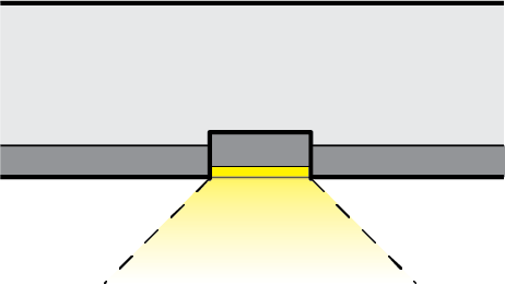 |
| (ii) | Light fixture incorporating shields, or is shielded by the edge of the canopy itself, so that light is restrained to 10 degrees or more below the horizontal plane; | 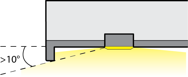 |
| (iii) | Surface mounted fixture incorporating a flat glass that provides a full cutoff design or fully shielded light distribution; or | 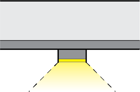 |
| (iv) | Indirect lighting where light is beamed upward and then reflected down from the underside of the canopy, provided the fixture is shielded so that direct illumination is focused exclusively on the underside of the canopy. | 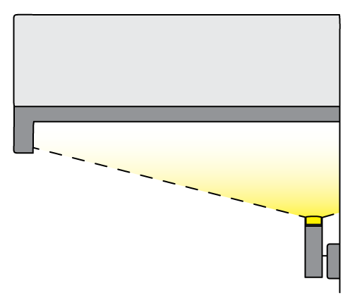 |
b.
Lights shall not be mounted on the top or sides of the canopy. The sides shall not be illuminated in any manner.
c.
Individual fixture lamp wattage shall not exceed 250 watts.
d.
The sides (fascia) of the canopy shall extend below the lens of the fixture(s) a minimum of twelve (12) inches to block the direct view of the light sources and lenses from property line.
3.
Flag pole lighting. A flagpole may be illuminated by one (1) fully shielded fixture at the top of the pole, aimed downward, and shall not exceed 3,000 lumens (150 watts).
4.
Flood lights and flood lamps. All flood lamps must shielded so that the main beam is not visible from adjacent properties or the street right-of-way.
5.
Outdoor performance, sport, and recreation facilities.
a.
Lighting levels and pole heights for outdoor performance, sports, and recreation facilities shall not exceed the IESNA published minimum standards for the proposed activity.
b.
Where playing fields or other special activity areas are to be illuminated, lighting fixtures shall be specified, mounted, aimed, and fully-cutoff fixtures where the beams fall within the primary playing area and immediate surroundings and no direct illumination is directed off the site.
c.
The main lighting shall be turned off as soon as possible following the end of the event. The main lighting shall not remain on longer than thirty (30) minutes following the end of the event. Where feasible, a low level lighting system shall be used to facilitate patrons leaving the facility, cleanup, nighttime maintenance and other closing activities. The low level lighting system shall provide a horizontal illumination level at grade of no more than four (4) footcandles.
6.
Parking and pedestrian areas.
a.
Table 17.06.570.H.6 establishes open-air parking lot lighting standards:
b.
Parking lot lighting shall be designed to provide for uniform lighting throughout the facility with no dark patches or pockets.
c.
All sidewalks and other pedestrian walkways shall have appropriate lighting.
7.
Security lighting.
(i)
Lighting that operates dusk-to-dawn in order to provide for protection of property and safety for individuals shall conform to the following:
(1)
Shall use the lowest possible illumination to effectively allow surveillance and not to exceed 0.5 footcandles;
(2)
Light shall be shielded and aimed so that illumination is directed to the designated areas; and
(3)
Shall generate less than fifty (50) percent of the lighting power density or lumen density utilized by the facility/site during normal business hours.
(ii)
Use of motion sensing devices for security lighting is encouraged.
I.
Design alternatives.
1.
The provisions of this section are not intended to prevent the use of any material or method of installation not specifically mentioned by this section. As new lighting technology develops which is useful in reducing light above the horizontal, consideration shall be given to use of state of the art technology in keeping with the intent of this section.
2.
The Planning Director may permit the use of designs, materials, methods of installation or operation as alternative to those otherwise required by this section upon proof that the alternative meets the standards set by the IESNA for outdoor lighting OR a written certification by a qualified lighting professional stating that the alternative meets or exceeds the standards set forth in this section and furthers its purpose and intent.
3.
The Planning Director may allow a design alternative for security lighting with a higher foot-candle maximum if there is a heightened need for security and surveillance for the site based on use type or if there is a history of security issues for that site. Such a design alternative may not exceed the maximum lighting levels in section 17.06.570.D.3.
J.
Lighting plan submission requirements.
1.
A lighting plan shall be required for projects as follows:
a.
When an exterior lighting installation is part of a new development proposal requiring site plan review, a conditional use permit, or other multi-family, commercial, or mixed-use development application that requires outside lighting;
b.
For projects undergoing redevelopment, expansion, or remodel when the redevelopment requires site plan approval, or for tenant improvements or other minor building improvements when exterior lighting is proposed to be installed or modified; and
c.
Subdivisions or individual dwelling units common areas. Examples of common areas include, but are not limited to, pathways, clubhouses, parking lots, and play areas.
2.
If only architectural lighting below five (5) footcandles is proposed, the exterior lighting plan submission requirements of this section, or any portion thereof, may be waived by the Planning Director.
3.
The exterior lighting plan shall include, at a minimum, the following information:
a.
The exterior lighting plan shall include the proposed location, mounting height, and type of light fixtures, and aiming point of all exterior lighting fixtures, both building and ground mounted lighting, as well as the illuminance levels shown on a ten-foot maximum grid;
(i)
If building elevations are proposed to be illuminated, drawings shall be provided for all relevant building elevations showing the fixtures, the portions of the elevations to be illuminated, the luminance levels of the elevations, and the aiming point for any remote light fixture; and
(ii)
For exterior lighting installations within fifty (50) feet of upper level living units, horizontal and vertical projection of photometric data is required.
b.
Certification that the angle of total light cutoff is no more than ninety (90) degrees in the form of Photometric data supplied by the manufacturer or a letter from a certified lighting professional stating that the proposed lighting meets the regulations of this section;
c.
Descriptions of light fixtures, including lamps, poles, or other supports and shielding devices (may be provided as catalogue cut sheets from the manufacturer);
d.
Color Rendering Index (CRI) and Kelvin Scale rating of all lamps (bulbs); and
e.
Additional information as may be required by the Planning Director in order to determine compliance with this section, including but not limited to information that indicates mature tree size.
f.
Shrubbery and other vegetation type and placement in order to evaluate the long-term and seasonal effectiveness of lighting or screening of lighting.
(Ord. No. C-49-19 [PLG-004-19], Exh. C, 6-18-2019; Ord. No. C-18-22 [PLG-002-21], Exh. A, 5-3-2022)
17.06.600 - BUILDING DESIGN STANDARDS
A.
Purpose.
1.
Promote and accomplish the goals, policies, and objectives of the Freeland Subarea Plan.
2.
Preserve and protect the public health, safety, and welfare of the citizens of Freeland.
3.
Provide clear objectives for those embarking on the planning and design of commercial and multi-family development projects in Freeland.
4.
Provide standards that support the creation of a safe, walkable community.
5.
Enhance the character of Freeland's village center and other commercial and multi-family areas.
6.
Increase awareness of design considerations among the citizens of Freeland.
7.
Maintain and enhance property values within Freeland.
B.
Applicability and compliance.
1.
The standards for the following apply to all non-residential, mixed-use, and multi-family development in Freeland unless otherwise noted:
a.
Horizontal building articulation in section 17.06.610;
b.
Vertical building modulation in section 17.06.620;
c.
Roofline modulation in section 17.06.630;
d.
Building elements and details in section 17.06.640;
e.
Building materials in section 17.06.650; and
f.
Blank wall treatment in section 17.06.660.
2.
The standards for the following apply to all single family residential development in Freeland, unless otherwise noted:
a.
Porch encroachment standards in section 17.06.670;
b.
Garage standards in section 17.06.550.I; and
c.
Driveway standards in section 17.06.550.H.3.
3.
Multi-family and mixed-use residential that offer individual garages shall comply with the garage standards in section 17.06.550.I and driveway standards in section 17.06.550.H.3.
C.
Design alternatives. Design alternatives will be considered provided the alternative meets the purpose of the building design standards in this section. Criteria to consider includes the level of detailing, quality of building materials, design of storefronts, integration with or enhancement of the surrounding context (considering views from all publicly observable locations within the area and/or views of Holmes Harbor from Hwy 525), and pedestrian scale and walkability.
For example, if the proposed building features attractive detailing and materials, interesting roofline treatments, and interesting design that helps the building fit into the site's context, building placement on the site protects water views from Hwy 525, and design features are at a scale and quality that contributes to the pedestrian environment and existing/desired character, then a design alternative may be approved.
(Ord. No. C-49-19 [PLG-004-19], Exh. C, 6-18-2019)
17.06.610 - Horizontal building façade articulation.
A.
Purpose. Horizontal building façade articulation is required for all non-residential, mixed-use, and multi-family buildings to create a street that welcomes and supports pedestrian activity by providing visual interest and a sense of security and community identity. Façade articulation shall be accomplished through a change of design elements (façade treatment).
B.
The general standards for horizontal building façade articulation shall be as shown in Table 17.60.610.B.
| TABLE 17.60.610.B HORIZONTAL BUILDING FAÇADE ARTICULATION GENERAL STANDARDS | ||||
|---|---|---|---|---|
| Storefronts | Other Non-Residential or Mixed-Use buildings | Multi-Family and residential portions of Mixed- Use buildings | ||
When Applicable | Façades greater than 60 ft. in length | Façades that contains a customer building entrance that faces a street or internal pedestrian pathway along a façade per ICC 17.06.550.I (alley façades are exempt) | Façades that face a street, access road, common open space, and common parking areas (alley façades are exempt). | |
Articulation interval (frequency) | 30 linear feet max | 40 linear feet max | 30 linear feet max | |
| Examples: | ||||
Storefront: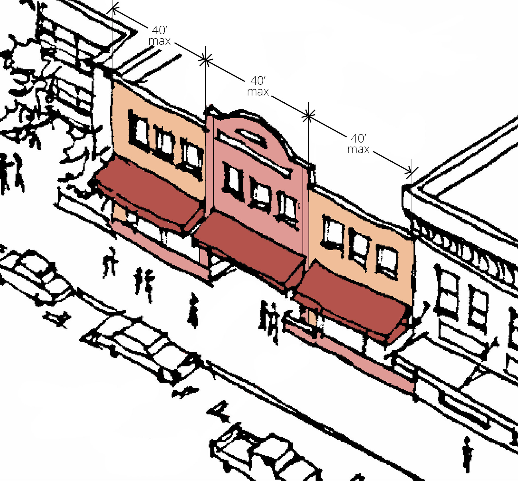 | Multi-family: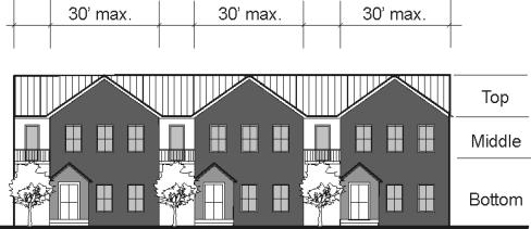 | |||
C.
The design standards of required façade articulation shall be per Table 17.60.610.C.
(Ord. No. C-49-19 [PLG-004-19], Exh. C, 6-18-2019)
17.06.620 - Vertical building modulation.
A.
Purpose. For most buildings, horizontal building façade articulation techniques (see section 17.06.610) are sufficient to reduce the perceived scale of buildings, maintain the rural village character of the NMUGA, add visual interest, and contribute to the pedestrian environment. Larger buildings, however, need more substantial modulation features to break up the massing.
Vertical building modulation that breaks up the bulk of the structure, within specified intervals, is required for all non-residential, mixed-use, and multi-family buildings façades wider than 120 feet and all above ground parking structures. Vertical building modulations are typically accomplished through recess or projection of vertical walls of a building (change of building depth) - a structural change to the building form.
B.
Maximum façade width.
1.
The maximum façade width is 120 linear feet for building façades along a street frontage, facing a customer parking lot, and/or where facing (and visible from) Hwy 525.
| FIGURE 17.06.620.B.1. - MAXIMUM FAÇADE WIDTH STANDARDS |
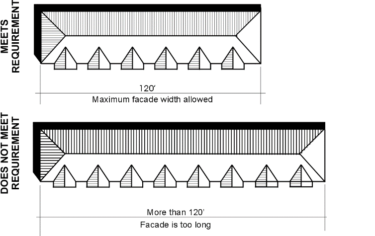 |
2.
Exception. Buildings in the Light Industrial zoning district are exempt from this maximum façade width standard.
C.
Vertical building modulation standards.
1.
Buildings exceeding 120 feet in width shall incorporate significant modulation features that effectively break up the apparent bulk and scale of the building and add visual interest from the street. Such buildings shall incorporate at least one (1) of the three (3) following modulations options. Regardless of the option utilized, both of the following standards apply (except where otherwise stated in section 17.06.550.E.4):
a.
No individual façade section shall exceed 120 linear feet; and
b.
The total combined façade length shall not exceed 200 feet.
2.
Option A. Provide horizontal façade articulation and/or modulation design elements to the extent that makes it appear like it is two (2) or more distinct buildings. In order to qualify for this option, each contrasting section of façade must utilize:
a.
Different building materials, colors, and/or configuration of building materials; and
b.
Different window design (sizes or configurations); and/or
c.
A different roofline modulation treatment.
| FIGURE 17.06.620.C.2. - EXAMPLE OF MODULATION OPTION A | |
| This example shows how a design alternative with both façade articulation and modulation elements can combine to create the appearance of multiple buildings with different materials, windows, and rooflines. | 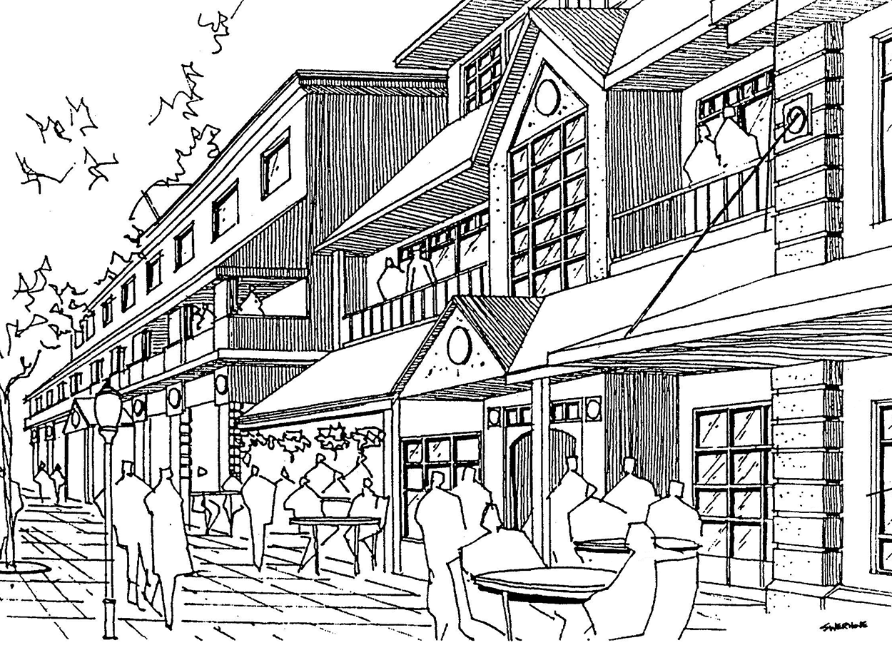 |
3.
Option B. Provide a vertical building modulation at least ten (10) feet deep and twenty (20) feet wide utilizing at least two (2) of the following features.
a.
Modulation extends through all floors fronting on the street; and
b.
Modulation utilizes a change in building materials that effectively contrasts from the rest of the facade and/or
c.
Building modulation includes a coinciding roofline modulation per section 17.06.630.
| FIGURE 17.06.620.C.3. - EXAMPLES OF MODULATION OPTION B | |
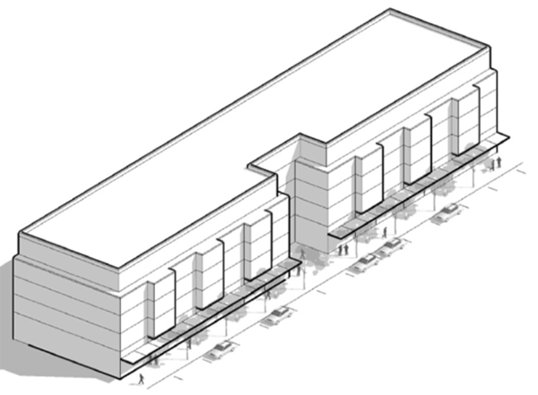 | 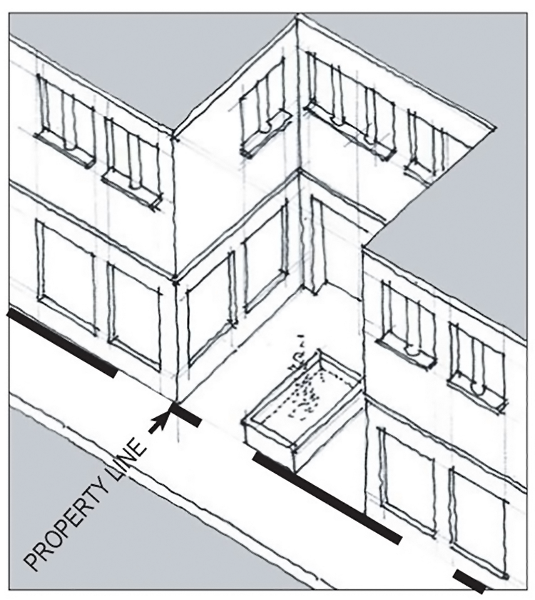 |
| The building on the left exceeds 120 feet in width but is divided by a 20-foot wide modulation of the exterior wall, so that the maximum length of any particular façade sections is 120 feet or less. The example on the right shows a close up view of how a forecourt can be utilized to meet this modulation requirement. In these examples, the modulations extend through all floors of the buildings. | |
4.
Option C. Provide vertical building modulation at least twenty (20) feet deep and thirty (30) feet wide, through either a step back or building projection.
a.
For multi-story buildings the modulation must extend through more than one-half (½) of the building floors; where an odd number of floors, round up to calculate the number of floors subject to the modulation requirement. Where not extending through all floors, modulation must be an upper story step back (not the lower stories or alternating). For example, a three-story building must have a modulation for two (2) stories (one-half (½) is equal to one and one-half (1½) stories, rounded up to two (2) stories) - if modulation does not extend to all floors, it must be to the 2nd and 3rd stories (not 1st and 2nd or 1st and 3rd), as shown in Figure 17.06.620.C.2.
b.
Upper story step backs may be used as a balcony or green roof provided that any safety railing visible from the sidewalk (at a height of six (6) feet above the surface of the sidewalk) shall have a transparency of ninety (90) percent or greater (i.e. glass, etc.) and shall not exceed a height of forty-eight (48) inches.
| FIGURE 17.06.620.C.4 - EXAMPLE OF MODULATION OPTION C | |
|
This building in this example exceeds 120 feet in width along the street front, but
has a building modulation in multiple forms to break up the massing of the structure.
The projection that runs through the entire structure along the front except that the 2nd and 3rd floor is recessed in the center of the projection. Each section (projection and recess) must meet the modulation width minimum standards. | 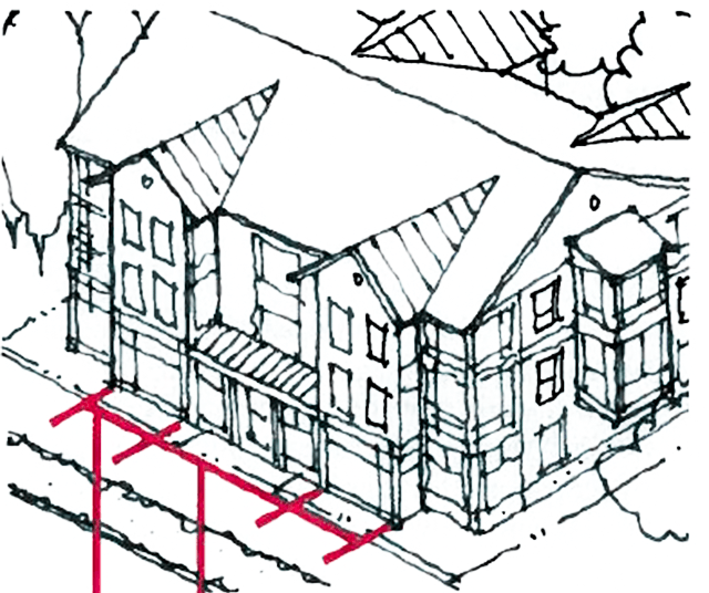 |
(Ord. No. C-49-19 [PLG-004-19], Exh. C, 6-18-2019)
17.06.630 - Roofline modulation.
A.
Purpose. A well-modulated roofline can break up a long façade, improving pedestrian experience and leading the eye down the street and ensure pedestrian scale design.
B.
In order to qualify as a roofline modulation treatment, rooflines must be varied by utilization of dormers, chimneys, stepped roofs, gables, or a broken or articulated roofline. Roofline modulation may include a combination of the flat and pitched roof modulations.
| FIGURE 17.06.630 - EXAMPLE OF ROOFLINE MODULATION |
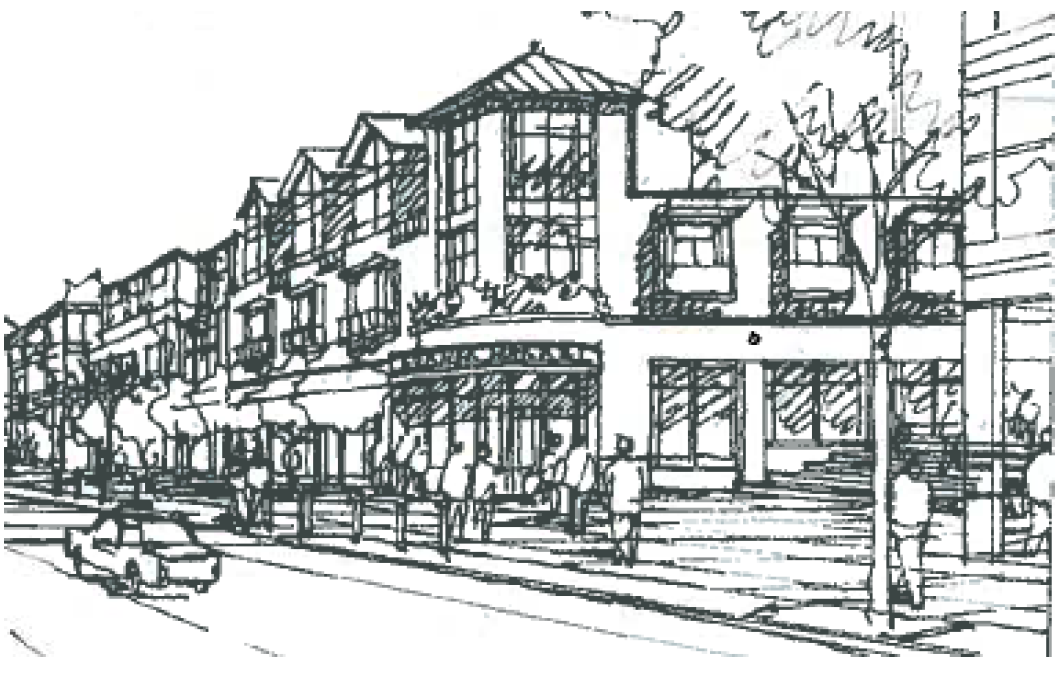 |
(Ord. No. C-49-19 [PLG-004-19], Exh. C, 6-18-2019)
17.06.640 - Building elements and details.
A.
Purpose.
1.
To incorporate design details and small-scale elements into non-residential, mixed-use, and multi-family building façades that are attractive at a pedestrian scale to create a pedestrian-friendly environment.
2.
Ensuring community longevity by designing projects and neighborhoods that will endure over time.
B.
Applicability. All non-residential, mixed-use, and multi-family buildings shall comply with the building elements and details standards herein unless otherwise noted. The design of a facility that occupies a pad or portion of a building within a larger commercial center shall be designed to reflect the design elements of that center.
C.
Façade details toolbox.
1.
All new buildings and improvements (additions or remodels) that are greater than fifty (50) percent of the building floor area or more than 4,000 square feet must employ at least one (1) detail element from each of the three (3) categories below for each façade facing a street, featuring a customer entry, or featuring the primary residential entry. For multi-tenant buildings, details shall be provided for each tenant (or consistent with façade articulation design).
a.
Window and/or entry treatment.
(i)
Storefront display windows divided into a grid of multiple panes;
(ii)
Transom windows;
(iii)
Roll-up windows/doors;
(iv)
Recessed storefront entry;
(v)
Decorative door;
(vi)
Landscaped trellises or other decorative element that incorporates landscaping near the building entry;
(vii)
Pedestrian-scale entry as a prominent feature of the façade elevation;
(viii)
Porch for individual unit entryways facing the street;
(ix)
For residential units with an entryway from the street, doors vary from unit to unit to distinguish the individual identity of each residence;
(x)
Entry portico; or
(xi)
Building modulation that incorporates and emphasizes the primary entrance.
b.
Building elements and façade details.
(i)
Custom-designed weather protection element such as a steel canopy, cloth awning, or retractable awning;
(ii)
Decorative building-mounted light fixtures;
(iii)
Bay windows, trellises, dormers, balconies, cupolas, towers, and similar elements;
(iv)
Decorative moldings, brackets, railings and similar elements;
(v)
Ornamental gate and/or fence; or
(vi)
Decorative paving at primary entranceway.
c.
Building materials and other façade elements.
(i)
Decorative building materials (i.e. decorative use of brick, tile, stonework or metalwork);
(ii)
Artwork on building (such as a mural) or bas-relief sculpture;
(iii)
Decorative kick-plate, shutters with crossheads, pier, watercourse, or other similar feature;
(iv)
Hand-crafted material, such as special wrought iron or carved wood; or
(v)
Other details that meet the purpose of the standards.
2.
"Custom," "decorative," or "hand-crafted" elements referenced above must be distinctive or "one-of-a-kind" elements or unusual designs that require a high level of craftsmanship.
D.
Stairs and other entry access requirements such as wheelchair ramps and elevators shall be integrated into the overall project design.
E.
Design alternatives to the building elements and details standards above may be considered provided the number, quality, and mix of details meet the purpose of the standards in this section.
(Ord. No. C-49-19 [PLG-004-19], Exh. C, 6-18-2019)
17.06.650 - Building materials.
A.
Purpose.
1.
To encourage high-quality building materials that reinforce the village character of Freeland.
2.
To discourage poor materials with high life-cycle costs to ensure the longevity of buildings.
3.
To encourage the use of materials that reduce the visual bulk of large buildings.
B.
Applicability. All non-residential, mixed-use, and multi-family buildings shall comply with the materials standards herein.
C.
Metal siding standards.
1.
Architectural grade metal siding may be used if it is incorporated with other permitted materials and it complies with the following:
a.
It features visible corner molding and trim and does not extend lower than two (2) feet above grade. Masonry, concrete, or other durable material must be incorporated between the siding and the ground plane; and
b.
Metal siding shall be factory finished, with a matte, non-reflective surface.
2.
The use of metal siding is prohibited on all registered landmark properties and within all historic districts.
3.
Prefabricated metal buildings are not allowed in the Low Density Residential, Medium Density Residential, and Business Village zoning districts.
D.
Concrete block standards. Concrete block may be used if it is incorporated with other permitted materials and it complies with the following:
1.
When used for the primary façade, buildings must incorporate a combination of textures and/or colors to add visual interest (for example, combining split or rock-façade units with smooth blocks can create distinctive patterns); and
2.
Concrete block may comprise no more than fifty (50) percent of a façade facing a public right-of-way or open space. Design alternatives to this standard will be considered provided design treatments are included to enhance the visual character of the building at all observable scales.
E.
Standards for EIFS or other similar synthetic stucco finishes.
1.
EIFS refers to "Exterior Insulation Finishing System."
2.
EIFS material/finishes (including other similar synthetic stucco materials) is discouraged, but may be used if it is incorporated with other permitted materials and it complies with the following:
a.
EIFS must be trimmed in wood, masonry, or other non-EIFS material and must be sheltered from extreme weather by roof overhangs or other methods and are limited to no more than fifty (50) percent of the façade area facing a public right-of-way or open space. Design alternatives to this standard will be considered provided design treatments are included to enhance the visual character of the building at all observable scales;
b.
EIFS and similar surfaces shall not extend below two (2) feet above the ground plane. Concrete, masonry, or other durable material must be used for wall surfaces within two (20 feet of grade to provide a durable surface where damage is most likely.
F.
Prohibited materials.
1.
Mirrored glass where used on more than ten (10) percent of the facade;
2.
T-111 siding and similar processed sheet products;
3.
Fiberglass products and similar sheet products; and
4.
Back-lit vinyl awnings used as signs.
(Ord. No. C-49-19 [PLG-004-19], Exh. C, 6-18-2019)
17.06.660 - Blank wall treatment.
A.
Purpose.
1.
To avoid untreated blank walls on non-residential, mixed-use, and multi-family residential buildings.
2.
To retain and enhance the character of Freeland's streets, business districts, and neighborhoods.
B.
Blank wall definition. A wall (including building façades and retaining walls) is considered a blank wall if:
1.
A wall or portion of a ground floor wall with a horizontal length greater than fifteen (15) feet, and greater than six (6) feet in height, and does not include a transparent window or door; or
| FIGURE 17.06.660.B.1 - MAXIMUM GROUND FLOOR BLANK WALL DIMENSION |
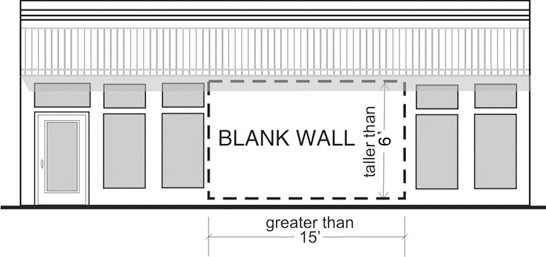 |
2.
Any portion of an upper floor wall with a horizontal length greater than twenty (20) feet that does not include a transparent window or door where the total surface area is 400 square feet or greater.
C.
Blank wall treatment standards.
1.
Untreated blank walls visible from a public street, highway, or pedestrian pathway are prohibited on all non-residential, mixed-use, and multi-family buildings. Methods to treat blank walls can include:
(i)
Display windows at least sixteen (16) inches of depth to allow for changeable displays. Tack on display cases shall not qualify as a blank wall treatment;
(ii)
Landscape planting bed at least five (5) feet wide or a raised planter bed at least two (2) feet high and three (3) feet wide in front of the wall with planting materials that are sufficient to obscure or screen at least sixty (60) percent of the wall's surface within three (3) years;
(iii)
Installing a vertical trellis in front of the wall with climbing vines or plant materials;
(iv)
Installing a non-commercial mural that reflects the history, character, and/or people of Island County; and/or
(v)
Special building detailing that adds visual interest at a pedestrian scale. Such detailing must use a variety of surfaces; monotonous designs will not meet the purpose of the standards.
2.
For large visible blank walls, a variety of treatments may be required to meet the purpose of the standards, as shown in the example in Figure 17.06.660.C.2.
| FIGURE 17.06.660.C.2 - BLANK WALL TREATMENT EXAMPLE |
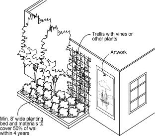 |
(Ord. No. C-49-19 [PLG-004-19], Exh. C, 6-18-2019)
17.06.670 - Front porch encroachment standards.
A.
Front porches are optional. Front porches are not required but are encouraged to create a sense of community and create a safe, walkable environment.
B.
Front porch encroachment allowed.
1.
The porch shall be allowed to encroach into the required front setback by a maximum of ten (10) feet under the standards of this section, as shown in Figure 17.06.670.B. In no case shall the reduction cause the front yard to be less than ten (10) feet.
| FIGURE 17.06.670.B - EXAMPLE OF PORCH ENCROACHMENT |
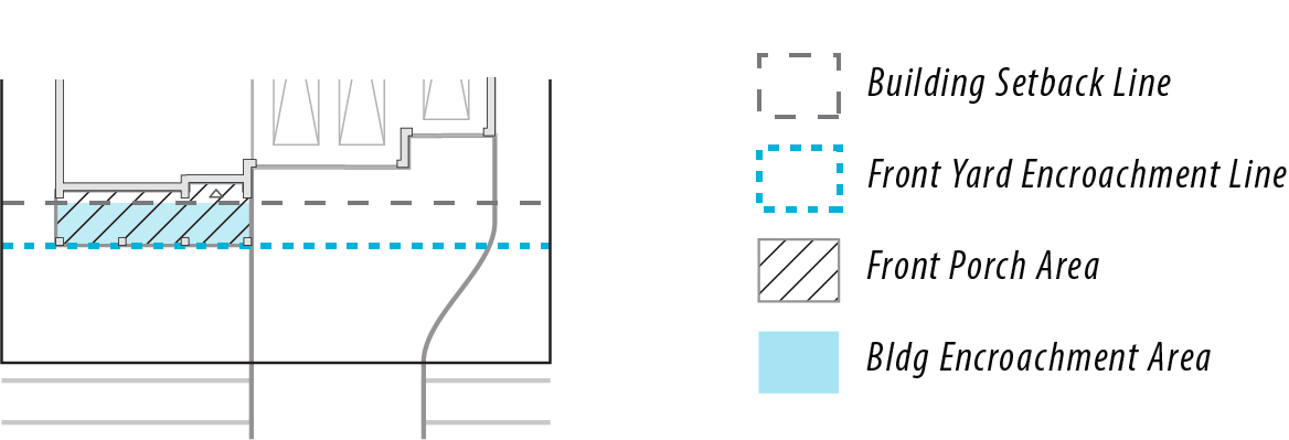 |
2.
Single story height. No porch that encroached into the front yard setback shall be more than a single story high.
3.
Front porch guidelines.
a.
A porch may be accompanied with a non-enclosed balcony above.
b.
Porches may be located along the front and/or side of the dwelling.
c.
A front porch need not contain the main entrance to a building. In such cases, it shall be adjacent to a primary living space and be designed as an outdoor extension of such space.
d.
Porches may wrap along more than one (1) façade of a structure.
C.
Encroaching front porch standards. The encroaching porch shall meet the following standards.
1.
Be fully covered.
2.
Be open on a minimum of two (2) sides.
| FIGURE 17.06.670.C.2 - PORCH DIMENSIONAL AND ENCLOSURE STANDARDS |
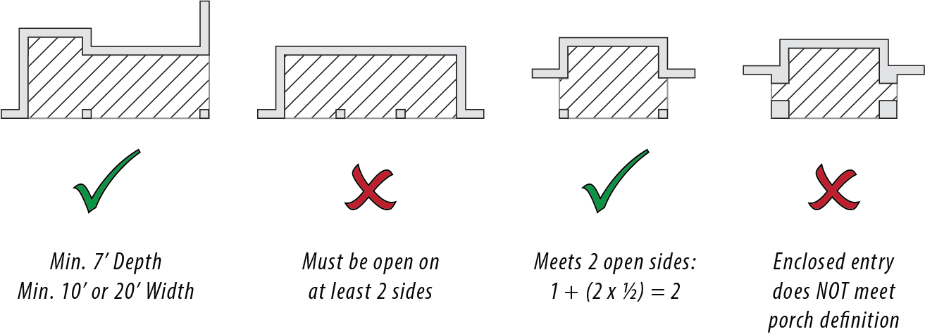 |
3.
Have decorative columns appropriate to the architectural style of the structure.
4.
Have a minimum porch floor dimension of seven (7) feet in depth measured from exterior face of the house to the front edge of the porch.
5.
Have minimum porch floor dimension of ten (10) feet in width feet.
6.
The long axis of the porch shall be parallel to the street to greatest extent possible.
7.
Have architectural details such as roof slopes, eave overhangs, columns, and a railing. Shapes, materials, and relationship of the porch to the structure shall be designed to accurately reflect the architectural style of the structure.
8.
Porch columns.
a.
Columns shall have a minimum ratio of 1:1 and a maximum of 1:2.
b.
Columns shall have a maximum size of twenty-four (24) inches by twenty-four (24) inches as shown below in Figure 17.06.670.C.8.
| FIGURE 17.06.670.C.8 - COLUMN DIMENSIONAL STANDARDS |
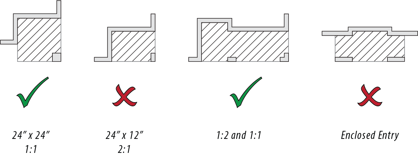 |
(Ord. No. C-49-19 [PLG-004-19], Exh. C, 6-18-2019)