
Kersey City Zoning Code
CHAPTER 20
COMMUNITY DESIGN AND DEVELOPMENT STANDARDS
[Section 20-1.] - General provisions.
A.
Applicability. All development applications and building permit applications shall comply with the applicable standards contained in this Chapter.
B.
Relation to Zone District Standards (Chapter 21). In the event of a conflict between a standard or requirement contained in Chapter 21 and Chapter 20, the standard in Chapter 21 shall prevail.
[Section 20-2.] - Vision and intent.
The intention of the Town of Kersey in enacting this Article is to clearly describe the Town's vision and to create a vital, cohesive, well-designed community in order to enhance its small-town character and further the citizens' goals as identified in Kersey's Comprehensive Plan (Comprehensive Plan).
When we look at the most beautiful towns and cities of the past, we are always impressed by a feeling that they are somehow organic.
This feeling of "organicness," is not a vague feeling of relationship with biological forms. It is not an analogy. It is instead, an accurate vision of a specific structural quality which these old towns had . . . and have. Namely: Each of these towns grew as a whole, under its own laws of wholeness . . . and we can feel this wholeness, not only at the largest scale, but in every detail; in the restaurants, in the sidewalks, in the houses, shops, markets, roads, parks, gardens, and walls.
- A New Theory of Urban Design, Christopher Alexander, Hajo Neis, Artemis Anninou, and Ingrid King,
The following qualities contribute to a Town "wholeness:"
1.
Walkable and pedestrian oriented.
2.
Variety of housing types.
3.
Orderly, grid-pattern, tree-lined streets.
4.
Safe and secure.
5.
Houses face the streets with garages less predominant in the back.
6.
One- and two-story buildings.
7.
Friendly, opportunity to know one's neighbors and care for one another.
8.
Rural, unique natural setting with mountain views.
9.
No excessive traffic.
10.
Quiet, slower paced environment.
11.
Town-wide activities.
12.
Cultural heritage.
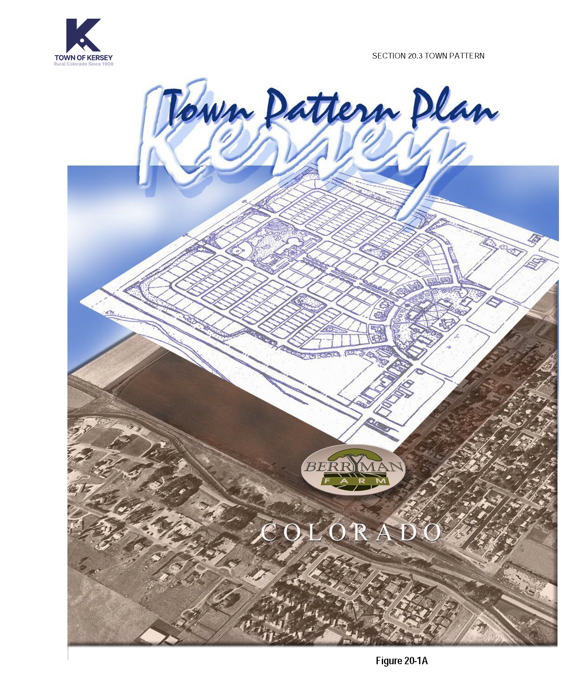
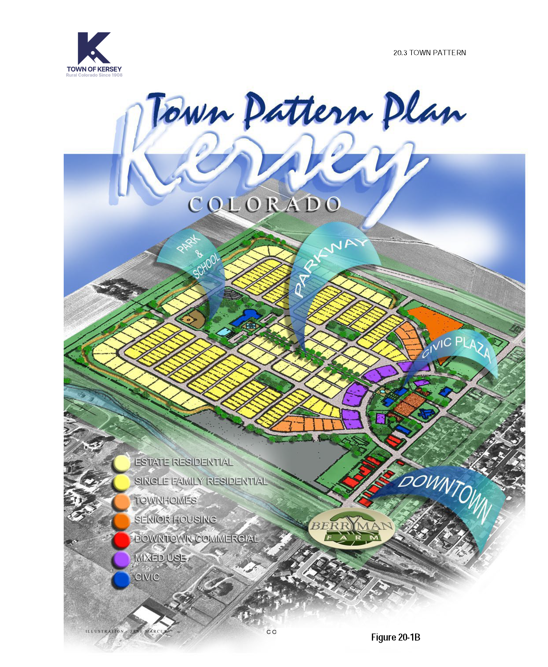
[Section 20-3.] - Town Pattern plan.
"The most basic rule of village design is to aim toward tying everything together with streets, sidewalks, footpaths, and also with interconnected open spaces and trails."
- Crossroads, Hamlet, Village, Town: Characteristics of Traditional Neighborhoods, Old and New, Randall Arendt
The importance of this basic rule cannot be overstated. For this reason, the Town Pattern Plan has been incorporated into the Kersey Land Use Code in order to assist the Town in creating a vision for expansion of the core community and to give direction to the development community on the elements needed to strengthen the sense of community and small town character.
Creating vibrant communities requires a sensitivity to context. Small towns typically have one central commercial downtown area that needs to be strengthened. As the community grows, the original downtown area can be expanded, redeveloped, and transformed. Often, as in Kersey, the community is located along a major highway, and the commercial and employment opportunities for the town are strongest in these locations. The need to balance these competing forces, strengthening the existing community while taking advantage of proximity to a major highway, is a key issue for evaluation.
The street pattern must reinforce the pedestrian nature of small towns and interconnect the community. Street design and the integration of land uses is critical to the vitality of the town. Streets must be designed to invite pedestrians to share the public realm. This requires attention to the street width, planting of shade trees and landscaping, sidewalks, the transition between the public and private areas, and the architecture. By integrating a mixture of land uses, destinations are created. The path to these destinations and the journey is what helps reinforce the "small town feeling."
Kersey's Pattern Plan is based on genuine opportunities and constraints. The base map includes the location of oil and gas wells (proposed and existing), the floodplain, wetlands, environmental issues, easements, topography, roadways, etc. The Town Pattern Plan represents the community's vision for the expansion of downtown. The plan represents a collaborative effort between the Town and the landowners of Berryman Farm. It is intended to influence the vitality and character of growth and to help Kersey expand in a manner that will strength the economy and the heart of the community.
[Section 20-4.] - Application of community design principles.
The community design principles as set forth in this Article are to be considered in every development proposal. The Town's goal is to expedite the planning review process by clearly outlining the Town's expectations for new development. To this end, the Planning Commission invites applicants to participate in a Visioning Meeting prior to preparing the sketch plan application. The Visioning Meeting is an initial meeting between the developer and the Planning Commission. It is intended to begin a collaborative process to ensure that new development is consistent with the community's goals and that issues are identified early in the process.
The Kersey Planning Commission and Board of Trustees will evaluate each proposal based on these principles and the context within which a project is located. The principles are intended to be specific enough to guide development, but not to preclude creative design solutions. Applicants must substantially conform to the design principles unless it can be demonstrated that an acceptable alternative meets one or more of the following conditions:
1.
The alternative better achieves the stated intent;
2.
The intent will not be achieved by application of the principle in this circumstance;
3.
The effect of other principles will be improved by not applying the principle; and/or
4.
Strict application or unique site features make the principle impractical.
[Section 20-5.] - Design elements.
A.
Design Elements. One of the greatest challenges facing small towns is the successful integration of new development with the original town pattern. Suburban development patterns which have included numerous cul-de-sacs and limited street connections have often separated communities and created enclaves of the original towns. In order to maintain Kersey's unique, small town character and clearly describe the Town's vision, the following design elements must be followed.
1.
Compact Urban Growth. As the community grows from the original Town limits, it is important to maintain a continuity of density, diversity and interconnectedness. Urban development should occur adjacent to the Town's core so that the community's prime agricultural land and natural areas are preserved and public infrastructure and utilities are used as efficiently as possible.
2.
Neighborhood Design. New developments should help create neighborhoods, rather than residential subdivisions adjacent to one another. Neighborhoods should be organized around a strong center which may include elements such as common open space, civic and commercial or mixed uses. Strong consideration should be given to pedestrian movement, the character of streets and sidewalks as inviting public space, and the interconnectedness of the streets within the neighborhood and as they connect to the rest of the community. In addition, new neighborhoods should have a variety of housing sizes and types that help to create a distinct identity rather than a monotonous replication of styles.
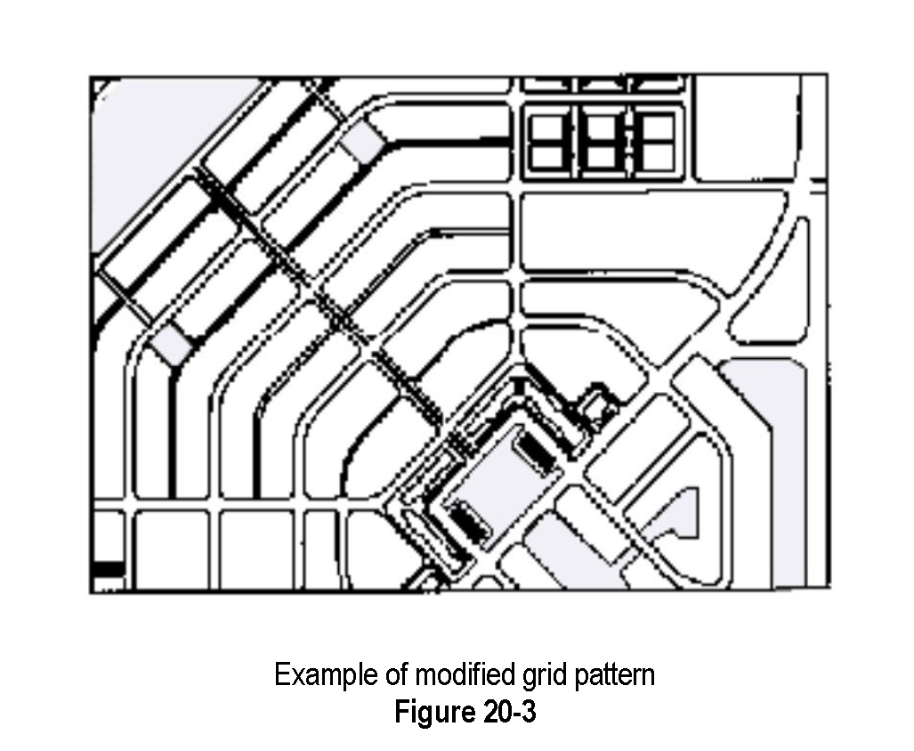
3.
Lots and Blocks, Streets and Sidewalks. The layout of lots and blocks should be designed to continue Kersey's existing block pattern to form a grid or modified grid pattern that is adapted to the topography, natural features and environmental considerations. The streets should be tree-lined and interconnected in order to create a comprehensive transportation network that facilitates the movement of pedestrians, cars and bicycles.
4.
Parks and Open Space. New developments shall use natural open spaces and developed public space (such as parks and plazas) to organize and focus lots, blocks and circulation patterns, protect natural areas and quality agricultural land and to create an identity for each neighborhood.
5.
Site Design, Architecture and Landscaping. One of the fundamental intentions of this Code is to encourage innovative, quality site design, architecture, and landscaping in order to create new places that can be integrated with the existing community and reflect the traditional patterns of the region. The photographic Design Vocabulary (refer to Town website), as well as illustrations throughout the Code are intended to provide a visual description of the Town's design intentions.
6.
Environment. New developments should be designed to fit within the environment. To the greatest extent feasible, sites should be designed to preserve natural areas and the plants and wildlife inhabiting those areas. In addition, new developments are encouraged to follow Green Builder Guidelines (see Section 20.22.C) and to conserve natural resources, especially water.
7.
Water Conservation. As the State grows, increasing pressure will be placed on the limited supply of water resources. Kersey residents have emphasized the importance of preserving the quality and quantity of water. All new development is encouraged to use raw water for irrigation and to incorporate water-saving measures in building design and landscaping. Developments are required to use stormwater management techniques that address water quality as well as quantity.
[Section 20-6.] - Compact urban growth.
A.
Intent. The Town has adopted a compact urban growth policy that encourages and directs development to take place within areas contiguous to existing development in the community. This policy will accomplish several goals, including:
1.
Improving air quality by reducing vehicle miles traveled and by promoting alternatives to the private automobile;
2.
Preserving natural areas and features, particularly in the periphery of the Town;
3.
Making possible the efficient use of existing infrastructure and cost effective extensions of new services;
4.
Encouraging in-fill development and reinvestment in built-up areas of the Town; and
5.
Promoting physical separation from neighboring communities to help each maintain its individual identity and character.
B.
General Provisions.
1.
The Town has established a Planning Area Boundary and adopted a cooperative planning area policy by entering into an Intergovernmental Agreement with Weld County. The purpose is to direct growth within the established Planning Area Boundary. Development located within the established Planning Area Boundary shall be consistent with the Kersey Comprehensive Plan.
C.
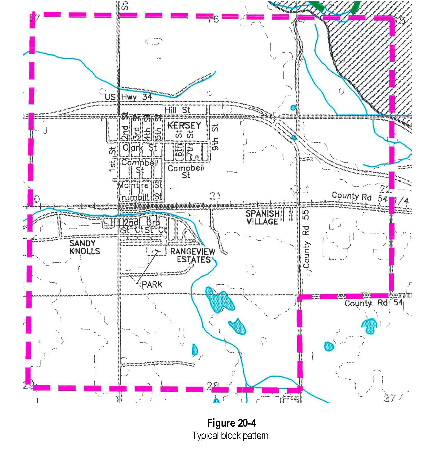
Town Structure. Town structure shall be formed by the clustering of neighborhoods, as opposed to developing single use residential subdivisions adjacent to and disconnected from each other. The clustering of neighborhoods to support the original Town Center and form additional Multi-Neighborhood Centers is illustrated on the Town Pattern Plan, Figures 20-1A and 20- 1b. The original downtown needs to be strengthened by commercial and mixed use development within the immediate vicinity, as per the Town Pattern Plan.
[Section 20-7.] - Neighborhood design principles.
"We have become so used to living among surroundings in which beauty has little or no place that we do not realize what a remarkable and unique feature the ugliness of modem life is. Both in this country and in many others, wherever one finds a street or part of a street dating from before what we may call the modem period, one is almost sure to see something pleasing and beautiful in its effect.... It is the lack of beauty, of the amenities of life, more than anything else which obliges us to admit that our work of town building in the past century has not been well done."
- Town Planning in Practice, Raymond Unwin, 1909
A.
Intent. To encourage the creation of viable neighborhoods that interconnect with each other and integrate new projects into the existing community, thereby strengthening the original town. The neighborhood layout should consider the street, lot and block pattern of the original town, as well as solar orientation, topography, sensitive wildlife habitat and vegetation, drainage patterns, and environmental and regional climate issues. Further, the edges of neighborhoods should be formed by features shared with adjacent neighborhoods such as major streets, changes in street pattern greenways or natural features such as streams and major drainage or riparian corridors. New streets, bikeways, sidewalks, paths, and trails should connect to existing adjacent neighborhoods.
B.
Neighborhood Structure. Following is a summary of essential elements to consider integrating into new neighborhoods:
1.
Street, sidewalk and trail connections within new neighborhoods that connect to adjacent existing neighborhoods and strengthen the connection to the existing town.
2.
Streets that encourage pedestrian activity by creating an inviting atmosphere through attention to the details of landscaping and tree locations, sidewalks, lighting, the building architecture, etc.
3.
A mixed-use neighborhood center located for easy access.
4.
A variety of housing types, sizes, densities and price ranges that are well integrated.
5.
A variety of land uses that are well integrated and a transition of intensity. Non-residential uses, larger buildings and attached multi-family housing should be encouraged to be located near commercial centers with a transition to smaller buildings closer to low density neighborhoods.
6.
Pedestrian and bike connections throughout residential neighborhoods and linked to neighborhood commercial or civic centers and open space systems.
7.
Parks, open space, public plaza and greens that are well integrated into the neighborhood.
8.
Street trees placed in new developments at regular intervals of thirty to forty (30 to 40) feet and placed directly adjacent to sidewalks. See Figure 20-18, Section 20-16.C.
9.
Architectural, landscaping and site design elements of new developments as outlined in this Article.
C.
General Provisions. The following principles are contained in the original "old town" of Kersey 1 . The Comprehensive Plan identifies them as contributing to the community's small town character. Although the size of individual development proposals will vary, projects will be evaluated with consideration to these neighborhood design principles and the context within which a project is located. Failure to incorporate these design principles into a project may be cause for denial of the project by the Board of Trustees.
1.
Each Neighborhood has a Center and an Edge. It is important that every neighborhood have activity centers that draw people together. Use natural and man-made features such as a drainageway, major roadways, and ditches to define neighborhood edges. Buildings or other features located at gateways entering a neighborhood shall mark the transition into and out of the neighborhood in a distinct fashion using massing, additional height, contrasting materials, and/or architectural embellishments to obtain this effect.
2.
Mix of Types of Dwelling Units. A mix of dwelling unit types shall be distributed throughout the development. (Refer to Section 20.19 Residential Architecture, for additional housing requirements and the Design Vocabulary on the town website, for illustrations of housing styles that Kersey is encouraging.)
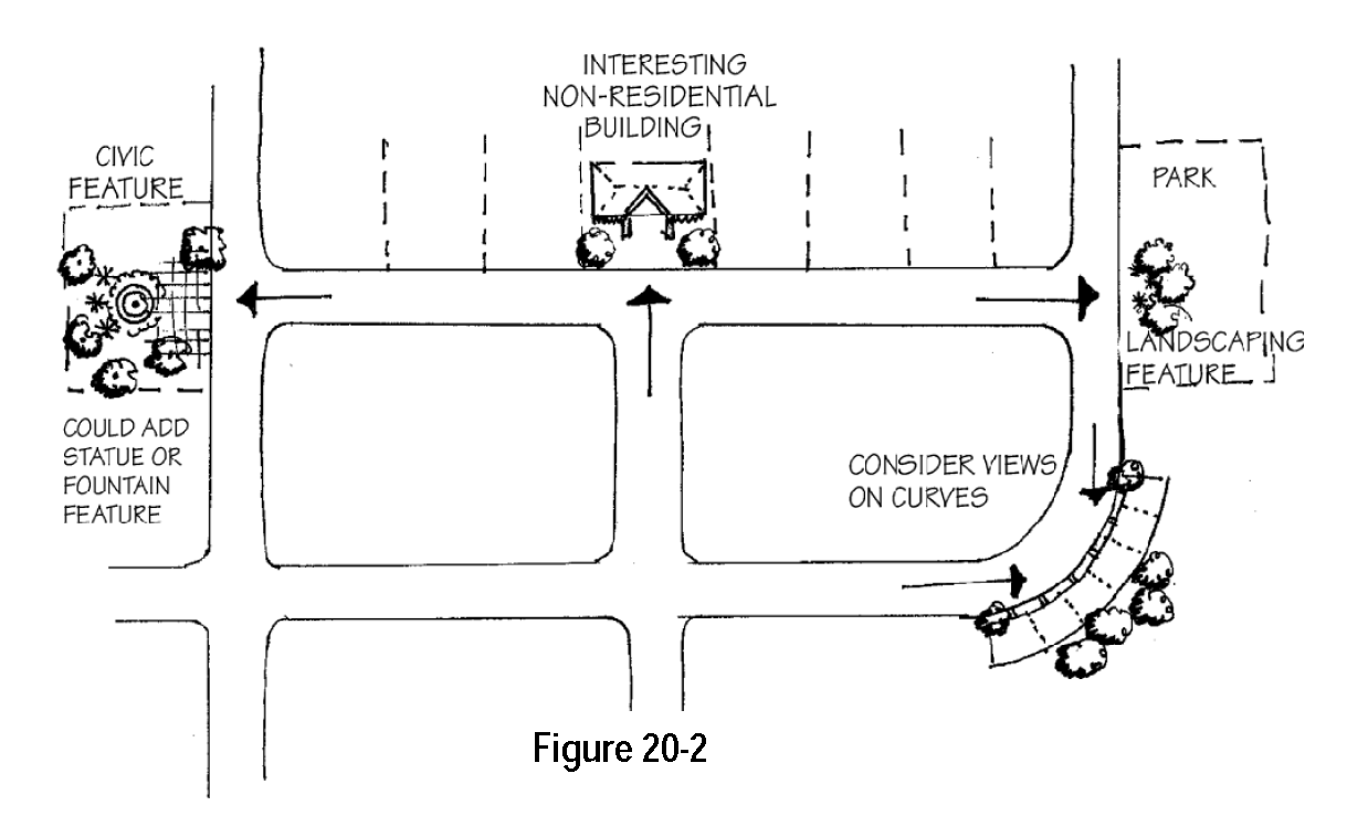
3.
Focal Points. Focal points, or points of visual termination, shall generally be occupied by more prominent, monumental buildings and structures that employ enhanced height, massing, distinctive architectural treatments, or other distinguishing features, as well as landscape features. See Figure 20-2.
4.
Public Space as Development Framework. Public space is used to organize blocks and circulation patterns and to enhance surrounding development. Public open space must be functional and easily accessible and shall be designed to organize the placement of buildings to create an identity for each neighborhood. Buildings should face public open space to allow for casual surveillance.
5.
Design Streets as Public Spaces. Buildings shall define streets through the use of relatively uniform setbacks along each block. The streetscape shall also be reinforced by lines of shade trees planted in the right-of-way landscape strip and may be further reinforced by walls, hedges, landscaping or fences which define front yards. (Refer to Design Vocabulary on the town website for illustrations of streetscapes.)
On a lot with multiple buildings, those located on the interior of the site shall relate to one another both functionally and visually. A building complex may be organized around features such as courtyards, greens, or quadrangles which encourage pedestrian activity and incidental social interaction. Smaller, individualized groupings of buildings are encouraged. Buildings shall be located to allow for adequate fire and emergency access.
6.
Order Rather Than Repetition. The orderly arrangement of design elements can unify a space even when the elements are not the same. The location of sidewalks relative to streets, building setbacks and orientation, the placement of trees can all help create an overall impression of unity even though each home or building has a distinct character.
7.
Use Human Proportion. Buildings shall be considered in terms of their relationship to the height and massing of adjacent buildings, as well as in relation to the human scale. (In a small town, this means generally one, two and three story buildings.)
8.
Define the Transition Between the Public and Private Realm. Buildings shall be located to front towards and relate to public streets or parks, both functionally and visually, to the greatest extent possible. Wherever possible, buildings shall not be oriented to front towards a parking lot.
9.
Encourage Walking and Bicycling. Sites shall be designed to minimize conflicts between vehicles, bicycles and pedestrians. Pedestrian and bicycle access and connections shall be designed to make it safe and easy to get around on foot and by bicycle.
10.
Neighborhoods Shall Have a Mix of Activities Available Rather Than a Purely Residential Land Use. Neighborhood residents shall have convenient access to parks, schools, open space, trails and services. The optimum size of a neighborhood is one-quarter (1/4) mile from center to edge.
11.
Fit Within the Environment Rather Than on Top of It. New developments shall be designed to respond to the natural environment, fit into the setting and protect scenic view corridors. Key design considerations shall include a site layout that responds to natural features both on- and off-site, the size of structures and materials used in the development and the transition between the development and the surrounding landscape.
12.
Encourage a Range of Residents In Every Neighborhood. Housing types and the size of lots shall be varied to enable people to remain in the neighborhood as their needs change. (Refer to Section 20.26 for illustrations of architectural styles that the Town is encouraging.)
13.
Housing Types and Styles That Reflect the Architecture of the Region. Familiar architectural styles shall play an important role in developing an architectural identity for neighborhood dwellings. New homes shall be designed consistent with the architectural principles outlined in Section 20.19 of this Code.
[Section 20-8.] - Lots and blocks.
A.
Intent. The intent of the block and lot standards is to continue Kersey's existing block pattern in a manner that is compatible with site-specific environmental conditions.
B.
General Provisions.
1.
Blocks (Exclusive of Rural Subdivisions). Streets shall be designed to create blocks that consider interconnectedness, topography, solar orientation, views, and other design features. The length of blocks in "Old Town" is typically four hundred (400) feet. Thus, to the greatest extent possible, blocks shall be designed to have a length of between three hundred (300) feet and seven hundred (700) feet (non-residential streets). The lengths, widths and shapes of blocks shall be determined with due regard to the following:
a.
Provision of adequate building sites suitable to the special needs of the type of use contemplated.
b.
Need for convenient access, control and safety of vehicular and pedestrian traffic circulation.
c.
Limitations and opportunities of topography.
2.
Lot Dimension and Configuration.
a.
Lot size, width, depth, shape, and orientation and minimum building setback lines shall conform to Chapter 21 Zoning and shall facilitate the placement of buildings with sufficient access, outdoor space, privacy and view.
b.
Depth and width of properties shall be adequate to provide for off-street parking, landscaping and loading areas required by the type of use and development contemplated.
c.
Lot Frontage. All lots shall have frontage that is either adjacent to or directly accessible to a street. Street frontage shall typically not be less than twenty-five (25) percent of the lot depth. Flag lots are prohibited unless otherwise approved by the Town Board.
d.
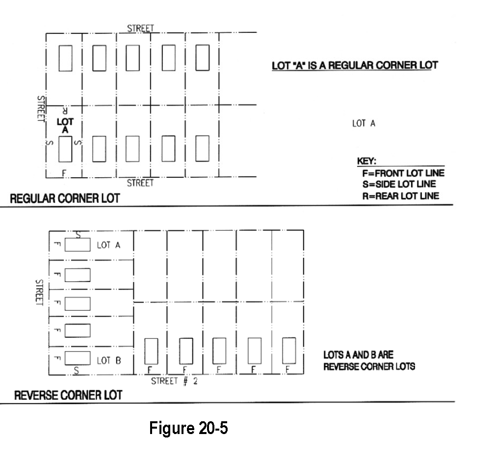
Corner Lots. Corner lots for residential use shall have extra width to accommodate side elevation enhancements, such as porches and bay windows, the required building setback and utility easements on both street frontages. For a corner lot, the front of the lot is defined as the side having the shortest street frontage. In the case of a reverse corner lot, both sides abutting a street shall maintain a front yard setback. See Figure 20-5.
e.
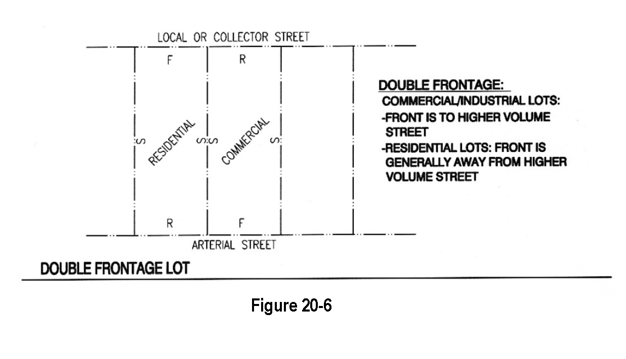
Double Frontage. Double frontage lots for residential uses shall not be permitted except where essential to provide separation of residential properties from arterial streets or commercial uses, or to overcome specific disadvantage of topography and orientation. A planting screen easement of at least ten (10) feet in width, across which there shall be no vehicular right of access, may be required along the property line of lots abutting an arterial or other disadvantageous use. See Figure 20-6.
f.
Side Lot Lines. Side lot lines shall be substantially at right angles or radial to road right-of-way lines or centerlines.
g.
Residential Lots Adjacent to Arterial Streets. When residential lots are adjacent to, and the houses do not face an arterial street (i.e., rear yards abut the street), they shall be a minimum of one hundred fifty (150) feet deep and direct access to the street shall be prohibited, except for nonconforming situations on unplatted parcels. The setback to the house shall be a minimum of seventy-five (75) feet. When houses face the arterial street or are side loaded relative to the street, the front or side setback to the house, respectively, shall be a minimum of fifty (50) feet. These setbacks do not apply for mixed use dwelling units in the Mixed-Use zone districts. Additional buffering techniques must also be applied such as those outlined in the Landscape Design, Section 20.17, Buffering and Screening Techniques.
h.
Residential Lot Access to Adjacent Street.
i.
Driveway access to a local or collector street from a single-family detached residential lot shall be limited to one driveway curb cut or driveway access of no greater than twenty (20) feet in width. A circular drive in which each access to the local or collector street is less than ten (10) feet in width, separated by at least thirty (30) feet and which is constructed as an integral part of the overall architectural design of the single family residence may be considered as a single driveway access.
ii.
Driveway access to a local street from a single-family detached residential lot shall be greater than fifty (50) feet from the intersection of the local street and a collector street or one hundred twenty-five (125) feet from the intersection of the local street and an arterial street as measured from the intersecting right-of-way lines.
iii.
Driveway access to a collector street from a single-family detached residential lot shall be greater than one hundred twenty-five (125) feet from the intersection of the collector street and a local street, another collector street, or an arterial street as measured from the intersecting right-of-way lines.
i.
Multi-family Residential, Commercial, Business and Industrial Lot Access to Adjacent Street.
i.
Driveway access to a local or collector street from a multi-family residential, commercial, business or industrial lot shall be greater than one hundred twenty-five (125) feet from any street intersection as measured from the intersecting right-of-way lines;
ii.
Driveway access to an arterial street from a commercial, business or industrial lot shall be not less than two hundred fifty (250) feet from any intersection on the arterial street, or from another commercial, business or industrial lot's access as measured from the intersecting right-of-way lines, or driveways; or
iii.
At the sole option of the Town, driveway access to a local street, collector street or arterial street from a multi-family residential, commercial, business or industrial lot shall be as determined by a traffic study approved by the Town.
[Section 20-9.] - Streets.
There is magic to great streets. We are attracted to the best of them not because we have to go there but because we want to be there.
- Great Streets, Alan B. Jacobs
[A.]
Intent. The intent of the street standards is to establish a safe, efficient, attractive transportation system that promotes all modes of transportation and is sensitive to the environment. In the recent past, streets have been designed primarily to promote the efficient movement of traffic. However, streets have multiple functions, as stated in "Performance Streets" (Bucks County, 1980). "It was often forgotten that residential streets become part of the neighborhood and are eventually used for a variety of purposes for which they were not designed. Residential streets provide direct auto access for the occupant to his home; they carry traffic past his home; they provide a visual setting, and entryway for each house; a pedestrian circulation system; a meeting place for the residents; a play area (whether one likes it or not) for the children, etc. To design and engineer residential streets solely for the convenience of easy automobile movement overlooks the many overlapping uses of a residential street."
Residential Streets, American Society of Civil Engineers, National Association of Home Builders, The Urban Land Institute, 1990.
[B.]
General Provisions. The local street system of any proposed development shall be designed to be safe, efficient, convenient and attractive, and consider the use by all modes of transportation that will use the system. Streets should be an inviting public space and an integral part of community design. Local streets shall provide for both intra- and inter-neighborhood connections to knit developments together, rather than forming barriers between them. All streets should interconnect to help create a comprehensive network of public areas to allow free movement of cars, bicycles and pedestrians.
1.
Street Connections. All streets shall be aligned to join with planned or existing streets consistent with the approved Transportation Map of the Kersey Comprehensive Plan. All streets shall be designed to bear a logical relationship to the topography of the land. Intersections of streets shall be at right angles unless otherwise approved by the Town. Street intersections shall be separated by not less than one hundred twenty-five (125) feet as measured from the intersecting right-of-way lines.
2.
Tree-Lined Streets. All streets shall be lined with trees on both sides with the exception of rural roads and alleys.
3.
Street Layout. The street layout shall form an interconnected system of streets primarily in a grid or modified pattern adapted to the topography, unique natural features, environmental constraints, and peripheral open space areas. The street layout shall emphasize the location of neighborhood focus points, other internal open space areas, gateways, and vistas. The use of cul-de-sacs and other roadways with a single point of access shall be minimized. The integration of traffic calming features within and adjacent to residential areas shall be utilized when appropriate. To the greatest extent possible, streets shall be designed to have a maximum length of seven hundred (700) feet, from intersection to intersection.
4.
Controlling Street Access. A strip of land between a dedicated street and adjacent property shall not be reserved for the purpose of controlling access to such street from such property.
5.
Visibility at Intersections. No shrubs, groundcover, berms, fences, structures, or other materials or items greater than thirty (30) inches in height shall be planted, created or maintained at street intersections within the site distance triangle. Trees shall not be planted in the site distance triangle.
6.
Pedestrian Crossings at Street Intersections and Mid-block. Pedestrian crossings shall be accessible to handicapped individuals and mid-block crossings may be required at the direction of the Board of Trustees.
7.
Horizontal Alignment. Horizontal alignment shall provide for the safety of pedestrians, bicyclists, and motorists. The street pattern shall be the most advantageous to serve the adjoining areas. When possible, proposed streets shall be continuous and in alignment with existing and proposed streets.
8.
Vertical Alignment. No vertical grade shall be less than four-tenths (4/10) percent in order to facilitate adequate drainage. The maximum percent of street grade, except as approved by the Town Engineer, shall be five (5) percent. Street grades shall not exceed four (4) percent for a distance extending at least forty (40) feet in each direction from a street intersection.
9.
Access. Access to all subdivisions shall be from a public street system. Driveways shall not be permitted to have direct access to arterials or state highways (principal arterials).
10.
Street Right-of-Way Dedication. The full width of right-of-way for all streets being platted must be dedicated to the Town. In cases where the perimeter streets have a portion of the proposed right-of-way on an adjacent property, the following standards will apply:
a.
The subdivider shall either:
i.
Purchase the other one-half (½) of the proposed right-of-way property for the Town at the appraised fair market value and then dedicate the right-of-way to the Town; or
ii.
If the landowner of the proposed right-of-way property is unwilling to sell the proposed right-of-way property to the subdivider for its appraised fair market value, the subdivider shall pay for the cost of an appraisal for the proposed right-of-way property and legal fees for the Town Attorney to complete the condemnation process.
b.
The subdivider shall finalize an agreement with the Town which guarantees the construction of the street to Town standards.
11.
Perimeter Streets. When a street is dedicated which ends on the plat, the street right-of-way must be dedicated to the boundary of the plat.
12.
Intersections. Intersections shall meet the following requirements unless otherwise approved by the Board of Trustees:
a.
Intersections shall be provided at the following minimum offsets:
i.
State Highway (Principal Arterial): In accordance with the State of Colorado Highway Access Code.
ii.
Arterial: Six hundred sixty (660) feet.
iii.
Collector: Two hundred fifty (250) feet.
iv.
Local: One hundred twenty-five (125) feet.
b.
No more than two (2) streets shall intersect at one (1) point.
c.
Streets shall intersect at ninety degree (90°) angles, unless otherwise approved by the Board of Trustees.
13.
Street Names. Names of new streets shall not duplicate names of existing streets. However, new streets which are extensions of, or which are in alignment with, existing streets shall bear the names of such streets.
[C.]
Street Standards. The width of street right-of-way and the design of the street it contains shall conform to the following minimum standards. However, additional right-of-way and street width may be required based upon special development requirements including but not limited to additional parking needs, sight distances and requirements for auxiliary lanes. Street cross-sections and the street designation (arterial, collector, local, rural local) within or adjacent to a development may be modified by the Town upon the recommendation of an approved development traffic study or Town-wide Transportation Master Plan.
1.
General Design Standards. Where curb and gutter is required, it shall be constructed per the Colorado Department of Transportation Specifications.
a.
Design of streets shall be in accordance with the Americans with Disabilities Act (ADA) standards.
b.
Streets shall be designed in accordance with the American Association of State Highway and Transportation Officials Policy on Geometric Design of Highways and Streets, 1990.
c.
The layout of arterial and collector streets shall be per the Transportation Map in the Kersey Comprehensive Plan unless otherwise directed by the Board of Trustees.
d.
Where future extension of a street is anticipated, a temporary turnaround having a minimum outside diameter of one-hundred and ten (110) feet shall be provided.
e.
The maximum allowable length of closed-end streets (cul-de-sacs) in single-family residential and multi-family residential developments shall be six hundred (600) feet unless otherwise approved by the Board of Trustees.
2.
State Highways (Principal Arterial Design). Right-of-way and road design shall be in accordance with the Colorado Department of Transportation Standards.
3.
Arterial Streets Design.
a.
Arterials shall be at one (1) mile intervals in both north-south and east-west directions, as illustrated on the Kersey Comprehensive Plan Transportation Map.
b.
Arterials shall be designed to accommodate present and future transportation requirements.
c.
Arterial streets shall align and connect across intersecting arterials to distribute traffic and provide continuity.
d.
Typical Adjacent Land Uses.
i.
Business parks.
ii.
Community commercial.
iii.
District and community parks.
iv.
High density residential land uses should be located near arterials with minimal travel through other land uses.
v.
Industrial developments should have highway access via the Town's arterial street system with minimal travel through other land uses.
vi.
When residential lots are adjacent to and the houses do not face an arterial street, they shall be a minimum of one hundred fifty (150) feet deep and direct access to the street shall be limited. The setback to the house shall be a minimum of seventy-five (75) feet. Additional buffering techniques must also be applied such as those outlined in the Landscape Design, Section 20.17, Buffering and Screening Techniques.
e.
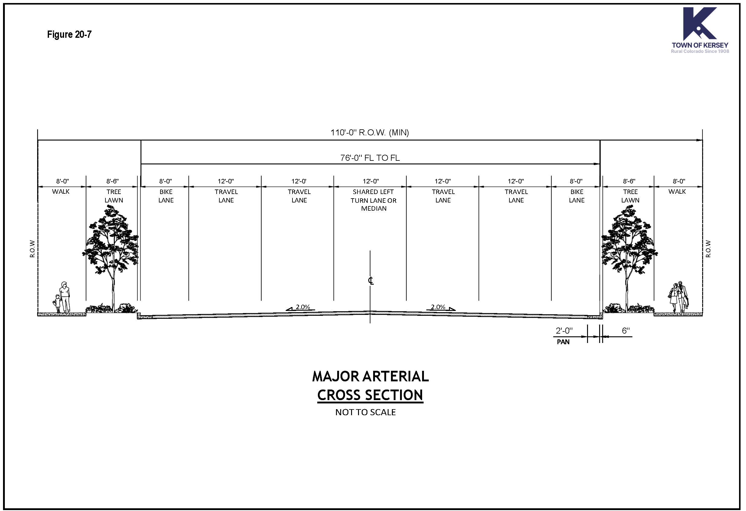
Typical street section for Major Arterial (See Figure 20-7).
i.
One hundred and ten feet (110') of right-of-way.
ii.
Seventy-six-feet (76') flowline width which includes: four (4) twelve foot (12') travel lanes, one (1) twelve-foot (12') median and two (2) eight foot (8') on-street bike lanes.
iii.
Two (2) eight feet six inches (8'-6") tree lawns.
iv.
Two (2) eight foot (8') sidewalks.
v.
Posted speed limit shall be between thirty-five (35) and forty-five (45) miles per hour.
f.
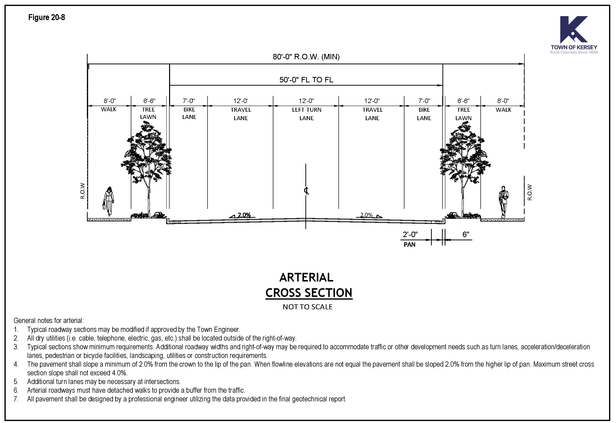
Typical street section for Arterial (see Figure 20-8).
i.
Eighty feet (80') right-of-way.
ii.
Fifty feet (50') flowline width which includes: two (2) twelve foot (12') travel lanes, one (1) twelve foot (12') two-way left turn lane and two (2) seven foot (7') on-street bike lanes.
iii.
Two (2) six feet six inches (6'-6") tree lawns.
iv.
Two (2) eight foot (8') detached sidewalks.
v.
Posted speed limit shall be between thirty-five (35) and forty-five (45) miles per hour.
4.
Collector Streets.
a.
Within each one (1) mile arterial segment, collector streets shall divide the north-south and east-west arterials at approximately the half mile point, as illustrated on the Kersey Comprehensive Plan Transportation Map.
b.
Intersections of collector streets and arterial streets shall be aligned to distribute traffic and provide continuity for bike routes.
c.
Typical Adjacent Land Uses.
i.
Agriculture.
ii.
Business parks.
iii.
Community parks.
iv.
Industrial.
v.
Low, medium and high density residential.
vi.
Middle and high schools.
vii.
Neighborhood commercial.
d.
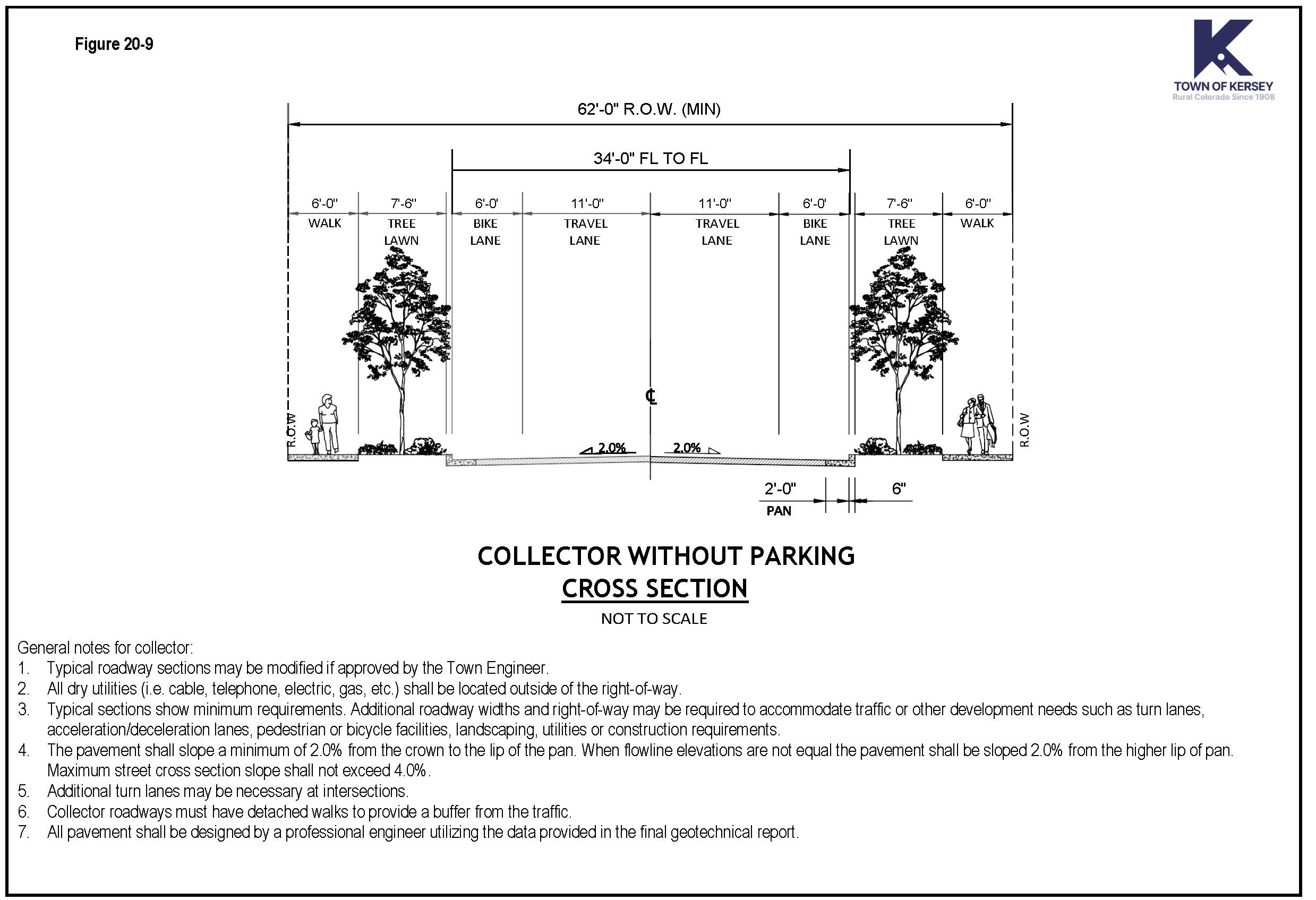
Typical street section for Collector Without Parking (See Figure 20-9).
i.
Sixty-two feet (62') right-of-way.
ii.
Thirty-four feet (34') flowline width which includes: two (2) eleven foot (11') travel lanes, and two (2) six foot (6') on-street bike lanes.
iii.
Two (2) seven feet six inches (7' 6") tree lawns.
iv.
Two (2) six foot (6') detached sidewalks.
v.
Posted speed limit shall be between thirty-five (25) and forty-five (45) miles per hour.
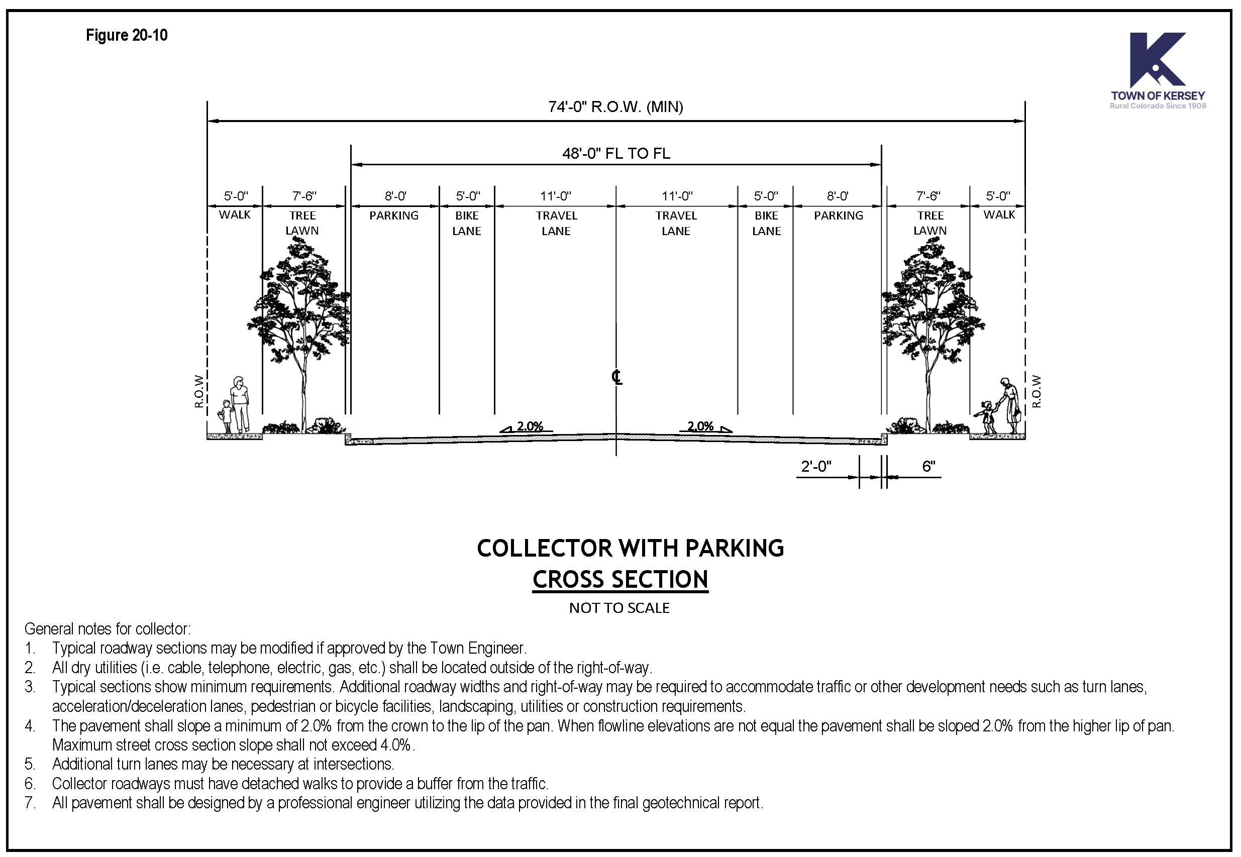
e.
Typical street section for Collector with Parking (See Figure 20-10).
i.
Seventy-four feet (74') right-of-way.
ii.
Forty-eight (48) feet flowline width which includes: two (2) - eleven foot (11') travel lanes, two (2) - five foot (5') on-street bike lanes and two (2) eight foot (8') parking lanes.
iii.
Two (2) seven feet six inches (7' 6") tree lawns.
iv.
Two (2) five foot (5') detached sidewalks.
v.
Posted speed limit shall be thirty (30) miles per hour.
5.
Local Streets.
a.
Local streets shall generally follow a modified grid pattern adapted to the topography, unique natural features, environmental constraints, and peripheral open space areas. These streets shall generally parallel the arterial and collector street system, provide a variety of route options, interconnect to allow traffic to disperse in an equitable manner and be as narrow as possible without sacrificing the ability to accommodate expected traffic and services.
b.
Local streets must provide for both intra- and inter-neighborhood connections to knit developments together, rather than forming barriers between them.
c.
Typical Adjacent Land Uses.
i.
Business parks.
ii.
Elementary schools.
iii.
Pocket parks.
iv.
Neighborhood parks.
v.
Residential.
d.
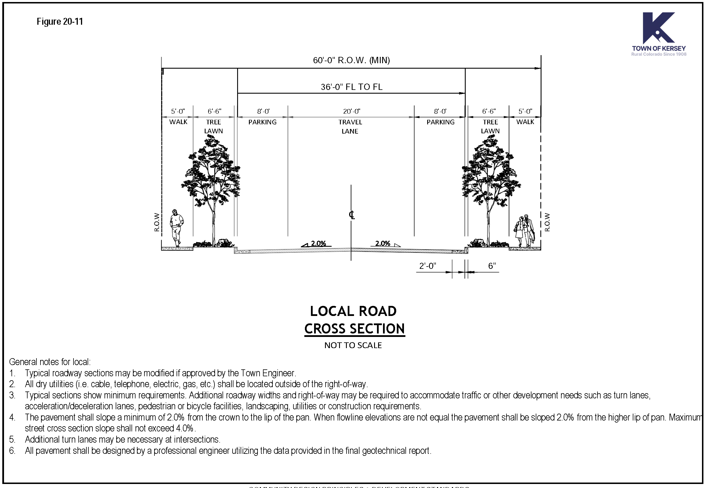
Typical street section for Local with Detached Sidewalk (See Figure 20-11).
i.
Sixty feet (60') right-of-way.
ii.
Forty feet (40') flowline width which includes: twenty feet (20') travel lanes and two (2) eight foot (8') parking lanes.
iii.
Two (2) six foot six inch (6' 6') tree lawns.
iv.
Two (2) five foot (5') detached sidewalks.
v.
Posted speed limit shall be twenty-five (25) miles per hour.
vi.
Cul-de-sac: One hundred foot (100') diameter flowline and one hundred twenty-four foot (124') diameter right-of-way.
e.
Typical street section for Local with Attached Sidewalk.
i.
Sixty (60) feet of right-of-way.
ii.
Forty (40) foot flowline width which includes: Two (2) eleven (11) foot travel lanes, one (1) four (4) foot on-street bike lane and two (2) seven (7) foot parking lanes.
iii.
Two (2) - five (5) foot attached curb walks (this includes curb, transition and walk).
iv.
Two (2) five (5) foot tree lawns.
v.
Posted speed limit shall be twenty-five (25) miles per hour.
vi.
Cul-de-sac: One hundred (100) foot diameter flowline and one hundred twenty-four (124) foot diameter right-of-way.
6.
Rural Local Street.
a.
Rural local streets are intended to serve areas defined as Rural Subdivisions and other appropriate rural locations as approved by the Board of Trustees.
b.
A driveway access crossing the borrow ditch of a rural local street shall contain a culvert of sufficient size to safely pass the designed stormwater drainage flows. A portion of the borrow ditch may fall outside of the rural local road right-of-way in order to obtain a borrow ditch cross-section sufficient to contain the designed storm water flows and/or to be sufficient in depth for the driveway access culvert.
c.
Typical Adjacent Land Uses.
i.
Agriculture.
ii.
Rural subdivisions.
d.
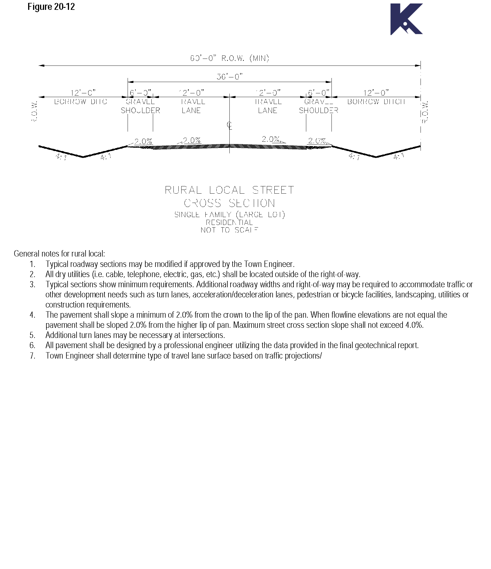
Typical street section for Rural Local (See Figure 20-12).
i.
Sixty feet (60') right-of-way.
ii.
Two (2) twelve foot (12') travel lanes.
iii.
Two (2) six foot (6') gravel shoulders.
iv.
Two (2) - twelve foot (12') borrow ditches.
v.
Posted speed limit shall be twenty-five (25) miles per hour.
vi.
Cul-de-sac: One hundred (100) foot diameter flowline and one hundred thirty-six (136) foot diameter right-of-way.
7.
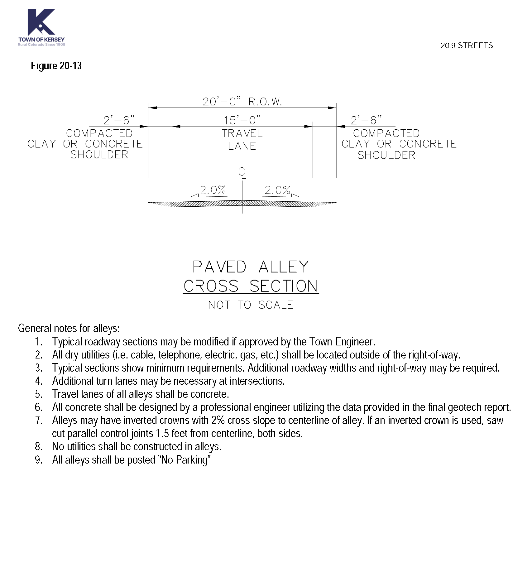
Alleys.
a.
Alleys shall be treated as public ways, and any lot having access from an alley shall also front upon a public street.
b.
Garages, accessory dwellings above garages and rear yards may access the collector and local street system via an alley with minimal travel through other land uses.
c.
Typical adjacent land uses.
i.
Accessory units above garages.
ii.
Garages.
iii.
Parking lots with landscaped edges.
iv.
Rear yards.
d.
Typical street section for Residential Alley (See Figure 20-13).
i.
Twenty (20) feet of right-of-way.
ii.
Twenty (20) feet of pavement width.
e.
Typical street section for Commercial/Industrial Alley.
i.
Twenty (20) feet of right-of-way.
ii.
Twenty (20) feet of pavement width.
[Section 20-10.] - Parking.
A.
Intent. The intent of this section is to provide adequate parking for motor vehicles while minimizing the visual and environmental impact of parking lots and structures. The goal is to provide adequate parking to meet the need without installing additional, unnecessary pavement while promoting environmentally responsible design and practices.
B.
General Provisions.
1.
In all zone districts, off-street parking facilities for the storage of self-propelled motor vehicles for the use of occupants, employees and patrons of the building or structures hereafter erected, altered or extended shall be provided and maintained as herein prescribed.
2.
Surface. All parking and driveway areas and primary access to parking facilities shall be surfaced with asphalt, concrete or similar materials.
3.
Integrate parking lots with surroundings. Parking lots shall not dominate the frontage of pedestrian-oriented streets, interfere with designated pedestrian routes, or negatively impact surrounding neighborhoods. The pedestrian character of streets and buildings shall be maximized through continuity of buildings and landscape frontage.
4.
Location. Parking lots shall be located to the rear or side of buildings or in the interior of a block whenever possible.
5.
Landscaping. Parking lots shall be landscaped, screened and buffered as provided in Sections 20.16 and 20.17.
6.
Share-access. Where feasible, parking lots shall share access drives with adjacent property with similar land uses.
7.
Off-street parking design. Any off-street parking area shall be designed so that vehicles may exit without backing onto a public street unless no other practical alternative is available. Off-street parking areas shall be designed so that parked vehicles do not encroach upon or extend onto public rights-of-way, sidewalks or strike against or damage any wall, vegetation, utility or other structure.
8.
Circulation area design. Circulation areas shall be designed to facilitate the safe movement of vehicles without posing a danger to pedestrians or impeding the function of the parking area.
9.
Lighting. All parking area lighting shall be full cutoff type fixtures. Any light used to illuminate parking areas or for any other purpose shall be so arranged as to reflect the light away from nearby residential properties, and away from the vision of passing motorists.
10.
Shared off-street parking. When there are opportunities to support parking demand through shared off-street parking for compatible uses (such as a movie theater and an office building), a parking study and shared parking agreements shall be used to demonstrate the adequacy of the parking supply as a substitute for standard parking requirements.
11.
Adjacent on-street parking in downtown and mixed use areas. In order to promote a pedestrian scale and encourage a perception of safety downtown and in neighborhood commercial and mixed use areas, parking may be satisfied using adjacent on-street parking or shared rear-lot parking areas. A parking study and shared parking agreements shall be used to demonstrate the adequacy of the parking supply as a substitute for standard parking requirements.
12.
Sustainable parking design. Parking facilities should incorporate sustainable design elements to minimize environmental impact, such as permeable pavement, EV charging stations, bicycle parking, shade trees, and on-site stormwater management features.
C.
Paved Off-Street Parking Requirements. Paved off-street parking shall be provided according to the minimum requirements as specified below:
Table 20-10
* Off-street parking for commercial, industrial, and institutional uses shall be sufficient to provide parking for employees of all proposed uses as well as long-term customer parking. The applicant may provide a parking study to demonstrate the project has an adequate parking supply as an alternative to standard parking requirements. Spaces reserved for employees shall be designated as such by means of striping and signage. Parking shall be located at the rear and sides of buildings to the greatest extent possible and screened from the view of streets per Section 20.17. Required parking downtown can be met with on-street and shared parking.
D.
Location of Spaces.
1.
Off-street parking facilities for residential uses shall be provided and located on the same lot as the building they are intended to serve.
2.
Required off-street parking in residential zones shall not lie within the front yard setback nor within any required side yard setback adjacent to a street. (Driveway spaces within these setbacks cannot be counted for required off-street parking.)
a.
The location of required off-street parking facilities for other than residential uses shall be within seven hundred (700) feet of the building they are intended to serve when measured from the nearest point of the building or structure.
b.
Except within a garage or in conjunction with an approved affordable housing project, tandem parking is not allowed to meet required off-street parking requirements.
c.
Garages or required off-street parking spaces shall be set back twenty-two (22) feet from the back of the sidewalk.
E.
Handicap Parking Spaces.
1.
Handicap parking spaces shall be required for all retail, office, business, industrial, institutional uses, as well as multi-family units.
2.
Handicap parking spaces shall be designated as being for the handicapped with painted symbols and standard identification signs.
3.
Handicap parking spaces shall be located as close as possible to the nearest accessible building entrance.
4.
Number of Handicap Parking Spaces:
Table 20-11
For every eight (8) handicap parking spaces must be at least one (1) van-accessible space. If there is only one (1) handicap parking space, that space must be van-accessible.
F.
Handicap Parking Space Dimensions.
1.
Parking spaces must be eight (8) feet by eighteen (18) feet with a five (5) foot wide access aisle.
2.
Van-accessible spaces must be eight (8) feet by eighteen (18) feet with an eight (8) foot wide access aisle.
3.
Parking spaces for the physically handicapped that are parallel to a pedestrian walk which is handicap accessible may have the same dimensions as those for standard vehicles.
G.
Parking Stall Dimensions. Parking stalls for automobiles shall meet the following standards. All dimensions represent the minimum requirement for any required parking space. Given the prevalence of large trucks in Town, it may be appropriate to consider adding a foot to stall width and additional spacing from stall to curb to accommodate these vehicles.
Table 20-13
* Except along local streets where 7' is permitted.
H.
Bicycle Parking Spaces. Commercial, industrial, civic, employment, multi-family and recreational uses shall provide bicycle facilities to meet the following standards:
1.
A minimum number of bicycle parking spaces shall be provided, equal in number to two (2) percent of the total number of automobile parking spaces provided by the development, but not less than one (1) space.
2.
For convenience and security, bicycle parking facilities shall be located near building entrances. Within downtown commercial areas, however, a grouping of spaces shall be utilized as directed by the Town.
3.
Bicycle parking facilities shall be designed to allow the bicycle frame and both wheels to be securely locked to a parking structure which is permanently attached to the pavement.
[Section 20-11.] - Sidewalks, multi-use pathways and trails.
A.
Intent. The intent of the standards for sidewalks, multi-use pathways and trails is to assure a safe, convenient, and attractive pedestrian/bicycle system that minimizes conflicts between vehicles, bicycles and pedestrians.
B.
General Provisions.
1.
Interconnected Network. A sidewalk network that interconnects all dwelling units with other dwelling units, non-residential uses, and common open space shall be provided throughout each development. Sidewalks shall be separate and distinct from motor vehicle circulation to the greatest extent possible. The pedestrian circulation system shall include gathering/sitting areas and provide benches, landscaping and other street furniture where appropriate.
2.
Sidewalks Required. In all zone districts, except for estate, agriculture and developing resource, sidewalks are required along both sides of a street.
3.
Sidewalk Width. Sidewalks shall be a minimum of five (5) feet wide along local streets; a minimum of five (5) feet wide along residential collector streets; a minimum of ten (10) feet wide along major collector streets; and a minimum of ten (1) feet wide along both arterial and major arterial streets. A four (4) foot detached sidewalk is an acceptable sidewalk alternative if it is approved through the subdivision exception process. Sidewalks adjacent to storefronts in commercial areas shall be ten (10) to fifteen (15) feet in width, or consistent with the average sidewalk width on a block if building in an area with existing sidewalks.
4.
Sidewalk Location. Sidewalks shall be located within the right-of-way unless otherwise authorized by the Board of Trustees.
5.
Sidewalk Materials. The acoustic, thermal, visual and tactile properties of sidewalk paving materials shall be appropriate to the proposed functions of pedestrian circulation. Sidewalks shall be constructed of concrete, brick, slate, colored/textured concrete pavers, concrete containing accents of brick, or some combination thereof that is compatible with the style, materials, colors, and details of the surrounding buildings. Asphalt shall not be used for sidewalks.
Sidewalks must be constructed of approved materials of sufficient strength to support light maintenance vehicles. If used as a secondary emergency access, sidewalks must also be able to support a fire truck (60,000 lbs.) Please refer to the Town of Kersey Standards and Specifications for additional sidewalk construction standards.
6.
Sidewalk Installation. Sidewalks and related improvements shall be installed or constructed by the subdivider in accordance with plans and specifications approved by the Town and, after installation or construction, they shall be subject to inspection and approval by the Town. All required improvements shall be completed in accordance with the officially established grades.
7.
Accessibility. Sidewalks and plazas shall be accessible to handicapped individuals. (Refer to Americans with Disabilities Act [ADA] requirements.)
8.
Walkways. Walkways through a subdivision block shall be not less than eight (8) feet in width, shall be within a dedicated right-of-way not less than twenty (20) feet in width, and shall be flanked with appropriate landscaping and lighting. Walkways along buildings and within parking lots shall be raised and curbed, where suitable. A direct pedestrian connection to building entries, public space and parking areas shall be provided from public sidewalks. Walkways shall be constructed of the same materials as sidewalks, except that walkways internal to asphalt surfaced parking lots may be of asphalt construction. Walkways crossing driveways in parking lots shall be clearly delineated by a change in pavement color or texture or paint striping. Please refer to the Town of Kersey Standards and Specifications for additional sidewalk construction standards.
9.
Lighting. All sidewalks and other pedestrian walkways shall have appropriate lighting, using poles and fixtures consistent with the overall design theme for the development.
10.
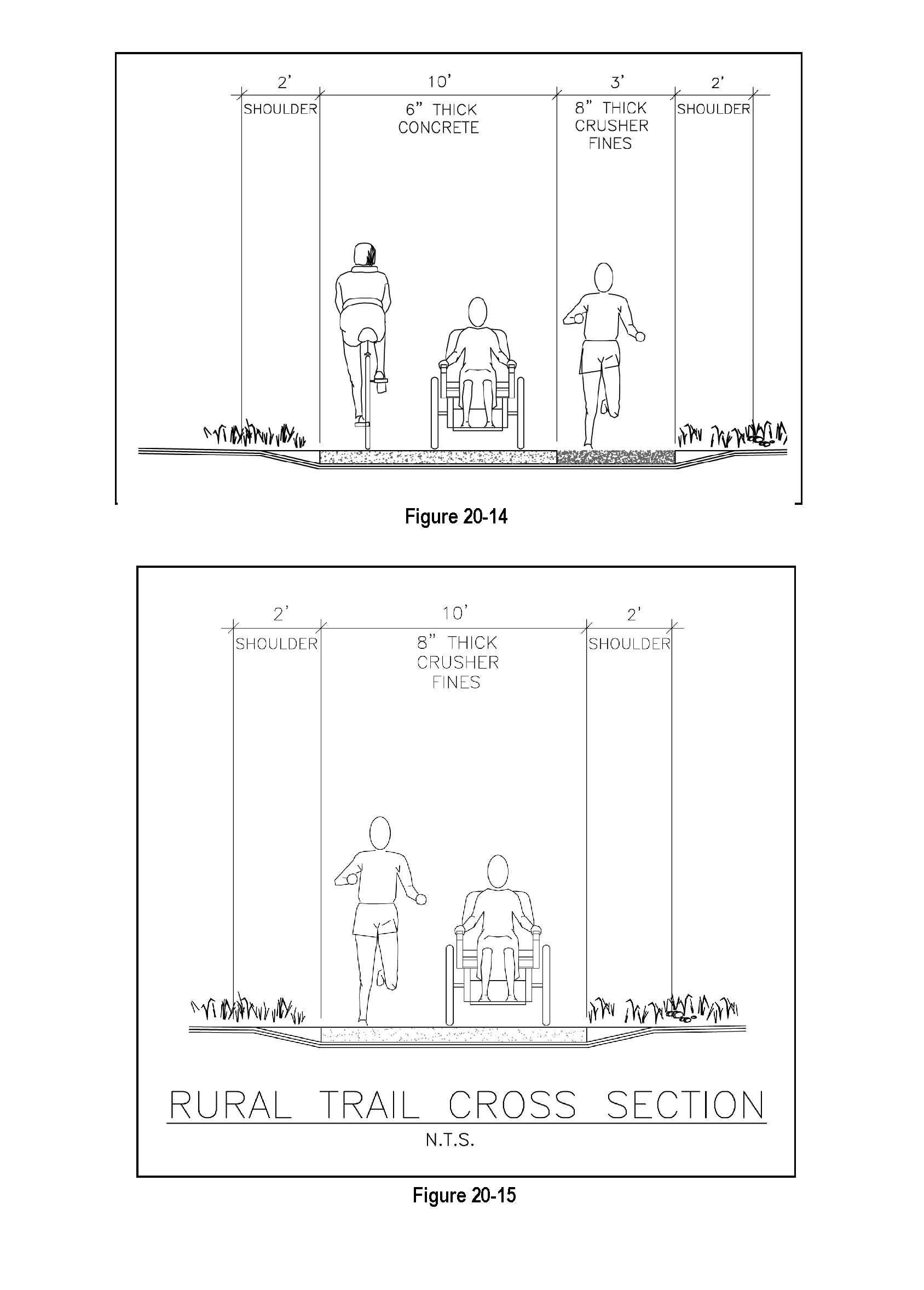
Multi-use Pathways (Bikeways). Multi-use pathways shall be provided to link internal open space areas with peripheral open space areas and shall connect to multi-use pathway routes throughout the community. Multi-use pathway routes shall be designated between residential areas and commercial and employment centers and schools. Multi-use pathways on local streets may be delineated by painted "bicycle only" lanes. Sidewalks that may be used as a multi-use pathway are required on arterial and collector streets. All other multi-use pathways shall be a minimum of eight (8) feet wide and shall be of concrete construction or where approved by the Board of Trustees, compressed gravel or crusher fines. Asphalt paving is prohibited. Bike racks shall be provided at the entry to internal and peripheral open space areas.
11.
Trails. Trails shall be provided within and surrounding open space areas and connecting open space areas. Trails shall be a minimum of ten (10) feet in width and shall be of concrete construction. The Town Board of Trustees may approve a ten (10') foot wide crusher fines trail in low density areas that will remain rural in character. A trail may be flanked on one side by a soft surface path a minimum of three (3) feet in width. The soft surface path shall be constructed with a minimum depth of eight (8) inches of compressed gravel, crowned and compacted with edging to contain trail material. See Figures 20-14 and 20-15.
[Section 20-12.] - Easement and utility standards.
A.
Utility Easement Width. Utility easements shall measure ten (10) feet on each side of abutting rear lot lines. On subdivision perimeter rear lot lines adjacent to unsubdivided property, utility easements shall measure ten (10) feet in width. In the event that the location of utility easements adjacent to rear property lines is unsuitable for use by utility companies due to drainage, irrigation ditches or other obstructions, the subdivider shall provide like width easements adjacent to said areas of obstruction. Side lot line easements, where necessary, shall measure ten (10) feet in full width; five (5) feet either side of a lot line is acceptable. Front lot line easements shall measure ten (10) feet in width. Easements may be more or less than widths stated if the specific utility indicates in writing a width other than those required by this Code. Utility easements shall be subject to the approval of the Town or applicable utility company.
B.
Multiple Installations within Easements. Easements shall be designed so as to provide efficient installation of utilities. Public utility installations shall be located to permit multiple installations within the easements. The developer will establish final utility grades prior to utility installations.
C.
Underground Utilities. Telephone lines, electric lines, cable television lines and other like utility services shall be placed underground. The subdivider shall be responsible for complying with the requirements of this Section and shall make the necessary arrangements including any construction or installation charges with each utility provider for the installation of such facilities. Transformers, switching boxes, meter cabinets, pedestals, ducts and other facilities necessarily appurtenant to such underground utilities shall be placed underground or on the surface but not on utility poles. Screening or fencing is required to the satisfaction of the Board of Trustees. Electric transmission and distribution feeder lines and necessary appurtenances thereto may not be placed above ground unless they are carrying greater than 115 kV. Such facilities shall be placed within easements or public streets, as therein provided, or upon private easements or rights-of-way provided for particular facilities. (Refer to Section 20.9 Streets - Utility easements have been identified outside the right-of-way in order to accommodate the location of street trees.)
D.
Street Lighting. Street lighting and associated underground street lighting supply circuits shall be installed. The minimum requirement shall be two hundred fifty (250) watt sodium vapor lamps at a maximum spacing of four hundred (400) feet for local streets. Arterial streets and commercial areas shall have a higher level of lighting as determined by the Board of Trustees. Street lighting shall also comply with Section 20.21.
[Section 20-13.] - Parks and open space.
A.
Intent. To ensure that a comprehensive, integrated network of parks and open space is developed and preserved as the community grows.
B.
Types of Parks and Open Space.
1.
Plazas. A plaza is typically located in a commercial or industrial area to serve as a gathering place. A plaza is usually bordered by civic or private buildings. Plazas may range from very active places with adjacent complimentary uses such as restaurants and cafes, to quiet areas with only seating, formal landscape plantings and amenities such as fountains or public art. Developers are responsible for developing and providing the appropriate amenities for each plaza.
2.
Pocket Parks. Pocket parks provide places within walking distance of residential units for supervised play for young children and unstructured activities for neighborhood residents. Developers must provide the land and develop a one (1) acre pocket park for every two hundred (200) residential units. At a minimum, a pocket park shall include live ground cover, trees, and irrigation plus one of the following: playground equipment, contemplative garden or other active or passive recreation opportunities for the neighborhood.
Projects with less than two hundred (200) units must provide a pocket park or demonstrate that they are within one-quarter (1/4) mile of a neighborhood park. If credit is taken for proximity to a neighborhood park, the developer must provide a cash-in-lieu equivalent for their pro rata share of the cost of land and improvements for a pocket park (i.e., provide twenty-five [25] percent of a pocket park for fifty [50] units).
The land and amenities of a pocket park may be added to a centrally located neighborhood park. The pocket park amenities placed in a neighborhood park must be within one-quarter (¼) mile of the sub-neighborhood's two hundred (200) residences served. For example a neighborhood park serving a neighborhood of four hundred (400) residences shall have two (2) pocket park amenity pods, located to conveniently serve each of the sub-neighborhoods.
3.
Neighborhood Parks. Neighborhood parks are places for recreation and social gatherings that are within walking distance of most residents. These parks can include multiple-use lawn areas, picnic areas, playground equipment, court game facilities and community gardens. There should be one (1) neighborhood park within ¼ mile of every residence. Every residential development shall either provide land for a neighborhood park or provide a fair share, cash-in-lieu contribution for the park that will serve the neighborhood. This can be credited toward the twelve (12) percent land dedication required at the time of subdivision. Developers providing land shall submit a conceptual design for the park to demonstrate that it meets the intent of the Town of Kersey Comprehensive Plan. Typically the Town will be responsible for the development and maintenance of the park.
4.
Community Park. Community parks serve the residents of several neighborhoods. Community parks are to be located on or near arterial streets at the edge of residential areas or in non-residential areas to minimize the impact of organized recreational activities such as lighted ball fields. These parks will be typically purchased and developed by the Town.
5.
District Park. District parks serve the residents of the entire Town as well as people who live outside of the community. These parks are located to take advantage of special natural settings, such as the South Platte river corridor. District parks are purchased and developed by the Town.
6.
Trails. The trail system shall link neighborhoods, parks, schools, open spaces, employment centers, community facilities and neighboring communities and thus provide important transportation connections as well as recreational opportunities and access. Developers must provide an internal trail system and connections to the Town's planned trail system and destinations within the neighborhood.
7.
Regional Open Space. Kersey's regional open space system includes: drainage ways, floodplains, natural areas, natural area buffer zones, wetlands, agriculture preservation areas and lands of archeological or historic significance. Improvements are generally limited to trails, educational signs and similar amenities.
8.
Storm Drainage Facilities. Storm drainage facilities, including stormwater detention and stormwater retention ponds, may function as open space for active recreation, trail corridors or habitat enhancement areas if they are designed appropriately. Credit toward the open space dedication requirements will be considered on a case by case basis by the Board of Trustees at the time of platting.
C.
General Provisions.
1.
Open Space Should Serve as the Neighborhood Focus. Open space, such as developed parks and plazas, shall be used to organize and focus lot, block and circulation patterns and to enhance surrounding development. Street, block, lot and building patterns shall respond to the views, landscape and recreational opportunities provided by the open space.
2.
Public Access. Areas designated as public open space shall be both visibly and physically accessible to the community. Public access shall be provided to all public open space, natural and developed, directly from the public street and trail system. Open space areas shall be bounded along at least fifty (50) percent of the perimeter by a street, except for pocket parks and plazas, unless otherwise authorized by the Board of Trustees. Pocket parks and plazas shall be integrated into the neighborhood design and be accessible to pedestrians and bicyclists.
3.
Buildings Shall Front Public Open Space. Development adjacent to open spaces shall front onto the area as much as possible, so that the areas are not enclosed by back yards. In the case of conservation subdivisions, open space frontage shall be appropriate to the design and character of the development. Open space and trail areas shall have a minimum of three hundred (300) feet of street frontage unless otherwise authorized by the Board of Trustees.
4.
Buffering. Appropriate buffering and setbacks shall be used between environmental resources and proposed development to ensure that the proposed development does not degrade the existing habitat. Developers shall provide an open space buffer zone around all natural areas unless otherwise authorized by the Board of Trustees. The size of the buffer zone shall be in accordance with studies prepared by the Colorado Parks and Wildlife or a qualified wetland/wildlife ecologist employed by the Town and paid for by the developer.
5.
Open Space Uses. Uses designated within the open space shall be appropriate to the context and character of the site and the intensity of the proposed development.
6.
Ownership and Maintenance of Open Space. Ownership and maintenance of public open space shall be determined by the Town on a case by case basis through the review process.
a.
Generally, the Town shall own and maintain neighborhood parks, community parks, district parks and public trails.
b.
Pocket parks, landscaped outlots and private recreational facilities shall be owned and maintained by a homeowners' association or the landowner, unless otherwise approved by the Board of Trustees.
c.
Environmentally sensitive, archaeologic and historic resources may be dedicated to the Town and maintained by the Town if approved by the Board of Trustees.
d.
Conservation areas set aside as part of a conservation subdivision shall be owned and maintained by the homeowners' association.
e.
Stormwater detention and retention areas that function as open space shall be owned and maintained by a homeowners' association or the landowner, unless otherwise approved by the Town.
f.
Areas designated as open space shall be maintained according the designated function of the area. Applicants shall work with the Weld County Public Works Department and/or National Resources Conservation Service to develop a management plan which addresses: irrigation, revegetation, erosion control, and weed management. If the area is to remain in private ownership, a mechanism which will ensure maintenance will be funded in perpetuity must be in place at the time of final plat.
7.
Open Space Protection. Areas designated as open space shall be protected by a deed restriction or other appropriate method to ensure that they cannot be subdivided or developed in the future and remain open in perpetuity. They may be dedicated to the public or held in private ownership. Appropriate ownership will be determined through the review process in cooperation with the landowner. Future use may include recreational or agricultural activities if approved by the Town.
D.
Open Space Requirements.
1.
Open Space Includes:
a.
Areas within the community designated for the common use of the residents of an individual development and/or the community at large;
b.
Areas designated for preservation and protection of environmental resources including floodplains, natural drainage ways, and wetland areas;
c.
Areas impacted by subsidence;
d.
Areas designated for agricultural preservation; and
e.
Areas of archeologic and historic significance.
2.
Open Space Shall Not Include the Following:
a.
Required setback areas around oil and gas production facilities;
b.
Disconnected remnants of land created by division of sites into lots or parcels that do not qualify as functional open space or that preserve environmental resources, unless approved by the Board of Trustees;
c.
Private yards;
d.
Tree lawns in street rights-of-way; or
e.
Required parking lot landscaping associated with all uses, except parking specifically designated for access to open space areas and within commercial/industrial projects.
3.
Amount of Open Space Required. The amount of functional open space required in each development will be based on the density of the development, the recreational requirements of the anticipated users and the anticipated opportunities for public recreation within walking distance of the site (¼ mile). However, all residential subdivisions shall dedicate a minimum of twelve (12) percent of the gross land area for public parks, trails, open space or other civic purposes at the time of subdivision. Non-residential subdivisions shall dedicate eight (8) percent of the gross land area for public parks, trails, open space and other civic purposes at the time of subdivision. This dedication can be credited toward the overall open space required for the subdivision.
a.
Single-Family Residential Developments. The developer shall provide:
i.
A minimum of twenty (20) percent of the gross land being subdivided as functional open space which may include: pocket parks, plazas, trails, recreational amenities, homeowner association owned landscaped areas (excluding parking lots), natural areas and amenities for residents or other civic purposes;
ii.
One (1) centrally-located pocket park for every two hundred (200) residential units;
iii.
The land for one (1) neighborhood park within one-quarter (¼) mile radius of the proposed homes, or a fair-share cash-in-lieu contribution for the cost of the neighborhood park that will serve the development; and
iv.
An internal trail system and local trails as designated by the Town.
b.
Multi-Family Residential Developments. The developer shall provide:
i.
A minimum of twenty-five (25) percent of the gross land being subdivided as functional open space which may include: pocket parks, plazas, trails, recreational amenities, homeowner association or landowner owned landscaped areas (excluding parking lots), natural areas and amenities for residents or other civic purposes;
ii.
One (1) centrally located pocket park for every two hundred (200) residential units;
iii.
The land for one (1) neighborhood park within one-quarter (¼) mile radius of the proposed homes, or a fair-share cash-in-lieu contribution for the neighborhood park that will serve the development; and
iv.
An internal trail system and local trails as designated by the Town.
c.
Townhouse/Condominium. The developer shall provide:
i.
A minimum of twenty-five (25) percent of the gross land being subdivided as functional open space which may include: pocket parks, plazas, trails, recreational amenities, homeowner association-owned landscaped areas (excluding parking lots), natural areas and amenities for residents or other civic purposes;
ii.
One (1) centrally located pocket park for every two hundred (200) units;
iii.
The land for one (1) neighborhood park within one-quarter (¼) mile radius of the proposed homes, or a fair-share cash-in-lieu contribution for the neighborhood park that will serve the development; and
iv.
An internal trail system and local trails as designated by the Town.
d.
Commercial, Industrial, Institutional Developments. The developer shall provide:
i.
A minimum of eight (8) percent of the gross land being subdivided as functional open space which may include: plazas, trails, landscaped areas (including parking lots), recreational amenities and natural areas and other civic purposes; and
ii.
An internal trail system and local trails as designated by the Town.
e.
Planned Unit Developments (PUD). The developer shall provide:
i.
A minimum of twenty-five (25) percent of the gross land being developed as common functional open space which may include: pocket parks, trails, homeowner association or landowner owned landscaped areas (excluding parking lots), natural areas and amenities for residents and other civic purposes;
ii.
One (1) centrally located pocket park for every two hundred (200) residential units;
iii.
Land for one (1) neighborhood park within one-quarter (¼) mile radius of the proposed homes, or a fair-share cash-in-lieu contribution for the neighborhood park that will serve the development; and
iv.
An internal trail system and local trails as designated by the Town.
4.
Open Space and Ecological Characterization Plans. All land development applications with the exception of plot plan applications for individual single-family residences shall be accompanied by the appropriate open space plan. Each land development application shall include an ecological characterization report to determine if additional areas within the development shall be preserved. Refer to Section 20.22 for a description of the ecological characterization report requirements. The following information shall be included with the landscape plans or submitted as a separate map.
a.
Conceptual Open Space and Ecological Characterization Plan (submit with subdivision outline development plan). The intent of the conceptual open space and ecological characterization plan is to identify the resources on a site and show how they are integrated into the overall design for the project and the neighborhood. This information shall be included on the outline development plan map or combined with the landscape plan if it can be clearly illustrated and the scale is not greater than 1"=200'. The conceptual open space and ecological characterization plan shall contain the following:
i.
A verbal and graphic description of the design intention and how the open space will function; and
ii.
Specific information required on the conceptual plan as listed in the table which follows.
b.
Preliminary Open Space and Ecological Characterization Plan (submit with subdivision preliminary plat). The intent of the preliminary open space and ecological characterization plan is to discuss the details of how the open space will be used to organize the overall project design, illustrate how it will function in the overall neighborhood and define long term maintenance requirements and responsibilities. Information shall be included on the preliminary landscape plan if it can be clearly illustrated and the scale is not greater than 1" = 100'. The preliminary open space and ecological characterization plan shall contain the following:
i.
A description of the design intention and how the proposal is consistent with the purpose and intent of this Section.
ii.
Specific information required on the preliminary plan as listed in the table which follows.
c.
Final Open Space and Ecological Characterization Plan (submit with subdivision final plat). The intent of the final open space and ecological characterization plan is to ensure that all phases of the final open space plan are consistent with the preliminary open space plan as approved during the preliminary plat; or for a PUD development, to identify the resources on the site and discuss the details of how the open space will be used to organize the overall project design, to illustrate how it will function in the overall neighborhood and define long term maintenance requirements and responsibilities. Information shall be included on the final landscape plan if it can be clearly illustrated and the scale is not greater than 1" = 50'. The final open space and ecological characterization plan shall contain the following:
i.
A description of the design intention and how the proposal is consistent with the preliminary open space and ecological characterization plan;
ii.
Appropriate documentation (i.e. warranty deed, homeowners' association documents, conservation easement and open space management plan) that shows who will own and maintain the open space. Applicants shall develop an open space management plan. Technical information and assistance in developing the plan are available from: the National Resources Conservation Service (NRCS), the local Colorado State University Cooperative Extension Service and the local Soil Conservation District; and
iii.
Specific information required on the final open space and ecological characterization plan as listed in the table which follows.
Table 20-14 OPEN SPACE AND ECOLOGICAL CHARACTERIZATION PLAN
[Section 20-15.] - Fair contribution for public school sites.
The subdivider shall dedicate or convey land for a public school site to the Kersey School District, hereinafter "School District," or in the event the dedication of land is not deemed feasible or in the best interests of the School District as determined by the Superintendent or designee of the School District, the subdivider shall make payment in-lieu of land dedication or conveyance. The amount of contribution of either land or payment in-lieu of land shall be determined pursuant to school district requirements.
[Section 20-16.] - Landscape design.
To exist as a nation, to prosper as a state, and to live as a people, we must have trees.
- Theodore Roosevelt
A.
Intent. To preserve Kersey and enhance new development by promoting quality landscape design that:
1.
Reinforces the identity of the community and each neighborhood;
2.
Provides tree-lined streets in urban areas;
3.
Anchors new buildings in the landscape;
4.
Provides tree canopies within paved areas; and
5.
Is environmentally sensitive by preserving existing trees, using water conservation techniques, planting native species (when appropriate), and enhances valuable habitat.
6.
Utilizes non-potable water for irrigation whenever possible.
7.
Includes integrated weed management during and after site development.
B.
General Provisions. All land development applications, including building permits for single family residential properties, shall be accompanied by an appropriate landscape plan. All landscaping within the community shall comply with the intent of these regulations.
Trees can transform a street more easily than any other physical improvement. Moreover, for many people, trees are the most important single characteristic of a good street.
- Great Streets, Alan B. Jacobs
1.
Street Trees. Landscape improvements in urban settings shall create an orderly, irrigated, managed landscape. All urban neighborhoods shall have tree-lined streets. Street trees shall include a mix of species and be aligned in straight rows. Street trees shall be placed within the right-of-way tree lawn. Spacing of trees shall allow for their mature spread. Trees installed along streets that will be widened in the future shall take into account plans for future widening of streets so that established trees will not be disturbed during future construction. On streets with attached walks, street trees shall be placed behind the walk within the right-of-way.
Landscape improvements in conservation subdivisions, environmentally sensitive areas and lower density, rural developments shall be native-looking and informal. Streets trees in rural developments shall be planted to create irregular clusters of trees to reinforce the design and character of each project and frame views.
2.
Site Landscape Design. Landscape improvements shall be an integral part of the overall site design for each property. Landscape improvements shall be designed to complement and enhance the character of neighborhoods and shall follow these guidelines:
a.
Landscaped areas shall be configured to maximize their interconnectivity within the site, to natural areas and to landscaped areas in adjacent developments. Small, isolated islands of landscaping should be avoided except as required in parking lots and for screening along roadways.
b.
Landscaped areas shall enhance functional open space through the creation of outdoor rooms appropriate to the location and purpose of the open space within the development. This can be accomplished through a combination of plantings, fencing and berms and by using natural features on the site. See Figure 20-16.
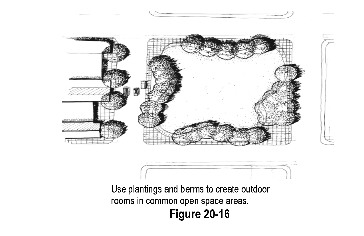
c.
Landscape improvements in all developments shall be consistent with the character of the proposed development and the surrounding area to reinforce neighborhood identity.
d.
Landscape design shall enhance natural features, drainage ways and environmental resources.
e.
All landscape improvements shall be designed for mature landscapes and shall provide appropriate visibility for cars and pedestrians.
f.
Preserve and frame views both into and out of the neighborhood.
g.
Incorporate the elements of gateway, path and destination into the design of landscapes. Gateways are entries that provide transitions from one space to another. Pathways are routes that lead to a destination. Destinations are focal points that can include anything from a garden bench at the end of a path to a civic building at the end of a street.
h.
Landscaping shall be no more than thirty (30) inches high when located in a sight distance triangle. (Refer to definitions in Article 1 and parking lot landscaping requirements for an explanation of "site distance triangle".)
i.
Existing trees shall be preserved and protected to the greatest extent possible. All land development applications shall include a tree inventory and tree preservation plan. Any trees to be removed as part of site development shall be replaced, caliper for caliper with new. New trees shall count toward the required onsite plantings. If there is insufficient room to plant replacement trees on the property to be developed, the applicant may request an alternative planting location or contribution to the Town of Kersey tree planting fund.
j.
The minimum separation between water, sanitary sewer and buried electric lines shall be five feet (5') for shrubs and ten feet (10') for trees.
k.
Planting areas that include trees shall be a minimum of six feet (6') wide.
l.
The minimum slopes for berms shall be as follows: 4:1 for any berms that require mowing for maintenance, 3:1.
m.
All applications for development shall incorporate an integrated weed management plan for both during and after completion of site development.
n.
Berms that will include mowed ground cover shall have a maximum slope of 4:1, all other berms shall have a maximum slope of 3:1 and include a combination of plantings and mulch to prevent erosion.
3.
Environmental Considerations.
a.
Landscapes shall use the following xeriscape design principles to facilitate water conservation:
i.
Well-planned planting schemes;
ii.
Appropriate turf selection to minimize the use of bluegrass;
iii.
Use of mulch to maintain soil moisture and reduce evaporation;
iv.
Zoning of plant materials according to their microclimatic needs and water requirements;
v.
Improve the soil with organic matter if needed;
vi.
Efficient irrigation systems; and
vii.
Proper maintenance and irrigation schedules.
b.
All landscapes shall strive to maximize the use of native species. Where native material is not appropriate for the intended use or appearance, plant species that are regionally adapted and noninvasive may be used.
c.
Landscapes shall consist of a variety of species to enhance biodiversity. No one species may make up more than twenty-five (25) percent of the total non-grass plant materials on the site.
d.
Buildings and parking areas shall be located to preserve and promote the health of existing trees, environmental resources and natural drainage ways. No existing vegetation, particularly mature trees shall be removed without good cause. This requirement is not intended to prevent the removal of unhealthy trees or invasive species in conjunction with site development. All existing plants that are incorporated into the design shall be adequately protected from damage during construction. Within the drip line of any protected tree, there shall be no cut or fill unless a qualified arborist or forester has evaluated and approved the disturbance and documentation is provided to the Town. The area required to protect existing trees shall be clearly marked and delineated with silt fencing or other appropriate material to assure that the area is protected from all construction activities including construction traffic.
e.
All existing plants that are incorporated into the design shall be adequately protected from damage during construction. Within the drip line of any protected tree, there shall be no cut or fill over a four-inch depth unless a qualified arborist or forester has evaluated and approved the disturbance and documentation is provided to the Town.
f.
Prior to and during construction, barriers shall be erected around all existing vegetation to be preserved with such barriers to be of orange fencing a minimum of four (4) feet high, placed no closer than six (6) feet from the trunk or one-half (1/2) of the drip line, whichever is greater. There shall be no storage or movement of equipment, material, debris, or fill within the fenced tree area. The cleaning of equipment or material or the storage and disposal of waste material such as paints, solvents, asphalt, concrete, motor oil or any other material harmful to the life of vegetation within the fenced protected area is prohibited.
g.
Trees shall be located to provide summer shade and limit winter shade on walks and streets.
h.
A combination of plantings, berms, walls and fences shall be used as appropriate to buffer sensitive habitat.
i.
All areas disturbed by construction shall be reseeded to prevent erosion. Native, noninvasive grasses shall be used for revegetation where practical. The landowner is responsible for weed control on all reseeded areas and all preservation areas.
4.
New buildings and paved areas.
a.
Anchor structures in the landscape through the use of trees, shrubs and groundcover. The size and intensity of plantings shall be appropriate to the size and context of the improvements.
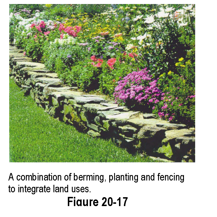
b.
Integrate adjacent land uses of different intensities through a combination of berming, plantings and fencing. Use opaque screening only when necessary to mitigate the impact of noise, light, unattractive aesthetics and traffic. A fence shall not be the only screening material use.
c.
Use landscaping to provide a transition from developed, managed landscape to more natural vegetation.
d.
Provide a tree canopy by installing shade trees within and adjacent to paved areas.
5.
Plant Materials.
a.
The minimum planting sizes on all required landscaping shall be two (2) inch caliper deciduous trees, one and one-half (1½) inch caliper ornamental trees, six (6) foot tall evergreen trees, five (5) gallon shrubs, and one (1) gallon perennials.
b.
Required plant materials shall be grown in a recognized nursery in accordance with proper horticultural practice. Plants shall be healthy, well-branched vigorous stock with a growth habit normal to the species and variety and free of diseases, insects and injuries.
c.
All plants shall conform to standards for measurements, grading, branching, quality, ball and burlapping as stated in the American Standard for Nursery Stock, 1990 Edition, American Association of Nurserymen, Inc., (AAN-ASNS) and Colorado Nursery Act of 1965 (CNA).
6.
Prohibited Plant Materials List. Refer to the Town's website or Town Hall for the list of prohibited trees.
7.
Irrigation. All required landscaping shall be irrigated as required for plant establishment and maintenance. Irrigation shall be appropriate to the type and scope of the improvements.
a.
Use of non-treated water for irrigation is encouraged if a permanent, suitable supply is available.
b.
Required landscaping in urban developments shall be irrigated with a permanent irrigation system.
c.
Temporary irrigation may be used to establish native grasses and vegetation.
8.
Guarantee of Installation. Required landscape improvements shall be installed prior to issuance of a Certificate of Occupancy (C.O.) for all structures. If weather conditions prevent installation, the developer shall post a financial guarantee for the improvements. This guarantee shall be released upon completion of the installation of the landscaping.
9.
Maintenance. In order to provide for the ongoing health and appearance of landscape improvements, all landscaping shall be maintained and replaced by the landowner/occupant as necessary. All property owners/occupants shall be responsible for maintenance and replacement of landscaping within the portion of the public right-of-way between the back of the curb or street pavement and the adjacent property.
C.
Landscaping Design Standards.
1.
Landscaped Area Definition. The area within a lot or property not comprised of hardscape, measured at the ground plane. Landscape area will not include tree canopy area, bare dirt, or weeds. Water features may be included in the calculation of landscape area. Landscaped area will not include rights-of-way. Landscape requirements within the right-of-way are met by complying with street tree and groundcover requirements.
2.
Landscaping within the Right-of-Way and Required Common Open Space. Where applicable along roadways, only the area between the ultimate build-out edge of road and the property line shall be used for street trees and other required landscaping. Areas between the current edge of road and ultimate build-out edge of road shall be covered with turf only and shall be irrigated with zones separate from the rest of the right-of-way. The developer or assigns shall provide:
a.
Street trees - Street trees: Deciduous shade trees, selected from the Town's tree list, shall be provided at the rate of one (1) tree on approximately forty-foot centers in tree lawns along all streets adjacent to or within new developments and for new single-family, two-family and town home dwellings in existing neighborhoods along all streets. Where this spacing would result in a tree location in conflict with utility facilities or driveways, the spacing may be reduced or increased to facilitate the best location for tree planting purposes. Tree lawns shall be a minimum of six (6) feet in width between the curb and detached sidewalk and shall consist of sixty-five percent (65%) live groundcover. See Figure 20-18.
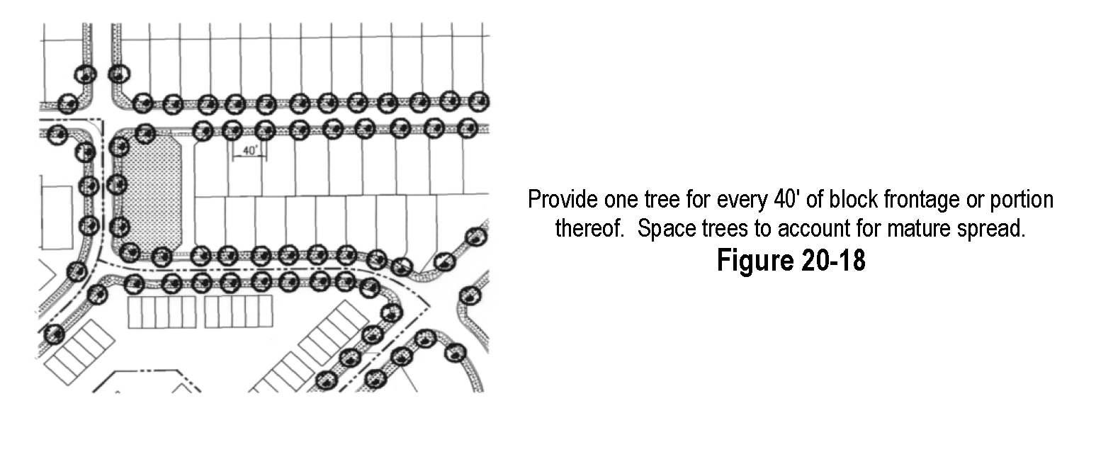
b.
Collector and local streets - live groundcover including a combination of grass, trees, flowers, grass or shrubs. In commercial areas this area may be paved if it functions as pedestrian access to storefronts and is integrated into the overall design of the other improvements on the site.
c.
Arterial streets - live groundcover as appropriate to the use and function of the area, including a combination of grass, trees, flowers, paving and one shrub for every two hundred (200) square feet of landscape area clustered into planting beds. Developer shall also install an automatic irrigation system for all landscaping within arterial rights-of-way. Existing trees and shrubs the are preserved may count toward the required plant materials.
d.
Landscaping for required common open space - landscaping within new multi-family developments or other residential developments that have common open space shall be provided as specified within each land use category below. Landscape area shall include common open space within the development and shall be in addition to the required street trees in Paragraph (1) above.
e.
A mechanism for long-term maintenance and replacement of landscaping in common open space and within arterial, collector and local street right-of-way landscaping - such as a homeowners' association and covenants.
3.
Small Lot Single Family Residential Development Landscaping Standards.
a.
In addition to landscaping the right-of-way tree lawn, the developer or assigns shall provide:
i.
Groundcover for the front yard setback of each home. There shall be a minimum of sixty-five percent (65%) live materials between the front of the house and the curb unless otherwise approved by the Town.
ii.
Five (5) shrubs for the front yard setback of each home.
iii.
One deciduous shade tree per lot, per street frontage in the front yard and on the side yard for corner lots.
b.
The homeowner shall:
i.
Install remainder of yard - and is encouraged to limit turf to functional areas and to plant additional trees, shrubs and flowers using xeriscape principles and the general provisions set forth in this Section.
ii.
Maintain the yard and landscaping within the adjacent road right-of-way in accordance with Town regulations.
4.
Multi-Family, Mixed Use and Townhouse/Condominium Residential Landscaping Standards:
a.
In addition to right-of-way landscaping, the developer or assigns shall provide:
i.
Site trees - Site trees: A minimum of one (1) tree per one thousand (1,000) square feet of the landscaped area provided, distributed on the site. A minimum of fifteen (15) percent of the site (gross) shall be landscaped areas, this may include landscaping in parking lots, within rights-of-way, and in detention areas. A minimum of 50% of the total trees provided must be deciduous and a minimum of 25% of the total trees provided must be deciduous canopy trees. Trees shall be located to provide shade for structures and common open space. Existing trees that are preserved may count toward the required plantings.
ii.
Shrubs - a minimum of one (1) shrub per three hundred (300) square feet of the landscaped area provided. Group shrubs and distribute throughout the site. Trees may be substituted for up to one-half (½) of the required shrubs at the rate of one (1) tree for ten (10) shrubs. Shrubs and groundcover shall be strategically placed near foundations to help anchor the structure.
iii.
Groundcover - irrigated turf maintained to appropriate standards for active recreation in areas that will function for active recreation. Where appropriate, use native grass for areas that will not function as active recreation areas. Native grass must be weed free and maintained at a maximum height of fifteen (15) inches. There shall be a minimum of sixty-five (65) percent live materials between the front of the house and the curb unless approved by the Town.
b.
Landscape setback to parking lots - twenty (20) feet from streets. The purpose of the setback is to provide a buffer between streets and parking areas. This setback may be reduced to fifteen (15) feet if used in combination with a two to three (2'-3') foot masonry or stone decorative wall. Signage may be included in this setback.
5.
Large Lot Single-Family Residential Development Landscaping Standards. Landscaping shall be designed to keep natural resource areas in their natural state as much as possible and should be in character with surrounding properties.
a.
The developer or assigns shall provide:
i.
Site trees - a minimum of one (1) deciduous shade tree per lot per street frontage, in the front yard and on the side yard for corner lots. Existing trees that are preserved may count toward the required plantings.
ii.
Groundcover - for the front yard setback of each home. The groundcover may be a combination of irrigated and native grasses and wildflowers as appropriate to the function of the areas and design of the individual home. There shall be a minimum of sixty-five (65) percent live materials between the front of the house and the edge of road unless approved by the Town.
iii.
Ten (10) shrubs - for the front yard setback of each home.
b.
The homeowner shall:
i.
Install remainder of yard - The homeowner is encouraged to limit installation of irrigated turf to functional areas and to plant additional trees, shrubs and flowers using xeriscape principles and the general provisions set forth in this Section.
ii.
Maintain the yard and replace required landscaping within the adjacent road right-of-way in accordance with Town regulations.
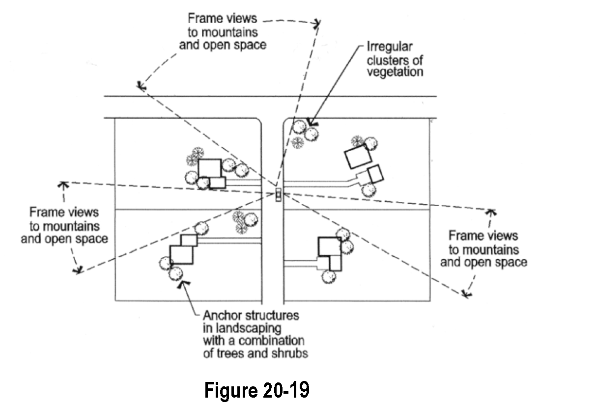
6.
Business/Commercial, Industrial Development, Institutional, Public Facilities, and Non-Residential Landscaping Standards.
a.
Landscape improvements shall be designed to enhance the overall appearance of the development and integrate the project with adjacent land uses and into the surrounding neighborhood. All improvements shall consider the people who will use the site, travel through or by the site and adjacent land uses. A minimum of fifteen (15) percent of the site (gross) shall be landscaped area, this may include landscaping in parking lots, within rights-of-way, and in detention areas.
b.
The developer or assigns shall provide:
i.
Site trees - plant a minimum of one (1) tree per one thousand (1,000) square feet of landscaped area required, distributed on the site. Trees shall be located to provide shade for structures and gathering places. Existing trees that are preserved may count toward this requirement.
ii.
Shrubs - plant a minimum of one (1) shrub per two hundred (200) square feet of landscaped area required. Group shrubs and distribute throughout the site. Trees may be substituted for up to one-half (½) of the required shrubs at the rate of one (1) tree for ten (10) shrubs. Shrubs and groundcover shall be strategically placed near the foundation to help anchor the structures.
iii.
Groundcover - establish irrigated grass turf maintained to appropriate standards for active recreation in areas that will function for active recreation. Where appropriate, use native grass for areas that will not function as active recreation areas. Native grass must be weed free and maintained at a maximum height of eight (8) inches. There shall be a minimum of sixty-five (65) percent live materials between the building and the street unless approved by the Town.
iv.
Landscape setback to parking lots - twenty (20) feet from streets. The purpose of the setback is to provide a buffer between street parking areas. This setback may be reduced to fifteen (15) feet if used in combination with a two to three (2'-3') foot masonry or stone decorative wall. Signage may be included in this setback.
v.
Screen loading areas - screen loading areas (including vehicles being loaded), service and storage areas visible from the public right-of-way or adjacent property with an opaque screen that is an integral part of the building architecture landscaping, or a combination. Chain link fences with slats, tires or used building materials are not acceptable screening materials.
vi.
Compatibility - integrate activities on the subject property with adjacent land uses by utilizing a combination of landscaping, building orientation and appropriate architectural elements.
c.
The building owner, owners' association, or occupant shall maintain and replace all required plantings in perpetuity.
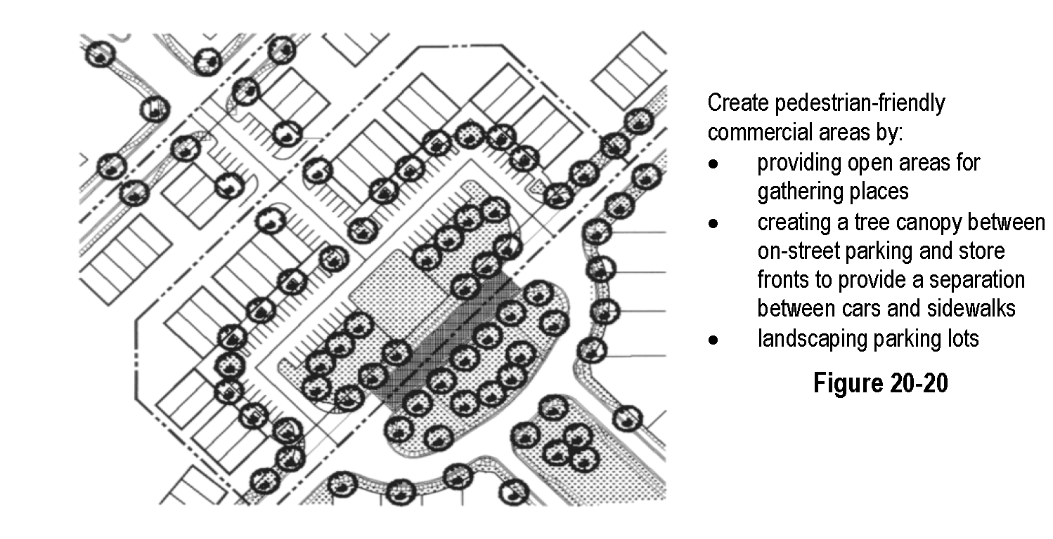
7.
State Highway 34 Corridor Landscaping Standards. The developer or assigns shall provide:
a.
Landscape setback to parking lots - provide a thirty (30) foot landscape setback from the highway. The purpose of the setback is to provide a buffer between the street and parking areas. Signage may be included in this setback.
b.
Shrubs - a minimum of one (1) shrub per two hundred (200) square feet of landscaped setback. Group shrubs and distribute throughout the landscape setback. Trees may be substituted for up to one-half (½) of the required shrubs at the rate of one (1) tree for ten (10) shrubs.
c.
Groundcover - native, low-water grasses shall be the primary groundcover.
8.
Downtown Landscaping Standards. Downtown landscaping is intended to provide an attractive environment for people to walk and shop. Refer to the Town's website Design Vocabulary for examples of the landscaping that the Town is encouraging.
a.
The developer or assigns shall provide:
i.
Deciduous shade trees, selected from the Town's tree list, shall be provided at the rate of one (1) tree on approximately forty-foot centers along all existing streets in the downtown area. Where this spacing would result in a tree location in conflict with utility facilities, alleys or driveways, the spacing may be reduced or increased to facilitate the best location for tree planting purposes. Trees installed along streets shall be located within a protective tree grate or included in mulched shrub beds that shall be flush with the sidewalk. Existing trees that are preserved may count toward this requirement.
ii.
Additional landscaping may be provided in the form of planters or window boxes which shall be constructed of the same or similar materials used in the adjacent building or of similar materials used in benches and trash receptacles and may be designed to include bench seating.
iii.
Buffering shall be provided between land uses of different intensities, such as between residential and commercial uses. The responsibility for buffering shall rest with the proposed land use, rather than with existing land uses. Buffering may be accomplished through the use of dense plant materials, fencing, walls, berms or a combination of these methods and shall provide visual screening between the land uses, as well as screen or mitigate other negative impacts such as noise or lighting.
iv.
Existing trees shall be preserved where feasible and when the trees are in good health and of a desirable species. When trees are removed from a site, replacement shall be at a ratio of two (2) trees for every tree that was removed from the site.
v.
Street furniture, including benches and trash receptacles, shall be provided to serve the public and shall be constructed of a combination of wood and wrought iron or other similar metal. Planters may be constructed of the same or similar materials used in the adjacent building or of similar materials used in benches and trash receptacles and may be designed to include bench seating. All street furnishings in the downtown shall meet standards established by the Town.
vi.
Street lighting fixtures shall be approved by the Town.
9.
Parking Lot Landscaping Standards. Parking lot landscaping is intended to break up large expanses of pavement, create shade, buffer views of parking lots from adjacent streets and development and enhance the overall appearance of each project.
a.
Applicability - All parking lots with fifteen (15) spaces or more shall be subject to these requirements. Landscape standards for parking lots within the downtown business district may be adjusted to provide the maximum number of parking spaces within the downtown. The applicant must demonstrate that the variance from the standard will provide additional parking and provide alternative streetscape improvements to meet the intent of this Article.
b.
The developer or assigns shall provide:
i.
Site trees - a minimum of one (1) tree per ten (10) parking spaces. Group trees together in islands which are a minimum of eight (8) feet wide. Use the landscaping to break up large expanses of pavement and to create a tree canopy for summer shade. Existing trees that are preserved my count toward this requirement. See Figure 20-21.
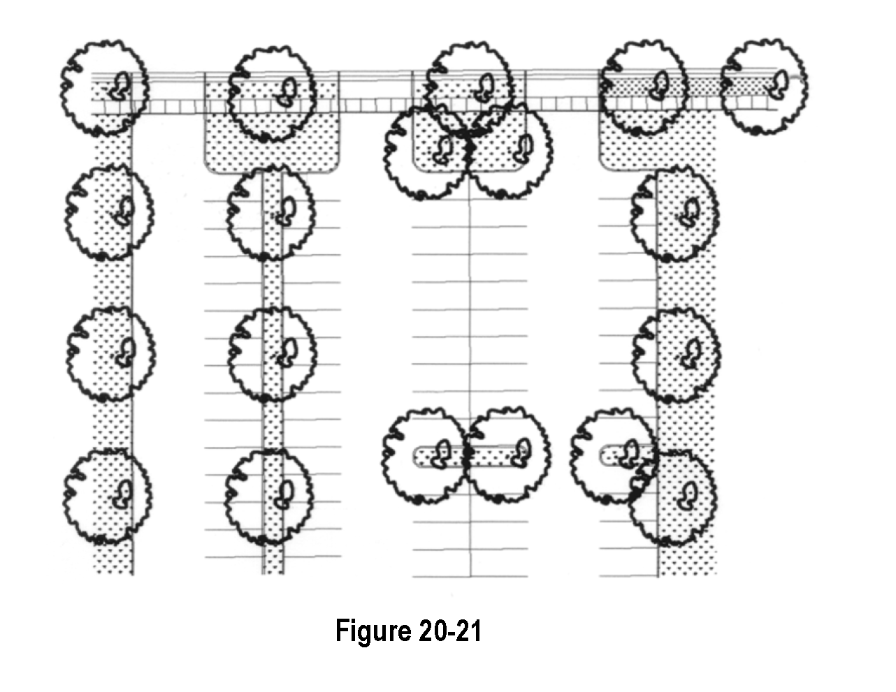
ii.
Shrubs - a minimum of one (1) shrub per three hundred (300) square feet of landscaped area. Group plantings in landscape islands.
iii.
Groundcover - limit areas of irrigated turf. Grass is discouraged in areas less than ten (10) feet wide. Install a grass buffer (native grass where possible) around the perimeter to filter runoff and improve water quality.
iv.
Landscape setback to parking lots - twenty (20) feet from streets. The purpose of the setback is to provide a buffer between the street and parking areas and to screen the parking from the street. This setback may be reduced to fifteen (15) feet if used in combination with a two to three (2-3) foot articulated masonry or stone decorative wall with trees and shrubs on both the street and parking lot sides of the wall to soften its appearance. Signage may be included in this setback.
v.
Screening - Parking lots shall be screened through the use of dense shrubbery, low walls, berms or a combination of these methods a minimum of three (3) feet in height, so that at least fifty (50%) percent of the light from headlights of vehicles in the parking lot is screened from view beyond the parking lot.
vi.
Parking bays - shall extend no more than fifteen (15) parking spaces without an intervening tree, landscape island or landscape peninsula.
vii.
Overstory/shade trees - shall comprise at least seventy-five (75%) percent of the trees within the landscape islands that are counted toward the parking lot landscape requirement.
viii.
Vehicle overhang - Planting of trees and shrubs with a mature height of 6 inches or more in the vehicle overhang is not allowed.
ix.
Provide a mechanism for long-term maintenance of landscaping - all landscaping within and adjacent to parking lots shall be owned, replaced in perpetuity, and maintained by the landowner, owners' association or occupant.
10.
Sight Distance Triangle. Landscaping taller than 36" high at maturity shall not be placed within the applicable sight distance triangle, nor in any manner that impedes visibility or public safety. The following chart shall be used to determine the sight distance triangle:
Table 20-15
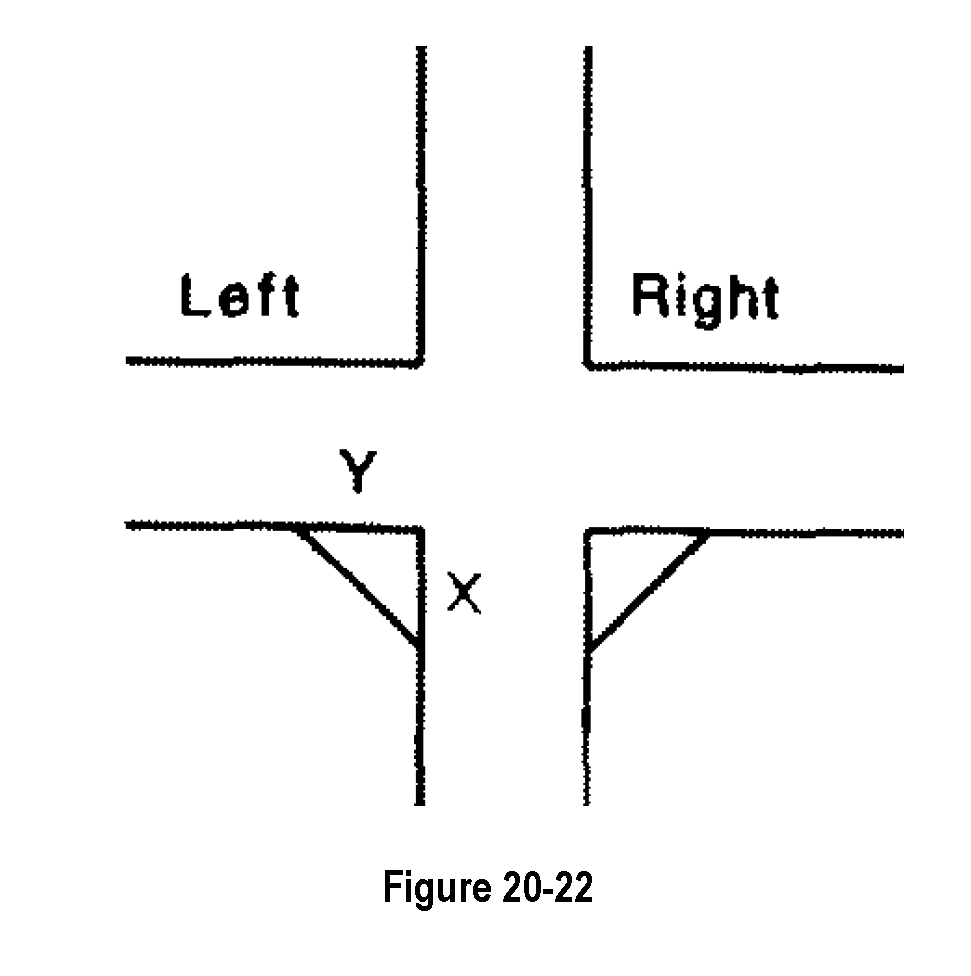
D.
Storm Drainage Facilities.
1.
Intent. To promote innovative and effective land and water management techniques that protect and enhance water quality.
2.
General Provisions.
a.
Landscaping associated with storm drainage facilities shall be integrated into the overall design of the project.
b.
It shall enhance the overall appearance of the project, prevent erosion and improve water quality of storm water runoff.
c.
Storm drainage facilities may function as open space for active recreation, trail corridors or habitat enhancement areas if they are designed appropriately and approved by the Board of Trustees.
d.
The use of planting strips and shallow, landscaped depressions in parking lots and along roads is encouraged to help trap and remove pollutants from storm water runoff.
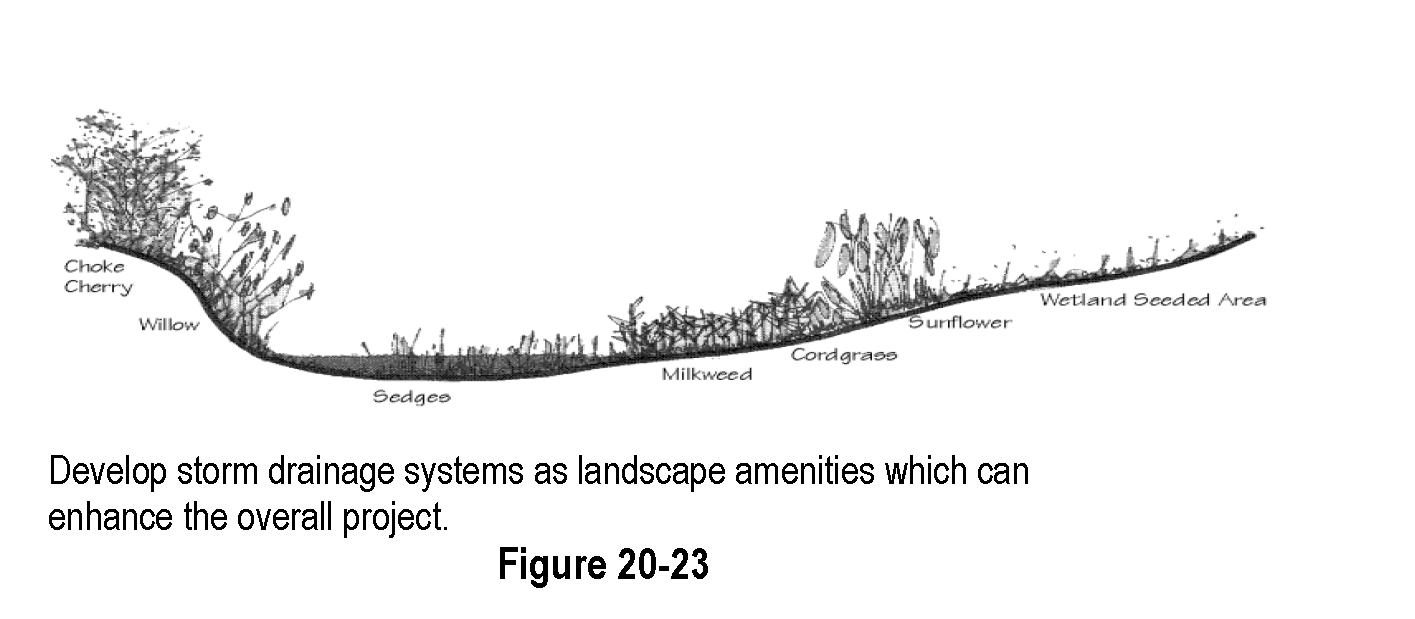
3.
Applicability. All storm drainage facilities shall be appropriately landscaped.
4.
Minimum Requirements.
a.
All facilities shall be seeded to grass appropriate to the function of the area. Areas to be used for active recreation shall be seeded to a turf-type grass and irrigated with a permanent irrigation system. Areas to be maintained for habitat enhancement shall be seeded to native grasses and wildflowers. Developer is responsible for establishment of a complete, weed free stand of grass. Trail corridors may be seeded to native grasses if appropriately integrated with adjacent improvements.
b.
Maximum side slope on drainage facilities shall be 4:1, minimum slope of the bottom of a drainage facility shall be one (1) percent.
c.
Landscape improvements shall be designed to enhance the function of the facility. Areas designed for recreation shall include clusters of trees to provide shade, located so they do not impair the function of the facility.
d.
Habitat and water quality enhancement including wetland plantings in low wet areas is encouraged.
5.
Ownership and Maintenance.
a.
All drainage facilities shall be owned by the owners' association and maintained by the landowner or occupant unless otherwise approved by the Town.
E.
Submittal Standards for Landscape Plans. All land development applications will be accompanied by the appropriate landscape plan per Table 20-16:
Table 20-16
1.
Conceptual Landscape Plan. (submit with sketch plan) Intent: to illustrate the overall design concept for landscaping and depict how it relates to the overall development.
a.
Describe the design intention of the proposed landscape improvements.
b.
This information should be included on the outline development plan map or combined with the conceptual open space and ecological characterization plan if it can be clearly illustrated, and the scale is not greater than 1"=200'.
c.
Information required on the plan is listed in Table 20-17.
2.
Preliminary Landscape Plan. (submit with preliminary plat) Intent: to illustrate the master landscape plan for the development.
a.
Describe the design intention and how the proposal is consistent with the purpose and intent of these regulations.
b.
Landscaping should be included on the preliminary open space and ecological characterization plan if it can be clearly illustrated and the scale is not greater than 1" = 100'.
c.
Information required on the plan is listed in Table 20-17.
3.
Final Landscape Plan. (submit with final plat, USR, site plan) Intent: to ensure each phase of the final landscape plan is consistent with the master landscape plan for the development and to illustrate the specific landscaping details for each phase.
a.
Describe the design intention and how the proposal is consistent with the preliminary landscape plan.
b.
The final landscape plan must be on a separate page from the final plat map and should be included with the final open space and ecological characterization plan if it can be clearly illustrated. The scale shall not greater than 1"=50'.
c.
Information required on the plan is listed in Table 20-17.
Table 20-17
[Section 20-17.] - Buffering and screening techniques.
A.
Intent. To integrate adjacent land uses and provide seamless transitions from one use to another through the use of building orientation and access, landscaping and appropriate architectural elements.
B.
General Provisions.
1.
Special consideration shall be given to adjacent land uses of different intensities. It shall be the responsibility of the developer of the more intensive use to ensure that the transition from one use to another is attractive, functional and minimizes conflicts between the current and planned uses. Proposed lower intensity uses adjacent to existing more intensive uses shall be responsible for appropriate screening and buffering as part of the proposed development.
2.
It is the responsibility of the developer of the higher intensity use to demonstrate that the uses will be compatible. This can be accomplished through the effective use of shared access and parking, appropriate building orientation and setbacks, landscaping, architectural treatment and limited use of fencing and screening walls. Special consideration shall be given to the impact of aesthetics, noise, lighting and traffic. See Figure 20-23. Proposed lower intensity uses adjacent to existing more intensive uses shall be responsible to demonstrate compatibility with the existing higher intensity use.
3.
Buffering may be required between any development and adjacent natural or environmentally sensitive areas. This will be determined on a case by case basis.
4.
Under no circumstances shall a fence be the only screening material used as a buffer between land uses.
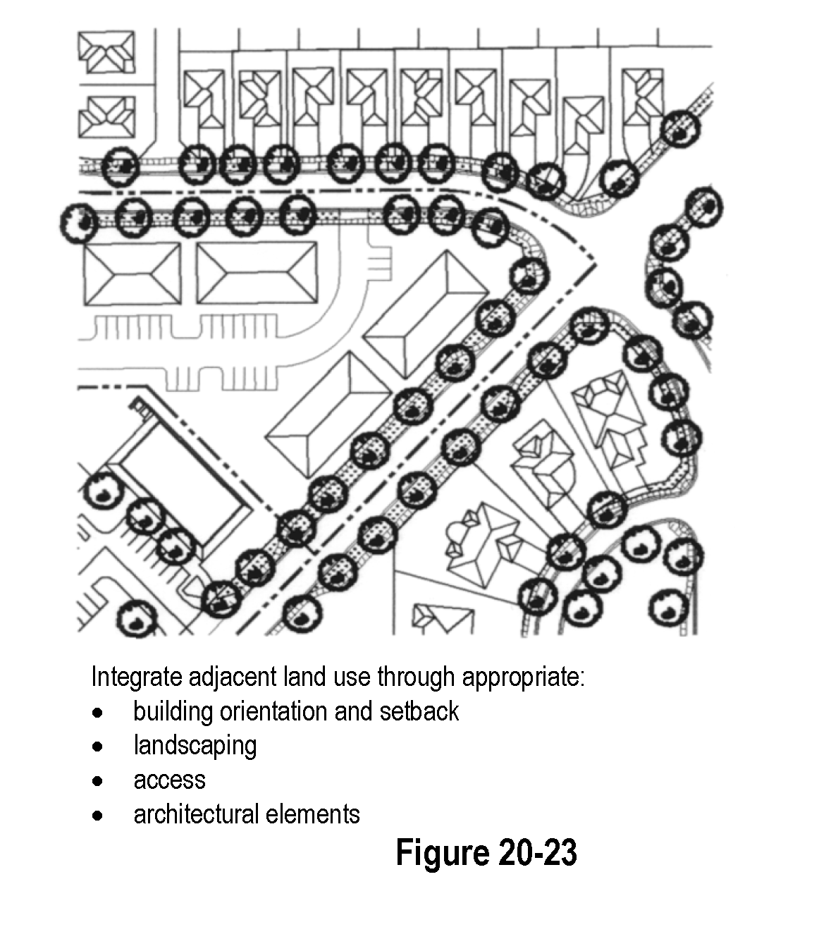
C.
Location and Screening of Required Loading and Service Areas.
1.
Loading docks, solid waste facilities, recycling facilities and other service areas shall be placed to the rear or side of buildings in visually unobtrusive locations.
2.
Screening and landscaping shall prevent direct views of loading areas and their driveways and outside storage areas from adjacent properties or from the public right-of-way. Screening and landscaping shall also prevent spill-over glare, noise, or exhaust fumes. Screening and buffering shall be achieved through walls, architectural features, and landscaping; and shall be visually impervious. Recesses in the building or depressed access ramps may be used.
D.
Dumpsters.
1.
Every development that is required to provide one or more dumpsters for solid waste collection shall provide sites for such dumpsters that are:
a.
Located to facilitate collection and minimize any negative impact on persons occupying the development site, neighboring properties, or public rights-of-way; and
b.
Constructed to allow for collection without damage to the development site or the collection vehicle.
2.
All such dumpsters shall be screened to prevent them from being visible to:
a.
Persons located within any dwelling unit on residential property other than that where the dumpster is located;
b.
Occupants, customers, or other invitees located within any building on nonresidential property other than that where the dumpster is located; and
c.
Persons traveling on any public street, sidewalk or other public way.
E.
Noise Pollution Buffers.
1.
For commercial and industrial uses where there is a potential for noise pollution, a noise study completed by a qualified noise engineer may be required to ensure that noise emissions at the property line do not exceed state standards.
2.
If a noise buffer is required, it shall consist of landscaped earth berms or sound barrier walls with landscaping at the base or as otherwise determined acceptable by the Board of Trustees.
3.
It shall be the responsibility of the higher intensity user to provide the appropriate buffer unless a lower intensity use is proposed adjacent to an existing higher intensity use. Lower intensity uses adjacent to existing higher intensity uses shall be responsible for the appropriate buffers.
[Section 20-18.] - Fences and walls.
A.
Intent. To ensure that walls and fences are attractive and in character with the neighborhood. Recognizing that fences are used to create privacy, Kersey encourages privacy fences be located close to the house and not alongside and rear property lines.
B.
Permit Required. No fence shall be constructed after the effective date of the ordinance codified herein unless a building permit has previously been issued authorizing the construction of such fence. The proposed building permit shall be reviewed by the Town Administrator or Building Official, and if such official is satisfied that the proposed fence complies with this Section, then a building permit may issue without a building permit fee or further review.
C.
Location.
1.
Fences, walls and hedges may be placed in appropriate locations in order to provide screening and enclosures. Fences and walls shall be constructed of materials which are visually pleasing and compatible with the surrounding improvements. Height changes, offset angles and the use of complementary materials may be used to create variety in fences and walls.
2.
Fences shall be permitted in the interior side or rear yards, provided that the fence does not extend beyond the front line of the principal building or structure; in the case of corner lots, does not extend beyond the front or street sideline of the building or structure and does not exceed a height of six (6) feet.
3.
On reverse frontage lots, fences shall be permitted, provided that the fence is set back a minimum of three (3) feet from the bank (back) of the sidewalk and does not exceed a height of three (3) feet and does not interfere with line of sight at intersections.
4.
Fences, walls and hedges shall not be located in any public right-of-way without the written consent of the Board of Trustees, and the Board of Trustees may withdraw such consent at any time upon sixty (60) days' notice, and upon such withdrawal with consent, the fence, wall or hedge must be removed at the landowner's cost.
D.
Materials. All fencing shall be constructed of brick, wood pickets, vinyl, wrought iron, decorative concrete block, chain link (in rear yards only) or other material normally used for fencing and shall be constructed to conceal or integrate all structural members of the fence into the architectural design of the fence. All other materials and construction methods shall be subject to review and approval by the Planning Commission and all such alternative materials shall only be approved if such materials comply with this Chapter, blend into the neighborhood and are not unsightly or dangerous in any manner. The following types of fences will only be permitted upon showing of a need for the designated type of fence:
1.
Chain link may be allowed in the front lot in a business or industrial zone, upon establishing a need for such a fence for reasons of security or protection of outdoor storage and approval from the Planning Commission. A six-foot chain link fence may be permitted upon approval of a Site Plan review, provided that such fence is set back a minimum of eight (8) feet from the bank or back of the sidewalk, or if no sidewalk, then eight (8) feet from where the sidewalk should be if one were in place;
2.
Barbed wire fencing in business or industrial areas may be allowed, upon approval as part of a Site Plan review, provided that no more than three (3) strands of barbed wire are added to the height of a fence, and provided that the lowest strand of barbed wire is maintained at least six and one-half (6½) feet above the adjoining grade.
E.
Prohibited Materials. No fences shall be constructed in whole or in any part of concertina, razor wire, barbed wire, tin, wood scraps, mill scraps or slabs, or any unsightly material. No electrically charged fences will be allowed. No chain link fence will be allowed in front yards. For purposes of this Section, the front yard shall exclude any porch, deck or veranda. The front wall shall be a load-bearing primary wall. Note: barbed wire and electrically charged fences are allowed in the A - Agriculture zone as required as part of ingoing agricultural operations.
F.
Decorative Fences. Decorative or ornamental fences shall be permitted in the front yard, provided that the following conditions are met:
1.
The fence shall not be located in the street right-of-way.
2.
The maximum height allowable is three (3) feet.
3.
The fence must meet all sight distance regulations as set forth in Section 20.16
4.
Visibility through fences shall not be less than fifty (50%) percent.
5.
No total enclosure or gates will be allowed.
6.
Minimum setback from the bank or back of the sidewalk shall be three (3) feet. This includes detached sidewalks in the adjacent right-of-way.
G.
Maintenance. All fences shall be maintained in good structural condition and in good repair at all times. Such maintenance shall include, but is not limited to, the replacement of any broken or missing portions of the fences. Dilapidated, unsightly or dangerous fences shall be removed or repaired when so ordered by the Town. Areas adjacent to fences, walls and hedges shall be maintained in a clean, sanitary and inoffensive condition, free and clear of all obnoxious substances, rubbish and weeds. Hedges shall be maintained in a healthy condition, trimmed and pruned as appropriate for the plant type. Dead plant material in hedges shall be removed or replaced as appropriate when so ordered by the Town. Hedges shall not encroach upon sidewalks or street rights-of-way. The Town may repair and/or replace fencing or plants and bill the owner if the owner does not make repairs as ordered by the Building Inspector.
H.
Non-Conforming Fences. This Section shall apply to all fences constructed after the effective date of the ordinance codified herein. Any fence existing prior to the effective date of the ordinance codified herein shall be allowed to remain as constructed. If any nonconforming fence is removed or rebuilt, the new construction must comply with this Section.
I.
Warranty Period. The warranty period for perimeter fences along arterial and collector streets shall be two (2) years. Provision for compliance shall be as outlined in the warranty section of the Subdivision Improvements and Development Agreement.
[Section 20-19.] - Residential architecture (single-family and multi-family dwellings).
A.
Intent. Architecture plays an important part in developing an identity for neighborhoods and dwellings. Thus, the Town wants to build upon the architectural traditions of the region yet allow for diversity of expression. In addition, the Town wants to encourage a variety of housing types, sizes and prices in each neighborhood to allow people to remain in their neighborhoods, as their housing needs change.
B.
Housing Diversity/Neighborhood Identity. Housing diversity is an important goal for new residential development in Kersey. In support of this, the integration of detached and attached single-family dwellings and multi-family dwellings within neighborhoods, even in the same block, is encouraged.
C.
Single-Family Detached and Duplex Dwellings. The intent of this section is to build a significant proportion of single-family detached and duplex dwellings with architectural designs that relate homes to the street, that create diversity and variety along residential streets, that have front porches, rear-loaded garages or alternatively loaded street-accessed garages, and that reflect traditional Colorado styles and neighborhoods, as well as more modern designs.
1.
Streetscape Diversity. Single-family detached building requirements are intended to ensure that an adequate mix of models and styles are offered within a neighborhood and within each block face.
Before the building of single-family and duplex dwellings may commence on a block and prior to the issuance of a building permit within the block, the applicant shall illustrate through the use of a Block Diversity Plan, how the development will comply with the requirements set forth in this section. Final plat approval cannot be given without approval of a Block Diversity Plan for the initial stage of development. Developments of three (3) dwelling units or less are exempted from this provision. A Block Diversity Plan shall include, at a minimum, the following:
a.
A map that illustrates the model and elevation for each building on the block.
b.
The color palette to be used.
c.
A written statement that specifies how provisions of Section 20.19.C.1 - 15 of the single-family detached and duplex dwellings section of this Code will be met.
In order to allow for flexibility in sales, a Block Diversity Plan may be modified over time, provided the minimum requirements of this section are met. The applicant shall enforce these requirements as individual lots are purchased.
2.
Model Diversity.
a.
Each block face shall contain at least three (3) different models or duplex buildings that have significant variations in floor plan configuration and massing. Differentiation in models requires all of the following variations:
i.
Rooms and elements program;
ii.
Floor plan configuration;
iii.
Massing;
iv.
Size;
v.
Color scheme;
vi.
Use of exterior material;
vii.
Garage component (at street-access condition); and
viii.
Garage access (at street-access condition).
b.
Each block face shall contain no more than two (2) of the same model or duplex building with the same architectural style.
c.
Significant variation in the range of wall colors on a block face is encouraged. Use different colors on adjacent building facades. Treat a block face as a unified composition.
d.
Each block face shall contain at least three (3) roof colors.
e.
The same model with the same architectural style shall not be placed adjacent to each other or directly across the street from one another.
f.
At least one-half (1/2) of the buildings on each block face shall have a front porch.
g.
All housing shall have a street address clearly displayed and visible from the street.
h.
Project should demonstrate in what manner it relates to adjacent properties. Submit a photo to show how it fits with context.
3.
Stylistic Diversity. Each model or duplex building shall have at least two (2) architectural styles and color schemes.
4.
Enhancements at Corners. At corners, buildings shall address the side street or open space. Corner lots shall be wide enough to allow for side elevation enhancements. At least two (2) of the following enhancements are required:
a.
A side or wrap-around porch, or a bay window. Wrap-around porches are encouraged.
b.
Windows or glazed doors that face the side street or open space.
c.
A change in the vertical or horizontal wall plane.
d.
Brackets, projections, belt courses, or other such details.
5.
Architectural Style. New residential architecture shall resemble the architecture commonly found in Colorado neighborhoods or more modern designs. The goal is to create the memorable character, identity, and appeal that these neighborhoods display, not to provide exact replicas of historic buildings. Photographs that illustrate the basis of the proposed architectural styles shall be provided. See Section 2.26 Design Vocabulary for examples of architectural styles that the Town is encouraging.
6.
Massing. The mass of a house or duplex should strongly reflect its architectural style and be scaled to provide visual interest and depth, reduce boxiness, and achieve an articulated form on all four sides.
7.
Roof.
a.
The roof forms and pitches of a house or duplex shall strongly reflect its architectural style. In general, a simple dominant roof form should be used in combination with complimentary secondary and minor roof forms and elements.
b.
Roof overhangs, eaves, fascias and soffit detail shall be detailed appropriately for the architectural style of the building.
c.
The character and placement of dormers, when used, shall also reflect the architectural style of the building.
d.
Any uninterrupted roof line greater than 30 feet long shall include a hip, gable, or other architectural elements to break up the uninterrupted roof line.
8.
Covered Entries and Porches.
a.
A covered entryway for the front door is encouraged.
b.
Porch designs shall reflect the architectural style of the building. Where provided, a porch shall be at least six (6) feet deep, eight (8) feet wide, and be defined by a railing, columns or similar architectural features that are scaled and detailed to reflect their style.
c.
Raised porch floors, sixteen (16) inches or more above the finished grade, are encouraged.
9.
Front Doors. Front doors shall be designed, detailed and located to be prominent architectural element visible from the street. The door style, scale, and trim shall complement the architectural style of the building.
10.
Windows. The window type, composition, proportions, and trim for a house shall strongly reflect its architectural style. The use of muntins is encouraged to create a smaller scale.
11.
Exterior Embellishments. Bays, projections, brackets, trim and material changes that are appropriate for the expression of the architectural style of a building are encouraged.
12.
Exterior Color.
a.
The skillful use of color variation is especially important. Monotonous color palettes are strongly discouraged.
b.
Strong colors should be muted shades or tints of the pure hue to ensure that colors are subdued. High gloss paints are discouraged. Use saturated color hues sparingly as accents.
c.
Wall, trim, accent, roof and masonry colors shall be coordinated.
d.
Generally, corner trim should be of similar or lighter value than the main body color.
13.
Decks.
a.
All vertical elements (columns, beams, railing, stairs, supports), fascias, and overhead elements of elevated and walkout decks shall be painted or stained to match or compliment the permanent colors of the main structure and not left to weather naturally.
b.
Deck posts shall be a minimum of six (6) inches in section unless grouped (two [2] or more posts) or enhanced with a built-up wood or masonry wrap or cladding.
c.
Rear lot ground level decks and railings are exempt from this painting/staining provision.
14.
Allowable Building Extensions. Cornices, canopies, eaves or similar architectural features may extend from the building into a required yard not more than two (2) feet. Open, unenclosed, uncovered porches at ground level may extend into a required yard not more than six (6) feet, excluding roof overhangs.
15.
Garages. Homes, not garages, shall have the emphasis on residential streets. The intent is that residential streets have variety and that garages not dominate homes and streets. Alley accessed garages are strongly encouraged.
a.
Requirements for Garages with Access from the Street:
i.
Variety of Garage Placement. Varying the placement of street-accessed garages on adjacent lots is encouraged to create diversity and avoid repetition.
ii.
Projecting Garage Doors. Street-facing garage doors shall be set back at least twenty-five (25) feet from the sidewalk or property line and may project no more than four (4) feet from the forward-most enclosed area of the home. In addition, there shall be a minimum of two (2) lots between every projecting garage door. Homers with projecting garage doors should have a front porch to emphasize the entrance to the home rather than the garage.
iii.
Recessed Garage Doors. Deep recessed and rear garages with side yard drive are encouraged. At least one-third (1/3) of garages on every block face shall be recessed.
iv.
Swing-in (side-loaded) garages are encouraged. However, such garage projections shall be minimized so that they appear integrated with the overall structure and do not become a dominant feature of the streetscape.
v.
Three-Car Street Accessed Garages. Three car front-facing garages are not allowed. Swing-in garages, split garages, and tandem garages are encouraged.
vi.
Maximum Driveway Curb Cut Width. The width of a driveway curb cut is limited to twenty (20) feet.
vii.
Garage Doors. Individual single garage doors with upper level windows or with architectural details are strongly encouraged.
b.
Compliance. The applicant shall include in the application for approval of the final plat, documentation showing how the development will comply with this requirement.
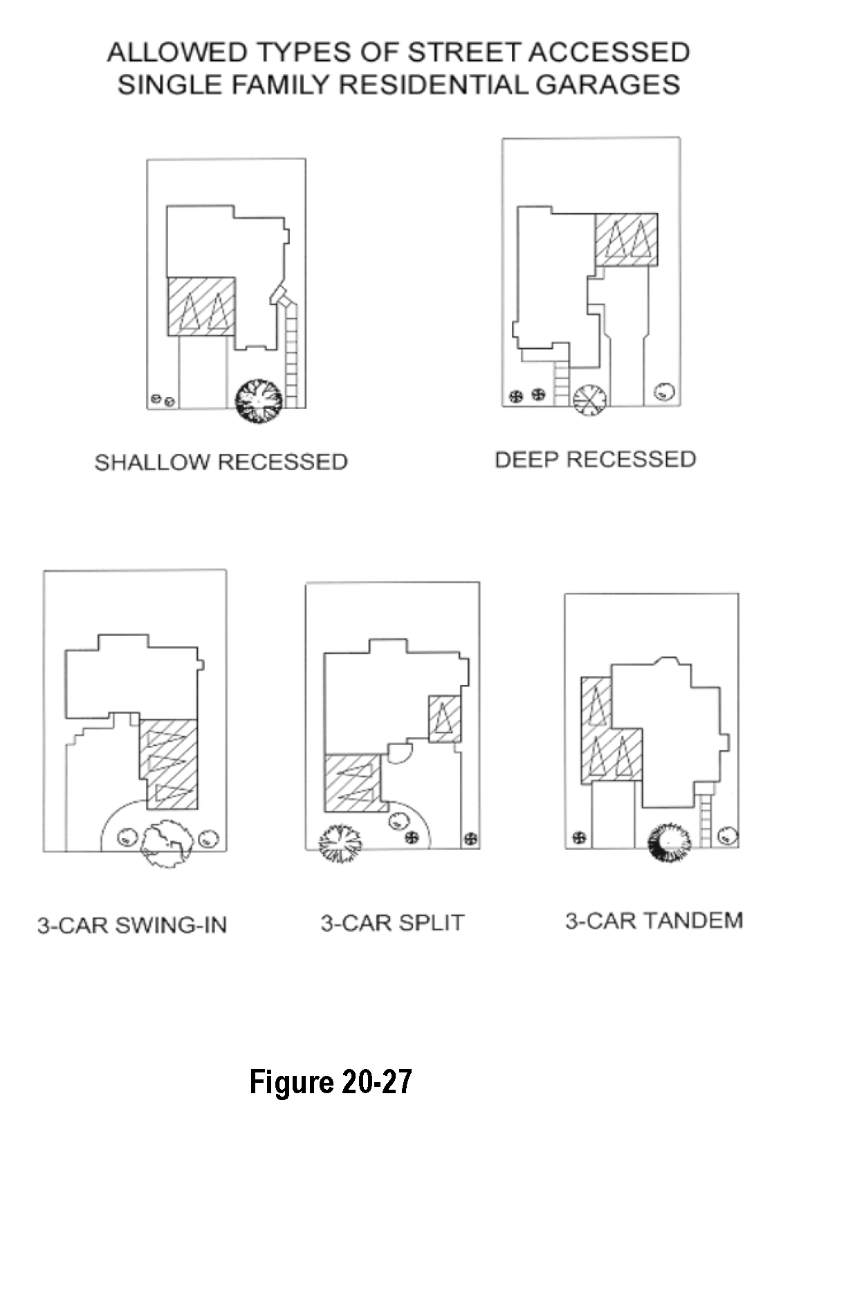
Row house groupings rely on the continuity of well-defined architectural elements to establish strong street presence. However, each unit must be expressed so that the composition reads as the sum of the individual parts.
Because repetition is important to the composition of the row houses, sufficient articulation of architectural elements on the primary facade of each row house is essential. Groupings of row houses are often repeated along the street, requiring techniques to promote architectural interest and streetscape diversity.
Stapleton Design Bookpublished by Forest City Stapleton, Inc., September 2000, pp. III.20 - III.22
D.
Townhouses and Row Houses (Single-Family Attached Dwellings). The intent of this Section is to build town houses and row houses with architectural designs that relate buildings to the street, and that achieve a harmonious balance between repetition and variety.
1.
Individual Dwelling Identity. Repeat principal architectural elements like entries, bays, cornices and parapets. Vary other architectural elements such as the offsetting of building walls, choice of materials, parapet height and color to create visual interest and streetscape diversity.
2.
Primary Facade. Design the primary facade of each row house so it is evident where the unit begins and ends.
3.
Articulation. A row house articulation is defined as a covered entry element, a dormer facing the street, a horizontal offset of at least two (2) feet in the principal building wall for a minimum of four (4) feet in width, a bay or projection, or a significant change in the parapet height and design.
a.
The primary row house elevation towards the street shall have at least two (2) articulations, but not more than three (3) articulations. The required articulation refers to an individual row house, not the entire grouping.
b.
Side elevations of row houses facing a street are subject to the same articulation requirements as the primary facade.
c.
Row house groupings of six (6) units or more (or groupings over one hundred twenty [120] feet in length) require two (2) different articulation combinations.
Well-defined and sensitive entries are particularly important for row house design. In addition to creating a feeling of welcome and providing shelter, they also help make a gracious transition between public and private realms.
- Stapleton Design Book published by Forest City Stapleton, Inc., September 2000
E.
Multi-family stacked units, including condominiums and apartments. The intent of this section is to build multi-family stacked units that achieve a harmonious balance between repetition and variety. Each multi-family dwelling containing more than three (3) dwelling units shall feature a variety of massing proportions, wall plane proportions, roof proportions and other characteristics. The following specific standards shall apply to multi-family stacked units, including condominiums and apartments:
1.
Individual Building Identity. For all developments of three (3) or more multi-family stacked buildings, a floor plan may be repeated, however, identical building facades must not be replicated more than twice within the development. Before building may commence on a block and prior to the issuance of a building permit within the block, the applicant shall illustrate, through the use of a Block Diversity Plan, how the development will comply with the requirements set forth in this section. Final plat approval cannot be given without approval of a Block Diversity Plan for the initial stage of development (refer to Workbook for an example). A Block Diversity Plan shall include, at a minimum, the following:
a.
A map that illustrates the floor plan and elevation for each building on the block.
b.
The color palette to be used.
c.
A written statement that specifies how provisions E.1 through 4 of Section 2.19, the multi-family stacked units section of this Code will be met.
2.
Articulation. Each multi-family dwelling or condominium shall be articulated with projections, recesses, covered doorways, balconies, box or bay windows and/or other similar features, dividing large facades and walls into human-scaled proportions. Each multi-family building shall feature walls that are articulated by a least two (2) of any of the following elements within every thirty-six (36) foot length of the facade:
a.
Recesses, projections or significant offsets in the wall plane;
b.
Distinct individualized entrances;
c.
Chimneys that project from the wall plane;
d.
Balconies and/or other outdoor living space; or
e.
Bay or box windows.
3.
Roofs. Each multi-family building shall feature a combination of primary and secondary roofs. Primary pitched roofs shall be articulated by at least one (1) of the following elements:
a.
Changes in plane and elevations;
b.
Dormers, gables or clerestories; or
c.
Transitions to secondary roofs over entrances, garages, porches, or bay windows.
4.
Color. For all developments, there shall be no more than two (2) similarly colored structures placed next to each other along a street or major walkway spine.
5.
Garages. No street-facing facade shall contain more than four (4) garage fronts. Resident garages or parking that is internal to the block is strongly encouraged. On-street parking should be made available for visitors.
[Section 2-20.] - Commercial and industrial architecture.
A.
Intent. The Town has the following three (3) distinctly different commercial/industrial types of development that can occur within its Planning Area: downtown, community or highway commercial and industrial/business parks. They are different in character, purpose and types of uses. The design considerations vary for each type, although there are many common design elements. 20.20.B below outlines the common elements, and the specific design considerations are identified by type.
1.
Downtown. Kersey's historic buildings have established a pattern of downtown development:
a.
Buildings are located close to the sidewalk, forming a continuous street facade.
b.
Pedestrian movement is the primary focus.
c.
Building height, architectural details, front setbacks, parking location, wall articulation and sidewalks establish the architectural edge that defines this area as a walkable commercial corridor.
2.
Community/Highway Commercial. The community/highway commercial is intended for uses that are predominantly accessed by automobile.
3.
Industrial/Business Park. The industrial/business park is a primary employment center for the community. This area is also predominantly automobile-accessible. One of the design challenges is to improve the pedestrian connections internally and as this area connects to the rest of the community.
B.
General Provisions.
1.
Connections. Commercial developments must be linked with surrounding areas by extending town streets, sidewalks and/or paths directly into and through the development, thereby providing convenient, direct pedestrian, bicycle and vehicle access to and from all sides of the development.
2.
Accessibility. Developments must be accessible to pedestrians and bicyclists as well as motorists. Site plans shall equally emphasize the following:
a.
Pedestrian access to the site and buildings;
b.
Gathering areas for people; and
c.
Auto access and parking lots.
The emphasis must not be placed solely on parking and drive-through functions.
3.
Walkways. Walkways must be located and aligned to directly and continuously connect areas or points of pedestrian origin and destination, and not be located and aligned solely based on the outline of a parking lot configuration that does not provide such direct pedestrian access.
4.
On-Street Parking. Streets and other elements of the site plan shall be designed so that on-street parking is a functional part of the development (except along arterial streets).
5.
Building Orientation. Where possible, buildings shall be located to front on and relate primarily to streets. Building setbacks from local and collector streets should be minimized in order to establish a visually continuous, pedestrian-oriented streetfront. In the case of large buildings for employment, storage or auto-related uses, where greater setbacks are needed, a minimum of thirty percent (30%) of the building shall be brought to the setback line. If a minimized setback is not maintained, the larger setback area shall have landscaping, low walls or fencing, a tree canopy and/or other site improvements along the sidewalk designed for pedestrian interest, scale and comfort. See Figure 2-28.
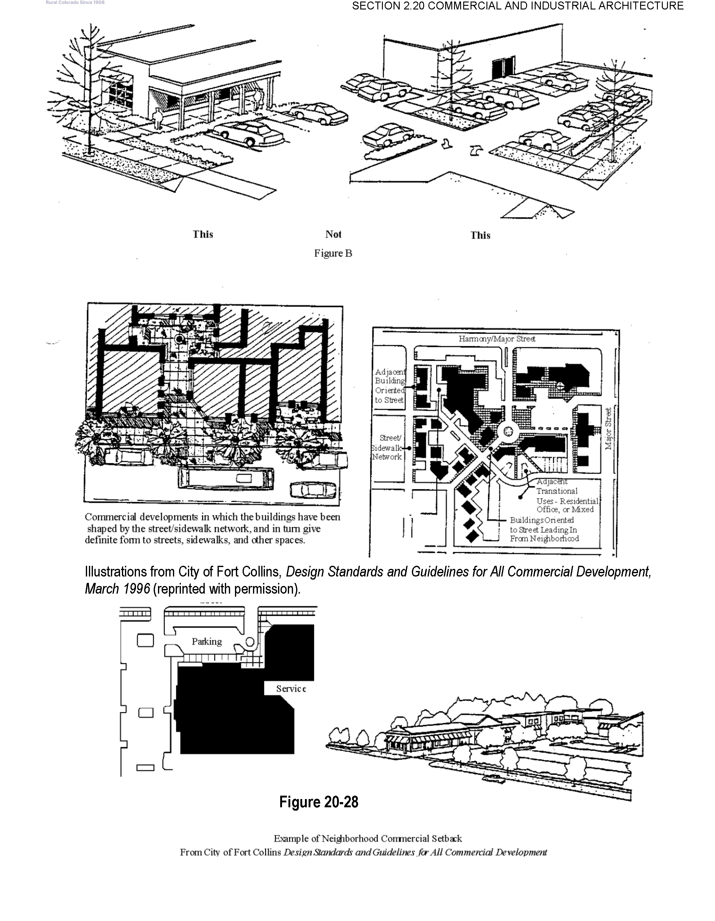
6.
Pedestrian Scale. The establishment of buildings on isolated "pad sites" surrounded by parking lots and driveways, and that offer mainly auto-oriented signage to define entrances, is discouraged. Even relatively massive development can be configured into "blocks" or other spaces, proportioned on a human scale and city block scale; and need not be proportioned on a monolithic, auto-oriented scale.
7.
Thematic Architectural Styles. Standardized "corporate" or strongly thematic architectural styles associated with chain-type restaurants and service stores are strongly discouraged unless they accommodate the desired image for the Town and are compatible with adjacent structures and uses. Refer to Section 2.26 Design Vocabulary for illustrations.
8.
Location of Parking Lots. Parking requirements shall be provided to the greatest extent possible by spaces at the rear or sides of the building. Refer to Landscaping (Section 2.16) and Parking (Section 2.10) for additional parking requirements.
9.
Blank Walls. Blank, windowless walls are discouraged. Where the construction of a blank wall is necessary, the wall shall be articulated.
10.
Wall articulation.
a.
Walls shall not have an uninterrupted length exceeding fifty (50) feet. Pilasters, texture transitions, windows and stepping of the wall plane are required.
b.
All exterior elevations shall maintain the integrity of the adjacent dwellings architectural character and detailing.
c.
Continuous cornice lines or eaves are encouraged between adjacent buildings.
d.
Buildings with flat roofs shall provide a parapet with an articulated cornice.
11.
Facade Treatment. The architectural treatment of the front facade shall be continued, in its major features, around all visibly exposed sides of a building. Blank wall or service area treatment of side and/or rear elevations visible from the public viewshed is discouraged.
12.
Windows. Windows shall be vertically proportioned wherever possible.
13.
Awnings. Fixed or retractable awnings are permitted. Canvas is the preferred material, although other water proofed fabrics may be used; metal or aluminum awnings shall not be used unless otherwise approved by the Board of Trustees.
14.
Screening. All air conditioning units, HVAC systems, exhaust pipes or stacks, elevator housing and satellite dishes and other telecommunications receiving devices shall be thoroughly screened from view from the public right-of-way and from adjacent properties by using walls, fencing, roof elements, and landscaping. In addition, all trash facilities, loading and parking areas shall be properly screened. Refer to Section 20.17 Buffering and Screening for additional requirements.
15.
Architectural Details. All materials, colors, and architectural details used on the exterior of a building shall be compatible with the building's style and with each other. Refer to Section 2.26 Design Vocabulary for illustrations of commercial architecture that the Town is encouraging.
C.
Downtown Architectural Standards.
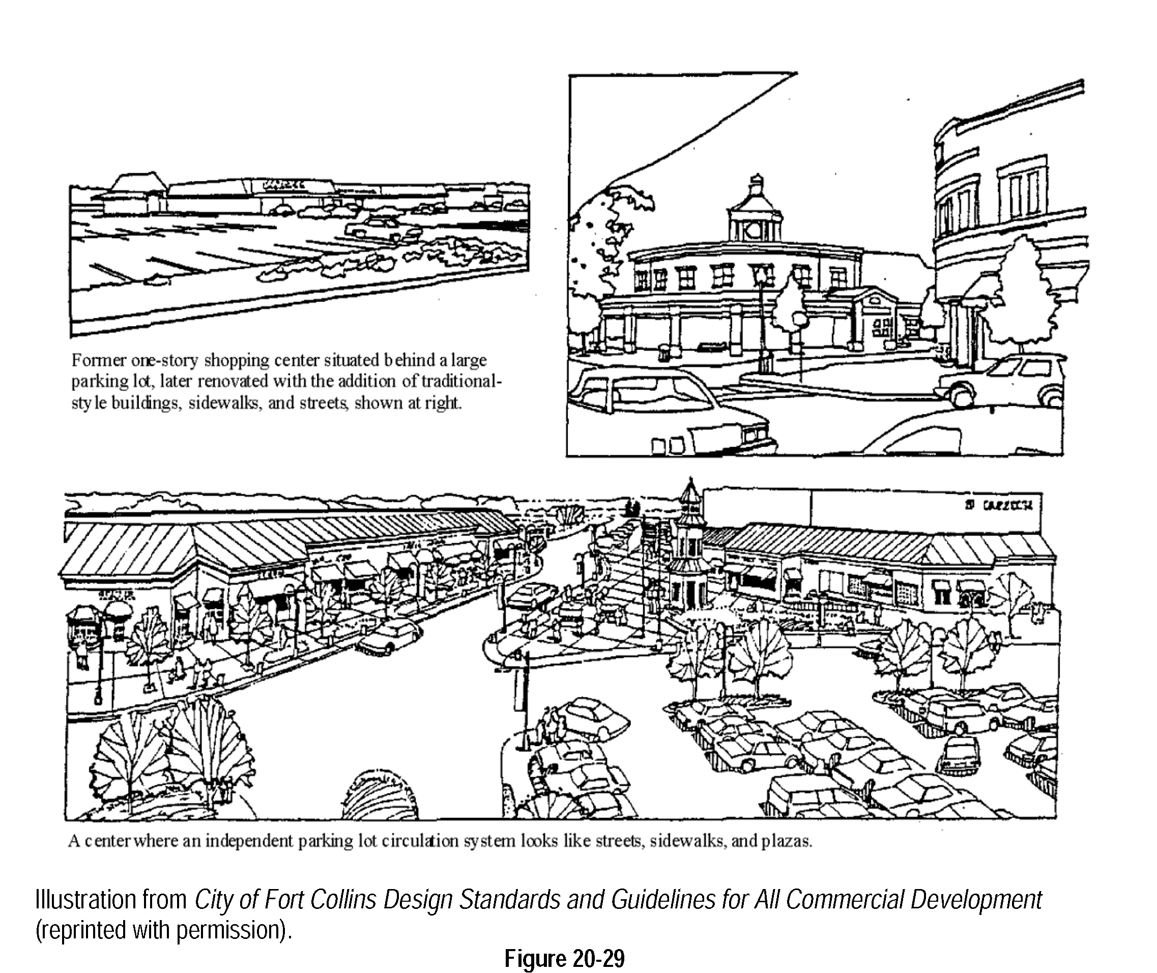
1.
Setbacks. Buildings shall abut the front property line. Building facades may be recessed if an arcade or similar structure abuts the front setback. Architectural projections including cornices, balconies, canopies and entry features may encroach into public rights-of-way, subject to permits as required by Kersey Codes.
2.
Multi-Story, Mixed-Use Structures. Commercial uses may be contained in multi-story (two to three stories) mixed-use structures with commercial/retail uses on the ground level and above and/or apartment dwellings or offices on the upper levels. Such building shall vary in terms of footprint and architectural elevations. The maximum ground level footprint of a commercial building shall be five thousand (5000) square feet unless otherwise approved by the Board of Trustees.
3.
Facade Treatments. Large buildings shall be articulated or designed to resemble the character and scale of the original downtown buildings, with each facade twenty-five (25) feet or less. Refer to Town website for examples of commercial architecture that the Town is encouraging.
4.
Entries. Transparent entries and large store front windows are strongly encouraged. Recessed and other styles of window openings are desired.
5.
Windows. Street-level storefront windows are strongly encouraged. Office and residential windows organized in a generally regular pattern are encouraged.
6.
Awnings/Canopies. Awnings or canopies, which provide a generally consistent cover along the pedestrian walk are strongly encouraged. Arcades are desired to maintain a more continuous weather protected walk.
D.
Neighborhood Commercial Architectural Standards.
1.
Neighborhood Center. The design of the commercial center needs to function as a focal point or activity center for the neighborhood. The design should include, where possible, outdoor space for pedestrians, such as a plaza, outdoor café or seating area.
2.
Setbacks. Building setbacks from local and collector streets should be minimized in order to establish a visually continuous, pedestrian-oriented streetfront. In the case of large buildings for employment, storage or auto-related uses, where greater setbacks are needed, a minimum of thirty (30) percent of the building shall be brought to the setback line. If a minimized setback is not maintained, the larger setback area shall have landscaping, low walls or fencing, a tree canopy and/or other site improvements along the sidewalk designed for pedestrian interest, scale and comfort.
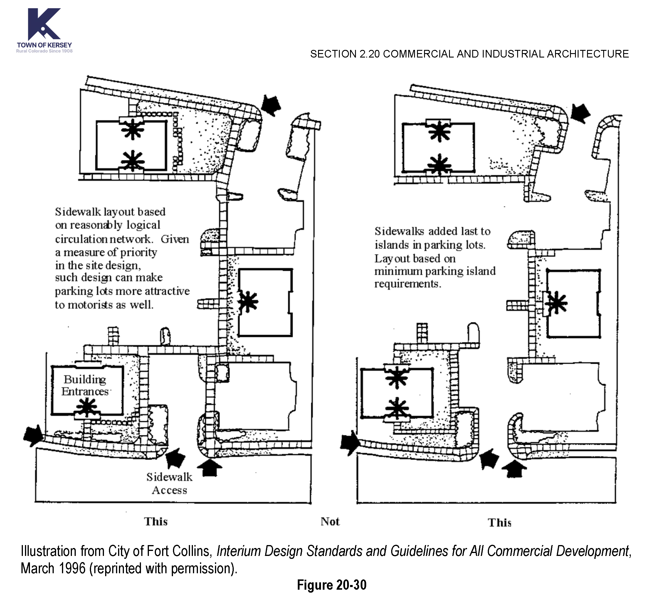
3.
Driveway Crossings. Driveway crossings must place priority on pedestrian access and the material and layout of the pedestrian access must be continuous as it crosses the driveways, with a break in the continuity of the driveway paving and not in the pedestrian access way. Continuous driveway aisles located directly in front of a building are discouraged.
E.
Community Commercial Architectural Standards.
1.
Design of Developments with Internal Orientation. In multiple-building developments where setbacks are increased to accommodate independent development with internal orientation, all primary building entrances must face walkways, plazas, or courtyards that have direct, continuous linkage to the street without making people walk through parking lots. However, it may be necessary for such direct pedestrian access ways to cross drive aisles. Driveway crossings must place priority on the pedestrian access. Continuous driveway aisles located directly in front of a building are discouraged.
2.
Connections. Where it is not possible or appropriate to extend Town street and sidewalks directly into development or bring the building up to a Town sidewalk, buildings shall be shaped and designed to form pleasant, direct connections to adjacent land uses.
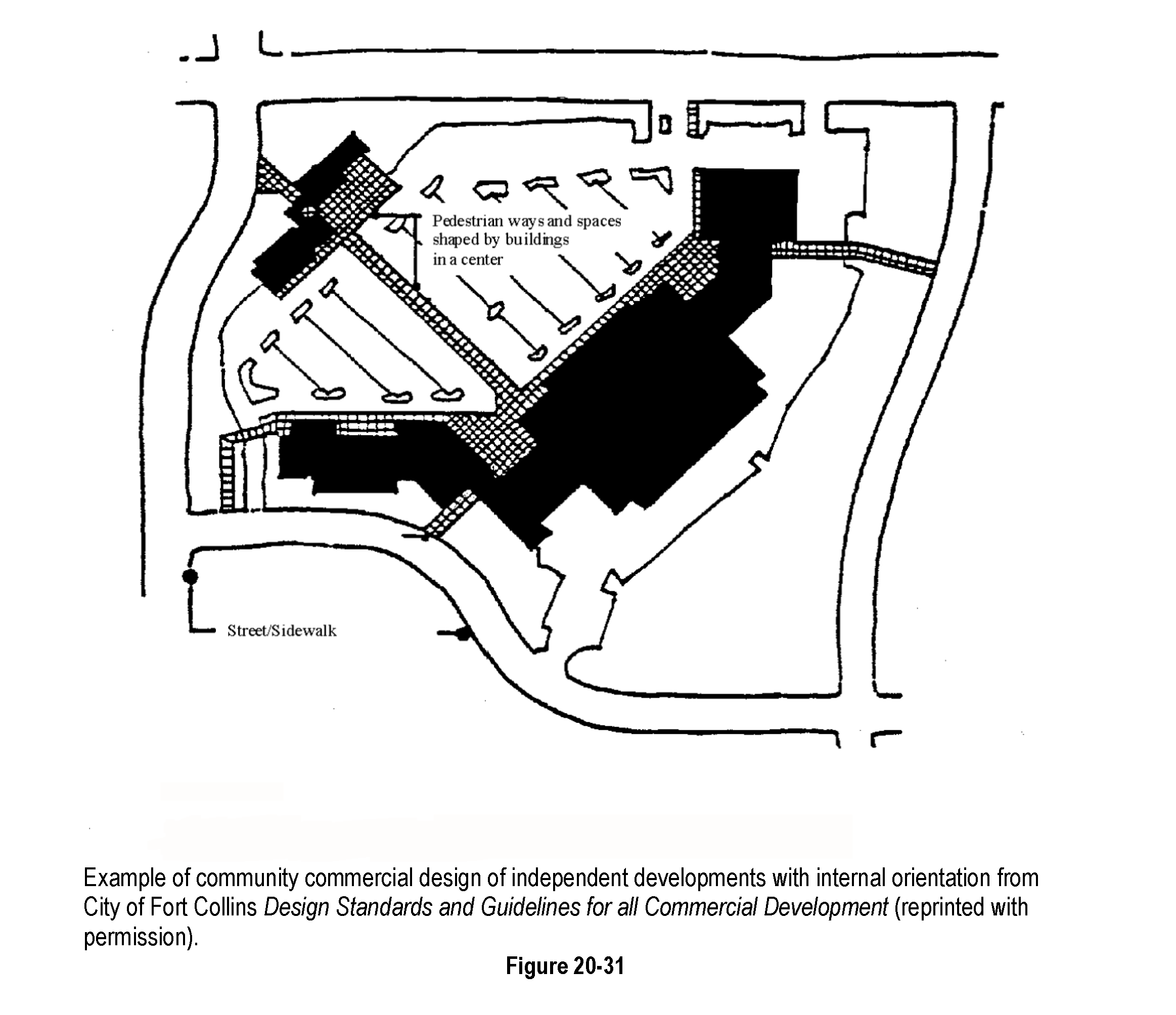
3.
Requirement for Four-Sided Design: A building's special architectural features and treatments shall not be restricted to a single facade. All sides of a building open to view by the public, whether viewed from public or private property shall display a similar level of quality and architectural interest.
4.
Building Form: The design of all buildings shall employ textured surfaces, projections, recesses, shadow lines, color, window patterns, overhangs, reveals, changes in parapet heights, and similar architectural features to avoid monolithic shapes and surfaces and to emphasize building entries. Designs shall not contain unbroken flat walls of fifty (50') feet or greater in length.
a.
Buildings having single walls exceeding fifty (50') feet in length shall incorporate one or more of the following for every fifty (50') feet:
i.
Changes in color, graphical patterning, changes in texture, or changes in material;
ii.
Projections, recesses and reveals;
iii.
Windows and fenestration;
iv.
Arcades and pergolas;
v.
Towers;
vi.
Gable projections;
vii.
Horizontal/vertical breaks; or
viii.
Other similar techniques.
5.
Exterior Building Materials and Colors: Intense, bright or fluorescent colors shall not be used as the predominant color on any wall or roof of any primary or accessory structure. These colors may be used as building accent colors.
6.
Roof Materials: All sloping roof areas with a pitch of three in twelve (3 in 12) or greater, and visible from any public or private right-of-way, shall be surfaced with attractive and durable materials.
7.
Orientation of Pedestrian Entries: All office, hotel and motel structures shall be oriented so that pedestrian entries face the nearest adjacent street.
F.
Industrial/Business Park Architectural Standards.
1.
Intent. The intent of the Industrial/Business Park Architectural Standards is to ensure that the quality of industrial/business park development enhances the overall well being and image of the community.
a.
Items 3 through 7 from the Community Commercial Section 2.20.E shall apply.
b.
Building Massing and Form:
i.
Office and entry spaces shall be distinguished from the building mass.
ii.
Large, square, "box-like" structures are not an acceptable form. Architectural elements with smaller forms stepping outwards and down shall be included.
iii.
Loading areas shall not front any street or public right-of way.
iv.
Parking requirements shall be provided to the extent possible at the rear or sides of the building.
c.
Wall Articulation. Walls shall not have an uninterrupted length exceeding fifty (50) feet. Pilasters, texture transitions, windows and stepping of the wall plane are required. Refer to the Town website for examples of industrial architectural styles that the Town is encouraging.
d.
Siting Structures.
i.
Structures shall be sited to avoid a "wall" effect along public rights-of-way and along adjacent property lines. This can be achieved by varying the building setbacks and clustering buildings.
ii.
Where multiple buildings are proposed on a development parcel, buildings shall be oriented to allow views into the project and shall preserve high quality views through the project (e.g. views of the mountains).
[Section 20-21.] - Lighting.
A.
Intent.
1.
To create an attractive lighting system to enhance visibility and safety, while minimizing glare and contrast.
2.
To encourage exterior lighting that is functional, aesthetically pleasing, and complimentary to the architectural style of buildings.
B.
General Provisions.
1.
Evaluation of Exterior Lighting. Exterior lighting shall be evaluated in the development review process to ensure that the functional and security needs of the project are met in a way that does not adversely affect the adjacent properties or neighborhood. The degree to which exterior night lighting affects a property owner or neighborhood will be examined considering the light source, level of illumination, hours of illumination, and need for illumination in relation to the effects of the lighting on the adjacent property owners and the neighborhood.
2.
Light Style. The style of lights shall be consistent with the style and character of architecture proposed on the site. Light fixtures that illuminate signage shall be compatible with the architecture of the building on which they are placed.
3.
Concealed Light Source. Light sources shall be concealed or shielded to the maximum extent feasible to minimize the potential for glare and unnecessary diffusion on adjacent property and away from the vision of passing motorists. All lights shall be directed downward and the light source shall be equipped with "cut-off" devices so that it will not be visible from any adjacent property and to ensure that ambient skyward light is eliminated. Accent and flagpole lighting shall be permitted to be directed upward as long as the light source is shielded and not visible from any adjacent property. Light fixtures installed under canopies, awnings, overhangs and the like shall be fully recessed.
4.
Hours of Lighting Operation. All parking lot lighting fixtures and exterior building lights, except those required for security purposes, shall be extinguished within one (1) hour after the end of business hours and remain extinguished until one (1) hour prior to the beginning of business hours. If a portion of a parking lot is used after dark, only that portion shall be lighted.
5.
Lighting Standards.
a.
Residential Zoning Districts. Light fixtures shall be mounted on concrete, fiberglass or painted metal poles no higher than sixteen (16) feet from the ground. Lighting mounted on a building or structure shall not exceed the height of the building or structure. Bollard-type lighting fixtures shall be between three (3) and four (4) feet high. Developer shall use Town approved light fixtures and poles.
b.
Non-Residential Zoning Districts. Light fixtures shall be mounted on concrete, fiberglass or painted metal poles no higher than twenty-five (25) feet from the ground, unless a greater height, not to exceed the maximum building height in the applicable zone district, is approved by the Planning Commission or Board of Trustees through a development application review process. Lighting mounted on a building or structure shall not exceed the height of the building or structure. Bollard-type lighting fixtures shall be between three (3) and four (4) feet high. Developer shall use Town approved light fixtures and poles.
6.
Exemption for Outdoor Recreational Uses. Because of their limited hours of operation and their unique requirements for nighttime visibility, ball diamonds, playing fields, tennis courts, and other similar outdoor recreational uses (both public and private, unless otherwise restricted by the Board of Trustees) shall be exempt from the general provisions of this section. However, exterior lighting for such uses shall be extinguished no later than 11:00 p.m.
[Section 20-22.] - Environmental considerations.
A.
Intent. The intent of this section is to ensure that new development limits/mitigates its impact to wildlife and wildlife habitat and that it minimizes environmental impacts.
B.
General Provisions.
1.
Protection of Wildlife and Natural Areas. To the maximum extent practical, development shall be designed to ensure that disturbances which occur to any natural area as a result of development shall be minimized through the use of natural buffer zones. If any development materially disturbs a natural area, the development project shall mitigate such lost natural resource either on- or off-site. Any such mitigation shall be roughly proportional to the loss suffered as a result of the disturbance.
a.
Natural areas shall include: floodplains and floodways, natural drainage and water ways, significant native trees and vegetation, wildlife travel corridors, special habitat features such as raptor nest sites, key nesting, breeding or feeding areas for birds; fox and coyote dens, prairie dog colonies over twenty-five (25) acres in size, remnant native prairie habitat, plains cottonwood galleries, and any wetland greater than one-quarter (¼) acre in size.
b.
The natural area buffer zone shall be used between natural areas and proposed development to ensure that the proposed development does not degrade the natural area. The size of the buffer zone shall be determined in conjunction with the Colorado Division of Wildlife or a Town-approved wetland or wildlife ecologist. The Town may decrease this buffer when strict application of this subsection will impose an exceptional and undue hardship upon the property owner or developer.
c.
Exceptions. The Board of Trustees may allow disturbance or construction activity within the natural area or natural area buffer zone for the following limited purposes: mitigation of development activities, restoration of previously degraded areas, emergency public safety activities and utility installations when such activities and installations cannot reasonably be contained within other nearby develop areas, construction of a trail that will provide public access for educational or recreational purposes, or the enhancement of the habitat value and/or other natural resource values of a natural area.
d.
Ecological Characterization. If the Town determines that the site likely includes areas with wildlife, plant life, and/or other natural characteristics in need of protection, the Town may require the developer to provide a report prepared by a professional qualified in the areas of ecology, wildlife biology, or other relevant discipline. The ecological characterization report should be included on the open space plan and describe the following:
i.
The wildlife use of the natural area showing the species of the wildlife using the area, the times or seasons the areas is used by those species and the "value" (meaning feeding, watering, cover, nesting, roosting, perching) that the area provides for such wildlife species;
ii.
The boundary of wetlands in the area and a description of the ecological functions and characteristics provided by those wetlands;
iii.
Any prominent views from or across the site;
iv.
The pattern, species, and location of any significant native trees and other native site vegetation;
v.
The bank, shoreline and high water mark of any perennial stream or body of water on the site;
vi.
Wildlife travel corridors, and
vii.
The general ecological functions provided by the site and its features.
e.
Wildlife Conflicts. If wildlife that may create conflicts for the future occupants of the development (including, but not limited to, prairie dogs, beaver, deer and rattlesnakes) are known to exist in areas adjacent to or on the development site, then the development plan must, to the extent reasonably feasible, include provisions such as barriers, protection mechanisms for landscaping and other site features to minimize conflicts that might otherwise exist between such wildlife and the developed portion of the site. Any impacts to wildlife must be referred to the Colorado Division of Wildlife and, in the case of threatened or endangered species, United States Fish and Wildlife Services.
C.
Green Builder Guidelines. The Green Builder Program establishes environmental standards for the construction and operation of buildings. The intent of this program is to promote building practices which benefit the environment and the socio-economic well-being of current and future residents.
1.
There are five resource areas that are addressed by the Green Builder Standards:
a.
Water (quality and quantity);
b.
Energy (quantity and type);
c.
Building Materials (life cycle impacts);
d.
Solid Waste (construction and operation impacts); and
e.
Health and Safety
2.
Compliance. Compliance with the requirements of the Colorado Green Builder Program [2] is strongly encouraged.
Information is available from Green Builder Program Administration office at (303) 778-1400 or on the web at www.builtgreen.org.
[Section 20-23.] - Sanitary sewer.
All residential, commercial and industrial uses which have human occupancy shall have sanitary sewer. The sanitary sewer system shall be connected to an existing public sanitary sewer system and shall consist of a closed system of sanitary sewer mains and lateral branch connections to each structure or lot upon which a structure is to be built. Sanitary sewer lines are to be of sufficient size and design to collect all sewage from all proposed or portable structures within the subdivision or development. On a case-by-case basis, the Board of Trustees may approve individual sewage disposal systems that comply with Weld Public Health & Environment Department standards. However, no new addition, upgrade or major repair to an individual sewage disposal system will be permitted if the property is located within four hundred (400') feet of a municipal or sanitation district collection line, measured through existing sewer easements or utility rights-of-way, except where such connection is not feasible or has been denied by the Town.
[Section 20-24.] - Potable water.
All residential, commercial and industrial uses, which have human occupancy shall have potable water served by the Town or appropriate water district. The water system shall be of sufficient size and design to supply potable water to each structure or lot upon which a structure is to be built.
[Section 20-25.] - Fire hydrants.
The subdivider shall install fire hydrants at street intersections and at other points as per the requirements of the Platte Valley Fire District. Fire hydrants shall have national standards threads, two and one-half (2½) inch outlets and four and one-half (4½) inch or six (6) inch streamers.