
Kiawah Island City Zoning Code
DIVISION 2
ZONING MAP/DISTRICTS
Sec. 12-61. - Establishment of zoning districts.
The zoning districts described in this division implement the land use categories as described in the Town of Kiawah Island Comprehensive Plan, as amended.
(1)
List of districts. In order to classify and segregate the uses of land and buildings, the following districts are hereby established:
R-1, Residential
R-2, Residential
R-3, Residential
C, Commercial
RST-1, Resort
RST-2, Resort
CS, Community Support
CS-2, Community Support
PR, Parks and Recreation
PD, Planned Development
KC, Conservation District
(2)
Land use categories. The following table lists each of the comprehensive plan land use categories and the zoning districts which may be established in each category:
(Code 1993, § 12A-201; Ord. No. 94-12, § 2(12A-201), 9-26-1994; Ord. No. 2005-08, § 12A-201, 10-12-2005; Ord. No. 2016-04, § 1, 9-6-2016)
Sec. 12-62. - Zoning map.
The purpose and intent of the zoning map is to define the boundaries of each district, e.g., Residential (R-1, R-2, R-3) or Resort District. In order to provide sufficient clarity and/or deal with special areas of interest, a supplemental zoning map may be used as is done with the key locations zoning map. The official zoning maps are available at the Kiawah Island Municipal Building.
(1)
The boundaries of all zoning districts are shown on the official zoning map (exhibit 12A-1) of the Town of Kiawah Island, South Carolina (exhibit 12A-1) ("zoning map"), the Key Locations Zoning Map (exhibit 12A-2) and tables 2N and 2O set forth in section 12-78, define approved docks and dock locations both maps are set forth at the end of this section.
(2)
The zoning maps and a record of all amendments thereto shall be kept on file in the office of the Town Administrator and shall constitute the original record, and shall be the final authority as to the current zoning status of all property within the Town of Kiawah Island.
(3)
Changes in the boundaries of any zoning district, in accordance with the provisions of this article and S.C. Code 1976, ch. 29, shall be reflected on the zoning maps promptly upon approval of the amendment by the Town Council. All amendments to the zoning maps shall be signed and attested to by the Town Clerk.
(4)
The zoning maps may be prepared in sections as may be required to adequately portray the boundaries of all zoning districts. The zoning maps may include supplemental maps including: the key locations zoning maps and overlay district maps in order to portray street classifications, dock locations, boundaries of areas subject to specific limitations or exceptions or such other information as may be required by this article.
(5)
In the event that the zoning maps become damaged, destroyed, lost or difficult to interpret by reason of the nature or number of changes and additions, the Town Council may, by resolution, adopt zoning maps, which shall supersede the prior maps; provided, however, that the new zoning maps shall reflect the prior zoning district boundaries unless changed pursuant to law.
(6)
The following rules shall apply in the determination of the boundaries of any district shown on the zoning map:
a.
Where boundaries approximate street or other identifiable property or boundary lines, such lines shall be construed to be the district boundary. Where such boundaries are shown as being within street or within identifiable rights-of-way or creeks, the centerline of the street right-of-way, or creek shall be construed to be the district boundary.
b.
Where a district boundary divides an unsubdivided parcel, the location of the district boundary shall be determined by the use of the scale appearing on the zoning map unless indicated by dimensions.
c.
In the case of a district boundary line dividing a platted lot into two parts, the district boundary line shall be construed to be the property line nearest the less restricted district.
d.
Map codes or symbols indicating the classification of property on the zoning map apply to the entire area within the district boundaries.
e.
Where a street or right-of-way is officially vacated or abandoned, the regulations applicable to the abutting property shall apply to the centerline of the vacated or abandoned street right-of-way.
f.
Should any uncertainty remain as to the location or meaning of a boundary indicated on the zoning map, said uncertainty shall be resolved by the Planning Director, whose decision may be appealed to the Board of Zoning Appeals.
(7)
When regulations refer to the classification of property, the term "classification" means the zone or district applicable to the property.
Exhibit 12A-1, Zoning Map
Exhibit 12A-2, Key Locations Map
(Code 1993, § 12A-202; Ord. No. 94-12, § 2(12A-202), 9-26-1994; Ord. No. 2005-08, § 12A-202, 10-12-2005; Ord. No. 2009-02, § 2, 2-3-2009; Ord. No. 2013-14, § 2, 12-3-2013; Ord. No. 2016-04, § 1, 9-6-2016; Ord. No. 2016-07, § 2, 11-1-2016; Ord. No. 2018-03, § 1(att. A), 5-1-2018; Ord. No. 2025-13, § 2(Exh. B), 8-5-2025)
Sec. 12-63. - Description of zoning districts and regulations.
The purpose and intent of this section is to specify zoning categories and standards for all classes of use, e.g., residential, resort, commercial, etc. Standards include permitted density, lot size and coverage, and supplemental regulations.
(1)
Any property previously zoned special development shall fall under the PD zoning.
(2)
In determining the maximum number of dwelling units or hotel rooms per acre, all water bodies and all land below mean high-water level on the original or "grassroots" site are to be excluded. This requirement serves to reduce overcrowding and over-development of residential, resort, commercial and other sites. Maximum density/intensity is a limit on development rights, and not a grant of vested rights.
(3)
Lot coverage is defined in article IV, definitions, of this ordinance. Maximum percentage lot coverage is specified for each zoning district: however, the following items shall be excluded from lot coverage as determined by the Planning Director:
a.
At grade boardwalks and landscape retaining walls below three feet in height; or
b.
The access drive located on the "pole" of a flag lot as defined by this ordinance.
Allowable increase for residential districts. The maximum lot coverage for the R1, R2, and R3 districts may be increased for specific pervious elements as follows:
The only items that qualify for allowable increase in maximum lot coverage as determined by the Planning Director are:
a.
Driveways not defined by this ordinance that utilize pervious materials.
b.
Pervious walks and patios.
c.
Raised courtyards and planters created by walls three feet or less above the adjacent grade.
Where an OCRM critical line is located on the property, the setback and buffer requirements of the waterfront development standards, section 12-76, shall apply.
(4)
The following apply to the residential zoning districts:
a.
For lots on cul-de-sacs or similar circumstances, the minimum width shall apply at the front yard setback line. Cul-de-sac lots shall have a minimum width of 25 feet at the street line. The minimum width of any flag lot may be reduced to 20 feet, provided that the minimum width specified in the table is provided at the front building setback line.
b.
The minimum yard requirements shall be increased to 30 feet from any lot or parcel boundary which abuts a golf course, lagoon, marsh, and/or open area.
c.
Height of single-family detached homes is measured from the Federal Emergency Management Agency's base flood elevation determined for the individual home site.
(5)
The following apply to the nonresidential zoning districts:
a.
For lots on cul-de-sacs or similar circumstances, the minimum width shall apply at the front yard setback line. Cul-de-sac lots shall have a minimum width of 25 feet at the street line.
b.
Nonresidential structures may have the height in stories shown in the corresponding zoning district lot standards table, provided that the highest roof ridge of the building does not exceed the height shown from the Federal Emergency Management Agency's base flood elevation determined for that individual structure.
c.
Canopies connected to the main building shall be set back a minimum of 20 feet from any property line.
(Code 1993, § 12A-203; Ord. No. 2005-08, § 12A-203, 10-12-2005; Ord. No. 2015-04, § 2, 4-14-2015)
Sec. 12-64. - Setbacks.
Setback means a required minimum distance from the lot line, or street right-of-way, or OCRM critical line that establishes an area within which a structure shall be erected.
(1)
Contextual setbacks. Notwithstanding the front setback requirements of the underlying zoning district, the front building line of any structure or addition to a structure may be as close to the street as the front building line of a structure located on any lot that is immediately adjacent to the subject lot. If the subject lot is located between two developed lots, the front building line of the structure that is set back further from the street shall apply to the subject lot.
(2)
Setbacks on corner and double frontage lots. On corner and double-frontage lots, front setback standards will apply to each lot line that borders a street right-of-way. The rear yard setback shall apply to the opposite side of the principle structure's front main entrance. The side yard setback shall apply to the remaining side(s).
(3)
Exception to setbacks. Every part of a required setback must be open and unobstructed from the ground to the sky except as set out in this subsection.
Driveways and walkways may be located within any required setback.
Uncovered stairs or stair landings to building entrances may extend up to five feet into any required setback.
Uncovered, at-grade patios may extend into a required setback; however, they shall maintain a minimum ten-foot distance from the property line.
Uncovered decks may extend up to five feet into any required rear yard setback.
Sills, belt courses, cornices, buttresses, eaves and other architectural features may extend up to two feet into any required setback.
Walls and retaining walls below three feet in height may be located within required setback.
(4)
HVAC Equipment. In all zoning districts heating, ventilation and air conditioning (HVAC) equipment and associated HVAC stands may extend up to five feet into required side or rear setbacks only when all of the following conditions are met:
a.
The HVAC equipment is replacing existing HVAC equipment which was originally placed below an existing structure and/or which HVAC equipment being replaced is now required to be elevated to meet the requirements of the Federal Emergency Management Agency (FEMA) and the Town of Kiawah Island Building Code;
b.
Such HVAC equipment cannot reasonably be accommodated in compliance with the setback required by otherwise applicable zoning requirements;
c.
The property owner has, through regular mail postmarked no later than five days in advance of applying for a zoning permit, notified the affected adjacent property owner(s) that are adjacent to the property line where the proposed HVAC equipment will be located, and has submitted to the Planning Director a signed affidavit stating that such property owner has notified the affected adjacent property owner(s) and proving each name and address to which notice was sent; and
d.
A zoning permit is approved by the Planning Director.
(5)
Generators. In all zoning districts generators and generator stands may extend up to five feet into required side or rear setbacks only when all of the following conditions are met:
a.
The proposed generator stand is being proposed for an existing home permitted prior to November 1, 2022. Generator stands installed at the time of new construction must meet required setbacks.
b.
The generator cannot reasonably be accommodated in compliance with the setback required by otherwise applicable zoning requirements;
c.
The generator is located to not impede emergency access;
d.
The property owner has, through regular mail postmarked no later than five days in advance of applying for a zoning permit, notified the affected adjacent property owner(s) that are adjacent to the property line where the proposed generator will be located, and has submitted to the Planning Director a signed affidavit stating that such property owner has notified the affected adjacent property owner(s) and proving each name and address to which notice was sent;
e.
The generator stand is set back a distance of not less than ten feet from the adjacent side or rear property line;
f.
The generator stand is adequately screened with plantings as determined by the Planning Director; and
g.
A zoning permit is approved by the Planning Director.
(Code 1993, § 12A-204; Ord. No. 2005-08, § 12A-204, 10-12-2005; Ord. No. 2012-03, § 2, 4-3-2012; Ord. No. 2015-04, § 2, 4-14-2015; Ord. No. 2022-06, § 2(Exh. A), 11-1-2022)
Sec. 12-65. - R-1, Residential District.
(a)
Purpose and intent. The purpose of the R-1 zoning district is to promote stable residential neighborhoods consisting of low density, detached, single-family dwellings and surrounding parks, golf courses, and open spaces. Activities and endeavors which might serve to mitigate against this purpose shall be prohibited or strictly regulated.
(b)
District regulations. The following apply to all dwelling units in the R-1 zoning district:
(1)
The maximum density for this district is three dwelling units per acre;
(2)
All required parking shall be enclosed;
(3)
Open storage is prohibited;
(4)
Lot standards (setbacks, lot coverage, etc.) for single-family detached dwellings on existing platted lots that are included in article VII of this chapter, the Kiawah Island Property Setback Requirements Appendix, dated 7-10-2007, incorporated herein by reference and adopted hereto as said article VII shall apply in lieu of the setback requirements in table 2B following subsection (b)(6) of this section;
(5)
Lot standards (setbacks, lot coverage, etc.) for single-family detached dwellings not covered by subsection (b)(4) of this section are listed in table 2B following subsection (b)(6) of this section and table 2C following section 12-66(b)(8);
(6)
Authorized uses are listed in table 3A in section 12-102(c).
(Code 1993, § 12A-205; Ord. No. 2005-08, § 12A-205, 10-12-2005; Ord. No. 2006-10, § 2, 2-6-2007; Ord. No. 2007-05, § 2(12A-205), 7-10-2007; Ord. No. 2025-19, § 2(Exh. A), 10-14-2025)
Sec. 12-66. - R-2, Residential District.
(a)
Purpose and intent. The purpose of the R-2 zoning district is to promote stable residential neighborhoods consisting of medium density residences surrounded by parks, golf courses and open spaces. The district is intended for a variety of dwelling unit types. Activities and endeavors which might serve to mitigate against this purpose shall be prohibited or strictly regulated.
(b)
District regulations. The following apply to the R-2 zoning district:
(1)
The maximum density for this district is six dwelling units per acre;
(2)
All required parking shall be enclosed;
(3)
Open storage is prohibited;
(4)
There shall be no more than four dwelling units in any building within this district;
(5)
Lot standards (setbacks, lot coverage, etc.) for single-family detached dwellings on existing platted lots that are included in article VII of this chapter, the Kiawah Island Property Setback Requirements Appendix, dated 7-10-2007, incorporated herein by reference and adopted hereto as said article VII shall apply in lieu of the setback requirements in table 2C following subsection (b)(8) of this section;
(6)
Lot standards (setbacks, lot coverage, etc.) for patio homes, on existing platted lots that are included in article VII of this chapter, the Kiawah Island Property Setback Requirements Appendix, dated 7-10-2007, incorporated herein by reference and adopted hereto as said article VII shall apply in lieu of the setback requirements in table 2D following subsection (b)(8) of this section;
(7)
Lot standards (setbacks, lot coverage, etc.) for patio homes not covered by subsection (b)(6) of this section are listed in table 2D following subsection (b)(8) of this section;
(8)
Authorized uses are listed in table 3A in section 12-102(c).
(Code 1993, § 12A-206; Ord. No. 2005-08, § 12A-206, 10-12-2005; Ord. No. 2007-05, § 2(12A-206), 7-10-2007; Ord. No. 2025-19, § 2(Exh. A), 10-14-2025)
Sec. 12-67. - R-3, Residential District.
(a)
Purpose and intent. The purpose of the R-3 zoning district is to provide for neighborhoods consisting of higher density, residential development for Kiawah Island's residents and guests, surrounded by parks, golf courses, and open spaces. It accommodates multifamily dwellings and other higher density single-family alternatives, such as duplexes or townhouses. Activities and endeavors which might serve to mitigate against this purpose shall be prohibited or strictly regulated.
(b)
District regulations. The following apply to the R-3 zoning district:
(1)
The maximum density for this district is 12 dwelling units per acre;
(2)
Open storage is prohibited;
(3)
There shall be no more than four dwelling units in any building within this district;
(4)
Lot standards (setbacks, lot coverage, etc.) for single-family detached dwellings are listed in table 2F in this subsection;
(5)
Lot standards (setbacks, lot coverage, etc.) for patio homes, duplexes, townhouses and multifamily are listed in table 2G in this subsection (b);
(6)
Authorized uses are listed in table 3A in section 12-102(c).
(Code 1993, § 12A-207; Ord. No. 2005-08, § 12A-207, 10-12-2005; Ord. No. 2025-19, § 2(Exh. A), 10-14-2025)
Sec. 12-68. - C, Commercial District.
(a)
Purpose and intent. The purpose of the Commercial District is to provide for high quality, low-rise commercial development to meet the needs of the Island's residents and guests. Because of the limited population served by the Town's commercial facilities, uses permitted in this district generally are smaller in scale than typical in a regional commercial district.
(b)
District regulations. The following apply to the C zoning district:
(1)
The maximum floor area ratio for this district is 0.2;
(2)
Open storage is prohibited;
(3)
Lot standards (setbacks, lot coverage, etc.) are listed in table 2H in this subsection;
(4)
Authorized uses are listed below in table 3A in section 12-102(c);
(5)
Parking standards are given in section 12-128.
(Code 1993, § 12A-208; Ord. No. 2005-08, § 12A-208, 10-12-2005; Ord. No. 2025-19, § 2(Exh. A), 10-14-2025)
Sec. 12-69. - RST-1, Resort District.
(a)
Purpose and intent. The purpose of the RST-1 zoning district is to provide for development of high quality resorts and associated uses providing a wide range of activities for guests of Kiawah Island.
(b)
District regulations. The following apply to the RST-1 zoning district:
(1)
The density of guestrooms shall be limited to eight rooms per acre;
(2)
Hotels, and Inns shall provide the following resort facilities:
a.
Ten square feet of swimming pool and contiguous pool deck area per guestroom;
b.
Ten square feet of dining/lounge area per guestroom;
c.
One seat of meeting room capacity per guestroom;
d.
Shuttles to transport guests to Kiawah Island golf courses, tennis centers, and other amenities;
e.
Exercise facilities;
f.
Direct beach access;
g.
One tennis court per 50 rooms, which may be waived for hotels located within 1,000 feet of existing courts that may be used by hotel guests;
(3)
Lot standards (setbacks, lot coverage, etc.) are listed in table 2I in this subsection;
(4)
Authorized uses are listed in table 3A in section 12-102(c);
(5)
Parking standards are given in section 12-128.
(Code 1993, § 12A-209; Ord. No. 2005-08, § 12A-209, 10-12-2005; Ord. No. 2025-19, § 2(Exh. A), 10-14-2025)
Sec. 12-70. - RST-2, Resort District.
(a)
Purpose and intent. The purpose of the RST-2 zoning district is to provide for development of high quality resorts and associated uses providing a wide range of activities for guests of Kiawah Island.
(b)
District regulations. The following apply to the RST-2 zoning district:
(1)
The density of guestrooms shall be limited to nine rooms per acre;
(2)
Hotels and inns shall provide the following resort facilities:
a.
Ten square feet of swimming pool and contiguous pool deck area per guestroom;
b.
Ten square feet of dining/lounge area per guestroom;
c.
One seat of meeting room capacity per guestroom;
d.
Shuttles to transport guests to Kiawah Island golf courses, tennis centers, and other amenities;
e.
Exercise facilities;
f.
Direct beach access;
g.
One tennis court per 50 rooms, which may be waived for hotels located within 1,000 feet of existing courts that may be used by hotel guests;
(3)
Lot standards (setbacks, lot coverage, etc.) are listed in table 2J in this subsection;
Notation: Accessory uses include pools, changing rooms, restrooms, gazebos, shade structures, food and beverage services, poolside-beachside retail sales, meeting facilities, fitness and other similar uses related to hotel guest services.
(4)
Authorized uses are listed in table 3A in section 12-102(c);
(5)
Parking standards are given in section 12-128.
(Code 1993, § 12A-210; Ord. No. 2005-08, § 12A-210, 10-12-2005; Ord. No. 2017-14, § 1(Exh. A), 7-11-2017; Ord. No. 2025-19, § 2(Exh. A), 10-14-2025)
Sec. 12-71. - CS, Community Support District.
(a)
Purpose and intent. The purpose of the CS, Community Support District is to provide for supporting community facilities and services including, but not limited to, utilities, street maintenance facilities and other necessary uses that may not otherwise be compatible with uses permitted in other districts in the Town of Kiawah Island.
(b)
District regulations. The following apply to the CS zoning district:
(1)
The maximum floor area ratio for this district is 0.25;
(2)
Lot standards (setbacks, lot coverage, etc.) are listed in table 2K in this subsection;
(3)
Authorized uses are listed in table 3A in section 12-102(c);
(4)
Parking standards are given in section 12-128.
(Code 1993, § 12A-211; Ord. No. 2005-08, § 12A-211, 10-12-2005; Ord. No. 2025-19, § 2(Exh. A), 10-14-2025)
Sec. 12-71.1. - CS-2, Community Support District.
(a)
Purpose and intent. The purpose of the CS-2, Community Support District is to provide for supporting community facilities and services including, but not limited to, residential use, office, recreational and other necessary uses that may not otherwise be compatible with uses permitted in other districts in the Town of Kiawah Island.
(b)
District regulations. The following apply to the CS-2 zoning district:
(1)
The maximum floor area ratio for this district is 0.25;
(2)
Lot standards (setbacks, lot coverage, etc.) are listed in table 2K in this subsection;
(3)
Authorized uses are listed in table 3A in section 12-102(c);
(4)
Parking standards are given in section 12-128.
(5)
Residential uses standards are given in section 12-67.
(6)
Parks and recreation standards are given in section 12-72.
(Ord. No. 2016-04, § 1, 9-6-2016; Ord. No. 2025-19, § 2(Exh. A), 10-14-2025)
Sec. 12-72. - PR, Parks and Recreation District.
(a)
Purpose and intent. The purpose of the PR, Parks and Recreation District is to provide community parks and recreation facilities, including parks, open spaces, golf courses and tennis courts. This district provides for both active and passive use of land. Accessory structures which support or compliment the parks/recreation use may be permitted as conditional or special exception uses.
(b)
District regulations. The following apply to the PR zoning district:
(1)
Lot standards (setbacks, lot coverage, etc.) for accessory structures in this district are listed in table 2L in this subsection (b);
(2)
Authorized uses for this district are listed in table 3A in section 12-102(c);
(3)
Parking standards are given in section 12-128.
(Code 1993, § 12A-212; Ord. No. 2005-08, § 12A-212, 10-12-2005; Ord. No. 2025-19, § 2(Exh. A), 10-14-2025)
Sec. 12-72.1. - PR, Parks and Recreation—Ocean Course District.
(a)
Purpose and intent. The purpose of the PR, Parks and Recreation District is to provide community parks and recreation facilities, including parks, open spaces, golf courses, tennis courts and limited residential associated with the golf course operation. This district provides for both active and passive use of land. Accessory structures which support or compliment the parks/recreation use may be permitted as conditional or special exception uses.
(b)
District regulations. The following apply to the PR zoning district:
(1)
Lot standards (setbacks, lot coverage, etc.) for accessory structures in this district are listed in table 2L in this subsection (b);
(2)
Authorized uses for this district are listed in table 3A in subsection 12-102(c);
(3)
Parking standards are given in section 12-128.
(4)
Maximum dwelling units for this district shall be no greater than 26 dwelling units total, of which no more than six may be single-family attached, duplexes or multi-family.
(5)
Maximum residential density shall be no more than one dwelling unit per 1.1 acres.
(6)
Up to six dwelling units may be attached to and integrated with non-residential buildings, but there shall be no more than four dwelling units in any building within this district.
(Ord. No. 2018-05, § 1(att. A), 5-1-2018; Ord. No. 2025-19, § 2(Exh. A), 10-14-2025)
Sec. 12-73. - PD, Planned Development District.
(a)
The South Carolina Local Government Comprehensive Planning Enabling Act of 1994, as amended (Planning Act) authorizes local governments to utilize zoning and planning techniques (not limited to those found in the Planning Act) for implementation of the goals specified in S.C. Code Ann. 2007, § 6-29-720. The town hereby establishes a zoning and planning technique called a "planned development" zoning district. The "planned development" zoning district incorporates provisions of the planning technique called "planned development district" referred to in the Planning Act and identified in this section and the additional provisions found in this article that expands, varies and/or differs from the provisions found in the references to planned development districts in the Planning Act. A "planned development," as applied herein, is a type of zoning district (PD) and a type of development plan. PD zoning districts are inextricably linked to planned development plans, in that no rights of development apply to a PD zoning designation other than those of the approved planned development plan.
Planned development provisions are intended to encourage innovative site planning for residential, commercial, institutional, and/or industrial developments within planned developments. Planned developments may provide for variations from other ordinances and the regulations of other established zoning districts concerning use, setbacks, lot size, density, bulk, and other requirements to accommodate flexibility in the arrangement of uses for the general purpose of promoting and protecting the public health, safety, and general welfare. A planned development as used in this section is intended to apply the flexibility and variation provisions of the Planning Act provided in the planned development zoning district provision, along with the additional regulatory and procedural provisions of this article.
(b)
Purpose and intent. The purpose of this district is to promote development under a single overall plan pursuant to special regulations allowing broad land use and site design flexibility in development of property that proposes a single or multiple uses(s). A planned development accommodates other than what could be accomplished under traditional zoning standards. It is intended to encourage efficient land use, building patterns, circulation systems, and utility location; to preserve natural resources, landscape features and other amenities; and to encourage innovative design, architectural styles, building forms and site relationships. This district allows more flexibility in land use and site design while meeting the overall goals of the comprehensive plan.
(c)
District regulations. Planned developments (PD) are subject to the following criteria:
(1)
All uses authorized in any zoning district are allowed in the PD zoning district so long as uses and densities/intensities are consistent with the comprehensive plan and are compatible with adjacent land uses;
(2)
Conditions may be imposed to ensure a safe and efficient road network, to protect natural resources, to provide for open space and recreational areas and to provide for needed utilities;
(3)
Standards for the design, bulk and location of buildings and structures shall comply with this article, provided that the Town Council may, in the process of approving a planned development district:
a.
Approve deviations from the minimum standards when there is evidence that the deviations will not adversely affect neighboring property or traffic;
b.
Approve deviations from the development's amenities offset the impacts of less stringent standards; and
c.
Granting the deviations will not constitute the mere granting of a privilege;
(4)
Reductions of setbacks or other open space shall be compensated by the provision of additional open space in other appropriate portions of the project, and shall be in keeping with good land use planning principles;
(5)
The design of all planned developments shall provide for adequate access by firefighting equipment and other emergency vehicles. Approval of the St. John's Fire District shall be required for any deviation from building spacing or road standards.
(d)
Applicability. Planned development applications shall follow the planned development provisions contained in section 12-159 and the code text and zoning district map amendments provisions contained in section 12-158.
(Code 1993, § 12A-213; Ord. No. 2005-08, § 12A-213, 10-12-2005; Ord. No. 2016-01, § 2, 1-15-2016)
Sec. 12-74. - KC, Conservation District.
The purpose of the KC, Conservation District is to protect and preserve areas which are outside the OCRM critical line or define other sensitive areas, which are unsafe or unsuitable for permanent structures or developments.
(1)
Accreted lands shall become part of the KC, Conservation District.
(2)
No development is allowed in this district.
(3)
Uses permitted in the KC district shall be limited to boardwalks for beach access, unpaved temporary parking and nonhabitable structures controlled by the Town relating to public health, safety and welfare.
(Code 1993, § 12A-214; Ord. No. 2005-08, § 12A-214, 10-12-2005)
Sec. 12-75. - Resort Overlay District.
The Town of Kiawah Island entered into a Development Agreement dated October 5, 2010, pursuant to Ordinance No. 2010-07, of even date therewith. The Development Agreement contains the land development regulations applicable to those properties (subject to the Development Agreement) on Kiawah Island for a period of ten years from October 5, 2010 (i.e., October 5, 2020). Thereafter, the land development regulations set forth in that Development Agreement and as fully incorporated in article VIII of this chapter, Resort Overlay District Appendix, shall automatically expire. Thereafter, the land development regulations contained elsewhere in this chapter shall apply to those properties subject to the referenced Development Agreement.
(Ord. No. 2010-08, § 2(12A-215), 10-5-2010)
Sec. 12-76. - Waterfront development standards applying to properties adjacent to saltwater marshes, wetlands, waterways.
The South Carolina Department of Environmental Services Bureau of Coastal Management (SCDES-BCM) Critical Line setback and buffer standards of this Article are intended to provide a protected area between the furthermost projection of a structure, parking or driveway area, or any other building elements, and all saltwater marshes/wetlands/waterways other than ocean front, on properties affected by BCM (saltwater) Critical Lines. The purpose of the required buffer is to provide a visual, spatial, and ecological transition zone between development and the Island's saltwater marshes/wetlands/waterways, and to protect water quality and wildlife habitat.
1.
The following dimensions have precedence over Base Zoning District standard for properties, which adjoin saltwater marshes/wetlands/waterways as shown on the following table:
2.
The following additional provisions shall apply to Development of properties adjacent to saltwater marshes/wetlands/and waterways.
A.
Existing platted lots. The BCM Critical Line setbacks on existing platted lots that are included in the "Kiawah Island Property Setback Requirements Appendix" dated July 10, 2007 incorporated herein by reference and adopted hereto as Article 12-G of the Municipal Code of the Town of Kiawah Island shall apply in lieu of the setback requirements in Table 2L.
B.
Existing platted lots not included in Appendix 12G. Lots platted prior to July 10, 2007 that contain an BCM Critical Line setback that are not included in "Kiawah Island Property Setback Requirements Appendix" shall be administratively included by the Planning Director in such appendix if the property owner provides a plat or site plan delineating a current certified BCM critical line and critical line setback approved by the Kiawah Architectural Review Board ("ARB" as defined in the Development Agreement between the Town and Kiawah Island Resort Associates, L.P., as amended) prior to July 10, 2007.
C.
Unplatted land. All land platted after July 10, 2007 that contains an BCM Critical Line shall show the required BCM Critical Line setbacks and BCM Critical Line buffers on the preliminary, conditional, and final recorded plats submitted per Article 12C Subdivision Regulations of this Ordinance.
D.
Measurements. Required BCM Critical Line buffers and setbacks shall be measured from the current BCM Critical Line, whether the Critical Line or saltwater marsh/wetland/waterway is located on, adjacent to, or near the subject parcel. The current BCM Critical Line is defined as a line delineated on a plat or survey, verified by the SCDES-BCM, for the term identified by the BCM Department representative's signature on the plat or survey. The provisions of section 12A-204.A, Contextual Setbacks, shall apply to this section when deemed applicable by the Planning Director.
E.
Lot width. The minimum lot width standards of the underlying zoning district at the time the lot was initially platted shall apply at the required buffer or setback line.
F.
Prohibited activities within the BCM critical line buffer. The following activities are specifically prohibited within the required BCM critical line buffer area:
(1)
Destruction, removal, excavation, or disturbance of existing pattern of vegetation or soil, except for minimal disturbance associated with the planting of additional indigenous vegetation, and limited removal or pruning for view corridors, public safety or tree or pond health;
(2)
Planting of various species of grass, shrubs and trees requiring fertilization pesticides, herbicides and/or requiring regular maintenance;
(3)
Installation of gardens, fences, or structures:
(4)
Installation of paved or other impervious surfaces; and
(5)
Structures and activities associated with SC DES-BCM approved permits (such as docks, bridges, bulkheads), or stormwater management systems or other utilities and infrastructure and associated ongoing maintenance of such utilities and infrastructure shall be exempt from the above-prohibited activities within the required BCM Critical Line Buffer.
(6)
Any existing structure that was lawfully established prior to May 6, 2025 and does not conform to the new buffer standards herein is allowed to continue.
G.
Pond edges. For purposes of this ordinance, ponds which are classified as Critical Area by the BCM shall be subject to the required BCM Critical Line Buffer standards.
H.
Reductions to OCRM critical line setbacks. The BCM Critical Line Setback depth for a parcel may be reduced up to a minimum depth of fifteen (15) feet on residential zoned properties when all of the following criteria and conditions have been met:
(1)
As of the time the current platted parcel is submitted for development of for changes or additions to the existing development on the parcel, the parcel contains not more than 0.5 highland acres of buildable area; and
(2)
The Parcel has an BCM Critical Line delineation depicted on the most recently approved and recorded subdivision plat for that parcel, which BCM Critical Line delineation is five or more years old (expired); and
(3)
A new and current BCM Critical Line delineation has been established for the parcel which has changed the linear boundary of the parcel from that depicted on the subdivision plat referred to in subsection (2) above, and 50 percent or more of the new linear boundary has, in the aggregate, moved toward the highland; and
(4)
Said new linear boundary of the parcel has also resulted in a decrease in the amount of buildable area contained within the parcel of 25% of more, when the amount of such buildable area as it existed on the subdivision plat referred to in subsection (2) above is compared to such buildable area as defined by said new linear boundary; and
(5)
The 25 percent or more reduction in the buildable area of the parcel, upon for the above described reduction in depth of the BCM Critical Line Setback, has been solely the result of change in the parcel's linear boundary occasioned by the change in the parcel's BCM Critical Line delineation as described in subsections (3) and (4) above; and
(6)
A plan and depiction of a minimum ten foot vegetated buffer, to be located within the newly established BCM Critical Line Setback and using existing or native plant material, is submitted for approval by the Planning Director, and following approval, such buffer is incorporated in the parcel.
(Code 1993, § 12A-216; Ord. No. 2005-08, § 12A-216, 10-12-2005; Ord. No. 2007-05, § 2(12A-216), 7-10-2007; Ord. No. 2013-1, §§ 1, 2, 3-5-2013; Ord. No. 2025-06, § 2(Exh. A), 5-6-2025)
Sec. 12-77. - Prohibited conversions.
The purpose of this section is to define the limits of prohibited conversions.
(1)
Unless expressly provided for in these zoning regulations, no land shall be used and no building shall be erected for, or converted to, any use other than those authorized for the district in which the use is located.
(2)
No building or portion thereof designed and constructed as a residential building shall be changed to an office, retail or business use of any type, except as provided herein.
(Code 1993, § 12A-217; Ord. No. 94-12, § 2(12A-205), 9-26-1994; Ord. No. 2005-08, § 12A-217, 10-12-2005)
Sec. 12-78. - Dock key locations.
(a)
Purpose and intent. Kiawah Island is bordered by the Atlantic Ocean on the south, and the Kiawah and Stono Rivers on the north and east, respectively. Creeks, streams and marsh are also an integral part of Kiawah Island's ecosystem.
(b)
Key locations. Key locations are specific shoreline and marsh sites where floating and fixed docks are permitted to be constructed. The purpose and intent of this key location zoning is to strictly control location and installation of all docks, floating and fixed, so as to prevent their uncontrolled proliferation along Kiawah Island's river and stream frontage. Permitted dock locations and general design criteria are as follows:
(1)
The Town of Kiawah Island Key Locations Map, dated April 1, 2003, shows all sites where authorized docks currently exist or may be permitted to exist in the future. Table 2N, Town of Kiawah Island Key Locations Floating Docks, and table 2O, Town of Kiawah Island Key Locations Fixed Docks, both dated April 1, 2003, and set forth in subsection (b)(7) of this section provide detailed information as to current and future docks. These are the Town's official zoning documents and are kept at the Town's municipal offices. The maps and the tables show and detail the specific locations of installed docks on developed lots by identifying lot number and dock type. For property not yet platted, linear footage of shoreline is shown where construction of future docks may be authorized. In addition to these official documents, the Town will catalog new docks as they are installed at undeveloped key locations. This information will be periodically incorporated into the official key locations map.
(2)
Two basic types of docks are authorized using alphanumeric coding. Authorized dock sites identified by letters (e.g., A, F, AA, etc.) are predesignated to be fixed docks. These are generally intended for fishing and crabbing and have no movable parts to them. Authorized dock sites identified by numerals (e.g., 3, 12, 21, etc.) are predesignated to be floating docks. These normally have a separate floating pontoon or platform attached to them, which rises and falls with the tides. Floating docks are suitable for mooring small watercraft.
(3)
The Town of Kiawah Island Key Locations Map (set forth in section 12-62) and the two tables of the Town of Kiawah Island Key Locations (set forth at the end of this section), used in conjunction with one another, describe the dock type and lot numbers of authorized and in-place dock locations. True orientation of floats attached to floating docks is shown on the map. Floats on both sides at the end of a single pier usually indicate a pier structure shared by two adjacent lots with separate floats provided for each lot owner. Undeveloped shorelines authorized as future key location dock sites are shown by color-coding on the maps to indicate dock type, with authorized shoreline given in linear feet in the tables.
(4)
For undeveloped properties and subdivisions where platting is not complete, a developer may, with approval of the Planning Commission, trade-off linear footage of shoreline from one permitted location to another permitted location with no net gain in total authorized footage. Further, transfer of footage may not cause a key location to be lengthened by more than 50 percent. In a trade-off event, the developer borrows from one key location to supplement another key location that does not have sufficient linear footage to meet development requirements. Some trade-offs which have occurred in the past resulted in the deletion of key locations once authorized in the original key location ordinances No. 91-2 and 92-1. These deletions are identified and described on both the map and in the tables.
(5)
It is the intent of this article that construction of community docks, subdivision (neighborhood) docks, and joint use docks shared by adjacent lot owners be encouraged versus a single installation per lot. This approach serves to minimize the ultimate number of docks built and is more environmentally compatible.
(6)
The following criteria shall be applied in the design of any authorized dock structure:
a.
Overall dock length. No dock shall be erected greater than 600 linear feet in length.
b.
Float design. Floats attached to such docks shall be limited in size and configuration as the South Carolina Department of Health and Environmental Control's Office of Ocean and Coastal Resource Management (DHEC/OCRM) and the U.S. Army Corps of Engineers shall permit.
c.
Spacing between adjacent docks. The minimum distance between adjacent docks shall be 150 feet. However, for adjacent key locations properties on river or stream bends, the waterside terminus of adjacent docks may be at a minimum distance of 75 feet.
d.
Maximum extension of the dock structure into a river, stream, or channel. The leading edge (edge nearest the river, stream or channel center) of a pier head and/or float structure shall not extend out into a river or stream more than one-quarter of the river or stream width measured at mean low water, or 50 feet, whichever is less. This projection is to be measured from the water's edge at mean low water.
e.
Minimum river or stream width. No dock shall be erected, whether an authorized key location or not, if the stream or river on which it is to be erected is 25 linear feet or less in width measured from the marsh grass edge on one bank to the marsh grass edge on the opposing bank directly across the waterway.
(7)
The following approvals shall be required before construction on any dock can proceed:
a.
Town of Kiawah Island. An initial written request to construct shall be submitted to the Town of Kiawah Island Planning Director prior to any other requests being made. The intent is to confirm to the lot owner whether, in fact, the proposed site is a key location before the lot owner spends time and money in developing drawings, etc., for a nonviable project.
b.
Design approval by DHEC/OCRM and the Town of Kiawah Island. The second step shall be for the applicant or his contractor to submit dock design to DHEC/OCRM using the appropriate forms and following accepted procedures. During this process, the Town of Kiawah Island will have an opportunity to review the design prior to DHEC/OCRM returning the approved or disapproved application to the applicant. No construction shall start until this approval is forthcoming.
(Code 1993, § 12A-219; Ord. No. 2005-08, § 12A-219, 10-12-2005; Ord. No. 2012-5, §§ 1, 2, 10-2-2012; Ord. No. 2018-02, § 2(atts. A, B), 5-1-2018)
Sec. 12-79. - Designation of annexed territory.
(a)
Purpose and intent. This section describes the Town's policies and procedures for annexation of property located outside of the Town's boundaries.
(b)
Authority. Changing the corporate limits of a municipality is authorized by S.C. Code Ann.§ 5-3-10 through 5- 3-315, as amended.
(c)
Annexation policy. Applications for annexation of territory located outside of Town's corporate limits shall follow the Town's Annexation Policy Plan and Procedures Manual adopted by resolution as of June 7, 2022 and as periodically amended.
(d)
Zoning designation. Zoning of the proposed annexation is an important factor in the review and analysis of an annexation petition.
(1)
A zoning map amendment application requesting the permanent zoning district(s) for the annexation area may be submitted concurrently with the annexation petition pursuant to section 12-158.
(2)
No permit applications including zoning, building, administrative, site plan or other permits as determined by the Planning Director shall be filed until proceedings to designate permanent zoning for the newly annexed territory pursuant to section 12-158 or section 12-159 as applicable have been completed.
(3)
If a zoning map amendment application requesting a specific zoning designation does not accompany the annexation petition, the territory shall be subject to the R-1, Residential Zoning District designation at the time of annexation.
(Code 1993, § 12A-220; Ord. No. 94-12, § 2(12A-206), 9-26-1994; Ord. No. 2005-08, § 12A-220, 10-12-2005; Ord. No. 2022-02, § 2, 6-7-2022)
Sec. 12-80. - R-2-O, Residential Overlay Zoning District.
(a)
Definition. For purposes of this section, the term "major renovations" means costs of repair or restoration that exceed 50 percent of the appraised value of the structure at the time of zoning and building permit application. Refer to sections 12-192 and 12-193.
(b)
Purpose and intent. The purpose and intent of the R-2-O Residential Overlay Zoning District is to promote stable residential neighborhoods consisting of medium density single-family detached residences and patio homes surrounded by parks, golf courses and open spaces. Additionally the purpose and intent is to ensure that new dwelling units and major renovations to existing dwelling units are compatible with the character of existing neighborhoods located within the overlay by permitting consistent dwelling types through the implementation of the R-2-O development standards. Activities and endeavors which might serve to mitigate against this purpose and intent shall be prohibited or strictly regulated.
(c)
Effect of overlay zoning district. The R-2-O, Residential Overlay Zoning District regulations of this section apply in addition to the underlying (base) zoning district regulations to impose different development rules for properties within the R-2-O district. In case of conflict between the regulations of this section and other regulations in this article, the regulations of this section shall control.
(d)
Applicability. The R-2-O, Residential Overlay Zoning District is illustrated on the attached map. The standards of this section shall apply to all development within the R-2-O district.
(e)
Development standards. The following apply to the R-2-O, Residential Overlay Zoning District:
(1)
The maximum density for this district is six dwelling units per acre;
(2)
All required parking shall be enclosed;
(3)
Open storage is prohibited;
(4)
Lot standards (setbacks, lot coverage, etc.) for single-family detached dwellings on existing platted lots that are included in article VI of this chapter, the Kiawah Island Property Setback Requirements Appendix dated July 10, 2007, incorporated herein by reference and adopted hereto as article VI of this chapter shall apply in lieu of the setback requirements in table 2C, section 12-66;
(5)
Lot standards (setbacks, lot coverage, etc.) for patio homes, on existing platted lots that are included in the Kiawah Island Property Setback Requirements Appendix dated July 10, 2007, incorporated herein by reference and adopted hereto as article VI of this chapter shall apply in lieu of the setback requirements in table 2D, section 12-66;
(6)
Lot standards (setbacks, lot coverage, etc.) for patio homes not covered by subsection (e)(5) of this section are listed in table 2D, section 12-66, excluding duplexes and townhouses;
(7)
Authorized uses are listed in table 3A in section 12-102(c) except that townhouses and duplexes shall not be permitted uses in the R-2-O, Residential Overlay Zoning District;
(8)
Nonconforming structures and nonconforming uses that were lawfully erected within this overlay district prior to adoption of the R-2-O, Residential Overlay Zoning District, shall comply with sections 12-192 and 12-193; and
(9)
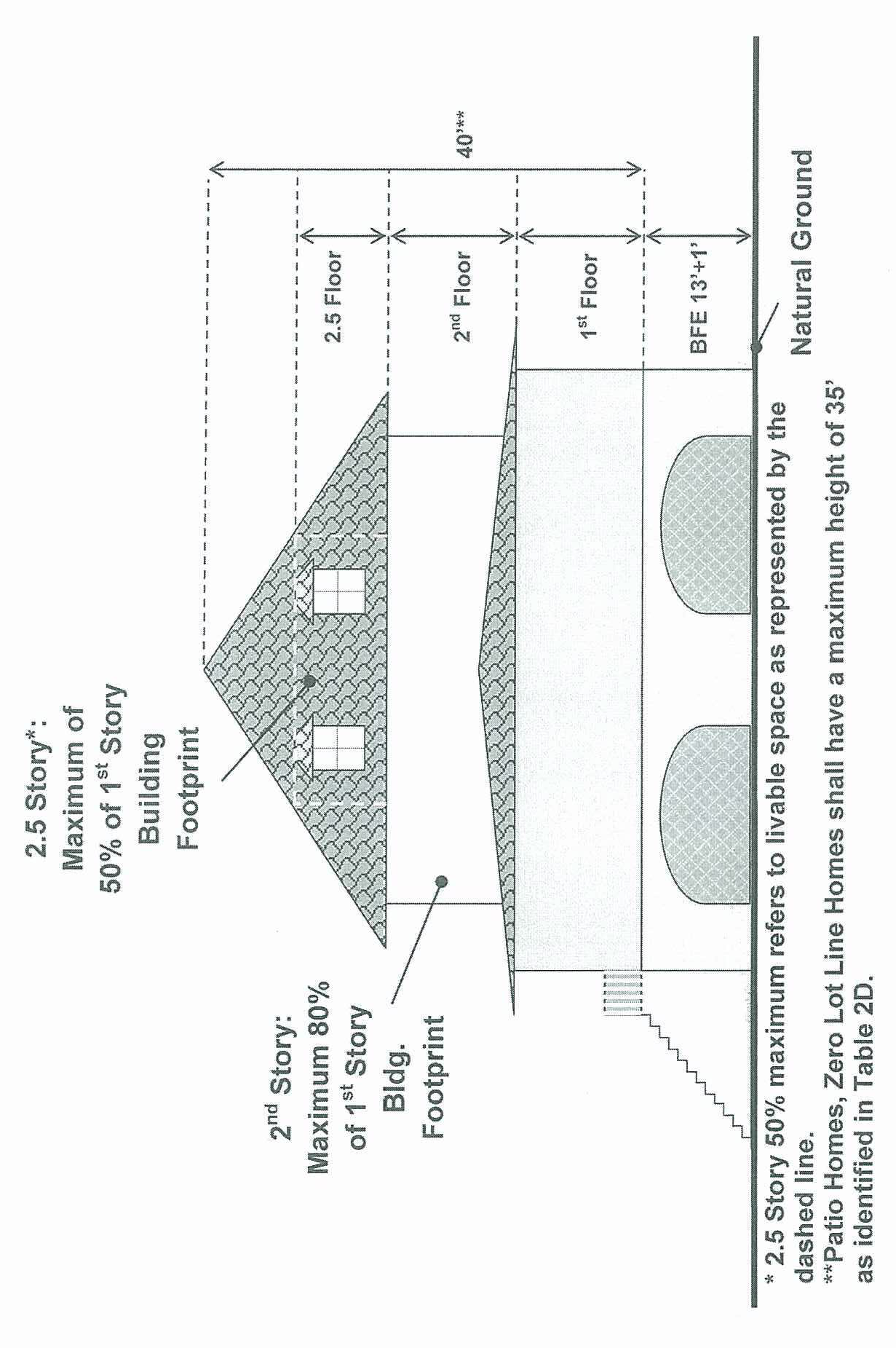
The term "height" means the elevation from ground floor level as measured in feet and stories to the highest point of the roof. The term "building height" does not include chimneys, antennas or ventilation pipes. Height in stories is the number of habitable floors (stories) exclusive of the area below the first finished floor. One-half story is a habitable floor which has heated square footage that is no greater than one-half the heated square footage of the largest story;
(10)
The second story floor area shall not exceed 80 percent of the first story building footprint area. If there is a half story above the second story, it shall not exceed 50 percent of the first story floor area.
Graphic 2A, elevation and graphic 2B, plan view: single-family detached maximum height in stories/feet: ;frax;2.5;40;, illustrating 80 percent maximum second story floor area and 50 percent maximum 2½ story floor area.
(1) Note. Patio homes, zero lot line homes shall have a maximum height of 35 feet as identified in table 2D.
(Ord. No. 2011-06, § 2(12A-221), 10-4-2011; Ord. No. 2025-19, § 2(Exh. A), 10-14-2025)