
Kiawah Island City Zoning Code
DIVISION 4
SUPPLEMENTAL REGULATIONS
Sec. 12-126. - Adequate public facilities regulations.
The purpose of the regulations of public facilities is intended to provide high-quality, orderly and controlled development while allowing for community growth and maintaining the residential character of the Town.
(1)
Land proposed for development must be served by essential community facilities and services (water, sewer and access) which are available at the time of occupancy and adequate to support the proposed development. Land shall not be approved for development unless and until adequate community facilities exist or provision has been made for the development of water facilities, wastewater facilities, drainage facilities, electric power and streets which are necessary to serve the development proposed at the time the development is occupied, whether or not such facilities are to be located within the property being developed or off site.
(2)
All buildings must have access to a public water system which is capable of providing water for health and emergency purposes, including adequate fire protection. Water systems shall meet the minimum standards established in the Town of Kiawah Island Fire Code.
(3)
All platted lots must be served by an approved means of wastewater collection and treatment.
(4)
Proposed streets shall provide a safe, convenient and functional system for vehicular and pedestrian circulation, shall be consistent with the comprehensive plan and any amendments thereto, and shall be appropriate for the particular traffic characteristics of each proposed development.
a.
This section provides a set of performance standards for the Kiawah River Bridge (bridge) and the Kiawah Island Parkway (parkway). The standards of this section are meant to maintain the performance of these facilities in terms of the volume of traffic thereon and the ratio of that volume to the maximum capacity of the facility. Critical traffic volumes and frequencies of their occurrence are used in accordance with subsection (3)b of this section to specify the point at which traffic mitigation plans and traffic mitigation measures will be required. As traffic volume on any link of the transportation facilities approaches full capacity, it will become necessary to expand the capacity of that link. Two important factors should be considered in deciding when traffic mitigation measures are needed.
1.
First, traffic on the bridge and parkway should not be required to fully reach capacity volumes before traffic mitigation measures are mandated. Near capacity traffic volumes will result in congestion, delay, and driving discomfort, which can be avoided if sufficient lead time is provided between the decision to build and the actual construction of traffic mitigation measures. Traffic volumes should exceed only a specified percentage of capacity in order to require traffic mitigation measures.
2.
Second, infrequent peaking of traffic volumes at or near capacity due to special events or circumstances does not, alone, justify the expansion of the transportation facilities. Traffic volumes should approach capacity with a specific regularity in order to require traffic mitigation measures.
Traffic mitigation measures approved by the Town shall be required whenever a specified traffic volume is reached. A phased process whereby a developer will plan and provide approved traffic mitigation measures is described in subsection (3)c of this section.
b.
Traffic counts will be conducted by the Town on the bridge and parkway three times per year in accordance with subsection (3)c of this section. The traffic counts will be used to evaluate the existing traffic conditions during the summer peak and during time periods on each side of the peak season during the times specified in subsection (3)c of this section. If for any three consecutive days during these count periods traffic volume for any peak hour exceeds 70 percent of peak-hour capacity (defined herein as "near capacity traffic volume") of any link of the bridge or parkway, the data shall be formally submitted to the developer. The developer will submit for Town approval (which approval shall not be unreasonably withheld) a traffic mitigation plan for each affected link. Traffic mitigation plans will propose traffic mitigation measures which shall reduce traffic volume below near capacity traffic volume or increase roadway capacity for each affected link. Upon Town approval of a traffic mitigation plan, the developer shall begin construction of improvements and implement approved traffic mitigation measures within six months. The developer may submit traffic mitigation plans and implement approved traffic mitigation measures at any time prior to the above traffic conditions being reached. traffic mitigation measures include improvements and/or traffic management strategies to restore or maintain acceptable levels of service for roadway links include, but are not limited to: turn lane additions, acceleration/deceleration lanes, other road widening alternatives, and other measures to decrease traffic volume or increase roadway capacity. For the purpose of determining when 70 percent of capacity is reached, peak-hour capacity for each lane shall be:
1.
1,700 vehicles per hour (VPH) for the existing bridge; and
2.
1,900 VPH for the existing parkway.
Near capacity traffic volume shall be 1,190 VPH for each lane for the existing bridge and 1,330 VPH for each lane for the existing parkway, with both of these volumes measured under conditions of free traffic flow.
c.
Traffic counts will be conducted annually during the first two weeks of June (June 1 through 14), the second and third week of July (July 8 through 22) and the last two weeks of August (August 17 through 31) at each of the intersections along the parkway and peak hour travel time runs will be conducted from the parkway's intersection with Betsy Kerrison Parkway to its intersection with Governor's Drive. The traffic counts and travel time runs will be used to evaluate near capacity traffic volume during the summer peak and during periods on each side of the peak season. The data will be used to calibrate an appropriate traffic simulation model for the Town. The model will be used to evaluate the impact of proposed development and mitigation measures on the capacity of the parkway and bridge between Betsy Kerrison Parkway and the Vanderhorst security gate. The model network will be formed using data collected from an inventory of field observations, including: intersection spacing, intersection layout, peak hour turning movement counts, traffic counts and travel time studies throughout the parkway and bridge corridor. The network will be segmented into individual links as shown in table 4A in subsection (6) of this section, near capacity travel volumes. The links shown in table 4A include specific intersections along the parkway and allow the investigation of traffic flow characteristics for each localized area. Traffic flow interruptions for the security gates will be incorporated into the model, with regular model calibration to reflect actual traffic observations.
(5)
Except as otherwise provided by State Law, drainage improvements shall accommodate potential runoff from the entire upstream drainage area and shall be designed to prevent overloading the capacity of the downstream drainage system. The Town may require the use of control methods such as retention or detention, and/or the construction of off-site drainage improvements in order to mitigate the impacts of the proposed development.
(6)
Sites and convenient access for parks and other community services should be consistent with the Town's Comprehensive Plan.
(Code 1993, § 12A-401; Ord. No. 94-12, § 2(12A-401), 9-26-1994; Ord. No. 2005-08, § 12A-401, 10-12-2005)
Sec. 12-127. - Compatibility buffering standards.
The purpose and intent of these compatibility buffering standards is to provide development flexibility and discretion to applicants, while providing adequate assurances to existing and future property owners that the use and design of new developments will be compatible with that of existing adjacent development. Specifically, that sufficient buffering and screening will be provided between and among existing and new developments and especially where zoning changes.
(1)
The following three standards shall apply for all new development:
a.
Density equal to adjacent lots or parcels;
b.
Designation for the same use as adjacent lots or parcels; and
c.
Identical lot standards for adjacent lots or parcels.
(2)
If the proposed development does not satisfy these three conditions, bufferyards shall be required as specified in this section and specifically the following table 4B and table 4C set forth in subsection (4) of this section:
(3)
Table 4B in subsection (2) of this section shows the minimum requirements for bufferyard types I, II and III. In addition to the criteria listed in table 4B, the following shall also apply:
a.
Bufferyards and open spaces shall be provided on the site of the new development, regardless of existing setbacks, except that existing golf courses or dedicated open space areas may be counted towards bufferyard requirements.
b.
Natural bufferyards are those for which the vegetation has been permitted to grow through natural succession to include trees which are at least 20 feet tall with thickly vegetated understory growth.
c.
Densely planted bufferyards shall include a variety of trees and understory plantings which will mature to create an opaque bufferyard within five years of planting.
d.
Open bufferyards include golf courses, water bodies, and other areas where vegetation does not completely visually screen adjacent land uses.
e.
Design and plant material shall be determined by the Planning Director provided, however, that the Planning Director shall reasonably determine whether or not the specific planting criteria for vegetative bufferyards have been met.
(4)
Table 4C as set forth in this subsection shows bufferyard requirements between and among residential, commercial, resort and other zones. The Planning Director shall determine the type of bufferyard based on table 4C. Any zoning district not represented in the following table 4C shall follow the bufferyard standards for commercial, office or resort zoning:
a.
If bulk, height and area standards for new developments do not reflect the development standards established on existing R-1 district lots, a type I bufferyard must be provided.
b.
Bufferyards may be included within required building setbacks.
c.
Bufferyards at the edges of marshes, lakes, ponds or dunes and/or at the critical line shall be natural for at least three feet into the property.
(Code 1993, § 12A-402; Ord. No. 94-12, § 2(12A-402), 9-26-1994; Ord. No. 2005-08, § 12A-402, 10-12-2005)
Sec. 12-128. - Access, parking and loading regulations.
The following regulations are intended to aid in the design and location of proper access, parking, and loading areas in order to maintain safe and efficient traffic flow.
(1)
Access/driveways. The following regulations shall apply to all development to prevent the proliferation of poorly spaced driveways that can result in reduced safety and carrying capacity of community streets, except that the distances may be varied in accordance with section 12-163 to permit the construction of a single, safe access where no other access to a lot is possible.
a.
Generally, any lot having access to more than one type of street shall provide access on the street designed for the lowest traffic volume.
b.
Nonresidential properties having access to a minor and collector street may construct a single driveway on the collector street, provided that the driveway complies with the standards herein.
c.
There shall be only one curb cut for an individual lot or parcel. Town approval shall be required for more than one curb cut to an individual lot or parcel from any street, where there is a compelling reason.
d.
No lot or development parcel shall directly access Kiawah Island Parkway and the arterial portions of Governor's Drive and Flyway Drive.
e.
Private residential driveways shall be a minimum of ten feet in width and provide a vertical clearance of a minimum of 13.5 feet. Nonresidential driveways shall be a minimum of 18 feet in width and provide a vertical clearance of a minimum of 13.5 feet.
(2)
Spacing between driveways and intersections. The centerline of driveways shall be separated from the centerline of other driveways and intersections in accordance with the following table 4D, excepting lots platted prior to adoption of the ordinance from which this article is derived and where relief is needed to protect essential natural features, such as specimen trees and dunes:
a.
No driveway shall be permitted providing access to an arterial street if the property has access to a collector or minor street.
b.
On minor streets, no driveway should be permitted within 60 feet of an intersection, except when relief is needed due to an existing tree, unusual lot configuration, wetlands or other topographical or geographic feature of the lot.
c.
When channelized right turn lanes are used, the Planning Director shall determine the minimum spacing between the driveways and intersections based on AASHTO standards as modified by site-specific conditions.
(3)
Parking and loading. This section specifies the minimum parking and loading standards for the Town. Where strict interpretation of these standards creates a unique hardship, an individual may seek a variance pursuant to section 12-163.
a.
Minimum parking requirements. Each use shall provide the number of parking spaces specified in table 4F in subsection (3)c of this section and comply with the following:
1.
The Planning Director shall determine the number of parking spaces required for uses not referenced in table 4F in subsection (3)c of this section by first applying the standard for the most similar use or uses as listed in the table. If there is no similar use, the Planning Director may make a determination or may request that the applicant undertake a parking study.
2.
Any fraction of a parking space required under this article shall be counted as a full parking space.
3.
Handicapped spaces shall be provided as required by the Americans with Disabilities Act (ADA) standards shown below in table 4E in subsection (3)b of this section, or as requirements are amended by Federal Law.
4.
Parking requirements shall be based on gross leasable area.
5.
Off-street parking facilities shall be provided for any new building constructed and for any new use established, for any addition or enlargement of an existing building or use, or for any change of occupancy or manner of operation that would result in additional parking spaces being required; provided, however, if insufficient parking exists on a lot or parcel, then the number of spaces required to meet the needs of both the existing and new buildings or uses shall be provided.
6.
Facilities being used for off-street parking on the effective date of this article shall not be reduced in capacity to less than the number of spaces prescribed, nor shall they be altered in design or function to less than the minimum standards prescribed herein.
7.
For sites with more than one use, or for adjacent sites served by a common parking facility, the parking requirement shall be the total number of spaces required for each site or use.
b.
Accessible parking for physically disabled persons. Handicapped spaces shall be provided as required by the Americans with Disabilities Act (ADA) standards shown in the following table 4E:
c.
Minimum dimensions. All parking spaces reserved for persons with disabilities shall comply with the parking space dimension standards of this section, provided that access aisles shall be provided immediately abutting such spaces, as follows:
1.
Car accessible spaces. Car accessible spaces shall have at least a five-foot-wide access aisle located abutting the designated parking space.
2.
Van accessible spaces. Van accessible spaces shall have at least an eight-foot-wide access aisle located abutting the designated parking space.
3.
Proximity to main entrance. All accessible spaces shall be in close proximity to the main entrance of the facility being served.
d.
Parking design standards. The following are minimum design standards, the Planning Director may require modifications to parking lot design to ensure the safety of pedestrians, bicyclists and motorists:
1.
All off-street parking shall be located outside of required landscape buffer areas and behind front building lines.
2.
Parking facilities constructed, or reconstructed greater than 50 percent of their original size, subsequent to the effective date of the ordinance from which this article is derived shall conform to these design standards.
3.
All required parking facilities shall be maintained for the duration of the use requiring such facilities. Parking facilities shall be used exclusively for the temporary parking of passenger automobiles, motor vehicles or light trucks not exceeding one ton in capacity, and shall not be used for the sale, display or storage of merchandise, or for the storage or repair of vehicles or equipment.
4.
All required parking facilities shall be located on the same site as the use for which such facilities are required.
5.
On street head-in parking is prohibited.
6.
Angled parking is prohibited.
7.
Required parking for residential uses shall be provided within an enclosed garage.
8.
Each standard parking space shall consist of an independently accessible rectangular or trapezoidal area.
9.
Each parking space shall have a vertical clearance of at least 7.5 feet.
10.
Each parking and loading area shall have adequate drives, aisles, and turning and maneuvering areas for access and usability, and shall at all times have access to a street or alley.
11.
The minimum parking facility design standards are listed in table 4G in this subsection.
12.
Where applicable, the Planning Director may require overflow parking spaces in addition to those required in table 4F in subsection (3)c of this section. All overflow parking spaces shall be of a pervious surface.
13.
Required parking spaces shall not have direct access to a street or highway. Access to required parking spaces shall be provided by on-site driveways. Off-street parking spaces shall be accessible without backing into or otherwise reentering a public right-of-way.
e.
Markings. In paved parking areas, each off-street parking space shall be identified by surface markings at least four inches in width. Marking shall be visible at all times. Such markings shall be arranged to provide for orderly and safe loading, unloading, parking and storage of vehicles.
f.
Off-street loading requirements.
1.
Spaces required. For every nonresidential use there shall be provided sufficient space to accommodate the maximum number of trucks that will be loading, unloading, or standing at any one time.
2.
Size of space. Each off-street loading space shall be of a size commensurate with the buildings to be accommodated. In no case shall required off street loading space encroach upon off street parking space required by this article.
3.
Location. All required off street loading spaces shall be located on the same lot as the building which they are intended to serve.
4.
Entrances and exits. Off-street loading entrance and exit drives shall be located at least 25 feet from any street intersection.
5.
Loading spaces adjacent to sidewalks. Where a loading space is adjacent to a public sidewalk or other public pedestrian way, it shall be so located, arranged, and improved with curbs or other barriers, as to provide adequate protection for pedestrians.
6.
Maneuvering areas. All off street loading spaces shall be provided with adequate off street maneuvering areas.
g.
Parking, loading and vehicular use area landscaping. See section 12-129, Tree Preservation and Landscaping Standards.
h.
Paving and drainage.
1.
For all uses except single-family dwellings, parking and loading facilities shall be surfaced and maintained with asphaltic concrete or other permanent hard surfacing material sufficient to prevent mud, dust, loose material and other nuisances. Pervious materials may be allowed as approved by the Planning Director.
2.
All parking and loading facilities shall be designed, graded and provided with permanent storm drainage facilities that prevent standing water on any parking area, and do not increase the flow of water onto adjacent properties, streets or alleys.
(Code 1993, § 12A-405; Ord. No. 94-12, § 2(12A-404), 9-26-1994; Ord. No. 2005-08, § 12A-405, 10-12-2005; Ord. No. 2025-02, § 2(Exh. B), 3-4-2025)
Sec. 12-129. - Tree Preservation and Landscaping Standards.
Purpose and Intent. The purpose of these regulations is to provide tree preservation and landscaping standards for all properties within the Town of Kiawah Island's municipal boundaries in order to consistently preserve and enhance Kiawah's natural environment and to protect significant trees and forests for present and future generations. The proper care of trees, shrubs and other landscape plants is important to the implementation of this chapter. It is the expectation that property owners, tree care professionals and design professionals utilize industry best practices in providing the proper care of trees for the overall health of the environment. The intent of these regulations is to:
a.
Preserve the natural character of neighborhoods;
b.
Ensure the health and wellbeing of Kiawah's native trees and maritime forests;
c.
Protect the health and safety of residents;
d.
Protect water quality and minimize stormwater runoff;
e.
Help prevent erosion or flooding;
f.
Promote integrated development with nature to minimize tree loss and environmental degradation;
g.
Establish a minimum standard for tree preservation and mitigation of environmental impacts resulting from tree removal;
h.
Screen noise, dust and glare;
i.
Maintain and or improve aesthetic and property values;
j.
Promote the planting of native trees and shrubs; and
k.
Encourage best practices for proper landscape and tree care.
Tree Preservation
(1)
Applicability & Exemptions. The provisions of this article apply to all real property within the municipal limits of the Town of Kiawah Island, excluding single-family residential developments, except single family residential developments which are not subject to review or purview of any established architectural review board.
a.
The following are exempt from the provisions of this article:
1.
Pruning of trees or shrubs for regular maintenance including dune maintenance.
2.
The trimming or removal of trees or vegetation for safe sight distance and visibility within or adjacent to a right of way or leisure trail for pedestrian, bicycle and or vehicular travel.
3.
Routine maintenance as pruning and trimming of trees on golf course. The removal of Specimen Trees on golf courses shall not be exempt from the provisions of this article.
4.
The removal of trees for emergency work.
5.
The removal of invasive tree species as defined within this article.
6.
Tree work completed by utility companies, electric suppliers, or governmental agencies. This article shall not restrict utility and electric suppliers from maintaining safe clearance around existing utility equipment, and existing easements in accordance with applicable state laws. The siting and construction of future gas, telephone, communications, electrical lines, or other utilities shall be exempt from the provisions of this article provided that the applicable company, supplier, or agency has consulted with the Town and received zoning approval from the Planning Director prior to the commencement of construction or major maintenance projects to develop a strategy to:
i.
Minimize trimming of Protected Trees that do not substantially interfere with the intended purpose of construction or maintenance;
ii.
Prioritize the protection of Protected Trees as a factor to be considered in the design process;
iii.
Specify that trees to be removed from the rights-of-way by electric utilities and other utilities may be required to be replaced by such entity.
7.
Nothing in this article shall be construed to prevent the ordinary trimming and maintenance of trees provided that a permit is obtained if required and such trimming is so excessive so as to constitute an abuse as described in this section.
b.
The removal of any Specimen Tree on a single-family residential development shall not be exempt from the provisions of this article.
(2)
Required Permit.
a.
No person shall cut down, top, remove, relocate, damage, destroy, or in any manner abuse any Protected Tree or Specimen Tree on any lot or right-of-way unless authorized by the terms of this article.
b.
The removal of any Protected Tree or Specimen Tree on any site prior to the issuance of a zoning permit by the Town of Kiawah Island is prohibited. A zoning permit shall be required for the removal, relocation or destruction of Protected Trees or Specimen Trees in accordance with the procedures set out in this article. Permits for tree removal may be approved when the Planning Director has determined that one or more of the following conditions exist:
1.
The tree removal is part of a development plan or site plan for which a Tree Preservation Plan prepared by a licensed surveyor, civil engineer, forester, arborist, or landscape architect has been reviewed and approved pursuant to this article; or
2.
The tree(s) to be removed has been approved by the Landscape and Tree Preservation Board; or
3.
The density of trees is great enough that removal of a tree would be beneficial to the overall area and or health of a Protected Tree and or an environment as determined by a certified arborist.
c.
Trees that are determined to be causing structural damage to a structure greater than 200 square feet or sidewalks and driveways, where said damage cannot be remedied without removing the tree may be removed as determined by a certified arborist. When there is a question of whether tree removal is necessary, the Planning Director may require documentation from a certified arborist with Tree Risk Assessment Qualifications that said damage cannot be successfully halted through root pruning and the installation of a root barrier while maintaining the structural integrity of the tree.
d.
An approved zoning permit for tree removal may be issued with conditions as determined by the Planning Director or Landscape and Tree Preservation Board.
e.
A permit shall not be required for tree(s) to be removed that have been determined to be dead, diseased, irreparably damaged, hazardous, or clearly causing damage to the property or injury toa person in the opinion of a certified arborist or Tree Risk Assessment Qualified (TRAQ) Arborist. Notification shall be made to the Town's Planning Department of such condition(s) prior to tree removal.
1.
Notification to the Planning Department should include photos of the subject tree(s) and any supporting documentation to describe the conditions.
(3)
Tree Surveys, Tree Preservation Plans, and Landscape Plans.
a.
A tree survey showing all existing trees throughout the portion of any site or right-of-way proposed for disturbance and including any area counted as required open space area shall be submitted as part of any site plan for zoning permits for new construction, substantial improvements, or renovations; or any preliminary and final subdivision plats in accordance with the requirements below. Tree Survey submittal requirements can be found in Table 41, Tree Survey, Preservation and Landscape Plan Submittal Requirements of this article.
1.
Tree surveys shall include the name, phone number, address, signature, and seal of a licensed surveyor, civil engineer, forester, arborist, or landscape architect.
2.
The tree survey must be certified and dated within two years of its submittal.
3.
A topographical and tree survey must be to an architectural or engineer's scale and is required to show the legal description of the property, including the following:
i.
Recorded property lines, easements, and setbacks.
ii.
The topographical contours of the lot, along with spot elevations for existing curbs, the street, and neighboring lot curbing.
iii.
The location, genus, and species of all oak trees over three inches caliper DBH and other trees more than six inches caliper DBH.
iv.
Any prominent natural features of the site.
v.
Adjacent residences with roof heights from mean sea level (MSL), garages, and driveways.
vi.
Current Ocean and Coastal Resource Management's Certified Critical Line which must be certified with five years of submittal.
vii.
Utility locations.
b.
A Tree Preservation Plan is a plan that shows all trees in the area to be developed or within the property, the trees to be protected or preserved, the measures taken to preserve them and those scheduled to be removed, including dead and damaged trees. Tree Preservation Plans may be required to be submitted to meet the requirements of this article as specified in Table 41, Tree Survey, Preservation and Landscape Plan Submittal Requirements.
1.
The Tree Preservation Plan will include calculations to determine the number of replacement trees as required by the tree removal, mitigation, and replacement section of this article and a proposed reforestation landscape plan.
2.
The Tree Preservation Plan shall be developed by a forester, arborist, landscape architect or other horticultural registered professional.
3.
The Tree Preservation Plan shall reflect the applicant's best effort to determine the most feasible and practical layout of buildings, parking lots, driveways, streets, storage, and other physical features, so that the fewest Specimen and Protected Trees are destroyed or damaged and to minimize the negative environmental impact to the site.
4.
The Tree Preservation Plan should consider how the subject property along with adjacent properties, tree densities and landscape can contribute to develop and or maintain wildlife habitat.
5.
The Tree Preservation Plan shall consider the grade quality of trees greater than eight inches DBH where all Grade A and Grade B trees should be prioritized for preservation.
6.
Required Tree Protection Fencing: Tree protection fencing shall be shown on the plan, placed around all trees designated to be saved, prior to the start of development activities or grading. Such barriers shall be erected at a recommended minimum distance from the base of Protected Trees according to the following standards:
i.
Tree protection fencing shall be placed at a minimum distance equal to ten feet from the base of a Specimen Tree. All vegetation on the site that is not impacted by construction shall be protected using tree protection fencing.
ii.
Tree protection fencing shall consist of barriers approved by the Planning Department (a minimum of four feet in height). The Planning Department shall not require that chain link fences be used.
iii.
Protective barricades shall remain in place until development activities are complete. The area within the tree protection fencing shall remain free of all building materials, stockpiled soil, or other construction debris. Construction traffic, storage of vehicles and materials, and grading shall not take place within the protective areas of the existing trees. Any violations must be addressed immediately, or a stop work will be issued.
iv.
Construction access to a site should occur where an existing or proposed entrance/exit is located, except for driveway access points, sidewalks, and curb and gutter, land disturbance within a tree dripline is prohibited.
c.
Landscape Plans may be required to be submitted to meet the requirements of this article as specified in Table 41, Tree Survey, Preservation and Landscape Plan Submittal Requirements. Details of what must be included can be found in Landscape Standards (2).
d.
Table 41, Tree Survey, Preservation and Landscape Plan Submittal Requirements in subsection (3) of this section shows the minimum requirements for submittal of various plans.
(4)
Specimen and Protected Trees.
a.
Specimen Trees and Protected Trees are species chosen as a point of focus in a landscape which usually has an unusual shape, texture, color or other feature that distinguishes it from other trees and shrubs in the area excluding invasive species. These trees have a life expectancy of greater than ten years, have a relatively sound and solid trunk with no extensive decay or hollow, and have no major insects, pathological problem, or defects. Specimen Trees are valued for their size and their legacy.
b.
Under the provisions of this article, the following trees are considered Specimen Trees and shall be prohibited from being removed unless approval is granted by the Planning Director or designee in accordance with the requirements of this article:
1.
Grand Trees: Any tree with a diameter breast height of 24 inches or greater in size; and
2.
Live Oak Trees with a diameter breast height of 16 inches or greater.
c.
Under the provisions of this article, the following trees are considered Protected Trees and shall be prohibited from being removed unless approved by the Planning Director or designee in accordance with the requirements of this article:
1.
Any tree with a diameter breast height of eight inches or greater.
(5)
Tree Removal and Tree Impacts.
a.
For the purpose of this article, the term "Tree Removal" shall include, but not be limited to, damage inflicted to the root system by machinery; girdling; storage of materials and soil compaction, changing the natural grade above or below the root system or around the trunk; damage inflicted on the tree permitting fungus infection or pest infestation; excessive pruning; excessive thinning; excessive paving with concrete, asphalt or other impervious material within such proximity as to be harmful to the tree; excessive grading; or any act of malicious damage to a tree. The final determination of tree removal shall be made by the Planning Director.
1.
Tree Pruning:
i.
Pruning or thinning more than 25 percent of the leaf surface on both the lateral branch and the overall foliage of a mature tree that is pruned within a growing season shall be considered excessive. Additionally, one-half of the foliage of a mature tree should remain evenly distributed in the lower two thirds of the crown and individual limbs upon completion of any pruning.
ii.
Pruning or thinning such as the removal of branches six inches or greater in diameter shall also be considered excessive.
iii.
Crape Myrtle Trees shall be excluded from the requirements of tree pruning.
2.
Tree Root Zone Protection:
i.
Paving or grading within five feet of the base of the tree or paving or grading 50 percent or greater of the circumference of the tree shall also be considered excessive as determined by the Planning Director.
(6)
Tree Mitigation and Replacement.
a.
Tree mitigation shall adhere to the following standards in which the applicant shall mitigate loss or removal of Protected Trees and Specimen Trees by planting replacement trees in appropriate areas on the property in accordance with the tree replacement requirements as listed in Table 4J. Tree Preservation Requirements and Mitigation Standards and the approved tree preservation plan.
(7)
Maintenance of Trees.
a.
Following development, the property owner shall be responsible for maintaining the trees that were saved and/or planted. Proper tree care should use ANSI A300 (Tree, Shrub, and Other Woody Plant Maintenance—Standard Practices) for best practices.
(8)
Administration.
a.
Plan Alterations or Revisions: Due to seasonal planting problems and/ or a lack of plant availability, approved plans may require minor revisions. Minor revisions to planting plans may be approved by Town Staff if:
i.
There is no reduction in the quantity of plant material;
ii.
There is no significant change in size or location of plant materials; and
iii.
The new plants are of the same general category (i.e., shade tree, ornamental tree, evergreen, or shrub) and have the same general design characteristics (mature height, crown spread) as the materials being replaced.
(9)
Landscape and Tree Preservation Board.
a.
The Landscape and Tree Preservation Board shall review with the authority to approve, approve with conditions, or disapprove a proposed Tree Preservation Plan for proposed commercial or multifamily residential developments in accordance with the provisions of the article.
b.
The Landscape and Tree Preservation Board shall review and approve the removal of any Specimen Tree or Grand Tree in accordance with the provisions of the article.
c.
The Landscape and Tree Preservation Board shall also be in place to hear special circumstances regarding tree removal or where strict interpretation of the ordinance has been made by the Planning Director. An applicant may apply to be granted relief or exception to this article as reviewed and approved by the Landscape and Tree Preservation Board. The applicant should make their appeal case to the Landscape and Tree Preservation Board pursuant to section 12-24.1, Landscape and Tree Preservation Board, in which the Landscape and Tree Preservation Board shall review and make a decision based on the applicant's submission and approval criteria.
(10)
Inspections, Violations, and Fines.
a.
The Planning Director or Landscape and Tree Preservation Board may approve a delayed schedule for planting materials (provided by the applicant's contractor) when the immediate planting schedule would impair the health of plants. When a delayed planting schedule is approved, the applicant shall provide a bond equivalent to one and one-half times the projected cost of the planting materials and installation in accordance with the American Association of Nurserymen Standards. This is designed to include severe weather, such as droughts, heat waves, and floods. The applicant shall provide a minimum of two quotes from local (tri-county area) contractors for review and the bond amount shall be determined by the Planning Director.
b.
The Town reserves the right to inspect the site or property at any reasonable time for compliance with tree preservation requirements. Town Staff may inspect the site one year after the issuance of a permanent Certificate of Occupancy in order to ensure compliance with the approved tree plan.
c.
If the Town finds a development in violation of this article or if an applicant fails to satisfy any condition that was imposed as part of the original or revised approval of the zoning permit or Tree Preservation Plan or that was made pursuant to the provisions of this article, the applicant or property owner shall be in violation of this article.
d.
Any applicant or property owner in violation of this ordinance shall be subject to fines or penalties as prescribed in this article and or other remedies and enforcement actions pursuant to section 12-214.
i.
The illegal removal of a tree(s), in accordance with the provisions of the article shall constitute a violation and the property owner shall be subject to a penalty fine of $1,080.00 per tree.
ii.
The illegal removal of a tree(s), in accordance with the provisions of the article shall constitute a violation and the property owner shall be required to mitigate the illegal removal of a tree(s).
Landscape Standards
The preservation and enhancement of natural systems is a principal priority on Kiawah Island. Development of Sustainable Landscapes is a key objective of these landscape standards and a key component of the community's resilience planning. Sustainable Landscapes sequester carbon; clean the air and water; increase energy efficiency; restore habitats; and create value through significant economic, social and environmental benefits.
(1)
Applicability. The provisions of this Article apply to all real property within the municipal limits of the Town of Kiawah Island, excluding single family residential developments. However, the provisions of this article shall still apply to single family residential developments which are not subject to review or purview of any established architectural review board.
a.
Landscape Plan shall be required for:
1.
All new construction.
2.
Exterior remodeling involving a change in the building footprint.
3.
Parking areas or other impervious surfaces.
4.
Change of use that results in a more intense use.
5.
Additions to any structure used for any purpose (except single-family residences
6.
At the request of the Planning Director.
b.
No zoning permit shall be issued for a development subject to review until the landscape plan has been approved in accordance with the provisions contained within this article.
(2)
Landscape Plans.
a.
Plans submitted to meet the requirements of this article shall be a minimum of one-inch equals 20 feet and/or the same engineering scale as the site plan and include; a graphic scale and north arrow. All landscape documents submitted shall be prepared, sealed and dated by a Landscape Architect licensed to practice in the State of South Carolina.
b.
Landscape drawings shall show and describe all site conditions including buildings, pervious and impervious areas, parking, service areas, site furnishings, site and street lighting, natural areas and open space in relationship to site development. Landscape drawings shall consist of sufficient detail and of profession quality to enable comprehensive review.
c.
All landscape plan submissions shall include, but not be limited to documentation of the following;
1.
Limits of project site, property lines, setbacks, easements, and context including adjacent sites, vegetation, and buffers.
2.
Location of above and below grade site utilities, and service connections including fire department connections, easements, and access requirements. (shown as an underlay).
3.
All land disturbing activities and limits of disturbance, including utility work.
4.
Phasing, future development, temporary uses and timing of construction if applicable.
5.
Tree Preservation fencing.
6.
Proposed topography, drainage ways, yard inlets, area drains, overflow areas.
7.
Proposed plant material shall be depicted at maturity.
8.
Specification and location for hardscape elements such as planters, street and site lighting, site furnishings, paving, walls, fences, signs, etc.
9.
Plant list that includes the complete botanical and common name, native species designation, quantities of each, container size, caliper size, height and spread at planting.
10.
Landscape plan must include in tabular format how the proposed planting meets the requirements of this ordinance.
(3)
Issuance of Certificate of Occupancy. The landscape architect of record shall provide a certification letter to the town certifying that the landscaping was installed in accordance with the plans and specifications submitted. With respect to landscape material for a newly developed or redeveloped site undergoing construction, a final certificate of occupancy (CO) shall be issued by the Building Official once all landscape material has been installed in accordance with the approved landscape plans and certified by the Landscape Architect of Record. A temporary certificate of occupancy (TCO) may be issued by the Building Official until all pending issues are addressed; such as plant availability, planting season time of year etc.
(4)
Plant Materials.
a.
Natives. Using native plants has a direct impact on the local ecosystem which includes many benefits such as the protection of water resources and reducing the need for fertilizers, pesticides and irrigation which can contribute to stormwater runoff pollution and degradation of downstream water quality. Native plants also provide essential watershed protection, helping natural aquifers recharge, serving to filter water naturally before flowing into rivers and estuaries, lessening erosion and flooding and resistance to saltwater intrusion from flooding and storm surge. In addition, native plants sustain pollinators vital for fruit production and provide high-quality food and shelter for wildlife.
Town of Kiawah Island Grow Native Plant Database is a searchable online database of native trees, shrubs, perennials, vines, ferns, and grasses that provides detailed information on growing conditions, size, flowering, salt tolerance, deer resistance, and the wildlife value for each plant.
https://www.kiawahisland.org/wildlife/top_initiatives/grow_native/native_plant_database.php
Unless otherwise noted in this Ordinance, all proposed planting must be 70 percent native species for trees and shrubs and 50 percent for ground covers.
b.
Existing Plant Materials. Utilization of vegetation and plant materials that exist on a parcel prior to its development may be used to satisfy the landscaping standards provided they meet the requirements of this ordinance, at the determination of the Planning Director. No site clearing may commence without a Town of Kiawah Island zoning permit.
c.
Invasive Plant Materials. Landscape plans may not indicate the use of plant species listed on the "Nonnative Invasive Plants of Southern Forests" registry published by the USDA and the "Invasive Plant Pest Species of South Carolina." These species must be removed during site development if existing on the property.
d.
Size. Unless otherwise stated, all plant materials used to satisfy the requirements of this Ordinance shall meet the following minimum size standards:
e.
Species. Species of plant material used to satisfy the requirements of this Ordinance shall be native to the Island or cultivated to survive in this climate. No single plant species shall represent more than 40 percent of the total landscape plantings, except for projects whose landscape requirements for canopy trees are less than ten trees.
All plants installed to satisfy the requirements of this Ordinance shall meet or exceed the plant quality standards of the most recent edition of American Standard for Nursery Stock, published by the American Association of Nurserymen. Plants shall be nursery grown and either balled and burlapped, container grown or transplanted.
(5)
Installation, Maintenance and Replacement.
a.
Installation. All landscaping shall be installed according to American Association of Nurserymen standards and sound nursery practices in a manner designed to encourage vigorous growth. Sites for plant materials shall be prepared or improved in accordance with American Association of Nurserymen standards for soil preparation and drainage. Landscape plans shall include specifications and details required for the specific requirements of the site.
b.
Irrigation. An automatic irrigation system is required to sustain the initial landscape planting.
c.
Maintenance and Replacement. Required trees, shrubs, and other landscape features shall be considered elements of the project in the same manner as parking, building materials, etc. The property owner shall be responsible for the following:
All landscapes shall be maintained free from disease, pests, weeds, and litter. This maintenance could include weeding, watering, fertilizing, pruning, mowing, mulching or other maintenance as needed and in accordance with acceptable horticultural practices, including American National Standards Institute standards for Tree Care operations and American Association of Nurserymen standards.
The regular maintenance, repair, or replacement of any landscaping required by the ordinance and as shown on the approved site plan.
When replacement of trees, plant material, or other landscape features is required, such replacement shall be accomplished within the shorter of one growing season, one year or such time frames as required by the Planning Director.
(6)
Planting Standards.
a.
Minimum Lot Landscape Requirements.
1.
Trees: The minimum tree requirements for a developed lot shall be equal to a combined DBH greater than or equal to 20 trees per acre or 160 inches per acre, whichever is greater.
Each lot after development must contain a minimum of 70 percent of the healthy trees that existed on the lot predevelopment. This requirement may be fulfilled with a combination of existing trees and mitigation trees per the tree preservation plan.
2.
Shrubs: 50 percent of all shrubs installed must be a minimum size of seven gallons. The remaining installed shrubs must be a minimum of three gallons.
3.
Grass, ground cover, and mulch: Large expanses of non-native grass are prohibited unless associated with recreational purposes. Areas of sod must be a minimum of ten feet from lagoon edges. Areas to be grassed must be sodded as opposed to seeded or sprigged. Synthetic turf is discouraged.
4.
Pine straw or mulch areas are minimized and limited to an area no greater than ten percent of the planting areas.
b.
Vehicular use landscape standards.
1.
Parking, loading, and vehicular area perimeters. Unless otherwise expressly stated, perimeter landscaping shall be required around the outer perimeter of all off-street, surface parking, loading, and vehicular use areas. Parking areas for the exclusive use of single-family dwellings shall be exempt from these requirements. Any off-street parking, loading, or vehicular use area that will be entirely screened from view by an intervening building or structure or by a buffer provided to satisfy requirements contained elsewhere in this article shall also be exempt from these (parking, loading, and vehicular use area) perimeter landscaping requirements.
All new parking lots shall be designed with the required landscape areas to accommodate green infrastructure and low-impact development practices.
2.
Perimeter landscape requirements.
(i)
A perimeter landscape area at least ten feet in depth shall be provided at the perimeter of all off-street parking, loading, and vehicular use areas, except where permitted driveway openings are to be provided. Where drainage or other utility easements exist along property lines, the perimeter landscape area shall be located adjacent to the easement. Adjacent buffers shall count toward the minimum ten-foot perimeter landscape area.
(ii)
Required perimeter landscape areas shall be planted in accordance with the following minimum standards:
a.
One canopy tree shall be provided for each 50 linear feet of parking, loading, or vehicular use area perimeter.
b.
Landscape material of a least five feet in height (at maturity) shall be planted within the perimeter landscape area to provide a continuous landscape element, or a combination of trees, hedges, other durable landscape material or approved wall or fence may be used to form the continuous landscape element.
c.
All portions of the perimeter landscape area not planted with shrubs or trees or covered by a wall or fence barrier shall be planted in ground cover;
d.
Landscape material with a mature height greater than 18 inches shall not be permitted within the sight triangle.
A clear sight triangle formed by a diagonal line connecting two points located on intersecting lines of pavement edge, each point being 20 feet from the intersecting lines.
ii.
Interior areas landscape requirements. The following interior parking lot landscaping requirements shall apply to all parking lots except those exclusively serving single-family residential uses.
(i)
A minimum of one landscape island shall be provided for each ten parking spaces within an off-street parking area. Required landscape islands shall have a minimum of 450 square feet and 12-foot, six-inch width. Each parking lot bay must terminate with a tree island.
(ii)
Each required landscaping island shall contain at least one canopy tree and there shall be at least one canopy tree per ten parking spaces within the off-street parking area. Double-loaded interior parking landscape islands are to be no less than ten feet wide and canopy trees planted in these islands are to be planted in line with parking stripes (between vehicles).
(iii)
Landscaping provided to meet the right-of-way buffer standards (same as perimeter landscape) of this article may not be used to satisfy interior parking lot landscaping requirements.
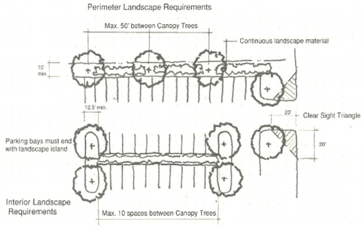
VEHICULAR USE LANDSCAPE STANDARDS
c.
Buffers.
1.
The compatibility buffers as outlined in section 12-127 are meant to provide sufficient buffering and screening between and among new and existing developments. It is prohibited to remove any vegetation in these buffers without a permit except invasive species as listed on the "Invasive Plant Pest Species of South Carolina".
2.
Natural buffer yards are the preference, those which vegetation has been permitted to have grown through natural succession to include trees which are at least 20 feet tall with thickly vegetated understory growth.
3.
Densely planted buffer yards. If the current conditions of the proposed buffer yard does not meet the above definition the proposed landscape shall include 70 percent native variety of trees and understory planting which will mature to create an opaque buffer yard within five years of planting.
(Ord. No. 2024-01, § 2(Exh. A), 4-2-2024; Ord. No. 2025-02, § 2(Exh. A), 3-4-2025)
Sec. 12-130. - Design Standards.
(a)
Purpose and intent. The purpose of these regulations are to provide a clear and transparent process for design review of commercial, mixed-use, civic, and multi-family residential developments in the Town of Kiawah Island, ensuring new development projects support community character and environmental stewardship. The intent of these regulations is to:
(1)
Preserve the natural character of existing neighborhoods;
(2)
Ensure aesthetic combability with existing character of Kiawah;
(3)
Promote integrated development with nature;
(4)
Maintain and or improve aesthetic values; and to
(5)
Establish consistent application of minimum standards and guidelines for architectural design.
(b)
Applicability and exemptions. The provisions of this article shall apply to all real property within the municipal limits of the Town of Kiawah Island, excluding single-family residential, except single family residential which are not subject to review or purview of any established architectural review board.
(c)
Design standards and guidelines. Proposed developments shall be reviewed in accordance the provisions of this article and the "Town of Kiawah Island Design Review Standards and Guidelines". The following standards shall be utilized by the board and the Planning Director in reviewing the plans, drawings, sketches and other documents as required for review and or approval. These standards are intended to guide property owners and design professionals in achieving thoughtful, context-sensitive architecture that reflects Kiawah Island's unique character. All projects should reinforce the Town's principle of Living with Nature within the Comprehensive Plan by integrating built form with the natural landscape, scale, and community character. These standards are not intended to affect the use of property or any by right entitlement of applicable zoning regulations, with the exception of the siting and design of development.
(1)
Site orientation and layout. Developments should respect the Kiawah's natural topography, vegetation and ecological systems; prioritize site planning that reduces visual and environmental impacts; orient primary building facades to maximize natural light and ventilation while minimizing heat gain; position buildings to preserve significant trees, wetlands, dunes and other natural features; avoid large expanses of paving; cluster parking areas and screen them with native landscaping; site buildings to maintain view corridors to natural features (marsh, forest edges, ocean); and incorporate pedestrian pathways, shaded outdoor areas, and connections to nearby amenities.
(2)
Massing and scale. Developments should ensure buildings are appropriately scaled and complement the Town of Kiawah Island's natural character; break down larger developments into visually cohesive but distinct components; use form and rhythm to harmonize with surrounding development and the natural setting; employ varied rooflines, articulated facades, and step-backs to avoid monolithic appearances; use massing strategies that reflect a hierarchy of forms (primary volume with secondary wings or terraces); break large buildings into smaller scaled segments to maintain pedestrian-friendly proportions; design transitions between building elements to reduce perceived bulk at edges or along public frontages; and consider how massing interacts with the skyline and treeline, ensuring natural dominance.
(3)
Building and structure heights. Building heights should reinforce Kiawah's low-rise, nature-focused identity; transition thoughtfully to surrounding contexts, especially near sensitive habitats and existing neighborhoods; be limited to maintain a harmonious relationship with surrounding vegetation and structure; be step downed along sensitive edges (adjacent single-family areas, critical area, marsh fronts, or ocean fronts); buildings should use roof forms (hipped, gabled, or gently sloped) to blend with the natural canopy line; screening rooftop mechanicals and utility equipment with architectural enclosures integrated into building design; and avoid flat-topped silhouettes that create stark contrasts with the natural environment.
(4)
Fenestration (windows, doors, openings). Openings should contribute to human scale, rhythm, and transparency while respecting privacy and energy performance; fenestration should enhance the building's relationship to the outdoors and natural light; windows and doors should be proportioned and grouped to create balanced compositions; avoid excessive expanses of unbroken glass; use mullions, bays, or screens to provide rhythm; orient and shade fenestration to minimize glare and heat gain while maximizing natural light; employ materials and colors that reduce reflectivity and blend with natural surroundings; encourage the use of porches, loggias, screened rooms, and recessed openings to create depth and shadow; and ground-floor fenestration should promote activity and visual connection with the public realm.
(5)
Environmental stewardship and process. Developments should protect Kiawah's ecosystems during and after construction; minimize disruption and restore impacted areas; establish tree/vegetation protection zones before construction; employ low-impact construction access and staging to development sites; use native plantings for restoration and landscape; integrate use of pervious materials and nature based solutions for stormwater management; and use sustainable materials and energy-efficient building practices.
(6)
Signs. The shape, configuration, location, design, color, texture, lighting and materials of all exterior signs and outdoor advertising structures or features should not detract from the design of proposed or existing buildings and structures and the surrounding properties.
(d)
Application and review stages.
(1)
Preliminary review. Prior to advancing a project, the applicant shall submit for preliminary review and approval to the Design Review Board. Preliminary Review shall not constitute final approval of design.
(2)
Final review. Prior to submitting for zoning review and approval, applicants shall receive final Design Review Board approval.
(e)
Design Review Board. The Design Review Board shall review with the authority to approve, approve with conditions, or disapprove developments in accordance with the provisions of the article.
(f)
Inspections, violations, and fines.
(1)
The Town reserves the right to inspect the site or property at any reasonable time for compliance with approved standards and guidelines. Town staff may inspect the site after the issuance of a permanent Certificate of Occupancy in order to ensure compliance with the approved plans.
(2)
If the Town finds a development in violation of this article or if an applicant fails to satisfy any condition that was imposed as part of the original or revised approval of the proposed development that was made pursuant to the provisions of this article, the applicant or property owner shall be in violation of this article.
(3)
Any applicant or property owner in violation of this ordinance shall be subject to fines or penalties as prescribed in this article and or other remedies and enforcement actions pursuant to section 12-214.
(Ord. No. 2025-22, § 2(Exh. B), 12-2-2025)