
Kingsburg City Zoning Code
CHAPTER 17
48 - COMBINING AND OVERLAY DISTRICTS3
Editor's note—Ord. No. 2024-07, § 1, adopted Dec. 18, 2024, amended the title of Ch. 17.48 to read as herein set out. The former Ch. 17.48 title pertained to combining districts.
17.48.010 - PUD—Planned unit development combining district.
A.
PUD—Purposes and Application. The PUD—planned unit development combining district is intended for application to those residential, professional office, commercial and industrial base zoning districts which are designated by the general plan and/or city council as areas to assure that property will be developed in a manner superior to that which otherwise would be achieved through regulations of the base zoning district involved. The PUD combining district is also intended as an optional approach to achieving the purposes of Chapter 17.76, at the discretion of the city rather than the landowner.
B.
PUD—Applicable Regulations and Procedures. The development of property within a PUD combining district shall be subject to all of the regulations and procedures of Chapter 17.76.
(Ord. 92-11 § 1 (part), 1992: Ord. 408 (part), 1982)
(Ord. No. 2024-07, § 1, 12-18-2024)
17.48.020 - MXU—Mixed use combining district.
A.
Purposes and Application. The MXU—Mixed use combining district is intended for application to two (2) types of property:
1.
Within commercial base zoning districts, on any site of such a size and configuration that a mixture of businesses is determined to appropriate, such as a commercial subdivision or business park.
2.
Those residential, commercial and industrial base zoning districts which lay within the boundaries of the city's redevelopment project area(s), and which are designated as areas characterized by a mixture of uses, blighted structures and sites, and/or inadequate street and alley improvements. The MXU combining district is to be applied to those redevelopment project areas selected by the city council as meeting the purposes of this section.
Use arrangements within the areas designated MXU are to be made physically, functionally and aesthetically compatible through site plan review, architectural design review, PUD (planned unit development) procedures, or a combination thereof, as determined by the city council.
B.
Applicable Regulations and Procedures. The MXU combining district provides the flexibility needed to achieve the following goals:
1.
To facilitate full development of large pieces of commercial property, different portions of which may have varying degrees of suitability and desirability for development for particular types of businesses.
2.
To improve land use conditions within redevelopment project areas under conditions of uncertainty as to the types of uses that may be proposed or that may be economically feasible for specific properties over time.
Under mixed use, all categories of land use shown on the general plan diagram are eligible for consideration. Because the best potential use for some properties may be more clear-cut than for others, the base land use designations of the general plan provide guidance for the selection of those base zoning districts to be applied. However, such guidance does not abrogate the potential and flexibility offered for mixed use.
An application for a building permit, site plan review or PUD will initiate the process for determining an appropriate development proposal under mixed use regulations. The planning commission shall make a determination as to which procedures shall be followed under the provisions of Chapters 17.68, 17.72 and 17.76 of this title.
C.
Low barrier navigation centers allowed. The MXU combining district shall allow low barrier navigation centers as a permitted use.
D.
Supportive housing allowed. The MXU combining district shall allow supportive housing as a permitted use.
E.
Transitional housing allowed. The MXU combining district shall allow transitional housing as a permitted use.
(Ord. 2005-04 § 1, 2005: Ord. 92-11 § 1 (part), 1992: Ord. 408 (part), 1982)
17.48.030 - PF—Public facilities combining district.
A.
PF—Purposes and Application. The PF—public facilities combining zoning district is intended for application to all base zoning districts which are designated by the general plan for the accommodation of public facilities. For purposes of this section, public facilities shall include, but not be limited to, the following:
1.
Elementary, junior high and high schools.
2.
Corporation yard.
3.
City Hall.
4.
Fire station.
5.
Police station.
6.
Justice court.
7.
Library.
8.
Senior center.
9.
Youth center.
10.
Off-street parking areas.
11.
Neighborhood parks.
12.
Community parks.
13.
Open space corridors.
14.
Drainage basins.
The PF—public facilities combining district is intended to preserve the opportunity for the acquisition of lands that eventually will be needed for public purposes at locations where they will be needed.
B.
Applicable Regulations and Procedures. No site or parcel of land designated for future public use by the general plan, or designated by the zone plan as a PF combining district, shall be developed for any other use until the public agency having jurisdiction has the opportunity to purchase or otherwise acquire the land for the intended public use.
In order to assure reasonable use of lands until needed for public purposes, interim private use is allowed. Interim use may include any existing use of the property, or the remodeling or conversion of an existing use in such manner that it does not preclude the ability to physically remove and relocate existing structures to other sites. Uses to be remodeled or converted in use shall be subject to the provisions of Chapter 17.60 of this ordinance requiring administrative approval by the city.
Interim use of vacant parcels of land designated for future public use by the general plan or zone plan shall be permitted an interim use as may be approved by the planning commission or city council under the provisions of Chapter 17.68 of this title. Interim uses proposed shall be compatible with the purposes of the applicable base zoning district, with any structures involved to be capable of physical removal and relocation to another site.
(Ord. 92-11 § 1 (part), 1992: Ord. 408 (part), 1982)
(Ord. No. 2024-07, § 1, 12-18-2024)
17.48.040 - HB—Highway beautification overlay district.
A.
Statement of Intent. The HB—Highway beautification overlay district is intended to promote attractive development along highways of regional and interregional importance in Kingsburg and Fresno County. In the past, development along important highways, such as State Route 99, has often treated these important transportation routes like back alleys, fronting the highway with unembellished rears of buildings, junk storage, utility equipment, and trash receptacles. This has given the traveling public, particularly out-of-town visitors, a negative image of Kingsburg and Fresno County, and has also damaged Fresno County's image of itself. The regulations of this district are designed to ensure that our important highways present Fresno County's best side, not its worst, to the traveling public. These regulations seek to encourage continued growth in commerce while contributing to the aesthetic enhancement of the district, balancing the economic health of our community with achievements in a visually improved corridor.
B.
Area of Applicability. The HB—highway beautification overlay district shall apply to the following areas:
1.
Highway 99: All property within one thousand (1,000) feet of the outside boundaries of the state right-of-way.
C.
Definitions. For the purposes of the section, the following definitions shall apply. Due to the unique nature of this overlay, the following definitions may be in conflict with other sections of the zoning ordinance and shall only apply to the highway beautification ordinance.
"At-Grade" means a section of highway, the grade of which is within five (5) feet of the grade of the adjacent properties.
"Billboard" means a freestanding sign or wall sign advertising off-site services, ideas, and products.
"Co-location" means locating more than one antenna on the same antenna mount.
"Communication tower" means a structure higher than its diameter used to support antennas for wireless communications.
"Depressed" means a section of highway, the grade of which is more than five (5) feet below of the grade of the adjacent properties.
"Elevated" means a section of highway, the grade of which is more than five (5) feet above the grade of the adjacent properties.
"Freestanding sign" means any sign supported by structures or supports that are placed on, or anchored in, the ground and that are independent from any building or other structure, or sign taller than eight (8) feet in height with a height limit of thirty-five (35) feet. Includes sign types that are independent of a building.
"Gateway sign" means a freestanding sign in which the bottom of the sign is in contact with the ground and marks a perceptual designated entry into city or county borders.
"Guyed tower" means a communication tower that is supported, in whole or in part, by guy wires and ground anchors.
"Lattice tower" means a self-supporting communications tower consisting of an open work structure made of crossing bars or rods forming a network used for support.
"Marquee sign" means any sign supported by structure or supports that are placed on, or anchored in, the ground and that are independent from any building or other structure, or sign taller than eight (8) feet in height with a height limit of one hundred (100) feet. A marquee sign will advertise multiple destinations within a set location and eliminate visual clutter by combining what would otherwise be multiple freestanding signs.
"Monopole" means a self-supporting communication tower consisting of a single pole.
"Monument signs" means a freestanding sign in which the entire bottom of the sign is in contact with the ground, and which does not exceed eight (8) feet in height.
"Wall sign" means any sign attached parallel to, but within six (6) inches of a wall; painted on the surface of a wall; or erected and confined within the limits of an outside wall of any building or structure, which is supported by such wall or building, and which displays only one sign surface.
D.
Uses Permitted. Uses permitted shall be those uses permitted in the underlying zone district.
E.
Uses Permitted Subject to Conditional Use Permit. Uses permitted subject to a conditional use permit shall be as follows:
1.
Those uses permitted subject to a conditional use permit in the underlying zone;
2.
Communications towers, unless expressly prohibited by the underlying district.
F.
Uses Expressly Prohibited. Uses prohibited shall be those uses prohibited in the underlying zone district.
G.
Property Development Standards. The following additional property development standards shall apply to all land and structures in the HB district.
1.
Lot Area. Each lot shall have the minimum area required by the underlying district.
2.
Lot Dimensions. Each lot shall have the minimum dimensions required by the underlying district.
3.
Population Density. Population shall be as required by the underlying district.
4.
Building Height. Building heights shall be as required by the underlying district.
5.
Yards. Yards shall be provided as follows:
a.
General Provisions.
i.
All yard requirements shall be for the entire length of the specified lot line.
ii.
Yard requirements shall apply whether property is directly adjacent to the highway, or is adjacent to a frontage road that runs along the highway.
b.
For agricultural uses, yards shall be as required by the underlying district.
c.
For single-family residential uses, yard requirements shall be as follows:
i.
Along residential properties adjacent to at-grade highway sections, a landscaped buffer no less than twenty (20) feet deep shall be provided. The setback line shall constitute the lot line of the adjacent subdivision and building setback requirements of the underlying zone district shall apply.
(A)
In conventional subdivisions this landscaped buffer shall be deeded to the city and an assessment district created to fund its maintenance. In subdivisions in which there is a homeowners association responsible for the maintenance of common facilities, the landscaped buffer may be owned and maintained by the homeowners association.
(B)
The landscaped buffer shall consist of ground cover and shrubs. Trees shall be provided within the landscape buffer at a rate of one per twenty-five (25) feet of highway frontage, and may be spaced evenly or planted in groups or clusters.
(C)
No buildings, parking areas, storage areas, trash or recycling areas, utility equipment, freestanding signs, communications towers, or other structures may be established within the landscaped buffer.
(D)
All city standards for noise reduction shall apply.
ii.
Along lot lines that are adjacent to elevated highway sections, trees shall be provided at a rate of one tree per twenty-five (25) feet of highway frontage. The trees may be spaced evenly or planted in groups or clusters, and shall be of a species which will grow tall enough to be visible from the highway. All city standards for noise reduction shall apply.
iii.
Along lot lines that are adjacent to depressed highway sections trees shall be provided at a rate of one tree per twenty-five (25) feet of highway frontage. The trees may be spaced evenly or planted in groups or clusters and shall be placed close enough to the right-of-way line that they will be visible from the highway. No buildings; parking areas; trash or recycling areas; utility equipment; communications towers; or other structures may be established within twenty (20) feet of the highway right-of-way. All city standards for noise reduction shall apply.
d.
Yard requirements shall be as follows for automobile wrecking yards; damaged automobile storage yards; dumps; transit storage facilities; electric distribution substations; electric transmission substations; garbage, offal, dead animal, or refuse incineration, reduction, or dumping; generating plants; junkyards; pallet yards; quarries; recycling plants; refuse dumping; surface mining operations; waste-to-energy plants; or similar uses:
i.
Along lot lines that are adjacent to at-grade highway sections, or allow visibility into the site from at-grade highway sections, a landscaped buffer no less than twenty (20) feet deep shall be provided.
(A)
The landscaped buffer shall contain, as a minimum, a continuous shrub hedge, interplanted twenty (20) feet on center with trees. The plant species used should coordinate with adjacent highway landscaping. Shrub variety used shall be fast growing, and attain an ultimate height of no less than eight (8) feet. Shrubs and trees shall not be pruned as to allow visibility into the site from the highway.
(B)
A solid masonry wall shall be located at the rear of the landscaped buffer. The wall shall be not less than six (6) feet in height and shall be located twenty (20) feet from and parallel to the buffered property line or right-of-way line.
(C)
No buildings, parking areas, trash or recycling areas, utility equipment, freestanding signs, communications towers or other structures may be established within twenty (20) feet of the highway right-of-way, with the exception of one monument sign as set forth in subsection (G)(10).
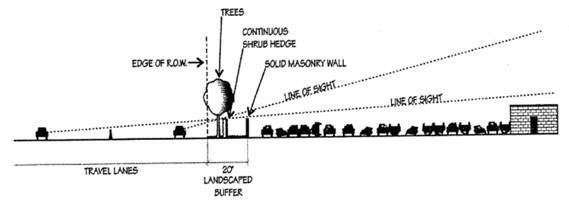
Figure 1: Required landscaped buffer for wrecking yard next to at-grade highway section.
ii.
Along lot lines that are adjacent to elevated highway sections, or allow visibility into the site from elevated highway sections, a landscaped buffer of no less than twenty (20) feet deep shall be provided.
(A)
The landscaped buffer shall consist of trees spaced at thirty (30) feet on center and staggered or triangularly spaced within the buffer to minimize visibility into the site from the highway. Species used shall be fast-growing, dense, tall evergreen trees.
(B)
No buildings, communications towers or other structures may be established within twenty (20) feet of the highway right-of-way, with the exception of one monument sign as set forth in subsection (G)(10).
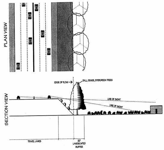
Figure 2: Required landscaped buffer for wrecking yard next to above grade highway section.
iii.
Along lot lines which are adjacent to depressed highway sections, or allow visibility into the site from depressed highway sections, a landscaped buffer no less than ten (10) feet deep shall be provided.
(A)
The landscaped buffer shall contain a continuous shrub hedge adjacent to the right-of-way line, interplanted twenty (20) feet on center with trees. The plant species used should coordinate with adjacent highway landscaping. Shrub variety used shall be fast-growing, and attain an ultimate height of no less than eight (8) feet. Shrubs and trees shall not be pruned as to allow visibility into the site from the highway.
(B)
No buildings, parking areas, trash or recycling areas, utility equipment, communications towers or other structures may be established within ten (10) feet of the highway right-of-way, with the exception of one monument sign as set forth in subsection (G)(10).
iv.
Along lot lines which are not adjacent to the highway right-of-way and do not allow visibility into the site yards shall be provided as required by the underlying district.
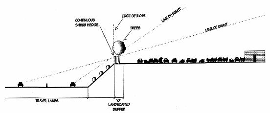
Figure 3: Required landscaped buffer for wrecking yard next to below grade highway section.
e.
For commercial uses, professional office uses, manufacturing uses, multiple-family residential uses, and all other uses not included in subsections (G)(5)(a) through (c) of this section, yard requirements shall be as follows:
i.
Along lot lines that are adjacent to at-grade highway sections a landscaped buffer no less than twenty (20) feet deep shall be provided.
(A)
The landscaped buffer shall consist of lawn, ground cover, or shrubs. Trees shall be provided within the landscape buffer at a rate of one per twenty-five (25) feet of highway frontage, and may be spaced evenly or planted in groups or clusters.
(B)
No buildings, parking areas, storage areas, trash or recycling areas, utility equipment, freestanding signs, communications towers or other structures may be established within the landscaped buffer, with the exception of one monument sign as set forth in subsection (G)(10).
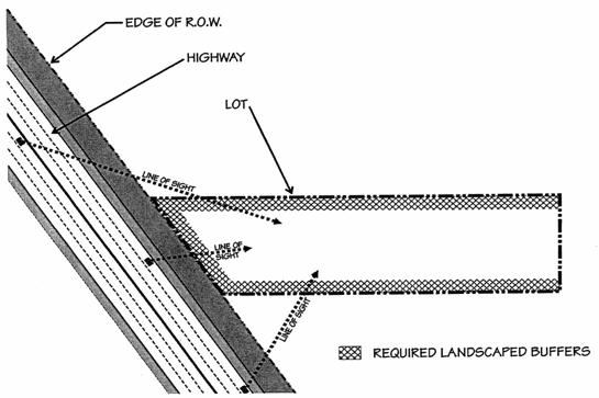
Figure 4: Illustration of possible required landscaped buffers for land uses specified in subsection (G)(5)(d) (wrecking yards, etc.). Unlike other land uses, these uses must provide landscaped buffers along not only the highway frontage, but along all lot lines that allow visibility into the site from the highway.
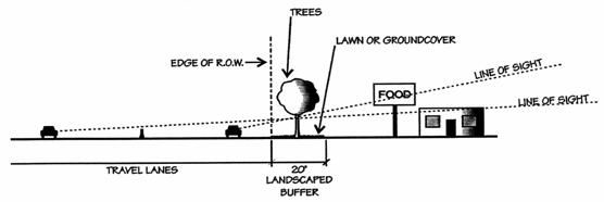
Figure 5: Required landscaped buffer for commercial use next to at-grade highway section.
ii.
Along lot lines that are adjacent to elevated highway sections a landscaped buffer no less than twenty (20) feet deep shall be provided.
(A)
Trees shall be provided at a rate of one tree per twenty-five (25) feet of highway frontage. The trees may be spaced evenly or planted in groups or clusters, and shall be of a species which will grow tall enough to be visible from the highway.
(B)
No freestanding signs or communications towers may be established within twenty (20) feet of the highway right-of-way.
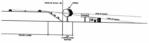
Figure 6: Required landscaped buffer for commercial use next to elevated highway section.
iii.
Along lot lines that are adjacent to depressed highway sections a landscaped buffer no less than twenty (20) feet deep shall be provided.
(A)
Trees shall be provided at a rate of one tree per twenty-five (25) feet of highway frontage. The trees may be spaced evenly or planted in groups or clusters and shall be placed close enough to the right-of-way line that they will be visible from the highway.
(B)
No buildings, parking areas, trash or recycling areas, utility equipment, freestanding signs, communications towers or other structures may be established within twenty (20) feet of the highway right-of-way, with the exception of one monument sign as set forth in subsection (G)(10).
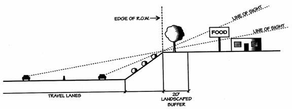
Figure 7: Required landscaped buffer for commercial use next to depressed highway section.
Highway Beautification Overlay Yard Requirements*
* For illustrative purposes only. Refer to text for complete requirements.
iv.
Yards for areas of the lot other than those specifically addressed in this overlay district shall be as required by the underlying district.
6.
Space Between Buildings. Space between buildings shall be as required by the underlying district.
7.
Lot Coverage. Lot coverage shall be as required by the underlying district.
8.
Fences, Hedges, and Walls. Fences, hedges, and walls shall be provided as required by the underlying district, with exceptions noted above.
9.
Off-Street Parking. Off-street parking shall be provided as required by the underlying district.
10.
Outdoor Advertising.
a.
Freestanding Signs.
i.
No freestanding sign shall be erected on lots in which the underlying district prohibits freestanding signs.
ii.
On lots in which the underlying district permits freestanding signs, the number of freestanding signs on any lot shall be limited to two (2). One shall be permitted facing the highway, and one shall be permitted facing the street that the lot fronts. On lots that are not adjacent to the highway, only one freestanding sign shall be permitted.
iii.
No freestanding sign may be located in the required yard area described in subsection (G)(5). Only monument signs shall be permitted in the required yard area.
iv.
Sign height shall be as follows:
(A)
The maximum permitted height of freestanding signs shall be dependant on the distance that the freestanding sign is set back from the highway and shall be calculated using the following formula: one foot of sign height shall be permitted for every one foot that the sign is set back from the highway, to a maximum of thirty-five (35) feet in height.
(B)
The maximum permitted height of a marquee sign shall be one hundred (100) feet in height. The required setback for marquee signs shall be at the discretion of each individual city/county.
v.
The maximum permitted area for monument signs in the required yard area shall be sixty (60) square feet.
vi.
The maximum permitted area for freestanding signs shall be as follows:
(A)
The maximum permitted area of freestanding signs shall be dependant on the distance that the sign is set back from the highway and shall be calculated using the following formula: three (3) square feet of sign area shall be permitted for every one foot that the sign is set back from the highway, to a maximum of two hundred (200) square feet in area.
(B)
The maximum permitted area of a marquee sign shall be at the discretion of each individual city/county.
b.
Wall Signs.
i.
No wall sign shall be erected on lots in which the underlying district prohibits wall signs.
ii.
Wall signs shall consist of no more than ten percent (10%) of the wall area.
c.
Sign types not addressed in this section shall be as regulated by the underlying district.
d.
Sign characteristics not addressed in this section shall be as regulated by the underlying district.
e.
Non-conforming Signs and Advertising Structures.
i.
Signs which become non-conforming on or after the effective date of the ordinance codified in this section but which lawfully existed and were maintained prior to the effective date of the ordinance codified in this section shall be removed or made to conform within ten (10) years after the effective date of the ordinance. During the interim ten (10) year period, said non-conforming signs shall be kept in good repair and visual appearance.
ii.
Any sign determined to be of historical significance, and identified as such in any community or specific plan, shall be exempt from the removal and conformance requirements of this section.
iii.
A non-conforming sign may be required to be removed prior to the ten (10) year amortization period if it meets any of the following criteria:
(A)
The sign was erected without first complying with all ordinances and regulations in effect at the time of its construction and installation or use.
(B)
The sign was lawfully erected but its use has ceased, or its owner has abandoned it, for a period of not less than ninety (90) days.
(C)
The sign has been more than fifty percent (50%) destroyed, repair of the sign would require more than copy replacement, and the damage cannot be repaired within thirty (30) days of the date of its occurrence.
(D)
The sign owner remodels the sign, beyond a change of copy, without first complying with all ordinances and regulations in effect at the time of its remodeling.
(E)
The property owner expands or enlarges the building or land use upon which a lawfully erected, non-conforming sign is located and the sign is displaced by the construction, enlargement, or remodeling.
(F)
The sign is or may become a danger to the public or is unsafe.
(G)
The sign constitutes a traffic hazard that was not created by relocation of streets or highways or by acts of the governing body.
iv.
Non-conforming, on-premises signs that were installed without first obtaining required approvals and permits shall be removed or made to comply within six (6) months of the effective date of the ordinance codified in this section.
v.
Advertising structures that become non-conforming on or after the effective date of the ordinance codified in this section are subject to the following provisions:
(A)
Notwithstanding any other provision of this code, only customary maintenance or use of the structure shall be permitted.
(B)
No addition, structural alteration, modification to, or enlargement, repair, reconstruction, change in use or replacement of, the structure will be permitted, except:
(1)
Mere customary maintenance or use; or
(2)
Such alterations or changes that will render the structure conforming in every respect with this code.
(C)
Maintenance, repair, structural alteration, modification, change in use or construction to the structure in any twelve (12) month period which exceeds fifty percent (50%) of the fair market value of the structure immediately prior to such twelve (12) month period, or increases the basis of such structure to its owner by one hundred percent (100%) or more than it was immediately prior to such twelve (12) month period, shall be considered as reconstruction or replacement, or as exceeding customary maintenance or use. Advertising structures requiring this level of maintenance or repair shall be removed or made to conform in every respect with this municipal code.
(D)
Any non-conforming advertising structure that is permitted to remain pursuant to this section shall be maintained in good repair and visual appearance.
11.
Architectural Standards. Any building wall visible from the highway shall be detailed and treated equally in terms of appearance to the front of the building.
12.
Communications Towers.
a.
Communications towers shall be permitted subject to a conditional use permit in the HB district unless the underlying district expressly prohibits communications towers.
b.
Each application for a communications tower shall be accompanied by the following:
i.
A signed statement from the applicant indicating their intention to share space on the tower with other providers.
ii.
A copy of the lease between the applicant and the landowner. The lease shall contain the following provisions:
(A)
The landowner and the applicant shall have the ability to enter into leases with other carriers for co-location.
(B)
The landowner shall be responsible for the removal of the communications tower or facility in the event the lessee fails to remove it upon abandonment.
c.
Communications towers must be of a monopole design. Lattice tower and guyed tower communications towers shall not be permitted.
d.
Communications towers may not be located closer than twenty (20) feet to the highway.
e.
The maximum permitted height of communications towers shall be dependant on the distance than the communications tower is set back from the highway and shall be calculated using the following formula: one foot of height shall be permitted for every one foot that the tower is set back from the highway, to a maximum of one hundred fifty (150) feet in height. A lightning rod, not to exceed ten (10) feet, shall not be included within the height limitations.
f.
All new communications towers shall be designed to accommodate no less than two additional providers.
g.
All communications towers shall maintain a galvanized finish, unless camouflaged in some other manner. Examples include disguising the tower as a tree or hiding the equipment in a church steeple.
h.
All communications towers shall be separated by not less than one thousand five hundred (1,500) feet. Communications equipment mounted to existing towers or structures such as light poles, tall buildings, water towers, grain silos, or church steeples shall not be subject to this requirement.
i.
Mobile or immobile equipment not used in direct support of a communications tower facility shall not be stored or parked on the site of the communications tower unless repairs to the tower are being made.
j.
Accessory uses shall only include such buildings and facilities necessary for transmission functions and satellite ground stations associated with them, but shall not include broadcast studios, offices, vehicle storage areas, or other similar uses not necessary for the transmission function. All accessory buildings shall be constructed of building materials consistent with the primary use of the site and shall be subject to site plan or final development plan approval. Where there is no primary use other than the tower, the building materials for the accessory building shall be subject to the review and approval of the governing body.
k.
Communications towers shall only be illuminated as required by the Federal Communications Commission and/or the Federal Aviation Administration. Security lighting around the base of the communications tower may be provided if the lighting is shielded so that no light is directed towards adjacent properties or right-of-way.
l.
The base of the tower and all related equipment shall be screened from view with a solid masonry wall a minimum of six (6) feet in height. A landscaped buffer of no less than five (5) feet shall be provided outside of the screening wall.
m.
Any antenna or communications tower that is not operated for a continuous period of twelve (12) months shall be considered abandoned, and the owner of such antenna or tower shall remove the same within ninety (90) days of a receipt of notice from the governing body notifying the owner of such abandonment. If such antenna or tower is not removed within said ninety (90) days, the governing body may remove such antenna at the owner's expense. If there are two (2) or more users of a single tower, then this provision shall not become effective until all users cease using the tower.
13.
Utility and Mechanical Equipment. Utility and mechanical equipment such as heating units, air conditioners, antennas, satellite dishes, HVAC units, or similar devices, shall be integrated into the design of the building or situated on the site so that they are not visible from the highway. When this is not possible, the equipment shall be screened from view of the highway by a masonry wall.
14.
Trash and Recycling Areas. Trash and recycling areas shall be situated on the site so that they are not visible from the highway. When this is not possible, the trash and recycling areas shall be screened from view of the highway by a masonry wall.
15.
Loading Areas. Loading areas shall be situated on the site so that they are not visible from the highway. When this is not possible, the loading areas shall be screened from view from the highway by a masonry wall.
(Ord. 2006-04 § 1, 2006; Ord. No. 2024-07, § 1, 12-18-2024)