
Lafayette City Zoning Code
PART 3
- Land Use Districts
Article 1. - Retail Business District[8]
Editor's note—Ord. No. 696, § 3(Exh. A), adopted Jan. 13, 2025, repealed the former Art. 1, §§ 6-901—6-915, and enacted a new Art. 1 as set out herein. The former Art. 1 pertained to similar subject matter and derived from Ord. 221 § 1 (part), adopted in 1980; Ord. 324 § 2(e) (part), adopted in 1984; Ord. 357 § 1, adopted in 1987; Ord. 359 §§ 3(A)—3(E), adopted in 1987; Ord. 433 § 5, adopted in 1994; Ord. No. 614, § 1(exh. A), adopted Dec. 10, 2012; and Ord. No. 635, § 4(exh. A), adopted Oct. 14, 2014.
Article 2. - General Commercial District[9]
Editor's note—Ord. No. 696, § 3(Exh. A), adopted Jan. 13, 2025, repealed the former Art. 2, §§ 6-921—6-935, and enacted a new Art. 2 as set out herein. The former Art. 2 pertained to similar subject matter and derived from Ord. 245 § 3 (part), adopted in 1981; Ord. 296 § 1 (part), adopted in 1983; Ord. 324 § 2(e) (part), adopted in 1984; Ord. 359 §§ 4(A), 4(B), adopted in 1987; Ord. 433 § 6, adopted in 1994; Ord. No. 614, § 1(exh. A), adopted Dec. 10, 2012; and Ord. No. 635, § 4(exh. A), adopted Oct. 14, 2014.
Article 4. - Special Retail Business District[10]
Editor's note—Ord. No. 696, § 3(Exh. A), adopted Jan. 13, 2025, repealed the former Art. 4, §§ 6-961—6-974, and enacted a new Art. 4 as set out herein. The former Art. 4 pertained to similar subject matter and derived from Ord. 221 § 2 (part), adopted in 1980; Ord. 323 §§ 1—2, adopted in 1984; Ord. 324 § 2(e) (part), adopted in 1984; Ord 349 §§ 1—7, adopted in 1986; Ord. 357 §§ 3, 4, adopted in 1987; Ord. 359 §§ 5(A)—5(C), adopted in 1987; Ord. 429 § 1, adopted in 1994; Ord. 433 § 7, adopted in 1994; Ord. No. 614, § 1(exh. A), adopted Dec. 10, 2012; and Ord. No. 635, § 4(exh. A), adopted Oct. 14, 2014.
Article 5. - General Commercial District 1[11]
Editor's note—Ord. No. 696, § 3(Exh. A), adopted Jan. 13, 2025, repealed the former Art. 5, §§ 6-981—6-997, and enacted a new Art. 5 as set out herein. The former Art. 5 pertained to similar subject matter and derived from Ord. 245 § 4 (part), adopted in 1981; Ord. 269 § 1, adopted in 1982; Ord. 324 § 2(e) (part), adopted in 1984; Ord. 359 §§ 6(A), 6(B), adopted in 1987; Ord. 401 § 1, adopted in 1992; Ord. 433 § 8, adopted in 1994; Ord. No. 614, § 1(exh. A), adopted Dec. 10, 2012; and Ord. No. 635, § 4(exh. A), adopted in Oct. 14, 2014.
Chapter 6-10 - OFFICE DISTRICTS
Sections:
Chapter 6-11 - PLANNED DISTRICTS
Sections:
Chapter - 6-11.5 SENIOR HOUSING OVERLAY DISTRICT
Sections:
Chapter 6-12 - COMBINING LAND USE DISTRICTS
Sections:
Chapter 6-13 - SPECIAL DISTRICTS
Sections:
6-701 - General.
All land in the single-family residential district-6 (map symbol R-6) shall be used in accordance with the provisions of this article.
(Ord. 49 § 1 (part), 1971)
6-702 - Purpose.
The level land in the city of Lafayette has been substantially developed, and it is necessary for the general welfare of the city to preserve hills and open space, to prevent erosion of creek banks and hillsides, and in general to retain the rural nature of the city. In order to accomplish these ends, it is necessary to prevent the creation of additional residential lots which are smaller than 10,000 square feet in size. Therefore, although this article prescribes regulations for lots as small as 6,000 square feet in size, many of which now exist, it requires newly subdivided lots in the R-6 district to contain not less than 10,000 square feet; and it prohibits the placement of additional land into the R-6 district.
(Ord. 49 § 1 (part), 1971)
6-703 - Uses permitted.
The following uses are permitted in the R-6 district:
(a)
A detached single-family dwelling on each lot and the accessory structures and uses normally auxiliary to it;
(b)
Crop and tree farming not including the raising or keeping of any animals other than ordinary household pets;
(c)
Publicly owned parks and playgrounds;
(d)
Reserved;
(e)
A home occupation;
(f)
Animal farming consistent with Chapter 6-5, Article 6, "Small Farm Animals";
(g)
Supportive care pursuant to Section 6-534 LMC.
(Ord. 115 § 3 (part), 1973; Ord. 49 § 1 (part), 1971)
(Ord. No. 631, § 4(exh. C), 10-27-2014; Ord. No. 635, § 4(exh. A), 10-14-2014)
6-704 - Uses requiring a permit.
In the R-6 district the following uses are permitted on the issuance of a land use permit:
(a)
Residential businesses;
(b)
Hospitals, and eleemosynary and philanthropic institutions;
(c)
Churches and religious institutions and parochial and private schools, including nursery schools;
(d)
Community buildings, clubs and activities of a quasi-public, social or fraternal character; and private recreational facilities, such as golf clubs, swimming pools and tennis clubs, whether or not operated for profit;
(e)
Greenhouses, over 300 square feet;
(f)
A second unit which complies with Chapter 6-5, Article 3 of this title;
(g)
Commercial nurseries (an application shall include a site plan indicating planting and landscaping areas, existing and proposed structures, and plans and elevations to indicate architectural type);
(h)
Medical and dental offices and medical clinics;
(i)
Publicly owned buildings and structures, except as provided in Section 6-516;
(j)
Reserved;
(k)
Uses which the planning commission has found, after notice and hearing, to be comparable to the uses enumerated in this section;
(l)
Commercial radio and television receiving and transmitting facilities but not including broadcasting studios or business offices;
(m)
Multiple pet activity, but only on parcels of land 20,000 square feet in size or larger;
(n)
A recreation court as required in section 6-572.
(Ord. 541 § 2 (part), 2004; Ord. 333 § 1 (part), 1985; Ord. 300 §§ 3 (part), 4 (part), 1984; Ord. 266 § 4, 1982; Ord. 120 §§ 1 (part), 2 (part), 1973; Ord. 115 § 5 (part), 1973; Ord. 49 § 1 (part), 1971)
(Ord. No. 635, § 4(exh. A), 10-14-2014)
6-705 - Lot area.
No single-family dwelling or other structure permitted in the R-6 district shall be erected or placed on a lot smaller than 6,000 square feet in area.
(Ord. 49 § 1 (part), 1971)
6-706 - Lot width.
No single-family dwelling or other structure permitted in the R-6 district shall be erected or placed on a lot less than 60 feet in average width.
(Ord. 49 § 1 (part), 1971)
6-707 - Lot depth.
No single-family dwelling or other structure permitted in the R-6 district shall be erected or placed on a lot less than 90 feet in depth.
(Ord. 49 § 1 (part), 1971)
6-708 - Height.
(a)
No single-family dwelling or other structure permitted in this district may exceed 35 feet in height or two and one-half stories.
(b)
Structures higher than 30 feet in height shall be subject to approval of the design review commission and the findings contained in Section 6-1905.
(Ord. 386 § 5 (part), 1991)
6-709 - Side yards.
There shall be an aggregate side yard width of at least 15 feet for any structure in the R-6 district. No side yard shall be less than five feet wide. These minima may be reduced to three feet for an accessory building or structure if it is set back at least 50 feet from the front property line.
(Ord. 49 § 1 (part), 1971)
6-710 - Setback.
There shall be a setback (front yard) of at least 20 feet for any structure in the R-6 district; on corner lots the principal frontage shall have a setback of at least 20 feet and the other setback shall be at least 15 feet.
(Ord. 49 § 1 (part), 1971)
6-711 - Rear yard.
There shall be a rear yard, for any principal structure in the R-6 district, of at least 15 feet. There shall be a rear yard for accessory structures of at least three feet.
(Ord. 49 § 1 (part), 1971)
6-712 - Parking space.
Every new dwelling unit constructed or installed in the R-6 district shall have on the same lot or parcel enough automobile storage space for at least two automobiles; this space shall have minimum dimensions of at least ten feet by 20 feet, either covered or open, and shall not be located within the setback or side yard area of a principal structure.
(Ord. 261 § 7, 1982: Ord. 49 § 1 (part), 1971)
6-713 - Modifiable sections.
Land use permits for the special uses enumerated in Section 6-704, and variance permits to modify the provisions contained in Sections 6-705 to 6-712, inclusive, may be granted in accordance with the applicable provisions of Chapter 6-1 of this title.
(Ord. 49 § 1 (part), 1971)
6-714 - No rezoning to R-6.
No land may hereafter be placed in the R-6 zoning district.
(Ord. 49 § 1 (part), 1971)
6-715 - Creation and improvement of new lots.
Any new lots created in the R-6 zoning district shall comply with the minimum standards for lot area, width and depth prescribed in Article 2 of this chapter for the R-10 zoning district. Any buildings or other structures erected on such newly-created lots shall be placed on the lot in compliance with the side yard requirements of the R-10 zoning district.
(Ord. 49 § 1 (part), 1971)
6-721 - General.
All land in the single-family residential district-10 (map symbol R-10) shall be used in accordance with the provisions of this article.
(Ord. 63 § 4 (part), 1972)
6-722 - Uses permitted.
The following uses are permitted in the R-10 district:
(a)
A detached single-family dwelling on each lot and the accessory structures and uses normally auxiliary to it;
(b)
Reserved;
(c)
Residential care home for the aged, operated by a public agency, or by a private agency which has obtained state or local approval (license) for the proposed operation, where not more than six aged persons reside on the premises with not more than two supervisory persons;
(d)
A home occupation;
(e)
Animal farming consistent with Chapter 6-5, Article 6, "Small Farm Animals";
(f)
Supportive care pursuant to §6-534 LMC.
(Ord. 115 § 3 (part), 1973; Ord. 63 § 4 (part), 1972)
(Ord. No. 631, § 4(exh. C), 10-27-2014; Ord. No. 635, § 4(exh. A), 10-14-2014)
6-723 - Uses requiring a permit.
In the R-10 district the following uses are permitted on the issuance of a land use permit:
(a)
Residential businesses;
(b)
Churches, religious institutions and parochial and private schools, including nursery schools;
(c)
Reserved.
(d)
Publicly owned buildings and structures, except as provided in Section 6-516;
(e)
Publicly owned parks and playgrounds;
(f)
Community buildings, clubs and activities of a quasi-public, social or fraternal character; and private recreational facilities, such as golf clubs, swimming pools and tennis clubs, whether or not operated for profit;
(g)
Greenhouses, over 300 square feet;
(h)
Crop and tree farming;
(i)
The keeping of livestock as provided in Sections 6-523 and 6-524;
(j)
Uses which the planning commission has found, after notice and hearing, to be comparable to the uses enumerated in this section;
(k)
Multiple pet activity, but only on parcels of land 20,000 square feet in size or larger;
(l)
A second unit which complies with Chapter 6-5, Article 3 of this title;
(m)
A recreation court as required in Section 6-572.
(Ord. 541 § 2 (part), 2004; Ord. 333 § 1 (part), 1985; Ord. 300 § 4 (part), 1984; Ord. 266 § 5, 1982; Ord. 120 §§ 1 (part), 2 (part), 1973; Ord. 115 § 5 (part), 1973; Ord. 80 § 3, 1972: Ord. 63 § 4 (part), 1972)
6-724 - Lot area.
No single-family dwelling or other structure permitted in the R-10 district shall be erected or placed on a lot smaller than 10,000 square feet in area.
(Ord. 63 § 4 (part), 1972)
6-725 - Lot width.
No single-family dwelling or other structure permitted in the R-10 district shall be erected or placed on a lot less than 80 feet in average width.
(Ord. 63 § 4 (part), 1972)
6-726 - Lot depth.
No single-family dwelling or other structure permitted in the R-10 district shall be erected or placed on a lot less than 90 feet deep.
(Ord. 63 § 4 (part), 1972)
6-727 - Height.
(a)
No single-family dwelling or other structure permitted in this district may exceed 35 feet in height or two and one-half stories.
(b)
Structures higher than 30 feet in height shall be subject to approval of the design review commission and the findings contained in Section 6-1905.
(Ord. 386 § 5 (part), 1991)
6-728 - Side yards.
There shall be an aggregate side yard width of at least 20 feet for any structure in the R-10 district. No side yard shall be less than ten feet wide. These minima may be reduced to three feet for an accessory building or structure if it is set back at least 50 feet from the front property line.
(Ord. 63 § 4 (part), 1972)
6-729 - Setback.
There shall be a setback (front yard) of at least 20 feet for any structure in the R-10 district; on corner lots the principal frontage of the lot shall have a setback of at least 20 feet and the other setback shall be at least 15 feet.
(Ord. 63 § 4 (part), 1972)
6-730 - Rear yard.
There shall be a rear yard for any principal structure in the R-10 district of at least 15 feet. There shall be a rear yard for accessory structures of at least three feet.
(Ord. 63 § 4 (part), 1972)
6-731 - Parking space.
Every dwelling unit permitted in the R-10 district shall have on the same lot or parcel enough automobile storage space for at least two automobiles; each parking space shall have minimum dimensions of at least ten feet by 20 feet either covered or open, and shall not be located within the setback or side yard area of a principal structure.
(Ord. 63 § 4 (part), 1972)
6-732 - Parking restrictions.
The provisions of Section 8125 of the Contra Costa County Ordinance Code apply to the R-10 district.
(Ord. 63 § 4 (part), 1972)
6-733 - Modifiable sections.
Land use permits for the special uses enumerated in Section 6-723, and variance permits to modify the provisions contained in Sections 6-724 to 6-732, inclusive, may be granted in accordance with the applicable provisions of Chapter 6-1 of this title.
(Ord. 63 § 4 (part), 1972)
6-741 - General.
All land in the single-family residential district-12 (map symbol R-12) shall be used in accordance with the provisions of this article.
(Ord. 63 § 5 (part), 1972)
6-742 - Uses permitted.
The following uses are permitted in the R-12 district:
(a)
A detached single-family dwelling on each lot and the accessory structures and uses normally auxiliary to it;
(b)
Foster home or family care home operated by a public agency, which has obtained state or local approval (license) for the proposed operation, where not more than six minors reside on the premises with not more than two supervisory persons;
(c)
Residential care home for the aged, operated by a public agency which has obtained state or local approval (license) for the proposed operation, where not more than six aged persons reside on the premises with not more than two supervisory persons;
(d)
A home occupation;
(e)
Animal farming consistent with Chapter 6-5, Article 6, "Small Farm Animals."
(Ord. 115 § 3 (part), 1973; Ord. 85 § 1, 1972: Ord. 63 § 5 (part), 1972)
(Ord. No. 631, § 4(exh. C), 10-27-2014)
6-743 - Uses requiring a permit.
In the R-12 district the following uses are permitted on the issuance of a land use permit:
(a)
Residential businesses;
(b)
Churches, religious institutions and parochial and private schools, including nursery schools;
(c)
Reserved.
(d)
Publicly owned buildings and structures, except as provided in Section 6-516;
(e)
Publicly owned parks and playgrounds;
(f)
Community buildings, clubs and activities of a quasi-public, social or fraternal character; and private recreational facilities, such as golf clubs, swimming pools and tennis clubs, whether or not operated for profit;
(g)
Greenhouses, over 300 square feet;
(h)
Crop and tree farming;
(i)
The keeping of livestock, as provided in Sections 6-523 and 6-524;
(j)
Uses which the planning commission has found, after notice and hearing, to be comparable to the uses enumerated in this section;
(k)
Multiple pet activity, but only on parcels of land 20,000 square feet in size, or larger;
(l)
A second unit which complies with Chapter 6-5, Article 3 of this title;
(m)
A recreation court as required in Section 6-572.
(Ord. 541 § 2 (part), 2004; Ord. 333 § 1 (part), 1985; Ord. 300 § 4 (part), 1984; Ord. 266 § 6, 1982; Ord. 120 §§ 1 (part), 2 (part), 1973; Ord. 115 § 5 (part), 1973; Ord. 80 § 4, 1972: Ord. 63 § 5 (part), 1972)
6-744 - Lot area.
No single-family dwelling or other structure permitted in the R-12 district shall be erected or placed on a lot smaller than 12,000 square feet in area.
(Ord. 63 § 5 (part), 1972)
6-745 - Lot width.
No single-family dwelling or other structure permitted in the R-12 district shall be erected or placed on a lot less than 100 feet in average width.
(Ord. 63 § 5 (part), 1972)
6-746 - Lot depth.
No single-family dwelling or other structure permitted in the R-12 district shall be erected on a lot less than 100 feet deep.
(Ord. 63 § 5 (part), 1972)
6-747 - Height.
(a)
No single-family dwelling or other structure permitted in this district may exceed 35 feet in height or two and one-half stories.
(b)
Structures higher than 30 feet in height shall be subject to approval of the design review commission and the findings contained in Section 6-1905.
(Ord. 386 § 5 (part), 1991)
6-748 - Side yards.
There shall be an aggregate side yard width of at least 25 feet for any structure in the R-12 district. No side yard shall be less than ten feet wide. These minima may be reduced to three feet for an accessory building or structure if it is set back at least 65 feet from the front property line.
(Ord. 63 § 5 (part), 1972)
6-749 - Setback.
There shall be a setback (front yard) of at least 20 feet for any structure in the R-12 district; on corner lots the principal frontage of the lot shall have a setback of at least 20 feet and the other setback shall be at least 15 feet.
(Ord. 63 § 5 (part), 1972)
6-750 - Rear yard.
There shall be a rear yard for any principal structure in the R-12 district of at least 15 feet. There shall be a rear yard for accessory structures of at least three feet.
(Ord. 63 § 5 (part), 1972)
6-751 - Parking space.
Every dwelling unit permitted in the R-12 district shall have on the same lot or parcel enough automobile storage space for at least two automobiles; each parking space shall have dimensions of at least ten feet by 20 feet, either covered or open, and shall not be located within the setback or side yard area of a principal structure.
(Ord. 63 § 5 (part), 1972)
6-752 - Parking restrictions.
The provisions of Section 8125 of the Contra Costa County Ordinance Code apply to the R-12 district.
(Ord. 63 § 5 (part), 1972)
6-753 - Modifiable sections.
Land use permits for the special uses enumerated in Section 6-743, and variance permits to modify the provisions contained in Sections 6-744 to 6-752, inclusive, may be granted in accordance with the applicable provisions of Chapter 6-1 of this title.
(Ord. 63 § 5 (part), 1972)
6-761 - General.
All land in the single-family residential district-15 (map symbol R-15) shall be used in accordance with the provisions of this article.
(Ord. 63 § 6 (part), 1972)
6-762 - Uses permitted.
The following uses are permitted in the R-15 district:
(a)
A detached single-family dwelling on each lot and the accessory structures and uses normally auxiliary to it;
(b)
Reserved;
(c)
Reserved;
(d)
A home occupation;
(e)
Animal farming consistent with Chapter 6-5, Article 6, "Small Farm Animals";
(f)
Supportive care pursuant to Section 6-534 LMC.
(Ord. 115 § 3 (part), 1973; Ord. 63 § 6 (part), 1972)
(Ord. No. 631, § 4(exh. C), 10-27-2014; Ord. No. 635, § 4(exh. A), 10-14-2014)
6-763 - Uses requiring a permit.
In the R-15 district the following uses are permitted on the issuance of a land use permit:
(a)
Residential businesses;
(b)
Churches, religious institutions, and parochial and private schools, including nursery schools;
(c)
Reserved.
(d)
Publicly owned buildings and structures, except as provided in Section 6-516;
(e)
Publicly owned parks and playgrounds;
(f)
Community buildings, clubs and activities of a quasi-public, social or fraternal character; and private recreational facilities, such as golf clubs, swimming pools and tennis clubs, whether or not operated for profit;
(g)
Greenhouses, over 300 square feet;
(h)
Crop and tree farming;
(i)
The keeping of livestock, as provided in Sections 6-523 and 6-524;
(j)
Uses which the planning commission has found, after notice and hearing, to be comparable to the uses enumerated in this section;
(k)
Multiple pet activity, but only on parcels of land 20,000 square feet in size, or larger;
(l)
A second unit which complies with Chapter 6-5, Article 3 of this title;
(m)
A recreation court as required in Section 6-572.
(Ord. 541 § 2 (part), 2004; Ord. 333 § 1 (part), 1985; Ord. 300 § 4 (part), 1984; Ord. 266 § 7, 1982; Ord. 120 §§ 1 (part), 2 (part), 1973; Ord 115 § 5 (part), 1973; Ord. 80 § 5, 1972: Ord. 63 § 6 (part), 1972)
6-764 - Lot area.
No single-family dwelling or other structure permitted in the R-15 district shall be erected or placed on a lot smaller than 15,000 square feet in area.
(Ord. 63 § 6 (part), 1972)
6-765 - Lot width.
No single-family dwelling or other structure permitted in the R-15 district shall be erected or placed on a lot less than 100 feet in average width.
(Ord. 63 § 6 (part), 1972)
6-766 - Lot depth.
No single-family dwelling or other structure permitted in the R-15 district shall be erected or placed on a lot less than 100 feet deep.
(Ord. 63 § 6 (part), 1972)
6-767 - Height.
(a)
No single-family dwelling or other structure permitted in this district may exceed 35 feet in height or two and one-half stories.
(b)
Structures higher than 30 feet in height shall be subject to approval of the design review commission and the findings contained in Section 6-1905.
(Ord. 386 § 5 (part), 1991)
6-768 - Side yards.
There shall be an aggregate side yard width of at least 25 feet for any structure in the R-15 district. No side yard shall be less than ten feet wide. These minima may be reduced to three feet for an accessory building or structure if it is set back at least 65 feet from the front property line.
(Ord. 63 § 6 (part), 1972)
6-769 - Setback.
There shall be a setback (front yard) of at least 20 feet for any structure in the R-15 district; on corner lots the principal frontage of the lot shall have a setback of at least 20 feet and the other setback shall be at least 15 feet.
(Ord. 63 § 6 (part), 1972)
6-770 - Rear yard.
There shall be a rear yard for any principal structure in the R-15 district of at least 15 feet. There shall be a rear yard for accessory structures of at least three feet.
(Ord. 63 § 6 (part), 1972)
6-771 - Parking space.
Every dwelling unit permitted in the R-15 district shall have on the same lot or parcel enough automobile storage space for at least two automobiles; each parking space shall have minimum dimensions of at least ten feet by 20 feet, either covered or open, and shall not be located within the setback or side yard area of a principal structure.
(Ord. 63 § 6 (part), 1972)
6-772 - Parking restrictions.
The provisions of Section 8125 of the Contra Costa County Ordinance Code apply to the R-15 district.
(Ord. 63 § 6 (part), 1972)
6-773 - Modifiable sections.
Land use permits for the special uses enumerated in Section 6-763, and variance permits to modify the provisions of Sections 6-764 to 6-772, inclusive, may be granted in accordance with the applicable provisions of Chapter 6-1 of this title.
(Ord. 63 § 6 (part), 1972)
6-781 - General.
All land in the single-family residential district-20 (map symbol R-20) shall be used in accordance with the provisions of this article.
(Ord. 63 § 7 (part), 1972)
6-782 - Uses permitted.
The following uses are permitted in the R-20 district:
(a)
A detached single-family dwelling on each lot and the accessory structures and uses normally auxiliary to it;
(b)
Reserved;
(c)
Reserved;
(d)
The keeping of livestock, as provided in Sections 6-523 and 6-524;
(e)
A home occupation;
(f)
Animal farming consistent with Chapter 6-5, Article 6, "Small Farm Animals";
(g)
Supportive care pursuant to Section 6-534 LMC.
(Ord. 115 § 3 (part), 1973; Ord. 63 § 7 (part), 1972)
(Ord. No. 631, § 4(exh. C), 10-27-2014; Ord. No. 635, § 4(exh. A), 10-14-2014)
6-783 - Uses requiring a permit.
In the R-20 district the following uses are permitted on the issuance of a land use permit:
(a)
Residential businesses;
(b)
Churches, religious institutions, and parochial and private schools, including nursery schools;
(c)
A second unit which complies with Chapter 6-5, Article 3 of this title;
(d)
Reserved.
(e)
Publicly owned buildings and structures, except as provided in Section 6-516;
(f)
Publicly owned parks and playgrounds;
(g)
Community buildings, clubs and activities of a quasi-public, social or fraternal character; and private recreational facilities, such as golf clubs, swimming pools and tennis clubs, whether or not operated for profit;
(h)
Crop and tree farming and horticulture;
(i)
Small farming, including the raising of poultry or rabbits or other grain-fed rodents, exclusively for home consumption;
(j)
Uses which the planning commission has found, after notice and hearing, to be comparable to the uses enumerated in this section;
(k)
Multiple pet activity, but only on parcels of land 20,000 square feet in size or larger;
(l)
A recreation court as required in Section 6-572.
(Ord. 541 § 2 (part), 2004; Ord. 333 § 1 (part), 1985; Ord. 300 §§ 3 (part), 4 (part), 1984; Ord. 266 § 8, 1982; Ord. 120 §§ 1 (part), 2 (part), 1973; Ord. 115 § 5 (part), 1973; Ord. 63 § 7 (part), 1972)
6-784 - Lot area.
No single-family dwelling or other structure permitted in the R-20 district shall be erected or placed on a lot less than 20,000 square feet in area.
(Ord. 63 § 7 (part), 1972)
6-785 - Lot width.
No single-family dwelling or other structure permitted in the R-20 district shall be erected or placed on a lot less than 120 feet in average width.
(Ord. 63 § 7 (part), 1972)
6-786 - Lot depth.
No single-family dwelling or other structure permitted in the R-20 district shall be erected or placed on a lot less than 120 feet deep.
(Ord. 63 § 7 (part), 1972)
6-787 - Height.
(a)
No single-family dwelling or other structure permitted in this district may exceed 35 feet in height or two and one-half stories.
(b)
Structures higher than 30 feet in height shall be subject to approval of the design review commission and the findings contained in Section 6-1905.
(Ord. 386 § 5 (part), 1991)
6-788 - Side yards.
There shall be an aggregate side yard width of at least 35 feet for any structure in the R-20 district. No side yard shall be less than 15 feet wide. These minima may be reduced to three feet for an accessory building or structure if it is set back at least 65 feet from the front property line.
(Ord. 63 § 7 (part), 1972)
6-789 - Setback.
There shall be a setback (front yard) of at least 25 feet for any structure in the R-20 district; on corner lots the principal frontage of the lot shall have a setback of at least 25 feet and the other setback shall be at least 20 feet.
(Ord. 63 § 7 (part), 1972)
6-790 - Rear yard.
There shall be a rear yard for any principal structure in the R-20 district of at least 15 feet. There shall be a rear yard for accessory structures of at least three feet.
(Ord. 63 § 7 (part), 1972)
6-791 - Parking spaces.
Every dwelling unit permitted in the R-20 district shall have on the same lot or parcel enough automobile storage space for at least two automobiles; each parking space shall have minimum dimensions of at least ten feet by 20 feet, either covered or open, and shall not be located within the setback or sideyard area of a principal structure.
(Ord. 63 § 7 (part), 1972)
6-792 - Parking restrictions.
The provisions of Section 8125 of the Contra Costa County Ordinance Code apply to the R-20 district.
(Ord. 63 § 7 (part), 1972)
6-793 - Modifiable sections.
Land use permits for the special uses enumerated in Section 6-783, and variance permits to modify the provisions of Sections 6-784 to 6-792, inclusive, may be granted in accordance with the applicable provisions of Chapter 6-1 of this title.
(Ord. 63 § 7 (part), 1972)
6-7101 - General.
All land in the single-family residential district-40 (map symbol R-40) shall be used in accordance with the provisions of this article.
(Ord. 63 § 8 (part), 1972)
6-7102 - Uses permitted.
The following uses are permitted in the R-40 district:
(a)
A detached single-family dwelling on each lot and the accessory structures and uses normally auxiliary to it;
(b)
Reserved;
(c)
Reserved;
(d)
The keeping of livestock, as provided in Sections 6-523 and 6-524;
(e)
Small farming, including the raising of poultry or rabbits or other grain-fed rodents exclusively for home consumption;
(f)
A home occupation;
(g)
Animal farming consistent with Chapter 6-5, Article 6, "Small Farm Animals";
(h)
Supportive care pursuant to Section 6-534 LMC.
(Ord. 115 § 3 (part), 1973; Ord. 63 § 8 (part), 1972)
(Ord. No. 631, § 4(exh. C), 10-27-2014; Ord. No. 635, § 4(exh. A), 10-14-2014)
6-7103 - Uses requiring a permit.
In the R-40 district, the following uses are permitted on the issuance of a land use permit:
(a)
Residential businesses;
(b)
Churches, religious institutions, and parochial and private schools, including nursery schools;
(c)
A second unit which complies with Chapter 6-5, Article 3 of this title;
(d)
Reserved.
(e)
Publicly owned buildings and structures, except as provided in Section 6-516;
(f)
Publicly owned parks and playgrounds;
(g)
Crop and tree farming and horticulture;
(h)
Horse riding academies and horse riding instruction, if the requirements listed in Sections 6-523 and 6-524 are met;
(i)
Uses which the planning commission has found, after notice and hearing, to be comparable to the uses enumerated in this section;
(j)
Multiple pet activity, but only on parcels of land 20,000 square feet in size, or larger;
(k)
Kennel activity;
(l)
A recreation court as required in Section 6-572.
(Ord. 541 § 2 (part), 2004; Ord. 333 § 1 (part), 1985; Ord. 300 §§ 3 (part), 4 (part), 1984; Ord. 266 § 9, 1982; Ord. 115 § 5 (part), 1973; Ord. 63 § 8 (part), 1972)
6-7104 - Lot area.
No single-family dwelling or other structure permitted in the R-40 district shall be erected or placed on a lot smaller than 40,000 square feet in area.
(Ord. 63 § 8 (part), 1972)
6-7105 - Lot width.
No single-family dwelling or other structure permitted in the R-40 district shall be erected or placed on a lot less than 140 feet in average width.
(Ord. 63 § 8 (part), 1972)
6-7106 - Lot depth.
No single-family dwelling or other structure permitted in the R-40 district shall be erected or placed on a lot less than 140 feet deep.
(Ord. 63 § 8 (part), 1972)
6-7107 - Height.
(a)
No single-family dwelling or other structure permitted in this district may exceed 35 feet in height or two and one-half stories.
(b)
Structures higher than 30 feet in height shall be subject to approval of the design review commission and the findings contained in Section 6-1905.
(Ord. 386 § 5 (part), 1991)
6-7108 - Side yards.
There shall be an aggregate side yard width of at least 40 feet. No side yard shall be less than 20 feet wide. These minima may be reduced to three feet for an accessory building or structure, if it is set back at least 75 feet from the front property line.
(Ord. 84 § 1, 1972: Ord. 63 § 8 (part), 1972)
6-7109 - Setback.
There shall be a setback (front yard) of at least 25 feet for any structure in the R-40 district; on corner lots the principal frontage of the lot shall have a setback of at least 25 feet and the other setback shall be at least 20 feet.
(Ord. 63 § 8 (part), 1972)
6-7110 - Rear yard.
There shall be a rear yard for any principal structure in the R-40 district of at least 15 feet. There shall be a rear yard for accessory structures of at least three feet.
(Ord. 63 § 8 (part), 1972)
6-7111 - Parking space.
Every dwelling unit permitted in the R-40 district shall have on the same lot or parcel enough automobile storage space for at least two automobiles; each parking space shall have minimum dimensions of at least ten feet by 20 feet, either covered or open, and shall not be located within the setback or side yard area of a principal structure.
(Ord. 63 § 8 (part), 1972)
6-7112 - Parking restrictions.
The provisions of Section 8125 of the Contra Costa County Ordinance Code apply to the R-40 district.
(Ord. 63 § 8 (part), 1972)
6-7113 - Modifiable sections.
Land use permits for the special uses enumerated in Section 6-7103, and variance permits to modify the provisions of Sections 6-7104 to 6-7112, inclusive, may be granted in accordance with the applicable provisions of Chapter 6-1 of this title.
(Ord. 63 § 8 (part), 1972)
6-7121 - General.
All land in the single-family residential district-65 (map symbol R-65) shall be used in accordance with the provisions of this article.
(Ord. 63 § 9 (part), 1972)
6-7122 - Uses permitted.
The following uses are permitted in the R-65 district:
(a)
A detached single-family dwelling on each lot and the accessory structures and uses normally auxiliary to it;
(b)
Reserved;
(c)
Reserved;
(d)
The keeping of livestock, as provided in Sections 6-523 and 6-524;
(e)
Small farming, including the raising of poultry or rabbits or other grain-fed rodents exclusively for home consumption;
(f)
A home occupation;
(g)
Animal farming consistent with Chapter 6-5, Article 6, "Small Farm Animals";
(h)
Supportive care pursuant to Section 6-534 LMC.
(Ord. 115 § 3 (part), 1973; Ord. 63 § 9 (part), 1972)
(Ord. No. 631, § 4(exh. C), 10-27-2014; Ord. No. 635, § 4(exh. A), 10-14-2014)
6-7123 - Uses requiring a permit.
In the R-65 district the following uses are permitted on the issuance of a land use permit:
(a)
Residential businesses;
(b)
Churches, religious institutions, and parochial and private schools, including nursery schools;
(c)
A second unit which complies with Chapter 6-5, Article 3 of this title;
(d)
Reserved.
(e)
Publicly owned buildings and structures, except as provided in Section 6-516;
(f)
Publicly owned parks and playgrounds;
(g)
Crop and tree farming and horticulture;
(h)
Horse riding academies and horse riding instructions, if the requirements of Section 6-523 and 6-524 are met;
(i)
Uses which the planning commission has found, after notice and hearing, to be comparable to the uses enumerated in this section;
(j)
Multiple pet activity, but only on parcels of land 20,000 square feet in size or larger;
(k)
Kennel activity;
(l)
A recreation court as required in Section 6-572.
(Ord. 541 § 2 (part), 2004; Ord. 333 § 1 (part), 1985; Ord. 300 §§ 3 (part), 4 (part), 1984; Ord. 266 § 10, 1982; Ord. 115 § 5 (part), 1973; Ord. 63 § 9 (part), 1972)
6-7124 - Lot area.
No single-family dwelling or other structure permitted in the R-65 district shall be erected or placed upon a lot smaller than 65,000 square feet in area.
(Ord. 63 § 9 (part), 1972)
6-7125 - Lot width.
No single-family dwelling or other structure permitted in the R-65 district shall be erected or placed upon a lot which is less than 140 feet in average width.
(Ord. 63 § 9 (part), 1972)
6-7126 - Lot depth.
No single-family dwelling or other structure permitted in the R-65 district shall be erected or placed upon a lot which is less than 140 feet deep.
(Ord. 63 § 9 (part), 1972)
6-7127 - Height.
(a)
No single-family dwelling or other structure permitted in this district may exceed 35 feet in height or two and one-half stories.
(b)
Structures higher than 30 feet in height shall be subject to approval of the design review commission and the findings contained in Section 6-1905.
(Ord. 386 § 5 (part), 1991)
6-7128 - Side yards.
There shall be an aggregate side yard width of at least 40 feet for any structure in the R-65 district. No side yard shall be less than 20 feet in width. These minima may be reduced to three feet for an accessory building or structure if it is set back at least 75 feet from the front property line.
(Ord. 63 § 9 (part), 1972)
6-7129 - Setback.
There shall be a setback (front yard) of at least 25 feet for any structure in the R-65 district; on corner lots, the principal frontage of the lot shall have a setback of at least 25 feet and the other setback shall be at least 20 feet.
(Ord. 63 § 9 (part), 1972)
6-7130 - Rear yard.
There shall be a rear yard for any principal structure in the R-65 district of at least 15 feet. There shall be a rear yard for accessory structures of at least three feet.
(Ord. 63 § 9 (part), 1972)
6-7131 - Parking space.
Every dwelling unit permitted in the R-65 district shall have, on the same lot or parcel, automobile storage space sufficient for at least two automobiles; each parking space shall have minimum dimensions of at least ten feet by 20 feet, either covered or open, and shall not be located within any setback or side yard area provided for principal structures.
(Ord. 63 § 9 (part), 1972)
6-7132 - Parking restriction.
The provisions of Section 8125 of the Contra Costa County Ordinance Code apply to the R-65 district.
(Ord. 63 § 9 (part), 1972)
6-7133 - Modifiable sections.
Land use permits for the special uses enumerated in Section 6-7123, and variance permits to modify the provisions of Sections 6-7124 to 6-7132, inclusive, may be granted in accordance with the applicable provisions of Chapter 6-1 of this title.
(Ord. 63 § 9 (part), 1972)
6-7141 - General.
All land in the single-family residential district-100 (map symbol R-100) shall be used in accordance with the provisions of this article.
(Ord. 63 § 10 (part), 1972)
6-7142 - Uses permitted.
The following uses are permitted in the R-100 district:
(a)
A detached single-family dwelling on each lot and the accessory structures and uses normally auxiliary thereto;
(b)
Reserved;
(c)
Reserved;
(d)
The keeping of livestock, as provided in Section 6-523 and 6-524;
(e)
Small farming, including the raising of poultry or rabbits or other grain-fed rodents exclusively for home consumption;
(f)
Crop and tree farming and horticulture;
(g)
A home occupation;
(h)
Animal farming consistent with Chapter 6-5, Article 6, "Small Farm Animals";
(i)
Supportive care pursuant to Section 6-534 LMC.
(Ord. 115 § 3 (part), 1973; Ord. 63 § 10 (part), 1972)
(Ord. No. 631, § 4(exh. C), 10-27-2014; Ord. No. 635, § 4(exh. A), 10-14-2014)
6-7143 - Uses requiring a permit.
In the R-100 district, the following uses are permitted on the issuance of a land use permit:
(a)
Residential businesses;
(b)
Churches, religious institutions, and parochial and private schools, including nursery schools;
(c)
A second unit which complies with Chapter 6-5, Article 3 of this title;
(d)
Reserved;
(e)
Publicly owned buildings and structures, except as provided in Section 6-516;
(f)
Publicly owned parks and playgrounds;
(g)
Horse riding academies and horse riding instructions, if the requirements of Sections 6-523 and 6-524 are met;
(h)
Commercial nurseries (the application shall include a site plan indicating planting and landscaping areas, automobile parking areas, existing and proposed structures, and plans and elevations to indicate architectural type);
(i)
Uses which the planning commission has found, after notice and hearing, to be comparable to the uses enumerated in this section;
(j)
Multiple pet activity, but only on parcels of land 20,000 square feet in size or larger;
(k)
Kennel activity;
(l)
A recreation court as required in Section 6-572.
(Ord. 541 § 2 (part), 2004; Ord. 333 § 1 (part), 1985; Ord. 300 §§ 3 (part), 4 (part), 1984; Ord. 266 § 11, 1982; Ord. 115 § 5 (part), 1973; Ord. 84 § 3, 1972; Ord. 63 § 10 (part), 1972)
6-7144 - Lot area.
No single-family dwelling or other structure permitted in the R-100 district shall be erected or placed on a lot smaller than 100,000 square feet in area.
(Ord. 63 § 10 (part), 1972)
6-7145 - Lot width.
No single-family dwelling or other structure permitted in the R-100 district shall be erected on a lot less than 200 feet in average width.
(Ord. 63 § 10 (part), 1972)
6-7146 - Lot depth.
No single-family dwelling or other structure permitted in the R-100 district shall be erected on a lot less than 200 feet deep.
(Ord. 63 § 10 (part), 1972)
6-7147 - Height.
(a)
No single-family dwelling or other structure permitted in this district may exceed 35 feet in height or two and one-half stories.
(b)
Structures higher than 30 feet in height shall be subject to approval of the design review commission and the findings contained in Section 6-1905.
(Ord. 386 § 5 (part), 1991)
6-7148 - Side yards.
There shall be an aggregate side yard width of at least 60 feet for any structure in the R-100 district. No side yard shall be less than 30 feet wide. These minima may be reduced to three feet for an accessory building or structure if it is set back at least 65 feet from the front property line.
(Ord. 63 § 10 (part), 1972)
6-7149 - Setback.
There shall be a setback (front yard) of at least 30 feet for any structure in the R-100 district; on corner lots, the principal frontage of the lot shall have a setback of at least 30 feet and the other setback shall be at least 25 feet.
(Ord. 63 § 10 (part), 1972)
6-7150 - Rear yard.
There shall be a rear yard for any principal structure in the R-100 district of at least 30 feet. There shall be a rear yard for accessory structures of at least three feet.
(Ord. 63 § 10 (part), 1972)
6-7151 - Parking space.
Every dwelling unit permitted in the R-100 district shall have on the same lot or parcel enough automobile storage space for at least two automobiles; each parking space shall have dimension of at least ten feet by 20 feet either covered or open, and shall not be located within the setback or side yard area of a principal structure.
(Ord. 63 § 10 (part), 1972)
6-7152 - Parking restrictions.
The provisions of Section 8125 of the Contra Costa County Ordinance Code apply to the R-100 district.
(Ord. 63 § 10 (part), 1972)
6-7153 - Modifiable sections.
Land use permits for the special uses enumerated in Section 6-7143, and variance permits to modify the provisions of Sections 6-7144 to 6-7152, inclusive, may be granted in accordance with the applicable provisions of Chapter 6-1 of this title.
(Ord. 63 § 10 (part), 1972)
6-7181 - General.
All land in the low-density residential district-5 (map symbol L-R-5) shall be used in accordance with this title.
(Ord. 529 § 1, 2002)
6-7182 - Purposes.
The purposes of the low-density residential (L-R-5) district include the following:
(a)
Provide for areas of low-density residential uses consistent with the general plan and with the city's primary objective of preservation and enhancement of its semi-rural residential character;
(b)
Promote the health, safety and welfare of the community by protecting the land in the L-R-5 district from uses that would disturb the natural environment and increase geologic, pedologic, seismic, hydrologic or other inherent hazards;
(c)
Preserve and maintain the scenic, recreational, biotic, historic and other resources of land in the L-R-5 district.
(Ord. 529 § 1, 2002)
6-7183 - Uses permitted.
In the L-R-5 district, the following uses are allowed on a lot:
(a)
A single-family residence and an accessory structure and use normally auxiliary to it;
(b)
The keeping of livestock, consistent with recognized principles of range management and in compliance with sections 6-523 and 6-524;
(c)
Small farming, including the raising of poultry or rabbits or other grain-fed rodents exclusively for home consumption in compliance with Section 6-524;
(d)
A home occupation;
(e)
A second unit which complies with Section 6-560 through 6-568;
(f)
Animal farming consistent with Chapter 6-5, Article 6, "Small Farm Animals";
(g)
Supportive care pursuant to Section 6-534 LMC.
(Ord. 543 § 3, 2004; Ord. 529 § 1, 2002)
(Ord. No. 631, § 4(exh. C), 10-27-2014; Ord. No. 635, § 4(exh. A), 10-14-2014)
6-7184 - Uses requiring a permit.
The planning commission, after a public hearing and upon a showing by an applicant that such use is consistent with the uses in the general area, may grant a land use permit for the following uses:
(a)
A residential business;
(b)
Church, religious institution, parochial and private school, including nursery school;
(c)
Publicly owned buildings and structures, except as provided in Section 6-516;
(d)
Crop and tree farming, horticulture, viticulture, grazing and other similar agriculture uses;
(e)
Community building, club or activities of a quasi-public, social or fraternal character, private recreational facility, such as a golf club, swimming pool and tennis club, whether or not operated for profit;
(f)
Horse riding academy or horse riding school meeting the requirements of Sections 6-523 and 6-524;
(g)
Kennel activity;
(h)
Uses that the planning commission has found, after notice and hearing, to be comparable to the uses enumerated in this section;
(i)
A recreation court as required in Section 6-572.
(Ord. 541 § 2 (part), 2004; Ord. 529 § 1, 2002)
6-7185 - Development requiring hillside development permit.
New development or the expansion of an existing use requires the issuance of a hillside development permit pursuant to Sections 6-2061 et seq.
(Ord. 529 § 1, 2002)
6-7186 - Lot area.
The minimum lot area in the L-R-5 district is five acres.
(Ord. 529 § 1, 2002)
6-7187 - Lot width.
No lot shall be created in the L-R-5 district that is less than 200 feet in average width.
(Ord. 529 § 1, 2002)
6-7188 - Lot depth.
Not lot shall be created in the L-R-5 district that is less than 200 feet deep.
(Ord. 529 § 1, 2002)
6-7189 - Height.
No single-family residence dwelling or other structure permitted in the L-R-5 district shall exceed 30 feet in height or two and one-half stories, whichever is less.
(Ord. 529 § 1, 2002)
6-7190 - Yards.
Each building erected in the L-R-5 district, including an accessory building, shall be a minimum of 50 feet from property lines or easement lines.
(Ord. 529 § 1, 2002)
6-7191 - Parking space.
(a)
Residential parking space. Each dwelling unit permitted in the L-R-5 district shall have, on the same lot or parcel, space for at least four automobiles. Each parking space shall have dimensions of at least 10 feet by 20 feet, and shall not be located within 50 feet of any property line.
(b)
Nonresidential parking space. Parking for a recreation building, club building, or nonresidential uses in the L-R-5 district is governed by Sections 6-601 through 6-661.
(Ord. 529 § 1, 2002)
6-7192 - Variances.
6-7201 - General.
All land in the low-density residential district-10 (map symbol L-R-10) shall be used in accordance with this article.
(Ord. 530 § 1, 2002)
6-7202 - Purposes.
The purposes of the low-density residential (L-R-10) district include the following:
(a)
Provide for areas of low-density residential uses consistent with the general plan and with the city's primary objective of preservation and enhancement of its semi-rural residential character;
(b)
Promote the health, safety and welfare of the community by protecting the land in the L-R-10 district from uses that would disturb the natural environment and increase geologic, pedologic, seismic, hydrologic or other inherent hazards;
(c)
Preserve and maintain the scenic, recreational, biotic, historic and other resources of land in the L-R-10 district.
(Ord. 530 § 1, 2002)
6-7203 - Uses permitted.
In the L-R-10 district, the following uses are allowed on a lot:
(a)
A single-family residence and an accessory structure and use normally auxiliary to it;
(b)
The keeping of livestock, consistent with recognized principles of range management and in compliance with Sections 6-523 and 6-524;
(c)
Small farming, including the raising of poultry or rabbits or other grain-fed rodents exclusively for home consumption in compliance with Section 6-524;
(d)
A home occupation;
(e)
A second unit which complies with Sections 6-560 through 6-568;
(f)
Animal farming consistent with Chapter 6-5, Article 6, "Small Farm Animals";
(g)
Supportive care pursuant to Section 6-534 LMC.
(Ord. 543 § 4, 2004; Ord. 530 § 1, 2002)
(Ord. No. 631, § 4(exh. C), 10-27-2014; Ord. No. 635, § 4(exh. A), 10-14-2014)
6-7204 - Uses requiring a permit.
The planning commission, after a public hearing and upon a showing by an applicant that such use is consistent with the uses in the general area, may grant a land use permit for the following uses:
(a)
A residential business;
(b)
Church, religious institution, parochial and private school, including nursery school;
(c)
Publicly owned buildings and structures, except as provided in Section 6-516;
(d)
Crop and tree farming, horticulture, viticulture, grazing and other similar agriculture uses;
(e)
Community building, club or activities of a quasi-public, social or fraternal character, private recreational facility, such as a golf club, swimming pool and tennis club, whether or not operated for profit;
(f)
Horse riding academy or horse riding school meeting the requirements of Sections 6-523 and 6-524;
(g)
Kennel activity;
(h)
Uses that the planning commission has found, after notice and hearing, to be comparable to the uses enumerated in this section;
(i)
A recreation court as required in Section 6-572.
(Ord. 543 § 5, 2004; Ord. 541 § 2 (part), 2004; Ord. 530 § 1, 2002)
6-7205 - Development requiring hillside development permit.
New development or the expansion of an existing use requires the issuance of a hillside development permit pursuant to Sections 6-2061 et seq.
(Ord. 530 § 1, 2002)
6-7206 - Lot area.
The minimum lot area in the L-R-10 district is 10 acres. The minimum lot area of an existing L-R parcel that was less than 10 acres on July 8, 2002 is the area of the parcel that existed on that date.
(Ord. 530 § 1, 2002)
6-7207 - Lot width.
No lot shall be created in the L-R-10 district that is less than 200 feet in average width.
(Ord. 530 § 1, 2002)
6-7208 - Lot depth.
No lot shall be created in the L-R-10 district is less than 200 feet deep.
(Ord. 530 § 1, 2002)
6-7209 - Height.
No single-family residence dwelling or other structure permitted in the L-R-10 district shall exceed 30 feet in height or two and one-half stories, whichever is less.
(Ord. 530 § 1, 2002)
6-7210 - Yards.
Each building erected in the L-R-10 district, including an accessory building, shall be a minimum of 50 feet from property lines or easement lines.
(Ord. 530 § 1, 2002)
6-7211 - Parking space.
(a)
Residential parking space. Each dwelling unit permitted in the L-R-10 district shall have, on the same lot or parcel, space for at least four automobiles. Each parking space shall have dimensions of at least 10 feet by 20 feet, and shall not be located within 50 feet of any property line.
(b)
Nonresidential parking space. Parking for a recreation building, club building, or nonresidential uses in the L-R-10 district is governed by Sections 6-601 through 6-661.
(Ord. 530 § 1, 2002)
6-7212 - Variances.
6-7221 - Claim.
If an owner of property claims that the application of the minimum lot area in the L-R-10 district as applied to that property deprives the owner of the economic use of the property to the extent that its application is a taking under either the state or federal constitution or both, the owner may request a reduction in the minimum lot area of the property to a size that would not deprive the owner of the economically viable use of the property. An owner, however, may not request a reduction in the minimum lot area that is less than the minimum lot area that applied to the property before the ten-acre minimum was imposed.
(Ord. 531 § 1, 2002)
6-7222 - Application for reduction in minimum lot area.
An application requesting a reduction in the minimum lot area shall be on a form prescribed by the city and accompanied by a fee prescribed by city council resolution.
(Ord. 531 § 1, 2002)
6-7223 - Information required to measure economic impact of the minimum lot area.
An applicant for a reduction in the minimum lot area of ten acres shall provide the basis upon which the applicant believes the ten-acre minimum prevents the economically viable use of the property. The information shall include the following:
(a)
Basis for application.
(1)
Brief description of the property together with a map or plat;
(2)
Date of acquisition of the property;
(3)
Purchase price of the property;
(4)
General plan and zoning designations for the property at the time of acquisition; and
(5)
An explanation of how the application of the ten-acre minimum lot area would deprive the applicant of the economically viable use of the property.
(b)
Property information.
(1)
A map drawn to scale showing both the property for which the reduction in minimum lot area is requested and the property lines for the properties within 500 feet of the exterior boundary lines of the subject property;
(2)
A conceptual plan showing how the property could be developed in accordance with the ten-acre minimum lot area standard;
(3)
Names and mailing addresses for each person holding an interest in or encumbrance on the subject property including a lessee;
(4)
Copy of each recorded restriction and every document defining or affecting control or use of the property;
(5)
A map indicating all property owners within a 300-foot radius of the exterior boundaries of the subject property; and
(6)
A description and analysis of the alternate allowable uses under the L-R-10 zoning.
(c)
Economic data.
(1)
The dates and amounts of invested capital following acquisition of the property;
(2)
The description and amount of each assessment, if any, imposed upon the property for public improvements;
(3)
Actual and planned activities for the property with documentation as to their nature and timing;
(4)
The value of the parcel at the time the taking was said to have occurred;
(5)
The time period of the loss;
(6)
The portion of the property retaining economic use, if any;
(7)
The applicant's ability to carry out the uses and activities intended for the property;
(8)
The market conditions that created the opportunities that are prevented by the ten-acre minimum lot area standard; and
(9)
The reduced profits caused by the imposition of the ten-acre minimum lot area standard, including the assumptions underlying the estimates.
(d)
Additional information.
Such additional information as the city may request in order to take action on the request. The applicant shall cooperate with city requests for financial information regarding the property. Confidential business information provided by an applicant to the city shall remain confidential consistent with the requirements of the Public Records Act (Government Code § 6250 et seq.)
(e)
Consultants and experts.
The name, address and occupation of each consultant and expert providing information or in any way assisting in the preparation of the application shall be provided.
(Ord. 531 § 1, 2002)
6-7224 - Processing concurrently with general plan amendment and zoning change request.
The application shall be accompanied by and processed concurrently with an application requesting a amendment to the general plan and a change in zoning to the minimum lot area requested.
(Ord. 531 § 1, 2002)
6-7225 - City retention of economic consultant.
The city may retain an economic consultant to evaluate the basis upon which the applicant claims that the minimum lot area standard deprives the owner of the economically viable use of the property. The applicant shall pay the fees for the retention of such consultant.
(Ord. 531 § 1, 2002)
6-7226 - Notice.
The city shall give notice of the filing of an application to reduce the minimum lot area in the manner prescribed in section 6-210. The notice shall also fix the time and place of each hearing on the request as required by section 6-7227 and shall be given by posting and mailing as prescribed in section 6-211.
(Ord. 531 § 1, 2002)
6-7227 - Hearing recommendation and decision.
The application shall be heard initially by the appeals hearing board after the giving of notice. The board shall, at the conclusion of the hearing, make its findings and recommendation and forward them to the planning commission for its consideration as part of the general plan amendment and zoning change request. The planning commission shall hold a hearing and make its findings and recommendation and forward them to the city council for its consideration as part of the general plan amendment and zoning change request. The city council is the decision-making body on the request. It shall hold a hearing and thereafter make its findings and decision.
(Ord. 531 § 1, 2002)
6-7228 - Factors in determination.
In acting upon an application, the hearing body shall consider among other matters, the following:
(a)
Characteristics of the property, including:
(1)
Size, shape and location;
(2)
Topography, geology and available information relating to soils;
(b)
Details of the applicant's acquisition of the property, including:
(1)
Date of purchase;
(2)
Purchase price;
(3)
Nature of title;
(4)
Activities planned for the use of the property at the time of acquisition;
(c)
General plan designation and zoning at time of acquisition;
(d)
Allowable uses at time of acquisition;
(e)
Present use of the property and duration of that use;
(f)
History of the land use of the property preceding acquisition, including:
(1)
Each general plan designation and zoning classification applied to the property;
(2)
Each use to which the property was put;
(g)
Fair market value of the property before the ten-acre minimum lot area was applied; and
(h)
Fair market value of the parcel after the ten-acre minimum lot area was applied.
(Ord. 531 § 1, 2002)
6-7229 - Findings supporting recommendation and decision.
Each hearing body shall make its recommendation or decision, as the case may be, based on the evidence presented to it. The recommendation and decision shall be in writing with specific findings on the following:
(a)
What were the reasonable investment-backed expectations of the applicant; and
(b)
What was the economic impact of the application of the ten-acre minimum lot area on the subject property
The findings must be supported by substantial evidence in the record before the hearing body.
(Ord. 531 § 1, 2002)
6-7230 - Time limit for judicial review.
The time limit for judicial review of the city council's decision on the application is governed by Code of Civil Procedure § 1094.6(b).
(Ord. 531 § 1, 2002)
6-801 - General.
All land in the two-family residential district (map symbol D-1) shall be used in accordance with the provisions of this article.
(Ord. 137 § 2 (part), 1975)
6-802 - Purpose.
The purpose of this article is to provide a two-family residential district, and regulations therefor, in areas close to the central area and major transportation services; to enhance the semirural residential character of the city; to ensure attractive and compatible architectural treatment of structures; and to encourage quality development consistent with the goals and policies and other provisions of the general plan.
(Ord. 137 § 2 (part), 1975)
6-803 - Uses permitted.
The following uses are permitted in the D-1 district:
(a)
A detached single-family dwelling on each lot, and the accessory structures and uses normally auxiliary to it;
(b)
On lots 10,000 square feet in size or larger, a detached two-family dwelling (duplex) on each lot and the structures and uses normally auxiliary thereto;
(c)
Reserved;
(d)
Reserved;
(e)
A home occupation;
(f)
Supportive care pursuant to Section 6-534 LMC.
(Ord. 137 § 2 (part), 1975)
(Ord. No. 635, § 4(exh. A), 10-14-2014)
6-804 - Uses requiring a permit.
In the D-1 district the following uses are permitted on the issuance of a land use permit:
(a)
Residential businesses;
(b)
Churches and religious institutions and parochial and private schools, including nursery schools;
(c)
On lots 10,000 square feet in size or larger, two detached single-family residences;
(d)
Publicly owned buildings and structures, except as provided in Section 6-516;
(e)
Community buildings, clubs and activities of a quasi-public, social or fraternal character; and private recreational facilities, such as golf clubs, swimming pools and tennis clubs, whether or not operated for profit;
(f)
Hospitals, and eleemosynary and philanthropic institutions;
(g)
Uses which the planning commission has found, after notice and hearing, to be comparable to the above uses;
(h)
A recreation court as required in Section 6-572.
(Ord. 541 § 2 (part), 2004; Ord. 137 § 2 (part), 1975)
(Ord. No. 635, § 4(exh. A), 10-14-2014)
6-805 - Lot area.
No new lot may be created in the D-1 district smaller than 10,000 square feet in area.
(Ord. 137 § 2 (part), 1975)
6-806 - Lot width.
No new lot may be created in the D-1 district with an average width of less than 80 feet.
(Ord. 137 § 2 (part), 1975)
6-807 - Lot depth.
No new lot may be created in the D-1 district with a depth of less than 90 feet.
(Ord. 137 § 2 (part), 1975)
6-808 - Height.
No building or structure in the D-1 district may exceed one and one-half stories in height. No building or structure may exceed 25 feet in height.
(Ord. 137 § 2 (part), 1975)
6-809 - Setback.
There shall be a setback (front yard) of at least 20 feet for any structure in the D-1 district; on corner lots the principal frontage of the lot shall have a setback of at least 20 feet and the other setback shall be at least 15 feet.
(Ord. 137 § 2 (part), 1975)
6-810 - Side yards.
No side yard in the D-1 district shall be less than ten feet wide. These minima may be reduced to three feet for an accessory building or structure if it is set back at least 50 feet from the front property line.
(Ord. 137 § 2 (part), 1975)
6-811 - Rear yard.
There shall be a rear yard for any principal structure in the D-1 district of at least 15 feet. There shall be a rear yard for any accessory structure of at least three feet.
(Ord. 137 § 2 (part), 1975)
6-812 - Lot coverage.
No buildings or structures permitted in the D-1 district shall cover more than 50 percent of the lot area.
(Ord. 137 § 2 (part), 1975)
6-813 - Parking space.
Every dwelling unit in the D-1 district shall have on the same lot or parcel covered automobile parking space for at least two automobiles; each parking space shall have minimum dimensions of at least ten feet by 20 feet.
(Ord. 137 § 2 (part), 1975)
6-815 - Modifiable sections.
6-816 - Design review.
All new construction and all remodeling of a structure when the completed new work will be visible from public property, or when the nature of the use will be changed, shall be subject to the design review requirements and procedures set forth in Part 1 of this title.
(Ord. 324 § 2(d) (part), 1984: Ord. 137 § 2 (part), 1975)
6-821 - General.
All land in the multiple-family residential district A (map symbol M-R-A) shall be used in accordance with the provisions of this article.
(Ord. 141 § 2 (part), 1975)
(Ord. No. 696, § 3(Exh. A), 1-13-2025)
6-822 - Purpose.
The purpose of this article is to provide a multiple-family residential district which allows a varied mix of housing types within the core area of the city convenient to central business areas and public transit, and regulations therefore, development of which will be consistent with and further the city's overall planning objective of the preservation and enhancement of its semirural residential character. The regulations in this article are intended to require carefully conceived plans; to preserve natural settings and open space; to achieve the optimum in quality development, preservation of the environment, enhancement of the tax base, and beneficial use of available land; and to provide for development which is consistent with the goals and policies and other provisions of the general plan.
(Ord. 279 § 1, 1982: Ord. 141 § 2 (part), 1975)
(Ord. No. 696, § 3(Exh. A), 1-13-2025)
6-823 - Uses permitted.
The following uses are permitted in the M-R-A district:
(a)
A detached single-family dwelling on each lot and the accessory structures and uses normally auxiliary to it;
(b)
Duplex;
(c)
Multiple-family building;
(d)
Reserved;
(e)
Reserved;
(f)
A home occupation;
(g)
Consultative services in buildings which contain such uses on November 30, 1982, and for which the main building permit was issued prior to June 1, 1982, provided there is no future conversion of residential use to office use;
(h)
Medical services in buildings which contain such uses on November 30, 1982 and for which the main building permit was issued prior to June 1, 1982, provided there is no future conversion of residential use to medical services;
(i)
Limited child care;
(j)
Supportive care pursuant to Section 6-534 LMC.
(Ord. 279 § 2, 1982: Ord. 141 § 2 (part), 1975; Ord. No. 696, § 3(Exh. A), 1-13-2025)
6-824 - Uses requiring a permit.
In the M-R-A district the following uses are permitted on the issuance of a land use permit:
(a)
Residential businesses;
(b)
Community assembly and education;
(c)
Publicly owned buildings and structures, except as provided in Section 6-516;
(d)
Day-care and educational services;
(e)
Eleemosynary and philanthropic institutions;
(f)
Uses which the planning commission has found, after notice and hearing, to be comparable to the above uses;
(g)
A recreation court as required in Section 6-572.
(Ord. 541 § 2 (part), 2004; Ord. 279 § 3, 1982: Ord. 141 § 2 (part), 1975)
(Ord. No. 635, § 4(exh. A), 10-14-2014; Ord. No. 696, § 3(Exh. A), 1-13-2025)
6-825 - Lot area.
No new lots may be created in the M-R-A district smaller than 10,000 square feet in area.
(Ord. 141 § 2 (part), 1975)
(Ord. No. 696, § 3(Exh. A), 1-13-2025)
6-826 - Floor area ratio (FAR).
(a)
The maximum gross floor area ratio for all buildings shall be no greater than 1.0.
(b)
Small size, studio and one-bedroom units are encouraged.
(Ord. 279 § 4, 1982: Ord. 141 § 2 (part), 1975)
(Ord. No. 696, § 3(Exh. A), 1-13-2025)
6-826.5 - Density.
The maximum and minimum residential densities for lots within the M-R-A district shall conform to the density standards specified in the applicable land use designation of the General Plan Land Use Element and as outlined in Program 10.3.g of the 2023-2031 6 th Cycle Housing Element.
(Ord. No. 696, § 3(Exh. A), 1-13-2025)
6-827 - Lot width.
No new lots may be created in the M-R-A district with an average width of less than 80 feet.
(Ord. 141 § 2 (part), 1975)
(Ord. No. 696, § 3(Exh. A), 1-13-2025)
6-828 - Lot depth.
No new lots may be created in the M-R-A district with a depth of less than 90 feet.
(Ord. 141 § 2 (part), 1975)
(Ord. No. 696, § 3(Exh. A), 1-13-2025)
6-829 - Height.
No building in the M-R-A district shall exceed 35 feet in height. reviewed by the planning commission so as to ensure that its height and proportions are compatible with other buildings in the vicinity, and that it is favorably located in relation to topographic conditions in a manner that visually attenuates its height.
(Ord. 279 § 5, 1982: Ord. 141 § 2 (part), 1975)
(Ord. No. 696, § 3(Exh. A), 1-13-2025)
6-830 - Setback.
There shall be a minimum setback (front yard) of at least 20 feet for any structure in the M-R-A district. On corner lots the principal frontage of the lot shall have a setback of at least 20 feet and the other setback shall be at least 15 feet.
(Ord. 279 § 6, 1982: Ord. 141 § 2 (part), 1975)
(Ord. No. 696, § 3(Exh. A), 1-13-2025)
6-831 - Side yards.
There shall be a minimum side yard of at least ten feet for any structure in the M-R-A district. For a three-story building there shall be an average side yard of at least 20 feet, with a minimum side yard of ten feet. These minima may be reduced to three feet for an accessory building or structure if it is set back at least 50 feet from the front property line and from any street line.
(Ord. 279 § 7, 1982: Ord. 141 § 2 (part), 1975)
(Ord. No. 696, § 3(Exh. A), 1-13-2025)
6-832 - Rear yard.
There shall be a minimum rear yard of at least 15 feet for any principal structure in the M-R-A district. There shall be a rear yard of at least three feet for any accessory structure.
(Ord. 279 § 8, 1982: Ord. 141 § 2 (part), 1975)
(Ord. No. 696, § 3(Exh. A), 1-13-2025)
6-833 - Lot coverage.
There shall be a maximum lot coverage of 60 percent in the M-R-A district. Lot coverage includes all buildings and structures.
(Ord. 279 § 9, 1982: Ord. 141 § 2 (part), 1975)
(Ord. No. 696, § 3(Exh. A), 1-13-2025)
6-834 - Open space.
A minimum of 35 percent of the ground level of the lot shall not be occupied by buildings, structures or pavement for automobiles, but shall be maintained as open space, and devoted to landscaping. Open space includes planted open space, and may include ground-level private open space.
(Ord. 279 § 10, 1982: Ord. 141 § 2 (part), 1975)
(Ord. No. 696, § 3(Exh. A), 1-13-2025)
6-835 - Planted open space.
A minimum of 20 percent of the ground level of a lot in the M-R-A district shall be planted and maintained with growing plants. To qualify as planted open space, an area must have a minimum dimension of 15 feet. Planted open space may include ground-level private open space if the latter has a minimum dimension of 15 feet. The 20 percent of the lot which must be planted open space is part of the 45 percent of the lot which must be open space.
(Ord. 279 § 11, 1982: Ord. 141 § 2 (part), 1975)
(Ord. No. 696, § 3(Exh. A), 1-13-2025)
6-836 - Private open space.
A private patio, balcony or other open area shall be provided for each dwelling unit in the M-R-A district. This private open space shall be equal to or greater than ten percent of the floor area of each dwelling unit, and in no case shall be smaller than 100 square feet. The minimum dimension of this private open space shall be five feet.
(Ord. 279 § 12, 1982: Ord. 141 § 2 (part), 1975)
(Ord. No. 696, § 3(Exh. A), 1-13-2025)
6-837 - Parking.
(a)
In the M-R-A district, off-street parking shall be provided on the same lot, convenient to all dwelling units, in accordance with the following schedule:
(1)
One-bedroom units, 1.0 spaces per unit;
(2)
Two-bedroom units, 1.2 spaces per unit;
(3)
Three or more bedroom units, 1.5 spaces per unit.
(b)
In addition, one guest parking space shall be provided for each five dwelling units. A minimum of one parking space per unit shall be covered.
(Ord. 141 § 2 (part), 1975)
(Ord. No. 696, § 3(Exh. A), 1-13-2025)
6-839 - Design review.
All new construction and all remodeling of a structure when the completed new work will be visible from public property, or when the nature of the use will be changed, shall be subject to the design review requirements and procedures set forth in Part 1 of this title.
(Ord. 324 § 2(d) (part), 1984: Ord. 141 § 2 (part), 1975)
(Ord. No. 696, § 3(Exh. A), 1-13-2025)
6-840 - Modifiable sections.
Land use permits for the special uses enumerated in Section 6-824 and variance permits to modify the provisions of Sections 6-825 to 6-838, inclusive, may be granted in accordance with the applicable provisions of Chapter 6-1 of this title.
(Ord. 141 § 2 (part), 1975)
(Ord. No. 696, § 3(Exh. A), 1-13-2025)
6-841 - General.
All land in the multiple-family residential district B (map symbol M-R-B) shall be used in accordance with the provisions of this article.
(Ord. 146 § 2 (part), 1975)
6-842 - Purpose.
The purpose of this article is to provide a medium-density multiple-family residential district, and regulations therefor, development of which will be consistent with and further the city's overall planning objective of the preservation and enhancement of its semirural residential character. The regulations in this article are intended to require carefully conceived plans; to preserve natural settings and open space; to ensure attractive and compatible architectural treatment of structures; to achieve the optimum in quality development, preservation of the environment, enhancement of the tax base, and beneficial use of available land; and to provide for development which is consistent with the goals and policies and other provisions of the general plan.
(Ord. 146 § 2 (part), 1975)
6-843 - Uses permitted.
The following uses are permitted in the M-R-B district:
(a)
A detached single-family dwelling on each lot and the accessory structures and uses normally auxiliary to it;
(b)
Duplex;
(c)
Multiple-family building;
(d)
Reserved;
(e)
Reserved;
(f)
A home occupation;
(g)
Supportive care pursuant to Section 6-534 LMC.
(Ord. 146 § 2 (part), 1975)
(Ord. No. 635, § 4(exh. A), 10-14-2014)
6-844 - Uses requiring a permit.
In the M-R-B district the following uses are permitted on the issuance of a land use permit:
(a)
Residential business;
(b)
Churches, religious institutions, and parochial and private schools, including nursery schools;
(c)
Publicly owned buildings and structures, except as provided in Section 6-516;
(d)
Community buildings, clubs and activities of a quasi-public, social or fraternal character; and private recreational facilities, such as golf clubs, swimming pools and tennis clubs, whether or not operated for profit;
(e)
Eleemosynary and philanthropic institutions;
(f)
Uses which the planning commission has found, after notice and hearing, to be comparable to the above uses;
(g)
A recreation court as required in Section 6-572.
(Ord. 541 § 2 (part), 2004; Ord. 146 § 2 (part), 1975)
(Ord. No. 635, § 4(exh. A), 10-14-2014)
6-845 - Lot area.
No new lots may be created in the M-R-B district smaller than 10,000 square feet in area.
(Ord. 146 § 2 (part), 1975)
6-846 - Density.
In the M-R-B district, one dwelling unit may be constructed for each 2,500 square feet or more of lot area.
(Ord. 146 § 2 (part), 1975)
6-847 - Lot width.
No new lots may be created in the M-R-B district with an average width of less than 80 feet.
(Ord. 146 § 2 (part), 1975)
6-848 - Lot depth.
No new lots may be created in the M-R-B district with a depth of less than 90 feet.
(Ord. 146 § 2 (part), 1975)
6-849 - Height.
No building in the M-R-B district may exceed 35 feet in height.
(Ord. 146 § 2 (part), 1975)
6-850 - Setback.
There shall be a setback (front yard) of at least 20 feet for any structure in the M-R-B district. On corner lots the principal frontage of the lot shall have a setback of at least 20 feet, and the other setback shall be at least 15 feet.
(Ord. 146 § 2 (part), 1975)
6-851 - Side yards.
There shall be a side yard of at least ten feet for any structure in the M-R-B district. For a three-story building there shall be an average side yard of at least 20 feet, with a minimum side yard of ten feet. These minima may be reduced to three feet for an accessory building or structure if it is set back at least 50 feet from the front property line or any street line.
(Ord. 146 § 2 (part), 1975)
6-852 - Rear yard.
There shall be a rear yard of at least 15 feet for any principal structure in the M-R-B district. There shall be a rear yard of at least three feet for any accessory structure.
(Ord. 146 § 2 (part), 1975)
6-853 - Lot coverage.
There shall be a maximum lot coverage of 25 percent in the M-R-B district. Lot coverage includes all buildings and structures, except that roof areas which are approved by the planning commission as recreation space shall have only one-half of their area considered as lot coverage.
(Ord. 146 § 2 (part), 1975)
6-854 - Open space.
In the M-R-B district, 50 percent of the lot shall not be occupied by buildings, structures or pavement for automobiles, but shall be maintained as open space, and devoted to landscaped or private open space uses. Open space includes landscaped space and private open space.
(Ord. 146 § 2 (part), 1975)
6-855 - Landscaped space.
In the M-R-B district, 30 percent of the lot shall be planted and maintained with growing plants. To qualify as landscaped space, an area must be a minimum of 15 feet wide. Landscaped space includes private open space if it is at least 15 feet wide.
(Ord. 146 § 2 (part), 1975)
6-856 - Private open space.
A private patio, balcony or other open area shall be provided each dwelling unit in the M-R-B district. This private open space shall be equal to or greater than ten percent of the floor area of each dwelling unit, and in no case shall be smaller than 100 square feet. The minimum width of this private open space shall be eight feet.
(Ord. 146 § 2 (part), 1975)
6-857 - Parking.
(a)
In the M-R-B district, off-street parking shall be provided on the same lot, convenient to all dwelling units, in accordance with the following schedule:
(1)
One-bedroom units, 1.2 spaces per unit;
(2)
Two-bedroom units, 1.5 spaces per unit;
(3)
Three or more bedroom units, 2.0 spaces per unit.
(b)
In addition, one guest parking space shall be provided for each five dwelling units. A minimum of one parking space per unit shall be covered.
(Ord. 146 § 2 (part), 1975)
6-859 - Design review.
All new construction and all remodeling of a structure when the completed new work will be visible from public property, or when the nature of the use will be changed, shall be subject to the design review requirements and procedures set forth in Part 1 of this title.
(Ord. 324 § 2(d) (part), 1984: Ord. 146 § 2 (part), 1975)
6-860 - Modifiable sections.
Land use permits for the special uses enumerated in Section 6-844 and variance permits to modify the provisions of Sections 6-845 to 6-858, inclusive, may be granted in accordance with the applicable provisions of Chapter 6-1 of this title.
(Ord. 146 § 2 (part), 1975)
6-861 - General.
All land in the multiple-family residential/professional office district (map symbol M-R-O) shall be used in accordance with the provisions of this article.
(Ord. 139 § 2 (part), 1975)
(Ord. No. 696, § 3(Exh. A), 1-13-2025)
6-862 - Purpose.
The purpose of this article is to allow a mixture of professional offices and multiple-family residences, in locations where those uses are compatible, and where proximity to rapid transit facilities, freeway off-ramps and central commercial areas combine to create a need for both uses. The regulations in this article are intended to require carefully conceived plans, at a physical scale compatible with nearby residential areas; to preserve natural settings and a feeling of open space; to ensure attractive and compatible architectural treatment of structures; to achieve the optimum in quality development; and to provide for development which is consistent with the goals and policies and other provisions of the general plan.
(Ord. 280 § 1, 1982: Ord. 139 § 2 (part), 1975)
(Ord. No. 696, § 3(Exh. A), 1-13-2025)
6-863 - Uses permitted.
The following uses are permitted in the M-R-O district:
(a)
Duplexes;
(b)
Multiple-family buildings;
(c)
Home occupations;
(d)
Consultative service;
(e)
Medical service;
(f)
Limited child-care;
(g)
A recreation court as required in section 6-572;
(h)
Supportive care pursuant to Section 6-534 LMC.
(Ord. 541 § 2 (part), 2004; Ord. 280 § 2, 1982: Ord. 139 § 2 (part), 1975)
(Ord. No. 635, § 4(exh. A), 10-14-2014; Ord. No. 696, § 3(Exh. A), 1-13-2025)
6-864 - Uses requiring a permit.
In the M-R-O district, the following uses are permitted on the issuance of a use permit:
(a)
Residential businesses;
(b)
Day care and educational services;
(c)
Publicly owned buildings and structures, except as provided in Section 6-516;
(d)
Community assembly and education;
(e)
Eleemosynary and philanthropic institutions;
(f)
Uses which the planning commission has found, after notice and hearing, to be comparable to the above uses.
(g)
A recreation court as required in Section 6-572.
(Ord. 541 § 2 (part), 2004; Ord. 280 § 3, 1982: Ord. 139 § 2 (part), 1975)
(Ord. No. 696, § 3(Exh. A), 1-13-2025)
6-865 - Lot area.
No new lots may be created in the M-R-O district smaller than 10,000 square feet in area.
(Ord. 139 § 2 (part), 1975)
(Ord. No. 696, § 3(Exh. A), 1-13-2025)
6-866 - Lot width.
No new lots may be created in the M-R-O district with an average width of less than 80 feet.
(Ord. 139 § 2 (part), 1975)
(Ord. No. 696, § 3(Exh. A), 1-13-2025)
6-867 - Lot depth.
No new lots may be created in the M-R-O district with a depth of less than 90 feet.
(Ord. 139 § 2 (part), 1975)
(Ord. No. 696, § 3(Exh. A), 1-13-2025)
6-868 - Height.
The following height restrictions apply in the M-R-O district:
(a)
Office use only: no building may exceed two stories or 30 feet in height.
(b)
Combined office/residential use (as defined in Section 6-872(b)), or residential-only use: no building may exceed three stories or 35 feet in height.
(Ord. 280 § 4, 1982: Ord. 139 § 2 (part), 1975)
(Ord. No. 696, § 3(Exh. A), 1-13-2025)
6-869 - Setback.
There shall be a minimum setback (front yard) of at least 20 feet for any structure in the M-R-O district. On corner lots the principal frontage of the lot shall have a setback of at least 20 feet and the other setback shall be at least 15 feet.
(Ord. 280 § 5, 1982: Ord. 139 § 2 (part), 1975)
(Ord. No. 696, § 3(Exh. A), 1-13-2025)
6-870 - Side yards.
There shall be a minimum side yard of at least ten feet for any structure in the M-R-O district. This minimum may be reduced to three feet for an accessory structure if it is set back at least 50 feet from the front property line or any street line.
(Ord. 280 § 6, 1982: Ord. 139 § 2 (part), 1975)
(Ord. No. 696, § 3(Exh. A), 1-13-2025)
6-871 - Rear yard.
There shall be a minimum rear yard of at least 15 feet for any principal structure in the M-R-O district. There shall be a rear yard of at least three feet for any accessory structure.
(Ord. 280 § 7, 1982: Ord. 139 § 2 (part), 1975)
(Ord. No. 696, § 3(Exh. A), 1-13-2025)
6-872 - Floor area ratio.
The following floor area ratio restrictions apply in the M-R-O district:
(a)
Office Use. On any office site, the maximum floor area of all buildings shall be no greater than 0.30 times the area of the site.
(b)
Combined Office/Residential Use. On any combined-use site, where 50 percent or more of the floor area will be residential, the maximum floor area of all buildings shall be no greater than 1.0 times the area of the site. Where less than 50 percent of the floor area will be residential, the maximum floor area of all buildings shall be no greater than 0.50 times the area of the site.
(c)
Residential Use. On any residential site, the maximum floor area shall be no greater than 1.0 times the area of the site.
(Ord. 280 § 8, 1982: Ord. 139 § 2 (part), 1975)
(Ord. No. 696, § 3(Exh. A), 1-13-2025)
6-872.5 - Density.
The maximum and minimum residential densities for lots within the M-R-O district shall conform to the density standards specified in the applicable land use designation of the General Plan Land Use Element and as outlined in Program 10.3.g of the 2023-2031 6 th Cycle Housing Element.
(Ord. No. 696, § 3(Exh. A), 1-13-2025)
6-873 - Open space.
A minimum of 30 percent of the ground level of a lot in the M-R-O district shall not be occupied by buildings, structures or pavement for automobiles, but shall be maintained as open space, and devoted to landscaping, recreational or private open space uses. Open space includes landscaped space. To be included in the calculation of open space, each area must have a minimum dimension of ten feet.
(Ord. 280 § 9, 1982: Ord. 139 § 2 (part), 1975)
(Ord. No. 696, § 3(Exh. A), 1-13-2025)
6-874 - Landscaped space.
A minimum of 20 percent of the ground level of a lot in the M-R-O district shall be planted and maintained with growing plants. To qualify as landscaped space, an area must have a minimum dimension of ten feet.
(Ord. 280 § 10, 1982: Ord. 139 § 2 (part), 1975)
(Ord. No. 696, § 3(Exh. A), 1-13-2025)
6-875 - Parking space.
(a)
In the M-R-O district, off-street parking shall be provided on the same lot, convenient to all offices and dwelling units, in accordance with the following schedule:
(1)
One-bedroom units, one space per unit;
(2)
Two-bedroom units, 1.2 spaces per unit;
(3)
Three or more bedroom units, 1.5 spaces per unit;
(4)
Offices, as required under Chapter 6-6 of this title.
(b)
In addition, for multifamily residential developments, one guest parking space shall be provided for each five dwelling units. A minimum of one parking space per dwelling unit shall be covered.
(c)
For combined office and residential developments the number of parking stalls specified above may be modified by the planning commission in consideration of the cumulative parking needs of all the uses on the subject property.
(Ord. 280 § 11, 1982: Ord. 139 § 2 (part), 1975)
(Ord. No. 696, § 3(Exh. A), 1-13-2025)
6-877 - Design review.
All new construction and all remodeling of a structure when the completed new work will be visible from public property, or when the nature of the use will be changed shall be subject to the design review requirements and procedures set forth in Part 1 of this title.
(Ord. 324 § 2(d) (part), 1984: Ord. 139 § 2 (part), 1975)
(Ord. No. 696, § 3(Exh. A), 1-13-2025)
6-878 - Modifiable sections.
Land use permits for the special uses enumerated in Section 6-864 and variance permits to modify the provisions of Sections 6-865 to 6-875, inclusive, may be granted in accordance with the applicable provisions of Part 1 of this title, except that no variance may be granted to Section 6-868(a), number of stories for office use.
(Ord. 280 § 12, 1982: Ord. 139 § 2 (part), 1975)
(Ord. No. 696, § 3(Exh. A), 1-13-2025)
6-881 - General.
All land in the multiple-family residential townhouse district (map symbol M-R-T) shall be used in accordance with the provisions of this article.
(Ord. 129 § 2 (part), 1974)
6-882 - Purpose.
The purpose of this article is to provide a medium-density residential district for townhouse development, which will be consistent with and further the city's overall planning objective of the preservation and enhancement of its semirural residential character. The regulations in this article are intended to require carefully conceived plans at a physical scale compatible with nearby residential areas; to preserve natural settings and open space; to ensure attractive and compatible architectural treatment of structures; to achieve the optimum in quality development, preservation of the environment, enhancement of the tax base, and beneficial use of available land; and to provide for development which is consistent with the goals and policies and other provisions of the general plan.
(Ord. 314 § 1 (part), 1984: Ord. 129 § 2 (part), 1974)
6-883 - Uses permitted.
The following uses are permitted in the M-R-T district:
(a)
Townhouses;
(b)
Reserved;
(c)
Reserved;
(d)
Home occupations;
(e)
Supportive care pursuant to Section 6-534 LMC.
(Ord. 129 § 2 (part), 1974)
(Ord. No. 635, § 4(exh. A), 10-14-2014)
6-884 - Uses requiring a permit.
In the M-R-T district, the following uses are permitted on the issuance of a land use permit:
(a)
Residential businesses;
(b)
Eleemosynary and philanthropic institutions;
(c)
Uses which the planning commission has found, after notice and hearing, to be comparable to the above uses;
(d)
A recreation court as required in Section 6-572.
(Ord. 541 § 2 (part), 2004; Ord. 129 § 2 (part), 1974)
(Ord. No. 635, § 4(exh. A), 10-14-2014)
6-885 - Density.
The maximum number of dwelling units permitted on any lot in the M-R-T district shall conform to the general plan density range for that area.
(Ord. 314 § 1 (part), 1984: Ord. 129 § 2 (part), 1974)
6-886 - Height.
No building in the M-R-T district may exceed 25 feet in height.
(Ord. 129 § 2 (part), 1974)
6-887 - Property development standards.
There are no minimum standards for lot area, setback, side and rear yard, and lot coverage in the M-R-T district. This is intended to allow flexibility in design. During the review process, the planning commission may impose such conditions as it deems necessary to assure in any development proposal provision of adequate privacy, general appearance and relationship to the natural and manmade elements of the environment.
(Ord. 314 § 1 (part), 1984: Ord. 129 § 2 (part), 1974)
6-888 - Open space.
A minimum of 50 percent of the ground level of a lot in the M-R-T district shall not be occupied by buildings, structures or pavement for automobiles, but shall be maintained as open space and devoted to landscaping. Open space includes landscaped open space and ground-level private open space.
(Ord. 314 § 1 (part), 1984: Ord. 129 § 2 (part), 1974)
6-889 - Design review.
All new construction and all remodeling of a structure when the completed new work will be visible from public property, or when the nature of the use will be changed, shall be subject to the design review requirements and procedures set forth in Part 1 of this title.
(Ord. 324 § 2(d) (part), 1984: Ord. 314 § 1 (part), 1984: Ord. 129 § 2 (part), 1974)
6-890 - Parking.
(a)
In the M-R-T district off-street parking shall be provided on the same lot, convenient to all dwelling units, in accordance with the following schedule:
(1)
One-bedroom units, 1.5 spaces per unit;
(2)
Two or more bedroom units, 2.0 spaces per unit.
(b)
In addition, one guest parking space shall be provided for each five dwelling units. A minimum of one parking space per unit shall be covered.
(c)
The provisions of Chapter 6-6 of this title apply to the M-R-T district.
(Ord. 314 § 1 (part), 1984: Ord. 129 § 2 (part), 1974)
6-891 - Site plan and building elevation approval.
(a)
In the M-R-T district no building shall be constructed or altered or painted a new color in such a manner as to affect exterior appearance, unless plans for such proposal have been approved pursuant to the site plan and building elevations requirements set forth in Part 1 of this title.
(b)
Design review of townhouses shall include special emphasis to ensure that building styles and forms, clustering arrangements, heights, materials, colors, street alignments, grading approaches and introduced plantings are designed in a manner which is harmonious and consistent with nearby residential units and which minimizes visual impact from public property.
(Ord. 314 § 1 (part), 1984)
6-892 - Modifiable sections.
6-8101 - General.
All land in the multiple-family residential/professional office, one-story district (map symbol M-R-P) shall be used in accordance with the provisions of this article.
(Ord. 158 § 1 (part), 1976)
6-8102 - Purpose.
The purpose of this article is to allow a mixture of one-story professional offices and multiple-family residences, in locations that are immediately adjacent both to low-density residential areas and to major streets. The regulations in this article are intended to require carefully conceived plans, at a physical scale compatible with nearby low-density residential areas; to preserve natural settings and a feeling of open space; to ensure attractive and compatible architectural treatment of structures; to achieve the optimum in quality development; and to provide for development which is consistent with the goals and policies and other provisions of the general plan.
(Ord. 158 § 1 (part), 1976)
6-8103 - Uses permitted.
The following uses are permitted in the M-R-P district:
(a)
Duplexes;
(b)
Multiple-family buildings;
(c)
Home occupations;
(d)
Professional offices and laboratories, such as medical and dental offices and clinics, or offices for attorneys, architects, engineers and individual and family counselors (not including group counseling), such as psychiatrists, sociologists and psychologists;
(e)
Other uses determined by the planning director to be compatible with the purpose of the district, such as research uses, small real estate offices, insurance offices, offices of product manufacturers' or distributors' representatives, and similar small general business offices, but not including general retail sales of products or services such as clothing stores, furniture stores, beauty and barber shops, restaurants, food stores, automobile service stations and similar uses. (Before permitting a use not otherwise specifically permitted, the planning director shall find that the proposed use will not create additional pedestrian or vehicle traffic sufficient to substantially alter the character of residential development near land in the district, and shall find that the proposed use will not result in any audibly or visually obtrusive effect on residential development near land in the district;)
(f)
Supportive care pursuant to Section 6-534 LMC.
(Ord. 158 § 1 (part), 1976)
(Ord. No. 635, § 4(exh. A), 10-14-2014)
6-8104 - Uses requiring a permit.
In the M-R-P district the following uses are permitted on the issuance of a land use permit:
(a)
Residential businesses;
(b)
Nursery schools;
(c)
Publicly owned buildings and structures, except as provided in Section 6-516;
(d)
Community buildings, clubs and activities of a quasi-public, social or fraternal character;
(e)
Eleemosynary and philanthropic institutions;
(f)
Uses which the planning commission has found, after notice and hearing, to be comparable to the above uses;
(g)
A recreation court as required in Section 6-572.
(Ord. 541 § 2 (part), 2004; Ord. 158 § 1 (part), 1976)
(Ord. No. 635, § 4(exh. A), 10-14-2014)
6-8105 - Lot area.
No new lot may be created in the M-R-P district smaller than 10,000 square feet in area.
(Ord. 158 § 1 (part), 1976)
6-8106 - Lot width.
No new lot may be created in the M-R-P district with an average width of less than 80 feet.
(Ord. 158 § 1 (part), 1976)
6-8107 - Lot depth.
No new lot may be created in the M-R-P district with a depth of less than 90 feet.
(Ord. 158 § 1 (part), 1976)
6-8108 - Height.
No building in the M-R-P district may exceed 20 feet or one story in height.
(Ord. 158 § 1 (part), 1976)
6-8109 - Property development standards.
There are no minimum standards for setback, side and rear yard, lot coverage and landscaping. The lack of such requirements is intended to stimulate quality design by allowing designers a considerable range of flexibility. During the review process, however, the planning commission may impose such conditions as it deems necessary to assure, in any development proposal, provision of adequate privacy, open space, general appearance, landscaping, parking, circulation, and relationship to natural and manmade elements of the environment.
(Ord. 158 § 1 (part), 1976)
6-8110 - Parking space.
(a)
Off-street parking shall be provided on the same lot, convenient to all offices and dwelling units, in accordance with the following schedule:
(1)
One-bedroom units, 1.0 space per unit;
(2)
Two-bedroom units, 1.2 spaces per unit;
(3)
Three or more bedroom units, 1.5 spaces per unit;
(4)
Offices, 1 space per 200 net rentable square feet of office space.
(b)
In addition, for multifamily residential developments, one guest parking space shall be provided for each five dwelling units. A minimum of one parking space per dwelling unit shall be covered.
(Ord. 158 § 1 (part), 1976)
6-8112 - Design review.
All new construction and all remodeling of a structure when the completed new work will be visible from public property, or when the nature of the use will be changed, shall be subject to the design review requirements and procedures set forth in Part 1 of this title.
(Ord. 324 § 2(d) (part), 1984: Ord. 158 § 1 (part), 1976)
6-8113 - Modifiable sections.
Land use permits for the special uses enumerated in Section 6-8104 and variance permits to modify the provisions of Sections 6-8105 to 6-8111, inclusive, may be granted in accordance with the applicable provisions of Chapter 6-1 of this title.
(Ord. 158 § 1 (part), 1976)
6-901 - General.
All land in the retail business district (map symbol RB) shall be used in accordance with the provisions of this article.
(Ord. No. 696, § 3(Exh. A), 1-13-2025)
6-902 - Purpose.
The purpose of the regulations for the RB district is to create, preserve and enhance areas with a selective range of retail and personal service establishments in attractive, compact locations oriented toward pedestrian comparison shopping and to complement the special shopping district at the core of the retail district.
(Ord. No. 696, § 3(Exh. A), 1-13-2025)
6-903 - Specific plans.
The use, design and other features of the RB district regulations may be overridden by regulations contained in specific plans adopted for any portion of said district.
(Ord. No. 696, § 3(Exh. A), 1-13-2025)
6-904 - Uses permitted.
Except as is otherwise provided in Section 6-906, the following uses may be conducted as a matter of right in the RB district, without the need for a land use permit. However, a land use permit (under Sections 6-215 and 6-531) is required if the proposed use will result from the conversion of a residential use of the property.
(a)
Administrative;
(b)
Administrative civic;
(c)
Home/business furnishings where the total floor area is less than 2,000 square feet in size;
(d)
Consultative service;
(e)
Fast-food restaurant without drive-thru, drive-up or pass-thru window services;
(f)
Full-service restaurant, including those with outside dining and service;
(g)
General food sales, where the total floor area is less than 2,000 square feet in size;
(h)
General personal service;
(i)
General retail sales;
(j)
Business and communication service, where the total floor area is less than 2,000 square feet in size;
(k)
Limited child-care;
(l)
Residential dwelling units on upper floors along Mount Diablo Boulevard (between Mtn. View Drive and First Street on the north side and between Mtn. View Drive and Moraga Road on the south side) and on all floors elsewhere in the district;
(m)
Supportive care pursuant to Section 6-534 LMC.
(Ord. No. 696, § 3(Exh. A), 1-13-2025)
6-905 - Uses requiring a permit.
In the RB district the following uses are permitted after the issuance of a land use permit:
(a)
Commercial automotive fee parking;
(b)
Commercial recreation;
(c)
Day-care and educational services;
(d)
Fast-food restaurant with drive-thru, drive-up or pass-thru window service;
(e)
Financial service;
(f)
General food sales, where the total floor area is or exceeds 2,000 square feet in size;
(g)
Real estate sales;
(h)
Residential dwelling units;
(i)
Self-service laundry or retail dry cleaners which complies with Section 6-532;
(j)
Utility distribution and civic service;
(k)
Retail business utilizing access to or from a public street having a right-of-way of 55 feet or less, which forms the common boundary between a district of any residential classification and the RB district. The application for land use permit shall be determined by the effects of traffic upon such a street occasioned by the use within the RB district, the characteristics of the adjacent areas, traffic problems, pedestrian traffic and other considerations found pertinent to the particular area concerned;
(l)
Business and communication service, where the total floor area of the building is or exceeds 2,000 square feet in size;
(m)
Home/business furnishings, where the total floor area of the building is or exceeds 2,000 square feet in size;
(n)
Sales representatives and goods brokers.
(Ord. No. 696, § 3(Exh. A), 1-13-2025)
6-906 - Restrictions on ground-level uses.
(a)
Notwithstanding the provisions of Section 6-904, no new or expanded administrative nor consultative service activity may be located on the ground level of any building, except upon the granting of a land use permit pursuant to Section 6-215 and 6-907.
(b)
No new or expanded financial service nor real estate service activity may be located on the ground level of any building, unless the approving authority determines that the proposed use will comply with the provisions of Sections 6-215 and 6-907.
(Ord. No. 696, § 3(Exh. A), 1-13-2025)
6-907 - Use permit criteria for ground-level uses.
A land use permit for any use enumerated in Section 6-906 may be granted only upon determination that the proposal conforms to the general use permit criteria set forth in Section 6-215 and to the following additional criteria:
(a)
That the proposal will not detract from the compact, integrated character of the area;
(b)
That the proposal will not impair a generally continuous wall of building facades;
(c)
That the proposal will not weaken the concentration and continuity of retail facilities at ground level, and will not break up an important shopping frontage;
(d)
That the proposal will not interfere with the movement of people along an important pedestrian walkway;
(e)
That the proposal will conform in all significant respects with any applicable specific plan which has been adopted by the city council.
(Ord. No. 696, § 3(Exh. A), 1-13-2025)
6-908 - Lot area.
No new lots may be created in the RB district smaller than 5,000 square feet in size.
(Ord. No. 696, § 3(Exh. A), 1-13-2025)
6-909 - Height.
No building in the RB district may exceed 35 feet in height.
(Ord. No. 696, § 3(Exh. A), 1-13-2025)
6-910 - Density.
The maximum and minimum residential densities for lots within the RB district shall conform to the density standards specified in the applicable land use designation of the General Plan Land Use Element and as outlined in Program 10.3.g of the 2023-2031 6 th Cycle Housing Element.
(Ord. No. 696, § 3(Exh. A), 1-13-2025)
6-911 - Open space.
(a)
A minimum of 20 percent of the area of any lot in the RB district shall be retained as permanent open space. The open space shall be open and unobstructed to the sky and shall be provided in a continuous undivided design with a minimum dimension of ten feet at any place. All open space shall be provided completely exterior to any building.
(b)
Open space created as a result of combination with contiguous open space on other properties may be approved when the combined open space is not less than 15 percent of the total area of the properties involved.
(c)
The open space shall not be used as outside merchandizing, parking, loading or service area.
(d)
The design and use of such open space shall be determined by the regulations of an adopted specific plan or through the land use permit or site plan and building elevation review procedures.
(Ord. No. 696, § 3(Exh. A), 1-13-2025)
6-912 - Landscaping.
Landscaping shall be provided in the RB district in the amount and manner as prescribed in the adopted specific plan or through the land use permit or site plan and building elevations review procedures.
(Ord. No. 696, § 3(Exh. A), 1-13-2025)
6-913 - Minimum setbacks or yards.
(a)
No setbacks or yards are required in the RB district, except as indicated in subsection (b) of this section.
(b)
If the site is adjacent to residentially zoned property, or property not zoned residential but with an existing residential structure or structures of four or more units, there shall be a ten-foot-wide landscaped yard along that entire property line.
(Ord. No. 696, § 3(Exh. A), 1-13-2025)
6-914 - Off-street parking and loading.
(a)
Parking and loading spaces shall be provided in the RB district as required by Chapter 6-6 of this title.
(b)
Parking lots, as much as feasible, shall be designed and located in a manner to promote the accumulation, combination, interconnection and mutual use with other existing or planned parking lots on contiguous or nearby properties.
(c)
Contiguous, connected by driveway parking lots of ten stalls or more, designed to be used mutually by two or more of the following uses: general retail sales, general personal service, and full-service restaurant, may provide 15 percent fewer parking stalls than required by Chapter 6-6, provided that no more than one of the uses served is a full-service restaurant.
(d)
Notwithstanding the lack of a required setback or yard, the edge of pavement at the head of a parking stall shall be no closer than five feet from any property line.
(Ord. No. 696, § 3(Exh. A), 1-13-2025)
6-915 - Design review.
No building, sign or other facility shall be constructed or established, or altered or painted a new color in such a manner as to affect exterior appearance, unless plans for such proposal shall have been approved pursuant to the design review requirements set forth in Part 1 of this title.
(Ord. No. 696, § 3(Exh. A), 1-13-2025)
6-916 - Modifiable sections.
Land use permits for the special uses enumerated in Sections 6-905 and 6-906, and variance permits to modify the provisions of Sections 6-908 through 6-914, inclusive, may be granted in accordance with the applicable provisions of Part 1 of this title.
(Ord. No. 696, § 3(Exh. A), 1-13-2025)
6-916.1 - General.
All land in the retail business-60 district (map symbol RB-60) shall be used in accordance with the provisions of this article.
(Ord. No. 696, § 3(Exh. A), 1-13-2025)
6-916.2 - Purpose.
The purpose of the regulations for the RB-60 district is to create, preserve and enhance areas with a selective range of retail and personal service establishments in attractive, compact locations oriented toward pedestrian comparison shopping and to complement the special shopping district at the core of the retail district.
(Ord. No. 696, § 3(Exh. A), 1-13-2025)
6-916.3 - Specific plans.
The use, design and other features of the RB-60 district regulations may be overridden by regulations contained in specific plans adopted for any portion of said district.
(Ord. No. 696, § 3(Exh. A), 1-13-2025)
6-916.4 - Uses permitted.
Except as is otherwise provided in Section 6-916.6, the following uses may be conducted as a matter of right in the RB-60 district, without the need for a land use permit. However, a land use permit (under Sections 6-215 and 6-531) is required if the proposed use will result from the conversion of a residential use of the property.
(a)
Administrative;
(b)
Administrative civic;
(c)
Home/business furnishings where the total floor area is less than 2,000 square feet in size;
(d)
Consultative service;
(e)
Fast-food restaurant without drive-thru, drive-up or pass-thru window services;
(f)
Full-service restaurant, including those with outside dining and service;
(g)
General food sales, where the total floor area is less than 2,000 square feet in size;
(h)
General personal service;
(i)
General retail sales;
(j)
Business and communication service, where the total floor area is less than 2,000 square feet in size;
(k)
Limited child-care;
(l)
Residential dwelling units;
(m)
Supportive care pursuant to Section 6-534 LMC.
(Ord. No. 696, § 3(Exh. A), 1-13-2025)
6-916.5 - Uses requiring a permit.
In the RB-60 district the following uses are permitted after the issuance of a land use permit:
(a)
Commercial automotive fee parking;
(b)
Commercial recreation;
(c)
Day-care and educational services;
(d)
Fast-food restaurant with drive-thru, drive-up or pass-thru window service;
(e)
Financial service;
(f)
General food sales, where the total floor area is or exceeds 2,000 square feet in size;
(g)
Real estate sales;
(h)
Residential dwelling units;
(i)
Self-service laundry or retail dry cleaners which complies with Section 6-532;
(j)
Utility distribution and civic service;
(k)
Retail business utilizing access to or from a public street having a right-of-way of 55 feet or less, which forms the common boundary between a district of any residential classification and the RB-60 district. The application for land use permit shall be determined by the effects of traffic upon such a street occasioned by the use within the RB-60 district, the characteristics of the adjacent areas, traffic problems, pedestrian traffic and other considerations found pertinent to the particular area concerned;
(l)
Business and communication service, where the total floor area of the building is or exceeds 2,000 square feet in size;
(m)
Home/business furnishings, where the total floor area of the building is or exceeds 2,000 square feet in size;
(n)
Sales representatives and goods brokers.
(Ord. No. 696, § 3(Exh. A), 1-13-2025)
6-916.6 - Restrictions on ground-level uses.
(a)
Notwithstanding the provisions of Section 6-916.4, no new or expanded administrative nor consultative service activity may be located on the ground level of any building, except upon the granting of a land use permit pursuant to Section 6-215 and 6-916.7.
(b)
No new or expanded financial service nor real estate service activity may be located on the ground level of any building, unless the approving authority determines that the proposed use will comply with the provisions of Sections 6-215 and 6-916.7.
(Ord. No. 696, § 3(Exh. A), 1-13-2025)
6-916.7 - Use permit criteria for ground-level uses.
A land use permit for any use enumerated in Section 6-916.6 may be granted only upon determination that the proposal conforms to the general use permit criteria set forth in Section 6-215 and to the following additional criteria:
(a)
That the proposal will not detract from the compact, integrated character of the area;
(b)
That the proposal will not impair a generally continuous wall of building facades;
(c)
That the proposal will not weaken the concentration and continuity of retail facilities at ground level, and will not break up an important shopping frontage;
(d)
That the proposal will not interfere with the movement of people along an important pedestrian walkway;
(e)
That the proposal will conform in all significant respects with any applicable specific plan which has been adopted by the city council.
(Ord. No. 696, § 3(Exh. A), 1-13-2025)
6-916.8 - Lot area.
No new lots may be created in the RB-60 district smaller than 5,000 square feet in size.
(Ord. No. 696, § 3(Exh. A), 1-13-2025)
6-916.9 - Height.
No building in the RB-60 district may exceed 60 feet in height.
(Ord. No. 696, § 3(Exh. A), 1-13-2025)
6-916.10 - Density.
The maximum and minimum residential densities for lots within the RB-60 district shall conform to the density standards specified in the applicable land use designation of the General Plan Land Use Element and as outlined in Program 10.3.g of the 2023-2031 6 th Cycle Housing Element.
(Ord. No. 696, § 3(Exh. A), 1-13-2025)
6-916.11 - Open space.
(a)
A minimum of 20 percent of the area of any lot in the RB-60 district shall be retained as permanent open space. The open space shall be open and unobstructed to the sky and shall be provided in a continuous undivided design with a minimum dimension of ten feet at any place. All open space shall be provided completely exterior to any building.
(b)
Open space created as a result of combination with contiguous open space on other properties may be approved when the combined open space is not less than 15 percent of the total area of the properties involved.
(c)
The open space shall not be used as outside merchandizing, parking, loading or service area.
(Ord. No. 696, § 3(Exh. A), 1-13-2025)
6-916.12 - Landscaping.
A minimum 12 percent of the ground level of a lot in the RB-60 district shall be planted and maintained with growing plants.
(Ord. No. 696, § 3(Exh. A), 1-13-2025)
6-916.13 - Minimum setbacks and upper-story step-backs.
(a)
Street-facing setbacks: Ten feet for residential uses; none required for non-residential uses.
(1)
Interior side and rear setbacks: Ten feet for residential uses; none required for non-residential uses.
(2)
If the site is adjacent to residentially zoned property, or property not zoned residential but with an existing residential structure or structures of four or more units, there shall be a ten-foot-wide landscaped yard along that entire property line.
(b)
Upper-story step-backs: For all street-facing facades, building portions above 20 feet in height must be stepped-back ten feet from the façade directly below and building portions above 40 feet in height must be stepped-back an additional ten feet from the façade directly below.
(Ord. No. 696, § 3(Exh. A), 1-13-2025)
6-916.14 - Off-street parking and loading.
(a)
Parking and loading spaces shall be provided in the RB-60 district as required by Chapter 6-6 of this title.
(b)
Contiguous, connected by driveway parking lots of ten stalls or more, designed to be used mutually by two or more of the following uses: general retail sales, general personal service, and full-service restaurant, may provide 15 percent fewer parking stalls than required by Chapter 6-6, provided that no more than one of the uses served is a full-service restaurant.
(c)
Notwithstanding the lack of a required setback or yard, the edge of pavement at the head of a parking stall shall be no closer than five feet from any property line.
(Ord. No. 696, § 3(Exh. A), 1-13-2025)
6-916.15 - Design review.
No building, sign or other facility shall be constructed or established, or altered or painted a new color in such a manner as to affect exterior appearance, unless plans for such proposal shall have been approved pursuant to the design review requirements set forth in Part 1 of this title.
(Ord. No. 696, § 3(Exh. A), 1-13-2025)
6-916.16 - Modifiable sections.
Land use permits for the special uses enumerated in Sections 6-916.5 and 6-916.6, and variance permits to modify the provisions of Sections 6-916.8 through 6-916.14, inclusive, may be granted in accordance with the applicable provisions of Part 1 of this title.
(Ord. No. 696, § 3(Exh. A), 1-13-2025)
6-921 - General.
All land in the general commercial district (map symbol C) shall be used in accordance with the provisions of this article.
(Ord. No. 696, § 3(Exh. A), 1-13-2025)
6-922 - Purpose.
(a)
The purpose of this article is to provide for, enhance the opportunities for, and protect existing establishments offering a variety of supplies or service which are essential to the economy of Lafayette but which are frequently incompatible with the operations of a retail shopping area because of their need for a large site, access by delivery and customer vehicles, open display or storage yards, and their propensity to produce limited but tolerable external impacts. Such uses ordinarily do not seek locations in shopping areas and therefore must be provided for at independent locations along a major thoroughfare, away from the retail core area.
(b)
The number of uses allowed in the C district has been limited in favor of the existing uses and to provide a favorable climate for administrative and consultative activities.
(c)
This article is to provide for the implementation of the general plan, which encourages the separation of uses permitted in the retail core area and those permitted elsewhere in the business districts.
(Ord. No. 696, § 3(Exh. A), 1-13-2025)
6-923 - Uses permitted.
The following uses may be conducted as a matter of right in the C district without the need for a land use permit. However, a land use permit (under Sections 6-215 and 6-531) is required if the proposed use will result in the conversion of a residential use of the property.
(a)
Administrative;
(b)
Administrative civic;
(c)
Business and communication service;
(d)
Consultative service;
(e)
Full-service restaurant;
(f)
General commercial sales and service, where the total floor area of a building or yard area, not including areas used for parking or landscaping (whenever the primary activity is not conducted within a building), or the combination thereof, is less than 7,500 square feet in size;
(g)
General personal service;
(h)
Limited child-care;
(i)
Real estate service;
(j)
Self-service laundry or retail dry cleaners which complies with Section 6-532;
(k)
Fast-food restaurant without drive-thru, drive-up or pass-thru window service;
(l)
Sales representatives and goods brokers;
(m)
Residential dwelling units;
(n)
Supportive care pursuant to Section 6-534 LMC.
(Ord. No. 696, § 3(Exh. A), 1-13-2025)
6-924 - Uses requiring a use permit.
In the C district the following uses are permitted subject to the issuance of a land use permit:
(a)
Automotive servicing;
(b)
Commercial automotive fee parking;
(c)
Commercial laundry or dry cleaning;
(d)
Commercial recreation;
(e)
Community assembly and education;
(f)
Construction sales and service;
(g)
Convenience market;
(h)
Day-care and educational services;
(i)
Fast-food restaurant with drive-thru, drive-up or pass-thru window service;
(j)
Financial service;
(k)
General commercial sales and service, where the total floor area of a building or yard area, not including areas used for parking or landscaping (whenever the primary activity is not conducted within a building), or the combination thereof, is 7,500 square feet or more;
(l)
Hospital;
(m)
Light manufacturing and research;
(n)
Medical service, where the cumulative gross floor area is 3,000 square feet or less;
(o)
Hotels and motels;
(p)
Undertaking service;
(q)
Utility distribution and civic service;
(r)
Firearm sales;
(s)
Uses which the planning commission has found, after notice and hearing, to be comparable to the above uses or which are determined to be compatible with the uses and purpose of the C-1 district. The concept of consolidation of several retail core area uses into a single complex (department store) which subverts the purpose of separation and distinction between the retail business district and/or the special retail business district and the C district is not permitted.
(Ord. No. 696, § 3(Exh. A), 1-13-2025)
6-925 - Lot area.
No new lots may be created in the C district smaller than 7,500 square feet in size.
(Ord. No. 696, § 3(Exh. A), 1-13-2025)
6-926 - Lot width.
No new lots may be created in the C district with an average width of less than 55 feet.
(Ord. No. 696, § 3(Exh. A), 1-13-2025)
6-927 - Lot depth.
No new lots may be created with a depth of less than 75 feet.
(Ord. No. 696, § 3(Exh. A), 1-13-2025)
6-928 - Height.
No buildings or other structures permitted in the C district shall exceed 35 feet in height.
(Ord. No. 696, § 3(Exh. A), 1-13-2025)
6-929 - Density.
The maximum and minimum residential densities for lots within the C district shall conform to the density standards specified in the applicable land use designation of the General Plan Land Use Element and as outlined in Program 10.3.g of the 2023-2031 6 th Cycle Housing Element.
(Ord. No. 696, § 3(Exh. A), 1-13-2025)
6-930 - Side yards for three-story buildings.
All portions of a three-story building in the C district shall be set back from the side property lines at least 20 feet. This setback may be reduced through the site plan and building elevation review process as determined by the degree to which the following criteria are met:
(a)
The presentation of building mass and height is visually attenuated by a deep, spacious setback from the street and variation of architectural form.
(b)
The articulation of the project with existing and proposed development of adjacent properties is addressed with a well-planned relationship of buildings and structures and coordinated open space and landscaping.
(c)
The project buildings or structures are favorably located in relation to topographic conditions.
(d)
The property has such a narrow width that the application of the full 20-foot side yard setbacks would critically reduce its practical usability.
(Ord. No. 696, § 3(Exh. A), 1-13-2025)
6-931 - Setback.
There shall be a landscaped setback of at least ten feet from any street line for any structure in the C district. No parking shall be allowed in the required setback.
(Ord. No. 696, § 3(Exh. A), 1-13-2025)
6-932 - Minimum side and rear yards.
Where the site is adjacent to residentially zoned property, or to a single parcel not zoned residential but containing four or more dwelling units, there shall be a ten-foot landscaped setback along that entire property line. Side yard setbacks for three-story buildings shall be regulated by Section 6-930.
(Ord. No. 696, § 3(Exh. A), 1-13-2025)
6-933 - Off-street parking and loading.
(a)
Off-street parking and loading facilities for the uses in the C district shall be provided in accordance with Chapter 6-6 of this title, except that the required number of off-street parking spaces for residential units is as follows:
(1)
One-bedroom units, 1.0 spaces per unit;
(2)
Two-bedroom units, 1.2 spaces per unit;
(3)
Units with three or more bedrooms, 1.5 spaces per unit.
(b)
In addition, one guest parking space shall be provided for each five dwelling units. A minimum of one parking space per unit shall be covered.
(Ord. No. 696, § 3(Exh. A), 1-13-2025)
6-935 - Design review.
No building, sign or other facility shall be constructed or established, or altered or painted a new color in such a manner as to affect exterior appearance, unless plans for such proposal have been approved pursuant to the design review requirements set forth in Part 1 of this title.
(Ord. No. 696, § 3(Exh. A), 1-13-2025)
6-936 - Modifiable sections.
Land use permits for the special uses enumerated in Section 6-924 and variance permits to modify the provisions of Sections 6-925 to 6-9332, inclusive, may be granted in accordance with the applicable provisions of Chapter 6-1 of this title.
(Ord. No. 696, § 3(Exh. A), 1-13-2025)
6-936.1 - General.
All land in the general commercial-60 district (map symbol C-60) shall be used in accordance with the provisions of this article.
(Ord. No. 696, § 3(Exh. A), 1-13-2025)
6-936.2 - Purpose.
(a)
The purpose of this article is to provide for, enhance the opportunities for, and protect existing establishments offering a variety of supplies or service which are essential to the economy of Lafayette but which are frequently incompatible with the operations of a retail shopping area because of their need for a large site, access by delivery and customer vehicles, open display or storage yards, and their propensity to produce limited but tolerable external impacts. Such uses ordinarily do not seek locations in shopping areas and therefore must be provided for at independent locations along a major thoroughfare, away from the retail core area.
(b)
The number of uses allowed in the C-60 district has been limited in favor of the existing uses and to provide a favorable climate for administrative and consultative activities.
(c)
This article is to provide for the implementation of the general plan, which encourages the separation of uses permitted in the retail core area and those permitted elsewhere in the business districts.
(Ord. No. 696, § 3(Exh. A), 1-13-2025)
6-936.3 - Uses permitted.
The following uses may be conducted as a matter of right in the C-60 district without the need for a land use permit. However, a land use permit (under Sections 6-215 and 6-531) is required if the proposed use will result in the conversion of a residential use of the property.
(a)
Administrative;
(b)
Administrative civic;
(c)
Business and communication service;
(d)
Consultative service;
(e)
Full-service restaurant;
(f)
General commercial sales and service, where the total floor area of a building or yard area, not including areas used for parking or landscaping (whenever the primary activity is not conducted within a building), or the combination thereof, is less than 7,500 square feet in size;
(g)
General personal service;
(h)
Limited child-care;
(i)
Real estate service;
(j)
Self-service laundry or retail dry cleaners which complies with Section 6-532;
(k)
Fast-food restaurant without drive-thru, drive-up or pass-thru window service;
(l)
Sales representatives and goods brokers;
(m)
Residential dwelling units;
(n)
Supportive care pursuant to Section 6-534 LMC.
(Ord. No. 696, § 3(Exh. A), 1-13-2025)
6-936.4 - Uses requiring a use permit.
In the C-60 district the following uses are permitted subject to the issuance of a land use permit:
(a)
Automotive servicing;
(b)
Commercial automotive fee parking;
(c)
Commercial laundry or dry cleaning;
(d)
Commercial recreation;
(e)
Community assembly and education;
(f)
Construction sales and service;
(g)
Convenience market;
(h)
Day-care and educational services;
(i)
Fast-food restaurant with drive-thru, drive-up or pass-thru window service;
(j)
Financial service;
(k)
General commercial sales and service, where the total floor area of a building or yard area, not including areas used for parking or landscaping (whenever the primary activity is not conducted within a building), or the combination thereof, is 7,500 square feet or more;
(l)
Hospital;
(m)
Light manufacturing and research;
(n)
Medical service, where the cumulative gross floor area is 3,000 square feet or less;
(o)
Hotels and motels;
(p)
Undertaking service;
(q)
Utility distribution and civic service;
(r)
Firearm sales;
(s)
Uses which the planning commission has found, after notice and hearing, to be comparable to the above uses or which are determined to be compatible with the uses and purpose of the C-60 district. The concept of consolidation of several retail core area uses into a single complex (department store) which subverts the purpose of separation and distinction between the retail business district and/or the special retail business district and the C-60 district is not permitted.
(Ord. No. 696, § 3(Exh. A), 1-13-2025)
6-936.5 - Lot area.
No new lots may be created in the C-60 district smaller than 7,500 square feet in size.
(Ord. No. 696, § 3(Exh. A), 1-13-2025)
6-936.6 - Lot width.
No new lots may be created in the C-60 district with an average width of less than 55 feet.
(Ord. No. 696, § 3(Exh. A), 1-13-2025)
6-936.7 - Lot depth.
No new lots may be created with a depth of less than 75 feet.
(Ord. No. 696, § 3(Exh. A), 1-13-2025)
6-936.8 - Height.
No buildings or other structures permitted in the C-60 district shall exceed 60 feet in height.
(Ord. No. 696, § 3(Exh. A), 1-13-2025)
6-936.9 - Density.
The maximum and minimum residential densities for lots within the C-60 district shall conform to the density standards specified in the applicable land use designation of the General Plan Land Use Element and as outlined in Program 10.3.g of the 2023-2031 6 th Cycle Housing Element.
(Ord. No. 696, § 3(Exh. A), 1-13-2025)
6-936.10 - Minimum setbacks and upper-story step-backs.
(a)
There shall be a landscaped setback of at least ten feet along the entire property line for any structure in the C-60 district.
(b)
No parking shall be allowed in the required setback adjacent to the street line.
(c)
For all street-facing facades, building portions above 20 feet in height must be stepped-back ten feet from the façade directly below and building portions above 40 feet in height must be stepped-back an additional ten feet from the façade directly below.
(Ord. No. 696, § 3(Exh. A), 1-13-2025)
6-936.11 - Off-street parking and loading.
(a)
Off-street parking and loading facilities for the uses in the C-60 district shall be provided in accordance with Chapter 6-6 of this title, except that the required number of off-street parking spaces for residential units is as follows:
(1)
One-bedroom units, 1.0 spaces per unit;
(2)
Two-bedroom units, 1.2 spaces per unit;
(3)
Units with three or more bedrooms, 1.5 spaces per unit.
(b)
In addition, one guest parking space shall be provided for each five dwelling units. A minimum of one parking space per unit shall be covered.
(Ord. No. 696, § 3(Exh. A), 1-13-2025)
6-936.12 - Design review.
No building, sign, or other facility shall be constructed or established, or altered or painted a new color in such a manner as to affect exterior appearance, unless plans for such proposal have been approved pursuant to the design review requirements set forth in Part 1 of this title.
(Ord. No. 696, § 3(Exh. A), 1-13-2025)
6-936.13 - Modifiable sections.
Land use permits for the special uses enumerated in Section 6-936.4 and variance permits to modify the provisions of Sections 6-936.5 to 6-936.11, inclusive, may be granted in accordance with the applicable provisions of Chapter 6-1 of this title.
(Ord. No. 696, § 3(Exh. A), 1-13-2025)
6-941 - General.
All land in the forestry recreation district (map symbol F-R) shall be used in accordance with the provisions of this article.
(Ord. 63 § 12 (part), 1972)
6-942 - Uses permitted.
In the F-R district all uses require a land use permit.
(Ord. 63 § 12 (part), 1972)
6-943 - Uses requiring a permit.
In the F-R district the following uses are permitted on the issuance of a land use permit:
(a)
Resort hotels, organized recreation camps, seasonal clubs and camps, golf courses and other recreational uses;
(b)
Gift shops and tea rooms;
(c)
Uses which the planning commission has found, after notice and hearing, to be comparable to the above uses.
(Ord. 63 § 12 (part), 1972)
6-944 - Lot area.
No building or other structure permitted in the F-R district shall be erected or placed on a lot smaller than one-half acre in area.
(Ord. 63 § 12 (part), 1972)
6-945 - Lot width.
No building or other structure permitted in the F-R district shall be erected or placed on a lot less than 80 feet in average width.
(Ord. 63 § 12 (part), 1972)
6-946 - Height.
No building or other structure in the F-R district shall exceed four stories or 50 feet in height.
(Ord. 63 § 12 (part), 1972)
6-947 - Side yards.
There shall be an aggregate side yard width of at least 35 feet for any structure in the F-R district. No side yard shall be less than 15 feet wide.
(Ord. 63 § 12 (part), 1972)
6-948 - Setback.
There shall be a setback (front yard) of at least 25 feet for any structure in the F-R district; on corner lots there shall be a setback of at least 25 feet from each street.
(Ord. 63 § 12 (part), 1972)
6-949 - Rear yard.
There shall be a rear yard for any structure in the F-R district of at least 15 feet.
(Ord. 63 § 12 (part), 1972)
6-950 - Parking restrictions.
The provisions of Section 8125 of the Contra Costa County Ordinance Code apply to the F-R district.
(Ord. 63 § 12 (part), 1972)
6-951 - Modifiable sections.
Land use permits for the special uses enumerated in Section 6-943 and variance permits to modify the provisions of Section 6-944 to 6-950, inclusive, may be granted in accordance with the applicable provisions of Chapter 6-1 of this title.
(Ord. 63 § 12 (part), 1972)
6-961 - General.
All land in the special retail business district (map symbol SRB) shall be used in accordance with the provisions of this article.
(Ord. No. 696, § 3(Exh. A), 1-13-2025)
6-962 - Purpose.
The purpose for the regulations of the SRB district is to enhance and stabilize the retail sales activities within the central area of the city, and to foster development of an especially attractive, high-quality retail shopping area, emphasizing pedestrian convenience and deemphasizing vehicular oriented or other uses which would tend to detract from an overall atmosphere of convenience, comfort and safety for the pedestrian retail shopper. The intent of the SRB district is that uses which are not compatible with the objectives of this zone be eventually eliminated. The district envisions a physical closeness of different uses and encourages the mixing of uses within buildings including residential uses. It is the objective of this article to create a more concentrated, easily accessible retail shopping and personal service central area for the benefit of business and consumer alike.
(Ord. No. 696, § 3(Exh. A), 1-13-2025)
6-963 - Specific plans.
(a)
The use, design and other features of the SRB regulations may be overridden by regulations contained in the adopted specific plans for portions of the district.
(b)
References in this article to the BART Block refer to the geographical area described in the BART Block specific plan.
(Ord. No. 696, § 3(Exh. A), 1-13-2025)
6-964 - Uses permitted.
Except as is otherwise provided in Section 6-966, the following uses may be conducted as a matter of right in the SRB district, without the need for a land use permit. However, a land use permit (under Sections 6-215 and 6-531) is required if the proposed use will result from the conversion of a residential use of the property.
(a)
Administrative civic;
(b)
Business and communication services where the total floor area is less than 2,000 square feet in size;
(c)
Full-service restaurant, including those with outside dining and service;
(d)
General personal service;
(e)
General retail sales;
(f)
Limited child-care;
(g)
General food sales, where the total floor area is less than 2,000 square feet in size;
(h)
Fast-food restaurant without drive-thru, drive-up or pass-thru window services;
(i)
Home/business furnishings, where the total floor area is less than 2,000 square feet in size;
(j)
Residential dwelling units on upper floors along Mt. Diablo Boulevard and on all floors elsewhere in the district;
(k)
Supportive care pursuant to Section 6-534 LMC.
(Ord. No. 696, § 3(Exh. A), 1-13-2025)
6-965 - Uses requiring a permit.
In the SRB district, the following uses are permitted after the issuance of a land use permit:
(a)
Administrative;
(b)
Commercial automotive fee parking;
(c)
Commercial recreation;
(d)
Consultative service;
(e)
Fast-food restaurant with pass-thru pedestrian service window;
(f)
Financial service;
(g)
General food sales, where the total floor area is or exceeds 2,000 square feet in area;
(h)
Utility distribution and civic service;
(i)
Retail businesses utilizing access to or from a public street having a right-of-way of 55 feet or less, which forms the common boundary between a district of any residential classification and the SRB district. The application for land use permit shall be determined by the effects of traffic upon such a street occasioned by the use within the SRB district, the characteristics of the adjacent areas, traffic problems, pedestrian traffic and other considerations found pertinent to the particular area concerned;
(j)
Business and communication services where the total floor area is or exceeds 2,000 square feet in size;
(k)
Home/business furnishings, where the total floor area is or exceeds 2,000 square feet in size;
(l)
Sales representatives and goods brokers;
(m)
Self-service laundry or retail dry cleaners which complies with Section 6-532;
(n)
Firearm sales.
(Ord. No. 696, § 3(Exh. A), 1-13-2025)
6-966 - Restrictions on ground-level and automobile traffic oriented uses.
(a)
No new or expanded administrative, consultative or financial service activity shall be located on the ground level of any building in the SRB district except as provided in subsections (c) or (d) of this section. An incidental pedestrian entrance which leads to such an activity on an upper floor in the building is permitted.
(b)
No new or expanded uses or facilities within the SRB district shall be organized or designed in such a manner as to require, encourage, promote or otherwise foster the use of interior-block driveways or vehicular access facilities designed to provide services directly or indirectly to an automobile, including, but not limited to, drive-thru service windows. This provision shall not apply to commercial automotive fee parking activities.
(c)
An administrative, consultative or financial service may be located on the ground level of a building (1) if the building is located north of South Thompson Road and Terrace Way and west of Oak Hill Road and (2) upon the granting of a land use permit under Section 6-215 and this section if the use permit is granted before April 13, 1999. A land use permit for an administrative, consultative or financial service under this subsection may be granted only upon determination that the proposal conforms to the general use permit criteria set forth in Section 6-215 and to the following additional criteria:
(1)
The proposal will not detract from the compact, integrated character of the area;
(2)
The proposal will not impair a generally continuous wall of building facades;
(3)
The proposal will not weaken the concentration and continuity of retail facilities at ground level, and will not break up an important shopping frontage;
(4)
The proposal will not interfere with the movement of people along an important pedestrian walkway;
(5)
The proposal will conform in all significant respects with any applicable specific plan which has been adopted by the city council and with Section 6-962 of this chapter; and
(6)
The proposal does not displace an existing residential use.
(d)
In the BART Block (not located in the area covered by subsection (c) of this section), a land use permit may be granted by the city council, after review by the planning commission, to allow administrative, consultative or financial service to be located on the ground level only upon the determination that the general use permit criteria set forth in Section 6-215, criteria (1) through (6) of subsection © of this section and the following criteria are met:
(1)
The area of ground floor use involved is minor and is of little consequence to the maintenance or creation of the retail ambience in the area;
(2)
The location is not suitable for residential use;
(3)
The proposed use is located in the interior of the block but not within 100 feet of the street lines of Mt. Diablo Boulevard, Happy Valley Road or Oak Hill Road, and is not located along the creek corridor;
(4)
The ground floor facilities are, or will be, designed in a manner to be readily converted to and usable for retail type activities; and
(5)
The proposed use is one which serves, and is compatible with the needs of, shoppers and merchants, and promotes pedestrian activity.
(Ord. No. 696, § 3(Exh. A), 1-13-2025)
6-967 - Lot area.
No new lots may be created in the SRB district smaller than 5,000 square feet in size.
(Ord. No. 696, § 3(Exh. A), 1-13-2025)
6-968 - Height.
(a)
Except as permitted in subsection (b), no building in the SRB district may exceed 35 feet in height unless otherwise indicated in this section.
(b)
The following regulations apply to the height of structures in the BART Block only:
(1)
No portion of a building located within 25 feet of Mt. Diablo Boulevard may exceed two stories or 35 feet in height.
(2)
In the remaining area of the BART Block (not within 25 feet of Mt. Diablo Boulevard), no building may exceed 35 feet in height. However, the planning commission may recommend and the council may grant an exception to permit additional building height not to exceed three stories total building height, if it finds that:
(A)
The increased height will not cast shadows or alter air currents in a manner which unreasonably limits the light and air reaching other buildings, places or pedestrian corridors;
(B)
The increased height will not adversely affect and will result in increased sensitivity to the visual and physical characteristics of the particular location through harmonious relationships to the terrain and to proposed and existing buildings in the vicinity;
(C)
The increased height will not adversely affect the semirural character of the city;
(D)
The increased height will not adversely affect the view of the hills or other views as discussed in the BART Block specific plan;
(E)
The orientation and location of the proposed structure will not diminish the health and safety of persons using the BART Block area; and
(F)
The overall project design meets the intent and purpose of the BART Block specific plan.
In a building which exceeds 35 feet in height the square footage of the third floor will be determined by the degree to which the city council finds that: the increased height will result in more open space than is otherwise required; and the open space is added in a manner which enhances important plaza or pedestrian mall space rather than in less significant places; and the developer will provide amenities (other than those specified in any applicable specific plans) which provide unique advantages to the general public, such as additional on-site pedestrian malls, arcades, decks, bridges or similar features.
(Ord. No. 696, § 3(Exh. A), 1-13-2025)
6-969 - Density.
The maximum and minimum residential densities for lots within the SRB district shall conform to the density standards specified in the applicable land use designation of the General Plan Land Use Element and as outlined in Program 10.3.g of the 2023-2031 6 th Cycle Housing Element.
(Ord. No. 696, § 3(Exh. A), 1-13-2025)
6-970 - Open space.
(a)
A minimum of 20 percent of the area of any lot in the SRB district shall be retained as permanent open space. The open space shall be open and unobstructed to the sky and shall be provided in a continuous undivided design with a minimum dimension of ten feet at any place. All open space shall be provided completely exterior to any building.
For residential uses the minimum 20 percent and ten-foot dimensional requirement for open space may be modified by provision of private open space or exterior recreational space as determined by the design review process.
(b)
Open space created as a result of combination with contiguous open space on other properties may be approved when the combined open space is not less than 15 percent of the total area of the properties involved.
(c)
The open space shall not be used as parking, loading or service area.
(d)
The design and use of such open space shall be determined by the regulations of an adopted specific plan or through the land use permit or site plan and building elevation review procedures.
(Ord. No. 696, § 3(Exh. A), 1-13-2025)
6-971 - Landscaping.
In the SRB district, landscaping shall be provided in the amount and manner as prescribed in the adopted specific plan or through the land use permit or site plan and building elevation review procedures.
(Ord. No. 696, § 3(Exh. A), 1-13-2025)
6-972 - Setbacks or yards.
(a)
No setbacks or yards are required in the SRB district except along creeks as specified in the BART Block specific plan, or as indicated in subsection (b).
(b)
If the site is for residential use or is adjacent to residentially zoned property or property with an existing residential structure of four or more units, there shall be a ten-foot landscaped yard along that entire property line.
(c)
Along Mt. Diablo Boulevard in the BART Block, a building constructed after the effective date of the ordinance from which this section derives may not be set back more than six feet from the property line for the purpose of providing off-street parking. Pedestrian amenities such as a plaza, recessed portion of a building arcade, outdoor café area or a wider sidewalk are encouraged.
(d)
Visual and pedestrian penetration from the street to the interior of the block is encouraged.
(Ord. No. 696, § 3(Exh. A), 1-13-2025)
6-973 - Off-street parking and loading.
(a)
Parking and loading spaces shall be provided as required by Chapter 6-6 of this title.
(b)
Parking lots, as much as is feasible, shall be designed and located in a manner to promote the accumulation, combination, interconnection and mutual use with other existing or planned parking lots on contiguous or nearby properties.
(c)
Contiguous, connected by driveway parking lots of ten stalls or more, designed to be used mutually by two or more of the following uses: general retail sales, general personal service full-service restaurant and general food sales where the total floor area is less than 2,000 square feet; may provide 15 percent fewer parking stalls than required by Chapter 6-6, provided that no more than one of the uses served is a full-service restaurant.
(d)
Notwithstanding the lack of a required setback or yard, the edge of pavement at the head of a parking stall shall be no closer than five feet from any property line.
(Ord. No. 696, § 3(Exh. A), 1-13-2025)
6-974 - Design review.
No building, sign or other facility shall be constructed or established, or altered or painted a new color in such a manner as to affect exterior appearance, unless plans for such proposal have been approved pursuant to the design review requirements set forth in Part 1 of this title.
(Ord. No. 696, § 3(Exh. A), 1-13-2025)
6-975 - Modifiable sections.
A land use permit for a special use enumerated in Sections 6-965 and 6-966 and a variance permit to modify the provisions of Sections 6-967 through 6-973, inclusive, may be granted under the applicable provisions of Part 1 of this title, except that no variance to Sections 6-968 through 6-9722 may be granted for properties within the area of the BART Block specific plan.
(Ord. No. 696, § 3(Exh. A), 1-13-2025)
6-975.1 - General.
All land in the special retail business district-60 (map symbol SRB-60) shall be used in accordance with the provisions of this article.
(Ord. No. 696, § 3(Exh. A), 1-13-2025)
6-975.2 - Purpose.
The purpose for the regulations of the SRB-60 district is to enhance and stabilize the retail sales activities within the central area of the city, and to foster development of an especially attractive, high-quality retail shopping area, emphasizing pedestrian convenience and deemphasizing vehicular oriented or other uses which would tend to detract from an overall atmosphere of convenience, comfort and safety for the pedestrian retail shopper. The intent of the SRB-60 district is that uses which are not compatible with the objectives of this zone be eventually eliminated. The district envisions a physical closeness of different uses and encourages the mixing of uses within buildings including residential uses. It is the objective of this article to create a more concentrated, easily accessible retail shopping and personal service central area for the benefit of business and consumer alike.
(Ord. No. 696, § 3(Exh. A), 1-13-2025)
6-975.3 - Specific plans.
(a)
The use, design and other features of the regulations may be overridden by regulations contained in the adopted specific plans for portions of the district.
(b)
References in this article to the BART Block refer to the geographical area described in the BART Block specific plan.
(Ord. No. 696, § 3(Exh. A), 1-13-2025)
6-975.4 - Uses permitted.
Except as is otherwise provided in Section 6-966, the following uses may be conducted as a matter of right in the SRB-60 district, without the need for a land use permit. However, a land use permit (under Sections 6-215 and 6-531) is required if the proposed use will result from the conversion of a residential use of the property.
(a)
Administrative civic;
(b)
Business and communication services where the total floor area is less than 2,000 square feet in size;
(c)
Full-service restaurant, including those with outside dining and service;
(d)
General personal service;
(e)
General retail sales;
(f)
Limited child-care;
(g)
General food sales, where the total floor area is less than 2,000 square feet in size;
(h)
Fast-food restaurant without drive-thru, drive-up or pass-thru window services;
(i)
Home/business furnishings, where the total floor area is less than 2,000 square feet in size;
(j)
Residential dwelling units on upper floors along Mt. Diablo Boulevard and on all floors elsewhere in the district;
(k)
Supportive care pursuant to Section 6-534 LMC.
(Ord. No. 696, § 3(Exh. A), 1-13-2025)
6-975.5 - Uses requiring a permit.
In the SRB-60 district, the following uses are permitted after the issuance of a land use permit:
(a)
Administrative;
(b)
Commercial automotive fee parking;
(c)
Commercial recreation;
(d)
Consultative service;
(e)
Fast-food restaurant with pass-thru pedestrian service window;
(f)
Financial service;
(g)
General food sales, where the total floor area is or exceeds 2,000 square feet in area;
(h)
Utility distribution and civic service;
(i)
Retail businesses utilizing access to or from a public street having a right-of-way of 55 feet or less, which forms the common boundary between a district of any residential classification and the SRB-60 district. The application for land use permit shall be determined by the effects of traffic upon such a street occasioned by the use within the SRB-60 district, the characteristics of the adjacent areas, traffic problems, pedestrian traffic and other considerations found pertinent to the particular area concerned;
(j)
Business and communication services where the total floor area is or exceeds 2,000 square feet in size;
(k)
Home/business furnishings, where the total floor area is or exceeds 2,000 square feet in size;
(l)
Sales representatives and goods brokers;
(m)
Self-service laundry or retail dry cleaners which complies with Section 6-532;
(n)
Firearm sales.
(Ord. No. 696, § 3(Exh. A), 1-13-2025)
6-975.6 - Restrictions on ground-level and automobile traffic oriented uses.
(a)
No new or expanded administrative, consultative or financial service activity shall be located on the ground level of any building in the SRB-60 district except as provided in subsections (c) or (d) of this section. An incidental pedestrian entrance which leads to such an activity on an upper floor in the building is permitted.
(b)
No new or expanded uses or facilities within the SRB-60 district shall be organized or designed in such a manner as to require, encourage, promote or otherwise foster the use of interior-block driveways or vehicular access facilities designed to provide services directly or indirectly to an automobile, including, but not limited to, drive-thru service windows. This provision shall not apply to commercial automotive fee parking activities.
(c)
An administrative, consultative or financial service may be located on the ground level of a building (1) if the building is located north of South Thompson Road and Terrace Way and west of Oak Hill Road and (2) upon the granting of a land use permit under Section 6-215 and this section if the use permit is granted before April 13, 1999. A land use permit for an administrative, consultative or financial service under this subsection may be granted only upon determination that the proposal conforms to the general use permit criteria set forth in Section 6-215 and to the following additional criteria:
(1)
The proposal will not detract from the compact, integrated character of the area;
(2)
The proposal will not impair a generally continuous wall of building facades;
(3)
The proposal will not weaken the concentration and continuity of retail facilities at ground level, and will not break up an important shopping frontage;
(4)
The proposal will not interfere with the movement of people along an important pedestrian walkway;
(5)
The proposal will conform in all significant respects with any applicable specific plan which has been adopted by the city council and with Section 6-975.2 of this chapter; and
(6)
The proposal does not displace an existing residential use.
(d)
In the BART Block (not located in the area covered by subsection (c) of this section), a land use permit may be granted by the city council, after review by the planning commission, to allow administrative, consultative or financial service to be located on the ground level only upon the determination that the general use permit criteria set forth in Section 6-215, criteria (1) through (6) of subsection (c) of this section and the following criteria are met:
(1)
The area of ground floor use involved is minor and is of little consequence to the maintenance or creation of the retail ambience in the area;
(2)
The location is not suitable for residential use;
(3)
The proposed use is located in the interior of the block but not within 100 feet of the street lines of Mt. Diablo Boulevard, Happy Valley Road or Oak Hill Road, and is not located along the creek corridor;
(4)
The ground floor facilities are, or will be, designed in a manner to be readily converted to and usable for retail type activities; and
(5)
The proposed use is one which serves, and is compatible with the needs of, shoppers and merchants, and promotes pedestrian activity.
(Ord. No. 696, § 3(Exh. A), 1-13-2025)
6-975.7 - Lot area.
No new lots may be created in the SRB-60 district smaller than 5,000 square feet in size.
(Ord. No. 696, § 3(Exh. A), 1-13-2025)
6-975.8 - Height.
No building in the SRB-60 district may exceed 60 feet in height.
(Ord. No. 696, § 3(Exh. A), 1-13-2025)
6-975.9 - Density.
The maximum and minimum residential densities for lots within the SRB-60 district shall conform to the density standards specified in the applicable land use designation of the General Plan Land Use Element and as outlined in Program 10.3.g of the 2023-2031 6 th Cycle Housing Element.
(Ord. No. 696, § 3(Exh. A), 1-13-2025)
6-975.10 - Open space.
(a)
A minimum of 20 percent of the area of any lot in the SRB-60 district shall be retained as permanent open space. The open space shall be open and unobstructed to the sky and shall be provided in a continuous undivided design with a minimum dimension of ten feet at any place. All open space shall be provided completely exterior to any building.
(b)
For residential uses the minimum 20 percent and ten-foot dimensional requirement for open space may be modified by provision of private open space or exterior recreational space as determined by the design review process.
(c)
Open space created as a result of combination with contiguous open space on other properties may be approved when the combined open space is not less than 15 percent of the total area of the properties involved.
(d)
The open space shall not be used as parking, loading or service area.
(Ord. No. 696, § 3(Exh. A), 1-13-2025)
6-975.11 - Landscaping.
A minimum 12 percent of the ground level of a lot in the RB-60 district shall be planted and maintained with growing plants.
(Ord. No. 696, § 3(Exh. A), 1-13-2025)
6-975.12 - Minimum setbacks and upper-story step-backs.
(a)
No setbacks or yards are required in the SRB-60 district except along creeks as specified in the BART Block specific plan, or as indicated below in subsection (b), (c) or (d).
(b)
Street-facing setbacks: Ten feet for residential uses; none required for non-residential uses.
(c)
Interior side and rear setbacks:
(1)
Ten feet for residential uses; none required for non-residential uses.
(2)
If the site is adjacent to residentially zoned property, or property not zoned residential but with an existing residential structure or structures of four or more units, there shall be a 10-foot-wide landscaped yard along that entire property line.
(d)
Upper-story step-backs: For all street-facing facades, building portions above 20 feet in height must be stepped-back ten feet from the façade directly below and building portions above 40 feet in height must be stepped-back an additional ten feet from the façade directly below.
(Ord. No. 696, § 3(Exh. A), 1-13-2025)
6-975.13 - Off-street parking and loading.
(a)
Parking and loading spaces shall be provided as required by Chapter 6-6 of this title.
(b)
Contiguous, connected by driveway parking lots of ten stalls or more, designed to be used mutually by two or more of the following uses: general retail sales, general personal service full-service restaurant and general food sales where the total floor area is less than 2,000 square feet; may provide 15 percent fewer parking stalls than required by Chapter 6-6, provided that no more than one of the uses served is a full-service restaurant.
(c)
Notwithstanding the lack of a required setback or yard, the edge of pavement at the head of a parking stall shall be no closer than five feet from any property line.
(Ord. No. 696, § 3(Exh. A), 1-13-2025)
6-975.14 - Design review.
No building, sign or other facility shall be constructed or established, or altered or painted a new color in such a manner as to affect exterior appearance, unless plans for such proposal have been approved pursuant to the design review requirements set forth in Part 1 of this title.
(Ord. No. 696, § 3(Exh. A), 1-13-2025)
6-975.15 - Modifiable sections.
A land use permit for a special use enumerated in Sections 6-965 and 6-966 and a variance permit to modify the provisions of Sections 6-975.7 through 6-975.13, inclusive, may be granted under the applicable provisions of Part 1 of this title, except that no variance to Sections 6-975.8 through 6-975.12 may be granted for properties within the area of the BART Block specific plan.
(Ord. No. 696, § 3(Exh. A), 1-13-2025)
6-981 - General.
All land in the general commercial district 1 (map symbol C-1) shall be used in accordance with the provisions of this article.
(Ord. No. 696, § 3(Exh. A), 1-13-2025)
6-982 - Purpose.
(a)
The purpose of this article is to provide for, and enhance the opportunities for, and protect existing establishments offering a variety of supplies or services which are essential to the economy of Lafayette but which are frequently incompatible with the operations of a retail shopping area because of their need for a large site, access by delivery and customer vehicles, open display or storage yards, and propensity to produce limited but tolerable external impacts. Such uses ordinarily do not seek locations in shopping areas and therefore must be provided for at independent locations along a major thoroughfare, away from the retail core area.
(b)
This article is to provide for the implementation of the general plan which encourages the separation of uses permitted in the retail core area and those permitted elsewhere in the business districts.
(Ord. No. 696, § 3(Exh. A), 1-13-2025)
6-983 - Uses permitted.
The following uses may be conducted as a matter of right in the C-1 district, without the need for a land use permit. However, a land use permit (under Sections 6-215 and 6-531) is required if the proposed use will result from the conversion of a residential use of the property.
(a)
Animal care, commercial;
(b)
Business and communication service;
(c)
General commercial sales and service where the total floor area of a building or yard area, not including areas used for parking or landscaping (whenever the primary activity is not conducted within a building), or the combination thereof, is less than 7,500 square feet in size;
(d)
General personal service;
(e)
Limited child care;
(f)
Self-service laundry and retail dry cleaners which comply with Section 6-532;
(g)
Fast-food restaurant without drive-thru, drive-up and pass-thru window service;
(h)
Home/business furnishings;
(i)
General retail sales, only in the Brown Avenue area, shown on Figure 6-983;
(j)
Medical services, only in the Golden Gate Way area, shown on said Figure 6-983;
(k)
Residential dwelling units;
(l)
Supportive care pursuant to Section 6-534 LMC.
Figure 6-983
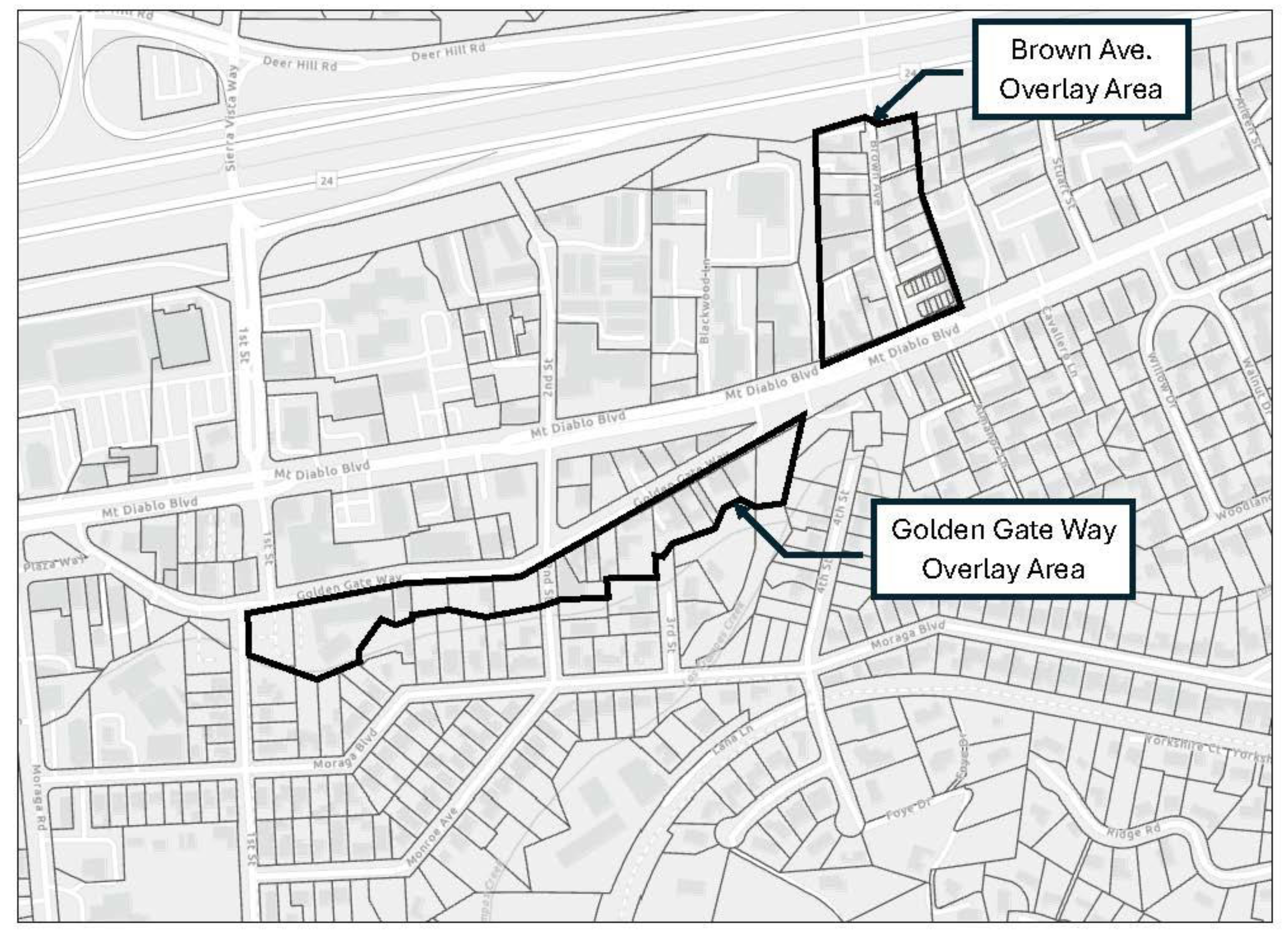
(Ord. No. 696, § 3(Exh. A), 1-13-2025)
6-984 - Uses requiring a permit.
The following uses are permitted in the C-1 district on the issuance of a land use permit:
(a)
Administrative civic;
(b)
Automotive sales, rental and delivery;
(c)
Automotive servicing;
(d)
Auto repair and cleaning;
(e)
Commercial automotive fee parking;
(f)
Commercial laundry or dry cleaning;
(g)
Commercial recreation;
(h)
Community assembly and education activity;
(i)
Construction sales and service;
(j)
Convenience market;
(k)
Day-care and educational service;
(l)
Fast-food restaurant with drive-thru, drive-up or pass-thru window service;
(m)
Full-service restaurant;
(n)
General commercial sales and service, where the total floor area of a building or yard area, not including areas used for parking and landscaping (wherever the primary activity is not conducted within a building), or the combination thereof, is 7,500 square feet or more;
(o)
General food sales;
(p)
Light manufacturing and research;
(q)
Real estate service;
(r)
Hotels and motels;
(s)
Undertaking service;
(t)
Utility distribution and civic service;
(u)
Firearm sales;
(v)
Uses which the planning commission has found, after notice and hearing, to be comparable to the above uses or which can be determined to be compatible with the uses and purpose of the C-1 district. The concept of consolidation of several retail core area uses into a single complex (department store) which subverts the purpose of separation and distinction between the retail business district and/or the special retail business district and the C-1 district is not permitted.
(Ord. No. 696, § 3(Exh. A), 1-13-2025)
6-985 - Lot area.
No new lots may be created in the C-1 district smaller than 7,500 square feet in size.
(Ord. No. 696, § 3(Exh. A), 1-13-2025)
6-986 - Lot width.
No new lots may be created in the C-1 district with an average width of less than 55 feet.
(Ord. No. 696, § 3(Exh. A), 1-13-2025)
6-987 - Lot depth.
No new lots may be created in the C-1 district with a depth of less than 75 feet.
(Ord. No. 696, § 3(Exh. A), 1-13-2025)
6-988 - Height.
No buildings or other structures permitted in the C-1 district shall exceed 35 feet in height, nor two and one-half stories, except as allowed for number of stories by Section 6-990 of this chapter.
(Ord. No. 696, § 3(Exh. A), 1-13-2025)
6-989 - Density.
The maximum and minimum residential densities for lots within the C-1 district shall conform to the density standards specified in the applicable land use designation of the General Plan Land Use Element and as outlined in Program 10.3.g of the 2023-2031 6 th Cycle Housing Element.
(Ord. No. 696, § 3(Exh. A), 1-13-2025)
6-990 - Third story for residential use.
Notwithstanding any other provisions of this article, a third story for a building is allowed when that third-floor area is to be used exclusively for residential use. No part of the third-floor portion of the building shall be located within 20 feet of the right-of-way, or planned right-of-way, lines of Mt. Diablo Boulevard, First Street, Golden Gate Way, Dyer Drive, Highway 24 or Pleasant Hill Road; nor within 20 feet of the boundary of any residential zone.
(Ord. No. 696, § 3(Exh. A), 1-13-2025)
6-991 - Setback.
There shall be a landscaped setback of at least ten feet from any street line for any structure in the C-1 district. No parking shall be allowed in the required setback. Setbacks for third-story portions of buildings shall be regulated by Section 6-990.
(Ord. No. 696, § 3(Exh. A), 1-13-2025)
6-992 - Minimum side and rear yards.
Where the site is adjacent to residentially zoned property, or to a single parcel not zoned residential but containing four or more dwelling units, there shall be a ten-foot landscaped setback along that entire property line. Side and rear yard setbacks for third-story portions of buildings shall be regulated by Section 6-990.
(Ord. No. 696, § 3(Exh. A), 1-13-2025)
6-993 - Off-street parking and loading.
(a)
Off-street parking and loading facilities for the uses in the C-1 district shall be provided in accordance with Chapter 6-6 of this title except that the required number of off-street parking spaces for new residential units is as follows:
(1)
One-bedroom units, 1.0 space per unit;
(2)
Two-bedroom units, 1.2 spaces per unit;
(3)
Units with three or more bedrooms, 1.5 spaces per unit.
(b)
In addition, one guest parking space shall be provided for each five dwelling units. A minimum of one parking space per unit shall be covered.
(c)
Parking for the third-floor residential use shall not be required to provide the number of parking stalls defined in this section (see Section 6-990).
(Ord. No. 696, § 3(Exh. A), 1-13-2025)
6-995 - Access from residential street.
Any use on a lot which has street frontage on more than one street, one street of which has a right-of-way of 55 feet or less and forms the common boundary between a district of any residential classification and the C-1 district, shall not be permitted to gain vehicular access from the residential street.
(Ord. No. 696, § 3(Exh. A), 1-13-2025)
6-996 - Design review.
No building, sign or other facility shall be constructed or established, or altered or painted a new color in such a manner as to affect exterior appearance, unless plans for such proposals have been approved pursuant to the design review requirements set forth in Part 1 of this title.
(Ord. No. 696, § 3(Exh. A), 1-13-2025)
6-997 - Modifiable sections.
Land use permits for special uses enumerated in Section 6-984 and variance permits to modify the provisions of Sections 6-985 to 6-993 may be granted in accordance with the applicable provisions of Chapter 6-1 of this title.
(Ord. No. 696, § 3(Exh. A), 1-13-2025)
6-998 - Special use provisions.
(a)
The provisions of this section apply to any parcel of land in the C-1 district for which a building permit for a principal structure was issued during the period of the office moratorium for the C zoning district, May 14, 1979 to May 14, 1981, inclusive. It is the intent of this section to supersede and clarify any land use authorizations, restrictions or prohibitions which may have been attached to, or implied by, any approvals of land use entitlements which led to the issuance of building permits for principal structures on land in this district during the moratorium period.
(b)
In addition to the uses authorized in Sections 6-983 and 6-984 of this article, for such parcels of land the uses enumerated in this section are authorized, provided that they are established only in the buildings or portions of buildings which were designed and constructed for general office uses.
(c)
Uses permitted, in addition to those listed in Section 6-983, are as follows:
(1)
Administrative;
(2)
Consultative service;
(3)
Medical services occupying up to 10,000 square feet of building area. Any medical services that would increase the area used beyond 10,000 square feet on that parcel shall be subject to a land use permit.
(d)
Notwithstanding the fact that the uses listed in subsection (b) of this section are nonconforming in the C-1 district generally, said uses are conforming and fully authorized in eligible buildings on any parcel of land which is subject to the provisions of this section.
(Ord. No. 696, § 3(Exh. A), 1-13-2025)
6-998.1 - General.
All land in the Pleasant Hill Road Commercial district (map symbol PHC) shall be used in accordance with the provisions of this article.
(Ord. No. 650, § 3(exh. A), 7-25-2016)
6-998.2 - Purpose.
The purpose of this article is to provide a limited number of commercial uses that primarily serve residents and motorists in the north eastern sector of Lafayette.
(Ord. No. 650, § 3(exh. A), 7-25-2016)
6-998.3 - Uses permitted.
The following uses may be conducted as a matter of right in the PHC district, without the need for a land use permit:
(a)
Automobile servicing;
(b)
Park-and-ride lot, whether publicly or privately owned;
(c)
Offices.
(Ord. No. 650, § 3(exh. A), 7-25-2016)
6-998.4 - Uses requiring a permit.
The following uses are permitted in the PHC district upon the issuance of a land use permit.
(a)
Drive through, drive up or pass through window serving coffee and other soft beverages.
(b)
Automotive cleaning as an ancillary use to automobile servicing. Automotive cleaning means the washing and polishing of motor vehicles and does not include the major repair or painting of motor vehicles, including body work and installation of major accessories.
(Ord. No. 650, § 3(exh. A), 7-25-2016; Ord. No. 652, § 3(exh. A), 9-26-2016)
6-998.5 - Lot area.
No new lots may be created in the PHC district smaller than 40,000 square feet in size.
(Ord. No. 650, § 3(exh. A), 7-25-2016)
6-998.6 - Lot width.
No new lots may be created in the PHC district with an average width of less than 75 feet.
(Ord. No. 650, § 3(exh. A), 7-25-2016)
6-998.7 - Lot depth.
No new lots may be created in the PHC district with a depth of less than 150 feet.
(Ord. No. 650, § 3(exh. A), 7-25-2016)
6-998.8 - Height.
No buildings or other structures permitted in the PHC district shall exceed 17 feet in height, nor one story.
(Ord. No. 650, § 3(exh. A), 7-25-2016)
6-998.9 - Setback.
There shall be a landscaped setback of at least ten feet from any street line for any structure in the PHC district. No parking shall be allowed in the required setback.
(Ord. No. 650, § 3(exh. A), 7-25-2016)
6-998.10 - Minimum side and rear yards.
There shall be a minimum yard setback of ten feet along side and rear property lines.
(Ord. No. 650, § 3(exh. A), 7-25-2016)
6-998.11 - Floor area ratio (FAR).
There shall be a maximum floor area ratio of 0.25 imposed on the land with slopes of 15 percent or less in the PHC district. Land in excess of 15 percent slope shall not be developed nor used to calculate the maximum floor area.
(Ord. No. 650, § 3(exh. A), 7-25-2016)
6-998.12 - Design review.
No building, sign or other facility shall be constructed or established, or altered or painted a new color in such a manner as to affect exterior appearance, unless plans for such proposals have been approved pursuant to the design review requirements set forth in Part 1 of this title.
(Ord. No. 650, § 3(exh. A), 7-25-2016)
6-998.13 - Modifiable sections.
Land use permits for special uses enumerated in Section 6-998.4 and variance permits to modify the provisions of Sections 6-998.5 to 6-998.10 may be granted in accordance with the applicable provisions of Chapter 6-1 of this title.
(Ord. No. 650, § 3(exh. A), 7-25-2016)
6-999.1 - General.
All land in the general commercial 1-60 district (map symbol C-1-60) shall be used in accordance with the provisions of this article.
(Ord. No. 696, § 3(Exh. A), 1-13-2025)
6-999.2 - Purpose.
(a)
The purpose of this article is to provide for, and enhance the opportunities for, and protect existing establishments offering a variety of supplies or services which are essential to the economy of Lafayette but which are frequently incompatible with the operations of a retail shopping area because of their need for a large site, access by delivery and customer vehicles, open display or storage yards, and propensity to produce limited but tolerable external impacts. Such uses ordinarily do not seek locations in shopping areas and therefore must be provided for at independent locations along a major thoroughfare, away from the retail core area.
(b)
This article is to provide for the implementation of the general plan which encourages the separation of uses permitted in the retail core area and those permitted elsewhere in the business districts.
(Ord. No. 696, § 3(Exh. A), 1-13-2025)
6-999.3 - Uses permitted.
The following uses may be conducted as a matter of right in the C-1-60 district, without the need for a land use permit. However, a land use permit (under Sections 6-215 and 6-531) is required if the proposed use will result from the conversion of a residential use of the property.
(a)
Animal care, commercial;
(b)
Business and communication service;
(c)
General commercial sales and service where the total floor area of a building or yard area, not including areas used for parking or landscaping (whenever the primary activity is not conducted within a building), or the combination thereof, is less than 7,500 square feet in size;
(d)
General personal service;
(e)
Limited child care;
(f)
Self-service laundry and retail dry cleaners which comply with Section 6-532;
(g)
Fast-food restaurant without drive-thru, drive-up and pass-thru window service;
(h)
Home/business furnishings;
(i)
General retail sales, only in the Brown Avenue area, shown on Figure 6-983;
(j)
Medical services, only in the Golden Gate Way area, shown on said Figure 6-983;
(k)
Residential dwelling units;
(l)
Supportive care pursuant to Section 6-534 LMC.
(Ord. No. 696, § 3(Exh. A), 1-13-2025)
6-999.4 - Uses requiring a permit.
The following uses are permitted in the C-1-60 district on the issuance of a land use permit:
(a)
Administrative civic;
(b)
Automotive sales, rental and delivery;
(c)
Automotive servicing;
(d)
Auto repair and cleaning;
(e)
Commercial automotive fee parking;
(f)
Commercial laundry or dry cleaning;
(g)
Commercial recreation;
(h)
Community assembly and education activity;
(i)
Construction sales and service;
(j)
Convenience market;
(k)
Day-care and educational service;
(l)
Fast-food restaurant with drive-thru, drive-up or pass-thru window service;
(m)
Full-service restaurant;
(n)
General commercial sales and service, where the total floor area of a building or yard area, not including areas used for parking and landscaping (wherever the primary activity is not conducted within a building), or the combination thereof, is 7,500 square feet or more;
(o)
General food sales;
(p)
Light manufacturing and research;
(q)
Real estate service;
(r)
Hotels and motels;
(s)
Undertaking service;
(t)
Utility distribution and civic service;
(u)
Firearm sales;
(v)
Uses which the planning commission has found, after notice and hearing, to be comparable to the above uses or which can be determined to be compatible with the uses and purpose of the C-1-60 district. The concept of consolidation of several retail core area uses into a single complex (department store) which subverts the purpose of separation and distinction between the retail business district and/or the special retail business district and the C-1-60 district is not permitted.
(Ord. No. 696, § 3(Exh. A), 1-13-2025)
6-999.5 - Lot area.
No new lots may be created in the C-1-60 district smaller than 7,500 square feet in size.
(Ord. No. 696, § 3(Exh. A), 1-13-2025)
6-999.6 - Lot width.
No new lots may be created in the C-1-60 district with an average width of less than 55 feet.
(Ord. No. 696, § 3(Exh. A), 1-13-2025)
6-999.7 - Lot depth.
No new lots may be created in the C-1-60 district with a depth of less than 75 feet.
(Ord. No. 696, § 3(Exh. A), 1-13-2025)
6-999.8 - Height.
(a)
No residential or residential mixed-use buildings or other structures permitted in the C-1-60 district shall exceed 60 feet in height.
(b)
No non-residential buildings or other structures permitted in the C-1-60 district shall exceed 35 feet or two and one-half stories.
(Ord. No. 696, § 3(Exh. A), 1-13-2025)
6-999.9 - Density.
The maximum and minimum residential densities for lots within the C-1-60 district shall conform to the density standards specified in the applicable land use designation of the General Plan Land Use Element and as outlined in Program 10.3.g of the 2023-2031 6 th Cycle Housing Element.
(Ord. No. 696, § 3(Exh. A), 1-13-2025)
6-999.10 - Third story and above for residential use.
For all street-facing facades, building portions above 20 feet in height must be stepped-back ten feet from the façade directly below and building portions above 40 feet in height must be stepped-back an additional ten feet from the façade directly below.
(Ord. No. 696, § 3(Exh. A), 1-13-2025)
6-999.11 - Minimum setbacks and upper-story step-backs.
(a)
Street-facing setbacks: Ten feet.
(b)
Interior side and rear setbacks:
(1)
Ten feet for residential uses; none required for non-residential uses.
(2)
If the site is adjacent to residentially zoned property, or property not zoned residential but with an existing residential structure or structures of four or more units, there shall be a ten-foot-wide landscaped yard along that entire property line.
(c)
Upper-story step-backs: For all street-facing facades, building portions above 20 feet in height must be stepped-back ten feet from the façade directly below and building portions above 40 feet in height must be stepped-back an additional ten feet from the façade directly below.
(d)
No parking shall be allowed in the required setback.
(e)
Side and rear yard setbacks for portions of buildings at the third story and above shall be regulated by Section 6-999.10.
(Ord. No. 696, § 3(Exh. A), 1-13-2025)
6-999.12 - Off-street parking and loading.
(a)
Off-street parking and loading facilities for the uses in the C-1-60 district shall be provided in accordance with Chapter 6-6 of this title except that the required number of off-street parking spaces for new residential units is as follows:
(1)
One-bedroom units, 1.0 space per unit;
(2)
Two-bedroom units, 1.2 spaces per unit;
(3)
Units with three or more bedrooms, 1.5 spaces per unit.
(b)
In addition, one guest parking space shall be provided for each five dwelling units. A minimum of one parking space per unit shall be covered.
(c)
Parking for residential uses at the third story and above shall not be required to provide the number of parking stalls defined in this section (see Section 6-999.10).
(Ord. No. 696, § 3(Exh. A), 1-13-2025)
6-999.13 - Access from residential street.
Any use on a lot which has street frontage on more than one street, one street of which has a right-of-way of 55 feet or less and forms the common boundary between a district of any residential classification and the C-1-60 district, shall not be permitted to gain vehicular access from the residential street.
(Ord. No. 696, § 3(Exh. A), 1-13-2025)
6-999.14 - Design review.
No building, sign or other facility shall be constructed or established, or altered or painted a new color in such a manner as to affect exterior appearance, unless plans for such proposals have been approved pursuant to the design review requirements set forth in Part 1 of this title.
(Ord. No. 696, § 3(Exh. A), 1-13-2025)
6-999.15 - Modifiable sections.
Land use permits for special uses enumerated in Section 6-999.4 and variance permits to modify the provisions of Sections 6-999.5 to 6-999.12 may be granted in accordance with the applicable provisions of Chapter 6-1 of this title.
(Ord. No. 696, § 3(Exh. A), 1-13-2025)
6-999.16 - Special use provisions.
(a)
The provisions of this section apply to any parcel of land in the C-1-60 district for which a building permit for a principal structure was issued during the period of the office moratorium for the C zoning district, May 14, 1979 to May 14, 1981, inclusive. It is the intent of this section to supersede and clarify any land use authorizations, restrictions or prohibitions which may have been attached to, or implied by, any approvals of land use entitlements which led to the issuance of building permits for principal structures on land in this district during the moratorium period.
(b)
In addition to the uses authorized in Sections 6-999.3 and 6-999.4 of this article, for such parcels of land the uses enumerated in this section are authorized, provided that they are established only in the buildings or portions of buildings which were designed and constructed for general office uses.
(c)
Uses permitted, in addition to those listed in Section 6-999.3, are as follows:
(1)
Administrative;
(2)
Consultative service;
(3)
Medical services occupying up to 10,000 square feet of building area. Any medical services that would increase the area used beyond 10,000 square feet on that parcel shall be subject to a land use permit.
(d)
Notwithstanding the fact that the uses listed in subsection (b) of this section are nonconforming in the C-1-60 district generally, said uses are conforming and fully authorized in eligible buildings on any parcel of land which is subject to the provisions of this section.
(Ord. No. 696, § 3(Exh. A), 1-13-2025)
Article 2. - Reserved[12]
Editor's note—Ord. No. 697, § 3(Exh. A), adopted July 28, 2025, repealed Art. 2, §§ 6-1321—6-1332, which pertained to General Agricultural District and derived from Ord. 70 § 1 (part), adopted in 1971; Ord. 81 § 1, adopted in 1972; Ord. 115 §§ 3 (part), 5 (part), adopted in 1973; Ord. 120 §§ 1 (part), 2 (part), adopted in 1973; Ord. 240 § 2, adopted in 1981; Ord. 266 §§ 13, 14, adopted in 1982; Ord. 300 §§ 3 (part), 4 (part), adopted in 1984; and Ord. 386 § 5 (part), adopted in 1991.
Article 3. - Reserved[13]
Editor's note—Ord. No. 697, § 3(Exh. A), adopted July 28, 2025, repealed Art. 3, §§ 6-1341—6-1351, which pertained to Ord. 81 § 1, 1972 and derived from Ord. 70 § 2 (part), adopted in 1971; Ord. 266 §§ 15, 16, adopted in 1982; Ord. 300 § 4 (part), adopted in 1984; Ord. 333 § 1, adopted in 1985; and Ord. 386 § 5 (part), adopted in 1991.
6-1001 - General.
All land in the administrative/professional office district (map symbol APO) shall be used in accordance with the provisions of this article.
(Ord. 170 § 2 (part), 1976)
6-1002 - Purpose.
The purpose of this article is to allow administrative and professional offices where such uses need not be located in the central area in order to best function to the benefit of the community, but where carefully conceived plans are necessary to provide comprehensive development that will assure safe, rational and functional internal and external circulation; design and landscaping compatible with unique, highly visible settings; the optimum in quality development; and development consistent with the goals, policies and other provisions of the general plan.
(Ord. 170 § 2 (part), 1976)
6-1003 - Uses permitted.
The following uses are permitted in the APO district:
(a)
Offices of an administrative, executive, professional, editorial or similar nature, if no merchandise is handled for sale and no merchandising services are rendered except those incidental or accessory to the principal use;
(b)
Professional offices and laboratories, such as medical-dental offices or the offices of lawyers, engineers and architects, if there are no retail sales;
(c)
Individual and family counseling offices (not including group counseling) such as psychiatrists, psychologists and sociologists, and other uses determined by the planning director to be of the same general character;
(d)
Prescription pharmacies, in connection with medical-dental offices.
(Ord. 170 § 2 (part), 1976)
6-1004 - Uses requiring a permit.
The following uses are permitted in the APO district on the issuance of a land use permit:
(a)
Research institutes and laboratories devoted to experimental study such as testing and analyzing;
(b)
Publicly-owned buildings and structures, except as provided in Section 6-516;
(c)
Community buildings, clubs and activities of a quasi-public, social or fraternal character;
(d)
Eleemosynary and philanthropic institutions, and convalescent hospitals;
(e)
Churches;
(f)
Multiple-family buildings;
(g)
Any permitted uses on a site smaller than two hectares (4.94 acres) in size;
(h)
Uses which the planning commission has found, after notice and hearing, to be comparable to the uses set out in this section. The city council expressly finds that the following uses are not comparable to any of the uses set forth in this section and, therefore, are not permissible under any circumstances: drug stores, manufacturing, restaurants and cafes, and retail sales not associated with a permitted use.
(Ord. 170 § 2 (part), 1976)
6-1005 - Lot area.
No new lots may be created in the APO district smaller than two hectares (4.94 acres) in size.
(Ord. 170 § 2 (part), 1976)
6-1006 - Height.
(a)
No building or other structure in the APO district shall exceed the height limitations indicated in the height areas illustration shown in Figure 6-1006.
(b)
When any portion of a building or structure lies across the boundary line of any of the height limitation areas described in subsection (a), the minimum height requirement of the most restrictive area shall be applicable.
(c)
Building height shall be measured to the highest point of a building or structure from the lowest point where the lowest foundation wall intersects with the ground.
6-1007 - Side yards.
No side yard in the APO district shall be less than 15 meters (49.21 feet) wide.
(Ord. 170 § 2 (part), 1976)
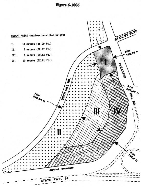
6-1008 - Rear yards.
There shall be a rear yard of at least eight meters (26.25 feet) for any structure in the APO district.
(Ord. 170 § 2 (part), 1976)
6-1009 - Setback.
There shall be a setback of at least eight meters (26.25 feet) for any structure in the APO district.
(Ord. 170 § 2 (part), 1976)
6-1010 - Separation of structures from public right-of-way.
Every one-story structure in the APO district shall be separated from the right-of-way of any public street by at least eight meters (26.25 feet), and every multiple-story structure shall be separated from the right-of-way of any public street by a distance of at least 15 meters (49.21 feet). No parking shall be allowed in the area separating a structure from a public right-of-way, and the area shall be landscaped.
(Ord. 170 § 2 (part), 1976)
6-1011 - Landscaping.
In addition to required landscaping in required areas separating structures from public right-of-way, 20 percent of a lot in the APO district shall be planted and maintained with growing plants. To qualify as landscaped space, an area must be a minimum of five meters (16.40 feet) in width.
(Ord. 170 § 2 (part), 1976)
6-1012 - Approval guidelines.
The design review commission and the planning commission, when reviewing development proposals for the APO district, shall apply discretionary development requirements according to the following guidelines:
(a)
Lots in the APO district should be linked by comprehensive internal road networks to facilitate and encourage easy internal movement and discourage numerous access/egress points associated with the road systems surrounding the district.
(b)
Buffer areas of terrain features and landscaping should be provided between buildings or other structures and road systems surrounding the district.
(c)
Buildings, other structures and earthworks should be designed and sited to be visually harmonious, and should be compatible with terrain features in terms of mass, colors, materials and general appearance.
(Ord. 324 § 2(b) (part), 1984; Ord. 170 § 2 (part), 1976)
6-1013 - Off-street parking and loading.
Off-street parking and loading facilities in the APO district shall be provided in accordance with Chapter 6-6 of this title.
(Ord. 170 § 2 (part), 1976)
6-1014 - Design review.
All new construction and all remodeling of a structure when the completed new work will be visible from public property, or when the nature of the use will be changed, shall be subject to the design review requirements and procedures set forth in Part 1 of this title.
(Ord. 324 § 2(d) (part), 1984: Ord. 170 § 2 (part), 1976)
6-1015 - Modifiable sections.
Land use permits for the special uses enumerated in Section 6-1004 and variance permits to modify the provisions of Sections 6-1005 through 6-1013, inclusive, may be granted in accordance with the applicable provisions of Chapter 6-1 of this title.
(Ord. 170 § 2 (part), 1976)
6-1101 - General.
All land in the planned unit district (map symbol P-1) shall be used in accordance with the regulations of this chapter.
(Ord. 51 § 1 (part), 1971)
6-1102 - Purpose.
It is recognized than an integrated development provides an opportunity for cohesive design when flexible regulations are applied; whereas the application of conventional regulations, designed primarily for individual lot development, to an integrated development may create a monotonous and stultified neighborhood. This planned unit district is intended to allow diversification in the relationship of various uses, buildings, structures, lot sizes and open spaces while ensuring substantial compliance with the general plan and the intent of this code in requiring adequate standards necessary to satisfy the requirements of the public health, safety and general welfare. These standards shall be observed without unduly inhibiting the advantages of integrated site planning.
(Ord. 51 § 1 (part), 1971)
6-1103 - Application.
An application for rezoning to the P-1 district shall contain:
(a)
A preliminary development plan, drawn to scale, which shall indicate:
(1)
The proposed use or uses of all lands within the subject area,
(2)
Existing natural land features and topography of the subject area,
(3)
A circulation plan for all vehicular and pedestrian ways,
(4)
The metes and bounds of the subject property,
(5)
The location and dimensions of all existing structures,
(6)
Landscaping, parking areas and typical proposed structures,
(7)
The anticipated grading for the development;
(b)
A written legal description of the subject area;
(c)
A preliminary report indicating provision for storm drainage, sewage disposal and public utilities;
(d)
An economic feasibility report and analysis of all commercial and industrial uses, if any, proposed to be located within the development;
(e)
A feasibility analysis of all public, quasi-public, recreational and educational areas and facilities proposed to be located within the development. This analysis shall include a statement of anticipated financing, development and maintenance;
(f)
A residential density analysis of the subject area, and the estimated population resulting therefrom;
(g)
A statement indicating how and why the proposed development conforms to the general plan;
(h)
A statement requesting the zoning change, signed by the owners in fee of the subject land and the owners of any option to purchase the property or any portion thereof, if any;
(i)
Schematic drawings showing the architectural design of all apartment houses and nonresidential buildings and structures proposed in the development;
(j)
Any additional information as may be required by the planning commission or the city council at the time of any public hearing.
(Ord. 51 § 1 (part), 1971)
6-1104 - Procedure.
An application for rezoning to this district shall be processed in accordance with the applicable provisions of Title 7 of the Government Code of the State of California. The preliminary development plan, as approved by the city council, shall be filed with the planning commission, and shall, by reference, be incorporated into and thereby become a part of the ordinance rezoning the subject property into the P-1 district. After the effective date of such ordinance, no grading or land clearing shall take place, nor shall any building or structure be erected, moved or altered on the subject property, except in compliance with the final development plan as approved by the planning commission.
(Ord. 51 § 1 (part), 1971)
6-1105 - Final development plan.
The final development plan shall contain or be accompanied by:
(a)
The metes and bounds of the subject property, together with the dimensions of the parcels, if any, into which the property is to be divided;
(b)
The location, grades, widths and types of improvements proposed for all streets, driveways, pedestrian ways and utilities;
(c)
The location, height, number of stories, use and number of dwelling units for each proposed building or structure;
(d)
The location and design of vehicle parking areas;
(e)
The location and design of proposed landscaping except for proposed single-family residential development;
(f)
The location and design of all storm drainage and sewage disposal facilities;
(g)
An engineer's statement of the proposed grading;
(h)
The location and extent of all proposed land uses;
(i)
Elevations of all buildings and structures other than single-family residences;
(j)
A statement indicating procedures and programming for the development and maintenance of semipublic or public areas, buildings and structures;
(k)
A statement indicating the stages of development proposed for the entire project;
(l)
Any additional drawings or information which may be required by the planning commission at the time of any public hearing on the plan.
(Ord. 51 § 1 (part), 1971)
6-1106 - Final development plan approval.
The final development plan shall be submitted to the planning commission for approval using the same procedure required for a use permit application. An appeal from the planning commission decision may be taken to the city council in accordance with the provisions of Part 1 of this title. If no appeal is taken, the decision of the planning commission becomes final.
(Ord. 51 § 1 (part), 1971)
6-1107 - Latitude of regulations.
The planning commission may recommend and the city council may adopt as part of the preliminary development plan, and may require in the final development plan, standards, regulations, limitations and restrictions either more or less restrictive than those specified elsewhere in this title, and which are designed to protect and maintain property values and community amenities near the subject property, and which would foster and maintain the health, safety and general welfare of the city, including and relating to, but not limited to, the following:
(a)
Height limitations on buildings and structures;
(b)
Percent coverage of land by buildings and structures;
(c)
Parking ratios and areas expressed in relation to use of various portions of the property and/or building floor area;
(d)
The location, width and improvement of vehicular and pedestrian access to various portions of the property, including portions within abutting streets;
(e)
Planting and maintenance of trees, shrubs, plants and lawns in accord with a landscaping plan;
(f)
Construction of fences, walls and floodlighting of an approved design;
(g)
Limitations upon size, design, number, lighting and location of signs and advertising structures;
(h)
Arrangement and spacing of buildings and structures to provide appropriate open spaces around same;
(i)
Location and size of off-street loading areas and docks;
(j)
Uses of buildings and structures by general classification, and specific designation when there are unusual requirements for parking, or when use involves noise, dust, odor, fumes, smoke, vibration, glare or radiation incompatible with present or potential development of surrounding property;
(k)
Architectural design of buildings and structures;
(l)
Schedule of time for construction and establishment of the proposed buildings, structures, or land uses or any stage of development thereof;
(m)
Performance bonds to ensure development as approved.
(Ord. 51 § 1 (part), 1971)
6-1108 - Required findings.
In approving and adopting the rezoning application with the preliminary development plan, and subsequently the final development plan, the planning commission and/or the city council, as the case may be, shall find the following:
(a)
That the applicant intends to start construction within two and one-half years from the effective date of zoning change;
(b)
That the proposed planned unit development substantially conforms to the general plan;
(c)
That, in the case of residential development, such development will constitute a residential environment of sustained desirability and stability, and that it will be in harmony with the character of the surrounding neighborhood and community;
(d)
That, in the case of commercial development, such development is needed at the proposed location to provide adequate commercial facilities of the type proposed; that traffic congestion will not likely be created by the proposed use, or will be obviated by presently projected improvements and by demonstrable provisions in the plan for proper entrances and exits, and by internal provisions for traffic and parking; that said development will be attractive and efficient and will fit harmoniously into and will have no adverse effects upon the adjacent or surrounding development;
(e)
That, in the case of proposed industrial development, such development is fully in conformity with the applicable performance standards, and will constitute an efficient and well-organized development, with adequate provisions for truck access service and necessary storage; and that such development will have no adverse effect upon adjacent or surrounding development;
(f)
That the development of a harmonious, integrated plan justifies exceptions from the normal application of this title.
(Ord. 51 § 1 (part), 1971)
6-1109 - Termination of zoning.
If, within 18 months of the effective date of the establishment of the P-1 district and the preliminary development plan, a final development plan is not submitted to the planning commission, the P-1 district shall become null and void and the land use district classification shall revert back to the designation in effect immediately before the rezoning to P-1. If, within 12 months after the approval by the planning commission of the final development plan, the construction specified in said final development plan has not been commenced, then the P-1 district shall become null and void and the land use district classification shall revert back to the designation in effect immediately before rezoning the P-1. The city council may grant one extension for not more than one year upon a showing of good cause.
(Ord. 51 § 1 (part), 1971)
6-1110 - Uses permitted.
Any land uses may be permitted in the P-1 district provided such use or uses are in harmony with each other and serve to fulfill the function of the planned unit development while substantially complying with the general plan.
(Ord. 51 § 1 (part), 1971)
6-1111 - Residential density.
The general plan shall be used as the guide in establishing residential densities. In establishing residential densities those areas set aside for churches, schools, streets, commercial use or other nonresidential use shall not be included in the net development area for purposes of computing residential densities. The area set aside for common open space, outdoor recreational use or parks shall be included in the net development area for purposes of computing residential densities.
(Ord. 51 § 1 (part), 1971)
6-1112 - Final development plan modifications.
The final development plan may be modified by submitting an application for such modification according to the same procedure as is required in the initial review and approval of the final development plan. The flexibility of ordinance requirement, ordinarily required in other districts, permitted in any initial approval of a P-1 district shall not be considered as precedent-setting, or as a lone compelling reason for approving any modifications. Any application for modification may be approved only after it has been found that it does not deviate from the intent and purpose of this district, and that provisions of Section 6-1108 and 6-1111 have been met.
(Ord. 51 § 1 (part), 1971)
6-1113 - Planned unit development on hillside land.
In developing hillside land as that term is defined in Section 6-2002(a)(1) of this title, the city encourages development by means of the planned district (P-1) zoning classification. The maximum number of dwelling units permitted for hillside land classified planned district (P-1) is that which would have been permitted by the land use regulations applicable to the property immediately before being classified planned district, including the application of the provisions of Section 6-2004 of this title.
(Ord. 175 § 4, 1976)
6-1151 - Purpose.
The senior housing overlay, ("SHO"), district is established to provide for the development of a variety of senior housing types pursuant to standards that reflect the unique character of senior residential occupancy, and to implement the goal of the housing element of the Lafayette General Plan to achieve an adequate supply of safe, decent housing for all residents of Lafayette.
In establishing the senior housing overlay district, the city council expressly finds that:
(1)
The impacts of senior citizen housing developments are lower than other multi-family residential developments; and
(2)
Senior citizen housing developments benefit greatly from a close proximity to downtown services and amenities.
Any land within the senior housing overlay district shall retain its existing, underlying zoning and may be developed and used either pursuant to regulations pertaining to such underlying zoning, or, when authorized by a senior housing permit, pursuant to the regulations set forth in this chapter.
(Ord. No. 598, § 2, 10-25-2010)
6-1152 - Restriction on alternative use.
Any lot developed or used for senior housing pursuant to a senior housing permit shall not thereafter be used for any purpose other than the provision of senior housing unless and until the zoning administrator has determined, in writing, that the alternative use satisfies all applicable land use regulations pertaining to the underlying zoning of the property.
(Ord. No. 598, § 2, 10-25-2010)
6-1153 - Definitions.
For the purposes of this chapter, the following definitions shall apply:
(a)
"Alzheimer's/memory care/dementia facility" is a specialized housing development serving the needs of persons with memory and/or dementia problems. Depending on the severity of the health concerns of residents, such housing may be provided in an assisted living format; or in a residential care facility format, which is more like a hospital setting. For the purposes of this chapter Alzheimer's/memory care/dementia facilities shall be considered a "senior residential care facility."
(b)
"Assisted living" is housing that provides a special combination of traditional housing with personalized supportive services and care. Such housing includes some form of kitchen facilities within the unit, even if most or all meals are taken in a communal dining facility. for the purposes of this chapter, "assisted living" facilities shall be considered a type of "senior citizen housing development" or "senior housing project." If the assistance provided at such a facility is nursing care, or if residents live in bedrooms rather than complete residential units, then it shall be considered a "senior residential care facility."
(c)
"Continuing care retirement community" is a residential facility that provides a continuum of care from independent living to assisted living to skilled nursing care, all in one location. For the purposes of this chapter, the portion of any "continuing care retirement community" that includes independent and/or assisted living units shall be considered a type of "senior citizen housing development" or "senior housing project" and must comply with the regulations applicable thereto. The portion of any "continuing care retirement community" that includes skilled nursing care or similar service shall be considered a "senior residential care facility" and must comply with the regulations applicable thereto.
(d)
"Dwelling unit" or "housing" is any residential accommodation other than a mobile home.
(e)
"Employee" is anyone hired to work at a senior housing facility within the SHO district, whether hired by the facility or residents, including but not limited to staff, doctors, nurses, permitted health care residents, maintenance workers, etc.
(f)
"Independent living" is housing that is designed to enable seniors to live an independent lifestyle that includes recreational, educational and social activities. Such housing includes kitchen facilities within the unit, even if most or all meals are taken in a communal dining facility. For the purposes of this chapter, "independent living" facilities are considered a type of "senior citizen housing development" or "senior housing project."
(g)
"Peak staffing" means the maximum number of employees on site at any point in time.
(h)
"Permitted health care resident" is a person hired to provide live-in care to a qualifying resident, or a family member of the qualifying resident providing such care. For the purposes of this chapter, the care provided by a permitted health care resident must be substantial in nature and must provide either assistance with necessary daily activities or medical treatment, or both.
(i)
"Qualifying resident" or "senior citizen" is a person who is 62 years of age or older, or the head of household who is 55 years of age or older in a senior citizen housing development, and who is a permanent resident of a "senior citizen housing development" or "senior housing project.
(j)
"Senior citizen housing development" is a residential facility, containing 35 dwelling units or more, constructed, substantially rehabilitated, substantially renovated for the purpose of housing senior citizens. heads of households of senior citizen housing developments must be 55 years old or older.
(k)
"Senior housing" or "senior housing project" is a residential facility, containing less than 35 dwelling units, that is constructed substantially rehabilitated, or substantially renovated for the purpose of housing senior citizens. Residents of senior housing projects must be 62 years old or older.
(l)
"Senior residential care facility" is a residential facility designed for the purpose of housing senior citizens, 60 years old or older, who are in need of 24-hour care. For the purposes of this chapter "nursing care," "skilled nursing facility," "board and care facility" and like uses, shall be considered residential care facilities. These facilities are operated in a nursing home, group home or hospital-like fashion and do not have kitchen facilities in resident's individual rooms. Residents live either in private or semi-private rooms. Services may or may not include medical care.
(m)
"Senior housing permit" is the senior housing use permit required by Section 6-1155 for the development of "senior citizen housing developments," "senior housing projects," and "senior residential care facilities" in the SHO district pursuant to this chapter.
(n)
"Zoning administrator" is the planning director or his/her designee.
(Ord. No. 598, § 2, 10-25-2010)
6-1154 - Location of the senior housing overlay district.
The SHO district classification is hereby established on land within the following zoning districts:
(a)
C General commercial district.
(b)
C-1 General commercial district 1.
(c)
MRA Multiple-family residential district A.
(d)
MRB Multiple-family residential district B.
(e)
MRO Multiple-family residential/professional office district.
(f)
MRT Multiple-family residential townhouse district.
(g)
RB Retail business district.
(h)
SRB Special retail business district.
(Ord. No. 598, § 2, 10-25-2010)
6-1155 - Application procedures.
A senior housing permit shall be required for the development of a senior citizen housing development, senior housing project and senior residential care facility under the provisions of this chapter. The project proponent shall submit an application to the planning division on a form prescribed by the city, accompanied by the application fee prescribed by resolution of the city council.
A senior housing permit shall not be required for a residential care facility with six or fewer residents, in addition to permitted health care residents, in all zoning districts that permit single-family residences.
(Ord. No. 598, § 2, 10-25-2010)
6-1156 - Senior housing development guarantee.
Prior to occupancy of any project developed pursuant to this chapter, the project proponent shall provide documentation limiting the use of the project to the use prescribed in the senior housing permit and vesting the right to enforce such limitation in the city until and unless the zoning administrator determines, in writing, that the alternative use satisfies all applicable land use regulations pertaining to the underlying zoning of the property. Such documentation shall be in a form satisfactory to the city attorney and shall be recorded against the property.
(Ord. No. 598, § 2, 10-25-2010)
6-1157 - Applicability.
This article applies to senior residential care facilities with seven or more qualifying residents, not including permitted health care residents.
(Ord. No. 598, § 2, 10-25-2010)
6-1158 - Development standards.
Except as expressly provided in this article, the land use standards for senior residential care facilities, such as yard areas and floor area, shall be those required by the underlying zoning district.
(Ord. No. 598, § 2, 10-25-2010)
6-1159 - Density.
Notwithstanding any other provisions of this article, residential care facilities shall have a total floor area that averages at least 350 square feet of floor area per resident, excluding parking.
(Ord. No. 598, § 2, 10-25-2010)
6-1160 - Common area.
Notwithstanding any other provisions of this section, residential care facilities shall provide a minimum of 100 square feet of usable common area per qualifying resident. Indoor common areas and amenities designed to facilitate program activities may be counted towards this requirement up to a maximum of 75 percent of the total required.
(a)
Any common area to be counted toward the requirements of this section shall have a minimum dimension of not less than six feet in any direction and shall be easily accessible to all residents.
(b)
Outdoor common areas shall be designed to provide amenities and recreational areas compatible with the needs of the residents, such as pathways and sitting areas, flower and vegetable gardens, or similar active or passive recreation areas.
(c)
Where additional stories prohibit easy access to common areas on the ground floor, the project shall provide open roof decks, balconies, or lanais in an amount, dimension, area, and location as deemed appropriate by the zoning administrator.
(d)
The proposed improvement of all required common areas shall be designated on the plans submitted with the senior housing permit application and, shall be considered a required part of the senior housing permit, if issued.
(Ord. No. 598, § 2, 10-25-2010)
6-1161 - Parking.
(a)
Buildings or portions of buildings constructed as senior residential care facilities shall be required to provide one parking space for each resident in addition to one parking space for each employee during peak staffing.
(b)
Existing single-family residences to be converted into residential care facilities shall maintain the existing number of parking spaces; additional parking to meet the requirement of subsection (a) above may be covered or uncovered.
(Ord. No. 598, § 2, 10-25-2010)
6-1162 - Findings.
In order to approve a senior housing permit for a senior residential care facility, the planning commission shall find as follows:
(a)
The proposed use is licensed by the state or county and conducted in a manner and with facilities that comply with Title 24 of the California Code of Regulations or any successor legislation. If the state or county license is suspended or revoked, the senior housing permit shall automatically also be suspended or revoked;
(b)
The facility is specifically designed to include safety bars and rails in bedrooms and bathrooms, ramps, and other structural provisions for senior citizens as required by state law or federal regulations. In addition, such facilities shall include a common dining area as well as adequate common living areas and amenities to facilitate program activities; and
(c)
The facility is specifically designed to have a residential appearance and is compatible with the character of the neighborhood, as determined by review of the applicable hearing authority. In residential zoning districts, signs, ramps and any other "non-residential" features shall be constructed so that they are not visible from the public right-of-way.
(Ord. No. 598, § 2, 10-25-2010)
6-1163 - Applicability.
This article applies to senior citizen housing developments and senior housing projects, regardless of whether the project is assisted living or independent living.
The references to "federal or state law" set forth in this section shall include but not be limited to, the Fair Housing Act (42 U.S.C. Sec. 3601 et seq.), the Americans with Disabilities Act (42 U.S.C. Sec. 12101 et seq.), and the regulations promulgated at Title 24 of the California Code of Regulations that relate to access for persons with disabilities.
(Ord. No. 598, § 2, 10-25-2010)
6-1164 - Development standards.
Except as expressly provided in this article, the land use standards for a senior citizen housing development or a senior housing projects, such as yard areas and floor area, shall be those required by the underlying zoning district.
All senior citizen housing developments and senior housing projects shall be developed so as to comply with the requirements set forth below:
(a)
Entryways, walkways, and hallways in the common areas of the development, and doorways and paths of access to and within the residential units, shall be as wide as required by laws applicable to new multifamily housing construction for provision of access to persons using a standard-width wheelchair.
(b)
Walkways and hallways in the common areas of the development shall be equipped with standard height railings or grab bars to assist persons who have difficulty walking.
(c)
Walkways and hallways in the common areas shall have lighting conditions which are of sufficient brightness to assist persons who have difficulty seeing.
(d)
Access to all common areas and residential units within the development shall be provided without use of stairs, either by means of an elevator or sloped walking ramps.
(e)
The development shall be designed to encourage social contact by providing at least one common room and outdoor common open space.
(f)
Refuse collection shall be provided in a manner that requires a minimum of physical exertion by residents.
(g)
The development shall comply with all other applicable requirements for access and design imposed by law, including, but not limited to, the Fair Housing Act (42 U.S.C. Sec. 3601 et seq.), the Americans with Disabilities Act (42 U.S.C. Sec. 12101 et seq.), and the regulations promulgated at Title 24 of the California Code of Regulations that relate to access for persons with disabilities.
(h)
Notwithstanding any other provision of this code, the minimum floor area for each residential unit in shall be as follows:
(1)
Studio - 450 square feet.
(2)
One bedroom - 540 square feet.
(3)
Two bedroom - 700 square feet.
(i)
All projects shall implement, at minimum, the following universal design principles:
(Universal design is a method of design that allows aging in place by creating an environment that can be used by everyone, regardless of age or physical condition.)
(1)
No-step entries.
(2)
One-story living such that an eating area, bathroom, and sleeping area are available on the same floor.
(3)
Front doors with a minimum width of 36 inches to accommodate the use of wheelchairs and 32-inch free-swing doors (34-inch door) on all interior doors.
(4)
Hallway minimum width of 42 inches to accommodate the use of wheelchairs.
(5)
Room thresholds that are flush.
(6)
Adequate lighting throughout the dwelling unit.
(7)
Lever door handles and rocker light switches.
(8)
Additional closet rod brackets to allow potential access from a wheelchair.
(9)
Adequate space for maneuverability and access to facilities to those using wheelchairs.
(Ord. No. 598, § 2, 10-25-2010)
6-1165 - Density.
Notwithstanding any other provision of this chapter, the density of a senior citizen housing development or senior housing project shall be governed by the density established by the senior housing permit, but in no case shall the density exceed 45 units per acre (not including applicable density bonuses).
(Ord. No. 598, § 2, 10-25-2010)
6-1166 - Parking.
Notwithstanding any other provision of this chapter, a senior citizen housing development or senior housing project shall be required to provide a minimum number of parking spaces as follows:
Independent Living.
(1)
One space for each studio or one-bedroom unit.
(2)
1.2 spaces for each two-bedroom unit.
(3)
One guest parking space for every five dwelling units.
(4)
One parking space for each employee on-site at peak staffing.
Assisted Living.
(1)
0.40 parking spaces per unit.
(2)
One space for each employee on-site at peak staffing.
(3)
One loading pace, sufficient to accommodate expected loading needs.
Independent Living for Extremely low, Very Low, Low Income Households.
(1)
0.50 spaces for each studio or one-bedroom units.
(2)
One guest parking space for every five dwelling units.
(3)
One space for each employee on-site at peak staffing.
(Ord. No. 598, § 2, 10-25-2010)
6-1167 - Findings.
In order to approve a senior housing permit for a senior citizen housing development or a senior housing project, the planning commission shall find as follows:
(a)
The impact of the use will be substantially equivalent to or less than the impacts produced by land uses otherwise allowed within the underlying classification of the zoning district, with consideration being given to the quantity and type of living units, their estimated demand on public facilities and their estimated services generated by the use;
(b)
The project complies with the city's adopted design guidelines;
(c)
The project design, density, lot coverage, bulk and mass are compatible with the surrounding neighborhood, as determined by review of the applicable hearing authority;
(d)
The number of units approved can be adequately accommodated by existing or planned infrastructure;
(e)
The projected peak hour trip generation rates will be equal to or less than that of a conforming, non-age restricted, project on the same site;
(f)
The location, design, and site planning provide residents with a convenient and functional living environment, and will be as attractive as the nature of the use and its location and setting allow. This includes, but is not limited to the provision of artwork, gardens, indoor and/or outdoor sculpture, and other recreation uses of an active or passive nature;
(g)
The project is specifically designed for senior citizens and includes facilities generally associated with the needs and interests of senior citizens. Such facilities include common meeting and recreation areas, secure parking, safety bars and rails in units, emergency signal system, security lighting, ramps and other structural elements required for elderly persons by state and federal laws or regulations; and
(h)
The project is located so as to provide qualifying residents access to community amenities such as transportation, shopping, and other daily services.
(Ord. No. 598, § 2, 10-25-2010)
6-1168 - Modifiable sections.
In the event a senior housing permit does not comply with Sections 6-1158, 6-1160, 6-1161, 6-1164 and 6-1166 relating to development standards for senior residential care facilities, senior citizen housing developments and senior housing projects, an application for a variance to a measurable standard may be filed and reviewed concurrently with the application for a senior housing permit. The applicable hearing authority shall consider the variance application in accordance with the applicable provisions of Chapter 6-1 of this title.
(Ord. No. 598, § 2, 10-25-2010)
6-1201 - General.
(a)
The purpose of this chapter is to provide a mechanism whereby certain additional regulations can be superimposed on or combined with the regulations in a land use district so that all of the regulations of the underlying district plus the regulations of the combining district apply to the land.
(b)
The council finds that authority to establish a combining land use district is necessary to (1) provide flexibility in land use development to meet changing social and economic conditions as they affect land uses; (2) encourage the maximum utilization of land; (3) guarantee the performance of development standards established by the city; (4) provide a means of permitting the development of land which has unique and special development problems which cannot be solved under other land use districts; and (5) provide time for in-depth studies of changing conditions which may require changes in zoning, without in the meantime preventing owners from developing their land.
(Ord. 68 § 1, 1971)
6-1211 - General.
All land in a land use district (hereafter called the "underlying land use district") which is combined with the study combining district (map symbol S) shall be used in accordance with both the regulations for the underlying land use district and the following additional regulations.
(Ord. 68 § 2 (part), 1971)
6-1212 - Purpose.
It is the purpose of the regulations in this article to:
(a)
Recognize through the planning process the relationship between short-term uses of environment and the maintenance and enhancement of long-term productivity;
(b)
Permit the study and development of appropriate alternatives for the allowable uses of land classified to a study combining district;
(c)
Encourage through the land planning process the restoration, maintenance and enhancement of the quality of environment in the city;
(d)
Attain the widest range of beneficial uses of land without adversely affecting the public health, safety and welfare;
(e)
Recognize that pending precise land use studies, the land planning process requires that there be reasonable interim limitations on land uses.
(Ord. 68 § 2 (part), 1971)
6-1213 - All uses subject to use permit.
The uses permitted in the study combining district are the same uses permitted in the underlying land use district. In the study combining district, however, all uses require the issuance of a land use permit.
(Ord. 68 § 2 (part), 1971)
6-1214 - Other requirements.
The requirements for lot area, width and depth; for building height, side and rear yards, setbacks, parking space, and open space; and for site plan and building elevations approval; and all other requirements not specifically mentioned in this article, shall be the same for the study combining district as they are for the underlying land use district.
(Ord. 68 § 2 (part), 1971)
6-1215 - Time limitation.
Land classified to a study combining district may remain so classified for not more than one year unless within that year the city starts a precise land use study of the land. If the city starts a precise land use study within one year from the date the land is so classified, the maximum time the land may remain so classified is 24 months. At the expiration of the first year, if the city has not started a precise land use study for the land, or upon completion of the study, or upon abandonment of the study before completion, or at the end of 24 months, whichever of these events occurs first, the city council shall promptly initiate action to classify the land either into the land use district recommended in the precise land use study or back to the underlying land use district in which is was classified before it was placed in the study combining district.
(Ord. 68 § 2 (part), 1971)
6-1221 - General.
All land in a land use district (hereafter called the "underlying land use district") which is combined with the design control combining district (map symbol B) shall be used in accordance with both the regulations for the underlying land use district and the following additional regulations.
(Ord. 50 § 1 (part), 1971)
6-1222 - Purpose.
The purpose of the B combining district is to provide design control and maintenance of an area where the respective owners have developed a plan wherein a high degree of amenities is intended to prevail, recognizing that an attractive development enhances property values, social values, and the health and welfare of the community.
(Ord. 50 § 1 (part), 1971)
6-1223 - When used.
Land in any underlying zoning district may be combined with the B district only when requested by the owners of two or more parcels of land, who have prepared a plan of development, setting forth criteria through maps, illustrations and text governing the size, bulk, coverage, relationship, color, texture, materials and other appurtenances of physical improvements, including, but not limited to, buildings, signs and fences. Such a plan may also provide for, through its location, design and site planning, a convenient, attractive and functional living, working, shopping or civic environment. Further, such a plan shall provide for off-street parking, landscaping and open space. This plan and accompanying text shall become part of the ordinance placing the land in the B combining district, and all further development on the subject parcels shall comply with it.
(Ord. 50 § 1 (part), 1971)
6-1224 - Site plan and building elevations approval.
All new construction and all remodeling of a structure when the completed new work will be visible from public property, or when the nature of the use will be changed, shall be subject to the site plan and building elevations approval requirements and procedures set forth in Part 1 of this Title.
(Ord. 101 § 2 (part), 1973: Ord. 50 § 1 (part), 1971)
6-1301 - General.
All land in the interchange transitional district (map symbol G-1) shall be used in accordance with the provisions of this article.
(Ord. 65 § 3 (part), 1971)
6-1302 - Purpose.
Acquisition for highway interchanges has left and may continue to leave parcels of land that may create difficult problems requiring solutions that provide the fullest possible agreement with the policies and goals of the general plan. This interchange transitional district is provided in order to establish a range of land uses from which may be selected one or several that would, through the application of exceptional or extraordinary design, develop the greatest number of compatibility factors and minimize or eliminate detrimental land use relationships. It is intended that this district shall have application only within the area of highway interchanges and their approaches, and then only when the above is clearly evident and found to exist by the planning commission.
(Ord. 65 § 3 (part), 1971)
6-1303 - Uses permitted.
The following uses are permitted in the G-1 district:
(a)
Publicly owned parks and playgrounds.
(Ord. 65 § 3 (part), 1971)
6-1304 - Uses requiring a permit.
In the G-1 district, the following uses are permitted upon the issuance of a land use permit:
(a)
Community buildings, clubs and activities of a quasi-public, social or fraternal character; and private recreational facilities, such as golf clubs, swimming pools and tennis clubs, whether or not operated for profit;
(b)
Publicly owned buildings and structures, except as provided in Section 6-516;
(c)
Uses which the planning commission has found, after notice and hearing, to be comparable to the above uses.
(Ord. 120 §§ 1 (part), 2 (part), 1973; Ord. 65 § 3 (part), 1971)
6-1305 - Lot area.
No building or structure permitted in the G-1 district shall be erected or placed on a lot having less than 10,000 square feet.
(Ord. 65 § 3 (part), 1971)
6-1306 - Lot width.
No building or structure permitted in the G-1 district shall be erected or placed on a lot having less than 100 feet in average width.
(Ord. 65 § 3 (part), 1971)
6-1307 - Height.
No building or structure permitted in the G-1 district shall exceed 25 feet in height.
(Ord. 65 § 3 (part), 1971)
6-1308 - Side yards.
There shall be an aggregate side yard width for any structure in the G-1 district of at least 15 feet, with no single side yard being less than five feet in width, except that when a side yard abuts a residential land use district, it shall then have a minimum width of 15 feet with a minimum of five feet width on the other side.
(Ord. 65 § 3 (part), 1971)
6-1309 - Setback.
There shall be a setback (front yard) of at least 20 feet for any building or structure in the G-1 district.
(Ord. 65 § 3 (part), 1971)
6-1310 - Rear yard.
There shall be a rear yard of at least 15 feet for any principal structure in the G-1 district. There shall be a rear yard of at least three feet for an accessory structure.
(Ord. 65 § 3 (part), 1971)
6-1311 - Lot coverage.
No buildings or structures permitted in the G-1 district shall cover more than 35 percent of the lot area.
(Ord. 65 § 3 (part), 1971)
6-1312 - Open area.
In the G-1 district, 25 percent of the parcel shall not be occupied by buildings, structures or pavement, but shall be landscaped. Seventy-five percent of this 25 percent (open area) shall be planted and maintained with growing plants. No open area which is less than 16 feet wide shall have a length in excess of three times its width. No open area shall be less than eight feet wide.
(Ord. 65 § 3 (part), 1971)
6-1313 - Site plan and building elevations approval.
All new construction and all remodeling of a structure when the completed new work will be visible from public property, or when the nature of the use will be changed, shall be subject to the site plan and building elevations approval requirements and procedures set forth in Part 1 of this title.
(Ord. 101 § 2 (part), 1973: Ord. 65 § 3 (part), 1971)
6-1314 - Modifiable sections.
Land use permits for the special uses enumerated in Section 6-1304 and variance permits to modify the provisions of Sections 6-1305 to 6-1312, inclusive, may be granted in accordance with the applicable provisions of Chapter 6-1 of this title.
(Ord. 65 § 3 (part), 1971)
6-1360 - Plaza Way Overlay District.
The Plaza Way Overlay District (map symbol PWO) is established to preserve and maintain the historical character of the block, encourage tenants who would take advantage of its central location and adjacency to Lafayette Plaza, address the historical parking shortage, and improve vehicular and pedestrian circulation within the block.
Participation in the Plaza Way Overlay District is voluntary and property within the Overlay District may be developed in accordance with the provisions of the Chapter only if property owners choose to opt in to the Overlay District, which shall include executing an agreement with the City as provided for in the Chapter, and compliance with the Chapter. If a property owner opts into the Overlay District, the parking requirements established by the Lafayette Municipal Code (LMC) shall not apply and will be replaced by customized parking standards as determined by the City and as provided for in the agreement taking into consideration the reduced parking requirements. If a property owner chooses not to opt-into the Overlay District, that property is subject to the provisions of the underlying zoning district and other standards and regulations contained in Title 6 of the Lafayette Municipal Code.
If a property owner chooses to opt in to the Overlay District, the requirements of the Chapter shall be combined with the requirements of the underlying zoning district for the property. In addition, the property is subject to all other regulations and provisions in the LMC not specifically addressed in the Chapter.
(Ord. No. 612, § 1(exh. A), 10-12-2012)
6-1361 - Purpose and Intent.
Plaza Way's long and rich history and old pre-auto era buildings distinguish it from other parts of the downtown. This short street located in the heart of the downtown contains modest buildings of a style reminiscent of California's pioneer days. The property on which these buildings sit are substandard in width and area. Access points to the rear are narrow with just enough room for one car to pass through. The block pre-dates Lafayette's incorporation by nearly a century; thus little room is provided for automobile parking.
The Plaza Way Overlay District is a cooperative arrangement by which property owners can fully lease their buildings without having to provide all of the required parking under current City standards in exchange for bringing in the appropriate tenant mix, upgrading the buildings, providing additional parking, and contributing to the Plaza Way Parking Fund. Participation in the Overlay is optional, not mandatory. Existing businesses may maintain the status quo and retain the existing uses and number of parking spaces for tenants and employees as provided in the LMC.
The goals of the Plaza Way Overlay District are:
(1)
To ensure that the block retains its history, charm and character.
(2)
To enliven the street, increase pedestrian activity and create an area in which the community will gather for civic and cultural events.
(3)
To encourage unique and appropriate tenants who will take advantage of the Overlay's central, visible location in the downtown and adjacency to Lafayette Plaza.
(4)
To optimize off-street parking in the block and improve vehicular and pedestrian circulation.
The city council finds that:
(1)
An active and vibrant business district is a valuable asset to the City and the community.
(2)
Plaza Way epitomizes Lafayette's past and the strict application of the municipal code's zoning and parking regulations make the properties nonviable and, as a result, will eventually destroy its quintessential character.
(3)
In order to implement the City's general plan policies and to promote development, it is necessary to provide an alternative to the standard zoning in this unique area of the City.
(Ord. No. 612, § 1(exh. A), 10-12-2012)
6-1362 - Adoption of Maps and Guidelines.
(a)
The following are adopted as part of the Chapter:
(1)
Boundary Map;
(2)
Vision Maps;
(3)
Design Guidelines.
(b)
The Overlay District is hereby established on property within the Boundary Map. Each original map is on file in the office of the City Clerk. A copy shall be kept on file in the office of the Planning and Building Services Manager and shall be made available to the public.
(c)
The City Council may amend a map referred to in subsection (a) by resolution after following the notice and hearing procedure prescribed for the adoption or amendment of a zoning ordinance (Government Code § 65853 et seq.).
(Ord. No. 612, § 1(exh. A), 10-12-2012)
6-1363 - Definitions.
In the Chapter, unless the context otherwise requires:
(a)
"Agreement" means the agreement executed by the property owner and the City that is specific to a Development Proposal for a property within the Overlay District that includes the requirements of this Chapter.
(b)
"Boundary Map" means the map entitled "Plaza Way Overlay Boundary Map", dated December 2011.
(c)
"Consolidated Parking Plan" means all improvements within the common parking lot and access ways used by the public as shown in the Vision Maps. Improvements include, but are not limited to paving, driveways, striping, lighting, signage, new meter bank(s), landscaping.
(d)
"Design Guidelines" means the document entitled "Plaza Way Overlay Design Guidelines", dated August 2012.
(e)
"Development Proposal" means a proposal for development which changes or intensifies the current uses on the property resulting in higher parking requirements.
(f)
"Opt-In" means a property owner's voluntary participation in the Overlay District through a Development Proposal and an Agreement with the City.
(g)
"Plaza Way Parking Fund" means a fund administered by the City used to acquire, construct and maintain the Consolidated Parking Plan for the property owners and tenants within the Overlay.
(h)
"Plaza Way Overlay District" means the property within the Boundary Map eligible for opting into the provisions of this Chapter.
(i)
"Property owner" means the owner of one or more parcels identified in the Boundary Map.
(j)
"Reduced Parking Requirements" means the maximum number of parking spaces that a Development Proposal requires after subtracting the following:
(1)
Reduced parking requirements for eating and drinking establishments of 1:100 sq. ft. of dining space. Parking requirement for kitchens/prep area of 1:500 sq. ft.
(2)
Credit of six (6) on-street parking spaces per property owner.
(3)
Credit of one space per property owner to compensate for spaces lost during the construction of Lafayette Plaza.
K. "Vision Maps" mean the maps entitled "Plaza Way Overlay Vision Maps", dated September 2012.
(Ord. No. 612, § 1(exh. A), 10-12-2012)
6-1364 - Uses.
Property owners may request to opt-in to the Overlay District only if the following uses are proposed for the ground floor:
(a)
"Eating and drinking establishments" means the serving or retail sale of prepared foods and beverages, for on-premises or off-premises consumption, including indoor customer seating.
(b)
"General food sales" means the retail sale from the premises of a comprehensive variety of specialty foods and beverages without indoor customer seating; but excludes convenience markets.
(c)
"General retail sales" means the retail sale from the premises of shopper goods which are generally of a nature that are easily carried or transported from place to place by a pedestrian, and does not normally necessitate the use of motor vehicles for portage of goods or the provision of parking in close proximity to the place of business.
(d)
Other uses that fulfill the goals of the Overlay District as determined by the City Council.
Uses on upper floors are those that are permitted by right or with a land use permit in the underlying zoning district. Residential uses are encouraged on the upper floors.
The tenant is of significant importance to the City in order to: (i) ensure the correct balance of unique uses and amenities so that the Plaza Way Overlay District retains its history, charm and character; (ii) enliven the street, increase pedestrian activity and create an area in which the community will gather for civic and cultural events; and (iii) encourage uses which take advantage of the visible location in the heart of the downtown and its adjacency to the Lafayette Plaza. Therefore, the City maintains discretion over the specific tenants proposed in both the ground and upper floors and the property owner shall obtain written approval of a list of potential tenants to the City Council prior to final inspection or a certificate of occupancy.
(Ord. No. 612, § 1(exh. A), 10-12-2012)
6-1365 - Agreement Requirements.
A property owner opting-in to the Overlay District shall be required to enter into an Agreement with the City. The Agreement shall include the following minimum requirements, but may include other requirements based on the scope of the proposed development, and as negotiated between the property owner and the City.
(1)
Update building facades or construct new development consistent with the Plaza Way Design Guidelines and Vision Maps.
(2)
Lease ground floor storefronts to retail, eating and drinking establishments, or other similar uses that fulfill the goals of the Overlay District as determined by the City Council and encourage vibrant pedestrian activity and add to the unique character of the area. Tenants are subject to City approval.
(3)
Construct parking in the rear of the property consistent with the Consolidated Parking Plan.
(4)
Grant cross access and parking easements to the City consistent with the Consolidated Parking Plan.
(5)
Provide additional parking at an off-site location if required by the City.
(6)
Make a financial contribution into the Plaza Way Parking Fund.
(7)
Offer employees incentives to use alternative modes of transportation.
(8)
Include in all new tenant leases a requirement that 25 percent of the reduced parking requirement be provided at a City-approved off-site location for employees.
(A)
The city may provide one or more of the following incentives to a property owner entering into an Agreement:
(1)
A reduction in the parking requirement for "eating and drinking establishments" of 1:100 sq. ft. of seating area. Parking requirement for kitchens/prep areas of 1:500. Parking for "general food sales" and "general retail sales" is 1:250.
(2)
Allowance to include on-street parking on Plaza Way and Golden Gate Way (up to First St.) to meet reduced parking requirements.
(3)
Exemption of outdoor dining area in calculations to meet parking requirements.
(4)
Credit of one space per property owner to compensate for spaces lost during the construction of Lafayette Plaza.
(5)
Consideration of allowing alternative forms of parking such as tandem spaces to meet parking requirements.
(6)
Initial financial contribution to the Plaza Way Parking Fund that may match the property owner's contribution.
(7)
Ongoing contribution of revenues from parking meters on Plaza Way and Golden Gate Way (up to First St.) and within the Consolidated Parking Plan to the Plaza Way Parking Fund.
(8)
Construction of portions of the Consolidated Parking Plan.
(9)
Assumption of maintenance, liability, and enforcement of the Consolidated Parking Plan.
(Ord. No. 612, § 1(exh. A), 10-12-2012)
6-1366 - Process for Opting in.
(a)
A person seeking an Agreement as defined in this Chapter shall file an application with the Planning Division on a form prescribed by the City. The Planning and Building Services Manager will evaluate the request as it relates to the purpose, intent and goals of the Plaza Way Overlay District and shall forward a recommendation to approve, conditionally approve, or deny the Agreement to the City Council.
(b)
All projects will be reviewed as appropriate under the California Environmental Quality Act (CEQA).
(c)
An Agreement is valid for one year from the date of design review approval of façade improvements unless a different period is specifically stated. If the applicant does not secure a building permit by the expiration date, the Agreement shall expire. The Planning and Building Services Manager may approve an extension of up to one additional year upon showing of good cause by the property owner and if a written request for an extension is received prior to the expiration of the Agreement. Additional extensions are subject to City Council review and approval.
(Ord. No. 612, § 1(exh. A), 10-12-2012)
6-1367 - Decision and findings.
(a)
All Agreements are subject to review and approval by the City Council. The following findings shall apply:
The Development Proposal:
(1)
Ensures that the block retains its history, charm and character.
(2)
Enlivens the street and increases pedestrian activity.
(3)
Takes advantage of the Overlay District's adjacency to Lafayette Plaza.
(4)
Improves vehicular and pedestrian circulation.
(5)
Is consistent with the Vision Maps.
(6)
Increases the supply of parking within the Overlay District.
(b)
The Planning and Building Services Manager may approve uses and façade improvement plans provided they fully comply with the Vision Maps, Plaza Way Design Guidelines and the purpose, intent and goals of the Plaza Way Overlay District. All other proposals shall be referred to the Design Review Commission or Planning Commission, as appropriate. Design review approval can be obtained before or after an Agreement is approved, but no later than a year after the approval of the Agreement. The City's design review findings (Section 6-275 LMC) shall apply.
(Ord. No. 612, § 1(exh. A), 10-12-2012)