
Lake Charles City Zoning Code
PART 3
- DISTRICT REGULATIONS
Sec. 24-5-301. - Residential dwelling district.
(1)
Purpose. To provide a residential neighborhood comprised of low-density residential uses predominated by detached structures.
(2)
Permitted uses.
(a)
Single-family detached dwellings, provided it does not exceed seven dwelling units per acre.
(b)
Home occupations.
(c)
Public uses.
(d)
Agriculture.
(e)
Accessory uses to the residential uses.
(3)
Conditional uses.
(a)
Minor conditional uses.
(i)
Home businesses, provided that:
(aa)
No more than one nonresident is employed at the business and if the resident of the premises is handicapped;
(bb)
No more than 250 feet of floor area is devoted to the home business; and
(cc)
The home business meets all other criteria for a home occupation in Section 5-207 except for the non resident employee.
(ii)
Low-intensity recreational uses, provided that:
(aa)
The parcel proposed for low-intensity recreational use has an area of a sufficient size to reasonably accommodate the use;
(bb)
The operation of the use will not adversely affect the residential character of the neighborhood.
(iii)
Churches, provided that:
(aa)
The lot on which the church is located fronts on a collector or arterial street; and
(bb)
The structure and any parking areas are buffered in accordance with the requirements of Section 24-5-209 for an intermediate difference in land use.
(iv)
Vocational or trade schools, provided that:
(aa)
The floor area ratio of all buildings on the parcel does not exceed 0.35;
(bb)
All outside lighting is shielded and/or directed to ensure that the lume of the light does not fall outside of the boundaries of the parcel on which the school is located; and
(cc)
All structures or parking areas within 50 feet of any side or rear lot line are buffered in accordance with the requirements of Section 5-209 for an intermediate difference in land use.
(v)
Hunting or fishing camps, provided that the parcel of land on which the development is located is within 300 feet of the banks of the Calcasieu River or other body of water subject to periodic flooding.
(vi)
Manufactured housing units other than mobile homes, provided that:
(aa)
The number of dwelling units does not exceed seven units per gross acre of land;
(bb)
The dwelling units are similar in appearance to other dwelling units permitted in the neighborhood;
(cc)
The dwelling units are permanently installed;
(dd)
No single dimension of a dwelling unit shall exceed two times either dimension;
(ee)
Off-street parking is provided in accordance with Section 24-5-208 and in a manner consistent with the predominant character of the neighborhood.
(vii)
Bed and Breakfast, provided that:
(aa)
The use is located within the historic district.
(bb)
The facility maintains a residential appearance.
(cc)
The use, structures, and parking areas are buffered in accordance with Section 24-5-209 for an intermediate difference in land use and Section 24-5-210 minimum landscape requirements.
(b)
Major conditional uses.
(i)
Single-family attached structures, provided that:
(aa)
The density does not exceed seven units per acre.
(bb)
No more than two dwelling units are located on an individual lot.
(cc)
The use is buffered in accordance with the requirements of Section 24-5-209 for an intermediate difference in land use.
(c)
Planned development. All other proposed uses in this district must be reviewed and approved meeting the requirements for a major planned development as provided in Part 4 of Article V of the ordinance.
(4)
Development standards.
(a)
The proportion of lot area covered by buildings shall not exceed a maximum of 40 per cent on any parcel within this district.
(b)
No more than one residential use per lot.
(c)
Except as provided for by an approved conditional use, all development in the Residential Dwelling District shall conform to the development standards set out in Figure 1:
RESIDENTIAL DISTRICT
Figure 1.
( ) Parentheses indicate intensity permitted as a conditional use.
* Asterisks indicated refer to additional five-foot front setback along arterial or collector corridors and federal or state designated routes per Section 24.5-203(10).
(Ord. No. 20180, § 1, 12-18-24; Ord. No. 20389, § 1(Exh. A), 9-17-25)
Sec. 24-5-302. - Neighborhood district.
(1)
Purpose. The purpose of this district is to provide a residential neighborhood with neighborhood service uses at a level consistent with and unlikely to disturb the long-term viability of the neighborhood as a residential neighborhood and to provide greater flexibility for the development of nonresidential uses in neighborhoods with a legally established nonresidential component.
(2)
Permitted uses.
(a)
Single-family attached and detached dwellings provided it does not exceed ten dwelling units per acre.
(b)
Public uses.
(c)
Churches.
(d)
Accessory uses to principal use.
(e)
Agriculture.
(f)
Home occupations.
(3)
Conditional uses.
(a)
Minor conditional uses.
(i)
Single-family attached and detached dwellings provided it does not exceed 12 dwelling units per acre, and buffering is provided in accordance with the requirements of [Section] 24-5-209(3) for bufferyards.
(ii)
Home businesses, provided that:
(aa)
No more than one nonresident is employed at the business;
(bb)
No more than 500 feet of floor area is devoted to the home business; and
(cc)
The home business meets all the requirements for a home occupation in Section 24-5-207 except for the nonresident employee.
(iii)
Vocational or trade schools, provided that:
(aa)
The floor area ratio of all buildings on the parcel does not exceed 0.35;
(bb)
All outside lighting is shielded and/or directed to ensure that the lume of the light does not fall outside of the boundaries of the parcel on which the school is located; and
(cc)
All structures or parking areas within 50 feet of any side or rear lot line are buffered in accordance with the requirements of Section 24-5-209 for an intermediate difference in land use.
(iv)
Day care centers, provided that:
(aa)
The site on which the facility is located fronts on a collector or arterial;
(bb)
The facility is fenced or otherwise enclosed so that children cannot leave the premises without adult assistance;
(cc)
No parking, loading or unloading areas are located between the structure and an adjacent residential lot;
(dd)
All play areas are screened from adjacent residential lots.
(v)
Manufactured housing units, other than mobile homes, provided that:
(aa)
The number of dwelling units does not exceed seven units per gross acre of land in the development;
(bb)
The dwelling units are similar in appearance to other dwelling units in the neighborhood;
(cc)
The dwelling units are permanently installed;
(dd)
No single dimension of a dwelling unit shall exceed two times any other dimension;
(ee)
Off-street parking is provided in accordance with Section 24-5-208 and in a manner consistent with the predominant character of the neighborhood.
(vi)
Bed and breakfast, provided that:
(aa)
The use is located within the historic district.
(bb)
The facility maintains a residential appearance.
(cc)
The use, structures, and parking areas are buffered in accordance with Section 24-5-209 for an intermediate difference in land use and Section 24-5-210 minimum landscape requirements.
(vii)
Low intensity recreational uses, provided that:
(aa)
The parcel proposed for low-intensity recreational use has an area of a sufficient size to reasonably accommodate the use.
(bb)
The operation of the use will not adversely affect the residential character of the neighborhood.
(b)
Major conditional uses.
(i)
Single-family attached and detached dwellings provided it does not exceed 18 dwelling units per acre and buffering is provided in accordance with the requirements of [Section] 24-5-209(3) for bufferyards.
(ii)
Manufactured housing units, other than mobile homes, provided that:
(aa)
The number of dwelling units does not exceed 12 units per acre.
(bb)
The dwelling units are similar in appearance to other dwelling units permitted in the neighborhood;
(cc)
The dwelling units are permanently installed;
(dd)
No single dimensions of a dwelling unit shall exceed two times either dimension;
(ee)
Off-street parking is provided in accordance with Section 24-5-208 and in a manner consistent with the predominant character of the neighborhood.
(iii)
Neighborhood commercial uses, provided that:
(aa)
The use is intended to provide goods and services to the residents of the neighborhood;
(bb)
All parking areas are located or buffered so that the head lamps of automobiles approaching, entering or departing the use do not shine onto the adjacent parcels of land;
(cc)
All outside lighting and signage is shielded and/or directed to ensure that light does not shine directly into or onto any adjacent land;
(dd)
The hours of operation of the use are limited to between 6:00 a.m. and 11:00 p.m.;
(ee)
No curb cut is located within 50 feet of the corner of the intersection;
(ff)
The use involves no more than 3,000 square feet of gross floor area, when the use fronts a collector or arterial street;
(gg)
The use does not involve the sale of petroleum products other than lubricants in sealed containers;
(hh)
There is no outside storage except for screened waste disposal areas; and
(ii)
If the parcel of land on which the use is developed is located at an intersection no less intense that an intersection of a collector and a local street; no single use occupies more than 2,500 square feet; and no more than 5,000 total square feet of nonresidential uses are located within 200 feet of any corner of the intersection; or
(jj)
If the parcel of land on which the use is developed is not located at an intersection and there is an established non residential character in the interior of the block at the time of filing an application for development approval; and
(kk)
The use involves no more than 1,500 square feet of gross floor area when the use fronts a local street. The use shall occupy no more than 25 per cent of the front footage of any block.
(ll)
On collector and arterial streets, nonresidential uses including the uses proposed for development, occupies no more than 50 per cent of the front footage of any block and no single use occupies more than 2,500 square feet.
(iv)
Intensive recreational facilities, provided that:
(aa)
The parcel of land on which the use is located fronts on a collector or arterial street;
(bb)
All parking areas are located or buffered so that the head lamps of automobiles approaching, entering or departing the use do not shine on to adjacent parcels of land;
(cc)
All outside lighting and signage is shielded and/or directed to ensure that light does not shine directly into or onto any adjacent land;
(v)
Restaurants, provided that:
(aa)
The use involves no more than 2,500 square feet of gross floor area;
(bb)
The parcel of land on which the use is developed is located at an intersection no less intense than the intersection of a collector street and a local street;
(cc)
The hours of operation of the use are limited to between 6:00 a.m. and 11:00 p.m.;
(dd)
All parking areas are located or buffered so that the head lamps of automobiles approaching, entering or departing the use do not shine on to adjacent parcels of land;
(ee)
All outside lighting and signage is shielded and/or directed to ensure that light does not shine directly into or onto any adjacent land;
(ff)
No curb cut is located within 50 feet of the intersection; and
(gg)
The use does not involve the sale of alcoholic beverages to be consumed off the premises.
(vi)
Bars, provided that:
(aa)
The use involves no more than 1,500 square feet of gross floor area;
(bb)
The parcel of land on which the use is developed is located at an intersection no less intense than a collector street;
(cc)
The hours of operation of the use are limited to between 8:00 a.m. and 11:00 p.m.;
(dd)
All parking areas are located or buffered so that the head lamps of automobiles approaching, entering or departing the use do not shine on to adjacent parcels of land;
(ee)
All outside lighting and signage is shielded and/or directed to ensure that light does not shine directly into or onto any adjacent land; and
(ff)
No curb cut is located within 50 feet of the intersection.
(gg)
The property line of the proposed use is no less than 300 feet from the nearest property line of any land located in a Residential Dwelling District or Neighborhood District. For purposes of this subsection, a bar or lounge shall be defined as an establishment that serves alcohol which is not eligible for a restaurant endorsement permit pursuant to the Code of Ordinances for the City of Lake Charles, Section 24-3-8.1.
(vii)
Offices, provided that:
(aa)
The use involves no more than 2,500 square feet on gross floor area; and
(bb)
The parcel of land on which the use is developed is located at an intersection no less intense than the intersection of a collector street and a local street.
(cc)
All parking areas are located or buffered so that the head lamps of automobiles approaching, entering or departing the use do not shine on to adjacent parcels of land;
(dd)
All outside lighting and signage is shielded and/or directed to ensure that light does not shine directly into or onto any adjacent land.
(c)
Planned development as a conditional use: Planned development in a neighborhood district must meet criteria set forth in Part 4 of Section 5 of this Zoning Ordinance.
(4)
Development standards.
(a)
The proportion of lot area covered by buildings shall not exceed a maximum of 40 per cent on any parcel within this district.
(b)
Except as provided for an approved conditional use, all development in the neighborhood district shall conform to the development standards set out in Figure 2:
NEIGHBORHOOD DISTRICT
Figure 2.
( ) Parentheses indicate intensity permitted as a conditional use.
* Asterisks indicated refer to additional five-foot front setback along arterial or collector corridors and federal or state designated routes or additional ten-foot for facilities that include fuel sales per Section 24.5-203(10).
(Ord. No. 12825, § 1, 8-20-03; Ord. No. 16777, §§ 2, 3, 10-2-13; Ord. No. 20180, § 2, 12-18-24; Ord. No. 20389, § 2(Exh. B), 9-17-25)
Sec. 24-5-303. - Mixed Use District.
(1)
Purpose. The district is intended to accommodate a diversity of land uses in a neighborhood with a character defined by a balance of residential and nonresidential uses. The character of the district is contemplated to be defined on a block-by-block basis and conserved through the use of bufferyards rather than limitations on use.
(2)
Permitted uses.
(a)
Single-family attached and detached dwellings provided it does not exceed 12 dwelling units per acre.
(b)
Schools.
(c)
Churches.
(d)
Public uses.
(e)
Home occupations.
(f)
Home businesses, subject to the limitations in Section 24-5-302(3)(a)(ii).
(g)
Accessory uses to principal use.
(h)
Agriculture.
(i)
Bed and breakfast facilities.
(3)
Conditional uses.
(a)
Minor conditional uses.
(i)
Single-family attached and detached dwellings provided it does not exceed 18 dwelling units per acre, and buffering is provided in accordance with the requirements of [Section] 24-5-209(3) for bufferyards.
(ii)
Manufactured housing units, other than mobile homes, provided that:
(aa)
The density does not exceed 18 units to the acre;
(bb)
The dwelling units are similar in appearance to other dwelling units in the neighborhood;
(cc)
The dwelling units are permanently installed;
(dd)
No single dimension of a dwelling unit shall exceed two times any other dimension; and
(ee)
Off-street parking is provided in accordance with Section 24-5-208 and in a manner consistent with the predominant character of the neighborhood.
(iii)
Day care centers, provided that:
(aa)
The site on which the facility is located is adjacent to a collector or arterial; Access must be available from the collector or arterial street;
(bb)
The facility is fenced or otherwise enclosed so that children cannot leave the premises without adult assistance;
(cc)
No parking, loading or unloading areas are located between the structure and an adjacent residential lot;
(dd)
All play areas are screened from adjacent residential lots.
(iv)
Indoor retail sales and service uses, provided that:
(aa)
The floor area ratio does not exceed 0.5;
(bb)
The parcel on which the use is located fronts on a collector or arterial street; and
(cc)
The use is buffered in accordance with the requirements for bufferyards set in Section 24-5-209 for an intermediate difference in land use.
(v)
Offices, provided that:
(aa)
The floor area ratio does not exceed 0.5;
(bb)
The parcel on which the use is located fronts on a collector or arterial street; and
(cc)
The use is buffered in accordance with the requirements for bufferyards set out in Section 24-5-209 for an intermediate difference in land use.
(vi)
Institutional uses, provided that:
(aa)
The floor area ratio does not exceed one;
(bb)
The parcel on which the use is located fronts on a collector or arterial street; and
(cc)
The use if buffered in accordance with the requirements for bufferyards set out in Section 24-5-209 for an intermediate difference in land use.
(vii)
Financial institutions, including banks and savings and loans, provided that:
(aa)
The floor area ratio does not exceed 0.25;
(bb)
The parcel on which the use is located fronts on a collector or arterial street;
(cc)
The use if buffered in accordance with the requirements for bufferyards for intermediate difference's in land uses set out in Section 24-5-209 of this Ordinance; and
(dd)
No more than two drive-in facilities are permitted on the parcel.
(viii)
Restaurants, provided that:
(aa)
The facility and use does not involve more than 2,500 square feet of gross floor area.
(bb)
All parking areas are located or buffered so that the head lamps of automobiles approaching, entering or departing the use do not shine on to adjacent parcels of land;
(cc)
All outside lighting and signage is shielded and/or directed to ensure that light does not shine directly into or onto any adjacent land;
(dd)
No curb cut is located within 50 feet of another curb cut; and
(ee)
The use does not involve the sale of alcoholic beverages to be consumed off the premises.
(ix)
Bars, lounges, etc., provided that:
(aa)
The facility and use does not involve more than 1,500 square feet of gross floor area.
(bb)
The use is located on a collector or arterial street.
(cc)
All parking areas are located or buffered so that the head lamps of automobiles approaching, entering or departing the use do not shine on to adjacent parcels of land;
(dd)
All outside lighting and signage is shielded and/or directed to ensure that light does not shine directly into or onto any adjacent land; and
(ee)
No curb cut is located within 50 feet of the intersection.
(ff)
The property line of the proposed use is no less than 300 feet from the nearest property line of any land located in a Residential Dwelling District or Neighborhood District. For purposes of this subsection, a bar or lounge shall be defined as an establishment that serves alcohol which is not eligible for a restaurant endorsement permit pursuant to the Code of Ordinances for the City of Lake Charles, Section 3-8.1.
(x)
Towers, provided that:
(aa)
All outside lighting is shielded and/or directed to ensure that light does not shine directly onto adjacent property.
(bb)
Comply with all requirements set out in Section 24-5-212.
(xi)
Recreational uses (low intensity and intensive).
(b)
Major conditional uses.
(i)
Single-family attached and detached dwellings provided it does not exceed 30 dwelling units per acre, and buffering is provided in accordance with the requirements of [Section] 24-5-209(3) for bufferyards.
(ii)
Drive-in or drive-through facilities for the sale of food or beverages, provided that:
(aa)
The facility is installed on a permanent foundation;
(bb)
The facility and use does not involve more than 2,500 square feet of gross floor area;
(cc)
The parcel on which the use is located fronts on a collector or arterial street;
(dd)
The use is buffered in accordance with Section 24-5-209.
(ee)
Parking and stacking for vehicles are provided in accordance with Section 24-5-208.
(iii)
Manufactured housing, other than mobile homes, provided that:
(aa)
The number of dwelling units does not exceed 30 dwelling units per acre;
(bb)
The dwelling units are similar in appearance to other dwelling units are permitted in the neighborhood;
(cc)
The dwelling units are permanently installed;
(dd)
No single dimension of a dwelling unit shall exceed two times either dimension;
(ee)
Off-street parking is provided in accordance with Section 24-5-208 and in a manner consistent with the predominant character of the neighborhood.
(iv)
Wholesale and warehousing uses, provided that:
(aa)
The parcel on which the use is located fronts on an arterial or collector street;
(bb)
All outside lighting and signage is shielded and/or directed to ensure that light does not shine directly into or onto any adjacent residentially used land; and
(cc)
The use is buffered in accordance with the requirements set out in Section 24-5-209.
(dd)
Exterior storage not allowed under this provision.
(v)
Manufacturing uses, provided that:
(aa)
The parcel on which the use is located fronts on an arterial or collector street;
(bb)
All outside lighting and signage is shielded and/or directed to ensure that light does not shine directly into or onto any adjacent residentially used land;
(cc)
The use does not involve the use of hazardous or toxic chemicals within 1,000 feet of a residence; land uses;
(dd)
The use is buffered in accordance with the requirements set out in Section 24-5-209.
(ee)
Exterior storage is not allowed under this provision.
(vi)
Kennels, provided that:
(aa)
The parcel on which the use is located fronts on a collector or arterial street;
(bb)
All structures are set back 25 feet from any residential use;
(cc)
The use is buffered in accordance with the requirements of Section 24-5-209 for intermediate differences in land uses.
(vii)
Indoor retail sales and service uses, offices, institutional uses, and day care centers, when the use does not meet the requirements set forth in this subsection for a Minor Conditional Use ([Section] 24-5-303(3)(a)).
(c)
Planned development as a conditional use. Planned development in a mixed use district must meet criteria set forth in Part 4 Section 24-5 of this zoning ordinance.
(4)
Development standards. Except as provided for an approved conditional use, all development in the Mixed Use District shall conform to the development standards set out in Figure 3:
MIXED USE DISTRICT
Figure 3.
( ) Parentheses indicate intensity permitted as a conditional use.
* Asterisks indicated refer to additional five-foot front setback along arterial or collector corridors and federal or state designated routes or additional ten-foot for facilities that include fuel sales per Section 24.5-203(10).
(a)
No massage establishment shall be located less than 300 feet from the nearest property line of any land located in a Residential Dwelling District or Neighborhood District unless granted a variance from the Planning Commission or the City Council as provided by Section 24-4-205 of the City of Lake Charles' Code of Ordinances along with an approved plan which satisfies the requirements for any signage and landscaping standards.
(Ord. No. 11074, §§ 3, 4, 8-6-97; Ord. No. 12825, § 2, 8-20-03; Ord. No. 16777, §§ 2, 3, 10-2-13; Ord. No. 20180, § 3, 12-18-24; Ord. No. 20197, § 1, 1-7-25; Ord. No. 20389, § 3(Exh. C), 9-17-25)
Sec. 24-5-304. - Business.
(1)
Purpose. The district is intended to provide an area of ordinary commerce devoted primarily to retail and service needs of the citizens of the City of Lake Charles.
(2)
Permitted uses.
(a)
Indoor general retail and service establishments, excluding retail fuel sales.
(b)
Offices.
(c)
Financial institutions.
(d)
Restaurants.
(e)
Entertainment.
(f)
Institutional uses.
(g)
Hotels and motels.
(h)
Public uses.
(i)
Schools.
(j)
Kennels.
(k)
Recreational facilities.
(l)
Churches.
(m)
Agriculture.
(n)
Day care centers, provided the facility is fenced or enclosed so that children cannot leave the premises without adult supervision and the premises is buffered in accordance with Section 24-5-209.
(o)
Drive in or drive through facilities for the sale of food or beverages, provide that:
(A)
The facility is installed on a permanent foundation;
(B)
The parcel of land on which the use is located fronts on a collector or arterial street;
(C)
The use is buffered in accordance with Section 24 5 209; and
(D)
Parking and stacking for vehicles are provided in accordance with Section 24 5 208.
(p)
Outdoor retail sales and service establishments when the facility is buffered and landscaped in accordance with Sections 24-5-209 and 24-5-210, and the floor area ratio does not exceed 0.5, excluding tow yards or wrecker companies and storage of vehicles related thereto.
(q)
Bed and Breakfast facilities.
(3)
Conditional uses.
(a)
Minor conditional uses.
(i)
Manufactured housing, other than mobile homes; provided that:
(aa)
The density does not exceed 30 dwelling units to the acre;
(bb)
The dwelling units are similar in appearance to other dwelling units permitted in the neighborhood;
(cc)
The dwelling units are permanently installed;
(dd)
No single dimension of a dwelling unit shall exceed two times either dimension;
(ee)
Off-street parking is provided in accordance with Section 24-5-208 and in a manner consistent with the predominant character of the neighborhood.
(ii)
Residential attached and detached dwellings, provided that:
(aa)
The facility is fenced or otherwise enclosed so that children cannot leave the premises without adult assistance; and
(bb)
All parking, loading and unloading areas are buffered in accordance with the requirements set out in Section 24-5-209;
(cc)
No parking, loading or unloading areas are located between the structure and an adjacent residential lot;
(dd)
All play areas are screened from adjacent residential lots.
(iii)
Indoor and outdoor retail sales and service establishments, provided that the facility is buffered and landscaped in accordance with Section 24-5-209 and Section 24-5-210, and the floor area ratio is greater than 0.5 but does not exceed one.
(aa)
The facility is installed on a permanent foundation;
(bb)
The facility does not involve more than 1,500 square feet of floor area;
(cc)
The parcel on which the use is located fronts on a collector or arterial street;
(dd)
The use is buffered in accordance with the requirements for bufferyards for an intermediate difference in land uses, set out in Section 24-5-209 of this Ordinance; and
(ee)
Parking and stacking spaces for vehicles are provided as follows:
(A)
If the facility contains less than 1,000 square feet, five parking spaces and 20 stacking spaces;
(B)
If the facility contains 1,000 square feet or more, ten parking spaces and 20 stacking spaces.
(iv)
Offices, restaurants, institutional uses and hotels and motels provided the facility is buffered and landscaped in accordance with Section 24-5-209 and Section 24-5-210 and when the floor area ratio is greater than one but does not exceed two.
(aa)
All outside storage, service or display areas which abut a public street are landscaped in accordance with the requirements set out in Section 24-5-210(2) for landscaping of off-street parking areas adjacent to public rights-of-way;
(bb)
Access from the parcel to public roadways is controlled in accordance with the requirements of Section 24-5-203(3); and
(cc)
The use is buffered in accordance with the requirements set out in Section 24-5-209.
(v)
Residential dwellings, provided that:
(aa)
The density does not exceed 30 dwelling units to the acre.
(vi)
Indoor general retail sales and service establishments, including retail fuel sales, provided that:
(aa)
The floor area ratio does not exceed one; and
(bb)
The use is buffered in accordance with the requirements set out in Section 24-5-209.
(vii)
Truck stop facilities and other gaming establishments, provided that:
(aa)
The parcel on which the use is located fronts on a major collector or arterial street;
(bb)
The parcel on which the use is located shall be at least five developed contiguous acres;
(cc)
The parcel on which the use is located must be located adjacent to a major state or interstate highway;
(dd)
The use is buffered in accordance with requirements set out in Section 24-5-209 of this chapter;
(ee)
Off-street parking is provided in accordance with Section 24-5-208 of this chapter;
(ff)
No portion of the parcel on which the use is located is within 1,000 feet of any property which is on the National Historic Registry, any public playground, or a building used exclusively as a church, synagogue, public library, or school; and
(gg)
The use complies with all applicable provisions set forth in La R.S. 33:4862.14 as well as any other state statutes applicable to truck stop facilities licensed for video draw poker device operation.
(viii)
Towers, provided that:
(aa)
All outside lighting is shielded and/or directed to ensure that light does not shine directly onto adjacent property.
(b)
Major conditional uses.
(i)
Manufacturing, wholesale and warehousing uses, provided that:
(aa)
The street on which the use is located is adjacent to and has access to an arterial or collector street;
(bb)
The use is buffered and landscaped in accordance with Section 24-5-209 and 24-5-210.
This does not apply to a building or structure 5,000 square feet or less in gross floor area which is used for the sale and service of products at wholesale prices.
(ii)
Offices, institutional uses, and hotels and motels, provided that:
(aa)
The floor area ratio does not exceed two;
(bb)
The parcel on which the use is located fronts on a collector or arterial street, or is connected to an arterial or collector by a street having no existing residential frontage within any Residential, Neighborhood or Mixed Use District; and
(cc)
The use is buffered in accordance with the requirements set out in Section 24-5-209.
(iii)
Supervised residential institution, provided that:
(aa)
The floor area ratio does not exceed one;
(bb)
The parcel on which the use is located fronts on a collector or arterial street; and
(cc)
The use is buffered in accordance with the requirements for bufferyards set out in Section 24-5-209 for an intermediate difference in land use.
(dd)
No portion of the parcel on which the use is located is within 2,640 feet (one-half mile) of any property which is on the National Historic Registry, any public playground, or a building used exclusively as a church, synagogue, public library or school.
(c)
Planned development as a conditional use. Planned development in a Business District must meet criteria set forth in Part 4 of Article V of this Zoning Ordinance.
(4)
Development standards. Except as provided for an approved conditional use, all development in the Business District shall conform to the development standards set out in Figure 4:
BUSINESS DISTRICT
Figure 4.
( ) Parentheses indicated intensity permitted as a conditional use.
* Asterisks indicated refer to additional five-foot front setback along arterial or collector corridors and federal or state designated routes or additional ten-foot for facilities that include fuel sales per Section 24.5-203(10).
(a)
Bars and lounges shall not be permitted if the property line of the proposed use is less than 300 feet from the nearest property line of any land located in a Residential Dwelling District or Neighborhood District. For purposes of this subsection, a bar or lounge shall be defined as an establishment that serves alcohol which is not eligible for a Restaurant endorsement permit pursuant to the Code of Ordinances for the City of Lake Charles, Section 3-8.1.
(b)
No massage establishment shall be located less than 300 feet from the nearest property line of any land located in a Residential Dwelling District or Neighborhood District unless granted a variance from the Planning Commission or the City Council as provided by Section 24-4-205 of the City of Lake Charles' Code of Ordinances along with an approved plan which satisfies the requirements for any signage and landscaping standards.
(Ord. No. 11074, § 5, 8-6-97; Ord. No. 12825, § 1, 8-20-03; Ord. No. 15616, § 1, 10-6-10; Ord. No. 15746, § 2, 1-19-11; Ord. No. 19013, § 1, 11-3-21; Ord. No. 20165, § 1, 12-4-24; Ord. No. 20197, § 2, 1-7-25; Ord. No. 20389, § 4(Exh. D), 9-17-25; Ord. No. 20390, § 1, 9-17-25)
Sec. 24-5-304.5. - Light Manufacturing District.
(1)
Characteristics. The purpose of these districts is to provide areas for the exclusive development of Light Manufacturing (aka Light Industrial) uses within enclosed structures near or adjacent to Residential and Mixed Use Districts. It is the intent of this Ordinance that land uses be compatible with abutting districts, such as Commercial Districts, which will serve as transitional zones between the industrial users and the lower intensity residential uses. The uses permitted in Light Manufacturing Districts shall generate no objectionable odor, smoke, dust, release materials, fumes vibration, or excessive noise. Such limited manufacturing and related uses shall be located only in areas directly accessible to major thoroughfares or railroads. It is further the intent of this Ordinance that encroachment by all residential uses be prohibited.
(2)
Purpose. The purpose of the Light Manufacturing District is to provide for a wide variety of light manufacturing, processing or fabricating, wholesale distributing and warehousing uses located in the vicinity of major streets or railroads for access. Light or limited manufacturing conducted wholly within completely enclosed buildings, except that the temporary storage of articles, materials, or other matter to be processed, assembled, or otherwise changed may be permitted in the Light Manufacturing District as a conditional use (See Development Standards). Commercial uses are permitted, but new residential development is excluded except as a conditional use. The following limited light manufacturing uses shall be permitted, provided they are not offensive to neighboring land uses due to the emission of dust, gas, smoke, noise, fumes, odors, vibrations, fire hazards, or other objectionable influences:
(3)
Permitted uses, Light Manufacturing District:
(a)
Indoor/outdoor retail and service establishments;
(b)
Indoor woodworking, including cabinetmakers and furniture manufacturing;
(c)
Welding shops;
(d)
Restaurants;
(e)
Entertainment;
(f)
Agriculture;
(g)
Repair of scientific or professional instruments;
(h)
Building, heating, plumbing, or electrical warehousing;
(i)
Printing, publishing, and lithography;
(j)
Exterminators; janitorial and building maintenance warehouses;
(k)
Coatings, clothing or textile manufacturing;
(l)
Financial institutions;
(m)
Offices;
(n)
Public uses;
(o)
Structured parking facility, public or commercial;
(p)
Towers; provided that the use conforms to Section 24-5-212;
(q)
Multimodal, warehousing and distribution operations;
(r)
Transit station or terminal;
(s)
Artisan/craft product manufacturing;
(t)
Hotels and motels;
(u)
Recreational facilities;
(v)
Drive-in or drive-through facilities for the sale of food or beverages, provided that:
(A)
The facility is installed on a permanent foundation;
(B)
The facility and use does not involve more than 2,500 square feet of total gross floor area;
(C)
The parcel of land on which the use is located fronts on a collector or arterial street;
(D)
The use is buffered in accordance with Section 24-5-209; and
(E)
Parking and stacking for vehicles are provided in accordance with Section 24-5-208;
(w)
Outdoor retail sales and service establishments when the facility is buffered and landscaped in accordance with Section 24-5-209 and Section 24-5-210, and the floor area ratio does not exceed 0.5, excluding tow yards or wrecker companies and storage of vehicles related thereto; and
(x)
Accessory uses, including permanent storage vessels.
(4)
Conditional Uses:
(a)
Major Conditional Uses:
(i)
Residential attached/detached, and live-work units (up to 30 d/u per acre);
(ii)
Temporary outdoor storage of materials;
(iii)
Dry stack boat storage and other exterior storage facilities;
(iv)
Agriculture;
(v)
Day care centers, provided the facility is fenced or enclosed so that children cannot leave the premises without adult supervision and the premises are buffered in accordance with Section 24-5-209; and
(vi)
Bed and Breakfast facilities.
(b)
Minor Conditional Uses:
(i)
Institutional Uses;
(ii)
Schools; and
(iii)
Churches.
(c)
Planned development as a conditional use. Planned development in a Light Manufacturing District must meet criteria set forth in Part 4 of Article V of this Zoning Ordinance.
(5)
Development Standards. All development in the Light Manufacturing District shall conform to the development standards set out in Figure 5:
LIGHT MANUFACTURING DISTRICT
Figure 5.
* Asterisks indicated refer to additional five foot front setback along arterial or collector corridors and federal or state designated routes or additional ten-foot for facilities that include fuel sales per Section 24.5-203(10).
Parking Provisions: Uncovered parking spaces may be provided within the 3rd layer (defined as not less than 20 feet plus the setback from the principal frontage). Temporary storage yards, outbuildings, trash containers, loading docks, heavy vehicle driveways, and warehouse entrances shall be permitted only in the 3rd layer.
(a)
No massage establishment shall be located less than 300 feet from the nearest property line of any land located in a Residential Dwelling District or Neighborhood District unless granted a variance from the Planning Commission or the City Council as provided by Section 24-4-205 of the City of Lake Charles' Code of Ordinances along with an approved plan which satisfies the requirements for any signage and landscaping standards.
(Ord. No. 15271, § 1, 12-16-09; Ord. No. 15616, § 2, 10-6-10; Ord. No. 20197, § 3, 1-7-25; Ord. No. 20389, § 5(Exh. E), 9-17-25)
Sec. 24-5-305. - Industrial district.
(1)
Purpose. To provide an area for the development of manufacturing uses and to limit uses in the district to those which are tolerant of the traffic, noise and odor attendant with manufacturing process.
(2)
Permitted uses.
(a)
General retail sales and services establishments.
(b)
Wholesale.
(c)
Warehousing.
(d)
Industrial uses.
(e)
Offices.
(f)
Public uses.
(g)
Agriculture.
(h)
Towers; provided that the use conforms to Section 24-5-212.
(3)
Development standards. All development in the Industrial District shall conform to the development standards set out in Figure 5:
INDUSTRIAL DISTRICT
Figure 5.
* Asterisks indicated refer to additional five-foot front setback along arterial or collector corridors and federal or state designated routes or additional ten-foot for facilities that include fuel sales per Section 24.5-203(10).
(a)
Bars and lounges shall not be permitted if the property line of the proposed use is less than 300 feet from the nearest property line of any land located in a Residential Dwelling District or Neighborhood District. For purposes of this subsection, a bar or lounge shall be defined as an establishment that serves alcohol which is not eligible for a restaurant endorsement permit pursuant to the Code of Ordinances for the City of Lake Charles, Section 3-8.1.
(b)
No massage establishment shall be located less than 300 feet from the nearest property line of any land located in a Residential Dwelling District or Neighborhood District unless granted a variance from the Planning Commission or the City Council as provided by Section 24-4-205 of the City of Lake Charles' Code of Ordinances along with an approved plan which satisfies the requirements for any signage and landscaping standards.
(Ord. No. 11074, § 6, 8-6-97; Ord. No. 12825, § 4, 8-20-03; Ord. No. 20197, § 4, 1-7-25; Ord. No. 20389, § 6(Exh. F), 9-17-25)
Sec. 24-5-306. - Lakefront Downtown Development District.
Article 1. General
1.1
Authority
1.1.1
The action of the Lake Charles, Louisiana, in the adoption of this Code as an overlay district is authorized under:
(a)
The Constitution of the State of Louisiana;
(b)
Louisiana law; and
(c)
The Charter of the City of Lake Charles and the Zoning Ordinance of the City of Lake Charles, Louisiana, Section 1-101 et seq., as amended.
1.1.2
This Code was adopted by and amended by vote of the City Council of Lake Charles, Louisiana (the "City Council").
1.1.3
This Code was adopted to promote the health, safety and general welfare of the City of Lake Charles, Louisiana and its citizens by enabling the purposes set forth in Section 1.2 of this Code.
1.2
Purpose
The purpose of this Code is to enable, encourage and qualify the implementation of the following policies:
1.2.1
The Region
a.
That the region should retain its natural infrastructure and visual character derived from topography, woodlands, farmlands, riparian corridors and coastlines.
b.
That growth strategies should encourage Infill and redevelopment in parity with new communities.
c.
That development contiguous to urban areas should be structured in the Neighborhood pattern and be integrated with the existing urban pattern.
d.
That development non-contiguous to urban areas should be organized in the pattern of clusters, traditional Neighborhoods or Villages, and Regional Centers.
e.
That affordable housing should be distributed throughout the region to match job opportunities and to avoid concentrations of poverty.
f.
That transportation corridors should be planned and reserved in coordination with land use.
g.
That green corridors should be used to define and connect the urbanized areas.
h.
That the region should include a framework of transit, pedestrian, and bicycle systems that provide alternatives to the automobile.
1.2.2
The Community
a.
That Neighborhoods and Regional Centers should be compact, pedestrian-oriented and mixed-use.
b.
That Neighborhoods and Regional Centers should be the preferred pattern of development and that districts specializing in single-use should be the exception.
c.
That ordinary activities of daily living should occur within walking distance of most dwellings, allowing independence to those who do not drive.
d.
That interconnected networks of Thoroughfares should be designed to disperse and reduce the length of automobile trips.
e.
That within Neighborhoods, a range of housing Types and price levels should be provided to accommodate diverse ages and incomes.
f.
That appropriate building Densities and land uses should be provided within walking distance of transit stops.
g.
That Civic, institutional, and Commercial activity should be embedded in Downtowns, not isolated in remote single-use complexes.
h.
That schools should be sized and located to enable children to walk or bicycle to them.
i.
That a range of open space including parks, squares, and playgrounds should be distributed within Neighborhoods and urban center zones.
1.2.3
The Block and the Building
a.
That buildings and landscaping should contribute to the physical definition of Thoroughfares as Civic places.
b.
That development should adequately accommodate automobiles while respecting the pedestrian and the spatial form of public space.
c.
That the design of streets and buildings should reinforce safe environments, but not at the expense of accessibility.
d.
That architecture and landscape design should grow from local climate, topography, history, and building practice.
e.
That buildings should provide their inhabitants with a clear sense of geography and climate through energy efficient methods.
f.
That Civic Buildings and public gathering places should be provided locations that reinforce community identity and support self-government.
g.
That Civic Buildings should be distinctive and appropriate to a role more important than the other buildings that constitute the fabric of the city.
h.
That the preservation and renewal of historic buildings should be facilitated to affirm the continuity and evolution of society.
i.
That the harmonious and orderly evolution of urban areas should be secured through graphic codes that serve as guides for change.
1.3
Applicability
1.3.1
Provisions of this Code are activated by "shall" when required; "should" when recommended; and "may" when optional.
1.3.2
The provisions of this Code, when in conflict, shall take precedence over those of other codes, ordinances, regulations and standards except the existing City of Lake Charles Fire/Life Safety and Building, Construction, and Occupancy Codes (the "Local Health and Safety Codes").
1.3.3
The existing City of Lake Charles Zoning Ordinance and development regulations (the "existing local development codes") shall continue to be applicable to applications not covered by this code.
1.3.4
Terms used throughout this Code shall be afforded their commonly accepted meanings except when defined in Articles 1—3 or in the Article 4, Definitions of Terms. In the event of conflicts between the definitions in this Code and those of the existing local development codes, the definitions of this Code shall take precedence.
1.3.5
The Article 4, Definitions of Terms, contains regulatory language that is integral to this Code. Capitalized Terms in this Code may refer to definitions in Articles 1—3 or to Article 4, Definitions of Terms.
1.4
Process
1.4.1
[Reserved]
1.4.2
[Reserved]
1.4.3
The Department of Planning and Economic Development (the "Planning Office") shall include the Lake Charles Downtown Development Authority (DDA) as designated by Ordinance No. 11646. The DDA shall expedite the permitting process by providing a single interface between the developer and the City of Lake Charles.
1.4.4
An owner or developer may appeal a decision of the DDA to the Planning Commission and may appeal a decision of the Planning Commission to the City Council.
1.4.5
Should a violation of an approved plan occur during construction, the Director of the Planning Office has the right to require the owner or developer to stop, remove, and/or mitigate the violation, or to require the owner or developer to secure a Variance to cover the violation.
1.4.6
Upon approval by the DDA, a Building Scale Plan shall, upon a written request being submitted to the DDA by the owner or developer or their agent, be placed on the next available agenda for final plat approval by the Planning Commission.
1.5
Warrants and Variances
1.5.1
There shall be two levels of deviation from the requirements of this Code: Warrants and Variances. Whether a deviation requires a Warrant or a Variance shall be determined pursuant regulations promulgated by the DDA.
1.5.2
A Warrant is a ruling that would permit a practice that is not consistent with a specific provision of this Code but is justified by the provisions of Purpose Section 1.2. The DDA shall have the authority to administratively to approve or disapprove a request for a Warrant pursuant to regulations promulgated by the DDA.
1.5.3
A Variance is any ruling on a deviation other than a Warrant. Variances shall be granted only in accordance with the procedures set out in Existing Local Development Codes.
1.5.4
The request for a Variance shall not subject the entire application to the procedures set forth in the Existing Local Development Codes, but only that portion necessary to rule on the specific issue under consideration for a Variance.
1.5.5
[Reserved]
1.5.6
The following standards and requirements shall not be available for Warrants or Variances:
a.
The allocation ratios of each Transect Zone.
b.
The maximum dimensions of traffic lanes.
c.
The required provision of Alleys and Rear Lanes.
d.
The minimum Residential Densities.
e.
The permission to build ancillary apartments.
f.
The requirements of parking location.
1.6
Incentives
1.6.1
To encourage the use of this Code, the following incentives are hereby granted to the extent not prohibited by or in conflict with applicable law:
a.
Applications under this Code shall be processed administratively rather than through public hearing.
b.
Applications under this Code shall be processed with priority over others under the Existing Local Development Codes with prior filing dates.
Article 2. Lots and Buildings
2.1
Instructions
2.1.1
Lots and buildings located within a Community Plan subject to this Code shall be subject to the requirements of this Article.
2.1.2
An owner or a developer may have site and building plans prepared on their behalf.
2.1.3
Owners and developers require administrative approval by the DDA.
2.1.4
The requirements described in this Article shall control the Site, Disposition, Configuration and Function of buildings, as well as their architectural, landscape, parking, and signage standards.
2.1.5
Applications submitted under this Article shall show the following, in compliance with the standards described in this Article:
a.
For preliminary site development and building approval;
•
Site
•
Building Disposition
•
Building Configuration
•
Building Function
•
Parking Standards
b.
For final approval, in addition to the above:
•
architectural standards
•
landscape standards
•
signage standards
•
Special Requirements (see Section 2.8)
2.1.6
Demolition or relocation. A design review is required, and a review shall be completed by the Downtown Development Authority (DDA). The demolition or relocation of a historic structure is strongly discouraged and is only considered as a last resort. The Director of Downtown Development shall not forward the application to the DDA until it is complete.
(a)
Required information. The following information must be supplied by the applicant before the application is considered complete:
(i)
Information describing the condition of the structure;
(ii)
Estimated cost of restoration or repair;
(iii)
Demonstration that the adaptive use or restoration of the structure has been seriously considered;
(iv)
Any available historic records of the building (drawings, photographs);
(v)
Architectural drawings for any proposed new constructions which are intended to replace the structure;
(vi)
Demonstration that the applicant has made a serious attempt for six months to sell the structure, at market value through a multiple listing agency, to an individual or group who would restore the property on site; and
(vii)
Any other information the staff finds appropriate for the Downtown Development Authority to render a decision on the application.
(b)
Standards for relocation. A decision by the Downtown Development Authority approving or denying a Design Review for the relocation of a building, structure, or object shall be guided by:
(i)
Whether the structure is endangered in its original location. Relocation should not be considered without meeting this first standard;
(ii)
The historic character and aesthetic interest the building, structure, or object contributes to its present setting;
(iii)
Whether there are definite plans for the area to be vacated and what the effect of those plans on the character of the surrounding area will be;
(iv)
Whether the building, structure or object can be moved without significant damage to its physical integrity; and
(v)
Whether the proposed relocation area is compatible with the historical and architectural character of the building, structure, site or object.
(c)
Standards for demolition permit. A decision by the Downtown Development Authority approving or denying a Design review for the demolition of buildings, structures, sites, trees or objects shall be guided by:
(i)
The historic, scenic or architectural significance of the building, structure, site or trees or object;
(ii)
The importance of the building, structure, site, tree or object to the ambiance of a district;
(iii)
The difficulty or the impossibility of reproducing such a building, structure, site, tree, or object because of its design, texture, material, detail, or unique location;
(iv)
Whether the building, structure, site, tree, or object is one of the last remaining examples of its kind in the neighborhood or the city;
(v)
Whether there are definite plans for use of the property if the proposed demolition is carried out, and what the effect of those plans on the character of the surrounding area would be;
(vi)
Whether reasonable measures can be taken to save the building, structure, site, tree, or object from collapse; and
(vii)
Whether the building, structure, site, tree, or object is capable of earning reasonable economic return on its value.
(d)
No design review for demolition shall be issued unless the applicant has demonstrated that:
(i)
It is not economically feasible to maintain the structure;
(ii)
The applicant has explored preservation options, such as the sale of the structure to an individual or group interested in preserving the structure;
(iii)
The applicant has posted on the premises of the structure, in a manner easily visible from the public way, notice of intended demolition for a period of six months prior to application for a Design Review;
(e)
Emergency. Notwithstanding any other provisions of this section, where the building official determines that demolition or alteration of a structure is necessary to correct a condition that is dangerous to life, health or safety, a conditional use permit may be issued under the signatures of the building official, director of planning, and the mayor.
(f)
Demolition by Neglect. No owner or person with an interest in real property designated as a landmark or included within the downtown lakefront development district shall permit the property to fall into a serious state of disrepair so as to result in the deterioration of any exterior architectural feature which would, in the judgment of the Downtown Development Authority, produce a detrimental effect upon the character of the district as a whole or the life and character of the property itself.
Examples of such deterioration include:
•
Deterioration of exterior walls or other vertical supports.
•
Deterioration of roof or other horizontal members.
•
Deterioration of exterior chimneys.
•
Deterioration or crumbling of exterior stucco or mortar.
•
Ineffective waterproofing of exterior walls, roof, or foundation, including broken windows or doors.
•
Deterioration of any feature so as to create a hazardous condition which could lead to the claim that demolition is necessary for the public safety. Demolition by neglect will bar a property owner from raising an economic hardship claim.
(g)
Limitations on approval of a Design Review. Within one year of the issuance of a Design Review, or such shorter time as may be established by an approved development schedule, if any, construction shall commence in accordance with the approved Design Review. Failure to commence construction within that period shall, unless a prior extension shall have been granted by the commission, automatically render the Design Review null and void.
(h)
Enforcement. All work performed pursuant to a Design Review issued under this Ordinance shall conform to any requirements included therein. It shall be the duty of the building inspector to inspect periodically any such work to assure compliance. In the event work is not being performed in accordance with the Design Review or upon notification of such fact by the DDA and verification by the Building Officer, then the building inspector or building officer shall issue a stop work order and all work shall immediately cease. No further work shall be undertaken on the project as long as a stop work is in effect.
(i)
The Downtown Development Authority and the Lake Charles City Council shall be authorized to institute any appropriate action or proceeding in a court of competent jurisdiction to prevent any material change in appearance of a property within the designated district, except those changes made in compliance with the provisions of the ordinance or to prevent any illegal act or conduct with respect to such property and district.
(j)
Penalties. Work begun or completed without a Design Review can lead to the reversal of any unapproved alterations, permit delays and fines. Failure to comply with any of the provisions of this Ordinance shall be deemed a violation and the violator shall be punishable by fine of not less than $10.00 or more than $25.00 for each and every day that such violation continues.
2.2
Zone Designations for Regulating Plan
2.2.1
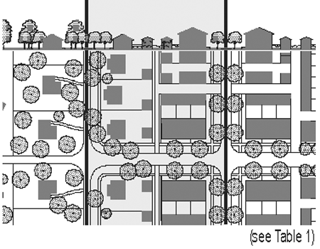
The legend on the map set forth below (See Section 2.2.2) illustrates the zone and other applicable designations for the regulating plan for the Lakefront Downtown Development District.
2.2.2
Map of Zone and other designations for the Lakefront Downtown Development District.
2.3
Specific to Sub-Urban Transect Zone (T3)
2.3.1
Building Disposition (T3)
a.
Newly platted lots shall be dimensioned according to Section 2.3.8.
b.
Buildings shall be disposed in relation to the boundaries of their lots according to Section 2.3.8.
c.
One Principal Building at the Frontage, and one Outbuilding to the rear of the Principal Building, may be built on each lot as shown in Table 10C.
d.
Lot coverage by building shall not exceed that shown in Section 2.3.8.
e.
Facades shall be built parallel to a rectilinear Principal Frontage Line or parallel to the tangent of a curved Principal Frontage Line.
f.
Setbacks for Principal Buildings shall be as shown in Section 2.3.8. Setbacks may be adjusted by Warrant.
g.
Rear Setbacks for Outbuildings shall be a minimum of 15 feet measured from the centerline of the Alley or Rear Lane easement. In the absence of Rear Alley or Lane, the rear Setback shall be as shown in Section 2.3.8.
h.
Building Types shall be as shown in Table 2.
i.
(Reserved)
j.
(Reserved)
2.3.2
Building Configuration (T3)
a.
Private Frontage types shall conform to and be allocated in accordance with Table 4 and Section 2.3.8.
b.
(Reserved)
c.
(Reserved)
d.
Building Heights shall be as shown in Section 2.3.8.
e.
(Reserved)
f.
All specified Building Heights may be increased by the difference between the actual Lot elevation and the base elevations required by applicable FEMA standards, provided that any first level space shall be designed for use as (i) parking or storage space set into the structure into the second and deeper Layers, concealed from view of all streets, or (ii) a loggia or porch or combination thereof, or other open-air area for recreation, relaxation or gathering.
2.3.3
Building Function and Density (T3)
a.
Buildings in each Transect Zone shall conform to the Functions described in Tables 5 or 7 and Section 2.3.8.
b.
(Reserved)
2.3.4
Parking Standards (T3)
a.
Vehicular parking shall be required and adjusted for mixed-use as shown in Tables 5 and 6.
b.
On-street parking available along the Frontage Lines that correspond to each lot shall be counted toward the parking requirement of the building on the lot.
c.
Maximum parking ratios may be established by the DDA.
d.
Parking shall be accessed by the Alley or Rear Lane, when such are available on the Community Plan.
e.
Parking lots shall be masked from the Frontage by a Liner Building or Streetscreen as specified in Section 2.3.5b.
f.
Open parking areas shall be located at the Second and Third Lot Layers, as shown in Table 10D, except that Driveway aprons and drop-offs may be located at the First Layer. Garages shall be located at the Third Layer.
g.
The required parking may be provided within one-quarter mile of the site that it serves, subject to approval by Variance.
h.
(Reserved)
i.
(Reserved)
j.
(Reserved)
2.3.5
Architectural Standards (T3)
a.
Building wall materials may be combined on each Facade only horizontally, with the heavier below the lighter.
b.
Streetscreens should be between 3.5 and 8 feet in height and constructed of a material matching the adjacent building Facade. The Streetscreen may be replaced by a hedge or fence by Warrant. Streetscreens shall have openings no larger than necessary to allow automobile and pedestrian access.
c.
All openings, including porches, galleries, arcades and windows, with the exception of storefronts, shall be square or vertical in proportion.
d.
Openings above the first Story shall not exceed 50 per cent of the total building wall area, with each Facade being calculated independently.
e.
(Reserved)
f.
Doors and windows that operate as sliders are prohibited along Frontages.
g.
Buildings shall have pitched roofs. Pitched roofs shall be symmetrically sloped no less than 5:12, except that porches and attached sheds may be no less than 2:12.
h.
The exterior finish material on all Facades shall be limited to brick, wood siding, cementitious siding and/or stucco.
i.
Balconies and porches shall be made of painted wood.
j.
Fences, if provided at the First Layer shall be painted. Fences at the Third Layer may be of wood board or chain link.
2.3.6
Landscape Standards (T3)
a.
A minimum of one tree to match the species of street trees on the Public Frontage shall be planted within the First Layer for each 30 feet of Frontage Line as illustrated in Tables 10D.
b.
(Reserved)
c.
(Reserved)
d.
Trees shall be of various species, naturalistically clustered, as well as an understory stall below for maintenance. Lawn shall be permitted by Warrant.
2.3.7
Signage Standards (T3)
a.
One address number no more than six inches measured vertically shall be attached to the building in proximity to the principal entrance or at a mailbox.
b.
One blade sign for each business may be permanently installed perpendicular to the Facade. Each shall not exceed four square feet.
c.
(Reserved)
d.
There shall be no signage permitted additional to that specified in this section.
e.
Signage shall not be lit.
2.3.8
[Tables]
Parking Provisions
See Tables 5 and 6
* or 15 ft. from center line of alley
Graphics are illustrative only. Please refer to actual metrics for setback and height information.
"N" stands for any stories above those shown, up to the maximum. Refer to metrics for exact minimums and maximums.
| Building Height | ||
|---|---|---|
| 1. | Building height shall be measured in number of stories, excluding a raised basement, or inhabited attic. | 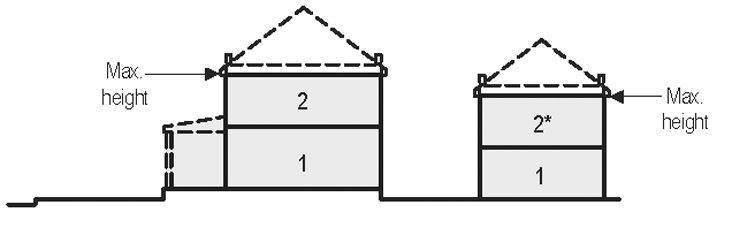 |
| 2. | Each story shall not exceed 14 feet clear, floor to ceiling. | |
| 3. | Maximum height shall be measured to the eave or roof deck. | |
| Building Disposition | ||
|---|---|---|
| 1. | The facades and elevations of principal buildings shall be distanced from the lot lines as shown. | 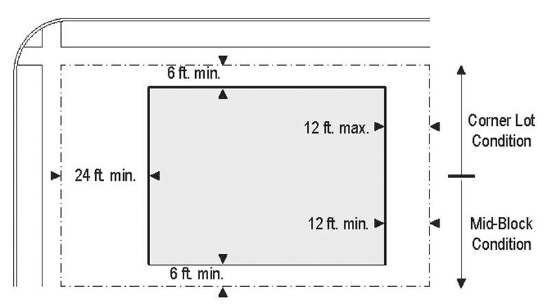 |
| 2. | Facades shall be built along the principal frontage to a minimum of 50 cent of its width. | |
| Outbuilding Disposition | ||
|---|---|---|
| 1. | The elevation of the out buildings shall be distanced from the lot lines as shown. | 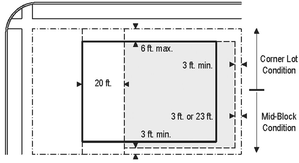 |
| Parking Placement | ||
|---|---|---|
| 1. | Uncovered parking spaces may be provided within the 2nd and 3rd Layer as shown in the diagram (see Table 10D). |  |
| 2. | Covered parking shall be provided within the 3rd Layer as shown in the diagram (see Table 10D). | |
| 3. | Trash containers shall be stored within the 3rd Layer. | |
2.4
Specific to General Urban Transect Zones (T4)
2.4.1
Building Disposition (T4)
a.
Newly platted lots shall be dimensioned according to Section 2.4.8.
b.
Buildings shall be disposed in relation to the boundaries of their lots according to Section 2.4.8.
c.
One Principal Building at the Frontage, and one Outbuilding to the rear of the Principal Building, may be built on each lot as shown in Table 10C.
d.
Lot coverage by building shall not exceed that shown in Section 2.4.8.
e.
Facades shall be built parallel to a rectilinear Principal Frontage Line or parallel to the tangent of a curved Principal Frontage Line.
f.
Setbacks for Principal Buildings shall be as shown in Section 2.4.8. In the case of an Infill lot, Setbacks shall match one or the other of the existing adjacent Setbacks. Setbacks may otherwise be adjusted by Warrant.
g.
Rear Setbacks for Outbuildings shall be a minimum of 15 feet measured from the centerline of the Alley or Rear Lane easement. In the absence of Rear Alley or Lane, the rear Setback shall be as shown in Section 2.4.8.
h.
Building Types shall be as shown in Table 2.
i.
A minimum Residential housing mix of three Types (none less than 20 per cent) shall be required in the General Urban Zone, selected from Table 2.
j.
Reserved.
2.4.2
Building Configuration (T4)
a.
Private Frontage types shall conform to and be allocated in accordance with Table 4 and Section 2.4.8.
b.
Awnings may encroach the public sidewalk without limit. Stoops may encroach 100 per cent of the depth of a Setback. Open porches and awnings may encroach up to 50 per cent of the depth of the Setback. Balconies and bay windows may encroach up to 25 per cent of the depth of the Setback.
c.
Loading docks and service areas shall be permitted on Frontages only by Warrant.
d.
Building Heights shall be as shown in Section 2.4.8.
e.
Reserved.
f.
All specified Building Heights may be increased by the difference between the actual Lot elevation and the base elevations required by applicable FEMA standards, provided that any first level space shall be designed for use as (i) parking or storage space set into the structure into the second and deeper Layers, concealed from view of all streets, (ii) an open market, a loggia or porch or combination thereof, or other open-air area for recreation, relaxation or gathering, (iii) enclosed commercial or retail space to the extent permitted by applicable FEMA requirements, or other use permitted by the Planning Office.
2.4.3
Building Function and Density (T4)
a.
Buildings in each Transect Zone shall conform to the Functions described in Tables 5 or 7 and Section 2.4.8.
b.
Accessory uses of Limited Lodging or Limited Office shall be permitted within an Outbuilding.
2.4.4
Parking Standards (T4)
a.
Vehicular parking shall be required as shown in Tables 5 and 6.
b.
On-street parking available along the Frontage Lines that correspond to each lot shall be counted toward the parking requirement of the building on the lot.
c.
Maximum Parking ratios may be established by the CRC.
d.
Parking shall be accessed by the Alley or Rear Lane, when such are available on the Community Plan.
e.
Parking lots shall be masked from the Frontage by a Liner Building or Streetscreen as specified in Section 2.4.5b.
f.
All parking areas except for Driveways shall be located at the Third Layer as illustrated in Table 10D. Garages shall be at the Third Layer.
g.
The required parking may be provided within one-quarter mile of the site that it serves, subject to approval by Variance.
h.
Reserved.
i.
Reserved.
j.
A minimum of one bicycle rack place shall be provided within the Public or Private Frontage for every ten vehicular parking spaces.
2.4.5
Architectural Standards (T4)
a.
Building wall materials may be combined on each Facade only horizontally, with the heavier below the lighter.
b.
Streetscreens should be between 3.5 and eight feet in height and constructed of a material matching the adjacent building Facade. The Streetscreen may be replaced by a hedge or fence by Warrant. Streetscreens shall have openings no larger than necessary to allow automobile and pedestrian access.
c.
All openings, including porches, galleries, arcades and windows, with the exception of storefronts, shall be square or vertical in proportion.
d.
Openings above the first Story shall not exceed 50 per cent of the total building wall area, with each Facade being calculated independently.
e.
(Reserved)
f.
Doors and windows that operate as sliders are prohibited along Frontages.
g.
Buildings shall have pitched roofs. Pitched roofs shall be symmetrically sloped no less than 5:12, except that porches and attached sheds may be no less than 2:12.
h.
The exterior finish materials on all Facades shall be limited to brick, clapboard, siding, cementitious siding and/or stucco.
i.
Balconies and porches shall be made of painted wood or metal.
j.
Fences, if provided within the First Lot Layer, shall be painted. Fences at other Layers may be of wood board or chain link.
2.4.6
Landscape Standards (T4)
a.
A minimum of one tree to match the species of street trees on the Public Frontage shall be planted within the First Layer for each 30 feet of Frontage Line as illustrated in Table 10D.
b.
(Reserved)
c.
(Reserved)
d.
Trees of species matching the planting on the Public Frontage. Lawn shall be permitted.
2.4.7
Signage Standards (T4)
a.
One address number no more than six inches measured vertically shall be attached to the building in proximity to the principal entrance or at a mailbox.
b.
One blade sign for each business may be permanently installed perpendicular to the Facade. Each shall not exceed four square feet.
c.
(Reserved)
d.
There shall be no signage permitted additional to that specified in this section.
2.4.8
Reserved
2.4.9
[Tables]
Parking Provisions
See Tables 5 and 6
* or 15 ft. from center line of alley
Graphics are illustrative only. Please refer to actual metrics for setback and height information.
"N" stands for any stories above those shown, up to the maximum. Refer to metrics for exact minimums and maximums.
| Building Height | ||
|---|---|---|
| 1. | Building height shall be measured in number of stories, excluding a raised basement, or inhabited attic. |  |
| 2. | Each story shall not exceed 14 feet clear, floor to ceiling. | |
| 3. | Maximum height shall be measured to the eave or roof deck. | |
| Building Disposition | ||
|---|---|---|
| 1. | The facades and elevations of principal buildings shall be distanced from the lot lines as shown. |  |
| 2. | Facades shall be built along the principal frontage to a minimum of 60 per cent of its width. | |
| Outbuilding Placement | ||
|---|---|---|
| 1. | The elevations of the out buildings shall be distances from the lot lines as shown. | 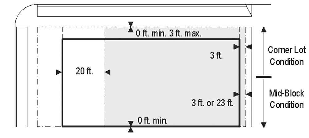 |
| Parking Provisions | ||
|---|---|---|
| 1. | Uncovered parking spaces may be provided within the 3rd Layer as shown in the diagram (see Table 10D). | 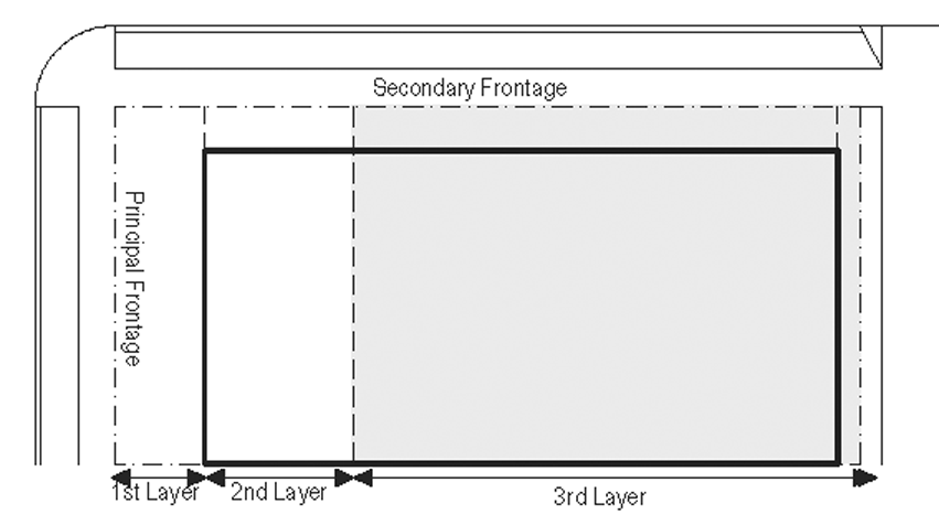 |
| 2. | Covered parking shall be provided within the 3rd Layer as shown in the diagram (see Table 10D). | |
| 3. | Trash containers shall be stored within the 3rd Layer. | |
2.5
Specific to Urban Center Transect Zones (T5)
2.5.1
Building Disposition (T5)
a.
Newly platted lots shall be dimensioned according to Section 2.5.8.
b.
Buildings shall be disposed in relation to the boundaries of their lots according to Section 2.5.8.
c.
One principal building at the Frontage, and one outbuilding to the rear of the principal building, may be built on each lot as shown in Table 10C.
d.
Lot coverage by building shall not exceed that shown in Section 2.5.8.
e.
Facades shall be built parallel to the Principal Frontage Line along a minimum of 70 per cent of its length on the Setback shown in Section 2.5.8. In the absence of a building along the remainder of the Frontage Line, a Streetscreen shall be built co-planar with the Facade.
f.
Setbacks for Principal Buildings shall be as shown in Section 2.5.8. Setbacks may be adjusted by Warrant.
g.
Rear Setbacks for Outbuildings shall be a minimum of 15 feet measured from the centerline of the Alley or Rear Lane easement. In the absence of Rear Alley or Lane, the rear Setback shall be as shown in Section 2.5.8.
h.
Building Types shall be as shown in Table 2.
i.
(Reserved)
j.
Buildings shall have their principal pedestrian entrances on a Frontage Line.
2.5.2
Building Configuration (T5)
a.
Private Frontage types shall conform to and be allocated in accordance with Table 4 and Section 2.5.8.
b.
Awnings may encroach the public sidewalk without limit. Stoops may encroach 100 per cent of the depth of a Setback. Open porches and awnings may encroach up to 50 per cent of the depth of the Setback. Balconies and bay windows may encroach up to 25 per cent of the depth of the Setback.
c.
Loading docks and service areas shall be permitted on Frontages only by Warrant.
d.
Building Heights shall be as shown in Section 2.5.8.
e.
A first level Residential or Lodging Function shall be raised a minimum of two feet from average sidewalk grade.
f.
All specified Building Heights may be increased by the difference between the actual Lot elevation and the base elevations required by applicable FEMA standards, provided that any first level space shall be designed for use as (i) parking or storage space set into the structure into the second and deeper Layers, concealed from view of all streets, (ii) an open market, a loggia or porch or combination thereof, or other open-air area for recreation, relaxation or gathering, (iii) enclosed commercial or retail space to the extent permitted by applicable FEMA requirements, or other use permitted by the Planning Office.
2.5.3
Building Function and Density (T5)
a.
Buildings in each Transect Zone shall conform to the Functions described in Tables 5 or 7 and Section 2.5.8. Functions that do not conform to the requirements of Tables 5 and 7 shall require approval by Warrant.
b.
Accessory uses of Limited Lodging or Limited Office shall be permitted within an outbuilding.
c.
First story Commercial shall be permitted throughout and shall be required at Mandatory Shopfront Frontages.
d.
Manufacturing within the first Story may be permitted by Variance.
2.5.4
Parking Standards (T5)
a.
Vehicular parking shall be required as shown in Tables 5 and 6.
b.
On-street parking available along the Frontage Lines that correspond to each lot shall be counted toward the parking requirement of the building on the lot.
c.
Maximum Parking ratios may be established by the CRC.
d.
Parking shall be accessed by the Alley or Rear Lane when such is available in the Community Plan.
e.
Parking lots shall be masked from the Frontage by a Liner Building or Streetscreen as specified in Section 2.5.5b.
f.
All parking areas shall be located at the Third Lot Layer.
g.
The required parking may be provided within one-quarter mile of the site that it serves, subject to approval by Variance.
h.
The vehicular entrance of a parking lot or garage on a Frontage shall be no wider than 30 feet.
i.
Pedestrian entrances to all parking lots and parking structures shall be directly from a Frontage Line. Only underground parking structures may be entered by pedestrians directly from a Principal Building.
j.
A minimum of one bicycle rack place shall be provided within the Public or Private Frontage for every ten vehicular parking spaces.
2.5.5
Architectural Standards (T5)
a.
Building wall materials may be combined on each Facade only horizontally, with the heavier below the lighter.
b.
Streetscreens should be between 3.5 and eight feet in height and constructed of a material matching the adjacent building Facade. The Streetscreen may be replaced by a hedge or fence by Warrant. Streetscreens shall have openings no larger than necessary to allow automobile and pedestrian access.
c.
All openings, including porches, galleries, arcades and windows, with the exception of storefronts, shall be square or vertical in proportion.
d.
Openings above the first Story shall not exceed 50 per cent of the total building wall area, with each Facade being calculated independently.
e.
The Facades on Retail Frontages shall be detailed as storefronts and glazed with clear glass no less than 70 per cent of the sidewalk-level story.
f.
Doors and windows that operate as sliders are prohibited along Frontages.
g.
Buildings may have flat roofs enclosed by parapets or pitched roofs. Pitched roofs shall be symmetrically sloped no less than 5:12, except that porches and attached sheds may be no less than 2:12.
h.
The exterior finish materials on all Facades shall be limited to stone, brick and/or stucco.
i.
Balconies, galleries and arcades shall be made of concrete, painted wood or metal.
j.
Streetscreens shall be located coplanar with the building Facade line as shown in Table 10D.
2.5.6
Landscape Standards (T5)
a.
A minimum of one tree to match the species of street trees on the Public Frontage shall be planted within the First Layer for each 30 feet of Frontage Line as illustrated in Table 10D.
b.
(Reserved)
c.
The First Layer as shown in Table 10D shall be landscaped or paved to match the enfronting Public Frontage.
d.
Trees shall be a species with shade canopies that, at maturity, remain clear of building Frontages.
2.5.7
Signage Standards (T5)
a.
One address number no more than six inches measured vertically shall be attached to the building in proximity to the principal entrance or at a mailbox.
b.
One blade sign for each business entrance may be permanently installed perpendicular to the Facade. Each shall not exceed six square feet.
c.
(Reserved)
d.
A single external sign band may be applied to the Facade of each building, providing that such sign not exceed three feet in height by any length.
e.
Signage shall be externally lit, except that signage within the shopfront glazing may be neon lit.
2.5.8
Reserved
2.5.9
[Tables]
Parking Provisions
See Tables 5 and 6
* or 15 feet from center line of alley
Graphics are illustrative only. Please refer to actual metrics for setback and height information.
"N" stands for any stories above those shown, up to the maximum. Refer to metrics for exact minimums and maximums.
| Building Height | ||
|---|---|---|
| 1. | Building height shall be measured in number of stories, excluding a raised basement, or inhabited attic. | 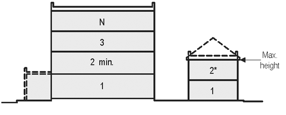 |
| 2. | Each story shall not exceed 14 feet clear, floor to ceiling. | |
| 3. | Maximum height shall be measured to the eave or roof deck. | |
| Building Disposition | ||
|---|---|---|
| 1. | The facades and elevations of a building shall be distanced from the frontage and lot lines as shown. | 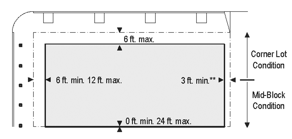 |
| 2. | Facades shall be built along the principal frontage to a minimum of 70 per cent of its width. | |
| Outbuilding Disposition | ||
|---|---|---|
| 1. | The elevations of the out buildings shall be distances from the lot lines as shown. | 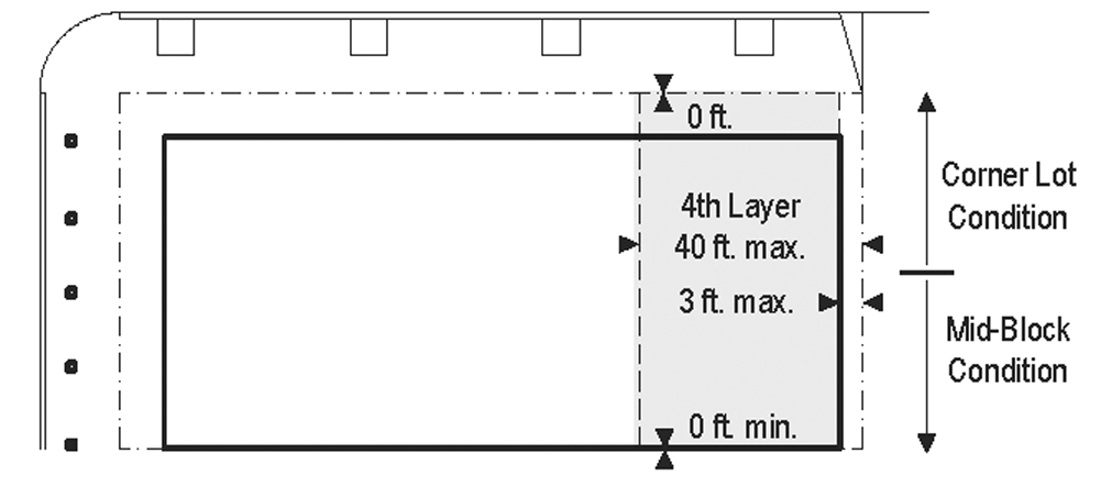 |
| Parking Provisions | ||
|---|---|---|
| 1. | Uncovered parking spaces may be provided within the 3rd Layer as shown in the diagram (see Table 10D). | 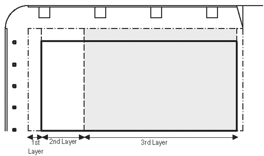 |
| 2. | Covered parking shall be provided within the 3rd Layer as shown in the diagram (see Table 10D). | |
| 3. | Trash containers shall be stored within the 3rd Layer as shown in the diagram (see Table 10D). | |
2.6
Specific to Urban Core Transect Zones (T6)
2.6.1
Building Disposition (T6)
a.
Newly platted lots shall be dimensioned according to Section 2.6.8.
b.
Buildings shall be disposed in relation to the boundaries of their lots according to Section 2.6.8.
c.
One principal building at the Frontage, and one outbuilding to the rear of the prinicipal building, may be built on each lot as shown in Table 10C.
d.
Lot coverage by building shall not exceed that shown in Section 2.6.8.
e.
Facades shall be built parallel to the Principal Frontage Line along a minimum of 80 per cent of its length on the Setback shown in Section 2.6.8. In the absence of building along the remainder of the Frontage Line, a Streetscreen shall be built co-planar with the Facade.
f.
Setbacks for Principal Buildings shall be as shown in Section 2.6.8. Setbacks shall match one or the other of the existing adjacent Setbacks. Setbacks may otherwise be adjusted by Warrant.
g.
[Reserved]
h.
Building Types shall be as shown in Table 2.
i.
[Reserved]
j.
Buildings shall have their principal pedestrian entrances on a Frontage Line.
2.6.2
Building Configuration (T6)
a.
Private Frontage types shall conform to and be allocated in accordance with Table 4 and Section 2.6.8.
b.
Awnings may encroach the public sidewalk without limit. Stoops may encroach 100 per cent of the depth of a Setback. Open porches and awnings may encroach up to 50 per cent of the depth of the Setback. Balconies and bay windows may encroach up to 25 per cent of the depth of the Setback.
c.
Loading docks and service areas shall be permitted on Frontages only by Warrant.
d.
Building Heights shall be as shown in Section 2.6.8.
e.
A first level Residential Function or Lodging Function shall be raised a minimum of two feet from average sidewalk grade.
f.
All specified Building Heights may be increased by the difference between the actual Lot elevation and the base elevations required by applicable FEMA standards, provided that any first level space shall be designed for use as (i) parking or storage space set into the structure into the second and deeper Layers, concealed from view of all streets, (ii) an open market, a loggia or porch or combination thereof, or other open-air area for recreation, relaxation or gathering, (iii) enclosed commercial or retail space to the extent permitted by applicable FEMA requirements, or other use permitted by the Planning Office.
2.6.3
Building Function and Density (T6)
a.
Buildings in each Transect Zone shall conform to the Functions described in Tables 5 or 7 and Section 2.6.8. Functions that do not conform to the requirements of Tables 5 or 7 shall require approval by Variance.
b.
The Actual Parking available to meet the Required Parking shown on Table 5 shall constitute the Base Density. Functions shall be limited by the Base Density, subject to upward adjustment in accordance with paragraphs 2.6.3c and 2.6.3d.
c.
First story Commercial shall be permitted throughout and shall be required at Mandatory Shopfront Frontages.
d.
Manufacturing within the first story shall be permitted by Variance.
2.6.4
Parking Standards (T6)
a.
Vehicular parking shall be required as shown in Tables 5 and 6.
b.
On-street parking available along the Frontage Lines that correspond to each lot shall be counted toward the parking requirement of the building on the lot.
c.
Maximum Parking ratios may be established by the CRC.
d.
Parking shall be accessed by the Alley or Rear Lane, when such are available on the Community Plan.
e.
Parking lots shall be masked from the Frontage by a Liner Building or Streetscreen as specified in Section 2.6.5b.
f.
All parking areas shall be located at the Third Lot Layer.
g.
The required parking may be provided within one-quarter mile of the site that it serves, subject to approval by Warrant.
h.
The vehicular entrance of a parking lot or garage on a Frontage shall be no wider than 30 feet.
i.
Pedestrian entrances to all parking lots and parking structures shall be directly from a Frontage Line. Only underground parking structures may be entered by pedestrians directly from a Principal Building.
j.
A minimum of one bicycle rack place shall be provided within the Public or Private Frontage for every ten vehicular parking spaces.
k.
For buildings on Secondary Grids (S-Grids), parking lots may be allowed on the Frontage by Warrant.
2.6.5
Architectural Standards (T6)
a.
Building wall materials may be combined on each Facade only horizontally, with the heavier below the lighter.
b.
Streetscreens should be between 3.5 and eight feet in height and constructed of a material matching the adjacent building Facade. The Streetscreen may be replaced by a hedge or fence by Warrant. Streetscreens shall have openings no larger than necessary to allow automobile and pedestrian access.
c.
All openings, including porches, galleries, arcades and windows, with the exception of storefronts, shall be square or vertical in proportion.
d.
Openings above the first Story shall not exceed 50 per cent of the total building wall area, with each Facade being calculated independently.
e.
The Facades on Retail Frontages shall be detailed as storefronts and glazed with clear glass no less than 70 per cent of the sidewalk-level story.
f.
Doors and windows that operate as sliders are prohibited along Frontages.
g.
Buildings may have flat roofs enclosed by parapets or pitched roofs. Pitched roofs shall be symmetrically sloped no less than 5:12, except that porches and attached sheds may be no less than 2:15.
h.
The exterior finish materials on all Facades shall be limited to stone, brick and/or stucco.
i.
Balconies, galleries and arcades shall be made of concrete, painted wood or metal.
j.
Streetscreens shall be located coplanar with the Facades as shown in Table 10C.
2.6.6
Landscape Standards (T6)
a.
A minimum of one tree to match the species of street trees on the Public Frontage shall be planted within the First Layer for each 30 feet of Frontage Line as illustrated in Table 10D.
b.
[Reserved]
c.
The First Layer shall be landscaped or paved to match the Public Frontage as shown in Table 10D.
d.
Trees shall be a species with shade canopies that, at maturity, remain clear of building Frontages.
e.
Trees shall not be required in the First Layer (Table 10D).
2.6.7
Signage Standards (T6)
a.
One address number no more than six inches measured vertically shall be attached to the building in proximity to the principal entrance or at a mailbox.
b.
Blade signs, not to exceed six square feet for each separate business entrance, may be attached perpendicular to the Facade.
c.
[Reserved]
d.
A single external sign band may be applied to the Facade of each building, provided that such sign does not exceed three feet in height by any length.
e.
Signage shall be externally lit, except that signage within the shopfront glazing may be neon lit.
2.6.8
Reserved
2.6.9
[Tables]
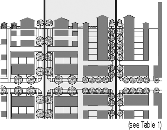
Parking Provisions
See Tables 5 and 6
* or 15 ft. from center line of alley
Graphics are illustrative only. Please refer to actual metrics for setback and height information.
"N" stands for any stories above those shown, up to the maximum. Refer to metrics for exact minimums and maximums.
| Building Height | ||
|---|---|---|
| 1. | Building height shall be measured in number of stories, not including a raised basement, or inhabited attic. |  |
| 2. | Each story shall not exceed 14 feet clear, floor to ceiling. | |
| 3. | Maximum height shall be measured to the eave or roof deck. | |
| Building Disposition | ||
|---|---|---|
| 1. | The facades and elevations of a building shall be distanced from the frontage and lot lines as shown. |  |
| 2. | Facades shall be built along the principal frontage to a minimum of 80 per cent of its width. | |
| Parking Provisions | ||
|---|---|---|
| 1. | Uncovered parking spaces may be provided within the 3rd Layer as shown in the diagram (see Table 10D). |  |
| 2. | Covered parking shall be provided within the 3rd Layer as shown in the diagram (see Table 10D). | |
| 3. | Trash containers shall be stored within the 3rd Layer as shown in the diagram (see Table 10D). | |
2.7
Civic Functions
2.7.1
General
a.
Community Plans shall designate, or allow by Warrant or Variance, Civic Space (CS) and Civic Building (CB).
b.
(Reserved)
c.
Parking for Civic Functions shall be determined by Warrant.
2.7.2
Civic Space (CS)
a.
Civic Spaces may be approved by Warrant in any Transect Zone.
b.
Civic Spaces shall be generally designed as described in Table 8.
2.7.3
Civic Building (CB)
a.
Civic Buildings shall be approved by Warrant or Variance in any Transect Zone, on sites reserved for them.
b.
Civic Buildings shall not be subject to the Requirements of the Building Scale Code. The particulars of their design shall be determined by Variance.
2.8
Special Requirements
2.8.1
A Community Plan may designate the following special requirements:
a.
A differentiation of the Thoroughfares as a Primary-Grid (P-Grid) and a Secondary-Grid (S-Grid). Buildings along the P-Grid shall be held to the highest standard of this Code in support of pedestrian activity. Buildings along the S-Grid may be more readily considered for Warrants and Variances allowing automobile-oriented standards. The Frontages assigned to the S-Grid shall not exceed 30 per cent of the total length within a Pedestrian Shed.
b.
A designation for Mandatory or Recommended Retail Frontage requiring that a building provide a Shopfront at sidewalk level along the entire length of the Frontage. The Shopfront shall be no less than 70 per cent glazed in clear glass and provided with an awning overlapping the sidewalk as generally illustrated in Table 4. The first floor shall be confined to Retail use through the depth of the First Layer.
c.
A designation for mandatory or recommended Gallery Frontage, requiring that a building provide a permanent cover over the sidewalk, either cantilevered or supported by columns. The Gallery Frontage may be combined with a Retail Frontage as shown in Table 4.
d.
A designation of Coordinated Streetscape Frontage, requiring that the Public and Private Frontages be coordinated as a single, coherent landscape and paving design.
e.
A designation of Terminated Vista location, requiring that the building be provided with architectural articulation of a type and character that responds to the location as approved by the CRC.
f.
A designation for Cross Block Passages, requiring a minimum eight-foot-wide pedestrian access be reserved between buildings.
g.
A designation of Buildings of Value, requiring that such buildings and structures may be altered or demolished only when in accordance with the historic preservation regulations of the City of Lake Charles.
Article 3. Standards and Tables
Table 1: Transect Zone Descriptions. This table provides description of the character of each Transect Zone.
| T3 The Sub-Urban Zone, consists of low density suburban residential areas, differing by allowing home occupations. Planting is naturalistic with setbacks relatively deep. Blocks may be large and the roads irregular to accommodate natural conditions. |  |
| T4 The General Urban Zone consists of a mixed-use but primarily residential urban fabric. It has a wide range of building types: single, sideyard, and rowhouses. Setbacks and landscaping are variable. Streets typically define medium-sized blocks. | 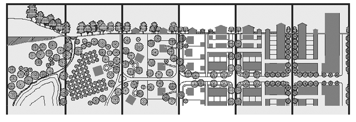 |
| T5 The Urban Center Zone consists of higher density mixed-use building types that accommodate retail, offices, rowhouses and apartments. It has a tight network of streets, with wide sidewalks, steady street tree planting and buildings set close to the frontages. | 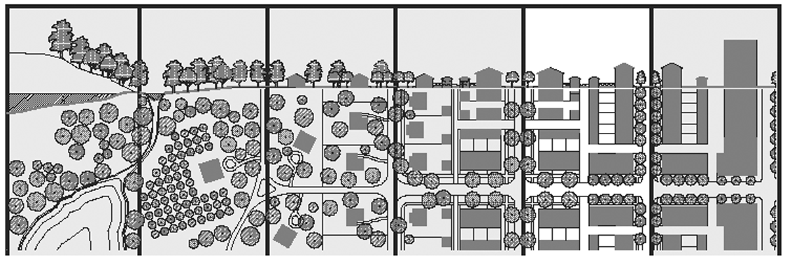 |
| T6 The Urban Core Zone consists of the highest density, with the greatest variety of uses, and civic buildings of regional importance. It may have larger blocks; streets have steady street tree planting and buildings set close to the frontages. | 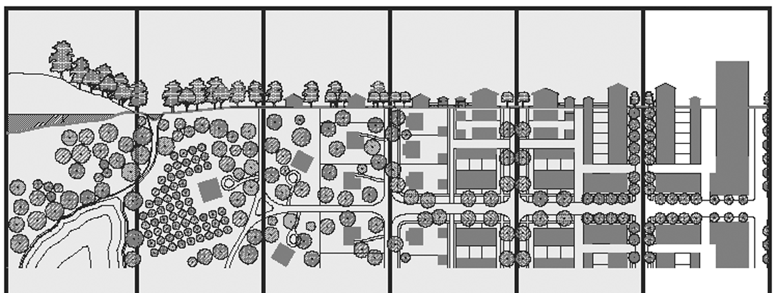 |
Table 2: Building Types. This table approximates the location of the structure relative to the boundaries of each individual lot, establishing suitable building types for each Transect Zone.
| a. | Edgeyard: Specific Types - Single family House, Cottage, Villa, Estate House, Urban Villa. A building that occupies the center of its lot with Setbacks on all sides. This is the least urban of types as the front yard sets it back from the frontage, while the side yards weaken the spatial definition of the public Thoroughfare space. The front yard is intended to be visually continuous with the yards of adjacent buildings. The rear yard can be secured for privacy by fences and a well-placed Backbuilding and/or Outbuilding. | 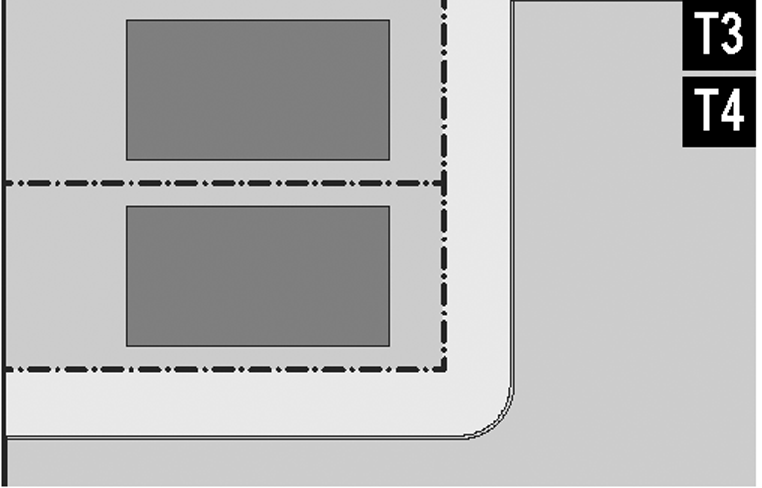 |
| b. | Sideyard: Specific Types - Charleston Single House, zero-lot-line house. A building that occupies one side of the lot with the Setback to the other side. The visual opening of the side yard on the street frontage causes this building type to appear freestanding. A shallow frontage Setback defines a more urban condition. If the adjacent building is similar with a blank party wall, the yard can be quite private. This type permits systematic climatic orientation in response to the sun or the breeze. | 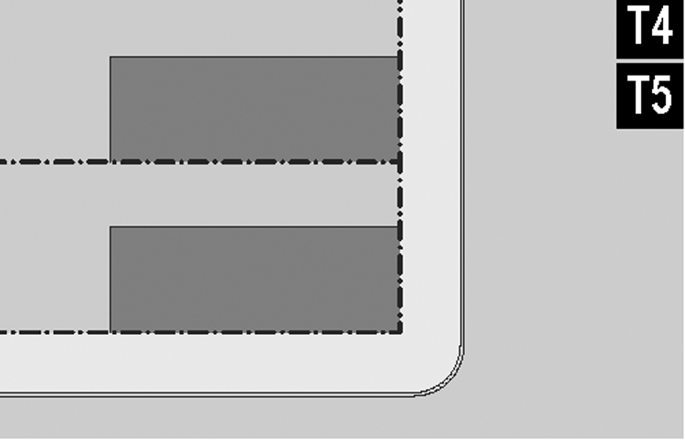 |
| c. | Rearyard: Specific Types - Townhouse, Rowhouse, Live-Work unit, perimeter block. A building that occupies the full frontage, leaving the rear of the lot as the sole yard. This is a very urban type as the continuous Facade steadily defines the public Thoroughfare. The rear Elevations may be articulated for functional purposes. In its Residential form, this type is the Rowhouse. For its Commercial form, the rear yard can accommodate substantial parking. | 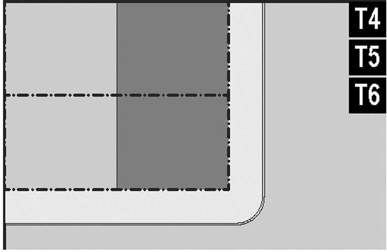 |
| d. | Courtyard: Specific Types - Patio House. A building that occupies the boundaries of its lot while internally defining one or more private patios. This is the most urban of types, as it is able to shield the private realm from all sides while strongly defining the public Thoroughfare. Because of its ability to accommodate incompatible activities, masking them from all sides, it is recommended for workshops, Lodging and schools. The high security provided by the continuous enclosure is useful for crime-prone areas. | 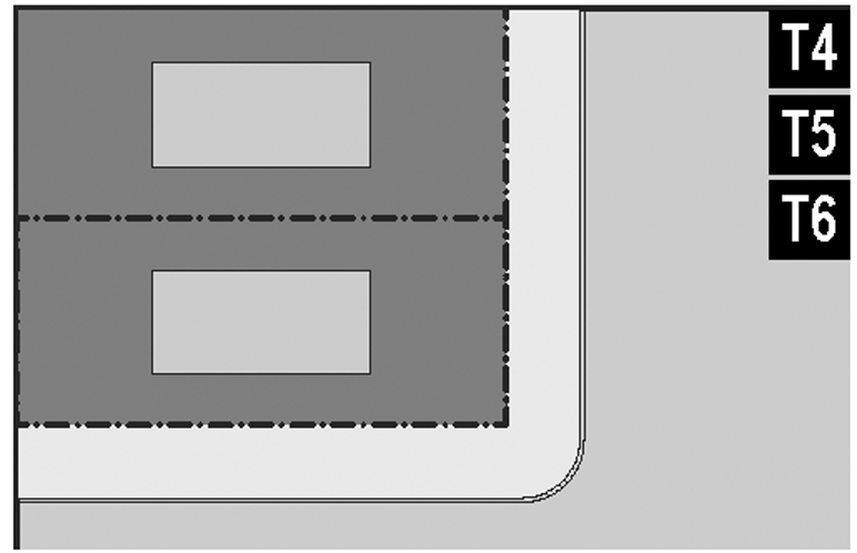 |
| e. | Specialized: A building that is not subject to categorization. Buildings dedicated to manufacturing and transportation are often distorted by the trajectories of machinery. Civic Buildings, which may express the aspirations of institutions, may be included. | 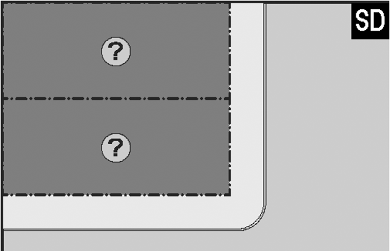 |
Table 3: Building Configuration. This table shows prescribed building heights for each Transect Zone. The vertical
extent of a building is measured by number of stories, not including a raised basement
or an inhabited attic. Heights are measured from the average grade of the frontage
line to the eave of a pitched roof or to the surface of a flat roof. The term "tower"
here refers to an attached or detached addition to a building, not to an entire building.
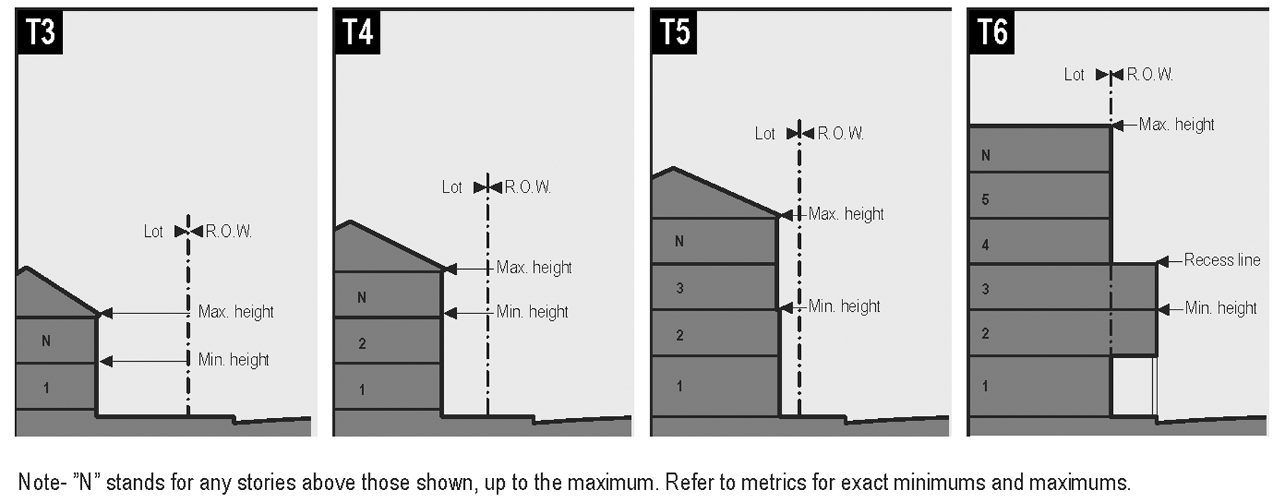
Note—"N" stands for any stories above those shown, up to the maximum. Refer to metrics for exact minimums and maximums.
Table 4: Private Frontages. The Private Frontage is the area between the building and the lot lines.
| a. | Common Yard: A frontage wherein the Facade is set back substantially from the frontage line. The front yard created remains unfenced and is visually continuous with adjacent yards, supporting a common landscape. The deep Setback provides a buffer from the higher speed Thoroughfares. | 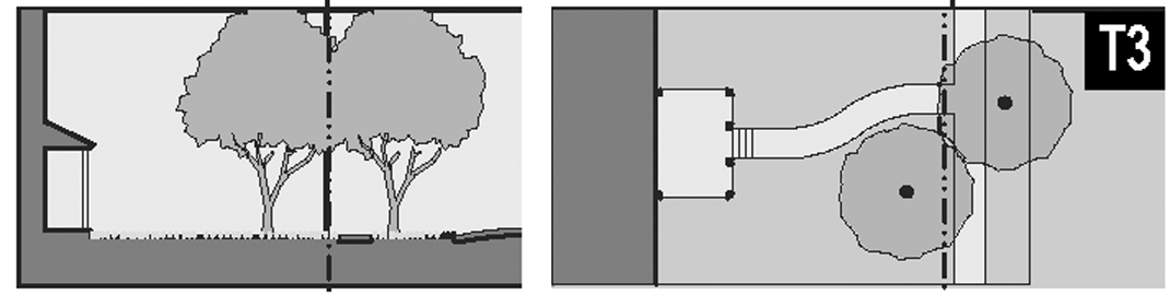 |
| b. | Porch and Fence: A frontage wherein the Facade is set back from the frontage line with an attached porch permitted to encroach. A fence at the Frontage Line maintains the demarcation of the yard. The porches shall be no less than eight feet deep. | 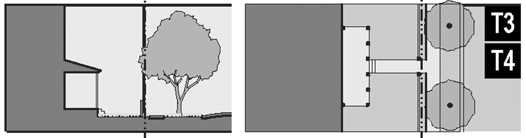 |
| c. | Terrace or Light Court: A frontage wherein the Facade is set back from the Frontage Line by an elevated terrace or a sunken light court. This type buffers Residential use from urban sidewalks and removes the private yard from public encroachment. The terrace is suitable for conversion to outdoor cafes. | 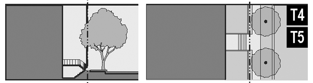 |
| d. | Forecourt: A frontage wherein a portion of the Facade is close to the Frontage Line and the central portion is set back. The forecourt created is suitable for vehicular drop-offs. This type should be allocated in conjunction with other frontage types. Large trees within the forecourts may overhang the sidewalks. |  |
| e. | Stoop: A frontage wherein the Facade is aligned close to the Frontage Line with the first story elevated from the sidewalk sufficiently to secure privacy for the windows. The entrance is usually an exterior stair and landing. This type is recommended for ground-floor Residential use. |  |
| f. | Shopfront and Awning: A frontage wherein the Facade is aligned close to the Frontage Line with the building entrance at sidewalk grade. This type is conventional for Retail use. It has a substantial glazing on the sidewalk level and an awning that may overlap the sidewalk to the maximum extent possible. | 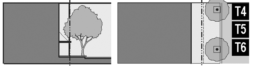 |
| g. | Gallery: A frontage wherein the Facade is aligned close to the Frontage Line with an attached cantilevered shed or a lightweight colonnade overlapping the sidewalk. This type is conventional for Retail use. The gallery shall be no less than ten feet wide and may overlap the whole width of the sidewalk to within two feet of the Curb. | 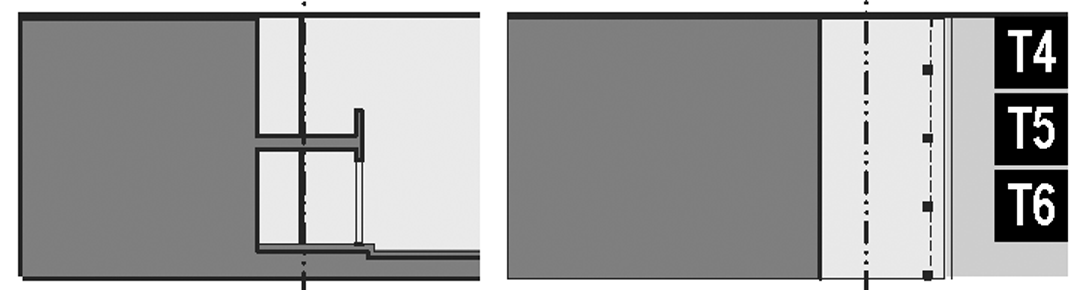 |
| h. | Arcade: A frontage wherein the Facade is a colonnade that overlaps the sidewalk, while the Facade at sidewalk level remains at the Frontage Line. This type is conventional for Retail use. The arcade shall be no less than 12 feet wide and may overlap the whole width of the sidewalk to within two feet of the curb. |  |
Table 5: Building Function—General. This table categorizes building functions within Transect Zones. For greater precision describing the functions, see Table 7.
Table 6: Parking Calculation. The Required Parking table summarizes the parking requirements of Table 5 for each site or, conversely, the amount of building allowed on each site given the parking available.
| Required Parking (See table 5) |  | |||
|---|---|---|---|---|
| T3 | T4 | T5 T6 | ||
| Residential |
2.0/
dwelling |
1.5/
dwelling |
1.0/
dwelling | |
| Lodging |
1.0/
bedroom |
1.0/
bedroom |
1.0/
bedroom | |
| Office |
3.0/
1000 sq. ft. |
3.0/
1000 sq. ft. |
2.0/
1000 sq. ft. | |
| Retail |
4.0/
1000 sq. ft. |
4.0/
1000 sq. ft. |
3.0/
1000 sq. ft. | |
| Civic | To be determined by Warrant | |||
| Other | To be determined by Warrant | |||
Table 7: Specific Function. This table expands the Building Function categories of Table 5 to delegate specific functions within Transect Zones. Table 7 should be customized for local character and requirements.
□ By right
X By warrant
Table 8: Civic Space
| a. | Park: A natural preserve available for unstructured recreation. A park may be independent of surrounding building frontages. Its landscape shall consist of paths and trails, meadows, woodland and open shelters, all naturalistically disposed. Parks may be lineal, following the trajectories of natural corridors. The minimum size shall be 15 acres. Larger parks may be approved by warrant as districts in all zones. | 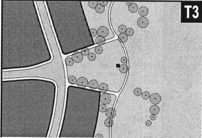 |
| b. | Green: An open space, available for unstructured recreation. A green may be spatially defined by landscaping rather than building frontages. Its landscape shall consist of lawn and trees, naturalistically disposed. The minimum size shall be two acres and the maximum shall be 15 acres. | 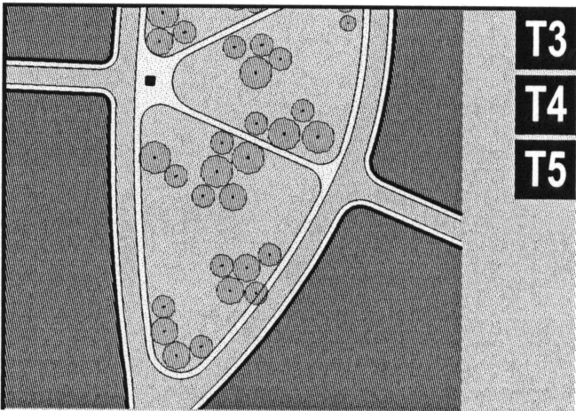 |
| c. | Square: An open space available for unstructured recreation and civic purposes. A square is spatially defined by building frontages. Its landscape shall consist of paths, lawns and trees, formally disposed. Squares shall be located at the intersection of important thoroughfares. The minimum size shall be one acre and the maximum shall be five acres. | 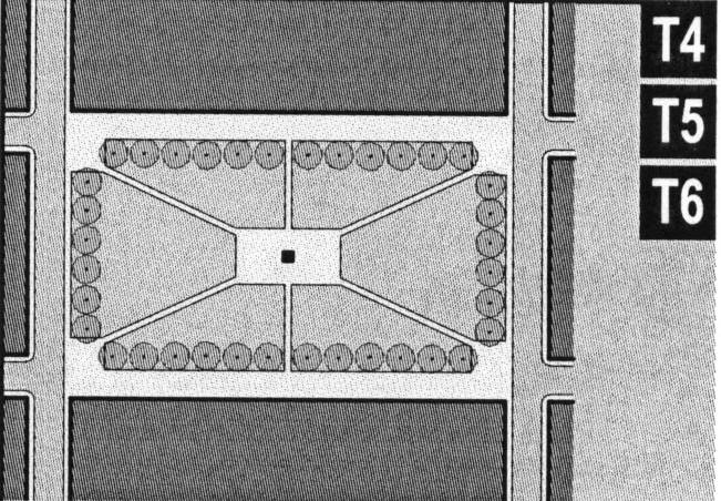 |
| d. | Plaza: An open space, available for civic purposes and commercial activities. A plaza shall be spatially defined by building frontages. Its landscape shall consist primarily of pavement. Trees are optional. Plazas shall be located at the intersection of important streets. The minimum size shall be one acre and the maximum shall be 2 acres. | 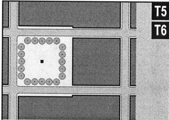 |
| e. | Playground: An open space designed and equipped for the recreation of children. A playground shall be fenced and may include an open shelter. Playgrounds shall be interspersed within residential areas and may be placed within a block. Playgrounds may be included within parks and greens. There shall be no minimum or maximum size. | 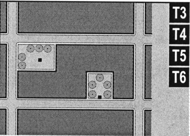 |
Table 9: Special District Summary. Special Districts (SD) are areas that cannot or should not comply with this Code. The metrics for each column of this table (SD1, SD2, etc.) are to be filled out with the details of Special Districts designated after the effective date of this Code, as each is approved. For existing Special Districts under zoning in place before the effective date of this Code, refer to the existing local codes and ordinances. More pages can be added.
Article 4. Definitions of Terms
Table 10 Definitions Illustrated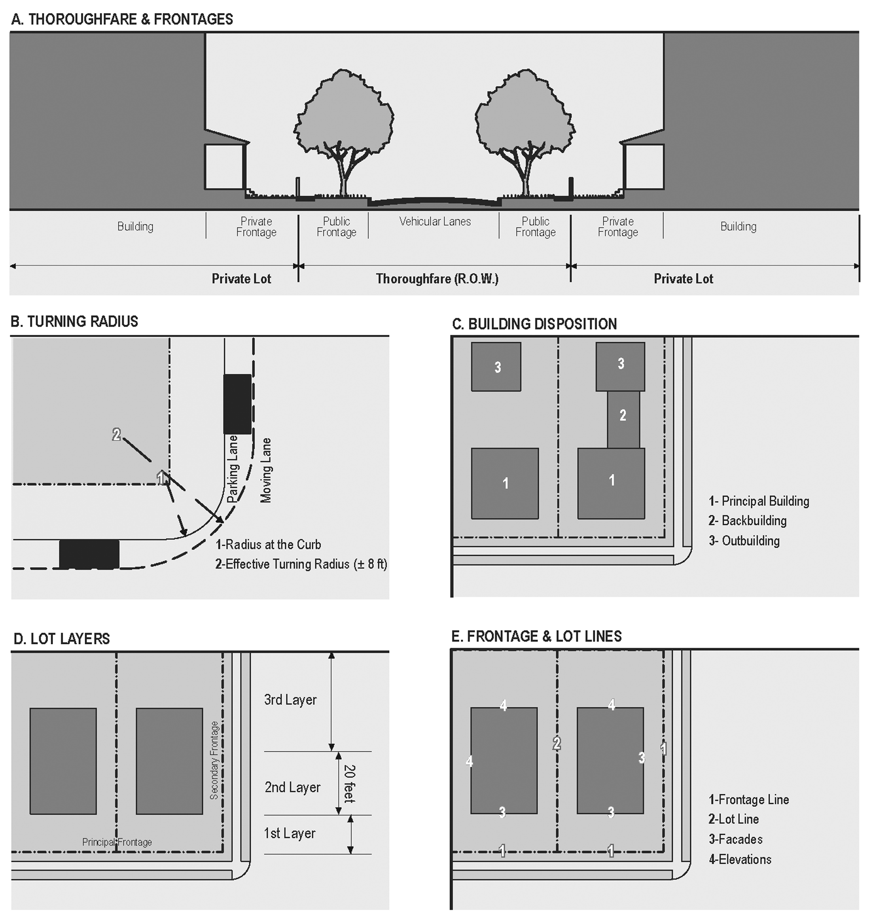
This Article provides definitions for terms in this Code that are technical in nature or that otherwise may not reflect a common usage of the term. If a term is not defined in this Article, then the Planning office shall determine the correct definition of the term.
Definitions
Affordable Housing: Dwellings consisting of rental units or for-sale units. Both shall be economically within the means of the equivalent of the starting salary of a local elementary school teacher.
Ancillary Unit: An apartment not greater than 600 square feet sharing ownership and utility connections with a Principal Building. An Ancillary Unit may or may not be within an outbuilding. Ancillary Units do not count toward maximum density calculations (see Tables 6 and 10).
Apartment: A dwelling unit sharing a building and a lot with other dwellings and/or uses. Apartments may be for rent or for sale as condominiums.
Attic: An interior space that occurs within the roof structure, whether conditioned or unconditioned.
Backbuilding: A single-story structure connecting a principal building to an outbuilding (see Table 10).
Block: The aggregate of private lots, passages, rear lanes and alleys, circumscribed by thoroughfares.
Block Face: The aggregate of all the building facades on one side of a block. The Block Face provides the context for establishing architectural harmony.
Building Configuration: The form of a building, based on its massing, private frontage, and height.
Building Disposition: The placement of a building on its lot (see Tables 2 and 8).
Building Function: The uses accommodated by a building and its lot. Functions are categorized as Restricted, Limited, or Open, according to the intensity of the use (see Tables 5 and 7).
Building Height: The vertical extent of a building measured in stories, not including a raised basement or a habitable attic. Height limits do not apply to masts, belfries, clock towers, chimney flues, water tanks, elevator bulkheads and similar structures. Building Height shall be measured from the average grade of the enfronting thoroughfare to the eave of a pitched roof or to the surface of a flat roof (see Table 3).
Building Type: A structure category determined by function, disposition on the lot, and configuration, including frontage and height.
By Right Permit: A proposal for a building or community plan that complies with this code and may thereby be processed administratively, without public hearing (see Warrant, Variance).
Civic: The term defining not-for-profit organizations dedicated to arts, culture, education, recreation, government, transit, and municipal parking.
Civic Building: A building designed specifically for a Civic Function. The particulars of their design shall be determined by Variance.
Civic Parking Reserve: Parking structure or lot within a quarter-mile of the site that it serves. Space may be leased or bought from this Reserve to satisfy parking requirements.
Civic Space: An outdoor area dedicated for public use. Civic Space types are defined by the combination of certain physical constants including the relationship between their intended use, their size, their landscaping and their enfronting buildings.
Commercial: The term collectively defining workplace, Office and Retail functions.
Common Destination: An area of focused community activity defining the approximate center of a Pedestrian Shed. It may include, without limitation, one or more of the following: a Civic Space, a Civic Building, a Commercial center, a bus stop. A Common Destination may act as the social center of a Neighborhood. (See Section 2.7 Civic Function).
Cottage: an Edgeyard Building Type. A single-family dwelling, on a regular lot, often shared with an Ancillary Building in the rear yard.
Courtyard Building: A building that occupies the boundaries of its lot while internally defining one or more private patios.
Curb: The edge of the vehicular pavement detailed as a raised curb or flush to a swale. The Curb usually incorporates the drainage system.
Density: The number of dwelling units within a standard measure of land area, usually given as units per acre.
District: See Special District.
Downtown Development Authority: Part of the Planning Office, the DDA is established pursuant to Ordinance 11646 and has jurisdiction over the permitting of a project.
Driveway: A vehicular lane within a lot, usually leading to a garage. A Driveway in the First Layer may be used for parking if it is no more than 18 feet wide, thereby becoming subject to the constraints of a parking lot.
Edgeyard Building: A building that occupies the center of its lot with Setbacks on all sides.
Effective Turning Radius: The curved edge of a Thoroughfare at an intersection, measured at the inside edge of the vehicular tracking (accounting for parked cars). The smaller the Turning Radius, the smaller the pedestrian crossing distance and the more slowly the vehicle is forced to make the turn. (See Table 10.)
Elevation: An exterior wall of a building not along a Frontage Line. See: Facade (see Table 10)
Enfront: To place an element along a frontage line, as in "porches enfront the street."
Entrance, Principal: The main point of access of pedestrians into a building.
Estate House (Syn.: Country house, Villa): An Edgeyard Building Type. A single-family dwelling on a very large lot of rural character, often shared by one or more Ancillary Buildings.
Exterior Environmental Features: All those aspects of the landscape or the development of a site which affect the character of the property.
Facade: The exterior wall of a building that is set along a Frontage Line (see Elevation; Frontage Line).
Frontage Line: Those lot lines that coincide with a public frontage. Facades along Frontage Lines define the public realm and are therefore more regulated than the Elevations that coincide with other Lot Lines (see Table 10).
Home Occupation: Non-retail Commercial enterprises permitted in Zones T3-6. The work quarters should be invisible from the frontage, located either within the house or in an Outbuilding. Permitted activities are defined by the Restricted Office category (Tables 5 and 7).
House (Syn.: Single): An Edgeyard Building Type. A single-family dwelling on a large lot, often shared with an Ancillary Building in the rear yard.
Independent Building: A building designed by a different architect from the adjacent buildings.
Layer: A range of depth of a lot within which certain elements are permitted (see Table 10).
Liner Building: A building specifically designed to mask a parking lot or a parking garage from a frontage. A Liner Building, if less than 30 feet deep and two stories, shall be exempt from parking requirements.
Live-Work: A fee-simple dwelling unit that contains a Commercial component anywhere in the unit. (Syn.: Flexhouse.) (See Work-Live.)
Lodging: Premises available for daily and weekly renting of bedrooms. The area allocated for food service shall be calculated and provided with parking according to Retail use.
Lot Line: The boundary that legally and geometrically demarcates a lot (see Frontage Line). Such lines appear graphically on Building Scale Plans. Codes reference lot lines as the baseline for measuring Setbacks (see Table 10).
Lot Width: The length of the principal Frontage Line of a lot.
Manufacturing: Premises available for the creation, assemblage and/or repair of artifacts, using table-mounted electrical machinery and including their retail sale.
Material Change in Appearance: A change that will affect either the exterior architectural or environmental features of a property or any building, structure, site, object, or landscape feature within the Downtown Lakefront district, such as:
1.
A reconstruction or alteration of the size, shape or façade of a property, including relocation of any doors or windows or removal or alteration of any architectural features, details or elements;
2.
Demolition or relocation of a historic structure;
3.
Commencement of excavation for construction purposes;
4.
A change in the location of advertising visible from the public right-of-way; or
5.
The erection, alteration, restoration or removal of any buildings or other structure within a property or district, including walls, fences, steps and pavements, or other appurtenant features, except exterior paint alterations.
Meeting Hall: A building available for gatherings, including conferences. It should accommodate at least one room equivalent to a minimum of ten square feet per projected dwelling unit within the pedestrian shed in which the meeting hall is located. A Meeting Hall shall be completed upon the sale of 75 per cent of the dwelling units. The Meeting Hall may be used for the marketing purposes of the development until the sale of 75 per cent of the dwelling units, at which time control of its use shall be given to the Community Council.
Mixed Use Building: Multiple functions within the same building through superimposition or adjacency.
Neighborhood: An urbanized area at least 40 acres that is primarily Residential. A Neighborhood shall be based upon a partial or entire Standard Pedestrian Shed. The physical center of the Neighborhood should be located at an important traffic intersection associated with a Civic or Commercial institution.
Office: Premises available for the transaction of general business but excluding Retail, artisanal and Manufacturing uses.
Outbuilding: An Ancillary Building, usually located towards the rear of the same lot as a Principal Building. It is sometimes connected to the Principal Building by a Backbuilding. Outbuildings shall not exceed 600 square feet of habitable space, excluding parking areas (see Table 10).
Parking Structure: A building containing two or more stories of parking. Parking Structures shall have Liner Buildings at the first story or higher.
Passage (PS): A pedestrian connector passing between buildings, providing shortcuts through long blocks and connecting rear parking areas to frontages. Passages may be roofed over.
Path (PT): A pedestrian way traversing a park or rural area, with landscape matching the contiguous open space. Paths should connect directly with the urban sidewalk network.
Primary-Secondary Grid: Thoroughfare designations appearing on the Regulating Plan. Buildings on the P-Grid are subject to all of the provisions of this Code. Buildings on the S-Grid are exempt from certain provisions, allowing for Warranted open parking lots, unlined parking decks, drive-throughs and hermetic building fronts.
Principal Building: The main building on a lot, usually located toward the frontage (see Table 10).
Private Frontage: The privately held layer between the Frontage Line and the Principal Building facade. The structures and landscaping within the Private Frontage may be held to specific standards. The variables of Private Frontage are the depth of the Setback and the combination of architectural elements such as fences, stoops, porches and galleries (see Table 4).
Public Frontage: The area between the curb of the vehicular lanes and the Frontage Line. Elements of the Public Frontage include the type of curb, walk, planter, street tree and streetlight. Along the waterfront in the T-6 zone, Public Frontage is the edge of the Servitude of Public Use as defined in, or modified per, Section 7-09 of the City Charter.
Rear Alley (AL): A vehicular driveway located to the rear of lots providing access to service areas and parking, and containing utility easements. Alleys should be paved from building face to building face, with drainage by inverted crown at the center or with roll curbs at the edges.
Rear Lane (LA): A vehicular driveway located to the rear of lots providing access to parking and Outbuildings and containing utility easements. Rear Lanes may be paved lightly to driveway standards. Its streetscape consists of gravel or landscaped edges, no raised curb and is drained by percolation.
Rearyard Building: A building that occupies the full Frontage Line, leaving the rear of the lot as the sole yard. This is a more urban type, as the continuous Facade spatially defines the public thoroughfare. For its residential function, this type yields a Rowhouse. For its Commercial function, the rear yard can accommodate substantial parking.
Residential: Premises available for long-term human dwelling.
Retail: Premises available for the sale of merchandise and food service.
Retail Frontage Line: Frontage Lines designated on a Community Plan that require the provision of a Shopfront, causing the ground level to be available for retail use.
Rowhouse: A single-family dwelling that shares a party wall with another of the same type and occupies the full Frontage Line (Syn: Townhouse; see Rearyard Building).
Secondary Grid: See Primary-Secondary Grid.
Setback: The area of a lot measured from the lot line to a building Facade or Elevation. This area must be maintained clear of permanent structures with the exception of: galleries, fences, garden walls, arcades, porches, stoops, balconies, bay windows, terraces and decks (that align with the first Story level) which are permitted to encroach into the Setback.
Shared Parking Policy: An accounting for parking spaces that are available to more than one function. The requirement is reduced by a factor, shown as a calculation. The Shared Parking ratio varies according to multiple functions in close proximity which are unlikely to require the spaces at the same time (see Tables 5 and 6).
Sideyard Building: A building that occupies one side of the lot with a Setback to the other side.
Sidewalk: The paved layer of the Public Frontage dedicated exclusively to pedestrian activity.
Specialized Building: A building that is not subject to Residential, Commercial, or Lodging classification. Most Specialized Buildings are dedicated to Manufacturing and transportation, and are distorted by the trajectories of machinery.
Special District (SD): Special District designations shall be assigned to areas that, by their intrinsic Function, Disposition, or Configuration, cannot conform to one of the six Transect Zones specified by this Code. Typical Districts may include large parks, institutional campuses, refinery sites, airports, etc.
Story: A habitable level within a building of no more than 14 feet in height from finished floor to finished ceiling. Attics and raised basements are not considered stories for the purposes of determining building height. (See Building Height.)
Streetscape: The urban element that establishes the major part of the public realm. The streetscape is composed of thoroughfares (travel lanes for vehicles and bicycles, parking lanes for cars, and sidewalks or paths for pedestrians) as well as the visible private frontages (building Facades and Elevations, porches, yards, fences, awnings, etc.), and the amenities of the Public Frontages (street trees and plantings, benches, streetlights, etc.).
Streetscreen: Sometimes called Streetwall. A freestanding wall built along the frontage line, or coplanar with the Facade, often for the purpose of masking a parking lot from the thoroughfare. Streetscreens [should] be between 3.5 and eight feet in height and constructed of a material matching the adjacent building Facade. The Streetscreen may be a hedge or fence by Warrant. Streetscreens shall have openings no larger than is necessary to allow automobile and pedestrian access. In addition, all Streetscreens over four feet high should be 30 per cent permeable or articulated to avoid blank walls.
Structure: A work made up of interdependent and interrelated parts in a definite pattern of organization. Constructed by man, it is often an engineering project large in scale.
Substantial Modification: Alterations to a building that are valued at more than 50 per cent of the replacement cost of the entire building, if new.
Town Center: The mixed-use center or main Commercial corridor of a community. A Town Center in a hamlet or small TND may consist of little more than a meeting hall, corner store, and main civic space. A Town Center for RCD or TOD communities may be a substantial downtown Commercial area, often connected to other Town Centers by transit.
Townhouse: Syn. Rowhouse. (See Rearyard Building.)
Transect: A system of ordering human habitats in a range from the most rural to the most urban.
Transect Zone (T-Zone): One of six Zones that are administratively similar to the land-use zones in conventional codes, except that in addition to the usual building use, Density, height, and Setback requirements, other elements of the intended habitat are integrated, including those of the private lot and building and the enfronting public Streetscape. The elements are determined by their location on the Transect scale. The T-Zones are: T1 Natural, T2 Rural, T3 Sub-Urban, T4 General Urban, T5 Urban Center, and T6 Urban Core (see Table 1).
Transition Line: A horizontal line spanning the full width of a Facade, expressed by a material change or by a continuous horizontal articulation such as a cornice or a balcony.
Turning Radius: See Effective Turning Radius.
Type: A category determined by Function, Disposition, and Configuration, including size or extent. (See also: Building Type.)
Variance: A ruling that would permit a practice that is not consistent with either a provision or the Purpose of this Code (Section 1.2). Variances are usually granted by the Board of Appeals in a public hearing. See Section 1.5.
Warrant: A ruling that would permit a practice that is not consistent with a specific provision of this Code, but is justified by its Purpose (Section 1.2). Warrants are usually granted administratively by the CRC. See Section 1.5.
Work-Live: A fee-simple mixed-use unit with a substantial Commercial component that may accommodate employees and walk-in trade. Therefore the unit shall require ADA compliance for accessibility. (Syn.: Live-With.) (See Live-Work.)
(Ord. No. 11074, §§ 8, 9, 8-6-97; Ord. No. 12204, § 1, 6-20-01; Ord. No. 12825 § 5, 8-20-03; Ord. No. 13701, § 1, 5-3-06; Ord. No. 14625, §§ 1—3, 7-2-08; Ord. No. 16301, § 1, 5-16-12; Ord. No. 17145, §§ 1—3, 12-17-14; Ord. No. 18223, § 1, 8-15-18)
Sec. 24-5-307. - Historic districts and historic landmarks.
(1)
Purposes. It is the purpose of the provisions of this section related to Historic Districts, Charpentier District, and Margaret Place District to recognize, preserve, and protect the cultural and historic resources of the City of Lake Charles by preserving individual landmarks and maintaining and fostering development in areas within the city of special significance to the history and tradition of the city and the region. It is the purpose of this Ordinance to:
(a)
Protect and enhance the districts and landmarks which represent the distinctive elements of Lake Charles' historic, architectural and cultural heritage;
(b)
Foster civic pride in accomplishments of the past;
(c)
Protect and enhance Lake Charles' attractiveness to tourists and thereby promote and stimulate business;
(d)
Insure the orderly, efficient and appropriate growth and development of Lake Charles;
(e)
Promote economic stability and prosperity of the community by encouraging the most appropriate use of such significant property in Lake Charles;
(f)
Stabilize and improve property values;
(g)
Enhance the opportunities for federal or state tax benefits under relevant provisions of federal or state law.
The Lake Charles City Council hereby declares it to be the purpose and intent of this Ordinance to establish a uniform procedure for use in providing for the protection, enhancement, perpetuation and use of places, districts, sites, buildings, structures, objects, and landscape features having a special historical, cultural or aesthetic interest or value, in accordance with the provisions of this Ordinance.
(2)
Definitions.
(a)
Building means a structure created to shelter any form of human activity, such as a house, barn, church, hotel or similar structure. Building may refer to a historically related complex such as a courthouse and jail or a house and barn.
(b)
Certificate of Appropriateness means a document evidencing approval by the Historic Preservation Commission of an application to make a material change in the appearance of a designated historic property or of a property located within a designated historic district.
(c)
Exterior Architectural Features means the architectural style, general design and general arrangement of the exterior of a building, structure or object, including, but not limited to, the kind or texture of the building material and the type and style of all windows, doors, signs and other appurtenant architectural textures, features, details or elements relative to the forgoing.
(d)
Exterior Environmental Features means all those aspects of the landscape or the development of a site which affect the historic character of the property.
(e)
Historic District means a geographically definable area, possessing a significant concentration, linkage, or continuity of sites, buildings, structures or objects united by past events or aesthetically by plan or physical development. A district may also comprise individual elements separated geographically but linked by association or history. A Historic District shall further mean an area designated by the Lake Charles City Council as a Historic District pursuant to the criteria establish in Section 24-5-307 of this Ordinance.
(f)
Historic Property means an individual building, structure, site or object including the adjacent area necessary for the proper appreciation thereof designated by the Lake Charles City Council as a historic property pursuant to the criteria established in Section 24-5-307 of this Ordinance.
(g)
Material Change in Appearance means a change that will affect either the exterior architectural or environmental features of a historic property or any building, structure, site, object, or landscape feature within a historic district, such as:
1.
A reconstruction or alteration of the size, shape or facade of a historic property, including relocation of any doors or windows or removal or alteration of any architectural features, details or elements;
2.
Demolition or relocation of a historic structure;
3.
Commencement of excavation for construction purposes;
4.
A change in the location of advertising visible from the public right-of-way; or
5.
The erection, alteration, restoration or removal of any buildings or other structure within a historic property or district, including walls, fences, steps and pavements, or other appurtenant features, except exterior paint alterations.
(h)
Object means a material thing of functional, aesthetic, cultural, historical or scientific value that may be, by nature or design, movable yet related to a specific setting or environment.
(i)
Site means the location of a significant event, a prehistoric or historical occupation or activity, or a building or structure, whether standing, ruined, or vanished, where the location itself maintains historical or archaeological value regardless of the value of any existing structure.
(j)
Structure means a work made up of interdependent and interrelated parts in a definite pattern of organization. Constructed by man, it is often an engineering project large in scale.
(3)
Creation of a Historic Preservation Commission. There is hereby created a commission whose title shall be "Lake Charles Historic Preservation Commission" (hereinafter "Historic Preservation Commission" or "Commission").
(a)
Commission Members: Number, Appointment, Terms and Compensation.
(i)
The Historic Preservation Commission shall consist of five regular members and two alternate members. At least one member of the Commission shall be from each of the districts subject to the provisions of this Ordinance. The alternate members shall serve only when called upon to form a quorum; however, when so serving such members shall have all the powers and duties of regular members.
(ii)
The members shall be appointed by the Mayor and approved by the City Council as follows: the positions for three regular members shall always be filled from nominations by the Calcasieu Historical Preservation Society, or the recognized preservation organization, and the remaining two regular members and two alternate members shall be proposed by the Mayor. All Historic Preservation Commission members shall have a demonstrated outstanding interest in the historic traditions of the city and experience in the preservation of the historic character and resources of Lake Charles.
(iii)
Each member shall be a resident of the City of Lake Charles.
(iv)
Each member shall serve a term of three years. In order to achieve staggered terms, initial appointments shall be one member for one year; two members for two years; and two members for three years. The Calcasieu Historical Preservation Society will slate one member for each of the staggered terms.
(v)
The members of the Historic Preservation Commission shall serve without compensation and shall hold no other public office.
(vi)
If a vacancy occurs prior to the expiration of a member's term, the mayor shall appoint a member for the duration of the unexpired term within 60 days of the vacancy; vacancies in the positions nominated from the Calcasieu Historical Preservation Society shall be slated by the Calcasieu Historical Preservation Society for appointment by the Mayor.
(vii)
A member of the Historic Preservation Commission may be removed from office by the mayor for inefficiency, neglect of duty, or malfeasance in office. Failure to attend three out of five consecutive regular meetings of the Historic Preservation Commission (and should there be no adequate excuse for such absence) shall constitute adequate grounds for removal. The vacant position shall be filled for the remainder of that member's unexpired term; vacancies in the positions nominated from the Calcasieu Historical Preservation Society shall be slated by the Calcasieu Historical Preservation Society for appointment by the Mayor.
(b)
Chairman and vice-chairman.
(i)
At the first regular meeting of each year, the members of the commission shall elect one of their number as chairman and one of their number as vice-chairman.
(ii)
No member may serve more than two consecutive terms as chairman.
(iii)
In the absence of the chairman, the vice-chairman shall act as chairman and shall have all the powers of the chairman.
(iv)
The members of the commission shall, in the event both the chairman and vice-chairman are absent from a meeting, select a member to preside over the meeting.
(v)
The chairman shall preside over all meetings of the commission and, in addition, may appoint committees, composed of members of the commission, as well as other persons, to serve the commission as he deems necessary.
(vi)
The chairman may engage in discussion and vote in the same manner as any other member of the commission.
(vii)
The chairman may suggest motions but may neither make nor second motions.
(viii)
The Chair shall decide all points of order and procedure, subject to the historic preservation ordinance, these bylaws, and any rules of procedure or guidelines adopted by the Historic Preservation Commission, unless otherwise directed by a majority of the members in session at the time.
(c)
Secretary.
(i)
The director of planning, or his designated representative, shall serve as secretary to the commission.
(ii)
The secretary shall keep the minutes of all meetings of the commission and maintain the record for each commission meeting, hearing or other proceeding.
(d)
Quorum and necessary vote. No business shall be transacted by the commission without a quorum which shall consist of at least four members of the commission being present. The concurring vote of at least three members shall be necessary for the commission to take any action.
(e)
Procedures.
(i)
The commission shall hold at least one regular meeting per month. Special meetings may be called by the chairman, or at the written request of any two members of the commission.
(ii)
All meetings and hearings shall be open to the public and shall be conducted in accordance with the procedures established in Section 4-201 of this Ordinance, and any rules of procedure adopted by the commission in accordance with subsection (f)(ii) of this section. However, members of the public shall be allowed by the Chair to address the Historic Preservation Commission in accordance with state law. A time limit may be set by the commission for the presentations or remarks of nonmembers.
(iii)
Any rules of procedure shall be kept on file by the Commission and be available to the public at all times and copies thereof shall be available at any meeting or hearing.
(iv)
In the event that less than a quorum is present at any meeting of the commission, the meeting shall be rescheduled by the director of planning to a date certain as soon as practical. The secretary shall notify, in writing, all members of the Commission, the applicant and all other interested persons of the date of the rescheduled meeting.
(v)
Prior to voting on any matter, each member shall review the entire record of the proceeding and fully inform himself of the facts and issues of the matter under consideration. If a member was absent during a public hearing conducted to consider a matter, he shall state on the record that he has complied with the provision prior to voting on the matter.
(vi)
Conflict of interest. A member shall not cast a vote on any issue before the Historic Preservation Commission which involves the interests of that member or an organization in which that member has an ownership interest or position of control or directly represents. Neither shall a member cast a vote on any matter which could provide direct financial benefit to that member. Whenever a conflict of interest situation arises in the conduct of business, the individual member should divulge the existence and reasons for the conflict, and he shall refrain from presenting, voting on, or discussing the project, other than answering a direct question.
(f)
Powers and duties. The Historic Preservation Commission shall be authorized to:
(i)
Recommend to the Lake Charles City Council specific districts, sites, buildings, structures or objects to be designated by ordinance as historic properties or historic districts;
(ii)
Adopt rules and standards for the transaction of its business and for consideration of application for designation of Certificates of Appropriateness, such as design guidelines and criteria, which are not in conflict with the provisions of this Ordinance and which shall be ratified by the City Council. The Historic Preservation Commission shall have the flexibility to adopt rules and standards without amendment to this Ordinance. All guidelines and other criteria used by the Historic Preservation Commission to make its determination as to the issuance of a Certificate of Appropriateness shall be submitted to the City Council for review and approval. Until such time as those guidelines are proposed and adopted the Historic Preservation Commission shall use the criteria set forth in subsection (10) to issue a Certificate of Appropriateness. Nothing herein shall be deemed to prevent the City Council from adopting any rules and regulations it deems necessary and appropriate for the Historic Preservation Commission to use in order to transact business or issue Certificates of Appropriateness prior to receiving a proposal regarding such matters from the commission.
(iii)
Review application for Certificates of Appropriateness, and grant or deny same in accordance with the provisions of this Ordinance or the design guidelines adopted by the City Council;
(iv)
Recommend to the Lake Charles City Council that the designation of any district, site, building, structure or object as a historic property be revoked or removed;
(v)
Prepare and maintain an inventory of all property within the City of Lake Charles designated as historic and all property having the potential for designation as historic property;
(vi)
Conduct educational programs on historic properties located within the City and on general historic preservation activities;
(vii)
Encourage individual listing of historic properties on the National Register of Historic Places;
(viii)
Prepare and promote design guidelines for landmarks and historic districts;
(ix)
Make recommendations to the City Council concerning the utilization of state, federal, or private funds to promote the preservation of landmarks and historic districts within the city;
(x)
Propose tax or other financial incentives, such as tax abatement program(s), for landmarks or historic districts to the City Council;
(xi)
Prepare and submit annually to the City Council a report summarizing the work completed during the previous year;
(xii)
To hear, review, and consider variances or special exceptions within established historic districts as provided in Sections 24-4-205 and 24-4-206;
(xiii)
To hear, review and consider applications for conditional use permits within established historic districts as provided in Section 24-4-203 of this Ordinance.
(4)
Appointment of Historic Preservation Officer. The Director of Planning or his designee shall serve as historic preservation officer. This officer shall administer this Ordinance and advise the Commission on matters submitted to it. In addition to serving as representative of the Commission, the officer is responsible for coordinating the City's preservation activities with those of state and federal agencies and with local, state, and national nonprofit preservation organizations.
(5)
Standards for designation. The city council shall consider the following standards in designating the boundaries of the Charpentier District, Margaret Place District, future historic districts, and individual landmarks:
(a)
The presence of structures, sites, or areas associated with the events of significance to the cultural, political, economic or social history of the city; or
(b)
The presence of structures, sites, or areas associated with the lives of persons or institutions of significance to the cultural, political, economic or social history of the city; or
(c)
The presence of structures which represent distinctive characteristics of a type, period or method of construction of significance to the cultural, political, economic or social history of the city.
(6)
Procedures for designation of districts and landmarks. The city council shall designate the boundaries of the Charpentier District, Margaret Place District, future historic districts, and historic landmarks in accordance with the procedures set forth in Section 4-207 for amending this Ordinance and zoning map.
(7)
Overlay district. The regulations set forth in this Section 5-307 are applicable to development in the Charpentier District, Margaret Place District and future historic districts and historic landmarks in addition to all other regulations in the underlying zoning district.
(8)
Certificates of Appropriateness. After the designation by the City Council of historic properties or historic districts, no material change in the appearance of such historic property, or of a contributing or noncontributing building, structure, site or object within such historic district, shall be made or be permitted to be made by the owner or occupant thereof, unless or until the application for a Certificate of Appropriateness (COA) has been submitted to and approved by the Historic Preservation Commission. A Building Permit shall not be issued without a Certificate of Appropriateness. A Certificate of Appropriateness may also be required for work not otherwise requiring a building permit. The COA shall be required in addition to, and not in lieu of, any required building permit.
(9)
Certificate of Appropriateness for New Construction Affecting Landmarks or within Historic Districts. No person shall carry out any new construction within a designated historic district without first obtaining a Certificate of Appropriateness in accordance with this Ordinance. The development of new buildings or structures shall conform with the underlying district regulations and shall be generally of such design, form, proportion, mass, configuration, building material, texture, color, and location on a lot as to be compatible with other buildings and structures in the district, and in particular with those buildings and structures in the immediate vicinity of the proposed new building or structure. The Historic Preservation Commission shall be guided by any adopted design guidelines for determining such compatibility.
(10)
Criteria for Approval of a Certificate of Appropriateness. In considering an application for a Certificate of Appropriateness, the Historic Preservation Commission shall be guided by any adopted design guidelines, and where applicable, the following from The Secretary of the Interior's Standards for Rehabilitation of Historic Buildings. Any adopted design guidelines and The Secretary of the Interior's Standards shall be made available to the property owners of historic landmarks or within historic districts.
In considering whether a Certificate of Appropriateness permitting exterior alterations shall be granted, the Historic Preservation Commission shall consider:
(a)
The extent the alteration affects the distinctive character or architectural features of the structure, including consideration of the harmony of materials, details, height, mass, proportion, rhythm, scale, setback, shape, street accessories, and workmanship;
(b)
The degree to which the proposed work would isolate the structure from its historical or architectural surroundings;
(c)
The degree to which the proposed work is compatible with the original design concept of the structure or with the general design characteristics of the era which the structure represents;
(d)
The degree to which the proposed building materials are compatible with the aesthetic and structural appearance of the structure including the texture, style, color of the materials and the proposed combination of materials such as brick, stone, concrete, shingle, wood, or stucco;
(e)
The degree to which the proposed work is compatible with the design guidelines approved by the Historic Preservation Commission; and
(f)
The degree to which the proposed work is compatible with the Department of the Interior's Standards for Historic Preservation Projects, 36 C.F.R. Section 68.1 et seq.
(g)
The Secretary of the Interior's Standards for Rehabilitation of Historic Buildings:
(i)
A property shall be used for its historic purpose or be placed in a new use that requires minimal change to the defining characteristics of the building and its site and environment.
(ii)
The historic character of a property shall be retained and preserved. The removal of historic materials or alteration of features and spaces that characterize a property shall be avoided.
(iii)
Each property shall be recognized as a physical record of its time, place, and use. Changes that create a false sense of historical development, such as adding conjectural features or architectural elements from other buildings, shall not be undertaken.
(iv)
Most properties change over time; those changes that have acquired historic significance in their own right shall be retained and preserved.
(v)
Distinctive features, finishes, and construction techniques or examples of craftsmanship that characterize a property shall be preserved.
(vi)
Deteriorated historic features shall be repaired rather than replaced. Where the severity of deterioration requires replacement of a distinctive feature, the new feature shall match the old in design, color, texture, and other visual qualities and, where possible, materials. Replacement of missing features shall be substantiated by documentary, physical, or pictorial evidence.
(vii)
Chemical or physical treatments, such as sandblasting, that cause damage to historic materials shall not be used. The surface cleaning of structures, if appropriate, shall be undertaken using the gentlest means possible.
(viii)
Significant archeological resources affected by a project shall be protected and preserved. If such resources must be disturbed, mitigation measures shall be undertaken.
(ix)
New additions, exterior alterations, or related new construction shall not destroy historic materials that characterize the property. The new work shall be differentiated from the old and shall be compatible with the massing, size, scale, and architectural features to protect the historic integrity of the property and its environment.
(x)
New additions and adjacent or related new construction shall be undertaken in such a manner that if removed in the future, the essential form and integrity of the historic property and its environment would be unimpaired.
(11)
Preapplication Conference.
(a)
Request and scheduling. An applicant for a Certificate of Appropriateness is strongly encouraged to request at his option an informal conference with the Director of Planning or his designee prior to filing an application.
(b)
Purpose of conference. The preapplication conference shall be informal and its purpose shall be to discuss the proposals, views and concerns of the applicant, to convey information about The Secretary of the Interior's Standards for Rehabilitation and the adopted design guidelines and to determine if any additional information will be required of the applicant.
(c)
Letter of understanding. Within ten days after the preapplication conference, the Director of Planning or his designee may transmit a letter of understanding to the applicant setting forth the substance of the preapplication conference. No representation by the Historic Preservation Officer or any other city official or employee at the preapplication conference or at any other time shall be binding on the city with respect to any application subsequently submitted unless such representation is set forth in the letter of understanding or in a zoning certificate.
(12)
Routine maintenance. Nothing in the Ordinance should be construed to prevent ordinary maintenance or repair of any exterior architectural feature of a property designated as a landmark or within a historic overlay district. Ordinary maintenance shall be defined as any work that does not constitute a change in design, material or outward appearance of the structure, and it includes in-kind replacement or repair. The Director of Planning or his designee shall be in charge of making the decisions as to what is "ordinary maintenance." Routine maintenance does not require the issuance of a Certificate of Appropriateness. Certificates of Appropriateness are issued for all other projects. Any repair or replacement where there is a change in the design, materials, or general appearance is defined as an alteration and needs a Certificate of Appropriateness.
(13)
Certificate of Appropriateness Application Procedure. Prior to the commencement of any work, the owner shall file an application for a Certificate of Appropriateness with the Director of Planning or his designee. The application shall contain such drawings, photographs, plans and documentation as may be required by the Director of Planning or Commission. Typical requirements shall include:
(a)
Name, address, telephone number of applicant, and a detailed description of proposed work.
(b)
Location and current photograph of the property and adjacent properties. Historical photographs are also helpful.
(c)
Scaled elevation drawings of the structure and the proposed changes showing all sides of the structure which are visible by pedestrians from any public street, sidewalk or pathway.
(d)
Building material schedules must include all facade materials: foundation, walls, trim, windows, and doors.
(e)
Scaled site plan detailing the placement of the structure on the lot.
(f)
Samples of materials to be used and product brochures.
(g)
If the proposal includes signs or lettering, a scaled drawing showing the type of lettering to be used, all dimensions and colors, a description of materials to be used, method of illumination (if any), and a plan showing the sign's location on the property.
(h)
Any other information which the City Staff or Historic Preservation Commission may deem necessary in order to visualize the proposed work.
No building permit shall be issued for such proposed work until a Certificate of Appropriateness has first been issued by the Historic Preservation Officer or the Historic Preservation Commission. The Certificate of Appropriateness required by this act shall be in addition to and not in lieu of any building permit that may be required by any other ordinance of the City of Lake Charles.
(14)
Minor exterior alterations (Minor Work) (Staff review).
(a)
Minor Work projects are reviewed by the Director of Planning or his designee. If the Historic Preservation Officer determines that the applicant is seeking a Certificate of Appropriateness to authorize only minor exterior alterations, as defined in this section, the Director of Planning or his designee shall review the application to determine whether the proposed work complies with the regulations contained in this section and all applicable historic overlay district designation ordinances and approve or deny the application within five working days of its receipt.
(b)
Minor exterior alterations include the installation of or alteration to awnings, gutters and downspouts; incandescent lighting fixtures, restoration of original architectural features that constitute a change from existing conditions (e.g., removing inappropriately installed aluminum windows and replacing with original wood windows); and additions and changes not visible from any street or public pathway which are located to the rear of the main structure or to an accessory structure. A Certificate of Appropriateness Checklist delineating Minor Work from Major Work is available upon request from the Director of Planning. The Director of Planning may refer Minor Work projects to the Commission for review if in staff's judgment the change involves alterations, additions, or removals that are substantial, do not meet the guidelines or are of a precedent-setting nature.
(c)
The Applicant or any City Council member may appeal the Director of Planning decision by submitting to the Commission a written request for appeal within 15 days of the Officer's decision. The written request for appeal starts the standard Certificate of Appropriateness review procedure by the Historic Preservation Commission.
(15)
Major Work Projects (Historic Preservation Commission review).
(a)
Major Work projects shall be reviewed by the Historic Preservation Commission. In general, major work projects involve a change in the appearance of a structure or site, and are more substantial in nature than routine maintenance or minor work projects. Examples include new construction additions or expansions of a building footprint, and requested changes in original materials.
(b)
The Historic Preservation Commission shall review the Certificate of Appropriateness application at a regularly scheduled meeting within 30 days from the date the complete application is received. The timeline does not begin until after the application is deemed complete by the Historic Preservation Officer. An incomplete application will not be reviewed by the Commission.
(c)
The Historic Preservation Commission shall hold a public hearing at which each proposed Certificate of Appropriateness is discussed. Notice of the hearing shall follow the procedures detailed in Section 24-4-201(4)(b). An opportunity will be provided for proponents and opponents of the application to present their views.
(16)
Historic Preservation Commission Decisions.
(a)
The Historic Preservation Commission shall approve, deny, or approve with modifications any Certificate of Appropriateness application, determining whether the proposed work is consistent with the regulations, standards, and guidelines contained in this Ordinance.
(b)
All decisions of the Commission shall be in writing. The Commission shall state its findings pertaining to the approval, denial, or modification of the application. A copy shall be sent to the applicant. Additional copies shall be filed as part of the public record on that property and dispersed to appropriate departments, e.g., building inspection.
(c)
In the event the Historic Preservation Commission rejects an application, it shall state its reasons for doing so, and shall transmit a record of such actions and reasons, in writing, to the applicant. The Commission may suggest alternative courses of action it thinks proper if it disapproves of the application submitted. The applicant, if he or she so desires, may make modifications to the plans and may then resubmit the application at any time.
In cases where the application covers a material change in the appearance of a structure which would require the issuance of a building permit, the rejection of the application for a Certificate of Appropriateness by the Commission shall be binding upon the building inspector or other administrative officer charged with issuing building permits and, in such a case, no building permit shall be issued.
An applicant for a Certificate of Appropriateness, or any City Council member, dissatisfied with the action of the Historic Preservation Commission relating to the issuance or denial of a Certificate of Appropriateness shall have the right to appeal to the City Council within 15 days after receipt of notification of such action. The City Council shall give notice, follow publication procedures, hold hearings, and make its decision in the same manner as provided in the general zoning ordinance of the city. In hearing an appeal, the City Council shall determine whether the proposed work is consistent with the regulations, standards, and design guidelines contained in this Ordinance.
(17)
Demolition or relocation. A Certificate of Appropriateness is required, and a review shall be completed by the Historic Preservation Commission. The demolition or relocation of a historic structure is strongly discouraged and is only considered as a last resort. Both are defined as Major Work projects. The Director of Planning shall not forward the application to the Commission until it is complete.
(a)
Required information. The following information must be supplied by the applicant before the application is considered complete:
(i)
Information describing the condition of the structure;
(ii)
Estimated cost of restoration or repair;
(iii)
Demonstration that the adaptive use or restoration of the structure has been seriously considered;
(iv)
Any available historic records of the building (drawings, photographs);
(v)
Architectural drawings for any proposed new constructions which are intended to replace the historic structure;
(vi)
Demonstration that the applicant has made a serious attempt for six months to sell the structure, at market value through a multiple listing agency, to an individual or group who would restore the property on site; and
(vii)
Any other information the staff finds appropriate for the Commission to render a decision on the application.
(b)
Standards for relocation. A decision by the Historic Preservation Commission approving or denying a Certificate of Appropriateness for the relocation of a building, structure, or object shall be guided by:
(i)
Whether the structure is endangered in its original location. Relocation should not be considered without meeting this first standard;
(ii)
The historic character and aesthetic interest the building, structure or object contributes to its present setting;
(iii)
Whether there are definite plans for the area to be vacated and what the effect of those plans on the character of the surrounding area will be;
(iv)
Whether the building, structure or object can be moved without significant damage to its physical integrity; and
(v)
Whether the proposed relocation area is compatible with the historical and architectural character of the building, structure, site or object.
(c)
Standards for demolition permit. A decision by the Historic Preservation Commission approving or denying a Certificate of Appropriateness for the demolition of buildings, structures, sites, trees judged to be 50 years old or older, or objects shall be guided by:
(i)
The historic, scenic or architectural significance of the building, structure, site, tree or object;
(ii)
The importance of the building, structure, site, tree or object to the ambiance of a district;
(iii)
The difficulty or the impossibility of reproducing such a building, structure, site, tree, or object because of its design, texture, material, detail, or unique location;
(iv)
Whether the building, structure, site, tree, or object is one of the last remaining examples of its kind in the neighborhood or the city;
(v)
Whether there are definite plans for use of the property if the proposed demolition is carried out, and what the effect of those plans on the character of the surrounding area would be;
(vi)
Whether reasonable measures can be taken to save the building, structure, site, tree, or object from collapse; and
(vii)
Whether the building, structure, site, tree, or object is capable of earning reasonable economic return on its value.
(d)
No Certificate of Appropriateness for demolition shall be issued unless the applicant has demonstrated that:
(i)
It is not economically feasible to maintain the structure;
(ii)
The applicant has explored preservation options, such as the sale of the structure to an individual or group interested in preserving the structure;
(iii)
The applicant has posted on the premises of the structure, in a manner easily visible from the public way, notice of intended demolition for a period of six months prior to application for a Certificate of Appropriateness; and
(iv)
The applicant has sought and been denied a conditional use permit for an alternate use, pursuant to Section 24-5-307(19).
(18)
Emergency. Notwithstanding any other provision of this section, where the building official determines that demolition or alteration of a structure is necessary to correct a condition that is dangerous to life, health or safety, a conditional use permit may be issued under the signatures of the building official, Historic Preservation Officer, director of planning, and the mayor.
(19)
Alternate uses.
(a)
A conditional use permit may be approved, in accordance with the procedures set forth in Section 24-4-203(5), to permit a use not otherwise permitted in the underlying zoning district in a designated historic structure, subject to ratification by the Planning Commission, provided that the applicant has demonstrated that:
(i)
The proposed alternate use will not alter the exterior appearance of the structure;
(ii)
The presence of the alternate use will not establish a precedent which will change the character of the neighborhood;
(iii)
The alternate use is economically necessary to preserve the structure; and
(iv)
The structure has been offered for sale at market value through a multiple listing agency for its existing use for a period of six months and no bona fide offer at market appraised value has been received.
(b)
No conditional use permit for an alternate use shall be issued for industrial or heavy commercial uses.
(c)
In considering whether the applicant for an alternate use has demonstrated compliance with the standards in subsection (a), the historic preservation commission shall consider whether the structure for the proposed use is in a neighborhood, the characteristics of the neighborhood, whether the proposed use will irreversibly shift the character of the neighborhood, and whether the site can adequately accommodate any additional parking which may be required as a result of the change in use.
(20)
Economic Hardship Application Procedure.
(a)
After receiving written notification from the Historic Preservation Commission of the denial of a Certificate of Appropriateness, an applicant may commence the hardship process. No building permit or demolition permit shall be issued after a denial unless the Commission makes a finding that hardship exists.
(b)
When a claim of economic hardship is made due to the effect of this Ordinance, the owner must prove that:
(i)
The property is incapable of earning a reasonable return, regardless of whether that return represents the most profitable return possible;
(ii)
The property cannot be adapted for any other use, whether by the current owner or by a purchaser, which would result in a reasonable return; and
(iii)
Efforts to find a purchaser interested in acquiring the property and preserving it have failed.
The applicant shall consult in good faith with the Commission, local preservation groups and interested parties in a diligent effort to seek an alternative that will result in preservation of the property. Such efforts must be shown to the Commission.
The Historic Preservation Commission shall hold a public hearing on the application within 60 days from the date the application is received by the Historic Preservation Officer. Following the hearing, the Commission has 30 days in which to prepare a written recommendation to the building inspector and Historic Preservation Officer. In the event that the Commission does not act within 90 days of the receipt of the application, a permit may be granted.
All decisions of the Commission shall be in writing. A copy shall be sent to the applicant by registered mail and a copy filed with the city clerk's office for public inspection. The Commission's decision shall state the reasons for granting or denying the hardship application.
An applicant for a Certificate of Appropriateness dissatisfied with the action of the Commission relating to the issuance or denial of a certificate of appropriateness shall have the right to appeal to the City Council within 15 days after receipt of notification of such action. The City Council shall give notice, follow publication procedure, hold hearings, and make its decision in the same manner as provided in the general zoning ordinance of the city. In hearing an appeal, the City Council shall determine whether the proposed work is consistent with the regulations, standards, and design guidelines contained in this Ordinance.
(21)
Demolition by Neglect. No owner or person with an interest in real property designated as a landmark or included within a historic district shall permit the property to fall into a serious state of disrepair so as to result in the deterioration of any exterior architectural feature which would, in the judgment of the Commission, produce a detrimental effect upon the character of the historic district as a whole or the life and character of the property itself.
Examples of such deterioration include:
Deterioration of exterior walls or other vertical supports.
Deterioration of roof or other horizontal members.
Deterioration of exterior chimneys.
Deterioration or crumbling of exterior stucco or mortar.
Ineffective waterproofing of exterior walls, roof, or foundations, including broken windows or doors.
Deterioration of any feature so as to create a hazardous condition which could lead to the claim that demolition is necessary for the public safety. Demolition by neglect will bar a property owner from raising an economic hardship claim.
(22)
Amendments to Certificates of Appropriateness. A Certificate of Appropriateness can be amended, extended, varied or altered only pursuant to the standards and procedures for approval in subsections (14) or (15). An applicant who wishes to change any terms of the COA must receive prior approval from the Historic Preservation Commission, if a Major Work COA, or the Historic Preservation Officer, if a Minor Work COA.
(23)
Limitations on approval of a Certificate of Appropriateness. Within one year of the issuance of a Certificate of Appropriateness, or such shorter time as may be established by an approved development schedule, if any, construction shall commence in accordance with the approved COA. Failure to commence construction within that period shall, unless a prior extension shall have been granted by the commission, automatically render the COA null and void.
(24)
Enforcement. All work performed pursuant to a Certificate of Appropriateness issued under this Ordinance shall conform to any requirements included therein. It shall be the duty of the building inspector to inspect periodically any such work to assure compliance. In the event work is not being performed in accordance with the Certificate of Appropriateness, or upon notification of such fact by the Commission and verification by the Historic Preservation Officer, the building inspector or Historic Preservation Officer shall issue a stop work order and all work shall immediately cease. No further work shall be undertaken on the project as long as a stop work is in effect.
The Historic Preservation Commission and the Lake Charles City Council shall be authorized to institute any appropriate action or proceeding in a court of competent jurisdiction to prevent any material change in appearance of a designated historic property or historic district, except those changes made in compliance with the provisions of the ordinance or to prevent any illegal act or conduct with respect to such historic property or historic district.
(25)
Penalties. Work begun or completed without a Certificate of Appropriateness can lead to the reversal of any unapproved alterations, permit delays and fines. Failure to comply with any of the provisions of this Ordinance shall be deemed a violation and the violator shall be punishable by fine of not less than $10.00 nor more than $25.00 for each and every day that such violation continues.
(26)
Maps defining the boundaries. Maps defining the boundaries of the Charpentier Historical District and the Margaret Place Historical District are located in Exhibits C and D of Ordinance No. 11601 [15813].
(Ord. No. 11601, § 1, 5-19-99; Ord. No. 15813, § 2, 4-6-11; Ord. No. 16086, § 3, 11-2-11)
Sec. 24-5-307.1. - Nellie Lutcher District overlay standards.
(1)
Purpose and intent. The purpose of this district is to improve defining neighborhood characteristics and provide a framework for future development that will preserve and enhance the quality and cultural significance of the surrounding neighborhood. The Nellie Lutcher Corridor consists of many infill and rehab opportunities. While a great deal of economic interest in the area exists, it is the intent of this overlay to ensure the future development enhances the vision and cultural significance of the neighborhood through thoughtfully designed structures and open space.
In particular, the purposes of this overlay district are as follows:
A.
Guiding new construction and developments to enhance the quality of the Nellie Lutcher Corridor, while celebrating the unique culture of Old Enterprise Boulevard for locals and visitors of all ages;
B.
Encouraging infill development, redevelopment, and rehabilitation that is compatible with and enhances the appearance and quality of the surrounding area to prevent future blight;
C.
Enhancing the I-10 corridor to realize economic and cultural development potential.
(2)
District boundaries. The Nellie Lutcher Corridor Overlay District shall consist of the area in the City bounded by the centerlines of: South Railroad Avenue on the north, Franklin Street on the east, 4th Street on the south, and Louisiana Avenue on the west, as shown on the following map:
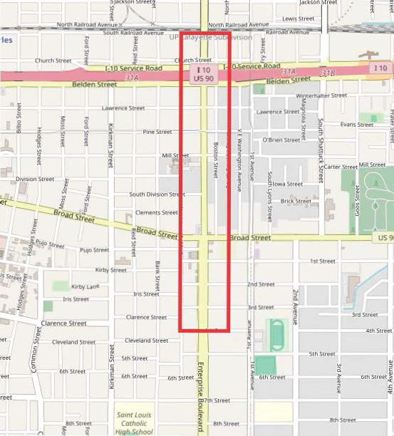
(3)
Application of district regulations. The regulations of this article shall be in addition to and shall overlay all other zoning districts and other ordinance requirements regulating the development of land so that any parcel of land lying within the overlay district shall also lie within one or more of the underlying zoning districts. Therefore, all property within this overlay district will have the requirements of both the underlying and overlay zoning district in addition to other ordinance requirements regulating the development of land, unless otherwise specified. All current businesses and residences located within the overlay district are exempt from complying with overlay district regulations except when a residential use converts or is replaced with a business use or where an existing building is damaged, destroyed, repaired, or renovated to 50 per cent or more of the market value of the structure. In the case of conflicting standards between this article and any other City of Lake Charles ordinances, the overlay requirements shall control. These regulations apply to all development, redevelopment, or expansion of existing development within the Nellie Lutcher Cultural Overlay District.
(4)
Permitted uses. Permitted uses will follow the standards outlined in the Zoning Ordinance.
(5)
Site design and development standards.
A.
General district characteristics.
1.
Exterior design. The "Big Picture" of the Nellie Lutcher Corridor is quaint and friendly, akin to downtown Lake Charles. Above all, buildings should enhance the character of the neighborhood by using simple façades. The district is creative and has a mix of uses with a vision to focus on local culture and pedestrian friendly opportunities.
i.
Building facades shall be brick, stone, stucco or Hardi Board horizontal Lap siding with no more than a six-inch reveal. Façade material must turn the corner on the building a distance no less than 12 feet;
ii.
Awnings are encouraged over the pedestrian walkway within 30 feet of all primary entrances. High gloss vinyl, plastic, horizontal ribbing, flowered, and four or more multicolor designs are prohibited;
iii.
Roofs shall complement the base building in material and color.
iv.
Loading docks, dumpsters, outdoor storage, compactors, air condition units, and similar areas shall be screened from view from adjacent properties and public streets. Screening material shall be consistent with the equivalent architecture and/or landscaping. Dumpsters may not be located within setback or landscape buffer areas.
v.
Windows. Clear or low-reflective glass shall be used for display windows and doors. Windows shall be defined with elements like frames, sills, and headers.
vi.
Entry ways shall be easily identifiable by customers.
vii.
Lighting. Freestanding light poles and wall-mounted exterior light fixtures shall be decorative and limited to 18 feet maximum height.
(a)
Lighting mounted on buildings or fences shall not exceed nine feet above ground.
(b)
Pole lighting is allowed in parking areas. Limit of 18 feet above ground and no closer than 15 feet from the property line.
(c)
All external lighting must be oriented inward toward the development or structures to minimize intrusion to surrounding property.
(d)
Neon lights and colors, high intensity, metallic or fluorescent colors, mirror or solar glass with a high level of reflectively or opacity is prohibited.
2.
Fences. All fence designs must be in harmony with the nature of the district. Encouraged fencing include wrought iron or wood with brick columns to anchor corners and entrances. The following fencing materials are not acceptable: barbed wire, chain link, concrete block, stockade, plastic, plywood, hardboard, or asbestos board.
3.
Parking. Parking for principal use shall be located behind the building, unseen front street frontages found within the Nellie Lutcher Corridor Overlay.
i.
Parking lots should be lined with a concrete curb.
ii.
Shared driveways and parking is encouraged.
iii.
Parking is prohibited within the Front Setback of the mass of the building.
4.
Amenities. Businesses located within the district are encouraged to provide at least one of the following public amenities which shall be incorporated within the front setback where possible. Amenities shall be musically or culturally themed and true to the character of the neighborhood.
i.
Public Art.
ii.
Outdoor seating or furniture with umbrellas for open-air seating.
iii.
Outdoor patio, courtyard, plaza, water features and fountains.
B.
New construction.
1.
Building site.
i.
Front setback—five feet minimum to 20 feet maximum.
ii.
Corner lot front setback—five feet.
iii.
Side setback—five feet.
iv.
Front setback landscape area—ten feet, not including where building setbacks are less than ten feet.
v.
Corner lots front landscaped areas—ten feet for both streets not including where building setbacks are less than ten feet.
vi.
Floor area—no maximum. Outdoor seating area can be 15 per cent of gross floor area.
2.
Building materials. The surface building fabric contributes to the exterior character and appearance of a building; therefore, it should conform to the style of the structure, the neighborhood, and the cultural district. The use of metal on the front façade is restricted to decorative details or design elements, with the final determination to be made by the Planning Director.
3.
Decorative details. The ornamentation or embellishment of the structure, including cornices, lintels, arches, balustrades, chimneys, shutters, columns, and other common details should create a unifying effect on a building and should be compatible with the context of the neighborhood.
4.
Architectural elements. The choice and arrangement of elements of a proposed building should reflect those of other buildings in the neighborhood. The building should not draw unnecessary attention to itself by failing to relate to neighboring styles. The object is to complement the musical and cultural context of the district.
C.
Landscaping treatment. This District shall conform with the standards set forth in Section 24-5-210. However, within the landscape areas that are visible from the frontage street and side streets (excluding Boston Ally), it shall be required that a minimum of 50 per cent of the planting area must be covered with plant materials other than grass.
1.
Corner lots shall be planted along their entire frontage.
(6)
Signage. Notwithstanding any other provision to the contrary, only Monument Signs or Wall Signs are allowed in the district. Signs may not flash, blink, or fluctuate, and may not be animated. Signage shall be externally lit, except that signage within the shopfront glazing may be neon lit. The appearance, color, size, positions, method of attachment, texture of materials and deign should conform to the character of the cultural district.
A.
Monument sign. One monument sign is allowed per lot.
B.
Wall signs. One wall sign is permitted for each building or tenant space.
C.
Sign guidelines.
1.
Dimensions.
i.
Wall Signs, including painted wall signs, shall not exceed 30 square inches of sign area to each foot of lot frontage per tenant space.
ii.
Freestanding Monument Signs cannot exceed 40 square feet.
2.
Materials.
i.
Signage materials should match the material of the main structure façade material.
(Ord. No. 19980, § 1, 7-3-24; Ord. No. 20425, § 1, 12-3-25)
Sec. 24-5-308. - Airport environs district.
(1)
Purposes. It is the purpose of the Airport Environs District in this section to promote the health, safety and general welfare of the inhabitants of the city, by preventing the creation or establishment of airport hazards, thereby protecting the lives and property of the users of the public airport and of the occupants of the land in its vicinity and preventing destruction or impairment of the utility of the airport and the public investment therein in accordance with and as a part of any future comprehensive master plan of the airports of the city area.
(2)
Applicability. The Airport Environs District is an overlay district and shall represent a mapped geographic area applied to the official zoning map. Unless expressly stated otherwise in this section, all lands encumbered by this district shall conform to all other applicable provisions of this Code.
(3)
Land use and safety zones. Zones established in order to carry out the purpose of this section, as set forth above, and also in order to restrict those uses which may be hazardous to the operational safety of aircraft operating to and from the airport and furthermore to limit population and building density in the runway approach areas, thereby creating sufficient open space so as to protect life and property in case of an accident, all of the land within 50,000 feet of the established airfield reference point is divided into height limiting zones, the boundaries of which and the height applicable thereto are shown on the zoning map, and hereby created and established are the following land use safety zones:
(a)
Height limits. Except as otherwise provided in this section, no structure or natural growth shall be erected, altered, allowed to grow, or maintained in the height limiting zones described below to a height in excess of the height specified therefor or established for the zone.
(i)
For the purpose of this section, the following height limits are established for each of the height limiting zones in question:
(ii)
An existing object, including a mobile object, is, and a future object would be, an obstruction to air navigation if it is of greater height than any of the following heights or surfaces:
(aa)
500 feet above ground level (AFL) at the site of the object.
(bb)
200 feet AFL or above the established airport elevation (EAR), whichever is higher, within three nautical miles of the established reference point (ARP) of the airport, and that height increases in the proportion of 100 feet for each additional nautical mile of distance from the airport up to a maximum of 500 feet.
(b)
Imaginary surfaces.
(i)
Precision runway approach zone. Slopes 50 feet outward for each foot upward beginning at the end of and at the same elevation as the primary surface for 10,000 feet upward. It extends an additional 40,000 feet at a slope of 40 feet outward for each foot upward. These areas begin with a width of 1,000 feet and end at a width of 16,000 feet.
(ii)
Transition zones. Slopes seven feet outward for each foot upward beginning at the sides of and at the same elevation as the primary surface and the approach surface, and extending to a height of 150 feet above airport elevation. In addition to the foregoing, there are established height limits sloping seven feet outward for each foot upward beginning at the sides of and at the same elevation as the approach surface, and extending to where they intersect the conical surface.
(iii)
Horizontal zone. Established at 150 feet above the airport elevation.
(iv)
Conical zone. Slopes 20 feet outward for each foot upward beginning at the periphery of the horizontal zone and at 150 feet above airport elevation and extends horizontally 4,000 feet to a height of 350 feet above the airport elevation.
(c)
All zones defined in this section shall be governed by all applicable Federal Aviation Regulations.
(4)
Development permits.
(a)
Future uses. Except as specifically provided in paragraphs (a) and (b) hereunder, no material chance shall be made in the use of land and no structure shall be erected, altered, or otherwise established in any zone hereby created unless a development permit therefor shall have been applied for and granted by the City of Lake Charles through the office of planning and development, as hereinafter provided for. Each application for a development permit shall indicate the purpose for which the permit is desired, with sufficient particularity to permit it to conform to the regulations herein prescribed. If such determination is in the affirmative, the development permit shall be granted.
(b)
Existing uses. No development permit shall be granted that would allow the establishment or creation of an obstruction or permit a nonconforming use, structure, or vegetation to become a greater hazard to air navigation than it was on the effective date of this section or any amendments thereto or than it is when the application for a development permit is made. A copy of each development permit application along with Form 7460-1 (available through the zoning office) sent by the applicant by certified mail to the F.A.A. Except as indicated all applications for such a development permit shall be granted.
(5)
Administration and enforcement. It shall be the duty of the director of the department of planning to administer and enforce the regulations prescribed herein. Applications for permits and variances shall be made to the director, department of planning, upon a form published for that purpose. Applications required by this Ordinance to be submitted to the director, department of planning, shall be promptly considered and granted or denied.
(6)
Conflicting regulations. Where there exists a conflict between any of the regulations or limitations prescribed in this Ordinance and any other regulations applicable to the same area, whether the conflict be with respect to the height of structures or vegetation, and the use of land, or any other matter, the more stringent limitations or requirements shall govern and prevail.
(7)
Airport zoning map. (See Appendix E).
(Ord. No. 11660, § 1, 8-4-99)
Editor's note— The airport zoning map is not set out herein but is available in the office of the clerk of council.
Sec. 24-5-309. - Traditional Neighborhood Development.
1.
General.
1.1.
Title. For brevity throughout these regulations, the term "TND" is used in place of "Traditional Neighborhood Development".
1.2.
General Provisions—Purpose and Intent.
1.2.1.
Purpose. The purpose of a Traditional Neighborhood Development is to encourage mixed-use, compact development that is sensitive to the environmental characteristics of the land and facilitates the efficient use of services. A TND diversifies and integrates land uses within close proximity to each other and provides for the daily recreational, civic, workplace and shopping needs of the residents. A TND is a sustainable, long-term community that provides economic opportunity and environmental and social integration for the residents.
1.2.2.
Design. A TND is designed to ensure the development of land as a traditional neighborhood. A TND is characterized by the following design elements:
1.
Neighborhoods that are limited in size and oriented toward pedestrian activity;
2.
A variety of housing types, shopping, services, and public facilities;
3.
Residences, shops, workplaces, and civic buildings interwoven within the neighborhood, all within close proximity;
4.
A network of interconnecting streets and blocks that maintains respect for the natural landscape;
a.
Natural features and undisturbed areas that are incorporated into the common open space of the neighborhood;
b.
A coordinated transportation system with a hierarchy of appropriately designed facilities for pedestrians, bicycles, public transit, automotive vehicles, and delivery and emergency services;
c.
Well-configured squares, plazas, greens, landscaped streets, preserves, greenbelts, and parks woven into the pattern of the neighborhood and dedicated to the collective social activity, recreation, and visual enjoyment of the residents and users of the TND;
d.
Civic buildings, common open spaces, and other visual features that act as landmarks, symbols, and focal points for community identity;
e.
Compatibility of buildings and other improvements as determined by their arrangement, bulk, form, character, and landscaping to establish a livable, harmonious, and diverse environment;
f.
Private buildings that form a consistent, distinct edge and define the border between the public street space and the private block interior;
g.
Architecture and landscape that are harmonious and respond to the unique character of the region; and
h.
Provides an increased range of options that are allowed by conventional zoning.
1.3.
Overview.
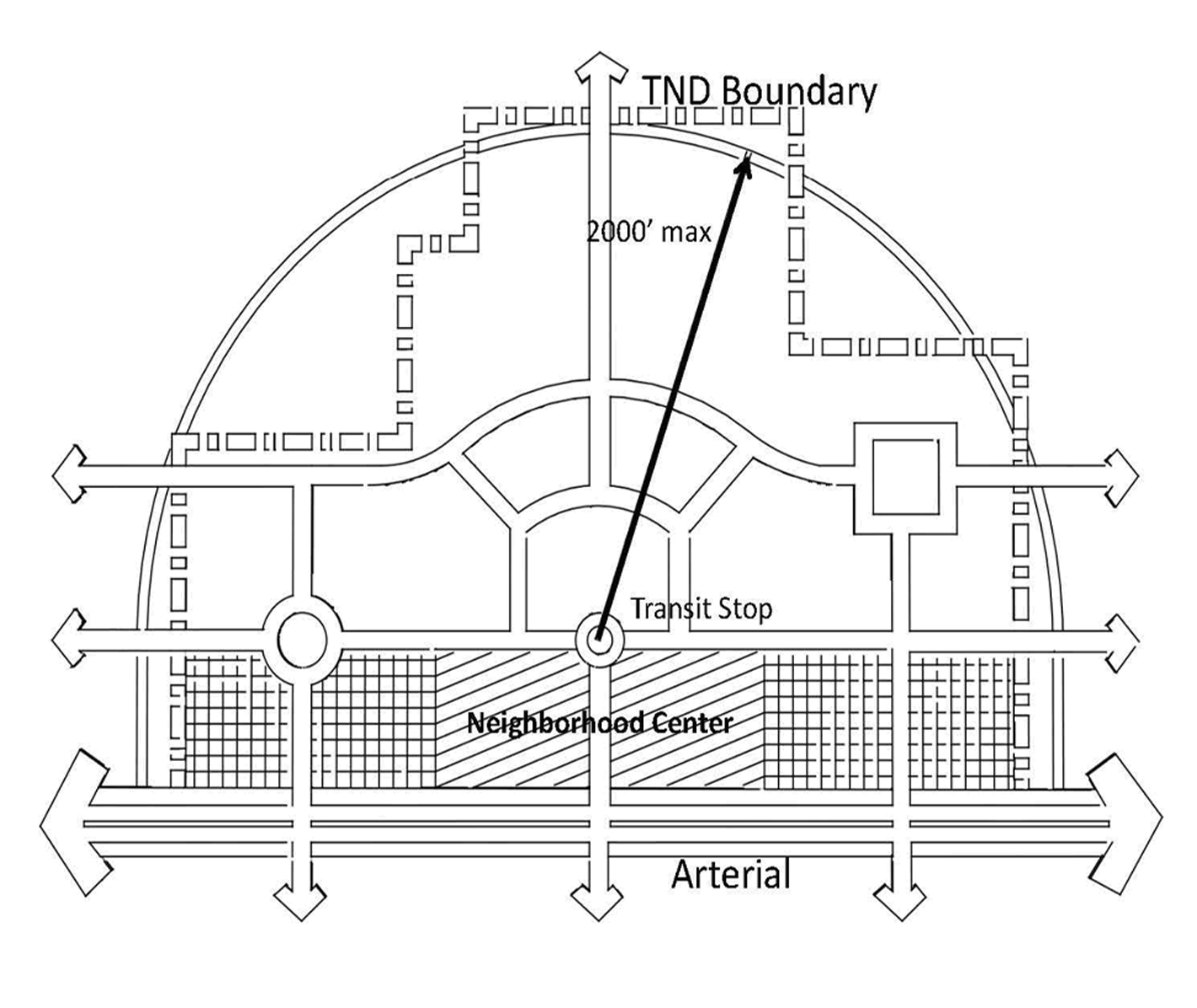
1.3.1.
Size. A TND consists of an area generally of not less than 25 contiguous acres. In this Ordinance, property is considered contiguous even if separated by a public roadway. TND "walkability" is defined as having a substantial majority of the TND within 2,000 feet (five minute walk) of the Neighborhood Center.
1.
In this Ordinance, there are two classifications of TND's based on acreage:
a.
Minor TND: 25 to 50 acres
b.
Major TND: Greater than 50 acres
a.
For a TND greater than 50 acres it may be necessary to have more than one Neighborhood Center
1.3.2.
Areas within the TND. A TND is divided into at least three types of areas. A TND shall have one Neighborhood Center Area (sometimes referred to as a town center or village center), at least one Mixed Residential Area, and common open space. A TND may also have a neighborhood edge area and civic spaces.
1.
Neighborhood Center Area. A Neighborhood Center Area serves as the focal point of a TND, containing retail, commercial, civic, and/or public services, and, to a secondary extent, residential uses, to meet the daily needs of community residents. A Neighborhood Center Area is pedestrian-oriented, and is designed to encourage pedestrian movement. A square may be located in a Neighborhood Center Area. Retail and commercial uses should generally be located adjacent to a square. A Neighborhood Center Area uses include, but are not limited to, retail shops, restaurants, offices, medical facilities, banks, hotels, post office, governmental offices, churches, schools, community centers, and attached residential dwellings.
2.
Mixed Residential Area. A Mixed Residential Area includes a variety of residential land uses including single-family detached, single-family attached, and multi-family. Residential scale retail and commercial uses are permitted within a Mixed Residential Area with architectural and land use controls. Retail and commercial uses in a Mixed Residential Area are required to blend into the residential character of the neighborhood. A Mixed Residential Area includes common open spaces such as small squares, pocket parks, community parks, and greenbelts. A Mixed Residential Area promotes pedestrian activity through well-designed and varied streetscapes that also provide for the safe and efficient movement of vehicular traffic. Mixed Residential Area uses include single-family homes, row houses, duplexes, townhomes, apartments, and condominiums. Nonresidential uses may be considered for approval in the Mixed Residential Area.
Nothing shall preclude the imposition of restrictive covenants to limit or eliminate retail or commercial uses. Mixed Residential Areas often utilize alleys. Varying lot sizes are encouraged within the Mixed Residential Area.
3.
Common open space. Common open space is a significant part of a TND design.
These spaces serve as areas for community gathering, landmarks, and as organizing elements for the neighborhood. Common open space includes squares, plazas, greens, preserves, parks, detention basins, community gardens or urban farms, playgrounds, recreational facilities and greenbelts. A minimum of 20 per cent of the total acreage of a TND shall be committed to common open space.
4.
Neighborhood Edge Area. A Neighborhood Edge Area is the least dense portion of a TND, with somewhat larger lots and somewhat greater setbacks than the rest of the neighborhood. Alleys are encouraged but not required, and direct vehicular access to the street is permitted. Only single-family residential dwellings are permitted. A Neighborhood Edge Area is appropriate along the perimeter of the neighborhood. A portion of a TND that adjoins existing or platted conventional low-density housing shall be designated as a Neighborhood Edge Area.
5.
Civic uses. Civic uses that are oriented to the general public are permitted throughout the TND. These uses are essential components of the social and physical fabric of a TND. Special attention should be paid to the location of government offices, libraries, museums, schools, churches, and other prominent public buildings to create focal points and landmarks for the community. The locations of these major public civic uses should be designated on the overall development plan at the time of approval. Civic spaces should be integrated into residential and commercial areas in the TND.
6.
Streets and alleys. A TND is designed to be pedestrian-oriented. To accomplish this goal, street pattern and design is used to reduce vehicle travel speeds and encourage pedestrian activity. An interconnected network of streets and alleys is required. A network of paths and greenways is strongly recommended. Streets may be smaller than in conventional development and more varied in size and form to control traffic and give character to the neighborhood, but they cannot be designed in any way to impede emergency response access. Where streets or alleys prohibit garbage vehicle access, provisions must be made for a designated area for pick-up that is easily accessible.
1.4.
Definitions.
Accessory Building: A subordinate building or a portion of the main building on a lot, the use of which is customarily incidental, secondary, or minor to that of the main or principal building.
Alley: A public or private roadway which affords only a secondary means of access to the rear of abutting property.
Application: An application filed by the developer for TND zoning and/or subdivision of property.
Arterial: An arterial road is a heavily traveled road which has intersecting collector roads.
Building Scale: The relationship between the mass of a building and its surroundings; including the width of the street, common open space, and mass of surrounding buildings. Mass is determined by the three-dimensional bulk of a structure: height, width, and depth.
Building Setback, Front: The distance from the street right-of-way line to the closest point of the foundation of a building or projection thereof.
Charrette: A technique for consulting with stakeholders in a particular planned development. Charrettes typically involve intense and possibly multi-day meetings, involving municipal officials, developers, and residents.
Civic Purpose: The purpose of a civic use in a TND is to provide a neighborhood serving space as an amenity.
Collector: A collector road is a low-to-moderate-capacity road which serves to move traffic from local streets to arterial roads.
Common Open Space: Shared use space not utilized for enclosed improvements, including squares, plazas, greens, preserves, parks, detention basins, community gardens or urban farms, playgrounds, recreational facilities and greenbelts, but excluding vehicular use areas. The only exception is the use of bio-swales or rain gardens to capture stormwater in parking lots, but only the surface area dedicated to bio-swales or rain gardens will be classified as common open space.
Community Gardens: An area set aside for residents to participate in community gardening. Such gardens will be credited as required common open space and to be managed under the auspices of the TND Property Owners Association.
Concept Plan: An informal map of a proposed subdivision or a site plan of sufficient accuracy to be used for the purpose of discussion and classification.
Curb Radius: The curved edge of streets at an intersection measured at the outer edge of the street curb.
Detention Basins: Stormwater management facilities that provide temporary storage of runoff, which is used to control the peak discharge rates generated by newly constructed impervious surfaces such as roads, parking lots, and rooftops.
Encroachment: The act of building a structure which is in whole or in part on a neighboring property. Certain overhangs are permissible on a case by case basis.
Green: A common open space available for unstructured recreation, its landscaping consisting of grassy areas, trees, shrubs, and other landscaping.
Greenbelt: A series of connected common open spaces that may follow natural features such as bayous and coulees.
Line of Sight: The clear sight distance area at an intersection required by motorists, pedestrians, bicyclists and others to view a conflict, make a decision and react to that decision.
Lot Line: Any of the property lines bounding the lot.
Lot Width: The horizontal distance between side lot lines measured at the front setback.
Net Acre: An acre of land excluding street rights-of-way and other publicly dedicated improvements such as parks, common open space, and stormwater detention and retention facilities.
Park: A common open space, available for recreation, its landscape tending to consist of paths and trails, some open lawn, trees, open shelters, or recreational facilities.
Plaza: A common open space at the intersection of important streets, set aside for civic purposes and commercial activity, its landscape tending to consist of durable pavement and formal tree plantings.
Preserve: Common open space that preserves or protects a tract of land from development, including, without limitations, floodplains, wetlands, protected habitats, environmental or natural features.
Principal Building: A building in which the primary use of the lot on which the building is located is conducted.
Reserve: A tract of land kept in reserve for future development.
Secondary Dwelling Unit: An additional dwelling unit located within the principal dwelling on the lot, in a freestanding building or above a residential garage.
Servitude: A right by which something, as a parcel of land, is subject to a specified use or enjoyment by another (servitude for utilities, access, construction, drainage, etc.).
Square: Common open space that may encompass an entire block, is located at the intersection of important streets, and is set aside for civic purposes, with landscape tending to consist of paved walks, lawns, trees, and civic buildings.
Streetscape: The area within a street right-of-way that contains sidewalks, street fixtures, landscaping, and/or trees.
TND: A compact, walkable, mixed-use neighborhood where residential, commercial and civic buildings are located within close proximity to each other.
TND Overlay: An unmapped zoning district whose standards are described in this Ordinance that may be established on lands that are designated as any current zoning excluding 'Industrial' and must be approved as a major conditional use.
TND Property Owners Association: The TND Property Owners Association is an organization that operates on behalf of all TND property owners. The association has a board of elected resident members that meet regularly and is charged with establishing and upholding architectural standards, covenants and deed restrictions as well as maintaining the common areas of the TND. The association is expected to charge maintenance fees in perpetuity.
1.5.
Procedures. The submittal requirements in the City of Lake Charles Subdivision Regulations apply to the TND, except to the extent inconsistent with or augmented by this section and, in particular, the following:
1.
A pre-application conference with the Planning and Zoning Department, Public Works Department, and Fire Department is required prior to submittal of a Concept Plan. At the pre-application conference, there will be consideration of densities of residential and commercial uses, common open space requirements, and other development related issues, including emergency services access. The applicant should hold the pre-application conference prior to conducting a charrette.
2.
Application. An application for a TND Overlay for a major conditional use permit, shall be submitted to the Director of Planning in accordance with the provisions of the City of Lake Charles Zoning Ordinance No. 10598 Section 24-4-201(1)—(3). The TND must follow the requirements for a major conditional use outlined in Section 24-4-203(5). The Concept Plan must be submitted with the major conditional use application that indicates the areas proposed for the Neighborhood Center Area, Mixed Residential Area, common open space, Neighborhood Edge Area (if applicable), and civic use (if applicable). The Concept Plan does not have to be an official plat of survey.
3.
Once a TND Overlay is approved by the Planning and Zoning Commission, changes to the Concept Plan shall be approved by the Planning and Zoning Department. During the development of a conditional use, adjustments to the approved use may be permitted according to City of Lake Charles Zoning Ordinance Section 24-4-203(6). The Concept Plan shall be recorded in the Calcasieu Parish Clerk of Court's office.
4.
The Planning and Zoning Department staff shall make technical adjustments according to the City of Lake Charles Zoning Ordinance Section 24-5-416(2).
5.
Property within a TND shall be subdivided.
6.
An application for preliminary plat approval of a TND may only be filed after the major conditional use has been approved by the Planning and Zoning Commission.
7.
An overall development plan must be submitted for a TND for approval by the Planning and Zoning Department. The overall development plan will be considered the preliminary plat. The overall development plan may be separated into phases for purposes of construction plan submittal and final plat approval. The overall development plan is intended to reflect the overall development concept, and in particular, the coordination of traffic, utilities and other improvements between phases.
8.
Lots, streets, common open spaces, and other property divisions shall be platted as set forth in this TND Ordinance.
9.
If a reserve tract is proposed, then the TND must provide for a temporary use until changed. Any change in the temporary use, including a change to a permanent use, must be approved by the Planning and Zoning Department.
10.
Development Agreement. All TND's that have received preliminary plat approval according to the provisions stated herein shall be subject to a City of Lake Charles development agreement prior to or contemporaneous with submittal of construction plans to the Public Works Department and the Fire Department. This agreement is designed and intended to reflect the agreement with the City of Lake Charles and the applicant as to the development, including, without limitation, the phasing of construction to ensure the timely and adequate provision of public infrastructure improvements. This agreement is also intended to ensure balanced intensity of development to avoid overloading existing public facilities during the construction phase. This agreement will be individually negotiated for each phase, but should address the following issues:
a.
Any agreement on cost sharing for the installation or over-sizing of major utility systems, lines or facilities.
b.
Any agreement for encroachment of overhangs into servitudes.
c.
Any agreement on cost sharing for the installation of interior or perimeter roadways or street network.
d.
Any agreement as to a mandatory construction or dedication schedule for common open space areas or improvements, school site(s), landscaping or greenbelt development or other comparable items to be dedicated or constructed for each acre of property within the TND.
e.
An agreement that relates to the creation of a TND Property Owners Association, which establishes and upholds architectural standards, covenants and deed restrictions, and maintains the common open spaces of the TND. The association is expected to charge maintenance fees in perpetuity.
f.
Any conditions that limit Fire Department emergency services caused by such things as street width, accessibility, building height and water pressure/volume, which will result in higher insurance premiums, should be identified.
11.
In order to ensure that the required common open space is allocated for the entire development, in a properly phased fashion as outlined in the development agreement, the Planning and Zoning Department staff may discontinue the issuance of building permits until the required common open space is constructed and/or dedicated.
2.
Guidelines.
2.1.
Land Use Allocations.
2.1.1.
Land use allocations. Each lot within a TND must be allocated particular permitted land use categories. Only the land uses listed here are permitted within the TND. A TND shall have one Neighborhood Center Area, at least one Mixed Residential Area (permitted land uses listed below), and common open space. A TND may also have a Neighborhood Edge Area with somewhat larger single family dwelling units. Most of the residences should be within approximately 2,000 feet from existing or proposed commercial, civic, and/or common open space areas. Civic uses are permitted throughout the TND (Neighborhood Center, Mixed Residential Area, and Neighborhood Edge Area).
2.1.2.
Neighborhood Center Area.
* Unlisted uses will be approved on a case-by-case basis.
2.1.3.
Mixed Residential Area.
| Land Uses Permitted | |
|---|---|
| Residential |
Minimum Lot Width/
Maximum No. Stories |
Single-family detached dwellings
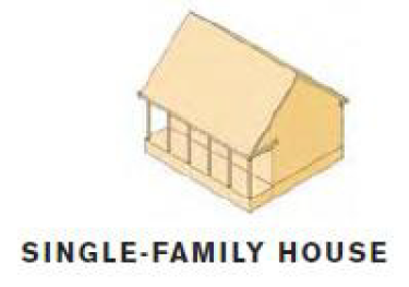 | Minimum 35' lot width |
Single-family attached dwellings
• Row houses
• Duplexes
• Townhomes
• Secondary dwelling unit (attached or detached)
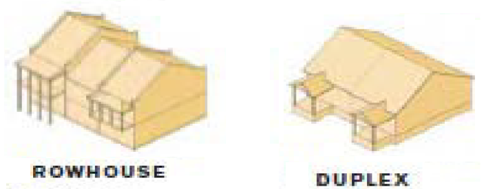 | Minimum 18' lot width |
Multi-family dwellings
• Apartments
• Condominiums
• Residential units above commercial
• "Special needs" housing (assisted living)
• Live/work units that combine residence and workplace
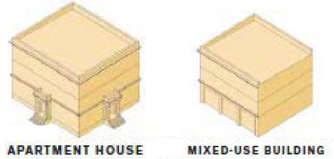 | Maximum 3 stories |
2.2.
Utility and Drainage Servitudes. Servitudes for public utilities and drainage ways shall be provided in the widths and locations deemed necessary by the City of Lake Charles Public Works Department. The servitudes shall be dedicated to the public entity as appropriate for its use and benefit, as well as for the benefit of such utility providers such as the City of Lake Charles.
Encroachments including, but not limited to, balconies and overhangs shall not be allowed in any servitudes that include or may include major utility equipment (i.e., transformers, fire hydrants, major valves, switching cabinets, etc.).
All irrigation and backflow prevention devices should be placed in the public right-of-way.
2.3.
Garages and Secondary Dwelling Units. Garages and secondary dwelling units may be placed on a single-family detached residential lot within the principal building or an accessory building provided that the secondary dwelling unit shall be no larger than 600 square feet. Garage doors shall have a minimum setback of 20 feet behind the façade of the principal structure when accessed from the front property line. The Planning and Zoning Department shall make technical adjustments on a case by case basis.
2.4.
TND Property Owners Association.
2.4.1.
Conditions, covenants, and restrictions for the property located within a TND must be filed at the Calcasieu Parish Clerk of Court by the owners before a final subdivision plat may be approved, a lot sold, or a building permit issued.
2.4.2.
Conditions, covenants, and restrictions shall contain the following:
1.
Create a TND Property Owners Association with mandatory membership for each property owner;
2.
Establish architectural standards that are in conformity with the requirements of this Ordinance;
3.
Create an architectural committee to review development for compliance with the architectural standards and issue certificates of approval;
4.
Provide for the ownership, development, management, and maintenance of private open space (except those owned by individual property owners), community parking facilities, and other common areas and facilities;
5.
Provide for the maintenance of the landscaping, trees, and fixtures within the streetscape;
6.
Require the collection of assessments from members in an amount sufficient to pay for its functions;
7.
Be effective in perpetuity;
8.
Require that the TND Property Owners Association address the disposition and management of private open space, community parking facilities, and other common areas before it may be dissolved.
2.5.
Architectural Standards.
2.5.1.
The conditions, covenants, and restrictions should establish architectural standards for the property within a TND. The standards should comply with this section.
2.5.2.
The architectural standards shall achieve the following objectives:
1.
Architectural compatibility;
2.
Human scale design;
3.
Integration of uses;
4.
Encouragement of pedestrian activity;
5.
Vista terminations that feature important buildings, parks, greens, civic features, scenery or other features;
6.
Buildings that relate to and are oriented toward the street and surrounding buildings;
7.
Residential scale buildings in mixed residential areas;
8.
Buildings that contain special architectural features to signify entrances to the Neighborhood Center Area and important street intersections;
9.
Neighborhood Center Area buildings that focus activity on the neighborhood square; and
10.
Provisions for above ground sprinklers and backflow preventers.
2.6.
Open Space. The following common open space requirements apply within a TND. At least 20 per cent of the gross acreage of the TND District must be common open space. Ninety per cent of the lots within the areas devoted to mixed residential uses shall be within 2,000 feet from common open space. At least 25 per cent of the common open space shall be dedicated to the City of Lake Charles or the TND Property Owners Association.
There should be a minimum average of one street tree on each side of the street per 40 feet of frontage. Depending upon the type of street tree, the spacing may be greater than described above. However, common open space within vehicle use areas or any noncontiguous green area of less than 500 square feet may not be included.
2.6.1.
The following uses may account for common open space:
2.6.2.
Common open space shall be permanently set aside for the sole benefit, use, and enjoyment of present and future occupants of the TND through covenant, deed restriction, common open space servitude, or similar legal instrument; or, if agreed to by the City of Lake Charles, the common open space may be conveyed to the City of Lake Charles for the use of the general public.
2.6.3.
In the event land shown on a preliminary plat (as hereinafter defined) as common open space is dedicated to the City of Lake Charles the government may, but shall not be required to, accept the common open space provided: (a) such land is accessible to the residents of the City; (b) there is no cost of acquisition other than the costs incidental to the transfer of ownership; and (c) the City of Lake Charles agrees to and has access to maintain such lands.
2.6.4.
Common open space shall be protected against building development and environmental damage by conveying to the City of Lake Charles, TND Property Owners Association, or land trust a common open space servitude restricting the area in perpetuity against any future building and against the removal of soil, trees and other natural features.
2.7.
Drainage. The drainage provisions of the City of Lake Charles Code of Ordinances Chapter 6, Article X, Large Development Drainage, apply to the development of a TND.
2.8.
Landscaping. The Public Works Department and the Fire Department shall have the right to dictate types of trees that may be planted in the public right-of-way for any development. In addition, plantings in the public right-of-way at intersections shall be reviewed for the appropriate line of sight distance (Refer to 2.11.4).
Overall composition and location of landscaping shall complement the scale of the development and its surroundings. In general, larger, well-placed contiguous planting areas shall be preferred to smaller, disconnected areas. Where screening is required by this Ordinance, it shall be at least three feet in height, unless otherwise specified. Required screening shall be at least 50 per cent opaque throughout the year. Required screening shall be satisfied by one or some combination of a decorative fence not less than 50 per cent behind a continuous landscaped area, a masonry wall, or a hedge.
2.8.1.
A comprehensive landscaping plan, which establishes coordinated landscaping guidelines, is required for the entire TND and shall be provided by a licensed landscape architect. A maintenance plan for all landscaping is also required that includes the acknowledgement that all landscape maintenance is solely the responsibility of the TND Property Owners Association.
2.8.2.
Trees along streets.
1.
A minimum of one deciduous canopy tree per 40 feet of frontage, or fraction thereof, shall be required. Trees may be clustered and need not be evenly spaced, subject to further provisions as set forth herein.
2.
Trees should preferably be located between the sidewalk and the curb, within the landscaped area of a boulevard, or in tree wells installed in pavement or concrete.
3.
Native shade trees which grow to a minimum height of 40 feet at maturity should be planted along all streets at a minimum average spacing which is appropriate for the specified trees.
4.
Trees shall have a minimum caliper of two and one-half inches at the time of planting.
5.
The following list of trees are permitted along streets:
2.8.3.
Parking area landscaping and screening for surface parking lots.
1.
All parking and loading areas fronting public streets or sidewalks, and all parking and loading areas abutting residential districts or users, should provide a landscaped area at least five feet wide along the public street or sidewalk; screening minimum of 42 inches in height and not less than 50 per cent opaque year-round; and one tree for each 25 linear feet of parking lot frontage.
2.
The corners of parking lots, "islands," and all other areas not used for parking or vehicular circulation shall be landscaped. Vegetation may include turf grass, native grasses or other perennial flowering plants, vines, shrubs or trees. Such spaces may include architectural features such as benches, kiosks or bicycle parking.
3.
For all parking lots with more than six spaces, the landscaped area shall be comprised of a minimum of 20 per cent of the total parking lot area.
4.
A landscaping plan is required for structured parking.
2.9.
Setbacks.
2.9.1.
Building setback, front—Mixed-Use Area. Structures in the mixed-use area have no minimum setback except where utility servitudes are required, in which case the minimum shall be behind the said servitude (including niches). Commercial and civic or institutional buildings should abut the sidewalks in the mixed-use area except where utility servitudes are required, in which case the minimum shall be behind the said servitude (including niches).
2.9.2.
Building setback, front—Mixed Residential Use Area. Single-family detached residences shall have a building setback in the front between zero and 25 feet, except where utility servitudes are required, in which case the minimum shall be behind the said servitude (including niches). Single-family attached residences and multifamily residences shall have a building setback in the front between zero and 15 feet except where utility servitudes are required, in which case the minimum shall be behind the said servitude (including niches).
2.9.3.
Building setback, garage - In residential areas, garage doors which face the front of a lot shall be placed a minimum of 20 feet beyond the setback of the principal structure. The Planning and Zoning Department shall make technical adjustments on a case by case basis.
2.9.4.
Building setback, rear—Mixed Residential Use Area. The principal building on lots devoted to single-family, non-alley loaded detached residences shall be setback no less than five feet from the rear lot line except where utility servitudes are required, in which case the minimum shall be behind the said servitude (including niches).
2.9.5.
Side setbacks. Provision for zero lot line single-family dwellings should be made, provided that a reciprocal access servitude is recorded for both lots and townhomes or other attached dwellings, provided that all dwellings have pedestrian access to the rear yard through means other than the principal structure and provided that there are no utility servitudes required. If utility servitudes are required, the minimum setback shall be behind the said servitude (including niches). All side setbacks shall meet the minimum required by the most current addition of the applicable building code - International Building Code or International Residential Code.
2.10.
Lot and Block Standards.
2.10.1.
Local Streets. Blocks shall not exceed 800 feet in length along local streets. The minimum block length for local streets shall be 200 feet or be sufficient to accommodate two tiers of lots.
1.
For any development wherein lots are subdivided and a public or private street is proposed which equals or exceeds 800 feet in length, provision for cross streets extending to the property line within each 800-foot interval, thereby creating two or more blocks shall be provided and constructed. In the case of public streets, said cross streets shall be dedicated to the public.
2.
For any development in which lots are being created along the length of an existing public or private street, and the cumulative length of frontage for said lots equals or exceeds 800 feet, a cross street extending to the rear property line of said lots, thereby dividing said lots into two or more blocks shall be provided for each 800 feet in frontage.
2.10.2.
Collectors.
1.
Blocks shall not exceed 2,000 feet and shall not be less than 1,000 feet along collector streets.
2.
For any development in which lots are being created along the length of an existing public street, and the cumulative length of frontage for said lots equals or exceeds 2,000 feet, a cross street extending to the rear property line of said lots, thereby dividing said lots into two or more blocks shall be provided for each 2,000 feet in frontage.
2.10.3.
Arterials—Major and Minor.
1.
Blocks shall not exceed 5,000 feet and shall not be less than 2,000 feet in length along major arterials and/or minor arterials.
2.
For any development in which lots are being created along the length of an existing public street, and the cumulative length of frontage for said lots equals or exceeds 5,000 feet, a cross street extending to the rear property line of said lots, thereby dividing said lots into two or more blocks shall be provided for each 5,000 feet in frontage.
2.10.4.
Measurement Criteria.
1.
Block lengths are to be determined by the measurement along the face of a block (i.e., congruent with street right-of-way lines) from street intersection to another street intersection, where such streets provide cross traffic circulation (not cul-de-sac streets or loop streets).
2.10.5.
Lot widths.
1.
Lot widths should create a relatively symmetrical street or road cross section that reinforces the public space of the street or road as a simple, unified public space.
2.10.6.
Access to alleys.
1.
Direct vehicular access from a lot to an alley in the TND is permitted and preferred. Direct vehicular access from a lot to a street is not permitted, except as provided in this section.
2.10.7.
Exception.
1.
Direct vehicular access from a lot to a street is permitted in situations where topographical conditions and/or insufficient lot depth to permit the use of an alley exists, or where the Planning and Zoning Department otherwise deems it appropriate.
2.10.8.
Lot arrangements.
1.
The side lines of lots in subdivisions shall be approximately at right angles to straight street lines or radial to curved street lines, unless site conditions dictate otherwise. An arrangement placing adjacent lots at right angles to each other shall be avoided, or where the Planning and Zoning Department otherwise deems it appropriate.
2.10.9.
Lots front streets.
1.
Each lot, except a lot that fronts on a common open space and abuts an alley, shall front a street.
2.11.
Street Design.
The circulation system shall allow for different modes of transportation.
The circulation system shall provide functional and visual links within the residential areas, mixed-use area, and common open space of the TND and shall be connected to existing and proposed external development. The circulation system shall provide adequate traffic capacity, provide connected pedestrian and bicycle routes, especially off-street bicycle or multi-use paths or bicycle lanes on the streets where required and ADA-approved crosswalks and sidewalks, control through traffic, provide adequate transit stops, limit lot access to streets of lower traffic volumes, and promote safe and efficient mobility through the TND.
The street network of the TND shall be connected to existing streets. TND streets that provide access to the TND from arterial streets should be laid out in accordance with DOTD Rule 70 and must allow extensions to future neighborhoods. Dead-end streets are prohibited unless topographical conditions offer no practical alternative for connectivity, as determined by the Director of Planning and Zoning or his/her designee.
2.11.1.
Design of streets.
1.
General.
a.
Streets consist of moving lanes, parking lanes, curbs or swales, planters, trees, streetlights and sidewalks.
b.
Street types shall be designated in the overall development plan.
c.
Streets passing from one use area to another shall change appropriately except those designated as a collector in the overall development plan.
d.
The exact locations of trees and lights along streets may be adjusted for specific conditions, such as building entrances.
e.
Streets that exist in or near a TND at the time of rezoning, and are consistent with the intent of this Ordinance, may become an approved standard for use in that TND. An example of such a condition is commonly found in a nearby historic neighborhood.
f.
Striping on formal parked streets is required in commercial corridors. Striping shall be completed prior to final plat approval.
g.
Utility location shall be coordinated with the Public Works and Engineering Department. Utilities shall be located outside of pavement areas when feasible.
h.
All streets within a TND shall terminate at other streets, forming a network. Culs-de-sac shall be granted only when justified by site conditions.
2.
Design of streets in commercial areas.
a.
All lots shall front on a street, except that a maximum of 20 per cent of lots served by a rear alley may front on a common open space.
b.
Streets may intersect at no less than a 60-degree angle.
3.
Design of streets in civic areas.
a.
Streets affronting civic buildings or civic spaces shall follow the standards of the underlying use area.
2.11.2.
Corner radii.
1.
The roadway edge at street intersections shall be rounded by a tangential arc with a minimum radius of 15 feet for local residential and commercial streets, and 25 feet for intersections involving collector or arterial streets.
2.
Deviations from these minimum standards must be approved by the Director of Public Works or his/her designee.
2.11.3.
Geometry.
1.
Street jogs and offsets shall be permitted as follows, with deviations from these minimum standards requiring approval by the Director of Public Works or his/her designee:
a.
along residential streets a minimum of 75 feet.
b.
along commercial streets a minimum of 100 feet.
c.
along arterial and collector streets a minimum of 125 feet.
2.
On TND local streets, the permitted centerline radius for streets with a design speed of 25 miles per hour and no super elevation is 150 feet. The minimum length of the centerline curve shall be 75 feet.
2.11.4.
Line of sight.
1.
All intersections shall be reviewed for the appropriate line of sight distance. The line of sight shall be based upon the City of Lake Charles Zoning Ordinance No. 10598 Section 5-203. No buildings, structures, parking or plantings shall be allowed within the line of sight.
2.12.
Circulation.
2.12.1.
Pedestrian Circulation.
Convenient pedestrian circulation systems that minimize pedestrian-motor vehicle conflicts shall be provided continuously throughout the TND. Where feasible, any existing pedestrian routes through the site shall be preserved and enhanced. All streets, except for alleys, shall be bordered by sidewalks on both sides. The following provisions also apply:
1.
Sidewalks in residential areas.
a.
Sidewalks shall be a minimum five feet in width.
b.
Sidewalks shall be provided along both sides of each street in residential areas. For pedestrian safety, sidewalks shall be separated at least four feet from the curb in areas of single-family detached dwelling units. In areas of multifamily and attached single-family dwellings, pavement may extend between the required pedestrian sidewalk and the street curb, provided a minimum five-foot unobstructed pedestrian sidewalk is provided.
2.
Sidewalks in mixed-use areas.
a.
Sidewalks shall be a minimum of five feet in width.
b.
Sidewalks shall be provided along both sides of each street type located within a mixed-use area. Within mixed-use areas, pavement may extend between the required pedestrian sidewalk and the street curb provided a minimum five-foot unobstructed pedestrian sidewalk is provided, and that there be a minimum six-foot street tree buffer between the pedestrian sidewalk and the curb on both sides of the roadway.
3.
Disabled accessibility.
a.
Sidewalks shall comply with the applicable requirements of the ADA.
4.
Crosswalks.
a.
Intersections of sidewalks with streets shall be designed with clearly defined edges. Crosswalks shall be well lit and clearly marked with contrasting paving markings or texture at the edges.
2.12.2.
Bicycle Circulation.
1.
Bicycle circulation should be accommodated on streets and/or on dedicated bicycle paths. Where feasible, any existing bicycle routes through the site should be preserved and enhanced. Facilities for bicycle travel may include off-street bicycle paths (generally shared with pedestrians and other non-motorized users) and separate, striped, five-foot bicycle lanes on streets.
2.12.3.
Public Transit Access.
1.
Where public transit service is available or planned, convenient access to transit stops should be provided. If provided, access to the transit stops should be within a five minute walk from the Neighborhood Center Area. Where transit shelters are provided, they should be placed in highly visible locations that promote security through surveillance, and should be well lighted.
2.12.4.
Motor Vehicle Circulation.
1.
Motor vehicle circulation shall be designed to minimize conflicts with pedestrians and bicycles. Traffic calming features such as curb extensions, traffic circles, and medians should be used to encourage slow traffic speeds.
2.12.5.
Joint Access Driveways.
1.
A system of joint use driveways and cross access servitudes shall be established wherever feasible within the TND. Building sites shall incorporate the following:
a.
An access and circulation system that includes coordinated or shared parking areas wherever feasible.
b.
Stub-outs and other design features to make it visually obvious that the abutting properties must be tied in to provide cross access via a service drive.
2.13.
Parking Requirements.
The requirements for parking spaces shall be as listed elsewhere in the City of Lake Charles Zoning Ordinance No. 10598, Section 5-208 unless stated otherwise herein. Parking areas for shared or community use should be encouraged. In addition:
1.
In the mixed-use area, the primary parking lot shall be located at the rear or side of a building. If located at the side, screening shall be provided as specified in paragraph 9, below.
2.
A parking lot or garage in most instances should not abut a street or intersection.
3.
In the mixed-use area, a commercial use must provide one parking space for every 400 feet (400 square feet) of gross building area.
4.
Parking lots or garages must provide not less than one bicycle parking space for every ten motor vehicle parking spaces.
5.
Adjacent on-street parking may apply toward the minimum parking requirements.
6.
In the mixed residential areas, parking may be provided on-site. A minimum of one off-street parking space with unrestricted ingress and egress shall be provided for each secondary dwelling unit.
7.
Multifamily uses must provide one parking space for every first bedroom and 0.5 parking spaces for each additional bedroom.
8.
In residential areas, garage doors which face the front of a lot shall be placed a minimum of 20 feet beyond the setback of the principal structure.
9.
In non-residential areas, parking lots in most instances should be located to the rear or side of buildings. Side parking lots shall account for no more than 25 per cent of parking per site, and shall be screened from sidewalks by a combination of low walls or fences and landscaping.
10.
In the case of commercial or office uses which have shop or store fronts adjacent to sidewalks and streets, parking along the street directly in front of the lot shall count toward fulfilling the parking requirements.
11.
The required number of spaces for commercial and office uses may be further reduced by demonstrating the use of shared parking.
12.
If a developer desires additional customer parking for non-residential uses, it shall be provided on grassy, pervious surfaces (of reinforced/plastic grid, reinforced block or similar material) which are adequate to support parked vehicles.
13.
Non-residential off-street parking should be located in parking lots located behind the buildings, internal to the block.
14.
Parking shall be accessed by alley or rear lane, when available. However, there shall be no parking in an alley or lane.
15.
Parking shall be prohibited within 40 feet of intersections to enable public service and emergency vehicles adequate turning radii, and in mid-block sections such that emergency vehicles can park and operate within 125 feet of all buildings on the block. The Public Works Department and Fire Department shall make technical adjustments on a case by case basis.
16.
Required parking must be provided within a five minute walk (2,000 feet) radius of the site which it serves.
17.
The location of permitted parking along streets should be coordinated to allow access to mail boxes. A central mail delivery location for all or a portion of the lots may be provided as opposed to individual deliveries to lots.
18.
Parking lots greater than two double loaded parking rows should be carefully arranged to minimize breaks between pedestrian destinations.
19.
Shared parking.
a.
If an office use and a retail use share parking, the parking requirement for the retail use may be reduced by 20 per cent, provided that the reduction shall not exceed the minimum parking requirement for the office use.
b.
If a residential use shares parking with a retail use other than lodging uses, eating and drinking establishments or entertainment uses, the parking requirement for the residential use may be reduced by 30 per cent, provided that the reduction does not exceed the minimum parking requirement for the retail and service use.
c.
If an office and a residential use share off-street parking, the parking requirement for the residential use may be reduced by 50 per cent, provided that the reduction shall not exceed the minimum parking requirement for the office use.
d.
The required number of spaces for commercial, office, civic, and multifamily uses may be further reduced by demonstrating the use of shared parking.
20.
Parking structures may have adjacent commercial uses.
2.14.
Signage. Comprehensive sign guidelines are required for the entire TND. Such guidelines shall be provided to the Planning and Zoning Department and Public Works Department. Signs within the TND shall share a common style as to sizes, shapes and material permitted. Signage must follow the Manual on Uniform Traffic Control Devices (MUTCD) and the City of Lake Charles Zoning Ordinance No. 10598 Section 24-5-211. Deviations must be approved by the Public Works Department.
2.15.
Lighting. Lighting along streets, including pedestrian scale lighting, shall be provided along all streets and be designed to the human-scale. Streetlights shall be installed on both sides of the street at intervals of not greater than 75 feet. Generally more, shorter lights, as opposed to fewer, high-intensity lights, should be used. Lighting must be approved by the Department of Public Works.
Lighting structures should be architecturally compatible with the surrounding area. Lighting shall be shielded and directed downward in order to reduce glare onto adjacent properties.
3.
Street Cross Sections. The following street sections shall be applied to the TND design. The applicant may propose additional street cross sections specific to the proposed development with the preliminary plat. All pavement construction requirements shall be in accordance with the City of Lake Charles Subdivision Regulations. Any proposed street cross sections differing from those contained in the attachments shall be required to be reviewed and approved by the Department of Public Works.
3.1. Rear Alley, Non-Dedicated Secondary Access
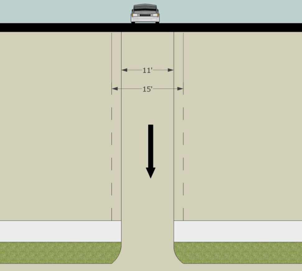
3.2. Rear Alley, Primary Access
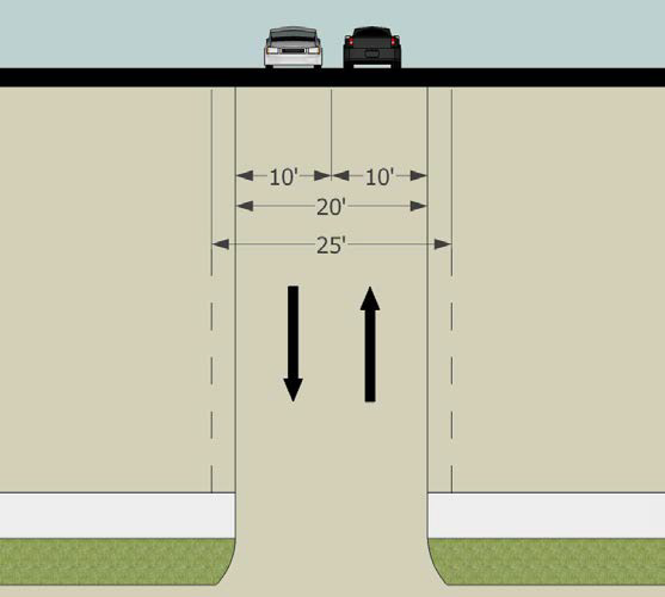
3.3. One Way, Primary Access
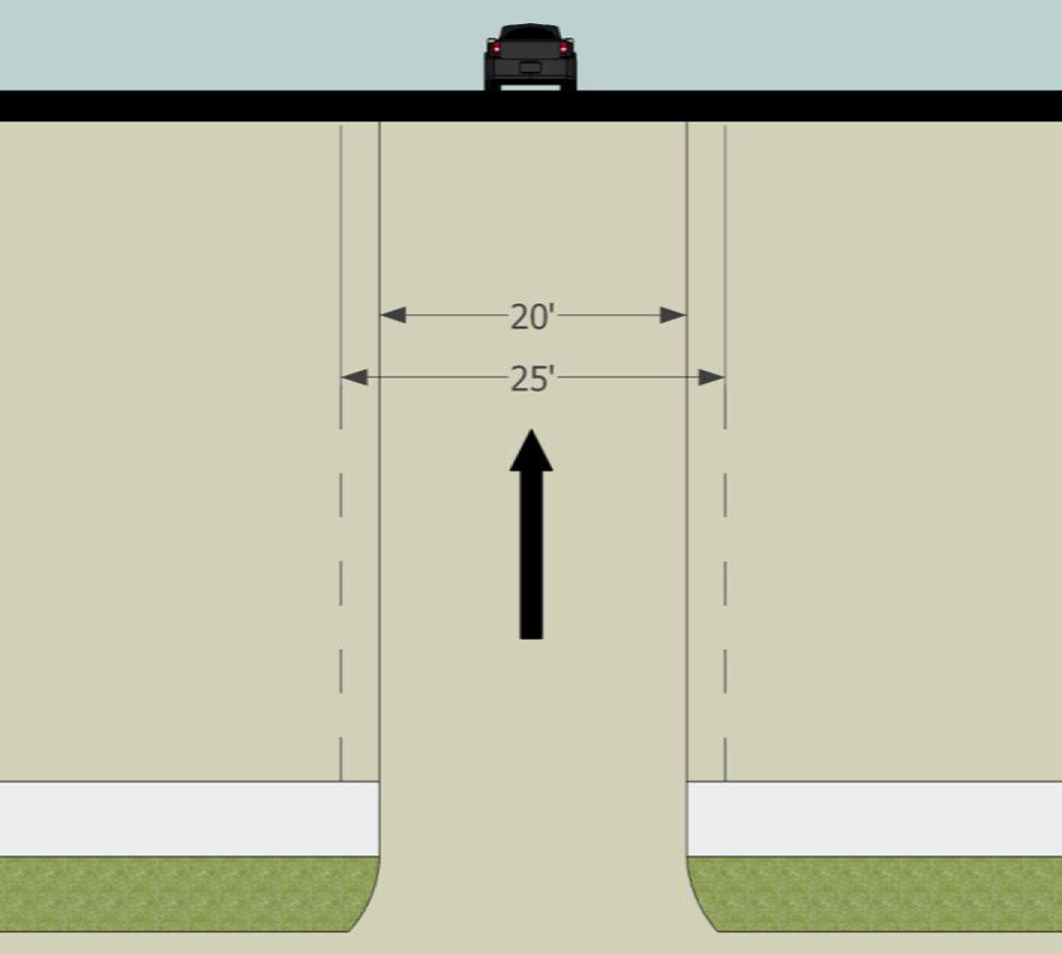
3.4. Residential Street
3.5. Residential Street with Parallel Parking (One Side)
3.6. Residential Street with Parallel Parking
3.7. Commercial Street
3.8. Residential or Commercial Street—2 Lanes
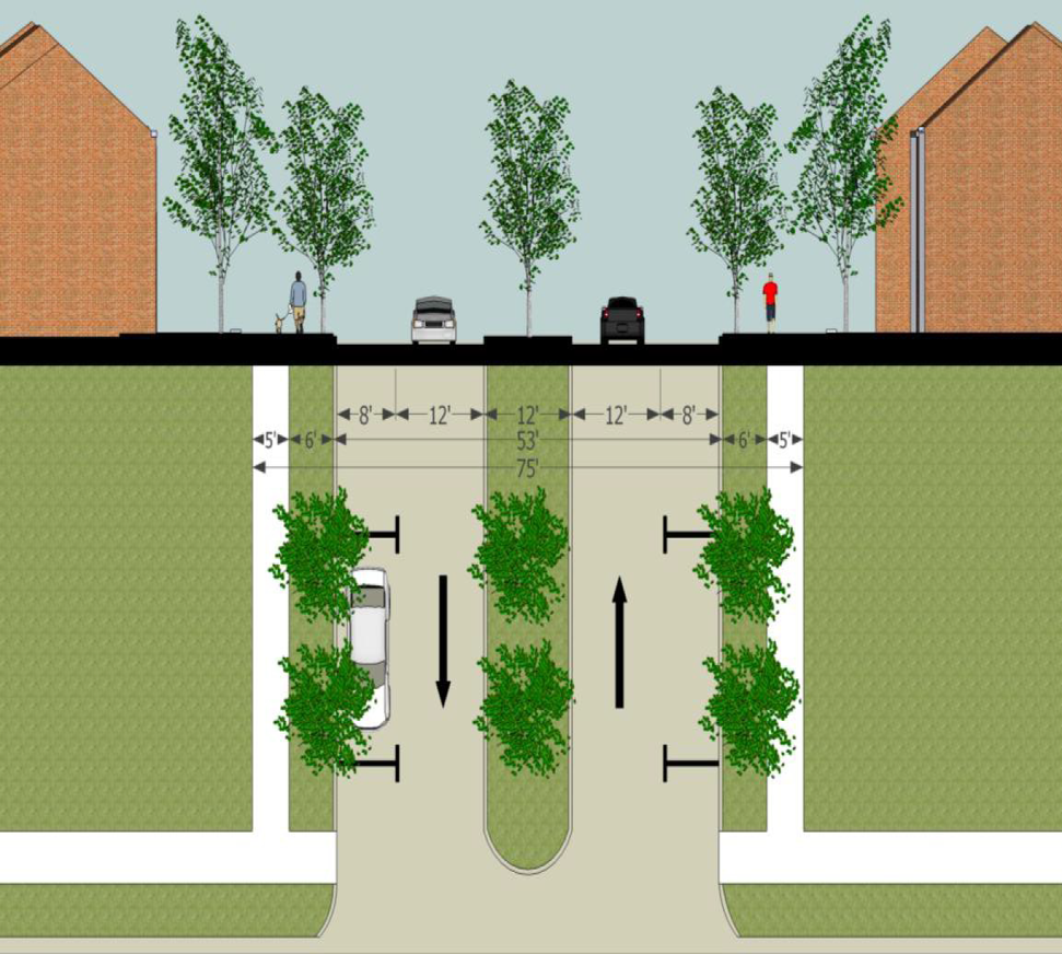
3.9. Residential or Commercial Street—4 Lanes
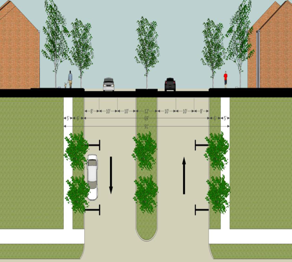
APPENDIX A