
Lake Placid City Zoning Code
ARTICLE IV
- DISTRICT REGULATIONS
§ 154-18. - Provisions applying to all districts.
Regulations under this section shall apply in all zoning districts as to all buildings and uses of land or water, unless otherwise altered or provided in district regulations.
(a)
Height. No structure or building shall be erected, nor shall any existing building be moved, reconditioned or altered for use, so as to exceed in height the limit established by section 154-13 or this chapter or amendments thereto for the district in which such building or structure is located.
(b)
Use. No building or structure shall be erected and no existing building shall be moved, altered, added to or enlarged, nor shall any land, building, structure or premises be used, designed or intended to be used for any purpose or in any manner other than a use designated in this chapter or amendments thereto as permitted in the district in which such land, building, structure or premises is or are located.
(c)
Percentage of lot coverage. No building or structure shall be erected, moved, altered, enlarged or rebuilt, nor shall any open space surrounding any building or structure be encroached upon or reduced in any manner, except in conformity with the building site or lot requirements and the area and parking space and yard regulations established by this chapter or amendments thereto for the district in which such building or structure is located.
(d)
Open space use limitations. No yard or other open space provided about any building or structure for the purpose of complying with this chapter or amendments thereto shall be considered as providing a yard or open space for any other building or structure.
(e)
Required lot. Every building or structure hereafter erected shall be located on a lot or tract as defined herein.
(f)
Established setback lines. Where setback lines have been established on subdivision plats recorded in the records of Highlands County, by ordinance of the town or by this chapter, from right-of-way lines, such setback lines shall be measured perpendicular to and from the right-of-way line at midlot to the front building line. If setback lines of a greater depth are required by one or the other of the above-listed sources, the most restrictive shall govern.
(g)
Vacated right-of-way. Whenever any public right-of-way is vacated and reverts to adjoining property ownership, the zoning regulations applicable to the property to which the former right-of-way is added shall apply to the vacated right-of-way up to the new property line established by the vacating procedure.
(h)
Curb cuts. In order to promote the safety of motorists and pedestrians and to minimize traffic congestions and conflict by reducing the potential points of contact, the following regulations shall apply:
(1)
Curb cuts to private property intended for vehicular use into and/or from a public street shall not exceed twenty-four (24) feet in width nor be less than ten (10) feet at the right-of-way line, except as may otherwise be provided.
(2)
The maximum number of curb cuts permitted into any street shall be:
(3)
No curb cut nor driveway apron shall be permitted nearer then thirty (30) feet to any intersecting street curb or the proposed location of an intersecting street curb.
(4)
There shall be a minimum of twenty (20) feet between any two (2) curb cuts on the same street and the same property. There shall be a minimum of ten (10) feet at the property line between curb cuts on adjoining properties in commercial and industrial districts.
(5)
No curb cut shall be made, nor any driveway apron placed, until a permit has been applied for and issued by the building inspector. An applicant shall submit with his application any and all necessary drawings and descriptive material showing not less than the location, width, number, shape, thickness, material and elevations of finish grade at the property line and at each end of the curb cut or apron, in sufficient detail and accuracy that the building inspector may determine that these and any other legal requirements of the town are, or are not met. No curb cut nor apron shall be permitted which will permit surface drainage to run from a public right-of-way onto private property unless a public utility or drainage easement exists or is provided.
(6)
Residential driveways that are nonasphalted: shellrock, limerock, or clay entering on public roads must have, at a minimum, five (5) feet of the driveway apron constructed of four-inch concrete with approved metal or fiber mesh or one-inch asphalt with a six-inch base of shellrock or limerock. Shellrock, limerock, or clay driveways entering on nonpaved public roads must have an eight-inch material base from the edge of the road to the town right-of-way line.
(i)
Lot of record. A lot or parcel of land which has an area or width which does not conform to the lot requirements of the district in which it is located, but such lot or parcel was shown by a plat or unique legal description recorded in the public records of Highlands County dated on or prior to December 8, 1958; such lot or parcel may be used for at least single-family use or a legal use in the district, provided that the minimum yard and percentage of lot coverage are met as nearly as is practicable in the opinion of the board of zoning adjustment.
(j)
Substandard vacant lots in subdivisions. When a subdivision, or contiguous portions thereof, contains platted lots of parcels that do not conform to the area and width requirements of the zoning district in which it is located and such land is in one (1) contiguous ownership, it shall be incumbent upon the owner to replat such land to conform to the provisions of this chapter before any permit may be issued by the town for any building or use of such property for which the existing platting is nonconforming under the provisions of this chapter, except that a permit may be issued for contiguous parcels which do not exceed one hundred (100) feet in width, regardless of previous platting.
(k)
Locations of buildings in dwelling districts. All accessory buildings in a dwelling district shall meet the following yard and height regulations:
(1)
No detached accessory building shall be located in any required front yard area. (Lakefront property has the option of declaring the lake side the front yard. However, if the lake side is declared the front, accessory structures shall be setback a minimum of fifty (50) feet from the right-of-way, be a minimum of five hundred (500) square feet in size, and be constructed of similar material and a like architectural style to the primary structure.)
(2)
When an accessory building is attached to a principal structure by a breezeway, roofed passage or otherwise, it shall comply with the yard requirements of the principal building.
(3)
A detached accessory building shall not be nearer than four (4) feet to the principal building, nor nearer than four (4) feet to any other accessory building on the same lot.
(4)
An accessory building may not exceed the height of the principal building on the lot and in no event exceed two (2) stories or twenty-four (24) feet in height nor may occupy more than fifty (50) percent of a required yard area or distance.
(l)
Street access required. No dwelling shall be erected on a lot or portion of a lot which does not abut upon a public street with a minimum frontage of at least forty (40) feet.
(m)
Yard and measurement of setbacks. Required setback and yard measurements shall comply with the following requirements:
(1)
Every part of the front, side and rear yard shall be unoccupied and vacant from the ground upward, except for eaves, trees, shrubs, landscaping materials, driveways and sunken garbage collection containers, and in rear or side yards, accessory buildings as permitted by subsection (k) above.
(2)
On double-frontage lots, the required front yard shall be provided on each street.
(3)
Open or enclosed fire escapes, outside stairways and balconies projecting into a minimum yard or court and the projection of chimneys and flues are permitted into yard areas not to exceed thirty-two (32) inches.
(4)
Temporary buildings. Temporary buildings or mobile homes used for construction offices may be permitted in any district upon obtaining a permit from the building and zoning official, but shall meet all health, building, fire, plumbing and electrical code requirements and shall be permitted for a period of not more than six (6) months within any eighteen-month period.
(n)
Service station requirements. Not more than one (1) automobile service and convenience station shall occupy any street frontage within one thousand (1,000) linear feet of another automobile service station in that same street frontage, as measured between property lines.
(1)
All gas pumps or other above-grade structures, excluding signs, shall be set back not less than twenty (20) feet from any street right-of-way line.
(2)
Requirements of subsection (h) of this section shall control access drives and curb cuts.
(o)
Big Box store.
(1)
Location. Big Box stores shall be located in a PD Zoning District with a commercial or mixed use future land use designation. Big Box stores are prohibited in the historic downtown area of the Town of Lake Placid.
(2)
Big Box store setbacks. At the minimum, all improvements shall be set back two hundred (200) feet from the front and side property lines, and one hundred (100) feet from the rear property lines. Provided however, that improvements shall be set back three hundred (300) feet from the property lines of all residentially zoned property. The setback space shall be densely landscaped, irrigated and maintained so that the view of all buildings and improvements are blocked from all public streets and private property. These setbacks are minimum requirements to assure protection of the surrounding property from visual and noise pollution created by the Big Box store and its suppliers and customers.
(3)
Big Box store buildings. Big Box store buildings may cover no more than twenty (20) percent of the Big Box store parcel. Each Big Box store shall reserve at least thirty (30) percent of the Big Box store parcel as landscaped open space (such space shall not be used for buildings, parking, water management facilities or streets).
(4)
Big Box store restrictions. These restrictions apply to all Big Box stores granted by through a PD Zoning District. The town council may adjust these standards provided that substitute restrictions provide equivalent or better protection to the public and surrounding land owners.
(5)
Definition. A Big Box store is any building designed for or devoted to retail use and which is in excess of fifty thousand (50,000) square feet measured from inside the exterior walls. In no event shall a Big Box store exceed one hundred thousand (100,000) square feet, regardless of the lot size.
(6)
Minimum parcel size. A Big Box store may be permitted by special exception on a parcel of land in excess of twenty (20) contiguous acres.
(7)
Building design standards for Big Box stores.
a.
Primary facade.
i.
Definitions.
1.
A primary facade is one that is in the public view and faces or abuts a public or private street, entry court or right-of-way.
2.
A maximum of two (2) facades will be considered primary facades, when more than two (2) facades of a building have frontage on public or private streets. The two (2) exterior facades with the most right-of-way exposure will adhere, to the extent possible, to the requirements of this article with respect to architectural design treatments for primary facades. A deviation from the above requirement for such elements as location of service door, minimum window area, or covered walk requirements may be considered through the PD process.
ii.
Primary facade standards.
1.
Building entrances. Buildings located along a public or private street or pedestrian right-of-way shall be designed with an entrance to the building or an entry courtyard facing or abutting the street or pedestrian right-of-way.
2.
Design standards. The design of the primary facades shall include, at a minimum, two (2) of the following design features:
A.
Glazing.
i.
Glazing covering at a minimum thirty (30) percent of the primary facade area, consisting of window and glazed door openings.
ii.
In the alternative, up to thirty (30) percent of the required glazing area may be covered with a trellis in lieu of glazing.
B.
Projected, or recessed covered public entry providing a minimum horizontal dimension of eight (8) feet, and a minimum area of one hundred (100) square feet.
C.
Covered walkway, or arcade (excluding canvas type). The structure shall be permanent, and its design shall relate to the principal structure. The minimum width shall be eight (8) feet, with a total length measuring sixty (60) percent of the length of the associated facade.
3.
Design features. Each primary facade of a building shall have at least six (6) of the following building design treatments:
A.
Canopies, porticos, or porte-cocheres, integrated with the building's massing and style, or
B.
Overhangs, minimum of three (3) feet, or
C.
Colonnades or arcades, a minimum of eight (8) feet clear in width, or
D.
Sculptured artwork, or
E.
Cornice minimum two (2) feet high with twelve-inch projection, or
F.
Peaked or curved roof forms, or
G.
Arches with a minimum twelve (12) inch recess depth, or
H.
Display windows, or
I.
Ornamental or structural architectural details, other than cornices, which are integrated into the building structure and overall design, or
J.
Clock or bell tower, or other such roof treatment (i.e., dormers, belvederes, and cupolas), or
K.
Emphasized building base, a minimum of three (3) feet high, with a minimum projection from the wall of two (2) inches, or
L.
Additional roof articulation above the minimum standards, or
M.
Curved walls, or
N.
Columns, or
O.
Pilasters, or
P.
Metal or tile roof material.
b.
Facade/wall height transition.
i.
Purpose and intent. The intent of this section is to ensure that the proposed buildings relate in mass and scale to the immediate streetscape and the adjacent built environment.
ii.
Applicability. Buildings that are more than the height of any existing conforming land use (i.e., what is permitted under the current zoning but not the existing structure) shall provide transitional massing elements to transition between the existing land uses of lower height, and the proposed development.
iii.
Transitional elements. No less than sixty (60) percent of the length of the facade, which is in part or whole within the one hundred fifty (150) feet of an existing building, shall incorporate any combination of the following transitional massing elements:
1.
Wall plane changes.
2.
Roofs.
3.
Canopies.
4.
Colonnades.
5.
Balconies.
6.
Other similar architectural features.
iv.
Variation in massing. A single, large, dominant building mass shall be avoided. Changes in mass shall be related to entrances, the integral structure and the organization of interior spaces and activities, and not merely for cosmetic effect. False fronts or parapets create insubstantial appearance and are discouraged. All facades, excluding courtyard area, shall be designed to employ the following design treatments:
1.
Projections and recesses. A maximum length or uninterrupted curve of any facade, at any point, shall be one hundred fifty (150) linear feet. Projections and recesses shall have a minimum depth of twelve (12) feet.
2.
Wall plane changes.
A.
Any facade with horizontal length exceeding fifty (50) linear feet shall incorporate wall plane projections or recesses having a depth of at least three (3) feet, with a single wall plane limited to no more than sixty (60) percent of each affected facade.
B.
If a building has a projection or recess of forty (40) feet or more, each is considered a separate facade, and shall meet the requirements for wall plane changes.
c.
Site design elements. All projects shall have a minimum of two (2) of the following:
i.
Decorative landscape planters or planting areas, a minimum of five (5) feet wide, and areas for shaded seating consisting of a minimum of one hundred (100) square feet, or
ii.
Integration of specialty pavers, or stamped concrete along the building perimeter walkway. Said treatment shall constitute a minimum of sixty (60) percent of walkway area, or
iii.
Water elements, a minimum of one hundred (100) square feet in area, or
iv.
Two (2) accent or specimen trees, above the minimum landscape code requirements, along the primary facade(s) with a minimum height of eighteen (18) feet at planting.
d.
Windows and entrances.
i.
Windows shall not be false or applied. Spandrel panels in curtain wall assembly are allowed, but may not be included in the maximum glazing required for primary facade.
ii.
The first floor of primary facades shall utilize transparent windows for no less than thirty (30) percent of the horizontal length of the building facade. The bottoms of such windows shall be no more than three (3) feet above the walkway grade and the tops of such windows shall not be less than eight (8) feet above the walkway grade.
e.
Detail features.
i.
Design elements. The design elements in the following standard shall be an integral part of the building's design and shall be integrated into the overall architectural style. This element shall not consist solely of applied graphics or paint.
ii.
Blank wall areas. Blank, opaque wall areas shall not exceed ten (10) feet in vertical direction or twenty (20) feet in the horizontal direction of any primary facade. For facades connected to a primary facade, this shall apply to a minimum of thirty-three (33) percent of the attached facades measured from the connection point. Control and expansion joints within this area shall constitute blank wall area unless used as a decorative pattern and spaced at intervals of six (6) feet or less. The depth of the relief and reveal work must be a minimum of two (2) inches.
f.
Roof treatments.
i.
Roof edge and parapet treatment. Roofs, other than mansard roofs, with the slope ratio of 3:12 or higher, are exempt from the preceding requirements for vertical change for the facades, which are not longer than one hundred ninety-nine (199) feet. One (1) roof edge, or parapet line change, shall be provided for every two hundred (200) linear feet of the facade length.
ii.
Design standards.
1.
Parapets.
A.
When parapets are used to conceal rooftop equipment and flat roofs, the height of the parapet(s) shall be sufficient to conceal such roof equipment from the ground-level public view.
B.
The use of parapets cannot constitute a roof change for purposes of this section.
C.
No more than four (4) vertical feet of parapet area may be used to calculate permissible sign area.
D.
Architectural detailing shall be present on parapets.
2.
When a flat roof is screened with a parapet wall or mansard roof at any facade, the parapet or mansard roof treatment shall be extended along the remaining facades.
3.
Prohibited roof types and materials. The following roof types and roof materials are prohibited:
A.
Asphalt shingles.
B.
Mansard roofs and canopies, unless they meet the following standards:
i.
Minimum vertical height clearance of eight (8) feet.
ii.
The roof angle shall not be less than twenty-five (25) degrees, and not greater than seventy (70) degrees.
C.
Awnings used as mansard or canopy roofs.
g.
Awning standards. These standards apply to awnings associated with and attached to the "Big Box store" structure.
i.
Mansard awnings, which are those awnings that span ninety (90) percent or more of a facade length, and those which do not provide a connection between facades, shall adhere to all roof standards of subsection 154-18(o)(7)(f), roof treatments.
ii.
All other awnings, which are awnings that constitute less than ninety (90) percent of a facade length, and those that do not provide a connection between facades, shall adhere to the following standards:
1.
The location of awnings shall relate to the window and door openings.
2.
Backlighting on awnings is prohibited.
h.
Overhead doors.
i.
Required screening. Overhead doors shall not be located on primary facades, unless sufficient screening is proposed. If an overhead door is required in a primary facade, a screening wall, with a minimum height of ninety (90) percent of the overhead door height, or a landscape buffer achieving seventy-five (75) percent opacity within (1) one year, shall be provided. The placement and length of these screening devices shall block the view of the overhead doors from the street.
ii.
Doors facing one another. Overhead doors facing one another may be treated as interior space, provided that the buildings meet all other requirements of this section, and the distance between the doors facing one another is no more than fifty (50) feet.
i.
Entryways/customer entrance treatments.
i.
Purpose and intent. Entryway design elements are intended to give protection from the sun and adverse weather conditions. These elements are to be integrated into a comprehensive design style for the project.
ii.
"Big Box store" structure shall have clearly defined, highly visible, customer entrance(s). The customer entrance shall meet the following standards:
1.
An outdoor patio area shall be provided adjacent to the customer entrance, with a minimum of two hundred (200) square feet in area. The patio area shall incorporate the following:
A.
Benches or other seating components,
B.
Decorative landscape planters or wing walls which incorporate landscaped areas, and
C.
Structural or vegetative shading.
2.
Front entry shall be set back from a driveway or parking area by a minimum distance of fifteen (15) feet.
j.
Materials and colors.
i.
Purpose and intent. Exterior building colors and materials contribute significantly to the visual impact of buildings on the community. The colors and materials shall be well designed and integrated into a comprehensive design style for the project.
ii.
Exterior building colors. Earth and/or pastel tones are encouraged to the maximum extent possible. The use of black, fluorescent, primary and secondary colors is limited to no more than ten (10) percent of the affected facade, or the roof area. Building trim and accent areas may feature any color.
iii.
Exterior building materials. The following building finish materials are limited to no more than thirty-three (33) percent of the facade area:
1.
Corrugated, or reflective metal panels,
2.
Smooth concrete block.
iv.
Neon tubing. The use of neon or neon type tubing is not permitted to outline the exterior or the roof of a building.
(8)
Additional requirements. In addition to the PD requirements herein set out, the town council may apply such additional requirements as are reasonable to insure that a Big Box store when in use, or if abandoned, shall be screened from public view and include all infrastructure reasonably required to support its maintenance and operation, including, without limitation, water supply, sewage disposal, irrigated and maintained green space.
(p)
Power substation location and landscape regulations.
(1)
Applicability: All new power transmission substations in all zoning districts.
(2)
Additional application requirements. The applicant shall provide a site plan for the proposed substation of sufficient scale to clearly indicate the arrangement of the various functions of the station. At a minimum the site plan shall indicate the following:
a.
An area sketch indicating the location of the property within its immediate vicinity and the distance to the closest intersecting public roads and the distance to all adjacent residential uses to the east, west, north and south.
b.
The boundaries of the property, with dimensions, including the wall or fence locations or borders.
c.
All uses on the site, the vegetative buffer areas, driveways or other entrances or exits, any storage areas, and types of materials to be stored within the property, including the length and width of such areas and uses.
d.
Location of any on-site environmental issues such as wetlands, and natural seasonal surface water areas and uses.
e.
The topography, surface drainage and location of proposed retention areas.
f.
Cross sections of the berms or fences and vegetative buffers.
(3)
Additional standards for approval.
a.
Zoning district setbacks. Setbacks in the front, side and rear shall be at a minimum no less than twice the footprint of the width of the substation, or the minimum of one hundred (100) feet in residential districts or adjacent to residential uses, measured from the inner part of the landscape buffer that surrounds the substation.
b.
Required screening in nonresidential zoning districts. A minimum forty (40) feet vegetative buffer is required in all nonresidential zoning districts. No substitution of berms or fences is allowed if the power substation is within one hundred (100) feet of a residential zoning district.
c.
Required screening in residential zoning districts. Required screening in a residential zoning district shall include in addition to vegetation; a wall or fence or berm.
d.
Screening in residential zoning districts or when the power substation is adjacent to or within one hundred (100) feet of a residential zoning district. A screen shall be provided around the entire perimeter of the power substation that will completely obscure the contents within from the abutting or adjacent properties and public rights-of-way. The screening shall be accomplished by one (1) of the following methods:
i.
Screen.
1.
Solid wall or fence. When a solid wall or fence is selected as a screen, it shall be a minimum eight (8) feet in height, constructed of substantial materials such as masonry units, pressure treated woods or composition non-organic materials simulating masonry, concrete or wood materials. The wall or fence shall be constructed without openings except for the entrance/exit. The gate to the entrance/exit shall, materials permitting also be without openings. If painted, the wall or fence colors shall be within the earth tone palette.
2.
Vegetative. When vegetation, which shall be fully irrigated, is selected as material for a screen, a continuous border forty (40) feet deep shall be set outside a security fence (chain-link, six (6) feet in height, if a wall is not used), with non-coniferous broad-leafed evergreen trees consisting of two (2) rows, with trees spaced not more than twenty (20) feet apart on centers, staggered alternately, with one (1) linear row of evergreen scrubs, three (3) feet on centers, planted between the two (2) rows of staggered trees, to obscure the area of view between the ground and the beginning of the tree canopy. The border is to be fully planted.
3.
Earthen berm. When an earthen berm is selected for a screen, a continuous border twenty (20) feet wide shall be set outside a security fence (chain-link, six (6) feet in height, if a wall is not used), within which the berm will be located and built on a maximum slope of 2:1 to at least four (4) feet in height, covered with an appropriate ground cover and capped with an evergreen shrub hedge at least four (4) feet in height, for an overall height of eight (8) feet.
4.
Plans for the walls or fence, earthen berm, and vegetative screen and fence shall be submitted and reviewed by the town's contractual engineering services as part of the building permit application.
5.
Screen maintenance. The applicant must guarantee by affidavit that the screen will be maintained as specified and approved by this Code.
(q)
Underground utilities. All utilities shall be underground in all new developments and redevelopments (individual residential lots, residential subdivisions, commercial development).
(r)
Multipurpose trails and paths.
(1)
The Town of Lake Placid desires to develop multipurpose paths for jogging, biking and walking. Collector roads shall include right-of-way of at least fifteen (15) feet for such paths. Developers shall either construct path segments adjacent to the proposed development; or pay for the construction of similar improvements off-site related to the impacts of the development. The paths are part of a coordinated trail and multiuse path system that provides interconnectivity for the entire planning area. The system design will accommodate an eight- to ten-foot pathway, adequate landscaping area, and maintenance.
(2)
On existing roads in developed areas, trails should be added to the extent that right-of-way is available. If right-of-way is not available in developed areas, paved shoulders at least five (5) feet wide may be substituted. Trails are not required (but are encouraged) within private gated communities, and along low traffic neighborhood roads.
Figure 154-18(r)A.
Multi-Use Trail

(s)
Access management standards.
(1)
Access to U.S. 27 and collector roads shall be managed through the use of, service roads (including frontage and backage roads) and access roads in a manner that protects the taxpayer's investment in the road system by reducing traffic impacts. Developers shall use to the greatest extent possible, shared drives, service roads, and linked parking lots. Division of property after July 1, 2006, shall not be used to create new parcels acquiring separate access rights to U.S. 27 or any other road (such newly created parcels shall have access only through the parent tract, unless reasonable benefit to the public is demonstrated by the applicant).
(2)
Access to individual parcels or parcels as part of an overall project, either requested for approval at one time or over a cumulative basis, shall be by an internal road system, frontage roads, cross-access easements, shared ingress/egress access easements, or some combination of these, off of a main access to a collector or arterial road.
(3)
Different uses shall incorporate shared ingress/egress facilities even if on the same parcel or multiple parcels.
(t)
Driveways. Private driveways for new platted lots on an existing collector or arterial road and new collector and arterial roads shall be prohibited. Driveways in proposed developments will be serviced by internal (public or private) community roadways. All parking spaces shall be accessed by a driveway and shall not have direct access to collectors and arterial roads.
(u)
Residential drives on major and minor collectors. Residential drive on major and minor collectors. Residential drives shall not be allowed on major or minor collectors, however, an exception may be made where this policy prevents the reasonable use of land. This exception should not be used to simply increase density. Parcels divided after the effective date of the LPRP may not rely upon this exemption to gain additional curb cuts or driveways. Where existing conditions require exception, individual drives shall be discouraged in favor of combined drives.
(v)
Parking. Parking requirements for residential and nonresidential development may be decreased or increased through a waiver process if the developer presents a parking study demonstrating a reduced need based on the proposed use. The use of unpaved parking areas should be allowed, where appropriate, to increase green space and pervious area.
(1)
Parking requirements may be increased if parking study shows that a specific use requires additional parking.
(2)
Change in use should be allowed only if the owner provides parking for the new use.
(w)
Traffic circulation systems (within developments). Traffic circulation system within developments shall be designed utilizing a network system that will be open to the public. However, the network may incorporate a grid system, a curvilinear design pattern and traffic circles where appropriate. The design of the circulation system shall encourage internal capture of road trips, thereby preserving capacity on the existing exterior arterials. Gated communities may be permitted. Ownership of the arterial, collector and local roadway system may be held by an appropriate governmental entity, community development district, master homeowners association, or a combination thereof. The internal roadway system shall be a combination of a two-lane undivided and a two-lane divided system. Where appropriate, four lane-divided systems may also be utilized. The divided lane system will be landscaped to improve the traveling experience and to provide beautification to the development.
Figure 154-18(w)A.: Example of 4-lane divided corridor
(Ord. No. 174, 4-9-90; Ord. No. 99-314, § 1, 9-20-99; Ord. No. 05-431, § 3, 8-8-05; Ord. No. 06-517, § 1, 7-10-06; Ord. No. 2016-712, 1-11-16; Ord. No. 2016-723, § 17, 6-12-17; Ord. No. 2018-766, § 2, 9-10-18)
§ 154-19. - Purpose.
The purpose of sections 154-20 through 154-27 is to set out the regulations which are applicable and unique to each district into which Lake Placid is divided and shown on the revised zoning map. The provisions of this article govern the use and location and establish requirements which shall be met for each zoning district.
(Ord. No. 2016-723, § 18, 6-12-17)
§ 154-20. - A-1 Agricultural District.
(a)
Purpose. The purpose of the A-1 Agricultural District is twofold. One, to provide for a holding classification of lands not expected to develop urban density of uses within the immediate future; and two, to provide for reasonable low-density urban uses and for normal agricultural uses. It is intended that, as lands in this district become necessary for orderly development of more intensive urban uses, changes in zoning classification can be considered through amendatory processes under law.
(b)
Principal uses permitted. Principal uses permitted shall be as follows:
(1)
Any recognized agricultural or horticultural use, including grove maintenance operations, which do not create a hazard or nuisance beyond the property on which they are located.
(2)
Single-family dwellings of conventional construction.
(3)
Private boat ramps, docks, boathouses and fishing piers, subject to the provisions of section 154-13.
(4)
Public parks, playgrounds of public schools.
(5)
Public utility facilities; any public use. It is intended that utility facilities operating under franchises granted by the town are classified as public.
(c)
Accessory uses permitted. Accessory uses permitted shall be as follows:
(1)
Private garages, barns and general storage buildings for agricultural uses.
(2)
Greenhouses, not for commercial use.
(3)
Hobby or craft shops, not for commercial use.
(4)
Swimming pools, not for commercial use.
(5)
Music, art or photography studio, provided that no evidence by sign, letter, symbol or marking indicates such use, which is visible from outside of the building.
(6)
Home occupation, such as office use, including the right to advertise such by address and telephone only.
(7)
Renting of up to three (3) rooms in a principal building, provided that adequate parking spaces are provided and no "for rent" signs are used.
(d)
Special exception uses. Special exception uses, which may be permitted by the board of zoning adjustment after public hearing, shall be as follows:
(1)
Churches and church uses.
(2)
Servant or domestic quarters, provided that no kitchen facilities are included therein.
(3)
Heliports or STOL ports, seaplane landing facilities.
(4)
Transmission towers and similar structures.
(e)
Prohibited uses. Prohibited uses shall be as follows:
(1)
Any nonagricultural or nonhorticultural commercial or industrial use.
(2)
Mobile homes and mobile home parks or factory-built housing.
(3)
Keeping of swine, horses, cattle, chickens or other food-producing animals.
(4)
Signs and billboards, except those permitted in connection with home occupations, temporary "for sale" signs for not more than six (6) months on any one property, church signs which may be approved by the board of zoning adjustment and necessary public information and directional signs.
(5)
Day nurseries and kindergartens.
(6)
Temporary buildings, including tents and mobile home structures, except that these may be permitted by the board of zoning adjustment when they are related with or used for temporary construction uses.
(7)
Duplexes and multifamily dwellings.
(8)
Any other use not specifically permitted.
(f)
Lot and living area minimum requirements. Lot and living area minimum requirements shall be as follows:
(g)
Yard and building requirements and height limitations.
(1)
Yard and building requirements shall be as follows:
(2)
No building may exceed thirty-five (35) feet in height, except spires, domes, towers or any structure not intended for human occupancy.
(h)
Lot coverage. Lot coverage by all buildings on any lot or parcel shall not exceed twenty (20) percent of land area.
(i)
Lot widths. No lot for any use shall be less than one hundred (100) feet in width at the front building line.
(Ord. No. 98-298, § 13, 9-14-98; Ord. No. 99-309, § 1, 6-29-99; Ord. No. 2016-723, § 19, 6-12-17)
§ 154-21. - R-1A Single-Family Dwelling District.
(a)
Purpose. The purpose of the R-1A Single-Family Dwelling District is to provide for areas of highly restricted single-family dwelling use, along with the necessary and incidental accessory uses and uses characteristic and accepted with, but not detrimental to the principal uses.
(b)
Principal uses permitted. Principal uses permitted shall be as follows:
(1)
Single-family dwellings of conventional construction.
(2)
The growing of agricultural or horticultural plants, with no sales buildings, displays, stands or places on the premises.
(3)
Public parks, playgrounds and utility facilities owned by the public or franchised firms, and any public use.
(4)
Private boat ramps, docks, boathouses and piers, subject to the provisions of § 154-13.
(c)
Accessory uses permitted. Accessory uses permitted shall be as follows:
(1)
Private garages, parking spaces and storage buildings, not for rental or commercial use.
(2)
Greenhouses, not for commercial use.
(3)
Hobby and craft shops, not for commercial use.
(4)
Swimming pools, not for commercial use.
(5)
Music, art or photography studio, provided that no evidence by sign, letter, symbol or marking indicates such use which is visible outside the building and that such use is within the principal building and only operated by residents of the premises.
(6)
Home occupation, such as office use, including the right to advertise such by address and telephone number only.
(7)
Renting of up to three (3) rooms in a principal building, provided that adequate parking is provided and no "for rent" signs are used.
(d)
Special exception uses. Special exception uses, which may be permitted by the board of zoning adjustment after a public hearing, shall be as follows:
(1)
Churches and church uses.
(2)
Servants' or domestic workers' quarters, provided that no kitchen facilities are included therein.
(3)
Schools.
(e)
Prohibited uses. Prohibited uses shall be as follows:
(1)
Any commercial or industrial use, except as permitted above.
(2)
Mobile homes, mobile home parks or factory-built housing, duplexes and multifamily dwellings.
(3)
Tents or temporary buildings and uses.
(4)
Overnight parking of commercial automotive equipment of more than one-ton capacity on residential lots.
(5)
Keeping of swine, cattle, horses, chickens and other such animals.
(6)
Dog kennels for breeding, feeding or keeping pens or lots for the keeping or boarding of any dogs.
(7)
Signs and billboards, except those permitted in connection with home occupations, temporary "for sale" signs for not more than six (6) months on any one (1) property, church signs which may be approved by the board of zoning adjustment and necessary public information and directional signs.
(8)
The teaching of swimming classes.
(9)
Day nurseries and kindergartens.
(10)
Any other use not specifically permitted.
(f)
Lot and living area minimum requirements. Lot and living area minimum requirements shall be as follows:
(g)
Yard and building requirements and height limitations.
(1)
Yard and building requirements shall be as follows:
(2)
No building may exceed thirty-five (35) feet in height, except spires, domes, towers or any structure not intended for human occupancy.
(h)
Lot coverage. Lot coverage by all buildings on any lot or parcel shall not exceed thirty (30) percent of land area.
(i)
Lot widths. Lot widths at the front building line shall be not less than seventy (70) feet.
(Ord. No. 174, 4-9-90; Ord. No. 99-309, § 2, 6-39-99; Ord. No. 2016-723, § 20, 6-12-17)
§ 154-22. - R-1 Single-Family Dwelling District.
(a)
Purpose. The purpose of the R-1 Single-Family Dwelling District is to provide for a slightly less restrictive single-family district than the A-1 or R-1A Dwelling Districts, along with allowing the necessary and incidental accessory uses and uses characteristic with, but not detrimental to the principal uses.
(b)
Principal use permitted. Principal uses permitted shall be as follows:
(1)
Single-family dwellings of conventional construction.
(2)
The growing of agricultural or horticultural plants, with no sales buildings, displays, stands or places on the premises.
(3)
Public parks, playgrounds and utility facilities owned by the public or franchised firms, and any public use.
(4)
Private boat ramps, docks, boathouses and piers, subject to the provisions of section 154-13.
(5)
Day nurseries and kindergartens, provided that there shall be no sign more than three (3) square feet in area and no lighted sign; the entire play yard is fenced with at least four-foot-high fencing; off-street unloading space is provided for not less than three (3) vehicles and does not require backing into the public right-of-way; the play yard is not less than seventy-five (75) feet from any residential dwelling unit not on the same lot; and the applicant has all licenses or permits required by the town, county and state.
(c)
Accessory uses permitted. Accessory uses permitted shall be as follows:
(1)
Private garages, parking spaces and storage buildings, not for rental or commercial use.
(2)
Greenhouses, not for commercial use.
(3)
Hobby and craft shops, not for commercial use.
(4)
Swimming pools, not for commercial use.
(5)
Music, art or photography studio, provided that no evidence by sign, letter, symbol or marking indicates such use which is visible outside the building and only operated by residents of the premises.
(6)
Home occupation, such as office use, including the right to advertise such by address and telephone number only.
(7)
Renting of up to three (3) rooms in a principal building, provided that adequate parking is provided and no "for rent" signs are used.
(d)
Special exception uses. Special exception uses, which may be permitted by the board of zoning adjustment after a public hearing, shall be as follows:
(1)
Churches and church uses.
(2)
Servants' or domestic workers' quarters, provided that no kitchen facilities are included therein.
(3)
Schools.
(e)
Prohibited uses. Prohibited uses shall be as follows:
(1)
Any commercial or industrial use, except as permitted above.
(2)
Duplexes and multifamily dwellings.
(3)
Tents or temporary buildings and uses.
(4)
Overnight parking of commercial automotive equipment of more than one-ton capacity on residential lots.
(5)
Keeping of swine, cattle, horses, chickens and other such animals.
(6)
Dog kennels for breeding, feeding or keeping pens or lots for the keeping or boarding of any dogs.
(7)
Signs and billboards, except those permitted in connection with home occupations, temporary "for sale" signs for not more than six (6) months on any one (1) property, church signs which may be approved by the board of zoning adjustment and necessary public information and directional signs.
(8)
The teaching of swimming classes.
(9)
Any other use not specifically permitted.
(f)
Lot and living area minimum requirements. Lot and living area minimum requirements shall be as follows:
;sz=9q;*NOTE: Or as required by state or county regulations, whichever are most restrictive.
(g)
Yard and building requirements and height limitations.
(1)
Yard and building requirements shall be as follows:
(2)
No building may exceed thirty-five (35) feet in height, except spires, domes, towers or any structure not intended for human occupancy.
(h)
Lot coverage. Lot coverage by all buildings on any lot or parcel shall not exceed thirty (30) percent of land area.
(i)
Lot widths. Lot widths at the front building line shall be not less than sixty (60) feet.
(Ord. No. 174, 4-9-90; Ord. No. 99-309, § 3, 6-29-99; Ord. No. 07-554, §§ 1, 2, 5-14-07; Ord. No. 2016-723, § 21, 6-12-17)
§ 154-23. - R-2 Multifamily Dwelling District.
(a)
Purpose. The purpose of the R-2 Multifamily Dwelling District is to provide areas for single-family, duplex and multifamily dwelling uses with a higher density standard and lower restrictive regulations than single-family districts, along with the necessary and incidental accessory uses and uses characteristic with, but not detrimental to the principal use; but to limit the density of dwelling units to not more than twelve (12) dwelling units per net acre of land area.
(b)
Principal uses permitted. Principal uses permitted shall be as follows:
(1)
Single-family dwellings of conventional construction.
(2)
The growing of agricultural or horticultural plants, with no sales buildings, displays, stands or places on the premises.
(3)
Public parks, playgrounds and utility facilities owned by the public or franchised firms, and any public use.
(4)
Private boat ramps, docks, boathouses and piers, subject to the provisions of section 154-13.
(5)
Day nurseries and kindergartens, provided that there shall be no sign more than three (3) square feet in area and no lighted sign; the entire play yard is fenced with at least four-foot-high fencing; off-street unloading space is provided for not less than three (3) vehicles and does not require backing into the public right-of-way; the play yard is not less than seventy-five (75) feet from any residential dwelling unit not on the same lot; and the applicant has all licenses or permits required by the town, county and state.
(6)
Duplex dwellings.
(7)
Multifamily dwellings.
(8)
Town or row house dwellings.
(c)
Accessory uses permitted. Accessory uses permitted shall be as follows:
(1)
Private garages, parking spaces and storage buildings, not for rental or commercial use.
(2)
Greenhouses, not for commercial use.
(3)
Hobby and craft shops, not for commercial use.
(4)
Swimming pools, not for commercial use.
(5)
Music, art or photography studio, provided that no evidence by sign, letter, symbol or marking indicates such use which is visible outside the building and that such use is within the principal building and only operated by residents of the premises.
(6)
Home occupation, such as office use, including the right to advertise such by address and telephone number only.
(7)
Renting of up to three (3) rooms in a principal building, provided that adequate parking is provided and no "for rent" signs are used.
(d)
Special exception uses. Special exception uses, which may be permitted by the board of zoning adjustment after a public hearing, shall be as follows:
(1)
Churches and church uses.
(2)
Servants' or domestic workers' quarters, provided that no kitchen facilities are included therein.
(3)
Schools.
(4)
Boarding- or rooming-houses.
(5)
Convalescent or nursing homes.
(6)
Medical or dental clinics or hospital for human care.
(e)
Prohibited uses. Prohibited uses shall be as follows:
(1)
Any commercial use or industrial use not specifically permitted.
(2)
Tents, temporary buildings and uses.
(3)
Keeping of swine, cattle, horses and chickens and other such animals.
(4)
Dog kennels for breeding, feeding or keeping pens or lots for the boarding of any dogs.
(5)
Signs and billboards, except those permitted in connection with home occupations, temporary "for sale" signs for not more than six (6) months on any one property, church signs which may be approved by the board of zoning adjustment and necessary public information and directional signs.
(6)
Any other use not specifically permitted.
(f)
Lot and living area minimum requirements. Lot and living area minimum requirements shall be as follows:
(g)
Yard and building requirements and height limitations.
(1)
Yard and building requirements shall be as follows:
a.
Adjacent to public rights-of-way.
i.
Principal use: Twenty-five (25) feet.
1.
Front yard.
2.
Accessory buildings not permitted in front yards.
ii.
Rear yard: Twenty (20) feet.
iii.
Side yard:
1.
Principal use: Seven and one-half (7-1/2) feet for a one-story structure, plus one (1) foot of yard for each one (1) foot of structure height above one (1) story.
2.
Accessory uses: Five (5) feet.
b.
Adjacent to private rights-of-way.
i.
Principal use:
1.
Front yard. Twenty-five (25) feet. In a platted subdivision incorporating new urbanism and traditional neighborhood design featured such as mixed housing types, pedestrian connectivity and providing a minimum community open space within the plat (excluding streets or alleys) of twenty-five (25) percent of the sum of all lot areas, the front yard setback may be reduced to twelve (12) feet. A corner lot within such subdivision may have a front setback at its corner reduced to five (5) feet provided that the actual building sets back a minimum of fifteen (15) feet from any roadway.
2.
Accessory buildings not permitted in front yards. Not withstanding subsection 154-18(k)(2), an accessory trellis which is part of and connected to a rear loaded garage, may have a minimum rear yard of ten (10) feet where such garage is accessed by a rear alley.
ii.
Rear yard: Twenty (20) feet.
iii.
Side yard:
1.
Principal use: Seven and one-half (7½) feet for a one-story structure, plus one (1) foot of yard for each one (1) foot of structure height above one (1) story.
2.
Accessory uses: Five (5) feet.
(2)
Height. No structure shall exceed thirty-five (35) feet in height, measured from the finished grade at the center front.
(h)
Lot coverage. Lot coverage by all buildings on any lot or parcel shall not exceed fifty (50) percent of the total land area.
(i)
Lot widths. The minimum lot width shall be fifty (50) feet.
(Ord. No. 05-464, § 1, 8-8-05; Ord. No. 2016-723, § 22, 6-12-17)
§ 154-23.1. - R-2A Two-Family Residential Dwelling District.
(a)
Purpose. The Two-Family Residential (R-2A) District is intended to provide relatively affordable housing for duplex dwellings, and to serve as a transitional zoning district between multifamily and single-family residential uses. The maximum density within this district shall not exceed six (6) dwelling units per net acre of land area.
(b)
Principle uses permitted. Principle uses permitted shall be as follows:
(1)
Two-family dwellings (duplexes).
(2)
Single-family unattached and attached dwellings.
(3)
Town or row house dwellings.
(4)
Zero lot line single-family dwellings.
In cases where two-family dwellings are proposed, plans shall be presented for both units simultaneously. Access easements for maintenance of common walls and other facilities shall be provided. Furthermore, utility easements allowing service to each unit shall be provided.
(c)
Accessory uses permitted. Accessory uses permitted shall be as follows:
(1)
Home occupation, such as office use is permitted. The right to advertise shall be restricted to an unlighted nameplate not more than two (2) square feet in area, and no displays that indicate from the exterior that the building is being utilized in part for any purpose other than that of a dwelling.
(d)
Special exception uses. None.
(e)
Lot and living area minimum requirements. Lot and living area minimum requirements shall be as follows:
(f)
Yard and building requirements and height limitations for duplexes.
(1)
Yard and building requirements shall be as follows:
a.
Principal use: Twenty-five (25) feet.
1.
Front yard: Twenty-five (25) feet.
2.
Rear yard: Twenty (20) feet.
3.
Side yard: Seven and one-half (7-1/2) feet for a one-story structure, plus one (1) foot of yard for each one (1) foot of structure height above one (1) story.
b.
Height: Thirty-five (35) feet in height, measured from the finished grade at the center front.
(g)
Yard and building requirements and height limitations for zero lot line, single-family dwellings on private rights-of-way.
(1)
Yard and building requirements shall be as follows:
a.
Principal use:
1.
Front yard: Twenty-five (25) feet. In a platted subdivision incorporating new urbanism or traditional neighborhood design features such as mixed housing types, pedestrian connectivity and providing a minimum community open space within the plat (excluding streets or alleys) of twenty-five (25) percent of the sum of all lot areas, the front yard setback may be reduced to nine (9) feet.
2.
Rear yard: Twenty (20) feet.
3.
[Side yard.] No side yard.
b.
Height: Thirty-five (35) feet in height, measured from the finished grade at the center front.
(h)
Yard and building requirements and height limitations for town or row houses and single-family attached units on public rights-of-way.
(1)
Yard and building requirements shall be as follows:
a.
Principal use: Twenty-five (25) feet.
1.
Front yard: Twenty-five (25) feet.
2.
Rear yard: Twenty (20) feet.
3.
[Side yard:] No side yard.
b.
Height: Thirty-five (35) feet in height, measured from the finished grade at the center front.
(i)
Lot coverage. Lot coverage by all buildings on any lot or parcel shall not exceed fifty (50) percent of the total land area.
(j)
Lot widths. The minimum lot width shall be fifty (50) feet.
(Ord. No. 98-298, § 14, 9-14-98; Ord. No. 05-464, § 2, 8-8-05; Ord. No. 2016-723, § 22, 6-12-17)
§ 154-24. - Reserved.
Editor's note— Ord. No. 04-415, § 1, adopted July 12, 2004, repealed § 4-24, [formerly of ch. 4 of the Land Development Code] which pertained to the MH-1 Mobile Home Park District (Residential) and was derived from Ord. No. 114, as revised in 1977.
§ 154-25. - C-1 Highway Commercial District.
(a)
Purpose. The purpose of the C-1 Highway Commercial District is to provide for commercial uses of land and buildings along highway frontage in a manner that will:
(1)
Recognize its economic utility in servicing the motoring public.
(2)
Establish certain criteria to promote traffic safety in such service.
(3)
Minimize any adverse effect of such commercial uses on adjoining residential or agricultural districts.
(b)
Principal uses permitted. Principal uses permitted shall be as follows:
(1)
Combination residence/limited commercial uses; provided, however, that both are owned and operated by the same party.
(2)
Public parks, playgrounds and utility facilities owned by the public or franchised firms, and any public use.
(3)
Private boat ramps, docks, boathouses and piers, subject to the provisions of chapter 162.
(4)
Day nurseries and kindergartens, provided that the entire play yard is fenced with at least four-foot-high fencing; off-street unloading space is provided for not less than three (3) vehicles and does not require backing into the public right-of-way; the play yard is not less than seventy-five (75) feet from any residential dwelling unit not on the same lot; and the applicant has all licenses or permits required by the town, county, and state.
(5)
Highway-oriented businesses, such as service stations; motels or hotels; restaurants; rental, sales, and service of automotive or other vehicles, farm machinery and equipment; and recreational vehicle or travel trailer or mobile home sales and service.
(6)
Any legal use of land or buildings which offers goods or services for retail sale or rental to the public or any sector of the public.
(7)
Commercial and personal services, such as barber and beauty shops, shoe repair, book and record sales, laundry pickup and delivery, antique shops, camera and photographic supplies and sales, pharmaceutical sales, custodial care centers for preschoolers or elderly persons and educational facilities, public or private.
(8)
Professional offices, such as dental, medical, legal, real estate, insurance, accounting, finance, trade organizations, cooperatives and government, where the principal use is that of providing goods and service at retail.
(9)
Medical or dental clinics or hospitals for human care.
(10)
Mini-warehouses. Wholesale uses are permitted as principal uses when totally enclosed in a building. Retail uses will be allowed with no outside display unless written authorization is granted by special exception. Parking requirements must be met for retail usage and the appropriate occupational licenses must be authorized prior to the initiation of the retail use.
(11)
Warehousing or wholesaling as a principal use when totally enclosed in a building providing visual obstruction from off-site.
(c)
Accessory uses permitted. Accessory uses permitted shall be as follows:
(1)
Any use normally deemed to be clearly incidental and secondary to a permitted use.
(d)
Special exception uses. Special exception uses, which may be permitted or excluded by the board of zoning adjustment after a public hearing, shall be as follows:
(1)
Churches and church uses.
(2)
Mobile home structures for temporary offices, not to exceed six (6) months in any eighteen-month period.
(3)
Tents and temporary buildings, not to exceed three (3) months in any eighteen-month period.
(4)
Reserved.
(5)
Funeral parlors, homes or mortuaries.
(6)
Flea markets.
(7)
The growing of agricultural or horticultural plants, with/without sales buildings, displays, stands, or places on the premises.
(8)
Bars, lounges.
(e)
Prohibited uses. The following listed or implied uses are prohibited in any C-1 District:
(1)
Single-family residence use.
(2)
Any use not permitted by subsections (b), (c) or (d) above or reasonably implied therein.
(3)
Warehousing or wholesaling as a principal use when not enclosed within a building which provides visual obstruction from off-site.
(f)
Lot and living area minimum requirements.
(g)
Yard and building requirements and height limitations.
(1)
Yard and building requirements shall be as follows:
a.
Residential uses and churches:
1.
Front yard:
(i)
Principal use: Twenty-five (25) feet.
(ii)
Accessory buildings not permitted in front yards.
2.
Rear yard: Twenty (20) feet.
3.
Side yard:
(i)
Principal use: Seven and one-half (7-1/2) feet for a one-story structure, plus one (1) foot of yard for each one (1) foot of structure height above one (1) story.
(ii)
Accessory uses: Five (5) feet.
b.
Professional offices or personal services: No side or rear yard shall be required at locations where property abutting that proposed to be used for this purpose is in a commercial or industrial zoning classification. However, where adjoining property is in any residential zoning classification, there shall be not less than ten (10) feet distance between the structure and the residentially zoned property line. There shall be a minimum of twenty (20) feet between the front or side building line and any right-of-way on any front or side street or alley.
(2)
No building or structure shall exceed two (2) stories or thirty-five (35) feet in height. Any structure proposed to exceed thirty-five (35) feet in height shall be considered by the board of zoning adjustment as a special exception and may thereby be permitted, provided that fire protection provisions meet all county and state requirements and the board of zoning adjustment authority is not exceeded.
(h)
Lot coverage. Lot coverage restrictions shall be as follows:
(1)
Churches and church uses: Lot coverage by all buildings on any lot or parcel shall not exceed fifty (50) percent of the total net land area.
(2)
Commercial uses: Maximum building coverage shall not exceed fifty (50) percent of the total lot area. Minimum open space shall be twenty-five (25) percent and shall not include parking area requirements.
(i)
[Lot width restrictions.] Lot width restrictions shall be as follows:
(1)
Commercial uses: The minimum lot width shall be one hundred (100) feet.
(Ord. No. 136, 7-11-83; Ord. No. 98-304, § 4, 3-8-99; Ord. No. 2016-723, § 24, 6-12-17; Ord. No. 2018-766, §§ 3—6, 9-10-18)
§ 154-25.1. - Planned Commercial Development (PCD) District.
(a)
Purpose. The Planned Commercial Development (PCD) District is intended to provide a flexible approach for unique and innovative land development proposals, which would otherwise not be permitted for this code. Notwithstanding the specific criteria identified herein, proposals should accomplish the following purposes, to the greatest extent possible.
(1)
Provide for mixed use commercial, office and light industrial development such as shopping centers, office parks, and industrial parks;
(2)
Promote innovative site and building design;
(3)
Provide efficient location and utilization of infrastructure through orderly and economical development;
(4)
Establish open areas set aside for the preservation of natural resources, significant natural features and listed special habitats;
(5)
Provide for a coherent and visually attractive physical environment through coordination and consistency of architectural styles, landscaping designs and other elements of the built environment; and
(6)
Provide for other limitations, restrictions and requirements as deemed necessary by the town to ensure compatibility with adjacent neighborhoods and effectively reduce potential adverse impacts.
(b)
Unified ownership. All land within the PCD shall be under the ownership or control of the applicant at the time of execution of the master development agreement whether the applicant be an individual, partnership or corporation, or groups of individuals, partnerships or corporations.
(c)
Perimeter setbacks and buffering. Yards for uses abutting the PCD boundary shall not be less than the yard requirements of the zoning district most similar to that portion of the PCD. The LPA may recommend and the town council may require greater peripheral yards when determined to be necessary to ensure compatibility and harmony between the PCD and adjoining properties.
(d)
Compliance with regulations in effect at the time of development. Unless otherwise specifically described within the master development agreement, final development plans and development permits for uses/structures within the PCD shall comply with regulations, ordinances and resolutions in effect at the time of plan approval or permit application. This provision shall be included in all master development agreements.
(e)
Preapplication conference. Prior to filing for conceptual plan and master development agreement approval, the developer, or the developer's representative, shall meet with the planning and zoning director or his/her designee(s), in order to verify steps necessary for application and review, and discuss potential issues regarding the PCD proposal. Comments made at the preapplication conference are totally nonbinding on the formal review of the conceptual plan and master development agreement.
(f)
Application for rezoning.
(1)
Application for conceptual plan and master development agreement approval. Application for conceptual plan and master development agreement approval shall be made utilizing the form provided by the town clerk for that purpose and accompanied by the appropriate review fee. Initial application shall be signed and sealed by a registered engineer, architect, or landscape architect.
a.
Review of application materials. Within five (5) working days of the receipt of an application, the town shall determine whether the submittal is complete. Incomplete submittals shall be returned to the applicant with the deficiencies noted.
b.
Initial development review. When an application is determined to be complete, it shall be scheduled for the next scheduled public hearing before the LPA board.
(2)
Conceptual development plan. Upon application for rezoning to the PCD District, the applicant shall provide a conceptual development plan, drawn at a scale of no smaller than one (1) inch equal to one hundred (100) feet. The plan shall contain the following information, when applicable:
a.
PCD name, date, north arrow, and the legal description, boundary dimensions and area in acreage of the property;
b.
Name and address of owner, surveyor, engineer, and any other professional consultants involved with the generation of the plan information. If the property is owned by a corporation, company or partnership, the name and address of the president and secretary, and the state of incorporation shall be provided;
c.
A vicinity map at a scale of one (1) inch equal to four hundred (400) feet showing the zoning of the area and the relationship of the proposed PCD to surrounding development;
d.
Proposed common areas, drainage areas, conservation areas, lot lines and lot dimensions;
e.
Proposed street names and lot numbers;
f.
Acreage in lots, drainage areas, common areas, streets and other uses, and the minimum lot size, average lot size and total number of lots;
g.
Existing topography shown in one-foot contours and delineation of flood insurance rate map flood zones;
h.
Environmental assessment providing delineation of all wetlands, wooded areas, vegetative communities and listed species habitats; general description of the character of such wetlands, wooded areas, vegetative communities and listed species habitats;
i.
The location of existing and proposed buildings, utilities, roads, easements or other improvements on the property, and all roads, lot lines, and abutting property owners within one hundred fifty (150) feet of the PCD boundary;
j.
A soils report including one (1) percolation test per ten (10) acres with one (1) or more eight-foot deep soil boring(s) at each percolation test site;
k.
Statement that compliance with the environmental preservation code may necessitate modification of the conceptual plan;
l.
Soil types, drainage basis and natural drainage patterns;
m.
General character, size and location of buildings, parking and loading areas, buffer yards and landscaped areas for each proposed land use;
n.
Site data for each land use parcel to verify that requirements of the master development agreement have been satisfied;
o.
Any other information deemed pertinent by the planning and zoning department, LPA or town council;
p.
Document certifying unified ownership of the property.
(3)
Master development agreement. Upon application for rezoning to the PCD District, the applicant shall provide a master development agreement. The agreement shall contain and/or address the following information, when applicable.
a.
Permitted uses and special exceptions.
b.
Minimum dimensional requirements. Such requirements shall include lot area and width, setbacks, building height, minimum floor area, spacing between buildings, maximum building coverage, minimum landscaped area and any other dimensional information pertinent to the project.
c.
Landscaping, parking and signage requirements when unique or different from those described in this development code.
d.
Architectural controls. Such controls shall provide for a common architectural theme to be applied to all development within the PCD.
e.
Project purchasing policy.
f.
Landowners association. An association or unified collection of individual associations shall be established to provide for maintenance of common area facilities and to enforce the specific restrictions established by the association.
g.
Maximum number of building lots.
h.
Improvements to infrastructure which may be required in addition to those specified by this code or at an earlier time than would otherwise be determined by this code.
i.
Statement that compliance with the environmental preservation code may necessitate modification of the conceptual plan.
j.
Expiration date.
k.
Statement of ownership and legal description.
l.
Any other information deemed pertinent by the planning and zoning department, LPA or town council.
(g)
Approval of application for rezoning.
(1)
Planning commission action. The LPA shall consider the conceptual plan and master development agreement at a regularly scheduled meeting to determine if the application meets the requirements of this Code. Upon consideration of the comments, the LPA shall take one (1) of the following actions:
a.
Table the consideration of the application until their next regularly scheduled meeting to allow for the resolution of outstanding issues. No applicant shall be tabled more than one (1) time in the presence of the application by the LPA.
b.
Recommend that the application be denied.
c.
Recommend that the application be approved.
d.
Recommend that the application be approved with conditions.
(2)
Town council approval. The town council shall consider the conceptual plan and master development agreement at a regularly scheduled meeting, and determine if the application meets the requirements of this Code. Upon consideration of the comments of the planning and zoning department and public, and the recommendation of the LPA, the town council shall take the following actions:
a.
Table the consideration of the application to allow for the resolution of outstanding issues.
b.
Deny the application.
c.
Remand the application back to the LPA for specific action.
d.
Approve the application.
e.
Approve the application with conditions.
(h)
Execution of master development agreement. The second reading of the ordinance for rezoning of any land to the PCD District shall not take place until the developer has provided an executed copy of the master development agreement to the town clerk. The document shall be a fully corrected copy which addresses all issues discussed prior to the scheduled second reading. The document shall also include reduced copies of the revised conceptual plan exhibits. If there are no additional requirements, corrections or conditions attached by the town council at the second reading, the executed document shall be signed by the town clerk and mayor and forwarded to the county clerk for recording. If there are additional requirements, corrections or conditions attached by the town council at the second reading, the applicant shall revise the agreement and conceptual plan and return the documents to the town clerk within thirty (30) days for execution and recording. The requirement to return the document within thirty (30) days shall be specified by the town council as a condition for approval of the rezoning.
(i)
Failure to provide timely resubmission. Failure to meet any of the resubmission deadlines cited above shall require the filing of a new application, including the appropriate review fees.
(1)
Extension of resubmittal deadliness. The planning and zoning official may extend the deadlines cited above, when warranted by unforeseeable events. A request for extension shall be filed in writing with the department explaining the circumstances justifying the extension.
(j)
Final development plan approval. Unless otherwise noted within the development approval for subdivisions or site plans within the PCD, the PCD approval shall be required in accordance with the general procedures established by this Code. Conceptual plan exhibits of the master development agreement which fully satisfy the requirements for conceptual subdivision plan submittal shall be considered as such.
(k)
Expiration of master development agreement. Any master development agreement executed and recorded after the adoption of this development code shall be required to include an expiration date or series of expiration dates tied to specific improvements or phases. Such date(s) shall be determined based upon the size of the project, the installation of physical improvements, and any other factors pertinent to the specific proposal. If the town should determine that the developer has failed to satisfy the requirements necessary to avert expiration, the development agreement shall be considered null and void, and the approval of any additional final development plans for the PCD shall both be permitted without resubmission and approval of a new development agreement in accordance with the procedures established in this development code.
(l)
Amendments to the master development agreement and/or conceptual development plan. Subsequent to execution and recording, the master development agreement and/or conceptual development plan may be amended at any time upon mutual agreement of both the town and the appropriate amending party, unless otherwise provided in the agreement. Application for amendment of the master development agreement and/or conceptual development plan shall be made to the planning and zoning department utilizing the form provided by the planning and zoning department for that purpose and accompanied by the appropriate review fee. Initial application shall be accompanied by five (5) copies of the proposed amendment. Upon receipt of the application by the planning and zoning department, the amendment shall be placed on the agenda of the LPA. Subsequent to action by the LPA, final review shall be requested by the town council.
(1)
Permitted uses. Conditions can be imposed on the site development when determined to be necessary by the planning and zoning official.
a.
Adult/vocational education.
b.
Game/recreation facilities.
c.
Health/exercise clubs.
d.
Restaurants.
e.
Retail, grocery and drug stores.
f.
Theaters.
g.
Child care centers.
h.
Funeral homes.
(2)
Prohibited uses. The following uses are specifically prohibited for these properties:
a.
Adult entertainment.
b.
Bars, lounges and night clubs.
c.
Greenhouses and nurseries (wholesale).
d.
Hotels/motels.
e.
Laundry/dry cleaning plants.
f.
Mobile home sales.
g.
Motor vehicle repair facilities.
h.
Motor vehicle service centers.
i.
Motor vehicle service stations.
j.
Pawn shops.
k.
Tattoo parlors.
l.
Veterinary clinics.
(m)
Violation of master development agreement or amendment. It is a violation of this Code for any person to violate, or to refuse, or fail to comply with any provision of a development agreement or an amendment to such agreement. Violations may be prosecuted or enforced as provided by law for prosecution or enforcement of municipal ordinances.
(Ord. No. 98-304, § 5, 3-8-99; Ord. No. 2016-723, § 24, 6-12-17)
§ 154-26. - C-2 Limited Commercial District.
(a)
Purpose. The purpose of the C-2 Limited Commercial District is to provide areas for development of uses of land for all legal retail product sales and services normally located in a central business area. It is intended to include all uses expressly permitted and those implied which are conducive to commercial center development but to exclude the normal industrial, warehousing, storage and such uses which do not blend with and add to the business activities of retailing of goods and services.
(b)
Principal uses permitted. Principal uses permitted shall be as follows:
(1)
All principal retail and/or office or service establishments, except service stations and drive-in food or drink establishments.
(2)
Any legal use of land or building which offers goods or services for retail sale or rental to the public or any sector of the public. Such uses shall include new and used cars, truck, tractor or farm equipment display for any retail sale; mobile home display and sale: outdoor advertising structures and devices which meet setback requirements; small bakeries where not more than four (4) persons are employed and the products produced are primarily sold on the premises; food and drink establishments, except for drive-in sales; repair services of any goods or machinery; veterinary clinics, not including open holding pens or exercise yards; and any combination of permitted uses.
(c)
Accessory uses permitted. Accessory uses permitted shall be as follows:
(1)
Any use normally considered to be clearly incidental and secondary to the permitted use; when in question, this shall be decided as a special exception.
(d)
Special exception uses. Special exception uses, which may be permitted by the board of zoning adjustment after public hearing, shall be as follows:
(1)
Any use which the building inspector determines and states in writing to be questionable as to whether or not it is permitted.
(2)
Any church or church use.
(3)
Convalescent or nursing home.
(4)
Boarding house or rooming house.
(5)
Residential use when accessory to a permitted commercial use.
(6)
Medical or dental clinics.
(e)
Prohibited uses. Prohibited uses shall be as follows:
(1)
Any use which is primarily for storage or warehousing of goods or products.
(2)
Any warehousing operation, either within a building or in open yards where the product is stored for a fee for others or for delivery to retailers.
(3)
All manufacturing, assembly or fabrication of parts. This includes commercial printing, except small offset print or duplicating operation employing not more than two (2) persons. This will include from this district all enterprises designated as manufacturing by a Standard Industrial Classification (SIC) code number assigned by the United States Commerce Department.
(4)
Residential uses.
(f)
Lot and living area minimum requirements. Lot and living area minimum requirements shall be as follows:
(1)
Lot and living area minimum requirements for residential uses shall be as follows:
(2)
Nonresidential uses shall have no minimum requirements other than those necessary to meet parking and setback requirements.
(g)
Yard and building requirements and height limitations. Yard and building requirements and height limitations shall be as follows:
(1)
Nonresidential uses shall be the same as those in C-1 Districts.
a.
Yard and building requirements shall be as follows:
1.
Churches:
a.
Front yard:
i.
Principal use: Twenty-five (25) feet.
ii.
Accessory buildings not permitted in front yards.
b.
Rear yard: Twenty (20) feet.
c.
Side yard:
i.
Principal use: seven and one-half (7-1/2) feet for a one-story structure, plus one (1) foot of yard for each one (1) foot of structure height above one (1) story.
ii.
Accessory uses: Five (5) feet.
2.
Professional offices or personal services: No side or rear yard shall be required at locations where property abutting that proposed to be used for this purpose is in a commercial or industrial zoning classification. However, where adjoining property is in any residential zoning classification, there shall be not less than ten (10) feet distance between the structure and the residentially zoned property line. There shall be a minimum of twenty (20) feet between the front or side building line and any right-of-way on any front or side street or alley.
b.
No building or structure shall exceed two (2) stories or thirty-five (35) feet in height. Any structure proposed to exceed thirty-five (35) feet in height shall be considered by the board of zoning adjustment as a special exception and may thereby be permitted, provided that fire protection provisions meet all county and state requirements and the board of zoning adjustment authority is not exceeded.
(2)
Lot coverage. Lot coverage restrictions shall be as follows:
a.
Churches and church uses: Lot coverage by all buildings on any lot or parcel shall not exceed fifty (50) percent of the total net land area.
b.
Other uses: There shall be no minimum except for that needed to provide side, rear and front yards, where required.
(3)
Setbacks. Unless otherwise provided elsewhere in this section, all buildings in the C-2 Zoning District shall have a front setback of no less than twenty (20) feet, and side setbacks shall be no less than five (5) feet.
(4)
[Lot width restrictions.] Lot width restrictions shall be as follows:
a.
Church uses: The minimum lot width shall be fifty (50) feet.
b.
Other uses: Commercial uses: The minimum lot width shall be fifty (50) feet.
(Ord. No. 98-304, § 6, 3-8-99; Ord. No. 05-472, § 1, 8-8-05; Ord. No. 2015-697, § 1, 7-13-15; Ord. No. 2016-723, § 25, 6-12-17; Ord. No. 2018-766, § 7, 9-10-18; Ord. No. 2022-09, § 1, 8-8-22)
§ 154-26.1. - C-2A Professional Commercial District.
(a)
Purpose. The purpose of the C-2A Professional Commercial District is to provide areas for development of uses of land for professional office, business, legal, and limited retail product sales and services normally located in a low intensive business area. It is intended to include all uses expressly permitted and those implied which are conducive to commercial/professional development but to exclude high impact service and sales and the normal industrial, warehousing, storage and such uses which do not blend with and add to the business activities of professionally-based goods and services.
(b)
Principal uses permitted. Principal uses permitted shall be as follows:
(1)
All low impact retail and/or office or service establishments, excluding automobile or mobile home display and sale, tractor or farm equipment display for any retail sale, service stations, and drive-in food or drink establishments.
(2)
Any legal use of land or building which offers professional goods or services for retail sale or rental to the public or any sector of the public. Such uses shall include medical/dental offices, consulting services, and small bakeries where not more than four (4) persons are employed and the products produced are primarily sold on the premises; food and drink establishments, except for drive-in sales.
(c)
Accessory uses permitted. Accessory uses permitted shall be as follows:
(1)
Any use normally considered to be clearly incidental and secondary to the permitted use; when in question, this shall be decided as a special exception.
(d)
Special exception uses. Special exception uses, which may be permitted by the board of zoning adjustment after public hearing, shall be as follows:
(1)
Any use which the zoning official determines and states in writing to be questionable as to whether or not it is permitted.
(2)
Any church or church use.
(3)
Residential use in conjunction with professionally oriented retail and/or office use. (Except in situations requiring, as an integral part of business operations, that someone be present to represent the owner on a twenty-four-hour basis, residential use shall be confined to the owner or lessee of the premises).
(4)
Funeral home.
(5)
Repair services of non-vehicular goods, computers, electronic equipment, and similar small equipment.
(e)
Prohibited uses. Prohibited uses shall be as follows:
(1)
Any use which is primarily for storage or warehousing of goods or products.
(2)
Any warehousing operation, either within a building or in open yards where the product is stored for a fee for others or for delivery to retailers.
(3)
All manufacturing, assembly or fabrication of parts. This includes commercial printing, except small offset print or duplicating operation employing not more than three (3) persons. This will include from this district all enterprises designated as manufacturing by a Standard Industrial Classification (SIC) code number assigned by the United States Commerce Department.
(4)
All new or used automobile, motorcycle, boat, or personal watercraft lots or facilities.
(5)
Outside machinery repair or tool rental facilities.
(6)
Residential uses (except as allowed under special exception uses).
(7)
No outside display of retail merchandise shall be allowed.
(8)
Convenience stores or mini-markets.
(9)
Laundromats.
(10)
Commercial car washes.
(f)
Lot and living area minimum requirements. Lot and living area minimum requirements shall be as follows:
(1)
Lot and living area minimum requirements for residential uses shall be as follows:
(2)
Nonresidential uses shall have no minimum requirements other than those necessary to meet parking and setback requirements.
(g)
Yard and building requirements and height limitations. Yard and building requirements and height limitations shall be as follows:
(1)
Nonresidential uses shall be the same as those in C-1 Districts.
a.
Yard and building requirements shall be as follows:
1.
Churches:
i.
Front yard:
(a)
Principal use: Twenty-five (25) feet.
(b)
Accessory buildings not permitted in front yards.
ii.
Rear yard: Twenty (20) feet.
iii.
No side or rear yard shall be required at locations proposed to be used for this purpose where no street abuts the property. However, there shall be not less than ten (10) feet between a side building line and any right-of-way on any side street or alley.
2.
Professional offices or personal services: No side or rear yard shall be required at locations where property abutting that proposed to be used for this purpose is in a commercial or industrial zoning classification. However, where adjoining property is in any residential zoning classification, there shall be not less than ten (10) feet distance between the structure and the residentially zoned property line. For noncorner lots, there shall be a minimum of twenty (20) feet between the front building line and any right-of-way on any front street or alley. On corner lots, there shall be a minimum of fifteen (15) feet between the side building line and any right-of-way on any front or side street or alley.
b.
No building or structure shall exceed two (2) stories or thirty-five (35) feet in height. Any structure proposed to exceed thirty-five (35) feet in height shall be considered by the board of adjustment as a special exception and may thereby be permitted, provided that fire protection provisions meet all county and state requirements and the board of adjustment authority is not exceeded.
(2)
Setbacks. Unless otherwise provided for elsewhere in this section, all buildings in the C-2A Zoning District shall have a front setback of no less than twenty (20) feet, and side setbacks shall be no less than five (5) feet.
(3)
Lot coverage. Lot coverage restrictions shall be as follows:
a.
Churches and church uses: Lot coverage by all buildings on any lot or parcel shall not exceed fifty (50) percent of the total net land area.
b.
Other uses: There shall be no minimum except for that needed to provide side, rear and front yards, where required.
(4)
[Lot width restrictions.] Lot width restrictions shall be as follows:
a.
Church uses: The minimum lot width shall be fifty (50) feet.
b.
Other uses: Commercial uses: The minimum lot width shall be fifty (50) feet.
(Ord. No. 99-335, § 1, 3-6-00; Ord. No. 05-472, § 2, 8-8-05; Ord. No. 2016-723, § 25, 6-12-17)
§ 154-27. - C-3 Commercial Light Manufacturing District.
(a)
Purpose. The purpose of the C-3 Commercial Light Manufacturing District is to provide for land uses which are primarily for storage, light manufacturing, retailing and wholesaling enterprises.
(b)
Principal uses permitted. Principal uses permitted shall be as follows:
(1)
Any business or establishment of a general retail, wholesale or service type. Retail shall be limited to uses combined with wholesale, and/or manufacturing.
(2)
Light manufacturing uses which are non-hazardous and whose premises do not contain any outdoor or open storage or above ground tank storage of merchandise, products or materials except for automobiles and delivery or service vehicles.
(3)
Light industry not detrimental to the health and welfare of the town by the emission of odor, dust, smoke, fumes or by the attraction of rodents and vermin.
(c)
Accessory uses permitted. Accessory uses permitted shall be as follows:
(1)
Any use normally considered to be clearly incidental and secondary to the principal permitted use.
(d)
Special exception uses. Special exception uses, which may be permitted by the board of zoning adjustment after a public hearing shall be as follows:
(1)
Any use which the building inspector determines by written opinion to be a questionable use within the district or to be an obnoxious or offensive use which would be detrimental to the Town of Lake Placid or harmful to the general health and well-being of the public.
(e)
Prohibited uses. Prohibited uses shall be as follows:
(1)
All residential uses.
(2)
Any use which, in the opinion of the building inspector, dangerously overloads a public utility or right-of-way access or which will be obnoxious and offensive and detrimental to the Town of Lake Placid or harmful to the general health and well-being of the public, as finally determined by the board of zoning adjustment.
(3)
Junkyards (salvage).
(4)
Processing, and/or packaging food with livestock.
(5)
Petroleum (refining).
(6)
Tank storage/outside warehousing.
(7)
Manufacturing/chemicals, textiles, etc.
(f)
Lot and living area minimum requirements.
(1)
Yard and building requirements shall be as follows:
a.
Front yard: Twenty (20) feet.
b.
Side and rear yard: No minimum setback, except where adjoining property or property across the street is residentially zoned, in which case there shall be a side and rear yard setback requirement of twenty (20) feet.
(2)
Height limitations shall be two (2) stories or thirty-five (35) feet.
(g)
Lot coverage. No minimum coverage is required other than necessary to establish setback and parking requirements.
(h)
Lot widths. No minimum lot widths are established except for those necessary to meet parking and setback requirements.
(i)
Fencing. If any security fencing or fencing other than decorative fencing shall be installed next to or adjacent to a residential area, the owner or tenant shall provide camouflage with adequate landscaping, such as shrubs, hedges or vines in combination with shrubs.
(j)
Commercial architectural standards. The following shall apply in C-3:
(1)
Definition.
Façade means the exterior face of the building.
(2)
Color. An earth tones palette (browns and beiges) are encouraged to the maximum extent possible. The use of black, florescent, primary and secondary colors should be limited to no more than ten (10) percent of the affected facade, or the roof area. Building trim and accent areas may feature any color.
(3)
Exterior building materials.
a.
The following is a non-comprehensive list of preferred exterior building materials:
i.
Stucco;
ii.
Concrete;
iii.
Brick;
iv.
Wood; and
v.
Stone veneer.
b.
The following shall not be used as an exterior finish: Metal (except for the roof, mansard, soffit, fascia and ten (10) percent exterior finish), struck concrete block, plywood, T-111 and similar products.
(Ord. No. 2016-723, § 26, 6-12-17)
§ 154-27.1. - Planned Development (PD) District.
A.
Purpose and intent of the district. The Planned Development (PD) District is designed to allow an applicant to submit a PD application for consideration, and to allow the town council to approve any application which it determines to be in the best interest of the public health, safety, and welfare, along with any conditions, requirements or limitations thereon which the town council deems advisable. The PD District is intended to:
1.
Promote more efficient and economic uses of land;
2.
Provide opportunities for design innovations by individual planned developments which are not provided for or allowed in the underlying zoning districts established by this chapter;
3.
Promote home ownership opportunities for all residents of the community;
4.
Encourage flexibility in design and permit planned integration of multiple uses and structures;
5.
Encourage uses of land which reduce transportation impacts;
6.
Provide for more usable and suitable located recreational facilities, open spaces and scenic areas, either commonly owned or publicly owned, than would otherwise be provided under conventional land development procedures;
7.
Lower development and building costs by permitting smaller lots, networks of utilities, and streets and the use of more economical building types and shared facilities;
8.
Accomplish more desirable living and working environments than would be possible through the strict application of the minimum requirements of the town's other zoning and subdivision regulations; and
9.
The LPRP outside of the developed historic town area shall be guided by density policies allowing for a maximum of three (3) dwelling units per gross acre by encouraging clusters with net densities not to exceed twelve (12) units per net acre.
B.
Procedure. Rezones to the PD District are required when there is a land use change, plat, rezoning or subdivision. See section 154-8 for exemptions.
C.
Establishment of PD Districts. A PD District may occur in all zoning districts or may be an independent zoning district. PD Districts will be established over or in place of, the respective zoning district by amendment of the official zoning map. PD zoning may be any of the following:
1.
A new PD Zoning District with no underlying zoning; or
2.
A PD Zoning District overlaying (and modifying) an underlying zoning district; or
3.
A PD Zoning District which overlays a newly created zoning district.
D.
Effect of planned development approval. When approved pursuant to the provisions of this code, the development plan and other documents as are adopted by ordinance shall constitute an amendment to the town Code. All planned development ordinances shall be included in chapter 159 of the Code of the Town of Lake Placid. Development within a planned development shall occur in conformity with the approved preliminary development plan.
E.
Application of other ordinances. All building codes, housing codes, and other land use regulations of the town (and applicable regulations of the county) are applicable to the PD District. Special exceptions and zoning variances are not allowed. Unless modified by the PD ordinance, the PD development shall be subject to the other provisions of the Town of Lake Placid 2030 Comprehensive Plan; the Code of Ordinances, Town of Lake Placid, Florida, chapter 154, Zoning; chapter 156, Concurrency; and chapter 161, Parking; and the adopted sections of the Highlands County Land Development Regulations, per Ordinance 06-544, known as the Bullard Ordinance. Accordingly, the zoning for the development is PD. In the event of a conflict between the PD ordinance and the town's land development regulations, the PD ordinance shall prevail. Applications shall include a listing and justification of any regulations in which the applicant is requesting an exception.
F.
Application requirements. There are three (3) types PD applications which may be applied for including: 1) planned development including site plan; 2) conceptual planned development requiring staff approval of site plan; and 3) legislative planned development and site plan. Applications to rezone land to the PD District shall contain the data and analysis listed under the respective options below. The town planning and zoning official shall determine the completeness of the application.
1.
Planned development including site plan.
This is a planned development zoning ordinance including a site plan (PD including site plan) establishing a development concept for the PD designated land. This PD delineates and vests specific development standards. The final elements, terms and conditions of the development are set forth in the PD ordinance.
The application for the planned development including site plan requires the following.
Applications for PD District zoning shall be accompanied by a professionally prepared site plan that will convey the general extent and character of the proposed improvements and which shall comply with the following:
a.
A planned development site plan drawn to acceptable scale indicating:
i.
The title of the project and name of developer; and
ii.
A general location map; and
iii.
An existing conditions boundary survey indicating the boundaries of the subject property, all existing streets, buildings, watercourses, the existing topography at contour intervals adequate to show drainage, existing land uses, and other important physical features within the proposed project; and
iv.
The PD site development plan should illustrate the proposed use of all land within the project boundaries, including all buildings and building sites, the location and function of all areas proposed to be dedicated or reserved for community or public use, the proposed public and private circulation system, including vehicular and pedestrian if applicable, as well as, primary access points to the existing street network, and, if applicable, illustrate anticipated development phasing; and
v.
The anticipated demand and impacts from the anticipated project population or an estimate of consumer and/or employee and/or residential dwelling unit impact on all proposed drainage, potable water, sanitary wastewater, and other utility service systems, solid waste generation, and parks and recreation based on the levels of service (LOS) established by the comprehensive plan; and
vi.
Location of archeological, xeric uplands, wetlands; and cutthroat seeps; and a list of permit applications for state or federal environmental reviews; and
vii.
A development program statement that includes, for residential development, the anticipated numbers of dwelling units, by type, the area of all individual uses, the potential population estimate at build-out; and for nonresidential development, the gross floor area, the floor area ratio (FAR) or building mass on the plan; and
viii.
Traffic analysis. A traffic impact analysis study prepared pursuant to standards contained in article 9 and article 13 of chapter 12 of the Highlands County Code of Ordinances and the Highlands County Technical Standards Manual; and
ix
Affidavit of ownership. An affidavit documenting the legal description of the land and the name, address and intent of every owner of an interest in the property; and
x.
Other information. Optional graphic material may be submitted to illustrate the proposed residential product through architectural elevations and perspective sketches for conveying and clarifying the nature of the proposed development. The same will be accepted for nonresidential developments.
xi.
Planned development ordinance. The application for Planned Development Zoning District shall include the proposed planned development ordinance and site plan.
2.
Conceptual planned development—Staff approval of site plan.
This is a conceptual planned development zoning ordinance (conceptual PD) establishing a development concept for the PD designated land. This conceptual PD delineates and vests specific development standards. This conceptual PD reserves for a later day (when the owner is ready to propose a specific development) the final elements, terms and conditions of the development. To be clear, no building permit will be issued until a site development plan, or an amendment to this conceptual PD (upon the below terms) is adopted (for the parcels individually or together). That may be accomplished by one (1) of two (2) methods.
Agreed upon site plan. The owner/applicant may obtain a site plan by written recorded agreement with the town's planning and zoning official (the "zoning official") according to the town Code. The site development plan should include development standards from the town's planned development code and from the town's commercial site development code. Use of this process does not waive or create a right for the owner to avoid any provision of the town's land development code or the authorities listed in subsection 154-27.1.E, above. If a site development plan is approved and agreed by the zoning official (as being consistent with this conceptual PD and the town's land development regulations), then the process is complete and building permits consistent with this PD ordinance and the site development plan may be issued. If an agreed upon site plan cannot be reached, the applicant is required to go back to the town council to amend the PD ordinance.
Amended PD ordinance and site development plan. If an agreed site development plan cannot be reached between the owner and the town's zoning official, then and in that event, the owner shall apply for an amendment to this PD ordinance according to the town's planned development code (§ 154-27.1). The amendment to this PD ordinance shall address the specifics of the development proposed by the owner. The owner shall also seek site development plan through the commercial site development process.
The application for the conceptual planned development with staff approval of site plan requires the following:
a.
The title of the project and name of developer; and
b.
A general location map; and
c.
An existing conditions boundary survey indicating the boundaries of the subject property, all existing streets, buildings, watercourses, the existing topography at contour intervals adequate to show drainage, existing land uses, and other important physical features within the proposed project; and
d.
Proposed lot sizes if no underlying zoning proposed; and
e.
Proposed setbacks if no underlying zoning is proposed; and
f.
Proposed number of dwelling units provided all other code requirements are satisfied. This is no guarantee of density and intensity. Other code provisions may limit density and intensity; and
g.
Proposed maximum non-residential square feet; and
h.
The anticipated demand and impacts from the anticipated project population or an estimate of consumer and/or employee and/or residential dwelling unit impact on all proposed drainage, potable water, sanitary wastewater, and other utility service systems, solid waste generation, and parks and recreation based on the levels of service (LOS) established by the comprehensive plan; and
i.
Location of xeric uplands, wetlands; and cutthroat seeps; and a list of permit applications for state or federal environmental reviews; and
j.
A development program statement that includes, for residential development, the anticipated numbers of dwelling units, by type, the area of all individual uses, the potential population estimate at build-out; and for nonresidential development, the gross floor area, the floor area ratio (FAR) or building mass on the plan; and
k.
A traffic analysis will be required prior to site plan approval; and
l.
Affidavit of ownership. An affidavit documenting the legal description of the land and the name, address and intent of every owner of an interest in the property.
3.
Legislative planned development and site plan.
This is a planned development zoning ordinance with a development concept delineating and vesting the specific development standards requested by the owner. This ordinance reserves for a later day (when the owner is ready to propose specifics) the final elements, terms and conditions of the development. To be clear, no building permit will be issued until an amended ordinance and site development plan for the PD land are adopted and go through the commercial site development process. The amended ordinance will address the specifics of the development proposed by the owner. Except as specifically herein addressed, the amended ordinance may include without limitation: access, parking, landscaping, boundary setbacks, building height, screening, concurrency, signage, open space, utility service, parks, transportation, stormwater management and multi-use paths. These requirements will vary depending upon the density and intensity of the specific development proposed by the owner.
The application for the legislative planned development and site plan requires the following:
a.
The title of the project and name of developer; and
b.
A general location map; and
c.
An existing conditions boundary survey indicating the boundaries of the subject property, all existing streets, buildings, watercourses, the existing topography at contour intervals adequate to show drainage, existing land uses, and other important physical features within the proposed project; and
d.
Proposed lot sizes if no underlying zoning proposed; and
e.
Proposed setbacks if no underlying zoning is proposed; and
f.
Proposed number of dwelling units provided all other code requirements are satisfied. This is no guarantee of density and intensity. Other code provisions may limit density and intensity; and
g.
Proposed maximum non-residential square feet; and
h.
The anticipated demand and impacts from the anticipated project population or an estimate of consumer and/or employee and/or residential dwelling unit impact on all proposed drainage, potable water, sanitary wastewater, and other utility service systems, solid waste generation, and parks and recreation based on the levels of service (LOS) established by the comprehensive plan; and
i.
Location of xeric uplands, wetlands; and cutthroat seeps: and a list of permit applications for state or federal environmental reviews; and
j.
A development program statement that includes, for residential development, the anticipated numbers of dwelling units, by type, the area of all individual uses, the potential population estimate at build-out; and for nonresidential development, the gross floor area, the floor area ratio (FAR) or building mass on the plan; and
k.
A traffic analysis will be required prior to site plan approval; and
l.
Affidavit of ownership. An affidavit documenting the legal description of the land and the name, address and intent of every owner of an interest in the property.
G.
Reserved.
H.
General requirements. The following requirements apply to all planned developments:
1.
Permitted uses. Any use permitted in the underlying zoning district may be permitted. The town council may delete specific uses permitted in the underlying district. Any use not expressly permitted in the underlying district may be permitted with the approval of the town council. A new PD Zoning District with no underlying zoning shall include proposed permitted uses (subject to town council approval).
2.
Development standards. PD applications may propose development standards based on underlying zoning district or the PD Zoning District, but are subject to approval by the town council. All other development standards will be established by the underlying district. However, the town council may permit modification of any specific requirement of the underlying district. Variations to subsections 154-27.1.H.7. through 154-27.1.H.19. may be allowed through the PD process.
3.
Phasing. When provisions for phasing are included in the development plan, each phase of the development must be so planned and so related to previous development, surrounding properties, and the available public facilities and services that a failure to proceed with subsequent phases of development will have no adverse impact on the completed phase(s) or surrounding properties.
4.
Compliance with comprehensive plan required. A planned development must be consistent with the town's comprehensive plan. However, the town council may increase those standards, as appropriate to meet the impacts of the planned development.
5.
Other conditions may be imposed by the town council. The town council may establish, in addition to concurrency requirements and the time limits set by relevant development orders cited in the land development regulations, reasonable conditions, including periods of time for completing the project or phases thereof including any dedicated public facilities which are a part of the development or required by the development.
6.
Underground utilities. All utilities shall be installed underground (except electric transmission lines). Underground utilities better survive storms and are cost effective if installed as a development is being constructed.
7.
Access management standards. Access to U.S. 27 and collector roads shall be managed through the use of, service roads (including frontage and backage roads) and access roads in a manner that protects the taxpayer's investment in the road system by reducing traffic impacts. Developers shall use to the greatest extent possible, shared drives, service roads, and linked parking lots. Division of property after July 1, 2006, shall not be used to create new parcels acquiring separate access rights to U.S. 27 or any other road (such newly created parcels shall have access only through the parent tract, unless reasonable benefit to the public is demonstrated by the applicant).
Access to individual and/or uses as part of an overall project, either requested for approval at one (1) time or over a cumulative basis, shall be by an internal road system, frontage roads, cross-access easements, shared ingress/egress access easements, or some combination of these, off of a main access to a collector or arterial road.
Different uses shall incorporate the use of shared ingress/egress facilities even if on the same parcel or multiple parcels.
8.
Multi-purpose paths or trails. The Town of Lake Placid desires to develop multi-purpose paths for jogging, biking and walking. Collector roads shall include right-of-way of at least fifteen (15) feet for such paths. Developers shall either construct path segments adjacent to the proposed PD; or pay for the construction of similar improvements off-site related to the impacts of the PD. The paths are part of a coordinated trail and multi-use path system that provides interconnectivity for the entire planning area. The system design will accommodate an eight-foot pathway, adequate landscaping area, and maintenance.
On existing roads in developed areas, trails should be added to the extent that right-of-way is available. If right-of-way is not available in developed areas, paved shoulders at least five (5) feet wide may be substituted. Trails are not required (but are encouraged) within private gated communities, and along low traffic neighborhood roads.
Figure 154-27.1.H.8.A.
Multi-Use Trail
9.
Parks. Parks and recreation shall be provided and maintained to meet the following level of service for the Lake Placid area, based on state recommended standards and comparable cities for a total of ten (10) acres per one thousand (1,000) people.
10.
Applicant to pay fair share. The applicant shall pay the fair share of the total traffic impacts caused by the PD. The calculation of traffic impacts shall recognize the existing and committed development (at build out) which impact the PD. Existing trip capacity in the road system (capacity existing on July 1, 2006) shall be equitably allocated to the landowners in the affected area based upon the area's total build-out and related concurrency requirements. Developers will be required to construct or otherwise provide traffic system improvements (based upon the impact of the PD) even though the impacts will not drop traffic below LOS C.
11.
Buffering. Provide maintenance, landscaping, landscaped berms, and irrigation to buffer roads, multipurpose paths, and nonresidential development.
12.
Infrastructure. Off-site infrastructure serving private development including roads, water, central wastewater, and other public facilities shall be funded privately by developers according to law. On-site infrastructure shall be provided by the developer or land owner. Infrastructure improvements shall be addressed through a binding infrastructure agreement.
13.
Payment in lieu of parks. Developers may contribute money equal to the value of the number of developed park acres required; or in the alternative, acquire and convey park acreage equal in value to the required developed park acreage in lieu of park acreage. The advanced approval of the payment in lieu of park land or the park acreage to be conveyed is required. The acres contributed or the payment in lieu shall both include the cost of improving the land to become functional parkland (land cost, clearing, engineering, construction and management fee, shall be included in the payment). Payment in lieu of parks shall only be done through the PD ordinance process. Payments in lieu of parks in the LPRP shall be spent in the LPRP.
14.
Lake Shore parks. Public parks and private parks along the shore of lakes should be allowed if contiguous to the land served, but only as herein regulated. Said parks may contain docks, picnic areas, marinas, restaurants, and boat ramps. However, the development and use of these parks shall be balanced with reasonable accommodations to protect the respective lakes and the affected riparian homeowners and neighbors. The following general standards apply:
a.
Lake shore parks should provide services (land areas and lake front) in proportion to their anticipated use. Lake shore parks with higher anticipated use should be proportionately sized and should provide adequate maintained landscape buffers from adjacent residential uses.
b.
The park's level of service should be a minimum size for lake parks (ten (10) acres per one thousand (1,000) persons). A long, narrow parcel should not be used. The parcel shall have significant lake front relative to the lake park acreage. The actual design, setback, and buffer of every lake front park shall be included in and approved only through the PD ordinance.
c.
Lake shore parks should have no more than two (2) boat slips and two (2) personal watercraft slips per ninety (90) feet of lake front. Only one (1) dock shall be allowed per park. Parking and other facilities needed to accommodate the park and slips shall be required. This is not intended to allow on-water boat storage or the rental or sale of boat slips.
d.
Boat ramps, docks, slips, and structures adjacent to vested residential development shall be significantly buffered from neighbors. The need for buffering decreases with the setback of the ramp and slips from vested residential neighborhoods.
e.
The amenities (docks, slips and ramps) and setbacks on smaller lakes should be smaller than those on the larger lakes.
f.
Lake shore parks may be allowed with appropriate safeguards. A lot with less than one hundred (100) feet on the lake will not be adequate for a lake shore park with a dock. Maintenance and security shall be addressed in the PD ordinance.
15.
Green space, open space and maximum lot coverage.
a.
Open space within the area should be at least thirty (30) percent for new development (residential). Open space for redevelopment may be less and shall be determined by the government with jurisdiction at the time of PD.
b.
Maximum lot coverage shall be forty (40) percent in the multi-family parcels (that percentage may increase/decrease with height of building—taller buildings should have more open space). Lot coverage includes the building footprint, impervious parking spaces, roads, and other impervious surfaces. Pools, tennis courts, and similar amenities are considered open space and not lot coverage.
c.
Green space shall be at least ten (10) percent of the open space.
d.
Green space requirements should increase to forty (40) percent if residential development is proposed for four (4) or more stories in height to encourage the use of structured parking, and to mitigate building height. This additional green space should be in the area of the taller building.
16.
Driveways. Private driveways for new platted lots on an existing collector or arterial road and new collector and arterial roads shall be prohibited. Driveways in proposed developments will be serviced by internal (public or private) community roadways. All parking spaces shall be accessed by a driveway and shall not have direct access to collectors and arterial roads.
17.
Residential drive on major and minor collectors. Residential drives shall not be allowed on major or minor collectors, however, an exception may be made where this policy prevents the reasonable use of land. This exception should not be used to simply increase density. Parcels divided after the effective date of the LPRP may not rely upon this exemption to gain additional curb cuts or driveways. Where existing conditions require exception, individual drives shall be discouraged in favor of combined drives.
18.
Parking. Parking requirements for residential and nonresidential development may be decreased or increased if the developer presents a parking study demonstrating a reduced need based on the proposed use. The use of unpaved parking areas may be allowed, where appropriate, to increase green space and pervious area. Parking requirements may be increased if parking study shows that a specific use requires additional parking.
19.
Traffic circulation systems (within developments). Traffic circulation system within developments shall be designed utilizing a network system that will be open to the public. However, the network may incorporate a grid system, a curvilinear design pattern and traffic circles where appropriate. The design of the circulation system shall encourage internal capture of road trips, thereby preserving capacity on the existing exterior arterials. Gated communities may be permitted. Ownership of the arterial, collector and local roadway system may be held by an appropriate governmental entity, community development district, master homeowners association, or a combination thereof. The internal roadway system shall be a combination of a two-lane undivided and a two-lane divided system. Where appropriate, four lane-divided systems may also be utilized. The divided lane system will be landscaped to improve the traveling experience and to provide beautification to the development.
Figure 154-27.1.H.19.A.: Example of 4-lane divided corridor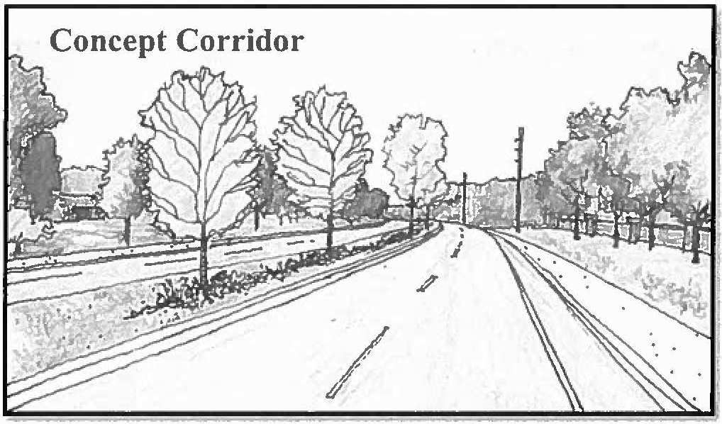
20.
To maintain the aesthetic character of the town, proposed uses approved through PD process that have been approved for outdoor storage shall meet the following standards. Figure 154-27.1.H.20.A. provides illustration of outdoor storage options for various lot configurations.
a.
Outdoor storage shall be allowed to the rear and sides of the lot.
b.
On corner lots, outdoor storage shall not extend toward the road frontage by more than one-half the length of the building structure in the rear yard or forward of the front building line in the side yard.
c.
Outdoor storage shall be prohibited on through-lots.
d.
Outdoor storage for multiple buildings, within a project or on a parcel, shall be permitted in a manner consistent with the intent of Figure 154-27.1.11.20.A. Outdoor storage for multiple buildings shall only be permitted behind the front building line of the building that is farthest from any street.
e.
All outdoor storage shall be screened from off-site view.
Figure 154-27.1.11.20.A. Outdoor Storage
I.
Status of previously approved PD's. All planned development projects approved shall be governed by the approved PD plan and any agreements, terms and conditions to which the approval may be subject, as long as the project continues to be actively under development.
J.
Minor amendments to approved planned development plan. Whenever any application is made to substantially modify the approved PD plan or to undertake a new development on part or all of the property, the application shall be made under the terms and procedures of the PD District. An individual or cumulative increase in density or intensity of less than one (1) percent does not require an amendment. Minor amendments to an existing planned development may be approved by the planning and zoning official. Minor changes include the following:
1.
Internal realignment of rights-of-way, other than a relocation of access points to the PD itself, where there is no net reduction of the size of conservation/preservation areas or required easements; and
2.
Relocation of building envelopes where there is no encroachment upon required conservation or preservation areas and no reduction in the setbacks between the buildings and perimeter boundary lines; and
3.
Relocation of swimming pools, clubhouses, or other recreation or other common facilities when such relocation will have no net impact on adjacent properties or land uses; and
4.
Relocation, reduction, or reconfiguration of lakes, ponds, or other water facilities subject to the submittal and approval of revised water management plans.
K.
Major amendments—Review and approval process. Except as provided in this section, all amendments, changes in uses, conditions or development standards and any other change in an approved planned development will be considered at public hearings, by the local planning agency for recommendation to the town council for approval. An individual or cumulative increase in density or intensity of less than one (1) percent does not require an amendment. Parties to PD ordinances acknowledge that laws change over time. Applicants may request amendments to PD ordinances for changes increasing entitlements. Such applications will be reviewed consistent with and in compliance with the land development regulations in place at the time of the proposed amendments.
(Ord. No. 06-543, § 1(154-13), 12-11-06; Ord. No. 2016-723, § 27, 6-12-17)
Editor's note— Section 1 of Ord. No. 06-543, adopted Dec. 11, 2006, enacted new provisions to be designated as § 154-13. In order to maintain organizational style of the Code, said provisions have been redesignated as § 154-27.1.
§ 154-27.2. - HIW Planned Development Ordinance.
(1)
Findings of fact and conclusions of law. The town council received and considered the application and all related comments; testimony and evidence submitted by the developer; comments by the appropriate reviewing agencies and the public; and the recommendation of the town's local planning agency. Based upon the forgoing and the developer's commitment to comply with the terms and conditions of this section, the Lake Placid Town Council makes the following findings of fact and conclusions of law:
(a)
Project. This project shall be known as the "HIW Planned Development" or the "development" and applies to 17.725+/acres of land legally described on Exhibit A (the "PD land"). The PD land is within the Town of Lake Placid.
(b)
Owner. The PD land is owned by 27 Northwest, LLC.
(c)
Developer. The PD land is being developed by HIW Development, LLC, a Florida Limited Liability Company (the developer), or its successor. The planned development application was submitted by the developer and owner. The owner and the developer shall be herein referred to as the "developer" because both consent to this ordinance and because this ordinance runs with the land and is binding on all future owners.
(d)
Comprehensive plan amendment. The developer has satisfactorily addressed all town issues. The PD land is not located in an area of critical state concern. The development will not interfere with the achievement of the objectives of the adopted state comprehensive plan F.S. ch. 163. Florida Statutes §§ 163.3161—163.3215 empower the town council (council) to adopt and to amend the Town of Lake Placid Comprehensive Plan (comp plan).
(e)
Public notice. The public notice requirements of F.S. ch. 163 and the town Code have been satisfied.
(f)
LPA public hearing. The local planning agency ("LPA") held a duly noticed public hearing to consider the planned development application. The LPA heard and considered testimony and documents and recommended to the council to approve the planned development.
(g)
Town public hearings. The Lake Placid Town Council held two (2) duly noticed public hearing to consider the application for the planned development. At each hearing, the town council heard and considered testimony and documents and approved the planned development.
(h)
Consistency. The town council finds that this ordinance is consistent with the adopted Town of Lake Placid Comprehensive Plan. The town council finds that this ordinance is necessary to promote, protect, and improve the public health, safety, comfort, good order, appearance, convenience, morals and general welfare of the Town of Lake Placid.
(2)
General conditions, restrictions and limitations. The council, having made the above findings of fact and conclusions of law, hereby adopts the following general and specific conditions, restrictions and limitations:
(a)
Runs with the land. This ordinance shall be binding upon and inure to the benefit of the PD land, developer, its successors and assigns, including any entity, which may assume any of the rights bestowed, or responsibilities imposed upon the developer by this ordinance.
(b)
Continuation of government and utilities. Any reference herein to any governmental agency or utility company shall be construed to mean any future entity, which may be created or designated as successor to, or which otherwise, possesses any of the powers and duties of, any branch of government, governmental agency or utility company.
(c)
Further review. Whenever this ordinance provides for reviews or determinations of any kind subsequent to its issuance, the right to review shall include all directly affected governmental agencies and departments as are or may be designated by the council as well as all governmental agencies and departments set forth under applicable laws and legally adopted rules.
(d)
Noncompliance. Failure by the developer (or the developer's successor in interest) to comply with the terms and conditions of this ordinance (as determined by the town planning and zoning official) shall result in the suspension of approval or issuance of further development permits and certificates of occupancy until the noncompliance is cured. The decision of the town's planning and zoning official may be reviewed denovo by the town council.
(e)
Land development regulations. The Town of Lake Placid Land Development Regulations (specifically including the portions of the Highlands County Code adopted on or before March 31, 2007) shall govern the HIW planned development. All development undertaken pursuant to this ordinance shall be in accordance with applicable local codes, ordinances, and other laws in effect at the time of permitting except as otherwise specifically provided herein. All development phases shall comply with the PD conceptual site development plan, and any applicable plat and/or site plan requirements of the Town of Lake Placid Land Development Regulations.
(f)
Amendment. Any amendment to this ordinance shall comply with the town's comprehensive plan in effect at the time of the amendment. If a phase of the planned development in this ordinance is amended, then the portions of the development which are not affected by the amendment shall remain vested.
(g)
Future fees. The provisions of this ordinance do not preclude the application of any other general government fees or any impact fees regardless of their nature either existing at adoption or enacted thereafter (including any increases in existing fees).
(h)
Improvement schedule. The applicants shall adhere to the following schedule (the precise times are set out in subsection 154-36(7):
(i)
Completion dates and rezoning. Construction of the development subject to this ordinance shall commence within thirty-six (36) months after the effective date of this ordinance and be completed within thirty-six (36) months after commencement. If physical development has not commenced or been completed during these time frames, the town council may rezone the property to agricultural zoning (which existed prior to the adoption of this ordinance). The foregoing notwithstanding, these time limits may be extended for a reasonable period upon petition of the developer to the town council.
(j)
Residential dwellings. The development shall include up to but not more than one hundred seventy-eight (178) residential dwelling units depicted on the PD conceptual site plan incorporated as Exhibit B.
(k)
School concurrency. The School Board of Highlands County has been advised of the development. All applicable impact fees (and school concurrency fees or mitigation required by the ordinance in effect at the time of building permit) shall be paid at the time each building permit is issued for the development, or as otherwise provided by applicable ordinance.
(3)
HIW Development R-2/PD Planned Development Zoning District. This R-2/PD Planned Development Zoning District is hereby established on and for the PD land.
(a)
Underlying zoning district. The underlying zoning for the development is the town's R-2 Residential Zoning District (section 154-23).
(b)
Zoning overlay. The Planned Development Zoning District (section 154-27.1) is established as an overlay by this ordinance. The development shall be subject to the other provisions of chapter 154 of the Code of Ordinances, Town of Lake Placid, Florida which are not inconsistent with this ordinance. Accordingly, the zoning for the development is R-2/PD.
(c)
Conceptual site plan. The development's conceptual site development plan is incorporated as Exhibit B and shall be considered as part of this zoning district. The conceptual site development plan shows the general location of buildings, amenities, roads and open space. The exact location/configuration of structures and amenities will be subject to further refinement on the final site plan or plat. Minor amendments may be made to the conceptual site development plan, pursuant to section 154-27.1 of the Code of Ordinances of the Town of Lake Placid, Florida; provided however that the number of residential units may be increased only by proper amendment of this ordinance. The final site plan shall be submitted to and approved by the LPA prior to the first building permit. If the property is platted, the final site plan approval may be concurrent with the plat approval.
(d)
Uses. Permitted principal uses and structures in this district shall be:
1.
One hundred seventy-eight (178) multiple-family dwelling units.
2.
Parking facilities that are ancillary to the residential units.
3.
Guard houses.
4.
Maintenance facilities.
5.
Clubhouse facilities and parking associated with the clubhouse.
6.
Recreational buildings and facilities, social centers, playgrounds, playfields, parks and benches and gazebos.
(e)
Accessory uses. Permitted accessory uses and structures in this district shall only be accessory to the permitted uses when located on the same lot.
(f)
Variance. Variances to the standards listed in this ordinance may only be made by the Town Council of the Town of Lake Placid, as an amendment to this ordinance; or as a minor amendment according to section 154-27.1 of the town Code (excepting an increase in the number of units).
(g)
Open space. At a minimum the project will provide fifty (50) percent of its gross land area as open space consisting of all land area not devoted to residential buildings.
(h)
Minimum set back requirements.
1.
Perimeter minimum: Fifty (50) feet.
2.
Interior street minimum: Twenty (20) feet.
Multifamily units shall have twenty (20) feet minimum building, separation otherwise all setbacks as stated above shall apply.
(i)
Height. No portion of any structure shall exceed:
Multifamily residential: Three (3) stories with a maximum of thirty-five (35) feet.
Permitted nonresidential uses such as clubhouses may be one (1) story but not greater than twenty (20) feet tall.
(j)
Buildings. Minimum floor areas (excluding carports, porches, patios, storage, and utilities) in this district shall be nine hundred (900) square feet for each multifamily residence. Each building shall be three (3) stories tall. The first floor shall be parking. Residential units shall be on the second and third floors.
(k)
Signs. Signs are not allowed in this district, except for the following signage for the site, as depicted on the conceptual site development plan:
1.
A landscaped entrance wall feature with identification signage on Heartland Boulevard, not to exceed six (6) feet in height.
2.
Internal directional signage at appropriate locations.
3.
Clubhouse signage at appropriate scale to the facility.
(l)
Pump stations. Structure for wastewater and water pump stations shall be landscaped so as not to be visible from roadways and adjacent residential uses.
(m)
Parking. At least two (2) parking spaces shall be provided for each dwelling unit. The owner or occupant shall be limited by deed restriction to only two (2) vehicles per unit. Additional parking spaces, equal to ten (10) percent of the total residential parking spaces, shall be provided for guest parking for a sum total of three hundred ninety-two (392) residential and guest parking spaces. Parking lot design (for the recreation areas) shall conform to town's off-street parking and loading requirements (chapter 161).
(4)
Public facilities requirements:
(a)
Water and wastewater facilities. Water and wastewater service shall be provided by the town, utilizing all existing department of environment protection standards. The developer shall be responsible for all costs associated with bringing/connecting these services to the site. The developer shall utilize the services of an established PSC regulated private or public contractor licensed to construct the required system. All applicable local, state and federal permits to operate the system shall be obtained and filed with the town prior to the issuance of the first residential C.O.
(b)
Water and wastewater service. The developer shall enter into a capacity agreement with town for the surrender of certain water rights to the town; the provision by the town of potable water and wastewater service to the development; and the developer's payment of the system development. Credit will be given for any portion of wastewater reserved under the agreement between the town and Smoak. The agreement shall be secured by bond or certificate of deposit approved by the town attorney.
(c)
Parks. The town's level of service requirement is five (5) acres for community park, two (2) acres for neighborhood park, and one (1) acre for mini-park per one thousand (1,000) persons. The neighborhood and mini-park requirement that the developer is to provide on-site, based upon the one hundred seventy-eight (178) units is one point two (1.2) acres. The developer shall develop the neighborhood park to be private, containing at least a playground, one (1) pool, one (1) multi-use court, and other appropriate facilities to accommodate the needs of the residents. Parks shall be in place prior to the first C.O. The community park requirement the developer is to provide and maintain for the Town of Lake Placid is five (5) acres per one thousand (1,000) persons. Based upon the one hundred seventy-eight (178) units, the developer is to provide two (2) acres of external community park land. To satisfy the external community park requirements, the developer shall pay to the town the sum of eighty thousand one hundred thirty-six dollars ($80,136.00) per acre for each acre of community park which is the responsibility of the developer (the developer shall pay to the town the sum of one hundred eleven thousand three hundred eighty-nine dollars ($111,389.00). Said payment shall be paid before the first building permit is issued in order for the development to meet this level of service. Developer shall receive credit towards the satisfaction of the town's park level of service requirement equivalent to developer's contribution of the multi-use path, pursuant to subsection (6)(f). This same land, the multi-use path, may not be used for transportation impact fee credit if used to meet the town's community park level of service.
(d)
Recycle center. The developer shall construct centrally located recycling collection center(s) within and for the development. The same shall be shown on the final site plan or plat.
(e)
Internal roads. All roads internal to the development shall be private roads and owned and maintained by the condominium association or home owners association. The ownership and maintenance obligation shall be set out in the deed restrictions and condominium association or home owners association documents.
(5)
Environment and natural resources:
(a)
Water management. The stormwater management system shall be maintained by the condominium association or homeowner association.
(b)
Landscape water conservation. Xeriscape landscaping and water conservation irrigation techniques should be used on the development. Eighty (80) percent native plant species as specified by the Highlands County LDRs must be used. Ecologically viable portions of existing native vegetation should be incorporated into the landscape design to the greatest extent practicable. The developer shall install reuse lines, and connection for such within the development, for landscape irrigation. When and if available, the development will utilize reuse water for irrigation.
(c)
Potable water conservation. For the purpose of potable water conservation, the development shall utilize high efficiency (low volume) plumbing fixtures, and other water conserving devices in all structures and facilities in accordance with applicable building codes.
(d)
Invasive exotics. Invasive exotic species listed in Highlands County LDRs shall be eliminated if found on-site prior to the first C.O. The homeowners association or condominium association shall maintain the development free of the invasive exotic plants.
(e)
Landscape. The developer shall provide the following irrigated landscaped areas, to wit: buffers, setbacks, open space, multi-use trails. The landscape plan shall be submitted with the final site plan or plat. The irrigation system shall be schedule 40 or stronger PVC.
(f)
Monotoring. In addition to any monitoring reports required by this ordinance, copies of any monitoring reports required under other local, regional, state or federal permits, which relate to the environmental and natural resources on the development shall be submitted to the town planning and zoning director.
(6)
Transportation.
(a)
Transportation impacts. Transportation improvements may require off-site mitigation to satisfy concurrency requirements of the town and county. Those impacts will be addressed prior to final plat, prior to the issuance of the first building permit, or prior to the final PD site development plan, whichever first occurs.
(b)
Concurrency. The concurrency mandated facility improvements required for this development shall be determined at or before final site plan approval. The developer retains the right to provide funding, design, engineering and construction of the improvements described in this subsection (6)(b).
(c)
Right-of-way conveyance. The developer shall convey about sixty (60) feet of right-of-way (enough to bring the total width of Heartland Boulevard to one hundred twenty-five (125) feet) along the north side of Heartland Boulevard to Highlands County. The developer may apply to Highlands County for credit for the county's transportation impact fees (credit shall not be given for the northerly ten (10) feet of the conveyance because it shall be used for the multi-use path). The right-of-way conveyed shall not be used by the developer for landscape buffers or other such improvements that are required elsewhere in this ordinance or the town land development regulations. The right-of-way shall be conveyed to Highlands County within twelve (12) months after this ordinance is adopted.
(d)
Private roads. All roads within the development shall be private; may be gated; and shall be built to Highlands County standards for public roads at the time of construction. All internal roads within the respective phase shall be completed prior to the issuance of the first certificate of occupancy.
(e)
Multi-use path. The northerly ten (10) feet of the right-of-way shall be used for the ten-foot wide multi-use path. The developer shall construct to town and county standards, the ten-foot wide multi-use path depicted on the PD conceptual site development plan. The developer shall be given credit by the Town of Lake Placid for the multi-use path toward the community park level of service requirements. The multi-use path shall be completed by the developer pursuant to subsection (2)(i) of this section before the first building permit is issued.
(f)
Impact fees. Developer may apply to Highlands County for impact fee credits for the dedication of Heartland Boulevard pursuant to the terms of the adopted Highlands County Impact Fee Ordinance. The foregoing notwithstanding, any value attributable to the dedicated right-of-way (for Heartland Boulevard) in excess of any impact fee credits granted to the developer, or its successor, shall not be applied to any other developments, or refunded to the developer.
(g)
Additional traffic study. In addition to the initial traffic study, the owner and developer shall provide an updated traffic study prepared and submitted prior to final PD site development plan approval, construction plan approval, final development permit, plat approval, final site plan approval or first residential building permit, whichever is later. Upon acceptance of the updated study, the town shall determine if any additional transportation improvements are required and the time when those improvements must be completed. The town may withhold any further development approval, including but not limited to, the issuance of building permits, until the updated study is completed and accepted, and any additional transportation improvements are assured for completion. The town shall be under no obligation to participate in any costs associated with providing these improvements or traffic study.
(h)
Alternative concurrency cost share calculations. Prior to construction, the developer shall pay or provide (at the town's option) the concurrency mandated traffic improvements being the greater of the following alternative cost calculation methods:
1.
The traffic improvements required by this ordinance, the comprehensive plan amendment for this development and the existing traffic study for this development.
2.
The costs determined at the time of development (immediately prior to the first residential building permit) using the county concurrency management system and proportionate fair share ordinance.
3.
The cost or improvements identified in the additional traffic study in subsection (6)(g) above.
(i)
Heartland Boulevard improvement. The developer shall pay its share of the signalization of United States Highway 27 intersection at Heartland Boulevard. The developer's share shall be based upon its prorata share of trips generated as demonstrated by the traffic study preformed at the time by the approved methodology (including HIW, Lake Partners and any other development impacting the respective improvement).
(j)
Updated traffic study. The developer shall provide an updated traffic study if fifty (50) percent of the proposed project is not under construction within five (5) years of the issue of the D.O. Additional off-site improvements, if necessary to maintain level of service (LOS) or the LOS adopted by the town at that time shall be identified in the updated traffic study, and the D.O. shall be amended. Development activities shall proceed in a manner concurrent with the provisions of the additional improvements and the revised build-out, if applicable.
(7)
Homeowner's association. A homeowner's association or condominium association (at the developers option) shall be established for the development (the "association") prior to the issuance of the first certificate of occupancy, and prior to the conveyance of any parcel by the developer (or successor developer). The association's declaration of covenants, conditions and restrictions (the declaration) shall encumber all of the PD land, and shall include the following provisions:
(a)
Common area maintenance. The association shall be responsible for the maintenance of the common areas (to include but not limited to, private roads, sidewalks, and open space, parks, and buffers) within the development.
(b)
Roads. The association shall own and maintain the internal roads. Said roads shall not be conveyed to the town or county.
(c)
Irrigation and landscape. The association shall maintain the irrigation systems, reuse lines, landscaped buffers, setbacks, sidewalks, all other common areas and the water management district mandated systems, all in a good and workman like manor, and in accordance with the approved landscape plan.
(d)
Parking. The association shall prohibit any owner from maintaining on the premises more than two (2) motor vehicles; and shall require recreational vehicles and boats (if they fit) to be parked within the owner's assigned parking spaces (or another owner's space with permission and within one (1) of the buildings on the development). No recreational vehicles or boats shall be parked outside.
(e)
Buildings. The association shall maintain the exterior of all buildings and improvements.
(f)
Enforcement. The association shall include a provision granting to the Town of Lake Placid the right, duty and power to enforce the restrictions.
(8)
Utilities.
(a)
Underground utilities. All utilities (specifically including electric distribution lines) shall be installed and maintained underground.
(b)
Streetlights. The developer shall install streetlights within the development which are substantially equal in size shape and quality to the streetlights used on Interlake Boulevard and Main Street, Lake Placid.
(c)
Reuse lines. The developer shall install reuse lines (to lawful standards) within the development. The developer shall design permit and cause to be installed, and connected according to law, the reuse supply lines from the point established by the town to the development on the development. The developer shall pay the reuse system development charge established by the town Code from time to time.
(9)
Severability. If any section, subsection, sentence, clause, phrase, or provision of this ordinance is for any reason held invalid or unconstitutional by any court of competent jurisdiction, such holdings shall not be construed to render the remaining provisions of this ordinance invalid or unconstitutional.
(10)
Effective date. This ordinance shall take effect upon the expiration of the period allowed by law to appeal the notice of intent (NOI) to find the plan amendment in compliance published by the DCA, or, in the case of appeal, such later date as the in compliance determination becomes final as provided by law.
(Ord. No. 2016-723, § 28, 6-12-17)
Editor's note—
Ord. No. 06-523 enacted provisions to be designated as ch. 160, §§ 160-1—160-1.9.
In order to maintain categorical standards, said provisions have been redesignated
as § 154-27.2.
Exhibits A and B, hereinabove referenced are attached to Ord. No. 06-523 and are on
file with the town clerk.
§ 154-27.3. - Highlands Cove Development Ordinance.
(1)
Findings of fact and conclusions of law: The town council received and considered the application and all related comments; testimony and evidence submitted by the developer; comments by the appropriate reviewing agencies and the public; and the recommendation of the town's local planning agency. Based upon the forgoing and the developer's commitment to comply with the terms and conditions of this ordinance, the Lake Placid Town Council makes the following findings of fact and conclusions of law:
(a)
Project. This project shall be known as the "Highlands Cove Planned Development" or the "development" and applies to twelve point eighty-nine (12.89) acres of land legally described on the survey incorporated as Exhibit A (the "PD land"). The PD land is within the Town of Lake Placid.
(b)
Owner. The PD land is owned by Lake Partners, LLC., a Florida Limited Liability Company.
(c)
Developer. The PD land is being developed by Lake Partners, LLC., a Florida Limited Liability Company (the developer), or its successor. The planned development application was submitted by the developer and owner. The owner and the developer shall be herein referred to as the developer, because both consent to this ordinance and because this ordinance runs with the land and is binding on all future owners.
(d)
Comprehensive plan amendment. The developer has satisfactorily addressed all town issues. The PD land is not located in an area of critical state concern. The development will not interfere with the achievement of the objectives of the adopted state comprehensive plan F.S. ch. 163. Florida Statutes §§ 163.3161—163.3215 empower the town council to adopt and to amend the Town of Lake Placid Comprehensive Plan (comp plan).
(e)
Public notice. The public notice requirements of F.S. ch. 163 and the town Code have been satisfied.
(f)
LPA public hearing. The local planning agency (LPA) held a duly noticed public hearing to consider the planned development application. The LPA heard and considered testimony and documents and recommended to the council to approve the planned development.
(g)
Town public hearings. The Lake Placid Town Council held two (2) duly noticed public hearings to consider the application for the planned development. At each hearing, the town council heard and considered testimony and documents and approved the planned development.
(h)
Consistency. The town council finds that this ordinance is consistent with the adopted Town of Lake Placid Comprehensive Plan. The town council finds that this ordinance is necessary to promote, protect, and improve the public health, safety, comfort, good order, appearance, convenience, morals and general welfare of the Town of Lake Placid.
(2)
General conditions, restrictions and limitations. The council, having made the above findings of fact and conclusions of law, hereby adopts the following general and specific conditions, restrictions and limitations:
(a)
Runs with the land. This ordinance shall be binding upon and inure to the benefit of the PD land, developer, its successors and assigns, including any entity which may assume any of the rights bestowed, or responsibilities imposed upon the developer by this ordinance.
(b)
Continuation of government and utilities. Any reference herein to any governmental agency or utility company shall be construed to mean any future entity, which may be created or designated as successor to, or which otherwise, possesses any of the powers and duties of, any branch of government, governmental agency or utility company.
(c)
Further review. Whenever this ordinance provides for reviews or determinations of any kind subsequent to its issuance, the right to review shall include all directly affected governmental agencies and departments as are or may be designated by the council as well as all governmental agencies and departments set forth under applicable laws and legally adopted rules.
(d)
Noncompliance. Failure by the developer (or the developer's successor in interest) to comply with the terms and conditions of this ordinance (as determined by the town planning and zoning official) shall result in the suspension of approval or issuance of further development permits and certificates of occupancy until the noncompliance is cured. The decision of the town's planning and zoning official may be reviewed de novo by the town council.
(e)
Land development regulations. The Town of Lake Placid Land Development Regulations (specifically including the portions of the Highlands County Code adopted on or before March 31, 2007) shall govern the development. All development undertaken pursuant to this ordinance shall be in accordance with applicable local codes, ordinances, and other laws in effect at the time of permitting except as otherwise specifically provided herein.
(f)
Amendment. Any amendment to this ordinance shall comply with the town's comprehensive plan in effect at the time of the amendment.
(g)
Future fees. The provisions of this ordinance do not preclude the application of any other general government fees or any impact fees regardless of their nature either existing at adoption or enacted thereafter (including any increases in existing fees).
(h)
Improvement schedule. The applicants shall adhere to the following schedule:
(i)
Completion dates and rezoning. Construction of the development subject to this ordinance shall commence within thirty-six (36) months after the effective date of this ordinance and be completed within thirty-six (36) months after commencement. If physical development has not commenced or been completed during these time frames, the town council may rezone the property to agricultural zoning (which existed prior to the adoption of this ordinance). The foregoing notwithstanding, these time limits may be extended for a reasonable period upon petition of the developer to the town council.
(j)
Residential dwellings. The development shall include up to but not more than one hundred twenty-eight (128) residential dwelling units depicted on the PD conceptual site plan incorporated as Exhibit B.
(k)
School concurrency. The School Board of Highlands County has been advised of the development. All applicable impact fees (and school concurrency fees or mitigation required by the ordinance in effect at the time of building permit) shall be paid at the time each building permit is issued for the development, or as otherwise provided by applicable ordinance.
(3)
Highlands Cove Development R-2/PD Planned Development Zoning District: R-2/PD Planned Development Zoning District. This R-2/PD Planned Development Zoning District is hereby established on and for the PD land.
(a)
Underlying zoning district. The underlying zoning for the development is the town's R-2 Residential Zoning District (section 154-23).
(b)
Zoning overlay. The Planned Development Zoning District (section 154-27.1) is established as an overlay by this ordinance. The development shall be subject to the other provisions of chapter 154 of the Code of Ordinances, Town of Lake Placid, Florida which are not inconsistent with this ordinance. Accordingly, the zoning for the development is R-2/PD.
(c)
Conceptual site plan. The development's conceptual site development plan is incorporated as Exhibit B and shall be considered as part of this zoning district. The conceptual site development plan shows the general location of buildings, amenities, roads and open space. The exact location/configuration of structures and amenities will be subject to further refinement on the final site plan or plat. Minor amendments may be made to the conceptual site development plan, pursuant to section 154-27.1 of the Code of Ordinances of the Town of Lake Placid, Florida; provided however that the number of residential units may be increased only by proper amendment of this ordinance. The final site plan shall be submitted to and approved by the LPA prior to the issuance of the first building permit. If the property is platted, the final site plan approval may be concurrent with the plat approval.
(d)
Uses. Permitted principal uses and structures in this district shall be:
1.
One hundred twenty-eight (128) multiple-family residential dwelling units (town homes, condominium units, and villas as shown on Exhibit C-2 incorporated herein).
2.
Parking facilities that are ancillary to the residential units.
3.
Guard house and gated entrance as shown on Exhibit C-1, incorporated herein.
4.
Community center and associated parking.
5.
Community mail center as shown on Exhibit C-3, attached and incorporated herein.
6.
Playground and two point one (2.1)-acre neighborhood park.
(e)
Variance. Variances to the standards listed in this ordinance may only be made by the Town Council of the Town of Lake Placid, as an amendment to this ordinance; or as a minor amendment according to section 154-27.1 of the town Code (excepting an increase in the number of units).
(f)
Minimum set back requirements.
1.
Perimeter: Minimum twenty (20) inches (from the landscaped berm).
2.
Interior street: Minimum twenty (20) inches.
Multifamily units shall have twenty (20) feet minimum building, separation otherwise all setbacks as stated above shall apply.
(g)
Height. No portion of any structure shall exceed:
Multifamily residential: Two (2) stories with a maximum height of thirty-five (35) feet.
Permitted nonresidential uses such as clubhouses may be one (1) story, but not greater than twenty (20) feet tall.
(h)
Buildings. Minimum floor areas (excluding carports, porches, patios, storage, and utilities) in this district shall be at least nine hundred (900) square feet for each multifamily residence. All buildings shall have a tile roof system.
(i)
Signs. Signs are not allowed in this district, except for the following signage for the site, as depicted on the conceptual site development plan:
1.
A landscaped entrance sign with identification signage on Hillcrest Street, as shown on Exhibit C-4 incorporated herein.
2.
Internal directional signage at appropriate locations.
3.
Clubhouse signage at appropriate scale to the facility.
4.
Temporary marketing signs (relating to the initial sale of the dwellings) according to the town sign code.
(j)
Pump stations. Structure for wastewater and water pump stations shall be landscaped so as not to be visible from roadways and adjacent residential uses.
(k)
Parking. At least two (2) parking spaces shall be provided for each dwelling unit. The owner or occupant shall be limited by deed restriction and this ordinance to only two (2) vehicles per unit. Additional parking spaces, equal to ten (10) percent of the total residential units, plus eleven (11) spaces for the community center shall be provided for guest parking. There shall be a total of two hundred ninety-two (292) residential and guest parking spaces within the development. Garages may not be converted or used for any purpose other than to garage an automobile (and reasonably related things).
(4)
Public facilities requirements:
(a)
Water and wastewater facilities. Water and wastewater service shall be provided by the town, utilizing all existing department of environment protection standards. The developer shall be responsible for all costs associated with bringing/connecting these services to the site. The developer shall utilize the services of an established PSC regulated private or public contractor licensed to construct the required system. All applicable local, state and federal permits to operate the system shall be obtained and filed with the town prior to the issuance of the first residential certificate of occupancy.
(b)
Water and wastewater service. The developer shall enter into a capacity agreement with town (prior to adoption) for the surrender of certain water rights to the town; the provision by the town of potable water and wastewater service to the development; and the developer's payment of the system development charges. The agreement shall be secured by bond or certificate of deposit approved by the town attorney.
(c)
Parks. The town's level of service requirement is five (5) acres for community park, two (2) acres for neighborhood park, and one (1) acre for mini-park per one thousand (1,000) persons. The neighborhood and mini-park requirement that the developer is to provide on-site, based upon the one hundred twenty eight (128) units is two and one-tenth (2-1/10) acres.
The developer shall develop the two and one-tenth-acre neighborhood/mini park, containing at least a playground, one (1) pool, and one (1) community center. The neighborhood park shall be in place prior to the twenty-fourth certificate of occupancy. The town's community park level of service requires the developer to provide and maintain for the Town of Lake Placid five (5) acres of community park per one thousand (1,000) persons. Based upon the one hundred twenty-eight (128) units, the developer is to provide 1.472 acres of external community park. To satisfy the external community park requirements, the developer shall pay to the town the sum of eighty thousand one hundred thirty-six dollars ($80,136.00) per acre for each acre of community park required for the development (the developer shall pay the town the sum of one hundred seventeen thousand nine hundred sixty dollars ($117,960.00) to satisfy the developer's community park obligation). Said payment shall be paid before the first residential building permit is issued. Developer shall receive credit towards the satisfaction of the town's park level of service requirement equivalent to developer's contribution of the Hillcrest Street right-of-way used for the multi-use path. This same land, the multi-use path, may not be used for transportation impact fee credit.
(d)
Recycle center. The developer shall construct centrally located recycling collection center(s) within the development. The same shall be shown on the final site plan or plat. The recycling collection center shall only be used for the development.
(e)
Internal roadways. All roads internal to the development shall be private and owned and maintained by the condominium association or homeowner's association. The ownership and maintenance obligation shall be set out in the deed restrictions and condominium association or homeowners association documents.
(f)
Exterior buffering. The developer shall install and the homeowners association shall maintain a landscaped buffer fifteen (15) feet wide on the north and south development boundary and ten (10) feet wide on the east development boundary. All three (3) buffers shall contain a solid wall six (6) feet tall equal in structure or better than a concrete wall. The landscaping shall be sufficiently dense to provide internal privacy for the residents and external screening for the neighbors. The landscape buffer shall be on each side of the wall and shall be planted, irrigated and maintained by the developer and then maintained by the association according to the approved landscape plan. The western boundary shall have a decorative fence.
(5)
Environment and natural resources.
(a)
Water management. The stormwater management system shall be maintained by the condominium association or homeowner's association.
(b)
Landscape water conservation. Xeriscape landscaping and water conservation irrigation techniques should be used on the development. Eighty (80) percent native plant species as specified by the Highlands County LDRs must be used. Ecologically viable portions of existing native vegetation should be incorporated into the landscape design to the greatest extent practicable. The developer shall install reuse lines, and connection for such within the development, for landscape irrigation. When and if available, the development will utilize reuse water for irrigation.
(c)
Potable water conservation. For the purpose of potable water conservation, the development shall utilize high efficiency (low volume) plumbing fixtures, and other water conserving devices in all structures and facilities in accordance with applicable building codes.
(d)
Invasive exotics. Invasive exotic species listed in Highlands County LDRs shall be eliminated on-site prior to the first certificate of occupancy. The homeowners association or condominium association shall maintain the development free of the invasive exotic plants.
(e)
Landscape. The developer shall provide, landscape, irrigate and the homeowners association shall maintain the following areas, to wit: road rights-of-way, buffers, setbacks and open space. The landscape plan shall be submitted with the final site plan or plat. The irrigation system shall be schedule 40 or stronger PVC.
(f)
Monotoring. In addition to any monitoring reports required by this ordinance, copies of any monitoring reports required under other local, regional, state or federal permits, which relate to the environmental and natural resources on the development shall be submitted to the town planning and zoning director.
(6)
Transportation.
(a)
Transportation impacts. Transportation improvements may require off-site mitigation to satisfy concurrency requirements of the town and county. Those impacts will be addressed prior to final plat, prior to the issuance of the first building permit, or prior to the final PD site development plan, whichever first occurs.
(b)
Hillcrest turn lanes. The developer shall construct a two hundred ten-foot northbound deceleration lane and taper; a northbound acceleration lane and taper; a southbound left turn land one hundred (100) feet long with a two hundred-foot taper all serving the entrance to the development, and all to Highlands County standards before the sixty-fourth residential certificate of occupancy is issued.
(c)
Concurrency. The concurrency mandated facility improvements required for this development shall be determined at or before the final site plan and shall be in place before the issuance of the first residential certificate of occupancy. The developer retains the right to provide funding, design, engineering and construction of the improvements described in this subsection (6).
(d)
Right-of-way conveyance (Hillcrest). The developer shall convey unencumbered the westerly thirty (30) feet of the development to become additional right-of-way (enough to bring the total width of Hillcrest Street to eighty (80) feet in width) adjacent to the east side of Hillcrest Street to the Town of Lake Placid (hereinafter the Hillcrest right-of-way). The right-of-way conveyed shall not be used by the developer for landscape buffers or other such improvements that are required elsewhere in this ordinance or the town land development regulations. The right-of-way shall be conveyed to the town prior to the adoption of this ordinance.
(e)
Internal private roads. All roads within the development shall be private; may be gated; and shall be built to Highlands County standards (for pavement and base matters but not right-of-way width) for public roads at the time of construction. All internal roads within the respective phase shall be completed prior to the issuance of the first certificate of occupancy.
(f)
Multi-use path. The easterly fifteen (15) feet of the Hillcrest right-of-way shall be used for the ten-foot wide multi-use path. The developer shall construct to town standards, the ten-foot wide multi-use path. The developer shall be given credit by the Town of Lake Placid for the multi use path toward the community park level of service requirements. The multi-use path shall be completed by the developer before the first certificate of occupancy is issued.
(g)
Additional traffic study. In addition to the initial traffic study, the owner and developer shall provide an updated traffic study prepared and submitted prior to final PD site development plan approval, construction plan approval, final development permit, plat approval, final site plan approval or first residential building permit, whichever is later. Upon acceptance of the updated study, the town shall determine if any additional transportation improvements are required and the time when those improvements must be completed. The town may withhold any further development approval, including but not limited to, the issuance of building permits, until the updated study is completed and accepted, and any additional transportation improvements are assured for completion. The town shall be under no obligation to participate in any costs associated with providing these improvements or traffic study.
(h)
Alternative cost share calculations. At the time of the county's concurrency determination, the developer shall pay or provide (at the town's option) the traffic improvements being the greater of the following alternative cost calculation methods:
a.
The traffic improvements required by this ordinance, the comprehensive plan amendment for this development, and the existing traffic study for this development.
b.
The costs determined at the time of development (immediately prior to the first residential building permit) using the county concurrency management system and proportionate fair share ordinance.
c.
The cost or improvements required in subsection (6)(g), above.
(i)
Heartland Boulevard improvement. The developer shall pay its share of the signalization of United States Highway 27 intersection at Heartland Boulevard, the signalization of the Heartland Boulevard intersection at North Main Avenue, and the turn lanes on Heartland Boulevard at United States Highway 27 and at North Main Avenue. The developers share shall be based upon its prorata share of residential dwelling units (considered with the Silver and HIW developments).
(j)
Updated traffic study. The developer shall provide an updated traffic study if fifty (50) percent of the proposed project is not under construction within five (5) years of the issue of this ordinance. Additional off-site improvements, if necessary to maintain level of service (LOS) C shall be identified in the updated traffic study. This ordinance shall be amended to require the additional off-site transportation system enhancements. Development activities (building permits) shall be issued only after the said transportation system enhancements have been completed (or secured by certificate of deposit, bond or locally drawn letter of credit.
(7)
Homeowner's association. A homeowner's association or condominium association (at the developers option) shall be established for the development (the "association") prior to the issuance of the first certificate of occupancy, and prior to the conveyance of any parcel by the developer (or successor developer). The association's declaration of covenants, conditions and restrictions (the "declaration") shall encumber all of the PD land, and shall include the following provisions:
(a)
Common area maintenance. The association shall be responsible for the maintenance of the common areas (to include, but not limited to, private roads, sidewalks, and open space, parks, community center and buffers) within the development.
(b)
Roadways. The association shall own and maintain the internal roads. Said roads shall not be conveyed to the town or county.
(c)
Irrigation and landscape. The association shall maintain the irrigation systems, reuse lines, landscaped buffers, setbacks, sidewalks, all other common areas and the water management district mandated systems, all in a good and workman-like manor and all according to the approved landscape plan.
(d)
Parking. The association shall prohibit any owner from maintaining on the premises more than two (2) motor vehicles; and shall require recreational vehicles and boats (if they fit) to be parked within the owner's assigned parking spaces (or another owner's space with permission and within one (1) of the buildings on the development). No recreational vehicles or boats shall be parked outside.
(e)
Buildings. The association shall maintain the exterior of all buildings and improvements.
(f)
Enforcement. The association shall include a provision granting to the Town of Lake Placid the right, duty and power to enforce the restrictions.
(8)
Utilities.
(a)
Underground utilities. All utilities (specifically including electric distribution lines) shall be installed and maintained underground.
(b)
Streetlights. The developer shall install streetlights within the development which are substantially equal in size, shape and quality to the streetlights used on Interlake Boulevard and Main Street, Lake Placid.
(c)
Reuse lines. The developer shall install reuse lines (to lawful standards) within the development. The developer shall design permit and cause to be installed, and connected according to law the reuse supply lines from the point established by the town to the development. The developer shall pay the reuse system development charge established by the town Code from time to time.
(9)
Severability: If any section, subsection, sentence, clause, phrase, or provision of this ordinance is for any reason held invalid or unconstitutional by any court of competent jurisdiction, such holdings shall not be construed to render the remaining provisions of this ordinance invalid or unconstitutional.
(10)
Effective date: This ordinance shall take effect upon the expiration of the period allowed by law to appeal the notice of intent (NOI) to find the plan amendment in compliance published by the DCA, or, in the case of appeal, such later date as the in compliance determination becomes final as provided by law.
(11)
Documents incorporated by reference:
Exhibit A: Legal description.
Exhibit B: PD Conceptual Site Development Plan.
Exhibit C (1—4) Conceptual Highlands Cove Plans.
(Ord. No. 2016-723, § 29, 6-12-17)