
Lake Worth Beach City Zoning Code
ARTICLE 5
- SUPPLEMENTAL REGULATIONS
Sec. 23.5-1.- Signs.
a)
Purpose and scope of regulations.
1.
The purpose of this section is to encourage the effective use of signs as a means of communications in the city; to maintain and enhance the aesthetic environment and the city's ability to attract sources of economic development and growth; to improve pedestrian and traffic safety; to minimize the possible adverse effects of signs on nearby public and private property; to foster the integration of signage with architectural and landscape designs; and to enable the fair and consistent enforcement of these sign regulations. Additionally, this section provides for regulations to achieve the following:
A.
Property value protection. Signs should not create a nuisance to the occupancy or use of other properties as a result of their size, height, brightness or movement. They should be in harmony with buildings, the neighborhood and other conforming signs in the area.
B.
Communication. Signs should not deny other persons or groups the use of sight lines on public rights-of-way, should not obscure important public messages and should not overwhelm readers with too many messages. Signs can and should help individuals to identify and understand the jurisdiction and the character of its subareas.
C.
Preservation of community's beauty. Cities such as this which include a public beach as well as small office, retail, residential and industrial uses rely heavily on their natural surroundings and beautification efforts to retain their economic viability. This concern is reflected by the active and objective regulations of the appearance and design of signs.
D.
Visibility. Signs should not in any way inhibit or obscure visibility of pedestrians or vehicles located within public rights-of-way. Safety shall be a determining factor in the approval and placement of signage.
2.
Noncommercial message. Notwithstanding anything contained in this section to the contrary, any sign erected pursuant to the provisions of this section may, at the option of the applicant, contain either a noncommercial message unrelated to the business located on the premises where the sign is erected or a commercial message related to the business and located on the business premises. The noncommercial message may occupy the entire sign face or portion thereof. The sign face may be changed from commercial to noncommercial messages as frequently as desired by the owner of the sign, provided that the size and design criteria conform to the applicable portions of this section, the sign is allowed by this section, the sign conforms to the requirements of the applicable zoning designation and the appropriate permits are obtained. For the purposes of this sign code, noncommercial messages, by their very nature, shall never be deemed off-premises.
b)
Permits required. It shall be unlawful for any person to erect, alter, relocate or have within the city, any sign or other advertising structure as defined in this section, without first obtaining a sign permit from the building official and making payment of the required fee.
c)
Application process for sign permit.
1.
In general. An application for sign permit shall be made upon forms provided by the department for community sustainability and shall, at a minimum, contain or have attached thereto the following information:
A.
Name, address and telephone number of the applicant.
B.
Location of building, structure or lot to which or upon which the sign or other advertising structure is to be attached or erected.
C.
Position of the sign or other advertising structure in relation to nearby buildings, structures and driveways.
D.
Two (2) sets of plans that accurately depict the specifications and methods of construction and attachment to the building or in the ground. Plans must also include images or mock-ups of the proposed signage, and must include copy and designated colors.
E.
Copy of stress sheets and calculations showing the structure is designed for dead load and wind pressure in any direction and in the amount required by this section and all other applicable laws and ordinances of the city when required by the building official.
F.
Name of person, firm, corporation or association erecting structure.
G.
Any electrical permit required and issued for such sign.
H.
Current occupational license number.
I.
Such other information as the building official shall require demonstrating full compliance with this section and all other applicable laws and ordinances.
J.
Fees, as applicable.
2.
Electrical review. The application for a permit for installation of a sign or other advertising structure in which electrical wiring and connections are to be used shall be submitted to the electrical inspector. The electrical inspector shall examine the plans and specifications with respect to all wiring and connections to determine if the same complies with the electrical code of the city and he shall approve such permit if the plans and specifications comply with the code, or disapprove the application if noncompliance with the code is found. This action of the electrical inspector shall be taken prior to submission of the application to the building official for final approval or disapproval of the sign permit.
3.
Issuance. Sign applications must be filed by a state or county licensed contractor. It shall be the duty of the building official, upon the filing of an application for a sign permit, to examine such plans and specifications and other data and the premises upon which it is proposed to erect the sign or other advertising structure. If he finds that the proposed sign or other advertising structure complies fully with this section and all other applicable laws and ordinances, he shall then issue the sign permit. If the work authorized under a sign permit has not commenced within ninety (90) days or has not been completed within one hundred eighty (180) days after the date of issuance, the permit shall become null and void and the fee paid therefore shall be retained by the city.
4.
Certificate of registered engineer. The building official may require the sign contractor to submit a design and stress diagram or plan, designed, signed and certified by a state registered engineer, containing the necessary information to enable the building official to determine that such sign complies with all regulations of this section for any type of sign which, in the building official's opinion, may create or cause a hazard to the health, safety or general well-being of the residents and property owners of the city.
The following signs and supporting structures shall be designed, signed and certified by a state registered engineer who shall submit sufficient data to enable the building official to determine whether the sign complies with the Code of Ordinances.
(a)
All projecting signs.
(b)
All freestanding signs.
(c)
All signs with unusual structural features.
(d)
All plastic-faced signs over twenty-four (24) square feet in area.
(e)
All mansard signs.
(f)
All individual letters or module signs over twenty-four (24) square feet in area.
5.
Photo record. Photographs of each building frontage shall be provided at the time of application.
6.
Fees. Permit fees shall be in accordance with the schedule set out in section 9-3(a) of the Code of Ordinances of the city.
7.
Revocation. The building official is hereby authorized and empowered to revoke any permit issued by him upon failure of the holder thereof to comply with any provisions of this section.
d)
General regulations and standards. The following shall apply to all signs.
1.
Construction; erection. All signs shall be constructed and erected in accordance with the standards and requirements of this section. Unless expressly permitted any sign not meeting this section is prohibited.
2.
Inspection. The contractor or owner securing the permit for any sign shall call the inspection office and request an inspection whenever any sign is being installed, and before any concrete is poured; a final inspection shall be requested upon completion. At the time of a request for final inspection, a photograph of the completed sign shall be taken by the inspector. (Minimum two and one-half (2½) inches by two and one-quarter (2¼) inches, maximum three (3) inches by five (5) inches for filing purposes.)
3.
Labels required. Every sign installed, constructed or maintained for which a permit is required shall be plainly marked with the name of the person, firm or corporation installing and maintaining such sign and shall have affixed on the front thereof the number of the permit issued for said sign by the building official.
4.
Wind pressure. All signs shall be so constructed as to withstand the wind pressures as specified in the current ASCE-7 as referenced in the adopted Standard Building Code.
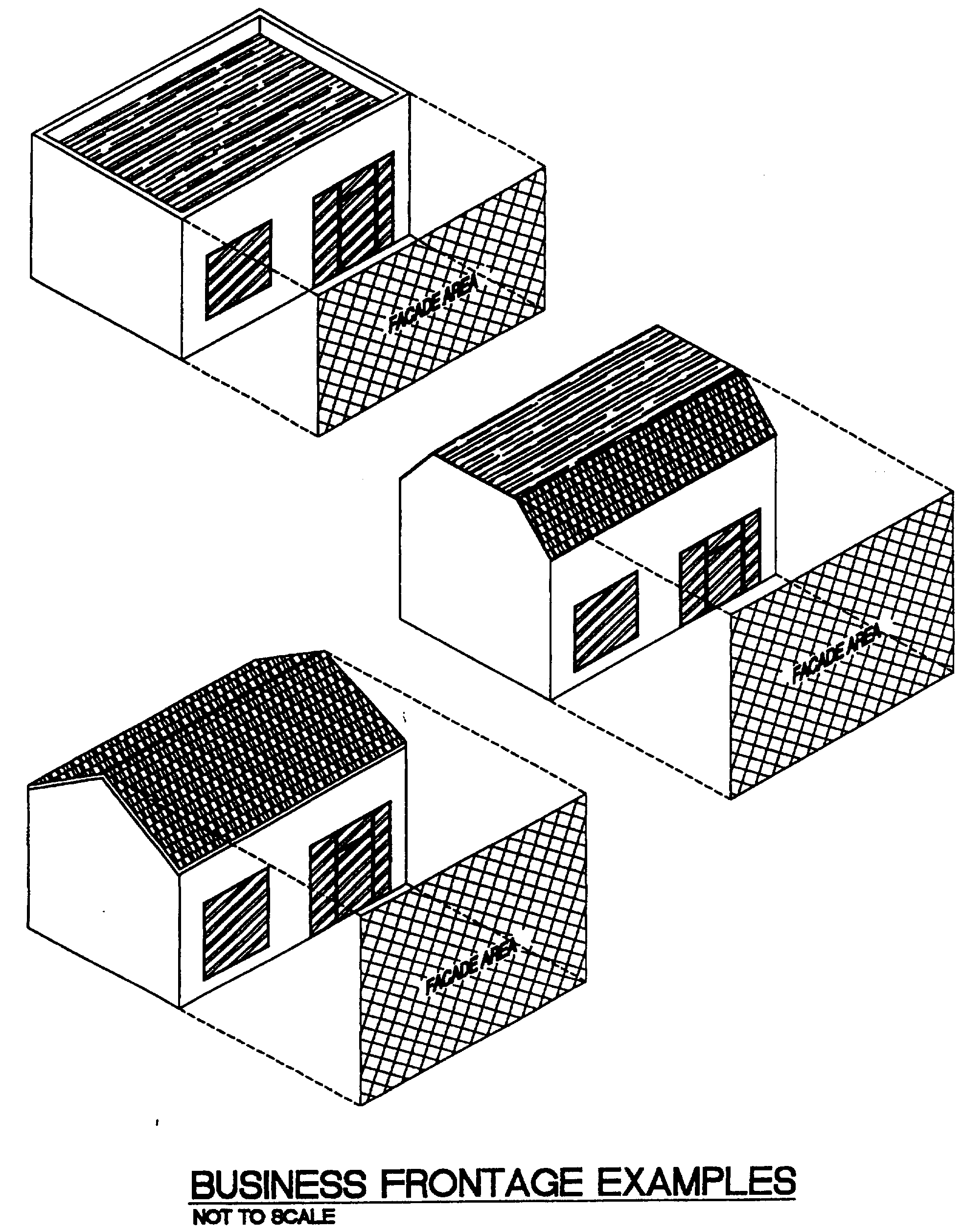
5.
Corner lots and double frontage lots. A business located on a corner lot or double frontage lot may advertise on each side of the building which fronts on improved twenty-foot or larger public right-of-way. The total allowable signage for the business shall be determined by the business frontage and may be equally divided between both elevations facing the public right-of-way. For such lots located on Dixie Highway or Federal Highway, if more than one (1) business is located on such lot and the main building entrance to any business is on a different side of the building than the others, that business may use the total allowable signage on the frontage where the main entrance to that business is located.
6.
Total combined sign area. Except where otherwise regulated in this section, the total combined sign area permitted, based on legal lot frontage, is as follows:
*Or such additional sign area as the appropriate review board may allow pursuant to
subsection j, below.
The square footage of each sign face shall be added in calculating the combined sign
area.
7.
Obstructing fire escapes. No sign shall be erected, constructed or maintained so as to obstruct any fire escape or any window or door opening used as a means of egress or so as to prevent free passage from one (1) part of the roof to any other part thereof. A sign shall not be attached in any form, shape or manner to a fire escape and shall not be placed in such a manner as to interfere with any opening required for legal ventilation.
8.
Signs on streets. No sign shall be constructed or erected in or over any road right-of-way except those listed in the "Uniform Manual of Traffic-Control Devices" and provided for in this paragraph.
A.
No sign shall be erected at the intersection of any street in such a manner as to obstruct free and clear vision, or at any location, where, by reason of position, shape or color, it may interfere with, obstruct the view of or be confused with any authorized traffic sign, signal or device, nor shall any sign be erected which makes use of the words "stop," "look," "danger," or any other word, phrase, symbol or character in such a manner as to interfere with, mislead or confuse traffic.
B.
The city may construct or erect signs in city road rights-of-way, including alleys, for city purposes upon approval by the city manager. Any such signs shall serve a public purpose and comply with the provisions of this section.
C.
Signs, other than city signs, may be constructed or erected in an unimproved city road right-of-way, including alleys, upon approval by the city commission and subject to a revocable use permit. Any such signs shall serve a public purpose and comply with the provisions of this section.
9.
Maintenance. The owner of any sign as defined and regulated by this section shall be required to have all parts and supports of the sign properly maintained and repair those which bear evidence of deterioration of structural integrity or physical appearance.
A.
Should any sign become abandoned, insecure, in danger of falling or otherwise unsafe in the opinion of the building official, the owner thereof, the person or firm maintaining same, or the owner of the property upon which such sign exists, shall, upon written notice from the building official, repair, secure or remove the sign within ten (10) days from the date the notice is sent. The notice shall be in accordance with established procedures for legal notices and shall be sent to the owner, agent or person in control of the sign.
B.
If the sign if not repaired, secured or removed as directed in the notice, within the ten-day time period, the building official shall, after due notice to the owner, agent or person in control of the sign and the owner of record of the property upon which sign is located, affording them an opportunity to be heard, cause the sign to be removed. Removal shall be done by the lowest responsible bidder through competitive bidding procedures, and all costs, including administrative costs, shall be assessed against the property upon which the sign was located in accordance with the standard assessment procedures set forth in the ordinances of the city.
C.
If the sign is, in the opinion of the building official, unsafe to the extent that it involves imminent danger to human life or health, the building official shall promptly cause it to be made safe or removed.
D.
If the owner, agent or person in control of an unsafe sign cannot be located, then notice shall be sent to the owner of record of the real property upon which the sign is located, giving said property owner ten (10) days' notice to repair, secure or remove the sign.
E.
The owner, agent or person in control of the sign or the owner of record of the property upon which the sign is located shall have the right, except in cases of emergency, to appeal the decision of the building official as provided in this section.
10.
Visibility triangle. No sign shall be constructed so as to obstruct clear vision through the visibility triangle. At street intersections with stop signs, the visibility triangle shall have twenty-foot sides measured along the street right-of-way line from the corner of the intersection, the third side of the triangle to be the line connecting the ends of the aforesaid lines. At street-alley intersections and alley-alley intersections, two (2) sides shall be ten (10) feet in length, the third side being the line connecting the ends of the ten-foot sides. At signalized intersections, the visibility triangle shall have twenty-foot sides measured from the corner of the right-of-way where there are sidewalks.
11.
Changeable copy signs. All changeable copy signs shall meet all applicable regulations set forth in this section.
12.
Setback. Setback shall be measured from leading edge of sign or sign face.
e)
Special regulations by type of sign. The following types of signs shall be constructed or erected in accordance with the following specific regulations in addition to all other applicable regulations set forth in this section. Special regulations for the core area are the only exception to the regulations provided below.
1.
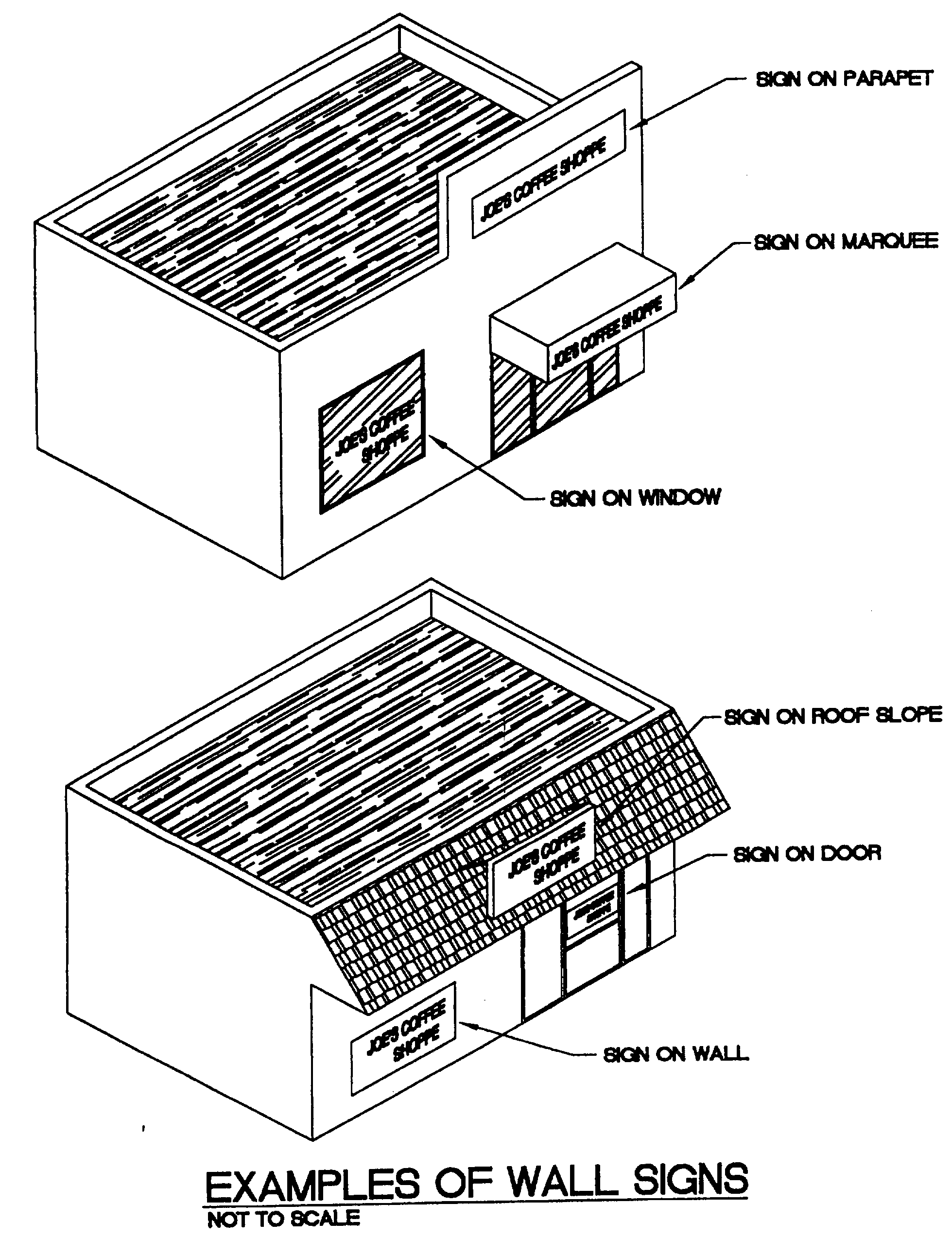
Wall signs.
A.
Painted wall signs may not co-exist with cabinet or channel letters on the same façade.
B.
No wall sign shall be mounted at a distance measured perpendicular to the wall greater than eight (8) inches measured from the lowest building wall to the face of the sign.
C.
The surface of all wall signs shall be of sheet metal or other approved noncombustible material, but the ornamental molding surrounding same may be of wood construction.
D.
All wall signs shall meet the same building code requirements as the structure to which they are attached.
E.
A wall sign shall not extend beyond any edge of the surface to which it is attached, nor disrupt a major architectural feature of the building.
F.
Sign area. The maximum allowable sign area for wall signs shall be one (1) square foot per linear foot of business frontage up to a maximum of one hundred (100) square feet.
G.
Wall signage may be constructed or painted on elevations not fronting on an improved right-of-way when adjacent to an improved parking lot. Such signage shall not exceed twenty (20) percent of the total combined allowance. Identification sign(s) of three (3) square feet or less shall be permitted at the rear of the building(s).
2.
Projecting signs.
A.
Projecting signs are not permitted to co-exist with freestanding signs. Projecting signs shall not be located within five (5) feet of wall signs on the same elevation.
B.
Sign area. The maximum allowable sign area for projecting signs shall be as follows:
C.
Projecting signs shall be erected a minimum of nine (9) feet above the sidewalk. Top of sign shall not exceed fourteen (14) feet. Projecting signs shall not extend more than five (5) feet from the building or within two (2) feet of the curb nor shall the projecting sign extend above the roof line, parapet wall. Additionally, where applicable, such signs shall comply with Florida Department of Transportation regulations and permitting.
D.
All projecting signs shall be entirely of metal or other noncombustible materials or plastics. A waiver by the HRPB may allow signs within historic districts to be constructed of wood or composite thereof that is routered, carved or sandblasted which produces a three-dimensional appearance. Plywood is expressly prohibited.
E.
Lighting shall be external, shield and colorless. Internal lighting is prohibited on all projecting signs located in the MU-FH, MU-E, DT and NC districts.
F.
Decorative wrought iron, wood or structural aluminum hangers shall be used. Guys or cables shall be prohibited. All lateral bracing shall architecturally blend with the hanger material.
3.
Mansard signs. Mansard signs shall be permitted if they meet the following criteria:
A.
Mansard signs may co-exist with freestanding signs. Such signs shall not co-exist with wall signs on the same business façade or with projecting signs.
B.
No mansard sign shall project above the top of the mansard or below the bottom.
C.
Mansard signs shall only be permitted to be placed in the lower slope of a mansard.
D.
The bottom of a mansard sign shall not be lower than eight (8) feet from finished grade.
E.
Sign area. The maximum allowable sign area for mansard signs shall be one (1) square foot per linear foot of business frontage up to a maximum of one hundred (100) square feet.
4.
Roof signs. Roof signs may be permitted by variance upon showing undue hardship and further provided that they meet the following criteria:
A.
Roof signs shall not extend over public property.
B.
Roof signs shall be point of purchase signs only.
C.
A roof sign shall not exceed ten (10) feet above the parapet, nor be less than six (6) feet above the roof level; however, the six-foot minimum required height above the roof level may be waived by the fire marshal if, in his judgment, the waiver will allow proper fire department maneuverability.
D.
The support members of any roof sign shall appear to be an architectural and integral part of the building and shall appear to be free of any extra bracing angle iron, guy wires, cables, etc.
E.
Every roof sign shall be constructed entirely of noncombustible material, including the upright supports and braces.
F.
The bearing plates of all roof signs shall distribute the load directly to or upon masonry walls, steel roof girders, columns or beams. The sign shall be designed to avoid overstress of such structural members.
5.
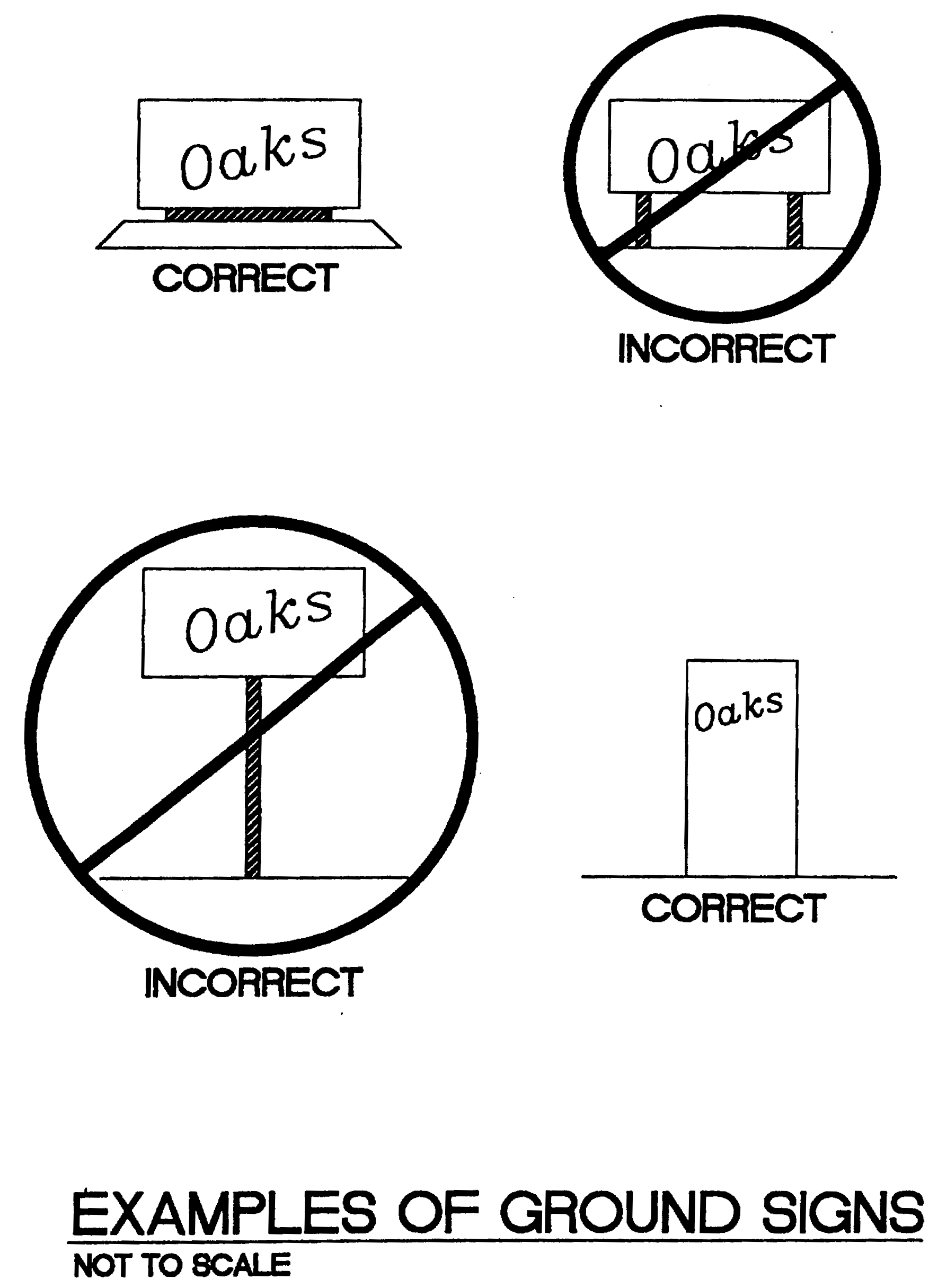
Freestanding signs.
A.
Pole signs are prohibited.
B.
Ground signs.
(i)
Ground signs may be designed with changeable copy area. Such area shall not exceed twenty-five (25) percent of the sign face. Ground signs shall not be constructed entirely as changeable copy.
(ii)
Ground signs are prohibited on property with less than fifty (50) feet of frontage. There shall be a minimum of forty-eight (48) feet between signs. Measurement shall be from any point on the sign face of the first sign to any point on the sign face of the second sign. The maximum number of ground signs on one (1) parcel shall be two (2).
C.
General requirements for freestanding signs.
(i)
Landscape shall be installed at the base of the freestanding sign in accordance with section 23.6-1.
(ii)
Corner parcels shall be limited to one (1) ground sign.
(iii)
Dual-faced signs, if faces are flat and back-to-back, shall be considered one (1) sign face.
6.
Pylon signs. Pylon signs shall be prohibited.
7.
Awning signs.
A.
Lettering shall be no more than eight (8) inches in height, and maximum length shall be no more than eighty (80) percent of the business frontage.
B.
Awning sign shall be installed on the vertical surface only and comply with Florida Department of Transportation requirements.
C.
Awnings shall be constructed of canvas, vinyl or similar material and shall be flame resistant.
D.
Waning colors shall be one (1) of the two (2) trim colors allowed and lettering shall match or closely coordinate with building colors.
8.
Illuminated signs.
A.
All illuminated signs shall meet all applicable Lake Worth Electrical Code regulations.
B.
All illuminated signs shall be lighted by electricity only.
C.
All electric wiring to illuminated signs shall be installed in conduit and concealed. The conduit shall be installed under the ground in accordance with the Lake Worth Electrical Code.
D.
All illuminated signs shall have a label, symbol or other identifying mark of a nationally recognized testing laboratory, inspection agency, or other organization concerned with product evaluation that maintains periodic inspection of production of labeled equipment or materials and by which labeling indicates compliance with nationally recognized standards or tests to determine suitable usage in a specified manner.
E.
Illuminated signs shall not have an intensity so as to impair momentarily the vision of any observer.
F.
Illuminated signs shall not, by way of their lighting or control mechanism, cause any radio, television or other communication interruption or interference.
G.
All illuminated signs shall meet all applicable regulations set forth in this section.
9.
Time and temperature signs. Time and temperature signs shall meet all the requirements set forth above for illuminated signs.
10.
Entrance signs.
A.
Entrance signs are permitted in any residential district for the exclusive purpose of identifying residential developments.
B.
Entrance signs shall meet all height and setback requirements of the district in which they are located. (See subsection f), below).
C.
Sign area. The sign area calculation for freestanding signs shall be used in calculating sign area for entrance signs. The maximum allowable size of any lettering shall be twelve (12) inches in height. Such lettering shall identify only the approved subdivision, community or development and shall be affixed on the face of a structure or approved entrance feature.
D.
All entrance signs shall meet all applicable regulations set forth in this section.
11.
Neon signs. Neon signs shall be allowed in all nonresidential zones. Neon shall not be placed within twenty-five (25) feet of, or face, a residentially zoned district and shall be guided by the following regulations:
A.
Neon copy shall contain no more than three (3) colors.
B.
Where neon copy is applied the sign area shall be calculated in accordance with the regulations by type of sign as provided in this subsection.
C.
Accent or outline lighting of windows, doors or buildings shall only be allowed on the following architecturally designed buildings:
Art deco: See definition in Article 1 of these land development regulations.
Moderne: See definition in Article 1 of these land development regulations.
Accent or outline lighting shall be subject to approval by the planning and zoning board or historic resources preservation board, as applicable.
12.
Temporary signs.
A.
General provisions. Temporary signs shall be subject to the following:
(i)
Temporary signs shall not be placed in any public right-of-way or on any other public property unless authorized in writing by the city manager or designee.
(ii)
Temporary signs larger than six (6) square feet shall require a permit. Such permits shall expire after six (6) months from the date of issuance.
(iii)
Temporary signs shall comply with all applicable regulations set forth in this chapter and shall meet any applicable criteria established for the zoning district in which it is located, unless such regulations or criteria conflict with this subsection 12.
(iv)
No temporary sign shall be placed in the visibility triangle or otherwise in a location in such a manner as to constitute a safety hazard, or hindrance to pedestrian or vehicular traffic.
(v)
The owner of the real property on which a temporary sign is located shall be responsible for compliance with this section. The city shall have one or more of the following remedies to enforce violations of this section:
a.
The city may initiate code enforcement action pursuant to Chapter 2 "Administration", Article IV "Code Compliance" or Article X "Supplemental Code Compliance Procedures".
b.
The city may post a notice on or near the non-complying sign that advises the owner of the requirements for correction and that allows forty-eight (48) hours to take corrective action. If after forty-eight (48) hours, the owner fails to comply or remove the sign, the city may remove the sign. If the sign is removed by the city, the owner may request a hearing before the special magistrate for a determination of whether the sign was in violation. The owner shall deliver the written request for a hearing to the code compliance division within ten (10) days from the date the sign was removed.
c.
The city is authorized to immediately remove any temporary sign that is placed in any public right-of-way or on any other public property in violation of this section.
d.
The city may take any other remedy available at law or in equity.
Each day that a temporary sign remains in violation of this section shall be deemed to be a separate offense.
(vi)
If a temporary sign pertains to an event, the temporary sign shall be removed within and by no later than three (3) days after the event is concluded. Types of events include, but are not limited to, the sale or lease of property, the holding of an election, the conclusion of a grand opening, etc.
(vii)
A temporary sign may not be placed on property without the permission of the owner of the real property.
(viii)
A temporary sign may not display any lighting or illuminations and must remain static.
(ix)
Temporary signs shall be setback from intersections of streets with other streets and with access drives as required by subsection 23.5-1d)10.
(x)
Temporary signs may not be attached to any utility pole, fence, tree, shrub, or other plant.
(xi)
When measuring the "sign area" of temporary signs, "sign area" shall be defined to include the entire surface area of a sign upon which copy may be placed.
B.
Residential zoning districts. The following criteria shall apply to temporary signs in residential zoning districts:
(i)
The maximum allowable sign area for all temporary signs per parcel shall be a total of twelve (12) square feet. In the calculation of the maximum sign area, only the sign area on one (1) side of each double-faced sign shall be included. The maximum allowable sign area shall not be included in the calculation of the overall total combined sign area set forth above in subsection 23.5-1d)6. of the general regulations and standards.
(ii)
The maximum allowable sign area for each temporary sign shall be four (4) square feet. The square footage limitation is per side for a double-faced sign.
(iii)
Temporary signs shall be placed no closer than three (3) feet from any property line and no closer than five (5) feet to the nearest public right-of-way (or other public property) or at the residence façade, whichever is greater.
(iv)
Freestanding temporary signs shall have a maximum sign height of six (6) feet. Sign height shall be measured from the ground level to the highest point of the sign.
(v)
A temporary sign shall not be placed closer than four (4) feet from another temporary sign.
(vi)
Banners are prohibited.
C.
Non-residential zoning districts and mixed use zoning districts. The following criteria shall apply to temporary signs in non-residential zoning districts and mixed use zoning districts:
(i)
The maximum allowable sign area for all temporary signs per parcel shall be a total of thirty-six (36) square feet. In the calculation of the maximum sign area, only the sign area on one side of each double-faced sign shall be included. The maximum allowable sign area shall not be included in the calculation of the overall total combined sign area set forth above in subsection 23.5-1d)6. of the general regulations and standards.
(ii)
The maximum allowable sign area for each temporary sign shall be twelve (12) square feet. The square footage limitation is per side for a double-faced sign.
(iii)
Temporary signs shall be placed no closer than three (3) feet from any property line and no closer than five (5) feet to the nearest public right-of-way (or other public property) or at the building façade, whichever is greater.
(iv)
Freestanding temporary signs shall have a maximum sign height of six (6) feet. Sign height shall be measured from the ground level to the highest point of the sign.
(v)
A temporary sign shall not be placed closer than four (4) feet from another temporary sign.
(vi)
Banners shall be permitted as follows:
i.
No more than two (2) banners are permitted on a property at any one time and may not remain for more than fifteen (15) days.
ii.
Banners shall be securely fastened.
iii.
Banners shall not be attached to utility poles or landscaping.
iv.
Banners may not be displayed more than two times per year.
v.
Banners related to the leasing and sale of units or bays in newly constructed buildings or in fully renovated buildings including improvements to one hundred (100) percent of structure/s interior areas shall not exceed three (3) percent of the building façade facing a right-of-way in total or thirty-six (36) square feet, whatever is greater, and shall be limited to two (2) banners per street frontage. These banners shall require a temporary sign permit that shall expire within six (6) months unless an extension of up to an additional six (6) months is granted by the development review official.
13.
Murals.
A.
All proposed murals shall be reviewed and approved by the planning and zoning board or historic resources preservation board, as applicable pursuant to:
(i)
The community appearance criteria of section 23.2-31 of these LDRs;
(ii)
The special regulations of this section; and
(iii)
Any administrative review policies adopted pursuant to subsection F. below.
B.
Murals shall be permitted in commercial and industrial districts. Other than trompe l'oeil architectural embellishments, murals shall not be permitted on the fronts of buildings or structures facing Lake Worth Road, Lake Avenue, Lucerne Avenue, Dixie Highway and Federal Highway, except as may be approved by the appropriate board. In all other districts, murals shall be evaluated on a case-by-case basis in relation to their surroundings and environment.
C.
Murals may co-exist with all types of on premises signs. If printed commercial messages are included in a mural, the entire mural shall be considered part of the overall allowable signage permitted by code.
D.
Murals shall be:
(i)
Installed in strict conformity with their approved plans and any special conditions.
(ii)
Installed by professional artists or licensed painters, or under their direct supervision.
(iii)
Properly and safely applied to building surfaces, using proper exterior paint or other materials.
(iv)
Suitably weatherproofed and protected against deterioration.
(v)
Maintained in their original condition.
E.
Removal of murals. Should an approved mural at any time enter into a deteriorated condition and no longer satisfy the terms of the approval determined by the department for community sustainability of the city, the following procedure may be used to abate the mural:
(i)
Notice to owner. Notice to the owner shall conform to the provisions set forth in F.S. § 162.12.
(ii)
Appeal by owner. The owner shall have thirty (30) days from the date of service to remove the mural or to request an appearance before the planning and zoning board or the historic resources preservation board, as applicable, to seek reversal of the decision of the department for community sustainability. If the appellate board affirms the department for community sustainability's decision, the owner shall have fifteen (15) days from the date of the appellate board meeting to remove the mural. The appellate board may, in its own discretion, impose conditions on the owner for the restoration of the mural.
(iii)
City's right to enter and abate. If the owner fails to remove the mural after thirty (30) days or the time limit imposed by the appellate board, the city may, at its own discretion, take such reasonable action as necessary to enter the property and remove the mural from the property, or restore the mural to a condition which is in compliance with the original terms of the approval.
(iv)
Costs of abatement by the city.
(a)
Upon the city's abatement of the mural, the costs thereof, including the administrative costs incurred by the city, shall be assessed against the real property from which the mural was removed. Mural abatement assessments shall be levied by resolution of the city commission and the date of levy shall be the date of adoption of such resolution. The resolution shall be filed in the office of the finance director as a lien against the land where the mural was abated, and shall be recorded in the public records of Palm Beach County, Florida, to afford notice to the public.
(b)
Such assessment shall be a lien against the land which the same is made effective as of the date of levy by the city commission. Such lien shall be prior, and prior in dignity, to all other liens against such property, save and except a lien for taxes. Liens shall be payable on the date of levy, and shall, from the date of delinquency (thirty (30) days after the date of levy), bear interest at a rate determined by the city commission.
(c)
The lien shall be subject to foreclosure as provided by law if not completely paid within three (3) years after date of delinquency. Three (3) years after the date of delinquency the interest on the unpaid principal shall be at a rate determined by the city commission.
(v)
Alternative remedies. Nothing in this section shall in any way limit the city to the remedy listed above. This remedy shall be in addition to any other remedy which the city can legally pursue.
(vi)
Recording requirements. The mural approval and agreement to remove shall be recorded in the records of the city, and may be recorded in the official records of Palm Beach County and shall be binding upon the heirs, personal representatives, grantees, successors in interest, or assigns of the parties.
(vii)
Removal by owner. Any mural may be removed by the property owner at any time.
(viii)
Removal agreement. Approved murals shall not be installed until the city receives a written removal agreement properly executed by the applicant and building owner. Such agreement shall be furnished by the city.
F.
The city commission may adopt reasonable guidelines and policies consistent with these regulations to assist the city in the review of proposed murals. After ratification, the adopted administrative policies shall be applied by the review board in reviewing applications for permits to install murals. Copies of adopted administrative policies shall be provided to all property owners considering the placement of murals.
G.
A written application for mural approval shall be submitted to the department for community sustainability using forms which shall be provided. The application shall include the following information:
(i)
The name and address of the applicant.
(ii)
The name and address of the owner.
(iii)
The street address and location of the proposed mural.
(iv)
A written description of justification for the proposal which specifically addresses how the mural satisfies the goals and objectives of this section of the comprehensive plan.
(v)
The written consent of the building owner.
(vi)
Renderings and sketches prepared in a professional manner clearly indicating the intended appearance of the proposed mural. A sketch of the mural shall be sufficiently detailed and depicted on a scaled elevation of the wall(s) on which it will be applied. Colored photographs of the building shall accompany the mural sketch, showing the wall to be painted in relation to adjacent streets and buildings.
(vii)
Color samples shall be precisely identified.
(viii)
Such other reasonable and relevant information as the department of community sustainability or board may require.
14.
Window signs.
A.
Window signs may co-exist with freestanding signs, pylon signs, wall signs, projecting signs, mansard signs, roof signs, illuminated signs, signs painted on buildings, and all other permitted signs.
B.
No individual window shall have more than twenty-five (25) percent of its total area covered with window signage or product advertisement(s). Window signs shall be added to the total sign area permitted in subsection d. above.
C.
Handwritten or hand-lettered signs affixed to the window shall be prohibited pursuant to subsection g. below.
D.
Method of calculation. Window sign(s) shall be computed by straight lines drawn closest to the copy extremities. Each line shall be calculated individually if no border exists and each glass panel shall be calculated separately.
15.
Flags.
A.
Only one (1) flag pole, with a maximum of two (2) flags or insignia of governmental, religious, charitable, fraternal or other organizations may be displayed for each seventy-five (75) lineal feet of legal lot frontage or fraction thereof.
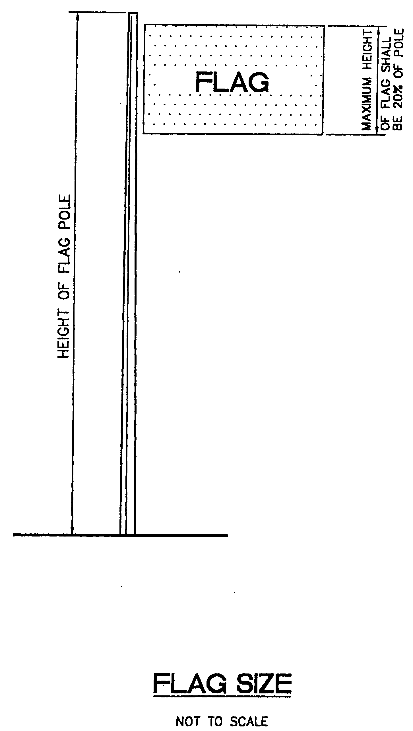
B.
The maximum distance from the top to the bottom of any flag shall be twenty (20) percent of the total height of the flag pole, or in the absence of a flag pole, twenty (20) percent of the distance from the top of the flag or insignia to the ground.
C.
Height shall not exceed twenty-five (25) feet.
16.
Changeable copy signs.
i.
Changeable copy shall be allowed for the following uses along the major thoroughfares of the city. Changeable copy signs may also be allowed on roadways with lower functional classifications for institutional and public uses only with a waiver per section 23.2-27.c. if approved by the applicable review board.
1.
Hotels and motels.
2.
Institutional and public uses.
3.
Gas and service stations.
4.
Movie theaters and playhouses.
5.
Menu board signs for restaurants.
ii.
For monument signs changeable copy shall be regulated by the following restrictions:
1.
Digital copy shall have a minimum dwell time cycle of sixty (60) seconds.
2.
Digital copy shall be limited to one (1) message related to one (1) type of use per cycle.
3.
Digital copy shall be limited to three (3) individual total cycles.
4.
Changeable copy shall relate only to the principal use on a property.
5.
Individual changeable copy messages may only be changed once in a four (4) hour period.
iii.
For wall signs changeable copy shall be regulated by the following restrictions:
1.
Digital copy shall have a minimum dwell time cycle of two hundred forty (240) minutes.
2.
Digital copy shall be limited to one (1) message related to one (1) type of use per cycle.
3.
Digital copy shall be limited to three (3) individual total cycles.
4.
Changeable copy shall relate only to the principal use on a property.
5.
Individual changeable copy messages may only be changed once in a twenty-four (24) hour period.
iv.
The following operating modes shall be prohibited:
1.
Flash: The condition created by displaying the same message intermittently by turning it on and off, on and off, with rapidity, or any other delivery mode that creates a flashing effect.
2.
Zoom: The look or condition created by expanding a message from a central point to its full size.
3.
Stop or danger: Any signs which use the word "stop" or "danger" or imply the need or requirement of stopping, or which are copies or imitations of official signs.
4.
Red, green or amber (or any color combination thereof): Revolving or flashing light giving the impression of a police or caution light shall be prohibited.
f)
Regulations according to property uses.
1.
Core area and Lake and Lucerne Avenues.
A.
The purpose of this section is to safeguard and enhance property values in the core area as well as along the two (2) major east-west thoroughfares in the heart of the city; to provide an environment which will promote the development of business in the downtown area; to encourage sound practices and lessen the objectionable effects of competition in respect to type, size and placement of signs; to aid in the attraction of tourists and other visitors who are very important to the economy of the city; to reduce hazards to motorists and pedestrians traveling on Lake and Lucerne Avenues and persons shopping in the core area; and thereby to promote public health, safety and welfare. The core area shall mean the central most properties of the downtown, more particularly described as: Those properties which are bounded on the west by "A" Street and on the east by Golfview Road, and on the north by 2nd Avenue North, and on the south by 1st Avenue South. Those properties shall also include those located in the Arts Overlay District from Dixie Highway on the west to Federal Highway on the east, and from 2nd Avenue North to 2nd Avenue South.
B.
Ground signs, wall signs, mansard signs, signs painted on buildings, projecting signs, bulletin boards, awning signs and neon signs may be permitted in the core area and on Lake and Lucerne Avenues. All allowable signs shall meet all applicable regulations set forth in this section, except where modified by special regulations providing for a uniform sign design theme which may be adopted by the city commission.
C.
Eating and drinking establishments with outdoor cafe seating in the core area are permitted to display menu board sign structures illustrating menu or specials, which shall not impede pedestrian traffic and which will be removed daily. The location and design of such signs shall be subject to department for community sustainability approval and requires a permit.
2.
Residential uses.
A.
The purpose and intent of this section is to safeguard and enhance private property values in residential areas; to encourage sound practices and lessen the objectionable effects of competition in respect to type, size and placement of signs; to reduce hazards to motorists and pedestrians residing in Lake Worth; and thereby to promote public health, safety and welfare.
B.
Entrance signs which meet all applicable requirements set forth in this section are allowable signs for any residential use.
C.
Single-family/duplex uses may have one (1) home nameplate sign with only the street address or resident's name displayed.
D.
Multifamily uses. Apartments may have an identification sign displaying the name or address of the apartment building. The maximum height of the lettering shall be one (1) foot and the maximum sign area shall be twelve (12) square feet. On properties with frontage less than one hundred (100) feet such sign area shall be six (6) square feet. Illumination of such signs is prohibited.
E.
Conditional uses. Day care centers or private schools may have one (1) sign per business address. Such sign shall meet the following regulations in addition to all other applicable regulations set forth in this section.
Size: Maximum six (6) square feet for wall sign and twelve (12) square feet for ground signs.
Height: Maximum four (4) feet for ground signs.
Allowable types: Wall or ground signs.
3.
Mobile home park. Such uses may have an entrance sign which meets all applicable regulations set forth for multifamily uses, above.
4.
Parking lots. Parking lot uses not appurtenant to a business or other land use may have one (1) freestanding sign which meets the following regulations in addition to all other applicable regulations set forth in this section.
Size: Maximum twelve (12) square feet.
Height: Maximum six (6) feet.
Allowable type: Ground signs.
5.
Mixed use-east (MU-E) and mixed use—Federal Highway (MU-FH) districts.
A.
Signs shall be limited to ground, projecting and wall signs. Projecting signs shall be constructed in accordance with design standards listed in subsection e), above. Neon open and vacancy signs shall be permitted on premises licensed as motel or hotel facilities and shall be subject to the neon regulations in subsection e) above.
B.
The maximum sign area shall be twenty-four (24) square feet.
6.
Multi-tenant buildings.
A.
Multi-tenant buildings shall be exempt from the total combined sign area requirements.
B.
The maximum allowable sign area for wall signs for each business in a multi-tenant building shall be one (1) square foot for each linear foot of the subject business' frontage.
7.
Service stations.
A.
Service stations may have a maximum of one (1) ground sign per business location in any area where service stations are permitted.
B.
Calculations for sign area and total combined sign area shall meet all regulations set forth in this section, except that price posting signs shall not be calculated into the maximum total combined sign area.
8.
Mixed Use - West (MU-W) zoning district.
A.
The following regulations shall govern signage for commercial and mixed use developments that are located within the MU-W zoning district.
B.
All sign types permitted under subsection e) above shall be permitted in the MU-W zoning district. However, the regulations contained in this subsection shall prevail in the case of a conflict.
C.
Properties that are over two (2) acres in gross area and located within the MU-W zoning district shall be exempt from the total combined sign area requirements.
D.
Wall signs:
i.
Total sign area for primary façades: Ten (10) percent of the area of primary building frontage façade that faces a public right-of-way.
ii.
Total sign area for secondary façades: Five (5) percent of the area of the secondary building façades visible from a public right-of-way.
iii.
Maximum sign area (per sign): One hundred (100) square feet.
iv.
Maximum number of signs per façade: One (1) Sign per approved use with frontage within the associated façade.
v.
Maximum number of signs per individual use: Three (3) Signs.
vi.
Calculating the area of a building face: The area of a building face shall be determined by multiplying the height of the building face to the eave or to the top of the parapet and by the width of the building face.
vii.
If more than one (1) sign is to be placed on the same façade for each of the approved uses within that façade, each use shall be afforded a percentage of the overall limit of the sign area for the façade based on the percentage of the linear footage of the façade associated with each use.
E.
Ground signs:
i.
Ground/monument signs may be designed with changeable copy area. Such area shall not exceed thirty-five (35) percent of the sign face or forty eight (48) square feet, whichever is less. Ground signs shall not be constructed entirely as changeable copy.
ii.
Ground/monument signs are prohibited on property with less than fifty (50) feet of frontage.
iii.
There shall be a minimum of fifty (50) feet between ground/monument signs. Measurement shall be from any point on the sign face of the first sign to any point on the sign face of the second sign.
iv.
The maximum number of ground signs on one (1) parcel shall be two (2).
F.
Wall signs may be designed with changeable copy area. Such area shall not exceed twenty-five (25) percent of the sign face or twenty-five (25) square feet, whichever is less. Wall signs shall not be constructed entirely as changeable copy
G.
Changeable copy:
i.
Changeable copy shall be allowed for the following uses in the MU-W zoning district provided that the property frontage is along either Tenth Avenue North or Lake Worth Road:
a.
Hotels and Motels.
b.
Institutional uses.
c.
Gas and service stations.
d.
Movie theaters and playhouses.
e.
Menu board signs for restaurants.
ii.
For monument signs changeable copy shall be regulated by the following restrictions:
a.
Digital copy shall have a minimum dwell time cycle of sixty (60) seconds.
b.
Digital copy shall be limited to one (1) message related to one (1) type of use per cycle.
c.
Digital copy shall be limited to three (3) individual total cycles.
d.
Changeable copy shall relate only to the principal use on a property.
e.
Individual changeable copy messages may only be changed once in a four (4) hour period.
iii.
For wall signs changeable copy shall be regulated by the following restrictions:
a.
Digital copy shall have a minimum dwell time cycle of two hundred forty (240) minutes.
b.
Digital copy shall be limited to one (1) message related to one (1) type of use per cycle.
c.
Digital copy shall be limited to three (3) individual total cycles.
d.
Changeable copy shall relate only to the principal use on a property.
e.
Individual changeable copy messages may only be changed once in a twenty-four (24) hour period.
iv.
The following operating modes shall be prohibited:
a.
Flash: The condition created by displaying the same message intermittently by turning it on and off, on and off, with rapidity, or any other delivery mode that creates a flashing effect.
b.
Zoom: The look or condition created by expanding a message from a central point to its full size.
c.
Stop or danger: Any signs which use the word "stop" or "danger" or imply the need or requirement of stopping, or which are copies or imitations of official signs.
d.
Red, green or amber (or any color combination thereof): Revolving or flashing light giving the impression of a police or caution light shall be prohibited.
9.
Unified master signage plan.
A.
All proposed mixed use projects must include a unified master sign plan to provide for an organized, aesthetically pleasing and architectural appropriate location for all signage within the project.
B.
Unified master signage plans shall address the following signage at a minimum:
i.
Monument signs.
ii.
Wall signs.
iii.
Directional signs.
iv.
Regulatory signs.
v.
Street signs.
C.
Unified master signage plans shall be required as part of the site plan, conditional land use, and mixed use planned development review processes.
g)
Prohibited signs.
1.
Animated signs (except time and temperature).
2.
Snipe signs.
3.
Billboards.
4.
A-frame, sandwich, sidewalk or curb signs.
5.
Streamers, twirling objects, fluttering objects, balloons or any other air or gas filled figure or sign, or any other similar items.
6.
Search lights.
7.
Swinging signs.
8.
Outdoor advertising of any kind or character where any live animal or human being is used as part of the advertising and is visible from any public street or public place.
9.
Any unauthorized sign on city property.
10.
Any portable signs or signs attached to trees, utility poles, trailers, roller casters, or any unapproved supporting structures.
11.
Any sign or advertising structure displaying obscene, indecent or immoral matter.
12.
Any sign which becomes unsightly. Signs which contribute to unsightliness or are inappropriate as deemed by the development review official may be appealed to the planning and zoning board or historic resources preservation board, as applicable.
13.
Abandoned signs.
14.
Vehicular signs.
15.
Any sign which contains or consists of a three-dimensional sculptured figure which is an emblem/logo of the business to which it is accessory or which represents products manufactured or sold by said business.
16.
Flashing sign.
17.
Any other sign not specifically authorized by this section.
18.
Pole signs.
19.
Pylon signs.
h)
Exemption from section regulations. The following signs shall be considered allowable signs when such signs meet the specific regulations set forth below (signs listed without specific regulations are also allowable signs under this section), and such signs shall be exempt from all other regulations of this section except the maintenance provisions of subsection e), above.
1.
All directional signs listed in the "Uniform Manual of Traffic-Control Devices."
2.
All signs directing traffic flow on private property. Such signs shall neither exceed four (4) square feet in background area nor extend to a greater height than four (4) feet above the ground. Only one (1) such sign shall be allowed at each point of ingress or egress, provided such signs do not create a traffic or pedestrian hazard.
3.
Impression signs. Such signs shall not be painted in contrast to the surrounding walls.
4.
All government signs. Any government informational sign that includes an electronic message component shall meet all other provisions of this Code for the type of sign to be installed; such electronic sign messages shall appear no less than at least ten-second intervals.
i)
Nonconforming signs. All signs in existence upon August 16, 2013 which violate any provision shall constitute a nonconforming sign. Any nonconforming sign in existence prior to August 16, 2013 or which is destroyed or damaged to the extent of fifty (50) percent or more as determined by the building official, or is altered or replaced, shall not be repaired, reinstalled, altered or replaced unless and until said sign has been made to conform to all applicable regulations of this section. All nonconforming signs shall be removed or made to conform within five (5) years from the date such sign(s) shall become nonconforming or December 31, 2019, except that nonconforming billboards shall be removed or made to conform within ten (10) years from the date such sign(s) shall become nonconforming. Notwithstanding the above, billboards which are the subject of a settlement of litigation, between the city and the billboard owner, which was filed before the adoption of these LDR's (August 6, 2013) may be altered or replaced as set forth in the approved settlement agreement and shall be removed or made to conform on the earliest date as set forth in the approved settlement or twenty (20) years, whichever is later. Any nonconforming sign previously approved by variance may continue in existence as permitted.
j)
Variances and appeals.
1.
Variances. Requests for variances from structural requirements shall be referred to the construction board of adjustments and appeals, and all others shall be referred to the planning and zoning board or historic resources preservation board, as applicable.
2.
Appeals.
A.
The word "board," when used in this section, shall be construed to mean the planning and zoning board or historic resources preservation board, as applicable.
B.
Interest in sign: Any member of the board who shall have direct or indirect interest in any sign or in any decision relating to a sign, which shall be the subject matter of, or affected by, a decision of the board, shall be disqualified from participating in the discussion, decision or proceeding of the board in connection therewith.
C.
Appeals: An appeal stays all proceedings in furtherance of the action appealed from, unless the building inspector certifies to the board, after the notice of appeal shall have been filed with him, that by reason of facts stated in the certificate, a stay would, in his opinion, cause imminent peril to life or property. In such case, proceedings shall not be stayed otherwise than by a restraining order granted by the board, or by a court of record on application, on notice to the building inspector and on due cause shown. The board shall fix a reasonable time for the hearing of the appeal, give five (5) days public notice thereof by publication in a newspaper of general circulation in the city, give due notice to the parties in interest, and decide the appeal within a reasonable time. At the hearing, any party may appear in person or by agent or by attorney.
D.
Jurisdiction: The board shall have the following powers and duties: To hear and decide appeals where it is alleged there is error in any order, requirement, decision or interpretation made in the enforcement of this section and to hear requests for variances from the literal provisions of this section for the erection of a new sign in instances where strict enforcement of this section would cause practical difficulties due to circumstances unique to the individual sign under consideration, and to grant such variances only when it is demonstrated that such action will be in keeping with the spirit and intent of this section.
(i)
The board shall not permit as a variance any sign which is prohibited in accordance with this section unless such a sign is declared a "historic nostalgia sign" by the historic resources preservation board and city commission pursuant to section 23.5-4.
(ii)
The Board may impose reasonable conditions in the granting of a variance to ensure compliance and to protect adjacent property. A violation of any such condition shall constitute a violation of this section.
(iii)
In exercising the above-mentioned powers, the board may reverse or affirm, wholly or partly, or modify the order, requirement, decision or interpretation.
(iv)
The concurring vote of a majority of the full board shall be necessary to decide in favor of the applicant on any matter upon which it is required to pass under this section.
(v)
Appeals from board. Any adversely affected person or persons aggrieved by any decision of the board may appeal such decision to the city commission.
E.
Service charge: There shall be a service charge, as may be set from time to time by the city commission, for each application for a variance from the literal provisions of this section or for application for a nostalgia designation.
F.
Appendix (A) illustrations.
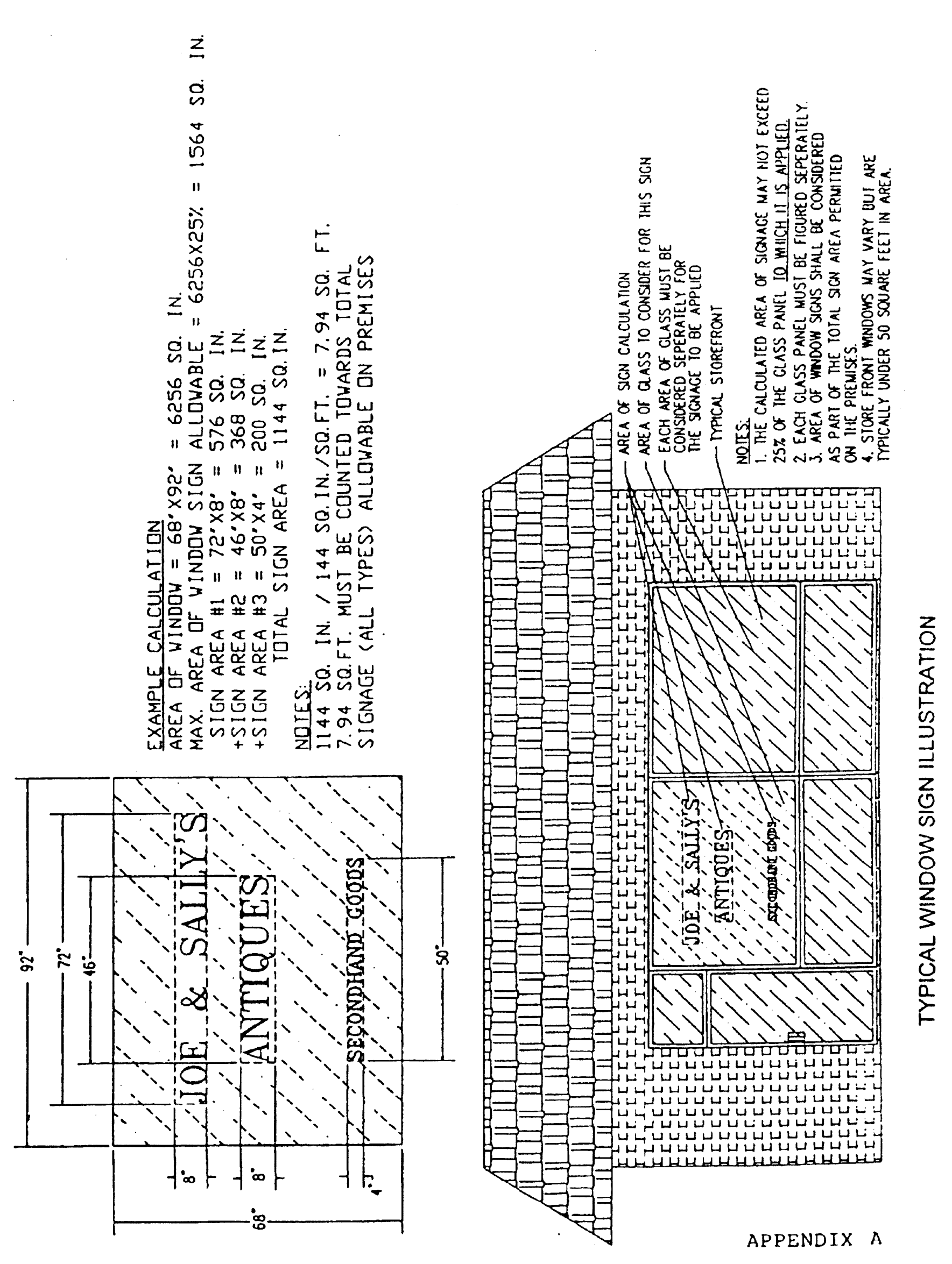
Typical Window Sign Illustration


(Ord. No. 2014-02, § 11(Exh. J), 1-7-14; Ord. No. 2014-22, § 19(Exh. R), 9-9-14; Ord. No. 2014-31, § 2(Exh. C), 11-4-14; Ord. No. 2015-04, § 8(Exh. G), 8-4-15; Ord. No. 2016-13, § 10(Exh. I), 5-17-16; Ord. No. 2018-08, §§ 3—5, 7-17-18; Ord. No. 2020-15, § 6(Exh. E), 12-1-20; Ord. No. 2023-06, § 14(Exh. M), 8-15-23; Ord. No. 2024-06, § 15(Exh. N), 5-21-24; Ord. No. 2024-13, § 24(Exh. W), 11-19-24; Ord. No. 2025-04, § 28(Exh. Z), 10-7-25; Ord. No. 2025-08, § 2, 9-16-25)
Sec. 23.5-2. - Subdivision regulations.
a)
Purpose, intent of section. The public health, safety, comfort, and welfare requires the harmonious, orderly, and progressive development of land within the city. It is the further purpose of this section to secure:
(1)
The establishment of standards of subdivision design which will encourage the development of a sound and economically stable community, and the creation of healthy living environments.
(2)
The efficient, adequate and economic supply of utilities and services to land developments.
(3)
The prevention of traffic hazards and the provision of safe and convenient vehicular and pedestrian traffic circulation in land developments.
(4)
The provision of public open spaces in land developments for recreational, educational, and community facilities.
(5)
The provision of adequate public school facilities for additional students generated by the city commission approval of plats of subdivisions.
(6)
Consistency with the policies and goals of the comprehensive plan of the city.
(7)
Site design respecting unique environmental characteristics of the site, and preservation of such characteristics to the maximum degree possible.
This section is intended to aid in the coordination of land development in the community in accordance with orderly physical patterns and to implement the comprehensive plan, or parts thereof, and such zoning regulations and other measure in furtherance of such comprehensive plan as may have been or may hereafter be adopted.
b)
Application of section. This section shall apply to and be enforced in all areas of the city. An individual, firm, corporation or any other subdivider shall not create a subdivision of a tract of land anywhere in the city except in conformity with this section and where applicable, with Chapter 23, Article 7.
c)
Definition of standards. Wherever reference is made in this section to standards, criteria, and the like established by the directors for community sustainability, public services, and utilities, and when the manner by which such standards, criteria, and the like are to be established are not defined by external criteria, in such event, such standards, criteria, and the like must be consistent with good, generally accepted engineering, public works, planning, zoning and utilities practices, and reasonably necessary to effectuate the intent of this section.
d)
Plats and platting; recording required; exceptions. Whenever land is subdivided a plat must be recorded, except that the recording of a plat will not be required if:
1.
The subdivision involved consists only of granting a public rights-of-way or easement and due to unusual conditions and circumstances the directors for the departments for community sustainability, public services and utilities find that it is not necessary that a plat be prepared.
2.
The land to be subdivided is to be divided into no more than two (2) lots and because:
(i)
Unusual conditions are created by ownership or development of adjacent lands; or
(ii)
The land concerned is isolated or remote in its relationship to other platted or improved lands; or
(iii)
The improvements and dedications existing on the land are substantially in accordance with the requirements of this section, and if the waiving of the requirement for platting, as determined by the directors for the departments for community sustainability, public services and utilities would not conflict with the purpose and intent of this section.
3.
The resubdivision of land heretofore platted is of such unusual size and shape, or is surrounded by such development or unusual conditions as may be determined by the directors for the departments for community sustainability, public services and utilities to justify the waiving of the requirement for preparing a replat. In lieu of platting, an official land survey sketch shall be supplied and the directors for the directors for the departments for community sustainability, public services and utilities reserve the right to require deeded rights-of-way and easements, reservations, or improvements required in connection with platting under this section including the posting of a performance and maintenance bond, as may be necessary to carry out the intent and purpose of this section.
4.
Regardless of any provision of this section, if recording is required by county or state legislation, then, and in that event, approval shall be secured from the city commission.
e)
Approval before recording. A plat of any subdivision shall not be entitled to recording in the office of the clerk of the circuit court until it shall have been approved in the manner prescribed herein.
f)
Revising plan after approval. Changes, erasures, modifications, additions or revisions shall not be made in any plat of a subdivision after approval has been given, unless the plat is resubmitted for approval, except as required by the county due to other governmental requirements, state laws, county procedures, or for clarification.
g)
Procedure for platting.
1.
Preliminary conference. The subdivider, his engineer or land surveyor, prior to the preparation of the tentative plat, may informally seek the advice of the director of public services in order that he may become familiar with the subdivision regulations.
2.
Tentative plat. The tentative plat shall show all of the facts and data required by the directors for the departments for community sustainability, public services and utilities to determine whether the proposed layout of the land in the subdivision is satisfactory from the standpoint of public interest. At least the following information shall be a part of or shall be submitted with the tentative plat:
(A)
Proposed subdivision name approved by the clerk of the circuit court for Palm Beach County, identifying title, the name of the city, and the section, township and range.
(B)
Name and address of record owner, subdivider and the person submitting the tentative plat.
(C)
Location of property lines, existing easements, buildings, watercourses and other essential features.
(D)
The name of abutting subdivisions and the name of owners of record of adjacent acreage.
(E)
The location of existing public utilities and storm drains on the property to be subdivided.
(F)
Location, name and present width of existing and proposed public rights-of-way, easements, parks, other open public spaces and similar facts regarding the immediate adjacent property.
(G)
Any desired changes in the use, height, area and density districts or other zoning regulations applicable to the area to be subdivided, and any boundaries of such districts affecting the tract, all parcels of land proposed to be dedicated to public use and the conditions of such dedications.
(H)
The width and location of any street or other public way shown upon the official map or the master plan, within the area to be subdivided, and the width, location, grades of all streets or other public ways proposed by the developer.
(I)
Typical cross-section of the proposed grading, roadways, sidewalks, canals, ditches and topographic conditions.
(J)
Date, north arrow and graphic scale.
(K)
Legal description and map of survey of tract boundary made and certified by a Florida-registered land surveyor or engineer.
(L)
Location of closest available city water supply system.
(M)
Location of closest available public sewage disposal system.
(N)
Provision for collecting and discharging surface drainage.
(O)
Preliminary design of bridges or culverts which may be required.
(P)
The proposed lot lines with approximate dimensions and in the case of odd or irregular-shaped lots, suggested location of buildings. Show square footage of each lot in a rectangle within each lot.
(Q)
The proposed location of sidewalks, curbs, gutters, water mains, sanitary sewers, storm drains, manholes, inlets, underground conduits and seawalls, and the sizes and shapes and types thereof, the character and width and depth of pavement and sub-base.
(R)
The location of proposed permanent utility easements.
(S)
Where the tentative plat submitted covers only a part of the subdivider's entire holding, a sketch of the prospective future street system of the unsubdivided part shall also be submitted and the street system of the unsubmitted part will be considered in the light of adjustments and connections with the street system of the part submitted.
(T)
A plat application on the form prescribed by the department of community sustainability.
(U)
An environmental survey, an aerial photograph, or other reliable depiction of the environmental characteristics of the site.
3.
Filing copies of tentative plat and plat application. The subdivider shall file eleven (11) blueprints and one (1) reproducible copy of the tentative plat with the department, together with two (2) copies of the plat application.
4.
Checking; investigating. The subdivider shall pay such fees as are prescribed in the fee schedule for checking and investigating the tentative plat.
5.
Review of tentative plat. Copies of the tentative plat shall be distributed to the departments for community sustainability, public services and utilities and to such other departments as may be necessary. After review by these departments, the plat shall be forwarded to the planning and zoning board or historic resources preservation board, as applicable (hereinafter the "review board"), and then to the city commission for consideration. Approval of a tentative plat by the city commission shall confer upon the subdivider the right, for a twelve-month period from the date of approval, that the terms and conditions under which the tentative plat approval was granted will not be changed if the final plat is in accordance with the tentative plat approval. The city may, after the twelve-month period, require complete reconsideration of all or any part of a tentative subdivision plat.
6.
Review board recommendation. The review board shall determine whether a tentative plat is in conformity with the provisions and requirements of these regulations and other applicable requirements of the ordinances of the city. It shall make such investigations and recommendations as may be deemed necessary to insure such conformity and to cause the tentative plat to be consistent with the city's comprehensive plan. The board shall recommend approval, approval with conditions, or disapproval of the tentative plat. The board's recommendation shall be forwarded to the city commission, signed by the chairman of the board, and filed with the city clerk. Upon recommending approval, approval with conditions, or disapproval, such action shall be endorsed on the face of each copy of the tentative plat by the secretary of the board. The city commission shall either approve, approve with modifications or conditions, or disapprove the tentative subdivision plat, or may refer the plat to any board or officer of the city for further consideration, after considering the recommendation of review board and all aspects of the plat necessary to meet the intent and requirements of this section and the comprehensive plan.
7.
Effect of consideration of tentative plat. The consideration of a tentative subdivision plat by the board and any recommended approval which it may submit does not constitute final acceptance and approval of the proposed subdivision. Such final acceptance and approval may only be given by the city commission.
h)
Final plat.
1.
Conformity to tentative plat. The final plat shall have incorporated all changes or modifications as required to make the tentative plat conform to the requirements of this section and to the conditions of tentative plat approval. Otherwise the final plat shall conform to the approved tentative plat, and it may constitute only that portion of the approved tentative plat which the subdivider proposes to record and develop at the time, provided that such portion conforms with all requirements of this section and meets with the approval of the directors for the departments for community sustainability, public services and utilities.
2.
Preparation. The final plat shall:
A.
Be prepared by a land surveyor registered in the State of Florida;
B.
Be clearly and legibly drawn in India ink on tracing cloth, or other acceptable materials, to a size twenty-four (24) inches by thirty-six (36) inches, and to a scale of one (1) inch equals one hundred (100) feet or one (1) inch equals two hundred (200) feet;
C.
Insofar as preparation is concerned, comply with all applicable regulations of the city and county and the laws of the State of Florida dealing with the preparation of plats.
3.
Contents. The final plat shall include:
A.
Name of subdivision. The plat shall have a title or name acceptable to both the city and county. When platting a new subdivision, an addition to, or revision of a recorded subdivision plat, the title of the plat shall include the name of such new subdivision, addition or revision, the name of the city, county, and the state, section, township, and range of which such platted land is a new subdivision, addition or revision.
B.
Legal description. There shall be lettered or printed upon the final plat a full and detailed description of the land embraced in the plat showing the township and range in which such lands are situated and the section and part of sections platted and a location sketch showing the plat's location in reference to the closest section corner or quarter section corner of each section embraced within the plat. The description must be so complete that from it, without reference to the plat, the starting point can be determined and the outlines run. If a resubdivision of a part of a previously recorded plat is proposed, the previous lots and blocks to be resubdivided shall be given. If the plat be a resubdivision of the whole of a previously recorded plat, the fact shall be so stated. Vacation of previously platted lands must be accomplished in a manner provided by law.
C.
Names of adjacent subdivisions.
D.
Names or numbers and width of streets immediately adjoining plat.
E.
All plat boundaries.
F.
Bearings and distances to the nearest established section or quarter section corner or other recognized permanent monuments which shall be accurately described on the plat.
G.
Municipal, township, county or section lines accurately tied to the lines of the subdivision by distance and bearing.
H.
Accurate location of all monuments.
I.
Length of all arcs together with deltas, degree of curves, radii, tangent distances, internal angles, points of curvatures and tangent bearings.
J.
When lots are located on a curve or when side lot lines are not parallel and are at angles less than or more than ninety (90), the width of the lot at the front building setback line shall be shown.
K.
The name or numbering and right-of-way width of each street or other public-of-way shown on plat.
L.
The numbering of all lots and blocks shown on the plat. All lots shall be numbered by progressive numbers individually or in blocks progressively numbered. Blocks in numbered additions, bearing the same plat name, shall be numbered consecutively throughout the several additions. Excepted parcels must be marked "not part of this plat."
M.
All areas dedicated for public purposes.
N.
The dimensions of all lots and angles.
O.
Square foot areas to the nearest foot of each lot shown in a rectangle within each lot.
P.
Location, dimension and purposes of any easements.
Q.
Certification by a State of Florida registered land surveyor to the effect that the plat represents a survey made under his direction and that all monuments shown thereon actually exist, and that their location is correctly shown.
R.
An acknowledgment by the owner of his adoption of the plat, and of the dedication of streets and other public areas, and the consent of any mortgage holders to such adoption and dedication. Existing right-of-way beneath a proposed plat must be vacated in accordance with city regulations prior to approval and acceptance of a final plat by the city commission.
S.
The signature of the review board chairman, the city manager, the city clerk and the mayor.
4.
Other data required with final plat.
A.
A certificate by the director of public services and the directors for water and electrical utilities certifying that the subdivider has either installed all required improvements or has posted a letter of credit or cash bond in an amount of one hundred ten (110) percent of the cost of improvements as estimated and submitted by the platter's engineer and verified by the director of public services and the directors for water and electrical utilities to assure the completion of all required improvements.
B.
Current certificate of title from a title company doing business in the State of Florida or opinion from an attorney authorized to practice law in this state, either of which must demonstrate fee simple title in applicant.
C.
Certification from the city and county that all taxes and assessments have been paid on the land within the proposed subdivision.
D.
If a zoning change is involved, certification from the department for community sustainability shall be furnished to the city clerk indicating that the change requested has been approved and is in effect, and that the size of lots and other features shown on the plat conform to all zoning requirements. Signing of the final plat by the city clerk shall constitute such certification.
h)
Final approval of plat; rejection. Approval of a plat by the directors for community sustainability and public services shall indicate the plat complies with this section, these LDRs and other applicable ordinances of the city, and is consistent with the comprehensive plan. Such approval is notice to the city commission that they may accept and approve the plat and authorize the review board chairman, the city manager, the city clerk and the mayor to execute said plat accordingly. After approval has been given as provided in this section, the director for community sustainability shall inform the subdivider, or his engineer, as the case may be, that the plat has been given final approval and is ready for recording in the public records of the county. In the event that the plat has been rejected, the director for community sustainability shall so notify the subdivider or his engineer in writing with a statement of reasons for such rejection.
i)
Letters of credit. Any requirement for a letter of credit under this section shall be satisfied by presentation of an irrevocable letter of credit written by a bank chartered by the State of Florida, or the United States government or any other state of the United States if the bank is authorized to do business in the State of Florida, whose legal lending limit exceeds the total face amount of the letter of credit. A letter of credit shall be accompanied by a letter executed by an officer of the bank certifying that the total face amount of the letter of credit is less than the legal lending limit of the bank, as defined herein, as of the date of the letter of credit. For the purposes of this section, "legal lending limit" means:
(1)
For a bank chartered by the State of Florida, ten (10) percent of the unimpaired capital and surplus of the bank.
(2)
For a bank chartered by the United States government, ten (10) percent of the amount of the capital stock usually paid in and unimpaired and ten (10) percent of the unimpaired surplus fund of the bank.
(3)
For a bank chartered by any state other than the State of Florida, the limitation imposed by the law of that state upon unsecured loans and lines of credit by the bank to any one (1) person, or ten (10) percent of the unimpaired capital and surplus of the bank, whichever is less.
The letter of credit shall be in a form acceptable to the city attorney and shall contain, as a minimum, the following provisions:
(1)
An expiration date of at least one (1) year from the date of issuance.
(2)
A provision that requires the issuer of the letter of credit to give at least thirty (30) days' notice to the city prior to expiration or renewal of the letter.
(3)
A provision that the letter is automatically renewed for a period of time equaling its original term if the written notice required hereunder is not given.
j)
Building permits. A building permit shall not be issued for any structure on a lot wherein the final plat has not been approved and recorded in the manner prescribed herein, unless the recording of a plat is not required.
k)
Public improvements and maintenance, withholding from subdivisions not approved or accepted. The city shall withhold all public improvement of any nature, including but not limited to, the maintenance of streets and the furnishings of sewage and water service, from all subdivisions which have not been approved, and from all areas dedicated to the public which have not been accepted, in the manner prescribed herein.
l)
Drainage.
1.
Permit to construct or alter drainage ways. No individual, partnership, or corporation shall construct, deepen, widen, fill, reroute, or alter any existing drainage way, ditch, drain, or canal without first obtaining a written permit from the city. Rights-of-way for such work must be dedicated to the use of the public or deeded in fee simple or by easement as may be required by the city to a proper governmental water control district; such dedication or deed to be made prior to any such construction or alteration.
2.
Rights-of-way and easements. Whenever any drainage way, stream, or surface drainage course is located or planned in any area that is being subdivided, the subdivider shall dedicate in fee simple or easement such stream or drainage course. Utility easements and drainage easements should not be combined or overlap and drainage easements shall take precedence.
3.
Stormwater. Adequate provision shall be made for the disposal of stormwater subject to the standards of the South Florida Water Management District, the Lake Worth Comprehensive Plan, and the city's master drainage plan.
4.
Contour map and drainage of adjacent areas. A contour map shall be prepared and submitted by a Florida registered land surveyor or engineer for the area comprising the subdivision and such additional areas as may be required by the director of public services necessary to include all watersheds which drain into or through the property to be developed, provided that this map of the adjacent areas may be prepared from existing maps or other data available to and acceptable by the director of public services. The design for drainage of the subdivision must be adequate to provide for drainage of adjacent watershed areas, and design or drainage structures must provide for drainage of adjacent watersheds after complete development to the total area. Where ditches and canals are required, rights-of-way shall be provided for future needs in accordance with uniform standards prescribed in the public works manual; provided, however, that the developer may be permitted by the director of public services to excavate, open, or construct necessary drainage facilities of sufficient capacity to provide for existing drainage needs whenever the developed or undeveloped status of adjacent watersheds may warrant as determined by the director of public services. Existing natural drainage features and wetlands shall be protected to the maximum extent feasible.
5.
On-site drainage. Drainage shall be detained on private property in accordance with the drainage level of service standards in section 23.5-7.
m)
Design standards.
1.
Conformity with master plan. If a master plan has been adopted for such area, the proposed subdivision shall conform in principle with such master plan, which shall be on file in the department for community sustainability.
2.
Streets.
A.
Conformance. The arrangement, extent, width, grade and location of all streets shall conform to the master plan, if one has been adopted for the area, and shall be considered in their relation to existing and planned streets, topographical conditions, to public conveniences, safety, and in their appropriate relation to the proposed uses of the land to be served by such streets, and where not shown on the master plan, the arrangement and the other design standards of streets shall conform to the provisions found herein.
B.
Relation to adjoining street system. The arrangement of streets in new subdivisions shall make provisions for the continuation of existing streets in adjoining areas.
C.
Projection of street. Where adjoining areas are not subdivided, the arrangement of streets in new subdivisions shall make provisions for the proper projection of streets.
D.
Streets to be carried to property lines. When a new subdivision adjoins unsubdivided land then the new streets shall be carried to the boundaries of the tract proposed to be subdivided where required to promote reasonable development of the adjacent lands or provide continuity of road systems.
E.
Street jogs prohibited. Street jogs with centerline offsets of less than one hundred twenty-five (125) feet shall be prohibited unless because of unusual conditions the directors for community sustainability and public services determine that a lesser centerline offset is justified.
F.
Dead-end streets or cul-de-sacs. Dead-end streets or cul-de-sacs designed to be permanent shall be provided at the closed end with a turnaround having a forty-five-foot radius. If a dead-end street is of a temporary nature and more than one (1) lot in depth, a similar turnaround shall be required, and provision made for future extension of street into adjoining property.
G.
Marginal access streets. Where a subdivision abuts or contains an existing limited access highway, freeway, or arterial street, a marginal access street or other such treatment as may be necessary for adequate protection of residential property and to afford separation of through and local traffic shall be required.
H.
Minor streets. Minor streets shall be so laid out that their use by through traffic shall be discouraged.
I.
Railroad on or abutting subdivision. Where a subdivision abuts or contains a railroad right-of-way, a street approximately parallel to and on each side of such right-of-way may be required, at a distance suitable for the appropriate use of the intervening land for park purposes in residential districts or for commercial or for industrial purposes in appropriate districts. Such distances shall be determined with due regard for the requirements of approach grade and future grade separation in accordance with directors for community sustainability and public services.
J.
Reversed curves. A tangent of at least one hundred (100) feet long may be required between reversed curves on arterial and collector streets.
K.
Connecting streets. When connecting street lines deflect from each other at any one (1) point by more than ten (10) degrees, they shall be connected by a curve with a radius adequate to insure a sight distance.
L.
Right-angle intersections. Streets shall be laid out so as to intersect as nearly as possible at right angles.
M.
Property lines at street intersections. Property lines at street intersections shall be rounded with a radius of twenty-five (25) feet. A greater or lesser radius may be prescribed by the director for public services in special cases. The director for public services may permit comparable cut-offs or chords in place of rounded corners.
N.
Rights-of-way widths. Street rights-of-way widths shall be as shown on the master plan and where not so shown shall be not less than as follows:
(1)
Arterial: Sixty (60) feet right-of-way.
(2)
Collector: Sixty (60) feet right-of-way.
(3)
Marginal access: Forty (40) feet where required in residential areas; forty (40) feet where access is limited by a limited access highway, a railroad or canal; sixty (60) feet in industrial subdivision.
(4)
Minor, for apartments and residences: Sixty (60) feet right-of-way.
(5)
Minor for industrial areas: Sixty (60) feet right-of-way.
(6)
Additional rights-of-way. Where existing plat dedications for perimeter street rights-of-way are less than twenty-five (25) feet, the proposed adjacent platted street may be improved providing additional rights-of-way are dedicated to increase the rights-of-way to a minimum width of forty (40) feet.
3.
Alleys. Existing, reserved, or dedicated alleys may be permitted in commercial and industrial districts. New alleys shall not be permitted unless the director for community sustainability finds such provision is necessary to provide additional means of service access, for off-street loading, unloading, and parking for the uses proposed.
4.
Easements.
A.
Easements shall be provided for utilities (not including drainage) where necessary and shall have a width approved by the directors for water and electrical utilities.
B.
Where a subdivision is traversed by a watercourse, drainage way or canal, there shall be provided a drainage easement or right-of-way conforming substantially with the lines of such watercourse, and such further width for construction, or both, as will be adequate for the purpose.
5.
Blocks.
A.
The length, width and shape of blocks shall be determined with due regard to:
(1)
Provision of adequate building sites suitable to the special need of the type of use contemplated.
(2)
Zoning requirements as to lot size and dimensions.
(3)
Need for convenient access, circulation, control and safety of street traffic.
(4)
Limitations and opportunities of topography.
B.
Block length shall not exceed fifteen (15) lots, or be less than four hundred (400) feet, unless a lesser or greater length is requested by the subdivider and is deemed advisable because of unusual conditions by the directors for community sustainability and public services.
C.
In blocks nine hundred (900) feet in length or over, crosswalks not less than ten (10) feet wide may be required to provide circulation or access to school, playground, shopping center, transportation, and other community facilities.
6.
Lots. The lot's depth, shape and orientation, and the minimum building setback lines shall be appropriate for the location of the subdivision and on the type of development and use contemplated.
A.
Lot dimensions shall conform to the requirements of the city zoning ordinance and in no case be less than one hundred (100) feet in depth.
B.
Each lot shall have frontage on a public street.
C.
Double frontage or through lots shall be avoided except where essential to provide separation of residential development from traffic arteries or to overcome specific disadvantages of topography or orientation. A planting screen easement of at least ten (10) feet may be required, across which there shall be no right of access.
D.
Side lot lines shall, where possible, be substantially at right angles or radial to street lines.
n)
Required improvements. Prior to final approval of a plat, the subdivider shall have installed or shall have furnished a letter of credit or cash bond equal to one hundred ten (110) percent of the cost of improvements for the ultimate installation of the following:
1.
Permanent reference monuments. Monuments shall be placed as required by the director for public services. The monuments shall be of such material, size and length as may be approved by the director for public services.
2.
Streets.
A.
Construction; inspection; approval. All streets shall be constructed and surfaced in accordance with applicable standard specifications of the city. Such construction shall be subject to the inspection of the director for public services or his designee and subject to issuance of permits by the building division. Where street construction complies with specifications, such installation shall be approved and accepted.
B.
Curbs, gutters and drainage. Curbs and gutters may be required and provisions for storm drainage and drainage structures shall be required. Each shall be provided in accordance with standard specifications of the city. Such construction shall be subject to the inspection of the director for public services or his designee, and subjected to issuance of permits by the building division.
C.
Fill. Where fill is necessary in a subdivision it shall be placed to the required elevation after settlement, indicated by the flood criteria and shall be reviewed by the director for public services. The type of fill shall be satisfactory to and meet with the approval of the director for public services, who shall require soil tests of the fill and the underlying material in areas in which streets or other public facilities are to be located. The fill for the balance of the subdivision shall be certified by a registered engineer as to type and method of placement.
D.
Street designation signs. Street designation signs shall be placed at all street intersections within or abutting the subdivision at the expense of the subdivider. Such signs shall be supplied and installed by the city.
E.
Sidewalks. Sidewalks may be required depending upon density, traffic volumes and adjacent development. All sidewalks shall meet FDOT Index 310 and all curb ramps shall meet FDOT Index 304.
3.
Water supply.
A.
Subdivision water supply. Potable water supply for a subdivision within the city limits must be connected to the city's system. Each lot within the subdivision area shall be provided with a connection thereto. All systems and extensions thereto shall be in accordance with the Lake Worth Utility Department requirements and shall be subject to the approval of the director for water and sewer utility, the Palm Beach County Board of Health, and the state board of health.
B.
Fire hydrants. Fire hydrants shall be installed in all subdivisions as may be required by the Southeastern Underwriters Association, the fire chief and the director for water and sewer utility.
4.
Sanitary sewer system. Public sewer systems are required in new subdivisions by the Palm Beach County Board of Health and by city ordinance. Each lot in the subdivision area shall be provided with a connection. All systems, extensions, and connections shall be in accordance with Lake Worth Utilities Department requirements and shall be subject to the approval of the director for water and sewer utility, the Palm Beach County Board of Health and the state board of health.
5.
Stormwater system. Stormwater management for a subdivision within the city limits must be connected to the city's stormwater management system. Each lot within the subdivision area shall be provided with a connection thereto. All systems and extensions thereto shall be in accordance with the Lake Worth Public Services Department requirements and shall be subject to the approval of the director for public services.
A.
Stormwater system shall be constructed in accordance with the city's construction standards and specifications and in accordance with FDOT Index's on "Drainage." Such construction shall be subject to the inspection by the director of public services and subject to permits issued by the building division.
B.
Erosion control measures and best management practices shall be utilized in construction of stormwater systems and shall be subject to inspection by the director of public services. An erosion control plan shall be submitted prior to issuance of the building permit.
C.
Stormwater system improvements are subject to the approval of, but not limited to, the city's public services department, South Florida Water Management District, Army Corps of Engineers, and the Lake Worth Drainage District.
6.
Electrical supply system. Electrical supply for a subdivision within the city limits must be connected to the city's electrical utility system. Each lot within the subdivision area shall be provided with a connection thereto. All systems and extensions thereto shall be in accordance with the Lake Worth Utilities Department requirements and shall be subject to the approval of the director for electric utility.
o)
Construction plans.
1.
Preparation. The applicant, or his engineer, shall confer with the public services and the public utilities departments to determine the standards and specifications which will govern the proposed improvements. The applicant shall submit to the director for public services complete construction plans prepared by an engineer registered in the State of Florida for the entire development of the area for which application to plat has been submitted, together with a complete and accurate contour map using National Geodetic Vertical Datum (NGVD) and a drainage plan showing elevations of adjacent properties. Sewer and water systems shall be reviewed and approved by the director for the water utility, director for public services, the county board of health and state department of environmental regulation. Construction plans shall include the complete design of required sanitary sewer, water supply, storm drainage and street systems for the entire area to be subdivided. Due consideration shall be given to the problems that may be created by the subdivision of adjacent lands, especially as pertains to storm drainage, in order that conformity with the overall master drainage plan will be obtained. Construction plans shall conform to the requirements of the Lake Worth Utilities Department, the city engineer, and all applicable ordinances.
2.
Approval of plans. All construction plans are to be reviewed and approved by the public services department and building division. Sewer and sewer plans shall also be reviewed and approved by the Lake Worth Utilities Department, the county health department, and no water or sewer construction shall commence prior to receipt of the approved county health department permit.
3.
Construction of improvements; inspection fees.
A.
After approved construction plans have been received, the applicant may construct the required improvements, subject to obtaining the required permits from the department for community sustainability. The city engineer shall be notified at least forty-eight (48) hours in advance of the date that such construction shall be commenced. Construction shall be subject to inspection by the utilities and public services departments. However, this in no way shall relieve the applicant and his engineer of close field supervision and final compliance with the approved plans and specifications. The public services department shall establish detailed regulations governing the inspections to be furnished by the developer or his engineer and may refuse to accept work done without proper inspection. Construction work shall not be undertaken prior to notifying the public services department. Prior to the issuance of the required permits, the applicant's engineer shall submit a certified estimate of construction costs of the required subdivision improvements. The applicant shall then pay an inspection fee to the city based upon the engineer's certified construction cost estimate in accordance with a schedule, to be determined, to cover resident supervision by the city during construction, and during a maintenance period of one (1) year following acceptance of the improvements by the city.
B.
An additional fee shall be paid to the city based upon a revised cost estimate or the final cost, according to the schedule mentioned above.
C.
Work started without a permit. Where work for which a permit is required by this section is started or proceeded with prior to obtaining the permit, the applicant shall pay an additional amount equal to the determined minimum fee for each day of unauthorized construction. The payment of such additional fee shall not relieve any persons from fully complying with the requirements of this chapter in the execution of the work.
D.
The applicant shall employ a Florida-registered engineer for complete supervision of the construction and installation of the improvements involved, and shall provide progress reports, two (2) sets of signed and sealed as-built plans, one (1) reproducible mylar of the as-built plans, and final certificate of the construction or installation from such engineer to be filed with the city engineer.
E.
Re-inspection fees. There shall be a fee for each re-inspection, due to wrong address, work rejected because of faulty construction, work not ready for inspection at time requested, code violations, repairs or corrections not made when inspection is scheduled, or premises not accessible to the inspection.
4.
Acceptance of improvements. When construction is complete in accordance with the approved plans and specifications and complies with the provisions of this subsection, the applicant shall obtain written approval and acceptance from the director for public services and the directors for water and electrical utilities.
5.
Letter of credit or cash bond in lieu of immediate construction. In lieu of immediate construction of improvements, the applicant shall file with the city attorney a letter of credit, or cash bond approved by the city attorney and city engineer, in an amount equal to one hundred ten (110) percent of the cost of the improvements to ensure the city the actual satisfactory completion of construction of proposed improvements within a period of not more than one (1) year from the date of the letter of credit or cash bond. The letter of credit for the installation of sidewalks may be a separate letter of credit or cash bond. The city engineer may require the applicant to recalculate and resubmit revised construction cost estimates, and letter of credit or cash bond. Provisions shall be made for extension of all such letters of credit or cash bonds, such extension to be commensurate with the percentage of improvements constructed in the subdivision concerned. Letters of credit or cash bonds shall also include a maintenance provision for one (1) year, covering all improvements by the applicant in an amount equal to fifteen (15) percent of the certified cost of the improvements. Letters of credit or cash bonds shall be subject to cancellations, reduction or renewal only by the city commission upon written certification of the city engineer.
p)
Subdivision of portion of tract. The owner or developer of a tract may prepare a master plan for an entire tract and then may submit a tentative and final plat for only a portion of the tract. No construction of the subdivision improvements shall be started until construction plans for the entire area covered by the final plat have been approved. Except as provided in this subsection, improvements must be installed for all of that area for which a final plat is submitted before building permits will be issued.
q)
Encroachment on or in street rights-of-way. Utilities, including franchised utilities, power and light, telephone and telegraph, water, sewer and gas, shall be constructed and installed beneath the surface of the ground; provided, however, that this subsection is not applicable to the erection on the ground or flush to the ground of transformers, pull-boxes, service terminals, pedestal-type telephone terminals, telephone splice closures or other similar on-the-ground facilities normally used with and as a part of an underground distribution system; nor to main feeder electric lines the principal purpose of which is delivering power between substations or from substations to local single-phase distribution systems.
A.
It is the intent of this section, in the case of electric power, that the underground requirement is applicable to the underground residential systems set forth by the standards of the electric utility involved, using single-base primary laterals, secondary and services necessary to serve a subdivision. It is not the intent to include an underground requirement for transmission or main distribution feeder lines serving more than the immediate area.
B.
The subdivider or developer shall make the necessary cost and other arrangements for such underground installation with each of the persons, firms or corporations furnishing utility services involved.
C.
The city commission may grant modifications to any of the provisions of this subsection on its own initiative or upon application from the utility or developer whenever the property to be divided is of such size or shape or is affected by such topographical location or subsurface or topographical conditions that it is impractical or economically unfeasible to conform to the strict application of the requirements of this subsection.
D.
The posting of a performance bond by the developer may be necessary to carry out the intent and purpose of this subsection.
E.
Utilities shall be constructed in assigned lanes where possible.
r)
Median strip beautification and utilization. Median strips which are part of a dedicated or deeded right-of-way to the city for street and highway purposes may not be utilized by others than the city or a city franchised utility except as follows:
1.
Landscape beautification. A developer or a property owner's association may landscape and beautify a median strip in proximity to their subdivision by placing grass and shrubs thereon provided that a landscape beautification permit shall be first obtained. The application for such landscape beautification permit shall be made in writing to the city manager and shall include a sketch or plan which shall contain sufficient detail as to location and dimension of the area involved and the materials and plantings to be utilized to follow and completely explain the proposal. The city manager shall refer such application to the department of public services, building division and law enforcement and fire prevention entities for their examination and advice and, upon receiving their respective approval of a finalized plan for same, shall authorize the building division to issue the permit for such work.
2.
Subdivision entrance signs. A subdivision entrance sign, including walls, fences, gates, rock piles or ornamental devices in connection therewith, may be constructed on or located upon a median strip in a dedicated or deeded right-of-way provided that such construction shall comply with the following requirements:
A.
No such entrance sign or structure in connection therewith shall be located within any front buildings setback line or within a twenty-five-foot radius of an intersection, whichever is greater.
B.
No such entrance sign or structure in connection therewith shall exceed an overall vertical height limitation of four (4) feet above grade level and a maximum of sixteen (16) square feet total area.
C.
There shall be a minimum side setback line observed in the median strip so that no such construction shall be located or placed within a horizontal distance of four (4) feet from the edge of the pavement of any such street or street area.
D.
The construction shall not interfere with visual line of sight of motorists or pedestrians lawfully traveling upon said streets and highways or with the orderly flow of traffic.
E.
Maintenance of such entrance signs and appurtenances thereto shall be and remain the responsibility of the developer or property owners' association, their successors and assigns, and shall not become the responsibility of the city except by the express assumption thereof by resolution.
s)
Placement, location of subdivision entrance signs. Subdivision entrance signs and appurtenances thereto which are constructed in whole or in part upon plots of land adjoining a right-of-way for street and highway purposes other than in the median strip thereto shall be placed so as not to constitute a traffic hazard. All of the requirements imposed upon subdivision entrance signs located in the median strip shall likewise apply to entrance signs located off the median strip except as to the minimum side setback line requirement which shall provide that no such construction shall be located or placed within a horizontal distance of four (4) feet from the edge of the pavement of any such street or street area.
t)
Exceptions from subdivision provisions.
1.
Authority of review board. The planning and zoning board or the historic resources preservation board, as applicable, (hereafter the "review board"), upon recommendation of the directors for community sustainability, public services, and utilities shall recommend to the city commission the granting or denying of an exception from these regulations when in its opinion undue hardship may result from strict compliance, except that no exception may be granted from subsection n), above, "Required improvements." Upon receiving such recommendation to deny or approve from the review board, the city commission may vary the regulations so that substantial justice may be done, provided that in granting such exception, the city commission shall prescribe any conditions that it deems necessary to, or desirable for, the public interest.
In making their findings, the review board and the city commission shall take into account, among other things, the nature of the proposed use of the land and the existing use of the land in the vicinity, the number of persons to reside or work in the proposed subdivision and the probable effect of the proposed subdivision upon traffic conditions in the vicinity.
No exception shall be granted unless the city commission finds, among other things, that all three (3) of the following conditions exist in regard to the land concerned:
A.
That there are special or unique circumstances or conditions affecting the property and that the strict application of the provisions of this section would deprive the applicant of the reasonable use of his land.
B.
That the exception is necessary for the preservation and enjoyment of a substantial property right of the applicant.
C.
That the granting of the exception will not be detrimental to the public welfare or injurious to the other property in the surrounding area in which the property is situated.
2.
Large scale developer. The standards and requirements of these regulations may be recommended for modification by the review board in the case of a plan and program for a complete community which in the judgment of the board provides adequate public spaces and improvements for the circulations, recreation, light, air and service needs of the tract when fully developed and populated, and which also provides such covenants or other legal provisions as will assure conformity to and achievement of the plan.
3.
Hearing; notice. All such exceptions shall be granted only after a quasi-judicial hearing and published and mailed notice as set forth in section 28-2.15 of these LDRs. The review board shall not act without considering the recommendation of the directors for community sustainability, public services, and utilities.
(Ord. No. 2016-17, § 3, 5-17-16)
Sec. 23.5-3. - Nonconformities.
a)
Generally.
1.
Purpose. It is the intent of this section to permit the continuation of those buildings and structures, lots of record, uses of buildings and structures, and uses of land which were lawfully permitted when established or commenced, but which do not conform in whole or in part to the present terms of these LDRs or as they may be amended from time to time. The expansion or enlargement of nonconformities however is discouraged as herein provided.
2.
Reserved.
3.
A change in tenancy, ownership, or management of a nonconforming use, structure, or lot shall not be construed to create a nonconformity, provided the change in otherwise lawful and in compliance with these LDRs.
4.
The existence of a nonconformity shall not be used as a reason to add new uses or structures that are not allowed by these LDRs.
5.
The temporary or illegal use of property shall not be sufficient to establish the existence of a nonconformity or to create rights in the continuation of a nonconformity until it shall come into compliance with these LDRs.
6.
For nonconformity in use to be maintained an active Lake Worth Business License must be maintained. Should the business license lapse due to non renewal by the annual due date or expire for a period of six (6) months or not be transferred to a new owner or occupant within three (3) months, the nonconformity shall be lost and the use shall conform to all of the requirements of these LDRs.
b)
Nonconforming uses of land. A nonconforming use of land is an activity primarily occurring not within a building, but either on open realty or with the use of minor buildings, and which use was lawful and properly permitted by the city when commenced or undertaken, but which does not conform to the current provisions of these LDRs. The decision of the development review officer as to whether a nonconforming use is a nonconforming use of land or a nonconforming use of a building or structure, as each is described in this section, shall be final unless reversed by the planning and zoning board or historic resources preservation board, as applicable. A nonconforming use of land, such as storage or junk yard operation, may be continued, subject to the following provisions:
1.
No such nonconforming use shall be enlarged, increased, or extended to occupy a greater area of land regardless of ownership or tenancy than was occupied on the effective date of the provision of these LDRs giving rise to the nonconformity.
2.
No nonconforming building or structure as defined and provided herein shall be erected in connection with a nonconforming use of land.
3.
If any nonconforming use of land ceases for any reason for a period of three (3) months or more, any subsequent use of such land shall be in compliance with the requirements of these LDRs.
c)
Nonconforming lots of record. A nonconforming lot of record is a legally created lot which by width, depth, area, dimension or location does not meet current standards set forth in these LDRs. In any zoning district in which single-family dwelling units are permitted, notwithstanding limitations imposed by other provisions of these LDRs, a single-family dwelling unit and customary accessory buildings may be erected on any single nonconforming lot of record legally created on or before January 5, 1976. For lots in the College Park and Worthmore Park subdivisions, if two (2) or more such lots, or combination of lots or portions of lots, with continuous frontage in single ownership were of record on January 5, 1976, the lands involved shall be considered to be an individual parcel or building site for the purpose of these LDRs and shall be no less than fifty (50) feet in width. No portion of said parcel shall be used or sold in a manner which prevents compliance with lot width and area requirements established by these LDRs. For lots created after January 5, 1976, no division of any parcel shall be made which creates a lot width or area below the requirements stated in these LDRs.
d)
Nonconforming buildings and structures. A nonconforming building or structure is a building or structure properly constructed according to the law existing at the time of permit but which does not presently conform to the property development regulations of these LDRs for minimum site area or dimensions, minimum setback requirements, maximum building or structure height, maximum lot coverage, minimum floor area, parking or loading or for other characteristics of buildings or structures regulated in these LDRs, or for its location on the lot. A nonconforming building or structure may continue to exist in a nonconforming state so long as it otherwise conforms to law, subject to the following provisions:
1.
Nonconforming buildings and structures may be enlarged, expanded or extended subject to these LDRs, including minimum site area and dimensions of the district in which the building or structure is located. No such building or structure, however, shall be enlarged or altered in any way so as to increase its nonconformity. Such building or structure, or portion thereof, may be altered to decrease its nonconformity, except as hereafter provided.
2.
Should the structure or building be deteriorated or destroyed to an extent of more than fifty (50) percent of the assessed value of the structure or building as determined by the building official, it shall not be reconstructed except in conformity with the provisions of these LDRs. However, a waiver of land development regulations may be granted as part of a certificate of appropriateness for a property within a designated historic district or landmark property. See sections 23.2-27 and 23.5-4 of these LDRs.
3.
Should the structure or building be deteriorated or destroyed to an extent of less than fifty (50) percent but more than thirty-three (33) percent of its assessed value as determined by the building official, it may be restored only upon issuance of a variance pursuant to section 23.2-26 for the particular building or structure nonconformity. A variance shall not supersede a condemnation order of the building official and such variance shall not obviate the necessity of obtaining other needed waivers or variances from the city.
4.
Should such building or structure be moved to a new site, or to a new location on the same lot or site, it shall conform to the current land development regulations relevant at the time of the relocation.
5.
A street wall may be utilized to meet the build-to line (front building line) requirements for existing buildings and structures as provided for in section 23.2-31 and section 23.2-27. Further, these nonconforming buildings and structures may be permitted to expand up to twenty-five (25) percent of the building area as provided for in section 23.2-31 if the proposed expansion does not increase all other nonconformities. A substantial improvement or permitted expansion (maximum twenty-five (25) percent) of these buildings and structures shall maintain or reduce the front building line nonconformity.
e)
Nonconforming uses of buildings and structures. A nonconforming use of a major building or structure is an activity primarily occurring within such building or structure, but which may also include the use of surrounding premises including land or nearby minor buildings. Such activity shall have been lawfully permitted at the time of its inception. The decision of the development review officer as to whether a nonconforming use is a nonconforming use of land or a nonconforming use of a building or structure, as each is described in this section, shall be final unless reversed by the planning and zoning board or historic resources preservation board, as applicable. Such nonconforming use may be continued so long as it remains otherwise lawful, subject to the following provisions:
1.
No existing building or structure devoted to a use not permitted by these LDRs may be extended, enlarged, reconstructed, moved, or structurally altered except as necessary to change the use of the building or structure to a use permitted by these LDRs or except to change the building or structure to a conforming building or structure.
2.
No nonconforming use of a structure may be extended to any portion of a building or structure not previously put to such use prior to the adoption of the regulation giving rise to the nonconformity. Further, such use shall not be extended to occupy any land outside such building or structure.
3.
In the event a nonconforming use of a building or structure is discontinued for any period however brief and replaced by a permitted use, the nonconforming use shall not be resumed.
4.
When a nonconforming use of a structure or building ceases for six (6) consecutive months, or for eighteen (18) months during any three-year period, and is not replaced by a permitted use, the structure or building shall not thereafter be used except in conformance with the regulations of the district in which it is located. The issuance or existence of a required license, permit or other governmental authorization to conduct such nonconforming use shall not mean that the use has not ceased, but the lack of such license, permit or authority shall create a rebuttable presumption that the use has ceased. Documentation of actions or activities of the owner of a property actively attempting to lease or rent the property, or documentation demonstrating that a business owner or property owner intended, but was prevented by no actions of their own to continuously operate said use shall be considered in determining whether a nonconforming use of a structure or building has ceased.
5.
When a nonconforming use of a structure or building ceases for six (6) consecutive months, or for eighteen (18) months during any three-year period, and is not replaced by a permitted use, the structure or building shall not thereafter be used except in conformance with the regulations of the district in which it is located. The issuance or existence of a required license, permit or other governmental authorization to conduct such nonconforming use shall not mean that the use has not ceased, but the lack of such license, permit or authority shall create a rebuttable presumption that the use has ceased. Documentation of actions or activities of the owner of a property actively attempting to lease or rent the property, or documentation demonstrating that a business owner or property owner intended, but was prevented by no actions of their own to continuously operate said use shall be considered in determining whether a nonconforming use of a structure or building has ceased.
f)
Certificate of conformity.
1.
Application. The provisions of this section shall apply to any real property which has been or will be rendered nonconforming because of the institution of eminent domain proceedings by a governmental agency. Any nonconforming parcel so created shall be deemed a conforming parcel upon the issuance of a certificate of conformity as provided in this section.
2.
Procedure. The condemnor or condemnee in an eminent domain proceeding may submit an application to the development review officer for a certificate of conformity relative to the remainder parcel which has been or will be created as a result of the eminent domain proceedings. The application shall include the following:
A.
The legal description of the remainder parcel which has or will become nonconforming.
B.
The name and address of the owner of the remainder parcel.
C.
The name and address of the condemnor including the name and address of the condemnor's representative.
D.
Evidence of the institution of eminent domain proceedings.
E.
A recent certified survey of the remainder parcel or of a sufficient portion thereof as will enable the director of the department for community sustainability to determine the extent of the acquisition and the location and nature of all affected structures located on the remainder parcel.
F.
A site plan of the property subject to the eminent domain proceeding or sold under the threat of an eminent domain proceeding at a scale of not less than one (1) inch equals twenty (20) feet, showing the location of all structures and improvements on the property and the extent of the condemnor's acquisition.
G.
A statement of justification in support of the issuance of the certificate of conformity.
H.
Evidence that both the condemnor and condemnee in the eminent domain proceedings are aware of the application for certificate of conformity.
I.
Any other information reasonably requested by the development review officer which is relevant to the application.
3.
Review of completed application. The development review officer shall review a complete application for a certificate of conformity and shall render a decision based upon the standards set forth below to issue or deny the certificate within thirty (30) days of the application. The applicant may appeal a denial to the planning and zoning board or historic resources preservation board, as applicable. The board may reverse the denial of the development review officer upon a finding that the application meets the standards of this section.
4.
Standards. The development review officer shall issue a certificate of conformity if the following standards are met:
A.
Severance or business damages relative to the remainder parcel would be reduced by the issuance of the certificate of conformity.
B.
A site plan for the remainder parcel has been prepared which minimizes the nonconformities caused by the eminent domain proceedings, and is otherwise consistent with all requirements of the LDRs.
C.
The remainder parcel can reasonably and safely function if redeveloped in accordance with the site plan described above.
5.
Landscape. All parcels subject to eminent domain proceedings must provide perimeter landscaping adjacent to public rights-of-way to screen vehicular parking and service and storage areas to the extent physically possible and deemed feasible by the site plan review staff. Landscaping shall be provided in areas of non-pedestrian or non-vehicular use.
6.
Duration. A certificate of conformity issued pursuant to this section shall automatically expire twenty-four (24) months from the date of issuance unless redevelopment of the remainder parcel in accordance with the site plan has been completed within said twenty-four-month period. However, an application for an extension of time in letter form may be submitted to the development review officer under circumstances such as (1) substantial completion of the landscaping per the site plan has been achieved, or (2) the delay in compliance with the approved site plan has been through no fault of the owner of the remainder parcel. Under no circumstances shall the extension of time exceed twelve (12) months. The decision of the development review officer shall be rendered within thirty (30) days of receipt of the letter requesting an extension of time. The decision may be appealed to the planning and zoning board or historic resources preservation board, as applicable. For purposes of these appeals, no application fee shall be charged. The board may reverse the denial for an extension of time and impose a new completion date upon a finding that the remainder parcel owner's failure to complete the project is through no fault of his/her own. Any subsequent, additional request for an extension of time shall be submitted directly to the board. The board shall determine whether an additional extension of time will be granted, using the criteria above to determine whether an additional extension of time will be granted.
7.
Enforcement. Noncompliance with the provisions set forth pursuant to the issuance of the certificate of conformity shall constitute a violation and is subject to those procedures set forth in Chapter 2, Article VI and Chapter 2, Article X of the City of Lake Worth Code of Ordinances.
g)
Repairs and maintenance. Except as otherwise provided herein, a nonconforming building or structure may be structurally repaired and maintained in the discretion of the owner. Any building or structure, or portion thereof, occupied by a nonconforming use may be structurally repaired and maintained but only to the extent required by law. Nothing in this section shall be deemed to prevent the strengthening or restoring to a safe condition of any building or structure or any part thereof declared to be unsafe by any official charged with protection of the public safety, upon order of such official, provided that the amount of damage to the nonconforming structure does not exceed the provisions of subsection d) above.
h)
In the event of a natural disaster, explosion, fire, act of God or the public enemy, the development review officer may permit the reconstruction of any nonconforming legally permitted structure to the same or decreased nonconformity as existed immediately prior to the disaster, upon proof satisfactory to the development review officer of the configuration of the prior structure, and only in compliance with the Florida Building Code. An application for reconstruction of the structure shall be filed within twelve (12) months of the event of its destruction, unless the city commission authorizes the development review officer to extend the twelve-month time period city-wide.
(Ord. No. 2014-22, § 20(Exh. S), 9-9-14; Ord. No. 2014-31, § 2(Exh. D), 11-4-14; Ord. No. 2020-07, § 6(Exh. E), 6-16-20; Ord. No. 2023-06, § 15(Exh. N), 8-15-23; Ord. No. 2024-13, § 25(Exh. X), 11-19-24)
Sec. 23.5-4. - Historic preservation.
a)
Public policy. The city commission declares as a matter of public policy that the preservation, protection, perpetuation, enhancement and use of landmarks and historic districts is a public necessity because they have a special historic, architectural, archaeological, aesthetic or cultural interest and value and thus serve as visible reminders of the history and heritage of this city, state and nation. The city commission finds that this section benefits the residents and property owners of Lake Worth and declares as a matter of public policy that this section is required in the interest of the health, prosperity, safety, welfare and economic well-being of the people.
The city commission further declares that this section specifically implements the comprehensive plan, and further, embodies the city's commitment to conserving its historical, cultural, archeological and architectural resources, not only to preserve its unique character, but also to meet the stated goals, objectives, and policies of land use, housing and conservation, as mandated by F.S. Ch. 163, and its comprehensive plan. Further, the city commission finds that the historic districts of Lake Worth add to the economic vitality of the city, help to preserve the city's unique character and charm, and their preservation helps to perpetuate an environmentally friendly city. Design review of structures within the historic districts is intended to support the rehabilitation and preservation of structures so as to be compatible with and support the surrounding structures in the district, while allowing for suitable reinvestment in the districts.
b)
National Register nominations.
(1)
The HRPB shall review all nominations of property within the city to the National Register of Historic Places following the regulations of the state historic preservation office. The HRPB shall also ask the city commission and the board of county commissioners for their written opinions as to whether or not a property or district should be nominated to the National Register. Following a public hearing, the HRPB shall consider the nomination. When necessary, the HRPB shall also seek expert advice before evaluating the nomination. The HRPB shall forward to the state historic preservation officer its action on the nomination and the recommendations of the local officials.
(2)
If a property owner objects to having his property nominated to the National Register, he shall submit a notarized written statement to the HRPB before the nomination is considered. The HRPB may then either continue its review and forward its recommendation to the state historic preservation officer and note the owner's objection or, it may cease any further review process and notify the state historic preservation officer of the property owner's objection to the proposed listing.
(3)
Any property placed on the National Register shall simultaneously be nominated for addition to the city's local register of historic places (the "local register"), as provided in this section. The HRPB's recommendation to the state historic preservation officer regarding a National Register listing may be transmitted prior to disposition of the nomination to the city local register.
c)
Certified local government program. In the development of the certified local government program, the city commission may ask the HRPB to perform other responsibilities that may be delegated to the city under the National Historic Preservation Act.
d)
Surveys and research. The HRPB shall undertake and maintain an on-going comprehensive survey and inventory of historic resources in the city (the "survey"). The purpose of the survey shall be to identify areas, sites, structures and districts within the city that have historic, archeological, architectural or aesthetic importance, interest or value. As part of the survey, the HRPB shall review and evaluate any prior surveys and studies conducted by the city, by any unit of government or by private organizations and compile appropriate descriptions, facts and photographs. Prior to nomination for designation of a landmark or a historic district, the survey shall be carefully reviewed to determine the significance of the areas, sites or structures under consideration. If the areas, sites or structures have not yet been surveyed, the HRPB shall first develop a plan and schedule for completion of the survey. Nominations to the National Register or the city register shall be based upon the survey in the manner provided herein, on forms prepared by the HRPB and shall be submitted to the city commission for final action.
e)
Designation of landmarks and historic districts.
1.
Designation in general. Upon recommendation of the HRPB, the city commission may, by ordinance, designate individual landmarks or historic districts. The designation of a landmark shall include a designation of a landmark site.
2.
Parties eligible to apply for designation. Applications for designation shall be initiated by the city commission, by any city commissioner, by the owner(s) of a potential site or (in the case of a potential historic district) by petition of not less than fifteen (15) percent of the affected land owners.
3.
Application requirements. Consideration of the designation of a landmark or a historic district shall be initiated by the filing with the division of planning, zoning and historic preservation (the "division") by an eligible party of an application for designation. The city shall charge a fee for each application which reflects processing costs for the application except that such fee shall be waived for publicly initiated applications. The applicant shall complete an application form provided by the division which shall include:
A.
Street address(es) and legal description(s) of the properties to be designated as a landmark or historic district.
B.
Name and address of the applicant.
C.
Name and address of the property owner(s).
D.
A history of the proposed site or district, including the names of the architects and for whom the properties were originally built, if known.
E.
A written description of the architectural, historical or archeological significance of the proposed landmark or building in the proposed historic district, specifically addressing the criteria set forth in this subsection.
F.
Date of construction of all structures on a property.
G.
Photographs:
(1)
For the proposed landmark, a minimum of two (2) photographs showing the main façade(s) of the property.
(2)
For a proposed historic district, one (1) view along each street and a photo of at least one (1) sample structure on each street.
H.
A sketch map, including scale and a north arrow, and the following additional information:
(1)
For a proposed landmark, the boundaries of the property, an outline of any structures, improvements or buildings on the site and their relationship to adjacent streets.
(2)
For a proposed historic district, all buildings and structures and their street addresses and all streets within the proposed district boundaries.
(3)
The applicant shall, based on the information submitted, classify each property within a proposed district as being either a "landmark," a "contributing" or "non-contributing" resource. The applicant's classification shall be verified by the division. The HRPB may recommend to the city commission that the applicant's initial classifications be revised based on the review criteria established herein. The classifications of structures and sites shall be indicated on all maps submitted to the HRPB.
I.
Two (2) sets of mailing labels showing the names and addresses of all property owners abutting or contiguous to the lot line of a proposed landmark; for properties within a proposed historic district, two (2) sets of mailing labels for each property owner within the proposed district boundaries.
J.
Sufficient funds to cover mailing costs.
K.
Exceptions from the city survey pertaining to the site or district.
L.
Any proposed waiver or deviation from property development regulations.
M.
Such other information which the division may find to be reasonable and necessary to carry out the purposes of this article.
4.
Staff review of applications. The director for community sustainability shall determine when the application is complete and may request additional relevant information when the application is determined to be incomplete. The division shall review the completed application and shall promptly forward its findings and recommendations to the HRPB prior to the public hearing. Upon the filing of an application for nomination, each property, building or structure included in an application shall be considered to be a potential landmark.
5.
Public hearings for designation. The HRPB shall schedule a public hearing on the proposed designation within sixty (60) days of the acceptance of a completed application, unless such time is extended by agreement of the applicant.
6.
Notice. Notice shall be provided in accordance with the provisions of section 23.2-15.
7.
Criteria for designation of property. The HRPB shall recommend the designation of property as a landmark or historic district after a public hearing based upon the following criteria. The HRPB's recommendation, as well as the city commission's final decision, may be based either on National Register designation criteria or on local designation criteria or on any combination of the criteria.
A.
Survey required. The HRPB and the city commission shall review the proposed designation of a landmark or a historic district in the context of the survey, which shall serve as the basis for consideration of the designation. Properties which have not been surveyed are not eligible for designation.
B.
National Register designation criteria. The HRPB and the city commission may evaluate nominated properties based on the criteria established for inclusion on the National Register of Historic Places, 36 C.F.R. 60.4, as it may be amended from time to time. In order to designate a landmark or historic district for inclusion on the National Register, the HRPB and the city commission shall make the following findings of fact:
(1)
The designee is of the highest importance (e.g., is the only, the best or the last example of such resource within the city), and therefore its loss to the city would be irreparable; and
(2)
The designee satisfies the criteria established to evaluate properties for inclusion on the National Register of Historic Places, 36 C.F.R. 60.4, as it may be amended from time to time, which currently reads substantially as follows. To be designated as a National Register landmark or historic district, the designated property shall:
(a)
Be associated with events that have made a significant contribution to the broad patterns of our history;
(b)
Be associated with the lives of persons significant in our past;
(c)
Embody the distinctive characteristics of a type, period or method of construction, or represent the work of a master, or possess high artistic values, or represent a significant or distinguishable entity whose components may lack individual distinction; or
(d)
Yield, or may be likely to yield, information important in prehistory or history.
(3)
Properties must possess an integrity of location, design, setting, workmanship, materials or association that represents a significant place in national, state or local history, architecture, engineering or culture.
(4)
Properties not generally considered eligible for designation on the National Register include cemeteries, properties owned by religious institutions or used for religious purposes, birthplaces or graves of historic figures, structures that have been moved from their original location, buildings or sites primarily commemorative in nature, reconstructed historic buildings and properties that have achieved significance within the past fifty (50) years. However, such properties will qualify if they are integral parts of districts that do meet the criteria previously described or if they fall into one or more of the following categories:
(a)
A religious property deriving its primary significance from architectural or artistic distinction or historical importance;
(b)
A building or structure removed from its original location but which is primarily significant for its architectural value, or which is the surviving structure most importantly associated with a historic event or person;
(c)
A birthplace or grave of a historic figure of outstanding importance if there is no other appropriate site of building directly associated with his or her productive life;
(d)
A cemetery which derives its primary importance from graves of persons of transcendent importance, from age, distinctive design features, or from association with historic events;
(e)
A reconstructed building when accurately executed in a suitable environment and presented in a dignified manner as part of a restoration master plan, and when no other building or structure with the same association has survived;
(f)
A property primarily commemorative in nature if design, age, tradition or symbolic value have invested it with its own exceptional historic significance; or
(g)
A property or district having achieved significance within the past fifty (50) years if it is of exceptional historic or architectural importance.
C.
Local designation criteria. In addition to or instead of National Register designation criteria, the HRPB and the city commission may designate a landmark or a historic district if it satisfies criterion C.(1) and any one (1) of the additional criteria C.(2) through C.(14), following:
(1)
In the case of a site, the structure shall be at least fifty (50) years old; in the case of a district, at least forty (40) percent of the structures shall be at least fifty (50) years old; and
(2)
Its location is a site of a significant local, state or national event;
(3)
It is identified with a person or persons who significantly contributed to the development of the city, state or nation;
(4)
It is identified as the work of a master builder, designer, or architect whose individual work has influenced the development of the city, state or nation;
(5)
Its value as a building is recognized for the quality of its architecture, and it retains sufficient elements showing its architectural significance;
(6)
It has distinguishing characteristics of an architectural style valuable for the study of a period, method of construction, or use of indigenous materials;
(7)
It embodies distinguishing characteristics of architectural style or elements of design, detailing, materials or craftsmanship that render it architecturally significant or valuable for the study of a period, type, method of construction or use of indigenous materials;
(8)
Its character is a geographically definable area possessing a significant concentration or continuity of sites, buildings, objects or structures united in past events or aesthetically by plan or physical development;
(9)
Its character is an established and geographically definable neighborhood, united in culture, architectural style or physical plan and development;
(10)
It is associated with a singular location that is unique or possesses singular physical characteristics that make it an established or familiar visual feature;
(11)
It demonstrates a likelihood of yielding significant information in terms of archaeology, history or prehistory;
(12)
It is listed in the National Register of Historic Places; or
(13)
It is consistent with the historic preservation goals of the comprehensive plan of the city.
(14)
No more than fifty (50) percent of the owners of a landmark property object to the designation.
D.
Interpretation. For purposes of this subsection, terms such as "exceptional importance", "exceptional significance", "significant", "significance", "compatible", "irreparable", "importance", and other subjective terms shall have their plain meaning, as established by the current edition of Webster's Dictionary, or applicable Florida or federal case law, to the extent that such exists.
8.
HRPB recommendation.
A.
After evaluating the testimony, survey information and other material presented at the public hearing, the HRPB shall within sixty (60) days determine, based on the evidence presented, whether or not the site satisfied the designation criteria. Such determination shall be submitted as a recommendation to the city commission, accompanied by a written report stating the HRPB's findings of fact based on the designation criteria. The recommendations shall be either for approval of the designation or for denial. In the case of a historic district, the HRPB shall also indicate by map or text which properties are identified as "landmarks" or as "contributing" or "non-contributing" properties; and may also recommend supplemental design guidelines and land development regulations which will govern issuance of certificates of appropriateness within the district. Unless waived by the applicant, the HRPB may vote to defer its decision for no more than an additional thirty (30) days.
B.
If the HRPB recommends denial of designation, such action shall be final unless an affected party (in the case of an individual landmark) or not less than two-thirds (⅔) of the affected eligible property owners (in the case of a historic district) appeal to the city commission in the manner provided in subsection n), below, of this section.
C.
The division shall promptly notify the applicant and the property owner(s) of the HRPB's recommendation.
9.
City commission review and designation.
A.
The city commission shall by ordinance approve, modify or deny the proposed designation within sixty (60) days of receipt of the HRPB's recommendation. A decision to reverse an HRPB recommendation of approval shall be by no less than four (4) votes of the full city commission or by no less than three (3) votes if the full city commission is not in attendance.
B.
If a landmark or district designation is made, the comprehensive plan, including the future land use map, shall be amended in accordance with state law to reflect the designation. In the case of designation of a historic district, the ordinance shall also set forth: (1) supplemental design guidelines and actions, if any, which would require a certificate of appropriateness; and (2) any additional exceptions to actions which would normally require a certificate of appropriateness, as provided in subsection m, below, of this section. Designation of a historical district shall include identification of contributing and non-contributing properties.
10.
Designation of landmark or historic district status; local register of historic places. The city clerk shall notify the applicant and the property owners of the city commission's decision within seven (7) working days of a final decision. If the city commission approves designation of a landmark or a historic district, the city clerk shall cause a notice or certificate of such action to be recorded in the public records of Palm Beach County at the expense of the applicant. The property or district shall be listed on the local register, which shall be maintained by the division. The division shall place a notation indicating the designation upon the official zoning map of the city. The future land use map of the comprehensive plan of the city shall also be amended to indicate the location and boundaries of landmarks and historic districts.
11.
Standardized street signs. Within two (2) years following official designation of a historic district, the city shall install standardized street signs which identify the district boundaries. The design of standardized historic district street signs shall be reviewed and approved by the HRPB prior to manufacture and placement.
12.
Successive applications. Upon denial of an application for designation, there shall be a twelve (12) month waiting period before the applicant may resubmit an identical or substantially similar proposal. An applicant shall be required to submit new evidence to justify his re-application unless the re-application is accepted pursuant to subsection o), below, pertaining to emergency actions. The waiting period may be waived by the city commission when such action is deemed necessary and in the best interests of the city.
13.
Amendments and rescissions. The designation of any landmark or historic district, including subsequent boundary adjustments thereto, may be amended or rescinded through the same procedure utilized for the original designation. The terms and conditions of the ordinance designating the landmark or the historic district which involve matters other than district boundaries may be amended as provided in F.S. Ch. 166. Upon the completion of a partial or complete survey of contributing and noncontributing buildings and structures in designated historic districts, where a previously designated noncontributing structure or building has changed to qualify as a contributing structure or building, a property owner may voluntarily agree to the classification of its structure or building as contributing without the necessity of HRPB or city commission approval. Upon request, the city will provide the property owner with a designation application which, upon completion, will be reviewed by city staff. If approved, the property will be designated as contributing. Thereafter, the city will provide the property owner with a written certification, and the property will be bound by the terms of this ordinance.
14.
Potential landmark designation.
A.
In general. The HRPB or the city commission may by a majority vote of its members and without notice to the owner, designate as a "potential landmark" any building, structure or site which is identified in the survey as value being "potentially eligible" for listing in the National Register based on the criteria for designation outlined in subsection b. If such interim designation is made, the HRPB shall within no more than forty-five (45) days complete an application and schedule a public hearing. If the owner of the potential landmark objects in writing to designation, the HRPB shall complete its review of the application within ninety (90) days of its initial designation of potential landmark status. Once a formal application for designation has been filed, the matter shall be reviewed as provided in subsection e). Designation of a potential landmark is to be considered an extraordinary action and its use shall be limited to situations where the HRPB has reason to believe that an imminent threat exists to the maintenance or survival of buildings or structures identified in the survey to be "potentially eligible" for listing in the National Register.
B.
Effect of pending applications for designation. When an application for designation is made and notice is mailed to affected parties, no action with respect to the exterior appearance of such site or district shall commence unless approved in accordance with the procedures provided in subsection e). In order to protect the city's general welfare, avoid an irreparable loss and prevent circumvention of the protections of this article, such requirement shall remain in effect until final disposition of the recommended action. The applicant may apply to the HRPB for review of a proposed action prior to final action by the city commission. The HRPB shall review the application using the criteria established herein, including unreasonable economic hardship. Permits may be issued upon HRPB approval of designation. Should the HRPB deny the applicant's request, the applicant may appeal to the city commission as provided in subsection o) below. If the city commission declines to designate the landmark or historic district, all permitting requirements set forth herein shall no longer apply to any proposed action.
15.
Design guidelines. The HRPB may recommend to the city commission supplemental design guidelines which will apply to proposed changes in the exterior appearance of individual landmarks or of buildings or structures in historic districts. The purpose of the design guidelines is to conserve and enhance the special aesthetic, historical and cultural character of the landmark or the historic district. Once adopted by the city commission via resolution, these guidelines will supplement the land development regulations applicable to the site or sites within a district. Guidelines may be amended from time to time as provided herein, and may be published in the form of a manual or as otherwise determined by the city commission.
Guidelines may include any aspect of physical design, including but not limited to architectural style and aesthetic character, site design, or site layout. For the purpose of section 23.5-4 architectural style shall be defined as: A classification characterizing buildings that share many common attributes, including similarity in general appearance, in the arrangement of major design elements in ornamentation, in the use of materials, and in form, scale and structure. Such styles are often related to a particular period of time, geographical region, country of origin, religious tradition, method of ornamentation, or to the architecture of a specific period.
Design guidelines further distinguish between the levels of preservation appropriate to the structure or site depending on whether the structure or site has been designated a landmark, or whether within a designated historic district a building or structure is a contributing or a non-contributing building or structure. The design guidelines shall afford most protection of the historic character of landmarks, and contributing buildings and structures, and lesser protection to non-contributing buildings and structures, understanding that the effect upon the district as a whole must be considered and evaluated.
Guidelines shall also balance the need for compatible rehabilitation of the structures within districts and the need for reinvestment and revitalization of neighborhoods. Life safety, energy conservation, hurricane protection and maintenance shall be afforded consideration. Further, they shall recognize the appropriateness of materials suitable for the climate of South Florida and overall character of the historic district. If a conflict exists between the guidelines adopted in the design guidelines and the standards in the underlying zoning district, the city shall apply the most restrictive of the two to the extent reasonable to effectuate the purposes of this section.
A.
Generally, changes to landmarks and to contributing buildings and structures shall be reviewed with the intent to ensure that the setbacks, height, mass, bulk, and orientation to a public street are compatible with neighboring properties within the historic district. Building materials and details of architectural style are of importance primarily where they are visible from the public rights-of-way, excluding alleys, and their preservation or replacement shall consider the costs of replicating the original materials and style. Integrity of overall architectural style and materials is important.
B.
Generally, new construction and changes to non-contributing buildings and structures shall be reviewed with the intent primarily to ensure that the setbacks, height, mass, bulk, and orientation to a public street are compatible with neighboring properties within the historic district, in order to protect the overall character of the district. Building materials and architectural styles are relevant only as to their effect on the district as a whole. Integrity of overall architectural style and materials is important.
f)
Certificates of appropriateness, in general. Approval of changes to designated landmarks or to properties within designated historic districts is required by way of a certificate of appropriateness (also referred to as "COA" or "certificate"). The intent of requiring a COA is to ensure the compatibility of changes to landmarks, buildings, and structures with regard to setback, height, mass, bulk and site organization of the properties. For landmarks and contributing buildings and structures, compatibility of materials, design, arrangement and detail to the architectural style of the properties is also to be considered.
Unless otherwise provided herein, no person may undertake the following actions affecting a designated or potential landmark or any property in a designated or potential historic district, or any appurtenance, improvement thereto, without first obtaining a certificate of appropriateness as provided in this section 23.5-4 whether or not a building permit is otherwise required:
(1)
Alteration of an archaeological site or the exterior part of a building or a structure;
(2)
New construction;
(3)
Additions;
(4)
Demolition; or
(5)
Relocation.
1.
Subject of certificate; other permits required. All new construction and alterations to landmarks and contributing buildings and structures shall include review of exterior changes on both primary façades and secondary façades. Alterations to non-contributing buildings and structures shall include review of exterior changes to the primary façade, (excluding those façades that face an alleyway) and that are visible from the Lake Worth Municipal Golf Course.
Whenever any alteration, new construction, demolition or relocation is undertaken on a designated landmark or on a property in a designated historic district without a certificate of appropriateness, the building official or the director for community sustainability is hereby authorized to issue a stop work order. A certificate of appropriateness shall be in addition to any other building permits required by law. The issuance of a certificate of appropriateness shall not relieve the property owner of the duty to comply with other state and local laws and regulations.
2.
Effective date of certificate stayed pending appeal. A certificate of appropriateness shall be effective immediately after the written rendition of the decision, notwithstanding the permit approval from the building division. If an appeal is made to the HRPB or city commission, all work permitted by the certificate of appropriateness shall automatically be stayed pending the appeal.
3.
Procedural rules. The HRPB is authorized to prepare such administrative and procedural rules it deems necessary to administer this function.
g)
Certificates of appropriateness, application procedures.
1.
Pre-application conference. A potential applicant may request an informal pre-application conference with division staff or with the HRPB to obtain information or guidance regarding the application process. The HRPB may designate a subcommittee of at least one member to hold a pre-application conference with the applicant. The purpose of the pre-application conference is to discuss and clarify preservation objectives and HRPB regulations and guidelines and to address any preliminary questions the applicant may have which may arise during the application process. If more than one HRPB member is present at a pre-application conference, it shall be subject to applicable open meetings and public notice requirements. No statement or representation made at a pre-application conference prior to official HRPB review shall bind the HRPB or any city department with regard to the application.
2.
Application fee. Each application for a certificate of appropriateness shall be accompanied by the required fee, which shall reflect processing costs for the application. The application fee shall be waived for any public construction project.
3.
Application form and contents. The applicant shall complete an application form provided by the city containing at least the following information:
A.
A site plan, rendering sketch or drawing of the proposed work, specifically indicating the proposed changes in appearance, color, texture of materials, and architectural design of the exterior of a structure, including the front, sides, rear (if visible from a public right-of-way), roof and any alterations to or additions of any outbuilding, courtyard, or other accessory structure or improvement;
B.
Photographs of the existing building or structure and adjacent properties;
C.
Information identifying the building materials to be used;
D.
Any proposed waiver of development regulations which may be permitted by these LDRs;
E.
Any other information which may be reasonably required by the city in order to convey a clear understanding of the applicant's proposed action;
F.
Proof of ownership and statement of applicant's interest in property if not the owner;
G.
If the applicant intends to claim unreasonable economic hardship per subsection 23.5-4(l), the applicant shall supply written estimates from competent sources showing cost of compliance versus applicant's preferred course of action;
H.
Proof of cost savings per subsection 23.5-4(k)(2)D, as it pertains to applicant, if the applicant proposes replacement materials for doors or windows that do not match the original materials;
I.
Landscape design when it has been determined through the historic designation that the landscape design of a historic property is the most significant aspect of the property; and
J.
Identification of whether the structure is a contributing or noncontributing structure.
4.
Staff review; complete application. The development review officer shall determine when an application is complete, may waive in writing certain information requirements, and may request additional information when such application is determined to be incomplete. If an application is found to be insufficient or incomplete, written notice shall be provided to the applicant specifying the deficiencies. The city shall take no further action on the application until the deficiencies have been addressed. If the applicant fails to correct the deficiencies within twenty (20) working days, the application shall be considered to be withdrawn.
5.
HRPB review of application. Unless administratively approved as provided in this section, the development review officer shall forward to the HRPB each application for a certificate of appropriateness that would authorize an alteration, new construction, addition, demolition or relocation affecting a designated landmark or a property in a designated historic district.
6.
Notice. Notice of an application for a certificate of appropriateness requiring a public hearing shall be posted by the applicant on the property in a prominent location and in a manner which is clearly visible from the street using a sign provided by the division. Courtesy mail notice, posted notice, and published notice of a public hearing for certificates of appropriateness for demolition and new construction shall be provided pursuant to section 23.2-15.
h)
Certificate of appropriateness, administrative approvals.
1.
Administrative approvals, in general. The HRPB shall prepare and maintain a list of routine alterations that may receive a certificate of appropriateness from the department for community sustainability without a decision by the HRPB, or a determination that a certificate of appropriateness is not needed, when an applicant complies with the design guidelines of the HRPB. This list shall be in the form of a certificate of appropriateness approval matrix, reviewed and approved by the HRPB as necessary. The development review officer may impose reasonable conditions on the approval in order to implement the goals and intent of this section. These routine alterations shall include, but are not limited to, the following:
A.
Repair of cornices using existing materials and duplicating the original design;
B.
Installation of decks at ground level which are not visible from any street and which do not require alteration of any structure;
C.
Installation of new doors which are compatible in size and style with the original;
D.
The painting of any material or surfaces other than unpainted masonry, stone, brick, terra-cotta, stucco or concrete;
E.
The replacement of front porch columns with ones duplicating the original in style, color and material;
F.
The replacement of a roof with one of the same material and color or with a color and material compatible with the original architectural style so that the character of the property is preserved;
G.
The repair of wooden siding with wood which duplicates the original or with fiber cement board that as closely as possible replicates the original architectural style so that the character of the property is preserved;
H.
Installation of skylights not visible from any public street;
I.
Replacement of windows with windows compatible with the original style in size, type and materials or compatible with the existing architectural style and fenestration pattern;
J.
Repair and maintenance of the visible exterior of a building when such work exactly duplicates the existing design and is executed in the existing materials;
K.
Installation of hurricane protection to include:
i.
Any installation not visible from any public street; and
ii.
Any replacement of windows or doors to improve hurricane protection where they conform to the original door and window openings, and as closely as possible replicate the original fenestration pattern so that the character of the property is preserved and conforms to the city's adopted illustrated guidelines;
L.
Installation of pools not visible from any public street; and
M.
Installation of solar panels not visible from any public street.
2.
Revisions to list of administrative approvals. The HRPB may expand or otherwise revise the list of exterior improvements which may be approved administratively.
3.
Appeals of administrative decisions. Any decision of an administrative COA approval permitted by this section may be appealed as provided below.
i)
Certificate of appropriateness; HRPB. Unless otherwise provided herein, the HRPB shall consider certificates of appropriateness at the next available meeting after determination of a completed application and notice thereof shall be given as provided by these LDRs. The HRPB may visit and shall be given access to the proposed site. The HRPB shall approve, approve with conditions, continue the item pending additional information, approve the withdrawal of or deny each application, based on the criteria contained in this section.
j)
Issuance of certificate of appropriateness; time limits. If the department for community sustainability or HRPB approves an application, a certificate of appropriateness shall be issued in a timely manner. Issuance of a certificate of appropriateness shall not relieve the applicant from obtaining all other required development permits, orders and approvals required by law. No building permit or other development order for a designated landmark or a property within a historic district shall be valid unless accompanied by a certificate of appropriateness. A certificate of appropriateness approval shall be subject to the time limits set forth in section 23.1-11 regarding building permits and section 23.2-37 regarding the expiration of development orders.
k)
General guidelines for granting certificates of appropriateness.
1.
In general. In approving or denying applications for certificates of appropriateness, the city shall, at a minimum, consider the following general guidelines:
A.
What is the effect of the proposed work on the landmark or the property upon which such work is to be done?
B.
What is the relationship between such work and other structures on the landmark site or other property in the historic district?
C.
To what extent will the historic, architectural, or archaeological significance, architectural style, design, arrangement, texture, materials and color of the landmark or the property be affected?
D.
Would denial of a certificate of appropriateness deprive the property owner of reasonable beneficial use of his property?
E.
Are the applicant's plans technically feasible and capable of being carried out within a reasonable time?
F.
Are the plans (i) consistent with the city's design guidelines, once adopted, or (ii) in the event the design guidelines are not adopted or do not address the relevant issue, consistent as reasonably possible with the applicable portions of the United States Secretary of the Interior's Standards for Rehabilitation then in effect? Copies of the city's design guidelines, once adopted, and the United States Secretary of the Interior's Standards for Rehabilitation are available at the department for community sustainability and are posted on the city website.
G.
What are the effects of the requested change on those elements or features of the structure which served as the basis for its designation and will the requested changes cause the least possible adverse effect on those elements or features?
H.
Such other supplemental guidelines for restoration and rehabilitation of historic properties which the HRPB may from time to time adopt.
2.
Additional guidelines for alterations and additions. In approving or denying applications for certificates of appropriateness for alterations and additions, the city shall also consider the following additional guidelines:
Landmark and contributing structures:
A.
Is every reasonable effort being made to provide a compatible use for a property that requires minimal alteration of the building, structure or site and its environment, or to use the property for its originally intended purpose?
B.
Are the distinguishing original qualities or character of a building, structure or site and its environment being destroyed? The removal or alteration of any historic material or distinctive architectural features shall be avoided whenever possible.
C.
Is the change visually compatible with the neighboring properties as viewed from a primary or secondary public street?
D.
When a certificate of appropriateness is requested to replace windows or doors the HRPB or development review officer, as appropriate, may permit the property owner's original design when the city's alternative design would result in an increase in cost of twenty-five (25) percent above the owner's original cost. The owner shall be required to demonstrate to the city that:
(1)
The work to be performed will conform to the original door and window openings of the structure; and
(2)
That the replacement windows or doors with less expensive materials will achieve a savings in excess of twenty-five (25) percent over historically compatible materials otherwise required by these LDRs. This factor may be demonstrated by submission of a written cost estimate by the proposed provider of materials which must be verified by city staff; and
(3)
That the replacement windows and doors match the old in design, color, texture and, where possible, materials where the property is significant for its architectural design or construction.
(4)
If the applicant avails himself of this paragraph the materials used must appear to be as historically accurate as possible and in keeping with the architectural style of the structure.
Noncontributing structures: For noncontributing structures in historic districts, alterations and additions that are determined to not be visible from a public street shall not require further administrative review; alterations and additions that are visible from a public street shall be reviewed only for their compliance with the LDRs and whether the addition or alteration's height, mass and orientation to a public street are compatible with neighboring buildings in the district, and whether major changes to the building include design and materials compatible with the district as a whole and maintain an overall integrity of architectural style for the building. Therefore, the following questions should be considered:
A.
Is this a change to the primary façade?
B.
Is the change visually compatible and in harmony with its neighboring properties as viewed from a public street?
3.
Additional guidelines for new construction and for additions (as applicable); visual compatibility. All improvements to buildings, structures and appurtenances within a designated historic district shall be visually compatible. The HRPB may adopt additional guidelines to help define visual compatibility, which shall be available at the department for community sustainability. New buildings should take their design cues from the surrounding existing structures, using traditional or contemporary design standards and elements that relate to existing structures that surround them and within the historic district as a whole. Building design styles, whether contemporary or traditional, should be visually compatible with the existing structures in the district.
A.
In approving or denying applications for certificates of appropriateness for new construction and additions (as applicable), the city shall also, at a minimum, consider the following additional guidelines which help to define visual compatibility in the applicable property's historic district:
(1)
The height of proposed buildings shall be visually compatible and in harmony with the height of existing buildings located within the historic district.
(2)
The relationship of the width of the building to the height of the front elevation shall be visually compatible and in harmony with the width and height of the front elevation of existing buildings located within the district.
(3)
For landmarks and contributing buildings and structures, the openings of any building within a historic district should be visually compatible and in harmony with the openings in buildings of a similar architectural style located within the historic district. The relationship of the width of the windows and doors to the height of the windows and doors in a building shall be visually compatible with buildings within the district.
(4)
The relationship of solids to voids in the front façade of a building or structure shall be visually compatible and in harmony with the front façades of historic buildings or structures located within the historic district. A long, unbroken façade in a setting of existing narrow structures can be divided into smaller bays which will complement the visual setting and the streetscape.
(5)
The relationship of a building to open space between it and adjoining buildings shall be visually compatible and in harmony with the relationship between buildings elsewhere within the district.
(6)
The relationship of entrance and porch projections to sidewalks of a building shall be visually compatible and in harmony with the prevalent architectural styles of entrances and porch projections on buildings and structures within the district.
(7)
For landmarks and contributing buildings and structures, the relationship of the materials, texture and color of the façade of a building shall be visually compatible and in harmony with the predominant materials used in the buildings and structures of a similar style located within the historic district.
(8)
The roof shape of a building or structure shall be visually compatible and in harmony with the roof shape of buildings or structures of a similar architectural style located within the historic district.
(9)
Appurtenances of a building, such as walls, wrought iron, fences, evergreen, landscape masses and building façades, shall, if necessary, form cohesive walls of enclosures along a street to insure visual compatibility of the building to the buildings and places to which it is visually related.
(10)
For landmarks and contributing buildings and structures, the size and mass of a building in relation to open spaces, the windows, door openings, porches and balconies shall be visually compatible and in harmony with the buildings and places to which it is visually related.
(11)
A building shall be visually compatible and in harmony with the buildings and places to which it is visually related in its directional character: vertical, horizontal or non-directional.
(12)
The architectural style of a building shall be visually compatible with other buildings to which it is related in the historic district, but does not necessarily have to be in the same style of buildings in the district. New construction or additions to a building are encouraged to be appropriate to the style of the period in which it is created and not attempt to create a false sense of history.
(13)
In considering applications for certificates of appropriateness to install mechanical systems which affect the exterior of a building or structure visible from a public right-of-way, the following criteria shall be considered:
(a)
Retain and repair, where possible, historic mechanical systems in their original location, where possible.
(b)
New mechanical systems shall be placed on secondary façades only and shall not be placed on, nor be visible from, primary façades.
(c)
New mechanical systems shall not damage, destroy or compromise the physical integrity of the structure and shall be installed so as to cause the least damage, invasion or visual obstruction to the structure's building materials, or to its significant historic, cultural or architectural features.
(14)
The site should take into account the compatibility of parking facilities, utility and service areas, walkways and appurtenances. These should be designated with the overall environment in mind and should be in keeping visually with related buildings and structures.
B.
In considering certificates of appropriateness for new buildings or structures which will have more than one primary façade, such as those on corner lots facing more than one street, the HRPB shall apply the visual compatibility standards to each primary façade.
4.
Additional requirements for demolitions.
A.
Decision-making criteria. All requests for demolition shall require a certificate of appropriateness. No certificate of appropriateness for demolition of a landmark or contributing property shall be issued by the HRPB unless the applicant has demonstrated that no other feasible alternative to demolition can be found. In making its decision to issue or deny a certificate of appropriateness to demolish, in whole or in part, a landmark building or structure, the HRPB shall, at a minimum, consider the following additional decision-making criteria and guidelines:
(1)
Is the structure of such interest or quality that it would reasonably fulfill criteria for designation as a landmark on the National Register of Historic Places?
(2)
Is the structure of such design, texture, craftsmanship, size, scale, detail, unique location or material that it could be reproduced only with great difficulty or economically unreasonable expense?
(3)
Is the structure one of the few remaining examples of its kind in the city?
(4)
Would retaining the structure promote the general welfare of the city by providing an opportunity to study local history, architecture and design or by developing an understanding of the importance and value of a particular culture or heritage?
(5)
Does the permit application propose simultaneous demolition and new construction? If new construction is proposed, will it be compatible with its surroundings (as defined above) and, if so, what effect will those plans have on the character of the surrounding sites or district?
(6)
Would granting the certificate of appropriateness for demolition result in an irreparable loss to the city of a significant historic resource?
(7)
Are there definite plans for the immediate reuse of the property if the proposed demolition is carried out, and what effect will those plans have on the architectural, historic, archeological or environmental character of the surrounding area or district?
(8)
Is the building or structure capable of earning reasonable economic return on its value?
(9)
Would denial of demolition result in an unreasonable economic hardship for the property owner?
(10)
Does the building or structure contribute significantly to the historic character of a designated historic district and to the overall ensemble of buildings within the designated historic district?
(11)
Has demolition of the designated building or structure been ordered by an appropriate public agency because of unsafe conditions?
(12)
Have reasonable measures been taken to save the building from further deterioration, collapse, arson, vandalism or neglect?
B.
Concurrent application for relocation required. The HRPB shall not deny a request for a certificate of appropriateness for demolition without also considering the request as a certificate of relocation. Absent compelling reasons otherwise, relocation shall be within the city.
C.
Concurrent application for new construction required. Unless otherwise provided in this section, no designated landmark and no contributing structure within a historic district shall be demolished without the owner first applying for and receiving a certificate of appropriateness for new construction, unless the HRPB waives this requirement upon a good cause showing that such requirement would be unduly harsh or result in an unreasonable economic hardship to the owner. A showing of good cause may include, but is not limited to, substantial competent evidence that the owner cannot comply with the simultaneous permit requirement because of advanced age, infirmity, physical or other debilitating personal handicap or financial inability to comply. If the requirement is not waived, the owner shall submit such information and plans as required by subsection h.
D.
Salvage and mitigation. As a condition precedent to issuance of a certificate of appropriateness for demolition, the HRPB may require the owner, at the owner's expense, to salvage and preserve specified building materials, architectural details and ornaments, fixtures and the like for reuse in the restoration of other historic properties. The HRPB may also require the owner, at the owner's expense, to excavate, record and conserve archeological resources threatened by the alterations of the site so permitted. With the owner's consent, an interested, qualified group selected by the HRPB may salvage and preserve building materials, architectural details, ornaments, fixtures and the like at the group's expense. If a certificate of appropriateness or demolition of a landmark or a contributing structure is approved, it shall be issued simultaneously with the certificate of appropriateness for new construction upon receipt of reasonable proof that the owner is financially prepared to proceed with the new construction. In the absence of such proof, the HRPB may make receipt of proof of financial backing a condition precedent to issuance of a certificate of appropriateness for demolition. Such proof may include presentation of an irrevocable letter of credit, a payment or performance bond, or a commitment letter from a solvent bank or other lending institution.
E.
Outside assistance. The HRPB may request assistance from interested individuals and organizations in seeking an alternative to demolition. The HRPB may require the applicant to submit additional information which is relevant to carrying out this responsibility.
F.
Delayed effective date. The HRPB may grant a certificate for demolition which may provide for a delayed effective date. The effective date of the permit will be determined by the HRPB based on the relative significance of the structure and the probable time needed to arrange an alternative to demolition. The HRPB may delay the demolition of landmarks listed on the National Register for up to six (6) months, for designated city landmarks for up to three (3) months, and for contributing structures within historic districts, for up to forty-five (45) days. During the demolition delay period, the HRPB may take such steps as necessary to preserve the structure. These steps may include consultation with community groups, public agencies and interested citizens, recommending acquisition of the property using public or private funds, or salvaging significant features of the structure.
G.
Issuance of certificate if site has lost historic character; redevelopment areas. The HRPB may grant a certificate of appropriateness for demolition even though the designated landmark, or property within the designated historic district has reasonable beneficial use, if the HRPB determines that the property no longer has significance as a historic, architectural or archaeological landmark or that the demolition of the designated property is required by a community redevelopment plan approved by the city commission and the community redevelopment agency.
H.
Demolition by public agencies. All public agencies having the authority to demolish or permit the demolition of unsafe structures shall receive notice of designation of landmarks and historic districts. The HRPB shall be deemed an affected party and shall be entitled to receive notice of any public hearings conducted by such agencies regarding demolition of any designated property. The HRPB may make recommendations and suggestions to the responsible agency and the owner regarding the feasibility of and the public interest in preserving the designated structure.
I.
Other permits required. A permit for demolition shall not be issued until all other plans for the site have been approved by all appropriate city boards (including the HRPB), departments and agencies.
J.
Applicant shall be required to submit an updated site file form with the State of Florida Division of Historic Resources Florida Master Site File.
5.
Additional guidelines for relocation. When an applicant seeks to obtain a certificate of appropriateness for the relocation of a landmark, a building or structure on a landmark site, or a building or structure in a historic district or wishes to relocate a building or structure to a landmark site or to a property in a historic district, the HRPB shall also, at a minimum, consider the following additional criteria and guidelines:
A.
What contribution does the building or structure make to its present setting?
B.
Are there definite plans for the site to be vacated?
C.
Can the building or structure can be moved without significant damage to its physical integrity, or change in or significant loss of historic characteristics? Prior to installation at its new location (especially if the structure has been dismantled to achieve relocation), will the owner undertake stabilization measures required by the HRPB as a condition of its approval of the certificate of appropriateness for relocation?
D.
Is the building or structure compatible with its proposed site and adjacent properties?
E.
Will relocation affect subsurface historic or archeological resources?
F.
Will site of relocation be within the city?
G.
Will the relocation cause the district to fall below the threshold needed to qualify as an historic district?
H.
Documentation of the resource to be removed with photographs of each elevation and significant architectural elements/features. The applicant and staff will determine the number of photographs needed to adequately satisfy this requirement.
l)
Supplemental standards to determine if unreasonable economic hardship exists.
1.
In general. No decision of the development review officer, HRPB or the city commission shall result in an unreasonable economic hardship for the property owner. The HRPB shall have the authority to determine the existence of an unreasonable economic hardship in accordance with the criteria set forth in this section. The applicant shall have the burden of proving by substantial competent evidence that denial of a certificate of appropriateness or imposition of conditions on a certificate of appropriateness have caused or will cause an unreasonable economic hardship for the owner of the property.
2.
Submission of evidence of hardship. In any case where the property owner or applicant for a certificate of appropriateness claims that denial of or imposition of conditions upon a certificate of appropriateness result in an unreasonable economic hardship, the owner or applicant may, by affidavit, submit to the HRPB any or all of the following information as justification for his claim. The applicant has the option of submitting evidence of unreasonable economic hardship at any time in the review permit process; however, all information shall be received by the HRPB at least fifteen (15) days prior to the public hearing.
3.
Evidence considered for all property. The HRPB shall consider the following:
A.
Whether the owner knew or should have known of the landmark or historic district designation at the time of acquisition and whether the structure or district was designated subsequent to acquisition.
B.
The amount paid for the property, the date of purchase and the party from whom purchased, including a description of the relationship, if any, between the owner of record or applicant and the person from whom the property was purchased, and any terms of financing between seller and buyer.
C.
The form of ownership of the property, whether sole proprietorship, for profit or not-for-profit corporation, limited partnership, joint venture or other form, and whether or not it is a homestead property.
D.
An estimate of the cost of the proposed construction, alteration, demolition or removal.
E.
The assessed value of the property according to the two (2) most recent assessments.
F.
The real estate taxes for the previous two (2) years.
G.
Annual debt service or mortgage payments if any, for the previous two (2) years.
H.
All appraisals obtained within the previous two (2) years by the owner or applicant in connection with the purchase, financing or ownership of the property.
I.
Any information that the property is not marketable or able to be sold, considered in relation to any listing of the property for sale or rent, price asked and offers received, if any, within the previous two (2) years, including testimony and relevant documents regarding:
(a)
Any real estate broker or firm engaged to sell or lease the property.
(b)
Reasonableness of the price or rent sought by the applicant.
(c)
Any advertisements placed for the sale or rent of the property.
J.
Any Phase I or any other environmental analysis prepared for the site.
K.
Any information regarding the unfeasibility of adaptive or alternative uses for the property that can earn a reasonable economic return for the property as considered in relation to the following:
(a)
A report from a professional engineer registered in the State of Florida or an architect with experience in rehabilitation as to the structural soundness of any structures on the property and their suitability for rehabilitation.
(b)
An estimate of the costs of construction, alteration, demolition or removal and an estimate of any additional cost that would be incurred to comply with the recommendation and decision of the HRPB concerning the appropriateness of the proposed alterations.
(c)
The estimated market value of the property in its current condition, after completion of the demolition, after completion of the proposed construction and after renovation of the existing property for continued use.
(d)
In the case of a proposed demolition, an estimate from an architect, developer, licensed contractor, real estate consultant, appraiser or other real estate professional experienced in rehabilitation as to the economic feasibility of rehabilitation or reuse of the existing structure on the property.
(e)
Financial documentation of the ability to complete the replacement project, which may include, but is not limited to, a performance bond, a letter of credit or a letter of commitment from a financial institution.
(f)
The fair market value of the property, as determined by at least two (2) independent certified appraisals.
L.
Any state or federal income tax returns relating to the property or the owner for the past two (2) years. These forms may be redacted for confidentiality purposes.
M.
Any other information considered necessary by the HRPB in making its determination.
4.
Evidence considered for income property (actual or potential). The HRPB shall consider the following:
A.
Annual gross income from the property, if any, for the previous two (2) years.
B.
Depreciation deductions and annual cash flow, if any, for the previous two (2) years, before and after debt service.
C.
Status of leases, rentals or sales for the previous two (2) years.
D.
Itemized operating and maintenance expenses for the previous two (2) years, including proof that adequate and competent management procedures were followed.
E.
Any other information considered necessary by the HRPB in making its determination as to whether or not the property does yield or may reasonably yield a reasonable economic return to the owners.
F.
Any state or federal income tax returns relating to the property for the past two (2) years. These returns may be redacted for confidentiality purposes.
5.
When information is unavailable. In the event that any of the required information is not reasonably available or cannot be obtained by the property owner, the property owner shall file, along with an affidavit, a statement of the information which cannot be obtained and the reasons why it cannot be reasonably obtained. Where such unobtainable information concerns required financial information, the property owner shall submit a statement describing estimates which will be as accurate as are feasible.
6.
Submission under oath. All submissions to the HRPB shall be furnished under oath.
7.
Alternative remedies. If the HRPB determines that the applicant has proved that an unreasonable economic hardship exists, it shall consider whether other relief is available that will not result in unreasonable economic hardship but which will provide the least adverse effect on the site or its historic, architectural, archeological or cultural features. If found, and within its power, the HRPB may grant this relief, or grant the requested relief with appropriate conditions attached thereto, so as to insure the least possible adverse effect on the historic property which does not result in unreasonable economic hardship. Such other relief, or conditions to the requested relief, may include, but is not limited to, property tax relief; loans or grants; requiring the owner to first market and offer the site for sale for a fair market price with appropriate preservation protections for a period of time not to exceed six (6) months (the length of time to be established by the HRPB based on a review of the structure's architectural, cultural or historic importance, as established by the survey and under the designation criteria set forth in this article); acquisition by a third party for a fair market value; taking by eminent domain with a fair compensation therefore; building and zoning code modifications; grant of transferable development rights; relaxation of the provisions of this article; in the case of an application for a demolition permit, waiver of the requirement that a permit for new construction be simultaneously issued; recommendation to the city commission that some or all of the applicable review fees be waived; or some other relief, as appropriate.
8.
Issuance of certificate. If, after full consideration of all other possible relief, the HRPB determines that unreasonable economic hardship shall result unless the specific relief requested is granted, the HRPB shall promptly grant the certificate of appropriateness for such relief. This shall not prevent the HRPB, however, from requiring the application for and issuance of a simultaneous permit for new construction, unless waived by the HRPB, or prevent the HRPB from imposing salvage or mitigation requirements set forth herein.
m)
Exceptions to certificates of appropriateness.
1.
General and occasional maintenance. A certificate of appropriateness shall not be required for general, occasional maintenance of any historic structure or of structures within a historic district. Occasional maintenance shall include, but is not limited to, lawn and landscaping maintenance, minor repairs that restore or maintain the historic site or the current character of the building or structure, and ordinary maintenance activities that do not require receipt of building permits. General and occasional maintenance shall not include addition or change of awnings, signs, or alterations to porches and steps or alterations which require excavation or disturbance of the surface of the ground.
2.
Interior alterations. No certificate of appropriateness shall be required for alteration, construction, reconstruction, restoration, renovation or demolition of the interiors of a building or structure unless such interiors have been included in the city survey, are open and accessible to the public and have been specifically called out in a landmarks designation.
3.
City condemnation. A certificate of appropriateness shall not be required when a designated city landmark or a contributing building within a designated local historic district has been condemned by the city. A demolition permit, however, shall not be issued until the HRPB has been notified and given an opportunity to comment, as provided in subsection l). A certificate of appropriateness shall be required prior to demolition by the city of a landmark listed on the National Register or of any contributing structure within a historic district listed on the National Register.
4.
Appeals of staff determinations. Any staff decision regarding routine alteration may be appealed to the HRPB, as provided below.
5.
Additional exceptions. An ordinance designating a landmark or historic district may specify additional exceptions to a certificate of appropriateness.
6.
Emergency conditions; designated properties. In any case where the building official determines that there are emergency conditions dangerous to life, health or property affecting a landmark, or a property in a historic district, the building official may order the remedying of these conditions without approval of the HRPB or issuance of a certificate of appropriateness. The building official shall promptly notify the chairperson of the HRPB in writing of the action being taken.
7.
Demolition of non-contributing single-family residential structures in special flood hazard areas. In compliance with F.S. § 553.79(26), a COA shall not be required for demolition of non-contributing single-family residential structures located in a coastal high-hazard area, moderate flood zone, or special flood hazard area if the lowest finished floor elevation of such structure is at or below base flood elevation as established by the Florida Building Code or a higher base flood elevation as may be required by local ordinance, whichever is higher. If a demolition permit is requested under this section, the HRPB shall be notified.
n)
Appeal of decisions regarding certificates of appropriateness.
1.
Appeal of administrative decisions. Any administrative decision may be appealed to the HRPB within fourteen (14) calendar days of its rendering. The HRPB shall consider the record made in the administrative proceedings and shall not take new testimony, and shall within sixty (60) days after the filing of the appeal reverse the administrative decision only if it was contrary to law or arbitrary and capricious.
2.
Appeal of HRPB decisions. Within thirty (30) days after the date of written confirmation of a HRPB decision, the applicant or any affected party may appeal to the city commission any decision of the HRPB regarding an application for a certificate of appropriateness pursuant to the procedures of section 23.2-17 of these LDRs. The city commission shall consider the record made before the HRPB in reaching its decision and shall not take new testimony. The city commission shall reverse the HRPB decision only if it was contrary to law or arbitrary and capricious.
o)
Emergency actions; nondesignated properties. The city commission may call an emergency meeting to review a threat to a property that has not yet been designated but appears to be eligible for designation based on the criteria in subsection b). The city commission may request that a stop work order be issued by the building official for a thirty (30) day period in order to provide time to negotiate with the property owner to remove the threat to the property; the matter shall be referred to the HRPB, which shall seek alternatives that will remove the threat to the property. During the thirty (30) day period the city commission may initiate steps to designate the property under the provisions of this section.
p)
Conformity with certificate of appropriateness. All work performed pursuant to a certificate of appropriateness shall conform to all provisions of such certificate. It shall be the responsibility of the building official to inspect from time to time, any work being performed to assure such compliance. In the event work is being performed not in accordance with such certificate, the building official is authorized to issue a stop work order. No additional work shall be undertaken as long as such stop work order shall continue in effect.
q)
Avoidance of demolition by neglect (deterioration through neglect); maintenance and repair of landmark or contributing property in historic districts:
1.
Minimum maintenance standards. Every owner of a landmark or a contributing property in a historic district shall keep in good repair all of the exterior portions of such buildings or structures and all interior portions thereof which, if not so maintained, may cause such buildings or structures to deteriorate or to become damaged or otherwise fall into a state of disrepair. In addition, where the landmark is an archaeological site, the owner shall maintain his property in such a manner so as not to adversely affect its archaeological integrity. The owner shall repair the structure if it is found to have one or more of the following defects:
A.
Deterioration to the extent that it creates or permits a hazardous or unsafe condition, as determined by the building official.
B.
Parts or elements of the building are so attached that they may fall and injure persons or property.
C.
Deteriorated or inadequate foundations, flooring, floor supports, deteriorated walls or other vertical structural supports.
D.
Defective or deteriorated floor supports or floor supports insufficient to carry imposed loads with safety.
E.
Members of walls or vertical supports that split, lean, list or buckle because of defective material, workmanship or deterioration.
F.
Members of ceilings, roofs, ceiling and roof supports or other horizontal members which sag, split or buckle because of defective material, workmanship or deterioration.
G.
Members of ceilings, roofs, ceiling and roof supports and other horizontal members which are insufficient to carry out imposed loads with safety.
H.
Fireplaces or chimneys which list, bulge or settle because of defective material, workmanship or deterioration.
I.
Deteriorated or ineffective waterproofing of exterior walls, roofs, foundations or floors, including broken windows or doors, or deteriorated or crumbling exterior finishes such as stucco, shingles, paint or mortar.
J.
Defective or insufficient weatherproofing or exterior wall covering because of lack of paint or other protective covering.
K.
Any fault, defect or condition in the building which renders its structurally unsafe or not properly watertight.
2.
Notice of violation; hearing. If the HRPB determines that a designated landmark or a contributing property within a historic district is in the course of deteriorating through neglect, it shall direct staff to so notify the owner of record immediately to cease any actions which contribute to such deterioration through neglect and shall give the owner thirty (30) calendar days to commence repairs sufficient to rectify the problems identified. Such notice shall be by certified mail, return receipt requested, to the address of the owner shown on the latest records of the Palm Beach County Property Appraiser and by attaching notice to the exterior of the structure. If the owner fails to commence repairs within thirty (30) days of receipt of the notice, the HRPB shall notify the owner to appear at its next regularly scheduled meeting. At that meeting, the HRPB shall present the reasons for the notice and permit the owner to present rebuttal evidence, if desired. If the HRPB fails to receive adequate assurance that identified problems will be rectified in a reasonable time, the HRPB shall find that the site is deteriorating through neglect and shall refer the matter to the city's code compliance division for appropriate action.
In the alternative, the director of the department for community sustainability, through staff, may directly refer a deterioration through neglect case to code enforcement and recommend possible citations with this preservation code in mind. In such event, staff will notify HRPB of all actions. If HRPB determines that it is in the city's best interest to follow its process above, it will so notify staff, and the case will be referred to HRPB.
3.
Supplemental to other maintenance standards. The provisions of this section shall be in addition to the provisions of any applicable building code or code compliance regulations requiring such buildings and structures to be kept in good order.
r)
Incentives for improvements to designated landmark and contributing properties.
1.
Waiver of modification of certain building code provisions. Structures, buildings, sites and appurtenances thereon which are designated as landmarks or which are contributing structures within designated historic districts are eligible for modified enforcement of Florida Building Code provisions as provided in Section 3401.5 of the Florida Building Code. The provisions of the Florida Building Code and the land development regulations relating to the construction, repair, enlargement, alteration, restoration or moving of designated buildings and structures, and to setback, height, floor area ratios shall not be mandatory if specifically waived by the HRPB. Such waivers and deviations from standard building and land development regulation provisions shall be granted or denied based on the criteria set forth herein or in the development guidelines, if any, applicable to a particular historic district, and when such waivers or deviations are judged by the building official to be safe and not against public health, safety or welfare. All such waivers or deviations shall be based on the applicant's submittal of architectural or engineering plans prepared and sealed by licensed professionals.
2.
Waiver or modification of certain land development regulations. In addition, the HRPB may waive or modify certain land development regulation requirements. Waiver or modification may occur concurrently with issuance of a certificate of appropriateness or upon initial designation of a landmark or of a historic district. Waivers may include setbacks, lot width, area requirements, height limitations, open space requirements, vehicular parking and circulation requirements, design compatibility requirements and similar development regulations. No waiver shall be permitted for permitted land uses, density or environmental and health standards. Before granting a waiver or modification, the HRPB must find that:
(A)
The waiver or modification is in harmony with the general appearance and character of the neighborhood or district.
(B)
The project is designed and arranged in a manner that minimizes aural and visual impact on adjacent properties while affording the owner reasonable use of the land.
(C)
The waiver or modification will not injure the area or otherwise be detrimental to the public health, safety or welfare.
(D)
The waiver or modification is the minimum necessary to allow reasonable use of the property while preserving its historical attributes.
3.
Supplemental conditions of approval. In approving a waiver or modification of property development regulations, the HRPB and the city commission may prescribe any appropriate conditions necessary to protect and further the interests of the community and of abutting properties, including but not limited to:
(A)
Landscape material, walls and fences as required buffering;
(B)
Modification of the orientation of any openings; and
(C)
Modification of site arrangements.
(D)
The waiver or modification shall be incorporated into the findings of the certificate of appropriateness.
s)
Penalties.
1.
Criminal penalties. Any person violating any of the provisions of this article shall be guilty of a misdemeanor in the second degree and fined not less than fifty dollars ($50.00) nor more than two hundred fifty dollars ($250.00) for each offense. Each day's continued violation up until the restoration of the site to its appearance and setting prior to the violation shall constitute a separate offense.
2.
Civil penalties. In addition to the criminal penalties provided above, any person who violates any provision of this article shall forfeit and pay to the city civil penalties equal to the fair market value of any property demolished, destroyed, disturbed (in case of an archaeological site) or relocated in violation of this article or the cost to repair or rehabilitate any property that is altered in violation of this section. Fair market value shall be construed to mean value of the property prior to its demolition, destruction or relocation. In lieu of any monetary penalty, any person altering property in violation of the provisions of this article may be required to repair or restore any such property or return it to its former location or condition. The civil penalty shall be in addition to and in lieu of any criminal prosecution or penalty.
3.
Board fines. In addition to any other penalties provided in this section, the HRPB may impose a fine of not less than fifty dollars ($50.00) on an applicant for failing to comply with an administrative order, HRPB order, conditions of approval, and/or any other conditions imposed on the property by either staff or the HRPB. The applicant shall be advised in any writing of the allegations, and staff shall have the burden to demonstrate at an HRPB meeting, the failure of the applicant to comply with the order(s), conditions of approvals, and/or other conditions imposed. The applicant shall have the right to respond to the allegations and/or to present evidence of mitigation. If a fine is imposed, the HRPB shall issue an order which may be recorded in the public records, and shall thereafter constitute a lien on the property if the fine is not paid in accordance with the order. The same penalties and processes shall apply to a property owner who fails to appropriately make application for a permit or COA with the department for community sustainability.
4.
Equitable remedies. In addition to any other remedies provided in this section, the city may seek injunctive or other equitable relief in an appropriate court to enforce the provisions of this section.
5.
Suspension of permit issuance. In addition to or in lieu of the civil penalty provided in this section, the applicant or owner shall not be entitled to issuance of any building or any other permit for the property, with the exception of a permit to fully restore the site, for a period of three (3) years from and after the date of such unpermitted activity. In addition, the applicant or owner shall not be issued by the city any permit allowing curb cuts on the property for a period of three (3) years from and after the date of such unpermitted activity. This provision may be waived if the applicant or owner is able to demonstrate that it will cause an unreasonable economic hardship, as provided in paragraph l) of this subsection.
6.
Enforcement by affected party. If the city should neglect or decline to enforce the provisions of this article, any affected party may undertake to do so at its sole cost. Such action shall not be used to circumvent the permit or certificate procedures, and procedures for appeals thereafter, as set forth in these LDRs. The circuit court shall determine whether such affected party has standing to pursue this action based on the facts in each case.
(Ord. No. 2017-27, § 2, 12-5-17; Ord. No. 2020-13, § 4(Exh. C), 10-20-20; Ord. No. 2024-06, § 16(Exh. O), 5-21-24)
Sec. 23.5-5. - Tax exemption for historic property.
a)
Scope of tax exemptions. A method is hereby created for the city commission to allow tax exemptions for the restoration, renovation or rehabilitation of historic properties, whether designated as a landmark or a contributing property. The exemption shall apply to a maximum of one hundred (100) percent of the assessed value of all improvements to a historic property which result from and are directly attributable to restoration, renovation or rehabilitation made on or after the effective date of this section. The exemption applies only to taxes levied by the city. The exemption does not apply to taxes levied for the payment of bonds or to taxes levied authorized by a vote of the electors pursuant to Section 9(b) or 12, Article VII of the Florida Constitution. The exemption does not apply to taxes on personal property.
b)
Duration of tax exemptions. Any exemption granted under this section to a particular property shall remain in effect for a maximum of ten (10) years, as specified in the ordinance approving the exemption. The exemption shall continue regardless of any change in the authority of the city to grant exemptions or any changes in ownership of the property. In order to retain an exemption, however, the historic character of the property and improvements which qualified the property for an exemption must be maintained over the period for which the exemption was granted.
c)
Eligible properties and improvements. The property is qualified for an exemption under this section if:
1.
At the time the exemption is granted, the property is:
(A)
Individually listed in the National Register; or
(B)
A contributing property within a historic district listed in the National Register; or
(C)
Is designated as a city landmark or is a contributing property within a designated historic district under the terms of this article; and
(D)
The HRPB has certified to the city commission that the property for which an exemption is sought satisfies the provisions of this section.
2.
In order for an improvement to a historic property to qualify the property for an exemption, the improvement must be:
(A)
Consistent with the United States Secretary of the Interior's Standards for Rehabilitation; and
(B)
Determined by the HRPB to meet the criteria established in rules adopted by the Florida Department of State.
d)
Applications.
1.
Any person, firm or corporation that declares ad valorem tax exemption for the improvement of a historic property must, in the year the exemption is desired to take effect, file with the department for community sustainability, a written application on a form approved by the Florida Department of State.
2.
The application shall consist of two (2) parts. Part 1, the preconstruction application, shall be submitted by the property owner or his agent before improvements are initiated, and Part 2, the request for review of completed work, shall be submitted by the property owner or his agent upon completion of the improvements.
3.
Application deadline shall be established by the city then ensures that a resolution approving an application for historic preservation tax exemption shall be transmitted to and received by the Palm Beach County property appraiser no later than March 1 of each year.
4.
All applicable fees shall be paid at the time the application is submitted. The application must include the following information:
A.
The name of the property owner and the location of the historic property;
B.
A description of the improvements to real property for which an exemption is requested and the date of commencement of construction of such improvements;
C.
Proof, to the satisfaction of the HRPB, that the property that is to be rehabilitated or renovated is either listed on the National Register or is a designated landmark or a contributing property within a designated historic district;
D.
Proof, to the satisfaction of the HRPB, that the improvements to the property will be consistent with the Secretary of the Interior's Standards for Rehabilitation and will be made in accordance with the guidelines developed by the Florida Department of State; and
E.
Such other information identified in applicable Florida Department of State regulations.
5.
The economic hardship portion of this chapter may not be applied to a property requesting tax abatement.
e)
Required covenant. To qualify for an exemption, the property owner must enter into a covenant or agreement with the city for the term for which the tax exemption is granted. The form of the covenant or agreement must be approved by the Florida Department of State and must require that the character of the property and the qualifying improvements to the property be maintained during the period for which the exemption is granted. The covenant or agreement shall be binding on the current property owner, transferees and their heirs, successors and assigns. Violation of the covenant or agreement results in the property owner being subject to payment of the differences between the total amount of taxes which would have been due in March of each of the previous years in which the covenant or agreement was in effect had the property not received the exemption and the total amount of taxes actually paid in those years, plus interest on the difference calculated as provided in F.S. § 212.12(3).
f)
Approval procedure.
1.
Review by HRPB.
(A)
Preconstruction applications. The HRPB, or its successor, shall review completed preconstruction applications and all required supporting materials to determine whether the property for which a proposed exemption is requested satisfies F.S. § 196.1997(11)(a); whether the proposed improvements are consistent with the Secretary of the Interior's Standards for Rehabilitation and Guidelines for Rehabilitating Historic Buildings (Revised 1990), U.S. Department of the Interior, National Park Service, which are hereby incorporated by reference into this section, and the criteria specified in Chapter 1A-38, F.A.C.; and for applications submitted under the provisions of F.S. § 196.1998, whether the improvements meet the criteria in Rule 1A-38.004(3) and (4), F.A.C. Upon completion of the review of a pre-construction application, the HRPB shall notify the applicant of the results of the review and shall make recommendations for correction of any planned work deemed to be inconsistent with the standards cited in Rule 1A-38.005, F.A.C. Each review of a preconstruction application shall be completed within thirty (30) days of receipt of a completed application and all required supporting materials.
(B)
Review of completed work. Upon receipt of a request for review of completed work, and all required supporting materials, the department for community sustainability shall conduct a field inspection to determine whether or not the completed improvements are in compliance with the work described in the appropriate preconstruction application, subsequent approved amendments thereto, if any, and the Secretary of the Interior's Standards or Rehabilitation and Guidelines for Rehabilitating Historic Buildings. The staff recommendation shall be presented to the HRPB for review and consideration. Each review of a request for review of completed work shall be completed within thirty (30) days of receipt of the completed request and all required supporting materials.
(C)
Recommendation regarding tax exemption. Upon completion of the review of a request for review of completed work, the HRPB shall recommend that the city commission grant or deny the exemption. Such review shall be conducted in accordance with the terms of this article and regulations governing historic preservation tax abatement which may be adopted by the Florida Department of State. The HRPB's recommendation and the reasons therefore, shall be provided to the applicant and to the city commission before consideration of the application by the city commission.
2.
Approval by city commission. A majority vote of the quorum of the city commission shall be required to approve an application for tax exemption. Such exemption shall take effect on the January 1 following substantial completion of the improvements. The city commission shall include the following in its resolution or ordinance approving the tax exemption:
(A)
The name of the owner and the address and property control number of the historic property for which the exemption is granted.
(B)
The period of time for which the exemption will remain in effect and the expiration date of the exemption.
(C)
A finding that the historic property meets the requirements of this section and section 23.5-4.
3.
Recording in public record. The covenant evidencing the tax abatement shall be recorded by the city at the owner's expense in the public records of Palm Beach County, Florida.
(Ord. No. 2017-27, § 2, 12-5-17)
Sec. 23.5-7. - Concurrency management and public facility capacity.
a)
Adequacy of public facilities and services. Public facilities and services shall be determined to be adequate to serve the needs of a proposed development when traffic circulation, recreation, drainage and flood protection, potable water, solid waste and sanitary sewer public facilities and services will be available to meet established level-of-service standards, consistent with F.S. Ch. 163, and the concurrency management provisions of this section.
b)
Level of service standards. New development shall not be approved unless there is sufficient available design capacity to sustain the following levels of service as established in the Lake Worth Comprehensive Plan.
1.
Streets.
"E" on the following "constrained" roadways:
Lucerne Avenue Dixie Highway.
Lake Avenue 10th Ave. N. (west of Dixie Highway).
Federal Highway 6th Ave. S. (west of Dixie Highway).
I-95.
"C/D" all other structures ("C" average daily volumes/"D" peak hour volumes).
2.
Sanitary sewer. The city collection and treatment system shall accommodate an average daily flow of at least one hundred fifty (150) gallons per person per day at the secondary treatment level.
3.
Drainage. Adequately accommodate run-off from a three-year frequency one-hour storm duration, as recorded in the FDOT Rainfall Intensity Curves in use in 1970. For zero lot line lots, a three-foot maintenance easement shall be provided on the non-zero side of each zero-lot-line lot to allow for maintenance of the adjoining property and whenever feasible on existing non-conforming lots as determined by the city engineer and the development review official.
4.
Water. One hundred (100) gallons per person per day at quality levels required by regulatory agencies and exclusive of water for irrigation purposes; also maintenance of water pressure at forty (40) psig residential and fifty-five (55) psig static.
5.
Solid waste. Collection and disposal of six and one-half (6.5) pounds per capita per day.
6.
Recreation.
c)
Concurrency review procedures.
1.
Development subject to adequacy determination.
(A)
New development. All development permits including but not limited to site plans, plats, conditional use applications, rezoning and building permits for principal buildings.
(B)
Additional development or redevelopment. All redevelopment or additional development of previously improved lands shall be subject to an adequacy determination for the additional capacity needed to serve the difference between the capacity to be consumed by the proposed additional development and the capacity generated or consumed by the existing development.
2.
Exemptions from adequacy determination.
(A)
Development which is authorized by an approved development of regional impact (DRI) development order.
(B)
Development which is found by the city attorney to have vested rights with regard to any affected roadway segments or infrastructure capacity reservations.
(C)
Development which is one (1) single-family or duplex dwelling on a lot in single and separate ownership from adjacent lots.
(D)
Any development which causes no increase in public facility usage.
(E)
Development which is a government facility which the city commission finds is essential to the health or safety of the city residents.
3.
Measurement of level-of-service capacities.
(A)
Water and wastewater. Measurement of the capacity of water and wastewater lines and plants will be based on design capacities and projected flows; generation rates may be based upon Tables I and II (below) or, in the case of sewage, the table in section 18-29 of the water and sewer chapter of the City Code. Whatever method or source is used, it must be acceptable to the director for the water utility and the director for public services.
(B)
Roadways. The standard for measuring highway capacities shall be the Florida DOT Table of generalized daily level-of-service maximum volumes. The measurement of capacity may also be determined by engineering studies or other data provided that analysis techniques are technically sound and acceptable to the city engineer. Traffic generation shall be based upon the rates contained in Palm Beach County Ordinance No. 89-19 (road impact fee ordinance) or the ITE Manual. The impact shall be presumed to be limited to the collector or arterial serving the local street giving access to the lot, or to the collector or arterial giving direct access to the lot. See also section 26.5-7(c)4, below.
(C)
Solid waste. Table III (below) may be used to calculate solid waste generation rates. Projections are subject to approval by the city engineer.
(D)
Drainage. Measurement of drainage shall be based on assumed runoff rates (for example, from the South Florida Water Management District or FDOT tables) subject to approval by the city engineer.
(E)
Recreation. Measurement shall be based on data in the city comprehensive plan and the latest city population estimate with any necessary interpretation provided by the planning director.
4.
Special traffic capacity procedures.
(A)
Less than five hundred (500) additional trips. If a development permit subject to concurrency review is for a project that generates less than five hundred (500) additional net trips per day, the procedures in the above subsection shall be followed.
(B)
More than five hundred additional trips. If the project will add more than five hundred (500) net trips per day to the county or state system of collector and arterial streets, conformance to the Palm Beach County Traffic Performance ordinances shall be demonstrated (Ordinance Nos. 90-6 and 90-7, and any amendments thereto). The only exemptions from this provision are if the project received a site specific formal development permit prior to January 30, 1990, or in some other way is determined to be vested by the city attorney. Specifically, the following steps shall be followed; see the county ordinances for detailed procedures:
(1)
Traffic study. The applicant shall submit a traffic study by a professional traffic engineer unless the project is exclusively residential with fifty (50) or less units.
(2)
Engineer review. The city engineer shall review the traffic study to determine conformance with county Ordinance No. 90-7 or request the county engineer to perform such a review. [2] In the former case, the city engineer shall submit his review to the county engineer; the county engineer shall have thirty (30) days to review the city engineer's review. See county Ordinance No. 90-6 for appeal procedures and required city procedures relative to "previous approvals."
5.
Determination of concurrency. For the purposes of these regulations, the capacity availability shall be determined by:
Adding together:
(A)
The total design capacity of existing facilities operating at the required level of service; and
(B)
The total design capacity of new facilities that will become available concurrent with the impact of the development. The capacity of new facilities may be counted only if one (1) or more of the following is shown:
(1)
The necessary facilities are in place at the time a site plan or plat approval is issued, or such approval is issued subject to the condition that the necessary facilities will be in place when the impacts of development occur.
(2)
Construction of the new facilities is under way at the time of site plan or plat development permit application.
(3)
The new facilities are the subject of a binding executed contract for the construction of the facilities to be constructed within a period of time as stipulated in the contract or the provision of services at the time the development permit is issued.
(4)
The new facilities have been included in a funded capital improvement program annual budget.
(5)
The new facilities are guaranteed at a specific time in an enforceable development agreement. An enforceable development agreement may include, but is not limited to, development agreements pursuant to F.S. Ch. 163, or an agreement or development order pursuant to F.S. Ch. 380. Such facilities must be consistent with the capital improvements element of the comprehensive plan and approved by the director for community sustainability.
(6)
The developer has contributed funds to the City of Lake Worth, Palm Beach County or other governmental entity necessary to provide new facilities consistent with the capital improvements element of the comprehensive plan. Commitment that the facilities will be built must be evidenced by an appropriate budget amendment and appropriation by the city, county or other governmental entity.
(C)
Subtracting from that number the sum of:
(1)
The design demand for the service created by existing development; and
(2)
The new design demand for the service (by phase or otherwise) that will be created concurrent with the impacts of the proposed development by the anticipated completion of other presently approved developments.
6.
Burden of showing compliance on applicant. The burden of showing compliance with these levels of service requirements shall be upon the applicant. In order to be approvable, applications for development approval shall provide sufficient and verifiable information showing compliance with these standards.
7.
Concurrency review fee. An applicant will be charged a concurrency review fee in accordance with the approved fee schedule, as may be adopted from time to time This will be used to defray the cost of the concurrency determination.
d)
Concurrency monitoring system.
1.
Responsibility. The development review officer shall be responsible for monitoring development activity to ensure the development is consistent with the comprehensive plan. All existing and committed development and its impact on facilities subject to level-of-service standards shall be recorded. Monitoring shall also include:
A.
A monthly report of all new or amended development code regulations, including changes in zoning districts.
B.
A monthly summary of all building permits.
C.
A monthly summary of all permits issued for demolition of buildings.
D.
A monthly summary of all certificates of occupancy.
2.
Concurrency rights reservation and effective period. Compliance will be finally calculated and capacity reserved at time of final action of an approved site plan, building permit if no site plan is required, or enforceable developer agreement. Applications for development permits shall be chronologically logged upon approval to determine rights to available capacity. A building permit application must be submitted within one (1) year of site plan approval to preserve the concurrency reservation. An extension of one (1) year may be issued by the city commission. Developer agreements as described in Chapter 163, the "Florida Local Government Development Agreement Act" shall have a valid concurrency period not to exceed five (5) years or as may be modified.
TABLE I. POTABLE WATER DESIGN FLOWS
In the case where the type of connection is not listed then the most suitable one is to be used.
The city retains the authority to require appropriate information to be submitted in accordance with American Water Works Association (AWWA) standards to settle any dispute.
TABLE II. SANITARY SEWER DESIGN FLOWS
In the case where the type of connection is not listed then the most suitable one is to be used.
The city retains the authority to require appropriate information to be submitted in accordance with AWWA standards to settle any dispute.
TABLE III. SOLID WASTE GENERATION RATES
(Ord. No. 2020-20, § 9(Exh. H), 2-16-21)
Note— Although currently the county performs the review for the city, it is recommended that both options remain available.
Sec. 23.5-8. - Expedited project and building permit review program.
a)
Purpose and intent. The expedited project and building permit review program provides qualifying projects an efficient process to resolve issues in a timely manner through face-to-face meetings with a city representative without sacrificing any requirements established in this chapter. The expedited project and building permit review program is available to qualifying companies that are expanding operations or moving into the city so that value-added employment may be created at a faster pace.
b)
Applicability. The city shall utilize the following qualification criteria when determining whether a company qualifies for the targeted expedited permitting program:
1.
The company must fall into one (1) of the following industry clusters:
A.
Medical and pharmaceutical;
B.
Aerospace and engineering;
C.
Information technology;
D.
Business and financial services;
E.
Education;
F.
Research and development;
G.
Tourism (including hotels);
H.
Green/sustainable manufacturing; and
I.
Any other industry cluster or company headquarters approved by the city council.
2.
The company must demonstrate the capability to create at least twenty (20) new positions in the City of Lake Worth within the first two (2) years of operation; or expand its operation within the city as a result of creating at least twenty (20) new positions in the two (2) years prior to the issuance of the certificate of occupancy for the new facilities; or a combination thereof.
3.
Positions created must be considered value-added employment based on the average wages or compensation paid by the employer. Value-added employment is defined when the average compensation package of positions created is at least twenty (20) percent higher than the current per capita income level in the city.
4.
Companies must pass the city's financial due diligence process to establish solvency and credibility prior to acceptance into the program. Due diligence reports (1) may include a Dun & Bradstreet report or other such reports as deemed necessary by the city, and (2) must be reviewed by the city manager, director for community sustainability, economic development manager, or finance administrator for the city.
5.
Notwithstanding the criteria above, a company may qualify for the expedited project and building permit review program if the company is a sanctioned project by the State of Florida or other officially sanctioned economic development organization (OTTED, Enterprise Florida, or Business Development Board of Palm Beach County).
c)
Benefits. Companies that have been accepted into the expedited project and building permit review program shall receive the following benefits:
1.
The city manager or community sustainability director shall appoint a single point of contact at the city who shall be kept apprised of all developments relating to the review of the project thorough the city's development review process including its site plan review committee and review by the appropriate advisory board, in order to keep the project on track and provide a periodic status report to the company's project manager; and
2.
The department for community sustainability shall establish the necessary steps required for project approval in a pre-application meeting, and subsequently, prepare an itemized timetable for the project's completion of the development review process; and
3.
The project shall receive priority at every phase of the review process by city staff, including face-to-face meetings; and
4.
The city's site plan review committee shall review and provide comments relative to the project not to exceed ten (10) business days of submission of plans by the applicant; and
5.
In the case that major issues arise at any point during the development review process, a face-to-face meeting of all concerned parties will be called within two (2) business days so that a resolution may be found in a timely and efficient manner.
Sec. 23.5-9. - Public purpose dedication.
(a)
Purpose and intent. It is the intent of this section to provide standards to apply to properties that provide a public purpose by dedicating right-of-way or other public property to the city when requested or required by the city.
(b)
Applicability. For purposes of this section, dedication of property for a public purpose, when requested or required by the city, shall apply to all properties currently in the development review process or those that apply for development review after having dedicated property for the public purpose. This section shall be applied whether or not the property will be made nonconforming as a result of the dedication. Site improvements and conditions, including nonconforming features existing prior to the dedication, shall be subject to the nonconforming section of this code.
(c)
Application. A property that has previously or will be dedicating right-of-way or other property to the city when requested or required by the city may file an application with the Development Review Official for public property credit as part of the site plan approval for the property.
1.
The application shall be as established by the department and fee shall be as established by resolution.
2.
The application shall be part of a complete application for the appropriate approval for the property.
3.
The application shall be reviewed as a part of the complete approval process.
4.
If the application is approved, in accordance with the standards below, the density or intensity of the dedicated property shall be applied to the remainder of the property.
A.
Credit shall also be given for the following development standards:
i.
Building lot coverage;
ii.
Impermeable lot coverage;
iii.
Floor area ratio; and,
iv.
Landscape Buffer.
B.
Credit may be applied to the required applicant payment under the Sustainable Bonus Incentive Program.
(Ord. No. 2014-31, § 2(Exh. E), 11-4-14; Ord. No. 2025-30, § 7(Exh. F), 1-20-26)
Sec. 23.5-10. - Medical marijuana treatment center dispensing facilities prohibited.
Prohibition of medical marijuana treatment center dispensing facilities:
(a)
Prohibition. Medical marijuana treatment center dispensing facilities are prohibited and shall not be located within the boundaries of the city. The city shall not accept, process or approve any request or application for a development order, building permit or other approval associated with a proposed medical marijuana treatment center dispensing facility.
(b)
Interpretation/intent. This section and the terms used herein shall be interpreted in accordance with F.S. § 381.986. The intent of this section is to ban medical marijuana treatment center dispensing facilities from being located within the boundaries of the city as authorized by F.S. § 381.986(11)(b)1.
(Ord. No. 2018-12, § 3, 9-13-18)