
Lakesite City Zoning Code
CHAPTER III
GENERAL REGULATIONS
SECTION 301 - ZONES AND BOUNDARIES
301.1 Division into Zones
In order to regulate and limit the height and size of buildings; to regulate and limit intensity of the use of lot areas; to regulate and determine the areas of open spaces within the surrounding buildings; to classify, regulate, and restrict the location of trades and industries; and the location of buildings designed to specified industrial, business, residential, and other uses, the City of Lakesite. Tennessee is hereby divided into the following zones:
301.2 The Zoning Map
The Commission of the City of Lakesite has adopted the Official Zoning Map (also known as the Digital Zoning Map or Zoning Map). This map contains the boundary of the above zones as described in this Zoning Ordinance and conforms to provisions of this Zoning Ordinance and all ordinances and laws related to zoning that are now in effect and which in the future may be in effect. The map and all notations, references and other information shown thereon are a part of this Ordinance.
The repository for the Official Zoning Map, in any form including digital as shown on a geographic overage layer as part of the geographic information system (GIS), is the Regional Planning Agency (RPA). The RPA also has the responsibility for maintenance of the Official Zoning Map. The Planning Director, or designee, shall revise the Official Zoning Map when amendments are passed by the governing body.
No unauthorized person may alter or modify the Official Zoning Map. Errors in the Official Zoning Map shall be corrected as they are discovered, and the corrected information shall be shown on the GIS system.
301.3 In the creation by this Ordinance of the respective zones, the City Commission has given due and careful consideration to the peculiar suitability of each and every such zone for the particular regulations applied thereto, and the necessary, proper and comprehensive grouping and arrangements of the various uses and densities of population in accordance with a well-considered plan for the development of the City.
301.4 The boundaries of such zones are as shown upon the map adopted by this Ordinance or amendment hereto, are hereby adopted and approved and the regulations of this Ordinance governing the uses of land and buildings, the height of buildings, building site areas, the size of yards about buildings and other matters as hereinafter set forth, are hereby established and declared to be in effect upon all land including water area, within the boundaries of each and every zone shown on said map.
301.5 Where uncertainty exists as to boundaries of any zone shown on said map, the following rules shall apply:
(a)
Zone boundaries which appear to approximately following street or alley shall be the center line of such boundaries;
(b)
Zone boundaries which appear to follow the lot lines or property lines shall coincide with such lines.
(c)
In unsubdivided property where a zone boundary divides a lot, the location of such boundary, unless the same is indicated by dimensions, shall be determined by use of the scale appearing on the map;
(d)
Where any street or alley is hereafter officially vacated or abandoned, the regulations applicable to each parcel of abutting property shall apply to that portion of such street or alley added thereto by virtue of such vacation or abandonment.
301.6 Except as hereinafter provided, no building, structure or land shall hereafter be used or occupied and no building or structure or part thereof shall hereafter be erected, constructed, reconstructed, moved, or structurally altered unless in conformity with all the regulations herein specified for the zone in which it is located.
301.7 Except as hereinafter provided, no yard or lot existing at the time of passage of this Ordinance shall be reduced in size or area below the minimum requirements set forth herein. Yard or lots created after the effective date of this Ordinance shall meet at least the minimum requirements established by this Ordinance, except that lot(s) may be created that do not meet the minimum requirements established by this Ordinance when they are the result of the resubdivision of lot(s) of record and the newly created lot(s) are as large or larger than the previous lot(s).
(as added by Ord. #306Ord. #306, Feb. 2024)
SECTION 302 - SUPPLEMENTAL REGULATIONS AND EXCEPTION
The following requirements or regulations qualify or supplement as the case may be, the regulations or requirements appearing elsewhere in this Ordinance.
302.1 Uses Restricted
Use of land, buildings, and structures not clearly permitted in the various zoning districts are prohibited.
302.2 Minimum Regulations
Within each zone, the regulations set by this Ordinance shall be the minimum regulations and shall apply uniformly to each class or kind of structure or land.
302.3 Measurement
For purposes of this Ordinance and any location restrictions set forth herein, unless otherwise specified to the contrary, all measurements shall be made from the property line of any property desiring a particular use to the nearest property lines of any properties within a distance restriction.
302.4 Street Access
Every residential building hereafter erected, reconstructed or structurally altered shall be located on a lot fronting a public street. Every non-residential building and/or structure hereafter erected, reconstructed or structurally altered shall be located on a lot fronting a public street or a permanent recorded easement which conforms to the City of Lakesite Subdivision Regulations for easements.
302.5 Principal Building
There shall be no more than one (1) principal building per lot used for residential purposes in the R-1, R-2, and R-5 zones.
Area Regulations
A.
No Yard or Space Counted Twice.
No yard or other open space required by these regulations shall be considered as providing a yard or other open space of more than one (1) building.
B.
Setback from Alleys
Setbacks from alleys, for buildings, or structures, shall be the same as the zone side and rear yard requirements.
C.
Corner Lot
On corner lots in all zones, the same yard requirements on the street side shall be the same as the front yard requirements, except as otherwise stated herein,
D.
Every part of a required yard shall be open from its lowest point to the sky unobstructed; except for the ordinary projections of sills, belt courses, cornices, buttresses, ornamental features and eaves; provided however, that none of the above projections shall project into a minimum side yard more than twenty-four (24) inches, except eaves which shall not project more than thirty-six (36) inches
E.
Open or enclosed fire escapes, fireproof outside stairways and balconies projecting into a minimum yard or court not more than three and one-half (3½) feet and the ordinary projections of chimneys and flues may be permitted by the City where same are so placed as not to obstruct the light and ventilation.
302.6 Height Regulations
Subject to other restrictions set forth herein, chimneys, water tanks or towers, penthouses scenery lots, elevator bulkheads, stacks, ornamental towers or spires, wireless or broadcasting towers, monuments, cupolas, domes, false mansards, parapet walls, similar structures, and necessary mechanical appurtenances to such structures may be built and used as established for the zone in which such structures are located.
302.7 A single family dwelling may be built on any lot duly recorded by deed at the time of passage of Zoning Ordinance No. 60 on May 19, 1988, or on any lot legally platted on record with the Hamilton County Register of Deeds on or before May 18, 1988, in any zone where dwellings are permitted regardless of lot size, provided the yard requirements for single family dwellings in that zone are met.
302.8 Curb-cuts
The location and design of all curb-cuts, points of access to and from all streets and parking and loading areas, parking and loading areas for all uses except single and two-family residences shall be submitted to and approved by the Building Official before building permits can be issued.
302.9 Installation of Screening
Any required screening must be in place prior to any building construction.
302.10 Signs for Traffic
Owners of private property used by the public shall install and maintain signs, signals, markings or other devices intended to regulate, warn or guide traffic in accordance with the standards as specified in the Manual on Uniform Traffic Control Devices. Businesses having fewer than twenty-five (25) parking spaces shall be exempt from the provisions of this section. The enforcement of these standards shall be the responsibility of the Building Official or his designee.
302.11 When it has been determined that an error in zoning has occurred which was caused by a mistake by the staff of any governmental agency, the Building Official may have the authority to issue temporary building or other permits subject to the following conditions:
(1)
The applicant shall furnish a Bond in an amount satisfactory to the Building Official;
(2)
The applicant shall sign a document to be prepared by the Building Official which states that the applicant will be able to proceed with the building, for which review has been approved;
(3)
That the document shall contain a statement that the applicant shall be permitted to proceed with any building or other construction at their own peril;
(4)
That the applicant agrees to remove any improvements to the site at the applicant's expense within a time specified by the Building Official in order to fully comply with the requirements of the Zoning Ordinance.
(as added by Ord. #306Ord. #306, Feb. 2024)
SECTION 303 - NON-CONFORMING USES
303.1 The lawful use of a building existing at the time of the passage of this Ordinance shall not be affected by this Ordinance, although such use does not conform to the provisions of this Ordinance; and such use may be extended throughout the buildings, provided no structural alterations except those required by law or Ordinance, or ordered by an authorized office to secure the safety of the building, are made therein; but no such use shall be extended to occupy any land outside such buildings. If such non- conforming building is removed or the non-conforming use of such building is discontinued for one hundred (100) consecutive days, every future use of such premises shall be in conformity with the provisions of this Ordinance.
303.2 The lawful use of land existing at the time of the passage of this Ordinance shall not be affected by this Ordinance; provided however, that no such non-conforming use be extended to occupy a greater area of land than that occupied by such use at the time of the passage of this Ordinance. If such non- conforming use is discontinued for a period of not less than one hundred (100) consecutive days, any future use of land shall be in conformity with the provisions of this Ordinance.
303.3 If no structural alterations are made, a non-conforming use may be changed to a use of the same classification according to the provisions of this Ordinance. When a zone shall hereafter be changed, any then-existing non-conforming use in such changed zone may be continued or changed to a use of a similar classification; provided all other regulations governing the new use are complied with. Whenever a non- conforming use of a building has been discontinued or changed to a conforming use, such use shall not hereafter be changed to a non-conforming use.
303.4 Nothing in this Ordinance shall be taken to prevent the restoration within one year of a building destroyed to the extent of not more than sixty (60) percent of its value by fire, explosions or other casualty, or Act of God, or the public enemy, nor the continued occupancy of such building.
(as added by Ord. #306Ord. #306, Feb. 2024)
SECTION 304 - SITE PLAN
304.1 Intent:
Site plans are required that will provide sufficient information for planners, planning commissioners, elected officials, and other interested parties to make more informed decisions regarding rezoning requests. Site plans that meet these requirements should promote greater understanding of the request and provide sufficient information under most circumstances to officials and stakeholders to allow informed decisions to be made.
304.2 Application: All zones except R-1.
304.3 Minimum Requirements:
1.
All site plans must be submitted on a minimum of tabloid size (11" × 17") paper. Larger sizes may be requested or provided. If a larger size is provided at least one (1) copy must be of tabloid (11" × 17") size.
2.
Five (5) copies of each site plan are required.
3.
All plans must be clear, legible, and drawn to scale.
4.
A site plan requirements checklist is also required for submittal; applicants must certify that their submitted site plan meets the requirements as stated in this document.
5.
All site plans submitted for rezoning must contain:
a.
A legend that shows:
•
Ownership (name & address)
•
North arrow
•
Graphic Scale
•
Identification of the project contact person (including address, phone number, and email address)
•
Area in acres (total area being requested for rezoning)
•
For residential projects or mixed-use projects with a residential component, number of dwelling units and unit densities (dwelling units/gross acreage & dwelling units/net acreage)
b.
A site plan map that shows:
•
Location map
•
Current zoning
•
Approximate location, size and dimensions of the existing or proposed building(s)
•
Property lines that contain the tract of land to be developed
•
Location of and access to all adjacent public streets
•
Vehicular and pedestrian points of ingress and egress, existing or proposed
•
Landscape buffers as required by ordinance or otherwise proposed
•
Proposed sidewalks
•
Approximate parking area design/redesign, including number of spaces and traffic circulation routes
•
Location of dumpsters
c.
Additional information may be requested.
304.4 Site plan must be submitted in conjunction with rezoning applications.
(as added by Ord. #306Ord. #306, Feb. 2024)
SECTION 305 - SPECIAL EXCEPTION PERMITS
305.1 General Standards and Procedure:
A.
Purpose
In order to accomplish the general purpose of this Ordinance, it is necessary to give special consideration to certain uses because they are unique in nature, are potentially incompatible with existing development, or because effects of such uses cannot definitely be foreseen. These uses required special exception permits and listed under the various districts are so classified because they more intensely dominate or influence the area in which they are located than do other uses permitted by right in the district. However, the nature of such uses makes it desirable that they be specifically placed into the development pattern which exists at the time of their arrival.
B.
Minimum Criteria for Consideration
Special exception permits may be approved where it can be shown that the proposed plan or use is in harmony with the general purpose and intent of the Zoning Ordinance. Also, the decision shall be based on the following considerations:
a.
The impact of the proposed use on traffic;
b.
The impact of the operations of the proposed use on the surrounding area regarding to public health, safety, comfort, morals and general welfare in terms of the followings but not limited to:
•
Hours of Operation.
•
Light.
•
Noise.
•
Gases, fumes, vapors, and/or heat.
c.
The availability and adequacy of infrastructure and public facilities.
d.
The compatibility of the proposed use with the surrounding uses.
e.
The consistency with adopted plans and policies including the general plan.
C.
Special conditions:
Upon approval of a special exception permit, the City Commission may impose conditions that must be met by the applicant, but not limited to, as the followings:
•
Increasing the minimum development standards;
•
Limiting and controlling the dimensions, number, shape, and location of structures, including fences, signs, and buildings;
•
Regulating the number and location of vehicular access points;
•
Requiring the dedication of additional rights-of-way for public streets;
•
Requiring the dedication of public use easements and the recording of the same;
•
Regulating the design, manner, and timing of construction of any site improvements;
•
Regulating the hours of operation of the proposed use;
•
Providing for the maintenance or retention of any regulated site improvement;
•
Requiring and designating the location and size of open space; and,
•
Reclamation of any site after discontinuance of use or expiration or revocation of a permit.
D.
Application
The applicant shall apply to the City Commission through the Chattanooga-Hamilton County Regional Planning Commission, following the same procedures and application requirements used for a rezoning request, including a public hearing before the Chattanooga-Hamilton County Regional Planning Commission, a recommendation by the Planning Commission to the City Commissioners, and a public hearing by the City Commission.
E.
Effective Date
The City Commission's approval shall become effective on the date specified on the special exception permit amendment. No Building permit shall be issued prior to the effective date of approval. The building permit shall be subject to all conditions and requirements stipulated by the City Commission.
F.
Expiration
If the work described in any special exception permit has not begun within six (6) months from the date of issuance and completed within twenty-four (24) months of the issuance, the special exception permit shall expire.
305.2 Commercial Communication Towers
A.
Definitions:
(a)
Antenna: An apparatus designed for telephonic, radio, television or other communications through the sending and or receiving of electromagnetic waves.
(b)
Tower Height: The distance measured from the ground level to the highest point on the communication tower excluding antennae.
(c)
Communication Tower: Any structure that is designed and constructed primarily for the purpose of supporting any telecommunication antenna, dish or transmitter.
B.
Statement of Intent and Regulations:
This regulation is designed to provide a standard for reviewing and issuing permits for the sighting of communicational towers. It is intended to minimize negative impacts of cellular towers by requiring landscape screening and encouraging co-location and conceal devices.
The City Commission may issue special exception permits for communication towers if the tower will not devalue or otherwise injure adjacent property or constitute a safety hazard. In every situation the reviewing body must find that the proposed site plan and tower design meets or exceeds all Federal Communications Commission (FCC) and American National Standard Institute (ANSI), Institute of Electrical and Electronics Engineers (IEEE) standards for power density levels and structural integrity.
C.
Requirements: All permits shall be issued subject to the following provisions:
1.
Location and Setback: Towers shall be permitted in any zone subject to applicable provision of said zone. The tower shall also be set back at least the height of the tower plus ten (10) feet from any residential dwelling.
2.
Co-location:
(a)
New communication towers permitted to be constructed must accommodate a minimum of three (3) primary cellular communication systems and must be made available for co-location to more than one (1) commercial communication company. In addition, the site size must be suitable to accommodate additional telecommunication equipment shelters, cabinets or additions to existing structures.
(b)
To further encourage co-location, additional users and associated equipment, which do not add to the tower height, may be added without additional approval. However, additional building code regulations may apply. All equipment buildings shall meet setback requirements.
3.
Landscape Requirements:
(a)
The visual impact of a tower on adjacent properties and streets shall be minimized to the extent practicable by utilizing existing topography, structures, and natural vegetation to screen the tower. For tower site not screened by existing structures or natural vegetation, it shall be landscaped with a ten (10) foot deep landscape yard with evergreen trees spaced a maximum of ten (10) feet apart on center or two (2) staggered rows of shrubs spaced a maximum of eight (8) feet apart. All plantings shall meet the requirements contained in Chapter III, Section 306.
(b)
A break in the landscape not to exceed sixteen (16) feet in width shall be allowed for access for maintenance personnel and vehicles.
(c)
New or existing vegetation, earth berms, existing topographic features, walls, screening fences, buildings and other features other than prescribed above may be used to meet the requirements of these regulations if the City Engineer or Building Official finds that they achieve reasonably equivalent screening as in subsection 306.07(a) herein.
(d)
In commercial districts a sight-obscuring fence at least eight (8) feet in height and a minimum of seventy five percent (75%) opaque may be substituted for screening trees or screening shrubs as specified in subsection 306.05(a) herein.
(e)
No screening shall be required if the bases of the communication tower site is not visible from adjoining property or is not otherwise visible from a dedicated public right-of-way.
(f)
Site landscaping is not required for antennas which are being co-located on existing towers, or which are being placed on other buildings or structures where the antenna is allowed as an accessory use.
(g)
No screening shall be required when this screening is explicitly prohibited by Federal Communication Commission regulations or is otherwise restricted by site limitations.
D.
Application:
The following information must be provided at the time of application for a special exception:
(a)
A scaled site plan, landscape plan and a scaled elevation view of the type of facility to be placed on the site. The site plan shall depict where the tower is to be located on the site and where additional co-located communication equipment, shelters or vaults can be placed.
(b)
Name and address of the intended user(s) of the tower.
(c)
Documentation provided by a registered engineer that the tower has sufficient structural integrity and equipment space to accommodate multiple users.
(d)
Adequate documentation by the applicant that no suitable existing facilities within the coverage area are available to the applicant. Documentation shall include the service area needs, propagation studies, tower height, maps, and letters from adjacent tower owners. Existing facilities shall include other towers, buildings, and other structures of suitable height.
(e)
Documentation of the number of other users that can be accommodated within the design parameters of the tower as proposed. If the tower will not accommodate the required number of users, the applicant must demonstrate with compelling evidence why it is not economically, aesthetically, or technologically feasible to construct the tower with the required co-location capability. Application not fulfilling the co-location requirement is not eligible for administrative approval.
(f)
A statement indicating the owner's commitment to allow feasible shared use of the tower within its design capacity for co-location.
(g)
The names and addresses of all property owners within three hundred (300) feet of the site as measure from the property lines of the site upon which the tower is to be constructed to the nearest property line of any property within said distance.
E.
Exemptions and Administratively Approved Sites: A special exception permit shall not be required under the following circumstances:
(a)
Concealed Towers/Devices: Communication towers and associated equipment which are totally concealed within a building or structure so that they are architecturally indiscernible may be permitted in all zoning districts subject to building permit procedures and standards. Architecturally indiscernible shall mean that the addition or feature containing the antenna is architecturally harmonious in such aspects as material, height, bulk, scale and design with the building or structure to which it is to be a part.
(b)
Additions to Existing Structures in Commercial District:
(1)
An antenna, a dish or transmitter may be placed inside or on an existing structure, including but not limited to steeples, silos, spires, utility water tanks or towers, athletic field lighting poles, utility poles and similar structures. This exemption excludes any residential structure.
(2)
The addition of the antenna and any supporting structure shall not add more than twenty (20) feet to the existing structure.
(3)
The setback requirements listed in section 305.03 shall not apply to the structure used to support or house the antenna.
(4)
If the addition causes any significant change to the ground level view of the existing structure, in the discretion of the City Engineer or Building Official the landscape screening requirement may be applied.
(c)
Existing Towers: Antennas, dishes, or similar equipment or additional users which do not add to the tower height, may be added to existing communication towers without obtaining a special exception permit, but shall be subject to all applicable zoning, setback, design, and building code regulations.
(d)
Towers for amateur radio.
F.
Removal of Abandoned Antennas and Towers:
Any antenna or tower that is not operated for a continuous period of twelve (12) months shall be considered abandoned, and shall be removed by the property owner. Owner shall be subject to the penalty provisions of Chapter I Section 107 of the Lakesite Zoning Ordinance, if failed to remove the abandoned tower within ninety (90) days after receipt of notice from the City of Lakesite.
305.3 Recreational Marinas
Five (5) copies of the Recreational Marina site plan must be submitted at the time of the application for a special exception permit. This site plan, in addition to the requirements specified in section 304 shall be drawn to a scale no smaller than one inch (1") = fifty feet (50') and include but not be limited to the following information:
•
Location of all building(s) and explanations of their use.
•
Location, type, and number of sanitary facilities as approved by the Chattanooga-Hamilton County Health Department or the Hamilton County Water and Wastewater Authority.
305.4 Recreational Vehicle Park
A.
A permit may be granted to develop and operate a park for recreational vehicles under the conditions as listed below:
(a)
Site Plan—in addition to information as required in section 304, the site shall be drawn to a scale no smaller than one inch (1") = fifty feet (50') and showing:
(1)
Name of the actual or beneficial owner(s)
(2)
Location of the tract
(3)
Tract boundaries and acreage
(4)
The number and general location of the trailer stands
(5)
Recreational vehicle density and setbacks to the residential community
(6)
Class of recreational vehicle to be accommodated
(7)
Driveways, parking spaces, and sidewalks/footpaths
(8)
Size and location of the nearest public waterline that is approved by the Tennessee Department of Environment and Conservation (if used)
(9)
Type and location of sewage disposal facilities
(10)
Rest rooms and shower facilities
(11)
Landscaped area
(12)
Recreation area
(b)
Accessory Uses
(1)
There may be one (1), but not more than one (1), small food market located on the recreation vehicle park site. It shall have no more than one thousand (1,000) square feet in floor area, and be in business to serve the transients of the park
(2)
There may be one (1), but not more than one (1), structure containing a launderette. This building shall be located on the site and shall contain no more than six hundred (600) square feet in floor area. Such building shall be heated, lighted, sidewalled, and covered.
B.
Landscaping: A greenbelt planting strip shall be located along the property lines of the recreation vehicle camp where the property abuts a residential district except in those parts of the perimeter where such planting would create a traffic hazard by impairing visibility. Refer to Section 306 Landscaping for specific requirements.
C.
A recreational area composed of outdoor and/or indoor area totaling not less than one hundred (100) square feet for each space included within the park shall be developed and maintained by the management of the recreational vehicle park.
D.
The recreational vehicle park shall be kept in good repair to ensure that the park shall be a pleasant, safe and sanitary living environment for present and future inhabitants.
E.
Location, type, and number of sanitary facilities as approved by the Chattanooga-Hamilton County Health Department or the Hamilton County Water and Wastewater Authority.
F.
Temporary Use Permit: Each Recreational Vehicle owner is required to purchase a temporary use permit as provided herein. A temporary use permit is required each time the Recreational Vehicle is parked at the site. It is the responsibility of the camp owner to ensure that the proper permits are obtained.
(1)
Each Temporary Use Permit shall require a non-refundable fee of twenty-five dollars ($25.00).
(2)
Electrical service to each Recreational Vehicle shall be provided by the owner of the park by means of a permanent electrical source, independent of any Recreational Vehicle or other structure on the side that is designed and installed in compliance with all applicable electrical and building codes. In no case shall electricity be provided to the Recreational Vehicle by means of an extension cord or other temporary electrical line.
(3)
Temporary Use Permits for Recreational Vehicle Parks shall not extend for a duration of greater than twenty-one (21) days. (Permits that do not extend to the maximum of twenty-one (21) days shall not be prorated at a reduced permit fee.)
(4)
Continuance of a Recreational Vehicle in a Recreational Vehicle Park, beyond the expiration of the initial Temporary Use Permit, shall require issuance of a new Temporary Use Permit prior to the continuance of such use.
(5)
A Temporary Use Permit shall not be renewed more than one (1) consecutive time for the same resident residing in the travel trailer or the same RV/Trailer VIN Number. No more than two (2) temporary use permits, whether renewed consecutively or with an interval between them, shall be granted for any twenty-four (24) month period, the twenty-four (24) month period to be measured from the first day of the issuance of the permit to the day before the two-year Anniversary of the initial issuance. For example, if the initial permit was issued on August 1, 2017, the twenty-four (24) month period in which only two (2) temporary use permits can be issued expires on July 31, 2019.
305.5 Day Care Centers and Day Care Homes
A special exception permit may be granted in district where a permit is required, subject to:
(1)
A site plan being submitted showing the location of the building, playground area, driveways, parking and loading areas, and other information, if requested.
(2)
The approval by the Municipal Engineer of the points of ingress and egress, internal circulation, loading areas and on-site parking.
(3)
The installation of a secured playground.
(4)
The residential character of the neighborhood being maintained.
305.6 Adult Oriented Establishments as defined in Lakesite Municipal Code § 9-301.
A.
Location Restrictions:
In no case shall an adult-oriented establishment be permitted to locate within five hundred feet (500') of any boundary of a R-1 Single Family Residential Zone, R-2 Urban Residential Zone, R-3MD Medium Density Zone, R-3 Apartments and Townhouses Zone, R-5 Single wide trailers and trailer parks Zone, PRD Planned Residential Development Zone MXU Mixed Use Zone (Medium Density Mixed Use Suburban Development Zone) or within five hundred feet (500') of a residential use within any zone, nor shall any proposed adult-oriented establishment be permitted to locate within five hundred feet (500') from the nearest property line of a site which is used for the purpose of a recreational park (ornamental parks are not to be considered in the requirement), place of worship, school, day care center, or other adult-oriented establishment. Measurement shall be made from the nearest recorded property line of the adult-oriented establishment to the nearest property line or boundary of the above-mentioned uses.
B.
Evaluation:
For the purpose of enforcing the regulations of this action, it shall be the responsibility of the building inspector to evaluate and advise the Planning Commission and the Board of Commissioners regarding compliance of a proposed adult-oriented establishment with the special restrictions set forth herein. It shall be the responsibility of the applicant to supply site plans, maps, surveys or other such special information as might reasonably be required and requested by the Planning Commission staff for use in making a thorough evaluation of the proposal.
C.
Revocation and Hearing:
Regulation or change in dominant sales items or services offered to the public or failure to operate the establishment in conformity with any terms and specifications set forth in the conditions attached to the special exception permit after notice and hearing. Notice of the hearing before the Hamilton County Commission for revocation of the permit shall be given in writing, setting forth the grounds of the complaint and the time and place of hearing. Such notice shall be mailed by certified mail to applicant's last known address at least five (5) days prior to the date set for hearing.
(as added by Ord. #306Ord. #306, Feb. 2024)
SECTION 306 - LANDSCAPE REQUIREMENTS
306.1 Purpose:
Lakesite's scenic landscapes are closely tied to our community's quality of life, community identity, and civic pride. These landscapes also form the critical first impressions of potential new employers, homeowners, and tourists, thus affecting Lakesite's economy. The intent and purpose of the landscape requirements are the following:
•
To improve the appearance of parking areas and property abutting public rights-of-way;
•
To protect property values;
•
To reduce stormwater runoff and improve water quality;
•
To improve air quality and create shade for cooling;
•
To provide transition between incompatible land uses; and
•
To provide relief from traffic, noise, heat, glare, dust, and debris.
306.2 Applicability
A.
Landscape requirements shall apply to the following activities:
•
All new development and/or uses.
•
Change in use of fifty (50) percent or more of the gross floor area (GFA).
•
All expansion which result in an increase of more than twenty-five (25) percent of GFA or parking area.
B.
Single family and two (2) family detached residential structures on their single lots are exempt from landscape requirements.
C.
Additional landscape requirements may be required within certain zones or uses. Refer to those sections of the Zoning Ordinance.
306.3 General Provisions
A.
Replacement: Vegetation planted or preserved that does not remain alive shall be replaced with equivalent vegetation. Preserved trees for which credit was awarded but which subsequently die, shall be replaced with a tree of the same variety of at least 4" caliper, and at least 18 feet in height. The replacement of dead landscape material shall be the responsibility of the current property owner. If any of the material should fail to survive it would be replaced during the appropriate planting season.
B.
Irrigation: Required landscaping shall be irrigated by one of the following methods during at least the initial growing season for all zones, except R-1-L, R-2, and AG:
1.
An underground sprinkler system;
2.
Automatic drip system,
3.
Or other suitable approach as approved by the Building Inspector.
4.
The irrigation requirement may be waived by the Building Inspector if drought resistant landscaping is installed.
C.
Plant Guarantee: Guarantee from the developer and/or owner that all plant materials will be warranted following installation. If the developer sells the property, then the new owner assumes responsibility for maintaining all landscaping.
D.
Soil and Climatic Conditions: Trees and other vegetation shall be planted in soil and climatic conditions which are appropriate for the growth habits. Native vegetation is preferred. Plants used in the landscape design shall to the greatest extent be:
1.
Appropriate to the conditions in which they are to be planted;
2.
Have non-invasive growth habits;
3.
Encourage low maintenance, high quality design; and,
4.
Otherwise consistent with the Intent of this Ordinance.
E.
Sod Requirement: Sod shall be used where grass is required. If suitable, sod may be substituted by river rock, mulch, monk grass, or similar landscaping as approved by the Building Inspector.
F.
Minimum Requirements: The requirements within the Landscape Ordinance are the minimum standards. Additional landscaping above and beyond these requirements that help to achieve an aesthetically pleasing site is encouraged by the City of Lakesite.
306.4 Landscape Plan Submittal
The Landscape Plan must be submitted with the rezoning request, building permit and/or the preliminary site plan. The scale shall be at least one (1) inch equals forty (40) feet. The following elements shall be shown on the plan:
1.
Existing and proposed contours at two (2) foot intervals or less;
2.
Boundary lines and lot dimensions;
3.
Date, graphic scale, north arrow, titles and name of owner, and the phone number of the persons or firm responsible for the landscape plan;
4.
Location of all proposed/existing structures and storage areas;
5.
Drainage features and one-hundred (100) year floodplain, if applicable;
6.
Existing and proposed utility lines, and easements;
7.
Existing trees or natural areas to be retained;
8.
The location of all required landscaped areas;
9.
Location, installation size, quantity, and scientific and common names of landscaping to be installed; and
10.
The spacing between trees and shrubs used for screening.
11.
Irrigation Plan.
12.
Sight triangles.
13.
Plant warranty (signed and dated by the owner):
"I (We) hereby guarantee to the City of Lakesite that the plant materials shown on this plan shall remain alive and after issuance of the final Certificate of Occupancy. Any plant material that dies or is damaged shall be replaced in the next appropriate planting season with equivalent material. If the property is sold, this guarantee shall become the responsibility of the new owner."
306.5 Hardship
A.
This Article does not intend to create undue hardship on affected properties. In consideration of modifications from the requirements of these regulations, the followings shall be considered:
1.
Conditions which are unique to the applicant's land.
2.
The manner in which strict application of the provisions of these regulations deprive the applicant of a reasonable use of the land in a manner equivalent to that permitted other landowners in the same zoning district.
3.
The existence of unique conditions and circumstances that are not the result of actions of the applicant subsequent to the adoption of these regulations.
4.
Whether the requested modification shall preserve, not harm, the public safety and welfare, and shall not alter the essential character of the neighborhood.
5.
Whether the applicant has provided for landscaping and buffering that achieves the spirit of these regulations.
B.
Special Administrative Remedies
1.
Lots with a depth of one hundred fifty (150) feet or less, or an area of fifteen thousand (15,000) square feet or less have the following special remedies:
(a)
an automatic fifty (50) percent reduction in landscape yard depth requirements for screening, street yard, and parking lot landscaping sections; and
(b)
a twenty-five (25) percent reduction in planting requirements for all sections except for the required evergreen plantings for screening.
2.
Lots that front on more than one (1) street have the following special exception:
All street frontages other than the primary street frontage may have a street yard with a minimum depth of four (4) feet.
3.
In situations where the landscape requirements would result in the demolition of an existing building, a loss of more than ten (10) percent of the gross required off-street parking for an existing development, or a loss of greater than fifteen (15) percent of the lot area, the following administrative remedies may be applied:
(a)
Reduce the required minimum landscaped area widths up to fifty (50) percent.
(b)
Reduce the tree planting requirements by up to twenty-five (25) percent.
I.
Administrative Remedy Guidelines
•
Where possible, reduction of landscaping requirements in one area should be offset by an increase of landscaping requirements in other portions of the site.
•
The first priority is to provide trees along the street frontage.
•
The second priority is to provide trees within portions of the parking lot that are highly visible from the street.
•
A screen should always be provided if it is required by this section. Where there are space limitations, reduce the landscape yard as necessary. If the planting area is less than five (5) feet in width, require a minimum six (6) feet tall wood or composite or masonry wall.
•
The building official or city manager may waive or substitute any landscaping requirement if existing vegetation and/or tree located on the same lot meet the intent of this landscape requirement.
306.6 Conflict
Where any requirement of this section conflicts with the requirement of another section or existing conditions in the Zoning Ordinance, the most restrictive requirement shall apply.
306.7 Street Yard Requirements
A.
Intent
The intent of this section is to add quality and definition to the street by planting trees within a landscaped area along the edges of the right-of-way.
B.
Dimensions
1.
Except for points of access, a street yard shall be provided where the proposed development site adjoins the public street right-of-way. Alleys are exempt from this requirement.
2.
The street yard shall have a minimum eight (8) feet as measured from the edge of the public right- of-way towards the interior of the property. The yard shall consist of sod grass or other natural living ground cover material. No impervious surfaces or rip-rap are permitted in the street yard area.
C.
Plantings
1.
Trees shall be planted within the street yard at a minimum ratio of one (1) tree per twenty-five (25) linear feet of right-of-way frontage. Trees do not have to be evenly spaced in twenty-five (25) feet increments. Fractions of trees shall be rounded up to the nearest whole number.
2.
The minimum spacing between trees is fifteen (15) feet measured trunk to trunk.
3.
The trees referred to in this section shall have a minimum expected maturity height of at least twenty (20) feet and a minimum expected canopy spread of ten (10) feet (see Plant Installation Specifications Section: Class II Shade Trees).
D.
Existing Woodlands
Existing woodlands along the street right-of-way frontage can be substituted for the street yard requirements subject to the following:
1.
Existing woodlands to be set aside shall have a minimum depth of twenty-five (25) feet as measured from the public street right-of-way;
2.
Number of woodland trees (not including prohibited trees) having a minimum caliper of six (6) inches shall equal or exceed the minimum street tree planting ratio of one (1) tree per thirty-five (35) linear feet;
3.
No impervious surfaces are permitted within the protected woodlands area except for approved access points to the site; and
4.
No cutting/filling activities or storage of materials/equipment are permitted within the protected woodlands.
E.
Exemptions/Special Situations
1.
Properties adjoining rights-of-way that encroach into established parking areas more than twenty (20) feet have the following street yard options:
(a)
Plant street trees within the right-of-way provided written permission is obtained from the owner of the public right-of way;
(b)
If permission cannot be obtained to plant in the right-of-way, no street yard will be required. However, the street trees will be relocated somewhere within the site in an area highly visible from the street. These trees cannot be used to meet requirements in other sections;
2.
Existing street trees planted within the right-of-way (not including the center median or opposite side of the street) and approved by the Building Inspector can be used to meet the street yard requirements.
3.
Where overhead power lines encroach into the street yard, Class II shade trees can be planted (see Plant Installations Specifications Section: Class II Shade Trees).
4.
Stormwater facilities may be located within the street yard subject to the following conditions:
(a)
No riprap, crushed stone, concrete, or other impervious materials are exposed (river rock may be used for erosion control); and
(b)
Trees and other living organic materials can be planted along the stormwater facility.
5.
With the written approval of the right-of-way owner, portions of the public right-of-way may be used to meet the street yard requirements.
F.
No trees or sight-obstructing shrubs and grasses shall be located within the sight triangle as defined by the Zoning Ordinance.
G.
Parking, merchandise display, signage and off-street loading are prohibited in the landscaped street yard.
306.8 Parking Lot Requirements:
A.
Intent
The intent of this section is to break up the expanse of asphalt, to provide shade, and to reduce the glare from parked cars and loading docks.
B.
Perimeter screening:
1.
Any parking areas contained six (6) or more space shall meet the perimeter landscaping requirement.
2.
A landscaped safety island not less than four (4) feet in width with shrubs, at least one tree and/or other landscape material such as berms, not exceed three (3) feet except at points of access shall be provided along street frontages or sidewalks. A durable bumper guard, approved by the Building Inspector, must be installed to prevent vehicles encroaching on the landscaped safety island.
3.
Perimeter landscaping and buffer shall be provided in side and rear yards between residential and non-residential uses, and in side and rear yards between multi-family and single family uses. These perimeter landscape areas shall consist of earth mounds, decorative fences or masonry walls, vegetative screens or combinations of these sufficient to screen views of vehicular use areas.
C.
Interior Landscape
1.
Any parking areas with ten (10) or more parking spaces shall meet interior landscaping requirements.
2.
No parking space can be more than fifty (50) feet from a tree.
3.
A landscaped island or peninsula shall border ends of interior parking bays that contain a minimum of ten (10) contiguous parking spaces.
4.
A landscaped peninsula shall border ends of perimeter bays.
5.
Dimensions/Planting Criteria
(a)
Landscaped islands and peninsulas used to meet the landscaping requirements shall have a minimum width of eight (8) feet and a minimum landscaped area of two hundred (200) square feet.
(b)
Landscaped islands and peninsulas used to meet the landscaping requirements shall be planted with at least one (1) tree.
I.
The trees referred to in this section shall have a minimum expected maturity height of at least thirty-five (35) feet and a minimum expected canopy spread of twenty (20) feet (see Plant Installation Specifications Section: Class I Shade Trees). In the special situations specified below, smaller Class II Shade Trees may be substituted for Class I Shade Trees:
•
An overhead obstacle such as a canopy or power line limits the tree height; or
•
The tree is located within twenty (20) feet of a building.
D.
All landscaped islands and peninsulas shall be bordered by a curb or a wheel stop.
306.9 Screening Requirements
A.
Intent
The intent of the screening requirements is to provide a year-round visual obstruction and to protect property values. The screening provides transition between the proposed use and the adjacent developments by requiring a landscaped yard of a minimum specified depth along all shared property lines planted to the specifications.
B.
Screening Along Shared Property Line
Refer to the matrix below to determine any screening requirements for the proposed development. First, identify the type of zoning for the proposed development (along the left side of the matrix) and each adjoining property (along the top of the matrix). Find where the zoning of the proposed development and each adjoining property intersect on the matrix. If a screen is required, a capital letter will indicate the type of screen to be applied. A description of each screen type is provided in this section.
X = No screening or buffer required
Screening Type A: Provide a thirty (30) feet deep (as measured towards the interior of the property) landscape yard along the shared property line planted with:
(a)
Evergreen trees spaced a maximum of ten (10) feet on-center or two (2) staggered rows, spaced a maximum of seven (7) feet apart, of shrubs spaced a maximum of eight (8) feet on-center, and two (2) rows of shade trees spaced a maximum of thirty-five (35) feet on-center.
(b)
All plantings shall meet the installation and planting size requirements specified in the Plant Installation Specifications section.
Screening Type B: Provide a twenty (20) feet deep (as measured towards the interior of the property) landscape yard along the shared property line planted with:
(a)
Evergreen trees spaced a maximum of ten (10) feet on-center or two (2) staggered rows, spaced a maximum of seven (7) feet apart, of shrubs spaced a maximum of eight (8) feet on-center, and one (1) row of shade trees spaced a maximum of thirty-five (35) feet on-center.
(b)
All plantings shall meet the installation and planting size requirements specified in the Plant Installation Specifications section.
Screening Type C: Provide a ten (10) feet deep (as measured towards the interior of the property) landscape yard along the shared property line planted with:
(a)
Evergreen trees spaced a maximum of ten (10) feet on-center or two (2) staggered rows, spaced a maximum of seven (7) feet apart, of shrubs spaced a maximum of eight (8) feet on-center.
(b)
All plantings shall meet the installation and planting size requirements specified in the Plant Installation Specifications section.
C.
Screening of Dumpsters, Mechanical Equipment and Open Storage Screening must be provided in the manner described below:
(a)
Screening shall be a minimum height of eight (8) feet;
(b)
All four (4) sides shall be screened;
(c)
If access is needed, the screen should incorporate access by using a wood fence or other opaque device to serve as a gate;
(d)
Screening materials can be any combination of evergreen plantings, wood, or masonry material.
D.
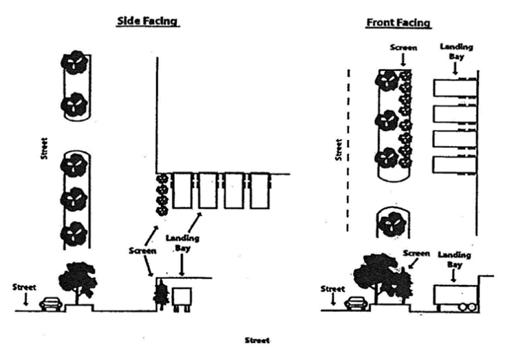
Loading Bay Screening Side and front-facing truck delivery stalls and loading bays shall be screened from the public right-of- way as described in below:
1.
One (1) row of evergreen shrubs spaced a maximum of five (5) feet on-center or a row of evergreen trees spaced a maximum of ten (10) feet on-center. (See Plant Installation Specifications Section for a list of recommended plantings);
2.
Provide a landscaped yard with a minimum depth of eight (8) feet for the planted screen.
306.10 Foundation Planting
A.
Building foundation landscaping is required on lots containing non-residential (excluding industrial), medium- and high-density residential development. Shrubs shall be placed around the facades facing rights-of-way, a minimum of three (3) feet from the building.
B.
Foundation plantings shall work in concert with transition yard plantings to frame important views, while visually softening long expanses of walls, particularly those lacking windows and other architectural details. Foundation plantings shall be compatible with the materials and the form of the proposed building(s).
C.
The minimum width of the area provided to accommodate foundation plantings is as follows:
1.
A minimum of a three (3) foot planting area adjacent to building walls having an eave height of up to twenty (20) feet.
2.
A minimum of a six (6) foot planting area adjacent to building walls having an eave height of twenty (20) feet or more.
D.
Foundation plantings shall be installed across the entire length of facades facing rights-of-way, except where walkways and driveways are located.
306.11 Utility Easement Policy
A.
Intent
Any tree or shrub used to meet the requirements of this Article shall not be located within proposed or existing utility easements unless it meets one of the special exceptions as defined below.
B.
Special Exceptions
(a)
Written permission has been obtained from the holder of the utility easement.
(b)
Where overhead power lines cross an area required by the ordinance to be planted with shade trees, smaller shade trees (listed in the Plant Installation Specifications section as Class II Shade Trees) may be substituted.
C.
If none of the special exceptions apply, the following options shall be considered in order of priority:
1.
Priority #1: Plant the tree as close to the easement as possible.
2.
Priority #2: For highly visible areas (street yards, parking lots in front) plant the tree in the same general area where it can be seen from the street or parking lot.
D.
Utility easements can be used to meet the landscape yard requirements. The applicant is responsible for identifying existing and proposed utility easements within the property on the landscape site plan.
306.12 Plant Installation Specifications
A.
Intent
All landscaping material shall be installed in a professional manner, and according to accepted planting procedures of the landscape industry. Planting methods and the season of planting will optimize chances for long-term plan survival and continued vigor.
B.
Class I Shade Trees:
These trees are used to meet the tree planting requirements specified in the Street Yard and Parking Lot sections. All Class I shade trees shall be installed at a minimum caliper of two (2) inches as measured from two and one-half (2½) feet above grade level. Class I shade trees shall also have a minimum expected maturity height of at least thirty-five (35) feet and a minimum canopy spread of twenty (20) feet. Evergreen trees can be treated as Class I shade trees provided, they meet the minimum maturity height and canopy spread criteria.
C.
Class II Shade Trees:
These trees are intended to be used for planting under overhead power lines only where they encroach into the property. All Class II shade trees shall be installed at a minimum caliper of one and one-half (1½) inches as measured at two and one-half (2½) feet above grade level from the base of the tree. Class II trees shall have a maximum expected maturity height of twenty (20) feet and a minimum canopy spread of ten (10) feet.
D.
Screening Trees:
Screening trees are used to meet the tree planting requirements of the Screening Section. All screening trees shall be installed at a minimum height of five (5) to (6) six feet and have a minimum expected mature spread of eight (8) feet.
E.
Screening Shrubs:
All screening shrubs shall be installed at a minimum size of three (3) gallons and have an expected maturity height of at least eight (8) feet and a mature spread of at least five (5) feet.
G.
Prohibited Plants:
The following plants are prohibited from being used to meet these requirements due to problems with hardiness, maintenance, and nuisance:
306.13 Maintenance:
A.
Generally, the property owner, unless specified differently in the zone requirement, shall be responsible for the maintenance of all provided landscaping.
B.
All landscaped areas must present a healthy, neat and orderly appearance and shall be kept free from refuse and weeds.
C.
In accordance with the plant guarantee in Section 306.3 C, any dead or diseased plant material shall be replaced by the property owner with new plantings that meet the requirements of these regulations.
D.
In the event that any vegetation or physical element functioning to meet the standards of this subsection is severely damaged due to an unusual weather occurrence or natural catastrophe, or other natural occurrence such as damage by wild animals, the owner or developer will be required to replant if the landscape standards are no longer met. The owner shall have one growing season to replace or replant.
E.
Protection During Operations. The owner or developer shall take actions to protect trees and landscape from unnecessary damages during all facility and site maintenance operations. Plants shall be maintained in a way that does not obstruct sight distances or roadway and drive intersections, obstruct traffic signs or devices, and/or interfere with the use of sidewalks or pedestrian trails.
F.
Maintain Shape. All required trees shall be maintained in their characteristic natural shape, and shall not be severely pruned, sheared, topped, or shaped as shrubs. Trees required by this chapter that have been severely pruned, sheared, topped, or shaped as shrubs that no longer meet their intended function shall be considered as damaged vegetation in need of replacement, and shall be replaced within one growing season.
306.14 Certificate of Occupancy/Bonding
A.
If the landscaping has not been installed and inspected for proper installation prior to receiving a Certificate of Occupancy, a Temporary Certificate of Occupancy may be granted provided the following conditions are met:
1.
Property owner posts a performance bond or irrevocable letter of credit with the City Manager;
2.
The amount of the bond or letter of credit shall be based on material and installation costs of the uninstalled landscape material, including a ten percent (10%) contingency cost, as shown on the submitted landscape plan;
3.
The costs of the landscaping shall be certified by a licensed contractor or determined using a general formula established by the landscape site reviewer (option of applicant).
B.
After receiving the Temporary Certificate of Occupancy, the remaining landscape material shall be installed within six (6) months. The bond or letter of credit shall be called if the required landscaping has not been installed by the end of the six (6) month period and the funds applied to complete the landscaping work.
306.15 Appeals
Any person aggrieved by the administration, interpretation, or enforcement of this Section may appeal to the Board of Zoning Appeals within sixty (60) days of the City of Lakesite's decision. Decisions of the Board of Zoning Appeals may be appealed to a court of competent jurisdiction. Should any court of competent jurisdiction find any portion of this Section to be unlawful or unconstitutional, such finding shall not affect this Section as a whole or any portion of it not found invalid.
Unique factors relating to topography, soil and vegetation conditions, space limitations, or uses of neighboring property may make landscaping impossible, ineffective or unnecessary. Section 306.5 Hardships provides administrative remedies and guidelines where the strict application of the City of Lakesite Landscape Ordinance would create an undue hardship. If the administrative remedies and guidelines as described within Section 306.5 Hardships do not relieve the undue hardship, requests for use of alternative landscaping schemes or variances are justified only when one or more of the following conditions apply:
1.
Topography, soil, vegetation, or other site conditions are such that full compliance is impossible, impractical, or ineffective. If the request is a variance in the screening requirements, a letter shall be required from the owners of the abutting property to acquiesce with the variance or alternative landscaping scheme.
2.
Due to a change of use of an existing site, the required screening requirements (Section 306.7 Street Yard Requirements) are larger than can be provided as required by the provisions of this Ordinance.
3.
The site involves space limitations or unusually shaped parcels.
4.
When the strict application of this Landscape Ordinance would impact the safety of the general public, a variance application must be completed and application fee (see latest fee schedule) submitted to the City of Lakesite Building and Codes Department.
306.15 Definitions
Caliper: a measurement of the tree trunk diameter measured six (6) inches above grade level.
Class I Shade Trees: any plant having a central trunk, an expected maturity height of at least thirty-five (35) feet, and an expected minimum mature canopy spread of at least fifteen (15) feet.
Class II Shade Trees: any plant having a central trunk and a maximum expected maturity height of twenty-five (25) feet.
Gross Floor Area (GFA): total interior space as defined by the International Code Council (ICC).
Impervious Surfaces: includes concrete, asphalt, brick, metal, or any other material constructed or erected on landscaped or natural buffer areas that impede the percolation of water into the ground.
Interior Bay: all parking bays that do not qualify as a perimeter bay.
Landscape Area/Landscaped Yard: an area to be planted with trees, grass, shrubs, or other natural living ground cover material. No impervious surfaces are permitted in these areas.
Landscaped Island: a landscaped area defined by a curb and surrounded by paving on all sides.
Landscaped Peninsula: a landscaped area defined by a curb and surrounded by paving on three sides.
Landscaped Median: a landscaped area bordering two (2) adjoining parking bays.
Natural Buffer: an area of land set aside for preservation in its natural vegetative state. No removal of plants is permitted with the exception of poisonous or non-native plant species. In addition, no fill/cutting activities or storage of materials is permitted in these areas. No impervious surfaces are permitted.
New Development: construction of a new building or structure on its own lot is considered as new development. New buildings or structures constructed on a lot which already contains existing buildings is considered as an expansion.
Parking Space/Parking Bay: includes spaces and areas for all vehicles except tractor trailers.
Perimeter Bay: all parking bays that are adjacent to the perimeter of a development.
Screening Shrubs: evergreen shrubs that maintain their foliage year-round.
Screening Trees: evergreen trees that maintain their foliage year-round.
Street Yard: a designated landscaped area where private property abuts the public street right-of-way for the planting of grass, trees, and shrubs.
(as added by Ord. #306Ord. #306, Feb. 2024)
SECTION 307 - PARKING AND LOADING REQUIREMENTS
307.1 Intent
The following standards are designed to meet the minimal, necessary off-street parking requirements for residential, institutional, office, commercial and industrial land uses within all zoning districts.
307.2 General Regulations
(1)
No building or other structure shall hereafter be erected or altered to provide less off-street parking and loading space as required herein or permitted, or in any manner contrary to the provisions of the Ordinance except as approved utilizing a Shared Parking Plan or with a parking variance from the Lakesite City Commission for Variances and Special Permits.
(2)
No part of a yard, or other open space, or off-street parking or loading space required about or in connection with any building for the purposes of complying with this Ordinance, shall be included as part of a yard, open space, or off-street parking or loading space similarly required for any other building except as provided through an approved Shared Parking Plan.
(3)
All parking and loading spaces shall be subject to review, approval and enforcement by the City Engineer.
Table 307
Commercial, Office and Manufacturing Requirements:
The number of spaces provided shall not exceed the required number of spaces by more than fifty percent (50%).
Handicapped parking shall meet the current ADA standard.
Note: GLA = Gross Leasable Area: The total floor area for which the tenant pays rent and that is designed for the tenant's occupancy and exclusive use. GLA does not include public or common areas, such as utility rooms, stairwells, mall and so on.
307.3 District Regulations
(1)
R-1 Residential Zone
For parking requirements refer to Table 307
(2)
R-2 Residential Zone
For parking requirements refer to Table 307
(3)
R-3 Residential Zone
For parking requirements refer to Table 307
(4)
R-3 MD Moderate Density Zone
For parking requirements refer to Table 307
(5)
Planned Residential Development (PRD) Zone
(a)
For parking requirements refer to Table 307
(b)
Parking spaces for parks, playgrounds, and community buildings in the development may be required according to the design of the Planned Residential Development.
(6)
Mixed Use Zone (MXU)
For parking requirements refer to Table 307
(7)
C-1 Commercial Zone
(a)
Off-street parking and loading shall be provided on the same lot as or a lot adjacent to the building in accordance with the requirement in Table 307.
(b)
Additional requirements:
(1)
Parking spaces are not required for detached warehouse facilities which are attendant to the principal commercial use.
(2)
There shall be one (1) loading space for every ten thousand (10,000) square feet of floor area used for commercial purposes. Such loading space shall be in accordance with the standards of and approved by the City Engineer. Off-street loading facilities shall be provided which do not require the use of required off- street parking space during hours when establishments in the zone are open for business.
(3)
All off-street parking and loading space shall be subject to review and approval by the City Engineer prior to issuance of building permits and shall be so located, improved, illuminated, operated, and maintained as to provide safe and convenient circulation on the premises from adjacent streets, and to minimize potential frictions with adjoining residential property.
(4)
For business operations which involve a combination of uses such as warehousing and wholesaling along with retailing or other permitted uses, total required parking may be determined by measuring the amount of floor space within the business structure that is devoted to each separate use and calculating the need based upon the specific parking requirements as set forth for the various uses in this section and elsewhere in this ordinance. Parking requirements calculated in this manner shall be subject to review and approval by the City Engineer prior to issuance of any building or occupancy permit.
(8)
M-2 Light Industrial Zone
(a)
Off-street parking and loading shall be provided on the same lot as or a lot adjacent to the building in accordance with the requirement in Table 307.
(b)
Additional requirements:
(1)
No parking or drives shall be permitted in required side yards joining a residential zone.
(2)
Truck doors or loading docks fronting on a street shall be not less than 75 feet from said street.
307.4 Shared parking:
(1)
Intent: The intent of this ordinance is to provide a method for providing shared parking facilities among diverse uses in order to reduce the amount of land dedicated to surface parking. The goal is to promote efficiency in land usage and complementary forms of development.
(2)
Definition: Shared Parking: Joint use of a parking area for more than one use and including valet and remote parking arrangements.
(3)
Application: Shared parking may be applied when land uses have different parking demand patterns and are able to use the same parking spaces/areas throughout the day. Shared parking is most effective when these land uses have significantly different peak parking characteristics that vary by time of day, day of week, and/season of the year. Shared parking is inherent in mixed- use developments that include one or more businesses that are complementary, ancillary, or support other activities such as church and retail shared parking. General off-site parking lots and valet parking are available for patrons of nearby land uses can also constitute shared parking. The standards in this ordinance provide an opportunity for shared parking; however, parking requirements are very often unique to an individual land use and as a result, each site's proposed parking plan must be approved in advance by the City Engineer.
(a)
In conjunction with the City Engineer, the applicant for shared parking will conduct a pre- survey meeting designed to review with the traffic engineer the shared parking standards and the applicant's proposed shared parking arrangement.
(b)
No formal parking study shall be required for proposed developments under three thousand (3,000) sq. feet gross leasable area (GLA).
(c)
For proposed developments over three thousand (3,000) sq. feet gross leasable area (GLA), the pre-survey meeting will help to determine the scope, method and engineering standards to be met in the parking study. In some specific cases, and with agreement of the City Traffic Engineer, a formal parking study maybe waived for small developments where there is established experience with the land use mix and its impact is expected to be minimal.
(d)
Applicants for a shared parking arrangement shall examine the feasibility of using shared parking arrangements by conducting a parking demand survey. Factors in this study include but are not limited to: operating hours, seasonal/daily peaks in parking demand, the site's size and orientation, location of access drives, accessibility to other nearby parking areas, pedestrian connections, availability of parking spaces, and duration of proposed agreements to share parking. A registered engineer must prepare this study.
(e)
For all developments, up to twenty-five percent (25%) of the required parking spaces for a specific development may be incorporated into a shared parking plan.
(f)
In no case shall the distance between the principal use and the property to be used as a shared parking site be greater than one thousand (1,000) linear feet except that in the situation where valet parking is provided, the distance may be greater.
(g)
Based on the results of the shared parking study if required and upon approval by the City Engineer, the applicant shall furnish to the City Engineer a shared parking agreement stipulating the conditions as approved by the City Engineer. The original of this document is to be kept on file in the City of Lakesite Office.
(h)
All the properties utilized as shared or valet parking including the donor and donee property shall be properly posted and identified as shared/valet parking.
(i)
The appurtenant easement created by this agreement, must be recorded in the Register's Office of Hamilton County Tennessee and a copy of this document furnished to the Traffic Engineer's office for its records.
(4)
Calculation of Parking Spaces Required with Shared Parking: The parking spaces required shall be based on the standards of the zoning ordinance for individual uses and the shared parking rates adjusted from the base-parking requirement. For those developments requiring a parking study, the minimum number of parking spaces for a specific use or mixed-use development as proposed shall be determined by the parking study furnished by the applicant following approved transportation engineering procedures and practices. Handicapped parking shall meet the current ADA standards.
(5)
Shared Parking Plan: Based on calculations resulting from the parking study or determined in conjunction with the City Engineer, a shared parking plan shall be submitted to the City Engineer. This plan will portray the parking pattern and number of spaces, detail the access points and provide distance information to the land uses they will serve. For valet parking, this will include the operating plan for the land uses being served, required employee parking and the area that is required for queuing vehicles being dropped off or picked up.
(6)
Operating Plan and Agreement: Among Sharing Property Owners: If a privately owned parking facility is to serve two (2) or more separate properties either as shared or valet parking, a written agreement between property owners guaranteeing access to, use of, available time of use and management of designated spaces is required. The agreement will be reviewed and approved by the City Engineer and the City Attorney. A copy will be retained in the City of Lakesite Office and a copy recorded in the Hamilton County Registers Office as an appurtenant easement.
(7)
Change of Land Use That Modifies the Parking Plan: In the event one or both land use types change and the parking characteristics of the site no longer are in conformance with the approved parking plan, a new parking plan must be developed in accordance with this ordinance.
(8)
On-Street Parking: Public parking spaces along public rights-of-way may prove to be beneficial to a specific user but by its very nature it cannot be reserved for private use by a specific business. For purposes of meeting the on-site parking requirement, on-street parking is not counted toward the parking standard. The use of on-street parking may alleviate requirements for required parking for truck loading or passenger loading but will not be counted towards the overall parking space requirement for shared parking.
307.5 Off-street parking on lots in residential zones
Special permit may be obtained by filing an application with a parking plan and drawing to the City Engineer and approved by the Lakesite City Commission for off-street parking on lots in the R-1, R- 2, R-3MD, R-3 and R-5 Residential Zones when such lots are adjacent to the C-1, or M-2 Zones. Such plans shall also provide for the paving of all driveways and parking areas and adequate drainage of the lots.
(as added by Ord. #306Ord. #306, Feb. 2024)