
Lakesite City Zoning Code
CHAPTER IV
ZONES
SECTION 401 - R-1 RESIDENTIAL ZONE
401.1 Principal Uses Permitted:
(a)
Single family dwelling
(b)
Schools
(c)
Parks, playgrounds and community buildings
(d)
Golf courses, except driving ranges, miniature courses and Par 3 golf courses
(e)
Fire stations and other public buildings
(f)
Kindergartens operated by governmental units or religious organizations
(g)
Accessory uses and buildings customarily incident and subordinate to the above
(h)
Home occupations
401.2 Uses Permitted as Special Exceptions by the Commission:
(a)
DELETED
(b)
Day care homes
401.3 Height and Area Regulations:
(a)
No building shall exceed two and one-half (2½) stories or thirty-five (35) feet in height except that a building may exceed these height regulations provided that for every one foot of additional height over thirty-five (35) feet the building shall be set back one additional foot from all property lines.
(b)
The minimum building site shall be fifteen thousand (15,000) square feet, and the minimum frontage of seventy-five (75) feet.
(c)
There shall be a front yard of not less than twenty-five (25) feet.
(d)
There shall be a side yard on each side of the building of not less than ten (10) feet; twenty-five (25) feet if at an intersection.
(e)
There shall be a rear yard of not less than twenty-five (25) feet.
(f)
The minimum lot depth shall be one hundred (100) feet.
401.4 Floor Area Regulations:
(a)
If a house is one story, the dwelling unit must have at least one thousand six hundred (1,600) square feet.
(b)
If a house is more than one story, the dwelling unit must have at least one thousand fifty (1,050) square feet on the first floor and a total of at least one thousand seven hundred fifty (1,750) square feet.
401.5 Off-Street Parking Regulations:
Parking Requirement: reference to CHAPTER III GENERAL REGULATIONS Section 307 Parking and Loading Requirements
401.6 Landscape Requirements:
Refer to Chapter III, Section 306.
(as added by Ord. #306Ord. #306, Feb. 2024)
SECTION 402 - R-2 RESIDENTIAL ZONE
402.1 Principal Uses Permitted:
(a)
Single family dwellings.
(b)
Two family dwellings.
(c)
Schools.
(d)
Parks, playgrounds, and community buildings.
(e)
Golf courses, except driving ranges, miniature courses and other similar commercial operations.
(f)
Fire stations and other public buildings.
(g)
Churches.
(h)
Accessory uses and buildings.
(i)
Kindergartens operated by governmental units or by religious organizations.
(j)
Home occupations.
402.2 Uses Permitted as Special Exceptions by the Commission:
(a)
Day care homes
(b)
Deleted
402.3 Height and Area Regulations:
(a)
No building shall exceed two and one-half (2½) stories or thirty-five (35) feet in height except that a building may exceed these requirements provided that for every foot of additional height over thirty-five (35) feet the building shall be set back one (1) additional foot from all property lines.
(b)
The minimum building site area shall be fifteen thousand (15,000) square feet for a single-family dwelling unit and eighteen thousand (18,000) square feet for a two-family dwelling unit. The minimum frontage shall be seventy-five (75) feet.
(c)
There shall be a front yard of not less than twenty-five (25) feet.
(d)
There shall be a side yard on each side of the building of not less than ten (10) feet; twenty-five (25) feet at an intersection.
(e)
There shall be a rear yard of not less than twenty-five (25) feet.
(f)
The minimum lot depth shall be one hundred (100) feet.
402.4 Floor Area Regulations:
(a)
For a single-family structure, at least one thousand six hundred (1,600) square feet of floor area.
(b)
For a single-family structure with more than one (1) story, the dwelling unit must have at least one thousand fifty (1,050) square feet on the first floor and a total of at least one thousand seven hundred fifty (1,750) square feet.
(c)
For a duplex, at least two thousand four hundred (2,400) square feet of floor area per structure.
402.5 Off-Street Parking Regulations:
Parking requirement: reference to CHAPTER III GENERAL REGULATIONS Section 307 Parking and Loading Requirements
402.6 Landscape Requirements:
Refer to Chapter III, Section 306.
(as added by Ord. #306Ord. #306, Feb. 2024)
SECTION 403 - R-3MD MODERATE DENSITY APARTMENT TOWNHOUSE ZONE
403.1 Intent
It is the intent of the R-3MD MODERATE DENSITY APARTMENT-TOWNHOUSE ZONE to provide areas for development of residential units to include triplex and quadplex residential structures.
403.2 Principal Uses Permitted:
(a)
Two, three, and four family dwellings, but not including mobile homes on individual lots.
(b)
Public parks not commercially operated.
(c)
Churches, schools, museums, libraries, art galleries and other cultural institutions, including convents, orphan asylums, or private or public penal, correctional or welfare institutions.
(d)
Kindergartens operated by governmental agencies and religious organizations.
(e)
Fire stations and other public buildings.
(f)
Home occupations.
(g)
Accessory uses and buildings.
403.3 Uses Permitted as Special Exceptions by the Commission:
(a)
Storage garage.
(b)
Public utility buildings and structures.
(c)
Substations, water towers, booster pumping stations and telephone exchanges.
(d)
Day care homes.
(e)
DELETED
(f)
Boarding House.
403.4 Height and Area Regulations
(a)
Each dwelling unit of a two, three, or four family structure shall be a minimum of 1,200 square feet.
(b)
Except as provided in special exception permits, no building shall exceed thirty-five (35) feet in height.
(c)
Minimum Lot Area, Depth, and Frontage
(d)
Percentage of Lot Occupancy No dwelling shall occupy more than thirty-five percent (35%) of its lot, and no building shall occupy more than fifty percent (50%) of its lot.
(e)
Front Yard There shall be on each lot a front yard of a minimum depth of twenty-five (25) feet.
(f)
Side Yard There shall be on each lot a side yard of a minimum depth of ten (10) feet.
(g)
Rear Yard There shall be a rear yard of a minimum depth of twenty-five (25) feet.
(h)
Off-Street Parking Regulations: Off-street parking shall be provided on the same lot as or a lot adjacent to the building accordance with the following requirements:
Parking Requirement: reference to CHAPTER III GENERAL REGULATIONS Section 307 Parking and Loading Requirements.
403.5 Landscape Requirements:
Refer to Chapter III, Section 306.
(as added by Ord. #306Ord. #306, Feb. 2024)
SECTION 404 - R-3 RESIDENTIAL ZONE
404.1 Principal Uses Permitted:
(a)
Single-family dwellings.
(b)
Two-family dwellings.
(c)
Apartments.
(d)
Schools.
(e)
Parks, playgrounds and community buildings.
(f)
Fire stations and other public buildings.
(g)
Churches.
(h)
Home occupations.
(i)
DELETED
(j)
Accessory uses and buildings.
404.2 Uses Permitted as Special Exceptions by the Commission:
(a)
Day care homes.
(b)
Kindergartens operated by governmental units or by religious organizations.
(c)
DELETED
(d)
Boarding and Loding houses.
404.3 Height and Area Regulations:
(a)
No building shall exceed two and one-half (2½) stories or thirty-five (35) feet in height, except that a building may exceed these height requirements provided that for every one (1) foot of additional height over thirty-five (35) feet the building shall be set back one (1) additional foot from all property lines.
(b)
The minimum building site area for dwellings shall be one (1) lot or parcel of fifteen thousand (15,000) square feet plus two thousand (2,000) square feet of lot area for each additional unit.
(c)
The minimum site area for lodging or rooming houses shall be eighteen thousand (18,000) square feet plus five hundred (500) square feet for each lodger in excess of two.
(d)
The minimum site area for all other permitted uses shall be fifteen thousand (15,000) square feet.
(e)
The minimum lot frontage shall be seventy-five (75) feet.
(f)
There shall be a front yard of not less than twenty-five (25) feet.
(g)
There shall be a side yard on each side of the building of not less than ten (10) feet, twenty-five (25) feet if at an intersection.
(h)
There shall be a rear yard of not less than twenty-five (25) feet.
(i)
The minimum lot depth shall be one hundred (100) feet.
404.4 Floor Area Regulations:
(a)
For a single-family dwelling, each dwelling unit must have at least one thousand six hundred (1,600) square feet.
(b)
For a single-family structure with more than one (1) story, the dwelling unit must have at least one thousand fifty (1,050) square feet on the first floor and a total of at least one thousand seven hundred fifty (1,750) square feet.
(c)
For a duplex, at least two thousand four hundred (2,400) square feet of floor area per structure.
(d)
For a multi-family dwelling, at least one thousand two hundred (1,200) square feet for each dwelling unit. Boarding and lodging houses must also fall under this floor area regulation.
404.5 Off-Street Parking Regulations:
Parking Requirement: reference to CHAPTER III GENERAL REGULATIONS Section 307 Parking and Loading Requirements.
404.6 Landscape Requirements:
Refer to Chapter III, Section 306.
(as added by Ord. #306Ord. #306, Feb. 2024; Ord. #315, Jan. 2025)
SECTION 405 - R-5 RESIDENTIAL ZONE
405.1 Principal Uses Permitted
(a)
Mobile homes (manufactured homes) shall be required to be placed on a permanent foundation and meet the requirements specified in the definition section of this ordinance.
(b)
Single-family dwellings, including single wide mobile homes, double wide mobile homes, or modular units.
(c)
Two-family dwellings.
(d)
Schools.
(e)
Parks, playgrounds, and community buildings.
(f)
Fire stations and other public buildings.
(g)
Churches.
(h)
Home occupation.
(i)
Accessory uses and buildings.
405.1[2] Uses Permitted as Special Exceptions by the Commission:
(a)
Day care homes.
(b)
Kindergartens operated by governmental units or by religious organizations.
(c)
DELETED
405.2 Height and Area Regulations
(a)
No building shall exceed two and one-half (2½) stories or thirty-five (35) feet in height, except that a building may exceed these requirements provided that for every foot of additional height over thirty-five (35) feet the building shall be set back one (1) additional foot from all property lines.
(b)
The minimum building site area shall be fifteen thousand (15,000) square feet for a single dwelling and eighteen thousand (18,000) square feet for a duplex. The minimum frontage shall be seventy-five (75) feet.
(c)
There shall be a front yard of not less than twenty-five (25) feet.
(d)
There shall be a side yard on each side of the building of not less than ten (10) feet, twenty-five (25) feet if at an intersection.
(e)
There shall be a rear yard of not less than twenty-five (25) feet.
(f)
The minimum lot depth shall be one hundred (100) feet.
405.3 Off-Street Parking Regulations:
Parking Requirement: reference to CHAPTER III GENERAL REGULATIONS Section 307 Parking and Loading Requirements.
405.4 General Provisions:
All mobile homes shall be tied down in a manner meeting safety and performance requirements of any governmental regulations covering tie-down and anchoring devices, as specified by the Building Official.
All accessory buildings to the principal building (whether attached or detached) shall be subject to the same permit procedures and other regulations pertaining to dwelling units.
No application for the R-5 Zone shall be accepted for an area greater than the minimum lot area requirement for the proposed number of mobile homes.
405.5 Landscape Requirements:
Refer to Chapter III, Section 306.
(as added by Ord. #306Ord. #306, Feb. 2024)
SECTION 406 - PLANNED RESIDENTIAL DEVELOPMENT (PRD) ZONE
406.1 Purpose
The purpose of the Planned Residential Development, sometimes hereinafter referred to as PRD, is to provide the opportunities to create more desirable environments through the application of flexible and diversified land development standards under a comprehensive plan and program professionally prepared. The Planned Residential Development is intended to be used to encourage the application of new techniques and technology to community development which will result in superior living or development arrangements with lasting values. It is further intended to achieve economies in land development, maintenance, street systems, and utility networks while providing building groupings for privacy, usable attractive open spaces, safe circulations, and the general well-being of the inhabitants.
406.2 Permitted Uses in PRD:
(a)
Detached single family units, except that mobile homes are not allowed.
(b)
Townhouses, no more than 4 units attached together.
(c)
Schools.
(d)
Parks, playgrounds, and community buildings.
(e)
Golf courses, except driving ranges, miniature courses, "Par 3" courses, and other similar operations.
(f)
Accessory uses and buildings customarily incident and subordinate to the above.
406.3 Height and Area Regulations:
(a)
No building shall exceed two and one-half (2½) stories or thirty-five (35) feet in height, except that a building may exceed these requirements provided that for every foot of additional height over thirty-five (35) feet the building shall be set back one (1) additional foot from all property lines.
(b)
The minimum development site for PRD shall be at least ten (10) acres.
(c)
Average Lot Size. In order to increase project design flexibility and as long as the overall density requirements of the PRD are met, no average lot size or minimum lot size per dwelling unit is established, but may be required as a condition of approval.
(d)
All buildings shall follow the Lakesite Building Code.
406.4 Off-Street Parking Regulations:
Parking Requirement: reference to CHAPTER III GENERAL REGULATIONS Section 307 Parking and Loading Requirements.
406.5 General Provisions:
A PRD will be shown on the zoning map when the Final PRD Plan has been approved by the City Commission.
406.6 Development Standards and Site Improvements:
(a)
All dedicated public streets shall be constructed in accordance with the Lakesite Roadway Regulations on rights-of-way having a minimum width of fifty (50) feet.
(b)
All private streets are allowed by special exception permits issued by the City Commission only. Private streets must be constructed in accordance with the Lakesite Roadway Regulations and with a minimum width of fifty (50) feet.
(c)
There shall be constructed concrete sidewalks, or an equivalent paved internal pedestrian circulation system. The minimum width of such sidewalks shall be four (4) feet. Sidewalks or other internal paved areas shall be located within a public right-of-way.
(d)
Storm drainage structures shall be constructed in accordance with plans and specifications approved by the Building Official.
(e)
The development shall be tied into an existing public sewer.
(f)
The development shall meet Hamilton County's Multi-Jurisdictional Stormwater Program water quality requirements.
406.7 Computation of Density:
The maximum number of dwelling units in a PRD shall be computed by multiplying the gross acreage of usable land to be developed by 4.5. No more than fifty percent (50%) of the units should be attached units. For purposes of this section, usable land is defined as land that excludes the following:
▶
Easements
▶
Sinkholes
▶
Floodway
▶
Retention ponds
▶
Wetlands, bogs, marshes and land within a forty (40) foot wetland buffer area.
▶
Water bodies
▶
Slope:
&diaK
50% of land with slope 15%—19.9%,
&diaK
80% of land with [slope] 20%—29.9%,
&diaK
100% of land with slope 30% or greater.
▶
Other environmentally sensitive areas as deemed appropriate by the Building Official.
The above regulation defines the maximum density of the development. However, the City Commission might require a lower density as a condition of approval under the following situations:
(a)
The proposed density will adversely affect the adjacent property;
(b)
The proposed density is not compatible with the surrounding developments;
(c)
The plan is not consistent with the intent and purpose of the regulations.
406.8 Open Space Requirements:
A minimum fifteen percent (15%) on-site open space is required which is calculated on the gross acreage of usable land. Such area shall be set aside permanently for open space or recreation purposes only. It shall be permanently protected from future development via a deed restriction or easements. It is intended to serve the residents of the PRD and should therefore be easily accessible to them. This space shall be maintained in common ownership, established in the appropriate legal manner.
Said open space shall be maintained in one of the following methods:
(a)
by the developer or management authority of the PRD.
(b)
by a Home Owner's Association established by deed restrictions.
No open area may be delineated or accepted as common open space under the provisions of this section unless it meets the following standards:
(a)
Common open space must be usable for recreational purposes and must provide visual, aesthetic and environmental amenities. The uses authorized for the common open space must be appropriate to the scale and character of the planned residential development, considering its size, density, expected population, topography, and the number and type of dwellings to be provided.
(b)
Common open space must be suitably improved for its intended use, but open space containing natural features worthy of preservation may be left unimproved. Any buildings, structures and improvements to be located in the common open space must be appropriate to the uses which are authorized therefore, and must conserve and enhance the amenities of the common open space having regard to its topography and the intended function of the common open space. Parking lots shall not be considered open space.
(c)
The development phasing sequence of the proposal development must coordinate the improvement of the common open space; the construction of the buildings, structures and improvements in the common open space; and the construction of public improvements and the construction of residential dwellings, but in no event shall occupancy permits for any phase of the final development plan be issued unless and until the open space which is part of that phase has been dedicated or conveyed and improved.
(d)
No common open space of a planned residential development shall be conveyed or dedicated by the developer or any other person to any public body, homeowner's association or other responsible party unless the Lakesite Commission has determined that the character and quality of the tract to be conveyed makes it suitable for the purpose for which it is intended. The Lakesite Commission may give consideration to the size and character of the dwellings to be constructed within the planned residential development, the topography and existing trees, the ground cover, and other natural features, the manner in which the open space is to be improved and maintained for recreational or amenity purposes, and the existence of public parks or other public recreational facilities in the vicinity.
406.9 Landscape Requirements:
Refer to Chapter III, Section 306.
406.10 Staging
Staging of development may be permitted subject to the approval of the entire development with all phases included.
406.11 Process
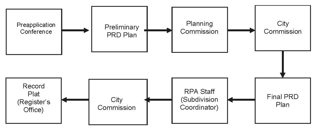
A.
Pre-application Conference
Prior to filing an application for approval of a PRD, the applicant shall confer with the planning staff, the Stormwater staff, and the city staff concerning policy and procedure relative to the application. The purpose of the pre-application conferences is to discuss the overall concept of the proposal early and informally, before the applicant has made substantial financial commitments. Major problems may be identified and solved before formal application. Community goals, plans and regulations that might affect the proposal can also be identified and discussed. The applicant is encouraged to have a sketch plan for the pre-application conference. This is an opportunity for the Planning Staff, Stormwater staff and City Staff to provide informed feedback on the project.
A community or neighborhood public meeting organized by the applicant for the purpose of informing residents and property owners near the project site about the proposed development is encouraged.
B.
Preliminary Planned Residential Development Plan
The developer shall submit a Preliminary Planned Residential Development Plan with the rezoning request application to the Chattanooga-Hamilton County Regional Planning Commission for its review and recommendation to the Lakesite City Commission. The Preliminary PRD Plan shall be drawn at a minimum scale of one-inch equals one hundred feet (1" = 100'), and shall include:
(a)
Date, graphic scale, north arrow, name of the proposed development;
(b)
Full name and mailing address with zip codes and telephone number of the owner as well as the person or firm preparing the preliminary plan;
(c)
The location, size, accessibility, and existing zoning of the proposed site;
(d)
The boundary line of the proposed development drawn to scale and showing all bearings and distances, including existing road curve functions and dimensional data.
(e)
Parcel number, including map sheet number and group identifier, for all parcels which are included in the proposed development. This is commonly referred to as the "Tax Map Number";
(f)
The surrounding type of development, land use and zoning;
(g)
The type of development proposed, the density of the proposed development, and the location of all structures, parking areas, and open space;
(h)
Plan for streets, thoroughfares, public utilities, school, and other public or community uses;
(i)
Natural contours at two (2) foot intervals or less (sea level elevations only) include any unique topography such as wetland, sinkholes and water bodies. The preliminary plan designer shall field check for accuracy of the contour lines if he/she has obtained the information from sources other than his/her own.
(j)
Contour line or limit of 100-year flood and/or Floodway Zone (Valley Zone), if applicable.
(k)
Drainage information:
1.
Show the size, location, outline and direction of water flow at all high and low points of all existing and proposed drainage easements in and adjacent to the subdivision. Show the number of acres drained into the high point of the drainage easement.
2.
Show size, location, number of acres drained, and direction of water flow in tiles (pipes) in and adjacent to the subdivision. (See Lakesite Subdivision Regulations Section 307.4.1 for determination of pipe size.)
3.
Show location and label any other proposed drainage improvements such as catch basins, headwalls, rock and mortar or concrete drainage ditches, etc.
4.
Show the location and label any proposed off-site drainage improvements which are made necessary by the construction of the proposed subdivision.
(l)
Streets information:
1.
The location, widths, and names of all existing, proposed, or recorded streets, public right- of-way, or access easements, etc., intersecting or paralleling the development, on or adjacent to the development
2.
Proposed street names shall not duplicate or closely approximate, phonetically or in spelling, the name of any other street in Hamilton County. The change of a street name prefix (East, North) or suffix (Road, Lane, Circle) shall not be construed as a different street name.
3.
The station numbers for all proposed streets. Station numbers shall begin at a known existing and reproducible street centerline.
4.
Split Road Cross Sections — A typical cross section of all split roads in the subdivision shall be shown on the preliminary plat, if applicable.
(m)
Utilities:
1.
For all existing and proposed water lines, show size, location of lines, and outline and size of easements (if applicable) in and adjacent to the development.
2.
Show location of existing wells, springs, or other natural sources of water supply within the development and within two hundred (200) feet of the boundaries of the development.
3.
Show the location of all existing fire hydrants in and within five hundred (500) feet of the development.
4.
For all existing and proposed gas lines and mains, show size, location, name of mains, and outline of easements (if applicable) in and within two hundred (200) feet of the boundaries of the development.
5.
For all existing electrical and telephone easements, show size, location, name of major easements, and outline of easements in and within two hundred (200) feet of the boundaries of the development.
6.
For all existing and proposed sanitary sewers and sewer easements, show sizes, locations, direction of flow, outlines of easements, manholes, and invert elevations in and within two hundred (200) feet of the boundaries of the development.
(n)
If the development will be subdivided:
Lots drawn and numbered in a logical numerical order. Every parcel of land within the development shall have a lot number.
(o)
Any additional information determined by the Planning Commission or the City Commission as necessary to adequately review the proposed development.
Statements to be included on the preliminary plan:
(a)
Total acres of the development
(b)
Number of proposed building Units: Single Family Unit and Townhouse
(c)
Number of Community Lots
(d)
Total Acres of Community Lots
(e)
Proposed Density
(f)
Present zoning of tract, and zoning applied for.
(g)
Source of water supply. If public water supply is not available; state nearest location, size of line, utility company's name, and whether water supply will be from wells.
(h)
Source of Topographic Quotation and natural features
1.
If the topographic was obtained from a source other than an actual field survey, use the following quote:
"Topographic and natural features were obtained from (source) and has been field verified to ensure its accuracy."
Examples of (source): Interpolated TVA quadrangle, Chattanooga quadrangle, Daisy quadrangle, etc.; aerial topographic map-Atlantic Aerial Survey; etc.
2.
If the topographic and natural features were taken from an actual field survey, use the following quote:
"Topographic and natural features were obtained from an actual field survey dated _______, conducted by _______. Elevations were determined from benchmark or monument located at _______, elevation _______."
(i)
For the Community Lot(s) and the open space; note the following:
"No building permit is to be issued for a residential, commercial, or industrial building on the Community Lot and open space. Lots are used for recreational purposes only. Maintenance to be assumed by the developer until lot is deeded to home owners in the subdivision, or to a homeowners association."
(j)
Special notations and information, if required.
The Planning Commission shall hold a public hearing on the proposed Preliminary PRD Plan. Notice and publication of such public hearings shall conform to the procedures used by the Chattanooga-Hamilton County Regional Planning Commission.
Upon the approval or disapproval by the Planning commission, the Preliminary PRD Plan shall be submitted to the City Commission for consideration, public hearing and action. The recommendation of the Planning Commission shall be accompanied by a report stating the reasons for the approval or disapproval of the Preliminary PRD Plan, with specific reference to, but not limited to, the following conditions:
(1)
The property adjacent to the area included in the plan will not be adversely affected.
(2)
The plan is consistent with the intent and purpose of these Regulations to promote public health, safety, morals, and general welfare.
(3)
That the buildings shall be used only for residential only and the usual accessory uses such as private or storage garages, storage space, and for community activities, including schools.
(4)
There is a need for such development in the proposed location.
(5)
There is reasonable assurance that development will proceed according to the approved PRD plan.
No Preliminary PRD Plan shall be approved by the City Commission, unless it is first submitted to and approved by the Chattanooga-Hamilton County Regional Planning Commission or if disapproved, shall receive the favorable vote of a majority of the entire membership of the City Commission.
C.
Final Planned Residential Development Plan
Approval of the Planned Residential Development Zone shall be conditioned to the approved final Planned Residential Development Plan. Upon approval, or approval with conditions, of the Preliminary PRD Plan by the City Commission, the applicant shall complete a Final PRD Plan for review by the Chattanooga-Hamilton County Regional Planning Agency (RPA). The Final PRD Plan shall substantially conform to the Preliminary PRD Plan and all the recommended changes and comments. When a Final PRD is approved, or approved with conditions, by the RPA, the RPA shall submit a resolution to the City Commission recommending that the Final Planned Residential Development be approved or approved with conditions. The Final PRD drawing, together with a list of any conditions not shown on the drawing, shall be attached to the RPA Resolution.
After notice and publication, the City Commission shall hold a public hearing to review the Final PRD Plan and take legislative action. The City Commission, by Resolution, may approve or approve with conditions, the Preliminary and Final PRD Plan. A copy of the Final PRD Plan drawing together with any conditions not shown on the drawing shall be attached to the resolution as exhibits.
The resolution by the City Commission approving the Preliminary and Final PRD Plan shall have attached thereto, as an exhibit, the official PRD Plan. The PRD Plan becomes a legal enforceable document after it is approved by the City Commission. The requirements of the PRD plan shall apply to the development site and shall not be nullified by transfer of land ownership.
The City Commission, by ordinance, might approved the PRD Zone and the approval shall be conditioned to the approved PRD Plan. A copy of the Final PRD Plan drawing together with any conditions not shown on the drawing and the resolution shall be attached to the ordinance of approving the PRD Zone and becomes a legal enforceable document.
If the proposed development will be subdivided, the final plan shall meet the requirements of Lakesite Subdivision Regulations.
406.12 Expiration of the Approval
Approval of the Preliminary PRD Plan shall expire twelve (12) months from the date after its approval by the City Commission if the Final PRD Plan has not been submitted to the Regional Planning Agency. Submittal of a Final PRD Plan shall constitute an automatic extension of the Preliminary PRD Plan; or if the Preliminary PRD Plan expires prior to submittal of a Final PRD Plan, the City Commission may grant an extension for an additional period not to exceed six (6) months upon condition that no major changes have been made to the Plan as originally approved, and provided that no other reason or circumstance, as determined by the Planning Agency staff, warrants resubmittal to the Planning Commission.
406.13 Changes and Modifications
All changes and modifications to the final PRD Plan after the zone has been approved shall be through a new petition of rezoning.
406.14 Issue of Building Permits
No building permits shall be issued until after approval of the Final PRD Plan. The building official shall revoke any permit issued in reliance upon said plan as finally approved at such time as it reasonably becomes obvious that such plan is not being complied with; and notice shall be given to the Planning Commission staff.
406.15 Reasons for Denial of a PRD Plan
The City Commission may deny the request of rezoning for PRD with specific reference to, but not limited to, the following conditions:
(a)
Failure of the proposal to conform to the standards set out in these regulations;
(b)
Approval of the proposal would be detrimental to the public safety, health or general welfare,
(c)
Approval of the proposal would not be in the best interest of the local government.
(d)
There is a reasonable doubt that the development will not proceed according to the approved development plan.
(e)
The proposal is not consistent with the intent of the zoning regulations.
(f)
The proposal is not consistent with the adopted plans or policies including the general land use plan.
(as added by Ord. #306Ord. #306, Feb. 2024)
SECTION 407 - MIXED USE ZONE (MXU)
407.1 Intent
The purpose of this zone is to allow medium intensity mixed-use suburban development that is compact, diverse, walkable, and urban in character and form. It encourages a market-driven alternative to conventional suburban development for sites that are neither appropriate for retail- only or residential-only use. The Mixed-Use Zone introduces a focus on the form of development rather than just the uses. This makes it possible to create special destinations with a "sense of place."
407.2 Location
A.
The MXU shall be located so that its primary access is via a minor arterial or greater as defined by the Functional Classification of Streets and Roads by the City of Lakesite.
B.
The MXU shall be located primarily in suburban or urbanized rural areas served by sewers.
407.3 Area Requirements
Minimum Land Area: The minimum development site size for a MXU shall be thee (3) acres. Maximum Land Area: There shall be no maximum development site size for a MXU. Minimum Lot Size: The minimum lot size within the MXU shall be 2,500 square feet.
Maximum Building Footprint: The maximum building footprint within the MXU shall be 25,000 square feet.
Smaller parcels of land may be considered when site adjoins an existing Mixed-Use Zone (MXU) and such site uses will be incorporated into the adjoining plan.
407.4 Permitted Uses
Residential: A residential component shall be required in the MXU (see Section 407.6 for specific requirements). The residential component may include, but is not limited to single-unit dwellings, duplexes, townhouses, condominiums, apartments. Residential units shall make up at least twenty-five (25) percent of the total land area of the MXU site.
Office: Office Building. The building area available for office use on each lot shall be limited by the minimum parking space requirements.
Retail: Restaurants, Retail Buildings. The building area available for retail use shall be limited by the minimum parking space requirements. Retail shall further make up at least thirty-five (35) percent of the total land area of the MXU site. Retail uses shall be sited away from existing off-site adjacent residential-zoned properties.
Limited Lodging: Hotels, Motels, Inns. Lodging shall only be permitted if it is determined to be compatible with existing surrounding uses as part of the review process. The number of guest rooms available on each lot shall be limited by the minimum parking space requirements. Lodging shall be further limited to fifty (50) percent of the total land area of the MXU site. The combined total land area of lodging and retail shall not exceed sixty-five (65) percent of the total land area of the MXU site.
Civic Spaces: Schools, Religious Facilities, Public Pavilions, Greens, Squares, Plazas, Parks, Playgrounds. A minimum of ten (10) percent of the total land area of the MXU site shall be used for one (1) or more of the public civic spaces as described in Section 407.07.
Mixed Use Buildings: Retail, Office, and Residential uses may be included with the same structure.
The minimum percentage requirements for any permitted use in this section may be adjusted downward if the proposed use is in harmony with the general purpose and intent of the Mixed-Use zone and the comprehensive plan for the area and is not detrimental to the public health, safety, convenience, and welfare in the surrounding area. Any finding that such factors exist by the Planning Commission must be confirmed by a majority vote of the City Commission.
407.5 Prohibited Uses:
Manufacturing Facilities, Warehouses and Mini-Warehouses, Self-Storage Facilities, Adult-Oriented Establishments, Vehicle Sales or Vehicle Repair Facilities, Fuel Service Stations, Commercial Communications Towers, Convenience Markets, Outdoor Commercial Storage, Outdoor Display or Sales. Signage- Signs not relating to identification of or direction to premises and occupants, or to products sold or services rendered on the premises are prohibited
407.6 Residential
Required: A residential component shall be required in the MXU site. The residential component may include, but is not limited to single-unit dwellings, duplexes, townhouses, condominiums, apartments.
Unit Size: The residential unit size shall be a minimum of eight-hundred and fifty (850) square feet. Furthermore, every eight-hundred and fifty (850) square feet of residential square footage shall be considered as one (1) unit. For example, a one thousand seven hundred (1,700) square foot dwelling would be considered as two (2) units.
Placement: Residential units may be located above non-residential uses within the same structure. A different placement and percentage may be permitted or required as part of the review process.
407.7 Civic Spaces
If the total land area is larger than 5 acres, a minimum of fifteen (15) percent of the total land area of the MXU site shall be used for one or more of the following public civic space types:
Green: An open space, available for unstructured recreation. It shall be centrally located so as to function as an easily accessible public open space. A green is spatially defined by landscaping rather than building frontages. Its landscape shall consist of lawn and trees, naturalistically disposed. It may also include a public pavilion. Easements for greenways and multi-use paths shall be credited toward the civic space requirement. Parking landscape islands are not given civic space credit.
Square: An open space available for unstructured recreation and civic purposes. A square is spatially defined by building frontages. Its landscape shall consist of paths, lawns, fountains, and trees, formally disposed. It may also include a public pavilion. Squares shall be located at the intersection of important thoroughfares.
Plaza: An open space, available for civic purposes and commercial activities. A plaza shall be spatially defined by building frontages. Its landscape shall consist primarily of pavement. It may also include a public pavilion. Trees are optional. Plazas shall be located at the intersection of important streets.
Playground: An open space designed and equipped for the recreation of children. A playground shall be fenced and may include an open shelter or public pavilion. Playgrounds may be included within parks and greens. There shall be no minimum or maximum size.
Walkways: Walkways with a minimum width of 5 feet are required that connects the civic spaces with a public right-of-way or other public access point if the civic space cannot be accessed from the required sidewalks.
407.8 Environmental Requirements
The alteration of the natural environment shall be subject to local, state, and federal guidelines.
Riparian: The riparian corridors of blue-line streams, as indicated on United States Geologic Survey (USGS) Quadrangle Maps, shall be a minimum of fifteen (15) feet in width on each side of the stream. The riparian corridors shall be maintained free of structures, except that thoroughfare crossings may be allowed. Streams may be moved only if approved by the Tennessee Department of Environment and Conservation.
Storm Water: Regional storm water detention facilities may be utilized if approved by the Hamilton County Water Quality staff. There shall be no retention or detention required on individual lots. Storm water retention and detention ponds and facilities may be placed within a "green" civic space and shall be credited toward the civic space requirement of the MXU if they are natural or constructed as Bioretention Cells, Grass Swales, or Filter Strips and approved by the water quality staff.
Trees: The MXU site shall provide a minimum of fifteen (15) percent tree canopy coverage with either existing or planted trees calculated as a percentage of the total land area (including streets, buildings, etc.) of the MXU site. Planted tree canopy coverage is determined by an estimate of the tree's coverage at maturity. Trees necessary to meet the MXU landscape requirements can be credited toward meeting the required fifteen (15) percent tree canopy requirement.
407.9 Parking Standards
Minimum Requirements: The standards for off-street parking and loading space requirements as described by the Building Official.
Reduced Parking: The minimum parking space requirements for non-residential uses may be reduced by as much as forty (40) percent if approved by the City Engineer.
Shared Parking: Parking may be shared between differing uses if a suitable arrangement is approved by the City Engineer.
407.10 Public Frontages
The public frontage is the space between the edge of the right-of-way and the edge of the curb. It usually includes walkways, landscaping and lighting. This space shall be a minimum of twelve (12) feet from edge of the curb to the edge of the right-of-way.
Sidewalks: Sidewalks with a minimum width of six (6) feet are required within the public rights-of-way. New sidewalks shall connect to any existing sidewalks.
Trees: Trees shall be planted within the public right-of-way between the sidewalk and the curb either in a grass strip or in individual tree wells combined with pervious concrete or pavers with a minimum width of 2 feet. The minimum planting ratio is one (1) tree per thirty-five (35) linear feet of right-of-way frontage. The minimum spacing between trees shall be fifteen (15) feet measured trunk to trunk. The maximum spacing is fifty (50) feet. This provision only applies to new sidewalks constructed as part of the development unless permission is obtained from the proper authority to include trees within the right-of-way of an existing sidewalk.
Bicycles: a Class II on-street bike lane or Class III on-street bike route shall be constructed on any street if deemed necessary by the Regional Planning Agency staff for the uninterrupted continuation of an existing or planned bike facility of the same type as identified by the Chattanooga-Hamilton County Bicycle Master Plan.
407.11 Private Frontages
The private frontage is the space between the edge of the right-of-way and the principal building.
Walkways: A pedestrian connection shall be provided to existing or planned sidewalks within a public right-of-way from buildings with a front set back twenty-five (25) feet or more.
Trees: Trees shall be planted in a street yard In accordance with the landscape requirements set forth in this ordinance.
The following items are provided as useful information. They may be used but are not requirements.
Porch & Fence: a frontage wherein the façade is set back from the frontage line with an attached porch permitted to encroaching. A fence at the frontage line maintains the demarcation of the yard. The porches are usually no less than eight (8) feet deep.
Terrace or Light Court: a frontage wherein the façade is set back from the frontage line by an elevated terrace or a sunken light court. This type buffers residential use from the urban sidewalks and removes the private yard from public encroachment. The terrace is suitable for conversion to outdoor cafes.
Forecourt: a frontage wherein a portion of the façade is close to the frontage line and the central portion is set back. The forecourt created is suitable for vehicular drop-offs. This type should be allocated in conjunction with other frontage types. Large trees within the forecourts may overhand the sidewalks.
Stoop: a frontage wherein the façade is aligned close to the frontage line with the first story elevated from the sidewalk sufficiently to secure privacy for the windows. The entrance is usually and exterior stair and landing. This type is recommended for ground-floor residential use.
Shopfront and Awning: a frontage wherein the façade is aligned close to the frontage line with the building entrance at sidewalk grade. This type is conventional for retail use. It has a substantial glazing on the sidewalk level and an awning that may overlap the sidewalk to the maximum extent possible.
Gallery: a frontage wherein the façade is aligned close to the frontage line with an attached cantilevered shed or a lightweight colonnade overlapping the sidewalk. This type is conventional for retail use. The gallery should be no less than ten (10) feet wide and may overlap the whole width of the sidewalk to within two (2) feet of the curb.
Arcade: a frontage wherein the façade is a colonnade that overlaps the sidewalk, while the façade at sidewalk level remains at the frontage line. This type is conventional for retail use. The arcade should be no less than twelve (12) feet wide and may overlap the whole width of the sidewalk to within two (2) feet of the curb.
407.12 Vehicular Lanes
All public streets shall be constructed in accordance with the standards set forth in the Lakesite Multi-Modal Ordinance (Ord. #298, 2023) and Lakesite Subdivision Regulations.
407.13 Building Setback
Building setback is measured from the property line.
Front: No minimum, twenty-five (25) feet maximum. However, if the building setback is twenty-five (25) feet or greater, the frontage line shall be defined with trees spaced no farther than twenty (20) feet apart or a low fence or wall with a minimum height of thirty-six (36) inches. Chain link fencing is not permitted along the frontage line.
Side: No minimum, except as determined necessary by Fire Code and Building Official. Rear: No minimum, except as determined necessary by Fire Code and Building Official.
Perimeter: The perimeter setback shall be no less than twenty-five (25) feet.
Attached Buildings: For attached fee-simple buildings there shall be no interior side yard requirement. Such buildings must meet all building code requirements for zero-lot line construction.
407.14 Building Height
Maximum: Five (5) stories or seventy (70) feet, including parapets. A building may exceed these requirements provided that the façade shall be set back a minimum of ten (10) feet for every grouping of one (1) to five (5) stories above the first five (5) stories; or for every foot of additional height over seventy (70) feet, the building shall be set back one (1) additional foot from the front property line.
Minimum: Two (2) stories or twenty (20) feet, including parapets.
407.15 Landscaping Requirements
Refer to Chapter III, Section 306.
407.16 General Requirements
(a)
Underground Utilities: Utility transmission lines within the development shall be placed underground.
(b)
Signage: Signs not relating to identification of or direction to premises and occupants, or to products sold or services rendered on the premises are prohibited.
(c)
Lighting: Lighting shall be at an appropriate height, appropriate lumens, and directed away from any residential structure within or adjacent to the MXU site so as not to be intrusive or disruptive.
(d)
Dumpsters: Dumpsters shall be located away from residential areas and shall limit the hours of pickup service from 8 a.m. to 6 p.m.
407.17 Development Plan
(a)
A development plan shall be prepared by a licensed architect, landscape architect, or civil engineer.
(b)
A vicinity map showing the location, existing zoning, and location of the perimeter boundaries of the land areas included in the application shall accompany the development plan.
(c)
The development plan shall be drawn at a minimum scale of one (1) inch equals fifty (50) feet and shall graphically show the following:
(1)
Existing surrounding development and land uses.
(2)
Boundaries, dimensions, square footage, densities and locations of proposed buildings, parking areas and other improvements and facilities to be constructed within the development along with such other pertinent information.
(3)
Proposed Uses: Each land use category (Open Residential, Limited Lodging, Open Office, Limited Retail, Civic Space) along with the percentage amount of the MXU site that each category covers.
(4)
Location of street trees, landscaped buffers and other known tree areas with percentage of mature tree canopy coverage.
(5)
Existing and proposed streets, thoroughfares, access drives, service drives, parking arrangements, pedestrian walks, cycle paths, intersections, safety areas.
(6)
Retention ponds, detention ponds, and other storm water drainage facilities.
(7)
Key environmental features such as topography, wetland, drainage pattern, any 100-year flood levels, streams and vegetation.
(d)
The requirements of the MXU development plan shall apply to the development site and shall not be nullified by transfer of land ownership.
(e)
A traffic study may be required by the City Engineer. If necessary, it shall be submitted with the MXU Development Plan.
(f)
If the proposed development will be subdivided, the final plan shall meet the requirements of Lakesite Subdivision Regulations.
407.18 Staging
Staging of development may be permitted subject to the approval of the entire development with all phases included.
407.19 Process
A.
Prior to filing an application for approval of a MXU Development Plan, the applicant shall confer with the planning staff, the Water Quality staff, and the city staff concerning policy and procedure relative to the application. The purpose of the pre-application conferences is to discuss the overall concept of the proposal early and informally, before the applicant has made substantial financial commitments. Major problems may be identified and solved before formal application. Community goals, plans and regulations that might affect the proposal can also be identified and discussed. The applicant is encouraged to have a sketch plan for the pre-application conference. This is an opportunity for the Planning Staff, Stormwater staff and City Staff to provide informed feedback on the project.
B.
A Mixed-Use Zone Application and complete Development Plan shall be submitted at time of application to the Chattanooga-Hamilton County Regional Planning Agency for its review and recommendations to the Planning Commission and City Commission.
C.
In addition to the development plan, other additional information may be required as determined necessary to adequately review the proposed development.
D.
A community or neighborhood public meeting organized by the applicant for the purpose of informing residents and property owners near the project site about the proposed development is encouraged.
E.
Approval of the Mixed-Use Zone shall be subject to approval of Mixed-Use Zone Development Plan.
F.
No Mixed-Use Zone Development Plan shall be approved by the City Commission unless it is first submitted to the Chattanooga-Hamilton County Regional Planning Commission and the Planning Commission.
G.
Upon the recommendation for approval, approval with conditions, or disapproval by the Planning Commission, the Mixed-Use Zone Development Plan shall be submitted to the City Commission for consideration, public hearing and action. The recommendation of the Planning Commission shall be accompanied by a report stating the reasons for the approval or disapproval of the Mixed-Use Zone Development Plan, with specific reference to, but not limited to, the following conditions:
1.
The property adjacent to the area included in the plan will not be adversely affected;
2.
The plan is consistent with the intent and purpose of this Ordinance to promote public health, safety, morals, and general welfare.
3.
There is a need for such development in the proposed location.
4.
There is a reasonable assurance that development will proceed according to the approved development plan.
H.
After notice and publication, the City Council shall hold a public hearing to review the Mixed-Use Zone Application & Development Plan and take legislative action.
I.
The City Commission, by Resolution, may approve or approve with conditions, the Mixed-Use Zone Development Plan. A copy of the Final Mixed Use Zone Development Plan drawing together with any conditions not shown on the drawing shall be attached to the resolution as exhibits.
J.
The City Commission, by ordinance, might approved the Mixed-Use Zone and the approval shall be conditioned to the approved Mixed Use Zone Development Plan. A copy of the Final Mixed Use Zone Development Plan drawing together with any conditions not shown on the drawing and the resolution shall be attached to the ordinance of approving the Mixed Used Zone and becomes a legally enforceable document.
K.
All traffic and road improvements as required by the City Traffic Engineer shall be complete before a certificate of occupancy is issued for the non-residential use structures.
407.20 Vesting Period
The vesting period applicable to a development plan shall be as outlined in T.C.A. 13-4-310.
407.21 Changes and Modifications
All changes and modifications to the final Development Plan after the zone has been approved shall be through a new petition of rezoning.
407.22 Issue of Building Permits
No building permits shall be issued until after approval of the Final Development Plan. The building official shall revoke any permit issued in reliance upon said plan as finally approved at such time as it reasonably becomes obvious that such plan is not being complied with; and notice shall be given to the Planning Commission staff.
407.23 Definitions:
Bioretention cell is a multi-functional landscaped depression that uses plants and layers of soil, sand, and mulch to control runoff volume and timing, reduce the temperature of and remove pollutants from storm water before it enters local waterways. Bioretention cells can be incorporated into open space, roadway swales, and parking areas.
Components of a Typical Bioretention Cell including: (Source: Low-Impact Development Center) Grass buffer strips - reduce runoff velocity and filter particulate matter.
Gravel/sand bed - provides aeration and drainage of planting soil and assists in the flushing of pollutants from soil materials.
Ponding area - provides storage of excess runoff and facilitates the settling of particulates. Organic layer - filters pollutants and prevents soil erosion
Planting soil - provides area for storm water storage and nutrient uptake by plants.
Vegetation - removes water through evapotranspiration and pollutants through nutrient cycling.
Class II On-Street Bike Lane: Class II facilities include bicycle lanes and shouldered bikeways. A bicycle lane is a portion of the roadway separated from conventional travel lanes with a stripe, and designated for exclusive or preferential use by bicyclists. They are one-way facilities placed on both sides of a street in order to carry bicyclists in the same direction as motor vehicle traffic.
Class III On-Street Bike Route: Class III facilities include bicycle routes. On a bike route, bicyclists and motorists share the same travel lanes. Motorists will typically have to move into the adjacent lane in order to safely pass a bicyclist.
Filter Strip: A narrow band of vegetation used to filter storm water runoff either before it enters a storm water management device or another body of water. Filter strips can be incorporated into parking lots or along the edge of other paved surfaces and are most effective when used in combination with other storm water management techniques.
Grass Swales: Can be used as an alternative to curb and gutter systems and can often be effectively combined with bioretention cells.
Greenway: Simply stated, a greenway is a corridor of protected open space managed for conservation, recreation and non-motorized transportation. Greenways are corridors of land recognized for their ability to connect people and places together. These ribbons of open space are located within linear corridors that are either natural, such as rivers and streams, or manmade, such as abandoned railroad beds and utility corridors. Greenways as vegetated buffers protect natural habitats, improve water quality and reduce the impacts of flooding in floodplain areas. Most greenways contain trails, which enhance existing recreational opportunities, provide routes for alternative transportation, and improve the overall quality of life in an area.
Land Area: Ground surface necessary for buildings, required parking, service drives and landscaped areas.
Multi-Use Path: The constructed path within a greenway. They do not allow motor vehicle traffic, but they do permit a range of non-motorized travel including bicycling, walking, running and in-line skating.
Pervious Surface: A surface that permits full or partial absorption of water into the ground.
Tree Canopy: The effective radial circumference area of a mature tree's vegetative cover, including all branches and leaves. The canopy can be conveyed in values of percentage area of total land space being assessed or by numerical measurement.
(as added by Ord. #306Ord. #306, Feb. 2024; Ord. No. 322, Oct. 2025)
SECTION 408 - C-1 COMMERCIAL ZONE
408.1 Principal Uses Permitted:
(a)
Banks.
(b)
Barber shops or beauty shops.
(c)
Studios.
(d)
Restaurants and other establishments serving food and beverages.
(e)
Theaters.
(f)
Shoe repair.
(g)
Grocery stores.
(h)
Florists.
(i)
Schools, churches and other public and semi-public buildings.
(j)
Plumbing workshops, electrical, radio and TV shops and other similar uses.
(k)
Offices.
(l)
Service Stations.
(m)
Drug Stores.
(n)
Gift shops.
(o)
Apparel, fabric, and dry goods stores.
(p)
Bakeries and delicatessens whose products are sold only at retail and on the premises.
(q)
Professional, medical, dental, and psychological offices and Clinics and social agencies.
408.2 Uses Permitted as Special Exceptions by the Commission:
(a)
Laundromats.
(b)
Miniature golf courses and similar outdoor amusement facilities.
(c)
A residence for a watchman and family.
(d)
Recreational Marinas, may include guest lodging as accessory use.
(e)
Commercial Communications Towers.
(f)
Recreational Vehicle Park. The following requirements must be met prior to the Commission granting a Special Exceptions Permit.
(1)
Minimum Lot Area. No recreational vehicle park shall be established on any lot less than ten (10) acres in size.
(2)
Effect on Residential Neighborhoods. Recreational vehicle parks shall not have a detrimental effect on residential street traffic.
(3)
Emergency Access. Recreational vehicle parks must be accessible to emergency vehicles and any concerns raised by the Fire Marshall must be addressed in the site plan.
(4)
Engineered Site Plan. The Commission must be presented with a site plan stamped by a licensed Tennessee engineer.
(g)
Package Liquor Stores.
(h)
Adult oriented establishments as defined in Lakesite Municipal Code § 9-301.
(i)
Hotels/Motels.
(j)
Retail Sales and Service Establishments not listed in section 408.01 but which are similar in character, consistent with the land use plan and are compatible to the surrounding use.
(k)
Day Care Centers.
(l)
Car lot (as defined in Section 200 of Definitions).
408.3 Height and Area Regulations:
(a)
No building shall exceed in height the shortest distance from such building to the nearest boundary of a residential zone.
(b)
There shall be a front yard of not less than twenty-five (25) feet.
(c)
There shall be a side yard of not less than ten (10) feet were permitted use adjoins a residential zone.
(d)
There shall be a rear yard of not less than twenty-five (25) feet where the permitted use joins a residential zone.
408.4 Off-Street Parking and Loading Regulations:
Parking and Loading Requirement: reference to CHAPTER III GENERAL REGULATIONS Section 307 Parking and Loading Requirements
408.5 Landscape Requirements:
Refer to Chapter III, Section 306.
(as added by Ord. #306Ord. #306, Feb. 2024; Ord. #315, Jan. 2025)
SECTION 409 - M-2 LIGHT INDUSTRIAL ZONE
409.1 Principal Uses Permitted:
(a)
Apparel and other finished fabric manufacturers
(b)
Blueprint and related shops
(c)
Cabinet making and woodworking shops
(d)
Cold storage plants
(e)
Contractor's offices and accessory storage uses
(f)
Electrical machinery, tools, equipment, and supplies assembly
(g)
Food and food products, packaging and distribution
(h)
Furniture and household goods manufacture
(i)
Gas metering and control stations
(j)
Greenhouses (Wholesale only)
(k)
Jewelry, silverware, and plated ware manufacture
(l)
Laboratories: research, testing and medical
(m)
Lumber yards
(n)
Musical instruments and parts manufacture
(o)
Photographic and optical goods production
(p)
Printing and publishing services, except small commercial photocopy shops and other similar operations
(q)
Professional, scientific and controlling instrument manufacture
(r)
Re-packaging
(s)
Steel and other fabrication and assembly, but not including the processing and/or refinement of elemental, raw materials into steel or other products
(t)
Utility and public service uses
(u)
Warehousing
(v)
Wholesaling
(w)
Wholesale produce markets
409.2 Uses Permitted as Special Exceptions by the Commission:
(a)
Commercial Communications towers
(b)
DELETED
(c)
Microwave stations, including towers
(d)
Rug cleaning plants
(e)
Textile production
409.3 Any use shall comply with all currently adopted codes of the City of Lakesite (Federal, State, or local) with regard to fire and explosive hazards, smoke, dust, fly ash, fumes, or odor.
409.4 Height and Area Regulations:
(a)
No building shall exceed thirty-five (35) feet in height except that a building may exceed thirty-five (35) feet in height provided either that for every foot of additional height over thirty-five (35) feet the building shall be set back one (1) additional foot from all property lines; or that if any point on the exterior surface of the building is above thirty-five (35) feet in height, the vertical projection of such point upon the ground shall not be nearer to any property line than a horizontal distance equal to the height of such point above the ground.
(b)
There is no minimum building site area.
(c)
There shall be a front yard of not less than twenty-five (25) feet.
(d)
There shall be a side yard of not less than twenty-five (25) feet where the side yard adjoins a residential zone.
(e)
There shall be a rear yard of not less than twenty-five (25) feet where the rear yard adjoins a residential zone.
(f)
No site shall be covered with building to an extent greater than fifty (50) percent of the area of said site.
(g)
Other than as provided above, no other front, rear or side yards are required, but where buildings are separated, the distance between them shall be at least ten (10) feet.
409.5 General Provisions:
(a)
No free-standing sign shall be permitted within twenty-five (25) feet of a residential zone.
(b)
Signs illuminated by exposed tubes, bulbs or similar exposed light sources shall be prohibited.
(c)
Exterior spot lighting or other illumination of structures shall be directed away from adjoining residential zones.
(d)
No storage shall be permitted in required front, side, or rear yards.
(e)
Any industrial use shall be screened on all side yard and rear yard lot lines adjoining a residential use or zone.
409.6 Landscape Requirements
Refer to Chapter III, Section 306.
409.7 Parking and Loading Requirement
Reference to CHAPTER III GENERAL REGULATIONS Section 307 Parking and Loading Requirements.
(as added by Ord. #306Ord. #306, Feb. 2024)