
Lauderhill City Zoning Code
LAND DEVELOPMENT
REGULATION SCHEDULES
SCHEDULE A. - LAND USE CLASSIFICATIONS
ADULT DAY CARE: A state licensed community care use which provides programs and services for adults who need a protective setting during the day. The basic services include, but are not limited to: social activities, self-care training, nutritional meals, a place to rest, and respite care.
ALCOHOLIC BEVERAGE ESTABLISHMENT: An establishment that is licensed by the State of Florida to sell alcoholic beverages. Alcoholic beverage establishments fall into one (1) of several categories:
(1)
Bars and taverns: Means any establishment devoted primarily to the retailing and consumption on premises of alcoholic beverages,
(2)
Bottle clubs: Means any establishment engaged in the business of catering to patrons who bring alcoholic beverages for consumption on the premises with a mixer or other beverage, ice, food, or container furnished by the establishment for a consideration, or in connection with the viewing of, entertainment for a consideration, or where admission to the premises is for a consideration.
(3)
Cigar bar: An establishment designed for smoking of tobacco products sold at the establishment is permitted on the premises this use excludes hookah lounge. Florida Building Code ventilations requirements apply.
(4)
Hookah lounge/bar: a commercial establishment that has water pipes (also known as a hookah shisha, boory, argileh, nargile, hubble-bubble, goza, meassel, sheesha) for people to share pipefuls of either tobacco, dried fruit, or a combination of those which is burnt using coal and becomes smoke, then passes through an ornate water vessel and is inhaled through a hose.
(5)
Hotel bar: Means a bar or tavern operated in connection with a hotel with more than fifty (50) hotel rooms.
(6)
Package store: Means vendors licensed to sell all alcoholic beverages, but in sealed containers only, and for consumption off the premises. The sealed package must not be broken, and the contents must not be consumed in or on the premises, under a package store license.
(7)
Restaurant: See listing under restaurant for additional requirements.
(8)
Restaurant bar: Means a bar operated in connection with a restaurant.
AMPHITHEATRE: A public assembly use where tiers of seats rising around an indoor or outdoor court or stage is provided and where the use is intended for the viewing of entertainment events but that can be used for sporting events and other public gatherings, such as concerts or conventions. This land use also includes arenas movie theatres and performing arts centers. A major amphitheatre has five hundred (500) or more permanent seat while a minor amphitheatre has four hundred ninety-nine (499) permanent seats or less.
AMUSEMENT ROOM, GAME ROOM OR RECREATION CENTER: A commercial recreation use where the primary emphasis is on providing a place or facility for amusement, enjoyment, entertainment, play, recreation or any combination of same and that may include amusement devices. This land use shall not be construed to prohibit the activity authorized by Section 849.161(1)(a)(1), Florida Statutes, as may be amended from time to time or any games played in private homes or residences, bingo games, or a gambling establishment. Further, this land use may be classified as a recreation use if not primarily established for financial gain and if located within a recreational zoning district or within a residential zoning district and intended to serve the residents of the residential development.
ANCILLARY SUPPORT USE: Studio use facilities designed to provide consumer services on the studio property and to reduce the need for off-site vehicle trips during business hours. Ancillary support uses include, but are not limited to, those facilities used for food services, banking services, hair salons, physical fitness, child care, commuter transportation, security, and the sale of sundries, studio merchandise and memorabilia if these uses are designed and operated to be available for employees and visitors, but are not available to the general public. Notwithstanding the above, banquet halls and indoor live entertainment are ancillary support services that may be made available to the general public.
ANIMAL HOSPITAL: A place where animals or pets are given medical or surgical treatment and are cared for during the time of such treatment. An animal hospital may provide short term animal boarding not to exceed 7 days when incidental to such hospital use.
ATHLETIC COURT: A recreational use where an indoor or outdoor playing surface designed for formal athletic competition is provided, such as a basketball court, netball court, racquetball court, shuffleboard court, and tennis court. This land use may be classified as a commercial recreation use if primarily established for financial gain and if located within a commercial recreational zoning district.
ATHLETIC FIELD: A recreational use where a tract of land designed and developed with such improvements as is needed for formal athletic competition is provided, such as a baseball field, cricket field, football field, multi-purpose field and soccer field.
AUDITORIUM: A public assembly use maintained, used or intended to be used for the gathering of people as an audience. This land use includes conference or convention halls, exhibition halls, lecture halls and similar uses but not amphitheatres, banquet halls, dance halls, eating and drinking establishments, fraternal halls, houses of religious worship, libraries, museums, and stadiums.
AUTOMOBILE SALES: Display, sales or rental of new or used automobiles, trucks, motorcycles, recreation vehicles and trailers but where no repair, repainting or remodeling is done (see conditions Article III).
AUTOMOTIVE REPAIR: general automobile repairs and preventive maintenance including engine tuning and fluids, tire changing and repairing (but not including recapping), battery service, charging and replacement but not including repair or rebuilding, radiator cleaning and flushing, but not including repair or steam cleaning, lubrication, brake adjustment, replacement of brake cylinders, brake fluid lines, and brake shoes, front end and wheel alignment but shall not include straightening of automobile frames. All automobile repair and maintenance shall be conducted within an enclosed building (see conditions Article III).
AUTOMOTIVE REPAIR (MAJOR): An establishment engaged in the major repair and maintenance of automobiles, motorcycles, trucks, vans, trailers, recreational vehicles, or mobile homes. Services include engine, transmission, or differential repair or replacement; body, fender, or upholstery work; and painting.
AUTOMOTIVE REPAIR (MINOR): An establishment engaged in light maintenance activities such as engine tune-ups; oil change or lubrication; carburetor cleaning; muffler replacement; brake repair; and tire shops. Vehicle parts are sold and are ordinarily installed on the premises.
AUTOMOTIVE SALES, CAR RENTAL (INDOOR AND OUTDOOR): Display, sales or rental of new or used automobiles, trucks, motorcycles, recreation vehicles and trailers but where no repair, repainting or remodeling is done. Display includes the public or private exhibition or advertisement of motorized and ancillary vehicles or vehicular parts or materials. Storage means a place where motorized or ancillary vehicles or vehicular parts or materials are reserved or kept for future use.
AUTOMOTIVE WRECKING: An industrial use upon premises where the service is the dismantling or dissembling of used motor vehicles or trailers, or the storage, sale or dumping of dismantled, partially dismantled, obsolete or wrecked vehicles or their parts. An automotive wrecking use is a prohibited use.
BANDSHELL: A recreation use where an outdoor stand or platform, often roofed, with a concave, almost hemispheric wall at the rear that serves as a sounding board for a band or orchestra.
BANQUET HALL: A personal services use accessory to a permitted primary use, where the entire building or property (or any combination or portion of the structure/property) is temporarily rented to any person to accommodate private events, functions or gatherings such as anniversaries, birthdays, graduation, weddings and similar celebrations but shall not include the use for religious worship more than five (5) days per calendar year. The sale of alcoholic beverages for on-premises consumption during the scheduled event and not open to the general public is allowed as an accessory and incidental use. This land use is allowed as a primary or principal use in some zoning districts and as an accessory use. This land use shall not be construed or interpreted to be a place of public assembly, event venue or a rental hall.
BATTING CAGE, PITCHING MACHINE, ARCHERY RANGE: A commercial recreation use where the primary emphasis is on providing a facility and services for hitting a baseball or target practice with bows and arrows (but excluding firearms). This land use may be classified as a recreation use if not primarily established for financial gain and if located within a recreational zoning district.
BILLIARD OR POOL PARLOR: A commercial recreation use where the primary emphasis is on providing a facility open to and for the use by the public or to members that contains two (2) or more billiard or pool tables, or combination thereof, regardless of size. This land use may be classified as a recreation use if not primarily established for financial gain and if located within a recreational zoning district or within a residential zoning district and intended to serve the residents of the residential development.
BINGO PARLOR: A commercial recreation use where the primary emphasis is on providing a facility that is open to the general public for the conduct of bingo games. This land use may be classified as a recreation use if not primarily established for financial gain and if located within a recreational zoning district or within a residential zoning district and intended to serve the residents of the residential development.
BLEACHERS: An outdoor grandstand without a roof and typically with tiered boards for seating and footboards and whose purpose is to allow people to sit and watch an event. For purpose of parking and determining the number of seats, one (1) seat equals eighteen (18) inches.
BOWLING ALLEY: A commercial recreation use where the primary emphasis is on providing a facility that is open to the general public and with one (1) or more bowling lanes, equipment and playing area. This land use may be classified as a recreation use if not primarily established for financial gain and if located within a recreational zoning district.
CAR WASH AND AUTO DETAILING: An establishment (automatic or hand wash) intended for the exterior washing of automobiles within an enclosed building or permanent structure. The cleaning of the interior of motor vehicles, waxing of the exterior detail work of motor vehicles, drying and exterior detail work of motor vehicles if any, may be permitted if the car wash is operating as the primary use. Automatic car wash shall be permitted as an accessory use to gas or service stations.
CHECK CASHING: A commercial use providing facilities for cashing checks, drafts, money orders and all other evidence of money for a fee, service charge or other consideration. This does not include pay day loan stores.
CHILDCARE, DAY: A child care use provided during the hours of 6:30 a.m. and 6:30 p.m. on Monday through Friday.
CHILDCARE, EVENING: A childcare use provided during the evening hours and may encompass the hours of 6:30 p.m. on Monday to 6:30 a.m. on Saturday to accommodate parents who work evenings and late-night shifts. This land use does not include family day care homes or large family day care homes. Notwithstanding, any family day care homes or large family day care homes state licensed in 2012 for evening childcare may continue to operate as a legal non-conforming use provided the use is not abandoned for six (6) months or more.
CHILDCARE, WEEKEND: A childcare use provided between the hours of 6:30 a.m. on Saturday and 6:30 a.m. on Monday. This land use does not include family day care homes or large family day care homes. Notwithstanding, any family day care homes or large family day care homes state licensed in 2012 for weekend childcare may continue to operate as a legal non-conforming use provided the use is not abandoned for six (6) months or more.
CLUBS, ATHLETIC, COUNTRY, FRATERNAL, PRIVATE, SOCIAL: A commercial recreation use where the primary emphasis is on providing a facility and services, catering primarily to its members, families and guests, and organized and operated primarily for fraternal, social or recreational purposes. This land use typically operates in conjunction with another principal use, such as a golf course, and allows as accessory and incidental uses such uses as food and beverage service.
COMMERCIAL KENNEL (ENCLOSED BUILDING): Located in an enclosed building in which household pets such as dogs, birds, ferrets, snakes or similar animals, are boarded or trained for a fee for temporary periods not exceeding thirty (30) days. May not be used for animal breeding or raising animals for sale.
COMMERCIAL RECREATION: Profit oriented amusements; commercial operation of sports and recreational services; commercial marinas; bingo parlor; athletic exercise and physical fitness facilities.
COMMUNITY GARDEN: Land, both managed and maintained by a public or private nonprofit organization and used for the cultivation, donation, or sale of edible produce, such as fruits, vegetables, and herbs, and for the benefit of the surrounding community.
CONSIGNMENT SHOP: A retail sales use engaged in accepting donated merchandise or purchasing used merchandise (such as books, clothing, decorative objects, furniture, household appliances, musical instruments, shoes and sporting goods) for resale to the general public and whereby merchandise is brought to the establishment and processed by marking, cleaning, sorting, and storing as a major part of the principal use. This land use does not include heavy equipment sales and rental, jewelry store, junkyard, metal and precious metals dealer, mobile collection center, recycling facility, or vehicular parts.
CONVENIENCE STORE: A commercial retail sales use where the primary emphasis is on providing for the benefit of persons living in the surrounding neighborhoods a limited variety and inventory of groceries, household items, periodicals, tobacco products, and self-service food and beverages necessary or desirable for everyday living and secondarily on providing for the convenience needs of persons in drive-by vehicular traffic. A land use shall be classified as a convenience store if it meets at least half of the below described characteristics:
• It has a size of two thousand five hundred (2,500) gross square feet or less if located on a collector or local roadway and a size of five thousand (5,000) gross square feet or less if located on an arterial roadways;
• It offers a limited variety of fresh fruits and vegetables and frozen fruit and vegetables;
• It offers a limited variety of fresh meat, poultry and seafood products and a limited variety of such frozen products;
• Alcoholic beverages, tobacco products, lottery tickets, pre-packaged snack foods and beverages account for thirty-five (35) percent or more of annual sales;
• It does not have self-opening doors upon entry and exist;
• It does not provide for five (5) or more push carts;
• It has two (2) cash registers or less; and
• It has two (2) employees or less per shift.
CORRECTIONAL AND JUDICIAL FACILITIES: A community facility use operated or sponsored or supervised or funded, in whole or in part, by a federal, state or county agency responsible for correctional or judicial services, such as but not limited to, the U.S. Department of Justice, the Florida Department of Corrections, the Florida Department of Juvenile Justice, the Florida Department of Law Enforcement, the Florida Parole Commission, the Florida Judicial Branch, and the Broward County Sheriff. This includes, but is not limited to correctional facilities, detention facilities, probation and parole offices, administrative offices, and courthouses, but does not include the City Police Station.
DIAGNOSTIC LABORATORY TESTING FACILITY: A medical facility use upon premises that provides diagnostic testing and laboratory services, such as X-rays, magnetic resonance imaging, blood testing, ultrasound, and similar medical services to patients referred by medical doctors outside of the diagnostic facility. A diagnostic laboratory testing facility does not include a medical office where practitioners diagnose or treat their patients.
DISTRIBUTION AND FULFILLMENT CENTER: A facility where goods or products are stored on-site temporarily for the purpose of delivery to a consumer. Such facilities may store refrigerated goods, and may include office space and a process area to be used by employees for sorting and packaging goods for delivery from available, on-site inventory. The delivery and sale of Alcohol and tabaco products shall require proper licensing from the Florida Division of Alcoholic Beverages and Tobacco and shall be for off-premises consumption only. The delivery and sale of medical marijuana shall be prohibited.
DOMESTIC AND BUSINESS SERVICE: Window cleaning, floor waxing, office cleaning and janitorial services; Septic tank service; Catering service; Linen, work clothing and uniform supply when laundry facilities are not located on the same premises; Maintenance, distribution and erection of display boards, signs, posters and related materials; Other domestic and business services of a similar nature.
EDUCATION, COLLEGE AND UNIVERSITY: An educational use where public or private post-secondary courses in multiple disciplines (such as general, business, professional, religious and scientific) are offered and where completion of the courses result in the receipt of an associate, bachelors, masters or doctoral degrees.
EDUCATION, INSTRUCTIONAL: An educational use for the express purpose of imparting specific knowledge or skills through short, intensive direct instruction from an expert to students individually or in groups. Illustrative examples are fine arts instruction (e.g., arts, dance, drama, and music), sports and competitive activities instruction (e.g., baseball, basketball, football, golf, gymnastics, netball, tennis, soccer, and swimming) martial arts instruction (e.g., karate, kung fu), cheerleading instruction, exercise and physical fitness instruction, and etiquette instruction. Instructional education does not include general education, remedial education or any substitute for or supplement to primary and secondary school education.
Instructional education is further distinguished from primary and secondary education and training education by the following characteristics:
• They do not serve food and do not allow students to bring food to the facility;
• They do not offer classes lasting longer than two (2) hours; and
• They do not have individual students on premises for more than two (2) hours in one (1) day.
EDUCATION, PRE-SCHOOL: An educational use for the daytime instruction of pre-school age children not yet receiving primary education and which includes nursery school and kindergarten. This land use does not include child care uses.
EDUCATION, PRIMARY AND SECONDARY, PUBLIC SCHOOLS: An educational use where instruction at the elementary, junior, or senior high school levels is provided in the branches of learning and study required to be taught in the public schools of the State of Florida. This land use does not include adult or child care, or pre-school education but allows remedial education as an accessory use.
EDUCATION, PRIMARY AND SECONDARY, CHARTER AND PRIVATE SCHOOLS: An educational use where instruction at the elementary, junior or senior high school levels is provided in branches of learning and study approved by, in the case of a charter school, the School Board of Broward County, Florida, or in the case of a private school, by the State and applicable accrediting agency. This land use does not include adult or child care, or pre-school education but allows remedial education as an accessory use.
EDUCATION, REMEDIAL: An educational use intended to provide supplemental training or tutoring for students receiving primary and secondary education on an individual basis. This land use does not include child care.
Remedial education is further distinguished from primary and secondary education and training education by the following characteristics:
• They do not serve food and do not allow students to bring food to the facility;
• They do not offer classes lasting longer than two (2) hours; and
• They do not have individual students on premises for more than two (2) hours in one (1) day.
EDUCATION, TRAINING: An educational use for the express purpose of imparting vocational and technical training in a variety of technical subjects and trades and that often leads to job-specific certification. Illustrative examples are apprenticeship training programs, aviation and flight training instruction, computer repair training (but not computer programming, software packages, computer operations), cosmetology training, electronic equipment repair training, modeling, nursing training (except academic), real estate schools and secretarial, stenographic and basic office skills training. School training does not include general education, remedial education or any substitute for or supplement to primary and secondary school education.
Training schools are further distinguished from primary and secondary schools and instructional schools by the following characteristics:
• Students are age seventeen (17) or older;
• Students are not attending or assigned to the training use in lieu of primary or secondary school education; and
• Students are taught individually or in groups of no more than thirty (30) students per instructor.
EVENT VENUE: A personal services use where the primary service is the temporary rental of any room or group of rooms, building or buildings, or portions thereof to any person to accommodate private events, functions or gatherings such as anniversaries, birthdays, graduation, weddings and similar celebrations but shall not include the use for religious worship more than five (5) days per calendar year. The sale of alcoholic beverages for on-premises consumption during the scheduled event and not open to the general public is allowed as an accessory and incidental use. This land use is allowed as an accessory use. This land use shall not be construed or interpreted to be a place of public assembly or a rental hall.
FINANCIAL INSTITUTION: A commercial use engaged in the primary and principal business of and providing facilities for financial and banking services to consumers or clients. Financial institutions include a state or federally chartered banks, savings and loan associations, saving banks, credit unions, lending companies, investment companies or industrial loan company and automatic teller machines. It does not include a check cashing/pay day loan store as defined herein or deferred presentment providers, money services businesses, and payday lending as defined in the Florida Statutes.
FINANCIAL INSTITUTION, DRIVE-THROUGH: A financial institution with one (1) or more drive-through lanes but not including one (1) or more drive-through lanes with an unmanned or stand alone automatic telling machine or machines.
FISHING: A recreational use providing for the catching of fish through the use of sports or similar equipment but excluding nets.
FITNESS CENTER, GYM, OR HEALTH AND WELLNESS SPA BUT EXCLUDING MASSAGE PARLOR: A commercial recreation use where the primary emphasis is on providing a facility with exercise equipment and amenities for members or nonmembers who engage in passive or active exercises and related activities performed for health (e.g., physical fitness, improved circulation or flexibility, weight control) and recreational purposes and associated services. This land use includes as accessory and incidental uses lockers, showers, saunas, whirlpools, swimming pools and similar uses.
A health and wellness spa may include such combination of services including massage, massage enhancements, waxing, hair removal enhancements, and facial services, skin care, manicure, pedicure, hair stylists. Health and wellness spa services are performed by State of Florida-licensed (Department of Business and Professional Regulation) barbers, cosmetologists, manicurists, pedicurists, physical therapists, physical therapists assistants, and estheticians and must be performed in a State of Florida-licensed salon/spa facility. A health and wellness spa facility must be two thousand eight hundred (2,800) gross square feet or larger.
This land use may be classified as a recreation use if not primarily established for financial gain and if located within a recreational zoning district or within a residential zoning district and intended to serve the residents of the residential development.
FOOD DISTRIBUTION CENTER: Any building or structure, or a portion thereof, of which the interior, or portion of the interior, is used to furnish meals to members of the public without cost or at a very low cost as a social service as defined herein, a food distribution center shall not be considered a restaurant.
GAMBLING ESTABLISHMENT: A commercial recreation use where the primary emphasis is on providing a place or facility where games of chance or skill are played and where any thing of value is waged, staked, hazarded, bet, won or lost. Characteristics associated with this land use include, but are not limited to: amusement devices; the provision of free drinks or food or both; the establishment or use of "odds" in forecasting an event, such as a sporting (e.g., dog and horse racing, baseball and football, etc.) event; and the playing of games, such as but not limited to baccarat, beat the banker, big injun, black jack, chemin de fer, chuck-a-luck, craps, fan-tan, faro, keno, klondike, monte, pai gow, panguingui, poker, roulette, seven-and-a-half, twenty-one, and similar games of chance or skill, This land use is prohibited within the City of Lauderhill but this land use shall not be construed to include games played by residents in their private homes or dwellings, a bingo game, or game operated by the Florida Lottery or to prohibit the activity authorized by Section 849.161(1)(a)(1), Florida Statutes, as may be amended from time to time.
GOLF COURSE AND DRIVING RANGE: A commercial recreation use where the primary emphasis is on providing either a tract of land laid out with at least nine (9) holes for playing a game of golf and improved with tees, greens, fairways, and hazards or a tract of land for driving golf balls and which may include as accessory and incidental uses a clubhouse, pro shop and shelters. This land use may be classified as a recreation use if not primarily established for financial gain and if located within a recreational zoning district or within a residential zoning district and intended to serve the residents of the residential development.
GOLF COURSE, MINI: A commercial recreation use where the primary emphasis is on providing a novelty version of golf played with a putter and a golf ball on a miniature course, typically with artificial playing surfaces and obstacles, such as bridges, tunnels and moving devices. This land use includes as accessory and incidental uses concession facilities.
GOVERNMENT OWNED USE: Owned and occupied by city, county, state or federal government.
GROCERY STORE: A commercial retail sales use devoted to the sale of food products for home preparation and consumption, which typically offer other home care and personal care products, and which are substantially larger in size and carry a broader range of merchandise than convenience stores. A land use shall be classified as a grocery store if it meets at all of the below described characteristics: it has a size between five thousand (5,000) and twenty-five thousand (25,000) gross square feet; it is located on a collector or arterial roadway; it offers a variety of fresh fruits and vegetables and frozen fruit and vegetables; it offers a variety of fresh meat, poultry and seafood products and a variety of such frozen products; it has self-opening doors upon entry and exit; it provides for five (5) or more push carts; it has at least three (3) cash registers; and at least fifty (50) percent of sales is in food products intended for off-premise preparation and consumption.
HELIPAD: A facility without the logistical support provided by a heliport where helicopters take off and land. Helipads do not include facilities for fueling, maintenance, parking, repair and storage of helicopters.
HELIPORT: A facility designated for the take off and landing of helicopters, including all necessary passenger and cargo terminals and operation facilities, such as fueling, maintenance, parking, repair and storage of helicopters.
HOLIDAY SALES: The short-term outdoor display, storage and sale of trees and plants around December 25 and fireworks around the Independence Day and New Year's Day holidays. The short-term outdoor display, storage and sale of other holiday-related merchandise around other recognized holidays (e.g., Valentine's Day, Easter, Mother's Day, Father's Day, Halloween and Thanksgiving Day), shall be allowed through the promotional license process.
HOME GARDEN: An accessory use to a single or multi-family residential dwelling consisting of an area of land on the exterior of a structure and used to plant, cultivate, and harvest fruit, vegetables, plants (excluding marijuana/cannabis) and flowers solely for the benefit of the property's residents or guests.
HOME OCCUPATION: Small-scale business which is conducted in the operator's principal residence, and, due to its small-scale nature, will have no negative impact upon the residential neighborhood.
HORTICULTURE: An accessory use to a retail sales use in which plants are grown for sale or their products for use in any business, and in which customarily incidental products may be sold. Examples include nurseries with greenhouses and garden stores.
HOUSE OF RELIGIOUS WORSHIP: A public assembly use where the primary emphasis is on providing a place where persons regularly gather for religious worship and which is maintained and controlled by a religious body organized to sustain public worship. This land use includes as accessory uses administrative offices, childcare incidental to and coinciding with the delivery of worship services, religious training, prayer meetings, and special events, such as bagel breakfast and spaghetti dinner. This land use excludes administrative or business offices not in the same location as the house of religious worship, except where located in commercial zoning districts, community care uses, educational uses, facilities where food is dispensed or meals are served or consumed, and residential uses, including dormitories.
JEWELRY STORE: A retail sales use that principally specializes in the sale of new objects that are worn for personal adornment (such as bracelets, cuff links, necklaces, rings and watches), which objects typically include precious metals and stones (such as diamonds, emeralds and rubies). A jewelry store may as an accessory and incidental use purchase used jewelry from estate sales or from customers provided the jewelry is not substantially modified and is sold at retail on the premises.
JUNKYARD: An industrial use upon premises involving the storage or sale of used and discarded materials, including but not limited to appliances, building materials, household furnishings, machinery, metal, vehicles, equipment or parts thereof. A junkyard is a prohibited use; however, existing approved junkyards may continue to operate as a legal, non-conforming use.
LARGE FAMILY DAY CARE HOME: An accessory residential use consistent with Article III., Part 5.0., Subsection 5.46.3, where weekday child care between 7:00 a.m. and 6:00 p.m. is regularly provided for children from at least two (2) unrelated families, where a payment, fee, or grant for any of the children receiving care is received, whether or not operated for profit.
LAUNDROMAT, SELF SERVICE: Facility for washing and drying personal clothing by automated machines. Customers operate the machines located in the customer service area and staff of business is involved primarily in the maintenance of the facility and the machines.
LAUNDRY AND DRY CLEANING, FULL SERVICE: Laundry; Dry cleaning; Rug cleaning; Dying apparel and household fabrics; Linen, work clothing and uniform supply when laundry facilities are located on the same premises. No Cleaning equipment is located in the customer service area and cleaning is done entirely by the staff of business.
LIBRARY: A public assembly use where the primary emphasis is on providing a facility that serves as a repository for a collection of literary, musical, artistic, or reference materials, such as books, manuscripts, recordings, films, paintings, etc., and which materials are kept for public use or temporarily loaned to patrons.
LIVE ENTERTAINMENT, INDOOR: A commercial recreation use established for the purpose of allowing the performance of a musical, theatrical, dance, cabaret, comedy or similar act by one (1) or more persons, including a disk jockey, or for the purpose of allowing dancing by patrons and guests within a completely enclosed building. This land use includes such uses as a dance hall, dinner theatre, nightclub, and similar facility. This land use may be classified as a recreation use if not primarily established for financial gain and if located within a recreational zoning district or within a residential zoning district and intended to serve the residents of the residential development. A live entertainment (indoors) use shall not be interpreted to include any "sexually oriented business" or an alcoholic beverage establishment.
LIVE ENTERTAINMENT (OUTDOORS): A use whereby a musical, theatrical, dance, cabaret or comedy act is performed by one (1) or more persons, including a disk jockey, within any partially enclosed building structure or open space area. Live entertainment (outdoors) use does not include "adult entertainment establishment or use."
LIVE/WORK UNIT: A residential dwelling unit that includes flex space which may be used to be used as either a commercial or office use, limited to fifty (50) percent maximum of the residential unit area, to operate in accordance with the regulations outlined in Section 12-9 of the Code.
MANUFACTURING: Processing of materials; Boat yards; Excludes agricultural processing establishments, junkyards and mining; Includes research and testing laboratory.
MEDICAL MARIJUANA DISPENSING CENTER: A use or a structure occupied by a use involving acquiring, possessing, transferring, transporting, selling. distributing, delivering, or dispensing of medical marijuana, products containing marijuana, related supplies, or educational materials.
MEDICAL MARIJUANA ESTABLISHMENTS: Medical marijuana establishments are regulated under state law (F.S. Ch. 381.986). Medical marijuana related businesses that involve growing, processing or dispensing medical marijuana must be associated with a state licensed medical marijuana treatment center (MMTC). The state licensed MMTC will not be allowed to operate in the City of Lauderhill excluding the operation of medical marijuana health care establishments and medical marijuana dispensary centers in accordance to Section 5.50.
MEDICAL MARIJUANA HEALTH CARE ESTABLISHMENT: A physician's office where the primary medical services offered is the processing of physician certifications to qualify patients for the use of medical marijuana, patient care, and ordering of medical marijuana for qualified patients. Exterior advertising or signage or documentation from the Florida Department of Health may be used in determining if a physician's office will be classified as a medical marijuana health care establishment. The State of Florida defines qualified physicians as those that hold an active, unrestricted license as an allopathic physician under Chapter 458 or as an osteopathic physician under Chapter 459 and is in compliance with the physician's education requirements of SB 8-A (2017) and is not employed by or associated with a licensed MMTC.
A medical marijuana health care establishment is a physician's office where the primary medical services offered is diagnosis of a qualifying medical condition and the processing of physician certifications, (which means a qualified physician's authorization for a qualified patient to receive marijuana and related devices); patient care; and ordering of medical marijuana for qualified patients. A personal caregiver may acquire, transport, and administer marijuana to a qualified patient, and a qualified patient as defined in the Florida Constitution may possess and consume medical marijuana. Retail sales of medical marijuana are prohibited, unless in accordance with the medical marijuana dispensing center standards listed in Section 5.50(B.
MEDICAL MARIJUANA TREATMENT CENTER: (MMTC) per F.S. Ch. 381.986. An establishment licensed by the State of Florida Department of Health to engage in the cultivation, preparation, wholesale storage, distribution, transfer, processing and dispensing of medical marijuana and medical marijuana products and related supplies and which does not allow on-site consumption of marijuana or marijuana products. The state licensed MMTC will not be allowed to operate in the City of Lauderhill.
MENTAL HEALTH FACILITY: A community facility and medical facility use where the primary emphasis is on outpatient services for the care, treatment, habilitation, or rehabilitation of the mentally ill, the developmentally disabled, or substance abusers, including any area facility, licensable facility, private facility, residential facility, state facility, 24-hour facility, and Veteran's Administration facility, and where the use and its professional employees are legally operating with a license, permit or other written authority issued by the appropriate government entity.
METALS AND ELECTRONICS DEALER: An industrial use upon premises involving the purchase of scrap metals (such as aluminum, copper, iron and steel), precious metals (such as gold, platinum and silver) and their alloys, electronic equipment (such as cellular telephones) and its subsequent processing or sale. This is a prohibited land use; however, existing owners of such use may continue to operate until September 30, 2015. Thereafter, such use shall become an illegal and prohibited use.
MICROBREWERY, BREWERY, INCLUDING A TAPROOM: This land use classification includes a brewery or microbrewery, including a taproom that produces of beer and sells up to seventy-five (75) percent or more of its beer off-site. Microbreweries sell to the public by one (1) or more of the following methods: the traditional three-tier system (brewer to wholesaler to retailer to consumer); the two-tier system (brewer acting as wholesaler to retailer to consumer); and directly to the consumer through carry-outs and/or on-site taproom and does not operate significant food services
MINOR FOOD OUTLET: Any retail establishment that sells groceries and may offer food service to the public, but neither business activity is a major retail function based on allocated space (the shelf space for those items does not exceed twelve (12) linear feet) and no other food is sold by the minor food outlet, or gross sales.
MIXED USE DEVELOPMENT: A development parcel which includes a mixture of residential dwelling units and commercial uses. A mixed use development may consist of one of the following:
1.
Mixed use—single use buildings: A mixed use development where the residential and commercial uses are in separate buildings.
2.
Mixed use—mixed use buildings. A mixed use development with a combination of residential and commercial uses in the same building.
MOBILE COLLECTION CENTER: A mechanical depository, trailer or structure used for the collection and temporary storage of donated merchandise (e.g., Salvation Army bin) or recyclable goods (such as aluminum, electronic equipment, paper and plastic products), regardless of whether the merchandise is sold on the premises or transferred or delivered elsewhere for disposition. This is a prohibited land use.
MOBILE FOOD VENDOR: Means any person, firm, corporation or other entity licensed by the State of Florida as applicable and Broward County, and registered within the City, engaged specifically in the sale of food or food products outdoors from a mobile vending vehicle situated outside the public right-of-way.
MOBILE ICE CREAM VENDOR: Shall be considered any vendor operating from a vehicle which sells, or offers for sale, at least ninety (90) percent of its inventory consisting solely of ice cream products or related frozen dessert products, as more particularly defined in Florida Statutes Chapter 503, as may be amended from time to time, and offers for sale no more than ten (10) percent of other prepackaged products or goods which are nonice cream or nonrelated frozen dessert products.
MOBILE VENDOR: Means any person, firm, corporation or other entity licensed by the State of Florida as applicable and Broward County, engaged in the selling or offering for sale any and all goods, wares, beverages, merchandise, or services from a mobile vehicle situated outside the public right-of-way.
MUSEUM: A public assembly use where the primary emphasis is on providing a facility that serves as a repository for a collection of cultural, historical, natural, scientific, or literary curiosities or objects of interest, or works of art, and arranged, intended and designed to be used by the public for viewing, with or without an admission charge, and which may include as an accessory use the sale of gifts and goods.
NEWSPAPER PUBLISHING AND PRINTING: Commercial and job printing services; Newspaper publishing and printing.
NONCOMMERCIAL AMUSEMENT FACILITY: Nonprofit oriented amusements; Noncommercial operation of sports and recreational services; Noncommercial marinas; Nonprofit clubs including golf, country, yacht, fraternal and related facilities.
NURSING/CONVALESCENT HOME: Provides lodging and long-term skilled nursing care for aged, chronically ill or convalescent patients; as defined by Florida Statutes.
OFFICE, BUSINESS: An office use upon premises where business services are performed, such as:
• Advertising, marketing and public relation services;
• Auditing and bookkeeping services;
• Credit reporting services;
• Detective and protective services;
• Insurance services;
• Legal services (e.g., paralegal, notary, court reporting but excluding law offices);
• Mailing and printing services;
• Modeling and talent agency services;
• Payroll services;
• Photographic services;
• Publishing, editing, and writing services;
• Real estate services;
• Tax preparation services;
• Translation and interpretation services;
• Travel services; and
• Surveying and mapping services.
OFFICE, GOVERNMENT: An office use upon premises where the administration of general governmental services are conducted but excluding any correctional, cultural, detention, educational, institutional, judicial, and public safety services.
OFFICE, MEDICAL (WITH CONTROLLED SUBSTANCE PRACTITIONER): Any office use upon premises where medical, chiropractic, or dental services are performed, by either a single health care practitioner or a group of health care practitioners providing primary or emergency care services and where one (1) or more of the practitioners has authority or is licensed to administer, dispense, distribute, manufacture, prepare or prescribe any substance named or described in Schedule II of F.S. § 893.03.
OFFICE, MEDICAL (WITH NON-CONTROLLED SUBSTANCE PRACTITIONER): Any office use upon premises where medical, chiropractic, or dental services are performed, by either a single health care practitioner or a group of health care practitioners providing primary or emergency care services and where none of the practitioners has authority or is licensed to administer, dispense, distribute, manufacture, prepare or prescribe any substance named or described in Schedule II of F.S. § 893.03.
OFFICE, MEDICAL AFTER HOURS: Any medical office use upon premises that operates between 7:01 p.m. and 6:59 a.m.
OFFICE, PROFESSIONAL: Any office use upon premises where professional services are conducted, such as:
• Accounting, tax preparation, bookkeeping and payroll services;
• Architectural services;
• Building inspection services;
• Computer programming, system design and related services;
• Engineering services;
• Environmental consulting services;
• Human resources consulting and management services;
• Industrial design services;
• Interior design services;
• Landscape architectural services;
• Legal services.
A professional use may be characterized as one requiring specialized knowledge and completion of intensive post-secondary educational studies typified by receipt of a bachelor, master or doctorate degree.
OPEN SPACE: A passive recreational use where land or water or both is intended to provide primarily for outdoor recreational use, natural resource protection, or visual relief to developed areas. This land use includes, but is not limited to, botanical gardens, canals, greenways (e.g., bikeways, pedestrian ways, etc.), lakes, multi-purpose trails, and similar passive recreational uses but excludes bridle trails. This land use may allow as an accessory use benches, boat docks and ramps, exercise and jogging stations, and picnic shelters.
OUTDOOR SEATING: Any partially enclosed building, structure, or open space where more than one (1) chair, one (1) or more benches or tables is situated, whether temporary or permanent.
OUTDOOR STORAGE: A light industrial or heavy commercial use primarily involving the keeping of personal or business property outside of an enclosed building for a period greater than twenty-four (24) hours but within a fully enclosed screened area designed and maintained so as not to be visible at street level from abutting property or rights-of-way. Typically stored property includes items that have a large size, mass, or volume and that are not easily moved or carried, such as: personal recreation vehicles and boats; recyclable materials, such as paper and plastic; construction materials, such as asphalt, bricks, and gravel; and business vehicles, such as bucket trucks and cement trucks. Outdoor storage does not include other uses defined herein, such as automotive wrecking and junkyard. It also does not include outdoor storage incidental or accessory to a new and used vehicular dealers. Through the special exception use process, the Board of Adjustment may provide for additional screening.
PAIN MANAGEMENT CLINIC: A community facility, medical facility use upon premises that advertise in any medium for any type of pain-management services, or employ a physician who is primarily engaged in the treatment of pain by prescribing or dispensing of controlled substances as identified in Schedule II, III, or IV in Section 893.03, and as further amended by Sections 893.035 or 893.0355, Florida Statutes. A physician is primarily engaged in the treatment of pain by prescribing or dispensing controlled substance medications when the majority of the patients seen are prescribed or dispensed controlled substance medications for the treatment of chronic nonmalignant pain. Chronic nonmalignant pain is pain unrelated to cancer which persists beyond the usual course of the disease or the injury that is the cause of the pain or more than ninety (90) days after surgery. A pain management clinic does not include:
• A health care practitioner when administering a controlled substance directly to a patient if the amount of the controlled substance is adequate to treat the patient during that particular treatment session;
• A pharmacist or health care practitioner when administering a controlled substance to a patient or resident receiving care as a patient at a hospital, nursing home, ambulatory surgical center, hospice, or intermediate care facility for the developmentally disabled which is licensed in this state;
• A heath care practitioner when administering a controlled substance in the emergency room of a licensed hospital in this state; and
• A medical office use where the majority of physicians who provide services upon the premises primarily provide surgical services.
A pain management clinic is a prohibited use.
PARKING FACILITY: An off-street, hard-surfaced, ground level open area, or structure or portion thereof composed of one (1) or more levels, used exclusively for the temporary parking or storage of operable passenger automobiles, motorcycles, and commercial vehicles. Where the parking facility is a structure consisting of more than one (1) level, the ground floor level must be occupied by commercial uses.
PAY DAY LOAN STORE: A commercial use providing for short-term loans (less than forty-five (45) days) to individuals in exchange for personal checks as collateral.
PERSONAL SERVICES: A commercial use or activity upon premises and at a scale greater than home industry, established primarily for financial gain and for the provision of frequent or recurrent needed nonmedical services of a business, domestic or personal nature. It does not include mobile collection centers and those services specifically identified elsewhere.
• Personal services includes: installation, maintenance and repairs of business machines, computers, printers, typewriters, and similar specialized business equipment; repairs of household goods, such as bicycles, furniture and re-upholstery, musical instruments, radios, small electrical appliances, small engine repair (less than ten (10) horsepower), and televisions; locksmiths; renting or leasing of small miscellaneous merchandise, products or goods; barber shops, hair and nail salons; clothing rental, dry cleaning pick-up, garment, leather alteration and repair; body wrapping for weight loss or cellulite reduction; self-service laundromat, and shoe repairs.
• Personal services includes massage services by persons who are licensed as a massage therapist under Chapter 480 of the Florida Statutes and performed under one of the following situations:
1.
A massage of the upper body or feet and lower legs while fully clothed and seated in a chair or salon station.
2.
A massage administered in a hospital, medical clinic or in the office of a physician, chiropractor, osteopath, nurse, or physical therapist licensed by the State of Florida.
3.
A massage administered in a nursing home, convalescent care facility, assisted living facility, progressive care facility, life care facility, or as part of a licensed home health care program (such as hospice, for example).
4.
A massage administered at an organized public event, such as a health fair or sporting event, which is open for participation or viewing by the general public.
5.
A massage administered in a health and wellness spa facility may include such combination of services including massage, massage enhancements, waxing, hair removal enhancements, and facial services, skin care, manicure, pedicure, hair stylists. Health and wellness spa services are performed by State of Florida-licensed (Department of Business and Professional Regulation) barbers, cosmetologists, manicurists, pedicurists, physical therapists, physical therapists assistants, and estheticians and must be performed in a State of Florida-licensed salon/spa facility. a health and wellness spa facility must be two thousand eight hundred (2,800) gross square feet or larger.
• Personal services does not include funeral home services, tattoo services, massage services except as described above or any sexually oriented business.
PEST CONTROL SERVICES: A personal services use operating upon premises, and pertaining to the regulation, management or extermination of a species defined as a pest, usually because it is perceived to be detrimental to a person's health, the ecology, or the economy. Typical pest species include but are not limited to ants, bees and wasps, fleas and ticks, lawn bugs, mice and rats, roaches, spiders, and other Florida bugs.
PHARMACY: A commercial retail sales use where the specialty is the compounding, dispensing, storing or sale of medicinal drugs or where prescriptions are filled or dispensed on an outpatient basis and operating with a pharmacy permit issued by the Florida Board of Pharmacy as required by F.S. § 465.022. It shall be illegal for any pharmacy to compound, cultivate, dispense, distribute, fill, possess, store, sell or use medical marijuana (cannabis).
PHARMACY, DRIVE-THROUGH: A pharmacy with one (1) or more drive-through lanes.
PUBLIC TRANSPORTATION TERMINAL: Passenger transportation by rail or highway; Services related to public transportation; Incidental maintenance facilities.
RECYCLING FACILITY: An industrial use upon premises involving the indoor sorting, dismantling, baling or packaging and temporary indoor storage of used or discarded materials and the subsequent sale or processing for use as new materials or products. This land use does not include automotive wrecking, consignment shops, metal and precious metals dealer, and salvage yards.
REFUSE AREA: An accessory use intended for the collection and temporary storage of garbage and recycling materials that typically includes such structures as a dumpster, dumpster enclosure, trash compactor and recycling bin.
RENTAL HALL: A personal services use involving the rental of a room or group of rooms, building or buildings, or portions thereof to any person primarily to accommodate an event, function or gathering; such as an athletic event (e.g., boxing or wrestling match), an entertainment event (e.g., concert or play), a religious gathering (e.g., prayer and worship services) and similar functions that is open to the general public or to group membership. The sale of alcoholic beverages for on-premises consumption during the scheduled event is prohibited unless a temporary license for the sale of alcoholic beverages is received. This land use shall not be construed or interpreted to be a public assembly use and is prohibited as a primary or principal use and as an accessory use to a banquet hall. This land use may be allowed, through the discretionary special event permit process, as an accessory or incidental use within the local park and regional park zoning districts.
RESTAURANT: Any building, place, or structure, or any room or division in a building, place, or structure where food or beverages is prepared, served, or sold for immediate consumption on or in the vicinity of the premises; called for or taken out by customers; or prepared prior to being delivered to another location for consumption. A restaurant does not include:
• Any place maintained and operated by a public or private school, college, or university for the use of students and faculty or temporarily to serve such events as fairs, carnivals, and athletic contests;
• Any eating place maintained and operated by a church or a religious, nonprofit fraternal, or nonprofit civic organization for the use of members and associates or temporarily to serve such events as fairs, carnivals, or athletic contests;
• Any vehicle where food is prepared, served, or sold for immediate consumption on or in the vicinity of the premises or roadways;
• Any eating place located on a common carrier, such as an airplane, train, bus, or watercraft;
• Any eating place maintained by a hospital, nursing home, sanitarium, special residential facility, adult day care center, or other similar place that is regulated under s. 381.007;
• Any minor food outlet;
• Any place of business where the food available for consumption is limited to ice, beverages with or without garnishment, popcorn, or prepackaged items sold without additions or preparation;
• Any theater or performing arts center, if the primary use is as a theater or performing arts center and if patron service is limited to food items customarily served to the admittees of theaters or performing arts center;
• Any vending machine that dispenses any food or beverages.
RESTAURANT, SIT DOWN, LOW TURNOVER: A restaurant located in-line in a multi-tenant structure or a freestanding structure. Such restaurant shall not have a drive through facility or exterior walk-up window or counter. Take-out service is permitted. An eating establishment with average table turnover rates of one (1) hour, or longer. Generally, these uses do not serve breakfast, some serve lunch, and all serve dinner: in addition, wait service is provided, usually tables are cloth covered, and usually napkins are cloth as well. These uses do not have drive-through windows, generally do not have a significant amount of moderately priced or inexpensive entrees, do not usually have a significant amount of take-out business, and usually do not have extended early morning (i.e. 2:00 a.m.) operating hours.
RESTAURANT, SIT DOWN, HIGH TURNOVER: A restaurant located in-line in a multi-tenant structure or a freestanding structure. Such restaurant shall not have a drive through facility. Walk-up window or counter may be permitted subject to the conditions in Section 5.32.2(G). Take-out service is permitted. An eating establishment where average table turnover rates are less than one (1) hour. Except for those specializing in breakfast meals, these restaurants usually have extended operating hours. These restaurants often have portions of meals or entrees pre-prepared without any reference to a particular menu order: however, at least some portion of the meals are prepared as a result of a menu order. Take-out service is usually significant. Entrees are usually moderately priced or inexpensive. The high turnover, sit-down restaurant industry has a significant amount of franchised or "chain" operations. In addition, a significant amount of high turnover, sit-down restaurants are small in size and do not have a broad range of food types offered for consumption, are theme oriented, or offer food items from menus which are standardized throughout the state, southeast region, or the country. Rarely are tables covered with cloth, and additionally, cloth napkins are rare. If a particular restaurant could reasonably be classified as a high turnover, sit-down restaurant or a low turnover, sit-down restaurant; it shall be presumed to be a high turnover, sit-down restaurant for purposes of this zoning code.
RESTAURANT, SIT DOWN, HIGH TURNOVER WITH DRIVE-THROUGH: (See Article III, Section 5 for additional requirements.)
RESTAURANT, FAST FOOD IN-LINE: A restaurant located within a multi-tenant structure. Such restaurant shall not have a drive-through facility. Walk-up window or counter may be permitted subject to the conditions in Section 5.32.2(G). Take-out service is permitted. An eating establishment whose principal business is the sale of food and beverages in a ready-to-eat state (usually prepared without any reference to a specific menu order) for consumption on premises or for carry out and consumption off-premises. and whose principal method of operation is food which is packaged for delivery in paper, plastic, metallic foil, or disposable containers, and where service is provided over-the-counter with no waiting table service. Usually menus are posted in plain view at the area where the order is taken and this area is different than the area where food is consumed. If a particular restaurant could reasonably be classified as either a fast food restaurant or a high turnover, sit-down restaurant: it shall be deemed a fast food restaurant for purposes of this zoning code. (See Article III, Section 5 for additional requirements).
RESTAURANT, FAST FOOD WITH OR WITHOUT DRIVE-THROUGH: A restaurant located in a freestanding structure that includes a drive-through service. Walk-up window or counter may be permitted subject to the conditions in Section 5.32.2(G). An eating establishment whose principal business is the sale of food and beverages in a ready-to-eat state (usually prepared without any reference to a specific menu order) for consumption on premises or for carry out and consumption off-premises, and whose principal method of operation is food which is packaged for delivery in paper, plastic, metallic foil, or disposable containers, and where service is provided over-the-counter with no waiting table service. Usually menus are posted in plain view at the area where the order is taken and this area is different than the area where food is consumed. Drive-through service is common. If a particular restaurant could reasonably be classified as either a fast food restaurant or a high turnover, sit-down restaurant, it shall be deemed a fast food restaurant for purposes of this zoning code. (See Article III, Section 5 for additional requirements).
RETAIL SALES: A commercial use or activity upon premises and at a scale greater than home industry established primarily for financial gain wherein goods or merchandise are marketed, displayed, and sold in small quantities directly to the ultimate consumer and where such goods are available for immediate purchase and removal from the premises by the consumer. Retail sales use includes the marketing, display, storage, sales, and rental of goods and merchandise. Retail sales use excludes consignment shops, convenience stores, firearms, heavy equipment sales and rental, mobile food sales, pawnshops, pharmacies, restaurants, service stations, vehicular sales and repairs, and those retail sales uses specifically identified elsewhere. Four (4) types of retail sales uses are established:
• Neighborhood-scale: A retail sales use of less than ten thousand (10,000) square feet of gross floor area.
• Community-scale: A retail sales use of more than ten thousand (10,000) square feet of gross floor area and less than thirty thousand (30,000) square feet of gross floor area.
• City-scale: A retail sales use of more than thirty thousand (30,000) square feet of gross floor area and less than seventy-five thousand (75,000) square feet of gross floor area.
• Regional-scale: A retail sales use of more than seventy-five thousand (75,000) square feet of gross floor area.
SCRAP METAL PROCESSING PLANT: An establishment or place of business (indoors and/or outdoors) maintaining and operating machinery and equipment used to process scrap iron, steel, and other any other metals for the purposes of recycling and/or sales to the public. The business or use might also be commonly known and licensed as a secondhand dealer pursuant to Florida Statute Chapter 538, as amended from time to time.
SELF-SERVICE STORAGE FACILITY: Any real property designed and used for the purpose of renting or leasing individual storage space to tenants who are to have access to such space for the purpose of storing and removing personal property. No individual storage space may be used for residential purposes.
SEXUALLY ORIENTED BUSINESS: An "adult arcade," an "adult bookstore," an "adult motion picture theater," a "semi-nude lounge," or a "sex paraphernalia store," as those terms are defined in Section 12-192 of the City of Lauderhill Code of Ordinances.
SHORT-TERM VACATION RENTALS: A short-term vacation rental means any unit or group of units in a condominium or cooperative or any individually or collectively owned single-family, two-family, three-family or four-family house or dwelling unit within a single complex of buildings which is advertised and/or rented to guests more than three (3) times in a calendar year for periods of less than thirty (30) days or one (1) calendar month, whichever is less, or which is advertised or held out to the public as a place regularly rented to guests. but that is not a timeshare project.
SKATING RINK: A commercial recreation use wherein the primary emphasis is on providing a facility, whether indoor or outdoor, that is designed for persons riding in-line skates, roller skates, or ice skates but not skateboards.
SPECIAL RESIDENTIAL FACILITIES: A state licensed community care use which provides a living environment for unrelated individuals who operate as the functional equivalent of a family, including such supervision and care by supportive staff as may be necessary to meet the physical, emotional and social needs of the residents. The residents are limited to the special needs population. The three (3) types of special residential facilities include:
• Category 1: A special residential facility for six (6) or fewer residents.
• Category 2: A special residential facility for seven (7) to fourteen (14) residents.
• Category 3: A special residential facility for more than fourteen (14) residents.
This land use includes adult family care homes, assisted living facilities, community residential homes as defined in F.S. ch. 419, and nursing homes. It does not include adult day care, childcare or residential treatment uses.
SPECIALTY FOOD STORE: A commercial retail sales use primarily engaged in the sale of a single food category (such as meat and seafood markets, produce markets and stands, dairy stores, candy and nut stores, and retail bakeries) or engaged in selling food products associated with a particular nationality, religious observation, dietary practice or cuisine. A land use shall be classified as a specialty food store if it has the following characteristics:
• Specialty food products represent at least seventy (70) percent of the cost of the inventory; and
• Alcoholic beverages, tobacco products, lottery tickets, pre-packaged snack foods and beverages account for thirty-five (35) percent or less of annual sales.
In addition, as a pre-condition to the issuance or annual re-issuance of a Certificate of Use or Local Business Tax Receipt, the operator shall provide substantial competent evidence of compliance with the two (2) above-described requirements.
STADIUM: A public assembly use wherein the primary emphasis is on providing a facility with tiers of seats or bleachers rising around an athletic field, intended for the viewing of athletic events but that can be used for entertainment and other public gatherings, such as concerts or conventions. A major stadium has five hundred (500) or more permanent seats while a minor stadium has four hundred ninety-nine (499) permanent seats or less.
STUDIO OFFICE USE: Studio use facilities in which the occupants conduct their primary work activity at a desk or non-technical work station, either within a private office or in an open area, together with facilities used for office related support functions including, but not limited to, conference rooms, reception and waiting rooms, files, copying, coffee rooms, bathrooms, and which are not otherwise designated for studio production/post production use, support use or ancillary support use.
STUDIO OPERATIONS: Activities related to the physical production (on sound stages, outdoor sets, television facilities and other locations), recording, broadcasting, transmission or editing (including special effects and music) of motion pictures, television and radio programming, video recordings, audio recordings, publications and any evolution of the foregoing, including maintenance and repair and construction of sets used in production which are not buildings intended for permanent occupancy.
STUDIO PRODUCTION/POST-PRODUCTION USE: Studio use facilities primarily used for (1) filming, video and audio taping, recording, publication ort transmission, visual or aural special effects or both; and (2) processing, screening, editing or otherwise converting films, video or audio tapes, or other material into products for sale, licensing, transmission or distribution.
STUDIO PROPERTY: The property where the studio use is located.
STUDIO USE: Facilities primarily for the acquisition, creation, development, production (on sound stages, outdoor sets, television facilities and other locations), reproduction, recording, transmission, reception, publicizing, merchandising, marketing, promotion, licensing, sales, leasing, financing, distribution and other exploitation of visual, print or aural works or both, products, services, rights and communications. Examples of such works include, but are not limited to, motion pictures, television and radio programming, video recordings, audio recordings, publications and any evolution of the foregoing, as well as the management and administration thereof. Studio use facilities include those designated for studio office use, studio production/post-production use, support use, ancillary support use and related parking. Studio use shall not include the printing of books, magazines, newspapers or other materials except as otherwise related to studio use.
SUPERMARKET: A commercial retail sales use devoted to the sale of food products for home preparation and consumption, which typically offer other home care and personal care products, and which are substantially larger in size and carry a broader range of merchandise than a grocery store. A land use shall be classified as a supermarket if it meets at least half of the below described characteristics:
• It has a minimum size of twenty-five thousand (25,000) gross square feet;
• It has meat, fresh produce, dairy, and baked goods departments along with shelf space reserved for canned and packaged goods as well as for various nonfood items such as household cleaners, pharmacy products, and pet supplies;
• It uses extensive advertisements in newspaper and other media;
• It present elaborate in-store displays of products; and
• It is supplied by the distribution center of its parent company.
SUPPORT USE: Studio use facilities primarily used for storage, utilities, central heating and cooling, set manufacturing, and equipment maintenance and repair.
TEMPORARY FOOD SERVICE EVENT: Any event of thirty (30) days or less in duration where food is prepared, served, or sold to the general public.
TOBACCO STORE: A commercial retail sales use where the primary or principal use is the sale of tobacco products and the use has a retail tobacco products dealer permit under Section 569.003, Florida Statutes.
TUBE RIDE: A commercial recreation or recreation use that may consist of an area of land together with an area of water where persons ride on a floating device.
UTILITIES: Services essential for the public health and welfare, including electricity, telephone, water, sewer and gas.
WATER PLAY AREA: A commercial recreation or recreation use that typically includes an area of land developed with water related play facilities, such as cranks, valves, nets, spray features and similar facilities.
WATER SLIDE: A commercial recreation or recreation use that may consist [of] an area of land together with a ladder, platform and chute elevated on one end and where the use of water in the chute facilitates the descent of persons.
WELDING SHOP: The use of land or building or structure where pieces of metal are joined by applying heat, sometimes with pressure and sometimes with an intermediate or filler metal having a high melting point.
WHOLESALE SALES: Sales which are made to retail establishments which are located off the property whereon the business which is selling the product is located.
(Ord. No. 95-127, § 2, 6-12-95; Ord. No. 95O-169, § 2, 11-27-95; Ord. No. 96O-161, § 1, 11-25-96; Ord. No. 00O-5-25, § 1, 6-12-00; Ord. No. 03O-01-103, § 1, 1-27-03; Ord. No. 03O-03-126, § 1, 4-14-03; Ord. No. 03O-05-151, § 1, 6-9-03; Ord. No. 03O-07-168, § 1, 8-25-03; Ord. No. 04O-07-151, § 1, 8-30-04; Ord. No. 05O-01-104, § 1, 1-31-05; Ord. No. 06O-07-141, § 1, 9-25-06; Ord. No. 06O-10-176, § 3, 11-13-06; Ord. No. 07O-02-112, § 1, 4-9-07; Ord. No. 07O-06-127, § 1, 6-25-07; Ord. No. 07O-08-146, § 1, 9-10-07; Ord. No. 08O-02-104, § 3, 2-25-08; Ord. No. 08O-02-105, §§ 1, 3, 6-30-08; Ord. No. 08O-10-156, § 1, 11-24-08; Ord. No. 09O-03-115, § 1, 3-30-09; Ord. No. 09O-07-132, § 1, 8-31-09; Ord. No. 09O-07-133, § 1, 8-31-09; Ord. No. 01O-04-116, § 1, 4-26-2010; Ord. No. 10O-05-124, § 2, 6-14-2010; Ord. No. 10O-05-125, § 2, 6-14-2010; Ord. No. 10O-12-173, § 1, 1-10-2011; Ord. No. 11O-01-101, § 1, 1-31-2011; Ord. No. 11O-04-119, § 1, 4-25-2011; Ord. No. 11O-04-121, § 1, 4-25-2011; Ord. No. 12O-06-123, § 1, 7-9-2012; Ord. No. 12O-06-127, § 1, 7-9-2012; Ord. No. 12O-09-147, § 2, 9-24-2012; Ord. No. 12O-09-148, § 2, 9-12-2012; Ord. No. 12O-10-150, § 1, 11-26-2012; Ord. No. 13O-01-103, § 2, 1-28-2013; Ord. No. 13O-01-104, § 2, 1-28-2013; Ord. No. 13O-01-106, § 2, 1-28-2013; Ord. No. 13O-03-110, § 2, 4-8-2013; Ord. No. 13O-05-119, § 1, 6-10-2013; Ord. No. 13O-05-120, § 1, 6-10-2013; Ord. No. 13O-09-150, § 1, 12-9-2013; Ord. No. 14O-05-120, § 2, 7-14-2014; Ord. No. 14O-06-127, § 1, 6-30-2014; Ord. No. 14O-08-133, § 1, 9-15-2014; Ord. No. 15O-05-118, § 3, 6-8-2015; Ord. No. 15O-06-124, § 3, 7-13-2015; Ord. No. 15O-08-129, § 9(Exh. 1), 9-11-2015; Ord. No. 15O-10-146, § 3, 11-9-2015; Ord. No. 16O-02-107, § 3, 3-28-2016; Ord. No. 16O-04-112, § 1, 4-25-2016; Ord. No. 16O-09-146, § 5, 10-31-2016; Ord. No. 16O-09-144, § 1, 11-28-2016; Ord. No. 17O-01-105, § 1, 2-13-2017; Ord. No. 18O-04-109, § 1, 5-14-2018; Ord. No. 18O-07-125, § 1, 8-27-2018; Ord. No. 19O-08-114, § 3, 9-12-2019; Ord. No. 19O-08-116, § 1, 9-12-2019; Ord. No. 20O-02-106, § 1, 2-24-2020; Ord. No. Ord. No. 20O-08-122, § 2, 9-29-2020; Ord. No. 21O-01-100, § 3, 1-25-2021; Ord. 21O-03-108, § 1, 5-10-2021; Ord. No. 21O-12-161, § 1, 1-10-2022; Ord. No. 22O-01-101, § 2, 2-14-2022; Ord. No. 22O-06-117, § 1, 6-27-2022; Ord. No. 23O-10-136, § 1, 11-13-2023; Ord. No. 24O-02-109, § 1, 3-25-2024; Ord. No. 25O-02-107, § 3, 5-12-2025; Ord. No. 25O-04-114, § 2, 5-12-2025)
SCHEDULE B. - ALLOWABLE USES
B-1. Uses Allowed in Residential Districts.
Footnotes:
SE = Special exception use
P = Permitted use
A = Accessory use
SP = Special permit
N = Nonconforming use
L = Promotional license
EP = Special event permit
1 = See Article III, Zoning Districts, Part 5.0, Special Regulations for Specific Land Use Classifications and Structures for additional requirements.
2 = See the specific zoning district regulations in Article III., Part 3.0. for specific regulations regarding this specific land use.
A blank cell indicates the land use is prohibited.
B-2. Uses Allowed in Nonresidential Districts.
Footnotes:
SE = Special exception use
P = Permitted use
A = Accessory use
SP = Special permit
N = Nonconforming use
L = Promotional license
EP = Special Event Permit
1 = See Article III, Zoning Districts, Part 5.0, Special Regulations for Specific Land Use Classifications and Structures for additional requirements.
2 = See the specific zoning district regulations in Article III, Part 3.0, for special regulations regarding this specific land use.
3 = These uses will sunset and expire on December 31, 2019 and will no longer be allowed in this district.
4 = Fast food/drive-through restaurant is not permitted in the General Commercial (CG)/Transect Overlay Zone zoning district along Rt. 441/SR7.
5 = Permitted Use within the Arts and Entertainment Overlay District.
(Ord. No. 93-144, §§ 2, 3, 6-14-93; Ord. No. 93-160, § 2, 1-31-94; Ord. No. 94-124, § 2, 6-27-94; Ord. No. 94-177, § 1, 11-28-94; Ord. No. 94-158, § 2, 2-13-95; Ord. No. 95-115, § 5, 3-27-95; Ord. No. 95-127, § 3, 6-12-95; Ord. No. 95O-155, § 2, 9-26-95; Ord. No. 95O-157, § 1, 9-26-95; Ord. No. 96O-102, § 2, 2-26-96; Ord. No. 96O-118, § 1, 5-28-96; Ord. No. 96O-134, § 1, 8-26-96; Ord. No. 96O-155, § 1, 11-12-96; Ord. No. 97O-133, § 1, 9-8-97; Ord. No. 97O-9-144, § 1, 9-29-97; Ord. No. 97O-9-152, § 1, 11-10-97; Ord. No. 98O-5-122, § 1, 5-27-98; Ord. No. 99O-1-104, § 1, 1-25-99; Ord. No. 99O-1-105, § 1, 1-25-99; Ord. No. 99O-2-111, § 1, 3-8-99; Ord. No. 99O-4-125, § 1, 5-10-99; Ord. No. 99O-4-126, § 1, 4-26-99; Ord. No. 99O-4-120, § 1, 4-26-99; Ord. No. 99O-8-135, § 1, 10-25-99; Ord. No. 99O-11-157, § 1, 12-13-99; Ord. No. 00O-1-8, § 1, 2-14-00; Ord. No. 00O-5-24, § 1, 6-12-00; Ord. No. 00O-5-26, § 1, 6-12-00; Ord. No. 00O-9-70, § 1, 10-30-00; Ord. No. 01O-01-02, § 1, 1-29-01; Ord. No. 01O-01-03, § 1, 1-29-01; Ord. No. 01O-06-35, § 1(Exh. 1), 8-27-01; Ord. No. 01O-09-56, § 1(Exh. 1), 9-24-01; Ord. No. 02O-07-144, § 1, 8-26-02; Ord. No. 03O-01-104, § 1, 2-24-03; Ord. No. 03O-02-123, § 1, 3-31-03; Ord. No. 03O-02-124, §§ 1, 2, 3-31-03; Ord. No. 03O-03-127, §§ 1, 2, 4-14-03; Ord. No. 03O-03-128, §§ 1, 2, 4-14-03; Ord. No. 03O-05-148, § 2, 6-9-03; Ord. No. 03O-06-159, § 1, 6-30-03; Ord. No. 03O-06-160, § 1, 6-30-03; Ord. No. 03O-06-162, § 1, 6-30-03; Ord. No. 03O-06-161, § 1, 6-30-03; Ord. No. 03O-08-171, §§ 1, 2, 10-27-03; Ord. No. 03O-11-200, § 1, 12-8-03; Ord. No. 04O-01-106, § 1, 2-9-04; Ord. No. 04O-04-131, § 1, 5-10-04; Ord. No. 04O-04-134, § 1, 5-10-04; Ord. No. 04O-07-148, §§ 1, 2, 8-30-04; Ord. No. 07O-02-113, § 4(Exh. 1), 4-9-07; Ord. No. 07O-06-127, § 2(Exh. 1), 6-25-07; Ord. No. 080-02-104, § 1(Exh. 1), 2-25-08; Ord. No. 08O-08-130, § 1(Exh. 1), 9-8-08; Ord. No. 08O-08-131, § 1(Exh. 1), 9-8-08; Ord. No. 08O-10-156, § 2(Exh. 1), 11-24-08; Ord. No. 08O-11-159, § 1(Exh. 1), 12-8-08; Ord. No. 09O-03-115, § 2(Exh. 1), 3-30-09; Ord. No. 09O-07-132, §§ 2(Exh. 1), 3(Exh. 2), 8-31-09; Ord. No. 09O-07-133, § 2(Exh. 1), 8-31-09; Ord. No. 10O-01-101, § 1(Exh. 1), 2-8-2010; Ord. No. 01O-04-115, § 1(Exh. 1), 4-26-2010; Ord. No. 10O-05-122, § 1(Exh. 1), 6-14-2010; Ord. No. 10O-05-124, § 5(Exh. 1), 6-14-2010; Ord. No. 10O-05-125, § 4(Exh. 1), 6-14-2010; Ord. No. 10O-05-126, § 1, 6-14-2010; Ord. No. 10O-05-128, § 1, 6-14-2010; Ord. No. 11O-01-104, § 1(Exh. 1), 1-31-2011; Ord. No. 11O-01-105, § 4(Exh. 1), 1-31-2011; Ord. No. 11O-04-119, § 2(Exh. 1), 4-25-2011; Ord. No. 11O-06-135, § 1(Exh. 1), 6-27-2011; Ord. No. 11O-06-138, § 1(Exh. A), 6-27-2011; Ord. No. 12O-06-123, § 2(Exh. 1), 7-9-2012; Ord. No. 12O-06-127, § 2(Exh. 1), 7-9-2012; Ord. No. 12O-09-147, § 3(Exh. 1), 9-24-2012; Ord. No. 12O-09-148, § 3(Exh. 1), 9-12-2012; Ord. No. 13O-01-103, §§ 6(Exh. 1), 7(Exh. 2), 1-28-2013; Ord. No. 13O-01-104, §§ 3(Exh. 1), 4(Exh. 2), 1-28-2013; Ord. No. 13O-01-106, § 5(Exh. 1), 1-28-2013; Ord. No. 13O-03-109, §§ 1(Exh. 1), 2(Exh. 2), 4-8-2013; Ord. No. 13O-05-119, § 2(Exh. 1), 6-10-2013; Ord. No. 13O-05-120, § 2(Exh. 1), 6-10-2013; Ord. No. 13O-08-133, § 1(Exh. 1), 10-28-2013; Ord. No. 13O-09-149, § 1, 12-9-2013; Ord. No. 14O-02-105, § 10, 3-31-2014; Ord. No. 14O-05-120, §§ 3(Exh. 1), 4(Exh. 2), 7-14-2014; Ord. No. 14O-08-133, § 1, 9-15-2014; Ord. No. 14O-12-161, § 10(Exh. 1), 1-12-2015; Ord. No. 15O-05-118, §§ 4, 5, 6-8-2015; Ord. No. 15O-06-124, § 4, 7-13-2015; Ord. No. 15O-08-129, §§ 10, 11(Exhs. 2, 3), 9-11-2015; Ord. No. 15O-10-146, § 4, 11-9-2015; Ord. No. 16O-02-108, § 3, 3-14-2016; Ord. No. 16O-02-109, § 1, 3-14-2016; Ord. No. 16O-04-111, § 1(Exh. 1), 4-25-2016; Ord. No. 16O-09-145, § 1, 10-31-2016; Ord. No. 16O-09-146, § 6, 10-31-2016; Ord. No. 17O-09-142, § 1, 11-13-2017; Ord. No. 18O-04-109, § 2, 5-14-2018; Ord. No. 18O-07-125, § 2, 8-27-2018; Ord. No. 19O-08-114, § 4, 9-12-2019; Ord. No. 19O-08-116, § 2, 9-12-2019; Ord. No. 20O-02-106, § 2, 2-24-2020; Ord. No. 20O-06-118, § 2, 7-13-2020; Ord. No. 20O-08-122, § 3, 9-29-2020; Ord. No. 21O-01-100, § 4, 1-25-2021; Ord. No. 21O-03-106, § 1, 4-12-2021; Ord. 21O-03-108, § 2, 5-10-2021; Ord. No. 22O-01-101, § 3, 2-14-2022; Ord. No. 23O-10-136, § 4, 11-13-2023; Ord. No. 24O-02-109, § 3, 3-25-2024; Ord. No. 25O-02-107, § 4, 5-12-2025; Ord. No. 25O-04-113, § 2, 5-12-2025; Ord. No. 25O-04-114, § 3, 5-12-2025)
SCHEDULE C. - ZONING DISTRICT DEVELOPMENT STANDARDS[1]
(a)
Residential Districts.
1.
Area and Dimension Regulation Footnotes:
(1)
Some lots may have a minimum of sixty-six (66) feet of frontage; or
(2)
One (1) times the building height or greater.
(3)
Thirty-five (35) percent for two-story buildings; forty (40) percent for one-story buildings.
(4)
One (1) story = thirty-five (35) percent;
Two (2) story = thirty (30) percent;
Three (3) story = thirty (30) percent;
Four (4) story = twenty-seven (27) percent.
(5)
One (1) to four (4) story = forty (40) percent;
Five (5) to eight (8) story = thirty-five (35) percent.
(6)
One hundred (100) sleeping units per acre or double the maximum density as permitted by the City Future Land Use Map.
(7)
The maximum lot coverage may be exceeded in cases where an on-site retention system is provided for any runoff generated by the impervious area which is in excess of the maximum allowed in the preceding table. In order to exceed the maximum lot coverage, sealed drawings which set forth the on-site drainage retention must be submitted by an architect, engineer, or landscape architect registered in the State of Florida. The plans must be approved by the City Engineer prior to the issuance of a building permit for the use which causes the need for the on-site retention system. The system must be designed to retain on-site the twenty-five (25) year, three (3) year storm event. In no case shall any lot exceed sixty-five (65) percent lot coverage even when an on-site drainage system is provided.
(8)
On all corner plots, there shall be a front setback as specified and a side yard at least fifteen (15) feet in width on the side which abuts the side street or dedicated waterway. The front and side of the plot shall be determined from the plat.
(9)
One (1) story = forty (40) percent;
Two (2) story = thirty-five (35) percent.
(10)
Single-family minimum setbacks of fifteen (15) feet rear, twenty-five (25) feet front and seven and one-half (7½) feet side should be applied to single family development in RM-8 zoning districts.
(11)
The minimum building size refers to living area; it excludes garages, patios, etc.
(12)
The minimum building size set out above is not applicable to hotels, motels, hospitals, assisted living facilities, dormitories, or special residential facility overlay zones as more particularly described in Schedule U.
(13)
On all corner plots, there shall be a front setback as specified and a side yard at least ten (10) feet in width on the side that abuts the side street or dedicated walkway. The front and side plot shall be determined from the plat.
(14)
The maximum building height may be exceeded by up to fifteen (15) feet in order to accommodate unoccupied hierarchical architectural features, such as cupolas and camouflaged telecommunication antenna, designed to create a focal point for the surrounding area.
(15)
Within the RM-22 zoning district, a one-family dwelling unit shall be subject to the RS-5 zoning district development standards. Alternatively, if located within the RM-22 zoning district and a safe neighborhood district, then the following standards shall be allowed:
a.
Minimum street frontage: seventy (70) feet.
b.
Minimum lot depth: eighty-five (85) feet.
c.
Front setback: twenty (20) feet.
d.
Rear setback: fifteen (15) feet.
e.
Side setback: seven and one-half (7½) feet.
f.
Street side setback: fifteen (15) feet.
(16)
Recreational amenities and open space. Common open space may be used for amenity or recreation purposes and must be suitably improved for its intended use. Recreational amenities must be ten (10) percent or more of the total square feet dedicated to residential uses. The following amenities shall be provided:
a.
Swimming pool and associated canopy or recreational water feature if a pool cannot be accommodated; and
b.
Air-conditioned club house with community conference/meeting room and with restrooms; and
c.
Playground with playground equipment and canopy shall be provided and incorporated into the overall design scheme of the development; and
d.
Barbeque areas with canopy; and
e.
Community gym equipped with weights and cardio equipment.
(b)
Non-residential Districts.*
* The following footnotes apply to this entire Schedule C subsection (b) regarding Non-residential Districts:
TBD = To Be Determined through the site plan or site plan modification process.
1.
Area and dimension regulation footnotes:
(1)
The following setbacks shall be measured from the centerline of the street or parcel which fronts on the following trafficways:
A.
Commercial Blvd.—One hundred twenty-three (123) feet;
B.
University Drive—One hundred twenty-five (125) feet;
C.
Oakland Park Blvd.—One hundred twenty-five (125) feet;
D.
Sunrise Blvd.—One hundred fifty (150) feet;
E.
State Road 7—One hundred (100) feet.
(2)
Required water retention areas may account for only fifty (50) percent of the previous area, when determining amount of open space provided.
(3)
Where the side or rear property line of non-residential property abuts a residential property line, the side and rear yard setback shall be no less than twenty-five (25) feet. There shall be no parking in the twenty-five (25) feet. Uses found in Schedule B-2 of this Land Development Regulation that require a special exception may be subject to increased setbacks due to the hazards or conflicts inherent with their use, at the discretion of the City Commission. In this 25-foot setback shall be a wall or fence landscaped on both sides with a hedge or vine, and shall include installed shade trees, thirty (30) feet on center. No parking shall be allowed in the twenty-five (25) feet where it abuts residential.
(4)
When not abutting residential property, the minimum setback shall be five (5) feet on the interior side or one-half (½) times the height of the building, whichever is greater. When not abutting residential property, the minimum rear yard setback shall be a minimum of fifteen (15) feet.
(5)
When a non-residential property abuts residentially zoned property and is separated from that residentially zoned land by a waterway of at least twenty-five (25) feet, then parking may be allowed in the 25-foot setback, provided that hedging is provided and maintained between the canal and the parking lot and that all other provisions of the landscaping schedule are met.
(6)
When not abutting a residential district, setback shall be five (5) feet or one-half (½) times the height of the building not to exceed ten (10) feet.
(7)
Reserved. [See Article III, § 5.34.8 for self-storage facilities setbacks.]
(8)
Uses found in Schedule B-2 of this Land Development Regulation that require a special exception may be subject to increased height limitations due to the hazards or conflicts inherent with their use, at the discretion of the City Commission.
(9)
Consistent with the requirements of Article III, Part 5.0, Section 5.41., Telecommunication facility uses, the maximum height for telecommunication antenna support structures is one hundred fifty (150) feet.
(10)
The height limit in the General Commercial (C-3) zoning district is fifty (50) feet, except that those properties zoned General Commercial district that abut a RS-4, RS-5, or RM-8 zoning district are limited to a maximum building height of twenty-five (25) feet.
(11)
The maximum building height may be exceeded by up to fifteen (15) feet in order to accommodate unoccupied hierarchical architectural features, such as cupolas and camouflaged telecommunication antenna, designed to create a focal point for the surrounding area.
(12)
Multifamily developments located in commercial and industrial zoning districts shall install a 10-foot buffer wall screening the property. For developments located on Commercial Boulevard an 8-foot buffer wall shall be installed.
(Ord. No. 93-178, § 2, 11-8-93; Ord. No. 94-158, § 8, 2-13-95; Ord. No. 95-115, § 6, 3-27-95; Ord. No. 95O-155, § 3, 9-26-95; Ord. No. 97O-8-143, § 1, 9-8-97; Ord. No. 98O-6-125, § 1, 6-29-98; Ord. No. 98O-12-187, § 1, 1-11-99; Ord. No. 00O-1-9, § 1, 2-14-00; Ord. No. 01O-01-04, § 1, 2, 1-29-01; Ord. No. 02O-07-145, §§ 1—3, 8-26-02; Ord. No. 03O-02-117, § 1, 2-24-03; Ord. No. 03O-01-105, § 1, 3-31-03; Ord. No. 03O-03-129, § 1, 4-14-03; Ord. No. 05O-03-119, § 1, 3-28-05; Ord. No. 05O-03-125, § 1, 3-28-05; Ord. No. 05O-03-126, § 1, 3-28-05; Ord. No. 05O-08-173, § 1, 9-12-05; Ord. No. 05O-09-189, § 1, 11-14-05; Ord. No. 06O-03-120, §§ 1, 2, 4-10-06; Ord. No. 08O-08-132, § 1(Exh. 1), 9-8-08; Ord. No. 13O-01-105, § 10(Exh. 1), 1-28-2013; Ord. No. 13O-08-132, § 1(Exh. 1), 10-28-2013; Ord. No. 23O-06-113, § 5, 6-26-2023)
Editor's note— Ord. No. 06O-03-120, § 1, adopted April 10, 2006, amended the title of Schedule C to read as herein set out. Prior to inclusion of said ordinance, Schedule C was entitled, "General Requirements for Building Parcels, Building Setbacks, and Yards, and Area Dimension Regulations for Lot and Tract."
SCHEDULE H. - NON-CONFORMING LAND USE PROVISIONS
1.1. Existing uses. Any lawful use of land or structure existing on June 11, 1990, and which by its terms has become a nonconforming use, is hereby declared not to be in violation of these regulations. Such a nonconforming use shall be subject to all of the provisions of these regulations pertaining to its continuance, change, and discontinuance.
1.2. Nonconforming use; extension. The nonconforming use of a building may be extended throughout any part of a building clearly designed for such use but not so used on June 11, 1990. Any nonconforming use which occupied a portion of a building not originally designed or intended for such use shall not be extended to any other part of the building. No nonconforming use shall be extended to occupy any land outside the building nor any additional building on the same plot not used for such nonconforming use at the effective date of this code. The nonconforming use of land shall not be extended to any additional land not so used at the effective date of this code.
1.3. Nonconforming use; repair, alternation, enlargement. No structure utilized for a nonconforming use shall be enlarged, extended, reconstructed or structurally altered, unless the use is changed to one which complies with the provisions of these regulations. Provided, that repairs, maintenance and improvement may be carried out in any one (1) year in an amount not to exceed twenty-five (25) percent of the assessed value of the structure for that year, and provided that such work does not increase the cubical content of the building nor the floor area devoted to the nonconforming use, nor increase the number of dwelling units. Nothing in this section shall prevent compliance with applicable laws or ordinances relative to the safety and sanitation of a building occupied by a nonconforming use, but if those laws or ordinances are applied to the nonconforming use, the terms of this section also be applied thereto.
1.4. Reconstruction after catastrophe. If any nonconforming structure, or building in which there is a nonconforming use, is damaged by fire, flood, explosion, collapse, wind, war or other catastrophe to such an extent that the cost of rebuilding, repair and reconstruction will exceed seventy-five (75) percent of the replacement cost of the building or structure, it shall not be again used or reconstructed except in full conformity with the regulations of the district in which it is located.
1.5. Change of nonconforming use:
1.5.1. In any residential district, any change of a nonconforming use in a conforming building shall be to a conforming use.
1.5.2. In any residential district, a nonconforming use in a nonconforming building shall be changed only to a use permitted in the particular residential district involved, except as provided in paragraph 1.5.3.
1.5.3. There may be a change of tenancy, ownership or management of a nonconforming use, provided there is no change in the nature or character of such nonconforming use, except as may be permitted by the zoning code.
1.5.4. In a non-residential district, a nonconforming use in a nonconforming structure may be replaced by a new or different use permissible in the same zoning district as the original nonconforming use or in a more restricted zoning district, if the City Commission, after public hearing, finds that the new or different use will be less detrimental to the surrounding neighborhood than the old use, and approves the new or different use as being in accordance with the spirit and purpose of these regulations.
1.5.5. Any change of a nonconforming use of land, except as incidental to a change of a nonconforming use of a nonconforming structure permitted and approved under paragraph 1.5.4., shall be to a conforming use.
1.6. Discontinuance or abandonment of a nonconforming use:
1.6.1. If for any reason a nonconforming use of land ceases or is discontinued for a period of one (1) year or more, the building shall not thereafter be used for a nonconforming use.
1.6.2. If for any reason the nonconforming use of a building ceases or is discontinued for a period of one (1) year or more, the building shall not thereafter be used for a nonconforming use.
1.6.3. Any part of a building, structure or land occupied by a nonconforming use which is changed to or occupied by a conforming use shall not thereafter be used or occupied by a nonconforming use.
1.7. Unlawful use not authorized. Nothing in this section shall be interpreted as authorization for, or approval of the continuance of the use or a structure or premises in violation of any ordinance in effect on June 11, 1990.
1.8. District or regulation change. The foregoing provisions of this code shall also apply to buildings, structures, land, premises or uses which hereafter become nonconforming due to a change in district regulations.
1.9. Nonconformity other than use or lot. Any additions, extensions or alterations to existing buildings or structures shall comply with all applicable provisions of this code and the Land Development Regulations.
1.10. Illegal use. The casual, temporary or illegal use of land or a building shall not be sufficient to establish the existence of a nonconforming use or to create any rights in the continuance of such a use.
1.11. Zoning certificate for nonconforming use. After the effective date of these regulations, or any amendment thereto, the owner and operator of any use, which by the terms of this section or any amendment thereto, is or becomes a nonconforming use, shall be notified by the Community Development Department of the provisions of this section which may be in effect at the time of such notification. Within sixty (60) days of the receipt of said notification, the owner or operator shall apply to the Community Development Department for a certificate for the nonconforming use, which certificate, after verification of the facts of the nonconforming use, shall be duly and promptly issued to the applicant. The applicant for such certificate shall indicate the location, nature and extent of the nonconforming use and such other details as may be pertinent thereto. If the owner or operator of a nonconforming use fails to properly apply for a certificate within sixty (60) days after receipt of the aforesaid notice, the nonconforming use ceases to be a permissible nonconforming use and is hereby declared to be in violation of this section. If the Community Development Director shall find, upon reviewing the application for a certificate, that the existing use is illegal or in violation of other laws or ordinances, or if he finds that a building for which a certificate is requested has been constructed for the existing use or any other use without full compliance with the building code or zoning district regulations in effect at the time of construction or alteration, he shall not issue the certificate, but shall declare such use to be in violation of this section and take appropriate action.
1.12. Nonconforming lots. These Land Development Regulations shall not be construed to prevent the construction of a single-family dwelling unit on any undeveloped lot of record notwithstanding the fact that such lot may have a lesser area or street frontage than is required in the particular zoning district; in which case building setbacks shall be made to conform to existing building setbacks on the same street in the same block.
1.13. Existing special exception uses. Any special exception use existing on January 1, 2006, and for which the City Commission has not adopted a resolution allowing such special exception use is a nonconforming use.
1.14. Amortization period for astrology, clairvoyant, fortune telling and similar uses. An astrology, clairvoyant, fortune telling and similar use which was lawfully in existence before June 27, 2006, and which under the terms of the Land Development Regulations, Schedule H., would be a nonconforming use shall be allowed to continue until September 30, 2009. Thereafter, such use shall be prohibited. If a court of competent jurisdiction determines that the amortization period set forth in this section is invalid for any reason, and if the City Commission then revises this amortization period, then the commencement of the amortization period shall date back to the date of the passage of this legislation and shall be considered as a single amortization period.
1.15. Amortization period for nonconforming uses located in the Cannon Point area. Any Special Residential Facility use and similar use which was lawfully in existence before January 30, 2006, and which following the passage and adoption of Ordinance No. 05O-09-187 became a nonconforming use under the terms of the Land Development Regulations, Schedule H, shall be allowed to continue until January 30, 2016. Thereafter, such use shall be prohibited. If a court of competent jurisdiction determines that the amortization period set forth in this section is invalid for any reason, and if the City Commission then revises this amortization period, then the commencement of the amortization period shall date back to the date of the passage of this legislation and shall be considered as a single amortization period.
1.16. Amortization period for scrap metal processing plant uses along Martin Luther King Jr. Blvd./N.W. 31stAve. Any scrap metal processing plant uses along Martin Luther King Jr. Blvd./N.W. 31 st Ave lawfully in existence as of November 30, 2020 and which under the terms of the Land Development Regulations, Schedule H. would be a nonconforming use shall be allowed to continue until November 30, 2025. Thereafter, such use shall be prohibited. If a court of competent jurisdiction determines that the amortization period set forth in this section is invalid for any reason, and if the City Commission then revises this amortization period, then the commencement of the amortization period shall date back to the date of the passage of this legislation and shall be considered as a single amortization period.
1.17. Amortization period for food distribution uses within Community Facility Zoning District. Any food distribution uses within Community Facility Zoning District lawfully in existence as of December 14, 2020 and which under the terms of the Land Development Regulations, Schedule H. would be a nonconforming use shall be allowed to continue until December 14, 2025. Thereafter, such use shall be prohibited. If a court of competent jurisdiction determines that the amortization period set forth in this section is invalid for any reason, and if the City Commission then revises this amortization period, then the commencement of the amortization period shall date back to the date of the passage of this legislation and shall be considered as a single amortization period.
1.18. Amortization period for automotive uses along Broward Blvd and Martin Luther King Jr Ave./N.W. 31stAve. Any Automotive Sales, Car Rental uses, Automotive Repair (Major) uses, Automotive Repair (Minor) uses, and Car Wash and Auto Detailing uses along Broward Blvd and Martin Luther King Jr Ave./N.W. 31 st Ave lawfully in existence as of March 29, 2021 and which under the terms of the Land Development Regulations. Schedule H. would be a nonconforming use shall be allowed to continue until March 29, 2026. Thereafter, such use shall be prohibited. If a court of competent jurisdiction determines that the amortization period set forth in this section is invalid for any reason, and if the City Commission then revises this amortization period, then the commencement of the amortization period shall date back to the date of the passage of this legislation and shall be considered as a single amortization period.
(Ord. No. 93-145, § 1, 6-14-93; Ord. No. 06O-01-110, §§ 1—3, 2-13-06; Ord. No. 06O-07-141, § 2, 9-25-06; Ord. No. 09O-01-100, § 1, 1-26-09; Ord. No. 20O-10-146, § 1, 11-30-2020; Ord. No. 20O-11-148, § 1, 12-14-2020; Ord. No. 21O-03-107, § 1, 4-12-2021)
SCHEDULE J. - LANDSCAPE INSTALLATION, IRRIGATION AND MAINTENANCE STANDARDS AND REQUIREMENTS[2]
1.0. GENERAL LANDSCAPE STANDARDS AND REQUIREMENTS
Editor's note— Ord. No. 03O-10-193, § 1, adopted Nov. 10, 2003, amended the title of Schedule J to read as herein set out. Sections 2—24, adopted Nov. 10, 2003, amended Schedule J in its entirety to read as herein set out. Former Schedule J pertained to landscape, buffer and tree requirements, and derived from Ord. No. 93-163, § 1, adopted May 31, 1994; Ord. No. 95-115, § 7, adopted March 27, 1995; Ord. No. 97O-129, § 1, adopted July 14, 1997; Ord. No. 00O-5-23, § 1, adopted June 12, 2000 and Ord. No. 03O-07-169, § 1, adopted Aug. 25, 2003. See the Table of Amendments.
SCHEDULE L. - ENGINEERING STANDARDS AND PROCEDURES FOR LAND DEVELOPMENT ACTIVITIES[4]
Editor's note— Ord. No. 19O-03-101, § 1, adopted April 8, 2019, amended Sch. L in its entirety to read as herein set out. Former Sch. L pertained to similar subject matter. See Code Comparative Table for a detailed history of derivation.
SCHEDULE O. - GATEWAY ROADS OVERLAY ZONING DISTRICT[6]
Editor's note— Ord. No. 01O-01-08, § 1, adopted Jan. 29, 2001, redesignated Schedule O as Article III, § 5.18. Formerly, said schedule pertained to fences, walls and hedges regulations. Further, Ord. No. 01O-11-66, § 1, adopted Dec. 10, 2001, set out Schedule O provisions related to the Gateway Roads Overlay Zoning District. See the Table of Amendments.
SCHEDULE P. - DESIGN STANDARDS AND GUIDELINES[7]
Editor's note— Ord. No. 10O-02-107, § 1, adopted Feb. 22, 2010, repealed the former Sch. P, §§ 1—14, Apps. A, B, which pertained to design guidelines and derived from Ord. No. 05O-03-124, § 1, 3-28-05. Additionally, Ord. No. 10O-02-108, §§ 1—12, adopted Feb. 22, 2010, enacted a new Sch. P, §§ 1—14, Apps. A, B, as set out herein. See also the Table of Amendments.
SCHEDULE S. - SMARTCODE[8]
Editor's note— Set out herein is the SmartCode (Schedule S) for the City of Lauderhill, as adopted by Ord. No. 12O-04-112, § 2(Exh. 1), on May 14, 2012. The original section numbering and style of capitalization has been maintained for reference purposes. The expression of numbers in text has been amended to match the style of the Land Development Code. Parenthetical history notes follow amended provisions. The absence of a history note means the provision remains unchanged from the original. Said ordinance repealed the former Schedule S, §§ 1—7, which pertained to provisions for the Lauderhill Community Redevelopment Area and derived from the original codification.
ARTICLE 4. - STANDARDS, TABLES AND MAPS
TABLE 1: Transect Zone Descriptions. This Table describes of the intent of each Transect Zone.
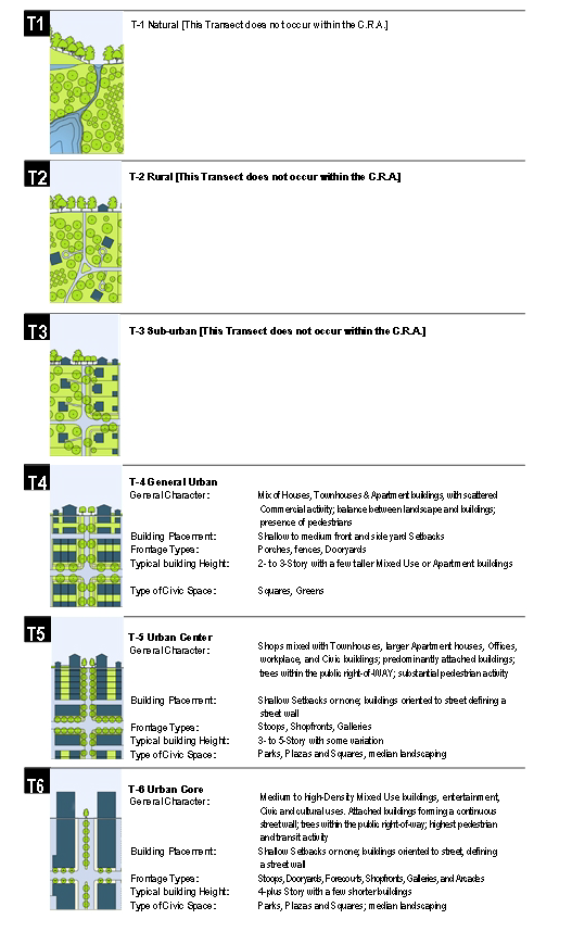
TABLE 2: Vehicular Lane Dimensions. This Table assigns lane widths to Transect Zones. The Design ADT (Average Daily Traffic) is the determinant for each of these sections. The most typical assemblies are shown in Table 3B. Specific requirements for truck and transit bus routes and truck loading shall be decided by Warrant. Federal, state and county roads are not subject to these standards.
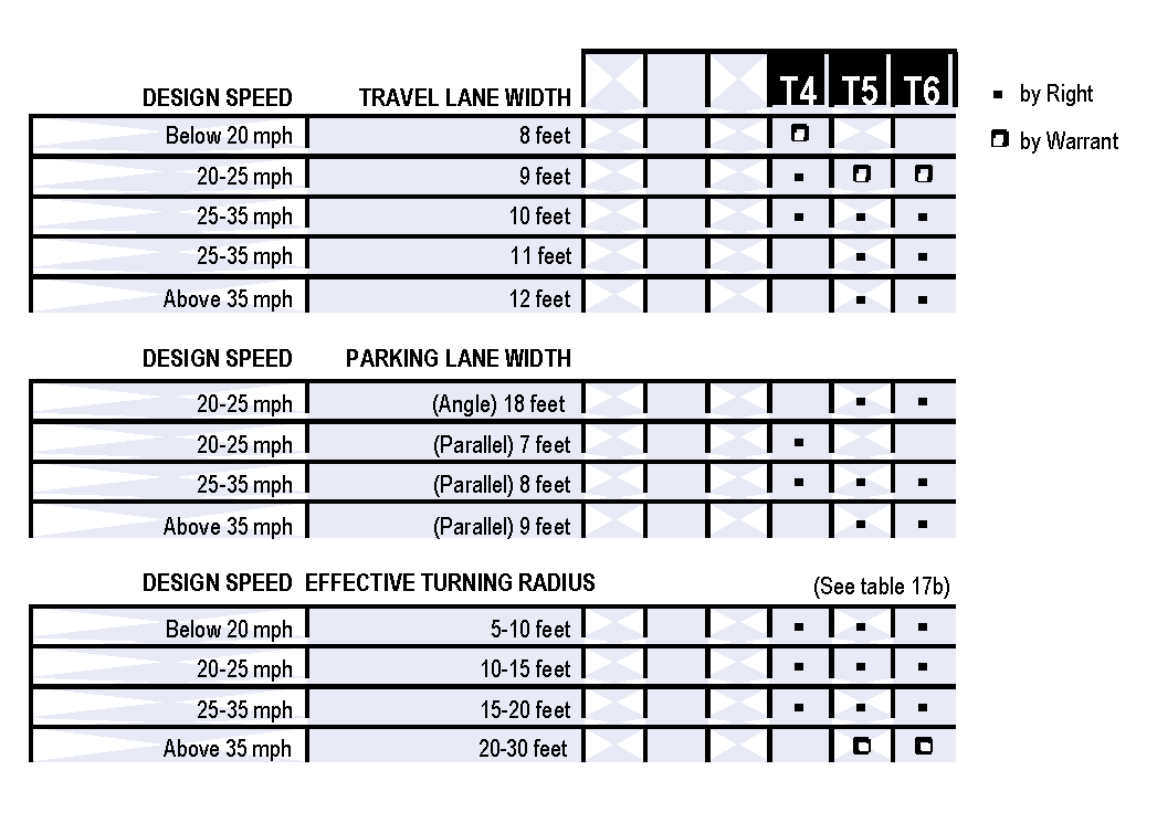
TABLE 3: Vehicular Lane & Parking Assemblies. The projected design speeds determine the dimensions of the vehicular lanes and turning radii assembled for thoroughfares.
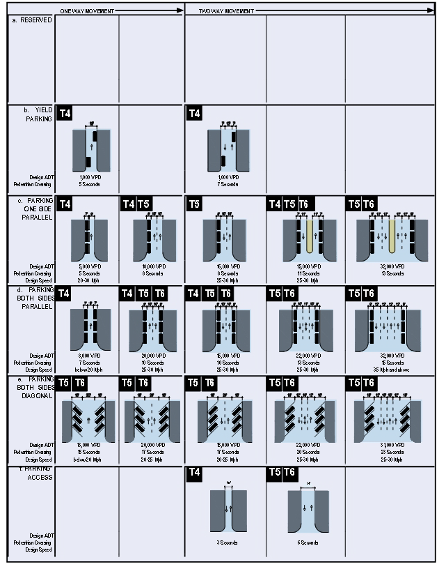
TABLE 3A:
Thoroughfares with 24 Foot Widths.
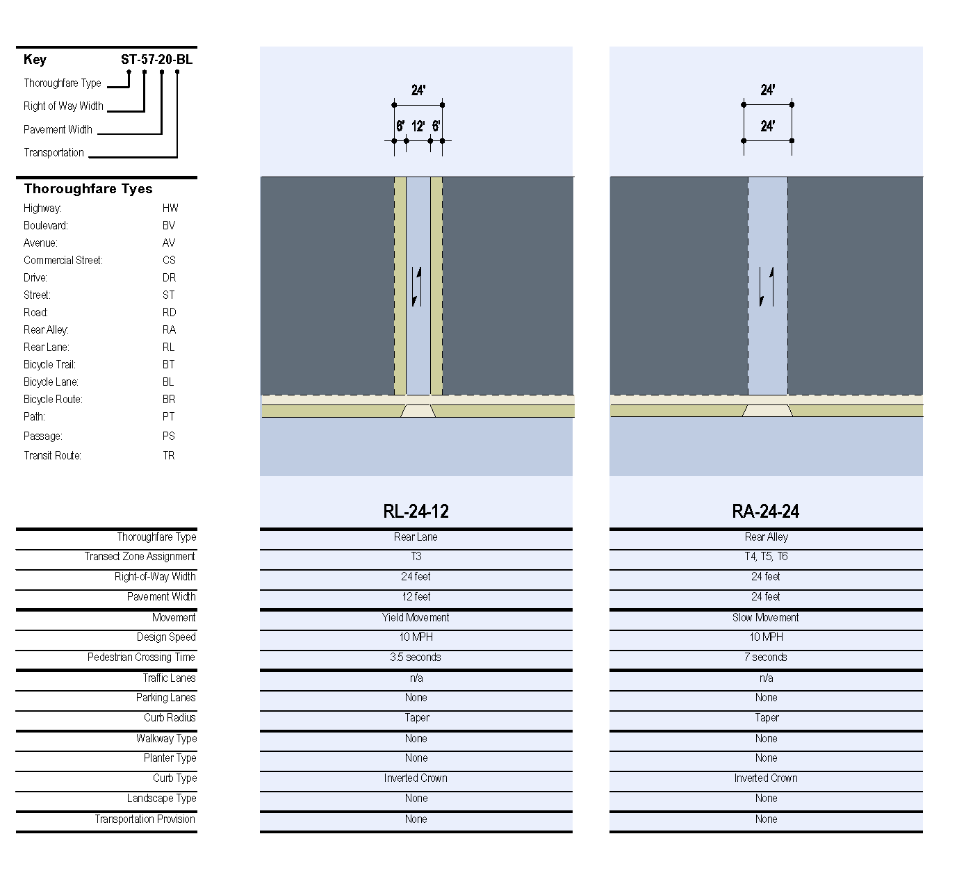
TABLE 3B:
Thoroughfares with 50 and 40 Foot Widths.
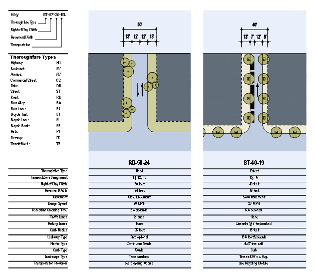
TABLE 3C:
Thoroughfares with 50 Foot Widths.
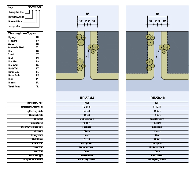
TABLE 3D:
Thoroughfares with 50 Foot Widths.
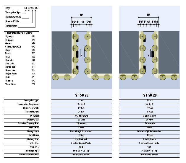
TABLE 3E:
Thoroughfares with 50 and 55 Foot Widths.
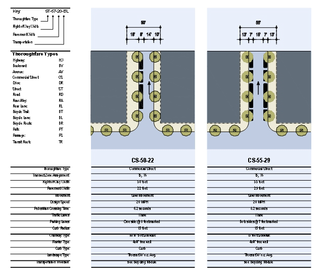
TABLE 3-F:
Thoroughfares with 50 and 60 Foot Widths.
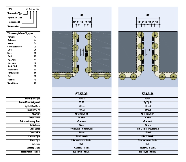
TABLE 3G:
Thoroughfares with 60 and 80 Foot Widths.
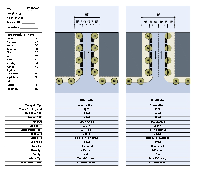
TABLE 3H:
Thoroughfares with 75 and 90 Foot Widths.
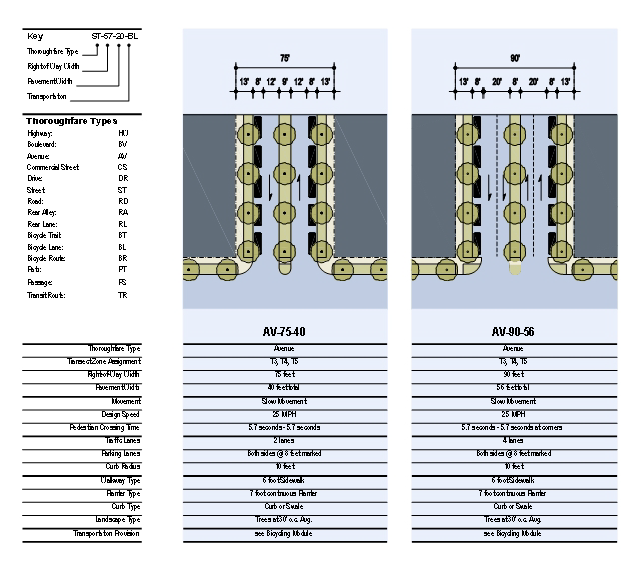
TABLE 3I:
Thoroughfares with 80 and 100 Foot Widths.
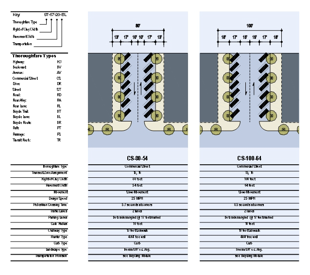
TABLE 4: Public Frontages—General. The Public Frontage is the area between the private Lot line and the edge of the vehicular lanes. Dimensions are given in Table 5.
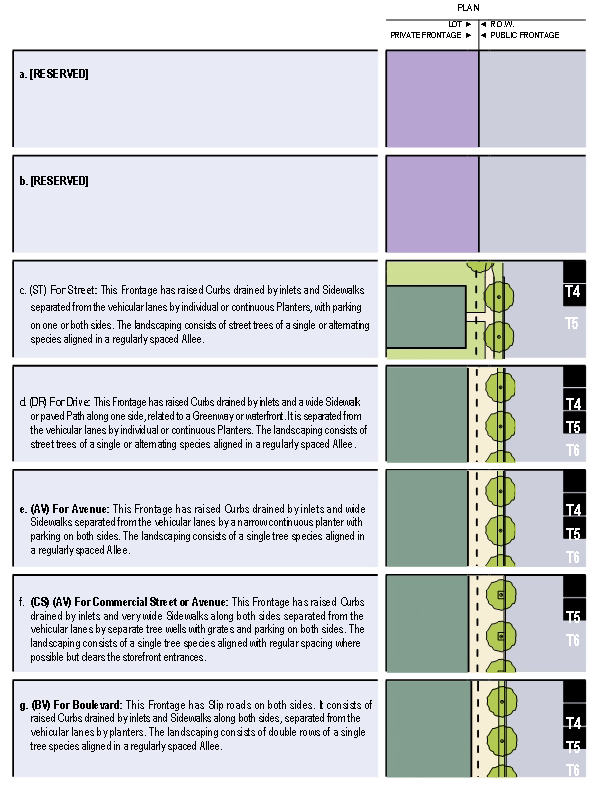
TABLE 5: Public Frontages—Specific. This Table assembles prescriptions and dimensions for the Public Frontage elements - Curbs, walkways and Planters - relative to specific Thoroughfare types within Transect Zones.
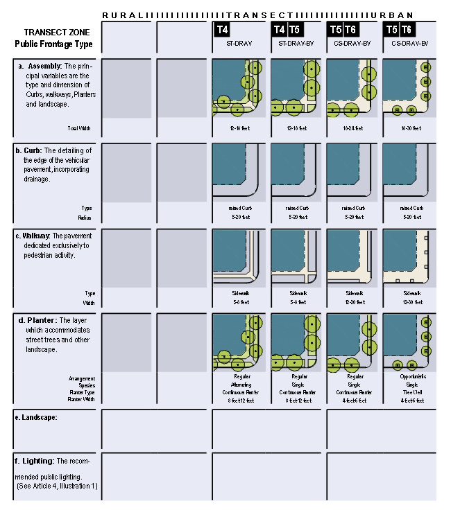
TABLE 6: Private Frontages. The Private Frontage is the area between the building Facades and the Lot lines.
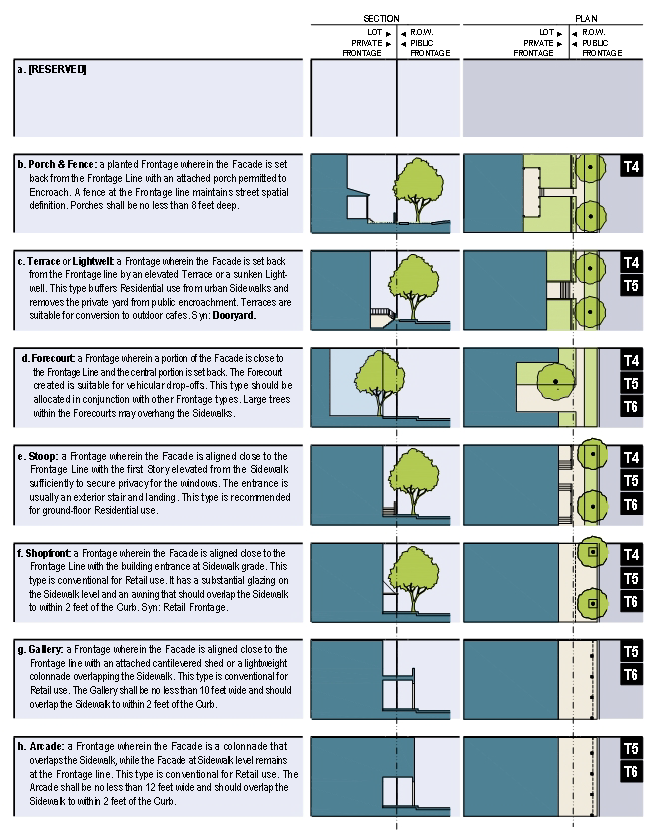
TABLE 7: Building Configuration. This Table shows the Configurations for different building heights for each Transect Zone. Recess Lines and Expression Lines shall occur on higher buildings as shown. N = maximum height as specified in Table 11.
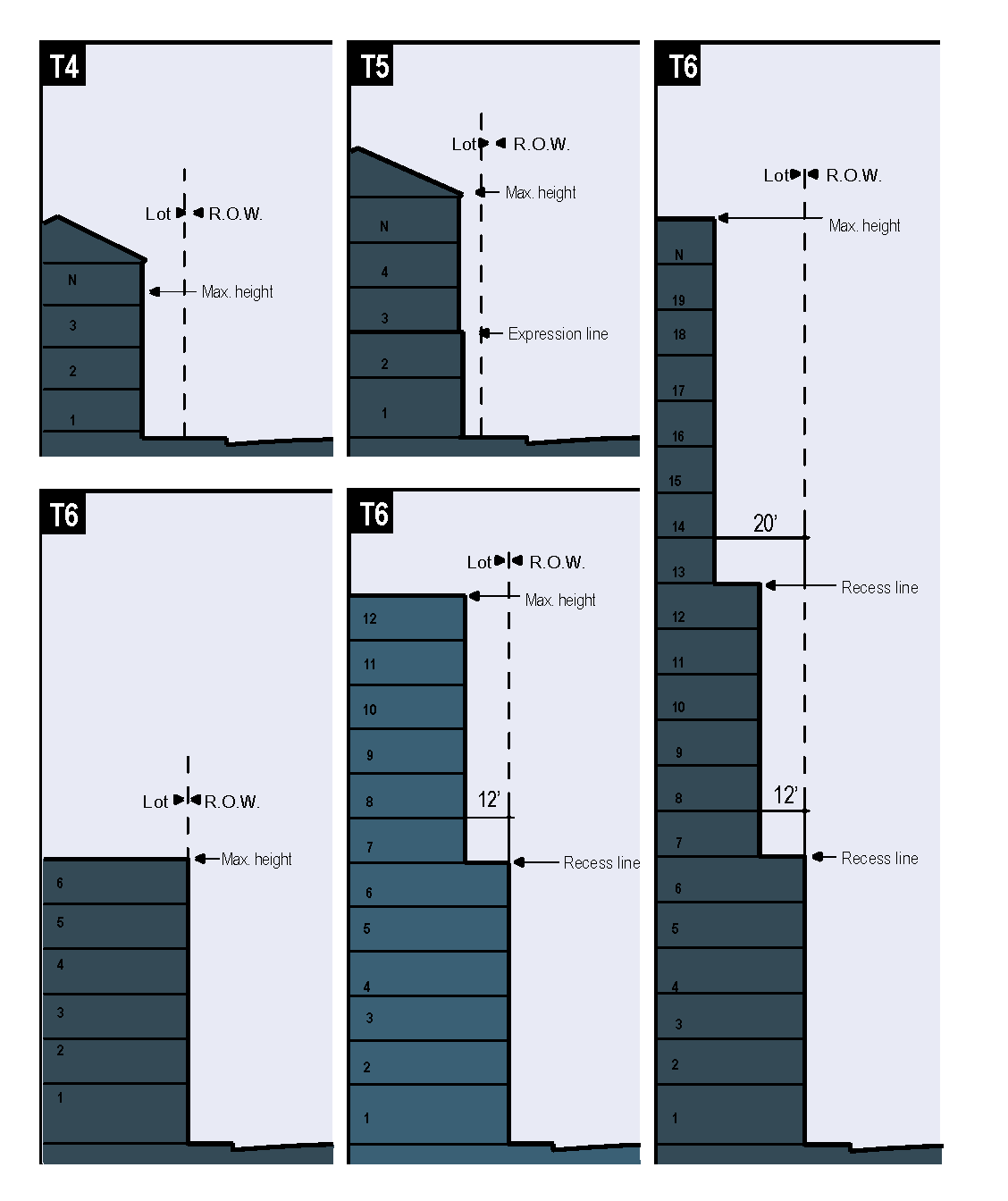
1.
Building height shall be measured in number of Stories, excluding attics and raised basements. Height limits also do not apply to masts, belfries, clock towers, chimney flues, water tanks, elevator bulkheads and similar structures.
2.
Stories may not exceed 14 feet in height from finished floor to finished floor, except for a first floor Commercial Function which shall be a minimum of 11 feet and may be a maximum of 25 feet.
3.
Height shall be measured from the average Enfronting Sidewalk grade to the upper-Most eave of a main pitched roof (not of a domer), or to the uppermost roof deck (not the top of parapet) of a flat roof.
4.
T6 Recess lines shall be required if a Building exceeds 6 floors. The Recess line shall be at the 6th floor and shall be 12 ft. from the property line. If the Building exceeds 12 floors, a second Recess line shall be required at the 13th floor and shall be 20 ft. from the property line.
TABLE 8: Building Disposition. This Table approximates the location of the structure relative to the boundaries of each individual Lot, establishing suitable basic building types for each Transect Zone.
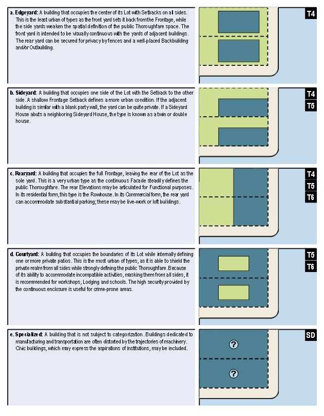
• The Shared Parking Standards Table provides the method for calculating shared parking for buildings with more than on Use type. It refers to the parking requirements that appear in Table 9-a.
• The parking required for any two Land Uses on a Lot is calculated by dividing the number of spaces required by the lesser of the two uses by an appropriate factor from this Table and adding the result to the greater use parking requirements.
• For example, for a building with a Residential Use requiring 100 spaces and a Commercial Use requiring 20 spaces, the 20 spaces divided by the sharing factor of 1.2 would reduce the total requirement to 100 plus 16 spaces.
• Driveways shall have a minimum of 10 feet of paved width of a one-way drive and 20 feet for a two-way drive for parking areas providing 10 or more stalls.
• Pedestrian entrances shall be at least 3 feet from stall, driveway or access aisle.
• Allowable slopes, paving and drainage per Florida Building Code.
• Off-street Parking facilities shall have a vertical clearance of 7 feet. Where such a facility is to be used by trucks or loading Uses, the minimum shall be 12 feet Residential and 15 feet Commercial and Industrial.
• For landscaping requirements of parking lots, refer to LDR Schedule J, Part 2.0, Section 2.5
Notes:
• Residential 240 square feet = 10 feet * 20 feet * 12 feet
• Commercial 420 square feet = 12 feet * 35 feet * 15 feet
• Residential loading berths shall be set back a distance equal to their length
• One Commercial berth may be substituted by 2 residential berths
TABLE 10: Civic Space.
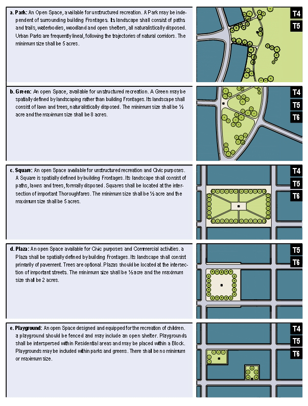
TABLE 11: SmartCode Summary.
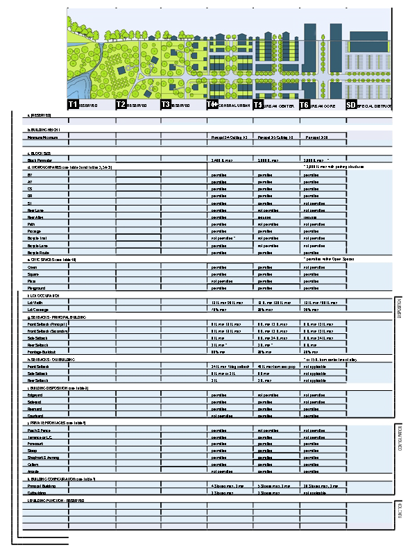
TABLE 12A: Form-Based Code Graphics - T4.
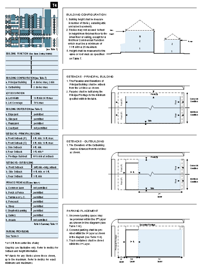
TABLE 12B: Form-Based Code Graphics - T5.
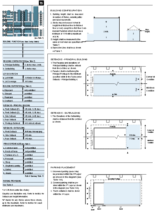
TABLE 12C: Form-Based Code Graphics - T6.
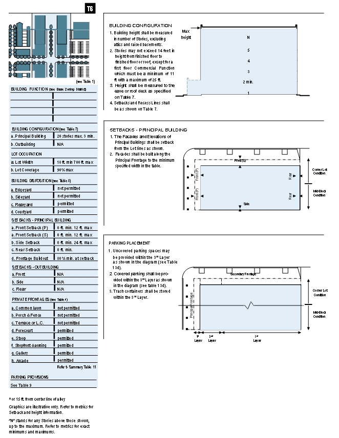
TABLE 13: Definitions Illustrated.
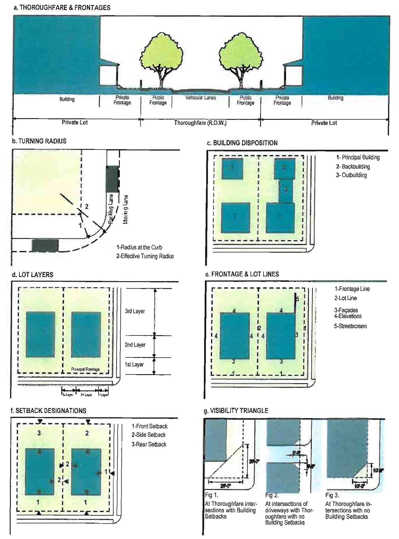
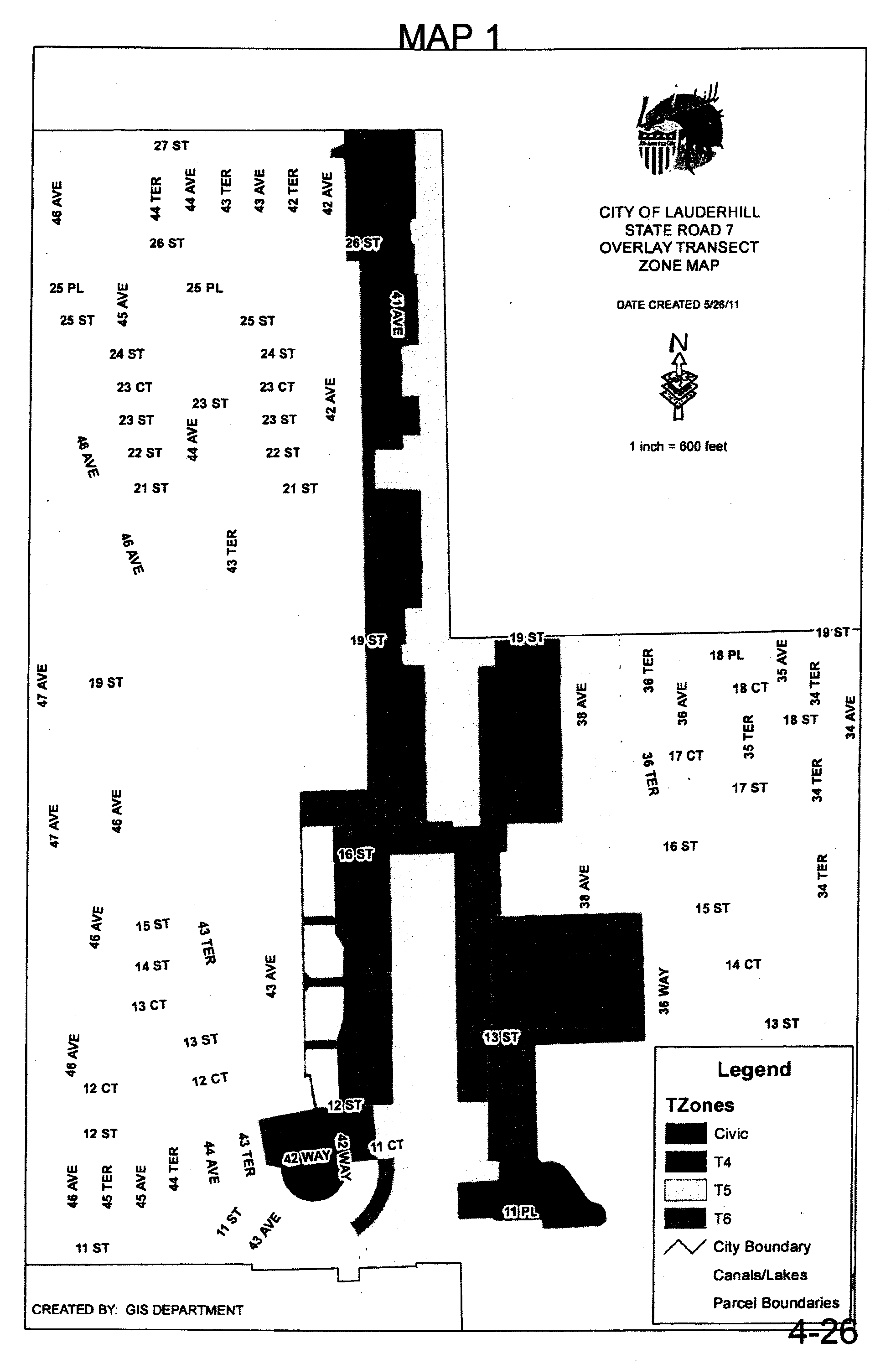
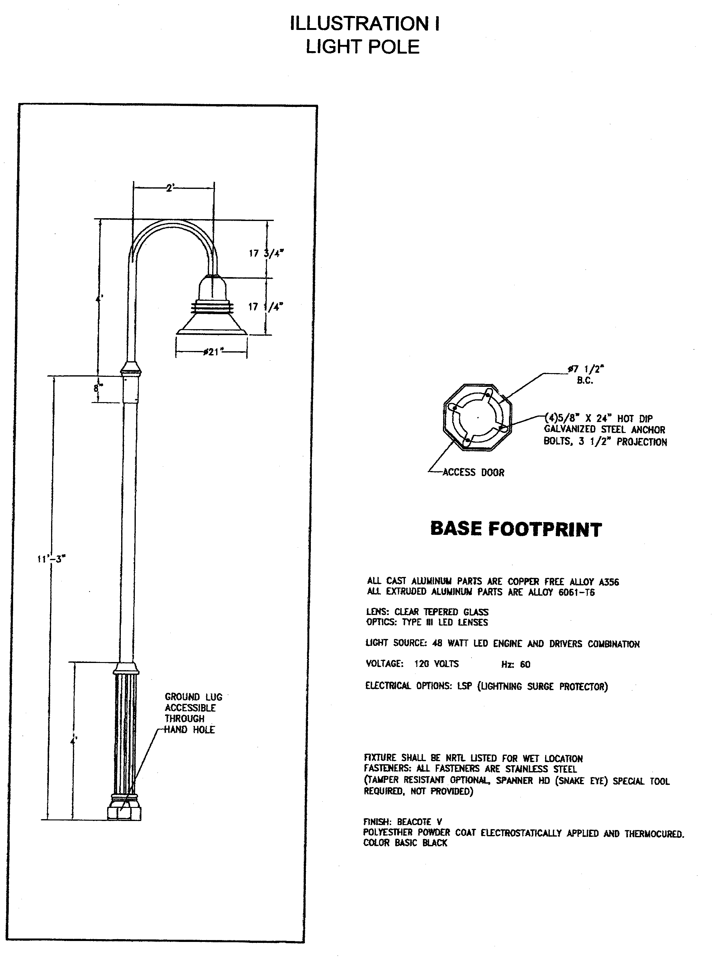
ARTICLE 8. - DEFINITIONS AND ABBREVIATIONS
This Article provides definitions for terms in this Schedule that are technical in nature or that otherwise may not reflect a common usage of the term. If a term is not defined in this Article, then the City Planner shall determine the correct definition. Items in italics refer to Articles, Sections, or Tables in the Schedule. This Article also provides abbreviations for commonly used or frequently used terms.
Abutting: To reach or touch; to touch at the end or be contiguous with; join at a border or boundary; terminate on. Abutting properties include properties across a street or alley.
Accessory Structure: a Structure customarily incidental and subordinate to the Principal Structure and, unless otherwise specifically provided, located on the same premises. "On the same premises" shall be constructed as meaning on the same Lot or on a contiguous Lot in the same ownership. Where a Building is attached to the Principal Building, it shall be considered part thereof, and not an Accessory Structure.
Allee: a regularly spaced and aligned row of trees usually planted along a Thoroughfare or Pedestrian Passage.
Alley: A Thoroughfare designated on a Connections Plan Map or shown on a recorded plat, deed, or legal instrument and intended to be a secondary means of vehicular access to the rear of side of properties otherwise Abutting a street; an Alley may connect to a vehicular driveway located to the rear of Lots providing access to outbuildings, service areas and parking and containing utility Easements.
Arcade: a private Frontage conventional for retail use wherein the Facade is a colonnade that overlaps the Sidewalk, while the Facade at Sidewalk level remains at the Frontage line. OR a covered pedestrian way within a building or along the side of a Building at the first floor, which may provide access to one (1) or more sides.
Attic: the interior part of a building contained within its roof structure.
Average Sidewalk Elevation: The averages of the record profile grade elevation of each of the streets Abutting a development, as determined by the City Engineer.
Awning: a moveable roof-like Structure, cantilevered or otherwise entirely supported from a Building, used to shade or screen windows or doors.
Backbuilding: a single-story Structure connecting a Principal Building to an Outbuilding. See Article 4.0, Table 13.
Balcony: an unenclosed habitable Structure cantilevered from a Façade or Building Elevation.
Bicycle Lane (BL): a dedicated lane for cycling within a moderate-speed vehicular thoroughfare, demarcated by striping.
Bicycle Rack Space: Parking space for any two-wheel alternative mode of transportation, including bicycle, scooter, motorcycle, Segway, etc.
Bicycle Route (BR): a Thoroughfare suitable for the shared use of bicycles and automobiles moving at low speeds.
Bicycle Trail (BT): a bicycle way running independently of a vehicular thoroughfare.
Blade Sign: small sign board for each separate business entrance attached to and perpendicular to the Façade.
Block: the aggregate of private Lots, passages, rear alleys and rear lanes, the perimeter of which abuts Thoroughfares.
Block Face: the aggregate of all the building Façades on one (1) side of a Block. The Block Face provides the context for establishing architectural harmony.
Brownfield: an area designated on the City or State brownfield map.
Building: any Structure having a solid roof intended for shelter or enclosing of persons, animals, chattels, property or equipment or a process of any kind or nature, excluding freestanding tents, freestanding awnings and cabanas and screened enclosures.
Building Configuration: The form of a Building, based on its massing, Private Frontage, and Height.
Building Disposition: The placement of a Building on its Lot.
Building Function: the land uses accommodated by a Building and its Lot. Allowable functions are based on the base or underlying zoning district.
Building Height: The vertical extent of a Building measured in Stories.
Building Permit: The permit required for new construction and additions pursuant to City regulations.
Build-To Line: a line established within a given Lot indicating where the outer edge of a structure must be located.
Bus Rapid Transit (BRT): a rubber tire system with its own right-of-way or dedicated lane along at least seventy (70) percent of its route, providing transit service that is faster than a regular bus.
By Right: characterizing a land use that is allowed as a permitted use or as an allowable accessory use within a base or underlying zoning district.
Certificate of Use: an official City document verifying that a particular Use is in compliance with applicable sections of the Land Development Regulations and Code of Ordinances.
City Commission: The elected local governing body for the City of Lauderhill, Florida.
Civic Use: A use or activity within land or water areas or both, established primarily for the benefit of the community and which may involve the use of the environment or the display, exhibition, inspection, observation, presentation or review of artifacts that document the civic, historical and social structures and intellectual and artistic manifestations that characterize a society. The term may be interpreted to include not-for-profit organizations dedicated to arts, culture, education, recreation, government, transit, and municipal parking.
Civic Building: a building operated by not-for-profit organizations dedicated to arts, culture, education, recreation, government, transit, and municipal parking, or for use approved by the legislative body.
Civic Parking Reserve: Parking Structure or parking lot within a quarter-mile of the site that it serves. See Article 7.0.
Civic Space: an outdoor area dedicated for public use. Civic Space types are defined by the combination of certain physical constants including the relationships among their intended use, their size, their landscaping and their enfronting buildings. See Article 4.0, Table 10.
Civic Zone: designation for public sites dedicated for Civic buildings and Civic Space.
Commercial Use: A use or activity within land or water areas or both, and at a scale grater than home industry, established primarily for financial gains and involving the retail or wholesale marketing, display and sale of goods; or for providing business, domestic or personal services; or for conducting business, governmental, medical and professional affairs. Commercial use includes office, personal services, retail sales, wholesale sales, and lodging.
Common Destination: An area of focused Community activity, usually defining the approximate center of a Pedestrian Shed. It may include without limitation one (1) or more of the following: a Civic Space, a Civic Building, a Commercial center, or a transit station, and may act as the social center of a neighborhood.
Configuration: the form of a building, based on its massing, private Frontage, and height.
Connections Plan Map: a map showing for planning purposes the proposed general location of Thoroughfare (including alleys and pedestrian passages) rights-of-way within an area designated on the Comprehensive Plan's Future Land Use Map Series as a Transit Oriented Corridor for the purpose of ensuring connectivity and continuity. The actual right-of-way or pedestrian passageway location may vary to accommodate development and redevelopment and to ensure connectivity and continuity. See Article 4.0, Map 2.
Context: surroundings made up of the particular combination of elements that create specific character in the area.
Corridor: a lineal geographic system incorporating transportation or Greenway trajectories or both. A transportation Corridor may be a lineal transect Zone.
Courtyard Building: a building that occupies the boundaries of its lot while internally defining one (1) or more private patios. See Article 4.0, Table 9.
Curb: the edge of the vehicular pavement that may be raised or flush to a Swale. it usually incorporates the drainage system. See Article 4.0, Table 5.
Density, Gross: the number of dwelling units per net acre plus one-half (½) any abutting right-of-way. The maximum net allowable density is based on the maximum allowed under the base or underlying zoning district.
Density, Net: the number of dwelling units per acre.
Design Speed: is the velocity at which a thoroughfare tends to be driven without the constraints of signage or enforcement. there are four (4) ranges of speed: Very low: (below twenty (20) Mph); low: (twenty (20) to twenty-five (25) Mph); Moderate: (twenty-five (25) to thirty-five (35) Mph); high: (above thirty-five (35) Mph). lane width is determined by desired Design Speed. See Article 4.0, Table 2.
Development Review Committee (DRC): a collegial body consisting primarily of City staff responsible for reviewing site plan applications and making a recommendation thereto the Planning and Zoning Board and for reviewing and approving site plan modification applications.
Disposition: the placement of a building on its lot. See Article 4.0, Table 8 and Table 13.
Districts, Zoning: The zones displayed on the Official Zoning District Map along with the associated development standards and regulations.
Dooryard: a Private Frontage type with a shallow Setback and front garden or patio, usually with a low wall at the Frontage line. See Article 4.0, Table 6. (Variant: Lightwell, light court.)
Drive: a thoroughfare along the boundary between an urbanized and a natural condition, usually along a waterfront, Park, or promontory. One (1) side has the urban character of a Thoroughfare, with Sidewalk and building, while the other has the qualities of a Road or parkway, with naturalistic planting and rural details.
Driveway: a vehicular lane within a lot, often leading to a garage.
Easement: Any strip of land created for public or private utilities, access, drainage, sanitation, or other specified uses having limitations, the title to which shall remain in the name of the property owner, subject to the right of use designated in the reservation of the servitude.
Edgeyard Building: a building that occupies the center of its Lot with Setbacks on all sides. See Article 4.0, Table 8.
Effective Parking: the amount of parking required for Mixed Use after adjustment by the Shared Parking Factor.
Effective Turning Radius: the measurement of the inside Turning Radius taking parked cars into account. See Article 4.0, Table 13.
Elevation: an exterior wall of a building not along a Frontage line. See Article 4.0, Table 13. Contrast with Façade.
Encroachment: any structural element that breaks the plane of a vertical or horizontal regulatory limit, extending into a Setback, into the Public Frontage, or above a height limit.
Enfront: to place an element along a Frontage, as in "porches enfront the street."
Expression Line: a line prescribed at a certain level of a building for the major part of the width of a Facade, expressed by a variation in material or by a limited projection such as a molding or balcony. See Article 4.0, Table 7. (Syn: transition line.)
Façade: the exterior wall of a building that is set along a Frontage line. Contrast with Elevation.
Fence: a permeable metal or wooden wall, independent of a Building, located along a Frontage line.
Floorplate: the total indoor and outdoor Floor Area of any given Story of a Building measured to the exterior of the wall or balcony.
Floor Area: the floor area within the inside perimeter if the outside walls of the Building, including hallways, stairs, closets, thickness of walls, columns and other features, and parking and loading areas and excluding only interior Atria and open air spaces such as exterior corridors, Porches, balconies and roof areas.
Forecourt: a private Frontage wherein a portion of the Facade is close to the Frontage Line and the central portion is set back. See Article 4.0, Table 6.
Form-Based Code: Form-based codes address the relationship between building facades and the public realm, the form and mass of buildings in relation to one another, and the scale and types of streets and blocks. The regulations and standards in form-based codes are presented in both words and clearly drawn diagrams and other visuals. In contrast, conventional zoning codes focus on the segregation of land uses, and the control of development intensity through abstract and uncoordinated parameters (e.g., floor area ratio, dwellings per acre, setbacks, parking ratios), to the neglect of an integrated built form.
Frontage: the area between a building Façade and the vehicular lanes, inclusive of its built and planted components. Frontage is divided into Private Frontage and Public.
Frontage, Principal: that Frontage facing public space such as a Thoroughfare of higher pedestrian importance (i.e., traffic volume, number of lanes, etc).
Frontage, Private: the Layer between the Frontage Line and the Principal Building Façade. The Structures and landscaping within the Private Frontage may be held to specific standards regarding the depth of the setback and the combination of architectural elements such as Fences, Stoops, Porches and Galleries. See Article 4.0, Table 6.
Frontage, Public: the area between the Curb of the vehicular lanes and the Frontage line. See Article 4.0, Table 5.
Frontage, Secondary: that Frontage facing public space such as a Thoroughfare that is of lesser pedestrian importance.
Frontage Line: Property Line or Base Building Line Abutting a public space such as a Plaza or Thoroughfare, whether at the front, rear or side of a Lot. Facades parallel to Frontage Lines define the public realm and are therefore more regulated than the Elevations that coincide with other Lot Lines.
Function: the use or uses accommodated by a building and its lot. Building function generally is not covered by this Schedule. Function generally is regulated by the base or underlying zoning district.
Gallery: private Frontage conventional for retail use wherein the Façade is aligned close to the Frontage line with an attached cantilevered shed or lightweight colonnade overlapping the Sidewalk. See Article 4.0, Table 6.
Glazing: a transparent part of a wall, usually made of glass. Glazing may be mounted in a window sash or door stile, usually made of wood, aluminum or PVC.
Green: a Civic Space type for unstructured recreation, spatially defined by landscaping rather than building Frontages. See Article 4.0, Table 10.
Greenfield: an area that consists of open or wooded land or farmland that has not been previously developed.
Greenway: an open Space Corridor in largely natural conditions which may include trails for bicycles and pedestrians.
Greyfield: an area previously used primarily as a parking lot. Shopping centers and shopping malls are typical Greyfield sites. (Variant: Grayfield.)
Habitable Space: building space which Use involves human presence with direct view of the enfronting streets or public or private Open Space, excluding Parking Garages, self-service storage facilities, warehouses, and display windows separated from retail activity.
Hotel: lodging available for rent on a daily or weekly basis that is accessed from an interior hallway. Conference and restaurant facilities may be provided.
House: an Edgeyard Building type, usually a single-family dwelling on a large lot, often shared with an Accessory Building in the back yard. (Syn: single.)
Infill: (Noun) - new development on land that had been previously developed, including most Greyfield and Brownfield sites and cleared land within Urbanized areas. (Verb) - to develop such areas.
Inside Turning Radius: the curved edge of a Thoroughfare at an intersection, measured at the inside edge of the vehicular tracking. The smaller the Turning Radius, the smaller the pedestrian crossing distance and the more slowly the vehicle is forced to make the turn.
Layer: a range of depth of a Lot within which certain elements are permitted. See Article 4.0, Table 13.
Layer, First: the area of a Lot comprise of the distance between the Base Building Line and the required Setback including the Private Frontage. See Article 4.0, Table 13.
Layer, Second: that portion of the Lot behind the First Layer which includes that portion of the Building which Enfronts and Thoroughfare. See Article 4.0, Table 13.
Layer, Third: That portion of the Lot that is not within the First and Second Layer and is least visible from the Thoroughfare. See Article 4.0, Table 13.
Lightwell: a private Frontage type that is a below-grade entrance or recess designed to allow light into basements. See Article 4.0, Table 6. (Syn: light court.)
Liner: a Building or part of a Building with Habitable Space specifically designed to enfront a public space, masking a function without capacity to monitor public space, such as a parking lot, Parking Garage or storage facility.
Liner Building: a building specifically designed to mask a parking lot or a Parking Structure from a Frontage.
Loading Space: an area in which goods and products are moved on and off a vehicle, including the stall or berth and the apron or maneuvering room incidental thereto.
Lot: a parcel of land accommodating a building or buildings of unified design. The size of a Lot is controlled by its width in order to determine the grain (i.e., fine grain or coarse grain) of the urban fabric.
Lot Area: the area within the Lot Property Lines, excluding any portions of street rights-of-way or other required dedications.
Lot, Conforming: a parcel of land meeting the requirements of this Schedule as to dimensions (width, depth, area) and access.
Lot Coverage: the area of the Lot occupied by all Structures including Buildings, Structures and any other impervious surface.
Lot, Interior: A Lot Abutting only one (1) Thoroughfare.
Lot, Through: A Lot other than a Corner Lot, and with Frontage on more than one (1) Thoroughfare; Alleys shall not be considered for purposes of this definition.
Lot Line: the boundary that legally and geometrically demarcates a lot.
Lot Width: the length of the narrowest dimension Frontage Line of a Lot.
Mixed Use: A use or activity within land or water areas or both, with three (3) or more building functions within the same building through superimposition or adjacency, or in multiple buildings within the same area by adjacency.
Open Space: land intended to remain undeveloped; it may be reserved for Civic Space.
Outbuilding: an accessory building, usually located toward the rear of the same Lot as a Principal Building, and sometimes connected to the principal building by a Backbuilding. See Article 4.0, Table 13.
Park: A Civic Space type providing a natural preserve that is available for unstructured recreation. See Article 4.0, Table 10.
Parking Area: any area designed and used for parking motor vehicles including parking lots and garages, driveways, garages serving residential Uses, and Thoroughfares.
Parking, Garage or Structure: a Structure containing vehicular parking, including mechanical parking systems.
Parking, Off-site: spaces provided for vehicles and located outside of the boundaries of the Lots to be served.
Parking, Off-street: any land area designated and used for parking motor vehicles including parking lots and garages, driveways, garages serving residential Uses, but excluding Thoroughfares.
Parking, Tandem: the placement of vehicles one behind the other as opposed to side by side.
Passage (PS): a pedestrian connector, open or roofed, that passes between buildings to provide shortcuts through long Blocks and connect rear parking areas to Frontages.
Path (PT): a pedestrian way traversing a Park or rural area, with landscape matching the contiguous Open Space, ideally connecting directly with the urban Sidewalk network.
Pedestrian Orientation: the characteristics of an area where the location and access to Buildings, types of Uses permitted on the street level, and the storefront design relate to the needs of persons traveling on foot.
Pedestrian Passage: a public Open Space restricted to pedestrian Use and limited vehicular access that connects Thoroughfares, Plazas, Alleys, garages and other public Use spaces.
Planter: the element of the public Frontage which accommodates street trees, whether continuous or individual. See Article 4.0, Table 5.
Playground: An Open Space designated and equipped for the recreation of children. See Article 4.0, Table 10.
Plaza: a Civic Space type designed for Civic purposes and Commercial activities in the more urban Transect Zones, generally paved and spatially defined by building Frontages. See Article 4.0, Table 10.
Porch: an open air room appended to a Building, with floor and roof but no walls on the sides and facing Frontages. See Article 4.0, Table 6.
Principal Building: a Structure used to enclose or house the primary Use(s) located on a Lot, or the main Building on a Lot, usually located toward the front. See Article 4.0, Table 13.
Principal Entrance: the main point of access for pedestrians into a building.
Property Line: demarcation of private property ownership.
Rear Alley (RA): a vehicular way located to the rear of lots providing access to service areas, parking, and Outbuildings and containing utility easements. Rear Alleys should be paved from building face to building face, with drainage by inverted crown at the center or with roll Curbs at the edges.
Rear Lane (RL): a vehicular way located to the rear of lots providing access to service areas, parking, and Outbuildings and containing utility easements. Rear lanes may be paved lightly to Driveway standards. The streetscape consists of gravel or landscaped edges, has no raised Curb, and is drained by percolation.
Rearyard Building: a building that occupies the full Frontage line, leaving the rear of the lot as the sole yard. See Table Article 4.0, Table 8. (Var: rowhouse, townhouse, apartment house)
Recess Line: a line prescribed for the full width of a Façade, above which there is a Stepback of a minimum distance, such that the height to this line (not the overall building height) effectively defines the enclosure of the Enfronting public space. See Article 4.0, Table 7.
Right-of-Way, Public: that land held in trust by the City between the base building lines, including the sidewalk, swale and parkway area, and the road, street and highway.
Rowhouse: a single-family dwelling that shares a party wall with another of the same type and occupies the full Frontage line. Contrast with Rearyard Building. (Syn: Townhouse)
Scale: the spatial relationship among Structures along a street or block front, including height, bulk and yard relationships.
Screening: visually shielding or obstructing one (1) Structure or Use from another by a Liner Building, fencing, wall or densely planted vegetation.
Setback: the area of a lot measured from the lot line to a building Façade or Elevation that is maintained clear of permanent structures, with the exception of encroachments listed in Article 6.
Shared Parking Factor: an accounting for parking spaces that are available to more than one (1) Function. See Article 4.0, Table 9.
Shopfront: a private Frontage conventional for retail use, with substantial Glazing and an awning, wherein the Façade is aligned close to the Frontage line with the building entrance at Sidewalk grade. See Article 4.0, Table 6.
Sidewalk: the paved section of the Public Frontage dedicated exclusively to pedestrian activity.
Sideyard Building: a building that occupies one (1) side of the Lot with a Setback on the other side. This type can be a Single or twin depending on whether it abuts the neighboring house. See Article 4.0, Table 8.
Site Plan: The plan required under Article 2.0, Section 2.8 that provides a graphic representation of the arrangement of buildings, parking, drives, landscaping and any other structure that is part of a development or redevelopment project.
Slip Road: an outer vehicular lane or lanes of a thoroughfare, designed for slow speeds while inner lanes carry higher speed traffic, and separated from them by a planted median. (Syn: access lane, service lane)
Special District (SD): an area that, by its intrinsic Function, Disposition, or Configuration, cannot or should not conform to one (1) or more of the normative Community types or Transect Zones specified by the Schedule. Special Districts may be mapped and regulated at the regional scale or the community scale.
Square: a Civic Space type designed for unstructured recreation and Civic purposes, spatially defined by building Frontages and consisting of Paths, lawns and trees, formally disposed. See Article 4.0, Table 10.
Stepback: a building Setback of a specified distance that occurs at a prescribed number of Stories above the ground. See Article 4.0, Table 7.
Stoop: a private Frontage wherein the Façade is aligned close to the Frontage Line with the first Story elevated from the Sidewalk for privacy, with an exterior stair and landing at the entrance. See Article 4.0, Table 6.
Story: a habitable level within a Building, excluding an attic or raised basement, by which Height is measured.
Street (ST): a local urban thoroughfare of low speed and capacity. See Tables 3, 3A-3I, and Table 5.
Streetscape: the urban element that establishes the major part of the public realm. The streetscape is composed of Thoroughfares (travel lanes for vehicles and bicycles, parking lanes for cars, and Sidewalks or paths for pedestrians) as well as amenities of the Public Frontages (street trees and plantings, benches, streetlights, paving, street furnitures, etc.) and the visible Private Frontages (Building Facades and Building Elevations, Porches, yards, Fences, etc).
Streetscreen: a freestanding wall built along the Frontage line or coplanar with the Façade. It may mask a parking lot from the Thoroughfare, provide privacy to a side yard, and/or strengthen the spatial definition of the public realm. (Syn: streetwall.)
Structure: a Structure is anything constructed or erected, the use of which requires fixed location on the ground or attachment to something having fixed location on the ground or on or below the surface of the ground or water.
Substantial Improvement or Modification: alteration to a building that increases the building area or size of the original structure by ten (10) percent of more.
Swale: a low or slightly depressed natural area for drainage.
Terminated Vista: a location at the axial conclusion of a Thoroughfare. A Building located at a terminated Vista designated on the Connections Plan Map is required or recommended to be designed in response to the axis. See Article 4.0., Map 2.
Thoroughfare: a vehicular way incorporating moving lanes and parking lanes within a right-of-way as part of an interconnected network for vehicular, pedestrian and bicycle mobility. See Article 4.0, Table 2, Table 3, Tables 3A - 3I, and Table 13.
Transect: a system for ordering human habitats in a range from the most natural to the most urban cross-section of the environment showing a range of different habitats.
Transect Zone (T-Zone): one (1) of several areas depicted as an overlay zone on the Zoning District Map regulated by this Schedule. Transect Zones are administratively similar to the zoning districts in conventional zoning codes except that it generally does not address allowable land uses. Instead, it focuses on Height and Setback requirements, building form and the form of the enfronting streetscape.
Transitional Line: a horizontal line spanning the full width of a Façade, expressed by a material change or by a continuous horizontal articulation such as a cornice or a balcony.
Tree Well: the most urban type of planter, used in T5 and T6. The tree planter is located within the Sidewalk, and covered by a permeable grate. Properly used tree wells establish a much needed green canopy in the hot urban environment.
Turning Radius: the curved edge of a thoroughfare at an intersection, measured at the inside edge of the vehicular tracking. The smaller the Turning Radius, the smaller the pedestrian crossing distance and the more slowly the vehicle is forced to make the turn. See Article 4.0, Table 13.
Type: a category determined by disposition and configuration, including size or extent, such as Thoroughfare types.
Unity of Title: a written agreement executed by and between a property owner and the City whereby the property owner for a specified consideration by the City agrees that the Lots or parcels of land or both constituting the Building site shall not be conveyed, mortgaged and or leased separate and apart from each other and that they shall be held together as one (1) tract. Such Unity of Title shall be recorded in the public records of Broward County, Florida and shall run with the land and shall be binding upon the property owner or owners, their successors and assigns.
Urban Design: Form, in terms of both beauty and function, of urban areas. Urban design is concerned with the location, mass and design of various urban components and combines elements of urban planning, architecture, landscape architecture and traffic engineering.
Urban Form: The spatial arrangement of a particular environment, as defined by the connectivity of built mass and form, the natural environment, and the movement of persons, goods and information.
Urbanism: collective term for the condition of a compact, Mixed use settlement, including the physical form of its development and its environmental, functional, economic, and socio-cultural aspects.
Urbanized: generally, developed. Specific to the Schedule, developed at T3 (Sub-urban) Density or higher.
Use: The purpose for which a structure or lot is arranged, designed or intended to be used, occupied or maintained.
Variance: a ruling that would permit a practice that is not consistent with either a specific provision or the Intent of this Schedule (See Article 2.0, Section 2.5). Variances are considered by the board of appeals in a public hearing. See LDR Article IV, Part 3.0.
Warrant: a ruling that would permit a practice that is not consistent with a specific provision of this Schedule, but that is justified by its Intent (See Article 2.0, Section 2.5). Warrants typically are granted administratively by the DRC.
Yield: characterizing a Thoroughfare that has two-way traffic but only one (1) effective travel lane because of parked cars, necessitating slow movement and driver negotiation.
Zoning District Map: the official map or maps that are part of the Land Development Regulations and delineate the boundaries of individual districts.
SCHEDULE T. - THE ARTS AND ENTERTAINMENT OVERLAY DISTRICT[9]
Editor's note— Ord. No. 19O-08-116, § 3, adopted Sep. 12, 2019, amended Sch. T in its entirety to read as herein set out. Former Sch. T pertained to Commerce Park Special Overlay District and derived from Ord. No. 92-184, § 1, adopted Oct. 13, 1992; Ord. No. 05O-03-120, § 1, adopted March 28, 2005; and Ord. No. 14O-05-121, § 1, adopted June 9, 2014.
SCHEDULE V. - TRANSPORTATION DEMAND MANAGEMENT PLAN IMPLEMENTATION ELEMENTS
The property owner shall submit to the Planning and Zoning Director for review by the special permit team or Development Review Committee seven (7) copies of a Transportation Demand Management (TDM) Plan Implementation Elements application. The property owner may make changes to the TDM Plan, as necessary, to achieve the best mix of TDM actions to meet commuting needs of employees and other affected parties. Some combination of the following TDM services and incentives may be offered to all employees of the property owner:
A.
Marketing and Education Measures.
1.
Employ one (1) or more trained TDM staff persons on-site on a full-time basis.
2.
Encourage extensive rideshare participation through newsletters, bulletin boards and other similar methods.
3.
Track usage of each TDM incentive or service.
4.
Operate a "commuter store" at a visible, central location on the studio property.
5.
Utilize prizes and special events to maintain interest and encourage participation in the TDM Plan.
6.
Brief each new employee of the property owner on TDM Plan requirements.
B.
On-site Services Enhancements.
1.
Make bus or Tri-Rail passes available for sale at the commuter store.
2.
Enhance and encourage utilization of on-site amenities.
C.
Facility Improvements.
1.
Establish convenient carpool or vanpool or both loading areas.
2.
Upgrade and expand bicycle racks, showers, and lockers.
3.
Contribute to improvement of bike routes on access routes to the studio property.
4.
Add or upgrade bus stop facilities near the studio property.
5.
Seek improved bus service to the studio property, especially on north and south routes.
6.
Support the City's Community Shuttle Service by paying employee fares.
D.
Service Operation.
1.
Provide information on carpools, vanpools, public transit and bicycles to each employee of the property owner.
2.
Provide personalized assistance to facilitate employee participation in ridesharing.
3.
Expand the vanpool fleet.
4.
Operate a guaranteed ride home (GRH) program for ridesharers only.
5.
Provide short-term auto rental (STAR) service for midday trips.
6.
Create and operate a Transportation Management Association midday shuttle service.
E.
Alternative Work Arrangements.
1.
Allow employees to adjust work schedules to accommodate ridesharing arrangements.
2.
Establish staggered work hours to shift studio traffic out of peak commuter hours.
3.
Establish pilot telecommuting programs, such as work-at-home programs or a "telework center."
(Ord. No. 09O-07-132, § 9, 8-31-09)
Sec. 1. - Grade of building.
The top surface of all floors of residential buildings shall be not less than eighteen (18) inches, and of non-residential buildings shall be no less than six (6) inches above the highest point of the crown of all streets adjacent to the plot upon which such buildings are located, except that in cases where topographical conditions are such that, in the opinion of the City Engineer or the Broward County Health Department, compliance would be impracticable or would cause grade level conditions which would be detrimental to adjacent or nearby property. The Director of Community Development may modify the application of this requirement in accordance with specifications as approved by said engineering and health departments.
(Ord. No. 01O-01-05, § 14, 1-29-01)
Editor's note— Ord. No. 01O-01-05, § 14, adopted Jan. 29, 2001, renumbered former § 1.4 as § 1 to read as herein set out. See the Table of Amendments.
Sec. 2. - Trafficway setbacks.
(1)
Applicability and standards:
(a)
The following setbacks are established and pertain to all buildings within the area between the centerline of each street and the setback line.
(b)
Commercial Boulevard: One hundred twenty-three (123) feet.
(c)
University Drive: One hundred seventy (170) feet.
(d)
Oakland Park Boulevard: One hundred seventy (170) feet.
(e)
Sunrise Boulevard: One hundred fifty (150) feet.
(f)
State Road 7 (N.W. 40 Avenue): One hundred (100) feet.
(2)
Building prohibited; exemptions. No building or building addition shall be permitted within the setback areas along the applicable streets within the City limits of the City of Lauderhill. However, this section shall not apply to any existing building for which a building permit has been issued by the City prior to June 11, 1990.
(Ord. No. 01O-01-05, § 14, 1-29-01)
Editor's note— Ord. No. 01O-01-05, § 14, adopted Jan. 29, 2001, renumbered former § 3 as § 2 to read as herein set out. See the Table of Amendments.
Sec. 3. - Reserved.
Editor's note— Ord. No. 01O-04-26, §§ 1, 2, adopted April 30, 2001, redesignated Schedule E, Subsections (1)—(9) and (12) as Art. IV, §§ 4.1—4.10. Formerly said section pertained to special exception uses. See the Table of Amendments.
(10)
Reserved. [See Article III, § 5.29 for regulations pertaining to pawnshops and pawnbrokers.]
(11)
Reserved. [See Article III, § 5.29 for regulations pertaining to motor vehicle repair businesses.]
(12)
Reserved. See editor's note at Section 3 title.
(13)
Reserved. [See Article III, § 5.34 for regulations pertaining to self-storage facilities.]
(14)
Reserved. [See Article III, § 5.21A for regulations pertaining to holiday sales.]
Editor's note— Ord. No. 01O-01-05, § 14, adopted Jan. 29, 2001, renumbered former § 5 as § 3 to read as herein set out. See the Table of Amendments.
Sec. 1. - Off-street parking and loading.
1.1. General requirements:
1.1.1. Every building, use or structure, instituted or erected after December 11, 1984, shall be provided with off-street parking facilities in accordance with the provisions of this section for the use of occupants, employees, visitors or patrons. Buildings, uses and structures instituted or erected on or before December 11, 1984 shall be required to provide off-street parking facilities in accordance with the provisions of this section within six (6) months of their sale or transfer anytime after June 1, 1999.
1.1.2. Such off-street parking facilities shall be maintained and continued as an accessory use as long as the main use is continued.
1.1.3. Where a building existed on December 11, 1984, provided there is no increase in floor area or capacity and there is no change of occupancy, such building may be modernized, altered or repaired, without providing additional off-street parking facilities.
1.1.4. Where a building or use, which existed on December 11, 1984, is enlarged in floor area, volume, capacity, or space occupied, off-street parking facilities as specified herein shall be provided for the additional floor area, volume, capacity or space so created or occupied.
1.1.5. It shall be unlawful for an owner or operator of any building, structure or use affected by this code to discontinue, change or dispense with, or to cause the discontinuance or reduction of the required parking facilities apart from the discontinuance, sale, or transfer of such structure or use, without establishing alternative vehicle parking facilities which meet the requirements of this section. It shall be unlawful for any person, firm, or corporation to utilize such building, structure or use without providing the off-street parking facilities to meet the requirements of and be in compliance with this section.
1.1.6. All off street parking shall be in compliance with those standards set forth in LDR Article III, Section 6.5.1.C.
1.1.7. [Reserved.]
1.1.8. [Reserved.]
1.1.9. [Reserved.]
1.2. Location and design standards:
1.2.1. The off-street parking facilities required by this section shall be located on the same plot or parcel of land they are intended to serve; provided, however, when practical difficulties, as determined by the City Commission, prevent the establishment of such facilities upon the same plot, the off-street parking facilities shall be provided on land which a abuts the premises they are to serve and are within seven hundred (700) feet of the premises they are to serve, and the owner of said parking area and the owner of the property to be served shall enter into written agreement with the City whereby the land providing the parking area shall never be sold or disposed of except in conjunction with the sale of the building the parking area serves so long as these parking facilities are required, and said agreement shall be recorded at the expense of the owner of the property on which the facilities will be located and shall run with the land to bind the heirs, successors and assigns of said owner. Said written agreement may be voided by the City Commission if other provisions are made for off-street parking facilities pursuant to this section.
1.2.2. Each parking space required and provided pursuant to the provisions of this section shall not be less than nine (9) feet in width, and eighteen (18) feet in length, except for spaces utilized for parallel parking. The parallel parking space shall not be less than nine (9) feet in width and twenty-three (23) feet in length.
1.2.3. Off-street parking facilities required by this section shall be arranged or designed in the same manner as depicted in Table 1-1, "Minimum Space Requirements at Various Parking Angles for Self-Parking Facilities."
TABLE 1-1. MINIMUM SPACE REQUIREMENTS AT VARIOUS PARKING ANGLES FOR SELF-PARKING FACILITIES
*Note: Dimensions are for one-way direction movement only.
1.2.4. The required off-street parking facilities shall be clearly delineated by four-inch, visible, painted striping, except for single-family dwellings. Parking and vehicle service areas which abut landscaped areas, shall be designed with bumper guards, wheel stops, or contiguous curbing. The required bumper guards or wheel stops shall be located a minimum of two and one-half (2.5) feet from any landscaped area, sidewalk structure or property line. The required off-street parking facilities, including access aisles and driveways shall be surfaced with hard, durable, dustless material, and maintained in a smooth well graded condition.
1.2.5. All required parking spaces shall be directly accessible from a public or private street, alley or easement. All off-street parking areas shall be designed to permit convenient maneuvering of vehicles and each space shall be accessible without driving over or through any other parking space. Backout parking shall not be permitted on any street or highway designated on the Lauderhill Land Use Plan Map, except for parking spaces required for single-family dwellings.
1.2.6. All off-street parking facilities required by this code shall be drained so as to retain run-off on site and not to cause any nuisance on adjacent or public property, and any lighting thereon shall be so arranged and designed as to prevent any glare or excessive light on adjacent property or public streets. Such facilities shall be arranged for convenient access and safety of pedestrians and vehicles.
1.2.7. A plan shall be submitted with every application for a building permit for any use or structure required to provide off-street parking under these regulations, which plan shall clearly and accurately designate the required parking spaces, access aisles and driveways, and relation to the uses or structures these off-street parking facilities are intended to serve.
1.2.8. In a Tree Preservation District, the Community Development Director may authorize up to twenty-five percent (25%) of the required parking spaces to be designed for compact cares (nine (9) feet by sixteen (16) feet). Compact parking spaces must be clearly marked.
1.2.9. Backlot area. Backlot areas of motion picture studios shall not be off-street parking areas.
1.3. Amount of off-street parking. The off-street parking required by this section shall be provided and maintained on the basis of the following minimum requirements:
1.3.1. One-, two-and three-family dwellings.
(a)
Dwelling, single-family: Two (2) parking spaces, a minimum of one (1) shall be within a garage. Access may be through either parking space. The C.A.C. may waive the requirement of one parking space within a garage if occupancy by bona fide permanent residents thereof has increased since time of original occupancy and exceeds available bedroom facilities; but two parking spaces must be available on the property.
(b)
Dwelling, two-family and three-family: Two (2) parking spaces for each dwelling unit. Garage and carport included. Access to one of the two (2) spaces may be through or over one or the other, notwithstanding other provisions of this Section.
1.3.2. Dwelling, multi-family, four (4) units or more:
1.3.2.1. One and one-half (1.5) parking pads for each efficiency or one bedroom apartment unit.
1.3.2.2. Two (2) parking spaces per each two-or more bedroom apartment unit. Plans presented showing one, two, and three-bedroom units and including a "den," "library," a "convertible," or other extra room shall count such extra room as a bedroom for purpose of computing parking space requirements.
1.3.2.3. Two and one-quarter (2.25) parking spaces per each townhouse or rowhouse unit.
1.3.3. Rooming houses, lodginghouses, boarding houses: One (1) parking space for each one (1) rental sleeping room, plus one (1) parking space for each employee.
1.3.4. Dormitories, fraternities: One (1) parking space for each two (2) beds, plus one (1) parking space for the manager or operator, plus one (1) parking space for each employee.
1.3.5. Hotels, apartment hotels: Three (3) parking spaces for each four (4) sleeping rooms, or three (3) parking spaces for each four (4) bathrooms, whichever may be greater. If, in addition to sleeping rooms, there are other uses operated in conjunction with and/or as part of the hotel, additional off-street parking spaces shall be provided for such other uses as would be required by the section if such uses were separate from the hotel, to the extent of thirty-five (35) percent of the off-street parking specified in this section for retail stores, offices, service establishments, bars, restaurants, dining rooms, night clubs, cabarets, ballrooms, banquet hall, meeting rooms, and auditoriums.
1.3.6. Motels, tourist homes, guest cabins, villas, house courts: One (1) parking space for each guest room, cabin or rental unit, plus one (1) parking space per each employee.
1.3.7. Trailer courts, camps or parks (transient use): One and two-tenths (1.2) parking spaces for each trailer.
1.3.7.1. Mobile home parks and mobile home subdivisions: Two (2) parking spaces for each site.
1.3.8. Hospitals: One (1) parking space per patient bed plus one (1) parking space per one thousand (1,000) square feet of gross floor area.
1.3.9. Sanitariums, asylums, orphanages, convalescent homes, homes for the aged and infirm: One (1) parking space for each three (3) beds for patients or inmates.
1.3.10. Theatres and other places of assembly having fixed seats: One (1) parking space for each three (3) seats, except when a theatre is part of a shopping center with greater than fifty thousand (50,000) square feet of gross floor area, one (1) parking space for each five (5) seats shall be required.
1.3.11. Places of public assembly, including assembly hall, (except as provided in paragraph 1.3.10), exhibition halls, convention halls, skating rinks, sports arenas: One (1) parking space for each seventy-five (75) square feet of floor area occupied by guests, customers, patrons, members, or other occupants; or one (1) parking space for each two hundred (200) feet of gross floor area, whichever is greater.
1.3.12. Private clubs, lodges, fraternal buildings, union halls: One (1) parking space for each fifty (50) square feet of floor area occupied by guests, customers, patrons, or members; or one (1) parking space for each two hundred (200) square feet of gross floor area, whichever is greater.
1.3.13. Churches: One (1) parking space for each fifty (50) square feet of auditorium or chapel area, not including Sunday School classrooms.
1.3.14. Stadiums, racetracks, fairgrounds, circus grounds: One (1) parking space for each five (5) seats.
1.3.15. Bowling alleys: Five (5) parking spaces for each alley, plus additional spaces as required for other uses on the same premises.
1.3.16. Mortuaries: One (1) parking space for each fifty (50) square feet of floor area in public assembly rooms.
1.3.17. Medical, dental, chiropractic offices and clinics: One (1) parking space for each two hundred (200) square feet of gross floor area.
1.3.18. Business, professional and governmental offices: One (1) parking space for each two hundred fifty (250) square feet of gross floor area including covered walkways.
1.3.19. Restaurants, fast-food restaurants, lounges, bars, nightclubs: If part of a shopping center: One (1) parking space for every fifty (50) square feet of customer-service floor area and one (1) parking space for every two hundred (200) square feet of all other area. All restaurants, fast-food restaurants, lounges, bars and nightclubs which are not part of a shopping center: One (1) parking space for every thirty (30) square feet of floor area in rooms for customer service, including customer waiting area.
1.3.20. Elementary schools, middle schools, whether public, private or parochial: One and one-half (1.5) parking spaces for each classroom, plus one-half (0.5) of the parking spaces for rooms used for public assembly as otherwise required by this section. Additionally, there shall be a designated area for temporary parking to include five (5) parking spaces per classroom.
1.3.21. Senior high schools, colleges, business schools, whether public, private or parochial schools: One (1) parking space for each classroom, plus one (1) parking space for each five (5) students, or one-half (0.5) of the parking spaces for rooms used for public assembly as otherwise required by this section, whichever is greater.
1.3.22. Retail stores, personal service shops, household repair or equipment shops: One (1) parking space for every two hundred (200) square feet of gross floor area.
1.3.23. Banks, savings and loans, financial institutions, credit unions, convenience stores: One (1) parking space for each two hundred (200) square feet of gross floor area.
1.3.24. Shopping centers: One (1) parking space for each two hundred (200) square feet for the first fifty thousand (50,000) square feet of gross floor area and one (1) parking space for each two hundred fifty (250) square feet of that area in excess of fifty thousand (50,000) a square feet of gross floor area. Whenever a shopping center shall contain restaurants, fast-food restaurants, lounges, bars, nightclubs or any combination thereof, the terms of Section 1.3.19 shall apply to the extent applicable, any other provision of this Section 1.3.24 notwithstanding.
1.3.25. Manufacturing and industrial use research and testing laboratories, warehouses, motor vehicle salesrooms, wholesale establishments, and storage buildings: One (1) parking space for each five hundred (500) square feet of gross floor area of the building.
1.3.26. Auto repair shops, auto service stations, paint and body shops, service facilities accessory to motor vehicle showrooms: One (1) parking space for each three hundred fifty (350) square feet of gross floor area.
1.3.27. Game rooms, amusement room center: One (1) parking space for each seventy-five (75) square feet of floor area occupied by guests, customers, patrons, members or other occupants.
1.3.28. Adult congregate living facilities: One-quarter (0.25) parking space per resident, and one (1) parking space for each staff person.
1.3.29. Motion picture studios:
(a)
There shall be no off-site parking.
(b)
One (1) parking space for each permanent employee shall be provided on-site and shall meet all off-street parking requirements, including size, striping, landscaping and handicapped parking.
(c)
Parking shall be provided for non-employees and oversized vehicles on-site. Off-street parking requirements, including striping and landscaping, need not be met, but the parking area must be designated on the site plan so as not to impede flow of emergency vehicles.
1.3.30. Self-service storage facility:
(a)
Indoor climate controlled self storage units: One (1) parking space for every five thousand (5,000) square feet of gross floor area.
(b)
Drive-up rows of garage type storage units: One (1) parking space for every two hundred (200) units, plus a minimum ten (10) foot parking lane along either side of any driveway which provides access to storage units (garage type).
(c)
Office space: One (1) parking space for every two hundred fifty (250) square feet of gross floor area.
(d)
Manager's quarters: Two (2) parking spaces.
1.3.31. Auctions: One parking space for every forty (40) square feet of fixed or nonfixed seating plus one parking space for every two hundred (200) square feet of gross floor area. Gross floor area not to include seating area.
1.3.32. Measurement: For the purposes of this section, gross floor area shall mean the gross floor area inside of the exterior walls, except as specifically provided herein. In hospitals, bassinets shall not count as beds. In stadiums, sport arenas or other places of assembly in which occupants utilize benches, pews or other similar seating facilities, each twenty (20) lineal inches of such seating facilities shall be counted as one (1) seat for the purpose of computing off-street parking requirements.
1.4. Combined off-street parking. Nothing in this section shall be construed to prevent collective provision for, or joint use of, off-street parking facilities for two (2) or more buildings or uses by two (2) or more owners or operations; provided, that the total of such parking spaces, when combined or used together, shall not be less than the sum of the requirements of the several individual uses computed separately in accordance with this section. The owners of both properties must enter into a written agreement with the City which shall provide for the mutual use of the parking facilities. Said agreement shall be recorded at the expense of the property owners, and may not be cancelled without the prior consent of the City Commission.
1.5. Nonconforming uses. In the case of a building occupied by a use which is not permitted as a new use in the district in which such building is located, additions shall not be permitted unless and until the off-street parking requirements of this section for a new use of the type involved, are applied to such existing use and are fully provided for.
1.6. Use of required off-street parking by another building. No part of an off-street parking area required for any building or use by this section shall be included as a part of an off-street parking area similarly required for another building or use, unless the type of use indicates that the periods of usage will not overlap or be concurrent with each other, as determined by the City Commission, by resolution, or unless one of the buildings has excess parking and the terms of Section 1.4 are complied with.
1.7. Parking of commercial vehicles. Off-street parking facilities supplied by the owner or operator to meet the requirements of this section shall not be used by commercial vehicles owned, operated or used in the business of such owner or operator during regular hours of business.
1.8. Off-street loading standards:
1.8.1. On the same plot with every structure or use hereafter erected or created, there shall be provided and maintained adequate space for loading and unloading of materials, goods, or things, and for delivery and shipping, so that vehicles for these services may use this space without encroaching on or interfering with the public use of streets and alleys by pedestrians and vehicles.
1.8.2. Where any structure is enlarged or any use is extended so that the size of the resulting occupancy comes within the scope of this section, the full amount of off-street loading space shall be supplied and maintained for the structure or use in its enlarged or extended size. Where the use of a structure or land or any part thereof is changed to a use requiring off-street loading space under this section, the full amount of off-street loading space shall be supplied and maintained to comply with this section.
1.8.3. For the purposes of this section, an off-street loading space shall be an area at the grade level at least ten (10) feet wide by twenty-five (25) feet long with fourteen-foot vertical clearance. Each off-street loading space shall be directly accessible from a street or alley without crossing or entering any other required off-street loading space, and arranged for convenient and safe ingress and egress by motor truck and/or trailer combination. Such loading space shall also be accessible from the interior of any building it is intended to serve.
1.8.4. Off-street loading space shall be provided and maintained in accordance with the following Schedule:
1.8.4.1. For each retail store, shopping center, warehouse, wholesale establishment, industrial plant, factory, freight terminal, market, restaurant, mortuary, laundry, dry cleaning establishment, motion picture studio, or similar use which has an aggregate floor area of:
1.8.4.2. For each multiple dwelling or apartment having at least fifty (50) dwelling units but not over one hundred (100) dwelling units: One (1) loading space.
1.8.4.3. For each multiple dwelling or apartment having over one hundred (100) dwelling units: One (1) loading space, plus one (1) loading space for each additional one hundred (100) dwelling units or major fraction thereof.
1.8.4.4. For each auditorium, convention hall, exhibition hall, museum, hotel, office building, sports arena, stadium, hospital, sanitarium, or similar use which has an aggregate gross floor area of:
1.8.4.5. For any use not specifically mentioned in this section, the requirements for off-street loading for a use which is so mentioned and to which the unmentioned use is similar shall apply. The determination shall be at the sole discretion of the Director of Community Development.
1.8.4.6. For each self-service storage facility: Two (2) loading spaces.
1.8.5. Off-street loading facilities supplied to meet the needs of one (1) use shall not be considered as meeting off-street loading needs of any other use.
1.8.6. No area or facilities supplied to meet the required off-street parking facilities for a use shall be utilized for or be deemed to meet the requirements of this section for off-street loading facilities.
1.8.7. Nothing in this section shall prevent the collective, joint or combined provision of off-street loading facilities for two (2) or more buildings or uses, provided that such off-street loading facilities are equal in size and capacity to the combined requirements of the several buildings or uses and are so located and arranged as to be usable thereby.
1.8.8. Plans for building or uses requiring off-street loading facilities under the provisions of this section shall clearly indicate the location, dimensions, clearances and access of all such required off-street loading facilities.
1.9. Dead storage area as accessory use in commercial buildings. One (1) parking space for each five hundred (500) square feet of gross floor area of dead storage space. Dead storage area as used in this section shall mean space improved only for storage.
1.10. Retail uses. When there has been no change in use as to the space to be used since original approval of the shopping center, and when that use has consistently been retail, parking shall be determined as it was required at the time that the original approval was granted for the shopping center.
MINIMUM AUTOMOBILE OFF-STREET PARKING
Off-Street Loading:
Off-street loading space shall be provided and maintained in accordance with the following Schedule:
For each retail store, shopping center, warehouse, wholesale establishment, industrial plant, factories, freight terminal, market, restaurant, mortuary, laundry, dry cleaning establishment or similar use which has an aggregate floor area of:
For each multiple dwelling or apartment having at least 50 dwelling units but not over 100 dwelling units: One loading space.
For each multiple dwelling or apartment having over 100 dwelling units: One loading space, plus one loading space for each additional 100 dwelling units or major fraction thereof.
For each auditorium, convention hall, exhibition hall, museum, hotel, office building, sports arena, stadium, hospital, sanitarium, or similar use which has an aggregate gross floor area of:
(Ord. No. 94-124, § 4, 6-27-94; Ord. No. 94-158, §§ 4, 5, 2-13-95; Ord. No. 96O-102, § 3, 2-26-96; Ord. No. 970-115, § 1, 5-12-97; Ord. No. 98O-2-106, § 1, 2-23-98; Ord. No. 98O-11-177, § 1, 11-23-98; Ord. No. 99O-3-113, § 1, 3-29-99; Ord. No. 06O-06-139, §§ 1, 2, 7-10-06; Ord. No. 20O-02-107, § 2, 2-24-2020; Ord. No. 22O-09-139, § 2, 11-28-2022)
Editor's note— Ord. No. 22O-09-139, § 2, adopted Nov. 28, 2022, contained a scrivener's error which set out provisions intended for use as Art. IX, § 1.1. At the editor's discretion, these provisions have been included as Sch. G, § 1.1.
Sec. 1.0.- Legislative purpose and intent.
The purpose of this Schedule is to implement Section 163.3202, Florida Statutes, and Rule 9J-5, Florida Administrative Code, which requires that local governments adopt sign regulations. The intent of this Schedule is to create a comprehensive framework and balanced system of sign control, thereby facilitating a clear and pleasant communication between people and their environment.
(Ord. No. 93-128, § 1, 5-10-93; Ord. No. 00O-1-2, § 2, 2-14-00)
Sec. 2.0. - Definitions and acronyms.
(a)
The following phrases, words and terms shall have the following meanings when used in this schedule, unless the context indicates a contrary intent:
Advertising sign. A sign situated upon or attached to real property, including the improvements thereon, intended for advertising purposes and to aid, directly or indirectly, in the sale, use or promotion of a product, commodity, service, activity, or entertainment, or to aid, directly or indirectly, in the sale of real or personal property.
Animated sign. A sign or part of a sign that changes physical position light intensity by any movement or rotation or that gives the visual impression of such movement or rotation. Animated signs include klieg or search lights.
Announcing sign. A sign announcing a project to be under construction or an intended use of the premises in the immediate future.
Awning, canopy or marquee sign. A sign that is mounted, painted, or attached to an awning, canopy or marquee.
Banner. A vertical hanging device utilized to attract attention, made of cloth or fabric.
Banner sign. A sign having the characters, letters or illustrations applied to cloth, paper or fabric of any kind with only such material for backing.
Bare bulb sign. Any exterior sign with incandescent bulbs that are exposed to the elements.
Bench sign. A sign painted, located on, or attached to any part of the surface of a bench, seat, or chair placed on or adjacent to a public right-of-way or roadway.
Billboard sign. A structure utilized for advertising an establishment, an activity, a product, service or entertainment, which is sold, produced, manufactured, available or furnished at a place other than on the property on which said sign is located. The term "billboard" does not include any sign that is permitted by this schedule.
Box or cabinet sign. Any sign, the face of which is enclosed, bordered or contained within a boxlike structure, frame or other device.
Chief planning official. The planning and zoning director or director's designee.
Chief sign official. The chief planning official or designee.
City. The City of Lauderhill, Florida.
Community identification sign. Any sign within an area zoned for residential uses and intended for the identification of the neighborhood, subdivision, planned unit development or planned unit development pod.
Community information sign. A permanent, freestanding, non-illuminated single-faced sign located within a residential zoning district, intended to provide to the affected community information on regular meetings and special communitywide events through changeable copy.
Construction sign. A temporary sign erected on the premises on which construction is taking place, during the period of such construction, indicating the names of the architects, engineers, planners, landscape architects, contractors or similar artisans, and the owners, financial supporters, sponsors, and similar individuals or firms having a role or interest with respect to the structure or project.
Directional sign. May include one or more of the following:
• A sign permanently erected or permitted to be erected and maintained by the city, Broward County, or the State of Florida, or any agency thereof, to denote the name of any thoroughfare, the route to any city, educational institution, public building, park, recreational facility, or hospital; to direct and regulate traffic, to denote any transportation or transmission company for the direction or safety of the public.
• A sign, notice, or symbol for the information of the Federal Aviation Agency as to locations, directions, landings and conditions, affecting the safety of aircraft and aviation.
• A sign located on and relating to an activity on the premises upon which the sign is located, providing information to pedestrian and vehicular traffic, e.g., "entrance," "exit," "caution," and "no trespassing."
Directory sign. An index consisting of multiple names of tenants and complex of an office building or a shopping complex. Such sign may not have more than two (2) sign faces.
Disability glare. A situation where a driver or pedestrian is exposed to a light source so bright that it temporarily blinds the driver or pedestrian, thereby impairing the driver's or pedestrian's ability respectively to perform driving and pedestrian tasks.
Discomfort glare. A situation where a light source is bright enough to distract or encourage a person or driver to look away from the light but is not blinding.
Double-faced sign. A sign with two (2) faces which are usually, but not necessarily, parallel.
Duly designated code compliance officer(s). Any person designated by the city manager to enforce the provisions of this schedule. It presently includes certain finance, fire and police department employees.
Dynamic display. Any characteristic of a sign that appear to have movement or that appear to change, caused by any method other than physically removing and replacing the sign or its components, whether the apparent movement or change is in the display, the sign structure itself, or any other component of the sign. This includes a display that incorporates a technology or method allowing the sign face to change the image without having to physically or mechanically replace the sign face or its components. This also includes any rotating, revolving, moving, flashing, blinking, or animated display and any display that incorporates rotating panels, Light Emitting Diode (LED) lights manipulated through digital input, "digital ink" or any other method or technology that allows the sign face to present a series of images or displays. A dynamic display sign may be allowed as an on-premises sign advertising the on-site land uses but are prohibited on a billboard sign.
Exterior wall sign. A sign which is affixed to an exterior wall, marquee, or mansard of any building or structure and which is approximately parallel thereto and supported by said wall, marquee, mansard or building.
Free-standing sign. Any non-movable sign not affixed to a building. Examples include construction signs, ground signs, and pole signs.
Grand opening sign. A temporary sign announcing the first opening of a business not previously conducted in the city by the same person(s), at that location.
Ground sign. Any sign that is erected .on the ground, when no part of the sign is attached to any part of a building.
Hand-held sign. An unlighted sign of not more than ten (10) square feet held by an individual on private property.
Illegal sign. A sign installed without a permit as required by this schedule, or which is otherwise not permitted by this schedule.
Iluminance. The total brightness of all the light at a point of measurement.
Illuminated sign. Any sign having characters, letters, figures, designs, logos or outlines illuminated by electric lights or luminous tubes designed for that purpose, whether or not said lights or tubes are physically attached to the sign.
Inflatable sign. Any display capable of being expanded by air or other gas and used on a permanent or temporary basis to advertise a product or event. Permanent inflatable signs are prohibited.
Internally illuminated sign (neon). Neon signs wherein the source of the illumination is inside the sign and light emanates through the message of the sign, rather than being reflected off the surface of the sign from an external source.
Item of information.
(1)
A syllable of a word, an initial, logo, abbreviation, number, symbol, or geometric shape.
(2)
A word, logo, abbreviation, symbol, or geometric shape.
Leasing sign. A sign indicating vacant, unimproved property, vacant store, house, building or apartment for lease or rent.
Logo sign. A sign giving the nature, logo, trademark, or other identifying symbol; address; or any combination of the name, symbol, and address of a building, business, development or establishment on the premises where it is located. For purposes of issuing a sign permit, the color of a logo sign may be demonstrated through its regular business practice.
Luminance. The measure of light emanating from an object with respect to its size and is the term used to quantify dynamic display sign brightness. The unit of measurement is nits, which is the total amount of light emitted from a sign divided by the surface area of the sign.
Memorial sign. A sign, tablet, or plaque memorializing a person, event, structure or site.
Model arrow sign. A sign pointing to development project models having just one word "models" thereon, an arrow or logo, or both, but no commercial advertising.
Model office sign. A sign identifying a project-model sales office.
Model sign. A sign which designates a particular dwelling unit design which is not for sale, but rather represents other units of a similar design that are for sale.
Nameplate or owner designation sign. A sign, other than a directory sign, indicating the name or profession or address of the person or persons residing on the premises or legally occupying the premises, provided that no such sign shall include letters or other symbols or both exceeding four (4) inches in height.
Negative space. The open space surrounding the sign face.
New business construction sign. A temporary sign erected on the premises on which construction is taking place, during the period of such construction, indicating the names of the future business, tenants or occupants of the premises. A new business construction sign shall be installed at the construction site within fifteen (15) days after the building permit is issued.
Noncommercial sign means a sign which contains a message not associated with the products, activity or services available on premises where the sign is located. This includes religious messages, political messages or other expressions of personal views, but does not include political signs as defined below.
Nonconforming sign. A sign that does not comply with the sign regulations as of February 14, 2000, but which complied with applicable regulations at the time the sign was erected.
Off-site sign. Any sign relating in its subject matter to businesses, commodities, accommodations, services, facilities, activities or events which are on premises other than the premises on which the sign is located.
On-site sign. Any sign relating in its subject matter to businesses, commodities, accommodations, services, facilities, activities or events which are on the premises on which the sign is located.
Open house arrow sign. A temporary sign pointing to that property which is open for inspection by a potential purchaser. Shall contain no commercial advertising.
Open house sign. A temporary sign erected by the owner of a single or multi-family residence or his agent, indicating that the property is open for inspection by potential purchaser, on a given date and time.
Outdoor identification feature. A permanent or temporary display or structure, or part thereof, intended to call attention to the development or land use, designed and located in such a manner as to be an integral part of the project and with a design not to exceed a size and scale necessary for the recognition from vehicles moving along abutting streets at prescribed legal speeds.
Painted wall sign. A sign painted on any outside wall of any building.
Painted window sign. A permanent sign painted on a storefront window or door, indicating main or accessory uses of the business.
Paper or fabric window sign. A temporary sign displayed within glass display windows for promotion of the business conducted therein.
Parapet. A false front or wall extension above the roof line of any building.
Permanent sign. Any sign with an intended use in excess of twelve (12) months from the date of installation.
Pole or pylon sign. A sign that is mounted on a freestanding pole or other support so that the bottom edge of the sign is above grade. It does not include real estate signs and signs with dynamic display.
Political sign. A sign or poster advertising either a candidate or public office or a political cause subject to election.
Portable sign. A temporary sign that is not affixed to a building, structure, or the ground. Portable signs include sidewalk signs, sandwich signs and other forms of advertising held or displayed by humans and mannequins.
Price rate gas service station sign. A sign indicating gasoline or petroleum product prices, or both.
Projecting sign. A sign attached to or supported by a building or other structure, or both, and which extends at any angle therefrom.
Promotional gas service station sign. A sign or signs indicating a service, such as mechanical or tune-up, and credit card logo. Also a special sale or gift notice.
Real estate sign. A temporary sign erected by the owner, or his agent, indicating property that is for rent, lease or sale.
Roof sign. A sign erected over, across or on the roof of any building extending above the roof line, which is dependent on the roof, parapet or upper walls of any building for support.
Scoreboard. A sign associated with an athletic field that includes information, statistics, and similar data pertinent to an on-site game or activity and which also may include any sponsor or identification panels.
Sequencing. Using two (2) or more successive signs or screens to convey a message.
Sign. Any object, device, display, structure, light source, or part thereof, situated outdoors or indoors, which is used to advertise, identify, display, direct, or attract attention to an object, person, institution, organization, business, product, service, event or locations by any means, including words, letters, figures, design, symbols, fixtures, colors, illumination or projected images. An outdoor identification feature, however, shall not be considered a sign for purposes of this Schedule.
Sign area. The square foot area enclosed by the perimeter of the sign consisting of the sign face and the negative space, including any framing, trim or molding. The supporting framework, base or bracing that is clearly incidental to the sign shall not be included in the sign area.
Sign face (a.k.a. copy and graphic area). The part of the sign area that is or can be used for communication purposes, that is, the area in square feet of the smallest four-sided figure which encloses the copy and graphic of a sign.
Snipe sign. A sign which is tacked, nailed, posted, pasted, glued or otherwise attached to trees, poles, stakes or fences, or to other objects with the message appearing thereon not applicable to the present use of the premises or structures upon which such sign is located.
Special event banner sign. A temporary sign or banner which announces a new event, such as "under new management," "new hours," a sale, or other similar events. The chief sign official shall determine which events qualify for this sign.
Telephone sign. Any sign displayed on the telephone enclosure, booth, or similar privacy structure.
Temporary sign. Any sign with an intended use of twelve (12) months or less.
Unified development. A development consisting of three (3) or more principal structures with common characteristics as determined by the Planning and Zoning Department. Common characteristics may include shared access, similar architecture, single ownership, single management or operation, and site plan history.
Vehicle sign. A sign affixed to a transportation vehicle, including automobiles, recreational vehicles, motorcycles, bicycles, trucks, boats, trailers and camper, for the purpose of identification.
Wayfinding sign. A directional sign that guides the public to key civic, cultural, visitor, and recreational destination within the City or an on-site directional sign that guides the public to other destinations with the property or development, and a sign that identifies the destination consistent with the directional sign.
Window display area. Any area behind a storefront window designed or intended to display visual merchandising in hopes of attracting more profits. Visual merchandising may include, but are not limited to, mannequins, signage, photographs, videos, posters, or other material goods intended for sale, rent or lease to the customer.
(b)
The following acronyms are provided for phrases, words and terms commonly referred to in this Schedule:
CPO—Chief Planning Official
CSO—Chief Sign Official
DRC—Development Review Committee
(Ord. No. 93-128, § 1, 5-10-93; Ord. No. 99O-10-154, § 1, 10-25-99; Ord. No. 00O-1-2, § 3, 2-14-00; Ord. No. 02O-01-102, § 1, 1-28-02; Ord. No. 02O-04-123, § 1, 5-13-02; Ord. No. 05O-03-129, § 1, 3-28-05; Ord. No. 08O-08-142, § 1, 9-8-08; Ord. No. 10O-01-102, § 1, 1-25-2010; Ord. No. 11O-11-176, § 1, 11-28-2011; Ord. No. 15O-06-124, § 5, 7-13-2015; Ord. No. 18O-08-130, § 1, 9-12-2018; Ord. No. 22O-10-141, § 1, 11-28-2022)
Editor's note— Ord. No. 00O-1-2, § 3, adopted Feb. 14, 2000, renumbered the former section 1.1 as a new section 2.0.
Sec. 3.0. - Sign development permit application process.
It shall be unlawful for any person or business to erect, alter, relocate or display within the City any sign or other advertising structure as defined in this Schedule without first obtaining a sign permit from the Chief Sign Official and paying the fee required by this Schedule. All illuminated signs shall, in addition, be subject to the provisions of the electrical code and the South Florida Building Code, Broward Edition, and the permit fees required thereunder. No permit shall be required for refurbishing a sign, provided copy, size, shape and form is not changed.
(a)
Permit application requirements. Application for initial sign permit, when required by the terms of this Schedule, shall be filed upon forms provided by the Chief Sign Official. The application shall provide for the following information (for temporary permits the Chief Sign Official may waive one (1) or more of the items below as applicable):
1.
Name, address and telephone number of applicant.
2.
Location of building, structure, or lot to which or upon which the sign or other advertising structure is to be erected.
3.
Type of sign or sign structure.
4.
Cost of sign stated in dollars, to the nearest whole dollar.
5.
Two (2) sets of blueprints or inked drawings (ten (10) sets for ground and directory signs) of the plans and specifications and method of construction and attachment to the building or in the ground, which blueprints or inked drawings shall be to scale, showing the square foot area of the sign as well as the sign face, height of letters, colors, materials, lighting equipment, if any, and the proposed sign's position relative to buildings and property lines; provided, however, that in the event the proposed sign exceeds twenty-four (24) square feet in area, two (2) of the blueprints or inked drawings shall have affixed thereto the seal of an engineer registered in the State of Florida, including wind load criteria as per South Florida Building Code, except where the sign consists of individually mounted letters.
6.
Name of person(s), firm(s), or corporation(s), or association(s) erecting the sign or structure or any combination of the above.
7.
Written consent of the owner of the building, structure or land to which or on which the sign or structure is to be erected, relocated, maintained or altered.
8.
Any electrical permit required and issued for said sign(s). The electric permit application for the sign must accompany the sign application.
9.
Name of sign contractor and City certificate of competency number.
10.
Such other information as the Chief Sign Official, Chief Planning Official, or Chief Building Official may require to show full compliance with this Schedule and all other laws and ordinances of the City.
11.
Landscaping around base of sign for ground or ground-mounted directory signs. Ten (10) copies of plans must be submitted.
(b)
Permit fee requirements. Sign permit fees shall be paid according to the amounts and Schedules in Section 6-10 of the Lauderhill Code of Ordinances. Any relocation of an existing sign shall require a permit and pay fees as for a new sign.
(c)
Permit application review procedure. This subsection addresses the review procedures for ground signs, wall signs and all other signs. Additions or changes to the approved permanent signage shall require a new application.
1.
Ground sign. Upon receipt of an application for a permit to erect a ground sign, the Chief Sign Official shall:
a.
Examine such plans and specifications and other data required;
b.
Inspect and examine the premises upon which said sign or structure is proposed to be erected; and
c.
Consider visual impact and effect on adjacent properties.
The Chief Sign Official shall have up to forty-five (45) days to review the sign development permit application and make a formal written determination as to the consistency of the application with all applicable requirements. If the sign development permit application is in compliance with all the requirements of this Schedule and all other ordinances of the City, the Chief Sign Official shall provide written notice to the Chief Building Official to issue the sign development permit.
If the sign development permit application is not in conformance with all applicable requirements, the Chief Sign Official may approve the application subject to conditions correcting the application's nonconformance or may deny the application. The Chief Sign Official shall provide written notice to the Chief Building Official to issue the sign development permit with conditions or to deny the application. If the application is denied, the Chief Sign Official shall identify with particularity the nonconforming requirements and recommend how such nonconformities can be remedied.
The Chief Building Official shall issue a written sign development permit authorizing the installation of the referenced sign, provided all provisions of the South Florida Building Code have been met. With each permit issued, the Chief Sign Official shall also cause a label to be issued bearing the number of the sign development permit and further identifying with specificity the sign which the permit authorizes. This label shall then be affixed to the sign or to an adjacent area next to the permitted sign in a manner so that the label will be readily visible for inspection purposes. The absence of such a label upon any sign constructed or installed within the City shall be prima facie evidence of failure to meet requirements of this Schedule.
2.
Wall sign. An application for a sign permit for a wall sign, as defined in this Schedule, shall not be reviewed by the Chief Planning Official. After examination of such plans, specifications and other data required hereunder, and if it shall appear that the proposed sign is in compliance with all the requirements of this Schedule and all other ordinances of the City, the Chief Building Official shall issue a written permit authorizing the installation of the referenced sign.
3.
All other signs. The Chief Sign Official shall be charged with the responsibility for the review and approval of all other sign permit applications, including temporary and permanent window signs and additions or changes thereto, pursuant to the terms, conditions and regulations specified in this Schedule.
4.
Appeal. In the event the sign development permit is denied, the applicant may file a written appeal to the City Commission, said appeal to be filed with the City Clerk. The appeal by the applicant shall be made within ten (10) days of the issuance of the written rejection. Decisions of the Chief Building Official pursuant to the South Florida Building Code shall not be subject to appeal.
5.
Waivers. A waiver shall not be granted unless findings and conclusions to support the following factors exists:
a.
The waiver does not adversely affect the neighboring area;
b.
The waiver does not significantly diminish the provision of public facilities;
c.
The waiver does not create an unsafe situation; and
d.
The waiver does not result in the grant of a special privilege in that the same waiver would be granted under similar circumstances on other property for another applicant or owner.
(Ord. No. 93-128, § 1, 5-10-93; Ord. No. 93-181, § 3, 2-14-94; Ord. No. 00O-1-2, § 4, 2-14-00; Ord. No. 10O-01-102, § 2, 1-25-2010)
Editor's note— Ord. No. 00O-1-2, § 4, adopted Feb. 14, 2000, renumbered former sections 1.4, 1.6, 1.7, and 1.8, as a new section 3.0.
Sec. 4.0. - Signs development permit application and permit fee exemptions.
Any person seeking to erect the signs specifically set forth hereinafter shall be exempt from the requirements of Section 3, provided, however, that this exemption shall in no way exempt the owner of such sign or such sign from the requirements as to structural fitness or safety or both as set forth in this Schedule and the South Florida Building Code, Broward Edition, or other limitations specified in this Schedule:
(a)
Paper window or fabric signs, painted window signs or special sale signs in the Neighborhood Commercial (CN), Community Commercial (CC), General Commercial (CG), Commercial Entertainment (CE) and Light Industrial (IL) zoning districts, provided that such signs, as measured within a rectangle enclosing each item of information, do not cover in excess of forty (40) percent of the total glass area (with full public view) to which said signs are affixed.
(b)
Information signs installed under the direction of a Federal, State, County or City agency, on public property or on the public rights-of-way.
(c)
Nameplate or owner identification signs when letters for said signs do not exceed four (4) inches in height and when said signs do not exceed two (2) square feet in area.
(d)
Vehicle signs, except when said vehicle signs are utilized at a specific location or site for advertising purposes in addition to or in lieu of a permanent or temporary sign as permitted under this Schedule [but subject to Section 14.45 of the Code].
(e)
Any sign announcing an event that is sponsored or jointly sponsored by the City. Any sign to be posted for more than thirty (30) days requires sign development permit approval.
(f)
Construction signs subject to the requirements of paragraph 8.0(a)(5), promotional gas service station signs, entrance and exit at each entrance to control in and out traffic and one (1) nameplate or identification sign.
(g)
Two (2) flags, pennants or banners per temporary office pursuant to Land Development Regulations Article VII, Section 8 for the time period permitted therein, each flag not to exceed fifteen (15) square feet.
(h)
No more than two (2) flags that do not exceed fifteen (15) square feet each on residential property developed with a single- or two-family dwelling unit. Notwithstanding the foregoing, a homeowner may display flag(s) pursuant to F.S. § 720.304 (2)(a) to the extent it is applicable.
(i)
Off-site noncommercial signs; however, the requirements of paragraph 8.0(a)(3) must be satisfied.
(j)
A community homeowner s association sign to announce an upcoming meeting which can be placed within the homeowner s development no earlier than two (2) days prior to the meeting date and which must be removed by noon the day following the meeting. The signs shall not be placed in the public right-of-way.
(k)
Real estate signs.
(l)
Off-site commercial signs displayed within City-owned recreation facilities and intended primarily to support recreation programs. Examples include, but are not limited to, off-site commercial signs displayed within an in-line skating hockey rink and signs on a baseball field fence and backstop.
(m)
No more than three (3) national, state, or local government flags that do not exceed fifteen (15) square feet each per non-residential building, shopping center, or parcel, whichever is most restrictive, provided that the flags are on flag poles approved through the site plan review process. In addition, vehicular dealers offering vehicles for sale may display one (1) flag not to exceed fifteen (15) square feet for each thirty (30) linear feet of street frontage provided such flags are mounted on grounded flag poles and not on vehicles or other structures.
(Ord. No. 93-128, § 1, 5-10-93; Ord. No. 94-133, § 1, 8-29-94; Ord. No. 00O-1-2, § 5, 2-14-00; Ord. No. 02O-01-102, § 2, 1-28-02; Ord. No. 10O-01-102, § 3, 1-25-2010; Ord. No. 10O-03-111, § 1, 4-12-2010; Ord. No. 13O-03-111, § 1, 4-8-2013; Ord. No. 22O-12-147, § 1, 1-9-2023)
Editor's note— Ord. No. 00O-1-2, § 5, adopted Feb. 14, 2000, renumbered the former section 1.5 as a new section 4.0.
Sec. 5.0. - Mandatory signs.
(a)
All buildings within the city shall display their street address, in numerals or letters, or both, not less than six (6) inches in height, or the minimum required by the Florida Building Code and Florida Fire Prevention as amended. Said street address shall be displayed on each building so that said numerals and letters shall be visible from the street or right-of-way upon which said building faces at all times. Should a structure be subdivided into businesses or uses or both, each subdivided use shall have a separate address posted.
(b)
All businesses located within the city shall also display said street addresses on the rear entrances of their businesses in numerals or letters or both not less than six (6) inches in height which shall be readily visible to those who approach the rear entrance of said businesses, or the minimum required by the Florida Building Code and Florida Fire Prevention as amended. The chief sign official shall designate in written form all addresses for compliance with this section. Compliance with this section is a condition precedent to the issuance of a certificate of occupancy.
(c)
Community buildings. All buildings owned and/or operated by community associations shall have the address, including building number and street name, posted on the exterior of the building at the building entrance, the association entrance or entrance to the complex, and in the lobby of the building, if a lobby exists, in numbers and letters at least six (6) inches in height.
(d)
Community and commercial swimming pools. Swimming pools owned and/or operated by community associations and commercial entities shall have the address, including building number and street name, of the swimming pool or the address of the building for which the swimming pool is included, posted so as to be visible from all areas of the swimming pool deck and at the entrance to the community or commercial complex during both daylight and nondaylight hours, in numbers and letters at least six (6) inches in height.
(Ord. No. 93-128, § 1, 5-10-93; Ord. No. 00O-1-2, § 6, 2-14-00; Ord. No. 25O-04-113, § 2, 5-12-2025)
Editor's note— Ord. No. 00O-1-2, § 6, adopted Feb. 14, 2000, renumbered the former section 1.20 as a new section 5.0.
Sec. 6.0. - Prohibited signs.
The following signs shall neither be constructed, erected, placed, repaired, altered nor maintained within the City:
(a)
Advertising signs or sign structures except where specifically permitted in this Schedule.
(b)
Painted signs on a wall, except in the Commercial Warehouse (CW) and Light Industrial (IL) and zoning districts.
(c)
Billboards signs.
(d)
Flashing illuminated signs, including strobe lighting.
(e)
Moving, rotating or animated signs, except a time and temperature unit.
(f)
Signs in public rights-of-way, except for information signs installed under the direction of a Federal, State, County or City agency.
(g)
Pole signs.
(h)
Roof signs.
(i)
Permanent portable signs, except for political signs and hand held signs.
(j)
Reserved.
(k)
Signs projecting in excess of eighteen (18) inches from the structure upon which they are constructed.
(l)
Real estate signs in excess of the size permitted in this Schedule.
(m)
Bare bulb signs.
(n)
Permanent inflatable signs except for temporary inflatable signs.
(o)
Snipe signs.
(p)
Banner signs, except as permitted in paragraphs 9.0(i)(6), 8.0(a)(6), 7.0(j)(2), and 8.0(a)(7).
(q)
Off-site commercial signs in excess of twenty-four (24) square feet, and unless specifically permitted in this Schedule.
(r)
Window signs in excess of forty (40) percent of the total glass area.
(s)
Illuminated outlines of windows.
(t)
Any sign that substantially impedes visibility to the cash register area or interior of store as seen at seated or standing level from a pathway parallel to any facade allowing visibility into the establishment.
(u)
Searchlights or any lighting not an integral part of an allowable sign that is designed or functions to attract attention rather than for required and approved illumination of a premises.
(v)
Any sign not specifically listed as an allowable sign.
(w)
Dynamic display signs, except window signs meeting the standards and requirements of Subsection 8.(b)3.f., Sections 15 and 16 and scoreboard signs in the Regional Park and Local Park zoning districts meeting the standards and requirements of Sections 15 and 16.
(Ord. No. 93-128, § 1, 5-10-93; Ord. No. 98O-12-188, § 1, 1-11-99; Ord. No. 00O-1-2, § 7, 2-14-00; Ord. No. 06O-01-107, § 1, 2-13-06; Ord. No. 08O-08-142, § 2, 9-8-08; Ord. No. 10O-01-102, § 4, 1-25-2010; Ord. No. 10O-03-111, § 2, 4-12-2010; Ord. No. 110-03-115, § 2, 4-11-2011; Ord. No. 16O-09-146, § 7, 10-31-2016)
Editor's note— Ord. No. 00O-1-2, § 7, adopted Feb. 14, 2000, renumbered the former section 1.11 as a new section 6.0.
Sec. 7.0. - General sign requirements.
Signs erected or maintained in the city under and pursuant to the provisions of this schedule shall be subject to the following regulations, irrespective of the nature, size and location of said sign:
(a)
Not to interfere with public. No sign shall create a traffic or fire hazard, or be dangerous to the general welfare of the citizenry or interfere with the free use of public streets or sidewalks.
(b)
Not to create traffic hazards or distractions to drivers. No sign shall be constructed, erected, used, operated or maintained so as to display intermittent lights to the extent of confusing or distracting a motorist, so as to display intermittent lights resembling or seeming to resemble the flashing lights which are customarily associated with danger or which are customarily used by police, fire or ambulance vehicles, or for navigational purposes.
(c)
Not to imply nonexistent danger. No sign shall be constructed, directed, used, operated or maintained which uses the word "stop" or "danger" or presents or implies the need or requirement for stopping or the existence of danger, or which is a copy or imitation of an official sign. This provision regarding the words "stop" and "danger" or similar words does not apply when the words are a part of attraction titles for a broadcast, motion picture, theater event, opera or concert event, or when they are used in advertising, so long as they are not used to simulate, copy or imply any official traffic warning, either for vehicles or pedestrians.
(d)
Not to interfere with traffic-control devices. No sign shall be constructed, directed, used, operated, or maintained so as to provide background of colored lights blending with the traffic signals to the extent of confusing a motorist when viewed from a normal approaching position of a vehicle at a distance of twenty-five (25) to three hundred (300) feet.
(e)
Not to be attached to trees, shrubs, utility poles, bus benches, etc. No sign shall be attached or otherwise applied to trees, shrubs, utility poles, bus benches, trash receptacles, sidewalks, crosswalks, curbs, hydrants, bridges, traffic signs or lights, street signs, any wire appurtenances attached thereto, or any other unapproved supporting structure. This does not preclude signs necessary for utility identification or some similar purpose.
(f)
Not to have spinning or strings of spinning devices. No sign shall have spinning, or strings of spinning, or similar type devices.
(g)
Not to be infirmly affixed. Signs which are not securely affixed to the ground or otherwise affixed in a permanent manner to an approved supporting structure shall be prohibited.
(h)
Not to advertise accessory commercial use. No sign indicating the presence of an accessory commercial use in a hotel, motel or apartment building located in a residential district shall be constructed, erected, used, operated or maintained so as to be visible from a public street, walk, or other way.
(i)
Not to be of an immoral nature. No sign shall display any statement, word or character or illustration of any obscene, indecent or immoral nature.
(j)
Not to be erected on public property.
1.
No sign, other than signs placed by agencies of governments, shall be erected on any public property.
2.
The city may place signs including banner signs on city property which announce city events or events which are to occur on city property. Said signs shall not exceed thirty-two (32) square feet in size.
(k)
Not to be allowed to fall into disrepair. All signs must be kept in good condition, neat appearance and good state of repair. Any sign at least fifty (50) percent destroyed must be immediately removed at the owner's expense and a new permit secured before the sign is replaced. If not repaired within a reasonable time, the sign shall constitute a public nuisance and shall be removed by the city at the owner's expense.
(l)
Imprint of owner's name or maker's name. All signs shall be marked with the owner's or maker's name and registry number of the permit issued therefore.
(m)
On-site. All signs shall be on-site unless specifically identified as an off-site sign.
(n)
Substitution. An on-site or off-site noncommercial message may be substituted for a commercial message on any sign permitted pursuant to this schedule. No permit, fee or other requirements of the commercial sign shall be waived if a noncommercial message is utilized.
(Ord. No. 93-128, § 1, 5-10-93; Ord. No. 00O-1-2, § 8, 2-14-00)
Editor's note— Ord. No. 00O-1-2, § 8, adopted Feb. 14, 2000, renumbered the former section 1.10 as a new section 7.0.
Sec. 8.0. - Specific sign requirements.
This section addresses the requirements for temporary and permanent signs.
(a)
Temporary permits. In addition to any other regulations and conditions set forth in this Schedule, the following regulations shall apply to each of the signs or types of signs referred to hereinafter and only such temporary signs as are prescribed herein below which conform to and with the provisions of this Schedule shall be permitted to be erected or maintained upon any lot, plot or parcel of land or improvement thereon; provided, further, that no sign so permitted shall exceed six (6) feet in height above the crown of any abutting roadway.
1.
Temporary sales and announcement signs. Maximum allowable sign area in residential districts will be based on the amount of units or lots being developed. The following criteria shall apply for the size of signs permitted:
a.
Residential districts:
b.
Commercial or industrial districts:
(1)
Setback and height: Minimum setback shall be ten (10) feet.
(2)
Measurement of sign area: Sign area shall be measured by copy board area.
(3)
Must be placed on the same property as the units or lots being advertised.
(4)
Expiration of permit:
i.
All temporary sales and announcement signs shall expire one (1) year after the date on the permit.
ii.
Temporary sales and announcement signs may be renewed once for a one (1) year period upon submission of a new application and fee.
2.
Model signs.
a.
Maximum sign area, thirty-two (32) square feet.
b.
Must be located on the same property as the model being advertised.
3.
Off-site noncommercial and political signs.
a.
Temporary off-site noncommerical signs or signs advertising a candidate for public office, or a political campaign, measure or issue scheduled for an election are only permitted subject to the following requirements:
(1)
Standards.
(a)
Residential zoning districts. On property zoned residential district, the maximum sign size is three (3) square feet or eighteen (18) inches by twenty-four (24) inches. The maximum sign size in residential zoning districts does not apply to magnetic signs temporarily affixed to the door of a passenger automobile.
TABLE (3A.): OFF-SITE NONCOMMERCIAL AND POLITICAL SIGNS
(b)
Nonresidential districts. On property zoned nonresidential, the maximum sign size is restricted to thirty-two (32) square feet, with a maximum height of eight (8) feet.
TABLE (3B.): OFF-SITE NONCOMMERCIAL AND POLITICAL SIGNS
i.
Placement of signs. On property zoned nonresidential, no sign. poster, banner or placard of any type shall be affixed, painted, tacked, or nailed to any utility poles, trees, or buildings, or otherwise displayed, placed or located on any state, County or City rights-of-way and/or median strips within the City limits. See Florida Statute § 479.11(8).
ii.
No sign shall be placed within one-hundred fifty (150) feet from any polling site building entrance. Any sign so placed is subject to immediate removal by the Broward County Supervisor of Elections Office. See Florida Statute § 102.031(4)(a) and (b).
iii.
No sign shall be placed within ten (10) feet of any City of Lauderhill permanent sign.
(2)
Prohibited signs. No sign shall be attached or otherwise applied to trees. shrubs, utility poles, bus benches, trash receptacles, sidewalks, crosswalks, curbs, hydrants, bridges, traffic signs or lights, street signs or any other unapproved supporting structure.
(3)
Illumination prohibited. Signs shall not be illuminated or constructed of a reflective material and shall not contain any signs, streamers, movable items, fluttering, spinning, totaling or similar attention attractors or advertising devices.
(4)
Location of signs. No sign shall block corner visibility or be located in a required sight visibility triangle. All signs shall be placed and erected in a safe and appropriate manner.
(5)
Enforcement procedures.
(a)
Application. With the exception of signs erected by the City, any candidate, individual or organization that intends to post a political sign or noncommercial sign, must first file an application with the Finance Department before signs are erected, providing name, address, and telephone numbers of applicant.
(b)
Bond. Every applicant, who wishes to display off-site noncommercial or political signs on real property located in the City of Lauderhill must post a nonrefundable cash bond in the amount of two hundred dollars ($200.00) with the City of Lauderhill before posting any signs in the City of Lauderhill. Failure to post a bond shall result in a citation being issued for fifty dollars ($50.00) per day against the candidate for political signs or against the applicant for off-site noncommercial signs. If the sign bond is depleted as a result of repeat violations, the candidate shall be required to post a new sign bond in the amount of two hundred dollars ($200.00).
(c)
Removal of improper political signs and off-site noncommercial signs. Political campaign signs and off-site noncommercial signs not posted in accordance with these regulations shall be subject to removal by the candidate, the property owner, or the City. If the City removes the sign, the City shall deduct the cost and expense of removal from the posted cash bond.
(d)
Date of installation. No political sign or off-site noncommercial sign shall be displayed, erected or installed on nonresidential property prior to ninety (90) days immediately preceding any election, event or meeting which is the subject matter of the sign.
(e)
Date of removal. Each and every sign posted by an applicant, a candidate, or his/her supporters must be removed within seven (7) days from the day of the event, meeting, or election in which the candidate's victory or defeat is determined. If a candidate participates in a run-off and has a general election to follow, the signs may remain up until the general election is complete, with no further sign bond required.
(f)
Responsibility for removal. For purposes of this Section, each political candidate is responsible for each sign advertising his or her candidacy, regardless of who posted the sign or whether the sign is posted with authorization from the political candidate. The person or persons posting a political candidate's campaign sign shall be regarded as an agent of the candidate. The applicant is required to remove any nonpolitical off-site noncommercial sign.
b.
Violation; Penalty. For signs on commercial property only.
(1)
The person(s) to be charged with violation of this Section shall be the candidate(s) or person or entity whose name(s) appears and is advertised on the prohibited sign, poster, banner or placard or the campaign treasurer and sponsors of any other type of political campaign or issue which campaign or issue appears and is advertised on the prohibited sign, poster, banner or placard. Notice shall be given to the person(s) described herein of violation of Schedule I, Section 8. After notice is given, compliance must be achieved within forty-eight (48) hours. If compliance is not achieved within forty-eight (48) hours, a civil citation may be issued by a City of Lauderhill Code Enforcement Officer.
(2)
In addition to the bond forfeiture specified above, violation of any of the provisions of Schedule I, Section 8 shall be punishable by a fine of fifty dollars ($50.00) per violation. Each prohibited sign shall constitute a separate offense. Each day that a violation is permitted to exist shall constitute a separate offense.
(3)
Any and all outstanding fines for violating this section assessed against a candidate must be satisfied prior to his or her qualification to run in any future city election.
4.
Real estate signs permitted in zoning districts.
a.
In residentially zoned areas, one (1) nonilluminated real estate sign by owner or his agent, not to exceed four (4) square feet in area, shall be permitted on a plot, provided that such sign is located no less than fifteen (15) feet from the property line. Corner properties are allowed one (1) sign per street front. Golf course and canal lots are allowed, in addition, one (1) sign in the rear. Signs must say "for sale" or "for rent" or "for lease," and may list the name, address and phone number of the owner or listing broker, and up to two (2) accessory uses.
b.
In commercially and industrially zoned areas, vacant stores and offices shall be permitted to post one (1) "for lease" sign on the parcel. This sign shall not exceed thirty-two (32) square feet. On vacant land one (1) "for sale" or "for lease" sign shall be permitted per parcel. This sign shall not exceed thirty-two (32) square feet. One (1) "open for inspection" or "open house" sign is permitted not to exceed four (4) square feet, only when the owner or agent is on the premises. These signs may remain only so long as a vacancy exists or the property has not been sold.
c.
Four (4) nonilluminated open house directional signs, to be located on private property or contiguous swale areas only with the consent of the property owner, not to exceed four (4) square feet in area, shall be permitted to be erected by an owner or his agent on weekends and legal holidays only. Any such signs shall be displayed no sooner than twenty-four (24) hours prior to the open house and removed no later than twenty-four (24) hours after the open house.
5.
Construction signs and new business construction signs in all districts. Construction signs and new business construction signs may be permitted during the time of construction only and such sign shall not exceed four and one-half (4½) square feet (eighteen (18) inches × thirty-six (36) inches) of sign face. No permit shall be required for the sign itself. New business construction signs shall be installed at the construction site within fifteen (15) days after the building permit is issued.
6.
Grand opening signs. A new business may utilize either grand opening banner or pennant signs, or a grand opening inflatable sign, but not both, as set forth herein:
a.
Grand opening banner or pennant signs.
(1)
May be displayed once during the first year after a business opening for a period not to exceed ninety (90) days.
(2)
One (1) sign may be displayed on each frontage of the business.
(3)
If displayed in a window, shall not exceed fifty (50) percent of the glass area.
(4)
May be hung from a marquee or on the exterior wall or parapet of the building containing the business.
(5)
Must display the words "grand opening."
b.
Grand opening inflatable sign.
(1)
One (1) inflatable sign may be displayed once during the first year after a business opening for a period not to exceed fifteen (15) days.
(2)
May not exceed thirty-five (35) feet in height.
(3)
Application must:
(a)
Provide name and address of business owner and company that will provide and affix the balloon.
(b)
Provide letter of permission signed by property owner or its agent.
(c)
Provide method of affixing balloon to building that must be approved by the Building Official.
(d)
Provide evidence of at least two hundred thousand dollars ($200,00.00) in property damage and personal injury insurance in a form acceptable to the City, naming the City as an additional insured.
(4)
The inflatable sign must display the words "grand opening."
(5)
Prior to erecting the inflatable sign the applicant must obtain permission to do so by special exception from the City Commission, the fee for which shall be one hundred fifty dollars ($150.00). Notice shall be given by an advertisement that shall be published in a newspaper of general circulation once at least five (5) days prior to the meeting at which the special exception shall be considered. All other requirements of the Land Development Regulations Schedule E, Section 5(9) shall be waived.
7.
Temporary promotional signage. Temporary promotional signage must be approved by the Chief Sign Official after application on forms approved by the Planning and Redevelopment Department.
a.
Temporary promotional signage may consist of banners, window signage, portable signs, pennants and other temporary signage provided the total signage area under any one (1) permit application does not exceed thirty (30) square feet.
b.
Signage may be approved that does not contain any specifically prohibited types of signage or elements thereof.
c.
Temporary promotional signage may be approved for non-consecutive days if the nature of the promotion so warrants.
d.
Pennants, hand held signs and balloons are limited to three (3) days per permit for existing businesses and ten (10) days per permit for businesses in their first six (6) months of operation.
e.
Fees for temporary promotional signage are described in Section 6-10 of the Code of Ordinances. A maximum sixty (60) days per calendar year per business is allowed for temporary signage and only one (1) such permit shall be allowed during any such period.
8.
Roadside memorial signs. Although the City encourages an alternate means of memorial such as the placement and dedication of a tree within a City park, roadside memorial signage within the City shall be permitted as follows:
a.
Roadside memorial signs are permitted only in locations where vehicular fatalities have occurred and only within non-residential areas.
b.
Roadside memorials may be located within the public right-of-way, but shall not be located closer than five (5) feet from the edge of pavement or five (5) feet from the edge of a sidewalk. Flowers, wreaths, or other paraphernalia affixed to, or placed adjacent to or near, the sign shall be subject to removal by the City at any time, without notice, and will be discarded.
c.
There shall be no activities while the memorial marked is in place that pose a safety hazard to the public or violate any provisions of Chapter 316, Florida Statutes, concerning stopping, parking or obstruction of traffic on public roads.
d.
Roadside memorial signs shall be installed only by City personnel after approval of an application has been made for their placement within the right-of-way. The height of the sign shall be no greater than thirty-six (36) inches and the roadside memorial signage shall be twelve (12) inches in diameter and be limited in its content, if any, to the phrase "DRIVE SAFELY in the memory of [insert name(s) of decedent(s)]" with the text written in such colors and on such background as the City may specifically designate for such purposes.
e.
The application shall be made to the Department of Environmental and Engineering Services Director on such forms as the City may designate. The application and installation fee shall be twenty dollars ($20.00).
f.
There shall be no more than one (1) roadside memorial sign per accident location where a death has occurred.
g.
Roadside memorial signs shall be permitted for an initial period of one (1) year and may be renewed for a second year upon reapplication and payment of an additional permit fee.
h.
Any roadside memorial sign found installed contrary to the provisions of this section within the City rights-of-way shall be removed by the City.
9.
Corridor special events. To promote the branding of the below identified corridors as significant business destinations, notwithstanding Code of Ordinances Section 12.9, the City shall allow one (1) consecutive four-day period per calendar year the outdoor display of merchandise and portable signs and the outdoor placement of furniture (e.g., tables and chairs) and equipment (e.g., canopies, generators, grills, kiosks, push carts).
a.
University Drive (a/k/a Décor Row);
b.
Commercial Boulevard;
c.
State Road 7; and
d.
Oakland Park Boulevard.
To initiate a corridor special event, at least sixty (60) days prior to the event dates at least four (4) property must sign a petition proposing the dates of such special event and shall file an application with the Planning and Redevelopment Department (Department). The Department is authorized to prepare such application.
(b)
Permanent permits. Only such permanent signs as are detailed herein below shall be permitted to be constructed, erected, placed, repaired, altered or maintained upon any building, lot, plot or parcel of land:
1.
RS-4 and RS-5 zoning districts. One (1) community identification sign shall be permitted at each entrance not to exceed thirty (30) square feet of sign face or six (6) feet above ground level. Such sign shall not necessarily be built flush with the ground.
2.
All RM zoning districts, except RMH-50.
a.
One (1) nameplate sign which shall be permitted shall not exceed two (2) square feet of sign face. No permit shall be required.
b.
One (1) ground sign or one (1) wall sign or both indicating the name and address of the complex, not to exceed seventy-two (72) square feet in overall area or eight (8) feet above the crown of any abutting street or road. The setback from the front or side property line shall be a minimum of ten (10) feet. One (1) such sign may be permitted at each entrance to the complex. Such ground signs shall be built flush with the ground on a masonry, metal or rot-resistant wood pedestal base at least two-thirds (⅔) as wide as the sign face. A planter box or other landscaping shall be at the bottom with curbing for protection from vehicles.
c.
Apartment complexes may incorporate a statement on the ground sign or on an exterior wall sign permitted in paragraph b. above, in four (4) words or less, that it is a rental development.
d.
One (1) community identification sign shall be permitted at each entrance not to exceed thirty (30) square feet of sign face or six (6) feet above ground level. Such sign shall not necessarily be built flush with the ground.
e.
Areas designated Residential Irregular Dashed Line Area on the Future Land Use Map Series are allowed up to seven (7) community information signs. Such community information signs shall be structurally sound, be professional designed and painted, shall not exceed thirty-two (32) square feet, shall not exceed a height of ten (10) feet as measured from the centerline of the crown of the adjacent roadway, and shall be kept and maintained in good repair.
3.
CO, CN, CC, CG, CW, and RMH-50 zoning districts.
a.
One (1) exterior wall identification sign above the storefront shall be permitted for each business conducted on the premises not to exceed a square footage of two (2) times the width of the store facade. A mansard or marquee or awning sign may be used for the location of such wall signs. However, in no case shall such signs project higher than the top of such mansard or marquee. Where the building contains only one (1) business and is on a corner plot or in excess of twenty-five (25) feet from the side plot-line, or where a business has a corner location, then one (1) additional exterior wall sign not to exceed the size permitted on the front shall be permitted. In CW zone districts, painted wall signs shall be permitted.
b.
A hanging marquee sign shall be permitted for each business conducted on the premise. Such sign shall not exceed six (6) square feet, provided that the lower edge of such sign is at least seven and one-half (7½) feet from the sidewalk surface.
c.
A nameplate identification sign shall be permitted on or near the front and the rear door of the business conducted on the premises with letters not in excess of four (4) inches in height and sign area not in excess of three (3) square feet.
d.
In CN, CC, CG and CW zoning districts, up to forty (40) percent of the total glass area may be devoted to window signs in any mixture of the following categories:
(1)
A temporary paper or vinyl material or professionally painted sign provided such sign is professionally prepared, applied or constructed; and
(2)
Internally illuminated window signs may comprise fifty (50) percent of the allowable window signage area but shall not exceed a maximum thirty-two (32) square feet.
e.
One (1) ground sign/ground directory sign shall be permitted in shopping centers, single tenant buildings and office buildings per vehicular entrance subject to the limitations in [the] table below. Such ground signs/directory signs shall be built flush with the ground on a masonry, metal or rot-resistant wood pedestal base at least two-thirds (⅔) as wide as the sign face. The overall sign shall not exceed two (2) feet beyond the sign face on top and sides. A planter box or other landscaping shall be at the bottom with curbing for protection from vehicles. The size of such signs shall not exceed the limitations as follows:
The setback from the front and side property line shall be a minimum of ten (10) feet. In the case of multiple tenants in shopping centers and office buildings, no one (1) tenant will be allowed to utilize the maximum size.
f.
In the General Commercial (CG) zoning districts, up to three (3) square foot dynamic display window signs are permitted to be dynamic display signs subject to the following special conditions in the CG zoning districts:
(1)
No animation, wipes, or fades and minimum of sixty (60) seconds between message changes.
(2)
Dynamic display ground signs must separated from one another by five hundred (500) linear feet as in a straight line between the nearest points of the sign and not as specified in Article I., Section 1.5.
(3)
Freestanding buildings and shopping centers shall be allowed no more than one (1) dynamic display window sign for each of the first two (2) retail businesses located on the ground floor and one (1) additional dynamic display window sign for each three (3) businesses in addition to the first two (2). The building owner shall submit a unified plan to the Chief Sign Official indicating which businesses will utilize dynamic display window signs and the plan must be approved prior to the issuance of any permits for dynamic display window signs. Dynamic display window signs in the CG zoning districts shall be exempt from Sections 15.2.b. and 15.2.e. of these regulations.
g.
Theaters, playhouses, other entertainment establishments, and other establishments presently having changeable copy signs, shall be permitted an additional wall sign to display changeable copy not to exceed eighty (80) square feet in sign face. Multiple theaters shall be permitted additional sign area, not to exceed twenty-four (24) square feet per additional screen.
h.
Time and temperature signs. Signs showing the time and temperature may be permitted as part of allowed ground signs in business districts provided that not more than four (4) feet in height is added to the allowable height of the ground sign.
i.
Promotional gas service stations signs. Various promotional type signs advertising a service, convenience, or gift, shall be permitted providing that such signs are placed on the window and do not exceed twenty-five percent (25%) of the total glass area. (See paragraph 8.0.b.7) below.) No permit shall be required.
j.
Entrance and exit signs shall be permitted at each entrance and exit to control in and out traffic, pursuant to paragraph 9.0(h).
4.
I-1, U-1, CF and S-1 zoning districts.
a.
One (1) nameplate or identification sign shall be permitted on or near the front and rear door of the building with letters not in excess of four (4) inches in height and sign area not in excess of three (3) square feet. No permit shall be required.
b.
One wall identification sign shall be permitted not to exceed in square footage two times the width of the building frontage.
c.
Painted and permanent window signs shall be permitted when professionally applied in paint or vinyl and limited to thirty (30) percent of the glass surface to which they are applied. No permit shall be required.
d.
One (1) ground/directory sign shall be permitted per site street frontage, such sign shall be flush built with the ground on a masonry, metal or rot resistant wood pedestal base at least two-thirds (⅔) as wide as the sign face. The sign must be on a five foot minimum width landscape island with curing for protection from vehicles. The size of such sign shall not exceed the limitations as follows:
5.
Directory signs. All commercial and industrial developments shall have one (1) directory sign, subject to requirements as set forth elsewhere in this schedule.
6.
Multi-family signs. All condominium and multi-family developments must have one (1) sign at the main entrance that identifies the complex or names the development.
7.
Retail gasoline service stations, signs and prices. The term "retail gasoline service station," as used in this section, shall mean any retail service station that sells to the public gasoline, gasohol or diesel fuel.
a.
At least one price sign per gasoline station, service station other retail gasoline outlet is required (illuminated or otherwise). Said sign shall be prominently placed and be easily read from a passing motor vehicle on abutting streets. The size of the sign shall be limited to a maximum of fifteen (15) square feet, and shall be a minimum of twelve (12) square feet.
b.
Should a gasoline station, service station, or other retail gasoline outlet sell leaded gasoline fuel, at least one octane level price in a unit price increment must be displayed in numerals no smaller than ten (10) inches tall on said sign. Should a gasoline station, service station, or other retail gasoline outlet also sell unleaded gasoline fuel, at least one octane level price, in a unit price increment, must also be displayed in numerals no smaller than ten (10) inches tall, on said sign.
c.
If a unit price is in increments of less than one gallon, i.e., gasoline is priced at one-half (½) gallon increments, or liters, then said fraction of a gallon and/or liter or other fractional amount must be displayed on the price sign in numerals not less than eight (8) inches tall.
d.
All price signs for gasoline products at gasoline service stations shall display separately and specifically with equal prominence the full-service price and the self-service price in numbers or letters of equal size and on equally sized backgrounds with the same color combination and with equal illumination, if any. The number of signs for self-service shall be equal.
e.
If at any time a price for a particular grade of gasoline is displayed or that the price of gasoline is for "self-serve" or "full-serve," said gasoline product or such service must be available.
f.
Any person who owns or manages a gasoline station, service station or other retail gasoline outlet and who shall violate any of the provisions of this section shall, upon conviction before a court of competent jurisdiction, be subject to a fine of fifty dollars ($50.00). Each day of noncompliance shall be a separate violation.
8.
Handicapped sign requirements. Each parking space for the handicapped shall comply with Section 316.1955, Florida Statutes, as currently existing or as may be amended from time to time. Required standards shall be prepared by the chief sign official and be available upon request. Handicapped parking signs shall bear the international symbol of accessibility and the caption "PARKING BY DISABLED PERMIT ONLY" and shall be of a height no less than six (6) feet above the paved parking area. However, those signs in existence prior to May 30, 1989, which measure between four and a half (4½) and six (6) feet above grade shall be deemed in compliance with this section.
9.
Drive-in establishment signs. Drive-in establishments shall be permitted to erect the following signs on their site:
a.
Traffic control signs pursuant to paragraph 9.0(h), not to exceed four (4) signs per site.
b.
One sign which shall set forth the establishment's food and drink menu for each drive-thru lane for drive-in eating establishments.
c.
One sign which shall indicate maximum permitted vehicle height for roof or other clearances for each drive-thru lane.
10.
Flags. A sign permit shall be required for flying one (1) or more flags on any residential property exceeding a two-family dwelling unit, for flying more than two (2) flags on any single- or two-family dwelling unit and flying more than one (1) flag on any non-residential property except as is provided for in Subsection 4.0.m. All flags must be flown from a pole that is attached to the ground except that for single- and two-family dwelling units flags may be affixed to the wall of the dwelling in appropriate brackets.
a.
Application. A site plan modification application and fee shall be filed with the Chief Sign Official. The site plan modification shall show, at a minimum, the location of each flag in relation to the elevation, landscaping and aesthetic appearance of the building or lot where the flags are to be displayed. The Chief Sign Official may require other documentation deemed necessary to make a determination on the application. The Community Appearance Committee shall approve, approve with conditions, or deny the site plan modification application for flags consistent with the Community Appearance Committee permit applications requirements, the requirements herein and the appeal requirements.
b.
Maximum number. The maximum number of flags allowed for any single property is one (1) for each thirty (30) linear feet of street frontage but not to exceed four (4) flags.
c.
Maximum size. Each flag is limited to a maximum size of fifteen (15) square feet, except in those instances where F.S. § 720.304(2)(a) is applicable.
d.
Maintenance. All flags shall be maintained in good order, and shall not be discolored, tattered, torn or ripped.
11.
PO, PR and PL zoning districts.
a.
One (1) nameplate or identification sign shall be permitted on or near the front and rear door of the building with letters not in excess of four (4) inches in height and sign area not in excess of three (3) square feet. A permit shall not be required.
b.
One (1) wall identification sign shall be permitted not to exceed in square footage two (2) times the width of the building frontage.
c.
Painted and permanent window signs shall be permitted when professionally applied in paint or vinyl and limited to thirty (30) percent of the glass surface to which they are applied. A permit shall not be required.
d.
One (1) ground/directory sign shall be permitted per site street frontage, such sign shall be flush built with the ground on a masonry, metal or rot resistant wood pedestal base at least two-thirds (⅔) as wide as the sign face. The sign must be on a five (5) foot minimum width landscape island with curbing for protection from vehicles. The size of such sign shall not exceed the limitations as follows: Eight (8) feet high with thirty (30) square feet of signage for the PO and PL zoning districts; and fifteen (15) feet high with one hundred twenty (120) square feet of signage in the PR zoning district. In the PL and PR zoning districts, a ground sign may have changeable copy and electronic signage.
12.
House of religious worship. For a house of religious worship in a free standing building, one (1) on-site ground/directory sign shall be allowed per site street frontage. Such sign shall be built flush with the ground on a masonry, metal or rot resistant wood pedestal base at least two-thirds (⅔) as wide as the sign face. The sign must be located within a minimum five-foot wide landscaped island and curbing must be provided for protection from vehicles. The size of such sign shall not exceed a height of eight (8) feet as measured from the crown of the abutting street and the maximum size of the sign area or face is forty (40) square feet. Up to a maximum of seventy (70) percent of the sign may be changeable copy or electronic to announce schedules and events.
(Ord. No. 93-128, § 1, 5-10-93; Ord. No. 98O-11-178, § 1, 11-23-98; Ord. No. 00O-1-2, § 9, 2-14-00; Ord. No. 02O-01-101, § 1, 1-28-02; Ord. No. 02O-01-102, §§ 3, 4, 1-28-02; Ord. No. 02O-08-153, § 1, 9-9-02; Ord. No. 03O-10-192, § 1, 11-24-03; Ord. No. 04O-09-212, § 1, 9-27-04; Ord. No. 05O-08-169, § 1, 9-12-05; Ord. No. 07O-01-104, § 1, 2-12-07; Ord. No. 10O-01-102, §§ 5, 6, 1-25-2010; Ord. No. 10O-03-111, §§ 3—5, 4-12-2010; Ord. No. 10O-03-114, § 2, 4-12-2010; Ord. No. 110-03-115, §§ 1, 3, 4, 4-11-2011; Ord. No. 11O-11-176, § 2, 11-28-2011; Ord. No. 13O-03-111, §§ 2, 3, 4-8-2013; Ord. No. 18O-08-130, § 1, 9-12-2018; Ord. No. 21O-06-118, § 1, 6-28-2021; Ord. No. 22O-10-141, § 2, 11-28-2022; Ord. No. 25O-06-119, § 1, 7-14-2025)
Editor's note— Ord. No. 00O-1-2, § 9, adopted Feb. 14, 2000, renumbered the former sections 1.12, 1.14, 1.21, 1.22, and 1.24 as a new section 8.0.
Editor's note— Ord. No. 10O-01-102, § 6, adopted Jan. 25, 2010, contained a scrivener's error which set out provisions intended for use as Sch. I, § 7.0(b). At the editor's discretion, these provisions have been included as Sch. I, § 8.0(b).
Sec. 9.0. - Sign location, design and construction requirements.
Any and all signs permitted by this Schedule to be constructed, erected, placed, repaired, altered or maintained within the City shall be so constructed, designated and located as hereinafter provided:
(a)
Structure. Every sign, together with its framework, braces, angles or other supports, shall be maintained in a safe condition, properly secured, supported and braced, and shall be kept in good structural condition, clean and well painted at all times.
(b)
Support. Every sign shall be constructed to withstand pressure as set forth in the Florida Building Code, Broward Edition, as may be amended from time-to-time and shall be rigidly and firmly braced and securely attached to the building or structure by bolts, anchors, chains, cables, or guys, all of which must be metal, provided by the code.
(c)
Wood. All wood signs shall be of rot and deterioration resistant materials.
(d)
Determination of sign size. The maximum size of a sign, sign area, and letter/number size shall be the size prescribed in this schedule. Where such sizes are not provided, the sizes shall be determined through the methodology described in the latest edition of the American Planning Association's, Street Graphic and the Law (Planning Advisory Service Report Number 527, August 2004).
(e)
Location of signs. In determining the location of signs, the overall visual effect on adjacent business or residential zoned properties and on drivers shall be considered. Except for traffic-control signs, signs shall not be located within a site triangle.
(f)
Illuminated, internally illuminated and dynamic display signs. No illuminated, internally illuminated or dynamic display signs shall face a residential district or be placed in such a way as to allow light to adversely affect or be a nuisance to the residential district. Further, no such sign shall cause disability glare, discomfort glare or other hazard to drivers.
(g)
Additional signs. Once erected, no additional signs shall be attached to an approved sign on a temporary or permanent basis.
(h)
Traffic-control signs. Necessary signs for the control of traffic on private premises or entering or leaving the premises in all business districts shall bear no advertising. Wording shall be terse, the size of signs shall not exceed six (6) square feet, and the top of the sign shall not be higher than six (6) feet above-ground.
(i)
Shopping centers and office complexes.
1.
New. Whenever a new shopping center or office complex is developed, then all exterior wall signs or marquee signs permitted shall be harmonious in design, color, style and type of lettering and overall maximum height per a designated sign criteria. Said sign criteria shall use only three (3) colors, one of which must be the background color and such background color must be uniform on all signs. Shadowing of letters shall not count as a permitted color. Company logos are permitted, and do not count as accessory uses nor as one of the permitted colors.
The owner or agent of such a new shopping center or office complex shall submit the sign criteria to the chief sign official (CSO) prior to any sign permits being processed. No sign permit shall be issued unless such criteria are submitted and the sign permit requests are in conformance with them.
2.
Existing. In an existing shopping center or office complex, prior to a sign permit application being processed through the CSO for a new or an altered sign, it shall be required that the owner or agent of such a center or complex submit a sign criteria to the CSO to be used in reviewing the new and subsequent applications. Said sign criteria shall use only three (3) colors, one of which must be the background color and such background color must be uniform on all signs. Shadowing of letters shall not count as a permitted color. Company logos are permitted, and do not count as accessory uses or as one of the permitted colors. No sign permit shall be issued unless such criteria are submitted and the sign permit requests are in conformance with them.
3.
In the case of channel lettering or reverse channel lettering, the background color shall be the color of the building to which the sign is attached or the standard raceway colors of bronze, gold, silver or white.
4.
Upon a shopping center or office complex being approved for a three-color sign criteria, the shopping center or office complex may change the criteria through written notice to the CSO, which shall permit the change in criteria. Upon the City allowing any change of the criteria, the shopping center or office complex must have all signs conform to the new criteria within one (1) year thereafter.
5.
Outparcels shall be considered as part of the shopping center or office complex for purposes of this section.
6.
Banners and banner signs are permitted through minor review, and with the approval of the CSO. Banners and banner signs are permitted one or two per pole, parallel to each other, and permanently fixed. The maximum permitted size of the banner or banner sign shall be based on the size of the road right-of-way, as follows:
a.
For right-of-way up to sixty (60) feet, maximum size of banner: Twenty-four (24) inches by thirty-six (36) inches;
b.
For right-of-way between sixty (60) feet and one hundred (100) feet, maximum size of banner: Thirty-six (36) inches by seventy-two (72) inches; and
c.
For right-of-way in excess of one hundred (100) feet, maximum size of banner: Thirty-eight (38) inches by sixty (60) inches.
The color must coordinate with the building color and they must be presented and maintained in a clean and neat fashion at all times. Banners and banner signs must meet specifications established by the CSO. The minimum height above the ground for a banner or banner sign is seven and one-half (7½) feet from the lowest point on the banner. Minimum spacing on banners shall be thirty (30) feet on center.
(j)
Exterior wall signs. Wording on exterior wall signs shall be restricted to identification of the main use of the establishment and optionally accessory uses not to exceed twenty-five (25) percent of two times the width of the store facade.
(k)
Ground signs or directory signs of shopping centers and office complexes. In shopping centers or office complexes only the name and/or address of such shopping center or office complex shall be permitted on a ground sign. On a directory sign, the names and address shall be permitted along with the names of tenants.
(l)
Ground signs generally. Ground signs shall conform to color criteria established for the center. No ground sign shall be located closer than fifty (50) feet from an existing ground sign.
(Ord. No. 93-128, § 1, 5-10-93; Ord. No. 00O-1-2, § 10, 2-14-00; Ord. No. 08O-08-142, § 3, 9-8-08)
Editor's note— Ord. No. 00O-1-2, § 10, adopted Feb. 14, 2000, renumbered the former section 1.13 as a new section 9.0.
Sec. 10.0. - Nonconforming signs.
(a)
Any change or alteration of any kind to a nonconforming sign, except for change of copy or maintenance of the sign, must be in conformance with the requirements of this Schedule.
(b)
Any change or alteration of any kind to a nonconforming sign, without first having obtained a permit, shall result in the nonconforming sign becoming an illegal sign.
(c)
Nonconforming signs in the following categories will become illegal signs as of the dates stated below.
1.
Banners and paper signage: February 28, 2010.
2.
Illuminated window signage: June 30, 2010.
3.
Landscaping visibility trimming or relocation: June 30, 2010.
4.
Shopping center color criteria: June 30, 2011.
(Ord. No. 93-128, § 1, 5-10-93; Ord. No. 00O-1-2, § 11, 2-14-00; Ord. No. 10O-01-102, § 7, 1-25-2010)
Editor's note— Ord. No. 00O-1-2, § 11, adopted Feb. 14, 2000, renumbered the former section 1.15 as a new section 10.0.
Sec. 11.0. - Relief from the sign requirements.
(a)
Time extensions. In the event a person is desirous of seeking an extension to comply with the provisions of this Schedule, an application for same may be filed with the City Manager and may be granted for up to twelve (12) months where, in the City Manager's sole discretion, it is determined that said person was not properly noticed as provided for in this Schedule.
(b)
Variances. It is recognized that due to the diversity of the development of the City, the rules and regulations provided herein do not and cannot address all situations pertaining to the construction, erection, placement, repair, alteration and maintenance of signs within the municipal boundaries of the City. The City Commission is, therefore, empowered to grant a variance from the provisions of this Schedule in cases of hardship.
In the event a person is desirous of seeking a variance to the provisions of this Schedule, such person, or his or her authorized agent, shall file a petition in such form as determined by the Chief Sign Official of the City.
(Ord. No. 93-128, § 1, 5-10-93; Ord. No. 96O-132, § 26, 8-26-96; Ord. No. 00O-1-2, § 12, 2-14-00)
Editor's note— Ord. No. 00O-1-2, § 12, adopted Feb. 14, 2000, renumbered the former sections 1.18 and 1.19 as a new section 11.0.
Sec. 12.0. - Sign development permit revocation.
(a)
Each and any permit issued hereafter pursuant to the terms, conditions, regulations and provisions of this Schedule may be revoked at any time by the CSO, upon the determination that a particular sign exists and its existence is not in full compliance with the provisions of this Schedule; provided, however, that the CSO has notified the owner of such sign, in writing, of such defect or noncompliance and the owner of such sign has not remedied the defect or noncompliance within the thirty (30) days allowed for the remedy of such defect or noncompliance in accordance with the terms of subsection 13.0(b) herein set forth.
(b)
In the event the applicant or owner of a sign proposed to be erected pursuant to the issuance of a valid permit fails to erect, establish or place the sign for which the permit was issued within three (3) months subsequent to the date of the issuance of said permit, then said permit shall automatically expire and shall be of no further force and effect unless an extension has been granted as per subsection (c) below. Any individual erecting such sign after the revocation shall be deemed in violation of the terms, conditions, regulations and provisions of this Schedule as if said owner or applicant had never received or applied for a permit pursuant to the terms of this Schedule.
(c)
Within three (3) months of the issuance of a sign permit, the applicant may apply for no more than one (1) three-month extension of the permit. No fee shall be required.
(d)
After a permit or subsequent extension has expired, no additional permit shall be issued unless a new application shall have been filed and all required fees have been paid again with the new application.
(Ord. No. 93-128, § 1, 5-10-93; Ord. No. 00-000, § 1, 2-14-00; Ord. No. 00O-1-2, § 13, 2-14-00)
Editor's note— Ord. No. 00O-1-2, § 13, adopted Feb. 14, 2000, renumbered the former section 1.9 as a new section 12.0.
Sec. 13.0. - Sign abandonment; removal.
(a)
Abandonment. Any sign abandoned for a period of forty-five (45) consecutive days shall be taken down and removed by the owner, agent or person having the beneficial use of the building, structure or property upon which said sign(s). The CSO shall notify by certified letter the owner and tenant, based on property ownership and occupational license records, that the sign is abandoned. The owner and tenant shall have ten (10) business days from receipt of the letter to answer the sign abandonment petition and provide substantial competent evidence that the use and sign has not been abandoned. Within ten (10) business days, the CSO shall review the answer and issue by certified mail to the owner and tenant a final sign letter concluding either the sign has been abandoned and must be removed within ten (10) business days or the sign is still active. The owner may appeal the CSO's determination to the City Commission by filing an appeal with the City Clerk within ten (10) business days of receipt of the CSO's final sign letter.
(b)
Removal. Illegal signs erected without permit in the City, shall be removed at the expense of the owner of the real estate on which such signs are located, or at the expense of the owner of such signs within ten (10) working days after notice by any duly designated Code Compliance Officer. The City reserves the right to remove any such illegal signs if the owner thereof fails to comply with this requirement for removal, and the City is hereby vested with authority to appropriate the materials obtained from such signs and to credit the current market value thereof to the owner against the cost of such removal.
(Ord. No. 93-128, § 1, 5-10-93; Ord. No. 00O-1-2, § 14, 2-14-00)
Editor's note— Ord. No. 00O-1-2, § 14, adopted Feb. 14, 2000, renumbered the former section 1.16 as a new section 13.0.
Sec. 14.0. - Inspection; enforcement.
(a)
Inspection. Any duly designated Code Compliance Officer shall have the right to enter onto property to inspect signs and shall enforce the provisions of this Schedule. Duly designated Code Compliance Officers are hereby authorized and directed to cite and remove all signs from areas in which such signs are prohibited by this Schedule or which are erected, constructed, placed, repaired, altered or maintained contrary to the provisions of this Schedule; provided, however, notice of violation shall be served upon the establishment setting forth the details of the violations and shall provide for a period of ten (10) working days from the receipt of said notice for corrections.
(b)
Enforcement. Enforcement shall be by the Code Enforcement Board of the City or the Circuit Court of Broward County.
(Ord. No. 93-128, § 1, 5-10-93; Ord. No. 00O-1-2, § 15, 2-14-00; Ord. No. 10O-01-102, § 8, 1-25-2010)
Editor's note— Ord. No. 00O-1-2, § 15, adopted Feb. 14, 2000, renumbered the former sections 1.2 and 1.17 as a new section 14.0.
Sec. 15.0. - Dynamic displays.
15.1. Findings and conclusions. The City Commission makes the following findings of fact and conclusions to support Schedule I., Sections 15.0 and 16.0:
a.
Studies show that there is a correlation between dynamic displays on signs and the distraction of highway drivers. Distraction can lead to traffic accidents. Drivers can be distracted not only by a changing message, but also by knowing that the sign has a changing message. Drivers may watch a sign waiting for the next change to occur. Drivers also are distracted by messages that do not tell the full story in one look. People have a natural desire to see the end of the story and will continue to look at the sign in order to wait for the end. Additionally, drivers are more distracted by special effects used to change the message, such as fade-ins and fade-outs. Finally, drivers generally are more distracted by messages that are too small to be clearly seen or that contain more than a simple message. Time and temperature signs appear to be an exception to these concerns because the messages are short, easily absorbed, and become inaccurate without frequent changes.
b.
Despite these public safety concerns, there is merit to allowing new technologies to easily update messages. Except as prohibited by state or federal law, sign owners should have the opportunity to use these technologies with certain conditions or restrictions. The conditions or restrictions are intended to minimize potential driver distraction and to minimize proliferation in those zoning districts where signs can adversely impact the character of the area within the zoning district.
c.
Local spacing requirements could interfere with the equal opportunity to use such technologies and are not included. Without those requirements, however, there is the potential for numerous dynamic displays to exist along any roadway. If more than one dynamic display can be seen from a given location on a road, the minimum display time becomes critical. If the display time is too short, a driver could be subjected to a view that appears to have constant movement. This impact would obviously be compounded in a corridor with multiple signs. If dynamic displays become pervasive and there are no meaningful limitations on each sign's ability to change frequently, drivers may be subjected to an unsafe degree of distraction and sensory overload. Therefore, a longer display time is appropriate.
d.
A constant message is typically needed on a sign so that the public can use it to identify and find an intended destination. Changing messages detract from this way-finding purpose and could adversely affect driving conduct through last-second lane changes, stops, or turns, which could result in traffic accidents. Accordingly, dynamic displays generally should not be allowed to occupy the entire copy and graphic area of a sign.
e.
In conclusion, the City Commission finds that dynamic displays should be allowed on signs but with significant controls to minimize their proliferation and their potential threats to public safety.
15.2. Regulatory conditions or restrictions. Dynamic display signs are allowed subject to the following conditions:
a.
One (1) double-faced dynamic display pylon sign is allowed within a unified development that is located within the Open Space and Recreational (S-1) and Commercial Recreation (CR) zoning districts, [and] the Regional Park (PR) and the Commercial Entertainment (CE) zoning districts. Within S-1 and CR zoning districts, dynamic displays are limited to property with a minimum size of one hundred fifty (150) acres, a maximum height of fifty-three (53) feet as measured from the average grade to the top of the structure, and abutting an arterial road with an ultimate minimum right-of-way of at least one hundred ten (110) feet according to the Broward County Trafficways Plan Map (2008);
b.
A site plan or site plan modification development order approving a dynamic display sign is a pre-requisite to the issuance of a building permit for the sign. The maximum sign height, sign area, and sign face size shall be established through the site plan or site plan modification process but the sign area shall not exceed three hundred sixty (360) square feet. That portion of the sign area outside of the sign face shall not have the capability to have dynamic displays even if not used. Only one (1) contiguous dynamic display area is allowed on a sign face;
c.
A dynamic display may not change or move more often than once every eight (8) seconds, except one for which changes are necessary to correct hour-and-minute, date, or temperature information. Time, date, or temperature information is considered one (1) dynamic display and may not be included as a component of any other dynamic display. A display of time, date, or temperature must remain for at least one (1) minute before changing to a different display, but the time, date, or temperature information itself may change no more often than once every three (3) seconds. The images and messages displayed must be static, and the transition from one static display to another must be instantaneous without any special effects. Any commercial messages displayed on a dynamic display sign must be related to the land uses on the premises or to products and services provided to the premises by suppliers or by sponsors of events and activities occurring at the premises;
d.
The images and messages displayed must be complete in themselves, without sequencing or continuation in content to the next image or message or to any other sign;
e.
Every line of copy and graphics in a dynamic display must be at least:
1.
Five (5) inches in height on a road with a speed limit of fifteen (15) to twenty-five (25) miles per hour;
2.
Seven (7) inches in height on a road with a speed limit of twenty-five (25) to thirty-four (34) miles per hour;
3.
Nine (9) inches on a road with a speed limit of thirty-five (35) to forty-four (44) miles per hour;
4.
Twelve (12) inches on a road with a speed limit of forty-five (45) to fifty-four (54) miles per hour; and
5.
Fifteen (15) inches on a road with a speed limit of fifty-five (55) miles per hour or more.
If there is insufficient room for copy and graphics of this size in the area allowed under paragraph b. above, then a dynamic display is not allowed;
f.
Dynamic displays must be designed and equipped to freeze the device in one (1) position if a malfunction occurs. The displays also must be equipped with a means to immediately discontinue the display if it malfunctions, and the sign owner must immediately stop the dynamic display when notified by the City that it is not complying with the standards of this section;
g.
Dynamic displays must comply with the brightness standards contained in Section 16;
h.
Each dynamic display sign shall be programmed to set-aside a minimum five (5) percent of the time (seventy-two (72) minutes per day) for public service announcements, such as Amber Alerts, Emergency Evacuation Information, and City public service or event announcements;
i.
A dynamic display scoreboard sign is allowed within the Local Park and Regional Park zoning district. Animated or video displays are allowed on scoreboards; and
j.
Dynamic display signs existing on September 25 th , 2008 must comply with the Schedule I standards and requirements before January 1 st , 2010. An existing dynamic display sign that is not brought into conformance with the Schedule I standards and requirements by January 1 st , 2010 may continue after that date but shall be deemed a nonconforming structure pursuant to Schedule H and not to Section 10 of this Schedule. An existing dynamic display sign that cannot meet the minimum text size requirement in paragraph f. must use the largest size possible for one line of copy to fit in the available space.
15.3. Incentives. [RESERVED].
(Ord. No. 08O-08-142, §§ 4—7, 9-8-08; Ord. No. 09O-03-116, § 1, 3-30-09; Ord. No. 10O-03-114, § 2, 4-12-2010; Ord. No. 110-03-115, §§ 1, 5, 4-11-2011; Ord. No. 18O-06-120, § 1, 6-25-2018)
Sec. 16.0. - Brightness standards.
16.1. Standards. All signs must meet the following brightness standards:
a.
No sign may be brighter than is necessary for clear and adequate visibility.
b.
No sign may be of such intensity or brilliance as to impair the vision of a motor vehicle driver with average eyesight or to otherwise interfere with the driver's operation of a motor vehicle.
c.
No sign may be of such intensity or brilliance that it interferes with the effectiveness of an official traffic sign, device or signal.
d.
For compliance purposes, the following brightness standards shall apply unless a lesser standard is determined appropriate for a particular location:
1.
The daytime standard is five thousand (5,000) nits; and
2.
The nighttime standard is five hundred (500) nits.
e.
As conditions of site plan or site plan modification approval, the sign manufacturer must provide written certification confirming that:
1.
The light intensity has been preset so as to not exceed the brightness standard specified herein;
2.
The preset intensity level is protected from end user manipulation by password protected software or other method approved by the City's Management Information Systems official or other official designated by the City Manager; and
3.
A dimmer control and photo cell is included that constantly keeps track of ambient light conditions and adjusts sign brightness accordingly.
16.2. Procedures. The person owning or controlling the sign shall be required to reduce the sign brightness below the adopted standard if the sign is determined to cause discomfort to persons or a distraction to drivers. The adjustment must be made within twenty-four (24) hours upon written notice of non-compliance from the City. The person owning or controlling the sign may appeal the City's determination through the Code Enforcement Board appeal procedure.
16.3. Adjustment. All signs installed after September 28 th , 2008 that will have illumination by a means other than natural light must be equipped with a mechanism that automatically adjusts the brightness in response to ambient conditions. These signs must also be equipped with a means to immediately turn off the display or lighting if it malfunctions, and the sign owner or operator must immediately turn off the sign or lighting when notified by the City that it is not complying with the standards in this section.
(Ord. No. 08O-08-142, §§ 8-11, 9-8-08)
Sec. 17.0. - Violations; penalties.
(a)
Violations. Either the owner of the sign which is in violation of this schedule, or the owner of the property whereon the sign is located, or both, shall be liable for any violation of this schedule.
(b)
Penalties. Any person violating any of the terms, conditions, regulations or provisions of this schedule shall be punished by a fine of not less than fifty dollars ($50.00) nor more than five hundred dollars ($500.00) per violation. Any continuing violations of the terms, conditions, regulations or provisions of this schedule may be enjoined and restrained by injunctive order of the circuit court in appropriate proceedings instituted for such purposes.
(Ord. No. 93-128, § 1, 5-10-93; Ord. No. 00O-1-2, § 16, 2-14-00; Ord. No. 08O-08-142, § 12, 9-8-08)
Editor's note— Ord. No. 08O-08-142, § 12, adopted Sept. 8, 2008, renumbered section 15.0 as a new section 17.0.
Sec. 18.0. - Severability.
If any part, section, subsection, paragraph, subparagraph, sentence, phrase, clause, term, or word are declared invalid, such invalidity shall not affect the validity or enforceability of the remaining portions.
(Ord. No. 08O-08-142, § 13, 9-8-08)
Sec. 1.1.- Purpose and intent, minimum standards and definitions.
1.1.1. Purpose and intent. The intent of these regulations is to protect, preserve, and enhance the natural environment and the beauty of the City by providing for landscape for green spaces, trees and other plants and arranging them in a pleasing manner in relation to paved areas and structures. The planting of native materials is the most highly desirable and preferred. These objectives are defined in general terms and the realization can only be obtained by proper design and location of trees, shrubs, plants and grass.
1.1.2. Minimum standards. This Schedule incorporates by reference the "Landscape Irrigation & Florida-Friendly Design Standards" and the "Florida Green Local Government Designation: Landscape Maintenance" Manual and shall be the minimum standard and requirement and shall apply to the incorporated area of the City of Lauderhill, Florida. Upon reviewing any property, as it relates to this Schedule, the City of Lauderhill, may require additional requirements.
1.1.3. Definitions. See definitions listed in Article III, Part 6.0., Section 6.8 [of] these regulations.
(Ord. No. 03O-10-193, § 6, 11-10-03; Ord. No. 08O-08-138, § 2, 9-8-08; Ord. No. 11O-01-103, § 1, 1-31-2011)
Sec. 1.2. - Plant installation, irrigation and maintenance.
1.2.1. Irrigation.
A.
All landscaped and grass areas shall be provided with an automatically operating underground irrigation system, unless otherwise provided herein. Sizing and spacing of heads and lines shall be specified and installed to provide one hundred (100) percent water coverage, and a minimum fifty (50) percent overlap of all living surface areas and with or no water spraying onto hard pedestrian and vehicular surfaces, building walls or fences. The irrigation system shall be maintained in a fully operational state, as defined in Schedule L.
B.
Landscaped and grass areas shall be irrigated consistent with the year-round landscape irrigation measures imposed by Broward County, subject to the following exceptions:
1.
Repair and maintenance of irrigation systems.
2.
Preparation of, or irrigation of, athletic play areas, nurseries, agricultural areas and new landscaping as defined in Chapter 40E-24.101, Florida Administrative Code.
3.
Landscape activities, such as application of fertilizer, insecticides, pesticides, herbicides and fungicides, when recommended by the product manufacturer or when generally recommended by professional landscapers as good landscape management practice.
4.
Irrigation using low volume hand watering, such as one (1) hose attended by one (1) person, fitted with a self-canceling or automatic shutoff nozzle or both.
5.
Reclaimed water end uses or water recovered or derived from an aquifer storage and recovery system.
6.
As otherwise further restricted by order of the South Florida Water Management District, Broward County or the City of Lauderhill.
The Broward County year-round landscape irrigation measures shall apply to all property types and sizes and is specified in the City of Lauderhill Code of Ordinances, Chapter 21 Article VI, Mandatory Year-Round Irrigation Restrictions for Permanent Year-Round Irrigation Restrictions Section 21-74.
C.
Any person, corporation or business entity convicted of violating subsection B. shall be subject to a fine of fifty dollars ($50.00) for the first violation, one hundred dollars ($100.00) for the second violation, and two hundred fifty dollars ($250.00) for the third and each subsequent violation thereafter or imprisonment for a period not to exceed thirty (30) days, or both. Each day of violation of subsection B. shall be a separate offense.
D.
Irrigation Systems. Irrigation systems shall be designed to comply with the following standards.
1.
Irrigation systems shall be designed to meet the need of the plant material.
2.
When feasible, irrigation systems shall be designed to separately serve grass and non-grass areas.
3.
The irrigation system plans and specifications shall identify the materials to be used and the construction methods.
4.
The design shall consider soil, slope, and other site characteristics in order to minimize water waste, including overspray, the watering of impervious surfaces and other non-vegetated areas, and off-site runoff.
5.
The system shall be designed to minimize free flow conditions in case of damage or other mechanical failure.
6.
The system shall be designed to use the lowest quality water when feasible.
7.
Rain switches or other devises, such as soil moisture sensors, to prevent unnecessary irrigation, shall be incorporated as provided in Section 373.62, Florida Statutes.
8.
Controls to operate irrigation systems shall provide the following minimum capabilities:
a.
The ability to be programmed in minutes, by day of week, season, and time of day.
b.
The ability to accommodate multiple start times and programs.
c.
An automatic shut off after adequate rainfall.
d.
The ability to maintain time during power outages for a minimum of three (3) days.
e.
Operational flexibility to meet applicable year-round water conservation requirements and temporary water shortage restrictions.
9.
Precipitation rates for sprinklers and all other emitters in the same zone shall be matched, except that microirrigation emitters may be specified to meet the requirements of individual plants.
10.
Irrigation systems shall be designed to maximize uniformity, considering factors such as:
a.
Emitter types.
b.
Head spacing.
c.
Sprinkler pattern.
d.
Water pressure at the emitter.
11.
Irrigation systems with main lines larger than two (2) inches or designed to supply more than seventy (70) gallons per minute shall incorporate a means to measure irrigation water use, at a minimum of ninety-five (95) percent accuracy across the flow range.
12.
Irrigation system plans and specifications shall require the system installer to conduct final testing and adjustments to achieve design specification prior to completion of the system.
13.
Irrigation system plans and specifications shall require that the installer provide property owners and users with post-construction documentation, including as-constructed drawings, recommended maintenance activities and schedules, operational schedule, design precipitation rates, instruction on adjusting the system to apply less water after the landscape is established, maintenance schedule, water source, water shut-off method, and the manufacturer's operational guide for the irrigation controller.
14.
The irrigation systems installed may be a sprinkler irrigation system or a drip irrigation system. A combination of these two systems is permitted and may be required to efficiently water landscaping, and minimize water waste. When using the drip irrigation system, mulch is required to hide the drip tube from view and to add to the life expectancy of the system. The irrigation system shall be zoned so that each group of plants with similar water needs receives only the amount of water required to maintain the plant.
15.
Where established native vegetation is incorporated into the landscape design, irrigation of those areas may not be required.
1.2.2. Installation.
A.
All landscaping material shall be installed in a sound workmanlike manner and according to accepted good planting procedures with quality of plant materials as hereinafter described and be properly fertilized at the time of installation. A qualified representative of the City charged with the issuance of building permits shall inspect all landscaping following installation within seven (7) calendar days of proper notification of such completion. No permanent certificate of occupancy will be issued unless the landscaping meets the requirements herein provided. Once a certificate of occupancy is issued, the landscaping and irrigation shall be continuously maintained and protected by the property owner.
B.
All landscaped areas shall have natural sub-grade material as exists in Lauderhill. Top soils shall be required as specified in the Landscape Materials Section of this Schedule. All trees and shrubs shall be planted with a minimum of six (6) inches of additional backfill top soil around and beneath the root ball. A minimum of three (3) inches thick of mulch (or equal material) shall be installed around said trees and throughout shrub and ground cover plantings.
C.
Landscape areas in vehicular use areas shall be provided with an approved means of landscape protection, such as curbing or wheel stops to prevent vehicular encroachment.
D.
All trees shall be properly guyed and staked at the time of planting to ensure establishment and erect growth. Trees shall be restaked in the event of blow-overs or other failure of the staking and guying. Nail staking or other methods which cause cosmetic or biological damage to the tree are prohibited. Wells at the base of all trees or palms will be required after planting, and shall have a minimum diameter of at least three (3) feet and the same shall contain mulch.
E.
No soil is to be removed from the dripline of any tree that is to remain in its original location without permission of the Planning and Zoning Director. Approval shall be based upon at least one (1) of the following conditions:
1.
An environmental effort to preserve an existing tree that could not otherwise be saved;
2.
Public safety;
3.
City utility service repair.
F.
In order to reduce the transpiration rate of plant material during relocation of trees and plants, practices such as leaf striping, frond removal, the use of anti-transpirants, or other acceptable policies in the nursery industry, according to plant type, shall be used. These techniques shall be documented by organizations such as Florida Institute of Food and Agricultural Sciences, Florida Cooperative Extension Services or Florida Division of Forestry.
G.
Plants shall be grouped together by irrigation demands.
H.
A minimum of three (3) inches layer of mulch is required in planting beds. Mulch may be substituted for grass or groundcover in areas where it would require extensive water, or the grass or groundcover could not cover an area completely.
I.
Walls, fences, shrubs beds or hedges can be used as windbreaks to reduce wind velocity to reduce water loss due to evaporation during irrigation and by evapo-transpiration from plant materials.
J.
With approval of the Planning and Zoning Director, and the City Engineer, artificial turf may be permitted in place of grass or other ground cover.
K.
Avoiding sign conflicts. Trees and landscaping shall be installed so as to avoid impeding visibility of any sign as seen from the abutting right-of-way. The Planning and Zoning Director, through the site plan or site plan modification process, shall have the authority to allow the relocation of landscaping to effectuate this provision.
1.2.3. Maintenance.
A.
The owner shall be continually responsible for maintaining all landscaped areas including lawn areas in good condition so as to present a healthy, neat, and orderly appearance, free of disease, refuse, and debris. If any living or nonliving landscape material or plant is destroyed, severely damaged, or poorly maintained regardless of cause, the City will notify the owner in writing of such problem.
B.
The owner will be given fourteen (14) calendar days from the date of said notification to either replace the landscape material with equivalent healthy, new material, or to provide the maintenance necessary to bring the material back to an acceptable condition, within three (3) months, unless determined by the Planning and Zoning Director that the property owner requires a reasonable extension, as to be decided by the Planning and Zoning Director.
C.
Should the owner fail to respond within the above time period following written notification by the City, the City will report the matter to the Chief Code Enforcement Officer. The City may also use its own resources to correct the problem.
D.
All watering and fertilizing of the planted areas and the fertilizing of lawns shall be managed so as to:
1.
Maintain healthy flora;
2.
Make plant material more drought tolerant;
3.
Avoid expensive turf growth;
4.
Minimize fungus growth;
5.
Stimulate deep root growth;
6.
Minimize leaching of fertilizer;
7.
Minimize cold damage; and
8.
Avoid weed growth.
E.
Avoiding sign conflicts. Trees and landscaping shall be maintained so as to avoid impeding visibility of any sign as seen from the abutting right-of-way. Such maintenance shall allow full view of all permitted signage on property. Monument signs and façade signs that face the road shall be visible from the public right-of-way. If landscaping cannot be trimmed or relocated, signs must be removed or relocated.
(Ord. No. 03O-10-193, § 7, 11-10-03; Ord. No. 08O-08-138, §§ 3—11, 9-8-08; Ord. No. 10O-01-104, §§ 1, 2, 1-25-2010; Ord. No. 11O-01-103, § 2, 1-31-2011; Ord. No. 21O-01-102, § 1, 1-25-2021)
Sec. 1.3. - Plant material requirements.
1.3.1. Quality. Plant materials used in conformance with provisions of this section shall conform to the standards for Florida No. 1 or better as given in "Grades and Standards for Nursery Plants," State of Florida, Department of Agriculture, Tallahassee, current edition. Grass sod shall be clean and reasonably free of weeds and noxious pests and diseases. Grass seed shall be delivered to the job site in bags with Florida Department of Agriculture tags attached indicating the seed grower's compliance with the department's quality program.
1.3.2. Preservation of existing native vegetation. Existing native vegetation and plant communities shall be protected and incorporated into the site plan whenever feasible. Natural plant communities shall be given special protection appropriate to a geographical area and shall be protected and preserved up to the total entity, including understory.
1.3.3. Trees and palms.
A.
Trees.
1.
Trees shall be species having an average mature spread crown of greater than fifteen (15) feet in Broward County and having trunk(s) which can be maintained in a clean condition over five (5) feet of a clear wood. Trees having an average mature spread of crown less than fifteen (15) feet may be substituted by grouping the same so as to create the equivalent of a fifteen (15) foot crown spread.
2.
Trees shall be a minimum of ten (10) feet overall height immediately after planting, with a spread of at least five (5) feet and a minimum caliper of two (2) inches. However, when adjacent to a residential district, trees shall be a minimum of twelve (12) feet overall height immediately after planting, with a spread of at least six (6) feet and a minimum caliper of two and one-half (2½) inches.
3.
Trees of species whose roots are known to cause damage to public roadways or other public works shall not be planted closer than twelve (12) feet to such public works, unless the tree root system is completely contained within a barrier for which the minimum interior containing dimensions shall be five (5) feet square and five (5) feet deep, and for which the construction requirements shall be four (4) inch thick concrete reinforced with No. 6 road mesh (6 × 6 × 6) or equivalent.
4.
Minimum tree spacing shall be:
a.
Large canopy trees (thirty-five (35) feet or greater in diameter)—Twenty-five (25) feet off center.
b.
Medium canopy trees (twenty-five (25) to thirty-five (35) feet in diameter)—Twenty (20) feet off center.
c.
Small canopy trees (less than fifteen (15) feet in diameter)—Eight (8) feet off center.
B.
Palms. A cluster of three (3) palms may be considered a tree and must create the total of a fifteen (15) foot crown spread. All palms that have substantially "clear trunk" characteristics at maturity shall have a minimum of six (6) feet clear trunk overall height at the time of planting. If palms are used, they shall make up no more than forty (40) percent of the total trees required.
C.
The following trees are specifically prohibited from being planted and will not count for having met any planting requirements:
1.
Black olive (Bucida buceras);
2.
Ficus (Ficus benjamina);
3.
Schefflera (Schefflera actinophylla);
4.
Norfolk Island Pine (Arqucaria heterophylla);
5.
Tree bamboo (Bambosa vulgaris).
D.
Shrubs and hedges. Shrubs and hedges shall have a minimum height of thirty (30) inches with a minimum spread equal to the planting interval, when measured immediately after planting, with branches touching, except as otherwise required by this Schedule.
E.
Vines. Vines shall be a minimum of thirty (30) inches in height immediately after planting, with at least three (3) runners spaced a minimum of six (6) feet apart and may be used in conjunction with fences, screens or walls.
F.
Ground cover. Ground cover may be used in lieu of grass and at the time of installation shall be planted with a minimum of seventy-five (75) percent coverage with one hundred (100) percent coverage occurring within three (3) months of installation, with no gaps or overlaps.
G.
Grass. Grass areas may be sodded. Solid sod shall be used in swales or other areas subject to erosion. The finished grade of sod area shall be free of all stones, sticks, roots, and other matter prior to placement of the sod. Sod shall be installed flat and continuous, with no gaps or overlaps. The variety of grass used shall be drought tolerant. Bahiagrass, Bermudagrass, Zoysiagrass, and Centipedegrass are preferred variety of grass to be used. St. Augustine grass is acceptable and may be used. Carpetgrass is prohibited from being used.
H.
Adaptive species. Twenty (20) percent of the required landscaping shall be of a species adaptive to local precipitation patterns which do not require water beyond the limits of normal seasonal rainfall.
I.
Invasive exotic species. All species listed in the Florida Exotic Pest Plant Council's List of Invasive Species (current edition) as Category I or Category II invasive exotics are prohibited to be planted within the City of Lauderhill. The Planning and Zoning Department shall be responsible for assuring that the current edition of the Florida Exotic Council's List of Invasive Species is included in Schedule J as Appendix I.
Note— Appendix I, referenced above, is not set out herein, but is on file and available for inspection in the City offices.
1.3.4. Use of natural landscaping. Whenever possible, Natural Landscaping shall be used when installing new landscaping.
(Ord. No. 03O-10-193, § 12, 11-10-03; Ord. No. 04O-09-211, §§ 1—3, 9-27-04; Ord. No. 05O-09-191, § 1, 2, 11-14-05; Ord. No. 08O-08-138, §§ 12, 13, 9-8-08)
Sec. 1.4. - Water conservation landscaping.
1.4.1. Water conservation requirements may be met by providing for the following:
A.
The preservation of existing and native plant communities. Excludes invasive exotic pest plants;
B.
The reestablishment of native plant communities;
C.
Limited amount of lawn grass areas. Shall not exceed sixty (60) percent of the required landscape area in commercial and industrial zones and not more than seventy (70) percent of the pervious surface requirement in residential zones. The percentage of grass area may be exceeded in commercial zones where the use is for:
1.
School requiring outdoor play areas. Additional sod shall be only in play areas;
2.
Athletic clubs, drama schools, private lodges, community centers or similar uses providing outdoor activities. Additional sod shall be only in activity areas;
D.
The use of site specific plants;
E.
The use of shade trees to reduce transpiration rates of lower story plant materials;
F.
Site development that retains stormwater runoff on site;
G.
Use of pervious paving materials as technical developments are advanced;
H.
Site development that addresses the carrying capacity of the land in its present form; and
I.
Implementing other environmentally sensitive site development concepts as required by the Director of Community Development.
1.4.2. All existing plant communities on sites proposed for development shall be preserved inasmuch as they can be incorporated into required landscaping or pervious area. Existing plant communities that are specified to remain shall be preserved in their entirety, with all trees, understory, and ground cover left intact and undisturbed.
1.4.3. Trees and other vegetation shall be planted in soil and climate conditions which are appropriate for their growth habits. Plants used in landscape design pursuant to this Section shall to the greatest extent be:
A.
Appropriate to conditions in which they are to be planted;
B.
Have non-invasive growth habits;
C.
Low maintenance, high quality design; and
D.
Otherwise consistent with the intent of this Schedule.
1.4.4. The use of plant material adapted to the vicinity of the development is encouraged.
1.4.5 Permanent year-round irrigation restrictions.
Refer to Code of Ordinance Chapter 21, Article VI for Permanent Year-Round Irrigation Restrictions.
(Ord. No. 03O-10-193, § 13, 11-10-03; Ord. No. 21O-01-102, § 2, 1-25-2021)
2.0. SPECIFIC LANDSCAPE STANDARDS AND REQUIREMENTS
Sec. 2.1. - Landscaping and maintenance of swale areas.
2.1.1. All swale areas and water bank areas within the corporate limits of the City of Lauderhill shall be sodded in species normally grown as permanent lawns in Broward County.
2.1.2. All swale areas within the corporate limits of the City of Lauderhill shall be free and clear of shrubs, hedges, asphalt, cement or rock substances, but concrete buttons shall be permitted if they are round, and not square or pointed at the top, or have no metal or wood protrusions, and are otherwise shaped in any manner so as not to be hazardous to persons or property.
2.1.3. All swale and water bank areas within the corporate limits of the City of Lauderhill shall be maintained, kept in good repair and free from obstructions which may be hazardous to the welfare of the general public and further must be maintained by contiguous property owner.
2.1.4. A permit is required for the planting of any trees in the swale area. There is no fee for such permit. When overhead power lines exist in swale areas only trees approved in the Florida Power and Lighting (FPL) "Plant the Right Tree in the Right Place" publication are allowed to be planted. The adjacent property owner is responsible for the removal of trees in the swale that interfere with overhead power lines and are not in accordance to the distance requirements from power lines established in the above-mentioned FPL publication.
(Ord. No. 03O-10-193, § 10, 11-10-03; Ord. No. 03O-11-201, § 1, 12-8-03)
Sec. 2.2. - Landscape and maintenance of drainage canals.
2.2.1. All property owners whose property abuts a drainage canal within the City of Lauderhill shall be required to remove all trees, shrubs, bushes, structures, docks, fences and/or any other obstruction which interfere with right-of-way access to the water's edge or the maintenance of the canal property.
2.2.2. When the city is notified that property owners are not in compliance with subsection (1) hereof, the owner shall receive notice from the Code Enforcement Department notifying them that they are not in compliance with this Schedule and notifying them that they must comply with the terms hereof within ninety (90) days from the date of the notice. Property owners may apply to the Code Enforcement Department within that ninety (90) day compliance period for an additional ninety (90) days to come into compliance. The city does not provide tree trimming or cutting services.
2.2.3. Property owners who fail to comply with the terms hereof shall be subject to Article 1, Section 1.8 of the Lauderhill Development Regulations.
(Ord. No. 03O-10-193, § 11, 11-10-03; Ord. No. 20O-09-141, § 1, 9-29-2020)
Sec. 2.3. - Required landscaping adjacent to public rights-of-way in all areas of the City except single-family and two-family owner-occupied dwellings.
For an off-street parking area or other vehicular use area, where such area will not be entirely screened visually by an intervening building or structure from any abutting right-of-way, excluding dedicated alleys, there shall be provided landscaping between such area and such right-of-way, as follows:
2.3.1. A strip of land at least five (5) feet in depth located between the abutting right-of-way and the off-street parking area or other vehicular use area which is exposed to an abutting right-of-way shall be landscaped, such landscaping to include one (1) tree for each forty (40) linear feet or fraction thereof. Such trees shall be located between the abutting right-of-way and off-street parking area or other vehicular use area and shall be planted in a planting area of at least twenty-five (25) square feet with a dimension of at least five (5) feet.
In addition, a continuous hedge of thirty (30) inches in height at the time of installation shall be placed along the perimeter of such landscaped strip. However, where a public right-of-way is adjacent to a residential district, the hedge height shall be increased to thirty-six (36) inches in height at the time of installation. The remainder of the required landscape area shall be landscaped with grass, ground cover, or other landscape treatment excluding pavement.
2.3.2. All property other than the required landscaped strip lying between the right-of-way and off-street parking area or other vehicular use area shall be landscaped with at least grass or other ground cover.
2.3.3. Necessary accessways from the public right-of-way through all such landscaping shall be permitted to service the parking or other vehicular use areas and such accessways may be subtracted from the lineal dimension used to determine the number of trees required.
(Ord. No. 03O-10-193, § 14, 11-10-03)
Sec. 2.4. - Percentage of tree canopy and pervious area required in nonresidential zoning districts.
The following tree canopy and pervious area standards shall apply to any development within any nonresidential zoning district, except that such standards shall not apply within the Open Space Park and Transportation zoning districts. Such standards shall be measured against the net size of the development.
2.4.1. Tree canopy standard. Trees shall be planted and maintained consistent with an approved site plan or site plan modification development order so that within two (2) years after planting, a minimum tree canopy standard of eighteen (18) percent is established and maintained within any development.
2.4.2. Pervious area standard. A minimum thirty (30) percent pervious area standard shall be established and maintained within any development consistent with an approved site plan or site plan modification development order. For purposes of calculating the weight to be given to various pervious area surfaces, the following provisions shall apply.
A.
Landscaped areas. One-hundred (100) percent of any ground area covered with landscaping shall count toward meeting the pervious area standard.
B.
Water detention/retention areas. One-half (½) of any water detention/retention area shall count toward meeting the pervious area standard.
C.
Green roof. The area encompassed and maintained for a "green" roof may count double toward meeting the pervious area standard. A green roof shall be limited to the roof of such buildings that are currently visible or that are projected to be visible in the future from taller buildings within the surrounding area. The Planning and Zoning Department shall make such determination and the weight to be assigned to the roof area. The City Engineer may require a structural engineer or green roof expert or both to certify that the green roof is sound and functional.
D.
Pervious paving materials. One-half (½) of any area covered with pervious paving materials shall count toward meeting the pervious area standard.
(Ord. No. 03O-10-193, § 17, 11-10-03; Ord. No. 06O-11-184, §§ 1—7, 11-27-06)
Sec. 2.5. - Parking area interior landscaping.
2.5.1. Fifteen (15) percent minimum of the gross parking area is to be devoted to living landscape, which includes grass, ground cover, plants, shrubs and trees. The gross parking area is to be measured from the edge of the parking and/or driveway paving and sidewalks extended five (5) feet in all directions, but is not to include any area enclosed by the building or covered by a building overhead.
2.5.2. Every eleventh consecutive parking space, and at the end of every parking strip area, shall have a landscaped island five (5) feet in width and eighteen (18) feet in depth. Each island shall contain one (1) tree, and grass or ground cover, said island to be protected from vehicular encroachment by means of a six (6) inch vertical curbing or other barrier acceptable to the Planning and Zoning Director.
2.5.3. Required parking lot medians. Parking lot medians dividing two (2) adjoining rows of parking are required for all new development and redevelopment which exceeds seventy-five (75) percent of the assessed value of the property. Each median shall be landscaped with hedge, shrubs, or ground cover. The parking median shall be a minimum five (5) feet wide without vehicular encroachment. There shall also be one (1) tree for every forty (40) lineal feet of area. Plant material referred to in this Schedule shall be in accordance with Section 1.3. The remainder of the required landscaped area shall be landscaped with grass, ground cover or other approved landscape treatment, excluding impervious paving.
2.5.4. Installation. Landscaped areas, walls, structures and walks, shall require protection from the encroachment or overhang of parked vehicles where such protection is necessary, reinforced concrete wheel stops or a staff approved continuous curbing arrangement of not less than six (6) inches in height, shall be installed to prevent said encroachment. Concrete wheel stops, when used, shall be permanently anchored to the ground, and located not less than thirty (30) inches from the landscaped area. If the thirty (30) inch vehicular overhang area is left unpaved, it shall be landscaped according to the provisions of this section.
2.5.5. The Planning and Zoning Director is hereby authorized to grant the following permitted modifications:
A.
The living landscape requirements of any parking area may be consolidated or clustered.
B.
The requirement of five (5) by eighteen (18) feet living landscaped islands for each eleven (11) parking spaces may be consolidated, clustered or replaced.
C.
Perimeter landscaping requirements relating to buffers between property may be transferred, or utilized on other areas of the site.
(Ord. No. 03O-10-193, § 18, 11-10-03)
Sec. 2.6. - Perimeter landscaping adjacent to buildings.
All buildings in commercial and industrial districts shall have a five (5) foot landscaped strip immediately adjacent to the exterior wall of the building. Such landscaped area shall include one (1) tree for each thirty-five (35) linear feet.
(Ord. No. 03O-10-193, § 15, 11-10-03)
Sec. 2.7. - Buffering of storage area, dumpsters, and mechanical equipment.
Storage areas, dumpsters, and mechanical equipment such as air conditioning compressors, pool pumps, sprinkler pumps and electrical transformers shall be fully buffered on three (3) sides by walls, screening, hedges or some combination of the preceding so as to be substantially hidden from view from adjacent properties and/or public rights-of-way at ground level. Said buffering shall also meet all other requirements provided by Code. Single family homes are exempt from the provisions of this section.
(Ord. No. 03O-10-193, § 16, 11-10-03)
Sec. 2.8. - Sight distance for landscaping adjacent to public rights-of-way and points of access.
2.8.1. When an accessway intersects a public right-of-way or when the subject property abuts the intersection of two (2) or more public rights-of-way, all landscaping within the triangular areas described below shall provide unobstructed cross-visibility at a level between three (3) feet and six (6) feet in height. Trees or palms shall have limbs and foliage trimmed in such a manner so that no limbs or foliage extend into the cross-visibility area unless they are so located so as not to create a traffic hazard. Landscaping, except required grass or ground cover shall not be located closer than three (3) feet from the edge of any accessway pavement.
2.8.2. The triangular areas above referred to are:
A.
The areas of property on both sides of an accessway formed by the intersection of each side of the accessway and the public right-of-way with two (2) sides of each triangle being ten (10) feet in-length from the point of intersection and the third side being a line connecting the ends of the two (2) other sides.
B.
The area of property located at a corner formed by the intersection of two (2) or more public rights-of-way with the two (2) sides of the triangular area being thirty (30) feet in length along the abutting public right-of-way lines measured from their point of intersection and the third side being a line connecting the ends of the other two (2) lines.
(Ord. No. 03O-10-193, § 21, 11-10-03)
Sec. 2.9. - Landscaping for commercial and industrial zones.
2.9.1. All areas not utilized for structures, walks, drives or other legal amenities shall be covered with grass or ground cover and planted with trees or shrubs.
2.9.2. Where ground signs are located the base area shall be landscaped, and any asphalt, road rock shall be removed and the area refilled with clean fertile soil as necessary before planting. The area shall be separated from vehicular use areas by a protective barrier placed around the outside edge of the required area.
2.9.3. Swale/right-of-way shall be planted with sod.
2.9.4. The owner or agent of said parcel shall deliver to the City of Lauderhill the required survey, the Planning and Zoning Director shall review the survey and submit a landscape area determination to said owner or agent of such parcel within sixty (60) days after the delivery of the required survey. After the Planning and Zoning Director has issued the notification of landscape determination to the owner or agent of subject parcel, said owner or agent shall submit a landscape program to the City that shall be completed within one hundred eighty (180) days of notification of landscape determination. The owner or agent's landscape program will require review and approval by the Planning and Zoning Department and the Planning and Zoning Board.
2.9.5. Required site/landscape plans must be drawn no smaller than one (1) inch to forty (40) scale, and must indicate all existing structures, show all boundaries and dimensions, vehicular use area, utility services, pad mounted transformer locations, fire hydrants, Siamese connections, light fixtures and other factors affecting new landscape areas as deemed necessary by the Planning and Zoning Director. The landscape plan shall also include planting specifications and details and the location of new and existing landscape materials to be installed, removed and relocated.
2.9.6. Standards and requirements.
A.
Trees, where required, will be in compliance with Section 1.1.3.
B.
Shrubs and hedges, where required, will be in compliance with Section 1.2.4.
C.
Grass, where required, will be in compliance with Section 1.2.7.
D.
Irrigation maintenance shall be in compliance with Section 1.2.1.
E.
Off-street parking shall be in compliance with Article III, Part 6.0., Section 6.6 [of] these regulations.
F.
Any other sections of this Schedule as deemed applicable by the Planning and Zoning Director will also be required to be held in compliance.
2.9.7. In cases in which the application of this section would result in a severe financial hardship, the owner or agent may apply for a variance from the provisions of this section.
(Ord. No. 03O-10-193, § 22, 11-10-03)
Sec. 2.10. - Minimum requirements for single-family and duplex low-medium density districts (RS-4, RS-5, and RM-8 districts).
Minimum landscaping requirements for single-family zoning and duplex zoning districts shall be as follows:
2.10.1. Two (2) trees shall be located at the front yard, or on the street side yard.
2.10.2. Twenty-four (24) shrubs located in the front yard or on the street side yard.
2.10.3. The entire lot and swale area shall be fully covered with sod or other ground cover, including to the street or to the edge of the water bank area, as applicable.
2.10.4. All plant material shall be in accordance with Section 1.3.
2.10.5. The owner of the property shall provide for adequate maintenance of the landscaping, right-of-way areas, canal maintenance areas and swale areas.
2.10.6. All landscaped areas shall be irrigated, unless otherwise provided elsewhere herein.
(Ord. No. 03O-10-193, § 24, 11-10-03)
3.0. RELIEF FROM THE LANDSCAPE STANDARDS AND REQUIREMENTS
Sec. 3.1. - Adjustments of standards.
3.1.1. If, due to the configuration of the property to be developed, the Planning and Zoning Director determines that the landscaping provisions of this Schedule are so restrictive so as to prevent development in a reasonable manner, the Planning and Zoning Director may adjust these standards so as to allow reasonable development of said property. Said adjustments must be specifically set forth on the site plan, with explanation, and supplementary data, such as sketches, surveys and statistical information deemed necessary to substantiate the adjustment. The adjustments shall be submitted to the Planning and Zoning Board for its review. The Planning and Zoning Board shall approve, disapprove, or modify the recommendations of the Planning and Zoning Director, so as to allow the property to be reasonably developed or redeveloped, but still comply with the intent and purposes of this Schedule.
3.1.2. The Planning and Zoning Board shall have a period to reconsider its decision as provided by Article III, Section 3.7.4. Upon expiration of the reconsideration period, and within ten (10) days thereafter, any decision of the board may be appealed by the applicant, upon payment of a fee of one hundred dollars ($100.00), to the City Commission, otherwise. The City Commission shall reconsider the decision by the Planning and Zoning Board. The petitioner shall be notified of the time and place of any appeal or reconsideration by the City Commission. The appeal shall state in brief, concise language the grounds and reasons to reverse the ruling made by the Board, and the City Commission shall affirm, modify or reverse the ruling of the Planning and Zoning Board, subject to the guidelines and standards governing the Board.
(Ord. No. 03O-10-193, § 23, 11-10-03)
Sec. 3.2. - Nonconforming sites.
Where nonconformities exist at commercial and multifamily sites such as off-street parking, loading, access, fences, walls, lighting, landscaping, or similar nonconformities, such nonconformities may continue and the site may be altered only as provided below.
a.
No change shall be made to any nonconforming site improvement which increases the nonconformity. Changes which propose improvements which will have a greater impact on decreasing the nonconforming nature of the site than on increasing the nonconforming nature of the site may be approved by the planning and zoning director and confirmed by the development review committee (DRC) by way of site plan modification approval.
(Ord. No. 20O-02-107, § 3, 2-24-2020)
Editor's note— Ord. No. 20O-02-107, § 3, adopted Feb. 24, 2020, amended § 3.2 in its entirety to read as herein set out. Former § 3.2 pertained to nonconforming parking lots and derived from Ord. No. 03O-10-193, § 20, adopted Nov. 10, 2003.
Sec. 1. - General procedures.
1.01 Site plan review.
A.
All drawings submitted to the Engineering Division of the Environmental and Engineering Department must be 24" x 36" or 11"x17".
B.
All drawings must show linear feet of storm drains and linear footage of roadways.
C.
All of the following items must be received by the Planning and Zoning Division at least ten (10) working days prior to the scheduled date of the Department Review Committee (DRC) meeting.
1.
Site Plan to be reviewed
2.
Copy of recorded plat and/or survey
3.
Broward County's conditions for plat approval
4.
Schematic engineering plans showing and labeling the following items:
a.
Circulation
b.
Parking
c.
Paving
d.
Drainage
e.
Grading
f.
Traffic Control
g.
Sidewalks
h.
Water
i.
Sewer
j.
Other required Public Facilities pursuant to proposed use
D.
All of the following engineering items must be satisfied prior to site plan approval by the Planning and Zoning Board.
1.
Improvement bond: Prior to the approval of the site plan, the Developer shall submit to the Engineer, the Improvement Bond in the amount of one hundred (100) percent of the cost of the improvements such as paving, drainage, water, sewer, lakes excavation, pavement marking, traffic and road signs, street lights, sidewalks and the like. The bond shall be accompanied by the estimated costs of improvements certified by a registered professional engineer.
After acceptance of the improvements by the City's Engineering Division the Improvement bond shall be reduced by ninety-five (95) percent for a maintenance bond for one (1) year after acceptance.
2.
Street lighting: Prior to approval of the site plan, the Developer shall pay to the City one thousand dollars ($1,000.00) per pole for street lighting on all public roads, poles being a maximum of one hundred eighty (180) feet apart. Developer shall provide a plan to be approved by Florida Power and Light Company for the lighting of private roads and parking areas within the development. Lighting shall comply with City of Lauderdale Code of Ordinances.
3.
Street addresses: The Developer shall provide all street addresses prior to the approval of the site plan. The address plan shall be approved by the Engineering Division
4.
Impact fees: City recreation, water, sewer, stormwater and road/intersection impact fees shall be paid or a binding letter of credit or other device acceptable to the City shall be provided.
1.02 Engineering permitting procedures. Once a site plan is approved by the City of Lauderhill, no development may occur without all appropriate development permits. This document sets minimum permitting criteria to assist developers, contractors and the general public in obtaining an engineering permit. Consult with the City Engineer prior to submittal to determine if additional information will be required.
The services of a consulting engineer are usually necessary to the applicant during permitting process.
A.
City engineering plan review requirements:
1.
Submit three (3) complete sets of engineering drawings (including water, sewer, paving, drainage, signalization, geometrics, photometrics, site survey) signed and legibly sealed by an Engineer registered in the State of Florida. Original signature must be on the seal. All drawings are to be submitted on 11"x17" or 24" x 36" sheets (3 folded sets of prints required). Electronic files (PDFs) shall be submitted for all submissions. Horizontal scale must be between 1"=20' and 1"=60'; vertical scale must be between 1"=2' and 1"=6'.
2.
Submit drainage calculations which are consistent with the approved site plan. A twenty-five-year three-day design storm event shall be used for all development discharge, a five-year one-day storm event shall be used for private/public roads and a one hundred-year three-day storm event shall be used for building finished floor elevations.
3.
Submit fire flow (ISO standard) calculations and results of available fire flows.
4.
Requests for revisions and additional submittals will be made within ten (10) working days from the date of receipt of submittal package by the Engineer of Record. If revisions of the drawings are needed, resubmit three (3) sets of the revised engineering plans signed and sealed by the Engineer of Record.
5.
Submit certified cost estimates which include quantity take-offs and unit prices signed and legibly sealed by the Engineer of Record. Original signature must be on the seal. Increase bond amount if inadequate.
6.
Development Review Committee (DRC) review and approval.
7.
Planning and Zoning Board review and approval.
8.
City Commission review and approval.
9.
Soil Erosion and Sediment Control Plan.
B.
Other City permits and approvals required prior to release of engineering permit as appropriate.
1.
Tree removal permit.
2.
Verification and copy of current valid contractor's license.
3.
Verification and copy of current valid occupational license.
4.
Verification and copy of current and valid liability insurance policy.
5.
Three (3) sets of shop drawings which have been approved by the Engineer of Record.
C.
Potential outside agency permits and approvals required prior to release of engineering permit:
1.
Broward County Department of Environmental Protection and Growth Management Department approval for drainage, soil/water remediation and sanitary sewer collection and transmission.
2.
Broward County Health Department approval for water distribution.
3.
South Florida Water Management District (SFWMD) for drainage, dewatering and irrigation.
4.
Florida Department of Transportation (if project affects State roads).
5.
Florida Department of Environmental Protection for dredge and fill permit.
6.
Broward County Engineering (if project affects County infrastructure).
7.
Broward County Traffic Engineering for traffic engineering permit.
8.
Broward County Plat Office for final plat (provide the City with final plat approval and a mylar copy of the plat).
9.
Broward County Planning for County traffic planning issues.
10.
City of Lauderhill Building Department for building construction issues.
11.
Local Communications service provider.
12.
Florida Power and Light Company for electricity.
13.
Florida Department of Environmental Protection Agency NPDES permit (sites larger than one (1) acre).
14.
Waste Management.
D.
Fees: Provide the City with engineering permit fees. The engineering fees are calculated as provided for in Section 2.
E.
Utilities construction plan requisites:
1.
All drawings are to be submitted on 11" x 17" or 24" x 36" sheets (three (3) folded sets of prints required). Electronic files (PDFs) shall be submitted for all submissions. CAD files shall be included for all final submissions.
2.
A location map shall be included on the drawing.
3.
Each sheet shall bear a legible seal and original signature of the Design Engineer and include a title block, north arrow, Engineer's registration number, scale, date, references as to source of design information and notes.
4.
Horizontal scale shall be between 1"=20' and 1"=60'; vertical scale to be between 1"=2' and 1"=6'. Regardless of the scale, an overall layout of the proposed project shall be included on one (1) sheet of the plans submitted, indicating all phases of construction, existing utilities and proposed utilities. Where there is more than one (1) sheet of drawings, a sheet index diagram is required.
5.
All rights-of-way and easements shall be clearly defined on design and as-built drawings. The document setting forth the easements shall be referenced (e.g. by plat or otherwise).
6.
Size and type of material for all water and sewer mains and service lines shall be shown. Size and type of valves and other appurtenances to the systems shall be clearly indicated on design and as-built drawings.
7.
The exact location and size of all mains are to be shown within the right-of-way or within an easement. All service line locations and sizes shall be indicated on plans. Distances from right-of-way lines, property lines and from physical features to the water and sewer mains are required on all drawings.
8.
Water distribution systems shall be designed so as to provide a continuous looped system with two (2) independent sources of water during all phases of construction.
9.
All line deflection points shall be indicated (horizontal and vertical) on the plans. All water mains shall cross over drainage lines.
10.
Profiles are required for gravity sewer mains and they are to have the following information: invert elevation; rim elevation; slopes and profile grade (center line or base line); continuous station measurements; continuous numbering of manholes; service laterals; other conflict features such as drainage pipes, etc.; kind of material, as PVC or DIP, etc. This information shall also appear on site plan. Manholes shall be installed away from wheel paths of the vehicles.
11.
Off-set dimensions and detail drawings are required for all appendages, adjunct or auxiliaries from the main, full blown sketches are required for all areas where the details cannot readily be seen.
12.
Lift stations to be owned and operated by the City of Lauderhill, shall be submersible lift stations, manufactured by Utility Department approved vendor. Lift station drawings and specifications shall include the following:
a.
Plan, profile, detail and electrical schematics.
b.
Flow calculations; description of collection area.
c.
Pressure head calculations.
d.
Pump performance curves indicating efficiencies and horsepower and impeller size.
e.
Model numbers and ratings shall be shown for all pumps and meters.
f.
Site Plan of the station with full measurements given and properly tied to property lines. Site Plan shall include fencing, vehicle double swing gate, pedestrian gate, control panel, water service, driveways, emergency pump-out connection, generator receptacle, lightning protection, SCADA system, etc. Site plan shall be at a scale of 1"=10'.
g.
All of the lift station area within fenced limits shall be paved.
h.
Pressure gages shall be placed on the discharge force main.
i.
SCADA Controls.
13.
Public and private roadways shall be labeled; the names and/or numbers of the roadways, streets, avenues, etc. are to be clearly indicated on the plans. If the property is inside a block, then the side streets are to be shown with the names written and distances from the subject property to the side streets are to be written. Indicate lot and block numbers, if applicable.
14.
The perimeter boundary lines of property to be serviced are to be clearly shown.
15.
The outline of buildings to be serviced are to be shown.
16.
Bench mark positions and their vertical values are to be shown.
17.
Adjoining lots and block numbers and owners are to be shown. Reference as to plat is to be written, Legal description of the property is to be written and indicated on the drawings. The street or mailing address is to be shown on the design drawing and on the as-built drawing.
18.
Utilities shall be located within public rights-of-way or easements as indicated in Section 21-46 of the City of Lauderhill Code of Ordinances and shall be shown on all as-built drawings.
19.
Location of water meters and their sizes with service line sizes are to be shown on the design plans and as-builts. Meters are to be installed in green areas and in non-traffic areas as approved by the Utilities Department. Developer shall furnish to the City, at no expense to the City, a supply of replacement meter heads for each size of meter three-inch or larger that has been installed. For each size, the number to be furnished shall be equal to ten (10) percent of the number installed, with at least one (1) per size and all numbers greater than one (1) rounded to the nearest whole numbers. All meters shall be manufactured by Neptune Water Meter Company, or approved equal. Proposed meters be equipped with or easily converted to include automatic meter reading technology.
20.
Easement descriptions are to be written clearly with a point of beginning and a point of termination. Easements shall be shown on the Record Drawings. The plans shall reflect the description and shall carry additional information to facilitate construction of the worded description. Street corners are to be shown and the description shall relate the property being described to the streets. The scale shall be such to enable the direction of lines to be clearly observed. Where warranted, the plan is to be on more than one (1) sheet with proper match lines shown for each street. The City reserves the right to approve the description and plans (Process for acceptance of easement, LDR Article IV, Section 6.19.
21.
All pavement or parking areas shall be shown and referenced; all final planned elevations shall be established.
22.
At the completion of the construction of the water and sewer systems and prior to a final inspection, record drawings are to be drawn and submitted to the Utilities Department for review. All easements are to be clearly shown, all buildings to be serviced are to be shown with their street addresses, postal addresses, etc., written thereon. Record drawings are to have all the design plan information plus any changes made during construction. Record drawings are to represent what was constructed, and must be submitted as per Section 4.06(B)(7) of these standards.
23.
Apart from the showing of all meters, their sizes, locations etc. on the plan sheet, a summary note is to be written on the front sheet stating:
1.
The number and size of water meters
2.
The calculation for capacity and the ERC/s
3.
The use for the building; i.e., commercial, stores, factory, etc.
24.
The City has the authority to approve all drawings (preliminary design, final designs, preliminary and final Record Drawings), as to technical representations, engineering consideration/designs, draftsmanship, clarity, scale, precision, confusion, etc., which drawings shall at all times be in conformity with City of Lauderhill minimum specifications and practices.
25.
Drawings are reviewed ONLY for general compliance with City requirements. The Design Engineer shall be completely responsible for the Engineering design, technical competency and accuracy. The plans are approved with the condition that they shall conform to all City Ordinances, codes, standards and requirements. In case of conflict, the City Code of Ordinances shall supersede the plans. It shall be the responsibility of the Engineer of Record to have the plans approved by all other applicable federal, state, county or local agencies.
26.
Plumbing Inspectors/Fire Department approval does not constitute approval of water and sewer construction drawings.
F.
Paving and drainage plans review. Provide three (3) sets, signed and sealed, showing the following information:
1.
Paving and drainage construction plans
2.
Paving and drainage details
3.
Paving and drainage specifications
4.
Pavement markings and signage plans
5.
Proposed off-site improvements plans
6.
Elevations of ambient ground along the perimeter of this parcel
7.
As-built information of existing roads, drainage, sidewalks, electric poles, and other facilities
8.
Existing and/or proposed lake and canal locations
9.
Recorded and proposed easements and rights-of-way
10.
Drainage calculations
11.
Floodplain elevation in NAVD.
1.03 Street addresses. The owner/developer shall be responsible to prepare street address plan using the following guidelines:
A.
Drawings shall be of regular size (24" x 36") with all lot, block, unit, building and road numbers and legal description, zip code and location of the development shown clearly.
B.
For multi-story buildings, all units on the first floor shall commence with number 101 and all units on subsequent floors shall commence with the number of the floor as 201, 301 and the like.
C.
Odd numbers shall be assigned to units on the north and east sides of the road and even number shall be assigned to units on the south and west sides of the road.
D.
The addresses shall be reviewed and approved by the Planning and Zoning Division of the City of Lauderhill and the Engineering Division. Their signatures and stamps must appear on the address electronic copy (PDF).
E.
One copy of the approved address plan shall be submitted to the following agencies:
City of Lauderhill
5581 W. Oakland Park Blvd.
Lauderhill, FL 33313
Planning and Zoning Division (three (3) copies)
Engineering Division (one (1) copy)
Fire Department (five (5) copies)
BellSouth, 8601 West Sunrise Boulevard, Plantation, FL 33322
Florida Power & Light Co., Wingate Service Center, 3020 NW 19 th Street Fort Lauderdale, FL 33311
U.S. Post Office, SFMPC/Inverrary Branch, 6240 West Oakland Park Blvd., Lauderhill, FL 33319
U.S. Post Office, Tamarac Branch, 7875 N.W. 57 St., Tamarac, FL 33320-9998
U.S. Post Office, Lauderhill Crossroad Annex, 5580 W. Oakland Park Blvd., Ft. Lauderdale, FL 33313-9998
Media One, 141 NW 16 th Street, Pompano Beach, FL 33060
Broward County Traffic Engineering Dept., 2300 West Commercial Blvd.,
Ft. Lauderdale, FL 33309-3090
SUNSHINE STATE One Call of Florida, 1-800-432-4770
911 Project Office, , 115 South Andrews Avenue, Suite 325, Ft. Lauderdale, FL 33301
Broward County Elections Dept., 115 South Andrews Avenue, Room 102, Ft. Lauderdale, FL 33301
U.S. Department of Commerce Bureau of the Census, Regional Office, 101 Marietta St. NW # 300, Atlanta, GA 30303-2700,
1.04 Utilities construction.
A.
Construction drawings for all water and sewer facilities to be built by the Developer between the service connections of the individual lots and the existing City water and sewer facilities must be submitted with the applications for connection to the City's utility systems. At that time the Developer shall pay a Plan Review Fee as specified in Section 2 of these standards.
B.
Submit three (3) sets of drawings (folded) and specifications for proposed additions and/or modifications to all utility systems for review and comment, accompanied by Broward County Health Department, Broward County Environmental Protection and Growth Management Department and/or Florida Department of Environmental Protection completed application(s). All of the above to be originally signed and sealed by the Engineer of Record.
C.
Drawings, specifications and applications will be reviewed by the City within ten (10) working days of submittal. The Engineer of Record will receive back two (2) sets of approved plans which have been signed by the Director or Utilities Engineer for appropriate action as noted. Comments may be:
1.
Approved as proposed: in this case, one (1) copy of drawings bearing the Utility Division's approval stamp will be returned to the Engineer of Record (E.O.R.).
2.
Approved with provisions noted or changes required: the plans may be accepted as corrected. In this case, three (3) copies of drawings bearing the U.D. approval stamp will be returned to the E.O.R. indicating revisions to plans.
3.
Returned for corrections: the U.D. will instruct the E.O.R. in writing to revise drawings as indicated prior to approval. Engineer of Record will be required to alter or change the submittal to conform with the recommended changes and resubmit same for stamped approval and then transmittal to appropriate agencies for permitting.
4.
Rejection: in this case, no further action will be taken by the City unless and until a resubmittal is made.
It is the intent of the City that all submittals made to other reviewing agencies be approved by the City BEFORE presentation to those agencies.
D.
The Engineer of record will be responsible for obtaining all other approvals and permits from all other appropriate agencies or City departments. Drawings and applications approved by the City and reviewing agencies and returned to the Developer's Engineer of Record will then be submitted to the City's Engineer for permit to construct.
E.
To construct a utility expansion will require the following in addition to approved plans and applications:
1.
Utilities Construction Permit with relevant documentation
2.
Compliance with all other City Ordinances
F.
The City will provide to all applicants:
1.
Normal plan review (first submittal)
2.
Dry run (if required) Fees per City Building Division
3.
Re-submittal plan review
Normal plan review costs are defined to be all costs associated with: pre-submittal meeting with the City's staff and the Engineer; the first review of the final plans submitted with the application; the preparation of a letter and/or revised drawings to the Developer itemizing any required plan modifications identified in the first review; and the inspection of a first resubmittal to verify that the previously identified modifications have been made.
Abnormal review costs are defined to be any and all review costs that are incurred by the City subsequent to a determination that the first resubmittal has not complied with all requirements identified during the initial plan review. If the City incurs any abnormal plan review costs, the Developer shall be required to pay an additional plan review charge. Said additional charge shall be due and payable at the time a final set of construction plans is approved, prior to the issuance of any permits.
G.
Upon completion of a satisfactory final inspection, results will be certified by the City to the several regulating agencies for their use in granting final use permits, according to their requirements.
H.
At the City's discretion, acceptance of completed systems will be required.
1.05 Inspection services guidelines. The following requirements are to be followed by all Engineers of Record providing inspection services for private developments.
A.
Personnel:
Inspector - Must have at least two (2) years of related engineering experience, or be a certified engineering inspector, and must have three (3) years of directly related inspection experience.
Project Manager - Must have a degree in engineering and must have minimum of three (3) years of directly related experience.
Engineer - must be registered Professional Engineer in the State of Florida. Must have complete knowledge and control over the project.
B.
Reports: Daily inspection reports shall be prepared by the inspector submitted to the Engineering Division by the Engineer of Record. This report shall reflect the work performed, the work inspected/not inspected, the work approved/not approved, the problems with material, equipment, labor, workmanship, weather, etc., the deviations from approved plans, specifications and schedules, change order recommendations, field decisions, lab and field test reports/results, etc. and any questions for the Engineer or the City. The report shall be signed by the Inspector, and the Project Manager, and shall be forwarded to the Engineering Division. The Utilities Department reserves the right to stop construction activity if this documentation is not provided.
C.
Meetings (if necessary): There shall be weekly (or biweekly) progress meetings at the Engineering Divisions Offices not to exceed one (1) hour duration. This meeting shall be attended by the Project Manager or Inspector, the Contractor and the City Inspector. The minutes of these meetings shall be documented by the inspector and sent to the City. The meetings for all private development shall be held at the jobsite. The meetings for all public developments shall be held at City Facilities.
D.
Responsibilities: The Engineer of Record shall be completely responsible to enforce the approved plans, specifications schedules, and all applicable codes and regulations, and to make sure that all necessary permits and approvals have been obtained for all agencies.
1.06 Utility inspections: The following inspections shall be performed on utility installations by the public and private sectors.
A.
Water distribution.
1.
Connection to Existing Systems.
2.
Filling and Flushing.
3.
Hydrostatic Pressure Testing.
4.
Chlorination/Bacteriological Sampling.
5.
Visual Inspection of all Mechanically Restrained Joints.
6.
Visual Inspection of Pipe Bedding.
B.
Sewer collection.
1.
Structures (prior to installation).
2.
Connection to Existing Systems.
3.
Lamping.
4.
Structure Application of Protective Coatings (external and internal).
5.
Leakage/Infiltration Testing.
6.
Visual Inspection of Pipe Bedding.
C.
Sewer transmission.
1.
Connection to Existing Systems.
2.
Flushing.
3.
Hydrostatic Pressure Testing.
4.
Pump Station Start-up.
5.
Visual Inspection of all Mechanically Restrained Joints.
6.
Visual Inspection of Pipe Bedding.
D.
Reports/documents required.
1.
Inspection Reports as Outlined in Section IV: Inspection Services Guidelines.
2.
Hydrostatic Pressure Testing Report.
3.
Satisfactory Bacteriological Sampling Reports.
4.
Sewer Lamping Report.
5.
Leakage/Infiltration Testing Report.
6.
HRS Clearance Letter.
7.
DEP Certification of Completion Form.
8.
D.N.R.P. Approval Letter.
9.
Sanitary Sewer Televised Inspection Report and Tapes.
10.
Letter of Certification by Engineer of Record.
11.
Fire Flow Test Results.
E.
Notification. Please call 954-730-3060 for all Inspections/Appointments twenty-four (24) hours in advance. Inspections will not be conducted on the same day requested. Forward all documentation to the Engineering/GIS Department, 5581 W. Oakland Park Blvd., Lauderhill, Florida 33313.
F.
In the event a test or inspection fails, a required party is not present or the appointment requester fails to cancel within one (1) hour of the scheduled inspection time, the requesting party will be charged a minimum fee as per Section 2 of these standards to cover up to one (1) hour of the inspector's time.
G.
Contractor is responsible for the cost of inspections for any construction activities occurring outside normal working hours (8:00 a.m. to 5:00 p.m. Monday through Thursday), Fridays, Saturdays, Sundays and holidays are not considered normal working days. Arrangements for inspections outside normal working hours must be made a minimum of FIVE (5) days in advance of construction activity. Additional inspections or documentation may be required as determined by the Engineering Division.
1.07 Engineering inspections: The following inspections shall be performed on engineering permits.
A.
Paving:
1.
Demucking and filling
2.
Stabilized subgrade
3.
Limerock basecourses
4.
Asphalt paving
5.
Final inspection at the time of Certificate of Occupancy
6.
Reports needed:
a.
density test reports (subgrade and basecourse)
b.
LBR test reports (subgrade and basecourse)
c.
calcium carbonate reports (basecourse)
d.
certification of type of asphalt
e.
inspection reports for all underground utility lines such as: water, sewer, drainage, gas, power, phone, TV, etc.
f.
certificate that the entire pavement area has been completely demucked and backfilled properly with suitable material.
B.
Drainage: All joints, catch basin/manhole connections and drainfields to be inspected prior to backfill. Final inspection prior to Certificate of Occupancy.
C.
Sidewalks: Alignment, depth and pedestrian ramp details, as indicated in the City code of ordinances, to be inspected prior to concrete pouring. Final inspection prior to Certificate of Occupancy.
D.
Traffic signs, road signs and pavement markings: To be inspected at final inspection prior to Certificate of Occupancy.
E.
Notification: Please call (954)730-3060 for all inspections twenty-four (24) hours in advance. Forward all reports to the
Engineering/GIS Department, 5581 W. Oakland Park Blvd., Lauderhill, Florida 33313
1.08 Final engineering inspection checklist. This document sets minimum City inspection criteria. Additional criteria may be required by the City.
The Contractor shall use this checklist to perform a preliminary inspection prior to scheduling the final engineering inspection with the City. It is the Contractor's responsibility to provide personnel to perform the manual aspects of the inspection (i.e., opening manhole lids, turning gate valves, operating fire hydrants, etc.).
A.
Water distribution system:
1.
All features shall be installed according to the approved plans.
2.
Fire hydrants:
a.
Height (24" +/- 2" from finished grade to nozzle).
b.
Direction (5¼" nozzle must face accessway).
c.
Distance (4' minimum to 7' maximum from curb).
d.
Fire hydrant must be plumb.
e.
Paint (OSHA reflective traffic yellow bruning 1235 or equal).
f.
Reflective pavement markers (place two (2) in the center of the adjacent drive lane).
g.
Fire hydrant and fire hydrant gate valve shall be operational.
3.
Gate valves:
a.
Set to grade.
b.
Concrete collar per City specifications.
c.
Gate valves shall be operational.
d.
Paint (paint valve box lid blue).
e.
Reflective pavement markers (place one (1) in the center of the adjacent drive lane).
B.
Sewage collection and transmission system:
1.
All features shall be installed according to the approved plans.
2.
Collection system:
a.
Manhole rims shall be visible.
b.
Manhole rims shall be set to grade.
c.
Manhole rims shall be attached securely.
d.
Manhole rims shall be free of asphalt.
e.
Manhole interiors shall be painted with two (2) coats of approved paint.
f.
Manhole interiors shall be free of infiltration.
g.
Detection markers shall be placed at all stub-outs.
h.
Any stub-out not tied into a building shall have a 6"x6"x5' wooden stake as a marker and shall have the top twelve (12) inches painted green.
i.
All pipes shall be free of leaks and infiltration.
j.
Manholes located in grass areas shall have a concrete collar.
k.
Clean outs shall be set to grade.
l.
Rain guards installed in all manholes.
3.
Force main transmission system:
a.
Force main gate valves shall have concrete collars set to grade and painted green.
b.
Place green reflective pavement markers in the center of the adjacent drive lane.
c.
Air release valves and manholes shall be free of any defects.
d.
The lift station shall be in full operational condition.
e.
Lift station shall be operational.
f.
Lift station site shall be accessible by truck via paved driveway.
g.
All lift station fixtures shall be operational.
h.
Lift station site shall be fenced and landscaped.
C.
Drainage system and grading:
1.
All features shall be installed according to the approved plans.
2.
Drainage structures, sumps, and pipes shall be free of debris.
3.
Catch basins outside paved areas shall have a concrete apron.
4.
Outfalls shall be complete and clear of debris.
5.
Inlets shall be free of filter fabric.
6.
Lake, canal, or ditch banks shall be to grade and slope as per approved plans.
7.
Erosion protection measures shall be in effect.
8.
Pollution retardant device shall be in place as per approved plans.
9.
Flow lines of swales shall be six (6) inches below edge of pavement
10.
Grates shall be secure.
11.
Pollution baffles shall be in place as required.
12.
Head walls shall be in place.
D.
Pavement:
1.
All features shall be installed according to the approved plans.
2.
Alignments and cross-sections of all paved areas shall conform to the approved plans.
3.
Pavement:
a.
Pavement shall be clean.
b.
Pavement shall have second lift placed.
c.
Pavement shall be free of potholes, cracks, and divots.
d.
Crown and grade of roadway shall conform to approved plans.
e.
Pavement markings and signage shall conform to the approved plans.
f.
Curbs shall be free of cracks and shall otherwise conform to the approved plans.
g.
Expansion joints shall conform to approved plans.
h.
Wheelchair ramps shall conform to approved plans.
i.
Parking spaces shall conform to approved plans.
E.
Miscellaneous:
1.
Work of other utilities shall be complete.
2.
Site lighting and street lighting shall be operational.
3.
Street signs and traffic signs shall be in place.
4.
Permanent reference monuments (PRM's) with elevations shall be in place.
5.
All existing facilities disturbed during construction shall be restored.
6.
Site Wall (Screening and Retaining walls) completed and finished.
1.09 Bond release procedures. This document sets minimum City criteria for performance bond and maintenance release procedures. Additional criteria may be required by the City.
A.
For performance bond release: The Developer/Owner must provide the City Engineer with the following, thirty (30) days before the performance bond release inspection:
1.
One (1) complete set of acceptable "as-built" drawings for water, sewer, paving, drainage, and geometric controls. In electronic format (PDF and CAD)
2.
Five (5) complete sets of acceptable record drawings certified by the Engineer of Record, two (2) of which are to forwarded to the Planning and Zoning Division, and one (1) complete set of "as-builts" in digital format (i.e., Current AutoCAD version or transportable to a dfx format) including sheets for all water, sewer, paving, drainage, details, and geometric controls, certified by the Engineer of Record. [5]
3.
All utility easements, legal descriptions, and sketches, in recordable form.
4.
A bill of sale with the actual value of all public improvements to be transferred to the City.
5.
All release of liens for public improvements to be transferred to the City.
6.
Completion of all items on the water distribution section of the final engineering inspection checklist.
7.
Completion of all items on the sewer collection and transmission section of the final engineering inspection checklist.
8.
Completion of all items on the pavement section of the final engineering inspection checklist.
9.
Completion of all items on the drainage and grading section of the final engineering checklist.
10.
The actual construction cost for all improvements.
Within thirty (30) working days, the City will inform the Developer in writing if the public improvements are acceptable. If the public improvements are acceptable, the Developer will submit a maintenance bond to the City. If the maintenance bond is acceptable to the City staff will release the performance bond.
B.
For maintenance bond release: A letter of notification will be mailed to the Developer, approximately ninety (90) days prior to the maintenance bond expiration date, by the City. If fifty (50) percent of the certificates of occupancy have been issued for the buildings in the improved area, the City will request the Developer to arrange for reinspection for the bonded improvements.
1.
Completion of all items on the water distribution section of the final engineering inspection checklist.
2.
Completion of all items on the sewer collection and transmission section of the final engineering inspection checklist.
3.
Completion of all items on the pavement section of the final engineering inspection checklist.
4.
Completion of all items on the drainage and grading section of the final engineering inspection checklist.
Any defects in the water distribution, sewer collection or paving, grading and drainage, must be corrected and completed, and approved by the City twenty-one (21) days prior to the bond expiration date. Otherwise, the maintenance bond shall be extended until all deficiencies are completed and approved.
(Ord. No. 19O-03-101, § 1, 4-8-2019)
Note— If "record drawings" in digital format are not provided to the City, there will be a two-hundred dollar ($200.00) per sheet charge to the developer to reimburse the City for making the conversion.
Sec. 2. - Engineering permit fees.
2.01 Engineering permit requirements. An Engineering Permit is required for any addition, removal or modification within a public right of way, private thoroughfare, ingress or egress easement, utility easement, canal right of way, stormwater easement, or as determined by the City Engineer. An Engineering Permit is required for any existing or proposed structure or altered condition on any land, public or private, which is not solely governed by the Florida Building Code. An Engineering Permit is required for any possible source, storage or conveyance of a pollutant, except when it has been determined not to be a concern. An engineering permit is also required for any trenching, earthwork, directional boring/drilling, clearing and grubbing and any pavement construction within private or public lands.
The owner or adjacent property owner responsible for maintenance may apply for an Engineering Permit and is responsible for the Engineering Permit application and associated fees. The fee for Engineering Permit application is twenty-five dollars ($25.00) plus the schedule listed under Section 2.02 for review, inspections.
It is the applicant's responsibility to provide and use all information, data, analysis, drawings, etc. which are needed to submit an engineering permit application based on thorough and sound engineering information and decisions.
An Engineering Permit Application requires an Engineer, surveyor, landscape architect, to sign, date, and seal all submittals as applicable if the submittal requires professional judgment.
The City Engineer shall make the final determination when and if an Engineering Permit is required.
The City Engineer shall make decisions on permit application requirements and approvals based on engineering judgment.
The owner, the party responsible for maintenance, the contractor or alteree or the party that requisitioned them, may be responsible for the removal or modification of a condition that is not in accordance with the Engineering Standards.
2.02 Schedule of permit fees.
* Waived for single-family applications.
Notes:
1.
Permit fees are waived for franchise utilities.
2.
Failure to request a final inspection within ninety (90) days after work is completed, results in permit renewal fee at one hundred percent (100%) of original permit FEE plus a $250.00 minimum penalty.
3.
If applicant applies for renewal within ninety (90) days after expiration of a permit, the permit may be renewed at one-half (½) of the original fee with a maximum charge of one thousand dollars ($1,000.00) after review.
4.
On October 1 st of each year, the fees referred to above shall be increased in accordance with the Consumer Price Index for urban consumers in the United States published by the Bureau of Labor Statistics for the twelve (12) months ending April of each year unless otherwise instructed by the City Commission. Notwithstanding the foregoing, any fees quoted as a percentage of either total estimated construction cost or original fee (for reinspections) shall remain unchanged until changed by the City Commission. These adjustments will be effective on the following October 1st.
5.
Fees above includes three (3) inspections, two (2) plan reviews, issuance of permits and permit closeout documentation.
6.
There shall be a $75.00 re-inspection fee for all failed inspections.
7.
All permits will expire within ninety (90) days of issuance without first inspections request. All permits will expire after ninety (90) days between inspections.
8.
All permits and construction cost estimates for proposed work five (5) feet outside of any building.
(Ord. No. 19O-03-101, § 1, 4-8-2019)
Sec. 3. - General requirements.
3.01 Definitions. Definitions for the purpose of this section:
Alley: A minor public right-of-way of not more than twenty (20) feet in width providing secondary vehicular access to the side or rear of properties otherwise abutting a street.
Bicycle and pedestrian ways: Means any road, path or way which is open to bicycle travel and traffic afoot and from which motor vehicles are excluded.
Building: Any structure, either portable or fixed, having a roof, and used or built for the shelter or enclosure of persons, animals, chattels, or property of any kind.
City: The City of Lauderhill, Florida.
Code: Shall include both the Code of Ordinances of the City of Lauderhill and the Land Development Regulations thereof.
Collector: A street which carries traffic from minor streets to the major arterial streets.
Commercial uses: Activities within land areas which are predominantly connected with professional services, office use sales and distribution of products and personal services.
County: Broward County, Florida.
Density or gross density: The total number of dwelling units divided by the total site area less public right-of-way.
Drainage facilities: A system of man-made structures designed to collect, convey, hold divert or discharge stormwater.
Driveway: Space located on a lot, built for access to a garage, off-street parking or vehicle loading space.
Easement: Any strip of land created by a subdivider for public or private utilities, drainage, sanitation, or other specified uses having limitations, the title to which shall remain in the name of the property owner, subject to the right of use designated in the reservation of the servitude.
Fire lane: A fire rescue emergency access road, designated as such in accordance with the Florida Building Code, having a minimum inside turning radius of forty (40) feet with a twelve-foot clear sweep. Overhead clearances of eleven (11) feet shall always be provided for fire lanes designed for Fire Department use.
Local street: An arterial.
Lot: A designated parcel, tract or area of land established by plat subdivision or as otherwise permitted by law. Two (2) or more contiguous lots in common ownership may be treated as one (1) lot, provided that the combined lots are used as a single lot. Once treated in this fashion, the combined lots may not be later subdivided or treated as separate lots.
Lot depth: The mean horizontal distance between the front and rear lines of a lot.
Lot frontage: The uninterrupted length of the front lot line.
Lot line, front: The property line dividing a lot from a single street right-of-way.
Lot line, rear: The lot line most nearly opposite from the front lot line.
Lot line, side: Any lot line which is not a front or rear lot line.
Lot width: The horizontal distance between the side lot lines at the front setback line, or at the front lot line where no front setback is required.
Parking: The temporary, transient storage of private passenger automobiles used for personal transportation, while their operators are engaged in other activities. It shall not include storage of new or used cars for sale, service, rental or any other purpose other than specified above.
Parking space: A space at least nine (9) feet in width and eighteen (18) feet in length with at least eighteen (18) feet of back-up and maneuvering area directly behind the space, used exclusively as a parking stall for one (1) vehicle.
Parking space, off-street: A clear area, not located in a public street or alley, maintained exclusively for parking of one (1) standard passenger vehicle, and usable without moving another vehicle. Must conform with requirements of parking space.
Right-of-way: Land dedicated, deeded, used, or to be used for a street, alley, walkway, boulevard, drainage facility, access or ingress and egress, or other purpose by the public, certain designated individuals, or governing bodies.
Sanitary sewer facilities: Structures or systems designed for the collection, transmission, treatment, or disposal of sewage and includes trunk mains, interceptors, treatment plants and disposal systems.
Setback: The minimum distance between the street right-of-way outer line closest to the building and the front line of the building or any projection thereof, excluding projections specifically permitted or, the minimum distance between the side and rear property lines and the applicable side and rear building lines or any projection thereof, excluding projections specifically permitted.
Sign: Any permanent or temporary structure, or devise, letter, work, model, banner, pennant, insignia, or trade flag which is visible from any public street, alley, waterway or public place. Sign shall not be construed to include any flag, notice, badge, or insignia or any government or governmental agency, or any legal notice posted by and under governmental authority.
Speed hump: Similar to a speed bump except that it is three (3) inches in height and is twelve (12) feet long.
Street: A public thoroughfare greater than twenty-four (24) feet in width which affords principal means of access to abutting property, including the distance between applicable right-of-way lines. Street shall include land dedicated to or condemned for use as a public thoroughfare for public travel, whether or not utilized, but shall not include an alley as defined herein.
Street, arterial: A street used primarily for fast and heavy traffic traveling considerable distances. All arterials in Broward county are designated on the Broward County Trafficways Plan.
Street, expressway: A street or highway intended for fast and heavy traffic traveling considerable distances on which points of ingress and egress are limited and crossings are separated, and completed according to Broward County Engineering Standards.
Street, marginal access: A minor street parallel to and adjacent to arterial streets, highways or expressways, and which provides access to abutting property and protection from through traffic, and completed according to Broward County engineering standards.
Street, minor: A street used primarily for access to abutting properties, and completed according to Broward County engineering standards.
Structure: Anything constructed, assembled or erected, installed or portable, the use of which requires a location on a parcel of land. It includes a movable structure while it is located on land and which can be used for housing, business, commercial, industrial, recreational or office purposes, either temporarily or permanently. "Structure" also includes fences, billboards, swimming pools, poles, pipelines, transmission lines, tracks, and advertising signs and tennis courts, and the like.
Swale: That area owned by another which separates private property and waterway, streets, and other common improved areas. It may also be used as a ground collector of water for a designed drainage system. The center of the swale is halfway between the edge of the sidewalk and the edge of the pavement, and the size of the swale depends on the width of the road right-of-way when the swale separates private property and streets.
Trafficway: Any one (1) of the expressways, principal arterials, minor arterials or collector streets shown on the Broward County Trafficways Plan, promulgated by the Broward County Planning Council pursuant to Chapter 59-1154, Laws of Florida, as amended, and the Broward County Charter, on the Lauderhill Trafficway Plan.
Traffic circle: A road junction at which traffic moves in one (1) direction around a central island.
Utility: Includes any public or private utility, such as, but not limited to, storm drainage, sanitary sewers, electric power, water service, gas service, or telephone line, whether underground or overhead.
Walkway: A right-of-way intended primarily for pedestrians, excluding self-propelled vehicles.
Waterway: A stream, canal or body of water, dedicated to public use, publicly owned, or used and available for public travel by boats, not including privately-owned bodies of water or drainage ditches.
3.02 Roads.
A.
Design standards.
1.
Streets and alleys.
a.
Conformity to trafficway plan. The location, direction and width of all streets, roads and highways shall conform to the official trafficways plan where such a plan is in existence and is applicable.
b.
Relation to existing street system. The arrangement of streets in new or replatted subdivisions shall make provisions for proper extension of existing dedicated streets in existing subdivisions, where such extension is appropriate.
c.
Provisions for platting adjoining unplatted areas. The arrangement of streets in new or replatted subdivisions shall be such so as to facilitate and coordinate with the desirable future platting of adjoining unplatted property of a similar character, and provide for local circulation and convenient access to neighborhood facilities.
d.
Protection from through traffic. Minor and collector residential street shall be laid out and arranged so as to discourage their use by through traffic. Residential streets shall not connect with industrial areas.
e.
Arterial street frontage. Where a residential subdivision or residential property abuts an existing or proposed arterial street, the Board may require marginal access streets, reverse frontage with screen planting contained in a nonaccess reservation along the rear property line, deep lots with or without rear service alleys, or such other treatment as may be necessary for adequate protection of residential properties and to assure separation of through and local traffic.
f.
Plats adjacent to railroad or expressway right-of-way. Where a subdivision borders on or contains a right-of-way for a railroad, expressway, drainage canal or waterway, the Board may require a street approximately parallel to and on each side of such right-of-way at a distance suitable for the appropriate use of the intervening land. Such distances shall also be determined with due regard for requirements of approach grades for future grade separations.
g.
Reserve strips. Reserve strips controlling access to streets shall be prohibited except where their control is definitely placed in the City under conditions approved by the Board.
h.
Private streets. There shall be no private streets platted in any subdivision. Every subdivided lot or property shall be served from a publicly dedicated street. This requirement may be waived by the Commission in special situations where the Commission finds public safety, convenience, and welfare can be adequately served. All private streets shall be required to meet all requirements for public streets.
i.
Half streets. New half or partial streets shall not be permitted except where essential to reasonable subdivision of a tract in conformance with these regulations or where satisfactory assurance for dedication of the remaining part of the street is provided. Wherever a tract to be subdivided borders on an existing half or partial street, the other part of the street shall be dedicated within such tract.
j.
Dead end streets. Dead end streets shall be prohibited, except where appropriate as stub to permit future street extension into adjoining unsubdivided tracts, or when designed as a cul-de-sac.
k.
Cul-de-sac streets.
1)
Cul-de-sacs, permanently designed as such, shall not exceed four hundred (400) feet in length, except on finger islands.
2)
Cul-de-sacs shall be provided at the closed end with a circular dedicated area not less than one hundred (100) feet in diameter for turnaround purposes.
l.
Street rights-of-way.
1)
Unless otherwise indicated or required by the trafficways plan, for sufficient reasons shown that exceptions should be made in specific cases, street rights-of-way shall not be less than the following:
2)
Additional right-of-way width may be required to promote public safety and convenience, or to assure adequate access, circulation and parking in high density residential areas, commercial areas, and industrial areas.
3)
Less right-of-way may be permitted in cases where there is a quantifiable public benefit and all the criteria for public safety and sanitation vehicles can be met with the approval of the City.
m.
Alleys.
1)
Alleys shall be provided to serve multiple dwelling, business, commercial, and industrial areas, except that the Board may waive this requirement where other definite provision is made for service access, off-street loading, unloading and adequate parking, for the uses permissible on the property involved.
2)
The width of any alley shall be not more than twenty (20) feet. Alleys shall be design to keep runoff within the alley right-of-way.
3)
Changes in alignment or alleys must provide a centerline radius of at least forty (40) feet.
4)
Dead-end alleys shall be avoided where possible, but if unavoidable, shall be provided with adequate turnaround facilities for service trucks at the dead-end, with a minimum external diameter of one hundred (100) feet, or as determined to be adequate by the Board.
n.
Street alignment.
1)
Curved linear streets are recommended for residential minor and collector streets in order to discourage excessive vehicular speeds and to provide attractive vistas.
2)
Whenever a street changes direction, or connecting street lines deflect from each other by more than ten (10) degrees, there shall be a horizontal curve.
3)
To ensure adequate sight distance, minimum centerline radii for horizontal curves shall be in accordance with the design speed of roadway and the minimum requirements in the Florida Greenbooks.
4)
A tangent at least one hundred (100) feet long shall be provided between reverse curves on collector streets, and at least two hundred fifty (250) feet long on major and secondary thoroughfares and section line roads.
o.
Street intersections.
1)
Streets shall be laid out to intersect as nearly as possible at right angles. No street shall intersect another at an angle of less than sixty (60) degrees, except at a "Y" intersection of two (2) minor streets.
2)
Multiple intersections involving the junction of more than two (2) streets shall be prohibited except where found to be unavoidable by the Commission.
3)
"T" intersections of minor and collector streets are to be encouraged.
4)
As far as possible, intersections with arterial streets shall be located not less than eight hundred (800) feet apart, measured from centerline to centerline.
5)
Streets entering opposite sides of another street shall be laid out directly opposite each other or with a minimum offset of one hundred twenty-five (125) feet between their centerlines or as required by FDOT intersection design guide.
6)
Minimum property line radii at street intersections shall be twenty-five (25) feet for minor streets and where the angle of intersection is less than sixty (60) degrees, a greater radius may be required by the Commission.
p.
Excessive street widths. Streets shall not be platted to a width more than one hundred fifty (150) percent of the minimum width specified in these regulations for the type of street involved. No street shall be platted for center island development except where such center islands may be desirable or necessary for traffic separation and safety as determined by the Board.
q.
Traffic Circles: Traffic cirlces shall be permitted when all approach right-of-way are a minimum of sixty (60) feet and shall be warranted by a traffic data proofing the traffic circle will have a net positive impact on traffic calming for the approach roadways.
2.
Speed humps.
a.
Speed humps are similar to speed bumps except they are three (3) inches in height and are twelve (12) feet long (and twelve (12) feet wide for one (1) standard lane width). Geometric requirements for a permissible speed hump are shown in Section 5. Additionally, the following warning devices, hump spacing, and off-set requirements must be met.
-
Warning Signs one hundred twenty (120) feet from hump
-
Pavement Markings on hump
-
Humps must be at least twenty-five (25) feet from any road junction
-
Humps must be at least ninety (90) feet from any crosswalk
-
Humps shall not be located in the middle of a lot line and shall generally be located near the [sic]
B.
Circulation.
1.
Pavement widths and access points to peripheral streets shall be provided which adequately serve the proposed development and which are compatible and functional with circulation systems outside the development.
2.
All private driveways going into public roadways shall have stop signs placed at the point of intersection of the private road with the road or right-of-way dedicated or scheduled to be dedicated to the City or the County, said signs to be erected at the expense of property owner. A fifteen-foot visual radius shall be provided at all intersections of private and public roadways.
3.03 Parking areas.
A.
Design standards for parking areas.
1.
Parking lots for industrial, commercial and recreational subdivisions and for residential subdivisions with multi-family units or single-family attached units shall be constructed in accordance with the following criteria:
a.
Parking area. The term "Parking Area" shall include the driving lanes, parking spaces, curbing, landscaping, lighting signs, pavement markings, guardrails and drainage.
b.
Sketches. The sketches entitled "Standard Parking Area Details" shall be a part of these minimum standards and shall be available in the Engineering Division for inspection.
c.
Pavement construction. The parking area pavement shall be constructed of minimum twelve (12) inches compacted and stabilized subgrade (minimum 40 LBR), minimum eight (8) inches compacted limerock basecourse and minimum (one and one-half (1½) inches) compacted FDOT organic material shall be allowed under the pavement. The pavement shall have a cross slope of two (2) percent and a longitudinal slope of 0.5 minimum for normal crown section. The pavement shall have a crown slope of two (2) percent and a longitudinal slope of one (1) percent minimum for inverted crown section on runs greater than one hundred (100) feet. The pavement shall have a crown slope of not less than 1.0% with an average slope of not less than two (2) percent and a longitudinal slope of not less than one-half (.5) percent on runs less than one hundred (100) feet. The run is defined as the length of pavement between high and low elevations points. All centerline turning radii must be minimum fifty (50) feet.
d.
Curbing. All landscaped areas shall be provided with continuous concrete curbing around them. Either FDOT Type D or Type F curb.
e.
Driving lanes. Driving lanes shall have a minimum clear width of twenty-four (24) feet for two-way traffic, fifteen (15) feet for one-way traffic and twelve (12) feet for drive-thru/drop-off traffic. When parking spaces are provided at sixty (60) degrees angle, the one-way driving lane shall be minimum eighteen (18) feet clear. A 24-inch wide white stop bar, along with twenty-five (25) feet of double yellow lines, shall be provided at the end of each driving lane.
f.
Parking spaces. Standard parking spaces shall be minimum nine (9) feet wide and eighteen (18) feet long. Angle parking shall be designed to provide a clear ten (10) feet by twenty (20) feet rectangle for each parking space. Handicapped parking space shall be twelve (12) feet by eighteen (18) feet minimum. Parking spaces for parallel parking shall not be less than nine (9) feet in width and twenty-three (23) feet in length. Continuous concrete curbing or individual six (6) feet long concrete car stops shall be installed for each space. Provide four (4) inches wide white lines on either side of each space identifying the limits of the space. The number of parking spaces shall conform to Schedule G, Section 1.3 of the LDR.
g.
Pavement markings and signs. All pavement markings and signs shall conform to "Broward County Traffic Engineering" and "Manual of Uniform Traffic Control Devices" standards. All pavement markings shall be of thermoplastic material, except the four-inch white lines on either side of a parking space.
h.
Handicapped sign requirements. Each parking space for the handicapped shall comply with Florida Statute Sections 316.1955 and 316.1956, as currently existing or as may be amended, and shall be posted and maintained with a permanent, six-foot, above grade, unobstructed sign bearing the international symbol of accessibility and the caption "PARKING BY DISABLED PERMIT ONLY". Those signs in existence prior to May 30, 1989, which measure between four and one-half (4½) and six (6) feet above grade shall be deemed to be in compliance with this section.
i.
Landscaping. All landscaping shall conform to the requirements of Schedule J of the LDR. All landscaped areas shall be provided with automatic lawn irrigation systems.
j.
Lighting. The light poles shall be made of concrete, metal or fiberglass and all wires and cables shall be underground. Wooden poles and overhead lines shall not be allowed. All lighting shall comply with City of Lauderhill Code or Ordinances.
k.
Drainage. All drainage lines and structures shall be installed in accordance with the "Grading and Drainage Regulations and Standards", Broward County Transportation Department, Water Management Divisions, latest edition. Surface water along inverted crown shall be allowed to travel only in straight lines. Catch basins shall be provided at each change of direction. Drainage shall be designed so the storage depth shall not exceed 6 inches. Drainage from a 25-year 3-day storm event (fourteen (14) inches) shall be retained on-site. The first inch of runoff shall be treated in swales.
l.
Guardrails. FDOT type guardrails shall be provided where the edge of the parking area pavement is closer than fifty (50) feet from the top of the bank of a lake, canal or other waterway. The guardrail shall be installed along the full length of such pavement, in accordance with FDOT standards.
m.
Enforcement. The City's Engineering Division shall be responsible to review plans, issue construction permits, conduct inspections and approve all parking areas in the City.
n.
Commercial Drive Thru: All drive thru shall provide a minimum queuing distance for four (4) cars or as required by a queuing analysis.
o.
Guard Houses: All gated guardhouse shall provide a minimum queuing distance for four (4) cars or as required by a queuing analysis.
B.
Property maintenance.
1.
Minimum standards for private parking lots.
a.
All buildings and structures for private parking shall be maintained in a secure, safe, and attractive condition. Deteriorated or used metal covering on any such existing or subsequently constructed carport structure shall be repaired or replaced so as to render same in a safe and attractive condition that is neither physically nor visually a blighting influence.
b.
The off-street parking facilities shall be identified as to purpose and as to location when not clearly evident from a street or alley. Off-street parking facilities including access aisles and driveways shall be surfaced with Florida Department of Transportation Type SP-9.5 asphaltic concrete course or approved equal, and maintained in a smooth, well-graded condition without any potholes, pavement deterioration, surface irregularities, and any traffic/safety hazard, provided that driveways, access aisles, and parking spaces for churches and public and private schools and churches offering academic courses may be surfaced with grass or lawn.
c.
All off-street parking facilities for the use of public shall be drained so as not to cause any nuisance on adjacent or public property. All surface stormwater shall be drained off the pavement for proper disposal to the designated areas or structures within a reasonable time, not to exceed six (6) hours. All drainage lines and structures shall be maintained properly at all times to insure full efficiency.
d.
The lighting thereon shall be so arranged and designed as to prevent any glare on adjacent property. Such facilities shall be arranged for convenient access and safety of pedestrians and vehicles. All residential parking lots in Group H Occupancy, as defined by the Florida Building Code, shall be provided with a minimum of one-half (½) foot candle of light on the parking and walking surface from dusk until dawn. A maximum to minimum foot candle level shall not exceed a ratio of twelve to one (12:1). The lighting system shall be designed and installed as not to create spill lighting or glare onto any adjacent property not a part of the site plan. Parking lot lighting must be reflected on site plan.
e.
All car stops, curbing and sidewalks shall be maintained properly to insure safe and convenient vehicle and pedestrian traffic at all times. Broken, damaged or loose car stops and curbing and sidewalks shall immediately be repaired/replaced.
f.
All pavement markings and signage shall be maintained properly at all times to conform to the standards of "Manual of Uniform Traffic Control Devices". All parking spaces, stop bars, directional arrows, centerlines, edge lines and other pavement markings shall be painted properly to be clearly visible and well defined at all times. Stop signs and all other signs shall be maintained properly at all times as to the size, height, material, design, location, visibility, clarity and other features to conform to the "Manual of Uniform Traffic Control Devices". All pavement marking abutting the public right-of-way (stop bars, direction arrows, lane markings, etc.) shall be thermoplastic.
g.
The off-street parking facilities shall conform at all times to the site plan as approved by the City, including, but not limited to the location and size of all regular and handicap parking spaces.
h.
All private commercial parking lots shall be inspected periodically by the Engineering Department to insure proper maintenance and conformity to the approved site plan. The owner, tenant, manager, or their agent shall be notified in writing of any discrepancies and shall, within thirty (30) calendar days from the time of notification, correct the discrepancy.
3.04Driveways, sidewalks and swales.
A.
Driveways. Wherever vehicular entrances and exits are involved, the number, size and distance apart of entrances and exits and the specific design thereof shall comply with the established standards and requirements of the Florida Department of Transportation where a State of Federal highway is affected, and with the standards and requirements of the City of Lauderhill Engineer in the case of City roads or local streets. Where both State and City roads are involved, the higher standard shall apply.
B.
Sidewalks.
1.
Five-foot-wide sidewalks shall be installed in public rights-of-way. In a private area where there are no public rights-of-way, five-foot-wide sidewalks shall be installed which shall run parallel to all streets in the area.
2.
The following requirements shall apply to all sidewalks, whether public or private:
a.
Construction of sidewalks shall be required as a condition of:
1)
New site plan approval;
2)
Any modification of an existing site plan;
3)
Any renovation of a structure when the renovation exceeds five (5) percent of the assessed value of the structure during any twelve-month period, whether or not a site plan is modified.
b.
Design specifications shall be in accordance with the City's engineering standards, including required handicapped accessibility.
c.
In single-family residential areas:
1)
Sidewalks shall be on both sides of all streets.
2)
All sidewalks shall intersect with perpendicular streets.
3)
Sidewalks shall be constructed along the external street frontage of any integrated residential development.
d.
In multifamily areas:
1)
There shall be a sidewalk around the perimeter of each integrated development.
2)
Internally, there shall be clearly delineated, safe paved pedestrian pathways at least four (4) feet in width connecting the entrance of each residential building to the building's mailbox, and to all recreational facilities.
e.
In nonresidential areas:
1)
There shall be a sidewalk abutting all street frontages.
2)
There shall be clearly delineated, safe paved pedestrian pathways at least four (4) feet in width from major public entrances of buildings to parking lots, and from entrances of buildings to mailbox and dumpster locations.
3)
Sidewalks shall be constructed at least ten (10) feet from trees and three (3) feet from hedges. In situations where these requirements cannot be met, sidewalks shall be constructed in accordance with Schedule J, Section 34(C)(1) of the LDR.
C.
Swales
1.
Landscaping and maintenance of swale areas.
a.
All swale areas and water bank areas within the corporate limits of the City of Lauderhill shall be sodded in species normally grown as permanent lawns in Broward County.
b.
All swale areas within the corporate limits of the City of Lauderhill shall be free and clear of shrubs, hedges, asphalt, cement or rock substances, but concrete buttons shall be permitted if they are round, and not square or pointed at the top, or have no metal or wood protrusions, and are otherwise shaped in any manner so as not to be hazardous to persons or property.
c.
All swale and water bank areas within the corporate limits of the City of Lauderhill shall be maintained, kept in good repair and free from obstructions which may be hazardous to the welfare of the general public and further must be maintained by contiguous property owner.
2.
Purpose of swales. The swale area is intended to be utilized for draining surface waters from adjacent roadways and private property by percolation of the water through the soil. The swales lying within the City's boundaries, when properly constructed and maintained, effectively control the drainage of surface waters where there is an absence of other methods of drainage. The interference with the prescribed contours, the planting of trees or plants, and other above grade obstructions shall not be placed within the swale area.
3.
Construction, maintenance requirements. The following shall be minimum standards for construction and maintenance of swale areas:
a.
Paved swales are prohibited except in commercially or industrially zoned areas wherein the property owner may pave the swale area, provided that prior to paving, he/she obtains a permit from the City of Lauderhill Engineering Division and provided for subsurface drainage or other facilities to drain the adjacent land without runoff onto the lands of other property owners or onto the public right-of-way.
b.
The use and installation of any type of impervious paving, limerock, or stabilizing material to the swale area is prohibited.
c.
Swales shall be constructed and maintained as shown in the sketch on file in the Engineering Department.
d.
Paved areas on private property shall not be permitted to drain on the public right-of-way.
e.
Dome-shaped decorative blocks or markers shall not constitute items which interfere with the drainage of the swale areas and shall specifically be permitted along street rights-of-way, drives, and public walks in the City. These dome-shaped decorative blocks or markers shall have rounded surface areas and no corners which make a right angle projection corner interface. In the event that dome-shaped decorative blocks or markers are placed in the swale area, which shall be expressly permitted, then they shall be painted white or with a white reflective material.
f.
Concrete catch basin aprons may be installed in the area surrounding the catch basin where, in the judgment of the City Engineer, such installation will not adversely affect the drainage or percolation of the swale in the vicinity. An authorization permit shall be issued by the City Engineer for each instance where a concrete catch basin apron has been requested by the property owner.
g.
Concrete valley gutters or curb, and gutters shall be required in the roadway swale areas where the longitudinal slopes for the roadway pavement is less than the one-half (.5) percent or where the clear width of the roadway swale between the edge of roadway pavement and the sidewalk is less than eight (8) feet.
4.
Swale drainage: The swale drainage system shall be in accordance with the City's roadway section. Exfiltration trenches at the bottom of the swale may be required as directed by the City Engineer.
3.05 Canals and waterways.
A.
Drainage canal maintenance.
1.
All property owners whose property abuts a public drainage canal within the City of Lauderhill, shall be required to remove all trees, shrubs, bushes, structures, docks, fences and/or any other such obstruction which interfere with right-of-way access to the water's edge or the maintenance of the canal property. Any obstruction (fence, sheds, trees, etc.) shall require a permit from the Engineering Division.
2.
All property owners found to not be in compliance with subsection (1) hereof shall receive notice from the City Clerk, by regular mail, notifying them that they are not in compliance with this Ordinance and notifying them that they must comply with the terms hereof within ninety (90) days from the date of the notice. Property owners may apply to the Community Development Department within that ninety (90) day compliance period for an additional ninety (90) days to come into compliance.
3.
Property owners who fail to comply with the terms hereof shall be subject to the City Code of Ordinances, Chapter 1, General Provisions, Section 1-8.
B.
Waterways.
1.
Design standards.
a.
Development proposals containing proposed canals shall supply written conceptual approval from the South Florida Water Management District, Florida Department of Environmental Regulation, Broward County Environmental Protection and Growth Management Department, and/or Army Corps of Engineers along with the application for development proposal. Should canals be approved, construction shall be in accordance with the provisions of the applicable regulatory agency.
b.
All development shall meet the requirements of Broward County Environmental Protection and Growth Management Department and South Florida Water Management District to control stormwater runoff, for the purpose of preventing flooding in adjacent areas, or pollution of water bodies.
c.
Where a development proposal includes provisions for deposit of fill, shores resulting from such deposition shall not exceed a slope of four (4) horizontal to one (1) vertical above two (2) feet below the design water elevation.
d.
After construction, natural vegetation shall be retained or replaced on the site in order to minimize and stabilize erosion and decrease pollution of the water body.
e.
For lots or parcels which are cleared adjacent to water bodies, silt screens shall be placed between the construction site and the water body to prevent erosion and siltation.
f.
No waterway or portion thereof shall be created within a public road right-of-way or within reservations dedicated for roadway purposes.
2.
Permit required.
a.
No waterway, except those which are controlled and maintained by the South Florida Water Management District, shall be created unless a permit for same has been first approved in writing by the City Engineer.
b.
Application for such approval shall be made to the City Engineer, by letter, or upon such form as shall be prescribed, stating the reason for alteration or construction of the waters. This letter shall be accompanied by four (4) sets of plans prepared by an engineer registered and licensed to practice as such by the State of Florida, showing the location proposed cross-sections, structures in or across the waterway, and other details as may be required by the City Engineer.
c.
The City Engineer shall inspect waterways and all structures in or across any waterway during their construction period. As-built drawings shall be submitted to the City Engineer upon completion of all work in or across the waterway with as-built cross-sections of the waterway every one hundred (100) feet, or as often as may be necessary to determine the change in cross-section area.
3.
Waterway use.
a.
No person, firm or corporation shall obstruct any public waterway within the City of Lauderhill by any means whatever.
b.
No person shall allow or permit any material to wash, run or flow from property owned by or under the control of any such person into any public waterway within the City in such a way that the waterway shall thereby become obstructed or polluted.
c.
All water intakes from any waterway shall be of a type that is easily disconnected for the purpose of cleaning said waterways. All intakes shall protrude no more than five (5) feet from normal edge or water.
d.
The limitations on the use of motorboats are set forth in Chapter 5 of the Code of Ordinances.
3.06 Street lights and underground utilities.
A.
Street lights.
1.
The City shall provide street lights for all new subdivisions with public streets within the City. The developer shall pay to the City, at the time that his plat is approved by the City Commission, the sum of one thousand dollars ($1,000.00) per pole for the street lights. In the case of nonplatted developments, the one thousand dollars ($1,000.00) per pole shall be paid by the developer at the time the streets are dedicated to the City.
2.
All subdivision plats submitted to the City Commission for approval shall provide the necessary easements for installation and maintenance of street lights within the subdivision.
3.
The street light poles shall be aluminum poles, with underground wiring. The design and spacing of the street lights shall conform to the remainder of the City's overhead street lighting system.
B.
Illumination for streets and alleys.
1.
Private roads: Private roads in residential zoning districts shall be allowed in accordance with the following criteria:
a.
Street lighting shall be provided to deliver an illumination equal to that provided for public roads, but not less than an average illumination of one-half (½) foot-candle within the roadway. The street light poles shall be made of concrete, fiberglass, or metal poles which meet the standards set forth below, and all cables and wires shall be underground. The poles and lines shall be located outside the roadway width.
b.
Standards for light poles. Light poles shall withstand wind loads as required by Florida Building Code, latest edition. The pole shall be non-conductive, non-corrosive and shall be able to carry a minimum weight of one hundred (100) pounds at its top. Installation shall be done by direct burial. The pole material shall meet the following ASTM standards: D635, A153, A356, A319, A307.
c.
Design style standards for light poles. The design and style of decorative light poles shall be reviewed by the Development Review Committee (DRC).
C.
Illumination for parking areas. Parking lots for industrial, commercial and recreational, subdivisions and for residential subdivisions with multi-family units or single-family attached units shall be constructed in accordance with Article III, Schedule P Sections 7, 8 and 9 of the LDR.
D.
Property maintenance code. The lighting thereon shall be so arranged and designed as to prevent any glare or excessive light on adjacent property. Such facilities shall be arranged for convenient access and safety of pedestrians and vehicles. The lighting shall be maintained properly to deliver an average foot candle in accordance with LDR Section 8 and International Dark Sky Association standards.
E.
Underground utilities. Within the Planned Unit Development, all utilities including telephone, television, television cable, and electrical systems shall be installed underground. Primary facilities providing service to the site may be exempted from this requirement. Large transformers shall be placed on the ground and contained within pad mounts, enclosures or vaults. The developer shall provide adequate landscaping with shrubs and plants to screen all utility facilities permitted above ground.
3.07 Easements.
A.
Easements across lots or centered on rear or side lot lines shall be provided for public utilities where necessary and shall be at least twelve (12) feet in total width, or as determined by the Commission to be adequate.
B.
Where a subdivision is traversed by a watercourse, drainage way, canal or stream, there shall be provided a stormwater easement or drainage right-of-way conforming substantially with the lines or such watercourses, and such further width construction, or both, as will be adequate for the purpose. Parallel streets or parkways may be required in connection therewith where necessary for service or maintenance.
C.
Easements may be required for drainage purposes of such size and location as may be determined by the City Engineer. (minimum twelve (12) feet)
D.
Easements shall be provided six (6) feet around all water mains, fire hydrants and meters and dedicated to the City of Lauderhill.
E.
No below or above grade structures (or gas tanks) shall be placed in easements.
F.
Easements shall be provided six (6) feet (plus one (1) foot for each foot in depth below three (3) feet around all sewer force mains, eight (8) inches gravity lines, manholes and lift stations, and dedicated to the City of Lauderhill.
3.08 Fire hydrant spacing, fire service lines and flow requirements. Fire hydrant spacing and water flow requirements for all fire hydrants throughout the City shall conform to the table set forth below and made a part hereof. Distances shown in said table shall be measured only in directions that a fire hose can be laid, and it shall be interpreted herein that a fire hose cannot be laid across any street having a width greater than twenty-four (24) feet of pavement. All fire hydrants shall have a minimum of twenty (20) pounds per square inch residual pressure while flowing the required flow as indicated in the table below. The City Engineer may require additional fire hydrants and/or water flow where he/she deems it necessary.
The table to be used for minimum fire hydrant spacing and flow requirements is as follows:
Insurance Services Office Method (ISO): The ISO's technique for calculating required fire flow is documented in their publication "Fire Suppression Rating Schedule". The term used in that document to describe the fire flow requirement is needed fire flow (NFF). The calculation for NFF is as follows:
NFF i = (C i )(O i )(X+P) i
where
C i = construction factor
O i = occupancy factor
X i = exposure factor
P i = communication factor
NOTE: The City of Lauderhill Fire Department must be contacted for fire flow tests prior to the calculation of required fire flow.
The point of service of all fire service lines shall be considered to be at the gate valve located at the property line or the gate valve located six (6) feet away from the water main.
(Ord. No. 19O-03-101, § 1, 4-8-2019)
Sec. 4. - General specifications.
4.01 Applicable codes.
A.
General: All construction and materials shall conform to the Standards and Specifications of the City of Lauderhill, Broward County Environmental Engineering and Permitting (BCEPD), Broward County Health Department (BCHD), Broward County Traffic Engineering Division (BCTED), South Florida Water Management District (SFWMD), and all other local and national codes where applicable.
B.
Construction safety: All construction shall be performed in a safe manner, specifically, the rules and regulations of the Occupational Safety and Health Administration (OSHA) and the Manual of Uniform Traffic Control Devices (MUTCD) shall be strictly observed.
C.
Survey data: Elevations on the plans or referenced in the specifications are based on North American Vertical Datum of 1988 (NAVD 88).
4.02 Preconstruction responsibilities:
A.
Upon receipt of Notice of Award, the Contractor shall arrange a Preconstruction Conference to include the City of Lauderhill Utilities Division, the Owner, the City Engineer, the Engineer of Record and after obtaining an engineering construction permit from the Engineering Division.
B.
The Contractor shall obtain a "SUNSHINE One Call" Certification number at least forty-eight (48) hours prior to beginning any excavation.
C.
Prior to beginning construction, the Contractor shall verify the size, location, elevation, and material of all existing utilities within the area of construction.
D.
The Contractor shall be responsible for damage to any existing utilities for which he/she fails to request locations from the City of Lauderhill Utilities Division. The Contractor is responsible as well for damage to any existing utilities which are properly located.
E.
If upon excavation, an existing utility is found to be in conflict with the proposed construction or to be of a size or material different from that shown on the plans, the Contractor shall immediately notify the Engineer of Record, who will in turn notify the City of Lauderhill Utilities and Engineering Divisions.
4.03 Inspections: The Contractor shall notify the City of Lauderhill Engineering Divisions and the Engineer of Record at least forty-eight (48) hours prior to beginning construction and prior to the inspection of the storm drainage, paving, sanitary sewer and water system.
4.04 Shop drawings:
A.
Prior to issuance of an engineering construction permit, shop drawings shall be submitted to and reviewed by the Engineer of Record and the City of Lauderhill Utilities and Engineering Divisions for sanitary manholes, fire hydrants, valves, piping, lift stations and other accessories. Catalogue literature shall be submitted for water and sewer pipes, fittings and appurtenances.
B.
Individual shop drawings for all precast structures are required. Catalogue literature will not be accepted for precast structures.
4.05 Temporary facilities:
A.
Temporary utilities:
1.
It shall be the Contractor's responsibility to arrange for or supply temporary water service, sanitary facilities and electricity to his employees and subcontractors for their use during construction.
2.
Obtain construction meter with double CV assembly for all water used on job. All water used for cleaning, testing, etc. will be paid for by the Contractor. If water cannot be metered then it will be calculated.
B.
Traffic regulation:
1.
Maintenance of traffic in the public right-of-way shall be in accordance with the MUTCD and BCTED.
2.
All open trenches and holes adjacent to roadways or walkways shall be properly marked and barricaded to assure the safety of both vehicular and pedestrian traffic.
3.
No trenches or holes near walkways or in roadways or their shoulders are to be left open during nighttime hours.
4.06 Project closeout:
A.
Cleaning up:
1.
During construction, the project site and all adjacent areas shall be maintained in a neat and clean manner. Upon final clean up, the project site shall be left clear of all surplus material or trash. The paved areas shall be swept broom clean.
2.
The Contractor shall restore or replace, when and as directed by the Engineer or the City of Lauderhill, any public or private property damaged by the work, equipment, employees or subcontractors to a condition at least equal to that existing immediately prior to the beginning of operations. To this end, the Contractor shall do as required, all necessary highway or driveway, sidewalk and landscaping work. Suitable materials and methods shall be used for such restoration.
3.
Where material or debris has washed or flowed into or been placed in water courses, gravity sewer, ditches, drains, catch basins, or elsewhere as a result of the Contractor's operations, such material or debris shall be removed and satisfactorily disposed of during progress of the work, and the area kept in a clean and neat condition.
4.
When working in and around existing drainage canals, appropriate silt barriers shall be installed as required by the BCDNRP.
B.
Project record documents:
1.
The Contractor shall maintain accurate and complete records of work items completed.
2.
All "as-built" information submitted to the Engineer of Record and the City Engineer shall be sufficiently accurate, clear and legible to satisfy the Engineer that the information provides a true representation of the improvements constructed.
3.
Upon completion of construction, the Contractor shall submit to the Engineer of Record one (1) complete set of "as-built" construction drawings. These drawings shall be marked to show "as-built" construction changes and dimensioned locations and elevations of all improvements and shall be signed by the Contractor.
4.
All "as-built" information on elevations of sanitary sewage, paving and drainage shall be certified by a registered land surveyor.
5.
As-built information on the water system shall include, but not limited to, locations of all valves, fittings, fire hydrants and water services and top-of-pipe elevation on 100-foot intervals at a minimum.
6.
Prior to a final inspection by the City of Lauderhill, the Engineer shall submit two (2) sets of blueprints of "As-Built" construction drawings.
7.
Upon a final inspection by the City of Lauderhill, the Engineer shall submit to the City five (5) sets of blue prints of "as-built" construction drawings, two (2) of which are to be forwarded to the Engineering Department, that have been certified by a registered land surveyor and the Engineer of Record. Electronic files (PDFs) shall be submitted for all submissions. CAD files shall be included for all submissions.
4.07 Earthwork and compaction.
A.
All organic and other unsuitable material shall be removed and properly disposed under those areas to be paved and for the full width of the right-of-way.
B.
Suitable backfill shall be used and compacted as directed by the Engineer of Record.
4.08 Paving.
A.
General.
1.
All underground utilities shall be completed prior to construction of limerock base.
2.
All existing pavement, cut or damaged by construction, shall be properly restored at the Contractor's expense.
3.
Where any proposed pavement is to be connected to existing pavement, the existing edge of pavement shall be saw cut.
B.
Materials.
1.
Base course shall be crushed limerock with a minimum of sixty (60) percent carbonates of calcium and magnesium and a minimum Limerock Bearing Ratio (LBR) of one hundred (100).
2.
Asphalt surfaces shall be SP-12.5 modified asphaltic concrete unless otherwise specified on the plans.
3.
Reinforced concrete slabs shall be constructed of class 1 concrete with a minimum strength of three thousand (3,000) psi and shall be reinforced with a 6 x 6 No. 6 gauge wire mesh for all driveways within the right-of-way.
4.
All driveways will be restored from edge of road to edge of sidewalk and graded to prevent standing water.
5.
All grass swales shall be regraded to allow stormwater to drain from impervious surface to and stored in center of swale.
6.
All sod will be restored from edge of road to edge of sidewalk.
C.
Installation.
1.
Subgrade for roadway shall be compacted to a minimum of ninety-eight (98) percent of the maximum density (AASHTO T-180-74).
2.
Base course material for paved areas shall be a minimum thickness of eight (8) inches placed on a single layer for streets (six (6) inches for driveways, and designated parking areas).
3.
Base course shall be compacted to ninety-eight (98) percent of the maximum density as per AASHTO T-180-74.
4.
Installation of the wearing surface shall conform with the requirements of the D.O.T. standard specifications for asphaltic concrete or the latest revision for the approved Broward County mix.
D.
Testing.
1.
The finished surface of the base course and that of the wearing surface shall not vary more than one-quarter (¼) inch from the template. Any irregularities exceeding this limit shall be corrected.
2.
Density tests shall be taken by an independent testing laboratory, certified by the State of Florida where directed by the Engineer of Record or City Engineer.
3.
All testing costs (paving) shall be paid for by the Owner except those tests failing to meet the specified requirements which are to be paid by the Contractor.
4.
LBR test results and Maximum Dry density test results shall be approved by the Engineer of Records prior to installation of the base and subbase material.
4.09 Water distribution and/or sewage force main system:
A.
General.
1.
The Contractor shall notify the City of Lauderhill Utilities and Engineering Divisions and the Engineer of Record no later than twenty-four (24) hours prior to making connections to existing systems. A City of Lauderhill Utility Division representative and the Engineer of record must be present.
2.
No connections to the existing lines shall be made until pressure tests, for the water mains and sewer force mains, and bacteriological tests have been performed and the system is acceptable to the City of Lauderhill and the Broward County Public Health Unit.
3.
Cleaning of newly installed piping systems shall be accomplished using pipe pigging methods. Open flushing shall not be allowed without prior approval of the Utilities Division. All water will be accounted for.
4.
All efforts shall be made so that water and force mains cross above drainage lines with adequate cover and separation. If this is not possible, it shall be indicated on the plans.
5.
A minimum of three-foot lateral separation (five (5) feet preferred) shall be maintained between water/sewer lines and below grade obstructions (ie., catch basins, electrical conduits, storm sewers etc.). A minimum of seven (7) feet six (6) inches (17.5-foot) lateral separation shall be maintained between water/sewer lines and above grade obstructions (ie., light poles, concrete poles, street signs, etc.).. A minimum vertical clearance of thirteen (13) feet six (6) inches (13.5-foot) between final grade and any overhead obstruction must be maintained. A minimum one-foot vertical clearance shall be maintained between water/sewer lines and all below grade obstructions.
6.
No trees will be allowed with five (5) feet of water/sewer lines in public R/W. No trees will be allowed in Broward County Water and Wastewater easements located within private property.
7.
Metallic indicator tape shall be place over all other utilities where crossing City of Lauderhill potable water and sanitary sewer infrastructure.
B.
Materials:
1.
Pipe: The water main and/or sewage force main shall be either polyvinyl chloride (PVC) or Ductile Iron Pipe (D.I.P.) and shall be designed for a minimum working pressure of one hundred fifty (150) psi. PVC pipe is only permitted within swale areas.
a.
PVC pipe shall be ASTM 1120 pressure pipe with iron O.D., Class 150 (DR 18), conforming to ANSI/AWWA C900-89 or C905-88 or latest revision and shall have push on rubber gasket joints.
b.
D.I.P. shall be Class 350 wall thickness (up to twelve (12) inches), Class 300 (fourteen (14) inches to eighteen (18) inches), Class 250 (twenty (20) inches or greater) with interior cement lining conforming to ANSI/AWWA C151/A21.51-91, or latest revision. Sewage pipe shall be either double cement conforming to ANSI/AWWA C104/A21.4-90 or latest revision, or polyethylene lined conforming to ANSI/AWWA C105/A21.5-88 or latest revision, or approved equal. The pipe shall withstand a working pressure of three hundred fifty (350) psi. The joints shall be bell and spigot push on type, mechanical joint or flanged. Flanged pipe shall conform with the physical and chemical requirements as set forth in the Handbook of Ductile Iron Pipe of the Cast Iron Pipe Research Association.
2.
Fittings: Fittings shall be ductile iron compact mechanical joint type and shall be class 350 through twenty-four (24) inches conforming to ANSI/AWWA C153/A21.53-94, or latest revision, and class 250 in sizes twenty-four (24) inches and larger, conforming to ANSI/AWWA C110/A21.10-93, or latest revision, complete with glands, gaskets, bolts and nuts. All fittings shall be cement lined and seal coated with the same as pipe.
3.
Valves:
a.
Valves shall be gate valves for water (four (4) inches to twelve (12) inches in size), butterfly valves for water (sixteen (16) inches and up in size), or plug or gate valves for sewer (all sizes) as approved by utility. A six-inch thick concrete collar with a 12-inch radius shall be placed around all valves. Concrete collar shall support a minimum design strength of three thousand (3,000) psi.
1)
Gate valves shall be iron body, fully resilient seat, bronze mounted non-rising stem, double disc, rated at two hundred (200) psi and conforming to ANSI/AWWA C509-94 or latest revision. Exposed valves shall be outside screw and yoke type. Gate valves shall be American Flow Control AFC-2500 or approved equal.
2)
Butterfly valves and operators shall conform to ANSI/AWWA C504-94 or latest revision standard for rubber-seated butterfly valves. Valves shall be class 150 A or B and shall be Mueller, Pratt or approved equal.
3)
Plug valves shall be semi-steel body, non-lubricated, eccentric type, with resilient faced plugs, and capable of drip-tight shut off at the rated pressure if applied at either port. Valves are to be equipped with actuating nuts, cast iron handwheels or chain operators, with galvanized steel chains, as appropriate for the installation and type of operator. Valves shall be DeZurik Corp. Series 100, Clow Ful-Flow Model F5413 or approved equal.
4)
Insertion valves can be considered by the utility for valves sizes up to twelve (12) inches. The ductile iron body, bonnet and wedge provide strength and a pressure rating that meets or exceeds the requirements of AWWA C515. Insert Valve shall be ductile iron construtcoin meeting ASTM A536 Grade 65-45-12 and shall meet AWWA material specification of C509-09 for resilient seal valves suitable for potable water. Two hundred fifty (250) psi maximum working pressure shall be cast into the body of the insert valve.
b.
Air release valves.
1)
Sewer Force Main Air Release Valves - System shall be a combination of one (1) sewage air release valve and one (1) sewage air/vacuum valve with dual isolation plug valves. Both valve bodies and covers shall be of cast iron construction, ASTM A126-B. All internal parts shall be of stainless steel, ASTM A240 - Type 304 and ASTM A276 - Type 303. The venting orifice shall be five-sixteenths ( 5/16 ) inch in diameter with stainless steel seat. The inlet openings shall be a minimum of two-inch NPT screwed connection for both valves. The valves shall be fully capable of operation in sewage force main. Both valves shall include a back-flushing feature for periodic cleaning of the internal mechanism. The overall height shall not exceed twenty-two and one-half (22½) inches. Valves shall be manufactured by Val-Matic Corporation, model numbers 48S/301S BW, or approved equal.
2)
Water Main Air Release Valves - Valve body and cover shall be of cast iron construction, ASTM A126-B. All internal parts shall be of stainless steel, ASTM A240 - Type 304 for the float and ASTM A296 - Type 316 for the linkage. The venting orifice shall be three-sixteenths ( 3/16 ) inch in diameter with brass seat. The inlet opening shall be a two-inch NPT screwed connection. The overall height shall not exceed thirteen (13) inches. Valves shall be manufactured by Valve and Primer Corporation, model number APCO 200A, or approved equal.
c.
A reflective pavement marker shall be installed in the center of the nearest lane of road pavement adjacent to all valve locations outside the road pavement. Water markers shall be white, sewer markers shall be green.
4.
Fire hydrants:
a.
Fire hydrants shall have a minimum fie and one-quarter (5¼) inches valve opening and shall open against the pressure and closing with the flow. Hydrants shall be Mueller Centurion, model number A-423 or equal. Hydrants shall meet or exceed ANSI/AWWA C502-85, C503-88 or latest revision, and shall comply with Factory Mutual Research Corporation and Underwriters Laboratories UL246 Standard.
b.
A blue reflective pavement marker shall be provided in the center of the nearest lanes of road pavement adjacent to all fire hydrant locations.
c.
Hydrants shall be painted with a reflective type yellow paint (OSHA Yellow or approved equal). Fire hydrant tops and caps shall be painted per NFPA 291 to indicate the available GPM.
d.
6" bollards shall be placed around fire hydrants. The bollards shall be painted OSHA yellow.
e.
A blue reflective pavement marking shall be placed in the center of the outermost adjacent line.
5.
Detector tape:
a.
Detector tape shall be three-inch wide blue tape for water main and brown tape for force main with a metallized foil core laminated between two (2) layers of plastic film. The words "CAUTION WATER LINE BURIED BELOW" or "CAUTION FORCE MAIN BURIED BELOW" shall be printed at 30-inch intervals along the tape. Tape shall be placed eighteen (18) inches below grade above all PVC mains and services or as recommended by manufacturer. Non-metallic tape shall be used above ductile iron pipe.
b.
Metallic indicator tape shall be place over all other utilities where crossing City of Lauderhill potable water and sanitary sewer infrastructure.
6.
Service connections:
a.
Service saddles shall be Ductile Iron epoxy or nylon coated with double STAINLESS steel straps or single wide strap. Saddles shall conform to ANSI/AWWA C111/21.11-90 and ASTM A 588 or latest revision.
b.
Service lines shall be polyethylene (PE) tubing as described in ANSI/AWWA C901-96, or latest revision with a working pressure of two hundred (200) psi (DR 9). Pipe joints shall be of the compression type totally confined grip seal and coupling nut. Polyethylene shall be extruded from PE 3408 high molecular weight materials and must conform to ASTM D2737.
c.
Corporation stops shall be manufactured of brass alloy in accordance with ASTM B62 with threaded ends and shall be Mueller, Ford or approved equal.
d.
Meter stops shall be the 90-degree lockwing type and shall be of bronze construction in accordance with ASTM B62. Meter stops shall be closed button design and resilient "O" ring sealed against external leakage at the top. Stops shall be equipped with a meter coupling nut on the outlet sides, as manufactured by Mueller, Ford or approved equal.
e.
All meters and meter boxes are supplied and installed by the City of Lauderhill at the owner's expense.
7.
Tapping sleeves: Tapping sleeves shall be cast iron, mechanical joint, Clow Model F5207, or approved equal.
8.
Valve boxes:
a.
Valve boxes for water mains and sewer force mains shall be U.S. Foundry Model 7630, marked "Water" or "Sewer", or approved equal.
b.
Valve boxes for blow-off assembly shall be U.S. Foundry Model 7630 (No. 3) or approved equal.
9.
Retainer glands: Retainer glands shall conform to ANSI/AWWA C111/A21.11-90 or latest revision. All glands shall be manufactured from ductile iron as listed by Underwriters Laboratories for two hundred fifty (250) psi minimum water pressure rating. Clow Corporation, Tyler, EBAA Iron, or approved equal.
10.
Double check valve backflow prevention assembly: The assembly shall conform to ANSI/AWWA C510-92 or latest revision and be capable of withstanding a working pressure of at least one hundred fifty (150) psi without damage to working parts or impairment of function. It shall consist of two (2) internally loaded, independently operating check valves, located between two (2) tightly closing resilient-seated shut off valves, with four (4) properly placed resilient-seated test cocks.
C.
Installation:
1.
General: Connection of all new systems to existing mains shall be done using one (1) of the three (3) following methods:
a.
Method A per Broward County Health Department Standards, which involves a reduced size temporary connection between the existing main and the new main.
b.
Method B per Broward County Health Department Standards, which involves a direct connection between the new and existing mains using two (2) gate valves separated by a sleeve with a vent pipe.
c.
Method C approved by the Broward County Health Department, which involves a tap with one (1) gate valve requiring disinfection of the new system prior to conducting the pressure test.
2.
Bedding: Bedding and initial backfill (twelve (12) inches above pipe) for all pipe shall be sand with no rock larger than one (1) inch in diameter. Pearock or three-quarter-inch washed rock will be used in water or where unsuitable bedding exists at the discretion of the City of Lauderhill. All other fill shall not have rock larger than six (6) inches in diameter. Refer to typically bedding details for PVC and DIP minimum bedding requirements.
3.
PVC pipe:
a.
PVC pipe, where approved by the City Engineer, shall be installed in accordance with the Uni-Bell Plastic Pipe Association's Guide for Installation of PVC Pressure Pipe for Municipal Water Distribution Systems.
b.
PVC pipe shall be installed with a minimum of 36-inch cover.
c.
Detector tape shall be installed the full length of all PVC mains approximately eighteen (18) inches below grade, color side up.
4.
Ductile iron pipe:
a.
D.I.P. shall be installed in accordance with ANSI/AWWA C600 or latest revision.
b.
D.I.P. shall be installed with a minimum of 36-inch cover.
c.
Identification tape shall be installed the full length of all D.I.P. mains approximately eighteen (18) inches above the main, color side up.
5.
Valves:
a.
All valves shall be installed with adjustable cast iron valve boxes with the word "WATER" or "SEWER" cast in the cover.
b.
Main valves shall be located on an extension of the right-of-way line unless dimensioned otherwise.
c.
Main valves shall be installed away from parking areas. If this is unavoidable, proper measures shall be taken to avoid the parking of vehicles over the valves. Hydrant valves shall be installed as close to the main as possible. Valves located in non-paved areas or in parking stalls require a reflective pavement marker on the center of the nearest lane of road pavement. Blue reflectors for water main valves, green reflectors for force main valves.
d.
The distance from the top of the valve actuator nut to final grade shall be a minimum of twelve (12) inches and a maximum of eighteen (18) inches.
e.
All valves placed within a landscaped area shall have a six-inch thick concrete collar around the valve box. The collar shall extend a minimum six (6) inches outside of the valve box and shall be a minimum three (3) inches above the surrounding grade.
6.
Service:
a.
Cover over service lines shall be eighteen (18) inches minimum, twenty-four (24) inches maximum below finished grade and twenty-four (24) inches under pavement.
b.
Polyethylene shall be bedded in backfill of sand with no rock greater than 1" in diameter.
c.
Meter stops shall have eight (8) inches to ten (10) inches cover or as required for proper meter/box installation.
d.
Water services under pavement shall be encased in a Schedule 80 PVC sleeve for the full length of the pavement and for two (2) feet beyond the edge.
e.
The end of each service connection shall be marked with a 2"x4" treated stake, painted blue, extending eighteen (18) inches (minimum) above grade unless indicated otherwise.
D.
Testing:
1.
The physical connection of the new system to the existing system shall be done in accordance with Section C.1. above which will dictate the order of the pressure testing and disinfection.
2.
The complete water system shall be pressure tested and disinfected. The pressure test shall be for two (2) hours at one hundred fifty (150) psi minimum test pressure in accordance with ANSI/AWWA C600 or latest revision. The pressure test shall not vary more than +5 psi during the test. Leakage allowances will not be made for fittings or valves.
3.
Allowable leakage shall not exceed the formula of:
L (gallons per hour) = SD(P)
0.5
_______
148,000
L = allowable leakage in gals/hr (no allowable leakage for valves)
S = length of pipe tested in feet
D = nominal diameter of pipe in inches
P = average test pressure during test in lbs/sq. in.
4.
The pressure test shall be witnessed by a representative of the City of Lauderhill Utilities Division and the Engineer of Record.
5.
Sampling points shall be provided at the locations shown on the plans or as directed by the Broward County Health Department. If not specified, sampling points shall be provided at intervals of one thousand five hundred (1,500) feet maximum for lines greater than one thousand five hundred (1,500) feet in length. Provide a minimum of two (2) sampling points for all other test segments.
6.
Before acceptance for operation, the water system shall be disinfected in accordance with ANSI/AWWA C651-92 or latest revision with approved bacteriological samples and proper documentation by the County Health Department. Collection of samples is the Contractor's responsibility and will be witnessed by a City of Lauderhill representative.
7.
All fire flow test shall be conducted on all proposed fire hydrants or as directed by the City Engineer in accordance with NFPA requirements. Results of the fire flow test shall be included with the final certification package to the City of Lauderhill.
4.10Gravity sewage collection system:
A.
Materials:
1.
Sewer pipe and fittings:
a.
PVC sewer pipe and fittings shall be non-pressure polyvinyl chloride pipe conforming to ASTM D3034, SDR 35, with push-on rubber gasket joints unless otherwise noted.
b.
Ductile Iron Pipe (D.I.P.) shall be double cement lined, conforming to ANSI/AWWA C104/A21.4-90 or latest revision, minimum pressure Class 350 (unless otherwise specified).
c.
All fittings and accessories shall be as manufactured or supplied by the pipe manufacturer.
2.
Manholes:
a.
Manholes shall be precast per ASTM C478 Type 2 with four thousand (4,000) psi concrete and grade 60 steel. Monolithically poured bases only.
b.
Manhole openings are to be sealed with anti-hydro cement or approved equal. No molding plaster will be allowed.
c.
Manhole joints shall be sealed with "Ramnek" gaskets or approved equal and with anti-hydro cement on the inside and outside.
d.
The rim elevation of all sanitary manholes located in a landscaped area shall be eight (8) inches above the surrounding grade elevation.
B.
Installation.
1.
Pipe and fittings:
a.
Sewer pipe shall be installed in accordance with ASTM D2321.
b.
D.I.P. shall be installed in accordance with ANSI/AWWA C600 or latest revision.
c.
Bedding and initial backfill (twelve (12) inches) over sewer mains and services shall be sand with no rock larger than one (1) inch in diameter. Pearock or ¾-inch washed rock will be used in water or where unsuitable bedding exists at the discretion of the City of Lauderhill. All other fill shall not have rock larger than six (6) inches in diameter.
d.
Pipe connection into manhole wall shall be ductile iron pipe grouted in-place or cast-in neoprene rubber boot, or equal as approved by the City of Lauderhill.
e.
No sewer shall be in the back yard of a residential lot.
f.
Gravity lines between manholes shall be 8-inch minimum diameter.
2.
Manholes:
a.
Manholes shall be set plumb to line and grade on firm clean subgrade providing uniform bearing under the base.
b.
All openings and joints shall be sealed water-tight.
c.
The entire inside of the manholes shall be painted with two (2) coats (eight (8) mils each, dry) of Bitumastic coating or approved equal; first coat red, second coat black. The outside of each manhole requires only one (1) coat (eight (8) mils, dry) of the same type of coating.
d.
Manholes shall be installed away from parking areas on the centerline of the roadway. If this is unavoidable, proper measures shall be taken to prohibit the parking of vehicles over manholes.
e.
Orange reflective pavement markers shall be provided on the center of the nearest lane of road pavement adjacent to all manhole locations outside the road pavement.
f.
All lids shall be provided with a polyethylene watertight manhole insert, as manufactured by Southwestern Packing and Seals, "Rainstopper" model, or approved equal to reduce stormwater inflow.
g.
Manholes shall be set at a maximum spacing of four hundred (400) feet.
h.
All manholes shall be accessible to a vac truck via an asphaltic road and be encompassed by that asphalt road.
i.
Certain uses may require a private sanitary manhole immediately upstream of the public gravity sanitary sewer system equipped with a trash basket/strainer. The trash basket shall be maintained by the owner. The City Engineer shall determine which uses may require an upstream trash basket prior to discharge to the into the public gravity sewer system.
3.
Service:
a.
Minimum slope of all service lines shall be as indicated in the Florida Building Code.
b.
Service laterals shall terminate at a depth thirty (30) inches below finished grade.
c.
Each service connection shall be plugged water-tight with an approved plug.
d.
The end of each service connection shall be marked with a 2"x4" treated stake painted red, extending eighteen (18) inches (min.) above grade.
e.
Contractor shall rough in riser to one (1) foot above finished grade and plug. At project completion, cut back to finished grade.
f.
Connection of services to building's plumbing shall be coordinated with the City's Building and Zoning Division, Plumbing Section.
g.
When a proposed sanitary lateral connection is made to an existing vitrified clay pipe (VCP) by a proposed development, the entire VCP pipe run (from manhole to manhole) shall be televised to confirm existing conditions of the VCP pipe prior to any excavation for the proposed connection. The inspection report shall be provided the Utilities Department prior to making the proposed connection. If it is determined the existing pipe condition is unsatisfactory the existing pipe segments shall be replaced as directed by the City of Lauderhill. The VCP pipe shall be televised after the connection is made and properly backfilled to ensure no pipe segments were damaged during the back fill operations. The inspection report shall be provided to the Utilities Department prior to final restoration for approval.
C.
Testing:
1.
After construction of the sewer system, the entire system shall be lamped. Sewer lamping shall be witnessed by the Engineer of Record and a representative from the City of Lauderhill.
2.
After construction of the sewer system, the City of Lauderhill or the Engineer of Record may require a visual infiltration and/or exfiltration test to be performed on the entire system or any part thereof.
3.
Manhole exfiltration leakage shall not exceed four (4) gallons per day per unit.
4.
Sewer pipe exfiltration leakage shall not exceed ten (10) gallons per day per inch diameter per mile in a two-hour test period for any section tested. A minimum of two (2) feet of positive head shall be maintained on the system during the duration of the test.
5.
Visible manhole and sewer pipe infiltration leakage shall not be permitted.
6.
Sanitary sewer shall be televised, at Developer's expense, prior to final approval of construction. Video tape and report shall be examined by the City of Lauderhill Utility Division. Owner/Contractor shall be responsible for correcting any deficiencies prior to the City's certification of completion to any agency.
4.11Wastewater pumping station.
A.
General.
1.
Scope of work. Furnish all labor, materials, equipment and incidentals required and install, place in operation, and field test a wet well submersible wastewater pumping station. The station shall be complete with pumps, motors, piping, valves, electrical work (including motor controls), structures, connection and appurtenances, tested and ready for service. Refer to drawings for other site features.
2.
Description of system.
a.
The Contractor shall furnish and install one (1) factory built, submersible explosion proof pumping station as manufactured by Flygt (Xylem Inc.). The station shall be complete with all needed equipment, factory-installed on a welded steel base with fiberglass cover.
b.
The principal items of equipment shall include two (2) vertical, motor driven, submersible, non-clog sewage pumps; valves; internal piping; central control panel with circuit breakers; motor starters and automatic pumping level controls; ventilating blower; and all internal wiring.
c.
Refer to plans for a complete list of operating conditions.
d.
The pumping station shall pump raw, unscreened, domestic wastewater into a force main which is pumped to a local manhole, or transmission system.
e.
The pumping station shall be include back up power connection during the event of a power outage.
f.
Preferred voltage for any size motor is 480V, three-phase.
g.
The pumping station shall have a visual and audible alarm at the pump station when the high water float is triggered.
h.
The pumping station shall be equipped with a fully function SCADA communications system.
i.
The pumping station shall be equipped with an odor control device attached to the wet well venting pipe. The odor control device shall consist of a carbon filter or approved equal odor control device.
3.
Qualifications. To assure unity of responsibility, the motors and control system shall be furnished and coordinated by the local pump manufacturer's representative. The Contractor and pump manufacturer shall assume responsibility for the satisfactory installation and operation of the entire pumping system including pumps, motors, and controls as specified.
4.
Submittals.
a.
Copies of all materials required to establish compliance with the specifications shall be submitted in accordance with the provisions of the general conditions. Submittals shall include at least the following:
1)
Shop erection drawings showing all important details of construction, dimensions and anchor bolt locations.
2)
Descriptive literature, bulletins and catalogs of the equipment.
3)
Data on the characteristics and performance of each pump, data shall include a certified performance test, based on actual shop tests of the sale units, which show that they meet the specified requirements for head, capacity, efficiency, and horsepower. Curves shall be submitted on eight½-inch by 11-inch sheets at as large a scale as practical. Curves shall be plotted from no flow at shut off head to pump capacity at minimum specified total dynamic head. Catalog sheets showing a family of curves will not be acceptable.
4)
Complete master wiring diagrams, elementary or control schematics, including coordination with other electrical control devices operating in conjunction with the pump control system and suitable outline drawings shall be furnished for approval before proceeding with manufacturer, standard pre-printed sheets or drawings simply marked to indicate applicability to this contract will not be acceptable.
5)
A drawing showing the layout of the pump control panel shall be furnished, the layout shall indicate every device mounted on the door with complete identification.
6)
The total weight of the equipment including the weight of the single largest item.
7)
A complete total bill of materials of all equipment.
8)
A list of the manufacturer's recommended spare parts to be supplied in addition to those specified in paragraph 6.a. with the manufacturer's current price for each item. Include gaskets, seals, etc. on the list. List bearing by the bearing manufacturer's numbers only.
9)
All submittal dates required by the general conditions.
10)
Complete motor data.
b.
In the event that it is impossible to conform with certain details of the specifications due to different manufacturing techniques, describe completely all non-conforming aspects.
c.
Upon receipt of approval of submitted material, provide five (5) prints.
5.
Operating instructions.
a.
At least three (3) copies of operating and maintenance manuals shall be furnished which will include parts lists of components and complete service procedures and troubleshooting guide. The manuals shall be prepared specifically for the installation and shall include all required cuts, drawings, equipment lists, description, etc. that are required to instruct operating and maintenance personnel unfamiliar with such equipment.
b.
A factory trained representative of all major component manufacturers, who has complete knowledge of proper operation and maintenance, shall be provided for one (1) day at the station, to instruct representatives of the City and the Engineer on proper operation and maintenance and to perform initial start-up of the pump station. With permission of the City, this work may be conducted in conjunction with the inspection of the installation and test run. If there are difficulties in operation of the equipment due to the manufacturer's design or fabrication, additional service shall be provided at no cost to the Owner.
6.
Spare parts.
a.
A complete replacement pump shaft seal assembly shall be furnished with each pump station. The spare seal shall be packed in a suitable container and shall include complete installation instructions. In addition, a spare seal gasket shall be provided.
b.
Spare parts shall be properly bound and labeled for each identification without opening the packaging and suitably protected for long term storage.
7.
Warranty.
a.
The manufacturer of the lift station shall warranty the structure and all equipment to be free from defects in materials and workmanship for a period of up to one (1) year from date of acceptance, not to exceed eighteen (18) months from the date of shipment.
b.
Warranties by the suppliers of various components in lieu of single-source responsibility by the station manufacturer will not be accepted. The station manufacturer shall be solely responsible for the warranty of the station and all its components.
c.
The repair or replacement of those items normally consumed in service, such as seals, grease, light bulbs, etc., shall be considered as part of routine maintenance and upkeep.
B.
Execution.
1.
Installation.
a.
Installation shall be in strict accordance with the manufacturer's instructions and recommendations in the locations shown on the drawings. Installation shall include furnishing the required oil and grease for initial operation. The grades of oil and grease shall be in accordance with the manufacturer's recommendations. Anchor bolts shall be set in accordance with the manufacturer's recommendations.
b.
The Contractor shall submit a certificate from the equipment manufacturer stating that the installation of the equipment is satisfactory, that the equipment is ready for operation, and that the operating personnel have been suitably instructed in the operation, lubrication and care of each unit.
c.
Installation of the wet well shall be done in accordance with the written instructions provided by the manufacturer.
2.
Shop painting.
a.
Before exposure to weather and prior to shop painting, all surfaces shall be thoroughly cleaned, dry and free from all mill-scale, rust, grease, dirt and other foreign matter.
b.
All pumps and motors shall be shop coated, with manufacturer's standard coating.
c.
All nameplates shall be properly protected during painting.
d.
Gears, bearing surfaces and other similar surfaces obviously not to be painted shall be given a heavy shop coat of grease or other suitable rust-resistant coating. This coating shall be maintained as necessary to prevent corrosion during periods of storage and erection and shall be satisfactory to the engineer up to the time of the final acceptance test.
3.
Inspection and testing.
a.
General.
1)
The engineer shall have the right to inspect, test or witness test of all materials or equipment to be furnished under these specifications, prior to their shipment from the point of manufacture.
2)
The engineer shall be notified in writing prior to initial shipment, in ample time so that arrangements can be made for inspection by the engineer.
3)
The engineer or his representative shall be furnished all facilities, including labor, and shall be allowed proper time inspection and testing of material and equipment.
4)
Materials and equipment shall be tested or inspected as required by the engineer, and the cost of such work shall be included in the cost of the equipment. The Contractor shall anticipate that delays may be caused because of the necessity of inspection, testing and accepting materials and equipment before their use is approved.
5)
The services of a factory representative shall be furnished for one (1) day, for the station, and shall have complete knowledge of proper operation and maintenance to inspect the final installation and supervise the test run of the equipment.
6)
Field tests shall not be conducted until such time that the entire installation is complete and ready for testing, including permanent electrical power.
7)
All components of the pump station shall be given an operational test at the pump station manufacturer's facility to check for excessive vibration, for leaks in the pumping or seals and correct operation of the automatic control and all auxiliary equipment. Installed pumps shall simulate actual service conditions. The control panel shall undergo both a dry logic test and a full operational test with all systems operating.
8)
Factory test instrumentation must include flow measuring with indicator; ; bourdon tube type discharge pressure gauge; electrical meters to measure amperes, volts, kilowatts and power factor; speed indicator and a vibrometer capable of measuring both amplitude and frequency.
9)
An operation and maintenance manual shall be provided to the City of Lauderhill's representative prior to startup testing.
10)
The as-builts shall be geo-referenced in Florida State Plane.
b.
Pumps.
1)
After all pumps have been completely installed, and working under the direction of the manufacturer, conduct in the presence of the engineer of record and a City of Lauderhill representative, such tests as are necessary to indicate that pumps conform to the specifications. Field tests shall include all pumps included under this section. Supply all electrical power, water or wastewater labor, equipment and incidentals required to complete the field tests.
2)
If the pump performance does not meet the specifications, corrective measures shall be taken or pumps shall be removed and replaced with pumps which satisfy the conditions specified.
c.
Motors.
1)
The Contractor shall check all motors for correct clearance and alignment and for correct lubrication in accordance with manufacturer's instructions. The Contractor shall check direction of rotation of all motors and reverse connections if necessary.
4.12Storm drainage.
A.
General.
1.
Catch basin grates and rim elevations as shown on plans may be adjusted to conform to new or existing grades after approval from Engineer of Record is obtained.
2.
Distances and lengths shown on plans and profile drawings shall be referenced to the center of structures.
3.
All catch basin grates shall be oriented to align with centerline of drive.
4.
Minimum pipe size shall be eighteen (18) inches. A 15-inch pipe shall only be approved at the upstream most pipe segment serving a completely pervious area.
B.
Materials.
1.
Reinforced concrete pipe (RCP) for storm sewer shall conform to ASTM L70-79, Table III, Wall B, or latest revision. All pipes shall have modified tongue and groovejoints, and have rubber gaskets, unless otherwise specified.
2.
High Density Polyethylene Pipe (HDPE) for storm sewer shall conform to ASTM F2648. Pipe shall be joined using a bell and spigot meeting ASTM F2648 and the joints shall be watertight according to the requirements of ASTM D3212. Gaskets shall meet the requirements of ASTM F477. All fittings shall conform to ASTM F2306. The installation shall be in accordance with ASTM D2321 or as per manufactures recommendations. The maximum HDPE shall be sixty (60) inches.
3.
Corrugated aluminum pipe (CAP) shall be helical type, manufactured in conformance with ASTM B-209 and AASHTO M-193, as manufactured by Kaiser Aluminum, Inc., or approved equal. The corrugation pattern and gauge shall be as follows:
Pipe couplings for CAP shall be twelve (12) inches wide (minimum), twenty-four (24) inches for 60-inch diameter or larger. Split bands of the same alloy as the pipe, and may be one (1) gauge lighter than the pipe. Polyurethane or other manufacturer supplied sealant shall be used with the couplings.
4.
The rip rap headwalls shall be constructed of sand/cement with a minimum two thousand (2,000) psi compressive strength to meet FDOT standards. The bags shall be permeable burlap, cloth or paper. A concrete cap shall be poured on top of sand/cement rip rap bags with a minimum three thousand (3,000) psi compression strength.
5.
All drainage structures shall be precast concrete as manufactured by U.S. Precast Corporation, or approved equal. Block catch basins will be allowed only with approval of the Engineer. The minimum wall and slab thickness shall be eight (8) inches and the minimum reinforcing shall be No. 4 bars at twelve (12) inches each way, unless otherwise indicated. Concrete shall be minimum of fc = three thousand seven hundred fifty (3,750) psi at twenty-eight (28) days.
C.
Installation:
1.
Pipe shall be placed on stable granular material, free of rock formation, other foreign formations, and constructed to uniform grade and line.
2.
Backfill material shall be well graded granular material, well tamped in layers, not to exceed six (6) inches.
3.
Provide a minimum protective cover of eighteen (18) inches over storm sewer and avoid unnecessary crossing by heavy construction vehicles during construction.
4.
The contractor shall notify the local water control district at least 24 hours prior to the start of the construction and inspection.
D.
Storm drainage pre-treatment/exfiltration system.
1.
Any conflict with existing or proposed utilities shall immediately be brought to the attention of the Engineer. Any impermeable material encountered in the excavation for the drainfield shall be removed as directed by the Engineer.
2.
The trench liner shall be Typar spunbonded Polypropylene filter fabric as manufactured by the Dupont Company, or approved equal. It shall be used on the sides and top of drainfield ditch. The top section of the material shall be lapped a minimum of twenty-four (24) inches and the Contractor shall take extreme care in backfilling to avoid bunching of the fabric.
3.
Perforated pipe within the drainfield shall have ⅜-inch perforations three hundred sixty (360) degrees; around the pipe with approximately one hundred twenty (120) perforations per foot of pipe.
4.
Perforated pipe shall terminate five (5) feet from the drainage structure. The remaining five (5) feet shall be non-perforated pipe.
5.
Pipes shall terminate two (2) feet from the end of the trench or connect to additional catch basins.
(Ord. No. 19O-03-101, § 1, 4-8-2019)
Sec. 5. - Details.
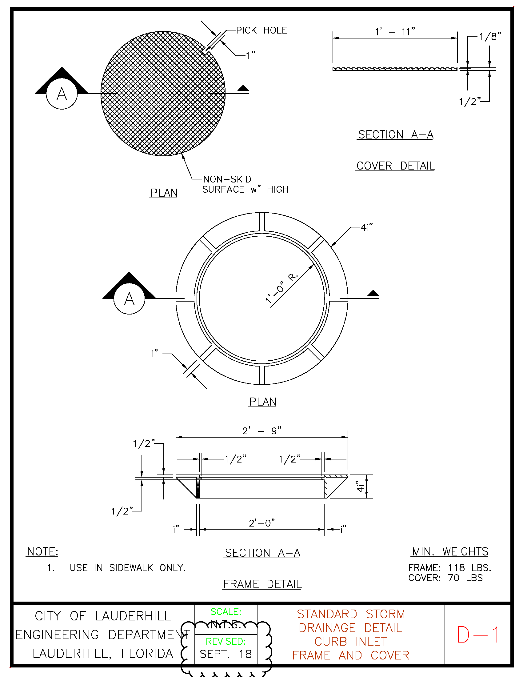
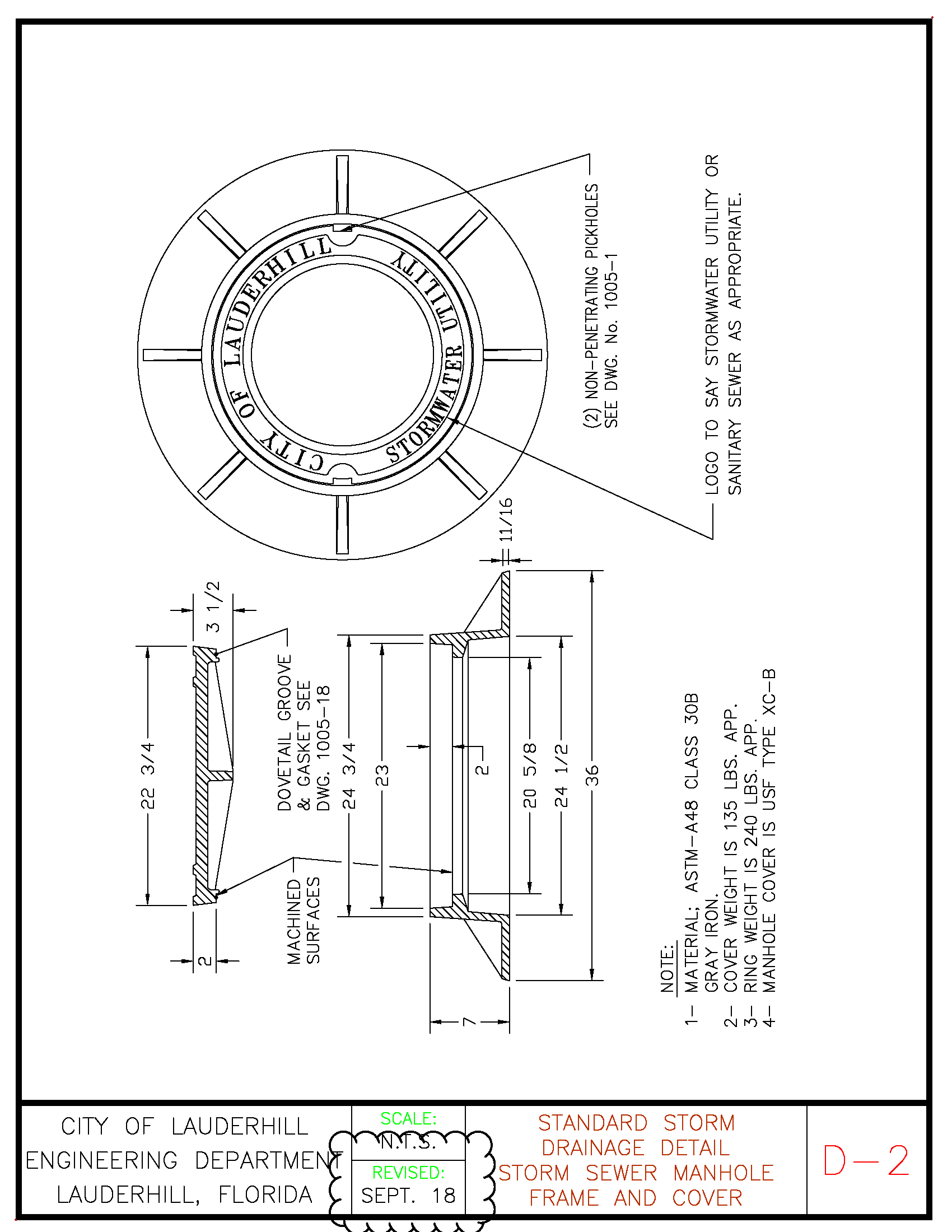
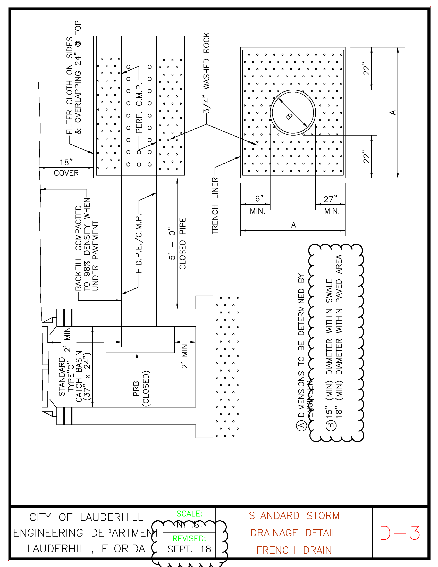
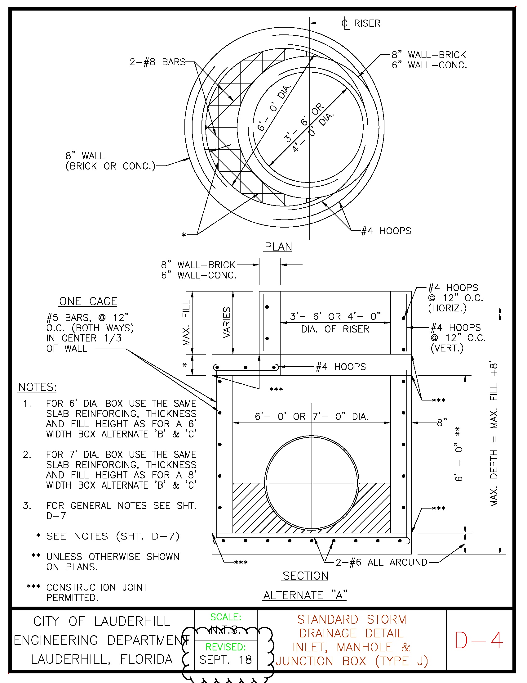
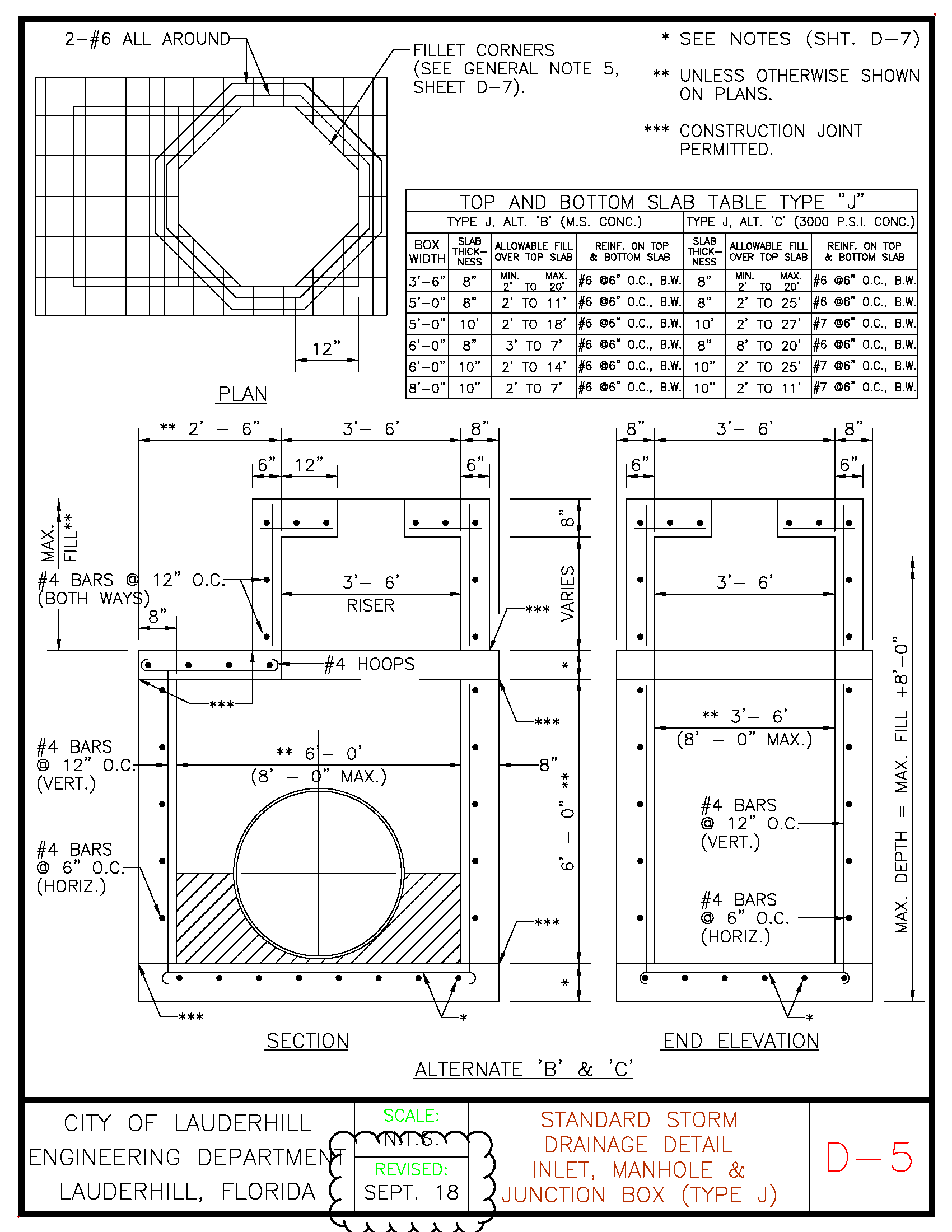
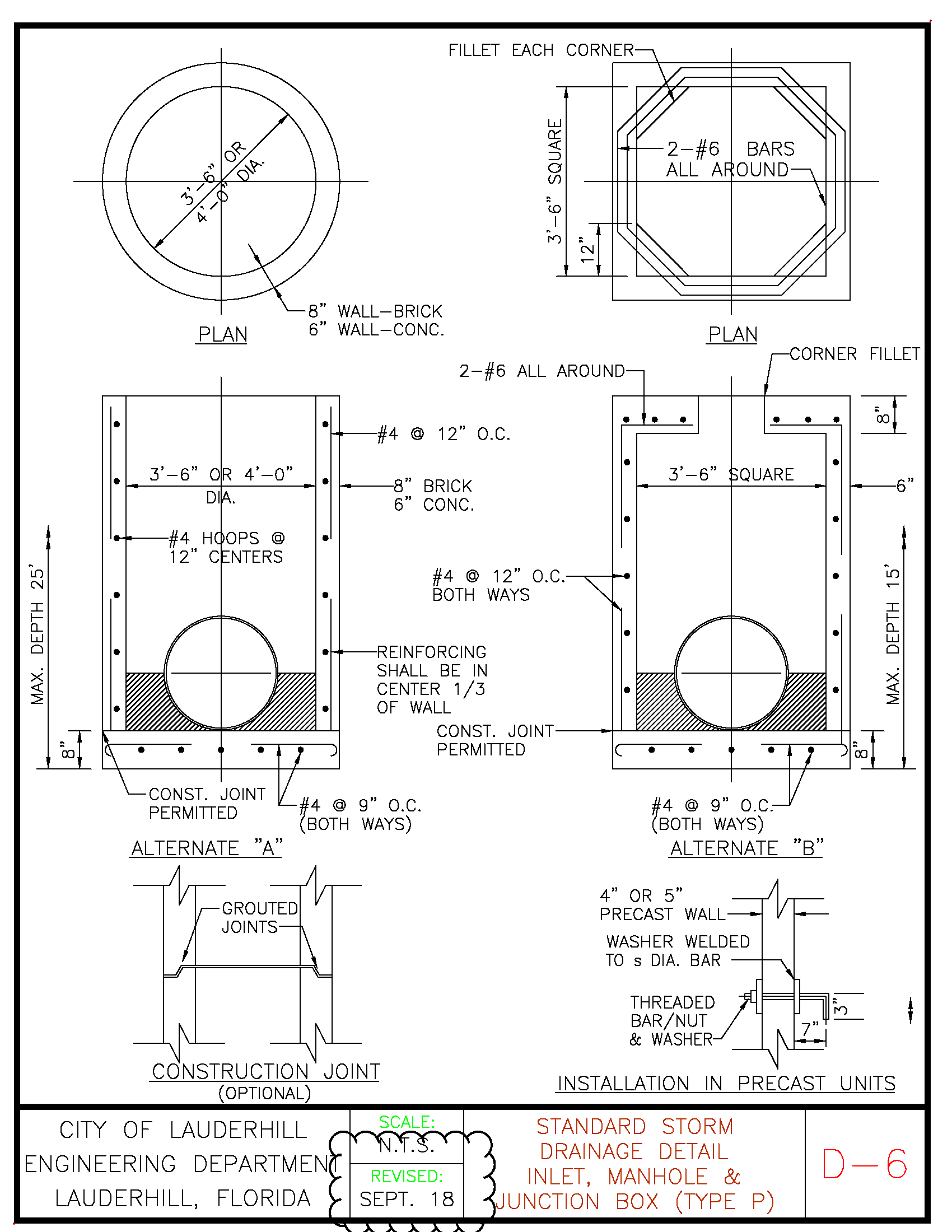
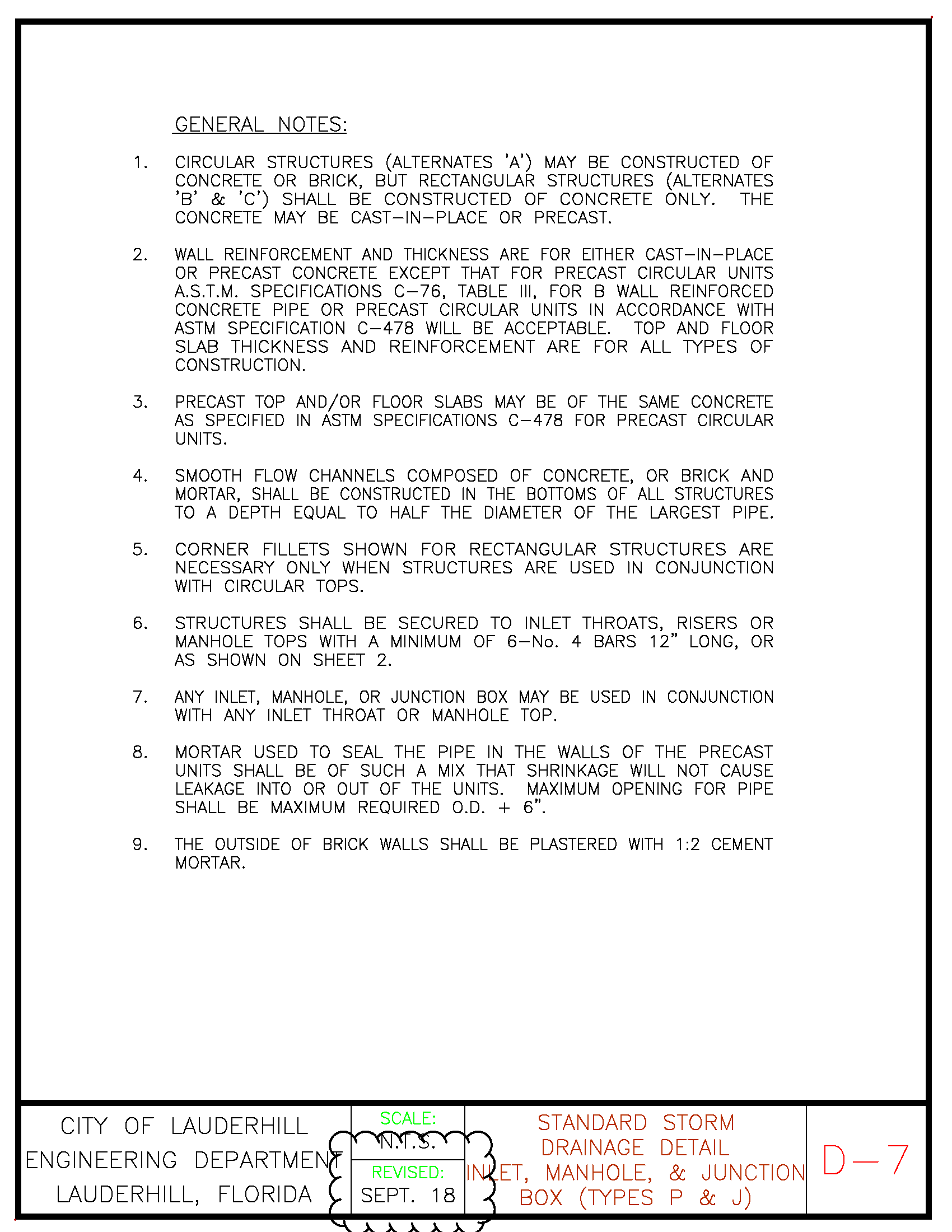
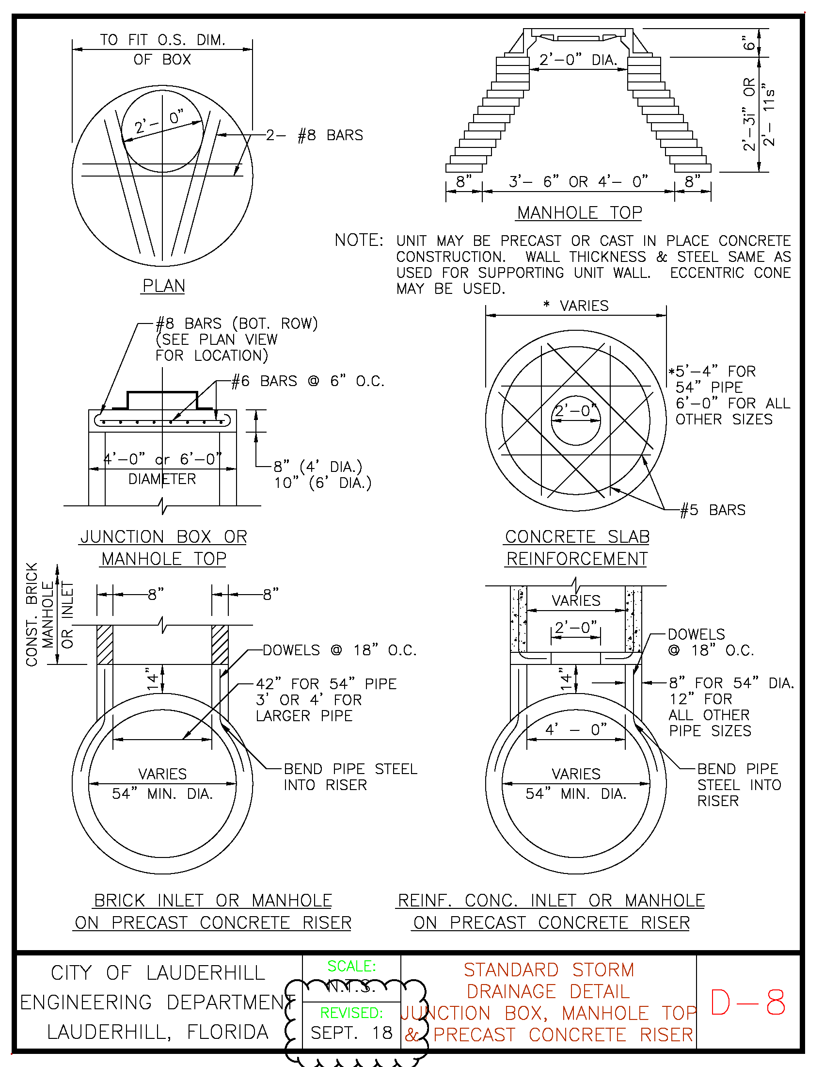
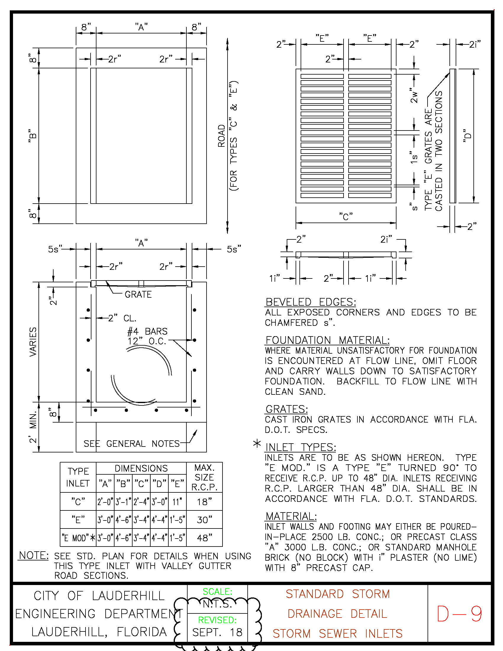
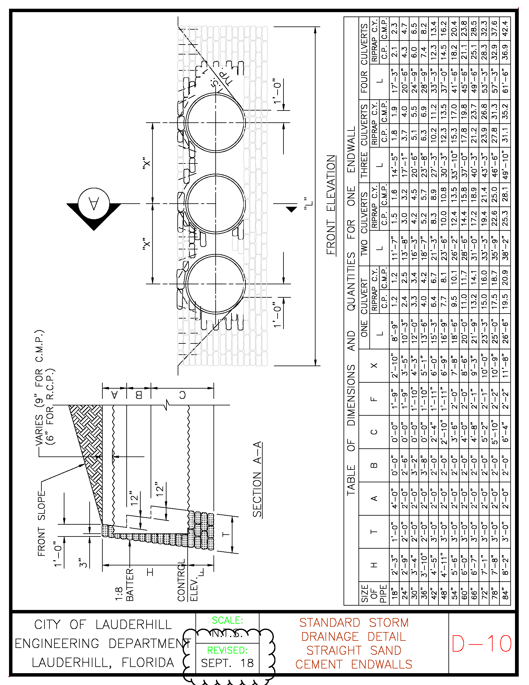
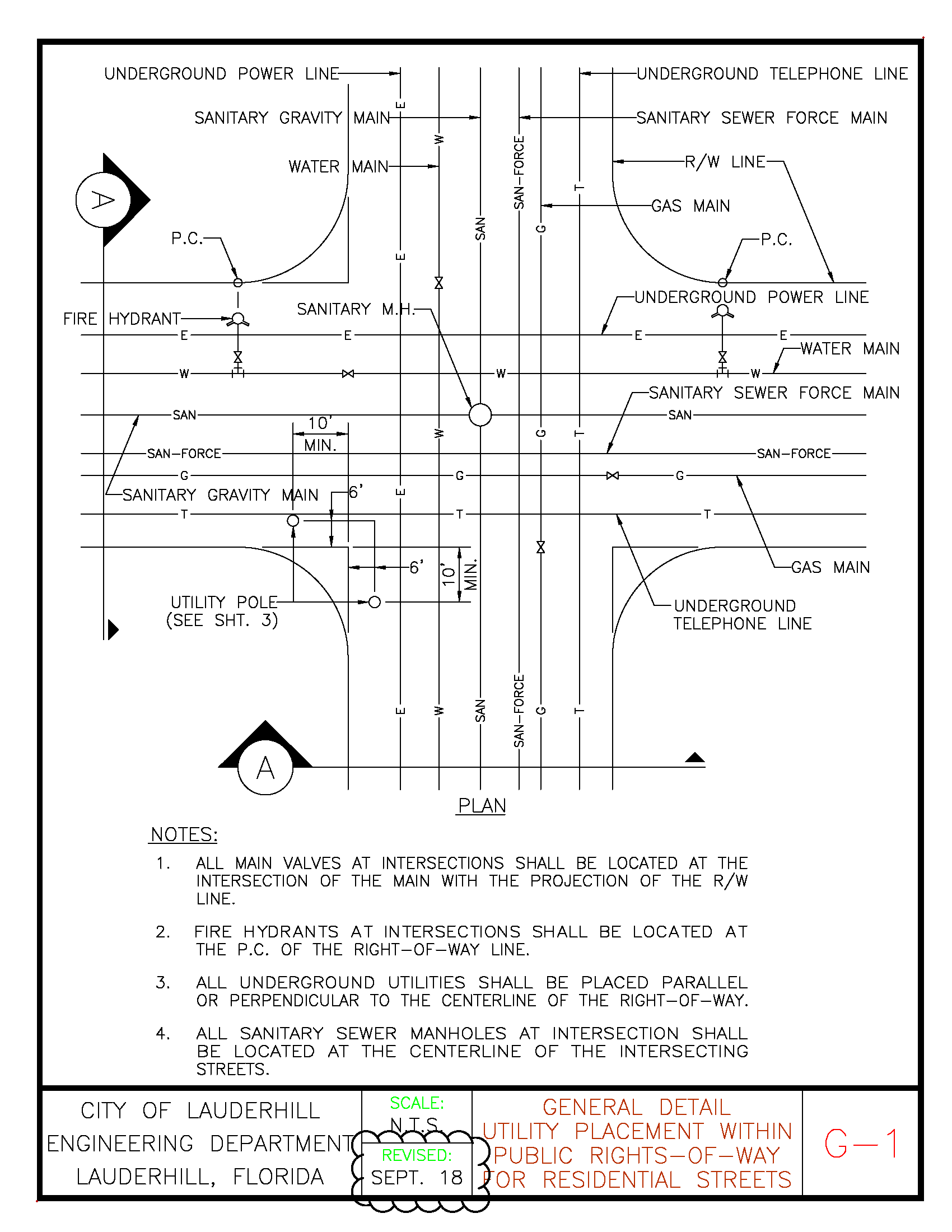
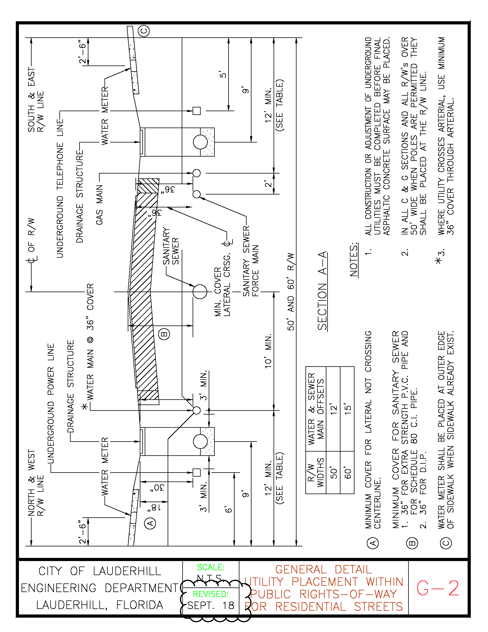
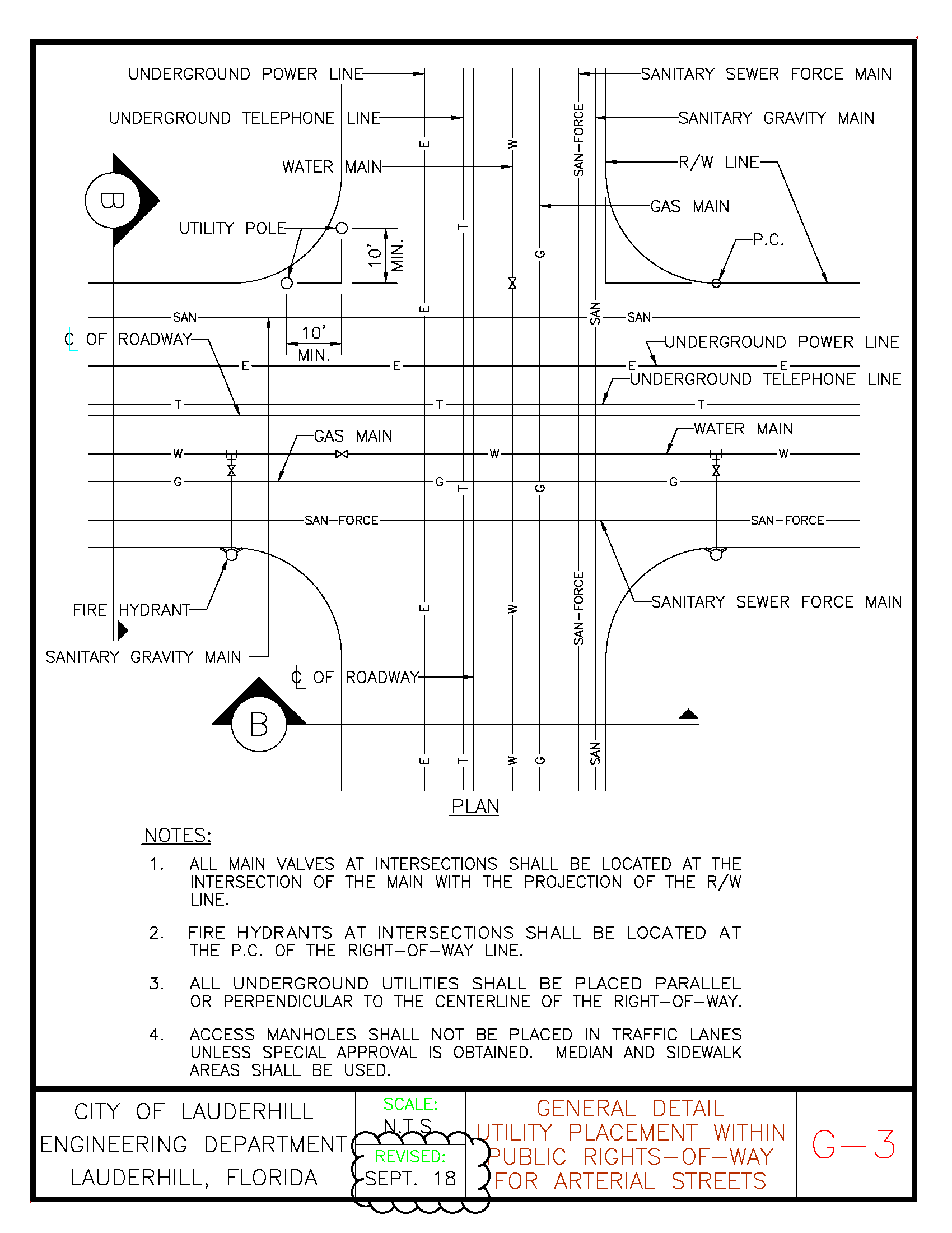
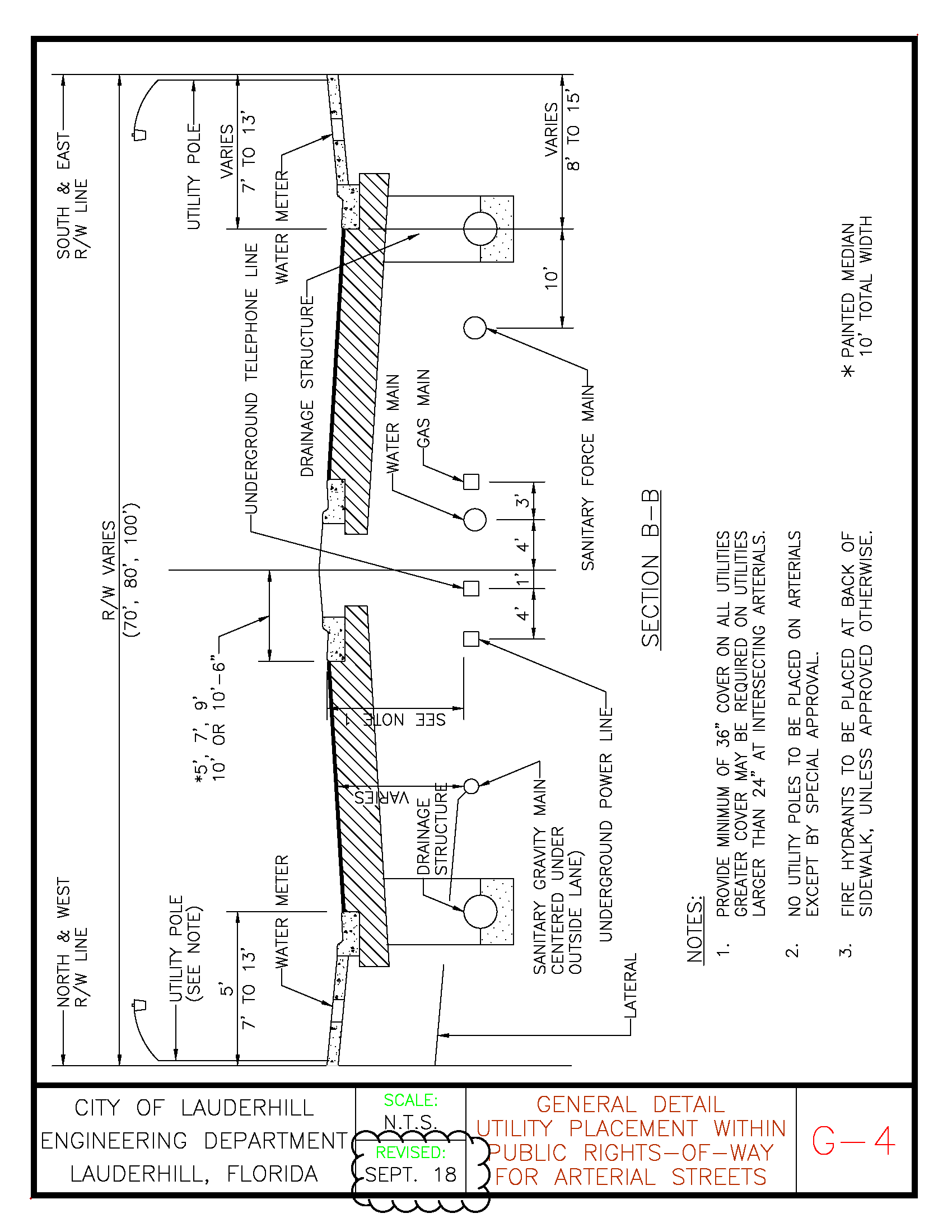
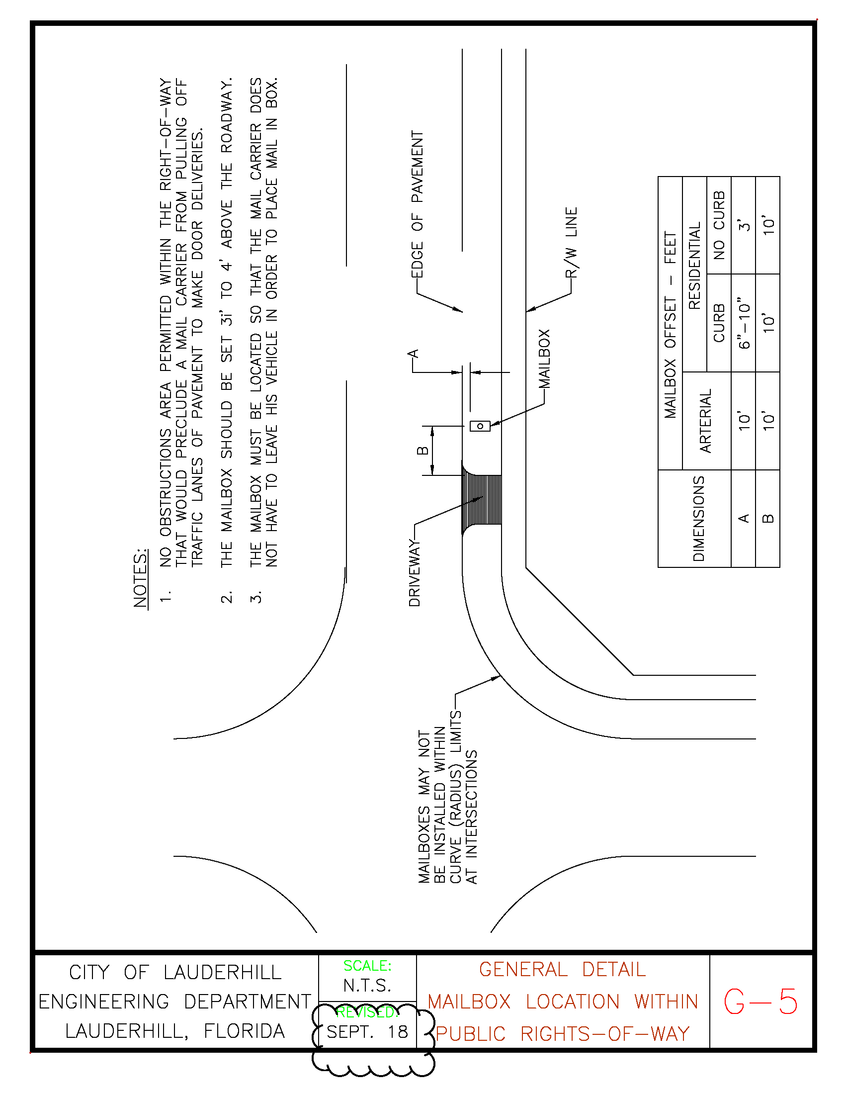
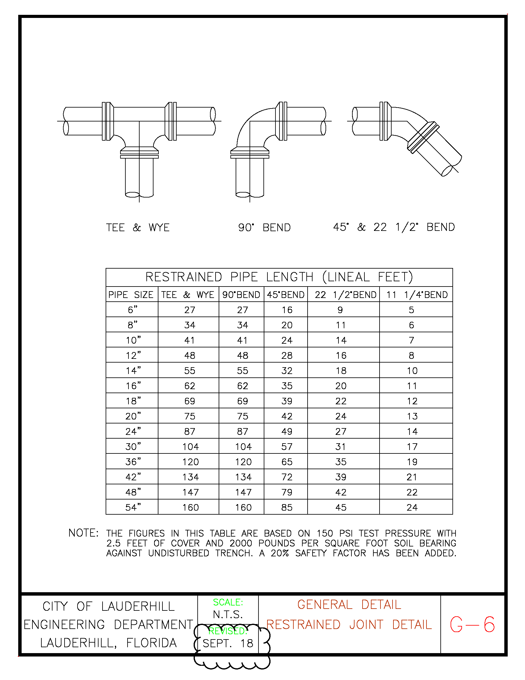
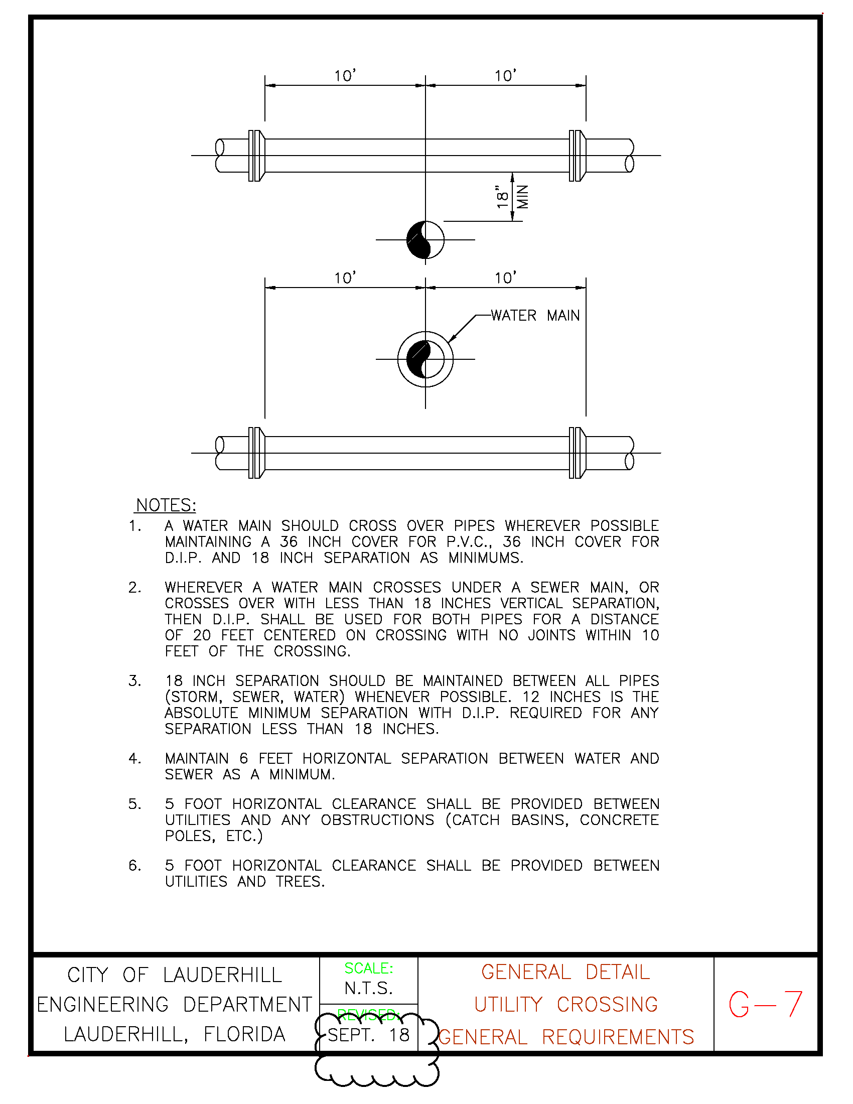
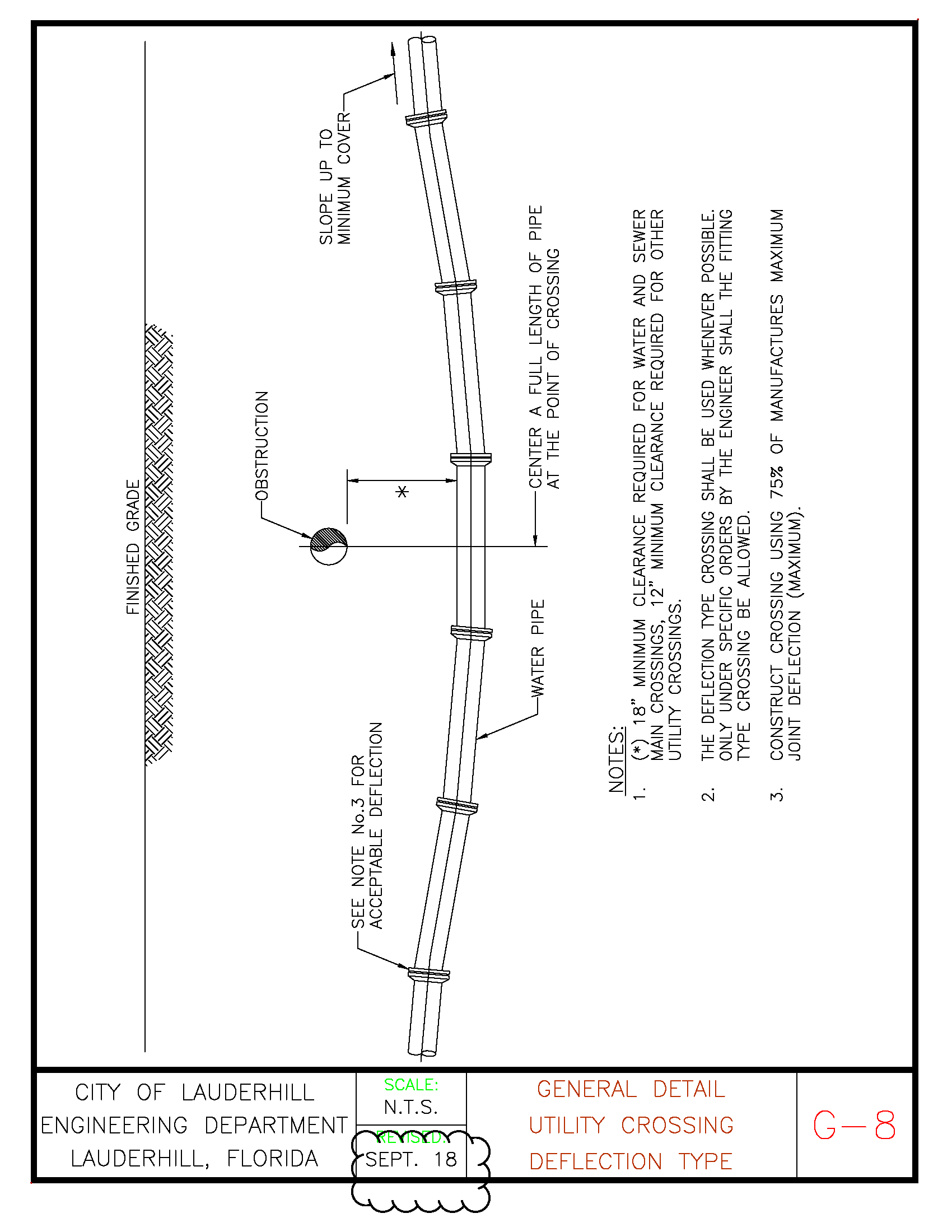
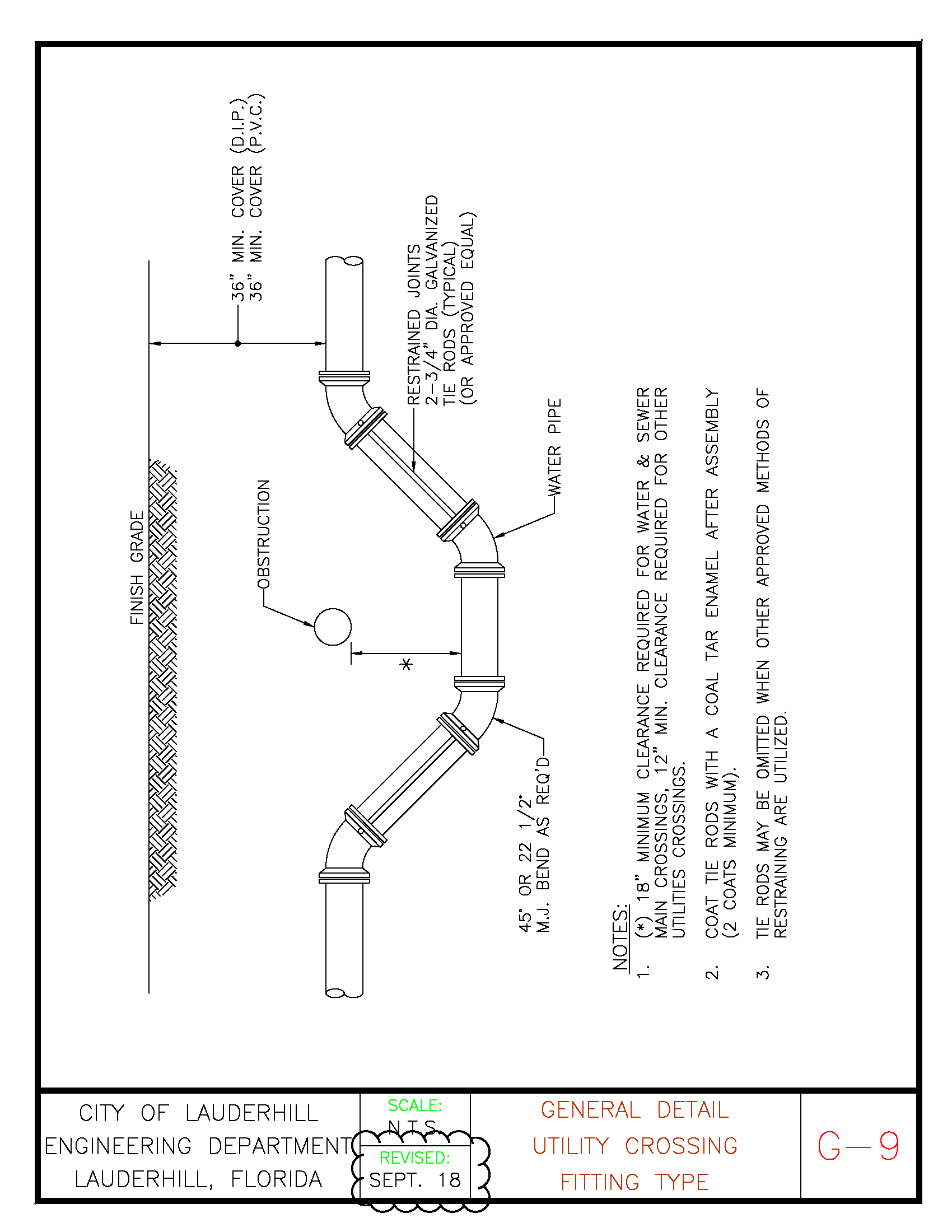
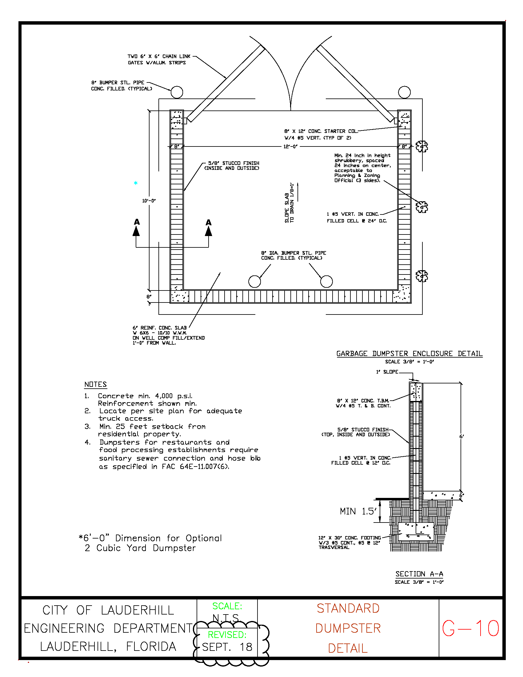
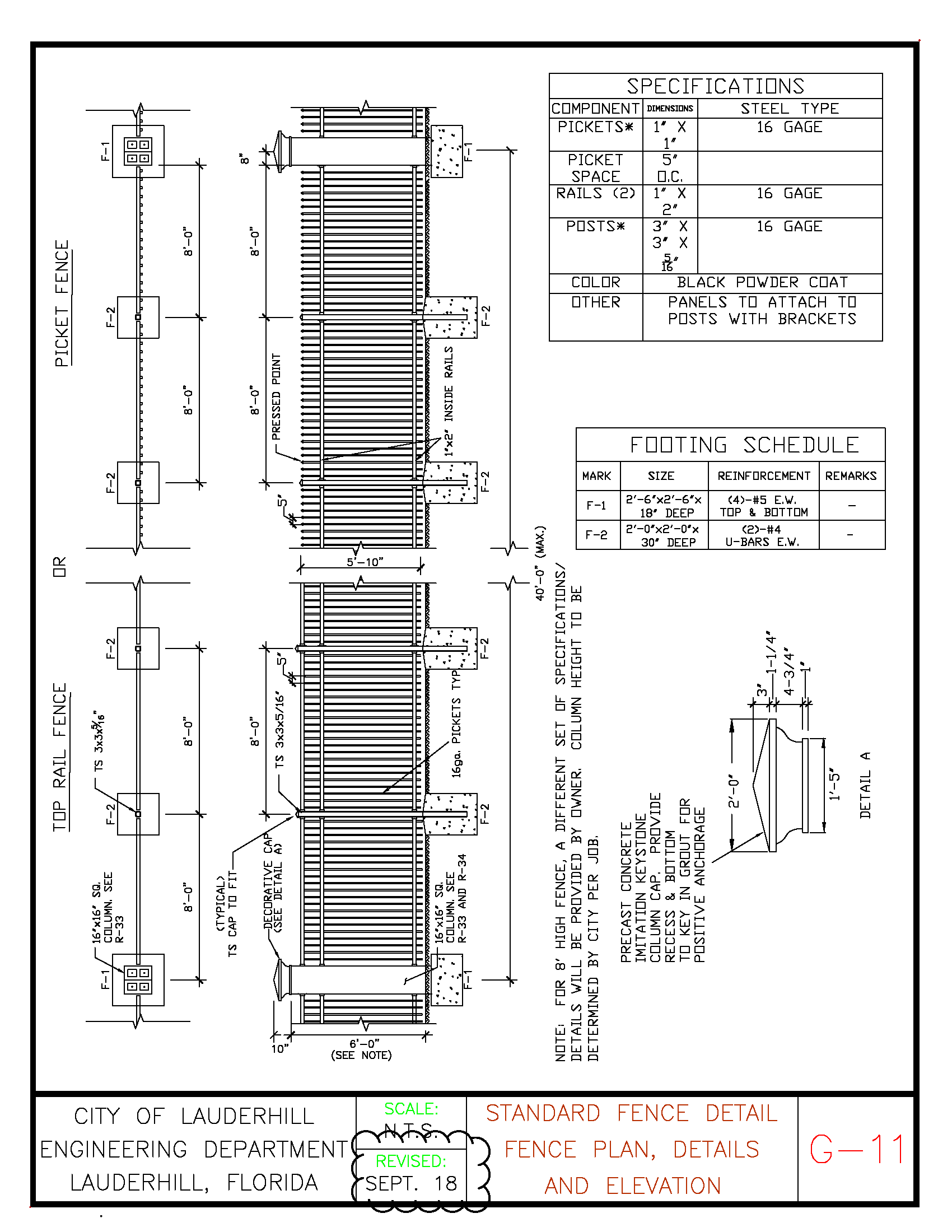
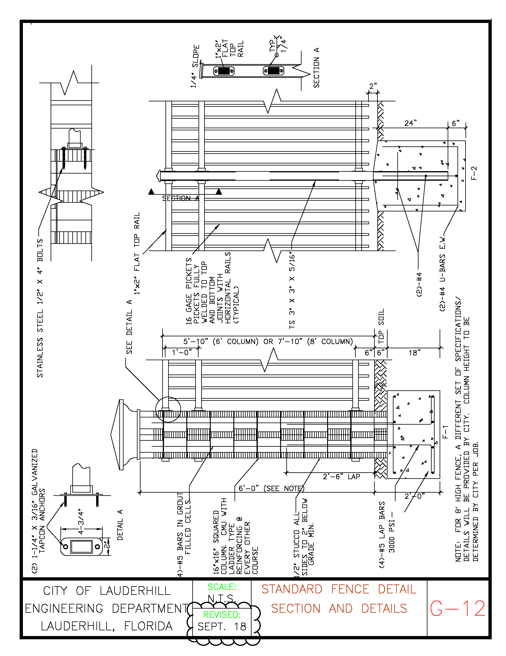

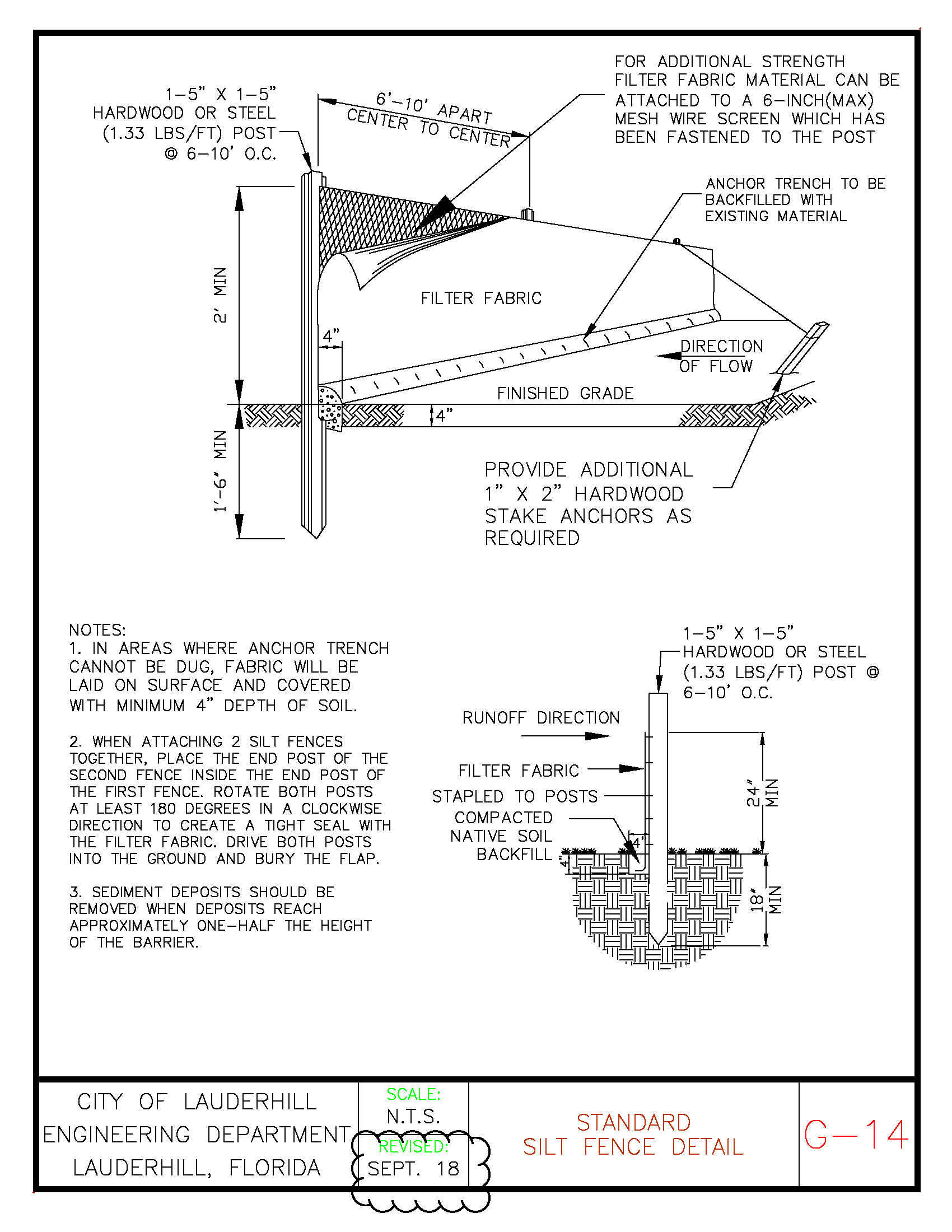
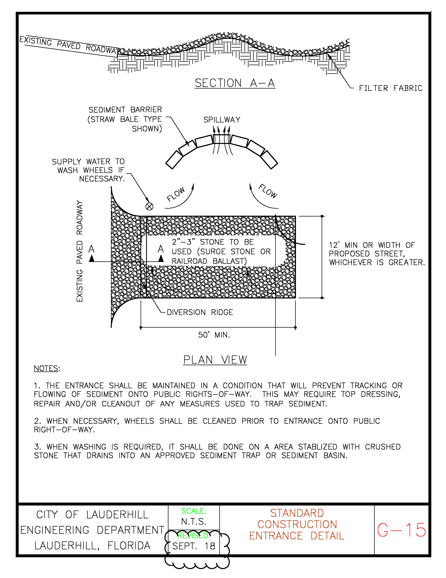
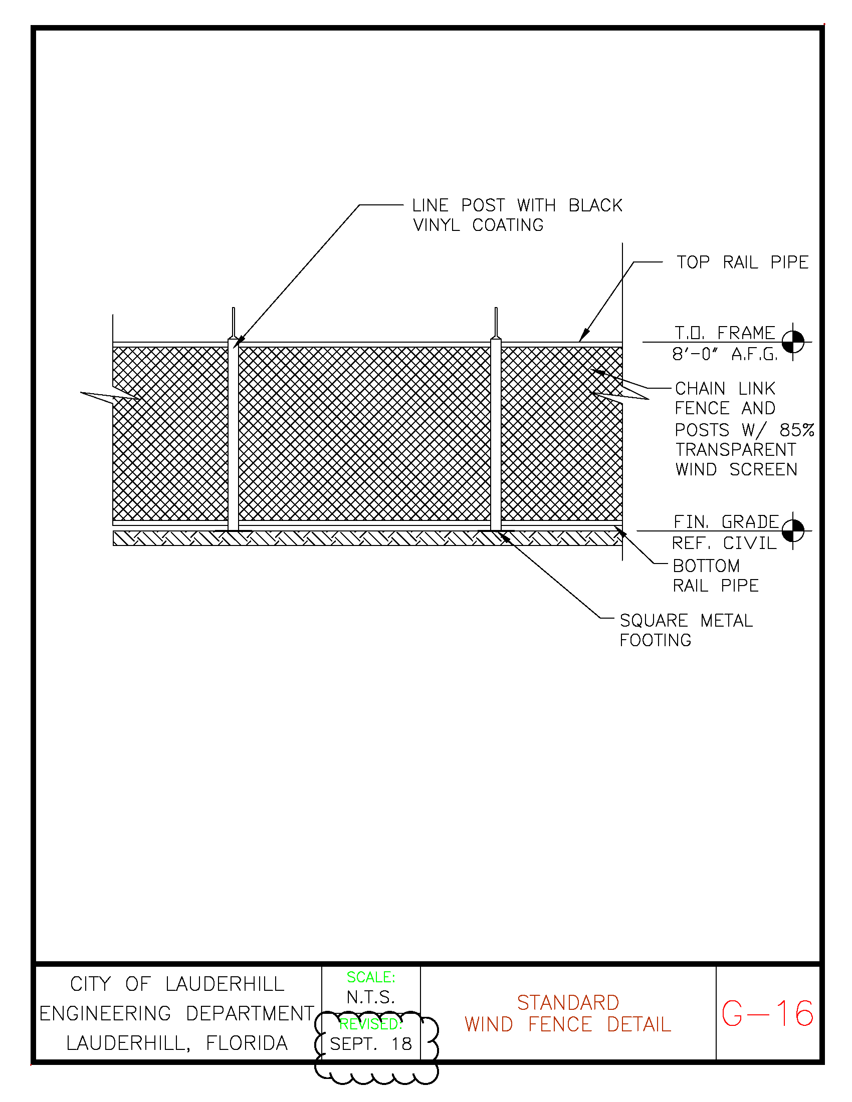
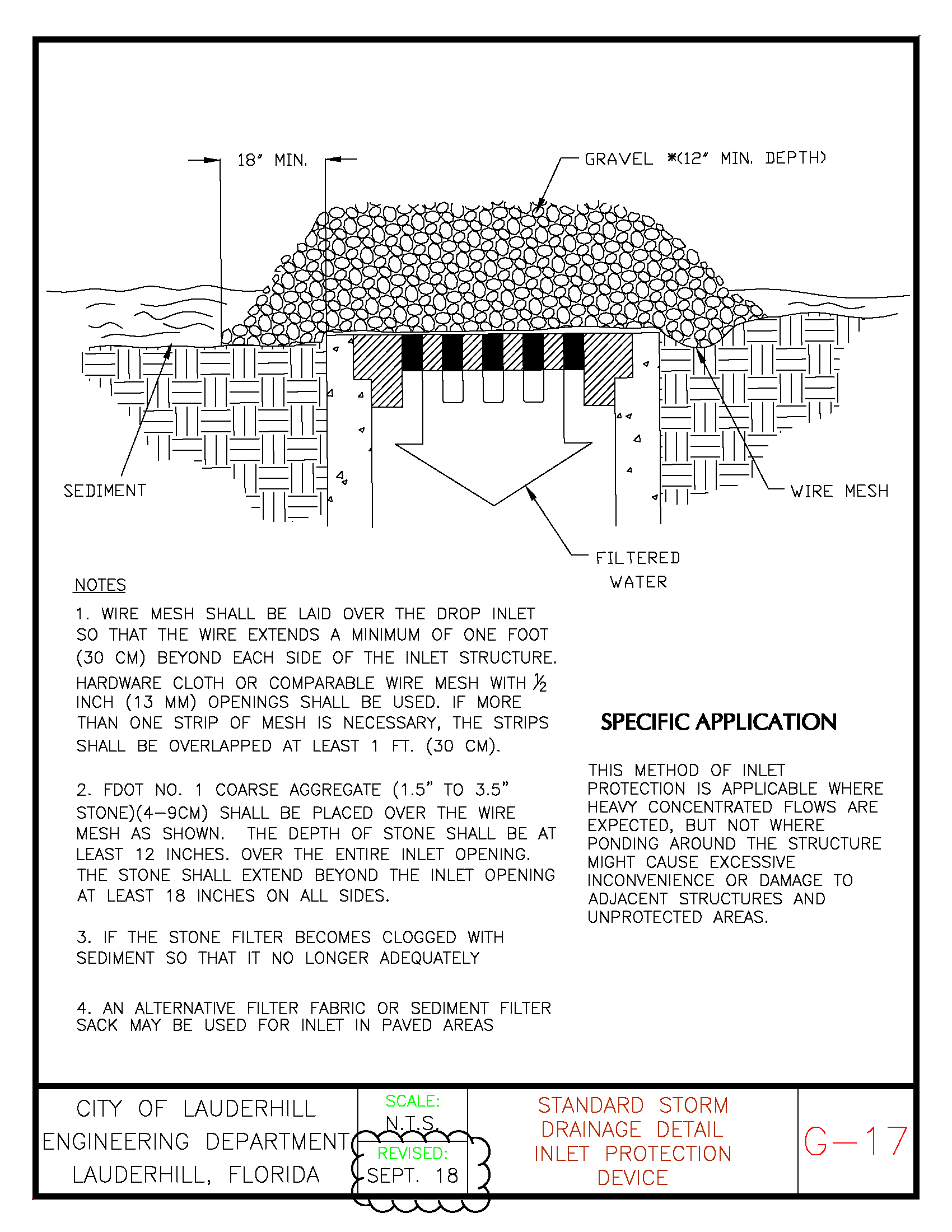
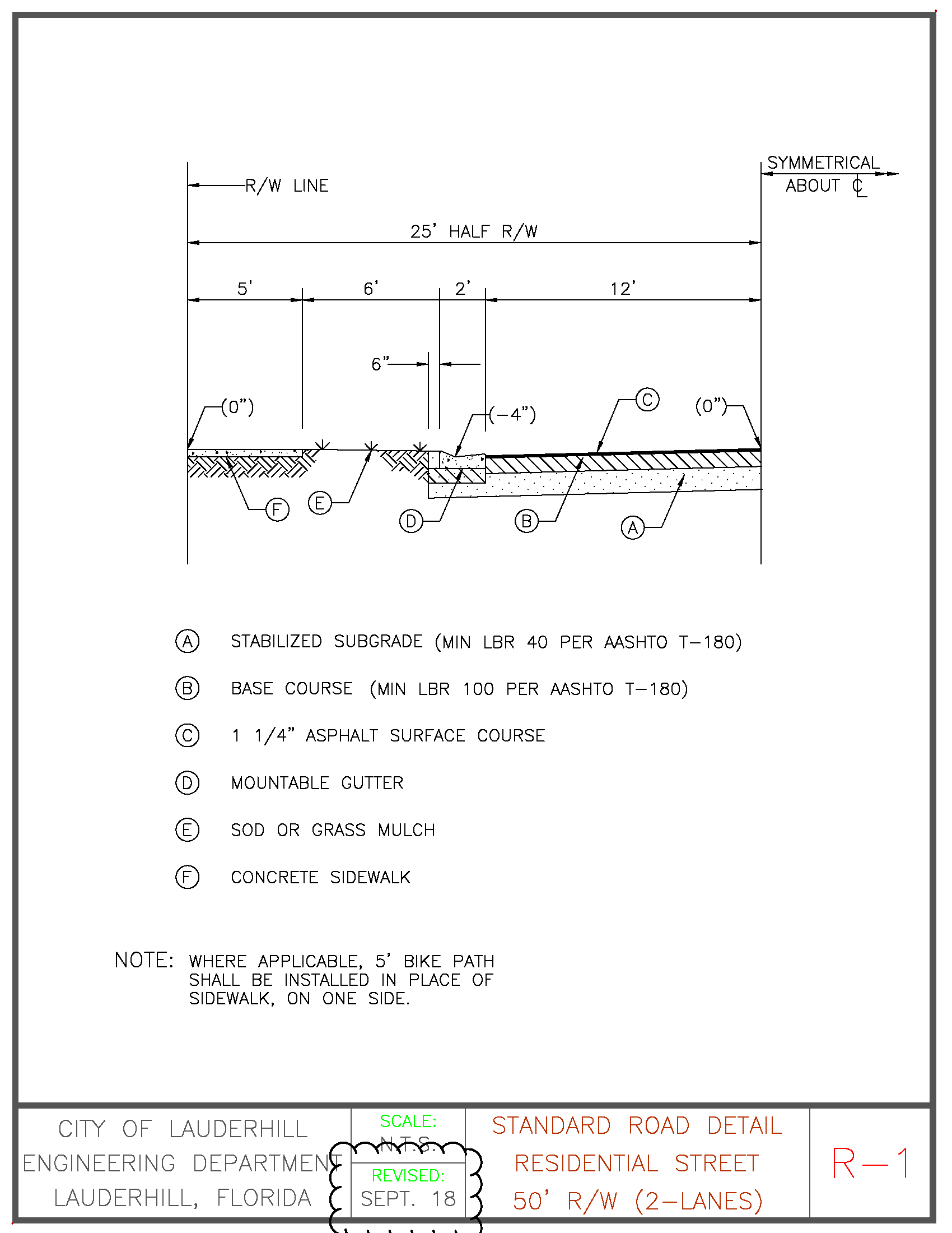
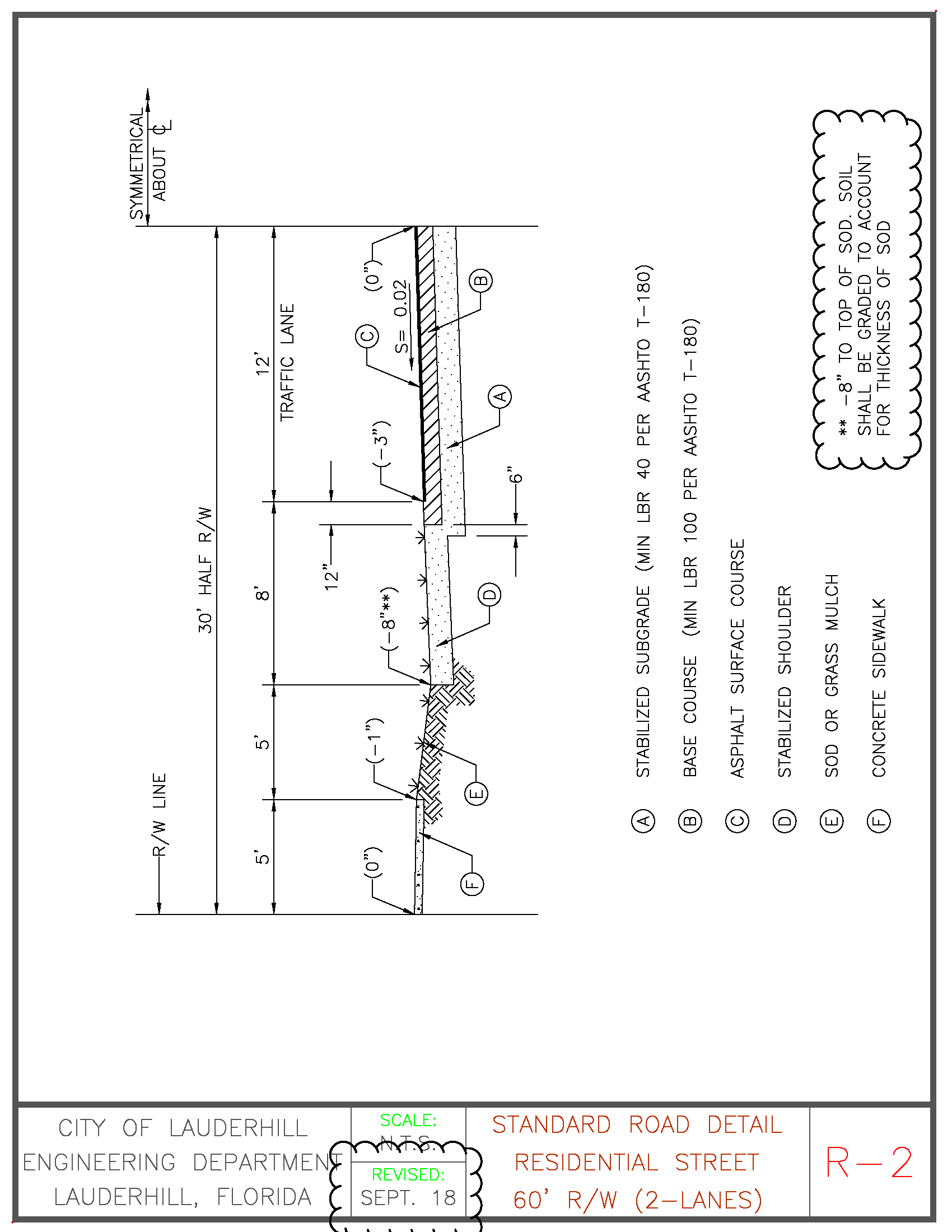
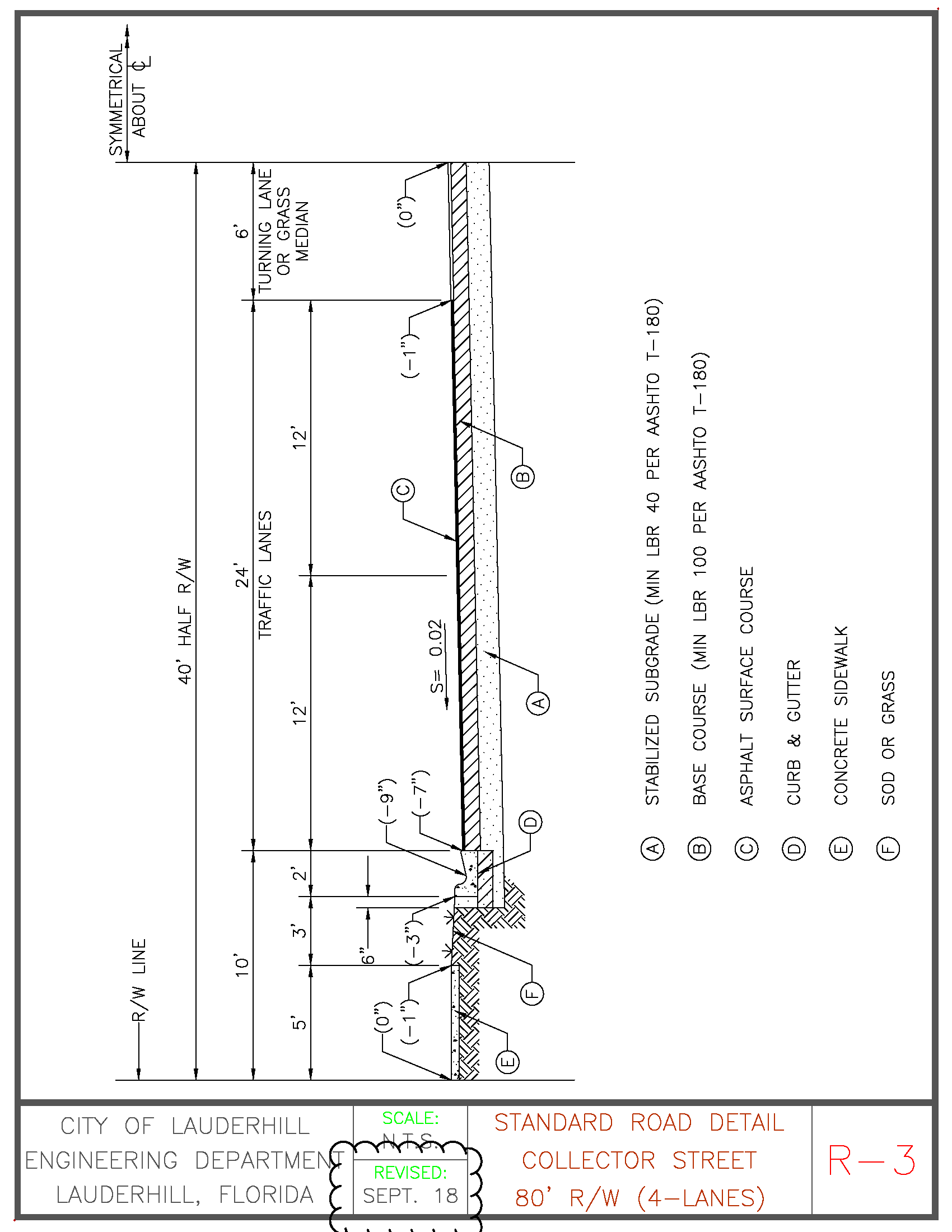
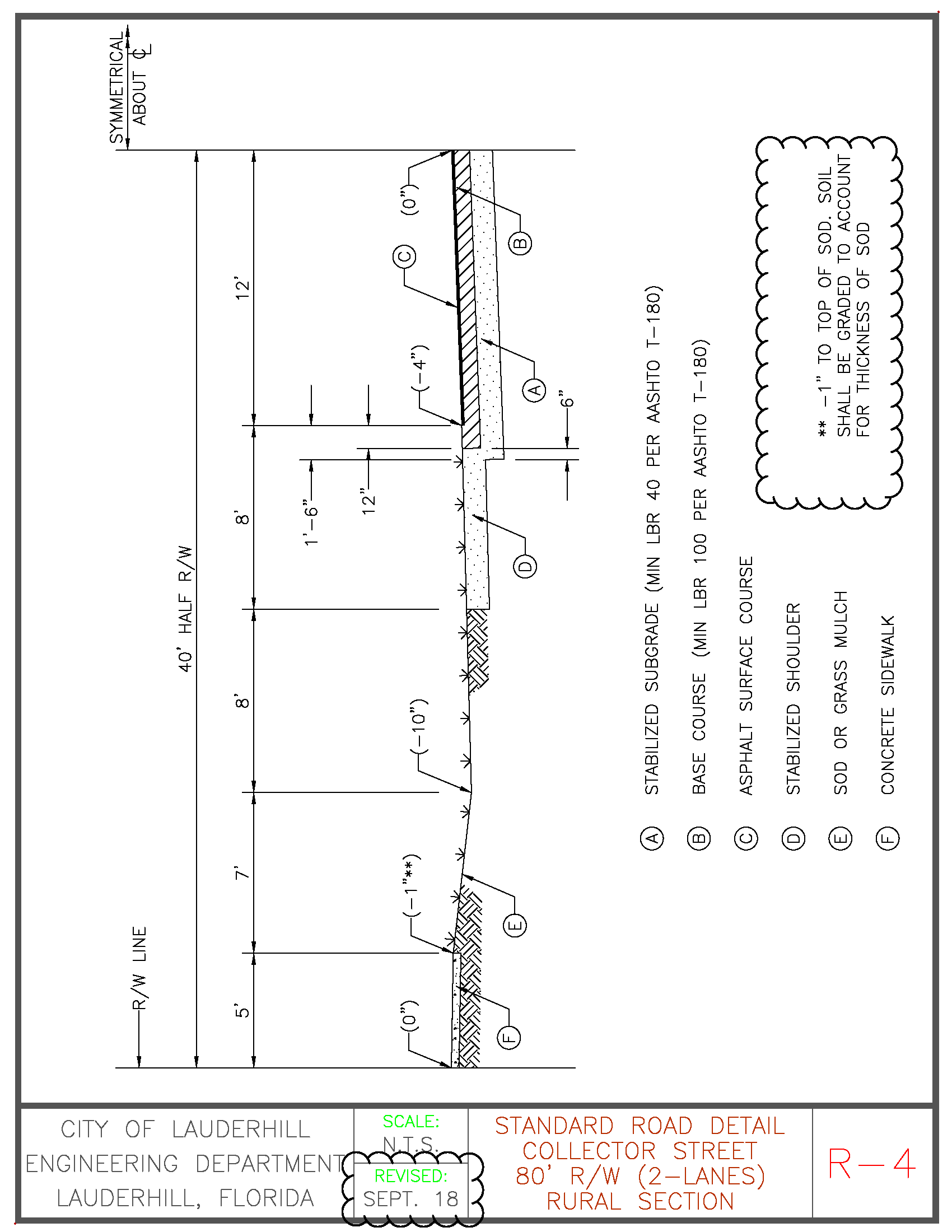
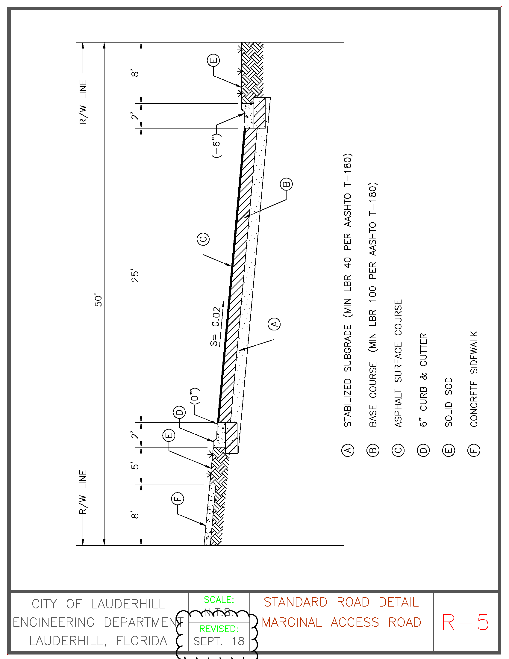
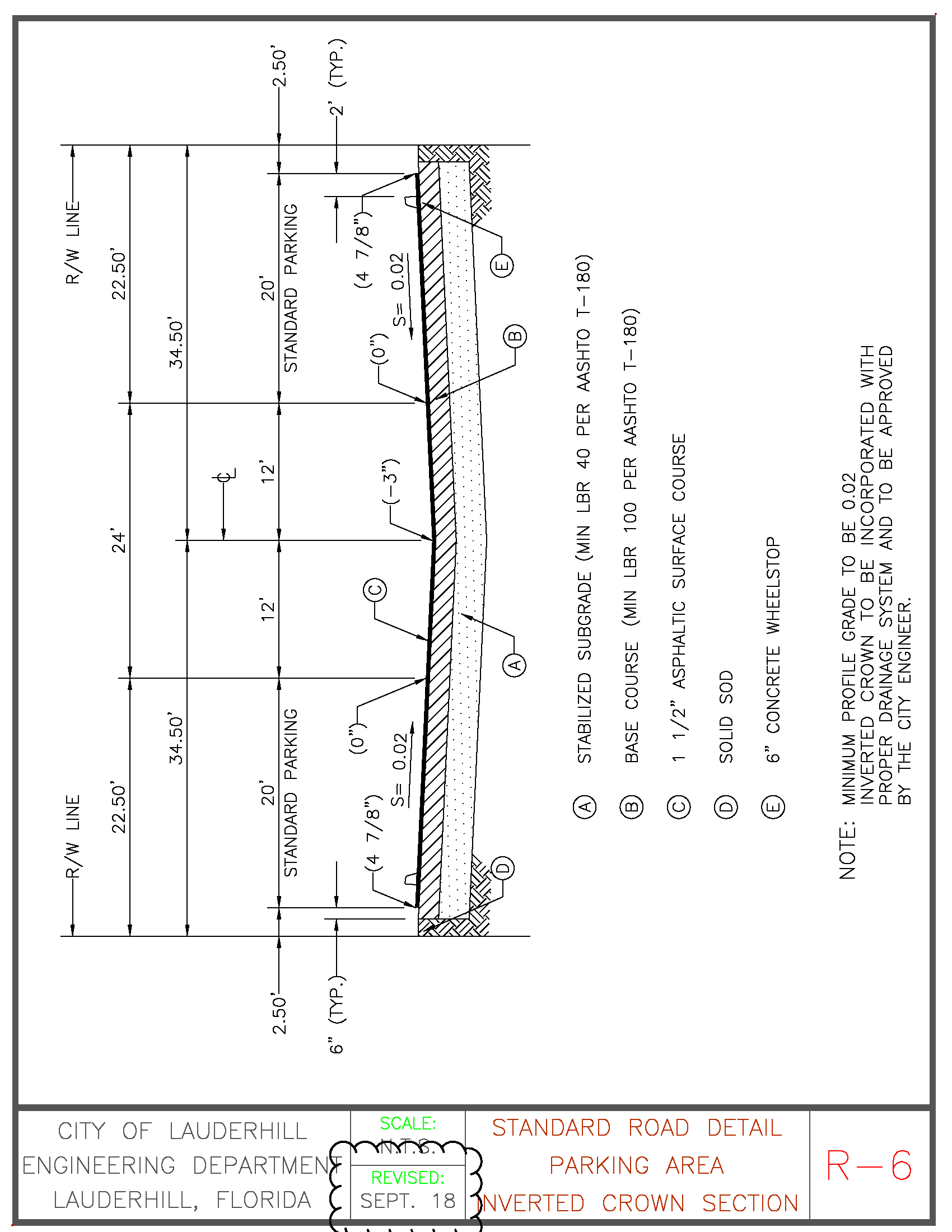
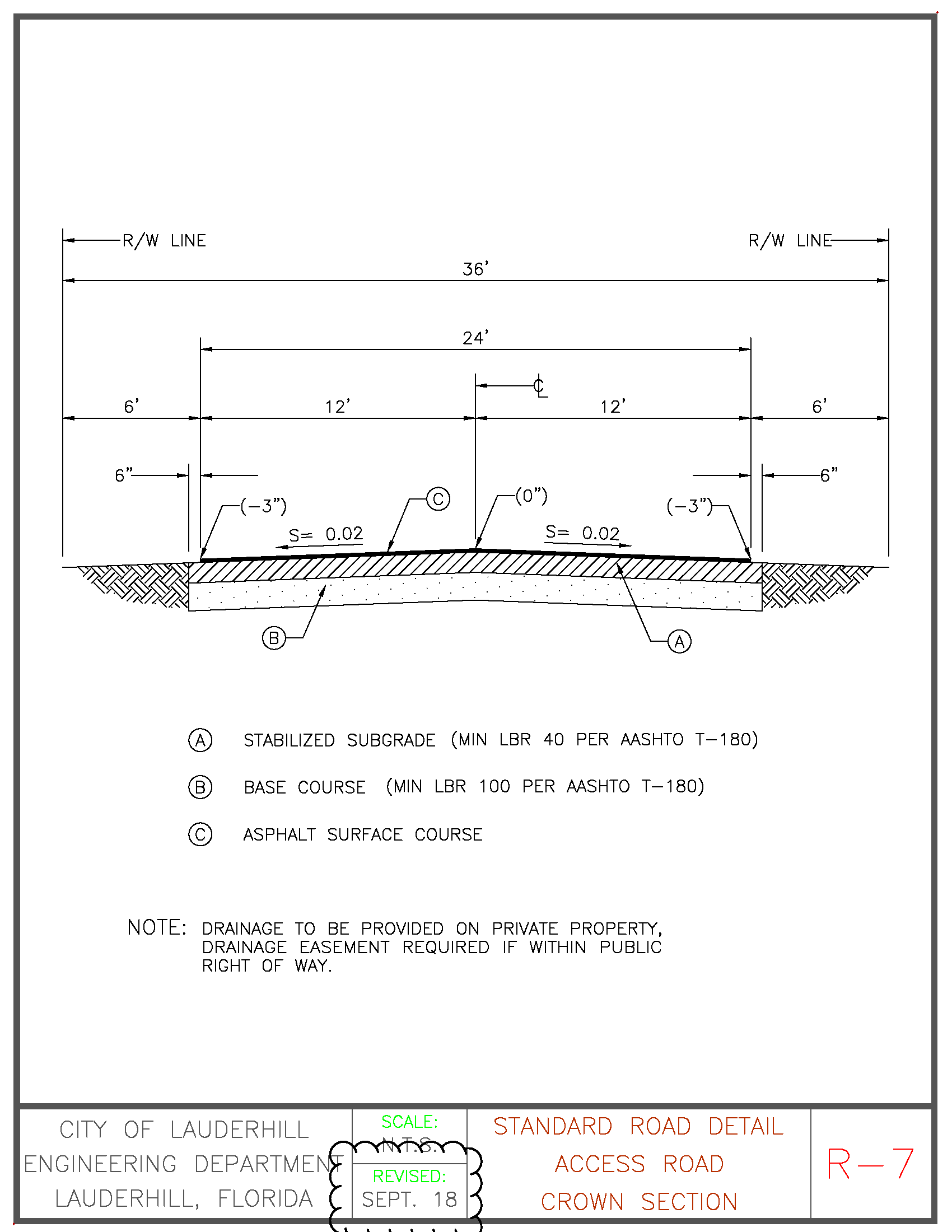
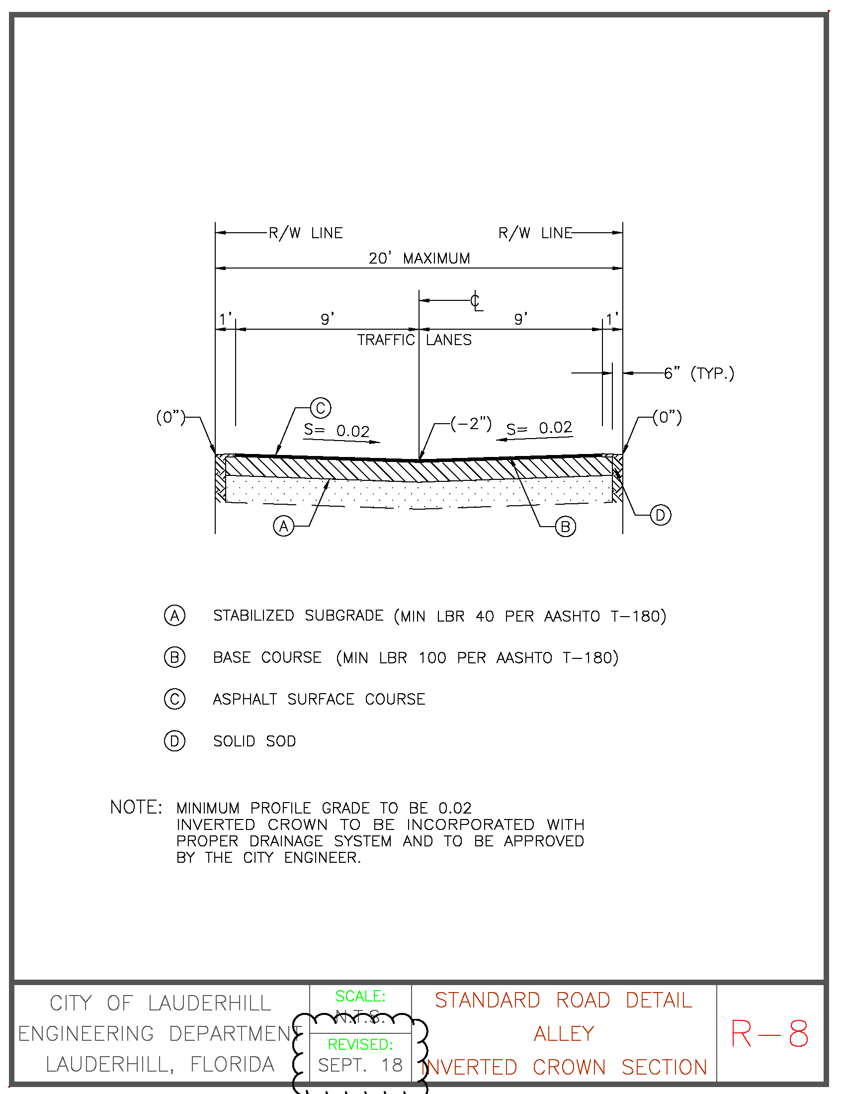
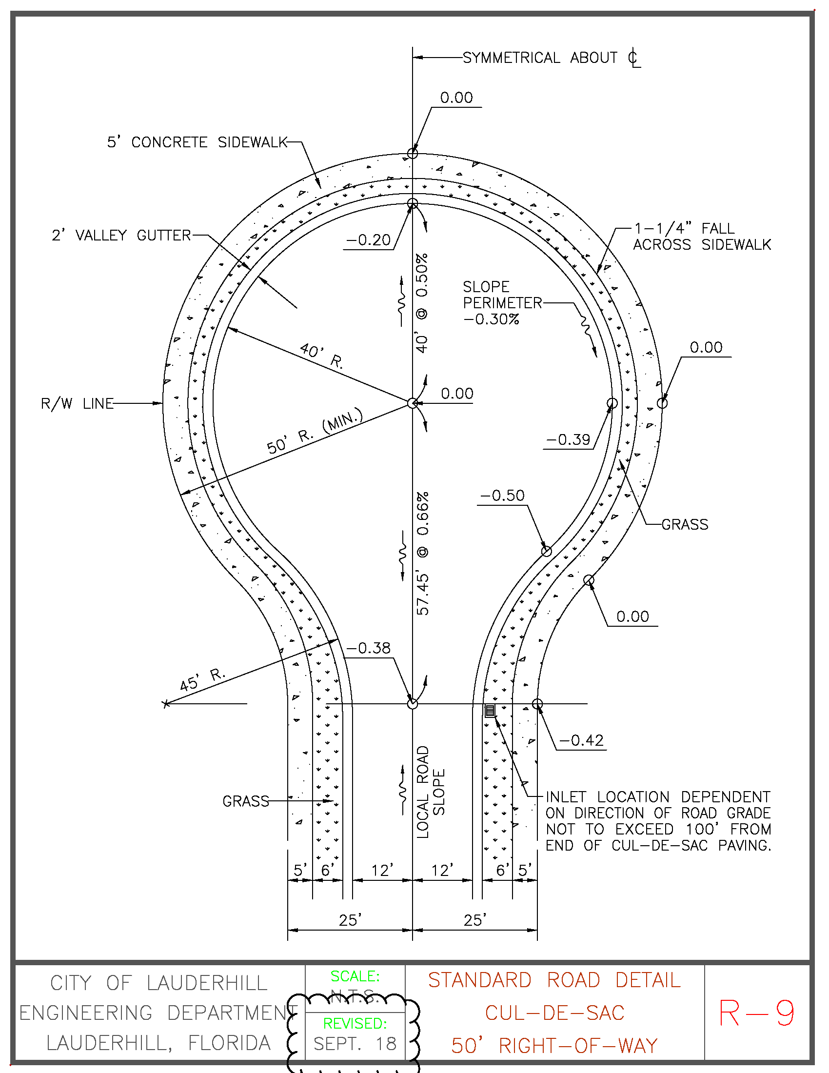
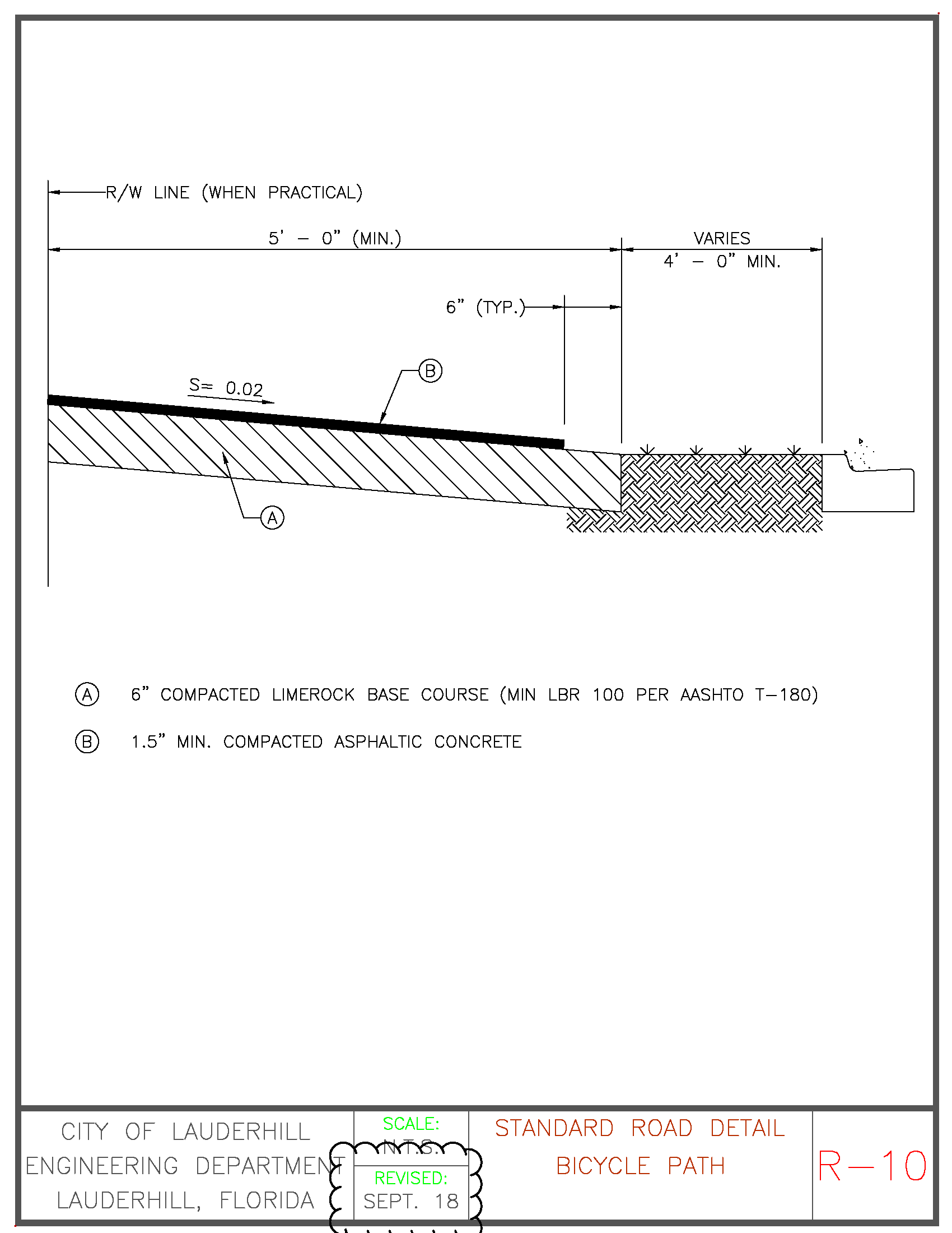
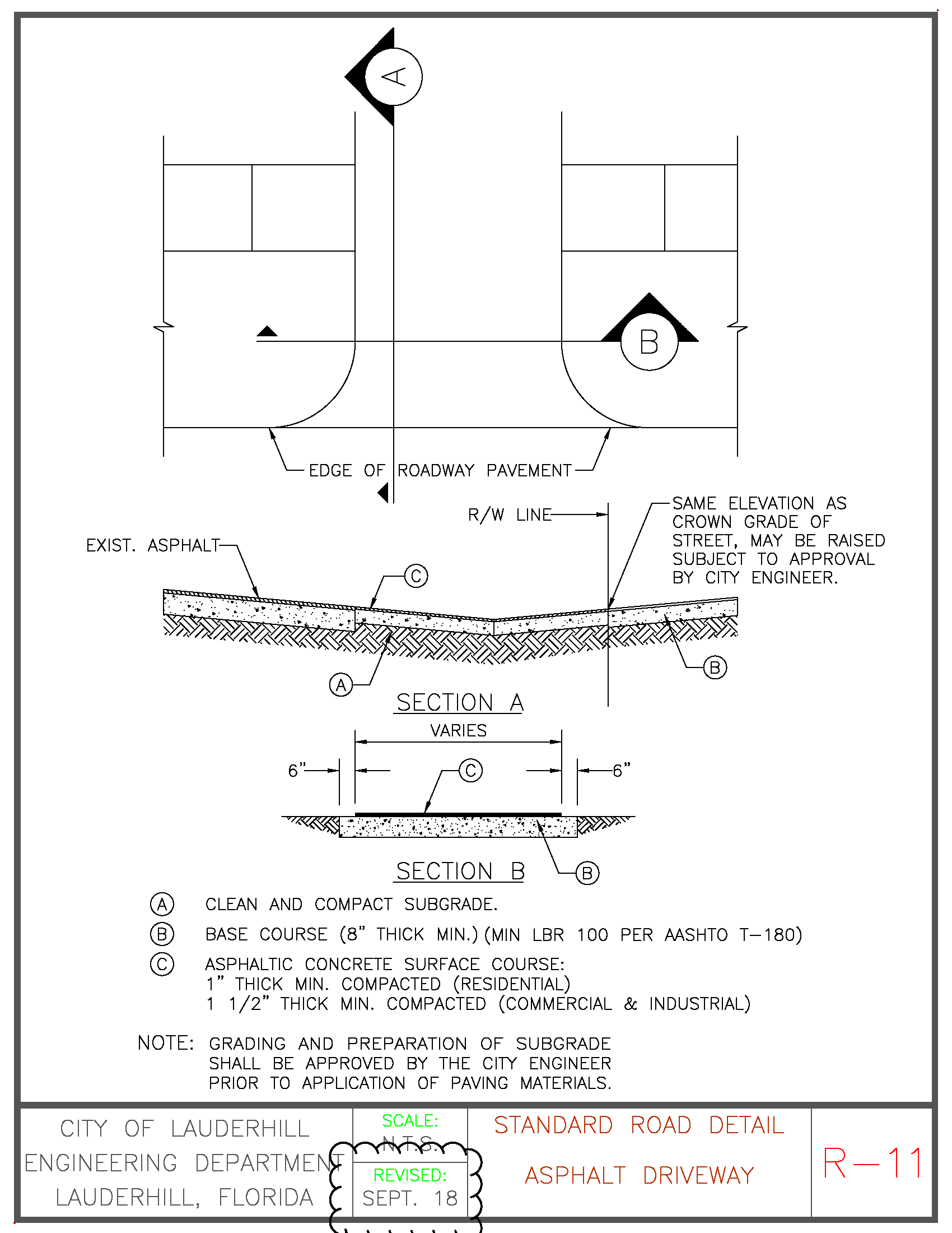
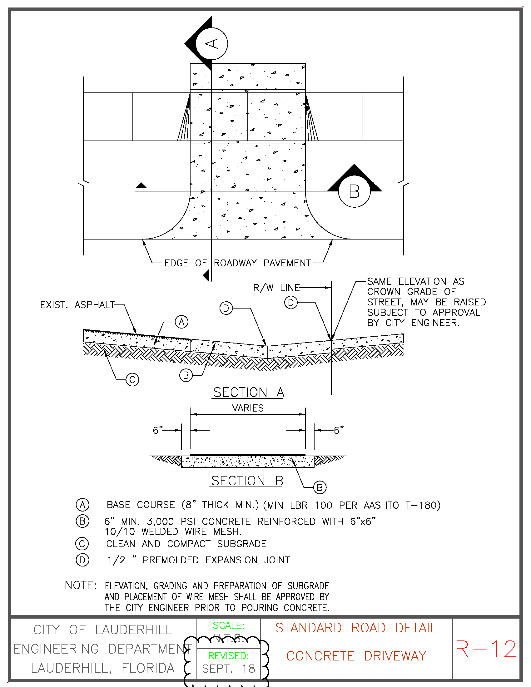
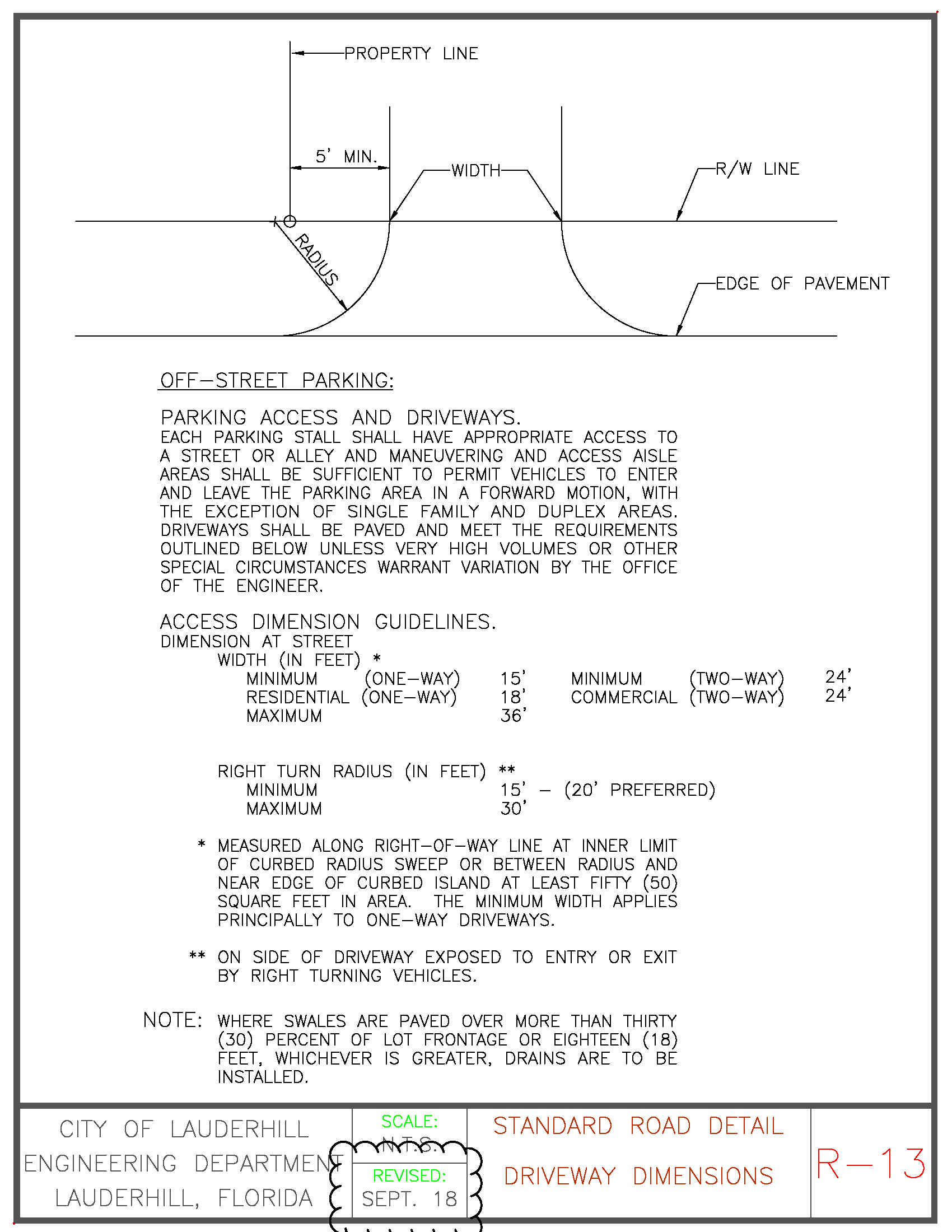
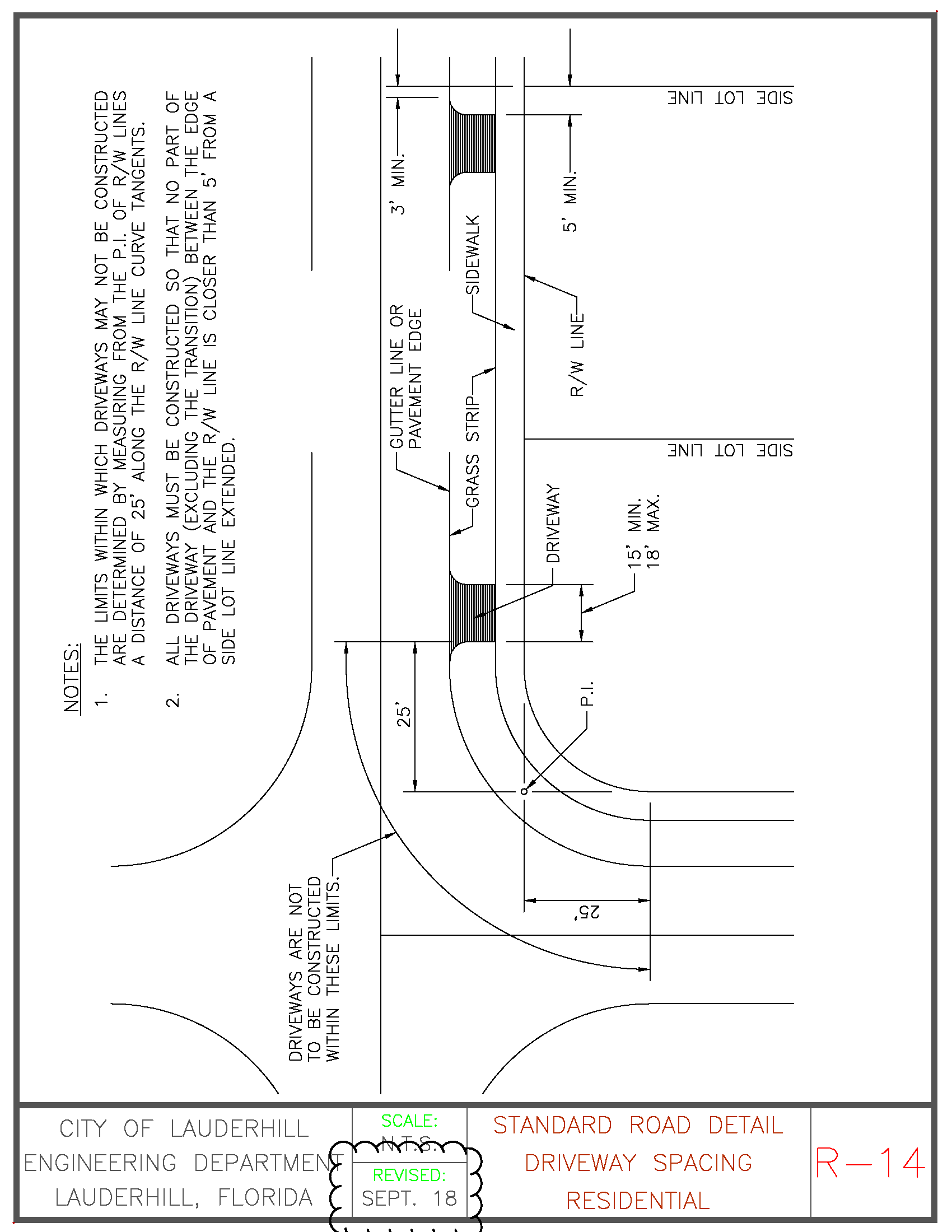
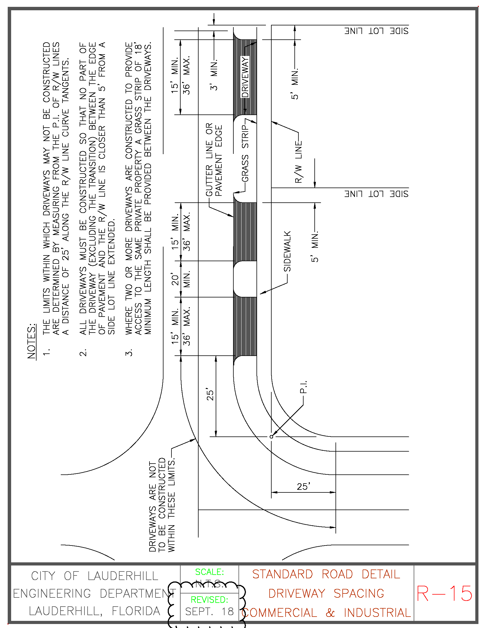
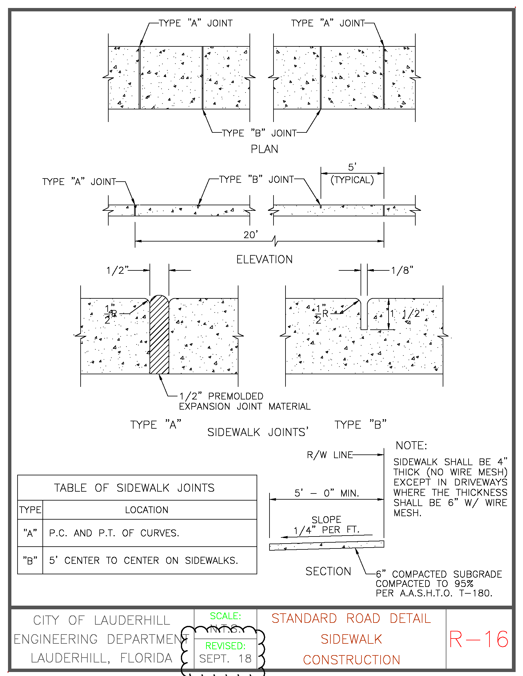
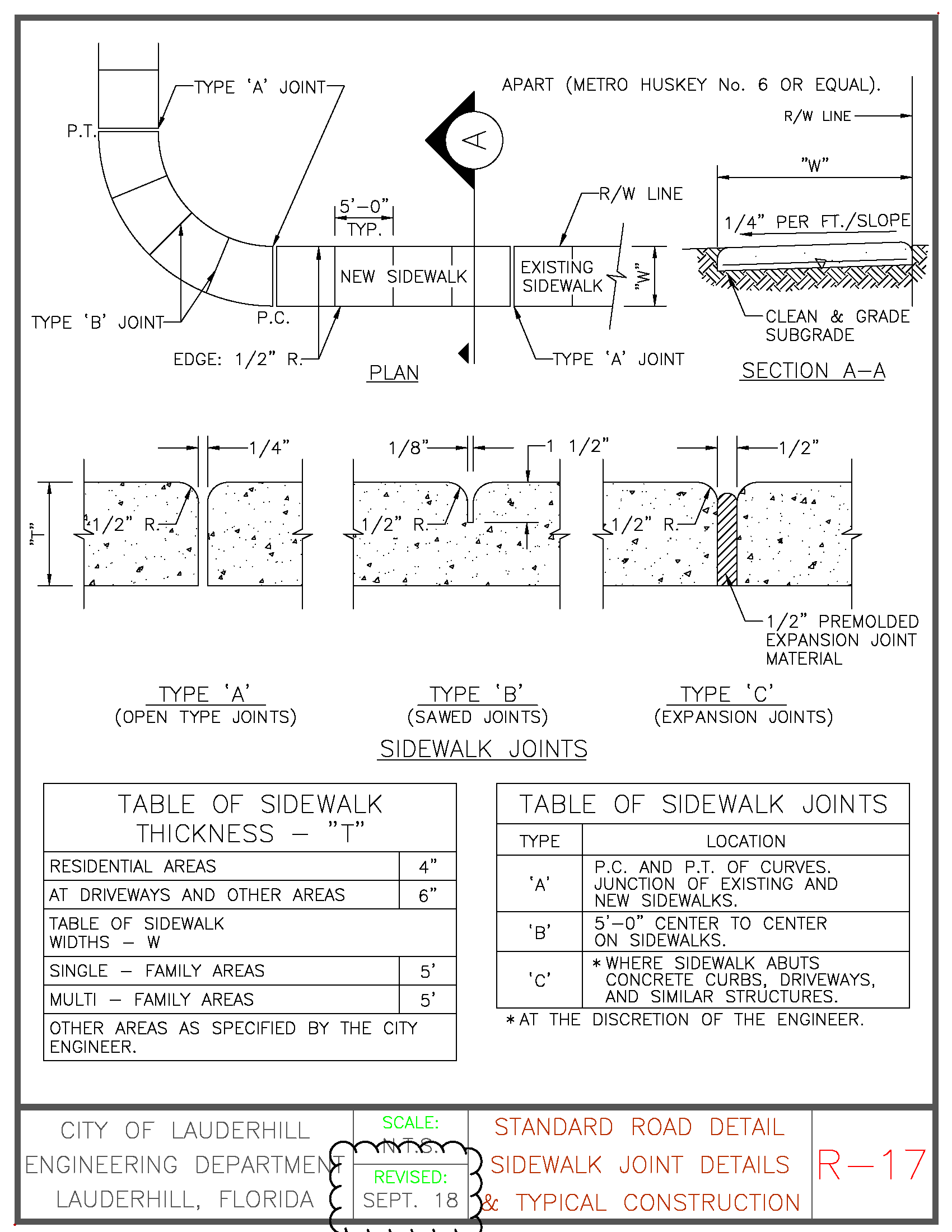
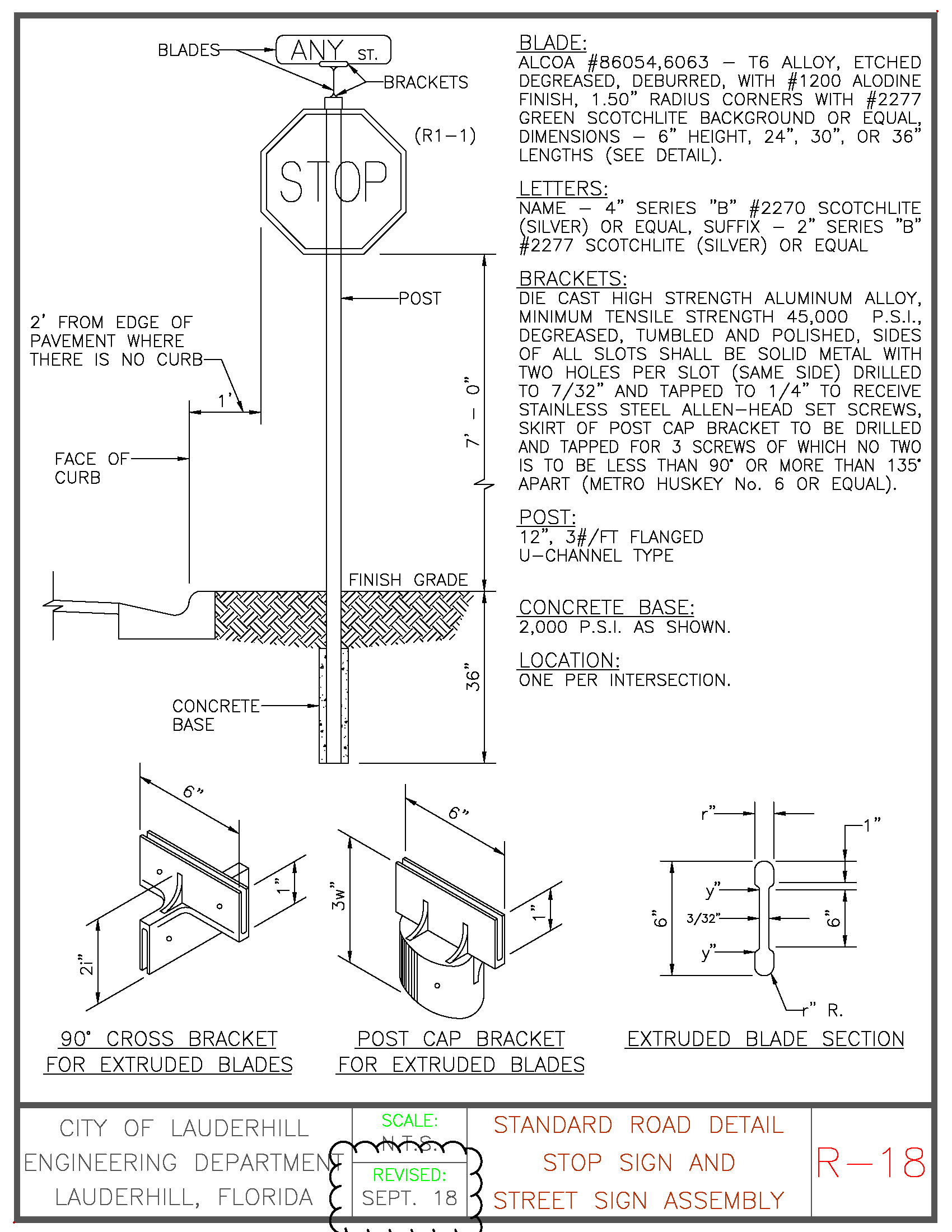
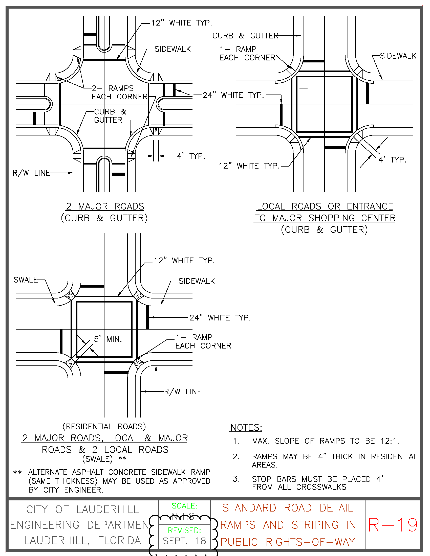
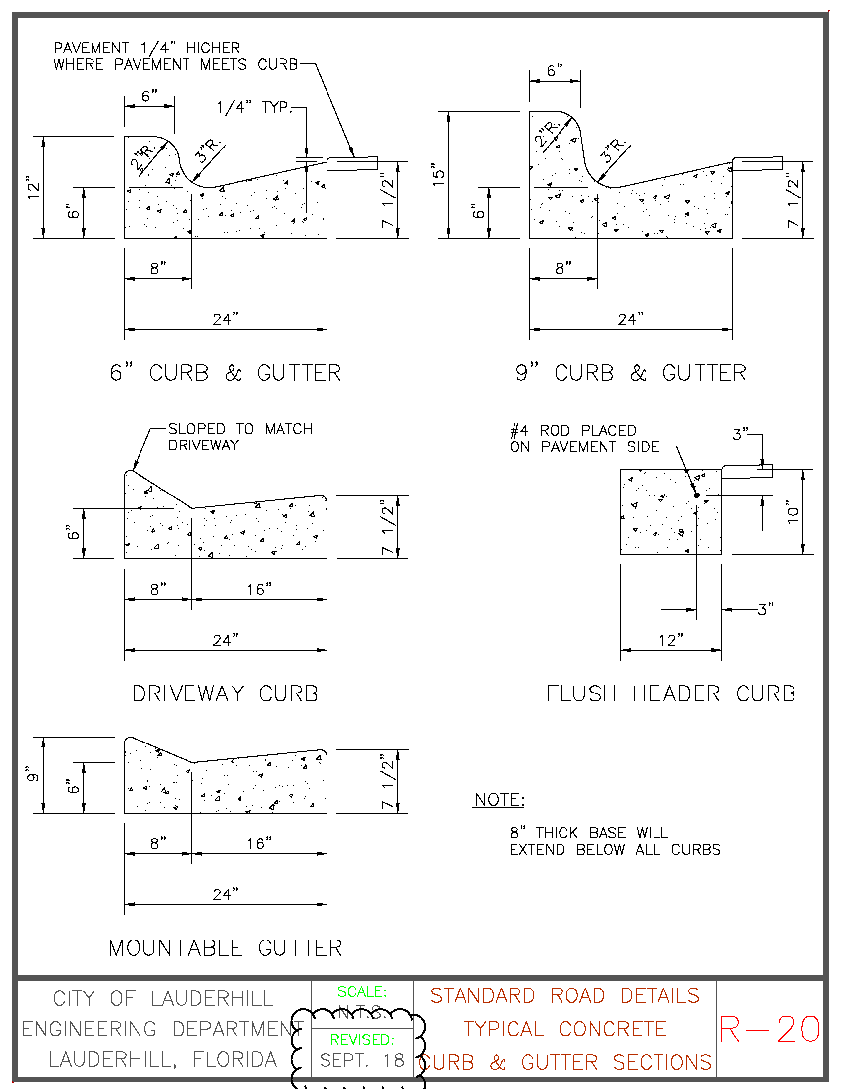
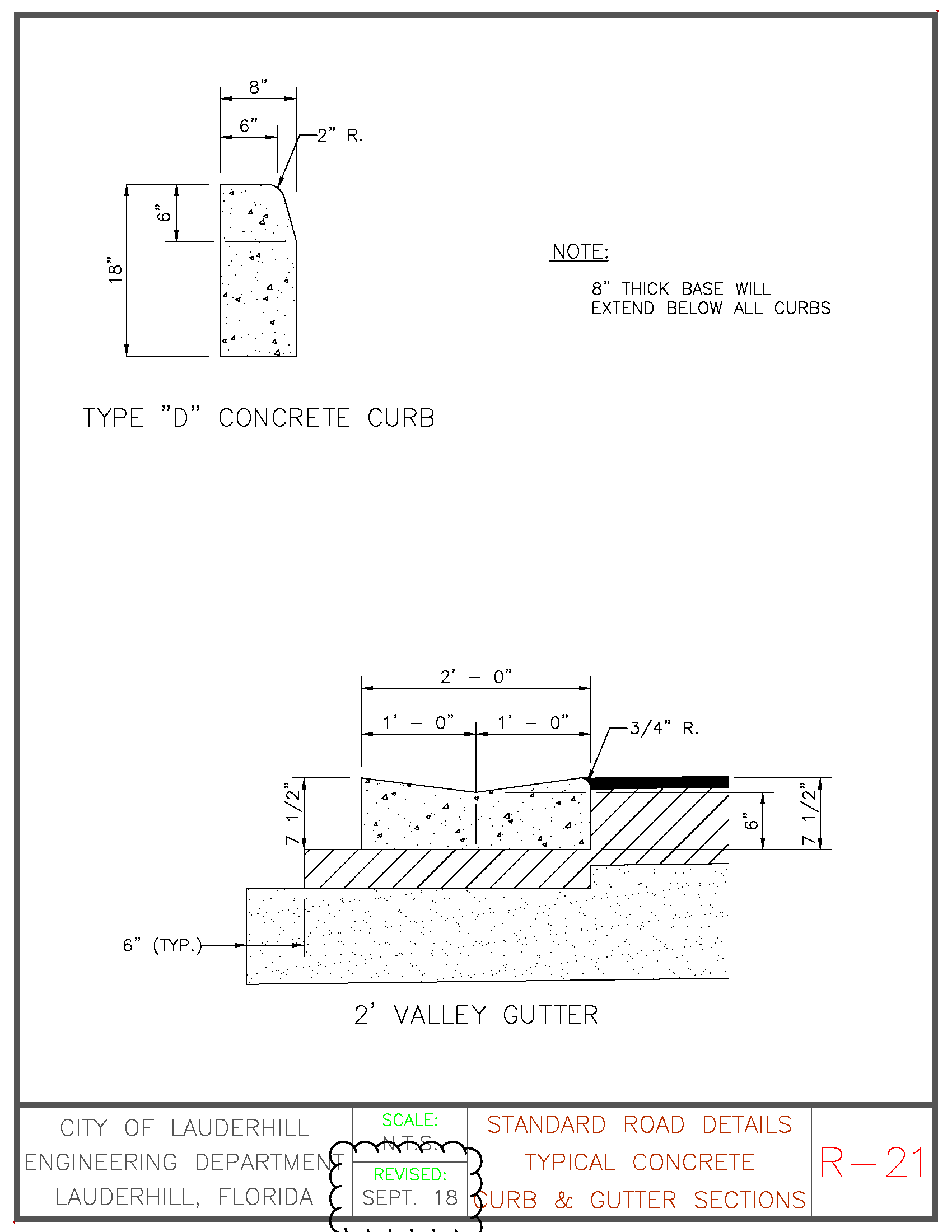
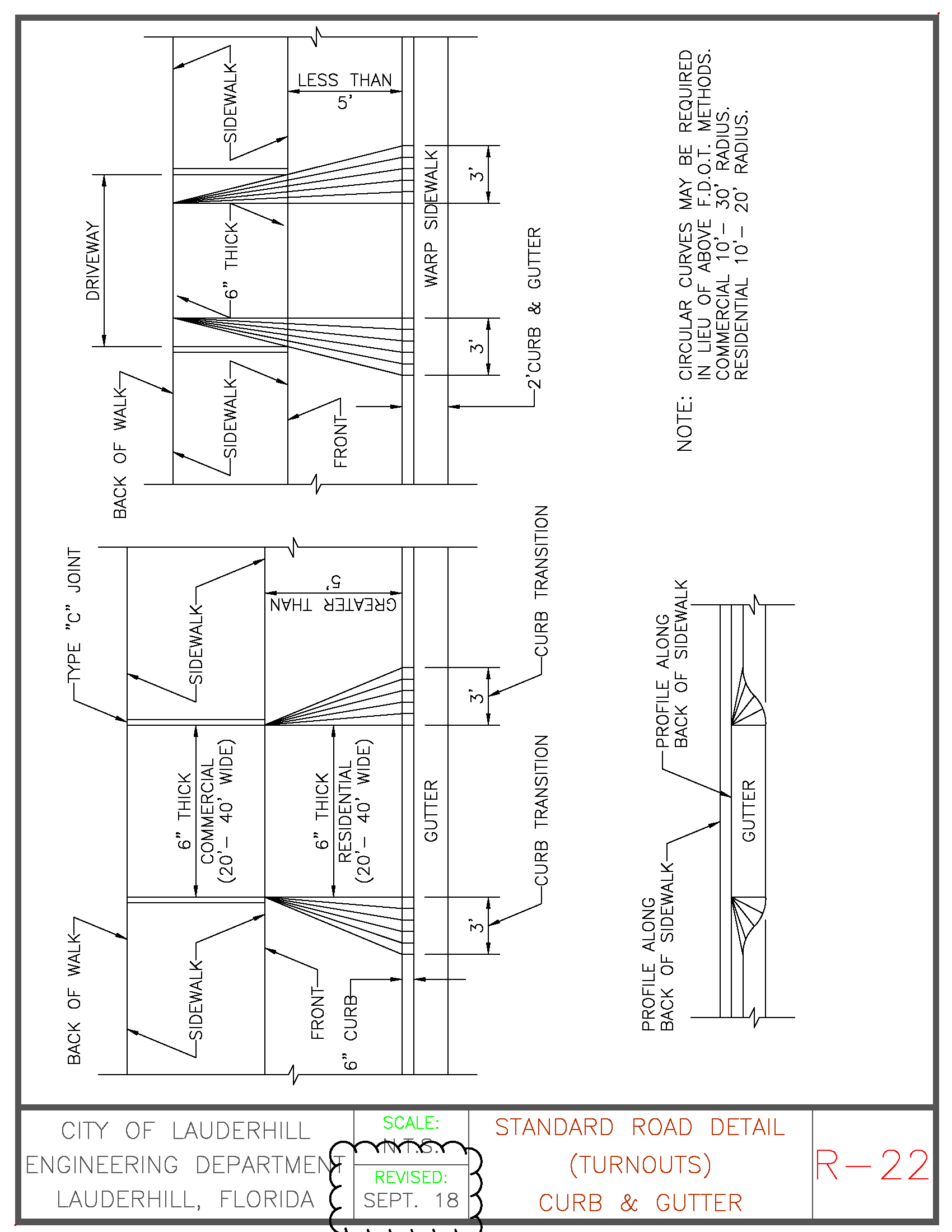
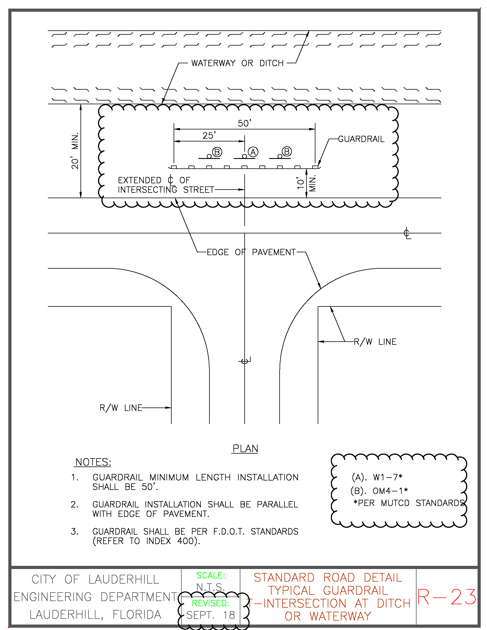
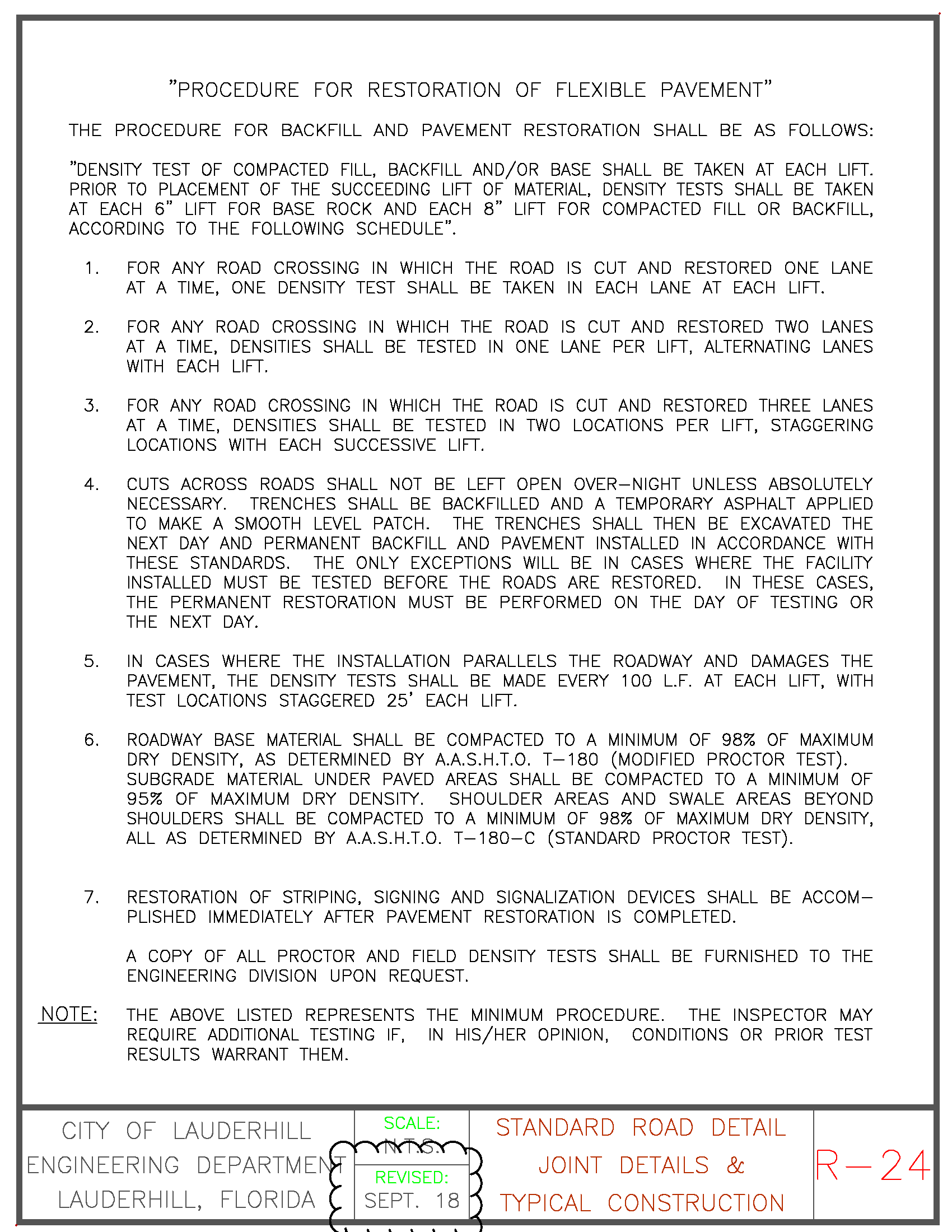
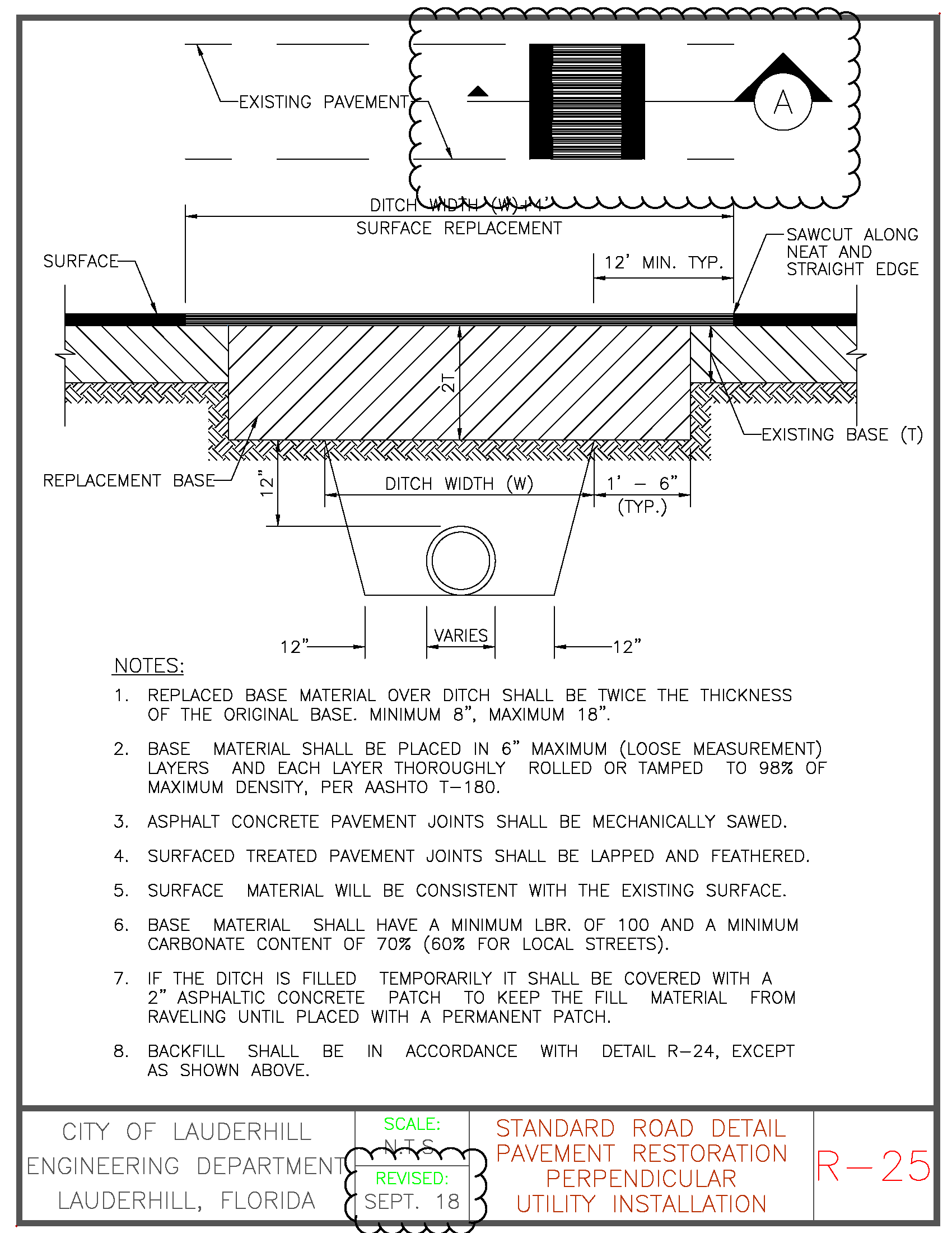
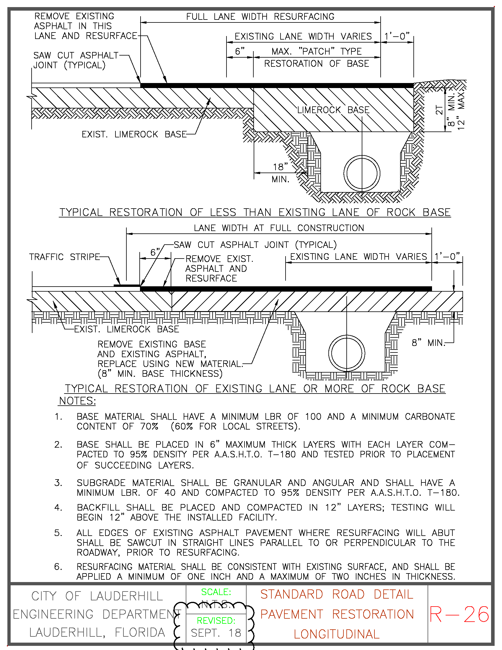
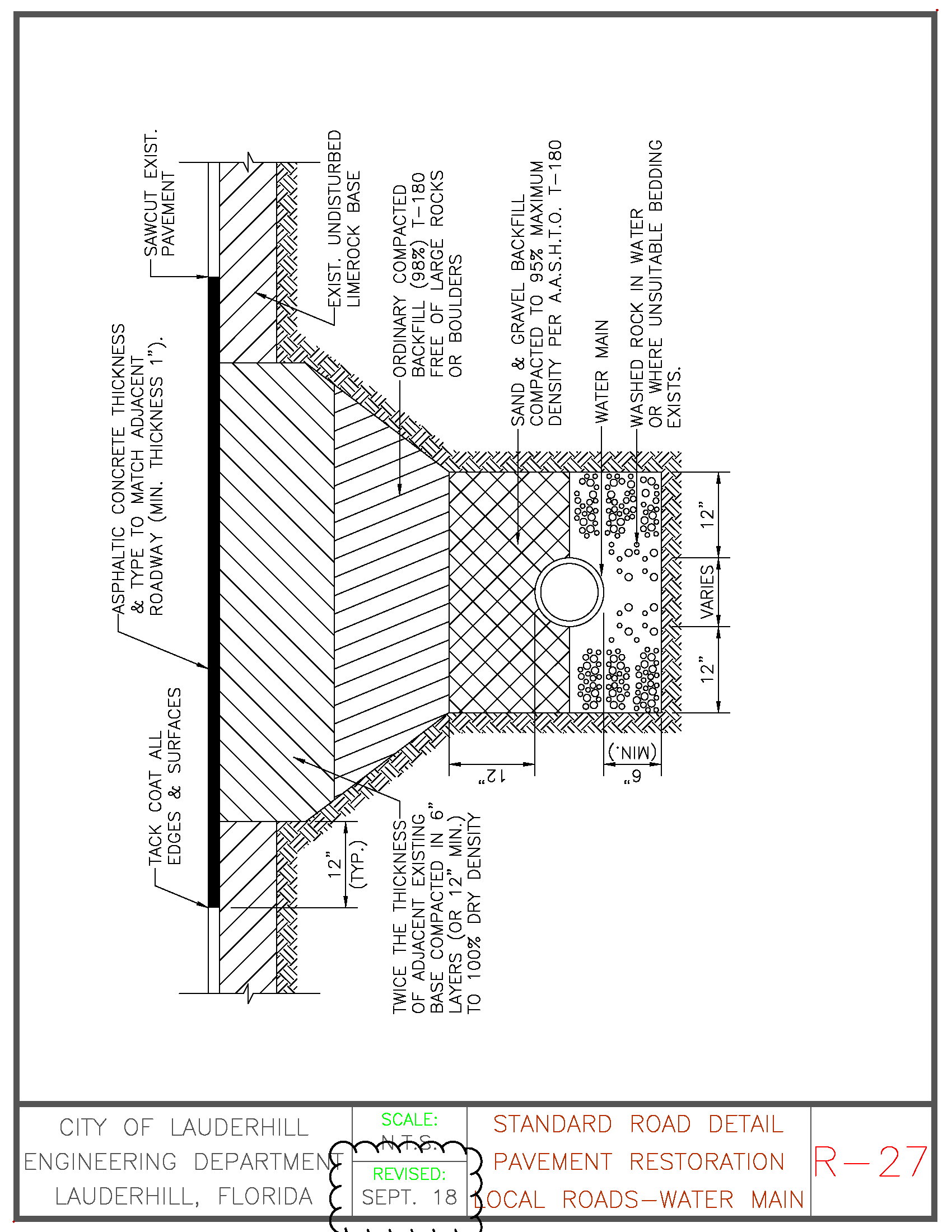
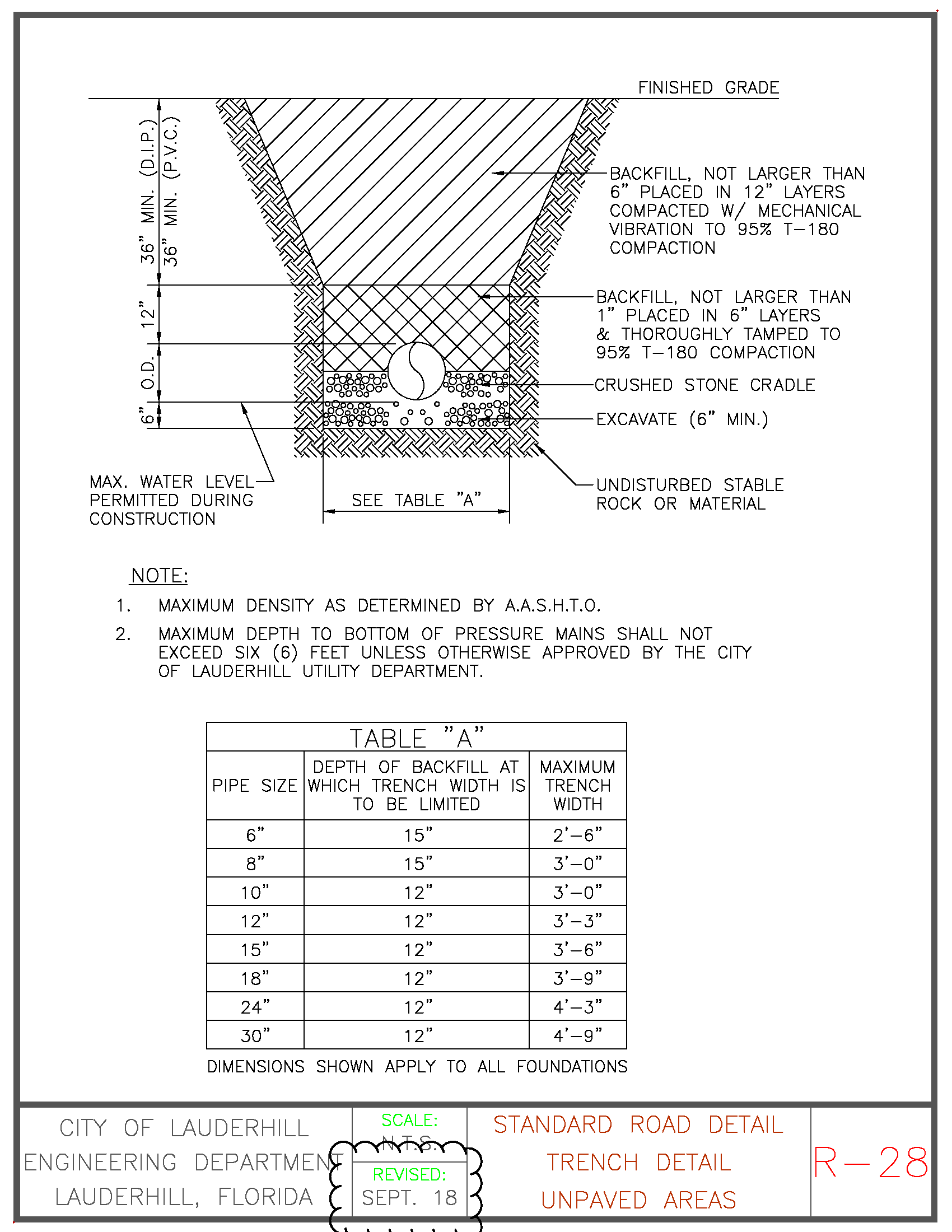
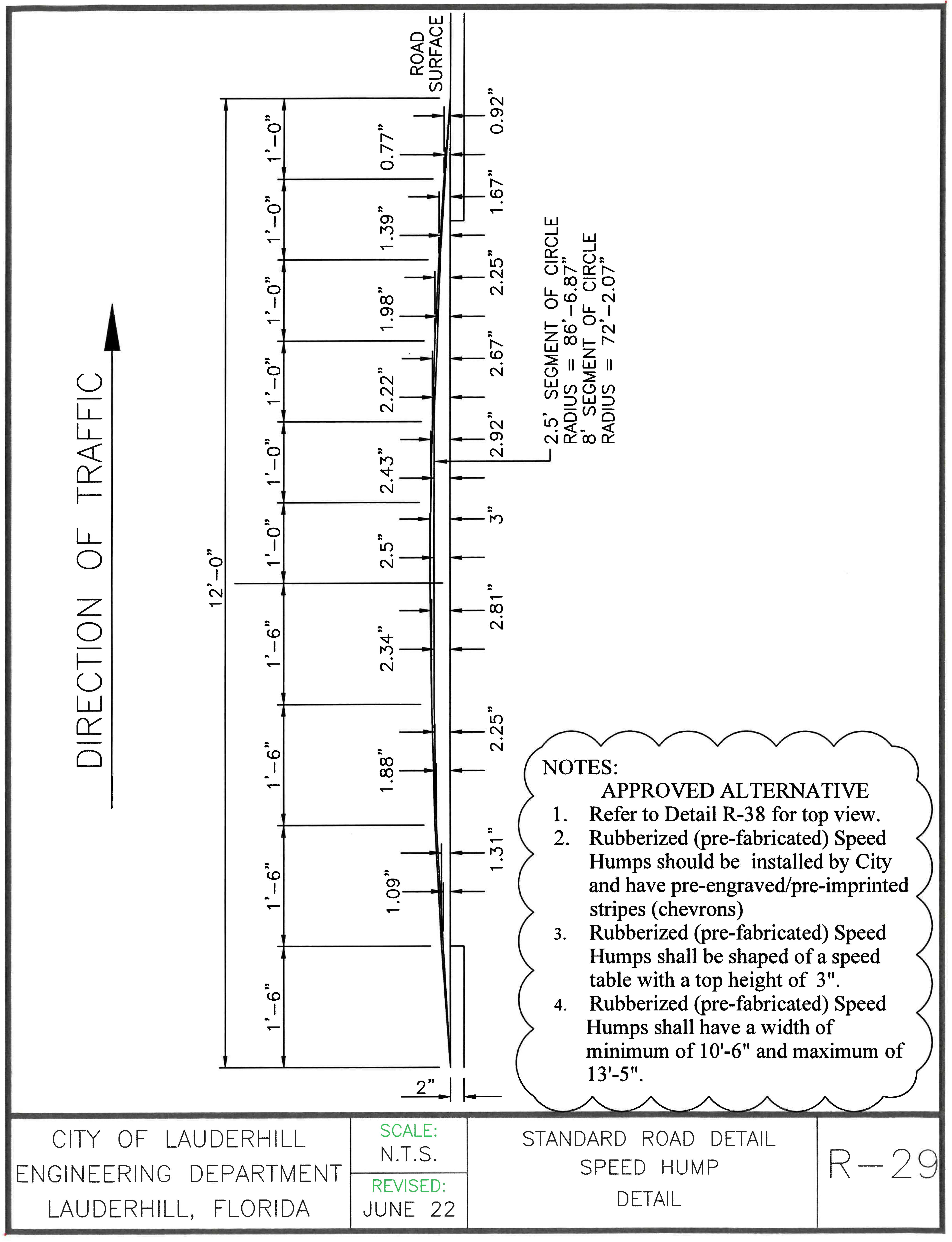
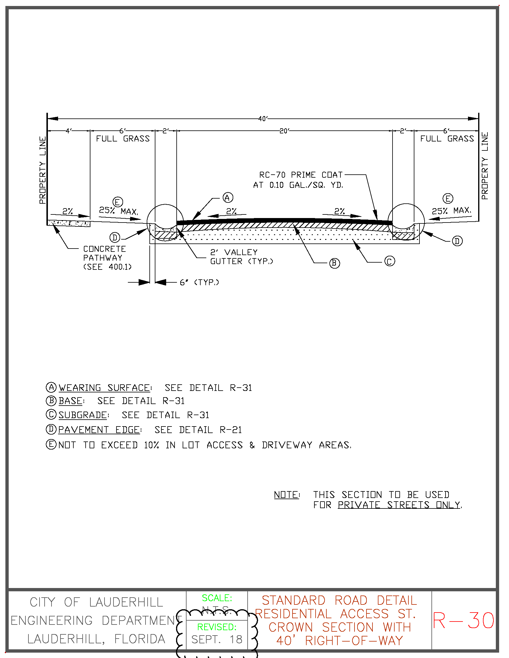
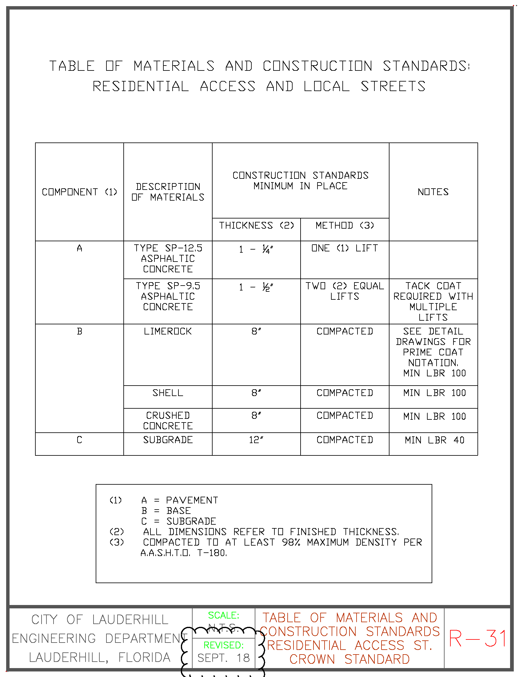
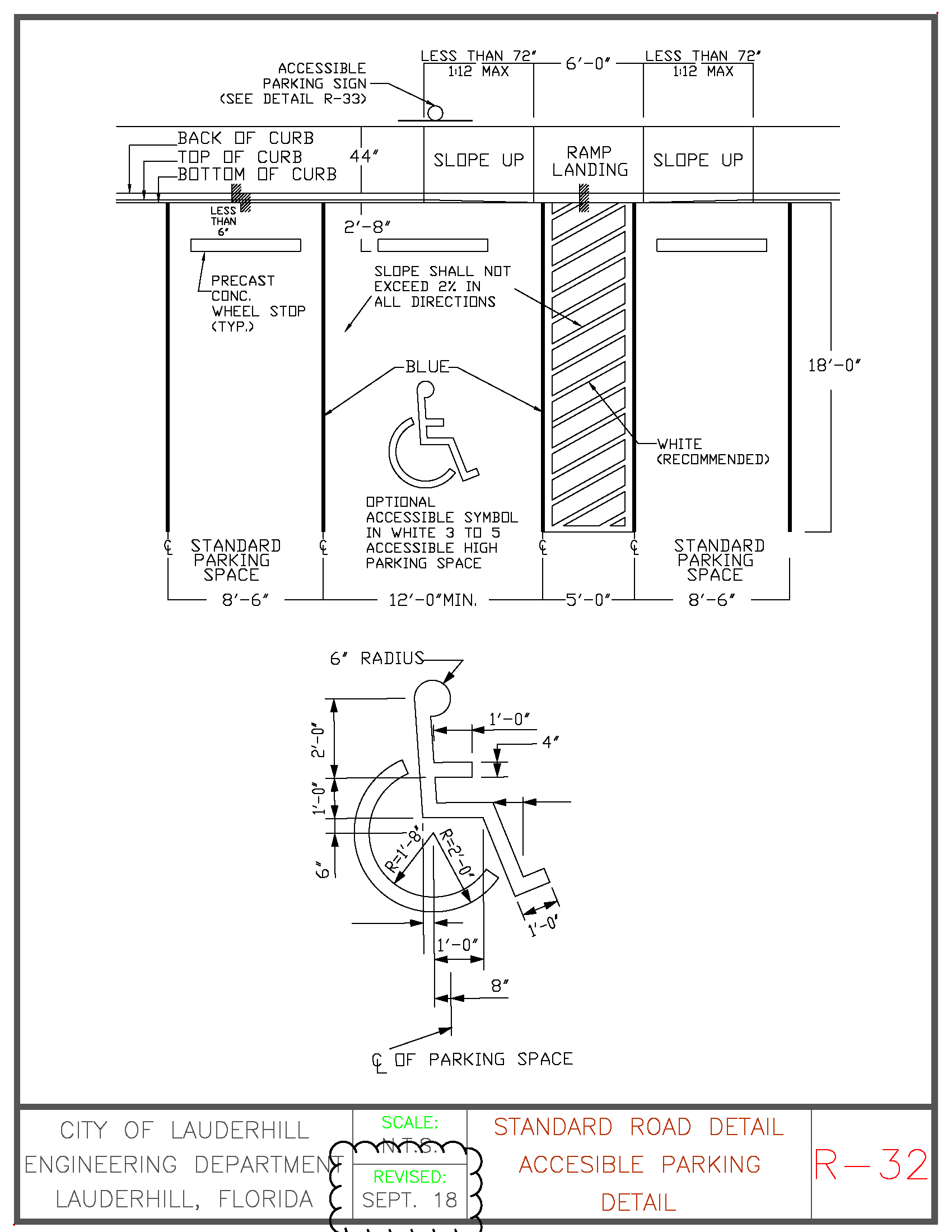
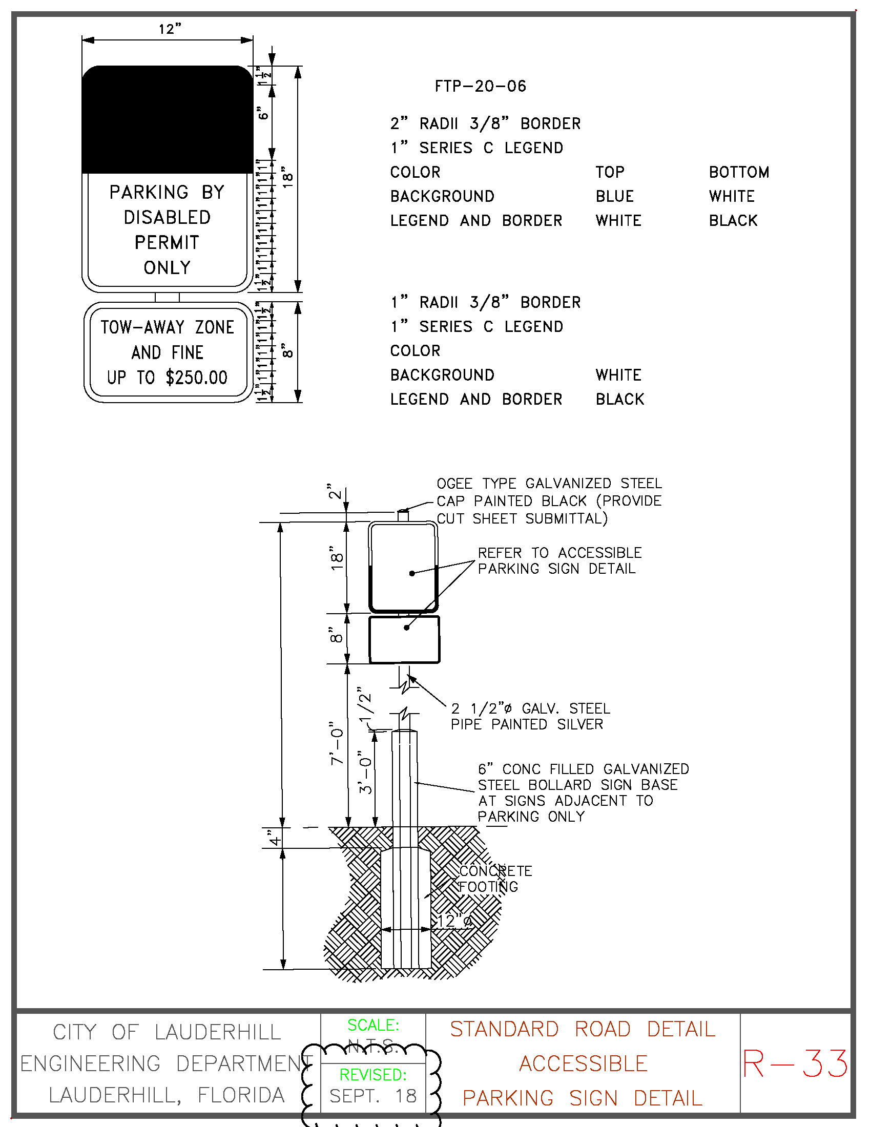
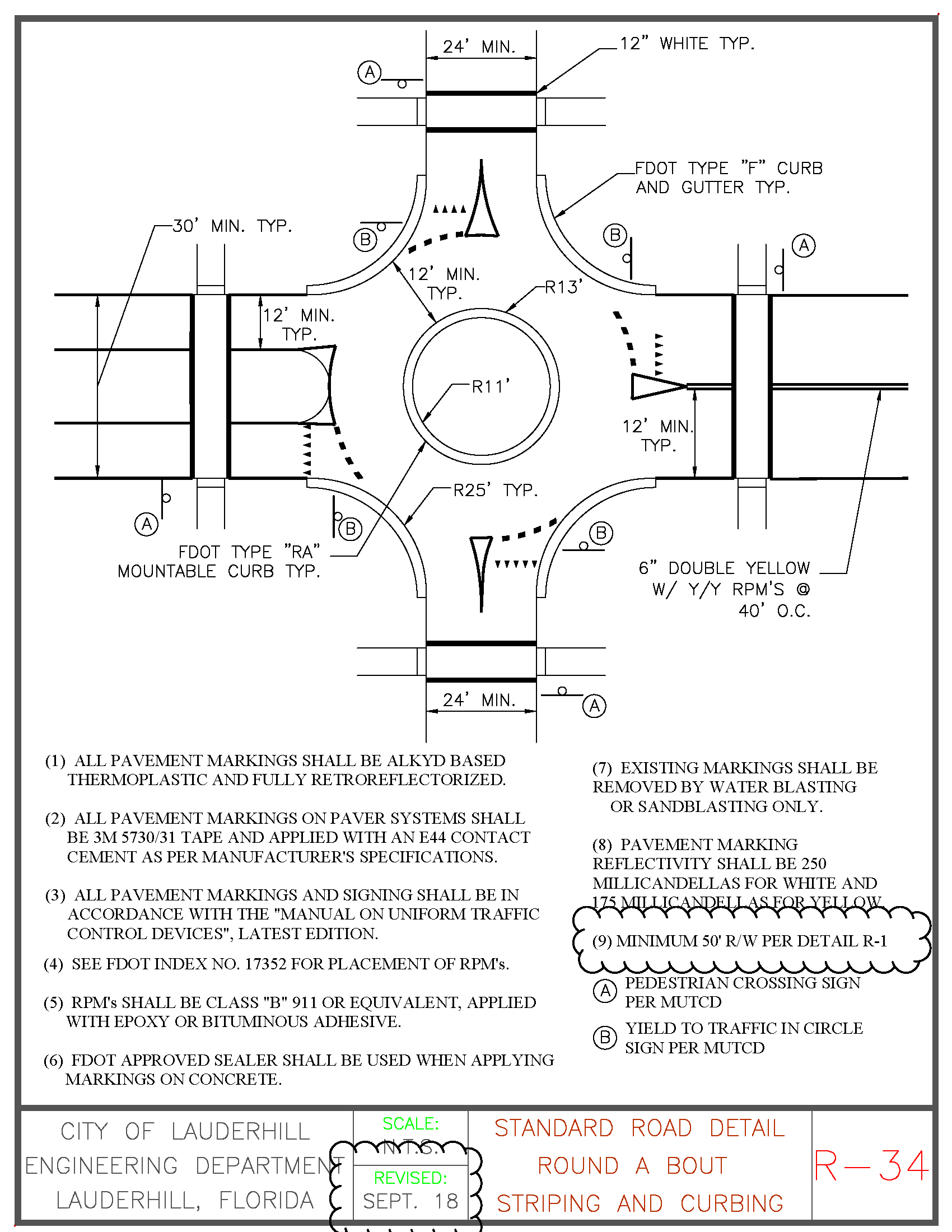
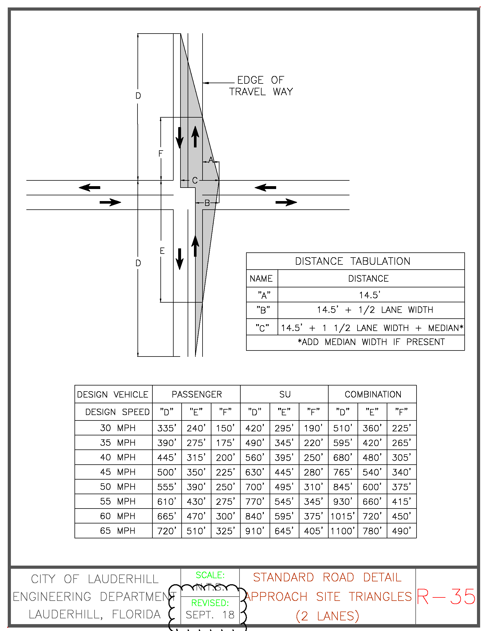
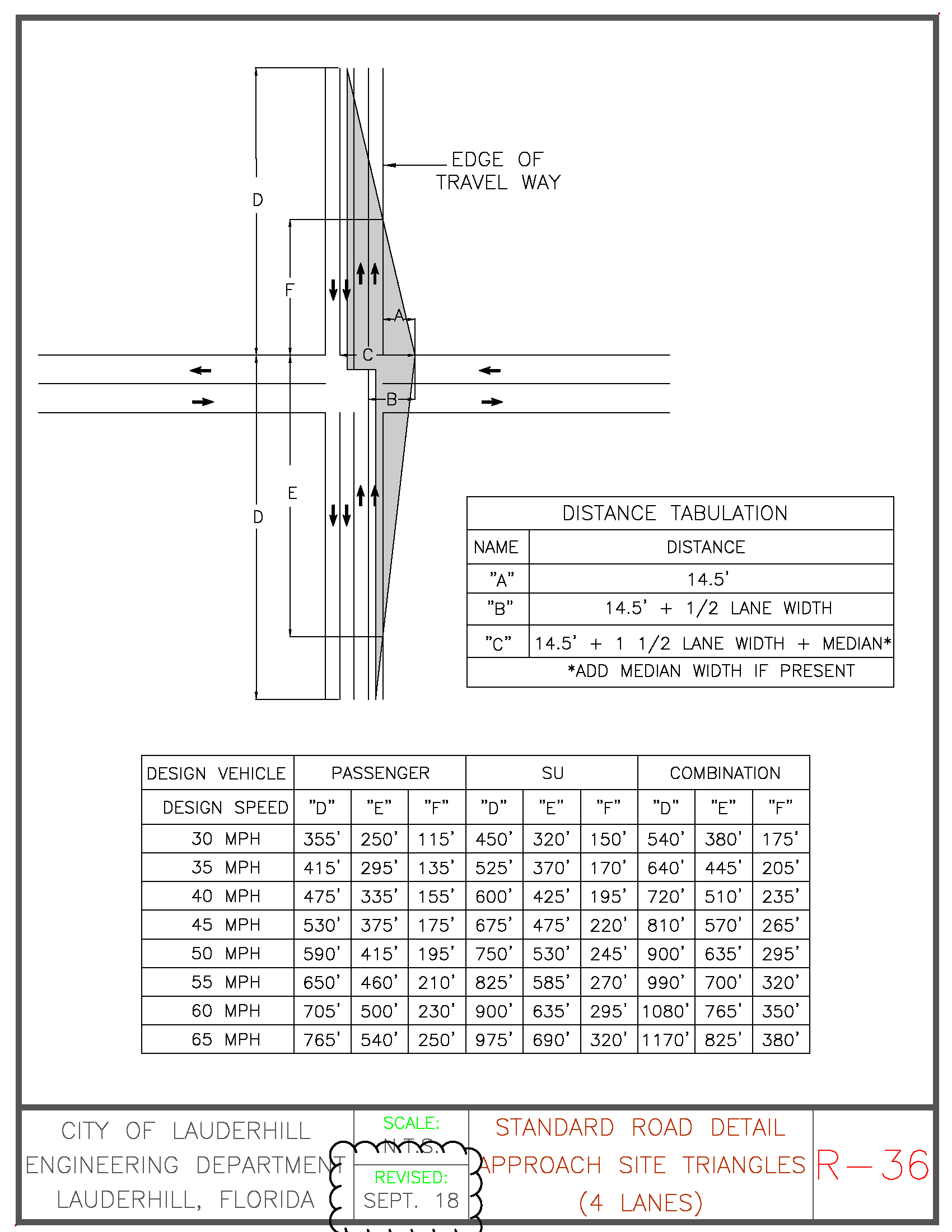
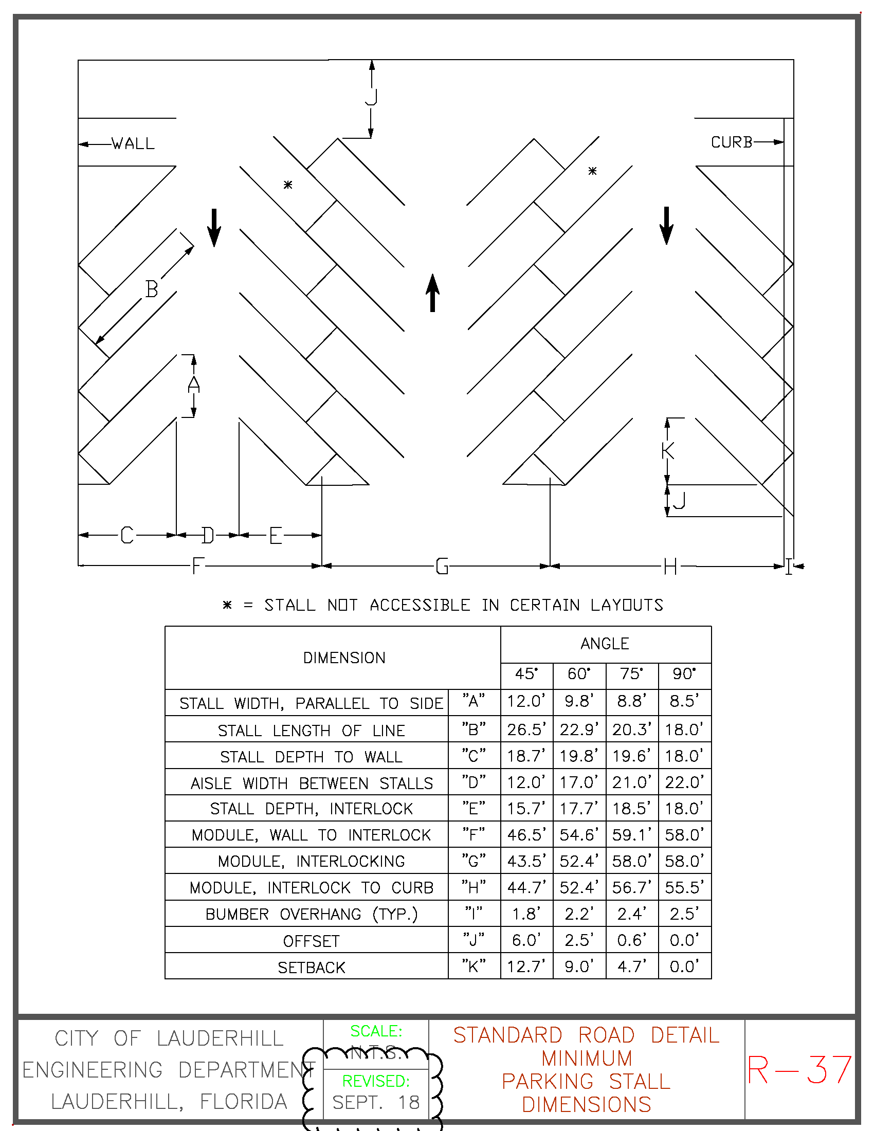
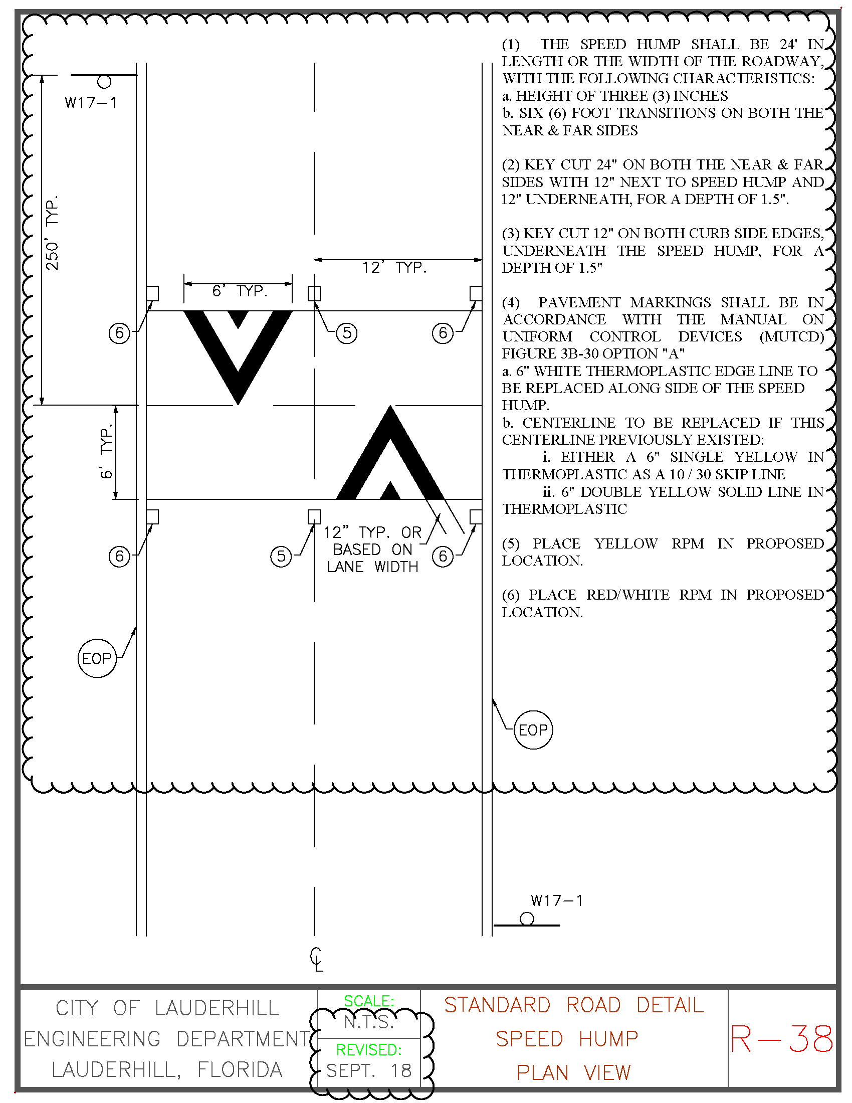
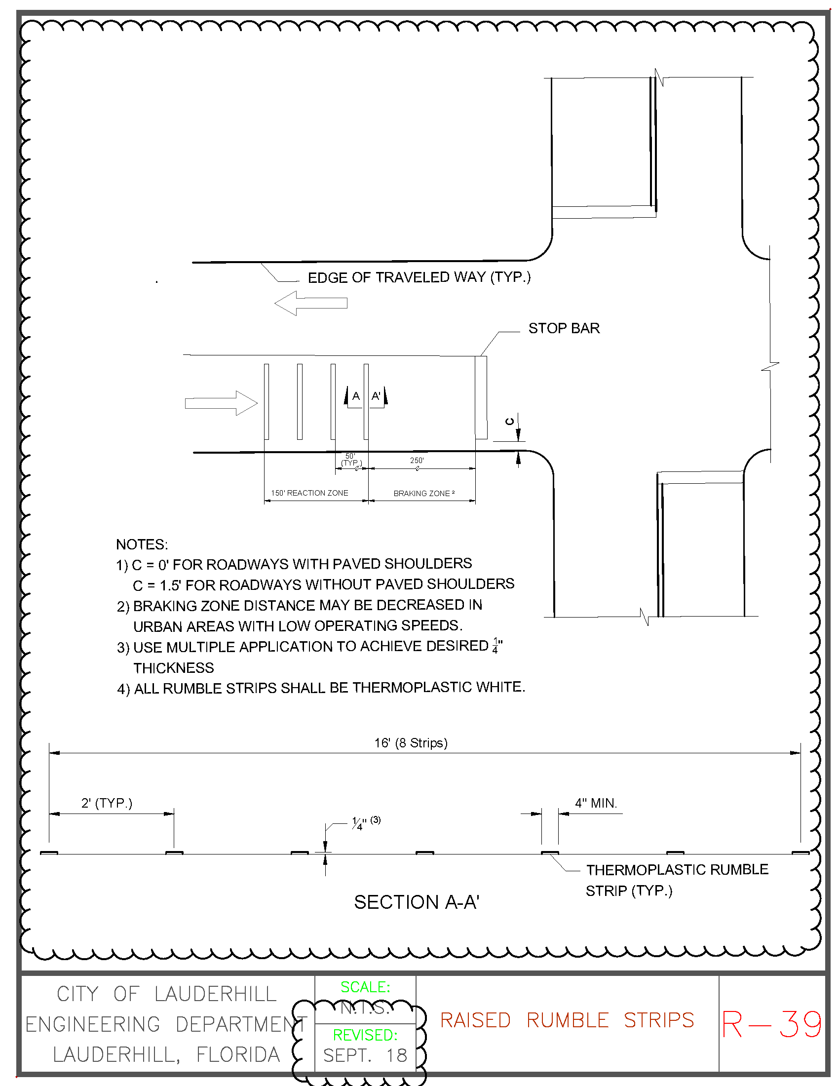
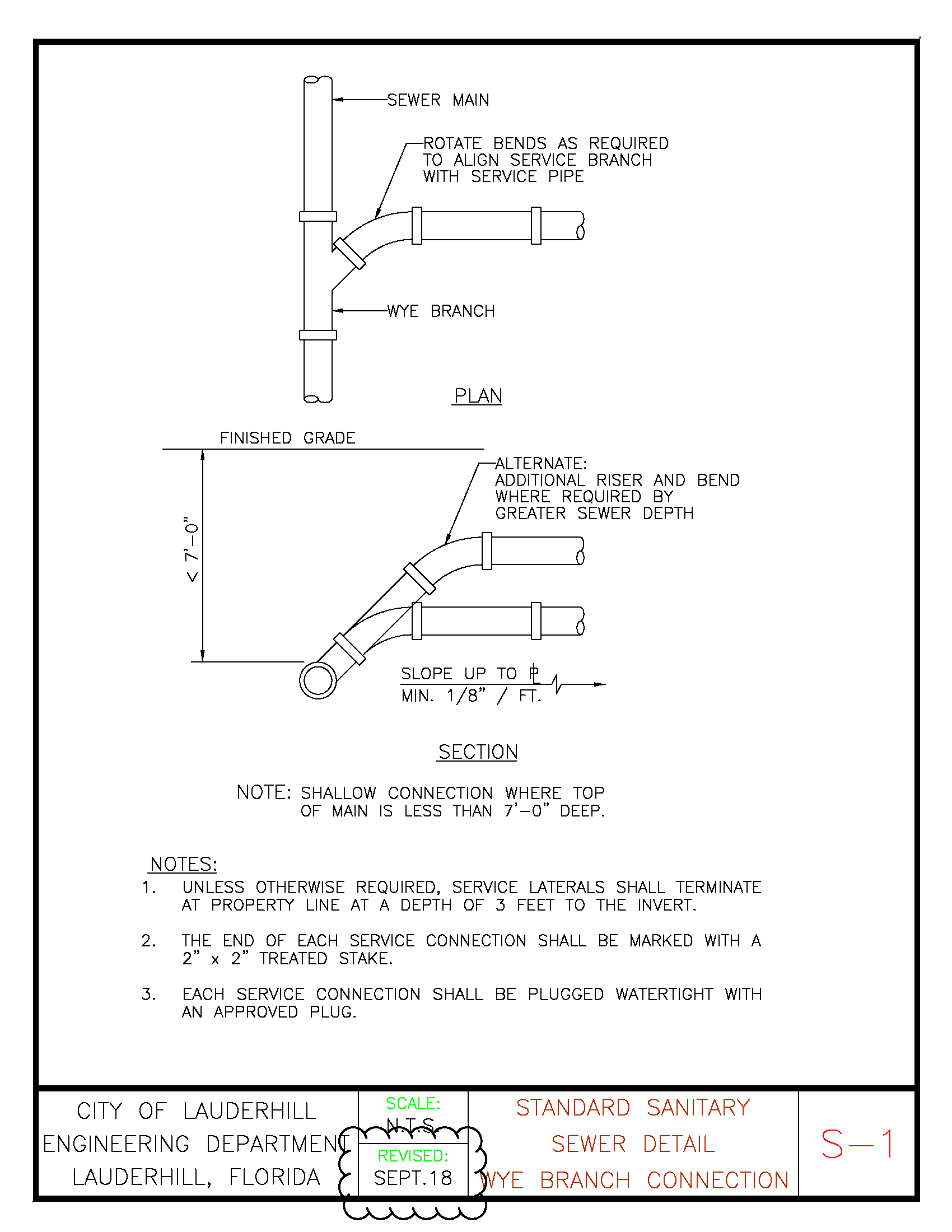
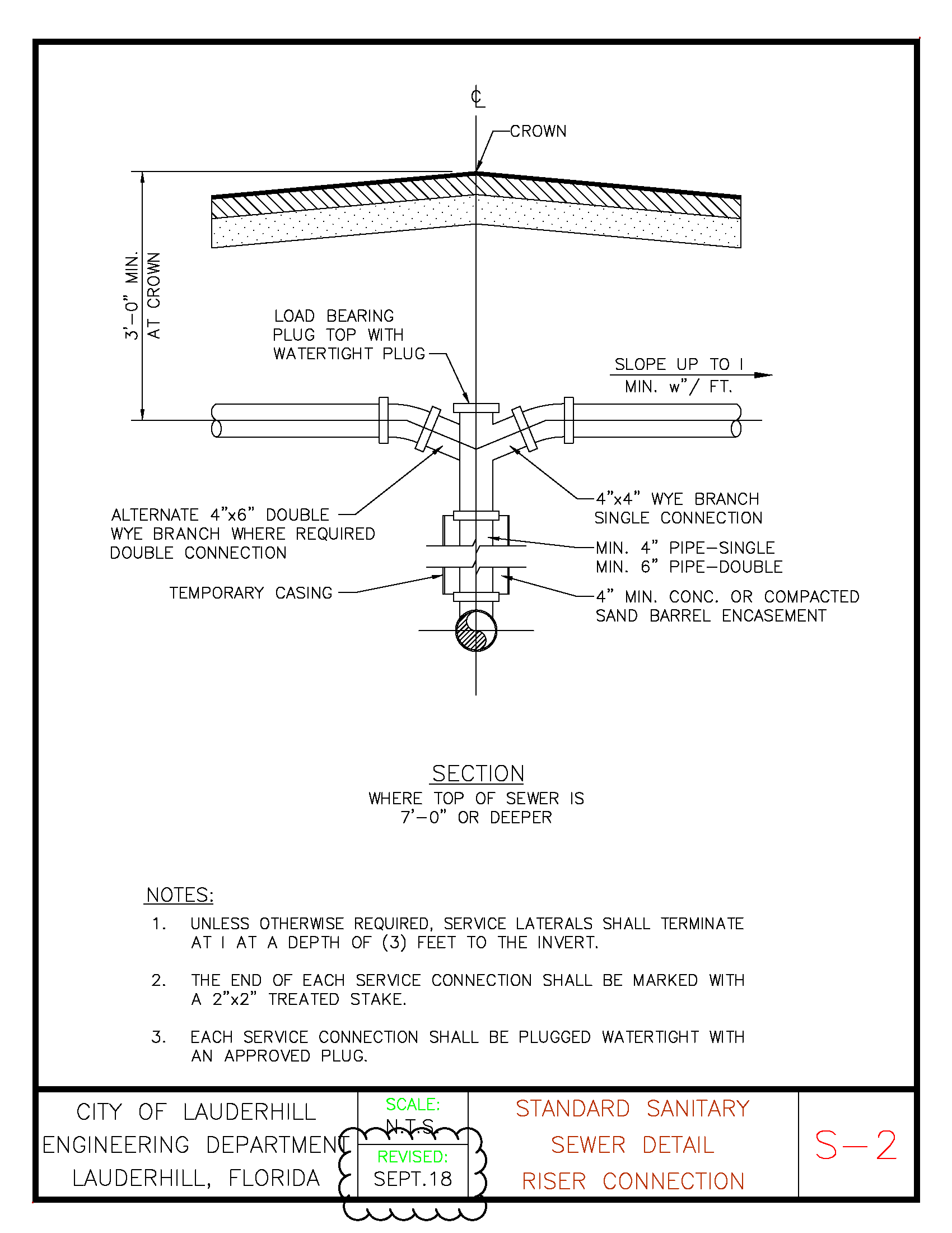
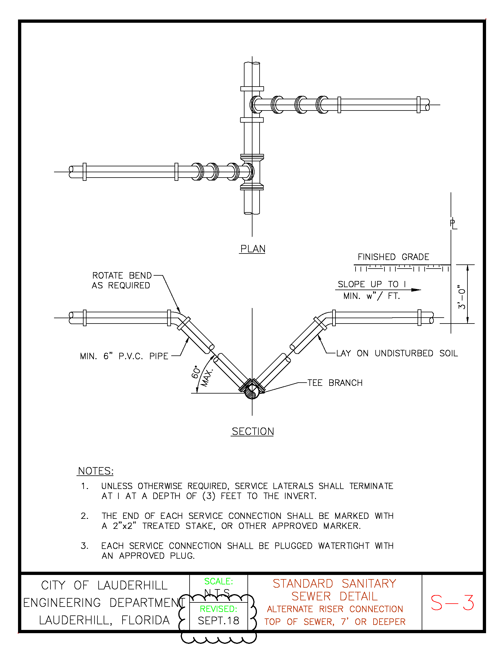
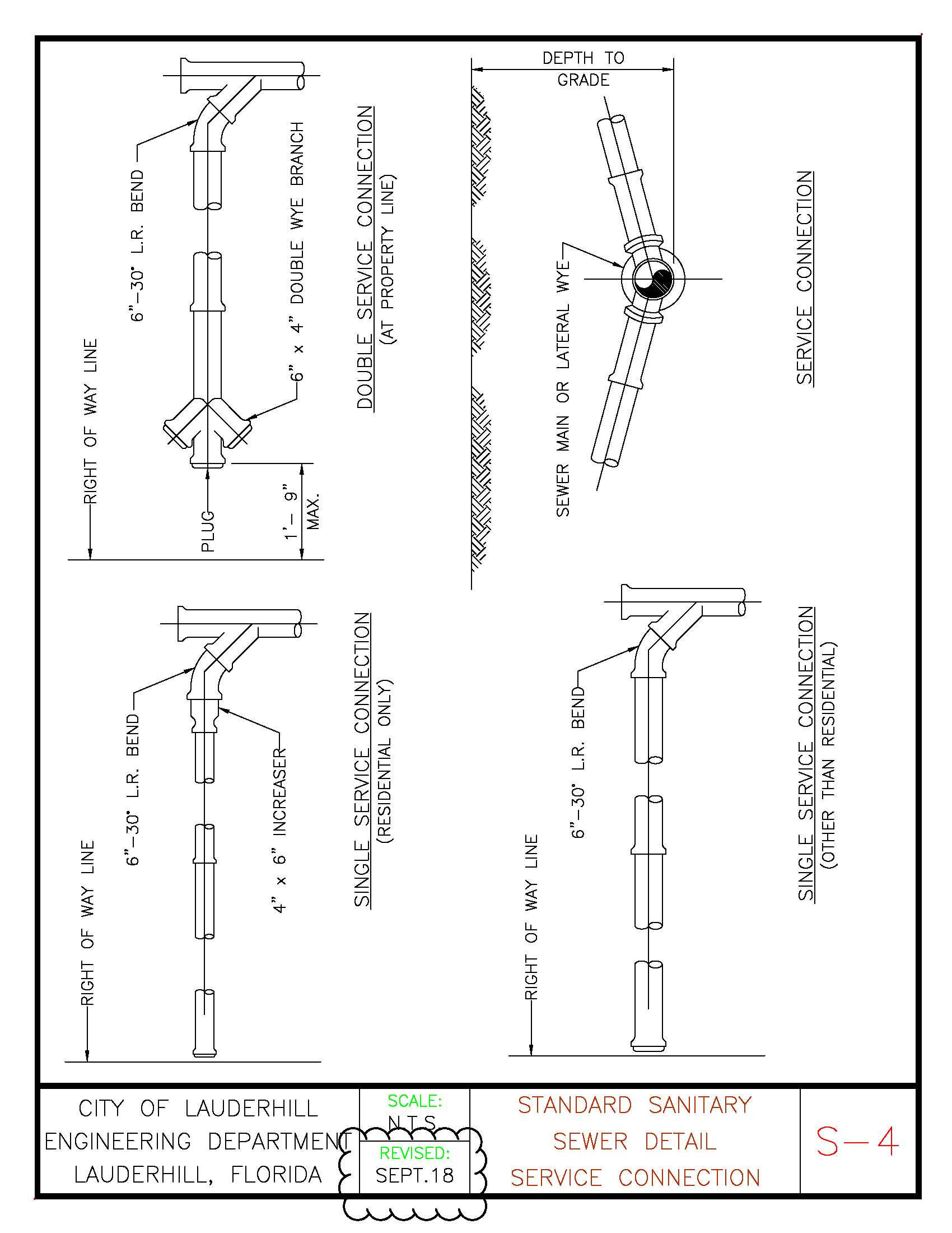
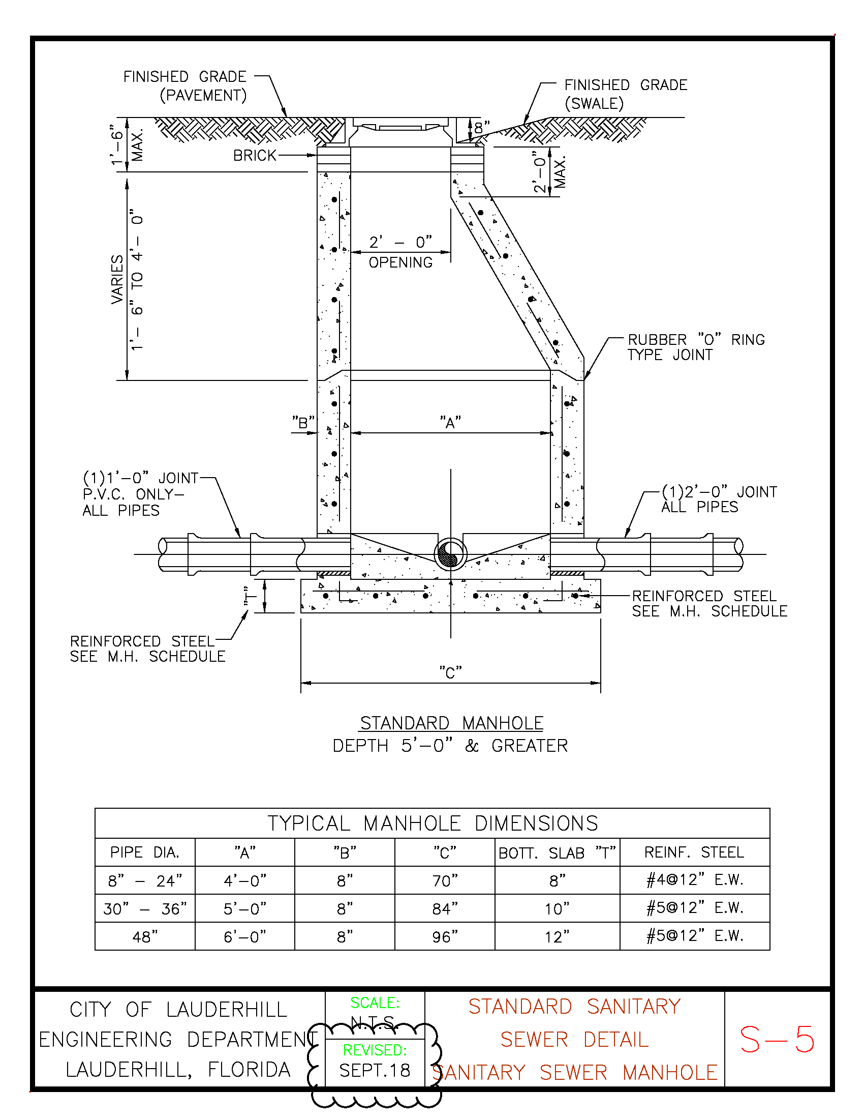
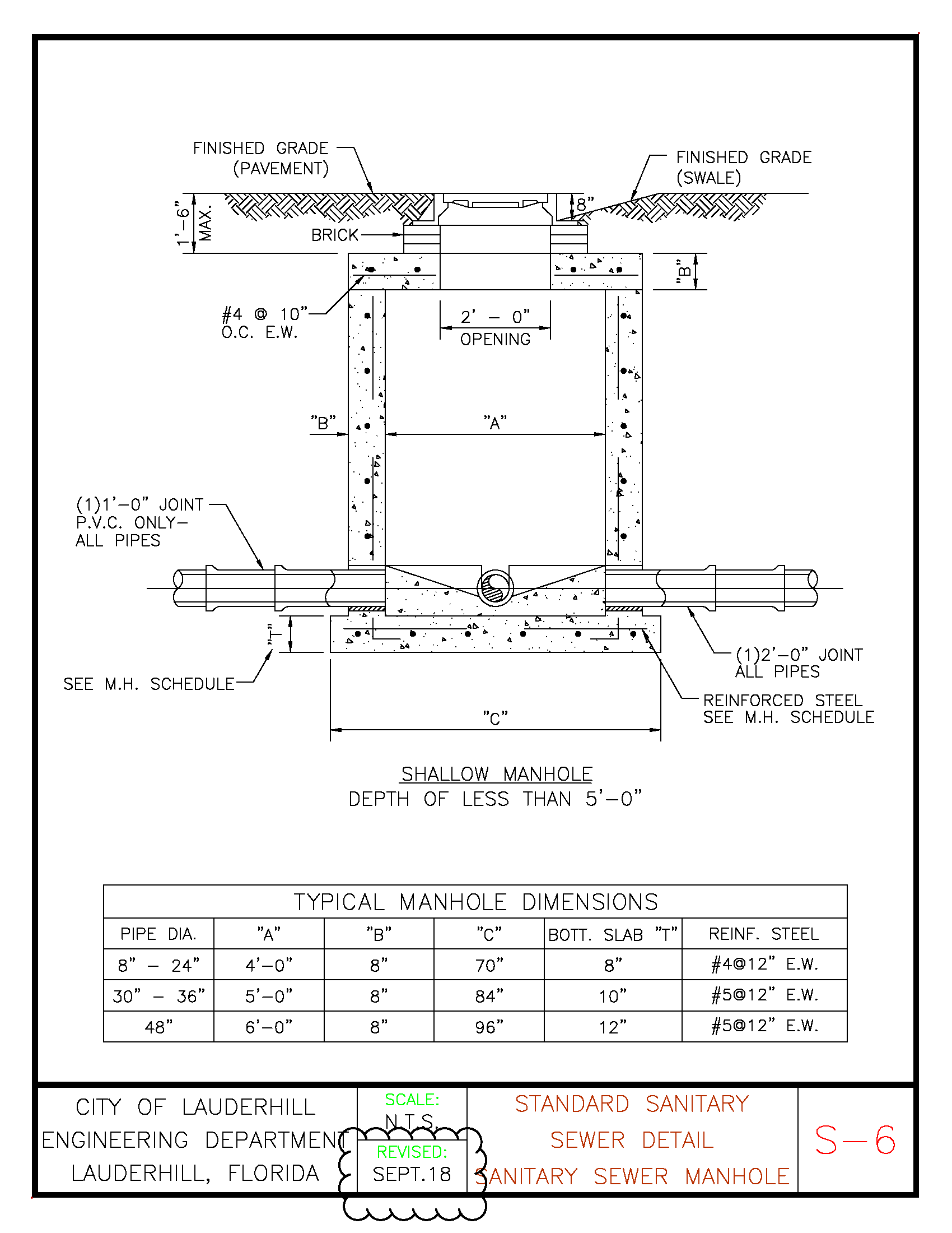
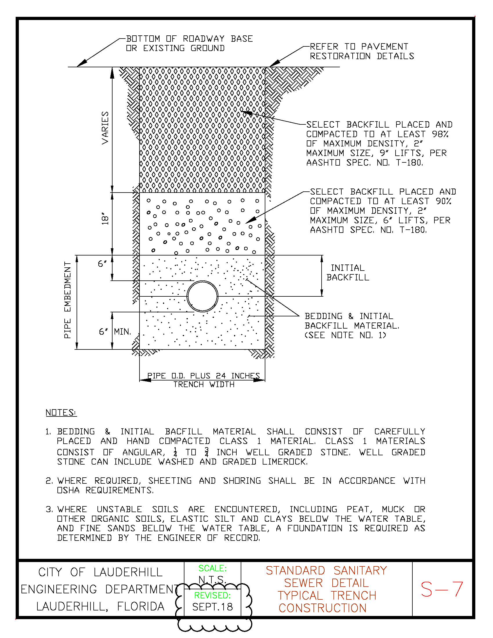
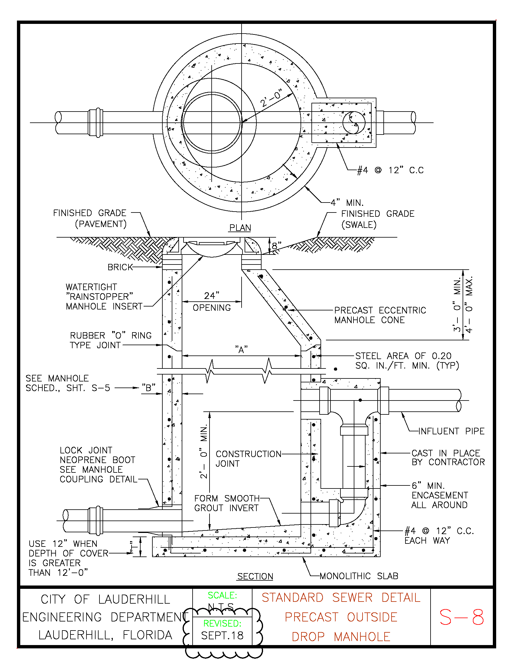
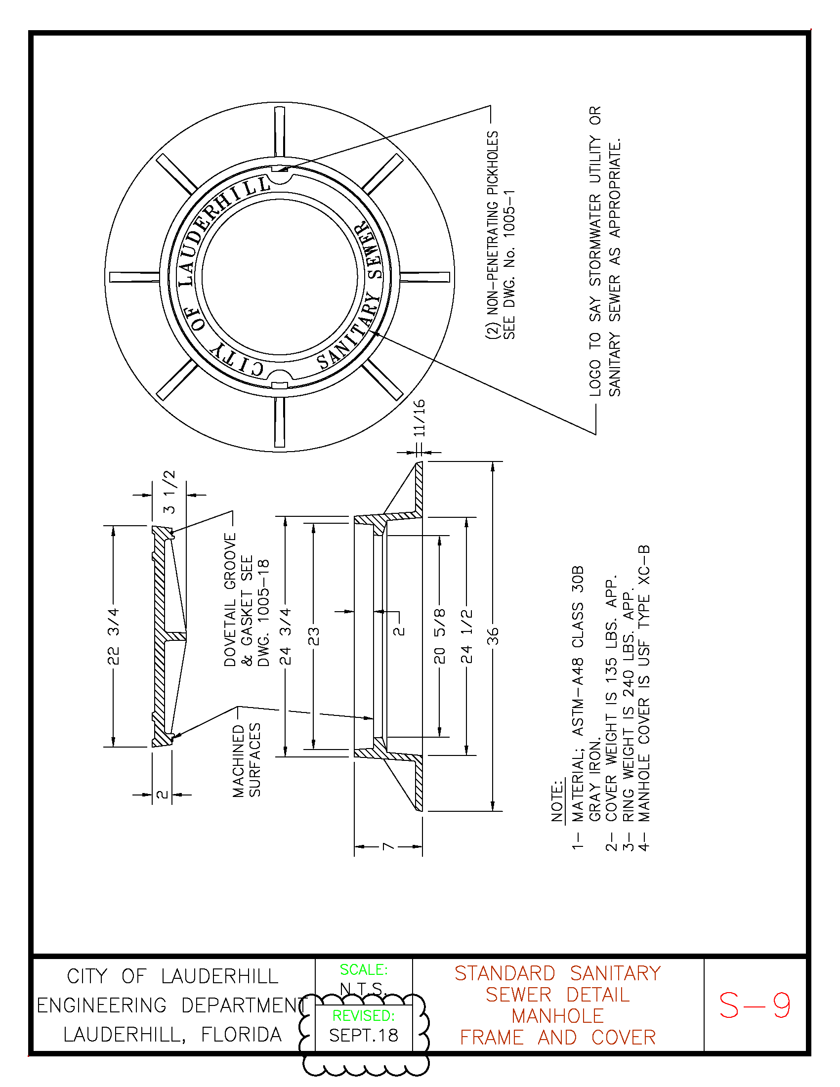
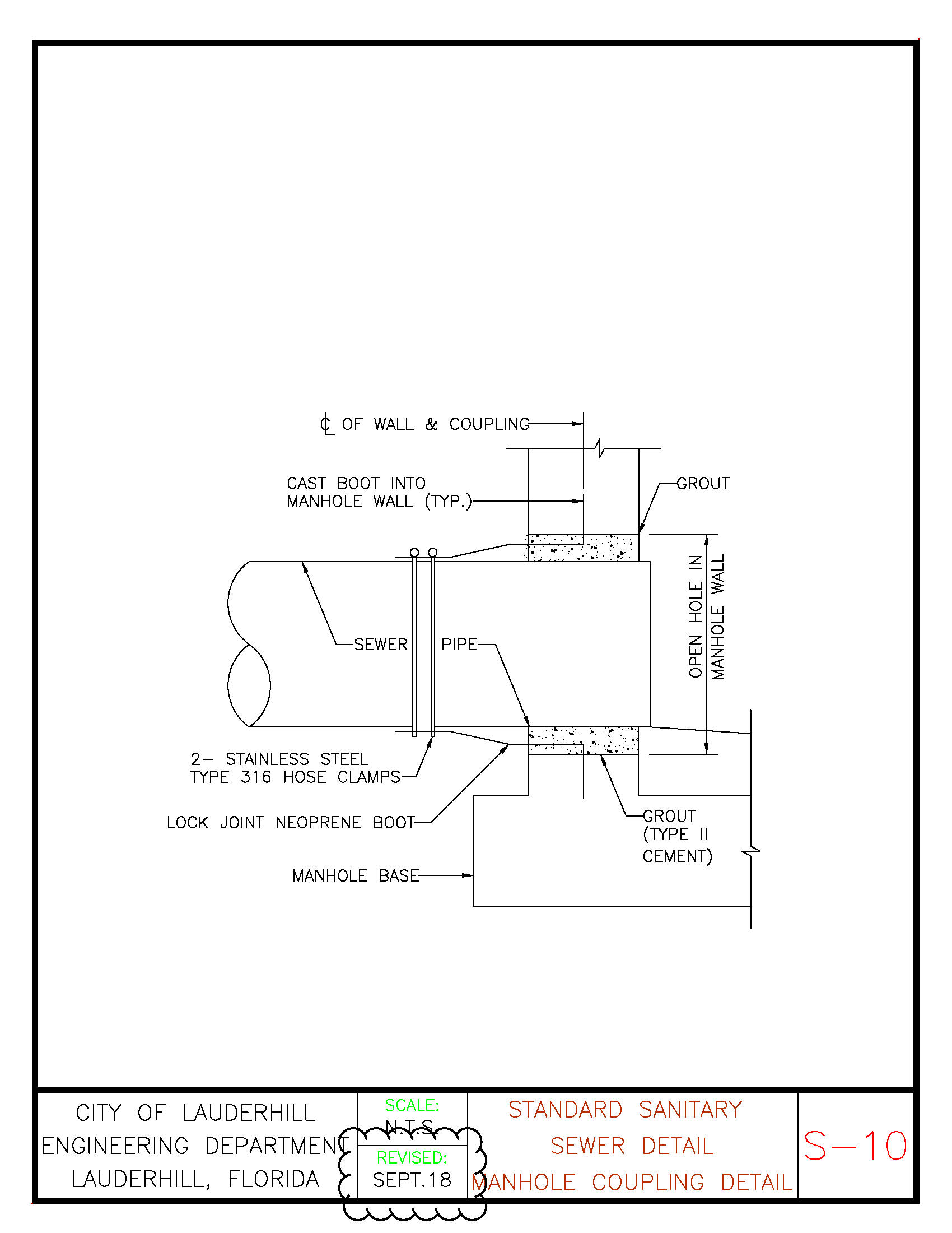
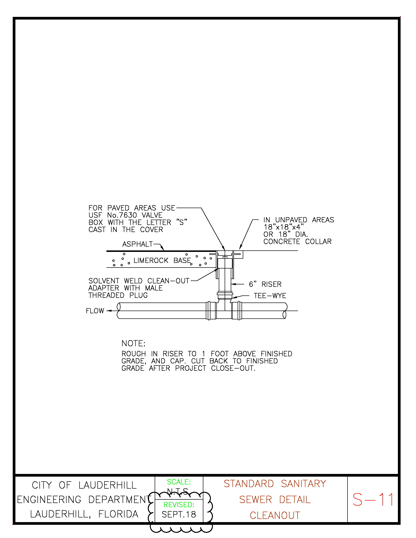
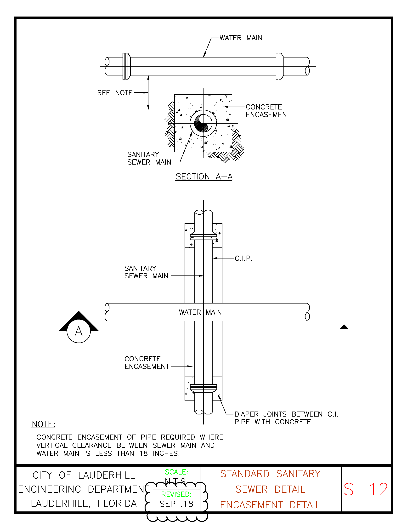
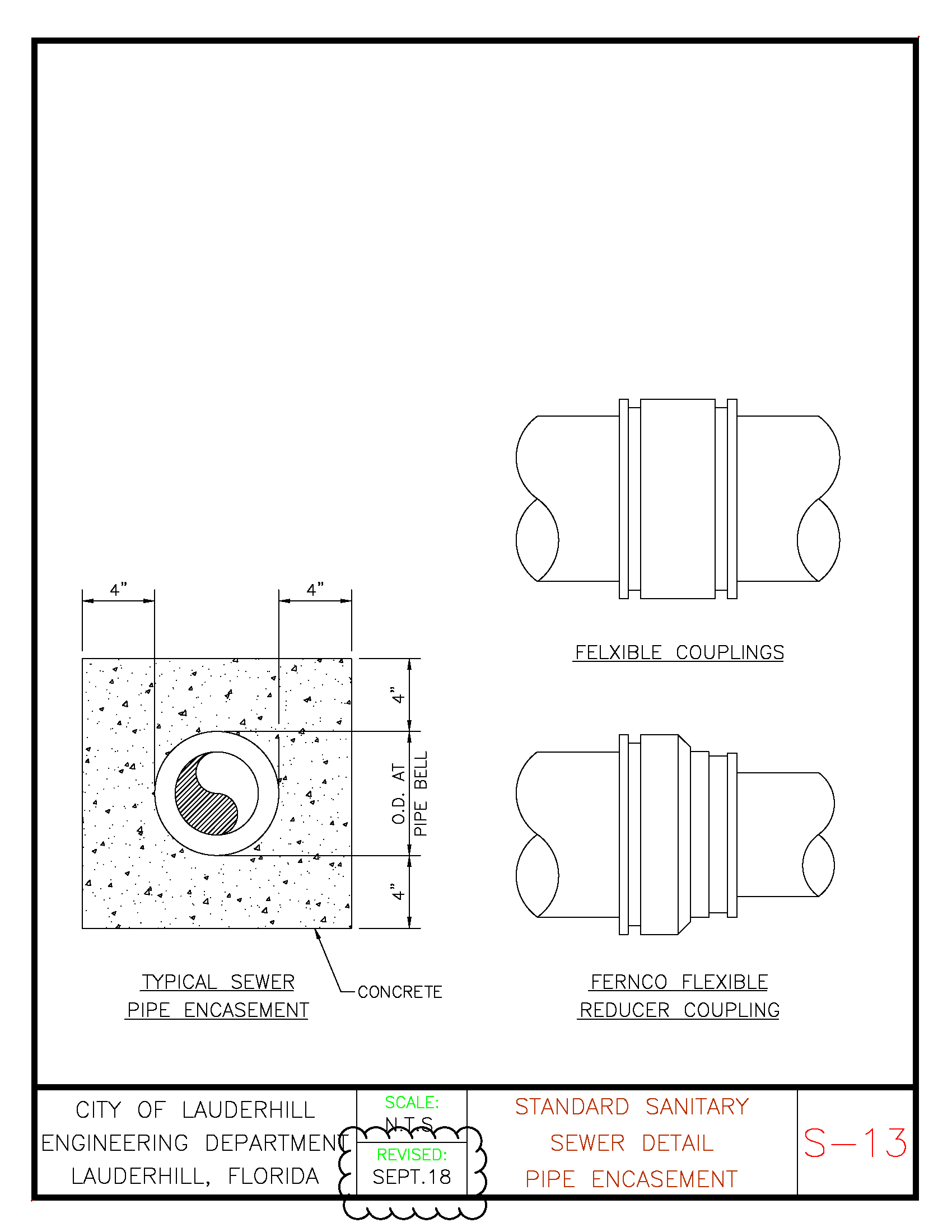
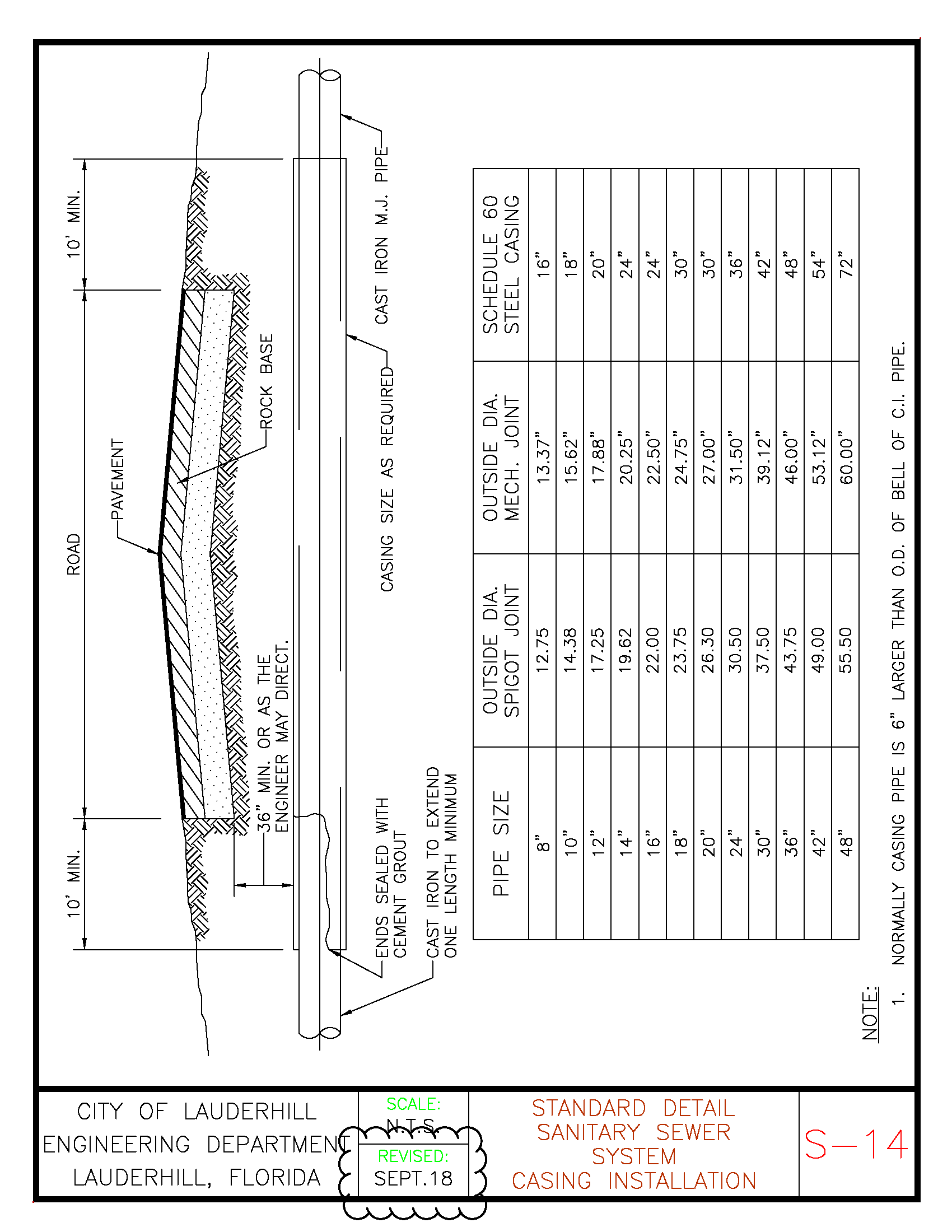
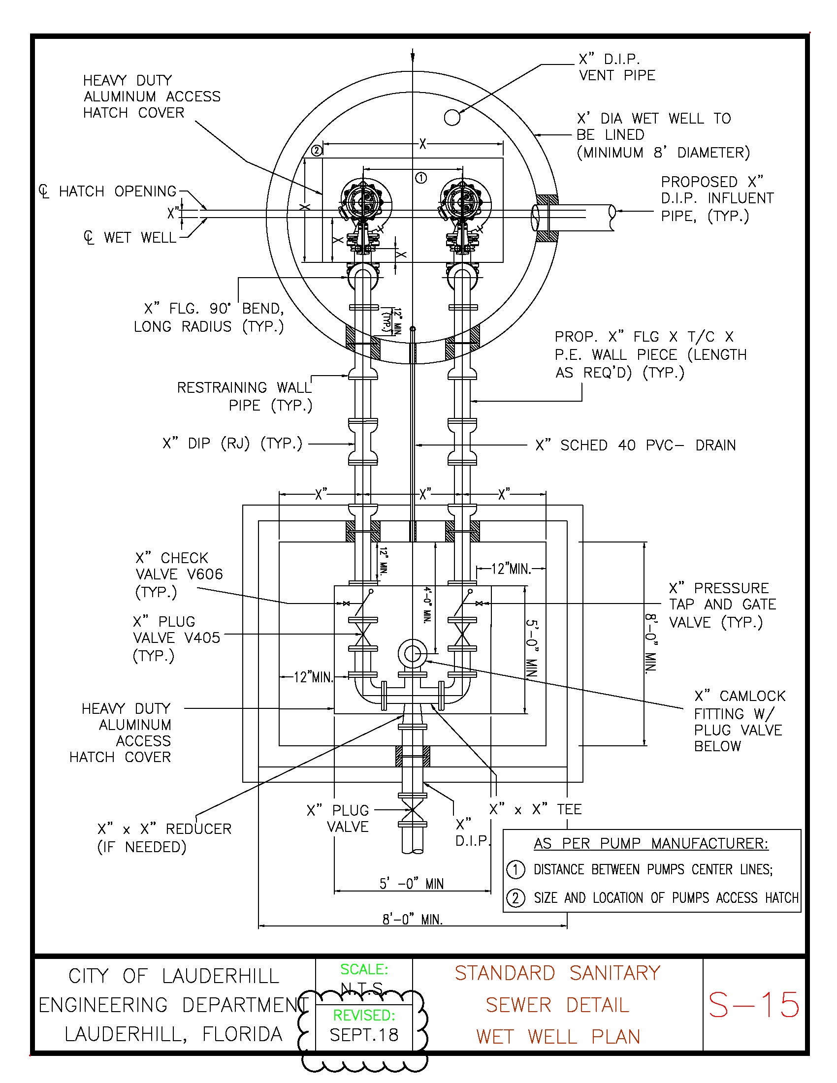
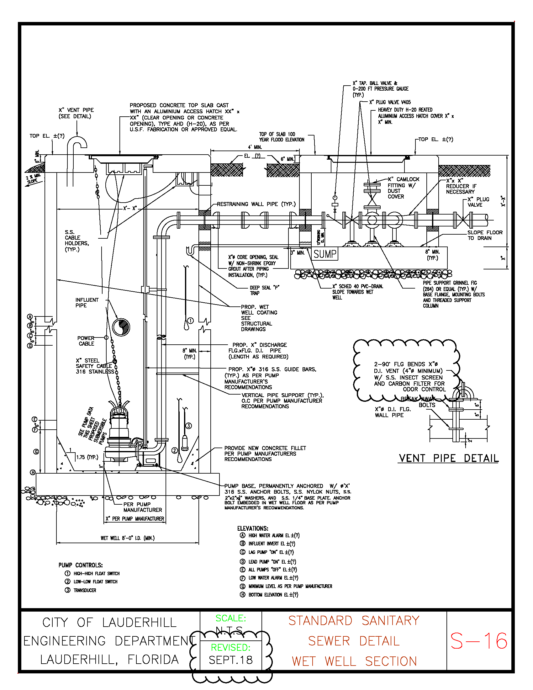
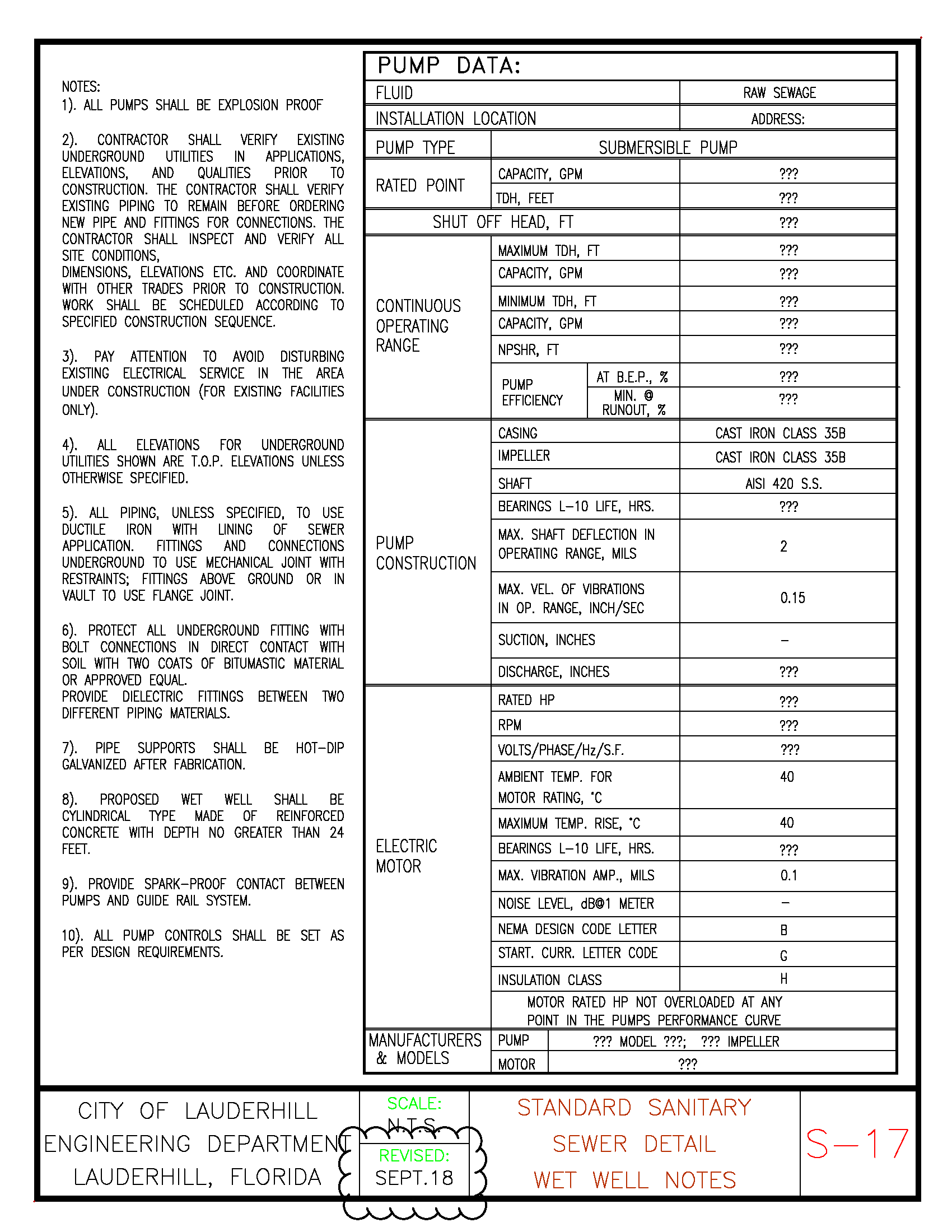
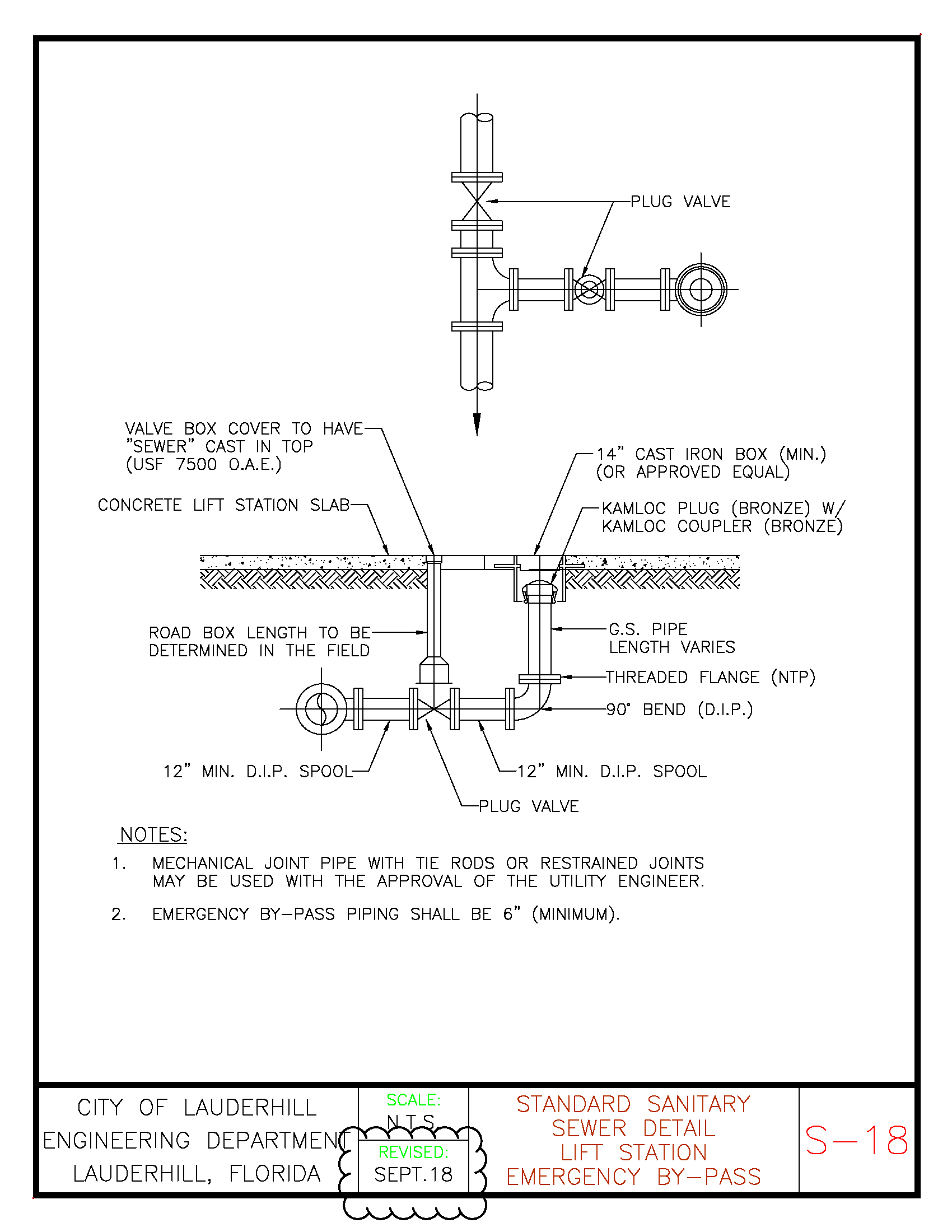
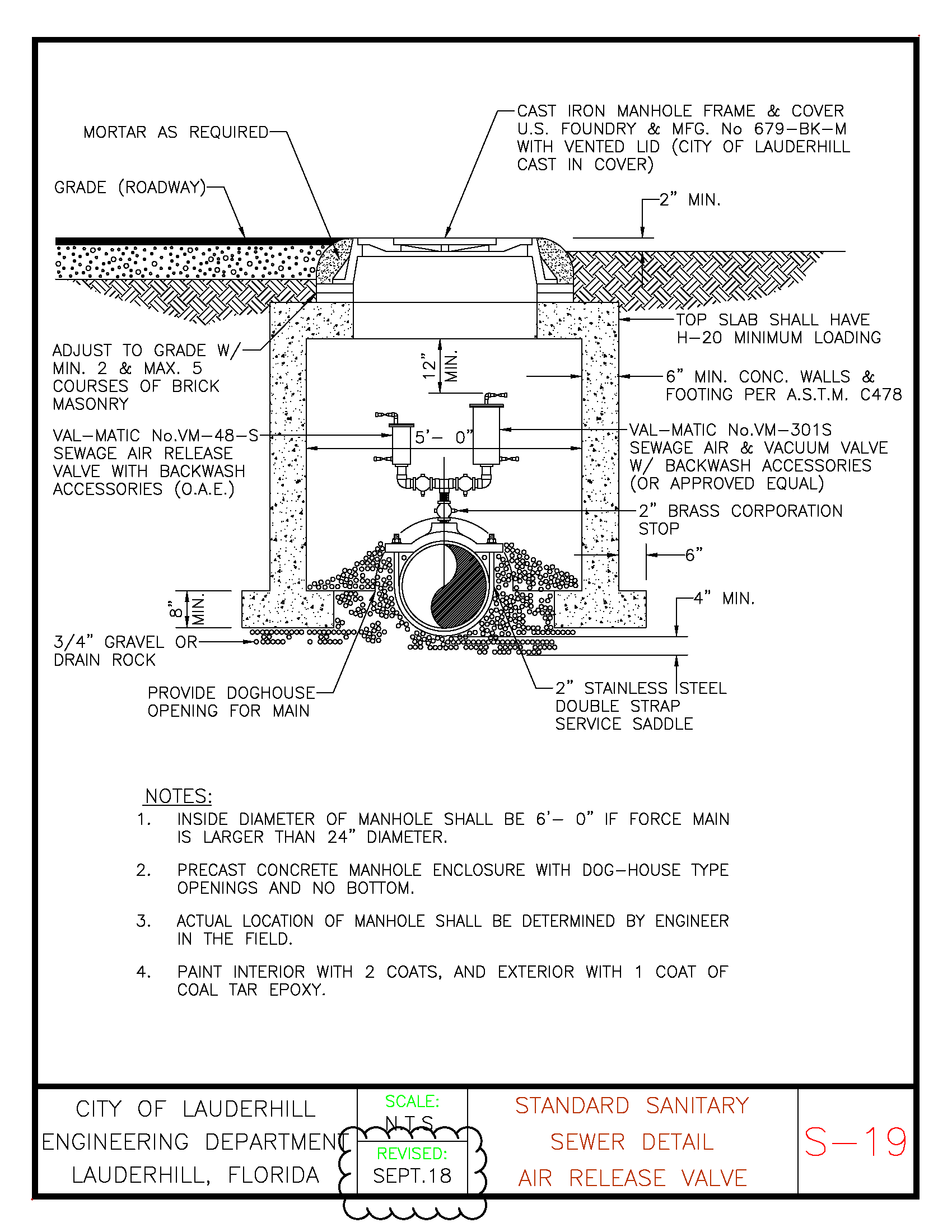
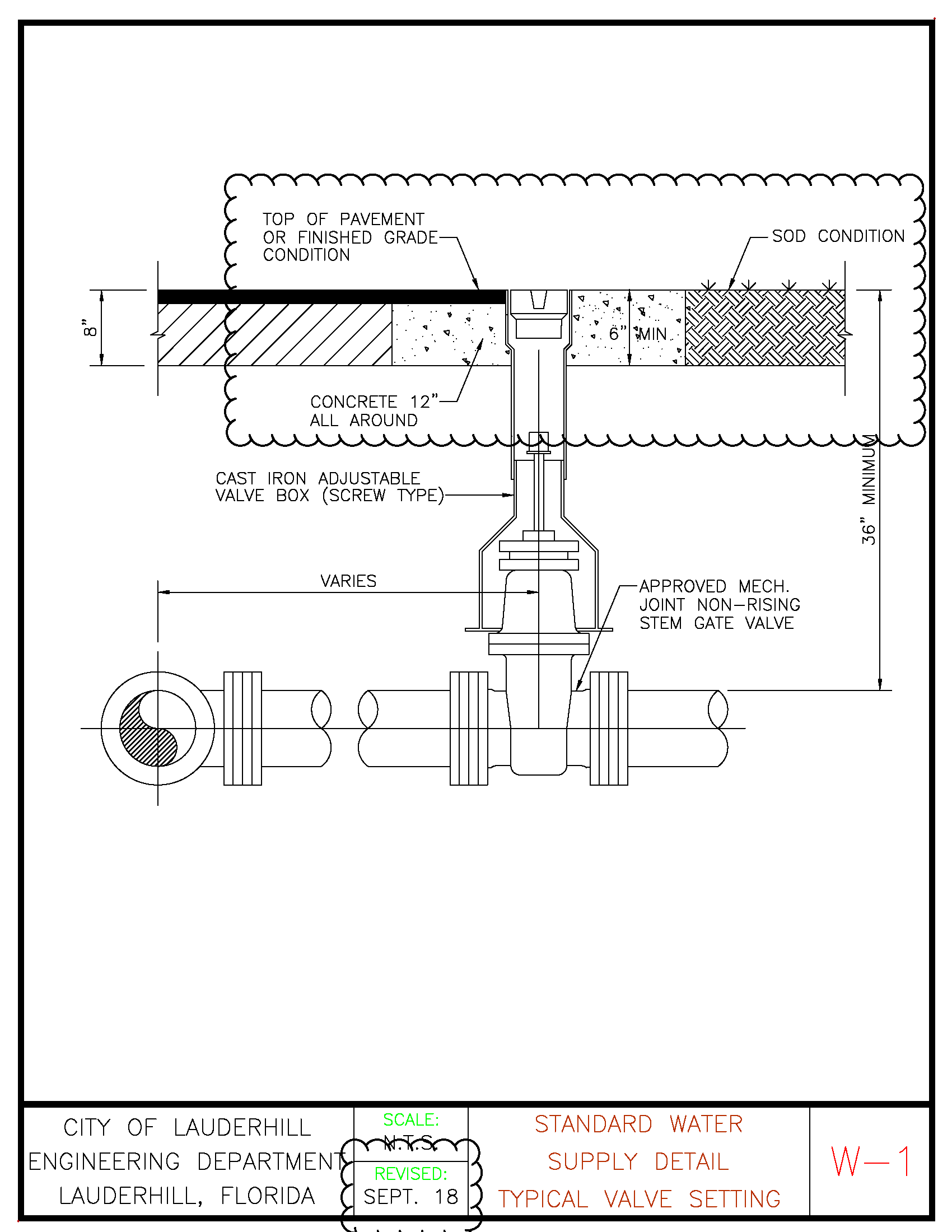
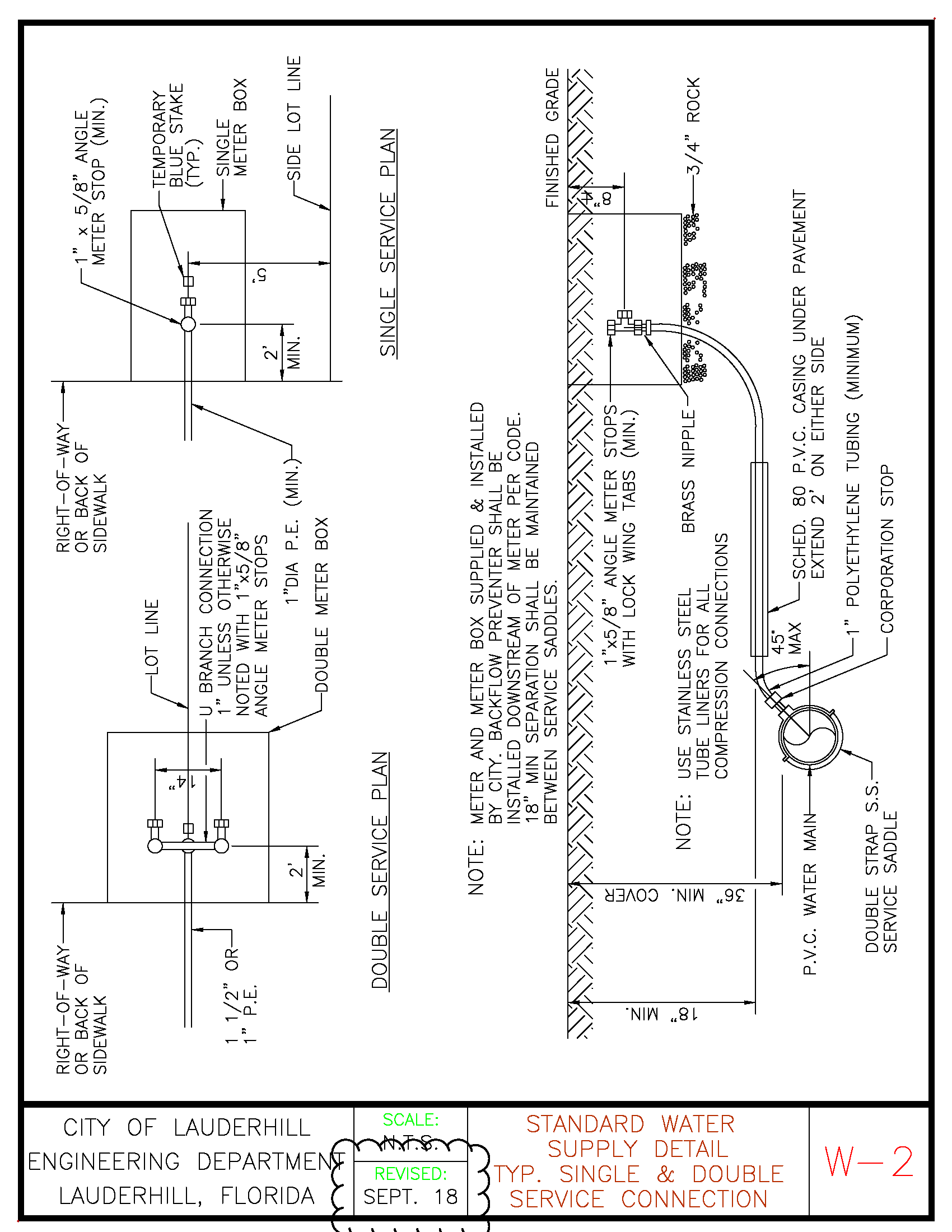
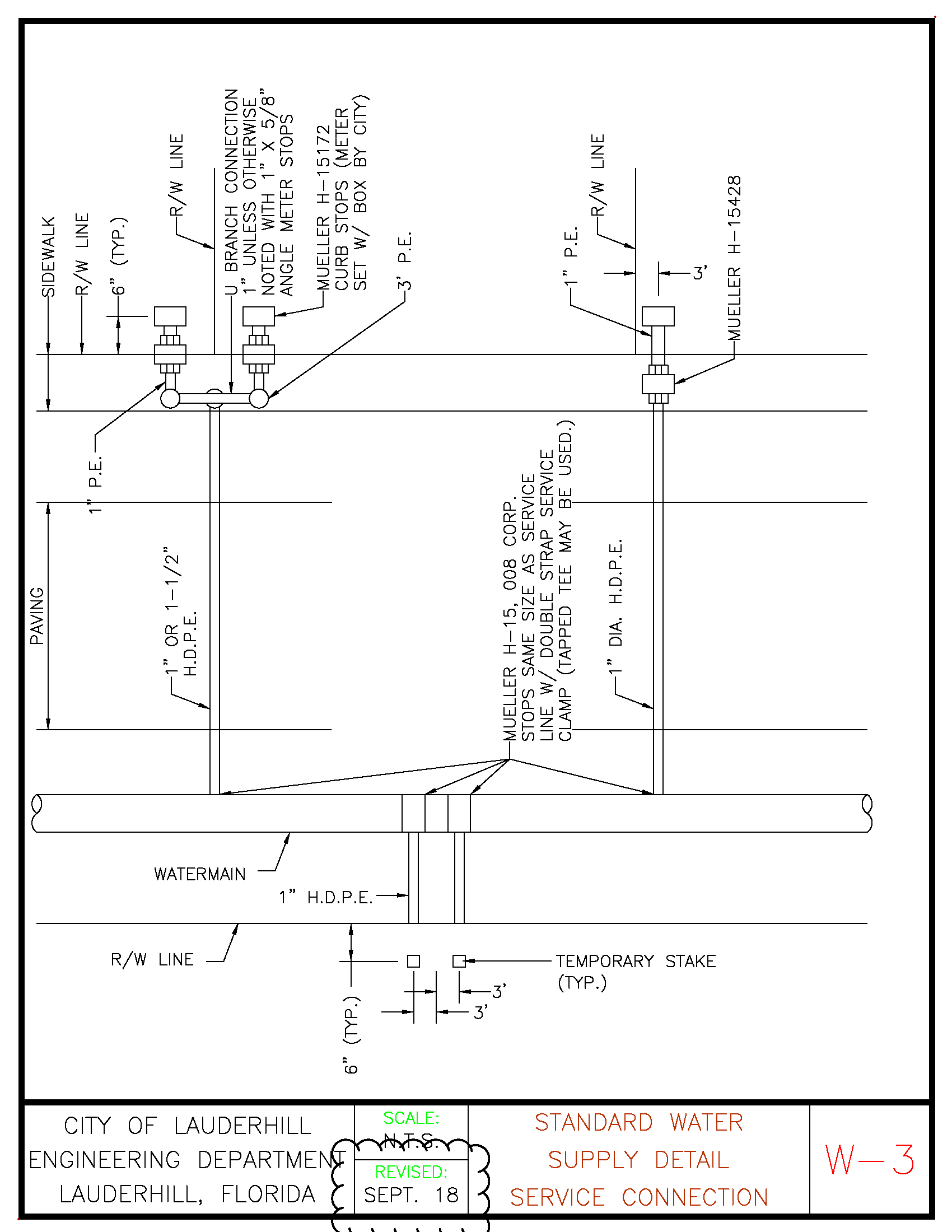
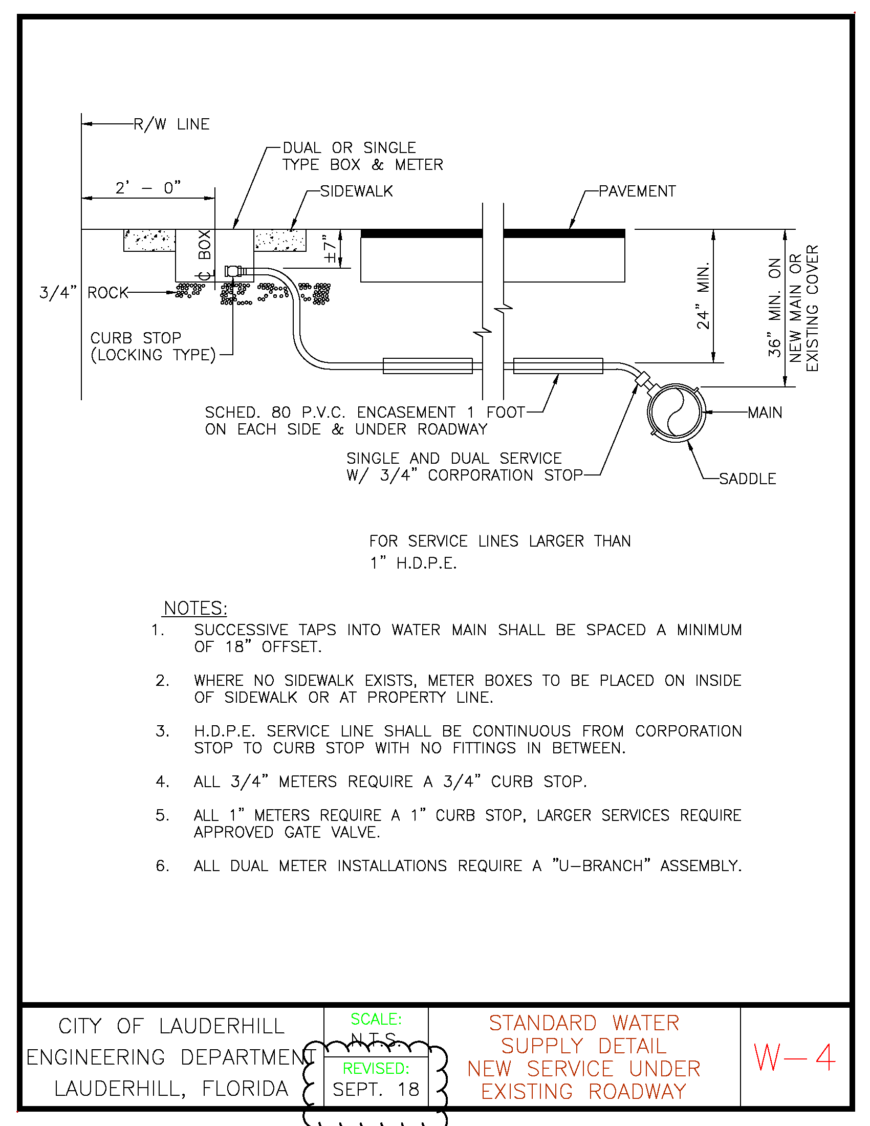
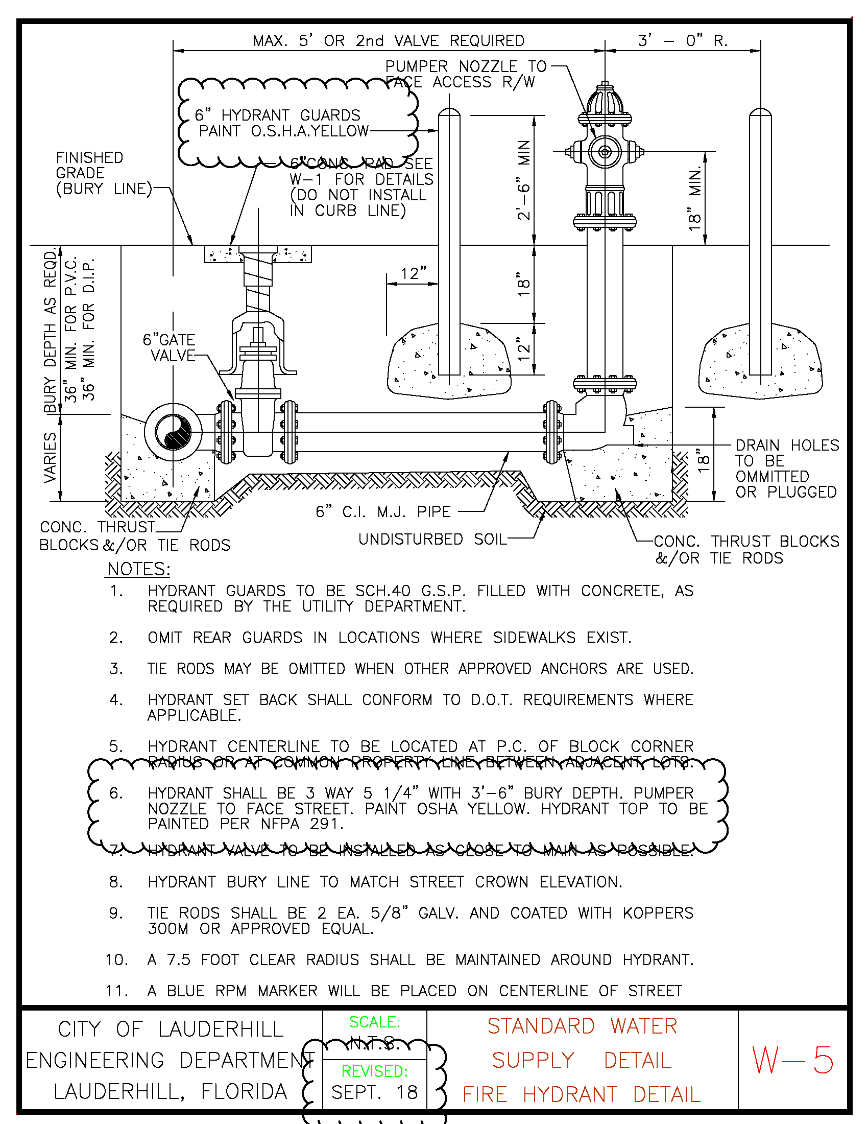
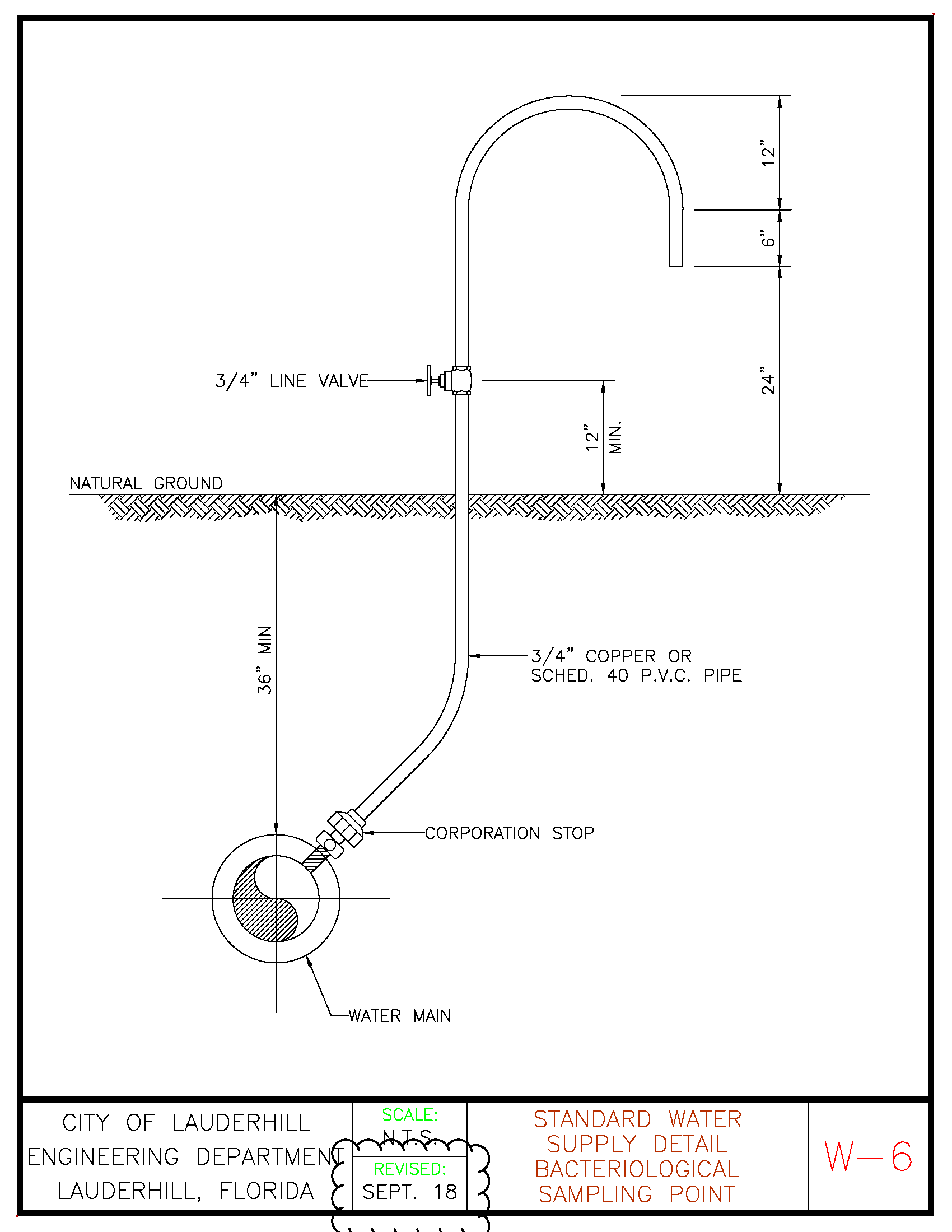
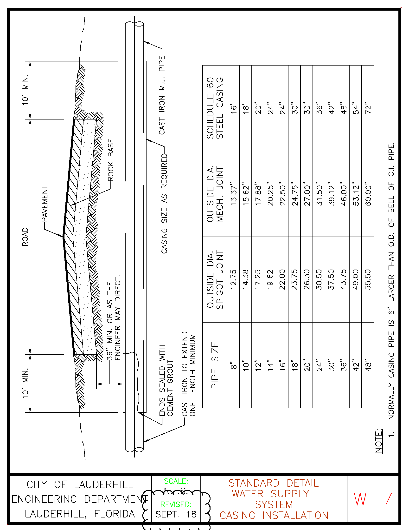
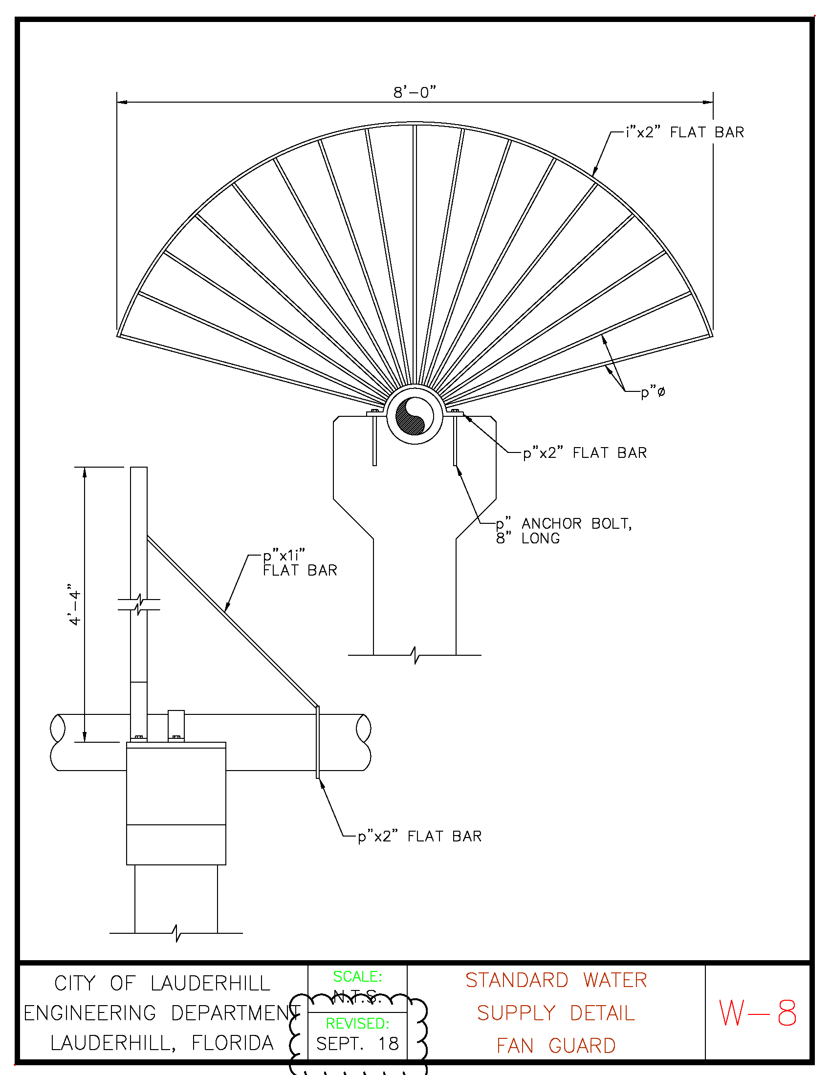
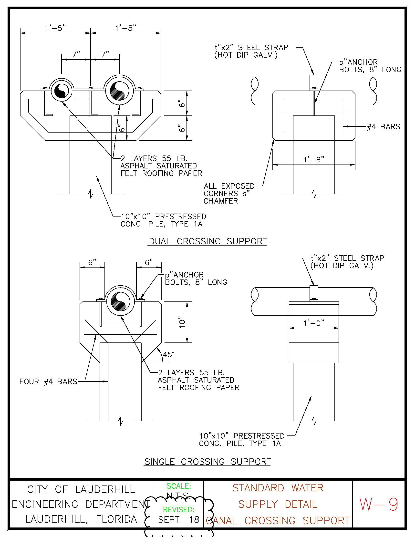
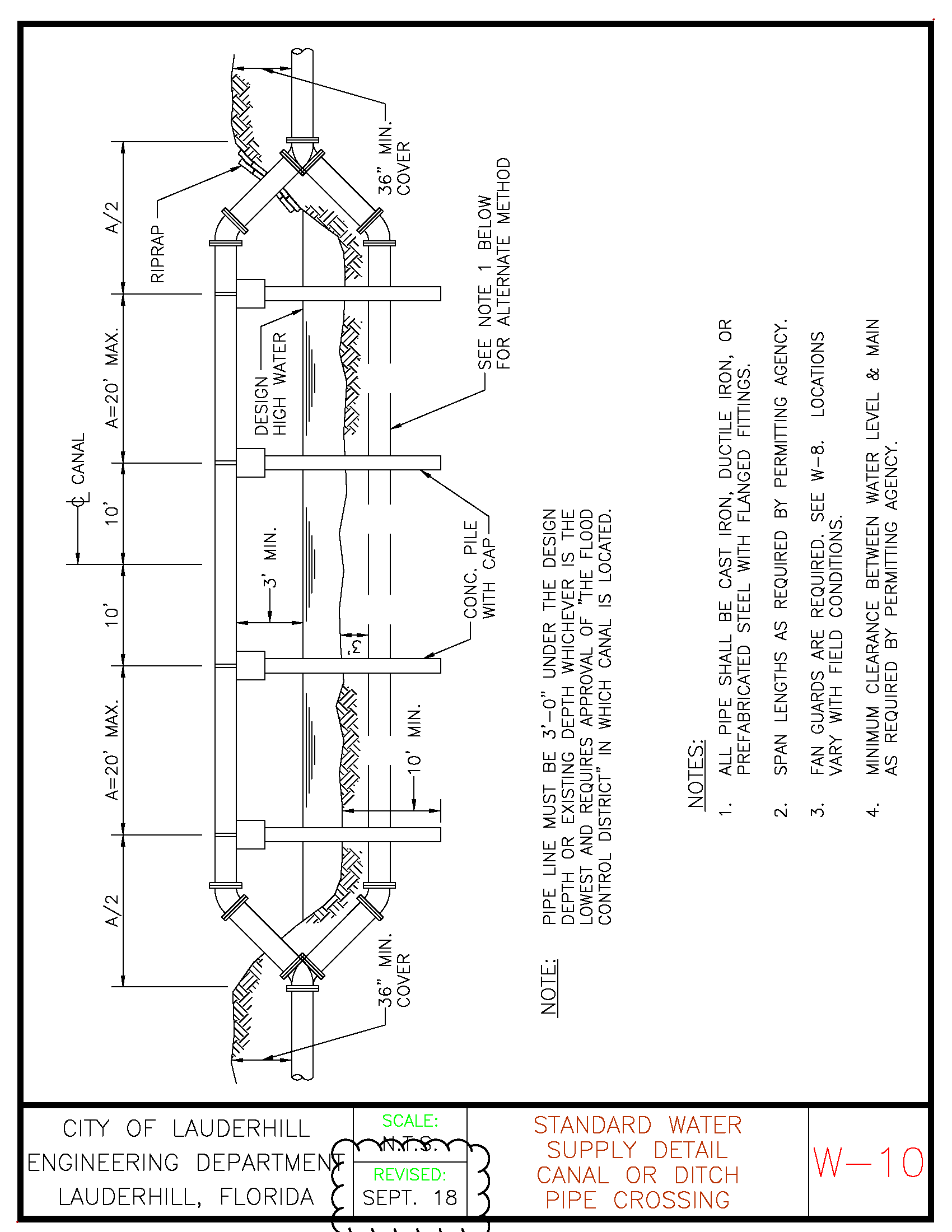
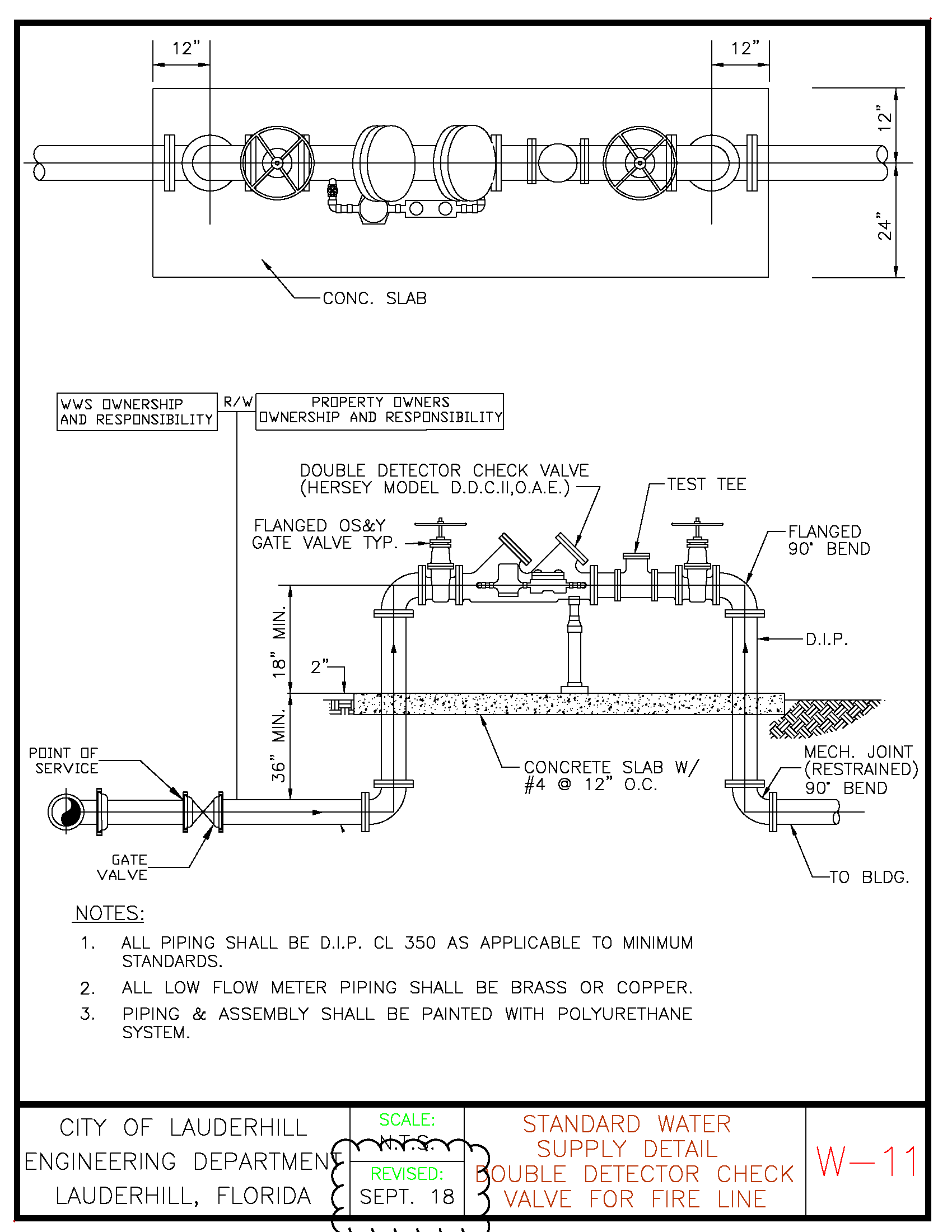
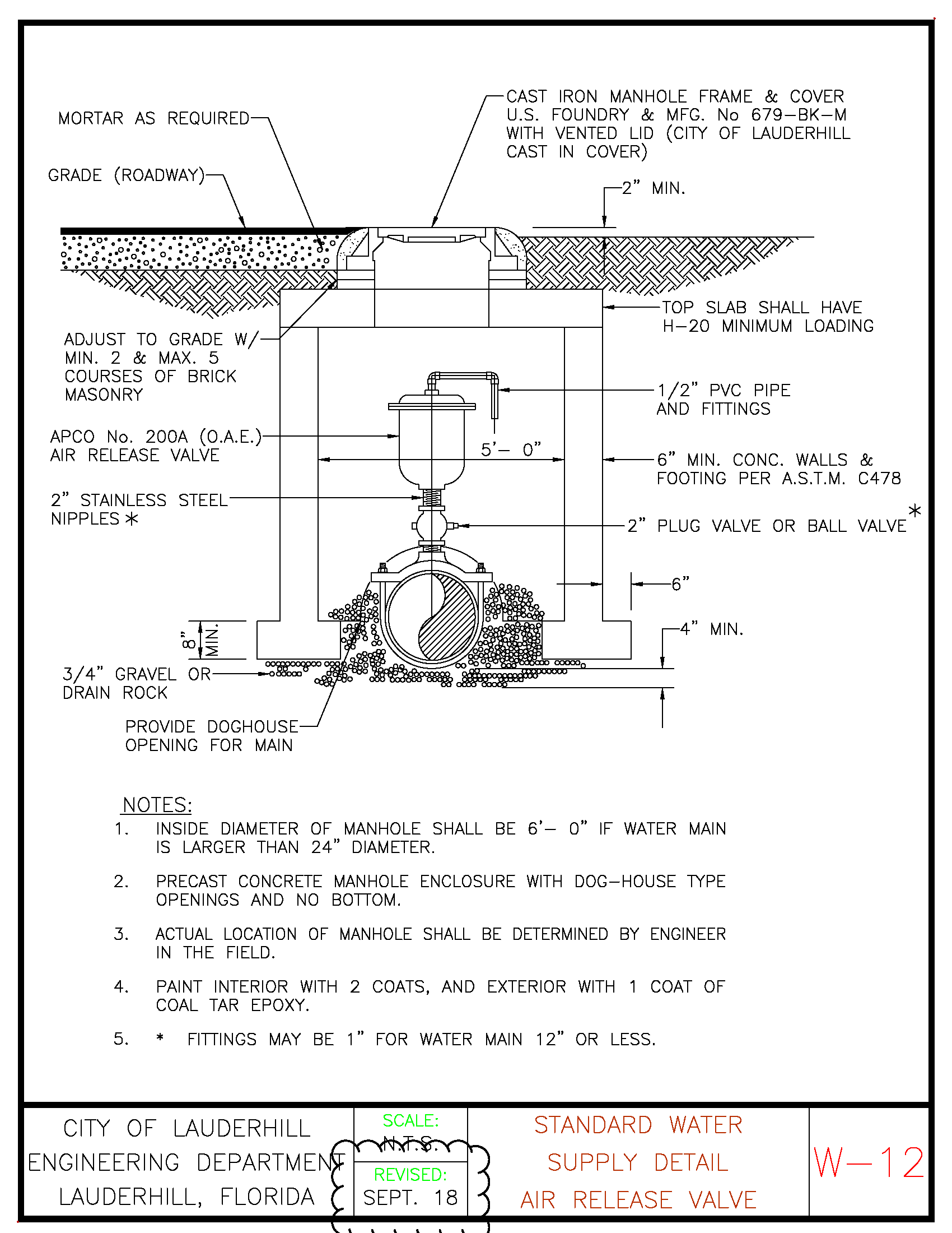
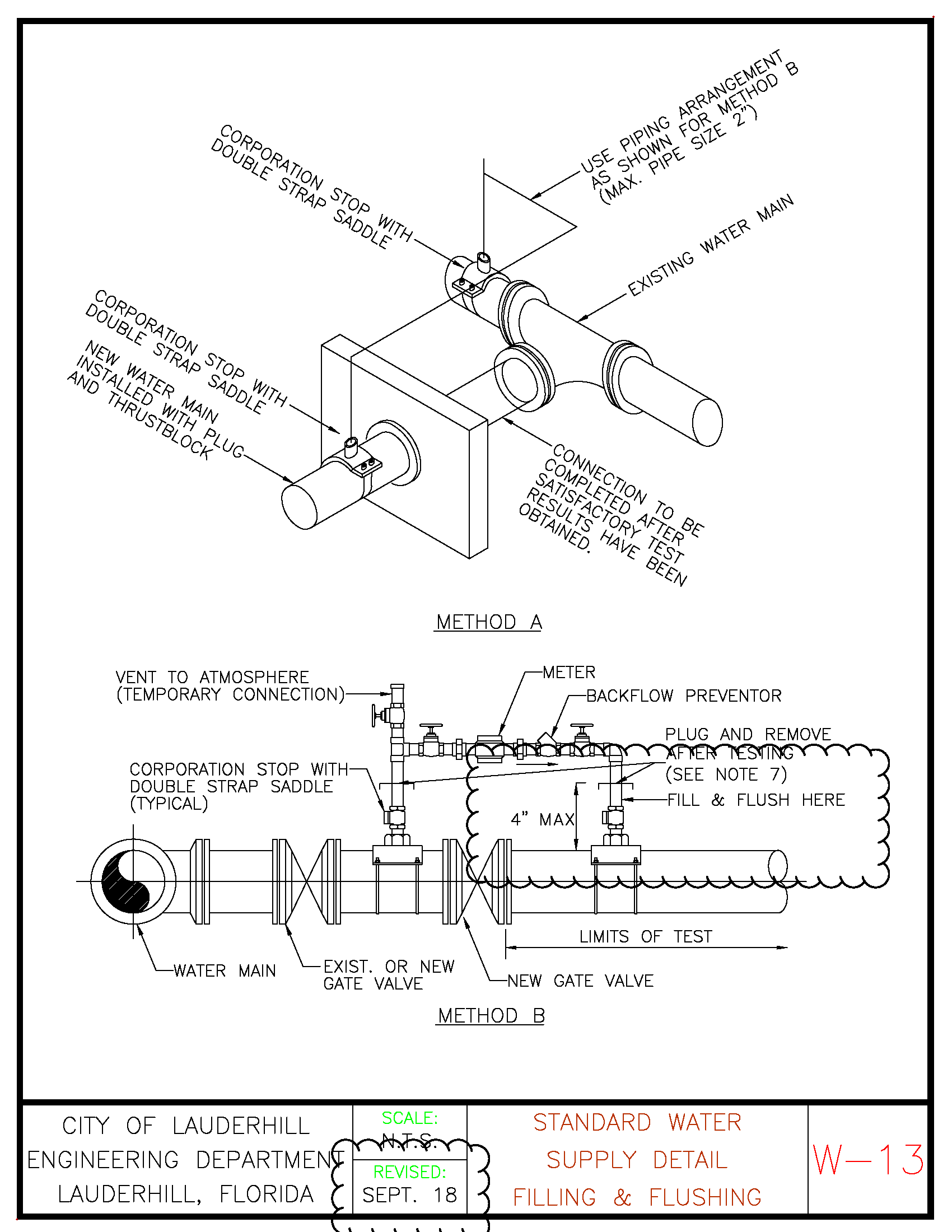
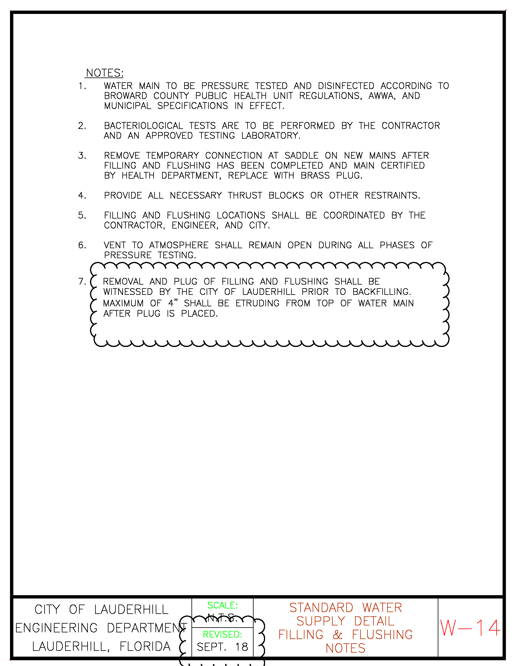
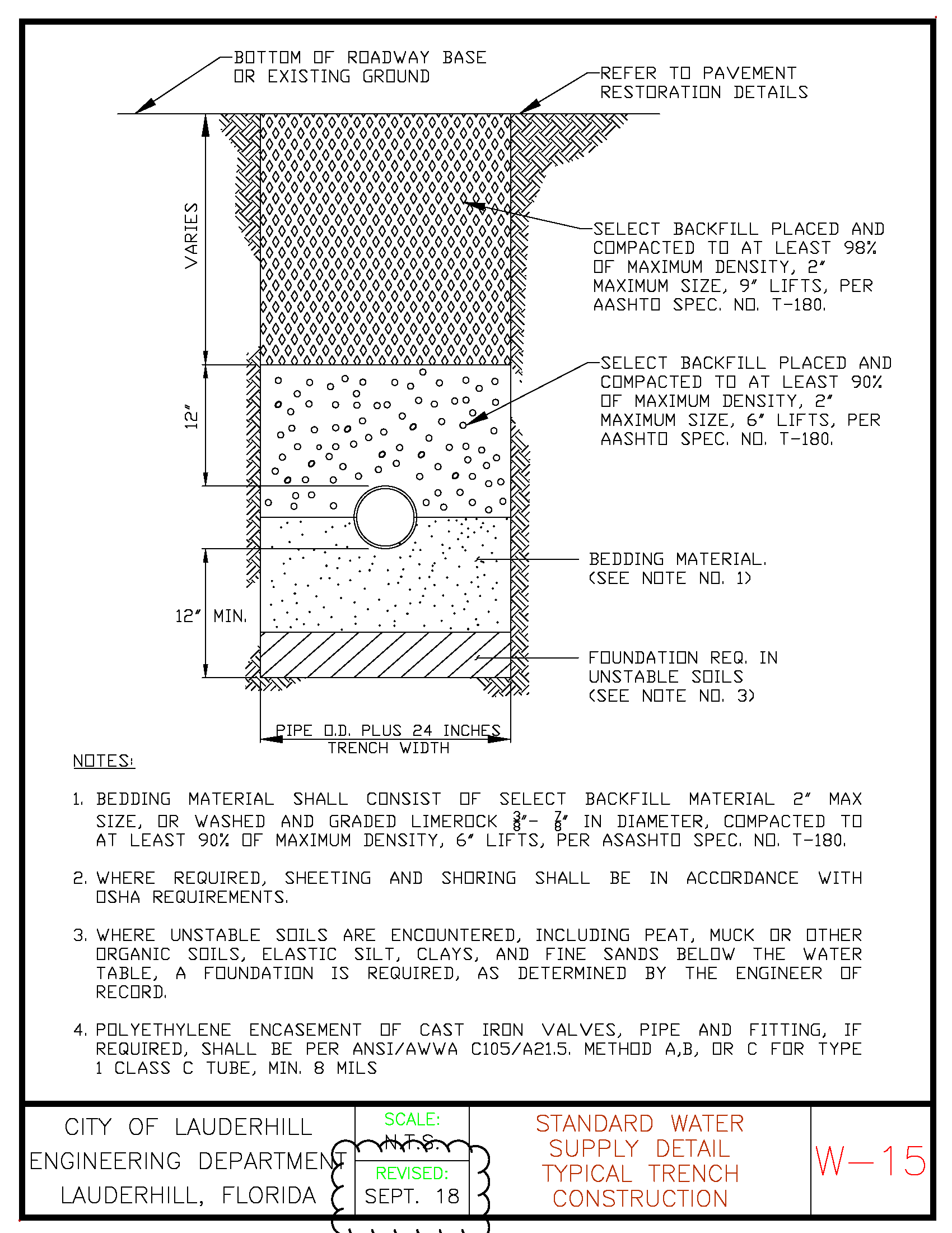
(Ord. No. 19O-03-101, § 1, 4-8-2019; Ord. No. 22O-09-132, § 1, 9-27-2022)
Sec. 6. - Forms.
Editor's note— It should be noted that the forms designated as Section 6 of Schedule L have not been set out at length but are incorporated into the Engineering Standards Manual which is on file and available for inspection in the office of the city clerk.
(Ord. No. 19O-03-101, § 1, 4-8-2019)
Sec. 1. - Minimum housing quality standards.
1.1. Definitions. For the purpose of this Schedule, the following terms, phrases, words, and their derivations shall have the meaning given herein. When not inconsistent with the context, words used in the present tense include the future, words in the plural number include the singular number, and words in the singular number include the plural number. The word "shall" is always mandatory and not merely directory.
Approved is approved in accordance with regulations promulgated by the Building Official.
Building Code is the Building Code of this City.
Building Official is the Building Official of this City.
Deterioration shall mean the condition or appearance of a building, or parts thereof, characterized by holes, breaks, rot, crumbling, cracking, peeling, rusting or other evidence of physical decay or neglect, excessive use or lack or maintenance.
Dwelling is a building or structure, except temporary housing, which is wholly or partly used or intended to be used for living or sleeping by human occupants.
Dwelling unit is a room or group of rooms located within a dwelling and forming a single habitable unit with facilities which are used or intended to be used for living, sleeping, cooking, and eating.
Enforcement Agency is both the Finance and Support Services Department and the Planning and Redevelopment Department.
Enforcement Agency Director is the Director of the Finance and Support Services Department, the Operations Manager of the Finance and Support Services Department, the Director of the Planning and Redevelopment Department, and any person duly designated by the City Manager in writing to serve in such capacity.
Enforcement Official is the Building Official, any Building Inspector, any Code Enforcement Officer or any person duly designated by the City Manager in writing to inspect premises and enforce these Minimum Housing Quality Standards.
Fire hazard shall mean any condition or act which increases the hazard or menace of fire to a greater degree than that customarily recognized as normal by persons in the service of preventing, suppressing or extinguishing fires; or which may obstruct, delay, or hinder or obstruct the prevention, suppression or extinguishment of fire.
Garbage shall mean all rubbish, trash, ashes, animal or vegetable waste resulting from the preparation, handling, cooking and consumption of food, and other organic waste.
Good state of repair as it relates to a structure shall mean that it is safe and reasonably comfortable for its ordinary intended use, or that the materials used in the structure are sound and stable and performing the function for which they were intended and as it relates to fixtures, appurtenances, and personally located within, on, or adjacent to any structure it shall mean that said property is sound, in a good state of repair, and fully performing the function for which it was designed.
Good working condition shall mean the item is fully operable for the use of which it was intended.
Habitable room is a room or enclosed floor space used or intended to be used for living, sleeping, or eating purposes, excluding bathrooms, water closed compartments, laundries, foyers, pantries, communicating corridors, stairways, closets, basement recreation rooms and storage spaces.
Hardship shall mean a bona fide burden placed upon an aggrieved party and causing irreparable injury to said party as the result of the implementation of the provisions of this Schedule.
Health Code shall mean the Florida Sanitary Code as established by Chapter 10D of the Florida Administrative Code, as existing or as may be amended.
Infestation shall mean the presence of any destructive or disease-bearing insects, rodents, vermin or other pests.
Multi-family dwelling is any dwelling or part thereof containing three or more dwelling units.
Nuisance shall mean any condition that endangers life or health, obstructs reasonable or comfortable use of property or any nuisance prohibited by general law, special law, local law or ordinance.
Occupant is any person including an owner or operator living and sleeping in a dwelling unit or rooming unit.
Openable area is the part of a window or door which is available for unobstructed ventilation and which opens directly to the outdoors.
Operator is a person having charge, care, management, or control of any dwelling or part of it, in which dwelling units or rooming units are let.
Owner is any person who, alone, jointly or severally with others, hold s legal or equitable title to any dwelling, rooming hour, dwelling unit, or rooming unit.
Person is any person, firm, partnership, association, corporation, company or organization of any kind.
Plumbing means, includes and refers to:
(1)
The materials including pipe, fittings, valves, fixtures and appliances attached to and a part of a plumbing or gas system for the purpose of creating and maintaining sanitary, heating or cooking facilities in buildings, camps and swimming pools on property where people live, work, play, assemble or travel;
(2)
That part of a water supply and sewage and drainage system extending from either the public water supply mains or private water supply to the public sanitary, storm or combined sanitary and storm sewers or to a private sewage disposal plant, septic tank, disposal field, pit, box filter bed or any other receptacle or into any natural or artificial body of water, water course upon public or private property;
(3)
The design, installation or contracting for installation, removal and replacement, repair or remodeling, or all or any part of the materials, appurtenance or devices attached to and forming a part of a plumbing system, including the installation of any fixture, appurtenance or devices used for cooking, washing, drinking, cleaning, fire fighting, mechanical or manufacturing purposes.
Plumbing Code is the Plumbing Code of this City.
Premises is a lot, plot, or parcel of land including the buildings and structures thereon.
Rental unit shall mean a dwelling unit, as defined herein, which is occupied under a single rental agreement and is located in an apartment, dwelling, rooming house, rooming unit, guest house, lodging house or dormitory. Insofar as these terms are defined in this section, they shall have the meaning herein ascribed to them. These rental units with two or more rental units located within the City shall require to have, in the City, a legal rental agent or operator.
Rooming house is any dwelling, or that part thereof containing one or more rooming units, in which space is let to three or more persons.
Rooming unit is any room or group as rooms forming a single habitable unit used or intended to be used for living and sleeping, but not for cooking or eating purposes.
South Florida Building Code shall be that edition of said code amended and adopted for use in Broward County, Florida.
Special Master is the person appointed by the City Commission as referred to in Code of Ordinances Chapter 7½, Code Enforcement, Article III., Procedure with Special Master, and intended to perform the duties described therein and the duties prescribed herein in Schedule M.
Structure is that which is built or constructed or any piece of work artificially built up or composed of parts joined together in some definite manner, the use of which requires a permanent location on the ground, or which is attached to something having a permanent location on the ground. The term shall be construed as followed by the words "or part thereof."
Structurally sound shall mean that the condition of a structure is such that it is free of imperfections and damage which could adversely affect the intended use of the structure.
Supplied is installed, furnished, or provided by the owner or operator at his expense.
Temporary housing shall mean any tent, trailer or other structure used for human shelter which is designed to be transportable and which is not permanently attached to the ground, to another structure, or to any utilities system on the same premises for more than thirty (30) consecutive days.
Two-family dwelling is any dwelling containing two dwelling units.
Yard is all ground, lawn, [court, walk,] driveway or other open space constituting part of the same premises as a dwelling.
1.2. Minimum standards. No person shall occupy as owner-occupant or shall let to another for occupancy any dwelling, rooming house, dwelling unit, or rooming unit for the purposes of sleeping, living, cooking or eating therein, which does not comply with the following minimum standards for basic equipment and facilities:
(A)
Maintenance. Every plumbing fixture, water pipe, waste pipe and gas line shall be maintained in good, sanitary, working condition.
(B)
Floor surfaces. Floor surfaces in water closet compartments, bathrooms, shower rooms, and kitchens shall be covered with asphalt, vinyl-plastic, rubber tile, ceramic tile, terrazzo or linoleum or other durable, waterproof, nonabsorbent material and such floors shall be properly maintained in clean and sanitary condition. No finished flooring material which requires "face nailing" shall be used.
(C)
Cooking facilities. Every occupied dwelling and dwelling unit shall have a properly installed cooking facility consisting of a stove having at least two top burners and all necessary utility connections shall be provided in each dwelling and dwelling unit for said cooking facility. Cooking facilities shall not be permitted in any hotel unit or rooming unit.
1.3. Space and occupancy. No person shall occupy or shall let to another for occupancy any dwelling, rooming house, dwelling unit, or rooming unit which does not comply with the minimum standards for space and occupancy as set forth in the South Florida Building Code.
1.4. Safe and sanitary maintenance of structural elements. No person shall occupy as owner-occupant or shall let to another for occupancy any dwelling, rooming house, dwelling unit or room unit which does not comply with the following minimum standards for safe and sanitary maintenance:
(A)
Foundations, exterior walls and roofs. Every foundation, exterior wall and exterior roof shall be substantially weathertight, watertight, and rodent proof; shall be kept in sound condition and good repair and maintained without any cracks and holes; and shall be safe to use and capable of supporting the load which normal use may cause to be placed thereon.
(B)
Floor, interior walls and ceiling. Every floor, interior wall and ceiling shall be substantially rodent proof; shall be kept in sound condition and good repair; and shall be safe to use and capable of supporting the load which normal use may cause to be placed thereon.
(C)
Windows and exterior doors. Every window, exterior door and cellar door and hatchway shall be substantially weathertight, watertight and rodent proof; and shall be kept in sound working condition, good repair and maintained without any cracks or holes. All windows intended for ventilation must be equipped with fully operable hardware and fitted with screens in sound working condition and good repair. Screens shall be free of tears, rips, holes and openings. Where separate screen doors are provided at exterior openings, they shall be self-closing. Screen doors shall not be required for units which are mechanically air conditioned or which have a total openable window area of five percent (5%) of the total floor area.
(D)
Stairways and porches. Every inside and outside stair, porch and any appurtenance thereto shall be safe to use and capable of supporting the load that normal use may cause to be placed thereon; and shall be kept in sound condition and good repair. Inside and outside stairways, porches, balconies, hallways, corridors and all appurtenances thereto shall be maintained in a safe condition and capable of supporting the loads set forth in the South Florida Building Code and other regulatory codes of the City of Lauderhill, Broward County or the State of Florida. Broken or deteriorating railings must be replaced with comparable materials.
(E)
Plumbing fixtures. Every plumbing fixture shall be properly maintained in sound mechanical condition, free from defects, leaks and obstructions and in accordance with all applicable Plumbing Codes. Each and every plumbing fixture, water pipe, waste pipe, gas line and drain line, including tenant owned equipment shall be maintained in sound, sanitary condition and good repair.
(F)
Bathroom floor surfaces. Every water closet compartment floor surface and bathroom floor surface shall be maintained so as to be substantially impervious to water and so as to permit such floor to be easily kept in a clean and sanitary condition.
(G)
Maintenance of required equipment and utilities. Every supplied facility, piece of equipment or utility, which is required under this Schedule, shall be so constructed and installed that it will function safely and effectively, and shall be maintained in sound working condition.
(H)
All parts and areas subject to deterioration shall be properly maintained and suitably protected from the elements.
(I)
Every plumbing fixture, water pipe, drain, waste pipe, and gas pipe shall be maintained in a sanitary and good working condition, free from defects, leaks and obstructions.
(J)
All electrical wiring and accessories shall be maintained in a safe and good working condition.
(K)
All accessory structures including fences, garden walls, and other similar enclosures shall be kept clean and maintained in reasonably good repair free from infestations.
1.5. Substandard and unsafe condition.
(A)
A dwelling, dwelling unit or rooming house shall be deemed unsafe when any one or more of the following apply to the structure:
(1)
It is vacant, unguarded and open at doors and windows.
(2)
There is a substantial accumulation of dust, debris or other combustible materials therein.
(3)
The physical condition of the building or structure creates a hazard with respect to a means of ingress or egress for the purpose of providing fire protection to said building or structure as provided in the South Florida Building Code and/or applicable Fire Codes, for the particular occupancy permitted therein.
(4)
There is a falling away, hanging loose or loosening of the siding, block, brick or other building materials.
(5)
There is a deterioration of or damage to the structure or structural parts.
(6)
The building is partially destroyed.
(7)
There is a sagging or leaning out of plumb of the building or any parts thereof caused by deterioration or overstressing of the structure or structural parts.
(8)
The electrical or mechanical installations or systems create a hazardous condition contrary to the standards established by the South Florida Building Code and/or applicable Fire Codes.
(9)
An unsanitary condition exists by reason of inadequate or malfunctioning sanitary facilities or waste disposal systems.
(10)
There is an inadequate or impure source of running water designed or intended for human consumption; or
(11)
By reason of use or occupancy the area, height, type of construction, fire-resistivity, means of egress, electrical equipment, plumbing, air conditioning or other features of the structure regulated by the South Florida Building Code do not comply with the South Florida Building Code and/or the applicable Fire Codes, for the use and Group of Occupancy permitted therein.
(B)
A building, structure of any part thereof, shall be presumed to be unsafe when one or more of the following apply to the structure:
(1)
The construction or installation of electrical, plumbing or other equipment has been commended or completed without a valid and current building permit; or having obtained a valid permit, the permit has expired prior to the completion of construction or installation of said equipment or has not been approved by the City Community Development Department.
(2)
By reason of a nonconforming, illegal or improper use, the occupancy or maintenance of said premises does not comply with this Schedule, the South Florida Building Code or the applicable Fire Codes in effect at the time of construction.
(C)
Repairs and installations. Repairs and installations shall be made so as to comply with the provisions of the South Florida Building Code and other regulatory codes of the City of Lauderhill, Broward County or the State of Florida.
1.6. Responsibilities of owners, operators and occupants.
(A)
Sanitation.
(1)
Every occupant of a dwelling, dwelling unit shall maintain in a clean and sanitary condition that part of the dwelling, dwelling unit and yard which he/she occupies and controls including, but not limited to, all equipment, sanitary facilities, yards, courts, driveways, lawns and landscaping and shall be responsible for their own misuse of areas and facilities available in common.
(2)
Every owner or operator of a two-family dwelling or multi-family dwelling shall maintain in a clean and sanitary condition the shared or public areas of the dwelling and yard.
(3)
Every occupant of a dwelling unit shall keep all supplied facilities, including plumbing fixtures and cooking equipment, in a clean and sanitary condition and shall be responsible for the exercise of reasonable care in their proper use and operation.
(4)
Every owner or operator shall maintain the exterior premises so as to prevent the accumulation of stagnant water thereon.
(B)
Extermination.
(1)
Every occupant of a dwelling unit shall be responsible for the extermination of any insects, rodents or other pests in the dwelling unit or in the yard. In a two-family dwelling, or a multi-family dwelling, the occupant shall be responsible for such extermination whenever his dwelling unit is the only one infested. When, however, infestation is caused by failure of the owner or operator to maintain a dwelling in a rodent-proof or substantially insect-proof condition, extermination shall be the responsibility of the owner or operator.
(2)
Every owner or operator shall be responsible for extermination of any insects, rodents or other pests whenever infestation exists in two or more of the dwelling units in any dwelling or in the shared or public areas of any two-family or any multi-family dwelling.
(C)
Transfer of responsibility. A contract effective as between owner and operator, operator and occupant or owner and occupant, with regard to compliance hereunder shall not relieve any direct responsibility under this Schedule on the part of the owner.
(D)
Notice of maximum occupancy. Every owner or operator shall advise the occupant in writing either by insertion in the lease between the parties or otherwise of the maximum number of occupants permitted in the occupied premises under this Schedule in compliance with the South Florida Building Code.
1.7. Enforcement.
(A)
Authority. The standards set forth in this section shall be enforced by the Enforcement Agency. The Enforcement Agency shall determine whether buildings used in whole or part for purposes of human habitation conform to the requirements of this Schedule. If an Enforcement Official determines that any such building does not conform to this Schedule, an Enforcement Official shall cause the owner to be notified by a notice of violation, in writing, of the manner in which such building does not conform, and the time that the owner shall have from the issuance of such notice in which to remedy the conditions therein specified; provided that an Enforcement Official may, in his/her discretion, extend the time for compliance with any such notice; and provided, further, that no owner shall be held responsible for any condition that is not specifically described in such notice. An Enforcement Official is granted the right of entry in the performance of his or her duties. Inspections shall be made by the inspectors for the Enforcement Agency on an annual basis for rental properties only.
(B)
Service of notice.
(1)
Whenever an Enforcement Official determines that there is a violation of any provision of this Schedule, the Enforcement Official issue a notice of violation.
(2)
A notice of violation shall be served on the owner or operator of the structure or premises or on the occupant where the occupant is responsible for said structure or premises pursuant to this Schedule. Service may be by hand delivery, or if hand delivery cannot be effectuated, then by posting and mailing via certified mail return receipt requested if no appropriate person is present for hand delivery at the time of the issuance of the notice. Such notice shall:
(a)
Be in writing;
(b)
Be dated and signed by the Enforcement Official;
(c)
Specify the violation or violations; and their respective code citations;
(d)
Contain an outline of the corrective action, which, if properly performed, will effect compliance with the provisions of this Schedule;
(e)
State whether a building permit is or is not necessary to correct the violations;
(f)
State that if a building permit is necessary, it must be obtained prior to correcting the violations and that it must be obtained no later than thirty (30) days after the date of the violation notice;
(g)
Set a time certain within which the corrective work is to be completed;
(h)
Contain a statement that final compliance must conform to the requirements of the current Florida Building Code, Broward Edition, as may be amended from time to time;
(i)
Inform the violator that unless an objection to the notice of violation is filed with the appropriate Enforcement Agency within thirty (30) days of the date of service, the Enforcement Agency may cause to be made any corrections necessary for compliance, the costs of which shall be paid by the owner, operator or occupant, as the case may be. Where the owner is charged, the cost shall be assessed against the property and made a lien thereon. Where the operator or occupant is charged, the cost shall be imposed as a code fine upon the certificate of use and the certificate of use shall not be issued or renewed until the fine is paid consistent with Code of Ordinances Section 12-27.
1.8. Inspections.
(A)
The Enforcement Agency is hereby authorized and empowered to make inspections of dwellings, dwelling units, hotels, rooming houses and all premises adjacent to such structures, including vacant lots and commercial properties located adjacent thereto in order to determine the physical condition of said premises.
(B)
All Enforcement Officials are hereby authorized to enter, examine and survey, all structures and premises for which minimum standards are established by this Schedule at reasonable hours.
(C)
In the event a person who has common authority over a structure or premises regulated hereunder, shall not consent to an inspection, survey and examination of said structure or premises, said person shall be given the opportunity to reschedule such inspection, survey and examination for a time certain within ten (10) days of the inspector's initial contact. Failure of the person exercising common authority over said structure, or premises, to thereafter consent to an inspection, survey and examination of the structure or premises, without just cause, shall be sufficient grounds and probable cause for a court of competent jurisdiction to issue a search warrant for the purpose of inspecting, surveying or examining said structure or premises.
(D)
In the event a structure or premises appears to be abandoned or vacant and the owner cannot be readily contacted in order to obtain consent to inspect, survey and examine the structure or premises, then and in that event, the inspector may enter upon any open, unsecured, or unlocked portion of the structure or premises in order to conduct an inspection, survey and examination thereof.
(E)
In the event it shall be deemed necessary for an Enforcement Official to enter a secured or locked structure or premises which appears to be abandoned or vacant and the owner cannot be readily contacted in order to obtain consent to inspect, survey and examine the structure or premises, then in that event, the absence of the owner and vacancy of the structure and premises shall be sufficient grounds and probable cause for a court of competent jurisdiction to issue a search warrant for the purpose of inspecting, examining and surveying the structure and premises.
(F)
Enforcement Officials shall be provided with official identification and shall exhibit such identification when making any inspection.
1.9. Objection to notice of violation.
(A)
Any person affected by a notice of violation issued in connection with the enforcement of any provisions of this Schedule may file written objections to said notice appropriate Enforcement Agency and request a hearing on the matter before the within thirty (30) days of the date of service to object to the City proceeding to make any corrections necessary for compliance at the costs of the owner, operator or occupant prior to a hearing before the Special Master.
(B)
All objections to a notice of violation and order to show cause shall be in the form of a petition seeking review of the Enforcement Official's basis for the notice of violation. The petition shall:
(1)
Be printed or typewritten on no less than 8½" × 11" white bond paper;
(2)
Contain the name, address, and telephone number of the petitioner, and the violation number;
(3)
Indicate whether or not the petitioner is represented by an attorney and if so, state his name, address and telephone number;
(4)
Set forth in clear and concise language the petitioner's objections to the notice of violation;
(5)
Contain a brief statement setting forth the specific grounds for each objection;
(6)
State whether or not the petitioner will appear at the hearing before the Special Master and if he or she will be accompanied by counsel;
(7)
State the relief or decision sought by the petitioner from the Enforcement Agency; and
(8)
Be signed and verified under oath by the petitioner.
(C)
The filing of objections to a notice with the appropriate Enforcement Agency, in the form of a petition as specified hereunder, shall entitle the petitioner to a hearing before the Special Master and shall stay the Enforcement Agency from taking any corrective action until after the hearing has been held, except in cases where an emergency has been determined to exist in accordance with Section 1.11.
1.10. Hearing on notice of violations.
(A)
All notices of violation issued under this Section will be set for hearing before the Special Master of the City of Lauderhill. In addition, upon receipt of a petition objecting to the notice of violation in the form specified hereunder, the Enforcement Agency Director shall immediately schedule a hearing thereon prior to proceeding to make corrections necessary for compliance. The hearing on objections to notice of violations also shall be heard before the Special Master. The petitioners shall also be given written notice of the hearing, by mailing a copy of the hearing notice to the address given in his or her petition provided that an objection was timely filed, or to the address of the property which was the basis for the notice of violation if no objection was filed.
(B)
The hearing shall be held not less than fifteen (15) days nor more than sixty (60) days after the day upon which the petition was received by the Enforcing Agency if an objection is filed, or from the date of the issuance of the notice of violation if no objection is filed.
(C)
Hearings shall be informal and need not be conducted according to technical rules relating to evidence and witnesses. Any relevant evidence may be admitted if it is the type of evidence on which responsible persons are accustomed to rely in the conduct of serious affairs. Hearsay evidence may be used for the purpose of supplementing or explaining any direct evidence but shall not be sufficient in itself to support a finding unless it would be admissible over objections in civil actions. The rules of privilege shall be effective to the same extent that they are recognized in all civil actions. All witnesses shall be sworn prior to giving any testimony and irrelevant and unduly repetitious evidence and testimony shall be excluded.
(D)
All parties shall have an opportunity to respond, to present evidence and argument on all issues involved, to conduct cross-examination and submit rebuttal evidence, and to be represented by counsel. When appropriate, the general public may be given an opportunity to present oral or written communications. If the Enforcement Agency proposes to consider such material then all parties shall be given an opportunity to cross-examine or challenge or rebut it.
(E)
The Special Master shall, at the conclusion of a hearing hereunder, sustain, modify or dismiss the notice of violation and issue an Order relative thereto consisting of the findings of fact, conclusion of law, a legal description of the subject premises and such other information deemed pertinent by the Special Master. When corrective action is ordered by the Special Master, the Special Master shall specify a date certain by which said action is to be completed. The Special Master has the authority to order fines associated with the violation if corrective action is not completed by the set compliance date, in addition to the recovery of any and all costs and expenses necessary to remedy the condition, costs for recording, prosecution costs, interest and any other reasonable costs associated with the notice of violation. The Order entered by the Special Master shall be recorded in the public records of Broward County, Florida. The recording of such Order shall constitute constructive notice to any subsequent purchasers, transferees, grantees, mortgagees, lessees, lienors, and all persons having, claiming or acquiring any interest in the property described herein or affected thereby.
(F)
When the corrective action specified in a Order is completed and the costs thereof paid by the owner of the subject premises, the Enforcement Agency Director shall file a certificate of correction and satisfaction stating that all violations have been corrected and thereupon the Order shall be deemed to be satisfied.
(G)
The cost of recording the Order and the certificate of correction shall be recoverable as costs from the owner of record of the property prior to recording the certificate of correction.
(H)
Appeals. All appeals under this section shall be filed with the Circuit Court for Broward County, Florida, within thirty (30) days of the date of the Order of the Special Master.
1.11. Emergency orders.
(A)
Whenever the Enforcement Agency Director determines that an emergency exists due to a disease epidemic, unsanitary situation, unsafe situation, or other condition which requires immediate action to protect public health, safety or welfare, and the owner of the subject premises is not readily available for service the Enforcement Agency Director may issue an order without notice to the owner, stating the existence of such emergency and requiring that a specified cause or action be taken to meet the emergency.
(B)
When the Enforcement Agency Director determines that an emergency condition exists he shall attempt to locate the owner of the subject premises and serve him with an emergency order to show cause which shall contain a short and plain statement of the emergency situation, the corrective action to be taken and the time and date by which such action is to be completed. If the owner cannot be readily located within twenty-four (24) hours the Community Development Department may issue an emergency order.
(C)
Whenever an emergency order is not complied with within twenty-four (24) hours by the owner of the subject premises, the Enforcement Agency shall take such direct and immediate action as is necessary to abate the hazard or danger. Expenses incurred in the execution of such orders shall be recovered as provided hereunder for the recovery of other expenses incurred by the Enforcement Agency.
1.12. Action to be taken upon noncompliance with final order.
(A)
Upon the refusal, failure or neglect of a person to comply with a final order, the Enforcement Agency may then have the dwelling, dwelling unit, hotel, hotel unit, rooming house or rooming unit repaired, altered, vacated, or otherwise made to conform with the requirements of this Schedule.
(B)
Prior to taking any action pursuant this section in executing an order, the Enforcement Agency shall attempt to locate and notify the owner, occupant, lessee and mortgagee of the property, in writing, and by personal service if they shall be found in Broward County, of the action ordered to be taken by the Enforcement Agency.
(C)
If the person or persons required to be noticed under this section cannot be found after diligent search and inquiry, or if all parties having an interest in said premises cannot be ascertained then notice shall be sent by certified mail to the last known address, if one can be found, of such person or persons found to have an interest in said property, and a copy of the notice posted in a conspicuous place on the premises. All notices shall be served not less than ten (10) days before any repairs, alterations, vacation, demolition or other action commenced hereunder and shall be deemed good and sufficient notice to all interested parties.
(D)
The owner of any property, and all persons having an interest therein, which is the subject of an order of the Special Master shall pay all costs of the corrective action required and ordered by the Special Master, in addition to any fines assessed, costs and expenses to remedy the condition, costs for mailing, service and recording, costs of prosecution, and any other reasonable related costs and shall be jointly and severally liable for all costs incurred in the execution of any action ordered by the Special Master.
(E)
In the event the owner of any property shall not take the corrective action ordered by the Special Master and the Special Master causes said action to be taken, all costs incurred by the Enforcement Agency in the execution of any action ordered by the Special Master shall be a lien against the subject property upon the filing of a statement of costs with the office of the Broward County Public Records, or its successor, by the Community Development Department.
(F)
Whenever an order is entered against the property owner, all costs of the proceedings, including the costs of service, notice, and title search shall be charged against the subject property. Where the operator or occupant is charged, all the above described costs shall be imposed as a code fine upon the certificate of use and the certificate of use shall not be issued or renewed until the fine is paid consistent with Code of Ordinances Section 12-27.
(G)
All costs incurred by the Enforcement Agency in the execution of any repairs, alterations, vacations, or other action ordered, may be paid from public funds upon certification by the Enforcement Agency of the date or dates the work was performed and that the items of cost are accurate, reasonable and necessary.
(H)
A lien for costs and repairs filed hereunder shall bear interest at the then current legal rate of interest per annum from the date of filing a certified copy of said lien with the Broward County Public Records and thereafter shall constitute a lien against the land on which the violation exists.
1.13. Conformance with federal standards. In addition to the local minimum housing quality standards herein, the federal housing quality standards codified in 24 CFR 982.401, as amended from time-to-time, shall apply when applicable. In the event of a conflict between the local and federal minimum housing quality standards, the more stringent standards shall apply.
(Ord. No. 10O-02-106, § 1, 2-22-2010; Ord. No. 11O-08-150, § 1, 9-14-2011)
Secs. 7.1.0, 7.1.1.- Reserved.
Editor's note— Ord. No. 01O-01-07, §§ 1—3, adopted Jan. 29, 2001, redesignated §§ 7.1.0, 7.1.1, subsections 7.1.1.1, 7.1.1.2 and 7.1.1.3 as Article III, §§ 5.1, 5.33 and 5.38, respectively. Formerly, said sections pertained to the accessory structures and uses purposes, general standards and requirements, satellite dish antennas, and storage buildings regulations. For a detailed analysis of these changes, see the Table of Amendments.
7.1.1.4. Storage on residential property.
No building material or construction equipment shall be stored in any residential zoned district, except when incidental to currently ongoing construction operations for which a permit is in effect.
(Ord. No. 93-149, § 1, 7-12-93; Ord. No. 93-164, § 1, 9-13-93; Ord. No. 96O-131, § 1, 9-9-96)
Sec. 1. - Purpose and intent.
The purpose of the Gateway Roads Overlay (GR-O) Zoning District is to enhance the general public welfare by improving the aesthetic appearance of those properties situated along roadways that provide ingress and egress of the City. The intent of the overlay zoning district is to implement those provisions in the adopted Future Land Use Element pertaining to gateway roads and focal points.
(Ord. No. 01O-11-66, § 1, 12-10-01)
Sec. 2. - Corridor properties.
Corridor properties are those properties whose boundary is coterminous with the public right-of-way for a designated gateway road. Corridor properties are subject to the following additional requirements.
2.1. Walls and fences. A wall or fence uniform in construction, texture, design and color shall be erected on all corridor properties. Alternatively, all fences and walls may be uniformly removed. The Planning and Zoning Department shall seek the input of the affected property owners, to the extent practicable, as to the preferred fence or wall construction, texture, design and color for each designated gateway road. After obtaining affected property owner input, the Planning and Zoning Department shall present to the Planning and Zoning Board, for each designated gateway road, the property owners' preference and the Department's recommendation. The Planning and Zoning Board shall then make a recommendation to the City Commission. The Department shall present the recommendations to the City Commission no later than December 31, 2002 in the form of Schedule O amendments.
2.2. Landscape and irrigation. Uniform landscaping and irrigation shall be installed on all corridor properties. The Planning and Zoning Department shall seek the input of the affected property owners, to the extent practicable, as to the landscaping and irrigation system for each designated gateway road. After obtaining affected property owner input, the Planning and Zoning Department shall present to the Planning and Zoning Board, for each designated gateway road, the property owners' preference and the Department's recommendation. The Planning and Zoning Board shall then make a recommendation to the City Commission. The Department shall present the recommendations to the City Commission no later than December 31, 2002 in the form of Schedule O amendments.
(Ord. No. 01O-11-66, § 1, 12-10-01)
Sec. 3. - Entranceway properties.
Entranceway properties are corridor properties whose boundary also is coterminous with the City boundary or in proximity to the City boundary.
3.1. Identification/signage. [RESERVED]
(Ord. No. 01O-11-66, § 1, 12-10-01)
Sec. 4. - Gateway roads designated.
The following gateway roads are designated:
4.1. U.S. 441/SR-7/N.W. 40 Avenue.
4.2. N.W. 47 Avenue.
4.3. Rock Island Road.
4.4. N.W. 55 Avenue.
4.5. N.W. 56 Avenue/Inverrary Boulevard/N.W. 50 Street.
4.6. Inverrary Boulevard West.
4.7. N.W. 70 Avenue.
4.8. University Drive.
4.9. N.W. 82 Avenue
4.10. Pine Island Road.
4.11. Oakland Park Boulevard.
4.12. N.W. 44th Street.
4.13. Commercial Boulevard.
(Ord. No. 01O-11-66, § 1, 12-10-01)
Sec. 1. - Introduction.
The City of Lauderhill Design Standards are intended to supplement the existing Lauderhill Land Development Regulations. These standards take into consideration the distinct character of Florida and more specifically, the City of Lauderhill. They are formulated to facilitate the development of a viable City design which is conducive to the overall enjoyment and safety of residents and visitors. The standards also seek to keep intact the elements that lend Lauderhill its unique character, while improving the overall aesthetic and functional quality of the City.
 |  |
| Sample images for Lauderhill street and intersection improvements. | |
The Lauderhill Design Standards and Guidelines are divided into nine (9) sections accompanied by a foreword and two (2) appendices. Each section is preceded by a brief introduction followed by a categorized enumeration of development standards and guidelines. Design standards are the performance criteria used to evaluate and approve any new development or alterations to an existing development, which standards must be complied with in order to secure a site plan or site plan modification, community appearance committee development order and building permit. Further these design standards and guidelines are supplemented with photographs, diagrams and sketches, where relevant to help assist in interpreting the intent of the standard and guidelines. The design standards and guidelines are organized into nine sections that may be summarized as follows:
Section 1: Introduction. This is a brief overview or outline of the various sections representing the Lauderhill "Tropical" Design Standards and Guidelines.
Section 2: General Design Standards. The General Design Standards applies to all non-residential developments and is an overarching framework within which site specific and detail recommendations can be made. It establishes effective design paradigms and focuses on determining techniques for best practice. It also addresses the necessary procedures required for certification and approval by organizations such the US Green Building Council and American with Disabilities Act (ADA) Standards.
Section 3: Architectural Standards. Architectural Standards provide standards and guidelines for effective massing techniques with respect to architecture. They are a mechanism by which aesthetic control may be exercised when designing sites with building clusters. This section also includes standards for building distances and height limits and setbacks, as well as, guidelines for treatment of building façades and frontages.
Section 4: Street Level Standards. The Street Level Standards are oriented toward fostering positive relationships between the public and their environment by specifically addressing elements within the pedestrian realm. They are intended to govern the functional and aesthetic quality of streets and other corridors. These standards pertain to aspects such as plaza design, water features, sculpture and art and sidewalks.
Section 5: Landscape and Irrigation Standards. The Landscape and Irrigation Standards is a guide to open space development within the City. This section enumerates the requirements for landscaped areas in Lauderhill and provides suggestions for development. The Landscape and Irrigation Standards aim to improve the overall vegetative aesthetic of Lauderhill with a specific focus on streetscape and parking areas given that they comprise a significant percentage of open space in the City. They are also intended to promote efficient irrigation systems and to perpetuate sustainable water conservation practices.
Section 6: Signage and Graphics Standards. The Signage and Graphics Standards address the role played by signage and its influence on the visual environment. It includes principles and requirements for public signage, such as informational and directional signs. This section addresses standards for entry and gateway signage, as well as, signage for retail establishments.
Section 7: Site Furnishings Standards. Site furnishings play an important role in the overall quality and experience of a space. The Site Furnishings Standards outline principles and requirements for the proper selection and placement of elements such as benches, bike racks, trash receptacles, planters, etc. The suggested furnishings are part of the City standard, helping to provide continuity in the overall environment.
Section 8: Lighting Standards. The Lighting Standards provide a set of standards which ensure a coordinated and efficient lighting system within Lauderhill. It addresses issues of safety, adequate illumination, scale and location. This section is divided into Streetscape Lighting, Pedestrian Lighting and Landscape Lighting.
Section 9: Road and Parking Design Standards. The Road and Parking Design Standards provide principles and requirements that aim to create an integrated system of circulation that is conducive to pedestrian and vehicular safety. These standards outline the design requirements for typical rights-of-way and provide illustrations for further clarification. This section also enumerates basic parking requirements for the City of Lauderhill.
The sections are meant to promote development, redevelopment and improvements that fulfill all the desired criteria with respect to image, scale and livability.
(Ord. No. 10O-02-108, § 2, 2-22-2010)
Sec. 2. - General design standards.
The design standards and guidelines contained herein in Schedule P shall apply when one (1) or more of the following circumstances occur:
•
New development; or
•
Redevelopment, which is defined as the demolition of any structure or building or a portion thereof and the construction of new improvements on a site or sites intended to be; or
•
Substantial improvements, which is defined as any repair, reconstruction or improvement of a structure which increases the building area or size of the original structure by ten (10) percent of more; or
•
Any development or improvements within the RT-15 zoning district; or
•
Service station re-branding or re-imaging.
2.1. Design objectives. Specific site design objectives will be drawn up based on the conclusions and observations derived from the site analysis. However, all design shall aim toward fulfilling the following basic goals:
• Encourage appropriate building massing where scale, function and light requirements are well respected.
• Provide appropriate transitions between pedestrian and vehicular zones in order to ensure safety and mobility.
• Minimize negative environmental impacts such as air, light and noise pollution, excessive surface drainage, etc. through appropriate and effective landscape design.
• Provide efficient systems of circulation which are compliant with existing development codes and parking standards.
• Create a strong and viable community environment where outdoor activities and positive interaction between neighborhoods is enhanced through effective design.
2.2. Contextual relationships. Any new development, redevelopment, substantial improvements or service station re-branding shall contribute positively to existing neighborhoods and communities. Therefore, it is important that all plans and proposals take into account the value, architectural quality, physical connectivity and landscape character of adjacent sites.
All plan documents shall show, in adequate detail, neighboring buildings and important site features of adjacent areas such that they facilitate the evaluation of relationships between any proposed development and the context within which it is situated.
When considering connectivity to adjacent areas, it is required that existing street patterns and sidewalks extend to connect to existing circulation patterns. This measure is to ensure a continuous and cohesive circulation system throughout the City. It is also important to link new development to established, existing areas in order to encourage internal circulation by pedestrians, bicycles and motorized vehicles. Such measures guarantee that proposed development does not occur against the grain of the existing fabric, but is instead conducive to it.
Specifically, all applicants for new development, redevelopment, substantial improvements or service station re-branding are required to submit a complete analysis of existing conditions, both on site and on adjacent properties. Such an analysis will include an examination of the site's physical elements, amenities and opportunities and constraints. This analysis shall be executed by a licensed design professional. Although the process and submittal requirements might vary by project, the following basic information would usually be required:
• General location map; and
• Overall adjacent land use map and views, i.e., street elevations; and
• Property boundaries; and
• Street and right-of-way locations; and
• Existing built structures; and
• Existing vegetation—Species counts, location and sizes; and
• Existing topography and drainage.
2.3. Purpose or intent. The City of Lauderhill Design Standards and Guidelines are intended to implement the Comprehensive Plan, supplement these existing Land Development Regulations, and conform to the most recent edition of the building codes.
2.4. Florida Building Code. All proposed development, redevelopment, building and structural improvements are required to comply with and conform to the most recent version of the applicable Florida Building Code, as amended from time to time. Site design recommendations shall adhere to the planning codes enumerated in the sections on Building Code and Florida Residential Code. Among other standards, the ones pertaining to building heights, location of exterior walls, dwelling unit separation, exterior coverings and exterior wall finishes are particularly relevant and shall be used as a general foundation for all site design.
2.5. ADA Standards for Accessible Design. All site design has to take into account the standards enumerated in the "ADA Standards for Accessible Design" handbook. This handbook includes standards for various categories of design, involving both interior and exterior spaces. All site design shall adhere to Section 4.1.2—Accessible Sites and Exterior Facilities, which lists the necessary requirements for any new construction including but not limited to, accessibility, ground surfaces, parking and signage. All building design shall conform to the latest edition of the Federal ADA Code and/or local municipal requirements.
2.6. LEED Design Standards. Site design shall aim toward conforming to Leadership in Energy and Environmental Design (LEED) Standards as much as possible. The LEED for New Construction and major renovation Rating System shall be utilized for all buildings constructed and intended for City use. The City strives for LEED "Silver" Certified buildings. LEED for Neighborhood Development, which is in its pilot phase, shall also serve as a guiding principle under which design recommendations will be made. The following are the primary mandates of the LEED System:
• Reducing urban sprawl
• Encouraging healthy living
• Protecting threatened species
• Increasing transportation choices and decreasing automobile dependence
• Creating sustainable sites
• Enhancing water efficiency
• Optimizing energy performance
• Recycling materials
• Creating innovative design solutions
These objectives are accompanied by a detailed checklist that includes parameters such as bicycle networks, restoration of habitat, diversity of uses, walkable streets, percentage water-use reduction, storm water design, construction waste management, daylight and views, etc. All design shall be assessed against such criteria and attempts shall be made to adhere closely to the list and to avoid shortfalls. This checklist shall serve not only as a measure of successful design but also as a guiding document governing the design for most situations. It is suggested that all design, development and redevelopment projects seek out design professionals with LEED certified team members. It is also recommended that relevant examples be researched and used as inspiration for projects where applicable. These projects could range from instate sites to national examples with similar contexts. More information can be found on the US Green Building Council website: http://www.usgbc.org/
2.7. CPTED Standards. Crime Prevention Through Environmental Design (CPTED) is an important factor in determining the efficiency of any site design. CPTED's goal is to prevent crime by designing a physical environment that positively influences human behavior. These standards include aspects such as access control and surveillance through natural means such as landscaping and street design. These include techniques such as keeping pathways unobstructed, discouraging through traffic, landscaping that avoids blind spots or hiding spots, keeping open/green spaces in visual proximity to homes and effective lighting. It is important that neighborhoods promote a sense of safety and comfort and CPTED standards therefore become an integral part of good design.
(Ord. No. 10O-02-108, § 3, 2-22-2010; Ord. No. 11O-04-120, §§ 1, 2, 4-25-2011; Ord. No. 14O-02-105, § 11, 3-31-2014; Ord. No. 14O-12-161, § 11, 1-12-2015)
Sec. 3. - Architectural standards.
Architectural standards aim to guide the articulation of buildings with regards to massing, façade treatments and elements. All these aspects form a significant part of the expression of individual buildings and in their totality affect the overall quality of the built environment.
3.1. Massing. Architectural massing standards are intended to create variation and interest in the positioning of buildings within the prescribed restrictions for heights, setbacks and distances. Building mass should reinforce the importance of the street.
3.1.1. Building Heights. Building height refers to the vertical distance from the average finished grade of the adjacent ground to the top of the structure, at the highest roof beams of a flat roof, the deck of a mansard roof or the mean level of the highest gable or slope of a hip roof. Maximum building heights are summarized in Schedule C., Zoning District Development Standards and are described in more particularity in the zoning district regulations contained in Article III., Part 3.0., Base or Underlying Zoning Districts and Part 4.0., Overlay Zoning Districts. This maximum might be exceeded by up to fifteen (15) feet in order to accommodate unoccupied, hierarchical architectural structures which might include aesthetic features such as cupolas or infrastructural elements such as camouflaged telecommunication antenna.
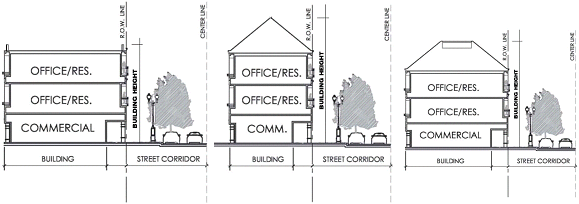
Height is measured from adjacent average finished grade to the highest point on the
building.
Design standards:
• Allowable maximum building heights vary by zoning districts and occasionally by land use classifications. The maximum allowable building height within higher intensity residential multi-family districts is one hundred (100) feet or eight (8) stories but may be higher it mixed use zoning districts. Within non-residential zoning districts, the most intensive zoning district allows a maximum building height of seventy-five (75) feet. Maximum building heights may exceed seventy-five (75) feet within that area designated in the Comprehensive Plan as Transit Oriented Corridors.
• The allowable maximum height of parking lot light poles is twenty-five (25) feet.
Design guidelines:
• New development shall be scaled to conform to existing development by stepping down building heights in order to promote greater neighborhood compatibility.
• When building heights exceed five (5) stories, it is recommended that the vertical plane is moderated by introducing a horizontal dimension. This may be done by creating step-backs along the building façade. These horizontal moderators are especially important along two (2) to four (4) lane streets in order to create the illusion of fragmented building mass.
• The step-back transition may be achieved by adding a balcony or terrace on the sixth level. Plants and soft landscape elements should be introduced along this transitional line in order to create visual interest. These step-backs should serve as outdoor living spaces that provide a more humanistic aspect to tall, uniform structures.
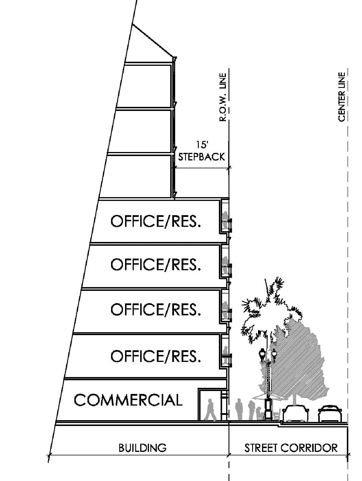
A 15' step-back on a building higher than 5 stories.
3.1.2. Setbacks. Building setbacks are required in all zoning districts although minimum build to lines may be established within the State Road 7 Community Redevelopment Area. LDR Article III., Part 2.0., Section 2.5 establishes a list of structures and features that are allowed within the building setbacks:
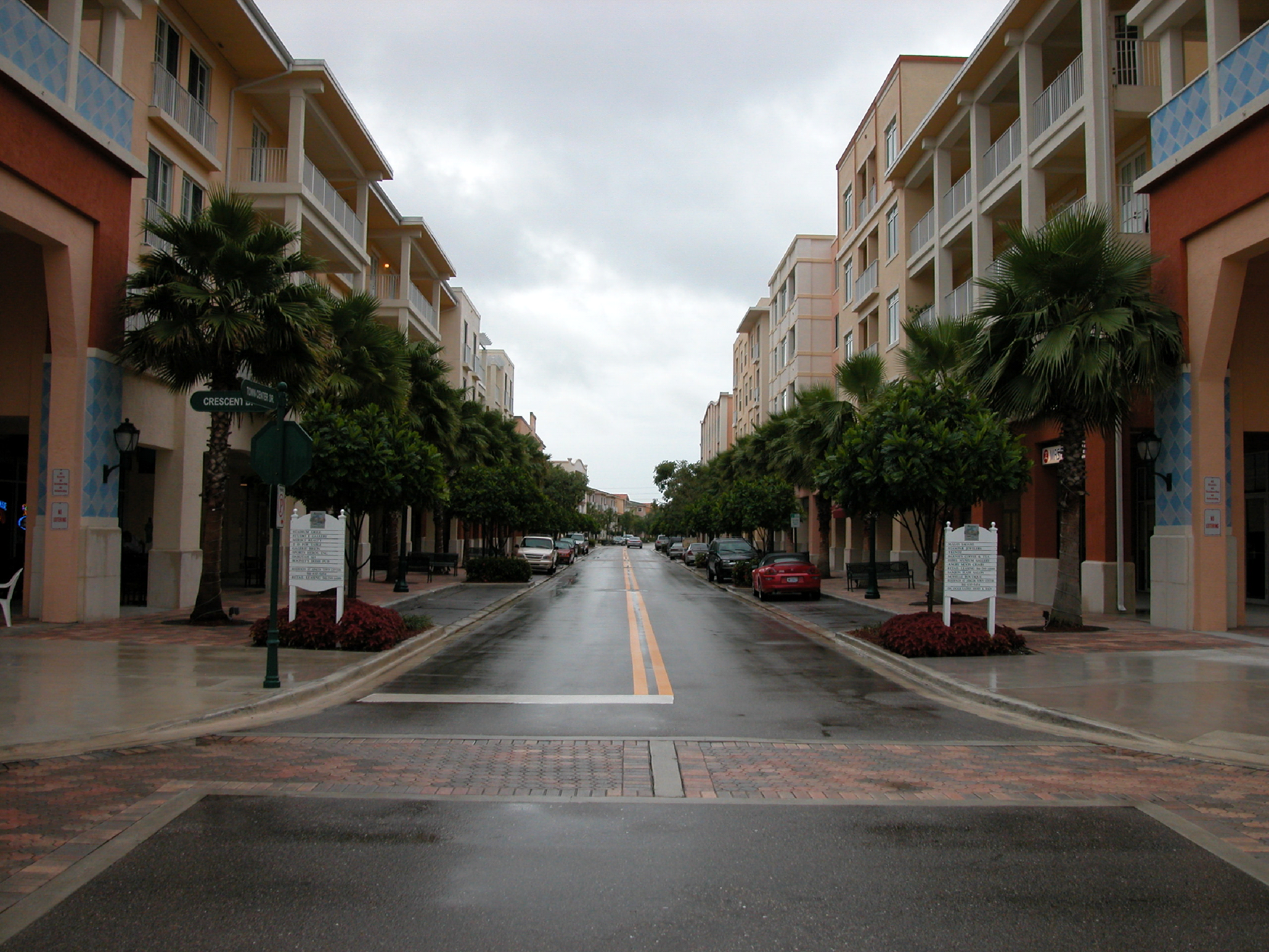
Sidewalks, street trees and signage are all approved features for setbacks.
3.2. Façade treatment and materials. Buildings should relate to the streets in a manner that enhances and strengthens pedestrian activity. Street-level architectural development should be scaled to the pedestrian and should be attractive and inviting.
The prevailing character of the design is generally found in the elevation of the building, with the use of molding, quoins and fretwork. They come together to form what is the façade of the project. Successful designs are typically strong and simple, with clear intent and detail treatment. A colonnade or veranda is consistent with this tropical vernacular and assists in identifying a strong entrance.
Design standards:
• All building elevations are required to have at least three (3) different material applications for visual interest.
• Façades shall impart traditional themes of colonial architecture. Setbacks or protrusions in the façade can give visual relief. Brick coursework should have some detail and depth, or should use traditional methods that enhance elevations and frame fenestration and door openings.
• Materials for façade shall be of stucco (smooth or textured): hardboard, brick, zinc, precast concrete or other suitable material that is appropriate to the Florida tropical theme and the South Florida climate. Detailed molding around fenestration and door openings is recommended. The use of decorative railing of ornate lines and themes is strongly encouraged along flat roof parapets or along large linear expenses of the façade. Small or broken shed roofs accents or awnings are also encouraged along a blank façade. Simulated or non-architectural stonework, such as applied river stone or scored brick face is not permitted.
• New construction shall have the maximum amount of transparent window area on the street front elevations or a percentage relative to the square footage of the building wall in which it is contained as determined by development review. A minimum of forty (40) percent opening is required.
• Storefront offices in structures originally designed for retail should be maintained or restored to its original configuration, as long as that is consistent with the City's design theme.
• Infill storefront design shall be compatible with these design standards for architecture of this building type in the area. Details and architectural features should relate to the entire building or block. A design theme consistent with the tropical environment is expected to be employed at the time of renovation, addition or update.
• Roll down gates, security shutters and bars are not permitted without approval from the Planning and Zoning Board. Iron work or shutters shall be of design vernacular or design elements that conceal the primary use of the element as security.
• Storm shutters may be deployed upon the issuance of a storm warning from the governing agency authorized to issue such warning.
• Columns and posts are recommended as the perimeter support element for the covered entrances, verandas, and walkway areas. A series of columns in wood, steel or concrete, with arches or beams are strong elements in creating scale and passive barrier.
• Surface treatment shall include ceramic tile with designed patterns and strong colors, crests, textured stucco finishes, and painting techniques employed to provide character accents. Repetition in accent elements along a façade or wall is encouraged as a simple way to tie a design together, provide a strong base and establish a datum line at the user scale.
• Lighting fixtures shall be of materials, design, colors and image as provided for by the tropical design. Wall washers or accent lighting shall be direct or indirect, designed to eliminate hot spots.
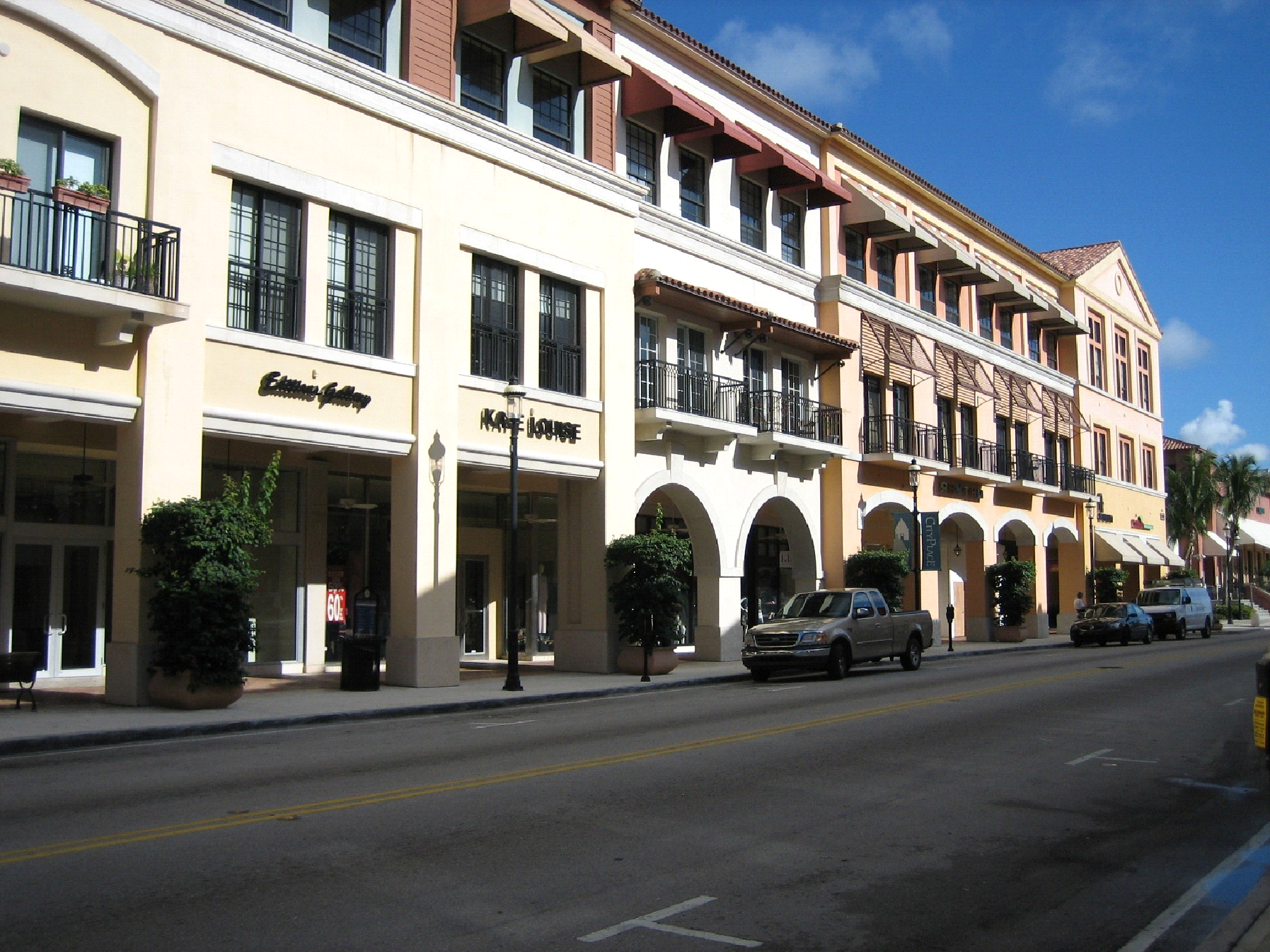
Building façades should have a variety of materials and color.
Design guidelines:
• Façade elements such as materials, textures, columns, openings, signs and overhangs should be designed in a manner that clearly articulates the building frontage. In addition, façades should be modulated in order to create visual interest and encourage thematic design. Traditional elements such as colonnades, setbacks or protrusions should be used in order to provide visual relief along building frontages.
• Street-level façades should provide entry and exit ways at suitable intervals of no more than fifty (50) feet apart. Appropriate landscaping should also be incorporated in order to provide additional texture and color in a manner that does not block views and openings.
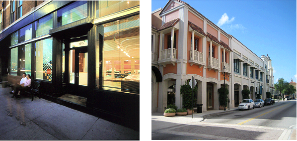
Large expanses of glass should be broken up and roof edges should be clearly demarcated
with cornices or other elements.
• Roof lines and edges should be clearly demarcated with the use of terminating elements such as decorative railings, cornices or other visual trims. Roof accents are especially encouraged along blank façades in order to provide interest both in the vertical and horizontal dimension.
• Façade materials should be of good quality and should meet established standards. Innovative, energy saving, high quality building materials are encouraged. Materials should vary in texture and type to accent windows, entrances and corners. Contrasting materials are encouraged and should create interest when carefully integrated. Materials should be changed in order to articulate building elements such as base, body, cornice, rooflines, parapets and arcades. Materials such as stucco, brick and certain metals that are appropriate to the South Florida climate should be utilized.
• Fretwork may be introduced here also: the use of cut-outs to create a positive-negative relationship between the open area and the surface beyond is typically successful to accent a specific element type or theme.
• Gable end windows or vents, and truss detail are design opportunities to emphasize the vernacular components, and are encouraged to be utilized again over entrances or elements of hierarchy.
• The use of trellis work and lattice work as entry elements, gathering space shelters and wall accents are encouraged. The environment relies on these elements for visual filtering as well.
3.3. Architectural fenestrations. To compliment pedestrian scale activity along major corridors, ground floor façades facing streets should include transparent doors and windows. Buildings should also feature architectural detailing in accordance with the South Florida tropical aesthetic. These details will help enliven the streetscape and create a pedestrian-friendly environment.
3.3.1. Windows. The treatment of windows is critical in defining the architectural form of buildings. The original needs were more for ventilation and visual comfort; due to the advent of air conditioned spaces, they are typically decorative and for natural lighting purposes. However, the use of operable windows with maximum opening is encouraged in multi-family residential employment. Some consideration shall be given to window styles and treatments for privacy and character.
Design standards:
• Windows should have muntins and mullions with well-defined frames, transoms and sills. The windows should be framed with shutters, awnings or iron work where appropriate. Minimal tinting to meet energy code requirements may be permitted. Fretwork can also be employed above some window transom designs.
• Storefront glass shall be clear and the interior view of the store unobstructed from signs, counters, display racks and merchandise. Some articulation of the perimeter of the storefront will be allowed.
• Windows must be placed on elevations that face the public right-of-way, and must be in scale and compatible with the architectural style of the surrounding buildings. The bottom of the window (knee wall) shall be twenty-four (24) inches typical or may be as low as possible or six (6) inches from slab or sidewalk. The use of full height windows is acceptable in the appropriate environment.
• Large expanses of wall without window or detail that face the public right-of-way are prohibited. Again some form of perimeter treatment is required and the use of large glazed windows that fold back to full open, with the use of parliament type hinges (one hundred eighty (180) degree swing) or stays, are required. Retail buildings should have fenestration that reveals interior activity, that encourages interest in the products or services provided at the store and illuminates the frontage with indirect lighting at night.
• Some utilization of the "cooler boxes" or "window chillers" may be appropriate and the employment of the window balcony is open for consideration if they are used appropriately and consistent with the design vernacular.
• Mirrored glazing or very dark shading on windows shall not be allowed.
Design guidelines:
• Transparent windows must take up a minimum of forty (40) percent of the building face at the street level, limiting expanses of solid walls along streets. Reflective surfaces must be avoided so pedestrians may view interior activities.
• Windows shall be vertical in proportion with consistent and proportionate articulation.
• Full height windows should generally be avoided unless they compromise the integrity of the architectural character.
Façades can be modulated by creating varying window sizes and design.
• Areas with large glazed surfaces should feature additional articulation to provide sufficient architectural detail, to create human scale and to provide shading on the sides of the building with the highest rate of heat gain. Clear glazing with Low E coatings (for heat gain) are strongly preferred to reflective surfaces.
• Windows or louvers at parking structures where exposed to side streets should be proportioned similar to the rest of the structure and be aesthetically treated.
3.3.2. Doors. The standards governing the design and placement of windows, also applies to doors.
Design standards:
• Doors should have muntins and mullions with well-defined frames, transoms and sills. The doors should be framed with sidelights, shutters, awnings, or iron work where appropriate. Reflective or mirrored glass is not permitted. Minimal tinting to meet energy code requirements may be permitted. Fretwork can also be employed above and along the side of some doors and in transom designs.
• Storefront glass doors shall be clear and the interior view of the store unobstructed from signs, display info and merchandise. Some articulation of the perimeter of the storefront door consistent with the overall design of the theme of character specific to the business shall be allowed.
• Doors must be placed on elevations that face the public right-of-way, and must be in scale and compatible with the architectural style of the building and surrounding buildings and this design guide. The bottom panel of the door may not be higher than twelve (12) inches above the floor or sidewalk. The use of full height doors is acceptable in the appropriate environment.
• Large expanses of wall without doors or detail that face the public right-of-way are prohibited. Again some form of perimeter treatment is required and the use of large glazed doors that fold back to full open, with the use of parliament type hinges one hundred eighty (180) degree swing or stays, are welcomed. Retail buildings should have openings that reveal interior activity, that encourage interest in the products or services provided at the store, and illuminate the frontage with indirect lighting at night.
Design guidelines:
• The use of fully operable doors with parliament hinges and stays are encouraged and represent a strong character presence for entrance identification and access with maximum opening. It is also encouraged in the residential employment. Some consideration shall be given to colonial styles and treatments for privacy and character.
3.4. Gates and entrances. The designation of gateway points and entrances is important in defining a hierarchy of circulation through an open space or in providing a clear path of entry to a building. Entrances are fresh with lively character and are based on spatial lightness with refinement of detail and ornament. They are typically central with symmetrical treatments, identifying them as nodes of arrival.
Entrances should have high visibility.
Design standards:
• Buildings shall have hierarchal architectural features such as porches or roof overhangs that delineate or emphasize entrances. This entrance shall face the public right-of-way, be well defined architecturally and readily visible to pedestrian and vehicular traffic and may identify a nodal point.
• The doors should have some detail and may be defined with sidelights or wooden or metal decorative shutters, and may have decorative transoms above that use molding, pediments, keystones or fretwork. The use of full glass panels, half glass and half louver and full louvers is an option to add a special character detail.
• Porches and overhangs should encourage pedestrian movement and activity, while providing continuous shelter from the sun and rain. Some gathering or nodal points are encouraged to mark a location and rest sports, i.e. patios and or courtyards. The mixing of materials, textures and colors and encouraged to identify the various zones within the pedestrian movement process. Fretwork is again an option that may be employed along the top edge post and beam around the perimeter of the porch overhang.
• Porch railings should have decorative detailed elements in wood or metal. The post may have a ball type cap or some other specific design. The rails may consist of boards and metal work in a designed shape or form that is repetitious in nature.
• Gate elements shall be designed to include posts, columns, brackets, lattice work, trellis work, and accent lighting. Gates shall be made of metal, wood, precast concrete, brick, or other approved materials. Fountains shall be of coral rock with continuous water flow and vegetation consistent with the lush tropical design.
• Entrance features may include town scale clocks, bell towers and gazebos.
Design guidelines:
• Entrances should be designed to create smooth transitions between exterior and interior spaces.
• Entrances should be highly visible to pedestrian and vehicular traffic and be placed at significant nodes of arrival such as sidewalk intersections and crosswalk access points.
 |  |
| Entrances should have high visibility and should be well articulated. | |
• Entrances should have adequate detail and should utilize a mix of materials to create variety and interest. Where space is available, the use of arches or other decorative framing elements should be used in order to create a sense of arrival. Although entrances should be emphasized through unique design, they should conform to and compliment the overall architectural character.
• The use of a gallery or courtyard for exterior to interior and interior to interior spatial transition is encouraged, as is prevalent in many tropical design approaches.
3.5. Arcades and canopies. Arcades should be located where pedestrian circulation along building frontage is important, typically commercial and retail districts with a high pedestrian volume. Arcades may be used as spaces for outdoor dining and gathering. Arcades should be provided where human comfort and protection is desired.
Arcades should be wide enough to promote efficient circulation.
Design standards:
• All new development and any amendments made to existing developments that support pedestrian circulation are to provide arcades along the building frontage.
• Arcades should also include ceiling fans or other devices to induce air movement.
• Awnings shall only be used where architecturally compatible with the building. The shape of the awning and related hardware should be consistent with the architecture of the building as well as proportional with the scale of the façade and its surroundings.
• Canopies should in no way interfere with street light fixtures or with the growth and maintenance of street trees, signature trees and landscape materials.
• Canopies are to be employed in entrances, courtyards, breezeways or connections between buildings. The forms' image or profile shall be consistent with the pitch of "roof" type elements. Canopies are typically hierarchical and a good opportunity for color, detailing embellishments and material enhanced definition.
• Awnings shall be the same throughout the entire building regarding design, materials, color, and scale.
Canopies should be unobtrusive and should maintain architectural integrity.
• Where a single building has several storefronts and tenants, or within a single center, they shall have a consistent design, scale, color scheme, and materials throughout. A rational system or differential rhythm may be employed in developing a design character; design sketches shall be submitted for review.
• Awning fabric shall be made of non-glossy material, such as treated cotton for durability and colorfast material subject to fire department approval.
• Ribbing (seams) should run vertically. Metal awnings are prohibited. Bahamas type shutters may be used where appropriate. Corrugated metal roofing on awnings, sometimes called windows sheds, shall be allowed.
• Awning frames should be supported from the underside of the awning to the building with angle braces and, where necessary, use vertical steel support or columns, including part of the primary entrance element.
• Awnings should not be backlit or contain any signage. Simple down lighting to illuminate the awning, window, door or sidewalk should be used. The awning may be used as an accent device to highlight the tropical theme, character and identity.
Design guidelines:
• Arcades should be wide enough to accommodate two-way circulation and standing space. A minimum of fourteen (14) feet is recommended.
• Arcades should run the entire length of the building frontage, providing a continuous, covered pedestrian corridor.
• Canopies should have a minimum depth of five (5) feet.
• Continuous architectural arcades and canopies should reflect the design integrity of the structure.
3.6. Rooftops. Rooftops serve as a unique opportunity to maximize floor area use within a building footprint. Where possible, rooftops must be designed to utilize the surface area for various forms of activities. Roofs are strong architectural elements. They provide cover and supply a strong sense of place to accentuate and identify entrances with architectural hierarchy.
Design standards:
• Roof surfaces that are not allocated to activity shall be finished with materials and textures in conformity to the architecture of the building.
• All flat roofs shall have parapets to articulate structural design and to screen roof mounted equipment.
• All infrastructures within a rooftop will be designed as an integral part of the building volume.
• Types: Rooflines are generally characterized as pitched with gable ends, hip punctuated with dormers, with windows or ventilation louvers that add detail and interest to the roofline, as well as shed roofs. The vernacular also calls for double gable or hips with a valley gutter. Some use of flat or built-up roofs are necessary in commercial or multi-family the façades to provide required image or character. Variation in roof heights and angles are required for new construction or for major aesthetic changes to an existing building, to add visual interest and delineation of activity within a structure. A minimum slope of 6:12 is required.
• Materials: The finished roofing material for pitched roofs shall be metal standing seam, flat concrete tile, corrugated metal or Mediterranean type S-tiles; for flat roofs a built-up system may be utilized.
• Fascia: The fascias around the eaves shall have limited simple detail molding that accentuates the fenestration, porch overhangs or entrances. Some fretwork type fascias are encouraged and design must be approved by the authority having jurisdiction (AHJ). Example: Roofline includes dormers to vary heights and angles, S-tile and metal seam roofing material and simple detail molding along fascia.
• Fascia option: Exposed rafters with simple detailed ends may be substituted for fascia type arrangements. Some design character may be added to incorporate the support of gutters and signs.
Shade structures are roof shade structures.
• Roof overhangs: Roof overhangs must provide continuous cover from sun and rain and be pedestrian friendly. A covered walkway eight (8) foot deep is ideal for the pedestrian circulation. Deeper overhangs are within the tropical vernacular; in most cases thirty (30) inches minimum roof overhang is required.
• Gable ends: Gable ends are to be treated with large scale fretwork design. Back lighting is encouraged.
Design guidelines:
• Acceptable rooftop activities include sun decks, roof gardens, tennis courts, outdoor cafes, pool decks and parking areas.
Rooftops may be made functional by the addition of landscape to help cool and insulate.
• In instances where rooftops are utilized for parking, the perimeter of the lot should include a trellis, canopy or screen landscaping in order to minimize undesirable views and to create buffers.
3.7. Corners. Corner structures play an important role in creating identity within a block and may become significant landmarks. These structures should be emphasized by prominent entrances or small plazas and gathering spaces along their frontages. Creating clearly delineated street corners will add to the overall unique character of Lauderhill.
Street corners should be well defined.
3.8. Renovations and additions. The actions taken in this process may differ depending on the condition of the existing structure. If the property has been identified to be listed in the Historic Register, their criteria for treatment must be followed. In typical cases, at a minimum, "before and after" photographs or renderings of each façade and details shall be taken, signed, dated and submitted with the Planning and Zoning (P&Z) applications. Care shall be taken to ensure the appropriateness of the design to the existing building.
Design standards:
• Renovations and additions to existing structures shall be compatible with the City of Lauderhill Design Standards, regarding scale, massing, materials and architectural design bearing some correlation to the existing openings patterns, rhythm and roofline. The primary elevations of the façade shall be reconstructed, employing the tropical architectural style and character of similar building in this thematic environment. All additions and new design to an existing structure must comply with the City of Lauderhill Design Standards.
• Wood, metal, stone and brick veneers of previous renovations shall be removed and the original building surface restored where appropriate. Features such as patio enclosures, sheds, inactive mechanical equipment and related conduit, and blocked up windows shall be removed to restore the original, where appropriate.
• A change of use to an existing structure shall pursue element modifications and alterations to entrances, canopies, awnings, paint and signage. New openings may be utilized to update the façade to meet the utilitarian needs as well as the City of Lauderhill Design Standards, but may be limited to secondary façades or even avoided.
• Building renovation projects shall encompass the entire structure, including those areas not visible from the public right-of-way. The use of the City of Lauderhill Design Standards shall be mandatory and employed in redesigning the building to meet the intended architectural character and is subject to the City's design review for approval.
• Accessibility alterations in order to comply with the Americans with Disabilities Act requirements shall be executed in a manner that is compatible with the City of Lauderhill Design Standards and have minimal impact on the original architecture of the building. Covers and canopies shall be employed to provide the additional coverage that may be required due to adverse weather.
• Building surface material shall be compatible with the South Florida region. Materials such as synthetics, exposed wood, coral or other material suitable to a southern climate intended as façade material shall be treated for exterior use and utilized, if present, or updated.
• Rehabilitation of existing storefronts shall include restoration and replacement of original architectural features, where appropriate, and the inclusion of architecturally correct elements as recommended by the City of Lauderhill Design Standards.
• Storefronts within a building, new construction or redevelopment, are to be uniform and contained within structural bays of the building. Uniformity can be achieved by a combination of accents that enhance the façade element or roof forms and types to create the desired amalgamation of images. The tropical character shall be consistent with the City of Lauderhill Design Standards.
• Individual storefront windows shall not be filled in. In those cases they have been covered windows from previous construction, the original storefront shall be replaced upon renovation with fenestration treatment that forms the ordered vignette prevalent in tropical design.
(Ord. No. 10O-02-108, § 4, 2-22-2010)
Sec. 4. - Street level standards.
The street level standards focus on the creation of a vibrant urban environment. An appropriate mix of uses and elements at the street level, in conjunction with effective design practices combine to produce a pedestrian-friendly and interactive City.
4.1. Fences, walls and privacy gates. Fences and walls within the City of Lauderhill may be useful in the creation of views, as well as, screening undesirable views, separating land uses and establishing physical barriers between different spaces.
Design standards:
• Wall height must not exceed eight (8) feet, except as provided for in LDR Article III., Part 5.0., Section 5.18.
• Walls which face pedestrian spaces must introduce a minimum five (5) foot wide strip of landscaping between the wall and the pedestrian space to soften the appearance. This landscape strip must be planted with groundcover or shrubs; sod is not an acceptable material.
• Fences, walls and gates are to comply with requirements outlined in relevant sections of the applicable Florida Building Code. A unique design may be submitted for review, if the project warrants the concept and is consistent with the City of Lauderhill Design Standards requirements or the interpretation thereof of the authority having jurisdiction (AHJ).
• Exterior walls shall be painted with a color approved by the City of Lauderhill. See Appendix B—Color Palette of the City of Lauderhill Design Standards. Painting techniques that install instant patina may be considered if a long-term maintenance program is adopted and a letter of the owners' commitment is submitted along with the color request for approval.
• Blank walls are not permitted and shall be embellished with windows or architectural elements. Elements may include accept tiles, crests, painted forms or murals that celebrate the tropical theme and concepts of repetition and rhythm, or tropical vegetation on figure ground format. All murals must be submitted for preapproval along with the color scheme application, and is subject to final approval from the authority having jurisdiction (AHJ).
• Walls shall be constructed only in non-residential zones, and shall be determined necessary for protection and security of the property and the community at large. Walls in residential areas are to be discouraged, as they break the continuity of the green belt and reduce the air circulation around the said property. In residential areas, walls are only permitted along the community perimeter or land use transition.
Design guidelines:
• Walls for screening should not be obtrusive and their heights and proximity to the use area should not be imposing.
Fences can be used to separate uses but maintain visual continuity.
4.2. Plazas. Plazas are integral to the success of a retail, office or residential development due to their ability to provide opportunities for public congregation, interaction and recreation. They also allow for integration between architecture and landscape by incorporating hardscape, structural and decorative elements. Large expanses of building blocks and parking lots should be interrupted by open space plazas for pedestrian comfort and refuge.
Plaza design should enhance social interaction.
Design standards:
• Any new development intended to support pedestrian activity should include plaza space.
• Plazas should abut public areas and be physically and visually accessible from the public sidewalks. Security fences, walls, and entry gates should not block the sidewalk edge of the plaza or views into the plaza.
• Plazas should be accessible to the public during business hours.
• Entries to the plaza, business and storefronts within the plaza shall be designed and lighted so they are safe and visible to plaza guest, avoiding hiding places.
• Plazas shall provide at least one (1) sitting place for each one hundred (100) square feet of plaza in addition to any permitted outdoor dining provided.
• Plazas should have adequate mix of sun versus shaded area. No more than forty (40) percent of the plaza shall be covered with a roof.
• At least twenty (20) percent of the plaza's surface shall be landscaped to provide heat relief.
• Vehicular access, loading, or parking within the plaza is prohibited. Emergency access drives will be considered through plaza upon review of integration into plaza design.
• Plazas shall be a minimum of two thousand five hundred (2,500) square feet.
• Easy and direct access should be provided for the elderly, disabled and young children and appropriately located and designed lighting should enhance the safety of the plaza. All plazas must meet ADA standards for accessibility.
• All plazas should be designed with materials that are compatible with the architecture and those that promote continuity throughout the City. Paving materials should reflect the scale of the plaza as well as provide visual keys to changes in use, elevation and circulation.
• The creation of courtyards or exterior arrival and gathering points are strong vernacular elements of spatial sequence that impart the tropical experience. The employment of courtyards as transitional spaces from exterior to interior and interior to enclosed exterior emphasizes the tropical concept of bringing the outside into the building.
Plazas should be well shaded to create a comfortable environment.
Design guidelines:
• Plazas should be designed such that they provide connections among adjacent uses, link parks and greenways and provide a sense of overall continuity within the City of Lauderhill.
• Plaza edges should be defined and maintained by the use of architectural features (arcades), site furnishings (benches, bollards) and landscape elements depending upon the areas that they connect.
• Plazas should be designed with good street-to-plaza visibility in order to announce the internal activities, while simultaneously increasing safety by allowing users to be able to watch street activity.
• Civic spaces should be designed to support various types of special events. Streets and adjacent plazas should be designed as temporary performance areas for special events, festivals and gatherings. A public amphitheater or small stage, where appropriate, should be incorporated into plaza design to encourage activities such as exhibitors, musicians, festivals, farmer's markets, folk dancers or public meetings.
• Where scale permits, water features should be introduced in order to enhance character and soften hardscape.
4.3. Water features. The use of water in a variety of forms is highly encouraged within the City of Lauderhill. Fountains add valuable accents to any setting and provide a sense of relaxation to the urban environment which allows for an improved enjoyment of the sub-tropical South Florida climate. They can mask noise, direct attention, cool small areas and create a soothing atmosphere.
Design standards:
• Water features shall avoid interference with circulation.
• Durable, solid materials should be used for containment. The color and materials used in and around fountains should be compatible with other streetscape and plaza elements.
• Wind regulators shall be used to minimize water spray on users and adjacent paving.
• Water feature mechanical equipment shall be remote and shall not obstruct pedestrian areas. All water features must comply with all local codes and regulations.
Design guidelines:
• Interactive fountains are encouraged in mixed-use areas to impart vibrancy and character.
• Nighttime lighting is strongly recommended near water features to add visual appeal and added security.
• A variety of effects are encouraged for fountain design, such as bubbles, sprays, falls, mists, pools and basins.
 |  |
| Water features can be focal and sculptural elements providing variety and interest. | |
4.4. Public art. Public art reflects the attitude and character of the community towards culture. Establishing public art throughout the City of Lauderhill will help to create space and identity, as well as, to celebrate the eclectic community of residents.
Design standards:
• All art pieces, whether sculptures, mosaics or frescoes, should be durable and free of sharp or obtrusive objects.
• All artwork must be reviewed and approved by a public art committee, established by the City, in order to ensure its universal appeal and applicability.
• Art work should not be offensive or disrespectful.

Sculptures lend character and infuse identity into spaces.
Interactive public art encourages community interaction.
4.5. Paving and materials. Paving becomes an important element within the urban environment in creating space on the ground plane and establishing identity within the City.
Design standards:
• Special paving, including stamped asphalt, should be utilized on all major intersections, pedestrian crosswalks, sidewalks, plazas and bus stops.
• Paving materials at streetscape intersections and sidewalks should reflect the intensity of pedestrian traffic and create identifiable ground plane links throughout the City.
• Paving color and textures shall utilize a tropical blend to reflect the South Florida aesthetic.
• Paving materials should also reflect more solar energy than traditional paving materials in order to reduce the overall heat index.
• The use of open grid pavement systems, such as unit pavers, is strongly encouraged for any pedestrian hardscape area in order to decrease storm water runoff.
Paving design should represent the South Florida tropical aesthetic.
Design guidelines:
• Pedestrian paving can define uses along the streetscapes. By varying the appearance of the surface materials, distinctions can be made between public sidewalks and private outdoor areas.
• Well marked sidewalks with special paving will also aid in the overall circulation system.
Changes in paving materials define different use areas.
4.6. Sidewalks and pedestrian routes. Pedestrian circulation is one of the most important aspects of the City. Sidewalks should connect major points within the City as well as connect the City to the surrounding neighborhoods.

Building blocks should be broken up by small-scale pedestrian spaces.
Design standards:
• The pavement system should be easily negotiated by all sidewalk users. It should not present any unnecessary obstructions and all sidewalks must be wheelchair accessible.
• Adequate shade and shelter must be provided to protect pedestrians from inclement weather.
• Sidewalks should not be composed of materials that might be dangerous or uncomfortable under any conditions.
• Sidewalks must be safely separated from vehicular circulation routes by provision of a curb and/or landscape treatment.
• Minimum sidewalk width must be five (5) feet in all neighborhoods and commercial areas.
• The attitude of tropical design in an urban setting encourages the shift of the building back towards the street side, while relocating the parking to the rear of the complex. This reverts the hierarchal component back to the pedestrian community. A paved pedestrian walk or colonnade to provide cover and intermittent landscaping would be the end solution.
Streetscapes should include desirable elements such as planters, shade structures,
site furniture and interesting paving patterns.
4.7. Bikeways.
Design standards:
• Bike lanes must meet all local transportation and State regulations.
• Bikeway lanes should be properly located along neighborhood streets leading to major corridors.
• Areas that are designated for bicyclists must use paving materials that are smooth and free of obstruction.
• There must be a clearly designated separation between bicycle zones and vehicular areas. This separation can be visually established by using varying colors or materials where possible.
• Proposed development must provide a minimum of two (2) bike racks (four (4) feet to six (6) feet length)
Bike routes should be clearly marked and should include bike racks at appropriate
locations.
Design guidelines:
• Roadway surfaces must be designed to accommodate bicyclists and should connect to the surrounding bicycle systems and link the neighborhoods to parks, open spaces, schools, libraries, and civic buildings within the area.
• Bike racks should be located at various locations throughout the City to provide safe and convenient temporary storage. Bike racks should be covered to protect bicycles and riders from inclement weather.
4.8. Utilities and loading areas.
Design standards:
• All building facilities for loading, trash and service should be located within the structure of the building.
• These areas shall be completely enclosed and shall be screened with a decorative wall or fence. Screen landscape plants should also be incorporated.
• Where trash/loading areas are visible from the street, they are to be gated with solid panels. All trash/utility/loading areas must allow for access by garbage maintenance vehicles.
4.9. Bus stops. The concept of the bus stop is simply that it provides shelter from sun, wind and rain, while allowing for three hundred sixty (360) degree visibility and security. The materials shall be durable and low maintenance. Standard design elements such as the roof form, construction details and colors indicate the tropical theme.
Design standards:
• The strongest single characteristic is the roof, its pitch, material and color. Utilization of a deep overhang and generous roof slope assists in protecting the user and representing the desired image. The standing metal seam roof is the material of choice.
• The bus stop shall be further articulated with metal or concrete posts, or columns with angle braces and benches which shall be exterior grade finished bench furniture with possible enhancements of wood cladding or accents. The finishes shall be coatings that remain cool to the touch.
• The bus stop shall be well lighted (tamper proof) or located within eight (8) feet of existing street light.
• The stop's side enclosure panels shall be translucent in character and attached in such detail as to allow air circulation within the sheltered area. This is a great moment to employ the use of lattice-work as portions of the enclosure.
• Site landscaping shall be included to provide sun shade for the bus stop and its users.
• The primary colors that are part of the recommended palette shall be utilized.
Design guidelines:
• Efforts should be made to retain storm water on site as far as possible to reduce run off.
• Rainwater harvesting should also be encouraged through the collection of water from roofs with large cisterns or rain barrels which can be subsequently used for irrigation.
• Wastewater shall be reused as much as possible for landscape irrigation.
(Ord. No. 10O-02-108, § 5, 2-22-2010)
Sec. 5. - Landscape and irrigation standards.
In order to establish a strong image for the City of Lauderhill, all landscape treatments should be bold, layered and consistent, therefore contributing to the tropical feel of the region. Plantings should provide a common framework and be governed by both the aesthetic qualities of the varying materials and the functional concerns of different areas within the City. In addition, there should be a consideration towards preserving existing plant material and attempts should be made to utilize native species as much as possible.
Landscape plantings will provide important spatial definitions to the City of Lauderhill. They will aid in establishing a strong identity for the City while visually unifying its streets, sidewalks, medians, open spaces and yards. Full and healthy plantings will also help mitigate the South Florida climate and will create year round habitable spaces. Plantings also help in the screening of unsightly views of parking garages and lots, exposed utility areas and loading zones. Proper use of landscape plantings will also aid in directing pedestrian traffic through the City.
5.1. Purpose. The intent of these regulations is to protect, preserve, and enhance the natural environment and the beauty of the City. It will provide landscape for green spaces, trees and other plants and arranging them in a pleasing manner in relation to paved areas and structures. The planting of native materials is highly desirable and preferred. These objectives are defined in general terms and the realization can only be obtained by proper design and location of trees, shrubs, plants and grass.
5.2. Streetscape planting. Streetscape planting will serve two (2) major purposes within the City of Lauderhill namely, the provision of shade along sidewalks and the creation of visual connectivity between different parts of the City.
Design standards:
• The location of street trees should provide a strong buffer between vehicular traffic zones and pedestrian zones.
• Continuous street tree trenches should be encouraged throughout the City to provide soil area for roots to spread and water to penetrate. Trenches should be approximately thirty (30) inches deep and six (6) to eight (8) feet wide running continuously parallel to the curb. Street tree trenches promote a healthier tree canopy which in turn provides more shade and stronger roots systems to fight overturning during storms.
Street trees should provide shade and separation from vehicular zones.
Street planting should be consistent in spacing and quality.
Design guidelines:
• A strong tree program should be created along primary and secondary roadways.
• Street trees should be at a consistent distance from each other and should be of the highest quality.
• Shade trees should be encouraged in order to create outdoor spaces that are habitable all year.
5.3. Buffering and screening. When properly planted, landscaping can be an effective technique to screen utility areas and to protect building elements. Dense planting along parking structures and busy streets can soften edges and buffer noise from habitable areas, such as residential neighborhoods, open spaces, schools etc. Proper placement of understory plantings, coupled with climbing vines, medium shrubs, palms and trees are strongly desired to minimize views.
Design standards:
• Situations where screening interferes with function and circulation within spaces must be avoided. For example, when screening cars in a parking lot, allowance must be made for vehicle dimensions such as open door radii and vehicle overhangs.
Screening should not interfere with function.
The following is a list of plant materials considered acceptable for screening purposes:
PALMS
TREES
ORNAMENTAL TREES
TALL/MEDIUM SHRUBS
UNDERSTORY SHRUBS/GROUNDCOVER
CLIMBING VINES
Design guidelines:
• Planting can be introduced to take advantage of cooling breezes as well as to mitigate the effects of major winds.
• Proper species selection and planting placement can funnel breezes to desired areas. Efforts should be made to identify and locate areas that might detract from the overall visual quality of a space and to effectively screen these through appropriate planting techniques.
5.4. Perimeter landscaping. Perimeter landscaping should be used to separate different land uses from one another and to create boundaries between utility zones and other use areas.
Design standards:
• Perimeter strips, at a minimum of five (5) feet in width, must be introduced between the abutting property line and any off-street parking areas, except that this standard may be waived if it is zoned under the City's Smartcode. One (1) tree and a hedge or other durable landscape material, must be planted for every thirty-five (35) lineal feet within this strip between a non-residential district and an adjacent residential lot. The Planning and Zoning Director may vary this to avoid conflicts with the visibility of signage.
5.5. Parking lot planting. Landscaping is required both within the interior area of a surface parking lot, as well as, along the perimeter of a surface parking lot to soften and screen the parking facility.
Design standards (which may be waived by the Planning and Zoning Director if within the area subject to the Smartcode):
• A minimum of fifteen (15) percent of the gross parking area is to be constituted by living landscape, which includes grass, ground cover, plants, shrubs and trees.
• Every eleventh consecutive parking space, and the end of every parking strip area, must have a landscaped island ten (10) feet in width and eighteen (18) feet in depth.
• Each island shall contain one (1) tree, and grass or ground cover.
• Two (2) adjoining rows of parking must be separated by a minimum five (5) foot median which should be landscaped with hedge, grass or ground cover and should have one (1) tree for every forty (40) lineal feet.
Parking areas should appear lush and soft.
5.6. Irrigation. All vegetation planted within the City of Lauderhill will require irrigation to maintain the lush, tropical aesthetic desired by the community.
Design standards:
• All planting and grass areas shall be provided with an automatically operating underground irrigation system.
• Sizing and spacing of heads and lines shall be specified and installed to provide one hundred (100) percent water coverage, and a minimum fifty (50) percent overlap of all living surface areas.
• Irrigation systems should be designed to accommodate the specific water requirements of the various planting areas.
• Distribution should be designed to minimize overspray onto buildings and site structures as well as pedestrian areas.
Bio-retention cells and rain garden are effective techniques to harvest rainwater.
Providing curb cuts with inlet protection areas allows for run-off to be properly
channeled.
Other requirements that must be strictly adhered to are enumerated elsewhere in these Land Development Regulations.
(Ord. No. 10O-02-108, § 6, 2-22-2010)
Sec. 6. - Signage and graphics standards.
Signage and graphics should functionally communicate information while fitting aesthetically into the fabric of the City. The signage and graphics system should be simple and coordinated and contribute towards enhancing the identity of Lauderhill. All signage should compliment other streetscape elements and conform to the requirements listed in LDR Schedule I.
In view of the broad range of public users, the design of signs and graphics needs to be flexible. It is essential that signage design have the ability to expand and serve new areas within the City. The City of Lauderhill is committed to providing signage identifying gateways into the City and its various neighborhoods. Approved colors for the main entrance and community identity signage include: Benjamin Moore Paint: Morning Glory 785, Matthews Paint: 46A-3P Mint Hint, Matthews Paint: 26B-1P Gladsome and Matthews Paint: 17A-3P Peach Whisper. Signage serves a variety of purposes and the scale, size and material used should be commensurate with function.
Design standards:
• A Master Sign Plan shall be included with any development order application for new construction, redevelopment and substantial improvement or major renovation. Signs shall use the same colors and materials as the building, or may be part of the overall complex signage system developed in the tropical character.
• Window signs shall be kept to a minimum consistent with Schedule I.
Design guidelines:
• Signage shall be clearly legible and simple in form, but reflect the attention to detail that provides relevant information.
• Figure ground and massing are typical techniques utilized in the tropical communities to achieve a graphic image that is symbolic and suggestive of the intended comment.
6.1. Directional signs. To emphasize the character of the City of Lauderhill and the cohesiveness of its various components, a uniform series of signs directing vehicles and pedestrians throughout the area is desirable. Directional signs have three (3) target groups—Motor vehicles, pedestrians, and cyclists. In areas where walkways/bikeways lie along vehicular routes, the signage for both groups is combined. In areas with separate pedestrian paths and bike routes, separate signage should be provided.
Design guidelines:
• The City should consider adopting a Master Directional Signage Plan which would provide a "standard" appearance for such signage, identify the public (e.g., City Hall, library, parks) and major private (e.g., Lauderhill Mall) facilities to be advertised, and the general location of the proposed signage.
6.2. Informational signs. These are signs that provide important information such as identifying focal areas, transit stops, public plazas entrances and other nodal areas. Informational signage could also include street identification signs, therefore having a consistent identification standard.
Information signs identifying nodes and routes.
6.3. Entry signs. Entry signs are intended to designate points of transition from one (1) area to another. They will be used to announce thresholds into major destinations within the City or indicate the entry into specific development properties. Elements that are approved be incorporated into the entry statement include: special paving, plant material, focal elements, special lighting, banners, signage and water features.
Entry signs should indicate a sense of arrival.
6.4. Specialty signs/banners. Specialty banners are intended to advertise special events throughout the City, celebrate holidays and festivals. They are intended to sustain a sense of excitement and change.
Banners should be colorful and artistic.
Design guidelines:
• The City should consider adopting a Master Specialty Signage Plan which would provide a separate appearance "standard" for branding important gateway and other roads, such as branding University Drive as "Decor Road."
• Due to the strength and intensity of the South Florida sun, all banners fabrics should be made from marine canvas or vinyl fabrics or both. These types of fabrics can withstand prolonged exposure to the sun and allow air movement through the banner.
6.5. Retail signs. Retail signs announce individual businesses and stores. Such signs should maintain the integrity of building façades and architectural character. Signs should not interfere with door and window openings, conceal architectural details or obscure the composition of the façade where they are located. Sign background colors must be compatible with the colors of the building façade with the exception of trademark and corporate colors. A dull or matte finish is recommended to minimize glare and enhance legibility. Wherever possible, signs located on buildings within the same block face shall be placed at the same height in order to create a unified sign band.
(Ord. No. 10O-02-108, § 7, 2-22-2010)
Sec. 7. - Site furnishing standards.
Site furnishings play an important role in the overall character and visual quality of the City. Careful consideration must be given to the selection of site furnishing such as benches, trash receptacles, drinking fountains, bicycle racks etc. Coordination of materials and colors, functionality, durability and handicap accessibility are paramount criteria in the selection of appropriate furnishings. Site furniture should be used as a tool for unifying character within various parts of the City.
7.1. Recommended materials. Materials for site furnishings should be selected for maximum strength, durability and low maintenance requirements. Surface finishes should weather and age gracefully and should be commensurate with the tropical climate of South Florida. Accents in the form of hardware may require some additional maintenance beyond the recommended minimum.
Design guidelines:
• Aluminum/cast aluminum
• Stainless steel
• Concrete
• Granite
• Keystone
• Specialty hardwoods
• Cast iron (finished with epoxy based paint)
7.2. Bike racks. Bike racks will provide a safe and secure place for residents and visitors to lock bicycles and participate in recreational and retail activities.
Design standards:
• The placement of bike racks must not interfere with pedestrian routes.
• Racks should be located along sides of buildings, relatively close to entrance doors and should be covered to protect from rain and extreme heat.
• These racks must be visible, within clear sight lines, both in the daytime and at night. Bike racks should therefore be located in close proximity to light fixtures, to enhance safety.
Bike racks may also be used as sculptural elements.
Design guidelines:
• Racks should be architecturally treated as aesthetic site elements and should be designed to have minimum visual impact.
Bike racks can be basic and functional.
7.3. Bollards. Bollards should be designed to be both functional and aesthetically pleasing. The primary function of the bollard is to discourage vehicular intrusion of pedestrian dominated spaces.
Design standards:
• Bollards design and location must consider emergency and maintenance vehicles.
Bollards can serve both functional and aesthetic purposes.
Design guidelines:
• Bollard design should relate to adjacent architectural elements and streetscape.
• The design of bollards should reflect and enhance the City's design theme.
• Where possible, it is recommended that light bollards be used in order to emphasize pathways and delineated pedestrian areas at night.
7.4. Flagpoles/banners. Flagpoles and banners present opportunities for the inclusion of color, pattern and movement within the City. They can be used both as seasonally displayed elements and as permanent information provided to the community.
Design standards:
• Flagpoles should be located in odd number groupings to create focal points at portals and major entrances.
• Flags and banners should also be changed periodically to maintain visual interest in various areas.
Flags and banners add visual interest to a space.
Design guidelines:
• Banners may include many items of various shapes such as windsocks and flags.
• They can be hung from walls, light fixtures or any other structural elements of sufficient strength.
• Flags or banners should provide information for upcoming events or celebrations.
7.5. Benches. Seating in urban spaces is used for social interaction, waiting, resting and people watching. They are to provide a place to stop and enjoy the surroundings.
Design standards:
• Benches should be placed outside of the main pedestrian flow, but within close proximity to pedestrian routes.
• Seating should be placed in shaded open spaces, plazas, parks and bus stops.
• Benches should be inviting and should encourage and invite longer stays in recreational areas. Benches in such locations should be designed with backs for increased comfort. In areas, such as transit stops, where shorter stays are anticipated, backless benches may be used.
• Special care should be taken to locate and select benches that discourage overnight sleeping by vagrants.
• Measures should be taken to ensure that the selected benches are comfortable all year round and are not drastically affected by exposure to intense sunlight.
Benches should be placed in the shade along pedestrian routes.
Design guidelines:
• Seating must occur along streetscapes, plazas and open spaces. It should be consistent with other site elements implemented in these areas.
• Seat walls can sometimes serve as alternatives to benches and should be incorporated to highlight grade changes, separate spaces and aesthetic purposes.
7.6. Tree grates. Tree grates are used to expand walkable surface in pedestrian areas while providing adequate canopy cover in order to enhance the overall environment.
Design standards:
• Tree grates shall be designed with small openings in order to be walkable, yet porous and moveable for maintenance purposes.
• Tree grates must have barrier free access for wheelchairs and should adhere to ADA codes and regulations.
• Tree grates must be compatible in character with other site furnishings in the City of Lauderhill.
Tree grates increase walkable surface area while allowing for tree planting in plazas.
7.7. Planters. As special site elements, planters and flower pots can visually enhance a space and provide areas for landscape relief, as well as reduce or accent an architectural mass. Planters define the human scale of spaces, absorb precipitation and help reduce the urban heat island effect.
Design standards:
• Planters are a required addition to the frontage of any building supporting pedestrian activity.
• The installation of free standing planters at seating areas, along edges of parking lots and in pedestrian plazas is required.
Planters soften edges and provide green relief in urban areas.
Design guidelines:
• Planters should be designed with consideration to both, the physical form of the planter as well as the plant material used. Where feasible, planters should be clustered with other furnishings.
• The design of planters should be compatible with other furnishings.
• Planters should also be used to define primary building entrances.
• Planters should be spaced to create rhythm or clustered at entry nodes.
7.8. Trash receptacles. Trash receptacles are an essential part of an urban community. They are provided for convenience and help to keep spaces clean.
Design standards:
• Receptacles shall be located along pedestrian routes and in plazas where they are easily visible and accessible but do not impede circulation and views. Preferable locations include curb edges, in close proximity to plant beds or planters, where they may be easily maintained.
• Trash receptacles must be waterproof and should be provided with lids.
• Each receptacle should have a sturdy removable liner for easy maintenance and be sized to accept standard trash bags.
Trash receptacles should be visible, easily accessible and well maintained.
Design guidelines:
• Trash receptacles must be consistent in terms of material, color and style with other streetscape elements. They must compliment other furnishings and help unify the image of Lauderhill.
7.9. Drinking fountains. Drinking fountains offer refreshment to users in pedestrian areas. When located under shade and near seating areas, they help to create a refreshing oasis in the tropical South Florida climate.
Design standards:
• Drinking fountains must be wheelchair accessible and must have self closing control to minimize inefficient or improper water usage.
Drinking fountains should be installed at varying heights to accommodate different
users.
Design guidelines:
• Drinking fountains can be freestanding or attached to a wall or building surface.
• They should compliment other site furnishings in the City by incorporating similar materials.
7.10. Parking meters. Parking meters are needed for organized and efficient parking areas. They are a necessary regulatory element in the urban environment.
Design standards:
• Parking meters shall be provided for public parking spaces.
• Parking meters must clearly designate the time of operation and cost.
• Meters shall be uniform in color, material and style to ensure continuity within the City of Lauderhill.
Electronic group parking meters are preferable to individual meters.
Design guidelines:
• Individual meters per space are discouraged and modern electronic group meters are encouraged.
(Ord. No. 10O-02-108, § 8, 2-22-2010)
Sec. 8. - Lighting standards.
A well coordinated lighting system is a very effective way of establishing a sense of security and unity throughout the City of Lauderhill. Although the primary function of site lighting is to provide nighttime orientation and security, light fixtures become visible site elements that contribute significantly to the overall urban character. Light fixtures should therefore be cohesive, with thematic variations consistent between streetscape lighting, pedestrian lighting and any added decorative fixtures.
The City of Lauderhill strives to adhere to lighting guidelines established by the International Dark Sky Association (IDA). The guidelines outline ways to preserve and protect the night sky. The IDA recommends light bulbs and fixtures that abide by these standards. The City of Lauderhill urges new development and any amendments to existing development to utilize lighting design that is Dark Sky compliant.
As an added standard recommended by the International Dark Sky Association (IDA) regulations, all outdoor lighting shall have a color temperature of no more than three thousand (3,000) Kelvins and be fully shielded. Exceptions to said requirement may be granted by process of site plan review for sports lighting, special entertainment districts, and other extraordinary circumstances with the approval of the City Manager.
Light fixtures must be scaled based on the spaces within which they are being implemented. In general, the larger the scale of the use, the higher the mounting light will be. The size of the fixture should also be in proportion to the height of the pole it is mounted on. Various uses require different types of lighting.
Light is measured in foot-candles. This unit measures the intensity of light falling on a surface, equal to one (1) lumen per square foot and originally defined with reference to a standardized candle burning at one (1) foot from a given surface.
The following suggested minimum average maintained foot-candle levels should be provided for the City:
Several different light sources are available for site lighting, with characteristic advantages and disadvantages to each. The following general standards are included for selection of an appropriate light source.
• High pressure sodium—Because of its high efficiency and long lamp life, high-pressure sodium should be the predominant light source throughout the City of Lauderhill. It should be used on all streets and parking lots. It should however, be avoided in areas of high pedestrian use because of its poor rendition qualities.
• Metal halide—Although not as efficient as high-pressure sodium, metal halide is much more pleasant in high pedestrian areas because it illuminates with true colors. It should be considered for large scale gathering spaces such as plazas and major pedestrian routes.
• Color corrected mercury vapor—Mercury vapor is less efficient than metal halide and should be used only in low voltage situations where efficiency is not critical. It may also be used to accent landscape plant material because of its ability to emphasize green foliage.
• Compact fluorescent—CFL's give off the same amount of light as incandescent lighting but use less power and have a longer rated life. CFL's may be used in low-level pedestrian scale fixtures at building entries or in small courtyards.
• L.E.D. lighting—L.E.D. lights are an energy efficient technique to light areas with more diffuse lighting requirements. These lights utilize much less power and provide softer lighting. They are thus effective in highlighting architectural and hardscape elements in the dark, and in providing mellow lighting that can be well incorporated into landscape and plantings. L.E.D. lights also last longer than other lighting types and is thus easier to maintain. L.E.D. lights can be used in signage, building, and landscape accent lighting.
8.1. Streetscape lighting. The main objective of streetscape lighting is to provide sufficient illumination for vehicular and pedestrian safety and to improve the aesthetic quality of the City's streets.
Design guidelines:
• Lighting should be hierarchical, varying in intensity between major thoroughfares and side streets.
• Fixtures along streets shall be located approximately one hundred (100) feet on center.
• All poles shall be located a minimum of four (4) feet from the curb face and maintained plumb and secure. The placement of poles should not create undesirable obstructions in pedestrian ways. Light poles on designated pedestrian routes shall be outfitted for specialty banners.
Lauderhill street and pedestrian lighting.
8.2. Pedestrian lighting. Pedestrian lighting within the City of Lauderhill must serve a variety of functions. Not only must the lighting establish a safe and secure atmosphere for nighttime use, it must also provide a distinct ambience, differentiating pedestrian facilities from adjacent vehicular zones.

Pedestrian lighting should create a positive ambience.
Design standards:
• The fixtures, poles and bollards must have a human scale and should compliment hardscape and other streetscape elements.
8.3. Landscape lighting. In many instances, appropriate light levels and pleasant accent effects may be achieved through the use of landscape lighting. Accent spotlight fixtures provide low intensity but often dramatic illumination of nearby pedestrian areas.
Design standards:
• When used, landscape accent lights should be unobtrusive in appearance or hidden from view or both.
• All landscape lighting should be placed where beams are directed away from pedestrians' vision cones.
• Lights mounted directly in trees should be discouraged unless means of attaching the fixture and conduit are sensitively handled to protect the plants' health and ensure a pleasing appearance.
Appropriate lighting can highlight planting and other landscape elements.
Design guidelines:
• Down lighting, with fixtures attached to free standing poles or neighborhood buildings, is advantageous when more than one (1) tree is to be lit or when a less concentrated effect is desired.
• Although it is impossible to provide definitive standards regarding the quantity of illumination or exact placement of fixtures, desired effects usually require between one-half (0.5) and one (1) ambient foot-candles, depending on design objectives, color of foliage, surrounding light levels etc.
8.4. Materials and colors. Light fixtures are available in many materials and colors.
Design standards:
• Cast aluminum or cast bronze is the most durable and aesthetically pleasing material option.
• Standard box light fixtures are prohibited.
• Fixture fittings of cast aluminum fixtures should be stainless steel.
• Poles and bollards for lighting should be aluminum, fiberglass, decorative concrete or cast iron. These poles provide a narrow profile and require little maintenance. Depending on location and thematic considerations, decorative poles may be selected.
Design guidelines:
• During daylight hours, lighting fixtures should blend into the landscape and appear well coordinated with other site furnishings.
• Finishes should preferably be powder coatings that minimize maintenance.
(Ord. No. 10O-02-108, § 9, 2-22-2010; Ord. No. 20-03-111, § 1, 3-30-2020)
Sec. 9. - Road and parking standards.
Creating a vibrant, exciting urban environment where pedestrians feel safe and comfortable is directly influenced by vehicular circulation and parking systems within the urban environment.
Traffic and circulation systems should have the following basic objectives:
• To create a hierarchy of vibrant urban corridors that are welcoming, comfortable and aesthetically pleasing to both vehicular and pedestrian traffic.
• To enhance streetscapes with pedestrian-friendly hardscape and landscape treatments and to provide an interconnected street system.
• To create defining streetscape elements which clearly delineated use zones.
9.1. Primary roads. Primary roads are roads with rights-of-way (ROWs) between one hundred (100) feet to two hundred (200) feet and are four (4) or more lane divided roads.
Design standards:
• Architecture should face the street and new parking lots should be located behind buildings or to the side.
• Existing parking lots should be effectively screened from the street.
• Primary roads must have consistent vehicular scaled lighting with fixture mounting heights from 15'—25' and pedestrian scaled lighting with fixture mounting heights from 10'—20'.
Primary roads should be landscaped as parkways and move traffic efficiently.
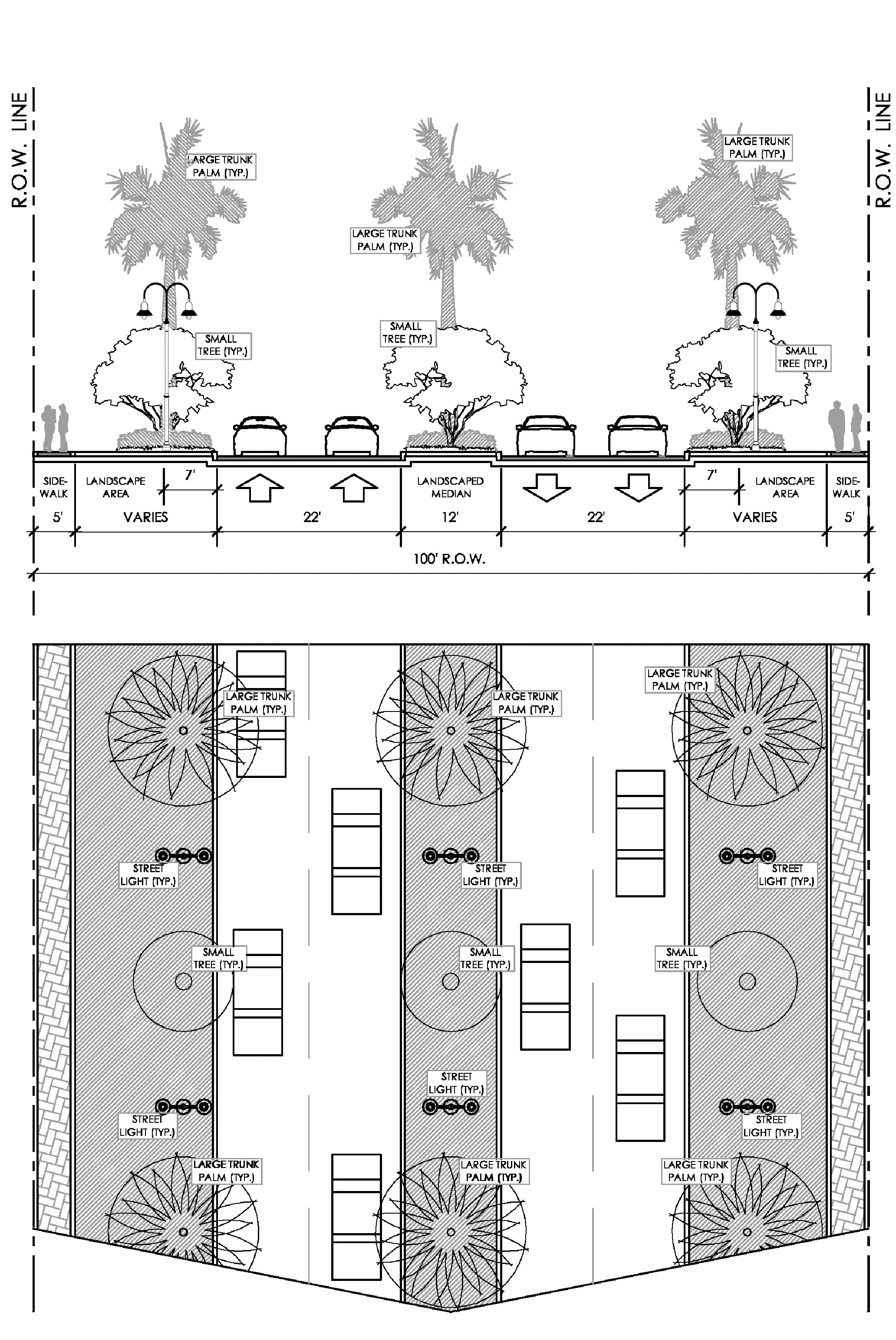
A typical road section and plan for a primary road.
Design guidelines:
• Primary roads should be the main spines which move traffic efficiently through the City.
• Primary roads should be provided with pedestrian walkways and bikeways.
• Primary roads and their central medians should be lined with street trees and palms spaced at 50'—75' on center and 30'—50' respectively.
9.2. Secondary roads. Secondary roads are roads with rights-of-way (ROWs) between seventy-five (75) feet to one hundred (100) feet and have four (4) lanes. Inverrary Boulevard, NW 56th Avenue and portions of NW 38th Avenue are Lauderhill's secondary roads.
Design standards:
• Architecture should face the street and new parking lots should be located behind or to the side of buildings.
• Existing parking lots should be effectively screened from the street.
• Secondary roads must have consistent vehicular scaled lighting with fixture mounting heights from 15'—25' and pedestrian scaled lighting with fixture mounting heights from 10'—20'.
Secondary roads have consistent trees, move traffic efficiently and provide sidewalks.
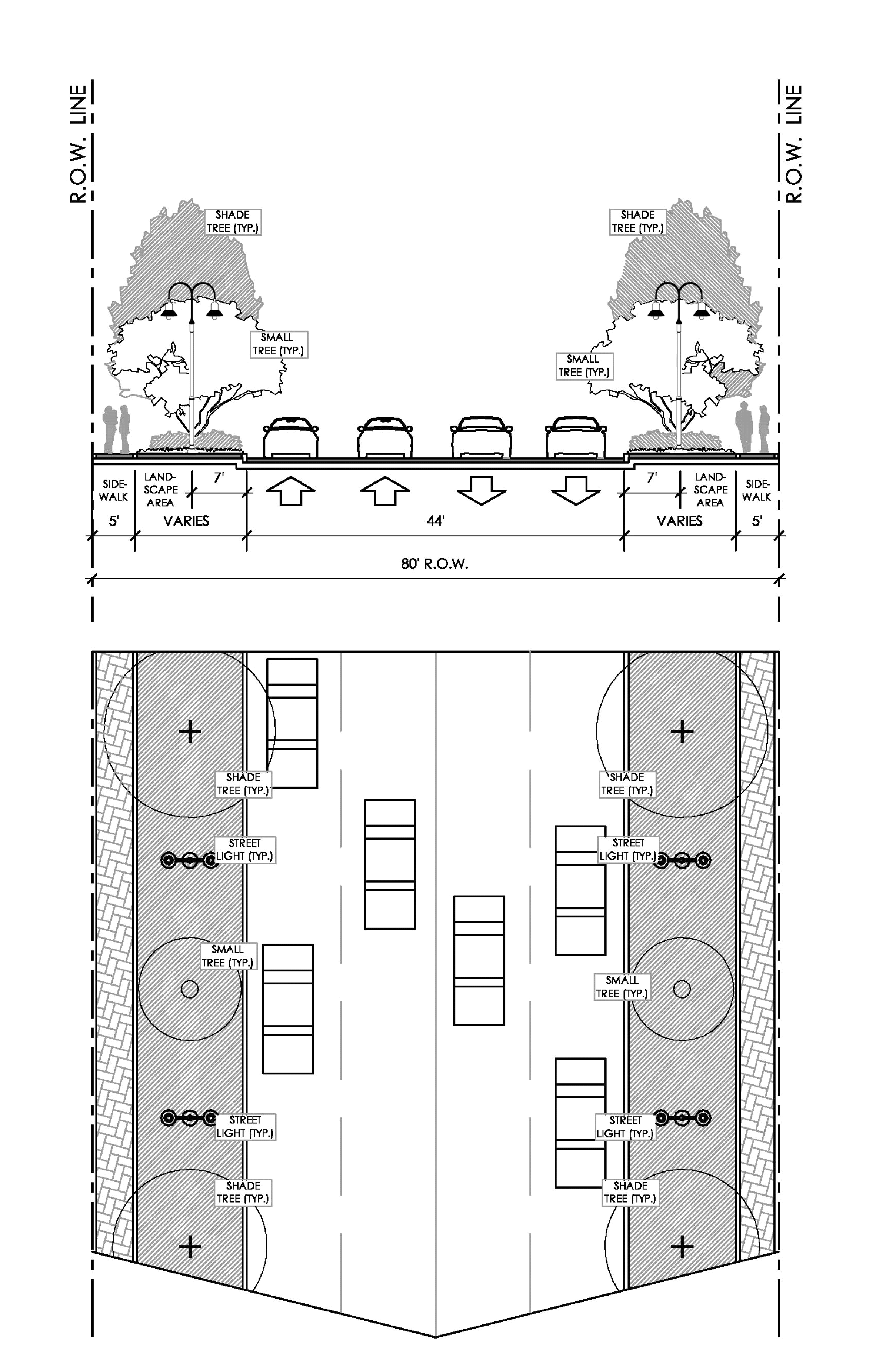
A typical road section and plan for a secondary road.
Design guidelines:
• Secondary roads should be the distribution network within the City.
• Vehicles should be collected and circulated throughout the districts on these roads.
• Sidewalks should be provided for walking and bicycling along these secondary roads.
• Shade trees and palm trees should line the roadways with the former spaced at 50'—75' on center and the latter spaced at 30'—50' on center.
9.3. Tertiary roads. These are streets with rights-of-way (ROWs) of seventy-five (75) feet or less in width and generally have two (2) lanes.
Design standards:
• Tertiary roads must have consistent vehicular scaled lighting with fixture mounting heights from 15'—25' and pedestrian scaled lighting with fixture mounting heights from 10'—20'.
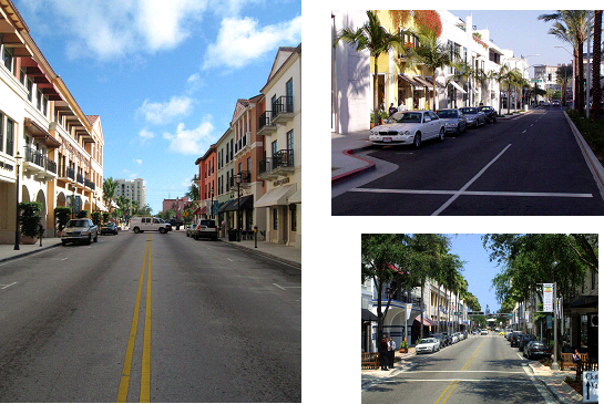
Tertiary roads have slower traffic, on-street parking and an active pedestrian zone.
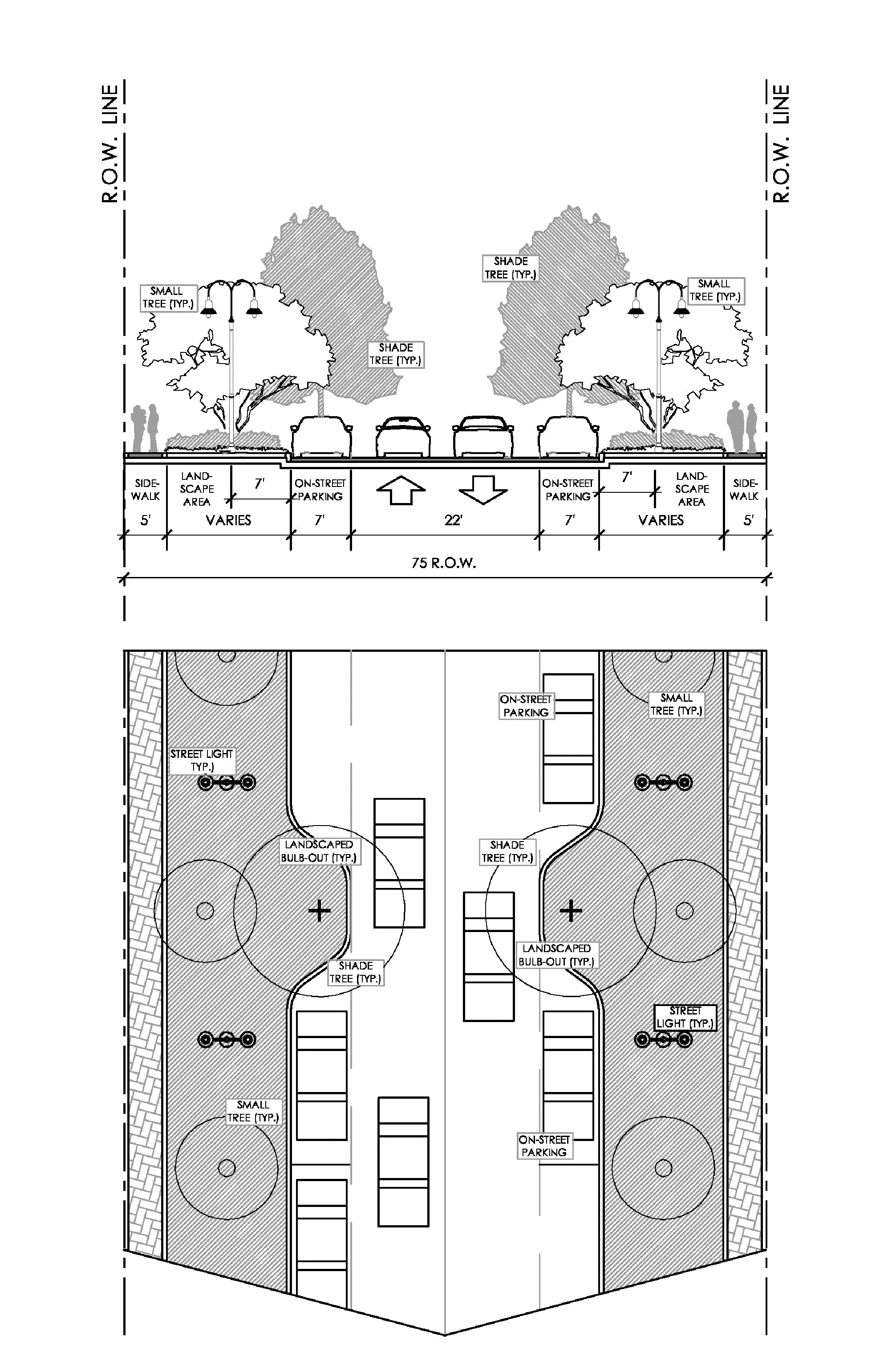
A typical road section and plan for a tertiary road.
Design guidelines:
• Tertiary roads should have slower moving traffic, provide on-street parking and encourage pedestrian activity.
• Sidewalks for walking, bicycling, dining and window shopping should be provided.
• Site furniture, public art, planters, water features and special paving should be implemented along tertiary roads.
• Shade trees and palm trees should line the roadways with the former spaced at 40'—50' on center and the latter spaced at 20'—30' on center. Small trees should be spaced at 20'—30' on center and small trunk palms should be spaced at 15'—25'.
9.4. Main street. These are streets with rights-of-way (ROWs) of less than sixty-six (66) feet in width and located within or along a Transit Oriented Corridor or Transit Oriented Development.
Design standards:
• Main streets must have consistent vehicular scaled lighting with fixture mounting heights from 15'—25' and pedestrian scaled lighting with fixture mounting heights from 10'—20'.
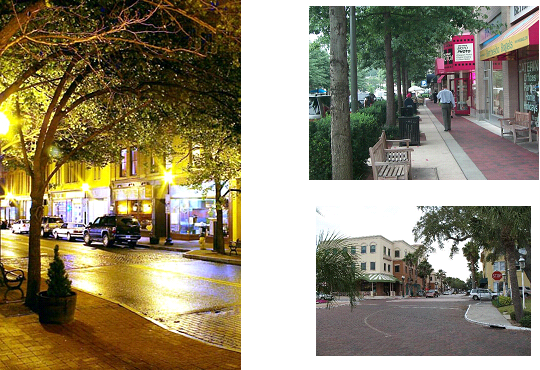
Main streets have a more urban atmosphere with an active pedestrian zone.
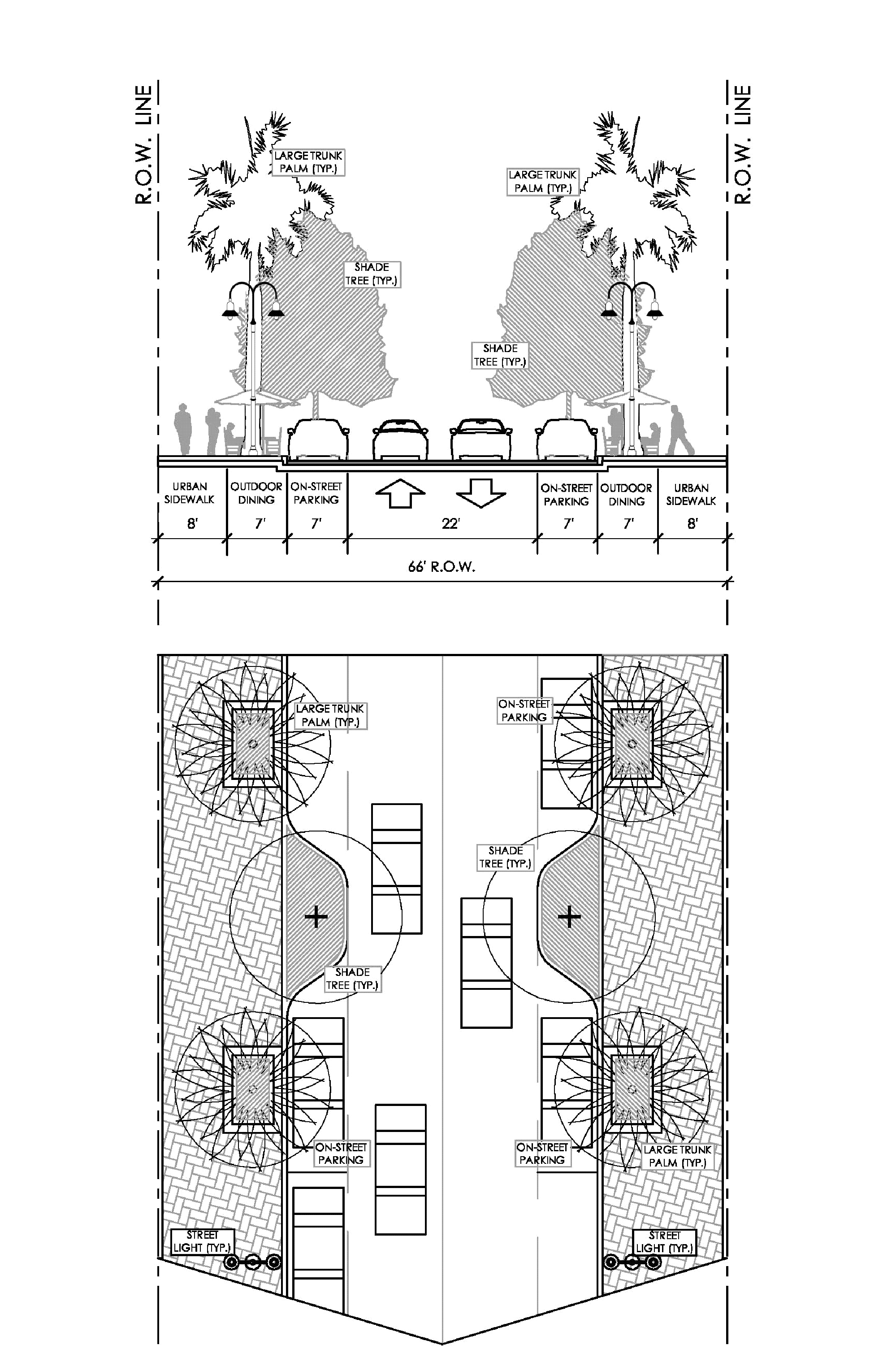
A typical road section and plan for a main street road.
Design guidelines:
• The main street should be a more urban corridor with slower moving traffic, provide on-street parking and encourage pedestrian activity.
• Wider sidewalks for walking, bicycling, dining and window shopping should be provided.
• Site furniture, public art, planters, water features and special paving should be implemented along main streets.
• Shade trees should be spaced at 40'—50' on center and large trunk palms should be spaced at 20'—30' on center. Small trees should be spaced at 20'—30' on center and small trunk palms should be spaced at 15'—25'.
9.5. Pedestrian crossing. Pedestrian crossings are an essential component to urban, pedestrian-friendly streets. Pedestrian crossings should be provided at all street intersections located within the City.
Design standards:
• Depressed curbs should be provided at crosswalks for wheelchair accessibility.
• Landscaped bulb-outs that increase pedestrian visibility and control vehicular speeds must be provided at intersections along the main street at the interior of sub-blocks within the City.

Crosswalks should be delineated with a change in material.
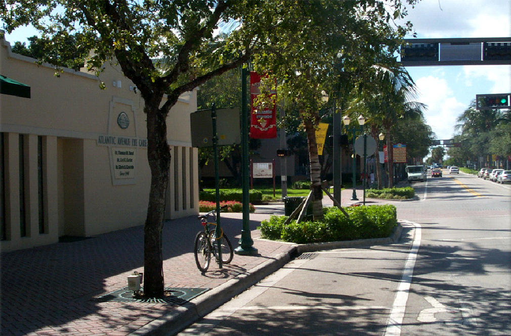
Landscaped bulb-outs should be provided at pedestrian intersections.
Design guidelines:
• Special paving and signalized crossings are encouraged at all intersections for safe and easy access.
9.6. Parking and access. The City of Lauderhill should have sufficient parking, both on and off street.
Design guidelines:
• On-street parking is encouraged along tertiary streets within the City.
• When intensity allows, parking structures are encouraged. Stacking parking levels will prevent unsightly expanses of large parking lots. When located on front tertiary roads or main streets, the first floor should have habitable space in order to foster a more pedestrian-friendly environment.
• Shared parking facilities across adjacent development blocks are encouraged when uses are mixed within a building or a project.
• Well marked, preferred spaces for fuel-efficient vehicles, carpools and compact automobiles are encouraged.
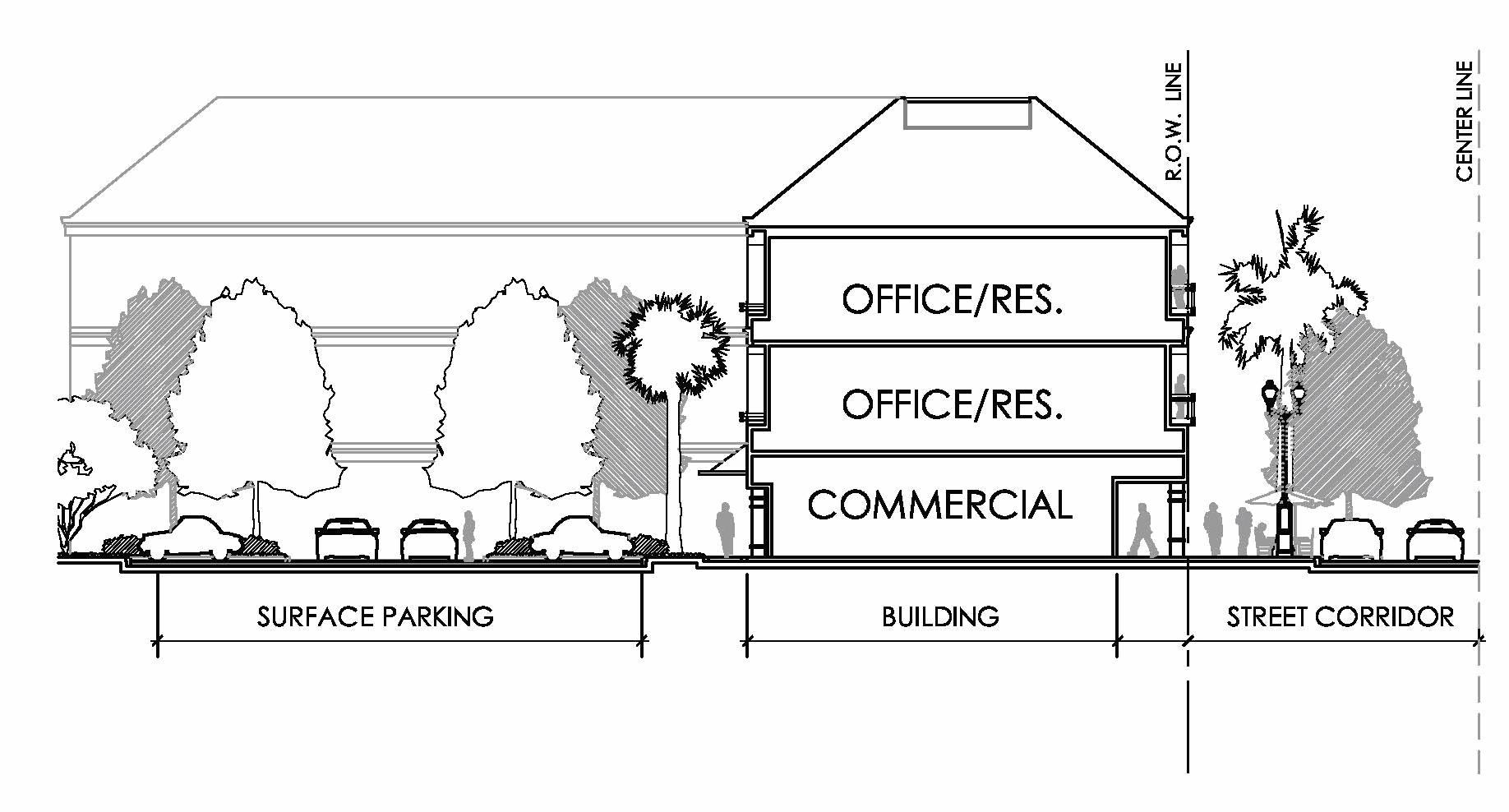
Surface parking lots should be located behind the building, allowing the architecture
to face the street.
9.7. Parking access.
Design standards:
• Larger parking areas (over five hundred (500) spaces) shall have two (2) or more access points.
Design guidelines:
• Parking areas should be designed to accommodate clear access and circulation.
• Shared access driveways are encouraged for smaller lots which are either developed simultaneously or planned for in agreement with the adjacent owners.
• Accommodations shall be made for visitor parking and drop-off facilities at building entry points.
9.8. Parking layout.
Design standards:
• Curb and gutters shall be implemented in high traffic areas within parking areas.
• For vehicular and pedestrian safety, parking stall striping shall be consistent throughout the parking area.
• Service areas, loading docks and garbage facilities shall be properly screened and located so as not to impede regular parking area traffic flow.
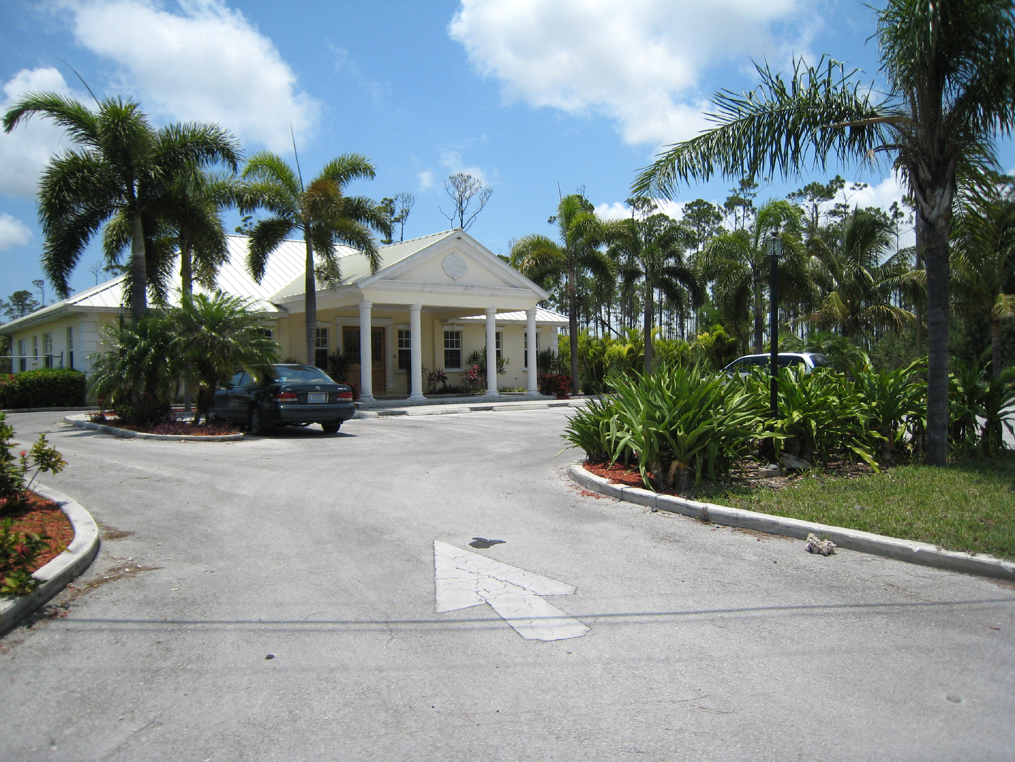
Parking areas should have clear access points.
Design guidelines:
• Bioswales are recommended in parking areas to catch excess storm water runoff.
• Wheel stops are encouraged for all parking areas.
(Ord. No. 10O-02-108, § 10, 2-22-2010)
Appendix A: Definitions
The following terms are defined specifically for use in the City of Lauderhill:
Abut: To physically touch or border upon, or to share a common property line.
Accessway: A way or means of entering or approaching a plot of land.
Addition: Act or process of adding; something added.
Alley: A minor public right-of-way of not more than twenty (20) feet in width providing secondary vehicular access to the side or rear of properties otherwise abutting a street.
Alteration: Having been made different.
Arcade: An arched, roofed-in gallery.
Awning or canopy: A structure attached to a building, the function of which is to shelter its window(s), door(s) or pedestrians from rain, wind and sun.
Bahama shutter: Frame and mini louver shutters.
Bicycle and pedestrian ways: Means any road, path or way which is open to bicycle travel and traffic afoot and from which motor vehicles are excluded.
Buffer: A specified land area used to visibly separate one (1) use from another or to block noise, lights or other nuisances.
Building frontage (length of): The length of a building façade along a street, as measured horizontally between lot lines.
Building frontage (type of): The several types of building façades utilized along streets, such as arcade, gallery, stoop and porch.
Building height: The vertical distance from the average finished grade of the adjacent ground to the top of the structure, at the highest roof beams of a flat roof, the deck of a mansard roof or the mean level of the highest gable or slope of a hip roof.
Bulb-outs: Landscaped islands in parking lots or along streets and their intersections that delineate parking spaces and slow vehicular traffic.
City: The City of Lauderhill, Florida.
Clapboard: Narrow board thicker at one (1) edge than the other used for siding.
Code: Shall include both the Code of Ordinances of the City of Lauderhill and the Land Development Regulations thereof.
Colonial: Of, relating to, or characteristic of a colony.
Cooler box (window chiller): A wood frame structure, with louvers or lattice work installed around a window for privacy and security while the window is open
Cornice: A continuous, molded projection that crowns a wall or other construction, or divided it horizontally for compositional purposes.
CPTED: Crime Prevention Through Environmental Design.
Development:
a.
The carrying out of any building activity or mining operation, the making of any material change in the use or appearance of any structure or land, or the dividing of land into two (2) or more parcels.
b.
The following activities or uses shall be taken for the purposes of these Land Development Regulations to involve "development," as defined in this section:
1.
A reconstruction, alteration of the size, or material change in the external appearance of a structure on land.
2.
A change in the intensity of use of land, such as an increase in the number of dwelling units in a structure or on land or a material increase in the number of businesses, manufacturing establishments, offices, or dwelling units in a structure or on land.
3.
Alteration of a shore or bank of a seacoast, river, stream, lake, pond, or canal, including any "coastal construction" as defined in Florida Statutes.
4.
Commencement of drilling, except to obtain soil samples, mining, or excavation on a parcel of land.
5.
Demolition of a structure.
6.
Clearing of land as an adjunct of construction.
7.
Deposit of refuse, solid or liquid waste, or fill on a parcel of land.
c.
The following operations or uses shall not be taken for the purpose of this Article to involve "development" as defined herein:
1.
Work by any utility and other persons engaged in the distribution or transmission of gas, sewage or water, for the purpose of inspecting, repairing, renewing, or constructing on established rights-of-way.
2.
Work for the maintenance, renewal, improvement, or alteration of any structure, if the work affects only the interior or the color of the structure or the decoration of the exterior of the structure.
3.
The use of any structure or land devoted to dwelling uses or any purpose customarily incidental to enjoyment of the dwelling.
4.
A change in use of land or structure from a use within a class specified in an ordinance or rule to another use in the same class.
5.
A change in the ownership or form of ownership of any parcel or structure.
Façade: The front of a building
Fenestration: Windows and other exterior openings of a building. Also refers to the arrangement of windows and doors in a building.
Fretwork: Ornamental openwork or work in relief, usually made from wood.
Infrastructure: Those man-made structures which serve the common needs of the population, such as: sewage disposal systems; potable water systems; potable water wells serving a system; solid waste disposal sites or retention areas; storm water systems; utilities; piers; docks; wharves; breakwaters; bulkheads; seawalls; bulwarks; revetments; causeways, marines, navigation channels; bridges; and roadways.
Keystone: Wedge-shaped piece of an arch that locks the other piece in place.
Land Development Regulation: Ordinances enacted by governing bodies for the regulation of any aspect of development and includes any local government zoning, rezoning, subdivision, building construction, or sign regulations or any other regulations controlling the development of land.
Land use: The type of use of a parcel of property.
Mixed use: Two (2) or more principal uses occupying the same structure or lot when more than one (1) principal use is permitted on the lot or in the structure.
Modification: Change.
Molding: Decorative surface, plane, or curved strip.
Mullion: Vertical strip separating window panes.
Muntin: The secondary framing member on the window to create the required glazing panel sizes, may be applied in lieu of built-in.
Open space: The following areas shall be considered as part of the required open space, both individually and in combination: landscaped areas, public sidewalks ten (10) feet in width or greater, plazas, courtyards, and other open spaces defined herein; outdoor dining and landscaping within any of the above and water features.
Parking: The temporary, transient storage of private passenger automobiles used for personal transportation, while their operators are engaged in other activities. It shall not include storage of new or used cars for sale, service, rental or any other purpose other than specified above.
Parking space: A space at least nine (9) feet in width and eighteen (18) feet in length with at least eighteen (18) feet of back-up and maneuvering area directly behind the space, used exclusively as a parking stall for one (1) vehicle.
Parliament hinge: Hinge designed to allow a door or window to fold back on itself or flush against a wall.
Pediment: Low triangular gable-like decoration (as over a door or window) on a building.
Pergola: An arbor or a passageway of columns supporting a roof of trelliswork on which climbing plants are trained to grow. Pergolas are usually a separate structure from the main building.
Pervious area: Area maintained in its natural condition, or covered by a material that permits infiltration or percolation of water directly into the ground.
Porch: A roofed-over space attached to the outside of an exterior wall of a building, which has no enclosure other than the exterior walls of such building. Open mesh screening shall not be considered an enclosure.
Primary roadway: Roadways that facilitate traffic movement between major arterial streets and local streets with direct access to abutting properties. Primary roads are roads with rights-of-way (ROWs) between a hundred (100) feet to two hundred (200) feet and are four (4) lane divided roads.
Public access: The ability of the public to physically reach, enter or use a site.
Reconstruction: Act of constructing again.
Recreational uses: Activities within areas where recreation occurs.
Restaurant: A building or room, not operated as a bar, nightclub, tavern or dining room in connection with a hotel, where food is prepared and sold for consumption on the premises and where alcoholic beverages may be sold only for consumption on the premises. A restaurant with a bar shall be defined as a bar for distance separation purposes only (Schedule E, Section 4(2)), unless it obtains a special exception which permits it to be defined as a restaurant for purposes of Schedule E, Section 4(2).
Redevelopment: Restructure for new use.
Renovation: Making like new again.
Restoration: Putting or bringing back into a former or original state.
Right-of-way: Land dedicated, deeded, used, or to be used for a street, alley, walkway, boulevard, drainage facility, access or ingress and egress, or other purpose by the public, certain designated individuals, or governing bodies.
Secondary roadway: Secondary roads should be developed to facilitate local traffic movement and direct access to abutting properties. These are roads with rights-of-way (ROWs) between seventy-five (75) feet to a hundred (100) feet and are four (4) lane roads.
Setback: The minimum distance between the street right-of-way outer line closest to the building and the front line of the building or any projection thereof, excluding projections specifically permitted or, the minimum distance between the side and rear property lines and the applicable side and rear building lines or any projection thereof, excluding projections specifically permitted.
Setback, front: Setback required from a front line and from any street line of a corner lot.
Setback, rear: Setback required from the rear line.
Setback, side: Setback required from a side line.
Sign: Any permanent or temporary structure, or devise, letter, work, model, banner, pennant, insignia, or trade flag which is visible from any public street, alley, waterway or public place. Sign shall not be construed to include any flag, notice, badge, or insignia or any government or governmental agency, or any legal notice posted by and under governmental authority.
Sill: Heavy crosspiece (as of wood or stone) that forms the bottom member of a window frame or a doorway.
Stay: Metal rod or hook used to secure window or door in various open positions.
Street: A public thoroughfare greater than twenty-four (24) feet in width which affords principal means of access to abutting property, including the distance between applicable right-of-way lines. Street shall include land dedicated to or condemned for use as a public thoroughfare for public travel, whether or not utilized, but shall not include an alley as defined herein.
Structure: Anything constructed, assembled or erected, installed or portable, the use of which requires a location on a parcel of land. It includes a movable structure while it is located on land and which can be used for housing, business, commercial, industrial, recreational or office purposes, either temporarily or permanently. "Structure" also includes fences, billboards, swimming pools, poles, pipelines, transmission lines, tracks, and advertising signs and tennis courts, and the like.
Transom: Window above an opening (as a door) built on and often hinged to a horizontal crossbar.
Use: The purpose for which a structure or lot is arranged, designed or intended to be used, occupied or maintained.
Vignette: Short descriptive literary sketch.
Walkway: A right-of-way intended primarily for pedestrians, excluding self-propelled vehicles.
Window chiller: See "cooler box."
(Ord. No. 10O-02-108, § 11, 2-22-2010)
Appendix B: Color Palette
The series of allowable colors shall be vibrant and rich. Vast contrast in shades and hues are allowed. Color palettes must be submitted with renderings for the proposed color schemes.
(Ord. No. 10O-02-108, § 12, 2-22-2010)
Sec. 1. - Minimum standards for all buildings and structures in the City of Lauderhill.
A.
All building exterior wall surfaces shall be painted and shall be kept free of faded or chipped paint, and shall be maintained in good repair and good condition to prevent deterioration. The building must be repainted, recovered or recleaned when the exposed surface becomes discolored or is peeling.
B.
All doors, including garage doors, shall be kept free of faded or chipped paint and shall be maintained in good condition, free from deterioration.
C.
All roofs and gutters shall be kept free of faded or chipped paint and must be recovered or recleaned when any exposed surface becomes discolored or is scaling. Said repairs shall be consistent with the materials used on the existing roof and shall provide a uniform appearance.
D.
All broken windows shall be replaced. Other exterior features associated with windows, including, but not limited to, sills, casings, shutters, and hurricane shutters, must be maintained in good condition and kept free of deterioration.
E.
Mailboxes shall be standing upright and shall not be in deteriorated or dilapidated condition.
F.
All wood trim shall be maintained in good repair and good condition to prevent deterioration, and must be repaired, repainted, recovered or recleaned when the exposed area becomes deteriorated, discolored or is peeling.
G.
All paved areas shall be maintained in good condition and good repair, which shall include proper drainage to prevent the accumulation of pools of water, except the swale area, and the removal of all ruts, potholes, and broken pavement. Paved areas must be repaired or replaced when any deterioration occurs to the extent that the roadrock or subbase is visible.
H.
(1)
In the event of a violation of this section, a notice of violation shall be served upon the property owner. If the violation is not corrected, a notice to appear shall then be served upon the property owner, who shall be required to appear before the Code Enforcement Board.
(2)
If the corrections shall all be made as required within the recommended time period, the property shall then be determined to be in compliance with this section, and no further action shall be taken.
(Ord. No. 98O-6-132, § 1, 7-13-98)
Sec. 2. - Boarded-up structures.
A.
Definition. Boarded-up means the covering of any one (1) or more doors, windows or other openings into a structure by any type of material, regardless of the reason for such boarding-up. Excluded from this definition of boarded-up are:
(1)
The typical hurricane or storm shutters custom manufactured permanently installed on residences on a year round basis and then closed during the owner's temporary absence;
(2)
The temporary (four- to five-day) boarding-up normally done in preparation for a severe storm such as a hurricane.
B.
Painting boarded-up material. Any person who boards-up [or] causes to be boarded-up any structure, and any owner who permits a structure to be boarded-up shall paint, or cause to be painted, the material used to board-up the structure the same color as the building.
C.
Maintenance of boarded-up premises. Any person who boards-up or causes to be boarded-up any structure, and any owner who permits a structure to be boarded-up shall maintain, or cause to be maintained, the exterior of the structure and the premises on which the structure is erected as required by the City of Lauderhill Code.
(Ord. No. 90-161, 9-10-90; Ord. No. 91-131, 5-28-91)
1.1.- AUTHORITY.
1.1.1. Chapters 163 and 166, Florida Statutes, and the Charter for the City of Lauderhill, Florida authorizes the Commission to adopt, repeal and amend, in whole or in part, regulations governing the use, development and redevelopment of land and water.
1.1.2. This Schedule is a land development regulation and was adopted as one of the instruments of implementation of the public purposes, goals, objectives and policies of the City of Lauderhill Comprehensive Plan and does not authorize development or redevelopment that is inconsistent with the City of Lauderhill Comprehensive Plan. Moreover, to further the Comprehensive Plan's goals and objectives and to further the purpose of this Schedule, the State Road 7 Community Redevelopment Area is divided into Transect Zones (T-Zones) of such number, characteristics, area, common unity of purpose, and adaptability as will accomplish the purpose of the Comprehensive Plan and this Schedule.
1.1.3. This Schedule was adopted to promote the health, safety and general welfare of the City of Lauderhill, including protection of the environment; conservation of land, energy and natural resources; reduction in vehicular traffic congestion; more efficient use of public funds; health benefits of a pedestrian environment, education and recreation; enhancement of economic development; reduction in sprawl development; and improvement of the built environment.
1.1.4. This Schedule was recommended for adoption by the Planning and Zoning Board (hereinafter the "Board") on June 21st, 2011 and was adopted on August 29th, 2011 by the Lauderhill City Commission (hereinafter the "Commission").
1.2. - APPLICABILITY.
1.2.1. Provisions of this Schedule are activated by "shall" when required; "should" when recommended; and "may" when optional.
1.2.2. The provisions of this Schedule, when in conflict, shall take precedence over those of other City codes, ordinances, regulations and standards except Chapters 6 (Buildings and Building Regulations), Chapter 9 (Fire Protection and Prevention) and Chapter 21 (Water and Sewer Service) of the Lauderhill Code of Ordinances (hereinafter the "Local Health and Safety Codes").
1.2.3. This Schedule, along with the land uses allowed within the respective base or underlying zoning districts, shall be the development code for the area designated on the official City of Lauderhill Zoning District Map as the SmartCode Overlay Transect Zone (See Map No. 1). The existing City of Lauderhill Land Development Regulations and Code of Ordinances shall continue to be applicable to issues not covered by this Schedule.
1.2.4. Capitalized terms used throughout this Schedule may be defined in Article 8 Definitions and Abbreviations. Article 8 contains regulatory language that is integral to this Schedule. Those terms not defined in Article 8 shall be interpreted as defined in the Land Development Regulations and, if not defined therein, then accorded their commonly accepted meanings. In the event of conflicts between these definitions and those of the existing City of Lauderhill Land Development Regulations, those of this Schedule shall take precedence.
1.2.5. The metrics of Article 4 Standards, Tables and Maps are an integral part of this Schedule; however, the diagrams and illustrations that accompany them should be considered guidelines, with the exception of those on Article 4, Table 12 Form-Based Code Graphics and the Maps, which are also legally binding.
1.2.6. Where in conflict, numerical metrics shall take precedence over graphic metrics.
1.3. - INTENT.
The intent and purpose of this Schedule is to enable, encourage and qualify the implementation of the following policies:
1.3.1. The Community.
a.
That development and redevelopment should be compact, pedestrian-oriented and Mixed use.
b.
That Mixed use developments should be the preferred pattern of development and that Districts specializing in a single use should be the exception.
c.
That ordinary daily living activities should occur within walking distance of most dwellings.
d.
That interconnected networks of Thoroughfares should be designed to disperse and reduce the length of automobile trips.
e.
That within neighborhoods, a range of housing types and price levels should be provided to accommodate diverse ages and incomes.
f.
That appropriate building densities and land uses should be provided within walking distance of transit stops.
g.
That Civic and Commercial activity should be embedded in downtowns, not isolated in remote single-use complexes.
h.
That schools should be sized and located to enable children to walk or bicycle to them.
i.
That a range of Open Space including Parks, Squares, and playgrounds should be distributed within neighborhoods and downtowns.
1.3.2. The Block and the Building.
a.
That buildings and landscaping should contribute to the physical definition of Thoroughfares as Civic places.
b.
That development and redevelopment should adequately accommodate automobiles while respecting the pedestrian and the spatial form of public areas.
c.
That the design of streets and buildings should reinforce safe environments, but not at the expense of accessibility.
d.
That architecture and landscape design should grow from local climate, topography, history, and building practice.
e.
That buildings should provide their inhabitants with a clear sense of geography and climate through energy efficient methods.
f.
That Civic buildings and public gathering places should be provided as locations that reinforce community identity and support self-government.
g.
That Civic buildings should be distinctive and appropriate to a role more important than the other buildings that constitute the fabric of the city.
h.
That the harmonious and orderly evolution of urban areas should be secured through form-based codes.
1.3.3. The Transect.
a.
That communities should provide meaningful choices in living arrangements as manifested by distinct physical environments.
b.
That the Transect Zone descriptions in Article 4, Table 1, shall demonstrate the intent of this Schedule with regard to the general character of each of these environments.
2.1.- SMARTCODE OVERLAY TRANSECT ZONE MAP.
2.1.1. The Zoning District Map described in Article III., Part 2.0., Section 2.2 is hereby supplemented by the SmartCode Overlay Transect Zone Map, which Map together with all adopted explanatory and supplemental information is shown in Article 4, Map 1, is hereby adopted and shall be a part of this Schedule.
2.1.2. The SmartCode Overlay Transect Zone Map and any amendments thereto shall be maintained in the Office of the City Clerk, and a certified copy shall be maintained in the Office of Planning and Zoning. The City Planner shall sign the Map to verify its accuracy and it shall be authenticated by the signature of the Mayor of the City.
2.1.3. This Schedule affects all lands, waters, Structures, Uses and occupancies within the area of the City of Lauderhill shown on the SmartCode Overlay Transect Zone Map. No Building, Structure, land or water shall be used or occupied, no land shall be subdivided and no Building, Structure, land or part thereof shall be developed except in conformity with the Transect regulations in which it is located, unless excepted, and with all applicable Land Development Regulations.
2.2. - TRANSECT ZONE BOUNDARIES.
2.2.1. Except as otherwise specifically provided, a Transect symbol or name shown within Transect boundaries in the SmartCode Overlay Transect Zone Map indicates that the regulations pertaining to the Transect Zone extend throughout the whole area surrounded by the boundary line.
2.2.2. Except as provided in Section 2.2.3, where a Transect Zone designation is not indicated for an area in the SmartCode Overlay Transect Zone Map, the area shall be construed to be zoned as for the most restrictive Abutting zone, until corrective action is taken by the City Commission.
2.2.3. Where uncertainty exists as to the location of the boundary of a Transect Zone, or other areas delineated for regulatory purposes in the SmartCode Overlay Transect Zone Map, the following rules shall apply:
a.
Boundaries indicated as approximately following the centerlines of streets, alleys, rights-of-way, or Easements shall be construed as following such centerlines as they exist on the ground.
b.
Boundaries indicated as approximately following Thoroughfares, public or private Property Lines, Rights-Of-Way or Easements shall be construed as following such boundaries; provided, however, that where such boundaries are so located with relation to other opposing boundaries as to leave such area without apparent Transect Zone designation, such boundaries shall be construed as running to the centerlines of the areas remaining.
c.
Boundaries indicated as approximately following centerlines of canals or other bodies of water shall be construed as following such centerlines.
d.
Where variation of the actual location from the mapped location would change the T-zone status of a Lot or parcel, the boundary shall be interpreted so as to avoid the change.
e.
In the event of vacation, the boundary shall be construed as remaining in its location, except where ownership of the vacated property is divided other than at the center, in which case the boundary shall be construed as moving with the ownership.
2.2.3. [2.2.4.] Where distances are not specifically indicated on the Map, distances shall be determined by reference to the scale of the Map.
2.2.4. [2.2.5.] Where boundaries occur within a parcel of land comprising more than one (1) Lot, the Lots shall be developed separately according to the assigned Transect Zone.
2.3. - PENDING ACTIONS AND DEVELOPMENT APPROVALS.
2.3.1. The effective date of this Schedule shall not affect nor prevent the prosecution of any action pending at the time of the effective date of this Schedule, which action is to enforce the Code of Ordinances or Land Development Regulations or the conditions of any previously adopted development order.
2.3.2. Any previously approved development orders and any conditions of approval shall continue in full force and effect unless a new development order is obtained, at which time the development shall come into conformance with these regulations if required.
2.3.3. Any development orders previously approved or applications filed and pending action under the Notice of Zoning in Progress (Resolution No. 10R-06-126) shall be vested provided it is constructed as displayed in the approved development order.
2.4. - PROCESS.
2.4.1. Article IV of the existing City of Lauderhill Land Development Regulations shall govern the review of applications under this Schedule except that the Development Review Committee (DRC) shall make the final determination on a Site Plan application.
2.4.2. An applicant may appeal a decision of the DRC to the Planning and Zoning Board (Board), may appeal a decision of the Board to the City Commission, and may appeal a decision of the City Commission to the appropriate court.
2.4.4. [2.4.3.] Should a violation of the approved Site Plan occur during construction, a Building or Code Enforcement official has the right to require the owner to stop, remove, mitigate the violation, or to require the owner to secure a Variance to cover the violation, or any combination of the above.
2.5. - WARRANTS AND VARIANCES.
2.5.1. There shall be two (2) types of deviation from the requirements of this Schedule: Warrants and Variances. Whether a deviation requires a Warrant or Variance shall be determined by the City Manager.
2.5.2. A Warrant is a ruling that would permit a practice that is not consistent with a specific provision of this Schedule but is justified by the provisions of Section 1.3 Intent. The DRC shall have the authority to approve, approve with conditions, or deny administratively a request for a Warrant pursuant to regulations established by the DRC.
2.5.3. A Variance is any ruling on a deviation other than a Warrant. Variances shall be granted only in accordance with the laws of the State of Florida and the City's Land Development Regulations.
2.5.4. The request for a Warrant or Variance shall not subject the entire application to public hearing, but only that portion necessary to rule on the specific issue requiring the relief.
2.6. - RULES OF CONSTRUCTION.
2.6.1. In their interpretation and application, the provisions of this Schedule shall be the minimum requirements or maximum limitations, as the case may be, adopted for the promotion of the public health, safety, or general welfare.
2.6.2. The following rules of construction shall apply to the text of this Schedule:
a.
Headings. Sections or subsections shall not be deemed to govern, limit, modify, or in any manner affect the scope, meaning, or intent of any provision herein.
b.
Illustrations. In case of any difference of meaning or implication between the text of any provision and any illustration, the text shall control, unless the intent of this Schedule is clearly otherwise.
c.
Terminology: Shall, may and should. "Shall" is always mandatory and not permissive. "May" is permissive. "Should" is advisory and identifies guidance provided by the City Commission in the implementation of these regulations.
d.
Tenses and numbers. Words used in the present tense include the future, words used in the singular include the plural, and the plural includes the singular, unless the context clearly indicates the contrary.
e.
Conjunctions. Unless the context clearly indicates otherwise, the following conjunctions shall be interpreted as follows:
1.
"And" indicates that all connected items or provisions shall apply.
2.
"Or" means that the connected items or provisions may apply singly or in any combination.
3.
"Either/or" indicates that the connected items or provisions shall apply singly but not in combination.
f.
Gender. Use of the masculine gender includes the feminine gender and use of the feminine gender includes the masculine.
g.
Any act authorized by this Schedule to be carried out by a specific official or agency of the City is impliedly authorized to be carried out by a designee of that official or agency.
h.
Any reference to federal laws, Florida Statutes, Florida Administrative Code, Broward County Code of Ordinances, the Lauderhill Code of Ordinances and Land Development Regulations or any other official code shall be construed to be a reference to the most recent enactment of the particular law, and shall include any amendments to it as may be adopted from time to time.
2.7. - CALCULATIONS.
2.7.1. Rounding. Where cumulative requirements or limitations are to be computed for purposes herein, fractions shall be carried forward in the summation, and the total rounded to the nearest whole number, subject to the minimum Lot sizes and maximum Densities or intensities of development required by these regulations.
2.7.2. Time. The time within which an act is to be done shall be computed by excluding the first and including the last day, except that if the last day is a Saturday, Sunday or legal holiday, that day shall be excluded.
2.8. - INSTRUCTIONS.
2.8.1. Lots and buildings located within any Transect Zone are subject to this Schedule.
2.8.2. Owners and developers may have the Site Plan required under this Schedule prepared on their behalf.
2.8.3. Prior to filing any plans subject to this Schedule, a mandatory Pre-Application Conference shall be held with the owners, developers or their consultants and City staff.
2.8.4. A Site Plan shall show the following, in compliance with the standards described in this Schedule for site and building approval:
a.
Cover sheet
b.
Building Disposition
c.
Building Configuration
d.
Base/Underlying Zoning District(s) and proposed primary and accessory uses
e.
Parking
f.
Landscape and Irrigation
g.
Signage
h.
Special Requirements
i.
Lighting
2.8.5. The development review process and time frames shall be as prescribed in LDR Article IV., Part 1.0. and Part 5.0., Section 5.10.
2.8.6. The following design review criteria shall be applied to a Site Plan consistent with the standards and requirements of this Schedule and the Land Development Regulations:
a.
Cover sheet
• Table Contents
• Scope of Work
• Legal Description
• General Location Map
• Project Name
• Scale
b.
Building Disposition
• Respond to the physical context taking into consideration natural features, existing urban form and Transect Zone intentions
• For Buildings on Corner Lots, design Façades to acknowledge all Frontages
• For modifications of nonconforming Structures, See Subsection 2.9.1
• Create transitions in Building Height with mass and with Abutting properties and Transect Zones
c.
Building Configuration
• Articulate the Building Façade vertically and horizontally in intervals appropriate to the existing Neighborhood and Transect Zone
• Articulate the Building Façade at street level to recognize pedestrian continuity and interest and at upper levels to recognize long views of Buildings
• Use architectural styles and details, colors and materials consistent with LDR Schedule P., Design Standards and Guidelines
• Design Façades that respond primarily to the human scale
• Promote pedestrian interaction
• Design all walls as active Façades, with doors and windows; when not possible, embellish walls with architectural design treatment
• Provide usable Open Space that allows for visible and convenient pedestrian access from the public sidewalk
• Building sites should locate service elements, such as trash dumpsters, utility meters, loading docks, backflow preventers, Siamese connections and electrical, plumbing, mechanical and communications equipment away from a street front. All service elements shall be situated and screened from view to the street and adjacent properties
d.
Uses allowed within the base/underlying zoning district
• Demonstrate that the land uses are allowed within the zoning district
e.
Parking
• Minimize the impact of automotive parking and driveways on the pedestrian environment and adjacent properties
• For pedestrian and vehicular safety, minimize conflict points such as the number and width of driveways and curb cuts
• Minimize off-street parking adjacent to a Thoroughfare front and where possible locate parking behind the Building
• Design landscaping or surface parking areas as buffers between dissimilar Uses
• Screen parking garage structures with Habitable Space. Where Habitable Space is not provided, architectural treatments and landscaping shall screen the garage structure
f.
Landscape and Irrigation
• Preserve existing vegetation or geological features or both whenever possible
• Reinforce Transect Zone intention by integrating landscaping, irrigation and hardscape elements
• Use landscaping to enhance Building design and continuity of streetscape
• Use landscape materials, such as plantings, trellises, pavers, screen walls, planters and similar features to enhance building design and continuity of streetscape
• Provide landscaping that screens undesirable elements, such as surface parking lots, and that enhances open space and architecture
g.
Signage
• Provide signage appropriate for scale and character of the project and immediate Neighborhood
• Provide functional and aesthetic signage identifying Building addresses at the entrance(s)
h.
Special requirements
• Engineering standards
• Stormwater management standards
i.
Ambient standards
• Provide lighting appropriate to the Building and landscape design in a manner that coordinates with signage and street lighting
• Orient outdoor lighting to minimize glare to the public realm and adjacent properties
• Protect residential areas from excessive noise, fumes, odors, commercial vehicle intrusion, traffic conflicts and the spillover effect of light
2.9. - PRE-EXISTING CONDITIONS.
2.9.1. Existing buildings and appurtenances that do not conform to the provisions of this Schedule may continue in use as they are until a Substantial Improvement or Modification is requested, at which time the DRC at a Pre-Application Conference shall determine the provisions of this Schedule that shall apply.
2.9.2. The modification of existing buildings is permitted By Right if such changes result in greater conformance with the specifications of this Schedule and is consistent with design guidelines in the Land Development Regulations, Schedule P.
2.9.3. [Reserved.]
2.9.4. Where buildings exist on adjacent lots, the DRC may require by Waiver that a proposed building match one or the other of the adjacent Setbacks and heights rather than the provisions of this Schedule.
2.9.5. When the restoration or rehabilitation of an existing building is proposed, the DRC may not require the provision of parking in addition to that existing. Existing parking requirements that exceed those for this Schedule may be reduced as provided by Table 9A and Table 9B.
2.10. - APPLICATION AND FEES.
2.10.1. Application. The City Planner is hereby authorized to prepare such application forms as is necessary to implement and effectuate the purposes of this Schedule.
2.10.2. Fees. The City Commission, by resolution, shall establish such fees for applications and other processes provided herein.
3.1.- TRANSECT ZONES.
3.2. - BUILDING FUNCTION.
3.2.1. This Schedule generally does not regulate Building Function. The Transect Zones are overlay zones on the Zoning District Map and the base or underlying Zoning District govern the Building Function or Uses allowable within a zoning district.
3.3. - PHASING.
3.3.1. All development shall conform to this Schedule regardless of phasing. Each phase of a development shall conform to this Schedule in its entirety.
3.4. - LOTS AND FRONTAGES.
3.4.1. Lots assembled into one (1) ownership that encompass more than one (1) Transect Zone shall be developed according to the corresponding Transect regulation for each lot. In such cases, there shall not be any transfer of density or intensity of development capacity between Transect Zones.
3.4.2. In Transect Zones T5 and T6, buildable sites shall Enfront a vehicular Thoroughfare or a Pedestrian Passage, with at least one (1) Principal Frontage.
3.4.3. Lots facing Thoroughfares on more than one (1) side shall have designated Principal Frontages(s) and may have Secondary Frontage(s). Unless otherwise designated by a Special Area Plan, a Principal Frontage shall be facing the Thoroughfare of higher pedestrian importance or intensity (i.e., traffic volume, number of lanes, etc.), as determined by the City Manager upon request by the City Planner.
a.
If two (2) Thoroughfares are of equal importance each Frontage shall be considered a Principal Frontage. Lots with two (2) or more Frontages may consider other non-fronting Property Lines as sides.
b.
Where an existing lot of record is located adjacent to a Thoroughfare in a manner that creates an irregular Frontage such that the sides or rear yards cannot be determined as with a regular lot, the City Planner shall determine, by Waiver, the yard and setbacks for the lot as fits the circumstances of the case. In addition to general Waiver requirements, the City Planner shall consider the minimum dimensions and methods of measurement as generally required for either a side or rear yard in the transect, determining which shall apply by the relation of the portion of the lot on which the yard is to be located to the adjoining lot, with due regard to the orientation of structures and buildable areas on each lot.
3.4.4. For purposes of this Schedule, Lots are divided into Layers (See Article 4, Table 13) which control Development on the Lot.
3.4.5. Where the property to be developed abuts an existing Building, a Waiver may be granted so that the proposed Building matches the dominant Setback of the block and its Context.
3.5. - DENSITY AND INTENSITY CALCULATIONS.
3.5.1. Lot Area is used for purposes of Density and Intensity calculation, except as provided elsewhere in the Schedule.
3.5.2. Density shall be calculated in terms of the number of dwelling units based on the gross acreage of the Development.
3.5.3. Intensity shall be calculated in terms of floor lot ratio.
3.5.4. A lodging unit shall be considered as equivalent to one-half (½) of a Dwelling Unit.
3.5.5. Density and Intensity shall be allocated from the Comprehensive Plan's Transit Oriented Corridor and such allocation shall be assigned at the time of plat or site plan approval. If allocated by Plat, such allocation shall expire within five (5) years of approval. If allocated by Site Plan, such allocation shall expire within three (3) years of approval.
3.6. - MEASUREMENT OF HEIGHT.
3.6.1. The Height of Buildings shall be measured in Stories. The height of Fences, walls and light poles shall be measured in feet. The Height of Buildings, Fences, walls and light pole shall be measured from the Average Sidewalk Elevation or, where no sidewalk exists, the average of the record profile grade elevation of the street Abutting the Principal Frontage of the Building, as determined by the City Engineer.
3.6.2. A Story is a habitable level within a Building of a maximum fourteen (14) feet in Height from finished floor to finished floor or roof. Basements are not considered Stories for the purposes of determining Building Height. A ground level retail Story may exceed this limit up to a total height of twenty-five (25) feet. A single floor level exceeding fourteen (14) feet, or twenty-five (25) feet at ground level retail, shall be counted as two (2) Stories. Where the first two (2) stories are retail, their total combined Height shall not exceed thirty-nine (39) feet and the first floor shall be a minimum of fourteen (14) feet in Height. Mezzanines may not exceed thirty-three (33) percent of the Habitable Space floor area. Mezzanines extending beyond thirty-three (33) percent of the Floor Area shall be counted as an additional floor. The Height of a Parking Structure concealed by a Liner may be equal to the Height of the Liner; this may result in a Liner Story concealing more than one (1) level of Parking.
3.6.3. Except as specifically provided herein, the Height limitations of this Schedule shall not apply to any roof Structures for housing elevators, stairways, tanks, ventilation fans, solar energy collectors, or similar equipment required to operate and maintain the Building provided that such Structures shall not cover more than twenty (20) percent of roof area for T4 and T5; nor to church spires, steeples, belfries, monuments, water towers, flagpoles, vents or similar Structures, which may be allowed to exceed the maximum Height by Waiver; nor to fire or parapet walls, which shall not extend more than five (5) feet above the maximum Height in T4 and T5 and ten (10) feet in T6 Districts.
3.6.4. No Building or other Structure shall be located in a manner or built to a Height which constitutes a hazard to aviation or creates hazards to persons or property by reason of unusual exposure to aviation hazards. A letter authorizing clearance from the Broward County Aviation Department or the Federal Aviation Administration (FAA) may be required by the City Planner prior to the issuance of any Development Order or Building permit.
3.7. - OFF-STREET PARKING AND LOADING STANDARDS.
3.7.1. Off-street Parking Standards.
a.
Off-street Parking calculations and the Shared Parking factor for the individual Transect Zones shall be as set forth in Article 4, Tables 9A and 9B.
b.
Off-street Parking Standards shall be as set forth in Article 4, Table 9C.
3.7.2. Additional Off-street Parking Regulations. General performance standards for Off-street Parking facilities:
a.
Parking shall be implemented so as to provide safe and convenient access to and from public Thoroughfares which include movement lanes and Public Frontages.
b.
Vehicular access through Residential properties for nonresidential Uses shall be prohibited.
c.
Off-street Parking spaces shall be located with sufficient room for safe and convenient parking without infringing on any public Thoroughfare or sidewalk.
d.
Off-street Park spaces whose locations require cars that back into movement lanes shall be permissible only in T4 zones. Backing into Alleys shall be permissible in all Transect Zones.
e.
Off-street Parking or loading area shall not be used for the sale, repair, or dismantling of any vehicle or equipment, or for storage of materials and supplies.
f.
Parking or storage of commercial trucks, buses, vans, sign trailers, trailers or semi-trailers for freight, cargo or the like is prohibited except when associated with an institutional use, such as a community blood bank.
g.
Inoperable vehicles shall be stored only in storage facilities or other approved places where they are completely concealed from public view.
h.
All Off-street Parking shall comply with applicable laws, rules and regulations pertaining to lighting, paving and drainage, including the Code of Ordinances and the Florida Building Code.
i.
Through the Waiver process, Parking facilities on adjoining Lots may share access points, driveways and parking subject to a recorded covenant running with the property on which the facilities are located.
3.7.3. Calculation of Off-street Parking requirements. Where Civic and other Uses provide for seats and seating is:
a.
In the form of undivided pews, benches or the like, twenty-four (24) lineal inches shall be construed to be to be equal to one (1) seat.
b.
Related to movable seating in auditorium and other assembly rooms, ten (10) square feet of Floor Area shall be construed to be equal to one (1) seat except where otherwise specified. Net floor area shall be the actual area occupied by seating and related aisles and shall not include accessory unoccupied areas or the thickness of walls.
3.7.4. Valet Parking. Off-street Parking facilities maintained with valet parking shall be allowed provided that the minimum Off-street Parking requirements of this Schedule are satisfied and that an attendant shall remain on duty during business hours or as long as the Principal Building is occupied.
3.7.5. Parking Management Plan. [RESERVED]
3.7.6. Off-street Parking Reductions by Use. [RESERVED]
3.7.7. Deferral of Off-street Parking Standards.
a.
Deferral of portions of total required parking improvements in phased projects. Parking requirements shall be met as set forth by this Schedule and built concurrently with approved improvements generating said requirements. Provision of parking should not in part or in whole be deferred for future implementation. Further, phased projects shall be approved subject to the provision of required parking for each component phase to be provided concurrently with the phase generating said requirement; however, deferrals may be granted by Waiver as specified below.
b.
Deferral period, revocation of permit; notice of revocation. A deferral may be allowed for up to three (3) years without provision for renewal except upon application for a new Exception.
3.7.8. Off-street Loading Requirements. Off-street vehicular loading shall be required for all T5 and T6 zones as shown in Article 4 Table 9D and shall require no more than three (3) turning movements.
3.8. - FENCES AND WALLS.
3.8.1. General. Fences, walls and privacy gates may be allowed in order to create views, screen undesirable views, separate land uses and establish physical barriers between different spaces. The requirements for fences and walls are specified in Land Development Regulations Article III, Section 5.18.
3.8.2. For all Commercial and Industrial Uses, including Mixed Uses with a Commercial or Industrial component, an eight-foot solid masonry wall shall be provided along property lines which adjoin property zoned Open Space Park (PO) or residential district. In addition, where landscaping is not required, blank walls are not allowed and shall be embellished with architectural elements or details.
3.8.2. [3.8.3.] Fences along a Thoroughfare shall conform to the City approved fence design depicted in Land Development Regulations Schedule L, Engineering Standards and Procedures for Land Development Activities.
3.9. - LANDSCAPING AND IRRIGATION.
3.9.1. Preemption. Broward County Article XI., General Provisions, Section 11.01., Conflict of County Ordinances with Municipal Ordinances, provides that a County ordinance shall prevail over Municipal ordinances whenever the County acts with respect to environmental regulations or land use planning. The environmental regulation provision has been interpreted to apply to landscaping.
The Broward County Code of Ordinances establishes minimum standards for landscaping, including a minimum thirty (30) percent pervious area and an eighteen (18) percent tree canopy for development. The City's Land Development Regulations contain similar standards and requirements.
3.9.2. The Broward County environmental standards are suburban in nature and are not suitable along within the City's TOC, which is urban in nature. In order to satisfy the Broward County environmental standards while maintaining the urban character, after meeting the minimum landscape standards and requirements identified within this Schedule, developers shall make a payment into the City Tree Preservation Trust Fund equal to the cost of satisfying and covering the Broward County environmental standards.
3.10. - LIGHTING.
3.10.1. General. Illumination shall strive for compliance with International Dark Sky Association guidelines. As such, uplighting is prohibited and all fixtures shall be full-cut off. All outdoor exterior lighting fixtures shall comply with EnergyStar Certification requirements for Solid State Lighting Luminaires.
3.10.2. Streetscape lighting. Sufficient illumination for vehicular and pedestrian safety and to improve the aesthetic quality of the environment shall be provided.
a.
The preferred style presently is installed along State Road 7 and any future installation shall be as approved by the utility provider.
b.
Light poles or posts shall be outfitted with provisions for specialty banners.
3.10.3. Pedestrian lighting. Pedestrian lighting shall be at a human scale and provide a distinct ambience that differentiates pedestrian facilities from adjacent vehicular zones.
a.
The preferred style is depicted in Article 4, Illustration 1 and shall be installed at a maximum Height of twenty-five (25) feet and approximately one hundred (100) feet on center.
b.
Light poles should be installed a minimum of four (4) feet from the curb face and maintained plumb and secure.
c.
Illuminated bollards may be allowed to substitute by Warrant for light poles.
d.
Light poles and illuminated bollards shall complement hardscape and other streetscape elements.
e.
Box lighting fixtures may be allowed by Warrant but only if it is located within an interior area generally not visible or accessible to the public.
f.
Light emitting diode shall be the preferred light source.
3.10.4. Landscape lighting shall be as provided for in Land Development Regulations Schedule P., Design Standards and Guidelines.
3.10.5. Materials, colors and design.
a.
Light poles and bollard shall be aluminum, fiberglass, concrete or cast iron.
b.
Light poles and bollards along a Thoroughfare shall be painted black. Poles and bollards serving a development shall be painted to complement the color of the development.
c.
Light poles or posts shall be designed with a narrow profile and shall include an integrated decorative structural base with tapered shaft, arm and fixture.
3.11. - DESIGN STANDARDS.
3.11.1. The design standards and guidelines in Land Development Regulations Schedule P shall apply except when directly in conflict with a standard herein.
5.1.- APPLICABILITY.
5.1.1. This Article describes the guidelines for development of Thoroughfares throughout the area designated on the SmartCode Overlay Transect Zone Map. It supplements the Engineering Standards and Procedures for Land Development Activities in Schedule J of these Land Development Regulations.
5.1.2. The urban landscape is characterized by a set of interdependent elements that help create a sense of place. These include Thoroughfare type, Building type, Frontage type, and the form and disposition of landscaping and lighting. Thoroughfares provide the City with moving lanes for vehicles, bicycles and pedestrians and public Open Space.
5.1.3. A Thoroughfare is associated with a particular type of movement and is endowed with two (2) attributes: movement and character. The movement type of the Thoroughfare refers to the number of vehicles that can move safely through a segment within a given time period; it is physically manifested by the number of lanes and their width, by the centerline radius, the curb radius, and the super-elevation of the pavement. The character of the Thoroughfare refers to its suitability as a setting for pedestrian activities and it is physically manifested by the associated Frontage types as determined by location within the Transect.
5.1.4. Thoroughfares can be assigned appropriately to Transect Zones, with calibrated Right-of-Way widths, movement types, design speeds, number of travel lanes, pavement width, curb radius and verge type.
a.
In Zone T4, generally sidewalks occur at the edge of the Right-of-Way.
b.
In Zones T5 and T6, sidewalks occur at the edge of the Right-of-Way and are given the additional dimensions of the ten-foot setback in the First Layer as an easement.
5.1.5. The following assumptions govern the Thoroughfares shown here:
a.
To clear sight line for drivers, Visibility Triangles shall be required as described in Section 5.6 and specifically Subsection 5.6.3. See Article 4., Table 13.
b.
Pavement widths are measured inside of curb to inside of curb.
c.
Curbs and gutters may range from one (1) foot six (6) inches for City Thoroughfares to two (2) feet zero (0) inches for some County Thoroughfares.
d.
Regular parking space widths range from seven (7) feet zero (0) inches to nine (9) feet zero (0) inches; they should be wider on higher speed Thoroughfares but may be restricted by existing Right-of-Way dimensions.
e.
Right turns may be taken from the parking lane.
f.
Tree spacing are twenty-three (23) feet on center to match parallel parking or centered to match Lot Line spacing.
g.
Tree planters have a minimum dimension of four (4) feet by four (4) feet; increased where possible to a four (4) foot by eight (8) foot dimension.
h.
Bulb-outs may be added where Thoroughfare widths are wide and design speed high, or where sidewalks are narrow, in order to facilitate pedestrian safety.
5.1.6. Thoroughfares must evolve with the needs of the area encompassed within the SmartCode Overlay Transect Zone Map. As the above-described area continues to develop and re-develop, a Thoroughfare may change in character reflecting new density or conversely, a return to a historic dimension. For example, a continuous lawn planter may be replaced with individual tree wells for additional sidewalk space or a wide neighborhood street may be narrowed to control traffic intrusion.
5.1.7. The accommodation of bicycles and transit requires detailed response to the existing Thoroughfare condition and thus is not illustrated here specifically.
5.2. - GENERAL PRINCIPLES.
5.2.1. Thoroughfares are intended for use by vehicular, transit, bicycle and pedestrian traffic and to provide access to Lots and Open Spaces.
5.2.2. Thoroughfares consist of lanes for vehicles, transit, bicycles and Public Frontages. The lanes may have a variety of widths for movement and parking. The Public Frontages contribute to the character of Transect Zones. They may include swales, Sidewalks, curbing, Planters, bicycle paths and street trees. See Article 4, Tables 2, 3, 3A - 3I, 6 and 13.
5.2.3. Thoroughfares should be designed in context with the urban form and the desired speed of the Transect Zones through which they pass. The Public Frontages that pass from one (1) Transect Zone to another should be adjusted accordingly.
5.2.4. Bicycles are a sustainable and viable mode of transportation and recreation within the area encompassed by SmartCode Overlay Transect Zone Map. Bicycle use of Thoroughfares should be as follows: Bicycles and vehicles may share use of lanes on all Thoroughfares. Thoroughfares that have sufficient paving width to accommodate bicyclists' safety should included dedicated Bicycle Lanes. Greenways, waterfront walks and other Civic Spaces should include Bicycle usage.
5.2.5. A bicycle plan may designate an interconnected network serving bicyclists with a series of marked routes that include Bicycle Lanes as well as Bicycle Routes that give bicycles priority, such as those Thoroughfares which parallel major corridors or include major corridors which can be re-configured to limit conflicts between vehicles and bicycles.
5.2.6. Pedestrian comfort should be a primary consideration of Thoroughfare design and dimensions. Design conflicts between and among vehicular, bicycle and pedestrian movement should be decided in favor of the pedestrian.
5.3. - THOROUGHFARES.
5.3.1. This Article establishes the guidelines for Thoroughfares. Typical Thoroughfares are assembled from the Vehicular Lane elements that appear in Article 4, Table 2, 3 and 3A - 3I and the Public Frontages of Article 4, Table 4 and Table 5. Through the Waiver process, additional Thoroughfare assemblies may be proposed on a plat or Site Plan.
5.3.2. The Thoroughfare network should be designed to prioritize connectivity, defining Blocks not exceeding the maximum block perimeter for the affected Transect zone. The block perimeter shall be measured as the sum of Lot Frontage Lines. Thoroughfare closing shall not be allowed; instead traffic calming designs should be deployed to control traffic volume and speeding. Notwithstanding, Thoroughfare closings may be deployed to discourage access to certain institutional/Civic uses (e.g., community blood banks) in order to protect the general health, safety and welfare.
5.3.3. All Thoroughfares should terminate at other Thoroughfares to form a network. Cul-de-sacs should be allowed only when supported by natural site conditions. Thoroughfares that provide View Corridors shall not be vacated.
5.3.4. In T5 and T6 Zones, Public and Private Frontages should be coordinated with a single paving and landscape design as provided in Article 4, Tables 4, 5, and 6.
5.4. - CONNECTIONS PLAN MAP.
5.4.1. In Palm Beach County v. Wright, 641 So.2d 50 (Fla. SCt 1994), the Florida Supreme Court approved the validity of a Thoroughfare Map designating for planning purposes roads that are likely to be widened and future roads that are to be built. Like the Palm Beach County Thoroughfare Map, the Connections Plan Map referenced herein is intended to:
a.
Protect existing and future Rights-of-Way (including Pedestrian Passages) from building encroachments and to preserve and acquire existing and future Rights-of-Way;
b.
Place property owners on notice as to the necessity and location of future Thoroughfares; and
c.
Allow land developers adequate time to plan their developments with proper Thoroughfare interfacing requirements.
5.4.2. The Connections Plan Map is displayed in Map Number 2 and shows the general locations for Thoroughfares (including Pedestrian Passages) consistent with the standards, requirements and guidelines established herein. The exact Thoroughfare locations, Thoroughfare types and widths have not been finally determined and shall be determined on a case-by-case basis so as to allow flexibility to ameliorate any hardships.
5.4.3. The City may require the dedication of Easements and Rights-of-Way in order to implement the Connections Plan Map. The City may allow a Thoroughfare to be initially developed as a private driveway and when circumstances are appropriate to be converted into a public Right-of-Way.
5.5. - PUBLIC FRONTAGES.
5.5.1. Public Frontage should be designed as shown in Article 4, Tables 4 and 5 and allocated within Transect Zones as specified in Article 4, Table 11.
5.5.2. Within the Public Frontages, the arrangement of street trees and street lights should be as provided in Article 4, Tables 4 and 5.
5.5.3. The Public Frontage in Transect Zones T4, T5, T6 should include trees planted in a regularly spaced Allée of single or alternated species with shade canopies of a height that, at maturity, clears the first Story. The introduced landscape should primarily be of a durable species tolerant of soil compaction.
5.6. - VISION CLEARANCE.
5.6.1. Intent. It is the intent of these regulations to provide protection from traffic hazards at intersections for motorized vehicles and their passengers and for cyclists and pedestrians, including small children.
5.6.2. Material Impediment to Visibility: Construed. Given the above intent, the phrase "Material Impediments to Visibility" as used here is to be construed as any material obstruction to Visibility which would result in concealment of a child over two and one-half (2½) feet in height approaching an intersection, or would conceal an approaching motorized vehicle or cyclist from such a child. In determinations as to whether or not there is a Material Impediment to Visibility, the speed, direction, and duration of movement to point of potential collision or contact shall be considered.
5.6.3. Adjacent to Thoroughfares, nothing shall be erected, placed, planted, or allowed to grow in such a manner as to form a Material Impediment to Visibility between the heights of two and one-half (2 ½) feet and ten (10) feet above the street grade level within the Visibility Triangle described below:
a.
At Thoroughfare intersections with Building Setbacks: Visibility Triangles shall be maintained to include an area bounded by the first twenty-five (25) feet along the intersecting edges of the right-of-way (or Base Building Line) projected where rounded, and a line running across the Lot and connecting the ends of such twenty-five (25) foot lines. See Article 4, Table 13.
b.
At intersection of driveways with Thoroughfares with Building Setbacks: Visibility Triangles shall be maintained to include an area bounded by the first ten (10) feet along the intersecting edges of the Base Building Line and the driveway, projected where rounded, and a line running across any intervening right-of-way and the Lot and connecting the ends of such ten (10) foot lines. See Article 4, Table 13.
c.
At Thoroughfare intersections with Buildings and no Setbacks: Visibility Triangles shall be maintained to include an area bounded by the first ten (10) feet along the intersecting edges of the Base Building Line, projected where rounded, and a line running across the Lot and connecting the ends of such ten (10) foot lines. See Article 4, Table 13.
d.
At intersections of driveways with Thoroughfares with no Building Setbacks: Visibility Triangles shall be maintained to include an area bounded by the first five (5) feet along the intersecting edges of the Base Building Line and the driveway, projected where rounded, and a line running across any intervening right-of-way and the Lot and connecting the ends of such five (5) foot lines. See Article 4, Table 13.
e.
At all Thoroughfare intersections: Visibility Triangles shall be maintained to include an area bounded by the first ten (10) feet along the intersecting edges of the Base Building Line, projected where rounded, and a line running across the Lot and connecting the ends of such ten (10) foot lines. See Article 4, Table 13.
5.6.4. Variances prohibited. Variances from the provisions of Section 5.6 are prohibited.
6.1.- GENERAL URBAN TRANSECT ZONE (T4).
6.1.1. Blocks and Lots.
a.
Property requiring platting or re-platting shall be subdivided into blocks and lots. Block size shall be as provided for in Article 4, Table 11. Lot dimensions shall be as depicted in Article 4, Table 12A.
b.
Property subject to site plan and site plan modifications shall provide for block sizes consistent with Article 4, Table 11 and lot dimensions as shown in Article 4, Table 12A.
6.1.2. Building Disposition.
a.
A Building shall be disposed in relation to the boundaries of its Lot as shown in Article 4, Table 12A and Article 4, Table 8.
b.
One (1) Principal Building at the Frontage, one (1) Backbuilding connected to the Principal Building and one (1) Outbuilding attached to the Backbuilding may be built on each Lot as is shown in Article 4, Table 13. Alternatively, one (1) principal Building at the Frontage and one (1) Outbuilding to the rear of the Principal Building may be built on each Lot as is shown in Article 4, Table 13. The Outbuilding shall be separated from the Principal Building by a minimum of fourteen (14) feet.
c.
Facades shall be built parallel to the rectilinear Principal Frontage Line or parallel to the tangent of a curved Principal Frontage Line, for a minimum sixty (60) percent of its length. See Article 4, Table 12A.
d.
Setbacks for Principal Buildings shall be as shown in Article 4, Table 12A. Setbacks may be adjusted by Waiver by no more than ten (10) percent.
e.
The setbacks for Outbuildings shall be as illustrated in Article 4, Table 12A.
6.1.3. Building Configuration.
a.
Development within Private Frontages shall comply with Article 4, Table 6, Table 11 and Table 12A.
b.
Encroachments shall be allowed as follows:
• At the First Layer, stairs may encroach up to fifty (50) percent of the depth of the Setback provided the minimum setback is ten (10) feet. Open Porches shall be at a minimum seven (7) feet deep and may encroach up to fifty (50) percent of the depth of the Setback provided the minimum setback is ten (10) feet.
• At the First Layer, Cantilevered portions of Awnings, balconies, bay windows and roofs shall be a maximum three (3) feet deep and may encroach up to thirty (30) percent of the depth of the Setback provided the minimum setback is ten (10) feet. Other cantilevered portions of the Building shall maintain the required Setbacks.
• At the Second and Third Layers, Awnings and canopies may encroach up to fifty (50) percent of the depth of the Setback provided a minimum clearance of twelve (12) feet is provided.
c.
All outdoor storage, electrical, plumbing, mechanical and communications equipment and appurtenant enclosures shall be within the Second or Third Layer and concealed from view from any Frontage or sidewalk by liner buildings, walls, Streetscreens or opaque gates. These features shall not be allowed as Encroachments.
d.
Loading and service entries shall be at the Third Layer and shall be accessed from Alleys when available. When a Lot only has Principal Frontages, vehicular entries, Loading Docks and service areas shall be at the Third Layer and shall be allowed on Principal Frontages only by process of Waiver.
e.
Building Heights shall be measured in Stories and shall conform to Article 4, Table 12A. The first-floor Elevation of a Principal Building shall be at average Sidewalk grade; a first-floor Residential or Lodging land use should be at a minimum Height of two (2) feet and a maximum Height of three and one-half (3½) feet for privacy reasons or as regulated by FEMA, whichever is higher.
f.
Mechanical equipment on a roof shall be enclosed by parapets of the minimum Height necessary to conceal it and a maximum Height of five (5) feet. Other ornamental effects may extent up to fifteen (15) feet above the maximum Building Height. Extensions above the maximum Height for a stair enclosure shall be permitted by process of Waiver.
g.
Fences, walls and hedges may be located at the Frontage Line as shown in Article 4, Table 6. Fences, walls and hedges shall be a maximum Height of three and one-half (3½) feet at the First Layer, except aluminum or iron picket and post fences with or without masonry posts shall not exceed six (6) feet. Within the Second and Third Layers, fences and walls shall be a maximum Height of eight (8) feet.
h.
All ground floor and roof top utility infrastructure and mechanical equipment shall be concealed from public view. At the Building Frontage, all equipment such as backflow preventers, Siamese connections and the like shall be placed within the line of the Façade or behind the Streetscreen. On the roof, a screen wall shall conceal all equipment except antennas from lateral view. Exhaust air fans and louvers may be allowed on the Façade only on Secondary Frontages above the first Floor.
6.1.4. Parking Standards.
a.
Off-street Parking shall be calculated as is shown in Article 4, Table 9A.
b.
Shared Parking shall be calculated according to Article 4, Table 9B.
c.
Off-street parking is encouraged consistent with Article 4, Table 9C.
d.
Surface parking lots, covered parking and garages shall be located within the Second and Third Layers as illustrated in Article 4, Table 13. Surface parking lots, garages, Loading space and service areas shall be masked from the Frontage by a Liner Building or Streetscreen as specified in Article 4, Table 12A.
e.
Parking shall be accessed by an Alley when available.
6.1.5. Landscape Standards.
a.
A minimum of ten (10) percent of the Lot Area in the First Layer shall be Green Space.
b.
In the First Layer, pavement shall be limited as follows: impervious pavement shall be limited to forty (40) percent of the area and pervious pavement shall be limited to fifty (50) percent of the area.
c.
Open Space shall be a minimum fifteen (15) percent of the Lot Area.
6.1.6. Ambient Standards.
a.
Noise regulation shall be as established by the Code of Ordinances.
b.
Average lighting levels measured at the Building Frontage shall not exceed 1.0 foot-candle.
c.
Lighting or Building and Open Space of First and Second Layers shall be compatible with street lighting of Abutting public spaces.
d.
The lighting fixtures of exposed rooftop parking shall be concealed by a parapet wall and shall not be seen from surrounding streets.
6.2. - URBAN CENTER TRANSECT ZONE (T5).
6.2.1. Blocks and Lots.
a.
Property requiring platting or re-platting shall be subdivided into blocks and lots. Block size shall be as provided for in Article 4, Table 11. Lot dimensions shall be as depicted in Article 4, Table 12B.
b.
Property subject to site plan and site plan modifications shall provide for block sizes consistent with Article 4, Table 11 and lot dimensions as shown in Article 4, Table 12B.
6.2.2. Building Disposition.
a.
A Building shall be disposed in relation to the boundaries of its Lot as shown in Article 4, Table 12B and Article 4, Table 8.
b.
Buildings shall have their principal pedestrian entrances on a Frontage Line or from a Courtyard at the Second Layer.
c.
One (1) principal Building at the Frontage and one (1) Outbuilding to the rear of the Principal Building may be built on each Lot as is shown in Article 4, Table 13. The Outbuilding shall be separated from the Principal Building by a minimum of fourteen (14) feet.
d.
For the minimum two-story Height, Facades shall be built parallel to the Principal Frontage Line along a minimum of eighty (80) percent of its length on the Setback Line as illustrated in Article 4, Table 12B. In the absence of a Building along the remainder of the Frontage Line, a Streetscreen shall be built co-planer with the Façade to conceal parking and service areas.
e.
Setbacks for Buildings shall be as shown in Article 4, Table 12B. Where the property to be developed abuts an existing Building, a Waiver may be granted so as to match the dominant setbacks of the block and its contents.
f.
For sites with three hundred forty (340) feet Frontage length or more, a cross-block passage shall be provided as follows:
• If the Frontage Line of a site is at any point more than three hundred forty (340) feet from a Thoroughfare intersection, the Building shall provide a cross Block Pedestrian Passage as a public easement.
• If the Frontage Line of a site is any point six hundred fifty (650) feet from a Thoroughfare intersection, a vehicular cross Block passage shall be provided as a public easement.
6.2.3. Building Configuration.
a.
Development within Private Frontages shall comply with Article 4, Table 6, Table 11 and Table 12B.
b.
Encroachments shall be allowed as follows:
• At the First Layer, Cantilevered portions of Awnings, and entry canopies may encroach up to one hundred (100) percent of the depth of the Setback; above the first Story, cantilevered balconies, bay windows, roofs and Façade components promoting energy efficiency such as shading and Screening devices that are non-accessible, may encroach a maximum three (3) feet into the Setback provided the Setback is at least eight (8) feet. Other cantilevered portions of the Building shall maintain the required Setbacks.
• At the Second and Third Layers, no encroachments are allowed.
c.
Galleries and Arcades shall be a minimum fifteen (15) feet deep and may encroach up to one hundred (100) percent of the depth of the Setback and shall conform to Article 4, Table 6.
d.
All outdoor storage, electrical, plumbing, mechanical and communications equipment and appurtenant enclosures shall be within the Second or Third Layer and concealed from view from any Frontage or sidewalk by liner buildings, walls, Streetscreens or opaque gates. These features shall not be allowed as Encroachments.
e.
Loading and service entries shall be at the Third Layer and shall be accessed from Alleys when available and otherwise from Secondary Frontage. When a Lot only has Principal Frontages, vehicular entries, Loading Docks and service areas shall be at the Third Layer and shall be allowed on Principal Frontages only by process of Waiver.
f.
Building Heights shall be measured in Stories and shall conform to Article 4, Table 12B. The first-floor Elevation of a Principal Building shall be at average Sidewalk grade; a first-floor Residential or Lodging land use should be at a minimum Height of two (2) feet and a maximum Height of three and one-half (3½) feet for privacy reasons or as regulated by FEMA, whichever is higher.
g.
Mechanical equipment on a roof shall be enclosed by parapets of the minimum Height necessary to conceal it and a maximum Height of five (5) feet. Other ornamental effects may extent up to fifteen (15) feet above the maximum Building Height. Extensions above the maximum Height for a stair enclosure shall be permitted by process of Waiver.
h.
Fences, walls and hedges may be located at the Frontage Line as shown in Article 4, Table 6. Fences and walls shall be a maximum Height of three and one-half (3½) feet at the First Layer, except aluminum or iron picket and post fences with or without masonry posts shall not exceed six (6) feet. Within the Second and Third Layers, fences and walls shall be a maximum Height of eight (8) feet.
i.
All ground floor and roof top utility infrastructure and mechanical equipment shall be concealed from public view. At the Building Frontage, all equipment such as backflow preventers, Siamese connections and the like shall be placed within the line of the Façade or behind the Streetscreen. On the roof, a screen wall shall conceal all equipment except antennas from lateral view. Exhaust air fans and louvers may be allowed on the Façade only on Secondary Frontages above the first Floor.
j.
Streetscreens shall be between three and one-half (3½) and eight (8) feet in Height and constructed of a material matching the adjacent building Façade or of masonry, wrought iron or aluminum. The Streetscreen may be replaced by a hedge or fence. Streetscreens shall have openings no larger than necessary to allow automobile and pedestrian access. Streetscreens shall be located co-planer with the Building Façade Line. Streetscreens more than three (3) feet high shall be fifty (50) percent permeable or articulated to avoid blank walls.
6.2.4. Parking Standards.
a.
Off-street Parking shall be calculated as is shown in Article 4, Table 9A.
b.
Shared Parking shall be calculated according to Article 4, Table 9B.
c.
Off-street parking is encouraged consistent with Article 4, Table 9C.
d.
Surface parking lots, covered parking and garages shall be located within the Second and Third Layers as illustrated in Article 4, Table 13. Surface parking lots, garages Loading space and service areas shall be masked from the Frontage by a Liner Building or Streetscreen as specified in Article 4, Table 12A.
e.
On-street parking available along the Frontage Lines that corresponds to each Lot shall be counted toward the parking requirement of the Building on the Lot.
f.
Parking should be accessed by an Alley when available. Parking shall be accessed from the Secondary Frontage when available. Where Lots have only Principal Frontages, parking may be accessed from the Principal Frontages.
g.
Pedestrian entrances to all parking lots and parking structures shall be directly from a Frontage Line. Underground parking structures should be entered by pedestrians directly from a Principal Building.
h.
Buildings mixing Uses shall provide parking for each Use.
6.2.5. Landscape Standards.
a.
The First Layer shall be paved and landscaped to match and extend the enfronting Public Frontage as shown in Article 4, Table 5.
b.
Open Space shall be a minimum of ten (10) percent of the Lot Area. Unpaved Green Space shall be a minimum five (5) percent of the Lot Area.
6.2.6. Ambient Standards.
a.
Noise regulation shall be as established by the Code of Ordinances.
b.
Average lighting levels measured as the Building Frontage shall not exceed 2.0 foot-candles.
c.
Lighting or Building and Open Space shall be compatible with street lighting of Abutting public spaces. Interior garage lighting fixtures shall not be visible from streets.
d.
The lighting fixtures of exposed rooftop parking shall be concealed by a parapet wall and shall not be seen from surrounding streets.
6.3. - URBAN CORE TRANSECT ZONE (T6).
6.3.1. Blocks and Lots.
a.
Property requiring platting or re-platting shall be subdivided into blocks and lots. Block size shall be as provided for in Article 4, Table 11. Lot dimensions shall be as depicted in Article 4, Table 12C.
b.
Property subject to site plan and site plan modifications shall provide for block sizes consistent with Article 4, Table 11 and lot dimensions as shown in Article 4, Table 12C.
c.
Maximum Lot size may be increase by Waiver for Uses that serve the Neighborhood.
6.3.2. Building Disposition.
a.
A Building shall be disposed in relation to the boundaries of its Lot as shown in Article 4, Table 12C and Article 4, Table 8.
b.
Buildings shall have their principal pedestrian entrances on a Frontage Line or from a Courtyard at the Second Layer.
c.
For the minimum three-story Height, Facades shall be built parallel to the Principal Frontage Line along a minimum of seventy (70) percent of its length on the Setback Line as illustrated in Article 4, Table 12C. In the absence of a Building along the remainder of the Frontage Line, a Streetscreen shall be built co-planer with the Façade to conceal parking and service areas. In the case of two (2) or three (3) Principal Frontages meeting at Thoroughfare intersections, the Building corner may recede from the designated Setback up to twenty (20) percent of the Lot length.
d.
At the first Story, Facades along a Frontage Line shall have frequent doors and windows; pedestrian entrances shall occur at a maximum spacing of seventy-five (75) feet. Vehicular entries shall occur at a minimum spacing of sixty (60) feet unless approved by Waiver.
e.
Setbacks for Buildings shall be as shown in Article 4, Table 12C. Where the property to be developed abuts an existing Building, a Waiver may be granted so as to match the dominant setbacks of the block and its contents. Frontage Setbacks or recess lines above the sixth floor shall be twelve (12) feet. Above the 12th floor, a second Frontage Setback or recess line shall be required at the 13th floor and shall be twenty (20) feet.
f.
For sites with three hundred forty (340) feet Frontage length or more, a cross-block passage shall be provided as follows:
• If the Frontage Line of a site is at any point more than three hundred forty (340) feet from a Thoroughfare intersection, the Building shall provide a cross Block Pedestrian Passage as a public easement.
• If the Frontage Line of a site is any point six hundred fifty (650) feet from a Thoroughfare intersection, a vehicular cross Block passage shall be provided as a public easement. Such a cross-Block passage may be covered above the first floor by a maximum of twenty-five (25) percent of its length with Structures connecting Buildings, such as a terrace, pedestrian bridge or vehicular bridge.
6.3.3. Building Configuration.
a.
Development within Private Frontages shall comply with Article 4, Table 6, Table 11 and Table 12C.
b.
Encroachments shall be allowed as follows:
• At the First Layer, Cantilevered portions of Awnings, and entry canopies may encroach up to one hundred (100) percent of the depth of the Setback; above the first Story, cantilevered balconies, bay windows, and roofs may encroach a maximum three (3) feet into the Setback provided the Setback is at least eight (8) feet. Other cantilevered portions of the Building shall maintain the required Setbacks.
• At the Second Layer no encroachments are allowed, except that Façade components promoting energy efficiency such as shading and Screening devices that are non-accessible, may encroach a maximum three (3) feet into the Setback provided the Setback is at least eight (8) feet.
c.
Galleries and Arcades shall be a minimum fifteen (15) feet deep and may encroach up to one hundred (100) percent of the depth of the Setback and shall conform to Article 4, Table 6.
d.
All outdoor storage, electrical, plumbing, mechanical and communications equipment and appurtenant enclosures shall be within the Second or Third Layer and concealed from view from any Frontage or sidewalk by liner buildings, walls, Streetscreens or opaque gates. These features shall not be allowed as Encroachments.
e.
Loading and service entries shall be within the Third Layer and shall be accessed from Alleys when available and otherwise from Secondary Frontage. Loading spaces and service areas shall be internal to the building. When a Lot only has Principal Frontages, vehicular entries, Loading Docks and service areas shall be at the Third Layer and shall be allowed on Principal Frontages only by process of Waiver.
f.
Building Heights shall be measured in Stories and shall conform to Article 4, Table 12C. The first-floor Elevation of a Principal Building shall be at average Sidewalk grade; a first-floor Residential or Lodging land use should be at a minimum Height of two (2) feet and a maximum Height of three and one-half (3½) feet above average Sidewalk grade. Existing one-story Structures shall be considered conforming and may be enlarged up to ten (10) percent without having to conform to the regulations in this Schedule.
g.
Mechanical equipment on a roof shall be enclosed by parapets of the minimum Height necessary to conceal it and a maximum Height of ten (10) feet. Other ornamental effects may extent up to fifteen (15) feet above the maximum Building Height. Extensions above the maximum Height for a stair enclosure shall be permitted by process of Waiver.
h.
All ground floor and roof top utility infrastructure and mechanical equipment shall be concealed from public view. At the Building Frontage, all equipment such as backflow preventers, Siamese connections and the like shall be placed within the line of the Façade or behind the Streetscreen. On the roof, a screen wall shall conceal all equipment except antennas from lateral view. Exhaust air fans and louvers may be allowed on the Façade only on Secondary Frontages above the first Floor.
i.
Streetscreens or fences shall be between three and one-half (3½) and eight (8) feet in Height and constructed of a material matching the adjacent building Façade or of masonry, wrought iron or aluminum. The Streetscreen may be replaced by a hedge or fence. Streetscreens shall have openings no larger than necessary to allow automobile and pedestrian access. Streetscreens shall be located co-planer with the Building Façade Line. Streetscreens more than three (3) feet high shall be fifty (50) percent permeable or articulated to avoid blank walls.
j.
Within the Second and Third Layers, fences and walls shall not exceed a Height of eight (8) feet.
k.
The ground floor along all Frontages shall contain Habitable Space.
6.3.4. Parking Standards.
a.
Off-street Parking shall be calculated as is shown in Article 4, Table 9A.
b.
Shared Parking shall be calculated according to Article 4, Table 9B.
c.
Off-street parking is encouraged consistent with Article 4, Table 9C.
d.
On-street parking available along the Frontage Lines that corresponds to each Lot shall be counted toward the parking requirement of the Building on the Lot.
e.
Parking should be accessed by an Alley when available. Parking shall be accessed from the Secondary Frontage when available. Where Lots have only Principal Frontages, parking may be accessed from the Principal Frontages.
f.
Primary Frontage. All parking (including drop-off drives and porte-cocheres, open parking areas, covered parking, garages, Loading Spaces and service areas) shall be located within the Third Layer and shall be masked from the Frontage by a Liner Building or Streetscreen. Parking may extend into the Second Layer above the Second Story, by Waiver, if an art or glass treatment, of a design approved by the City Manager, with the recommendation of the Planning and Zoning Board, is provided for one hundred (100) percent of that portion of the Pedestal Façade. Surface parking may extend into the Second Layer a maximum twenty-five (25) percent of the length of the Primary Frontage up to a maximum fifty (50) feet.
g.
Secondary Frontage. All parking, open parking areas, covered parking, garages, Loading Spaces and service areas shall be located within the Third Layer and shall be masked from the Frontage by a Liner Building or Streetscreen for a minimum fifty (50) percent of the length of the frontage or height of the pedestal. Above ground, Parking may extend into the Second Layer beyond fifty (50) percent of the length of the frontage or height of the Pedestal, by Waiver, if an art or glass treatment, of a design approved by the City Manager, is provided for one hundred (100) that portion of the Pedestal Façade.
h.
Underground parking may extend into the Second and First Layers only if it is fully underground and does not require raising the first floor elevation of the First and Second Layers above that of the sidewalk. Ramps to the underground parking shall be within the Second or Third Layers.
i.
The vehicular entrance of a parking Lot or garage on a Frontage shall be no wider than thirty (30) feet and the minimum distance between vehicular entrances shall be sixty (60) feet, unless approved by Waiver.
j.
Pedestrian entrances to all parking lots and parking structures shall be directly from a Frontage Line. Underground parking structures should be entered by pedestrians directly from a Principal Building.
k.
Buildings mixing Uses shall provide parking for each Use.
6.3.5. Landscape Standards.
a.
The First Layer shall be paved and landscaped to match the Public Frontage as shown in Article 4, Table 5.
b.
Open Space shall be a minimum of ten (10) percent of the Lot Area. Ten (10) percent of the Open Space provided in the Second or Third Layer shall be landscaped.
6.3.6. Ambient Standards.
a.
Noise regulation shall be as established by the Code of Ordinances.
b.
Average lighting levels measured as the Building Frontage shall not exceed four (4) foot-candles.
c.
Lighting or Building and Open Space shall be compatible with street lighting of Abutting public spaces. Interior garage lighting fixtures shall not be visible from streets.
d.
The lighting fixtures of exposed rooftop parking shall be concealed by a parapet wall and shall not be seen from surrounding streets.
7.1.- CIVIC ZONES.
7.1.1. General.
a.
The general location of proposed Civic Zones are displayed in Article 4, Map 2, the SmartCode Overlay Transect Zone Map.
b.
Parking for Civic Zones shall be determined by Warrant.
7.1.2. Civic Space Zones.
a.
Civic Spaces shall be generally designed as illustrated in Article 4, Table 10.
b.
Civic Buildings shall not be subject to the requirements of this Schedule. The particular design shall be determined by Warrant.
Sec. 1.1.- Purpose and administration of district.
The purpose of this Schedule is to describe the specific uses and restrictions that shall apply exclusively to land use in the City of Lauderhill, Florida. The Arts and Entertainment District is designated herein as a special overlay district. This Schedule defines the boundaries of the district and the goals, objectives and development regulations therein. Any item not specified in this Schedule shall be governed by the Land Development Regulations. In the event of conflicts between the terms of this Schedule and other provisions of the Code, the terms of this Schedule shall prevail. The Community Development Department will resolve any conflicts.
(Ord. No. 19O-08-116, § 3, 9-12-2019)
Sec. 1.1.1. - Intent.
The City's Economic Development Division is working closely with the CRA to transform 38th Avenue and the surrounding commercial warehouse area into a hip, arts and design district with vibrant entertainment and thriving industrial uses.
City of Lauderhill Business Improvement District
Overview
The primary goal of the Business Improvement District (BID) is to stimulate economic vitality and redevelopment activities within the Eastern Community Redevelopment Agency (CRA). The BID will work continuously on behalf of property owners and merchants to foster an environment that does the following:
(1)
Encourages business attraction and expansion;
(2)
Provides funding for infrastructure improvements;
(3)
Addresses community maintenance and appearance;
(4)
Enhances safety and security;
(5)
Creates marketing and promotional opportunities;
(6)
Land acquisition.
Nature of Proposed Infrastructure Improvements
Accordingly, the proposed BID will include several design elements that are essential to the elevating the design and appearance of the neighborhood. In addition, these improvements will enhance safety and create fluidity with regards to traffic flow in the subject area.
Specifically, improvements will be made in the following areas:
■
Addition of on-street parking;
■
Widening of sidewalks;
■
Landscaping;
■
Installation of pedestrian lighting;
■
Inclusion of street furniture.
Additional infrastructure improvements are slated in the areas of paving, storm drainage, pavement marking and signage.
District Maintenance
Ongoing community maintenance is essential to sustain the BID's investment in infrastructure and aesthetic improvements. In order to facilitate a consistently high standard of quality with the designated area a minimum of two (2) full-time maintenance workers will be required. Assigned duties for maintenance staff will include but not be limited to the following: Maintenance and upkeep of landscaping, street sweeping, pressure cleaning, grass cutting, weeding, mulching, and daily litter control. In addition, the district will have the ability to hire contractual works on an as needed basis to address additional needs associated with district festivals and/or events.
District Safety and Security
As the safety and wellbeing of all patrons and business owners is at the forefront of all BID policies and procedures, the proposed district includes provisions for two (2)sergeants and six (6) police officers. These personnel will work closely with the City of Lauderhill Police Department and the Lauderhill Community Redevelopment Agency to ensure that customers and visitors to the area have a safe and enjoyable experience. Funding will provide for 24/7 monitoring, security services and community policing of the district.
BID Marketing and Promotions
The BID will promote and advance the interests of local merchants in the area. As such, the BID will create opportunities for business owners to market their sales and events through its website, social media account and in promotional materials developed by the BID.
Land Acquisition
As the area flourishes, we expect land/building acquisition opportunities. As such, the BID will have the ability to acquire, redevelop and/or resale properties to move the district towards its stated goals. Also, funds will be used to make debt service payments should it become necessary to obtain debt financing.
This Arts and Entertainment District is intended to encourage places of cultural consumption - such as art galleries, breweries/brew pubs, visual and performing arts, theatres, cafes, artist studios, personal services, music venues, and public squares for performance along NW 38 th Avenue. The regulations and intent statements contained herein together comprise a policy blueprint for the Arts and Entertainment District development. Specifically, the district is intended to accomplish the following:
a.
Result in improved living and working environments;
b.
Enhance Lauderhill's tax base by increasing property values through high-quality development, and assisting in the redevelopment of NW 38 Avenue;
c.
Promote development rather than haphazard speculative development that compromises the integrity and the economic health of NW 38 Avenue;
d.
Promote land uses which attract people for specific purposes such as employment, entertainment, business needs, and shopping, as distinguished from land uses which depend largely upon pass-by traffic for business;
e.
Create a showcase Arts and Entertainment District along NW 38 Avenue, which serves as a prominent linkage between NW 19 Street and the Lauderhill Performing Arts Center (LPAC);
f.
Protect the integrity of adjacent residential neighborhoods;
g.
Permit a mix of residential and nonresidential development, including mixed uses within buildings or parcels;
h.
Encourage visual interest by ensuring the buildings and landscapes are accented rather than their parking facilities;
i.
Bring buildings to the roadway and ensure proper proportioning to "enclose" the corridor, and provide a sense of place;
j.
Encourage the use of creative shipping container/pop-up type construction (with second story viewing decks) for an array of different options installed in a pattern designed to be visually stimulating as well as functional;
k.
Proved for interesting lighting treatments, creative site furnishings and work of local artists;
l.
Provide for public amenities and pedestrian conveniences;
m.
Maintain flexibility so as not to restrict creativity in development and design, while producing development that adheres to the intent of the district, contributing positively to the image of the City of Lauderhill.
(Ord. No. 19O-08-116, § 3, 9-12-2019)
Sec. 1.2. - Overlay district delineation.
Designated herein as a special overlay district is the area beginning 300+ feet east of the northwest corner of Section 31 (centerline intersection of SR 7/US 441 and centerline of NW 19 Street); east 980+ feet along centerline of NW 19 Street; south 1,388+ feet along west side of canal right-of-way; west 32+ feet along property line; south 233+ feet along property line to centerline of NW 16 Street; west 560+ feet along centerline of NW 16 Street to the centerline intersection of NW 39 Avenue; north 280+ feet along centerline of NW 39 Avenue; west 30+ feet; north 990+ feet; west 360+ feet; north 366+ feet to centerline intersection of NW 19 Street; all within the City of Lauderhill, Florida. This Schedule shall apply only to land use within the boundaries so defined.
(Ord. No. 19O-08-116, § 3, 9-12-2019)
Sec. 1.3. - Land uses.
(a)
Permitted land uses. For the purpose of this schedule in regulating land, water, and buildings; and heights, bulk, and open space, is zoned as a district. Within this district, all Commercial, Warehouse (CW) District warehouse district land uses shall be permitted as specified within Schedule B—Allowable Uses in of the Land Development Regulations are permitted.
(Ord. No. 19O-08-116, § 3, 9-12-2019; Ord. No. 20O-08-122, § 4, 9-29-2020)
Sec. 1. - Purpose and creation.
A Special Residential Facility Overlay Zone is hereby created and is to be implemented in areas as determined to be special residential enclaves or neighborhoods. If there is a conflict between the provisions of this Schedule and other provisions of the Code or the Land Development Regulations, the provisions of this Schedule shall prevail. Any item not specified in this Schedule shall be subject to the other provisions of the Code or the Land Development Regulations.
(Ord. No. 95O-154, § 1, 9-26-95; Ord. No. 98O-9-152, § 1, 9-28-98)
Sec. 2. - Permitted uses.
(a)
Special residential facilities, category 1, 2 or 3 as defined in article I of the land development regulations shall be permitted in this zone. Multiple family residential uses are permitted uses. The preferred residential uses are those which support the assisted living facilities. There may also be the following uses that support these facilities. These uses may be located within a licensed facility or in a freestanding building. They may serve only the residents of the facility and the neighborhood specifically zoned within this overlay district and the clients of the licensed facilities, and not the general public.
(1)
Drug store or pharmacy.
(2)
Medical or dental office.
(3)
Food or other commodity retail sales (There shall be no sale of alcoholic beverages).
(4)
Auditorium.
(5)
Library.
(6)
Restaurant (There shall be no sale of alcoholic beverages).
(7)
Athletic facilities.
(8)
Senior day center.
(9)
Child day care.
(10)
Community center.
(11)
Banking branches.
(b)
In addition to the above permitted uses, a telecommunication antenna shall be a permitted use subject to the requirements of schedule E., section 7., telecommunication facilities.
(Ord. No. 95O-154, § 1, 9-26-95; Ord. No. 96O-103, § 1, 3-25-96; Ord. No. 98O-9-152, § 1, 9-28-98; Ord. No. 00O-1-10, § 1, 2-14-00)
Sec. 3. - Development standards.
(a)
Parking. There shall be a minimum of one parking space per twenty (20) beds for each separate assisted living facility. For multi-family residential uses or the support services listed in Section 2, the requirements of Schedule G of the Land Development Regulations shall apply. Each commercial vehicle shall have one parking space in addition to the other parking requirements of this subsection. New development shall meet the requirements for loading, handicapped parking and requirements of Schedule G of the Land Development Regulations unless other requirements are specifically set forth herein. Conversion from multi-family residential to assisted living facility shall constitute new development.
(b)
Lighting. Article III of the Land Development Regulations, Section 3.3(c)7 shall apply.
(c)
Landscaping. Schedule J of the Land Development Regulations applies to all properties in the zone.
(d)
Maximum lot coverage. Maximum building area shall be forty (40) percent of the total property. Development in excess of 40% shall require the planning, engineering and construction of on-site retention subject to approval of the city engineer.
(e)
Maximum dwelling units per acre. When the underlying zone is residential or commercial, units per acre shall be calculated as follows:
1.
Special Residential Facility Category 1. The entire facility is one dwelling unit.
2.
Special Residential Facility Category 2. The facility shall constitute two (2) dwelling units.
3.
Special Residential Facility Category 3. Every two (2) sleeping rooms shall constitute a dwelling unit.
In commercial zones, residential flex units must be used to accommodate special residential uses.
(f)
The requirements of Schedule C of the Land Development Regulations, based upon the underlying zoning district, shall apply.
(Ord. No. 95O-154, § 1, 9-26-95; Ord. No. 96O-103, § 1, 3-25-96; Ord. No. 98O-9-152, § 1, 9-28-98)
Sec. 4. - Minimum district size.
Minimum district requirements for any district in this zone shall be ten (10) acres or a minimum of two hundred (200) residents.
(Ord. No. 95O-154, § 1, 9-26-95; Ord. No. 96O-103, § 1, 3-25-96; Ord. No. 98O-9-152, § 1, 9-28-98)
Sec. 1. - General.
These regulations prescribe rules and regulations governing the submission and approval of Planned Unit Developments (P.U.D.) within the City of Lauderhill, Florida.
Sec. 2. - Intent and purpose.
2.01. It is intended that this district be utilized to permit great flexibility in the use and design of structures and land in situations where modification of specific provisions of these regulations will not be contrary to the intent and purposes or inconsistent with the comprehensive plan upon which they are based, and will not be harmful to the neighborhoods in which they occur.
2.02. Regulations for Planned Unit Developments are intended to accomplish the purposes of zoning, subdivision, and other applicable City regulations to the same degree that such regulations are intended to control development on a lot-by-lot basis. In view of the substantial public advantages of Planned Unit Development, it is the intent of P.U.D. regulations to promote and encourage development in this form where tracts suitable in size, location, and character for such uses and structures proposed are to be planned and developed in a unified and coordinated manner.
Sec. 3. - Definitions.
3.01. Comprehensive plan: A composite of the written and graphical proposals recommending the physical, social, and economic development of the City of Lauderhill, which has been adopted by the Planning and Zoning Board and by the City Commission, and may have been amended from time to time.
3.02. Gross area: The total surface (land and water) area contained within the proposed P.U.D., including on-site streets and rights-of-way, but excluding previously dedicated rights-of-way.
3.03. Gross density: The density of a building site calculated by dividing the total number of dwelling units by the total acreage of the site without reduction of any non-residential uses such as parks, waterways, shops, churches, schools, etc.
3.04. Open space: A generally unobstructed parcel or area of land permanently dedicated or reserved for the use and enjoyment of owners and occupants of the land within the P.U.D. Required open space shall be of a pervious nature and shall not be used for private roadways open to vehicular circulation, off-street parking, or loading berths. Lakes, canals, and other features may be considered as required open spaces to the extent of the limitations contained herein at the Open Space Requirement and Computation Section.
3.05. A Planned Unit Development shall be defined as follows:
3.0501. A P.U.D. is land under unified control, planned and developed as a whole, in a single development operation or an approved programmed series of development operations for dwelling units and related uses and facilities.
3.0502. A P.U.D. may include principal and accessory uses and structures substantially related to the character of the development itself and the surrounding area of which it is apart.
3.0503. A P.U.D. shall be developed according to comprehensive and detailed plans which include streets, utilities, lots, building sites and the like, and site plans, floor plans, and elevations for all buildings intended to be located, constructed, used, and related to one another, and detailed plans for other uses and improvements on the land related to the buildings, and;
3.0504. A P.U.D. shall include a program for full provision, maintenance, and operation of such areas. Improvements, facilities, and services for common use by the occupants of the Planned Unit Development, which will not necessarily be provided, operated, or maintained at public expense.
3.06. Unified control: All land included for purpose of development with P.U.D. District shall be under the control of the applicant (an individual, partnership, or corporation or group of individuals, partnerships, or corporations). The applicant shall present satisfactory legal documents to constitute evidence of the unified control of the entire area within the proposed P.U.D. which shall be certified by the City Attorney. Applicant shall agree in the application for rezoning to the following:
3.0601. To proceed with the proposed development according to the provisions of these regulations and conditions attached to the rezoning of the land to P.U.D.
3.0602. To provide agreements, contracts, covenants, deed restrictions, and sureties acceptable to the City for completion of the development according to the plans approved at the time of rezoning to P.U.D. and for continuing operation and maintenance of such areas, functions, and facilities which are not proposed to be provided, operated, or maintained at public expense; and
3.0603. To bind their successors in title to any commitments made under the above. All agreements and evidence of unified control shall be examined by the City Attorney and no rezoning of land to P.U.D. classification shall be adopted without a certification by the City Attorney that such agreements and evidence of unified control meet the requirements of these regulations.
Sec. 4. - Uses permitted.
The uses permitted shall be as follows and subject to the limitations of Section 5, below:
4.01. All uses permitted in any of the residential zoning districts.
4.02. All uses permitted in the C-3 district of the zoning regulations.
Sec. 5. - General requirements and special regulations.
5.01. Minimum size. All planned unit developments shall contain a minimum of twenty (20) acres of contiguous land, unless the Planning and Zoning Board finds that a tract which contains less than twenty (20) acres, but not less than ten (10) acres, is suitable as a P.U.D. by virtue of some unusual conditions. This minimum may then be waived by the City Commission, by resolution, upon the recommendation of the Board.
5.02. Maximum area limitations. Pursuant to more specific requirements and regulations as hereinafter prescribed, the following percentages express the maximum land area of the Planned Unit Development that the special land uses may occupy:
5.0201. Residential: 40% of gross area.
5.0202. Commercial: 12% of gross area.
5.0203. Hospital and Convalescent: 11% of gross area.
5.03. Minimum area limitations. Planned Unit Developments shall contain areas at least equal to the following:
5.0301. Open space: 30% of gross area.
5.0302. Governmental Services*: 5% of gross area.
*Said land shall be dedicated to the City of Lauderhill in accordance with Section 7.0204 herein.
5.04. Maximum density. The maximum gross density of residential dwelling units per acre permitted within any proposed P.U.D. shall not exceed the combined density recommendation of the Comprehensive Plan over the area where a particular P.U.D. is proposed. For the purpose of density calculations, non-residential land uses recommended by the Plan shall be considered as "low-density residential."
For example, consider a proposed P.U.D. of fifty (50) acres. The recommended land uses of the Comprehensive Plan are:
Low Density Residential—30 acres × 3.9 D.U./Acre = 117 D.U.
Medium Density Residential—10 acres × 15.9 D.U./Acre = 159 D.U.
Commercial—10 acres × 3.9 D.U./Acre = 30 D.U.
Total Units 315. The maximum density would therefore be: 315 D.U.—50 acres of 6.3 D.U./Acre.
5.05. Minimum lot area, distance between structures, frontage and setbacks.
5.0501. No minimum lot size shall be required within a Planned Unit Development District.
5.0502. No minimum distance between structures shall be required within a Planned Unit Development District.
5.0503. Each dwelling unit or other permitted use shall have access to a public street either directly, or indirectly via a private approach road, pedestrian way, court or other area dedicated by common easement guaranteeing access. Permitted uses are not necessarily required to front on a dedicated road. The City shall be allowed access on privately owned roadways, easements and common open space to insure the police and fire protection of the area, to meet emergency needs, to conduct City services, and to generally insure the health and safety of the residents of the Planned Unit Development.
5.0504. There are no required setbacks or yards except the following:
There shall be a setback or yard of not less than twenty-five (25) feet in depth abutting all public road rights-of-way within or abutting a Planned Unit Development District.
There shall be a peripheral setback from boundary lines of the P.U.D. of not less than twenty-five (25) feet in depth. Except for accessways, no portion of this peripheral setback may be used for parking or other vehicular use area.
5.06. Off-street parking and loading requirements. Off-street parking and loading requirements shall not deviate from the requirements of the Land Development Regulations.
5.07. Landscaping requirements. The landscaping requirements shall not deviate from existing requirements.
5.08. Underground utilities. Within the Planned Unit Development, all utilities including telephone, television, television cable, and electrical systems shall be installed underground. Primary facilities providing service to the site may be exempted from this requirement. Large transformers shall be placed on the ground and contained within pad mounts, enclosures or vaults. The developer shall provide adequate landscaping with shrubs and plants to screen all utility facilities permitted above ground.
5.09. Open space requirement and computation. A Planned Unit Development shall exhibit and maintain a total open space requirement at least equal to thirty-five percent (35%) of the gross area of the P.U.D. The following areas qualify wholly or partially as open space:
5.0901. If the major recreation use is concentrated in a localized section of the P.U.D. with less than thirty percent (30%) of the residential dwelling units abutting it, only fifty percent (50%) of the area adjacent to the facility may count toward the open space requirement.
5.0902. If, however, the major recreation use is dispersed throughout the P.U.D. with between thirty (30) and sixty (60) percent of the residential dwelling units abutting it, seventy-five percent (75%) of the area contained therein may count toward the open space requirement.
5.0903. If more than sixty percent (60%) of the residential dwelling units abut the major recreation use, one hundred percent (100%) of the area contained therein may count toward the open space requirement.
5.0904. The area occupied by a multiple-use recreation building and its attendant outdoor recreation facilities, excluding a golf course, may be included as open space.
5.0905. Any privately maintained or owned exterior open space adjacent to and for the exclusive use by the residents of an individual dwelling unit, enclosed or partially enclosed by fences, walls, or hedges, may be considered toward meeting the total open space requirement, provided, the total area contained therein does not exceed five percent (5%) of the gross area of the P.U.D., nor decreases the amount of ground level common open space below thirty percent (30%) of the gross area of the P.U.D.
5.0906. All previous land areas within the peripheral setback may be included.
5.0907. The area contained in public and private streets right-of-way is not considered as open space and receives no credit toward the open space requirement.
5.0908. All privately-owned common open space shall conform to its intended use and remain as delineated in the master development plan through the inclusion in all deeds of appropriate covenants. Said deed restrictions shall run with the land and be for the benefit of present as well as future property owners.
5.0909. All common open space as well as public and recreation facilities shall be specifically included in the development plan schedule and be constructed and fully improved by the developer at an equivalent or greater rate than the construction of residential structures. At least once every sixty (60) days, the building official shall inspect the P.U.D. site and examine the construction which has taken place on the site. If the rate of construction of dwelling units is greater than the rate which common open space and recreational facilities have been constructed and provided, no further building permits shall be issued until the proper ratio has been provided.
5.0910. Fifty percent (50%) of the area contained in manmade water bodies and canals with average water width of more than sixty (60) feet may be considered toward meeting the open space requirements. Man-made water bodies with average water width of less than sixty (60) feet shall not be considered toward meeting the open space requirements.
5.0911. If the water body is natural and the shoreline vegetation will not be disturbed by the development, one hundred percent (100%) of the area contained therein may be counted as open space.
5.0912. If natural habitats of unique and significant value are determined to exist, the Planning and Zoning Board may require the area so defined be left in an undisturbed state and adequately protected or incorporated into the design of the P.U.D. as a passive recreation area with a minimum of improvements permitted. In either case, one hundred percent (100%) of the area contained therein may be counted as open space.
5.0913. The area contained in a continuous open space pedestrian system, consisting of permanently maintained walks and trails not more than twelve (12) feet wide leading to a natural amenity, recreation facility, or commercial use, offering internal pedestrian w walkways that are divorced from roads and streets, may be included as open space.
5.0914. The area contained in mini-parks, which may or may not be a part of the open space system, but contain at least one (1) acre and have a minimum dimension of one hundred (100) feet together with, but not limited to, one of the following: benches, playground apparatus, barbecue pits, may be included as open space.
5.10. Limitations applying to commercial uses. No business shall be permitted in a Planned Unit Development until Certificates of Occupancy for no less than twenty-five percent (25%) of the total planned residential floor area or 100 residential dwelling units have been issued by the City.
5.11. Professional services required. Any plans submitted as part of a petition for a Planned Unit Development shall certify that the services of two (2) or more of the following professionals were utilized in the design or planning process; and shall state their names and businesses and addresses:
5.1101. A planner who by reason of his education and experience is qualified to become, or is, a full member of the American Planning Association.
5.1102. A landscape architect registered by the State of Florida, and/or
5.1103. An architect licensed by the State of Florida, together with
5.1104. A professional engineer registered by the State of Florida, and trained in the field of Civil Engineering, and/or
5.1105. A land surveyor registered by the State of Florida.
Sec. 6. - Rezoning of land to P.U.D.
On application for rezoning of land to P.U.D. classification, the Planning and Zoning Board and City Commission shall proceed in general as for other applications for rezoning of land giving special consideration, however, to the following matters and requirements, and allowing changes in the rezoning application prior to the required Planning and Zoning Board public hearing, as follows:
6.01. Procedures.
6.0101. Pre-hearing conference. On request by the applicant, the Planning and Zoning Board, Director of Community Development, and representatives of other City departments shall meet with the applicant and/or his agent to review a general concept plan, which shall include a boundary map of the proposed P.U.D., the proposed pattern of land use, the proposed number and type of dwelling units and densities, proposed streets and circulation, and proposed open spaces, an outline of the petition for rezoning; and other plans, maps and documents deemed necessary for a pre-hearing conference. The purpose of such a pre-hearing conference or conferences shall be to determine that the proposed development is not premature.
Prior to the formal submission of a petition for rezoning, the general concept plan shall be approved by the Planning and Zoning Board as to land use, density, streets and circulation, and open space, and shall thereafter be the basis for the petition for rezoning.
In the course of such pre-hearing conferences, any recommendations for changes shall be recorded in writing and shall become part of the record in the case. Pre-hearing conferences shall be continued until a general concept plan and petition is approved by the Planning and Zoning Board; however, approval of a general concept plan shall in no manner imply that the applicant has satisfied the conditions and requirements for rezoning.
6.0102. Public hearing. At such times as further conferences appear unnecessary, the applicant may present his formal petition and supporting data for rezoning, as set forth herein.
A public hearing date shall be established at the next regularly scheduled Planning and Zoning Board meeting. Thereafter, public notice shall be given and a public hearing before the Planning and Zoning Board on the petition for rezoning shall be held in the same manner as for other applications for rezoning, in accordance with the zoning regulations and requirements of these regulations.
6.0103. Planning and Zoning Board findings and recommendations. After the closing of the public hearing, the Planning and Zoning Board may recommend to the City Commission that the P.U.D. rezoning be approved, subject to stated stipulations and conditions, or disapproved. In making its recommendation, the Planning and Zoning Board shall find that the plans, maps, and documents submitted by the applicant and presented at the public hearing do or do not establish that the applicant has met the requirements of these regulations, and in addition:
(A)
The requirements of unified control;
(B)
The internal P.U.D. standards;
(C)
The tract for the proposed P.U.D. is suitable in terms of its relationships to the Comprehensive Plan and the area surrounding the proposed development can continue to be developed in coordination and substantial compatibility with the P.U.D. proposed, including overall dwelling unit or building density and peripheral transitions in such density;
(D)
That the proposed modifications of zoning or other regulations as applied to the particular case, justify such modification of regulations.
6.0104. Conditions and stipulations. In recommending rezoning of land to P.U.D. classification, the Planning and Zoning Board may recommend and the City Commission may attach, suitable conditions, safeguards, and stipulations, in accord with the standards set forth in the P.U.D. and Land Development Regulations. The conditions, safeguards, and stipulations so made at the time of rezoning to P.U.D. shall be binding upon the applicant or his successors in interest. Deviations from approved plans except in the manner herein set out or failure to comply with any requirement, condition, or safeguard, shall constitute a violation of these regulations. It is intended that no condition, safeguard, or stipulation be required which is unreasonable. Such conditions, safeguards, and stipulations shall be clearly related to the intent and purposes of the Land Development Regulations and this Schedule.
6.0105. City Commission consideration. Upon receipt of the Planning and Zoning Board recommendation, the City Commission shall schedule a public hearing to consider the rezoning petition as recommended by the Board. After the requisite public notice, the City Commission shall act in accordance with the procedures for rezoning generally.
6.02. Information required. In addition to information required for application for rezoning generally, the applicant shall submit the following materials or data in the form of a petition for rezoning:
6.0201. Legal documents assuring unified control of the proposed P.U.D. and any agreements required by the Planning and Zoning Board.
6.0202. Tabulations of total gross acreage in the P.U.D. and percentages thereof proposed to be devoted to the several dwelling types, other permitted uses, park and recreational facilities, open spaces, schools, streets and rights-of-way, and other reservations of land. Tabulations shall also show the proposed number and types of dwelling units and densities.
6.0203. A P.U.D. Rezoning Development Plan. At the time the petition for rezoning to P.U.D. is filed, the petitioner shall submit as part of said petition, in fifteen (15) identical copies, a P.U.D. development plan for the proposed P.U.D., including a written description and maps, reproduced and bound in a report format not to exceed eleven (11) inches by seventeen (17) inches in size, which shall include not less than the following materials:
(A)
Title of the project and the name(s) of the professionals preparing the submission.
(B)
Existing physical conditions of the site, including existing vegetation, topography, water courses, streets, rights-of-way easements, existing structures, soil conditions (series) and any other major natural features.
(C)
Identification of the developer; and description of the location and access of the P.U.D.
(D)
Generalized land use plan and development program (phasing) in terms of uses, densities, and population projections.
(E)
Residential plan and program in terms of density and housing types, and projected population.
(F)
Proposed usage of commercial and service areas.
(G)
The plan for circulation, streets and parking, and the proposed parking ratio.
(H)
The plan and program for open space, linear parks, parks, pedestrian and equestrian ways, and community and recreation facilities, etc.
(I)
Provisions for municipal and public services.
(J)
Provisions for water, sewer, and other utility services.
(K)
Provisions for schools and educational facilities, and projections of school-age children.
(L)
The plan for grading, excavation, drainage and waterways, and necessary calculations.
(M)
The relationship and conformity to the City's Comprehensive Plan and applicable county plans.
(N)
The projected net fiscal impact on the tax base of the City.
(O)
The estimated impact of the P.U.D. on increased vehicular traffic on existing and proposed moor streets and roadways.
(P)
A plan showing all land and acreage to be offered for dedication to the City, county, and/or state, and a written statement offering such lands for dedication.
(Q)
Existing zoning within one (1) mile of the site.
(R)
Description of proposed P.U.D. standards for all streets and right-of-ways, linear parks, canals and water courses, residential dwelling types, and landscaping and planning.
(S)
The amount of taxes generated by the use in the proposed development.
(T)
All other requirements as directed by the Planning and Zoning Board.
(U)
General location map, showing moor streets, facilities and developments within a two mile and five (5) mile radius.
(V)
Boundary map, with legal description at a scale no less than 1 inch = 600 feet.
(W)
General concept plan, as approved by the Planning and Zoning Board, showing the general pattern of land use, streets and circulation, and open spaces.
(X)
Master plan: Land use and access, showing land use by type, residential land use by density classification, common open space (and the portion thereof to be classified as permanent or public), streets and rights-of-way (public and private), canals and linear parks, pedestrian ways, and easements and the location and acreage of all land to be offered for public dedication to the City, county, and/or state.
(Y)
Utilities plan, showing location and sizes of water and sewer mains and provisions for water supply and sewage treatment.
(Z)
Streets map, showing all proposed streets, rights-of-way, cartway widths, sidewalks, typical landscaping, signs and lighting, and typical cross-sections and intersections, and the separation of vehicular traffic from pedestrian circulation.
(AA)
Grading and drainage plan, showing all existing and proposed grades, and existing and proposed water courses.
(BB)
Typical landscaping plan, showing typical landscaping for housing areas, streets, open space, canal areas, buffer strips, recreational, and other areas.
(CC)
Typical residential plan, showing typical site plan clusters, general floor plans of unit types and typical elevations, material, etc.
(DD)
Illustrative site plan, of the entire P.U.D. showing general layout of streets, buildings, parking areas, open space, parks and canals and other important features, for illustrative purposes only.
(EE)
Staging plan, showing the proposed order of development by year.
6.0204. A statement indicating that proposed modifications of zoning or other applicable City regulations are intended to serve the public interest to an equivalent degree, as would otherwise be required.
Sec. 7. - Preliminary and final development plans.
Plans for development of land rezoned to P.U.D. classification shall be processed in accordance with procedures and standards established in the subdivision regulations, and where applicable, the zoning regulations.
All preliminary and final development plans shall be in substantial compliance with the provisions and standards approved as part of the petition for rezoning the P.U.D.
7.01. Preliminary development plan. The applicant shall submit to the Planning and Zoning Board a preliminary development plan for all or a portion of the land area rezoned to P.U.D. classification. The following information shall be provided:
7.0101. Preliminary subdivision plat and subdivision details for streets and utilities.
7.0102. Information required for site plan review, as enumerated by City ordinances.
7.0103. If the request for preliminary approval is for a portion of the land area rezoned to P.U.D., a map depicting the relationship of the area under consideration and the P.U.D. master plan is required.
7.0104. Street and pedestrian circulation system lighting plan.
7.0105. An identification of specific lands to be offered for public dedication and written statements offering land and/or other facilities within the P.U.D., or portion thereof for which preliminary approval is sought.
7.0106. A description of all proposed covenants and restrictions, and a description of maintenance and performance guarantees.
7.0107. Signs. At the time of submission of the initial preliminary development plan for a P.U.D., the applicant shall submit, as a condition of approval of the preliminary development plan, a proposal for a comprehensive sign and graphics system, which shall include drawings and details of the following:
(A)
Official signs, for regulation of traffic and public circulation.
(B)
Permanent promotional and sales signs.
(C)
Temporary promotional and sales signs.
(D)
Signs and graphics for commercial and other non residential uses.
(E)
A plan showing the location of all signs and graphics.
The size, color, type, and intensity of illumination shall be indicated for each sign.
The Planning and Zoning Board shall review and approve the sign and graphic system as part of the preliminary development plan, and no sign shall be placed or erected within a P.U.D. prior to the approval of the final development plan, except temporary promotional and sales signs as approved by the Board.
The applicant may, at his option, resubmit the sign and graphics system at any time following approval of preliminary development plan, but not after final approval.
7.0108. A statement demonstrating substantial compliance of the preliminary development plan with the provisions, conditions, and standards of the petition approved for rezoning to a P.U.D. If substantial compliance cannot be demonstrated, the applicant shall include in said preliminary development plan submission, any modifications or changes proposed from the master plan of the entire P.U.D. area.
Such modifications shall refer to any changes in the following:
(A)
Changes in the location and area of land uses and densities within the P.U.D.
(B)
Changes in location and area of open space, linear parks, canal and drainage areas.
(C)
Changes in the alignment, location, and size of streets and roadways.
(D)
Changes in the location, area and size of commercial, institutional, school, or public facilities and sites.
Any such changes or modifications proposed shall be reviewed and considered by the Planning and Zoning Board prior to approval of the preliminary development plan. The Planning and Zoning Board shall approve, disapprove or approve with conditions such proposed changes and modifications in the master plan.
All changes and modifications approved shall be so marked on the official P.U.D. master plan of record. All such changes shall fully comply with the standards and criteria established for the P.U.D. at the time of rezoning.
The determination of what constitutes a substantial change shall be made by the City Commission.
7.0109. Approval of the preliminary development plan. All preliminary development plans shall be reviewed and approved by the Planning and Zoning Board in accordance with the procedures of the subdivision regulations.
7.02. Final development plan. The final development plan shall be based on the plans and details of the approved preliminary development plan.
7.0201. Following preliminary development plan approval, the applicant shall proceed in accordance with the requirements of the subdivision regulations.
7.0202. In addition to the final plat specified in the subdivision regulations, the developer shall file, as specified at the time of rezoning, a legally constituted maintenance agreement with the P.U.D. Association for improving, perpetually operating, and maintaining the common facilities; including streets, drives, parking areas, and open space and recreation facilities. Such documents shall be subject to the approval of the City Attorney.
7.0203. Prior to final development plan approval, the developer shall execute any developer's agreement, ff appropriate, with the City.
7.0204. Prior to final development plan approval, the developer shall give clear title to the City for any lands and/or facilities offered and accepted for dedication.
7.03. Fees. Fees for P.U.D. rezoning and all subsequent approvals shall be in accordance with Section 1.8 of the Land Development Regulations. Payment of the fees for the P.U.D. shall be in lieu of payment of fees for rezoning and subdivision approvals.
(Ord. No. 24O-07-125, § 3, 8-26-2024)
Sec. 8. - Issuance of building permits.
No building permit shall be issued in or for development in a P.U.D. district except in conformity with all provisions of the rezoning to P.U.D. classification and plans submitted under these regulations.
The building official may issue building permits only after a final plat has been approved by the City Commission. No Certificates of Occupancy shall be issued, however, until all improvements have been completed and the final plat has been recorded.
Sec. 9. - Time limitations of approval.
Failure to begin construction within eighteen (18) months of the rezoning to Planned Unit Development by the City Commission shall automatically negate the rezoning of such land. The zoning shall immediately thereafter revert to the district(s) as they existed prior to the rezoning to P.U.D. At its discretion and for good cause, the City Commission may, by resolution, extend, for one (1) additional year, the period during which said construction must commence.