
Leeds City Zoning Code
20 Hillside
Protection Overlay Zone HPO
20.1.1 Purpose And Intent
The purpose of the Hillside Protection Overlay Zone is to protect the health, safety and general welfare of the residents of the Town of Leeds by establishing procedures for the development of sensitive hillsides within the town. The standards set forth herein are intended to: 1) minimize adverse soils and slope instability; 2) decrease potential erosion; and 3) reduce adverse effects of grading and cut and fill operations. These procedures are also intended to preserve the natural character of the hillsides and encourage development that is harmonious with the aesthetics and character of the town.
- The provisions herein are intended to achieve the following:
- To preserve in their natural state the most visually significant slope banks and ridge lines by clustering development into meaningful neighborhood units.
- To encourage the location, design and development of building sites which provide maximum safety and human enjoyment while adapting the development to the natural terrain.
- To minimize the effects of grading and ensure that the natural character of the hillside is retained and, in addition, to minimize the scarring and erosion effect of cutting and/or filling and other development activities on hillsides.
- To encourage development that is designed to include the natural landscape as a major part of the site thereby achieving a feeling of continuity throughout the project area.
- To preserve views of significant visual features as viewed both within the hillside community as well as outside the hillside community.
- To discourage mass grading of large pads and excessive terracing.
- To prohibit activities and uses that would result in the degradation of fragile soils and steep slopes.
HISTORY:
Ord. 2008-04, 8/13/2008
Ord. 2015-02, 5/13/2015
Ord. 2025-03, 2/8/25
20.1.2 Applicability
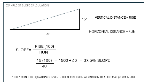
This chapter shall apply to all zoning districts listed in Chapter 12 of this ordinance and not as a separate zone. This chapter shall apply to development of land having an average natural slope of 20 percent or more (> 20%). There shall be no development of any kind on land having an average natural slope of 30 percent or more (> 30%). Average natural slope, S, shall be calculated as follows:
S = Rise(100)
Run
S = average natural slope in percent.
Rise = vertical change in elevation measured in feet over the distance of the run.
Run = horizontal distance over which slope will be measured, measured in feet. The run distance shall not exceed an interval greater than 40 feet along the profile line.
The average natural slope shall be computed from photogrammetric maps, grading plans, contour maps, or other acceptable data of reasonable accuracy. The average natural slope shall be calculated perpendicular to the contour lines at any point within the parcel being considered.
HISTORY:
Ord. 2008-04, 8/13/2008
Ord. 2015-02, 5/13/2015
Ord. 2025-03, 2/8/25
20.1.3 Requirements
- The area of a site proposed to be graded shall be that which fits into the natural terrain, and which allows for a minimal amount of grading. The ungraded area must be left in its natural form for the remainder of the site.
- Streets shall be designed to generally follow the natural contours and landform to minimize cut and fill.
- No street shall exceed 15 (fifteen) percent grade.
- The overall shape, height or grade of any cut or fill slopes shall be developed utilizing contour grading in concert with existing natural contours and the scale of the natural terrain of the site.
- Where any cut or fill slopes intersect, the intersection of cut or fill slopes shall be horizontally rounded and blended.
- Where any cut or fill slopes intersect the natural grade, the intersection of each slope shall be vertically and/or horizontally rounded and blended with the natural contours to present a natural slope appearance.
- Where any cut or fill slope exceeds 100 feet in horizontal length, the horizontal contours of the slope shall be developed in concert with existing natural contours.
- Pad sizes shall be limited as follows:
- Twenty percent to thirty percent (20% to 30%) average natural slope within the area to be graded shall not exceed 20,000 square feet.
- Visually significant rock outcroppings, native plant materials, natural hydrology and areas of historical or visual significance shall be preserved.
- To protect lower properties, no cut or fill operations shall be allowed within 20 (twenty) feet of the edge of a hillside or within any area where material may slide over the hillside, whichever is the greater distance.
HISTORY:
Ord. 2008-04, 8/13/2008
Ord. 2015-02, 5/13/2015
Ord. 2025-03, 2/8/25
20.1.4 Overlay Zone
The Hillside Protection Overlay Zone established by this chapter shall overlay the existing zoning classifications listed in the land use ordinance. In case of conflict between the provisions of this chapter, other zoning classifications, the uniform building code or the Town of Leeds Subdivision Ordinance, the most restrictive provisions shall apply.
HISTORY:
Ord. 2008-04, 8/13/2008
Ord. 2015-02, 5/13/2015
Ord. 2025-03, 2/8/25
20.1.5 Application Procedure
- All application procedures described in this ordinance, the Leeds Town Subdivision Ordinance for Subdivision Plats, and all other applicable Leeds Town ordinances shall be adhered to as described in the underlying zoning district.
- Additionally, any application for a use in the Leeds Hillside Protection Overlay Zone shall include a conceptual plan of the proposed development that shall include the following:
- The type and nature of the development.
- The goals and objectives of the developer.
- The development’s relation to the compatibility with the Town of Leeds General Plan.
- The conceptual plan shall be reviewed by the planning commission and the town council. The review may determine the extent of required plans necessary to meet the intent of this ordinance. The review may also establish conditions for approval based on the findings of such reports. These conditions shall become a part of the record and be considered binding upon the applicant as part of an approved plan.
HISTORY:
Ord. 2008-04, 8/13/2008
Ord. 2015-02, 5/13/2015
Ord. 2025-03, 2/8/25
20.1.6 Required Reports
The following described reports may be required by the planning commission or town council:
- General Information.
- Name, address and telephone number of applicant.
- Names, addresses and telephone numbers of the person(s) responsible for the preparation of any required reports.
- Date of application.
- A vicinity map showing the location of the site in relationship to the surrounding area’s watercourses, hillsides, prominent geographic features, roads and other significant structures.
- Boundary lines of the site and development to be made thereon.
- Signatures of the owners of the site or of an authorized representative.
- Technical Reports
- Grading Plan. The grading plan shall show the existing and proposed contours and cross sections. Accurate contours showing the topography of the existing ground extending at least 100 (one hundred) feet outside all boundary lines of the site, or significant to show on the off-site drainage, shall also be included.
- Drainage Plan. The drainage plan shall show all surface and subsurface drainage systems and facilities, walls, curbing or other erosion protection devices to be constructed in connection with or as part of the proposed work as well as a map showing the drainage area and estimated runoff of the area to be served by any drainage systems or facilities.
- Facilities Map. This map shall show any existing and proposed buildings or structures, easements and drainage channels on the property where the work is to be performed. Additionally, the locations of any buildings or structures on adjacent property that may be affected by grading operations shall be shown.
- Soils Report. The soils report shall be prepared by an engineering geologist and/or geotechnical engineer. The report shall include at least the following:
- Slope stability analysis: conclusions and recommendations concerning the effects of material removal, introduction of water, ground shaking and erosion on slope stability.
- Foundation investigation: Conclusions and recommendations concerning the effects of soil conditions on foundation and structural stability, including bearing capacity, shear strength and shrink-swell potential of soils on the site.
- The location and yield of springs and seeps on the site and the evaluation of soil permeability for septic systems if proposed for use.
- Conclusions and recommendations regarding means to increase safety during and after construction and means to minimize adverse effects to property.
- Geology Report. The geology report shall be prepared by a qualified geologist or geotechnical engineer and shall contain at least the following:
- Location and size of the subject area and its general setting noting any aquifers, shale units and poorly consolidated materials.
- Structural features including any geological limitations.
- Existence of surface hazards including potential for rock falls and toppling failures in cliffs, slopes and overhangs above the subject property.
- Conclusions and recommendations regarding the effects of geologic conditions on the proposed development and recommendations identifying the means proposed to minimize any hazard to life or property or any adverse impact on the natural environment.
- Vegetation Report. A vegetation plan and report shall be prepared by a qualified landscape architect who has expert knowledge of the subject. The report shall include a plan of any proposed re-vegetation of the site or modifications to existing vegetation and a plan for the preservation of existing vegetation during construction activities.
- Other Reports. Other reports deemed necessary by the planning commission or the town council to assure the health, safety and welfare of the project residents or the general public may be requested from the applicant by written specification. Such reports shall be submitted with other application materials.
HISTORY:
Ord. 2008-04, 8/13/2008
Ord. 2015-02, 5/13/2015
Ord. 2025-03, 2/8/25
20.1.7 Approval Required Before Excavation
It shall be unlawful to excavate or grade any area within the Leeds Hillside Protection Overlay Zone prior to the final approval of the conceptual plan by the town council. In addition to the penalties outlined in Section 1.13 of this ordinance, the Town of Leeds may enter legal proceedings to require any person who violates this section to return a site to the condition found prior to any disturbance.
HISTORY:
Ord. 2008-04, 8/13/2008
Ord. 2015-02, 5/13/2015
Ord. 2025-03, 2/8/25
20.1.8 Bonding
The planning commission and town council will require the applicant to post a suitable bond to ensure project completion according to approved plans and completion of re-vegetation projects, the stabilization of a grading site, cuts and fills, the construction of storm water drainage facilities or other hazard mitigation measures required in the approval of an application. Such bonds shall comply with the provisions outlined in the Town of Leeds Subdivision Ordinance. If the applicant is a state entity, the bond shall be filed with the town by the subcontractors.
HISTORY:
Ord. 2008-04, 8/13/2008
Ord. 2015-02, 5/13/2015
Ord. 2025-03, 2/8/25
20.1.9 Appeals
- In the event of a disagreement with the requirements imposed by an officer of the Town of Leeds in connection with this chapter, an applicant may appeal the matter to the Town of Leeds Appeal Authority by filing a notice of appeal at the town office within 10 (ten) working days of the decision of the town. Such appeal shall be scheduled for review by the board of adjustment.
- The Appeal Authority may uphold, modify or rescind any requirements imposed by the planning commission or the town council but must ensure that the purposes of this chapter are met.
- Any further appeals must be made through the court system.
HISTORY:
Ord. 2008-04, 8/13/2008
Ord. 2015-02, 5/13/2015
Ord. 2025-03, 2/8/25
20.1.10 Developments Of Record
Improvements approved and completed prior to January 1, 1999 exempt from this Chapter.
HISTORY:
Ord. 2008-04, 8/13/2008
Ord. 2015-02, 5/13/2015
Ord. 2025-03, 2/8/25

