Zoneomics Logo
search icon

Leon County Unincorporated
City Zoning Code

DIVISION 6

ZONING DISTRICTS AND OFFICIAL ZONING MAP

Subdivision VI. - Planned Unit Development, and Developments of Regional Impact[2]


Footnotes:
--- (2) ---

Editor's note—Ord. No. 23-05, § 31, adopted February 21, 2023, amended the title of subdivision VI to read as herein set out. The former subdivision VI title pertained to Planned Unit Developments, Developments of Regional Impact, and Florida Quality Developments.


Sec. 10-6.601. - Purpose.

The purpose of this division is to establish the zoning districts which directly implement the Comprehensive Plan. Based on the policy and purposes of this division, the following districts are consistent with the land use element of the Comprehensive Plan, as amended.

(Code 1992, § 10-6.601; Ord. No. 07-20, § 2, 7-10-2007)

Sec. 10-6.602. - List of zoning districts.

(a)

For the purpose of this division, the county is hereby divided into districts designated as follows:

R Rural
UF Urban Fringe
AC Activity Center
RC Rural Community
LP Lake Protection
RP Residential Preservation
LT Lake Talquin/Urban Fringe
I Industrial
RA Residential Acre
R-1 Single-Family Detached Residential District
R-2 Single-Family Detached Residential District
R-3 Single- and Two-Family Residential District
R-4 Single-, Two-Family and Multi-Family Residential District
R-5 Manufactured Home and Single-Family Detached District
MH Manufactured Home Park District
MR-1 Medium Density Residential District
OR-1 Office Residential District
OR-2 Office Residential District
OR-3 Office Residential District
OA-1 Airport Vicinity District
C-1 Neighborhood Commercial District
C-2 General Commercial District
CM Medical Arts Commercial District
CP Commercial Parkway District
UP-1 Urban Pedestrian District
UP-2 Urban Pedestrian District
M-1 Light Industrial District
PD Planned Development
PUD Planned Unit Development
DRI Development of Regional Impact
OS Open Space District
IC Interchange Commercial
BC-1 Bradfordville Commercial District
BC-2 Bradfordville Commercial District
BCS Bradfordville Commercial Services District
BOR Bradfordville Office-Residential District
WC Woodville Commercial District
NBO Neighborhood Boundary Office
MCR Mahan Corridor Ring
MCN Mahan Corridor Node


(b)

The districts are defined along with implementing standards and development regulations in division 6 of this article.

(Code 1992, § 10-6.602; Ord. No. 07-20, § 2, 7-10-2007; Ord. No. 09-13, § 1, 3-19-2009; Ord. No. 10-07, § 2, 3-23-2010)

Sec. 10-6.603. - Official zoning map.

(a)

Adopted. The county is hereby divided into zones, or districts, as shown on the official zoning map which, together with all explanatory matter thereon, is hereby adopted by reference and declared to be a part of this division.

(b)

District boundaries. Where uncertainty exists as to the boundaries of districts as shown on the official zoning map, the following rules shall apply:

(1)

Boundaries indicated as approximately following the centerline of streets, highways, or alleys shall be construed to follow such centerlines.

(2)

Boundaries indicated as approximately following urban service boundaries shall be construed as following such boundary lines.

(3)

Boundaries indicated as approximately following city and county jurisdictional limits shall be construed as following such city and county jurisdictional limits, but shall not change solely based upon any annexation of a parcel into the city.

(4)

Where district boundaries are indicated by specific dimensions, such specific dimensions shall control.

(5)

Boundaries indicated as following shorelines shall be construed to follow such shorelines, and in the event of change in the shoreline shall be construed as moving with the actual shoreline; boundaries indicated as approximately following the centerline of streams, rivers, canals, lakes or other bodies of water shall be construed to follow such centerlines as they exist from time to time.

(6)

Boundaries indicated as parallel to or extensions of features indicated in subsections (1) through (5) of this section shall be so construed. Distances not specifically indicated on the official zoning map or contained in the legal description contained in this division to amend the official zoning map shall be determined by the scale of the map.

(7)

Boundaries indicated as following parcel or subdivision boundaries shall be construed as following such parcel or subdivision boundaries.

(8)

Where physical features existing on the ground are at variance with those shown on the official zoning map, or in other circumstances not covered by subsections (1) through (7) of this section, the County Administrator or designee shall interpret the district boundaries. An affected property owner or agent shall have the right to appeal such decision to the Tallahassee-Leon County Planning Commission by filing a petition for formal proceeding together with the filing fee within 15 calendar days of the decision of the County Administrator or designee. Appeals shall be processed in accordance with, and are subject to the requirements, found in division 7, article VII of this chapter and the bylaws of the Tallahassee-Leon County Planning Commission.

(9)

In case of a street vacation, where a district boundary is indicated as following the right-of-way line at the edge of the street, such boundary shall be construed as moving to the former centerline of the street.

(Code 1992, § 10-6.603; Ord. No. 07-20, § 2, 7-10-2007)

Sec. 10-6.604. - Purpose and intent of zoning districts and development standards.

This division sets forth a complete description of each zoning district which comports with the Comprehensive Plan classifications. Within each district is:

(1)

A purpose and intent statement for the district as set forth in the Comprehensive Plan.

(2)

A list of allowable uses which meet the intent of the zoning district.

(3)

A series of schedules of allowable uses, schedule A, includes permitted (P), restricted (R), and special exception (S) uses, more narrowly reflecting district intent. If there is not a P, R, S, or PD in a cell, the use is not allowable within the district.

(4)

A series of schedules of land use development criteria relating use types to various factors; included are: schedule B, maximum allowable floor area standards and schedule C, minimum development standards.

(5)

A section on commercial site location standards as found in the Comprehensive Plan.

(6)

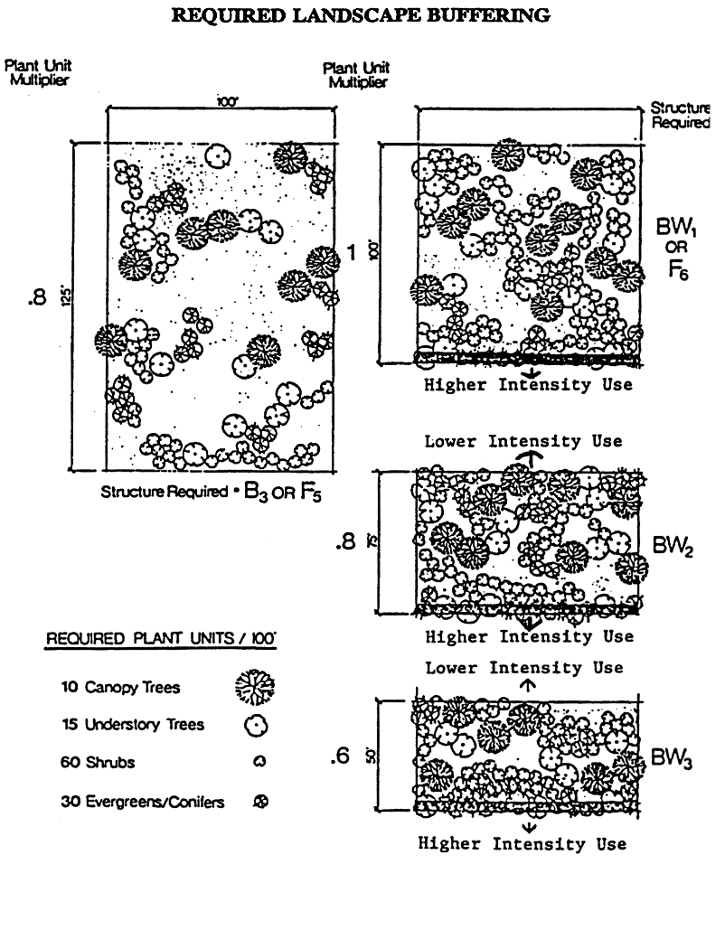
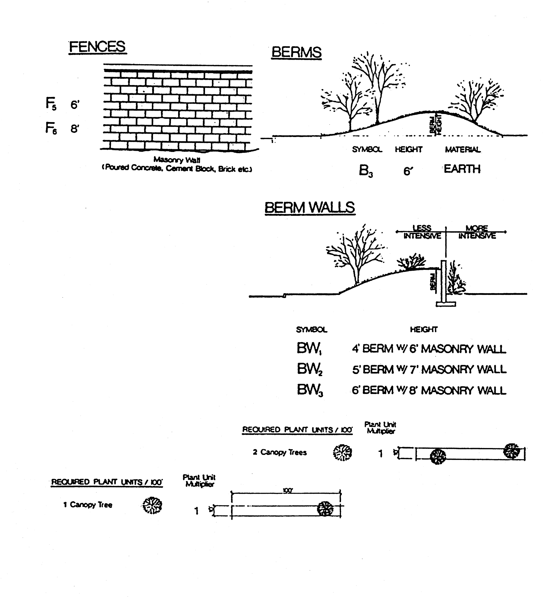
A description and buffer zone standards (section 10-7.522) is based on adjacencies and intensities.

(Code 1992, § 10-6.604; Ord. No. 07-20, § 2, 7-10-2007)

Sec. 10-6.611. - Special exception uses and restricted uses.

(a)

Applicability. Due to the nature of special exception uses tertiary, special criteria shall be applied to ensure compatibility of the proposed use with adjacent and nearby uses and developments:

(1)

If the proposed use is regulated by the supplemental regulations in division 8 of this article, the development review will include those specific requirements in division 8 of this article.

(2)

If the proposed use is not regulated by the supplemental regulations in division 8 of this article, such special exception uses shall include a statement with the application for site plan approval which addresses the following factors:

a.

Physical factors by which the environmental impact of the project on the site and adjacent site can be assessed.

b.

Scale and character compatibility factors by which the viability of the development in terms of use, scale, height, setbacks, open space and architectural design can be assessed.

c.

Relationship to other special exception in the vicinity of the subject site.

d.

Transportation access and location with respect to abutting transportation facilities. Unless otherwise specified, the development shall not access to or from any minor local street.

e.

Other factors as deemed appropriate by the County Administrator or designee, planning commission or Board of County Commissioners due to the nature of the proposed development.

(3)

Notwithstanding sections 10-7.403 and 10-7.404, all proposed special exception uses shall require review and approval by the Board of County Commissioners.

(b)

Regulations pertaining to special exception uses and restricted uses. In the review of any proposed restricted use for which specific restrictions are not elsewhere set forth in this subdivision, a determination shall be required to ensure that the requested use is consistent with the purpose and intent of the district in which it is proposed to be located; and that establishment of the proposed use would not be likely to interfere with the conduct of the principal activities intended to be accommodated within the district.

(Code 1992, § 10-6.611; Ord. No. 07-20, § 2, 7-10-2007)

Sec. 10-6.612. - Rural Zoning District.

1. District Intent2. Allowable District Location
 The intent of the rural zoning district is to maintain and promote agriculture, silviculture and natural resource-based activities, preserve natural systems and ecosystem functions, and protect the scenic vistas and pastoral development patterns that typify the county's rural areas.
 Allowable land uses within this district include agriculture, silviculture, ecotourism based activities, very low density residential, and community and passive recreational facilities, and some forms of active recreation as a restricted use.
 Non-residential uses, with the exception of community and passive recreational facilities that are not functionally related to and supportive of agriculture, silviculture and other natural resource-based activities shall be prohibited within the rural zoning district. This district is not intended to accommodate commercial activities designed to service basic household needs of area residents. Rural commercial uses, as well as restricted uses, may be allowed in this district but shall be limited to the locational and design standards as noted herein. Due to the need to protect and preserve existing rural lands from fragmentation and to promote infill and redevelopment within the urban services area and rural communities, urban services are not planned or programmed for this area.
 Design standards and development standards for non-residential development and restricted uses, as noted herein, shall be required to prevent encroachment and fragmentation of agricultural uses as well as to ensure compatibility with adjacent uses.
The district may only be located within areas designated rural on the future land use map.


Permitted, Prohibited, and Restricted Uses
3. Principal Uses4. Prohibited Uses5. Restricted Uses6. Rural Accessory Uses Functionally Related to Bona Fide Agriculture, Silviculture or Natural Resource-Based Activities
(1) Agricultural.
(2) Silviculture.
(3) Wholesale trade: Farm-product raw materials.
(4) Wholesale nursery products.
(5) Rural commercial.
(6) Community services.
(7) Low-density residential (single-, two-family, or manufactured home).
(8) Passive recreation.
(9) Light infrastructure.
(10) Cemeteries.
(1) Manufacturing.
(2) Extraction and bottling of mineral or springwater—wholesale.
(3) High pressure well stimulation/acid fracturing and/or hydraulic fracturing.
(4) Gas stations, fuel oil and liquefied petroleum products.
(5) Convenience stores.
(6) Grocery stores.
(7) General merchandise sales.
(8) Drug stores.
(9) Automotive repair.
(10) Motor vehicle racing tracks/amusement.
(11) Heavy infrastructure (with the exception of those listed under restricted uses).
(12) Active recreation (with the exception of those listed under restricted uses).
(13) Other uses which are not functionally supportive of and accessory to established agricultural, silvicultural or natural resource-based activities within the rural zoning district.
(1) Mining.
(2) Landscape counseling and planning.
(3) Airports, flying fields and services.
(4) Camps and recreational vehicle parks.
(5) Botanical and zoological gardens.
(6) Archaeological historical sites.
(7) Commercial kennels.
(8) Veterinary clinics.
(9) Riding academies/livery or boarding stables.
(10) Outdoor sport shooting ranges.
Pursuant to F.S. § 823.14, a bona fide farm operation shall be exempt from local regulation, ordinance, rule or policy that prohibits, restricts, regulates or otherwise limits activities of a bona fide farm operation on land classified as agricultural land pursuant to F.S. § 193.461.
Pursuant to F.S. § 823.14(3)(b), the term "farm operation" means all conditions or activities which occur on a farm in connection with that farm's products.


7. Development Standards
Use
Category
a. Lot area
(acres)
b. Minimum lot frontage c. Front yard setback d. Corner yard
setback
e. Side yard setbackf. Rear Yard setbackg. Maximum height at building envelope
perimeter
h. Maximum height per additional setbacki. Total maximum height
Low density residential 10 acres minimum 15 feet 30 feet 30 feet 20 feet 50 feet 35 feet 1′/1′ Not applicable
Rural commercial 3.0 acres minimum, 5.0 acres maximum * 40 feet 50 feet building, 50 feet parking 50 feet building, 50 feet parking 50 feet building, 50 feet parking 50 feet building, 50 feet parking 35 feet 1′/1′ 45 feet
Community services See Development Standards for Community Services in Section 8 40 feet 50 feet building, 50 feet parking
100 feet building, 100 feet parking (for structures greater than 5,000 square feet)
50 feet building, 50 feet parking
100 feet building, 100 feet parking (for structures greater than 5,000 square feet)
50 feet building, 50 feet parking
100 feet building, 100 feet parking (for structures greater than 5,000 square feet)
50 feet building, 50 feet parking
100 feet building, 100 feet parking (for structures greater than 5,000 square feet)
35 feet 1′/1′ 45 feet
Restricted uses; passive recreation facilities 3.0 acres minimum Not applicable 50 feet building, 50 feet parking; unless otherwise specified in subsection 10 of this section 50 feet building, 50 feet parking; unless otherwise specified in subsection 10 of this section 50 feet building, 50 feet parking; unless otherwise specified in subsection 10 of this section 50 feet building, 50 feet parking; unless otherwise specified in subsection 10 of this section 35 feet 1′/1′ 45 feet
Comp. Plan Policy 2.1.9 subdivision 0.5 acres minimum 15 feet 25 feet 25 feet 15 feet 50 feet 35 feet 1′/1′ Not applicable
8. Development Standards for Community Service Uses:
(1) The maximum single structure size and site area shall be limited by the overall acreage of the parcel to preserve the rural character through proper scale and massing. Community service uses shall also be subject to the site design criteria of subsection 11 of this section.


Parcel sizeLess than or equal to 10 acres>10 to 49 acres50 acres +
Maximum single structure size (gross building floor area) 5,000 square feet 10,000 square feet 15,000 square feet
Site area Min: 3 ac
Max: 5 ac
Min: 3 ac
Max: 10 ac
Min: 3 ac
Max: 15 ac
Existing, lawfully established non-conforming community services uses will be afforded flexibility with the required development standards, to the extent practical, when improvements are necessary to meet minimum health and safety standards according to the Florida Building Code (FBC), including, but not limited to ADA accessibility requirements.


9. Rural Commercial Intersection Location Standards: The intersection location standard is intended to group rural commercial activities toward intersections to provide access and to prevent fragmentation of agricultural uses.
(1) Major function: Provide sales and services functionally related to and supportive of agriculture, silviculture and natural resource-based activities.
(2) Location: On or near the intersection (access within 330 feet of the centerline of the intersection) of an arterial/arterial or arterial/major collector roadway.
(3) Site area: 3.0 acres minimum with a maximum of 5.0 acres per quadrant.
(4) Allowable building square footage: Maximum of 10,000 gross square feet per intersection (only 2 quadrants per intersection may be developed for rural commercial). Single structure limited to a maximum of 5,000 gross square feet.
10. Development Standards for Restricted Uses: All proposed restricted uses shall meet the applicable provisions of section 10-6.611; the applicable design standards noted in subsection 11 of this section; the buffer zone standards (section 10-7.522); and the parking and loading requirements (subdivision 3, division 5, article VII of this chapter). All restricted uses shall be limited to a maximum building area of 2,000 gross square feet per acre with no more than 5,000 gross square feet of retail commercial or office space. The following restricted uses require satisfaction of additional criteria:
(1)  Mining activities.
a. All mining activities as defined on the schedule of permitted uses must meet the specific development standards, as follows upon review and approval by the Board of County Commissioners following a duly noticed public hearing. This includes NAICS items 212321 and 212324.
b. A plan must be submitted demonstrating protection of adjacent properties and public interest which shall include, but not be limited to the following:
1. The mining activity, all accessory uses and structures, internal roadways, and driveways onto the adjacent streets shall be set back a minimum of 100 feet from the perimeter property boundaries or 200 feet from the nearest off-site residence, residential zoning district, or subdivision intended primarily for residential land use, whichever distance is greater. This setback standard may be reduced if less of a setback is approved in writing by the adjacent property owner prior to site plan approval or if the adjacent property is also used as a mining activity.
2. A plan of vehicular access to and from the site demonstrating that heavy trucks and equipment will not travel on that portion of a local or minor collector street with frontage containing residential land use, zoned for residential land use, or containing subdivision lots intended primarily for residential land use. For purposes of this requirement, local and minor collector streets shall be those identified in the local government Comprehensive Plan and the Tallahassee-Leon County Long Range Transportation Plan.
3. A land reclamation plan shall be submitted demonstrating that upon termination of the activity the land shall be returned to a condition that will allow an effective reuse comparable to surrounding properties.
4. Fencing requirement: All areas proposed for use in open-pit mining operations and/or construction and demolition debris disposal must be secured by a fence, unless the area is determined by the County Administrator or designee to be a reclaimed open-pit mine. The fence must be at least four feet in height with openings that will reject the passage of a seven-inch diameter sphere. The fence must be equipped with a gate which shall remain locked when workers or employees of the land owner or mining company are not present at the site. At every gate or access point, at least one sign must be posted which states, in at least four-inch tall letters. "Danger," "Keep Out," "No Trespassing," or similar language indicate that there may be hazardous conditions on the premises.
(2) Camps and recreational vehicle parks (NAICS 721211 and 721214).
a. All camps and recreational vehicle parks must meet the specific development standards, as follows upon review and approval by the Board of County Commissioners following a duly noticed public hearing. A plan must be submitted demonstrating protection of adjacent properties and public interest which shall include, but not be limited to the following:
1. Sanitary facilities shall be provided.
2. Not more than 5 campsites per gross acre shall be provided.
3. Individual campsites, roadways, and accessory structures shall be located to meet the minimum building setback standards from the exterior property lines of the campground.
(3) Airports, flying fields and services.
a. All airports, flying fields and services must meet the specific development standards as noted in this section and as required by state or federal law, and shall require review and approval by the Board of County Commissioners following a duly noticed public hearing.
(4) Outdoor sport shooting ranges.
a. This subsection shall not apply to personal firearm use on private property or to businesses that operate an outdoor sport shooting range as an ancillary use to a legal, principal use, such as, but not limited to, a hunting plantation, timber plantation, or special event venue.
b. All outdoor sport shooting ranges must meet the specific development standards as noted in this section, and shall require a Type C review and approval by the Board of County Commissioners following a duly noticed public hearing.
c. All outdoor sport shooting ranges must demonstrate protection of adjacent properties and the public interest which shall include, but not limited to the following:
1. An outdoor sport shooting range shall not be located within an unrecorded or recorded subdivision or in the residential preservation overlay district.
2. No outdoor sport shooting range shall be permitted within 500 feet of the property line.
3. The firing lines shall be oriented to minimize off-site impacts, including, but not limited to, noise and safety of existing structures and roadways.
4. Access to Canopy Road shall be subject to division 7, article VI of this chapter.
5. A minimum of a Type D buffer and a 15-foot high berm behind the line of fire/targets shall be constructed.
6. The county encourages the use of the National Rifle Association's Range Source Book for best practices.
7. The county encourages compliance with the state department of environmental protection's best management practices for environmental stewardship of state shooting ranges.
8. The county encourages outdoor sport shooting ranges to have range safety officers on the premises during the hours of operation.
9. To ensure compatibility with the surrounding area, additional site specific conditions may be imposed, such as, but not limited to, conditions related to noise reduction and safety.
11. Site Design Criteria: Rural commercial uses, community service uses and restricted uses shall be subject to the locational and design standards as noted herein.
A plan and supporting narrative must be submitted pursuant to the applicable site and development plan process outlined in article VII of this chapter that demonstrates compliance, as applicable, with the following:
(1) Building and Site Design Standards: All primary buildings and accessory structures shall reflect or compliment the local vernacular architectural style. Building facade treatments and materials shall provide architectural interest through, but not limited to: the utilization of fenestration that allows for natural surveillance and gabled or parapet roof treatments.
(2) Lighting: On-site lighting including 24-hour security lighting shall be wall mounted with illumination focused on the building in a manner that limits off-site illumination, consistent with the "Dark Sky Friendly" guidelines. All exterior lighting shall have recessed bulbs and filters which conceal the source of illumination. Security lighting is permitted; however, wall or roof mounted flood or spot lights used as general grounds lighting are prohibited. Lighting at the property line (six feet above ground) adjacent to residential uses shall not exceed 0.1 footcandles. Lighting for parking areas shall not exceed 15 feet in height as measured from average grade to the light fixture.
(3) Perimeter Buffering and Fencing: If the adjacent residential density is 0.5 dwelling units per acre or greater, a Type C buffer shall be required. A wooden buffer fence may be utilized on sites where the required vegetative buffer cannot be established based on site limitations or constraints.
(4) Fencing and Screening of Outdoor Service Areas and Equipment:
 a. Refuse collection areas shall be located in the side or rear yard and shall be fenced with a material and design treatment consistent with the building facade of the principal building and screened with vegetation.
 b. All appurtenant mechanical and electrical equipment, outside collection/drop-off/storage areas, and other accessory or ancillary structures shall be screened from public view. The screening material shall be consistent with the materials and design context of the primary on-site building.
(5) Hours of Operation: The hours of operation shall be limited to 6:00 a.m. to 8:00 p.m. Community service uses shall not be limited in hours of operation; however, typical hours of operation for facility shall be identified on final development plans.


*If subdivision is proposed to create the rural commercial parcel, then the remaining portion of the property shall meet the minimum lot size standards noted herein.

General notes:

(1)

If central sanitary sewer is not available, residential development shall provide no less than 0.50 acre of buildable area. Non-residential development and community service facilities located within the USA are limited to a maximum of 900 gallons of wastewater flow per day. Refer to Sanitary Sewer Policy 2.1.2 of the Comprehensive Plan for additional requirements.

(2)

Refer to the Environmental Management Act (EMA) for information pertaining to the regulation of environmental features (preservation/conservation features), stormwater management requirements, etc.

(3)

Refer to the concurrency management ordinance for information pertaining to the availability of capacity for certain public facilities (roads, schools, parks, etc.).

(Code 1992, § 10-6.612; Ord. No. 07-20, § 2, 7-10-2007; Ord. No. 08-17, § 2, 7-22-2008; Ord. No. 09-02, § 1, 1-15-2009; Ord. No. 14-14, § 1, 9-2-2014; Ord. No. 14-17, § 1, 12-9-2014; Ord. No. 15-08, § 2, 7-7-2015; Ord. No. 16-11, § 2, 7-12-2016; Ord. No. 21-12, § 1, 7-13-2021; Ord. No. 22-17, § 3, 6-14-2022)

Sec. 10-6.613. - Urban Fringe Zoning District.

(a)

Purpose and intent. The urban fringe district is intended to provide the opportunity for very low-density residential areas mixed with open space and agricultural activity on the periphery of the urban service area. The district allows for very low-density residential development of no greater than one unit on three acres of land, agricultural, and silvicultural activities. Residential development will also be allowed a gross density of one unit per three acres if developed as a conservation subdivision as described in section 10-7.204.

(1)

For sites developed under the previously available "25—75" clustering option, the remaining undeveloped portion (75 percent) may continue to be preserved as undisturbed open (green) space until such time as these sites are included in the urban service area and become eligible for development at urban densities. As an alternative, sites developed under the previously available "25—75" clustering option may seek to develop the undeveloped portion (75 percent) at the urban fringe densities described above prior to the sites inclusion in the urban service area. For either development option, review by the Board of County Commissioners shall be requested to authorize development of these undisturbed open (green) spaces.

(2)

To conveniently serve area residents, smaller scale, low-intensity commercial development is permitted in this district. To maximize efficiency in the development of agricultural and silvicultural resources located within this zoning district and surrounding areas, agriculturally and silviculturally related industrial activities, such as milling, are permitted. Community facilities are also permitted in this district.

(b)

Allowable uses. For the purpose of this subdivision, the following land use types are allowable in this zoning district and are controlled by the land use development standards of this subdivision, the Comprehensive Plan and schedules of permitted uses.

(1)

Low-density residential.

(2)

Agricultural.

(3)

Silvicultural.

(4)

Light industry—agriculturally and silviculturally related only.

(5)

Passive recreation.

(6)

Active recreation.

(7)

Minor commercial.

(8)

Neighborhood commercial.

(9)

Community services.

(10)

Light infrastructure.

(11)

Heavy infrastructure.

(c)

List of permitted uses. Some of the uses on these schedules are itemized according to the Standard Industrial Code (SIC). Allowable uses, appropriate permit level and applicable development and locational standards in the urban fringe district are as follows:

_____

Legend

Ag = Agricultural PR = Passive Recreation
MC = Minor Commercial AR = Active Recreation
NC = Neighborhood Commercial CS = Community Services
LR = Low-Density Residency PS = Postsecondary


SIC

Code
Name of UseDevelopment and Locational
Standards
AgMCNCLRPRARCSPS
Residential
Dwelling, one-family P P
Dwelling, two-family P P
Dwelling, mobile home P P
Mobile home park R
Agriculture, Forestry,and Fishing
01 Agricultural production—crops P
0181 Ornamental nursery products P
02 Agricultural production—livestock P
074 Veterinary services P P P
0781 Landscape counseling and planning R
092 Fish hatcheries and preserves P
Mining
144 Sand and gravel S
145 Clay, ceramic, and refractory minerals S
Manufacturing
201 Meat products R
202 Dairy products R
204 Grain mill products R
21 Tobacco products R
24 Lumber and wood products R
Transportation andPublic Utilities
401 Railroads P P S
43 Postal service P P
483 Radio and television broadcasting R
Retail Trade
521 Lumber and other building materials P P
523 Paint, glass, and wallpaper stores P P
525 Hardware stores P P
526 Retail nurseries and garden stores P P
533 Variety stores P P
539 Miscellaneous general merchandise stores P P
541 Grocery stores P P
542 Meat and fish markets P P
543 Fruit and vegetable markets P P
544 Candy, nut and confectionery stores P P
545 Dairy products stores P P
546 Retail bakeries P P
553 Auto and home supply stores P P
554 Gasoline service stations P P
Convenience store P P
581 Eating and drinking places R P
591 Drugstores and proprietary stores P P
592 Liquor stores P P
593 Used merchandise stores P P
5941 Sporting goods and bicycle shops P P
5943 Stationery stores P P
5961 Catalog and mail order houses P P
5983 Fuel oil dealers S
5984 Liquefied petroleum gas dealers S
5992 Florists P P
5993 Tobacco stores and stands P P
5994 News dealers and newsstands P P
5995 Optical goods stores P P
5999 Miscellaneous retail stores, nec R R
Finance, Insurance, and Real Estate
6553 Cemeteries P P
Services
702 Roominghouses and boardinghouses; dorms R
703 Camps and recreational vehicle parks R
721 Laundry, cleaning, and garment services R R
7215 Coin-operated laundries and cleaning P P
723 Beauty shops P P
724 Barber shops P P
725 Shoe repair and shoeshine parlors P P
7334 Photocopying and duplicating services P P
7335 Commercial photography P P
7336 Commercial art and graphic design P P
7353 Heavy construction equipment rental R
7359 Equipment rental and leasing, nec R
753 Automotive repair shops R R
754 Automotive services, except repair P P
762 Electrical repair shops P P
764 Reupholstery and furniture repair P P
784 Video tape rental P P
791 Dance studios, schools, and halls P P
7991 Physical fitness facilities P P
7992 Public golf courses S
Public elementary and secondary schools (that are subject to the school interlocal agreement) (excludes charter and private schools) S
822 Colleges and universities S
823 Libraries—less than 7,500 square feet P P
823 Libraries—7,500 square feet or more R
824 Vocational schools S
835 Day care services R P
836 Residential care R P
841 Museums and art galleries S
842 Botanical and zoological gardens S
864 Civic and social associations P
866 Religious organizations P
6553 Cemeteries P
Public Administration
922 Public order and safety P
9221 Police protection P
9223 Correctional institutions S
9224 Fire protection P
Recreation
Hiking and nature trails P
Picnicking P
Canoe trails P
Bicycle trails P
Horseback riding trails P
Tot lots P
Court sports P
Field sports P
Boat landings P
Archaeological historical sites S


P = Permitted use R = Restricted use S = Special exception

(d)

The maximum allowable gross square footage in the urban fringe district is as follows:

Commercial Land Use TypeUrban Fringe
Minor*
Total location 20,000
Single site or quadrant 10,000
Single structure 5,000
Neighborhood**
Total location 100,000
Single site or quadrant 100,000
Single structure 50,000


*Maximum 10,000 gross square feet, if located on a local street.

**Only one neighborhood commercial site (quadrant) will be permitted at the intersection of a major collector and arterial road. The maximum allowable commercial development permitted at the neighborhood commercial area located at the intersection of two major collectors is 50,000 square feet g.s.l.a.

(e)

The minimum development standards in the urban fringe district are as follows:

Low
Density
Residential
CommercialAgricultural-Related
Industrial

Community Services; Active Recreation;
Public, Primary and Secondary Schools
Comp. Plan Policy 2.1.9. Subdivision
NonclusterClusterNonclusterCluster
Minimum Setbacks (feet)
Front yard
Building 30 30* 30 25* 50 30 25
Parking 40 40* 50 40
Corner yard
Building 30 30* 30 25* 50 30 25
Parking 40 40* 50 40
Side yard
Building 20 20* 40 20* 50 40 15
Parking 40 20* 50 40
Rear yard
Building 50 50* 50 30* 50 50 50
Parking 40 10* 50 50 50
Adjoining Lower Intensity Zoning District
Building 100
Parking 100
Maximum percent impervious surface area 30 25** 30 25** 30 30
Heights (feet)
Maximum at building envelope perimeter 35 35 35 35 35 35 35
Maximum additional height/additional zoning setback l′/1′ l′/1′ l′/1′ l′/1′ l′/1′ l ′/1′ l′/1′
Total maximum height 35 45 45 45*** 45
Minimum lot frontage 15 15 40 40 100 15
Minimum lot area 3.0 0.5 3.0 0.5 10.0 0.5


*This number applies to the perimeter setback only.

**Maximum percent impervious area of developable portion of site.

***This height applies to habitable portion of an industrial structure.

_____

(f)

Development standards. All proposed development shall meet the commercial site location standards (section 10-6.619); buffer zone standards (section 10-7.522); and the parking and loading requirements (subdivision 3, division 5, article VII of this chapter).

(g)

Restricted uses and special exception uses. If uses are restricted or are special exception uses according to the schedule of permitted uses, they will not be allowed unless they follow the general development guidelines for restricted uses or for special exceptions as provided in this subdivision. Specific restricted uses are addressed below.

(1)

Eating and drinking establishments (SIC 581). No drive-in or drive-thru facilities are permitted within this district.

(2)

Laundry, cleaning and garment services (SIC 721). Does not include dry cleaning plant operations; pick-up stations only.

(3)

Funeral services and crematoriums (SIC 726). This use requires 100 percent opacity buffer surrounding perimeter with exception of access point.

(4)

Camps and recreational vehicle parks (SIC 703). A site plan shall be submitted demonstrating protection of adjacent properties and public interest which shall include, but not be limited to the following

a.

Sanitary facilities shall be provided.

b.

Not more than ten campsites per acre shall be provided.

c.

Individual campsites, roadways, and accessory structures shall be located to meet the minimum building setback standards from the exterior property lines of the campground.

(5)

Heavy construction equipment rental and equipment rental and leasing (SIC 7353 and 7359). A plan must be submitted demonstrating protection of adjacent properties and public interest which shall include, but not be limited to the following:

a.

Such equipment rental and leasing must be associated with timbering and/or agribusiness.

b.

A plan of vehicular access to and from the site demonstrating that heavy trucks and equipment will not travel on that portion of a local or minor collector street with frontage containing residential land use, zoned for residential land use, or containing subdivision lots intended primarily for residential land use. For purposes of this requirement, local and minor collector streets shall be those identified in the Comprehensive Plan and the Tallahassee-Leon County Long Range Transportation Plan.

(6)

Mining activities.

a.

All mining activities as defined on the schedule of permitted uses must meet the specific development standards, as follows upon review and approval by the Board of County Commissioners following a duly noticed public hearing. This includes SIC items 144 and 145.

b.

A plan must be submitted demonstrating protection of adjacent properties and public interest which shall include, but not be limited to the following:

1.

The mining activity, all accessory uses and structures, internal roadways, and driveways onto the adjacent streets shall be setback a minimum of 100 feet from the perimeter property boundaries or 200 feet from the nearest off-site residence, residential zoning district, or subdivision intended primarily for residential land use, whichever distance is greater. This setback standard may be reduced if less of a setback is approved in writing by the adjacent property owner prior to site plan approval or if the adjacent property is also used as a mining activity.

2.

A plan of vehicular access to and from the site demonstrating that heavy trucks and equipment will not travel on that portion of a local or minor collector street with frontage containing residential land use, zoned for residential land use, or containing subdivision lots intended primarily for residential land use. For purposes of this requirement, local and minor collector streets shall be those identified in the local government Comprehensive Plan and the Tallahassee-Leon County Long Range Transportation Plan.

3.

A land reclamation plan shall be submitted demonstrating that upon termination of the activity the land shall be returned to a condition that will allow an effective reuse comparable to surrounding properties.

4.

Fencing requirement. All areas proposed for use, currently used, or previously used, in open-pit mining operations and/or construction and demolition debris disposal must be secured by a fence, unless the area is determined to be a reclaimed open-pit mine by the County Administrator or designee. The fence must be at least four feet in height with openings that will reject the passage of a seven-inch diameter sphere. The fence must be equipped with a gate which shall remain locked when workers or employees of the land owner or mining company are not present at the site. At every gate or access point, at least one sign must be posted which states, in at least four-inch tall letters, "Danger," "Keep Out," "No Trespassing," or similar language to indicate that there may be hazardous conditions on the premises.

(Code 1992, § 10-6.613; Ord. No. 07-20, § 2, 7-10-2007; Ord. No. 08-17, § 3, 7-22-2008; Ord. No. 09-02, § 2, 1-15-2009; Ord. No. 09-12, § 4, 3-19-2009; Ord. No. 12-01, § 1, 1-24-2012; Ord. No. 16-07, § 2, 5-10-2016)

Sec. 10-6.614. - High-Intensity Urban Activity Center.

(a)

Purpose and intent. The purpose and intent of the high-intensity urban activity center district is to establish an urban activity center providing for community wide or regional commercial activities located in proximity to multifamily housing and office employment centers. This district is intended to provide large scale commercial activities to serve the retail market of region as well as the community. The intense commercial nature of this district promotes the efficiency of the transportation system through consolidation of trips and discouragement of the unabated sprawl of commercial activities. Planned, integrated development is required to promote synergy between the different allowable land uses. An integrated pedestrian and bicycle access system shall be provided to afford safe and accessible foot and bike travel between the land uses. The district is intended to facilitate efficient traffic flow by allowing only land uses developed with comprehensively planned access, egress, and internal circulation systems. The district will also allow residential development of complimentary intensity of 16 to 45 dwelling units per gross acre.

(b)

Allowable uses. For the purpose of this subdivision, the following land use types are allowable in this zoning district and are controlled by the land use development standards of this subdivision, the Comprehensive Plan and schedules of permitted uses.

(1)

Minor commercial.

(2)

Neighborhood commercial.

(3)

Community commercial.

(4)

Regional commercial.

(5)

Highway commercial.

(6)

Minor office.

(7)

Major office.

(8)

Office park.

(9)

Medium-density residential.

(10)

High-density residential.

(11)

Passive recreation.

(12)

Active recreation.

(13)

Community services.

(14)

Light infrastructure.

(15)

Postsecondary.

(16)

Light industrial—minor.

(c)

List of permitted uses. Some of the uses on these schedules are itemized according to the Standard Industrial Code (SIC). Allowable uses, appropriate permit level and applicable development and locational standards in the high intensity urban activity center district are as follows:

Legend

MC = Minor Commercial OP = Office Park
NC = Neighborhood Commercial MR = Medium-Density Residential
CC = Community Commercial HR = High-Density Residential
RC = Regional Commercial AR = Active Recreation
HC = Highway Commercial CS = Community Services
MO = Minor Office LI = Light Infrastructure
MjO = Major Office MI = Minor Light Industrial


SIC
Code
Name of UseDevelopment and Locational Standards
MCNCCCRCHCMOMjOOPMRHRARCSLIMI
Residential
Dwelling, multiple-family P P
Retail Trade
521 Lumber and other building materials P P P P P
523 Paint, glass, and wallpaper stores P P P P P
525 Hardware stores P P P P P
526 Retail nurseries and garden stores P P P P P
527 Mobile home dealers P P P P P
531 Department stores P P P P P
533 Variety stores P P P P P
539 Misc. general merchandise stores P P P P P
541 Grocery stores P P P P P
542 Meat and fish markets P P P P P
543 Fruit and vegetable markets P P P P P
544 Candy, nut and confectionery stores P P P P P
545 Dairy products stores P P P P P
546 Retail bakeries P P P P P
551 New and used car dealers P P P P P
553 Auto and home supply stores P P P P P
554 Gasoline service stations P P P P P
555 Boat dealers P P P P P
556 Recreational vehicle dealers P P P P P
557 Motorcycle dealers P P P P P
56 Apparel and accessory stores P P P P P
571 Furniture and home furnishings stores P P P P P
572 Household appliance stores P P P P P
573 Radio, television, and computer stores P P P P P
5736 Musical instrument stores P P P P P
581 Eating and drinking places P P P P P
591 Drugstores and proprietary stores P P P P P
592 Liquor stores P P P P P
593 Used merchandise stores P P P P P
5941 Sporting goods and bicycle shops P P P P P
5942 Bookstores P P P P P
5943 Stationery stores P P P P P
5944 Jewelry stores P P P P P
5945 Hobby, toy, and game shops P P P P P
5946 Camera and photographic supply stores P P P P P
5947 Gift, novelty, and souvenir shops P P P P P
5948 Luggage and leather goods stores P P P P P
5949 Sewing, needlework, and piece goods P P P P P
5961 Catalog and mail order houses P P P P P
5992 Florists P P P P P
5993 Tobacco stores and stands P P P P P
5994 News dealers and newsstands P P P P P
5995 Optical goods stores P P P P P
5999 Miscellaneous retail stores, nec P P P P P
Finance, Insurance, and Real Estate
601 Central reserve depositories P P P P P P P P
602 Commercial banks P P P P P P P P
603 Savings institutions P P P P P P P P
606 Credit unions P P P P P P P P
611 Federal and federal sponsored credit P P P P P P P P
614 Personal credit institutions P P P P P P P P
616 Mortgage bankers and brokers P P P P P P P P
62 Security and commodity brokers P P P P P P P P
64 Insurance agents, brokers, and service P P P P P P P P
65 Real estate P P P P P P P P
654 Title abstract offices P P P P P P P P
Services
701 Hotels and motels P P P P P P
702 Roominghouses and boardinghouses; dorms P P P P P
721 Laundry, cleaning, and garment services P P P P P
7215 Coin-operated laundries and cleaning P P P P P
723 Beauty shops P P P P P
724 Barber shops P P P P P
725 Shoe repair and shoeshine parlors P P P P P
726 Funeral service and crematories P P P P P
7311 Advertising agencies P P P P P P P P
732 Credit reporting and collection P P P P P P P P
7334 Photocopying and duplicating services P P P P P P P P
7335 Commercial photography P P P P P P P P
7336 Commercial art and graphic design P P P P P P P P
7353 Heavy construction equipment rental P P P P P P P P
7359 Equipment rental and leasing, nec P P P P P P P P
7361 Employment agencies P P P P P P P P
737 Computer and data processing services P P P P P P P P
751 Automotive rentals, no drivers P P P P P
752 Automobile parking P P P P P
753 Automotive repair shops P P P P P
754 Automotive services, except repair P P P P P
762 Electrical repair shops P P P P P
763 Watch, clock, and jewelry repair P P P P P
764 Reupholstery and furniture repair P P P P P
783 Motion picture theaters P P P P P
784 Video tape rental P P P P P
791 Dance studios, schools, and halls P P P P P
793 Bowling centers P P P P P
794 Commercial sports P P P P P
7991 Physical fitness facilities P P P P P
7992 Public golf courses P P P P P
7993 Coin-operated amusement devices P P P P P
7996 Amusement parks P P P P P
7997 Membership sports and recreation clubs P P P P P
801 Offices and clinics of medical doctors P P P
802 Offices and clinics of dentists P P P
804 Offices of other health practitioners P P P
805 Nursing and personal care facilities P P P P
806 Hospitals P P P P
807 Medical and dental laboratories P P P P
808 Home health care services P P P P
81 Legal services P P P
821 Elementary and secondary schools S
823 Libraries—less than 7,500 square feet P P P P P P P P P
823 Libraries—7,500 square feet or more S
824 Vocational schools S
835 Day care services P P P P P
836 Residential care P P P P P
841 Museums and art galleries P P P
842 Botanical and zoological gardens P
864 Civic and social associations P P
866 Religious organizations P P P P P P P P
871 Engineering and architectural services P P P
872 Accounting, auditing, and bookkeeping P P P
873 Research and testing services P P P
874 Management and public relations P P P
Public Administration
91 Executive, legislative, and general P P P P
921 Courts P P P P
922 Public order and safety P
9221 Police protection P
9224 Fire protection P
Recreation
Hiking and nature trails P
Picnicking P
Canoe trails P
Bicycle trails P
Horseback riding trails P
Tot lots P
Court sports P
Field sports P
Boat landings P
Archaeological historical sites S


P = Permitted use R = Restricted use S = Special exception

(d)

Maximum allowable floor area. The maximum allowable floor area in the high-intensity urban activity center district is as follows:

Commercial Land Use TypeActivity Center
Minor*
Total location 80,000
Single site or quadrant 20,000
Single structure 20,000
Neighborhood**
Total location 400,000
Single site or quadrant 400,000
Single structure 400,000
Community
Total location 800,000
Single site or quadrant 800,000
Single structure 800,000
Regional
Total location 4,000,000
Single site or quadrant 4,000,000
Single structure 4,000,000


*Maximum of 10,000 gross square feet, if located on a local street.

**Only one neighborhood commercial site (quadrant) will be permitted at the intersection of a major collector and arterial road. The maximum allowable commercial development permitted at the neighborhood commercial area located at the intersection of two major collectors is 50,000 square feet g.s.l.a.

(e)

Minimum development standards. The minimum development standards in the high-intensity activity center district are as follows:

Medium- or-High-DensityResidential,
Commercial, Office

Industrial Light Community Services; ActiveRecreation;
Public, Primary and Secondary Schools
Minimum Setbacks (feet)
Front yard
Building 20 20 20
Parking 20 20 20
Corner yard
Building 20 20 20
Parking 20 20 20
Side yard
Building 5 10 5
Parking 5 10 5
Rear yard
Building 20 20 20
Parking 10 10 10
Adjoining Lower IntensityZoning District
Building 50 50
Parking 20 20
Maximum % impervious surface area* 75 60 75
Heights
Maximum at building envelope perimeter 40 40 50
Additional height/additional zoning setback 4′/1′ 2′/1′ 4′/1′
Total height 120 120 120


*May utilize fee in lieu provision of EMA/EMO.

_____

(f)

Development standards. All proposed development shall meet the commercial site location standards (section 10-6.619); buffer zone standards (section 10-7.522); and the parking and loading requirements (subdivision 3, division 5, article VII of this chapter).

(Code 1992, § 10-6.614; Ord. No. 07-20, § 2, 7-10-2007)

Sec. 10-6.615. - Rural Community.

(a)

Purpose and intent.

(1)

The purpose of the rural community district is to accommodate hamlets or villages that develop in an area that is surrounded by very-low-intensity rural land use. This district allows residential development up to four dwelling units per acre. Small to moderate sized commercial development is allowed in order to give local and surrounding rural residents access to basic shopping opportunities. This district is intended to allow for the creation and continued maintenance of villages rather than an urban neighborhood. As such it is not intended to function as a growth node or to contribute to urban sprawl. Central sewer and water systems designed for lower density service may be present or constructed.

(2)

The shops and services that may be located in this district will be limited in scale, function, and number. Commercial retail and office establishments located within this district will provide residents within the village/district with convenient access to necessary goods, groceries, and other essential items and services rather than attract shoppers from other parts of the community. Commercial establishments will be limited in size as well as in vehicular access and parking opportunities to ensure compatibility with the rural character of the village.

(b)

Allowable uses. For the purpose of this subdivision, the following land use types are allowable in this zoning district and are controlled by the land use development standards of this subdivision, the Comprehensive Plan and schedules of permitted uses.

(1)

Minor commercial.

(2)

Neighborhood commercial.

(3)

Low-density residential.

(4)

Passive recreation.

(5)

Active recreation.

(6)

Community services.

(7)

Light infrastructure.

(8)

Heavy infrastructure.

(9)

Postsecondary.

(10)

Light industrial—Minor (agricultural related only).

(c)

List of permitted uses. Some of the uses on these schedules are itemized according to the Standard Industrial Code (SIC). Allowable uses, appropriate permit level and applicable development and locational standards in the rural community district are as follows:

_____

Legend

MC = Minor Commercial CS = Community Services
NC = Neighborhood Commercial PS = Postsecondary
LR = Low-Density Residential


SIC
Code

Name of Use
Development and Locational Standards
MCNCLRCSPS
Residential
Dwelling, one-family P
Dwelling, two-family P
Dwelling, mobile home P
Mobile home park S
Agriculture, Forestry, and Fishing
074 Veterinary services P
Transportation and Public Utilities
43 Postal service P P
Retail Trade
521 Lumber and other building materials P P
523 Paint, glass, and wallpaper stores P P
525 Hardware stores P P
526 Retail nurseries and garden stores P P
539 Misc. general merchandise stores P P
541 Grocery stores P P
542 Meat and fish markets P P
543 Fruit and vegetable markets P P
544 Candy, nut and confectionery stores P P
545 Dairy products stores P P
546 Retail bakeries P P
553 Auto and home supply stores P P
554 Gasoline service stations P P
Convenience store P P
56 Apparel and accessory stores P P
571 Furniture and home furnishings stores P P
572 Household appliance stores P P
573 Radio, television, and computer stores P P
5736 Musical instrument stores P P
581 Eating and drinking places P P
591 Drugstores and proprietary stores P P
592 Liquor stores P P
593 Used merchandise stores P P
5941 Sporting goods and bicycle shops P P
5942 Bookstores P P
5943 Stationery stores P P
5944 Jewelry stores P P
5945 Hobby, toy, and game shops P P
5946 Camera and photographic supply stores P P
5947 Gift, novelty, and souvenir shops P P
5948 Luggage and leather goods stores P P
5949 Sewing, needlework, and piece goods P P
5961 Catalog and mail order houses P P
5983 Fuel oil dealers S
5984 Liquefied petroleum gas dealers S
5992 Florists P P
5993 Tobacco stores and stands P P
5994 News dealers and newsstands P P
5995 Optical goods stores P P
5999 Miscellaneous retail stores, nec P R
Finance, Insurance, and Real Estate
602 Commercial banks P P
603 Savings institutions P P
606 Credit unions P P
611 Federal and federal sponsored credit P P
64 Insurance agents, brokers, and service P P
65 Real estate P P
Services
702 Roominghouses and boardinghouses; dorms R
721 Laundry, cleaning, and garment services R R
7215 Coin-operated laundries and cleaning P P
722 Photographic studios, portrait P P
723 Beauty shops P P
724 Barber shops P P
725 Shoe repair and shoeshine parlors P P
7334 Photocopying and duplicating services P P
7335 Commercial photography P P
7336 Commercial art and graphic design P P
7359 Equipment rental and leasing, nec R R
753 Automotive repair shops P P
754 Automotive services, except repair P P
762 Electrical repair shops P P
763 Watch, clock, and jewelry repair P P
764 Reupholstery and furniture repair P P
784 Video tape rental P P
791 Dance studios, schools, and halls P P
7991 Physical fitness facilities P P
7993 Coin-operated amusement devices P P
7997 Membership sports and recreation clubs P P
801 Offices and clinics of medical doctors P P
802 Offices and clinics of dentists P P
804 Offices of other health practitioners P P
805 Nursing and personal care facilities P P P
81 Legal services P P
821 Elementary and middle schools S
822 Colleges and universities S
823 Libraries—Less than 7,500 square feet P P
823 Libraries—7,500 square feet or more P
824 Vocational schools S
835 Day care services R P
841 Museums and art galleries P P P
842 Botanical and zoological gardens P P P
864 Civic and social associations P P
866 Religious organization P P
Public Administration
91 Executive, legislative, and general P
922 Public order and safety P
9221 Police protection P
9224 Fire protection P
Recreation
Hiking and nature trails P
Picnicking P
Canoe trails P
Bicycle trails P
Horseback riding trails P
Tot lots P
Court sports P
Field sports P
Boat landings P
Archaeological historical sites S S


P = Permitted use R = Restricted use S = Special exception

(d)

Maximum allowable gross square footage. The maximum allowable gross square footage in the rural community district is as follows:

Commercial Land Use TypeRural Community
Minor*
Total location 40,000
Single site or quadrant 20,000
Single structure 10,000
Neighborhood**
Total location 50,000
Single site or quadrant 50,000
Single structure 50,000


*Maximum of 10,000 gross square feet, if located on a local street.

**Only one neighborhood commercial site (quadrant) will be permitted at the intersection of a major collector and arterial road. The maximum allowable commercial development permitted at the neighborhood commercial area located at the intersection of two major collectors is 50,000 square feet g.s.l.a.

(e)

Minimum development standards. The minimum development standards in the rural community district are as follows:

Development Type
Low-Density ResidentialCommercial, OfficeAgricultural-
Related Industrial
Community Services and
Postsecondary Schools
NonclusterClusterNonclusterCluster
Minimum Setbacks (feet)
Front yard
Building 25 25** 25 25** 50 2 5
Parking 20 20** 50 40
Corner yard
Building 20 20** 25 25** 50 2 5
Parking 20 20** 50 40
Side yard
Building 10 20** 20 20** 50 2 0
Parking 20 20** 50 20
Rear yard
Building 25 20** 25 25** 50 2 5
Parking 20 20** 50 20
Adjoining lower intensityzoning district
Building 50 50** 100
Parking 20 20** 100
Maximum % impervious surface area 40 25*** 60 25*** 25 60
Maximum height at building envelope perimeter 35 35 35 35 35 35
Maximum additional height/additional zoning setback 1/1 1/1 1/1 1/1 1/1 1/1
Total maximum height 35 45 45 45* 45*
Minimum lot frontage 15 15 30 30 60
Minimum lot size (acres) 0.25 0.10 0.50 0.25 1.0


*This number applies to habitable portion of a structure.

**This number applies to the perimeter setback only.

***Maximum percent of impervious area of developable portion of site.

(f)

Development standards. All proposed development shall meet the commercial site location standards (section 10-6.619); buffer zone standards (section 10-7.522); and the parking and loading requirements (subdivision 3, division 5, article VII of this chapter).

(g)

Specific restrictions. If uses are restricted according to the schedule of permitted uses, they are not allowed unless they follow the general development guidelines for restricted uses as provided in this division. Specific restricted uses are addressed below.

Laundry, cleaning and garment services (SIC 721). Does not include dry cleaning plant operations; pick-up stations only.

(Code 1992, § 10-6.615; Ord. No. 07-20, § 2, 7-10-2007; Ord. No. 16-07, § 3, 5-10-2016)

Sec. 10-6.616. - Lake Protection.

1. District Intent
2. Allowable District Location
 The purpose and intent of the Lake Protection (LP) zoning district is to allow for the regulation and, where appropriate, limitation of development and redevelopment of land within the Lake Jackson Basin in a manner that improves water quality within the lake. The bounds of the category include the Lake Jackson Basin and contributing watersheds and limited to the urban service area. Intensely developed properties and areas south of Interstate 10 (I-10) have been excluded from the boundary.
 The LP zoning district shall permit single-family residential development at one dwelling unit per two gross acres. A clustered subdivision option is available that allows two dwelling units per gross acre, consistent with environmental and infrastructure constraints. The clustered subdivision option allows an increased number of residential units if developed on 40 percent of the property, provided central water and sewer are available and leaving the remaining 60 percent of the property as contiguous, undisturbed open space in perpetuity. The cluster subdivision option is intended to leave large areas of natural open space within the watershed and minimize pollution.
 Community services, light infrastructure and passive recreational facilities, including boat ramps, consistent with the applicable provisions of section 10-6.806, may be approved by the Board of County Commissioners through review by the existing Type C process. Approval by the Board of County Commissioners shall be based upon findings that the proposed use is consistent with the purpose and intent stated herein and the proposed development will comply with the provisions of section 10-4.323(b), as well as all current stormwater regulations.
 Other non-residential uses are not permitted within the LP zoning district. These sites shall be regulated by the allowable uses provided in section 10-6.660, lake protection node, subject to additional limitations noted herein.
 Urban services are intended for this district. The density of permitted development may depend upon the availability of such services.
The district may only be located within areas designated lake protection on the future land use map.


PERMITTED, PROHIBITED AND RESTRICTED USES
3. Principal Uses4. Prohibited Uses
5. Restricted Uses
(1) Single-family detached dwellings.
(2) Community services in accordance with section 10-6.806.
(3) Passive recreational facilities and boat ramps.
(4) Light infrastructure.
(1) Commercial, retail, office, and industrial activities.
(2) Active recreation, except for boat ramps.
(3) Golf courses.
(4) Manufactured and/or mobile home parks.
(5) High schools and post-secondary schools are prohibited.
(6) Heavy infrastructure.
(7) Campgrounds and recreational vehicle parks.
(8) Other uses which, in the opinion of the County Administrator or designee, are of a similar nature to those prohibited uses in this district.
(1) Single-family attached dwellings shall be allowed in a clustered subdivision.
(2) Mobile homes and standard design manufactured homes may be replaced or may be located within subdivisions platted explicitly for manufactured housing.


Development Standards
6. Minimum Lot or Site Size7. Minimum Building Setbacks8. Maximum Building Restrictions
Use Categorya. Lot or
Site area
b. Lot Widthc. Lot Deptha. Frontb. Side-
Interior Lot
c. Side-
Corner Lot
d. Reara. Building Size (excluding gross building floor area used for parking)b. Building Height (excluding stories used for parking)
Conventional Residential
Single-family
detached
dwellings
2 acres 80 feet 100 feet 25 feet 15 feet on each side; or any combination of setbacks that equals at least 30 feet, provided that no such setback shall be less than 10 feet 25 feet 25 feet Not
applicable
3
stories
Clustered Subdivision
Single-family
detached
dwellings
5,000 square feet 40 feet 100 feet 15 feet; 10 feet w/alley-
loaded garage
7.5 feet on each side; or any combination of setbacks that equals at least 15 feet, provided that no such setback shall be less than 5 feet 15 feet 15 feet; 10 feet w/alley-
loaded garage
Not applicable 3 stories
Single-family
attached
dwellings
3,750 square feet end unit; 2,400 square feet interior lot 37.5 feet end unit; 25 feet interior lot 80 feet 15 feet; 10 feet w/alley-
loaded garage
Not applicable 15 feet 15 feet; 10 feet w/alley-
loaded garage
Maximum length: 8 units 3 stories
Existing Non-Residential, Nonconforming Uses
Lawfully established non-residential use; refer to additional standards noted in subsection 10 of this section N/A 60 feet 100 feet 25 feet 7.5 feet on each side; or any combination of setbacks that equals at least 15 feet, provided that no such setback shall be less than 5 feet 15 feet 25 feet 10,000 square feet of gross building floor area per acre 3 stories
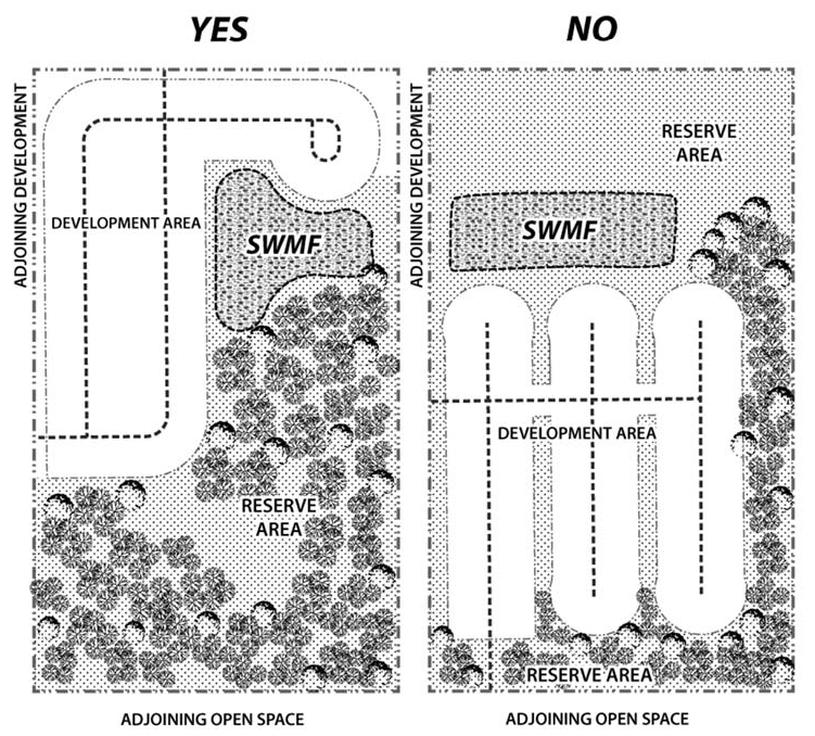
9. Clustered Subdivision:
1. Density. The maximum gross density allowed for new residential development in the LP district is one dwelling unit per two gross acres. As an alternative to large-lot developments, a clustered subdivision shall be permitted within the lake protection zoning district. Clustered subdivisions shall:
(a) Contain a minimum of 60 percent open space as a reserve area hereinafter referred to as the Clustered Subdivision Reserve Area (CSRA);
(b) Be developed at a maximum density of two dwelling units per gross acre;
(c) Be served by central water and sewer systems.
2. Design Principles for Clustered Subdivision Reserve Area (CSRA). The CSRA shall be selected first and designed according to the following steps for the identification and protection of natural resources. Notwithstanding the priority for designating areas to be included in the 60 percent provided herein, all clustered subdivisions under this section shall be consistent with all minimum environmental standards in Article IV of the Land Development Code and the Conservation Element of the Comprehensive Plan.
The CSRA shall be formed utilizing the following process:
(a) Step 1: Identification of Natural Features. Consistent with the requirements of Sec. 10-4.202(a)(1) & (2), the applicant shall conduct a Natural Features Inventory (NFI).
(b) Step 2: CSRA map. Utilizing the NFI, the applicant shall prepare a map that depicts the proposed CSRA, comprising the primary, secondary, and tertiary CSRA features as described below in accordance with the following standards:
1. Primary CSRA features.
(a) Features to be preserved.
i. All Conservation and Preservation Areas, as defined in Sec. 10-4.202(a)(1)a. and b, shall be set aside and reserved for conservation credit towards the CSRA 60 percent open space; and
ii. Protected portions of Lake Special Development Zones A and B, consistent with Sec. 10-4.323.
(b) A significant presence of Conservation and Preservation Areas may require a CSRA greater than 60 percent.
2. Secondary CSRA features.
(a) Features to be preserved. If the preservation of primary conservation areas does not reach the 60 percent threshold for area to be reserved, the following areas shall be included:
i. Wooded areas;
ii. Scenic corridors and views; and
iii. Stormwater Management Facilities designed in a manner consistent with Section 10-4.350(c).
3. Tertiary CSRA features.
(a) Features to be preserved. If the preservation of primary and secondary CSRA features does not reach the 60 percent threshold for area to be reserved, the following areas may be included:
i. Other developable areas contiguous to primary or secondary CSRA features; and
ii. Areas that could serve to connect existing greenways, trails, parks or recreation areas.
4. Clustered Subdivision Reserve Area Exclusions:
The following shall not be included in the CSRA:
(a) Required Buffers;
(b) Active recreation;
(c) Stormwater Conveyance Systems;
(d) Utilities and other Infrastructure;
(e) Required Landscape areas.
(c) Step 3: Layout. Design the CSRA as a single contiguous area with logical, straightforward boundaries to eliminate fragmentation. (d) Step 4: Mandatory Pre-submittal meeting. The applicant shall submit a conceptual layout, whereas the CSRA area is shown as a single contiguous area with logical, straightforward boundaries to eliminate fragmentation. DSEM staff shall review and provide feedback at a scheduled pre-submittal meeting to:1. Identify potential site development issues; and2. Provide an opportunity to discuss site development concepts, including the general layout of CSRA and potential locations for proposed structures, utilities roads and other development features.3. Design Principles for Clustered Subdivision Development Area. The development area shall be the area not set aside in the CSRA and shall comprise no more than 40 percent of the total parcel. The development area shall be located on the least environmentally sensitive or otherwise significant portions of the total clustered subdivision parcel; and be shown as a single contiguous area with logical, straightforward boundaries to eliminate fragmentation to the greatest extent practicable. Design of the development area shall follow the procedural steps set forth below.(a) Delineate areas of the site to be reserved due to their significant features and value to the area's continued natural character in accordance with subsection 2 of this section;
(b) Determine the number of allowable lots;
(c) Locate potential development sites on the area of the tract not delineated as CSRA, with due consideration for topography, soil suitability for construction, and efficient service by public or central water and sewerage systems;
(d) Align streets to serve residential sites, with due consideration for topography and connections to existing, planned or potential streets in adjacent areas, and align pedestrian trails if planned;
(e) Delineate boundaries of individual residential lots where lot sizes and shapes, block sizes and shapes, and street networks and alignments shall be designed in accordance with accepted planning practices to produce a rational and economical system without undue clearing or grading. The lot arrangement, design and orientation shall be such that all lots will provide satisfactory building sites that are properly related to topography and the character of surrounding development, encourage a range of housing types and sizes, and provide safe and convenient vehicular access to public streets; and
(f) Specific development and locational standards shall be subject to the minimum standards of the underlying land use category and base zoning district and shall be established at the time of development plan submittal.
10. Existing Nonconforming Non-Residential Uses: Existing non-residential uses within the lake protection land use category that meet all water quality and stormwater standards for their respective use, as specified within the land development regulations, will be considered permitted uses.
11. Sidewalks: Sidewalks shall be provided in the LP district consistent with the provisions of section 10-7.529. For clustered subdivisions, all required sidewalks shall connect to existing and proposed sidewalks to the maximum extent possible. Multi-use trails designed for non-motorized vehicles and pedestrians are also encouraged in the LP district to promote connectivity and to reduce automobile dependency.
12. Stormwater Management: Refer to section 10-4.301 for water quality treatment and volume control standards associated with development. Whenever possible. Low impact development (LID) techniques, as outlined in section 10-4.308, such as rain gardens and bio-retention swales are encouraged to allow stormwater infiltration to occur as close to the source as possible. A decentralized stormwater management design which disperses stormwater facilities across the site rather than to a centralized treatment facility is encouraged.


General notes:

(1)

If central sanitary sewer is not available, residential lots shall contain a minimum of 0.50 acres of contiguous buildable area. Non-residential development and community facilities are limited to a maximum of 900 gallons of wastewater flow per day. Refer to Sanitary Sewer Policy 2.1.12 of the Comprehensive Plan for additional requirements.

(2)

Residential lots in clustered subdivisions less than 60 feet in width shall be alley-loaded.

(3)

Refer to the Environmental Management Act (EMA) for information pertaining to the regulation of environmental features (preservation/conservation features), stormwater management requirements, etc.

(4)

Refer to the concurrency management ordinance for information pertaining to the availability of capacity for certain public facilities (roads, schools, parks, etc.).

(Code 1992, § 10-6.616; Ord. No. 07-20, § 2, 7-10-2007; Ord. No. 14-18, § 1, 12-9-2014; Ord. No. 15-10, § 1, 7-7-2015; Ord. No. 17-01, § 4, 1-24-2017; Ord. No. 23-07, § 1, 3-21-2023)

Sec. 10-6.617. - Residential Preservation (RP) Zoning District.

1. District Intent2. Principal Uses3. Special Exceptions4. Prohibited Uses
 The purpose and intent of the RP zoning district is to allow for neighborhood-scale development in a manner that is sensitive to the character of existing residential areas.
 Principal uses within the district shall include residential development and neighborhood supportive facilities such as community services, recreational amenities, and light infrastructure.
(1) Single-family detached dwellings, including Residential Design Manufactured Homes and Standard Design Manufactured Homes
(2) Single-family attached dwellings
(3) Two-family dwellings
(4) Passive recreation
(5) Light infrastructure
(1) Community services
(2) Expansions to elementary and secondary schools legally established and in existence as of July 1, 2015
(3) Mobile home/manufactured home parks
(4) Active recreation
(1) Commercial uses (including retail)
(2) Office uses
(3) Industrial uses


DEVELOPMENT STANDARDS
5. Parcels Outside the Urban Service Area (USA):
(1) Density: Shall be consistent with the underlying future land use category.
(2) Building Type: Shall develop as single-family detached, which includes Residential Design Manufactured Homes (RDMH) and Standard Design Manufactured Homes (SDMH) as outlined in Article XII, Manufactured Housing.
(3) Building Setbacks: Shall be consistent with the setbacks for the recorded or unrecorded subdivision, as determined by the Department of Development Support and Environmental Management. If on a metes and bounds parcel, the setbacks shall be determined at the time of site and development plan review.
6. Parcels Inside the Urban Service Area (USA) Within a Recorded or Unrecorded Subdivision: Consistency with surrounding residential building type and density shall be a consideration in granting development approval, subject to the exceptions noted below:
(1) Density: No newly created lot shall be smaller than the smallest lot of record approved as part of the original recorded (platted) or unrecorded subdivision, or any approved reconfiguration or re-plat that may have occurred consistent with the land development regulations in effect at that time.
Exception: If the parcel proposed for subdivision abuts an existing arterial or major collector roadway that was not constructed as part of the subdivision's roadway network, then the lot shall be considered akin to a metes and bounds parcel and may be re-subdivided per the densities outlined herein:
(a) When central water/sewer is available, a maximum gross density of 6 dwelling units per acre is allowed; or
(b) When no central water/sewer is available, a maximum gross density of 2 dwelling units per acre is allowed, consistent with all the applicable provisions of the Environmental Management Act.
(2) Building Type: Shall develop consistent with the predominant (>50%) residential building type (single-family detached, single-family attached, two-family, manufactured home, etc.) located inside the recorded or unrecorded subdivision.
Exception: If the parcel proposed for subdivision has been determined to be akin to a metes and bounds parcel, as outlined in the density section above, then it shall be allowed to develop with single-family attached, detached or two-family dwellings, or any combination thereof, notwithstanding the predominant type of development within the original recorded or unrecorded subdivision. If single-family detached units are located directly adjacent to the proposed development, then the development shall provide single-family detached units along these perimeter property boundaries, with the more intensive development type (attached, two-family) located internal to the development.
(3) Building Setbacks: Shall be consistent with the setbacks for the recorded or unrecorded subdivision as determined by the Department of Development Support and Environmental Management.
Exception: If the parcel proposed for subdivision has been determined to be akin to a metes and bounds parcel, as outlined in the density section above, then it shall be allowed to develop applicable building setbacks at the time of site and development plan review that shall be reviewed and approved by the County Administrator or designee.
7. Parcels Inside the Urban Service Area (USA) Not Within a Recorded or Unrecorded Subdivision (Metes and Bounds Parcels):
(1) Density:
(a) When central water/sewer is available, a maximum gross density of six dwelling units per acre is allowed. There is no minimum lot size requirement and a transfer of development density [Policy 1.3.3. Conservation Element of the Comprehensive Plan] shall be allowed in order to meet provisions of the Environmental Management Act and Comprehensive Plan goals, objectives and policies.
(b) When no central water/sewer is available, a maximum of two dwelling units per acre is allowed, consistent with all the applicable provisions of the Environmental Management Act.
(2) Building Type: Shall be allowed to develop with single-family detached, attached or two-family dwellings, or any combination thereof. If single-family detached units are located directly adjacent to the proposed development, then the development shall provide single-family detached units along these perimeter property boundaries, with the more intensive development type (attached, two-family) located internal to the development.
(3) Building Setbacks: To be developed at the time of site and development plan review and shall be reviewed and approved by the County Administrator or designee.
8. Community Services and Facilities/Institutional Uses: All community service and facilities/institutional uses shall meet the applicable provisions of section 10-6.611 (special exception and restricted uses) and section 10-6.806 (community services and facilities/institutional services). Special exception uses require review and approval of by the Board of County Commissioners.
(1) Intensity: Community service facilities are limited to a maximum of 5,000 square feet of building area, or a sewage flow estimated not to exceed 900 gallons per day, when central sanitary sewer is not available. Refer to Sanitary Sewer Policy 2.1.12 of the Comprehensive Plan for additional requirements.
(2) Building Setbacks: Building and parking setbacks are to be developed at the time of site and development plan review and shall take into consideration potential impacts to adjacent development.
(3) Lighting: On-site lighting shall be consistent with the "Dark Sky Friendly" guidelines. All exterior lighting shall have recessed bulbs and filters which conceal the source of illumination. No wall or roof mounted flood or spot lights shall be used as general grounds lighting.
Lighting for parking areas shall not exceed 15 feet in height as measured from average grade to the light fixture. Lighting at the property line (six feet above ground) shall not exceed 0.1 foot candles when adjacent to residential uses.
(4) Buffers: Perimeter buffering shall be a minimum of a Type B landscape standard and shall include an eight-foot (height) opaque wooden fence. The buffer fence may include the use of berms for visual screening, and shall be located internal to the required landscape buffer with at least half of the plantings being located on the least intensive side of development.
9. Mobile Home Parks: New mobile home parks may be established as per the provisions set forth in section 10-6.807. The placement of new mobile/manufactured home is limited to existing mobile home parks, platted mobile home subdivisions or as a replacement for an existing lawfully established mobile/manufactured home in other areas.
10. Buffer Zone Standards: Unless expressly noted above, all proposed development shall meet the minimum landscape buffer standards in section 10-7.522.


General notes:

1. If central sanitary sewer is not available, residential development is limited to a minimum of 0.50 acre lots.

2. Refer to the Environmental Management Act (EMA) for information pertaining to the regulation of environmental features (preservation/conservation features), stormwater management requirements, etc.

3. Refer to the Concurrency Management Ordinance for information pertaining to the availability of capacity for certain public facilities (roads, parks, etc.).

(Code 1992, § 10-6.617; Ord. No. 07-20, § 2, 7-10-2007; Ord. No. 16-07, § 4, 5-10-2016; Ord. No. 17-01, § 5, 1-24-2017; Ord. No. 18-17, § 1, 9-4-2018)

Sec. 10-6.618. - Lake Talquin Recreational/Urban Fringe.

(a)

Purpose and intent. The purpose and intent of the Lake Talquin recreational urban fringe district is to allow the same density as the urban fringe district through required clustering to protect environmentally sensitive areas. This area has unique characteristics in that it has developed to a large extent with weekend or vacation homes along the lake. In the future, a critical areas study will be performed for this area to ascertain the environmental impacts of future development as well to produce a strategy to provide services. Once this study has been completed the provisions of this district will be reassessed and this subdivision will be amended as appropriate.

(b)

Allowable uses. For the purpose of this subdivision, the following land use types are allowable in this zoning district and are controlled by the land use development standards of this subdivision, the Comprehensive Plan and schedules of permitted uses.

(1)

Minor commercial.

(2)

Neighborhood commercial.

(3)

Highway commercial.

(4)

Minor office.

(5)

Low-density residential.

(6)

Passive recreation.

(7)

Active recreation.

(8)

Community services.

(9)

Light infrastructure.

(10)

Heavy infrastructure.

(11)

Postsecondary.

(c)

List of permitted uses. Some of the uses on these schedules are itemized according to the Standard Industrial Code (SIC). Allowable uses, appropriate permit level and applicable development and locational standards in the Lake Talquin recreation urban fringe district are as follows:

_____

Legend

Ag = Agricultural PR = Passive Recreation
MC = Minor Commercial AR = Active Recreation
NC = Neighborhood Commercial CS = Community Services
HC = Highway Commercial PS = Postsecondary
LR = Low-Density Residential


SIC
Code
Name
of Use

Development and Locational
Standards
AgMCNCHCLRPRARCSPS
Residential
Dwelling, one-family P
Dwelling, two-family P
Dwelling, mobile home P
Agriculture, Forestry, and Fishing
02 Agricultural production—Livestock P
074 Veterinary services R S
Transportation and Public Utilities
43 Postal service P S S
Retail Trade
521 Lumber and other building materials P P
523 Paint, glass, and wallpaper stores P P S
525 Hardware stores P P S
526 Retail nurseries and garden stores R R
539 Misc. general merchandise stores P P
541 Grocery stores P P
542 Meat and fish markets P P
543 Fruit and vegetable markets P P
544 Candy, nut and confectionery stores P P
545 Dairy products stores P P
546 Retail bakeries P P
553 Auto and home supply stores P P
554 Gasoline service stations P R S
Convenience store P S S
56 Apparel and accessory stores P P
571 Furniture and home furnishings stores P P
572 Household appliance stores P P
573 Radio, television, and computer stores P P
5736 Musical instrument stores P P
581 Eating and drinking places P P
591 Drugstores and proprietary stores P P
592 Liquor stores P P
593 Used merchandise stores P P
5941 Sporting goods and bicycle shops P P
5942 Bookstores P P
5943 Stationery stores P P
5944 Jewelry stores P P
5945 Hobby, toy, and game shops P P
5946 Camera and photographic supply stores P P
5947 Gift, novelty, and souvenir shops P P
5948 Luggage and leather goods stores P P
5949 Sewing, needlework, and piece goods P P
5961 Catalog and mail order houses P P
5983 Fuel oil dealers S
5984 Liquefied petroleum gas dealers S
5992 Florists P P
5993 Tobacco stores and stands P P
5994 News dealers and newsstands P P
5995 Optical goods stores P P
Finance, Insurance and Real Estate
6553 Cemeteries P P
Services
703 Camps and recreational vehicle parks R
722 Photographic studios, portrait P P
723 Beauty shops P P
724 Barber shops P P
725 Shoe repair and shoeshine parlors P P
7334 Photocopying and duplicating services P P
7335 Commercial photography P P
7336 Commercial art and graphic design P P
753 Automotive repair shops R R
754 Automotive services, except repair R R
762 Electrical repair shops P P
763 Watch, clock, and jewelry repair P P
764 Reupholstery and furniture repair P P
784 Video tape rental P P P
791 Dance studios, schools, and halls P P
793 Bowling centers P P
7997 Membership sports and recreation clubs P P
821 Public elementary and secondary schools (that are subject to the school interlocal agreement); (excludes charter and private schools) S
822 Colleges and universities S
823 Libraries—Less than 7,500 square feet P P
823 Libraries—7,500 square feet or more S
824 Vocational schools S
841 Museums and art galleries S
842 Botanical and zoological gardens S
864 Civic and social associations P P S
6553 Cemeteries P
Public Administration
922 Public order and safety S
9221 Police protection S
9223 Correctional institutions S
9224 Fire protection S
Recreation
Hiking and nature trails P
Picnicking P
Canoe trails P
Bicycle trails P
Horseback riding trails P
Tot lots P
Court sports P
Field sports P
Boat landings P
Archaeological historical sites S


P = Permitted use R = Restricted use S = Special exception

(d)

Maximum allowable floor area. The maximum allowable floor area in the Lake Talquin urban fringe district is as follows:

Commercial Land Use TypeLake Talquin
Recreation Urban Fringe
Minor*
Total location 20,000
Single site or quadrant 10,000
Single structure 5,000
Neighborhood**
Total location 100,000
Single site or quadrant 100,000
Single structure 50,000


*Maximum 10,000 gross square feet, if located on a local street.

**Only one neighborhood commercial site (quadrant) will be permitted at the intersection of a major collector and arterial road. The maximum allowable commercial development permitted at the neighborhood commercial area located at the intersection of two major collectors is 50,000 square feet g.s.l.a.

(e)

Minumum development standards. The minimum development standards in the Lake Talquin urban fringe district are as follows:

Low Density ResidentialCommercialAgricultural-
Related
Industrial
Community Services; ActiveRecreation; Public, Primary and Secondary SchoolsComp. Plan Policy 2.1.9. Subdivision
NonclusterClusterNonclusterCluster
Minimum Setbacks (feet)
Front yard
Building 30 30* 30 25* 50 30 25
Parking 40 40* 50 40
Corner yard
Building 30 30* 30 25* 50 30 25
Parking 40 40* 50 40
Side yard
Building 20 20* 40 20* 50 40 15
Parking 40 20* 50 40
Rear yard
Building 50 50* 50 30* 50 50 50
Parking 40 10* 50 50 50
Adjoining Lower Intensity Zoning District
Building 100
Parking 100
Maximum percent impervious surface area 30 25** 30 25** 30 30
Heights (feet)
Maximum at building envelope perimeter 35 35 35 35 35 35 35
Maximum additional height/additional zoning setback 1′/1′ 1′/1′ 1′/1′ 1′/1′ 1′/1′ 1′/1′ 1′/1′
Total maximum height 45 45 45*** 45
Minimum lot frontage 15 15 40 40 100 15
Minimum lot area (acres) 3.0 0.5 3.0 0.5 10.0 0.5


*This number applies to the perimeter setback only.

**Maximum percent impervious of developable portion of site.

***This height applies to habitable portion of an industrial structure.

_____

(f)

Development standards. All proposed development shall meet the commercial site location standards (section 10-6.619); buffer zone standards (section 10-7.522); and the parking and loading requirements (subdivision 3, division 5, article VII of this chapter).

(Code 1992, § 10-6.618; Ord. No. 07-20, § 2, 7-10-2007; Ord. No. 09-02, § 3, 1-15-2009; Ord. No. 16-07, § 5, 5-10-2016)

Sec. 10-6.619. - Commercial site location standards.

(a)

The provisions of this section apply to the following zoning districts: Urban fringe, activity center, rural community, Lake Talquin/urban fringe, and industrial. Commercial sites are determined through the use of site location standards. The intensity of the commercial use is dependent upon the land use category of the potential site and the classification of the immediate adjacent roads. Individual road classifications are depicted on map 14 of the Comprehensive Plan. The site location standard is intended to group commercial land use toward intersections to provide access and prevent strip commercialization.

(b)

Commercial classifications.

(1)

Minor commercial.

a.

Major function. Provide for sale of convenience goods and services to immediate residential area.

b.

Location.

1.

On or near the intersection (within 330 feet of the centerline of the intersection) of, local and arterial, collector and arterial, and collector and collector.

2.

May be located within planned unit development provided it is located and designed to meet commercial needs of the majority of the residents of the development.

3.

If on a local street, only one quadrant of the intersection shall be used for commercial purposes.

c.

Trade area. Generally within one mile and not considered as an attractor.

d.

Design standards.

1.

Compatible with adjacent uses.

2.

Adequate buffering, screening, landscaping and architectural treatment if integrated into neighborhood.

3.

Sufficient parking; properly designed and safe internal traffic circulation.

(2)

Neighborhood commercial.

a.

Major function. Provide for the sale of convenience goods and personal services such as food, drugs, sundries and hardware items to one or more neighborhoods.

b.

Leading tenants. Supermarket, drugstore and postal substation.

c.

Location. At the intersection of major collector and arterial or arterial and arterial. Only one neighborhood commercial development will be allowed within one-quarter mile of the centerline of the intersection of a major collector and arterial road.

(3)

Community commercial.

a.

Major function. Same functions of neighborhood commercial but on a large scale, provide for sale of retail goods such as clothing, variety items, appliances and furniture, hardware and home improvement items.

b.

Leading tenants. Supermarket, drug store, minor department store, home improvement center, variety or discount center.

c.

Location. Within one-quarter mile of the centerline of the intersection of arterials. Prohibited on designated canopy roads.

d.

Radius of trade area. Five miles or 15 to 20 minutes driving time. Service distinct geographical quadrants of three or more combinations of neighborhoods within community.

(4)

Regional commercial.

a.

Major function. Same functions of community center, provide full range and variety of shopping goods for comparative shopping such as general merchandise apparel, furniture and home furnishings.

b.

Leading tenants. One or more full-time department stores.

c.

Location. Integrated into local transportation system and accessible by combination of arterials, major collectors, expressways and interstate highways. Potential on-site and off-site transportation improvements needed to provide adequate ingress and egress. Prohibited on designated canopy roads.

d.

Radius of trade area. Regional.

e.

Site area. Minimum 35 acres.

f.

Range of gross floor area. Over 200,000 up to 1,000,000 square feet.

(5)

Highway commercial.

a.

Major function. Provide for consumer oriented retail services designed for drive-in convenience.

b.

Leading tenants. Fast food franchise, liquor store, automotive service (i.e., oil change), and convenience stores.

c.

Location. Access via a combination of arterials or major collectors or integrated into transportation network by comprehensive ingress and egress system. Parking within rear is encouraged.

d.

Radius of trade area. May serve immediate area but relies heavily on passerby traffic.

e.

Range of gross floor area. Up to 10,000 square feet.

f.

Design standards.

1.

Adequate setback.

2.

Aesthetic landscaping.

3.

Rear parking.

(Code 1992, § 10-6.619; Ord. No. 07-20, § 2, 7-10-2007; Ord. No. 14-14, § 2, 9-2-2014; Ord. No. 15-08, § 3, 7-7-2015; Ord. No. 17-01, § 6, 1-24-2017)

Sec. 10-6.631. - Suburban, Urban Residential, Urban Residential 2 and Bradfordville Mixed Use future land use map categories.

(a)

The land use element of the Tallahassee-Leon County Comprehensive Plan created Suburban, Urban Residential, Urban Residential 2 and Bradfordville Mixed Use future land use categories, which are shown as overlays to the future land use map. The following zoning districts are established within the Suburban, Urban Residential, Urban Residential 2 and Bradfordville Mixed Use overlays:

(1)

RA Residential Acre.

(2)

R-1 Single-Family Detached Residential District.

(3)

R-2 Single-Family Detached Residential District.

(4)

R-3 Single- and Two-Family Residential District.

(5)

R-4 Single-, Two-Family and Multifamily Residential District.

(6)

R-5 Manufactured Home and Single-Family Detached District.

(7)

MH Mobile Home Park District.

(8)

MR-1 Medium Density Residential District.

(9)

OR-1 Office Residential District.

(10)

OR-2 Office Residential District.

(11)

OR-3 Office Residential District.

(12)

OA-1 Airport Vicinity District.

(13)

C-1 Neighborhood Commercial District.

(14)

C-2 Neighborhood Commercial District.

(15)

CM Medical Arts Commercial District.

(16)

CP Commercial Parkway District.

(17)

UP-1 Urban Pedestrian District.

(18)

UP-2 Urban Pedestrian District.

(19)

M-1 Light Industrial District.

(20)

Planned Development.

(21)

OS Open Space District.

(22)

PUD Planned Unit Development District.

(23)

DRI Development of Regional Impact District.

(24)

IC Interchange Commercial.

(25)

BC-1 Bradfordville Commercial District.

(26)

BC-2 Bradfordville Commercial District.

(27)

BCS Bradfordville Commercial Services District.

(28)

BOR Bradfordville Office Residential District.

(b)

District intent, allowable uses and development standards for each of these districts are set forth in this subdivision.

(Code 1992, § 10-6.631; Ord. No. 07-20, § 2, 7-10-2007; Ord. No. 09-13, § 2, 3-19-2009)

_____

Sec. 10-6.632. - Development patterns.

The Comprehensive Plan establishes development patterns within the suburban future land use category. The chart below shows the zoning districts which were intended to implement these development patterns.

Development Patterns

The Low Density Residential Development Pattern shall be implemented through the following districts:The Low Density Residential Office Development Pattern shall be implemented through the following districts: The Medium Density Residential Development Pattern shall be implemented through the following districts: The Suburban Corridor Residential Development Pattern shall be implemented through the following districts: The Medium Density Office Residential Development Pattern shall be implemented through the following districts:
RA OR-1 MR-1 MR-1 OR-2
R-1 OS OS CP OR-3
R-2 BOR OS OS
R-3 IC OA-1
R-4 BC-1
R-5 BC-2
MH BCS
OS


Development Patterns

The Medium Density Residential Office Development Pattern shall be implemented through the following districts:The Village Center Development Pattern shall be implemented through the following districts:The Medical Center Development Pattern shall be implemented through the following districts: The Urban Pedestrian Center Development Pattern shall be implemented through the following districts:The Light Industrial Development Pattern shall be implemented through the following districts:The Business Park Development Pattern shall be implemented through the following districts:
OR-3 C-1 CM UP-1 M-1 OR-2
OA-1 C-2 OS UP-2 OS PUD
OS OS OS OS


(Code 1992, § 10-6.632; Ord. No. 07-20, § 2, 7-10-2007; Ord. No. 09-33, § 2, 10-13-2009)

_____

Sec. 10-6.633. - Industrial District.

(a)

Purpose and intent: The purpose and intent of this district is to establish the appropriate location for the manufacturing, distribution, wholesaling, or storage of raw material, partially finished products or finished products characterized by one or more of the following attributes:

(1)

Potential for producing detectable off-site impacts—smoke, dust, dispersion of particulate matter, noxious or odorous gases, or any other air pollution;

(2)

Potential for producing detectable off-site water pollution, including thermal pollution;

(3)

The storage, manufacture, processing or distribution of any radioactive waste, explosive, or flammable materials;

(4)

The creation of noise or vibration not compatible with residential, agricultural, or commercial activities; or

(5)

Any use generating or storing, whether temporarily or permanently, more than 1,000 kg of hazardous waste per month.

a.

This district will accommodate land uses that have considerable impacts upon infrastructure and utilities; particularly upon: transportation (rail and highway systems), water, natural gas, wastewater treatment, and electricity. The location of this district and the standards required by this district will ensure that industrial uses will have access and facilities for truck and/or rail shipment, transfer, or delivery. This district is not intended to facilitate the shipment, transfer, or delivery of goods via passenger automobile traffic.

b.

This district will also allow industrial parks, transportation and communication facilities, as well as the manufacture, storage, or distribution of products unlikely to cause objectionable impacts to be detected off-site. Ancillary commercial uses, such as, offices, child care facilities, restaurants, designed and limited to serve persons working in the district are allowed. Other commercial and residential land uses are not allowed in this district; they would not be compatible with the uses that the district is intended for and would, in addition, have the potential to encroach upon or displace industrial uses, for which appropriate locations are at a premium.

(b)

Uses allowed in the district.

(1)

Permitted uses. These are the principal uses and activities allowed in this zoning district. This list of uses and activities is composed, to the extent possible, of major group classifications in the Standard Industrial Code (SIC). These major groups classifications are very broad; the SIC lists many other more specific industrial activities within these classes; unless specifically prohibited elsewhere in this section, these uses and activities are considered as permitted in this district. Other uses and activities not classified within the SIC, but appropriate for location within this district are also listed as permitted in this district. Further information concerning what uses are considered allowable in this district may be obtained by contacting the department of development support and environmental management.

a.

The following uses are permitted uses:

1.

#10 Metal mining.

2.

#13 Oil and gas extraction.

3.

#14 Mining and quarrying of nonmetallic minerals.

4.

#15 Building construction—general contractors and operative builders.

5.

#16 Heavy construction other than building construction contractors.

6.

#17 Construction—special trade contractors.

7.

#20 Food and kindred products—processing and manufacture.

8.

#21 Tobacco products—processing and manufacture.

9.

#22 Textile mill products—processing and manufacture.

10.

#23 Apparel and other finished products made from fabrics and similar materials—processing and manufacture.

11.

#24 Lumber and wood products, except furniture—cutting, milling, sawing, production, manufacture.

12.

#25 Furniture and fixtures—manufacture.

13.

#26 Paper and allied products—processing and manufacture.

14.

#27 Printing, publishing, and allied industries—publishing and publishing processes.

15.

#28 Chemicals and allied products—production.

16.

#30 Rubber and miscellaneous plastic products—manufacture.

17.

#31 Leather and leather products—processing and manufacture.

18.

#32 Stone, clay, glass, and concrete products—manufacture.

19.

#33 Primary metal industries—smelting, refining, manufacture.

20.

#34 Fabricated metal products, except machinery and transportation equipment—fabricating.

21.

#35 Industrial and commercial machinery and computer equipment—manufacture.

22.

#36 Electronic and other electrical equipment and components, except computer equipment—manufacture.

23.

#37 Transportation equipment—assembly and manufacture.

24.

#38 Measuring, analyzing, and controlling instruments; photographic, medical and optical goods; watches and clocks—manufacture.

25.

#39 Miscellaneous manufacturing industries.

26.

#40 Railroad transportation.

27.

#41 Local and suburban transit and interurban highway passenger transportation.

28.

#42 Motor freight transportation and warehousing.

29.

#43 United States Postal Service.

30.

#45 Transportation by air.

31.

#47 Transportation services.

32.

#48 Communications.

33.

#49 Electric, gas, and sanitary goods.

34.

#50 Wholesale trade—durable goods.

35.

#51 Wholesale trade—nondurable goods.

36.

#5984 Liquefied petroleum gas (bottled gas) dealers.

37.

#7211 Commercial power laundries.

38.

#7212 Garment pressing.

39.

#7213 Linen supply.

40.

#7216 Dry-cleaning plants.

41.

#7217 Carpet and upholstery cleaning.

42.

#7218 Industrial launderers.

43.

#7261 Funeral services and crematories.

44.

#7342 Disinfecting and pest control services.

45.

#7349 Building, cleaning and maintenance services.

46.

#735 Miscellaneous equipment rental and leasing.

47.

#7381 Armored car service; rental of dogs for protective services.

48.

#7384 Photofinishing laboratories.

49.

#7389 Auctioneering service on a commission or fee basis.

50.

#7389 Automobile recovery service.

51.

#7389 Field warehousing, not public warehousing.

52.

#7389 Packaging and labeling service; parcel packing.

53.

#7389 Recording studios.

54.

#7389 Repossession service.

55.

#7389 Water softener service.

56.

#7389 Window tinting.

57.

#7513 Truck rental and leasing; without drivers.

58.

#7519 Utility trailer and recreational vehicle rental.

59.

#966 Space research and technology.

60.

Biological research facilities.

61.

Chemical laboratories.

62.

Construction material storage and construction vehicle storage.

63.

Engineering laboratories.

64.

Farm vehicle sales, storage, repair, auction.

65.

Food research/testing facilities.

66.

Industrial laboratories.

67.

Laboratories, testing of products.

68.

Research laboratories.

69.

Storage yards.

70.

Testing facilities.

71.

Truck, bus, heavy equipment garages: maintenance, repair, motor pools.

72.

Trucking terminals.

73.

Warehouses.

b.

The following uses are permitted as conditional uses: #7389, Business Services, Not Elsewhere classified. The board may add additional uses within the #7389 industry number to the list of uses permitted in this district. These uses may be added through resolution of the board so long as the uses are consistent with the purpose and intent of this district and would not be likely to create incompatibilities with other uses permitted in this district.

c.

The following uses are permitted as accessory uses in this district:

1.

#581 Eating and drinking establishments. Allowed when located adjacent to a nonindustrial zoning district and not adjacent to any residential preservation zoning district or existing residential development, except when that development is a nonconforming land use. Such establishment may be no larger in size than 2,500 square feet, or may be located within the interior of any permitted use.

2.

#60 Depository institutions (banks/thrifts/credit unions, etc.). Allowed when located adjacent to a nonindustrial zoning district and not adjacent to any residential preservation zoning district or existing residential development, except when that development is a nonconforming land use. Such establishment may be no larger in size than 2,500 square feet, or may be located within the interior of any permitted use.

3.

#7363 Help supply services. Allowed when located adjacent to a nonindustrial zoning district and not adjacent to any residential preservation zoning district or existing residential development, except when that development is a nonconforming land use. Such establishment may be no larger in size than 2,500 square feet, or may be located within the interior of any permitted use.

4.

#7381 Security guard services. Allowed when located adjacent to a nonindustrial zoning district and not adjacent to any residential preservation zoning district or existing residential development, except when that development is a nonconforming use. Such establishment may be no larger in size than 2,500 square feet, or may be located within the interior of any permitted use.

5.

#835 Day care centers. Allowed as supplementary or accessory day care services as described in and regulated by section 10-6.811.

6.

Recreational amenities. Provided as an accessory to a permitted use established within the district for use by employees, management, and their guests.

(2)

The following uses are prohibited within this district:

a.

Landfilling.

b.

Permanent hazardous or toxic waste storage.

c.

Deep well injection of waste products.

d.

Biohazardous, hazardous, or toxic waste incineration.

e.

Wholesale outlets that sell to the general public are not permissible except for materials manufactured, or warehoused on-site. True wholesaling is permitted.

(c)

Development standards.

(1)

Height limitations.

a.

All measurements are from the average base elevation at ground level to highest point, except as noted.

b.

Habitable space (measured to highest floor elevation): 150 feet.

c.

Mechanical; water tower: 200 feet.

d.

Antennae, transmission tower; transponder station: no limitation except, proof of notification of the Administrator of the Federal Aviation Authority is required for proposed construction or alteration of any structure of 200 feet height or greater as required per the Federal Aviation Regulations part 77, subchapter B.

e.

Stack height limitations: 275 feet. A waiver may be obtained if following criteria are met:

1.

The height demonstrated by a fluid model or field study required and approved by the EPA, or the Department of Environmental Regulation which ensures that the emissions from a stack do not result in excessive concentrations of any air pollutant as a result of atmospheric downwash, wakes, or eddy effects created by the source itself, nearby structures, or nearby terrain features (the term "nearby" means as per F.A.C. ch. 17-2); and

2.

Proof of notification of the Administrator of the Federal Aviation Authority of proposed construction or alteration of any structure of 200 feet in height or greater as required per the Federal Aviation Regulations, part 77, subchapter B.

(2)

Setbacks and yard requirements.

a.

Structures fronting, having a corner side adjacent to, or otherwise adjoining streets or roadways that form zoning district boundaries shall be located no less than 50 feet from the property line along such roadway.

b.

Structures fronting on all other streets intended for public access shall be setback at least 20 feet from the property line along that street/roadway.

c.

Side setbacks from all other roadways/streets intended for public access should be setback at least 20 feet from the property line along such street/roadway.

d.

Access facilities intended primarily for loading/delivery of goods/materials and not to provide access by employees, customers and the general traveling public shall not be considered streets/roadways for the purpose of subsections (c)(2)a, b, and c of this section. Setbacks from such roadway/access facilities shall be sufficient to provide safe access.

e.

The required setback in all other instances shall be at least eight feet from the nearest property line.

(3)

Minimum lot size. 3,000 square feet.

(4)

Minimum lot frontage. 30 feet.

(5)

Minimum lot coverage.: All development in this district shall conform with applicable landscaping and natural area requirements and standards set forth in the EMA.

(6)

Maximum floor area ratio. Development in this district shall not be required to adhere to a maximum floor area ratio.

(7)

Open space standards. All development in this district shall comply with applicable open space requirements and standards set forth in the EMA.

(8)

Landscaping standards; visibility from other districts.

a.

Buffering within the interior of the zoning district is not required; the provisions of section 10-7.522(d) are not applicable within the district. This district is intended to foster development of industrial uses and is not intended to protect nonindustrial uses from industrial uses.

b.

Except in those instances described in subsections c. and d. of this section, development in this district shall be required to place buffering between the industrial district land use and the adjoining district at the time of development of the industrial use. This buffer shall meet the standards depicted in section 10-7.522.

c.

Development in this district adjacent to another land use in another district shall be required to place buffering to at least Type A standards (see section 10-7.522) between the industrial land use and the adjoining district at the time of development of the industrial use when the adjacent use in the adjoining district is:

1.

A conforming use; and

2.

Is a use listed as a principal use in this industrial zoning district.

d.

In instances where an accessory use, as per subsection (b)(1)b of this section. Is established on the periphery of this district, buffering to at least Type B standards (see section 10-7.522) shall be placed between that use and the adjoining zoning district; except when the adjacent zoning district is located on the opposite side of a major collector roadway, arterial road, or limited access highway, railroad, or river in which case buffering shall be at least to Type A standards except at access points, where buffering shall not be required.

(9)

Fencing requirement: All areas proposed for use, currently used, or previously used, in open-pit mining operations and/or construction and demolition debris disposal must be secured by a fence, unless the area is determined to be a reclaimed open-pit mine by the County Administrator or designee. The fence must be at least four feet in height with openings that will reject the passage of a seven-inch diameter sphere. The fence must be equipped with a gate which shall remain locked when workers or employees of the land owner or mining company are not present at the site. At every gate or access point, at least one sign must be posted which states, in at least four-inch tall letters, "Danger," "Keep Out," "No Trespassing," or similar language to indicate that there may be hazardous conditions on the premises.

(d)

Parking requirements. See section 10-7.545, schedule 6-2(23) and (24).

(e)

Expansion of the district. Land shall be added to this zoning district through rezoning only upon the simultaneous and concurrent amendment of the future land use map of the Comprehensive Plan to reflect the designation of additional land for industrial use. Additional land may be added to this district only upon the satisfaction of one of two following requirements:

(1)

The land to be added is adjacent to present district boundaries; or

(2)

The area to be included is at least 60 acres in size. The following factors shall be considered in determining the appropriateness of proposed locations for inclusion in the industrial zoning district: access to electric, natural gas, central water, and central sewer infrastructure; access to major transportation facilities, such as, Tallahassee International Airport, Interstate 10, rail service, or arterial highways; proximity to institutions of higher learning; proximity to the source of raw product or natural resource; proximity to employment force; low potential for environmental degradation (little or no anticipated impacts upon established biological communities and any "listed" species, minimal need for topographic changes, limited potential for adverse human health impacts); and minimal potential for creating land use incompatibilities with existing or proposed development.

(Code 1992, § 10-6.633; Ord. No. 07-20, § 2, 7-10-2007; Ord. No. 08-17, § 4, 7-22-2008; Ord. No. 20-06, § 3, 4-28-2020)

Sec. 10-6.634. - RA Residential Acre District.

1. District IntentPermitted Uses
2. Principal Uses
3. Accessory Uses
 The RA zoning district is intended to be located in areas designated Bradfordville Mixed Use Suburban, Urban Residential 2, or Woodville Rural Community on the future land use map and is intended to apply to selected areas located on the periphery of the urban service area where sanitary sewer is not expected to be available or environmental constraints exist.
 The regulations of this district are intended to permit low density or intensity development, consistent with environmental and infrastructure constraints, without precluding future expansion of urban services.
 The maximum gross density allowed for new residential development in the RA district is 1 dwelling unit per acre.
 This district also allows certain community and recreational facilities related to residential uses.
(1) Agricultural production-crops.
(2) Cemeteries.
(3) Community facilities related to residential uses including religious facilities, libraries and police/fire stations. Includes public elementary and middle schools that are subject to the school interlocal agreement; excludes private and charter schools. Vocational and high schools are prohibited. Other community facilities may be allowed in accordance with section 10-6.806.
(4) Golf courses.
(5) Passive and active recreational facilities.
(6) Single-family detached dwellings.
(1) A use or structure on the same lot with, and of a nature customarily incidental and subordinate to, the principal use or structure and which comprises no more than 33 percent of the floor area or cubic volume of the principal use or structure, as determined by the County Administrator or designee.
(2) Light infrastructure and/or utility services and facilities necessary to serve permitted uses, as determined by the County Administrator or designee.


Development Standards
4. Minimum Lot or Site Size5. Minimum Building Setbacks6. Maximum Building Restrictions
Use Categorya. Lot or Site Areab. Lot Widthc. Lot Deptha. Frontb. Side-
Interior Lot
c. Side-
Corner Lot
d. Reara. Building Size (excluding gross building floor area used for parking)b. Building Height
(excluding stories used for parking)
Single-Family Detached Dwellings 1 acre 80 feet 100 feet 35 feet 15 feet on each side; or any combination of setbacks that equals at least 30 feet, provided that no such setback shall be less than 10 feet 25 feet 25 feet Not applicable 3 stories
Any Permitted Principal Non-Residential Uses 1 acre 100 feet 100 feet 35 feet 15 feet on each side; or any combination of setbacks that equals at least 30 feet, provided that no such setback shall be less than 10 feet 25 feet 25 feet 10,000 square feet of gross building floor area per acre 3 stories


General notes:

(1)

If central sanitary sewer is not available, non-residential development is limited to a maximum of 900 gallons of wastewater flow per day. Community service facilities are limited to no more than 5,000 square feet, or a sewage flow not to exceed 900 gallons per day. Also, refer to Sanitary Sewer Policies 1.2.3 and 2.1.2 of the Utilities Element of the Comprehensive Plan for additional requirements.

(2)

Refer to the Environmental Management Act (EMA) for Information pertaining to the regulation of environmental features (preservation/conservation features), stormwater management requirements, etc.

(3)

Refer to the concurrency management ordinance for information pertaining to the availability of capacity for certain public facilities (roads, parks, etc.).

(Code 1992, § 10-6.634; Ord. No. 07-20, § 2, 7-10-2007; Ord. No. 09-13, § 4, 3-19-2009; Ord. No. 16-07, § 6, 5-10-2016; Ord. No. 23-05, § 3, 2-21-2023)

Sec. 10-6.635. - R-1 Single-Family Detached Residential District.

1. District IntentPermitted Uses
2. Principal Uses3. Accessory Uses
 The R-1 district is intended to be located in areas designated Bradfordville Mixed Use Urban Residential 2, Suburban, or Woodville Rural Community on the future land use map of the Comprehensive Plan which exhibit a predominant existing development pattern of residential, single-family detached housing with development standards similar to the development standards of the R-1 district. The maximum gross density allowed for new residential development in the R-1 district is 3.63 dwelling units per acre.
  Certain community and recreational facilities related to residential uses are also permitted.
(1) Community facilities related to residential uses including religious facilities, police/fire stations, and elementary and middle schools. New libraries, vocational, and high schools are prohibited. Expansion of existing libraries, vocational, and high schools is allowed. Other community facilities may be allowed in accordance with section 10-6.806.
(2) Golf courses.
(3) Passive and active recreational facilities.
(4) Single-family detached dwellings.
(1) A use or structure on the same lot with, and of a nature customarily incidental and subordinate to, the principal use or structure and which comprises no more than 33 percent of the floor area or cubic volume of the principal use or structure, as determined by the County Administrator or designee.
(2) Light infrastructure and/or utility services and facilities necessary to serve permitted uses, as determined by the County Administrator or designee.


Development Standards
4. Minimum Lot or Site Size5. Minimum Building Setbacks6. Maximum Building Restrictions
Use Categorya. Lot or Site Areab. Lot Widthc. Lot Deptha. Frontb. Side-
Interior Lot
c. Side-
Corner Lot
d. Reara. Building Size (excluding gross building floor area used for parking)b. Building Height (excluding stories used for parking)
Single-Family Detached Dwellings 12,000 square feet 80 feet 100 feet 25 feet 7.5 feet on each side; or any combination of setbacks that equals at least 15 feet, provided that no such setback shall be less than 5 feet 15 feet 25 feet Not applicable 3 stories
Any Permitted Principal Non-Residential Uses 24,000 square feet 100 feet 100 feet 25 feet 7.5 feet on each side; or any combination of setbacks that equals at least 15 feet, provided that no such setback shall be less than 5 feet 15 feet 25 feet 10,000 square feet of gross building floor area per acre 3 stories


General notes:

(1)

If central sanitary sewer is not available, residential development is limited to a minimum of 0.50 acre lots and non-residential development is limited to a maximum of 900 gallons of wastewater flow per day. Community service facilities are limited to no more than 5,000 square feet, or a sewage flow not to exceed 900 gallons per day. Also, refer to Sanitary Sewer Policies 1.2.3 and 2.1.2 of the Utilities Element of the Comprehensive Plan for additional requirements.

(2)

Refer to the Environmental Management Act (EMA) for information pertaining to the regulation of environmental features (preservation/conservation features), stormwater management requirements, etc.

(3)

Refer to the concurrency management ordinance for information pertaining to the availability of capacity for certain public facilities (roads, parks, etc.).

(Ord. No. 07-20, § 2, 7-10-2007; Ord. No. 09-13, § 4, 3-19-2009; Ord. No. 23-05, § 4, 2-21-2023)

Sec. 10-6.636. - R-2 Single-Family Detached Residential District.

1. District IntentPermitted Uses
2. Principal Uses3. Accessory Uses
 The R-2 district is intended to be located in areas designated Bradfordville Mixed Use Urban Residential 2 or Suburban on the future land use map which exhibit a predominant existing development pattern of residential, single-family detached housing with development standards similar to the development standards of the R-2 district.
 The maximum gross density allowed for new residential development in the R-2 district is 4.84 dwelling units per acre.
 Certain community and recreational facilities related to residential uses are also permitted.
(1) Community facilities related to residential uses including religious facilities, police/fire stations, and elementary and middle schools. Libraries, vocational and high schools are prohibited. Other community facilities may be allowed in accordance with section 10-6.806.
(2) Golf courses.
(3) Passive and active recreational facilities.
(4) Single-family detached dwellings.
(1) A use or structure on the same lot with, and of a nature customarily incidental and subordinate to, the principal use or structure and which comprises no more than 33 percent of the floor area or cubic volume of the principal use or structure, as determined by the County Administrator or designee.
(2) Light infrastructure and/or utility services and facilities necessary to serve permitted uses, as determined by the County Administrator or designee.


Development Standards
4. Minimum Lot or Site Size5. Minimum Building Setbacks6. Maximum Building Restrictions
Use Categorya. Lot or Site Areab. Lot Widthc. Lot Deptha. Frontb. Side-
Interior Lot
c. Side-
Corner Lot
d. Reara. Building Size (excluding gross building floor area used for parking)b. Building Height (excluding stories used for parking)
Single-
Family Detached Dwellings
9,000 square feet 60 feet 100 feet 25 feet 7.5 feet on each side; or any combination of setbacks that equals at least 15 feet, provided that no such setback shall be less than 5 feet 15 feet 25 feet Not applicable 3 stories
Any Permitted Principal Non-Residential Uses 18,000 square feet 80 feet 100 feet 25 feet 7.5 feet on each side; or any combination of setbacks that equals at least 15 feet, provided that no such setback shall be less than 5 feet 15 feet 25 feet 10,000 square feet of gross building floor area per acre 3 stories


General notes:

(1)

If central sanitary sewer is not available, residential development is limited to a minimum of 0.50 acre lots and non-residential development is limited to a maximum of 900 gallons of wastewater flow per day. Community service facilities are limited to no more than 5,000 square feet, or a sewage flow not to exceed 900 gallons per day. Also, refer to Sanitary Sewer Policies 1.2.3 and 2.1.2 of the Utilities Element of the Comprehensive Plan for additional requirements.

(2)

Refer to the Environmental Management Act (EMA) for information pertaining to the regulation of environmental features (preservation/conservation features), stormwater management requirements, etc.

(3)

Refer to the concurrency management ordinance for information pertaining to the availability of capacity for certain public facilities (roads, parks, etc.).

(Code 1992, § 10-6.636; Ord. No. 07-20, § 2, 7-10-2007; Ord. No. 09-13, § 4, 3-19-2009; Ord. No. 23-05, § 5, 2-21-2023)

Sec. 10-6.637. - R-3 Single- and Two-Family Residential District.

1. District IntentPermitted Uses
2. Principal Uses
3. Accessory Uses
 The R-3 district is intended to be located in areas designated Bradfordville Mixed Use Urban Residential, Urban Residential 2, or Suburban on the future land use map which contain or are anticipated to contain a wide range of single-family and two-family housing types.
 The maximum gross density allowed for new residential development in the R-3 district is 8 dwelling units per acre; a minimum density of 4 dwelling units per acre is required when applied to the urban residential future land use category. The minimum density is not applicable if constraints of public easements, concurrency, or preservation and/or conservation features preclude the attainment of the minimum densities.
 Certain community and recreational facilities related to residential uses are also permitted.
(1) Community facilities related to residential uses including religious facilities, police/fire stations, and elementary, middle, vocational and exceptional student education schools. Libraries and high schools are prohibited. Other community facilities may be allowed in accordance with section 10-6.806.
(2) Golf courses.
(3) Passive and active recreational facilities.
(4) Single-family attached dwellings.
(5) Single-family detached dwellings.
(6) Two-family dwellings.
(7) Zero-lot line single-family detached dwellings.
(1) A use or structure on the same lot with, and of a nature customarily incidental to, the principal use or structure and which comprises no more than 33 percent of the floor area or cubic volume of the principal use or structure, as determined by the County Administrator or designee.
(2) Light infrastructure and/or utility services and facilities necessary to serve permitted uses, as determined by the County Administrator or designee.


Development Standards
4. Minimum Lot or Site Size
5. Minimum Building Setbacks6. Maximum Building Restrictions
Use Categorya. Lot or Site Areab. Lot Widthc. Lot Deptha. Frontb. Side-
Interior Lot
c. Side-
Corner Lot
d. Reara. Building Size (excluding gross building floor area used for parking)b. Building Height (excluding stories used for parking)
Single-
Family Detached Dwellings
5,000 square feet 50 feet 100 feet 20 feet 7.5 feet on each side; or any combination of setbacks that equals at least 15 feet, provided that no such setback shall be less than 5 feet 15 feet 25 feet Not applicable 3 stories
Single-
Family Attached Dwellings
3,750 square feet end unit; 2,400 square feet interior lot 37.5 feet end unit; 25 feet interior lot 80 feet 20 feet Not applicable 15 feet 25 feet Maximum length: 8 units 3 stories
Zero-Lot Line Single-
Family Detached Dwellings
3,750 square feet 30 feet interior lot; 40 feet corner lot 100 feet 20 feet 0 feet one side; 5 feet other side 15 feet 25 feet Not applicable 3 stories
Two-Family Dwellings 8,000 square feet 60 feet 100 feet 20 feet Same as for single-family detached dwellings 15 feet 25 feet Not applicable 3 stories
Any Permitted Principal Non-
Residential Uses
12,000 square feet 60 feet 100 feet 25 feet Same as for single-family detached dwellings 15 feet 25 feet 10,000 square feet of gross building floor area per acre 3 stories


General notes:

(1)

If central sanitary sewer is not available, residential development is limited to a minimum of 0.50 acre lots and non-residential development is limited to a maximum of 900 gallons of wastewater flow per day. Community service facilities are limited to no more than 5,000 square feet, or a sewage flow not to exceed 900 gallons per day. Also, refer to Sanitary Sewer Policies 1.2.3 and 2.1.2 of the Utilities Element of the Comprehensive Plan for additional requirements.

(2)

Refer to the Environmental Management Act (EMA) for information pertaining to the regulation of environmental features (preservation/conservation features), stormwater management requirements, etc.

(3)

Refer to the concurrency management ordinance for information pertaining to the availability of capacity for certain public facilities (roads, parks, etc.).

(Code 1992, § 10-6.637; Ord. No. 07-20, § 2, 7-10-2007; Ord. No. 09-13, § 4, 3-19-2009; Ord. No. 23-05, § 6, 2-21-2023)

Sec. 10-6.638. - R-4 Urban Residential District.

1. District IntentPermitted Uses
2. Principal Uses
3. Accessory Uses
 The R-4 district is intended to be located in areas designated Mixed Use Urban Residential, Urban Residential 2 or Suburban on the future land use map of the Comprehensive Plan which contain or are anticipated to contain a wide range of single-family, two-family, and multifamily housing types.
 The maximum gross density allowed for new residential development in the R-4 district is 10 dwelling units per acre, with a minimum gross density of 4 dwelling units per acre when applied to the urban residential future land use category, unless constraints of concurrency or preservation and/or conservation features preclude the attainment of the minimum densities.
 Certain community and recreational facilities related to residential uses are also permitted.
(1) Community facilities related to residential uses including religious facilities, police/fire stations, and elementary and middle schools. Libraries, vocational, and high schools are prohibited. Other community facilities may be allowed in accordance with section 10-6.806.
(2) Golf courses.
(3) Multiple-family dwellings.
(4) Nursing homes and other residential care facilities.
(5) Passive and active recreational facilities.
(6) Single-family attached dwellings.
(7) Single-family detached dwellings.
(8) Two-family dwellings.
(9) Zero-lot line single-family detached dwellings.
(1) A use or structure on the same lot with, and of a nature customarily incidental and subordinate to, the principal use or structure and which comprises no more than 33 percent of the floor area or cubic volume of the principal use or structure, as determined by the County Administrator or designee.
(2) Light infrastructure and/or utility services and facilities necessary to serve permitted uses, as determined by the County Administrator or designee.


Development Standards
4. Minimum Lot or Site Size5. Minimum Building Setbacks6. Maximum Building Restrictions
Use Categorya. Lot or Site Areab. Lot Widthc. Lot Deptha. Frontb. Side-
Interior Lot
c. Side-
Corner Lot
d. Reara. Building Size (excluding gross building floor area used for parking)b. Building Height (excluding stories used for parking)
Single-
Family Detached Dwellings
5,000 square feet 50 feet 100 feet 20 feet 7.5 feet on each side; or any combination of setbacks that equals at least 15 feet, provided that no such setback shall be less than 5 feet 15 feet 25 feet Not applicable 3 stories
Single-
Family Attached Dwellings
3,750 square feet end unit; 2,400 square feet interior lot 37.5 feet end unit; 25 feet interior lot 80 feet 20 feet Not applicable 15 feet 25 feet Maximum length: 8 units 3 stories
Zero-Lot Line Single-Family Detached Dwellings 3,750 square feet 30 feet interior lot; 40 feet corner lot 100 feet 20 feet 0 feet one side; 5 feet other side 15 feet 25 feet Not applicable 3 stories
Two-Family Dwellings 8,000 square feet 60 feet 100 feet 20 feet Same as for single-family detached dwellings 15 feet 25 feet Not applicable 3 stories
Multiple-
Family Dwellings
10,850 square feet 80 feet 100 feet 20 feet 15 feet on each side 20 feet 25 feet Not applicable 3 stories
Any Permitted Principal Non-
Residential Uses
12,000 square feet 80 feet 100 feet 25 feet Same as for single-family detached dwellings 15 feet 25 feet 10,000 square feet of gross building floor area per acre 3 stories
7. Off-Street Parking Requirements: To further promote the compatibility among permitted residential uses in the R-4 district, off-street parking facilities associated with the construction of new multiple-family dwellings or nursing homes or other residential care facilities shall not be located on the perimeter of the site between a street right-of-way and the proposed buildings. Instead, the off-street parking facilities shall be located on the interior of the site.
8. Reserved.
9. Lighting Criteria for Non-Residential Uses: Lighting shall be directed toward the interior of the site and away from adjacent properties.
10. Criteria for Non-Residential Buildings:
a. Roofs shall be designed with a minimum pitch of 4 in 12 (four feet of rise per 12 feet of run). Flat roofs are prohibited.
b. Non-residential buildings shall be in character with surrounding area.
c. All exterior walls of new non-residential buildings shall be finished with the same material.
d. Exterior walls at street frontages shall be 50 percent transparent with clear or lightly tinted glass, or stained glass. Reflective glass is prohibited.
e. Exterior window shading devices such as awning or canopies are required.
f. Solid waste facilities and mechanical equipment serving non-residential facilities shall be screened with a material consistent with the principal structure.
11. Street Vehicular Access Restrictions: Properties in the R-4 zoning district may have vehicular access to a local street if the density is 8 or less dwelling units per acre. If the density is more than 8 dwelling units per acres and 10 or less dwelling units per acre, the site must have vehicular access to a collector or arterial street. Passive recreational uses may front on any classification of street. Active recreation, community facilities (except elementary schools), nursing homes and other residential care facilities are required to have access to a collector or arterial street.


General notes:

(1)

If central sanitary sewer is not available, residential development is limited to a minimum of 0.50 acre lots and non-residential development is limited to a maximum of 900 gallons of wastewater flow per day. Community service facilities are limited to no more than 5,000 square feet, or a sewage flow not to exceed 900 gallons per day. Also, refer to Sanitary Sewer Policies 1.2.3 and 2.1.2 of the Utilities Element of the Comprehensive Plan for additional requirements.

(2)

Refer to the Environmental Management Act (EMA) for information pertaining to the regulation of environmental features (preservation/conservation features), stormwater management requirements, etc.

(3)

Refer to the concurrency management ordinance for information pertaining to the availability of capacity for certain public facilities (roads, parks, etc.).

(Code 1992, § 10-6.638; Ord. No. 07-20, § 2, 7-10-2007; Ord. No. 09-13, § 4, 3-19-2009; Ord. No. 23-05, § 7, 2-21-2023)

Sec. 10-6.639. - R-5 Manufactured Home and Single-Family Detached District.

1. District IntentPermitted Uses
2. Principal Uses
3. Accessory Uses
 The R-5 district is intended to be located in areas designated Bradfordville Mixed Use Urban Residential 2, Suburban or Woodville Rural Community on the future land use map of the Comprehensive Plan which exhibit a predominant existing development pattern of single-family detached housing and manufactured homes on individual, standard sized lots.
 The maximum gross density allowed for new residential development in the R-5 district is 8 dwelling units per acre.
 Certain community and recreational facilities related to residential uses are also permitted.
(1) Community facilities related to residential uses, including religious facilities, police/fire stations, and elementary, middle, vocational, and exceptional student education schools. Libraries and high schools are prohibited. Other community facilities may be allowed in accordance with section 10-6.806.
(2) Golf courses.
(3) Manufactured homes.
(4) Passive and active recreational facilities.
(5) Single-family detached dwellings.
(1) A use or structure on the same lot with, and of a nature customarily incidental or subordinate to, the principal use or structure and which comprises no more than 33 percent of the floor area or cubic volume of the principal use or structure, as determined by the County Administrator or designee.
(2) Light infrastructure and/or utility services and facilities necessary to serve permitted uses, as determine by the County Administrator or designee.


Development Standards
4. Minimum Lot or Site Size5. Minimum Building Setbacks6. Maximum Building Restrictions
Use Categorya. Lot or Site Areab. Lot Widthc. Lot Deptha. Frontb. Side-
Interior Lot
c. Side-
Corner Lot
d. Reara. Building Size (excluding gross building floor area used for parking)b. Building Height (excluding stories used for parking)
Single-
Family Detached and Mobile Homes Dwellings
5,000 square feet 50 feet 100 feet 15 feet 7.5 feet on each side; or any combination of setbacks that equals at least 15 feet, provided that no such setback shall be less than 5 feet 15 feet 25 feet Not applicable 3 stories
Any Permitted Principal Non-
Residential Uses
12,000 square feet 80 feet 100 feet 25 feet 7.5 feet on each side; or any combination of setbacks that equals at least 15 feet, provided that no such setback shall be less than 5 feet 15 feet 25 feet 10,000 square feet of gross building floor area per acre 3 stories


General notes:

(1)

If central sanitary sewer is not available, residential development is limited to a minimum of 0.50 acre lots and non-residential development is limited to a maximum of 900 gallons of wastewater flow per day. Community service facilities are limited to no more than 5,000 square feet, or a sewage flow not to exceed 900 gallons per day. Also, refer to Sanitary Sewer Policies 1.2.3 and 2.1.2 of the Utilities Element of the Comprehensive Plan for additional requirements.

(2)

Refer to the Environmental Management Act (EMA) for information pertaining to the regulation of environmental features (preservation/conservation features), stormwater management requirements, etc.

(3)

Refer to the concurrency management ordinance for information pertaining to the availability of capacity for certain public facilities (roads, parks, etc.).

(Code 1992, § 10-6.639; Ord. No. 07-20, § 2, 7-10-2007; Ord. No. 09-13, § 4, 3-19-2009; Ord. No. 23-05, § 8, 2-21-2023)

Sec. 10-6.640. - MH Manufactured Home Park District.

1. District Intent
Permitted Uses
2. Unrestricted Uses3. Restricted Uses
a. Principal Uses
b. Accessory Usesa Useb. Applicable Restrictions
 The MH district is intended to be located in areas designated Urban Residential 2, Suburban or Woodville Rural Community on the future land use map of the Comprehensive Plan wherein manufactured home spaces are provided within a managed manufactured home park that is constructed according to minimum standards and guided by a carefully drawn plan of development. The standards, restrictions, and procedures required herein are designed to ensure that manufactured home parks will provide an adequate residential environment.
 The maximum gross density allowed for new residential development in the MH district is 8 dwelling units per acre.
 Manufactured home parks that were in existence prior to the effective of the ordinance adopting the MH district shall be permitted to maintain the number of spaces legally approved by the city, county, and/or the state.
Following uses subject to the special requirements of this district:
(1) Administration buildings, customary laundry and services buildings.
(2) Community centers and recreation facilities intended to serve residents of the mobile home park.
(3) Manufactured homes.

(1) Customary accessory uses and structures clearly incidental to one or more permitted uses and structures, as determined by the County Administrator or designee.
(2) Light infrastructure and/or utility services and facilities necessary to serve permitted uses, as determined by the County Administrator or designee.
(1) Convenience commercial uses as accessory to a mobile home park limited to:
a. Beauty and barber shops.
b. Food and grocery or drug stores.
c. Laundromat, laundry and dry-cleaning pick-up stations.
d. Hardware or garden supply store.
e. Newsstand or book store.
f. Video rental.
a. Such use shall not occupy over 5% of the area of the mobile home park.
b. The mobile home park shall contain a total area of at least five acres or more.
c. Public access to such uses shall be limited access from an internal park street.


Development Standards
4. Minimum Lot or Site Size
5. Minimum Building Setbacks6. Other Restrictions
Use Categorya. Lot or Site Areab. Lot Widthc. Lot Deptha. Frontb. Side-Interior Lotc. Side-Corner Lotd. RearRefer to section 10-6.807
Minimum park site 5 acres
Minimum lot size 3,000 square feet 40 feet 75 feet From exterior boundary of park 15 feet; from interior accessway 10 feet From public street: 25 feet; from interior accessway: 7.5 feet interior accessway 10 feet 8 feet


General notes:

(1)

If central sanitary sewer is not available, residential development is limited to a minimum of 0.50-acre lots and non-residential development is limited to a maximum of 900 gallons of wastewater flow per day. Community service facilities are limited to no more than 5,000 square feet, or a sewage flow not to exceed 900 gallons per day. Also, refer to Sanitary Sewer Policies 1.2.3 and 2.1.2 of the Utilities Element of the Comprehensive Plan for additional requirements.

(2)

Refer to the Environmental Management Act (EMA) for information pertaining to the regulation of environmental features (preservation/conservation features), stormwater management requirements, etc.

(3)

Refer to the concurrency management ordinance for information pertaining to the availability of capacity for certain public facilities (roads, parks, etc.).

(Code 1992, § 10-6.640; Ord. No. 07-20, § 2, 7-10-2007; Ord. No. 09-13, § 4, 3-19-2009; Ord. No. 23-05, § 9, 2-21-2023)

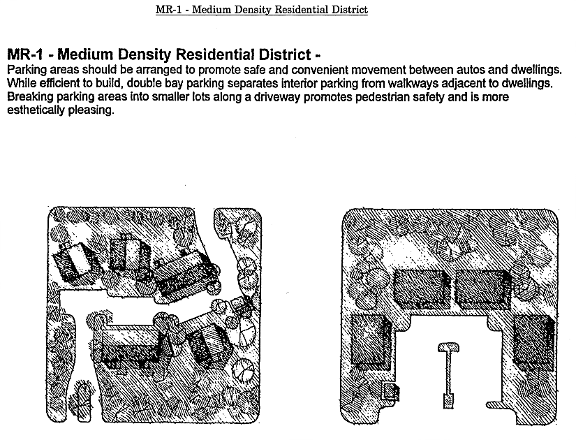
Sec. 10-6.641. - MR-1 Medium Density Residential District.

1. District IntentPermitted Uses
2. Principal Uses
3. Accessory Uses
 The MR-1 district is intended to be located are in areas designated Bradfordville Mixed Use Urban Residential 2 or Suburban on the future land use map of the Comprehensive Plan, in close proximity to more intensive non-residential uses, including commercial and office uses; and to residentially compatible public facilities such as schools, parks, and transit facilities. The MR-1 district is intended to achieve densities consistent with urban development, use of public transit, and efficient use of public infrastructure.
 Off-street parking facilities in the MR-1 district shall be located and designed to promote convenient access to pedestrian and mass transit facilities.
 The MR-1 district shall provide for a wide range of residential housing types.
 The maximum gross density allowed for new residential development in the MR-1 district is 16 dwelling units per acre, while the minimum gross density allowed is 8 dwelling units per acre, unless constraints of concurrency or preservation and/or conservation features preclude the attainment of the minimum densities.
 Certain community and recreational facilities related to residential uses and day care centers are also permitted.
(1) Community facilities related to residential uses, including religious facilities, police/fire stations, and elementary, middle, and high schools. Libraries or vocational schools are prohibited. Other community facilities may be allowed in accordance with section 10-6.806.
(2) Day care centers.
(3) Golf courses.
(4) Multiple-family dwellings.
(5) Nursing homes and other residential care facilities.
(6) Passive and active recreational facilities.
(7) Single-family attached dwellings.
(8) Single-family detached dwellings.
(9) Two-family dwellings.
(10) Zero-lot line single-family detached dwellings.
(1) A use or structure on the same lot with, and of a nature customarily incidental and subordinate to, the principal use or structure and which comprises no more than 33 percent of the floor area or cubic volume of the principal use or structure, as determined by the County Administrator or designee.
(2) Light infrastructure and/or utility services and facilities necessary to serve permitted uses, as determined by the County Administrator or designee.


Development Standards
4. Minimum Lot or Site Size5. Minimum Building Setbacks6. Maximum Building Restrictions
Use Categorya. Lot or Site Areab. Lot Widthc. Lot Deptha. Frontb. Side-
Interior Lot
c. Side-
Corner Lot
d. Reara. Building Size (excluding gross building floor area used for parking)b. Building Height (excluding stories used for parking)
Single-
Family Detached Dwellings
5,000 square feet 50 feet 100 feet 15 feet 7.5 feet on each side; or any combination of setbacks that equals at least 15 feet, provided that no such setback shall be less than 5 feet 15 feet 25 feet Not applicable 3 stories
Zero Lot Line Single-
Family Detached Dwellings
3,750 square feet 30 feet interior lot; 40 feet corner lot 100 feet 20 feet 0 feet one side; 5 feet other side 15 feet 25 feet Not applicable 3 stories
Two-Family Dwellings 7,000 square feet 70 feet 100 feet 15 feet Same as single-family dwellings above 15 feet 25 feet Not applicable 3 stories
Single-
Family Attached Dwellings
1,000 square feet minimum; average of 2,000 square feet 16 feet None 20 feet None 15 feet 25 feet Maximum length: 8 units 3 stories
Multiple-
Family Dwellings
10,000 square feet 80 feet 100 feet 15 feet 15 feet on each side 15 feet 25 feet Not applicable 3 stories
Any Permitted Principal Non-
Residential Use
12,000 square feet 80 feet 100 feet 15 feet 15 feet on each side 15 feet 25 feet 20,000 square feet of gross building floor area per acre 3 stories


General notes:

(1)

If central sanitary sewer is not available, non-residential development is limited to a maximum of 900 gallons of wastewater flow per day. Community service facilities are limited to no more than 5,000 square feet, or a sewage flow not to exceed 900 gallons per day. Also, refer to Sanitary Sewer Policies 1.2.3 and 2.1.2 of the Utilities Element of the Comprehensive Plan for additional requirements.

(2)

Refer to the Environmental Management Act (EMA) for information pertaining to the regulation of environmental features (preservation/conservation features), stormwater management requirements, etc.

(3)

Refer to the concurrency management ordinance for information pertaining to the availability of capacity for certain public facilities (roads, parks, etc.).

(Code 1992, § 10-6.641; Ord. No. 97-12, § 26, 7-8-1997; Ord. No. 99-15, § 17, 5-25-1999; Ord. No. 07-20, § 2, 7-10-2007; Ord. No. 09-13, § 4, 3-19-2009; Ord. No. 23-05, § 10, 2-21-2023)

Sec. 10-6.642. - OR-1 Office Residential District.

1. District IntentPermitted Uses
2. Principal Uses
3. Accessory Uses
 The OR-1 district is intended to be located within areas designated Bradfordville Mixed Use or Suburban on the future land use map of the Comprehensive Plan in areas where employment and residential uses are encouraged to locate in close proximity to each other. The provisions of the OR-1 district are intended to provide the district with a residential character to further encourage this mixing of uses at a compatible scale. A variety of housing types, compatible non-retail activities of moderate intensity and certain community facilities related to office or residential facilities (recreational, community services, and light infrastructure) may be permitted I the OR-1 district. The regulations of these districts are not intended to displace viable residential areas.
 The maximum gross density allowed for new residential development in the OR-1 district is 8 dwelling units per acre, while the minimum gross density allowed is 6 dwelling units per acre, unless constraints of concurrency or preservation and/or conservation features preclude the attainment of the minimum densities.
(1) Bed and breakfast inns up to a maximum of 6 rooms.
(2) Broadcasting studios.
(3) Community facilities related to office or residential facilities, including libraries, religious facilities, police/fire stations, and elementary, middle and high schools. Vocational schools are prohibited. Other community facilities may be allowed in accordance with section 10-6.806.
(4) Day care centers.
(5) Medical and dental offices and services, laboratories, and clinics.
(6) Non-medical offices and services, including business and government offices and services.
(7) Nursing homes and other residential care facilities.
(8) Passive and active recreational facilities.
(9) Personal services.
(10) Single-family attached dwellings.
(11) Single-family detached dwellings.
(12) Studios for photography, music, art, dance, drama, and voice.
(13) Two-family dwellings.
(14) Veterinary services, including veterinary hospitals.
(1) A use or structure on the same lot with, and of a nature customarily incidental and subordinate to, the principal use or structure an which comprises no more than 33 percent of the floor area or cubic volume of the principal use or structure, as determined by the County Administrator or designee.
(2) Light infrastructure and/or utility services and facilities necessary to serve permitted uses, as determined by the County Administrator or designee.


Development Standards
4. Minimum Lot or Site Size5. Minimum Building Setbacks6. Maximum Building Restrictions
Use Categorya. Lot or Site Areab. Lot Widthc. Lot Deptha. Frontb. Side-
Interior Lot
c. Side-
Corner Lot
d. Reara. Building Size (excluding gross building floor area used for parking)b. Building Height (excluding stories used for parking)
Single-
Family Detached Dwellings
5,000 square feet 50 feet 100 feet 15 feet 7.5 feet on each side: or any combination of setbacks that equals at least 15 feet, provided that no such setback shall be less than 5 feet 15 feet 25 feet Not applicable 3 stories
Two-Family Dwellings 8,500 square feet 70 feet 100 feet 15 feet Same as single-family above 15 feet 25 feet Not applicable 3 stories
Single-
Family Attached Dwellings
3,750 square feet end unit, 2,400 square feet interior lot 37.5 feet end unit; 25 feet interior lot 80 feet 15 feet None 15 feet 25 feet Maximum length: 8 units 3 stories
Any Permitted Principal Non-
Residential Use
6,000 square feet 50 feet 100 feet 15 feet Same as single-family above 25 feet 10 feet 10,000 square feet of gross building floor area per acre (does not apply to a conversion of an existing structure) or 12,500 square feet of gross building floor area per acre if the project is a mixed use development 3 stories
7. Off-Street Parking Requirements: Off-street parking facilities associated with permitted principal non-residential uses in the OR-1 zoning district must comply with the following requirements:
a. Parking setbacks:
1. Side-corner: 20 feet.
2. Rear and side-interior: 10 feet.
b. Driveway setbacks:
1. Side-corner: 10 feet (none if driveway is shared.
2. Rear and side-interior: 4 feet (none if driveway is shared).
c. Off-street parking may not be placed in a front yard between a building and the street.
d. The parking or driveway separation from the building is 4 feet.
e. All off-street parking spaces behind a building shall be screened from the required front yard and side corner lot areas by evergreen landscaping at least 4 feet in height.
f. Parking spaces shall be screened from rear and interior side property lines by a combination of a 6-foot high opaque fence or wall and landscape plant material.
g. Driveways connecting to a public street shall be the narrowest possible width to ensure appropriate safety standards, as determined by the County Administrator or designee.


General notes:

(1)

If central sanitary sewer is not available, residential development is limited to a minimum of 0.50-acre lots and non-residential development is limited to a maximum of 900 gallons of wastewater flow per day. Community service facilities are limited to no more than 5,000 square feet, or a sewage flow not to exceed 900 gallons per day. Also, refer to Sanitary Sewer Policies 1.2.3 and 2.1.2 of the Utilities Element of the Comprehensive Plan for additional requirements.

(2)

Refer to the Environmental Management Act (EMA) for information pertaining to the regulation of environmental features (preservation/conservation features), stormwater management requirements, etc.

(3)

Refer to the concurrent management ordinance for Information pertaining to the availability of capacity for certain public facilities (roads, parks, etc.).

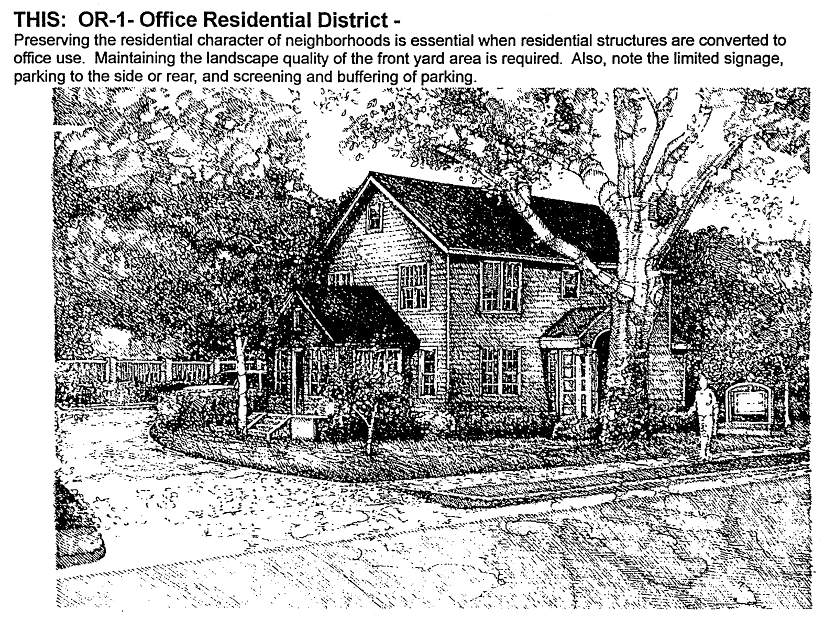
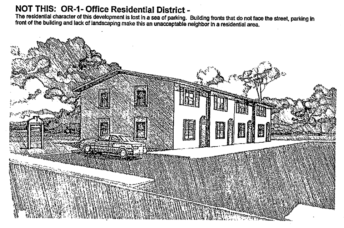
(Code 1992, § 10-6.642; Ord. No. 07-20, § 2, 7-10-2007; Ord. No. 09-13, § 4, 3-19-2009; Ord. No. 16-07, § 7, 5-10-2016; Ord. No. 23-05, § 11, 2-21-2023)

Sec. 10-6.643. - OR-2 Office Residential District.

1. District IntentPermitted Uses
2. Principal Uses
3. Accessory Uses
 The OR-2 district is intended to be located within areas designated Bradfordville Mixed Use or Suburban on the future land use map of the Comprehensive Plan in areas where employment and residential uses are encouraged to locate in close proximity to each other. The provisions of this district are intended to promote urban density and intensity of residential and office uses and the mixing of permitted uses to promote the use of public transit and the efficient use of public infrastructure.
 Off-street parking facilities in the OR-2 district shall be located and designed to promote convenient access to pedestrian and mass transit facilities. A variety of housing types, compatible non-retail activities of moderate intensity, retail commercial activities (limited to the ground floor), and certain community and recreational facilities related to office or residential uses are permitted in the OR-2 district.
 The maximum gross density allowed for new residential development in the OR-2 district is 16 dwelling units per acre, while the minimum gross density allowed is 8 dwelling units per acre, unless constraints of concurrency or preservation and/or conservation features preclude the attainment of the minimum densities. In order to implement the business park development pattern, a minimum of 10 acres is required with at least 3 types of uses which shall include office and commercial.
(1) Banks and other financial institutions.
(2) Broadcasting studios.
(3) Community facilities related to office or residential facilities, including libraries, religious facilities, police/fire stations and elementary, middle, high schools and vocational schools. Other community facilities may be allowed in accordance with section 10-6.806.
(4) Day care centers.
(5) Golf courses.
(6) Hotels and motels, including bed and breakfast inns.
(7) Medical and dental offices and services, laboratories and clinics.
(8) Multiple-family dwellings.
(9) Nonmedical offices and services, including business and government offices and services.
10) Nursing homes and other residential care facilities.
(11) Off-street parking facilities.
(12) Passive and active recreational facilities.
(13) Personal services.
(14) Retail drug store with drive-thrus (only allowed in a business park development).
(15) Retail food and grocery (only allowed in a business park development).
(16) Single-family attached dwellings.
(17) Single-family detached dwellings.
(18) Social, fraternal and recreational clubs and lodges, including assembly halls.
(19) Stand alone restaurants without drive-thrus (only allowed in a business park development).
(20) Studios for photography, music, art, dance, drama and voice.
(21) Two-family dwellings.
(22) Veterinary services, including veterinary hospitals.
(23) Zero-lot line single-family detached dwellings.
(24) Any use permitted in the C-1 district (and is not listed in uses (1) through (20) of this section), provided that the use is on the first floor of a multistory building containing office and/or residential uses on any of the floors above the first floor.
(1) A use or structure on the same lot with, and of a nature customarily incidental and subordinate to, the principal use or structure and which comprises no more than 33 percent of the floor area or cubic volume of the principal use or structure, as determined by the County Administrator or designee.
(2) Light infrastructure and/or utility services and facilities necessary to serve permitted uses, as determined by the County Administrator or designee.


Development Standards
4. Minimum Lot or Site Size5. Minimum Building Setbacks6. Maximum Building Restrictions
Use Categorya. Lot or Site Areab. Lot Widthc. Lot Deptha. Frontb. Side-
Interior Lot
c. Side-
Corner Lot
d. Reara. Building Size (excluding gross building floor area used for parking)b. Building Height (excluding stories used for parking)
Single-
Family Detached Dwellings
5,000 square feet 50 feet 100 feet 15 feet 7.5 feet on each side: or any combination of setbacks that equals at least 15 feet, provided that no such setback shall be less than 5 feet 15 feet 25 feet Not applicable 3 stories
Two-Family Dwellings 8,500 square feet 70 feet 100 feet 15 feet Same as single-family above 15 feet 25 feet Not applicable 3 stories
Single-
Family Attached Dwellings
1,600 square feet minimum; average of 2,000 square feet 16 feet None 15 feet None 15 feet 25 feet Not applicable 3 stories
Multiple-
Family Dwellings
10,000 square feet 80 feet 100 feet 15 feet 15 feet on each side 25 feet 10 feet Not applicable 3 stories
Zero-Lot Line Single-Family Detached Dwellings 3,750 square feet 30 feet interior lot; 40 feet corner lot 100 feet 20 feet 0 feet one side; 5 feet other side 15 feet 25 feet Not applicable 3 stories
Any Permitted Principal Non-
Residential Use
12,000 square feet 60 feet 100 feet 15 feet 15 feet on each side 25 feet 10 feet 20,000 square feet of gross building floor area per acre 3 stories
Commercial Uses (Only Allowed in Business Park Development) 12,000 square feet 60 feet 100 feet 15 feet 15 feet on each side 25 feet 10 feet 20,000 square feet of gross building floor area per acre; Individual buildings may not exceed 15,000 gross square feet 3 stories
7. Additional Criteria and Restrictions for Business Park Development: Commercial uses shall not exceed 25 percent of the total square feet of the development.


General notes:

(1)

If central sanitary sewer is not available, residential development is limited to a minimum of 0.50-acre lots and non-residential development is limited to a maximum of 900 gallons of wastewater flow per day. Community service facilities are limited to no more than 5,000 square feet, or a sewage flow not to exceed 900 gallons per day. Also, refer to Sanitary Sewer Policies 1.2.3 and 2.1.2 of the Utilities Element of the Comprehensive Plan for additional requirements.

(2)

Refer to the Environmental Management Act (EMA) for information pertaining to the regulation of environmental features (preservation/conservation features), stormwater management requirements, etc.

(3)

Refer to the concurrent management ordinance for information pertaining to the availability of capacity for certain public facilities (roads, parks, etc.).

(Code 1992, § 10-6.643; Ord. No. 07-20, § 2, 7-10-2007; Ord. No. 09-13, § 4, 3-19-2009; Ord. No. 09-33, § 3, 10-13-2009; Ord. No. 16-07, § 8, 5-10-2016; Ord. No. 23-05, § 12, 2-21-2023)

Sec. 10-6.644. - OR-3 Office Residential District.

1. District IntentPermitted Uses
2. Principal Uses
3. Accessory Uses
 The OR-3 district is intended to be located within areas designated Bradfordville Mixed Use or Suburban on the future land use map of the Comprehensive Plan in areas where employment and residential uses are encouraged to locate in close proximity to each other. The provisions of this district are intended to promote urban density and intensity of residential and office uses and the mixing of permitted uses to promote the use of public transit and the efficient use of public infrastructure.
 Off-street parking facilities in the OR-3 district shall be located and designed to promote convenient access to pedestrian and moss transit facilities. A variety of housing types, compatible nonretail activities of moderate intensity, retail commercial activities (limited to the ground floor), and certain community and recreational facilities related to office or residential uses are permitted in the OR-3 district.
 The maximum gross density allowed for new residential development in the OR-3 district is 20 dwelling units per acre, while the minimum gross density allowed is 8 dwelling units per acre, unless constraints of concurrency or preservation and/or conservation features preclude the attainment of the minimum densities.
(1) Banks and other financial institutions.
(2) Broadcasting studios.
(3) Community facilities related to office or residential facilities, including libraries, religious facilities, vocational, police/fire stations, elementary, middle, and high schools. Other community facilities may be allowed in accordance with any applicable provisions.
(4) Day care centers.
(5) Golf courses.
(6) Hotels and motels, including bed and breakfast inns.
(7) Medical and dental offices and services, laboratories, and clinics.
(8) Multiple-family dwellings.
(9) Nonmedical offices and services, including business and government offices and services.
(10) Nursing homes, including other residential care facilities.
(11) Off-street parking facilities.
(12) Passive and active recreational facilities.
(13) Personal services.
(14) Single-family attached dwellings.
(15) Single-family detached dwellings.
(16) Social, fraternal, recreational clubs and lodges, and assembly halls.
(17) Studios for photography, music, art, dance, drama, and voice.
(18) Two-family dwellings.
(19) Veterinary services, including veterinary hospitals.
(20) Zero lot line single-family detached dwellings.
(21) Any use permitted in the C-1 district (and is not listed in uses (1) through (20) of this section), provided that the use is on the first floor of a multi-story building containing office and/or residential uses on any of the floors above the first floor.
(1) A use or structure on the same lot with, and of a nature customarily incidental and subordinate to, the principal use or structure and which comprises no more than 33 percent of the floor area or cubic volume of the principal use or structure, as determined by the County Administrator or designee.
(2) Light infrastructure and/or utility services and facilities necessary to serve permitted uses, as determined by the County Administrator or designee.


Development Standards
4. Minimum Lot or Site Size5. Minimum Building Setbacks6. Maximum Building Restrictions
Use Categorya. Lot or Site Areab. Lot Widthc. Lot Deptha. Frontb. Side-
Interior Lot
c. Side-
Corner Lot
d. Reara. Building Size (excluding gross building floor area used for parking)b. Building Height (excluding stories used for parking)
Single-
Family Detached Dwellings
5,000 square feet 50 feet 100 feet 15 feet 7.5 feet on each side; or any combination of setbacks that equals at least 15 feet, provided that no such setback shall be less than 5 feet 15 feet 25 feet Not applicable 3 stories
Two-Family Dwellings 8,500 square feet 70 feet 100 feet 15 feet Same as single-family above 15 feet 25 feet Not applicable 3 stories
Single-
Family Attached Dwellings
1,600 square feet minimum; average of 2,000 square feet 16 feet None 15 feet None 15 feet 25 feet Not applicable 3 stories
Multiple-
Family Dwellings
10,000 square feet 80 feet 100 feet 15 feet 15 feet on each side 25 feet 10 feet Not applicable 3 stories
Zero-Lot Line Single-Family Detached Dwellings 3,750 square feet 30 feet interior lot; 40 feet corner lot 100 feet 20 feet 0 feet one side; 5 feet other side 15 feet 25 feet Not applicable 3 stories
Any Permitted Principal Non-
Residential Use
12,000 square feet 60 feet 100 feet 15 feet 15 feet on each side 25 feet 10 feet 20,000 square feet of gross building floor area per acre (See note 4) 3 stories (See note 4)


General notes:

(1)

If central sanitary sewer is not available, residential development is limited to a minimum of 0.50-acre lots and non-residential development is limited to a maximum of 900 gallons of wastewater flow per day. Community service facilities are limited to no more than 5,000 square feet, or a sewage flow not to exceed 900 gallons per day. Also, refer to Sanitary Sewer Policies 1.2.3 and 2.1.2 of the Utilities Element of the Comprehensive Plan for additional requirements.

(2)

Refer to the Environmental Management Act (EMA) for information pertaining to the regulation of environmental features (preservation/conservation features), stormwater management requirements, etc.

(3)

Refer to the concurrency management ordinance for information pertaining to the availability of capacity for certain public facilities (roads, parks, etc.).

(4)

In properties formerly designated as Mixed Use-C in the future land use map, the maximum non-residential gross building floor area is 40,000 square feet per acre and the maximum building height is six stories, if parking structures are provided for at least 50 percent of the parking spaces.

(Code 1992, § 10-6.644; Ord. No. 07-20, § 2, 7-10-2007; Ord. No. 09-13, § 4, 3-19-2009; Ord. No. 16-07, § 9, 5-10-2016; Ord. No. 23-05, § 13, 2-21-2023)

Sec. 10-6.645. - OA-1 Airport Vicinity District.

1. District IntentPermitted Uses
2. Principal Uses
3. Accessory Uses
 The OA-1 district is intended to be located in the vicinity of and particularly off the ends of the runways at Tallahassee International Airport which are subject to day/night sound levels (DNL) that exceed the threshold identified by both the Federal Aviation Administration and the state as being compatible with certain land use types. The intent of the OA-1 district is to provide reasonable and responsible development of parcels lying beneath the identified noise contours. The district provides for compatible planned office development and high technology and research and development activities as well as a limited number of activities that support the principal uses within areas subject to levels of aircraft noise of 65 DNL or above.
 This district is not intended to accommodate industrial activities. Residential uses are precluded in this district as are noise sensitive institutional and other noise sensitive land uses. This district may apply to properties in the Suburban Future Land Use category. Planned unit developments are encouraged in this district where such application is viable based on layout and size of parcels. Integration of development occurring on one tract with potential future development on adjacent tracts located in the same zoning district shall be provided.
 All buildings, their uses and accessory facilities shall comply with criteria relating to height, glare and electronic interference as delineated in FAR part 77 and related advisory guidance. More stringent criteria than contained in part 77 may be implemented if deemed necessary by the Federal Aviation Administration (FAA), state, or the airport director.
(1) Banks and other financial institutions.
(2) Cemeteries.
(3) Community facilities in accordance with section 10-6.806.
(4) Golf courses.
(5) Laboratories enclosed within a building.
(6) Mailing services.
(7) Medical and dental offices and services, clinics and laboratories.
(8) Non-medical offices and services, including business and government offices and services.
(9) Passive and active recreational facilities, whose structures comply with height requirements of the FAA.
(10) Personal services appurtenant to permitted office development and within an office building.
(11) Photocopying and duplicating services with associated office supplies sales.
(12) Research and development activities (no on-site disposable).
(13) Restaurants without drive-in facilities and contained within an office building.
(14) Retail drug store.
(15) Warehouses, miniwarehouses, or self-storage facilities.
(16) Other uses, which in the opinion of the County Administrator or designee, are of a similar and compatible nature to those uses described in this district.
(1) Customary accessory uses and structures incidental to the principal permitted use, provided that the accessory use and structure occupy 33 percent or less of the total area of the principal permitted use or structure, as determined by the County Administrator or designee.
(2) Light infrastructure and/or utility services and facilities necessary to serve permitted uses, as determined by the County Administrator or designee.
(3) Nature trail with associated benches, overlook, and picnic area.


Development Standards
4. Minimum Lot or Site Size5. Minimum Building Setbacks6. Maximum Building Restrictions
Use Categorya. Lot or Site Areab. Lot Widthc. Lot Deptha. Frontb. Side-
Interior Lot
c. Side-
Corner Lot
d. Reara. Building Size (excluding gross building floor area used for parking)b. Building Height (excluding stories used for parking)
Any Permitted Principal Non-
Residential Use Except Restaurants and Personal Services
6,000 square feet 50 feet 100 feet 20 feet 7.5 feet on each side; or 15 feet if adjoining a low density residential zoning district 25 feet 10 feet 20,000 square feet of gross building floor area per acre. 3 stories


General notes:

(1)

If central sanitary sewer is not available, non-residential development is limited to a maximum of 900 gallons of wastewater flow per day. Community service facilities are limited to no more than 5,000 square feet, or a sewage flow not to exceed 900 gallons per day. Also, refer to Sanitary Sewer Policies 1.2.3 and 2.1.2 of the Utilities Element of the Comprehensive Plan for additional requirements.

(2)

Refer to the Environmental Management Act (EMA) for information pertaining to the regulation of environmental features (preservation/conservation features), stormwater management requirements, etc.

(3)

Refer to the concurrency management ordinance for information pertaining to the availability of capacity for certain public facilities (roads, parks, etc.).

(Code 1992, § 10-6.645; Ord. No. 07-20, § 2, 7-10-2007; Ord. No. 09-13, § 4, 3-19-2009; Ord. No. 23-05, § 14, 2-21-2023)

Sec. 10-6.646. - C-1 Neighborhood Commercial District.

1. District IntentPermitted Uses
2. Principal Uses
3. Accessory Uses
 The C-1 district is intended to be located in areas designated Bradfordville Mixed Use, Suburban or Woodville Rural Community on the future land use map of the Comprehensive Plan and shall apply to suburban areas with direct access to collector or arterial roadways located within convenient traveling distance to one or more neighborhoods, wherein small groups of retail commercial, professional, office, community and recreational facilities and other convenience commercial activities are permitted in order to provide goods and services that people frequently use in close proximity to their homes.
 The C-1 district is intended to provide shopping for residential areas without requiring access to arterial roadways, thereby providing more convenient shopping for area residents and preserving the capacity of the arterial roadway network. The provisions of this district are intended to encourage commercial development that is compatible in scale and design with surrounding residential uses and therefore, the district limits the maximum size of individual buildings. The C-1 district is not intended to accommodate large scale commercial or service activities or automotive or other types of more intensive commercial activity.
 The maximum gross density allowed for new residential development in the C-1 district is 16 dwelling units per acre with a minimum gross density of 8 dwelling units per acre, unless constraints of concurrency or preservation and/or conservation features preclude the attainment of the minimum density.
 The residential uses are required to be located on the second floor or above a building containing commercial or office uses on the first floor. Mixed use projects in the C-1 district are encouraged, but are not required.
 In order to maintain compact and nonlinear characteristics, C-1 districts shall not be located closer than one-quarter mile to other C-1 or C-2 districts or to parcels containing commercial developments including more than 20,000 gross square feet of floor area shall not exceed 15 acres in size.
(1) Antique shops.
(2) Banks and other financial institutions.
(3) Community facilities related to the permitted principal uses, including libraries, religious facilities and police/fire stations. Other community facilities may be allowed in accordance with section 10-6.806.
(4) Day care centers.
(5) Laundromats, laundry and dry cleaning pick-up stations.
(6) Mailing services.
(7) Medical and dental offices and services, laboratories and clinics.
(8) Motor vehicle fuel sales.
(9) Nonmedical offices and services, including business and government offices and services.
(10) Passive and active recreational facilities.
(11) Personal services (barber shops, fitness clubs, etc.).
(12) Rental and sale of DVDs, videotapes and games.
(13) Repair services, nonautomotive.
(14) Residential (any type), provided that it is located on the second floor or above of a building containing commercial or office uses on the first floor.
(15) Restaurants, with or without drive-in facilities.
(16) Retail bakeries.
(17) Retail drug stores.
(18) Retail florists.
(19) Retail food and grocery.
(20) Retail home/garden supply, hardware and nurseries, without outdoor storage or display.
(21) Retail newsstand, books, greeting cards.
(22) Retail pet stores.
(23) Social, fraternal and recreational clubs and lodges, including assembly halls.
(24) Studios for photography, music, art, drama and voice.
(25) Tailoring.
(26) Veterinary services, including veterinary hospitals.
(27) Other uses, which in the opinion of the County Administrator or designee, are of a similar and compatiibe nature to those uses described in this district.
(1) A use or structure on the same lot with, and of a nature customarily incidental and subordinate to, the principal use or structure and which comprises no more than 33 percent of the floor area or cubic volume of the principal use or structure, as determined by the County Administrator or designee.
(2) Light infrastructure and/or utility services and facilities necessary to serve permitted uses, as determined by the County Administrator or designee.


Development Standards
4. Minimum Lot or Site Size5. Minimum Building Setbacks6. Maximum Building Restrictions
Use Categorya. Lot or Site Areab. Lot Widthc. Lot Deptha. Frontb. Side-
Interior Lot
c. Side-
Corner Lot
d. Reara. Building Size (excluding gross building floor area used for parking)b. Building Height (excluding stories used for parking)
Any Permitted Principal Use None None None 25 feet 15 feet on each side 25 feet 10 feet Except for properties within the Woodville Rural Community, 12,500 square feet of non-residential gross building floor area per acre and commercial and/or office uses not to exceed 200,000 square feet of gross building floor area per parcel. Individual buildings may not exceed 50,000 gross square feet. Within the Woodville Rural Community, 10,000 square feet of non-residential gross building area per acre and commercial uses not to exceed 50,000 square feet of gross building floor area per parcel. (See section 8 of this section). 3 stories
7. Additional Criteria for Non-residential Uses: Lighting shall be directed away from the perimeter of the site.
8. Incentive Criteria for Non-residential Buildings: A maximum of 12,500 square feet of non-residential gross building floor area per acre is allowed if the following criteria are satisfied: a. Non-residential buildings shall have a pitched roof; b. Non-residential buildings shall be in character with surrounding area. c. All exterior walls of non-residential buildings shall be finished with the same material.
9. Street Vehicular Access Restrictions: Properties in the C-1 zoning district shall be located on a collector street, but may have additional vehicular access to any type of street. However, in order to protect residential areas and neighborhoods from non-residential traffic, vehicular access to a local street is prohibited if one of the following zoning districts is located on the other side of the local street: RHA, R-1, R-2, R-3, R-4, R-5 MH and RP.


General notes:

(1)

If central sanitary sewer is not available, residential development is limited to a minimum of 0.50-acre lots inside the urban service area, and non-residential development is limited to a maximum of 900 gallons of wastewater flow per day. Community service facilities are limited to no more than 5,000 square feet, or a sewage flow not to exceed 900 gallons per day. Also, refer to Sanitary Sewer Policies 1.2.3 and 2.1.2 of the Utilities Element of the Comprehensive Plan for additional requirements.

(2)

Refer to the Environmental Management Act (EMA) for information pertaining to the regulation of environmental features (preservation/conservation features), stormwater management requirements, etc.

(3)

Refer to the concurrency management ordinance for information pertaining to the availability of capacity for certain public facilities (roads, parks, etc.).

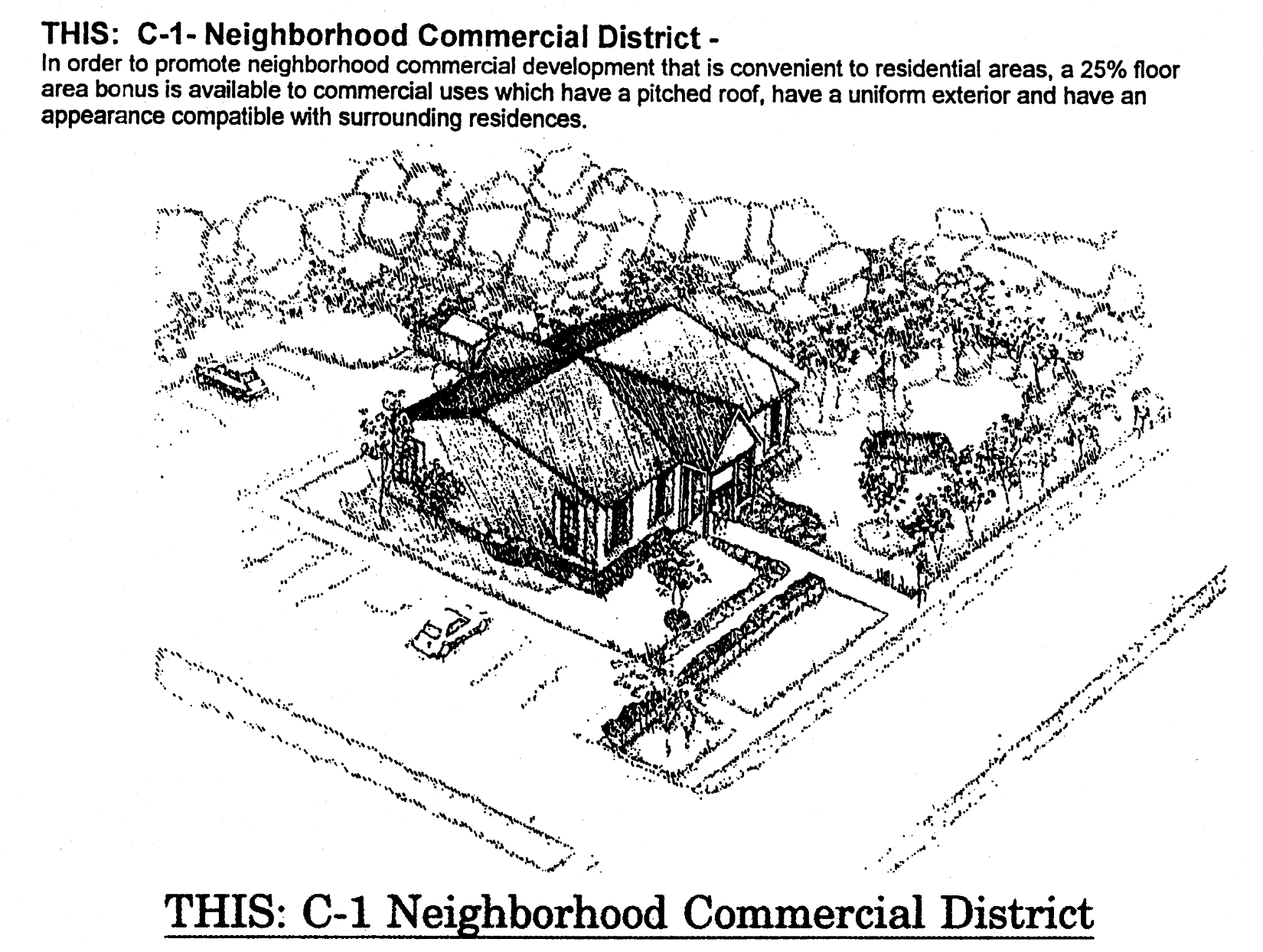
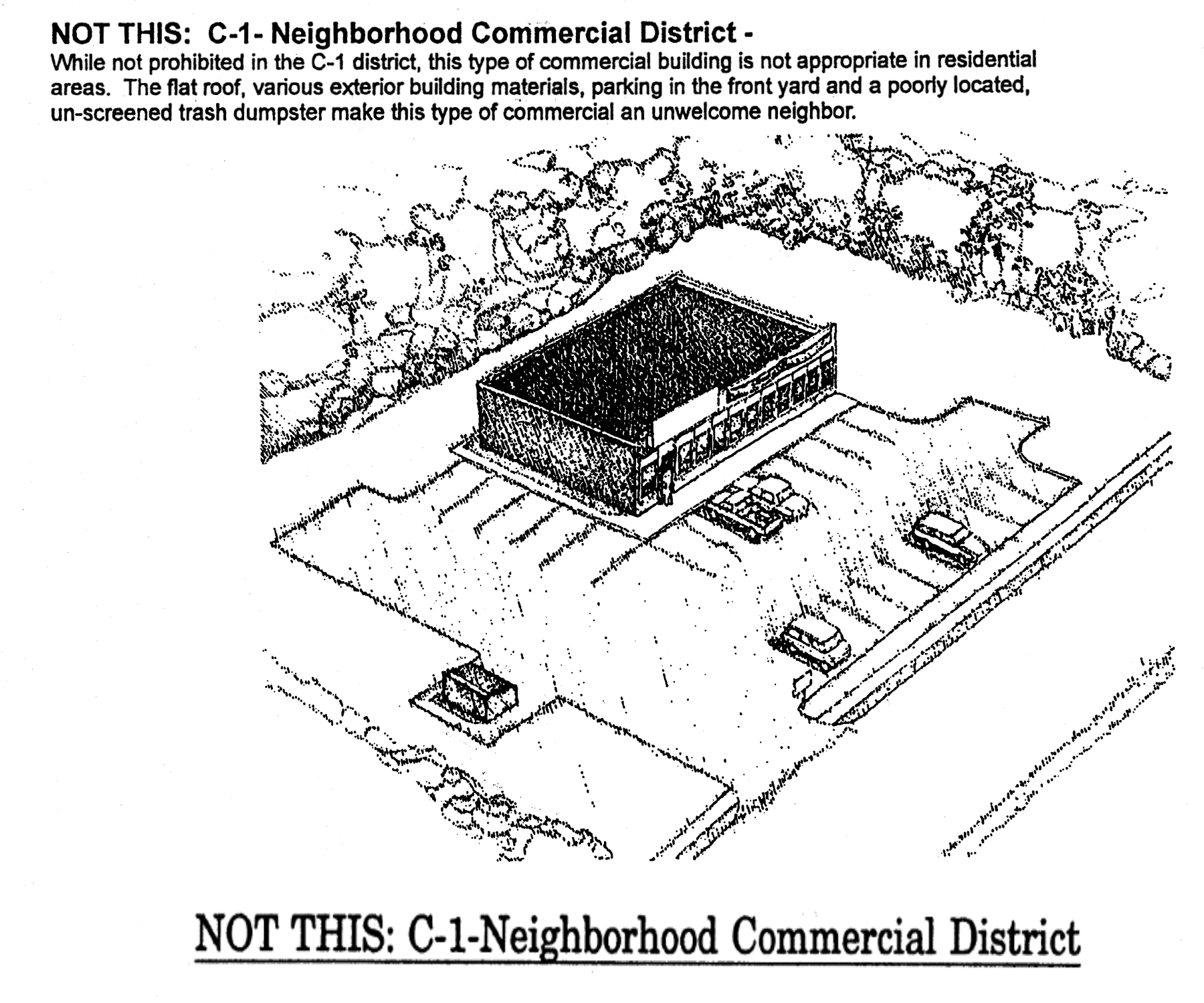
(Code 1992, § 10-6.646; Ord. No. 07-20, § 2, 7-10-2007; Ord. No. 09-13, § 4, 3-19-2009; Ord. No. 09-33, § 3, 10-13-2009; Ord. No. 23-05, § 15, 2-21-2023)

Sec. 10-6.647. - C-2 General Commercial District.

1. District IntentPermitted Uses
2. Principal Uses
3. Accessory Uses
 The C-2 district is intended to be located in areas designated Bradfordville Mixed Use, Suburban or Woodville Rural Community on the future land use map of the Comprehensive Plan shall apply to areas with direct access to major collector or arterial roadways located within convenient traveling distance to several neighborhoods, wherein small groups of retail commercial, professional, office, community and recreational facilities and other convenience commercial activities are permitted in order to provide goods and services that people frequently use in close proximity to their homes. The C-2 district is not intended to accommodate large scale commercial or service activities or other types of more intensive commercial activity.
 The maximum gross density allowed for new residential development in the C-2 district is 16 dwelling units per acre, with a minimum gross density of 8 dwelling units per acre, unless constraints of concurrency or preservation and/or conservation features preclude the attainment of the minimum density. The residential uses are required to be located on the second floor or above of a building containing commercial or office uses on the first floor.
 Mixed use projects in the C-2 district are encouraged, but are not required.
In order to maintain compact and nonlinear characteristics, C-2 districts shall not be located closer than one-quarter mile to other C-2 or C-1 districts or to parcels of land containing commercial developments including more than 20,000 gross square feet of floor area and shall not exceed 30 acres in size.
(1) Antique shops.
(2) Automotive service and repair, including car wash.
(3) Bait and tackle shops.
(4) Banks and other financial institutions.
(5) Camera and photographic stores.
(6) Cocktail lounges and bars.
(7) Community facilities related to the permitted principal uses, including libraries, religious facilities, police/fire stations, elementary, middle and high schools. Other community facilities may be allowed in accordance with section 10-6.806.
(8) Day care centers.
(9) Gift, novelty and souvenir shops.
(10) Indoor amusements (bowling, billiards, skating, etc.).
(11) Indoor theaters (including amphitheaters).
(12) Laundromats, laundry and dry cleaning pick-up.
(13) Mailing services.
(14) Medical and dental offices, services, laboratories and clinics.
(15) Motor vehicle fuel sales.
(16) Nonmedical offices and services, including business and government offices and services.
(17) Nonstore retailers.
(18) Passive and active recreational facilities.
(19) Personal services (barber shops, fitness clubs, etc.).
(20) Photocopying and duplicating services.
(21) Rental and sales of DVDs, video tapes and games.
(22) Rental of tools, small equipment or party supplies.
(23) Repair services, nonautomotive.
(24) Residential (any type), provided that it is located on the second floor or above a building containing commercial or office uses on the first floor.
(25) Restaurants, with or without drive-in facilities.
(26) Retail bakeries.
(27) Retail computer, video, record and other electronics.
(28) Retail department, apparel and accessory stores.
(29) Retail drug stores.
(30) Retail florists.
(31) Retail food and grocery.
(32) Retail furniture, home appliances, accessories.
(33) Retail home/garden supply, hardware and nurseries.
(34) Retail jewelry store.
(35) Retail needlework shops and instruction.
(36) Retail newsstand, books, greeting cards.
(37) Retail office supplies.
(38) Retail optical and medical supplies.
(39) Retail package liquors.
(40) Retail pet stores.
(41) Retail picture framing.
(42) Retail sporting goods, toys.
(43) Retail trophy store.
(44) Shoes, luggage and leather goods.
(45) Social, fraternal and recreational clubs and lodges, including assembly halls.
(46) Studios for photography, music, art, dance and voice.
(47) Tailoring.
(48) Veterinary services, including veterinary hospitals.
(49) Other uses, which in the opinion of the County Administrator or designee, are of a similar and compatible nature to those uses described in this district.
(1) A use or structure on the same lot with, and of a nature customarily incidental and subordinate to, the principal use or structure an which comprises no more than 33 percent of the floor area or cubic volume of the principal use or structure, as determined by the County Administrator or designee.
(2) Light infrastructure and/or utility services and facilities necessary to serve permitted uses, as determined by the County Administrator or designee.
For additional development standards, see below


Development Standards
4. Minimum Lot or Site Size5. Minimum Building Setbacks6. Maximum Building Restrictions
Use Categorya. Lot or Site Areab. Lot Widthc. Lot Deptha. Frontb. Side-
Interior Lot
c. Side-
Corner Lot
d. Reara. Building Size (excluding gross building floor area used for parking)b. Building Height (excluding stories used for parking)
Any Permitted Principal Use None None None 25 feet 15 feet on each side 25 feet 10 feet Except for properties within the Woodville Rural Community, 12,500 square feet of non-residential gross building floor area per acre and commercial and/or office uses not to exceed 200,000 square feet of gross building floor area for each district containing 20 acres or less. 12,500 square feet of non-residential gross building floor area per acre and commercial and/or office uses not to exceed maximum of 250,000 square feet of non-residential gross building area per district for districts containing more than 20 acres to 30 acres. Individual buildings may not exceed 50,000 gross square feet. Within the Woodville Rural Community, 12,500 square feet of non-residential gross building area per acre and commercial uses not to exceed 50,000 square feet of gross building floor area per parcel. 3 stories
7. Street Vehicular Access Restrictions: Properties in the C-2 zoning district shall be located on a major collector or arterial street, but may have additional vehicular access to any type of street. However, in order to protect residential areas and neighborhoods from non-residential traffic, vehicular access to a local street is prohibited if one of the following zoning districts is located on the other side of the local street: RHA, R-1, R-2, R-3, R-4, R-5, MH and RP.


General notes:

(1)

If central sanitary sewer is not available, residential development is limited to a minimum of 0.50-acre lots and inside the urban service area non-residential development is limited to a maximum of 900 gallons of wastewater flow per day. Community service facilities are limited to no more than 5,000 square feet, or a sewage flow not to exceed 900 gallons per day. Also, refer to Sanitary Sewer Policies 1.2.3 and 2.1.2 of the Utilities Element of the Comprehensive Plan for additional requirements.

(2)

Refer to the Environmental Management Act (EMA) for information pertaining to the regulation of environmental features (preservation/conservation features), stormwater management requirements, etc.

(3)

Refer to the concurrency management ordinance for information pertaining to the availability of capacity for certain public facilities (roads, parks, etc.).

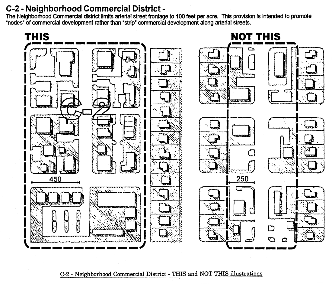
(Code 1992, § 10-6.647; Ord. No. 07-20, § 2, 7-10-2007; Ord. No. 09-13, § 4, 3-19-2009; Ord. No. 09-33, § 3, 10-13-2009; Ord. No. 16-07, § 10, 5-10-2016; Ord. No. 23-05, § 16, 2-21-2023)

Sec. 10-6.648. - CM Medical Arts Commercial District.

1. District IntentPermitted Uses
2. Principal Uses
3. Accessory Uses
 The CM district is intended to be located in areas designated Suburban on the future land use map of the Comprehensive Plan and shall apply to urban areas with convenient access to hospitals or other major medical facilities, wherein activities are restricted to medically related operations and support functions including residential uses and limited nonmedical commercial retail, offices, and services which serve medical operations. The provisions of the CM district are intended to protect and promote the efficient operation of hospitals and associated medical facilities and promote safe and efficient vehicular and pedestrian access to these facilities. Medical centers are characterized by a variety of directly related medical facilities and indirectly related support businesses in close proximity to allow for efficient operations. Also, certain community and recreational facilities related to medical facilities are permitted.
 The maximum gross density allowed for new development in the CM district is 20 dwelling units per acre.
 Exclusively residential uses shall have a minimums gross density of 8 dwelling units per acre unless constraints of concurrency or preservation and/or conservation features preclude attainment of minimum density.
 The minimum gross density for mixed use projects is six dwelling units per acre.
(1) Banks and other financial institutions, without drive-through facilities.
(2) Community facilities related to medical facilities, including religious facilities and police/fire stations. Schools and libraries are prohibited. Other community facilities may be allowed in accordance with section 10-6.806.
(3) Day care centers.
(4) Gift, novelty, and souvenir shops.
(5) Hospitals.
(6) Hotels and motels, including bed and breakfast inns.
(7) Laundromats, laundry and dry cleaning pick-up stations.
(8) Mailing services.
(9) Medical and dental offices, services, laboratories, and clinics.
(10) Mortuaries.
(11) Multiple-family dwellings.
(12) Nonmedical offices and services, including business and government offices and services.
(13) Nursing homes and other residential care facilities.
(14) Off-street parking facilities.
(15) Passive and active recreational facilities.
(16) Personal services (barber shops, fitness clubs, etc.).
(17) Photocopying and duplicating services.
(18) Restaurants without drive-in facilities.
(19) Retail bakeries.
(20) Retail drug store.
(21) Retail florists.
(22) Retail newsstands, books, greeting cards.
(23) Retail office supplies.
(24) Retail optical and medical supplies.
(25) Single-family attached dwellings.
(26) Tailoring.
(27) Veterinary services, including veterinary hospitals.
(28) Other uses, which in the opinion of the County Administrator or designee, are of a similar and compatible nature to those uses described in this district.
(1) A use or structure on the same lot with, and of a nature customarily incidental and subordinate to, the principal use or structure and which comprises no more than 33 percent of the floor area or cubic volume of the principal use or structure, as determined by the County Administrator or designee.
(2) Light infrastructure and/or utility services and facilities necessary to serve permitted uses, as determined by County Administrator or designee.


Development Standards
4. Minimum Lot or Site Size5. Minimum Building Setbacks6. Maximum Building Restrictions
Use Categorya. Lot or Site Areab. Lot Widthc. Lot Deptha. Frontb. Side-
Interior Lot
c. Side-
Corner Lot
d. Reara. Building Size (excluding gross building floor area used for parking)b. Building Height
Any Permitted Principal Non-
Residential Use
None None None 25 feet None 25 feet 10 feet 80,000 square feet of gross building floor area per acre, except 176,000 square feet of gross building floor area per acre for hospitals and commercial uses not to exceed 200,000 square feet of gross building floor area per parcel None for hospitals; 6 stories for other uses (excluding stories used for parking); or 4 stories (including stories used for parking) if proposed structure is within 150 feet of a low density residential zoning district
Single-
Family Attached Dwellings
1,600 square feet min.; average of 2,000 square feet 16 feet None 15 feet None 15 feet 25 feet Not applicable 3 stories
Multiple-
Family Dwellings
10,000 square feet 80 feet 100 feet 15 feet 15 feet on each side 15 feet 25 feet Not applicable Same as above
7. Street Vehicular Access Restrictions: Properties in the CM zoning district may have vehicular access to any type of street. However, in order to protect residential areas and neighborhoods from non-residential traffic, vehicular access to a local street is prohibited if one of the following zoning districts is located on the other side of the local street: RHA, R-1, R-2, R-3, R-4, R-5, MH, MR-1, and RP.


General notes:

(1)

If central sanitary sewer is not available, residential development is limited to a minimum of 0.50-acre lots and non-residential development is limited to a maximum of 900 gallons of wastewater flow per day. Community service facilities are limited to no more than 5,000 square feet, or a sewage flow not to exceed 900 gallons per day. Also, refer to Sanitary Sewer Policies 1.2.3 and 2.1.2 of the Utilities Element of the Comprehensive Plan for additional requirements.

(2)

Refer to the Environmental Management Act (EMA) for information pertaining to the regulation of environmental features (preservation/conservation features), stormwater management requirements, etc.

(3)

Refer to the concurrency management ordinance for information pertaining to the availability of capacity for certain public facilities (roads, parks, etc.).

(Code 1992, § 10-6.648; Ord. No. 07-20, § 2, 7-10-2007; Ord. No. 09-13, § 4, 3-19-2009; Ord. No. 23-05, § 17, 2-21-2023)

Sec. 10-6.649. - CP Commercial Parkway District.

1. District IntentPermitted Uses
2. Principal Uses
3. Accessory Uses
 The CP district is intended to be located in areas designated suburban in the future land use map of the Comprehensive Plan and shall apply to areas exhibiting an existing development pattern of office, general commercial, community facilities, and intensive automotive commercial development abutting urban area arterial roadways with high traffic volumes. The CP district is characterized by a linear pattern of development. The access management standards set forth in for the CP district addressing limitations placed on access are intended to minimize and control ingress and egress to arterial roadways and to promote smooth and safe traffic flow of the general traveling public. To encourage the benefits from mixed use development where residences are located in close proximity to the office and commercial uses allowed within this district, including convenience and opportunity for residents and improved market access for business establishments, medium density multifamily residential development up to a maximum of 16 dwelling units per acre is allowed.
 Reuse of existing single use sites for multiple use developments, adding new uses to single use sites and/or multiple use developments in the CP district that share parking facilities, have parking structures and/or have high floor area ratios are encouraged in the CP district.
 The principles of traditional neighborhood developments are encouraged, though not required.
New CP districts in the suburban FLUM category shall have access to arterial or major collector streets.
(1) Antique shops.
(2) Armored truck services.
(3) Automotive sales and rental (includes any type of motor vehicle including boats and motorcycles).
(4) Automotive service and repair, including car wash.
(5) Automotive-retail, parts, accessories, tires, etc.
(6) Bait and tackle shops.
(7) Banks and other financial institutions.
(8) Broadcasting studios.
(9) Building contractors and related services, without outdoor storage.
(10) Camera and photographic stores.
(11) Cemeteries.
(12) Cocktail lounges and bars.
(13) Commercial kennels.
(14) Community facilities, including libraries, religious facilities, vocational schools, and police/fire stations. Elementary, middle, and high schools are prohibited. Other community facilities may be allowed in accordance with section 10-6.806.
(15) Day care centers.
(16) Gift, novelty, and souvenir stores.
(17) Golf courses.
(18) Hotels and motels, including bed and breakfast inns.
(19) Indoor amusements (bowling, billiards, skating, etc.).
(20) Indoor theaters (including amphitheaters).
(21) Laundromats, laundry and dry-cleaning pick up stations.
(22) Lawn and tree removal services.
(23) Mailing services.
(24) Medical and dental offices, services, laboratories, and clinics.
(25) Manufactured home sales lots.
(26) Mortuaries.
(27) Motor vehicle fuel sales.
(28) Motor vehicle racing tracks, go-karts, etc.
(29) Nonmedical offices and services, including business and government offices and services.
(30) Non-store retailers.
(31) Nursing homes and residential care facilities.
(32) Off-street parking facilities.
(33) Outdoor amusements (golf courses, batting cages, driving ranges, etc.).
(34) Passive and active recreational facilities.
(35) Pawnshops.
(36) Personal services (barber shops, fitness clubs, etc.).
(37) Pest control services.
(38) Photocopying and duplicating services.
(39) Printing and publishing.
(40) Recreational vehicle park.
(41) Rental and sales of DVDs, videotaps and games.
(42) Rental of tools, small equipment, or party supplies.
(43) Repair services, non-automotive.
(44) Residential, multifamily, up to a maximum of 16 dwelling units per acre.
(45) Residential, any type, located on or above the second floor of any structure containing nonresidential use on the first floor, up to a maximum of 16 dwelling units per acre.
(46) Restaurants, with or without drive-in facilities.
(47) Retail bakeries.
(48) Retail caskets and tombstones.
(49) Retail computer, video, record, and other electronics.
(50) Retail department, apparel, and accessory stores.
(51) Retail drug store.
(52) Retail florist.
(53) Retail food and grocery.
(54) Retail furniture, home appliances and accessories.
(55) Retail home/garden supply, hardware and nurseries.
(56) Retail jewelry stores.
(57) Retail needlework and instruction.
(58) Retail newsstand, books, greeting cards.
(59) Retail office supplies.
(60) Retail optical and medical supplies.
(61) Retail package liquors.
(62) Retail pet stores.
(63) Retail picture framing.
(64) Retail sporting goods, toy stores.
(65) Retail trophy stores.
(66) Self-moving operation.
(67) Retail shoes, luggage, and leather products.
(68) Sign shops.
(69) Social, fraternal and recreational clubs and lodges, including assembly halls.
(70) Studies for photography, music, art, drama, voice.
(71) Tailoring.
(72) Towing, recking, and recovery services.
(73) Trailer sales and service.
(74) Veterinary services, including veterinary hospitals.
(75) Warehouses, mini-warehouses, or self-storage facilities.
(76) Other uses, which in the opinion of the County Administrator or designee, are of a simiar and compatible nature to those uses described in this district.
(1) A use or structure on the same lot with, and of a nature customarily incidental and subordinate to, the principal use or structure and which comprises no more than 33 percent of the floor area of cubic volume of the principal use or structure, as determined by the County Administrator or designee.
(2) Light infrastructure and/or utility services and facilities necessary to serve permitted uses, as determined by the County Administrator or designee.


Development Standards
4. Minimum Lot or Site Size5. Minimum Building Setbacks6. Maximum Building Restrictions
Use Categorya. Lot or Site Areab. Lot Widthc. Lot Deptha. Frontb. Side-
Interior Lot
c. Side-
Corner Lot
d. Reara. Building Size (excluding gross building floor area used for parking)b. Building Height (excluding stories used for parking)
Any Permitted Principal Use None None None 25 feet None 25 feet 10 feet 25,000 square feet of building floor area per acre and commercial uses not to exceed 200,000 square feet of gross building floor area per parcel. 50,000 square feet of building area per acre for storage areas within buildings. 4 stories
7. Access Management Criteria: (In case of a conflict with the provisions of other ordinances or regulations, the most strict provisions shall apply):
Capital Circle from Centerville clockwise to I-10.Driveway access to Capital Circle from Centerville Road in the northeast to I-10 in the northwest is prohibited except for:
a) Existing driveway access as of December 31, 1995;
b) A single driveway access for properties in existence before December 31, 1995 which have sole access to Capital Circle and do not have other street access; and
c) Temporary driveway access which may be permitted for properties which establish permanent access in another public street and grant the city or county the right to close the temporary access without compensation upon conversion of Capital Circle to a limited access or controlled access roadway.
All arterials and major collectors:
Full movement access to an arterial or major collector shall not be permitted closer than 330 feet to another full movement access point, nor within 660 feet of a signalized intersection.
Right-in/right-out access to an arterial or major collector shall not be permitted closer than 330 feet to another access point, nor within 100 feet of a signalized intersection, except properties with sole access to an arterial or major collector are permitted at least one right-in/right-out access point. Properties with 660 feet or more of arterial and major collector frontage may be permitted multiple accesses to a single street based upon a traffic safety and capacity evaluation.
All development fronting on an arterial or major collector shall record a joint access and cross easement benefiting adjoining properties fronting on the same arterial or major collector.
Minor collectors: Full movement access to a minor collector shall not be permitted closer than 200 feet to another full movement access point, nor within 400 feet of a signalized intersection. Right-in/right-out access to a minor collector shall not be permitted closer than 100 feet to another access point, nor within 200 feet of a signalized intersection.
Local streets: Full movement access to a local street shall not be permitted within 200 feet of a signalized intersection. Right-in/right-out access to a local street shall not be permitted closer than 100 feet to another access point or intersecting public street, nor within 200 feet of a signalized intersection.
8. Street Vehicular Access Restrictions: Properties in the CP zoning district may have vehicular access to any type of street. However, in order to protect residential areas and neighborhoods from non-residential traffic, vehicular access to a local street is prohibited if one of the following zoning districts is located on the other side of the local street: RHA, R-1, R-2, R-3, R-4, R-5, MH, MR-1, and RP.
9. Additional Criteria for Charitable Donation Stations: Such station shall have indoor storage for all donations, and shall have an attendant available during normal business hours responsible for the collection and/or storage of said donations. A "charitable donation station" is considered a community service/facility regulated by section 10-6.806.


General notes:

(1)

If central sanitary sewer is not available, residential development is limited to a minimum of 0.50-acre lots and non-residential development is limited to a maximum of 900 gallons of wastewater flow per day. Community service facilities are limited to no more than 5,000 square feet, or a sewage flow not to exceed 900 gallons per day. Also, refer to Sanitary Sewer Policies 1.2.3 and 2.1.2 of the Utilities Element of the Comprehensive Plan for additional requirements.

(2)

Refer to the Environmental Management Act (EMA) for information pertaining to the regulation of environmental features (preservation/conservation features), stormwater management requirements, etc.

(3)

Refer to the concurrency management ordinance for information pertaining to the availability of capacity for certain public facilities (roads, parts, etc.).

(Code 1992, § 10-6.649; Ord. No. 07-20, § 2, 7-10-2007; Ord. No. 08-27, § 1, 11-25-2008; Ord. No. 09-13, § 4, 3-19-2009; Ord. No. 17-01, § 7, 1-24-2017; Ord. No. 23-05, § 18, 2-21-2023)

Sec. 10-6.650. - UP-1 Urban Pedestrian District.

1. District IntentPermitted Uses
2. Principal Uses
3. Accessory Uses
 The UP-1 district is intended to be located in areas designated Suburban or Bradfordville Mixed Use on the future land use map of the Comprehensive Plan and shall apply to compact, linear urban areas with direct access to an arterial roadway. The intent of this district is to promote the redevelopment of areas from lower intensity "strip" development pattern to a more intensive, higher density urban pattern. It is one of the intents of this district to permit the gradual conversion of existing development to the new standards by allowing the continuation of certain existing uses and allowing the conversion of those existing uses to drive-through uses, provided that the new uses meet the development standards of this district and foster an improved pedestrian environment. It is not intended that additional sites within this district be converted to new drive-through uses. The UP-1 district shall be located in areas near employment or activity centers with access to public transit. The provisions of this district are intended to promote more intensive and multiple use developments with pedestrian facilitation and orientation. Retail commercial, professional, office, medium density residential, and community and recreational facilities related to principal permitted uses are permitted. This district is not intended to accommodate regional scale commercial and service activities, not automotive oriented uses (auto sales, service or repair). New residential development shall have a minimum gross density of 6 dwelling units per acre and a maximum gross density of 16 dwelling units per acre. The minimum gross density requirements may be eliminated if constrains of concurrency or preservation and/or conservation features preclude the attainment of the minimum densities. (1) Antique shops.
(2) Banks and other financial institutions, without drive-through facilities.
(3) Camera and photographic stores.
(4) Cocktail lounges and bars.
(5) Community facilities related to the permitted principal uses, including libraries, religious facilities, police/fire stations, vocational, elementary, middle and high schools. Other community facilities may be allowed in accordance with section 10-6.806.
(6) Day care centers.
(7) Gift, novelty, and souvenir stores.
(8) Hotels and motels, including bed and breakfast inns.
(9) Indoor amusements (bowling, billiards, skating, etc.).
(10) Laundromats, laundry and dry cleaning pick-up stations without drive-through facilities.
(11) Mailing services.
(12) Medical and dental offices, services, laboratories, and clinics.
(13) Nonmedical offices and services, including business and government offices and services.
(14) Non-store retailers.
(15) Off-street parking facilities.
(16) Passive and active recreational facilities.
(17) Personal services (barber shops, fitness clubs, etc.).
(18) Photocopying and duplicating services.
(19) Rental and sales of DVDs, video tapes and games.
(20) Repair services, non-automotive.
(21) Residential (any type).
(22) Restaurants without drive-in facilities.
(23) Retail bakeries.
(24) Retail computer, video, record, and other electronics.
(25) Retail department, apparel, and accessory stores.
(26) Retail drug store.
(27) Retail florist.
(28) Retail food and grocery.
(29) Retail furniture, home appliances, accessories.
(30) Retail home/garden supply, hardware, and surseries without outside storage or display.
(31) Retail jewelry store.
(32) Retail needlework shops and instruction.
(33) Retail newsstands, books, greeting cards.
(34) Retail package liquors.
(35) Retail picture framing.
(36) Retail trophy stores.
(37) Shoes, luggage, and leather goods.
(38) Social, fraternal and recreational clubs and lodges, including assembly halls.
(39) Studios for photography, music, art, drama, and voice.
(40) Tailoring.
(41) Existing drive-through uses and existing motor vehicle fuel sales which were legally established and in existence on October 1, 1997.
(42) Other uses, which in the opinion of the County Administrator or designee, are of a similar and compatible nature to those uses described in this district.
(1) A use or structure on the same lot with, and of a nature customarily incidental and subordinate to, the principal use or structure and which comprises no more than 33 percent of the floor area or cubic volume of the principal use or structure, as determined by the County Administrator or designee.
(2) Light infrastructure and/or utility services and facilities necessary to serve permitted uses, as determined by the County Administrator or designee.


Development Standards
4. Minimum Lot or Site Size5. Minimum Building Setbacks6. Maximum Building Restrictions
Use Categorya. Lot or Site Areab. Lot Widthc. Lot Deptha. Frontb. Side-
Interior Lot
c. Side-
Corner Lot
d. Reara. Building Size (excluding gross building floor area used for parking)b. Building Height
Any Permitted Principal Use None None None 0 feet minimum
10 feet maximum
None 0 feet minimum
10 feet maximum
20 feet minimum if adjoining a residential district 20,000 square feet of gross building floor area per acre and commercial uses not to exceed 200,000 square feet of gross building floor area per parcel 6 stories (excluding stories used for parking); or 4 stories (including stories used for parking) if proposed structure is within 150 feet of a low density residential zoning district
7. Requirements and Incentives for Off-Street Parking Facilities: In order to create developments consistent with the intent of the district and to encourage mixed used and pedestrian friendly developments, off-street parking facilities associated with the construction of a new building or the expansion of an existing building are prohibited from being located in the front of the subject lot or parcel. The off-street parking requirements set forth in subdivision 2, division 5, article VII of this chapter, including the number of required off-street parking spaces and dimensional requirements are not applicable to properties in the UP-1 zoning district. Instead, the number of required off-street parking spaces and dimensional requirements shall be approved by the County Administrator or designee during site plan review or permitting (whichever comes first) based on the information provided by the applicant.
8. Additional Criteria for Non-Residential Uses: The construction of a new non-residential building or expansion of an existing non-residential building shall require the front lot and street side exterior walls on the ground floor to contain a minimum of 70 percent transparent material.
9. Street Vehicular Access Restrictions: Properties in the UP-1 zoning district may have vehicular access to any type of street. However, in order to protect residential areas and neighborhoods from non-residential traffic, vehicular access to a local street is prohibited if one of the following zoning districts is located on the other side of the local street: RA, R-1, R-2, R-3, R-4, R-5, MH, MR-1, and RP.
10. Criteria for Conditional Uses: After October 1, 1997, drive-through facilities as part of a permitted use in this district may be permitted as conditional uses, providing that the following criteria are met:
(a) The new use must be the redevelopment of a site which contains a conforming motor vehicle fuel sale use or a conforming drive-through use (see section No. 2 of this chart);
(b) The new use complies with development standards of the zoning district;
(c) The use has a cross building floor area in excess of 5,000 square feet; and
(d) Arterial street access does not exceed one vehicular access point per arterial street frontage.


General notes:

(1)

If central sanitary sewer is not available, residential development is limited to a minimum of 0.50 acre lots and non-residential development is limited to a maximum of 900 gallons of wastewater flow per day. Community service facilities are limited to no more than 5,000 square feet, or a sewage flow not to exceed 900 gallons per day. Also, refer to Sanitary Sewer Policies 1.2.3 and 2.1.2 of the Utilities Element of the Comprehensive Plan for additional requirements.

(2)

Refer to the Environmental Management Act (EMA) for information pertaining to the regulation of environmental features (preservation/conservation features), stormwater management requirements, etc.

(3)

Refer to the concurrency management ordinance for information pertaining to the availability of capacity for certain public facilities (roads, parks, etc.).

(Code 1992, § 10-6.650; Ord. No. 07-20, § 2, 7-10-2007; Ord. No. 09-13, § 4, 3-19-2009; Ord. No. 16-07, § 11, 5-10-2016; Ord. No. 23-05, § 19, 2-21-2023)

Sec. 10-6.651. - UP-2 Urban Pedestrian District.

1. District IntentPermitted Uses
2. Principal Uses
3. Accessory Uses
 The UP-2 district is intended to be located in areas designated Suburban or Bradfordville Mixed Use on the future land use map of the Comprehensive Plan and shall apply to compact, linear urban areas with direct access to an access roadway. The intent of this district is to promote the redevelopment of areas from lower intensity "strip" development pattern to a more intensive, higher density urban pattern. It is one of the intents of this district to permit the gradual conversion of existing development to the new standards by allowing the continuation of certain existing uses and allowing the conversion of those existing uses to drive-through uses, provided that the new uses meet the development standards of this district and foster an improved pedestrian environment. It is not intended that additional sites within this district be converted to new drive-through uses. The UP-2 district shall be located in areas near employment or activity centers with access to public transit. The provisions of this district are intended to promote more intensive and multiple use developments with pedestrian facilitation and orientation. Retail commercial, professional, office, medium density residential, and community and recreational facilities related to principal permitted uses are permitted. This district is not intended to accommodate regional scale commercial and service activities, not automotive oriented uses (auto sales, service). New residential development that is exclusively residential shall have a minimum gross density of 6 dwelling units per acre and a maximum gross density of 16 dwelling units per acre. New residential development combined with non-residential development shall have a minimum gross density of 6 dwelling units per acre and a maximum density of 20 dwelling units per acre. The minimum gross density requirements may be eliminated if constraints of concurrency or preservation and/or conservation features preclude the attainment of the minimum densities. (1) Antique shops.
(2) Banks and other financial institutions, without drive-through facilities.
(3) Camera and photographic stores.
(4) Cocktail lounges and bars.
(5) Community facilities related to the permitted principal uses, including libraries, religious facilities, police/fire stations, vocational, elementary, middle and high schools. Other community facilities may be allowed in accordance with section 10-6.806.
(6) Day care centers.
(7) Gift, novelty, and souvenir stores.
(8) Hotels and motels, including bed and breakfast inns.
(9) Indoor amusements (bowling, billiards, skating, etc.).
(10) Laundromats, laundry and dry cleaning pick-up stations without drive-through facilities.
(11) Mailing services.
(12) Medical and dental offices, services, laboratories, and clinics.
(13) Nonmedical offices and services, including business and government offices and services.
(14) Non-store retailers.
(15) Off-street parking facilities.
(16) Passive and active recreational facilities.
(17) Personal services (barber shops, fitness clubs, etc.).
(18) Photocopying and duplicating services.
(19) Rental and sales of dvds, video tapes and games.
(20) Repair services, non-automotive.
(21) Residential (any type).
(22) Restaurants without drive-in facilities.
(23) Retail bakeries.
(24) Retail computer, video, record, and other electronics.
(25) Retail department, apparel, and accessory stores.
(26) Retail drug store.
(27) Retail florist.
(28) Retail food and grocery.
(29) Retail furniture, home appliances, accessories.
(30) Retail home/garden supply, hardware, and nurseries without outside storage or display.
(31) Retail jewelry stores.
(32) Retail needlework shops and instruction.
(33) Retail newsstand, books, greeting cards.
(34) Retail package liquors.
(35) Retail picture framing.
(36) Retail trophy stores.
(37) Shoes, luggage, and leather goods.
(38) Social, fraternal and recreational clubs and lodges, including assembly halls.
(39) Studies for photography, music, art, drama, and voice.
(40) Tailoring.
(41) Existing drive-through uses and existing motor vehicle fuel sales which were legally established and in existence on October 1, 1997.
(42) Other uses, which in the opinion of the County Administrator or designee, are of a similar and compatible nature to those uses described in this district.
(1) A use of structure on the same lot with, and of a nature customarily incidental and subordinate to, the principal use or structure and which comprises no more than 33 percent of the floor area or cubic volume of the principal use or structure, as determined by the County Administrator or designee.
(2) Light infrastructure and/or utility services and facilities necessary to serve permitted uses, as determined by the County Administrator or designee.


Development Standards
4. Minimum Lot or Site Size5. Minimum Building Setbacks6. Maximum Building Restrictions
Use Categorya. Lot or Site Areab. Lot Widthc. Lot Deptha. Frontb. Side-
Interior Lot
c. Side-
Corner Lot
d. Reara. Building Size (excluding gross building floor area used for parking)b. Building Height
Any Permitted Principal Use None None None 0 feet minimum
10 feet maximum
None 0 feet minimum
10 feet maximum
20 feet minimum if adjoining a residential district For properties that are exclusively non-residential: 20,000 square feet of gross building floor area per acre and commercial uses not to exceed 200,000 square feet of gross building floor are per parcel. For properties that combine non-residential with residential development: 40,000 square feet of gross building floor area per acre and commercial uses not to exceed 200,000 square feet of gross building floor area per parcel, provided that the combined development has at least 1 dwelling unit per 3,000 square feet of non-residential use, or at least 1,000 square feet of non-residential use per 3 dwelling units. 6 stories (excluding stories used for parking) only if proposed project combines non-residential with residential uses; or 4 stories (including stories used for parking) if proposed structure is within 150 feet of a low density residential zoning district.
7. Requirements and Incentives for Off-Street Parking Facilities: In order to create developments consistent with the intent of the district and to encourage mixed uses and pedestrian friendly developments, off-street parking facilities associated with the construction of a new building or the expansion of an existing building are prohibited from being located in the front of the subject lot or parcel. The off-street parking requirements set forth in subdivision 3, division 5, article VII of this chapter, including the number of required off-street parking spaces and dimensional requirements are not applicable to properties in the UP-2 zoning district. Instead, the number of required off-street parking spaces and dimensional requirements shall be approved by the County Administrator or designee during site plan review of permitting (whichever comes first) based on the information provided by the applicant.
8. Additional Criteria for Non-Residential Uses: The construction of a new non-residential building or expansion of an existing non-residential building shall require the front lot and street side exterior walls on the ground floor to contain a minimum of 70 percent transparent material.
9. Street Vehicular Access Restrictions: Properties in the UP-2 zoning district may have vehicular access to any type of street. However, in order to protect residential areas and neighborhoods from non-residential traffic, vehicular access to a local street is prohibited if one of the following zoning districts is located on the other side of the local street: RA, R-1, R-2, R-3, R-4, R-5, MH, MR-1, and RP.
10. Criteria for Conditional Uses: After October 1, 1997, drive-through facilities as part of a permitted use in this district may be permitted as conditional uses, providing that the following criteria are met:
(a) The new use must be the redevelopment of a site which contains a conforming motor vehicle fuel sale use or a conforming drive-through use (see section No. 2 of this chart);
(b) The new use complies with development standards of the zoning district;
(c) The use has a gross building floor area in excess of 5,000 square feet; and
(d) Arterial street access does not exceed one vehicular access point per arterial street frontage.


General notes:

(1)

If central sanitary sewer is not available, residential development is limited to a minimum of 0.50-acre lots and non-residential development is limited to a maximum of 900 gallons of wastewater flow per day. Community service facilities are limited to no more than 5,000 square feet, or a sewage flow not to exceed 900 gallons per day. Also, refer to Sanitary Sewer Policies 1.2.3 and 2.1.2 of the Utilities Element of the Comprehensive Plan for additional requirements.

(2)

Refer to the Environmental Management Act (EMA) for information pertaining to the regulation of environmental features (preservation/conservation features), stormwater management requirements, etc.

(3)

Refer to the concurrency management ordinance for information pertaining to the availability of capacity for certain public facilities (roads, parks, etc.).

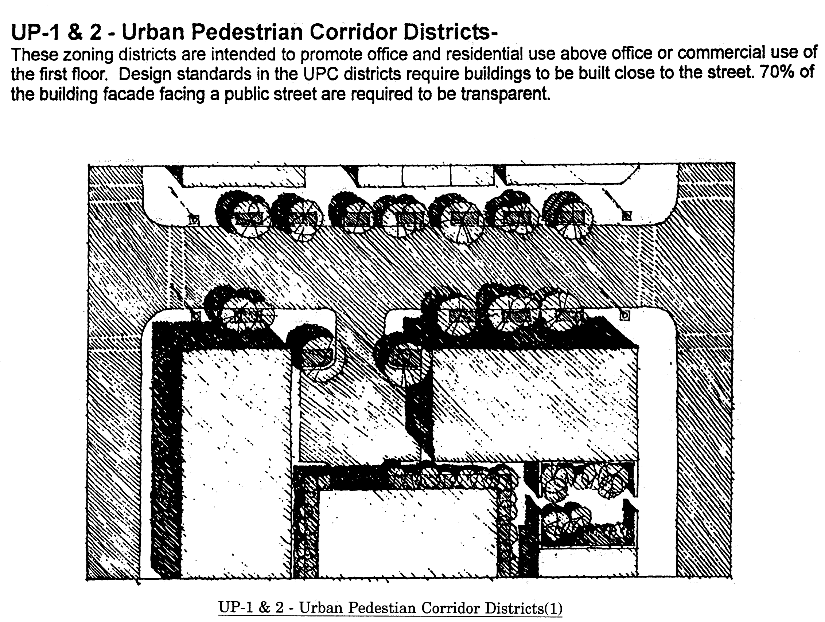
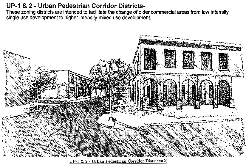
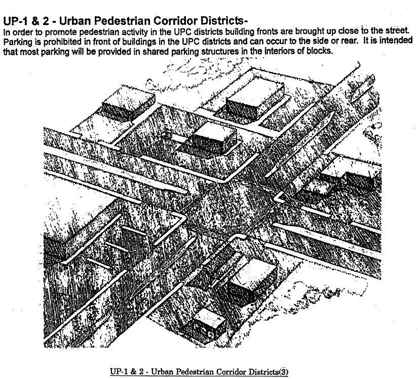
(Code 1992, § 10-6.651; Ord. No. 07-20, § 2, 7-10-2007; Ord. No. 09-13, § 4, 3-19-2009; Ord. No. 16-07, § 12, 5-10-2016; Ord. No. 23-05, § 20, 2-21-2023)

Sec. 10-6.652. - M-1 Light Industrial District.

1. District IntentPermitted Uses
2. Principal Uses
3. Accessory Uses
 The M-1 district is intended to be located in areas designated Branfordville Mixed Use or Suburban on the future land use map of the Comprehensive Plan shall apply to urban areas with convenient access to transportation facilities, where light manufacturing, processing, storage, community and recreational facilities and other activities compatible with light industrial operations are permitted. The district is not intended to accommodate heavy industrial operations or to accommodate commercial or residential development which would restrict the principal light industrial operations. (1) Armored truck services.
(2) Assembly of apparel and accessories.
(3) Automotive service and repair, including car wash.
(4) Bottling plants.
(5) Broadcasting studios.
(6) Building contractors and related services.
(7) Cemeteries.
(8) Communications and utilities.
(9) Community services, including vocational schools and police/fire stations. Libraries, elementary, middle, or high schools are prohibited. Other community services may be allowed in accordance with section 10-6.806.
(10) Crematoriums.
(11) Distribution facilities.
(12) Dry cleaning plants.
(13) Food processing, excluding slaughter.
(14) Golf courses.
(15) Gun firing ranges (indoor).
(16) Heavy infrastructure (maintenance yards, motor pools, airports, landfills, sewage treatment plants, etc.).
(17) Laboratories: research and development activities.
(18) Lawn and tree removal services.
(19) Manufacturing (consistent with the definition of light industrial).
(20) Non-medical offices and services, including business and government offices and services.
(21) Off-street parking facilities.
(22) Passive and active recreational activities.
(23) Post control services.
(24) Printing and publishing.
(25) Repair services, non-automotive.
(26) Towing, wrecking, and recovery services.
(27) Transportation and freight handling activities.
(28) Warehouses, miniwarehouses, or self-storage facilities.
(29) Welding and machine shops.
(30) Wholesale activities.
(31) Wholesale building supplies.
(32) Other uses, which in the opinion of the County Administrator or designee, are of a similar and compatible nature to those uses described in this district.
(1) A lawfully established use or structure on the same lot with, and of a nature customarily incidental and subordinate to, the principal use or structure and which comprises no more than 33 percent of the gross floor area or of the principal use or structure, as determined by the County Administrator or designee. The 33-percent limitation does not apply to outdoor storage that is accessory to a permitted principal use.
(a) Light infrastructure and/or utility services and facilities necessary to serve permitted uses, as determined by the County Administrator or designee.
(b) Residential use (intended for watchman or guard not to exceed one dwelling unit per industrial use).
(c) Outdoor storage (without the 33 percent limitation), provided it complies with subsection 7 of this section.
(d) The following uses are permitted accessory uses in this district:
1. Eating and drinking establishments such as cafeterias or snack bars, (located within the interior of any permitted use.)
2. Temporary employment.
3. Security guard service.
4. Day care centers—Licensed day care services as described in and regulated by section 10-6.811.
5. Recreational amenities—Provided as an accessory to a permitted uses established within the district for use by employees management and their guests.
6. Retail sales, provided the sales are directly related to the principal light industrial uses, e.g., gun sales at an indoor shooting range. Retail sales must be limited to no more than 33 percent of the gross floor area.


Development Standards
4. Minimum Lot or Site Size5. Minimum Building Setbacks6. Maximum Building Restrictions
Use Categorya. Lot or Site Areab. Lot Widthc. Lot Deptha. Frontb. Side-
Interior Lot
c. Side-
Corner Lot
d. Reara. Building Size (excluding gross building floor area used for parking)b. Building Height (excluding stories used for parking)
Permitted Principal Commercial Uses Number (3), (21), (25) None None None 25 feet None 25 feet 10 feet 10,000 square feet of gross building floor area parcel. 3 stories
All Other Permitted Principal Non-residential Uses None None None 25 feet None 25 feet 10 feet 2,500 square feet of commercial floor area per acre. 50,000 Square feet of gross building floor area per acre for storage areas within buildings 3 stories
7. Criteria for Outdoor Storage: Outdoor storage is permitted as an accessory use to a permitted principal use (without the 33 percent limitation) if the outdoor storage area is screened with an opaque material (an opaque material may include vegetation. The opacity requirements are as follows: 100 percent along any property line that adjoins an existing residential use; 80 percent along any property line that adjoins any other type of use other than residential (commercial, office, etc.) or a street right-of-way. The determination of the adequacy of the opaque material will be evaluated at the time of permitting.
8. Street Vehicular Access Restrictions: Properties in the M-1 zoning district may have vehicular access to any type of street. However, in order to protect residential areas and neighborhoods from non-residential traffic, vehicular access to a local street is prohibited if one of the following zoning districts is located on the other side of the local street: RA, R-1, R-2, R-3, R-4, R-5, MH, MR-1, and RP.
9. Fencing Requirement: All areas proposed for use, currently used, or previously used, in open-pit mining operations and/or construction and demolition debris disposal must be secured by a fence, unless the area is determined to be a reclaimed open-pit mine by the County Administrator or designee. The fence must be at least 4 feet in height with openings that will reject the passage of a seven-inch diameter sphere. The fence must be equipped with a gate which shall remain locked when workers or employees of the land owner or mining company are not present at the site. At every gate or access point, at least one sign must be posted which states, in at least four-inch tall letters, "Danger," "Keep Out," "No Trespassing," or similar language to indicate that there may be hazardous conditions on the premises.


General notes:

(1)

If central sanitary sewer is not available, residential development is limited to a minimum of 0.50-acre lots and non-residential development is limited to a maximum of 900 gallons of wastewater flow per day. Community service facilities are limited to no more than 5,000 square feet, or a sewage flow not to exceed 900 gallons per day. Also, refer to Sanitary Sewer Policies 1.2.3 and 2.1.2 of the Utilities Element of the Comprehensive Plan for additional requirements.

(2)

Refer to the Environmental Management Act (EMA) for information pertaining to the regulation of environmental features (preservation/conservation features), stormwater management requirements, etc.

(3)

Refer to the concurrency management ordinance for information pertaining to the availability of capacity for certain public facilities (roads, parks, etc.).

(Code 1992, § 10-6.652; Ord. No. 07-20, § 2, 7-10-2007; Ord. No. 08-17, § 5, 7-22-2008; Ord. No. 09-13, § 4, 3-19-2009; Ord. No. 13-06, § 3, 3-12-2013; Ord. No. 14-16, § 1, 11-18-2014; Ord. No. 23-05, § 21, 2-21-2023)

Sec. 10-6.653. - IC Interchange Commercial District.

1. District IntentPermitted Uses
2. Principal Uses
3. Accessory Uses
 The IC district is intended to promote economic opportunities which are supported by an economic base larger than the county in which a mixture of hotel, restaurants, retail shopping uses, office, light manufacturing, processing, storage, community and recreational facilities are permitted. The IC district may be located adjacent to an interchange with Interstate Highway 10 (I-10) in areas designated Suburban on the future land use map of the Comprehensive Plan. This district is intended to encourage significant investment in property improvements and provide a concentration of economic activity. The minimum district size is 40 acres.
 The district is not intended to accommodate heavy industrial operations, such as truck stops or uses requiring outside storage, not to accommodate residential development which would limit the ability of the district to attain its economic potential.
 The district is intended for intensive uses which benefit from locations adjacent to interchanges with I-10, and which will facilitate commercial activity directly related to through traffic on I-10.
 The IC district establishes minimum development criteria and design criteria which are intended to prevent underachievement of economic development objectives and to ensure high quality development.
 The maximum gross density allowed for residential development in the IC district is 16 dwelling units per acre while the minimum gross density allowed is six dwelling units per acre. The minimum gross density requirements may be eliminated if constraints of concurrency or preservation and/or conservation features preclude the attainment of minimum densities.
(1) Automotive service and repair, including car wash as part of a shopping center, in conjunction with a motel or hotel or approved as a PUD.
(2) Broadcasting studios.
(3) Commercial recreation and entertainment uses.
(4) Communications and utilities.
(5) Community services, including libraries, vocational schools and police/fire stations. Elementary, middle, or high schools are prohibited. Other community services may be allowed in accordance with section 10-6.806.
(6) Day care centers.
(7) Distribution facilities.
(8) Hotels and motels, including bed and breakfast inns.
(9) Laboratories: research and development activities.
(10) Manufacturing (consistent with the definition of light industrial).
(11) Motels and hotels.
(12) Office uses.
(13) Off-street parking facilities.
(14) Passive and active recreational activities.
(15) Personal services (barber shops, fitness clubs, etc.).
(16) Printing and publishing.
(17) Repair services, non-automotive.
(18) Retail uses permitted in CP as part of a shopping center or approved as a PUD.
(19) Transportation and freight handling activities.
(20) Warehouses, miniwarehouses, or self storage facilities.
(21) Other uses, which in the opinion of the Land Use Administrator, are of a similar and compatible nature to those uses described in this district.
(1) A use or structure on the same lot with, and of a nature customarily incidental and subordinate to, the principal use or structure and which comprises no more than 33 percent of the floor area or cubic volume of the principal use or structure, as determined by the County Administrator or designee. The 33 percent limitation does not apply to outdoor storage that is accessory to a permitted principal use.
(2) Light infrastructure and/or utility services and facilities necessary to serve permitted uses, as determined by the County Administrator or designee.
(3) Residential use (intended for watchman or guard not to exceed 1 dwelling unit per industrial use).
(4) Outdoor storage (without the 33 percent limitation), provided it complies with section 7 of this section.


Development Standards
4. Minimum Lot or Site Size5. Minimum Building Setbacks6. Maximum Building Restrictions
Use Categorya. Lot or Site Areab. Lot Widthc. Lot Deptha. Frontb. Side-
Interior Lot
c. Side-
Corner Lot
d. Reara. Building Size (excluding gross building floor area used for parking)b. Building Height (excluding stories used for parking)
Permitted Non-Industrial or Non-Office Principal Uses None None 1,000 square feet 50 feet None 25 feet 10 feet 25,000 square feet of gross building floor area per acre not to exceed 200,000 square feet per site.
50,000 square feet of gross building floor area per acre for storage areas within buildings.
4 stories
All Other Principal Uses None None 1,000 square feet 50 feet None 25 feet 10 feet 25,000 square feet of gross building floor area per acre. 50,000 square feet of gross building floor area per acre for storage areas within buildings. 4 stories
7. Urban Design Criteria—Development within the IC district shall meet the following criteria:
a. All buildings elevations which may be viewed from a public street shall be finished in brick, stucco, glass curtain wall, architectural concrete or textured block. All building elevations which may be viewed from a public street shall have an uniform appearance consistent with the front building elevation.
b. All buildings shall screen utility connections, roof top equipment and meter locations with materials found on the building exterior or with evergreen landscaping.
c. All buildings shall screen trash collection/storage areas with materials found on the exterior of the building.
d. All delivery truck docks shall provide a screen of sufficient height and length to screen loading and unloading trucks.
e. Sidewalks shall be a minimum six feet in width and form a continuous system on the site.
f. All electrical and telecommunication utilities shall be located underground except for antennae.
g. Parking shall not exceed a concentration of 100 spaces per net acre of parking lot and adjacent landscaping.
h. Each development within the IC district shall establish a uniform sign design for all signs.
i. Parking lots and driveways shall be designed to achieve a 60 percent tree canopy coverage within ten years of development.
j. All development shall develop and maintain a 30-foot landscape area adjacent to all public streets. This landscape area shall have at least one street tree for every 40 feet of street frontage. The landscape area may contain a sidewalk and be crossed by driveway entrances no wider than 30 feet.
8. Street Access Restrictions: Properties within the IC zoning district may have vehicular access to the types of streets listed below. For the purpose of this section, a "type" of street refers to the functional classification of the street according to the "Roadway Functional Classification" map adopted in the transportation element of the 2010 Comprehensive Plan. Also for the purpose of this section, a street is considered to be "at the border" of the M-1 zoning district if a zoning district other than the M-1 zoning district is located on the other side of the street.
a. To any street classified as a collector or arterial that is located inside or at the border of the IC zoning district;
b. To any street classified as a local that is located inside of the IC zoning district; or
c. To any street classified as a local that is located at the border of the IC zoning district, except that properties in the IC zoning district shall not have vehicular access to a local street if the local street is located at the border of the M-1 zoning district and a residential zoning district is located on the other side of the local street. For the purpose of this section, residential zoning districts include the following: RA, R-1, R-3, R-4, R-5, MR, MR-1, and the RP zoning districts.


General notes:

(1)

If central sanitary sewer is not available, residential development is limited to a minimum of 0.50-acre lots and non-residential development is limited to a maximum of 900 gallons of wastewater flow per day. Community service facilities are limited to no more than 5,000 square feet, or a sewage flow not to exceed 900 gallons per day. Also, refer to Sanitary Sewer Policies 1.2.3 and 2.1.2 of the Utilities Element of the Comprehensive Plan for additional requirements.

(2)

Refer to the Environmental Management Act (EMA) for information pertaining to the regulation of environmental features (preservation/conservation features), stormwater management requirements, etc.

(3)

Refer to the concurrency management ordinance for information pertaining to the availability of capacity for certain public facilities (roads, parks, etc.).

(Code 1992, § 10-6.653; Ord. No. 07-20, § 2, 7-10-2007; Ord. No. 09-13, § 4, 3-19-2009; Ord. No. 22-17, § 4, 6-14-2022; Ord. No. 23-05, § 22, 2-21-2023)

Sec. 10-6.654.1. - MCN Mahan Corridor Node District.

1. Purpose and Intent2. Allowable District Location
 The Mahan Corridor Node (MCN) zoning district is intended to implement the Mahan Gateway Node FLUM category of the Comprehensive Plan. The MCN zoning district allows residential development, within a range of 6—12 dwelling units per acre; or, up to 16 dwelling units per acre when incentives are used. The MCN zoning district allows non-residential development of up to 8,000 square feet floor area per acre; or, up to 12,000 square feet floor area per acre when incentives are used. Incentives for greater development density or intensity are provided for mixed-use development. Gross development intensities may be reduced in those instances where environmental limitations affect the amount of area that may be developed in any particular location. Non-residential development allowed within this district is limited to office, nonautomotive related retail, services, and community facilities.
 The district is intended to accomplish the following:
• Preserve the attractive Mahan Drive gateway corridor;
• Preserve the through-traffic mobility function and limit congestion of Mahan Drive by limiting direct access and promoting an interconnected local street network;
• Accommodate compact mixed-use development at major intersections to provide convenience for area residents by providing access to common goods, services, and recreation within a short distance of home;
• Provide a development pattern that is transit supportive, based on a high degree of interconnected streets, and a compact layout of use that addresses streets and sidewalks;
• Create a development pattern that maximizes infrastructure and environmental efficiency by concentrating non-residential uses around major intersections;
• Protect community health and safety by minimizing automobile dependency and reducing vehicle miles traveled through design supporting a variety of travel modes;
• Create a community where travel by foot and bicycle is safe, convenient, and comfortable;
• Minimize stormwater runoff by limiting surface area devoted to parking; and
• Facilitate compatibility with nearby neighborhoods through buffers, transitioning building mass and scale, and through careful site design.
a. The district may only be located within areas designated Mahan Gateway Node on the future land use map.
b. The district location is further limited to specific locations within the FLUM category, as follows:
i. The MCN zoning district shall be located at those areas immediately surrounding the intersection of Mahan Drive and Dempsey Mayo Road, Edenfield Road/Highland Drive, and Thornton Road.
ii. The MCN zoning district shall not extend more than 800 feet in either direction from the intersection of Mahan Drive and the perpendicular cross streets referenced in subsection (i) of this section, nor shall it extend away from Mahan Drive more than 1,200 feet.
iii. Future applications of the MCN zoning district shall not be approved if abutting parcels designated residential preservation on the FLUM.
iv. Regardless of the provisions in subsections i through iii of this section, the MCN zoning district is applicable in all areas designated Mahan Residential Corridor Node on the FLUM as of January 30, 2009.
c. Within the areas described in subsection (b) of this section, the location of the district may be further limited to facilitate compatibility with existing, adjoining residential preservation FLUM areas, minimize potential adverse environmental impacts, to correspond district boundaries with lot lines, or in recognition of physiographic features.


PERMITTED, PROHIBITED AND CONDITIONAL USES
3. Principal Uses4. Prohibited Uses5. Conditional Uses and Applicable Conditions
6. Accessory Uses
(1) Community facilities/service.
(2) Office—medical.
(3) Office—nonmedical.
(4) Recreation facility—passive.
(5) Residential—multifamily.
(6) Residential—single-family attached.
(7) Residential—two-family.
(8) Restaurant.
(9) Retail commercial.
(10) School—elementary, middle, high and vocational
(1) Automotive and boat, sales, services, repair, and rental.
(2) Building contractors and related services.
(3) Campgrounds and recreational vehicle parks, except where legally established and in existence prior to January 1, 2010.
(4) Car rental.
(5) Car wash facilities.
(6) Cocktail lounges and bars.
(7) Drive-through facilities.
(8) Funeral homes.
(9) Fuel/oil dealers and liquefied petroleum (LP) dealers.
(10) Golf courses.
(11) Heavy equipment rental.
(12) Manufactured home parks.
(13) Motor vehicle fuel sales.
(14) Outdoor storage.
(15) Residential—mobile homes and standard design manufactured homes.
(16) Schools—high.
(17) Scrap material storage or processing.
(18) Towing, wrecking, and recovery.
(19) Warehouses and self-storage.
(20) Welding and machine shops.
(21) Wholesale trade.
(1) Daycare centers.
a. May be established after 300 dwelling units have been built within one-half-mile radius; or
b. May be established as part of a development application including other uses, in which case, must be limited to no greater than 45 percent of the total development floor area; and
c. May not obtain a certificate of occupancy prior to the issuance of certificate for no less than 45 percent of the remainder of the development.
(2) Small appliance repair.
a. All repair activity shall occur within an enclosed structure;
(3) Hotels, motels, bed and breakfast inns.
a. Shall be located no less than 300 feet from areas designated residential preservation on the FLUM; and
b. Shall not exceed 15 guest rooms.
(4) Commercial kennels or pet day care.
a. Shall be an accessory use to a veterinary clinic or pet store.
b. Outside boarding and unsupervised outside activity are prohibited.
(5) Shared stormwater management facilities.
a. Shall be designed as an amenity.
b. Safety fences shall be planted with vegetation equal to the fence height at plant maturity.
(1) Any use or structure on the same lot with, and of a nature customarily incidental and subordinate to, the principal use or structure, as determined by the County Administrator or designee.
(2) Light infrastructure and/or utility services and facilities necessary to serve permitted uses, as determined by the County Administrator or designee.


DEVELOPMENT STANDARDS
7. Density, Intensity and Building Restrictions8. Lot or Site Area Restrictions9. Building Setbacks
Use Categorya. Allowable Densities (dwelling units/acre)b. Allowable Intensities (square feet/acre)c. Maximum Building Heighta. Minimum Lot Areab. Lot Widthc. Minimum Lot Deptha. Frontb. Side Interiorc. Side Cornerd. Rear
Single Use Development
Single-Family Attached Residential Min: 6
Max: 10
With master planning bonus: 16
See section 12 of this section.
N/A 35 feet N/A N/A N/A Min: 10 feet
Max: 15 feet
Min: 0 feet
Max: 10 feet
Adjoins RP Future Land Use Category: 25 feet min.
Min: 10 feet
Max: 15 feet
Min: 20 feet
Adjoins RP Future Land Use Category: 40 feet min.
Multifamily Residential Min: 6
Max: 10
With master planning bonus: 16
See subsection 12 of this section.
N/A 35 feet N/A N/A N/A Min: 5 feet
Max: 15 feet
Min: 10 feet
Max: 15 feet
Adjoins RP Future Land Use Category: 40 feet min.
Min: 10 feet
Max: 15 feet
Min: 20 feet
Adjoins RP Future Land Use Category: 40 feet min.
Non-Residential and Community Facilities N/A 8,000 square feet/ac; 10,000 square feet/ac with master planning bonus
See section 12 of this section.
35 feet N/A N/A N/A Min: 5 feet
Max: 15 feet
Min: Zero abutting buildings or 10 feet
Max: 15 feet
Adjoins RP Future Land Use Category: 40 feet min.
Min: Zero
Max: 15 feet
Min: 20 feet
Adjoins RP Future Land Use Category: 40 feet min.
Mixed-Use Development
Mixed-Use Development Min: 6
Max: 12
With master planning bonus: 16. See subsections 11 and 12 of this section.
10,000 square feet/ac; 12,000 square feet/ac with master planning bonus.
See sections 11 and 12 of this section.
45 feet N/A N/A N/A Min: 5 feet
Max: 15 feet
Min: Zero abutting buildings or 10 feet
Max: 15 feet
Adjoins RP Future Land Use Category: 40 feet min.
Min: 10 feet
Max: 15 feet
Min: 20 feet
Adjoins RP Future Land Use Category: 40 feet min.


10. Building Size Standards
Use Category
a. Maximum Building Footprint
b. Maximum building floor area per structure
Single-Family Attached Residential N/A N/A
Multifamily Residential 15,000 square feet N/A
Non-Residential and Community Facilities Standard: 8,000 square feet
With master planning bonus: 10,000 square feet
Standard: 14,000 square feet
With master planning bonus: 20,000 square feet
Mixed-Use Development Standard: 10,000 square feet
With master planning bonus: 15,000 square feet
Standard: 30,000 square feet
With master planning bonus: 40,000 square feet
11. Mixed Use Incentive Qualifications: Developments incorporating both residential and non-residential uses within a single development application or those which retrofit an existing development to include both residential and non-residential uses, qualify for additional density and intensity provided for mixed-use development, pursuant to the following criteria:
a. At the completion of all development phases, no less than 20 percent of the gross floor area within the development is devoted to either residential use or non-residential use;
b. The development consists of a mixture of uses within a single building or within multiple adjacent buildings, wherein the different uses are located no further than 200 feet apart; and,
c. The development application must provide a common plan for the development of all included parcels, including shared infrastructure.
12. Master Planning Bonus: The following shall be entitled to the master planning bonus:
a. Any development site area of 8 or more acres;
b. Development site area of 5 or more acres wherein at least 50 percent of associated off-street parking will be provided in a shared facility; and at least 50 percent of the surface area required for stormwater management facility area is located below grade, or in a shared facility; or
c. The development site area may be composed of multiple parcels; in those instances, the development application must provide a common plan for the development of all included parcels.
13. Access Management:
a. Direct access to Mahan Drive shall be limited and provided via public right-of-way.
b. There shall be no more than one public right-of-way connection to Mahan Drive and to each adjacent collector street per each nodal quadrant; until such time as a street system is created to provide access to all parcels adjoining Mahan Drive and the adjacent collector street, individual properties may obtain access, if needed, on a temporary basis.
c. Applicants for development shall enter an agreement to cooperate in any future project to consolidate access points or to share access with abutting properties as opportunities arise.
14. Blocks, Frontage, and Sidewalks: Street design and layout shall support an interconnected street network and pattern of a scale conducive to pedestrian and bicycle use.
a. Block length: Long side: 600 feet maximum, except where divided by a mid-block pedestrian crossing or alley, in which case, maximum block length may be 850 feet. Short side: Distance may vary between 200 and 400 feet to accommodate environmental and physiographic limitations.
b. Mid-block pedestrian crossings: A publicly accessible pedestrian crossing shall be provided for blocks with a length greater than 600 feet on one or more sides.
c. Sidewalk width and placement: Frontage sidewalks shall be a minimum of 8 feet in width. All other sidewalks shall be no less than 5 feet in width.
d. Pedestrian weather protection: Where practical, non-residential and mixed-use buildings shall provide weather protection, arcade, awning, etc., along the frontage sidewalk extending at least 3 feet.
e. Alternative Surface Material: Use of distinctive paving texture, type, and color for transitions between neighborhoods and within pedestrian areas is encouraged. Interconnections between neighborhoods should also be distinguished through the use of vertical architectural elements, such as archways, gateways, or bollards.
15. Street Trees: All development or redevelopment shall incorporate street trees within the right-of-way, preferably between the back of curb and sidewalk.
a. Street trees shall be planted between 20—30 feet on center, except when a greater distance may be required to avoid conflict with visibility, street lamps, utilities, or safety issues would be compromised with the required location.
b. A minimum planting strip of six feet shall be provided between the back of curb and sidewalk, except where on-street parking is provided and tree wells or planters are more appropriate.
c. Tree selection and location shall be approved by the local utility provider and shall be no higher than 20 feet at maturity when located beneath power lines.
16. Parking:
a. Location: Parking shall not be located between the building facade and the right-of-way, and shall be located on-street, internal to the block, or to the rear of structures. Where site constraints necessitate, up to 25 percent of required parking may be permitted to the side of buildings.
b. On-street parking: All streets created or expanded in association with development in this district shall be designed to accommodate on-street parking.
c. Quantity: On-site parking shall be limited to a range of 40 percent to 70 percent of the general parking standard set forth in section 10-7.545, schedule 6-2. On-street parking, provided on adjacent rights-of-way within the MCN zoning district without crossing an arterial or collector street may be counted towards meeting the parking requirement. Shared parking may also count toward the requirement.
d. Size: Individual off-street surface parking lots shall not exceed 0.75 acre.
17. Building Position:
a. Orientation: The principal building entryway shall be oriented to the street, other than Mahan Drive, and be designed to provide direct pedestrian access from that street. Where buildings are equidistant to two or more streets, the principal entryway may be located on either street. Buildings may be oriented toward Mahan Drive so long as there is a parallel street located between Mahan Drive and the building.
b. Encroachments: Porches, balconies, patios, pedestrian weather protection features and other like architectural features may encroach into 50 percent of the front setbacks. Seating within the required yard setbacks shall be allowed. Encroachments, permanent and temporary, shall not result in a constrained pedestrian passageway of less than 5 feet in width.
18. Building Facade Length: Non-residential and mixed-use building facades along any public street frontage shall not exceed 100 feet, unless vertical structural elements and functional entrance doors divide that facade no less than every 50 feet.
19. Transparency: Adjacent to streets, sidewalks, and publicly accessible parking areas, non-residential and mixed-use buildings shall provide a minimum facade transparency of 50 percent at pedestrian level, between two and 8 feet above finished grade, and residential buildings shall provide a minimum facade transparency of 25 percent at pedestrian level.
20. Building Materials:
a. The following materials are prohibited: corrugated metal, standing seam, or v-crimp metal sheeting exterior walls or wall coverings.
b. The use of vinyl siding may not comprise more than 20 percent of any wall plane.
21. Roof types:
a. All roof types are allowed. The use of gable roofs, cross gable roofs, and dormers are encouraged for buildings of two stories or less.
b. Flat roofs shall provide horizontal articulation with a building cap at the top of the building base and/or incorporate the use of parapets.
22. Buffering, Fencing, and Screening:
a. Buffer zone standards: Buffering is not required between uses in the MCN zoning district. Where development abuts Residential Preservation future land use areas, the landscape buffer standards of section 10-7.522 shall apply.
b. Fencing: Chainlink fencing visible from public right-of-way or property is prohibited, unless screened by vegetation that covers completely at plant maturity.
c. Screening of service connections and facilities: Outdoor service areas; loading docks, trash collection, outdoor storage, mechanical equipment; shall be mitigated by the use of screening material consistent with the materials and design treatments of the primary facade of the primary building and/or evergreen landscape plant material.
i. Landscape plans shall provide sight lines for natural surveillance between 3 and 8 feet above grade.
ii. The service areas shall not be within 50 feet of any adjoining residential property.
iii. The service areas shall be screened with vegetation and fences/masonry walls that are of sufficient height (minimum six feet) and opacity (minimum 50 percent) to screen from nearby streets and residential areas. Fences or masonry walls shall be constructed with materials that are incorporated in the design of the principal building.
iv. Above ground utility boxes visible from the street shall be screened with landscaping on at least two sides, thereby preserving access for the utility provider.
d. Off-street parking; landscaping: A minimum ten-feet wide landscaping strip shall line the perimeter of surface parking lots, and shall be landscaped with one canopy tree per 20 linear feet of frontage and a continuous row of shrubbery not to exceed 3 feet at maturity.
e. Required landscaping; alternative compliance methods. Development is encouraged to utilize the site design alternatives set out in sections 110-4.347 and 10-4.350.
23. Lighting:
a. Intensity limits. Lighting levels at the property line as measured at six feet above ground level shall not exceed 0.5 footcandles. The footcandle average in on-site parking lots should not exceed 2.0 footcandles. The recommended maximum uniformity ratio (average: minimum light level) is 4:1.
b. Light fixture types and location:
i. "Shoebox" and "Cobrahead" lights are prohibited.
ii. All light fixtures shall be full cut-off type fixtures and direct light internal to the site.
iii. Individual light poles and wall mounted light fixtures shall be no taller than 20 feet above grade. Wall mounted light fixtures shall be placed no closer than every 25 feet along the facade. Lighted bollards are encouraged along pedestrian routes.
24. Stormwater Management Facilities:
a. Whenever possible, low impact development (LID) techniques such as rain gardens and bio-retention swales are encouraged to allow stormwater infiltration to occur as close to the source as possible. A decentralized stormwater management design which disperses stormwater facilities across the site rather than to a centralized treatment facility is encouraged.
b. Landscape vegetation shall be incorporated around the perimeter of the stormwater facility, which at maturity will visually conceal required fencing.
c. Landscape plants should be native. A minimum of four different species of trees and shrubs shall be utilized. Stormwater management facilities shall incorporate appropriate tree and plant species that take into account the soil, hydrologic, and other site and facility conditions. Existing vegetation should be incorporated into the facility design where possible.
25. Facility Accommodation Credit Exchange: Where land area is dedicated to the state, the county, or City of Tallahassee for public facility development, the associated development rights may be transferred in whole or part to any other parcel within the MCN district. The resulting density and intensity shall not be greater than 200 percent of the amount which would otherwise be authorized to be developed.


General notes:

1.

If central sanitary sewer is not available, residential development is limited to a minimum of 0.50 acre lots and non-residential development is limited to a maximum of 900 gallons of wastewater flow per day. Community service facilities are limited to no more than 5,000 square feet, or a sewage flow not to exceed 900 gallons per day. Also, refer to Sanitary Sewer Policies 1.2.3 and 2.1.2 of the Utilities Element of the Comprehensive Plan for additional requirements.

2.

Refer to the Environmental Management Act (EMA) for information pertaining to the regulation of environmental features (preservation/conservation features), stormwater management requirements, etc.

3.

Refer to the concurrency management ordinance for information pertaining to the availability of capacity for certain public facilities (roads, schools, parks, etc.).

(Code 1992, § 10-6.654.1; Ord. No. 10-07, § 3, 3-23-2010; Ord. No. 16-07, § 13, 5-10-2016; Ord. No. 22-17, § 5, 6-14-2022; Ord. No. 23-05, § 23, 2-21-2023)

Sec. 10-6.654.2. - MCR Mahan Corridor Ring District.

1. District IntentALLOWABLE USES
2. Principal Uses3. Conditional Uses and Applicable

Conditions

4. Accessory Uses
 The Mahan Corridor Ring (MCR) zoning district is intended to be located in areas designated Mahan Gateway Node on the FLUM of the Comprehensive Plan. The purpose of the MCR district is to facilitate compact residential development and community facilities immediately surrounding the Mahan Corridor Node district. The MCR district is anticipated to provide convenient access to goods and services, opportunities for increased choice of transportation modes, and a safe, convenient, and comfortable pedestrian environment. In addition, the MCR district, when located adjacent to RP FLUM areas, is intended to serve as a transition area between the higher intensity/density uses of the Mahan Corridor Node zoning district. Development standards are included which are intended to facilitate compatible scale and design with adjoining RP FLUM areas. The MCR district is anticipated to contain a wide range of housing types and community facilities related to residential uses. Residential development in the MCR district is permissible in the range of 4 to 10 dwelling units per acre. (1) Single-family detached dwellings;
(2) Zero-lot line, single-family detached dwellings;
(3) Single-family attached dwellings;
(4) Two-family dwellings;
(5) Multifamily dwellings; and
(6) Passive recreation
(1) Community facilities and services related to residential uses including: religious facilities, police/fire stations, day care centers, nursing homes, residential care facilities, and elementary and middle schools.
a. Community facility uses immediately adjacent to RP Future Land Use areas shall provide adequate buffers as per section 10-7.522.
b. Community facility uses shall comply with the applicable provisions of section 10-6.806.
(1) A use or structure on the same lot with, and of a nature customarily incidental and subordinate to, the principal use or structure.
(2) Light infrastructure and/or utility services and facilities necessary to serve allowable uses, as determined by the County Administrator or designee.


DEVELOPMENT STANDARDS
5. Minimum Lot or Site
Size
6. Minimum Building Setbacks7. Maximum Building Restrictions
Use Categorya. Lot Areab. Lot Widthc. Lot Deptha. Frontb. Side-
Interior Lot
c. Side-
Corner Lot
d. Rear
(Alley setback)
a. Building Size b. Building Height
(See number 8)
Single-Family Detached Dwellings N/A 40 feet 70 feet 15 feet 5 feet 15 feet 20 feet
(5 feet from alley)
N/A 35 feet
Zero-Lot Line, Single-Family Detached Dwellings (not allowed when adjoining RP Future Land Use areas) N/A 30 feet interior lot;
40 feet corner lot
70 feet 15 feet 0 feet one side;
6 feet other side
15 feet 20 feet
(5 feet from alley)
N/A 35 feet
Single-Family Attached Dwellings (not allowed when adjoining RP Future Land Use areas) N/A 20 feet 70 feet 15 feet N/A 15 feet 20 feet (5 feet from alley) Maximum length: 8 units 35 feet
Two-Family Dwellings (not allowed when adjoining RP Future Land Use areas) N/A 40 feet 70 feet 15 feet 5 feet 15 feet 20 feet
(5 feet from alley)
N/A 35 feet
Multifamily Dwellings (not allowed when adjoining RP Future Land Use areas) N/A 50 feet 80 feet 15 feet 15 feet 15 feet 25 feet Maximum 12,000 square ft building footprint 35 feet
Community Facilities and Service Uses N/A 50 feet 80 feet N/A 15 feet 15 feet 50 feet
(25 feet from alley)
8,500 square feet of gross building floor area per acre 35 feet
8. Building Height: When located immediately adjacent to RP Future Land Use areas, the maximum building height shall be 25 feet.
9. Roof Types:
a. All roof types are allowed. The use of gable roofs, cross gable roofs, and dormers are encouraged for non-residential buildings.
b. Flat roofs shall provide horizontal articulation with a building cap at the top of the building base and/or incorporate the use of parapets.
10. Encroachments: Porches, balconies, patios, pedestrian weather protection features and other like architectural features may encroach into 50 percent of the front setbacks. Encroachments, permanent and temporary, shall not result in a constrained pedestrian passageway of less than 5 feet in width.
11. Access Management:
a. Direct access to Mahan Drive shall be limited and provided via public right-of-way.
b. There shall be no more than one public right-of-way connection to Mahan Drive and to each adjacent collector street per each nodal quadrant; until such time as a street system is created to provide access to all parcels adjoining Mahan Drive and the adjacent collector street, individual properties may obtain access, if needed, on a temporary basis.
c. Applicants for development shall enter an agreement to cooperate in any future project to consolidate access points or to share access with abutting properties as opportunities arise.
12. Blocks, Frontage, and Sidewalks: Street design and layout shall support an interconnected street network and pattern of a scale conducive to pedestrian and bicycle use.
a. Block length: Long side: 600 feet maximum, except where divided by a mid-block pedestrian crossing or alley, in which case, maximum block length may be 850 feet. Short side: Distance may vary between 200 and 400 feet to accommodate environmental and physiographic limitations.
b. Mid-block pedestrian crossings: A publicly accessible pedestrian crossing shall be provided for blocks with a length greater than 600 feet on one or more sides.
c. Sidewalk width and placement: All sidewalks shall be no less than 5 feet in width.

13. Off-Street Parking:
a. All off-street residential parking shall be either side-entry, rear-loaded (accessed by alley) or recessed as noted in subsection b of this section).
b. Recessed garages shall be setback, at minimum, an additional 10 feet from the street than the front facade of the principal structure.
c. All off-street parking associated with community facilities shall be located to the side or rear of the principal structure and shall meet the screening requirements set forth in subsection 14 of this section.
d. The use of shared driveways is encouraged, where there is the ability to reduce impervious surface area and stormwater runoff.
14. Buffering, Fencing, and Screening:
a. Buffer zone standards: Buffering is not required between uses within the MCR zoning district. Where development abuts a residential zoning district, the landscape buffer standards of section 10-7.522 shall apply.
b. Fencing: Chainlink fencing visible from public right-of-way or public property is prohibited.
The following provisions (subsections c through e of this section) apply only to community facilities or non-residential uses:
c. Screening of service connections and facilities: Outdoor service areas, loading docks, trash collection, outdoor storage, mechanical equipment, shall be mitigated by the use of screening material consistent with the materials and design treatments of the primary facade of the primary building and/or evergreen landscape plant material.
i. Landscape plans shall provide sight lines for natural surveillance between 3 and 8 feet above grade.
ii. The service areas shall not be within 50 feet of any adjoining residential property.
iii. The service areas shall be screened with vegetation and fences/masonry walls that are of sufficient height (minimum six feet) and opacity (minimum 50 percent) to screen from nearby streets and residential areas. Fences or masonry walls shall be constructed with materials that are incorporated in the design of the principal building.
iv. Service area gates to any enclosure shall be solid wood or metal doors.
v. Above ground utility boxes visible from the street shall be screened with landscaping on at least two sides, thereby preserving access for the utility provider.
d. Off-street parking; landscaping: A minimum 10-feet wide landscaping strip shall line the perimeter of surface parking lots, and shall be landscaped with one canopy tree per 20 linear feet of frontage and a continuous row of shrubbery not to exceed 3 feet at maturity.
e. Required landscaping; alternative compliance methods. Development is encouraged to utilize the site design alternatives set out in sections 10-4.347 and 10-4.350.
15. Street Trees: All development or redevelopment shall incorporate street trees within the right-of-way, preferably between the back of curb and sidewalk.
a. Street trees shall be planted between 20—40 feet on center, except when a greater distance may be required to avoid conflict with driveways, street lamps, other utilities, or visibility or safety issues would be compromised with the required location.
b. A minimum planting strip of six feet shall be provided between the back of curb and sidewalk, except where on-street parking is provided and tree wells or planters are more appropriate.
c. Tree selection and location shall be approved by the local utility provider and shall be no higher than 20 feet at maturity when located beneath power lines.
16. Stormwater Management Facilities:
a. Whenever possible, low impact development (LID) techniques such as rain gardens and bio-retention swales are encouraged to allow stormwater infiltration to occur as close to the source as possible. A decentralized stormwater management design which disperses stormwater facilities across the site rather than to a centralized treatment facility is encouraged.
b. Landscape vegetation shall be incorporated around the perimeter of the stormwater facility, which at maturity will visually conceal required fencing.
c. Landscape plants should be native. A minimum of 4 different species of trees and shrubs shall be utilized. Stormwater management facilities shall incorporate appropriate tree and plant species that take into account the soil, hydrologic, and other site and facility conditions. Existing vegetation should be incorporated into the facility design where possible.
d. Landscaping shall be situated to visually integrate the stormwater system into the overall landscape design.
17. Lighting for Community Facilities and Non-Residential Uses:
a. Intensity limits: Lighting levels at the property line, as measured at six feet above ground level, shall not exceed 0.5 footcandles. The footcandle average in on-site parking lots should not exceed 2.0 footcandles. The recommended maximum uniformity ratio (average: minimum light level) is 4:1.
b. Light fixture types and location:
i. "Shoebox" and "cobrahead" lights are prohibited. Flood or spotlights used as general grounds lighting are prohibited.
ii. All light fixtures shall be full cut-off type fixtures and shall direct light internal to the site.
iii. Individual light poles and wall mounted light fixtures shall be no taller than 20 feet above grade. Wall mounted light fixtures shall be placed no closer than every 25 feet along the facade. Lighted bollards are encouraged along pedestrian routes.
iv. Exterior lighting shall not exceed 0.5 footcandles, as measured at the property line and six feet above grade.


General notes:

1.

If central sanitary sewer is not available, residential development is limited to a minimum of 0.50-acre lots and non-residential development is limited to a maximum of 900 gallons of wastewater flow per day. Community service facilities are limited to no more than 5,000 square feet, or a sewage flow not to exceed 900 gallons per day. Also, refer to Sanitary Sewer Policies 1.2.3 and 2.1.2 of the Utilities Element of the Comprehensive Plan for additional requirements.

2.

Refer to the Environmental Management Act (EMA) for information pertaining to the regulation of environmental features (preservation/conservation features), stormwater management requirements, etc.

3.

Refer to the concurrency management ordinance for information pertaining to the availability of capacity for certain public facilities (roads, schools, parks, etc.).

(Code 1992, § 10-6.654.2; Ord. No. 10-07, § 3, 3-23-2010; Ord. No. 22-17, § 6, 6-14-2022; Ord. No. 23-05, § 24, 2-21-2023)

Sec. 10-6.655. - Neighborhood boundary office.

(a)

Purpose and intent. The purpose and intent of this district is to provide minor office opportunities and higher intensity residential land uses up to a maximum of eight dwelling units per acre. The district is intended to be located on the edges of existing or planned single-family neighborhoods fronting on arterial and collector roadways and provides a transition between the residential development and more intensive development. This zoning district is not intended to be applied to the interior of an existing neighborhood or in areas designated as lake protection on the future land use map of the Comprehensive Plan. The provisions of this district are intended to allow higher density residential development and non-residential development that is compatible in scale and design with adjoining residential neighborhoods. The maximum amount of non-residential square footage allowed per acre is 10,000 square feet, but additional criteria may further limit that amount. Design guidelines applicable to this district include building orientation, lighting criteria for non-residential use, street vehicular access requirements, fencing, buffering, and screening requirements, noise source restrictions, and solid waste container restrictions.

(b)

Allowable uses. For the purpose of this article, the following land use types are allowable in this zoning district and are controlled by the land use development standards of this article, the Comprehensive Plan and schedules of permitted uses.

(1)

Low density residential.

(2)

Minor office.

(3)

Community facilities and services.

(c)

List of permitted uses. The activity or use may be classified as principal, accessory, restricted, or not allowed.

1. District IntentPermitted Uses
2. Principal Uses
3. Accessory Uses
 The Neighborhood Boundary Office (NBO) district is intended to be located in areas designated as neighborhood boundary on the future land use map of the Comprehensive Plan and shall apply to areas located on the edges of existing or planned single-family attached and detached residential neighborhoods fronting arterial and collector roadways. The NBO district is intended to provide minor office opportunities serving the immediate area and higher intensity residential land uses while providing a transition between the residential development and more intensive development and preserving roadway capacity through appropriate access management. The intent of the access management requirements associated with this district is to reduce access points along the roadway system, to provide for interconnectivity between non-residential developments within this land use category, and to encourage convenient walk-to work opportunities in close proximity to the residential areas it will serve. This zoning district shall not be applied to the interior of an existing neighborhood nor in areas designated as lake protection on the future land use map of the Comprehensive Plan. In addition, the NBO district shall not exceed 350 feet in depth parallel to the arterial or collector roadway in which it fronts or one (originally) platted lot whichever is less. The provisions of this district are intended to allow higher density residential development and non-residential development that is compatible in scale and design with adjoining residential neighborhoods. The NBO district is not intended to accommodate large scale office development. The maximum gross density allowed for new residential development in the NBO district is eight dwelling units per acre. (1) Offices (all types).
(2) Multi-family residential (any type except dormitories, fraternities and sororities) located on the second floor of a building containing the permitted office uses on the first floor.
(3) Residential: Single-family-attached dwellings; Single-family-detached dwellings; and Two-family dwellings.
(4) Community facilities and services related to residential uses including: elementary and middle schools.
4. Other uses, which in the opinion of the County Administrator or designee, are of a similar and compatible nature to those uses described in this district. Noise and lighting impacts shall be considered when determining the eligibility of additional land uses. (1) A use or structure on the same lot with, and of a nature customarily incidental and subordinate to, the principal use or structure and which comprises no more that 33 percent of the floor area or cubic volume of the principal use or structure, as determined by the County Administrator or designee.
(2) Light infrastructure and/or utility services and facilities necessary to serve permitted uses, as determined by the County Administrator or designee.


General notes:

(1)

If central sanitary sewer is not available, residential development is limited to a minimum of 0.50-acre lots and inside the Urban Service Area, non-residential development is limited to a maximum of 900 gallons of wastewater flow per day. Community service facilities are limited to no more than 5,000 square feet, or a sewage flow not to exceed 900 gallons per day. Also, refer to Sanitary Sewer Policies 1.2.3 and 2.1.2 of the Utilities Element of the Comprehensive Plan for additional requirements.

(2)

Refer to the Environmental Management Act (EMA) for information pertaining to the regulation of environmental features (preservation/conservation features), stormwater management requirements, etc.

(3)

Refer to the concurrency management ordinance for information pertaining to the availability of capacity for certain public facilities (roads, parks, etc.).

(4)

If setbacks have been previously established by a preliminary plat or recorded plat, then setbacks that have been established shall apply except where approved by the development review committee.

(d)

Development standards. All proposed development shall meet the buffer zone standards (section 10-7.522); the parking and loading requirements (subdivision 3, division 5, article VII of this chapter) and the land use development criteria as specified below:

Development Standards
4. Minimum Lot or Site Size5. Minimum Building Setbacks (Note 4)6. Maximum Building Restrictions
Use Categorya. Lot or Site Areab. Lot Widthc. Lot Deptha. Frontb. Side-
Interior Lot
c. Side-
Corner Lot
d. Reara. Building Size (excluding gross building floor area used for parking)b. Building Height (excluding stories used for parking)
Single-Family Detached Dwellings 5,000 square feet 50 feet 100 feet 20 feet 7.5 feet on each side; or any combination of setbacks that equals at least 15 feet, provided that no such setback shall be less than 5 feet. 15 feet 25 feet Not applicable 2 stories including floors devoted to parking.
Single-Family Attached Dwellings 3,750 square feet end unit; 2,400 square feet interior lot 37.5 feet end unit; 25 feet interior lot 80 feet 20 feet Not applicable 15 feet 25 feet Maximum length: 4 residential units 2 stories including floors devoted to parking.
Two-Family Dwellings 8,000 square feet 60 feet 100 feet 20 feet Same as for single-family detached dwellings 15 feet 25 feet A) Residential structures adjacent to existing single-family detached dwellings structures may not be less than 50 percent smaller than the smallest adjacent principal single-family detached dwelling structure: and
B) All other two-family residential has no size limitations.
2 stories including floors devoted to parking.
Any Permitted Non-Residential Principal Use None 80 feet None 25 feet 15 feet on each side 25 feet 25 feet A) Non-residential structures adjacent to existing residential single-family detached structures may not exceed 2 times that of the largest adjacent principal residential structure: and
B) All other no-residential structures shall not exceed 5,000 square feet of non-residential gross building floor area per parcel and 10,000 square feet per acre.
2 stories including floors devoted to parking.
Community Facilities and Service Uses N/A 50 feet 80 feet N/A 15 feet 15 feet 50 feet 8,500 square feet of gross building floor area per acre. 35 feet
7. Building Orientation:
a. Non-residential development and/or redevelopment of properties located at the intersection of arterial or collector roadways shall have a primary building entrance oriented toward the arterial or collector roadway.
8. Lighting Criteria for Non-Residential Uses: All nighttime lighting including wall mounted security lightning, shall not exceed 0.5 vertical surface footcandle measured at the property line 6 feet above grade. Lighting shall not exceed 10 feet in height and shall have recessed bulbs and filters, which conceal the source of illumination. No wall or roof mounted flood or spotlights used as general grounds lighting are permitted. Wall mounted security lighting is permitted.
9. Street Vehicular Access Requirements:
a. Properties in the NBO zoning district may have vehicular access to any type of street except where specifically prohibited by this section.
b. Residential developments shall have access to the street serving the adjoining residential neighborhood where possible.
c. Non-residential development is not permitted access onto the street serving the residential neighborhood, or local street, and must have access onto the collector or arterial roadway.
d. All new non-residential development shall construct a vehicular and pedestrian interconnection to adjoining properties that have an existing commercial use. Interconnections shall be required to adjoining vacant properties, which are zoned for commercial and/or office use. The vehicular interconnection shall be constructed with material consistent with constructed or proposed vehicular use areas. Location of such interconnections shall be approved by the county Engineer or designee and constructed prior to issuance of a certificate of occupancy. Required interconnections between properties and/or to a private or public roadway shall be placed in a cross access easement acceptable by the County Attorney. The parking standards committee shall approve exemptions to and deviations from the interconnection requirements of this section.
10. Fencing, Buffering and Screening Requirements:
a. Chainlink fencing is prohibited.
b. Buffering shall be in accordance with the provisions of section 10-7.522. Notwithstanding that any existing trees and vegetation are required to remain in place and must be used to either fully or partially satisfy the buffering requirements of section 10-7.522. In instances where existing trees and vegetation are not present or are not sufficient to satisfy the buffering requirements of section 10-7.522, then new plantings shall be required.
c. The off-site visual impacts associated with outdoor service functions or areas such as loading areas, trash collections, outdoor storage, or mechanical equipment shall be mitigated by the use of screening material consistent with the materials and design treatments of the primary facade of the primary building and/or evergreen landscape plant material.
d. On-site parking adjoining roadways shall be screened from view from public roadways by landscape buffers with a minimum height of 3 feet. Approved height of screening shall take into consideration the elevation of the site in relation to the public roadway.
e. Landscaping should be used to define on-site pedestrian corridors, building design elements, public areas, and viewscapes.
11. Noise Source Restrictions: In the event that a property zoned NBO abuts a residential property, the noise source of the NBO zoned property shall not exceed an L10 noise level of 60 dBA in the daytime (7:00 a.m. to 7:00 p.m.) and an L10 noise level of 50 dBA in the night time (7:00 p.m. to 7:00 a.m.) as measured on the property line abutting the source.
12. Solid Waste Restrictions: New development and redevelopment may not place solid waste facilities within 30 feet of an adjoining residential property. However, such facilities shall be screened with a material consistent with the principal structure. The use of solid waste facilities greater than 90 gallons is prohibited within in the NBO district.
13. Additional Criteria for the Construction of New Non-Residential Buildings and Additions: The overall goals of this district is to provide a unified sense of place, a pedestrian scale, and design that reflects the general character and scale of typical residential structures in adjacent neighborhoods. No particular architectural style or materials are mandated variety within these design criteria is encouraged. However, buildings shall be designed to reduce the mass, scale, and monolithic appearance of large structures. Flat roofs are prohibited. Roofs shall be designed with a minimum pitch of 4 in 12 (four feet of rise per 12 feet of run). The horizontal footprint of a single roof plane may not exceed 1,000 square feet. Doors and windows shall be placed to reflect the predominant character and scale of adjacent residential structures, and to provide natural surveillance opportunities to discourage criminal activities. Exterior walls shall be designed with doors or windows spaced horizontally no more than 14 feet from each other. For purposes of this requirement, doors and windows shall be defined as having a horizontal dimension of no less than 3 feet and no more than 10 feet. Development and redevelopment applications shall provide sufficient documentation including, but not limited to, architectural elevations (at time of site plan submittal) demonstrating that the proposed development is consistent with the following features of the adjoining neighborhood:
a. Building facades including building material, architectural style, and colors.
b. Roof form.
These criteria shall only apply to new construction and when building additions are being proposed.


General notes:

(1)

If central sanitary sewer is not available, residential development is limited to a minimum of 0.50-acre lots and inside the Urban Service Area, non-residential development is limited to a maximum of 900 gallons of wastewater flow per day. Community service facilities are limited to no more than 5,000 square feet, or a sewage flow not to exceed 900 gallons per day. Also, refer to Sanitary Sewer Policies 1.2.3 and 2.1.2 of the Utilities Element of the Comprehensive Plan for additional requirements.

(2)

Refer to the Environmental Management Act (EMA) for information pertaining to the regulation of environmental features (preservation/conservation features), stormwater management requirements, etc.

(3)

Refer to the concurrency management: ordinance for information pertaining to the availability of capacity for certain public facilities (roads, parks, etc.).

(4)

If setbacks have been previously established by a preliminary plat or recorded plat, then setbacks that have been established shall apply except where approved by the development review committee.

(e)

Specific restrictions. If uses are restricted according to the scheduled of permitted uses, they must follow the general development guidelines for restricted uses as provided in this division.

(Code 1992, § 10-6.655; Ord. No. 07-20, § 2, 7-10-2007; Ord. No. 16-07, § 14, 5-10-2016; Ord. No. 22-17, § 7, 6-14-2022; Ord. No. 23-05, § 25, 2-21-2023)

Sec. 10-6.656. - PD Planned Development District.

1. District IntentPermitted Uses
2. Principal Uses
3. Accessory Uses
 The purpose of the planned development (PD) district is to establish planning guidelines for large undeveloped areas, greater than 200 acres inside of the urban service area, and whose development could have substantial impacts on the community as a whole. This district has specific planning requirements to coordinate the development in a comprehensive manner consistent with Land Use Objective 6.1 of the Tallahassee-Leon County Comprehensive Plan. Development within this district shall provide a mixture of integrated uses (i.e., residential, commercial, office, light industrial, public open space, recreation) that are predominantly self-supporting, rather than predominantly dependent on public funding for additional infrastructure, and place a greater emphasis on pedestrian mobility and transportation alternatives. The allocation of uses within the PD shall be consistent with the mixed use percentages required for the suburban future land use category until modified by approval of a planned development master plan. This zoning district contains lands located in the planned development future land use category. Lands in this category are required prior to subdivision or development to allocate future land uses and intensities through the Comprehensive Plan amendment process. In addition, a planned development master plan, an area plan for development of all contiguous land holdings, is required to be approved concurrently with the Comprehensive Plan amendment. The planned development master planis consistent with the Comprehensive Plan, but is not formally adopted as part of the Comprehensive Plan. The planned development master planis implemented through approval of a PUD or alternatively for a proposed DRI, the DRI development order. The PD zoning district will be replaced on the zoning map by PUD or DRI zoning. The PUD district replacing the PD zoning district shall be consistent with the allowable uses established in the master plan.
 Owners of properties that contain less than 200 acres may request that their property be included in the PD district, Such requests will be subject to all of the applicable procedural requirements set forth in the zoning code.
To provide for a more self-supporting development pattern that is less oriented to the use of automobiles, the planned development master plan shall include four different land uses that are integrated with each other and at build-out result in internal capture of at least 20 percent of the trips generated by the development. The master plan shall provide the mix, location and intensities of future land uses. The master plan shall be consistent with section 10-6.678. New zoning districts shall be established within all or a portion of the PD following the adoption of a master plan.Except as noted below, no subdivisions or development are allowed prior to the adoption of zoning districts to implement an adopted planned development master plan.
A portion of the district not exceeding either 20 percent of the district area or 200 acres, whichever is less, may be developed through the PUD process prior to the submittal of a planned development master plan. This advance portion must include at least two different land uses (excluding public and recreation) unless the applicant can justify the parcel size would not support two uses. In this case, the applicant is still required to develop a mixed use project for the advance portion but such project may include public or recreation uses. Easements, right-of-way and other improvements located throughout may be required to be dedicated in conjunction with this advance development. Any development authorized in advance of the planned development master plan must be included in the master plan.
Subdivision of a portion of a PD district for sale or donation to a public or quasi-public entity for the purpose of conservation, preservation, or passive resource based recreation use shall not be contingent upon the adoption of a master plan and the implementing zoning districts, but shall require local government approval of a management plan in lieu of a site plan for that portion of the PD subdivision and development of a portion of the district for sale or donation for schools and/or infrastructure to serve primarily off-site needs shall not, likewise, be contingent upon the adoption of a master plan and implementing zoning district, but the subdivision shall be required to follow Type D review process. If the remaining portion of the PD in private ownership is less than 200 acres following the public or quasi-public acquisition, the provisions of this zoning district shall apply to the remaining acreage. As specified in the planned development master plan and the implementing PUD or DRI zoning districts.
4. Infrastructure: The master plan shall be developed to maximize the use of infrastructure through phasing and development location that fosters compact development. Locations of future schools needed to support the future resident population of the planned development district shall also be designated.
5. General Design Standards: The master plan shall establish general design standards which will encourage and guide mixed use, integrated development that is pedestrian-friendly. The general design standards shall include, but are not limited to, standards for building, scale, setbacks, height, street design and access, pedestrian facilities and amenities, parking standards and design, natural areas, landscaping, stormwater accommodation, and property signage.


General notes:

(1)

If central sanitary sewer is not available, residential development is limited to a minimum of 0.50-acre lots and inside the urban service area, non-residential development is limited to a maximum of 900 gallons of wastewater flow per day. Community service facilities are limited to no more than 5,000 square feet, or a sewage flow not to exceed 900 gallons per day. Also, refer to Sanitary Sewer Policies 1.2.3 and 2.1.2 of the Utilities Element of the Comprehensive Plan for additional requirements.

(2)

Refer to the Environmental Management Act (EMA) for information pertaining to the regulation of environmental features (preservation/conservation features), stormwater management requirements, etc.

(3)

Refer to the concurrency management ordinance for information pertaining to the availability of capacity for certain public facilities (roads, parks, etc.).

(Code 1992, § 10-6.656; Ord. No. 07-20, § 2, 7-10-2007; Ord. No. 09-13, § 4, 3-19-2009; Ord. No. 23-05, § 26, 2-21-2023)

Sec. 10-6.657. - M Mining District.

1. District Intent2. Allowable District Location
The Mining district is intended to be located in areas designated Industry and Mining on the Future Land Use Map. Mining uses shall be permitted subject to applicable landscaping and natural area requirements and the dimensional standards included in land development regulations. A land reclamation plan shall be submitted demonstrating that upon termination of the activity, the land shall be returned to a condition that will allow an effective reuse compatible with surrounding properties. The Mining district is intended to be located in areas designated Industry and Mining on the Future Land Use Map


PERMITTED, ACCESSORY, AND PROHIBITED USES
3. Principal Uses4. Accessory Uses5. Prohibited Uses
1. Extraction of Nonmetallic Minerals
2. Light Infrastructure
3. Passive Recreation *
4. Other uses, which in the opinion of the County Administrator or designee, are of a similar and compatible nature to those uses described in this district.
1. Administrative Offices that Support and are functionally related to onsite activities 1. Residential - any type
2. Office, other than as accessory to permitted principal use
3. Landfilling
4. Permanent hazardous or toxic waste storage
5. Deep well injection or waste products
6. Biohazards, hazardous, or toxic waste incineration
7. "Wholesale outlets" that sell to the general public are not permissible except for materials mined on site
8. Recycling or processing of off-site materials (including Construction and demolition)
9. Hydraulic fracturing, proppant fracturing, acid fracturing, matrix acidizing, or other similar activities.
10. Extraction and bottling of mineral or spring water - Wholesale
6. Development Standards
UseMaximum IntensityMaximum Building Height
Permitted Principal Uses All structures associated with permitted principal uses shall be limited to no more than 10,000 sq. ft in total per site. 2 stories
7. Setbacks and Buffers:
All new Mining activities or expansion of existing mines and structures shall be set back 50 feet from all property lines. This setback standard may be reduced if less of a setback is approved in writing by the adjacent property owner prior to site plan approval or if the adjacent property is also used as a mine. All new mining uses or expansion of existing mines shall be subject to a minimum of a Type-D Buffer as illustrated in section 10-7.522 of this chapter. This buffer requirement may be reduced if less of a buffer is approved in writing by the adjacent property owner prior to site plan approval or if the adjacent property is also used as a mine.
8. Fencing Requirements:
All mining uses are subject to fencing requirements as identified in the land development regulations. All areas proposed for use in open-pit mining operations and/or construction and demolition debris disposal must be secured by a fence, unless the area is determined by the County Administrator or designee to be a reclaimed open-pit mine. The fence must be at least four feet in height with openings that will reject the passage of a seven-inch diameter sphere. The fence must be equipped with a gate which shall remain locked when workers or employees of the land owner or mining company are not present at the site. At every gate or access point, at least one sign must be posted which states, in at least four-inch tall letters. "Danger," "Keep Out," "No Trespassing," or similar language indicate that there may be hazardous conditions on the premises.
9. Environmental Resource permitting:
Mining uses may be subject to an Environmental Resource Permit (ERP) pursuant to Chapter 373, F.S., and Rule 62-330, Florida Administrative Code (F.A.C.) and mandatory reclamation requirements pursuant to Chapter 378, F.S., and Rule 62C-39, F.A.C.
10. Roadway access:
A plan of vehicular access to and from the site demonstrating that heavy trucks and equipment will not travel on that portion of a local street with frontage containing residential land use, zoned for residential land use, or containing subdivision lots intended primarily for residential land use. For purposes of this requirement, local streets shall be those identified in the local government Comprehensive Plan and the Tallahassee-Leon County Long Range Transportation Plan.
11. Land Reclamation:
A land reclamation plan shall be submitted demonstrating that upon termination of the activity the land shall be returned to a condition that will allow an effective reuse comparable to surrounding properties.


* Principal use to be implemented after the sand mine has closed and fulfilled reclamation conditions.

(Ord. No. 20-04, § 1, 3-10-2020)

Sec. 10-6.658. - OS Open Space District.

1. District IntentPermitted Uses
2. Principal Uses
3. Accessory Uses
 The OS district is intended to provide areas within the community for the resource conservation and passive or active recreational facility needs of the community. The OS district may be applied to publicly or privately owned lands where preservation of natural features is desired. The OS district is permitted in any future land use category established by the Comprehensive Plan, except the heavy industrial future land use category. (1) Agriculture.
(2) Cemeteries.
(3) Nature centers and related administrative and service facilities.
(4) Open space, natural areas, conservation areas and wildlife management areas.
(5) Outdoor passive and active recreational facilities, including trails.
(6) Silviculture.
(7) Stormwater management facilities.
(1) A use or structure on the same lot with, and of a nature customarily incidental and subordinate to, the principal use or structure and which comprises no more than 33 percent of the floor area or cubic volume of the principal use or structure, as determined by the County Administrator or designee.
(2) Light infrastructure and/or utility services and facilities necessary to serve permitted uses, as determined by the County Administrator or designee.


Development Standards
4. Minimum Lot or Site Size5. Minimum Building Setbacks6. Maximum Building Restrictions
Use Categorya. Lot or Site Areab. Lot Widthc. Lot Deptha. Frontb. Side-
Interior Lot
c. Side-
Corner Lot
d. Reara. Building Size (excluding gross building floor area used for parking)b. Building Height (excluding stories used for parking)
Any Permitted Principal Use None None None 25 feet None, except 15 feet if adjoining a low density residential zoning district 25 feet 10 feet 1,000 square feet of gross building area per acre 3 stories


(Code 1992, § 10-6.658; Ord. No. 07-20, § 2, 7-10-2007)

Sec. 10-6.659. - Government Operational District.

1. District Intent2. Allowable District Location
The Government Operational (GO) district is intended to provide for the operation and provision of services on property owned or operated by the local, state or federal government. The government facilities may include services and uses provided by private entities operating on property owned by the local, state, or federal government. This district is intended to allow facilities that are defined within the Land Development Code as community facilities or services, light infrastructure and post-secondary uses. The GO district is intended to be located in areas designated Government Operational on the Future Land Use Map


PERMITTED, ACCESSORY, AND PROHIBITED USES
3. Principal Uses4. Accessory Uses5. Prohibited Uses
1. Community facilities (on land owned or operated by local, state or federal government)
2. Light Infrastructure
3. Government Offices and Services
4. Indoor and Outdoor Storage Facilities
5. Fleet and Equipment Maintenance Facilities
6. Passive and Active Recreation
7. Other uses, which in the opinion of the County Administrator or designee, are of a similar and compatible nature to those uses described in this district.
Accessory uses and structures that support and are functionally related to principal onsite structures and/or activities which comprise no more than 33 percent of the floor area or cubic volume of the principal use or structure, as determined by the County Administrator or designee. 1. Residential - any type
2. Landfilling
3. Permanent hazardous or toxic waste storage
4. Deep well injection or waste products
5. Biohazards, hazardous, or toxic waste incineration
6. Recycling or processing of off-site materials (including construction and demolition)
7. Hydraulic fracturing, proppant fracturing, acid fracturing, matrix acidizing, or other similar activities.
8. Extraction and bottling of mineral or spring water


6. Development Standards
UseMaximum IntensityLot area (acres)Maximum Building Height
Permitted Principal Uses All structures associated with permitted principal uses shall be limited to no more than 10,000 sq. ft per acre N/A 3 stories
7. Setbacks:Front:Side-interior:Side-corner:Rear:
25 feet 15 feet 25 feet 10 feet
8. Buffers:
All uses shall be subject to the buffer standards outlined in section 10-7.522 of this chapter. At minimum, a Type "D" buffer shall be required adjacent to a residential lot zoned for or developed with a residential land use. Existing vegetation may satisfy some, if not all, of the required buffer.
9. Criteria for Outdoor Storage:
Outdoor storage shall be screened with an opaque material (an opaque material may include vegetation). The opacity requirements are as follows: 100 percent along any property line that adjoins an existing residential use; 80 percent along any property line that adjoins any other type of use other than residential (commercial, office, etc.) or a street right-of-way. The determination of the adequacy of the opaque material will be evaluated at the time of permitting.


General notes:

(1)

If central sanitary sewer is not available, non-residential development and community facilities are limited to a maximum of 900 gallons of wastewater flow per day. Refer to Sanitary Sewer Policy 2.1.12 of the Comprehensive Plan for additional requirements..

(2)

Refer to the Environmental Management Act (EMA) for information pertaining to the regulation of environmental features (preservation/conservation features), stormwater management requirements, etc.

(3)

Refer to the concurrency management ordinance for information pertaining to the availability of capacity for certain public facilities (roads, parks, etc.).

(Ord. No. 20-16, § 1, 7-14-2020)

Sec. 10-6.660. - Lake Protection Node Zoning District.

1. District Intent2. Allowable District Location
The Lake Protection Node (LPN) zoning district is intended to:
(a) Accommodate compact, mixed-use development at designated major intersections to provide retail, service, and recreation opportunities to nearby residents;
(b) Provide a development pattern that is transit-supportive, based on a high degree of interconnected streets, and a compact layout of uses that fronts streets and sidewalks;
(c) Create a development pattern that efficiently uses infrastructure and minimizes environmental impact by concentrating non-residential uses around major intersections;
(d) Protect community health and safety by minimizing automobile dependency and reducing vehicle miles traveled through design supporting a variety of travel modes;
(e) Create a safe, convenient, interconnected, and comfortable foot and bicycle network in the nodes;
(f) Minimize stormwater runoff by utilizing low-impact design and requiring strict water quality treatment and volume control stormwater facilities as outlined in section 10-4.301 to protect the Lake Jackson Basin; and
(g) Facilitate compatibility with nearby neighborhoods through buffers, transitioning building mass and scale, and other considerate site design strategies.
The LPN district permits residential, non-residential, and mixed-use development utilizing urban services. Non-residential development allowed within this district is limited to office, retail, lodging, professional and medical services, and residential care facilities. Community facilities, institutional uses and recreational facilities are also allowed.
(a) The LPN district may only be located within areas designated lake protection on the future land use map of the Comprehensive Plan; and
(b) The LPN zoning district shall be permitted generally within ¼ mile of the center of the following intersections and as specifically illustrated in exhibits A, B, C and D of this section:
1. Highway 27 North and Sessions Road;
2. Highway 27 North and Fred George Road;
3. Highway 27 North and Capital Circle NW/Old Bainbridge Road;
4. Bannerman Road and Bull Headley Road; and
(c) Within the areas described in subsection (b) above, the location of the district may be further limited to facilitate compatibility with existing residential areas in the Lake Protection Future Land Use Category or to minimize potential adverse environmental impacts on Lake Jackson and its tributaries and other environmental features.
(d) Shall be located in areas served by central sewer and central water.


3. PERMITTED, PROHIBITED AND RESTRICTED USES
(a) Permitted Uses(b) Prohibited Uses(c) Restricted Uses(d) Accessory Uses
(1) Retail
(2) Lodging
(3) Office, Professional and Medical
(4) Active and Passive Recreation
(5) Community Facilities
(6) Institutional
(7) Single-family attached and multi-family residential
(8) Daycare, Nursing Homes, and other residential care facilities
(9) Other uses, which in the opinion of the County Administrator or designee are of a similar and compatible nature to those uses described in this district.
(1) Automotive service and repair, including car wash.
(2) Campgrounds and recreational vehicle parks, except where legally established and in existence prior to 1-1-2010.
(3) Gas stations, fuel/oil dealers and liquefied petroleum products.
(4) Golf courses.
(5) Heavy equipment rental.
(6) Manufactured home parks.
(7) Motor vehicle tracks.
(8) Outdoor gun range.
(9) Outdoor storage.
(10) Single-family detached and two-family (duplex) residential dwellings.
(11) Scrap material storage or processing.
(12) Towing, wrecking, and recovery.
(13) Warehouses and self-storage.
(14) Welding and machine shops.
(15) Wholesale trade.
(1) Drive-thru and pick-up window facilities (1) Any use or structure on the same lot with, and of a nature customarily incidental and subordinate to, the principal use or structure as determined by the County Administrator or designee.
(2) Light infrastructure and/or utility services and facilities necessary to serve permitted uses, as determined by the County Administrator or designee.


DEVELOPMENT STANDARDS
4. Density, Intensity, Height and Building Restrictions5. Building Setbacks
Use Category(a) Residential Densities [dwelling units/acre](b) Non-
residential Intensities [square feet (sf)/acre]
(c) Max Building Height(d) Building Restrictions(a) Front(b) Side Interior(c) Side Corner(d) Rear
Single-family attached residential Max: 8 N/A 3 Stories Minimum of 3 units attached;
Maximum of 6 units attached
Min: None
Max: 15 feet
Min: 7.5 feet
Max: 10 feet
Min: 10 feet
Max: 15 feet
Min: 20 feet
Max: None
Multi-family residential Max: 8 N/A 3 Stories 12,000 sf maximum building footprint Min: None
Max: 15 feet
Min: 10 feet
Max: 15 feet
Min: 10 feet
Max: 15 feet
Min: 20 feet
Max: None
Non-residential N/A 10,000 sf/ac 3 Stories 20,000 sf maximum building footprint 1 Min: None
Max: 25 feet
Min: None
Max: None
Min: None
Max: 25 feet
Min: None
Max: None
Community and recreational facilities N/A 10,000 sf/ac 3 Stories 12,000 sf maximum building footprint Min: None
Max: 25 feet
Min: None
Max: None
Min: None
Max: 25 feet
Min: None
Max: None
Vertical mixed-use Max: 8 12,500 sf/ac 4 Stories 25,000 sf maximum building footprint Min: None
Max: 25 feet
Min: None
Max: None
Min: None
Max: 25 feet
Min: None
Max: None


1 With the exception of vertical mixed-use buildings, one building per node as illustrated in Exhibits A-D may exceed a maximum building footprint of 20,000 sf, but in no case shall exceed a building footprint of 50,000 sf.

6. Vertical Mixed-Use Incentive Qualifications: Developments incorporating a vertical mixture of residential and non-residential uses within a single development application or those which retrofit an existing development to include a vertical mixture of residential and non-residential uses, qualify for additional density and intensity, pursuant to the following criteria:
(a) At the completion of the development plan, including any phases, no less than 25 percent of the gross floor area within the overall development shall be devoted to either residential use or non-residential use.
(b) The development application must provide a common plan for the development of all included parcels, including shared infrastructure.
7. Access Management: Development within the node shall be designed to provide an internal circulation system with consolidated access for all properties via streets or cross-access easements to adjacent arterials and collectors.
(a) Access to adjacent arterial and collector roadways shall be limited to the minimum necessary as determined by the county engineer and at least one access point shall be provided via public right-of-way.
(b) Shared access points, rather than individual access points on adjacent arterial and collector roadways, shall be required as determined by the county engineer or designee.
8. Additional Development Standards for Restricted Uses: Drive-throughs and pick-up windows shall be sited to prioritize pedestrian traffic and shall meet the following standards and those outlined in subsections 8-18 below. Should conflicts arise, the stricter standard shall apply. Refer to Figure 1.
(a) Building Footprint: Uses with a drive-through or pick-up window shall also include an indoor retail and/or seating area that shall comprise at least one-quarter of the building footprint.
(b) Drive-through Location: Drive-through lanes shall not be located between the street frontage and the façade of the building and shall be adjacent to no more than two sides of the building. Direct pedestrian access shall be provided from the public sidewalk to the principal frontage entrance. A pedestrian network internal to the site shall provide safe and convenient routes from associated parking areas to the building entrances and/or public sidewalk.
(c) Screening: Each drive-through or pick-up window and queuing lane shall be visually screened with evergreen landscape materials of sufficient height (at maturity) to reasonably reduce visibility from adjacent streets and residential areas.


Figure 1: Drive-through Layout Examples

9. Site Layout (Blocks and Streets): Street design and site layout shall not be an auto-centric design but rather employ a pedestrian- and bicycle-centric model that prioritizes and maximizes comfort, convenience, safety and access for these users. Refer to Figures 2—5.
(a) Block Length: Long side: 600 feet maximum, except where divided by a mid-block pedestrian street crossing, in which case, maximum block length may be 850 feet. Short side: Distance may vary between 200 and 400 feet to accommodate environmental and physiographic limitations.
(b) Pedestrian Passageways: Publicly accessible pedestrian passageways from the street to and through the interior of the block are encouraged to separate pedestrians from traffic and provide pedestrian access from parking lots at the rear of the buildings to the street. Passageways shall be a minimum of eight (8) feet wide and a minimum of twelve (12) feet height. Pedestrian passageways shall be designed to preclude normal vehicular access and preferably be separate from other emergency vehicle access ways to the interior of the block.
(c) Streetscape: Convenient pedestrian and bicycle circulations systems that minimize conflicts with motor vehicles shall be provided continuously throughout the development. All development or redevelopment shall incorporate street trees within the right-of-way, preferably between the back of curb and sidewalk.
 1. The Frontage Zone is defined as the area between the building façade and pedestrian clear zone. Depending on the size of the frontage zone, they may be able to accommodate sidewalk cafes, store entrances, retail display, landscaping, transit stop amenities, or other features that activate and enhance the pedestrian environment. Wider frontage zones provide more room for future tenants and residents to activate the public right-of-way in a manner compatible with street trees and other required features between the frontage zone and curb. A minimum of 2' is recommended for the frontage zone to allow for shy distance from fixed objects.
 2. The Pedestrian Clear Zone is the area of the sidewalk corridor that is specifically reserved for pedestrian travel. Additional pedestrian clear zone widths are required within transit zones and pedestrian-designated zones. Street furniture, street trees, planters, and other vertical elements such as poles, fire hydrants and street furniture, as well as temporary signs and other items shall not protrude into the pedestrian clear zone.
  a. Sidewalks, whether adjacent to streets or not, must be at least eight (8) feet wide on retail or mixed-use blocks and at least five (5) feet wide on all other blocks.
  b.  Sidewalks shall be provided consistent with the provisions of section 10-7.529. Multi-use trails designed for non-motorized vehicles and pedestrians are also required in the LPN district to promote connectivity and to reduce automobile dependency. Bicycle and pedestrian interconnections shall also be provided, where possible and determined appropriate, to existing and programmed multi-use trails, greenways and public parks.
 3.  The Landscape/Furniture Zone (including the curb) is defined as the area between the roadway curb face and the front edge of the pedestrian clear zone and shall be a minimum of six (6) feet in width. In certain locations, this zone does not exist due to limited right-of-way widths. This zone buffers pedestrians from the adjacent roadway and is the appropriate location for bioretention cells, rain gardens, street furniture, art, street trees and vegetation, and includes the 6-inch curb in its dimensions. It is also the preferred location for other elements such as signage, pedestrian lighting, hydrants, and above and below grade utilities. Clearance and setback requirements apply to many elements located in the landscape/furniture zone.
  a. Frontage and landscape/furniture zone shift: In areas where ground-level active uses are anticipated within the building frontage zone—such as sidewalk cafes or merchandise display—frontage zones should be designed to be wide enough to accommodate those uses. In no case can an active use encroach on the pedestrian clear zone. In rare cases, the furniture zone may be reduced in width through the deviation process in order to maintain the minimum pedestrian clear zone and allow for activation uses in the frontage zone.
  b. Street trees shall be planted between 20-30 feet on center, except when a greater distance may be required to avoid conflict with visibility, streetlights, utilities, or safety issues would be compromised with the required location. Tree selection and location shall be approved by the local utility provider and shall be no higher than 14 feet at maturity when located beneath power lines.


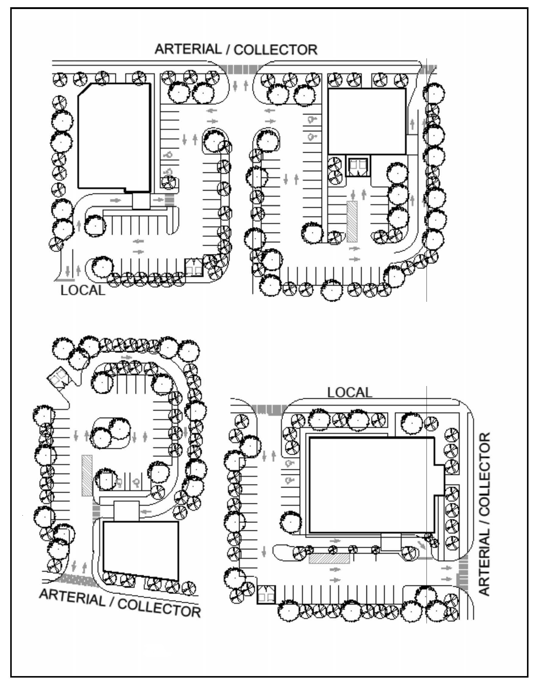
Figure 2: Main Street Layout

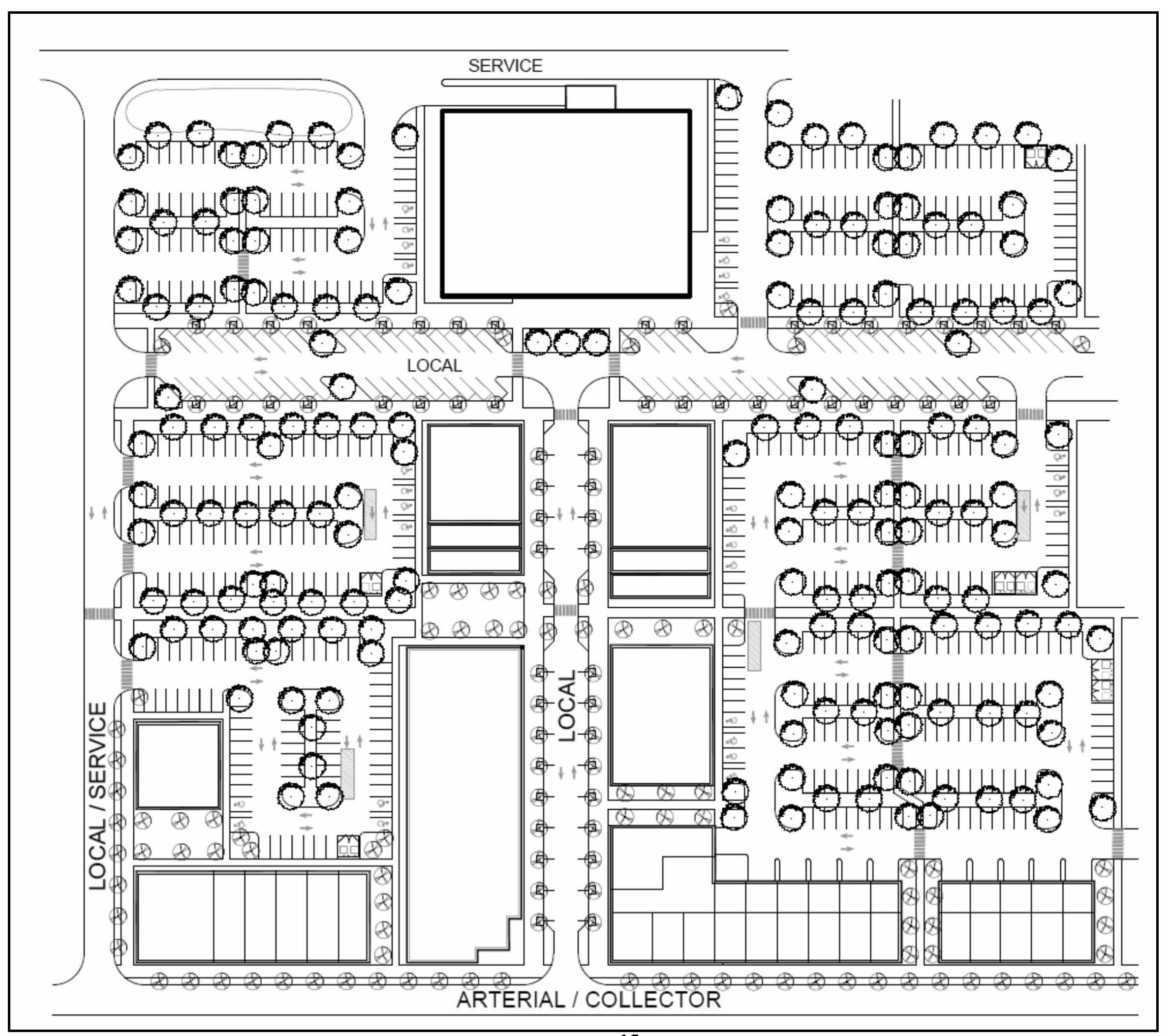
Figure 3. Streetscape Section

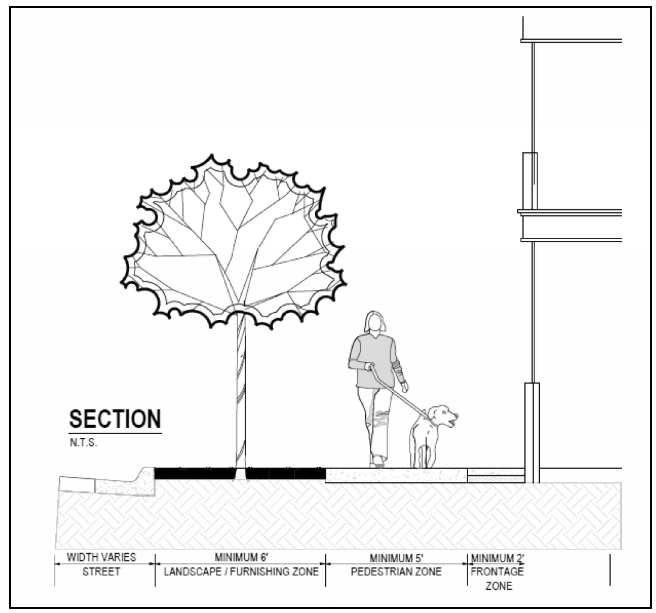
Figure 4. Commercial Streetscape Plan

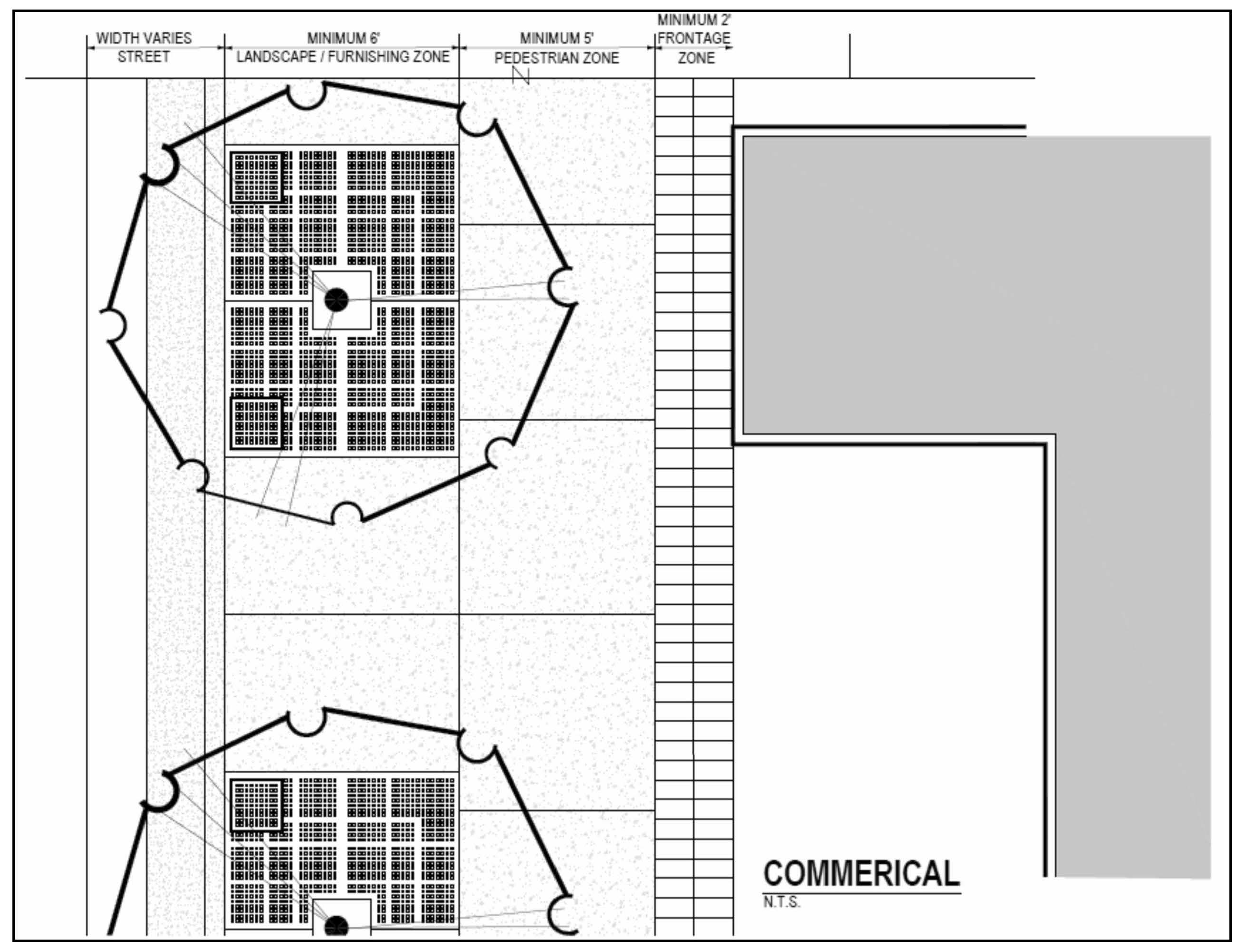
Figure 5: Residential Streetscape Plan

10. Building Orientation and Frontage:
(a) Proximity: Building shall contribute to the street wall of the overall development.
(b) Orientation: The principal building entryway shall be oriented and accessible from the most pedestrian-friendly street or corridor and be designed to provide direct pedestrian access from that street.
(c) Building Facade: Building facades along any public street frontage shall not exceed 100 feet, unless vertical structural elements and functional entrance doors divide that facade no less than every 50 feet. No more than 20% of the street-facing facade shall be faced directly by garage and service bay openings.
(d) Encroachments: Porches, balconies, pedestrian weather protection features and other like architectural features shall not encroach more than eight (8) feet into setbacks. Seating within the required yard setbacks shall be allowed. Encroachments, permanent and temporary, shall not result in a constrained pedestrian passageway of less than 5 feet in width.
11. Parking: Drive aisles, streets and parking shall not have primacy over pedestrian areas. Shared parking is envisioned as a necessity; therefore, large parking fields shall be prohibited. Refer to Figure 2.
(a) Location: Off-street parking shall not be located between the building facade and the right-of-way. Parking shall be dispersed throughout the site by using on-street parking and at the rear of buildings or internal to the block. One double-loaded bay of parking may be located to the side of buildings. Where site constraints necessitate, up to 25 percent of required parking may be permitted to the side of buildings.
(b) On-street parking: All streets created or expanded in association with development in this district shall be designed to accommodate on-street parking.
(c) Quantity: Parking shall be limited to a range of 40 percent to 70 percent of the general parking standard set forth in section 10-7.545 (Schedule 6-2). On-street parking provided on adjacent rights-of-way within the LPN zoning district without crossing an arterial or collector street may be counted towards meeting the parking requirement. Shared parking may also count toward the requirement.
(d) Size: Individual off-street surface parking lots shall not exceed 0.75 acre. Parking separated by a 30-foot wide landscape and sidewalk area shall be counted as separate parking areas.
(e) Screening: A minimum 10 feet wide landscaping strip shall be required between surface parking lots and adjacent streets. Landscaping shall require one canopy tree per 20 linear feet of frontage and a continuous row of shrubbery not to exceed 3 feet at maturity.
12. Building Design: Color architectural renderings shall be provided at the time of site plan review demonstrating compliance with this section. Refer to Figure 6. Variety in design elements, transparency, color, texture and materials shall create visual interest, particularly at the pedestrian scale, and contribute to the establishment of the architectural character of the area. This includes the incorporation of building facades that vary in mass, scale and height by inclusion of the following:
(a) Architectural Features: Large, unadorned and monolithic building faces and walls shall be prohibited. Multiple architectural and trim components including changes in color, texture, material and plane by using a reveal, offset or projecting rib shall be incorporated into the building design. Corner locations shall be considered opportunities for distinctive design on each frontage.
(b) Transparency: Adjacent to streets, sidewalks, and publicly accessible parking areas, non-residential and mixed-use buildings shall provide a minimum facade transparency of 50 percent at pedestrian level - between two and eight feet above finished grade—and residential buildings shall provide a minimum facade transparency of 25 percent at pedestrian level.
(c) Materials and Colors: Building facades shall be composed of natural materials such as brick, stone or wood siding or high-quality, manmade materials such as stucco and tinted or textured concrete masonry. The use of vinyl siding may not comprise more than 20 percent of any facade. Primary colors shall be natural, subdued earth tones while accent colors may be applied to architectural design elements. The following materials are prohibited: corrugated metal, standing seam, or v-crimp metal sheeting exterior walls or wall coverings. The materials used on the street-facing façades must return around exterior corners and terminate only at an internal corner (or a minimum of 6 feet from the principal façade).
(d) Rooflines: Variations in roofline accomplished by varying the building's mass in height and width so it appears divided into distinct massing elements through projections, recesses, and vertical changes in roof edges and slopes. Lengthy roofs with some transition but appearing to be flat shall not be permitted. Rooftop or ground mechanical equipment shall be considered in the initial stage of design and shall be screened through incorporation into the architectural form and layout of the building.
(e) Roof Types: All roof types are allowed. The use of gable roofs, cross gable roofs, and dormers are encouraged for buildings of two stories or less. Flat roofs shall provide horizontal articulation with a building cap at the top of the building base and/or incorporate the use of parapets.


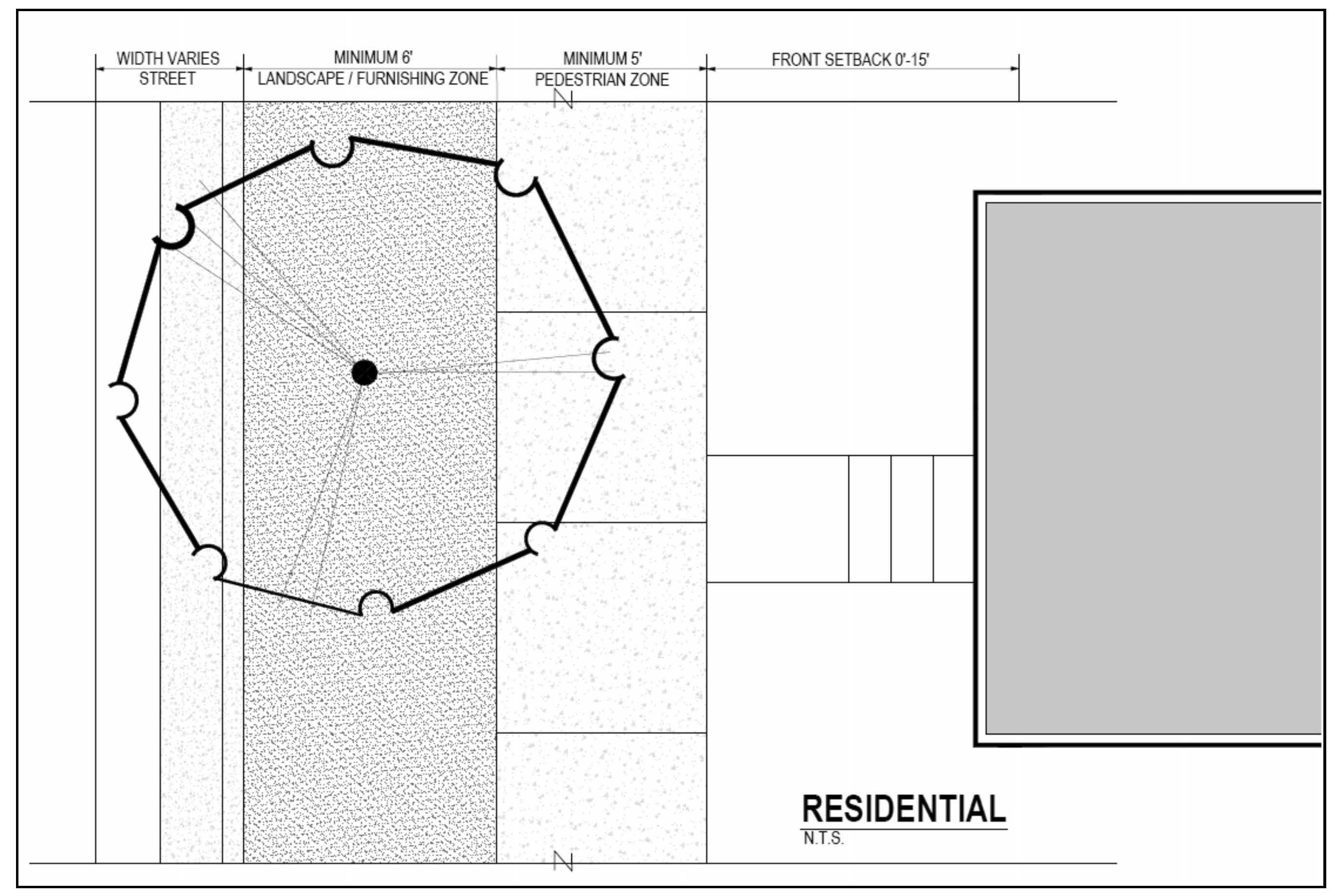
Figure 6: Building Design Examples
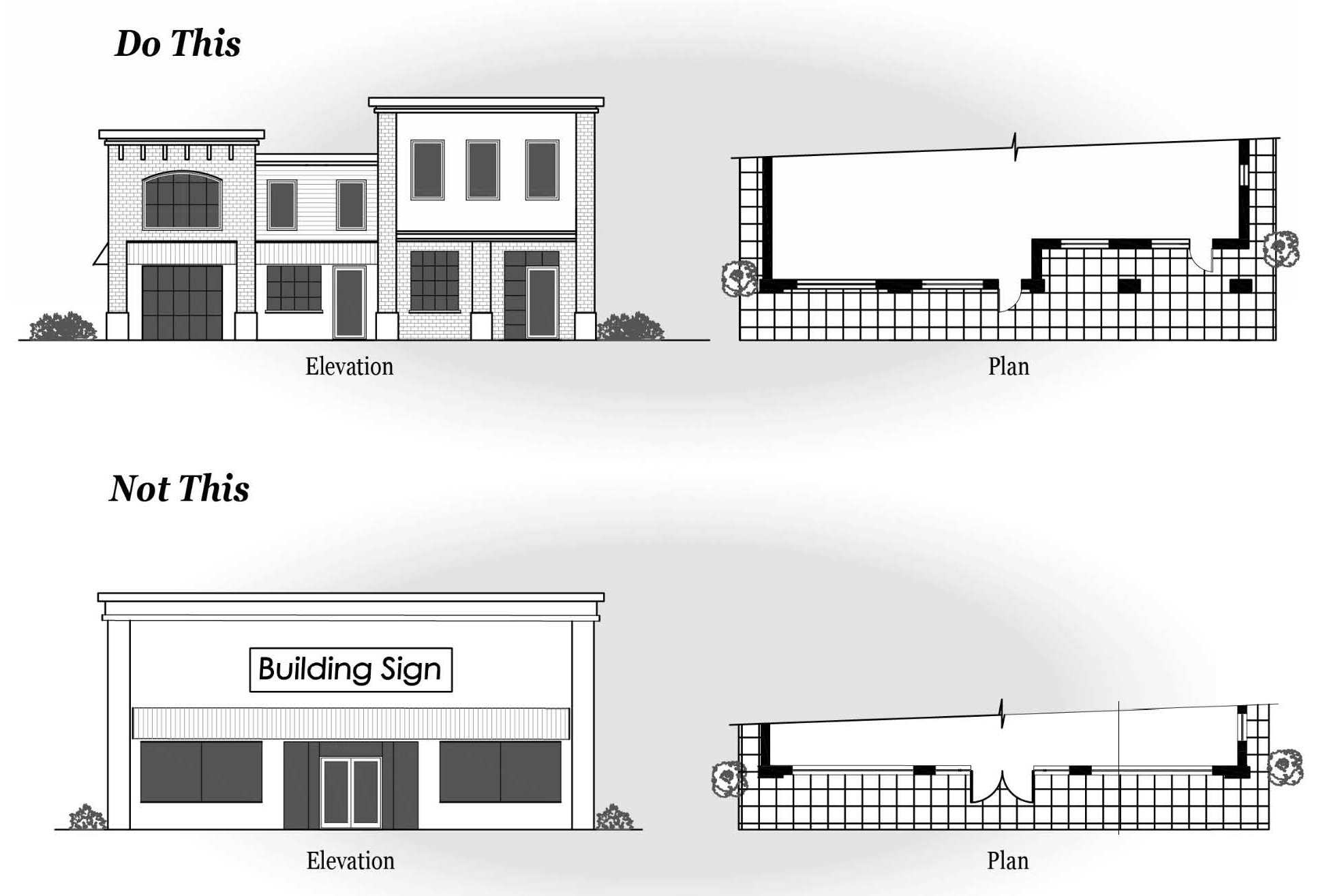
13. Buffering, Screening and Outdoor Service Areas:
(a) Buffer zone standards: Buffering is not required between uses within the LPN zoning district. Where development abuts existing single-family subdivisions, the landscape buffer standards of section 10-7.522 shall apply.
(b) Fencing: Chain link fencing visible from public streets or adjoining property is prohibited, unless it is screened by vegetation that provides 100% opacity within 5 years from planting or at plant maturity, whichever is less.
(c) Outdoor service areas, loading docks, delivery areas:
 1. Location: Shall only be located to the rear, side of a building, or in an interior location and shall adhere to the screening requirements in subsection (c)(2). Additionally, all outdoor services areas, loading docks and delivery areas shall be set back a minimum of 75-feet from the nearest residential structure in an adjoining zoning district.
 2. Screening: Outdoor service areas, loading docks, delivery areas, trash collection, outdoor storage, and mechanical equipment shall be mitigated using screening material consistent with the materials and design treatments of the primary facade of the primary building and/or evergreen landscape plant material.
  a. Landscape plans shall provide sight lines for natural surveillance between 3 and 8 feet above grade.
  b. The service areas shall not be within 50 feet of any adjoining residential property.
  c. The service areas shall be screened with vegetation and fences/masonry walls that are of sufficient height (minimum six feet) and opacity (minimum 50 percent) to screen from nearby streets and residential areas. Fences or masonry walls shall be constructed with materials that are incorporated in the design of the principal building.
  d. Above ground utility boxes visible from the street shall be screened with landscaping on at least two sides, thereby preserving access for the utility provider.
(d) Required landscaping; alternative compliance methods: Development is encouraged to utilize the site design alternatives set out in sections 10-4.347 and 10-4.350.
14. Lighting: A lighting and photometric plan that includes all lighting proposed on-site shall be provided at the time of site plan review to demonstrate compliance with this section.
(a) Parking Areas and Pedestrian Pathways:
 1. Intensity limits: Lighting levels adjacent to residential areas shall not exceed 0.5 footcandles at the property line as measured at 6 feet above ground level. The footcandle average for on-site parking lots shall not exceed 2.0 footcandles. The recommended maximum uniformity ratio (average: minimum light level) is 4:1.
 2. Light fixture types and location:
  a. Dark Sky compliant fixtures are encouraged.
  b. All light fixtures shall be full cut-off type fixtures and direct light internal to the site.
  c. Parking lighting shall be spaced a maximum of 50 feet apart and shall not exceed 20 feet in height above grade.
  d. Lighting for off-street walkways shall be spaced no more than 30 feet apart and shall not exceed 10 feet in height.
(b) Building Lighting: Lighting should be concentrated at ground floor. Above the ground floor, lighting shall only be used to selectively highlight specific architectural features and signs without lighting up an entire façade of the building. General floodlighting of building facades is not permitted.
15. Stormwater Management Facilities: All stormwater management facilities shall be constructed with 4:1 side slopes. Refer to section 10-4.301 for water quality treatment and volume control standards associated with development.
(a) Stormwater ponds shall be designed to imitate "natural" pond characteristics, including curved geometrics, gently sloping edges, landscaping and paving materials, and should be placed to be focal design amenities. A decentralized stormwater management design which disperses stormwater facilities across the site rather than to a centralized treatment facility is encouraged. Low impact development (LID) techniques, such as rain gardens and bio-retention swales, are encouraged to allow stormwater infiltration to occur as close to the source as possible.
(b) Landscape vegetation shall be incorporated around the perimeter of the stormwater facility, which at maturity will visually conceal required fencing. Landscape plants should be native and a minimum of four different species of trees and shrubs shall be utilized. Stormwater management facilities shall incorporate appropriate tree and plant species that consider the soil, hydrologic, and other site and facility conditions. Existing vegetation should be incorporated into the facility design wherever possible.
(c) Chain-link and vinyl clad fencing enclosures are prohibited where stormwater management facilities are visible from public roadways/access ways. Where fencing and/or retaining walls are proposed and visible from a public roadway/access way, such fencing shall be architecturally compatible with the principal structure.
16. Single-Family Attached Dwelling Units: Front-loaded units are prohibited. Driveway and parking access shall be from the rear of the unit.
17. Existing Single-Family Detached Dwelling Units: Individual single-family homes in the LPN zoning district that became non-conforming as of the date of this ordinance, shall be allowed to make improvements such as additions to the home, porches, accessory structures and an accessory dwelling unit provided they meet all the requirements for establishing such improvements on the property. Setback standards for single-family detached dwelling units shall be as follows: 10-foot front yard setback, 20-foot rear yard setback, 10-foot side corner setback and 10-foot maximum side yard setback. In the event of casualty, in whole or in part, structures located on the property shall be allowed to rebuild provided all provisions and requirements of the county's land development code have been met.


General notes:

(1)

Central sanitary sewer and water are required within LPN.

2.

Refer to the Environmental Management Act (EMA) for information pertaining to the regulation of environmental features (preservation/conservation features), stormwater management requirements, etc.

3.

Refer to the concurrency management ordinance for information pertaining to the availability of capacity for certain public facilities (roads, schools, parks, etc.).

4.

Development standards. All proposed development shall meet the buffer zone standards (section 10-7.522), and the parking and loading requirements (subdivision 3, division 5, article VII of this chapter).

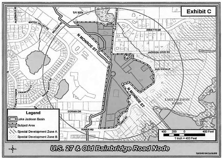
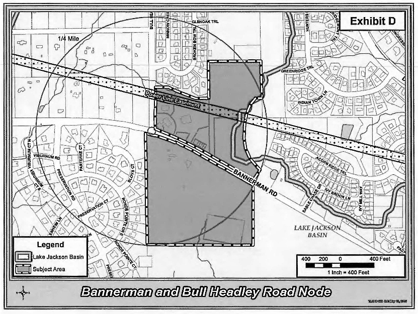
(Code 1992, § 10-6.660; Ord. No. 15-10, § 2, 7-7-2015; Ord. No. 20-10, § 1, 5-12-2020; Ord. No. 22-17, § 8, 6-14-2022)

Sec. 10-6.671. - Bradfordville Sector Plan.

(a)

Purpose and intent. The purpose and intent of this subdivision is to establish new standards for development in the Bradfordville Study Area so as to discourage urban sprawl; preserve the rural character of the area; protect and enhance the natural surface waterbodies in the area; eliminate potential stormwater problems in the area and reduce harm from flooding; maintain commercial services commensurate with population growth; provide for the development of a Bradfordville Commercial Center; establish design standards for development review; appropriately locate land uses; provide for an efficient and effective transportation system; ensure the availability of concurrent and adequate public facilities (including transportation, stormwater management, sewer, water, parks and open space); establish appropriate and necessary standards for the development and use of land in the Bradfordville Study Area; protect scenic viewsheds; protect historic resources; and establish appropriate design standards for development to protect the health, safety and welfare of current and future residents.

(b)

Findings.

(1)

The board hereby finds that the land uses, amount, rate, density and intensity of new development and all other aspects pertaining to development as set forth in the Bradfordville Sector Plan for the Bradfordville Study Area are compatible with and further the objectives, policies, land uses, and densities and intensities set forth in the Comprehensive Plan and are consistent with the Comprehensive Plan, including, but not limited to, the provisions relating to the Bradfordville Study Area.

(2)

The board hereby finds that the provisions contained in Ordinance No. 00-31, adopted July 11, 2000, amending the land development code of the county for the Bradfordville Study Area are consistent with the Comprehensive Plan and the Bradfordville Sector Plan.

(c)

Adoption of the Bradfordville Sector Plan. The board hereby adopts the Bradfordville Sector Plan as adopted July 11, 2000, by Ordinance No. 00-31, and incorporates said plan by reference.

(Code 1992, § 10-6.671; Ord. No. 07-20, § 2, 7-10-2007)

Sec. 10-6.672. - Bradfordville Mixed Use Overlay categories.

(a)

The land use element of the Tallahassee-Leon County Comprehensive Plan provides policies that recognize the special character of the Bradfordville area and directs the county to adopt land development regulations which discourage urban sprawl, preserve the character of the Bradfordville area, and provide adequate supply of facilities and services for the Bradfordville area. To implement these objectives a Bradfordville Mixed Use Future Land Use Overlay District is established. The following zoning districts are established within the Bradfordville Mixed Use Overlay District:

(1)

BC-1 Bradfordville Commercial District.

(2)

BC-2 Bradfordville Commercial District.

(3)

BCS Bradfordville Commercial Services District.

(4)

BOR Bradfordville Office Residential District.

(b)

Bradfordville Mixed Use Overlay intent, allowable uses and development standards are set forth in this subdivision.

(Code 1992, § 10-6.672; Ord. No. 07-20, § 2, 7-10-2007)

Sec. 10-6.673. - BC-1 Bradfordville Commercial Auto-Oriented District.

Permitted Uses*
1. District Intent2. Principal Uses
3. Accessory Uses


 The BC-1 district is intended to be located in areas designated Bradfordville mixed use in the future land use map of the Comprehensive Plan and shall apply to lands within the Bradfordville commercial center district. The intent of the BC-1 district is to implement the Bradfordville Study Area goals. Objectives and policies of the Comprehensive Plan preserving the residential character of the Bradfordville Study Area through a mixture of uses at a compatible scale with the adjacent residential communities.
 More specifically, the BC-1 district is intended to provide a location for services, with primary emphasis on vehicular oriented non-residential developments. However, the BC-1 district shall provide a continuous and efficient pedestrian circulation pattern.
 The access management standards for the BC-1 district are intended to minimize and control ingress and egress to collector and arterial roadways and to promote safe and efficient traffic circulation of the general traveling public.
 Increases in land zoned BC-1 shall demonstrate the need for additional services for the Bradfordville Study Area. Reuse of existing single use sites for multiple use developments, adding new uses to single use sites and/or multiple use developments that share parking facilities are encouraged in the BC-1 district. Expansions of the BC-1 district are prohibited in viable residential areas.


(1) Antique shops.
(2) Automotive-retail, parts, accessories, tires, etc.
(3) Automotive service and repair, including car wash.*
(4) Bait and tackle shops.
(5) Banks and other financial institutions (with and without drive through facilities).
(6) Camera and photographic stores.
(7) Cocktail lounges and bars.
(8) Commercial art and graphic design.
(9) Commercial printing.
(10) Community facilities, including libraries, religious facilities, and police/fire stations. Elementary, middle, and high schools are prohibited. Other community facilities may be allowed in accordance with section 10-6.806.
(11) Day care centers.
(12) Gift, novelty, and souvenir stores.
(13) Indoor amusements (bowling, billiards, skating, etc.).
(14) Indoor theaters (including amphitheaters).
(15) Laundromats, laundry and dry cleaning pick up stations.
(16) Mailing services.
(17) Medical and dental offices, services, laboratories, and clinics, mortuaries.
(18) Motor vehicle fuel sales.
(19) Museum and art galleries.
(20) Non-medical offices and services, including business and government offices and services.
(21) Nursing homes and residential care facilities.
(22) Off-street parking facilities.
(23) Outdoor amusements (golf courses, batting cages, driving ranges, etc.).
(24) Passive recreational facilities.
(25) Pawnshops.*
(26) Personal services (barber shops, fitness clubs, etc.).
(27) Pest control services.*

(28) Rental and sales of DVDs, video tapes and games.
(29) Rental of tools, small equipment, or party supplies.
(30) Repair services, non-automotive.
(31) Restaurants, with or without drive-in facilities.
(32) Retail bakeries.
(33) Retail caskets and tombstones.
(34) Retail computer, video, record, and other electronics.
(35) Retail department, apparel, and accessory stores.
(36) Retail drug store.
(37) Retail florist.
(38) Retail food and grocery.
(39) Retail furniture, home appliances and accessories.
(40) Retail home/garden supply, hardware and nurseries.
(41) Retail jewelry stores.
(42) Retail needlework and instruction.
(43) Retail newsstand, books, greeting cards.
(44) Retail office supplies.
(45) Retail optical and medical supplies.
(46) Retail pet stores.
(47) Retail picture framing.
(48) Retail sporting goods, toy stores.
(49) Retail trophy stores.
(50) Self-moving operation.*
(51) Shoes, luggage, and leather products.
(52) Sign shops.
(53) Social, fraternal and recreational clubs and lodges, including assembly halls.
(54) Studios for photography, music, art, drama, voice.
(55) Tailoring.
(56) Tobacco stores and stands.
(57) Other uses, which in the opinion of the County Administrator or designee, are of a similar and compatible nature to those uses described in this district.
(58) Residential single-family attached (townhomes), range of 6 du/ac to 12 du/ac.
(1) A use or structure on the same lot with, and of a nature customarily incidental and subordinate to, the principal use or structure and which comprises no more than 33 percent of the floor area or cubic volume of the principal use or structure, as determined by the County Administrator or designee.
(2) Light infrastructure and/or utility services and facilities necessary to serve permitted uses, as determined by the County Administrator or designee.


*Not all listed uses may be allowed. Refer to section 10-6.680 for a list of prohibited uses regardless of zoning district.

Development Standards
4. Minimum Lot or Site Size5. Minimum Building Setbacks6. Maximum Building Restrictions
Use Categorya. Lot or Site Areab. Lot Widthc. Lot Deptha. Frontb. Side-
Interior Lot
c. Side-
Corner Lot
d. Reara. Building Size (excluding gross building floor area used for parking)b. Building Height (excluding stories used for parking)
Any permitted principal and special exception use None None None 20 feet 15 feet 25 feet 10 feet 17,000 square feet of commercial floor area per acre. No single use tenant shall exceed 10,000 gross square feet. 30 feet (within Lake McBride Overlay District); otherwise, 3 stories.
7. Access Management Criteria: (In case of a conflict with the provisions of other ordinances or regulations, the most strict provisions shall apply).
(a.) Arterial and collector roads. Direct driveway access to arterial and collector roads is prohibited except for:
1) Existing driveway access as of July 28, 1998;
2) A single driveway access for properties in existence before July 28, 1998 which have sole access to the arterial road and does not have other street access; and
3) Temporary driveway access may be permitted for properties which establish permanent access to another public street and grant the local government with jurisdiction the right to close the temporary access without compensation upon opening of access to an alternative roadway.
(b.) All properties. All properties shall provide cross access easements benefiting adjoining properties to permit the development of an internal vehicular and pedestrian circulation system. All non-residential properties shall provide driveway interconnections to adjoining non-residential properties. All new developments proposing subdivision shall have shared access for every two parcels created.
(c.) Local streets. Full movement access to a local street shall not be permitted within 200 feet of a signalized intersection. Right-in/right-out access to a local street shall not be permitted closer than 100 feet to another access point or intersecting public street, nor within 200 feet of a signalized intersection, except properties with sole access to a local street are permitted at least one access point, which may be limited to right-in/right-out based upon a traffic safety evaluation.
8. Street Vehicular Access Restrictions: Properties in the BC-1 zoning district may have vehicular access to any type of street. However, in order to protect residential areas and neighborhoods from non-residential traffic, vehicular access to a local street is prohibited if one of the following zoning districts is located on the other side of the local street: RA, R-1, R-2, R-3, R-4, R-5, MH, MR-1, R, and RP.
9. Landscape Standards: Development within the BC-1 shall be subject to the landscape requirements of this section in addition to those requirements of the Environmental Management Act (EMA). Where standards conflict, the stricter of the two shall apply. All landscape plans shall be prepared by a registered landscape architect as per F.S. ch. 481.
(a.) Arterial road landscaping. All properties fronting arterial roads shall provide and maintain a 30-foot-wide landscape area immediately adjoining the arterial road. All vegetation within the 30-foot-wide landscaped area of good condition four inches and larger shall be preserved. This landscape area shall be planted with canopy trees with at least one tree for each 200 square feet of landscape area. Creative design and spacing is encouraged. The landscape area may be crossed by driveways permitted pursuant to subsection 7 of this section, but compensatory area shall be added, equal to the area of the driveway, adjacent to the required landscape area. Sidewalks are not permitted within the landscaped area except for interconnections to sidewalks fronting public roadways. Signs in accordance with subsection 13 of this section may be located within the landscape area, but shall not reduce the tree planting requirement. Existing healthy trees in the landscape area may be counted as prescribed in section 10-4.350(b) toward meeting the tree planting requirement. Management of the existing trees within the 30 feet shall include pruning of dead and hazardous tree limbs, pruning of live limbs less than 25 percent of the green mass of the tree, fertilization, pest control, and control of invasive vegetation. Mechanical methods which compact the earth or root systems shall not be allowed.
(b.) Collector and local road landscaping. All properties fronting collector and local roads shall provide and maintain a 20-foot-wide landscape area immediately adjoining the collector or local road. All vegetation within the 20-foot-wide landscaped area of good condition four inches and larger shall be preserved (This provision shall not apply where a primary entrance is oriented toward the street and there is no vehicular use area between the building and roadway). This landscape area shall be planted with canopy trees with at least one tree for each 200 square feet of landscape area. Creative design and spacing is encouraged. The landscape area may be crossed by driveways permitted pursuant to subsection 7 of this section, but compensatory area shall be added equal to the area of the driveway within the required landscape area. Sidewalks are not permitted within the landscaped area except for interconnections to sidewalks fronting public roadways. Signs in accordance with subsection 13 of this section may be located within the landscape area, but shall not reduce the tree planting requirement. Existing healthy trees in the landscape area may be counted as prescribed in section 10-4.350(b) toward meeting the tree planting requirement. Management of the existing trees within the 20 feet shall include pruning of dead and hazardous tree limbs, pruning of live limbs less than 25 percent of the green mass of the tree, fertilization, pest control, and control of invasive vegetation. Mechanical methods which compact the earth or root systems shall not be allowed.
(c.) Street trees. All existing and proposed roadways/access ways shall be planted with canopy trees at a standard of one canopy tree per 200 square feet of landscaped area. Credit shall be given for existing vegetation within the required landscaped areas as identified in subsections (a.) and (b.) of this section. Creative design and spacing is encouraged.
(d.) Parking areas. All vehicular use areas shall be buffered from view from public streets and/or access ways through the use of vegetation and/or topography or other manmade structures so long as such structures are architecturally compatible with the principle structure. All manmade visual buffers greater than 20 feet in unbroken length shall be designed to provide interesting visual effects and reduce apparent mass though the use of vegetation and plane projections, material changes, changes in scale or other architectural features. Canopy tree cover for the parking area shall be provided so as to attain a minimum of 60 percent plan view shading within 10 years of planting date. At grade parking grade shall include interior landscaped areas at a minimum ration of 400 square feet per 5,000 square feet of vehicular use area located internally to the parking area. Where interior landscaped areas cannot be obtained, the required landscaped area shall be placed between the proposed vehicular use area and the public right-of-way and/or access way. Existing vegetation shall be incorporated into the landscaped areas to the greatest extent possible. Planting areas shall have a minimum area of 400 square feet, with a minimum dimension of 10 feet and shall have a depth of 3 feet of good planting soil.
(e.) Trees planted within a sidewalk area shall incorporate tree grates or other surfacing so as to not impede the flow of pedestrian traffic.
(f.) Buffer standards for uncomplimentary land uses shall meet the requirements of section 10-7.522.
(g.) Developments within this district shall preserve a minimum of 25 percent of the total site as natural area. The required natural area may be located off-site if the required area is designated as public open space and is accepted by the public works department. On-site natural area shall encompass significant, naturally occurring vegetation areas or other significant environmental features.
(h.) Stormwater management facilities shall be landscaped in accordance with the Environmental Management Act, however, development is encouraged to provide innovative designs making such facilities an amenity to the site. All stormwater management facilities are encouraged to be constructed with 4:1 side slopes. Chainlink and vinyl clad fencing enclosures are prohibited where stormwater management facilities are visible from public roadways/access ways. Where fencing and/or retaining walls are proposed and visible from a public roadway/access way, such fencing shall be architecturally compatible with the principle structure. Stormwater ponds shall be designed to imitate "natural" pond characteristics, including curved geometrics, gently sloping edges, landscaping and paving materials, and should be placed so as to be focal design amenities.
10. Parking Standards:
(a.) Properties fronting an arterial road shall be allowed to construct 50 percent of all parking required by the land development code in front of the proposed building/structure and/or adjacent to a public roadway. Additional parking, above code requirements shall be located to a side or rear of the proposed building/structure that is not fronting a public or private roadway or access way.
(b.) Properties fronting a collector or local road shall be allowed to construct a single parking aisle between the proposed building and the collector and/or local road.
11. Lighting Standards:
(a.) All exterior lighting shall have recessed bulbs and filters which conceal the source of illumination. No wall or roof mounted flood or spot lights used as general grounds lighting are permitted. Security lighting is permitted.
(b.) Lighting for off-street walkways shall be spaced no more than 30 feet apart, and shall not exceed 10 feet in height.
(c.) Parking lighting shall be spaced a maximum of 50 feet apart and shall not exceed 20 feet in height.
(d.) Lighting levels adjacent to residential areas shall not exceed 0.5 footcandles at the property line (six feet above ground).
12. Noncompliance: Existing noncompliance of the standards set forth in this section shall be subject to the provisions of division 3 of this article.
13. Variance Procedure: Conformance to these design criteria shall be verified by the county during the site and development plan review process required for individual development projects. Deviation from the following subsections of this section may be requested pursuant to article I of the Leon County Land Development Code: subsections 5, 6, 7, 8, 10(c) and 11 of this section.
14. Incentives for Site Design Alternatives: An intensity bonus shall be provided to developments incorporating any of the following site design alternatives:
1) An intensity bonus of 3,000 square feet per acre (maximum) shall be allowed provided new development or redevelopment utilizes one or more of the following:
a) For properties fronting an arterial or collector roadway, no less than 25 percent of the parking will be provided in a shared facility.
b) Development site areas of 3 or more acres wherein at least 50 percent of the parking will be provided in a shared facility.
c) Parking is provided within a range of 50 percent—75 percent of the parking requirements in section 10-7.545.
d) The development contains a minimum of 35 percent natural open space.


General notes:

(1)

If central sanitary sewer is not available, non-residential development is limited to a maximum of 900 gallons of wastewater flow per day. Community service facilities are limited to no more than 5,000 square feet, or a sewage flow not to exceed 900 gallons per day. Also, refer to Sanitary Sewer Policies 1.2.3 and 2.1.2 of the Utilities Element of the Comprehensive Plan for additional requirements.

(2)

Refer to the Environmental Management Act (EMA) for information pertaining to the regulation of environmental features (preservation/conservation features), stormwater management requirements, etc.

(3)

Refer to the concurrency management ordinance for information pertaining to the availability of capacity for certain public facilities (roads, parks, etc.).

(Code 1992, § 10-6.673; Ord. No. 07-20, § 2, 7-10-2007; Ord. No. 09-13, § 4, 3-19-2009; Ord. No. 15-03, § 2, 2-10-2015; Ord. No. 17-01, § 8, 1-24-2017; Ord. No. 20-06, § 4, 4-28-2020; Ord. No. 22-17, § 9, 6-14-2022; Ord. No. 23-05, § 27, 2-21-2023)

Sec. 10-6.674. - BC-2 Bradfordville Commercial Pedestrian-Oriented District.

Permitted Uses*
1. District Intent2. Principal Uses
3. Accessory Uses
 The BC-2 district is intended to be located in areas designated Bradfordville mixed use in the future land use map of the Comprehensive Plan and shall apply to lands within the Bradfordville commercial center district. The intent of the BC-2 district is to implement the Bradfordville Study Area goals, objectives and policies of the Comprehensive Plan preserving the residential character of the Bradfordville Study Area through a mixture of uses at a compatible scale with the adjacent residential communities. More specifically, the BC-2 district is intended to provide a location for areas of intense pedestrian scale and oriented commercial services for the Bradfordville area.
 The BC-2 district is intended to encourage residential and office development above ground floor commercial development. The BC-2 district also encourages shared parking and utilization of on-street parking. Drive through facilities are prohibited in the BC-2 district.
 Residential intensities shall not exceed 16 dwelling units per acre.
 The access management standards for the BC-2 district are intended to minimize and control ingress and egress to collector and arterial roadways and to promote smooth and safe traffic flow of the general traveling public. Increases in land zoned BC-2 shall demonstrate the need for additional services for the Bradfordville Study Area. Reuse of existing single use sites for multiple use developments, adding new uses to single use sites and/or multiple use developments that share parking facilities are encouraged in the BC-2 district. Expansions of the BC-2 district are prohibited in viable residential areas.
(1) Antique shops.
(2) Banks and other financial institutions, without drive-through facilities.
(3) Camera and photographic stores.
(4) Cocktail lounges and bars.
(5) Community facilities related to the permitted principal uses, including libraries, religious facilities, vocational and middle schools, and police/fire stations. High schools are prohibited. Other community facilities may be allowed in accordance with section 10-6.806.
(6) Gift, novelty, and souvenir stores.
(7) Indoor amusements (bowling, billiards, skating, theaters etc.).
(8) Laundromats, laundry and dry cleaning pick-up stations without drive-through facilities.
(9) Mailing services.
(10) Medical and dental offices, services, laboratories, and clinics.
(11) Non-medical offices and services, including business and government offices and services.
(12) Off-street parking facilities.
(13) Passive and active recreational facilities.
(14) Personal services (barber shops, fitness clubs etc.).
(15) Photocopying and duplicating services.
(16) Rental and sales of dvds, video tapes and games.
(17) Repair services, non-automotive.
(18) Residential (any type provided it is located on second floor above commercial or office development).
(19) Restaurants without drive-in facilities.
(20) Retail bakeries.
(21) Retail computer, video, record, and other electronics.
(22) Retail department, apparel, and accessory stores.
(23) Retail drug store.
(24) Retail florist.
(25) Retail food and grocery.
(26) Retail home/garden supply, hardware, and nurseries without outside storage or display.
(27) Retail jewelry stores.
(28) Retail needlework shops and instruction.
(29) Retail newsstand, books, greeting cards.
(30) Retail package liquors.
(31) Retail picture framing.
(32) Retail trophy stores.
(33) Shoes, luggage, and leather goods.
(34) Social, fraternal and recreational clubs and lodges, including assembly halls.
(35) Studios for photography, music, art, drama, and voice.
(36) Tailoring.
(37) Other uses, which in the opinion of the County Administrator or designee, are of a similar and compatible nature to those uses described in this district.
(1) A use or structure on the same lot with, and of a nature customarily incidental and subordinate to, the principal use or structure and which comprises no more than 33 percent of the floor area or cubic volume of the principal use or structure, as determined by the County Administrator or designee.
(2) Light infrastructure and/or utility services and facilities necessary to serve permitted uses, as determined by the County Administrator or designee.


*Not all listed uses may be allowed. Refer to section 10-6.680 for a list of prohibited uses regardless of zoning district.

Development Standards
4. Minimum Lot or Site Size5. Minimum Building Setbacks6. Maximum Building Restrictions
Use Categorya. Lot or Site Areab. Lot Widthc. Lot Deptha. Frontb. Side-
Interior Lot
c. Side-
Corner Lot
d. Reara. Building Size (excluding gross building floor area used for parking)b. Building Height (excluding stories used for parking)
Any Permitted Principal and Special Exception Use None None None None (5 feet maximum) None None 30 feet 18,000 square feet of commercial floor area per acre. No single use tenant shall exceed 10,000 gross square feet. 3 stories
7. Access Management Criteria: (In case of a conflict with the provisions of other ordinances or regulations, the most strict provisions shall apply).
(a.) Arterial and collector roads. Direct driveway access to arterial and collector roads is prohibited except for:
1) Existing driveway access as of July 28, 1998;
2) A single driveway access for properties in existence before July 28, 1998 which have sole access to the arterial road and does not have other street access; and
3) Temporary driveway access may be permitted for properties which establish permanent access to another public street and grant the local government with jurisdiction the right to close the temporary access without compensation upon opening of access to an alternative roadway.
(b.) All properties. All properties shall provide cross access easements benefiting adjoining properties to permit the development of an internal vehicular and pedestrian circulation system. All non-residential properties shall provide driveway interconnections to adjoining non-residential properties. All new developments proposing subdivision shall have shared access for every two parcels created where accessed from a local street.
(c.) Local streets. Full movement access to a local street shall not be permitted within 200 feet of a signalized intersection. Right-in/right-out access to a local street shall not be permitted closer than 100 feet to another access point or intersecting public street, nor within 200 feet of a signalized intersection, except properties with sole access to a local street are permitted at least one access point, which may be limited to right-in/right-out based upon a traffic safety evaluation.
8. Street Vehicular Access Restrictions: Properties in the BC-2 zoning district may have vehicular access to any type of street. However, in order to protect residential areas and neighborhoods from non-residential traffic, vehicular access to a local street is prohibited if one of the following zoning districts is located on the other side of the local street: RA, R-1, R-2, R-3, R-4, R-5, MH, MR-1, R, and RP.
9. Landscape Standards: Development within the BC-2 shall be subject to the landscape requirements of this section in addition to those requirements of the Environmental Management Act (EMA). Where standards conflict, the stricter of the two shall apply. All landscape plans shall be prepared by a registered landscape architect as per F.S. ch. 481.
(a.) Arterial road landscaping. All properties fronting arterial roads shall provide and maintain a 30 foot wide landscape area immediately adjoining the arterial road. All vegetation within the 30 foot wide landscaped area of good condition four inches and larger shall be preserved. This landscape area shall be planted with canopy trees with at least one tree for each 200 square feet of landscape area. Creative design and spacing is encouraged. The landscape area may be crossed by driveways permitted pursuant to subsection 7 of this section, but compensatory area shall be added, equal to the area of the driveway, adjacent to the required landscape area. Sidewalks are not permitted within the landscaped area except for interconnections to sidewalks fronting public roadways. Signs in accordance with section 13. of this section may be located within the landscape area, but shall not reduce the tree planting requirement. Existing healthy trees in the landscape area may be counted as prescribed in section 10-4.350(b) toward meeting the tree planting requirement. Management of the existing trees within the 30 feet shall include pruning of dead and hazardous tree limbs, pruning of live limbs less than 25 percent of the green mass of the tree, fertilization, pest control, and control of invasive vegetation. Mechanical methods which compact the earth or root systems shall not be allowed.
(b.) Collector road landscaping. All properties fronting collector and local roads shall provide and maintain a 20-foot-wide landscape area immediately adjoining the collector road. All vegetation within the 20-foot-wide landscaped area of good condition four inches and larger shall be preserved (This provision shall not apply where a primary entrance is oriented toward the street and there is no vehicular use area between the building and roadway). This landscape area shall be planted with canopy trees with at least one tree for each 200 square feet of landscape area. Creative design and spacing is encouraged. The landscape area may be crossed (for redevelopment projects only) by driveways permitted pursuant to subsection 7 of this section, but compensatory area shall be added equal to the area of the driveway within the required landscape area. Sidewalks are not permitted within the landscaped area except for interconnections to sidewalks fronting public roadways. Signs in accordance with subsection 13 of this section may be located within the landscape area, but shall not reduce the tree planting requirement. Existing healthy trees in the landscape area may be counted as prescribed in section 10-4.350(b) toward meeting the use planting requirement. Management of the existing trees within the 20 feet shall include pruning of dead and hazardous tree limbs, paining of live limbs less than 25 percent of the green mass of the tree, fertilization, post control, and control of invasive vegetation. Mechanical methods which compact the earth or root systems shall not be allowed.
(c.) Local road and access ways landscaping. All properties fronting a local road and every access way shall provide one canopy tree for every 15 linear feet of local road frontage and/or access way.
(d.) Street trees. All canopy tree planting areas shall contain a minimum of 200 square feet of landscaped area. Creative design and spacing is encouraged.
(e.) Parking areas. All vehicular use areas shall be buffered from view from public streets and/or access ways through the use of vegetation and/or topography or other manmade structures so long as such structures are architecturally compatible with the principle structure. All manmade visual buffers greater than 20 feet in unbroken length shall be designed to provide interesting visual effects and reduce apparent mass though the use of vegetation and plane projections, material changes, changes in scale or other architectural features. Canopy tree cover for the parking area shall be provided so as to attain a minimum of 60 percent plan view shading within 10 years of planting date. At grade parking grade shall include interior landscaped areas at a minimum ratio of 400 square feet per 5,000 square feet of vehicular use area located internally to the parking area. Where interior landscaped areas cannot be obtained, the required landscaped area shall be placed between the proposed vehicular use area and the public right-of-way and/or access way. Existing vegetation shall be incorporated into the landscaped areas to the greatest extent possible. Planting areas shall have a minimum area of 400 square feet, with a minimum dimension of 10 feet and shall have a depth of 3 feet of good planting soil.
(f.) Trees planted within a sidewalk area shall incorporate tree grates or other surfacing so as to not impede the flow of pedestrian traffic.
(g.) Buffer standards for uncomplimentary land uses shall meet the requirements of section 10-7.522.
(h.) Developments within this district shall preserve a minimum of 25 percent of the total site as natural area. The required natural area may be located off-site if the required area is designated as public open space and is accepted by the public works department. On-site natural area shall encompass significant, naturally occurring vegetation areas or other significant environmental features.
(i.) Stormwater management facilities shall be landscaped in accordance with the Environmental Management Act, however, development is encouraged to provide innovative designs making such facilities an amenity to the site. All stormwater management facilities are encouraged to be constructed with 4:1 side slopes. Chainlink and vinyl clad fencing enclosures are prohibited where stormwater management facilities are visible from public roadways/access ways. Where fencing and/or retaining walls are proposed and visible from a public roadway/access way, such fencing shall be architecturally compatible with the principle structure. Stormwater ponds shall be designed to imitate "natural" pond characteristics, including curved geometrics, gently sloping edges, landscaping and paving materials, and should be placed so as to be focal design amenities.
10. Parking Standards:
(a) Off-street parking is prohibited between buildings fronting a local street and/or access way.
11. Lighting Standards:
(a.) All exterior lighting shall have recessed bulbs and filters which conceal the source of illumination. No wall or roof mounted flood or spot lights used as general grounds lighting are permitted. Security lighting is permitted.
(b.) Lighting for off-street walkways shall be spaced no more than 30 feet apart, and shall not exceed 10 feet in height.
(c.) Parking lighting shall be spaced a maximum of 50 feet apart and shall not exceed 20 feet in height.
(d.) Lighting levels adjacent to residential areas shall not exceed 0.5 footcandles at the property line (six feet above ground).
12. Noncompliance: Existing noncompliance of the standards set forth in this section shall be subject to the provisions of division 3 of this article.
13. Variance Procedure: Conformance to these design criteria shall be verified by the county during the site and development plan review process required for individual development projects. Deviation from the following subsections of this section may be requested pursuant to article I of the Leon County Land Development Code: subsections 4, 6, 7, 8, 9, 11(a), and 12 of this section.
14. Incentives for Site Design Alternatives: An intensity bonus shall be provided to developments incorporating any of the following site design alternatives.
1) An intensity bonus of 2,000 square feet per acre (maximum) shall be allowed provided new development or redevelopment utilizes one or more of the following:
a) For properties fronting an arterial or collector roadway, no less than 25 percent of the parking will be provided in a shared facility.
b) Development site areas of 3 or more acres wherein at least 50 percent of the parking will be provided in a shared facility.
c) Parking is provided within a range of 50 percent—75 percent of the parking requirements in section 10-7.545.
d) The development contains a minimum of 35 percent natural open space.


General notes:

(1)

If central sanitary sewer is not available, non-residential development is limited to a maximum of 900 gallons of wastewater flow per day. Community service facilities are limited to no more than 5,000 square feet, or a sewage flow not to exceed 900 gallons per day. Also, refer to Sanitary Sewer Policies 1.2.3 and 2.1.2 of the Utilities Element of the Comprehensive Plan for additional requirements.

(2)

Refer to the Environmental Management Act (EMA) for information pertaining to the regulation of environmental features (preservation/conservation features), stormwater management requirements, etc.

3)

Refer to the concurrency management ordinance for information pertaining to the availability of capacity for certain public facilities (roads, parks, etc.).

(Code 1992, § 10-6.674; Ord. No. 07-20, § 2, 7-10-2007; Ord. No. 09-13, § 4, 3-19-2009; Ord. No. 15-03, § 3, 2-10-2015; Ord. No. 16-07, § 15, 5-10-2016; Ord. No. 20-06, § 5, 4-28-2020; Ord. No. 22-17, § 10, 6-14-2022; Ord. No. 23-05, § 28, 2-21-2023)

Sec. 10-6.675. - BCS Bradfordville Commercial Services District.

Permitted Uses*
1. District Intent2. Principal Uses
3. Accessory Uses
 The BCS district is intended to be located in areas designated Bradfordville mixed use in the future land use map of the Comprehensive Plan and shall apply to lands within the Bradfordville commercial center district.
 The intent of the BCS district is to implement the Bradfordville Study Area goals, objectives and policies of the Comprehensive Plan preserving the residential character of the Bradfordville Study Area through a mixture of uses at a compatible scale with the adjacent residential communities.
 More specifically, the BCS district is intended to provide a location for non-retail services for the Bradfordville area. The non-retail uses include, but are not limited to auto oriented services and warehouse activities.
 The access management standards for the BCS district are intended to minimize and control ingress and regress to collector and arterial roadways and to promote smooth and safe traffic flow of the general traveling public.
 Increases in land zoned BCS shall demonstrate the need for additional services for the Bradfordville Study Area. Reuse of existing single use sites for multiple use developments, adding new uses to single use sites and/or multiple use developments that share parking facilities are encouraged in the BCS district. Expansions of the BCS district are prohibited in viable residential areas.
(1) Armored truck services.
(2) Automotive service and repair, including car wash.*
(3) Broadcasting studios.
(4) Building contractors and related services.
(5) Cemeteries.*
(6) Commercial kennels(enclosed).
(7) Communications and utilities.
(8) Community services may be allowed in accordance with section 10-6.806.
(9) Crematoriums.*
(10) Daycare facilities.
(11) Dry cleaning plants.*
(12) Golf courses.
(13) Gun firing ranges (indoor).*
(14) Laboratories, research and development activities.
(15) Lawn and tree removal services.
(16) Mortuaries.
(17) Non-medical offices and services, including business and government offices and services.
(18) Passive and active recreational activities.
(19) Pest control services.*
(20) Rental of tools, small equipment, or party supplies.
(21) Repair services, non-automotive.
(22) Retail and wholesale nurseries.
(23) Self moving operation.*
(24) Sign shops.
(25) Social, fraternal, and recreational clubs and lodges, including assembly halls.
(26) Towing, wrecking, and recovery services.*
(27) Veterinary services.
(28) Warehouses, miniwarehouses, or self-storage facilities.
(29) Welding and machine shops.
(30) Wholesale building supplies.*
(31) Other uses, which in the opinion of the County Administrator or designee, are of a similar and compatible nature to those uses described in this district.
(32) Residential, single-family detached, range of 1 du/ac; single-family attached (townhomes), range of 6 du/ac to 12 du/ac.
(1) A use or structure on the same lot with, and of a nature customarily incidental and subordinate to, the principal use or structure and which comprises no more than 33 percent of the floor area or cubic volume of the principal use or structure, as determined by the County Administrator or designee.
(2) Light infrastructure and/or utility services and facilities necessary to serve permitted uses, as determined by the County Administrator or designee.


*Not all listed uses may be allowed. Refer to section 10-6.680 for a list of prohibited uses regardless of zoning district.

Development Standards
4. Minimum Lot or Site Size5. Minimum Building Setbacks6. Maximum Building Restrictions
Use Categorya. Lot or Site Areab. Lot Widthc. Lot Deptha. Frontb. Side-
Interior Lot
c. Side-
Corner Lot
d. Reara. Building Size (excluding gross building floor area used for parking)b. Building Height (excluding stories used for parking)
Any Permitted Principal and Special Exception Use None None None 20 feet 15 feet 25 feet 10 feet Gross floor area shall not exceed 15,000 square feet per acre, except for buildings or portions thereof which are used for storage which may not exceed 17,000 square feet per acre. No single use tenant shall exceed 10,000 square feet. 2 stories
7. Access Management Criteria: (In case of a conflict with the provisions of other ordinances or regulations, the most strict provisions shall apply.)
(a) Arterial and collector roads. Direct driveway access to arterial and collector roads is prohibited except for:
1) Existing driveway access as of July 28, 1998;
2) A single driveway access for properties in existence before July 28, 1998, which have sole access to the arterial road and does not have other street access; and
3) Temporary driveway access may be permitted for properties which establish permanent access to another public street and grant the local government with jurisdiction the right to close the temporary access without compensation upon opening of access to an alternative roadway.
(b) All properties. All properties shall provide cross access easements benefiting adjoining properties to permit the development of an internal vehicular and pedestrian circulation system. All non-residential properties shall provide driveway interconnections to adjoining non-residential properties. All new developments proposing subdivision shall have shared access for every two parcels created.
(c) Local streets. Full movement access to a local street shall not be permitted within 200 feet of a signalized intersection. Right-in/right-out access to a local street shall not be permitted closer than 100 feet to another access point or intersecting public street, nor within 200 feet of a signalized intersection, except properties with sole access to a local street are permitted at least one access point, which may be limited to right-in/right-out based upon a traffic safety evaluation.
8. Street Vehicular Access Restrictions: Properties in the BCS zoning district may have vehicular access to any type of street. However, in order to protect residential areas and neighborhoods from non-residential traffic, vehicular access to a local street is prohibited if one of the following zoning districts is located on the other side of the local street: RA, R-1, R-2, R-3, R-4, R-5, MH, MR-1, R, and RP.
9. Landscape Standards: Development within the BCS shall be subject to the landscape requirements of this section in addition to those requirements of the Environmental Management Act (EMA). Where standards conflict, the stricter of the two shall apply. All landscape plans shall be prepared by a registered landscape architect as per F.S. ch. 481.
(a.) Arterial road landscaping. All properties fronting arterial roads shall provide and maintain a 30 foot wide landscape area immediately adjoining the arterial road. All vegetation within the 30-foot-wide landscaped area of good condition four inches and larger shall be preserved. This landscape area shall be planted with canopy trees with at least one tree for each 200 square feet of landscape area. Creative design and spacing is encouraged. The landscape area may be crossed by driveways permitted pursuant to subsection 7 of this section, but compensatory area shall be added, equal to the area of the driveway, adjacent to the required landscape area. Sidewalks are not permitted within the landscaped area except for interconnections to sidewalks fronting public roadways. Signs in accordance with subsection 13 of this section may be located within the landscape area, but shall not reduce the tree planting requirement. Existing healthy trees in the Landscape area may be counted as prescribed in section 10-4.350(b) toward meeting the tree planting requirement. Management of the existing trees within the 30 feet shall include pruning of dead and hazardous tree limbs, pruning of live limbs less than 25 percent of the green mass of the tree, fertilization, past control, and control of invasive vegetation. Mechanical methods which compact the earth or root systems shall not be allowed.
(b.) Collector and local road landscaping. All properties fronting collector and local roads shall provide and maintain a 20-foot-wide landscape area immediately adjoining the collector or local road. All vegetation within the 20-foot-wide landscaped area of good condition four inches and larger shall be preserved (This provision shall not apply where a primary entrance is oriented toward the street and there is no vehicular use area between the building and roadway). This landscape area shall be planted with canopy trees with at least one tree for each 200 square feet of landscape area. Creative design and spacing is encouraged. The landscape area may be crossed by driveways permitted pursuant to subsection 7 of this section, but compensatory area shall be added equal to the area of the driveway within the required landscape area. Sidewalks are not permitted within the landscaped area except for interconnections to sidewalks fronting public roadways. Signs in accordance with subsection 13 of this section may be located within the landscape area, but shall not reduce the tree planting requirement. Existing healthy trees in the landscape area may be counted as prescribed in section 10-4.350(b) toward meeting the tree planting requirement. Management of the existing trees within the 20 feet shall include pruning of dead and hazardous tree limbs, pruning of live limbs less than 25 percent of the green mass of the tree, fertilization, post control, and control of invasive vegetation. Mechanical methods which compact the earth or root systems shall not be allowed.
(c.) Street trees. All existing and proposed roadways/access ways shall be planted with canopy trees at a standard of one canopy tree per 200 square feet of landscape area. Credit shall be given for existing vegetation within the required landscaped areas as identified in subsection 9.(a) and (b) of this section. Creative design and spacing is encouraged.
(d.) Parking areas. All vehicular use areas shall be buffered from view from public streets and for access ways through the use of vegetation and/or topography or other manmade structures so long as such structures are architecturally compatible with the principle structure. All manmade visual buffers greater than 20 feet in unbroken length shall be designed to provide interesting visual effects and reduce apparent mass though the use of vegetation and plane projections, material changes, in scale or other architectural features. Canopy tree cover for the parking area shall be provided so as to attain a minimum of 60 percent plan view shading within 10 years of planting date. At grade parking areas shall include interior landscaped areas at a minimum ratio of 400 square feet per 5,000 square feet of vehicular use area located internally to the parking area. Where interior landscaped areas can not be obtained, the required landscaped area shall be placed between the proposed vehicular use area and the public right-of-way and/or access way. Existing vegetation shall be incorporated into the landscaped areas to the greatest extent possible. Planting areas shall have a minimum area of 400 square feet, with a minimum dimension of 10 feet and shall have a depth of 3 feet of good planting soil.
(e.) Trees planted within a sidewalk area shall incorporate tree grates or other surfacing so as to not impede the flow of pedestrian traffic.
(f.) Buffer standards for uncomplimentary land uses shall meet the requirements of section 10-7.522.
(g.) Developments within this district shall preserve a minimum of 25 percent of the total site as natural area. On-site natural area shall encompass significant, naturally occurring vegetation areas or other significant environmental features.
(h.) Stormwater management facilities shall be landscaped in accordance with the Environmental Management Act, however, development is encouraged to provide innovative designs making such facilities an amenity to the site. All stormwater management facilities are encouraged to be constructed with 4:1 side slopes. Chainlink and vinyl clad fencing enclosures are prohibited where stormwater management facilities are visible from public roadways/access ways. Where fencing and/or retaining walls are proposed and visible from a public roadway/access way, such fencing shall be architecturally compatible with the principle structure. Stormwater ponds shall be designed to imitate "natural" pond characteristics, including curved geometrics, gently sloping edges, landscaping and paving materials, and should be placed so as to be focal design amenities.
10. Parking Standards:
(a) Properties fronting an arterial road shall be allowed to construct 50 percent of all parking required by the land development code in front of the proposed building/structure and/or adjacent to a public roadway. Additional parking, above code requirements shall be located to a side or rear of the proposed building/structure that is not fronting a public or private roadway or access way.
(b) Properties fronting a collector or local road shall be allowed to construct a single parking aisle between the proposed building and the collector and/or local road.
11. Lighting Standards:
(a.) All exterior lighting shall have recessed bulbs and filters which conceal the source of illumination. No wall or roof-mounted flood or spot lights used as general grounds lighting are permitted. Security lighting is permitted.
(b.) Lighting for off-street walkways shall be spaced no more than 30 feet apart, and shall not exceed 10 feet in height.
(c.) Parking lighting shall be spaced a maximum of 50 feet apart and shall not exceed 20 feet in height.
(d.) Lighting levels adjacent to residential areas shall not exceed 0.5 footcandles at the property line (six feet above ground).
12. Noncompliance:
(a.) Existing noncompliance of the standards set forth in this section shall be subject to the provisions of division 3 of this article.
13. Variance Procedure: Conformance to these design criteria shall be verified by the county during the site and development plan review process required for individual development projects. Deviation from the following subsections of this section may be requested pursuant to article I of the Leon County Land Development Code: subsections 5, 6, 7, 8, 10(a), 10(c), and 11 of this section.
14. Incentives for Site Design Alternatives: An intensity bonus shall be provided to developments incorporating any of the following site design alternatives:
1) An intensity bonus of 2,500 square feet per acre (maximum) shall be allowed provided new development or redevelopment utilizes one or more of the following:
a) For properties fronting an arterial or collector roadway, no less than 25 percent of the parking will be provided in a shared facility.
b) Development site areas of 3 or more acres wherein at least 50 percent of the parking will be provided in a shared facility.
c) Parking is provided within a range of 50 percent—75 percent of the parking requirements in section 10-7.545.
d) The development contains a minimum of 35 percent natural open space.


General notes:

(1)

If central sanitary sewer is not available, non-residential development is limited to a minimum of 0.50 acre lots and non-residential development is limited to a maximum of 900 gallons of wastewater flow per day. Community service facilities are limited to no more than 5,000 square feet, or a sewage flow not to exceed 900 gallons per day. Also, refer to Sanitary Sewer Policies 1.2.3 and 2.1.2 of the Utilities Element of the Comprehensive Plan for additional requirements.

(2)

Refer to the Environmental Management Act (EMA) for information pertaining to the regulation of environmental features (preservation conservation features), stormwater management requirements, etc.

(3)

Refer to the concurrency management ordinance for information pertaining to the availability of capacity for certain public facilities (roads, parks, etc.).

(Code 1992, § 10-6.675; Ord. No. 07-20, § 2, 7-10-2007; Ord. No. 09-13, § 4, 3-19-2009; Ord. No. 15-03, § 4, 2-10-2015; Ord. No. 17-01, § 9, 1-24-2017; Ord. No. 20-06, § 6, 4-28-2020; Ord. No. 22-17, § 11, 6-14-2022; Ord. No. 23-05, § 29, 2-21-2023)

Sec. 10-6.676. - BOR Bradfordville Office Residential District.

Permitted Uses*
1. District Intent2. Principal Uses
3. Accessory Uses
 The BOR district is intended to be located in areas designated Bradfordville mixed use in the future land use map of the Comprehensive Plan and shall apply to lands within the Bradfordville commercial center district.
 The intent of the BOR district is to implement the Bradfordville Study Area goals. Objectives and Policies of the Comprehensive Plan preserving the residential character of the Bradfordville Study Area through a mixture of uses at a compatible scale with the adjacent residential communities. More specifically, the BOR district is intended to be located in areas where employment and residential uses are encouraged to locate in close proximity to one another. The provisions of the BOR district are intended to provide the district with a residential character to further encourage this mixing of uses at a compatible scale. A variety of housing types, compatible non-retail activities of moderate intensity and certain community facilities related to office or residential facilities (recreational, community services, and light infrastructure) may be permitted in the BOR district.
 The maximum gross density allowed for new residential development in the BOR district is 8 dwelling units per acre.
 The access management standards for the BOR district are intended to minimize and control ingress and egress to collector and arterial roadways and to promote safe and efficient traffic circulation of the general traveling public. Increases in land zoned BOR shall demonstrate the need for additional services for the Bradfordville Study Area.
 Reuse of existing single use sites for multiple use developments, adding new uses to single use sites and/or multiple use developments that share parking facilities are encouraged in the BOR district.  Expansions of the BOR district are prohibited in viable residential areas.
(1) Bed and breakfast inns up to a maximum of 6 rooms.
(2) Broadcasting studios.
(3) Community facilities related to office or residential facilities, including libraries, religious facilities, police/fire stations, elementary, middle schools, and high schools. Vocational schools are prohibited. Other community facilities may be allowed in accordance with section 10-6.806.
(4) Day care centers.
(5) Medical and dental offices and services, laboratories, and clinics.
(6) Miniwarehouses (see subsection 15 of this section).
(7) Non-medical offices and services, including business and government offices and services.
(8) Nursing homes and other residential care facilities.
(9) Passive and active recreational facilities.
(10) Personal services.
(11) Single-family attached dwellings.
(12) Single-family detached dwellings.
(13) Studios for photography, music, art, dance, drama, and voice.
(14) Two-family dwellings.
(15) Veterinary services, including veterinary hospitals.
(1) A use or structure on the same lot with, and of a nature customarily incidental and subordinate to, the principal use or structure and which comprises no more than 33 percent of the floor area or cubic volume of the principal use or structure, as determined by the County Administrator or designee.
(2) Light infrastructure and/or utility services and facilities necessary to serve permitted uses, as determined by the County Administrator or designee.


*Not all listed uses may be allowed. Refer to section 10-6.680 for a list of prohibited uses regardless of zoning district.

Development Standards
4. Minimum Lot or Site Size5. Minimum Building Setbacks6. Maximum Building Restrictions
Use Categorya. Lot or Site Areab. Lot Widthc. Lot Deptha. Frontb. Side-
Interior Lot
c. Side-
Corner Lot
d. Reara. Building Size (excluding gross building floor area used for parking)b. Building Height (excluding stories used for parking)
Single-Family Detached Dwellings 5,000 square feet 50 feet 100 feet 20 feet 7.5 feet on each side; or any combination of setbacks that equals at least 15 feet, provided that no such schools shall be less than 5 feet 20 feet 25 feet Not applicable 3 stories
Two-Family Dwellings 8,500 square feet 70 feet 100 feet 20 feet Same as single-family above 20 feet 25 feet Not applicable 3 stories
Single-Family Attached Dwellings 3,750 square feet end unit; 2,400 square feet interior lot 37.5 feet end unit; 25 feet interior lot 80 feet 20 feet None 20 feet 25 feet Maximum length: 8 units 3 stories
Any Permitted Principal Non-Residential Use 6,000 square feet 50 feet 100 feet 20 feet Same as single-family above 20 feet 10 feet 10,000 square feet of gross building floor area per acre (does not apply to a conversion of an existing structure) 3 stories
7. Access Management Criteria: (In case of a conflict with the provisions of other ordinances or regulations, the most strict provisions shall apply).
(a.) Arterial and collector roads. Direct driveway access to arterial and collector roads is prohibited except for:
1) Existing driveway access as of July 28, 1998;
2) A single driveway access for properties in existence before July 28, 1998, which have sole access to the arterial road and does not have other street access; and
3) Temporary driveway access may be permitted for properties which establish permanent access to another public street and grant the local government with jurisdiction the right to close the temporary access without compensation upon opening of access to an alternative roadway.
(b.) All properties. All properties shall provide cross access easements benefiting adjoining properties to permit the development of an internal vehicular and pedestrian circulation system. All non-residential properties shall provide driveway interconnections to adjoining non-residential properties. All new developments proposing subdivision shall have shared access for every two parcels created.
(c.) Local streets. Full movement access to a local street shall not be permitted within 200 feet of a signalized intersection. Right-in/right-out access to a local street shall not be permitted closer than 100 feet to another access point or intersecting public street, nor within 200 feet of a signalized intersection, except properties with sole access to a local street are permitted at least one access point, which may be limited to right-in/right-out based upon a traffic safety evaluation.
8. Street Vehicular Access Restrictions: Properties in the BOR zoning district may have vehicular access to any type of street. However, in order to protect residential areas and neighborhoods from non-residential traffic, vehicular access to a local street is prohibited if one of the following zoning districts is located on the other side of the local street: RA, R-1, R-2, R-3, R-4, R-5, MH, MR-1, R, and RP.
9. Landscape Standards: Development within the BOR shall be subject to the landscape requirements of this section in addition to those requirements of the Environmental Management Act (EMA). Where standards conflict, the stricter of the two shall apply. All landscape shall be prepared by a registered landscape architect as per F.S. ch. 481.
(a.) Arterial road landscaping. All properties fronting arterial roads shall provide and maintain a 30-foot-wide landscape area immediately adjoining the arterial road. All vegetation within the 30-foot-wide landscaped area of good condition four inches and larger shall be preserved. This landscape area shall be planted with canopy trees with at least one tree for each 200 square feet of landscape area. Creative design and spacing is encouraged. The landscape area may be crossed by driveways permitted pursuant to subsection 7 of this section, but compensatory area shall be added, equal to the area of the driveway, adjacent to the required landscape area. Sidewalks are not permitted within the landscape area except for interconnections to sidewalks fronting public roadways. Signs in accordance with subsection 13 of this section may be located within the landscape area, but shall not reduce the tree planting requirement. Existing healthy trees in the landscape area may be counted as prescribed in section 10-4.350(b) toward meeting the tree planting requirement. Management of the existing trees within the 30 feet shall include pruning of dead and hazardous tree limbs, pruning of live limbs less than 25 percent of the green mass of the tree, fertilization, post control, and control of invasive vegetation. Mechanical methods which compact the earth or root systems shall not be allowed.
(b.) Collector and local road landscaping. All properties fronting collector and local roads shall provide and maintain a 20-foot-wide landscape area immediately adjoining the collector or local road. All vegetation within the 20-foot-wide landscaped area of good condition four inches and larger shall be preserved (This provision shall not apply where a primary entrance is oriented toward the street and there is no vehicular use area between the building and roadway). This landscape area shall be planted with canopy trees with at least one tree for each 200 square feet of landscape area. Creative design and spacing is encouraged. The landscape area may be crossed by driveways permitted pursuant to subsection 7 of this section, but compensatory area shall be added equal to the area of the driveway within the required landscape area. Sidewalks are not permitted within the landscaped area except for interconnections to sidewalks fronting public roadways. Signs in accordance with subsection 13 of this section may be located within the landscape area, but shall not reduce the tree planting requirement. Existing healthy trees in the landscape area may be counted as prescribed in section 10-4.350(b) toward meeting the tree planting requirement. Management of the existing trees within the 20 feet shall include pruning of dead and hazardous tree limbs, pruning of live limbs less than 25 percent of the green mass of the tree, fertilization, pest control, and control of invasive vegetation. Mechanical methods which compact the earth or root systems shall not be allowed.
(c.) Street trees. All existing and proposed roadways/access ways shall be planted with canopy trees at a standard of one canopy tree per 200 square feet of landscaped area. Credit shall be given for existing vegetation within the required landscaped areas as identified in subsections a and b of this section. Creative design and spacing is encouraged.
(d.) Parking areas. All vehicular use areas shall be buffered from view from public streets and/or access ways through the use of vegetation and/or topography or other manmade structures so long as such structures are architecturally compatible with the principle structure. All manmade visual buffers greater than 20 feet in unbroken length shall be designed to provide interesting visual effects and reduce apparent mass though the use of vegetation and plane projections, material changes, changes in scale or other architectural features. Canopy tree cover for the parking area shall be provided so as to attain a minimum of 60 percent plan view shading within 10 years of planting date. At grade parking areas shall include interior landscaped areas at a minimum ratio of 400 square feet per 5,000 square feet of vehicular use area located internally to the parking area. Where interior landscaped areas cannot be obtained, the required landscaped area shall be placed between the proposed vehicular use area and the public right-of-way and/or access way. Existing vegetation shall be incorporated into the landscaped areas to the greatest extent possible. Planting areas shall have a minimum area of 400 square feet with a minimum dimension of 10 feet and shall have a depth of 3 feet of good planting soil.
(e.) Trees planted within a sidewalk area shall incorporate tree grates or other surfacing so as to not impale the flow of pedestrian traffic.
(f.) Buffer standards for uncomplimentary land uses shall meet the requirements of section 10-7.522.
(g.) Developments within this district shall preserve a minimum of 25 percent of the total site as natural area. The required natural area may be located off-site if the required area is designated as public open space and is accepted by the public works department. On-site natural area shall encompass significant, naturally occurring vegetation areas or other significant environmental features.
(h.) Stormwater management facilities shall be landscaped in accordance with the Environmental Management Act, however, development is encouraged to provide innovative designs making such facilities an amenity to the site. All stormwater management facilities are encouraged to be constructed with 4:1 side slopes. Chainlink and vinyl clad fencing enclosures are prohibited where stormwater management facilities are visible from public roadways/access ways. Where fencing and/or retaining walls are proposed and visible from a public roadway/access way, such fencing shall be architecturally compatible with the principle structure. Stormwater ponds shall be designed to imitate "natural" pond characteristics, including curved geometries, gently sloping edges, landscaping and paving materials, and should be placed so as to be focal design amenities.
10. Off-Street Parking Requirements: Off-street parking facilities associated with permitted principal non-residential uses in the BOR zoning districts must comply with the following requirements:
(a.) Parking setbacks: Side-corner: 20 feet; Rear and side-interior: 10 feet.
(b.) Driveway setbacks: Side-corner: 10 feet (none if driveway is shared); Rear and side-interior: 4 feet (none if driveway is shared).
(c.) Off-street parking may not be placed in a front yard between a building and the street.
(d.) The parking or driveway separation from the building is four feet.
(e.) All off-street parking spaces behind a building shall be screened from the required front yard and side corner lot areas by evergreen landscaping at least four feet in height.
(f.) Parking spaces shall be screened from rear and interior side property lines by a combination of a six feet high opaque fence or wall and landscape plant material.
(g.) Driveways connecting to a public street shall be the narrowest possible width to ensure appropriate safety standards, as determined by the County Administrator or designee.
11. Lighting Standards:
(a.) All exterior lighting shall have recessed bulbs and filters which conceal the source of illumination. No wall or roof-mounted flood or spot lights used as general grounds lighting are permitted. Security lighting is permitted.
(b.) Lighting for off-street walkways shall be spaced no more than 30 feet apart, and shall not exceed 10 feet in height.
(c.) Parking lighting shall be spaced a maximum of 50 feet apart and shall not exceed 20 feet in height.
(d.) Lighting levels adjacent to residential areas shall not exceed 0.5 footcandles at the property line (six feet above ground).
12. Noncompliance: Existing noncompliance of the standards set forth in this section shall be subject to the provisions of division 3 of this article.
13. Variance Procedure: Conformance to these design criteria shall be verified by the county during the site and development plan review process required for individual development projects. Deviation from the following subsections of this section may be requested pursuant to article I of the Leon County Land Development Code: subsections 4, 5, 6, 7, 8, 10(a), 10(c), and 11 of this section.
14. Design Standards Applicable to Miniwarehouse Land Uses:
(a.) Miniwarehouse developments shall be developed in accordance with standards as set forth in section 10-6.675 (BCS district).
(b.) A continuous 100 percent opaque buffer obtained through the use of vegetation and/or fencing shall be required around the perimeter of all areas used for miniwarehouse storage. This standard does not apply to the portion of the development utilized for a sales office.


General notes:

(1)

If central sanitary sewer is not available, non-residential development is limited to a minimum of 0.50-acre lots and non-residential development is limited to a maximum of 900 gallons of wastewater flow per day. Community service facilities are limited to no more than 5,000 square feet, or a sewage flow not to exceed 900 gallons per day. Also, refer to Sanitary Sewer Policies 1.2.3 and 2.1.2 of the Utilities Element of the Comprehensive Plan for additional requirements.

(2)

Refer to the Environmental Management Act (EMA) for information pertaining to the regulation of environmental features (preservation conservation features), stormwater management requirements, etc.

(3)

Refer to the concurrency management ordinance for information pertaining to the availability of capacity for certain public facilities (roads, parks, etc.).

(Code 1992, § 10-6.676; Ord. No. 09-13, § 4, 3-19-2009; Ord. No. 15-03, § 5, 2-10-2015; Ord. No. 16-07, § 16, 5-10-2016; Ord. No. 17-01, § 10, 1-24-2017; Ord. No. 20-06, § 7, 4-28-2020; Ord. No. 22-17, § 12, 6-14-2022; Ord. No. 23-05, § 30, 2-21-2023)

Sec. 10-6.678. - Bradfordville Scenic Overlay District.

(a)

Purpose and intent. The scenic overlay district applies to unique natural environments within the county that warrant special protection. The district protects identified scenic viewsheds from development that would reduce property values and threaten natural resources through unnecessary destruction of vegetation.

(b)

Applicability. The scenic overlay district shall apply to the following areas:

(1)

Lake McBride. The provisions of the Lake McBride scenic overlay district shall apply to all development within the lake viewshed overlay as designated in figure 12 of the Bradfordville Sector Plan surrounding Lake McBride, except the following:

a.

Construction or alteration of an accessory structure to a single-family, single-family attached, or duplex residential structure if:

1.

Not more than one principal residential structure is maintained on a legal lot or tract; and

2.

The proposed improvement is not located in zone "A" of the Lake McBride Special Development Zone;

b.

Interior alteration of an existing building that does not increase the square footage, area, or height of the building;

c.

Construction of a fence that does not obstruct the flow of water;

d.

Clearing an area up to 15 feet wide for surveying and testing, unless a tree more than 12 inches in diameter is to be removed;

e.

Restoration of a damaged building that begins within 12 months of the date of the damage provided that the reconstruction does not increase the lot area or the impervious coverage or height of the building prior to its damage;

f.

Enclosure of an existing staircase or porch;

g.

Construction of an uncovered wooden ground level deck up to 5,000 square feet in size;

h.

Replacement of a roof where the building with the new roof will not exceed building height limits;

i.

Remodeling of an exterior facade if construction is limited to the addition of columns or awnings for windows or entrance ways;

j.

A sidewalk constructed on existing impervious cover;

k.

Modification of up to 3,000 square feet of a building or impervious cover on a developed site to make facilities accessible for persons with disabilities.

(c)

Development guidelines. Development within the scenic overlay district shall comply with the following standards:

(1)

Building height. Buildings in commercial, office and service districts shall not exceed 30 feet in height as measured from average grade. No other non-residential structures shall exceed 45 feet in height.

(2)

Building finish. Buildings and roofs shall be finished with non-reflective surfaces.

(3)

Clearing. No tree with a diameter of 12 inches DBH or greater shall be removed within the scenic overlay district without the written approval of the County Administrator or designee.

(4)

Lighting. Lighting fixtures shall direct light downward and shall not be mounted at a height in excess of 30 feet. The projected cone of light from a fixture shall not exceed 120 degrees. All lighting fixtures for non-residential development shall be designed so that the source of light is not directly visible from the lake.

(5)

Additional buffers. The property within the scenic overlay district, shall be surrounded by a 25-foot -wide vegetative buffer, broken only by authorized access points.

(Code 1992, § 10-6.678; Ord. No. 07-20, § 2, 7-10-2007; Ord. No. 14-01, § 2, 1-21-2014)

Sec. 10-6.679. - Bradfordville rural road designations.

(a)

Purpose and intent. The rural road designations herein are intended to further implement the provisions of the Bradfordville Sector Plan with regard to efforts of preservation and enhancement of the visual character of roads that serve to both delineate and reinforce the transition from urban and suburban areas to rural areas with in the Bradfordville Study Area.

(b)

Designation. The following roadway segments are hereby designated as rural roads:

(1)

Bradfordville Road, from its intersection with Velda Dairy Road to Centerville Road;

(2)

Roberts Road, from its intersection with Centerville Road to its termination;

(3)

Proctor Road, from its intersection with Thomasville Road to Roberts Road;

(4)

Greenville Road, from its intersection with Pisgah Church Road to Proctor Road; and

(5)

Pisgah Church Road, from its intersection with Bradfordville Road to its termination at Pisgah Church.

(c)

Development and regulatory requirements. The following provisions shall apply to all rural roads designated in subsection (b) of this section:

(1)

A maximum of two travel lanes is allowed, except that no road lanes existing on the effective date of the ordinance from which this section is derived shall be eliminated.

(2)

No curb and gutter construction shall be allowed.

(3)

All proposed dwelling units shall be setback a minimum of 75 feet from the centerline of any designated rural roads. This provision shall not apply where its application would not provide for the construction of a single-family home on a legal lot of record. All proposed infrastructure, which for the purpose of this section shall include all structures or groups of structures greater than 25 square feet, and shall include structures pertaining to television, telephone, and computer, shall be allowed within the 75-foot setback if they are screened with vegetation in such a manner as to buffer or camouflage their view from the designated rural road.

(4)

The county shall not remove vegetation within 75 feet of the centerline of any designated rural road, unless the county determines it is required to provide for the health, safety or welfare of the public.

(5)

No new off-site or advertising signs shall be allowed within 200 feet of the centerline of any designated rural road.

(Code 1992, § 10-6.679; Ord. No. 07-20, § 2, 7-10-2007)

Sec. 10-6.680. - Bradfordville Commercial Center District (BCCD).

(a)

Purpose and intent. The purpose and intent of the Bradfordville commercial center district (BCCD) is to provide development standards that implement the goals, objectives, and policies of the Tallahassee-Leon County Comprehensive Plan recognizing the special character of the Bradfordville Study Area. The BCCD district is provided to ensure that goods and services are provided primarily for the area residents rather than serving a regional market and providing development consistent with the character of the area. The BCCD district is also intended to provide more focused development reviews for projects associated with sensitive historical, cultural or environmental resources. The BCCD district is implemented by the following zoning districts: BC-1 Bradfordville commercial auto-oriented district, BC-2 Bradfordville Commercial Pedestrian-Oriented District, BCS Bradfordville Commercial Services District, BOR Bradfordville Office-Residential District, OS Open Space, and PUD Planned Unit Development. The BCCD boundary is defined in figure A. Expansion of this district shall be prohibited until a new commercial needs assessment has been completed in 2030.

(b)

Allowable uses. The uses permitted in the BCCD are those provided in the underlying zoning district. The overall intensity of development of land may not exceed that permitted by the underlying zoning district, unless granted a deviation in accordance with the deviation criteria of article I, and may be further reduced in accordance with special development and design standards set forth in this division. The following uses shall be prohibited regardless of the zoning district:

(1)

Automotive service and repair;

(2)

Towing, wrecking and recovery services;

(3)

Pawn shops;

(4)

Pest control services;

(5)

Cemeteries;

(6)

Crematoriums;

(7)

Dry cleaning plants;

(8)

Gun firing ranges;

(9)

Self-moving operations;

(10)

Wholesale building supplies.

Any development proposing warehousing, miniwarehousing, or self-storage shall require a Type C site plan review.

(c)

Development standards. Development standards are established in the underlying zoning district as set forth in this subdivision. Developments affecting land within the BCCD shall be subject to review pursuant to division 4, article VII of this chapter and shall comply with the following development standards:

(1)

Site analysis. A comprehensive site analysis is required before planning and design begins. The analysis should examine the site's physical properties, amenities, special problems, character, and the neighboring environment of the site.

(2)

Stormwater. Development or redevelopment of any property located within the BCCD shall be subject to compliance with the Bradfordville Stormwater Standards outlined in article IV of this chapter.

(3)

Roadway access standards. In order to protect the roadway capacity of Thomasville, Bannerman, and Bradfordville Roads, new direct access is prohibited along the arterial and collector roadways except as permitted in this division.

(4)

Site design. Building and site design shall comply with the Bradfordville Site and Building Standards Guidelines Manual adopted by the Board of County Commissioners. Low impact design alternatives shall be incorporated into all site and development plans within the BCCD district. Development within the overlay shall provide integration of the proposed use and development with the adjacent uses and developments including, but not limited to, access/egress, building and parking location/orientation, natural and landscaped areas. Development shall incorporate the existing natural features of the development site into site and development plans avoiding clearing of expansive naturally vegetated areas. Parking areas shall be buffered from all public roadways through placement of vegetation and/or topography or manmade structures.

(5)

Lighting. All building lighting and parking area lighting shall be downward directional. Lighting in parking areas shall be restricted to low mounted closely spaced fixtures to minimize glare.

(d)

Existing uses and structures. The provisions of this section and the implementing zoning districts shall not apply to any properties which have currently existing conforming uses and structures. However, expansion or redevelopment of existing sites shall be subject to this section and the implementing zoning districts.

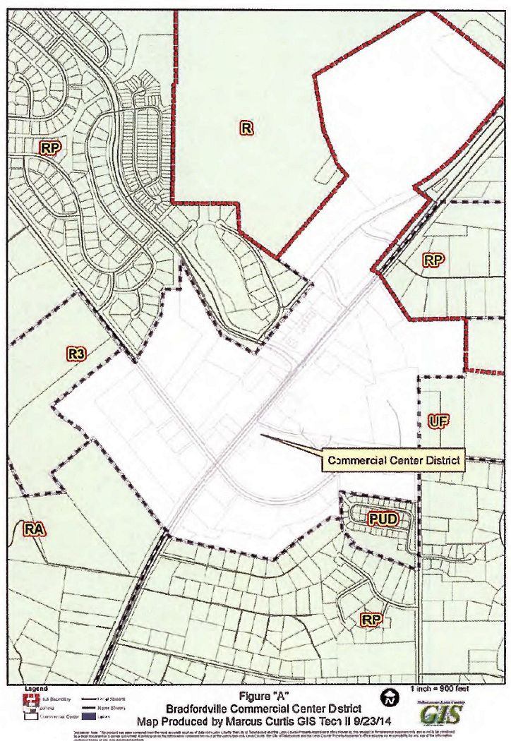
(Code 1992, § 10-6.680; Ord. No. 07-20, § 2, 7-10-2007; Ord. No. 13-06, § 4, 3-12-2013; Ord. No. 15-03, § 7, 2-10-2015; Ord. No. 20-06, § 8, 4-28-2020; Ord. No. 22-17, § 13, 6-14-2022)

Sec. 10-6.691. - Woodville Rural Community future land use map category.

(a)

The land use element of the Tallahassee-Leon County Comprehensive Plan establishes the Woodville Rural Community future land use category on the future land use map. The following zoning districts implement and are applicable within the Woodville Rural Community future land use category:

(1)

RA Residential Acre.

(2)

R-1 Single-Family Detached Residential District.

(3)

R-5 Manufactured Home and Single-Family Detached District.

(4)

RP Residential Preservation District.

(5)

MH Mobile Home Park District.

(6)

C-1 Neighborhood Commercial District.

(7)

C-2 Neighborhood Commercial District.

(8)

WC Woodville Commercial District.

(9)

OS Open Space District.

(10)

PUD Planned Unit Development District.

(b)

District intent, allowable uses and development standards for each of these districts are set forth in this subdivision.

(Code 1992, § 10-6.691; Ord. No. 07-20, § 2, 7-10-2007)

Sec. 10-6.692. - WC Woodville Commercial District.

Permitted Uses
1. District Intent2. Principal Uses
3. Accessory Uses
 The Woodville Commercial District is intended to be located in areas designated rural community on the future land use map of the Comprehensive Plan within the Woodville Community and shall apply to areas exhibiting an existing development pattern of office, general commercial, community facilities, and intensive automotive commercial development abutting arterial roadways with high traffic volumes. The Woodville Commercial District is characterized by a linear pattern of development. The access management standards for the Woodville Commercial district addressing limitations placed on access are intended to minimize and control ingress and egress to arterial roadways and to promote smooth and safe traffic flow of the general traveling public.
 Developments including two or more uses (i.e., commercial, office, light industrial, community facilities, open space/recreation), including the ruse of existing single use sites for multiple use developments and the addition of new uses to single use sites and/or multiple use developments that share parking facilities, are encouraged.  
(1) Antique shops.
(2) Automotive service and repair, including car wash.
(3) Automotive-retail, parts, accessories, tires, etc.
(4) Bed and Breakfast Inns, no more than eight guest rooms.
(5) Bait and tackle shops.
(6) Banks and other financial institutions.
(7) Camera and photographic stores.
(8) Cocktail lounges and bars.
(9) Community facilities, including libraries, religious facilities, vocational schools, and police/fire stations. New elementary, middle, and high schools are prohibited. Other community facilities may be allowed in accordance with section 10-6.806.
(10) Day care centers.
(11) Gift, novelty, and souvenir stores.
(12) Indoor amusements (bowling, billiards, skating, etc.).
(13) Laundromats, laundry and dry-cleaning pick up stations.
(14) Mailing services.
(15) Medical and dental offices, services, laboratories, and clinics.
(16) Mortuaries.
(17) Motor vehicle fuel sales.
(18) Museums and art galleries.
(19) Non-medical offices and services, including business and government offices and services.
(20) Non-store retailers.
(21) Passive and active recreational facilities.
(22) Pawnshops.
(23) Personal services (barber shops, fitness clubs, etc.).
(24) Pest control services.
(25) Photocopying and duplicating services.
(26) Printing and publishing.
(27) Rental and sales of video tapes and games.
(28) Rental of tools, small equipment, or party supplies.
(29) Repair services, non-automotive.
(30) Restaurants, with or without drive-in facilities.
(31) Retail bakeries.
(32) Retail caskets and tombstones.
(33) Retail building materials.
(34) Retail computer, video, record, and other electronics.
(35) Retail department, apparel, and accessory stores.
(36) Retail drug store.
(37) Retail florist.
(38) Retail food, grocery, and convenient stores.
(39) Retail furniture, home appliances and accessories.
(40) Retail home/garden supply, hardware and nurseries.
(41) Retail jewelry stores.
(42) Retail needlework and instruction.
(43) Retail newsstand, books, greeting cards.
(44) Retail office supplies.
(45) Retail optical and medical supplies.
(46) Retail package liquors.
(47) Retail pet stores.
(48) Retail picture framing.
(49) Retail sporting goods, toy stores.
(50) Retail shoes, luggage, and leather products.
(51) Retail trophy stores.
(52) Sign shops.
(53) Social, fraternal and recreational clubs and lodges, including assembly halls.
(54) Studios for photography, music, art, drama, voice.
(55) Tailoring.
(56) Veterinary services, including veterinary hospitals.
(57) Miniwarehouses, or self-storage facilities.
(58) Other uses, which in the opinion of the County Administrator or designee, are of a similar and compatible nature to those uses described in this district.
(1) A use or structure on the same lot with, and of a nature customarily incidental and subordinate to, the principal use or structure and which comprises no more than 33 percent of the floor area or cubic volume of the principal use or structure, as determined by the County Administrator or designee.
(2) Light infrastructure and/or utility services and facilities necessary to serve permitted uses, as determined by the County Administrator or designee.


General notes:

(1)

Refer to the Environmental Management Act (EMA) for information pertaining to the regulation of environmental features (preservation/conservation features), stormwater management requirements, etc.

(2)

Refer to concurrency management ordinance for information pertaining to the availability of capacity for certain public facilities (roads, parks, etc.).

Development Standards
4. Minimum Lot or Site Size5. Minimum Building Setbacks6. Maximum Building Restrictions
Use Categorya. Lot or Site Areab. Lot Widthc. Lot Deptha. Frontb. Side-
Interior Lot
c. Side-
Corner Lot
d. Reara. Building Size (excluding gross building floor area used for parking)b. Building Height (excluding stories used for parking)
Warehousing, Storage, Miniwarehousing None None None 25 feet None 25 feet 10 feet 20,000 square feet building area per acre, not to exceed 40,000 square feet per single structure. 3 stories
All other Permitted Principal Uses
a) Served by central sewer None None None 25 feet None 25 feet 10 feet 10,000 square feet building area per acre, not to exceed 50,000 square feet building area per parcel, nor 40,000 square feet per single structure. 3 stories
b) Not served by central sewer None None None 25 feet None 25 feet 10 feet No more than one septic tank, limited to no greater than 500 gallon capacity per one-half acre supporting a building area not to exceed 8,000 square feet building area per acre, not to exceed 40,000 square feet building area per parcel, nor 30,000 square feet per single structure. 3 stories
7. Access Management Criteria: (In case of a conflict with the provisions of other ordinances or regulations, the most strict provisions shall apply).
(a) All arterials and major collectors. Full movement access to an arterial or major collector shall not be permitted closer than 330 feet to another full movement access point, nor within 660 feet of a signalized intersection. Right-in/right-out access to an arterial or major collector shall not be permitted closer than 330 feet to another access point, nor within 100 feet of a signalized intersection, except properties with sole access to an arterial or major collector are permitted no less than one right-in/right-out access point. Properties with 660 feet or more of arterial and major collector frontage may be permitted multiple accesses to a single street based upon a traffic safety and capacity evaluation. All development fronting on an arterial or major collector shall record a joint access and cross easement benefiting adjoining properties fronting on the same arterial or major collector.
(b) Minor collectors. Full movement access to a minor collector shall not be permitted closer than 200 feet to another full movement access point, nor within 400 feet of a signalized intersection. Right-in/right-out access to a minor collector shall not be permitted closer than 100 feet to another access point, nor within 200 feet of a signalized intersection, except properties with sole access to a minor collector are permitted no less than east one right-in/right-out access.
(c) Local streets. Full movement access to a local street shall not be permitted within 200 feet of a signalized intersection. Right-in/right-out access to a local street shall not be permitted closer than 100 feet to another access point or intersecting public street, nor within 200 feet of a signalized intersection, except properties with sole access to a local street are permitted no less than one access point, which may be limited to right-in/right-out based upon a traffic safety evaluation.
8. Street Vehicular Access Restrictions: Properties in the Woodville Commercial zoning district may have vehicular access to any type of street. However, in order to protect residential areas and neighborhoods from non-residential traffic, vehicular access to a local street is prohibited if one of the following zoning districts is located on the other side of the local street: R, RA, R-1, R-5, MH, and RP.
9. Landscape Standards: Development within the Woodville commercial zoning district shall be subject to the landscape requirements of this section in addition to those requirements of the Environmental Management Act (EMA). Where standards conflict, the stricter of the two shall apply. All landscape plans shall be prepared by a registered landscape architect as per F.S. ch 481.
Arterial Road Landscaping. All properties fronting arterial roads shall provide and maintain a 30 foot wide landscape area immediately adjoining the arterial road. All vegetation within the 30 foot wide landscaped area of good condition four inches and larger shall be preserved. This landscape area shall be planted with canopy trees with no less than 1 tree for each 200 square feet of landscape area. Creative design and spacing is encouraged. The landscape area may be crossed by driveways permitted pursuant to section 8 of this section, but compensatory area shall be added, equal to the area of the driveway, adjacent to the required landscape area. Sidewalks are not permitted within the landscaped area except for interconnections to sidewalks fronting public roadways. Signs may be located within the landscape area, but shall not reduce the tree planting requirement. Existing healthy trees in the landscape area may be counted as prescribed in section 10-4.350(b) toward meeting the tree planting requirement. Management of the existing trees within the 30 feet shall include pruning of dead and hazardous tree limbs, pruning of live limbs less than 25 percent of the green mass of the tree, fertilization, pest control, and control of invasive vegetation. Mechanical methods which compact the earth or root systems shall not be allowed.
10. Parking Standards:
(a) Properties fronting an arterial road shall be allowed to construct 50 percent of all parking required by the land development code in front of the proposed building/structure and/or adjacent to a public roadway. Additional parking, above code requirements shall be located to a side or rear of the proposed building/structure that is not fronting a public or private roadway or access way.
(b) Properties fronting a collector or local road shall be allowed to construct a single parking aisle between the proposed building and the collector and/or local road.
11. Lighting Standards:
(a) All exterior lighting shall have recessed bulbs and filters which conceal the source of illumination. No wall or roof mounted flood or spot lights used as general grounds lighting are permitted. Security lighting is permitted.
(b) Lighting for off-street walkways shall be spaced no more than 30 feet apart, and shall not exceed 10 feet in height.
(c) Parking lighting shall be spaced a maximum of 50 feet apart and shall not exceed 20 feet in height.
(d) Lighting levels at the property line (six feet above ground) adjacent to residential areas shall not exceed 0.5 footcandles.
12. Design Standards:
(a) All buildings shall screen trash collection/storage areas with materials found on the exterior of the building.
(b) All delivery truck docks shall provide a screen of sufficient height and length to screen loading and unloading trucks.


General notes:

(1)

Refer to the Environmental Management Act (EMA) for information pertaining to the regulation of environmental features (preservation/conservation features), stormwater management requirements, etc.

(2)

Refer to the concurrency management ordinance for information pertaining to the availability of capacity for certain public facilities (roads, parks, etc.).

(Code 1992, § 10-6.692; Ord. No. 07-20, § 2, 7-10-2007)

Sec. 10-6.696. - Planned Unit Developments.

(a)

Specific uses required by the Comprehensive Plan to be developed as planned developments or planned unit developments.

(1)

Purpose and intent. The purpose and intent of this section is to provide for the required review of the uses specifically identified in the Comprehensive Plan as uses to be developed as planned developments or planned unit developments. These uses are ones which may have a potential adverse impact and therefore should be subject to additional review.

(2)

Allowable land uses. Those uses specifically identified in the goals, objectives, and policies, the land use categories and the land development use matrix shall be allowed.

(3)

Development standards. These uses shall be subject to review and approval by the Board of County Commissioners and any specific standards as shown in the Comprehensive Plan, these regulations, and other applicable codes or ordinances.

(b)

Planned unit development (PUD) zoning district requirements and procedures.

(1)

Purpose and intent of district.

a.

The PUD zoning district and associated concept plan may be used to establish types of development and arrangements of land uses that are consistent with the Comprehensive Plan, but which are not otherwise provided for or allowed in the zoning districts set out in this chapter. The range of uses and development intensities allowed within a particular PUD district, along with any corresponding development and design standards are established by an associated PUD concept plan. Subsequent development within the PUD district is implemented by the approval of one or more site and development plans, known as PUD final plans.

b.

The standards for creating a new PUD district and its associated concept plan set out herein are intended to promote flexibility of design and permit planned diversification and integration of uses and structures. The process set out herein allows the Board of County Commissioners to evaluate applications to establish new PUD districts and their associated concept plans, to make modifications to adopted concept plans, and to render final determination as to whether applications should be approved, approved with conditions, or denied. In addition, the Board of County Commissioners, may through approval with conditions, establish such additional limitations and regulations as it deems necessary to protect the public health, safety, and general welfare. Specifically, the PUD district is intended to:

1.

Promote more efficient and economic uses of land.

2.

Provide flexibility to meet changing needs, technologies, economics, and consumer preferences.

3.

Encourage uses of land which reduce transportation needs and which conserve energy and natural resources to the maximum extent possible.

4.

Preserve to the greatest extent possible, and utilize in a harmonious fashion, existing landscape features and amenities.

5.

Provide for more usable and suitably located recreational facilities, open spaces and scenic areas, either commonly owned or publicly owned, than would otherwise be provided under a conventional zoning district.

6.

Lower development and building costs by permitting smaller networks of utilities and streets and the use of more economical building types and shared facilities.

7.

Permit the combining and coordinating of land uses, building types, and building relationships within a planned development, which otherwise would not be provided under a conventional zoning district.

(2)

Planned unit development in residential preservation land use category. In addition to the provisions of this section, planned unit developments proposed for lots in a recorded or unrecorded residential subdivision zoned residential preservation and which directly abut an arterial or a major collector roadway shall be consistent with the provisions cited in section 10-6.617(a)(4). Planned unit developments proposed for interior lots in a recorded or unrecorded subdivision zoned residential preservation shall be consistent with the density of the existing residential development in the recorded or unrecorded subdivision as provided for in section 10-6.617(a)(2). For the purpose of this section, interior lots mean those lots within a recorded or unrecorded subdivision in the residential preservation zoning district having sole legal access via the roadway network internal to the subdivision and said roadway network was specifically constructed as part of the subdivision roadway network.

(3)

Establishment of a new PUD district and adoption of an associated concept plan.

a.

Eligibility for application. Applications for establishment of a new PUD zoning district shall demonstrate compliance with the following minimum eligibility criteria:

1.

Minimum area for a PUD zoning district. The minimum area required for an application to a PUD district shall be five acres, except where the proposed use is required to be approved as a planned unit development by the Comprehensive Plan wherein, there shall be no minimum area required.

2.

Configuration of the PUD zoning district. The PUD zoning district shall consist of a single discrete area of land of sufficient width and depth to accommodate the proposed use.

3.

Unified control/ownership. All properties included for the purpose of application to amend the official zoning map to create a PUD district shall be under the ownership or control of the applicant.

b.

Review process. The approval of a PUD zoning map amendment and associated concept plan application rests with the Board of County Commissioners. An application for a PUD zoning district shall include a PUD concept plan; a PUD zoning district shall not be established unless and until an associated implementing PUD concept plan is approved by the Board of County Commissioners. Review of an application for a PUD zoning map amendment and associated concept plan shall undergo the following sequence:

1.

Pre-application conference. An application for a pre-application conference shall be submitted in accordance with established policies and procedures.

2.

PUD concept plan application. A PUD concept plan application shall be submitted in accordance with the submittal requirements set forth in subsection (b)(3) of this section.

3.

Public notification. Public notice of the PUD concept plan shall be provided by publication in a newspaper of regular and general circulation. In addition, written notice shall be mailed to the current address of each owner of property located within 1,000 feet of the properties included in the application based upon the records of the county property appraiser's office, and to registered neighborhood associations.

4.

DRC meeting and recommendation. The development review committee shall review the PUD concept plan application to evaluate consistency with the Comprehensive Plan and compliance with applicable land development regulations adopted by the county. The DRC shall prepare an itemized list of written findings of fact that support a recommendation of approval, approval with conditions, or denial of the PUD concept plan. The written findings of the DRC shall be forwarded to the planning commission.

5.

Planning commission public hearing and recommendation. The planning commission shall conduct a public hearing on the PUD zoning map amendment and concept plan application and formulate findings supporting a recommendation to the Board of County Commissioners to approve, approve with conditions, or deny the application. The planning commission's recommendation shall be based upon the recommendation of the DRC, public testimony and findings made on the record at the public hearing. Quasi-judicial proceedings may be invoked pursuant to the provisions of division 9, article XI of this chapter.

6.

Board of County Commissioners public hearing and disposition. The Board of County Commissioners shall conduct a public hearing on the PUD zoning map amendment and concept plan application. The Board's final action approve, approve with conditions, or deny the application shall be based upon the recommendations of the planning commission and the DRC, public testimony, and findings made on the record at the public hearing. The decision of the Board of County Commissioners shall be supported by written findings. The decision of the Board of County Commissioners shall be final.

c.

Application content and submittal requirements.

1.

PUD concept plan. A PUD concept plan is a generalized plan that establishes the allowable land uses and the allowable development density or intensity ranges as well as any corresponding development and design standards for all lands within the PUD zoning district. A PUD concept plan may further establish separate subdistricts. The PUD concept plan may, for each subdistrict, establish a separate list of allowable uses and applicable standards, so long as those uses and standards are consistent with those established for the PUD district.

A PUD concept plan shall consist of the graphic and/or textual information itemized in subsections (b)(3)c.1.(i) through (iv) of this section. Adjustments to this information can be made at the pre-application conference.

(i)

A general plan for the use of all lands within the proposed PUD. Such plans shall indicate the general location of residential areas (including density and unit types), open space, parks, passive or scenic areas, and non-residential areas (including maximum building square footage and maximum height).

(ii)

A plan of vehicular and pedestrian circulation showing the general locations and right-of-way widths of roads, sidewalks, the capacity of the system and access points to the external and internal thoroughfare network. The conceptual vehicular plan for a PUD utilizing the provisions of section 10-6.617(a)(4) shall identify the functional classification of the roadway that will provide access to the proposed development.

(iii)

A summary of allowable development. The summary shall provide:

A.

The total acreage of the PUD district, and each subdistrict, as may be proposed;

B.

The acreage of areas proposed for specific land uses proposed to be allowed within the PUD district and PUD sub-districts proposed in the concept plan, as may be applicable;

C.

The acreage of open space or conservation areas not to be developed within the PUD district and PUD sub-districts proposed in the concept plan;

D.

The minimum and maximum allowable quantity of residential units to be allowed within the PUD district, and PUD sub-districts proposed in the concept plan, measured in residential dwelling units per acre;

E.

The minimum and maximum allowable residential density to be allowed within the PUD district, and PUD sub-districts proposed in the concept plan, measured in residential dwelling units per acre;

F.

The minimum and maximum allowable non-residential development intensity to be allowed within the PUD district, measured in gross building square footage; and,

G.

The minimum and maximum allowable non-residential development intensity to be allowed within the PUD district, measured in floor area ratio.

(iv)

Regulations and development standards for the PUD district and for each sub-district, including:

A.

An itemized list of uses proposed to be allowed in each the PUD district, or sub-districts, if any.

B.

The minimum and maximum residential densities for the PUD district and for any sub-districts.

C.

The minimum and maximum non-residential gross square footage and floor area ratios for the PUD district and for any sub-districts.

D.

Development and design standards governing the development of the PUD district and any sub-districts which shall, at a minimum, address: lot dimensions and size; building setbacks; building heights; dimensions of internal streets, sidewalks, and other transportation facilities (such standards may be conveyed through annotated diagrams); open space provision, off-street parking, buffering, and landscaping.

E.

The PUD concept plan may establish, for the PUD district or any sub-district therein, additional development and design standards for other development and design characteristics and elements, etc., so long as these standards are consistent with the Comprehensive Plan. The PUD concept plan may establish proprietary standards to regulate a particular development or design characteristic or element. In those instances where development or design standards are not specifically provided in the PUD concept plan, the standards set out in the land development code shall remain in force.

2.

A site conditions map that includes:

(i)

A legal description of the properties included in the application with an associated boundary survey signed and sealed by a registered state land surveyor.

(ii)

Name of the PUD; the owners of all properties included in the PUD district; the agent for the PUD application, and address and phone number of the agent; and date of drawing and of any subsequent revision.

(iii)

Scale, north arrow, and general location map showing relationship of the site to external uses, structures, and features.

3.

A natural features inventory approved by the department of development support and environmental management.

4.

A preliminary certificate of concurrency or appropriate documentation issued by the county department of development support and environmental management.

d.

Review criteria. In order to be approved, a proposed PUD zoning map amendment and concept plan application shall demonstrate satisfaction of the following criteria:

1.

Consistency with the Comprehensive Plan. The proposed PUD district shall be consistent with the Comprehensive Plan.

2.

Consistency with other ordinances. The proposed PUD district shall be consistent with all other ordinances adopted by the county, including, but not limited to, the applicable environmental and concurrency management ordinances.

3.

Consistency with purpose and intent of PUD district. An application for a PUD district shall include a narrative indicating how the proposed PUD district meets the purpose and intent of the PUD district, as set forth in subsection (a) of this section. The narrative shall specifically address the seven statements itemized in subsection (a) of this section.

(4)

Previously approved PUD districts and concept plans.

a.

Status of previously approved PUDs. Any PUD district approved prior to the effective date of the ordinance from which this subdivision is derived shall continue to be governed by the approved PUD plan and any agreements, terms, and conditions to which the approval may be subject and shall be designated PUD on the official zoning map

b.

Amendments to a PUD concept plan or PUD zoning districts. Whenever any application is made to substantially modify an approved PUD, or to undertake a new development on part or all of the property, the application shall be made under the terms and procedures of the PUD district set forth herein. Notwithstanding this provision, the County Administrator or designee may approve amendments to the PUD concept plan during the review of a PUD final development plan if said amendments are substantially minor in nature and do not affect the overall character of the PUD concept plan. The criteria that the County Administrator or designee shall use to determine if the proposed changes are not substantially minor in nature and effect the overall character of the PUD include, but are not limited to: a change in the overall number of residential dwelling units of ten percent or greater; a change in density of 15 percent or more; an increase of non-residential building square footage; a substantial decrease in the amount of acres devoted to common open space and/or natural area; a substantial change in the general location of the proposed land uses, including the common open space and/or natural areas; a substantial change in the location, design, or function of associated transportation facilities; and a substantial change in the location, design, type, or function of associated infrastructures.

c.

Eligibility for application for modification of a PUD concept plan or district.

1.

Minimum area for modification to an existing PUD zoning district or concept plan amendment: The minimum area required to be included in an application for amendment to a PUD district shall be the entire PUD zoning district; however, the County Administrator or designee, may allow an amendment of the official zoning map or the concept plan that affects or applies to only a portion of the land area included in the PUD district upon a finding that such amendment would not adversely impact the remainder of the district.

2.

Control/ownership.

(i)

All properties included for the purpose of application for modification to an existing PUD zoning district or concept plan amendment shall be under the ownership or control of the applicant; or

(ii)

An application may be made by the Board of County Commissioners.

(5)

PUD final plan. The PUD final plan is a site and development plan consistent with and intended to implement a PUD concept plan. The final plan may pertain to an entire PUD district or some portion of the land area included within that district. The appropriate level of site and development plan review for the PUD final plan, applicable submittal requirements, and procedural standards, including level of review, are those set forth in the site plan procedures of division 4, article VII of this chapter. In addition, the final vehicular plan for a PUD utilizing the provisions of section 10-6.617(a)(4) shall show consistency with the access provisions of section 10-6.617(a)(4) and subsection (b) of this section.

(6)

Joint concept and final PUD plan application. At the option of the applicant, a PUD concept plan may be reviewed simultaneously with a PUD final development plan. The submittal requirements of such a review shall be determined at the pre-application conference.

(Code 1992, § 10-6.696; Ord. No. 07-20, § 2, 7-10-2007; Ord. No. 08-04, § 2, 2-26-2008; Ord. No. 10-08, §§ 2—8, 3-23-2010; Ord. No. 14-10, § 18, 6-10-2014)

Sec. 10-6.697. - Development of Regional Impact (DRI) Zoning District requirements and procedures.

A development of regional impact (DRI) is a development which, because of its character, magnitude, or location, would have a substantial effect upon the health, safety or welfare of citizens of more than one county. Development standards in the DRI zoning district shall be those approved in the development order for the DRI. If no development standards were approved in the development order for the DRI, then development standards shall be established at the time that site plans and/or subdivision plats are submitted for review for each individual component of the DRI. Said development standards shall be consistent with the development standards of any previously approved site plan and/or subdivision in the DRI and the overall character of the DRI. Procedures for review and standards for approval of DRI's are found in F.S. ch. 380, and the rules promulgated thereunder. Applications for new DRI's shall follow the procedure set forth in section 10-7.406 and F.S. ch. 380. The procedures for review of the individual components of the DRI are set forth in article VII of this chapter. Prior to Board of County Commissioners consideration of any proposed change to an approved DRI, the planning commission shall review the proposed change or request for determination of substantial deviation at a public meeting and transmit its recommendation to the Board of County Commissioners for consideration. Prior to planning commission review, quasi-judicial proceedings may be invoked pursuant to the provisions of division 7, article VII of this chapter. Any DRI project approved prior the effective date of the ordinance from which this sudivision is derived shall continue to be governed by the approved DRI's development order and any agreements, terms, and conditions to which the approval may be subject and shall be designated DRI on the official zoning map for that portion of the DRI located in a Suburban, Urban Residential, Urban Residential 2 or Bradfordville Mixed Use future land use category.

(Code 1992, § 10-6.697; Ord. No. 07-20, § 2, 7-10-2007; Ord. No. 09-13, § 3, 3-19-2009)