
Leon County Unincorporated
City Zoning Code
City Zoning Code
DIVISION 7
SPECIAL REGULATORY PROVISIONS
Sec. 10-6.701.- Purpose and intent.
The purpose of this division is to establish special regulatory provisions and overlays. These provisions and overlays are applicable to unique site characteristics and conditions determined to require special protection by the Comprehensive Plan.
(Code 1992, § 10-6.701; Ord. No. 07-20, § 2, 7-10-2007)
Sec. 10-6.702. - Generally.
(a)
The Comprehensive Plan sets forth requirements for special regulatory mechanisms to implement the intent of the plan in locations where unique conditions are present. This division establishes the special regulatory overlay districts and areas to respond to the set of unique conditions.
(b)
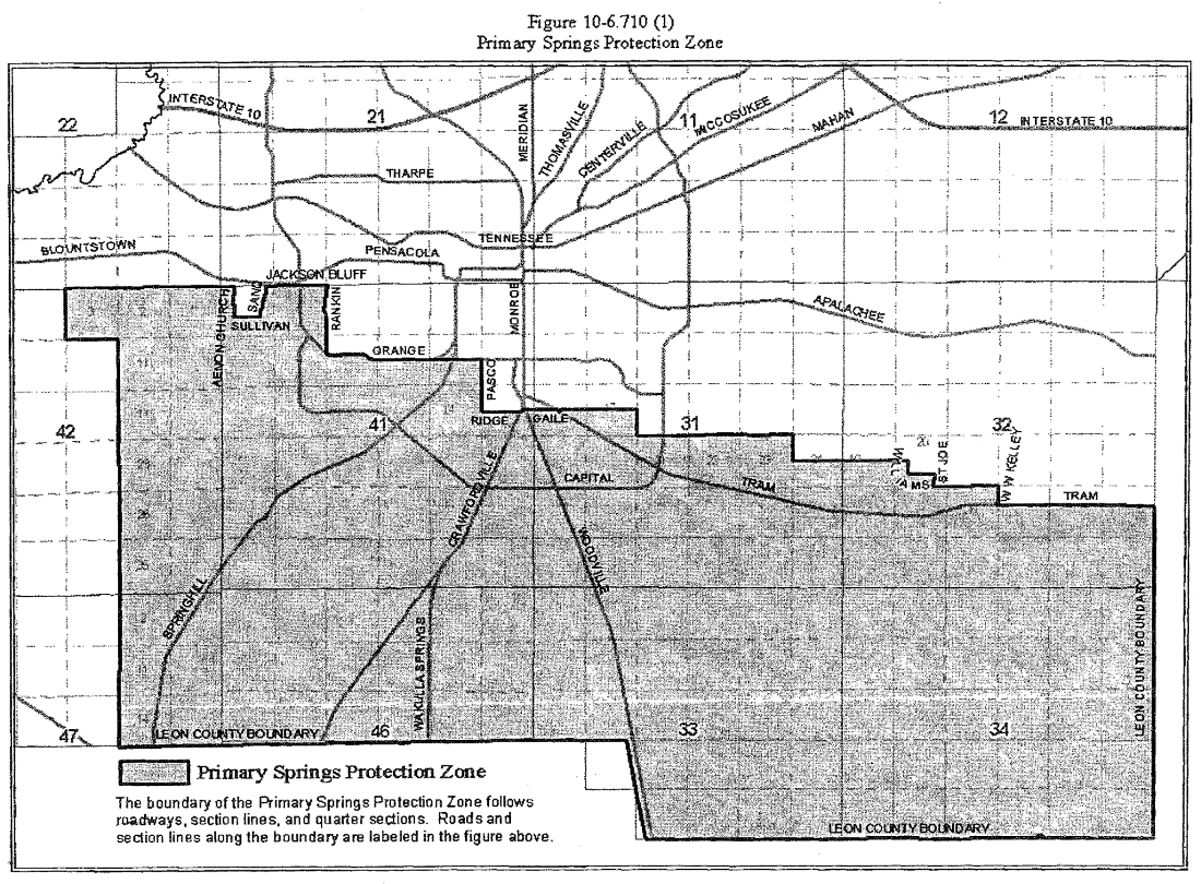
The canopy road and historic preservation overlay districts are depicted on the official zoning map. The conservation and preservation areas are based on presumptive criteria established in the Comprehensive Plan. The determination that particular lands lie within one of these two areas is dependent upon the presence or absence or environmental constraints on-site, confirmed through the environmental analysis required during development application review. The area included in the primary springs protection zone is displayed in exhibit A in section 10-6.710(1).
(Code 1992, § 10-6.702; Ord. No. 07-20, § 2, 7-10-2007; Ord. No. 09-12, § 1, 3-19-2009)
Sec. 10-6.703. - Canopy Road Overlay District, Preservation Areas, Conservation Areas, and Historic Preservation District.
(a)
Purpose and intent. The purpose and intent of the Canopy Road Overlay District (CRO), Preservation Areas (PA), Conservation Areas (CA), and Historic Preservation Overlay District HPOD are to provide for more focused development reviews for projects associated with sensitive historical, cultural or environmental resources.
(b)
Allowable uses. The uses permitted in CRO, PA, CA, and HPOD are those provided in the underlying zoning district. The overall intensity of development of land may not exceed that permitted by the underlying zoning district, and may be further reduced in accordance with special development and design standards set forth herein.
(c)
Applicable development standards. Developments affecting land within CRO, PA, CA, and HPOD shall comply with the special development standards for the CRO, PA, CA, and HPOD, which are found in this division.
(Code 1992, § 10-6.703; Ord. No. 07-20, § 2, 7-10-2007)
Sec. 10-6.704. - Conservation Areas.
(a)
Purpose and intent. The purpose and intent of the review of development proposed for conservation areas is to protect these areas and attributes; the habitats established upon or within them; and the private property from any associated hazards. Lands located under the following conditions shall be considered to be located within the conservation areas:
(1)
Altered floodplains and floodways.
(2)
Altered watercourses or improved elements of primary drainage systems.
(3)
Within a closed basin.
(4)
Having grades of ten percent to 20 percent.
(5)
Within a high quality successional forest.
(6)
Having active karst features.
(7)
Within designated canopy road areas.
Best management practices shall be applied to development in the conservation area to protect sensitive areas, ensure continued functioning of the ecosystem, and protect life and property.
(b)
Allowable land uses and activities. The allowable uses permitted in the conservation area shall be those permitted in the underlying zoning district.
(c)
Land use development criteria. Development shall be limited to the portion of the site that is outside the environmentally sensitive areas. Development density may be transferred to the nonenvironmentally sensitive areas consistent with the overall density or intensity permitted by the underlying zoning district. In no case shall development exceed the allowable density or intensity on the developable portion of the site. The density or intensity transferred to nonsensitive portions of the site may be limited by other applicable requirements, including, but not limited to, stormwater retention, open space, landscaping, buffers, setbacks, parking and any concurrency requirements. If there is no area on the site suitable for transfer, development may be allowed at one unit per acre. Where open space is required for development, a 50 percent credit may be granted for protection of conservation areas. The following development criteria shall be applied to the respective environmentally sensitive areas:
(1)
Altered floodplain and floodways. Development will be permitted only if it does not impede water flow or displace volume.
(2)
Altered watercourses and improved elements of the primary drainage system. Development shall not permitted in these areas.
(3)
Closed basins. Development shall be permitted only to the extent that there is sufficient stormwater capacity within the basin.
(4)
Significant grade areas (ten percent to 20 percent) where soil type presents a threat of erosion. Development will be permitted with the following conditions:
a.
Minimize any topographical changes. Minimal grade changes typically associated with site development include those necessary for the safety of a building, parking area, road right-of-way, disability access, or associated utilities, including stormwater management system.
b.
Use best management practices such as off-grade construction and design the building or adjustment of the site plan to take advantage of the slope.
c.
Fifty percent of the site must be left natural (inclusive of the grade areas and shall be best placed to proved downhill buffers, protect forested areas, and buffer more protected features such as wetlands).
(5)
High quality successional forest. Development in high quality successional forests shall be subject to the following requirements:
a.
If the entire site is high quality successional forest, the site may be developed at the permitted density of the underlying zoning district. However, no more than 20 percent of the site shall be disturbed.
b.
Development density may be transferred to nonenvironmentally sensitive areas of the site at the permitted density or intensity of the underlying zoning district.
c.
The development density or intensity of subsections (5)a and b of this section may be limited. The density or intensity transferred to nonsensitive portions of the site may be limited by other applicable requirements, including, but not limited to stormwater retention, open space, landscaping, buffers, setbacks, parking and any concurrency requirements.
d.
If the transfer option is not exercised, development will be limited to a maximum density of one unit per two acres.
(6)
Areas exhibiting active karst features (sink holes). No untreated stormwater will be allowed to enter active karst features. Stormwater discharged to active karst features must meet the following criteria:
a.
Runoff must be treated to comply with F.A.C. § 17-25.700(2).
b.
Discharge rates and volume shall not exceed predevelopment rate and volume.
c.
The area within the uppermost contour of an active sink, as determined by standard geotechnical evidence in consideration of soil types, slopes, vegetation, topography and geologic features, shall remain natural. Topography and geologic features shall remain natural. A transitional buffer from the uppermost contour may also be required.
d.
There will be no discharge of water to an active karst feature from any land use which uses, produces or generates as waste any listed Resource Conservation and Recovery Act material or listed Environmental Protection Agency priority pollutant.
(7)
Development standards. All development within a conservation area shall be subject to the applicable provisions of article IV of this chapter, the Environmental Management Act.
(Code 1992, § 10-6.704; Ord. No. 07-20, § 2, 7-10-2007; Ord. No. 09-20, § 1, 7-14-2009; Ord. No. 18-18, § 11, 12-11-2018)
Sec. 10-6.705. - Preservation Areas.
(a)
Purpose and intent. The purpose and intent of preservation areas is to protect environmentally sensitive areas that would be severely impacted by development. Preservation areas apply to the following:
(1)
Waterbodies.
(2)
Lands within or lying under wetlands.
(3)
Land within or lying under natural watercourses.
(4)
Lands impacted with severe grades over 20 percent.
(5)
Lands with native forests.
(6)
Lands within the undisturbed/undeveloped portion of the 100-year floodplain.
(7)
Areas of exceptional environmental significance; including the habitats of endangered, threatened species, or species of special concern.
These areas are unsuitable for all but extremely-low-density development.
(b)
Allowable land uses and activities. Development in this preservation area shall be limited to residential uses at a density of no greater than one dwelling unit per 40 acres and passive recreational activities designed to be compatible with site features.
(c)
Land use development criteria.
(d)
Development standards. All development within the preservation area shall be subject to the above listed criteria and to the applicable provisions of article IV of this chapter, the Environmental Management Act.
(Code 1992, § 10-6.705; Ord. No. 07-20, § 2, 7-10-2007; Ord. No. 09-20, § 2, 7-14-2009; Ord. No. 18-18, § 12, 12-11-2018)
Sec. 10-6.706. - Special Development Zones.
(a)
Purpose and intent. The purpose and intent of the Special Development Zones Overlay District is to protect environmentally sensitive zones adjacent to watercourses or receiving waterbodies and in other environmentally sensitive areas within any watershed. The lakes and basins protected are:
(1)
Lake Jackson;
(2)
Bradford Brook Chain-of-Lakes;
(3)
Fred George Basin;
(4)
Lake Iamonia;
(5)
Lake McBride; and
(6)
Lake Lafayette.
The Special Development Zones Overlay Districts shall be depicted on the official zoning map.
(b)
Development standards and allowable uses. The development standards, allowable uses, and the area of each zone for each lake and basin are as set forth in sections 10-4.301 and 10-4.323 (the Environmental Management Act), and all of which sections are specifically incorporated by reference.
(c)
Prohibited land uses. The following land uses shall be prohibited within special development zones A and B:
(1)
Automotive repair; major and minor.
(2)
Automotive; sale of tires, batteries, and accessories.
(3)
Automotive; sales and rentals.
(4)
Bottling plants.
(5)
Car washes.
(6)
Food processing.
(7)
Horticulture nurseries.
(8)
Laboratories; research and development activities.
(9)
Laundries and dry cleaning activities or establishments other than delivery and pickup only.
(10)
Manufacturing or assembly.
(11)
Paint and solvent sale, storage or manufacturing.
(12)
Permanent active recreational facilities including racetracks.
(13)
Petroleum storage, refining, and allied activities.
(14)
Printing, publishing, and allied activities.
(15)
Repair services; general (furniture and similar uses).
(16)
Resource development activities.
(17)
Salvage yards.
(18)
Sawmills, planing mills, gristmills, nut crushing plants, turpentine stills, and other activities utilizing the natural resources of the region.
(19)
Self-moving business operations.
(20)
Service stations or other sales of petroleum products.
(21)
Slaughterhouses.
(22)
Transportation activities, freight handling.
(23)
Warehousing including enclosed, open and tank storage.
(24)
Welding and machine shops.
(25)
Wholesale activities.
(26)
Any other use which the director determines may reasonably be expected to produce stormwater pollutants similar to those specifically listed above and sought to be eliminated by this subsection.
(27)
Manufacture or processing of the following:
a.
Apparel and accessories.
b.
Chemicals and allied products.
c.
Lumber, wood, furniture, and fixtures.
d.
Metals and allied products.
e.
Paper and allied products.
f.
Rubber, plastic and allied products.
g.
Stone, clay and glass products.
h.
Textile and textile products.
(Code 1992, § 10-6.706; Ord. No. 07-20, § 2, 7-10-2007; Ord. No. 09-20, § 3, 7-14-2009)
Sec. 10-6.707. - Canopy Roads Overlay District.
(a)
Purpose and intent. The purpose and intent of the Canopy Roads Overlay District is to ensure the preservation and protection of the canopy road trees on the following roads:
(1)
Meridian Road from its intersection with Seventh Avenue to the state line.
(2)
Magnolia Drive—Centerville Road—Moccasin Gap Road from their intersection with Seventh Avenue to State Road 59.
(3)
Miccosukee Road from its intersection with Capital Circle to Moccasin Gap Road.
(4)
Old St. Augustine Road from its intersection with East Lafayette Street to W.W. Kelley Road.
(5)
Old Bainbridge Road from its intersection with Raa Avenue to Capital Circle.
(6)
Sunny Hill Road from its intersection with Thomasville Road to Old Centerville Road.
(7)
Old Centerville Road from its intersection with Centerville Road to the state line.
(8)
Pisgah Church Road from Bradfordville Road to the end of the county maintained right-of-way east of Centerville Road.
(b)
Allowable land use. The uses permitted in the Canopy Roads Overlay District are those uses permitted in the underlying zoning district.
(c)
Development standards. The Canopy Roads Overlay District includes as all lands within 100 feet from the centerlines of the roadways. The following special restrictions shall apply within the Canopy Roads Overlay District:
(1)
All structures, including fences, shall be setback a minimum of 100 feet from the centerline of the canopy road unless there is no reasonable alternative in the case of a vested single-family lot of record. Any disturbance to the overlay shall be minimized to the greatest extent possible, but not cause an unreasonable and undue hardship on the use of the property. A permit may be issued by the county for gates and the repair or maintenance of an existing, lawfully established fence, pursuant to any and all applicable criteria and standards set out in section 10-4.202(a)(2)b.8(j) and (l). Structures are permitted to prevent motorized vehicles from accessing trail approaches.
(2)
Any structure which exceeds 40 feet in height must be setback an additional one foot for every one foot in excess of 40 feet in height.
(3)
No development may occur in the canopy road overlay (100 feet from the centerline of the road) unless authorized for health, safety or welfare of the public.
(4)
Any part of the canopy road overlay that is cleared or has trees removed from it for roadway projects must be widened by the same amount that was disturbed in the same location if possible, or another reasonable location.
(5)
A full analysis of the impact of a development on the affected canopy road shall be submitted by the applicant at the time of development review.
(6)
Joint access to canopy roads shall be required for newly created lots unless there is no alternative.
(7)
If the site is accessible by roads other than the canopy road, it shall not have direct access to the canopy road.
(Code 1992, § 10-6.707; Ord. No. 07-20, § 2, 7-10-2007; Ord. No. 08-25, § 5, 11-25-2008; Ord. No. 09-20, § 4, 7-14-2009; Ord. No. 17-10, § 5, 6-20-2017)
Sec. 10-6.708. - Historic Preservation, Historic Preservation Districts and Historic Preservation Overlay Zoning.
(a)
Purpose and intent. The purpose of this section is to describe the procedures for listing individual historic sites, buildings, structures, and objects on the local register of historic places with historic preservation overlay (HPO) zoning; for listing properties on the National Register of Historical Places with an HPO zoning; for designating districts with HPO zoning; as well as to impose special development restrictions on identified areas. The location of overlay zones is established by the county based on the need for special protective measures in that area. The underlying uses in the area remain undisturbed by the creation of the overlay zone. The overlay zone imposes different development standards than those that would otherwise apply.
(b)
Definitions. The following words, terms, and phrases, when used in this section, shall be supplemental to the definitions contained in section 10-1.101, which shall be applicable throughout this section unless section conflict with the definitions provided in this section exists, in which case the meaning of the words, terms, and phrases ascribed in this section shall prevail.
Architectural review board means the ten-member board appointed jointly by the city commission and Board of County Commissioners to review exterior changes, excluding routine maintenance, to properties on the local register of historic places.
Certificate of appropriateness means a written statement issued by the architectural review board or the historic preservation officer to confirm that the proposed work is approved as appropriate pursuant to criteria in this division.
Contributing property means a site, building, structure, or object at least 50 years old, located within the boundaries of a designated historic preservation district or special character district, which, by its location, design, setting, materials, workmanship, feeling, and association adds to a historic preservation district's sense of time and place and historical development. Properties less than 50 years old may be determined to be contributing if a strong justification of their historical or architectural contribution to the district's sense of time and place and historical development is determined to exist, or the historical attributes of the district are considered to be less than 50 years old.
Cultural resource shall mean a site, object, structure, building, or district listed on the city or county survey of cultural resources or in the historic preservation element of the Comprehensive Plan or on the local register of historic places.
Historic preservation district means a geographically definable area, urban or rural, possessing a significant concentration, linkage, or continuity of sites, buildings, structures, objects, or areas, which are united historically or aesthetically by plan or physical development, which is zoned with a historic preservation overlay.
Historic preservation officer means the director or designee of the Tallahassee Trust for Historic Preservation, Inc., who shall serve as the principal to the staff to the architectural review board.
Local register of historic places means a local listing of buildings, structures, sites, objects, and districts determined pursuant to the criteria in this division to possess historic and/or architectural significance and which are zoned with a historic preservation overlay.
Non-contributing property means a site, building, structure, or object, within the boundaries of a designated historic preservation district, that does not add to the historic preservation district's sense of time, place, and historic development, but which is subject to review as provided in this division because it can impact the historic character of the historic preservation district.
Ordinary maintenance means work which does not require a construction permit and that is done to repair damage or to prevent deterioration or decay of a part or all of a building or structure as nearly as practicable to its condition prior to the damage, deterioration, or decay.
Original appearance means that appearance (except for color) which closely resembles the appearance of either the feature on the building as it was originally built or was likely to have been built, or the feature on the building as it presently exists so long as the present appearance is appropriate to the style and materials of the building.
Residential historic preservation district means an area of more than one property designated as a historic preservation district for which the underlying zoning is a low-density residential category.
Variance means a relaxation of the terms of this Code or ordinances involved where such variance will not be contrary to the public interest and, where owing to conditions peculiar to the property and not the result of the actions of the applicant, a literal enforcement of the code involved would result in undue hardship.
(c)
Local register of historic places and rezoning to include a Historic Preservation Overlay (HPO) for individual sites, buildings, structures, and objects.
(1)
Creation. A local register of historic places is hereby created as a means of identifying and classifying various sites, buildings, structures, and objects as historically and/or architecturally significant. The local register will be kept by the architectural review board.
(2)
Initiation of placement and rezoning with an HPO. The applicant for placement of sites, buildings, structures, or objects on the local register and rezoning with an HPO may be the city commission, the Board of County Commissioners, the planning commission, or the owner of the site, building, structure, or object. Upon written request of an owner, the Tallahassee Trust for Historic Preservation or the architectural review board may initiate placement on the local register of sites, buildings, structures, or objects.
(3)
Placement on the local register and rezoning with an HPO. The following procedure shall be followed for placement of a site, buildings, structures, or objects on the local register and rezoning with an HPO:
a.
A nomination form, available from the historic preservation officer, shall be completed by the applicant and returned to the historic preservation officer. If the Board of County Commissioners, city commission, or planning commission is the applicant, the planning department shall complete the nomination and return it to the architectural review board.
b.
Upon receipt of a completed nomination form, including necessary documentation, the historic preservation officer shall place the nomination on the agenda of the next appropriate regularly scheduled meeting of the architectural review board for a public hearing.
c.
Adequate notice of the architectural review board's consideration of the nomination at a public hearing shall be provided to the public at-large by publication in a newspaper of general circulation in the community, by U.S. Mail to the owner of property within 500 feet of the nominated properties, by U.S. Mail to the Tallahassee Trust for Historic Preservation, and by U.S. Mail to the owners of the nominated properties, at least 15 days in advance of the meeting at which the nomination will be considered by the architectural review board. The notice shall include a locational map of the affected property and shall state that the public may appear and comment on the nomination.
d.
The architectural review board shall, within 30 days from the date of the public hearing, review and prepare a recommendation on the nomination. The recommendation shall include specific findings and conclusions as to why the nomination does or does not meet the appropriate criteria for listing on the local register and rezoning with an HPO.
e.
The nomination form and the architectural review board's recommendation shall be sent to the planning commission. The nomination shall then be processed as rezoning pursuant to this chapter.
(d)
Criteria for listing on the local register and rezoning with an HPO.
(1)
A site, building, structure, or object must meet the following criteria before it may be listed on the local register and rezoned with an HPO:
a.
It possesses integrity of location, design, setting, materials, workmanship, feeling and association;
b.
It is associated with events or persons that are significant to local, state, or national history;
c.
It embodies the distinctive characteristics of a type, period, or method of construction, represents the work of a master, or possesses high artistic values; or
d.
It has yielded, or may be likely to yield, information important in prehistory or history.
(2)
Examples and explanations of the criteria set forth above are available in the Historic Preservation Property Guidelines Manual, which has been approved by action of the Board of County Commissioners. The Historic Preservation Property Guidelines Manual is intended to assist owners of property with an individual historic preservation overly or in historic preservation zoning districts, and shall be available from the planning department. Upon recommendation of the planning department director, or designee, the Historic Preservation Property Guidelines Manual may be amended from time to time in a manner consistent with this section. Final approval of amendments to the Historic Preservation Property Guidelines Manual is hereby delegated to the Board of County Commissioners. The planning department may charge a reasonable fee for copies of the publication to recoup the expenses of printing the publication.
(e)
Effect of listing on local register.
(1)
Upon approval of the nomination for listing on the local register and rezoning with an HPO, the architectural review board shall issue an official certificate of historic significance to the owner of sites, buildings, structures, or objects listed individually on the local register.
(2)
Sites, structures, buildings, and objects listed individually on the local register and zoned with an HPO shall be deemed historic and may be entitled to less restrictive standards, consistent with the state building code, existing building.
(3)
No demolition, alteration, relocation or construction activities may take place except as provided in this division.
(f)
Local register of historic places and rezoning with Historic Preservation Overlay (HPO) for historic preservation districts.
(1)
Historic preservation districts may be placed on the local register of historic places and rezoned with an HPO pursuant to this section.
(2)
Initiation of placement on the local register and rezoning with an HPO. The applicant for placement of a historic preservation district on the local register and rezoning with an HPO may be the Board of County Commissioners, the planning commission, or the owne of property within the proposed historic preservation district. If the Board of County Commissioners or the planning commission is the applicant, the planning department shall prepare the application.
(3)
Placement on the local register and rezoning with an HPO. The following procedure shall be followed for the designation of an HPO district, rezoning with an HPO and placement of an HPO district on the local register:
a.
Application for initiation of a historic preservation district viability study. An application form for initiation of a historic preservation district viability study, available from the planning department, shall be completed by the applicant following a pre-application meeting with the planning department, and returned to the planning department.
1.
The application shall include a proposed boundary of the historic preservation district.
2.
The application shall include a list of all property owners within the proposed historic preservation district, based on the latest tax rolls from the county property appraiser's office, and shall include parcel tax identification numbers, names, addresses, telephone numbers, and email addresses if available, with the signatures of property owners in favor of the initiation of a historic preservation district viability study. The planning department shall provide the list of property owners to the applicant at or following the pre-application meeting, but the applicant is responsible for obtaining the signatures.
3.
Prior to completing the application, the applicant shall contact the planning department and arrange a pre-application meeting. The applicant shall meet with technical assistance staff and the historic preservation officer to discuss the application, the procedures for review and approval, and applicable regulations and requirements for historic preservation districts.
b.
Review of application for initiation of a historic preservation district viability study. Upon receipt of a completed application, the planning department shall calculate the percentage of signatures on the list of properties within the proposed historic preservation district in favor of the initiation of a historic preservation district viability study. For purposes of calculating the percentage of signatures in favor of initiation of the historic preservation district viability study, owners of multiple parcels shall receive one vote for each parcel he owns. Likewise, parcels with multiple owners shall have only one vote.
1.
If the signatures reflect approval by 30 percent or more of the owners of the listed parcels, the planning department shall initiate the historic preservation district viability study as set forth below.
2.
If the signatures reflect approval by fewer than 30 percent of the owners of the listed parcels, the application will not move forward unless the applicant requests, through the planning department, initiation of the historic preservation district viability study by the Board of County Commissioners. The planning department, upon request by the applicant, shall prepare an agenda item for the Board of County Commissioners on behalf of the applicant. If the Board of County Commissioners denies the request, the planning department shall not initiate a historic preservation district viability study, and the historic preservation district designation process shall not move forward. If the request is approved, the planning department shall initiate the historic preservation district viability study as set forth below.
c.
Viability study (historic preservation district public outreach and education process). The planning department and the historic preservation officer shall conduct community meetings within the proposed historic preservation district. All property owners within the proposed historic preservation district shall be mailed notice by regular U.S. Mail of each community meeting for discussion of the proposed historic preservation district. The notices shall be mailed at least 15 calendar days prior to each meeting. The following topics shall be discussed in the community meeting:
1.
Overview of procedures for establishing a historic preservation district;
2.
Explanation of Secretary of the Interior's Standards for Rehabilitation and Guidelines for Rehabilitating Historic Buildings;
3.
County historic preservation regulations;
4.
Impacts of designation as a historic preservation district, including benefits, responsibilities, and the effect on ownership rights; and
5.
Next steps for the application. Other topics may be discussed.
d.
Formal vote by owners to initiate application for placement on the local register and rezoning with an HPO. The planning department shall be responsible for conducting a formal vote by owners within the proposed historic preservation district by mailed ballots. The ballots shall be sent to the owner of each parcel within the proposed historic preservation district by both regular U.S. Mail and certified mail, and shall request the owner of each parcel to indicate YES, he is in favor of initiating the application for a historic preservation district; or NO, he is not in favor of initiating the application for a historic preservation district. Owners of multiple parcels shall have one vote for each parcel he owns. If a parcel has multiple owners, the parcel shall have only one vote. Each ballot shall clearly state in a prominent place on the ballot that the ballot must be returned to the planning department by a specified return date, which shall be at least 45 days from the date it was mailed. Ballots not received by the date stated on the ballot shall not be counted.
e.
Tally of formal vote. After the specified return date stated on the ballot, if at least 50 percent plus one of the mailed ballots have been returned, the planning department shall count the ballots received. One ballot shall be counted for each parcel. A super majority (66.7 percent) of the ballots received must vote in favor of the proposed application in order for the process to designate the historic preservation district to continue. If fewer than 50 percent plus one of the mailed ballots are returned on or before the specified return date stated on the ballot, a tally will not be done and there shall be no application. Likewise, if fewer than 66.7 percent of the returned ballots vote in favor of the proposed application, there shall be no application.
f.
Processing the application. If the application receives a super majority vote in favor, it shall be deemed to have been initiated and the historic preservation officer and the planning department shall compile the necessary data and prepare an analysis based on the criteria herein for a historic preservation district. A staff report and recommendation shall be prepared by the planning department and presented to the architectural review board for a public hearing. The staff report and recommendation shall include the following information:
1.
A copy of the application;
2.
A finding as to whether each site, building, structure, or object within the boundaries of a proposed historic preservation district is contributing or noncontributing (historic status) under the criteria set forth in this section. The planning department shall consult with the historic preservation officer in making a finding as to whether a structure is contributing or noncontributing;
3.
Proof that a notice of historic status has been mailed by the planning department to each owner within the proposed historic preservation district of the status of the owner's property as contributing or noncontributing. The notice of historic status shall be sent by regular U.S. Mail to the owner's address as shown on the county property appraiser's web site; and shall include a statement of the owner's right to appeal as provided herein; and
4.
A record of whether each owner agrees, objects, or fails to respond to the designation of the site, building, structure and/or object on the owner's parcel as contributing or noncontributing.
g.
Objections. Prior to the architectural review board public hearing on an application, any owner who objects to the designation of the owner's property as contributing or noncontributing may request a hearing on the matter as provided below:
1.
Within 15 days after the mailing of a notice of historic status from the planning department, the owner may request, in writing, a hearing on the status determination. The Board of County Commissioners may require a filing fee by resolution.
2.
Failure to request the hearing as provided herein shall represent a waiver of the objection.
3.
Any hearing requested under this subsection shall be held prior to consideration of the application by the architectural review board.
4.
The hearing shall be conducted by a hearing officer selected by the county, who is an administrative law judge, lawyer or a non-lawyer, who is determined by the County Attorney to have expertise in historic preservation. The hearing officer shall not be required to follow state rules of evidence or procedure, but shall provide a fair opportunity to the owner to present evidence and be heard pursuant to procedures approved by Board of County Commissioner's policy. The planning department shall provide staff services to the hearing officer.
5.
The hearing officer may affirm or overturn the planning department's decision on whether a property within the proposed historic preservation district is contributing or noncontributing.
6.
The hearing officer's decision shall be in writing, shall be considered rendered when filed with the planning department, and shall be final. The planning department shall include any decision of the hearing officer in its report and recommendation to the architectural review board.
h.
Architectural review board public hearing. When all timely filed appeals have been resolved by the hearing officer, the application for designation of a historic preservation district shall be placed on the agenda of the next appropriate regularly scheduled meeting of the architectural review board for a public hearing.
i.
Notice. Adequate notice of the architectural review board's consideration of the application at a public hearing shall be provided to the public at-large by publication in a newspaper of general circulation in the community, by U.S. Mail to the owner of property within the proposed district and within 500 feet of the proposed district, and the Tallahassee Trust for Historic Preservation at least 15 days in advance of the meeting at which the application will be considered by the architectural review board. The notices shall state that the public may appear and comment on the application.
j.
Architectural review board recommendation. The architectural review board shall, within 30 days from the date of the public hearing, review the application, data, and staff report and recommendation, and shall prepare a recommendation thereon. The recommendation shall include specific findings and conclusions as to why the application does or does not meet the appropriate criteria for designation as a historic preservation district. The recommendation shall note any owners' appeals and the hearing officer's decision on each. If the architectural review board's recommendation is to list the properties on the local register and rezone with an HPO, then the application and the architectural review board's recommendation shall be sent to the planning commission. The nomination shall then be processed as a rezoning. If the recommendation is not to list and rezone with an HPO, the application shall be forwarded to the planning commission with a recommendation for denial.
k.
Planning commission public hearing. Pursuant to the rezoning procedures in this chapter, a public hearing shall be set before the planning commission on the application. Notice of the public hearing shall also be provided to the Tallahassee Trust for Historic Preservation at least 15 days in advance of the meeting at which the application will be considered by the planning commission.
l.
Planning commission decision. If the architectural review board's recommendation is for denial of the request for designation as a historic preservation district, the planning commission may affirm the denial; reject the recommendation for denial and remand it to the architectural review board for further proceedings; or reject the recommendation for denial and recommend that the application for designation as a historic preservation district be approved by the Board of County Commissioners and that the district be rezoned with an HPO. If the planning commission affirms the architectural review board's denial, the determination is final. If the planning commission recommends approval by the Board of County Commissioners, its decision shall be placed on the agenda for the next appropriate regularly scheduled Board of County Commissioners meeting. All decisions must be in writing.
m.
Appeal of a planning commission denial. An applicant may challenge a final decision of the planning Commission to deny an application in the circuit court for the second judicial circuit by petition for writ of certiorari filed no later than 30 calendar days after the planning commission's final decision is rendered.
n.
Board of County Commissioners public hearing. Pursuant to the rezoning procedures in this chapter, a public hearing shall be set before the Board of County Commissioners on the application. Notice of the public hearing shall also be provided to the Tallahassee Trust for Historic Preservation at least 15 days in advance of the meeting at which the application will be considered by the Board of County Commissioners.
1.
The Board of County Commissioners' designation of a historic preservation district with HPO shall identify contributing and non-contributing properties.
2.
The Board of County Commissioners' decision on a historic preservation district may be challenged as allowed by law.
(g)
Criteria for listing a historic preservation district on the local register and rezoning with an HPO.
(1)
A historic preservation district may be listed on the local register and rezoned with an HPO if it:
a.
Has significant character, interest, or value as part of the community's development heritage;
b.
Is the site of an historic event with a significant effect upon society;
c.
Exemplifies the cultural, political, economic, social, or historic heritage of the community;
d.
Portrays the environment in an era of history characterized by a distinctive architectural style;
e.
Embodies those distinguishing characteristics of an architectural-type or engineering specimen;
f.
Is the work of a designer whose individual work has significantly influenced the development of the county;
g.
Contains elements of design, detail, materials, or craftsmanship which represent a significant innovation;
h.
By being part of or related to a square, park, or other distinctive area, should be developed or preserved according to a plan based on an historic, cultural, or architectural motif; or
i.
Owing to its unique location or singular physical characteristic, represents an established and familiar visual feature of the neighborhood, community, or city.
(2)
For sites, buildings, structures, or objects located within potential historic preservation districts located in the county, the planning department shall provide examples and definitions of the criteria in a Historic Preservation Property Guidelines Manual to assist applicants.
(h)
Effect of listing on the local register.
(1)
Upon approval of the nomination for listing on the local register and rezoning with an HPO, the architectural review board shall issue an official certificate of historic significance to the owner of sites, buildings, structures, or objects listed individually on the local register.
(2)
Sites, structures, buildings, and objects listed individually on the local register and zoned with an HPO shall be deemed historic and may be entitled to less restrictive standards, consistent with the state building code, existing building.
(3)
No demolition, alteration, relocation or construction activities may take place except as provided in this division.
(4)
The county will waive permit fees, development review fees, annual fees, and other rehabilitation-related fees for contributing structures within a historic preservation district that are privately owned (nongovernmental), including fees for building and fire permit and review, electrical permits, plumbing permits, mechanical permits, gas permits, roofing permits, reinspection, landscape, stormwater permits, variances, tree removal, and rezoning.
(5)
As an additional incentive for residential historic districts, the county shall install special street signs and boundary identification markers.
(i)
Certificate of appropriateness.
(1)
Required.
a.
Alterations. A certificate of appropriateness must be obtained before making certain alterations, described below as regulated work items, to contributing properties and properties listed individually on the local register. For each of the regulated work items listed below, the following applies:
1.
Ordinary maintenance. If the work constitutes ordinary maintenance as defined in section 10-6.709, the work may be done without a certificate of appropriateness.
2.
Staff approval. If the work is not ordinary maintenance, but will result in the original appearance as defined in subsection (b) of this section, the certificate of appropriateness may be issued by the historic preservation officer.
3.
Architectural review board approval. If the work is not ordinary maintenance and will not result in the original appearance, a certificate of appropriateness must be obtained from the architectural review board before the work may be done.
b.
Regulated work items. The following are regulated work items:
1.
Installation or removal of any exterior wall, including the enclosure of any porch or other outdoor area with any material other than insect screening.
2.
The installation or removal of all fire escapes, exterior stairs or ramps for the disabled.
3.
Installation of all decks above the first floor level and/or on the front of the structure.
4.
Installation of new exterior siding materials, or removal of existing exterior siding materials.
5.
Installation or removal of railings or other wood, wrought iron or masonry detailing.
6.
Abrasive cleaning of exterior walls.
7.
Painting unpainted masonry including stone, brick, terracotta and concrete.
8.
Installation of new roofing materials, or removal of existing roofing materials.
9.
Installation of an exterior door or door frame, or the infill of an existing exterior door opening.
10.
Installation of an exterior window or window frame or the infill of an existing exterior window opening.
11.
Installation or removal of exterior skylights.
12.
Installation or removal of metal awnings or metal canopies.
13.
Installation or removal of security grilles, except that in no case shall permission to install such grilles be completely denied.
14.
Installation of exterior screen windows or exterior screen doors.
15.
The installation, relocation, or removal of fences or masonry garden walls.
c.
New construction within a historic preservation district. A certificate of appropriateness must be obtained from the architectural review board to erect a new building or parking lot within a historic preservation district listed on the local register.
d.
Demolition. A certificate of appropriateness must be obtained from the architectural review board to demolish a building, structure, or object listed individually on the local register, or designated as contributing to a district listed on the local register.
e.
Relocation. A certificate of appropriateness must be obtained from the architectural review board to relocate a building, structure, or object listed individually on the local register, or designated as contributing to a historic preservation district listed on the local register.
(2)
Criteria for issuing.
a.
The decision on all certificates of appropriateness, except those for demolition, shall be guided by the secretary of the interior's standards for rehabilitation and guidelines for rehabilitating historic buildings and the local historic district design guidelines contained in schedule A of the Policies and Procedures Manual and the following visual compatibility standards:
1.
Height shall be visually compatible with adjacent buildings.
2.
Mass shall be visually compatible with adjacent buildings.
3.
The width of building, structure or object to the height of the front elevation shall be visually compatible with buildings and places to which it is visually related.
4.
The proportion or relationship of the width of the windows in a building, structure or object shall be visually compatible with buildings and places to which the building, structure or object is visually related.
5.
The rhythm or relationship of solids to voids in the front facade of a building, structure, or object shall be visually compatible with buildings and places to which it is visually related.
6.
The rhythm or relationship of the building, structure, or object to open space between it and adjoining buildings and places shall be visually compatible with the buildings and places to which it is visually related.
7.
The rhythm or relationship of entrances and projections to sidewalks of a building, structure, or object shall be visually compatible with the buildings and places to which it is visually related.
8.
The relationship of materials, texture, and color of the facade of a building, structure or object shall be visually compatible with the predominant materials used in the buildings to which it is visually related.
9.
The roof shape of the buildings, structure, or object shall be visually compatible with the buildings to which it is visually related.
10.
Appurtenances of a building, structure, or object such as walls, fences, landscape masses shall, if necessary, form cohesive walls of enclosure along a street, to insure visual compatibility of the building, structure, or object to the building and places to which it is visually related.
11.
The scale or size of the building, structure, or object, the building mass of the building, structure or object in relation to open space, the windows, door openings, porches, and balconies shall be visually compatible with the buildings and places to which it is visually related.
12.
The directional expression of front elevation of a building, structure, or object shall be visually compatible with the buildings and places to which it is visually related in its directional character.
b.
Relocations of historic buildings. In addition to the guidelines provided in subsection (i)(1) of this section, issuance of certificates of appropriateness for relocations shall be guided by the following factors:
1.
The historic character and aesthetic interest the building, structure, or object contributes to its present setting;
2.
Whether there are approved definite plans that affect the area to be vacated and the effect of those plans on the character of the surrounding area;
3.
Whether the building, structure, or object can be moved without significant damage to its physical integrity; and
4.
Whether the proposed relocation area is compatible with the historical and architectural character of the building, structure, or object.
c.
Demolition of historic buildings. Issuance of certificates of appropriateness for demolitions shall be guided by the following factors:
1.
The historic or architectural significance of the building, structure, or object.
2.
The importance of the building, structure, or object to the ambience of a district.
3.
The difficulty or the impossibility of reproducing such a building, structure, or object because of its design, texture, material, detail, or unique location.
4.
Whether the building, structure, or object is one of the last remaining examples of its kind in the neighborhood, the county, or the region.
5.
Whether there are definite plans for reuse of the property if the proposed demolition is carried out, and the effect of those plans on the character of the surroundings.
6.
Whether reasonable measures can be taken to save the building, structure, or object from collapse.
7.
Whether denial of a certificate of appropriateness would inordinately burden the property owner by permanently depriving the owner of all reasonable investment-backed expectations for the use of the property.
8.
For properties on the state master site file list located in the Bradfordville Study Area, as defined in the Comprehensive Plan, any approved demolition cannot be performed until 90 days after the issuance of the certificate of appropriateness for the demolition.
d.
For buildings in the Bradfordville Study Area, as defined in the Comprehensive Plan, that are more than 50 years old, no demolition permits will be issued until a cultural resource assessment is completed by the applicant.
1.
If the result of the cultural resource assessment is a determination that the property is eligible for listing on the National Register of Historic Places individually or as a contributing property to a district, or that the property is already listed on the national register either individually or as a contributing property to a district, the applicant shall apply for a certificate of appropriateness and comply with the procedures set forth in this section. No permit for demolition shall be issued and demolition shall not commence until 90 days after the issuance of the certificate of appropriateness for the demolition. Within the first 30 days of this delay period, the applicant shall confer with the local historic preservation officer or the architectural review board to explore options to preserve the historic building. The applicant is encouraged to confer with the Tallahassee Trust for Historic Preservation at the earliest possible date to reach a resolution or agree upon a mitigation plan, in which case the 90 days may be waived.
2.
If the result of the cultural resource assessment is a determination that the property is ineligible for listing on the national register, a permit for demolition may be issued to the applicant immediately after issuance of the certificate of appropriateness and satisfaction of mitigation conditions, if any.
3.
If a means is not found during consultation with the architectural review board or the local historic preservation officer to avoid demolition of a property that is listed or eligible for listing on the national register either individually or as a contributing property to district, mitigation of the adverse effect of the demolition may be required as a condition of issuance of the certificate of appropriateness. Mitigation measures shall include one or more of the following:
(i)
Relocation;
(ii)
Allowing salvage of specified features and materials;
(iii)
In the case of a contributing building to a district, requiring that new construction on the site is compatible with the historic character of its surroundings; or
(iv)
Requiring documentation of the property in accordance with the standards of the Historic American Building Survey (HABS) or the Historic American Engineering Record (HAER) developed by the National Parks Service.
(3)
Procedure.
a.
A person wishing to undertake any of the actions specified above shall file an application for a certificate of appropriateness, and supporting documents, with the historic preservation officer. The application shall include the tax identification number for parcel or parcels that are subject of application and the street address of the subject property.
b.
The prospective applicant shall confer with the historic preservation officer concerning the nature of the proposed action and requirements related to it. The historic preservation officer shall advise the applicant of the nature and detail of the plans, designs, photographs, reports, or other exhibits required to be submitted with the application. Such advice shall not preclude the architectural review board from requiring additional material prior to making its determination in the case. Following the conference with the historic preservation officer, a preapplication conference may be held with the architectural review board if requested by the applicant.
c.
Upon receipt of a completed application and all required submittals the historic preservation officer shall place the application on the next regularly scheduled meeting of the architectural review board allowing for notice as required herein. Applications for certificates of appropriateness may be heard at specially called meetings of the architectural review board provided all notice requirements are met. Upon mutual agreement between the applicant and the historic preservation officer, the application may be set for hearing at a meeting later than the next regularly scheduled meeting.
d.
At least 15 days, but not more than 30 days, prior to the meeting at which the application is to be heard, the historic preservation officer shall give notice as listed below. The notice shall include the street address and tax identification number of the subject property. In the event the property does not have a street address, the notice will provide a general description of the site's location.
1.
Written notice of the time and place of the meeting shall be sent by regular U.S. Mail to the applicant any persons or organizations filing written requests with the historic preservation officer, and all property owners within 500 feet of the affected property.
2.
One advertised notice shall be published in a newspaper of general circulation in the community.
e.
The hearing shall be held at the time and place indicated in the notice. The decision of the architectural review board shall be made at the hearing.
f.
The architectural review board shall use the criteria set forth in this section to review the completed application and accompanying submittals. After completing the review of the application and the public hearing, the architectural review board shall take one of the following actions:
1.
Grant the certificate of appropriateness with an immediate effective date;
2.
Grant the certificate of appropriateness with special modifications, variances, and conditions; or
3.
Deny the certificate of appropriateness.
g.
The architectural review board shall make written findings and conclusions that specifically relate the criteria for granting or denying of certificates of appropriateness. All parties shall be given the opportunity to present evidence through documents, exhibits, testimony, or other means. All parties shall be given the opportunity to rebut evidence through cross examination or other means. The decisions of the architectural review board shall be considered rendered when filed with the historic preservation officer. The architectural review board shall notify the applicant of the appeal rights provided in subsection (i)(3)i of this section.
h.
The historic preservation officer shall record and keep records of all meetings. The records shall include the vote, absence, or abstention of each member upon each question, all official actions of the architectural review board, and the findings and conclusions of the architectural review board. All records shall be filed with the planning department.
i.
Any person aggrieved by a decision reached by the architectural review board may appeal the decision to the planning commission by filing written notice to the historic preservation officer within ten days of the architectural review board decision. Appeals of the planning commission decision may be filed in writing within ten days of their decision for consideration by the Board of County Commissioners, as appropriate.
j.
No work for which a certificate of appropriateness is required may be undertaken unless a certificate of appropriateness authorizing the work is conspicuously posted on the property where the work is to be performed.
(j)
Single-family dwelling units listed on the state master site file list within the Bradfordville Study Area, as defined in the Comprehensive Plan, shall have a two-week stay from the date that an application for any applicable building permit is submitted and a facsimile copy of the application is received by the Tallahassee Trust for Historic Preservation. The property owner will be notified at the time of application about the two-week stay to allow the Tallahassee Trust for Historic Preservation the opportunity to review the collection of archaeological information.
(Code 1992, § 10-6.708; Ord. No. 07-20, § 2, 7-10-2007; Ord. No. 09-20, § 5, 7-14-2009; Ord. No. 13-13, § 1, 5-28-2013)
Sec. 10-6.710. - Primary Springs Protection Zone.
(a)
Purpose and intent. The purpose of establishing a Primary Springs Protection Zone (PSPZ) is to identify the region of the county with elevated aquifer vulnerability so that additional regulations may be applied within this zone to minimize the adverse impacts of development on groundwater recharge quality and quantity. This section is intended to implement Comprehensive Plan policy 4.2.5C. The boundary of the PSPZ is provided in the figure in section 10-6.710(1). All parcels of land in the unincorporated county that have area located inside the PSPZ are presumed to be wholly within in the area of elevated aquifer vulnerability and shall abide by the development standards provided below.
(b)
Allowable land uses and activities. The allowable uses permitted in the PSPZ shall be those permitted in the underlying zoning district.
(c)
Process for amending the PSPZ. Amendments to the boundary of the PSPZ shall be based on-site-specific aquifer vulnerability data related to the distance to karst features, soil permeability, and thickness of overburden.
(Code 1992, § 10-6.710; Ord. No. 09-12, § 2, 3-19-2009; Ord. No. 12-01, § 2, 1-24-2012)
_____
Sec. 10-6.710(1). - Exhibit A.
Exhibit A is as follows:
EXHIBIT A
(Code 1992, § 10-6.710(1)(exh. A); Ord. No. 09-12, § 3(exh. A), 3-19-2009)
_____