
Lexington County Unincorporated
City Zoning Code
City Zoning Code
ARTICLE 4
AIRPORT DISTRICT
Chapter 3. - Designation of the Lexington County Airport District
(Ord. No. 23-17, 6-25-2024)
41.00 - Purpose
The concentration of people and sound-sensitive activities on lands adjacent to airport or heliport operations and the maximum height of buildings, other structures, and trees in such areas shall be regulated by airport district overlay zones as set forth in this article. In order to protect people and property in the vicinity of airports and heliports from the danger of aircraft accidents and the impact of excessive noise levels, certain land use activities shall not be permitted in designated noise exposure overlay zones surrounding such facilities. Establishment of sound-sensitive activities on lands in less intense noise exposure overlay zones may be permitted if specified soundproofing standards are met. To preserve the safety and efficiency of air navigation, height control overlay zones may be designated around airfields to limit the obstruction of landing, takeoff, and maneuvering airspace by buildings, other structures, and trees. Such controls serve to protect the public investment in airports or heliports by restricting adjacent land uses incompatible with the use, growth, or expansion of these facilities.
(Ord. No. 23-17, 6-25-2024)
41.10 - Application of Airport District Overlay Zones
The land use controls associated with airport district overlay zones shall be in addition to and shall only apply where underlying zoning districts and their controls have been established under other articles of this Ordinance. Where airport district overlay zone controls conflict with the controls of underlying zoning districts, the more restrictive controls shall apply.
(Ord. No. 23-17, 6-25-2024)
41.20 - Definitions
Columbia Metropolitan Airport Plan: the official and most current Airport Layout Plan (ALP) set approved by the Federal Aviation Administration (FAA) that is associated with the development of the Columbia Metropolitan Airport. The defined FAA location identifier for Columbia Metropolitan Airport is CAE.
Day-Night Average Sound Level (DNL): means the 24-hour average sound level, in decibels, for the period from midnight to midnight, obtained after the addition of ten decibels to sound levels for the periods between midnight and 7 a.m., and between 10 p.m., and midnight, local time.
Elevation: a numerical representation of a vertical distance in relation to mean sea level.
Height: a numerical representation of a vertical distance in relation to existing ground level or some other specified reference level.
Heliport: a facility specifically designed to accommodate the operational characteristics of helicopters and other rotary wing aircraft, separate and apart from inclusion in an airport facility.
Primary Surfaces: horizontal planar surfaces which, in plan view, are longitudinally centered on runways, extending 200 feet horizontally beyond the runway ends, and of constant width for a given runway.
Runway: a defined area on an airport prepared for landing and takeoff of aircraft along its length.
Slope: a surface of which one end or side is at a higher level than the other.
Structure: an object, including a mobile object, constructed or installed by man, including but without limitation to buildings, towers, cranes, smokestacks, earth formation, and overhead transmission lines.
Tree: a hard-wooded perennial plant of a species which normally reaches a height of 8 feet or more at maturity.
42.00 - Introduction
The Columbia Metropolitan Airport District is hereby established pursuant to the purposes of this article, comprising all those lands within the noise exposure and height control overlay zones as further delineated in this chapter.
(Ord. No. 23-17, 6-25-2024)
42.10 - Noise Exposure Overlay Zones
Three noise exposure overlay zones are designated for the Columbia Metropolitan Airport, based on the DNL (day/night noise level) contours described in the most current FAR Part 150 Noise and Land Use Compatibility Study approved by the Federal Aviation Administration. The following activities are not permitted in the designated zones:
(Ord. No. 23-17, 6-25-2024)
42.20 - Height Control Overlay Zones
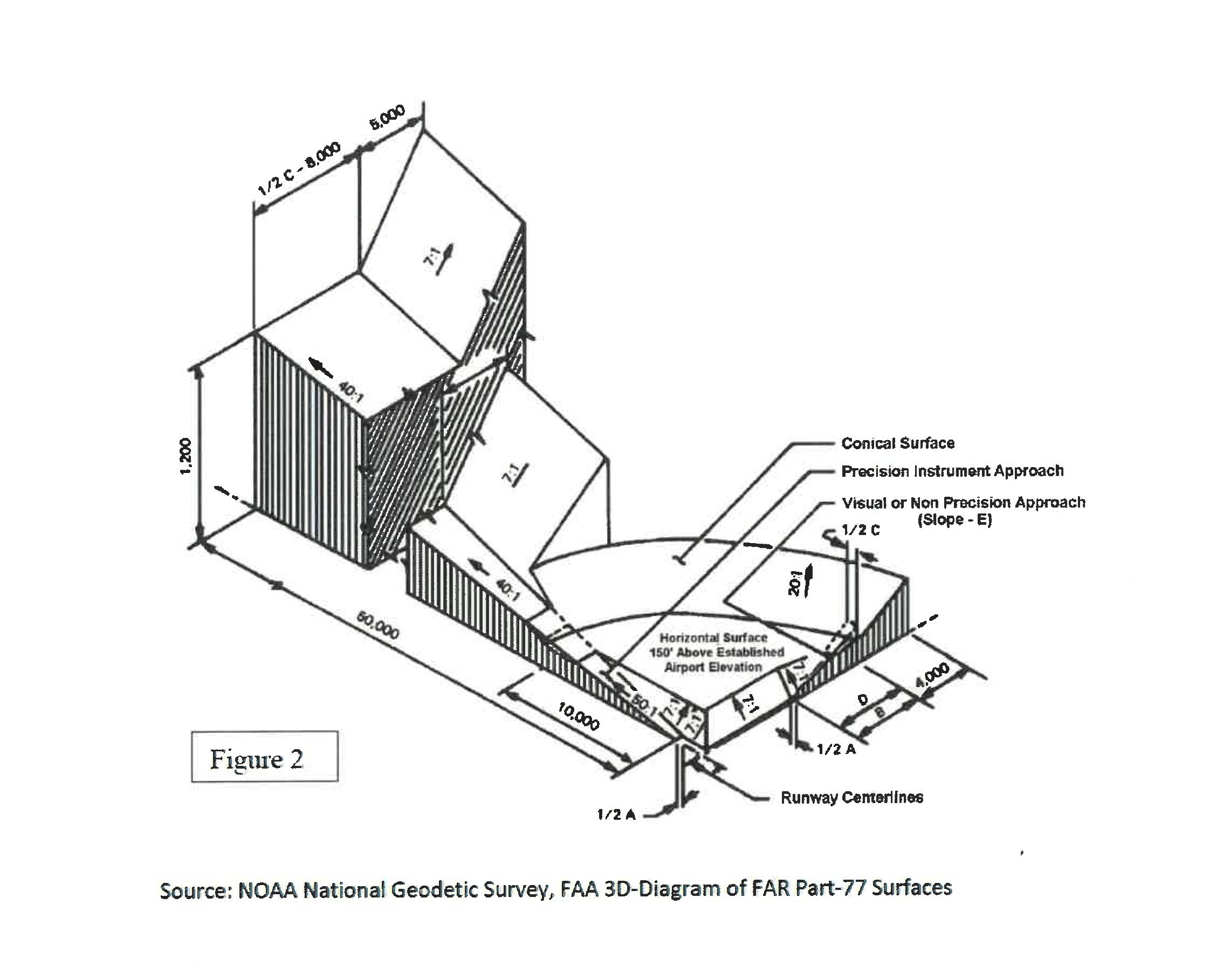
Four types of height control overlay zones are established for the Columbia Metropolitan Airport District, based on the present and proposed runway configuration described in the Columbia Metropolitan Airport Plan (see definitions) and the most current edition of Federal Aviation Administration Advisory Circular # 150/5190-4A, A Model Zoning Ordinance to Limit Height of Objects Around Airports, or in successor Federal Aviation Administration advisory circulars. Figure 1 represents the present and proposed runway configuration as well as the related primary surfaces (see definitions).
The elevations of the primary surfaces are different for each runway end, according to this table:
42.21 Approach Zones
Approach zones (Figures 1 and 2) are delineated for each of the four runway approaches. The beginning of each approach zone is coincident with, as wide as, and at the same elevation as the end of the primary surface for the respective runway end. Each approach zone expands outward uniformly to its ultimate width which is at a distance measured horizontally from the end of the primary surface. The centerline of each approach zone is the horizontal continuation of the centerline for the respective runway end. The six approach zones are dimensioned as follows:
42.22 Transitional Zones
Transitional zones (Figure 2) are established adjacent to the sides, but not past the wide ends, of the approach zones and the sides, in plan view, of the primary surfaces, except that the transitional zones shall not overlay, in plan view, any primary surfaces. Transitional zones shall be 5,000 feet wide, measured horizontally and perpendicular to the runway centerlines, and the runway centerlines extended.
42.23 Horizontal Zone
The horizontal zone (Figure 2) is established by swinging radii 10,000 feet, measured horizontally, from the midpoints of the ends of the primary surfaces (see runway diagram) at runway ends 11, 5, 23, and 29, and then connecting the adjacent arcs by drawing straight lines tangent to those arcs. All lands within the outermost boundary so formed are in the horizontal zone.
42.24 Conical Zone
The conical zone (Figure 2) begins at any given point on the periphery of the horizontal zone and extends outward from the airport for a horizontal distance of 4,000 feet, measured perpendicular to a line tangent to the periphery of the horizontal zone at the given point.
42.25 Height Limits
The maximum height of buildings, other structures, and trees shall be restricted within each height control overlay zone. Where these zones overlap each other, the most restrictive height limitation shall apply. However, the height limits of this article shall not prohibit the construction or maintenance of any building or other structure, or the growth of any tree up to a height of 50 feet above the land surface elevation as it existed at the date of enactment of this Ordinance. Following are the height limits for the height control overlay zones.
a.
Approach Zones 11, 29, and 5: starting at the end of and at the same elevation as the primary surface at the respective runway ends, measure a slope 1 foot vertically upward for each 50 feet horizontally outward from the runway end, for a distance of 10,000 feet measured parallel to the horizontal extension of the runway centerline. Subsequently, measure a slope 1 foot vertically upward for each 40 feet horizontally outward from the runway end, for a distance of 40,000 feet measured parallel to the horizontal extension of the runway centerline.
b.
Approach Zones 23, 11, and 29: starting at the end of and at the same elevation as the primary surface at the respective runway ends, measure a slope 1 foot vertically upward for each 34 feet horizontally outward from the runway end, for a distance of 10,000 feet measured parallel to the horizontal extension of the runway centerline.
c.
Transitional Zones: starting at the side of and at the same elevation as the primary surfaces, and also starting at any given point on the sides of the approach zones at the same elevation as the approach zone height limit for the given point, measure a slope 1 foot vertically upward for each 7 feet horizontally outward from the runway, for a distance of 5,000 feet measured perpendicular to the runway centerline or the horizontal extension of the runway centerline.
d.
Horizontal Zone: the height limit for the horizontal zone is 385 feet above mean sea level.
e.
Conical Zone: starting at any given point on the periphery of the horizontal zone and at the same elevation as the horizontal zone height limit, measure a slope 1 foot vertically upward for each 20 feet horizontally outward from the airport, for a distance of 4,000 feet measured perpendicular to a line tangent to the periphery of the horizontal zone at the given point.
Figure 2 illustrates a cross sectional perspective of the height limits for the height control overlay zones of a portion of the Columbia Metropolitan Airport (see the X and Y arrows on the runway diagram for the corresponding location of the corner on the perspective illustration).
(Ord. No. 23-17, 6-25-2024)
42.30 - Other Use Restrictions
Notwithstanding any other provisions of this Ordinance, no use may be made of any land or water body within the Columbia Metropolitan Airport District in such a manner as to create electrical interference with navigational signals or radio communications between the airport and aircraft, make it difficult for pilots to distinguish between airport lights and others, result in glare in the eyes of pilots using the airport, impair visibility in the vicinity of the airport, or otherwise endanger the landing, takeoff, or maneuvering of aircraft using the airport. Existing nonconforming activities shall comply with Article 16 of this Ordinance.

43.00 - Introduction
The Lexington County Airport District is hereby established pursuant to the purposes of this article, comprising all those lands within the overlay zones as further delineated in this chapter. Lexington County Airport is strictly to be used as a reference in the event the name of the airport should change or be modified. The defined FAA location identifier for this airport is 6J0.
(Ord. No. 23-17, 6-25-2024)
43.10 - Purpose
The concentration of people and sound-sensitive activities on lands adjacent to airport or heliport operations and the maximum height of buildings, other structures, and trees in such areas shall be regulated by airport district overlay zones as set forth herein. In order to protect people and property in the vicinity of airports and heliports from the danger of aircraft accidents and the impact of excessive noise levels, certain land use activities shall not be permitted in designated overlay zones surrounding such facilities. To preserve the safety and efficiency of air navigation, height control overlay zones may be designated around airfields to limit the obstruction of landing, takeoff, and maneuvering airspace by buildings, other structures, and trees. Such controls serve to protect the public investment in airports or heliports by restricting adjacent land uses incompatible with the use, growth, or expansion of these facilities.
(Ord. No. 23-17, 6-25-2024)
43.20 - Application of Airport District Overlay Zones
Overlay zones are established for the Lexington County Airport District, based on the present runway configuration described in the most current Pelion Corporate Airport Master Plan.
The land use and height controls associated with these airport district overlay zones shall be in addition to and shall only apply where underlying zoning districts and their controls have been established under other articles of this Ordinance. Where the Airport District overlay zone controls conflict with the controls of underlying zoning districts, the more restrictive shall apply.
(Ord. No. 23-17, 6-25-2024)
43.30 - Height Control Overlay Zones
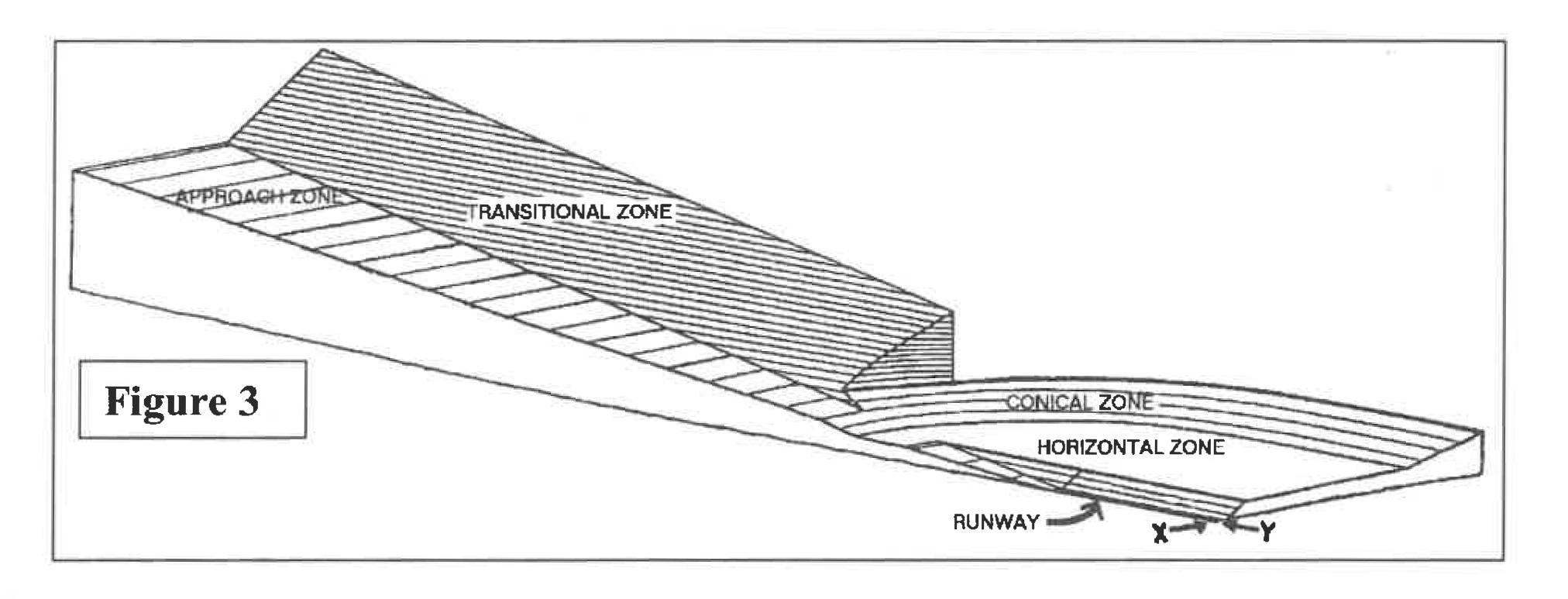
Four types of height control overlay zones as described below and in Figure 3 are established for the Lexington County Airport District, based on the present runway configuration.
43.31 Approach Zones
Approach zones (Figure 3) are delineated for each of the two runway approaches. The beginning of each approach zone is 1,000 feet wide and is coincident with and at the same elevation as the respective runway end. Both zones expand outward uniformly to an ultimate width of 2,000 feet which is at a distance of 5,000 feet measured horizontally from the end of the primary surface. The centerline of each approach zone is the horizontal continuation of the centerline of the respective runway end.
43.32 Transitional Zones
Transitional zones (Figure 3) are established adjacent to the sides of the runway and the approach zones, but shall be exclusive of both. These zones shall be 1,000 feet wide, measured horizontally and perpendicular to the sides of the runway. At the end of the runways the zone shall decrease in width until it intersects the approach zones at the point where the horizontal zone surface is at the same elevation as the approach zone.
43.33 Horizontal Zone
The horizontal zone (Figure 3) is established as all the area within 5,000 feet, measured horizontally, from any part of the runway surface, exclusive of the transitional and approach zones.
43.34 Conical Zone
The conical zone (Figure 3) is established as all the area within 10,000 feet, measured horizontally, from any part of the runway surface, exclusive of the transitional, horizontal, and approach zones.
43.35 Height Limits
The maximum height of buildings, other structures, and trees shall be restricted within each height control overlay zone. Where these zones overlap each other, the most restrictive height limitation shall apply. The following are the height limits for the height control overlay zones.
a.
Approach Zones: starting at the end of and at the same elevation as the respective runway ends, measure a slope 1 foot vertically upward for each 20 feet horizontally outward from the runway end, for the full extent of the approach zones.
b.
Transitional Zones: starting at the side of and at the same elevation as the runway surface, and also starting at any given point on the sides of the approach zones at the same elevation as the approach zone height limit for the given point, measure a slope 1 foot vertically upward for each 7 feet horizontally outward from the runway, for the full extent of the transitional zones.
c.
Horizontal Zone: the height limit for the horizontal zone is 601 feet above mean sea level.
d.
Conical Zone: starting at any given point on the periphery of the horizontal zone and at the same elevation as the horizontal zone height limit, measure a slope 1 foot vertically upward for each 20 feet horizontally outward from the airport, to the full extent of the conical zone.
(Ord. No. 23-17, 6-25-2024)
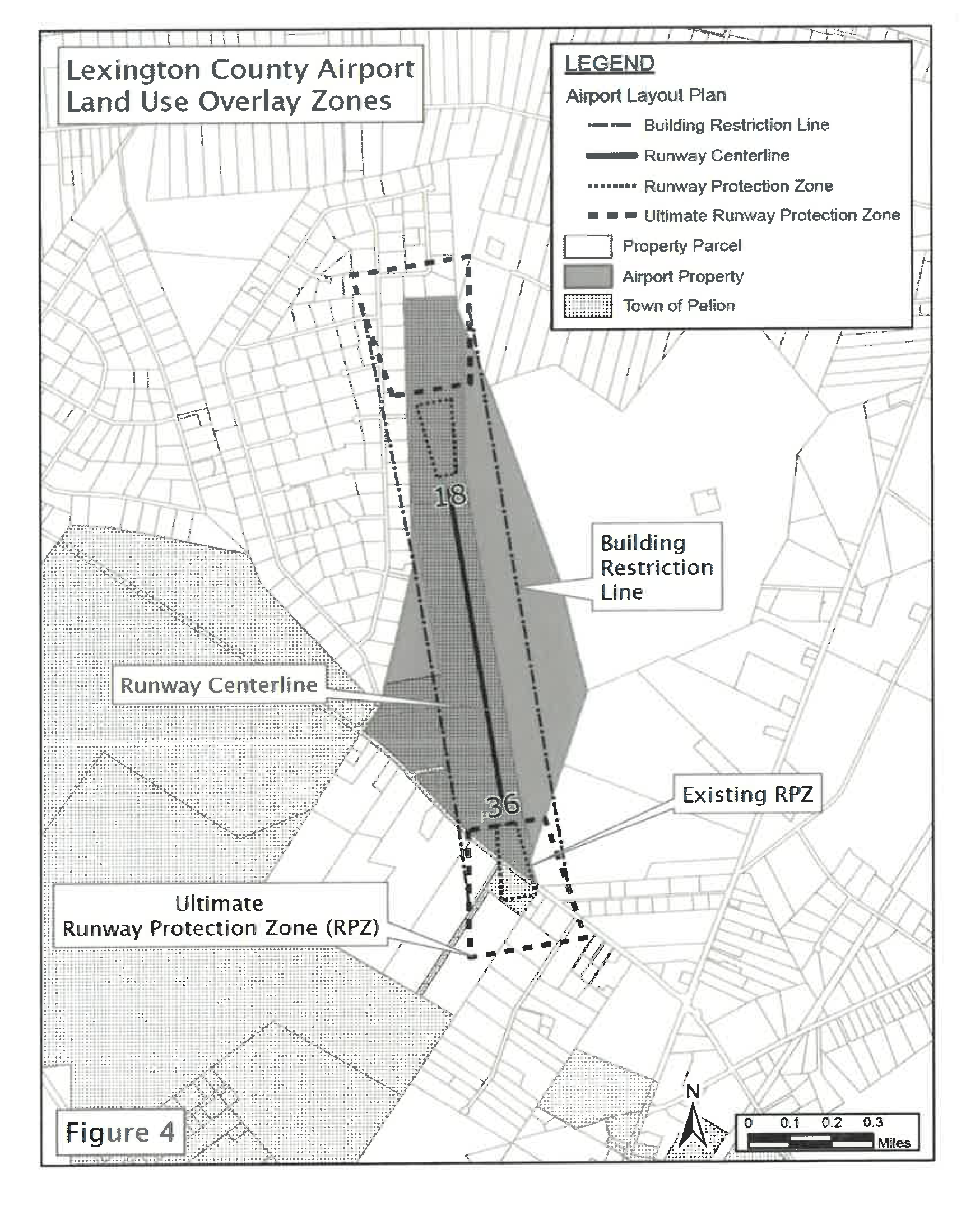
43.40 - Land Use Overlay Zones
Three land use overlay zones for Runway 18 and 36, as depicted in Figure 4, are designated for the Lexington County Airport District (FAA location identifier 6J0). They are the Existing Runway Protection Zone (Existing RPZ), the Ultimate Runway Protection Zone (Ultimate RPZ), and the Building Restriction Line (BRL). No buildings, except facilities required by their function to be located near runways and taxiways, are allowed within the Building Restriction Line and the following activities are not permitted in these designated zones:
(Ord. No. 23-17, 6-25-2024)
43.50 - Other Use Restrictions
Notwithstanding any other provisions of this Ordinance, no use may be made of any land or water body within the Lexington County Airport District in such a manner as to create electrical interference with navigational signals or radio communications between the airport and aircraft, make it difficult for pilots to distinguish between airport lights and others, result in glare in the eyes of pilots using the airport, impair visibility in the vicinity of the airport, or otherwise endanger the landing, takeoff, or maneuvering of aircraft using the airport. Existing nonconforming activities shall comply with Article 16 of this Ordinance.
(Ord. No. 23-17, 6-25-2024)
44.00 - Introduction
Other Airport Districts are hereby established pursuant to the purposes of this article, comprising all those lands within the overlay zones as further delineated in this chapter. In order to qualify for designation under this chapter, an airport must be of such a nature as to require approval from the Federal Aviation Administration (FAA).
(Ord. No. 23-17, 6-25-2024)
44.10 - Height Control Overlay Zones
Four types of height control overlay zones are established for these Airport Districts, based on the runway configuration.
44.11 Approach Zones
Approach zones (Figure 3) are delineated for each of the two runway approaches. The beginning of each approach zone is 500 feet wide and is coincident with and at the same elevation as the respective runway end. Both zones expand outward uniformly to an ultimate width of 2,000 feet which is at a distance of 5,000 feet measured horizontally from the end of the primary surface. The centerline of each approach zone is the horizontal continuation of the centerline of the respective runway end.
44.12 Transitional Zones
Transitional zones (Figure 3) are established adjacent to the sides of the runway and the approach zones, but shall be exclusive of both. These zones shall be 1,000 feet wide, measured horizontally and perpendicular to the sides of the runway. At the end of the runways the zone shall decrease in width until it intersects the approach zones at the point where the horizontal zone surface is at the same elevation as the approach zone.
44.13 Horizontal Zone
The horizontal zone (Figure 3) is established as all the area within 5,000 feet, measured horizontally, from any part of the runway surface, exclusive of the transitional and approach zones.
44.14 Conical Zone
The conical zone (Figure 3) is established as all the area within 9,000 feet, measured horizontally, from any part of the runway surface, exclusive of the transitional, horizontal, and approach zones.
44.15 Height Limits
The maximum height of buildings, other structures, and trees shall be restricted within each height control overlay zone. Where these zones overlap each other, the most restrictive height limitation shall apply. However, the height limits of this chapter shall not prohibit the construction or maintenance of any building or other structure, or the growth of any tree up to a height of 50 feet above the land surface elevation as it existed at the date of enactment of this chapter. The following are the height limits for the height control overlay zones.
a.
Approach Zones: starting at the end of and at the same elevation as the respective runway ends, measure a slope 1 foot vertically upward for each 20 feet horizontally outward from the runway end, for the full extent of the approach zones.
b.
Transitional Zones: starting at the side of and at the same elevation as the runway surface, and also starting at any given point on the sides of the approach zones at the same elevation as the approach zone height limit for the given point, measure a slope 1 foot vertically upward for each 7 feet horizontally outward from the runway, for the full extent of the transitional zones.
c.
Horizontal Zone: the height limit for the horizontal zone is 150 feet above the highest point of the runway(s).
d.
Conical Zone: starting at any given point on the periphery of the horizontal zone and at the same elevation as the horizontal zone height limit, measure a slope 1 foot vertically upward for each 20 feet horizontally outward from the airport, to the full extent of the conical zone.
(Ord. No. 23-17, 6-25-2024)
44.20 - Buffering Restrictions
Airport Districts must meet all of the restrictions and standards as required by this Ordinance for the appropriate principal activity classification.
(Ord. No. 23-17, 6-25-2024)
44.30 - Other Use Restrictions
Notwithstanding any other provisions of this Ordinance, no use may be made of any land or water body within these Airport Districts in such a manner as to create electrical interference with navigational signals or radio communications between the airport and aircraft, make it difficult for pilots to distinguish between airport lights and others, result in glare in the eyes of pilots using the airport, impair visibility in the vicinity of the airport, or otherwise endanger the landing, takeoff, or maneuvering of aircraft using the airport. Existing nonconforming activities shall comply with Article 16 of this Ordinance.
(Ord. No. 23-17, 6-25-2024)