
Lisbon City Zoning Code
ARTICLE IV
- DISTRICT REGULATIONS
DIVISION 7. - VILLAGE DISTRICT[5]
Cross reference— Parking in Lisbon Village, § 50-71.
DIVISION 8. - COMMERCIAL DISTRICT[6]
Cross reference— Businesses, ch. 10; town council, regulations and policies for businesses, ch. 82.
DIVISION 9. - INDUSTRIAL DISTRICT[7]
Cross reference— Businesses, ch. 10; town council rules, regulations and policies for businesses, ch. 82.
DIVISION 10. - DIVERSIFIED DEVELOPMENT DISTRICT[8]
Cross reference— Businesses, ch. 10; town council rules, regulations and policies for businesses, ch. 82.
Sec. 70-231.- Zoning districts named.
To implement the provisions of this chapter, the town is divided into the following districts:
(1)
Resource protection district.
(2)
Limited residential district.
(3)
General residential district.
(4)
Rural open space I district.
(5)
Rural open space II district.
(6)
Rural residential district.
(7)
Limited rural residential district.
(8)
Village district.
(9)
Commercial district.
(10)
Industrial district.
(11)
Diversified development district.
(12)
Aquifer protection overlay district.
(Code 1983, § 15-201; T.M. of 5-14-1988, art. 90; T.M. of 5-13-1995, art. 58, § 2; C.M. of 11-15-2011, V. 2011-208)
Sec. 70-232. - Location of districts.
The districts are located and bounded as shown on the official zoning map, entitled "Zoning Map of Lisbon, Maine," at the end of this chapter and on file in the office of the town clerk. The official zoning map shall be signed by the town clerk and by the chairman of the planning board at the time of adoption or amendment of this chapter, certifying the date of such adoption or amendment. Additional copies of this map shall be available in the town offices at a fee to be determined by the officers of the town.
(Code 1983, § 15-202; T.M. of 5-13-1995, art. 58, § 3; T.M. of 5-20-1996, art. 61, § 15-202; C.M. of 11-15-2011, V. 2011-208)
Sec. 70-233. - Uncertainty of boundary location.
Where uncertainty exists with respect to the boundaries of the various districts as shown on the official zoning map, the following rules shall apply:
(1)
Street lines. Boundaries indicated as approximately following the centerlines of streets, highways or alleys shall be construed to follow such centerlines;
(2)
Lot lines. Boundaries indicated as approximately following well-established lot lines shall be construed as following such lot lines;
(3)
Town lines. Boundaries indicated as approximately following town limits shall be construed as following town limits;
(4)
Railroad lines. Boundaries indicated as following railroad lines shall be construed to follow such lines;
(5)
Shorelines. Boundaries indicated as following shorelines shall be construed to follow such shorelines, and in the event of natural change in the shoreline shall be construed as moving with the actual shoreline; boundaries indicated as approximately following the centerline of streams, rivers, canals, lakes or other bodies of water shall be construed to follow such center lines; the depiction of the boundaries from the normal high water mark of water bodies and upland edge of freshwater wetlands is merely illustrative of their general location; the exact boundaries shall be determined by on-site inspection and measurements from the normal high water line or upland edge of a freshwater wetland;
(6)
Distance. Boundaries indicated as being parallel to or extensions of features indicated in subsections (1) through (5) of this section shall be so construed; distance not specifically indicated on the official zoning map shall be determined by the scale of the map; and
(7)
Conflicts. Where physical or cultural features existing on the ground are at variance with those shown on the official zoning map, or in other circumstances not covered by subsections (1) through (6), the board of appeals shall interpret the district boundaries.
(Code 1983, § 15-203; T.M. of 5-16-1992, art. 86, § 15-203)
Sec. 70-234. - Division of lots by district boundaries.
(a)
Single parcel. Where a district boundary line divides a lot or parcel of land of the same ownership of record at the time such line is established by adoption or amendment of this chapter, the regulations applicable to the less restricted portion of the lot may be extended not more than 50 feet into the more restricted portion of the lot, provided that the other portion is not within the resource protection district, subject to the provisions of subsection (b) of this section.
(b)
Extension of use. Extension of use shall be considered a conditional use, subject to approval of the planning board and in accordance with the criteria set forth in section 70-194.
(c)
Frontage and area. The minimum area and frontage of a lot or parcel divided by a district boundary shall be established by the district in which the majority of the lot falls.
(Code 1983, § 15-204; T.M. of 5-15-1999, art. 53; C.M. of 11-15-2011, V. 2011-208)
Sec. 70-235. - Division of lots by zone boundaries.
(a)
Where a zone boundary line divides a parcel of land smaller than two acres, the regulations applicable to the zone shall apply to the entire parcel only if the portion of the parcel within the zone exceeds 50 percent of the entire parcel. If the portion of the parcel within the zone is 50 percent or less, the regulations applicable to the zone shall not apply to any portion of the parcel. The determination of the areas within and without the zone shall be made by the code enforcement officer.
(b)
Where a zone boundary line divides a parcel of land two acres or larger, the pertinent regulations applicable to the zone shall apply to that portion of the parcel within the zone and only as much area outside the zone as would be necessary to meet the regulations.
(T.M. of 5-20-1996, art. 61, § 15-205)
Sec. 70-261.- Purpose.
The purpose of the resource protection district is to:
(1)
Prevent and control water pollution;
(2)
Protect spawning grounds, fish, aquatic life, bird and other wildlife habitat;
(3)
Control building sites, placement of structures and land uses; and
(4)
Conserve shore cover, visual as well as actual points of access to inland areas, especially on floodprone areas and slopes unsuitable for development.
(Code 1983, § 15-401(1))
Sec. 70-262. - Areas.
(a)
The resource protection district includes areas in which development would adversely affect water quality, productive habitat, biotic systems, or scenic and natural values.
(b)
This district shall include:
(1)
Freshwater wetlands and areas within 250 feet, horizontal distance, of the upland edge of freshwater wetlands as depicted on the official zoning map.
(2)
Floodplains. Floodplains along rivers, defined by the 100-year floodplain as designated on the Federal Emergency Management Agency's (FEMA) Flood Insurance Rate Maps or Flood Hazard Boundary Maps, or the flood of record or in the absence of these, by soil types identified as recent floodplain soils.
(3)
Slopes. Areas having sustained slopes greater than 25 percent, or unstable soil subject to slumping, mass movement, or severe erosion, when these areas are two acres or more in size.
(4)
Water supply. Town water supply protection.
(5)
Wildlife habitat. Significant wildlife habitat.
(6)
Scenic areas. Natural sites of significant scenic or aesthetic value.
(7)
Natural areas. Areas designated by federal, state or town governments as significant natural areas to be protected from development.
(8)
Other areas depicted on the Official Zoning Map.
(9)
Areas of two or more contiguous acres supporting wetland vegetation and hydric soils, which are not part of a freshwater wetland as defined, and which are not surficially connected to a water body during the period of normal high water.
(Code 1983, § 15-401(2); T.M. of 5-16-1992, art. 86, § 15-401.2; T.M. of 7-21-2009, § 2009-109; T.M. of 11-17-2009, § 2009-174)
Sec. 70-263. - Permitted uses.
Uses identified in section 70-531 are permitted by right in a resource protection district if they comply with all applicable federal, state and town laws and regulations and the performance standards in article VI of this chapter.
(Code 1983, § 15-401(3); C.M. of 11-15-2011, V. 2011-208)
Sec. 70-264. - Conditional uses.
Uses identified in section 70-531 and the following may be permitted in a resource protection district only upon the authorization of a conditional use permit by the planning board in accordance with the provisions of article III of this chapter and upon compliance with all applicable federal, state and town laws and regulations:
(1)
Single-family dwelling, three acres. Single-family dwelling on a lot of three acres or more upon a finding of the planning board that the following criteria are met:
a.
Waste disposal. Sanitary waste shall be adequately disposed of on suitable soils at least five feet in elevation above any inland wetland or floodplain.
b.
Drainage field. A minimum setback of the drainage field shall be 150 feet from the normal high water elevation of any water body or upland edge of a freshwater wetland.
c.
Building setback. A minimum setback of any building shall be 100 feet from the normal high water elevation of any water body or upland edge of a freshwater wetland.
d.
Frontage. A minimum street and shore frontage of 200 feet shall be provided.
e.
Other. All other applicable requirements of this chapter shall be met in full.
f.
Floodplain areas. In addition to subsection (1)a.—e. of this section, the planning board shall determine that the applicant has met all of the following criteria for areas within 250 feet of the normal high water line of the Androscoggin River zoned resource protection due to the 100-year floodplain:
1.
There is no location on the property, other than a location within the resource protection district, where the structure can be built.
2.
The lot on which the structure is proposed is undeveloped and was established as a lot of record and recorded in the county registry of deeds before the adoption of the resource protection district.
3.
The proposed location of all buildings, sewage disposal systems and other improvements are:
i.
Located on natural ground slopes of less than 20 percent; and
ii.
Located outside the floodway of the 100-year floodplain along rivers based on detailed flood insurance studies and as delineated on the Federal Emergency Management Agency's flood boundary and floodway maps and flood insurance rate maps; all buildings, including basements, are elevated at least one foot above the 100-year floodplain elevation; and the development is otherwise in compliance with chapter 58 of this Code.
4.
The total ground floor area of all principal and accessory structures located within the district is limited to a maximum of 1,500 square feet.
(2)
Single-family dwelling, two acres. Single-family dwelling on a lot of two acres upon a finding of the planning board that the following criteria are met:
a.
Water; sewer. Public water and sanitary sewer are available and shall be connected;
b.
Setback. A minimum setback of any building shall be 100 feet from the normal high water elevation of any water body or upland edge of a freshwater wetland;
c.
Frontage. A minimum street and shore frontage of 200 feet shall be provided;
d.
Other. All other applicable requirements of this chapter shall be met in full; and
e.
Floodplain. In addition to subsections (2)a.—d., the planning board shall determine that the applicant has met all of the following criteria for areas within 250 feet of the normal high water line of the Androscoggin River zoned resource protection due to the 100-year floodplain:
1.
There is no location on the property, other than a location within the resource protection district, where the structure can be built.
2.
The lot on which the structure is proposed is undeveloped and was established as a lot of record and recorded in the county registry of deeds before the adoption of the resource protection district.
3.
The proposed location of all buildings, sewage disposal systems and other improvements are:
i.
Located on natural ground slopes of less than 20 percent; and
ii.
Located outside the floodway of the 100-year floodplain along rivers based on detailed flood insurance studies and as delineated on the federal emergency management agency's flood boundary and floodway maps and flood insurance rate maps; all buildings, including basements, are elevated at least one foot above the 100-year floodplain elevation; and the development is otherwise in compliance with the floodplain management ordinance for the town, chapter 58, article II of this Code.
4.
The total ground-floor area of all principal and accessory structures located within the resource protection district is limited to a maximum of 1,500 feet.
(Code 1983, § 15-401(4); T.M. of 5-16-1992, art. 86, § 15-401(4)(c); T.M. of 5-14-1994, art. 49, § 15-401(4); C.M. of 11-15-2011, V. 2011-208)
Sec. 70-265. - Prohibited uses.
Uses which are not specifically allowed as permitted uses or conditional uses in this division are prohibited.
(Code 1983, § 15-401(5); C.M. of 11-15-2011, V. 2011-208)
Sec. 70-266. - Dimensional requirements.
Lots in the resource protection district shall meet or exceed the minimum requirements as identified in section 70-536, (refer also to article V of this chapter).
(Code 1983, § 15-401(6); T.M. of 5-16-1992, art. 86, § 15-401.6; T.M. of 5-13-1995, art. 58, § 5; C.M. of 11-15-2011, V. 2011-208)
Sec. 70-267. - Performance or land use standards.
Permitted uses and conditional uses in this division shall conform to the performance standards delineated in article VI of this chapter.
(Code 1983, § 15-401(7); C.M. of 11-15-2011, V. 2011-208)
Sec. 70-291.- Purpose.
The purpose of the limited residential district is to provide:
(1)
Areas for medium-density residential growth in such a manner and at such locations to be compatible with existing development and the ability of the town to provide essential services and utilities.
(2)
Areas for public and semipublic uses compatible with and necessary to residential development.
(Code 1983, § 15-402(1))
Sec. 70-292. - Permitted uses.
Uses identified in section 70-531 are permitted in the limited residential district.
(Code 1983, § 15-402; T.M. of 5-13-1995, art. 60, § 4; T.M. of 5-20-1996, art. 62, § 15-402; C.M. of 11-15-2011, V. 2011-208)
Sec. 70-293. - Conditional uses.
Uses identified in section 70-531 may be permitted in a limited residential district only upon the authorization of a conditional use permit by the planning board in accordance with the provisions of article III of this chapter and upon compliance with all applicable federal and state laws.
(Code 1983, § 15-402(3); T.M. of 5-13-1995, art. 58, §§ 6, 7; T.M. of 5-13-1995, art. 60, § 4; T.M. of 5-20-1996, art. 63, § 15-402; C.M. of 11-15-2011, V. 2011-208)
Sec. 70-294. - Prohibited uses.
Uses which are not allowed as permitted uses or conditional uses in this division are prohibited.
(Code 1983, § 15-402(4); C.M. of 11-15-2011, V. 2011-208)
Sec. 70-295. - Dimensional requirements.
Lots in the limited residential district shall meet or exceed the minimum requirements as identified in section 70-536, (refer also to article V of this chapter):
(1)
Parking. Parking requirements shall be in accordance with the provisions of section 70-661 et seq.
(2)
Additional requirements. All additional requirements as delineated in article VI, division 2, of this chapter shall be met.
(Code 1983, § 15-402(5); T.M. of 5-16-1992, art. 86, § 15-402; T.M. of 5-13-1995, art. 58, § 8; T.M. of 5-17-2003, art. 54; C.O. of 8-19-2008, § 2008-135)
Sec. 70-296. - Performance or land use standards.
Permitted uses and conditional uses in this division shall conform to the performance standards delineated in article VI of this chapter.
(Code 1983, § 15-402(6); C.M. of 11-15-2011, V. 2011-208)
Sec. 70-321.- Purpose.
The purpose of the general residential district is to provide for the uses and activities generally found in developed residential neighborhoods, while protecting the health, safety, welfare and property values of residents and property owners from encroachment by incompatible uses.
(Code 1983, § 15-403(1); C.M. of 11-15-2011, V. 2011-208)
Sec. 70-322. - Permitted uses.
Uses identified in section 70-531 are permitted in the general residential district.
(Code 1983, § 15-403(2); T.M. of 5-13-1995, art. 60, § 7; C.M. of 11-15-2011, V. 2011-208; C.M. of 12-2-2014, V. 2014-257)
Sec. 70-323. - Conditional uses.
Uses identified in section 70-531 may be permitted in the general residential district only upon the authorization of a conditional use permit by the planning board, in accordance with the provisions of article III of this chapter.
(Code 1983, § 15-403(3); T.M. of 5-13-1995, art. 60, § 7; T.M. of 5-20-1996, art. 62, § 15-403; T.M. of 5-20-1996, art. 63, § 15-403; T.M. of 5-15-1999, art. 54; T.M. of 2-12-2002, art. 5; C.M. of 11-15-2011, V. 2011-208; C.M. of 12-2-2014, V. 2014-257)
Sec. 70-324. - Prohibited uses.
Uses which are not specifically allowed as permitted uses or conditional uses in this division are prohibited.
(Code 1983, § 15-403(4); T.M. of 5-20-1996, art. 63, § 15-403; C.M. of 11-15-2011, V. 2011-208)
Sec. 70-325. - Dimensional requirements.
Lots in the general residential district shall meet or exceed the minimum requirements as identified in section 70-536, (refer also to article V of this chapter).
(Code 1983, § 15-403(5); T.M. of 5-16-1992, art. 86, § 15-403; T.M. of 5-13-1995, art. 58, § 9; C.M. of 11-15-2011, V. 2011-208)
Sec. 70-326. - Performance or land use standards.
Permitted uses and conditional uses in this division shall conform to the performance standards delineated in article VI of this chapter.
(Code 1983, § 15-403(6); C.M. of 11-15-2011, V. 2011-208)
Sec. 70-351.- Purpose.
The purpose of the rural open space I district is to provide for a full range of family and rural residential uses and activities while maintaining adequate sanitary standards and conditions beneficial to the general welfare of the community. The district should be maintained primarily as rural and low density residential. Commercial uses related to the sale of agricultural products and home occupations are appropriate, as are public and semi-public uses.
(Code 1983, § 15-404(1); C.M. of 11-15-2011, V. 2011-208)
Sec. 70-352. - Permitted uses.
Uses identified in section 70-531 are permitted in the open space district I.
(Code 1983, § 15-404(2); T.M. of 5-13-1995, art. 60, § 5; T.M. of 5-19-2001, art. 75; C.M. of 11-15-2011, V. 2011-208)
Sec. 70-353. - Conditional uses.
Uses identified in section 70-531 may be permitted in the rural open space I district only upon the authorization of a conditional use permit by the planning board, in accordance with the provisions of article III of this chapter.
(Code 1983, § 15-404(3); T.M. of 5-13-1995, art. 58, § 10; T.M. of 5-13-1995, art. 60, § 5; T.M. of 5-15-1999, art. 54; C.M. of 11-15-2011, V. 2011-208)
Sec. 70-354. - Prohibited uses.
Uses which are not specifically allowed as permitted uses or conditional uses in this division are prohibited.
(Code 1983, § 15-404(4); T.M. of 5-13-1995, art. 58, § 10; C.M. of 11-15-2011, V. 2011-208)
Sec. 70-355. - Dimensional requirements.
Lots in the rural open space I district shall meet or exceed the minimum requirements as identified in section 70-536, (refer also to article VI of this chapter).
(Code 1983, § 15-404(5); T.M. of 5-13-1989, art. 89; T.M. of 5-16-1992, art. 86, § 15-404; T.M. of 5-13-1995, art. 58, § 10; C.M. of 11-15-2011, V. 2011-208)
Sec. 70-356. - Performance or land use standards.
Permitted uses and conditional uses in this division shall conform to the performance standards delineated in article VI of this chapter.
(Code 1983, § 15-404(6); C.M. of 11-15-2011, V. 2011-208)
Sec. 70-357.- Purpose.
The purpose of the rural open space district II is to maintain the agriculture land base of Lisbon. Agriculture, uses supporting agriculture and limited residential uses are appropriate uses in the rural open space district II.
(C.M. of 11-15-2011, V. 2011-208)
Sec. 70-358. - Permitted uses.
Uses identified in section 70-531 are permitted in the open space district II.
(C.M. of 11-15-2011, V. 2011-208)
Sec. 70-359. - Conditional uses.
Uses identified in section 70-531 may be permitted in the rural open space II district only upon the authorization of a conditional use permit by the planning board, in accordance with the provisions of article III of this chapter.
(C.M. of 11-15-2011, V. 2011-208)
Sec. 70-360. - Prohibited uses.
Uses which are not specifically allowed as permitted uses or conditional uses in this division are prohibited.
(C.M. of 11-15-2011, V. 2011-208)
Sec. 70-361. - Dimensional requirements.
Lots in the rural open space II district shall meet or exceed the minimum requirements as identified in section 70-536.
(C.M. of 11-15-2011, V. 2011-208; C.M. of 7-12-2022, Vote No. 2022-166)
Sec. 70-362. - Performance or land use standards.
Permitted uses and conditional uses in this division shall conform to the performance standards delineated in article VI of this chapter and the following:
(1)
After the effective date of this amendment, rear lots are prohibited.
(C.M. of 11-15-2011, V. 2011-208; C.M. of 7-12-2022, Vote No. 2022-166; C.M. 6-18-2024, Vote No. 2024-110)
Sec. 70-381.- Purpose.
The purpose of the rural residential district is to provide for a full range of family and rural residential uses and activities while maintaining adequate sanitary standards and conditions beneficial to the general welfare of the town.
(Code 1983, § 15-405(1); T.M. of 5-13-1995, art. 58, § 11; C.M. of 11-15-2011, V. 2011-208)
Sec. 70-382. - Permitted uses.
Uses identified in section 70-531 are permitted in the rural residential district.
(Code 1983, § 15-405(2); T.M. of 5-13-1995, art. 58. § 11; T.M. of 5-19-2001, art. 76; C.M. of 11-15-2011, V. 2011-208; C.M. of 12-2-2014, V. 2014-257)
Sec. 70-383. - Conditional uses.
Uses identified in section 70-531 may be permitted in the rural residential district only upon the authorization of a conditional use permit by the planning board, in accordance with the provisions of article III of this chapter.
(Code 1983, § 15-405(3); T.M. of 5-13-1995, art. 58, § 11; T.M. of 5-15-1999, art. 54; C.M. of 11-15-2011, V. 2011-208; C.M. of 12-2-2014, V. 2014-257)
Sec. 70-384. - Prohibited uses.
Uses which are not specifically allowed as permitted uses or conditional uses in this division are prohibited.
(Code 1983, § 15-405(4); T.M. of 5-13-1995, art. 58, § 11; C.M. of 11-15-2011, V. 2011-208)
Sec. 70-385. - Dimensional requirements.
Lots in the rural residential district shall meet or exceed the minimum requirements as identified in section 70-536, (refer also to article VI of this chapter).
(Code 1983, § 15-405(5); T.M. of 5-13-1995, art. 58, § 11; C.M. of 11-15-2011, V. 2011-208)
Sec. 70-386. - Performance or land use standards.
Permitted uses and conditional uses in this division shall conform to the performance standards delineated in article VI of this chapter.
(Code 1983, § 15-405(6); T.M. of 5-13-1995, art. 58, § 11; C.M. of 11-15-2011, V. 2011-208)
Sec. 70-411.- Purpose.
The purpose of the village district is to:
(1)
Provide for the variety of land uses in a village where residential, public, semipublic, service, and retail activities are commonly mixed.
(2)
Maintain the historical and architectural integrity of existing village development and to ensure that future development is compatible both in character and use.
(Code 1983, § 15-405(1); T.M. of 5-13-1995, art. 58, § 11; C.M. of 11-15-2011, V. 2011-208)
Sec. 70-412. - Permitted uses.
Uses identified in section 70-531 are permitted in the village district.
(Code 1983, § 15-405(2); T.M. of 5-13-1995, art. 58, §§ 11, 12: T.M. of 5-20-1996, art. 62, § 15-406; T.M. of 5-15-1999, art. 55, §§ 1, 2; T.M. of 10-2-2000, art. 3; T.M. of 5-17-2003, art. 53; T.M. of 5-15-2006, art. 29; C.M. of 11-15-2011, V. 2011-208; C.M. of 12-2-2014, V. 2014-257)
Sec. 70-413. - Conditional uses.
Uses identified in section 70-531 may be permitted in the village district only upon the authorization of a conditional use permit by the planning board, in accordance with the provisions of article III of this chapter.
(Code 1983, § 15-405(3); T.M. of 5-13-1995, art. 58, §§ 11, 12; T.M. of 5-15-1999, art. 54; T.M. of 2-12-2002, art. 5; C.M. of 11-15-2011, V. 2011-208)
Sec. 70-414. - Prohibited uses.
Uses which are not specifically allowed as permitted uses or conditional uses in this division are prohibited.
(Code 1983, § 15-405(4); T.M. of 5-13-1995, art. 58, § 11; C.M. of 11-15-2011, V. 2011-208)
Sec. 70-415. - Dimensional requirements.
Lots in the village district shall meet or exceed the minimum requirements as identified in section 70-536, (refer also to article VI of this chapter).
(Code 1983, § 15-405(5); T.M. of 5-16-1992, art. 86, § 15-405; T.M. of 5-13-1995, art. 58, §§ 11, 14; T.M. of 5-15-1999, art. 57; T.M. of 5-17-2003, art. 54; C.M. of 11-15-2011, V. 2011-208)
Sec. 70-416. - Performance or land use standards.
Permitted uses and conditional uses shall conform to the performance standards delineated in article VI of this chapter. In addition, any new nonresidential structure which is immediately adjacent to a residential use in the general residential district shall maintain a 50-foot vegetated buffer between the new structure and the abutting residential property boundaries. The buffer shall include sight and sound mitigation; for example, coniferous trees spaced to block visual access and attenuate sound.
(Code 1983, § 15-405(6); T.M. of 5-13-1995, art. 58, § 15; C.M. of 11-15-2011, V. 2011-208)
Sec. 70-441.- Purpose.
The purpose of the commercial district is to:
(1)
Encourage the location of commercial and industrial uses on those lands within the town which are best suited for such development.
(2)
Provide minimum controls on those uses which, by virtue of their size or external effects (waste discharge, noise, glare, fumes, smoke, dust, odors, or auto, truck, or rail traffic) could otherwise create a public nuisance or endanger public health and safety.
(3)
Avoid the blight, congestion and inconvenience caused by inappropriate and poorly located development of commercial and industrial facilities.
(4)
Avoid the economic disadvantages of providing essential services to commercial and industrial strip development along highways or major thoroughfares.
(Code 1983, § 15-406(1); T.M. of 5-13-1995, art. 58, § 11; C.M. of 11-15-2011, V. 2011-208)
Sec. 70-442. - Permitted uses.
Uses identified in section 70-531 are permitted in the commercial district.
(Code 1983, § 15-406(2); T.M. of 5-13-1995, art. 58, §§ 11, 16; T.M. of 5-13-1995, art. 60, § 8; T.M. of 5-20-1996, art. 62, § 15-407; T.M. of 5-15-1999, art. 55, § 1; T.M. of 5-17-2003, art. 53; C.M. of 11-15-2011, V. 2011-208; C.M. of 12-2-2014, V. 2014-257)
Sec. 70-443. - Conditional uses.
Uses identified in section 70-531 may be permitted in the commercial district only upon the authorization of a conditional use permit by the planning board, in accordance with the provisions of article III of this chapter.
(Code 1983, § 15-406(3); T.M. of 5-13-1995, art. 58, § 11; T.M. of 5-16-1998, art. 58, § 15-407; T.M. of 5-15-1999, art. 54; C.M. of 11-15-2011, V. 2011-208)
Sec. 70-444. - Prohibited uses.
Uses which are not specifically allowed as permitted uses or conditional uses in this division are prohibited.
(Code 1983, § 15-406(4); T.M. of 5-13-1995, art. 58, § 11; C.M. of 11-15-2011, V. 2011-208)
Sec. 70-445. - Dimensional requirements.
Lots in the commercial district shall meet or exceed the minimum requirements as identified in section 70-536, (refer also to article VI of this chapter).
(Code 1983, § 15-406(5); T.M. of 5-16-1992, art. 86, § 15-406; T.M. of 5-14-1994, art. 48; T.M. of 5-13-1995, art. 58, § 11; T.M. of 5-13-2000, art. 56, 57; C.M. of 11-15-2011, V. 2011-208)
Sec. 70-446. - Performance or land use standards.
Permitted uses and conditional uses in this division shall conform to the performance standards delineated in article VI of this chapter.
(Code 1983, § 15-406(5); T.M. of 5-13-1995, art. 58, § 11; C.M. of 11-15-2011, V. 2011-208)
Sec. 70-471.- Purpose.
The purpose of the industrial district is to provide special areas for industrial activities in order to encourage and enhance sound economic development without endangering the public health, safety and well-being.
(Code 1983, § 15-407(1); T.M. of 5-13-1995, art. 58, § 11; C.M. of 11-15-2011, V. 2011-208)
Sec. 70-472. - Permitted uses.
Uses identified in section 70-531 are permitted in the industrial district.
(Code 1983, § 15-407(2); T.M. of 5-16-1987, art. 80, § 15-407-2B; T.M. of 5-13-1995, art. 58, § 11; T.M. of 5-13-1995, art. 60, § 9; T.M. of 5-20-1996, art. 62, § 15-408; C.M. of 11-15-2011, V. 2011-208; C.M. of 12-2-2014, V. 2014-257)
Sec. 70-473. - Conditional uses.
Uses identified in section 70-531 may be permitted in the industrial district only upon the authorization of a conditional use permit by the planning board, in accordance with the provisions of article III of this chapter.
(Code 1983, § 15-407(3); T.M. of 5-16-1987, art. 80, § 15-407(3)(A); T.M. of 5-13-1995, art. 58, § 11; T.M. of 5-16-1998, art. 59, § 15-408; T.M. of 5-15-1999, art. 54; C.M. of 11-15-2011, V. 2011-208)
Sec. 70-474. - Prohibited uses.
Uses which are not specifically allowed as permitted uses or conditional uses in this division are prohibited.
(Code 1983, § 15-407(4); T.M. of 5-13-1995, art. 58, § 11; C.M. of 11-15-2011, V. 2011-208)
Sec. 70-475. - Dimensional requirements.
Lots in the industrial district shall meet or exceed the minimum requirements as identified in section 70-536, (refer also to article VI of this chapter).
(Code 1983, § 15-407(5); T.M. of 5-16-1992, art. 86, § 15-407; T.M. of 5-14-1994, art. 48, § 11; T.M. of 5-13-1995, art. 58, § 11; T.M. of 5-13-00, art. 57; C.M. of 11-15-2011, V. 2011-208)
Sec. 70-476. - Performance or land use standards.
Permitted uses and conditional uses in this division shall conform to the performance standards delineated in article VI of this chapter.
(Code 1983, § 15-407(6); T.M. of 5-14-1994, art. 48, § 11; C.M. of 11-15-2011, V. 2011-208)
Sec. 70-501.- Purpose.
The purpose of the diversified development district is to allow the diversification of the relationships of various uses, buildings, structures and open spaces in planned building groups in a compact manner to avoid the disadvantages of strip development by limiting access points to this district and to promote the health, safety and general welfare of the public while allowing for a planned approach for a compatible mixture of public, commercial, service and residential development. The amenities and compatibilities of the diversified development district shall be ensured through development plans which present appropriate orientation, density and use compatibilities within the district.
(T.M. of 5-18-1991, art. 95, § 15-411(1); T.M. of 5-20-1996, art. 64, § 15-411(1); C.M. of 11-15-2011, V. 2011-208)
Sec. 70-502. - Permitted uses.
Uses identified in section 70-531 are permitted in the diversified development district.
(T.M. of 5-18-1991, art. 95, § 15-411(3); T.M. of 5-13-1995, art. 58, §§ 11, 21; T.M. of 5-20-1996, art. 64, § 15-411(2), (3); C.M. of 11-15-2011, V. 2011-208)
Sec. 70-503. - Space and bulk standards.
Space and bulk standards in the diversified development district shall meet or exceed minimum requirements as identified in section 70-536 and the following.
(1)
Additional standards.
a.
Where the lot abuts or is within 100 feet of the right-of-way of Route 196, a 50-foot buffer strip shall be maintained, although 25 feet may be used for parking.
b.
Any required side or rear yard area located within 100 feet of a residential district or an existing lot containing a dwelling shall maintain a 50-foot buffer strip. The planning board may reduce the width of side and rear buffer strips for commercial and institutional lots when it has been demonstrated that the design of the reduced buffer strip will provide adequate screening and will minimize the impact upon adjoining properties. In no case shall the buffer strips be reduced by more than 50 percent. The planning board shall consider the location of the lot, existing or proposed activities on adjacent lots, and the impacts of the reduced setbacks. In the decision to reduce any yard setbacks, the planning board shall consider if the abutting property owners have consented to such setback reductions. The board shall make a written finding of fact that the reduction in setback will not affect the public health, safety and welfare or nullify the intent and purpose of this section.
c.
A buffer strip of 20 feet shall be maintained adjacent to the railroad right-of-way.
d.
Frontage and lot width shall not be reduced.
e.
All uses shall be served by public water and sewer.
(T.M. of 5-18-1991, art. 95, § 15-411(4); T.M. of 5-13-1995, art. 58, §§ 11, 22, 23; T.M. of 5-20-1996, art. 64, § 15-411; C.M. of 11-15-2011, V. 2011-208)
Sec. 70-504. - Development plan.
The following provisions shall apply in the diversified development district, which district shall also be subject to the other provisions of this chapter; however, where conflicts in regulations occur, the regulations set forth in this division shall apply:
(1)
Development plan. In addition to plans required by section 70-191 et seq., or by chapter 66, the applicant shall submit a narrative containing a circulation pattern, indicating both public and private streets and how they relate to existing public and private streets and to planned or potential streets in those areas of the district yet to be developed.
(2)
Factors to be considered by the planning board. The planning board's review of a development plan shall include but is not limited to the following considerations in addition to provisions contained in section 70-191 et seq.:
a.
Specific standards.
1.
Parking requirements shall be in accordance with the provisions of section 70-661 et seq.
(3)
Access to diversified development district. Access to the diversified development district shall be limited to three points from Route 196 which shall be a minimum of 500 feet apart. The proposed development shall indicate how it proposes to utilize such access points. Entrances to uses in existence on January 1, 1996, may be continued for those uses but may not be utilized for other uses. Entrances on Gartley Street shall be allowed without regard to the restrictions listed in this paragraph.
(4)
Internal vehicular circulation. The layout of the site will provide for the safe movement of passenger, service and emergency vehicles through the site.
a.
Nonresidential projects will provide a clear route for delivery vehicles with appropriate geometric design to allow turning and backing for such delivery vehicles.
b.
Clear routes of access will be provided and maintained for emergency vehicles to all portions of the site and will be posted with appropriate language.
c.
The layout and design of parking will provide for safe and convenient circulation of vehicles throughout the lot and will discourage vehicles from backing out onto a street.
(5)
Pedestrian circulation. All development plans shall include a route for pedestrian traffic. The development plan will provide for a system of pedestrian circulation within the development and to adjacent developments and/or development areas. This system will connect with existing sidewalks if they exist in the vicinity of the project. The pedestrian network may be located either in the street right-of-way or outside the right-of-way in open space or recreation areas. The system will be designed to link residential units with recreational and commercial facilities, other common facilities, school bus stops, and existing sidewalks in the neighborhood.
(6)
Open space.
a.
Common open spaces as shown on any approved development plan shall contain a notation that common open space areas shall not be further developed for any other use without planning board approval.
b.
When reviewing the location and type of open space designated in the development plan, the planning board shall consider the following criteria:
1.
Individual lots, buildings, streets and parking areas shall be designed and situated:
i.
To minimize alterations of the natural site;
ii.
To avoid the adverse effects of shadows, noise and traffic on the residents of the site;
iii.
To relate to surrounding properties, to improve the view from and of buildings.
2.
Open space shall include irreplaceable natural features located on the tract (such as but not limited to stream beds, significant standards of trees, individual trees of significant size and rock outcroppings).
3.
Open space intended for recreation or public use shall be determined by the size, shape, topographic and location requirements of the site.
4.
The planning board may allow up to 100 percent of the required open space to be comprised of land not suitable for development.
(7)
Utilities.
a.
Utilities shall be installed underground except as otherwise approved by the planning board.
b.
Underground utilities shall be installed only within the limits of the access to the property (i.e., no utility easements shall be permitted); and, to the extent practicable, provisions shall be made for stubs to developable land passed by the utilities to avoid disruption of the pavement.
c.
The size, type and location of streetlights, electric and gas lines, telephone and other utilities shall be shown on the development plan and approved by the planning board.
(8)
Advertising features. The size, location, texture and lighting of all exterior signs and outdoor advertising structures or features shall not detract from the layout of the property and the design of proposed buildings and structures and the surrounding properties, and shall not constitute hazards to vehicles and pedestrians. The development plan shall include the proposed sign design and be approved by the planning board. Total sign area is limited to 60 square feet per sign.
(9)
Special features. Exposed storage areas, exposed machinery installations, service areas, truck loading areas, utility buildings and structures, and similar accessory areas and structures shall be subject to such setbacks, screen plantings or other screening methods as shall reasonably be required to prevent their being incongruous with the existing or contemplated environment and the surrounding properties.
(10)
Exterior lighting. All exterior lighting shall be designed to encourage energy efficiency, to ensure safe movement of people and vehicles, and to minimize adverse impact on neighboring properties and public ways. Adverse impact is to be judged in terms of hazards to people and vehicular traffic and potential damage to the value of adjacent properties. Lighting shall be arranged to minimize glare and reflection on adjacent properties and the traveling public.
(11)
Emergency vehicle access. Provisions shall be made for providing and maintaining convenient and safe emergency vehicle access to all buildings and structures at all times.
(12)
Landscaping. Landscaping, including those areas contained in the open space ratio, shall be designed and installed to define, soften or screen the appearance of off-street parking areas from the public right-of-way and abutting properties, to enhance the physical design of the buildings and site, and to minimize the encroachment of the proposed use on neighboring land uses.
(13)
Conversion of existing buildings. Where existing structures located in the diversified development district are converted from residential to another use, access to that use shall be allowed via Route 196 if the distance is consistent with subsection (3) of this section. All other structures shall be accessed through the diversified development district.
(14)
Relation of proposed buildings to environment. Proposed structures shall be related harmoniously to the terrain and to existing buildings in the vicinity that have a visual relationship to the proposed structures, so as to have minimally adverse affect on the environmental and aesthetic qualifies of the developed and neighboring areas. Colors of structures should correspond to the adjacent properties and landscape.
(T.M. of 5-18-1991, art. 95, § 15-411(5); T.M. of 5-13-1995, art. 58, §§ 11, 24; T.M. of 5-13-1995, art. 60, § 1; T.M. of 5-20-1996, art. 64, § 15-411; T.M. of 5-17-2003, art. 54; C.M. of 11-15-2011, V. 2011-208; C.M. of 5-1-2012, V. 2012-47)
Sec. 70-511.- Purpose.
The purpose of the limited rural residential district is to provide for a full range of family and rural residential uses and activities while maintaining adequate sanitary standards and conditions beneficial to the general welfare of the town.
(T.M. of 5-19-2001, art. 74; C.M. of 11-15-2011, V. 2011-208)
Sec. 70-512. - Permitted uses.
Uses identified in section 70-531 are permitted in the limited rural residential district.
(T.M. of 5-19-2001, art. 74; C.M. of 11-15-2011, V. 2011-208)
Sec. 70-513. - Conditional uses.
Uses identified in section 70-531 may be permitted in the limited rural residential district only upon the authorization of a conditional use permit by the planning board, in accordance with the provisions of article III of this chapter.
(T.M. of 5-19-2001, art. 74; C.M. of 11-15-2011, V. 2011-208)
Sec. 70-514. - Prohibited uses.
Uses which are not specifically allowed as permitted uses or conditional uses in this division are prohibited.
(T.M. of 5-19-2001, art. 74; C.M. of 11-15-2011, V. 2011-208)
Sec. 70-515. - Dimensional requirements.
Lots in the limited rural residential district shall meet or exceed the minimum requirements as identified in section 70-536, (refer also to article VI of this chapter).
(T.M. of 5-19-2001, art. 74; C.M. of 11-15-2011, V. 2011-208)
Sec. 70-516. - Performance or land use standards.
Permitted uses and conditional uses in this division shall conform to the performance standards delineated in article VI of this chapter.
(T.M. of 5-19-2001, art. 74; C.M. of 11-15-2011, V. 2011-208)
Sec. 70-526.- Purpose.
The purpose of the floating industrial district is to provide areas of sufficient size and characteristics for future industrial development.
(C.M. of 11-15-2011, V. 2011-208)
Sec. 70-527. - Procedure.
(1)
The ordinance from which this division was derived may be amended to affix the floating industrial district following the procedures set forth in section 70-7 of the ordinance from which this division was derived and the following:
(a)
The district may be affixed only in the rural open space I district.
(b)
The minimum land area to be rezoned shall not be less than fifty (50) acres.
(c)
The District shall not be affixed more than two (2) times without amendment to the comprehensive plan.
(d)
Only those uses allowed in Industrial District shall be permitted.
(e)
The Planning Board shall review the request for rezoning and make written findings of fact as to whether the following criteria are met.
1.
The applicant(s) for rezoning shall provide the Planning Board an overall development plan for the area to be rezoned; the development plan which may be developed from existing sources of maps and data at a minimum shall contain the following:
a.
The type and size of the proposed development activity.
b.
Internal Circulation and Parking Plan.
c.
The direction of existing surface water drainage across the site.
d.
Location of wetlands on the site.
e.
Estimated daily and peak hour traffic to be generated by the development.
2.
Transportation systems and other public services, including water and sewer service are available to serve the area and have the capacity to serve the area. The Planning Board shall consider the capacity and condition of roads which will provide access to the site. Access to the site shall not be in a residential street or through residential areas. The Planning Board shall request Town Department Heads to evaluate the proposal based upon current department capacities to serve the development.
3.
At least seventy (70) percent of the land area is suitable for proposed uses. In determining suitability, the Board shall consider soil suitability, slope of the land and the existence of wetlands regulated by the ordinance from which this section was derived, the Maine Department of Environmental Protection, and the Army Corps of Engineers.
4.
The proposed rezoning will not adversely affect residential values. In determining adverse affect, the Planning Board shall consider the location of existing or approved residential development activity and the impact of rezoning on traffic, noise and lighting on such residential areas.
5.
Is consistent with the Comprehensive Plan.
(C.M. of 11-15-2011, V. 2011-208)
Sec. 70-530.- Land uses.
All land use activities, as indicated Sec. 70-531 Table of Land Uses, shall conform to all of the applicable performance standards. The district designation for a particular site shall be determined from the Zoning Map of Lisbon, Maine.
(1)
Key to Table of Land Uses:
(2)
Abbreviations:
(C.M. of 11-15-2011, V. 2011-208; C.M. of 10-30-2018, V. 2018-238; C.M. of 8-17-2021, V. 2021-182)
Sec. 70-531. - Table of land uses.
Notes:
1
Up to four dwelling units.
2
Home occupations, limited to 25 percent of the total floor area and employing no more than two outside employees.
3
Mobile home parks approved during the period June 29, 1971, through March 10, 1975, under the previous ordinance.
4
Mobile home parks, limited to area within 1,000 feet of a general residential district and where public water and sewer is available or is accessible.
5
Multifamily dwelling up to two dwelling units.
6
Multifamily dwellings containing more than four units require a conditional use permit, unless those units are designated as an affordable housing density bonus in accordance with 30-A MRSA §4364.
7
Provided that where open storage is habitually involved, a solid, view-obstructing fence shall be erected between such storage and any adjoining residential district.
8
The planning board may allow to be located in the diversified development district certain uses which are not specifically listed by conducting a public hearing and approving by affirmative vote by a majority of its members.
9
A plan unit development or cluster development must contain a minimum of 15 dwelling units.
10
Must be in a planned unit development or cluster development.
11
Multifamily dwellings are permitted conditionally in structures that were last actively used as dwellings, notwithstanding any limitations pertaining to nonconforming uses in Sec. 70-5(b)(2).
12
Small businesses, on individual lots/principal building not exceeding 2,500 sq. ft. are a conditional use in the general residential district.
13
Minimum lot size must be 40,000 sf. to raise nondomestic animals.
14
Medical Marijuana Businesses:
• Registered caregiver retail stores - authorized to operate a retail store to sell medical marijuana to qualifying patients.
• Registered caregiver cultivation facilities - authorized to cultivate medical marijuana for qualifying patients except that the facility must be organized as a legal business entity recognized under the laws of the state and that the business must operate its cultivation area solely as an indoor operation.
• Registered dispensaries - authorized to cultivate and dispense medical marijuana to qualifying patients and caregivers.
• Marijuana testing facilities - authorized to test medical marijuana for contamination, potency and cannabinoid profile.
• Manufacturing facilities - authorized to manufacture marijuana products and marijuana concentrate for medical use.
• Signs, advertising and marketing used by or on behalf of Medical Marijuana business may not be placed within 500 feet of the property line of a pre-existing public or private school.
• Manufacturing activities in the Village Zone shall not include marijuana extraction or preparation by means of chemical synthesis.
15
Adult Use Marijuana Businesses:
• Marijuana stores - authorized to sell marijuana, marijuana products, immature marijuana plants and seedlings directly to consumers.
• Cultivation facilities - authorized to grow, prepare and package marijuana for sale to other marijuana businesses.
• Products manufacturing facilities - authorized to blend, infuse or extract components of the marijuana plant to make marijuana products such as ointments, tinctures or edibles, for sale to marijuana stores or other marijuana products manufacturing facilities.
• Testing facilities - authorized to conduct research, analysis and testing of marijuana and marijuana products for contamination, potency and safety.
• Signs, advertising and marketing used by or on behalf of Adult Use Marijuana business may not be placed within 500 feet of the property line of a pre-existing public or private school.
• Manufacturing activities in the Village Zone shall not include marijuana extraction or preparation by means of chemical synthesis.
(C.M. of 11-15-2011, V. 2011-208; C.M. of 5-1-2012, V. 2012-47; C.M. of 2-5-2013, V. 2013-28; C.M. of 12-2-2014, V. 2014-257; C.M. of 1-6-2015, V. 2015-02; C.M. of 5-5-2015, V. 2015-109; C.M. of 4-17-2018, V. 2018-83; C.M. of 10-30-2018, V. 2018-238; C.M. 6-4-2019, V. 2019-128; C.M. of 6-2-2020, V. 2020-106; C.M. of 8-17-2021, V. 2021-183; C.M. of 4-5-2022, Vote No. 2022-80; C.M. of 12-6-2022, Vote No. 2022-257; C.M. 10-17-2023, Vote No. 2023-195; C.M. 7-16-2024, V. 2024-120; C.M. 1-21-2025, V. 2025-010)
Sec. 70-535.- Bulk and space standards.
(1)
Lots in each district shall meet or exceed the minimum requirements as identified in section 70-536, (refer also to article VI of this chapter).
(2)
Multifamily development designated as affordable housing according to the requirements 30-A MRSA §4364 is eligible for a density bonus of 2.5 times the base density in Sec. 70-531.
(C.M. of 11-15-2011, V. 2011-208; C.M. 10-17-2023, Vote No. 2023-195)
Sec. 70-536. - Dimensional requirements.
NOTES:
1
Minimum lot sizes of 10,000 square feet in subdivisions approved during the period June 29, 1971, through March 10, 1975, under the previous ordinance, shall remain valid.
2
Up to two dwelling units.
3
Setbacks for high intensive farm use shall conform with performance standards in article VI of this chapter.
4
Without public water and sanitary sewer, 20,000 square feet or large enough to provide adequate on-site sewage disposal, depending on soil type and amount of water.
5
Front setback, the lesser of ten feet or the established uniform setback. The established uniform setback is the average of the setbacks of the structures on the two parcels to the left and the two parcels to the right of the subject parcel. Undeveloped parcels among these four shall be included in the calculation using a ten-foot setback.
6
Side setback for fireproof buildings, common walls permitted.
7
The ratio of impervious surface to total lot area shall not exceed 30 percent; except that where a stormwater management plan indicates no net stormwater runoff increase, a ratio in excess of 30 percent but not more than 60 percent may be authorized by the permitting authority.
8
Side setback, ten feet except where buffers are required in accordance with subsection (3).
9
Rear setback, 20 feet except where buffers are required in accordance with subsection (3).
10
Maximum lot coverage ratio, 0.60 (requires stormwater management plan if lot coverage ratio is greater than 0.40).
11
See section 70-564 for dimensional requirements.
(C.M. of 11-15-2011, V. 2011-208; C.M. of 2-3-2015, V. 2015-39; C.M. of 7-12-2022, Vote No. 2022-166; C.M. 5-16-2023, V. 2023-94; C.M. 10-17-2023, Vote No. 2023-195)
Sec. 70-537.- Map 1.
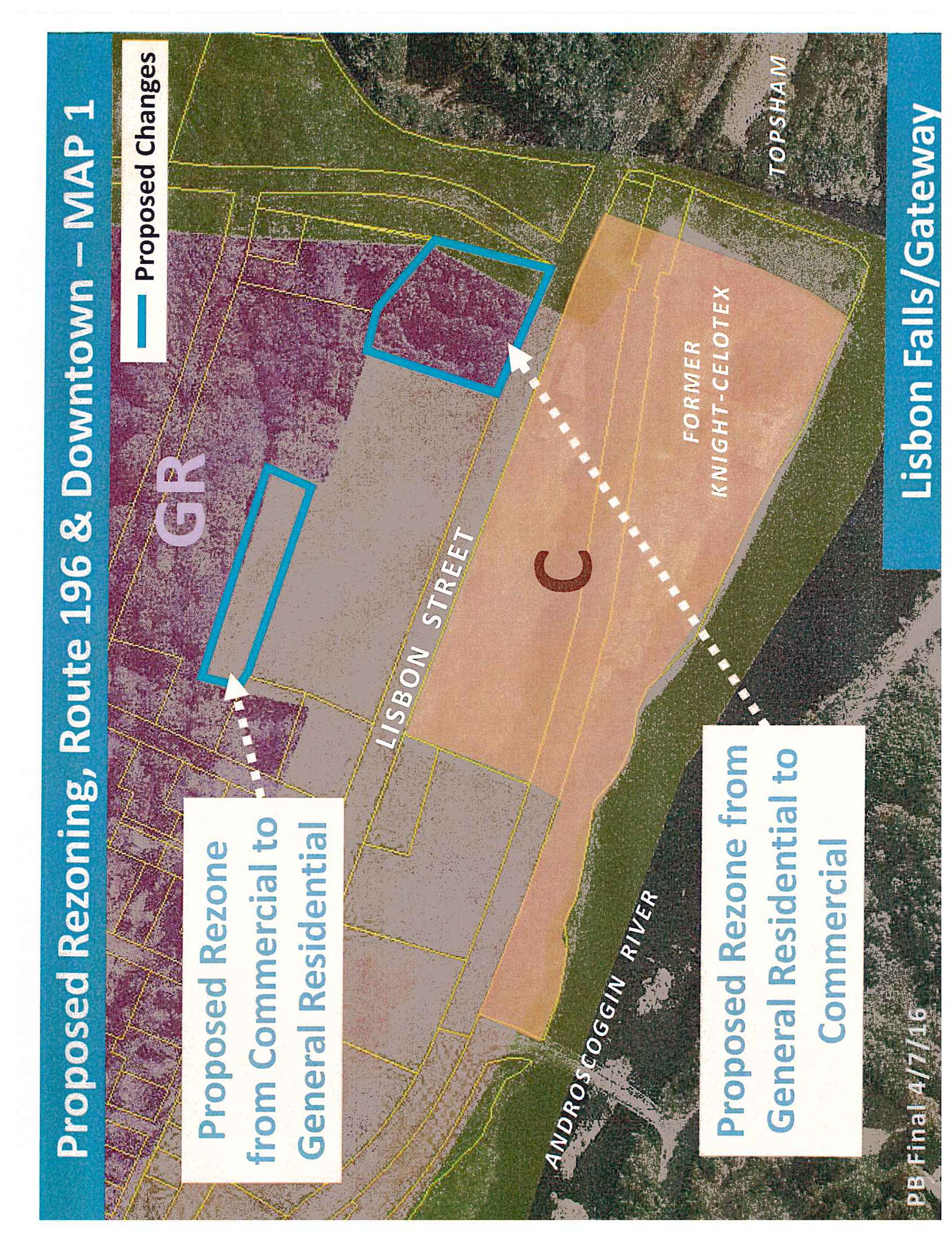
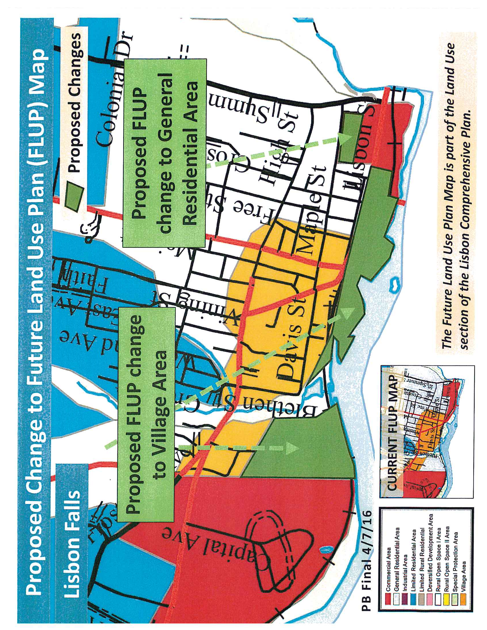
The former Knight-Celotex site was recently rezoned from industrial to commercial; a minor change is proposed for the property across from it on Route 196, to provide for commercial frontage along both sides of Route 196 (Lisbon Street) at the gateway (Lisbon town line).
(C.M. of 6-21-2016, V. 2016-146)
Sec. 70-538. - Map 2.
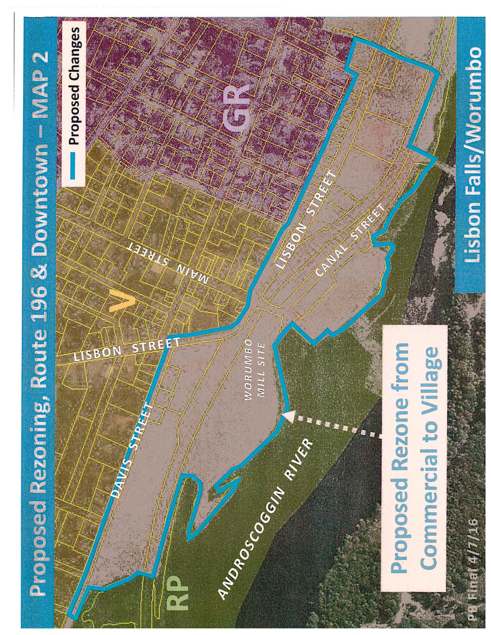
With consideration for the vision for the Lisbon Falls waterfront area (Route 196 Corridor Plan), including the Worumbo site, this area is proposed to be rezoned from commercial to village. Village zoning would allow for more mixed uses (including residential, which is not allowed in commercial), and has more flexible dimensional standards such as setbacks and lot coverage, which may help with the redevelopment of the waterfront area. The commercial zone also allows some potentially incompatible land uses in the village, such as warehousing, truck terminals, electrical/plumbing/contractor yards, or manufacturing. None of the existing land uses would become nonconforming by rezoning to village.
(C.M. of 6-21-2016, V. 2016-146)
Sec. 70-539. - Map 3.
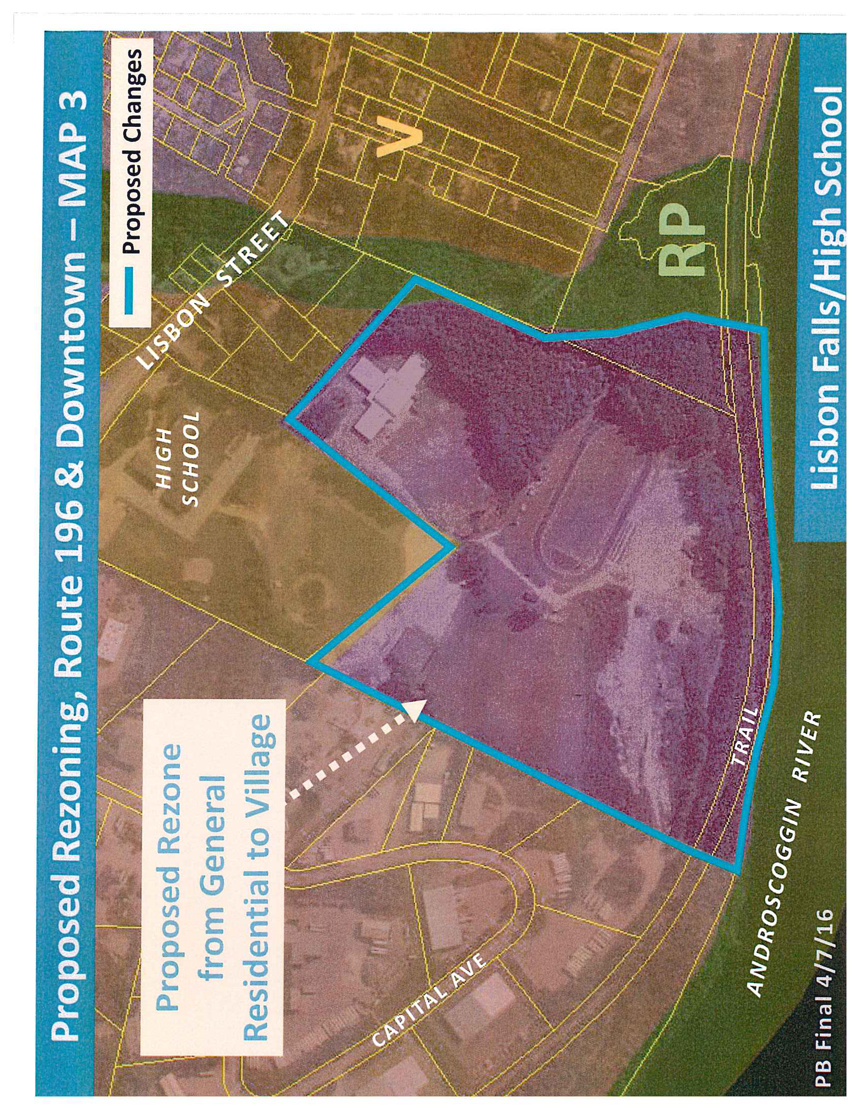
The rear lot of the school property, where the middle school and fields are located, was at some point zoned general residential instead of village, like the high school property. However, technically schools and school uses are not allowed in the general residential zone. Give the zoning of the high school lot and abutting commercial zone, this lot would be more compatible (and no longer nonconforming) if rezoned to village.
(C.M. of 6-21-2016, V. 2016-146)
Sec. 70-540. - Map 4.
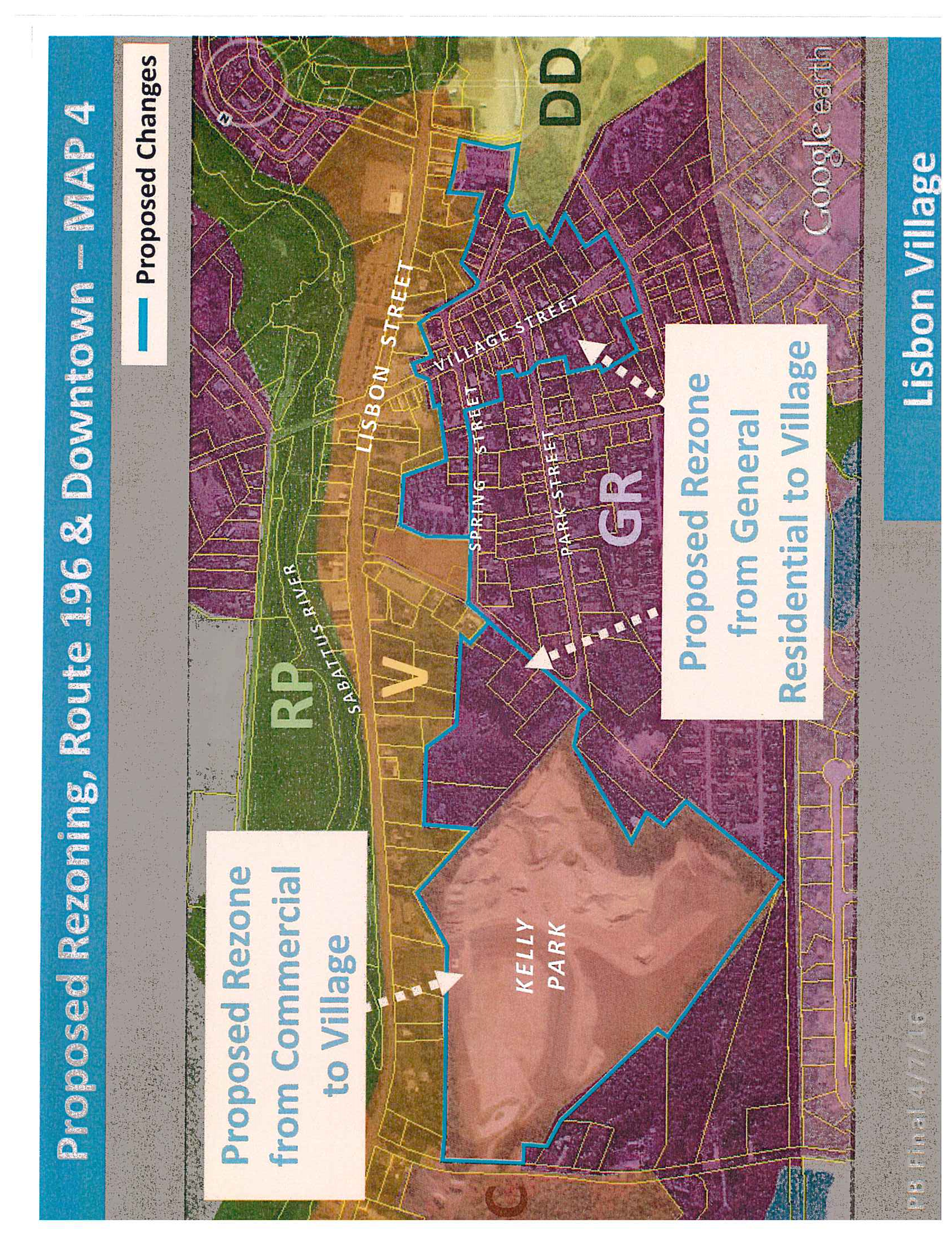
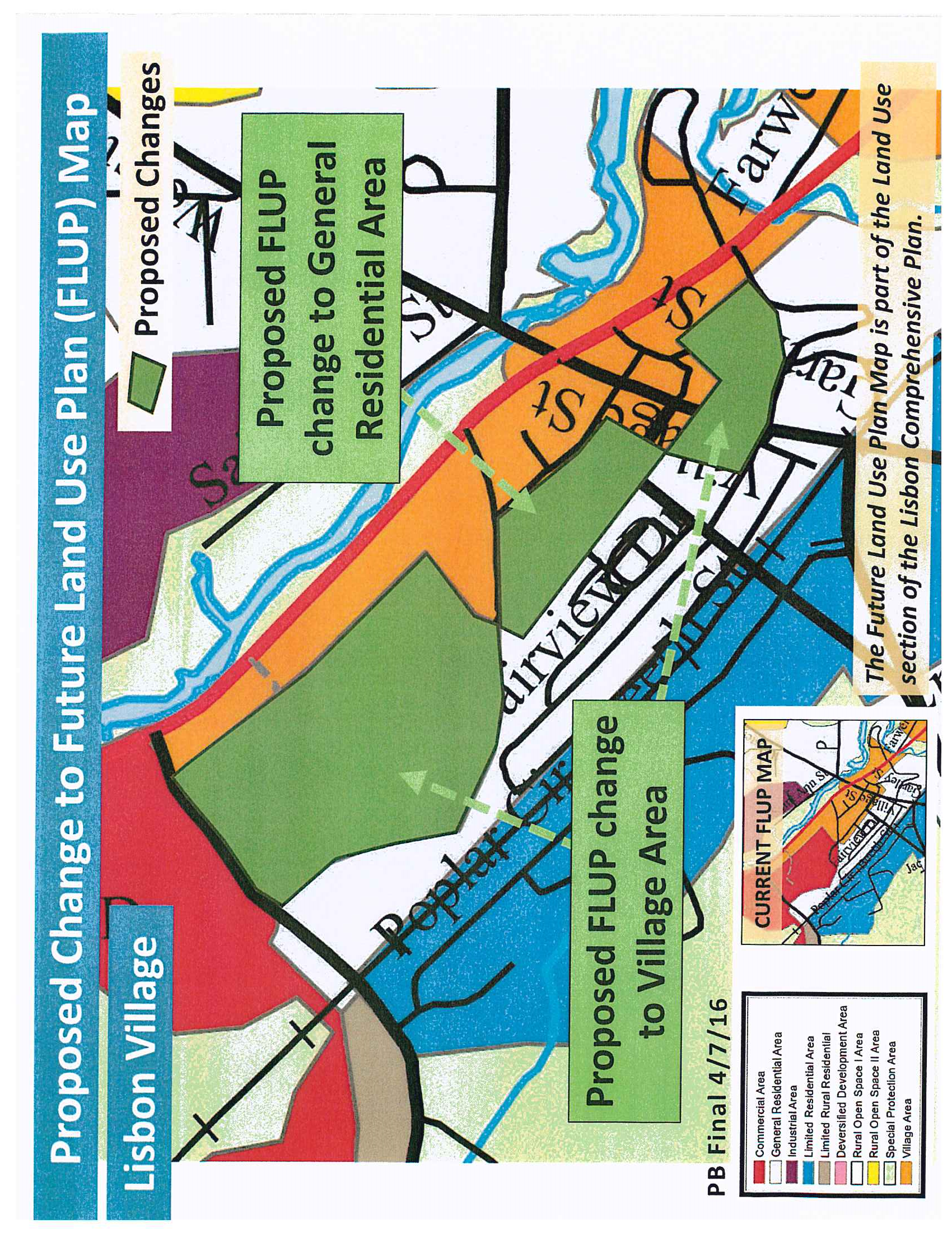
In Lisbon Village there is a proposed expansion of the village zone along Route 196 to include Village Street (currently the zone doesn't allow business uses), and the areas around Spring Street and one side of Park Street. The vision for Village Street in both the Downtown Plan and Route 196 Plan calls for allowing traditional village mixed uses. Expanding the village zone to include the Spring Street and Park Street areas would still allow for the existing residential uses, areas which might remain predominantly residential for some time, but would provide for future opportunities for small business growth in Lisbon Village.
(C.M. of 6-21-2016, V. 2016-146)
Sec. 70-541. - Comprehensive plan—Future land use plan.
The proposed zoning changes in Lisbon Falls and Lisbon Village are all consistent with the text and policies set forth in the Lisbon Comprehensive Plan. However, the changes proposed in Lisbon Falls are not consistent with the future land use plan, a map that is part of the land use section of the comprehensive plan. This map must be updated in order to keep the comprehensive plan and zoning map consistent. This change to the future land use map is consistent with the town's comprehensive plan text, Route 196 Corridor Plan, and downtown plan.
(C.M. of 6-21-2016, V. 2016-146)

