
Lomita City Zoning Code
PART 2
- ESTABLISHMENT OF ZONES
Article 20. - Designation of Zones[2]
Editor's note— Ord. No. 535, § 2, adopted Dec. 5, 1994, provided that §§ 11-1.21.01 and 11-1.23.01, being the sole substantive sections of Arts. 21 and 23, be renumbered as §§ 11-1.20.02 and 11-1.20.03 in Art. 20; hence, Arts. 21 and 23 are reserved.
Article 21. - Reserved
Note— See the editor's note to Art. 20.
Article 23. - Reserved
Note— See the editor's note to Art. 20.
Sec. 11-1.20.01. - List of zones.
Sec. 11-1.20.02. - Zoning map.
The Zoning Map of the City of Lomita is adopted by reference and shall hereafter be in effect and exist pursuant to and as a part of this chapter and shall be known and designated as the zoning map.
(Ord. No. 535, § 2, 12-5-94)
Sec. 11-1.20.03. - Uncertainty of boundaries.
Where uncertainty exists as to boundaries of any zone shown upon a zoning map, or any part thereof, the following provisions shall apply:
1.
Where boundaries are indicated as approximately following lot lines or the center line of highways, streets or alleys, such lines shall be construed to be such boundaries.
2.
Where a public highway, street or alley, or any portion thereof is officially vacated or abandoned, the area comprising such vacated highway, street or alley shall acquire the zone classification of the property to which it reverts.
3.
Areas in dedicated highways, streets or alleys, shall be deemed to be unclassified and in the case of highways, streets or alleys permitted to be used only for purposes lawfully allowed.
(Ord. No. 535, § 2, 12-5-94)
Sec. 11-1.25.01. - Designation of special purpose zones.
O-S Open space and recreation
Sec. 11-1.25.02. - Intent and purpose.
The special purpose zones are established to attain the goals of the general plan relative to recreation areas, undeveloped lands, areas with hazard restrictions and areas with natural resources. The special purpose zones may also provide incentives for specialized types of development not normally permitted in the basic zones contained in this ordinance but which comply with the city's development policies contained in the general plan.
(Ord. No. 535, § 3, 12-5-94)
Sec. 11-1.26.01. - Intent and purpose.
Zone O-S is established in compliance with the City of Lomita General Plan and the California Open Space Lands Act to provide for the preservation, maintenance and enhancement for the recreational and natural resources of the City of Lomita. It is the purpose and intent of this zone:
(1)
To provide for the continual availability of open space lands for outdoor recreational use;
(2)
To protect water resources by maintaining open areas to recharge groundwater;
(3)
To protect ecological and habitat areas to assure continued survival of wildlife and vegetation;
(4)
To protect sites of historical, archaeological, cultural, scenic or scientific value;
(5)
To reduce the risk to public safety through the protective management of seismic, floodprone, fire, geologic and other natural hazard areas.
(Ord. No. 535, § 4, 12-5-94)
Sec. 11-1.26.02. - Principal uses permitted.
Premises in Zone O-S may be used for the following principal uses:
(1)
Arboretums;
(2)
Athletic fields excluding stadiums;
(3)
Beehives;
(4)
Campgrounds;
(5)
Cultural heritage sites and historical monuments;
(6)
Existing easements for underground pipelines;
(7)
Riding and hiking trails, excluding trails for motorized vehicles;
(8)
Public water reservoirs and related facilities;
(9)
Wildlife preserves and sanctuaries.
(Ord. No. 715, § 2, 6-16-08)
Sec. 11-1.26.03. - Accessory uses permitted.
Premises in zone O-S may be used for accessory uses provided such uses are established on the same lot or parcel of land, are incidental to and do not substantially alter the character of any permitted principal use, including but not limited to:
(1)
Antennas, for receiving, relaying and transmitting signals relative to emergency services.
(2)
Pedestrian and vehicular safety control boxes and devices.
(3)
Signs as permitted in Article 67.
(4)
Structures for the provision of public utility service to permitted principal uses.
(Ord. No. 715, § 2, 6-16-08)
Sec. 11-1.26.04. - Uses subject to commission's review and approval.
Premises in Zone O-S may be used for the following purposes subject to review and approval by the commission, pursuant to the provisions of Article 70, "Zoning Ordinance Administration":
(1)
Accessory buildings not more than four hundred (400) square feet and not for permanent human occupancy.
(2)
Comfort stations.
(3)
Grading in excess of five hundred (500) cubic yards.
(4)
Nursery stock including the raising of flowers, herbs and vegetables.
(5)
Parking lots accessory to a principal use permitted in this zone.
(6)
Stands for the display and sale of agricultural or horticultural products lawfully produced on the same lot or parcel.
(Ord. No. 535, § 4, 12-5-94; Ord. No. 733, § 2(pt. 2), 9-7-10)
Sec. 11-1.26.05. - Uses by conditional use permit.
Premises in Zone O-S may be used for the following purposes, provided a permit has been first obtained, pursuant to the provisions of Article 70, "Zoning Ordinance Administration":
(1)
Caretaker residences for principal uses permitted in this zone.
(2)
Communication equipment buildings.
(3)
Electric distribution and transmission substations.
(4)
Golf courses.
(5)
Golf driving ranges.
(6)
Military reservations.
(7)
Museums, public.
(8)
Parks and playgrounds including normal appurtenant facilities.
(9)
Refreshment stands.
(Ord. No. 535, § 4, 12-5-94; Ord. No. 733, § 2(pt. 2), 9-7-10)
Sec. 11-1.26.06. - Standards of development.
Premises in Zone O-S shall be subject to the development standards prescribed in this Article and those standards contained in Part 6, "General Standards of Development".
(A)
Lot area: Each lot or parcel of land created in Zone O-S after the adoption of this ordinance [December 5, 1994] shall have a minimum lot area of not less than five thousand (5,000) square feet.
(B)
Lot width and frontage: Each lot or parcel of land created after the adoption of this ordinance shall be reviewed for lot width and street frontage to provide adequate buffer area to insure compatibility with adjoining uses and access to public streets.
(C)
Height limit: No structure in Zone O-S except historic structures shall exceed thirty-five (35) feet in height.
(Ord. No. 535, § 4, 12-5-94)
Sec. 11-1.27.01. - 24000 Crenshaw Boulevard Specific Plan location.
The 24000 Crenshaw Boulevard Specific Plan (the "24000 Crenshaw Blvd. Specific Plan") applies to the 2.516 net acre property located at 24000 Crenshaw Boulevard, on the northwest side of Lomita, and is generally bound by Crenshaw Blvd. to the west and Lomita Blvd. to the south. The precise boundaries of the 24000 Crenshaw Boulevard Specific Plan are depicted on Figure 1.
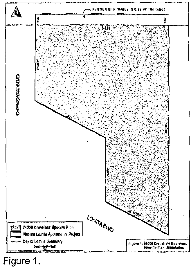
(Ord. No. 791, § 3, 10-3-17)
Sec. 11-1.27.02. - Permitted uses.
The following uses shall be permitted in the development area subject to the provisions of this chapter:
(1)
Multiple-family dwellings and amenities commonly associated to multi-family dwellings, including without limitation, leasing office, pool, roof deck, community room and fitness center.
(Ord. No. 791, § 3, 10-3-17)
Sec. 11-1.27.03. - Density.
Dwelling unit density shall not exceed eighty-eight (88) units per acre. In addition, the dwelling unit density in this specific plan shall be no greater than one dwelling unit per every four hundred ninety (490) square feet of net land area.
(Ord. No. 791, § 3, 10-3-17)
Sec. 11-1.27.04. - Maximum building height.
The maximum building height of all structures shall not exceed sixty-four (64) feet two (2) inches from the average grade plane along Crenshaw and Lomita Blvds. and sixty-four (64) feet zero inches from the average grade plane along the east property line. Staircases and elevator shafts and other minor accessory structures may exceed these height limits to the minimum extent necessary for compliance with the required by the building code of the City of Lomita.
(Ord. No. 791, § 3, 10-3-17)
Sec. 11-1.27.05. - Setbacks.
Minimum setbacks for structures above finished ground level shall be provided as follows:
(a)
Front (Crenshaw Blvd.): sixteen (16) feet.
(b)
Rear (East Property Line): thirty-four (34) feet.
(c)
Side (Lomita Blvd.): ten (10) feet.
(d)
Side (North Specific Plan Line): none.
(e)
No setbacks shall be required for a subterranean parking structure located below the finished ground level.
(Ord. No. 791, § 3, 10-3-17)
Sec. 11-1.27.06. - Open space.
(1)
Private usable open space. Private usable open space, such as a patio or a balcony, shall be provided for all units greater than one thousand (1,000) square feet in area. This private usable open space shall be distinguished from adjacent spaces by a wall, decorative wrought iron fence and/or landscape. The private usable open space for each unit shall be no less than forty (40) square feet in area.
(2)
Public open space. Public useable open space, including active recreation open space and passive open space (including landscaping), shall be provided and shall occupy at least thirty (30) percent of the total unbuilt land area.
(Ord. No. 791, § 3, 10-3-17)
Sec. 11-1.27.07. - Dwelling unit area.
The gross area per dwelling unit, not including patios or balconies, shall be no less than five hundred fifty (550) square feet for studio units, no less than six hundred fifty (650) square feet for one-bedroom units, and no less than nine hundred fifty (950) square feet for two-bedroom units.
(Ord. No. 791, § 3, 10-3-17)
Sec. 11-1.27.08. - Loading.
No off-street loading spaces shall be required.
(Ord. No. 791, § 3, 10-3-17)
Sec. 11-1.27.09. - Parking and drive aisles.
(1)
There shall be a blended parking ratio no less than 1.86 parking spaces per unit with one space per four (4) units allocated to guests. For a project providing two hundred twenty (220) dwelling units, a minimum of four hundred nine (409) parking spaces shall be provided.
(2)
Tandem parking may be arranged to be no more than two (2) spaces in depth with no more than fourteen (14) tandem stalls for twenty-eight (28) spaces.
(3)
Standard parking stalls shall be nine (9) feet by nineteen (19) feet. Compact stalls shall be nine (9) feet by fifteen (15) feet. There shall be no more than ninety-eight (98) compact stalls. Required guest spaces shall be standard parking stall size.
(4)
Drive aisles shall be a minimum twenty-four (24) feet in width for two-way traffic.
(5)
Parking management plan required. Parking shall be designed in accordance with a parking management plan subject to community development director approval. The parking management plan shall indicate the location and allocation of parking stalls for individual units, visitors, and for physically handicapped designated spaces.
(6)
Tandem spaces shall only be assigned to two-bedroom units.
(7)
All guest spaces shall be clearly marked.
(8)
All parking spaces and driveway aprons within parking structures shall be constructed of concrete.
(Ord. No. 791, § 3, 10-3-17)
Sec. 11-1.27.10. - Lighting.
Lighting shall be designed to provide safety and security and shall serve to unify and enhance the appearance of the residential development. All lighting shall be in accordance with a lighting plan and photometric plan. The lighting plan shall examine the degree to which exterior lighting affects adjacent uses and shall consider the light source, level of illumination, and hours of illumination. The photometric plan shall depict the anticipated light levels generated by all exterior lights located on adjacent properties and immediately beyond the residential development boundaries. Both plans shall be subject to community development director or designee approval and shall ensure that light fixtures and illumination levels do not adversely impact aesthetics and architectural elements of the development.
(Ord. No. 791, § 3, 10-3-17)
Sec. 11-1.27.11. - Walls and fences.
All walls or fences shall be of decorative concrete, brick, block, vinyl, or decorative wrought iron, or a combination of the above. The design of walls and fences and the selection of landscape materials shall result in unifying elements throughout the development area. All walls and fences shall be coordinated to serve a common theme in terms of design, color, materials and location. The design, color, material and location of walls and fences shall be subject to the approval of the community development director or designee.
(Ord. No. 791, § 3, 10-3-17)
Sec. 11-1.27.12. - Signs.
(A)
Intent and purpose. The intent and purpose of this section is to establish a framework for a comprehensive system of sign controls governing the display, design, construction, installation, and maintenance of signs that will discourage indiscriminate and unregulated erection and maintenance of signs and other visual media which tend to create a garish, gaudy, and unsafe atmosphere and which tend to be out of harmony with the goals and objectives of the community.
(B)
Definitions.
(1)
Address sign shall mean a sign that identifies the building's legal numeric address and is visible from the closest streets and/or public access points. An address sign may also contain the legal address's street name. The copy height of address signs shall be no less than four (4) inches and no greater than eighteen (18) inches.
(2)
Area of sign includes the entire area within any type of perimeter or border which may enclose the outer limits of any writing, representation, emblem, figure, or character, including all open space. The area of the sign having no such perimeter or border shall be computed by enclosing the entire area within a parallelogram or triangle of the smallest size sufficient to cover the entire area of the sign and computing the area of the parallelogram or triangle. Decorative panels or face plates considered an integral part of the building design shall not be included as sign area.
When each letter of a sign is mounted individually against the face of a building and said letters are more than one foot apart, the area of each letter and its background face plate, if any, shall be computed separately as a portion of the total permitted wall sign area.
Sign area for double-faced signs area of both faces shall be included in the sign area.
(3)
Building identification sign shall mean a sign containing any of the following information, and no more; the name of the building, any portion of which is located on the same site area on which the sign is located, and the address of such building.
(4)
Directional sign shall mean a sign that is intended to provide directions for motorists entering a site from a public right-of-way to on-site parking or loading.
(5)
Door nameplate shall mean a sign containing the name of the businesses on the premises, and/or the street address and number only, and shall be affixed to the door shall occupy no more than ten (10) percent of the door area.
(6)
Monument sign is a freestanding sign where the base of the structure connects to the ground and is supported primarily by an internal structural framework or integrated into landscaping or other solid structural features other than support poles.
(7)
Parking entrance and exit signs shall mean a sign in close proximity to the driveway. Copy on the signs to be limited to information or instructions to guide motorists and/or assist with vehicle circulation.
(8)
Private regulatory signs shall mean a sign that provides information on regarding conduct on private property. Examples include, no trespassing, no dumping, no parking, towing and other similar signs.
(9)
Real estate sign shall mean a sign relating to the sale, lease, rental or other disposition of the real property on which the sign is located and shall be temporary in nature.
(10)
Sign shall mean any name, figure, character, outline, spectacle, display, delineation, announcement, signboard, device, appliance, a combination thereof, or any other thing of similar nature to attract attention outdoors or on the face or wall of any building, and shall include all parts, portions, units and material composing the same, together with the frame background, and support or anchorage therefor as the case may be, but shall not include official notices authorized by a court, public body or public officer, nor directional, warning or information signs authorized by federal, state or municipal authority.
(11)
Temporary sign shall mean a sign with commercial or non-commercial text which is intended to be displayed for less than sixty (60) days. Temporary signs shall include banners, and portable signs constructed of plywood, wallboard or similar light, rigid material which is not affixed in a permanent manner to the ground or to any structure.
(12)
Wall sign shall mean a sign affixed to an exterior wall of any building and projects not more than one foot from the building wall and does not project above the parapet wall of the building to which it is affixed. A sign painted on the face, side or rear wall of a building shall be considered as a wall sign. The face of the sign and the lettering shall be parallel to the wall of the building.
(13)
Window sign shall mean a sign affixed to the interior of a window.
(C)
General conditions.
(1)
All provisions set forth in section 11-1.67.03(A) must be complied with.
(2)
Sign review and approval.
a.
Applicability. No sign, except those identified as exempt in section 11-1.27.12(6), may be erected, constructed, altered or relocated without first obtaining sign approval.
b.
Authority. The community and economic development director, or designee, is responsible for determining compliance with this section and is responsible for sign approval.
c.
Procedure.
1.
Applications for a sign review must be submitted to the city with the applicable fees.
2.
Sign plans must be drawn to scale and show the following:
i.
Dimensions in inches.
ii.
Lettering style and size in inches.
iii.
Construction details.
iv.
An elevation of the proposed sign drawn to scale.
v.
Color samples and material samples, where appropriate, identified by using the Pantone system.
vi.
For illuminated signs, Nits or foot candle data.
d.
Expiration. If the work authorized under a sign approval is not completed within one year after the date of issuance, the sign permit is void.
e.
Unapproved signs. Should any sign be displayed or erected without receiving approval from the city, the city shall cause the sign to be abated subject to section 1-2.01 of the Municipal Code.
(D)
Permanent signs.
(1)
Building identification sign.
a.
The total combined area of all walls and/or monument signs shall be 1.25 square feet for each dwelling unit located on the lot or parcel.
b.
The total quantity of all signs shall not to exceed five (5) signs.
1.
Monument sign.
i.
One sign shall be allowed to identify the building, so long as it does not interfere with or obstruct the visibility of pedestrians and vehicular traffic.
ii.
The maximum height shall be six (6) feet from the lowest finished grade.
iii.
The area for each face shall be counted separately.
iv.
The sign shall be setback at least two (2) feet from the property line.
v.
The sign may be externally illuminated, in accordance with subsection (7).
2.
Wall sign.
i.
No more than four (4) wall signs shall be allowed to identify the building.
ii.
A singular sign shall not exceed one-half (0.5) a square foot for each dwelling unit located on the lot or parcel.
iii.
All signs shall be mounted flush against the wall of the building and shall not project above the parapet wall.
iv.
The sign may be externally illuminated, in accordance with subsection (7).
(2)
Address sign.
a.
Address signs are permissible provided they are visible from the closest street and/or public access located on the ground floor.
b.
The copy height of address sign shall be no less than four (4) inches and no greater than eighteen (18) inches.
c.
The sign may be illuminated with halo lighting and subject to subsection (7).
(3)
Parking entrance and exit signs. The maximum sign size shall be fourteen (14) square feet.
(E)
Temporary signs.
(1)
Initial for lease banner.
a.
One banner shall be allowed with a maximum area of six hundred ninety-seven (697) square feet.
b.
The banner shall be mounted on the wall of the building and shall not be higher than the height of the building to which it is attached.
c.
The sign shall not be illuminated.
d.
This provision shall sunset twelve (12) months after the certificate of occupancy is issued.
e.
The expiration date shall not be extended.
(2)
Banner.
a.
One banner sign shall be allowed, so long as it does not interfere with or obstruct the visibility of pedestrians and vehicular traffic.
b.
The sign may be ground or building mounted.
c.
The sign may be displayed for up to sixty (60) consecutive days per approved application and up to twice per calendar year for a maximum of one hundred twenty (120) days.
d.
The maximum size shall be thirty-six (36) inches by twenty-four (24) inches.
(3)
Failure to remove the temporary sign(s) after expiration of the permitted time period and failure to maintain the sign(s) in good condition will result in the city causing the sign(s) to be abated subject to section 1-2.01 of the Lomita Municipal Code.
(F)
Exempt signs permanent and temporary.
(1)
Directional signs.
a.
Directional signs shall contain only directional information and not any advertising message.
b.
The maximum sign area shall be two (2) square feet and the maximum height shall be forty-two (42) inches.
c.
The number and location of directional signs shall be at the discretion of the community and economic development director.
(2)
Door nameplate.
a.
Shall be non-illuminated and affixed to the interior of a door.
b.
A door nameplate shall have a maximum height of two (2) feet and a maximum width of two (2) feet per glazing pane.
c.
It shall be located only on the ground floor.
(3)
Private incidental regulatory signs.
a.
The maximum area shall not exceed twelve (12) square feet in surface area per/face and no more than one-inch thick.
b.
A lot may have up to two (2) signs per street frontage and an unlimited quantity of signs not visible from the public rights-of-way.
c.
Such signs shall contain no advertising, logos, or other promotional information.
(4)
Real estate sign.
a.
The type of sign may be either a wall or a monument sign.
b.
One sign shall be allowed per frontage and the maximum size shall be no more than fifteen (15) square feet per face.
c.
Real estate signs shall be removed with fifteen (15) days after such property is no longer for sale, lease, or exchange.
(5)
Window sign.
a.
It shall be non-illuminated and affixed to the interior of a window.
b.
A window sign shall have a maximum height of two (2) feet and a maximum width of two (2) feet per glazing pane.
c.
It shall be located only on the ground floor.
(G)
Illumination.
(1)
Unless authorized in this section, signs shall not be illuminated.
(2)
A wall sign(s), if illuminated, shall be illuminated by a single color continuous halo-lit light.
(3)
A monument sign, if illuminated, shall be illuminated by one single color continuous light per face.
(4)
Lighting shall not cause a hazard, create a glare, or be distracting.
(5)
The brightness level shall, to the satisfaction of the director of community and economic development, be consistent with the lighting in the area and not pose a nuisance or danger.
(6)
The community and economic development director's decision may be appealed to the planning commission per section 11-1.70.07, "site plan review." The decision of the planning commission may be appealed to the city council pursuant to the provisions for "appeals" set forth in this article.
(Ord. No. 791, § 3, 10-3-17; Ord. No. 827, § 4, 2-1-22; Ord. No. 844, § 4(A, B), 3-21-23)
Sec. 11-1.27.13. - Mechanical equipment.
Mechanical equipment, devices or facilities that are ancillary to residential dwelling units including, but not limited to, antennas, air conditioning systems, and filtration systems, are permitted in accordance with the following:
(1)
Air conditioning and filtration systems.
a.
Units shall be prohibited on private open space areas, including patios and balconies, and shall be located on the roof of residential buildings. In all cases, the units shall be neither visible nor audible from any adjacent properties, structures or streets. All residential units shall be provided with central air conditioning systems.
b.
The mechanical equipment shall comply with the city's noise ordinance.
c.
The air conditioning and filtration system units shall be screened by parapet walls to eliminate noise and visibility. Raised parapets shall be a minimum of six inches greater than the height of all units and shall be subject to the approval of the community development director.
(2)
Satellite dish antennas. Satellite dish antennas shall be located to be hidden from public view from the street level.
(Ord. No. 791, § 3, 10-3-17)
Sec. 11-1.27.14. - Trash facilities.
Trash facilities, including trash chutes, trash receptacles, or bins, shall be located wholly within the parking area or residential structures and hidden from public view to eliminate aesthetic impacts. Trash storage areas shall be designed in accordance with a solid waste plan. The solid waste plan shall identify the location of trash facilities and/or storage areas and should identify on-site scheduled trash pick-up times and shall be subject to review and approval by the community development director. Trash facilities shall be clean and free of debris.
(Ord. No. 791, § 3, 10-3-17)
Sec. 11-1.27.15. - Infrastructure.
Due to the urbanized nature of the surrounding area and the limited project size, the 24000 Crenshaw Blvd. Specific Plan area is currently provided with adequate facilities and services for sewage, water, drainage, solid waste disposal, and energy. As limited in size and intensity of use by the 24000 Crenshaw Blvd. Specific Plan, the 24000 Crenshaw Blvd. Specific Plan area will not require the development of additional sewage, water, solid waste disposal, energy, or other essential facilities. In addition, all utility construction, connections and maintenance shall conform to the provisions of the City of Lomita Municipal Code.
(Ord. No. 791, § 3, 10-3-17)
Sec. 11-1.27.16. - Applicability of other standards.
All other development standards shall be governed by the city's zoning code. When uncertainly over applicability of requirements exists, standards applicable to the Residential Variable Density (RVD) and multi-family residential development, shall apply. In the event of a conflict between this Specific Plan and the zoning code, the Specific Plan shall control.
(Ord. No. 791, § 3, 10-3-17)