
Loves Park City Zoning Code
ARTICLE IX
PLANNED DEVELOPMENTS
Sec. 102-331.- Planned community development.
(a)
Permitted by special use permit. Planned community development may be permitted in any district by special use permit in accordance with the provisions of section 102-335.
(b)
Intent and purpose. A planned community development is a project occupying not less than 30 acres of land which shall include all land within the project boundaries plus one-half of all adjacent public rights-of-way. The planned community development may encompass planned unit developments. Otherwise the planned community development shall be developed as one entity involving a related group of land uses planned and therefore acceptable for development and regulation as one complete land use unit. The planned community development provision is established for the purpose of:
(1)
Providing a procedure by which new communities or larger integrated developments may be processed.
(2)
To encourage developers to prepare comprehensive land use plans for large acreage as opposed to piecemeal solutions.
(3)
To encourage variety in physical development through the use of new techniques in site development not attainable through conventional zoning application.
(4)
To ensure the most effective provision of environmental amenities for new and redeveloped urban areas, including parks, schools, open space, utilities and services.
(c)
Permitted uses. Unless otherwise provided in this article, no building or land may be used, and no building may be erected, converted, enlarged, or structurally altered in a planned community development, except for the following uses:
(1)
Any use that is a permitted or a special use in the R1, R4, CR and IL districts.
(2)
A temporary real estate office in conjunction with a planned community development limited to the selling or renting of properties in planned community development and in no case to be in operation for more than one year following the completion date of such construction.
(3)
Temporary construction buildings and uses related to the planned community development provided all buildings are removed and uses ceased upon completion date of such construction. Accessory uses and buildings incidental to any use permitted by this section.
(Ord. No. 795, § 900, 5-13-74)
Sec. 102-332. - Mobile home parks.
(a)
Intent and purpose. The mobile home special use permit procedures are established in order to provide and regulate the placement of mobile homes in the city to provide adequate standards to protect and promote public health, safety, morals, convenience, and general welfare. The general purpose includes the following specific purposes:
(1)
To provide regulations and standards for the development of a safe, healthy, and well-designed community for permanent mobile home living.
(2)
To protect mobile home areas against undue congestion of streets and facilities by controlling the intensity of development by density regulations.
(3)
To comply as much as possible with the objectives and purposes of each zoning district in which mobile home parks are located.
(4)
To ensure adequate light, air, access, and open space for each mobile living unit.
(b)
Location. Mobile home parks may be permitted in the RU, R3, R4 and CG zoning districts by a special use permit in accordance with the provisions of section 102-334.
(c)
Placement and occupancy. No mobile home shall be located, occupied or used for living or sleeping purposes unless it is located in a mobile home park that has been granted a special use permit in accordance with the provisions of this article. However, individual mobile homes may be located or placed outside mobile home parks, or subdivisions only as follows:
(1)
For use as shelter on the site of a construction project, during the course of construction, provided the mobile home shall not be occupied for human habitation.
(2)
For display purposes as part of a mobile home sales or rental business; provided the mobile home shall not be occupied for human habitation.
(3)
For use in conjunction with carnivals, circuses, fairs or rodeos while they are on the site.
(d)
Design and performance standards. Mobile home parks shall conform to the following design and performance standards.
(1)
Mobile home parks shall have not less than 300,000 square feet of land area.
(2)
A maximum of six mobile homes shall be allowed per gross acre.
(3)
There shall be a minimum of 6,000 square feet of site area per mobile home.
(4)
A mobile home park shall contain recreational open spaces, not less than 5,000 square feet of which, for each ten acres, or portion thereof, shall be developed for recreational use. The aggregate open space shall be not less than 200 square feet for each mobile home space.
(5)
Not more than one conventional single-family dwelling shall be located in a mobile home park.
(6)
No mobile home or dwelling shall be located in a required front yard or less than 25 feet from the property line of the mobile home park.
(7)
Only one mobile home may be located on a mobile home site as designated in a mobile home park and shall be subject to the following yards and setbacks:
a.
Front yard and/or rear lot line, a minimum of ten feet.
b.
Side yard, a minimum of ten feet.
c.
Minimum distance of 20 feet between mobile homes and/or other permitted structures.
d.
Minimum distance of ten feet from unrelated accessory structures.
(8)
A minimum of two improved off-street parking spaces shall be provided for each mobile home site.
(9)
All street design and development shall be in compliance with the subdivision regulations of the city.
(10)
All utilities including television service shall be underground.
(11)
A designated trailer and boat storage shall be provided with an aggregate area of 50 square feet for each mobile home site.
(12)
Fencing and landscaping as follows:
a.
Adequate landscaping shall be provided including trees and shrubs around the perimeter of the mobile home park.
b.
Additional fencing and landscaping including perimeter fencing along interior, side and rear lot lines may be recommended by the zoning board of appeals as part of the special use permit for a mobile home park.
(Ord. No. 795, § 901, 5-13-74)
Sec. 102-333. - Mobile home subdivision.
(a)
Intent and purpose. The intent and purpose of a mobile home subdivision is to provide areas for mobile home owners who wish to own land and to regulate these subdivisions.
(b)
Administration. Application for a special use permit for a mobile home subdivision shall be the same as provided in section 102-334(d)(2) for mobile home parks.
(c)
General conditions. General conditions for a mobile home subdivision shall be as follows:
(1)
Only mobile homes shall be permitted in a mobile home subdivision.
(2)
A special use permit shall be void after one year if there are no final subdivision plats on record.
(d)
Design and performance standards. A-1 design and performance standards shall meet the requirements of subsection 102-332(d) and the city subdivision ordinance.
(e)
Location. Mobile home subdivisions may be permitted in the RU, R3, and R4 districts by a special use permit in accordance with the provisions of section 102-334.
(Ord. No. 795, § 902, 5-13-74)
Sec. 102-334. - Administration for planned developments.
(a)
Applicant. The applicant for a planned development special use permit shall be the owner of the site, or if more than one, all owners of the site acting jointly. For the purposes of this subsection, the term "owner" shall mean and include any public body corporate, a holder of a written option to purchase, or a redeveloper under contract with the local public agency for urban renewal.
(b)
Preliminary conference. Each prospective applicant may confer with the zoning officer in connection with the preparation of the application prior to the submission of a formal application. At this conference, the following basic information and data shall be provided the zoning officer:
(1)
The boundaries of the property;
(2)
Existing easements and covenants affecting the property;
(3)
Land characteristics, such as natural drainage, swamp areas;
(4)
Development characteristics, such as surrounding streets, existing buildings, available community sewer, water and other utilities; and
(5)
The proposed layout, including the location and extent of the various types of uses including residential and commercial uses, parks, playgrounds and other community facilities.
(c)
Zoning Board of Appeals application. Prior to filing for a planned development special use permit with the zoning board of appeals, the following information shall be provided to the zoning officer:
(1)
For planned community development:
a.
Kind and general location of the proposed land uses; and
b.
Proposed topography, ten-foot contour intervals.
(2)
For mobile home parks:
a.
An overall land use development plan delineating the street system, off-street parking areas, concrete pads, recreational areas, public and private utility installations, proposed finished topography and any additional on-site improvements;
b.
In addition, the land use development plan shall be accompanied by a phasing plan for the development of the project.
(3)
For mobile home subdivisions:
a.
All information and date required by the subdivision ordinance of the city for tentative plats.
b.
An overall development plan delineating the street system, off-street parking areas, kind and location of proposed structures and uses; proposed finished topography (two-foot contour intervals); public and private utility installations and other onsite engineering and improvements plans.
c.
In addition, the development plan shall be accompanied by a phasing plan for the development of the project.
(4)
For all planned developments. In addition, the following information shall be provided:
a.
Fifteen copies of each of the required plans.
b.
Written statement of facts explaining in detail the proposal and justifying the project at this location.
c.
Included also will be provisions for service, maintenance and continued protection of the planned development and adjacent property.
d.
The applicant shall include such other pertinent information as the zoning board of appeals shall prescribe, but to promote efficiency and minimize expense, the zoning board of appeals may provide for the serial submission of portions of the application.
(5)
The form shall be accompanied by a filing fee as prescribed by a fee schedule adopted by the city council.
(d)
Zoning board of appeals public hearing. Upon receipt of the application and other applicable pertinent material referred to in this subsection, the zoning board of appeals shall hold at least one public hearing on the proposed planned development at such time and place as shall be established by the zoning board of appeals. The hearing shall be conducted, and a record of such proceedings shall be made and filed with the office of the city clerk. Notice of such public hearing shall be published at least once, not more than 30 nor less than 15 days before the hearing, in one or more newspapers distributed in the city. Supplemental or additional notices may be published or distributed as the board may prescribe from time to time. The city council may, by ordinance, require an applicant to assume the cost of administration, public notice and due notice of interested parties.
(e)
Zoning board of appeals review and recommendations. The zoning board of appeals shall review the proposed planned development to determine its conformity with the land development trends in the community; standards of the official comprehensive plan; the overall design of the proposed planned development as it relates to the natural and manmade features in the immediate and surrounding area; and recognized principles of design, and use planning, and landscape architecture.
(1)
For planned community development:
a.
The zoning board of appeals shall recommend to the city council the maximum density (dwelling units per net acre) and height which should be permitted which is consistent with the character of the surrounding development. In establishing the maximum density and height, due consideration shall be given to the maximum density and height permitted in adjacent residential districts and to the actual density and height of the surrounding residential area where such exists.
b.
A planned community development site may be divided into two or more parts with densities and heights determined for each part if such division will improve the total character of the development and make it more compatible with the general development of the area.
(2)
For mobile home parks, and mobile subdivisions. The zoning board of appeals shall recommend to the city council the maximum density (dwelling units per acre) which should be permitted.
(3)
With the exception of planned community developments, additional detailed plans of site improvements and proposed documents to provide security for the installation and maintenance of utilities and community facilities and open spaces may be requested from time to time to facilitate the review of the proposed planned development. The zoning board of appeals may recommend reasonable conditions regarding the layout, circulation and performance of the proposed development.
(4)
The zoning board of appeals may approve variation in the zoning and subdivision standards in mobile home subdivisions which may permit private streets for unique developments that may utilize condominium development technique, cluster housing concepts and other imaginative and unique development methods when consistent with the purposes of this article.
(5)
After the zoning board of appeals has completed its review of the proposed planned development it shall convey in writing to the city council, with a duplicate to the applicant;
a.
Approval;
b.
Approval with conditions; or
c.
Approval with modification.
This communication must be made within 60 days of the request for tentative approval of the planned development unless a mutually acceptable extension is set.
(f)
Findings of fact and recommendation of the zoning board of appeals. Within 60 days after the close of the public hearing on the proposed planned development special use permit, the board shall make written findings of fact and shall submit same together with its recommendation to the city council. For the board of appeals to make an affirmative recommendation, it must find in each of the following instances that:
(1)
The establishment of a planned development will not be detrimental to or endanger the public health, safety, morals, comfort, or general welfare.
(2)
The planned development will not be injurious to the use and enjoyment of other property in the immediate vicinity for the purposes already permitted, not diminish and impair property values within the neighborhood.
(3)
The planned development will not impede the normal or orderly development and improvement of the surrounding property for uses permitted in the district.
(4)
Adequate measures have been or will be taken to provide ingress and egress so designed as to minimize traffic congestion in the public streets.
(g)
Authorization. The planned development special use permit shall be authorized by the city council resolution after a public hearing and taking into consideration the recommendations from the zoning board of appeals. Such resolution shall specify the maximum density (dwelling units per net acre) and such other conditions and/or restrictions upon the location, design and construction as shall be deemed necessary to secure the general objectives of this chapter. If written protest against a proposed planned development is made by the owner of 20 percent of the frontage immediately adjoining or across a street, alley, or public easement therefrom, and filed with the city clerk, such planned development special use permit shall not be granted except by an affirmative vote of at least three-quarters of all the members of the city council.
(1)
Effect of denial. No application for a planned development special use permit which has been denied wholly or in part by the zoning board of appeals shall be resubmitted for a period of one year from the date of the denial, except on the grounds of new evidence of proof of changed conditions found to be valid by the zoning board of appeals.
(2)
Recorded plat required. In the case of a mobile home subdivision, a lat of subdivision shall be recorded with the county recorder. Such plat will show building lines, common land, streets, easement, and other applicable features required by the subdivision ordinance shall be followed except those in conflict with this article, in which case this article shall take precedence. No building permits or occupancy permits shall be issued until after final approval of the planned development special use permit and recording of the subdivision plat as finally approved by the city council.
(3)
Guarantee of completion. Before final approval of a planned development special use permit, the zoning board of appeals may recommend and the city council may require a contract with safeguards satisfactory to the city attorney guaranteeing completion of the planned development in a period specified by the zoning board of appeals, but which shall not exceed five years, unless extended by the city council.
(4)
Revocation. In any case when construction of a planned development has not commenced within one year after the date of approval, the zoning board of appeals shall review the residential planned unit development and recommend to the city council whether or not the planned development special use permit shall be revoked or continued.
(Ord. No. 795, § 903, 5-13-74; Ord. No. 2987-03, § 4, 4-28-03)
Sec. 102-335. - Precise plan development.
(a)
Permitted by special use permit. A precise plan development may be permitted in any zoning district by a special use permit in accordance with the provisions of this section.
(b)
General purpose. The precise plan development special use permit is developed in order to:
(1)
Encourage unique design and site planning of land areas through the use of criteria which, when properly implemented, allow for certain flexibility;
(2)
Permit and foster condominium developments in accord with the provisions of the "Condominium Property Act," (765 ILCS 605/1 et seq.) effective June 1963, as amended;
(3)
Provide an administrative procedure to facilitate and utilize imaginative design and subdivision technology which may necessitate variation in traditional yards, setbacks, lot shapes and sizes.
(c)
Definition. A precise plan development is a development occupying one or more parcels of land involving a group of associated uses and/or structures planned as an entity and, therefore, acceptable for development and regulation as one complete land use unit.
(d)
Applicant. The applicant for a precise plan development shall be the owner of the site, or if more than one, all owners of the site acting jointly. For the purpose of this subsection, the term "owner" shall mean and include any public body corporate, a holder of a written option to purchase, or a redeveloper under contract with the local public agency for urban renewal.
(e)
Permitted uses. Unless otherwise provided in this chapter, no building may be erected, converted, enlarged or structurally altered in a precise plan development, except for uses permitted or special uses in the zoning district in which it is located and except for specific uses listed in the special use permit for such development.
(f)
Filing procedure. A precise plan development may be permitted by filing for a precise plan development special use permit in accordance with the provisions of article VIII of this chapter.
(g)
Review procedure. The zoning board of appeals shall review all precise plan special use permits and submit a recommendation to the city council within 45 days of final review.
(Ord. No. 795, § 905, 5-13-74; Ord. No. 1104, § 1, 11-13-79; Ord. No. 2987-03, § 5, 4-28-03)
Sec. 102-336. - Traditional neighborhood development (TND).
(a)
Permitted by special use permit. Traditional neighborhood developments may be permitted in any district by special use permit in accordance with the provisions of this section and with section 102-335. If land is identified within the city comprehensive plan's planned or future land use map as appropriate for traditional neighborhood development or traditional village center commercial, the process and standards in this section shall be used for all new development or redevelopment of said land.
(b)
Intent and purpose. A traditional neighborhood development (TND) is intended to allow desirable and innovative development activities and variation in the relationship of uses, structures and open spaces in developments conceived and implemented as cohesive, unified projects. This special use permit zoning option is intended to promote the development and redevelopment of land consistent with the following traditional neighborhood design principles:
(1)
Creates an environment that promotes human interaction, a healthy civic life, a sense of place, and a high-quality living environment;
(2)
Is compact and reflects the character of neighborhood development patterns that were commonplace before the second half of the twentieth century;
(3)
Designed for the human scale (i.e., sizes of buildings and spaces in proportion to sizes of people) and for walkability (i.e., comfort, ease, and quickness of moving on foot from one point to another);
(4)
Provides a mix of uses, including residential, commercial, civic, and open space uses in close proximity to one another, along with a vertical mixing of uses in multi-story buildings;
(5)
Provides a mix of housing styles, types, and sizes to accommodate households of all ages, sizes, and incomes;
(6)
Incorporates a system interconnected streets with sidewalks and paths that offer multiple routes for motorists, pedestrians, and bicyclists within and through the neighborhood;
(7)
Retains, to the extent reasonably practical, existing buildings with historical or architectural features that enhance the visual character of the community;
(8)
Incorporates significant environmental features into the design; and
(9)
Consistent with the city's comprehensive plan.
(c)
Recommended minimum TND district size. Each mapped TND shall be a minimum of 40 acres in gross land area, except where a smaller TND is anticipated in the city comprehensive plan. Where not otherwise authorized in comprehensive plan, an individual TND project may be smaller than 40 acres if it is anticipated in the comprehensive plan to be part of a contiguous area of 40 acres or greater developed under this section.
(d)
Procedure for TND special use permit approval.
(1)
Step 1: Preliminary consultation. Before submitting an application for a special use permit, the applicant shall schedule an appointment with the city planning staff to discuss the procedures and design standards for TNDs.
(2)
Step 2: General development plan (GDP) approval.
a.
The procedure to obtain a special use permit for a TND shall be the same as for any other special use permit (see article VIII), except that in addition, 12 copies of a general development plan (GDP) shall be submitted to and approved by the city council following a recommendation by the zoning board of appeals as part of the special use permit. The GDP application shall include or be accompanied by the following:
1.
A location map of the subject property and its vicinity, using the city's planned or future land use map from the comprehensive plan as a base;
2.
A site inventory and analysis map with topography at two-foot contours to identify site assets, resources, and constraints, including but not limited to floodplains, wetlands, soils with limitations for building construction, utility easements, slopes greater than 12 percent, and existing trees over eight inches in diameter or the edges of woodlands in which a majority of trees meet this criterion;
3.
A conceptual site plan or neighborhood development plan, at a scale of not less than one inch equals 100 feet, or at a scale that is appropriate to the size of the development, which indicates existing and proposed major public streets, private drives, and paths; different land use areas by proposed type and density; and proposed recreational, open space, and generalized stormwater management areas and facilities;
4.
An analysis or map showing the general locations of proposed public utility connections, and anticipated upgrades to public utilities to serve the project;
5.
A conceptual landscape plan showing general locations and types of proposed landscaping, including maintenance of existing vegetation where appropriate;
6.
A conceptual phasing plan, if the applicant intends to phase construction of the project;
7.
A conceptual stormwater management plan identifying the proposed patterns of major stormwater run-off, locations of stormwater infiltration areas, and other significant stormwater management features, including relationships to and alignment with any regional stormwater management plan adopted by the city;
8.
Typical proposed building elevations identifying the architectural style of each of the different use areas, along with a general program for proposed signage;
9.
A written report that provides general information about the site conditions; TND project vision, objectives, themes, and images; mix of uses and dwelling unit types; approximate residential densities and non-residential development intensities; and the relationship of the project to adjacent land uses, the city's comprehensive plan, other applicable adopted city plans, and the purpose and principles for TNDs included in section 102-336(b).
b.
Upon city council approval and adoption of the GDP and associated special use permit, all plans submitted as well as other commitments, conditions of approval, restrictions and other factors pertinent to the project shall be filed with the community development department and shall be referred to in regard to enforcement or modification of the GDP.
c.
If the applicant does not submit and have approved at least one precise implementation plan for a TND project within two years of city approval of the GDP and special use permit, or unless an alternate phasing plan is approved by the city council, the previously approved GDP shall be considered null and void. A new petition and approval process shall be required to obtain approval of the same or a revised GDP if such time period lapses.
(3)
Step 3: Precise implementation plan (PIP) approval.
a.
Detailed plans, described below under the precise implementation plan (PIP) submittal requirements, are not required to be submitted at the time the special use permit is approved; however, the GDP and PIP review process may be combined and made faster by doing so. Before any building permit is issued, the zoning board of appeals shall review and recommend to the city council approval of a PIP. If the approved GDP specified that development of the site would proceed in phases, the zoning board of appeals shall review and recommend to the city council approval of a PIP covering only a portion of the previously approved GDP area. The applicant shall file 12 copies of the PIP. The PIP application shall include the following:
1.
A location map of the PIP area and the GDP area (if different) and its vicinity, using the city's planned or future land use map from the comprehensive plan as a base;
2.
Where a land division or lot consolidation is proposed, a tentative plat of the entire project area included in the PIP, meeting all applicable requirements of chapter 78, except in the event of conflict the provisions of this section shall apply.
3.
A detailed neighborhood development plan showing the precise horizontal and vertical mix of land uses; densities of use areas and development sites; building setbacks and massing; main driveways and parking areas; parks, squares, and open spaces; civic buildings; street trees and other natural elements; the street, alley, and block structure; and paths and other pedestrian ways;
4.
Typical building elevations or architectural standards for single- and two-family residential buildings, including but not limited to design character and architectural details; lot dimensions; building height; building mass or bulk; building or impervious surface coverage maximums; accessory structure standards; dwelling and garage placement, setbacks, separation, relationships, and allowed encroachments, and off-street parking;
5.
Detailed building elevations and site plans for all proposed non-residential, mixed use, and multiple-family residential buildings. Such detailed elevations and plans shall identify all wall signs; the percentage of ground floor commercial facade in windows; the location of parking; and the location, height and materials for screening walls and fences including those proposed to surround outdoor trash and recyclable storage areas, utility meters, ground and rooftop mechanical equipment; and the precise locations of natural features such as wetlands and floodplains;
6.
Detailed signage plan and lighting plan, each demonstrating a unified or compatible sign and lighting design theme within the TND. Lighting plan shall indicate lighting intensity, height, design, placement, and orientation. Signage plan shall indicate signage placement, dimensions, design, materials, and illumination;
7.
A detailed landscape plan showing specific locations, types, and sizes of proposed landscape plantings and ground cover, including maintenance of existing vegetation where appropriate;
8.
Detailed grading plan, storm water management plan, public utility plan, and erosion control plan, meeting all state, county, and city requirements and consistent and assisting with the implementation of regional stormwater management plans adopted by the city;
9.
Arrangements, bylaws, provisions or covenants that will govern the organizational structure, use, architectural standards, maintenance and continued protection of the TND, which shall include detailed requirements for the ongoing maintenance of common areas by a property owners' association or alternative mechanism;
10.
A written report describing the proposed PIP, including specific project themes and images (e.g., drawings, photos, simulations), a specific mix of dwelling unit types and/or land uses, specific densities and dimensional standards for residential and non-residential uses, the specific treatment of open space areas, and an evaluation of the consistency of the proposed PIP with the previously approved GDP;
11.
Site summary data, including gross site area, area and lineal feet in street rights-of-way, net area proposed for development and common open space uses, net subdivided area, total number of building sites, and average or typical lot and building site sizes;
12.
Other information of sufficient detail to allow the zoning board of appeals to determine compliance with each of the requirements of this section.
b.
At a regular meeting, the zoning board of appeals shall recommend approval, conditional approval with changes consistent with the approved GDP, or reject the PIP. A PIP that is consistent with the GDP and meets other applicable ordinance provisions shall be entitled to approval or conditional approval. Upon final approval of the PIP by city council, it shall be filed with the community development department, and shall be referred to in regard to enforcement or modification of the project development plans. All covenants, restrictions or contractual agreements with the city shall be recorded with the registrar of deeds, and a final plat meeting all applicable requirements of chapter 78, be approved before final issuance of building permits.
c.
If an applicant does not commence construction in the approved PIP area within one year after city approval of a PIP for a TND, or complete construction in the approved PIP area within two years of approval of the PIP, the previously approved PIP shall be considered null and void; except where the zoning board of appeals approves an alternative phasing plan with the PIP. If considered null and void, a new petition and approval process shall be required for PIP approval.
(e)
Allowable and required uses. Any land use that is permitted by right or as a special use, accessory use, or temporary use in any zoning district in this chapter, or mix of uses, may be permitted within a TND subject to the criteria listed below. All precise implementation plans shall specify the range of proposed and approved land uses in that particular TND, which when approved shall be construed to be and enforced as part of this chapter. The total gross land area in the TND devoted to commercial and institutional uses shall not exceed 25 percent of the gross land area of the entire TND. Each TND shall include a carefully planned and integrated mix of land uses with varied development densities throughout the project, as provided below:
(1)
Residential use areas. Each TND shall include at least one area intended for predominately residential use. The overall mix of residential uses within each large TND shall resemble the mix of existing housing types and tenure within the entire city, per the most recent U.S. Census or more current or accurate figures if provided by the city. Each small TND shall include at least two of the following types of residential uses:
a.
Single-family detached dwellings, on a mix of lot sizes throughout the neighborhood.
b.
Single-family attached dwellings, including two-family dwellings, townhouse dwellings, and row dwellings.
c.
Multiple-family dwellings, including senior housing.
d.
"Special needs" housing, including community living arrangements and assisted living facilities.
(2)
At least one mixed-use area. Mixed-use areas are intended to serve as pedestrian-friendly gathering places and focal points for the project. The highest development density within the TND shall occur in and adjacent to the mixed-use area(s). Figure 1 shows one example of a mixed-use area. At least 90 percent of the dwelling units within the TND shall be within ¼ mile from a mixed-use area within or outside of the project. Each TND shall include at least one mixed-use area, unless the city's comprehensive plan identifies the location of a mixed-use area on a nearby site and the "90-percent" criterion in the previous sentence will be met. The mixed-use area(s) within each large TND shall, when combined, include all of the following uses, while any required mixed-use area within each small TND shall include an appropriate mix of the following uses:
a.
Commercial uses, such as services, retail, restaurants, and accommodations. Individual businesses shall not exceed 5,000 square feet each in gross floor area.
b.
Attached residential dwellings, including single-family attached, multiple-family, second-story residential units, live/work units, and special needs housing.
c.
Civic or institutional uses, such as municipal offices; a library; post office; places of worship; educational facilities; or usable, developed common open space like a town square.
(3)
At least one common open space area. At least 15 percent of the gross land area of the TND must remain as permanently protected common open space, unless the TND is located within the downtown area as identified in the city's comprehensive plan. At least 90 percent of the dwelling units within the TND shall be within one-fourth mile from a protected common open space area. Permanently protected common open space areas include public parks, environmental corridors, trails, protected natural areas, and private parks that are permanently restricted from non-recreational development, but do not include private yards, stormwater management basins, or stormwater conveyance channels. Small neighborhood parks, playgrounds, and squares should creatively designed and sited and integrated into the project, while large outdoor recreation areas should generally be located at the periphery. Such common open space areas shall be owned and maintained by a homeowners association, or under a written agreement with a public agency.
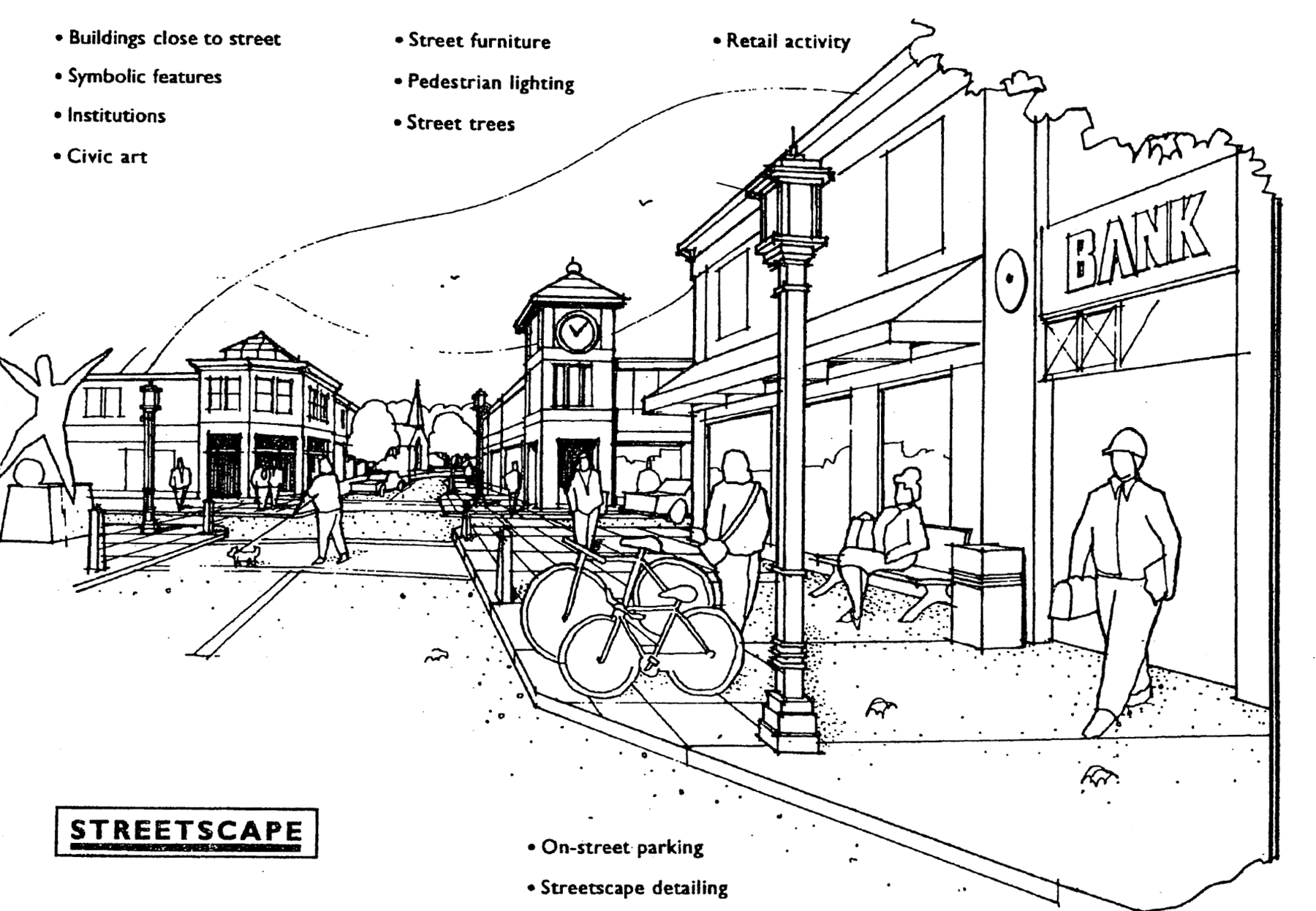
Figure 1: Example of Mixed-Use Area Design
(f)
Dimensional requirements. Any lot, building, yard, density, or other building or dimensional requirements approved by the city as part of a TND general development plan or precise implementation plan shall be construed to be and enforced as part of this chapter. If not otherwise specified within an approved general development plan or precise implementation plan, the dimensional standards of the zoning district in which the TND (or that part of the TND) is located shall apply. Lot area, width, and yard requirements shall also conform to the following criteria:
(1)
Minimum lot area and width. A variety of lot sizes shall be provided to facilitate housing choice and meet the requirements of people with different housing needs. Minimum lot areas and widths shall be as follows:
a.
Single family detached dwellings:
1.
With street (front or side) loaded garages: Minimum lot area shall be 5,000 square feet. Minimum lot width shall be 50 feet with an attached garage and 40 feet with a detached garage.
2.
With alley loaded garages: Minimum lot area shall be 4,000 square feet. Minimum lot width shall be 45 feet with an attached garage and 40 feet with a detached garage.
3.
Total building coverage of a new or remodeled single-family detached dwelling plus accessory buildings shall not exceed 75 percent of the area of lot on which it is located for lots that are 7,000 square feet or greater, and 85 percent of the area of the lot for lots that are less than 7,000 square feet.
4.
Dwellings within condominium development components of the project shall be subject to similar density standards as those described above.
b.
Single-family attached dwellings, including two-family dwellings, townhouse dwellings, and row dwellings:
1.
Two-family dwellings: Minimum lot area shall be 3,500 square feet per dwelling unit. Minimum lot width shall be 30 feet per dwelling unit.
2.
Row dwellings and townhouse dwellings (3+ attached units): Minimum lot area shall be 2,200 square feet per dwelling unit. Minimum lot width shall be 22 feet per dwelling unit.
3.
Dwellings within condominium development components of the project shall be subject to similar density standards as those described above.
c.
Multiple-family dwellings: Minimum lot area shall be 700 square feet for each efficiency dwelling unit, with an additional 300 square feet of lot area required for each additional bedroom in the dwelling unit. Multiple-family dwellings within condominium development components of the project shall be subject to similar density standards.
d.
Minimum lot areas and widths for all other uses shall be as specified in the submitted TND project plans.
(2)
Block size. Street layouts shall provide for perimeter blocks that are a maximum of 400 feet deep and 800 feet long, unless expressly permitted through project approval.
(3)
Building setbacks and separation. The TND should include buildings placed relatively close to the street to promote interaction, enclose space along the street, and direct less attractive site features to less visible yards. Maximum front yard setbacks and minimum building separation shall be as provided in table 1.
Table 1: Building Setbacks
1 Porches, entry bays, covered walkways or stoops, hooded front doors, or other similar architectural elements may project six feet closer to the street.
2 Minimum building separation standards may substitute for required side and rear lot setbacks, however side setbacks will not be less than one foot.
(g)
Circulation and parking requirements. The circulation system shall allow for different modes of transportation, provide functional and visual links among the residential area(s), mixed-use area, and open space areas within the TND; connect to existing and proposed developments outside the TND; provide adequate traffic capacity; provide connected pedestrian and bicycle routes including off-street paths or bicycle lanes on streets; control through traffic; limit direct lot access on streets with higher expected traffic volumes; and promote safe and efficient mobility. More specific design standards that shall be met are as follows:
(1)
Pedestrian circulation. Convenient and continuous pedestrian circulation systems, including walkways and paths intended to minimize conflicts between pedestrians and motor vehicles, shall be provided throughout the TND. Where feasible, any existing pedestrian routes through the site shall be preserved, enhanced, or relocated if necessary. All streets, except for alleys, shall be bordered by sidewalks on both sides in accordance with the specifications listed in table 2 and installed by the developer, unless otherwise approved by the city. Clear and well-lighted walkways shall connect building entrances to the adjacent public sidewalk and to any associated parking areas. Intersections of sidewalks with streets shall be designed with clearly defined edges. Crosswalks shall be well lit and clearly marked with contrasting paving materials at the edges, raised pavement, or striping. Curb bulbouts, median refuges, and other related techniques should be incorporated along collector streets and at key intersections to shorten the pedestrian crossing distance.
(2)
Bicycle circulation. Facilities for bicycle travel shall be included in the project and installed at the developer's expense, unless otherwise approved by the city. Such facilities may include off-street bicycle and multi-use paths, striped bicycle lanes on streets per table 2, signed bicycle routes, or some combination. Any existing bicycle routes through the site shall be preserved, enhanced, or relocated if necessary. Selected bicycle routes and facilities shall implement the recommendations in the city's comprehensive plan. All businesses, civic uses, and multiple-family dwelling units shall provide adequate bicycle parking areas and facilities.
(3)
Public transit access. Where public transit service is available or planned, streets intended to serve as transit routes shall be appropriately designed and convenient access to transit stops shall be provided. Where transit shelters are provided, they shall be placed in highly visible locations that promote security, be well lit, and include bicycle racks.
(4)
Motor vehicle circulation. Motor vehicle circulation shall be designed to efficiently move motor vehicle traffic via multiple routes and to minimize conflicts with pedestrians and bicycles. Traffic calming features such as curb extensions, traffic circles, medians, and on-street parking is encouraged to slow traffic speeds. Arterial streets should generally not bisect a TND. Minor streets within the TND are intended to be used primarily for access to abutting properties, and are usually not subject to access controls. Collector streets within the TND are intended to carry traffic from minor streets to arterial streets, include the principal entrance street to a residential use area, and may be subject to access controls. Alleys are special public ways affording secondary access to the rear of abutting properties, and shall be privately built, held, and managed (with a permanent dedicated fund established for maintenance and repair), unless explicitly approved by the city council. Minimum street design standards for a TND shall be in accordance with table 2, figure 2, and figure 3.
(5)
Street layout. The TND shall maintain the existing street grid, where present, and restore and disrupted street grid where feasible. The orientation of streets shall enhance the visual impact of common open spaces and prominent buildings, create lots that facilitate passive solar design, minimize street gradients, and minimize the use of double frontage lots. All streets shall extend through the project or terminate at other streets, except streets may temporarily "dead end" when such streets will connect to future phases or other sites outside the TND and minor streets may permanently terminate in a cul-de-sac only where site conditions require a cul-de-sac.
(6)
Parking and loading requirements. All TNDs shall meet the parking and loading requirements found in article V, except that: (a) The city may approve alternate parking ratios and other standards where specifically proposed by the applicant; and (b) The following standards shall apply in the event of conflict with article V. For multiple-family residential buildings and in mixed-use areas, shared use parking lots and structures are encouraged, off-street parking lots may not be adjacent to or opposite from a street intersection, and parking lots and structures shall be located to the rear or sides of buildings. The edges of parking lots, landscaped islands, and all other areas not used for parking or vehicular circulation shall be curbed and landscaped per the requirements in section 102-258. Examples of these parking lot placement and landscaping standards are included in figure 4. Parking lots containing more than 30 spaces shall be broken up into smaller pods with not more than 30 spaces each, with the pods separated from another by landscaped areas or buildings. Site plans shall provide a direct route to service or loading dock areas, while minimizing the movement of loading vehicles through parking areas. Reduction of impervious surfaces through the use of pervious pavement and interlocking pavers is encouraged, particularly for remote parking lots and parking areas for periodic uses.
Table 2: Minimum Street Design Requirements in a Traditional Neighborhood Development
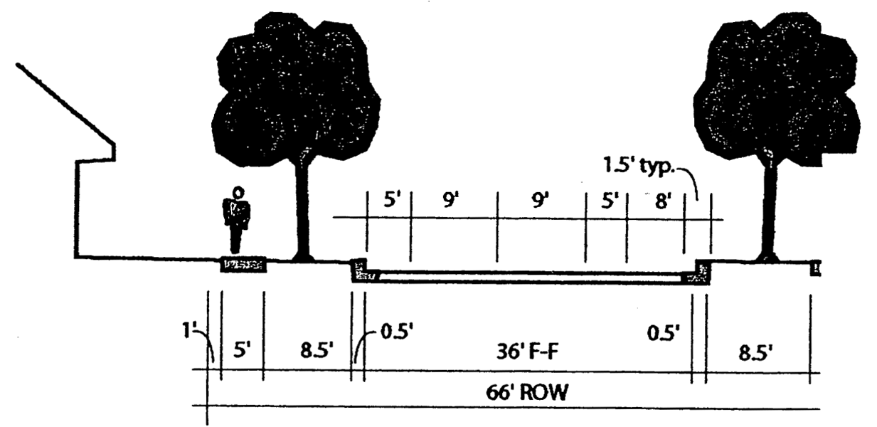
Figure 2: Schematic sketch of a typical collector street cross-section with one-sided
parking and bike lanes
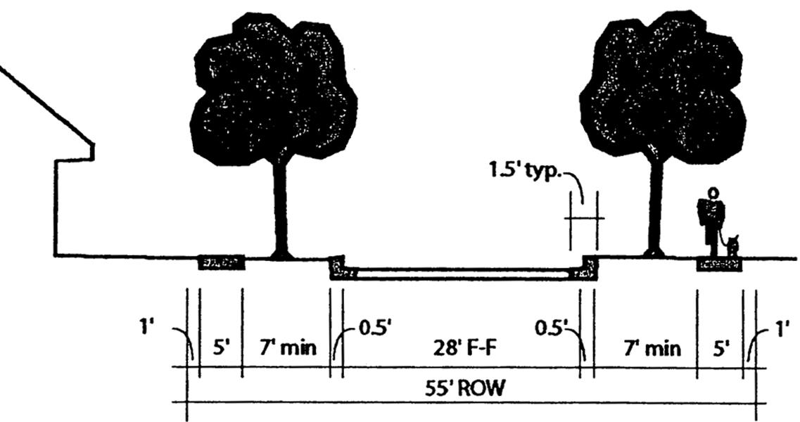
Figure 3: Schematic sketch of a typical minor street cross-section with two-sided
parking
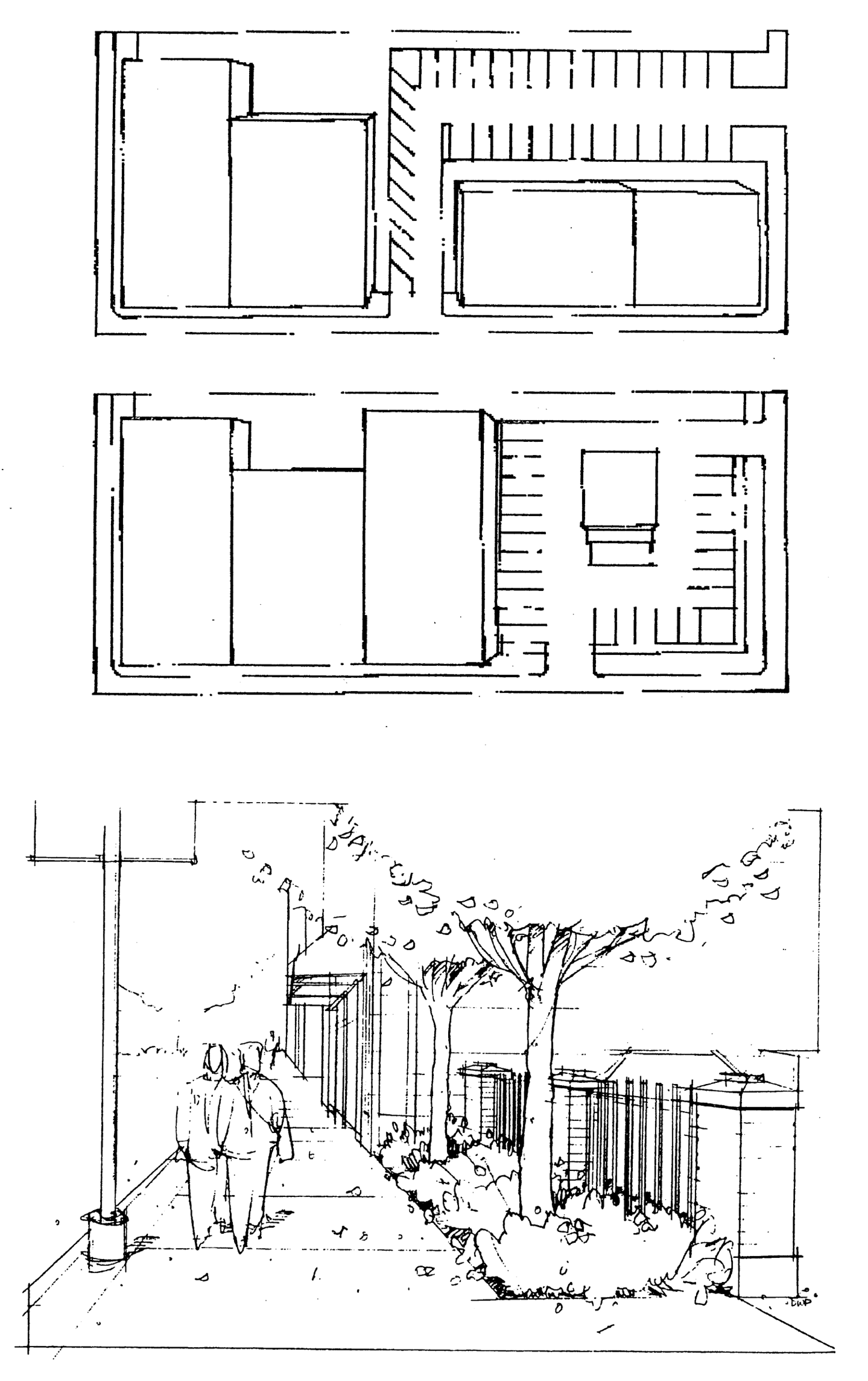
Figure 4: Examples of Required Parking Lot Placement and Landscaping
(h)
Other site and neighborhood design requirements.
(1)
Stormwater management. Stormwater shall be managed within the TND according to the following principles and requirements:
a.
Comply with state and federal regulations and guidelines associated with stormwater management;
b.
Comply with regional stormwater management plans adopted by the city;
c.
Minimize off-site stormwater runoff;
d.
Promote on-site filtration;
e.
Utilize natural stormwater management systems wherever practical;
f.
Utilize stormwater management best management practices.
g.
Provide vegetative buffers between:
1.
Stormwater basins and conveyance routes; and
2.
Wetlands;
h.
Provide areas for snow storage;
i.
Minimize the discharge of pollutants to ground and surface water; and
j.
Maintain and protect natural topography and existing land cover to the extent reasonably practicable.
(2)
Exterior lighting and utilities. The styles of proposed street and private lot lighting shall be compatible with one another. The city shall review all exterior lighting within the TND. Street lighting shall be provided on both sides of all streets at intervals of no greater than 200 feet. A larger quantity of smaller street lights should be used rather than fewer, higher intensity lights. All new public and private utility installations shall be underground.
(3)
On-site landscaping and screening. Overall composition and location of landscaping shall complement the scale of the project and its surroundings. In general, larger, well-placed contiguous planting areas shall be preferred to smaller, disconnected areas. Plants native to the region are encouraged. For all nonresidential and multiple-family residential building sites, live landscape plantings shall be planned and installed based on the following requirements for street frontages, paved areas, building foundations, buffer yards, and general yard areas. These requirements are additive to each other. Credit for existing landscape plantings that are retained and protected with the development of the site shall be allowed.
a.
Street frontages. An average minimum of one deciduous tree per 40 feet of public street frontage shall be required to be planted by the developer, except if otherwise approved by the city. Street tree placements may be clustered or adjusted to achieve a particular design objective or account for traffic visibility, curb openings, street lighting, and other obstructions. Street trees shall generally be located between the sidewalk and the curb and within the landscaped area of a boulevard. If placement of street trees within the right-of-way will interfere with pre-existing utility lines, trees may be planted within the private street yard adjacent to the sidewalk. The types of street trees must be approved by the city and comply with chapter 94, article II of the City Code of Ordinances.
b.
Parking and loading areas. The standards in section 102-258 and 102-259 shall be met. Additionally, one large deciduous tree and 60 points of additional landscaping shall be planted for each 1,500 square feet of paving. (Point values for different types of plantings are described below.
c.
Building foundations. 150 points of landscaping shall be planted for each 100 lineal feet of exterior building wall. Plants must be installed within 20 feet of the building foundation, and should not include large deciduous trees.
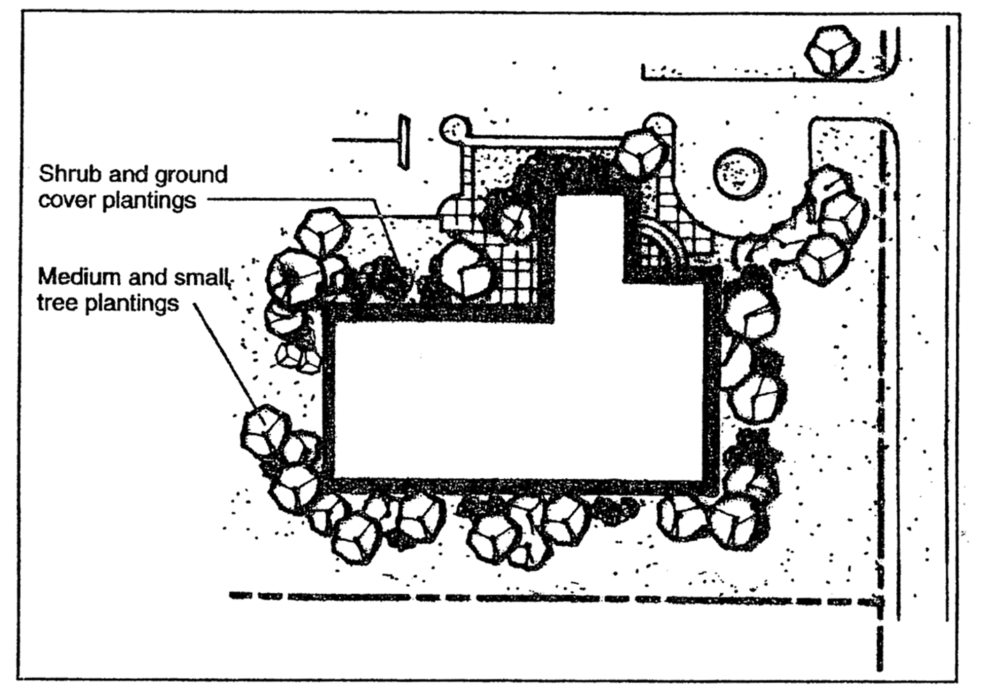
Figure 5: Example of Foundation Planting Placement
d.
Buffer yards. There shall be provided and maintained a permanent buffer yard screen planting along any boundary of a nonresidential use which adjoins any residential use. The plantings shall be designed to provide an all-season screen, with opacity of at least 60 percent at maturity. Buffer yard landscaping shall have a minimum height of three feet at time of planting. The use of berming or an opaque fence constructed of materials compatible with the building on the site may be approved by zoning board of appeals in addition to or in lieu of landscaping, per the standards of section 102-136. The location of buffer yard plantings shall be within 25 feet of the property line, except where necessary to avoid utility easements.
e.
General yard areas. 200 additional points of landscaping shall be planted for each 5,000 square feet of total lot, site or parcel area. Landscaping required by this standard should be placed where appropriate on the site, but generally in those areas not covered by other provisions of this subsection. At least 50 percent of the general yard landscaping should be located in front yards.
f.
Other green areas. Green areas of the site not used for landscape plantings shall be graded and seeded or sodded with an acceptable maintainable seed mix. Mulch of plantings or planting beds is acceptable provided that such mulching consists of organic or natural materials. Mulches shall be installed so that they will not erode, fall, be plowed or otherwise transported into walks, drives, streets or other hard surfaced portions of the site.
g.
Landscaping point credits. Credit for landscape plantings will be granted based on the following schedule:
1.
Large deciduous tree (mature height 25+ feet) = 150 points;
2.
Small deciduous tree (mature height <25 feet) = 60 points;
3.
Evergreen tree = 40 points;
4.
Shrub (deciduous or evergreen) = 20 points;
5.
Annual/perennial bed: 20 points per 20 square feet of bed.
h.
Minimum landscaping size. At time of planting, plants must be the following minimum size:
1.
Large deciduous tree: 2-inch diameter at breast height;
2.
Small deciduous tree: 1½-inch diameter breast height or 5 feet in height for clump varieties;
3.
Evergreen tree: 4 feet in height;
4.
Shrub: 18 inches in height;
5.
Annual/perennial bed: Minimum 20 contiguous square feet in area.
(i)
Architectural and signage requirements. A variety of architectural features and building materials is encouraged to give each building or group of buildings a distinct character, while maintaining a compatible design theme throughout the TND. More specific design standards that shall be met are as follows:
(1)
Existing structures. Existing structures, if determined to be historic, architecturally, or culturally significant, shall be protected from demolition or encroachment by incompatible structures or land development, to the extent reasonably practical. The U.S. Secretary of the Interior's Standards for Rehabilitation of Historic Properties shall be used as criteria for renovating significant structures.
(2)
New structures.
a.
General design. The bulk and height of each building shall properly relate to and flow from surrounding buildings, and shall be in proper proportion to the size of the lot on which it is to be placed. The style, materials, and design of new buildings may be organized around a consistent design theme that may draw from a local vernacular architectural style and/or natural building materials common to the region. However, design monotony shall be avoided (see figure 6). Unless otherwise approved by the zoning board of appeals to carry out a particular design theme of exceptional quality, no two principal buildings within four lots on either side of the street on which the buildings front shall have a similar front facade. Front facades shall be deemed to be similar where there is:
1.
No substantial difference in roof lines or form;
2.
No substantial change in window size, location, or type; and
3.
No or minimal change in material colors.
b.
Masonry construction material. In order to provide exceptional aesthetic and construction quality in a designated TND district, residential and non-residential buildings will be required to include a percentage of masonry material on the exterior of the buildings.
1.
Residential buildings or structures constructed in a TND district shall contain no less than 75 percent of brick or stone material on the exterior of the primary building or structure on a given lot. This standard applies to the facade of the building, exclusive of doors, windows, and associated trim. Chimneys constructed on any such building shall consist of 100 percent (from grade level to the caps) of the exterior brick or stone material of such building. All permitted accessory buildings or structures with an interior floor space of less than 225 square feet shall be exempt from the aforementioned provisions.
2.
Non-residential buildings or structures constructed in a TND district shall contain 100 percent of, or combination of, brick, stone, concrete, concrete panel, and/or glass material on the exterior of the primary building or structure on a given lot. This standard applies to all sides of the building, exclusive of doors, windows, and associated trim. Chimneys constructed on any such building shall consist of 100 percent (from grade level to the caps) of brick or stone material. All rooftop equipment and/or apparatuses shall be non-visible from street frontages. All permitted accessory buildings or structures shall comply with the aforementioned provisions.
3.
Masonry construction material shall not be painted.
c.
Height. New structures within a TND shall be no more than three stories for single-family detached dwellings and attached dwellings, and six stories for commercial, multiple-family, or mixed use buildings. Buildings within the mixed-use area shall additionally meet the standards depicted in figure 7.
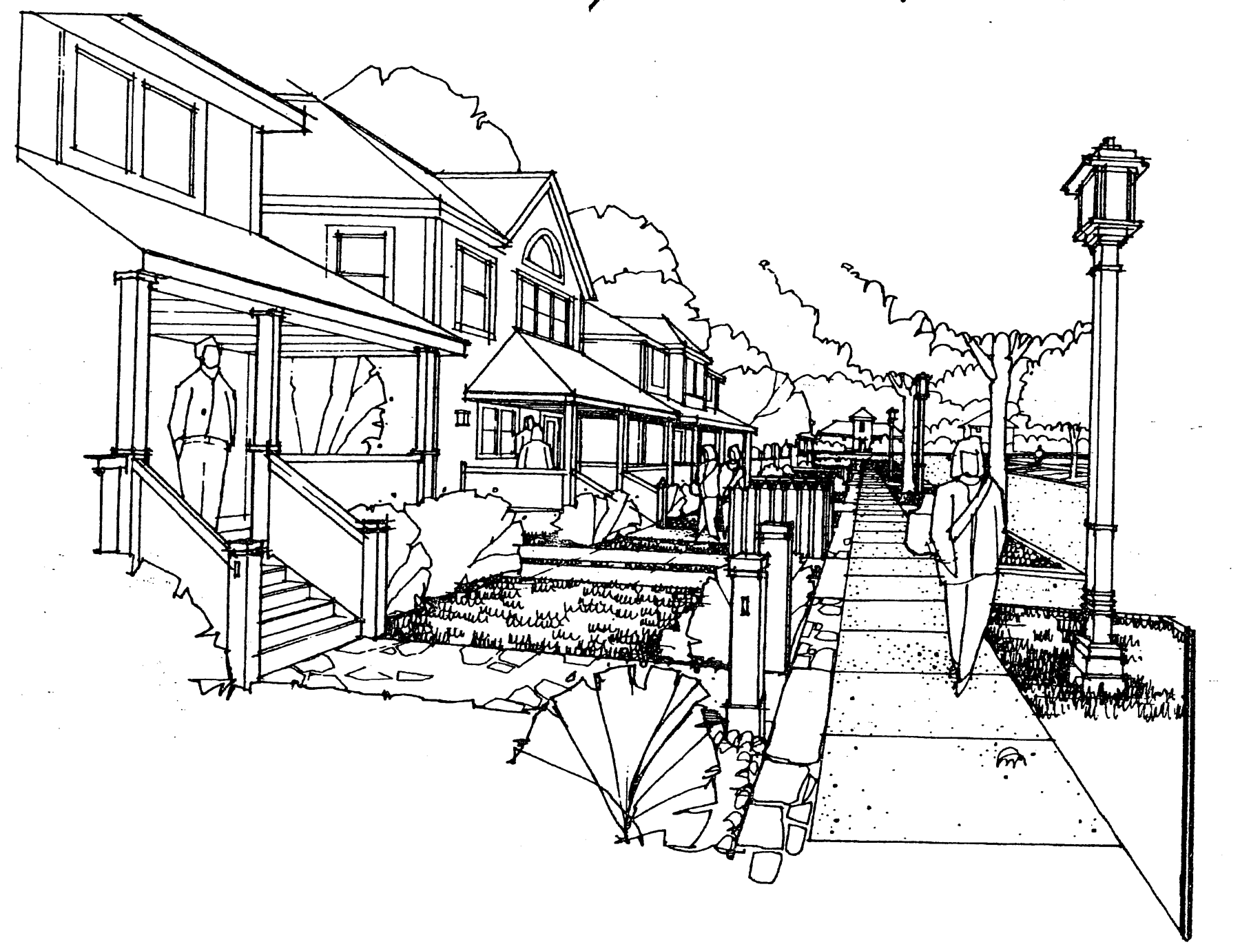
Figure 6: Example of Design Variation with Consistent Form
d.
Entries and facades. Similar architectural features, materials, and the articulation of a building facade shall be continued on all sides visible from a public street. The front facade of the principal building shall face onto the street yard of a public street (not directly toward a parking lot) and shall parallel the line of the street to create a continuous edge. As buildings are moved closer to the street and to each other, special attention should be paid to design details and landscaping. Porches, entry bays, covered walkways or stoops, hooded front doors, or other similar architectural elements shall define the front entrances to all dwelling units; such features shall generally be closer to the street than the remainder of the dwelling. Porches should be a minimum of six feet deep to enhance aesthetics and function. For nonresidential buildings, a minimum of 50 percent of the public street facade(s) on the ground floor shall be transparent, consisting of window or door openings, and entries shall face the public street. Figure 8 provides examples of required treatments of entries and front facades.
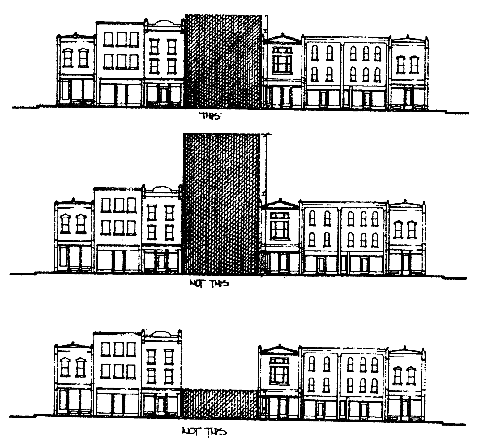
Figure 7: Schematic elevation sketch of a typical mixed-use area "streetscape."
To create a visually unified "streetwall," buildings shall be no more than 30 percent taller or 30 percent shorter than the average building height on the block within the mixed-use area.
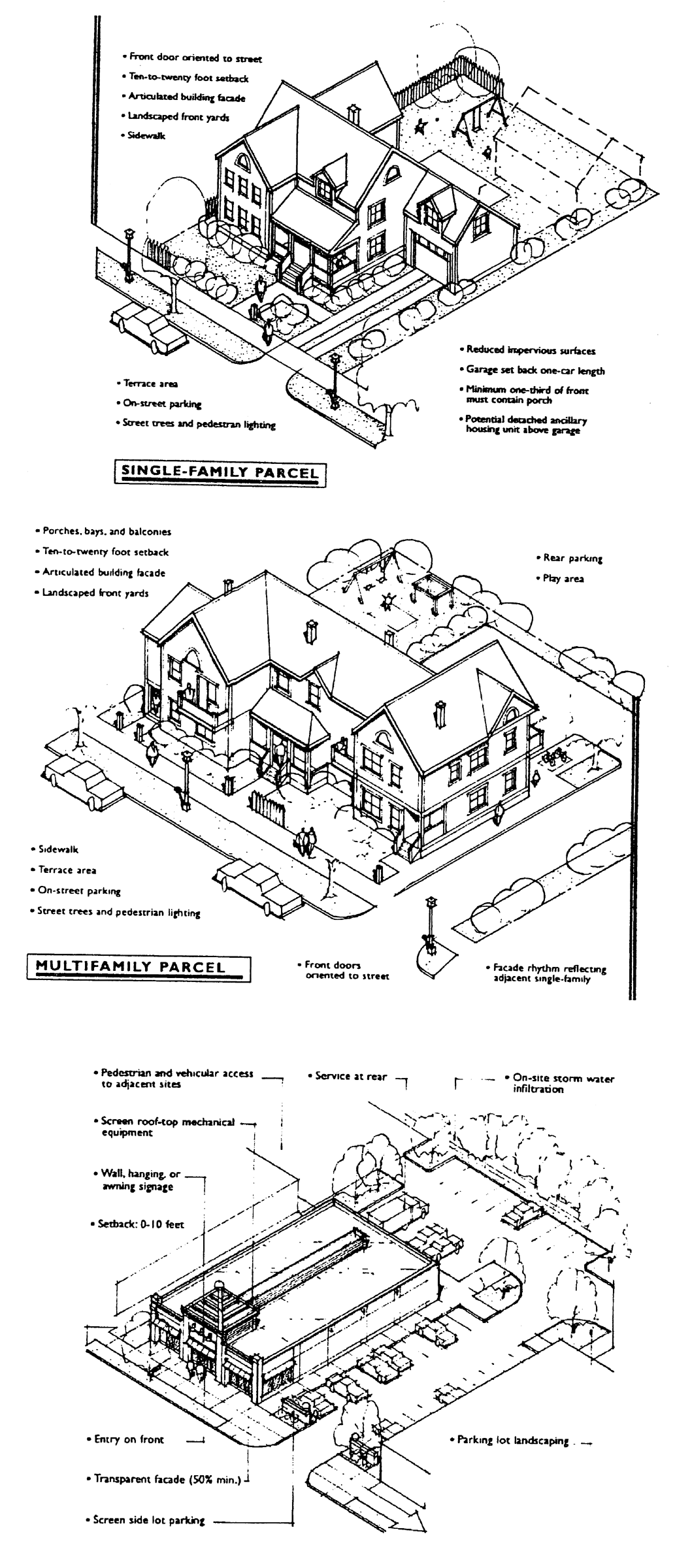
Figure 8: Examples of Entry and Front Facade Treatments
These graphics show examples of how TND entryway and front facade provisions may be carried out in single-family residential, multiple-family residential, and commercial applications.
e.
Garages. Garages accessed from the public street, where garage doors face a public street, shall occupy no more than 50 percent of the front facade of the house. No garage shall exceed 1,500 square feet in area. Residential garages shall be set back a minimum of two feet to the rear of the main front facade of the dwelling structure (not including porches or other projections) to ensure that the garage does not dominate the view from the street. Where the house does not include a front porch or similar projection from the main living area of the house, garages shall be set back a minimum of four feet to the rear of the main front facade. Garage setbacks along alleys shall either be between two and eight feet from the private alleyway to allow proper turning radii but no driveway parking, or at least 16 feet to allow driveway parking without encroaching into the alley. Garage placement alternatives and standards are illustrated in figure 9.
f.
Signage. Business signs, entrance monuments, and other major signs within a TND shall share a common or compatible style, which may be demonstrated by similarities in sizes, shapes, and/or materials. In addition, all signage shall meet the technical requirements of article VI, except that the maximum height of a freestanding sign shall be eight feet and the maximum area of a freestanding sign shall be 50 square feet and be comprised of the same masonry material as the exterior of the principle building.
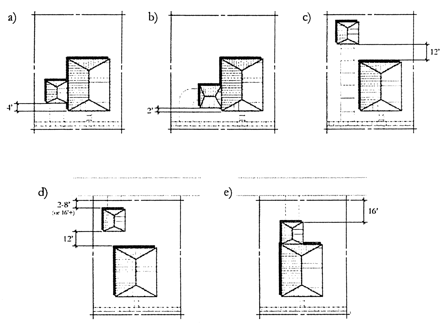
Figure 9
Diagrams of five alternative garage locations on a TND residential lot:
a)
Attached garage is accessed from a street (street-loaded garage). Four-foot minimum setback required if no front porch or similar front yard building projection; Two-foot minimum with front porch.
b)
Attached garage is accessed from a street (side-loaded garage). Two-foot minimum setback required.
c)
Detached garage, behind the house, is accessed from a street. 12-foot separation between house and garage.
d)
Detached garage is accessed from an alley. Either two-foot to eight-foot setback from private alleyway or 16+ foot minimum setback from private alleyway. 12-foot separation between house and garage.
e)
Attached garage is accessed from an alley. 16-foot minimum setback from private alleyway.
(j)
Modifications and changes.
(1)
Upon written request by the applicant and following a recommendation from the zoning board of appeals, the city council may waive or modify any of the requirements in subsections (e) through (i) as they relate to a GDP. Such waiver or modification may be approved by a two-thirds vote of council members in attendance, but only if supplemental design elements or improvements are incorporated into the project which compensate for the waiver or modification of the particular requirement.
(2)
Upon written request by the applicant and following a recommendation from the zoning board of appeals, the city council may waive or modify any of the requirements in subsections (e) through (i) as they relate to a PIP. Such waiver or modification may be approved by a two-thirds vote of council members in attendance, but only if supplemental design elements or improvements are incorporated into the project which compensate for the waiver or modification of the particular requirement.
(3)
The approved GDP or PIP may include any aspect of project flexibility requested by the applicant that is not prohibited by this section, including but not limited to future developer options for different uses and densities within the TND. Any subsequent change of use of any parcel of land or addition or modification of any approved PIP beyond such approved flexible aspects shall be submitted to the zoning board of appeals for approval. Minor changes that do not affect the intent of the GDP or PIP may be recommended by the community development staff and approved by the community development committee. Major changes that involve changes to the general intent of the project as expressed in the approved GDP shall be made by the city council, following the same process as required for the original GDP approval.
(Ord. No. 3215-05, § 2, 11-14-05)
Sec. 102-337. - North Second Street Overlay District.
(a)
Purpose. The purpose of this section is to improve the aesthetic and visual character, of the hereby-designated North Second Street Overlay District, and to promote orderly development and redevelopment by creating an overlay district. North Second Street serves as a major north and south commercial corridor for the city. The North Second Street Overlay District recognizes the importance of this commercial corridor to the city and is intended to improve and enhance the historic character of this gateway into the city.
The overlay district is also intended to encourage appropriate renovations to existing structures and compatible new construction by promoting the use of building forms, materials, and site design that will improve the architectural and visual character and enhance the functionality of this corridor.
(b)
Established boundaries. The North Second Street Overlay District regulations shall apply to all parcels contiguous to the right-of-way of the following boundary described as of the date of ordinance adoption from which this section derived. Legal description for the North Second Street Overlay District: Part of the southeast ¼ of section 1 and part of the northeast ¼ of section 12 in Township 44 North, Range 1 East of the third principal meridian and part of the southwest ¼ of section 6 and part of the northwest ¼ of section 7 in Township 44 North, Range 2 East of the third principal meridian, bounded and described as follows: Beginning at a point on the east line of the northeast ¼ of said section 12 which is 26.59 south of the northeast corner of lot 108 as designated upon the plat of Eastwood & Stokburger's Second Subdivision of Loves Park, the plat of which is recorded in book 12 of plats on page 1 in the county recorder's office; thence west, parallel with the north line of said lot 108, a distance of 83′ ; thence south, parallel with the east line of said lot 108, a distance of 0.91′ ; thence west, parallel with the north line of said lot 108, a distance of 122′ to the west line of premises conveyed by Loves Park Lanes to Park Lanes, Inc. by warranty deed dated June 28, 1985 and recorded as microfilm number 85 15 0751 in said recorder's office; thence north, along said line, 27.5′ to the south line of lot 107 as designated upon the plat of Eastwood & Stokburger's Second Subdivision of Loves Park, as aforesaid; thence west, along said line and along the south line of lot 114 in said plat, 502′ to the east line of premises conveyed by Bruce L. and Jean M. Wood to the city by warranty deed dated July 14, 1992 and recorded as microfilm number 92 46 0067 in said recorder's office, said point being 155′ west of the southeast corner of said lot 114; thence northeasterly, along said line, 167′ to a point on the south line of lot 116 in said plat which is 130′ west of the southeast corner of said lot 116; thence northeasterly, along said line, 89.7′ to a point on the south line of lot 117 in said plat which is 95′ west of the southeast corner of said lot 117; thence northeasterly, along said line, 173.54′ to a point on the west line of lot 103 in said plat which is 20′ south of the northwest corner of said lot 103 and to the southeast line of premises conveyed by Amcore Bank N.A., Rockford to the city by trustee's deed dated July 8, 1992 and recorded as microfilm number 92 43 1294 in said recorder's office; thence northeasterly, along said line, 25.03′ ; thence northeasterly, along said line, 96.57′ ; thence northeasterly, along said line, 50.03′ to the north line of lot 101 in said plat; thence northeasterly, along said line, 154.14′ to the south line of lot 99 in said plat; thence west, along said line, 20′ to the east line of premises conveyed by Saint Francis, Inc. to city by quit claim deed dated July 28, 1992 and recorded as microfilm number 92 50 2157 in said recorder's office; thence north, along said line, 82.5′ to the south line of lot 98 in said plat; thence east, along said line, 142.5′ to the east line of premises conveyed by Dean E. and Ellen M. Olmstead to the city by warranty deed dated September 9, 1994 and recorded as document number 9453185 in said recorder's office; thence north, along said line, 77.52′ to the northeast corner of said premises; thence southwesterly, along the northerly line of said premises, 48.03′ ; thence southwesterly, along the northerly line of said premises, 40.61′ to the northeast corner of premises conveyed by Saint Francis, Inc. as aforesaid; thence southwesterly, along the northwest line of said premises, 36.38′ ; thence southwesterly, along said line, 97.32′ to the east line of premises conveyed by Lorraine A. Delahanty, trustee to Steven A. Cooter and Paul D. Lizer by trustee's deed dated February 24, 1995 and recorded as document number 9512359 in said recorder's office; thence north, along said line, 17.5′ to the south line of lot 98 in said plat; thence east, along said line, 10′ to the east line of premises conveyed by Lorraine A. Delahanty, trustee as aforesaid; thence north, along said line and said line extended north, a distance of 272.5′ to the centerline of River Lane; thence east, along said centerline, 197.5′ to the southerly extension of the west line of premises conveyed by Jay W. and David M. Sklar, trustees, to J & D Enterprises by trustee's deed dated December 4, 2003 and recorded as document number 3113398 in said recorder's office, said point being 160′ west of the east line of the southeast ¼ of section 1; thence north, along said line and along the west line of premises conveyed by Richard A. and Marsha K. Curley to Robert A. and Gail L. Champion by quit claim deed dated August 14, 1990 and recorded as microfilm number 90 27 0334 in said recorder's office and along the west line of premises conveyed by William H. Shippee, trustee to Bruce E. and Judith M. Snively by trustee's deed dated March 24, 1995 and recorded as document number 9510244 in said recorder's office, a distance of 140.36′ to the south line of lot 38 as designated upon the plat of Weigert & Hornemans Re-subdivision, the plat of which is recorded in book 16 of plats on page 34 in said recorder's office; thence west, along the south line of lots 38, 37, 36 and 35, a distance of 187′ to the west line of said lot 35; thence north, along said line and said line extended north, a distance of 141.48′ to the south line of Merrill Avenue; thence east, along said line, 314′ to the northeast corner of lot 40 in said Weigert & Horneman's Resubdivision; thence east, 99′ to the northwest corner of lot 1 in block 9 as designated upon Burchfield Gardens, the plat of which is recorded in book 16 of plats on page 2 in said recorder's office; thence east, along the north line of said lot 1, a distance of 151.38′ to the northeast corner of said lot 1; thence south, along the east line of lots 1, 2 and 3 in said block 9, a distance of 84.69′ to the north line of Myer's Subdivision, the plat of which is recorded in book 13 of plats on page 20 in said recorder's office; thence east, along said line, 162′ to the east line of lot 6 in said plat; thence south, along said line and said line extended south, 210.75′ to the south line of the southwest ¼ of section 6, Township 44 North, Range 2 East of the third principal meridian; thence east, along said line, 120′ to the northerly extension of the east line of premises conveyed by National City Bank of Michigan/Illinois to Affordable Services, L.L.C. by special warranty deed dated January 14, 2004 and recorded as document number 0406141 in said recorder's office; thence south, along said northerly extension and line, 157′ to the south line of lot 11 as designated upon the plat of Parker's Resubdivision of Rodger's Park, the plat of which is recorded in book 14 of plats on page 49 in said recorder's office; thence east, along said line, 45′ to the east line of said subdivision; thence south, along said line, 221′ to the south line of said subdivision; thence west, along said line, 128′ to the east line of lot 1 as designated upon the plat of Lawndale Subdivision, the plat of which is recorded in book 12 of plats on page 2 in said recorder's office; thence south, along the east line of lots 1 and 2 in said Lawndale Subdivision, 111.3′ to the south line of lot 2 in said plat; thence west, along said line, 60′ to the east line of premises conveyed by Joseph F. and Lori A Martin to Raymond A. and Beverly J. Norris by warranty deed dated November 19, 1993 and recorded as microfilm number 93 79 1574 in said recorder's office; thence south, along said line, 136.32′ to the centerline of Lawn Street; thence west, along said centerline, to the northerly extension of the east line of parcel V of premises conveyed by Mearle O. Bergsten, Inc. to Volant Investments, LLC by corporate warranty deed dated September 23, 2005 and recorded as document number 0565002 in said recorder's office; thence south, along said extension and line, 136.36′ to the north line of lot 7 in said plat of Lawndale Subdivision; thence east, along said line, 120′ to the east line of said lot 7; thence south, along said line and along the east line of lot 8 in said Lawndale Subdivision, 111.3′ to the north line of the plat of Shrope & Dempsey Subdivision, the plat of which is recorded in book 13 of plats on page 13 in said recorder's office; thence west, along said line, 37.68′ to the east line of lot 2 as designated upon the plat of East Pearl Subdivision, the plat of which is recorded in book 44 of plats on page 179A in said recorder's office; thence south, along said line and said line extended south, 228.08′ to the north line of Pearl Avenue; thence west, along said line and said line extended west, 378.3′ to the west line of the northwest ¼ of section 7; thence north, along said line, 84.62′ to the point of beginning excepting therefrom all that part of lots 3 and 4 in said Lawndale Subdivision lying west of the east 180′ of said lots 3 and 4. Situated in the City of Loves Park, County of Winnebago and the State of Illinois.
(c)
Permitted uses. Permitted uses in the North Second Street Overlay District shall be as established by the underlying zoning district as set forth in article III, section 102-174, subject to the following limitations.
(1)
Permitted with a special use permit:
a.
Boardinghouses and lodging houses.
b.
Churches, rectories, seminaries, convents, monasteries, and similar religious institutions. This includes dormitories and other accessory uses required for their operation.
c.
Clubs, lodges, social and community center buildings, except those a chief activity of which is a gainful service or activity conducted as a business.
d.
Housing as a primary use.
e.
Day care centers and nursery schools.
f.
Higher education institutions.
g.
Laundries, automatic self-service type or hand.
h.
News stands.
i.
Package liquor establishments.
j.
Postal substations.
k.
Laboratories, medical, dental, research, experimental and testing, provided no production or manufacturing of products take place.
l.
Secondhand stores, pawn shops, and rummage shops.
m.
Taverns and bars.
n.
Theater, indoor.
o.
Fast food and/or carryout.
p.
Hospitals, medical clinics.
q.
Amusement establishments, bowling alleys, pool halls, dance halls, gymnasiums, swimming pools, skating rinks, and amusement parks.
r.
Banks.
s.
Automatic teller machine (ATM) which are not located on the promises of the financial institution with which they are affiliated.
t.
Museums.
u.
Art galleries and studios.
v.
Garden supply, hydroponics, and seed stores.
w.
Outdoor storage.
x.
Small engine repair with all activity to be conducted in a totally enclosed structure.
y.
Automobile sales and services, new and used, on an open lot or within a building for dealers or dealerships that are four acres or more.
(2)
Not permitted (the following are not permitted in the North Second Street Overlay District):
a.
Greenhouses.
b.
Automobile service stations.
c.
Ambulance service.
d.
Carpet stores.
e.
Blueprinting and photo stating establishments.
f.
Exterminating shops.
g.
Reserved.
h.
Motels, hotels.
i.
Charitable and nonprofit uses or institutions.
j.
Radio and television broadcasting stations.
k.
Taxidermists.
l.
Temporary sales, 45 days, i.e., Christmas trees, landscape and nursery supply.
m.
Undertaking establishments, funeral parlors, or mortuaries.
n.
Veterinary clinics.
o.
Drive-in or drive-through restaurants.
p.
Automobile laundry.
q.
Reserved.
r.
Automobile parts and accessory stores.
s.
Automobile painting and body repair.
t.
Upholstery shops.
u.
Mini-warehouses.
(3)
Accessory uses. Any use or accessory to any permitted use is permitted in this district when clearly established as an accessory to a permitted use.
(4)
Housing and commercial office uses. To maintain the integrity of a mixed-use development, 100 percent housing and or commercial office use will be allowed above any permitted ground level use.
(5)
Multiple buildings on a single lot. Multiple buildings on a single lot may be permitted by an applied variance.
(d)
Review required. Review and approval shall be required for: All new mixed-use and commercial development; a site access plan, that shall be included as part of the site plan and approved by the city and the state department of transportation; additions, alterations and improvements, other than ordinary repair or maintenance to existing structures, signs and sites located within the North Second Street Overlay District. The zoning board of appeals and the community development committee will conduct review and approval for conformance of submitted projects. The overlay review board will conduct review and approval for conformance of submitted projects. Any projects requesting a variance will be reviewed by the overlay review board and the community development committee. Any projects requesting a special use permit will be reviewed by the zoning board of appeals and community development committee.
(e)
Ordinary repair or maintenance activity permitted without review. Ordinary repair and maintenance is work done to prevent deterioration or to replace parts of a building, structure, and sign or exterior architectural feature with equivalent materials used to correct the deterioration, decay or damage of any building, structure, sign or exterior architectural feature. Ordinary maintenance or repair work may not exceed 25 percent of the structure's assessed value in any 24 consecutive month period.
(f)
Development guidelines and standards. The development guidelines and standards are intended to enhance and protect the aesthetic and visual character and experience within the North Second Street Overlay District.
(1)
Development guidelines. The development of any site within the North Second Street Overlay District shall be in accordance with an approved master plan or site plan. Design and architectural features shall be consistent with the following provisions:
a.
Active building elevations shall face public right-of-way, never blank walls or loading areas.
b.
Mechanical equipment, whether ground level or roof top, shall be either screened from view or located so that such items are not visible from the establish boundaries in section 102-337. Large trash receptacles, dumpsters, utility meters, satellite dishes, antennas, etc., shall be similarly treated. Screening material shall consist of a masonry wall, dense evergreen plants, or any other such material that is found compatible and approved.
c.
Loading spaces for commercial sites shall be located only at the rear of buildings and should be out of view from all right-of-ways within the established boundaries in section 102-337. Views from adjacent properties or uses must be minimized through site design, architectural design, topography, landscaping, setbacks, or other features.
d.
Required parking areas should be located to the rear or side of main buildings or developed areas.
e.
Any parking area, or portion thereof, facing North Second Street shall require a three-feet tall wall constructed out of brick, stone, or other masonry material that is similar in style and color to adjacent buildings.
f.
Fencing along the right-of-way within the established boundaries, in section 102-337, should be of decorative (ornamental) style.
g.
Stucco, brick, stone, or other masonry materials with similar texture and appearance shall be the primary material used for building facade.
h.
No building facade, whether front, side, or rear, shall consist of architectural materials of inferior quality, appearance, or detail to any other facade of the same building.
i.
No visible portion of a building wall shall be constructed of corrugated material, sheet metal, or barren and unfinished cinder block.
j.
Color schemes should be kept simple and non-flamboyant.
k.
Blank, solid walls shall be avoided.
l.
Buildings on the same site should have a strong spatial and functional relationship to each other.
m.
Generic franchise architectural design is strongly discouraged.
(2)
Development standards. New mixed use and commercial development within the North Second Street Overlay District shall provide continuity of site design and visual compatibility and harmony with surrounding development within the North Second Street Overlay District.
a.
Building setbacks shall be as follows: Front setbacks shall be a minimum of five feet to a maximum of ten feet. Rear setbacks shall be ten feet. Side setbacks shall be five feet.
b.
Any building that is located at an intersection of two streets shall provide a visual clearance of 30 feet from the property corner.
c.
Any building, and portion thereof, fronting public right-of-way will provide a decorative surface, such as brick or brick stamped asphalt, at ground level, from the building setback line to the property line.
d.
Structures shall not dominate, by excessive or inappropriate height or mass, any adjacent building or development. There shall be no height restrictions, however, there shall be no more than a building story difference in height between adjacent buildings.
e.
Site development should include streetscape improvements. These improvements are considered as those architectural or functional facilities or structures that occur on site but are not part of the building and that encourage and facilitate human interaction with the built environment. Examples include, but are not limited to the following: decorative light fixtures, fountains, sculptures, benches and tables, planters, retaining walls, pedestrian and bicycle paths, bicycle parking structures.
(g)
Parking and circulation. The purpose of the parking and circulation section is to: allow a reduction in the total number of parking spaces required for certain properties in cases where a mix of adjacent land uses have varying peak periods of parking demand; encourage efficient use of land; promote walking and bicycling; and improve accessibility and mobility to common destinations.
(1)
Parking area guidelines.
a.
Vehicular movement and parking areas shall be paved with concrete, asphalt, exposed aggregate, or pavers.
b.
Vehicular movement and parking areas surfaced with gravel or other similar material are prohibited.
c.
Concrete curb and gutter or other storm water management structure approved by the city engineer shall be installed around the perimeter of all parking areas.
d.
All vehicle parking areas shall, whenever practicable, be located to the side or rear of the primary structure and screened with landscaping to soften the view from any public right-of-way. Any vehicle parking areas adjacent to public right-of-way shall be screened with a continuous hedge or landscaped berm or decorative wall of at least three feet in height.
e.
Any parking area adjacent to North Second Street will require a decorative wall of at least three feet in height.
(2)
Shared off-street parking for different categories of uses. Business establishments constituting different categories of use may share parking as follows:
a.
Office use and a retail sales and service use. The parking requirement for the retail sales and service use may be reduced by 20 percent, provided that the reduction does not exceed the minimum parking requirement for the office use.
b.
Residential use and a retail sales and service use (other than eating and drinking establishments or entertainment uses). The parking requirement for the residential use may be reduced by 30 percent, provided that the reduction does not exceed the minimum parking requirement for the retail sales and service use.
c.
Office use and a residential use. The parking requirement for the residential use may be reduced by 50 percent, provided that the reduction does not exceed the minimum parking requirement for the office use.
(3)
Shared off-street parking for uses of the same type. Business establishments constituting uses of the same type may share parking as follows:
a.
The city zoning officer may authorize, in writing, shared parking arrangements between two or more commercial uses having the same or overlapping operating hours, allowing reductions in the total minimum number of required parking spaces as follows:
1.
Up to a 20 percent reduction in the total minimum number of required parking spaces for four or more separate establishments;
2.
A 15 percent reduction in the total minimum number of required spaces for three establishments;
3.
A ten percent reduction in the total minimum number of required spaces for two establishments.
b.
No reductions to the parking requirement shall be made if the proposed business establishments have previously received a reduction through the provisions for shared parking under paragraph (2) above.
c.
The establishments, for which the shared parking application is being made for, shall be located within 800 feet of the parking facility. The parking facility shall be located in a commercially zoned district.
d.
The reductions to parking quantities allowed through shared parking shall be determined as a percentage of the minimum parking requirement as stated in article V, section 102-260 of the City Code of Ordinances.
e.
New business establishments seeking to meet parking requirements by becoming part of an existing shared parking arrangement shall provide the zoning officer with an amendment to the agreement stating their inclusion in the shared parking facility or area.
(4)
Written agreement between property owners to share parking.
a.
Where an application for a zoning permit for which shared parking is proposed includes two or more separately owned properties and the zoning officer has made a determination of the minimum number of required parking spaces for each of the applicable properties and uses, the zoning officer shall require that the owners of the properties enter into a legal agreement guaranteeing access to, use of, and management of designated shared parking spaces. The agreement shall be in a form approved by the city legal attorney, included as a condition of the zoning permit, and enforceable by the city.
b.
Where an application for a zoning permit for which shared parking is proposed includes two or more properties owned by the same property owner and the zoning officer has made a determination of the minimum number of required parking spaces for the applicable properties and uses, the zoning officer shall require that the owner of the properties enter into a legal agreement with the city guaranteeing access to, use of, and management of designated shared parking spaces. The agreement shall be in a form approved by the city legal attorney, included as a condition of the zoning permit, and enforceable by the city.
(5)
Shared parking plan.
a.
The zoning officer may require an application for a zoning permit, that incorporates shared parking, to submit a shared parking plan. A shared parking plan shall be included as an addendum to a site plan and shall be drawn to the same scale. A shared parking plan includes on or more of the following:
1.
A site plan showing parking spaces intended for shared parking and their proximity to the uses they will serve.
2.
A signage plan that directs drivers to the most convenient parking areas for each particular use or group of uses, if such distinctions can be made.
3.
A pedestrian circulation plan that shows connections and walkways between parking areas and land uses.
b.
The shared parking plan shall satisfy the following standards, as applicable:
1.
Shared spaces for residential units must be located within 300 feet of the dwelling unit entrances they serve.
2.
Shared spaces at nonresidential uses must be located within 800 feet of the principal building entrances of all sharing uses. However, up to 20 percent of the spaces may be located greater than 800 feet but less than 1,000 feet from the principal entrances.
3.
Clearly delineated and direct pedestrian connections must be provided from the shared parking area(s) to the building entrances.
4.
Pedestrians shall not be required to cross an arterial street to access shared parking facilities except at a signalized intersection along a clearly delineated pedestrian pathway.
(h)
Lighting.
(1)
The proper layout, height, fixture selection and lighting level shall be incorporated as part of the site design requirements to create a safe and secure environment.
(2)
Site lighting shall be of low-intensity from a concealed source, shall be of a clear white or amber light that does not distort colors, and shall not spill over onto adjoining properties, highways, or in any way interfere with the vision of on-coming motorists. Lighting fixtures shall be of a directional type capable of shielding the light source from direct view. The development plan or site plan must show the relationship of fixtures and the light patterns to each other, to the project site, to the unit development, and to the adjacent right-of-ways.
(3)
Fixtures used to accent architectural features, landscaping or art shall be located, aimed or shielded to minimize light spill into the surrounding environment.
(4)
Architectural lighting shall be recessed under roof overhangs or generated from a concealed source, low-level light fixture(s). Roof lights, lighted roof panels, and other methods of illuminating buildings, deemed inappropriate, are not allowed.
(5)
Decorative, low-level intensity, non-concealed source lighting that defines on site vehicular and/or pedestrian ways is acceptable.
(6)
The lighting plan shall not conflict with the landscape plan, and the two shall be submitted simultaneously for review.
(i)
Landscaping requirements. The purpose and intent of the landscaping requirements are to reduce the visibility of paved areas from adjacent properties and streets, minimize noise and glare, and to enhance public safety by defining spaces so as to influence traffic movement. Landscaping will also reduce the amount of storm water run-off, provide transition between neighboring properties, and soften structures. The landscaping requirements shall be as established by article III, section 102-136 and article V, section 102-258. In addition, the following requirements shall apply to all landscape plans:
(1)
A landscaping plan shall be submitted in conjunction with the development or site plan.
(2)
A landscaping plan shall be drawn to scale, include dimensions and distances, and clearly delineate all existing and proposed vehicular movement and parking, and the location, size and description of all landscaping materials. All easements, transition buffer areas and setback areas shall be labeled and dimensioned. Outdoor furniture and fixtures for commercial and mixed-use development are elements of building and landscaping design, and shall be identified on the landscape plan.
(3)
The property owner or designated agent shall be responsible for the maintenance, repair and replacement of all landscaping materials. All plant material and landscaped bed areas shall be tended and maintained in a healthy growing condition, free from refuse, debris and weeds at all times.
(4)
Parking area landscaping.
a.
Masonry walls, fences, hedges or berms three feet in height in combination with required landscaping are required to screen parking areas with 10 or more spaces.
b.
Pedestrian walkways between sites, parking areas and buildings are required to promote and enhance safe pedestrian circulation.
(j)
Signs. The purpose and intent of the sign requirements are to protect and enhance the visual character of the North Second Street Overlay District; to improve pedestrian and traffic safety; and minimize visual clutter that is potentially harmful to traffic and pedestrian safety, property values, and community appearance. Signs shall be regulated, in the North Second Street Overlay District, by the underlying zoning district as set forth in article VI, section 102-284, subject to the following limitations.
(1)
No sign when attached to the wall of a building may project higher then the structure to which it is attached.
(2)
Only one freestanding sign will be permitted per zoning lot.
(3)
The height of a freestanding sign shall not exceed 15 feet above grade level.
(4)
A single tenant freestanding sign may not exceed 100 square feet in area.
(5)
All signs must reflect the character of the North Second Street Overlay District and must be approved as part of the site plan.
(6)
No changeable signs will be permitted.
(Ord. No. 3401-07, § 1, 10-15-07; Ord. No. 3616-10, 3-15-10; Ord. No. 4329-20, 3-16-20; Ord. No. 4332-20, 4-13-20; Ord. No. 4417-21, 6-14-21)
Sec. 102-338. - East Riverside/I-90 Overlay District.
(a)
Purpose. The purpose of the standards is to improve the quality, compatibility of development, aesthetic and visual character, to promote orderly development and redevelopment, and enhance the economic base of the community by creating an overlay district. East Riverside Boulevard serves as a major east and west commercial corridor for the City of Loves Park, and Interstate 90 is a transcontinental freeway, and the longest interstate highway in the United States.
(b)
Submittal/approval process. Please refer to the flow chart below for guidance on the city's process for plan approval. The following process is for plans that are not requesting a variance permit for projects within the East Riverside/I-90 Overlay District:
(1)
Staff review/overlay review board (O.R.B.).
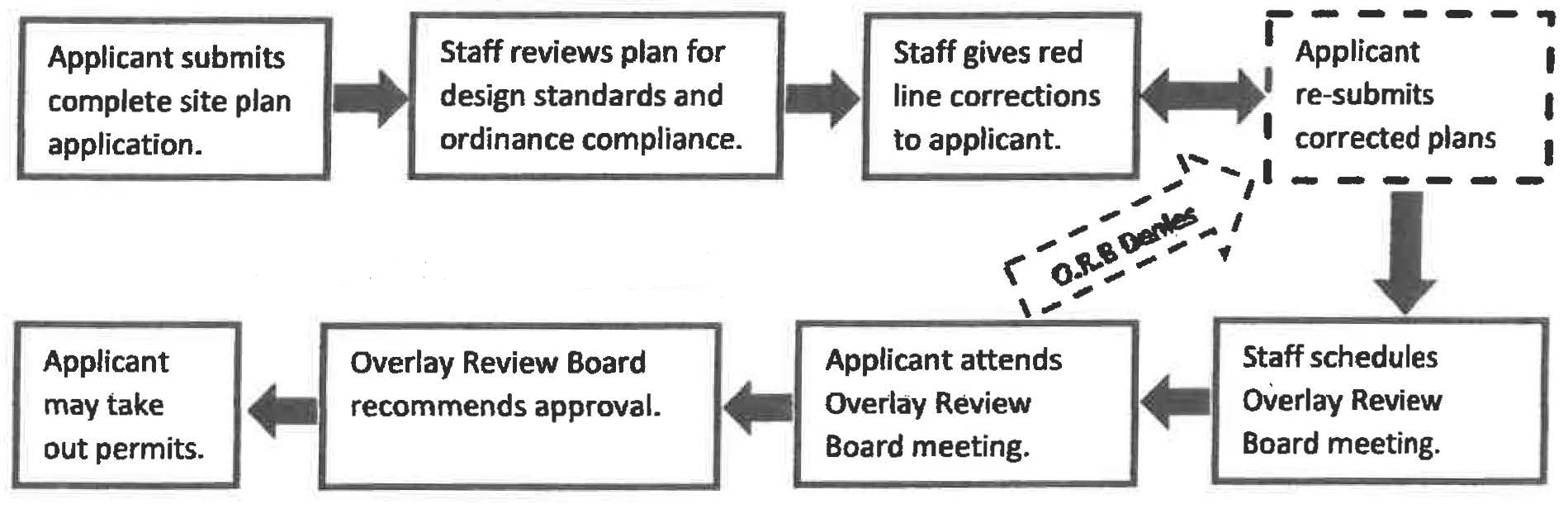
(c)
Established boundaries.
East of 1-90: Part of the Northeast Quarter (1/4) of Section 2 and part of the North Half (1/2) of Section 1, all in Township 44 North, Range 2 East of the Third Principal Meridian and part of the Southwest Quarter (1/4) of Section 36, Township 45 North, Range 2 East of the Third Principal Meridian, bounded and described as follows, to-wit: Beginning at the Southeast corner of the West Half (1/2) of the Northeast Quarter (1/4) of said Section 1; thence South 89°-35'-04" West, along the South line of the North Half (1/2) of said Section 1, a distance of 4006.10 feet to the Southwest corner of the Northwest Quarter (1/4) of said Section 1; thence North 00°-58'-27" East, 105.01 feet; thence North 88°-00'-26" West, 416.32 feet; thence North 00°-51'-18" East, 211.79 feet; thence South 89°-05'-12" West, 250.06 feet to the East line of premises conveyed to People of the Illinois State Toll Highway Commission per Micro-film No. 88-33-1030 in the Recorder's Office of Winnebago County, Illinois; thence North 30°-34'-14" West, along said East line of said premises, so conveyed, 444.46 feet to the Southernmost corner of Plat 1 of the Business Park at Spring Creek Lakes, being a subdivision of part of the Southeast Quarter of Section 35 and part of the Southwest Quarter of Section 36, both located in Township 45 North, Range 2 East of the Third Principal Meridian, also part of the Northwest Quarter of Section 1 and part of the Northeast Quarter of Section 2, both located in Township 44 North, Range 2 East of the Third Principal Meridian, the plat of which subdivision is recorded in Book 49 of Plats on Page 93B in said Recorder's Office of Winnebago County, Illinois; thence North 36°-30'-17" East, 75.29 feet; thence North 08°-35'-05" West, 303.51 feet; thence North 49°-23'-43" East, 520.43 feet; thence North 00°-25'-00" East, 236.18 feet; thence North 80°-31'-51" East, 587.18 feet; thence North 66°-31'-31" East, 584.94 feet (the previous six courses being along a Southerly boundary of said Plat 1 of the Business Park at Spring Creek Lakes); thence South 88°-59'-23" East, 120.00 feet; thence North 01°-00'-37" East, 687.59 feet to the North line of the Northwest Quarter (1/4) of said Section 1; thence North 89°-39'-29" East, along the North line of the Northwest Quarter (1/4) of said Section 1, a distance of 442.56 feet; thence North 24°-11'-05" East, 666.63 feet; thence North 00°-06'-31" West, 233.40 feet; thence North 24°-12'-11" East, 531.82 feet; thence North 89°-38'-18" East, 942.41 feet to the North and South Half Section line of aforesaid Section 36 (the previous four courses being along an Easterly and Southerly boundary of said Plat 1 of the Business Park at Spring Creek Lakes); thence South 00°-15'-45" West, along the North and South Half Section line of said Section 36, a distance of 1274.04 feet; thence South 13°-43'-16" West, 114.04 feet to a point on the North and South Half Section line of aforesaid Section 1; thence South 00°-13'-45" West, along the North and South Half Section line of said Section 1, a distance of 648.83 feet; thence South 89°-39'-36" West, 690.42 feet to the Northwest corner of Lot Three (3) as designated upon Plat No. 1 of Northeast Community Park, being a subdivision of part of the North ½ of Section 1, T. 44N., R. 2E. of the 3rd P.M., the plat of which subdivision is recorded in Book 47 of Plats on Page 169 in said Recorder's Office; thence South 00°-27'-15" East, along the West line of said Lot Three (3), and said line extended South, 1364.67 feet to a point in the North line of Plat No. 3 of Riverside -1-90 Centre, being a subdivision of part of the North Half of Section 1-44-2, the plat of which subdivision is recorded in Book 40 of Plats on Page 71B in said Recorder's Office; thence North 89°-33'-34" East, along the North line of said Plat No. 3 of Riverside -1-90 Centre, and said line extended East, 1515.46 feet to a point on the curved Easterly line of Paladin Parkway (County Highway No. 5); thence Northwesterly, along the curved Easterly line of said Paladin Parkway (County Highway No. 5), being along a circular curve to the left, having a radius of 1062.94 feet, to the North line of the South 163 Acres of the North Half of said Section 1 (the chord across said curved course bears North 20°-49'-25" West, 799.64 feet); thence North 89°-35'-04" East, along the North line of the South 163 Acres of the North Half of said Section 1, a distance of 884.69 feet to the East line of the West Half (1/2) of the Northeast Quarter (1/4) of said Section 1; thence South 01°-10'-38" West, along the East line of the West Half (1/2) of the Northeast Quarter (1/4) of said Section 1, a distance of 1329.94 feet to the point of beginning. Situated in the County of Winnebago and State of Illinois. West of 1-90: Beginning at the Northwest corner of Lot 12 as designated upon Plat No. 4 of Gateway Business Park in part of the Northeast Quarter of Section 2, Township 44 North, Range 2 East of the Third Principal Meridian, being a re-subdivision of part of Plat 2 and Plat 3 of Gateway Business Park, the first mentioned plat of which subdivision was recorded October 11, 2017 in Book 49 of Plats on Page 140B, as Document No. 20171032611 in the Recorder's Office of Winnebago County, Illinois; thence North 89 degrees 29 minutes 32 seconds East along the Northerly line of said Lot 12 and the Northerly line Lot 9 of said Gateway Business Park Plat No. 4, a distance of 415.83 feet to the Northeast corner of said Lot 9; thence South 3 degrees 36 minutes 09 seconds West along the Easterly line of said Lot 9, a distance of 124.45 feet; thence South 18 degrees 44 minutes 39 seconds West along the Easterly line of said Lot 9, a distance of 210.39 feet; thence South 31 degrees 26 minutes 38 seconds West along the Easterly line of said Lot 9, a distance of 590.96 feet to the Northeast corner of Lot 3 as designated upon Final Plat No. 2 of Gateway Business Park, being a subdivision of part of the Northeast Quarter of Section 2, Township 44 North, Range 2 East of the Third Principal Meridian, the plat of which subdivision was recorded September 10, 2003 in Book 44 of Plats on Page 103A, as Document No. 0385869 in said Recorder's Office; thence South 31 degrees 26 minutes 38 seconds West along the Easterly line of said Lot 3, a distance of 290.00 feet; thence South 56 degrees 26 minutes 43 seconds West along the Southerly line of said Lot 3, a distance of 168.13 feet to the Southeast corner of Lot 2 as designated upon Plat No. 1 of Gateway Business Park, being a subdivision of part of the Northeast Quarter of Section 2, Township 44 North, Range 2 East of the Third Principal Meridian, the plat of which subdivision was recorded March 18, 2003 in Book 44 of Plats on Page 66B, as Document No. 0323993 in said Recorder's Office; thence South 56 degrees 26 minutes 43 seconds West along the Southerly line of said Lot 2, a distance of 70.41 feet; thence South 83 degrees 30 minutes 47 seconds West along the Southerly line of said Lot 2 and the Southerly line of Lot 1 of said Plat No. 1 of Gateway Business Park, a distance of 383.81 feet; thence North 87 degrees 03 minutes 05 seconds West along the Southerly line of said Lot 1, a distance of 134.32 feet to the Southwest corner thereof; thence South 82 degrees 14 minutes 39 seconds West, a distance of 153.27 feet to the Southeast corner of Lot 5 as designated upon Rock Cut Business Park Plat No. 2, being a subdivision part of the Northwest Quarter of Section 2, Township 44 North, Range 2 East of the Third Principal Meridian, the plat of which subdivision was recorded August 25, 1994 in Book 40 of Plats on Page 60B, as Document No. 9444269 in said Recorder's Office; thence Southwesterly along the Southerly line of said Lot 5 along a circular curve to the left whose radius is 18677.17 feet and whose center lies to the South, the long chord of which curve bears South 88 degrees 42 minutes 59 seconds West, a chord distance of 112.13 feet; thence South 88 degrees 32 minutes 39 seconds West along the Southerly line of said Lot 5, a distance of 108.04 feet to the Southwest corner thereof, said point being the Southeast corner of Lot 19 as designated upon Plat No. 5 Rock Cut Business Park, being a subdivision part of the Northwest Quarter of Section 2, Township 44 North, Range 2 East of the Third Principal Meridian, the plat of which subdivision was recorded April 29, 2005 in Book 45 of Plats on Page 117, as Document No. 0522987 in said Recorder's Office; thence South 88 degrees 32 minutes 39 seconds West along the Southerly line of said Lot 19 and the Southerly line of Lots 18 and 17 of said Plat No. 5 Rock Cut Business Park, a distance of 474.06 feet to the Southwest corner of said Lot 17; thence South 88 degrees 32 minutes 39 seconds West, a distance of 128.04 feet to the Southeast corner of Lot 7 as designated upon Rock Cut Business Park Plat No. 3, being a subdivision part of the Northwest Quarter of Section 2, Township 44 North, Range 2 East of the Third Principal Meridian, the plat of which subdivision was recorded April 29, 2005 in Book 45 of Plats on Page 117, as Document No. 0522987 in said Recorder's Office; thence South 88 degrees 32 minutes 39 seconds West along the Southerly line of said Lot 7, a distance of 423.93 feet to the Southwest corner thereof; thence South 88 degrees 32 minutes 39 seconds West, a distance of 94.03 feet to the Southeast corner of Lot 25 as designated upon Plat No. 8 of Rock Cut Business Park, being part of the Northwest Quarter of Section 2, Township 44 North, Range 2 East of the Third Principal Meridian and a re subdivision of Lot 22 of Plat No. 6 of Rock Cut Business Park, the first mentioned plat of which subdivision was recorded February 1, 2021 in Book 49 of Plats on Page 180B, as Document No. 2021003845 in said Recorder's Office; thence South 88 degrees 32 minutes 39 seconds West along the Southerly line of said Lot 25, the Southerly line of Lot 24 of said Plat No. 8 of Rock Cut Business Park and the Southerly line of Lots 20 and 21 as designated upon Plat No. 6 of Rock Cut Business Park, being a subdivision of part of the Northwest Quarter of Section 2, Township 44 North, Range 2 East of the Third Principal Meridian and a resubdivision of Lots 8, 9 and 10 of Rock Cut Business Park Plat 3, the first mentioned plat of which subdivision was recorded May 2, 2006 in Book 47 of Plats on Page 136, as Document No. 0625314 in said Recorder's Office, a distance of 510.79 feet to the Southwest corner of said Lot 20 of said Plat No. 6 of Rock Cut Business Park; thence North 88 degrees 05 minutes 32 seconds West, a distance of 85.22 feet to the Southeast corner of Lot 7 as designated upon Plat No. 17 of Kings Acres Subdivision, being a subdivision of part of the Northwest Quarter of Section 2, Township 44 North, Range 2 East of the Third Principal Meridian and a replat of Lot 1 and 3 of Plat No. 16 of Kings Acres Subdivision, the first mentioned plat of which subdivision was recorded November 12, 2008 in Book 48 of Plats on Page 182B, as Document No. 200800852436 in said Recorder's Office; thence South 88 degrees 32 minutes 39 seconds West along the Southerly line of said Lot 7 and the Southerly line of Lot 6 of said Plat No. 17 of Kings Acres Subdivision, a distance of 261.09 feet to the Southwest corner of said Lot 6, said point being the Southeast corner of Lot 2 of said Plat No. 16 of Kings Acres Subdivision, being a subdivision of part of the Northwest Quarter of Section 2, Township 44 North, Range 2 East of the Third Principal Meridian and a replat of Lot 154 of Plat No. 8 of Kings Acres Subdivision, the first mentioned plat of which subdivision was recorded May 4, 2006 in Book 47 of Plats on Page 139, as Document No. 0625950 in said Recorder's Office; thence South 88 degrees 32 minutes 39 seconds West along the Southerly line of said Lot 2, a distance of 158.09 feet to the Southwest corner thereof, said point being the Southeast corner of Lot 5 as designated upon said Plat No. 17 of Kings Acres Subdivision; thence South 88 degrees 32 minutes 39 seconds West along the Southerly line of said Lot 5, a distance of 143.94 feet to the Southwest corner thereof; thence South 88 degrees 17 minutes 11 seconds West, a distance of 186.64 feet; thence South 88 degrees 29 minutes 54 seconds West, a distance of 175.68 feet to the Southeast corner of Lot 52 as designated upon Plat No. 17 of Rock Valley Business Park, being a subdivision of part of the Northeast Quarter of Section 3, Township 44 North, Range 2 East of the Third Principal Meridian and a Re-Plat of part of Lot 10 of Plat No. 1 of Rock Valley Business Park and a part of Vacated County Highway 11 (Perryville Road), the first mentioned plat of which subdivision was recorded January 6, 1999 in Book 41 of Plats on Page 109B, as Document No. 9900759 in said Recorder's Office; thence North 0 degrees 00 minutes 00 seconds East along the Easterly line of said Lot 52, a distance of 228.23 feet to the Southerly line of Back Street as designated upon Road and Easement Dedication Plat for Back Street, being part of Lots 9 and 10 of said Plat No. 1 of Rock Valley Business Park, part of Lot 2 in the Re-Plat of Lot 7 of Plat No. 1 of Rock Valley Business Park and part of Lots 52, 53 and 54 in said Plat No. 17 of Rock Valley Business Park, the first mentioned plat of which dedication was recorded December 31, 2000 in Book 43 of Plats on Page 31, as Document No. 0065040 in said Recorder's Office; thence North 3 degrees 36 minutes 28 seconds West, a distance of 71.83 feet to a point of tangency in the Easterly line of said Back Street; thence North 9 degrees 59 minutes 55 seconds West along the Easterly line of said Back Street, a distance of 229.19 feet; thence North 7 degrees 47 minutes 32 seconds West along the Easterly line of said Back Street, a distance of 173.71 feet; thence North 11 degrees 56 minutes 47 seconds West along the Easterly line of said Back Street, a distance of 193.19 feet to the Southwest corner of Lot 8 of said Plat No. 1 of Rock Valley Business Park, being a subdivision of part of the Northeast Quarter of Section 3, Township 44 North, Range 2 East of the Third Principal Meridian, the plat of which subdivision was recorded July 19, 1989 in Book 38 of Plats on Page 128A, as Document No. 1844711 in said Recorders Office; thence North 0 degrees 00 minutes 00 seconds East along the Westerly line of said Lot 8, a distance of 420.00 feet to the Northwest corner thereof, said point lying in the Southerly line of a public road designated Rock Valley Parkway; thence South 88 degrees 29 minutes 54 seconds West along the Southerly line of said Rock Valley Parkway, a distance of 367.92 feet to the Northwest corner of Lot 1 of the Re-Plat of Lot 7 of Plat No. 1 of Rock Valley Business Park, being a subdivision of part of the Northeast Quarter of Section 3, Township 44 North, Range 2 East of the Third Principal Meridian and Lot 7 of Plat No. 1 of Rock Valley Business Park, the plat of which subdivision was recorded July 10, 1996 in Book 40 of Plats on Page 180B in said Recorder's Office; thence North 69 degrees 01 minutes 12 seconds West, a distance of 233.27 feet to the Southeast corner of Lot 64 as designated upon the Re-Plat of part of Plat 15 of Rock Valley Business Park, being a subdivision of part of the Northeast Quarter of Section 3, Township 44 North, Range 2 East of the Third Principal Meridian and a Re-Plat of Lots 4, 5, 6, 13 and Marsh Hawk Drive of Plat No. 1 of Rock Valley Business Park and part of Vacated Perryville Road (County Highway 11), the first mentioned plat of which subdivision was recorded September 30, 1999 in Book 41 of Plats on Page 144B, as Document No. 9963589; thence South 88 degrees 29 minutes 54 seconds West along the Southerly line of said Lot 64, a distance of 139.67 feet to a point of curvature; thence Westerly along the Southerly line of said Lot 64 and the Southerly line of Lot 5 as designated upon Commonwealth Acres, being a re-subdivision of Lots 63, 65 and 66 of the Re-Plat of part of Plat 15 of Rock Valley Business Park in part of the Northeast Quarter of Section 3, Township 44 North, Range 2 East of the Third Principal Meridian, the first mentioned plat of which subdivision was recorded June 24, 2005 in Book 45 of Plats on Page 143, as Document No. 0535696 in said Recorder's Office, along a circular curve to the left whose radius is 1325.0 feet and whose center lies to the South, the long chord of which curve bears South 83 degrees 14 minutes 05 seconds West, a chord distance of 243.10 feet to the Southwest corner of said Lot 5 of said Commonwealth Acres; thence Northwesterly along the Westerly line of said Commonwealth Acres and along the Easterly line of a public road designated Marsh Hawk Drive along a circular curve to the left whose radius is 1180.00 feet and whose center lies to the West, the long chord of which curve bears North 20 degrees 53 minutes 09 seconds West, a chord distance of 344.29 feet to a point of reverse curvature; thence Northwesterly along the Westerly line of said Commonwealth Acres and along the Easterly line of said Marsh Hawk Drive along a circular curve to the right whose radius is 1300.00 feet and whose center lies to the East, the long chord of which curve bears North 18 degrees 34 minutes 02 seconds West, a chord distance of 482.94 feet to the Northwest corner of Lot 1 of said Commonwealth Acres, said point also being the Southwest corner of Lot 67 as designated upon said Re-Plat of part of Plat 15 of Rock Valley Business Park; thence Northerly along the Westerly line of said Lot 67 and the Easterly line of said Marsh Hawk Drive along a circular curve to the left whose radius is 1108.62 feet and whose center lies to the West, the long chord of which curve bears North 14 degrees 25 minutes 53 seconds West, a chord distance of 253.64 feet to the Northwest corner of said Lot 67; thence North 21 degrees 30 minutes 42 seconds West, a distance of 60.00 feet to the Southwest corner of Lot 2 as designated upon Plat One of Perryville Ridge, being a subdivision of part of the Southeast Quarter of Section 34, Township 45 North, Range 2 East and part of the Northeast Quarter of Section 3, Township 44 North, Range 2 East of the Third Principal Meridian, the plat of which subdivision was recorded July 13, 2005 in Book 45 of Plats on Page 157, as Document No. 0540203 in said Recorder's Office; thence Northerly along the Westerly line of said Lot 2, along a circular curve to the right whose radius is 270.00 feet and whose center lies to the East, the long chord of which curve bears North 0 degrees 32 minutes 36 seconds West, a chord distance of 157.77 feet to a point of reverse curvature; thence Northerly along the Westerly line of said Lot 2, the Westerly line of Lot 3 of said Plat One of Perryville Ridge and the Westerly line of Lot 4 as designated upon Plat Two of Perryville Ridge, being a Re-plat of Lot 1 of Plat One of Perryville Ridge and part of the Southeast Quarter of Section 34, Township 45 North, Range 2 East and part of the Northeast Quarter of Section 3, Township 44 North, Range 2 East of the Third Principal Meridian, the plat of which subdivision was recorded January 18, 2006 in Book 47 of Plats on Page 83, as Document No. 0603209 in said Recorder's Office, along a circular curve to the left whose radius is 330.00 feet and whose center lies to the West, the long chord of which curve bears North 11 degrees 15 minutes 50 seconds West, a chord distance of 306.88 feet to a point of tangency; thence North 38 degrees 58 minutes 19 seconds West along the Westerly line of said Lot 4, a distance of 209.96 feet to the Northwest corner of said Lot 4, thence North 51 degrees 01 minutes 41 seconds East along the Northerly line of said Lot 4, a distance of 230.00 feet to the Northeast corner thereof; thence North 44 degrees 15 minutes 47 seconds East, a distance of 180.56 feet to the Northwest corner of Lot 10 as designated upon Plat No. 2 of Peak Sports Subdivision, being a resubdivision of Lots 1, 2 and 3 of Plat No. 1 of Peak Sports Subdivision, being a subdivision of part of the Southeast Quarter of Section 34, Township 45 North, Range 2 East of the Third Principal Meridian and part of the Northeast Quarter of Section 3, Township 44 North, Range 2 East of the Third Principal Meridian, the plat of which subdivision was recorded July 1, 2008 in Book 48 of Plats on Page 166A, as Document No. 200800831720 in said Recorder's Office, thence North 87 degrees 51 minutes 59 seconds East along the North line of said Lot 10, a distance of 321.40 feet to the Northeast corner thereof; thence South 33 degrees 30 minutes 17 seconds East along the Easterly line of said Lot 10 and the Easterly line of Lot 9 of said Plat No 2 of Peak Sports Subdivision, a distance of 406.60 to a point of curvature; thence Southeasterly along the Easterly line of said Lot 9 and the Easterly line of Lot 8 of said Plat No 2 of Peak Sports Subdivision along a circular curve to the right whose radius is 3000.00 feet and whose center lies to the West, the long chord of which curve bears South 29 degrees 40 minutes 42 seconds East, a chord distance of 400.40 feet to the Southeast corner of said Lot 8; thence South 44 degrees 56 minutes 23 seconds East, a distance of 73.72 feet to the Southwest corner of Broadcast Parkway as designated upon a Roadway Dedication Plat for Broadcast Parkway being part of the Southeast Quarter of Section 34, Township 45 North, Range 2 East of the Third Principal Meridian and part of the Northeast Quarter of Section 3, Township 44 North, Range 2 East of the Third Principal Meridian, the plat of which Roadway Dedication was recorded January 9, 2007 in Book 48 of Plats on Page 54B, as Document No. 0701878 in said Recorder's Office; thence the following 6 courses all being along the Southerly line of said Broadcast Parkway, Northeasterly along a circular curve to the right whose radius is 229.27 feet and whose center lies to the South, the long chord of which curve bears North 77 degrees 00 minutes 30 seconds East, a chord distance of 91.40 feet; thence North 88 degrees 30 minutes 23 seconds East, a distance of 313.98 feet; thence Northeasterly along a circular curve to the left whose radius is 431.38 feet and whose center lies to the North, the long chord of which curve bears North 78 degrees 31 minutes 56 seconds East, a chord distance of 149.43 feet; thence North 68 degrees 33 minutes 29 seconds East, a distance of 100.00 feet; thence Northeasterly along a circular curve to the right whose radius is 250.00 feet and whose center lies to the South, the long chord of which curve bears North 78 degrees 31 minutes 56 seconds East, a chord distance of 86.60 feet; thence North 88 degrees 30 minutes 23 seconds East, a distance of 50.00 feet to the Westerly line of a public road designated McFarland Road; thence Southerly along the Westerly line of said McFarland Road along a circular curve whose radius is 6835.55 feet and whose radius lies to the East, the long chord of said curve bears South 2 degrees 30 minutes 59 seconds West, a distance of 600.24 feet; thence South 0 degrees 00 minutes 00 seconds East along the West line of said McFarland Road, a distance of 77.51 feet to the Westerly extension of the North line of Lot 90 as designated upon Kings Acres Subdivision Plat No. 3, being a subdivision of part of the Northwest Quarter of Section 2, Township 44 North, Range 2 East of the Third Principal Meridian and a resubdivision of Lot 2 Rock Cut Business Park, the plat of which subdivision was recorded December 12, 1996 in Book 41 of Plats on Page 16B, as Document No. 9661119 in said Recorder's Office; thence South 89 degrees 16 minutes 26 seconds East along the Westerly extension of the North line of said Lot 90, the North line of said Lot 90 and the North line of Lot 91 of said Kings Acres Subdivision Plat No. 3, a distance of 739.71 feet to the Northeast corner of said Lot 91; thence South 0 degrees 43 minutes 34 seconds West along the East line of said Lot 91, a distance of 619.45 feet to the Southeast corner thereof, said point also being the Southwest corner of Lot 92 of said Kings Acres Subdivision Plat No. 3 and the Northerly line of a public road designated Rock Valley Parkway; thence North 85 degrees 23 minutes 47 seconds East along the South line of said Lot 92 and the Northerly line of said Rock Valley Parkway, a distance of 180.61 feet to a point of curvature; thence Easterly along the Northerly line of said Rock Valley Parkway along a circular curve to the right whose radius is 2030.00 feet and whose center lies to the South, the long chord of which curve bears North 87 degrees 33 minutes 35 seconds East, a chord distance of 153.38 feet to a point of tangency; thence North 89 degrees 43 minutes 29 seconds East along the Northerly line of said Rock Valley Parkway, a distance of 450.41 feet to the Southwest corner of Lot 107 of said Kings Acres Subdivision Plat No. 3; thence North 0 degrees 16 minutes 31 seconds West along the West line of said Lot 107, a distance of 184.31 feet to a point of curvature; thence Northerly along the Westerly line of said Lot 107 along a circular curve to the Right whose radius is 478.11 feet and whose center lies to the East, the long chord of which curve bears North 3 degrees 51 minutes 26 seconds East, a chord distance of 68.96 feet to the Northwest corner of said Lot 107; thence South 89 degrees 11 minutes 22 seconds East along the North line of said Lot 107 and the South line of Lot 37 as designated upon Rock Cut Business Park Plat No. 9, being a subdivision of part of the Northwest Quarter of Section 2, Township 44 North, Range 2 East of the Third Principal Meridian, part of Outlot 1 of Kings Acres Subdivision Plat No. 5 and part of Lot 3 of Rock Cut Business Park, the first mentioned plat of which subdivision was recorded February 8, 2022 in Book 49 of Plats on Page 193A, as Document No. 2022003999 in said Recorder's Office, a distance of 484.83 feet to the Northeast corner of Lot 3 as designated upon Rock Cut Business Park being a subdivision of part of the Northwest Quarter Section 2, Township 44 North, Range 2 East of the Third Principal Meridian, the plat of which subdivision was recorded December 16, 1993 in Book 40 of Plats on Page 14A, as Document No. 2103247 in said Recorder's Office; thence South 0 degrees 48 minutes 38 seconds West along the East line of said Lot 3, a distance of 83.00 feet to the South line of the North 83.00 feet of Lot 36 of said Rock Cut Business Park Plat No. 9; thence South 89 degrees 11 minutes 22 seconds East along the South line of the North 83.00 feet of said lot 36, a distance of 229.98 feet to the East line of said Lot 36; thence Southerly along the East line of said Lot 36 along a circular curve to the right whose radius is 270.00 feet and whose center lies to the West, the long chord of which curve bears South 7 degrees 41 minutes 29 seconds East, a chord distance of 85.07 feet; thence South 1 degree 22 minutes 21 seconds West along the East line of said Lot 36 and the Southerly extension of said East line, a distance of 142.90 feet to the South line of said Rock Valley Parkway; thence South 89 degrees 11 minutes 22 seconds East along the South line of said Rock Valley Parkway, a distance of 436.17 feet to the Northeast corner of Lot 14 as designated upon Rock Cut Business Park plat No. 4, being a subdivision of part of the Northwest Quarter of Section 2, Township 44 North, Range 2 East of the Third Principal Meridian, the plat of which subdivision was recorded April 7, 1997 in Book 41 of Plats on Page 30A, as Document No. 9715235 in said Recorder's Office; thence South 84 degrees 43 minutes 52 seconds East, a distance of 126.59 feet to the Northwest corner of Lot 14 as designated upon said Plat No. 4 of Gateway Business Park; thence Easterly along the Northerly line of said Lot 14, along a circular curve to the right whose radius is 190.00 feet and whose center lies to the South, the long chord of which curve bears North 89 degrees 07 minutes 48 seconds East, a chord distance of 85.29 feet; thence South 77 degrees 53 minutes 58 seconds East along the Northerly line of said Lot 14, a distance of 125.08 feet; thence Easterly along the Northerly line of said Lot 14, along a circular curve to the left whose radius is 380.00 feet and whose center lies to the North, the long chord of which curve bears South 84 degrees 12 minutes 13 seconds East, a chord distance of 83.45 feet; thence North 89 degrees 29 minutes 32 seconds East along the Northerly line of said Lot 14 and the Northerly line of Lot 13 of said Plat No. 4 of Gateway Business Park, a distance of 429.58 feet to the Northeast corner of said Lot 13; thence North 81 degrees 56 minutes 05 seconds East, a distance of 101.88 feet to the Point of Beginning.
(d)
Permitted uses. The permitted uses in the East Riverside/I-90 Overlay District shall be as established by the underlying zoning district as set forth in article III, section 102-174, and section 102-188, subject to the following limitations:
(1)
Permitted with a special use permit.
a.
Commercial retail (CR).
1.
Day care centers and nursery schools.
2.
Dry cleaning and laundry receiving and distribution stations.
3.
Educational institutions.
4.
Florist shops that include attached greenhouses.
5.
Laundries, automatic self-service type or hand.
6.
Postal substations.
7.
Shoe and hat repair shops.
8.
Studios for musicians, artists, dancing instruction, photo, and masseurs.
9.
Garden supply and seed stores, including greenhouses.
10.
Interior decoration shops, including upholstery and making of draperies, slip covers and other similar articles, when conducted as part of the retail operation and secondary to the main use.
11.
Laboratories, medical, dental, research, experimental and testing, provided no production or manufacturing of products take place.
12.
Offices, business, medical and professional, as a single use on a zoning lot, or which occupy more than 25 percent of the total building area in a multi-tenant building.
13.
Orthopedic and medical appliance store, but not including the assembly or manufacturing of such articles.
14.
Pet shops.
15.
Charitable and nonprofit uses or institutions.
16.
Printing and publishing.
17.
Schools: music, dance, business, commercial or trade.
18.
Intertrack wagering facility.
19.
Medical marijuana dispensary.
20.
Automobile service stations.
21.
Fast food restaurants with drive-in facilities or drive-through facilities.
22.
Automobile laundry.
23.
Hospitals and medical clinics.
24.
Banks and credit unions.
25.
Automatic teller machines which are not located on the premises of the financial institution with which they are affiliated.
26.
Motels, hotels.
b.
Light industrial (IL).
1.
Any production, processing, cleaning, servicing, testing, repair or storage of materials, goods or products which conform to the performance standards established for this article. Not including any uses listed under IH.
2.
Accessory structures and uses.
3.
Any use which may be allowed as a permitted use or a special use in the CR and CG districts.
4.
Veterinarians' offices and hospitals.
(2)
Not permitted. The following are not permitted uses in the East Riverside/I-90 Overlay District:
a.
Commercial retail (CR).
1.
Ambulance service.
2.
Blueprinting and photo stating establishments.
3.
Exterminating shops.
4.
Laundry, dry cleaning plant, provided that only nonflammable solvents are used.
5.
Radio and television broadcasting stations.
6.
Taxidermists.
7.
Temporary sales as a primary use, 45 days, i.e., Christmas trees, landscape and nursery supplies.
8.
Undertaking establishments, funeral parlors, or mortuaries.
9.
Veterinary clinics.
10.
Automobile sales and services, new and used, on an open lot or within a building.
11.
Automobile parts and accessory stores.
12.
Automobile painting and body repair.
13.
Upholstery shops.
14.
Mini-warehouses and/or self-storage facilities, including boat, motorhome, and trailer storage facilities.
15.
Truck, boat, and recreational vehicle sales as the primary use.
16.
Cash/title loan financial institutions.
17.
Overnight commercial vehicle and/or semi-trailer parking.
18.
Tattooing, body piercing, body carving, including services that simulate cosmetic make-up. Such establishments shall be subject to the provisions in article V of the City's Code.
b.
Light industrial (IL).
1.
Wholesaling and warehousing; local cartage and express facilities, but not including motor freight terminals.
2.
Radio and television towers.
3.
Sewer lift stations.
4.
Telephone exchanges.
5.
Water filtration plants.
6.
Water pumping stations.
7.
Water reservoirs.
8.
Gun shooting range.
9.
Archery ranges.
10.
Overnight commercial vehicle and/or semi-trailer parking.
11.
Tattooing, body piercing, body carving, including services that simulate cosmetic make-up. Such establishments shall be subject to the provisions in article V of the City's Code.
(3)
Accessory uses. Any use or accessory to any permitted use is permitted in this district when clearly established as an accessory to a permitted use.
(4)
Housing and commercial office uses. To maintain the integrity of a mixed-use development, 100 percent housing and/or commercial office use will be allowed above any ground level permitted commercial retail use.
(5)
Multiple buildings on a single lot. Multiple buildings on a single lot may be permitted through an approved site plan.
(e)
Review required. Review and approval shall be required for: All new mixed-use and commercial development; a site access plan, that shall be included as part of the site plan and approved by the city; additions, alterations and improvements, other than ordinary repair or maintenance to existing structures, signs and sites located within the East Riverside/I-90 Overlay District. The overlay review board will conduct review and approval for conformance of submitted projects. Any projects requesting a variance will be reviewed by the overlay review board and the community development committee. Any projects requesting a special use permit will be reviewed by the zoning board of appeals and community development committee.
(f)
Ordinary repair or maintenance. Ordinary repair or maintenance is work done to prevent deterioration or to replace parts of a building, structure, and sign or exterior architectural feature with equivalent materials used to correct the deterioration, decay or damage of any building, structure, sign or exterior architectural feature. Ordinary maintenance or repair work may not exceed 25 percent of the structure's assessed value in any 24-consecutive-month period. Ordinary repair or maintenance is permitted without review.
(g)
Additions to existing structures. Any additions to an existing primary structure located within the boundary of the East Riverside/I-90 Overlay District will be required to comply with the development guidelines and standards (below). Unless, the addition to the primary structure is less than 25 percent of the total square feet of the existing structure.
(h)
Development guidelines and standards. The development guidelines and standards are intended to enhance and protect the aesthetic and visual character and experience within the East Riverside/I-90 Overlay District.
(1)
Building design. New buildings must be designed to include common features and materials. These features create a sense of place and character for the city.
a.
Exterior building materials. Building materials, including those of attached structures, should be used and installed in keeping with the chosen architectural style. A minimum of three colors per elevation required. Materials should be of a scale appropriate to the pedestrian and compliment adjacent structures. If building facade is away from pedestrian walkways, larger scale building materials may be approved by the city. See "Exterior Material Legend" below for a listing of approved/not approved materials.
Exterior Material Legend
b.
Exterior material colors. The building color palette should consider the surrounding buildings and strive to be harmonious with buildings both within the development and between adjacent off-site buildings (adjacent buildings are buildings within a 200-foot radius).
c.
Building details. Each building shall incorporate several common architectural features, appropriate for the architectural style chosen. Examples include: Pilasters, piers, columns, friezes, cornices, and window surrounds. Building elements such as awnings, signs, doors, windows, and lighting should complement the building facade and finishes.
d.
Attached structures. Use of awnings, canopies, or other design features are required to enhance main facades, especially at building entries. Attached structures shall be compatible with and complement adjacent structures within a 200-foot radius.
e.
Building entrances. Building entrances are required to be clearly articulated to indicate a transition from the exterior to the interior of the building. Every main entrance is required to have a special emphasis when compared to the other portions of the building.
f.
Facade articulation. Buildings designed with completely flat facades and monotone color schemes are not permitted. All buildings are required to have horizontal and vertical facade variations such as pop-outs, bays, recesses, arches, banding, columns, or similar features. These features are required at least every 50 feet along all exterior wall planes.
g.
Height and roofline. Varied roofline elevations are required to add architectural interest and avoid the appearance of long, monotonous roofline expanses. A variation such as a parapet or tower is required every 50 feet of roofline. Also, mechanical equipment mounted on the roof must be screened from ground-level view and the back of parapets must match the color and materials of the building.
h.
Pedestrians. All buildings will be designed to encourage pedestrian activity and social interaction. Buildings that contain more than one story or that are above 20 feet in height are required to provide a clearly articulated and more detailed base that relates to pedestrians.
i.
Windows. Windows are key to the overall design of a building and the relationship between the exterior and interior. Eye level windows are required to relate to the scale of a person. Clear glass for storefronts, windows and doors, within the retail merchandising areas is required. Slightly tinted glass for energy efficiency purposes may be used. Window tints shall be grey, blue, or bronze. Mirrored glass is prohibited.
j.
Building signs. Signs located on any building will be planned for as part of the building's overall design and should integrate similar or complementary materials as the building.
(2)
Site design. New developments are required to match or compliment surrounding developments and landscapes to create a site which follows the standards and adds positively to the overall East Riverside/I-90 Overlay District environment.
a.
Building placement. A building's placement is an essential component to site design and has an overall effect on the development of surrounding properties. Building placement is required to comply with the following:
1.
The main facade of a building must be oriented to face the principal street which it has frontage.
2.
Buildings on corner lots must be oriented so that the main facade is giving equal treatment to each street it has frontage. Also, these buildings should include a prominent architectural feature of greater height than the rest of the roof, or emphasis at the corner where the two public streets meet.
b.
Screening. Screening sometimes is an afterthought to site planning and design, screening is an important detail for making aesthetically attractive sites. The following is required for screening:
1.
Loading and service areas shall be screened with walls and landscaping. Views from adjacent properties or uses must be minimized.
2.
Mechanical equipment, whether ground level or roof top, shall be screened from ground-level view. Large trash receptacles, dumpsters, utility meters, satellite dishes, antennas, etc., shall be similarly treated. Screening material shall consist of a masonry wall, dense landscaping, or any other such material that is found compatible and approved.
3.
Razor fences and chain link are prohibited.
c.
Landscaping. The purpose and intent of the landscaping requirements are to reduce the visibility of paved areas from adjacent properties and streets, minimize noise and glare, and to enhance public safety by defining spaces to influence traffic movement. Landscaping will also reduce the amount of storm water run-off, provide transition between neighboring properties, and soften structures. The landscaping requirements shall be as established by article III, section 102-136 and article V, section 102-258. In addition, the following requirements shall apply to all landscape plans:
1.
A landscaping plan shall be submitted in conjunction with the development or site plan.
2.
A landscaping plan shall be drawn to scale, include dimensions and distances, and clearly delineate all existing and proposed vehicular movement and parking, and the location, size and description of all landscaping materials. All easements, transition buffer areas and setback areas shall be labeled and dimensioned. Outdoor furniture and fixtures for commercial and mixed-use development are encouraged and shall be considered part of the landscaping plan and identified on the landscape plan.
3.
The property owner or designated agent shall be responsible for the maintenance, repair and replacement of all landscaping materials. All plant material and landscaped bed areas shall be tended and maintained in a healthy growing condition, free from refuse, debris and weeds.
d.
Lighting. Carefully planned lighting schemes can create safe environments for pedestrians and motorists. Proper layout, height, fixture selection and lighting level shall be incorporated as part of the site design requirements:
1.
Site lighting shall be of low-intensity from a concealed source, shall be of a clear white or amber light that does not distort colors, and shall not spill over onto adjoining properties, highways, or in any way interfere with the vision of on-coming motorists. Lighting fixtures shall be of a directional type capable of shielding the light source from direct view. The development plan or site plan must show the relationship of fixtures and the light patterns to each other, to the project site, to the unit development, and to the adjacent rights-of-way.
2.
Fixtures used to accent architectural features, landscaping or art shall be located, aimed or shielded to minimize light spill into the surrounding environment.
3.
Architectural lighting shall be recessed under roof overhangs or generated from a concealed source, low-level light fixture(s). Roof lights, lighted roof panels, and other methods of illuminating buildings, deemed inappropriate, are not allowed.
4.
Decorative, low-level intensity, non-concealed source lighting that defines on-site vehicular and/or pedestrian ways are acceptable.
5.
The lighting plan shall not conflict with the landscape plan, and the two shall be submitted simultaneously for review.
e.
Parking and active transportation. Developments which generate significant traffic increases shall include a traffic study by a licensed civil engineer. Site layout and design must address the needs of motorists, pedestrians, bicycles, and other forms of transportation. Access and safety on the site should be ensured for all users. In addition to the parking requirements established in article V, section 102-260, the following will be required:
1.
Major internal circulation roadways must be separated from parking areas using curb and gutter, landscaping, pedestrian walkways, and lighting.
2.
Separated cross-access for automobiles and pedestrians in parking lots is required. Cross-access for pedestrians shall consist of a dissimilar material from the parking lot.
3.
Pedestrian cross-access within parking lots shall connect to sidewalks, bike paths, and/or multi-use paths within the public rights-of-way.
4.
Loading and service areas should be located away from street edge and public circulation patterns.
f.
Pedestrian circulation and trail connections. Development shall recognize the need for pedestrian circulation both within development and to and from adjacent developments.
1.
The design of development plans shall incorporate sidewalks meeting the city's standards that allow for safe pedestrian access throughout the area and provide the ability for pedestrians to conveniently walk between development areas throughout the East Riverside/I-90 Overlay District.
2.
Site plan designs shall provide for ADA-compliant handicapped access to the sidewalks at street intersections and from parking areas within the development.
3.
Where applicable, development plans will be required to provide for pedestrian and/or bike trail connections that can provide a link to larger trail networks both within and/or adjacent to the overlay district area. Where construction of such facilities is not appropriate as part of the initial development (because of incomplete adjacent sections), the developer/property owner will be required to provide a permanent easement or right-of-way for later construction along with a surety bond or escrow in compliance with the city's subdivision regulations to pay for the trail/bikeway improvement at a future time.
g.
Shared off-street parking for different categories of uses. Business establishments constituting different categories of use may share parking as follows:
1.
Office use and a retail sales and service use. The parking requirement for the retail sales and service use may be reduced by 20 percent, provided that the reduction does not exceed the minimum parking requirement for the office use.
2.
Residential use and a retail sales and service use (other than eating and drinking establishments or entertainment uses). The parking requirement for the residential use may be reduced by 25 percent, provided that the reduction does not exceed the minimum parking requirement for the retail sales and service use.
3.
Office use and a residential use. The parking requirement for the residential use may be reduced up to 50 percent, provided that the reduction does not exceed the minimum parking requirements for the office use.
h.
Shared off-street parking for uses of the same type. Business establishments constituting uses of the same type may share parking. The zoning officer may authorize, in writing, shared parking arrangements between two or more commercial uses having the same or overlapping operating hours, allowing reductions in the total minimum number of required parking spaces as follows:
1.
Up to a 15 percent reduction in the total minimum number of required parking spaces for four or more separate establishments.
2.
A ten percent reduction in the total minimum number of required spaces for three separate establishments.
3.
A five percent reduction in the total minimum number of required spaces for two establishments.
4.
The establishments, for which the shared parking application is being made for shall be located within 800 feet of the parking facility. The parking facility shall be in a commercially zoned district.
5.
The reduction to parking quantities allowed through shared parking shall be determined as a percentage of the minimum parking requirement as stated in article V, section 102-260 of the City Code of Ordinances.
(Ord. No. 4204-18, § 1, 5-14-18; Ord. No. 4254-19, 2-11-19; Ord. No. 4399-21, 3-15-21; Ord. No. 4400-21, 3-15-21; Ord. No. 4670-25, 1-6-25; Ord. No. 4671-25, 1-6-25; Ord. No. 4707-25, 5-6-25)