
Mableton City Zoning Code
ARTICLE V
- SUPPLEMENTAL REGULATIONS
Sec. 134-261.- Street frontage requirement.
No nonresidential building or structure shall be erected on a lot that does not have at least 50 feet of frontage on either a public street, a publicly approved street or a publicly maintained street. The minimum required frontage of a residential lot shall be not less than 75 feet along a public street, a publicly approved street or a publicly maintained street, except on culs-de-sac. On culs-de-sac, the lots shall have a minimum of 50 feet of frontage on the public road, approved public street or publicly maintained street, except as otherwise provided in this section. In R-12, RA-4 and RA-6 districts, lots fronting on a cul-de-sac shall have a minimum of 35 feet of frontage on the public road, approved public street or publicly maintained street.
(Ord. of 12-26-72; Ord. of 12-11-90, § 3-28-11.3)
Sec. 134-262. - Classification of streets.
For the purpose of this chapter, all of the streets, roads and highways in the county are classified as arterial, major and minor collector and local streets and state highways.
(Ord. of 12-26-72; Ord. of 12-11-90, § 3-28-11.4)
Sec. 134-263. - Vision clearance at intersections.
In all zoning districts, no fence, wall, structure, shrubbery or other obstruction to vision between the heights of three feet and 15 feet, except utility poles, light or street sign standards or tree trunks, shall be permitted within 20 feet of the intersection of the right-of-way lines of streets, roads, highways or railroads.
(Ord. of 12-26-72; Ord. of 12-11-90, § 3-28-11.5)
Sec. 134-264. - Nonapplicability of setback requirements to railroad spurs.
The setbacks from property lines or public streets or other property shall not apply to railroad spurs located on the side and rear of the property in all commercial and industrial zones.
(Ord. of 12-26-72; Ord. of 11-8-77, § 19(3); Ord. of 12-11-90, § 3-28-11.7)
Sec. 134-265. - Nonresidential access not to cross residential property.
No nonresidential access shall cross residentially zoned property.
(Ord. of 12-26-72; Ord. of 12-11-90, § 3-28-11.8)
Sec. 134-266. - Gasoline pumps/electric car charging station(s) and canopies.
(a)
Setbacks. Within any zoning district which allows for gasoline pumps and canopies (attached or detached) covering the pumps, pumps and canopies shall be set back at least 15 feet from the future right-of-way. Any permanent building, whether or not attached to a canopy, must be located within the required building setbacks. Within any zoning district which allows for freestanding carwashes, canopies that cover any vehicles being washed on site must be permitted (through both the site plan review and structural review process and subject to the landscape enhancement strip provisions contained in section 134-285) as a permanent structure requiring a footing or foundation to which the canopy is structurally attached, capable of supporting a predesigned load withstanding wind and other natural forces as may be further defined in this chapter, including structural calculations as prepared and certified by a professional designer licensed to practice in the State of Georgia and as distinguished from a temporary canopy or tent and the like (temporary canopies or tents are prohibited). When permitted, these canopies must be at least 15 feet from the future right-of-way. Canopies originally constructed to cover gasoline pumps may be utilized as canopies covering vehicles being washed on site, provided that they shall be set back at least 15 feet from the future right-of-way. Canopies, whether permitted as a permanent structure or preexisting as described above, may not be used for signage purposes.
(b)
Service station canopy lighting shall adhere to the following standards:
(1)
All luminaries shall be mounted on or recessed into the lower surface of service station canopies and shall be fully shielded and utilize flat lenses. Lighting shall be designed and installed to minimize or eliminate stray lighting onto roadways and adjacent residential properties.
(2)
The total light output of luminaries mounted on the lower surface, or recessed into the lower surface of the canopy, and any lighting within signage or illuminated panels over the pumps, shall not exceed 50 foot-candles.
(3)
Lights shall not be mounted on the top or sides of a canopy and the sides of a canopy shall not be illuminated.
(4)
This section shall be effective October 1, 2022.
(c)
Electric car charging station(s).
(1)
Installation of four or less outdoor charging stations and their associated equipment on nonresidentially or multifamily zoned property:
a.
Must be installed at least 20 feet from the side or rear property line;
b.
Cannot be installed in front setback or in any buffers;
c.
Must be installed next to the same or more intense zoning category;
d.
No reader boards are allowed if visible from the street; and,
e.
Lighting for charging stations must be down lighting designed not to spill over onto neighboring property.
(2)
Installation of five or more outdoor charging stations and their associated equipment on nonresidentially or multifamily zoned property (not allowed on single-family residentially zoned property):
a.
Require approval of the site plan, landscaping, signage by the Board of Commissioners as an Other Business Item;
b.
Charging station installation will be considered a site plan modification;
c.
Cannot be located in a yard adjacent to a residentially zoned property;
d.
Should be shielded from roadways;
e.
Lighting for stations must be down lighting designed not to spill over onto neighboring property; and,
f.
Staff to verify that the installation will not cause a parking shortage on the property (stations are for electric vehicles only.
(3)
Criteria 1 and 2 of this subsection shall not apply to a single charging station on single-family residentially zoned property. A maximum of one outdoor charging station is permitted on single-family residentially zoned property.
(4)
Indoor charging stations, or charging stations within parking decks that have been approved by the Fire Marshal and Development and Inspections Division are exempted from this section.
(Ord. of 12-26-72; Ord. of 12-11-90, § 3-28-11.9; Amd. of 3-23-10; Amd. of 9-27-22; Amd. of 10-24-23; Amd. of 11-21-24)
Sec. 134-267. - General development standards.
(a)
Prerequisites for moving building. No dwelling unit or other permanent structure shall be moved within or into the county unless, when relocated, it meets all requirements of this chapter and requirements of this Code and is approved by the board of commissioners. See also section 134-276.
(b)
Height of fences and walls. No fence or freestanding wall (both herein referred to as fence) other than a retaining wall shall be more than eight feet in height, or be constructed in a public road right-of-way. If a fence is adjacent to a public road right-of-way, or is in front of or to the side of the house in a residential district, or is in front of or to the side of the building in a nonresidential district, such fence shall not exceed six feet in height and shall further meet the requirements set forth in section 134-263. The required height limitation (which includes posts and ornaments on top of fence) must be met on both sides of fence, and measured from the existing grade upon which it is erected. No more than six inches of backfill shall be allowed on the existing grade against the fence. This six inches of backfill shall be included when determining the height of the fence. Fences shall be maintained in a structurally sound condition. When retaining walls are constructed on residential lots, excluding subdivisions or other residential developments that are under active construction and have not yet been accepted for maintenance by Cobb County, the exposed portion of a retaining wall, as measured from the adjacent property owners side of the wall, cannot exceed six feet in height when constructed within five feet of the property line. The height of a retaining wall can increase an additional five feet in height, as measured from the adjacent property owners side of the exposed wall, per each additional five feet that the retaining wall is off of the property line, provided that a landscape buffer is provided and approved by county staff. Interpolation of the five feet increments from the property line is not permissible. Tiered retaining walls must be at least five feet apart measuring from the top of the bottom wall to the bottom of the top wall.
(c)
Open space. Open space area required to be established by this chapter shall be permanently maintained as open space and appropriately landscaped with trees, shrubs, flowers, grass, stones, rocks or other landscaping materials. Such areas may not be used for vehicular access, parking or similar uses except as otherwise permitted in this chapter.
(d)
Required fences to be completed prior to occupancy. When this chapter requires a fence to be constructed, such fence shall be completed prior to occupancy of the primary use structure.
(e)
Site plan preparation. Site plans and other development plans required to be submitted under the provisions of this chapter shall be prepared only by those currently registered for such work in accordance with applicable state law. No plans for structures shall be prepared by other than a currently state-registered engineer.
(f)
Compliance with other regulations. Any development sought to be constructed or built under the existing zoning requirements shall meet or exceed all applicable development codes and regulations of the county, the state and federal law, as amended from time to time, including but not limited to chapter 110, pertaining to subdivisions, the soil erosion and sedimentation ordinance of the county, and article VI of this chapter, pertaining to signs.
(g)
Footings survey.
(1)
On any development, prior to obtaining a building permit, the developer or builder must file a copy of a current plat and survey of the property signed by a registered land surveyor providing such information as shall be required from the community development department.
(2)
Prior to commencing pouring of footings, it shall be the responsibility of the builder or developer to accurately and clearly flag all pin corner boundaries prior to the conduct of any footings inspection. Should the developer or builder desire to place the footing within five feet of the applicable building setback line, then the builder or developer shall provide a footings (foundation) survey signed by a registered land surveyor showing the footing location and the outer perimeter of the proposed structure. The failure to provide such a footing survey shall be a primary consideration in whether or not the board of zoning appeals may dispose of a variance application.
(h)
Compliance with Americans with Disabilities Act. Assurances of compliance with the Americans with Disabilities Act (ADA), including the ADA as it may be amended from time to time, will be given to the county by all development applicants.
(i)
Compliance with building height restrictions affecting the county's 800 mhz emergency services radio system. Any project proposed for property within the lines of communication between the six tower sites transmitting signals for the county's 800 mhz emergency radio system must be designed so as to not interfere with the transmission of such radio system. Applications for any projects that fall within the lines of communication between the 6 tower sites shall be reviewed by the director of public safety, or his/her designee to verify that the proposal does not and will not interfere with the transmission. Any project greater than 80 feet in height that is located in Land Lots 334 and 1159 of the 16th District, Land Lot 978 of the 17th District, Land Lots 384 and 588 of the 18th District and Land Lots 248 and 338 of the 20th District, 2nd Section, Cobb County, Georgia, must demonstrate that the building will not affect any of the lines of communication between the six tower sites.
(j)
Outdoor displays of merchandise. Where outdoor displays of merchandise are permitted as part of a retail or service establishment (as distinguished from a sales, contractor or supply operation dealing in material or merchandise that is intended for storage or display outdoors) in any nonresidential zoning district, the following minimum requirements shall apply:
(1)
Effective July 1, 2014, all existing and new outdoor merchandise display permits shall be limited to an area equal to two square feet per every linear foot of building/tenant frontage. The maximum area for any singular outdoor merchandise display area shall be 1,000 square feet or half the linear frontage of the building multiplied by two, whichever is smaller.
(2)
The location of the outdoor display of merchandise must be shown on a plan approved by the zoning division manager or his/her designee and a copy of the approved plan must be kept on site and available for review if requested by county staff. The approved outdoor merchandise display is only permitted during the hours of operation of the business and all items must be stored inside during the hours/days the business is closed.
(3)
The area displaying the merchandise must be screened from any contiguous residentially zoned property.
(4)
The area displaying the merchandise may not be located within any required buffers.
(5)
The area displaying may be within designated parking spaces, if the spaces are above and beyond the minimum required.
(6)
The area displaying merchandise shall not impede vehicular traffic within the site, nor shall it prohibit or disrupt traffic entering or exiting the site from or to public rights-of-way, nor shall it impede adequate site distance to vehicles entering or exiting the site to or from public rights-of-way.
(7)
The area displaying the merchandise shall not impede pedestrian traffic within the site, particularly any sidewalks or pedestrian areas designed in accordance with the Americans with Disabilities Act (ADA).
(8)
These requirements shall apply to peddlers as defined and regulated in sections 78-81 and 78-83 of the Cobb County Code.
(k)
Limitation on utility meters in certain residential zoning districts. Single-family residential zoning districts shall be limited to a maximum one gas meter and one electrical meter per lot. This requirement shall apply to the R-80, RR, R-40, R-30, R-20, R-15, OSC, CS, R-12, RA-4, RA-5, RA-6, and PRD zoning districts. Additionally, this requirement shall apply to the SC, RSL, RM-8, RM-12, and RM-16 zoning districts when developed for single-family detached uses. Application may be made to the board of zoning appeals for a variance to allow more than one electrical or gas meter per lot. This section shall not apply to additional electrical meters strictly used to operate entrance gates, security lights, electric car charging systems or water irrigation systems.
(Ord. of 12-26-72; Ord. of 12-11-90, § 3-28-16.1; Ord. of 9-12-00; Ord. of 7-25-06; Ord. of 2-27-07; Ord. of 7-24-07; Amd. of 2-24-09; Ord. of 7-27-10; Ord. of 2-28-12; Ord. of 7-23-13; Amd. of 2-25-14; Amd. of 2-24-15)
Sec. 134-268. - Reserved.
Editor's note— An ordinance of June 27, 2006, deleted § 134-268, which pertained to adult entertainment establishments (GC only), and derived from ordinances of Dec. 26, 1972; Dec. 11, 1990; and June 22, 1993.
Sec. 134-269. - Lighting plan.
(a)
Lighting plans shall be drawn to scale and shall show the location of all proposed lights and nearby county roads and adjacent properties and the following information:
(1)
Arrangement of all poles (with dimensions);
(2)
Height of all poles;
(3)
Number of luminaries per pole;
(4)
Mounting heights of luminaries;
(5)
Wattage of proposed lights;
(6)
Mounting angle of fixtures; and
(7)
Lamp source to be used.
(b)
A picture of the light to be utilized must be attached to the final plans. Care must be exercised to control any stray light that might trespass upon adjacent properties and roadways.
(c)
The requirements set out in this section are minimum requirements, based on chapter 106, article II, division 3, pertaining to street lighting. The county department of transportation may require additional information or conditions prior to final approval.
(Ord. of 12-26-72; Ord. of 12-11-90, § 3-28-16.3)
Sec. 134-270. - Golf courses.
Standards and requirements for golf courses are as follows:
(1)
Definitions.
a.
Ancillary sales means the sale of food, beverages, sports apparel and accessories, and those items traditionally sold within a pro shop or clubhouse.
b.
Clubhouse means a structure providing ancillary uses and sales. Such structure shall be in proportion to the overall golf facilities.
c.
Driving range (outdoor) means a tract of land as an accessory use dedicated to driving of golf balls off tees into a designated landing area. See section 134-209, pertaining to recreational driving ranges, for regulations except where the driving range is internal to the golf course. An additional five acres, above and beyond the required acreage for the golf course, shall be required where the driving range is internal to the golf course. Buffering, netting and setbacks shall not be required when the range is internal.
d.
Executive golf course means a tract of land not less than 65 acres in size dedicated for playing an 18-hole game of golf, which is open to the general public or for private club use. The par shall not be less than 58 from the men's tees as governed by the United States Golf Association. Further, the golf course shall not measure less than 4,000 yards from the men's tees as governed by the United States Golf Association.
e.
Par 3 golf course means a tract of land not less than 40 acres in size dedicated for playing an 18-hole game of golf, which is open to the general public or for private club use. The par shall not be less than 27 for nine holes or 54 for 18 holes from the men's tees as governed by the United States Golf Association. Further, the golf course shall not measure less than 1,750 or greater than 3,500 yards, respectively.
f.
Private golf course means a tract of land not less than 115 acres in size dedicated for playing the game of golf, which is open to the private club's membership and their guests and for special events. The par shall not be less than 68 from the men's tees as governed by the United States Golf Association. Further, the golf course shall not measure less than 5,500 yards from the men's tees as governed by the United States Golf Association.
g.
Pro shop means an ancillary structure or area provided for sale or supply of equipment associated with the primary permitted or accessory use.
h.
Public golf course and semipublic golf course mean a tract of land not less than 125 acres in size dedicated for playing an 18-hole game of golf, which is open to the general public for play. The par shall not be less than 70 from the men's tees as governed by the United States Golf Association. Further, the golf course shall not measure less than 6,000 yards from the men's tees as governed by the United States Golf Association.
i.
Regulation public nine-hole course means a tract of land not less than 65 acres in size dedicated for playing a nine-hole game of golf, which is open to the general public. The par shall not be less than 34 from the men's tees as governed by the United States Golf Association. Further, the golf course shall not measure less than 3,000 yards from the men's tees as governed by the United States Golf Association.
(2)
Standards.
a.
Par 3 golf course. The following standards shall apply to par 3 golf courses:
1.
Minimum lot size: Nine holes, 20 acres; 18 holes, 40 acres.
2.
Minimum course yardage: Nine holes, 1,750 yards; 18 holes, 3,500 yards.
3.
Minimum public road frontage: 100 feet.
4.
Minimum building, driving range, fairway, clubhouse and pro shop setbacks: 50 feet from future public road right-of-way; 75 feet from property lines.
b.
Public golf course or semipublic golf course. The following standards shall apply to public golf courses and semipublic golf courses:
1.
Minimum lot size: 125 acres.
2.
Minimum course yardage: 6,000 yards.
3.
Minimum public road frontage: 100 feet.
4.
Minimum building, driving range, fairway, clubhouse, pro shop and hole setbacks: 50 feet from future public road right-of-way; 75 feet from property lines.
c.
Private golf course. The following standards shall apply to private golf courses:
1.
Minimum lot size: 115 acres.
2.
Minimum course yardage: 5,500 yards.
3.
Minimum public road frontage: 100 feet.
4.
Minimum building, driving range, fairway, clubhouse and pro shop setbacks: 50 feet from future public road right-of-way and 75 feet from property lines, unless the property is developed in connection with a residential subdivision. In such cases, the overall plan shall be approved by the division manager of zoning or his designee.
d.
Executive golf course. The following standards shall apply to executive golf courses:
1.
Minimum lot size: 65 acres.
2.
Minimum course yardage: 4,000 yards.
3.
Minimum public road frontage: 100 feet.
4.
Minimum building, driving range, fairway, clubhouse and pro shop setbacks: 50 feet from future public road right-of-way; 75 feet from property lines.
e.
Regulation public nine-hole course. The following standards shall apply to regulation public nine-hole courses:
1.
Minimum lot size: 65 acres.
2.
Minimum course yardage: 3,000 yards.
3.
Minimum public road frontage: 100 feet.
4.
Minimum building, driving range, fairway, clubhouse and pro shop setbacks: 50 feet from future public road right-of-way; 75 feet from property lines.
(3)
Safety netting. Safety netting of not less than 32 feet in height shall be placed along the perimeter of the golf course playing area which abuts any public road frontage.
(4)
Landscape buffer and screening requirements. Unless otherwise noted within this section, any golf course developed in accordance with this section which abuts residentially zoned property shall have a 25-foot landscaped screening buffer adjacent to all residentially zoned property, subject to county staff approval.
a.
Objectives. Undisturbed, planted landscape buffers and berms shall be implemented in connection with a permitted project and shall address the following objectives:
1.
Screen objectionable views and enhance aesthetic appeal;
2.
Control or direct vehicular and pedestrian movement;
3.
Reduce glare;
4.
Buffer noise; and
5.
Establish privacy.
b.
Standards.
1.
Buffers. Landscape buffers are subject to review and approval by county staff in accordance with the following standards:
i.
Plantings are to be a mix of evergreen trees and shrubs.
ii.
Species are to be ecologically compatible to the site and appropriate for the design situation.
iii.
Unless public safety concerns dictate otherwise, the buffer should provide a maximum barrier to a height of six feet within two years of planting.
iv.
Minimum height of plant materials at installation is five feet for trees and two feet for shrubs.
v.
Fencing or walls are to be a minimum of six feet in height or as determined by county staff.
vi.
Trees included in buffer plantings may be counted toward site density calculations as required by chapter 50, article VI, pertaining to tree preservation and replacement, subject to review and approval of county staff.
vii.
Buffers shall be regularly maintained by the property owner to ensure that the objectives and standards set out in this subsection are met.
viii.
When any golf course developed in accordance with this section abuts a residential district, a minimum 25-foot buffer is required. When topography and existing conditions allow, this 25-foot buffer should be undisturbed. If topography and existing conditions do not allow for an undisturbed buffer, then the 25-foot buffer shall be a planted, landscaped, maintained buffer.
2.
Berms. Berms are subject to review and approval by county staff in accordance with the following standards:
i.
Berm shall be utilized when consistent with surrounding property features.
ii.
Berms shall be stabilized.
iii.
Berms shall be constructed to be consistent with natural or proposed drainage patterns.
iv.
Berms shall be regularly maintained by the property owner.
(5)
Building and structure requirements. Maximum building height is 35 feet.
(6)
Parking requirements. See section 134-272 for paved parking specifications.
(7)
Lighting requirements. Any golf course and accessory uses permitted in accordance with this section which proposes a lighted facility must have a county department of transportation approved lighting plan in accordance with the minimum conditions listed in section 134-269.
(8)
Use limitations.
a.
The maximum size for a pro shop or clubhouse associated with par 3 or executive golf courses is 2,000 square feet.
b.
The maximum size for a clubhouse or pro shop for an 18-hole public or private regulation golf course is 40,000 square feet.
c.
Loudspeakers are not allowed if adjacent to residential districts.
d.
No advertising of retail sales is permitted when located within a residential category as defined by the county comprehensive land use plan.
e.
Any structure used in conjunction with this use shall be subject to the site plan and architectural requirements presented at the time of zoning.
f.
No outside lighting of a golf course is permitted when the course is located within or adjacent to a residential district. However, accessory uses approved by the division manager of zoning or his designee in an internal location not less than 100 feet from any residential property line may be lighted in accordance with section 134-269.
(9)
Accessory structures and uses. Permitted accessory structures and uses are as follows:
a.
Buildings used to house equipment solely for the maintenance and operation of the golf courses, not to exceed 3,000 square feet in size.
b.
Professional teaching and lessons.
c.
Golf club and ball rental.
d.
Pro shop.
e.
Tennis courts (two acres required in addition to required golf course acreage).
f.
Swimming pools (one acre required in addition to required golf course acreage).
g.
Driving range (eight acres required in addition to required golf course acreage).
(Ord. of 12-26-72; Ord. of 12-11-90, § 3-28-16.4)
Sec. 134-271. - Special exceptions.
The following uses are permitted as special exception uses in all districts, provided the conditions listed are met. The division manager of zoning or his or her designee shall issue a certificate of special exception to an applicant when the conditions relating to the special exception have been met.
(1)
Any other facility for the disposal of the dead, provided all requirements for a cemetery have been satisfied.
(2)
Bed and breakfast homestay or house, defined as a private owner-occupied residence with a maximum of five guestrooms rented for a daily fee, which use is subordinate and incidental to the primary residence.
a.
Acreage must meet the minimum requirements of the specific district.
b.
Such use must be located within a historical structure at least 50 years old which is included on the local county register.
c.
No parking area for guests shall be located closer than 25 feet to any residential property line. The location shall be approved by county staff.
d.
No freestanding signs are permitted. All signage must be attached to the structure used for the bed and breakfast house or homestay and not exceed six square feet and be indirectly illuminated.
e.
Food service shall be limited to breakfast only and be served to guests taking lodging in the facility.
f.
No food preparation or cooking for guests shall be conducted within any bedroom made available for rent.
g.
Individual rooms that are rented shall not contain cooking facilities.
h.
No catering, parties, weddings or special events shall be permitted.
i.
The exterior appearance of the structure shall not be altered from its single-family character, and, if changes are made, the changes must be approved by county staff.
j.
Any interior modifications shall not be injurious to the historic character of the structure.
k.
The architectural integrity of the existing interior spaces must be maintained.
l.
All bed and breakfast houses or homestays must meet all applicable health and safety codes.
m.
The owner of the structure or property must reside at the facility.
n.
One employee shall be allowed to assist the owner.
o.
Maximum length of stay shall not exceed 14 days.
p.
Approval by the board of commissioners after a public hearing.
(3)
Cemeteries, existing as of March 28, 2017, for human or animal interment, with the following minimum requirements:
a.
Minimum lot size is ten acres.
b.
Minimum public road frontage is 100 feet.
c.
When abutting any residential property line, a 50-foot natural or landscaped buffer shall be approved by county staff (see landscaping standards).
d.
Permanent public ingress and egress shall be provided.
e.
Compliance with all state requirements is required.
f.
An overall parking and landscaping plan shall be approved by county staff.
g.
A special land use permit shall be required for existing cemeteries if they expand more than 20 acres, or expand more than 50 percent of the cemetery is less than 20 acres.
(4)
Churches, chapels, temples, synagogues and other such places of worship when located within the R-80, RR, R-40, R-30, R-20, R-15, OSC, R-12, RD, RA-4, PRD, RA-5, SC, RA-6, RSL, RM-8, FST, RM-12, RM-16, MHP/S, MHP, and RMR districts with the following minimum requirements:
a.
Minimum lot size is five usable acres, excluding flood plain.
b.
Primary access to the facility shall be from an arterial or major collector roadway.
c.
Structures associated with the use shall be located a minimum of 50 feet from any property line.
d.
Structures associated with the use shall be limited to 55 feet in height.
e.
When abutting any residential property line, a 50-foot landscaped screening buffer shall be approved by county staff (see landscaping standards). Additionally, in any zoning district for this specific use, the maximum impervious surface for properties with religious facilities shall be 70 percent.
f.
An overall parking and landscape plan for the entire site shall be approved by county staff.
g.
One paved parking space shall be provided per four seats in the principal place of worship; provided that the number of spaces thus required may be reduced by not more than 50 percent if the place of worship is located within 500 feet of any public parking lot or any commercial parking lot where sufficient spaces are available by permission of the owner without charge, during the time of services, to make up the additional spaces required.
h.
A lighting plan shall be approved by the division manager of zoning or his designee in accordance with section 134-269.
i.
A church may have an accessory cemetery with the following minimum requirements:
1.
Minimum lot size is two usable acres for a cemetery in addition to the five-acre requirement for a church.
2.
When abutting any residential property line, a 50-foot natural or landscaped buffer shall be approved by county staff (see landscape standards).
3.
Ingress and egress shall be provided.
4.
Compliance with all state requirements is required.
j.
A church may have an accessory school with the following minimum requirements:
1.
Minimum lot size is three usable acres for a school in addition to the five-acre requirement for a church.
2.
Minimum public road frontage is 100 feet.
3.
An overall parking and landscape plan for the entire site shall be approved by county staff.
4.
One paved parking space shall be provided per every one full-time employee of the accessory school in addition to required parking for the principal church use.
k.
Where department of community affairs (DCA) buildings are utilized, the following requirements shall apply:
1.
The roof shall have a minimum four in twelve pitch;
2.
The building shall be permanently affixed and totally underpinned;
3.
An overall parking and landscape plan for entire site to be approved by county staff; and
4.
Parking required under section (4)g. of this chapter.
l.
A church may have an accessory day care facility (commonly known as pre-K, day care school, child development center, "mother's morning out", and the like) program for the members of the church and up to 25 percent non-church members of the total number of children in the day care program. Any signage for this use shall be incorporated into the main church signage, which cumulatively shall meet the sign requirements of this chapter. The church may be required to submit a traffic circulation and parking plan to the Cobb County Department of Transportation for review and approval if there is a potential the day care facility could negatively affect adjacent roadways. The church day care shall adhere to all State of Georgia requirements relating to the operation of the day care facility. The day care facility shall be located on the same lot as the main church building or facility, and stand alone facilities are not permitted. Any proposed accessory church day care facility that exceeds the 25 percent non-church member clause of this section may file a petition with the board of commissioners for consideration of a temporary land use permit.
(5)
Mausoleums when used in conjunction with a cemetery, provided that all requirements for the cemetery have been satisfied.
(6)
Private schools of general and special education with the following minimum requirements:
a.
Minimum lot size is five acres.
b.
Minimum public road frontage is 100 feet.
c.
An overall parking and landscape plan for the entire site shall be approved by county staff.
d.
One paved parking space shall be provided for every person lawfully permitted within the assembly areas at one time, plus one per employee. In the absence of designated assembly areas, one paved space shall be provided per 300 square feet of gross floor area.
(7)
Any use proposed for a parcel or tract of land which does not have the required minimum public road frontage or does not have the minimum lot size required by this chapter, with the following requirements:
a.
Approval by the board of commissioners as an other business item. The board of zoning appeals shall not consider reductions in minimum public road frontage or reductions in minimum lot size as required by this chapter.
(Ord. of 12-26-72; Ord. of 12-11-90, § 3-28-16.5; Ord. of 8-13-91; Ord. of 5-26-92; Ord. of 6-9-92; Ord. of 8-8-95; Ord. of 6-24-97 (eff. 7-1-97); Ord. of 9-12-00; Ord. of 7-8-03; Ord. of 7-27-04; Ord. of 2-28-12; Amd. of 2-25-14; Amd. of 2-24-15; Amd. of 7-28-15; Amd. of 3-28-17; Amd. of 2-27-18; Amd. of 11-21-24)
Sec. 134-272. - Traffic and parking.
Each use shall meet the following requirements:
(1)
Street access generally. Each building shall be located on a lot or parcel which abuts a public street for at least 50 feet. Access to a public street by means of a recorded access easement may be permitted if approved by the county department of transportation.
(2)
Curb cuts in districts other than R districts. Curb cuts for service drives, entrances, exits and other similar facilities on public streets shall follow county standards.
(3)
Approval of entrances and exits on state highways. All entrances or exits of any street or drive, public or private, from or to any state highway shall be approved by the state highway department prior to the construction of such street or drive, or the issuance of any development permit for any improvement to be served by such street or drive.
(4)
Corner visibility clearance. In any district, no fence, structure, sign, planting or other obstruction above a height of three feet shall be maintained within 15 feet of the intersection of the right-of-way lines extended of two streets, or of a street intersection with a railroad right-of-way.
(5)
On-street vehicle parking. Perpendicular parking is not allowed on a public road, approved public street or publicly maintained street. Parallel parking (including curbline parking in culs-de-sac) will not be striped but can be designed with the approval of the county department of transportation.
(6)
Off-street vehicle parking. Off-street automobile parking shall be provided in accordance with all applicable provisions of this section.
a.
Design standards. All parking facilities, including entrances, exits and maneuvering areas, shall comply with the following provisions:
1.
Such facilities shall have access to a public street.
2.
Such facilities, including access drives, shall be graded and paved, and be curbed when needed for effective drainage control.
3.
Such facilities shall have all spaces marked with paint lines, curbstones or other similar designations.
4.
Spaces and drives shall conform to the following standards:
i.
Each space set at a 90-degree angle shall be not less than 162 square feet in size and shall not be less than eight feet six inches wide and 19 feet deep, exclusive of passageways, which shall be not less than 24 feet wide.
ii.
Each space set at a 60-degree angle shall be not less than 176 square feet in size and shall be not less than eight feet six inches wide and 20 feet eight inches deep, exclusive of passageways, which shall be not less than 18 feet six inches wide.
iii.
Each space set at a 45-degree angle shall be not less than 165 square feet in size and shall be not less than eight feet six inches wide and 19 feet five inches deep, exclusive of passageways, which shall be not less than 13 feet six inches wide.
iv.
There shall be adequate interior drives to connect each space with a public street.
5.
Such facilities shall be drained so as to prevent damage to abutting properties or public streets.
6.
Adequate lighting shall be provided if the facilities are to be used at night. Such lighting shall be arranged and installed so as not to reflect or cause glare on abutting properties and shall be subject to the lighting requirements in section 134-269.
7.
Any parking areas within the required front yard of any RM or office district shall not be closer than ten feet to any public right-of-way.
8.
No parking or loading area shall be established in the required front yard of any R district except for a single-family residential use; no more than 35 percent of the required front yard may be used for parking in such case.
The provisions of subsections (6)a.2, 3, 4, 6, 7 and 8 of this section shall not apply to single-family residential uses where three or less spaces are required.
9.
Where a fractional space results during the calculation of required parking, the required number of parking spaces shall be construed to be the next highest whole number.
b.
Location. All parking facilities shall be located in accordance with the following provisions:
1.
The required space shall be provided on the same plot with the use it serves, except as provided in this section.
2.
If vehicular parking or storage space required cannot be reasonably provided on the same lot on which the principal use is conducted, the board of zoning appeals may permit such space to be provided on other off-street property provided such space lies within 400 feet of the main entrance to such principal use. Such vehicular parking space shall be associated with the permitted use and shall not thereafter be reduced or encroached upon in any manner.
3.
The required parking space for any number of separate uses may be combined in one lot, but the required space assigned to one use may not be assigned to another use at the same time, except that one-half of the parking space required for churches, theaters or assembly halls whose peak attendance will be at night or on Sunday may be assigned to a use which will be closed at nights or on Sundays.
4.
The required number of parking spaces for non-residential uses may be reduced if a property owner or developer provides a shared parking study that is prepared by a professional engineer to industry standards that demonstrates the proposed shared parking facility will not cause a burden, nuisance or safety concern to the subject property, adjacent properties or the right-of-way. The shared parking study must be approved by the Cobb County Department of Transportation, the Cobb County Stormwater Management Division and the Cobb County Zoning Division to be implemented or constructed. Cobb County reserves the right, at any time, to require additional parking spaces if the shared parking study turns out to be erroneous, or if uses change that revise the merits of the shared parking study or if problems arise relating to the reduced number of parking spaces that are causing harm to the subject property, adjacent property or the right-of-way.
5.
In the R-30, R-20, R-15, R-12, RD, RA-4, RA-5 and RA-6 districts, only one vehicle, one boat and one recreational vehicle (or any combination of such totaling three) may be parked in the rear and side yard areas on a hardened surface.
6.
In the R-40, R-80 and RR districts, any combination of boats and recreational vehicles exceeding three must be screened from public roadways via a buffer (approved by Cobb County Landscape Architect) or fencing.
c.
Surfacing. The parking of any vehicle on any lot in any district other than a surface treated and hardened with concrete, asphalt, tar and gravel mix, or the like, to accommodate such vehicle, is prohibited except as provided in this section. (All tires of vehicle must be on hardened surface.) The required number of surface treated and hardened parking spaces for any use or number of separate uses may be reduced via an administrative variance per section 134-35, if: a) the reduced number of spaces is provided on pervious surface; or: b) documentation is submitted and approved by community development staff that indicates a reduced number of spaces is sufficient for the use or combination of uses provided that the area remains in a natural state or is landscaped. This reduction shall not allow for any increase in square footage of any use or number of separate uses. In addition, parking of vehicles within the front yard setback or in front of the principal building line in an R district shall be prohibited except on a hardened surface with concrete, asphalt, tar and gravel mix, or the like, driveway or in a carport or garage. (For the purpose of this section only, the use of concrete blocks, pavers, runners or the like, used as a treated and hardened surface, must be installed flush with the ground and capable of supporting all vehicle/equipment tires without driving onto or over an unapproved parking surface.) Additionally, in any R district in which the lot is greater than five acres, the maneuvering and parking surface may be a non-hardened surface, provided no vehicles shall be parked within 50 feet of the public right-of-way unless on a treated and hardened surface, and any new access to a public road has a 25-foot paved or asphalt apron at the public road. In heavy industrial (HI) zoning districts, parking may be provided on gravel for heavy equipment (such as but not limited to dozers, loaders, compactors, cranes and the like in excess of 12,500 pounds) or semi tractor trailers as long as there is a paved apron from the right-of-way 75 feet into the property that is at least 20 feet wide; said parking must be screened with a combination of landscaping and/or fencing subject to county approval when visible from an adjacent property zoned in a more restrictive category or a local or minor collector roadway as defined on the Cobb County Major Thoroughfare Plan, as may be amended from time to time. In certain HI zoning districts, those properties with sole access to a major collector or arterial roadway as defined on the Cobb County Major Thoroughfare Plan, may request that this screening may be waived by the zoning division manager or his/her designee upon presentation of a written petition signed by all adjacent property owners. Any required parking based on building size or use for vehicles under 12,500 pounds shall be paved and striped to county standards.
d.
Required spaces. The number of parking spaces or area required for a particular use shall be as follows:
The board of commissioners may, at its discretion, reduce the required parking spaces to such number as it deems adequate in instances where applicant reduces the impact on roads and traffic, and the impact associated with runoff by grading and creation of impervious surfaces, by incorporating and utilizing an active ride-sharing program through the state department of transportation.
(Ord. of 12-26-72; Ord. of 2-7-79, § 2; Ord. of 8-5-81, § 4; Ord. of 8-13-85, § V; Ord. of 12-11-90, § 3-28-16.6; Ord. of 6-24-97 (eff. 7-1-97); Ord. of 3-9-99; Ord. of 11-23-99; Ord. of 2-8-00; Ord. of 7-10-01; Ord. of 9-10-02; Ord. of 12-9-03; Ord. of 7-27-04; Ord. of 1-24-06; Ord. of 7-25-06; Ord. of 3-25-08; Amd. of 2-22-11; Ord. of 2-28-12; Ord. of 7-24-12; Amd. of 2-25-14; Amd. of 8-12-14; Amd. of 2-24-15; Amd. of 2-27-18; Amd. of 9-8-20; Amd. of 2-8-22)
Sec. 134-273. - Television, land mobile, communication, microwave and radio transmission antennas and towers over 35 feet in height.
Television, land mobile, communication, microwave and radio transmission antennas and towers shall be subject to the following:
(1)
General provisions; applicability.
a.
The height limitations set forth in this chapter applicable to buildings and structures shall not apply to towers and antennae which shall be governed by the special use permit procedure set forth in this chapter.
b.
These standards shall only be applicable to antennae and towers in excess of 35 feet in height.
c.
The board of commissioners may consider for approval a site plan specific request which is in substantial conformance with the requirements listed in this section.
d.
In considering applications under this section, it shall be the policy of the county to construe all exemptions from zoning under this chapter narrowly and, unless expressly exempted, to ensure that all proposals to construct television, land mobile, communication, cellular, PCS, wireless communication, microwave and radio transmission towers, antennas and other facilities conform to the requirements set forth herein.
(2)
Special use permit required. A special land use permit shall be required for all television, land mobile, communication microwave and radio transmission antennae and towers. An application to place any such facilities on a tower or other facilities constructed, or to be constructed, pursuant to the exemption set forth in section 134-3(2) shall be considered as though the applicant were seeking to build not only the new facilities to be constructed, but also the tower or other facilities that were or are to be built pursuant to that exemption.
(3)
Application, design, location and safety requirements.
a.
Setback and separation.
1.
All towers and antennas in excess of 70 feet must be set back a distance equal to the full height of the tower from any adjoining residential parcel boundary or as safety concerns may dictate.
2.
A tower located on or immediately adjacent to parcels zoned "R" or residential must be located no closer to the boundary of such residential property than the height of the proposed tower (as certified by a professional engineer licensed in the State of Georgia), plus a safety factor of ten percent.
In addition, any tower shall:
(a)
As to any unimproved parcel, the tower is to be located toward the center of such parcel, unless other factors reflect a more desirable location. Such factors may include, but shall not be limited to: topography, bodies of water, streams, creeks, and other water courses, ravines, valleys, tree cover, and the like.
(b)
As to an improved parcel, the tower is to be located closer to the structure than to the boundary of the parcel unless other factors reflect a more desirable location. Such factors may include, but shall not be limited to, type of structure (i.e., residential in character versus commercial or industrial), topography, tree cover, and the like.
Notwithstanding the foregoing, all towers, regardless of zoning district, shall be set back a distance equivalent to one-half of the tower's height as measured from the tower's base, to any public right-of-way or property boundary. However, the board of commissioners may waive the requirements contained in this paragraph if it finds that placement of the proposed tower at a different location on the parcel would mitigate any negative effects of the proposed tower upon the adjoining parcels.
3.
In any "R," or residential zoning district, any tower over 100 feet in height shall not be located within 4,500 feet from an existing or approved tower that is more than 100 feet in height, unless the applicant presents evidence satisfactory to the board of commissioners that not allowing the proposed tower to be located closer than 4,500 feet would have the effect of prohibiting wireless service. However, the board of commissioners may waive the requirements contained in this paragraph if it finds that placement of the proposed tower at the proposed location would mitigate any negative effects upon most parcels in the vicinity of the proposed tower. The zoning division shall accept for processing a special land use application submitted under this section seeking approval of a tower which would be located less than 4,500 feet from an existing or approved, but not yet constructed, tower. Although, the board of commissioners is not required to approve such an application it shall take into account whether the proposed location would mitigate any negative effects upon most parcels in the vicinity of the proposed tower and whether denying the application would have the effect of prohibiting wireless service.
4.
No portion of the parcel on which a tower is located that is closer to the base of the tower than a distance equal the height of the tower plus an additional distance of ten percent of the tower height may be developed for residential uses.
5.
Notwithstanding the above provisions regarding setbacks, in cases where the tower is designed with a "breakpoint", the fall zone setback may be reduced to the equivalent of the measurement from the base of the tower to the breakpoint and may further include a safety factor of up to ten percent. To be eligible for this provision, the engineer's report and/or drawing indicating the designed breakpoint must be demonstrated by the applicant through a report or drawing and must be stamped and sealed by a registered engineer.
b.
Collocation of antennas or other facilities or equipment on existing towers that have already received special land use permits is required, so long as technically feasible and space is available on the existing towers to do so, and all towers should be designed to accommodate at least three users.
c.
Accessory structures shall be limited to usages associated with operation of the antennae or towers and shall be appropriate in scale and intensity. For towers located in any "R" or residentially zoned district, the board of commissioners may require accessory structures to be located below ground level in order to mitigate any negative effects of the proposed tower upon adjoining parcels if it finds that circumstances at the site make screening of aboveground structures insufficient.
d.
All towers and equipment compounds shall be equipped with an anti-climbing device, such as a six-foot fence topped with a barbed strand or other appropriate devices to prevent unauthorized access. To reduce the need for more telecommunication towers in the future, a tower owner/operator may expand (with the property owner's permission) the compound area an additional 20 percent over the board of commissioners' approved compound plan if additional compound space is needed to place more or different equipment on the tower it serves. Any compound expansion should be planned so it does not get any closer to residentially used property than the original tower compound, and the appropriate, required, and/or approved buffers, landscaping, and fencing shall be reinstalled on the perimeter of the compound (if applicable), subject to district commissioner and county arborist approval.
e.
All towers and antennae must meet or exceed current standards and regulations of the Federal Aviation Administration, the Federal Communications Commission or such governing agency guidelines as may be established from time to time. All towers and antennae must be updated and brought into conformity with such standards and regulations within six months of their adoption. The failure to comply with this provision shall be grounds for the county to require removal or repermitting of the antenna or tower at the owner's expense.
f.
At the time of application for building permit, the plans for tower or antenna construction shall be certified by an independent registered structural engineer as meeting all current safety and design standards of all applicable codes.
g.
Applicants are required to explore and fully utilize space on existing towers that have already received special land use permits and are required to bear an equitable share of capital, operating and other expenses in connection with such shared usage.
h.
Residential sites are strongly disfavored for tower location. Use of platted lots in existing subdivisions is prohibited. In addition to all other criteria contained in this section, applicants proposing towers on residentially zoned parcels must demonstrate that there are no other residentially zoned but not residentially used, locations for the proposed tower, such as parks, schools, churches, and other similar institutional uses.
i.
Towers and antennas are encouraged to be located at a height above the tree line no greater than necessary to reasonably accommodate the facilities, and should have the structural ability to add up to three additional users in the future through pole extensions, if necessary. However, the board of commissioners may waive this requirement if it determines that a stealth style of tower would mitigate any adverse effects upon adjoining parcels and constructing the tower to the standards set forth in this paragraph would prevent utilization of a stealth tower.
j.
In addition, all such towers and antennas shall be designed to minimize visual scenic impact when located on a hill.
k.
1.
Any tower approved under the provisions of this section which is not utilized by any communications service provider or entity for any communications related purpose for a period of 24 consecutive months shall lose any privilege of special use previously granted by the board of commissioners, and must thereafter be resubmitted for approval prior to use for any purpose not permitted by the existing zoning. If the resubmission does not result in zoning approval, the owner of such tower shall remove the structure within sixty days of the denial of the zoning sought in the resubmission. If the tower is not removed within sixty days, the county may, in the manner provided for in O.C.G.A. §§ 41-2-7 through 41-2-17 and/or other county ordinances, remove the tower at the owner's expense.
2.
Prior to the issuance of a permit for the construction of a tower, the owner of the tower facility shall procure a bond or a letter of credit form a surety with an office located in Cobb County, Georgia, in an amount not less than $25,000.00 conditioned upon the removal of the tower should it be deemed abandoned under the provision set forth in paragraph 1. of this subsection. Such bond or letter of credit must be renewed at least every two years during the life of the tower.
l.
Other than amateur radio towers, no new tower shall be permitted unless the applicant demonstrates to the satisfaction of the board of commissioners that there is an actual need for the proposed tower and that no existing tower or existing alternative tower structure can accommodate the applicant's proposed antenna. At the time of filing the application for the tower, the items listed below must be satisfactorily addressed by the applicant. All evidence submitted shall be signed and sealed by appropriate licensed professionals or qualified industry experts and shall consist of more than mere conclusory statements. Evidence submitted in connection with this paragraph shall, at a minimum, consist of the following:
1.
That no existing towers or suitable alternative tower structures are located within the geographic placement area required to meet the applicant's engineering requirements.
2.
That existing towers or structures do not have sufficient structural strength to support applicant's antenna and related equipment.
3.
That the applicant's proposed antenna(e) on existing towers or structures, or the antenna(e) on the existing towers or structures, would cause interference with the applicant's proposed antenna(e).
4.
That the cost or contractual provisions required by the tower owner to share an existing tower or structure or to adapt an existing tower or structure are unreasonable.
5.
That the applicant adequately demonstrates that there are other limiting factors that render towers and structures unsuitable.
6.
With respect to wireless communications towers, that there is a significant gap in wireless service in the geographic area under consideration, and that this gap is demonstrated by dropped call data and analysis and actual wireless coverage field tests performed in the geographic area under consideration. To the extent the applicant has the technical ability to do so, the dropped call information must specify what type of service is dropped, voice or data, and the percentage of dropped calls due to users disconnecting calls as opposed to the system dropping calls without input to do so by the user. The applicant must also list the parameters used to determine if there is a coverage gap in the area of the proposed tower and how such a gap equates to the signal strength displayed on wireless devices in the area. The applicant must also provide the number and location of data points used to determine the size of the contended gap.
7.
That a lower tower height was considered but determined not to offer adequate coverage improvement.
For each of the above items, the applicant must submit an affidavit(s) signed by one or more qualified experts or appropriately licensed professionals in the field in which they are expressing their opinion listing the existing towers and alternative possible tower heights and designs which were considered, and ultimately rejected, by the applicant and providing a detailed explanation of why the existing towers and other alternatives were determined not to be usable. If the affidavit referenced in this paragraph is submitted by a person who is not appropriately licensed in the field in which they are expressing their opinion, the affidavit must establish the individual's credentials and competence to provide the opinions stated therein. The board of commissioners reserves the right to reject any opinions given by such individuals should it determine that the person giving the opinion has not provided sufficient information in the affidavit to establish their competence in the field or on the subject about which the opinion is given.
m.
Further, at the time of filing the application for a tower, the applicant shall provide a site plan, scaled elevation drawing of the proposed tower, information regarding topography, radio frequency engineer's report that details the need for the proposed tower (the radio frequency engineer's report shall address possible alternatives, such as lowering the height of the tower, co-locating on another tower, and incorporating stealth towers such as "monopines," "slick-sticks," and the like), and coverage zone and tower height requirements. The applicant shall provide documentation of all towers within a three-mile radius of the proposed location, to include the number of users approved to collocate and the number of users existing on said towers. The applicant shall be required to submit a written analysis to address the 15 considerations contained in Cobb County Code section 134-37(e) and the following additional items:
1.
The proximity of the tower to offsite residential structures and residential areas.
2.
The tower's effect on property owners or potential purchasers of nearby or adjacent residentially zoned properties.
3.
The height and species of surrounding trees and foliage.
4.
The height of existing structures.
5.
The aesthetic design of the tower in relation to reducing or eliminating visual obtrusiveness to the surrounding area.
6.
The impact of the proposed tower upon the scenic views and visual quality of the area.
The zoning division of the community development department shall be authorized to charge a fee to the applicant in an amount designed to allow the county to retain the services of one or more consultants, engineers, or other experts in the area of radio frequency engineering or other relevant fields to assist the county in analyzing the application and providing an independent assessment of the information submitted as a part of the application.
(4)
Grandfather clause. Any existing tower or antenna location existing on the date of adoption of the ordinance from which this section is derived shall be grandfathered and nonconforming and not required to meet the requirements of this section, subject to the other provisions of this chapter.
(5)
Landscape buffer and screening requirement. Telecommunication tower equipment compounds shall have a 15-foot landscape screening buffer between the tower and the residentially zoned property which will be subject to county staff approval. Required buffers may be included within required setbacks; however, in such case that the required buffer is greater than the required setback, the required buffer shall be adhered to. Additionally, necessary private utilities and/or access drives may be allowed through, over or across a landscaped buffer. Any such uses which are proposed through, over or across a designated, undisturbed buffer must be approved pursuant to an original site plan or site plan modification as set forth under section 134-126. Access drives will be from the nearest paved surface on the property.
a.
Objectives. The landscape screening buffer required by this section shall be implemented in connection with a permitted project and shall address the following objectives:
1.
Screening to enhance aesthetic appeal;
2.
Control or direction of vehicular and pedestrian movement;
3.
Reduction of glare;
4.
Buffering of noise; and
5.
Establishment of privacy.
b.
Standards. The landscape screening buffer required by this section is subject to review and approval by county staff in accordance with the following standards:
1.
Plantings are to be a mix of rows of evergreen trees and shrubs, deciduous trees and taller evergreen trees designed to cover a substantial vertical amount of the tower.
2.
Species are to be ecologically compatible to the site and appropriate for the design situation.
3.
Unless public safety concerns dictate otherwise, buffers should provide a maximum visual barrier.
4.
The minimum height of plant materials at installation is to be five feet for trees.
5.
Fencing or walls are to be opaque and a minimum of six feet in height as approved by county staff.
6.
Trees included in buffer plantings may be counted toward site density calculations as required by chapter 50, article VI, pertaining to tree preservation and replacement, subject to review and approval of county staff.
7.
Buffers shall be regularly maintained by the property owners to ensure that the objectives and standards of this section are met.
8.
When topography and existing conditions allow, the required landscape buffer should be a maintained natural buffer; provided, however, the buffer may be crossed by an access drive as shown on the site plan and/or necessary utilities.
9.
Any appeals from a determination by county staff regarding the landscape buffer shall be to the board of zoning appeals.
(6)
Exemptions.
a.
A single antenna under 70 feet in height owned and operated by a federally-licensed amateur radio station operator shall be exempted from the requirements of this section. However, the owner or operator of such antenna shall be required to comply with all applicable county, state and federal building codes.
b.
Roof antennae on nonresidential structures are exempted from the requirements of this section, except that such antennae shall meet or exceed FAA and FCC standards. Subsection (4) of this section shall also apply to roof antennae on nonresidential structures. Such nonresidential structures shall include signs, light poles, water towers and other such suitable freestanding structures as may be located throughout the county. Antenna placement above the height of the structure utilized shall be limited to 20 feet. Placement of antennas or other communications equipment on any grandfathered, nonconforming use shall provide no vested right for continued use of the site should the nonconforming use cease.
c.
Placement of antennae or other facilities or transmission equipment on existing towers that have already obtained a special land use permit, as well as on towers that are covered by subsection (4) of this section, shall be exempted from the requirements of this section so long as the structure or height of such existing tower is not altered. The zoning division manager or his designee shall be authorized to grant administrative approval to site plan amendments necessitated by the placement of such additional equipment in previously approved equipment compounds. All requirements of subsection (5)b. of this section shall apply to any site plan so amended. This exemption shall not apply to applications seeking placement of antennae or other facilities or transmission equipment on towers constructed pursuant to the exemption set forth in section 134-3(2) of this chapter.
(Ord. of 12-26-72; Ord. of 12-11-90, § 3-28-16.7; Ord. of 3-12-96; Ord. of 2-9-99; Ord. of 9-28-10; Amd. of 7-28-15)
Sec. 134-274. - Satellite television antennas and dishes and other receiving antennas.
No antenna or satellite television antenna or dish shall be erected, constructed, maintained or operated except in conformance with the following regulations:
(1)
Definitions.
a.
Antenna means an apparatus capable of receiving television, radio or other communication signals from a transmitter or a relay feed.
b.
Satellite television antenna means an apparatus capable of receiving television or cable communications from a transmitter or a transmitter relay located in planetary orbit.
c.
Usable satellite signals means satellite signals from all major communications satellites that, when viewed on a conventional television set, are at least equal in picture quality to those received from local commercial television stations or by way of cable television.
(2)
Location.
a.
In any commercial, industrial or multifamily residential district, satellite television antennas or other antennas may be located, subject to applicable setbacks, anywhere on the lot or buildings thereon.
b.
In a noncommercial or single-family district, subject to the provisions contained in this section, such antenna shall be located only to the rear of any principal structure. If usable satellite or communication signals cannot be obtained from the rear location, the antenna may be located in the side yard, subject to applicable setbacks.
c.
If usable satellite or communication signals cannot be received by locating the antenna in the rear or to the side of the principal structure, such antenna may be placed in the front yard or on the roof of the dwelling structure, provided that a satellite reception permit is obtained prior to such installation. Such permit shall be issued upon a showing by the applicant that usable satellite signals are not receivable from any location on the property other than the location selected by the applicant. A satellite reception permit shall not be required for installations complying with subsections (2)a and (2)b of this section.
(3)
Size.
a.
In a noncommercial or single-family district, a satellite television antenna or other antenna shall not exceed 12 feet in diameter, and a ground-mounted satellite television antenna or other antenna shall not exceed 20 feet in height, including any platform or structure upon which the antenna is mounted or affixed.
b.
Radio antennas shall not exceed 35 feet in height without compliance with the standards contained in section 134-273.
c.
If usable satellite signals cannot be obtained from an antenna installed in compliance with the height limitation imposed by subsection (3)a of this section, such antenna may be installed at a greater height, provided that a satellite reception permit is obtained prior to such installation. Such permit shall be issued upon a showing by the applicant that installation at a height greater than 20 feet is necessary for the reception of usable satellite signals. A satellite reception permit shall not be required for installations complying with subsection (3)a of this section.
d.
Except in a commercial, industrial or multifamily residential district, satellite television antennas or other antennas shall be located and designed to screen and reduce visual impact from surrounding properties at street level and from public streets.
e.
Antennas shall meet all manufacturer's specifications, be on noncombustible and corrosion-resistant material, and be erected in a secure, wind-resistant manner.
f.
Every antenna must be adequately grounded for protection against a direct strike of lightning.
(Ord. of 12-26-72; Ord. of 12-11-90, § 3-28-16.8)
Sec. 134-275. - Civilian airport hazard district.
(a)
Definitions and acronyms. The following words, terms and phrases, when used in this section, shall have the meanings ascribed to them in this subsection, except where the context clearly indicates a different meaning:
Above ground level ("AGL") means a reference of elevation above ground level.
Airport means Cobb County Airport-McCollum Field and Fulton County Airport - Charlie Brown Field and other civilian use public-owned airfields, including heliports as recognized by the State of Georgia.
Airport impact zones means the six areas closest to airport under which airport operations regularly occur, as shown on the airport impact zones land use map.
Airport impact zones land use map means map describing compatible land uses within the vicinity of each airport.
Airport manager means the administrative representative of each airport.
Airport operations means take off, climb out, approach, landing, and traffic pattern operations that may vary for each aircraft.
Airspace surfaces means the same areas as stated in the Federal Aviation Regulations ("FAR") Part 77 Airspace Surfaces as amended from time-to-time.
Federal Aviation Administration ("FAA") means the federal agency titled "Federal Aviation Administration" which is charged with oversight and regulation of civil aviation to promote safety, including that of most publicly owned airports.
Federal Aviation Regulations ("FAR") Part 77 Airspace Surfaces means regulated airspace surfaces promulgated in 14 Code of Federal Regulations (CFR) Part 77, Objects Affecting Navigable Airspace.
Hazard to air navigation means an object which, as a result of an aeronautical study, the FAA determines will have a substantial adverse effect upon the safe and efficient use of navigable airspace by aircraft, operation of air navigation facilities, or existing or potential airport capacity.
Mean sea level ("MSL") means the elevation reference for objects above sea level.
Nonconforming use means any structure, natural growth or use of land which does not conform to a regulation prescribed in this chapter or an amendment thereto, as of the effective date of such regulations.
Obstruction to air navigation means an object of greater height than any of the heights or surfaces presented in Federal Aviation Regulations Part 77 Airspace Surfaces. (Obstructions to air navigation are presumed to be hazards to air navigation until an FAA aeronautical study has determined otherwise.)
Runway means an airport's paved or cleared strip on which planes land and take off.
Runway elevation means height limitations originate from the nearest airport's runway mean sea level. Runway elevations are documented in the airport's master plan.
TERPS means terminal instrument procedures, which is the standard instrument approach procedures and takeoff minimums and obstacle departure procedures based on the criteria contained in FAA Order 8260.3 U.S. Standard for Terminal Instrument Procedures.
(b)
Height zoning. Height limitation zoning applies to structures and natural growth objects within the airspace as defined by the Federal Aviation Regulations Part 77 Airspace Surfaces and TERPS.
(1)
Construction or alteration requiring notice to the FAA. Except for construction less than 25 feet AGL or as provided in FAR Part 77.15, any construction or alteration that meets or exceeds the height criteria established in FAR Part 77.13 as amended from time to time, shall complete the FAA notification process as provided in FAR Part 77.17 as amended from time to time, using the FAA Notice of Proposed Construction or Alteration form 7460-1 as amended from time to time.
(2)
Height limitation. The Civilian Airport Hazard District Ordinance does not preclude approval of obstructions to air navigation with heights in excess of those height limitations prescribed in FAR Part 77 and/or TERPS, if either of the following is met:
a.
A determination of "No Hazard to Air Navigation" is issued from a FAA Airspace Study resulting from the Notice Requirement of FAR part 77.17 and the Airport Manager supports the determination; or
b.
A variance application may be considered by the Board of Zoning Appeals, when such action is considered advisable to effectuate the purposes of this section and reasonable in the circumstances when considering the results of the determination of an FAA Airspace Study and the input from the Airport Manager.
(c)
Land use zoning recommendations. Land use zoning recommendations prescribes land uses and zoning designations that are deemed compatible within the airport operations areas, as shown on the airport impact zones land use maps. Table 1 presents recommended conforming land uses within each airport impact zone.
TABLE 1
AIRPORT IMPACT ZONES LAND USE RECOMMENDATIONS
1 /Low density residential
(1)
Generally. Notwithstanding any other provisions of this chapter, no use may be made of land within the zones listed in this section in such a manner as to create electrical interference with radio communication between the Airport and any aircraft, make it difficult for flyers to distinguish between airfield lights and other lights, result in glare in the eyes of flyers using the airfield, impair visibility in the vicinity of the airfield, attract birds, or otherwise endanger the landing, takeoff or maneuvering of any aircraft.
(d)
Existing nonconforming uses or heights. This section shall not be construed to require the removal, lowering, change or alteration of any previously approved nonconforming use or structure, or otherwise interfere with the continuance of any previously approved nonconforming use or structure, except as otherwise provided by this section, including those previously approved nonconforming uses or structures under construction.
(1)
Nothing in this section shall contradict the limitations placed on nonconforming uses of a building, structure or land as described in section 134-31 of the county ordinances, nonconforming uses.
(2)
Notwithstanding the preceding subsection, this section shall provide the right to require the owner of any existing nonconforming structure to mark and/or light any structure as deemed necessary by Cobb County.
(3)
Notwithstanding the preceding subsection, no existing nonconforming natural growth may become higher, or become a greater hazard to air navigation than it was on the effective date of this ordinance.
(e)
Conflicting regulations. In case of conflict between the regulations of this chapter and other regulations, unless otherwise stated, the more stringent regulations shall control.
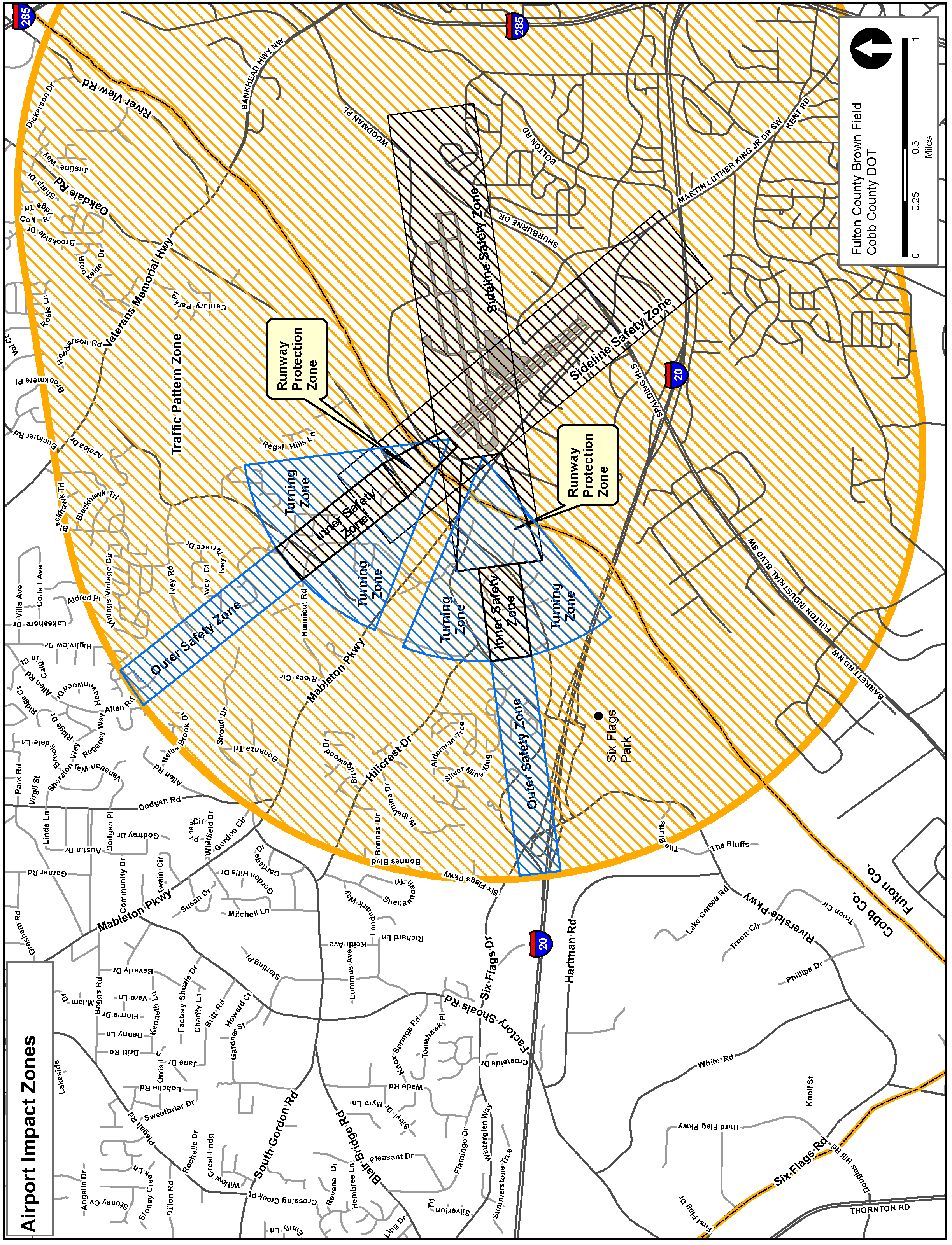
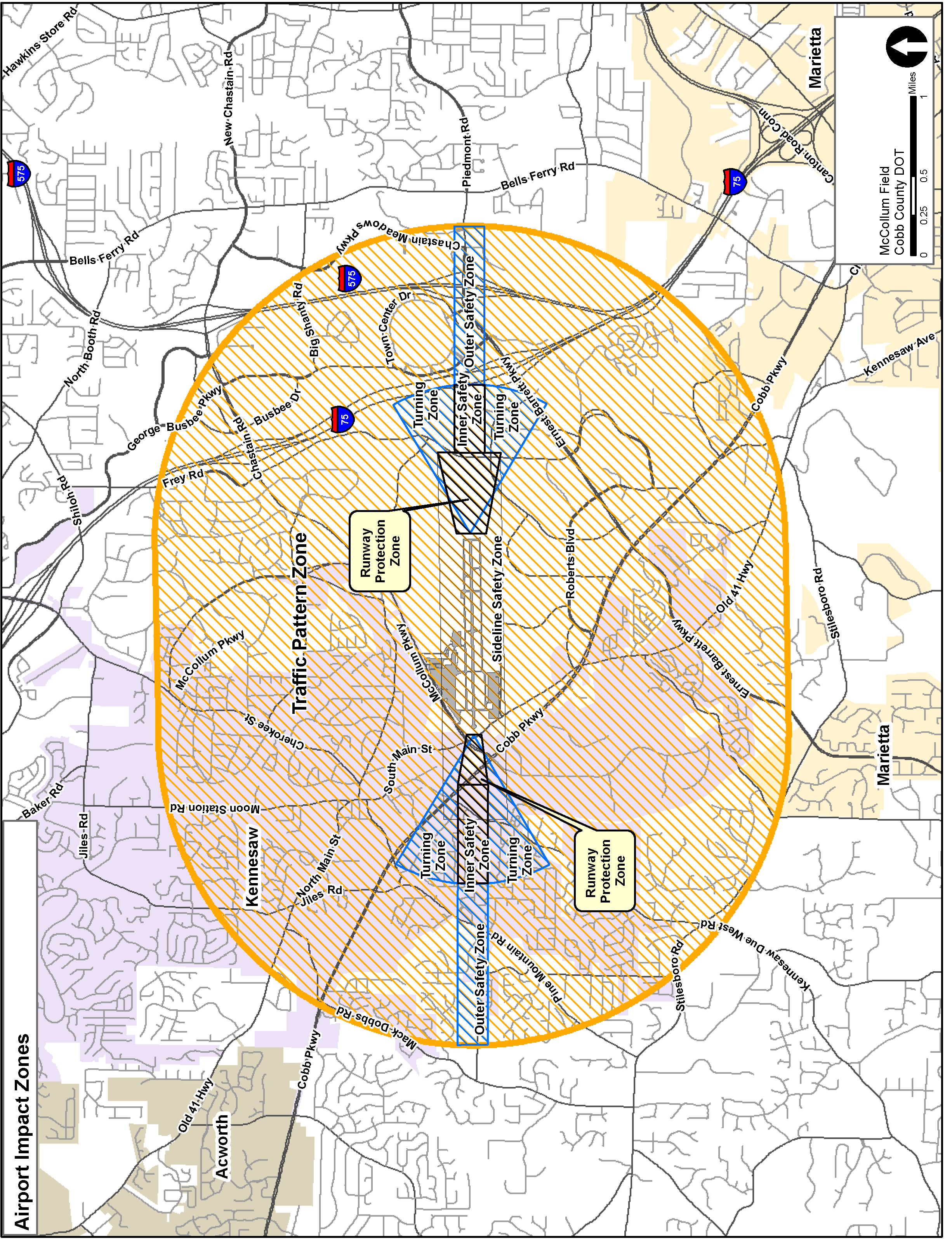
(Ord. of 12-26-72; Ord. of 12-11-90, § 3-28-17.1; Ord. of 6-24-97 (eff. 7-1-97); Ord. of 2-28-12)
Sec. 134-275.1. - Military airport hazard district.
(1)
Intent and purpose. The military airport hazard district is established to contribute to the safe operation of Dobbins Air Reserve Base (ARB), to facilitate orderly development around the airfield, to protect property values, and to control and minimize noise and potential accident impacts on the surrounding areas of Cobb County and the City of Marietta. The military airport hazard district promotes development patterns which are appropriate for the airfield vicinity and protect the public's safety and welfare by limiting land uses near the airport which require or generate large concentrations of individuals. The boundaries, contained herein are taken directly from the 2011 Air Installation Compatible Use Zone Study at Dobbins Air Reserve Base conducted by the United States Air Force.
(2)
Applicability. Properties subject to the military airport hazard district provisions and the specific land use controls encumbering those properties shall be referenced as an overlay on the official zoning map of Cobb County and contained in the Cobb County Comprehensive Plan and known as airport impact zones. The military airport hazard district regulates and recommends uses for the affected properties within the accident potential and noise zones depicted on the maps and shall be considered complementary of any other zoning district standards. Properties located within the military airport hazard district and seek to develop after the adoption of this section are subject to the rules and regulations set by this section.
(3)
Definitions.
Definitions and acronyms. The following words, words and phrases, when used in this section, shall have the meaning ascribed to them in this subsection, except where the context clearly indicates a different meaning:
Above ground level ("AGL") means a reference of elevation above ground level.
Accident Potential Zone I. This is an airport impact zone area extending outward from the clear zone an additional 5,000 feet by 3,000 feet (the runway centerline is the midpoint for the width) presenting a risk of aircraft accident less than the clear zone but greater than APZ II; thereby, extra protection is required. Accident Potential Zone I includes all land encompassed within the area designated APZ I on the official zoning map of Cobb County.
Accident Potential Zone II. This is an airport impact zone area extending outward from Accident Potential Zone I an additional 7,000 feet by 3,000 feet (the runway centerline is the midpoint for the width) presenting a risk of accident less than both the clear zone and Accident Potential Zone I, but a measurable risk nonetheless; thereby, extra protection is required. Accident Potential Zone II includes all lands encompassed within the area designated APZ II on the official zoning map of Cobb County.
Airport manager means the administrative representative of each airport.
Airport operations means take off, climb out, approach, landing, and traffic pattern operations that may vary for each aircraft.
Airspace surfaces means the same areas as stated in the Federal Aviation Regulations ("FAR") Part 77 Airspace Surfaces as amended from time-to-time.
Clear zone. This is an airport impact zone area starting at the end of the runway and extending outward 3,000 feet by 3,000 feet (the runway centerline is the midpoint for the width), presenting the greatest accident risk of all the designated accident potential zones; thereby, extra protection is required The clear zone includes all lands encompassed within the area designated CZ on the official zoning map of Cobb County.
DBA. The "A" weighting in noise measurements (an official method of measuring sound per industry accepted standards) that assists in determining acceptable noise levels.
Federal Aviation Administration ("FAA") means the federal agency titled "Federal Aviation Administration" which is charged with oversight and regulation of civil aviation to promote safety, including that of most publicly owned airports.
Federal Aviation Regulations ("FAR") Part 77 Airspace Surfaces means regulated airspace surfaces promulgated in 14 Code of Federal Regulations (CFR) Part 77, Objects Affecting Navigable Airspace.
Hazard to air navigation means an object which, as a result of an aeronautical study, the FAA determines will have a substantial adverse effect upon the safe and efficient use of navigable airspace by aircraft, operation of air navigation facilities, or existing or potential airport capacity.
Mean sea level ("MSL") means the elevation reference for objects above sea level.
Noise Contour 1. This is a depiction of an area that has a day night average sound level of between 65 and 69 DBAs.
Noise Contour II. This is a depiction of an area that has a day night average sound level of between 70 and 74 DBAs.
Noise Contour III. This is a depiction of an area that has a day night average sound level of between 75 and 79 DBAs.
Nonconforming use means any structure, natural growth or use of land which does not conform to a regulation prescribed in this chapter or an amendment thereto, as of the effective date of such regulations.
Obstruction to air navigation means an object of greater height than any of the heights or surfaces presented in Federal Aviation Regulations Part 77 Airspace Surfaces. (Obstructions to air navigation are presumed to be hazards to air navigation until an FAA aeronautical study has determined otherwise.)
Runway means an airport's paved or cleared strip on which planes land and take off.
Runway elevation means an elevation as measured by mean sea level. Height limitations established herein will be measured against the closest runway and its mean sea level. Runway elevations are documented in the airport's master plan.
TERPS means terminal instrument procedures, which is the standard instrument approach procedures and takeoff minimums and obstacle departure procedures based on the criteria contained in FAA Order 8260.3 U.S. Standard for Terminal Instrument Procedures.
(4)
Permitted uses.
1.
Three primary determinants are used in promoting compatibility between the airfield and nearby areas: accident potential to land users, aircraft noise, and hazards to operations from land uses (height, obstructions, etc.). The military airport hazard district establishes use restrictions, recommended noise reduction measures, and height limitations as necessary to produce compatible land uses in each of these three areas: clear zones, accident potential zone I, accident potential zone II. No development in an accident potential zone shall be approved unless in accordance with the requirements of this section, including the land use compatibility standards chart.
2.
Land use zoning recommendations. Land use zoning recommendations prescribes land uses and zoning designations that are deemed compatible within the airport operations areas, as shown on the airport impact zones land use maps. The land use compatibility standards table presents recommended conforming land uses within each airport impact zone and noise contour. If there is a conflict between an airport impact zone and a noise contour area recommendation, the more restrictive regulation shall control. the board of commissioners may use the future land use map designations and this Code to determine appropriate density and intensity of land uses in order to protect individual property owners and Dobbins Air Reserve Base.
Legend:
Y - a use is compatible
N - a use is not compatible
Y 1 - a use is compatible if noise reduction measures are required in construction
Y 2 - density and intensity of land uses should reviewed for compatibility with operations at Dobbins Air Reserve Base on a case by case basis.
3.
Land uses not specifically listed in the land use compatibility standards table shall be governed by the standards applicable to the land use most similar to the proposed use.
4.
Generally, notwithstanding, any other provisions of this chapter, no use may be made of land within the zones listed in this section in such a manner as to create electrical interference with radio communication between the airport and any aircraft, make it difficult for flyers to distinguish between airfield lights and other lights, result in glare in the eyes of flyers using the airfield, impair visibility in the vicinity of the airfield attract birds, or otherwise endanger the landing, takeoff, or maneuvering of any aircraft.
5.
Any person submitting a building permit application, application for rezoning or variance, or an application for land use permit or special land use permit shall notify the community development agency in writing if the property in question is within the clear zone, or APZ I or APZ II.
6.
The community development agency shall notify Dobbins Air Reserve Base if an application for a rezoning, variance, land use permit or special land use permit is submitted for consideration. This provides the commander of Dobbins ARB, or his/her designee with an opportunity to provide an official response.
7.
The Cobb County Department of Transportation shall notify the FAA when a rezoning, variance, land use permit or special land use permit is submitted for consideration. This provides the FAA with an opportunity to provide an official response.
(5)
Height zoning. Height limitation zoning applies to structures and natural growth objects within the airspace as defined by the Federal Aviation Regulations Part 77 Airspace Surfaces and TERPS.
1.
Construction or alteration requiring notice to the FAA. Except for construction less than 25 feet AGL or as provided in FAR Part 77.15, any construction or alteration that meets or exceeds the height criteria established in FAR Part 77.13 as amended from time to time, shall complete the FAA notification process as provided in FAR Part 77.17 as amended from time to time, using the FAA Notice of Proposed Construction or Alteration form 7460-1 as amended from time to time.
2.
Height limitation. The military airport hazard district ordinance does not preclude approval of obstructions to air navigation with heights in excess of those height limitations prescribed in FAR Part 77 and/or TERPS, if either of the following is met:
a.
A determination of "No Hazard to Air Navigation" is issued from a FAA airspace study resulting from the notice requirement of FAR part 77.17 and the airport manager supports the determination; or
b.
A variance application may be considered by the board of zoning appeals, when such action is considered advisable to effectuate the purposes of this section and reasonable in the circumstances when considering the results of the determination of an FAA airspace study and the input from the airport manager.
(6)
Permits. Any building permit or business license application submitted for properties within the military airport hazard district shall be reviewed by the community development agency to determine whether it meets the standards set forth in this Code. Those applications which do not meet these criteria shall be required to seek approval from the board of commissioners via other business.
1.
No permit shall be granted by the community development agency that would allow the establishment of a flight hazard or use not authorized by this section or permit a nonconforming use, structure, or natural growth to become higher, or become a greater hazard to air navigation or become less compatible in use than it was on the effective date of this section.
2.
Before any existing use or structure within any portion of the military airport hazard district may be altered in such a manner as to increase its base height, a letter from Dobbins Air Reserve Base is required. The letter should state that the air base does not object to the alteration of the height limit.
(7)
Existing nonconforming uses or heights. This section shall not be construed to require the removal, lowering, change or alteration of any previously approved nonconforming use or structure, or otherwise interfere with the continuance of any previously approved nonconforming use or structure, except as otherwise provided by this section, including those previously approved nonconforming uses or structures under construction.
1.
Nothing in this section shall contradict the limitations placed on nonconforming uses of a building, structure or land as described in section 134-31 of the county ordinances, nonconforming uses.
2.
Notwithstanding the preceding subsection, this section shall provide the right to require the owner of any existing nonconforming structure to mark and/or light any structure as deemed necessary by Cobb County.
3.
Notwithstanding the preceding subsection, no existing nonconforming natural growth may become higher, or become a greater hazard to air navigation than it was on the effective date of this section.
(8)
Conflicting regulations. In case of conflict between the regulations of this chapter and other regulations, unless otherwise stated, the more stringent regulations shall control.
(Ord. of 2-26-13; Amd. of 2-26-19; Amd. of 2-8-22)
Sec. 134-276. - Moving buildings.
(a)
Permit required. It shall be unlawful for any person to move or transport, over the roads of any unincorporated area, any house or structure or other building, over or through any street or streets, alley or public way or thoroughfare of the county, unless such person has first applied for and obtained from the division manager of code enforcement or his designee a written permit authorizing such moving or transportation.
(b)
Issuance of permit.
(1)
The code enforcement division shall furnish any applicant a form application which shall contain, among other information, the following:
a.
A description of the structure proposed to be moved, giving the street number, construction materials, dimensions, number of rooms and condition of exterior and interior (required only on house moving relocation applications within the county).
b.
A street address or description of the property from which the structure is to be moved, giving a sufficient legal description (required only on house moving relocation applications within the county).
c.
A plat of the portion of the property to be occupied by the structure when moved which shows the origin and destination of the structure (required only on house moving relocation applications within the county).
d.
The name of the person performing the moving operation.
e.
The routing of the highways, streets and alleys over and along which the structure is proposed to be moved.
f.
The name and consent of the owner of the property from which removed and of the owner of the property to which moved (required only on house moving relocation applications within the county).
g.
An estimate of the time that will be involved in the moving process, not to exceed four working days, to be accomplished between the hours of 9:00 a.m. and 4:00 p.m. After the permit is issued and relocation begins, the applicant shall continuously and without interruption work at moving the structure until it reaches the destination shown on the permit. In order to successfully complete house moves between these hours, a house move should begin promptly at a time early enough to complete within these hours. If it is determined by the department of transportation or the assigned police officers that said move cannot be completed within these hours due to a late start, house move will not be allowed to begin in the county, and a new date will need to be set for that move. An applicant's failure to comply therewith shall, in addition to the revocation of the permit, form the basis for withholding of future permits.
h.
Any additional information which any agent of the county shall find necessary to determine whether or not a permit should be issued.
(2)
This subsection (2) shall apply only to applicants for permits to move houses being located or relocated in the county. The applicants shall show consent of the neighboring property owners adjoining the property on which the structure is being placed. In the event that applicant cannot obtain consent from the adjoining property owners, the applicant shall send a letter via first class mail with a certificate of mailing or certified mail to those adjoining property owners which shall contain the application for relocating existing structure, statement of all proposed improvements and a plat of the property. The certificate of mailing or certified receipts shall be submitted to the code enforcement office two weeks prior to the hearing. The applicant shall post an "Other Business" sign on the property 30 days prior to the hearing.
(3)
Permits shall be issued only to licensed building movers who provide satisfactory evidence of liability insurance coverage as defined in this section.
(4)
Any house being moved which is to be located or relocated in the county shall require a building permit.
(c)
Work prohibited on certain days; duration of permit; deadline for submission of permit application.
(1)
In addition to the provisions of subsection (b) of this section regarding the time in which the structures shall be allowed to be moved, houses or structures shall be moved only on Monday through Thursday, except that no houses or structures may be moved on holidays or any other day said county offices are closed. For purposes of this subsection, holidays are defined as being New Year's Day, Martin Luther King Day, Memorial Day, July 4th, Labor Day, Thanksgiving Day and Christmas Day. Work on the structure during those hours shall be consistent with applicable noise requirements (see chapter 50, article VII).
(2)
The permit shall be valid immediately from the day of issuance and expire six good working days from the day of issuance. If a structure is not moved within this period, the applicant must obtain a new permit. All route applications must be submitted at least four working days prior to the requested date of the house move.
(d)
Minimum standards for structure. No applications shall be approved for moving a structure which is not equal to or better than the adjacent structures within the area (required only for house moving relocation applications within the county)
(e)
Operational requirements. Additional requirements shall be a follows:
(1)
There will be no structure moved along the roadways of the unincorporated area of the county with an overall height in excess of 18 feet, or with an overall width in excess of 30 feet, including overhang or with an overall length of the tractor and house in excess of 100 feet, provided however, an exception may be made for good cause shown by the applicant to the county department of transportation. Even though all the above operational requirements might be met, said house move route is subject to denial, if the county department of transportation determines that proper clearance cannot be obtained on the proposed route as stated on the application. Any route denials can be appealed to the county department of transportation operations division manager.
(2)
Reserved.
(3)
Must conform with state department of transportation on requirements for number of workers on top of house to ensure that overhanging utilities will be completely clear of the roof; however, a minimum of two men are required to be placed on the top of the house when traveling through traffic signals to ensure signals will be completely clear of the roof.
(4)
Front and rear escort vehicles shall be required at all times during the moving process. These escorts shall be police cars driven by police officers. The division manager of code enforcement or his/her designee shall coordinate the police officer escorts. Up to four police officer escorts are required for each house move permitted, unless department of transportation and public safety deem that less officer escorts would be sufficient as determined per the route submitted. The department of transportation should be contacted by the house mover before application is submitted to code enforcement for this request and approval. Each police officer shall be compensated by the house mover in the amount of $150.00 and will be compensated for each day they are assigned a move, unless the code enforcement division is notified 24 hours in advance of a cancellation. The house mover shall make payment for such police officer compensation directly to the county at the time the application is submitted. No application shall be received unless the police officer compensation is paid. The police officer shall have the final decision as to whether or not the house moving takes place. Notwithstanding the police officer's decision, the house mover shall not be entitled to a refund of the police officer compensation. The police officer shall be considered the borrowed servant of the house mover, subject to the control of the house mover. The police officer shall be within the scope of his employment for the house mover at all times during the house moving process. The police officer shall be considered the servant of the house mover and the county, and shall not be liable to any person for any person or property injured or damaged during the move. It is the intent of this subsection that the county shall not be liable for the acts of the police officer while operating under the direction or control of the house mover. The house mover shall indemnify and hold the county harmless from all conduct of such police officer, and all other liability arising out of the house moving. The house mover, by submitting an application for a house moving permit, agrees and consents to this subsection.
(5)
All vehicles used by house movers in the moving process, except for the police car, shall be equipped with a revolving amber light at least eight inches in diameter, located on top of the vehicle, which must be clearly visible from all directions. The light shall have a minimum candlepower of 35,000 and shall rotate so as to provide at least 80 revolutions per minute. The operators of such moving vehicles shall have obtained a valid driver's permit from the state department of safety.
(6)
All vehicles involved within the moving process shall be plainly marked and display the house mover's name. There will be no house parked on the route or off the route in the unincorporated areas of the county due to mechanical breakdown for more than 12 hours. Applicants are charged with the responsibility of notifying the appropriate property owners should a mechanical breakdown necessitate the parking of the house on private property. This also includes discontinuing a move due to a safety issue.
(7)
Sufficient personnel, consisting of at least five individuals and employees of the house mover, each having a valid state driver's license, shall be available to assist each vehicle involved in the house moving, in case of illness or accident to vehicle operators during the house moving process.
(8)
All house movers shall have a wrecker large enough to tow the entire load accompanying the house in the event there is a breakdown during the house moving process.
(9)
Any debris or damage caused by the house moving process or the house movers involved in the house moving process shall be removed or corrected at the time of the incident by the house mover and his support personnel, and shall be the house mover's exclusive financial responsibility.
(10)
All masonry shall be removed from the structure prior to the moving process being undertaken.
(11)
Escort vehicles and the vehicle transporting the house shall also be equipped with two-way radios in good working order so that all drivers will have constant radio contact with each other. The rear escort vehicle driver shall advise the driver of the load and the front police officer escort as to the traffic conditions behind the movement. Additionally, an agent of the county or the police escort shall have the right to have the structure being moved pulled over to the side of the roadway to relieve traffic backup during the moving process, whether a state route or county road.
(12)
Approval and authorization to initiate the planned move will be in the discretion of the off-duty police officer front escort to the house moving, and approval will only follow after inspection and verification that compliance with the items mentioned in this section has been forthcoming.
(13)
The driver of the front and rear escort vehicles shall maintain sufficient separation between their vehicles and the structure being moved so as to provide adequate warning of the presence of the structure being moved.
(14)
All vehicles used during the moving process must be roadworthy and in extremely good condition. The truck tractor and dollies attached to the house will be subject to a federal commercial vehicle inspection. If either are placed "out of service" and can not be repaired at the scene within 30 minutes, the house move is deemed denied and a new permit must be obtained.
(15)
Any structure being moved with a cut-down roof shall have plywood covering the structure.
(16)
There shall be no structures moved within the unincorporated areas of the county during inclement weather (when roads are wet with rain, sleet, ice, snow or when visibility is dangerously reduced by fog). If during a house move, the aforementioned occurs, then the house mover shall seek a safe location to stop the house move. Once the house move is stopped, a new permit must be obtained.
(17)
If a house move begins in the county, the house move must begin within 30 minutes of the start time. A house move entering the county must be timely to allow the house move to be completed within the hours as stated in section (b)(1)g. If any of these conditions are not met, then the house move is denied, and a new permit must be obtained.
(f)
Action on permit application; appeal of denial; resubmission after denial.
(1)
When an application has been received under this section, it shall be the duty of the code enforcement division to confer with the county department of transportation, operations division, to determine whether or not the proposed operation may be carried out without danger to adjacent property, existing utilities and the traveling public. After such determination and after full compliance with this section, the division manager of code enforcement may approve the application. Upon approval, he may issue the permit upon such conditions as may be necessary to ensure the safety of the operator. If the division manager of code enforcement determines from his investigation that the operation cannot be undertaken with safety or might result in traffic, zoning or building code violations, he may reject the application, furnishing to the applicant the reasons why the application was declined.
(2)
Any person aggrieved by such rejection of an application may appeal such a rejection and appeal before the board of commissioners at the next regularly scheduled meeting to review the actions of the code enforcement division. All applications approved will provide conditions, which conditions may include but shall not be limited to the route of travel, the time of travel, the destination or number of employees and authorized police personnel for the safe completion of the move, the type and necessary equipment so as to prevent breakdown during such removal, and other conditions, rules or requirements to ensure a safe and speedy removal of any structure upon the highways of the unincorporated areas of the county.
(3)
An application for a house moving permit that has been rejected by the board of commissioners cannot be resubmitted for a period of 12 months from the date of the public hearing at which the application was considered and denied (only for house moving relocation applications within the county).
(g)
Exemptions. The provisions of this section shall not apply to the moving of small temporary structures, portable buildings, mobile buildings, mobile homes or other similar structures where the structure can be moved on normal automotive equipment and will not require the blocking of rights-of-way or interfere with the normal movement of traffic.
(h)
Failure to obtain permit. It shall be unlawful to engage in the business of moving structures, as defined in this section, without first having filed the application with and having secured a permit from the code enforcement division.
(i)
Liability insurance; damage to traffic control signals.
(1)
Every applicant must secure liability insurance covering all working operations, including loading and unloading buildings upon vehicles, in minimum amounts of $300,000.00 for bodily injuries to each person, $500,000.00 for each accident, and $100,000.00 for property damage. Additionally, each applicant must secure automobile liability insurance in minimum amounts of $300,000.00 for each accident and $100,000.00 for property damage covering all vehicles used in connection with the moving process.
(2)
Certificates of liability insurance with insurance companies authorized to do business in the state shall be delivered to the code enforcement division. Each policy shall, by its terms, provide that it cannot be canceled until after ten days' written notice to the appropriate county official. Should any licensed house mover fail to provide another policy of liability insurance prior to such cancellation, then his permit shall automatically be suspended as of the date the insurance policy cases to be effective. Suspensions, as provided in this section, shall be automatic and effective without notice or hearing as otherwise required by this section.
(3)
Any damage done to electronic traffic signal control devices caused by the house moving process or the house movers involved in the house moving process shall be the financial responsibility of the house movers and shall be reported immediately to the police escorts or agents of the county department of transportation.
(j)
Transfer of permit. No permit issued under this section shall be transferred or assigned to any other person.
(k)
Suspension or revocation of permit. The following shall govern suspension and revocation of house moving permits:
(1)
Permits will be withheld for a period of six months whenever three or more violations occur within any six-month time period. Violations include damage to county real or personal property, mechanical breakdown of equipment, interruption of normal flow of traffic as determined by assigned officers and any other violation of this section. With any damage to county property, upon receiving a statement issued by the county for the repair cost, the repair cost shall be satisfied by the house mover or his agent, prior to the consideration of any new permit being issued by code enforcement. If a permit is withheld from a licensed house mover, this will include no additional permits being issued to any other house mover under another name, associated with those owners or agents in violation during that six-month suspension.
(2)
Reserved.
(3)
Any suspension imposed pursuant to this section shall remain in effect until all defects, deficiencies and work not complying with this section have been corrected by the applicant.
(4)
Reserved.
(5)
Any person aggrieved by the decision of the division manager of zoning, code enforcement, transportation operations or his designee in refusing to issue, suspending, revoking or refusing to reinstate the permit may appeal therefrom to the board of zoning appeals within ten days of receipt of written notification of the decision. The written notification shall inform the applicant of his right to appeal. The appeal must be taken by submitting a written request therefor to the director of community development. The board of zoning appeals shall hear the appeal within 30 days after receipt of the notice of appeal by the director of community development. The decision of the division manager of zoning, code enforcement or transportation operations shall be final unless appealed within the time and manner as set forth in this subsection.
(l)
Judicial review. Nothing contained in this section shall be construed so as to deprive any person of any right which he may have to obtain judicial review of any administrative decision made under this section.
(m)
Additional remedies; responsibility for violations by partnership or corporation.
(1)
In addition to any other remedy in this section, the county may seek injunctive relief to enjoin any violation of this section in the appropriate court against the appropriate person or entity.
(2)
In the event of a partnership or corporate entity, the person directing the work of the partnership or corporate entity shall be construed to be the person violating the provisions of this section. In addition, all of the partners in the partnership, and all of the directors, the president or any other officer or employee of the corporation exercising significant managerial responsibility over those employees whose acts violate the terms of this section shall also be construed to be in violation of this section.
(n)
Conflicts with regulations of department of transportation. In the event of a conflict with the regulations of the department of transportation promulgated pursuant to statutory authority, such regulations shall supersede the provisions of this section to the extent necessary to avoid a conflict.
(Ord. of 12-12-89; Ord. of 12-11-90, § 3-28-17.2; Ord. of 1-22-02; Amd. of 2-25-14; Amd. of 2-27-18)
Sec. 134-277. - Junk, abandoned or inoperative vehicles.
(a)
Any automobile, vehicle, mobile home, manufactured home or trailer of any kind or type, without a valid license plate and/or valid decal attached thereto, shall not be parked or allowed to stand on any residentially zoned property or other zoned property unless it shall be in a completely enclosed building or on property zoned HI heavy industrial, with a land use permit issued for the operation of an automobile wrecking business or junkyard.
(b)
No automobile, vehicle, mobile home, manufactured home or trailer of any kind or type, which shall be in an inoperative or junk condition, shall be parked or allowed to stand on any residentially zoned property or other zoned property unless it is:
(1)
In an enclosed building;
(2)
On the premises of a business enterprise operated in a lawful manner, when necessary to the operation of such business enterprise; or
(3)
On property occupied and used for repair, reconditioning or remodeling of vehicles in conformance with this chapter.
(c)
Nothing in this section shall authorize the maintenance of a public or private nuisance as defined under other provisions of law.
(d)
For purposes of this section, vehicles in an inoperative or junk condition shall include but not be limited to any automobile, vehicle, mobile home, manufactured home or trailer of any kind or type, or contrivance or part thereof, the condition of which is one or more of the following:
(1)
Wrecked.
(2)
Dismantled.
(3)
Partially dismantled.
(4)
Inoperative.
(5)
Abandoned.
(6)
Discarded.
(7)
One which does not have a valid license plate and/or valid decal attached thereto.
(e)
This section shall not be the exclusive regulation of abandoned, wrecked, dismantled or inoperative vehicles or contrivances within the unincorporated limits of the county and shall be supplemental and in addition to the other regulations and regulatory codes, ordinances, statutes or provisions of law enacted by the county, the state or other legal entity or agency having jurisdiction.
(f)
It is found and declared that vehicles found in violation of the provisions of this section constitute a public nuisance.
(Ord. of 12-26-72; Ord. of 11-8-77, § 13; Ord. of 12-11-90, § 3-28-17.3; Ord. of 7-24-07; Ord. of 3-25-08; Ord. of 7-27-10; Amd. of 7-22-14)
Sec. 134-278. - Erection, installation and use of factory-built buildings and dwelling units and manufactured homes.
(a)
Definitions. The following words, terms and phrases, when used in this section, shall have the meanings ascribed to them in this subsection, except where the context clearly indicates a different meaning:
(1)
Commissioner means the commissioner of community affairs for the state.
(2)
Component means any assembly, subassembly, or combination of parts for use as a part of a building, which may include structural, electrical, plumbing, mechanical and fire protection systems and other systems affecting health and safety.
(3)
Industrialized building means any structure or component thereof which is wholly or in substantial part made, fabricated, formed or assembled in manufacturing facilities for installation or assembly and installation on a building site and has been manufactured in such a manner that all parts or processes cannot be inspected at the installation site without disassembly, damage to such parts, or destruction thereof.
(4)
Installation means the assembly of an industrialized building on-site and the process of affixing the industrialized building, component or system to land, a foundation, footings or an existing building.
(5)
Manufacture means the process of making, fabricating, constructing, forming or assembling a product from raw, unfinished or semifinished materials.
(6)
Manufactured home.
a.
Class I manufactured home means a single-family dwelling unit that is constructed in accordance with the Federal Manufactured Home Construction and Safety Standards and bears an insignia issued by the U.S. Department of Housing and Urban Development (HUD), or one, if constructed prior to applicability of such standards and insignia requirements, that was constructed in conformity with the state standards in effect on the date of manufacture.
b.
Class II manufactured home means a unit meeting the requirements of a manufactured home class I and, in addition, bearing an insignia of the Southern Standard Building Code Congress International (SSBCCI) of Birmingham, Alabama.
(7)
Modular home means a factory-manufactured single-family dwelling which is constructed in one or more sections and complies with the definition of an industrialized building.
(8)
Site means the entire tract, subdivision or parcel of land on which the industrialized building or manufactured home is installed.
(9)
System means structural, plumbing, mechanical, electrical or fire safety elements, materials or components used separately or combined for use in a building.
(b)
Class I manufactured homes.
(1)
Zoning. No manufactured home, class I, shall be installed, used, parked or occupied on any site in the county except one zoned MHP or MHP/S or on a site for which a land use permit for such use been issued by the county, except that such units may be located for sale upon a site properly zoned to a commercial classification which allows such activity.
(2)
Notification to purchaser. It shall be the duty and responsibility of any seller of a unit of this class to notify any potential purchaser, prior to completion of any sale, of the zoning requirements of subsection (1) of this subsection, and this notification shall be evidenced by a statement signed by each purchaser at the time of any sale that such notification was made prior to completion of the sale. Such signed statement shall be retained by the seller for a minimum of three years from the date of sale and shall be produced for inspection by the county at any time during the hours of 10:00 a.m. to 4:00 p.m., Monday through Friday, except holidays established by the county, through any authorized agent appointed by the county manager for the county, upon request by the county for inspection.
(c)
Class II manufactured homes.
(1)
Zoning and permits. No manufactured home of this class shall be installed, used, parked or occupied on any site in the county except one zoned MHP or MHPS or on a site for which a land use permit for such use has been obtained from the county (except that such units may be located for sale upon property properly zoned to a commercial classification which allows such activity), unless the following requirements are met:
a.
An application shall be filed with the county, through the zoning division, for a permit from the board of commissioners to allow such installation, use and occupancy for single-family purposes on any site zoned for single-family use, and a permit must be obtained prior to transportation to such site. Such application shall be on forms specified by the county and shall include such information as is reasonably necessary for evaluation of the application.
b.
The following, as a minimum, shall be filed with the application:
1.
A complete set of design plans as approved by SSBCCI, which should also include a drawing depicting each elevation of the exterior appearance of the unit.
2.
A plat of the proposed site prepared by a registered surveyor showing at a minimum the exterior boundaries of the site, proposed location of the unit upon the site, and side, front and rear setbacks of the unit as proposed to be located, as measured from the exterior boundaries of the lot.
3.
A fee in an amount determined by the board of commissioners and on file in the office of the zoning division.
4.
A certificate from an inspector selected or approved by the county certifying that the unit was manufactured in accordance with the SSBCCI approved plans and the building codes in effect for the county at the time of filing the application for a permit, for example, building, heating and air conditioning, plumbing, electrical or other codes.
c.
The permit required in this subsection shall be in addition to all other permits or requirements of the ordinances, rules and regulations of the county.
d.
No action on a request for permit shall be considered by the board of commissioners until a sign is posted on the proposed site for a period of not less than ten days stating the requested action and the date, time and place for the hearing, and a hearing is conducted by the board of commissioners.
e.
No such permit shall be granted unless the unit, when completely installed as a single-family dwelling unit, will be compatible with the adjacent and surrounding area, especially in size, exterior appearance, front, rear and side setbacks, and will have no adverse effect upon the value of adjacent property and the surrounding area and will not otherwise be detrimental to the health, safety or welfare of the citizens of the county. No unit shall be installed upon any site unless and until any permit required in this section is granted and unless and until all permits for any on-site work to be performed (such as site preparation, utility and service connections, foundation or any other on-site work) have been obtained from the county. The applicant for any such permits shall pay to the county, at the time of application, its fee for those inspections required for on-site work. Such fees shall not exceed the amount charged for similar inspections and permits on conventionally built structures.
f.
In addition to obtaining the permit required by this subsection, and prior to occupancy, every such unit which is installed shall be installed on a permanent foundation, which is permanently enclosed, and shall have all wheels, axles and hitches removed.
g.
No unit shall be installed upon any lot or parcel of land which forms a part of a platted subdivision for which a plat has been approved by the county and recorded in the office of the clerk of the superior court.
(2)
Notification to purchaser. It shall be the duty and responsibility of any seller of a unit of this class to notify any potential purchaser, prior to completion of any sale, of the requirements of zoning or the necessity to obtain a permit as set forth in subsection (1) of this subsection. This notification shall be evidenced by a statement signed by each purchaser at the time of closing that such notification was made prior to completion of the sale. Such signed statement shall be retained by the seller and subject to inspection in the same manner as such statements are required to be retained for class I units.
(d)
Industrialized buildings.
(1)
Permits required. No industrialized building shall be installed upon any site unless and until all permits for any on-site work to be performed (such as site preparation, utility and service connections, foundation or any other on-site work) have been obtained from the county.
(2)
Permit fees. The applicant for any such permits shall pay to the county, at the time of application, its fee for those inspections or permits on conventionally built structures.
(3)
Insignia requirements. No industrialized building shall be installed or occupied in the county unless it bears an insignia of the department of community affairs of the state indicating state approval pursuant to the acts of the general assembly.
(4)
Zoning. No industrialized building shall be erected upon any site in the county, or used for any purpose, unless the site is properly zoned for the intended use or a land use permit has been obtained for the intended use, and unless all other requirements of zoning (setback requirement, building size, etc.) and other ordinances of the county are met which are applicable to the zoning classification for the site or for the installation.
(5)
Applicability of county regulations. This section does not eliminate the necessity of complying with any ordinance, rule or regulation of the county which relates to matters addressed, investigated and approved by the state through its department of community affairs resulting in the issuance of its insignia.
(6)
Notification to purchaser. It shall be the duty and responsibility of any seller of any industrialized building to notify any potential purchaser, prior to completion of any sale, of the requirements of this subsection. This notification shall be evidenced by a statement signed by each at the time of completion of a sale, that such notification was made prior to completion of the sale. Such signed statement shall be retained and open for inspection the same as for a manufactured home, class I, as provided in subsection (b) of this section.
(e)
Minimum square footage per occupant. Each mobile home must consist of one or more rooms which are arranged, designed or used as living quarters for one family (as defined in section 134-1) and two or fewer persons who are not family members.
(1)
A mobile home may be occupied only by a family and up to two persons who are not family members.
(2)
A mobile home shall have an interior bathroom and complete kitchen facilities, permanently installed.
(3)
A mobile home shall have at least 250 square feet of total square footage (as determined in the records maintained by the Cobb County Tax Assessor) per each adult occupant.
(4)
No more than one vehicle per 250 square feet of total square footage may be parked regularly overnight at or within a paved parking area as required by the MHP and MHP/S zoning districts. "Regularly" means a majority of nights in any 21-day period. Exceptions to this paragraph may be considered as part of a land use permit processed in accordance with section 134-36.
(f)
Violations. Any violation of the provisions of this section shall be punishable as provided in section 1-10, or by loss of the business license of any seller. In addition, any manufactured home or industrialized building erected, constructed, parked, occupied or used in violation of the terms of this section shall be termed a nuisance and a continuing nuisance so long as such violation may be continued, and such violation may be subject to abatement as a nuisance as provided by the laws of this state, and the industrialized building or manufactured home shall be instantly removed from the site. In addition, the terms of this section may be enforced by the county, or proper county authority authorized by the county manager, by injunction or otherwise. This right to injunctive relief is cumulative and is not to be construed as curtailing the rights of any resident, property owner or other person regarding enforcement of this section or of such rules and regulations as may be promulgated by the county in pursuance of this section.
(g)
Steel shipping containers. Steel shipping containers or the like shall not be used for or converted to a dwelling unit, other living space or storage space in residentially zoned districts.
(h)
Portable storage units.
(1)
Only one portable storage unit may be placed on a residential property.
(2)
A portable storage unit or similar enclosure shall only be placed on a driveway which is a hardened surface and shall be located at the furthest point away from the street.
(3)
A portable storage unit or similar enclosure is limited to 30 days on a property during any consecutive 365 day period beginning on the date of the placement of the unit.
(4)
In cases where there is an active building permit to significantly perform a major remodel to an existing home or to construct a new home the portable storage unit or similar enclosure may be placed on the property as long as there is an active building permit and work is progressing to the satisfaction of the building official. In no event will the storage unit be allowed to remain over 180 days. At the time of issuance of a certificate of occupancy or letter of completion the removal of the storage unit will be required within five days after the issuance date.
(5)
In cases where a hardship can be demonstrated, the director of community development may grant an extension on a property for 30 days. Additional 30-day periods may be granted by request, but not to exceed three extensions in total. Additional requests for extension may be brought to the board of commissioners zoning hearing as an other business item. A hardship may be caused by an accidental or unintentional fire, flood, natural disaster or other circumstances presented on a case by case basis, that create a need for additional time for the unit to be on the property. The applicant for the extension bears the burden of proof to document and demonstrate, in writing, to the director the basis for the required extension.
(Ord. of 2-25-86; Ord. of 12-11-90, § 3-28-17.4; Ord. of 2-26-08; Amd. of 2-23-10; Ord. of 7-27-10; Ord. of 2-28-12; Amd. of 2-26-13)
Sec. 134-279. - Self-service storage facilities.
(a)
Purpose and intent. The purpose of this section is to establish minimum standards for use, site development, construction and placement of self-service storage facilities and allow service convenience that satisfies the needs of the citizens of the county. Self-service storage facilities (SSSF) shall be permitted within the light industrial and heavy industrial classification. Effective January 1, 1998, no new applications for a special land use for self-service storage facilities (SSSF) are to be accepted by the board of commissioners.
(b)
Definitions. The following words, terms and phrases, when used in this section, shall have the meanings ascribed to them in this subsection, except where the context clearly indicates a different meaning:
(1)
Dead storage means storage of goods partly not in use and not associated with any principal commercial or manufactory use.
(2)
Self-service storage facility (SSSF) means a fully enclosed facility containing independent bays, which are leased to individuals exclusively for dead storage of goods or personal property.
(c)
General regulations.
(1)
Use limitations. No wholesale or retail sales are permitted. A self-service storage facility included within a planned commercial or planned industrial development shall have a minimum of one acre devoted exclusively for such use. The only commercial activities permitted exclusively on the site of a self-service storage facility shall be rental of storage bays and pickup and delivery of goods or property in dead storage. Storage bays shall not be used to manufacture, fabricate or process goods, to service or repair vehicles, boats, small engines or electrical equipment, or to conduct similar repair activities, to conduct garage sales or retail sales of any kind, to rehearse or practice utilizing band instruments, or for conversion to an apartment or dwelling unit, or to conduct any other commercial or industrial activities on the site.
(2)
Security quarters. A residential quarters for security purposes may be established on the site.
(3)
Fencing. The self-service storage facility shall be enclosed by a fence or wall a minimum of six feet in height. The fence or wall shall be constructed of either brick, stone, masonry units, wood, chain link, cyclone or other similar materials to be approved by the division manager of zoning or his designee. The fence or wall shall be set back a minimum of 20 feet from the side and rear property lines. Fences and walls shall adhere to the required front yard setback. This requirement will be inapplicable should the facility comply with subsections (f)(6)a and b of the landscape requirements of this section.
(4)
Storage bays not to be used as legal address. Individual storage bays within a self-service storage facility shall not be considered premises for the purpose of assigning a legal address in order to obtain an occupational license or any other governmental permit or licenses to do business.
(5)
Prohibited storage. Except as provided in this section, all property stored on the site shall be entirely within enclosed buildings. Storage of flammable liquids, highly combustible or explosive materials, or hazardous chemicals is prohibited.
(6)
Minimum lot size. Notwithstanding any other provisions of this chapter, the minimum lot size for a self-service storage facility shall be one acre.
(7)
Building setbacks.
a.
The front setback shall be:
1.
Fifty feet on arterial streets.
2.
Forty feet on major or minor collector streets.
3.
Forty feet on local nonresidential streets.
b.
The side setback shall be:
1.
Twenty feet adjacent to residential and O&I zoned property.
2.
Ten feet on the side where all doors face internally adjacent to commercial or industrial zoned property.
c.
The rear setback shall be 30 feet.
(8)
Access. A self-service storage facility shall be located on a lot that gains access to a local nonresidential, major collector or arterial street as defined in the major thoroughfare plan.
(9)
Outside storage. Open storage of recreational vehicles and dry storage of pleasure boats of the type customarily maintained by private individuals for their personal use shall be permitted within a self-service storage facility provided the following conditions are met:
a.
Such storage shall take place only within a designated area. The area so designated shall be clearly delineated upon the site plan submitted for approval by the board of commissioners when applying for a special land use permit.
b.
The storage area shall not exceed 25 percent of the total buildable area of the site.
c.
The storage area shall be entirely screened from view from adjacent residential and office areas and public streets by a building or by the installation of a six- or eight-foot-high wall or fence. If existing vegetation or topography provides the required screening, then this wall or fence requirement may be eliminated upon approval by the division manager of zoning or his designee.
d.
Vehicles shall not be stored within the area set aside for minimum building setbacks.
e.
No vehicle maintenance, washing or repair shall be permitted on-site. Pleasure boats stored on-site shall be stored upon wheeled trailers. No dry stacking of boats shall be permitted on-site.
(d)
Development regulations.
(1)
Separation between storage buildings. If separate buildings are constructed, there shall be a minimum ten-foot separation between individual buildings. Buildings shall be situated or screened so that overhead access doors are not visible from public roads or residentially or office and institutionally zoned property.
(2)
Maximum bay size. The maximum size of a storage bay shall be 450 square feet.
(3)
Maximum building height. With the exception of the structure used for security quarters, the maximum height of a self-service storage facility shall be one story unless additional stories are approved by the board of commissioners upon issuance of the special land use permit. The height of the building shall not exceed 20 feet. Roof-mounted air conditioning and other equipment, if utilized, shall be screened from view. The combined height of the building and the parapet wall shall not exceed 25 feet. All self-service storage facility shall utilize gable roofs with not less than a two and 12 slope.
(4)
Exterior architectural treatment. The exterior façade of all structures shall receive uniform architectural treatment, to be approved by the division manager of zoning or his designee.
(e)
Parking requirements.
(1)
Generally. Designated customer parking is not required; however, a minimum of five parking spaces shall be provided adjacent to the facility's leasing office, if a leasing office is located on-site.
(2)
Interior parking. Interior parking shall be provided in the form of aisleways adjacent to the storage bays. These aisleways may be used for both circulation of traffic and user parking while using the storage bays. The minimum width of these aisleways shall be as follows:
a.
If aisleways permit two-way traffic, minimum width is 24 feet.
b.
If aisleways permit only one-way traffic, minimum width is 20 feet.
Prior to issuance of a certificate of occupancy, the traffic flow patterns in the aisleways shall be clearly marked. Parking shall consist at a minimum of the use of standard directional signage and painted lane markings with arrows. In order to ensure appropriate access and circulation by emergency vehicles and equipment, the turning radii of the aisleways shall be approved by county department of transportation and the fire marshal at the time of plan review.
(f)
Landscape requirements. A detailed landscape plan shall be submitted with the development plans at the time of plan review for approval. Landscaping shall be provided in the areas between the property lines and the required fencing. This area shall be designated as a perimeter landscape strip. Landscaping shall be designed, placed and maintained in such a manner not to interfere with traffic visibility. A landscape strip of at least 20 feet in width shall be provided along all street frontages. The side and rear yard setbacks shall remain in their natural state or be re-landscaped when the self-service storage facility adjoins residentially or office and institutionally zoned property. If the existing vegetation is inadequate to buffer adjoining office and institution or residential development, an eight-foot-high wall shall be installed along interior property lines and street setbacks. The following minimum planting requirements shall apply as follows and shall supersede the landscape buffer and screening requirements of the NRC, CRC and GC zoning districts:
(1)
A minimum of one tree shall be planted for each 20 feet of perimeter landscape strip.
(2)
Immediately upon planting, trees shall be a minimum of ten feet in height.
(3)
The provisions outlined in subsections (1) and (2) of this subsection do not negate the requirements outlined within chapter 50, article VI, pertaining to tree preservation and replacement, or any additional requirements that may be required by the board of commissioners.
(4)
If a hedge is to be installed in the perimeter landscape strip, the hedge shall be 24 inches in height upon planting, with the material planted every 24 inches on center. All planting shall be maintained in good condition by the property owner.
(5)
If the perimeter landscape strip is to remain undisturbed or natural, utilizing existing vegetation, then the requirements of subsections (1) through (4) of this subsection can be eliminated except for the landscape plan. The landscape plan shall indicate the limits of the perimeter landscape strip.
(6)
In the absence of adequate vegetation, in addition to a perimeter landscape strip, an eight-foot-high wall is to be constructed between a residential or office and institutional property line and the storage bays. The wall may be dispensed with along that portion of the perimeter landscape strip when all the following are met:
a.
The exterior façades of the storage buildings present an unbroken, wall-like appearance when seen from adjacent residential or office and institutional properties or rights-of-way. Storage bay doors shall not face towards adjacent residential or office and institutional properties or rights-of-way. This shall not prevent the installation of fire access doors, if mandated by the fire marshal.
b.
The exterior façades of separate storage buildings are joined by walls to give appearance of structural continuity.
c.
The resulting area between the outer face of the buildings and the property line or right-of-way is maintained and appropriately planted as a landscaped buffer utilizing berms, plantings and existing vegetation and approved by the division manager of zoning or his designee.
d.
There are no aisleways or other vehicle accessways located in the area between the building and adjacent residential or office and institutional property lines or rights-of-way.
(g)
Dumpsters and trash receptacles. Dumpsters and trash receptacles shall be located where they are not visible from adjacent residentially zoned properties, and adequately screened from view from all other adjacent properties and streets. Dumpster locations are to be approved by the staff during the plan review process.
(h)
Signage.
(1)
Maximum number. One freestanding sign shall be allowed for each lot frontage on which a self-service storage facility has access to a public dedicated street. In addition, one flat wall-mounted sign may be utilized.
(2)
Maximum height. The maximum height of a freestanding sign shall not exceed 20 feet.
(3)
Maximum sign area. The maximum total sign structure area for a freestanding or wall-mounted sign shall not exceed 100 square feet. If a ground base sign is utilized, the maximum total sign area may be increased to 120 square feet.
(4)
Prohibited signs. The following types of signs are prohibited on the site:
a.
Off-premises outdoor advertising signs.
b.
Signs placed on the doors of individual storage bays.
c.
Roof-mounted signs.
Signs attached to a required wall or fence are also prohibited, but may be approved by the division manager of zoning or his designee and a code enforcement officer.
(i)
Outdoor lighting. All outdoor lights shall be shielded to ensure that light and glare are limited to the premises and are directed away from adjacent properties. Lights shall be low intensity. If a self-service storage facility abuts a residentially zoned property, outdoor lighting shall be limited to a maximum height of 15 feet.
(j)
Use of loudspeakers. No exterior loudspeakers or paging equipment shall be permitted on the site.
(Ord. of 4-11-89; Ord. of 12-11-90, § 3-28-17.5; Ord. of 2-9-99)
Sec. 134-280. - Automobile and scrap salvage yards and scrap metal processing.
Automobile and scrap salvage yards may be permitted in the HI (heavy industrial) zoning district, but only after application has been made for a special use permit and the permit has been granted by the board of commissioners. Special use permits may be obtained for scrap metal processing in the HI (heavy industrial) and LI (light industrial) districts after advertisement and hearing as in the case of land use permits.
(Ord. of 12-26-72; Ord. of 11-8-77, § 19(5); Ord. of 12-11-90, § 3-28-11.10)
Sec. 134-281. - Residential agricultural farm and wood products and livestock and poultry sales.
On residential property of two acres or more where agricultural, farm and wood products, and livestock and poultry are grown, raised or cultivated on-site, sales of such products shall be permitted under the following conditions:
(1)
No permanent sale structure shall be allowed.
(2)
Seasonal sales may be made from tables or tents placed temporarily.
(3)
All sales are to be conducted on the property where the products are grown and off the right-of-way.
(4)
Should sales of such products constitute a nuisance or create a safety hazard, then such sales may be further restricted to adequately protect the health, safety and welfare of the public.
(5)
Signage is subject to the following:
a.
One sign is permitted per property, no greater than 32 square feet in size.
b.
No manufactured portable signs shall be allowed.
c.
The height of signs shall not exceed six feet.
d.
All signage requires a sign permit.
(Ord. of 10-27-92)
Sec. 134-282. - Commercial produce and agricultural product stands.
Temporary structures not greater than 250 square feet for the purpose of sale of produce and agricultural products, including firewood, not grown on-site, are permitted subject to the following conditions:
(1)
Such uses must have a current business license.
(2)
All structures shall be temporary and located off the right-of-way and shall not impair vision at intersecting streets, driveways, alleys or easements.
(3)
Sale of animals, livestock and poultry shall not be permitted.
(4)
Adequate parking off the right-of-way must be provided; however, should sales of such products constitute a nuisance or create a safety hazard, then such sales may be further restricted to protect the health, safety and welfare of the public.
(5)
No permanent, temporary or mobile living or office quarters are permitted.
(6)
Christmas tree sales and other temporary uses are specifically excluded from this section, but shall be subject to the specific requirements of those uses.
(7)
No outside storage of empty containers such as boxes, crates, palettes, etc., is permitted.
(8)
Signage is subject to the following:
a.
One sign is permitted per temporary vendor, not greater than 32 square feet in size.
b.
No manufactured portable signs shall be allowed.
c.
All signage requires a sign permit.
(Ord. of 10-27-92; Ord. of 9-12-00)
Sec. 134-283. - Standards for state mountain and river corridor protection act areas.
(a)
Authorization. The manager of the zoning division, or his designee, shall be authorized to review and approve development projects or land uses within the river corridor or protected mountain areas as set forth in this section.
(b)
Definitions. The following words, terms and phrases, when used in this section, shall have the meanings ascribed to them in this subsection, except where the context clearly indicates a different meaning:
Land disturbing activity means any grading, scraping, excavating or filling of land; clearing of vegetation; and any construction, rebuilding or alteration of a structure. Land disturbing activity shall not include activities such as ordinary maintenance and landscaping operations, individual home gardens, yard and grounds upkeep, repairs, additions or minor modifications to a single-family residence and the cutting of firewood for personal use.
Natural vegetation means the flora native to the area as described in the Georgia Geologic Survey Bulletin 114, The Natural Environments in Georgia.
Protected mountain area. As defined by O.C.G.A. § 12-2-8, as may be amended, the term "protected mountain area" currently includes all land area 2,200 feet or more above mean sea level that has a percentage slope of 25 percent or greater for at least 500 feet horizontally and shall include the crests, summits and ridgetops which lie at elevations higher than any such area. There are currently no areas in the county which meet these criteria.
River corridor. As defined by O.C.G.A. § 12-2-8, as may be amended, the term "river corridor" currently includes all land not regulated under O.C.G.A. §§ 12-5-440 through 12-5-457, the Metropolitan River Protection Act, and the Coastal Marshlands Protection Act of 1970 O.C.G.A. § 12-5-280 et seq., in the areas of a perennial stream or watercourse with an average annual flow of at least 400 cubic feet per second as defined by the United States Geologic Survey and being within 100 feet on both sides of the river as measured from the river banks at mean high water. With the extension of the MRPA boundaries, there are currently no areas in the county which meet these criteria.
(c)
Permitted uses. Unless otherwise permitted or granted a variance, no land uses other than those set forth in this section shall be allowed within the river corridor or protected mountain area. Within the river corridor or protected mountain area, the following land uses are allowed so long as the natural vegetation is restored as quickly as possible following any land disturbing activity.
(1)
Single-family dwellings, including the usual appurtenances, meeting the following conditions:
a.
The dwelling must be in compliance with all local zoning regulations.
b.
A minimum lot size of two acres is required. When lot lines run into the river, for example, the center of the river is used as the boundary, the area of the lot in the river may not be included in the calculation of area. Lots existing prior to passage of the ordinance from which this section is derived may be used so long as other provisions of this chapter are met.
c.
No more than one dwelling unit per lot is permitted.
(2)
A septic tank or tanks serving a residential dwelling unit; provided, however, that septic tank drainfields may not be located within the buffer area.
(3)
Construction of road crossings and utility crossings meeting the following conditions:
a.
Construction of such road and utility crossings must meet all requirements of the Erosion and Sedimentation Control Act of 1975.
b.
The requirements of any applicable local ordinances on soil erosion and sedimentation control must be met.
(4)
Timber production and harvesting meeting the following conditions:
a.
Forestry activity must be consistent with the best management practices established by the state forestry commission.
b.
Forestry activity must not impair the drinking water quality of the river water as defined by the federal Clean Water Act, as amended.
(5)
Wildlife and fisheries management activities.
(6)
Wastewater treatment.
(7)
Recreational usage consistent either with the maintenance of a natural vegetative buffer or with river-dependent recreation. For example, a boat ramp would be consistent with this criterion but a hard-surface tennis court would not. Parking lots are not consistent with this criterion. Paths and walkways within the river corridor are consistent with this criterion.
(8)
Natural water quality treatment or purification.
(9)
Agricultural production and management, meeting the following conditions:
a.
The agricultural activity must be consistent with best management practices established by the state soil and water conservation commission.
b.
The agricultural activity must not impair the drinking water quality of the river water as defined by the federal Clean Water Act, as amended.
(10)
Utilities, so long as they do not impair the drinking water quality of the river water.
(d)
Prohibited uses. All uses not otherwise allowed shall be excluded. Specifically, and without limitation, the following uses shall be prohibited within river corridor or protected mountain area:
(1)
Septic tanks, except as provided in connection with permitted single-family dwellings.
(2)
Handling areas for the receiving and storage of hazardous water.
(3)
Hazardous waste or solid waste landfills.
In the event of a conflict between O.C.G.A. § 12-2-8, regarding promulgation of minimum standards and procedures for protection of natural resources, environment and vital areas of the state, and any minimum standards or guidelines adopted by the department of natural resources, the more restrictive standards or guidelines shall prevail.
(Ord. of 7-11-95; Ord. of 2-9-99)
Sec. 134-284. - Standards for state metropolitan river protection act areas.
(a)
Authorization. The manager of the zoning division, or his designee, shall be authorized to submit to the Atlanta Regional Commission, referred to in this section as "the center," a request for issuance of a certificate to allow for permitted land uses. Upon recommendation by the Atlanta Regional Commission in accordance with O.C.G.A. § 12-5-445, the county board of commissioners may approve a Chattahoochee River development certificate.
(b)
Definitions. The following words, terms and phrases, when used in this section, shall have the meanings ascribed to them in this subsection, except where the context clearly indicates a different meaning:
Applicant means any person who requests the issuance of a certificate under this part.
Center means the Atlanta Regional Commission, or its successor, created for the county or group of counties including the county, pursuant to the authority contained in O.C.G.A. tit. 50, ch. 8, art. 2 (O.C.G.A. § 50-8-30 et seq.).
Certificate means a building permit or other written authorization issued under the Metropolitan River Protection Act (O.C.G.A. § 12-5-440 et seq.) and shall include, as a part thereof, the application and all documents supplied in support thereof and the approval by the governing authority together with any conditions thereto.
Floodplain means that area adjacent to a major stream which is subject to being flooded with a probable frequency of at least once every 100 years. The center shall delineate the floodplain and in doing so may utilize or adopt studies prepared by the Corps of Engineers, United States Army or such other studies as the center deems competent.
Flowing stream means any stream which is designated and shown as a permanent stream, represented as a "blue line," on the 7.5 minute quadrangle maps of the US Department of the Interior, USGS maps. The current 7.5 minute quadrangle USGS maps will govern to designate the protection area of Cobb County.
Governing authority means the board of commissioners of the county or, except for the purposes of O.C.G.A. § 12-5-445(c)(2), a committee of such governing authority.
Land disturbing activity means scraping, plowing, clearing, dredging, grading, excavating, transporting or filling of land or placement of any structure or impervious surface, dam, obstruction or deposit.
Person means any individual, partnership, corporation, trust, entity or authority and shall include the state, its political subdivisions and all its departments, boards, bureaus, commissions or other agencies.
Plan means the comprehensive plan prepared by the center pursuant to O.C.G.A. § 12-5-443.
Political subdivision means a county or a municipality in which the section of the river corridor to be affected or any part thereof is located.
Protection area means the stream channel and the land area extending outward 25 horizontal feet from the banks on either side of all flowing streams in the drainage basin of all tributaries of the Chattahoochee River which enter the Chattahoochee River downstream from Buford Dam to the Douglas County border.
Stream corridor means all land in the area in the watercourse, within 2,000 feet of the watercourse, or within the floodplain, whichever is greater.
The Chattahoochee River Tributary Protection Area within the county, hereinafter referred to as the "protection area," is hereby established to include the portion of the Chattahoochee River downstream from Buford Dam to the Douglas County border and located outside of the stream corridor.
Watercourse means the banks of a major stream, including any impoundments thereon, in the area as defined by the low-water mark of such stream any impoundments and including the entire bed of such stream and any impoundments and all islands therein, from the point where the stream enters the area downstream to a line perpendicular across the flow of such stream at the point, within the area, which is the last downstream water supply intake location for any political subdivision in the area.
State Law reference— Similar provisions, O.C.G.A. § 12-5-441.
(c)
Permitted uses. Any proposed land use is evaluated on an individual case-by-case basis. When an applicant makes application to the Atlanta Regional Commission and the county board of commissioners for a Chattahoochee River development certificate, the application is evaluated for conformance with an adopted Chattahoochee Corridor Plan and Vulnerability Standards. An administrative manual for the Metropolitan River Protection Act review process is available through the zoning division.
(d)
Prohibited uses.
(1)
Pending adoption of the plan by the center, it shall be unlawful for any person to erect, maintain, suffer or permit any structure, dam, obstruction, deposit, clearing or excavation in or on the stream corridor which will adversely affect the efficiency of or restrict the capacity of the watercourse or floodplain, appreciably increase runoff of flood heights, adversely affect the control, protection, allocation or utilization of the water and related land resources of the stream corridor, harmfully obstruct or alter the natural flow of floodwaters, or harmfully increase erosion, siltation or water pollution.
(2)
Pending adoption of the plan by the center as to any land brought within the stream corridor after March 1, 1983, it shall be unlawful for any person to engage in any land disturbing activity in or on such land within the stream corridor which will adversely affect the efficiency of or restrict the capacity of the watercourse or floodplain, appreciably increase runoff or flood heights, adversely affect the control, protection, allocation or utilization of the water and related land resources of the stream corridor, harmfully obstruct or alter the natural flow of floodwaters or harmfully increase erosion, siltation or water pollution.
(3)
After adoption by the center of the plan or any portion thereof or any amendment thereto, it shall be unlawful within those areas regulated by the plan or any portion thereof or any amendment thereto for any person to engage in any land disturbing activity in or on the stream corridor which will be incompatible or inconsistent with the plan or any portion thereof or any amendment thereto. A proposed land or water use shall be deemed to be not in compliance with the plan unless and until the governing authority of the political subdivision issues a certificate for the proposed use pursuant to O.C.G.A. § 12-5-445.
(e)
Excluded uses not subject to this section.
(1)
Any land or water use for agriculture or animal husbandry as defined in the ordinances adopted by the governing authority, provided that a buffer of natural vegetation is maintained for a distance of 50 horizontal feet from the bank of the watercourse.
(2)
Ordinary maintenance and landscaping operations, except for a distance of 50 horizontal feet from the bank of the watercourse and except for the removal of healthy trees over two inches diameter breast height (DBH) anywhere in the stream corridor.
(3)
Any land or water use or project which, on March 16, 1973, is approved, pending or is completed, actually under construction or which is zoned for such use and where expenditures in excess of $2,500.00 have been made in preparation for construction in accordance with such zoning; provided, however, that the construction of the project is actually commenced within 36 months of March 16, 1973; otherwise, a certificate for the project must be obtained pursuant to the Metropolitan River Protection Act (O.C.G.A. § 12-5-440 et seq.).
(4)
With regard to any land included in the stream corridor for the first time after March 1, 1983, any land or water use or land disturbing activity:
a.
Which, on March 1, 1983, is completed, under construction, fully approved by the governing authority or for which all requests for approval of construction are pending before the governing authority; or
b.
Which is to be located on land which, on March 1, 1983, is zoned for such use and where expenditures in excess of $2,500.00 have been made in preparation for construction in accordance with such zoning; provided, however, prior to March 1, 1984, construction of such land disturbing activity must have actually commenced and expenditures must have been made in connection with such construction in excess of ten percent of the estimated cost of the total projected land disturbing activity, exclusive of the cost of the land, or in excess of $100,000.00 exclusive of the cost of the land, whichever is less; otherwise a certificate for the project must be obtained pursuant to the Metropolitan River Protection Act (O.C.G.A. § 12-5-440 et seq.).
(5)
Upon request by the owner of any land included in the stream corridor for the first time after March 1, 1983, the center shall make a determination whether any land or water use or land disturbing activity on such land satisfies the conditions set forth in this subsection for exclusion from application of this part. Any such request shall be accompanied by an information concerning the land or water use or land disturbing activity as the center may reasonably request. If the center determines that the land or water use or land disturbing activity fails to satisfy the conditions set forth in this subsection, the center shall state the reasons therefor. The center shall be authorized to delegate this authority to its executive director. If such delegation is made, any person aggrieved by any such determination of the executive director may appeal such determination to the center within 30 days of the issuance of such determination.
(6)
Any land or water use or land disturbing activity which is undertaken or financed, in whole or in part, by the state department of transportation.
(Ord. of 2-9-99)
State Law reference— Similar provisions, O.C.G.A. § 12-5-451.
Sec. 134-285. - Landscape enhancement strip.
In all nonresidential zoning districts, no vehicular use areas shall be constructed adjacent to a public street, publicly approved street, or publicly maintained street without a landscape enhancement strip. For the purposes of this section, a vehicular use area shall be defined as a parking lot with more than five parking spaces, a vehicular drive running parallel to the street or a loading dock area.
The landscape enhancement strip will extend along the entire road frontage except for approved access drives and shall extend from the right-of-way line into the property a distance of eight feet.
The purpose of this strip is to enhance the landscape between the right-of-way and the vehicular use areas from the public streets. The strip may only include trees required to be planted to meet tree ordinance street yard requirements, evergreen shrubs, grasses, berms and the combination of such, except for the following exemptions:
(1)
Vehicular access drives placed approximately perpendicular to the right-of-way;
(2)
Foot and bicycle paths;
(3)
Walls and fences less than six feet in height;
(4)
Landscaping sculpture, lighting fixtures, trellises and arbors;
(5)
Utility transformers;
(6)
Signage;
(7)
Public utilities, including stormwater detention facilities, provided that they are placed approximately perpendicular to the right-of-way. After installation, the landscape enhancement strip shall be restored. Where existing lines or planned lines/utilities must run parallel to the right-of-way, an equivalent amount of landscape enhancement strip may be required beyond the eight feet. To the extent possible, such lines should be consolidated with vehicular access routes. If stormwater detention facilities must be located within the landscape enhancement strip, an equivalent amount of landscape enhancement strip may be required beyond the eight feet.
All plantings, berms and walls must meet Georgia and/or Cobb Department of Transportation standards for sight distances, irrigation and right-of-way obstructions. All standards for planting in a public easement apply as well. A corridor through the plantings must be incorporated in the design between a fire hydrant and the building.
The redevelopment of a site utilizing all or parts of an existing building shall not be required to meet the above landscape enhancement strip standards except as follows:
(1)
When the orientation of the building changes to face another street frontage.
(2)
When new loading docks are proposed.
(3)
When new parking or drives are proposed.
Existing vegetation which is preserved may be applied toward meeting the intent of this section with the approval of community development agency landscape plan review staff.
The landscape enhancement plan shall be included with the civil plans submitted for land disturbance permit review. The plan shall include the following:
(1)
The, type, surveyed location, trunk diameter and critical root zone (see Cobb County Development Standards section 416.01) of any existing trees and the type, location and crown diameter of any existing shrubs that are proposed to be preserved.
(2)
The type, location and size of all street yard trees to be planted per development standards section 416.02.03.
(3)
The type, location and size of all shrubs, grasses, berms, etc., to be planted.
The owner/developer of the property shall provide performance and/or maintenance surety for materials in this landscape enhancement strip in accordance with tree ordinance requirements (section 50-224). After the prescribed developer maintenance period, it shall be the responsibility of the landowner to maintain and replace as needed all plant materials in the street buffer. The landowner shall also keep the area free of trash and debris. If the owner/developer is unable to comply fully with this requirement he/she may pursue alternate compliance with this chapter (thru the Cobb County Community Development Agency) by making a donation to Cobb County for the sole purpose of planting landscaping and shrubbery on county property. The amounts shall be equal to the cost of materials only (no labor installation costs shall be required). The fund shall be administered as a part of the Cobb County Tree Replacement Fund, as specified in section 50-223 of the Cobb County Code.
(Amd. of 2-24-09; Amd. of 2-23-10)
Sec. 134-286. - Mableton form-based redevelopment.
(1)
General procedures.
(a)
Intent. Due to the sustained lack of private investment in the old Downtown Mableton, it is necessary to institute development incentives to assist residences and businesses in having the community they desire. Therefore, the intent and purpose of this section is to enable and encourage the implementation of the South Cobb Town Center-Mableton Lifelong Community Plan (as adopted February 8, 2011) as depicted and expressly limited to the boundaries shown on Table 1C. The following policies provides further clarification on the intent for this section:
1.
The Mableton Community:
a.
That Mableton should retain its natural infrastructure and visual character.
b.
That growth strategies should encourage infill development in parity with the development of new communities.
c.
That development within or contiguous to urbanized areas should support Traditional Neighborhood Development (TND) or Regional Corridor Development (RCD) patterns.
d.
That transportation corridors should be planned and reserved in coordination with land use.
e.
That green corridors should be used to define and connect the urbanized areas.
f.
That the community should include a framework of transit, pedestrian, and bicycle systems that provide alternatives to the automobile.
g.
That compact, pedestrian-oriented and mixed use development should be enabled as a pattern of development.
h.
That ordinary activities of daily living should occur within walking distance of most dwellings, allowing independence to those who do not drive.
i.
That interconnected networks of thoroughfares should be designed to disperse traffic and reduce the length of vehicle trips.
j.
That a range of housing types, sizes and price levels should be distributed throughout the community to accommodate diverse ages and incomes.
k.
That appropriate building densities and land uses should be provided within walking distance of transit stops.
l.
That civic, institutional, and commercial activity should be in downtowns, not isolated in remote single-use complexes.
m.
That schools should be sized and located to enable most children to walk or bicycle to them.
n.
That a range of open space, specifically parks, squares, and playgrounds should be distributed within neighborhoods and downtowns.
2.
The block and the building:
a.
That buildings and landscaping should be disciplined to contribute to the spatial definition of thoroughfares.
b.
That block structure should adequately accommodate automobiles while respecting the pedestrian and the spatial form of public areas.
c.
That the design of streets and buildings should reinforce safe environments, but not at the expense of accessibility.
d.
That architecture and landscape design should grow from local climate, topography, history, and building practice.
e.
That the architectural design of buildings should respond to climate through energy efficient methods.
f.
That civic buildings and public gathering places should be distributed to locations that reinforce community identity and support local governance.
g.
That civic buildings should be distinctive and appropriate to a role more important than the other buildings that constitute the fabric of the city.
h.
That the preservation and reuse of historic buildings should be facilitated.
i.
That the harmonious and orderly evolution of urban areas should be secured through regulating the form of buildings.
3.
The transect:
a.
That communities should provide meaningful choices in living arrangements as enabled by distinct physical environments.
b.
That the transect zone descriptions on Table 1C shall constitute the intent of this Code with regard to the general character of each of these environments.
(b)
Applicability.
1.
Provisions of this section are activated by "shall" or "are" when required, "should" when recommended, and "may" when optional.
2.
Areas that are outside of the Mableton Form-based Redevelopment District, as depicted in Table 1C, which may request to utilize form-based coding will need to demonstrate a specific need as to why the normal zoning process will not accommodate their needs. Reasons to authorize the use of form-based codes shall include all of the following:
a.
A lack of development in comparison to the county average for a period of at least 15 years;
b.
Blight, which includes social, economic, and physical factors; and
c.
Areas that have been part of a board of commissioners approved master plan or corridor study.
3.
If an area of Cobb County desires to have the Board of Commissioners consider applying form-based type standards to an area outside of that which is depicted in Table 1C, the requesting party will be required to undertake a process similar to that of the South Cobb Town Center-Mableton Lifelong Community Plan (as adopted February 8, 2011) and the Mableton Form-based Redevelopment District. This shall include, but is not limited to, the following:
a.
A week long design workshop, which culminates in a joint-presentation to the planning commission and board of commissioners. The design workshop shall include multiple designers and planners that will create the illustrative master plan, illustrations, graphics, and maps which sets the vision for the future of the area.
b.
Community participation and involvement in all aspects of the design workshop;
c.
Public notification of the week long design workshop through road signs, direct mailing to all property owners impacted by the plan and code, e-mail, website, and print media;
d.
An illustrative master plan document shall be compiled and approved by the board of commissioners prior to final consideration of draft form-based code.
e.
The creation of the regulating plan and code language shall be a direct reflection of the vision created in the illustrative plan.
f.
Prior to a draft code being presented to the planning commission and board of commissioners, at least two public workshops will need to occur to educate the impacted community about the contents of the code and obtain community input into the specifics of the code.
g.
Finally, consideration of new form-based code areas should be done in accordance with the standard and procedures for other code amendments.
4.
Specific standards set forth in the implementation of the Mableton Form-based Redevelopment District are considered part of this Code. These standards are available for viewing with the community development agency, the Cobb County Clerks Office, and on-line via the Cobb County website. Alterations to the standards shall be considered amendments to the Code and will be undertaken in the manner described below.
5.
Provisions of this section, when in conflict, shall take precedence over those of other codes, ordinances, regulations and standards except chapter 54 (Fire Prevention and Protection) of the Cobb County Code; the Cobb County Commission approved International Building Code; International Fire Code; International Mechanical Code; International Plumbing Code; International Residential Code; National Electical Code; International Fuel Gas Code; International Energy Conservation Code; and International Property Management Code. These provisions shall not take precedence if owners opt to utilize the existing underlying zoning.
6.
The existing provisions of the Cobb County Code and Cobb County Development Standards shall continue to be applicable to parcels that opt to utilize the existing underlying zoning as well as applying to issues not covered by this section except where the existing local codes would be in conflict.
7.
Definitions and synonyms contains regulatory language that is integral to this section. Those terms not defined in definitions and synonyms shall be accorded their commonly accepted meanings. In the event of conflicts between these definitions and those of the existing local codes, those of this section shall take precedence.
8.
The provisions of this section or the numerical metrics of its tables, when in conflict with diagrams and illustrations, shall take precedence.
9.
Illustrations of recommended infrastructure strategies and land use allocations that would support the implementation of the South Cobb Town Center-Mableton Lifelong Community Plan (as adopted February 8, 2011) are located in the Regulating Plan.
10.
Infrastructure illustrated in the Regulating Plan may be required as part of the routinely applied development approval process, but in no event constitutes a commitment that Cobb County will install the infrastructure.
(c)
Approvals process.
1.
A review committee (RC) shall process administratively applications and plans for proposed projects.
2.
An owner may request a variance or appeal a decision of the RC to the board of commissioners.
(d)
Warrants and variances.
1.
There are two types of deviations from the requirements of this section: warrants and variances.
2.
A warrant shall permit a practice that is not consistent with a specific provision of this section but is justified by the general procedures intent. The warrant committee (WC) shall have the authority to approve or disapprove administratively a request for a warrant pursuant to the procedures established by the board of commissioners. Prior to warrant being considered, notice shall be provided to the entire RC at least 15 days prior to the WC meeting. WC decisions my be appealed to the board of commissioners with 30 days of the WC decision. Appeals should be filed with the zoning division manager, or his/her designee.
3.
A variance is any ruling on a deviation other than a warrant. Variances shall be granted only by the board of commissioners with a recommendation provided by the planning commission.
4.
Variance and appeals requests heard by the planning commission and board of commissioners shall be heard as per the rules set forth for consideration of other business agenda items.
(e)
Incentives. To encourage the use of this section, an incentives plan shall be presented to the county board of commissioners after the adoption of this section. General items that may be considered in this incentives plan include:
1.
Fee reduction.
2.
Density increases (particularly as they relate to workforce housing options).
3.
Tax relief (tax abatement via development authority).
4.
Green building certifications.
(f)
Amendments.
1.
There are two types of amendments available for this section, amendments to the regulating plan and amendments to the metrics of this section. All amendments to the regulating plan and metrics of this section shall be approved by board of commissioners. Amendments may be permitted, provided they are consistent with the intent of this section and adhere to the following:
a.
Amendments to this section shall be considered as a request by the community development agency or at the discretion of the board of commissioners. Modifications to the regulating plan and metrics, including changes in transect zone assignments are considered amendments.
b.
The community development agency may prepare or have prepared on its behalf amendments to the regulating plan, subject to review and recommendation by the planning commission and approval of the board of commissioners. Amendments shall adhere to specific criteria set forth in the implementation of the Mableton Form-based Redevelopment District, which are hereby considered part of this Code.
(g)
The regulating plan.
Table 1C - Transect Zone Allocation

(Amd. 2-22-11; Amd. of 7-26-16)
Sec. 134-287. - Unattended donation drop boxes.
(a)
The purpose of this chapter is to regulate the placement of unattended donation drop boxes within unincorporated areas of the county. The procedures and requirements of this chapter are intended to: promote the community's health, safety, and welfare by regulating unattended donation boxes for clothing or other salvageable personal property; ensure that unattended donation boxes do not pose a hazard to pedestrian and vehicular traffic; ensure that material is not allowed to accumulate outside of the unattended donation boxes where it can be scattered by adverse weather conditions, animal contacts and human activities; and establish criteria that avoid attracting vermin, unsightliness, and public health hazards.
(b)
Definitions.
Donation drop boxes means any enclosed container or receptacle designed or intended for the donation and temporary storage of clothing or other materials.
Unattended in relation to donation drop box means no person who is employed by the operator of the drop box is present at the drop box to assist in receipt of donations.
(Amd. of 2-23-16; Amd. of 2-28-17; Amd. of 6-25-19)
Sec. 134-287.1. - Registration required; dates of issuance, expiration, response.
It shall be unlawful to erect, place, maintain or operate an unattended donation drop box ("UDDB") without first registering with the community development agency and obtaining a registration sticker. Relocation of any UDDB on the same site or any other parcel within unincorporated Cobb County shall require a new registration.
(a)
Registration of the UDDBs shall be accompanied by:
(1)
Physical location and parcel identification number of the proposed UDDB;
(2)
Name of UDDB owner, physical address, contact name, phone number, email address (if applicable) and website address (if applicable);
(3)
Name of property owner, physical address, contact name, phone number, email address (if applicable) and website address (if applicable);
(4)
A statement by the property owner, lessee, or agent that the property owner, lessee, or agent owns or lawfully occupies the subject property and that the property owner, lessee, or agent has given permission in writing to operate a UDDB on the property owner's lot, provided the UDDB owner or operator maintains a lawful county registration at all times to operate the UDDB. A duly authorized lessee or agent may provide the statement provided lessee's or agent's statement shall be under penalty of perjury that they have the authority to approve the UDDB placement. This shall not negate the property owner's liability as provided in section 134-287.2.
(5)
Information identifying the organization(s) responsible for operation and maintenance of the UDDB including a physical address, contact name, phone number, email address (if applicable) and website (if applicable) for the organization(s).
(6)
A site plan or drawing depicting the size (height, width, and length) and location of any and all donation drop boxes located on the property; and
(7)
The registration shall be accompanied by the appropriate registration fee. This fee shall be set by a fee schedule adopted and approved by the county manager, as may be amended from time to time. The fee schedule for donation drop box registrations under this chapter shall be on file at the community development agency.
(b)
Upon receipt of a registration form that is complete and fulfills the requirements set forth in section 134-287.1(a), the county shall examine and process the registration. An action by the county to approve or deny the registration shall be taken within 30 days. Any complete registration for which no action has been taken after 30 days or more shall be deemed to be approved.
(c)
If the registration is incomplete or fails to meet the requirements as set forth in section 134-287.1(a), the county shall notify the applicant of such deficiency within 30 days of its submission.
(d)
Community development's decision to deny a registration application may be appealed to the board of zoning appeals in conformance with the process set forth in section 134-95. Such appeal shall be taken within 30 days from the date of the final decision of the administrative officer, by filing with the county clerk a notice of appeal specifying the jurisdictional grounds for appeal; the decision being appealed; the relief desired; the reason(s) why such relief should be granted and the documents relative to the issues raised in the appeal. The county clerk shall forthwith transmit to the administrative officer whose decision is being appealed and the members of the board of zoning appeals the notice of appeal with all supporting documents received.
(e)
UDDBs not registered with the community development agency within the prescribed timeframe shall be removed at the expense of the property owner, and may be subject to enforcement and fines pursuant to section 134-287.7.
(f)
The registration of a UDDB shall be valid for a period of one year after which the owner or operator of the UDDB shall be required to reregister with the county.
(Amd. of 6-25-19)
Sec. 134-287.2. - Responsibility and liability of UDDB owner, operator and property owner.
(a)
UDDBs shall not be placed on private property without the express permission from the property owner or duly authorized lessee or agent.
(b)
It shall be the responsibility of the UDDB owner, operator and the property owner identified in the registration application to comply with the provisions of this section 134-287. Failure to comply shall constitute a violation of this section and shall subject the violator to the penalties provided herein.
(Amd. of 6-25-19)
Sec. 134-287.3. - Design of UDDB.
The maximum size for any UDDB shall be five feet in width by five feet in depth and seven feet in height. All UDDBs must be designed so that they are secured from unauthorized access. All UDDBs shall be made of metal, steel, or similar durable materials. No wood or cardboard UDDBs are allowed.
(Amd. of 6-25-19)
Sec. 134-287.4. - Information and label requirement for UDDBs.
All UDDBs shall have the following clearly identified, in writing on the face of the box:
(a)
Specific items and materials requested for donation.
(b)
Information identifying the organization(s) responsible for the operation and maintenance of the donation drop box including a contact name, phone number, and website for the organization(s).
(c)
Statement that no items or materials may be left outside of the box.
(d)
Statement that the box is not intended for refuse disposal and liquids are prohibited. Do not use for garbage, candy or food wrappers, drink bottles, etc.
(e)
In addition to the requirements above, the county issued registration sticker shall be affixed to the front face of the donation drop box.
(f)
Any additional information required by Georgia law as same may be amended from time to time.
(Amd. of 6-25-19)
Sec. 134-287.5. - Placement of UDDBs.
(a)
UDDBs shall not be allowed in any residential zoning district, except on properties for a place of worship allowed as a special exemption in section 134-271(4).
(b)
UDDBs are permitted only on properties where there is an active primary use.
(c)
UDDBs shall not be permitted on vacant lots or abandoned property.
(d)
UDDBs must be placed on a paved surface. The placement of the UDDBs must meet the minimum setback requirements for the lot and, if the setback is less, at least 20 feet from any property line. Additionally, the boxes may not be placed in a location that would interfere with:
(1)
A fire lane;
(2)
A loading zone;
(3)
Drive aisles;
(4)
Circulation areas;
(5)
Ingress or egress from the property;
(6)
Any sidewalks;
(7)
Any "required" parking spaces such that the elimination of the parking space causes the on-site business to be in violation of the minimum required parking spaces for its zoning classification; or
(8)
Public or private rights-of-way.
(e)
UDDBs are not permitted to be located in a manner that obstructs visibility at intersections per the Cobb County Development Standards or at any other location that may cause hazardous conditions, constitute a threat to public safety, or create a condition detrimental to surrounding land uses.
(f)
When multiple UDDBs are located on an individual property, they must be adjacent to one another. When it is not feasible to place UDDBs adjacent to one another, then they must not be located within the same view shed.
(g)
The total allowable number of UDDBs depends on the size of the parcel on which the donation drop box is located with the following limitations:
(1)
Property equal to or less than one acre shall have a maximum of one donation drop box.
(2)
Property greater than one acre shall allow one donation drop box per acre.
(Amd. of 6-25-19)
Sec. 134-287.6. - Management, maintenance; requirements.
The owner, lawful occupant, or operator must maintain the aesthetic presentation of each UDDB including fresh paint, readable signage and general upkeep. The owner or operator, as well as the property owner of the property, shall be responsible for maintaining the area around each UDDB so that is it free of litter, garbage, and any other undesirable material.
(a)
Each donation drop box must be regularly emptied of its contents so that it does not overflow. All UDDBs must be checked at least semi-monthly and cleaned at least quarterly.
(b)
All donated items must fit and be contained in the donation drop box. Donated items or materials shall not remain or be allowed outside of donation drop boxes and the areas around each box.
(c)
Removal of graffiti shall be within 48 hours following receipt of notice of its existence.
(d)
If the UDDB is damaged or vandalized, it shall be repaired, replaced or removed within five days of receipt of notice.
(e)
The owner, lawful occupant, or operator must provide the county and property owner or lawful occupant a telephone number for requests to respond to UDDB maintenance complaints. The owner or operator must respond to complaints within 48 hours of receiving said complaint from the county by phone during regular business hours of 8:00 a.m. through 5:00 p.m., Monday through Friday. This response may be by phone and should include a time frame for resolving the complaint.
(f)
Failure to maintain the UDDB or the surrounding area may result in the permit being revoked and/or removal of the UDDB, at the expense of the owner, operator, or property owner and the prohibition of future UDDBs being allowed on the site for a period of five years.
(Amd. of 6-25-19)
Sec. 134-287.7. - Waiver as to number of UDDBs.
A waiver of the total allowable size and number of UDDBs may be requested by submitting a letter to the community development director, or his/her designee, that demonstrates compliance with the following conditions:
(a)
The site is solely occupied by a public, educational, not-for-profit, or religious use or facility;
(b)
The UDDBs is otherwise in conformance with all other requirements of this section 134-287.
(Amd. of 6-25-19)
Sec. 134-287.8. - Violations and penalties.
(a)
In addition to any other penalties or remedies authorized by law, if code enforcement personnel have reason to believe that a violation of any provision of this section exists, a notice of violation shall be issued to the UDDB owner, operator and property owner and enforcement of this section shall proceed as set forth in section 2-101 et seq.
(b)
If the UDDB owner, operator or property owner fails to correct the condition noted in the notice of violation, a citation shall issue and an arraignment shall be scheduled with the Cobb County Magistrate Court.
(1)
Upon the issuance of the first citation, the UDDB owner, operator, or property owner shall be required to provide a written plan to the community development agency director, or his or her designee, to ensure full compliance with the regulations contained in this section within five days. The UDDB owner, operator, or property owner shall be subject to a fine of up to $100.00.
(2)
Upon the issuance of a second citation within the preceding 12-month period, the UDDB owner, operator, or property owner shall be required to show records and logs for compliance with all requirements of this section 134-287 and will be required to hire a private company to assist them in ongoing compliance with this section. The UDDB owner, operator, or property owner shall be subject to a fine of up to $500.00.
(3)
Upon the issuance of a third or any additional citation within the preceding 12-month period, the UDDB owner, operator, or property owner shall be required to remove the UDDB from the property at the expense of the UDDB owner, operator, or property owner within 30 days of the citation. The UDDB owner, operator, and property owner shall be suspended from having a UDDB at this location for a period of five years and shall be suspended from operating any new donation drop boxes in unincorporated Cobb County for a period of five years. The UDDB owner, operator, or property owner shall be subject to a fine of up to $1,000.00.
(Amd. of 6-25-19)
Sec. 134-287.9. - Liability; protections.
The property owner may remove the UDDB from their property at any time regardless of a valid registration by the county, provided notice is given in conformance with Georgia law as same may be amended from time to time.
(Amd. of 6-25-19)
Sec. 134-288. - Temporary residential dumpsters.
(1)
Only one temporary residential dumpster unit may be placed on a residential property.
(2)
A temporary residential dumpster unit shall only be placed on a hardened surface and shall be located at the furthest point away from the street.
(3)
A temporary residential dumpster unit or similar enclosure is limited to 30 days on a property during any 365-day period beginning on the date of the placement of the unit.
(4)
In no event shall a temporary residential dumpster or similar enclosure be placed in a public street or on the right-of-way.
(5)
In no event shall a temporary residential dumpster or similar enclosure pose an obstruction for public safety.
(6)
In cases where there is an active building permit to significantly perform a major remodel to an existing home or to construct a new home the temporary residential dumpster unit or similar enclosure may be placed on the property as long as there is an active building permit and work is progressing to the satisfaction of the building official. Only debris from the permitted construction activity is permitted in a temporary residential dumpster. In no event will the temporary residential dumpster unit be allowed to remain on a property for over 180 days. At the time of issuance of a certificate of occupancy or letter of completion the removal of the temporary residential dumpster unit will be required within five days after the issuance date. If no driveway with a hardened surface exists on the property where a new home is being constructed, a gravel pad shall be provided for placement of the temporary residential dumpster to prevent erosion on the site.
(7)
In cases where a hardship can be demonstrated, the director of community development may grant an extension on a property for 30 days. Only three 30-day extensions may be granted at a specific site by the director of community development. Any additional request for an extension may be considered by the board of commissioners zoning hearing as an "other business" agenda item. A hardship may be caused by an accidental or unintentional fire, flood, natural disaster or other circumstances presented on a case by case basis that creates a need for additional time for the unit to remain on the property. The applicant for the extension shall bear the burden of proof to document and demonstrate, in writing, to the director the basis for the required extension.
(Amd. of 2-23-16)
Sec. 134-289. - Mableton Parkway/Veterans Memorial Highway design overlay district.
(a)
General procedures.
(1)
Intent. Mableton Parkway and Veterans Memorial Highway are two key thoroughfares in southern Cobb County. Both roads carry significant volumes of commuter vehicular traffic, and both contain multiple nodes of commercial activity and associated land uses. Over time, both corridors have seen a decline in their respective commercial markets. Additionally, more residential development, both single-family and multi-family, have moved into the general area. The purpose and intent of this section is to enable and encourage the implementation of the Design Guidelines for Mableton Parkway and Veterans Memorial Highway (as adopted January 23, 2018) as depicted and expressly limited to the boundaries shown on Figure 1. The following policies further clarify the intent for this section:
a.
Affected areas. The overlay district covers the following areas:
1.
Parcels with frontage along Mableton Parkway, from Veterans Memorial Highway to the Cobb/Fulton County line at the Chattahoochee River.
2.
Parcels with frontage along Veterans Memorial Highway, from Austell Road/Maxham Road to the Cobb/Fulton County line at the Chattahoochee River.
3.
Nodes. There are two types of development nodes along each of the two corridors:
i.
Centers. Focused development/redevelopment within a one-half-mile radius around three intersections (identified in the design guidelines document).
ii.
Villages. Focused development/redevelopment within a one-fourth-mile radius around five intersections (identified in the design guidelines document).

Figure 1—Mableton Parkway/Veterans Memorial Highway Design Overlay District
(2)
Applicability. Design standards shall apply to each of the following aspects of building construction and site development:
a.
Public right-of-way.
b.
Corridor frontage zone (applicable to uses that are not single-family residential in nature).
c.
Landscaping.
d.
Signage. The following standards shall supplement the existing regulations outlined in chapter 134, article VI of this Code of Ordinances.
1.
Monument-based ground signs shall be constructed of durable materials that match those used in the façade of the primary structure(s) within a development; additionally, the use of materials on monument-based signage and the primary structure(s) shall be equally proportioned.
2.
Within a development, all signage shall be consistent in style for each tenant.
3.
For multi-tenant developments, signage for each tenant shall be limited to ten percent of the total window area per tenant space.
4.
Reflective films or coating on windows, including mirrored glass, shall be prohibited.
e.
Street furniture.
f.
Walls and screening (excluding fencing).
g.
Fencing.
h.
Additional information. These design standards shall be applicable in the following instances:
1.
Exterior rehabilitation or modifications to existing buildings or structures that require building or land disturbing permits.
2.
New construction, including additions to existing structures and buildings within the overlay district.
3.
Installation and/or modification of signs requiring a sign permit.
(3)
Architectural standards.
a.
New buildings shall be constructed of predominantly brick, in combination with at least two of the following materials:
1.
Additional brick (on primary façade, brick must be contrasted utilizing a varying shade of color or varied pattern of orientation).
2.
Stone.
3.
Stucco.
b.
Burglar bars, steel gates, metal awnings, and steel roll-down curtains are prohibited.
c.
Buildings with a façade greater than 100 feet in length (measured horizontally) shall incorporate recesses or projections having a depth of at least three percent of the length of the façade, and span at least 20 percent of the façade. No uninterrupted length of any façade shall exceed 100 feet horizontally.
d.
Ground floor façades that face public streets shall have arcades, display windows, entry areas, non-metal awnings, or other similar features along at least 50 percent of its length.
e.
Multi-tenant buildings shall include the following:
1.
Recessed windows that include sills, shutters, or other similar framing/bordering.
2.
Individual entrances that are delineated by non-metal awnings, columns, canopies or porticoes, arches, or other similar features.
3.
Façades that consist of a repeating pattern through changes in color, texture and/or materials. At least one of these elements must repeat along the length of the façade at an interval of 30 feet.
4.
Expression of architectural or structural bay through a change in plane no less than 12 inches in width.
f.
Roof lines.
1.
Buildings consisting of less than 5,000 square feet shall have a pitched roof with a minimum pitch of four and one-half inches of vertical elevation for every one foot of horizontal run, except as otherwise provided herein. Roof shall be pitched with gables, dormer and other similar treatments.
2.
Commercial building styles without a pitched roof shall have a detailed parapet and cornice.
3.
All roofing materials shall be of a consistent style and pattern. Pitched roofs shall be finished in either architectural or dimensional shingles. Standing seam metal roofs are also permitted. Roofing consisting of reflective metal material is prohibited.
4.
Roofing materials for pitched or mansard roofs shall be limited to the following:
i.
Metal standing seam of red, green, dark gray or silver in natural shades (no bright or pastel colors).
ii.
Tile, slate or stone.
iii.
Shingles with a slate, tile or metal appearance.
iv.
Architectural shingles.
(4)
Access management.
a.
Access shall exist between and among all adjoining commercial properties via internal access networks (see Figure 2 below). Such access shall be accomplished by the granting of an access easement as described in this subsection to each adjoining property. The purpose of the easement is to facilitate access not only between businesses, but also to provide connections to secondary streets and signalized intersections. The benefit of such access is reduced traffic congestion and enhanced traffic flow and safety on Mableton Parkway and Veterans Memorial Highway.
1.
Access easements. The recorded easements shall permit automobile access between adjacent, commercial properties intended for tenant or customer use. Respective parking areas may be restricted to use by the individual owner. The granting of such easement shall become effective only upon the granting of a reciprocal easement by the adjoining property owner. Consenting owners shall extend the pavement on their property to the point of access at the common property boundary.
2.
Relief. Whenever the adjoining land use would create a documented adverse impact on the property to which the easement requirement would pertain, and such adverse impact outweighs the benefit of the resulting reduced impact on the public street, the Cobb County Board of Commissioners may waive the requirement for such access.
b.
Consolidation of driveways shall occur when owners of properties on which new buildings or substantial renovation of existing buildings occurs, and when said substantial renovation includes resurfacing of parking areas. Access points which exist on the property in excess of two such locations for every 200 feet of frontage should be eliminated. Any access points so eliminated shall be replaced by landscaped areas and parking areas, as appropriate. For the purposes of this subsection, the term "substantial renovation" shall be defined as renovation exceeding 50 percent of the assessed value of the improvement.
Figure 2—Access Management
(Amd. of 2-26-19; Amd. of 2-11-20)
Sec. 134-290. - Backyard chickens for properties under two acres.
(a)
There shall be a maximum ratio of one backyard chicken per 5,000 square feet of lot area on any lot less than two acres;
(b)
Only hens are kept on the property;
(c)
The backyard chickens shall be kept/maintained within a fenced area to the rear of the house;
(d)
Coops, or other buildings used for the poultry shall be located at least 25 feet off any property line. Coops are considered an accessory structure and all conditions for accessory structures in that zoning district shall also apply for any coop over 144 square feet;
(e)
The owner(s) of the poultry shall keep the property maintained in a fashion that eliminates the potential negative effects resulting from the poultry, including but not limited to, odors, pollution, noise, insects, rodents and other wild animals;
(f)
The backyard chickens shall not cause a nuisance, as defined by state law;
(g)
The slaughter of any hen on site is prohibited; and
(h)
This section does not authorize persons to violate applicable restrictive covenants and/or homeowners' association rules and regulations. Property owners are solely responsible for compliance with all applicable restrictive covenants and homeowners' association rules and regulations.
(i)
The community development director or their designee shall develop an application form for review of these requests. A person seeking to keep and raise chickens in accordance with this section shall first submit a complete application to the community development department.
(Amd. of 2-11-20; Amd. of 2-8-22)
Sec. 134-291. - Austell Road design overlay district.
General procedures
Intent
Austell Road is a key commercial corridor and serves as one of the gateways into the county for visitors and residents. The commercial corridor is home to medical services, shopping, dining, and cultural and entertainment opportunities for residents of the region, the county, and adjacent neighborhoods. Existing development patterns along Austell Road emphasize automobile uses and access, which are contrary to the goal of creating a multi-modal corridor that is safe for all users. The purpose and intent of this section is to enable and encourage the implementation of the "Design Guidelines for Austell Road" (as adopted November 13, 2018) as depicted and expressly limited to the boundaries shown on figure 1. The Austell Road design overlay district utilizes design standards that are supplemental to the zoning district classifications established in article III, section 134-161. All parcels that are within the affected areas as defined in section 134-290.1 and are conducting building construction or site development as defined in section 134-290.2 shall meet all of the requirements of the base zoning district in which it is located, all conditions of rezoning or special use permit approval and, in addition, shall meet the requirements of the Austell Road design overlay district standards. Furthermore, let it be clarified that in instances in which the standards of the overlay district conflict with those of the underlying zoning district, the standards of the overlay district shall take precedence. The following policies further clarify the intent for this section:
1.
Affected areas. The overlay district covers the following areas as depicted below and expressly limited to the boundaries shown on figure 1:
a.
Parcels with frontage along Austell Road from Veterans Memorial Highway/US 78 to South Cobb Drive/SR 280.
b.
Nodes - There are two types of development nodes along each of the two corridors:
i.
Neighborhood activity centers: focused development/redevelopment within a one-half-mile radius around intersections as defined within the Austell Road design overlay district standards.
ii.
Healthcare village center: focused development/redevelopment within a one-quarter-mile radius around intersections as defined within the Austell Road design overlay district standards.
c.
Austell Road design overlay district.
Figure 1
2.
Applicability. Design standards shall apply to each of the following aspects of building construction and site development:
a.
Exterior rehabilitation or modifications to existing buildings or structures that require building or land disturbance permits where the construction value exceeds 25 percent of fair market value as reflected on the tax assessor's records.
b.
All new construction, including additions to existing structures and buildings within the affected areas.
c.
Installation and/or modification of signs requiring a sign permit.
d.
Notes:
i.
Parcels within the boundaries of an incorporated municipality are not subject to the standards herein.
ii.
Work performed on single-family residential units is specifically exempted from the standards herein.
3.
Austell Road design overlay district standards. Specific development standards set forth in the implementation of the design guidelines for Austell Road are part of this Code (section 134-291). The Austell Road design guidelines are available for viewing with the Community Development Agency, the Cobb County clerk's office, and online via the Cobb County website. Alterations to the standards shall be considered amendments to the Code and will be undertaken in the manner described below:
a.
There are two types of amendments available for this section, amendments to the Austell Road design guidelines and amendments to the general procedures of this section.
i.
Amendments to the Austell Road design guidelines shall be considered by the Community Development Agency or at the discretion of the board of commissioners. Modification to the guidelines include changes related to the most recently updated and adopted Austell Road design overlay district.
ii.
The Community Development Agency may prepare or have prepared on its behalf amendments to the Austell Road design guidelines, subject to review and recommendation by the planning commission and approval by the board of commissioners. Amendments shall adhere to specific criteria set forth in the implementation of the Austell Road design guidelines, which are hereby considered part of this Code.
iii.
Amendments to the general procedures of this section shall be conducted in adherence to chapter 1, General Provisions, of the Official Code of the county.
(Amd. of 2-9-21)