
Maggie Valley City Zoning Code
CHAPTER 152
GENERAL PROVISIONS
152.01 APPLICABILITY
The provisions in this Chapter shall apply to all development regardless of the underlying base district provisions.
152.02 ZONING COMPLIANCE
Before any newly constructed or significantly altered structure can be inhabited or used for any purpose, a letter of zoning compliance must be acquired from the Town of Maggie Valley and where applicable, a certificate of occupancy obtained from Haywood County Building Inspections.
152.03 DIMENSIONAL STANDARDS
- General. A building, structure, or lot shall not be developed, used, or occupied unless it meets the minimum setback requirements for the land development or overlay district in which it is located. Vegetative buffers and fences can abut the property line.
- Interpretation. When any requirement of this ordinance results in a fraction of a unit, a fraction of one-half or more shall be considered a whole unit and a fraction of less than one-half shall be disregarded. When the determination of the number of dwelling units permitted on a lot results in a fraction of a dwelling unit, any fractional component shall be disregarded and rounded down to the nearest whole number.
- Calculating Setback Zones. The minimum setback is the space defined by measuring perpendicularly from and along the entire boundary of the lot (property line or Road Right-of-way, whichever is greater) to the building line as shown in the diagrams below.
Front Setback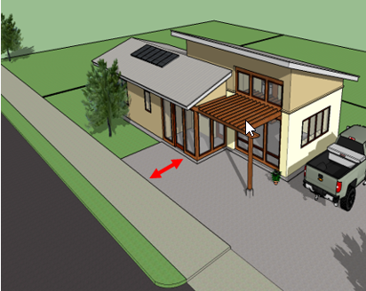
Side and Rear Setbacks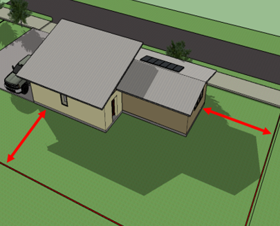
Lot Width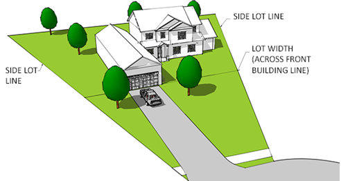
DENSITY & DIMENSIONAL TABLE*
*Requirements, as specified in the table below and as otherwise specified in the ordinance, are the minimum standards for individual lot development and subdivisions. Developments that do not meet the below requirements may apply for conditional zoning.Zoning District
Minimum Lot Size
Maximum Dwelling Units per Acre
Minimum Lot Width
Minimum Front Setback
Minimum Side Setback
Rear Setback (min.)
Maximum Height
Steep Slope
R-0
Rural Residential
0.5 Acre 21,780 SF
2 single
100
25
10
10
35
N/A
R-1
Low Density Residential
0.33 Acre 14,520 SF
3 single
75
25
10
10
35
N/A
R-2
Medium Density Residential
0.25 Acre 10,890 SF
4 single
8 multi
60
20
10
10
35
N/A
R-3
High Density Residential
0.2 Acre 8,712 SF
5 single
10 multi
60
15
10
10
35
N/A
R-4
Seasonal/Short Term Residential
0.07 Acre 3,111 SF
14
60
15
10
10
35
N/A
RC-1 Residential Conservation
See Table 152.15 (e)
4 single 8 multi
See Table 152.15 (e)
See Table 152.15 (e)
See Table 152.15 (e)
See Table 152.15 (e)
35
See Table 152.15 (e)
RC-2 Residential Conservation See Table 152.15 (e) 5 single 10 multi See Table 152.15 (e) See Table 152.15 (e) See Table 152.15 (e) See Table 152.15 (e) 35 See Table 152.15 (e) MHP
Manufactured Home Park
2 Acres 87,120 SF
8 single
100
50
50
50
35
N/A
MU-1
Soco Road Mixed Use
0.17 Acre 7,260 SF
6 single
12 multi
40
10
10
10
45
N/A
MU-2
Moody Farm Road Mixed Use
0.17 Acre 7,260 SF
6 single
12 multi
60
10
10
10
45
N/A
/A MU-3
General Mixed Use
0.14 Acre 6,222 SF
7 single
14 multi
40
10
10
10
45
MU-4
Community Attraction Mixed Use
0.14 Acre 6,222 SF
7 single
14 multi
40
10
10
10
45
N/A
/A TC
Town Center
3 Acres
130,680 SF
*
*
*
*
*
*
N/A
C-1
Central Business
0.14 Acre 6,222 SF
7 single
14 multi
40
10
10
10
45
C-2
Commercial Gateway
0.14 Acre 6,222 SF
7 single
14 multi
40
10
10
10
45
N/A
C-3
Dellwood Road Commercial
0.14 Acre 6,222 SF
7 single
14 multi
40
10
10
10
45
N/A
152.04 TROUT STREAM BUFFER REQUIREMENTS
There shall be a 25-foot buffer zone established adjacent to Jonathan Creek and Campbell Creek (designated trout streams) and any of their tributaries with year-round flow, as delineated on U.S.G.S. topographic maps having a scale of 1:24000. The buffer zone shall be composed of grasses and similar vegetative materials and shall be measured from the top of the creek bank, as determined by the Town Planner or the Haywood County Soil and Erosion Control Office. No permanent improvements shall be located in the buffer zone without approval from the Town Planner and the Haywood County Soil and Erosion Control Office.
152.05 ENCROACHMENTS
The features listed below may encroach into a required setback area:
- Awnings and Canopies: All awnings and canopies, if provided, shall be supported by means of a frame attached directly to the building receiving beneficial use of the awning. In no case shall awnings be supported by a frame attached to a sidewalk or other public right-of-way. Awnings may encroach up to five (5) feet into any required front or street yard but shall not encroach into the street tree planting area or across the street edge of the sidewalk.
- Bay Windows and Balconies: Bay windows, balconies and similar features projecting from the principal building may encroach up to five (5) feet into any required yard.
- Cornices and Gutters: Cornices and gutters may encroach up to two (2) feet into any required yard.
- Vegetative buffers, fences, and walls: Vegetative buffers, fences, and garden/yard walls may encroach into required yards but, if higher than three and one-half (3 1/2) feet, may not be placed within the site visibility triangle of a public street, private street, or driveway contained either on the property or on an adjoining property.
- Handicap Ramps: Ramps for handicap accessibility and fire escapes that are required by the North Carolina State Building Code may encroach into any required yard but may not be closer than five (5) feet to any property line.
- Steps and Stairs: Uncovered and unenclosed steps and stairs may encroach up to five (5) feet into any required front or street yard but may not be closer than five (5) feet to any property line.
152.06 LOT PLACEMENT CONFORMITY
The required minimum front setback may be reduced for any lot where the average established front yard on developed lots located within 300 feet on each side of such lot, and fronting on the same street as such lot, is less than the minimum required. In such cases, the minimum front or street yard may be less than that required but not less than the average of the existing front yards on the developed lots within 300 feet of each side.
Averaging Neighboring Setback
152.07 IRREGULAR LOT SETBACKS
The location of required front, side, and rear setbacks on irregularly shaped lots shall be determined by the Town Planner. The determination will be based on the intent and purpose of this Ordinance to achieve an appropriate spacing and location of buildings and buildings on individual lots. Where questions arise as to appropriateness, the subdivider may be requested to provide additional design information.
152.08 ASSUMED RIGHT-OF-WAY
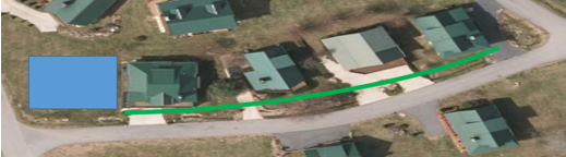
A right-of-way is not always at the edge of a sidewalk and or roadway. Where no right-of-way exists or if the right-of-way is only inclusive of the street pavement then the front setback shall be measured from an assumed right-of-way line that is parallel to the edge of pavement and setback a minimum of 10 feet from the edge of the pavement. This calculation is for setback calculation purposes only and does not represent any expressed or implied taking of property. A stamped survey should be provided before any development occurs in order to determine exactly where the property lines are located.
Right of Way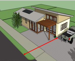
152.09 FRONTAGE
All lots shall front upon a street right-of-way (publicly dedicated or privately maintained) or a driveway constructed to the standards of this ordinance. With provision of alley access, lots may front upon a public open space, but access shall be of sufficient design to allow for the provision of emergency services.
152.10 NUMBER OF BUILDINGS PER LOT
In any zoning district, no more than one principal building may be erected on a single lot. Accessory structures may be added, provided that all structures are fully compliant with all setback requirements. All other requirements of this ordinance not related to building placement shall be adhered to for all structures.
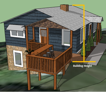
152.11 BUILDING HEIGHT
No building shall hereafter be erected or altered so as to exceed the height established in Section 152.03 Density & Dimensional Requirements.
- Determining Building Height on a Slope. If a structure is to be built on a slope, the building shall be measured from the highest ground level of the visible foundation to the highest point of the structure, excluding chimneys and antennas.
- Building Stories. A story is a habitable level within a building of no more than 14 feet in height from finished floor to finished ceiling. Unoccupied attics, less than 7 feet in height, and raised basements, less than 6 feet in height (as measured from the average grade of the fronting sidewalk), are not considered stories for the purposes of determining building height. A mezzanine (a low story between two others in a building, typically between the ground and first floors) shall be considered a story if it is contiguous with at least 60 percent of the building's front façade, is designed to be inhabited, and maintains an average depth of at least 16 feet.
- Items Not Included in Height Calculations. The height limitations of this ordinance shall not apply to church spires, belfries, cupolas, and domes not intended for human occupancy, monuments, water towers, mechanical penthouses (provided they are set back 20 feet from the front elevation), observation towers, transmission towers, chimneys, smokestacks, conveyors, flagpoles, masts, and antennas (provided evidence from appropriate authorities is submitted to the effect that such building or buildings will not interfere with any airport zones or flight patterns).
152.12 ACCESSORY USES AND STRUCTURES
The purpose of this section is to establish standards for accessory uses and structures in the Town of Maggie Valley’s land use jurisdiction. Except as provided elsewhere in this ordinance, it shall be unlawful for any person to erect, construct, enlarge, move, or replace any accessory use or structure without first obtaining a Zoning Permit from the Town Planner.
- General Provisions
- Accessory uses and structures may only be used for purposes permitted in the district in which they are located.
- Accessory structures shall not be used for dwelling purposes except when approved as an Accessory Dwelling Unit.
- Accessory structures with a footprint greater than six hundred (600) square feet shall be buffered from any adjacent residential developments.
- The maximum size of the accessory dwelling unit shall be determined based on the following:
- A detached accessory dwelling unit may not exceed the lesser of: 70% percent of the gross floor area of the primary dwelling unit, or 800 square feet.
- An attached accessory dwelling unit (located within the same structure as the primary dwelling unit with shared foundation, exterior walls and roof) may not exceed the lesser of: 70% percent of the gross floor area of the primary dwelling unit, or 1,000 square feet.
- Location, Setback and Height
Standards Single family dwellings or duplexes located on 2 or less acres Single family dwellings and duplexes located on lots larger than 2 acres All other uses Location Side and rear yard only Front, side, and rear yard Side and Rear Only Setbacks May not be closer than 10 feet of any property line or right-of-way whichever is greater May not be closer than 10 feet of any property line or 30 feet of a public right-of-way Subject to individual district requirements Height May not be higher than 24 feet in residential districts or 30 feet in commercial districts
152.13 TEMPORARY STRUCTURES
- General Standards
- All permitted temporary uses listed in this section require a temporary use permit that shall be reviewed and issued by the Town Planner.
- Temporary use permits shall be issued for no more than one hundred and eighty (180) days within a calendar year on any individual lot.
- The property on which a temporary use is proposed must contain sufficient space to support the temporary use, with all district setback requirements being met.
- Parking must be adequate to support the proposed temporary use.
- Restroom facilities must be provided, if the building is to be accessed by employees or the general public, unless otherwise stated.
- Plans for security and safety must be provided.
- All inspections and permits required by the building code or fire marshal must be received.
152.14 TEMPORARY USES
- Civic/cultural events and yard sales. Allowed in all districts with civic/cultural events being limited to thirty (30) days of operation and yard sales being limited to three (3) days of operation. Yard sales must be operated on the premises of the long-term renter or owner with that individual present at all times.
- Special events. Special events, notwithstanding the provisions of this chapter, the Town of Maggie Valley by special permit may exempt special events from the provisions of this chapter, provided that:
- The sponsoring agency must be a state or nationally recognized civic, charitable, fraternal, governmental organization, or demonstrates to the Board of Aldermen the direct benefits to the community. Commercial, for-profit, or similar activities may not receive exemptions;
- The sponsoring agency shall submit a written application to the Board of Aldermen at least 120 days prior to the event in a form as prescribed by the town; and
- The Board of Aldermen shall upon granting an exception transmit the approval to the sponsoring organization stating any conditions, terms, requests, or dates.
- Nonresidential districts. Temporary uses allowed in all districts except for the residential districts include: automotive, motorcycle, and craft fairs, religious services and similar types of events, and the sale of agricultural products, including Christmas trees. Such events shall be allowed for no more than thirty (30) days.
- Offices.
- Contractor's Office and Equipment/Storage Sheds.
- Contractor's office and/or equipment/storage sheds may be placed in any District temporarily on the site of construction of a development for which a land development permit has been issued.
- Time Limit: Placement of such a temporary use is limited to a period of time determined by an estimated project completion date, with the option of an extension of up to one (1) year if approved by the Administrator. All temporary construction buildings and trailers shall be completely removed from the site within thirty (30) days of issuance of a certificate of occupancy or completion of the project, whichever comes first.
- Real Estate Office in a Construction Trailer or Temporary Modular Unit.
- One (1) temporary structure, such as a construction trailer or temporary modular unit, may be used as a real estate sales office in any new construction project in any District. Such a temporary structure shall be used for the sale of units within that project only.
- Time Limit: Temporary real estate offices in construction trailers or temporary modular units may remain on the site for no more than one (1) year or until one-half (½) of the units for the project are completed, whichever occurs first.
- Real Estate Office in a Model Home. A model dwelling may be used as a real estate sales office in a new residential development in any District. Such model home/sales office may be used for the sale of units within that project only.
- Contractor's Office and Equipment/Storage Sheds.
- Mobile Food Vending. The purpose of these standards is to promote the general health, safety, and welfare of the citizens of the Town by establishing reasonable standards to allow the retail sale of food and food products via mobile vendors, including food trucks, provided herein, and shall not apply to itinerant merchants.
- Permission. Nothing herein shall be construed to grant any right or license to mobile food vending operators to operate on private or public property without permission. Mobile food vending operators shall be required to have the express written permission of the property owner in order to operate on private property.
- Location Standards. Mobile food vendors shall only be located in nonresidential zoning districts within the jurisdiction of the Town including the ETJ, or as a special event approved by the Town Board of Aldermen herein as follows:
- Principal Use. Mobile food vendors shall only be located on developed property that is occupied by a nonresidential use in operation in a permanent structure. No mobile food vendor may sell food to the general public within the Town unless a business, nonprofit, or similar organization, with a physical location, has given signed written approval as part of an application submitted to the Town.
- Maximum Number. Maximum of one (1) mobile food vendor per individual private lot, except where a special event has been approved by the Town.
- Safety. Mobile food vendors shall not be located in a manner that impedes, endangers, or interferes with pedestrian or vehicular traffic and shall not impede safe ingress and egress at all entrances and are prohibited on public sidewalks.
- Separation. Mobile food vendors shall be located a minimum of 15 feet from the main building entrance, the edge of any driveway, intersection, handicap ramp, sidewalk, fire hydrant, or access for emergency services.
- Parking. Mobile food vendors shall not occupy parking spaces required to fulfill the minimum requirements of the principal use unless the hours of operation of the principal use do not coincide with those of the mobile food vendor. No mobile food vendor may be located in a standalone parking lot unless approved as a special event. No mobile food vendor shall occupy or interfere with any handicapped parking. Mobile food vendors shall only be located at the host site one (1) night immediately prior to operating for set up, operating hours, and one (1) night immediately following operating for break down. Mobile food vending units are only allowed to remain at the host site overnight with the express written permission of the property owner.
- Operation Standards.
- Outdoor Seating. Outdoor seating may not be provided by the mobile food vendor but may be utilized if existing at the host location.
- Equipment. All equipment required for the operation of the mobile food vendor shall be located on or within the mobile food vending unit. Accessory items such as a waste receptacle or table for condiments is permitted outside of the unit during operating hours.
- Signs. Signage on the mobile food vending unit shall be permitted. One (1) freestanding sandwich board sign shall be permitted in association with the mobile food vendor. No other freestanding or off-premise signs are permitted.
- Hours of Operation. Open hours are permitted between 7:00 AM and 11:00 PM.
- Designated Person Present. The mobile food vending operator or a designated person knowledgeable of the operation and regulations pertaining to a mobile food unit shall be present at all times except in the case of an emergency.
- Health & Sanitation Standards.
- Permits & Licenses. All equipment required for the operation, all food preparation, storage, and sales/distribution shall be in compliance with all applicable County, State, and Federal sanitary regulations. Each operator/vendor shall be responsible for obtaining food preparation and handling permit(s) by a County Health Department or other such regulating agency. The operator/vendor shall have obtained all other proper licenses from the County, State, and local agencies and shall be clearly and visibly displayed with the mobile food vendor. A copy of the signed application and Town of Maggie Valley Mobile Food Vending Permit shall be on site for review by Town personnel. If any necessary licenses are revoked or suspended from the County, State, or local agencies, the issued Town permit will be revoked or suspended accordingly.
- Operator(s) shall be Responsible: Operator(s) of a mobile food vending unit shall be responsible for the following standards:
- Waste & Trash Disposal. Waste receptacles are to be provided by the mobile food vendor or by the host site. Operators shall be held responsible for removing all waste and trash from their location at the end of each day or more often as needed to maintain public health and safety.
- Liquid Waste or Grease. No liquid waste or grease shall be disposed in storm drains, onto sidewalks, streets, or any other public space, or into the Town’s sanitary sewer system. If at any time evidence of improper disposal of liquid waste or grease is discovered, the Town permit for the mobile food vending unit shall be forfeited and required to cease operation immediately.
- Special Events. Mobile food vendors may request approval by Town Board of Aldermen to operate outside of the standard requirements outlined above by following applicable procedures:
- Operating Hours. The sponsored event shall take place during normal business hours or extended hours as long as the host site that has invited a mobile food vendor to participate is open to the public. The operation of the mobile food vending unit shall cease upon the business or nonprofit closing its operation for the sponsored event.
- Support Documentation. The special event application shall specify how a mobile food vendor supports a planned promotional, holiday, fundraising, or similar event in support of the applicant's business or organization.
- Duration of the Event. For the purpose of this Section, special events shall be classified as a one (1) day event, except as otherwise approved by the Town Board of Aldermen.
- Exceptions. Mobile food vendors may operate outside of the standard requirements when in compliance with the following applicable procedures:
- Mobile food vendors are permitted at Town Sanctioned Events, including those hosted on the Festival Grounds
- Mobile food vendors are permitted on commonly owned property within a residential development in order to serve residents and guests at a neighborhood activity or function.
- Private catering services in which the principal use is the preparation of food and meals off premises and where such food and meals are delivered to another location for consumption as a private event and is not sold directly to the general public is not subject to the standards of mobile food vending. Similarly, a mobile food vendor may operate as a catering service without a special event permit, provided the mobile food vendor is serving the participants of such private event only and not selling food to the general public.
- Violations. Notice of the violation will be given by means of a certified letter by the Town of Maggie Valley official to the host site and, where appropriate, the operator. If the violation is not remedied within ten (10) days, the permit will be revoked. The Town may take civil action against an operator or host site based on the type and seriousness of the violation of the above standards per Section 154.999 of the Zoning Ordinance.
152.15 STEEP SLOPE REQUIREMENTS
A. Purpose. These provisions set forth standards for environmental protection and conservation in the Town of Maggie Valley’s land use jurisdiction concerning steep slopes. The Town of Maggie Valley possesses an abundance of unique natural assets. The standards set forth in this section address the enhancement and preservation of these important features. The purpose of this section is to regulate development in Steep Slope areas in order to preserve the Town of Maggie Valley’s unique character, conserve the public health, safety and general welfare and to promote environmentally sound design and planning in accordance with the following objectives: a. To protect life and property from all potentially hazardous conditions particular to steep slopes, e.g., rock falls, flash flooding, debris flows, mud slides and increased wildfire hazard. b. To preserve and enhance the scenic and environmental resources of the landscape by encouraging the maximum retention of prominent natural topographic features, i.e., drainage swales, streams, slopes, ridgelines, rock outcroppings, vistas, natural plant formations, and trees. c. To encourage innovative site and architectural design and planning in order for the development to adapt to the natural terrain and be harmonious with the character of the area. d. To minimize grading and cut and fill operations inconsistent with the retention of the natural character of the hillside. e. To preserve where possible riparian vegetation. f. To require the retention of trees and other vegetation to stabilize steep hillsides, retain moisture, prevent erosion and enhance the natural scenic beauty. g. To provide land use densities to promote the best possible development of hillside areas in order to retain significant natural features and to preserve slope stability. h. To preserve predominant views from and of the hillside areas in order to retain the sense of identity and imagery that the hills and mountains now impart to the Town of Maggie Valley. B. Land Suitability.
Land subject to erosion, landslides or that is for topographical or other reasons unsuitable for development as determined by the Town of Maggie Valley or their appointee, shall not be developed for residential use nor for any other uses that will continue or increase the danger to health, safety, or property unless the hazards are corrected or mitigated. C. Applicability. a. For the purposes of this section, a Steep Slope Area is defined as any lot, parcel, tract or portion thereof, that has a natural elevation of 2,900 feet above mean sea level or higher, with a natural slope of 25% or greater. b. Application to properties with a slope of 25% or greater split by the 2,900-foot contour line. The area above 2,900 feet may be developed as provided for in Table 152.15 (e), and the remainder of the property below 2,900 feet or with a slope below 25% may be developed as permitted in the R-2 or R-3. c. The area on any lot, parcel, or tract that constitutes a Steep Slope Area shall be the only portion subject to steep slope requirements. The remaining area that is not considered Steep Slope shall apply base requirements of either R-2 or R-3 depending on which conservation district (RC-1 or RC-2) the property is located within. D. Determining Steep Slope Areas. For the purposes of this section, slope means the average natural slope of an entire parcel. The average natural slope for the parcel shall be calculated using the following formula.
S = .0023(I)(L) A | Where:
S = Existing grade of parcel in percent
I = Contour interval of map in feet, with said contour intervals to be five feet or less
L = Total length of the contour lines within the parcel in feet
A = Area of the parcel in acres
0.0023 = Product of two constants, one of which converts feet into acres and one of which converts a decimal into a percentage |
E. General Steep Slope Development Standards. a. No land disturbing activity shall take place until full development approval has been received. b. Land disturbing activity shall be limited to designated building envelopes and approved road and driveway corridors as shown on approved site plans. c. The riparian stream buffers shall be left intact, which means that removal of trees, or other vegetation, or disturbance of soils within this buffer is prohibited, except for necessary road crossings. The buffers shall be 30 feet from the top of bank. d. Developers shall make reasonable efforts to preserve and protect existing natural features of the slope, such as trees and other plan material, and rock outcroppings which may help to stabilize the slope. e. In addition to the requirements of the chapter, no person may construct a Tall Building or Structure on any Protected Mountain Ridge as defined by N.C.G.S. 113A-206.
F. Specific Steep Slope Development Standards. In addition to any development restriction imposed by the underlying zoning districts, R-2, and R-3, the following standards shall apply to any properties that are zoned RC-1 and RC-2, unless cluster development is applied. TABLE 152.15 (e)
| Average Slope | 25 - 29% | 30 - 34% | 35 - 39% | 40 - 44% | 45 - 49% | 50% + |
| Maximum Density/Minimum Lot Size (acres/du) | 25% Reduction underlying zoning | 50% Reduction underlying zoning | 4 acres/du | 5 acres/du | 7.5 acres/du | 10 acres/du |
| Minimum Front Setback | RC-1 25 ft. RC-2 20 ft. | RC-1 25 ft. RC-2 20 ft. | RC-1 25 ft.
RC-2 20 ft. | RC-1 30 ft.
RC-2 25 ft. | RC-1 30 ft.
RC-2 25 ft. | RC-1 30 ft.
RC-2 25 ft. |
| Minimum Side Setback | 15 ft. | 15 ft. | 15 ft. | 20 ft. | 20 ft. | 20 ft. |
| Minimum Rear Setback | 15 ft. | 15 ft. | 15 ft. | 20 ft. | 20 ft. | 20 ft. |
| Minimum Riparian Buffer | 30 ft. | 30 ft. | 30 ft. | 30 ft. | 30 ft. | 30 ft. |
| Maximum Building Height | 35 ft. | 35 ft. | 35 ft. | 35 ft. | 35 ft. | 35 ft. |
G. Plan Requirements. Any development on Steep Slopes shall be subject to the plan submittal requirements of the underlying zoning district and any plan requirements laid out in Chapter 156 of the Town of Maggie Valley Unified Development Ordinance. At a minimum all site plans shall include the elevation of the tract in intervals of no more then 20 feet and the average grade of any portion of the parcel over 2,900' above sea level. H. Cluster Developments. Cluster development may be used in RC-1 and RC-2, where a portion of a parcel is located on a Steep Slope to cluster the development on the portion of the parcel that is not in the Steep Slope area. The objective of the cluster option is to locate smaller lots than what would normally be permitted by R-2 or R-3 in which the development is located, and to preserve land which is in a Steep Slope area and would otherwise have been included in private lots. a. When cluster development is implemented, all lot size and other dimensional requirements are waived to comply with a more compact, smaller lot. b. The remaining lot area must be designated as open space. c. Cluster development is only permitted if the Fire Marshal approves the fire protection options. d. All other development standards apply. Example: If ten (10) lots are permissible in the area of a parcel not considered Steep Slope and five (5) lots are permissible in the Steep Slope area, density can be clustered to permit 15 lots in the non-Steep Slope area and designate the Steep Slope area as open space, if all other development standards other than dimensional requirements are met and the Fire Marshal approves.