
Malden City Zoning Code
12.08 ESTABLISHMENT
OF DISTRICTS
12.08.010 ESTABLISHMENT OF DISTRICTS
For the purpose of this ordinance, the City of Malden is hereby divided into the following zoning districts:
- Residence A Districts
- Residence B Districts
- Residence C Districts
- Residential Office (RO) Districts
- Neighborhood Business (BN) Districts
- Central Business (BC) Districts
- Highway Business (BH) Districts
- Industrial (I) Districts
- Reclamation and Redevelopment Districts
- Rowe's Quarry Reclamation and Redevelopment District
- Rowe's Quarry Reclamation and Redevelopment District
- Marijuana Establishment Overlay District
- MBTA Communities Multi-Family Overlay District (MCMOD)
- Mandatory Mixed-Use Overlay District (MMUD)
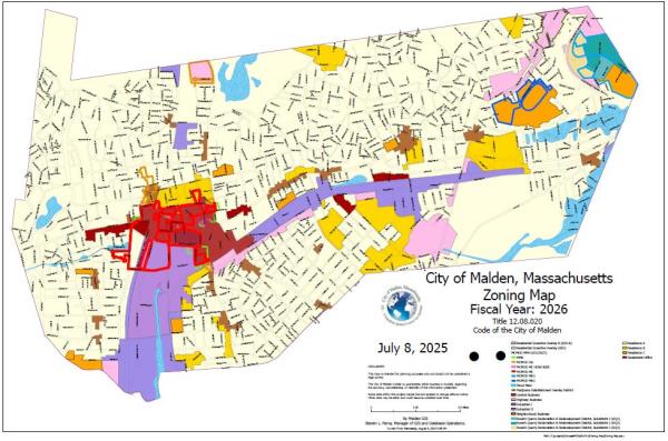
12.08.020 ZONING MAP
These zoning districts are detailed on a map entitled Zoning Map, City of Malden, August 8, 1977, as amended with all boundary lines designated thereon, which map is hereby declared to be part of this ordinance and shall be on file in the office of the City Engineer who shall be responsible for its maintenance and any authorized amendments thereto.
MBTA COMMUNITIES ZONING Overlay Districts 12/12/23 MCMOD - MMUD were ordained by the Malden City Council on December 19, 2023 and amended on June 3, 2025. For an expanded view of the MBTA COMMUNITIES ZONING Overlay Districts 12/12/23 Revised June 3, 2025 MCMOD - MMUD Boundary Map, please click here.

Amended by Ord. 418-23 on 12/21/2023
Adopted by Map MBTA Zoning Map on 12/21/2023
Amended by Ord. 171-25 on 6/17/2025
Amended by Map MBTA Zoning Map on 8/6/2025
Amended by Map Zoning Map on 8/6/2025
12.08.030 BOUNDARIES
The following guidelines shall apply where any uncertainty exists with respect to the boundary of any district as delineated on the zoning map:
- Boundary lines indicated as a highway, street, alley, railroad, watercourse, or other body of water, shall be construed to be the centerline or middle thereof.
- Boundary lines which approximate a city boundary are to be considered to be the limits of the city boundary.
- Boundary lines which are located outside of street lines with distances placed upon the map shall be the distance in feet from the street lines to said boundary lines.
- Boundary lines located outside of street lines without distances are intended to coincide with lot lines; where a dimensional boundary coincides five (5) feet or less with a lot line the boundary shall be construed to be that lot line.
- Wherever any uncertainty exists beyond the preceding provisions of this section as to the exact location of a boundary line, the location of such line shall be determined by the Inspector of Buildings.
12.08.040 FLOODPLAINS
- Flood Plain District: The Floodplain District is herein established as an overlay district. The District includes all special flood hazard areas within the City of Malden designated as Zone A or AE, on the Middlesex County Flood Insurance Rate Map (FIRM) issued by the Federal Emergency Management Agency (FEMA) for the administration of the National Flood Insurance Program. The map panels of the Middlesex County FIRM that are wholly or partially within the City of Malden are panel numbers 25017C0429E, 25017C0433E, 25017C0434E, 25017C0437E, 25017C0441E and 25017C0442E dated July 8, 2025. The exact boundaries of the District may be defined by the 100-year base flood elevations shown on the FIRM and further defined by the Middlesex County Flood Insurance Study (FIS) report dated July 8, 2025. The FIRM and FIS report are incorporated herein by reference and are on file with the City Clerk, Planning Board, Building Inspector, Conservation Commission and Assessor.
- The City of Malden hereby designates the Building Inspector to be the official floodplain administrator for the City.
The City of Malden requires a permit for all proposed construction or other development in the floodplain overlay district, including new construction or changes to existing building, placement of manufactured homes, placement of agricultural facilities, fences, sheds, storage facilities or drilling, mining, paving and any other development that might increase flooding or adversely impact flood risks to other properties. - Base Flood Elevation and Floodway Data: In Zones A, A1-30, and AE, along watercourses that have not had a regulatory floodway designated, the best available federal, state, local or other floodway data shall be used to prohibit encroachments in floodways which would result in any increase in flood levels within the community during the occurrence of the base flood discharge.
- In Unnumbered A Zones, in the absence of FEMA BFE data and floodway data, the building department will obtain, review and reasonably utilize base flood elevation and floodway data available from a Federal, State, or other source as criteria for requiring new construction, substantial improvements, or other development in Zone A and as the basis for elevating residential structures to or above base flood level, for floodproofing or elevating nonresidential structures to or above base flood level, and for prohibiting encroachments in floodways.
- Subdivision Proposals
- Base Flood Elevation Data in A Zones: base flood elevation data is required for subdivision proposals or other developments of 3 or more lots or more than 15,000 square feet, whichever is the less and the proponent must provide technical data to determine base flood elevations for each developable parcel shown on the design plans.
- All subdivision proposals and development proposals in the floodplain overlay district shall be reviewed to assure that:
- Such proposals minimize flood damage,
- Public utilities and facilities are located & constructed so as to minimize flood damage and
- Adequate drainage is provided.
- Base Flood Elevation Data in A Zones: base flood elevation data is required for subdivision proposals or other developments of 3 or more lots or more than 15,000 square feet, whichever is the less and the proponent must provide technical data to determine base flood elevations for each developable parcel shown on the design plans.
- Requirement to Submit New Technical Data
If the City acquires data that changes the base flood elevation in the FEMA mapped Special Flood Hazard Areas, the Town/City will, within 6 months, notify FEMA of these changes by submitting the technical or scientific data that supports the change(s.) Notification shall be submitted to:
- NFIP State Coordinator c/o Massachusetts Department of Conservation and Recreation
- NFIP Program Specialist Federal Emergency Management Agency, Region I. - In A, A1-30, AH, AO, AE Zones, V1-30, VE, and V Zones, all recreational vehicles shall be:
- placed on a site must be elevated and anchored in accordance with the zone’s regulations for foundation and elevation requirements or
- be on the site for less than 180 consecutive days or be fully licensed and highway ready.
- Variances to Building Code Floodplain Standards
The City will request from the State Building Code Appeals Board a written and/or audible copy of the portion of the hearing related to the variance and will maintain this record in the community’s files.
The City shall also issue a letter to the property owner regarding potential impacts to the annual premiums for the flood insurance policy covering that property, in writing over the signature of a community official that (i) the issuance of a variance to construct a structure below the base flood level will result in increased premium rates for flood insurance up to amounts as high as $25 for $100 of insurance coverage and (ii) such construction below the base flood level increases risks to life and property.
Such notification shall be maintained with the record of all variance actions for the referenced development in the floodplain overlay district. - Variances to Local Zoning Bylaws Related to Community Compliance with the National Flood Insurance Program (NFIP)
A variance from these floodplain bylaws must meet the requirements set out by State law, and may only be granted if: 1) Good and sufficient cause and exceptional non-financial hardship exist; 2) the variance will not result in additional threats to public safety, extraordinary public expense, or fraud or victimization of the public; and 3) the variance is the minimum action necessary to afford relief. - Abrogation and Greater Restriction
The floodplain management regulations found in this Floodplain Overlay District section shall take precedence over any less restrictive conflicting local laws, ordinances or codes. - Disclaimer of Liability
The degree of flood protection required by this bylaw [ordinance] is considered reasonable but does not imply total flood protection. - Severability
If any section, provision or portion of this bylaw [ordinance] is deemed to be unconstitutional or invalid by a court, the remainder of the ordinance shall be effective.