Martinsville City Zoning Code
SECTION IV
SITE PLAN REGULATIONS
A.- Purpose and intent.
1.
Title and application. Where applicable, the city shall require submission and approval of a site plan and a public improvements plan prior to the issuance of zoning permits and building permits or the approval of a final subdivision plat to ensure the compliance with regulations contained in the zoning ordinance (hereinafter "ordinance") and, specifically, this section, which shall be hereinafter referred to as the "site plan regulations" pursuant to Code of Virginia § 15.2-2286.
2.
Relationship to other plans. The site plan requirements shall be employed to facilitate and coordinate the implementation of the city's comprehensive plan, zoning ordinance, subdivision ordinance and other applicable planning documents. For most qualifying projects and development related activities, both a concept plan and a final site plan shall be required to facilitate the application and review process. Such plans provide for a balanced development policy that accommodates and directs future growth in a manner sensitive to existing amenities, sensitive environmental areas, historic areas and significant cultural features. There is mutual responsibility between the city and the developer to develop land within Martinsville in an orderly manner in accord with the adopted comprehensive plan and this ordinance.
3.
General purpose and process.
a.
The purpose of this section is to facilitate the utilization of the most advantageous site improvement techniques in the development of land within the city. The site plan requirements promote contemporary standards in the siting, design, landscaping, and implementation of site development to ensure that land is used in a manner which is efficient and harmonious with neighboring properties.
b.
This section also provides for a site plan review process by city staff and establishes requirements for residential lot development plans within certain districts.
c.
Site plans and public improvements plans, landscape plans, plats, design calculations, construction specifications, and architectural drawings, to be prepared and approved in accordance with the provisions of this section and the subdivision ordinance (if applicable), shall be required by the city in the review of site development applications.
d.
Nothing herein shall require the approval of any development or land use, or any feature thereof, which shall be found by the planning commission to constitute a danger to the public health, safety or general welfare, or which shall be determined by the planning commission to be a departure from, or violation of, sound engineering design or standards.
e.
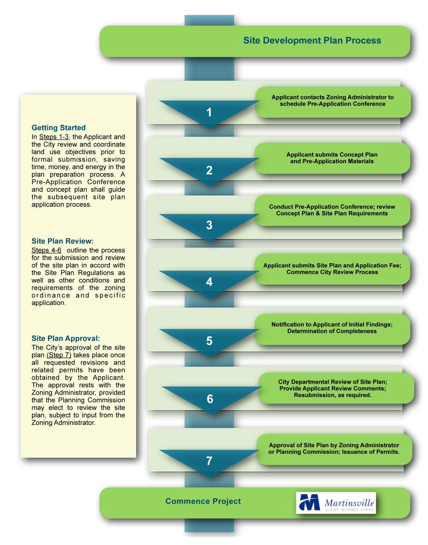
Applicants shall meet with the zoning administrator to discuss the scope of the proposed development and its relationship to city requirements. A pre-application conference and concept plan shall be required prior to the submission of a site plan.
f.
No work or site preparation may begin before the applicant for a project has received an approved site plan, erosion and sediment control plan, stormwater management plan, and subdivision plat (if required).
4.
Non-conforming uses, structures and sites (general). A change or addition to any non-conforming use, structure, or site subject to a major or minor site plan shall require that the entire use, structure, or site (including both the non-conforming and conforming improvements) be brought into full conformance with all of the requirements of this ordinance, provided that the planning commission, upon recommendation by the zoning administrator, may waive a portion or all of the individual requirements for conformance.
5.
Costs of development. The developer shall be responsible for all costs incurred in planning, engineering, bonding, constructing, installing and testing of all public facilities and infrastructure as well as other necessary improvements required to complete the proposed project.
6.
Fees. The developer shall pay all applicable plan review fees at the time of submission of a site plan or plat, including pro-rata share fees for off-site improvements and cash proffers. Fees for site inspections and other aspects of the development process shall be due and payable in accord with the schedule of fees. A site development fee schedule shall be made available by the zoning administrator.
B. - Section administration.
1.
General. The city council designates the zoning administrator to review and act to approve or disapprove site plans within its jurisdiction. In the performance of its duties, the zoning administrator shall request and consider the review and comments of the zoning administrator or designee, city staff, and other public agencies as may be deemed appropriate.
2.
Authority to review and approve site plans. The zoning administrator shall administer, review and provide a recommendation concerning any site plan or public improvements plan submission. Subject to the scope and nature of the planned project, final approval of any given site plan may be granted by the zoning administrator subject to input and recommendations from reviewing staff and agencies.
a.
The zoning administrator shall be responsible for the receipt and processing of all site plan applications subject to the procedures as hereinafter provided.
b.
The zoning administrator may establish, from time to time, such proper and reasonable administrative procedures, in addition to those provided herein, as shall be necessary for the proper administration of this section.
c.
It shall be the responsibility of the applicant, owner or developer to notify the zoning administrator when each stage of the development shall be ready for field inspection for compliance with the approved site development plan in accordance with testing and inspection schedules and regulations promulgated by this section, ordinance and the city's adopted design and construction standards.
d.
City staff and other designated public officials responsible for the supervision, inspection, testing and enforcement of this section shall have the right to enter upon any property subject to the provisions of this section and ordinance at all reasonable times during the periods of plan review and construction for the purpose of ensuring compliance with this section.
C. - Uses requiring a site plan or public improvements plan.
A final site plan for land development activities is required for projects involving the following:
1.
Uses in any commercial, business, mixed-use or TND zoning district.
2.
Uses in any economic development (industrial) zoning district.
3.
Non-residential uses within any residential zoning district.
4.
Attached or multifamily residential uses within any zoning district.
5.
Uses requiring a special use permit in any district.
6.
Enlargement of a building which results in changes in onsite parking requirements, provided that such enlargement exceeds twenty-five (25) percent of the gross floor area of the original building or two thousand five hundred (2,500) square feet, whichever is less.
7.
Uses and facilities which impact wetlands or designated streams and waterways.
8.
Installation, extension or change of a public water or sewer main or other public infrastructure requiring a public right-of-way or dedicated easement to the city.
9.
Parking lots intended for either commercial or public use in a residential, commercial or economic development zoning district.
10.
Installation or change of a public water or sewer pump facility.
11.
Installation or change of a public water storage facility.
12.
Installation or change of a public water or sewer treatment facility or installation or change of a private sewer treatment or pretreatment facility.
13.
Construction of a new street or extension of an existing street and related infrastructure.
14.
Development of a road or street lying within a previously platted public right-of-way or easement.
15.
Construction of a private commercial or industrial road entrance or intersection with an existing or proposed public street.
16.
Construction of a retaining wall that abuts or is adjacent to a public right-of-way, private street, or alley.
17.
Any disturbed areas greater than five thousand (5,000) square feet in total land area, except single family detached dwellings and other uses that are exempted by erosion and sediment control regulations.
18.
Enlargement of a parking lot in a residential, commercial or economic development zoning district, increasing parking spaces by more than ten (10) spaces.
19.
Any development in a residential, commercial or economic development zoning district in which any required off-street parking space requiring more than ten (10) parking spaces which is to be used by more than one establishment.
D. - Waiver of requirement for site plan.
A waiver for submission of a site plan may be granted by the zoning administrator under following considerations:
1.
Where it can be clearly established by the applicant that the use will not require the improvements subject to review in this section.
2.
Where it can be clearly demonstrated by the applicant that a waiver from the requirement to submit a site plan (or a portion thereof) will be in keeping with the intent of this section, provided that the requirement for a public improvements plan required by the subdivision ordinance may not be waived.
3.
Where it can be clearly shown that the application for a site plan and building permit involves building and safety regulations which are not critical to the purpose and intent of this ordinance.
4.
Where it can be clearly established by the applicant that such waiver will not have an adverse effect on:
a.
The public health, safety, welfare, and convenience;
b.
The planning for and provision of adequate public facilities, utilities, drainage, environmental controls, and transportation facilities;
c.
Preservation of agricultural, forestry and conservation lands; and
d.
Other relevant considerations related to the comprehensive plan.
5.
Where it can be shown that any change in, or expansion of, a use meets all of the following criteria:
a.
Such change or expansion does not occasion additional parking as required by this ordinance.
b.
No additional ingress/egress to a public street or change in ingress/egress is recommended by the zoning administrator based on intensification or use.
c.
No additional ingress/egress or alteration of existing ingress/egress is proposed.
d.
Disturbed area is less than five thousand (5,000) square feet in area.
e.
It has been verified in writing by the zoning administrator that availability and connection to water and sewer are attainable.
f.
All requirements of the subdivision ordinance have been met.
6.
An applicant seeking a waiver from a requirement to submit a concept plan or a site plan (or any portion thereof) shall provide written documentation to the zoning administrator addressing all of the applicable above conditions for waiver. Subject to the scope and impact of the requested waiver, the zoning administrator, at its sole discretion, may either: (a) act upon the waiver request, or (b) refer the waiver request and applicant's supporting documentation to the planning commission for action at its next regularly scheduled meeting.
7.
The applicant shall be notified in writing by the zoning administrator within ten (10) business days upon action by either the zoning administrator or the planning commission.
8.
Notwithstanding any grant of waiver by the zoning administrator or the planning commission, the applicant is required to show evidence of having obtained a building permit, erosion and sediment control permit, subdivision ordinance approval, other applicable state or federal permits, and, upon completion of improvements, a certificate of occupancy.
E. - Pre-application conference and concept plan.
1.
Requirement for pre-application conference and concept plan.
a.
A pre-application conference and concept plan shall be submitted by the applicant prior to undertaking the formal submission and review process for a site plan. The goal of the pre-application conference is to identify, understand and anticipate key planning issues and site-related design issues which may be deemed relevant by the city.
b.
The pre-application conference provides the opportunity for the applicant and the city to assess the specific requirements for a subsequent site plan submission and to determine which, if any, of the requirements of this section may be waived or amended by the zoning administrator.
c.
A pre-application conference does not negate the requirement for the submission of:
1.
A concept plan;
2.
A final plat (or public improvements plan as may be required by the subdivision ordinance);
3.
A site plan;
4.
Erosion and sediment control plan;
5.
Applicable state (including DCR/DEQ permit plans) and federal permits;
6.
Any other applicable provisions of this ordinance and other city ordinances; and
7.
Site plan review fee and other related inspection or application fees.
2.
Pre-application conference objectives. The applicant shall contact the zoning administrator to schedule a pre-application conference. The purpose of this conference is to review and provide guidance on the applicant's concept plan and other aspects of the applicant's land use proposal with respect to the following considerations:
a.
Project location, type and mix of uses, lot configuration and setback, conceptual design, density, physical characteristics and phasing of proposed development.
b.
Compatibility of the proposed development with the city's comprehensive plan, the zoning ordinance, the subdivision ordinance, the stormwater management ordinance, all adopted master facilities plans, the capital improvements program, and plans for development of neighboring properties.
c.
Coordination of transportation improvements with other existing and planned streets within the general area of the proposed development and otherwise in keeping with the provisions of the transportation element of the comprehensive plan and other adopted transportation plans.
d.
Reasonable regulations and provisions uniquely applicable to the proposed development as related to topography, soils, geology, public utility and facilities service, drainage and flood control, transportation, environmental and historic impact, economic development, and facilitation of the creation of a convenient, attractive and harmonious development.
e.
Coordination of proposed development with applicable ordinances, design guidelines and development criteria.
f.
Assurance of adequate public utility location and capacity (water, sewer, etc.).
g.
Other matters related to review of a concept plan.
3.
Information required on a concept plan. The concept plan is intended to graphically depict and communicate the primary elements of an applicant's proposed project. The concept plan is not intended to be a detailed engineering document and may be generalized in nature. It provides the opportunity for the applicant and the city review and provide preliminary feedback on the key physical elements of a project that are of mutual interest and relevance to the health, safety, and welfare.
The applicant, at its discretion, may meet with the zoning administrator in advance of preparation of the concept plan to determine if any of the requirements herein below may be waived or modified. A pre-application checklist shall be employed for this purpose. Five (5) copies of the concept plan and any supporting documentation shall be submitted to the zoning administrator ten (10) business days prior to the scheduled date of the pre-application conference. The concept plan and supporting documentation shall also be submitted in a digital format (PDF preferred).
The concept plan shall show the following:
a.
Name, address and telephone number of owner or developer.
b.
Map scale (to be one inch equal to not more than thirty (30) feet, with a maximum sheet size of twenty-four (24) inches by thirty-six (36) inches, and date of plan preparation.
c.
Name, address and telephone number of preparer of concept plan.
d.
Vicinity map.
e.
Current boundary survey of the lot and a north arrow; preparer of survey.
f.
The area of the lot and gross acreage or square footage of area to be developed.
g.
Public frontage improvements; the location of the proposed and existing right-of-way, proposed edge of pavement or curb line, and other public improvements along the frontage of the property.
h.
Size, location and use of existing and proposed buildings.
i.
Location of the proposed transportation and site improvements (including points of site access, utilities, drainage conveyance, building and site signage, buildings, streets, site lighting, driveways and parking areas, retaining walls), and distances from all property lines.
j.
The dimension, height, and use of the proposed building improvements.
k.
Limits of clearing and grading.
l.
Existing zoning district (including conditional zoning and proffer agreements) and, if a rezoning is required, the proposed zoning district (including overlay districts, where applicable).
m.
Existing topography and a preliminary grading plan depicting finished contours, with contour intervals of five (5) feet or less.
n.
Proposed location, alignment, easements, and sizing of proposed utility service for potable water, fire protection and sanitary sewer.
o.
Certification in writing from the city that availability and connection to water and sewer are attainable.
p.
Approximate location of wetlands and impacts of the proposed development thereon, with copies of state and federal permit applications and permit approval related to any proposed disturbance to the wetlands.
q.
Approximate location of one hundred-year floodplain boundaries and impacts of the proposed development thereon, employing FEMA mapping where available and for areas where development may encroach upon areas which may be subject to periodic flooding, engineering calculations and mapping for one hundred-year floodplains which have not been mapped by FEMA.
r.
Approximate location of planned stormwater management (SWM) facilities and best management practices (BMP), with emphasis to be placed on low impact development improvements (LID) adhering to Virginia runoff reduction methods (VRRM).
s.
Approximate location of significant geological formations which could impact the proposed development, including significant rock outcrops.
t.
Site plan construction phasing (or public improvements and subdivision phasing, if applicable) for the proposed development, if the project is to be developed in more than one phase, with a narrative explanation of how phasing and completion of project is to be accomplished.
u.
References to and location of survey datum, employing the State Plane Coordinate System (specifically indicate State Plane Zone and a NAD coordinate system) and National Mapping Standards accuracy for urban surveys.
v.
Information related to subdivision of the parcel, if applicable.
F. - Minimum design and construction standards.
To assure the public safety and general welfare, no site plan shall be approved unless and until the city is assured that the following improvements and minimum design criteria will be implemented as required. In addition to requirements outlined herein, all site improvements are to be provided in accord with the city's adopted design and construction standards, the stormwater management ordinance, subdivision ordinance, and the erosion and sediment control ordinance.
1.
Street construction and design standards. All street and highway construction and geometric design standards shall be in accord with the city's design and construction standards and any applicable VDOT design and construction standards which have been adopted by the city.
a.
All development in all zoning districts must have direct access to public dedicated streets or highways. Such developments are to be designed so that interior parcels or lots within a larger development will not have direct access to any existing arterial highway unless the physiography, shape or size of the tract would preclude other methods of providing access via secondary streets.
b.
Where traffic generated from any development exceeds one thousand (1,000) vehicle trips per day, or when a residential subdivision contains one hundred (100) or more dwelling units (whichever is less), such development or subdivision shall provide connectors to any existing public road at two (2) locations. Where only one connection is physically achievable, the connecting portion of the entrance roadway must be of a four-lane divided standard extending into the development for a length of not less than two hundred (200) feet or as otherwise determined by the zoning administrator. No internal vehicular connections shall be permitted to this entrance section.
c.
Streets and rights-of-way shall be provided and designed to permit access to adjoining acreage in conformance with the comprehensive plan and other transportation plans and to the satisfaction of the zoning administrator and the planning commission.
d.
Curb and gutter shall be required for all new public and private streets in all developments and all districts, with the exception of the R-E District.
e.
Where public or private streets are to be constructed in phases, such streets shall be terminated with a temporary cul-de-sac or other temporary turn-around acceptable to the zoning administrator. Where temporary turnarounds are provided, adequate rights-of-way and/or temporary access and construction easements shall be designated on site plans and subdivision plats.
f.
Any grading or site improvement that could potentially impact safe intersectional sight distances with public or private streets shall provide for site distances consistent with current VDOT or city standards or as otherwise approved by the city engineer. Such improvements may include, but not be limited to, landscape materials, fences, retaining walls, and signage.
2.
Parking, loading and site access.
a.
For all residential, institutional and commercial uses, other than single family homes, required off-street parking, access, and loading spaces shall be constructed of a permanent, stabilized, dust free surface such as concrete or asphalt, with curb and gutter, or of alternative design and materials as approved by both the zoning administrator and city engineer.
b.
For industrial uses, all employee and customer parking, as well as all entrances into parking areas, shall be constructed of an all-weather, stabilized, dust free surface which is clearly defined from adjoining onsite improvements and in accordance with the city's adopted design and construction standards.
c.
For industrial uses, surfacing may be waived only for areas used for heavy equipment parking and loading areas.
d.
Surfacing requirements may also be waived or modified for uses in the city's historic districts.
e.
Curb and gutter shall be required on all new private travelways, private streets, and travelways, loading areas and parking lots within a lot which serves twenty (20) or more vehicles, provided that storm drainage can be adequately accommodated.
f.
Parking lots shall be adequately illuminated during non-daylight hours to provide use comfort and safety, unless otherwise waiver by the zoning administrator. Lighting shall be designed, shielded, and otherwise arranged to direct light and glare away from abutting properties and adjacent rights-of-way. Lighting fixtures in parking lots should be compatible with the architectural characteristics of the development. A lighting study may be required with the submission of a site plan.
g.
Dimensional requirements and design criteria for parking spaces, parking lots and loading areas shall be in accord with any city-adopted design and construction standards, with accepted industry standards.
h.
Refer to landscaping requirements (section XXII) for parking lot landscaping requirements.
i.
The design measures and facilities meeting the requirements of the state stormwater management regulations shall demonstrate sensitivity to the physical conditions of the property and its surrounding area. Low impact development improvements, runoff reduction methods and coordinated landscape improvements shall be employed in the design of private parking areas, travelways and other impervious site improvements. Consideration shall be given to the use of porous pavement and paver alternatives where traffic volume and loading conditions permit.
3.
Sidewalks and pedestrian walkways.
a.
Sidewalks within public rights-of-way shall be required on all new public streets or other areas of a site where in keeping with the comprehensive plan and other city public improvements plans. Sidewalks shall be constructed of concrete and otherwise in accord with the city's adopted design and construction standards, except in cases where other materials, including brick, asphalt, or other materials, may be approved by the planning commission based on its suitability to its environs and natural setting.
b.
Bicycle lanes and facilities shall be provided in all areas where so designated by the comprehensive plan. When an individual lot which does not involve a public street is developed, additional right-of-way to provide for future bicycle facilities may be dedicated as recommended by the zoning administrator.
4.
Lots and yards. Lot and yard sizes shall conform to applicable zoning district regulations.
5.
Easement widths. Minimum easement width shall be established as required in the city's design and construction standards.
6.
Hydrologic and hydraulic analysis. Engineering documentation shall be provided and certified for all storm drainage improvements, stormwater management facilities, and LID and BMP facilities. Floodplain studies may be required at the option of the zoning administrator. Analysis and design recommendations shall take into consideration the impact of two-, ten-, and one hundred-year storm intensities, both pre- and post-development.
7.
Storm drainage systems and stormwater management. The policies for drainage systems and stormwater management are to be in accord with the city's design and construction standards, the stormwater management ordinance, and related DCR/DEQ permit requirements. Onsite storm drainage and stormwater management structures shall be constructed in concert with all site development activities and post-development runoff volumes and velocities shall not exceed pre-development levels. Design emphasis shall be placed on runoff reduction techniques that integrate site landscaping, LID, BMP and SWM facilities.
8.
Water systems. Water distribution systems shall be designed and constructed to adequately supply both peak load demands for domestic and commercial service and fire flow requirements for the intended development, and meet all requirements of the city's adopted design and construction standards.
9.
Sewer systems. Sewer systems shall be designed and constructed on the basis of average daily per capita flows of not less than those set forth by sewerage regulations of the state department of health and the city's adopted design and construction standards.
10.
Street lights, site lighting and electrical facilities. Provisions for street lights, parking lot lighting and other site lighting shall be shown on site plans, as required by the city's adopted design and construction standards. Locations of street and parking lot light poles, fixtures, conduits, transformers, wires and easements shall be coordinated with the city and shall be shown on the site plans. Conduits of a size and location satisfactory to the city shall be located under street pavements at all proposed major intersections for the future installation of traffic control signals as required by the city.
11.
Erosion and sedimentation control measures. Installation of adequate temporary and permanent erosion and sedimentation control measures, as required by the city's adopted design and construction standards and the erosion and sediment control ordinance.
12.
Retaining walls and other structural improvements. The design and construction standards for retaining walls shall be certified by a qualified design professional in conjunction with the site plan application process. The design and placement of retaining walls shall be evaluated based on the impact on sight distance at public and private street intersections, grading relative to adjoining properties, structural integrity, safety relative to the general public, and relationship to comprehensive plan recommendations for inter-parcel access. Any proposed retaining wall that is proposed for a location on or in close proximity to an adjoining property line or right-of-way shall demonstrate that no better alternative is available. If retaining wall construction or future maintenance requires access to an adjoining property or right-of-way, the applicant shall provide the city with copies of construction access and maintenance agreements with the impacted property owner.
13.
Other design criteria. All other design criteria and construction standards shall be in accordance with the city's adopted design and construction standards and other applicable regional, state and federal requirements, including those of the VDOT, DCR/DEQ, COE or other public agency where such entities are referenced by the city. Where standards and criteria are not provided therein for a particular site development component, the zoning administrator either shall provide the governing standards or shall approve a proposed standard as prepared by the applicant's engineer.
14.
Construction standards, inspection, and supervision.
a.
Unless otherwise specifically provided in this ordinance, the construction standards for all required onsite and off-site improvements shall conform to the provisions of this section and the city's adopted design and construction standards. The zoning administrator shall provide written approval of the plans, details, and specifications for all required improvements prior to commencement of construction.
b.
Inspections during the installation of the required onsite improvements shall be made by the zoning administrator or other city personnel, as applicable, as required to monitor compliance with the approved site plan and applicable city design and construction standards.
c.
The owner or developer shall notify the zoning administrator in writing forty-eight (48) hours prior to the beginning of any work shown to be constructed on an approved major or minor site plan.
d.
The owner or developer shall provide adequate supervision on the site during the installation of all required improvements and have a responsible superintendent or foreman together with one set of approved plans, profiles and specifications available at the site at all times when work is being performed.
e.
The installation of improvements, as required by this section, shall in no case serve to bind the city to accept such improvements for the maintenance, repair or operation thereof, but such acceptance shall be subject to the existing regulations concerning the acceptance of each type of improvement.
f.
The applicant's contractor shall be responsible for the location of all utilities and underground infrastructure in accord with MISS UTILITY practices prior to land disturbance.
g.
It shall be the responsibility of the applicant to determine and satisfy all additional requirements as may be imposed by the subdivision ordinance. Where a site plan and subdivision plat are required, the application for and review of both plat and plan shall be undertaken concurrently.
h.
Prior to issuance of an occupancy permit, a certified "as-built" survey shall be provided to the zoning administrator upon completion of site improvements. Variations in the as-built conditions shall be noted. The as-built survey shall be provided in both digital and hard copy formats. It is recommended that the survey include "as-built" invert and building corner information, as well as elevation data of any stormwater management basins. At the discretion of the zoning administrator, a letter from the project engineer verifying that the project has been built to substantial conformance to design may be accepted in lieu of the "as-built" survey.
G. - Site plan review and approval process.
1.
Site plan submittal, fee and compliance procedures.
a.
Site plan submission requirements. Five (5) copies of the site plan or public improvements plan and one digital copy of the site plan and public improvements plan shall be submitted to the zoning administrator. The plan shall be accompanied by payment of fees for review and processing. The fee shall be based on a fee schedule as may be adopted and modified from time to time by the city council.
2.
Initial site plan compliance requirements.
a.
An initial review of the applicant's site plan will be made by the zoning administrator to determine the completeness and general compliance with the information requirements of this ordinance.
b.
Site plans which contain information required by this section, and which are consistent with the proceedings of the pre-application conference, shall be deemed to be complete and shall be forwarded to all necessary reviewing agencies and staff within five (5) business days of submittal, at which time the applicant's submittal shall be deemed "substantially complete and accepted for review." The applicant shall be notified of this finding in writing.
c.
Site plans and public improvements plans which lack any information required by this section, the city adopted design and construction standards and the site plan checklist, and which are not consistent with the proceedings of the pre-application conference shall be deemed to be incomplete and shall be rejected by the zoning administrator within five (5) business days of submittal, at which time the applicant's submittal shall be deemed "incomplete and rejected" and the reasons for rejection clearly provided. Further review of the submission shall be suspended. The applicant shall be notified of this finding in writing.
d.
All features and elements of the site plan required by this section shall in all respects conform to all applicable provisions and standards of the Code of Virginia (1950), as amended, and the Code of the City of Martinsville, including, but not limited to the Code of Martinsville: Section 6, "Building Regulations"; Chapter 8, "Erosion & Sediment Control"; Chapter 19, "Streets & Sidewalks"; Chapter 23, "Water, Sewer & Sewage Disposal"; Appendix A, "Land Subdivision Ordinance," and this ordinance, Appendix B, "Zoning Ordinance."
3.
Review procedures for site plans.
a.
Review process, general. The site plan review process shall include participation by city staff and other reviewing agencies as determined by the zoning administrator. Final approval of any site plan shall be granted by the planning commission by majority vote at a regularly scheduled public hearing, subject to a decision by the zoning administrator to request review and approval by the planning commission, provided that the approval process for a public improvements plan submitted with a final subdivision plat shall be reviewed in accord with the additional provisions of the city's subdivision ordinance.
b.
Site plan review and notification process.
1.
Distribution of the site plan for review. Within ten (10) business days after acceptance of a site plan which has been determined to be "substantially complete and accepted for review," the reviewing staff and agencies will be issued a copy of the site plan for review and comment on the technical compliance with this ordinance and all applicable standards, provided that the site plan has been found to be in initial compliance as hereinabove stated.
2.
Administrative site plan review. All reviews and comments shall be completed within thirty (30) business days from the date of issuance of the site plan for review. Review comments shall be provided in writing to the zoning administrator, who shall be responsible for preparing a site plan review report with the zoning administrator's recommendations for approval, approval with conditions, or disapproval within fourteen (14) business days after receipt of all staff and agency comments.
3.
Site plan review meeting. Prior to notifying the applicant of review comments, the zoning administrator, at its discretion, may determine the need for a site plan review meeting with appropriate staff and agencies for the purpose of clarifying and coordinating site plan review comments. Such meeting shall be conducted within the thirty-day period above mentioned for administrative site review. If a meeting is to be held, the zoning administrator shall be responsible for notifying the applicant and adjoining property owners of the time, date, and location of the meeting. The zoning administrator shall be responsible for placing a notification of the meeting on the city's website.
It shall be the responsibility of invited staff and agency representatives to attend the site plan review meeting upon invitation by the zoning administrator. Staff and agency representatives may be invited from amongst the following agencies and departments: City manager's office, city attorney, public works, city engineer, economic development, building official, planning, mapping, fire marshal, police chief, and others deemed essential for the completion of the review and coordination process. Members of the planning commission shall be notified of each site plan review meeting.
4.
Notice to applicant. Upon receipt by the zoning administrator, the applicant shall be provided with all review comments and recommendations.
In cases where site plan revisions, deletions, or additions are necessary, the applicant shall be so notified, in writing, within fourteen (14) business days after receipt of all staff and agency comments by the zoning administrator along with the zoning administrator's determination to whether or not the planning commission shall be asked to approve the site plan.
In cases where no site plan revisions, deletions, or additions are necessary and the zoning administrator has determined that the planning commission shall not be asked to approve the site plan, the applicant shall be so notified, in writing, of the terms and conditions of plan approval by the zoning administrator within fourteen (14) business days.
5.
Revisions by applicant. Upon receipt of comments, the site plan or public improvements plan shall be revised by the applicant to comply with all review comments and requirements. The applicant shall submit such revisions together with any required re-submittal fee. Where the revised site plan does not include all requested or required revisions, the applicant will be notified that the site plan review process shall not proceed until the requested or required revisions are complete. Site plans requiring only minor revisions will be reviewed within fourteen (14) business days upon resubmission. Plans requiring substantial revisions will be reviewed on the time frame of a new submission.
6.
Scheduling for a planning commission public meeting (provisional). At the sole discretion a of the zoning administrator, the zoning administrator may elect to schedule a meeting or public hearing with the planning commission for the purpose of obtaining additional input, recommendations or approval. Otherwise the zoning administrator shall act to approve, deny or amendment the site plan. Upon determination of a need for planning commission approval of a site plan by the zoning administrator and within ten (10) business days after receipt of all staff and agency comments, the zoning administrator shall schedule the site plan for a public hearing before the planning commission.
7.
Notification of adjacent property owners, if required. Within ten (10) business days after receipt of all staff and agency comments, the zoning administrator shall notify in writing all adjacent property owners of the site plan request and of the scheduled time and location of the public meeting on the site plan before the planning commission.
8.
Action by planning commission, if required. After receipt of staff comments, the planning commission shall act on the application and shall render a decision to approve, approve with conditions, defer or disapprove the site plan upon action at a regularly scheduled meeting.
9.
Site plan revisions. In consideration of site plan revisions to any site plan or public improvements plan, such revisions may be (a) approved administratively by the zoning administrator, or (b) approved administratively by the zoning administrator upon input from the planning commission, provided that where the zoning administrator is of the opinion that the site plan revision is of such a magnitude and impact that a decision on the revision should be reached only after a public meeting thereon. In such instances, a public meeting before the planning commission shall be scheduled prior to action on the site plan revision. If the latter, the applicant shall be notified in writing of action by the planning commission within five (5) business days of the action taken.
4.
Approval/denial process.
a.
Site plans will be approved by either the zoning administrator or the planning commission if they demonstrate substantial compliance with this ordinance, as well as with the site design criteria set forth in this section and the city's design and construction standards and other ordinances, if the public facilities, utilities and site designs as designed will be able to function in a manner beneficial to the health, safety and general welfare of the public.
b.
Under certain conditions approval by other agencies not specifically referred to hereinabove shall be a prerequisite to approval by the city.
c.
In denying a site plan or public improvements plan, specific reasons shall be provided. Reasons for denial shall relate in general terms to such modifications or corrections as will permit approval of the site plan.
5.
Expiration of approval. Final approval of any site plan (with the exception of erosion and sediment control plans) submitted under the provisions of this ordinance shall expire five (5) years after the date of such approval in accordance with the Code of Virginia, 1950, as amended, thereafter requiring re-submittal for approval. Erosion and sediment control plans expire in accordance with applicable sections of the city Code.
6.
Fees.
a.
Payment of fee. The developer shall pay fees to the city for the examination and review of a site plan submitted pursuant to this ordinance.
b.
Site development fee schedule. A schedule of fees for the examination of plans and the inspection of all required improvements in such plans shall be determined by a city council resolution, which schedule may be changed from time to time. Before approval of any site plan, such fee shall be made payable to the treasurer, City of Martinsville and deposited into the credit of the general fund.
H. - Site plan requirements.
1.
Copies required. Five (5) sets of all site plans (or public improvements plans) and supporting documents, plus one digital copy, shall be submitted in clearly legible blue or black line copies and shall contain the information outlined in this section. Site plans which lack information required by this section, the site plan checklist, and/or the city's adopted design and construction standards shall be deemed to be incomplete and shall be rejected.
2.
Site plan certification. Site plans or any portion thereof involving engineering, architecture, geology, environmental science, or land surveying shall be certified by an engineer, architect, land surveyor, or landscape architect who is duly qualified to practice and whose professional practice is duly registered by the State of Virginia.
Unless otherwise approved by the zoning administrator, no person shall prepare or certify design elements of site plans which are outside the limits of their professional expertise and license. All sheets and calculations submitted with any site plan shall bear the seal and signature of the respective design professional(s).
3.
Information required on site plan and public improvements plan. This section outlines the required information on site plans and public improvements plans. The applicant shall employ as many sheets as necessary to incorporate the following minimum requirements:
•
The sheet size shall be no larger than twenty-four (24) inches by thirty-six (36) inches in size, or other sheet size pursuant to the approval of the zoning administrator prior to submission.
•
The minimum scale of any site plan shall be one inch = thirty (30) feet.
•
All site plans shall be prepared on a current base map which depicts existing topography with contour intervals of two (2) feet or less, extending a minimum of twenty-five (25) feet minimum beyond property lines.
•
Topographic mapping shall be prepared by a certified land surveyor and depict all natural and cultural features for the property, as well as supplemental existing spot elevations.
•
A north arrow shall be included on all plan sheets.
•
All sheets shall be bound into a single document, and each sheet shall include the seal and signature of the design professional.
•
A copy of the site plan checklist and the pre-application plan checklist, with documentation of waivers and modification to any requirements of this section.
a.
Project cover sheet. The application shall prepare a cover sheet which clearly depicts the following:
1.
Title of project.
2.
Name, address, phone number and professional seal of preparer of (a) plan, (b) boundary survey, and (c) topographic mapping.
3.
Name, address and phone number of owner of property.
4.
Tax map number, parcel number, and deed book reference for parcel or parcels subject to development.
5.
Zoning classification (both existing and proposed, if changing).
6.
Description of planned land use, along with projected number of employees or amount of public or private investment (for non-residential land uses) and other information related to the activities to be conducted on the property.
7.
Date of plan and mapping preparation.
8.
Vicinity map and location of zoning district boundaries.
9.
Gross acreage (or square footage) of property.
10.
Net developable area of property and supporting calculations.
11.
Calculation of lot coverage; compliance with lot coverage regulations.
12.
Copy of rezoning conditions or proffers, special use permit conditions, and waivers or variances granted.
13.
A blank space, sized approximately four (4) inches by four (4) inches, for city review and approval notations
b.
Boundary survey information. A current certified boundary survey of the property prepared to National Mapping Standards accuracy shall be submitted with the site plan in both paper and digital form and shall include the following:
1.
Title, title source, and name of owner of lot and subdivision names and/or lot owners for surrounding lots.
2.
Metes and bounds of property. Statement of boundary survey closure accuracy and compliance with National Mapping Standards.
3.
Location and metes and bounds of all existing property lines, rights-of-way and easements.
4.
Names of existing streets in and adjoining the development.
5.
Setback and yard lines in accord with zoning requirements.
6.
Location of one hundred-year floodplain boundaries, employing FIRM mapping boundaries or engineered boundaries in absence of FIRM information.
7.
Tax map number, parcel number, deed book reference and zoning designation for parcel or parcels subject to development.
8.
Tax map number, parcel number, deed book reference and zoning designation for adjacent parcels.
9.
Reference to survey datum. Horizontal control shall be based on referenced to the Virginia State Plane Coordinate System in the most current North American Datum coordinate system. State Plane coordinates shall be provided on two (2) property corners or perimeter irons.
10.
All digital survey data must be contained in a format acceptable to the city, and the submission of the digital file must contain a list providing the name and a brief description of each layer in the file.
c.
Minimum information to be included in a site plan and public improvements plan:
1.
Location, dimensions, design sections and construction specifications of all site improvements, including, but not limited to, existing and proposed streets, travelways, alleys, driveways, curb and gutter, sidewalk, utilities, street lights, site lighting, traffic control devices and signage, retaining walls, storm drainage, stormwater management, best management practices, erosion and sediment control measures. Information shall also include proposed street names.
2.
Location of existing and proposed buildings and accessory structures, including land area coverage and floor elevations of proposed use(s).
3.
Location of existing utilities within and adjacent to the development including size and elevation. Provide elevation profile where grading is proposed above existing and proposed utilities or within easement limits.
4.
Plans and design profiles of proposed transportation improvements, including street improvements located within existing or proposed public right-of-way or private streets and travelways, depicting:
(a)
Street stations at appropriate station intervals.
(b)
Percent of longitudinal grades.
(c)
Elevations at fifty-foot stations in vertical tangent sections and on twenty-five-foot stations in vertical curves.
(d)
Finished grades and finished grading contours (on site plans).
(e)
Spot elevations for all non-typical sections.
(f)
Locations of entrances, taper design and any necessary structures and roadway appurtenances.
(g)
Horizontal and vertical curve data, including definition of curve control points (e.g. PI, PC, PT, PVI data, etc.).
(h)
Sight distances for all crest and sag vertical curves.
(i)
Sight distances (horizontal and vertical) at all street intersections and road entrances other than single family driveways, unless warranted by unique topographical conditions and subject to waiver of requirement.
(j)
Street intersections showing spot elevations along curb radii and in pavement area to define surface drainage patterns.
(k)
Super-elevation tables shall be provided where roads and streets require super-elevation.
(l)
Typical pavement detail shown for design and cross slope.
(m)
Pavement design calculations, if required.
5.
Site plan location and design specifications for off-street parking, travelways, parking lots, sidewalks, and loading areas, including:
(a)
Building square footage.
(b)
Site access plan for internal traffic and pedestrian circulation, including handicap access.
(c)
Size of parking spaces, angle of stalls, width of aisles.
(d)
Travelway and parking lot pavement sections.
(e)
Pavement design calculations.
(f)
Parking calculations, including ADA requirements.
(g)
Provisions for emergency access/fire protection.
(h)
Location and marking of permanent fire lanes, if required.
(i)
Pavement striping and marking.
(j)
Finished grades and spot elevations at critical design points.
6.
Location, size, design profiles and design calculations for proposed domestic water service and sanitary sewer mains and laterals. Invert and cover elevations shall be shown to the nearest one-hundredth-foot accuracy. Water system details shall include location and design of valves and hardware, water meters, water meter vaults, and fire hydrants. Location of gas, telephone, electric and other utility lines and other underground or overhead structures in or affecting the project. Plans shall include detail of utility appurtenances and construction procedures. If irrigation wells are proposed, well locations are to be designated.
7.
Site plans for projects which incorporate improvements for utility pumping storage or treatment facilities shall be supported by appropriate structural, hydraulic, electrical and mechanical plans and construction specifications.
8.
Detailed site grading plan depicting finished contours, to be prepared at a minimum two (2) foot contour interval, with spot elevations, as required, at key locations of paving, sidewalks, curb and gutter, signage, retaining walls, and other proposed surface improvements.
9.
Storm drainage and stormwater management. Site plans and engineering design profiles shall be provided for all stormwater drainage improvements related to on-site water quantity and water quality. These shall include conveyance structures, stormwater management (SWM) facilities, best management practices (BMP), low impact development (LID) measures, and other similar improvements, including detailed plan and section views of retention/detention ponds, underground storage structures, runoff reduction measures, and other SWM/BMP/LID facilities. Design documentation shall be provided demonstrating adherence to state stormwater management regulations and permit requirements in effect at the time of site plan application.
Site plan exhibits shall include the locations of existing and proposed stormwater drainage conveyance pipes, culverts, channels and drop inlets, indicating size, type and grade of all proposed improvements. Typical sections and linings for all channels shall be included. Invert elevations and other design details for all drainage improvements shall be shown to the nearest one-hundredth-foot accuracy. Energy grade lines shall be shown on profiles.
Stormwater management improvements for water quantity shall adhere to the following design principle: The post-development stormwater runoff rate of flow and characteristics shall replicate, as nearly as practicable the existing pre-development runoff characteristics and site hydrology of the development site. The basic design criteria for stormwater management facilities employs the ten-year frequency, two-hour duration storm to determine pre- and post-development flows. Required storage shall be computed using unit hydrograph methods, employing commonly accepted hydraulic and hydrologic software.
A storm drainage and stormwater management engineering report shall be submitted to include:
(a)
A drainage delineation map, prepared at the same scale as the site plan, shall include drainage divides and areas of contributing pre-development runoff patterns and planned post-development runoff to proposed improvements.
(b)
Hydrologic calculations and hydraulic modeling of the contributing drainage basin.
(c)
Energy grade line calculations for all enclosed pipe systems.
(d)
Storm runoff for pre-development and post-development characteristics, based on the modified rational formula, TR-55 methodology or other appropriate modeling techniques as approved by the city engineer.
(e)
Analysis and verification of receiving channel capacity and adequacy to accommodate runoff generated by proposed project.
(f)
Stormwater management pond or retention/detention/BMP structure routing calculations and hydraulic performance analysis of the proposed facility. Elevations for the calculated two-, ten-, and one hundred-year pre- and post-development water surface elevations shall be shown.
(g)
Storm culvert, pipe, and inlet (street and yard) design loading and sizing calculations.
10.
Location, width and purpose of all existing and proposed utility right-of-ways and easements.
11.
Location and boundaries of existing water courses, the existing one hundred-year flood plain and floodways employing either FIRM mapping or engineering floodplain studies and mapping using HEC I and II procedures where FIRM information does not exist. In areas where development may encroach upon floodplains or floodways, the zoning administrator may require both a pre-development and post-development floodplain study.
12.
Plan for accommodation of significant geologic characteristics, such as sinkholes and significant rock outcrops.
13.
Erosion and sediment control plan, specifications, design standards, and narrative report. Plans for erosion control and drainage facilities shall be designed and displayed independently for each construction phase.
14.
Site plan location and design criteria for the following:
(a)
Recreation areas (including playgrounds, courts, fields, pedestrian walkways, bike paths, etc.).
(b)
Open space, including required land area calculations.
(c)
Site amenities.
(d)
Retaining walls (to include structural calculations).
(e)
Site and building signage, including street and advertising signs.
(f)
Site lighting (exterior and building mounted), including height, illumination intensity, foot-candle distributions, and fixture type and shielding, as required). A lumen plan for site lighting addressing city site lighting standards may be required.
(g)
Provisions and location for private or public trash pick-up.
(h)
Refuse collection and dumpster locations, including access and screening.
(i)
Locations and design for traffic control devices and signalization.
15.
Landscape and screening plan.
16.
Geotechnical report for proposed buildings, structures, streets, pavements, foundations, and other infrastructure, subject to requirements of the zoning administrator.
17.
A phasing plan, if the development is to be constructed in more than one phase. The phasing plan shall clearly indicate by phase lines, notes or other methods which facilities are to be constructed under each phase. Plans shall indicate locations of contour tie-ins for each phase and specific measures for phased termination of all water, sewer, storm drainage, streets and other public improvements.
18.
Articles of incorporation, covenants and property maintenance documents related to the ownership, management, and maintenance functions for any development which includes the creation of common ownership agreements.
19.
Statement of facility and land use operations and activities, including hours of operation, number of employees, and number of work shifts.
20.
Site plan check list, certified by preparer of plan.
d.
Provisional Information on site plans. The zoning administrator may require one or more of the following as well as any other materials as may be deemed necessary to facilitate the city's site plan review:
1.
Statement of estimated construction time.
2.
Subdivision or easement plats, if applicable.
3.
Site design drawings, showing building configuration, topography and relationship to site improvements, color and building materials.
4.
Architectural drawings showing plan and elevations of new planned construction or renovations (including drawings of the original building).
5.
Traffic impact assessment.
6.
The approval of the architectural review board.
I. - Bonding and construction permits.
1.
Prerequisites for commencement of site improvement activities. No site improvement activities may occur unless the following requirements are met:
a.
Completion of pre-application conference.
b.
Approval of site plan, public improvements plan, and subdivision plat, as may be required.
c.
Approval of stormwater management and erosion and sediment control plan, if required.
d.
Approval of stormwater management and erosion and sediment control bond, if applicable.
e.
Installation of first phase of approved erosion and sediment control measures in accord with the plan.
f.
Approval of a performance bond or other surety to ensure the completion of public infrastructure facilities within a specified timeframe.
g.
Issuance of a land disturbance permit (for projects with greater than five thousand (5,000) square feet of disturbed land area).
h.
Approval of availability and adequate capacity of all necessary utilities or, in the absence therefore, approval of plan and bonding for applicant to provide adequate public facilities.
2.
Improvements costs. All improvements required by this ordinance shall be installed at the cost of the applicant, except where cost sharing or reimbursement agreements between the city and the applicant are appropriate, the same to be recognized by formal written agreement prior to site development plan approval.
3.
Acceptance of site improvements. The approval of a site development plan or the installation of the improvements, as required by this ordinance or the subdivision ordinance, shall not obligate the city to accept the improvements for maintenance, repair or operation. Acceptance shall be subject to city regulations, standards and criteria, where applicable, concerning the acceptance of each type of improvement.
4.
Bonding of improvements.
a.
Performance (surety) bond required for improvements.
1.
A bond shall be required by the city engineer prior to commencement of construction to guarantee the successful completion, function, and operation of certain improvements which are to be accepted for dedication, maintenance and/or operation by the city and as otherwise required by this ordinance and the subdivision ordinance (where applicable).
2.
The owner or his designated agent shall submit a bond or other surety acceptable to the city engineer to ensure that measures could be taken by the city at the owner's expense should owner fail to complete the public utilities, infrastructure, facilities and erosion control measures required for the project within the specified time frame.
This bond or surety must be submitted prior to any issuance of a land disturbance permit, and it must be in place in order for the zoning administrator to consider the site plan for approval.
3.
The period of the initial bond (surety) agreement shall be not less than twelve (12) months from its effective date. The bond shall be of a form which automatically renews itself unless and until the issuing guarantor shall give ninety (90) calendar days prior written notice to the city of its intent to terminate the bond.
4.
Appropriate personnel and agencies of the city may make inspections of the improvements subject to bonding at any time during the progress of the work. The owner or developer shall be required to notify the city of progress on a periodic basis in accord with the city's published inspection timeframes and procedures.
5.
A decision by the city to draw upon the bond to ensure compliance with bonding requirements may be made at any point during the life of the bond at the sole discretion of the city.
b.
Bond cost estimate required by applicant.
1.
The developer or his agent shall submit a detailed, itemized cost estimate of:
(a)
Public utilities, infrastructure and/or facilities;
(b)
Erosion control and public facilities; and
(c)
Other bondable improvements related to the public health, safety and general welfare as determined and required by the city engineer for the proposed project.
2.
A cost estimate for improvements to be covered by bonding shall be submitted for approval prior to site plan approval, with said estimate based upon standard unit prices within the region and shall be prepared by a registered professional engineer or licensed general contractor qualified to perform the work subject to the bond.
3.
The city attorney with recommendation from the city engineer shall employ the original bond cost estimate in setting the bondable amount for any project.
c.
Notification of expiration and extension of bond.
1.
If prior to sixty (60) calendar days from the expiration date of the bond the applicant has not taken steps to gain approval of improvements, release of the bond, and/or extension of the bond, the applicant and surety will be notified by the city by mail within forty-five (45) calendar days prior to the expiration date that a bond extension or new bond will be required.
2.
If an extension or new bond is not received by the city engineer within twenty-five (25) calendar days of the original bond's expiration date, action will be taken to draw upon the original to allow the city to complete the installation of public improvements, other site improvements and erosion control and public works facilities. At that time, all construction permits will be revoked and continued work at the project will place the developer, the contractor, and/or other associated parties in violation of this ordinance.
d.
Forms of bond and surety guarantees. Forms of surety guarantees, all of which shall be subject to the approval of the city, shall be limited to the following:
1.
Corporate surety bond from an insurance corporation licensed in Virginia.
2.
Cash escrows and set-asides from an insured lending institution.
3.
Irrevocable letters of credit from an insured lending institution.
4.
Cashier's check.
5.
Other surety as approved by the city attorney.
6.
The bond may be released by the city in full or in part only upon the satisfactory completion of applicable improvements and the permanent stabilization of the site against erosion and sedimentation.
e.
Maintenance (defect) bonds.
1.
Prior to the release of the performance bond and the acceptance of public facilities by the city, the owner shall submit a maintenance (defect) bond for any improvement to be accepted for dedication, maintenance, and/or operation by the city.
2.
The maintenance (defect) shall be in an amount and form satisfactory to the city attorney but in no instance shall be less than ten (10) percent of the total construction cost of the improvements subject to the bond.
3.
The maintenance bond may be released at the end of two (2) years from the date of city acceptance of responsibility. Such bond shall be released in full if no defects have been found to exist, or if defects are found to exist, they have been corrected by the owner or development to the satisfaction of the city. If defects found to exist have been corrected by action of the city, the costs of such action shall be deducted from the amount of the maintenance bond.
f.
As-built construction drawings. As-built construction drawings for all improvements subject to bonding shall be provided to the city prior to the release of any bond amounts. The as-built drawings shall fully document the accuracy of improvements and update all information shown on the original site plan.
5.
Foundation survey. No work on a new building or addition that is required to have a site plan and is located within five (5) feet of any required setback shall be approved to proceed above the foundation or slab until the building inspections office has received a survey prepared by a certified land surveyor licensed to practice in Virginia, showing that the foundation or slab, as constructed, is located in accordance with the approved site plan and other applicable ordinances. This requirement is supplemental to, and does not negate the requirement for, submission of application for building permits prior to commencing any construction activity.
6.
Phase 1 and 2 environmental assessments and remediation. The zoning administrator may require a phase i environmental site assessment based on the anticipated use of the property proposed for the site plan that meets generally accepted national standards for such assessments, such as those developed by the American Society for Testing and Materials, and phase II environmental site assessments, that also meet accepted national standards, such as, but not limited to, those developed by the American Society for Testing and Materials, if the city engineer or zoning administrator deem such to be reasonably necessary, based on findings in the phase I assessment, and in accordance with regulations of the United States Environmental Protection Agency and the American Society for Testing and Materials.
A reasonable fee may be charged for the review of such environmental assessments. Such fees shall not exceed an amount commensurate with the services rendered, taking into consideration the time, skill, and administrative expense involved in such review.
The city may require the owner or developer to make full disclosure and establish provisions for remediation of contamination and other adverse environmental conditions of the property prior to approval of the site plan.
J. - Requests for waivers, variations and substitutions.
1.
An applicant or owner may request a waiver, variation or substitution pursuant to:
a.
The requirements for physical improvements;
b.
The requirements for site development processes and activities;
c.
The requirements for specific designs, plans and documentation to be submitted with the site plan application; and
d.
Other requirements related to the application of this section.
The specific provisions for the waiver of the requirement for preparation and submission of a site plan are addressed in this section. A written request for a waiver, variation or substitution shall state the rationale and justification for such request together with such alternatives as may be proposed by the applicant or owner.
2.
Such request shall be submitted in writing to the zoning administrator with the filing of a site plan or public improvements plan accompanied by a statement from the applicant as to the public purpose served by such waiver, variation, or substitution as related to the purpose and intent of this section.
3.
The zoning administrator may accept the request for waiver, variation or substitution for any requirement in a particular case upon a finding that the waiver, variation or subdivision of such requirement would advance the purposes of this ordinance and otherwise serve the public interest in a manner equal to or exceeding the desired effects of the requirements of the ordinance. Alternately, the zoning administrator may recommend a conditional modification to the request, or the zoning administrator may deny the request. The applicant may appeal the decision of the zoning administrator to the planning commission.
4.
No such waiver, variation, or substitution shall be detrimental to the public health, safety or welfare, orderly development of the area, sound engineering practice, or to properties located within the project impact area.
5.
The zoning administrator, in deliberation on the request, may require the submission of a professional engineering report or other related technical documentation and plan exhibits to support the applicant's request for waiver, variation, or substitution.
6.
The zoning administrator, at his or her sole discretion, may waive any individual requirement for graphic or written information to be contained on a single family residential lot plan.
K. - Revisions to approved site plans.
1.
Any revision or deviation from approved plans and specifications must be submitted in writing with related site plan documentation to the zoning administrator.
2.
The zoning administrator shall determine which staff and agencies are required to review the requested modifications and will oversee the implementation of this process.
3.
The zoning administrator may grant approval of site plan revisions, provided that where the zoning administrator is of the opinion that a proposed revision is of such a magnitude and impact that a decision on the revision should be reached only after a public hearing thereon, then a meeting before the planning commission to act on such revision shall be scheduled in a fashion similar to an original site plan submission.
L. - Single family residential lot plans for existing lots of record.
The intent of the single family residential lot plan is to ensure that proposed single family uses and certain related lot development activities are compatible with approved subdivision plats and public improvements plans as well as to ensure consistency with the zoning regulations. A residential lot plan may be required to accompany a zoning permit or building permit for existing lots of record as well as other subdivided and unsubdivided parcels. Refer to the subdivision ordinance, section 9, Single Family Residential Lot Plans, for the requirements and process for application and approval.
M. - Acceptance of public facilities.
Within thirty (30) business days following satisfactory completion, inspection and approval of the installation of all required improvements, and upon the satisfactory compliance with the provisions of this ordinance and the city's adopted design and construction standards, a "certificate of substantial completion." The city will accept ownership of maintenance responsibilities for such facilities on the effective date of said letter.
N. - Appeals.
1.
The decision of the zoning administrator or by any other administrative officer of the city shall constitute a decision within the purview of Code of Virginia § 15.2-2311 and this article. The decision may be appealed to the city's board of zoning appeals (BZA) as provided by that section of the Code. Decisions of the board of zoning appeals may be appealed to the city circuit court.
2.
Appeals to the BZA shall be filed within thirty (30) days for the date of the decision appealed with the director of development and the BZA.
3.
In the filing of an appeal, the applicant shall provide all copies of all documentation as submitted with the final site plan application and other additional materials as may be requested by the BZA. In addition, the applicant shall submit the BZA review fee as established by the zoning administrator for the appeals process.
4.
Review and decisions of the BZA shall be rendered in accord with the terms of its responsibilities as presented in section XXV (Board of Zoning Appeals) of this zoning ordinance.
5.
Appeals of a decision of the planning commission in conjunction with this section by the applicant or a party in interest regarding a decision related to a site plan, waiver, variation or substitution shall be to the city council, provided that such appeal is filed with the zoning administrator within ten (10) business days of the decision being appealed. The appeal shall be placed on the agenda of the city council at the next regular meeting. The city council may reverse or affirm, wholly or partly, or may modify the decision of the planning commission.
6.
Any subsequent appeal of a decision by the city council shall constitute a decision within the purview of the Code of Virginia, and the decision may be appealed to the city board of zoning appeals in accord with section XXV of this zoning ordinance. Decisions of the board of zoning appeals may be appealed to the Martinsville circuit court.
O. - Violations and penalties.
1.
Any person, whether owner, lessee, principal, agent, employee or otherwise, who violates any of the provisions of this ordinance, or permits any such violation, or fails to comply with any of the requirements hereof, or who erects any building or uses any building or uses any land in violation of any detailed or proffered statement or plan submitted by him and approved under the provisions of this ordinance shall be guilty of a class I misdemeanor and, upon conviction thereof, shall be subject to punishment as provided by law. Each day that a violation continues shall be deemed a separate offense.
2.
Any building erected or improvements constructed contrary to any of the provisions of this ordinance or to the approved plans, and any use of any building or land which is conducted, operated or maintained contrary to any of the provisions of this ordinance shall be, and the same is hereby declared to be, unlawful.
3.
The city may initiate injunction, mandamus, or any other action to prevent, enjoin, abate or remove such erection or use in violation of any provision of this ordinance.
4.
Upon becoming aware of any violation of a provision of this ordinance, the zoning administrator or city attorney may serve notice of such violation on the person committing or permitting the same. If such violation has not ceased within a reasonable time as specified in the notice, action as may be necessary to terminate the violation shall be initiated.
5.
The remedies provided for in this section are cumulative and not exclusive and shall be in addition to any other remedies provided by law.
P. - Hardships.
1.
As provided by Code of Virginia § 15.2-2286, in consideration of hardships which may arise from the strict application of this ordinance, the zoning administrator may consider an applicant's request for and grant a modification from any provision contained in the zoning ordinance with respect to physical requirements on a lot or parcel of land, including but not limited to size, height, location or features of or related to any building, structure, or improvements.
2.
The modification may be granted upon a determination by the zoning administrator that:
a.
The strict application of the ordinance would produce undue hardship;
b.
Such hardship is not shared generally by other properties in the same zoning district and the same vicinity;
c.
The authorization of the modification will not be of substantial detriment to adjacent property; and
d.
The character of the zoning district will not be changed by the granting of the modification.
3.
Prior to the granting of a hardship modification, the Zoning Administrator shall give, or require the applicant to give, all adjoining property owners written notice of the request for modification, and an opportunity to respond to the request within twenty-one (21) calendar days of the date of the notice.
4.
Prior to granting a hardship modification, the zoning administrator may distribute the hardship request for input from qualified reviews among city staff and other necessary agencies.
5.
Prior to the granting of a hardship modification, the zoning administrator may schedule the request to be reviewed by the planning commission.
6.
The zoning administrator shall respond within ninety (90) calendar days of a request for a decision or determination on such zoning matters related to hardship and further within the scope of the authority of the unless the applicant has agreed to a longer period.
7.
The zoning administrator shall make a decision on the application for hardship modification and shall issue a written decision with a copy provided to the applicant and any adjoining landowner who responded in writing to the notice sent pursuant to this paragraph.