
Marysville City Zoning Code
TITLE ONE
SUBDIVISION REGULATIONS
CHAPTER 1100 - DEVELOPMENT AND ZONING FEES[2]
Cross reference— Subdivision approval procedure, Ch. 1105; zoning permits, Ch. 1121.
CHAPTER 1101 - TITLE[3]
Cross reference— Planning and Zoning Ordinance Definitions, see Glossary.
State Law reference— Plat and subdivision defined, ORC 711.001.
CHAPTER 1103 - SCOPE AND JURISDICTION[4]
Charter reference— Planning Commission, Sec. 9.03.01.
Cross reference— Amendments, Ch. 1141.
State Law reference— Planning Commission powers and duties, ORC 713.02, 713.06.
CHAPTER 1105 - SUBDIVISION APPROVAL PROCEDURE[5]
Cross reference— Definitions, see Glossary; Construction of improvements, Ch. 1109; Required statements forms, Ch. 1115; Planned unit development, Ch. 1135.
State Law reference— Plat and subdivision defined, ORC 711.001; Plat and contents, ORC 711.01 et seq.; Engineer to approve plats, ORC 711.08; Platting in unincorporated territory, ORC 711.10.
CHAPTER 1107 - DESIGN STANDARDS[6]
Cross reference— Districts established, Ch. 1121; District regulations, Chs. 1137, 1139; Off-street parking, Ch. 1127.
State Law reference— Inspection of streets and acceptance, ORC 711.09; Marking flood areas, ORC 1521.14; Conservancy districts, purpose, ORC 6101.04.
CHAPTER 1109 - CONSTRUCTION OF IMPROVEMENTS[7]
Cross reference— Cable television systems, Ch. 721; Definition, see Glossary; Regulations governing improvements, § 1105.15.
State Law reference— Cornerstones and permanent markers, ORC 711.03, 711.14.
CHAPTER 1111.- MOBILE HOME SUBDIVISIONS[8]
Cross reference— Cable television systems, Ch. 721; Mobile home subdivision defied, see Glossary; Mobile home park defined, see Glossary; Mobile home parks, Ch. 1137.
CHAPTER 1113.- ENFORCEMENT AND PENALTY[9]
Cross reference— Planning and Zoning Ordinance enforcement, Ch. 1145; Required statements forms, Ch. 1115; Subdivision approval procedure, Ch. 1105.
State Law reference— Violations of rules and regulations, ORC 711.102.
CHAPTER 1115.- PLAT STATEMENTS AND SIGNATURES[10]
Cross reference— Subdivision approval procedure, Ch. 1105.
1100.01 - DEVELOPMENT AND ZONING FEES.
The following fees and charges shall be set for development and zoning matters:
1.
Administrative Services.
2.
Boards and Commissions.
3.
Development.
4.
Signage.
5.
Zoning.
(Ord. No. 054-2020, Passed 11-23-2020.)
1100.02 - PAYMENT IN LIEU OF OPEN SPACE DEDICATION.
The payment in lieu of dedication as called for in Section 1107.16 shall be required in the amount of one thousand dollars ($1,000) per residential dwelling unit or five hundred dollars ($500.00) for the first 3,000 square feet of a nonresidential unit, and $0.07 per square foot for each square foot above 3,000 square feet. Deposits shall be placed in a Parkland Development Fund at the time of final plat approval or at the time of issuance of a zoning permit, whichever comes first. This fee does not apply to residential accessory buildings.
(Ord. No. 054-2020, Passed 11-23-2020.)
1101.01 - TITLE.
These regulations shall be known and may be cited and referred to as the "Subdivision Regulations of the City of Marysville, Ohio," and shall hereinafter be referred to as "these regulations."
(Ord. No. 054-2020, Passed 11-23-2020.)
1103.01 - ADMINISTRATION.
These regulations shall be administered by the Marysville City Planning Commission, hereinafter referred to as "City Planning Commission."
(Ord. No. 054-2020, Passed 11-23-2020.)
1103.02 - POLICY.
The City considers the subdivision of land and subsequent development of the subdivided plat as subject to control of the City pursuant to provisions stated in the purpose. Land to be subdivided shall of such character that it can be used safely for building purposes without danger to health or peril from fire, flood and other danger, and land shall not be subdivided until all available improvements and public facilities as called for in these regulations exist or their construction is guaranteed by bonding. The existing and proposed improvements shall be reviewed in relation to all applicable City plans.
(Ord. No. 054-2020, Passed 11-23-2020.)
1103.03 - JURISDICTION.
These regulations shall be applicable to all subdivisions of land within the City limits as provided in Ohio R. C. 711.09 as the same may be amended from time to time. The City Planning Commission shall have the power of review and final approval of the plats.
(Ord. No. 054-2020, Passed 11-23-2020.)
1103.04 - RELATION TO OTHER LAWS.
The provisions of these regulations shall supplement any and all laws of the State, ordinances of the City, any and all rules and regulations promulgated by authority of such law or ordinance relating to the purpose, policy and scope of these regulations, and any easements, covenants or any other private agreement or restrictions. Whenever the requirements of these regulations are at variance with the requirements of any other lawfully adopted rules, regulations, resolutions, ordinances, agreements or restrictions, the most restrictive or that imposing the higher standards shall govern.
(Ord. No. 054-2020, Passed 11-23-2020.)
1103.05 - PUBLIC HEARING.
The City Planning Commission on its own initiative or upon petition by a citizen or neighboring property owner may, prior to acting on a preliminary plat of subdivision, hold a public hearing thereon at such time and upon such notices as the Commission may designate.
(Ord. No. 054-2020, Passed 11-23-2020.)
1103.06 - AMENDMENTS.
The City Council may, after public hearing, amend or supplement these regulations. Notice shall be given of the time and place of such hearing by publication in at least one newspaper of general circulation published in the area or City thirty (30) days prior to holding of such hearing. The amendment or amendments shall be on file in the office of the City Planning Commission and Council for public examination during the thirty (30) days.
(Ord. No. 054-2020, Passed 11-23-2020.)
1103.07 - SEPARABILITY.
If, for any reason, any clause, sentence, paragraph, section or other part of these regulations should be decided by a court of competent jurisdiction to be invalid, such judgment shall not affect the validity of these regulations as a whole, or any part thereof, other than the part so held to be invalid.
(Ord. No. 054-2020, Passed 11-23-2020.)
1104.01 - PURPOSE.
The purpose of this chapter is to define types of development and establish the requirements for developing property in the City. The goal is to develop well planned, attractive and functional neighborhoods.
(Ord. No. 054-2020, Passed 11-23-2020.)
1104.03 - TYPES OF DEVELOPMENTS.
For the purpose of establishing requirements and procedures for submission of materials to the City, developments are grouped into two types of development.
Land can be developed as:
(a)
A Subdivision, as defined in the Glossary, or
(b)
The development of, or alteration to, an existing lot including a minor subdivision pursuant to Section 1105.23. This definition does not include the construction of one or two family dwellings on lots that are reflected on an approved final plat, as described in 1105.21.
(Ord. No. 054-2020, Passed 11-23-2020.)
1104.04 - REQUIRED IMPROVEMENTS.
An owner who desires to develop any land shall provide and pay the entire cost of the following improvements (unless a mutual oversizing agreement between the City and Developer is executed) needed to develop such land:
(a)
Streets and parking areas, graded and paved, including drainage structures, bridges, and when required sidewalks and curbing;
(b)
Sanitary sewers, including manholes, inlets and all the appurtenances;
(c)
Water distribution system including lines, services, valves, fire hydrants, and all appurtenances;
(d)
Storm sewers including manholes, inlets and all the appurtenances;
(e)
Monuments and stakes as required in Chapter 1109;
(f)
Street signs designating the name of each street at each intersection within the development. Street signs shall conform to the standards established by the City;
(g)
Street lighting including poles, underground conduits and appurtenances at intersections and along the street are required;
(h)
Landscaping (as required in Chapter 1125);
(i)
Traffic control devices including signals and regulatory, guide and warning signs, including posts and supports, roadway striping (including lane line, stop bar and crosswalk), and directional arrows, and traffic signals, where required, to be located as directed by the City;
(j)
All other improvements shown on the plans and as required and approved by the City Planning Commission.
(k)
Erosion Control measures to meet City Code (Section 938) and all applicable Ohio EPA regulations.
(Ord. No. 054-2020, Passed 11-23-2020.)
1104.05 - PLAN FILING AND REVIEW FEE.
Subdivision Fees shall be collected in accordance with the Subdivision Fee Schedule as established in Chapter 1100 of the Planning and Planning and Zoning Ordinance and in force on the date the fees are due and payable.
(Ord. No. 054-2020, Passed 11-23-2020.)
1104.06 - REQUIRED SUBMISSIONS AND GENERAL PROCEDURE.
The following are required for each type of development.
(a)
The Subdivision of land with plat shall require:
(1)
Pre-application meeting (1105.03)
(2)
Sketch Plan (1105.04)
(3)
Preliminary Plat (1105.05-1105.12)
(4)
Final Engineering Plans to include:
A.
Construction and Utility Plan (1107.021)
B.
Grading Plan (1109.13)
C.
Erosion and Sediment Control Plan (1109.13)
D.
Street tree plan (Section 1125.06)
(5)
Final Plat (1105.13-1105.21)
(b)
The development of or alteration to an existing lot or the minor subdivision of land without plat in conjunction with the development of the land shall require:
(1)
Development Plan to include:
A.
A site and/or Utility Plan.
B.
Grading Plan.
C.
Erosion and Sediment Control Plan.
D.
Landscape Plan (as required in Chapter 1125).
(Ord. No. 054-2020, Passed 11-23-2020.)
1104.07 - OBLIGATIONS OF THE OWNER, CONSTRUCTION GUARANTEES, VIOLATIONS OF PROVISIONS.
In consideration of the approval of the Construction and Utility Plans, or when there are no public improvements, the site and/or utility plans, the owner of the land being developed shall be subject to the following regulations:
(a)
A pre-construction meeting shall occur and the City Engineer shall be notified in writing five (5) working days before any construction is to begin.
(b)
Upon filing of the plat or easements for public improvements, the construction of the public improvements shall be guaranteed by filing with the City evidence satisfactory to the City of one of the following:
(1)
A performance bond made out to the City of Marysville equal to one hundred twenty percent (120%) of the estimated construction cost of the public improvements, with the provision that the bond proceeds shall be used to cover the cost of contractors, subcontractors, laborers, and other costs to the City of Marysville to complete the project upon default by the owner;
(2)
A certified check made out to the City of Marysville equal to one hundred percent (100%) of the estimated construction cost of the public improvement; or
(3)
Subject to the approval of the City Law Director and Finance Director, a Certificate of Deposit or an irrevocable Letter of Credit made out to the City of Marysville, equal to one hundred percent (100%) of the estimated construction cost of the public improvements. Such Certificate of Deposit or irrevocable Letter of Credit shall be in effect for a period not less than three (3) years or until the construction is accepted by the City.
(c)
All permits and approvals shall be obtained and all fees and deposits paid prior to beginning any construction of any improvements.
(d)
A Developer's Agreement shall be executed in such form and on such terms and conditions as approved by the City.
(e)
All construction work and materials used in connection with site and public improvements shall conform to the requirements of the City, shall be observed as required by the City representative when being installed, and shall be installed at no expense to the City.
(f)
During construction and prior to acceptance of any public improvement, the owner shall remove or cause to be removed such dirt and debris and foreign matter from all public rights-of-way, improvements and/or easements as were deposited, left or resulted from the construction of improvements of any nature for the development, within twenty-four (24) hours after being notified by the City that such removal is required.
(g)
No lot, parcel or tract shall be transferred from the proposed development nor shall any construction work on such development, including grading, be started until the owner has obtained the necessary approval of the plans required in Section 1105.021, and when required, the subdivision plat has been filed with the Union County Recorder.
(h)
The owner shall hold the City free and harmless from any and all claims which might originate by virtue of the development of the subject premises or the conduct of the owner, its agent or employees relative to said development including, but not limited to, any and all claims for damages of every nature whatsoever or for injunctive relief emanating from the construction and improvements or resulting from the construction and improvements of said developed area. The owner shall defend, at his/her own cost and expense, any suit or action brought against the City by reason thereof. The owner acknowledges that the owner or its agents or employees are knowledgeable developers who have utilized said knowledge and skill in developing the subject premises and though conforming to local regulations and ordinances of the City, owner is relying solely on his/her expertise or the expertise of his/her developer in developing the subject premises; and the owner is not relying on any skill or expertise of the City, its agents or employees in preparing the developed area in accordance with sound engineering and development practices.
(i)
No person or owner shall violate any of the regulations established in these Development Regulations and upon violation the City shall have the right to:
(1)
Stop all work on the Development forthwith upon the City having posted a notice to stop work at the development site.
(2)
Continue any unfinished work or replace any unaccepted work to a point that any public improvements do not appear to create a health or safety hazard or create maintenance or repair expense to the City because of their state of completion by:
A.
Holding the bonding company responsible for all actual expenses incurred, including engineering, legal and construction expenses, plus interest as set forth in subsection (g)(1) hereof, from the date of default by the owner and/or his/her contractor or representatives, to the date the City receives reimbursement for all expenses incurred, or
B.
Using the certified check, or proceeds thereof, or proceeds of the Certificate of Deposit or the letter of credit.
(j)
The Owner shall adhere to and fix all items on the City's post-construction punchlist with respect to repairs and replacement of deficient infrastructure work. Such work shall be done to the satisfaction of the City.
(k)
All improvements and utilities will be satisfactorily installed within two (2) years from the date of approval of the final plat, as required herein or within such time schedule as presented and approved by the City Planning Commission.
(Ord. No. 054-2020, Passed 11-23-2020.)
1104.99 - PENALTY.
Whoever violates any provision of Chapter 1104 shall be fined not more than one thousand dollars ($1,000). A separate offense shall be deemed committed each day during or on which an offense occurs or continues. The enforcement of the fines described herein shall be separate and distinct from the exercising of any City right described in Section 1104.07. In addition to the remedies set forth herein, the City shall have the right to pursue any other remedies provided to it in a court of law or equity.
(Ord. No. 054-2020, Passed 11-23-2020.)
1105.01 - GENERAL PROCEDURE.
Whenever any subdivision of land is proposed and before any sale for any part thereof or permits for construction are granted, the subdividing owner shall apply for and secure approval of the proposed subdivision in accordance with the following procedure:
(a)
Major Subdivisions.
(1)
Preapplication meeting (Section 1105.03)
(2)
Sketch plan (Section 1105.04)
(3)
Preliminary plat (Sections 1105.05- 1105.12)
A.
Construction and utility plans (Chapter 1107)
B.
A grading plan (Section 1109.13)
C.
An erosion and sediment control plan (Section 1109.13)
D.
Street Tree plan (Section 1125.06)
(4)
Final plat for each development phase (Sections 1105.13-1105.21)
(b)
Minor Subdivisions (lot split). (See Sections 1105.23 and 1104.06(b))
(c)
The preliminary plat shall be submitted for the entire subdivision or development.
(Ord. No. 054-2020, Passed 11-23-2020.)
1105.02 - COORDINATION OF A PLANNED UNIT DEVELOPMENT WITH THE SUBDIVISION APPROVAL.
The Planned Unit Development (PUD) approach to development is greatly encouraged. However, the subdivision process as outlined in Chapters 1103 through 1115 must also be followed. See Chapter 1135 for the combined PUD and subdivision procedure and requirements. The requirements of the subdivision regulations may be modified by the degree necessary to accomplish the objectives of Chapter 1135. Subdivision regulation requirements so modified must be approved by Council at the time of the legislative act of approving the PUD Zoning.
(Ord. No. 054-2020, Passed 11-23-2020.)
1105.03 - PREAPPLICATION MEETING REQUIRED.
The subdivider shall meet with the Division of Engineering prior to submitting the sketch plan.
The purpose of this meeting is to discuss early and informally the purpose and effect of these regulations and the criteria and standards contained therein; and to familiarize the developer with existing plans (i.e., comprehensive plan, thoroughfare plan, etc.) the capital improvements program, the zoning regulations, the drainage, sewerage, and water systems for the City and to become acquainted with the Planning Commission's requirements. At this meeting the subdivider and the Division of Engineering shall discuss details regarding proposed streets, parks, playgrounds, school sites and other planned developments. The schedule of fees, as set forth in Chapter 1100 will also be discussed.
(Ord. No. 054-2020, Passed 11-23-2020.)
1105.04 - SKETCH PLAN REQUIRED.
(a)
Applications for review by the Planning Commission for Sketch Plan:
(1)
Shall be filed on an application provided by the City;
(2)
Shall include all required supplemental information;
(3)
Shall be submitted by the application deadline as established by the City;
(4)
Shall be signed by the applicant and owner attesting to the truth and exactness of all information supplied on the application.
(b)
The staff shall review submitted materials for completeness and shall:
(1)
Place the sketch plan on the next appropriate agenda; or
(2)
Reject the application and return the fee to the subdivider with an itemization of deficiencies.
(c)
At the Planning Commission meeting the Planning Commission shall review the content of the sketch plan and shall:
(1)
Approve the sketch plan in principle;
(2)
Discuss the deficiencies with the developer and allow the developer an opportunity to return on the next regularly scheduled meeting with a revised plan to be provided to the Division of Engineering by an agreed upon deadline; or
(3)
Disapprove the sketch plan.
(Ord. No. 054-2020, Passed 11-23-2020.)
1105.041 - SKETCH PLAN NOTIFICATION.
Prior to the Planning Commission's review of an application for a Sketch Plan, the City shall publish a notice of the hearing in selected multiple media outlets at least seven (7) days prior to the regularly scheduled Planning Commission meeting. The City shall send notice of the Planning Commission's review of an application for Sketch Plan review at least ten (10) days before the regularly scheduled Planning Commission meeting to all owners of properties contiguous to or directly across from the property concerned via first-class mail.
(Ord. No. 054-2020, Passed 11-23-2020; Ord. No. 031-2025, Passed 9-22-2025.)
1105.042 - SUITABILITY OF LAND.
(a)
If the Division of Engineering finds that land proposed to be subdivided is deemed unsuitable for subdivision development due to flooding, bad drainage, swamp or marsh lands, inadequate water supply, schools, transportation facilities or other such conditions which may endanger health, life or property; and if from investigations conducted by the public agencies concerned it is determined that in the best interests of the public then the land should not be developed for the purpose proposed.
(b)
The Division of Engineering may approve the land for subdivision if adequate methods are advanced by the subdivider for clearly meeting or resolving the existing problems and/or problems that will be created by the development of the land.
(Ord. No. 054-2020, Passed 11-23-2020.)
1105.05 - PRELIMINARY PLAT REQUIRED.
After the sketch plan approval in principle, the subdivider shall submit a preliminary plat of the proposed subdivision which shall conform with the requirements set forth in Sections 1105.06 through 1105.11. Notwithstanding anything to the contrary contained herein, the Division of Engineering may in its sole discretion waive the preliminary plat requirement for any project that does not include the subdivision of land for the approval of a residential subdivision.
(Ord. No. 054-2020, Passed 11-23-2020.)
1105.06 - APPLICATION FOR PRELIMINARY PLAT APPROVAL.
Application for review by the Planning Commission for Preliminary Plat:
(a)
Shall be filed on an application provided by the City;
(b)
Shall include all required supplemental information;
(c)
Shall be submitted by the application deadline as established by the City;
(d)
Shall be signed by the applicant and owner attesting to the truth and exactness of all information supplied on the application.
(Ord. No. 054-2020, Passed 11-23-2020.)
1105.07 - PRELIMINARY PLAT FORM.
The preliminary plat shall be drawn at a scale of not less than one inch equals one hundred feet, and shall be on one or more sheets 24 inches by 36 inches in size. If more than one sheet is needed, each sheet shall be numbered and the relation of one sheet to another clearly shown.
(Ord. No. 054-2020, Passed 11-23-2020.)
1105.08 - PRELIMINARY PLAT DEVIATION.
A request of any proposed deviations and variances from the Planning and Planning and Zoning Ordinance must be submitted with the preliminary plat per Section 1113.06.
(Ord. No. 054-2020, Passed 11-23-2020.)
1105.09 - RESIDENTIAL SUBDIVISION LOT VARIABILITY.
For residential subdivisions of 20 acres or more, to the greatest extent practicable, the plat shall include for a minimum of 30% of lots in the residential subdivision: (i) a minimum lot area variation of at least 20% from the smallest to the largest lot, exclusive of corner lots, and (ii) a minimum frontage variation of at least 20% above the minimum frontage for the base zoning district, exclusive of corner lots.
(Ord. No. 054-2020, Passed 11-23-2020.)
1105.10 - FILING OF PRELIMINARY PLAT.
The preliminary plat shall be considered accepted after it is reviewed by the Division of Engineering and found to be complete. The date of acceptance will be deemed to be the date of filing. A filing fee shall be collected, as indicated in Section 1113.05 at the time the application is provided to the Division of Engineering. If the application is found to be incomplete, the application and fee shall be returned to the applicant with an itemization of deficiencies.
Once the application is reviewed and accepted by the Division of Engineering, they shall:
(a)
Forward copies of the preliminary plat to such officials and agencies as may be necessary for the purpose of study and recommendation.
(b)
Place the preliminary plat submittal on the next appropriate Planning Commission agenda.
(Ord. No. 054-2020, Passed 11-23-2020.)
1105.11 - PRELIMINARY PLAT APPROVAL.
Within 60 days of the acceptance of the preliminary plat by the Division of Engineering, the City Planning Commission shall, after receipt of reports from such officials and agencies as appropriate (see Section 1105.10(a)), determine whether the preliminary plat shall be approved, conditionally approved or disapproved. The preliminary plat shall not be approved unless the Planning Commission finds that:
(a)
All the provisions of the Planning and Planning and Zoning Ordinance, these regulations and other codes of the City are complied with;
(b)
The subdivision can be adequately served with public facilities, schools, transportation facilities and services suitable in the circumstances; and
(c)
All land intended for building sites can be used safely and without endangering the health and safety of the residents by peril from floods, erosion, bad drainage, swamp or marsh lands, inadequate water supply or transportation facilities, or adverse school impact pursuant to Section 1107.03 of the Planning and Planning and Zoning Ordinance.
Approval or conditional approval of the preliminary plat shall not constitute approval of the final plat, nor shall it grant the subdivider the right to construct improvements, but shall be an endorsement of the layout and intent of the proposal, and shall govern the preparation of the final plat.
If disapproved, the reasons for a disapproving vote shall be stated by those members and it shall be captured in the minutes of the meeting.
(Ord. No. 054-2020, Passed 11-23-2020.)
1105.111 - NOTIFICATION TO BOARD OF EDUCATION AND PROPERTY OWNERS.
Before preparing and submitting a preliminary plat for any subdivision which contains residential living units to the Division of Engineering, the subdivider shall also give notice, by way of the City, to (a) the Board of Education of the Marysville Exempted Village School District, of the proposed subdivision (b). Such notice shall contain the proposed location of the subdivision and a copy of the sketch plan, to ascertain the Board's desires as to the location of school sites within the subdivision. The Board of Education may communicate its desires to the Commission by no later than seven (7) days prior to the regularly scheduled Planning Commission meeting. In addition to delivering the foregoing notice to the Board of Education, the City shall no later than (i) seven (7) days prior to the regularly scheduled Planning Commission meeting on a preliminary plat the City shall publish notice of such hearing in selected multiple media outlets and (ii) ten (10) days prior to the regularly scheduled Planning Commission meeting on a preliminary plat send notice to all owners of property contiguous to and across from the subject property via first class mail.
(Ord. No. 031-2025, Passed 9-22-2025.)
1105.12 - APPROVAL PERIOD.
(a)
The approval of the preliminary plat shall be effective for a maximum period of twenty-four (24) months and shall guarantee that the terms under which the approval was granted will not be affected by changes to these regulations, or changes in the Planning and Planning and Zoning Ordinance provided that a final plat is filed within this period.
(b)
The approval of the Planning Commission shall be null and void for all undeveloped portions of a development as shown on the preliminary plat:
(1)
If a final plat has not been submitted to the Planning Commission for the first phase of development within twenty-four (24) months of the preliminary plat approval or on the schedule as established in the approval of the preliminary plat.
(2)
If a final plat has not been submitted to the Planning Commission for the next phase of development within twenty-four (24) months of the approval by the City of a preceding phase of development or on a schedule as established in the approval of the previous final plat, or
(3)
The City Planning Commission, upon demonstration in writing of extenuating circumstances may at their discretion grant extensions of the twenty-four (24) month approval period. Granting of such extensions may result in additional bond being required.
(4)
If the time limits stated in subsections (b)(1) or (b)(2) hereof have been exceeded and no time extension has been granted per subsection (b)(3) hereof by the Planning Commission.
(c)
All phases occurring after the original approval period, as described in this section, shall be in conformance with the current zoning standards in effect at the time of filing.
(Ord. No. 054-2020, Passed 11-23-2020.)
1105.13 - FINAL PLAT REQUIRED.
(a)
The subdivider, having received approval of the preliminary plat of the proposed subdivision, shall submit a final plat of the subdivision only after:
(1)
The drawings and specifications of the improvements required in Chapter 1107 and 1109 are approved by the Division of Engineering.
(2)
A developers agreement in such form and such terms as are required by the City is signed.
(3)
Prior to recording the final plat, the subdivider shall furnish a performance bond to the City in the amount of one hundred twenty percent (120%) of the estimated construction cost of the ultimate installation of the improvements or for the amount of the estimated construction cost of the uncompleted improvements. The bond shall assure the City that the subdivider shall faithfully perform and complete the work of constructing such improvements in accordance with these regulations. Before the bond is accepted, it shall be approved by the Division of Engineering.
Cash deposit, letter of credit or other instrument may be provided in lieu of a bond when approved by the Division of Engineering. The term of the bond shall state: "This obligation shall remain in full force and effect until termination in writing by the City of Marysville, Ohio". Release of the performance bond shall be in accordance with Section 1113.04. Inspection of Construction of Public Improvements fees shall be collected pursuant to Chapter 1100 prior to construction.
(b)
No later than seven (7) days prior to approval of any final plat, the City shall publish notice that such plat is under consideration by the City Planning Commission in selected media outlets.
(c)
The final plat shall have incorporated all changes in the preliminary plat required by the City Planning Commission. It shall conform to the preliminary plat except for minor technical adjustments or corrections that do not significantly change the preliminary plat as approved. The final plat may constitute only that portion of the approved preliminary plat which the subdivider proposed to record and develop at the time.
(Ord. No. 054-2020, Passed 11-23-2020.)
1105.14 - APPLICATION FOR FINAL PLAT APPROVAL.
Application for review by the Planning Commission for Final Plat:
(a)
Shall be filed with the City on forms provided by the City;
(b)
Shall include all required supplemental information;
(c)
Shall include an original tracing (as set forth in Section 1105.16).
(d)
Shall be submitted by the application deadline as established by the City; and
(e)
Shall be signed by the applicant, a professional surveyor, and owner attesting to the truth and exactness of all information supplied on the application.
(Ord. No. 054-2020, Passed 11-23-2020.)
1105.15 - REGULATIONS GOVERNING IMPROVEMENTS.
No construction shall be permitted prior to the approval of the final plat in accordance with Section 1105.21 of these regulations.
(Ord. No. 054-2020, Passed 11-23-2020.)
1105.16 - FINAL PLAT FORM.
The final plat shall be drawn at a scale of not less than one inch equals 100 feet, and shall be on one or more sheets 24 inches by 36 inches in size. If more than one sheet is needed, each sheet shall be numbered and the relation of one sheet to another clearly shown. The subdivider shall also submit one copy of the final plat legibly drawn in India ink on Mylar or other materials of equal permanence.
(Ord. No. 054-2020, Passed 11-23-2020.)
1105.20 - FILING OF FINAL PLAT.
The final plat shall be considered accepted after, it is reviewed by the Division of Engineering and found to be complete. The date of acceptance will be deemed to be the date of filing. A filing fee shall be collected, as indicated in Section 1113.05 at the time the application is provided to the Division of Engineering. If the application is found to be incomplete, the application and fee shall be returned to the applicant with an itemization of deficiencies.
Once the application is reviewed and accepted by the Division of Engineering, they shall:
(a)
Forward copies of the final plat to such officials and agencies as may be necessary for the purpose of study and recommendation;
(b)
Place the final plat submittal on the next appropriate agenda.
(Ord. No. 054-2020, Passed 11-23-2020.)
1105.21 - FINAL PLAT APPROVAL.
Within 60 days of the acceptance of the final plat by the Division of Engineering, the City Planning Commission shall, after receipt of reports from such officials and agencies as appropriate (See Section 1105.20(a)), determine whether the final plat shall be approved, conditionally approved or disapproved. Failure of the Commission to act upon the final plat within such time shall be deemed as approval of the plat.
If disapproved, the reasons for a disapproving vote shall be stated by those members and it shall be captured in the minutes of the meeting.
Disapproval shall also be endorsed on the final plat as "Disapproved: Marysville Planning Commission; Date; Signature of Commission Chairman".
If a development is phased, reference Section 1105.12 for expiration time frames.
(Ord. No. 054-2020, Passed 11-23-2020.)
1105.211 - CONSTRUCTION OF IMPROVEMENTS.
In no event shall the completion of the final plat improvements exceed two (2) years from the date of the final plat approval.
(Ord. No. 054-2020, Passed 11-23-2020.)
1105.22 - TRANSMITTAL OF ORIGINAL TRACINGS AND COPIES.
When the final plat has been approved by the City Planning Commission, the following steps shall be followed in subsequent order:
(a)
Prior to beginning of any construction, the original signed tracings shall be returned to the subdivider, for filing with the County Recorder.
(b)
After original tracings are recorded, return recorded tracing to the City Engineer.
(c)
Upon completion of construction of all public infrastructure, the subdivider shall have transmitted to the City Engineer the construction and utility plans prepared under Chapters 1107 and 1109. The original tracings shall be revised to reflect as built conditions upon the completion of the infrastructure for the project or each of its phases. A maintenance bond shall also be required as set forth in Section 1113.04. After the one (1) year maintenance period, the final original tracing of the final plat shall be forwarded to City Council for dedication of public infrastructure.
(d)
Once City Council accepts the public infrastructure for dedication, the final original tracings shall be returned to the subdivider for filing with the County Recorder.
(Ord. No. 054-2020, Passed 11-23-2020.)
1105.23 - MINOR SUBDIVISIONS (LOT SPLITS).
(a)
The Division of Engineering should be consulted as to the purpose and effects of Minor Subdivisions (Lot Splits). An application to proceed with a minor subdivision must be obtained. Approval without a plat of the proposed minor subdivision may be granted by the Division of Engineering for those subdivisions within the corporation limits if the proposed division of a parcel of land meets all of the following conditions:
(1)
The proposed subdivision is located along an existing public street or road and involves no opening, widening or extension of any street or road; and
(2)
No more than five (5) lots are involved after the original parcel has been completely subdivided; and
(3)
The proposed subdivision is not contrary to applicable subdivision or zoning regulations including frontage on a public road; and
(4)
The property has been surveyed and a sketch and legal description of the property is submitted with the application; and
(5)
All known easements shall be provided on the lot split documentation; and
(6)
The property has been approved by the Board of Health for sewage disposal if a public sewer is not available.
(b)
If approval is given under these provisions, the Division of Engineering, shall approve such proposed submission of division within fifteen (15) business days and, upon presentation of a conveyance for such parcel, shall stamp "Approved by the City of Marysville: no plat required" and the Division of Engineering shall sign the conveyance.
(Ord. No. 054-2020, Passed 11-23-2020.)
1105.24 - LOT LINE ADJUSTMENT.
(a)
The Division of Engineering should be consulted as to the purpose and effects of lot line adjustments. An application to proceed with Lot Line Adjustments must be obtained. Approval without a plat of the proposed adjustment may be granted by the Division of Engineering for those subdivisions within the corporation limits if the proposed division of a parcel of land meets all of the following conditions:
(1)
The proposed adjustment does not create any additional lots; and
(2)
The proposed adjustment does not create a non-conforming lot; and
(3)
The proposed adjustment does not cause any structures, driveways, etc., to become non-conforming; and
(4)
The property has been surveyed and a copy of the survey and legal description of the property is submitted with the application, including area map showing adjacent properties.
(b)
If approval is given under these provisions, the Division of Engineering, shall within fifteen (15) business days after submission approve such proposed division and, upon presentation of a conveyance for such parcel, shall stamp "Approved by the City of Marysville Division of Engineering: no plat required" and the Division of Engineering shall sign the conveyance.
(Ord. No. 054-2020, Passed 11-23-2020.)
1107.01 - GENERAL STATEMENT.
The regulations in Sections 1107.02 through 1107.19, shall control the manner in which streets, lots and other elements of a subdivision are arranged on the land. These design controls shall help ensure convenient and safe streets, creation of usable lots, provision of space for public utilities, and reservation of land for recreational uses.
The City Planning Commission has the responsibility for reviewing the layout of each future subdivision throughout its design development.
The Commission shall confirm that all of the requirements of Sections 1107.02 through 1107.19 are met.
Roadway design standards shall meet the City's Thoroughfare Plan, City's Access Management Standards or the Ohio Department of Transportation Location and Design Manual. If these documents are silent on a particular subject, then an agreeable solution shall be determined between the design engineer and Division of Engineering.
(Ord. No. 054-2020, Passed 11-23-2020.)
1107.02 - CONFORMITY TO DEVELOPMENT PLANS AND ZONING.
The arrangement, character, extent, width, grade and location of all streets or roads shall conform with the City's thoroughfare plan. Streets or roads or any parts thereof contained in the adopted plans shall be dedicated to the public for street purposes by the subdivider/developer. Streets or roads not contained in the aforementioned plan shall conform to the recommendation of the City Planning Commission, based upon the design standards set forth in this chapter. In addition, no final plat of land within the area in which an existing resolution or ordinance including the Marysville Planning and Planning and Zoning Ordinance and the capital improvements program is in effect shall be approved unless it conforms with such resolution or ordinance.
When developing along one side of an existing or planned street or roadway which is included in the City's thoroughfare plan or an approved preliminary development plan, the subdivider/developer shall be responsible for sidewalk, curb, pavement widening to thoroughfare width on his or her side, all necessary adjustments to existing pavement, extensions of water main, sanitary sewer and storm drainage for the street in accordance with current design standards as set forth by the City Engineer. As determined by the City Planning Commission, the subdivider/developer shall also be responsible for installation of street trees, landscaping and buffering along existing streets which may abut their development.
(Ord. No. 054-2020, Passed 11-23-2020.)
1107.021 - CONSTRUCTION AND UTILITY PLAN REQUIREMENTS.
All drawings and specifications shall be prepared by a registered professional engineer.
(a)
Construction Plans. Based on the preliminary plat and required changes relating thereto, the subdivider shall cause to be prepared a set of construction plans. Construction plans shall be prepared for all public sanitary sewers, water lines, streets, street lights, pavement, sidewalks and storm sewers which are proposed for construction. All construction plans and specifications shall be approved in advance by the City Engineer, before submittal of the final plat to Planning Commission for approval. The plan shall:
(1)
Shall conform to the requirements of the City of Marysville Specifications and Standard Drawings as found on the City's website (www. marysvilleohio.org).
(2)
Be made on paper, mylar or other accepted material, sizes 22 inches by 34 inches or 24 inches by 36 inches. Digital submittals (including .pdf and AutoCAD) will also be required throughout the approval process.
(3)
Show the relationship between the proposed work and the existing topography conditions. Both the existing conditions and proposed work shall be shown in both plan and profile on the same sheet and in sufficient detail to clearly show all work to be done.
(4)
Contain General Notes and a summary of estimated quantities.
(5)
Be made in ink and a title block shall be included in the lower right hand corner of each sheet except on the title sheet. Spaces shall be provided on the first sheet for the approval signatures of the City Manager, City Engineer and the Public Service Director.
(6)
Show on the first sheet for the plans a location map, development title, required signature spaces, standard drawing lists and index when required.
(7)
Show the routing of construction traffic to the development and within the development shall be included.
Additional required information may include (but is not limited to):
Stormwater Pollution Prevention Plan (SWP3): a separate plan, contained within a 3-ring binder to comply with Ohio EPA and City Standards
Traffic Impact Study: per the City's Traffic Impact Study Requirements found on the City's website (www.marysvilleohio.org).
Stormwater Management Report: per the City's Stormwater Drainage Manual found on the City's website (www.marysvilleohio.org).
(b)
Site and Utility Plans. Site and/or Utility Plans may be prepared in lieu of Construction Plans for any development that does not require a plat or for any portion of a development that does not involve installing public improvements.
The plans shall:
(1)
Show the horizontal and vertical location of the utility and site improvements in sufficient detail to fully describe the improvements.
(2)
Show the existing topography and utilities for the land being developed, as well as enough of the adjacent lots or area to show what effect the proposed improvements will have on the existing utilities and adjacent lots or area.
(3)
Include a location map, development title, scale, north arrow and references to the City development standards and requirements.
(4)
Be at a scale of one inch equals fifty feet or larger.
(5)
Show all site improvements for any development.
(Ord. No. 054-2020, Passed 11-23-2020.)
1107.04 - STREET DESIGN.
The arrangement, character, extent, width, grade and location of all streets shall conform to the Thoroughfare Plan of the City or subsequent amendments thereof, and shall be considered in their relation to existing and planned streets, topographical conditions, and public convenience and safety; and in their appropriate relation to the proposed uses of the land to be served by such streets. The street pattern shall provide ease of circulation within the subdivision, but the minor streets shall be so laid out that their use by through traffic will be discouraged. The subdivider shall provide within the boundaries of the subdivision plat, by dedication, the necessary right-of-way for the widening, continuance or alignment of such streets in conformity with the thoroughfare plan.
(Ord. No. 054-2020, Passed 11-23-2020.)
1107.05 - HORIZONTAL ALIGNMENT.
(a)
The radius of curvature on the centerline of streets shall comply with Ohio Department of Transportation standards.
(b)
When there is an angle of deflection of more than one degree between two centerline tangent sections of a street, a curve of adequate radius shall connect them. Minimum horizontal visibility, measured on the centerline, shall conform to the Ohio Department of Transportation's regulations in effect on the date of the approval of the preliminary plat. Where sight distance problems or other engineering requirements make it imperative, the pavement adjustment shall include the replacement on as much as the entire existing pavement as required by the City Engineer.
(Ord. No. 054-2020, Passed 11-23-2020.)
1107.06 - VERTICAL ALIGNMENT.
All changes of grade shall be connected by vertical curves that meet Ohio Department of Transportation standards, which will ensure that minimum vertical visibility is obtained. Where sight distance problems or other engineering requirements make it imperative, the pavement adjustment shall include the replacement of as much as the entire existing pavement as required by the City Engineer.
(Ord. No. 054-2020, Passed 11-23-2020.)
1107.07 - RIGHT-OF-WAY AND PAVEMENT WIDTHS.
(a)
To comply with the City's current Thoroughfare Plan, the street or road right-of-way widths shall not be less than the following:
(b)
Where there are unusual topographical or other physical conditions, the City Planning Commission may require greater widths for rights-of-way.
(c)
On-street parking shall be determined by roadway widths (measured from face of curb to face of curb). No roadway shall be constructed to a width of less than 29 feet. Parking requirements shall be as outlined below:
> 29' - 34' pavement - parking on one side of street only. Parking shall not be permitted on the same side of the street as the fire hydrants.
34' + pavement - subject to determination by City Engineer.
Developers shall be responsible for the installation of the required roadway signage.
(Ord. No. 054-2020, Passed 11-23-2020.)
1107.08 - STREET GRADES.
(a)
Street or road grades shall not exceed the following, unless otherwise approved by the City Engineer:
(b)
No street grade shall be less than one-half of a percent (0.5%), and in no case shall a street grade be more than three percent (3%) within 100 feet of an intersection, unless otherwise approved by the City Engineer.
(Ord. No. 054-2020, Passed 11-23-2020.)
1107.09 - SPECIAL STREET TYPES.
The following requirements shall apply to special street types:
(a)
Cul-de-sac streets shall not exceed 600 feet in length and shall have a minimum length of 160 feet unless the Planning Commission finds that exceptional topographical or other physical features exist. The closed end shall be a paved turnaround having a minimum radius of fifty feet to the outer pavement edge and a radius of sixty (60) feet to the right-of-way line. Pavement shall cover all area within the outer pavement edge.
(b)
Permanent dead-end streets shall not be permitted. Temporary dead-end streets shall be permitted only as part of a continuing street plan, and only if a temporary turnaround satisfactory to the Commission in design, maintenance and removal is provided. Temporary dead-end streets longer than 200 feet shall not be permitted.
(c)
Repealed.
(d)
Where a subdivision adjoins an arterial street, a marginal access street may be required to control access to the arterial from lots fronting on it. Access is controlled in the interest of public safety and to maintain the design capacity of the street system.
(e)
(1)
Public alleys shall not be approved in residential districts, except where justified by extreme conditions or via Planned Unit Development zoning.
(2)
Alleys may be acceptable in commercial and industrial districts if other provisions cannot be made for adequate service access. When required, alleys shall have a minimum right-of-way width of twenty (20) feet and a minimum pavement width of twenty (20) feet.
(Ord. No. 054-2020, Passed 11-23-2020.)
1107.10 - STREET INTERSECTIONS.
The following regulations shall govern the design and layout of street intersections unless stricter requirements are deemed necessary by the City Engineer:
(a)
Streets shall be designed to intersect at ninety degrees. Streets shall remain in the right angle of intersection for 100 feet beyond the point of intersection. Deviation from ninety degrees shall be at the approval of the City Engineer.
(b)
Where a proposed development abuts or contains an existing or proposed arterial street, the number of intersections with the arterial shall be dictated by the City's Access Management standards.
(c)
Intersections involving junctions of more than two streets shall be prohibited.
(d)
Pavement and right-of-way radius at intersections shall be not less than:
(1)
Local and marginal access streets - 30 feet.
(2)
Arterial and collector streets - 50 feet.
(e)
Safe sight distances, as determined by the Ohio Department of Transportation Location and Design Manual, shall be provided at all intersections. Earth banks and vegetation (including trees) shall be removed, as deemed necessary, in connection with the grading of the public right-of-way to assure safe sight distances. A safe sight distance shall be assured by allowing that no sign, fence, wall, shrub or other obstruction to vision exceeding three (3) feet in height above the established street grade shall be erected, planted or maintained within the area of a corner lot that is included between the lines of the intersecting streets and a straight line connecting them at points thirty (30) foot distant from the intersection of the street lines.
(Ord. No. 054-2020, Passed 11-23-2020.)
1107.13 - BLOCKS.
(a)
The following regulations shall govern the design and layout of blocks:
(1)
The arrangement of blocks shall be such as to conform to the street planning criteria set forth in Sections 1107.04 through 1107.12, and shall be arranged to accommodate lots and building sites of the size and character required for the district as set forth in these regulations or the zoning regulations and to provide for the required community facilities.
(2)
Irregularly shaped blocks, those intended for cul-de-sacs or loop streets, and those containing interior parks or playgrounds, shall be approved by the Commission when properly designed and located and when the maintenance of interior public spaces is covered by agreements.
(3)
No block length shall be longer than 1,500 feet nor less than 500 feet.
(4)
Where blocks are over 900 feet in length, a public access easement not less than ten (10) feet in width with a paved surface at or near the halfway point shall be required, if necessary, to provide proper access to schools, recreational areas, shopping centers and other facilities. Maintenance of the public access easements shall be the responsibility of the Home Owners or Property Owners Association.
(Ord. No. 054-2020, Passed 11-23-2020.)
1107.14 - LOTS.
The following regulations shall govern the design and layout of lots:
(a)
The lot arrangement and design shall be such that all lots shall provide satisfactory building sites, properly related to topography and the character of surrounding development.
(b)
All lots shall conform to or exceed the requirements of these regulations or the zoning district in which they are located.
(c)
All side lot lines should be at right angles to street lines and radial to curved street lines, except where the Commission determines that a variation to this rule would provide a better layout.
(d)
Through lots shall be avoided except where the Commission determines that it is essential to provide separation of residential development from arterial streets.
(e)
A lot shall only have vehicular access through a rear yard, abutting public or private vehicular infrastructure, if required for the building typology per Chapter 1121.
(f)
Every lot shall abut on a public street, and narrow reserve strips of land which are intended by the owner of a plat to prevent access to streets or the extension of sewer, water or storm drain lines from one plat to another are prohibited.
(g)
No lots shall be formed or building permitted at the closed end of a temporary or sub-end street which would tend to prevent the appropriate extension of such road or street into an adjoining territory.
(Ord. No. 054-2020, Passed 11-23-2020; Ord. No. 044-2025, Passed 11-24-2025.)
1107.15 - EASEMENTS.
Easements at least twenty (20) feet in width centered on the utility or along all lot lines or adjacent to the right-of way shall be provided where necessary for sanitary sewers, water mains and storm sewers. Easements at least ten (10) feet in width centered on the utility or along all lot lines shall be provided wherever necessary for gas mains and electric lines, unless otherwise requested by the respective utility company. Easements shall also be provided as required along every water course, drainage channel or stream within a subdivision. All plats shall contain a restriction requiring that no structures, etc. will be permitted in the easement area.
(Ord. No. 054-2020, Passed 11-23-2020.)
1107.16 - PUBLIC SITES, OPEN SPACE AND NATURAL FEATURES.
(a)
It is the purpose of this section to provide necessary authority to the Planning Commission to require developers and builders of individual residences and commercial buildings to share in the cost of obtaining land and developing parks, recreational facilities and open spaces. Public health, safety and welfare require at least ten (10) acres of such land per 1,000 population, developed with the combination of facilities determined by the Parks and Recreation Commission to meet national standards tempered by specific needs of the community.
At the option of the City, a developer will be required to provide any one of the following or a combination thereof:
(1)
Dedicate a portion of the land to be developed and construct amenities as requested;
(2)
Pay a fee in lieu of such land dedication;
(3)
Develop Common Open Space approved by the Planning Commission; and/or
(4)
Reservation of land.
Specifics for each of these options follow.
(b)
Dedication.
(1)
Land dedicated shall be at a minimum at the rate often ten (10) acres per 1,000 population. Population of the area to be developed shall be estimated by using 2.6 people per multifamily dwelling unit and 3.6 people per single family unit.
(2)
Where a park or playground which is shown on an official map or in a City plan for future use, such as a comprehensive plan, is located in whole or in part in the proposed subdivision, the Planning Commission may require the dedication of such area within the subdivision or payment in lieu thereof as provided in subsection (c) hereof. If the Planning Commission requires dedication, the developer will be required to install amenities as requested. In no case shall the total cost to install the amenities for any or all parks within the development exceed one dollar of the amount set forth in Chapter 1100 and calculated using the total number of residential units represented on the preliminary plat.
(c)
Payment in Lieu of Dedication.
(1)
The City may require payment in lieu of dedication when such payment would better fit the overall recreational plans and needs of the community.
(2)
This payment in lieu of land shall be made to the City in the amount set forth in Chapter 1100, and shall be payable at the time of final plat approval or at the time of issuance of a zoning permit if no plat is required. Deposits shall be placed in a Parkland Development Fund and used only for purchase, development and improvement of parks, recreational facilities and public open space.
(d)
Development of Common Open Space. For residential developments a minimum of 20% of the land must be reserved for common open space. To the extent practicable, all common open space required hereunder shall be incorporated over a contiguous area. These area(s) shall be maintained by the Home Owners Association (HOA) or the Property Owners Association (POA), and the common open space shall be defined by legal instruments setting forth the ownership and perpetual maintenance of the required open space by the developer, HOA or POA, as applicable. In the event a new residential development does not include an HOA or POA, then the City, in its sole and absolute direction, may elect to accept the dedication of the common open space required hereunder; provided, however, the City shall be under no obligation to accept such common open space.
(e)
Reservation. Where other parks, schools, trails, paths or public sites are shown on a map or in a City plan for future use, or are deemed necessary by the Planning Commission, and the developer has already met his minimum dedication requirements, then the Planning Commission may require the reservation of such land. The reservations shall not exceed three (3) years. The appropriate public official shall be notified of such reservation before the preliminary plat is approved and may comment upon the location shown. If, at the end of the three-year reservation period, commencing from the preliminary plat approval date, the public body does not initiate, in writing, the purchase of such land, then the owner may develop the property for its own use in accordance with these regulations.
(Ord. No. 054-2020, Passed 11-23-2020; Ord. No. 036-2025, Passed 10-27-2025.)
1107.17 - DEVELOPMENT ALONG RAILROAD, LIMITED ACCESS HIGHWAYS AND AIRPORTS.
Industrial, commercial and/or residential building sites along railroads and limited access highways shall be of sufficient size to ensure suitable depth for such building development and uses. Streets or roads serving such development along railroads and limited access highways shall be located to minimize the potential for interference with possible future construction of grade crossing or grade separation bridges of perpendicular streets. Development adjacent to or within the Airport Zoning district shall obtain an ODOT (FAA) and Union County Airport Permit. As a result, the Developer may be required to provide a no-build zone upon coordination with the Division of Engineering.
(Ord. No. 054-2020, Passed 11-23-2020.)
1107.18 - FLOOD AREAS.
In order to protect the health, safety and general welfare of the people, the City Planning Commission shall reject any proposed subdivision located in an area subject to periodic flooding, as determined and illustrated in the current effective flood insurance rate maps (FIRM) as published by the Federal Emergency Management Agency, or other recognized documents or authorities. If the subdivision in whole or a portion thereof is located in flood area, the Commission may approve the subdivision provided the subdivider agrees to perform such improvements as required by Chapter 1113.
(Ord. No. 054-2020, Passed 11-23-2020; Ord. No. 042-2025, Passed 11-24-2025.)
1107.19 - RESIDENTIAL ARCHITECTURE IN SRD, VRD, ARD, HMD, UT, USF.
The purpose of this section is to apply standards that enhance the architectural integrity and exterior appearance of developments in the City of Marysville, and by doing so, promote and preserve the aesthetic character and economic vitality of the community.
(a)
Garages (Single Family Detached).
(1)
Purpose. The purpose of the following design standards is to ensure residential garages are integrated and well-designed extensions of the home as it is not intended for the garages to be the most dominant feature of the house when seen from the street. Each house shall be designed to emphasize the house mass and entry, and garages shall be secondary in character. A mixture of front-loaded, side-loaded, and rear-loaded garage locations throughout a development is encouraged.
(2)
Garage Location.
(A)
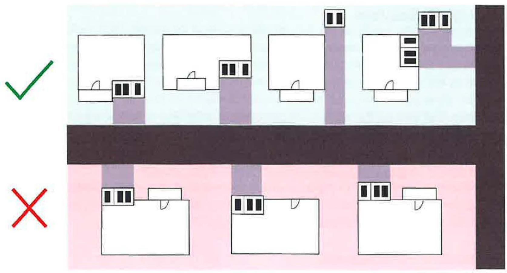
Front-Loaded Garages: A garage with vehicular access doors oriented the same direction as the front facade of the principal structure. The garage shall be a minimum of two (2) feet behind the front edge of the porch, unless architecturally appropriate as determined by the Board or Commission. If no porch exists, the garage shall not be the most forward part of the house. See Figure 1107.19-1 Permitted and Prohibited Garage Location Examples - Front Loaded.
Figure 1107.19-1 - Permitted and Prohibited Garage Location Examples - Front Loaded
(B)
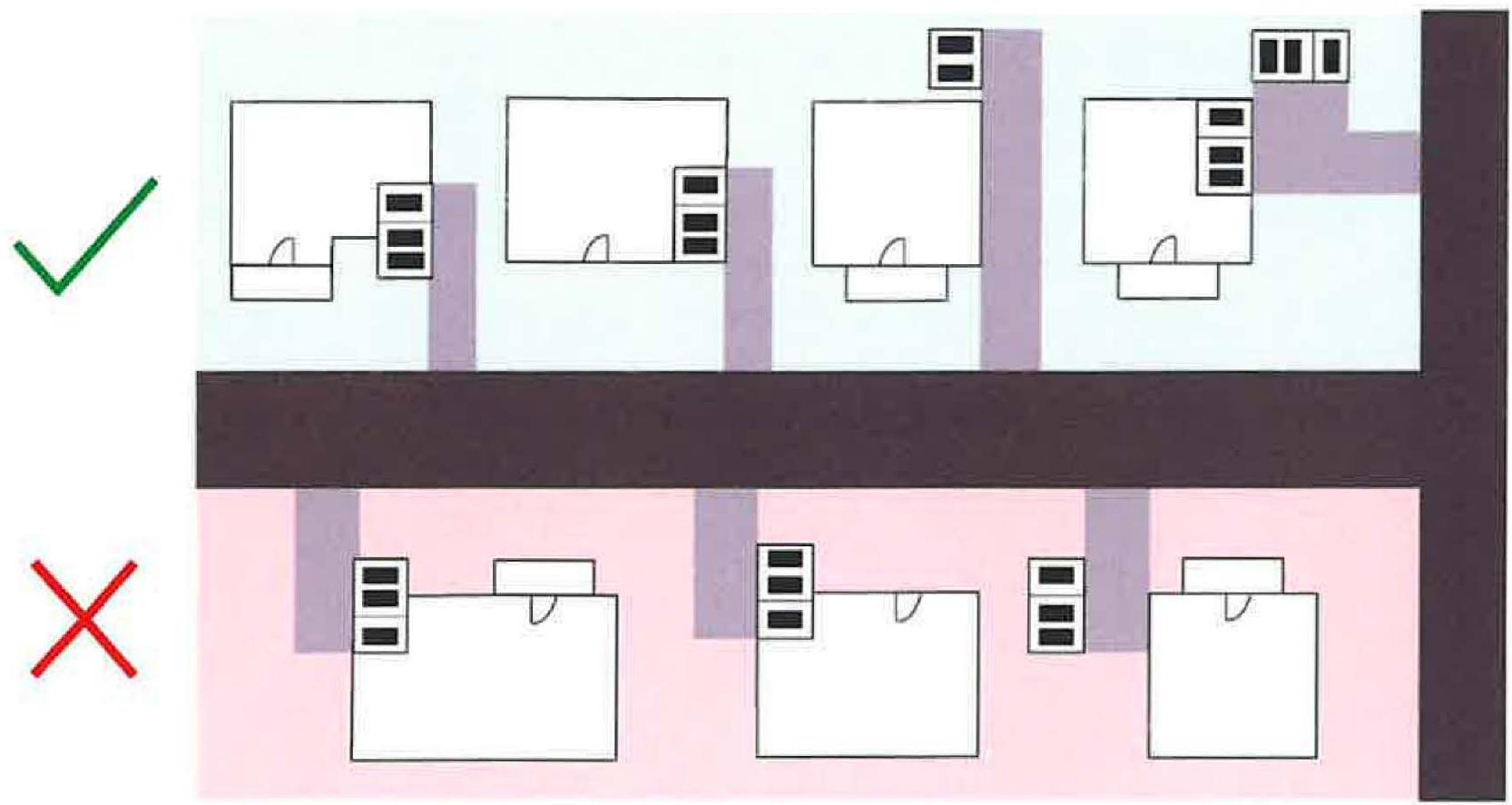
Side-Loaded Garages: A garage with vehicular access doors oriented perpendicular to the front facade of the principal structure. The garage structure shall be a minimum of two (2) feet behind the front edge of the porch, unless architecturally appropriate as determined by the Board or Commission. If no porch exists, the garage shall not be the most forward part of the house. See Figure 1107.19-2 Permitted and Prohibited Garage Location Examples - Side Loaded.
Figure 1107.19-2 - Permitted and Prohibited Garage Location Examples - Side Loaded
(3)
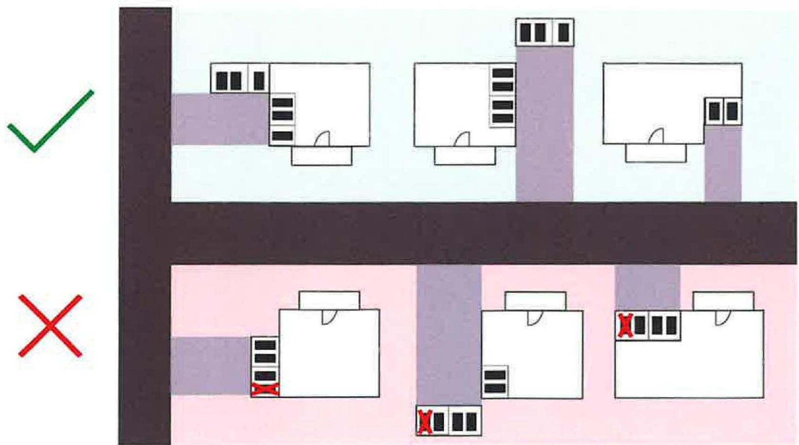
Garage Bay Quantity. No more than three (3) bays shall be permitted to face any street, except rear-loaded garages. This includes attached or detached garages. See Figure 1107.19-3 for Permitted and Prohibited Garage Quantity Examples.
Figure 1107.19-3 - Permitted and Prohibited Garage Bay Quantity Examples
(4)
Garage Door Design: Front-loaded, side-loaded, and rear-loaded garage doors shall have at least two (2) design features, unless architecturally appropriate as determined by the Board or Commission. Design features are as follows:
(A)
Raised paneling or architectural relief feature.
(B)
Permanent hardware.
(C)
Paint color other than white.
(D)
One or more panel rows of windows. If desired, vertical window designs will be considered by the Board or Commission.
(E)
Other significant architectural components as determined by the Board or Commission.
(b)
Front Porch Design. A front porch must be at least six (6) feet in depth and at least six (6) feet in length, measured from the edges of the floor material, unless another architecturally appropriate structure shall be provided as determined by the Board or Commission. The forwardmost edge of the porch shall be extended in front of or flush with the front facade of the home. Front porches shall be covered and open unless approved by the Board or Commission.
(c)
Landscaping (Single Family Detached).
(1)
Foundation Planting Shrubs or other plant material shall be planted along foundations of newly constructed single-family detached homes along the street frontage and for ten (10) feet along any other foundation extending from the corner shared with a foundation fronting on a street.
A.
Topsoil shall be required within the foundation landscape beds and shall be installed in accordance with the following:
1.
Till the top four (4) inches of native soil using a tiller, plow or other implement to reduce soil compaction.
2.
Prior to placing any topsoil, all foreign material and any rocks one (1) inch or larger in any dimension shall be removed from the area.
3.
Place six (6) inches topsoil according to the following:
a.
Topsoil shall be free of grass, brush, and roots.
4.
Final elevation of landscape beds shall promote positive drainage away from the foundation of the building.
5.
The application of soil amendments such as commercial fertilizer, lime, compost, organic matter, or other soil amendments is recommended.
(2)
Trees. In addition to street trees required in Chapter 1125, trees shall be planted on each lot with a single-family detached dwelling, in accordance with the following:
A.
Each tree shall be:
1.
Two (2) inches caliper at installation;
2.
Planted on private property;
3.
Of an appropriate size and species included on the City's approved single-family residential tree list, or as approved by the City's Urban Forester; and
4.
Not planted on a tree lawn.
B.
The number of trees required to be planted is as follows:
C.
Existing trees may be used to offset the requirement to plant new trees in Section 1107.19(c)(2) on a one-to-one basis, subject to approval by the Division of Engineering, if:
1.
Each existing tree measures at least four (4) inches dbh;
2.
The condition of each tree is fair or better, as determined by the city's Urban Forester; and
3.
Each tree is protected during construction, in accordance with Section 1125.08(c)(2).
D.
Existing trees used to satisfy the requirements of Section 1107.19(c)(2)(B) shall be depicted on the site-tree planting plan required in Section 1125.08(a)(1).
(d)
Building Architecture (Single Family Detached). The following standards apply to the principal building on a lot in the SRD, VRD, HMD, ARD, UT and USF zoning districts:
(1)
Facades. A newly constructed single family detached dwelling shall include at least three (3) architectural features on the facade facing the front yard, at least two (2) architectural features on a façade facing a side yard (including a side yard adjacent to a street on a corner lot), and at least one (1) architectural feature on all other facades. A zoning permit shall be issued only after architectural elevations for the new structure have been submitted and approved by the Division of Engineering.
A.
The following architectural features shall be used to satisfy the requirements:
1.
A door at least twenty-eight (28) square feet in area;
2.
A window at least six (6) square feet in area. Windows located less than six (6) feet from another window shall be considered one (1) architectural feature. A set of adjacent windows, such as double or bay windows, shall be considered one (1) architectural feature. Each window on a facade visible from a street shall include a decorative window treatment;
3.
Decorative shutters on the majority of windows on a single facade;
4.
A chimney, functional or simulated;
5.
Masonry used on at least twenty percent (20%) of a single facade;
6.
Gable vent at least four (4) square feet in area;
7.
A dormer;
8.
Corbels placed within the eave of a gable or roof overhang or decorative trim on rooflines or overhangs;
9.
A deck, balcony, portico, or porch, including wraparound porches, where each facade that the porch extends onto is considered a distinct architectural feature; and
10.
Decorative, permanently installed styled lighting, such as carriage lighting or similar styles.
B.
The following architectural features shall not be used to satisfy the requirements:
1.
Foundation cladding;
2.
Water table;
3.
Side of porches, not including wraparound porches; and
4.
Rooflines.
(2)
Roof Pitch. All roofs for newly constructed single-family detached dwellings shall have a pitch of 6:12 (rise:run) (six (6) inches vertical rise for twelve (12) inches horizontal run) or greater on the primary roof.
(Ord. No. 037-2025, Passed 10-27-2025; Ord. No. 042-2025, Passed 11-24-2025; Ord. No. 045-2025, Passed 11-24-2025; Ord. No. 046-2025, Passed 11-24-2025; Ord. No. 047-2025, Passed 11-24-2025)
1109.02 - CONSTRUCTION PROCEDURE AND MATERIALS.
The subdivider shall design and construct improvements not less than the standards outlined in these regulations. The public work shall be done under City inspection, and in no event shall the completion of the final plat improvements exceed two (2) years from the date of the final plat approval. Inspection fees shall be borne entirely by the subdivider according to the fee schedule to be determined as outlined in Section 1113.05. Materials and Specifications shall meet the City requirements and shall be in accordance with the standards of the current volume of "Construction and Material Specifications" of the Ohio Department of Transportation and the "Standard Construction Drawings of the City of Marysville".
(Ord. No. 054-2020, Passed 11-23-2020.)
1109.03 - SURVEY AND MONUMENTS.
(a)
General. Survey and monument activities shall meet "Minimum Standards for Boundary Surveys in the State of Ohio" set forth in Ohio Administrative Code Section 4733-37. Permanent monuments shall be tied to and referenced in the Ohio Plane Coordinate System.
(b)
Monuments. A minimum of four permanent monuments shall be set to control the subdivision plat. Additional monuments shall be set at block corners and to properly control the original survey and streets. For street alignment control, monuments shall be set at street centerline intersections and changes of direction. Permanent marks for street alignment control shall be one-inch diameter iron pins 30 inches long buried one foot below finish grade and bearing the identification mark of the surveyor or surveying company that set the marker.
(c)
Certification. Before release of the surety, the subdivider's surveyor shall certify by letter to the City Engineer that all monuments are in place and those disturbed during construction have been replaced.
(Ord. No. 054-2020, Passed 11-23-2020.)
1109.05 - STREET WIDTH.
Minimum street pavement widths shall conform to the City of Marysville Standard Drawings and Thoroughfare Plan.
(Ord. No. 054-2020, Passed 11-23-2020.)
1109.06 - STREET SPECIFICATIONS.
Street subgrade, base course and surface course materials and construction standards shall follow the minimums as set forth in the "Standard Construction Drawings" of the City as provided by the City Engineer.
(Ord. No. 054-2020, Passed 11-23-2020.)
1109.07 - STREET CURBS AND GUTTERS.
Per the Thoroughfare Plan, concrete curbing (and potentially and gutters) shall be required on all residential, commercial and industrial streets of proposed subdivisions (unless otherwise approved by Planning Commission). Curbs and gutters shall be constructed in conformance with the current volume "Construction and Material Specifications" of the Ohio Department of Transportation and the City of Marysville Standard Specifications.
(Ord. No. 054-2020, Passed 11-23-2020.)
1109.08 - WATER SUPPLY IMPROVEMENTS.
The following requirements shall govern water supply provisions:
(a)
Where a public water supply, in the determination of the City Engineer, is reasonably accessible or required because of pollution problems, the subdivision shall be provided with a complete water distribution system, built in conformance with the standards of the City Water Department. Public water distribution shall meet the requirements of the Ohio Environmental Protection Agency, as cited in the current laws and regulations.
(b)
Where a public water supply is not available or not required, the current regulations of the Union County Health Department and Ohio Environmental Protection Agency shall be followed for public wells.
(c)
The size of water lines shall not be based solely on present needs, but rather on the contemplated population density and land uses of the area to be served. When oversized water lines are deemed necessary by the City Engineer because of potential growth, to avoid dead end lines, or to assure flow and pressure to the area, the developer shall provide sizes of water lines greater than necessary for a singular subdivision. The reimbursement to the developer for the extra size of the water lines shall be made in accordance with the procedures established by the City Administration with the approval of Council. It is the intent of these regulations that future benefiting developers shall reimburse the original developer, or the City, if the City participated in the financing of the original oversizing of the water lines.
(Ord. No. 054-2020, Passed 11-23-2020.)
1109.09 - SEWAGE TREATMENT.
The following requirements shall govern sanitary sewage disposal treatment:
(a)
For areas within the corporation limits, where an adequate public sanitary sewer system, in the determination of the City Engineer is reasonably accessible, public sanitary sewers shall be installed to adequately serve all lots and extended to the lot line. Finally, all public sewer system extensions shall meet the requirements of the Ohio Environmental Protection Agency and City standards.
(b)
All laws, regulations and guidelines set forth by the Union County General Health District at the time of this enactment shall be followed and any future laws, regulations and guidelines deemed necessary for the protection of public health shall be followed as they become effective. The Union County Health Department shall conduct such inspections of individual sewage treatment systems as provided by law and shall have the authority and responsibility of enforcing these regulations.
(c)
The size of sanitary sewers shall not be based solely on present needs, but rather on the contemplated population density of the service area. Where oversized sanitary sewer sizes are deemed necessary by the City Engineer because of potential growth, then the developer shall provide a greater than necessary sanitary sewer. The reimbursement to the developer for the extra size of the sanitary sewer shall be made in accordance to procedures established by the City Administration with the approval of Council. It is the intent of these regulations that future benefiting developers shall reimburse the original developer, or the City if the City participated in the financing of the original oversizing of the sanitary sewer.
(Ord. No. 054-2020, Passed 11-23-2020.)
1109.10 - DRAINAGE IMPROVEMENTS.
(a)
The subdivider shall construct all necessary facilities including underground pipe, inlets, catch basins, bridges, culverts, ditches or retention basins, as determined by the City Engineer in accordance with the City of Marysville Standard Specifications and Marysville Stormwater Manual to provide for the adequate drainage of subsurface and surface water and maintenance of natural drainage courses. In cases of open drainage ditches, a storm water easement or drainage right-of-way of sufficient width shall be provided to adequately handle potential maximum flows with access from a public street or ROW for the purpose of maintenance. Drainage ditches, whenever possible, should be constructed with landscaped banks. All storm drainage facilities within the subdivision shall connect to an adequate drainage outlet. Sound engineering practice considering local physical conditions or innovative techniques in variance with the City of Marysville Standard Specifications may be acceptable if approved by the City Engineer.
(b)
Bridges shall be constructed according to current ODOT standards or as approved by the City Engineer. No work shall commence until approval is received from the City Engineer.
(Ord. No. 054-2020, Passed 11-23-2020.)
1109.11 - STORM SEWERS AND STORM WATER DRAINAGE.
Where an adequate public storm main is reasonably available, the subdivider shall construct a storm sewer system and connect with such storm sewer main. The subdivider shall also extend laterals from the public system to the lot line of each lot. If such storm sewer systems are not accessible, adequate provision shall be made for the disposal of storm waters, subject to the specifications of the City Engineer.
(Ord. No. 054-2020, Passed 11-23-2020.)
1109.12 - TOPSOIL.
Topsoil shall comply with the following standards:
(a)
Topsoil shall be installed in accordance with the following:
1.
Till the top two (2) inches of native soil using a tiller, plow or other implement to reduce soil compaction.
2.
Prior to placing any topsoil, all foreign material and any rocks one (1) inch or larger in any dimension shall be removed from the area.
3.
Place topsoil according to the following:
a.
Topsoil shall be free of grass, brush, and roots.
b.
For Seeding: Three (3) inches of topsoil shall be placed.
c.
For Sodding: Two (2) inches of topsoil shall be placed.
4.
Lightly compact and roll the soil surface to provide good contact between the topsoil and the surface.
5.
The application of soil amendments such as commercial fertilizer, lime, compost, organic matter, or other soil amendments is recommended.
(Ord. No. 048-2025, Passed 11-24-2025)
1109.13 - SURFACE WATER, EROSION AND SEDIMENT CONTROL.
The following requirements will promote the public welfare by guiding, regulating and controlling the design, construction, use and maintenance of any development or other activity that disturbs or breaks the topsoil or results in the movement of earth on land in the City. An Erosion and Sediment Control Plan that complies with Ohio EPA regulations must be submitted to and approved by the City Engineer. Such plan shall follow the guidelines set forth in the policies of the City. It shall further incorporate the following controls:
(a)
A natural resources map identifying soils, forest cover, and resources protected under other chapters of this code. Scale of this map shall be no smaller than 1" = 50', unless prior approval has been obtained.
(b)
All erosion and sediment control measures necessary to meet the objectives of this local regulation throughout all phases of construction and after completion of development on the site.
Depending on the complexity of the project, the drafting of intermediate plans may be required at the close of each construction year.
(c)
A sequence of construction of the development site, including stripping and clearing, rough grading, construction of utilities, infrastructure, buildings, final grading and landscaping. Sequencing shall identify the expected date on which clearing will begin, the estimated duration of exposure of cleared areas, areas of clearing, installation of temporary erosion and sediment control measures, and establishment of permanent vegetation.
(d)
No area shall be allowed to go into the winter season without vegetative or mulch cover. Permanent seeding shall be applied by September 30. Temporary seeding may be applied through October 30. A heavy mulch layer or another method that does not require germination to control erosion shall be placed at the close of the construction season.
(e)
Provisions for maintenance of the control facilities, including easements, and estimates of the cost of maintenance. Seeding mixtures and rates, types of sod, method of seedbed preparation, expected seeding dates, type and rate of lime and fertilizer application, kind and quantity of mulching for both temporary and permanent vegetative control measures.
(f)
Repealed.
(g)
Whenever feasible, natural vegetation shall be retained and protected.
(Ord. No. 054-2020, Passed 11-23-2020.)
1109.14 - ELECTRIC, GAS, STREET LIGHTING, TELEPHONE AND CATV IMPROVEMENTS.
Electric service, gas mains, street lighting and telephone service shall be provided within each subdivision. Whenever CATV services are reasonably accessible and available, they shall be required to be installed (including additional conduits for technology) within the area. Telephone, electric power, street lighting and CATV wires, or cables shall be required to be constructed underground. All electric, gas, street lighting, telephone and CATV installations shall be subject to the approval of the City Engineer.
(Ord. No. 054-2020, Passed 11-23-2020.)
1109.15 - SIDEWALKS.
(a)
Concrete sidewalks, or shared use path/paths as determined by the City Engineer, shall be installed on both sides of all new streets.
(b)
All sidewalks shall be extended to connect with existing walks or to the boundaries of the subdivision if existing walks are not accessible. Sidewalks shall be constructed according to the minimums set forth in the "Standard Construction Drawings" of the City and shall conform to the appropriate City plan.
(c)
All required sidewalks or paths shall be installed to connect with existing sidewalks or paths within five (5) years of the City's acceptance of all other public infrastructure in the development. If special circumstances are present, a time extension of this requirement can be granted by the City Engineer.
(Ord. No. 054-2020, Passed 11-23-2020.)
1109.16 - DRIVEWAYS.
Residential driveways shall be not less than three (3) feet from the side lot line and non-residential driveways shall not be less than four (4) feet from the side lot line. Both shall be constructed according to the standards set forth in the "Standard Construction Drawings" of the City.
(Ord. No. 054-2020, Passed 11-23-2020.)
1109.17 - STREET NAME AND TRAFFIC SIGNS AND PAVEMENT MARKINGS.
(a)
Street name signs, of a type in use throughout the City and approved by the City, shall be paid for by the developer at all locations designated by the City.
(b)
Initial traffic signs including signs that regulate, warn or guide traffic for a new subdivision and as required by the City shall be paid for by the developer at all locations and for all types of traffic signs required by the City.
(c)
Pavement markings which are necessary to regulate, control and direct the flow of pedestrian and/or vehicular traffic as required by the City shall be paid for by the developer at all locations and for all markings required by the City.
(Ord. No. 054-2020, Passed 11-23-2020.)
1109.18 - TREES.
The subdivider shall plant trees within the street right-of-way as required by Chapter 1125 and approved by the City Planning Commission. Notwithstanding anything to the contrary contained in this Zoning Code, trees planted in the right-of-way shall not constitute replacement trees to be planted in accordance with this Chapter.
(Ord. No. 054-2020, Passed 11-23-2020.)
1109.19 - OVERSIZED AND OFF-SITE IMPROVEMENTS.
The utilities, pavements, and other land improvements as required shall be designed of oversized and/or extensions provided as may be necessary to serve nearby land which is an integral part of the neighborhood service or drainage area in addition to the improvements required for the development of the proposed subdivision.
(Ord. No. 054-2020, Passed 11-23-2020.)
1109.20 - OFF-SITE EXTENSIONS.
If streets or utilities are not available at the boundary of a proposed subdivision, and if the City finds the extensions across undeveloped areas would not be warranted as a special assessment to the intervening properties or as a municipal expense until some future time, the subdivider may be required, prior to approval of the final plat, to obtain necessary easements or rights-of-way and construct and pay for such extensions. Such improvements shall be available for connections by subdividers of adjoining land.
(Ord. No. 054-2020, Passed 11-23-2020.)
1109.21 - EXTENSIONS TO BOUNDARIES.
The subdivider shall be required to extend the necessary improvements to the boundary of the proposed subdivision to serve adjoining unsubdivided land, as determined by the City Planning Commission.
(Ord. No. 054-2020, Passed 11-23-2020.)
1110.01 - GENERAL PURPOSE.
The Property Owners Association (POA) or Homeowners Association (HOA) represents the property owner(s) of a planned community. The POA or HOA is intended to be the vehicle for the community communication and for maintaining the common areas and common services that exist for the benefit of each member of the POA or HOA.
(Ord. No. 054-2020, Passed 11-23-2020.)
1110.02 - ASSOCIATIONS CREATED; MEMBERS; FUNCTIONS.
(a)
With the exception of platted property dedicated to the City, restricted open space, common areas, designated easements and reserves shall be held by the individual members of the POA or HOA as tenants-in-common or shall be held in common ownership by a homeowners' association, condominium association, community association or other similar legal entity. Documents shall be submitted with the Final Plat which will ensure compliance with the following requirements:
(1)
Membership in the POA or HOA shall be mandatory for all purchasers of lots or units in the development.
(2)
The POA or HOA shall be capable of and responsible for maintenance, control and insurance of common areas, including restricted open space.
(3)
The POA or HOA shall have the right to impose assessments upon its members, enforceable by liens, in order to ensure that it will have sufficient financial resources to provide for proper care and maintenance of the restricted open space.
(4)
The City Manager may request an annual report detailing the POA's or HOA's financial status and current officers with contact information.
(Ord. No. 054-2020, Passed 11-23-2020.)
1110.03 - MAINTENANCE REQUIREMENTS FOR OPEN SPACE AND EASEMENTS.
The common owner of all restricted open space, common areas, designated easements and reserves shall be responsible for raising all monies required for operation, maintenance, or physical improvements to such areas through annual dues, special assessments, and/or valid and enforceable collection methods. The owner shall be authorized under appropriate restrictions and covenants, to place liens on the property of residents who fall delinquent in payment of such dues and assessments.
In the event that the organization established to own, operate and maintain restricted open space, common areas, designated easements and reserves shall at any time after the establishment of the development fail to maintain such areas in reasonable order and condition in accordance with the Final Plat, such failure shall constitute a violation of both the Final Plat and this Planning and Zoning Ordinance.
(Ord. No. 054-2020, Passed 11-23-2020.)
1110.04 - CITY OF MARYSVILLE RIGHTS.
(a)
The City shall have the right to access restricted open space, common areas, designated easements and reserves in the community for maintenance, update and expansion of utilities and community facilities.
(b)
If the City determines an area of non-compliance or concern for the health, safety and welfare of the development, the City shall issue a letter of noncompliance to the officers of record for the POA or HOA detailing the noncompliance, corrective action to be taken, and a date by which the corrections are to be completed.
(c)
Upon completion of the requested work, the City will inspect the site and if the matter(s) of noncompliance have been corrected, the City will issue a letter stating the POA or HOA is in compliance as of that date.
(d)
If the matter of noncompliance is not corrected on or before the date set forth in the letter of noncompliance, the City or its agent may perform the work necessary to bring the noncompliant conditions into compliance. The cost for this work and administration fees shall be billed to the officers of record of the POA or HOA for payment.
(e)
If the payment is not received by the due date stated on the bill, the City may bill the individual property owners for the appropriate financial share of the cost and apply this cost to their utility bill in a manner deemed appropriate by the Director of Finance.
(Ord. No. 054-2020, Passed 11-23-2020.)
1110.99 - PENALTY.
See Section 1113.99.
(Ord. No. 054-2020, Passed 11-23-2020.)
1111.01 - DESIGN STANDARDS.
(a)
The following design standards shall apply to mobile home subdivisions:
(1)
The subdivisions shall contain a minimum of five (5) acres.
(2)
Each mobile home site shall have a clearly defined minimum area of 4,000 square feet, with a minimum lot width of forty feet, and a minimum depth of 100 feet. The minimum width of corner lots, however, shall be fifty feet.
(3)
The subdivision shall have a minimum frontage of 250 feet. The ratio of width to depth shall not exceed one to five (1:5).
(4)
A side yard on each side of the subdivision and a rear yard of thirty (30) feet or more shall be provided around the edge of the mobile home subdivision. Such yards shall not be occupied by or counted as part of an individual mobile home site.
(5)
There shall be a minimum clearance of twenty (20) feet between the individual mobile homes.
(6)
A maximum density shall not exceed six (6) mobile homes per gross acre.
(Ord. No. 054-2020, Passed 11-23-2020.)
1111.02 - STREETS.
All mobile home subdivisions shall meet the street requirements and specifications of these regulations, Sections 1107.04 through 1107.12. All underground utilities, sanitary sewers and drainage structures installed in streets shall be constructed prior to the surfacing of such streets.
(Ord. No. 054-2020, Passed 11-23-2020.)
1111.03 - WALKWAYS.
Walkways not less than three (3) feet wide which may abut street pavement shall be provided from the mobile home sites to the service buildings and frontage street sidewalk. Sidewalk on the frontage street shall be required at not less than four (4) feet and shall be extended to existing sidewalks or to the boundaries of the subdivision if walks are not accessible. Walkways and sidewalks shall be constructed according to standard City specifications.
(Ord. No. 054-2020, Passed 11-23-2020.)
1111.04 - ELECTRIC, GAS, STREET LIGHTING, TELEPHONE AND CATV IMPROVEMENTS.
Electric service, gas mains, street lighting, telephone service shall be provided within each mobile home subdivision. CATV service shall be provided if so determined by Planning Commission in accordance with current City CATV ordinance. Whenever such facilities are reasonably accessible and available, they may be required to be installed within the area prior to the approval of the final plat. Telephone, electric power, street lighting, and CATV wires, conduits or cables shall be required to be constructed underground. All electric, gas, street lighting, telephone, CATV installations shall be subject to the approval of the City or County Engineer, as the case may be.
(Ord. No. 054-2020, Passed 11-23-2020.)
1111.05 - WATER AND SEWERS.
Each mobile home site shall be provided with a water outlet connected to the City or an approved water supply and a connection to the City or an approved central sanitary sewer system.
(Ord. No. 054-2020, Passed 11-23-2020.)
1111.06 - ELECTRICITY.
Electricity, electrical outlets and wiring shall be according to the current provisions of the National Electric Code published by the National Fire Protection Association.
(Ord. No. 054-2020, Passed 11-23-2020.)
1111.07 - DRAINAGE.
The mobile home subdivision shall be located on a well-drained site, properly graded to insure rapid drainage and freedom from stagnant pools of water.
(Ord. No. 054-2020, Passed 11-23-2020.)
1111.08 - HEALTH REQUIREMENTS.
The mobile home subdivision shall conform to all County and State Health Department requirements.
(Ord. No. 054-2020, Passed 11-23-2020.)
1111.09 - RECREATION.
A safe, usable recreation area shall be conveniently located in each mobile home subdivision the size of which shall be determined at 1,000 square feet per household or mobile home.
(Ord. No. 054-2020, Passed 11-23-2020.)
1111.10 - LANDSCAPING.
The mobile home subdivision shall be landscaped with lawns and plantings, including appropriate trees.
(Ord. No. 054-2020, Passed 11-23-2020.)
1111.11 - SCREENING.
Mobile home subdivisions shall be effectively screened on all sides by means of walls, fences or plantings except where the area is sufficiently removed from other urban uses as determined by the City Planning Commission. Walls or fences shall be a minimum of four (4) feet in height without advertising thereon. In lieu of such wall or fence, a strip of land not less than ten (10) feet in width and planted and maintained with an evergreen hedge or dense planting of evergreen shrubs not less than four (4) feet in height may be situated.
(Ord. No. 054-2020, Passed 11-23-2020.)
1111.12 - MOBILE HOME STAND.
Each mobile home site shall be developed with a mobile home stand of not less than ten (10) feet by fifty feet and such mobile home stand shall not be less than ten (10) feet from the mobile home site boundary. The mobile home stand shall be constructed of a minimum of six (6) inches of concrete and provide at least two tie-down rings.
(Ord. No. 054-2020, Passed 11-23-2020.)
1111.13 - MOBILE HOME SKIRTING.
Each mobile home placed in the mobile home subdivision shall be skirted entirely enclosing the bottom section, within ninety days after its placement. Skirting shall be constructed of vinyl, aluminum or other suitable material that is designed specifically for skirting.
(Ord. No. 054-2020, Passed 11-23-2020.)
1111.14 - GARBAGE AND REFUSE.
The storage and collection of garbage and refuse within the subdivision shall be conducted so as to create no health hazards. All garbage and refuse shall be stored in fly-tight, rodent-proof containers and shall be collected at least once weekly.
(Ord. No. 054-2020, Passed 11-23-2020.)
1111.15 - STORM SHELTERS.
Mobile home subdivisions shall be required to provide a storm shelter for the protection of all residents. Storm shelters shall provide four (4) square feet of floor area per resident, have sufficient ventilation, and have a generator of sufficient size to provide power for heat and light. Windows are permissible if provisions are made for their protection by shutters or other similar devices that are designed for immediate installation in the event of sudden emergency. The storm shelter may be used for recreational purposes, laundry facilities or other purposes.
(Ord. No. 054-2020, Passed 11-23-2020.)
1113.01 - RECORDING OF PLAT.
No plat of any subdivision shall be recorded by the County Recorder of Union County or have any validity until such plat has received final approval in the manner prescribed in these regulations. In the event any unapproved plat is recorded, it shall be considered invalid and Council shall institute proceedings to have the plat stricken from the records of the County.
(Ord. No. 054-2020, Passed 11-23-2020.)
1113.02 - REVISION OF PLAT AFTER APPROVAL.
No changes may be made to a plat after approval, except that minor technical adjustments or corrections that do not significantly change the plat as approved, may be made with the approval of the Planning Commission upon recommendation from the City Engineer.
(Ord. No. 054-2020, Passed 11-23-2020.)
1113.03 - SALE OF LAND WITHIN SUBDIVISIONS.
No owner or agent of the owner of any land located within a subdivision shall transfer or sell any land by reference to, exhibition of or by the use of a plat of the subdivision before such plat has been approved and recorded in the manner prescribed in these regulations. Any sale or transfer contrary to the provisions of this section is void. The description of such lot or parcel by metes and bounds in the instrument of transfer or other documents used in the process of selling or transferring shall not exempt the transaction from the provisions of these regulations.
(Ord. No. 054-2020, Passed 11-23-2020.)
1113.04 - PERFORMANCE AND MAINTENANCE BONDS.
(a)
Performance bonds are required as stated in Section 1105.13, to assure the proper authorities that completion of the improvements shall be made and that the improvements are in conformance with the standards established in these regulations. The City Manager should secure approval as to the form, sufficiency and execution of the bond from their appropriate legal counsel, the performance bond shall not be released until the City Engineer has certified satisfactory completion of all required improvements and the dedication of land and facilities for public use has been submitted to Council, as set forth in Section 1115.02. Council shall accept, within 120 days, all dedications which have been certified by the City Engineer as being satisfactorily completed.
Reduction of the performance bond may be made, on a prorated basis, for portions that have received the engineer's certification for meeting the requirements and have been dedicated for public use. In no event shall a performance bond be reduced below twenty-five percent (25%) of the principal amount.
If the improvements are not completed on the completion date set forth under Section 1105.15, then the City shall exercise the performance bond to secure completion of the improvements.
(b)
Maintenance bonds shall be required by the City Planning Commission to assure maintenance of all improvements in the subdivision by the developer, until dedication of such improvements are formally accepted by Council. The amount of the maintenance bond shall be determined by the City Engineer and be submitted and approved in the same manner as performance bonds. The developer shall provide for the upkeep and maintenance of all improvements. If there are certificates of occupancy on any street, which dedication has not been accepted, the City may, on twelve (12) hours notice, effect emergency repairs for any improvement and charge same to applicant. The maintenance bond shall be submitted for a period of at least one year after the completion of the improvements and offer of dedication for public use is made, and shall not be required longer than two (2) years.
(Ord. No. 054-2020, Passed 11-23-2020.)
1113.05 - SCHEDULE OF FEES, CHARGES AND EXPENSES.
The Marysville City Council shall establish a schedule of fees, charges and expenses and a collection procedure for same, and other matters pertaining to these regulations. The schedule of fees shall be posted in the office of the City Manager and may be altered, or amended only by Council. Until all applicable fees, charges and expenses have been paid in full, no action shall be taken on any application or appeal.
(Ord. No. 054-2020, Passed 11-23-2020.)
1113.06 - VARIANCES.
(a)
The following regulations shall govern the granting of variances:
(1)
Where the City Planning Commission finds that extraordinary and unnecessary hardship may result from strict compliance with these regulations, due only to exceptional topographic or other physical conditions, or where such a hardship results from strict compliance with the procedures required, it may vary the regulations so as to relieve such hardship, provided such relief may be granted without detriment to the public interest and without impairing the intent and purpose of these regulations or the desirable development of the neighborhood and community. In some cases, such physical conditions shall justify a finding that the land is unsuitable for any subdivision development, as outlined in Section 1107.03. Such variations shall not have the effect of nullifying the intent and purpose of these regulations, the comprehensive plan or the Planning and Zoning Ordinance.
(2)
In granting the variances or modifications, the City Planning Commission may require such conditions as will, in its judgment, secure substantially the objective of the standards or requirements so varied or modified.
(3)
Procedure for a variance requires an application, which shall be submitted in writing by the subdivider at the time when the preliminary plat is filed for the consideration of the Planning Commission. The application shall state fully the grounds for the request and all the facts relied upon by the petitioner.
(4)
Any variances authorized or denied by the Planning Commission shall be stated in writing in the official minutes of the Planning Commission, with specific reasonings on which the variance was justified set forth.
(Ord. No. 054-2020, Passed 11-23-2020.)
1113.07 - APPEAL.
Any person who believes he has been aggrieved by these regulations or the action of the City Planning Commission, has all the rights of appeal as set forth in Ohio R.C. Chapter 711 or any other applicable section of the Revised Code.
(Ord. No. 054-2020, Passed 11-23-2020.)
1113.99 - PENALTIES.
(a)
The following penalties shall apply to the violations of these regulations.
(1)
Whoever willfully violates any rule or regulation adopted by Council for the purpose of setting standards and requiring and securing the construction of improvements within a subdivision or fails to comply with any order pursuant thereto shall forfeit and pay not less than one hundred dollars ($100.00) nor more than one thousand dollars ($1,000). Such sum may be recovered with costs in a civil action brought in the Court of Common Pleas by the legal representative of the City, in the name of the City and for the use thereof.
(2)
A County Recorder who records a plat contrary to the provisions of these regulations shall be fined not more than five hundred dollars ($500.00), to be recovered with the costs in a civil action by the Law Director in the name and for the use of the City.
(3)
Whoever, being the owner or agent of the owner of any land within or without the municipal corporation, willfully transfers any lot, parcel or tract of such land from or in accordance with a plat of a subdivision before such plat has been recorded in the office of the Union County Recorder, shall be fined not more than five hundred dollars ($500.00) for each lot, parcel or tract of land so sold. The description of such lot, parcel or tract by metes and bounds in the deed of transfer shall not serve to exempt the seller from the forfeiture provided in this section.
(4)
Any person who disposes of, offers for sale or lease for a time exceeding five (5) years any lot or any part of a lot in a subdivision with intent to violate these regulations before provisions of these regulations are complied with shall be fined not more than five hundred dollars ($500.00) for each lot or part of a lot sold, offered for sale or lease, to be recovered with costs in a civil action, in the name of the City Treasury for the use of the City.
(5)
In addition to the above penalties and remedies, the Law Director is hereby empowered to enforce these regulations by bringing a civil action for an injunction and/or declaratory judgment in the Common Pleas Court of Union County in the name and for the use of the City.
(Ord. No. 054-2020, Passed 11-23-2020.)
1115.01 - REQUIRED STATEMENTS.
The following statements shall be affixed on the subdivision plat.
(Ord. No. 054-2020, Passed 11-23-2020.)
1115.02 - DEDICATION.

(Ord. No. 054-2020, Passed 11-23-2020.)
1115.03 - SURVEYORS CERTIFICATE.
(Ord. No. 054-2020, Passed 11-23-2020.)
1115.04 - ACCEPTANCE OF DEDICATION.

(Ord. No. 054-2020, Passed 11-23-2020.)
1115.05 - WITHIN THE CORPORATE LIMITS OF MARYSVILLE.
PLAT APPROVAL PROCEDURE
Editor's note— Ordinance 16-05 deleted the Plat Approval Procedure Flow Chart.
| LEGEND: STREET TYPE | |||
| Expressway | Cul-de-sac | ||
| Major Arterial Street | Alley | ||
| Minor Arterial Street | Marginal Access Street | ||
| Collector Street | Dead-end Street | ||
| Local Street | |||
(Ord. No. 054-2020, Passed 11-23-2020.)