
Marysville City Zoning Code
TITLE THREE
ZONING ORDINANCE
Chapter 1123 - GENERALLY APPLICABLE DISTRICT REGULATIONS[11]
Cross reference— Swimming pool defined, see Glossary.
State Law reference— Swimming pool, health requirements, Ohio Adm. Ch. 3701-31.
Chapter 1125 - LANDSCAPE REQUIREMENTS[12]
State Constitution reference— Ohio Constitution, Art. XVIII, Sec. 3.
Chapter 1127 - OFF-STREET PARKING & LOADING FACILITIES[13]
Cross reference— Loading trucks, Ch. 351.09; Parking generally, Ch. 351.
State Law reference— Off-street parking facilities, ORC 717.05 et seq.
Chapter 1129 - SIGNS[14]
Editor's note—Ord. No. 013-2025, passed March 24, 2025, repealed and replaced Chapter 1129 to read as set out herein. Former Chapter 1129, §§ 1129.01—1129.21 and 1129.99 pertained to similar subject matter and derived from Ord. No. 054-2020, passed Nov. 23, 2020; and Ord. No. 022-2021, passed July 12, 2021.
State Law reference— Municipal regulations of billboards and signs, ORC 715.27(A); Power to regulate advertising, ORC 715.65.
Chapter 1131 - HISTORIC DESIGN REVIEW DISTRICT(S) & LANDMARK(S) (INCLUDING HISTORIC UPTOWN MARYSVILLE DESIGN REVIEW DISTRICT)[15]
Cross reference— Uptown Commercial District, Ch. 1133; Generally applicable regulations, Ch. 1125.
State Constitution reference— Ohio Constitution, Art. XVIII, Sec. 3.
Chapter 1135 - PLANNED UNIT DEVELOPMENT[16]
Cross reference— Planned unit development application, Ch. 1105.02; Planned unit development defined, see Glossary.
State Law reference— Planning Commission powers and duties, ORC 713.02, 713.06.
State Constitution reference— Ohio Constitution, Art. XVIII, Sec. 3
Chapter 1137 - MOBILE HOME PARKS[17]
Cross reference— Mobil home subdivisions, Ch. 1111; Mobile home dwelling defined, see Glossary.
State Law reference— Trailer parks, ORC Ch. 4781; Definitions, ORC 4501.01(1), (K); Tax levy on house trailers, ORC 4503.03 et seq.
Chapter 1141 - ADMINISTRATION AND PROCEDURES[18]
State Law reference— Council may amend districting or zoning, ORC 713.10; Council to hold public hearing, ORC 713.12.
Chapter 1143 - NONCONFORMITIES[19]
State Law reference— Nonconforming uses, retroactive measures, ORC 713.15.
Chapter 1145 - ENFORCEMENT AND PENALTY[20]
Cross reference— Subdivision enforcement and penalty, Ch. 1113.
State Law reference— Violation of Planning and Zoning Ordinances, ORC 713.13.
APPENDIX - GLOSSARY OF TERMS
A.
TERMS GENERALLY APPLICABLE TO THE MARYSVILLE SUBDIVISION REGULATIONS AND ALL CHAPTERS OF THE MARYSVILLE PLANNING AND ZONING ORDINANCE.
ACCESS MANAGEMENT means the City's process of providing and managing access to land development while maintaining traffic flow, safety, capacity and speed.
ACCESSORY DWELLING UNIT means an independent residential dwelling unit located on the same parcel as a single family detached building, either attached to the principal building or in a detached building. The accessory dwelling unit must be subordinate and incidental to the principal building and have a separate egress.
ACCESSORY DWELLING UNIT (ATTACHED) means an independent residential dwelling unit located on the same parcel as a single family detached building which is attached to the side or rear of the principal building. The accessory dwelling unit must be subordinate and incidental to the principal building and have a separate egress.
ACCESSORY DWELLING UNIT (DETACHED) means an independent residential dwelling unit located on the same parcel as a single family detached building in a detached building located at side or rear of the principal building. The accessory dwelling unit must be subordinate and incidental to the principal building and have a separate egress.
ADVERTISING STRUCTURE means any outdoor display for the purpose of advertisement, notice or announcement located apart from the premises or product referred to in the display.
ALTERATIONS, STRUCTURAL means any change in the supporting members of a building such as bearing walls, columns, beams or girders.
ACCESSORY STRUCTURE means a building or structure that is subordinate to the principal building or structure upon the same lot and serving a purpose customarily incidental to the principal structure, including but not limited to sheds, pole barns, pergolas and patios.
ACCESSORY USE means a use that is subordinate to the principal use of the land and serving a purpose customarily incidental to the principal use or structure.
ADULT BOOTH means any area of a sexually oriented business establishment set off from the remainder of such establishment by one or more walls or other dividers or partitions and used to show, play, or otherwise demonstrate any adult materials or to view any live performance that is distinguished or characterized by an emphasis on the exposure, depiction, or description of specified anatomical areas or the conduct or simulation of specified sexual activities.
ADULT MATERIAL means any of the following, whether new or used:
A.
Books, magazines, periodicals, or other printed matter, or digitally stored materials that are distinguished or characterized by an emphasis on the exposure, depiction, or description of specified anatomical areas or the conduct or simulation of specified sexual activities.
B.
Films, motion pictures, video or audio cassettes, slides, computer displays, or other visual representations or recordings of any kind that are distinguished or characterized by an emphasis on the exposure, depiction, or description of specified anatomical areas or the conduct or simulation of specified sexual activities.
C.
Instrument, novelties, devices, or paraphernalia that are designed for use in connection with specified sexual activities, or that depict or describe specified anatomical areas.
AGRICULTURE means farming; ranching; aquaculture; algaculture meaning the farming of algae; apiculture and related apicultural activities, production of honey, beeswax, honeycomb, and other related products; horticulture; viticulture, winemaking, and related activities; animal husbandry, including, but not limited to, the care and raising of livestock, equine, and fur-bearing animals; poultry husbandry and the production of poultry and poultry products; dairy production; the production of field crops, tobacco, fruits, vegetables, nursery stock, ornamental shrubs, ornamental trees, flowers, sod, or mushrooms; timber; pasturage; any combination of the foregoing; the processing, drying, storage, and marketing of agricultural products when those activities are conducted in conjunction with, but are secondary to, such husbandry or production.
AGRICULTURAL DISPLAY STAND means display stands for the purpose of displaying and selling agricultural or farming products which are grown or produced on the premises on which said stand is located.
AIRPORT means any runway, land area or other facility designed or used either publicly or privately by any person for the landing and taking-off of aircraft, including all necessary taxiways, aircraft storage and tie-down area, hangers, and other necessary buildings, and open spaces.
APPLICANT means any Person or authorized agent of a Person, that applies for a Zoning Permit, Certificate of Appropriateness, Map Amendment or other land use process or approval pursuant to this chapter.
APPLICATION means the process by which an Applicant submits a request to be granted any land use approval or land use approvals under the provisions of this chapter. An Application includes all attachments to the form promulgated by the city from time to time, as well as all verbal statements and representations made by the Applicant throughout the review process.
ARTISAN STUDIO means a building or any portion thereof dedicated to the creation of original handmade works of art or craft items by no more than ten (10) artists or artisans.
ARTISAN WORKSHOP means a use primarily involving the limited on-site production of goods by hand manufacturing which involves only the use of hand tools or mechanical equipment that does not exceed two (2) horsepower each or a single kiln not exceeding eight (8) cubic feet in volume and the incidental direct sale to consumers typical production includes: custom furniture, ceramic studios, glass blowing, candle making, custom jewelry, stained and leaded glass, woodworking, custom textile manufacturing and crafts production.
AVERAGE means a number expressing the typical value in a set of data for purposes of determining an applicable dimension under this Zoning Code.
Illustration: Where regulations under this Zoning Code require establishing an applicable dimension based on the average dimensions of other properties in the vicinity of the subject property, the following methodology for determining the dimension shall apply:
Step 1 Calculation:
First, the applicable dimension of the other properties in the vicinity of the subject property shall be added together.
Property 1 - 25 foot
Property 2 - 25 foot setback
Property 3 - 29 foot setback
Property 4 - 27 foot setback
Sum - 106
Next, the sum of the applicable dimension for the properties in the vicinity of the subject property shall be divided by the number of properties used as a reference for determining the applicable dimension for the subject property.
Step 2 Calculation:
106 [Sum of the applicable dimension] divided by 4 [number of properties] equals 26.5.
Finally, the number resulting from the Step 2 calculation (26.5 feet in the example above) shall become the applicable dimension with respect to the subject property.
AWNING means a permanent or temporary structure other than a canopy that is attached to a building wall, that is made of flexible material (which can move from the movement of air) stretched over or attached to a frame, and that projects from said wall over a passable sidewalk, driveway, or similar pathway. An awning may be fixed in place without operating parts or it may be retractable.
AWNING SIGN means a sign affixed flat to the surface of an awning or which does not extend vertically or horizontally beyond the limits of such an awning.
Figure 1129.14-1: Example Awning Sign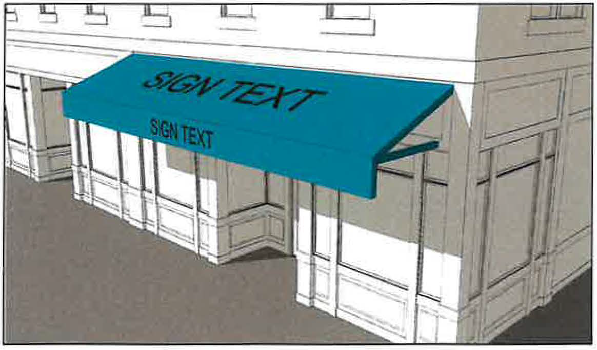
BALCONY means a covered or uncovered unenclosed exterior platform, designed as an architectural feature or for outdoor use, projecting or recessed from a façade on the upper floor of a building.
BANK OR FINANCIAL INSTITUTION means an establishment that provides retail banking, credit and mortgage, or insurance services to individuals and businesses. This classification includes banks and trust companies, savings and loan establishments, credit unions, credit agencies, lending and thrift institutions, investment companies and brokerage firms, securities/commodity contract brokers, securities/commodities exchanges, vehicle finance agencies, check cashing and currency exchange outlets and stand-alone automated teller machines. This does not include payday loan/alternative financial establishments.
BANNER SIGN means a temporary sign composed of light-weight material and secured or mounted in a manner that allows movement of air to cause movement of the sign. Such signs may also be called "feather" signs, typically constructed in a manner where a moveable material is stretched over a single curved pole. A sign enclosed in a rigid frame shall not qualify as a banner sign.
Figure 1129.14-2: Example Banner Sign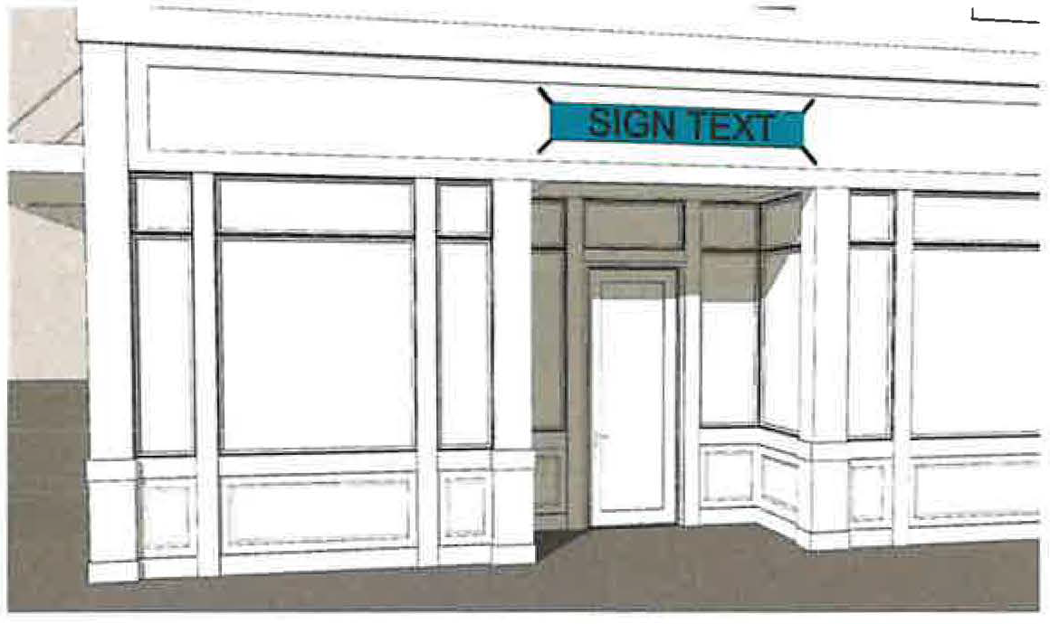
BASEMENT means a story all or partly underground but having at least one-half (1/2) of its height below the average level of the adjoining ground.
BED AND BREAKFAST means an owner-occupied residential single-family, detached structure wherein lodging and breakfast only are provided to transient guests for compensation.
BILLBOARD means an off-premises sign located at any place other than within the same parcel of land on which the specific business or activity being identified on such sign is itself located or conducted, and that is typically mounted to a pole.
Figure 1129.14-3: Example Billboard Sign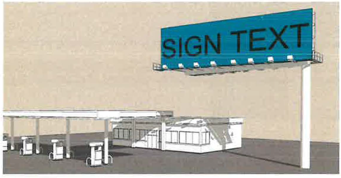
BIOMEDICAL WASTE STERILIZATION FACILITY: A facility where biomedical waste material is received, sterilized utilizing steam/autoclaving sterilization methods only, and then transported to an off-site location for recycling, re-use, incineration or final disposal. Any Biomedical Waste Sterilization Facility permitted under this definition must be licensed pursuant to Ohio Revised Code § 3734 and the Ohio Environmental Protection Agency, and shall comply with all applicable requirements of the Ohio Environmental Protection Agency and the Ohio Revised Code for such uses. This definition of Biomedical Waste Sterilization Facility expressly excludes any facilities where biomedical waste is treated via any method other than steam/autoclaving sterilization, including, but not limited to, incineration, or where biomedical waste is retained for onsite disposal.
BLOCK means a parcel of land which is bound by other lots, streets, highways, railroad rights-of-way, parks or open space, undeveloped land, water courses or bodies of water, channels or a combination thereof.
BOX SIGN means a sign that contains all copy within a single enclosed cabinet, with or without internal lighting, and which can be single- or double-faced. Typical features of a box sign may include but are not limited to:
(1)
A rectangular shape;
(2)
A frame separate from and supporting the message board that may or may not serve as a decorative element; and
(3)
Message boards made of acrylic, polycarbonate, or metal.
BUILDING means any STRUCTURE having a roof supported by columns or walls that is used, or intended to be used, for the shelter or enclosure of persons, animals, or property.
BUILDING ENTRANCE SIGN means a sign that is directly affixed to a building near a PUBLIC ENTRANCE. Such a sign typically identifies the interior uses that are accessible from the nearby entrance.
Figure 1129.14-4: Example Building Entrance Sign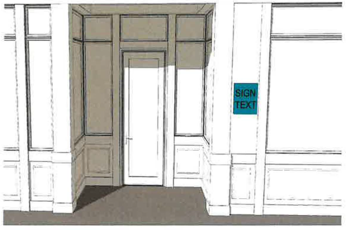
BUILDING, HEIGHT means the vertical distance measured from the average elevation of the proposed finished grade at the front of the building to the highest point of the roof for flat roofs, to the deck line of mansard roofs, and the mean height between eaves and ridge for gable, hip and gambrel roofs.
BUILDING MATERIALS AND HARDWARE (RETAIL) means retailing, wholesaling or rental of building supplies or construction equipment. This use classification includes lumberyards, home improvement sales and services, tool and equipment sales or rental establishments.
BUSINESS SIGN means a sign containing product advertisements or other detailed information about the operation of a business. Specifically, such sign is one which contains brand names of goods sold or services rendered on the premises, a listing of numerous specific types of goods or services, prices or special sale information, telephone number or other similar information. A business sign may also include items permitted on an identification sign.
CANOPY, BUILDING-MOUNTED means a permanent or temporary structure other than an awning that is attached to a building wall, that is made exclusively of rigid materials which do not move from the movement of air, and that projects from said wall over a passable sidewalk, driveway, or similar pathway. A canopy may also be referred to as a MARQUEE.
CANOPY, GROUND-MOUNTED means a cover or shelter that is directly connected to the ground on a supporting framework that is fixed in place. A ground-mounted canopy may or may not also be partially attached to a BUILDING.
CANOPY (BUILDING-MOUNTED) SIGN means a sign that is attached to a BUILDING-MOUNTED CANOPY. This definition excludes BOX SIGNS.
Figure 1129.14-5: Example Building-Mounted Canopy Sign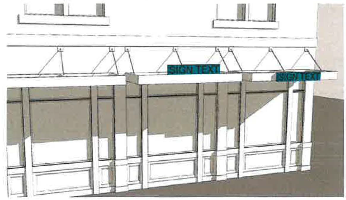
CANOPY (GROUND-MOUNTED) SIGN means a sign that is attached to a GROUND-MOUNTED CANOPY. This definition excludes BOX SIGNS.
Figure 1129.14-6: Example Ground-Mounted Canopy Sign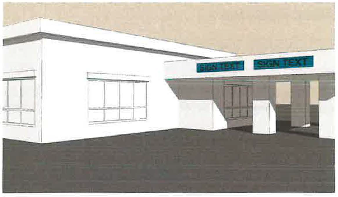
CAPITAL IMPROVEMENTS PROGRAM means a proposed schedule of future public improvement projects and major equipment purchases listed in order of priority, with cost estimates and anticipated means of financing each project for a specified time period. All major projects and purchases requiring public funds over and above the operating expenses for the replacement or initial acquisition of the community's physical assets are included.
CEMETERY means land used or intended to be used for the burial of the human dead and dedicated as a cemetery for such purposes.
CERTIFICATE OF APPROPRIATENESS means a certificate authorizing any alteration of architectural character or any environmental change within the Historic District(s) and Landmark(s) including the Uptown Marysville District.
CERTIFICATE OF DEPOSIT means any certificate of deposit delivered in accordance with the provisions of these regulations to secure the performance of a developer until such developer has discharged its obligations with respect to any final plan.
CHANGEABLE COPY SIGN (AUTOMATIC) means a sign or portion thereof on which the copy changes automatically or animation is displayed through electrical or electronic means (e.g., time and temperature units and message centers); considered a business sign.
CHANGEABLE COPY SIGN a portion of a sign where copy is changed manually through placement of letters or symbols on a sign panel.
CHANNEL means a natural or artificial watercourse of perceptible extent, with bed and banks to confine and conduct continuously or periodically flowing water.
CHARTER means the charter of the City, the same as may be amended from time to time.
CHILD CARE, TYPE A means the permanent residence of the administrator in which child care or publicly funded child care is provided by an employee or employees for seven to twelve children at one time or for four to twelve children at one time, if four or more children at one time are under two years of age. In counting children for the purposes of this division, any children under six years of age who are related to a licensee, administrator, or employee and who are on the premises of the type A home shall be counted. "Type A family day-care home" and "type A home" shall not include any child day camp as defined in Ohio Revised Code Section 5104.01
CHILD CARE CENTER, TYPE B means a permanent residence of the provider in which care is provided for one to six children at one time and in which no more than three children are under two years of age at one time. In counting children for the purposes of this division, any children under six years of age who are related to the provider and who are on the premises of the type B home shall be counted, but not including any child day camp as defined in Ohio Revised Code Section 5104.01.
CHILD DAY CARE CENTER means any place in which child care is provided for thirteen or more children at one time, or any place that is not the permanent residence of the administrator in which child care is provided. (See, Ohio Revised Code Section 5104.01)
CHIMNEY means a structure projecting from the facade and beyond the roofline incorporating a material change and enclosing or appearing to enclose a flue that carries off smoke excluding a stove pipe.
CITY means the City of Marysville, Ohio, a municipal corporation, acting by and through its City Council.
CLUB means a building or portion thereof or premises owned or operated by a person for a social, literary, political, educational or recreational purpose primarily for the exclusive use of members and their guests.
CODE means the Code of Ordinances of the City.
COMMERCIAL AND INDUSTRIAL EQUIPMENT AND MATERIAL, SALES, RENTAL, LEASING AND REPAIR means businesses primarily engaged in renting or leasing machinery and equipment for use in business or industrial operations. These establishments typically cater to a business clientele and do not generally operate a retail-like or store-front facility. Examples including the leasing of heavy equipment, office furniture or equipment, or off-highway transportation equipment.
COMMERCIAL PRINTING, PRINTING AND PUBLISHING means any business publishing of newspapers, magazines, brochures, business cards and similar activities either for profit or nonprofit.
COMMERCIAL RECREATION, INDOOR, EXCLUDING ADULT ENTERTAINMENT means any business which is operated as a recreational enterprise, either publicly or privately owned, for profit. Examples include, but are not limited to, arcades, bowling alleys, theaters, etc.
COMMERCIAL RECREATION, OUTDOOR, EXCLUDING ADULT ENTERTAINMENT means any business which is operated as a recreational enterprise, either publicly or privately owned for profit. Examples include but are not limited to horse stables, fisheries, wilderness preserves, golf course, mini-golf courses, amusement parks and campgrounds.
COMMON AREA means land in any development held in common or single ownership that is not reserved for the exclusive use or benefit of an individual tenant or owner.
COMMUNITY CENTER means a building or other enclosed structure open to residents of a subdivision or the general public, which is owned and operated by a private entity, a public agency, or a nonprofit organization, and that is used predominantly for cultural, educational, recreational, or social purposes.
COMMUNITY FACILITIES means existing, planned and proposed parks, playgrounds, schools and other public lands and buildings located within the City of Marysville.
COMMUNITY GARDEN means a site operated and maintained by an individual or group to cultivate trees, herbs, fruits, vegetables, flowers, or other ornamental foliage for the following uses: personal use/consumption, donation or offsite sale of items grown on the site.
COMPREHENSIVE PLAN means a plan, or any portion thereof, adopted by the Planning Commission and Council of the City showing the general location and extent of present and proposed physical facilities including housing, industrial and commercial uses, major thoroughfares, parks, schools and other community facilities. This plan establishes the goals, objectives and policies of the community.
CONDITIONAL USE means a special use that allows the Planning Commission to review and place conditions on development standards such as location, design, size, density, operation, intensity of use, generation of traffic and traffic movement, processes and equipment employed, and the amount and kinds of public facilities and services required.
These conditions ensure that each proposed use is consistent with the intent and objectives of the particular district in which it is to be located, and protects adjacent properties and the general health, safety and welfare of the public.
CONDITIONAL USE PERMIT means a permit issued by the Division of Engineering upon approval by the Planning Commission to allow a use designated as such in the applicable district or overlay.
CONGREGATE CARE FACILITY, ASSISTED LIVING means a residential facility for elderly persons (age 60 or older) and their spouses, or for persons having such disabilities as to require assistance with daily living tasks, as suggested by their physician. The facility contains four or more dwelling units and/or rooming units, and provides, through on-site personnel, such exclusive resident services as meal preparation, laundry services and room cleaning.
CONGREGATE CARE FACILITY, NURSING HOME means a facility operated and dedicated to the care of persons who cannot care for their own needs either partially or totally. This term includes nursing homes, skilled nursing facilities, convalescent homes, and special care facilities (e.g., Alzheimer Unit).
CONGREGATE RESIDENCE means any building or portion thereof that contains facilities for living, sleeping and sanitation as required by this Code, and may include facilities for eating and cooking for occupancy other than a family. A congregate residence shall be permitted to be a shelter, convent, monastery, dormitory, fraternity or sorority house, but does not include jails, hospitals, nursing homes, hotels or lodging houses.
CONTRACTOR'S OFFICES means a building or part of a building utilized for the principal office or permanent business office for a company providing construction services.
CORBEL means a structural or non-structural projection of materials such as stone, wood, or metal protruding from a façade that carries or appears to carry superincumbent weight.
COUNCIL means the Council of the City. COUNTY means Union County, Ohio.
COUNTY RECORDER means the office of official land records for the County.
CULTURAL INSTITUTION means a nonprofit institution engaged primarily in the performing arts or in the display or preservation of objects of interest in the arts or sciences that are open to the public on a regular basis, with or without a charge for admission. Cultural institution includes performing arts centers for theater, dance and events, museums, historical sites, art galleries, aquariums and such related uses.
CURB LINE means the vertical plane projected upward from the face of the curb along a street.
DECK means a first-floor level structural platform that is uncovered, unenclosed, and projects from a facade.
DEED means a written instrument for the conveyance of real property from one person to another.
DATA PROCESSING/CALL CENTER means a facility, which is operated for the purpose of storing or managing data or operating customer service communications functions.
DENSITY means the number of dwelling units per acre of the total land to be developed.
DESIGN REVIEW BOARD means the Design Review Board of the City.
HISTORIC DISTRICT means the Historic Uptown Marysville Review District and designated landmarks.
DEVELOPER means any person, subdivider, partnership, owner or corporation or duly authorized agent who constructs or contracts to construct improvements on subdivided land.
DEVELOPMENT means the improvement of a tract or parcel of land, which results in an alteration of land or vegetation.
DEVELOPMENT AGREEMENT contains the following components:
A.
Summary and Affidavit.
B.
Preliminary Development Plan.
C.
Final Development Plan.
D.
Restrictive Covenants.
E.
Attachments.
DIMENSIONAL PROJECTING SIGN means a three-dimensional projecting sign such as sign made to look like an object.
DIRECTIONAL SIGN means on-premise sign used to direct vehicles to parking areas or indicate points of entry or exit for a facility or off-street parking lot. Such signs may contain information such as "Lot A", "Green Lot", "in", "enter", "entrance", "out", "exit", "do not enter" or similar directives. Such signs shall not include any business information other than the business logo and/or name.
DORMER means a structure projecting from a sloping roof, usually housing a window, typically used to provide light, ventilation, or more livable space.
DRIVEWAY means a paved way providing access from a street or other means of access to the subject premises.
DIVISION OF ENGINEERING means the City of Marysville Division of Engineering.
DWELLING means any building or portion thereof designed or used exclusively as the residence or sleeping place of one or more persons, but not including a tent, cabin, trailer or mobile home, boarding or rooming house, hotel or motel.
DWELLING, MOBILE HOME means any non-self-propelled vehicle so designed, constructed, reconstructed or added to by means of accessories in such manner as will permit the use and occupancy thereof for human habitation when connected to utilities, whether resting on wheels, jacks, blocks or other temporary foundation and used or so constructed as to permit its being used as a conveyance upon the public streets and highways and exceeding a gross weight of 4,500 pounds and an overall length of thirty (30) feet.
DWELLING, ROOMING HOUSE BOARDING HOUSE, LODGING HOUSE, OR DORMITORY means a dwelling or part thereof, other than a hotel, motel or restaurant where meals and/or lodging are provided for compensation, for three (3) or more unrelated persons where no cooking or dining facilities are provided in the individual rooms.
DWELLING UNIT means Dwelling unit means one room, or a suite of two (2) or more rooms, designed for or used by one family or housekeeping unit for living and sleeping purposes. A dwelling unit shall be comprised of the following components:
(A)
Kitchen or kitchenette; and
(B)
Bath/toilet facility
DWELLING UNIT, EFFICIENCY means a dwelling unit consisting of two habitable rooms or less and not exceeding five hundred (500) square feet in gross floor area including all rooms, measured within the outside walls of the dwelling unit.
EASEMENT means a right granted by a written instrument from one owner of land to another for use of a specified portion of the grantor's real property for a specific purpose or purposes as set forth in an easement agreement.
EASEMENT AREA means the particularly described area of exclusive or non-exclusive legal interest in, on, under, over or through a portion of a parcel of land or appurtenance thereto
ELECTRONIC MESSAGE CENTER means a portion of a sign on which the copy changes automatically is displayed through electrical or electronic means
EMERGENCY means a reasonably unforeseen occurrence with a potential to endanger personal safety or health, or cause substantial damage to property, that calls for immediate action.
EMERGENCY CARE FACILITY means a 24-hour outpatient facility, operated by a hospital or health organization, and staffed by doctors and nurses that provides immediate emergency care services similar to what would be expected in a hospital. Urgent care facilities are not considered emergency care facilities.
ENGINEER means any engineer licensed by the State of Ohio State Board of Registration for Professional Engineers.
ESSENTIAL PUBLIC SERVICES AND UTILITIES means the erection, construction, alteration or maintenance, by public utilities or municipal or other governmental agencies, of underground gas, electrical, water transmission or distribution systems, collection, communication, supply or disposal systems or sites, including poles, wires, mains, drains, sewers, pipes, traffic signals, hydrants or other similar equipment and accessories in connection therewith which are reasonably necessary for the furnishing of adequate service by such public utilities or municipal or other governmental agencies or for the public health or safety of general welfare, but not including buildings.
EXTENDED STAY HOTEL OR MOTEL means any structure consisting of one or more buildings, with more than five (5) dwelling units with provisions for living, eating, cooking, sanitation, and sleeping, that is specifically constructed, kept, used, maintained, advertised, and held out to the public to be a place where temporary residence is offered for more than thirty (30) days and a maximum stay of one (1) year within the dwelling units at the structure, that is approved pursuant to a valid certificate of occupancy issued by the chief building official, having all of the required dwelling unit features, and for which such valid certificate of occupancy indicates the specific rooms within the structure that can be used as dwelling units, and that is approved by the fire chief for extended stay temporary residence purposes.
EXTERIOR FEATURES (OUTDOOR ADVERTISING SIGN) means the style, material, size and location of the sign.
FAMILY means a person living alone, or two or more persons living together as a single housekeeping unit in a dwelling unit, as distinguished from a group occupying a rooming house, motel or hotel, dormitory, fraternity or sorority house, provided, that "family" shall not include more than four persons unrelated to each other by blood, marriage or legal custodial relationships.
FENCE means a structure, hedge or other landscape material positioned up to or on top of the property line, easement line, right-of-way, or setback line, as applicable for the purpose of separating properties, or for screening, enclosing, and/or protecting the property within its perimeter.
FIRE PIT means an aboveground structure together with a seating area, installed, constructed and designed for the setting of small-scale fires in accordance with the regulations applicable to the subject property upon which such structure and seating area are located.
FLAG means a piece of fabric or other flexible material that is attached to or designed to be flown from a flagpole or similar device.
FLOOD PLAIN means land under and along a watercourse which is subject to inundation by a 100-year flood, as determined by the Federal Emergency Management Agency (FEMA) or other source determined acceptable to the city.
FLOOD, REGIONAL means large floods which have previously occurred or which may be expected to occur on a particular stream because of like physical characteristics. The regional flood generally has an average frequency of the 100 year recurrence interval flood.
FLOODWAY FRINGE means that portion of the flood plain, excluding the floodway, where development may be allowed under certain restrictions.
FLOODWAY means that portion of the flood plain, including the channel, which is reasonably required to convey the regional flood waters. Floods of less frequent recurrence are usually contained completely within the floodway.
FLOOR AREA, GROSS means the total square feet of all main and accessory buildings which are enclosed, measured from the exterior building face or from the centerline of common walls separating building units.
FOOD TRUCK PARK means land designated for the operation of food truck vendors in accordance with applicable local and state laws and regulations, including this planning and zoning ordinance.
FREESTANDING SIGN means a sign which is not attached to a building, and which is either attached directly to the ground or elevated on a supporting structure attached to the ground.
FRONTAGE means the principal elevation of a building, which is most often the elevation that abuts a street. In the context of the location of any building typology described under the Zoning Code, frontage means the street or right-of-way type that a building is permitted to abut.
FUNERAL HOME means a building or buildings for the storage of human bodies prior to their burial or cremation, or a building used for the preparation of the deceased for burial and the display of the deceased and ceremonies connected therewith before burial or cremation.
GABLE means a wall that comes to a point at its intersection with the ridge of two sloping roof planes.
GABLE VENT means a decorative or non-decorative vent placed within a gable.
GARAGE, PRIVATE means an accessory building or part of a principal building used for the storage of motor vehicles as an accessory use and in which no business or industry connected directly or indirectly with the repair or servicing of such motor vehicles is carried on.
GENERAL RETAIL means retail store generally carrying a general line of apparel, such as produce, perishable food, non-perishable food, clothing apparel, home furnishings, major household appliances and accessory items, building materials and accessory items. These and other merchandise lines are normally arranged in separate sections or departments with the accounting on a departmentalized basis. The departments and functions are integrated under a single management. The stores usually provide their own charge accounts, deliver merchandise, and maintain open stocks. These stores have 50 employees or more.
GRADE means the elevation of land surrounding a structure or the slope of a road, in each case expressed as a percentage.
GROCERY STORE OR SUPERMARKET means an establishment for retail sales of food and beverages for off-site preparation and consumption, including large-scale stores with customary accessory uses such as delicatessens, coffee shops, and financial institutions.
GROUND PASSENGER DISPATCH FACILITY means an establishment serving as the headquarters and parking site of a fleet of two-axle vehicles such as passenger vans, employed for the transport of not more than twelve passengers in and around the City for purposes such as accessing healthcare, employment opportunities and educational opportunities.
HEALTH AND FITNESS STUDIO means any fitness center, gymnasium, health, studio fitness center and athletic club, which may include any of the following: aerobics instruction, exercise machines, sauna, spa or hot tub facilities; indoor tennis, handball, racquetball and other indoor athletic amenities and events.
HEIGHT OR ABOVE GROUND LEVEL means, when referring to a tower or other structure, the distance measured from the finished grade at the base of the tower/structure to the highest point on the tower or other structure, including the base pad and any antenna.
HOME OCCUPATION means an occupation conducted in a dwelling unit, provided that no more than one person other than members of the family residing on the premises shall be engaged in such occupation. The use of the dwelling unit for the home occupation shall be clearly incidental and subordinate to its use for residential purposes by its occupants, and not more than thirty-five percent (35%) of floor area of the dwelling unit shall be used in the conduct of the home occupation. There shall be no change in the outside appearance of the building or premises, or other visible evidence of the conduct of such home occupation other than one sign, not exceeding four (4) square feet in area, non-illuminated, and mounted flat against the wall of the principal building. No traffic shall be generated by the conduct of such home occupation and any need for parking generated by the conduct of such home occupation shall meet the off-street parking requirements as specified in this Planning and Zoning ordinance, and shall not be located in a required front yard.
HOMEOWNERS ASSOCIATION (HOA) OR PROPERTY OWNERS ASSOCIATION (POA) means an incorporated, non-profit organization established by a developer, subdivider or an association of property owners whose membership shall consist of individual property owners within a subdivision.
HOSPITAL means an institution in which sick or injured persons are provided medical care and assistance and, in the course of same, may be housed overnight, fed and provided nursing and related services. Hospital shall comprise any related, accessory facilities such as laboratories, outpatient departments, training facilities, food service facilities, central service facilities and staff offices which are integral parts of the principal hospital facility.
HOTEL OR MOTEL means a place of transient occupancy which includes any structure consisting of one or more buildings containing any combination of more than 5 guest rooms that are each approved by the Chief Building Official and the fire chief as meeting the requirements for transient sleeping rooms or extended stay temporary residence dwelling units, or as having features of such sleeping rooms and dwelling units within the same room, and such structure is specifically constructed, kept, used, maintained, advertised, and held out to the public to be a place where transient sleeping accommodations or temporary residence is offered for pay to persons, but such structure does not otherwise meet the definition of a transient hotel or an extended stay hotel as defined in this section. "Hotel" does not include agricultural labor camps, multi-family buildings or other similar places of permanent personal residence, lodging houses, rooming houses, or hospital or college dormitories
IDENTIFICATION SIGN means generally, a sign identifying or naming a business institution, residential development or other use. Specifically, such sign may indicate the name, owner, or manager and address of an existing building, business or other use, including the general type of goods sold or services rendered, but without a listing of numerous specific goods or services and without reference to brand names, prices, "sales" or telephone numbers.
ILLUMINATED SIGN means any sign illuminated by electricity, gas, or other artificial light including reflecting or phosphorescent light. This includes the following defined categories:
(1)
BOX ILLUMINATION means illumination accomplished by illuminating the majority of a translucent face to which a sign is applied. Such illumination shall not qualify as, and is defined separately from, INTERNAL ILLUMINATION.
(2)
EXTERNAL ILLUMINATION means illumination accomplished by directing a shielded light source (that is separate from a sign) to a given sign. Such illumination may apply lighting across the face of a sign, or it may provide back-lighting to the letters, numbers, symbols, logos, and accent lines of a sign.
(3)
INTERNAL ILLUMINATION means illumination accomplished by back-lighting or allowing light exclusively through the letters, numbers, symbols, logos, and accent lines of a sign from a concealed light source. Such illumination shall not qualify as, and is defined separately from, BOX ILLUMINATION.
IMPROVEMENTS means any additions to the natural state of the land which increases its value or utility, including pavements, curbs, gutters, sidewalks, crosswalks, water mains, sanitary and storm sewers, landscaping and other appropriate facilities or plantings.
A.
"Site improvements" means the improvements made to the land outside the exterior limits of a structure or structures.
B.
"Public improvements" means all improvements financed entirely or in part by public funds or which have been dedicated to public use by plat, easement or deed of transfer.
C.
"Final Plat Improvements" mean those improvements set forth in the final plan submitted to and approved by the City in accordance with these regulations.
D.
"Drainage Improvements" means those improvements determined by the City Engineer to be necessary to facilitate satisfactory drainage in accordance with these regulations, including but not limited to underground pipe, inlets, catch basics, ditches, and/or retention basins.
INDEPENDENT LIVING, AGE-RESTRICTED means a private development comprised of individual dwelling units designed for occupancy by individuals who are over a threshold age, which is typically fifty-five (55) years old.
INFORMATION WINDOW/WALL SIGN means window or wall signage bearing only information about entry and exit, business hours, authorized service representative information and/or discount, credit systems accepted in that establishment (e.g. American Express, MasterCard, Visa, Golden Buckeye Card, etc.), and business directives (e.g. no soliciting, no firearms, etc.).
INSTITUTIONAL/GOVERNMENT OFFICES means a building or location that provides for community meetings and/or activities including, but not limited to, City Hall, Township Hall, school administration building, recreation center (public or private), property listed on the National Register of Historic Places, Chamber of Commerce building, Arts Council building, library, or other public buildings owned or operated by the City.
JUNK means old or scrap copper, brass, rope, gas, trash, waste, batteries, paper or rubber, junked, dismantled or wrecked, automobiles or parts thereof, iron, steel and other old or scrap ferrous or nonferrous materials.
KENNEL means any structure or premises on which five (5) or more dogs or cats over three (3) months of age are housed, bred, boarded, or trained overnight.
LABORATORY OR RESEARCH FACILITY means a facility primarily for medical, optical, orthotic, prosthetic, or dental laboratory services, photographic, analytical, or testing services and/or engaged in the research, development and controlled production of high technology electronic, industrial or scientific products or commodities for sale.
LANDSCAPED AREA means an area with plants, trees, natural turf or other vegetation planted in accordance with a landscape plan.
LIGHT MANUFACTURING means manufacturing establishments engaged in and undertaking the assembly, fabrication and conversion of already processed raw materials into products, the production of which does not cause excessive noise, odor or other similar impacts on surrounding land uses.
LIGHTING DEVICE means any light, string of lights or group of lights located or arranged so as to cast illumination on a sign.
LOADING SPACE, OFF-STREET means space logically and conveniently located for bulk pickups and deliveries, scaled to delivery vehicles expected to be used, and accessible to such vehicles when required off-street parking spaces are filled. Required off-street loading space is not to be included as off-street parking space in computation of required off-street parking space. All off-street loading spaces shall be located totally outside of any street or alley right-of-way.
LOGO FLAG means a sign made of flag-like material containing a logo or identifying symbol.
LOGO (OR TRADEMARK) means a letter or group of letters (usually stylized) or a symbol or symbols that represent a word, group of words, or business name. Usually used as part of a business identification scheme that is meant to identify goods, products, services or a business entity itself.
LOT COVERAGE means the ratio of enclosed ground floor area of all buildings, structures and surfaces, regardless if it is pervious or impervious, on a lot to the horizontally projected area of the lot, expressed as a percentage.
LOT MEASUREMENTS means the method of measurement for a lot under this chapter, which shall be conducted as follows: (A) Depth means the distance between the mid-points of straight lines connecting the foremost points of the side lot lines in front and the rearmost points of the side lot lines in the rear. (B) Width means the distance between straight lines connecting front and rear lot lines at each side of the lot, measured at the minimum required building setback line.
LOT OF RECORD means a lot which is part of a subdivision recorded in the office of the County Recorder, or a lot or parcel described by metes and bounds, the description of which has been so recorded.
LOT TYPES means, as follows:
(A)
Corner lot means a lot located at the intersection of two (2) or more streets. A lot abutting on a curved street or streets shall be considered a corner lot if straight lines drawn from the foremost points of the side lot lines to the foremost point of the lot meet at an interior angle of less than 135 degrees.
(B)
Interior lot means a lot with only one frontage on a street.
(C)
Through lot means a lot other than a corner lot with frontage on more than one street. Through lots abutting two (2) streets may be referred to as double frontage lots.
(D)
Reversed frontage lot means a lot on which frontage is at right angles to the general pattern in the area. A reversed frontage lot may also be a corner lot.
LOT means a portion of a subdivision or other parcel of land intended as a unit for transfer of ownership and/or for building purposes or development, having fixed boundaries and designated on a plat or survey together with the required open spaces and having frontage on a public street or a private street.
LOT LINE ADJUSTMENT means a process that is used to change property lines of existing parcels for the purpose of combining two (2) or more adjacent parcels into one (1) parcel, alter and/or correct the boundary between two (2) or more parcels, or reconfigure the shape of parcels, without creating any additional parcels.
LOT, MINIMUM AREA OF means the area of a lot is computed exclusive of any portion of the right-of-way of any public or private street.
MAINTENANCE BOND means an agreement by a subdivider or developer with the City, for a percentage of the established construction cost, used as a guarantee against any deficiencies which might develop between commencement of a development by a subdivider or developer and formal acceptance of dedication by City Council.
MAJOR THOROUGHFARE PLAN means the portion of comprehensive plan adopted by the City Planning Commission indicating the general location recommended for arterial, collector and local thoroughfares within the appropriate jurisdiction.
MANUFACTURED HOME PARK means any tract of land upon which three (3) or more manufactured homes are located for residential use, either free of charge or for revenue purposes, including any roadway, building, structure, vehicle, or enclosure used or intended to be used as a part of the facilities of such park.
MANUFACTURED HOME means any non-self propelled vehicle transportable in one or more sections which, in the traveling mode, is 8 body feet or more in width or 40 body feet or more in length, or, when erected on site, is 320 or more square feet, and which is built on a permanent chassis and designed to be used as a dwelling unit with or without a permanent foundation when connected to the required utilities, and includes the plumbing, heating, air conditioning, and electrical systems contained therein, and which bears a label certifying that it is built in compliance with Federal Manufactured Housing Construction and Safety Standards.
MANUFACTURING, GENERAL means major manufacturing, processing, storage, warehousing, research and testing establishments which may require large sites, extensive community services and facilities, ready access to regional transportation; have large open storage and service areas; generate heavy traffic; and create no nuisance discernible beyond the district boundary.
MARQUEE means a permanent structure fastened entirely to the building and projecting from the wall above an entrance and extending over the street right-of-way to provide shelter for automobile passenger loading and unloading entrance.
MARQUEE SIGN means a display sign attached to or hung from and supported by the building and extending beyond the building wall, building line, or street lot line.
MEDICAL OR DENTAL OFFICE OR CLINIC means a facility other than a hospital, emergency room or urgent care where medical, mental health, surgical and other personal health services are provided on an outpatient basis. Examples of these uses include: offices for physicians, dentists, chiropractors, or other health care professionals; outpatient care facilities; urgent care facilities; and other allied health services. These facilities may also include incidental medical laboratories. Patients are not provided with room and board and are not kept overnight on the premises. Medical Services and medical clinics include medical and dental laboratories incidental to the medical office use.
MEETING FACILITY means a meeting facility means facilities, typically accommodating groups of students in multiple instructional spaces. Examples of these facilities include: individual and group instruction and training in the arts; production rehearsal; photography, and the processing of photographs produced only by users of the studio facilities; martial arts training studios; gymnastics instruction, and aerobics and gymnastics studios with no other fitness facilities or equipment.
This definition also includes production studios for individual musicians, painters, sculptors, photographers, and other artists.
MINOR SUBDIVISION means a proposed division of a parcel of land along an existing public street, not involving the opening, widening or extension of any street or road, and involving no more than five (5) lots after the original tract has been completely subdivided, that may be submitted to the authority having approving jurisdiction of plats under the provisions of Ohio R. C. 711.05, 711.09 or 711.10 for approval without plat.
MOBILE HOME means any non-self-propelled vehicle so designed, constructed, reconstructed, or added to by means of accessories in such manner as will permit the use and occupancy thereof for human habitation, when connected to utilities, whether resting on wheels, jacks, blocks, or other temporary foundation and used or so construed as to permit its being used as a conveyance upon the public streets and highways and exceeding a gross weight of four thousand five hundred (4,500) pounds and an overall length of thirty (30) feet, and not in compliance with the Federal Manufactured Housing Construction and Safety Standards Act of 1974.
MOBILE HOME PARK means any site, or tract of land under single ownership, upon which three (3) or more mobile homes used for habitation are parked, either free of charge or for revenue purposes; including any roadway, building, structure, vehicle or enclosure used or intended for use as a part
MOBILE HOME SUBDIVISION means a subdivision as defined in this section in which three (3) or more mobile homes used for habitation are parked, including any roadway, building, structure, vehicle or enclosure used or intended for use therein.
MONUMENT SIGN means a sign, with one (1) or two (2) sides, attached to a permanent foundation or fastened to a base, and not attached or dependent upon any structure, pole, post or similar manner of construction.
Figure 1129.14-8: Example Monument Sign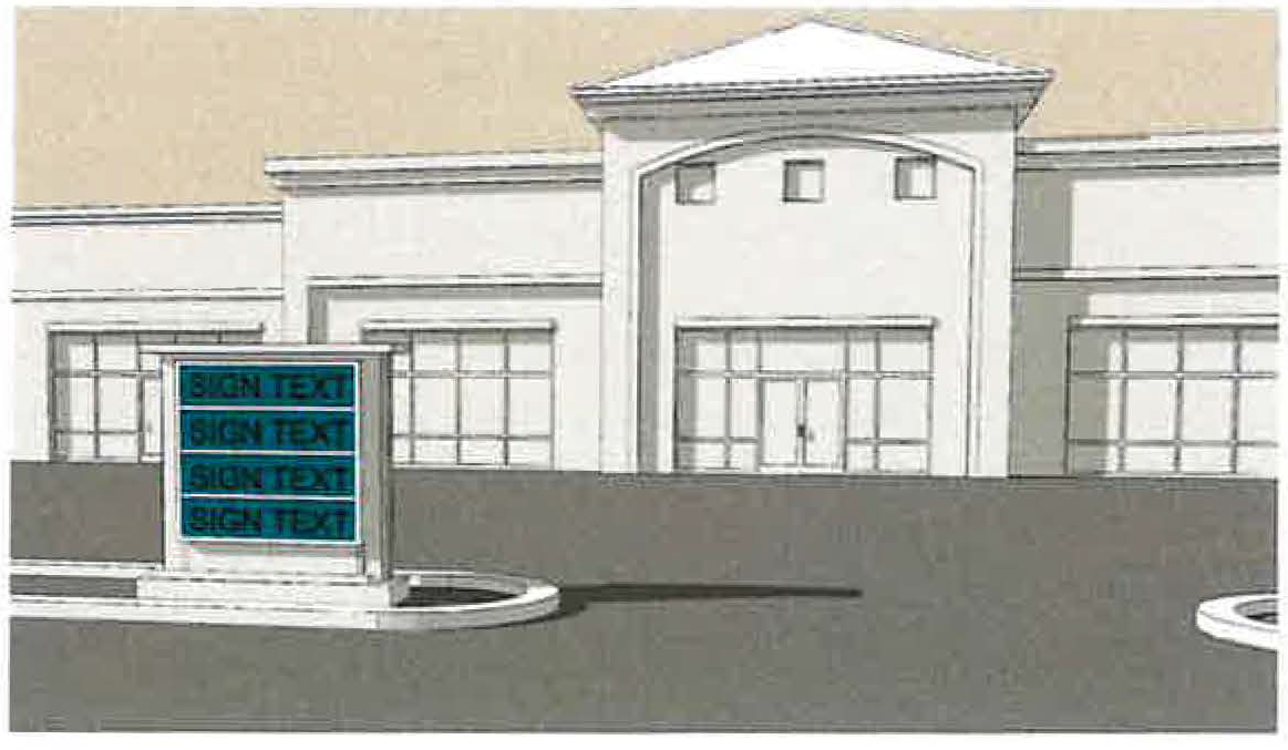
MONUMENTS means permanent concrete or iron markers used to establish definitely all lines of the plat of a subdivision, including all lot comers, boundary line comers and points of change in street alignment.
MOTOR VEHICLE means a vehicle which is designed and manufactured to be self-propelling or self-moving upon the public street or highway.
More specifically, as referred to in this ordinance, it includes: automobiles, trucks, tractors and scooters and motorcycles.
MULTI-FAMILY means a building or portion thereof designed for or occupied by two (2) or more families, or housekeeping units, living independently of each other in separate dwelling units which are accessible by interior hallways. This type of dwelling unit excludes a hotel.
MULTI-FAMILY RENTAL OFFICE/MANAGEMENT SITE means a residential apartment structure, permitted in multi-family residential districts, that is used by an apartment owner, employee or realtor to demonstrate construction and to display built-in amenities to prospective apartment tenants and to promote the rental or lease of apartment units. The rental office may be staffed and furnished.
MULTI-TENANT SIGN PACKAGE means a group of multiple tenant signs to be applied in a common development such as a shopping center or mixed-use development project. Each sign that is included in a multi-tenant sign package shall comply with all of the standards for that type of sign. No multi-tenant sign package will be approved unless all individual signs comply with the regulations contained in this chapter.
MURAL means a design, representation, or graphic illustration that is painted, drawn, or similarly applied to an exterior surface of a structure, and that does not meet the definition of a SIGN; typically established for the purposes of decoration, cultural representation, storytelling, beautification of public spaces, and artistic expression. Murals are separate from and do not include WALL SIGNS.
Figure 1129.14-9: Example Mural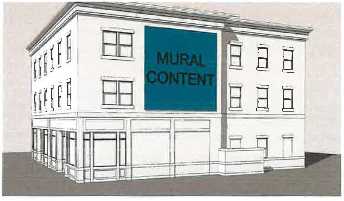
NEIGHBORHOOD MARKET means a pedestrian-oriented retail establishment, oriented to the daily shopping needs of surrounding residential areas.
NONCONFORMITIES means a building, structure or use of land existing at the time of enactment of this Planning and Zoning ordinance which does not conform to the regulations of the district or zone in which it is situated.
NUDE OR STATE OF NUDITY means a state of dress or undress that exposes to view: Less than completely and opaquely covered human genitals; pubic region; anus; or female breast below a point immediately above the top of the areolae, but not including any portion of the cleavage of the female breast exhibited by a dress, blouse, shirt, leotard, bathing suit, or other wearing apparel, provided the areolae is not exposed; or Human male genitals in a discernibly turgid state, even if completely and opaquely covered, or any device or covering that, when worn, simulates human male genitals in a discernibly turgid state.
NURSERY means an establishment primarily engaged in the retail sale of garden supplies and plants grown on the premises or elsewhere. This classification includes the sale of landscape materials, topsoil and rental of landscaping equipment.
OFF-PREMISES SIGN means any sign unrelated to a business or profession conducted or to a commodity or services sold or offered upon the premises where such sign is located.
OFFICIAL ZONING MAP means the Official Zoning Map of the City of Marysville, as the same may be amended from time to time in accordance with this Planning and Zoning ordinance.
ON-PREMISES SIGN means any sign related to a business or profession conducted, or a commodity or service sold or offered upon the premises where such sign is located.
OPEN/CLOSED SIGN means a window or wall sign bearing only information indicating if the business is open or closed. This does not include the hours of operation. Signs that include both the open/closed information and the hours of operation shall be deemed to be an information sign.
OPEN SPACE means an area of land unoccupied by buildings, structures, storage or vehicular use areas, except for recreational structures and which is generally used for the purpose of active or passive recreation, natural features, environmental protection, preservation of scenic views or similar purposes. Open space does not include street rights-of-way or setbacks.
OUTDOOR COURTS means basketball court, tennis court, pickleball court, volleyball court or multi-purpose court in each case installed as an accessory structure to a principal use.
OWNER means any individual, firm, association, syndicate, co-partnership, corporation, trust, or other legal entity having sufficient proprietary interest in real property to commence and maintain proceedings with respect to any land use approval sough hereunder.
OVERLAY means an area depicted on the official zoning map, within which, through super-imposition of a special designation, certain regulations and requirements apply in addition to those of the base zoning districts to which such designation is added.
PAD means a building site prepared by artificial means, including grading, excavation or filling, or any combination thereof.
PANEL SIGN means a sign which is mounted, attached, painted, or displayed on a sign panel.
PARCEL means a division of real property contained in a single legal description that is recorded in the official land records of the Union County Recorder's office.
PARK/PLAYGROUND see community facilities.
PARKING AREA OR STRUCTURE means an off-street area or structure for required parking or loading spaces, including driveways, access ways, aisles, parking and maneuvering space necessary for the parking or loading areas.
PARKING SPACE, OFF-STREET means an area adequate for parking an automobile with room for opening doors on both sides, together with properly related access to a public street or alley and maneuvering room, but shall be located totally outside of any street or alley right-of-way.
PATIO means an outdoor seating area, covered or uncovered, constructed, installed and located upon a property in accordance with all local and state laws and regulations, including this Planning and Zoning ordinance, applicable to the subject property upon which such seating area is located.
PERGOLA means an attached or detached structure constructed and located upon a property in accordance with all local and state laws and regulations, including this Planning and Zoning ordinance, applicable to the subject property upon which such attached or detached structure is located.
PERFORMANCE BOND OR SURETY BOND mean an agreement by a subdivider or developer with the City for the amount of the estimated construction cost guaranteeing the completion of physical improvements according to plans and specifications within the time prescribed by the subdivider's agreement.
PERSON means any firm, association, organization, limited partnership, general partnership, trust, company or corporation as well as any natural person.
PERSONAL SERVICES means any enterprise conducted for gain which primarily offers services to the general public such as shoe repair, watch repair, barber shops, beauty parlors and similar activities.
PLANNED UNIT DEVELOPMENT (PUD) means an area of land in which a variety of housing types and subordinate commercial and industrial facilities are accommodated in a preplanned environment under more flexible standards, such as lot sizes and setbacks, then those restrictions that would normally apply under these regulations. The procedure for approval of such development contains requirements in additional to those of the standard subdivision, such as building design principles and landscaping plans.
PLANNING AND ZONING ORDINANCE means the zoning regulations of the City of Marysville.
PLANTING AREA means any area utilized for landscape material installation having a minimum area of fifty (50) square feet.
PLANTS means living vegetation. Artificial plants are not included in this definition.
PLAT means the map, drawing or chart on which the developer's plan of subdivision is presented to the City Planning Commission for approval and, after such approval, to the County Recorder for recording.
PLAT, FINAL means the final map, drawing or chart made by a surveyor registered in the State of Ohio, and supplementary information, based upon the approved preliminary plat, in which the subdivider's plan is presented to the City Planning Commission for approval and which, if approved, will be certified and submitted to the Recorder of Union County.
PLAT, PRELIMINARY means the preliminary map, drawing or chart, and supplementary information, on which the layout and design of a proposed subdivision is submitted to the City Planning Commission for consideration and tentative approval.
POLE SIGN means a freestanding sign, other than a BILLBOARD, and typically oriented vertically, that is attached directly to a pole mounted to the ground.
Figure 1129.14-7: Example Freestanding Pole Sign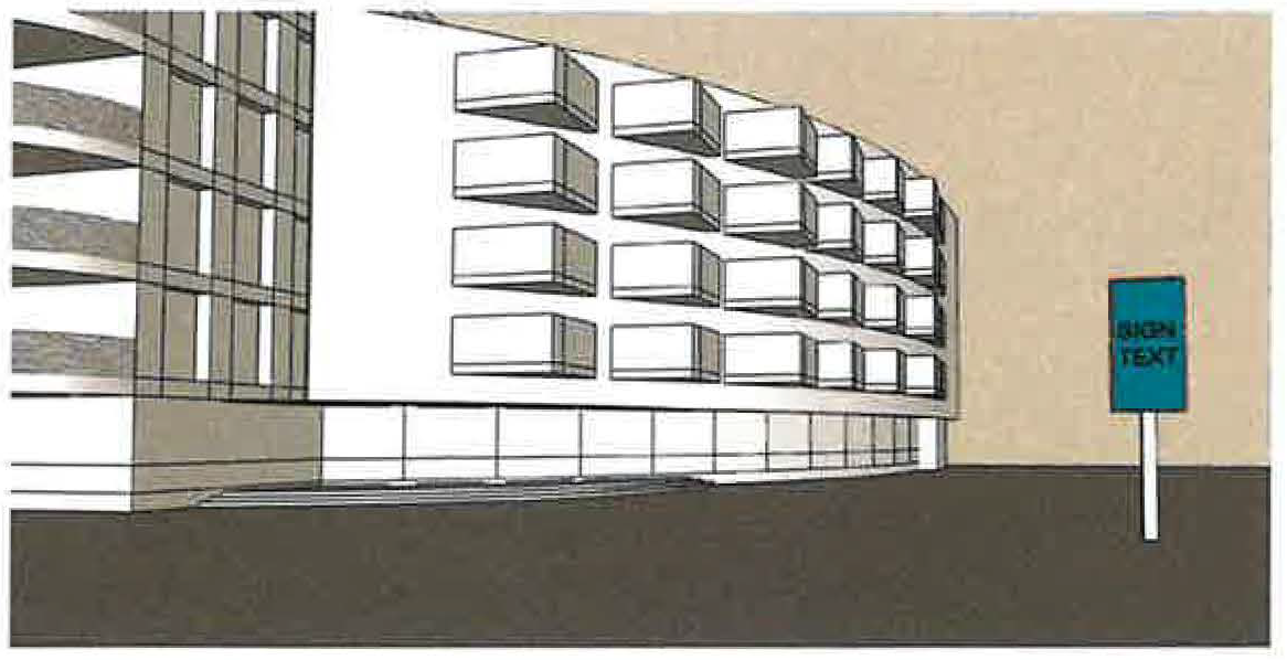
POLITICAL SIGN means signs having reference to a political official, candidate, question, issue or opinion.
POND shall mean an inland body of standing water either natural or man-made.
POOL HOUSE means a detached structure serving a swimming pool, constructed and located upon a property in accordance with all local and state laws and regulations, including this Planning and Zoning ordinance, applicable to the subject property upon which such structure is located.
PORCH means a first-floor level structural platform that is covered, unenclosed, and projects or is recessed from a façade. Wraparound porches extend outdoor space, partially or fully, across at least two facades.
PORTABLE SIDEWALK SIGN means any portable or freestanding sign displayed on a sidewalk in front of a business or other enterprise and taken inside at night or when the associated business or enterprise is closed.
Figure 1129.14-10: Example Portable Sidewalk Sign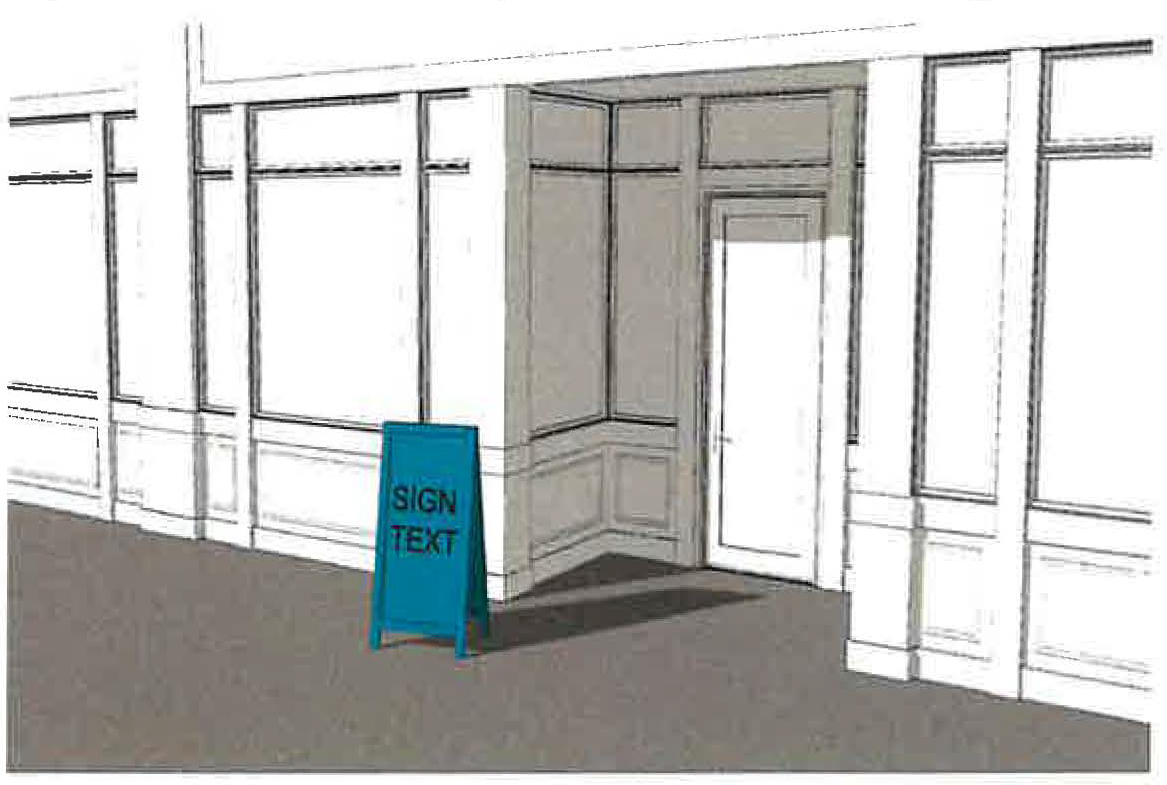
PORTABLE SIGN means a sign which is designed to be moved and is not permanently attached to any part of a building or to the ground.
POST AND PANEL SIGN means a sign suspended from or otherwise connected to one or more posts that are mounted directly into the ground.
Figure 1129.14-11: Example Post and Panel Sign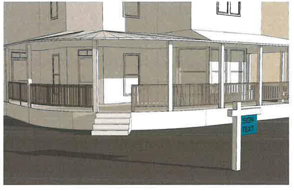
PORTABLE STORAGE CONTAINER means a moving and/or storage service whereby a company delivers and leaves a storage container on-site for a customer to pack. The storage container is then picked up and moved to a company warehouse and/or the customer's destination for unpacking and subsequent removal.
PORTICO means a structure consisting of a roof supported by columns, often leading to the entrance of a building, typically attached as a porch to a facade.
PRIVATE SWIMMING POOL means any structure that contains water over 24 inches (610 mm) in depth and which is used, or intended to be used, for swimming or recreational use and which is available only to the family and guests of the property owner. This includes in-ground, aboveground, portable and inflatable swimming pools, hot tubs and spas.
PROFESSIONAL OFFICE means a building or portion of a building wherein services are performed involving predominately administrative, professional or clerical operations.
PROJECTING SIGN means a double-faced sign which is attached directly to and projecting outward from the building wall, generally at a right angle to the building as opposed to parallel to the building like a wall sign.
Figure 1129.14-12: Example Projecting Sign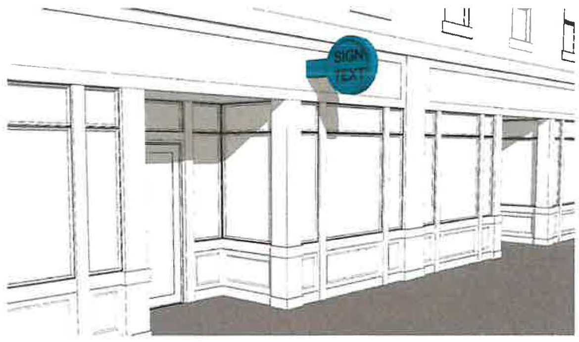
PUBLIC ACCESS EASEMENT means an easement granted to the public for all the purposes for which a public sidewalk may be used, including but not limited to, pedestrian and bicycle travel.
PUBLIC ENTRANCE means an exterior entrance that allows public pedestrian access into or out of a building or a tenant space within a building. Public entrances into the same tenant space that are within 25 feet of each other (as measured in a straight line from the leading edges of the framework surrounding such doorways) shall not be considered separate entrances for the purpose of this Sign Code. This definition does not include emergency-only exterior doorways, employee-only doorways, entrances into dwelling units, or garage doors.
PUBLIC SAFETY FACILITY means facilities operated by public agencies including fire stations, other fire prevention and fire-fighting facilities, police and sheriff substations and headquarters, including interim incarceration facilities.
PUBLIC SERVICE FACILITY means the erection, construction, alteration, operation or maintenance of buildings, power plants or substations, water treatment plants or pumping station, sewage disposal or pumping plants, and other similar public service structures by a public utility, by a railroad, whether publicly or privately owned, or by a municipal or other governmental agency, including the furnishing of electrical, gas, rail transport, communication, public or private water and sewage service.
PUBLIC SWIMMING POOL means any outdoor structure, chamber, or tank containing a body of water for swimming, diving, recreational use, or sanctioned event that is intended to be used collectively for swimming, diving, recreational use, or sanctioned event and is operated by any person whether as the owner, lessee, operator, licensee, or concessionaire, regardless of whether or not a fee is charged for use.
PUBLIC WAY means an alley, avenue, boulevard, bridge, channel, ditch, easement, expressway, freeway, highway, land, parkway. right-of-way, road, sidewalk, street, subway, tunnel, viaduct, walk, bicycle path or other ways in which the general public or a public entity have a right, or which are dedicated whether improved or not.
REAL ESTATE/MODEL HOME SIGN means a temporary sign promoting the development, construction, rental, sale or lease of property.
RECREATION, NONCOMMERCIAL means any business which is operated as a recreational enterprise, either publicly or privately owned, for nonprofit. Examples include, but are not limited to: fishing areas, parks, archery ranges, etc.
RECREATIONAL POND shall mean any naturally occurring or man-made body of water designed to retain water on an ongoing basis. Such ponds are to be designed for enjoyment and to further activities such as swimming, fishing, ice skating, kayaking, or similar activities. Such ponds shall not engage in commercial uses nor in any commercial recreational activities without the appropriate zoning permit, any requisite Health Department approval or other applicable local/state/federal regulations.
RECREATIONAL VEHICLE means a vehicle type unit primarily designed as temporary living quarters for recreation, camping, or travel use only, which either has its own motive power or is mounted on or drawn by another vehicle. The basic entities are: boat, travel trailer, camping trailer, truck camper, and motor home.
RECYCLING CENTER means a center for the collection and/or processing of recyclable materials. A recycling facility does not include storage containers located on a residentially, commercially or industrially designated site used solely for the recycling of material generated on the site.
RELIGIOUS PLACES OF WORSHIP means a permanently located church, cathedral, synagogue, temple, mosque, or other place dedicated to religious worship. As part of its functions it may include the following incidental and subordinate uses subject to applicable federal, state and local regulations: offices, residences for clergy, religious instruction, educational institutions, private and special schools, day care centers, emergency shelters, and community and recreational activities.
RESERVATION shall mean any reservation of public land made by a developer in accordance with the provisions of these regulations.
RESIDENTIAL (UPPER FLOOR) means, where permitted, dwelling units located on a floor other than the ground floor.
RESIDENTIAL CARE FACILITY means an establishment operated for the purpose of providing special care or rehabilitation to the occupants for the corresponding purposes at the corresponding capacity as described below and governed by the applicable Ohio Revised Code Section, including the following:
•
Developmental Disability Dwelling (1-5 Unrelated Persons) (R.C. 5123.19)
•
Developmental Disability Dwelling (6-8 Unrelated Persons) (R.C. 5123.19)
•
Developmental Disability Dwelling (9-16 Unrelated Persons) (R.C. 5123.19)
•
Mental Health or Substance Abuse (1-5 Unrelated Persons) (R.C. 5119.341)
•
Mental Health or Substance Abuse (6-16 Unrelated Persons) (R.C. 5119.341)
RESIDENTIAL MODEL HOME means a residential structure, permitted in all residential districts that is used by a licensed home builder/ developer, real estate workers or realtor to demonstrate construction, display built-in amenities and color selection charts to prospective home buyers and promote the sale or lease of housing units. The model home may be staffed and furnished. (Ord. 25-97. Passed 6-12-97 :)
RESTAURANT means establishments whose primary use is to prepare and serve food and/or beverages to patrons in exchange for payment, which may be consumed on-site or available for takeout service.
RESTRICTED OPEN SPACE means open space within any subdivision that is restricted from further development in accordance with a deed restriction or similar restrictive covenant.
RETAIL, SALES & SERVICE means an establishment engaged in sales of goods or the provision of services, including, but not limited to: alcoholic beverages, furniture and home furnishings, electronics and appliances, clothing and shoes, jewelry, luggage and leather goods, sporting goods and hobbies, books, periodicals and music, tobacco sales, department stores, florists, office supplies and stationary, gifts and novelties, pets, hardware, pawn shops, video stores and auto parts, tailor, dry cleaning, tax preparation, hairdresser, or barber.
This classification includes the retail sale or rental of merchandise not specifically listed under another use classification.
RIGHT-OF-WAY means a strip of land taken or dedicated for use as a public way. In addition to the roadway, it normally incorporates the curbs, lawn strips, sidewalks, lighting and drainage facilities, and may include special features (required by the topography or treatment) such as grade separation, landscaped area, viaducts and bridges.
ROOF SIGN means a sign that is attached to or supported by the roof of a building; or a sign that extends above the roofline of the building to which it is attached, but not including signs attached to a mansard-style roof. Shingles that are designed to spell a word shall be included in the definition of roof sign for purposes hereof.
Figure 1129.14-13: Example Roof Sign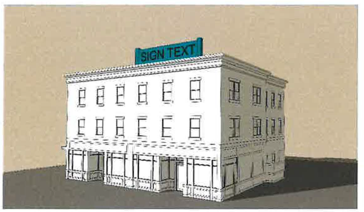
ROOMING HOUSE means any dwelling, or that part of any dwelling containing one or more rooming units, in which space is provided by the occupant to more than four persons who are not husband or wife, son or daughter, mother or father, or sister or brother of the occupant.
ROOMING UNIT means any room or group of rooms forming a single habitable unit used or intended to be used for living and sleeping, but not for cooking or eating purposes.
SCHOOL (K-12) means any school having regular sessions with regularly employed instructors teaching subjects which are fundamental and essential for a general academic education, under the supervision of, and in accordance with, the applicable statutes of the State of Ohio.
SCHOOL, COLLEGE OR UNIVERSITY, VOCATIONAL AND TECHNICAL, TRADE OR BUSINESS means School, college or university, vocational and technical, trade or business means an institution of higher education providing curricula of a general, religious, or professional nature, typically granting recognized degrees. This classification includes business and computer schools, management training, technical vocational and trade schools, but excludes personal instructional services.
SEAT means, for purposes of determining the number of off-street parking spaces for certain uses, the number of seats is the number of seating units installed or indicated, or each twenty-four (24) lineal inches of benches, pews or space for loose chairs.
SEMI-NUDE means a state of dress or undress in which clothing covers no more than the human genitals, anus, and areolae of the female breast, as well as portions of the body covered by supporting straps or devices or by other minor accessory apparel such as hats, gloves, and socks.
SENIOR LIVING, INDEPENDENT LIVING means any building or buildings designed, built, rented, leased or let to contain three or more age-restricted (55 or older) dwelling units, or which is occupied as a home or place of residence by three or more age-restricted families living in independent dwelling units.
SETBACK means a line established by these regulations and/or Planning and Zoning ordinance or resolution, generally parallel with and measured from the front(s), side(s) and rear lot line, defining the limits of a parcel in which no building or structure may be located above ground, except as may be provided in such Codes.
SETBACK LINE means a line established by the Planning and Zoning ordinance generally parallel with and measured from the lot line, defining the limits of a yard in which no building, other than accessory building, or structure may be located above ground, except as may be provided in such Planning and Zoning ordinance.
SEWERS, CENTRAL OR GROUP means an approved sewage disposal system which provides a collection network and disposal system and central sewage treatment facility for a single development, community or region.
SEWERS, ON-SITE means a septic tank or similar installation on an individual lot which utilizes an aerobic bacteriological process or equally satisfactory process for the elimination of sewage and provides for the proper and safe disposal of the effluent, subject to the approval of health and sanitation officials having jurisdiction.
SEXUALLY ORIENTED BUSINESS ESTABLISHMENT means a commercial establishment including adult cabaret, adult store, or adult theater primarily engaged in presenting persons who appear nude/semi-nude, live performances, films or other visual representations, adult booths or sale or display of adult material.
(A)
Adult cabaret. Any commercial establishment that as a substantial or significant portion of its business features or provides any of the following:
1.
Persons who appear nude or semi-nude.
2.
Live performances that are distinguished or characterized by an emphasis on the exposure, depiction, or description of specified anatomical areas or the conduct or simulation of specified sexual activities.
3.
Films, motion pictures, video or audio cassettes, slides, computer displays, or other visual representations or recordings of any kind that are distinguished or characterized by an emphasis on the exposure, depiction, or description of specified anatomical areas, or the conduct or simulation of specified sexual activities.
(B)
Adult store. Any commercial establishment that:
1.
Contains one or more adult booths;
2.
As a substantial or significant portion of its business offers for sale, rental, or viewing any adult materials; or
3.
Has a segment or section devoted to the sale or display of adult materials.
(C)
Adult theater. Any commercial establishment that as a substantial or significant portion of its business features or provides films, motion pictures, video or audio cassettes, slides, or other visual representations or recordings of any kind that are distinguished or characterized by an emphasis on the exposure, depiction, or description of specified anatomical areas, or the conduct or simulation of specified sexual activities.
SHED means a storage structure constructed and located upon a property in accordance with the regulations applicable to the subject property the purpose of which is for the storage of yard equipment, recreational equipment or other consumer goods to be utilized by the residents of the subject property upon which such structure is located.
SHOPPING CENTER means a group of buildings and accessory space devoted to permitted uses under one ownership with separate establishments rented or leased, having common parking facilities for all establishments, with no lot lines drawn between establishments.
SIDEWALK means that portion of the road right-of-way outside the roadway, which is improved for the use of pedestrian traffic.
SIGN means any words, lettering, parts of letters, figures, numerals, phrases, sentences, emblems, devices, structures, costumes, designs, trade names, or trademarks by which anything is made known (all or any of which are sometimes referred to as "copy") and that are visible from any public street or adjacent property. A sign includes the sign structure and the sign face on which any copy is displayed.
SIGN PANEL means a structural object or portion of a structural object designed to form a distinct background area or frame for the display of a sign's information.
SIGN SUPPORT STRUCTURE means any supports, braces, guywire, anchors, and similar devices that support a sign and, together with the sign itself, are connected directly to the ground or to a building. Such support structures may include but are not limited to walls that are not part of a building, flagpoles, frames, brackets, and columns.
SINGLE-FAMILY (ATTACHED) HOME means a dwelling unit that is attached to one or more dwelling units, each with independent exterior access and each with no less than two (2) exterior walls.
This type of dwelling includes condominiums and townhouses.
SINGLE FAMILY (DETACHED) HOME means a building designed for or occupied by one family or housekeeping unit.
SITE OBSCURING STRUCTURE means opaque or having such qualities as to constitute a complete visual barrier to persons outside the perimeter of the site obscuring object. A fence, which partially obscures a site, shall not be considered site obscuring if it has maintained at least 40% transparency.
SKIRTING means the rigid physical attachments to a mobile home designed and intended to completely screen, shelter, and protect such mobile home's base and entire area between the floor surface and the ground, which includes, but not limited to, all electrical and plumbing conduits, insulation material, and undercarriage.
SPECIALTY FOOD AND/OR BEVERAGE FACILITY means a facility wherein food and/or beverage is produced and is: sold on a wholesale and/or retail basis; distributed; and/or consumed on the premises. This may include but is not limited to a winery, brew pub, micro-brewery, tap room, distillery, coffee roaster, bakery, charcuterie, cheese making and/or other facilities producing crafted alcoholic or non-alcoholic beverages and/or artisan food.
SPECIFIED SEXUAL ACTIVITIES means any of the following activities, the fondling or other intentional touching of human genitals, pubic region, buttocks, anus, or female breasts; or Sex acts, normal or perverted, actual or simulated, including intercourse, oral copulation, or sodomy; masturbation, actual or simulated; or Human genitals in a state of sexual stimulation, arousal or tumescence; or excretory functions as part of or in connection with any of the activities set forth above.
STORM WATER DESIGN MANUAL The most current copy of the "Storm Water Design Manual", which provides guidelines for developing proper and adequate storm water collection and disposal facilities will be on file in the office of the City Engineer. The Storm Water Design Manual is that manual prepared by the Mid-Ohio Regional Planning Commission.
STREET means the full width between property lines bounding every public way of whatever nature, with a part thereof to be used for vehicular traffic and designated as follows:
A.
"Expressway" or "freeway" means a thoroughfare which carries relatively large volumes of traffic at a relatively high speed over long distances. Expressways are usually multi-lane highways for through traffic with all crossroads separated in grade and with full control of access.
B.
"Major arterial street" or "principal arterial street" means a throughway which carries through traffic, usually intra-city, on a continuous route. Major arterial streets will have no curb parking and will have no curb parking and will use of marginal access roads, including limited access highways.
C.
"Minor arterial street" means a throughway which carries crosstown traffic from several neighborhoods, thereby servicing several residential collector streets.
D.
"Collector streets" means a thoroughfare, whether within a residential, industrial, commercial or other type of development, which carriers traffic from local streets to arterial highways, including principal entrance streets of residential developments and primary circulation routes within such development.
E.
"Local street" means a street primarily for providing access to residential, commercial or other abutting property.
F.
"Cul-de-sac" mean a local street of relatively short length with one end open to traffic and the other end terminating in a vehicular turnaround.
G.
"Alley" mean minor ways used primarily for vehicular service access to the back or side of properties abutting on other streets.
H.
"Marginal access streets" means a local street parallel and adjacent to an arterial highway, providing access to abutting properties and protection from the major street or arterial highway.
I.
"Dead-end street" means a street or a portion of a street with only one vehicular traffic outlet.
J.
"Half-street" means a street or a portion of a street with only one-half of the width paved and having proper right-of-way. Usual access at edge of subdivision where the centerline is also the plat boundary.
The comprehensive plan gives additional guidance on street classification and definitions.
STRUCTURE means anything constructed or erected, the use of which requires location on the ground, or attachment to something having a fixed location on the ground.
STRUCTURED PARKING FACILITY means a free-standing structure or portion of a structured dedicated to the parking of vehicles owned by patrons or tenants of the subject property or the general public as the case may be.
SUBDIVIDER means any individual, owner, developer, firm, association, syndicate, co-partnership, corporation, trust or any other legal entity commencing proceedings under these regulations as an applicant to effect a subdivision of land hereunder for himself or for another.
SUBDIVISION means:
A.
The division of any parcel of land shown as a unit or as contiguous units on or before January 1, 1976 into two (2) or more parcels, sites or lots, any one of which is less than five (5) acres for the purposes, whether immediate or future, of transfer of ownership, provided, however, that the division or partition of land into parcels of more than five (5) acres not involving any new streets or easement of access, and the sale or exchange of parcels between adjoining lot owners, where such sale or exchange does not create additional building sites, shall be exempted; or
B.
Commercial Subdivision means the improvement of one or more parcels of land for commercial structures or groups of structures involving the division or allocation of land for the opening, widening or extension of any street or streets, except private streets serving industrial structures; the division or allocation of land as open spaces for common use by owners, occupants or lease holders or as easements for the extension and maintenance of public sewer, water, storm drainage or other public facilities;
C.
Industrial Subdivision means the improvement of one or more parcels of land for industrial structures or groups of structures involving the division or allocation of land for the opening, widening or extension of any street or streets, except private streets serving industrial structures; the division or allocation of land as open spaces for common use by owners, occupants or lease holders or as easements for the extension and maintenance of public sewer, water, storm drainage or other public facilities; or
E.
Minor Subdivision. See Minor Subdivision.
TEMPORARY SIGN means a display sign, banner or other advertising device constructed of cloth, canvas, fabric, or other light temporary material with or without a structural frame, intended for a limited period of display, including decorative displays for holidays or public demonstrations.
TENANTS-IN-COMMON means that form of real property ownership described in Ohio R. C. Chapter 5302.19, as the same may be amended from time to time.
THOROUGHFARE, STREET OR ROAD means the full width between property lines bounding every public way of whatever nature, with a part thereof to be used for vehicular traffic and designated as follows:
A.
Alley means a minor street used primarily for vehicular service access to the back or side of properties abutting on another street.
B.
Arterial street means a highway primarily for through traffic, carrying heavy loads and large volume of traffic, usually on a continuous route.
C.
Collector street means a thoroughfare, whether within a residential, industrial, commercial or other type of development, which primarily carries traffic from local streets to arterial streets, including the principal entrance and circulation routes within residential subdivisions.
D.
Cul-de-sac means a local street of relatively short length with one end open to traffic and the other terminating in a vehicular turnaround.
E.
Dead-end street means a street temporarily having only one outlet for vehicular traffic and intended to be extended or continued in the future.
F.
Local street means a street primarily for providing access to residential or other abutting property.
G.
Loop street means a type of local street, each end of which terminates at an intersection with the same arterial or collector street, and whose principal radius points of the 180 degree system of turns are not more than 1,000 feet from such arterial or collector street, nor normally more than 600 feet from each other.
H.
Marginal access street means a local or collector street, parallel and adjacent to an arterial or collector street, providing access to abutting properties and protection from arterial or collector streets. (Also called "frontage street.")
TRACT means a continuous expanse of land.
TREE, MAJOR means any tree measured with a diameter-at-breast height equal to or greater than 10 inches.
UNIT OF A BUILDING OR BUILDING UNIT means a space occupying a portion of a building, containing an entrance from the building exterior, and separated from other such spaces by a party wall or walls.
USE means the specific purposes for which land or a building is designated, arranged, intended or for which it is or may be occupied or maintained.
VARIANCE means an adjustment to the development standards of the zoning regulations, that does not apply to use or required density that is reviewed and approved, modified, or denied by the Board of Zoning Appeals after at least one public hearing.
VEHICLE BODY SHOP means a building, lot, or portion of a lot used or intended to be used for the business of collision service, which shall include body, frame, or fender straightening or repair, painting and glass replacement. It also includes the reconditioning of motor vehicles, which shall include repainting, resculpturing, rust repair, steam cleaning, and undercoating.
VEHICLE FUEL SALES means a building and/or lot or use having pumps and storage tanks where motor vehicle fuels or lubricating oil or grease or accessories for motor vehicles are dispensed, sold, or offered for sale at retail only; where deliveries are made directly into motor vehicles, including greasing and oiling on the premises and car washing; and where repair services is incidental to the use.
VEHICLE SERVICE AND REPAIR FACILITY means a building, lot, or portion of a lot used or intended to be used for the retail dispensing of vehicle fuels, excluding gasoline, and including as an accessory use minor mechanical repair such as brake, exhaust and muffler work, and the dispensing of lubricants, tires, batteries, similar accessories, and convenience food items.
VEHICLE WASH FACILITY means a building, lot, or portion of a lot used or intended to be used exclusively for exterior washing and interior cleaning of motor vehicles.
VEHICLE SALES, RENTAL AND LEASE (EXCLUDING BODY WORK) means a building, lot, or portion of a lot used or intended to be used for the display, sale, rent or lease of new or used motor vehicles in operable condition and where repair service is accessory to the sale, rental or lease.
VEHICULAR CURB CUT means a paved opening abutting a roadway (typically interrupting a curb and/or a sidewalk) that provides vehicular access to enter or exit a property from a roadway's paved surface.
VEHICULAR SIGN means a sign mounted upon, painted upon, or otherwise erected on a trailer, truck, automobile, or other vehicle parked or placed so that the signs thereon are visible from a public street or right of way.
VEHICULAR USE AREA means spaces such as driveways, parking stalls, drive aisles, and other paved surfaces intended for vehicular movement and maneuvering. It serves as the functional zone within a property or development for vehicles to access, park, and navigate safely, ensuring efficient traffic flow and organized parking arrangements.
VEHICULAR USE AREA SETBACK means the setback area between the street right-of-way and any vehicular use area as set forth under Chapter 1125 of this Planning and Zoning Ordinance.
VEHICULAR USE AREA SIGN means a sign within a vehicular use area that: (1) does not qualify as an otherwise defined sign, or (2) does not exceed maximum dimensional standards applicable to vehicular use area signage. Such signage typically facilitates the orderly movement of automobiles and people into, out of, or within a property. This definition may include signs affixed directly onto pathways such as "EXIT ONLY" on a driveway, among other configurations of signage.
Figure 1129.14-14: Example Vehicular Use Area Sign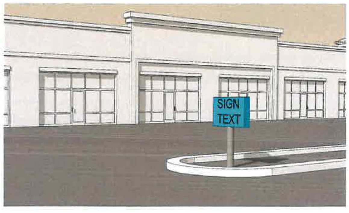
Figure 1129.14-15: Example Vehicular Use Area Sign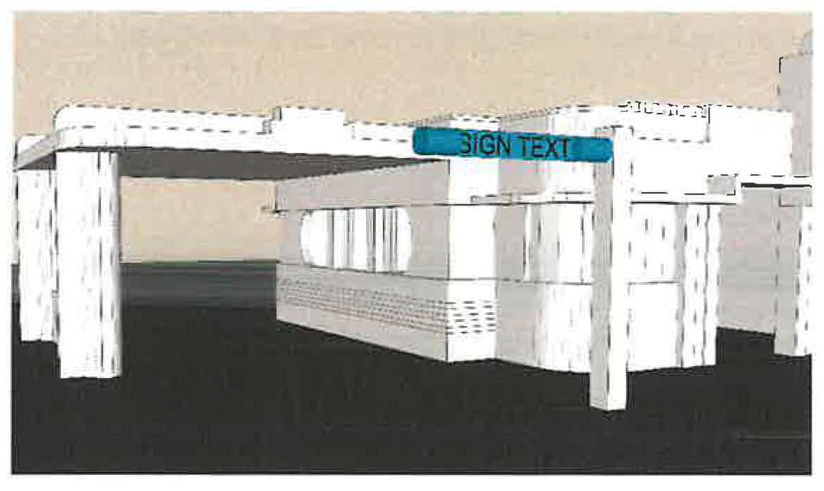
VETERINARY ANIMAL HOSPITAL AND/OR ANIMAL CLINIC means a structure or premises utilized for the diagnosis and treatment of ill and injured animals and the short-term boarding incidental to the clinical use. A veterinary clinic cannot be implicitly interpreted as a kennel.
VICINITY MAP means a drawing located on the plat which sets forth by dimensions or other means, the relationship of the proposed subdivision or use to other nearby developments or landmarks and community facilities and services within the general area in order to better locate and orient the area in question.
WALKWAY means a public or private way, four (4) feet or more in width, for pedestrian use only, whether along the side of a road or not.
WALL SIGN means a sign that is applied on a non-window and non-door surface of a building with a sign face parallel to such surface. Wall signs do not include and are separately defined from BUILDING ENTRANCE SIGN and from MURAL.
Figure 1129.14-16: Example Wall Sign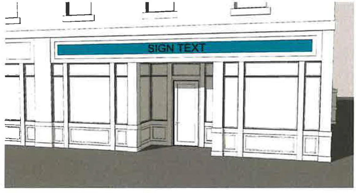
WAREHOUSING, PERSONAL STORAGE/MINI means a building or group of buildings designed and used solely for the purpose of leasing interior space for the storage of personal property, household items and the inventory of commercial businesses where storage units are individually leased or rented and where access to storage units is infrequent.
Outdoor storage and the storage of junk, explosives, flammable materials and other noxious or dangerous materials are specifically prohibited.
WAREHOUSING, PRIVATE means a person or business whose primary concern and profit motive is manufacture, assembly or sale of finished products and who needs to receive, store and ship merchandise or commodities only for purposes of supporting the primary concern.
WAREHOUSING, PUBLIC means a person or business whose primary purpose and profit motive is the receiving, storing and shipping of merchandise or commodities for one or more unrelated persons or businesses.
WATER TABLE (ARCHITECTURE) means a projecting stringcourse, molding, or ledge placed near the base of a building that is designed or appears to divert water from a building.
WATER SUPPLY IMPROVEMENTS means those improvements determined by the City Engineer to be necessary to facilitate the satisfactory delivery of water in accordance with these regulations, with the City Water Department standards and applicable state and federal laws and regulations.
WHOLESALE AND DISTRIBUTION means an establishment that engages in the sale of goods, merchandise and commodities for resale by the purchaser.
WINDOW AND DOOR SIGN means a sign that is painted, attached, or affixed to the interior or exterior surface of windows or doors of a building or suspended on the inside or outside of the windows or doors. A single window and/or door sign includes any portions of a message and associated graphics that span across separate panes of glass where such areas of separation or interruption are not wider than 18 inches.
Figure 1129.14-17: Example Window and Door Sign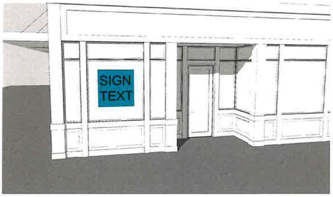
WORKING DAY means the days occurring Monday through Friday, excluding legal holidays. The time within which an act is required by law to be done shall be computed by excluding the first and including the last day; except that when the last day falls on the weekend or a legal holiday, the act may be done on the next succeeding day that is not the weekend or a legal holiday.
YARD means a required open space other than a court unoccupied and unobstructed by any structure or portion of a structure above the general ground level of the graded lot upward; provided accessories, ornaments and furniture may be permitted in any yard, subject to height limitations and requirements limiting obstruction of visibility.
YARD, FRONT means a yard extending between side lot lines across the front of a lot and from the front lot line to the front of the principal building.
YARD, REAR means a yard extending between side lot lines across the rear of the lot and from the rear lot line to the rear of the principal building.
YARD, SIDE means a yard extending from the principal building to the side lot line on both sides of the principal building between the lines establishing the front and rear yards.
YARD SIGN means a temporary sign, often double faced, that is supported by metal legs, or a wooden post anchored into soil with no permanent foundation.
Figure 1129.14-18: Example Yard Sign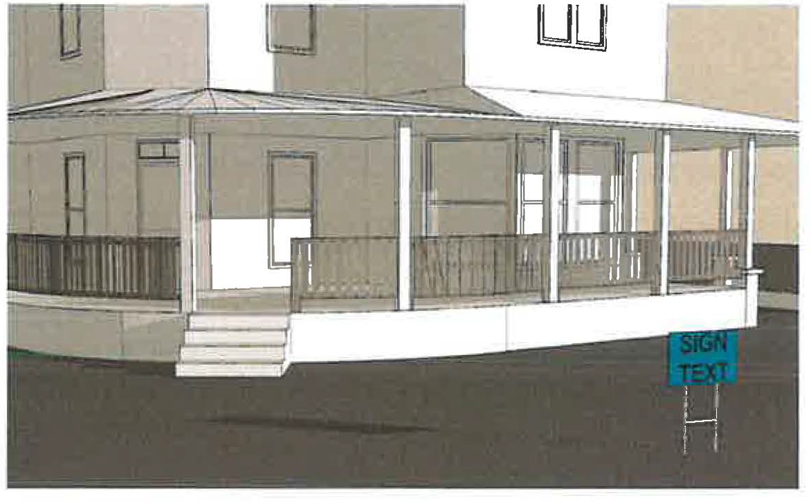
ZONING CERTIFICATE means a document issued by the Division of Engineering authorizing the occupancy or use of a building or structure or the actual use of lots or lands in accordance with the previously issued zoning permit.
ZONING DISTRICT OR DISTRICT means an area depicted on the official zoning map comprised of properties and land uses that are otherwise intended to reflect the comprehensive plan.
ZONING ORDINANCE means the zoning regulations of the City of Marysville.
ZONING PERMIT means a document issued by the Division of Engineering authorizing the use of lots, structures, uses of land and structures, and the characteristics of the uses.
B.
TERMS APPLICABLE TO DESIGN REVIEW, CHAPTER 1133
ARCHITECTURAL CHARACTER means the architectural style, general design, and general arrangement of the exterior of a building or other structure including the type and texture of the light fixtures, signs and other appurtenant fixtures.
CERTIFICATE OF APPROPRIATENESS means a certificate authorizing any alteration of architectural character or any environmental change within the Historic District(s) and Landmark(s).
DESIGN REVIEW BOARD means the Design Review Board of the City.
ENVIRONMENTAL CHANGE means the construction, modification, reconstruction, demolition, or removal of exterior features of a structure or property subject to the provisions of this chapter.
LANDMARK means a property, structure, or building designated by the Design Review Board to be worthy of rehabilitation, restoration, and preservation because of its historic and/or architectural significance.
MAINTENANCE means the ordinary repair of any structure or property provided such work involves no change in material, design, texture, color or exterior appearance.
PRESERVE OR PRESERVATION means the process, including maintenance of treating an existing building to arrest the slow future deterioration, stabilize the structure and provide structural safety without changing or adversely affecting the character or appearance of the structure.
C.
TERMS APPLICABLE TO LANDSCAPE REQUIREMENTS, CHAPTER 1125
CROWN SPREAD means the distance measured across the greatest diameter of the above ground portions of a plant.
DECORATIVE WALLS AND FENCES means barriers constructed of wood, masonry or other appropriate material.
DEVELOPED AREA means that a portion of a plot or parcel of land upon which a building, structure, pavement, landscaped material or other improvements, excluding public rights-of-way, have been placed.
DIAMETER AT BREAST HEIGHT (DBH) means the diameter of the tree as measured at four and a half (4½) feet above grade. If a tree splits into multiple trunks below 4½ feet above grade, the trunk is measured at its most narrow point below the split.
EARTH MOUNDS means earthen physical barriers which block or screen a view, which have vegetation capable of preventing erosion, and have a maximum permitted slope of three (3) feet horizontal to one vertical (3:1) where mounds are to be mowed.
GROUND COVER means landscape materials such as natural mulch or low growing plants installed in such a manner so as to form a continuous cover over the ground.
INTERIOR LANDSCAPING means the use of landscape materials within the boundaries of the parcel, exclusive of the perimeter landscaping.
LANDSCAPE BUFFER means landscape materials installed between certain land uses [i.e. (1) between multifamily and single-family uses, (2) between any residential and commercial uses, and (3) between any manufacturing and residential or commercial use], between thoroughfares and land uses, and between thoroughfares and off-street parking in order to reduce glare, unsightly views, and noise.
LANDSCAPE MATERIAL means materials such as, but not limited to, living trees, shrubs, vines, lawn grasses, ground cover, landscape water features and non-living, durable material commonly used in landscaping, including, but not limited to, rocks, pebbles, sand, decorative walls and fences, earthen mounds, but excluding pavements or surfaces for parking areas.
NATIVE PLANT SPECIES means a plant species, other than noxious weeds, that are indigenous to the area and usually do not need human intervention to grow or reproduce.
NEW STRUCTURE means any structure newly constructed or erected, except for fences, decks, signs, trash enclosures, swimming pools, playground equipment and accessory structures under 250 sq. ft., which requires location on the ground. Additions to, alterations to and/or reconstruction of an existing structure or building shall not be considered a new structure.
OPACITY means the required percentage of visual screening from adjacent properties in a vertical plane extending from the established grade to a required height.
SERVICE STRUCTURES means equipment or elements providing service to a building or a site including but not limited to loading docks, storage tanks, trash containers or receptacles, electrical transformers, utility vaults which extend above the surface, cooling towers, and heating and cooling units.
SHRUB means a perennial plant which has persistent multiple woody stems from a common root and differing from a tree by its low stature and habit of branching from the base.
SUBSTANTIAL EXPANSION means when an existing structure or vehicular access area is expanded, altered, or enlarged where such expansion, alteration, or enlargement exceeds twenty-five percent (25%) of the area of the existing structure or vehicular access area.
TREE means any self-supporting, woody perennial plant which normally grows to an overall height of at least fifteen (15) feet.
TREE, DECIDUOUS means trees which normally shed their leaves in the fall.
TREE, LARGE means any tree which normally attains a mature height equal to or greater than forty (40) feet.
TREE LAWN means that part of the street right-of-way not covered by sidewalk, bike path or other paving, lying between the sidewalk and street.
TREE, MEASUREMENT means the diameter in inches of a tree trunk measured six (6) inches above grade for trees equal to or less than six (6) inches in diameter or measured at DBH for trees larger than six (6) inches in diameter.
TREE, MEDIUM means any tree which normally attains a mature height greater than twenty-five (25) feet and less than forty (40) feet.
TREE, SMALL means any tree which normally attains a mature height greater than fifteen (15) feet and less than twenty-five (25) feet.
TREE, STANDARD means a tree planted with a trunk caliper (diameter) of at least one and 3/4 (1¾) inches measured 6" above grade.
VEHICLE ENCROACHMENT means an protrusion of a vehicle outside of a parking space, display area, storage area, access way, or access aisle into a landscape area.
VEHICULAR USE AREA means any paved surface area, excepting public rights-of-way, used by any type vehicle, whether moving or at rest for the purpose of (including but not limited to) driving, parking, loading, unloading, or storage.
D.
TERMS APPLICABLE TO WIRELESS TELECOMMUNICATION STRUCTURES, SECTION 1123.26
ANTENNA means any exterior transmitting or receiving device mounted on a tower, building or structure and used in communications that radiate or capture electromagnetic waves, digital signals, analog signals, radio frequencies (excluding radar signals), wireless telecommunications signals or other communication signals.
ANTENNA SUPPORT STRUCTURE means any building or other structure other than a Tower which can be used for location of Wireless Telecommunications Facilities.
CO-LOCATION means the use of a wireless telecommunications facility by more than one wireless telecommunications provider.
ENGINEER, RADIO FREQUENCY means an engineer who possesses the additional qualifications of holding a FCC General Radiotelephone Operator License and who has successfully completed training in electromagnetic field theory and antenna theory.
EQUIPMENT SHELTER means the structure in which the electronic receiving and relay equipment for a Wireless Telecommunications Facility is housed.
FAA means the Federal Aviation Administration and any legally appointed, designated or elected agent or successor.
FCC means the Federal Communications Commission and any legally appointed, designated or elected agent or successor.
HEIGHT OR ABOVE GROUND LEVEL means, when with respect to Chapter 1123.16, the distance measured from the finished grade at the base of the tower/structure to the highest point on the tower or other structure, including the base pad and any antenna.
MONOPOLE means a support structure constructed of a single, self-supporting hollow metal tube securely anchored to a foundation.
OPEN SPACE means an area substantially open to the sky which may be on the same lot with a building. The area may include, along with the natural environmental features, water areas, swimming pools and tennis courts, any other recreational facilities that the Planning Commission deems permissive. Streets, parking areas, structures for habitation and the like shall not be included.
TOWER means any structure that is designed and constructed primarily for the purpose of supporting one or more antennas for telephone, radio and similar communication purposes, including self-supporting lattice towers, guyed towers, or monopole towers. The term includes radio and television transmission towers, microwave towers, common-carrier towers, wireless telecommunications towers, alternative tower structures, and the like. The term includes the structure and any support thereto.
TOWERS, PRE-EXISTING AND PRE-EXISTING ANTENNAS means any tower or antenna for which a building permit or special use permit has been properly issued prior to the effective date of this chapter, including permitted towers or antennas that have not yet been constructed so long as such approval is current and not expired.
VIEWSHED means the area surrounding a Wireless Telecommunications Facility or Antenna Support Structure, within which the Facility or Structure is visible from street level.
WIRELESS TELECOMMUNICATIONS FACILITIES means any cables, wires, lines, wave guides, antennas and any other equipment or facilities associated with the transmission or reception of communications as authorized by the FCC which a Person seeks to locate or has installed upon a Tower or Antenna Support Structure.
However, the term Wireless Telecommunications Facilities shall not include: (1) Any satellite earth station antenna two (2) meters in diameter or less which are located in an area zoned industrial or commercial; (2) Any satellite earth station antenna one meter or less in diameter, regardless of zoning category; (3) Antennas used by amateur radio operators are excluded from this definition.
E.
TERMS APPLICABLE TO ALTERNATIVE ENERGY, CHAPTER 1139
ANEMOMETER means an instrument that measures the force and direction of the wind.
CLEAR FALL ZONE means an area surrounding the wind turbine unit into which the turbine, tower and/or turbine components might fall due to inclement weather, poor maintenance, faulty construction methods, or any other condition causing turbine failure. The area shall remain confined within the property lines of the primary parcel where the turbine is located. The purpose of the zone being that if the turbine shall fall or otherwise become damaged, the falling structure will be confined to the primary parcel and will not intrude onto a neighboring property.
GROUND MOUNTED means an alternative energy project which is not attached to a building and which is either attached directly to the ground or elevated on a supporting structure attached to the ground.
MEGAWATT means a unit of power equal to one million watts.
MONOPOLE means a support structure constructed of a single, self-supporting hollow metal tube securely anchored to a foundation.
OWNER means, with respect to Chapter 1139, any of the following:
(A)
Equipment owner means the person or entity that owns an alternative energy project.
(B)
Participating owner means the owner of the property on which an alternative energy project is built.
(C)
Non-participating landowner means an owner of property on which an alternative energy project is not being built.
ROOF/BUILDING MOUNTED means an alternative energy project which is attached to a building or roof.
ROTOR DIAMETER means the cross-sectional dimension of the circle swept by the rotating blades.
SMALL WIND ENERGY PROJECT means a wind energy project that has a capacity of more than 2 kilowatts and less than 5 megawatts, including the wind turbine generator or anemometer or any parts thereof and is primarily used to generate energy for use on the property where it is located. Small wind energy projects shall include Horizontal Axis Wind Turbines (HAWTs), Vertical Axis Wind Turbines (V AWTs), and Blade Tip Power System (BTPSs) as shown in Figure 1.
SOLAR ENERGY SYSTEM is a solar photovoltaic panel, solar hot air or hot water panel collector device, or other type of energy system which relies upon solar radiation as a source for the generation of electricity or transfer of stored heat.
TOTAL HEIGHT means, with respect to Section 1123.26, any of the following: (1) Means for a horizontal and vertical axis turbine; the vertical distance from ground level to the tip of the wind generator blade when the tip is at its highest point. (2) Means for a blade tip power system; the vertical distance from ground level to the highest point of the turbine structure.
WIND ENERGY PROJECT means equipment that converts and then stores or transfers energy from the wind into usable forms of energy (as defined by Ohio R. C. 1551.20) and includes any base, blade, foundation, generator, nacelle, rotor, tower, transformer, turbine, vane, wire or other component used in the project.
WIND GENERATOR means the mechanical and electrical conversion components mounted at the top of a tower in a wind energy project.
F.
TERMS APPLICABLE TO MARIJUANA, CHAPTER 1123
Adult Use Cannabis. Pursuant to ORC 3780 as amended or replaced from time to time, "adult use cannabis" has the same meaning as "marihuana" as defined in ORC 3719, as amended from time to time.
Adult Use Cannabis Operator. Pursuant to ORC 3780 as amended or replaced from time to time, "adult use cannabis operator" means an adult use cultivator, processor, and dispensary.
Cannabis. Pursuant to ORC 3780 as amended or replaced from time to time, "cannabis" has the same meaning as "marihuana" as defined in ORC 3719, as amended from time to time.
Cultivation Facility. Pursuant to ORC 3780 as amended or replaced from time to time, "cultivation facility" means a facility where a cultivator is licensed by the State of Ohio to operate.
Cultivate. Pursuant to ORC 3780 as amended or replaced from time to time, "cultivate" means to grow, harvest, package, and transport adult use cannabis.
Cultivator. Pursuant to ORC 3780 as amended or replaced from time to time, "cultivator" means an entity or person licensed by the State of Ohio to grow, harvest, package, and transport adult use cannabis.
Dispensary. Pursuant to ORC 3780 as amended or replaced from time to time, "dispensary" means an entity or person licensed by the State of Ohio to sell adult use cannabis.
Manufacture. Pursuant to ORC 3780 as amended or replaced from time to time, "manufacture" means the process of converting harvested plant material into adult use extract by physical or chemical means for use as an ingredient in an adult use cannabis product.
Marihuana. Pursuant to ORC 3780 as amended or replaced from time to time, "marihuana" has the same meaning as "marihuana" as defined in ORC 3719, as amended from time to time.
Marijuana. Pursuant to ORC 3780 as amended or replaced from time to time, "marijuana" has the same meaning as "marihuana" as defined in ORC 3719, as amended from time to time.
Medical Marijuana. means marijuana that is cultivated, processed, dispensed, tested, possessed, or used for a medical purpose.
Mobile building means a single modular building designed to be transported, placed, or removed as a single unit.
Processor. Pursuant to ORC 3780 as amended or replaced from time to time, "processor" means an entity or person licensed by the State of Ohio to manufacture adult use cannabis products.
G.
TERMS APPLICABLE TO SMALL BOX DISCOUNT RETAIL STORES, CHAPTER 1123
Small Box Discount Retail Store. A retail store between 3,000 and 15,000 square feet that sells directly to consumers a limited assortment of physical goods, products, or merchandise, personal grooming and health products, household goods, and other consumer products, including food or beverages for off-premises consumption, most of which are sold for ten dollars ($10.00) or less, and that does not dedicate a minimum of fifteen percent (15%) of shelf space to fresh food and produce.
Fresh Produce means fruits and vegetables that have not been processed in any manner. This term does not include such items as potted or dried herbs, wild rice, dried fruits and vegetables, raw nuts of any kind or popcorn, fruit or vegetable/plant seedlings, seeds/grains, flowers, maple syrup, cider, eggs, meat, cheese and seafood.
Fresh or Fresh Frozen Food means that is in its raw state, or unprocessed; food that was quickly frozen while still fresh (blanching, blast freezing) and no deterioration has taken place.
(Ord. No. 054-2020, Passed 11-23-2020; Ord. No. 005-2022, Passed 3-14-2022; Ord. No. 017-2022, Passed 3-1-2022; Ord. No. 002-2023, Passed 2-13-2023; Ord. No. 016-2023, Passed 3-7-2023; Ord. No. 052-2024, Passed 11-25-2024; Ord. No. 005-2025, Passed 2-24-2025; Ord. No. 013-2025, Passed 3-24-2025; Ord. No. 014-2025, Passed 4-14-2025; Ord. No. 030-2025, Passed 9-22-2025; Ord. No. 038-2025, Passed 10-27-2025; Ord. No. 046-2025, Passed 11-24-2025.)
1121.01 - INTENT.
The following zoning districts and overlays are hereby established for the City of Marysville, Ohio. For the interpretation of this Planning and Zoning Ordinance, the zoning districts and overlays have been formulated to realize the general purpose as set forth in the preamble of original Ordinance 1005-77 and the Comprehensive Plan, as may be amended from time to time. The specific purpose of each zoning district or overlay shall serve as guidance for regulating existing and future development within each zoning district or overlay.
(Ord. No. 054-2020, Passed 11-23-2020.)
1121.02 - COMPLIANCE WITH REGULATIONS.
The regulations for each district set forth by this Planning and Zoning Ordinance shall be minimum regulations and shall apply uniformly to each class or kind of structure or land, except as hereinafter provided or as otherwise granted by the Board of Zoning Appeals.
(a)
No building, structure or land shall be used or occupied and no building or structure or part thereof shall be erected, constructed, reconstructed, moved or structurally altered except in conformity with all of the regulations herein specified for the district in which it is located.
(b)
No building or other structure shall be erected or altered:
» To provide for greater height or bulk;
» To accommodate or house a greater number of families;
» To occupy a greater percentage of lot area;
» To have narrower or smaller rear yards, front yards, side yards or other open spaces than herein required, or in any other manner be contrary to the provisions of this Planning and Zoning Ordinance.
(c)
No yard or lot existing at the time of passage of this Planning and Zoning Ordinance shall be reduced in dimension or area below the minimum requirements set forth herein. Yards or lots created after the effective date of this Planning and Zoning Ordinance shall meet at least the minimum requirements set forth herein.
(d)
Notwithstanding anything to the contrary contained herein, any single lot of record existing as of the effective date of this Planning and Zoning Ordinance shall comply with the yard dimension requirements in effect at the time such lot was platted and/or created.
(Ord. No. 054-2020, Passed 11-23-2020.)
1121.03 - OFFICIAL SCHEDULE OF DISTRICT REGULATIONS ADOPTED.
(a)
District regulations shall be as set forth in this Chapter 1121. Regulations for mobile home parks shall be those specified in Chapter 1111.
(b)
Permitted Uses and Conditional Uses for each zoning district are set forth within the respective section for such district. Permitted Uses shall include all Accessory Uses, as such term is defined within this Planning and Zoning Ordinance. Conditional Uses require the grant of a Conditional Use permit by the Planning Commission.
(c)
Any use not specifically listed in any zoning district, shall only be allowed.
» Upon amendment of this Planning and Zoning Ordinance and/or Zoning Map as provided in Chapter 1141; or
» Upon a finding by the Division of Engineering that the use is substantially similar to a permitted use in the district; or
» Upon a finding by the Division of Engineering that the use is substantially similar to a conditionally permitted use in the district and is approved by the Planning Commission as a conditional use.
Uses permitted or conditionally permitted in any zoning district shall not be allowed to be permitted or conditionally permitted in any other district unless a zoning change is granted through the procedures as outlined in Chapter 1141.
(Ord. No. 054-2020, Passed 11-23-2020.)
1121.04 - PLANNED UNIT DEVELOPMENTS.
(a)
Existing Planned Unit Developments. In accordance with Chapter 1121 of this Planning and Zoning Ordinance, Planned Unit Developments and all associated development plans and supporting documentation adopted prior to the effective date of this Planning and Zoning Ordinance shall continue in effect and be considered legally conforming under this Planning and Zoning Ordinance. The procedures for amendments of those developments must conform to the regulations indicated in Chapter 1135 hereof. Zoning amendments passed during the time period granted for the approved development plan shall not in any way affect the terms under which approval of the PUD was granted. Such existing Planned Unit Developments are set forth on the Official Zoning Map.
(b)
New Planned Unit Developments. Any application for a new Planned Unit Development shall be reviewed in accordance with the procedures set forth in Chapter 1135 of this Planning and Zoning Ordinance.
(Ord. No. 054-2020, Passed 11-23-2020.)
1121.05 - BUILDING TYPOLOGIES.
The building typologies set forth under each district and overlay reflect the forms of development contemplated for all new development and redevelopment within the City. While there is a correspondence between residential uses and the various underlying residential building typologies, nonresidential uses may be incorporated into a range of building typologies based on the specifications of the underlying project. Upon reviewing any application for a residential use or nonresidential use, the Division of Engineering shall determine the most applicable building typology for the proposed project and evaluate the project based upon the applicable standards.
The alteration or renovation of existing structures shall comply with those development standards that the Division of Engineering determines are applicable to the existing structure and site.
(Ord. No. 054-2020, Passed 11-23-2020.)
1121.06 - DEVELOPMENT STANDARDS.
Figure 21.1 below illustrates the key terms applicable to the development standards found under each building typology. These key terms are illustrated as follows:
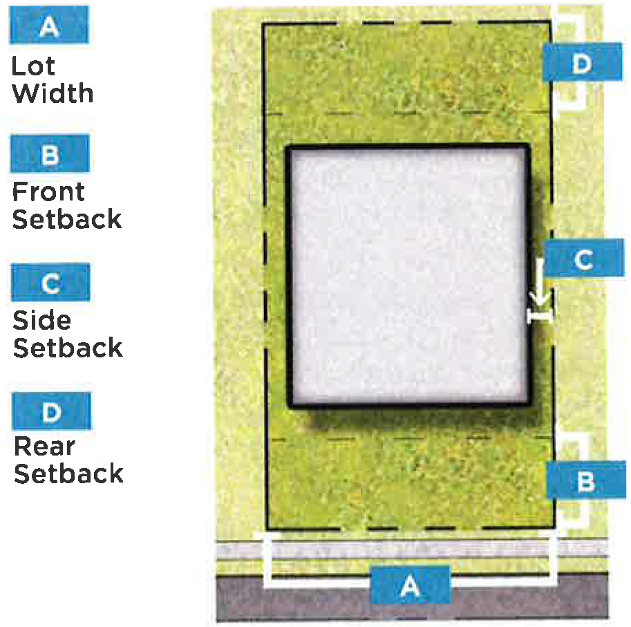
FIGURE 21.1: DEVELOPMENT STANDARDS
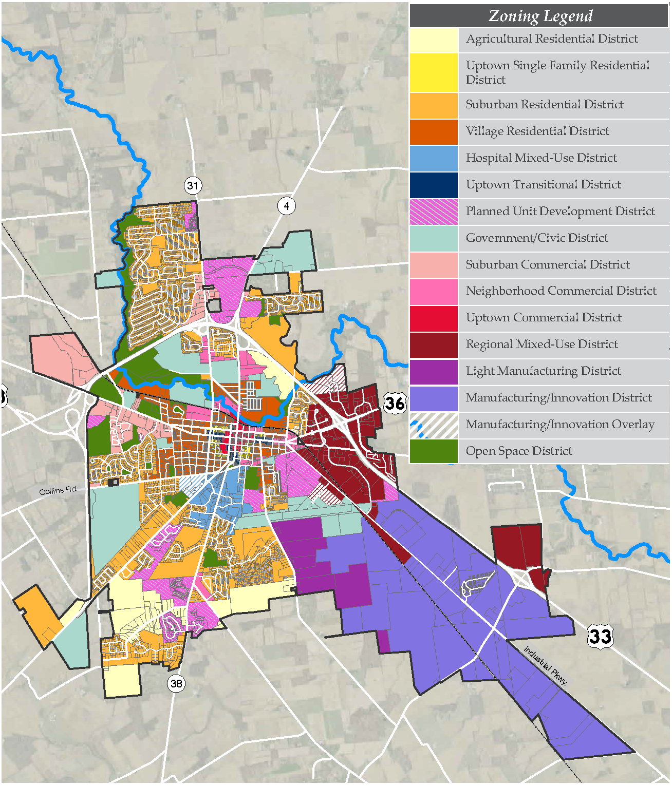
FIGURE 21.2: ZONING MAP
(Ord. No. 054-2020, Passed 11-23-2020.)
1121.07 - THE SUBURBAN RESIDENTIAL DISTRICT (SRD).
I.
Purpose and Intent
A.
The Suburban Residential District is intended to regulate all land in the city platted for medium scale suburban single-family residential development.
II.
Existing Development Patterns
A.
The existing development pattern in the SRD is traditional single-family residential subdivisions with single-unit structures. The existing subdivisions are adjacent to commercial corridors with commercial development on a scale that serves the residents of the Suburban Residential District.
III.
Desired Development Pattern
A.
The desired development pattern in the SRD is to accommodate multiple forms of single-family development, including attached single-family townhomes and to promote increased open-space and pedestrian between residential development and adjacent commercial development.
IV.
Development Typologies
New development in the SRD shall be developed in accordance with the following building typologies.
» Single-Family (detached) Building Typology
» Single-Family (attached) Building Typology
» Community Center Building Typology
» Institutional Flex Building Typology
» Multi-Family Building Typology
SINGLE-FAMILY (DETACHED) BUILDING TYPOLOGY
The Single-Family (detached) Building Typology is the traditional suburban single-family typology within the SRD. This building typology features off-street parking in a side-loading or front-loading garage with a driveway entry.
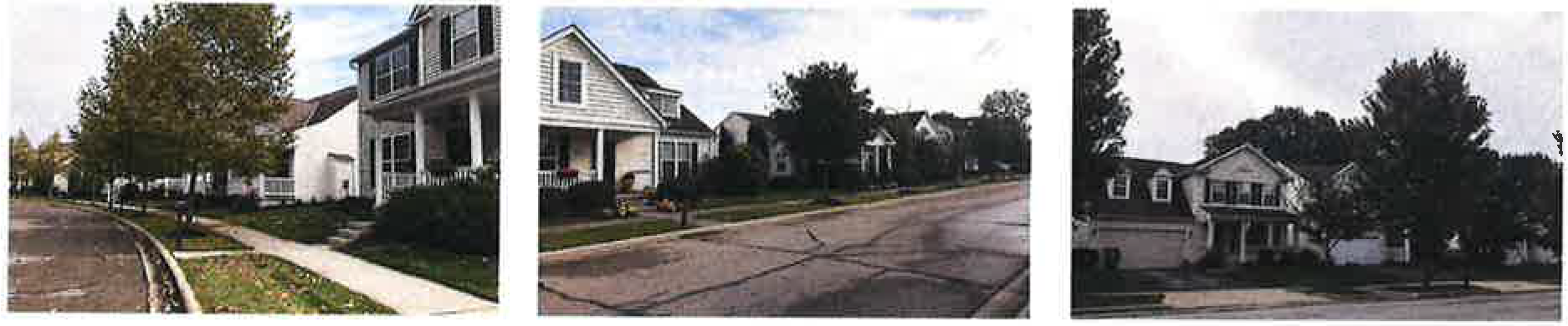
Supplemental Regulations:
* Determination of the setback line starting point, as it relates to the right-of-way line, lot line or easement line, shall be at the discretion of the Division of Engineering.
SINGLE-FAMILY (ATTACHED) BUILDING TYPOLOGY
The Single-Family (attached) Building Typology allows for increased density in the SRD while preserving the predominant residential development pattern.
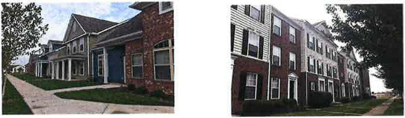
Supplemental Regulations:
* Determination of the setback line starting point, as it relates to the right-of-way
line, lot line or easement line, shall be at the discretion of the Division of Engineering.
Maximum continuous frontage of 200 feet for attached units. 20 feet minimum spacing between any grouping of attached units.
SRD SINGLE-FAMILY (DETACHED)
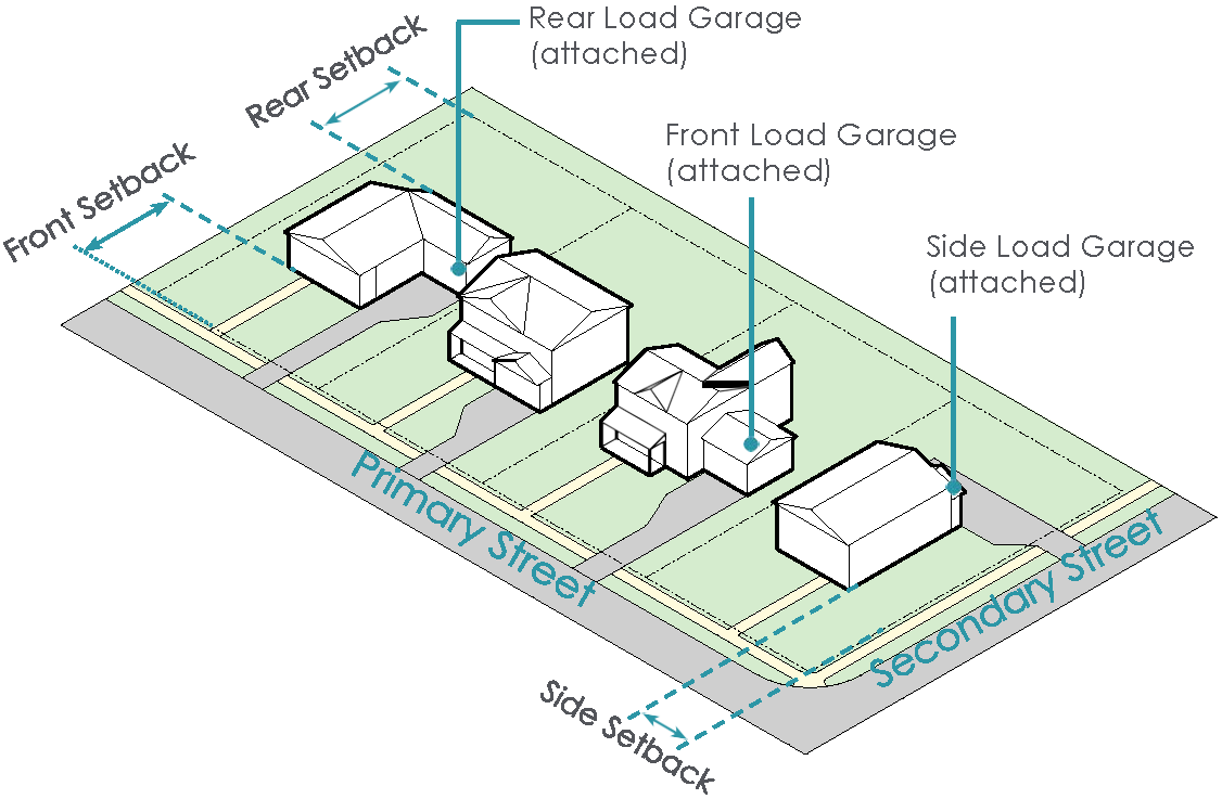
SRD SINGLE-FAMILY (ATTACHED)
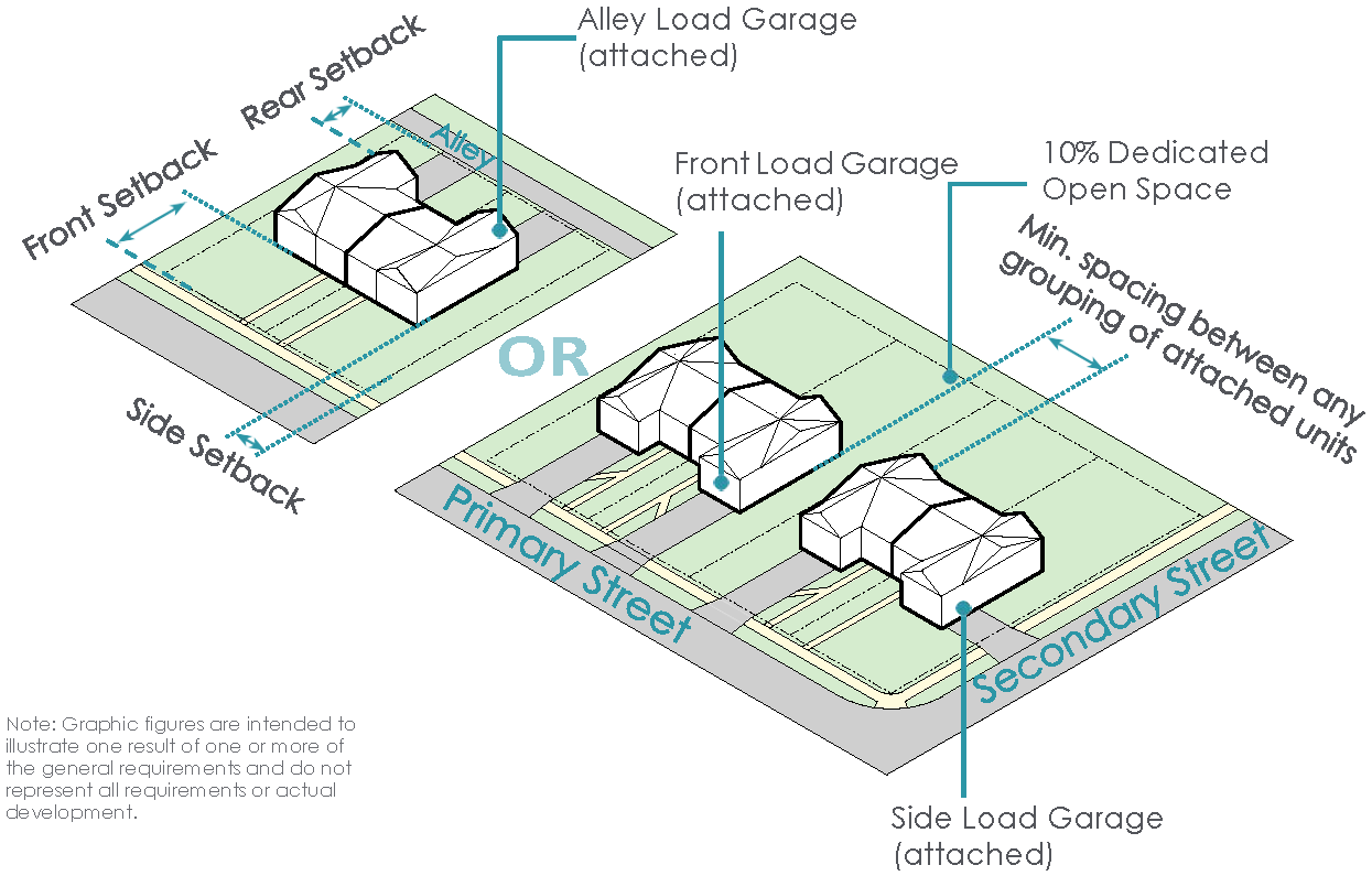
COMMUNITY CENTER BUILDING TYPOLOGY
The Community Center Building Typology allows for community-oriented uses to serve surrounding residential development throughout the SRD.
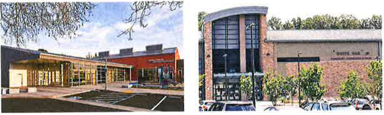
Supplemental Regulations:
* Determination of the setback line starting point, as it relates to the right-of-way line, lot line or easement line, shall be at the discretion of the Division of Engineering.
INSTITUTIONAL FLEX BUILDING TYPOLOGY
The Institutional Flex Building Typology allows for institutional and community uses within the SRD. This typology is intended to allow for non-residential uses to be incorporated in a residential setting.

Supplemental Regulations:
* Determination of the setback line starting point, as it relates to the right-of-way line, lot line or easement line, shall be at the discretion of the Division of Engineering.
SRD COMMUNITY CENTER
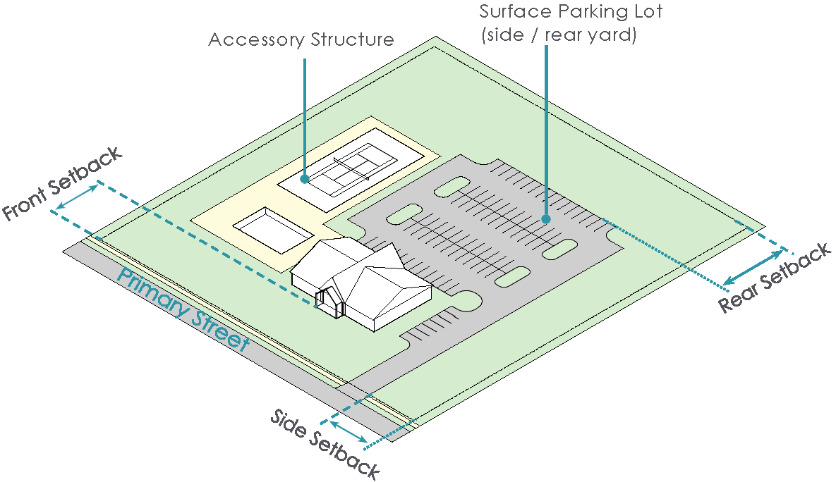
SRD INSTITUTIONAL FLEX BUILDING
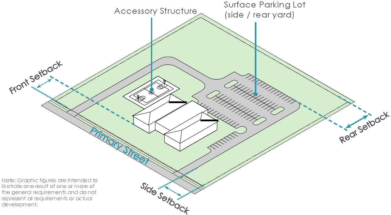
MULTI-FAMILY BUILDING TYPOLOGY
The Multi-Family Building Typology within the SRD promotes additional density within the traditional suburban development pattern. The design and layout of this building typology should complement the existing built environment.
Supplemental Regulations:
* Determination of the setback line starting point, as it relates to the right-of-way line, lot line or easement line, shall be at the discretion of the Division of Engineering.
SRD MULTI-FAMILY
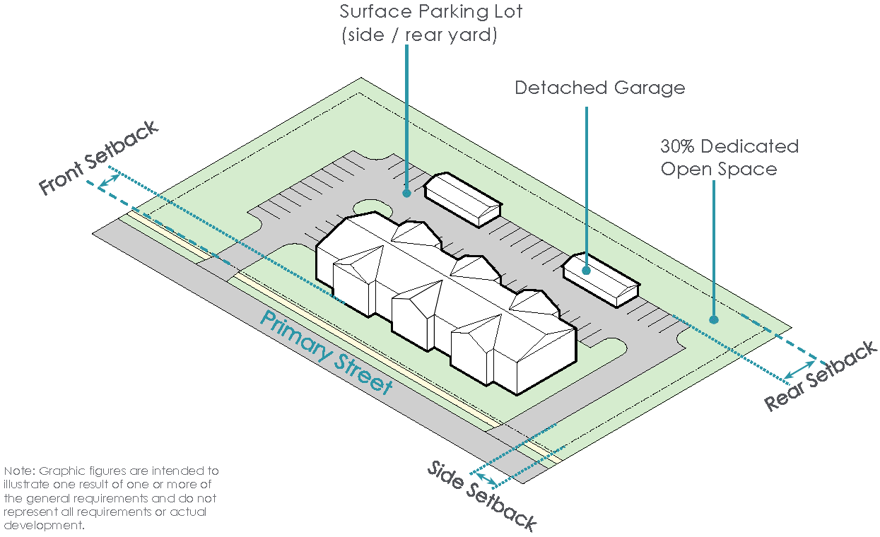
(Ord. No. 017-2023, Passed 4-24-2023; Ord. No. 048-2023, Passed 10-9-2023; Ord. No. 013-2025. Passed 3-24-2025; Ord. No. 044-2025, Passed 11-24-2025; Ord. No. 046-2025, Passed 11-24-2025; Ord. No. 047-2025, Passed 11-24-2025.)
1121.08 - SUBURBAN COMMERCIAL DISTRICT (SCD).
I.
Purpose and Intent
A.
The purpose of the Suburban Commercial District (SCD) is to promote a mix of uses in close proximity to residential forms of suburban development. The SCD allows for the establishment of commercial and institutional uses that support suburban development.
II.
Desired Development Pattern
A.
The desired development pattern in the SCD is commercial and mixed-use development along commercial corridors that are adjacent to residential development. New development should be oriented to commercial streets with parking at the rear and sides of buildings.
III.
Development Typologies
A.
Buildings in the Suburban Commercial District shall be developed in accordance with the following development typologies.
» Commercial Building Typology
» Office Building Typology
» Institutional Flex Building Typology
» Single-Family Home (attached)
» Multi-Family Residential Building Typology
COMMERCIAL BUILDING TYPOLOGY
The Commercial Building Typology in the SCD allows for commercial development that is oriented toward suburban commercial corridors that are adjacent to suburban residential development, providing convenient retail options to residents in the surrounding area.
Supplemental Regulations:
* Determination of the setback line starting point, as it relates to the right-of-way line, lot line or easement line, shall be at the discretion of the Division of Engineering.
OFFICE BUILDING TYPOLOGY
The Office Building Typology allows for the development of offices in close proximity to residential development, providing residents with access to service providers and employers.
Supplemental Regulations:
* Determination of the setback line starting point, as it relates to the right-of-way line, lot line or easement line, shall be at the discretion of the Division of Engineering. SCD COMMERCIAL
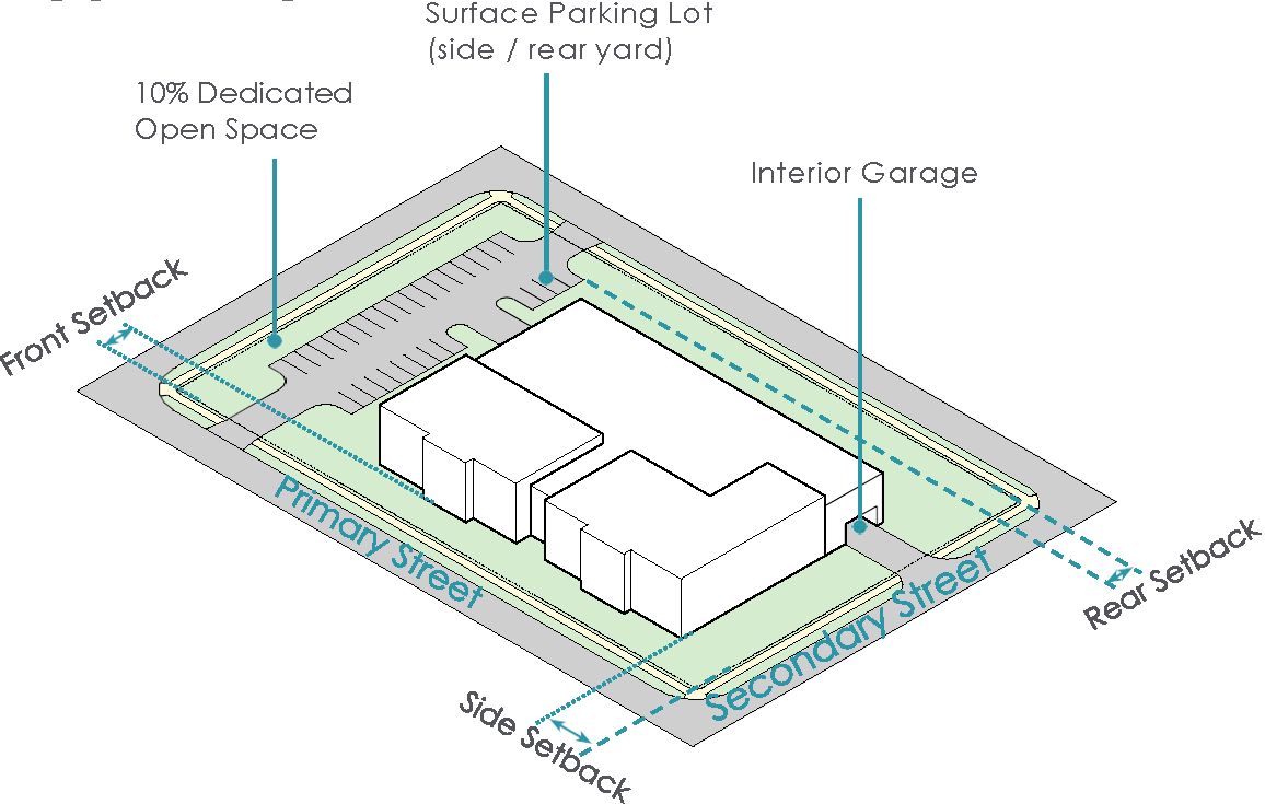
SCD OFFICE

INSTITUTIONAL FLEX BUILDING TYPOLOGY
The Institutional Flex Building Typology promotes the placement of community-oriented uses in close proximity to suburban residential development patterns to provide walkable amenities for area residents.
Supplemental Regulations:
* Determination of the setback line starting point, as it relates to the right-of-way line, lot line or easement line, shall be at the discretion of the Division of Engineering.
SCD INSTITUTIONAL FLEX BUILDING

SINGLE-FAMILY (ATTACHED) BUILDING TYPOLOGY
The Single-Family (attached) Building Typology within the SCD promotes additional density within the existing development pattern and complements the proposed commercial development.
Supplemental Regulations:
* Determination of the setback line starting point, as it relates to the right-of-way line, lot line or easement line, shall be at the discretion of the Division of Engineering.
Maximum continuous frontage of 200 feet for attached units. 20 feet minimum spacing between any grouping of attached units.
SCD SINGLE-FAMILY (ATTACHED)

MULTI-FAMILY BUILDING TYPOLOGY
The Multi-Family Building Typology within the SCD promotes additional density within the commercial development pattern. The design and layout of this building typology should complement the existing built environment
Supplemental Regulations:
* Determination of the setback line starting point, as it relates to the right-of-way line, lot line or easement line, shall be at the discretion of the Division of Engineering.
SCD MULTI-FAMILY
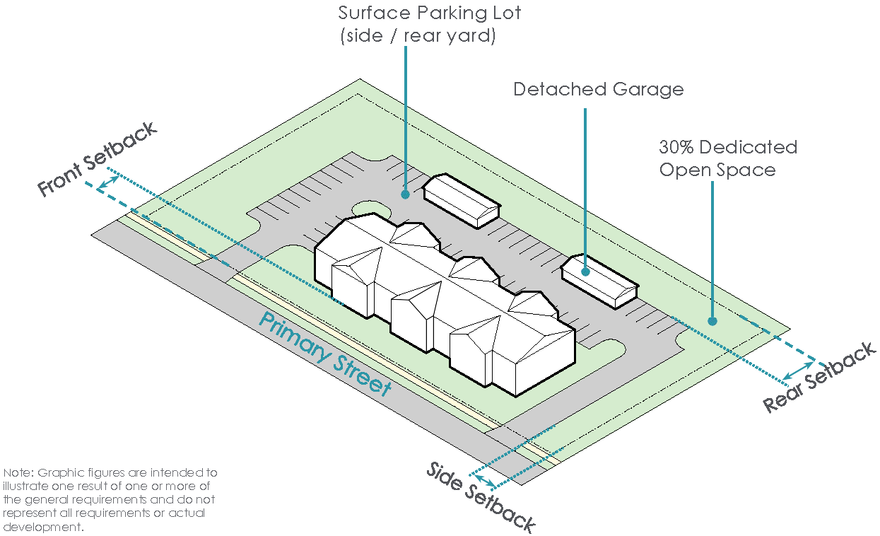
(Ord. No. 017-2023, Passed 4-24-2023; Ord. No. 049-2023, Passed 10-9-2023; Ord. No. 005-2025. Passed 2-24-2025; Ord. No. 013-2025. Passed 3-24-2025.)
1121.09 - THE AGRICULTURAL RESIDENTIAL DISTRICT (ARD).
I.
Purpose and Intent
A.
The Agricultural Residential District (ARD) is intended to regulate all land to the south of the city that was developed in an agricultural context with large lot sizes, minimal lot coverage, and significant open space for each residence.
II.
Existing Development Patterns
A.
The existing development pattern in the ARD is large lot residential development with minimal lot coverage and significant open space. Accessory agricultural uses may exist these lots.
III.
Desired Development Pattern
A.
The desired development pattern in the ARD is to maintain the traditional development form and ensure that new development reflects the low-density environment.
IV.
Development Typologies
New development in the ARD shall be developed in accordance with the following development typologies.
» Single-Family (detached) Building Typology
SINGLE-FAMILY (DETACHED) BUILDING TYPOLOGY
The Single-Family (detached) Building Typology is the predominant development typology in the Agricultural Residential District. The configuration of the lots within the ARD promotes open space consistent with the rural development pattern throughout the district.
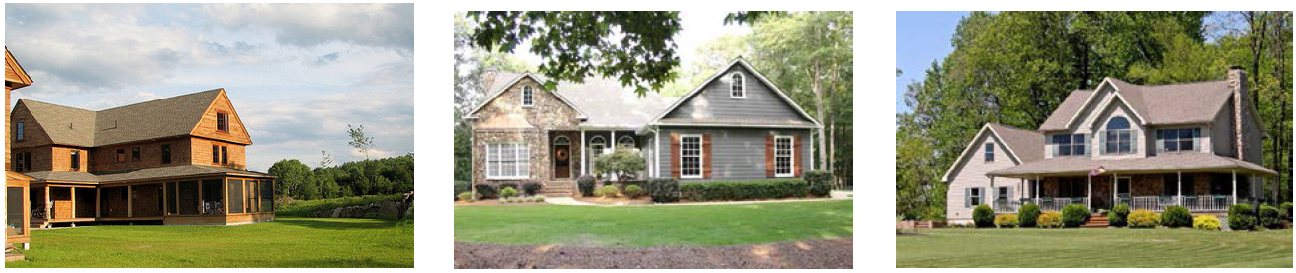
Supplemental Regulations:
* Determination of the setback line starting point, as it relates to the right-of-way line, lot line or easement line, shall be at the discretion of the Division of Engineering.
ARD SINGLE-FAMILY DETACHED
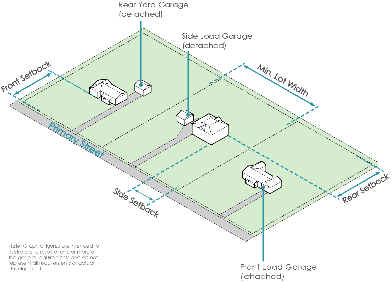
(Ord. No. 017-2023, Passed 4-24-2023; Ord. No. 050-2023, Passed 10-9-2023; Ord. No. 013-2025. Passed 3-24-2025; Ord. No. 046-2025, Passed 11-24-2025; Ord. No. 047-2025, Passed 11-24-2025.)
1121.10 - VILLAGE RESIDENTIAL DISTRICT (VRD).
I.
Purpose and Intent
A.
The Village Residential District (VRD) is intended to regulate all land in the city that was developed on a neighborhood-scale immediately to the north, south, east and west of Marysville's Uptown Districts.
II.
Existing Development Patterns
A.
The existing development pattern in the Village Residential District is traditional neighborhood-oriented development with lot and building footprint increasing with distance from the Uptown Districts. Throughout the Village Residential District, single-family residences have been converted to small-scale commercial uses such as personal service providers and professional offices.
III.
Desired Development Pattern
A.
The desired development pattern in the Village District is to accommodate medium density single family and multi-family development, including detached single-family homes, attached single-family, townhomes and quadplexes. Where appropriate, small-scale commercial development may be conditionally approved to promote a mix of uses within the district.
IV.
Development Typologies
A.
Buildings in the Village Residential District shall be developed in accordance with the following development typologies.
» Single-Family (Detached) Building Typology
» Single-Family (Attached) Building Typology
» Multi-Family Building Typology
» Institutional/Flex Building Typology
SINGLE-FAMILY (DETACHED) BUILDING TYPOLOGY
The Single-Family (detached) Building Typology is the predominant development typology in the VRD. The lot size and building placement requirements for this building typology reflect the historic lot sizes and dimensions in the district.
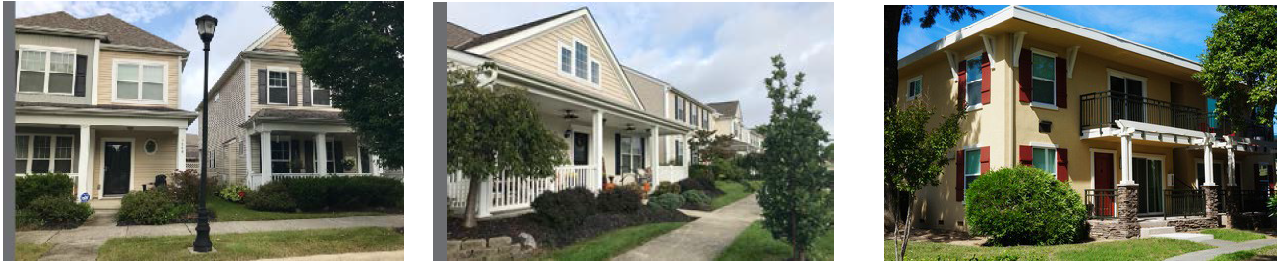
Supplemental Regulations:
* Determination of the setback line starting point, as it relates to the right-of-way line, lot line or easement line, shall be at the discretion of the Division of Engineering.
V.
VILLAGE RESIDENTIAL DISTRICT SINGLE-FAMILY (DETACHED) DESIGN REVIEW PROCESS
(a)
Purpose. The purpose of the Village Residential District Single-Family (Detached) Design Review process is to maintain and enhance the distinct character of the City's inner ring residential district. The Village Residential District includes a wide range of architecturally significant single-family (detached) structures ranging from Victorian style to mid-century modern, prairie style.
(b)
Intent. The intent of the design review contemplated hereunder is to:
(1)
Maintain the unique character of the single-family (detached) structures located in the Village Residential District through basic design regulations;
(2)
Promote high-quality infill projects involving single-family (detached) structures that enhance the character and fabric of the Village Residential District; and
(3)
Allow for innovative major renovations and substantial expansions that reflect the predominant aesthetic while maintaining consistency with the existing built environment.
(c)
Design Review Process. When the applicability criteria set forth below are satisfied for a change or a project, the Design Review Board or City staff, as applicable, shall review applications for the new construction, substantial expansion, and/or major renovation of single-family (detached) structures located in the Village Residential District.
(d)
Applicability Criteria—Changes and Projects Requiring Review and Approval. The Design Review Board or City staff, as applicable, shall review changes or projects involving single-family (detached) structures located in the Village Residential District under the following circumstances:
(1)
New Construction. The Design Review Board shall review all applications for new construction of single-family (detached) structures in the Village Residential District in accordance with the applicable design standards set forth under Section (F) below.
(2)
Substantial Expansions. The Design Review Board or City staff, as applicable, shall review qualifying substantial expansions of existing single-family (detached) structures. For purposes of this subsection (d)(ii), "substantial expansion" shall mean an increase by 50% or more of the gross floor area of a single-family (detached) structure proposed in any single application. The determination of whether a change constitutes a "substantial expansion" shall be made by the Division of Engineering using public records setting forth the existing square footage of the subject structure as well as other information that may be available to the Division of Engineering, including but not limited to information provided by the applicant.
(i)
Substantial Expansions not visible from public right-of-way. Where a substantial expansion will not be visible from the public right-of-way, City staff shall review and approve or deny the application for the change in accordance with the applicable design standards for single-family (detached) structures set forth under Section (f) below.
(ii)
Substantial Expansions visible from right-of-way. Where a substantial expansion will be visible from the right-of-way, City staff shall review the application and may elect to either (i) approve the application based on the applicable design standards set forth under Section (f) below or (ii) refer the application to the Design Review Board for review and approval or denial.
(3)
Major Renovations. The City staff or the Design Review Board, as applicable, shall review applications for major renovations to existing single-family (detached) structures. For the purposes of this subsection (d)(iii), "major renovation" shall include any or all of the following changes to an existing single-family (detached) structure:
(i)
A change to 25% or more of the surface area of a single-family (detached) structure proposed in any single application; The determination of whether a change to the surface area of a structure constitutes a "major renovation" shall be made by the Division of Engineering using public records and other information that may be available to the Division of Engineering.
(ii)
The replacement of any window or door with a dissimilar window or door on a principal single-family (detached) structure; or
(iii)
The replacement of the existing roof on a single-family (detached) structure with a metal roof.
(4)
Major Renovations not visible from the public right-of-way. City staff shall review and approve or deny any application for a major renovation that is not visible from the public right-of-way.
(5)
Major Renovations visible from the public right-of-way. Where a major renovation will be visible from the public right-of-way, City staff may either (i) approve the application based on the applicable design standards set forth under Section (f) below or (ii) refer the application to the Design Review Board for review and approval or denial.
(e)
Applicability Criteria—Changes and Projects Not Requiring Review and Approval. The following changes, projects, and activities are exempt from review under this section and shall not require the review or approval of City staff or the Design Review Board:
(1)
Repainting a principal structure with any permitted paint color as described under Section (f ) below;
(2)
Replacing windows or doors with replacement windows and doors that have similar appearance and do not reduce the openings by more than 10%;
(3)
Removing existing materials to expose original materials beneath such existing materials, including but not limited to removing vinyl siding to expose original brick;
(4)
Covering or removing non-historic materials or hazardous materials, such as asbestos siding, with materials that comply with the materials guidelines set forth under Section (f ) below;
(5)
Replacing existing materials with like-materials; provided however, if like-materials are not commercially available, then with such other materials that are in compliance with the materials guidelines set forth under section (f) below;
(6)
Conducting routine maintenance and upkeep, including the repair or restoration of existing materials; and
(7)
Projects or changes undertaken at the direction of the Division of Engineering or pursuant to a code enforcement order.
For the purposes of this Section (e), "like-materials" shall mean materials that are substantially similar to existing materials in texture, shape, dimension, and style.
Table 1121.10-1 Summary of Approval Requirements
Key
M- Mandatory Review
D- Discretionary Review
R- Review upon Administrative Referral
(f)
Design Guidelines for Single-Family (Detached) Structures in the Village Residential District. The following design review standards shall apply to any review required in accordance with this Section.
(1)
Building Architecture.
(i)
Design. All buildings shall provide visual interest that will be consistent with the community's identity, character and scale. As further described herein, building additions shall be of similar design, materials, and construction to that of the existing or principal structure.
(ii)
Color. Specific colors and color schemes shall be designed to be compatible and harmonious with those of the buildings in the surrounding area. Facade colors shall be subtle and of low reflectance. Accent colors may be used to highlight architectural features. Permitted colors shall include any color that is compatible with the color of other structures located in the district, except for prohibited colors as described herein.
Prohibited colors shall include any colors included in day-glow, neon, metallic and/or high-chroma color palettes.
(iii)
Articulation. A building frontage that exceeds a width of fifty (50) feet shall incorporate articulation and offset of the wall plane to inhibit a large expanse of blank wall and add interest to the facades. Where a structure has a front-loaded garage, the garage shall be placed a minimum of two feet behind the front building facade.
(iv)
Materials. Building materials shall be of high quality, durable and consistent with the principal structure's surroundings. Architectural features shall be used to create visual interest and livability of the single-family dwellings. All structures shall be designed to be architecturally compatible with each other by employing similar roof pitches, architectural details and be constructed of compatible exterior building materials. Permitted building materials shall be high quality, durable materials.
(2)
Roofing. Roofing shall be compatible and harmonious with building materials and color scheme.
(3)
Additions. Additions to existing single-family (detached) building types shall not destroy or otherwise impede the original materials of the principal structure. Additions shall be constructed with compatible materials, scale, massing, features, and proportion of the principal structure and adjacent principal structures.
(g)
Appeal. Any party aggrieved by the decision of City Staff may appeal such decision to the Design Review Board, and any party aggrieved by the decision of the Design Review Board may appeal such decision to the Board of Zoning Appeals.
SINGLE-FAMILY (ATTACHED) BUILDING TYPOLOGY
The Single-Family (attached) Building Typology in the VRD allows for increased density and serves as a complement to the existing single-family detached development pattern.
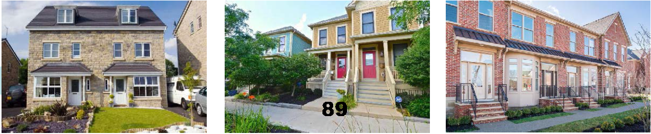
Supplemental Regulations:
* Determination of the setback line starting point, as it relates to the right-of-way
line, lot line or easement line, shall be at the discretion of the Division of Engineering.
Maximum continuous frontage of 185 feet for attached units. 15 feet minimum spacing
between any grouping of attached units.
VRD SINGLE-FAMILY (DETACHED)

VRD SINGLE-FAMILY (ATTACHED)

MULTI-FAMILY BUILDING TYPOLOGY
The Multi-Family Building Typology within the VRD promotes additional density within the traditional neighborhood development pattern. The design and layout of this building typology should complement the existing built environment.
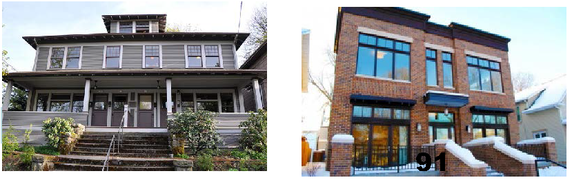
Supplemental Regulations:
* Determination of the setback line starting point, as it relates to the right-of-way
line, lot line or easement line, shall be at the discretion of the Division of Engineering.
INSTITUTIONAL FLEX BUILDING TYPOLOGY
The Institutional Flex Building Typology allows for institutional and community uses within the VRD. This typology is intended to allow for non-residential uses to be incorporated in a residential setting.

Supplemental Regulations:
* Determination of the setback line starting point, as it relates to the right-of-way line, lot line or easement line, shall be at the discretion of the Division of Engineering.
VRD MULTI-FAMILY

VRD INSTITUTIONAL FLEX

(Ord. No. 017-2023, Passed 4-24-2023; Ord. No. 051-2023, Passed 10-9-2023; Ord. No. 013-2025. Passed 3-24-2025; Ord. No. 044-2025, Passed 11-24-2025; Ord. No. 046-2025, Passed 11-24-2025; Ord. No. 047-2025, Passed 11-24-2025.)
1121.11 - NEIGHBORHOOD COMMERCIAL DISTRICT (NCD).
I.
Purpose and Intent
A.
The purpose of the Neighborhood Commercial District (NCD) is to provide a mix of uses in close proximity to residential districts not zoned for commercial uses such as the Village Residential District. The NCD allows for the establishment of walkable neighborhood commercial scale commercial and institutional uses supported by surrounding single-family and multi-family residential development.
II.
Desired Development Pattern
A.
The desired development pattern in the Neighborhood Commercial District is to accommodate continued residential development while allowing for neighborhood-scale retail and institutional uses. Mixed-use development will be conditionally approved where appropriate.
III.
Development Typologies
A.
Buildings in the Neighborhood Commercial District shall be developed in accordance with the following development typologies.
» Commercial (Neighborhood) Building Typology
» Institutional Flex (Neighborhood) Building Typology
» Mixed-Use (Neighborhood) Building Typology
» Multi-Family Building Typology
» Single-Family (attached) Building Typology
COMMERCIAL BUILDING TYPOLOGY
The Commercial (neighborhood) Building Typology allows for commercial development on a pedestrian scale. The placement of this development typology is oriented toward commercial streets but maintains a pedestrian scale.
Supplemental Regulations:
* Determination of the setback line starting point, as it relates to the right-of-way line, lot line or easement line, shall be at the discretion of the Division of Engineering.
INSTITUTIONAL FLEX BUILDING TYPOLOGY
The Institutional Flex Building (neighborhood) Typology allows for the location of community-oriented uses along neighborhood commercial corridors.
Supplemental Regulations:
* Determination of the setback line starting point, as it relates to the right-of-way line, lot line or easement line, shall be at the discretion of the Division of Engineering.
NCD COMMERCIAL (NEIGHBORHOOD)
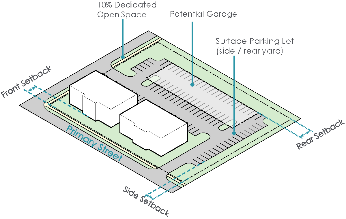
NCD INSTITUTIONAL FLEX (NEIGHBORHOOD)
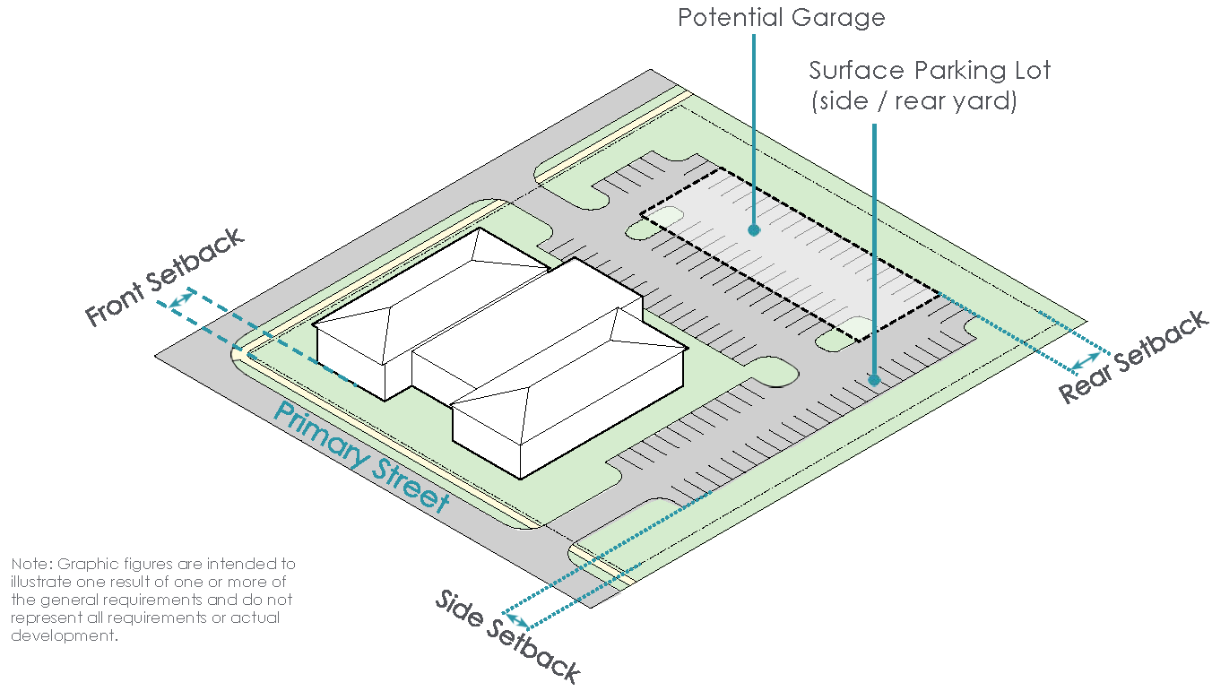
MIXED-USE BUILDING TYPOLOGY
The Mixed-Use Building (neighborhood) Typology allows for mixed-use residential and commercial development on a neighborhood scale.
Supplemental Regulations:
* Determination of the setback line starting point, as it relates to the right-of-way line, lot line or easement line, shall be at the discretion of the Division of Engineering.
SINGLE-FAMILY (ATTACHED) BUILDING TYPOLOGY
The Single-Family (attached) Building Typology within the NCD promotes additional density within the existing development pattern and complements the proposed commercial development.
Supplemental Regulations:
* Determination of the setback line starting point, as it relates to the right-of-way line, lot line or easement line, shall be at the discretion of the Division of Engineering.
Maximum continuous frontage of 185 feet for attached units. 15 feet minimum spacing between any grouping of attached units.
NCD SINGLE-FAMILY (ATTACHED)
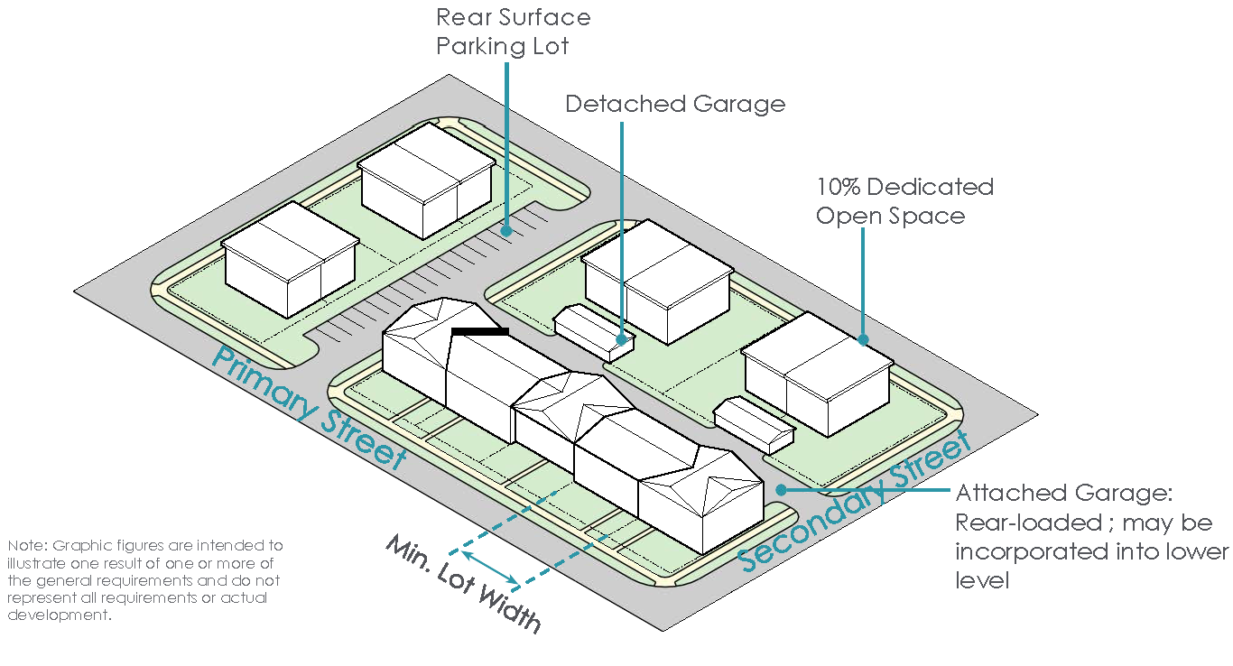
NCD MIXED-USE (NEIGHBORHOOD COMMERCIAL)
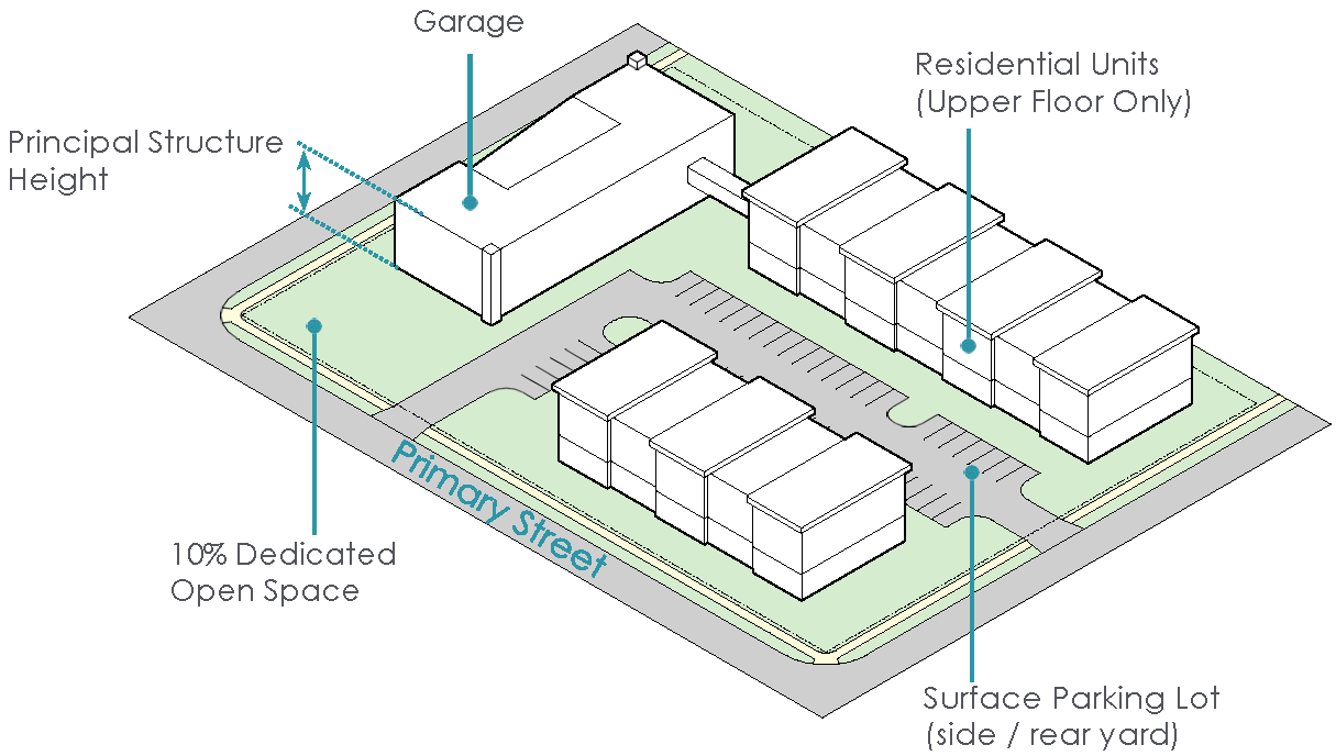
NCD MULTI-FAMILY
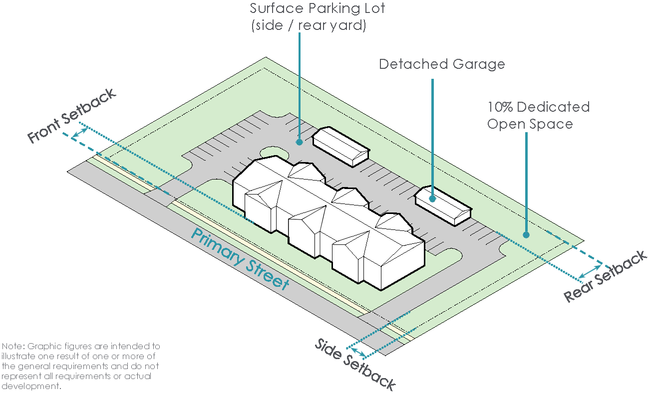
MULTI-FAMILY BUILDING TYPOLOGY
The Multi-Family Building Typology within the NCD allows for density in close proximity to the desired mixed-use and retail development patterns.
Supplemental Regulations:
* Determination of the setback line starting point, as it relates to the right-of-way line, lot line or easement line, shall be at the discretion of the Division of Engineering.
(Ord. No. 017-2023, Passed 4-24-2023; Ord. No. 052-2023, Passed 10-9-2023; Ord. No. 005-2025. Passed 2-24-2025; Ord. No. 013-2025. Passed 3-24-2025.)
1121.12 - HOSPITAL MIXED-USE DISTRICT (HMD).
I.
Purpose and Intent
A.
The Hospital Mixed-Use District (HMD) is intended to regulate all land in the city that was developed around Marysville's anchor health institutions and hospitals. The HMD encompasses a mix of traditional health services, commercial uses and residential uses.
II.
Existing Development Patterns
A.
The existing development pattern in the HMD is traditional large scale institutional development in the form of hospitals and medical facilities with adjacent residential development.
III.
Desired Development Pattern
A.
The desired development pattern in the HMD is to accommodate medium density single-family and multi-family development, including detached single-family homes, attached single-family townhomes and quadplexes. Where appropriate, small-scale commercial development may be conditionally approved to promote a mix of uses within the district.
IV.
Development Typologies
A.
Buildings in the Hospital Mixed-Use District shall be developed in accordance with the following development typologies:
» Single-Family (Attached) Building Typology
» Single-Family (Detached) Building Typology*
» Mixed-Use Building Typology
» Multi-Family Typology
» Office Building Typology
* (See Development Regulations for Single-Family (detached) Building typology in Village Residential District (1121.10, Design Review does not apply)
SINGLE-FAMILY (ATTACHED) BUILDING TYPOLOGY
The Single-Family (attached) Building Typology allows for increased density in the HMD and provides a live-work opportunity for employees of the healthcare businesses and services that predominate in the district.
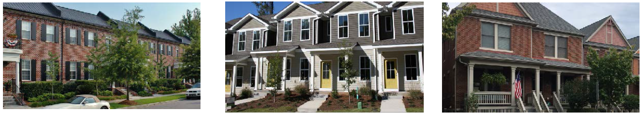
Supplemental Regulations:
* Determination of the setback line starting point, as it relates to the right-of-way line, lot line or easement line, shall be at the discretion of the Division of Engineering.
Maximum continuous frontage of 200 feet for attached units. 20 feet minimum spacing between any grouping of attached units.
SINGLE-FAMILY (DETACHED) BUILDING TYPOLOGY
Supplemental Regulations:
* Determination of the setback line starting point, as it relates to the right-of-way line, lot line or easement line, shall be at the discretion of the Division of Engineering.
MIXED-USE BUILDING TYPOLOGY
The mixed-use development typology within the HMD promotes a greater variety of uses within the district to complement the existing medical institution and office uses.
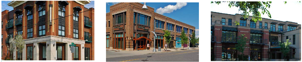
Supplemental Regulations:
* Determination of the setback line starting point, as it relates to the right-of-way line, lot line or easement line, shall be at the discretion of the Division of Engineering.
HMD SINGLE-FAMILY (ATTACHED)
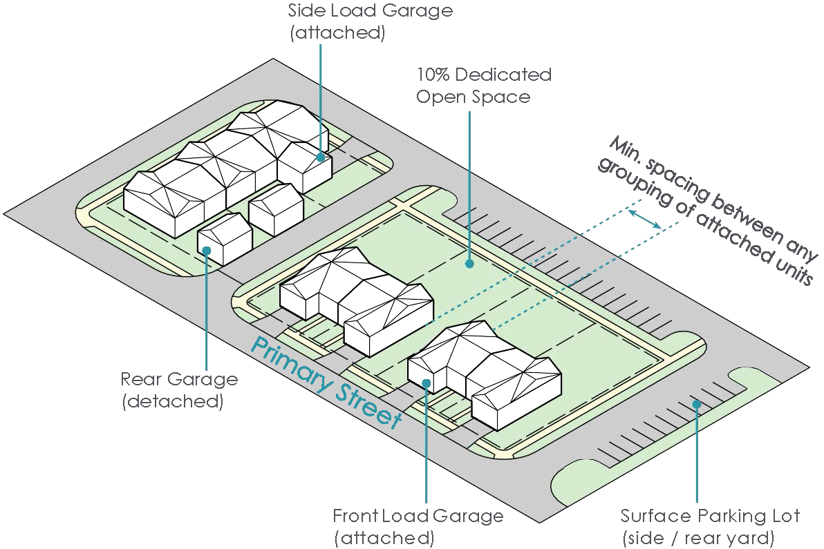
HMD MIXED-USE
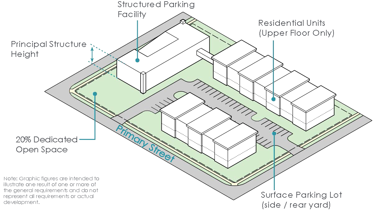
MULTI-FAMILY BUILDING TYPOLOGY
The Multi-Family Building Typology in the HMD allows for the introduction of new residents to the district and presents a live-work opportunity for employees of the existing healthcare development.
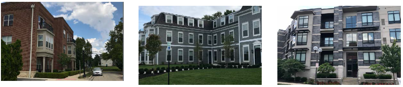
Supplemental Regulations:
* Determination of the setback line starting point, as it relates to the right-of-way line, lot line or easement line, shall be at the discretion of the Division of Engineering.
OFFICE BUILDING TYPOLOGY
The office building development typology within the HMD allows for the development of complementary businesses uses to the existing healthcare development.
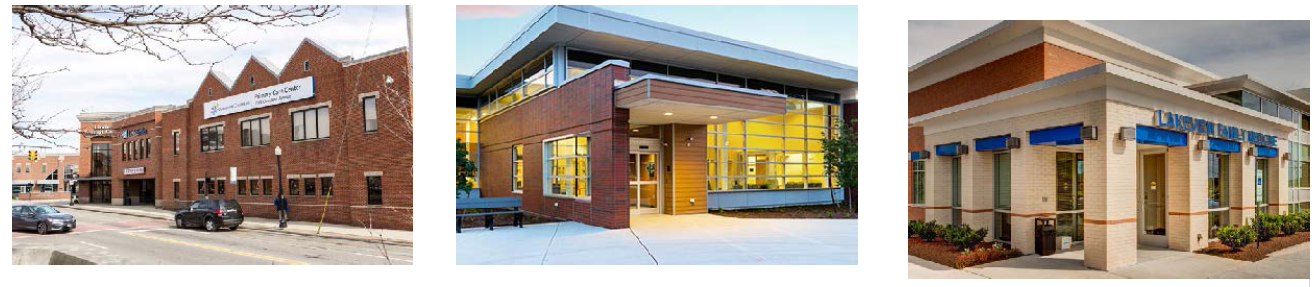
Supplemental Regulations:
* Determination of the setback line starting point, as it relates to the right-of-way line, lot line or easement line, shall be at the discretion of the Division of Engineering.
HMD MULTI-FAMILY
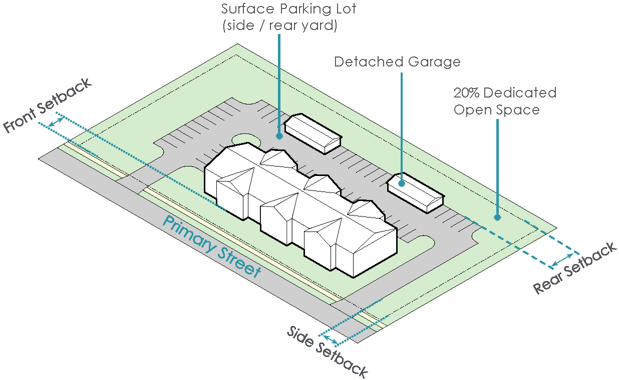
HMD OFFICE
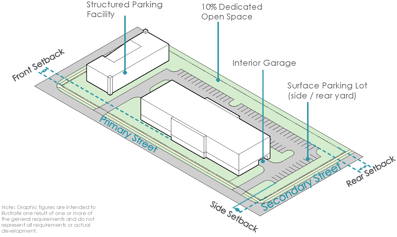
(Ord. No. 017-2023, Passed 4-24-2023; Ord. No. 053-2023, Passed 10-9-2023; Ord. No. 013-2025. Passed 3-24-2025; Ord. No. 044-2025, Passed 11-24-2025; Ord. No. 046-2025, Passed 11-24-2025; Ord. No. 047-2025, Passed 11-24-2025.)
1121.13 - MANUFACTURING/INNOVATION DISTRICT (M/I).
I.
Purpose and Intent
A.
The purpose of the Manufacturing/Innovation District (M/I District) is to serve as the economic engine of the City. This district currently serves as the location for many of Marysville's largest businesses and companies.
II.
Existing Development Patterns
A.
The existing development patterns in the Manufacturing/Innovation District (M/I District) include medium to large-sized manufacturing facilities and warehouses providing users with proximity to freeways and rail lines.
III.
Desired Development Pattern
A.
The desired development pattern in the M/I District is to continue the development of manufacturing and warehouse facilities with an emphasis on proximity to fiber optic and rail lines. Additionally, certain retail, commercial and office uses are appropriate within the M/I District when located in accessible nodes.
IV.
Development Typologies
A.
Buildings in the Manufacturing/Innovation District shall be developed in accordance with the following development typologies:
» Manufacturing Building Typology
» Office/Warehouse Flex Building Typology
» Office Building Typology
MANUFACTURING BUILDING TYPOLOGY
The industrial building typology is the standard development form within the M/I District. This development typology allows manufacturing and industrial uses to function according to their business needs.
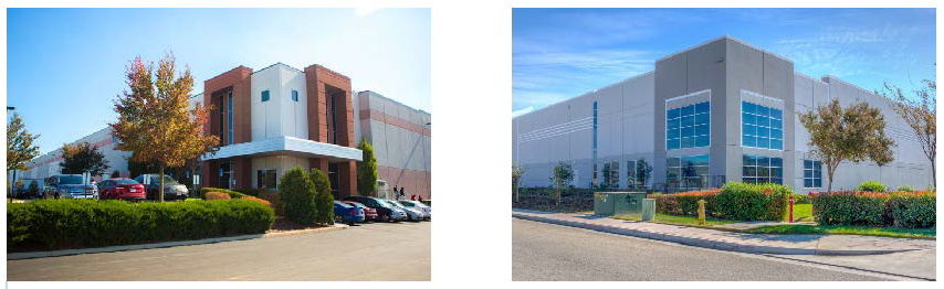
Supplemental Regulations:
* Determination of the setback line starting point, as it relates to the right-of-way
line, lot line or easement line, shall be at the discretion of the Division of Engineering.
OFFICE/WAREHOUSE FLEX BUILDING TYPOLOGY
The Office/Warehouse Flex typology may be located along an industrial drive or an interior commercial street. This typology provides the ability to combine office space and storage/loading areas for industrial, distribution or related principal uses.

Supplemental Regulations:
* Determination of the setback line starting point, as it relates to the right-of-way
line, lot line or easement line, shall be at the discretion of the Division of Engineering.
M/I MANUFACTURING
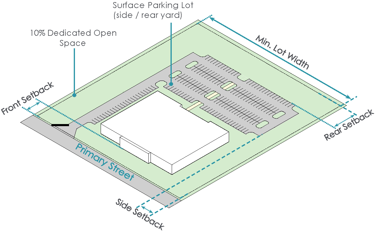
M/I OFFICE/WAREHOUSE FLEX

OFFICE BUILDING TYPOLOGY
The Office Typology in the Manufacturing/Innovation District allows for the development of office uses in close proximity to industrial development.
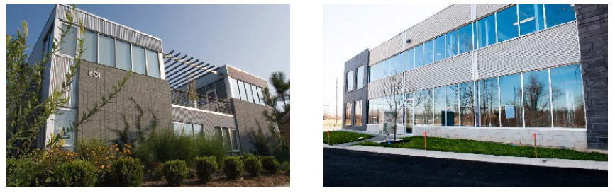
Supplemental Regulations:
* Determination of the setback line starting point, as it relates to the right-of-way line, lot line or easement line, shall be at the discretion of the Division of Engineering.
M/I OFFICE
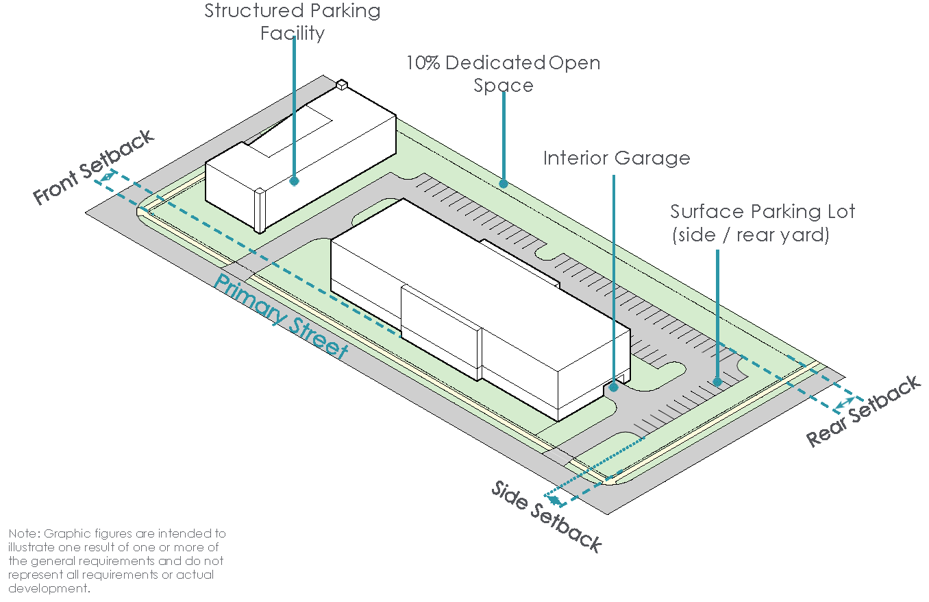
(Ord. No. 017-2023, Passed 4-24-2023; Ord. No. 013-2025. Passed 3-24-2025; Ord. No. 014-2025. Passed 4-14-2025; Ord. No. 052-2024. Passed 11-25-2024.)
1121.14 - LIGHT MANUFACTURING DISTRICT (LMD).
I.
Purpose and Intent
A.
The purpose of the Light Manufacturing District (LMD) is to allow for the development of light manufacturing and related uses in proximity to adjacent residential development.
II.
Existing Development Patterns
A.
The existing development pattern of the LMD is undeveloped industrial land that is located in close proximity to Marysville's primary industrial corridor.
III.
Desired Development Pattern
A.
The desired development pattern for the LMD is lower impact industrial and office developments that are developed with recognition of nearby established residential developments.
IV.
Development Typologies
A.
Buildings in the Light Manufacturing District shall be developed in accordance with the following development typologies.
» Manufacturing Building Typology
» Office/Warehouse Flex Building Typology
MANUFACTURING BUILDING TYPOLOGY
The Industrial Building Typology in the LMD allows for light manufacturing and similar development that relates to adjacent residential development.
Supplemental Regulations:
* Determination of the setback line starting point, as it relates to the right-of-way line, lot line or easement line, shall be at the discretion of the Division of Engineering.
OFFICE/WAREHOUSE FLEX BUILDING TYPOLOGY
The Office/Warehouse Flex Building Typology allows for the introduction of office users in the LMD at a scale that relates to adjacent or nearby residential development.
Supplemental Regulations:
* Determination of the setback line starting point, as it relates to the right-of-way line, lot line or easement line, shall be at the discretion of the Division of Engineering.
LMD INDUSTRIAL
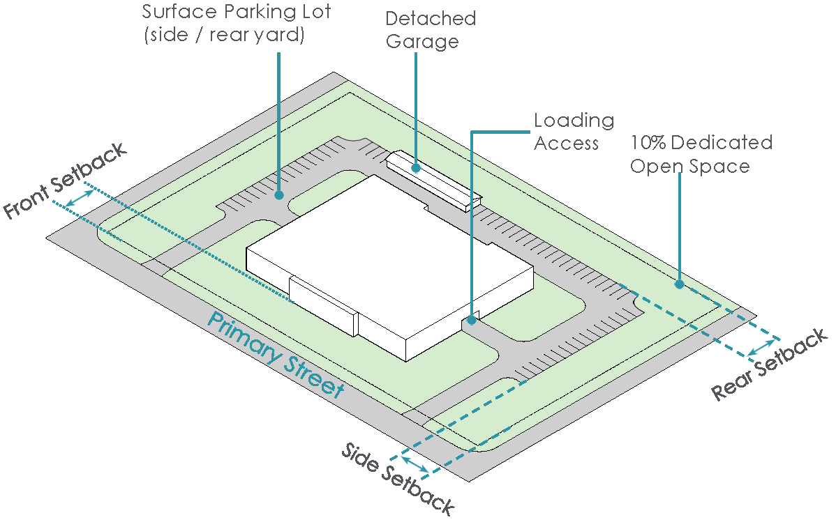
LMD OFFICE/WAREHOUSE FLEX
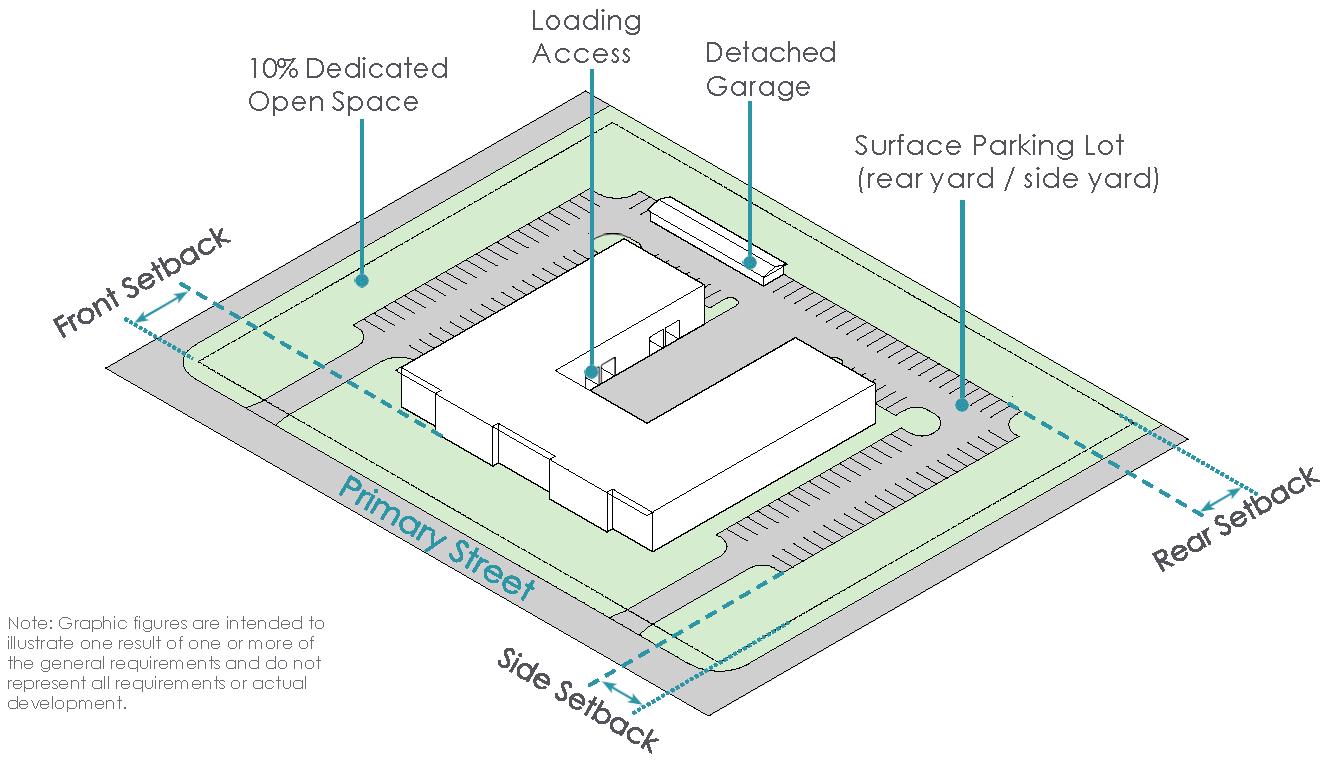
(Ord. No. 017-2023, Passed 4-24-2023; Ord. No. 054-2023, Passed 10-9-2023; Ord. No. 013-2025. Passed 3-24-2025; Ord. No. 052-2024. Passed 11-25-2024.)
1121.15 - REGIONAL MIXED-USE DISTRICT (RMU).
I.
Purpose and Intent
A.
The Regional Mixed-Use District (the "RMU District") is intended to regulate the development of the land located at and around the intersection of U.S. Route 33 in Marysville.
II.
Existing Development Patterns
A.
The existing development pattern in the RMU consists of retail uses located on large lots with surface parking. Existing residential development is present in select areas of the district in the form of high density multi-family development and senior-housing.
III.
Desired Development Pattern
A.
The desired development pattern in the RMU consists of more varied forms of commercial development that reflect the changing retail environment, including retail development with a smaller footprint. Mixed-use development with a residential component is encouraged and all new development should promote pedestrian-oriented design and connectivity.
IV.
Development Typologies
A.
Buildings in the Regional Mixed-Use District shall be developed in accordance with the following development typologies.
» Commercial Building Typology
» Mixed-Use Building Typology
» Office Building Typology
» Multi-Family Building Typology
COMMERCIAL BUILDING TYPOLOGY
The Commercial Building Typology in the RMU supports the continuation of the traditional form of development in the district while allowing for flexibility and more intention pedestrian-oriented design that promotes connectivity between development sites.

Supplemental Regulations:
* Determination of the setback line starting point, as it relates to the right-of-way line, lot line or easement line, shall be at the discretion of the Division of Engineering.
OFFICE BUILDING TYPOLOGY
The Office Building Development Typology within the RMU allows for the introduction of an employment-base to utilize the existing retail and restaurant uses while generally promoting economic development in the City.
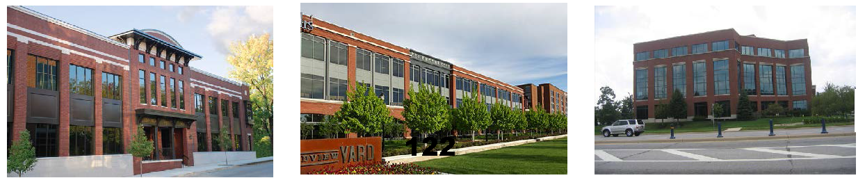
Supplemental Regulations:
* Determination of the setback line starting point, as it relates to the right-of-way line, lot line or easement line, shall be at the discretion of the Division of Engineering.
RMU COMMERCIAL
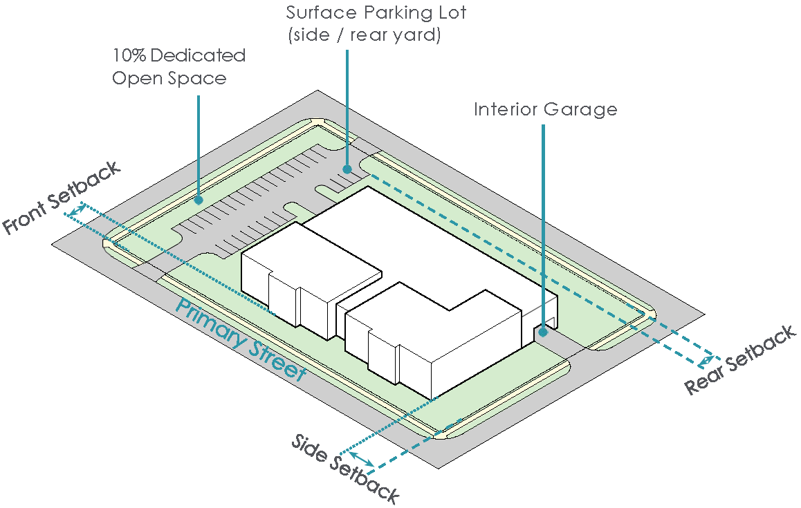
RMU OFFICE
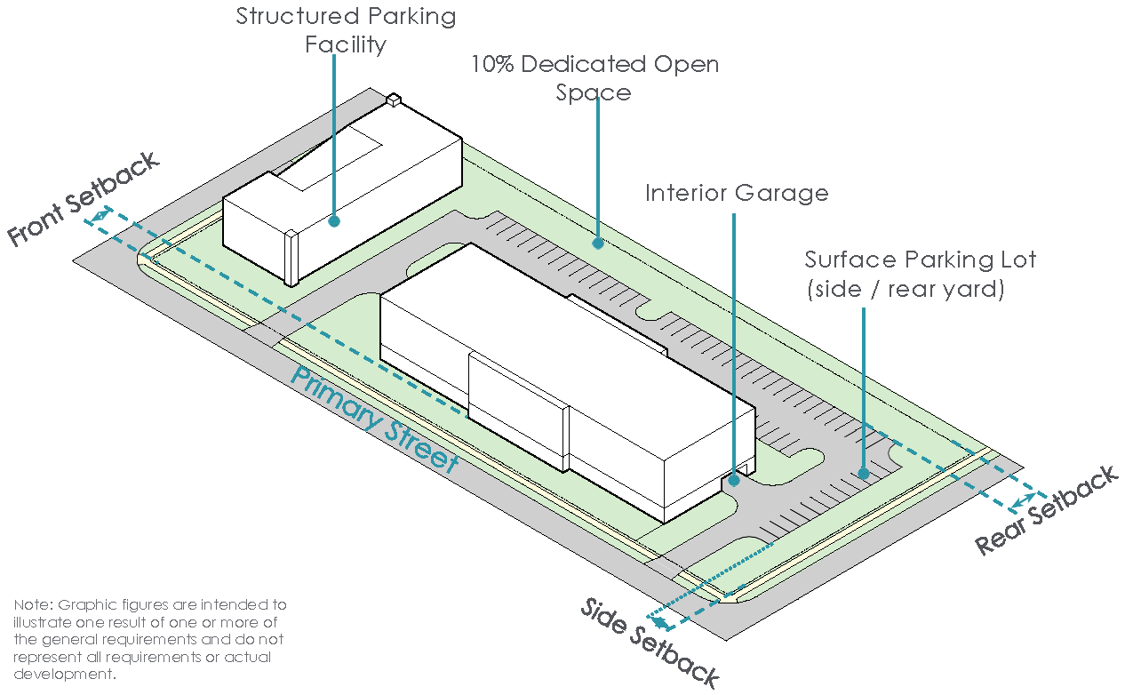
MIXED-USE BUILDING TYPOLOGY
The Mixed-Use Building Typology in the RMU promotes the introduction of residential uses into the district.
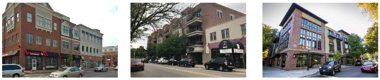
Supplemental Regulations:
* Determination of the setback line starting point, as it relates to the right-of-way line, lot line or easement line, shall be at the discretion of the Division of Engineering.
MULTI-FAMILY BUILDING TYPOLOGY
The Multi-Family Building Typology within the RMU promotes the introduction of residential uses to the RMU to support the existing retail development and present a live-work option for employees of office development.
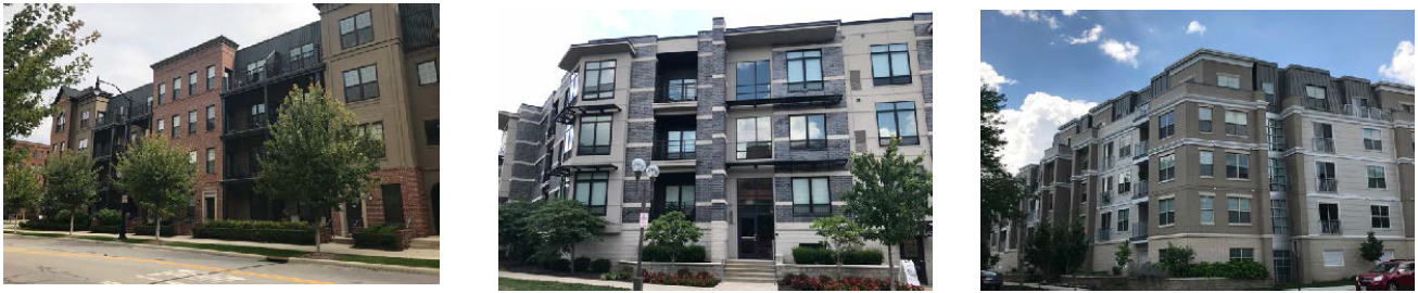
Supplemental Regulations:
* Determination of the setback line starting point, as it relates to the right-of-way line, lot line or easement line, shall be at the discretion of the Division of Engineering.
RMU MIXED-USE
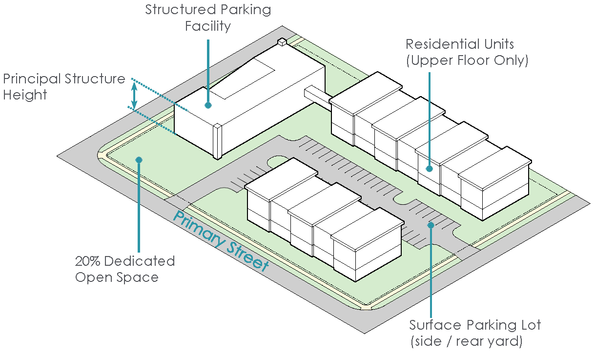
RMU MULTI-FAMILY
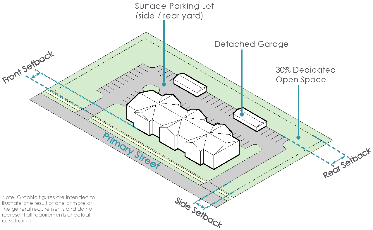
(Ord. No. 017-2023, Passed 4-24-2023; Ord. No. 055-2023, Passed 10-9-2023; Ord. No. 060-2024, Passed 12-2-2024; Ord. No. 005-2025. Passed 2-24-2025; Ord. No. 013-2025. Passed 3-24-2025.)
1121.16 - GOVERNMENT AND INSTITUTIONAL DISTRICT (GOV DISTRICT).
I.
Purpose and Intent
A.
The Government Institutional District (GOV) regulates all land that is designated for use by a government, quasi-governmental entity or other similar organization.
II.
Existing Development Patterns
A.
The existing development pattern in the GOV District includes a variety of government and institutional uses that serve adjacent residential development. The GOV District also includes more intensive institutional land uses such as airports and fairgrounds.
III.
Development Typologies
New development in the Government/Institutional District requires site plan review and approval by the Design Review Board in accordance with the applicable standards under Chapter 1133 for the proposed development typology.
(Ord. No. 049-2022, Passed 8-22-22.)
1121.17 - OPEN SPACE DISTRICT.
I.
Purpose and Intent
A.
The Open Space District (OSD) is intended to consist of passive and active greenspaces and recreational opportunities throughout the City, either in close proximity to residential development or easily accessible via pedestrian-oriented transit options.
II.
Desired Development Pattern
A.
The existing development patterns in the OSD consist of either undeveloped greenspace or existing recreational uses situated in proximity to residential development.
IV.
Development Typologies
A.
New development in the Open Space District requires site plan review and approval by the Design Review Board in accordance with the standards applicable to the proposed development form under Chapter 1133.
1121.18 - UPTOWN COMMERCIAL DISTRICT (UC).
I.
Purpose and Intent
A.
The purpose of this walkable district is to maintain and protect the character and charm of the commercial core within the Historic Uptown Marysville Design Review District.
II.
Existing Development Pattern
A.
The existing development pattern in this district is varied commercial and residential development with high character, quality and charm reflected in the existing architecture.
III.
Desired Development Pattern
A.
This district is positioned for historic preservation as well as new growth and redevelopment for uses such as retail, personal services, office, restaurants, and housing. New development shall compliment and/or maintain the historic architecture and urban form while also promoting walkability.
IV.
Development Typologies
A.
All new development and substantial modifications to existing structures in the Uptown Commercial District shall require review and approval by the Design Review Board in accordance with Chapter 1133.
UPTOWN COMMERCIAL DEVELOPMENT STANDARDS
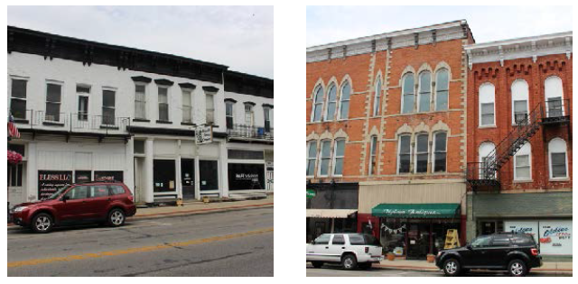
Supplemental Regulations:
* Determination of the setback line starting point, as it relates to the right-of-way line, lot line or easement line, shall be at the discretion of the Division of Engineering.
UC
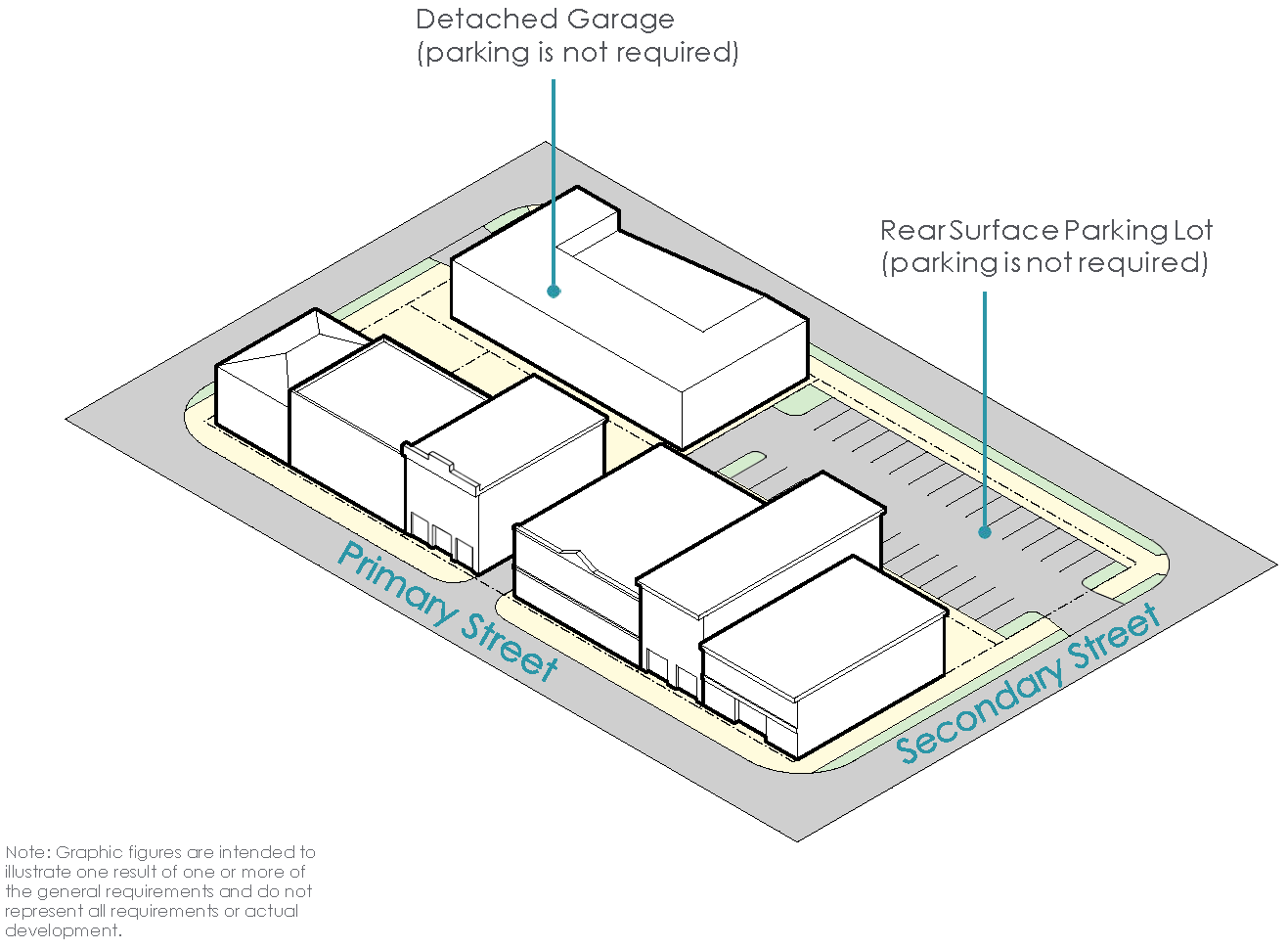
(Ord. No. 017-2023, Passed 4-24-23; Ord. No. 018-2023, Passed 4-24-2023; Ord. No. 013-2025. Passed 3-24-2025.)
1121.20 - UPTOWN SINGLE-FAMILY DISTRICT (USF).
I.
Purpose and Intent
A.
The purpose of the Uptown Single-Family District (USF) is to create a pedestrian-oriented, walkable district that maintains and promotes the character of single-family dwellings present throughout the Historic Uptown Marysville Design Review District.
II.
Existing Development Patterns
A.
The existing development patterns and standards vary throughout the USF. The district regulations reflect these varied patterns and standards to promote and compliment the character, quality and charm of the existing dwellings.
III.
Desire Development Pattern
A.
New development within this district should promote walkability and connectivity to the Uptown Commercial District and the Uptown Transitional District. New structures should reflect the character, quality and charm of existing residences within the district.
IV.
Development Typologies
New development in the USF shall be developed in accordance with the following development typologies.
UPTOWN SINGLE-FAMILY DEVELOPMENT STANDARDS
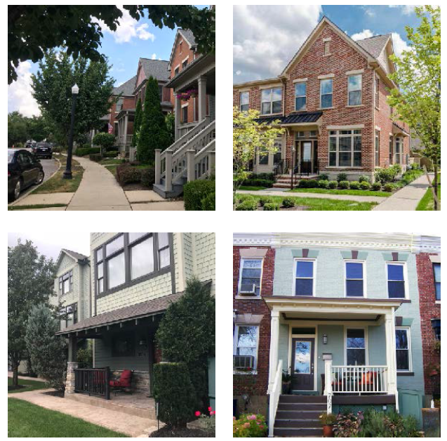
Supplemental Regulations:
* Determination of the setback line starting point, as it relates to the right-of-way line, lot line or easement line, shall be at the discretion of the Division of Engineering.
USF SINGLE-FAMILY DETACHED
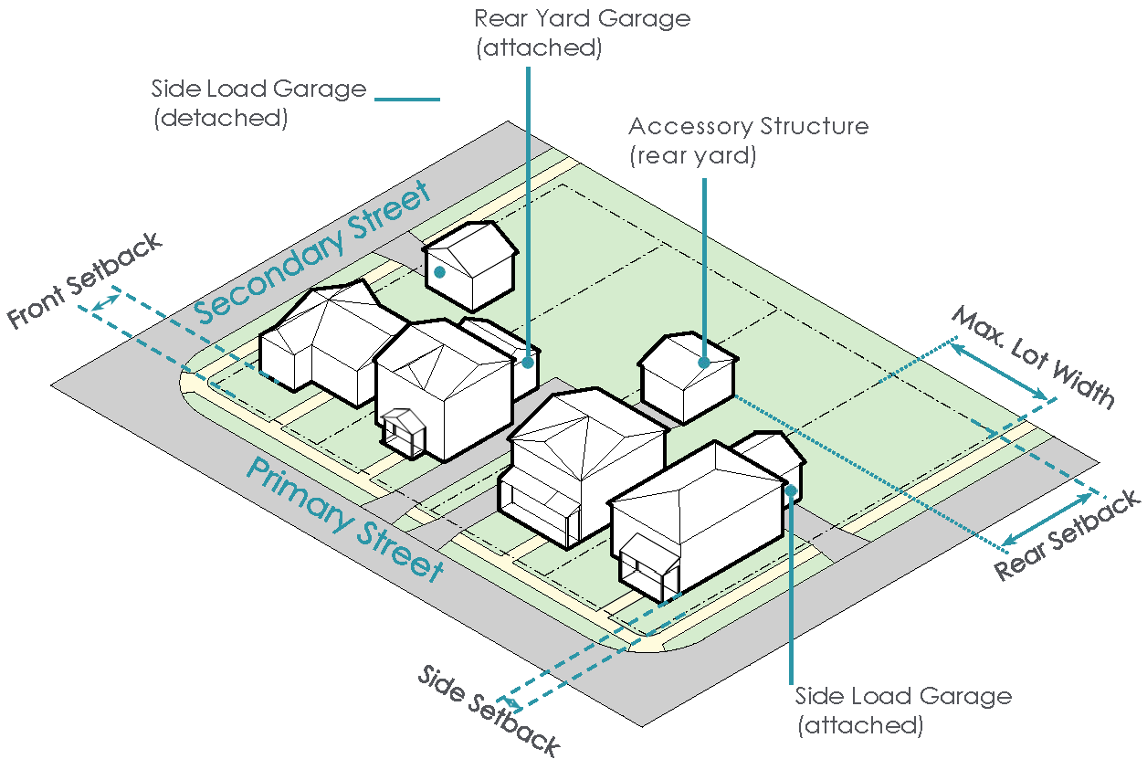
USF SINGLE-FAMILY ATTACHED
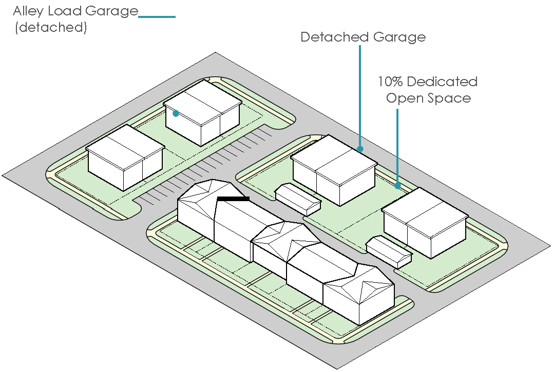
(Ord. No. 017-2023, Passed 4-24-2023; Ord. No. 013-2025. Passed 3-24-2025; Ord. No. 044-2025, Passed 11-24-2025; Ord. No. 046-2025, Passed 11-24-2025; Ord. No. 047-2025, Passed 11-24-2025.)
1121.21 - UPTOWN TRANSITIONAL DISTRICT (UT).
I.
Purpose and Intent
A.
The purpose of this walkable district is to maintain and protect existing single family housing structures while permitting small businesses to operate out of a single family home structure in the Historic Uptown Marysville Design Review District.
II.
Existing Development Pattern
A.
The existing development patterns in this district is varied commercial and residential development with high character, quality and charm reflected in the existing architecture.
III.
Desired Development Pattern
A.
New construction adjacent to existing single-family homes shall maintain the residential character, scale and charm of the historic homes within the district. Governmental buildings, churches and/or commercial buildings located in the district shall compliment the historic single-family housing architecture and promote walkability.
IV.
Development Typologies
A.
All new development and substantial modifications to existing structures in the Uptown Transitional District shall require review and approval by the Design Review Board in accordance with Chapter 1133.
UPTOWN TRANSITIONAL DEVELOPMENT STANDARDS
Supplemental Regulations:
* Determination of the setback line starting point, as it relates to the right-of-way line, lot line or easement line, shall be at the discretion of the Division of Engineering.
UT SINGLE-FAMILY DETACHED
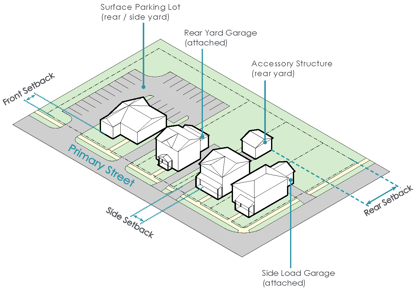
UT SINGLE-FAMILY ATTACHED

(Ord. No. 017-2023, Passed 4-24-23; Ord. No. 019-2023, Passed 4-24-2023; Ord. No. 013-2025. Passed 3-24-2025; Ord. No. 044-2025, Passed 11-24-2025.)
1121.22 - MANUFACTURING/INNOVATION OVERLAY DISTRICT (M/I-O).
I.
Purpose and Intent
A.
The Manufacturing/Innovation Overlay (M/I-O) regulates land that is intended to be utilized for lower intensity manufacturing uses subject to development protections for existing residential development adjacent to this overlay.
II.
Existing Development Pattern
A.
The existing development pattern of the M/I-O includes light manufacturing campuses with principal manufacturing structures and Accessory Structures that support manufacturing processes.
III.
Desired Development Pattern
A.
The desired development pattern for the M/I-O includes the location of light manufacturing, research and development and related fields incorporated in lower intensity developments.
IV.
Development Typologies
A.
Buildings in the Manufacturing/Innovation Overlay shall be developed in accordance with the following development typologies.
» All typologies permitted in the underlying zoning district
» Manufacturing Building Typology
» Office/Warehouse Flex Building Typology
MANUFACTURING BUILDING TYPOLOGY
The Industrial Building Typology in the M/I-O allows for light manufacturing and similar development that relates to adjacent residential development.
Supplemental Regulations:
* Determination of the setback line starting point, as it relates to the right-of-way line, lot line or easement line, shall be at the discretion of the Division of Engineering.
OFFICE/WAREHOUSE FLEX BUILDING TYPOLOGY
The Office/Warehouse Flex Building Typology allows for the introduction of office users in the M/I-O at a scale that relates to adjacent or nearby residential development.
Supplemental Regulations:
* Determination of the setback line starting point, as it relates to the right-of-way line, lot line or easement line, shall be at the discretion of the Division of Engineering.
M/I-O MANUFACTURING
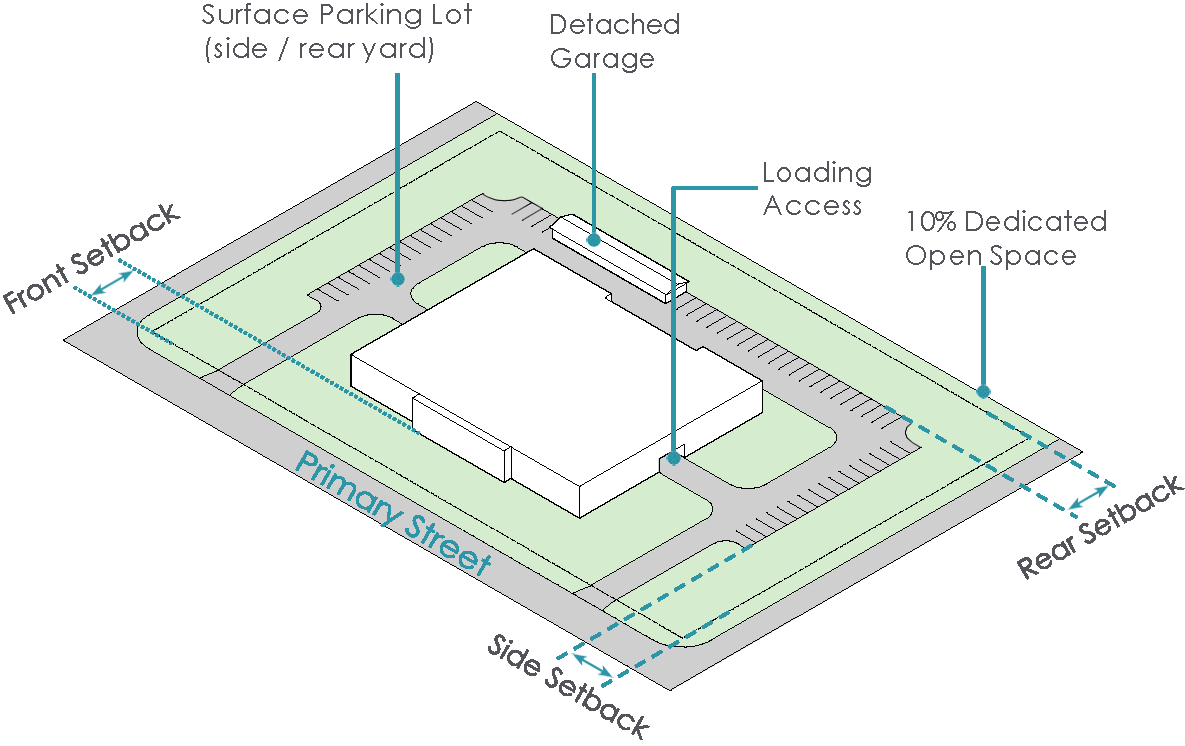
M/I-O OFFICE/WAREHOUSE FLEX

(Ord. No. 017-2023, Passed 4-24-2023; Ord. No. 013-2025. Passed 3-24-2025.)
1123.01 - GENERAL.
The purpose of generally applicable district regulations is to set specific conditions for various uses, classification of uses or areas where problems are frequently encountered.
(Ord. No. 054-2020, Passed 11-23-2020.)
1123.02 - CONVERSION OF DWELLINGS TO MORE UNITS.
A single-family detached structure may be converted to accommodate an increased number of dwelling units provided:
(a)
The yard dimensions still meet the yard dimensions required by the zoning regulations for new structures in that district;
(b)
The density of the new development meets the density requirements for new structures in that district;
(c)
The floor area per dwelling unit is not reduced to less than that which is required for new construction in that district; and
(d)
The conversion is in compliance with all other applicable codes, regulations ordinances and laws.
(Ord. No. 054-2020, Passed 11-23-2020.)
1123.03 - PRIVATE RESIDENTIAL SWIMMING POOLS.
No private residential swimming pool shall be allowed in any district, except as an accessory use and unless it complies with the following conditions and requirements:
(a)
The pool is intended and is to be used solely for the enjoyment of the occupants of the principal use of the property on which it is located;
(b)
It may not be located closer than ten (10) feet to any property line or easement line;
(c)
The swimming pool, or the entire property on which it is located, shall be walled or fenced to prevent uncontrolled access by children from the street or from adjacent properties.
Such fence or wall shall not be less than four (4) feet in height, maintained in good condition with a gate and lock, and meet the barrier requirements as established in the swimming pools, spas and hot tub appendix of the Ohio Residential Code.
(d)
Swimming pools must be located at the rear yard of a principal structure and if a comer lot, shall not be closer to the street line than the principal structure.
(Ord. No. 054-2020, Passed 11-23-2020.)
1123.04 - COMMUNITY OR CLUB SWIMMING POOLS.
Community and club swimming pools are permitted in any commercial or residential district, but shall comply with the following conditions and requirements:
(a)
The pool is intended solely for the enjoyment of the members and families and guests of members of the association or club under whose ownership or jurisdiction the pool is operated;
(b)
The pool and accessory structures thereto, including the areas used by the bathers, shall not be closer than fifty feet to any property line or easement line; and
(c)
The swimming pool and all of the area used by the bathers shall be walled or fenced to prevent uncontrolled access by children from the thoroughfare or adjacent properties. Such fence or wall shall not be less than six (6) feet in height, maintained in good condition, and meet the barrier requirements as established in the Ohio Building Code.
(Ord. No. 054-2020, Passed 11-23-2020.)
1123.05 - TEMPORARY BUILDINGS.
(a)
Temporary buildings, construction trailers, equipment and material used in conjunction with construction work only may be permitted in any district during the period construction work is in progress, but such temporary facilities shall be removed upon completion of the construction work. Storage of such facilities or equipment beyond the completion date of the project shall require a zoning permit authorized by the Division of Engineering.
(b)
Portable Storage Containers that are loaded with materials and placed on a residential property for the purpose of temporarily storing materials are permitted with the following regulations:
(1)
Portable Storage Containers shall not be located on any parcel for a period exceeding fourteen days from date of delivery. At the end of fourteen days, an extension for a maximum fourteen additional days may be granted by the Division of Engineering based on just cause.
(2)
Portable Storage Containers shall not be located on any parcel for a period exceed twenty-eight (28) days per calendar year.
(3)
Portable Storage Containers shall be kept in the driveway of the property at the furthest accessible point from the street. The location of the Portable Storage Container on a driveway shall not obstruct visibility nor block the sidewalk. If no driveway is present, approval from City departments for the placement of the Portable Storage Container prior to its delivery is required.
(4)
Only one (1) Portable Storage Container shall be placed at any residential property at one time.
(5)
Penalties shall be applied to the container owner, lessor and lessee per Section 1149.99.
(Ord. No. 054-2020, Passed 11-23-2020.)
1123.06 - DENSITY-BONUS PROGRAM.
(a)
Purpose. The City of Marysville density bonus program is applicable to all forms of single-family (attached), multi-family, and mixed-use development as provided in Chapter 1121 of this Planning and Zoning Ordinance. The density bonus program is intended to accommodate additional density beyond the as of right densities set forth in the applicable zoning regulations for the subject property.
(b)
Specific Objectives. The following objectives shall be met to promote a high-quality development that enhances the visual character, functionality and the overall community:
(1)
Promote harmonious development: Ensure new development integrates seamlessly with existing neighborhood character and natural features.
(2)
Enhance public realm: Create attractive, safe, and accessible public and semi-public spaces.
(3)
Improve pedestrian and vehicular circulation: Foster efficient and safe movement for all modes of transportation.
(4)
Encourage environmental awareness: Support sustainable practices and conservation of existing natural features.
(5)
Foster community identity: Reinforce the unique identity and sense of place within the municipality.
(c)
Procedure. To receive a density bonus for any development, the developer shall file an application to the Planning Commission for review. The Planning Commission shall hear all applications for density bonuses and determine whether each application should be approved or denied based upon the evidence presented in the application and at the hearing at which the proposed Plan bonus is considered.
(d)
Eligible Building Typologies. As provided in Chapter 1121 of this Planning and Zoning Ordinance, the residential and mixed-use building typologies are eligible for the density bonus program as described under Table 1123A.
(e)
Development Plan Review. Any project considered for a density bonus under the provisions of this subchapter shall also be further considered by the Design Review Board in accordance with Chapter 1133. The approval of any density bonus under this subchapter shall be conditional upon such approval by the Design Review Board.
(f)
Development Requirements for Density-Bonus. In order to qualify for a density bonus, an applicant must demonstrate compliance with the applicable requirements for the corresponding density bonus level for which the applicant has applied. The requirements are set forth in the Design Criteria within this section and Table 1123A.
(g)
Design Criteria. Before granting the density bonus application, the Planning Commission shall find that the information submitted with the application establishes all of the following:
(1)
The design shall respond to the unique characteristics of the site and its surroundings, including topography, natural features, adjacent land uses, and architectural styles.
(2)
The development shall exhibit a high degree of aesthetic quality, contributing to the visual environment through thoughtful massing, materials, colors, and landscaping.
(3)
The design shall incorporate sustainable practices, including but not limited to, stormwater management, energy efficiency, and native landscaping.
(4)
Setbacks can be utilized to accommodate landscaping, and provide appropriate transitions between public and private realms and adjacent land uses. Variations in setbacks may be encouraged to create visual interest and respond to site conditions.
(5)
The development shall feature diverse architectural facades to encourage visual interest and unique neighborhood character.
(6)
The development shall provide adequate and appropriately designed common open space that is publicly accessible, usable, and integrated into the overall site design. Pedestrian connectivity is encouraged between adjacent properties and community facilities.
(7)
Driveway access points shall be minimized and consolidated where possible to reduce conflicts with pedestrian and vehicular traffic.
(h)
Adaptive Reuse Density-Bonus. Development projects incorporating the redevelopment and conversion of an existing nonresidential principal use within a building to a residential or mixed-use project are eligible for a density bonus subject to the following conditions:
(1)
The last use of the building prior to the redevelopment project shall have been any nonresidential use and the proposed redevelopment project shall either be a mixed-use project or a residential project;
(2)
Redevelopment projects that incorporate only a residential component shall be eligible for a density bonus of an additional two (2) units per gross acre above the maximum density otherwise permitted in the underlying zoning district;
(3)
Redevelopment projects that incorporate a nonresidential component on any portion of the subject property, including out-lots shall be eligible for a density bonus of an additional four (4) units per gross acre above the maximum density otherwise permitted in the underlying zoning district for any residential component of the underlying redevelopment project; and
(4)
Redevelopment projects that qualify for this adaptive reuse density bonus may proceed under any other density bonus provision under the Zoning Code.
(i)
Blighted Property Density Bonus. Development projects incorporating the redevelopment of a "blighted property" are eligible for a density bonus subject to the conditions set forth below:
(1)
For the purposes of this subsection (i), "blighted property" shall mean either (A) a property with a structure that is dilapidated, unsanitary, unsafe, or vermin infested that because of its condition has been designated by the Division of Engineering as unfit for human habitation or use; or (B) a property that poses a direct threat to public health or safety in its present condition by reason of environmentally hazardous conditions, solid waste pollution, or contamination;
(2)
Redevelopment projects that incorporate only a residential component shall be eligible for a density bonus of an additional two (2) units per gross acre above the maximum density otherwise permitted in the underlying zoning district;
(3)
Redevelopment projects that incorporate a nonresidential component on any portion of the subject property, including out-lots shall be eligible for a density bonus of an additional four (4) units per gross acre above the maximum density otherwise permitted in the underlying zoning district for any residential component of the underlying redevelopment project; and
(4)
Redevelopment projects that qualify for this adaptive reuse density bonus may proceed under any other density bonus provision under the Zoning Code.
TABLE 1123A
(Ord. No. 054-2020, Passed 11-23-2020; Ord. No. 020-2023, Passed 4-24-2023; Ord. No. 033-2025, Passed 9-22-2025.)
1123.07 - REQUIRED TRASH AREAS.
Provisions for adequate vehicular access to and from such area or areas for collection of trash and/or garbage as determined by the Division of Engineering shall be required.
(Ord. No. 054-2020, Passed 11-23-2020; Ord. No. 049-2025, Passed 11-24-2025.)
1123.08 - SUPPLEMENTAL YARD AND HEIGHT REGULATIONS.
In addition to all yard regulations specified in Chapter 1121 and in other sections of this Planning and Zoning Ordinance, the provisions of Sections 1123.09 through 1123.14 shall be used for interpretation and clarification.
(Ord. No. 054-2020, Passed 11-23-2020.)
1123.09 - SETBACK REQUIREMENTS FOR CORNER BUILDINGS.
On a corner lot the principal building and its accessory structure shall be required to have the same setback distance from all street right-of-way lines as required for the front yard in the district in which such structures are located.
(Ord. No. 054-2020, Passed 11-23-2020.)
1123.10 - VISIBILITY AT INTERSECTIONS.
On a corner lot in any district, nothing shall be erected, placed, planted or allowed to grow in such a manner as to materially impede vision between a height of two and one-half (2.5) feet and ten (10) feet above the centerline grades of the intersecting streets in the area bounded by the right-of-way lines of such corner lots and a line joining points along such street lines fifty feet from the point of intersection.
(Ord. No. 054-2020, Passed 11-23-2020.)
1123.11 - YARD REQUIREMENTS FOR MULTI-FAMILY DWELLINGS.
Multi-family dwellings arranged in two or more buildings shall be considered one (1) building for the purpose of determining front, side and rear yard requirements. Multiple buildings with multi-family dwelling units shall require one (1) front, one (1) rear and two (2) side yards as specified for dwellings in the appropriate district.
(Ord. No. 054-2020, Passed 11-23-2020.)
1123.12 - SIDE AND REAR YARDS FOR NONRESIDENTIAL USES ABUTTING RESIDENTIAL DISTRICTS.
Nonresidential buildings or uses shall not be located nor conducted closer than ten (10) feet to any lot line of a residential district; provided however, the regulations of any zoning district or overlay may require such additional distance between uses as so required for the co-existence of nonresidential and residential buildings and uses.
(Ord. No. 054-2020, Passed 11-23-2020.)
1123.13 - ARCHITECTURAL PROJECTIONS.
Open structures such as porches, canopies, balconies, platforms, carports, covered patios and similar architectural projections shall be considered parts of the building to which attached and shall not project into the required minimum front, side or rear yard with the exception of canopies, awnings and balconies.
(Ord. No. 054-2020, Passed 11-23-2020.)
1123.14 - EXCEPTIONS TO HEIGHT REGULATIONS.
The height limitations contained in Chapter 1121 do not apply to spires, belfries, cupolas, antennas, water tanks, ventilators, chimneys or other appurtenances usually required to be placed above the roof level and not intended for human occupancy except where the height of such structures will constitute a hazard to the safe landing and take-off of aircraft at the airport.
(Ord. No. 054-2020, Passed 11-23-2020.)
1123.15 - SPECIAL PROVISIONS FOR NON-RESIDENTIAL DISTRICTS OR USES.
(a)
Compliance Required. No land or building in any district shall be used or occupied in any manner so as to create any dangerous, injurious, noxious, or otherwise objectionable fire, explosive, or other hazard; noise or vibration; smoke, dust, odor or other form of air pollution; heat, cold, dampness, electrical or other substance, condition or element in such a manner or in such amount as to adversely affect the surrounding area or adjoining premises (referred to herein as "dangerous or objectionable elements"); provided that any use permitted or not expressly prohibited by this Planning and Zoning Ordinance may be undertaken and maintained if it conforms to the regulations of this subchapter limiting dangerous and objectionable elements at the point of the determination of their existence.
(b)
Existing Uses. Any use authorized under the provisions of this Section 1123.15 shall comply continually therewith and shall remedy any dangerous or objectionable elements which may develop in the course of its operation.
(1)
Whenever it is alleged that a use of land or structure creates or is likely to create or otherwise produce dangerous or objectionable elements as defined in Section 1123.17, the City Engineer shall be responsible for conducting an investigation of the allegation. The City Engineer may employ a competent specialist, outside laboratory, or obtain use of whatever equipment is needed for the purpose of determining the nature and extent of such dangerous or objectionable elements and a practical means of remedying such condition.
(2)
Upon completion of the investigation and receipt of recommendation of such outside specialists or laboratory as used, and if a violation is found, the City Engineer may determine the measures, to the extent practical, that should be taken to correct the violation. To the extent a violation is found, the City Engineer shall so advise the Division of Engineering who shall proceed with the enforcement of such measures in accordance with the provision of Section 1123.01. Appeals from decisions of the City Engineer, if made, shall follow the procedures set forth in Section 1123.09.
(3)
The City shall bear the costs of the various tests, consultant fees or other investigations which are required herein. in the event that operation or use of such property is found to be in violation of the provisions of this subchapter by the City Engineer, the Board of Zoning Appeals, or by a court of competent jurisdiction, the owner of the use under investigation shall reimburse the City for all such expenses. Such reimbursement shall be made within thirty (30) days from the date of the final Board ruling or court judgment.
(c)
New Uses. The applicant for new uses shall bear the actual costs of all tests and investigations required to establish compliance or ability to comply and shall be in addition to the usual zoning and other City permit fees.
(Ord. No. 054-2020, Passed 11-23-2020.)
1123.16 - LOCATIONS WHERE DETERMINATIONS ARE TO BE MADE FOR ENFORCEMENT OF PERFORMANCE STANDARDS.
The determination of the existence of any dangerous and objectionable elements shall be made at the location of the use creating the same and at any points where the existence of such elements may be more apparent (herein referred to as "at any point"); provided, however, that the measurements necessary for enforcement of performance standards set forth in this subchapter shall be taken at different points in different districts in relation to the establishment or use creating the element being measured (herein referred to as "point of measurement") as follows:
(a)
M/I District, M/I Overlay and Light Manufacturing District. At the boundary or boundaries of the district, or at any point within an adjacent district or overlay.
(b)
All Other Districts and Overlays. Twenty-five (25) feet from the establishment or use, or at the lot line of the use if closer to the establishment or use.
(Ord. No. 054-2020, Passed 11-23-2020.)
1123.17 - PERFORMANCE STANDARD REGULATIONS.
The relevant provisions of federal, state and local law and regulations apply to this section. In addition, the following provisions, standards and specifications shall apply to the districts set forth below:
(a)
Fire and Explosion Hazards. In the M/I District, M/I Overlay and Light Manufacturing District, all activities involving, and all storage of, flammable and explosive materials shall be provided at any point with adequate safety devices plans and procedures against the hazard of fire and explosion and adequate fire-fighting and fire suppression equipment and devices standard in the industry. Burning of waste materials in open fire shall be prohibited at any point.
(b)
Radioactivity or Electric Disturbance. In the M/I District, M/I Overlay and Light Manufacturing District, anyone using equipment, materials or in any way handling radioactive materials shall be licensed by the NRC as required by the NRC. No activities shall be permitted which emit dangerous radioactivity at any point. Electrical disturbance adversely affecting the operation at any point of any equipment other than that of the creator of such disturbance are also prohibited.
(c)
Noise. At the point of measurement specified in Section 1123.16 the sound pressure level of noise radiated from a facility at night time shall not exceed the values set forth in the table below:
(d)
Vibration. In any district or overlay, no vibration shall be permitted which is discernible without instruments at the points of measurement specified in Section 1123.16.
(e)
Smoke. In all districts and overlays, no emission shall be permitted at any point, from any chimney or otherwise, or visible gray smoke of a shade equal to or darker than No. 2 on the Power's Micro-Ringlemann Chart, published by McGraw-Hill Publishing Company, Inc., and copyrighted 1954 (being a direct facsimile reduction of the standard Ringlemann Chart as issued by the United States Bureau of Mines), except that visible gray smoke of a shade equal to No. 2 on such Chart may be emitted for four (4) minutes in any thirty minutes. These provisions applicable to visible gray smoke shall also apply to visible smoke of a different color but with an apparently equivalent capacity.
(f)
Odor. In all districts and overlays, no emission shall be permitted of odorous gases or other odorous matter in such quantities as to be offensive at the point of measurement specified in Section 1123.16. Any process which may involve the creation or emission of any odors shall be provided with a secondary safeguard system, so that control will be maintained if the primary safeguard system should fail. There is hereby established as a guide in determining such qualities of offensive odors Table III, "Odor Thresholds," in Chapter 5, "Air Pollution Abatement Manual," copyright 1951 by Manufacturing Chemist Assn., Inc., Washington, D.C.
(g)
Dust, Fly Ash, Fumes, Vapors, Gases, and Other Forms of Air Pollution. In all districts and overlays, no emission shall be permitted which can cause any damage to health, to animals, vegetation, or other forms of property, or which can cause any excessive soiling, at any point; and in no event any emission, from any chimney or otherwise, of any solid or liquid particles in concentrations exceeding 0.3 grains per cu. ft. of the conveying gas at any point. For measurement of the number of particles in gases resulting from combustion, standard corrections shall be applied to a stack temperature of 500 degrees Fahrenheit and fifty percent (50%) excess air.
(h)
Glare. In all districts and overlays, no direct or sky-reflected glare, whether from flood lights or from high temperature processes such as combustion or welding or otherwise, so as to be visible at the points of measurement specified in Section 1123.16. This restriction shall not apply to signs otherwise permitted by the provisions of the Planning and Zoning Ordinance.
(i)
Liquid or Solid Wastes. In all districts and overlays, no discharge at any point into any public sewer, private sewage disposal system, stream, or into the ground, except in accord with standards approved by the Department of Health of the State of Ohio and by the Superintendent of the Waste Water Treatment Plant (see Chapter 921-Codified Ordinances of Marysville, Ohio) and by the Ohio Environmental Protection Agency or standards equivalent to those approved by such department for similar uses, of any materials of such nature or temperature as can contaminate any water supply or Otherwise cause the emission of dangerous or offensive elements.
(j)
Hazardous or Toxic Materials. In all districts and overlays, all activities involving, and all storage of hazardous or toxic materials shall be provided with at any point, adequate safety devices, plans and procedures to protect against injury to persons on the premises using or storing such materials or to persons in other districts or on neighboring property.
(k)
Erosion. In all districts and overlays, no erosion, by wind, water or other means, shall be permitted which will carry objectionable substances or inflict damage onto neighboring property.
(l)
Manufacturing Uses Abutting Residential Districts. Uses permitted, conditional or non-conforming in the M/I District, LMD, or M/I Overlay, shall not be located or conducted closer than 100 feet to any lot line of a residential district except that the minimum yard requirements contained in the regulations for the applicable building typology may be utilized if acceptable landscaping, fencing or other screening approved by the Division of Engineering is provided.
(Ord. No. 054-2020, Passed 11-23-2020.)
1123.18 - ENFORCEMENT PROVISIONS.
(a)
Proof of Compliance. The Division of Engineering or Board of Zoning Appeals, prior to the issuance of a Zoning Permit, may require the submission of statements and plans indicating the manner in which dangerous and objectionable elements involved in processing and in equipment operations are to be eliminated or reduced to acceptable limits and tolerances.
(b)
The Division of Engineering or Board of Zoning Appeals may also establish a reporting requirement of at least annually, requiring the applicant to show results of eliminating or reducing dangerous or objectionable elements to acceptable limits and tolerances.
(Ord. No. 054-2020, Passed 11-23-2020.)
1123.19 - ENCLOSED ACCESSORY STRUCTURES IN SRD, VRD, NCD, AND ARD.
(a)
Enclosed Accessory Structures in SRD, VRD, and NCD Zoning Districts.
(i)
Design Standards. An enclosed accessory structure shall have an exterior which meets these standards and is compatible in appearance to the principal residential structure on the parcel or lot. Compatibility shall be determined based upon the following criteria: exterior building materials, color, architecture, roof style, and siding.
(ii)
Maximum Number of Enclosed Accessory Structures and Maximum Square Feet of All Enclosed Accessory Structures. Up to two (2) of the below-listed enclosed accessory structures may be located on property in the Suburban Residential District (SRD), Village Residential District (VRD), and Neighborhood Commercial District (NCD) in accordance with the provisions set forth hereunder. Under no circumstances shall the combined square footage of the accessory structures located in accordance with this section exceed 1,000 square feet.
(iii)
Detached Garage. As permitted under the regulations for the base zoning district of the subject property, one (1) of the permitted enclosed accessory structures located in accordance with this section may be a detached garage, not exceeding 750 square feet in floor area or fifteen feet in height and otherwise complying with the applicable regulations under the base zoning district of the subject property.
(iv)
Other Enclosed Accessory Structures. One (1) of the permitted enclosed accessory structures under this section may be any enclosed accessory structure permitted under the applicable regulations for the base zoning district of the subject property, not exceeding 250 square feet in floor area or fifteen feet in height and otherwise complying with the applicable regulations under the base zoning district of the subject property.
(b)
Enclosed Accessory Structures in ARD Zoning District.
(i)
Design Standards. An enclosed accessory structure shall have an exterior which meets these standards and is compatible in appearance to the principal residential structure on the parcel or lot. Compatibility shall be determined based upon the following criteria: exterior building materials, color, architecture, roof style, and siding.
(ii)
Maximum Number of Enclosed Accessory Structures and Maximum Square Feet of All Enclosed Accessory Structures. Up to two (2) enclosed accessory structures may be located on property located in the Agricultural Residential District (ARD) in accordance with the provisions set forth hereunder. Under no circumstances shall the combined square footage of the enclosed accessory structures located in accordance with this section exceed 2,400 square feet.
(iii)
Detached Garage. As permitted under the regulations for the base zoning district of the subject property, one (1) of the permitted enclosed accessory structures located in accordance with this section may be a detached garage not exceeding 1,200 square feet in floor area or twenty feet in height and otherwise complying with the applicable regulations for the ARD zoning district.
(iv)
Other Enclosed Accessory Structures. One (1) of the permitted enclosed accessory structures located in accordance with this section may be any enclosed accessory structure permitted under the regulations for the Agricultural Residential District (ARD), not exceeding 1,200 square feet in floor area or twenty feet in height and otherwise complying with the application regulations for the ARD zoning district.
(c)
Administrative Adjustment. Notwithstanding anything to the contrary in this Zoning Code, when an applicant seeks approval to construct an enclosed accessory structure or enclosed accessory structures that would otherwise exceed the maximum floor area permitted hereunder by up to 50%, the Division of Engineering is authorized to review such request in accordance with the provisions set forth under Section 1141.15 and impose any supplementary conditions in accordance with Section 1141.17 of this Zoning Code. If upon review of the application for an enclosed accessory structure the Division of Engineering determines that such application satisfies the applicable conditions, the Division of Engineering shall grant an administrative adjustment to permit the construction of the accessory structure or accessory structures in accordance with this Zoning Code and the terms and conditions of the administrative adjustment; provided however, the Division of Engineering may refer any request for an administrative adjustment to the Board of Zoning Appeals for consideration by the BZA in accordance with Section 1141.15 of this Zoning Code.
(d)
Accessory Dwelling Units (ADUs) in SRD, VRD, ARD, UT and USF. Accessory dwelling units must be located, developed and operated in compliance with the following development standards:
i.
All ADUs shall require a Conditional Use Permit through an application to the Planning Commission.
ii.
Planned Unit Developments (PUDs). No Accessory Dwelling Units shall be located within a Planned Unit Development unless the use is listed as an accessory use within the PUD. Any amendments to modify the permitted accessory uses to an existing PUD shall follow the City's PUD amendment process.
iii.
Design Standards. An accessory dwelling unit shall have an exterior which meets these standards and is compatible in appearance to the principal residential building on the parcel. Compatibility shall be determined based upon the following criteria: exterior building materials, color, architecture, roof style, and siding.
iv.
Location. Accessory Dwelling Units shall be located in compliance with the following standards:
1.
Attached. Constructed as an addition to either the side or rear of the principal residential building with a separate egress.
2.
Detached. Constructed as an entirely separate structure than the principal residential building located on the side or rear of the principal residential building.
Setbacks: Refer to the principal structure regulations in the typology chart of the corresponding zoning district.
v.
Maximum Number of Accessory Dwelling Units per Parcel. Not more than one (1) Accessory Dwelling Unit shall be constructed per parcel.
vi.
Size.
1.
Shall not exceed more than eight hundred fifty (850) square feet of living space.
2.
Detached. Shall not exceed more than nine hundred fifty (950) square feet of living space or not to exceed the principal structure floor area, whichever is less.
vii.
Height. Accessory Dwelling Units shall comply with the following height requirements:
1.
Attached. Shall be subject to the principal structure height requirements under the typology chart of the corresponding zoning district, or the height of the principal structure, whichever is less.
2.
Detached. Shall not exceed thirty (30) feet in height, or the height of the principal structure, whichever is less.
viii.
Garage Conversion. A garage may be converted to an ADU if:
1.
Enclosed parking is maintained within the garage being converted, or
2.
Enclosed parking is provided as an addition to the conversion.
ix.
Parking Requirements. A minimum of one (1) additional off-street parking space is required for each accessory dwelling structure on a parcel.
x.
Review Process. Following approval from the Planning Commission for a conditional use permit, applicants shall apply to the Design Review Board for approval.
Accessory Dwelling Unit Examples
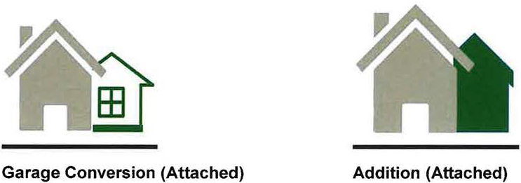
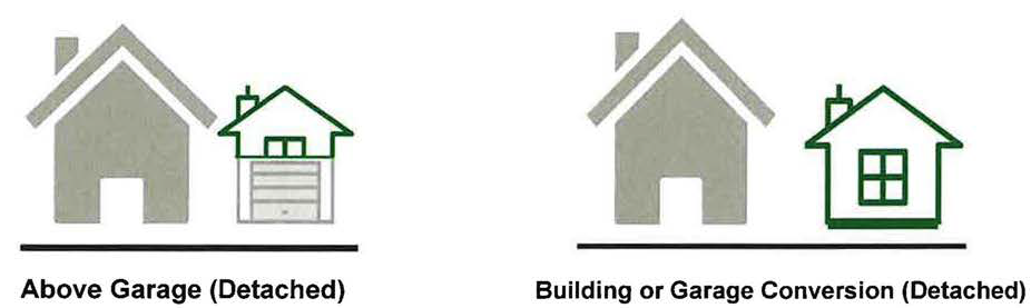
(Ord. No. 054-2020, Passed 11-23-2020; Ord. No. 003-2023, Passed 2-13-2023; Ord. No. 009-2025. Passed 3-10-2025.)
1123.20 - FENCES.
(a)
Fences or walls shall not be installed prior to obtaining a zoning permit. Applications for such a permit shall include plans or drawings to be at minimum 8½" x 11" in size and not to exceed 11" x 17" in size, showing the actual and accurate shape and dimensions of the property on which the fence or wall is to be erected; the exact height, location, length, type of material, type of construction of such proposed fence or wall; the location of all structures on the lot; location and width of easements or no build zones; or any other information deemed necessary by the Division of Engineering.
(b)
Approved fence and wall materials include those materials set forth for the applicable building typology under the district regulations. Synthetic products or other material as approved by the Division of Engineering may also be used. The smooth finished side of the fence or wall shall be the side of the fence that faces outward from the yard being fenced; All of the framing or support members shall face inward of the yard being fenced. Fences and walls shall be maintained in good repair, be structurally sound, and be attractively finished at all times by the owners and/or occupant of the lot on which they are located as well as the space between such fence and the lot line of any adjoining property. Hedges or other landscape material must be kept trimmed to or below the maximum allowed height and trimmed back to the inner edge of the public sidewalk area or property line.
(c)
The following are specifics to the type of fencing installed.
(1)
Commercial fences may be erected as follows:
A.
Prohibited materials. No barbed wire, razor barb or electrically charged fence shall be erected, except in the M/I District, M/I Overlay, or ARD.
B.
Height. The maximum height of front yard, rear yard and side yard fences shall be equal to the dimension provided for the applicable building typology under the base zoning regulations.
C.
Location. Fences may be placed on the side or rear property line or easement line, but may not be placed closer to the street than the front of the main building.
(2)
Residential fence may be erected as follows:
A.
Prohibited material. Except as otherwise provided in the regulations for the applicable building typology, residential fences may be constructed of any material except barbed wire, razor barb, woven or chain-link.
B.
Height. Side Yard and Rear Yard fences on single-family (attached) structures and single-family (detached) structures may be erected to a maximum height of six (6) feet, provided however such fences shall be eligible for a variance to increase the maximum height to eight (8) feet. Front yard fences shall be a maximum of three (3) feet, and shall not be sight obscuring. For corner lots, when decorative fences are constructed, the maximum height shall be two feet, six (2'6") inches above the grade.
C.
Location. Residential fences may be placed on the front, side or rear property line or easement line and may not be placed closer to the street or road than the street or road right-of-way line.
D.
Opacity. Fences located in the front yard of residential properties shall have a maximum opacity of fifty percent (50%).
(Ord. No. 054-2020, Passed 11-23-2020.)
1123.21 - RESIDENTIAL MODEL HOME AND MULTI-FAMILY RENTAL OFFICE/MANAGEMENT SITE.
Residential model homes and multi-family rental offices/management sites, where permitted (see appropriate sections of Chapter 1121) shall be operated under the following conditions:
(a)
Residential Model Homes.
(1)
Residential Model Homes are intended for open house purposes exclusively for prospective home buyers and not for corporate meetings.
(2)
Model Homes are to be sited so that they are easily accessible and identifiable.
(3)
Signage shall conform to Chapter 1129.
(4)
There is a two-year time limit for residential model homes. An extension may be granted if the development is not completed within two (2) years provided circumstances beyond the developer's control make the extension necessary. Such circumstances may include a down turn in the economy, the size of the development is such that a two-year build-out was impractical, etc. Extensions shall be in one-year increments, not to exceed three (3) extensions.
(5)
Any non-customary residential lighting shall be shut off by 9:00 p.m. daily.
The City of Marysville is not responsible for restricted deed covenants if applicable for individual subdivisions.
(b)
Multi-Family Rental Office/Management Site.
(1)
Multi-family rental offices management sites are intended for open house purposes exclusively for prospective tenants and not for corporate meetings.
(2)
Multi-family rental offices/management sites are to be located so that they are easily accessible and identifiable.
(3)
Signage shall conform to Chapter 1129.
(4)
Any non-customary residential lighting shall be shut off by 9:00 p.m. daily.
(Ord. No. 054-2020, Passed 11-23-2020.)
1123.22 - SPECIAL PROVISIONS FOR CERTAIN PUBLIC USES AND FACILITIES.
In order to assure services to all areas within the City limits, certain public uses and facilities shall be permitted in all zoning districts. Those services, with conditions and requirements, are as follows:
(a)
Water storage towers provided that there is a minimum of seventy-five (75) feet from the property line or easement line to the base of the tower and that the City Engineer documents and approves the location is necessary and appropriate for the needs of the water distribution system.
(b)
Sewage pumping stations where those pumping stations are necessary to serve the area in which they are located and the City Engineer documents and approves the need for the pumping station at that location. Any such sewage pumping station shall be fenced and in residential districts, shall be screened with trees and other plantings as determined by the Planning Commission.
(c)
"Public Parks" by their need to serve residents as well as employees of commercial and industrial enterprises shall be a permitted use in all zoning districts. If this paragraph is in conflict with other sections of the Zoning Code, this paragraph shall prevail.
(Ord. No. 054-2020, Passed 11-23-2020.)
1123.23 - PROVISIONS FOR SEXUALLY ORIENTED BUSINESS ESTABLISHMENTS WITHIN THE REGIONAL MIXED-USE DISTRICT (RMU).
Sexually oriented business establishments include adult cabarets, adult stores, or adult theaters primarily engaged in persons who appear nude/semi-nude, live performances, films or other visual representations adult booths, or sale or display of adult material.
(a)
In addition to all other applicable development standards, no person shall operate, locate, or permit the location of a sexually oriented business establishment within 500 feet (as measured from property line to property line) of any residential use or district, school, preschool, daycare, place of worship, synagogue, park, library, federal, state, county, township, or city building, cemetery, or other civic use or public use (within the City of Marysville or other municipality).
(b)
No person shall operate, locate, or permit the location of a sexually oriented business within 500 feet (as measured from property line to property line) of another sexually oriented business establishment.
(c)
No person shall operate, locate, or permit the location of a sexually oriented business establishment within 500 feet (as measured from property line to property line) of any commercial establishment selling beer or alcohol for consumption on the premises.
(d)
No person shall operate, locate, or permit the location of a sexually oriented business establishment within 500 feet (as measured from property line to property line) of any hotel or motel.
(e)
No person shall permit the operation, location or establishment of more than one sexually oriented business on the same property, in the same building or structure, or any portion thereof.
(Ord. No. 054-2020, Passed 11-23-2020.)
1123.24 - LIGHTING REQUIREMENTS FOR ZONING DISTRICTS.
Lighting Requirements for uses permitted in this district is set forth as follows:
(a)
All exterior lighting shall be designed to direct light downwardly.
(b)
All lights shall be arranged to reflect light away from any street or adjacent property.
(c)
Direct or indirect glare into the eyes of motorists or pedestrians shall be avoided.
(d)
Parking lot lighting shall be no higher than 28 ft.
(e)
No permanent colored or flashing lights shall be used to light the exterior of buildings.
(Ord. No. 054-2020, Passed 11-23-2020.)
1123.25 - SIDEWALKS FOR RESIDENTIAL DWELLING UNITS.
All newly constructed residential dwelling units shall have sidewalks installed along all existing public streets if sidewalks do not presently exist. Sidewalks shall be constructed according to the minimums set forth in the "Standard Construction Drawings" of the City within five (5) years.
(Ord. No. 054-2020, Passed 11-23-2020.)
1123.26 - WIRELESS TELECOMMUNICATION FACILITIES.
(a)
Applicability. The regulations set forth under this subchapter 1123.26 shall apply to the following wireless telecommunications structures located in the City of Marysville:
(1)
All Towers, Antenna Support Structures and Wireless Telecommunications Facilities, any portion of which are located within the City.
(2)
Except as provided in this subchapter, any use being made of an existing Tower or Antenna Support Structure on the effective date of this subchapter or any amendment hereto shall be deemed a legal nonconforming use and shall be allowed to continue in accordance with Chapter 1143. Any Tower site that has received City approval in the form of either a special exception or zoning permit, but has not yet been constructed or located, shall be considered a nonconforming structure so long as such approval is current and not expired.
(b)
Permitted Use. Subject to the terms and conditions set forth in this subchapter, the location and operation of Wireless Telecommunications Facilities shall be a permitted use in the following Zoning Districts and Overlays:
(i)
Regional Mixed-Use District (RMU)
(ii)
Government/Institutional District (GOV)
(iii)
Open Space District (OSD)
(iv)
Manufacturing/Innovation District (M/I-D)
(v)
Hospital Mixed-Use District (HMD)
(vi)
Light Manufacturing District (LMD)
(vii)
Manufacturing/Innovation Overlay (M/I-O)
(c)
Conditional Use—Wireless Telecommunication Facility with a Tower. A Wireless Telecommunication Facility which includes a Tower may be permitted as a conditional use in the following districts:
(1)
Regional Mixed-Use District (RMU)
(2)
Hospital Mixed-Use Districts (HMD).
(d)
General Requirements Applicable to All Wireless Telecommunications Facilities. The following requirements apply to all Wireless Telecommunication Facilities regardless of the zoning district or overlay in which they are to be located and operated. These general standards are to be supplemented with the specific regulations for conditional uses set forth in subsection 1125(h) hereof and for permitted uses set forth in subsection 1125(e) hereof:
(1)
Natural Resource Protection Standards. The location of the Tower and Equipment Shelter and Antenna Support Structure shall comply with all natural resource protection standards established in the Zoning Code, including those for floodplain, wetlands and steep slopes.
(2)
Security Enclosure Required. Security fencing eight (8) feet in height shall surround the Tower, Equipment Shelter and any guy wires, either completely or individually as determined by the Planning Commission. The City and co-locaters shall have reasonable access. No fence shall be required on top of a building or other structure if access to the roof or top of the structure or building is secure.
(3)
Existing Vegetation and Buffer Plantings. Existing vegetation (trees and shrubs) shall be preserved to the maximum extent possible. Buffer plantings may be located around the perimeter of the security enclosure as deemed appropriate by the Planning Commission upon recommendation of the Design Review Board. Options are an evergreen screen to be planted that consists of either a hedge, planted three (3) feet on center maximum, or a row of evergreen trees planted five (5) feet on center maximum, or other screens determined to be appropriate by the Planning Commission.
(4)
Co-Location. All wireless telecommunication facilities shall be subject to the co-location requirements as specified in Section 1123.26(f) hereof.
(5)
Historic or Architectural Standards Compliance. Any application to locate a Wireless Telecommunication Facility on a building or structure that is listed on a historic register, or is in a historic district, shall be subject to review by the City's Design Review Board where applicable.
(6)
Advertising Prohibited. No advertising is permitted anywhere on the Wireless Telecommunication Facility, with the exception of identification signage as governed by Chapter 1125-Signs.
(7)
Artificial Lighting Restricted. No Tower shall be artificially lighted except to assure safety or as required by the FAA or other applicable authority.
(8)
Access Control and Emergency Contact. "No Trespassing" signs shall be posted around the Wireless Telecommunication Facility with a telephone number of who to contact in the event of an emergency.
(9)
Construction Standards. Monopole towers only are permitted. To insure the structural integrity of towers, the owner of a tower shall ensure that it is maintained in compliance with standards contained in applicable state or local building codes and the applicable standards for towers are published by the Electronics Industry Association as amended from time to time. If, upon inspection, the City concludes that a tower fails to comply with such codes and standards and constitutes a danger to persons or property, then upon notice being provided to the owner of the tower, the owner shall have thirty (30) days to bring such tower into compliance with such standards. Failure to bring such tower into compliance within said thirty (30) days shall constitute grounds for removal of the tower or antenna at the owner's expense.
(10)
Color and Appearance Standards. All wireless telecommunication facilities shall be painted a non-contrasting gray or similar color minimizing its visibility, unless otherwise required by the Federal Communications Commission, Federal Aviation Administration, and/or by historical or architectural standards imposed under Chapter 1100 of this Planning and Zoning Ordinance. All appurtenances shall be aesthetically and architecturally compatible with the surrounding environment.
(11)
Abandonment. All wireless telecommunication facilities shall be subject to the abandonment requirements set forth in Section 1123.26(h) of this Planning and Zoning Ordinance.
(12)
Setback from Edge of Roof. Any wireless telecommunication facility and its appurtenances permitted on the roof of a building shall be set back one (1) foot from the edge of the roof for each one (1) foot in height of the wireless telecommunication facility. However, this setback requirement shall not apply to antennas that are less than two (2) inches in thickness mounted to the sides of antenna support structures and do not protrude more than six (6) inches from the side of such an antenna support structure. This requirement is subject to change by the Planning Commission upon the review of the photo simulation provided in compliance with Section 1123.26(i)(2) hereof.
(13)
State or Federal Requirements. All towers and antenna must meet or exceed current standards and regulations of the FAA, the FCC, and any other agency of the State or Federal government with the authority to regulate towers and antennas. If such standards and regulations are changed, then the owners of the towers and antennas governed by this subchapter shall bring such towers and antennas into compliance with such revised standards and regulations within six (6) months of the effective date of such standards and regulations, unless a different compliance schedule is mandated by the controlling State or Federal agency. Failure to bring towers and antennas into compliance with such revised standards and regulations shall constitute grounds for the removal of the tower or antenna at the owner's expense.
(14)
Non-Essential Services. Towers and antennas shall be regulated and permitted pursuant to this subchapter and shall not be regulated or permitted as essential services, public utilities, or private utilities.
(15)
License to Operate. Owners and/or operators of towers and antennas shall submit copies of all franchises, certifications, licenses, and permits required by law for the design, construction, location, operation, and discontinuance of operation of wireless communications in the City limits of the City of Marysville. Owners and/or operators shall be required to maintain the towers and antennas and to provide evidence of renewal and extension thereof when granted.
(e)
Terms and Conditions for Operation as Permitted Use. Where a proposed Wireless Telecommunication Facility is a permitted use, the location and operation of such facility is subject to the following terms and conditions:
(1)
Sole Use on a Lot. Where the proposed Wireless Telecommunication Facility will comprise the sole use on the subject property the following requirements shall apply:
(f)
Operation of Wireless Telecommunications Facility as Accessory Use. Wireless Telecommunication Facilities are permitted on a property with an existing principal use subject to the following conditions:
(1)
The existing or future use on the property may be any permitted or approved conditional use in the applicable zoning district or overlay, and need not be affiliated with the wireless telecommunication provider, provided all applicable setback and lot size/distance requirements in Chapter 1121 are met.
(2)
The Wireless Telecommunication Facility shall be fully automated and unattended on a daily basis and shall be visited only for periodic and necessary maintenance (except during construction or an emergency).
(3)
The minimum lot area shall be the area needed to accommodate the Tower (and guy wires, if used), the Equipment Shelter, security fencing and buffer planting.
(4)
Where a Wireless Telecommunication Facility is located as an accessory structure under these regulations, the following locations requirements shall apply:
(5)
Combined with an Existing Structure: Where possible, an antenna for a Wireless Telecommunication Facility shall be attached to an existing structure or building subject to the following conditions:
A.
Maximum Height. Twenty feet (20') or twenty percent (20%) of the building height above the existing building or structure, whichever is greater.
B.
If the applicant proposes to locate the telecommunications equipment in a separate Equipment Shelter (not located on, or attached to, the building) the Equipment Shelter shall comply with the following:
1.
The minimum setback requirements for the subject zoning district.
2.
A buffer yard may be planted in accordance with Chapter 1140.
3.
Vehicular access to the shelter shall not interfere with the parking or vehicular circulation on the site for the principal use.
4.
The maximum size of the Equipment Shelter shall not exceed four hundred (400) square feet, or, if there is more than one (1), eight hundred (800) square feet.
(g)
Located in Open Space. A Wireless Telecommunication Facility is permitted on land that has been established as permanent Open Space, athletic field, or a park subject to the following conditions:
(1)
The Open Space shall be owned by the municipality, county or state government or school board.
(2)
Maximum Height Tower: Two hundred feet (200') (includes antenna) Equipment Shelter: (include the maximum building height for the district)
(3)
The maximum size of the Equipment Shelter shall not exceed four hundred (400') square feet, or, there is more than one (1), eight hundred (800') square feet.
(4)
The Tower shall be set back from any residential zoning district line the height of the tower plus 10 feet.
(h)
Criteria for a Conditional Use. A Wireless Telecommunication Facility which includes a tower may be permitted as a conditional use in all other districts provided that all other conditions of this section are met. In order to be considered for review, the Applicant must prove that a newly constructed Tower is necessary because co-location on an existing Tower is not feasible in accordance with Section 1123.26(f). The following steps must also be taken for the application to be considered for review in this category:
(1)
The Applicant shall demonstrate that the Tower must be located in the proposed area in order to service the applicant's service area. There shall be an explanation of why a Tower and this proposed site is technically necessary.
(2)
Where the Wireless Telecommunication Facility is located on a property with another principal use, the Applicant shall present documentation that the owner of the property supports the application and that vehicular access is provided to the facility.
(3)
The Applicant shall present a site/landscaping plan showing the specific placement of the Wireless Telecommunication Facilities on the site; showing the location of existing structures, trees, and other significant site features; and indicating type and locations of plant materials used to screen the facilities and the proposed color of the facilities.
(4)
Applicant shall present a signed statement indicating:
A.
The Applicant agrees to allow for the potential co-location of additional Wireless Telecommunication Facilities by other providers on the Applicant's structure or within the same site location; and
B.
That the Applicant agrees to remove the facility within one hundred eighty (180) days after the site's use is discontinued.
(5)
Conditional Use Permit must be approved by the Planning Commission in accordance with Chapter 1141. Co-location of antennas on a single tower, antennas attached to existing structures/buildings, towers located in industrial districts, or replacement towers to be constructed at the site of a current tower are permitted uses and will not be subject to the Conditional Use permitting process.
(6)
Any decision to deny a request to place, construct or modify a Wireless Telecommunication Facility and/or Tower shall be in writing and supported by evidence contained in a written record of the proceedings of the Board of Zoning Appeals.
(i)
Co-Location Requirements. The following requirements shall apply to the co-location of Wireless Telecommunication Facilities in the City of Marysville:
(1)
Public Property First. In order to encourage the location of Wireless Telecommunication Facilities on publicly owned property, the City shall undertake an identification of publicly owned properties that the City determines are suitable for such use. The City shall regularly update such identification and make the results of such identification available to the public.
(2)
Persons locating Wireless Telecommunication Facilities upon such identified publicly owned properties shall be exempted from the requirements herein regarding presentation of proof that co-location of facilities on Towers or structures owned by other Persons or in other locations is not available. However, Persons locating Wireless Telecommunication Facilities on publicly owned properties shall continue to be subject to the requirements contained in subsection (b)(4) below.
(3)
In addition, Persons locating Wireless Telecommunication Facilities on publicly owned properties identified by the City to be suitable for such purposes shall be exempt from the requirement of Section 1123.26(h)(2) through (h)(4).
(4)
No new Tower shall be constructed in the City unless such Tower is capable of accommodating at least one (1) additional Wireless Telecommunication Facility owned by other Persons.
(5)
A Conditional Use Permit shall be issued only if there is not technically suitable space reasonably available on an existing Tower or structure within the geographic area to be served. With the permit application, the applicant shall list the location of every Tower, building, or structure within such area that could support the proposed antenna. The Applicant must demonstrate that a technically suitable location is not reasonably available on an existing Tower, building or structure. If another communication Tower is technically suitable, the applicant must show that it has offered to allow the owner to co-locate an antenna on another Tower within the City owned by the applicant on reciprocal terms and the offer was not accepted or the other Tower is presumed to be reasonably available.
(j)
Application and Review Process. All applications for Wireless Telecommunication Facilities, including Towers, shall include the information:
(1)
Plot Plan Required. When a proposed wireless telecommunications facility or antenna support structure is to include a new tower, a plot plan at a scale of not less than one (1) inch equals one hundred (100) feet shall be submitted. This plot plan shall indicate all building and land uses within two hundred (200) feet of the proposed facility. Aerial photos and/or renderings may augment the plot plan. A diagram or map showing the view-shed of the proposed Wireless Telecommunication Facilities or Antenna Support Structures shall be provided.
(2)
Photo Simulations Required. Photo simulations of the proposed wireless telecommunications facility from affected residential properties and public rights-of-way taken at varying distances shall be provided.
(3)
Proof Why Residential Tower Location is Mandatory. In applying for authorization to erect a tower within any residential district, the applicant must present sufficient evidence as to why it is not technically feasible to locate such tower in a more appropriate nonresidential zone. This evidence shall be reviewed by the City of Marysville. If the City of Marysville refutes the evidence, then the tower is not permitted.
(4)
Technical Necessity. The applicant shall demonstrate that the telecommunication tower must be located where it is proposed in order to provide adequate coverage to the applicant's service area. There shall be an explanation of why a tower and the proposed site is technically necessary.
(5)
Review by Radio Frequency Engineer. The evidence submitted by the applicant shall be reviewed by a radio frequency engineer, who will support or refute the evidence. If such engineer is retained by the City, fees for such engineer's service shall be reimbursed to the City by the applicant prior to issuance of the zoning permit.
(6)
Landowner Support and Access. Where a wireless telecommunication facility is located on a property with another principal use, the applicant shall present documentation that the owner of the property supports the application and vehicular access is provided to the facility.
(7)
Required Site and Landscaping Plan. The applicant shall present a site and landscaping plan showing the following:
A.
Specific placement of the wireless telecommunication facility on the site.
B.
The location of existing structures, trees, and other significant site features.
C.
Type and locations of plant materials used to screen the facilities.
D.
The proposed color of the facilities.
(8)
Co-Location and Removal Agreement. The applicant shall present signed statements indicating that:
A.
The applicant agrees to allow for the potential co-location of additional wireless telecommunication facilities by other providers on the applicant's structure; and
B.
The applicant agrees to remove the facility within one hundred and eighty (180) days after it use is discontinued.
(9)
Denial by Jurisdiction. Any decision to deny a request to place, construct or modify a wireless telecommunication facility and/or tower shall be in writing and supported by evidence contained in a written record.
(k)
Abandonment of a Tower. The following provisions shall apply in order to determine whether a Tower has been abandoned:
(1)
Required Notification. All providers utilizing towers shall present a report to the Division of Engineering notifying them of any Tower facility located on the municipality whose use will be discontinued and the date this use will cease. A copy of the notice to the FCC will suffice. If at any time the use of the facility is discontinued for one hundred and eighty (180) days, a designated local official may declare the facility abandoned. (This excludes any dormancy period between construction and the initial use of the facility.) The facility's owner operator will receive written notice from the Division of Engineering and be instructed to either reactivate the facility's use within one hundred and eighty (180) days, or dismantle and remove the facility. If reactivation or dismantling does not occur, the municipality will remove or will contract to have removed the facility and assess the owner/operator the costs.
(2)
Required Notice to Owner. The City must provide the Tower owner three (3) months' notice and an opportunity to be heard before the Board of Zoning Appeals before initiating such action. After such notice has been provided, the City shall have the authority to initiate proceedings to either acquire the Tower and any appurtenances attached thereto at the then fair market value, or in the alternative, order the demolition of the Tower and all appurtenances.
(3)
Right to a Public Hearing. The City shall provide the Tower owner with the right to a public hearing before the Board of Zoning Appeals, which public hearing shall follow the three (3) month notice required in subsection (b). All interested parties shall be allowed an opportunity to be heard at the public hearing.
(4)
Order of Abatement or Demolition. After a public hearing is held pursuant to subsection (c), the Commission may order the acquisition or demolition of the Tower. The City shall require Licensee to pay for all expenses necessary to acquire or demolish the Tower.
(l)
Variations and Special Exceptions. Any request to deviate from any of the requirements of this subchapter shall require variance approval in conformance with the procedures set forth in Chapter 1141.
(m)
Miscellaneous Regulations Pertaining to Wireless Telecommunications Structures. The following miscellaneous regulations shall apply to this subchapter and to the location and operation of Wireless Telecommunications structures in the City of Marysville:
(1)
Non-Waiver. Nothing in this subchapter shall preclude the City from exercising any right or remedy it may have in law or equity to enforce the terms and conditions of this subchapter.
(2)
Severability. If any provision of this subchapter or the Application of any provision hereof or to any Person is, to any extent, held invalid or unenforceable by a tribunal of competent jurisdiction, the remainder of this subchapter and the application of such provision to other Persons or circumstances shall not be affected by such holding. In case of such an event, this subchapter and all of its remaining provisions shall, in all other respects, continue to be effective. In the event the law invalidating such a subchapter provision is subsequently repealed, rescinded, amended or is otherwise changed so that the provision which had previously been held invalid or unenforceable, no longer conflicts with the laws, rules or regulations then in effect, the previously invalid or unenforceable provision shall return to full force and effect.
(Ord. No. 054-2020, Passed 11-23-2020.)
1123.27 - SUPPLEMENTAL REGULATIONS FOR MULTI-FAMILY DEVELOPMENT IN UPTOWN SINGLE-FAMILY DISTRICT (USF) AND UPTOWN TRANSITIONAL DISTRICT.
(a)
Applicability. All new multi-family development and substantial modifications to existing structures in the Uptown Single-Family District or the Uptown Transitional District shall comply with the requirements set forth under Table 1123C Below.
(Ord. No. 054-2020, Passed 11-23-2020.)
1123.28 - SUPPLEMENTAL REGULATIONS FOR DRIVE-THRU USES.
(a)
Applicability. These standards shall apply to all principal uses incorporating drive-thru facilities.
(b)
Review. Prior to the Design Review Board's consideration of any principal structure that proposes to incorporate a drive-thru facility, the following general requirements shall be satisfied:
(1)
Administrative approval of a drive-thru site plan that depicts compliance with the stack lane requirements set forth under subsection (c) hereof; and
(2)
Administrative approval that the proposed drive-thru complies with the City's access management standards as implemented by the Division of Engineering.
(c)
Stacking Lane Requirements.
(1)
All stacking spaces must have a minimum width of 10 feet along straight segments, 12 feet along curved segments, and the stacking space length must be a minimum of 20 feet.
(2)
Drive-thru lanes must be separated by striping and may not interfere with off-street parking or the lanes utilized for maneuvering in and out of off-street parking spaces.
(3)
Establishments with drive-thrus must provide a by-pass lane whereby vehicles may circulate around drive-thru lanes.
(4)
There must be one trash receptacle provided per drive-thru lane.
(5)
Pedestrian walkways shall be clearly visible, and be emphasized by enhanced paving or markings where they intersect drive-in or drive-through aisles.
(Ord. No. 054-2020, Passed 11-23-2020.)
1123.29 - OPEN SPACE REGULATIONS.
(a)
Open-Space Requirements. The required open space set forth under the applicable zoning regulations in Chapter 1121 shall comply with the following terms and conditions:
(1)
The open space shall comprise an area or areas large enough to allow for the effective utilization of such space.
(2)
To the greatest extent possible, the design of the open space area or areas shall incorporate natural features pre-existing on the subject property.
(3)
The open space shall be easily accessible, and, as applicable, provide access to other open space areas in the vicinity of the development as well as the City's trail network.
(4)
The calculation of the open space requirement may include areas preserved as wetlands, woodlands, natural lakes or ponds, historic or archaeological sites, environmentally sensitive areas, or similar conservation-oriented areas.
(b)
Open-Space Designated for Recreational Activities. Any open space area intended to be devoted to recreational activities shall be of a usable size and shape for the intended purpose as determined by the designated Board or Commission. Recreation areas shall include parking in accordance with the applicable regulations of the zoning district.
(c)
Restrictions on Calculation of Open-Space. Land area attributable to the following shall not be included as meeting the open space requirements:
(1)
Public street rights-of-way, private roads, parking areas, and retention and detention areas.
a.
Residential. Retention and detention areas may be calculated as open space if it provides landscape areas, excluding natural turf, and usable amenities such as, but not limited, to a walking path around the retention/detention basin, seating areas, or other usable amenities as approved by a Board or Commission.
b.
Commercial. Retention and detention areas may be calculated as open space if a minimum of thirty percent (30%) of the basin perimeter includes landscape areas, excluding natural turf. The landscape areas may be constructed within the basin upon approval from the Division of Engineering.
(2)
Required setbacks or spacing whether between buildings, parking areas, different land uses or public and private streets, unless such required setback is contiguous to and incorporated in the proposed open space area.
(3)
Private yards within subdivided lots.
(4)
The land area within fifteen (15) feet of all dwelling units, whether included in a mandatory setback or not.
(d)
Ownership and Ongoing Maintenance. The ownership and maintenance obligations with respect to any open space area shall be established in a legal instrument or instruments reviewed and approved by the City Attorney and executed by the applicant, a homeowner's association or similar entity with authority.
(e)
Prohibition on further subdivision. All required open space shall be prohibited from further subdivision, sale or development by a placement in a reserve and notation on the final plat and/or development agreement or similar agreement in a form acceptable to the City Attorney.
(Ord. No. 020-2023, Passed 4-24-2023.)
1123.30 - SINGLE-FAMILY ATTACHED—FEE SIMPLE LOTS REGULATIONS.
(a)
On a single-family attached development where the units are independently owned (fee-simple), the side setback for the shared wall(s) between units shall be zero (0) feet.
(b)
The side setbacks established in the typology chart of the applicable zoning district shall apply to the outermost unit(s).
(Ord. No. 020-2023, Passed 4-24-2023.)
1123.31 - FARM ANIMALS.
(a)
Purpose. The regulations of this Section are established to permit the keeping of farm animals in a manner that prevents nuisances to occupants of nearby properties and prevents conditions that are unsanitary or unsafe.
(b)
Chickens (excluding roosters), Ducks, Rabbits and Similarly Sized Farm Animals. The keeping of chickens, ducks, rabbits and similarly sized farm animals, and coops, cages and other enclosures for the keeping of such animals, shall be governed by the following regulations.
(1)
In Residential Districts, which include the Suburban Residential, Village Residential, Agricultural Residential, and Uptown Single-Family districts, and on residential properties located in Non-residential Districts, the following regulations shall apply:
a.
Number. No more than one (1) such animal shall be kept on a parcel of land for each one thousand two hundred (1,200) square feet of parcel or lot area.
b.
Setbacks. The coops or cages housing such animals may not be located in the front yard or side yard areas. Coops, cages and other enclosures shall be located as to comply with the required side and rear yard setbacks of the parcel according to the development typologies for the zoning district in which such coops or cages are located. No animals shall be permitted to roam or otherwise be located in the front yard and/or side yards.
c.
Prohibitions. No roosters, geese or turkeys may be kept in a Residential District except on a parcel that is at least one (1) acre in area and only if the coop or cage housing the bird(s) is at least one hundred (100) feet from all property lines. Residential Districts include the Suburban Residential, Village Residential, Agricultural Residential, and Uptown Single-Family districts. For parcels greater than one (1) acre in area, one (1) additional such bird may be kept for each twenty-four thousand (24,000) square feet in excess of one (1) acre. No predatory birds may be kept on any property under the regulations of this Section 1123.31 except raptors for use in the sport of Falconry as permitted under Section 1533.05 of the Ohio Revised Code.
d.
Coops and Cages. All animals shall be provided with a covered, predator-proof coop, cage or other enclosure that is thoroughly ventilated, designed to be easily accessed, maintained and cleaned, and of sufficient size to permit free movement of the animals, exclusive of areas used for storage of materials or vehicles. The total area of all coops, cages, or other enclosures on a lot shall not be greater than fifty (50) square feet for every six (6) animals kept on a lot or parcel. Coops, cages, or other enclosures singly or in combination, shall not exceed the maximum accessory structure height permitted within the corresponding zoning district.
e.
Enclosures and Fences. Chickens and other birds shall have access to an outdoor enclosure adequately fenced, or otherwise bounded, to contain the birds on the property and to prevent access by dogs and other predators. Additionally, at least ten (10) square feet of area for each bird shall be provided.
f.
Accessory Structures. Compliance with Chapters 1121 and 1123.
(i)
Coops, Cages and other enclosures that are easily portable by one (1) or two (2) persons without the use of a machine and without disassembly and that do not require a foundation, are considered temporary and portable and are exempt from the provisions of Section 1123.05 Accessory Uses and Structures.
(ii)
Enclosures, coops and cages not meeting the criteria specified under section (i) above are considered permanent and shall comply with the provisions of Section 1123.19 Enclosed Accessory Structures.
g.
Sanitation and Nuisances. Farm animals shall be kept only in conditions that limit odors and noise and the attraction of insects and rodents so as not to cause a nuisance, as defined in Section 1332.20, to occupants of nearby buildings or properties and not to cause health hazards. Furthermore, farm animals shall not be kept in a manner that is injurious or unhealthful to the animals being kept on the property.
h.
Animal or Bird Noise. It shall be unlawful for any person or other party operating or occupying any building or premises to keep or allow to be kept any animal or bird that makes noise so as to habitually disturb the peace and quiet of any person in the vicinity of the premises.
i.
Slaughtering of Animals. Chickens, ducks, rabbits and similar small animals may be slaughtered on-site only in a garage or other building and only if for use by the occupants of the premises and shall not be for sale. No other farm animal may be slaughtered on-site.
j.
Enforcement. The Division of Engineering shall have the authority to inspect any property to determine compliance with the regulations of this Section 1123.31 regarding the construction and permitted placement of coops, cages, enclosures, fences, and other structures used in the keeping of farm animals and shall have the authority to enforce the regulations of this Section 1123.31 as they apply to such matters.
k.
Definitions. Terms used in this Section shall have the meanings assigned to them in the following definitions.
(i)
Farm Animal. "Farm Animal" means any domestic species of animal that is kept and raised for food or in the production of food or in the operation of a farm and is not a "dangerous or wild animal" as defined in Section 935.02 of the Ohio Revised Code and is not a house pet such as a dog, cat or similar animal.
(ii)
Coop and Cage. "Coop" and "Cage" mean a structure, not necessarily attached to the ground, with a top and sides and designed to provide shelter and protection for small animals or birds.
(iii)
Enclosure. "Enclosure" means a set of walls or fences designed to confine animals or birds to a space that is large enough to permit the animals and birds to roam relatively freely in an open yard area.
(iv)
Predatory Bird. "Predatory Bird" means an owl, hawk, falcon, eagle or similar bird that feeds principally by catching live prey.
(v)
Similar Animal. Any farm animal that is similar to other animals listed in the particular category of permitted animals with respect to impacts on nearby properties, including noise, odors, safety hazards or other nuisances.
(c)
Goats, Pigs, Sheep, Horses, Cows, Llamas, Alpacas and Similar Animals. Goats, pigs, sheep, horses, cows, llamas, alpacas and similar animals are only permitted in the Agricultural Residential District, or, on a legally non-conforming parcel that has established an agricultural use prior to the enactment of this code section. The keeping of such animals shall be done in a manner that complies with the Regulations of the Ohio Department of Agriculture.
(d)
Nonconformities. The lawful use of land as it relates to the keeping of animals may be continued as existing at the time of enactment of Section 1123.31. However, if such use is discontinued, any future use as it relates to the keeping of animals shall be in conformity with these regulations. Nonconformities, as they relate to the keeping of animals within the City limits, shall not be eligible for the Continuation, Expansion, Substitution or Re-establishment provisions of Section 1143.04 Non-Conforming Uses. Any such nonconforming animal that meets its demise subsequent to the effective date of this ordinance shall be permitted to be replaced. However, such nonconformities shall not be increased.
(e)
Exemptions. It is recognized that a number of school students participate in projects involving the raising of farm animals within the City limits. Properties where such students reside shall be exempt from certain regulations found herein, as they relate to the number of such permitted small farm animals. Furthermore, it is recognized that more than one (1) student of such households may participate in such projects. Therefore, when small animals are being kept as part of an agricultural project within the City limits, the number of such animals shall be permitted to be increased, but not to exceed thirty (30) such small animals.
The nature of agricultural projects is deemed to be temporary. Anyone with projects that involve the keeping of a greater number of small farm animals than permitted by these regulations shall submit verification from the organization administering such projects. There shall be no fees for verified agriculture projects.
Exemptions shall not be applied to large farm animals, which are prohibited by this Code, unless such animal is being kept in the Agricultural Residential District, or, on a legally non-conforming parcel that has established an agricultural use prior to the enactment of this code section.
The provisions of this Code shall not apply to emotional support animals. However, the keeping of such animals shall be in accordance with the applicable provisions of the Ohio Revised Code.
(Ord. No. 037-2024, Passed 9-23-2024.)
1123.32 - General Conditions for Adult Use and Medical Marijuana Operators.
In the interest of protecting the public health, safety, and general welfare, this section establishes zoning regulations for State-authorized adult use cannabis and medical marijuana cultivators, and processors within the municipal corporation.
(a)
Not an Agricultural Use. The cultivation and/or manufacture of adult use cannabis and medical marijuana shall not be considered an "agricultural" use.
(b)
Zoning Districts. No adult use cannabis and/or medical marijuana operator including a cultivator and/or processor shall be located in a zoning district where the use is not explicitly listed as a permitted or conditionally permitted use. No adult use cannabis and/or medical marijuana cultivation and/or manufacture shall occur in a zoning district where the use is not explicitly listed as a permitted or conditionally permitted use. Furthermore, no cultivator and/or processor shall operate as a home occupation.
(c)
Mobile Building Prohibited. No adult use cannabis and/or medical marijuana cultivator and/or processor shall be located within a mobile building.
(d)
Distance from Other Uses. Pursuant to ORC 3780, no cultivator or processor shall be located within five hundred (500) feet of the boundaries of a lot having situated on it a church, public library, public playground, public park, or school. The distance shall be measured as the shortest straight line from property line to property line. If there is an exception to this distance requirement provided in ORC 3780 or ORC 3796, this requirement shall not apply.
(e)
Lighting. All exterior light sources shall be concealed (100% cutoff) to minimize the amount of light pollution affecting neighboring properties. In any building or other structure where adult use cannabis and/or medical marijuana is cultivated, the cultivator shall utilize blackout screens, retractable window coverings, or other methods to contain or minimize light pollution affecting neighboring properties and the night sky. In addition to the lighting requirements found herein, adult use cannabis and Medical Marijuana Operators shall be subject to lighting requirements outlined within Chapter 1123 - Generally Applicable District Regulations and Chapter 1133 - Design Review.
(Ord. No. 052-2024. Passed 11-25-2024)
1123.33 - Small Box Discount Retail Stores
(a)
Spacing. No small box discount retail store located as a tenant of an in-line retail center shall be established on a parcel or parcels within five thousand two hundred and eighty (5,280) feet (one mile) of another parcel or parcels containing an existing small box discount retail store. No small box discount retail store constructed as a standalone building shall be established on a parcel or parcels within ten thousand five hundred and sixty (10,560) feet (two miles) of another parcel or parcels containing an existing small box discount retail store. No two (2) small box discount retail stores shall be located in the same building or on the same lot. Such distance shall be measured in a geometrically straight line which represents the shortest distance between the parcel or parcels accommodating the proposed small box discount retail store and the parcel or parcels from which the existing small box discount retail store is located. Such measurement shall be made using a scaled map, or a survey if deemed necessary, and shall be made without regard to intervening structures, objects, uses, the street grid, landforms or any other topographical feature.
(b)
Floor and Shelf Plan Required. For any small box discount retail store subject to these regulations, a Floor and Shelf Plan shall be submitted as part of its Zoning Permit application in addition to any other required plans and information, and shall contain each of the following:
(1)
The amount of shelf space dedicated to food sales and the amount of shelf space dedicated to fresh or fresh frozen foods and produce; and
(2)
The types of goods, products, or merchandise to be sold and the general cost of such items.
(c)
Maintenance and Other Requirements. The owner and/or operator of a small box discount retail store shall comply with applicable provisions of these codified ordinances regarding maintenance of the premises and shall comply with the following:
(1)
Keep the exterior of the site including the sidewalks and tree lawns abutting the property free of litter and debris; and
(2)
Provide one or more solid waste containers located directly outside the primary entrance for the placement of paper, wrappers, and other items by customers and others. Such containers shall be maintained in good condition and be of suitable capacity to sufficiently contain litter and debris between scheduled waste collections.
(d)
Exclusions. For purposes of this section, "Small Box Discount Retail Store" does not include stores that dedicate less than five percent (5%) of shelf space to food sales, sell gasoline or diesel fuel, contain a prescription pharmacy or dedicate at least a minimum of fifteen percent (15%) of shelf space to fresh or fresh frozen foods and produce.
(Ord. No. 005-2025. Passed 2-24-2025)
1125.01 - PURPOSE.
The purpose of this Landscape Chapter is to apply standards that preserve the existing landscape, promote the planting and maintenance of landscape, and enhance the appearance of new developments by using landscape in the City, and by so doing, protect and promote the public health, safety and general welfare of the residents and visitors to the community.
(Ord. No. 054-2020, Passed 11-23-2020.)
1125.02 - INTENT.
The intent of this Landscape Chapter is to:
(a)
Ensure that buffering is provided between certain land uses, between thoroughfares and land uses, and between thoroughfares and off-street parking in order to reduce glare, unsightly views, and noise while improving the aesthetic environment of the City.
(b)
Ensure that the location, configuration, and design of landscape are visually harmonious with land uses, buildings, thoroughfares, and off-street parking on the planned property or thoroughfare.
(c)
Ensure the reduction of surface water runoff and contribute to air purification.
(d)
Encourage efforts to preserve natural vegetation and protect existing trees and woodlands, wetlands, and other natural features.
(e)
Encourage the planting of native plant species where practical and available.
(f)
Require planting of street trees along public thoroughfares.
(Ord. No. 054-2020, Passed 11-23-2020.)
1125.03 - DUTIES AND RESPONSIBILITIES.
(a)
The Design Review Board (DRB), in accordance with Chapters 1131 and 1133, shall review and approve landscape plans as part of the Certificate of Appropriateness or the Exterior Plan approval process for the installation and construction of new development typologies. In the case of substantial expansions, the Division of Engineering shall review and approved landscape plans as part of a zoning permit approval.
(b)
The Planning Commission shall review and approve landscape plans for street trees as part of the preliminary plat process.
(c)
The DRB shall maintain an "Approved Tree List" for use as guidelines for meeting the provisions of this Landscape Chapter. The "Approved Tree List" is a guideline and should be considered by the DRB, Planning Commission, and Division of Engineering when approving Landscape Plans. However, if determined appropriate, the DRB, Planning Commission, or Zoning. Inspector may permit landscape materials or trees not specifically listed in the "Approved Tree List".
(Ord. No. 054-2020, Passed 11-23-2020.)
1125.04 - LANDSCAPE PLAN REQUIREMENTS.
(a)
Types of Requirements.
(1)
New Structures. A zoning permit for construction of a new structure, or a vehicular use area shall be issued only after a landscape plan as required by this Landscape Chapter has been submitted and approved by the Division of Engineering. This requirement does not apply to the construction of new single-family (detached) structures except that for construction of dwellings subject to Section 1107.19, a zoning permit shall be issued only after a foundation planting plan, a site-tree planting plan, and a species list, excluding invasive species, has been submitted and approved by the Division of Engineering.
(2)
Substantial Expansions. A zoning permit for the construction of a substantial expansion to a structure or vehicular use area shall be issued only after a landscape plan as required by this Landscape Chapter has been submitted and approved by the Division of Engineering. In the case of a substantial expansion to a structure or a vehicular use area, the site shall comply at a minimum with the required street trees to be planted along the public thoroughfare and the landscape requirements for vehicular use areas as required by this Landscape Chapter. If the Division of Engineering determines that the street trees along the public thoroughfare or the landscaping for vehicular access areas are not practical due to topographic conditions or physical site limitations, the street trees may be planted in different locations on the site or reduced by size or number as approved by the Division of Engineering.
(3)
Preliminary Plats. In accordance with Chapter 1105 of the Subdivision Regulations, a preliminary plat submitted for approval to the Planning Commission shall contain a landscape plan for streets as required by this Landscape Chapter. A typical foundation planting plan for development subject to Section 1107.19 shall be provided with the preliminary plat.
(b)
Landscaping Plan Requirements. Any landscape plan required hereunder shall include the following:
(1)
The name and address of the property owner and applicant.
(2)
The zoning and specific land use for the subject property and for immediately adjacent properties.
(3)
A Site Plan to an appropriate scale showing:
a.
All existing and proposed buildings, structures, overhead and underground utilities, vehicular use areas, service structures, fences, mounds, storm water detention areas, drainage swales, or any other site feature.
b.
Existing major trees and vegetation or landscape features. Major trees are to be located, identified, and health condition noted.
c.
Existing major trees, vegetation, or landscape features to be removed.
d.
New landscaping to be installed as part of the project. The plan shall include a plant list that identifies all plants by species, common name, and size to be installed.
Materials and vegetation shall be identified for all proposed landscaping.
e.
Dimensions of all planting areas and specified mulch type.
f.
Dimensions of the perimeter distance of the vehicular use area.
g.
Location and plant name(s) of existing landscaping on any shared property line.
(4)
Major trees preservation plan.
A.
Unless otherwise exempted for one of the reasons stated below, all major trees shall be depicted on a tree preservation plan approved by the Division of Engineering in accordance with section 1125.08 hereof. Preservation of major trees shall only be exempted under the following circumstances with approval of the Division of Engineering:
1.
The proposed structure or vehicular use area cannot be located in a manner to avoid removal of the major tree while at the same time permitting desirable and logical development of the lot.
2.
The major tree is damaged or diseased or otherwise is an undesirable or invasive species in its present location.
B.
All major trees identified for removal shall be replaced as follows:
1.
It is encouraged that any major tree identified for replacement be replaced with a tree of like species unless it is proven to be unfeasible or it is determined by staff to be undesirable.
2.
Each major tree removed under this section shall be replaced by the owner/developer of the parcel with a tree(s) of the same or a similar species in accordance with the table below.
3.
Replacement trees for major trees shall be identified on the landscape plan required hereunder and, to the greatest extent practicable, located on the same parcel as the tree to be removed.
4.
In the event the Division of Engineering or City Urban Forester determines that a tree to be removed hereunder cannot be relocated or replaced, the City Urban Forester may permit the developer or owner, in lieu of providing such replacement tree, to pay into the City of Marysville Street Tree Program at a rate of $100.00 per inch of diameter at breast height based on the measurement of the tree to be removed. Notwithstanding anything to the contrary contained in this Zoning Code, trees planted in the right-of-way shall not constitute replacement trees to be planted in accordance with this Chapter.
(Ord. No. 054-2020, Passed 11-23-2020; Ord. No. 045-2025, Passed 11-24-2025; Ord. No. 050-2025, Passed 11-24-2025.)
1125.06 - MINIMUM LANDSCAPE STANDARDS.
The following landscape standards are required for new structures or substantial expansions unless the DRB or Planning Commission determines that the landscape standards are not practical due to topographic conditions or physical site limitations allowing the landscape materials to be planted in different locations on the site as approved by the DRB or Planning Commission.
For the purpose of this section, property lines along a public alley shall be considered a side or rear lot line.
(a)
Perimeter Landscape Standards. Landscape buffering shall be required between multi-family and single family uses, between any residential and commercial uses, and between any manufacturing use and residential use. Landscape buffering shall achieve and maintain a minimum of eighty percent (80%) opacity, a height of at least six (6) feet, and a varied use of landscaping material. Fences and walls shall be installed in accordance with the base zoning regulations applicable to the subject property. The landscape material must achieve height and opacity requirements within four (4) years after installation.
PERIMETER LANDSCAPE EXAMPLE
(b)
Foundation Planting Standards. Foundation planting shall be provided in accordance with the following:
(1)
Foundation planting in beds with topsoil at least five (5) feet in width shall be required along all elevations of new structures and structures undergoing substantial expansions, except single-family detached dwellings, with not less than forty percent (40%) of the length of each elevation being planted with landscape material, which shall be spaced as evenly as practicable taking into consideration entryways, outdoor display areas and such other building features as may prevent the location of landscape material. Notwithstanding anything to the contrary herein, in the event an applicant cannot strictly adhere to the requirements set forth hereunder, the applicant may request a distribution adjustment or request to relocate the foundation planting to other areas between parking areas and building facades to accommodate outdoor displays, dining areas, or other building features, in accordance with this Chapter.
(2)
Single-family detached dwellings in the SRD, VRD, HMD, ARD, UT, and USF zoning districts shall provide foundation landscaping in accordance with Section 1107.19(c)(1).
FOUNDATION PLANTING EXAMPLE
(c)
Landscaped Area and Tree Planting. Landscaping and tree planting shall be provided in accordance with the following:
(1)
For remaining areas of non-residential lots that are not covered by structures, paving, or landscaped area as required hereunder, such remaining areas shall be covered by natural turf. Except for vehicular use areas, which shall incorporate tree planting in accordance with subsection (d)(1)C. below, all remaining areas of lots on which non-residential uses are conducted shall incorporate tree planting at a rate of one (1) tree per one thousand (1,000) square feet of building ground coverage for buildings up to five thousand (5,000) square feet with one (1) additional tree for each additional five thousand (5,000) square feet of building coverage. All trees planted in accordance with this chapter shall be of a nursery caliper of not less than two (2) inches. Notwithstanding anything to the contrary, in the event the applicant demonstrates that new trees required hereunder cannot be located on the subject property, then with the approval of the Division of Engineering, the applicant can donate to the City Street Tree Program in lieu of planting such new trees.
(2)
Single-family detached dwellings in the SRD, VRD, HMD, ARD, UT, and USF zoning districts shall provide on-site trees in accordance with Section 1107.19(c)(2).
(d)
Landscape Requirements for Vehicular Use Areas. Public and private off-street parking facilities and other vehicular use areas, except for single family (detached) and two (2) unit multifamily buildings, shall be landscaped in accordance with the requirements:
(1)
Vehicular use area perimeter requirements.
A.
Setback Requirements. Except for the Uptown Districts in which the front setback area shall consist of a five (5) foot wide strip between the street right-of-way and the vehicular use area, the front setback area for off-street parking shall consist of a ten (10) foot wide strip between the street right-of-way and the vehicular use area. Side and rear setbacks are to consist of a four (4) foot wide strip as measured from the property line to the vehicular use area. For those lots with a double-frontage, the applicable front setback regulations shall apply.
B.
Screening Requirements. Vehicular use areas adjacent to a public street or private roadway shall be screened with evergreen plantings to conceal the view of parked cars from the street. The evergreen plantings shall be at least two (2) feet in height at installation and planted to develop a continuous hedge at least three (3) feet in height within two (2) years of installation, except in line of sight triangles at driveways and street intersections where the height shall be limited to two (2) feet. All screening shall have a minimum opacity of one hundred percent (100%) at all times. Height of plantings required in this paragraph shall be measured from the finished grade of the plant bed.
C.
Tree Planting. In addition to the vehicular use area perimeter buffering requirement, one (1) standard tree with a nursery caliper of not less than two (2) inches shall be planted for each seventy-five (75) feet of vehicular use area and/or parking area perimeter distance. Tree planting requirements may be waived by the DRB upon the recommendation of the City Urban Forester if the quantity of existing trees and their aggregate trunk sizes meet or exceed these requirements and are evenly distributed throughout the subject property.
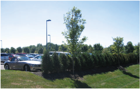
VEHICULAR PERIMETER EXAMPLE
(2)
Interior requirements. Vehicular use areas with more than twenty (20) parking spaces shall be devoted planting areas in accordance with the below table and standards.
A.
The total planting area around a vehicular use area may be reduced by one hundred (100) square feet if such amount is relocated elsewhere to emphasize an entrance corridor or feature.
B.
In order that there shall be safe access to parking spaces, planting areas shall be arranged as to divide parking corridors and to limit "cross taxiing" through open parking spaces.
C.
Grass cover shall be planted on all portions of the interior planting areas not occupied by other landscape material.
D.
The minimum width of a landscape area where a tree or planting is planted shall be five (5) feet and the minimum distance from a tree or planting to a vehicular use area shall be two and one half (2½) feet measured from the trunk of the tree or planting to the face of the curb.
E.
Planting area shall mean any area utilized for landscape material installation having a minimum area of fifty (50) square feet.
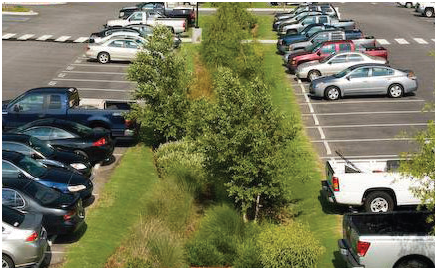
PARKING LOT PLANTING EXAMPLE
(3)
Distribution adjustments. In areas where the DRB has determined that strict application of this Landscape Chapter will interfere with the function of the area, the required interior landscaping may be located on-site to an area approved by the DRB. For automotive or vehicle sales or dealerships and other uses where landscaping adversely impacts the operation of the use, the DRB may approve the reduction or relocation of the number, size, or design of landscaping materials. The grant of any distribution adjustment shall be determined based upon a written explanation from the applicant filed with the DRB together with a plan that depicts the proposed redistribution of the landscaping materials.
(4)
Construction adjustments. If it is determined during construction that exact landscaping placement as approved by the ORB is not practical due to topographic or physical site limitations, the Division of Engineering may permit the reallocation of the landscaping to a different location on the property.
(a)
Intersection Clear Vision Requirements. To minimize traffic hazards, when an access way to a vehicular use area intersects a public right-of-way or where the property abuts the intersection of two (2) or more rights-of-way, all landscaping shall provide unobstructed visibility between two (2) feet and seven (7) feet in a line of sight triangular area bounded by a thirty (30) foot dimension along each access way edge, street edge, or curb and connecting the endpoints. Landscaping other than grass or ground cover shall not be located closer than four (4) feet from the edge of the access way pavement. Pursuant to 1143.06(e) see appendix A for sight triangles at intersections.
(b)
Street Trees and Public Tree Requirements. Street trees along public streets as part of a preliminary plat shall meet the guidelines established below and shall be reviewed and approved by the Planning Commission as part of the preliminary plat process. Street trees along public streets as part of a proposed development shall meet the guidelines below and shall be reviewed and approved by the ORB or Division of Engineering in the case of a substantial expansion. Street trees shall be required in all zoning districts and overlays, and in accordance with the following regulations.
(1)
Street trees shall be planted along public streets in such a manner, type, quantity and location as approved by the Planning Commission, DRB, or Division of Engineering. Any existing street with undeveloped frontage shall also conform to these requirements at the time of the frontage development.
(2)
The minimum trunk caliper measured at six (6) inches above grade for all street trees shall be no less than two (2) inches.
(3)
Street trees shall be planted as per the following spacing requirements:
(4)
The spacing between trees shall be adjusted to accommodate the location of driveways, fire hydrants, utility service lines, street lights, street signs, or any other permanent street fixtures.
(5)
Tree locations shall be at least thirty-five (35) feet from all stop and yield signs and ten (10) feet from fire hydrants or utility poles and fifteen (15) feet from all other street signs unless a reduced distance is proposed and approved by the City Engineer.
(6)
Street trees shall be planted half the distance between the sidewalk and the edge of the street. When no sidewalks or curbs exist, the location shall be half the distance between the edge of the street and the right-of-way.
(7)
A small tree shall be used when planting within ten (10) feet horizontal distance of overhead utility wires. A small or medium tree shall be used when planting between ten (10) and twenty (20) feet horizontal distance of overhead utility wires.
(8)
If the Planning Commission, DRB, or Division of Engineering determines that the street trees along the public thoroughfare are not practical due to topographic conditions or physical site limitations, such trees may be planted in different locations on the site or reduced by size or number as approved by the Planning Commission, DRB, or Division of Engineering.
(9)
For all tree installations within the right-of-way, the tree shall be replaced if less than 50% of the tree canopy remains healthy within 1 year of installation.
(Ord. No. 054-2020, Passed 11-23-2020; Ord. No. 021-2023, Passed 4-24-2023; Ord. No. 045-2025, Passed 11-24-2025; Ord. No. 050-2025, Passed 11-24-2025.)
1125.08 - INSTALLATION AND MAINTENANCE.
(a)
Installation. All landscaping materials required on property affected by this Chapter shall be installed in accordance with ANSI 300 construction and planting procedures.
(1)
Except for public street trees, the following maintenance standards apply:
a)
Owners of nonresidential properties shall be responsible for the continued property maintenance of all landscape materials planted or placed to fulfill the requirements of this Landscape Chapter and shall keep them in a proper, neat and orderly appearance, free from refuse and debris at all times.
b)
Until the subject property has passed final zoning inspection and the certificate of compliance has been issued by the Division of Engineering, owners of properties with newly constructed single-family detached dwellings in the SRD, VRD, HMD, ARD, UT, and USF zoning districts shall be responsible for the continued proper maintenance of all landscape materials planted or placed to fulfill the requirements of this Chapter 1125 and shall keep them in a proper, neat, and orderly appearance, free from refuse and debris, at all times.
(2)
All unhealthy or dead landscape material shall be replaced within six months, or by the next planting period, whichever comes first, while other defective non-plant landscape material shall be replaced or repaired within three (3) months.
(3)
Violations of these provisions shall be grounds for the City to refuse a zoning certificate and find that the owner is in violation of this Zoning Code (See Chapter 1145.99).
(b)
Maintenance. Publicly owned trees or privately owned trees located in or encroaching upon the public right-of-way shall conform as follows:
(1)
Persons providing services to public owned trees and/or providing utility line clearing services shall adhere to guidelines of ANSI 300 for tree maintenance and utility line clearance work.
(2)
Pruning of tree limbs greater than 1" diameter on a publicly owned tree shall require prior written approval by the Public Service Department. No person shall top any tree within the public right-of-way. Topping means to cut back limbs to stubs larger than three (3) inches in diameter within the tree's crown so as to remove the normal canopy and disfigure the tree.
(3)
The Public Service Department shall be notified if persons are digging within 10' of a publicly owned tree.
(4)
Tree limbs extending from privately owned trees over a sidewalk shall be trimmed so that no portion of such tree shall be less than eight (8) feet above the sidewalks. Tree limbs extending from privately owned trees over streets shall be trimmed so that no portion of the same should be less than thirteen (13) feet above the roadway.
(5)
The City shall have the right to plant, prune, maintain and remove trees, plants, and shrubs or portions thereof within all public rights-of-way and public grounds, as may be necessary to insure public safety or to preserve or enhance the health of the landscape material or the beauty of such rights-of-way and public grounds.
(6)
No person shall intentionally attach any rope, wire, nails, advertising posters, or other contrivance to any tree or shrub, allow any liquid, or solid substance which is harmful to such trees or shrubs to come into contact with them; or set fire or permit fire to burn when such fire or the heat thereof will injure any portion of any tree or shrub.
(7)
Stumps shall be removed at least four (4) inches below grade. All residual material shall be removed from the site at the time the tree is removed, and the grade shall be restored.
(8)
The City of Marysville is responsible for the maintenance of trees within the public right-of-way. In the event a tree(s) in the public right-of-way poses a risk of harm to public safety, the City reserves the right to remove the tree(s) in order to mitigate the risk of harm. Once a tree is removed from the right-of-way, the City shall replace the tree with a tree that is approved by the City's Public Service Department. The City Manager or his designee has the authority to waive or postpone the requirement to replace a tree that has been removed.
(9)
If a tree in the public right-of-way is removed by a property owner or his agent without authorization from the Public Service Department, the property owner shall, within ninety (90) days, replace said tree with one approved by the Public Service Department.
Failure within ninety (90) days to replace a tree that, without authorization, has been removed from the public right-of-way is a violation of this Ordinance.
Notice of such violation and the right to appeal shall be administered as provided in Chapter 1145 of this Code. If, after being notified by the City, a tree that has been removed without authorization from the public right-of-way is not replaced, the City may replace such tree and assess the cost(s) of said replacement against the owner of the lot or parcel. Within five (5) days of such tree replacement, the City shall give notice, by regular mail, to the owner of the lot or parcel of cost(s) incurred, and in the event the same is not paid within thirty (30) days after the mailing of such notice, such amount shall be certified to the County Auditor for collection of same as other taxes and assessments are collected.
(10)
In addition to the tree replacement requirement, the property owner shall be fined $100 per inch of tree measured at diameter breast height (DBH), determined by the City's most recent tree survey, for the unauthorized removal of the publicly owned tree.
(11)
If a tree is planted in the public right-of-way that is not approved by Public Service Department, the City may order the removal of such tree. Such order and notice of the right to appeal shall be administered as provided in Chapter 1145 of this Code. If, after being notified by the City, an unapproved tree located in the public right-of-way is not removed, the City may remove such tree and assess the cost(s) of said removal against the owner of the lot or parcel. Within five (5) days of such removal, the City shall give notice, by regular mail, to the owner of the lot or parcel to pay the cost(s) of such removal. Such notice shall be accompanied by a statement of the amount of cost(s) incurred and, in the event the same is not paid within thirty (30) days after the mailing of such notice, such amount shall be certified to the County Auditor for collection of same as other taxes and assessments are collected.
(c)
Tree Preservation Plan.
(1)
Tree Preservation Plan. In order to ensure the preservation of trees that are required to be maintained in accordance with this chapter, a tree preservation plan shall be required under the following circumstances: excavation, earth moving, demolition, road widening, road construction, road extensions, parking lots, utility service lines, utility structures, bikepaths, sidewalk construction, the construction of new buildings, the construction of building additions, and/or the construction of detached accessory structures. Any tree preservation plan required under this chapter shall be reviewed and approved by the Division of Engineering and incorporate the following information:
A.
Proposed tree preservation area;
B.
Unless approved by the Division of Engineering, a tree survey to be drawn to a scale not to exceed 1"= 100 feet, showing all existing trees on the site with a ten (10) inch diameter breast height or greater. The survey shall indicate the location, species, the condition, and the coverage of the critical root zone or fifteen (15) feet whichever is greater;
C.
The location of all protective fencing and barriers;
D.
The location of all existing and proposed utility lines;
E.
Site grading and excavation;
F.
Specified locations for all clearing and grubbing;
G.
Other measures such as construction pruning and root pruning of trees directly impacted by construction must also be indicated on the plan or on an accompanying sheet and approved by the City. Pruning shall be performed in accordance with International Society of Arboriculture Standards; and
H.
Major trees that are proposed to be removed from the subject property, which removal shall be subject to the approval of the Division of Engineering.
(2)
Maintenance Requirements During Construction. During construction the owners shall be responsible for undertaking the following measures to protect existing trees installed in accordance with this chapter:
A.
Protective fencing. Prior to the commencement of construction activities, the owner shall be responsible for the erection and installation of temporary barriers or fencing around the tree preservation areas so as to ensure that all trees shall be protected and preserved. The fencing or barrier installed in accordance with this subsection shall remain in place and be secured in an upright position during the duration of the construction period. Any deviation for the requirements of this subsection shall require approval by the Division of Engineering.
B.
Tree Protection Area. No construction activity, movement, and/or placement of equipment, vehicles or materials shall be permitted within the tree preservation area approved by the Division of Engineering.
C.
Damaged Trees. Any protected tree that is damaged during the construction period shall be repaired in accordance with the standards of the Society of Arboriculture.
(Ord. No. 054-2020, Passed 11-23-2020; Ord. No. 021-2023, Passed 4-24-2023; Ord. No. 045-2025, Passed 11-24-2025.)
1125.09 - LANDSCAPING REQUIRED BEFORE FINAL OCCUPANCY.
(a)
Before a zoning permit is issued, landscaping as approved by the DRB, Planning Commission, and/or the Division of Engineering or designee shall be installed, unless it is determined by the Division of Engineering or designee that due to unforeseen circumstances or inclement weather that the approved landscaping cannot be installed prior to occupancy.
(b)
Failure to install landscaping as approved by the DRB and/or Division of Engineering is a violation of the Planning and Zoning Ordinance and is subject to the penalties in Section 1145.99.
(Ord. No. 054-2020, Passed 11-23-2020.)
1125.10 - LANDSCAPE DESIGN STANDARD SUBSTITUTION.
(a)
The landscape design standard substitution is a procedure that allows applicants to propose a unique landscape design standard as an alternative to a landscape design standard that is otherwise required under this chapter. The grant of a landscape design standard substitution is not a variance, waiver, or weakening of regulations; rather, this procedure permits a site-specific plan that is equal to or better than the strict application of the landscape design standard(s) specified under this chapter. Approval of a landscape design standard substitution shall apply only to the specific site for which it is requested and does not establish a precedent for assured approval of other requests.
(b)
The Division of Engineering shall review proposed plans and consider whether the proposed landscape design standard substitution satisfies the following criteria:
(1)
That the proposed alternative achieves the intent of the applicable landscape design standard to the same or better degree than the subject standard;
(2)
That the proposed alternative achieves the goals and policies of the comprehensive plan;
(3)
That the proposed alternative results in benefits to the community that are equivalent to or better than compliance with the applicable landscape design standard; and
(4)
That the proposed alternative imposes no greater impact on adjacent properties than would occur through compliance with the applicable landscape design standard under this chapter.
(c)
Any person or entity claiming to be injured or aggrieved by the final action of the Division of Engineering shall have the right to have their application heard before the DRB, provided the applicant files a notice of appeal with the DRB within seven (7) calendar days of the Division of Engineering's decision.
(Ord. No. 054-2020, Passed 11-23-2020.)
1125.11 - APPEAL.
Any person whose plan has been disapproved or who has otherwise been aggrieved by a decision of the Board of Zoning Appeals, Division of Engineering or their respective designees may appeal that decision to the Board of Zoning Appeals in accordance with the appeal procedures set forth in Chapter 1145.
(Ord. No. 054-2020, Passed 11-23-2020.)
1127.01 - GENERAL REQUIREMENTS.
(a)
No building or structure shall be erected, substantially altered, or its use changed unless permanently maintained off-street parking and/or loading spaces have been provided in accordance with the provisions of this Planning and Zoning Ordinance.
(b)
The provisions of this chapter, except where there is a change of use, shall not apply to any existing building or structure.
(c)
Whenever a building or structure constructed after the effective date of this Planning and Zoning Ordinance is changed or enlarged in floor area, number of employees, number of dwelling units, seating capacity or otherwise to create a need for an increase in the number of existing parking spaces, additional parking spaces shall be provided on the basis of the enlargement or change. Whenever a building or structure existing prior to the effective date of this Planning and Zoning Ordinance is enlarged by fifty percent (50%) or more in floor area, number of employees, number of housing units, seating capacity or otherwise, such building or structure shall then and thereafter comply with the full parking requirements set forth herein.
(Ord. No. 054-2020, Passed 11-23-2020.)
1127.02 - PARKING SPACE DIMENSIONS.
Parking spaces shall conform to the following minimum area and dimensions exclusive of driveways and aisles:
(Ord. 33-12. Passed 6-28-12; Ord. No. 054-2020, Passed 11-23-2020.)
1127.03 - LOADING SPACE REQUIREMENTS AND DIMENSIONS.
(a)
Whenever a use requires goods, merchandise, or equipment to be delivered to or shipped from that use, off-street loading and unloading areas shall be provided to accommodate the delivery or shipment operations in a safe and convenient manner.
(b)
Loading spaces shall conform to the following minimum dimensions:
(1)
Type A - (for semi-truck vehicles) fourteen (14) feet width, fifty-five (55) feet length, fifteen (15) feet clearance. The space shall not inhibit service access to neighboring properties, facilities or loading areas.
(2)
Type B - twelve (12) feet width, thirty (30) feet length, fifteen (15) feet clearance, and arranged so as to not inhibit service access to neighboring properties, facilities or loading areas.
(c)
Number of spaces required:
(d)
Loading and unloading areas shall be located and designed so that the vehicles intended to use them can maneuver safely and conveniently to and from the public right-of-way, and complete the loading and unloading operations without obstructing or interfering with any public right-of-way, parking space or parking lot aisle.
(e)
No area allocated for loading and unloading parking may be used to satisfy the area requirements for off-street parking, nor shall any portion of any off-street parking area be used to satisfy the area requirements for loading and unloading parking.
(f)
No loading space shall be located closer than fifty feet to any residential zoning district.
(g)
A developer needs to only comply with this section to the extent reasonably possible when:
(1)
A lot exists with one or more structures on it that were constructed prior to the effective date of this chapter.
(2)
A change of use is required that does not involve the enlargement of a structure.
(3)
The loading requirement cannot be satisfied because there is not sufficient area available on the lot that can practicably be used for loading and unloading.
(Ord. No. 054-2020, Passed 11-23-2020.)
1127.04 - PAVING.
(a)
The required number of parking and loading spaces as set forth in Sections 1127.03 and 1127.12, together with driveways, aisles and other circulation areas, shall be curbed to City standards and contain a hard-surface of asphalt, concrete or a combination thereof, unless a viable or environmentally friendly solution is proposed and approved by the City Engineer.
(b)
Exempt from the curbing requirement are driveways that connect a residential dwelling unit or garage with a street or thoroughfare and off-street parking areas for residential dwelling units that contain four (4) or fewer spaces.
(Ord. No. 054-2020, Passed 11-23-2020.)
1127.05 - DRAINAGE.
All parking and loading areas shall provide for proper drainage of surface water to prevent the drainage of such water onto adjacent properties or walkways.
(Ord. No. 054-2020, Passed 11-23-2020.)
1127.06 - MAINTENANCE.
The owner of property used for parking and/or loading shall maintain such area in good condition without holes and free of all dust, trash and other debris.
(Ord. No. 054-2020, Passed 11-23-2020.)
1127.07 - LIGHTING, STRIPING AND TRAFFIC CONTROL.
(a)
Any nonresidential parking area with ten (10) or more off-street parking spaces and any residential area with twenty (20) or more off-street parking spaces shall be illuminated. All light fixtures shall be flat lenses and arranged to direct and reflect light away from any adjacent residential property and public right-of-way, and away from the sky above the light fixture.
(b)
Any parking area with five (5) or more off-street parking spaces shall be clearly striped and maintained in good condition with lines four (4) inches wide. Striping shall be either white or yellow in color. Striping for spaces designated for handicap parking may be blue in color if approved by the applicable governmental entity. The width of the parking spaces shall be computed from the centers of the striping.
(c)
Parking of automobiles and/or recreational vehicles at permitted automobile dealerships that have outdoor storage and displays do not require lines or striping except for those spaces designated for employee and customer parking.
(d)
Temporary parking areas for approved construction projects do not require lines or striping. Temporary parking areas shall only remain the duration of the construction project when permanent parking is not feasible.
(e)
Any off-street parking area shall be marked or posted with such traffic control devices as may be determined necessary by the City Engineer and Police Chief for the protection of operators and pedestrians, including directional arrows, one-way signs, no parking signs and fire lane signs.
(Ord. No. 054-2020, Passed 11-23-2020.)
1127.08 - LOCATION OF PARKING SPACES.
The following regulations shall govern the location of off-street parking spaces and areas:
(a)
Parking spaces for all detached residential uses shall be located on the same lot as the use which they are intended to serve;
(b)
Parking spaces for commercial, industrial or institutional uses shall be located on property under common ownership not more than 700 feet from the principal use;
(c)
Parking spaces for apartments or similar residential uses shall be located on property under common ownership located not more than 300 feet from the principal use.
(Ord. No. 054-2020, Passed 11-23-2020.)
1127.10 - WHEEL BLOCKS.
Whenever a parking lot extends to a property line, sidewalk, landscape area or building, a wheel stop device consisting of blocks, a permanent curb, or other suitable restraint as approved by the City Engineer shall be installed to prevent any part of a parked motor vehicle from extending beyond the property line, overhanging a pedestrian walkway or sidewalk or damaging any building, structure or landscaping.
(Ord. No. 054-2020, Passed 11-23-2020.)
1127.11 - WIDTH OF DRIVEWAY AISLE.
Driveway aisles serving parking spaces shall conform to the following minimum standards:
(Ord. No. 054-2020, Passed 11-23-2020.)
1127.12 - PARKING SPACE/STACKING REQUIREMENTS.
(a)
Floor Area: Where floor area is designated as the standard for determining parking space requirements, the gross floor area of each floor shall be used.
(b)
Seats: Where the number of seats is designated as the standard for determining parking space requirements, the number of seating units installed or indicated, or each 18 linear inches of benches, pews, or space for loose chairs or similar seating facilities shall be used.
(c)
Employees: Where the number of employees is the standard for determining parking space requirements, employees shall mean the maximum total number of employees on any two successive shifts.
(d)
Fractional Numbers: Fractional numbers shall be increased to the next whole number.
(e)
Joint Use:
(1)
A building or group of buildings containing two (2) or more uses even if a use in the building(s) is under the same ownership, operating during the same hours and which have different off-street parking requirements, may jointly provide spaces for not less than the sum of the spaces required for each use.
(2)
Two or more nonresidential uses may jointly provide and use parking spaces when their hours of operation do not normally overlap, provided that a written agreement approved by the Division of Engineering shall be filed with the application for a zoning permit.
(f)
For the purpose of this Planning and Zoning Ordinance, the following parking space requirements shall apply.
* Full service shall be defined as any eating and drinking establishment with the sale or consumption of food and/or drink on the premises with less than fifty percent (50%) of the business intended for carry-out or delivery.
** Partial service shall be defined as any eating and/or drinking establishment with the sale or consumption of food and/or drink on the premises with fifty percent (50%) or more of the business intended for carry-out or delivery.
In any case, vehicles shall not be permitted to wait within any public right-of-way for service at such drive-in or drive-thru facilities.
(Ord. No. 054-2020, Passed 11-23-2020.)
1127.13 - GENERAL INTERPRETATIONS.
In the interpretation of this chapter, the following rules shall govern:
(a)
Parking spaces for other permitted or conditional uses not listed in this chapter shall be determined by the Planning Commission upon an appeal from a decision of the Division of Engineering.
(b)
Fractional numbers shall be increased to the next whole number.
(c)
When a reason for parking demand is unusually low, then the parking space provisions cited above may be reduced proportionately by the Planning Commission upon an appeal from a decision of the Division of Engineering.
(Ord. No. 054-2020, Passed 11-23-2020.)
1129.01 - PURPOSE AND INTENT.
(A)
Sign regulations are hereby established to control the type, design, size, location, maintenance, and removal of signage in Marysville.
(B)
These provisions are established for the following purposes:
(1)
To enable the public to locate goods, services, and facilities without difficulty or confusion;
(2)
To provide a safe environment by prohibiting conditions hazardous to vehicular and pedestrian traffic;
(3)
To protect property values, public investment and overall neighborhood character by preventing conditions that have undesirable impacts on surrounding properties;
(4)
To permit enforcement and prosecution of the regulations in this Chapter, and to create a system of variances and appeals to allow exceptions where justified by hardship;
(5)
To identify locations of development and economic activity by permitting signs appropriate to the land use and zoning district of each parcel while ensuring that signs will be harmonious with their surroundings; and
(6)
To support the creation and existence of businesses so that additional jobs and services are available to Marysville.
(Ord. No. 013-2025. Passed 3-24-2025)
1129.02 - APPLICABILITY AND EXEMPT SIGN TYPES.
(A)
Applicability. Except as otherwise explicitly provided, the provisions of this Chapter apply to all of the following:
(1)
All signage within the city that may be directly viewed from a right-of-way;
(2)
All signage that may be directly viewed from a lot other than the lot on which the sign is located; and
(3)
All signage that may be directly viewed from an unrestricted, publicly accessible outdoor space, including but not limited to surface parking lots, unenclosed yards, and driveways that are not gated.
(B)
Compliance with other codes.
(1)
All references within this Chapter to laws and/or regulations that exist outside of this Chapter shall be construed to refer to the most current version and citation for those laws and/or regulations unless expressly indicated otherwise.
(2)
If a referenced law or regulation is repealed and not replaced, any requirements within this Chapter for compliance with such law or regulation shall no longer be in effect.
(C)
Exempt sign types. The provisions of this Chapter do not apply to or govern the display of:
(1)
The flags of the United States, State of Ohio, Union County, City of Marysville, and flags of other governmental entities, nations or nationality groups that are unaltered from their officially adopted versions;
(2)
Flags that are 3 feet by 5 feet or smaller in surface area, provided there are not more than 2 such flags per parcel;
(3)
Signs installed by a government entity;
(4)
Signs which are part of the original construction of a vending machine, fuel pump, or similar device;
(5)
Monuments within a cemetery;
(6)
Cornerstones and permanent building plaques that are carved into stone and/or that are an integral, structural component of a load-bearing wall;
(7)
Signs on vehicles that are regularly and customarily used to transport persons or property for a business;
(8)
Signs required by law to be installed;
(9)
Signs and/or notices issued by, or required to be placed by, any court, officer, or other person in performance of a public duty;
(10)
Scoreboards and related components in athletic fields that are oriented towards the field of play:
(11)
Seasonal lighting, decorations, and related elements that are in place for less than 61 consecutive days and do not require heavy equipment to move or remove; and
(12)
Other signs determined by the city to be outside the scope of this Chapter with respect to a reasonable, customary interpretation of intent.
(Ord. No. 013-2025. Passed 3-24-2025)
1129.03 - SIGN MATERIALS.
(A)
All sign materials shall be of durable and weatherproof materials that are not prone to fading or cracking.
(B)
Any sign material that is faded, cracked, or otherwise worn such that it no longer substantially reflects its original appearance shall be replaced by the sign owner or operator not later than 60 days from the date of written notice from the city regarding same.
(Ord. No. 013-2025. Passed 3-24-2025)
1129.04 - MEASUREMENT METHODOLOGIES.
(A)
Applicability. Where regulated by this Chapter, the following measurement methodologies must be followed in determining compliance with applicable standards. An applicant for a sign permit bears the sole burden of calculating all sign measurements and proving that each proposed sign complies with all sign standards, including but not limited to, all dimensional standards set forth herein.
(B)
Duration of sign placement. The duration of a sign's placement shall be counted as the total number of days per calendar year, unless otherwise explicitly stated, that a sign is allowed to stand.
(C)
Sign illuminance level. Light sources associated with signs shall be measured by the illuminance they produce on specified surfaces. An illuminance meter (also described as a lux meter) shall be held upright and directed at the center of the sign being measured.
(1)
Internally illuminated signs.
(i)
An illuminance reading for an internally illuminated sign shall be taken with the meter placed along property lines that have direct views to the illumination.
(ii)
Internal illumination sources within a sign shall not produce an illuminance at a joint property line of a property within a residential zoning district that exceeds 0.5 footcandles. At a joint property line of a property that is not within a residential zoning district, such illuminance may not exceed one (1) footcandle.
(2)
Externally illuminated signs.
(i)
An illuminance reading for an externally illuminated sign shall be taken with the meter placed a distance equal to or greater than twice the largest dimension of the sign (e.g., if the sign is 15 feet wide and five (5) feet tall, the measurement shall be taken at a distance 30 feet away from the sign).
(ii)
Light sources that are intended for a sign and that are external from the sign may produce an illuminance of the sign face not exceeding 30 footcandles. Such light sources must be directed towards the sign, must be shielded in a manner that prevents light from spilling past the edges of the sign, and must be shielded in a manner that prevents direct views of the source of light. External lighting is encouraged to be powered by solar means where possible.
(D)
Sign surface area. Sign area is measured based on the following practices, as applicable:
(1)
For signs on a background, the entire area of the background of the sign face is calculated as the sign area, including any material or color forming the sign face or background used to differentiate the sign from the supporting structure against which it is placed, as shown in the area outlined in red in Figure 1129.04-1: Sign Surface Area Measurement Example 1. This area does not include the base that supports the sign or the sign surround.
Figure 1129.04-1: Sign Surface Area Measurement Example 1
(2)
For signs consisting of freestanding letters or features attached to a wall, the sign area is calculated as the total area of the smallest rectangle(s) that encapsulates text, numbers, symbols, images, and logos, as shown in the area outlined in red in Figure 1129.04-2: Sign Surface Area Measurement Example 2. This area does not include the supporting framework or bracing unless such framework or bracing is part of the message or sign face.
Figure 1129.04-2: Sign Surface Area Measurement Example 2
(3)
If two signs of the same shape and dimensions are mounted or displayed back-to-back and parallel in a manner where a person can only view one side at a time, or are separated by an angle of 45 degrees or less, as shown in Figure 1129.04-3: Example Double-Faced Sign (45 Degrees or Less), then only one of such sign faces shall be measured for the total sign surface area, except where sign surface area standards are specified per face. Where the two sides of such a sign are not equal in size, the larger size shall be used for the total surface area calculation.
Figure 1129.04-3: Example Double-Faced Sign (45 Degrees or Less)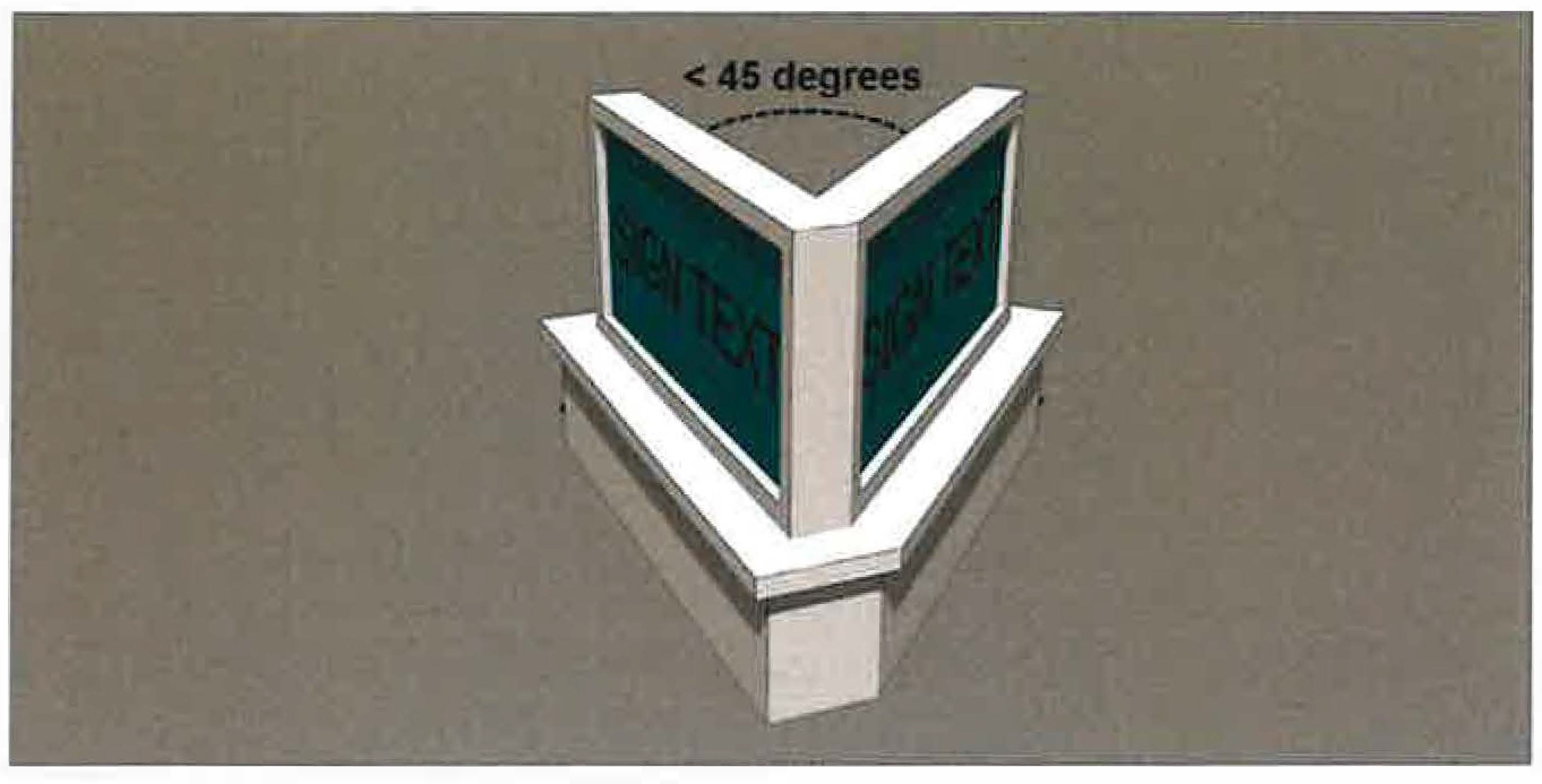
(4)
If two signs are mounted and displayed in a "V" shape, instead of back-to-back, where the angle of separation is greater than 45 degrees, as shown in Figure 1129.04-4: Example Double-Faced Sign (Over 45 Degrees), then each such sign face shall be measured for total sign surface area.
Figure 1129.04-4: Example Double-Faced Sign (Over 45 Degrees)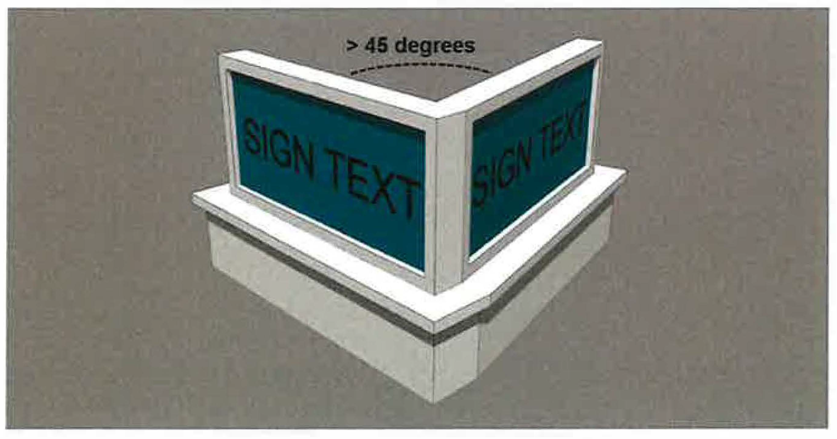
(E)
Sign width. The width of a sign shall be measured as the longest horizontal measurement between the outermost edges of the sign, as shown in Figure 1129.04-5: Sign Width Measurement Example.
Figure 1129.04-5: Sign Width Measurement Example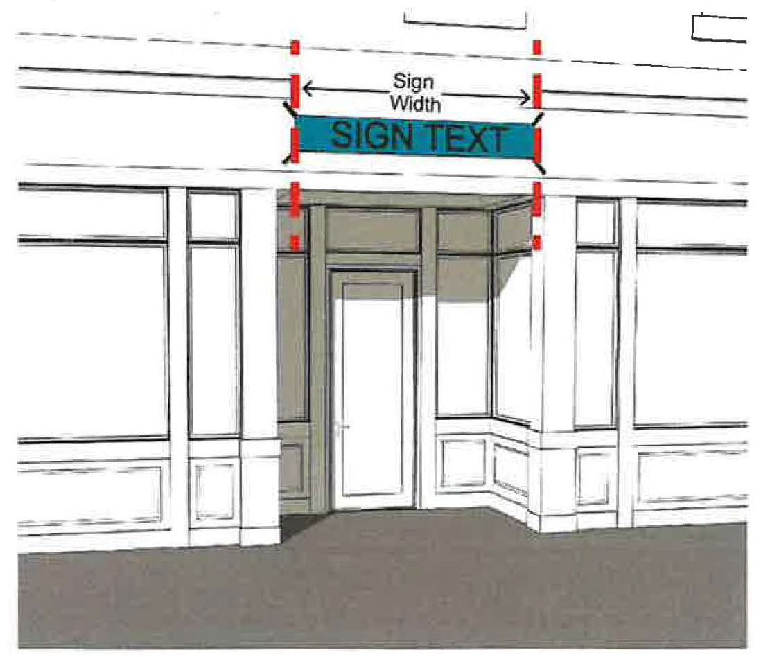
(F)
Sign support structure width and depth. The width and depth of a sign support structure shall be measured horizontal in perpendicular directions along the constructed elements that support a sign, as shown in Figure 1129.04-6: Sign Width and Depth Measurement Example.
Figure 1129.04-6: Sign Width and Depth Measurement Example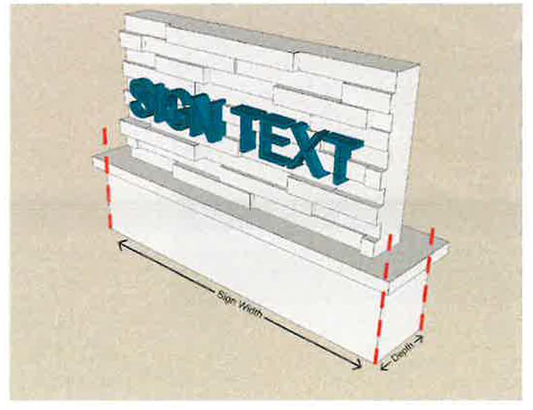
(G)
Window and door signs. The total area of all window and door signs shall be the total area of the smallest rectangle(s) that encapsulates text, numbers, symbols, images, and logos, as shown in the area outlined in red in Figure 1129.04-2: Sign Surface Area Measurement Example 2.
Figure 1129.04-7: Window and Door Sign Measurement Example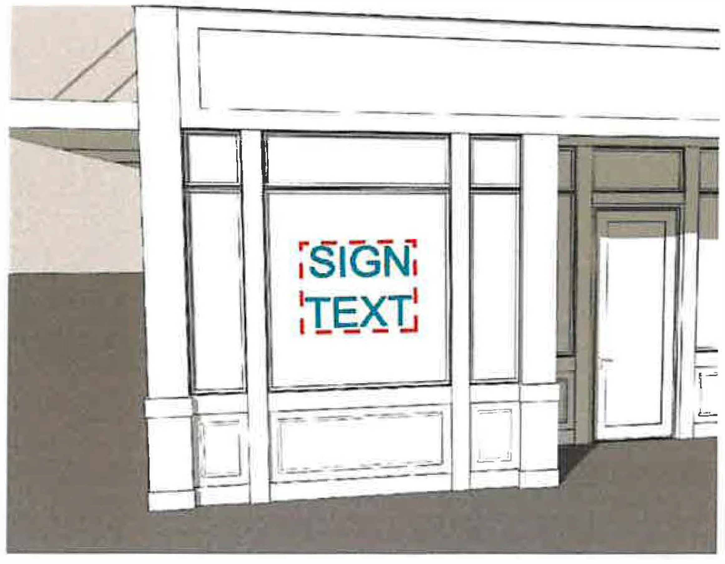
(H)
Dimensional projecting signs.
(1)
The volume of a dimensional projecting sign shall be calculated as the volume within a rectilinear form constructed to enclose the primary form of the sign. Each face of a rectilinear form shall not exceed 12 square feet in area.
(2)
Minor sign elements may project beyond the primary boundaries of this volume at the discretion of the Division of Engineering. Minor elements are defined as those parts of the sign that add to the design quality without adding significantly to the perceived volume and mass of the sign.
(3)
No dimension (height, width, or depth) shall be considered to be less than 12 inches for the purposes of calculating projecting sign volume.
(4)
For the purposes of this Section, a cubic foot of projecting sign or graphic volume, as calculated pursuant to these provisions, is considered to be equivalent to a square foot of sign area permitted for projecting signs.
(I)
Sign setback from a parcel line. Sign setbacks shall be measured as the shortest horizontal distance, as measured in a straight line, between the leading outside edge of the sign or sign support structure and the nearest parcel line(s), as shown in Figure 1129.04-8: Sign Setback Measurement Example.
Figure 1129.04-8: Sign Setback Measurement Example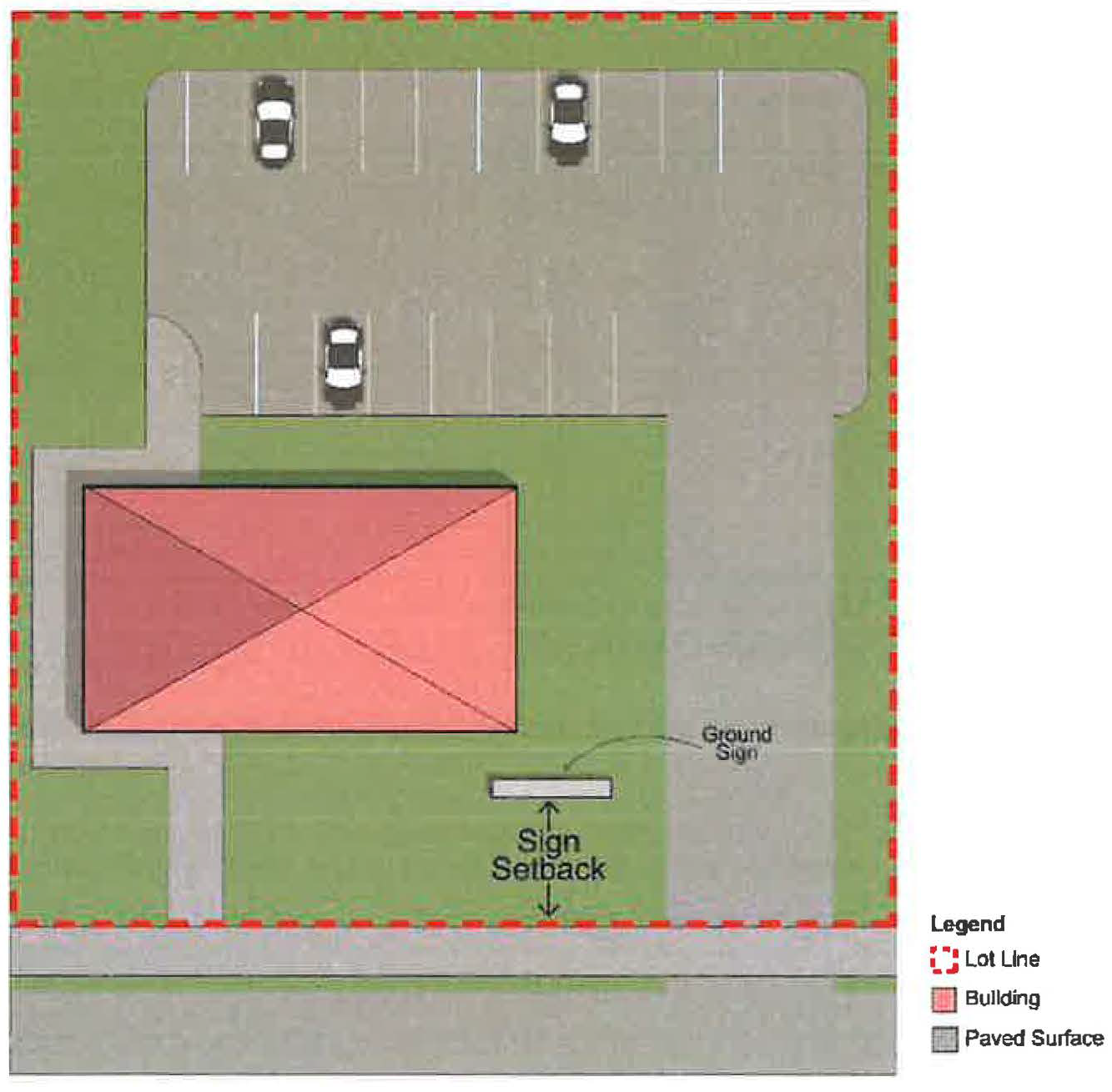
(J)
Sign separation from a separate sign. Separation between signs shall be measured as the shortest horizontal distance, as measured in a straight line, between the leading outside edge of each sign or sign support structure, as shown in Figure 1129.04-9: Sign Separation Measurement Example.
Figure 1129.04-9: Sign Separation Measurement Example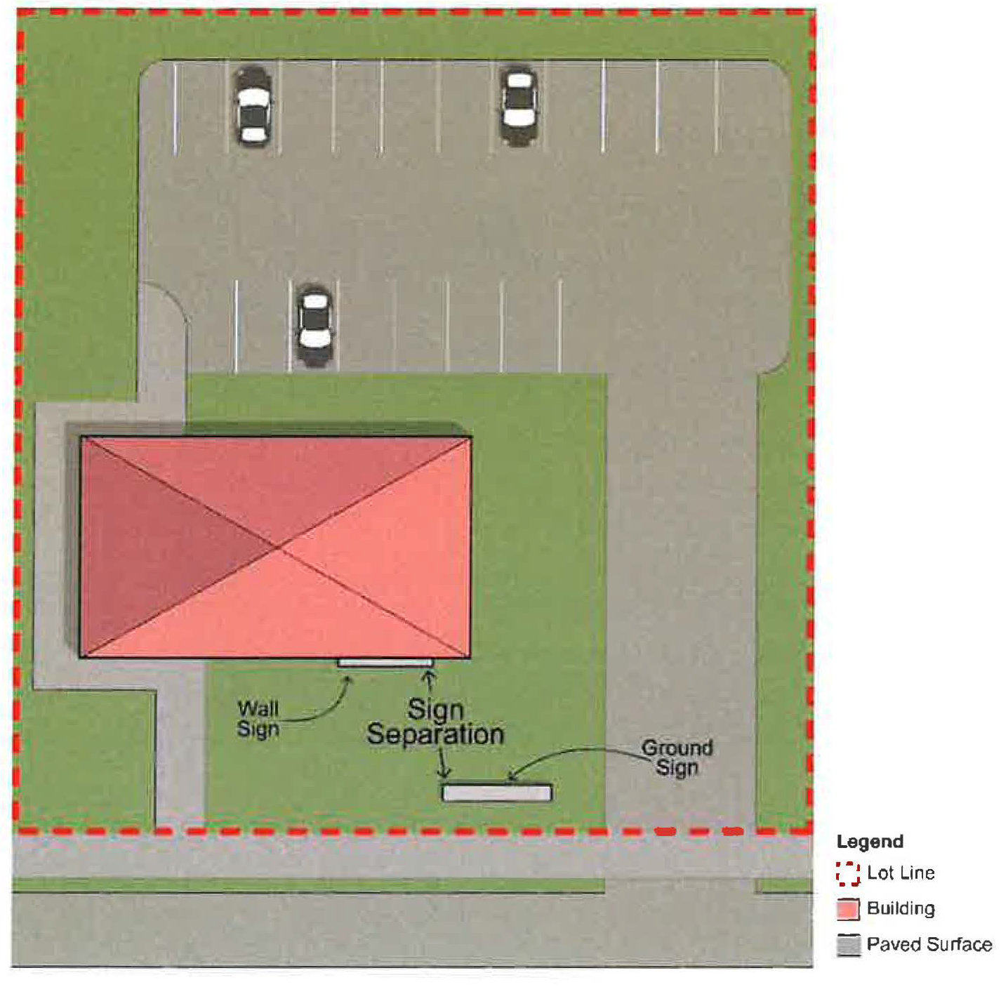
(K)
Clearance from grade level to sign bottom edge. The clearance to the bottom edge of a sign shall be measured as the distance between grade level at the base of or beneath the sign or associated sign support structure and the lowest point of the lowest element of the sign that can be traveled under, including sign support structures that are not a building, as shown in Figure 1129.04-10: Clearance to Sign Bottom Edge Measurement Example.
Figure 1129.04-10: Clearance to Sign Bottom Edge Measurement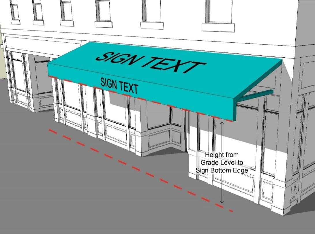
(L)
Height from grade level to sign top edge. The height to the top edge of a sign shall be measured as the distance between grade level at the base of or beneath the sign or associated sign support structure and the highest point of the highest element of the sign, including the height of sign support structures that are not a building, as shown in Figure 1129.04-11: Height to Sign Top Edge Measurement Example.
Figure 1129.04-11: Height to Sign Top Edge Measurement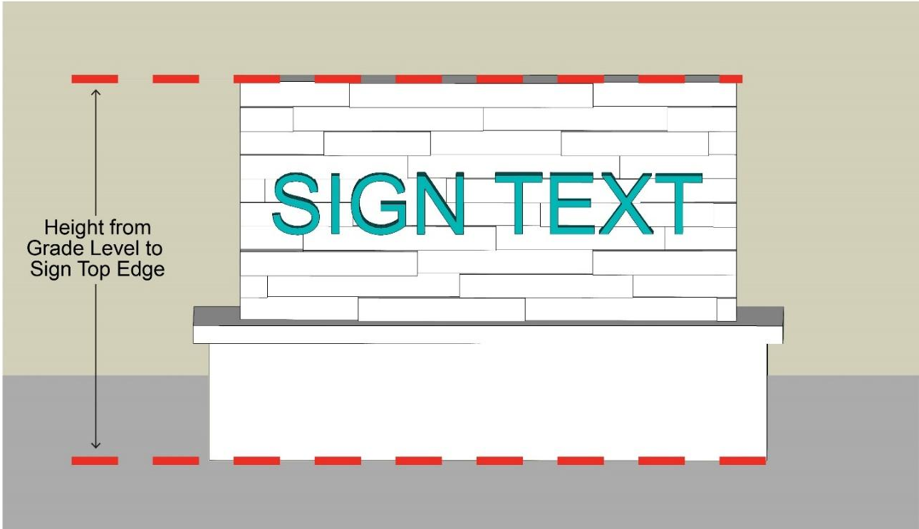
(Ord. No. 013-2025. Passed 3-24-2025)
1129.05 - PROHIBITED SIGNS AND SIGN ELEMENTS.
(A)
Prohibited signs. The following signs and sign elements are prohibited:
(1)
Electronic messaging centers, except as allowed per Table 1129.07-B: Comprehensive Sign Permissions and Design Standards;
(2)
Box illumination;
(3)
Off-site signs (billboards);
(4)
Moving, flashing, and animated signs of any sort, including rotating or revolving signs, exposed neon (except as otherwise expressly allowed in certain districts herein), exposed LED, pole signs, flashing messages, video signs with moving text or pictures, streamers, ribbons, pennants, spinners, and/or other similar moving devices;
(5)
Roof signs, except roof signs attached to mansard roofs may be allowed;
(6)
Portable signs, except for portable sidewalk signs as allowed per Table 1129.07-B: Comprehensive Sign Permissions and Design Standards;
(7)
Signs that imitate or resemble official traffic or government signs and signals;
(8)
Signs that create a visibility hazard or impair the future utilization or expansion of public streets;
(9)
Signs that cause, create, or allow public viewing of any adult material, or any entertainment depicting, describing, or relating to specified sexual activities, specified anatomical areas, and/or words, letters, photographs, silhouettes, drawings, or pictorial representations of any adult material, specified sexual activities, or specified anatomical areas;
(10)
Signs that are installed, erected, or attached in any form, slope, or manner to a fire exit or any door or window giving access to any fire escape or other emergency ingress and egress, unless approved or required by the Division of Fire; and
(11)
Signs that are attached to a building by fastening the sign directly to a brick facade; provided signs may be fastened directly to the mortar between bricks.
(B)
Unauthorized Signs on Public Property. Signs installed or placed within the City right-of-way, or on City owned property without prior written authorization shall be removed immediately without prior notification.
(C)
Nonconforming signs. Any signage that is made nonconforming by these prohibitions shall be subject to the provisions of Section 1129.12 Nonconformities.
(Ord. No. 013-2025. Passed 3-24-2025)
1129.06 - PERMIT REQUIREMENTS (BY SIGN TYPE).
(A)
Sign permit requirements. Sign permits are required for all new signs except as otherwise expressly exempt herein. Signs within the Uptown Districts or signs that will be installed as part of new development shall be subject to review by the Design Review Board as part of the Exterior Plan Application.
(B)
Discretionary Review. Where a discretionary review is designated in Table 1129.06-A: Sign Permit Requirements, City staff shall review the application and may elect to either (i) approve the application based on the applicable design standards set forth in this Chapter or (ii) refer the application to the Design Review Board for review and approval or denial.
Table 1129.06-A: Sign Permit Requirements
(Ord. No. 013-2025. Passed 3-24-2025)
1129.07 - SIGN TYPE PERMISSIONS AND DIMENSIONAL STANDARDS (BY DISTRICT).
(A)
District groups. For the purposes of this Chapter, zoning districts are categorized into the groups identified in Table 1129.07-A: Zoning District Categories:
Table 1129.07-A: Zoning District Categories
(B)
Comprehensive sign table. Specified types of signs shall be allowed or prohibited and limited as to their design per the provisions of Table 1129.07-B: Comprehensive Sign Permissions and Design Standards. Signs shall be allowed or prohibited per the following key:
(1)
A solid circle identifies a sign type as allowed through the approval of a zoning permit within specified zoning districts.
(2)
A hyphen identifies a sign type as not allowed within specified zoning districts.
Table 1129.07-B: Comprehensive Sign Permissions and Design Standards
(Ord. No. 013-2025. Passed 3-24-2025)
1129.08 - MURALS.
(A)
A mural is not a sign for purposes of this Chapter.
(B)
One mural is allowed per parcel in all non-residential districts. All murals shall be reviewed and approved by the Design Review Board for compliance with this Chapter and a mural permit approved by the City.
(C)
A mural shall be painted on or affixed to the front, side, or rear elevation of a building; provided, however, no mural shall be located on the front façade of a building in any of the Uptown districts (UC/USF/UT). No mural shall be located on the roof of a building. In addition to paint applied directly to a building surface, a mural on ultra flex vinyl, metal, or canvas shall be permitted to be affixed on the side or rear elevation of a building in conformance with this Chapter. A mural may be projected on the surface of a building by a light projector so long as it complies with all locational and dimensional standards of this Chapter and provided that the light projector and the projection is contained solely on the parcel where the building on which the mural is being projected is located and does not shine on or cross over any other parcel without the express permission of such burdened parcel owner.
(D)
A mural may be externally illuminated.
(Ord. No. 013-2025. Passed 3-24-2025)
1129.09 - GENERAL DESIGN AND ILLUMINATION STANDARDS.
(A)
General construction requirements. All signs and supporting structures, as applicable, are subject to the following standards:
(1)
All permanent signs and supporting structures shall be designed and constructed in a manner to withstand a pressure of 30 pounds per square foot without collapsing, leaning, or otherwise exhibiting damage.
(2)
All electrical wiring, fittings, and material used in construction and operation of signs shall conform to any applicable codes and specifications of the City of Marysville to the extent the specifications are in effect, or to the applicable codes of the State of Ohio where they supersede those of the City of Marysville.
(B)
Relation to traffic devices. Privately owned signs shall not imitate traffic control devices and other signs installed by government entities in a public right-of-way. Unless regulated otherwise in the codes of the city, signs shall not be erected in a manner that obstructs sight lines along any public right-of-way to or from:
(1)
Traffic control lights;
(2)
Traffic control signs;
(3)
Street name signs;
(4)
Street sight lines;
(5)
Signals at railroad or grade crossings; and
(6)
Similar official devices in a public right-of-way.
(C)
Clear sight triangle required. As shown in Figure 9-1: Example Clear Sight Triangles, a clear sight triangle shall be observed and is subject to the following:
(1)
Intersections of rights-of-way. A clear sight triangle shall be observed at all street intersections within the area formed by measuring 30 feet along both directions from the corner point of the right-of-way intersection, connecting the end points with a straight line.
(2)
Intersections of driveways and rights-of-way. A clear sight triangle shall be observed at all intersections of driveways and streets within the area formed by measuring 10 feet along both directions from the corner point of the driveway pavement and the right-of-way, connecting the end points with a straight line.
(3)
Obstructions in a clear sight triangle. Signs shall be located and designed in a manner that maintains a substantially clear view between 2.5 feet and 8 feet above grade level within clear sight triangles.
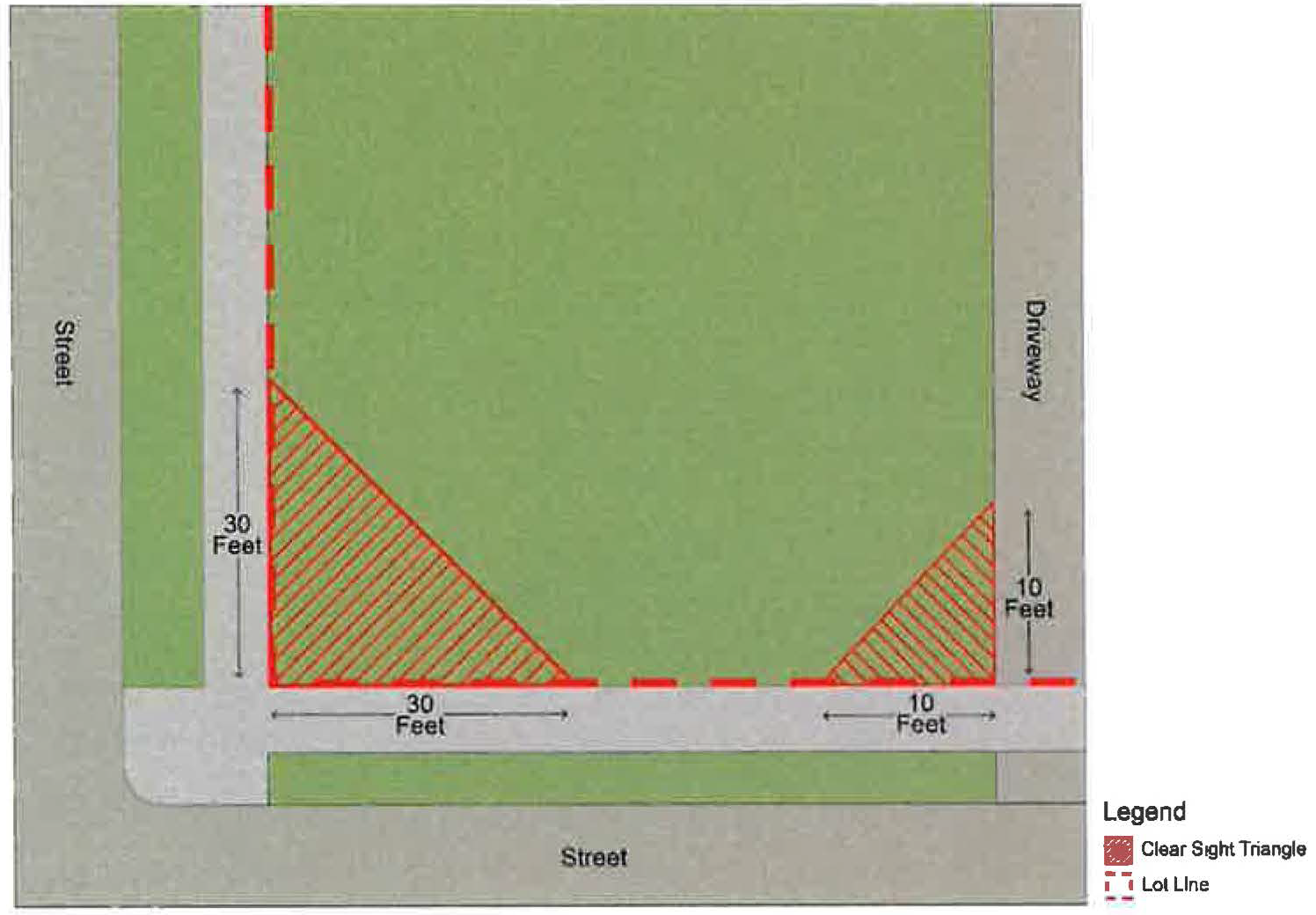
Figure 9-1: Example Clear Sight Triangles
(D)
Illumination of signs. Signage illumination, where allowed per Table 1129.07-B: Comprehensive Sign Permissions and Design Standards and other provisions of this Chapter, shall not produce a glare onto properties other than the subject parcel, and shall meet the following standards:
(1)
Shielding required. Light sources to illuminate signs shall be shielded from all nearby residential buildings and from all rights-of-way and shall be of such brightness or intensity as to not cause a hazardous glare towards pedestrians or automobile operators.
(2)
Prohibited illumination. Signage illumination must meet the applicable standards of Section 1129.05 Prohibited Signs and Sign Elements.
(E)
Additional standards for electronic message center signs. In addition to the applicable standards of Table 1129.07-B: Comprehensive Sign Permissions and Design Standards, electronic message center signs are subject to the following standards:
(1)
Sources of illumination shall incorporate dimmers and glare screens and shall be equipped with a photocell to automatically reduce brightness that corresponds to available ambient light;
(2)
Such signs shall incorporate a default design that will turn off completely all illumination sources in the event of a malfunction;
(3)
Messages within such signs shall not flash and/or provide the illusion of motion; and
(4)
The maximum illumination at a point 150 feet or greater from any such sign shall not exceed 1.5 footcandles above ambient light.
(Ord. No. 013-2025. Passed 3-24-2025)
1129.10 - SIGN PERMIT PROCEDURES.
(A)
Applicability. A sign permit must be approved prior to the installation, construction, erection, alteration, relocation, or replacement of all signs that are not explicitly exempted from requiring a sign permit per Section 1129.02 Applicability and Exempt Sign Types or Table 1129.06-A: Sign Permit Requirements.
(B)
Review and decision authority. The Division of Engineering staff shall review and decide on the completeness of applications for sign permits and shall be responsible for directing such applications to the applicable review and decision authority per Table 1129.06-A: Sign Permit Requirements.
(C)
Approval criteria. The applicable review and decision authority shall approve and issue a sign permit only upon finding that the design, size, scale, height, illumination, location, orientation, and related aspects of the proposed sign(s) meets all applicable standards of this Chapter.
(D)
Denial. The applicable review and decision authority shall deny an application for a sign permit that does not meet the approval criteria. Following such a determination, the Department of Planning and Zoning staff shall issue to the applicant a notice of denial in writing with the reasons for the denial stated therein.
(E)
Appeal. An aggrieved party may appeal a final decision of the applicable review and decision authority in accordance with Section 1141.13 Appeals of the Marysville Planning and Zoning Code.
(F)
Required application information. A complete application for a sign permit must be submitted to the Department of Planning and Zoning staff on forms furnished by the City and must include the following information:
(1)
The design and layout of each sign proposed, including the total area of all signs and the area, height, materials, colors, and illumination of individual signs;
(2)
If a maximum display period applies: the proposed display duration and the date that the sign will be removed;
(3)
Photographs or drawings of the building, if applicable, for which the signs are proposed and photographs of surrounding buildings, signs, and uses;
(4)
A site plan of the subject parcel showing the location of existing buildings and other site improvements and the location existing and proposed signs with setback and separation measurements marked;
(5)
A site plan of the subject parcel showing any required clear sight triangles;
(6)
The application fee as established by ordinance; and
(7)
Any additional information required by the Department of Planning and Zoning staff to determine compliance with applicable standards of this Chapter.
(Ord. No. 013-2025. Passed 3-24-2025)
1129.11 - SIGN VARIANCE PROCEDURES.
(A)
Applicability. A sign variance must be approved prior to the installation, construction, erection, alteration, relocation, or replacement of a sign that does not meet applicable standards of this Chapter.
(B)
Review and decision authority. The Board of Zoning Appeals shall review and decide on sign variance applications in a public hearing.
(C)
Public hearing and notices. The Division of Engineering shall publish notice of a public hearing before the Board of Zoning Appeals and hold the public hearing on a complete application for a sign variance in accordance with the provisions of Section 1141.18, 1141.19, 1141.20, and 1141.21 of the Zoning Code, as applicable.
(D)
Approval criteria. The Board of Zoning Appeals shall approve a sign variance only upon finding that:
(1)
There are special circumstances or conditions, such as the existence of buildings, topography, vegetation, sign structures, or other matters on adjacent lots or within the adjacent public right-of-way that would substantially restrict the effectiveness of the proposed sign, provided however, that such special circumstances or conditions must be peculiar to the particular use of the lot and are not generally applicable to all allowed uses within the given zoning district; and
(2)
The variance would be in general harmony with the purposes and intents of this Chapter 1129; and
(3)
The requested variance is the minimum deviation from the applicable standard necessary to overcome a hardship and allow for a reasonably effective sign.
(E)
Conditions authorized. The Board of Zoning Appeals is hereby authorized to impose conditions upon its approval of a sign variance. Such conditions must be the smallest and/or least restrictive conditions necessary to cause or ensure that a proposed sign is compatible with the purpose and intent of this Chapter 1129.
(F)
Denial. The Board of Zoning Appeals shall deny an application for a sign variance that does not meet the approval criteria. Following such a determination, the Board of Zoning Appeals shall issue to the applicant a notice of denial in writing with the reasons for the denial stated therein.
(G)
Appeal. Any person aggrieved by a final decision of the Board of Zoning Appeals may seek relief there from in a court of competent jurisdiction.
(H)
Required application information. A complete application for a sign variance shall require the same information required for a sign permit (as provided in Section 1129.10) along with the following:
(1)
A description of the special circumstances and the hardship being faced for the proposed sign; and
(2)
A description of the proposed sign's compliance with the purposes and intents of this Chapter 1129.
(Ord. No. 013-2025. Passed 3-24-2025)
1129.12 - NONCONFORMITIES.
(A)
Nonconforming signs.
(1)
Signs and structures in existence prior to or on the effective date of this Chapter which violate or otherwise do not conform to the provisions of this chapter, and which were erected in accordance with a city permit shall be deemed legal nonconforming signs. All such legal nonconforming signs and structures shall be maintained in accordance with this Chapter.
(2)
The regulations in this section are designed to prevent a public nuisance through overconcentration, improper placement, and excessive height, bulk, enlargement, number, and area of signs. They shall not be construed to prohibit changing a sign panel, provided there is no increase in height, area, or location; or to permit a nonconforming sign to be placed closer to a right-of-way lot line or power line than as allowed by this Chapter.
(B)
Loss of nonconforming status. It is the intent of this section that legal nonconforming signs eventually be brought into compliance with the provisions and regulations of this chapter. As a result, a legal nonconforming sign shall immediately lose its legal nonconforming status and therefore must be brought into conformance with this chapter or be removed if the sign is enlarged, relocated, modified, or replaced. If the sign is part of an establishment which discontinues operation for 30 consecutive days; or if it is structurally damaged to an extent greater than one-half its estimated replacement value, it will also immediately lose its legal nonconforming status. Similarly, any legal nonconforming advertising structure so damaged must be brought into compliance or removed.
(C)
Maintenance and repair of nonconforming signs. Any legal nonconforming sign may be painted, cleaned, or maintained and structural or electrical parts may be repaired or restored to a safe condition provided the maintenance or repair does not alter, change, enlarge, or relocate the existing sign or sign structures.
(D)
Limitation on reconstruction. A nonconforming sign or part thereof damaged or deteriorated to an extent exceeding 50% of its replacement cost shall not be reconstructed or replaced unless made to conform to the regulations of this code. For a nonconforming sign damaged by a single incident (such as a storm) to an extent less than 50% of its replacement cost, reconstruction is permitted only if such work is begun within six months of the incident and is completed within 12 months of the incident.
(Ord. No. 013-2025. Passed 3-24-2025)
1129.13 - MAINTENANCE AND REMOVAL OF SIGNS.
(A)
General maintenance standards. All signs and sign-supporting structures must be maintained in a safe and secure condition.
(B)
Removal of signs. Signs that are no longer in service, or that have been abandoned, or that are not maintained in accordance with this Zoning Code or in accordance with another governmental agency with competent jurisdiction, must be removed by the permit holder, the building owner, and/or the parcel owner. The city may remove such signs at the expense of the permit holder, the building owner, and/or the parcel owner following a notice that complies with the applicable requirements of Chapter 1141 - Administration and Procedures, and Chapter 1145 - Enforcement and Penalty, of the Zoning Code.
(C)
Notice of required maintenance or removal.
(1)
Whenever the removal or maintenance of any permanent sign has been ordered by the Division of Engineering and the entity to which such notice has been supplied fails to remove or maintain the sign within 30 days after receiving such notice, the Division of Engineering may remove or cause to be removed or maintained such sign at the expense of the sign permit holder, building owner, and/or parcel owner, as applicable.
(2)
Prohibited and/or temporary signs that violate the standards of this Chapter shall be removed within five (5) days after a removal order is issued by the Division of Engineering.
(3)
Signs installed or placed within the City right-of-way, or on City-owned property without prior authorization shall be removed immediately, without prior notification.
(D)
Signs constituting a public hazard. If the Division of Engineering determines that a sign constitutes an immediate hazard to public health and safety, then the Division of Engineering shall promptly cause the repair or removal of the sign at the expense of the permit holder, the building owner, and/or the parcel owner, as applicable.
(Ord. No. 013-2025. Passed 3-24-2025)
1129.14 - VIOLATIONS AND PENALTIES.
(A)
A person, entity, or corporation who does not correct a violation of this Chapter within the time limits established in Section 1129.13 shall be subject to fines and other penalties in accordance with Chapter 1145 - Enforcement and Penalty, of the Zoning Code. Each day such offense continues shall constitute a separate and distinct offense. Such fines and other penalties shall be separate from and be in addition to any expenses incurred by the city for the removal or maintenance of a sign that the city implements in accordance with Section 1129.13 Maintenance and Removal of Signs.
(Ord. No. 013-2025. Passed 3-24-2025)
1131.01 - GENERAL STATEMENT.
The City of Marysville, which includes the Uptown Commercial District (UC), the Uptown Single-Family District (USF), and the Uptown Transitional District (UT) (all as depicted on Figure 1131A) contains numerous historic structures and other architectural and special features which are considered assets that establish the character of the community. The Marysville UC is a mixed-use area where residential and commercial uses support each other's economic vitality and the historic character is directly linked to the economic health of the business and residential districts. The Marysville USF is a neighborhood comprised predominantly of single-family structures with historic character. Additional buildings and places that exhibit historic character add meaning and livability to our City. The vitality of historic buildings, structures and areas within the City of Marysville affects the economic, social, historical and cultural health and well-being of the community.
(Ord. No. 054-2020, Passed 11-23-2020.)
1131.02 - PURPOSE.
The purpose of the Historic Uptown Marysville District is to maintain and enhance the distinctive character of the community's historic area(s) by safeguarding the exterior architectural integrity of the various period structures and other historic features within the District thereby promoting the public health, safety, and welfare of the residents and visitors to the community.
(Ord. No. 054-2020, Passed 11-23-2020.)
FIGURE 1131A UPTOWN HISTORIC DISTRICT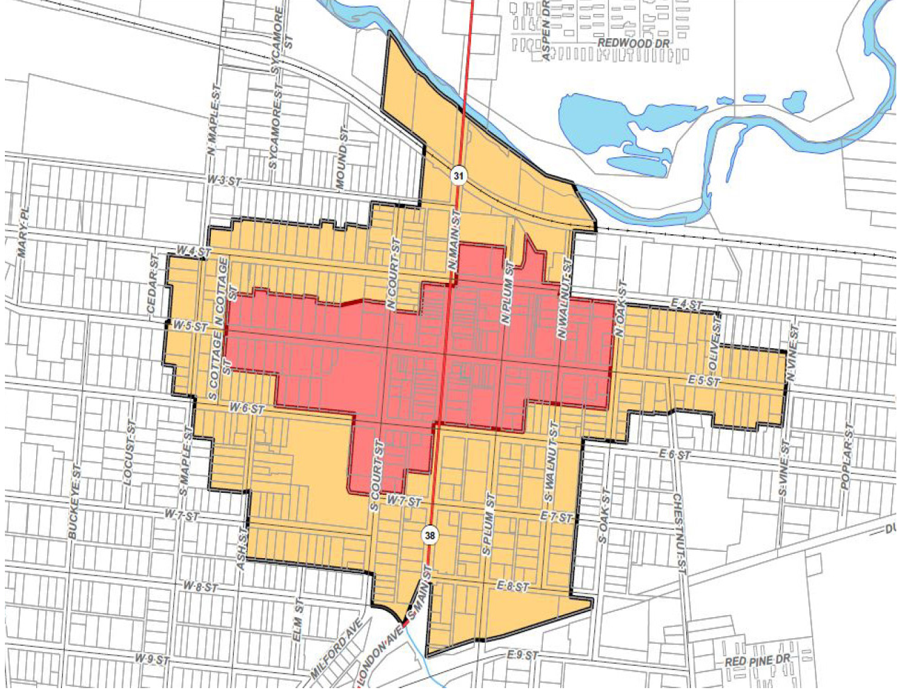
| LEGEND | |
| Uptown District | |
| Historic District | |
1131.03 - INTENT.
The intent of the Historic District(s) and Landmark(s) is to:
(a)
Create a unique District which protects a historically significant area which includes multiple zoning districts. This means that the requirements of this Chapter must be met in addition to the established requirements of the underlying use districts.
(b)
Provide a process of architectural review in reference to historic preservations criteria which would also guide, support and encourage new construction which would be compatible with historic structures.
(c)
Promote, preserve, and enhance the historic integrity and special features of the District.
(Ord. No. 054-2020, Passed 11-23-2020.)
1131.04 - CRITERIA AND ESTABLISHMENT OF HISTORIC DISTRICT(S) AND LANDMARK(S).
(a)
In considering the designation of any area, property, structure, work of art, or similar object in the City of Marysville as an historic district or landmark, the City Planning Commission and City Council shall apply the following criteria:
(1)
Its character, interest, or value as part of the development, heritage or cultural characteristic of the City of Marysville, Union County, the State of Ohio, or the United States of America.
(2)
Its location as a site of a significant historical event.
(3)
Its identification with a person who significantly contributed to the culture and development of the City.
(4)
Its exemplification of the cultural, economic, social or historic heritage of the City.
(5)
Its embodiment of distinguishing characteristics of an architectural type.
(6)
Its embodiment of elements of architectural design or detail or materials or craftsmanship which represent architecture of significant character, charm, or grandeur.
(7)
Its unique location or singular physical characteristics representing an established and familiar visual feature of a neighborhood or of the City.
(8)
Its portrayal of the environment of a group of people in an era of history characterized by a distinctive architectural style.
(b)
Additional Historic district boundaries within the City of Marysville must be eligible for or listed on the National Register of Historic Places or contain locally designated landmarks.
(1)
The initiation of a proposal for a Historic District may be made only by one or more citizens of the City of Marysville, a City Board, City Commission, City Council or committee.
(2)
The proposal shall be submitted to the City Manager and/or designee. The submission shall include documentation proving the subject property(s) either eligible for or is listed on the National Register of Historic Places.
(3)
All known legal or equitable property owner(s) of the designated property(s) and abutting property owners shall be notified by mail of the proposal, and their written comments requested.
(4)
Within twenty (20) days, the City Manager and/or designee shall forward the proposal with owner(s) written comments to the Union County Historical Society and City of Marysville Design Review Board for recommendations.
(5)
After review, the Union County Historical Society and the City of Marysville Design Review Board shall forward their recommendations in writing to the City Manager and/or designee.
(6)
The City Manager and/or designee shall forward the proposal with all written comments and recommendations to the City of Marysville Planning Commission for review.
(7)
The Planning Commission shall review the proposal, the recommendations of the Union County Historical Society, the City of Marysville Design Review Board and the owners' written comments and shall forward them on to City Council with a recommendation.
(8)
Upon receipt of the Planning Commission's recommendation, the City Council shall cause an appropriate ordinance to be prepared, shall schedule public hearings on the proposed legislation and shall cause written notice to be given to the owner or any person having a legal or equitable interest in the property(s) being proposed for designation.
(9)
City Council shall give due consideration to the findings and recommendations of the Planning Commission, Union County Historical Society, written comments from property owner(s), and to the public hearing comments, in making its determination.
(10)
After a decision by City Council, the Clerk of Council shall notify all persons known to have a legal or equitable interest in the said property(s). The Planning Commission and the Union County Historical Society shall also be notified of the decision.
(11)
City Council shall, notwithstanding any provision of this Chapter may rescind by ordinance the designation of any area, place, building or structure located within a designated Historic District.
(12)
The Clerk of Council shall notify any appropriate county and/or state offices after a designation is approved or rescinded.
No legislation under this section shall be rendered invalid by any failure or alleged failure of the Clerk of Council to provide a prescribed notice, by mail or otherwise, to any person.
(c)
Maps with delineated boundaries of the following Historic District(s) and/or Landmark(s) are on file with the City of Marysville Clerk of Council.
(Ord. No. 054-2020, Passed 11-23-2020.)
1131.05 - ESTABLISHMENT OF HISTORIC DISTRICT(S) AND LANDMARK(S) DESIGN REVIEW PROCESS.
The Design Review Board, as contemplated under Chapter 1133 shall review Certificate of Appropriateness applications for this District and shall ensure that all the provisions of this Chapter are enforced. The Design Review Board shall have the following duties:
(a)
Develop and maintain specific design and color guidelines for the Historic and Landmark District. These design and color guidelines shall be reviewed and updated when appropriate.
(b)
Review the District code and guidelines and make recommendations to City Council and the City Administration on how to improve the architectural and design environment.
TABLE 1131-1: APPROVAL REQUIREMENTS
(Ord. No. 054-2020, Passed 11-23-2020.)
1131.06 - CERTIFICATE OF APPROPRIATENESS REQUIRED.
(a)
An environmental change within any designated Historic and/or Landmark District including the Historic Uptown Marysville District shall require a Certificate of Appropriateness approved by the Board or a fast track Certificate of Appropriateness approval, approved by the Division of Engineering.
(b)
Applications for the approval of the Certificate of Appropriateness:
(1)
Shall be filed with the City on forms provided by the City;
(2)
Shall include all required supplemental information;
(3)
Shall be submitted by the application deadline as established by the City;
(4)
Shall be signed by the applicant and owner attesting to the truth and exactness of all information supplied on the application.
(c)
Staff shall review the submitted materials for completeness and shall:
(1)
Determine if the Certificate of Appropriateness is a fast track application (as defined later in this Chapter) or if it is a Design Review Board application. If it is a Design Review Board application, the Division of Engineering shall place said application on the next appropriate Design Review Board agenda; or
(2)
Reject incomplete applications and return the fee to the applicant with an itemization of deficiencies.
(Ord. No. 054-2020, Passed 11-23-2020.)
1131.07 - PROJECTS, WORK AND MAINTENANCE NOT REQUIRING A CERTIFICATE OF APPROPRIATENESS.
An environmental change on a structure or on a property within any designated Historic and/or Landmark District including the Historic Uptown Marysville District does not require a Certificate of Appropriateness if the:
(a)
Environmental change which in the view of the Division of Engineering and/or Fire Chief is required for the public safety because of an unsafe, insecure or dangerous condition.
(b)
Work which involves ordinary maintenance or repair of any structure or property, provided such work involves no change in material, design, texture, color or exterior appearance.
(c)
In addition to the foregoing Work, the following Work to either a single-family (attached) or single-family (detached) structure shall not require a Certificate of Appropriateness:
(1)
repainting the structure with a permitted paint color described under this Chapter;
(2)
replacing windows or doors with replacement windows or doors that have similar appearance and do not reduce the openings by more than 10%;
(3)
removing existing materials to expose original materials beneath such existing materials, including but not limited to removing vinyl siding to expose original brick;
(4)
covering or removing non-historic materials or hazardous materials, such as asbestos siding, with materials permitted under this Chapter; or
(5)
replacing existing materials with like-materials; provided however, if like-materials are not commercially available, then with such other materials that are in compliance with the guidelines set forth under this Chapter.
(Ord. No. 054-2020, Passed 11-23-2020.)
1131.08 - FAST TRACK APPROVAL FOR SPECIFIC PROJECTS.
(a)
Applicability. The following environmental changes qualify for fast track approval for Certificate of Appropriateness:
(1)
Awnings if the design remains the same but the color(s) is being modified provided that the color(s) proposed meet the design and color guidelines established by the Design Review Board.
(2)
Signs if the same sign board or a window is used, but the color(s) and information are changed provided that the color(s) proposed meet the design and color guidelines established by the Design Review Board.
(3)
Portable sidewalk signs as long as the sign complies with the regulations outlined in Section 1129.09.
(4)
Painting of structures and signs as long as the painting does not involve any structural modification and the paint color selection complies with the design and color guidelines established by the Design Review Board. (Ord. 23-11. Passed 7-28-11.)
(5)
Fences, trash enclosures and accessory structures under 250 sq. ft. as long as the design, color and materials are compatible with the primary structure and meet the guidelines stated in Section 1131.11.
(6)
Where a substantial expansion of a single-family (detached) or single-family (attached) structure will not be visible from the public right-of way.
(7)
Where a substantial expansion of a single-family (attached) or single-family (detached) structure will be visible from the public right-of-way, City staff may elect to either approve the application based on the standards set forth herein or refer the application to the Design Review Board.
(8)
Where a major renovation to a single-family (attached) or single-family (detached) structure is not visible from the public right-of-way.
(9)
Where a major renovation to a single-family (attached) or single-family (detached) structure is visible from the public right-of-way, City staff may elect to either approve the application based on the standards set forth herein or refer the application to the Design Review Board.
(b)
Procedure. The procedure for Fast Track approval shall be as follows:
(1)
The Division of Engineering shall review the application for compliance with the Planning and Zoning Ordinance and verify that the proposed work satisfies the design and color guidelines established by the Design Review Board.
(2)
The Division of Engineering shall approve, conditionally approve, or disapprove the application within eight (8) working days of the complete Certificate of Appropriateness application being filed.
(Ord. No. 054-2020, Passed 11-23-2020.)
1131.09 - PROCEDURE FOR CERTIFICATE OF APPROPRIATENESS BEFORE DESIGN REVIEW BOARD.
(a)
The application for a Certificate of Appropriateness:
(1)
Shall be filed with the City on forms provided by the City;
(2)
Shall include all required supplemental information;
(3)
Shall be submitted by the application deadline as established by the City;
(4)
Shall be signed by the applicant and owner attesting to the truth and exactness of all information supplied on the application.
(b)
Prior to the Design Review Board's review of an application for a Certificate of Appropriateness, the City shall publish a notice of the hearing in selected multiple media outlets at least seven (7) days prior to the date of the hearing. The City shall send notice of the Design Review Board's review of an application for a Certificate of Appropriateness at least ten (10) days before the regularly scheduled Planning Commission meeting to all owners of properties contiguous to or directly across from the property concerned via first-class mail. Notwithstanding anything to the contrary herein, such notices shall not be required for any application that pertains to City-owned property.
(c)
The Design Review Board shall approve, conditionally approve, or disapprove the Certificate of Appropriateness application. The Design Review Board may request reports or testimony by City staff or other applicable organizations in reviewing the application. The Certificate of Appropriateness shall be approved if the Design Review Board finds that:
(1)
Applicable provisions in the Planning and Zoning Ordinance are satisfied.
(2)
The location and configuration of the building(s) are visually harmonious with their sites and surroundings.
(3)
The criteria, design guidelines, and color guidelines as established in this Chapter are satisfied.
(d)
If the Certificate of Appropriateness application is disapproved, the reasons for the disapproval shall be stated in the record.
(e)
Certificate of Appropriateness applications must be approved, conditionally approved or disapproved within thirty (30) days from the date of receipt except that Certificate of Appropriateness applications for demolition must be approved, conditionally approved or disapproved within ninety (90) days from the date of receipt, unless a waiting period is imposed pursuant to Section 1131.14, and in such case within five days of the expiration of the waiting period,. The approval periods may be extended by the mutual agreement of the Design Review Board and the applicant. Any Certificate of Appropriateness granted hereunder shall expire two (2) years after the date of issuance if work has not commenced.
(Ord. No. 054-2020, Passed 11-23-2020; Ord. No. 039-2022, Passed 6-27-2022; Ord. No. 031-2025, Passed 9-22-2025.)
1131.10 - STANDARDS FOR REHABILITATION AND GUIDELINES FOR REHABILITATING HISTORIC BUILDINGS FOR CERTIFICATE OF APPROPRIATENESS.
When evaluating and considering the appropriateness of any proposed environmental change, including landscaping or exterior change, the Design Review Board shall consider the guidelines outlined in the "Standards for Rehabilitation and Guidelines for Rehabilitating Historic Buildings" as adopted by the Secretary of Interior, U.S. Department of Interior. A general overview of these guidelines is as follows:
(a)
A property shall be used for its historic purpose or be placed in a new use that requires minimal change to the defining characteristics of the building and its site and environment.
(b)
The historic character of a property shall be retained and preserved. The removal of historic materials or alteration of features and spaces that characterize a property shall be avoided.
(c)
Each property shall be recognized as a physical record of its time, place and use. Changes that create a false sense of historical development, such as adding conjectural features or architectural elements from other buildings, shall not be undertaken.
(d)
Most properties change over time; those changes that have acquired historic significance in their own right shall be retained and preserved.
(e)
Distinctive features finish and construction techniques or examples of craftsmanship that characterize a property shall be preserved.
(f)
Deteriorated historic features shall be repaired rather than replaced. Where the severity of deterioration requires replacement of a distinctive feature, the new feature shall match the old in design, color, texture and other visual qualities and where possible, materials. Replacement of missing features shall be substantiated by documentary, physical or pictorial evidence.
(g)
Chemical or physical treatments, such as sandblasting, that cause damage to historic materials shall not be used. The surface cleaning of structures, if appropriate, shall be undertaken using the gentlest means possible.
(h)
Significant archeological resources affected by a project shall be protected and preserved. If such resources must be disturbed, mitigation measures shall be undertaken.
(i)
New additions, exterior alterations or related new construction shall not destroy historic materials that characterize the property. The new work shall be differentiated from the old and shall be compatible with the massing, size, scale and architectural features to protect the historic integrity of the property and its environment.
(j)
New additions and adjacent or related new construction shall be undertaken in such a manner that if removed in the future, the essential form and integrity of the historic property and its environment would be unimpaired.
(Ord. No. 054-2020, Passed 11-23-2020.)
1131.11 - DESIGN GUIDELINES.
The design guidelines listed below should be used when reviewing Certificate of Appropriateness applications.
(a)
Building and Site Design.
(1)
Height in relation to existing structures.
(2)
Building massing - the relationship of the building width to its height and depth, and its relationship to visual perspective.
(3)
Window and door treatment which shall include the size, shape and materials of the individual window and door units and the overall harmonious relationship of window and door openings
(4)
Exterior detail and relationships, which shall include all projecting and receding elements of the exterior, including but not limited to, porches and overhangs and the horizontal or vertical expressing which is conveyed by these elements.
(5)
Roof shape, which shall include type, form and materials.
(6)
Materials, texture and color, which shall include a consideration of material compatibility among various elements of the structure.
(7)
Compatibility of design and materials, which shall include the appropriateness of the use of exterior design details.
(8)
Landscape design and plant materials including but not limited to, lighting and the use of landscape details to highlight architectural features or screen or soften undesirable views.
(9)
Pedestrian environment which shall include the provision of features which enhance pedestrian movement and environment, and which relate to the pedestrian's visual perspective.
(b)
Materials.
(1)
Masonry and Wood. The use of natural traditional exterior material such as brick, stone, masonry, and wood are encouraged.
A.
Sandblasting will not be permitted on masonry.
B.
Replaced mortar should duplicate as much as possible the original used in appearance.
C.
Replaced brick, stone, masonry, and wood should duplicate the appearance as much as possible to the original used on the structure.
(2)
Metals. The use of contemporary materials, such as aluminum, other metals, fiberglass and plastics for exterior surfaces on architecturally significant structures shall be prohibited unless the use of such materials would contribute to the preservation or enhancement of existing traditional materials and the overall integrity and longevity of a structure.
(3)
Roofs. Roofs shall be aesthetically pleasing, and the materials proposed shall not alter the historical significance of the structure.
(4)
Windows and Doors. Windows and doors shall be replaced with similar materials and styles of the original windows and doors.
A.
Wood, aluminum-clad, and fiberglass/composite-clad windows are permitted.
B.
The replacement windows shall match the original window opening width, depth, and integrate historical design elements.
C.
Storm windows are permitted if painted the same color as the actual window frame and crossbars match with the interior.
D.
The replacement doors shall match the original door opening width,depth, and integrate historical design elements.
E.
Rear doors may be replaced with steel doors; however, it is recommended that the doors have character with inserts or windows.
(5)
General Storefront Guidelines. Storefronts may be replaced when there is no historic integrity. Storefronts with historic integrity may be replaced if irreparable.
A.
Awnings shall be of traditional nature. Awnings should be the forty-five (45) degrees, made of canvas material, and are of compatible color. They should be attached to mortar joints not brick or stone.
B.
Metal awnings may be replaced only if they contribute to the historic integrity of the building or if they are located to the rear of the structure. No new metal awnings will be permitted.
C.
Porches and steps that contribute to the historical integrity of the structure should be retained. It is not recommended to enclose porches or steps.
(6)
Exterior Finishes. Exterior finishes should be compatible with the structure's age and appearance. If brick is painted, it can be repainted. Brick or stone should not be painted. If the owner can show historic proof that the building has been painted or if the building does not have historic integrity, the brick may be painted.
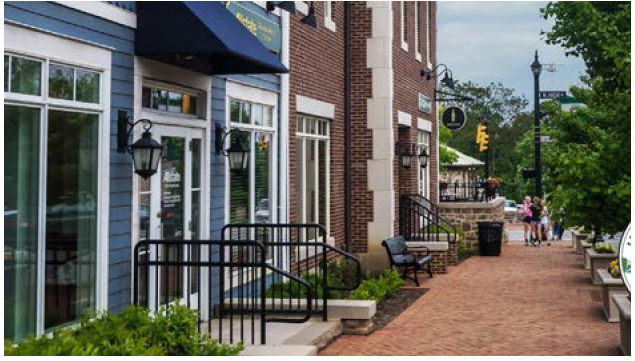
PEDESTRIAN ENVIRONMENT
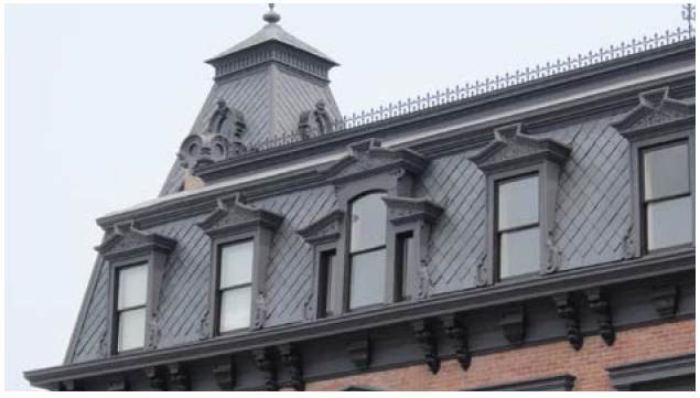
HISTORICALLY SIGNIFICANT ROOFS
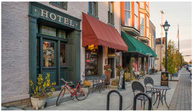
PEDESTRIAN ENVIRONMENT
EXTERIOR FINISHES
(c)
Color. Traditional colors and combination of those colors that are both identified with the origin or the era in which the structure of property was originally built, shall be used for exteriors of all new structures to be built, and reconstruction, remodeling and exterior maintenance of existing structures within the District. The Design Review Board shall adopt color guidelines that the Board and Division of Engineering will utilize in reviewing Certificate of Appropriateness applications.
(d)
Signs. All signs within the District shall conform to the color and material standards of this section, be of such a style or design that reflects the era during which the structure was built, and shall, except for the following exceptions, conform to the requirements of Chapter 1129.
(1)
Sign size should be minimized so as not to dominate the facade of the structure.
(2)
Sign color and design shall be compatible with the existing colors and design of the structure.
(3)
Signs shall not be permitted to cover, "blank out" or close existing window and doorway openings or otherwise hide important architectural features.
(e)
Guidelines. The design guidelines established in this chapter or any adopted design guidelines, design diagrams, or color guidelines by the Design Review Board are to be used in evaluating applications unless the Design Review Board determines that due to special circumstances other architectural designs are appropriate.
(Ord. No. 054-2020, Passed 11-23-2020; Ord. No. 045-2024, Passed 10-14-2024.)
1131.12 - DEMOLITION OF STRUCTURES.
The last alternative for a determined historically significant structure is demolition. In cases where an applicant applies for a Certificate of Appropriateness to demolish a structure within the District, the Design Review Board shall conduct a thorough investigation of the application for demolition and shall authorize a Certificate of Appropriateness only when (a) and either (b) or (c) below are satisfied:
(a)
Historical Significance. The architectural and historic significance of a structure to the character of the District shall be determined by the Design Review Board. In addition to the submittal requirements for a Certificate of Appropriateness in Section 1131.09, the applicant is required to include with the application a report or testimony from a historic preservation professional, architect, and/or consultant which verifies the historical significance, or non-significance, of the proposed structure to be demolished; and verifies the applicant has considered alternative historical uses of the structure including the preservation of the structure by a governmental or non-profit organization.
When the Division of Engineering receives a Certificate of Appropriateness application for demolition of a structure in the District, the application shall be forwarded to the Union County Historical Society. Within forty-five (45) days of sending the application to the Historical Society, the Historical Society shall provide information to the Design Review Board verifying any architectural or historic significance of the structure. The review may also include recommendations on alternative uses that may preserve the structure. Reasonable extensions may be given if the Historical Society requests them based on the need for additional research.
The Design Review Board shall make its determination after considering the following:
(1)
No Significance. If the Design Review Board finds the structure to have no architectural or historic significance based on its investigation outlined above, the Design Review Board shall approve the application for Certificate of Appropriateness to demolish the structure.
(2)
Significance. If the Design Review Board finds the structure to have architectural or historic significance based on its investigation outlined above, the Design Review Board shall not approve the demolition unless (b) or (c) are satisfied.
(b)
Economic Use. There exists no reasonable economic use for the structure as it exists or as it might be restored, and that there exists no feasible and prudent alternative to demolition as determined by the Design Review Board. At the City's expense, the
Design Review Board may hire an architect, engineer, or professional consultant to provide an independent report to the Design Review Board verifying the economic use of the structure as outlined above. The applicant shall permit access to the structure.
(c)
Deterioration. If deterioration has progressed to the point where it is not economically feasible to restore the structure as determined by the Design Review Board. At the City's expense, the Design Review Board may hire an architect, engineer, or professional consultant to provide an independent report to the Design Review Board verifying the economic feasibility to restore the structure as outlined above. The applicant shall permit access to the structure.
(Ord. No. 054-2020, Passed 11-23-2020; Ord. No. 039-2022, Passed 6-27-2022.)
1131.13 - PRESERVATION OF HISTORIC MATERIALS.
If the applicant satisfies the criteria to demolish a structure in the District and the Design Review Board decides to approve the demolition, the Design Review Board may conditionally approve the demolition with the following conditions:
(1)
Pictures. The applicant shall permit the Union County Historical Society to take interior and exterior pictures of the structure prior to demolition.
(2)
Preserving Features of Structure. The applicant shall permit the Union County Historical Society to inspect the structure's interior and exterior to determine any features or items of architectural or historic significance. If the applicant intends to demolish the features or items of architectural or historic significance, the applicant shall permit the Union County Historical Society at the Union County Historical Society's expense, to arrange for the removal of the features or items.
(Ord. No. 039-2022, Passed 6-27-2022.)
1131.14 - WAITING PERIOD FOR HISTORICALLY OR ARCHITECTURALLY SIGNIFICANT STRUCTURES.
The Design Review Board may impose a demolition waiting period of up to six (6) months for a building that is found to be historically or architecturally significant. Reasons for the Board to impose the waiting period include, but are not limited to, time necessary to secure a tangible funding source and plan to rehabilitate the building that the Design Review Board has determined to be historically significant.
(Ord. No. 039-2022, Passed 6-27-2022.)
1131.15 - DEMOLITION PROCESS.
(a)
The property or portion of property shall not be demolished until a replacement design has been approved by the Design Review Board.
(b)
If construction on the approved new structure has not commenced within six months following demolition, the site shall be reconditioned in accordance with Section 1131.16 until construction on the new structure has commenced.
(Ord. No. 039-2022, Passed 6-27-2022.)
1131.16 - REPLACEMENT OF STRUCTURES.
(a)
Demolition Authorization. If the Design Review Board approves the certificate of appropriateness to demolish a structure in the District, the applicant shall follow the process outlined below. Reconstruction shall comply with the Historic Uptown Guidelines in Chapter 1131 with approval from the City Engineer and the Design Review Board.
1.
Stand-Alone Structure:
a.
The site shall be cleared of all demolition materials including the foundation, sidewalks, fences, poles, etc. and ornamental shrubs or other plantings removed.
i.
Preserve trees where possible.
ii.
All pits or holes shall be filled and compacted.
b.
The entire site shall be graded so water will not pond or flow onto adjoining properties, but will flow to an authorized location.
c.
The site shall be thoroughly grass seeded and maintained thereafter.
d.
City sidewalks shall be left in good repair.
2.
Structure Adjoined by One or More Structures Before Demolition:
a.
The applicant shall secure a professional engineer in order to formally determine whether the building and adjoining building(s) is structurally dependent on each other. The Design Review Board may hire its own structural consultant, at the City's expense, if deemed necessary. The Design Review Board shall make a finding regarding the structural dependence that the building has on the adjoining building(s).
b.
Demolition of a building where it and adjoining building(s) is determined structurally dependent on each other prior to demolition by a Professional Engineer shall conform to the following guidelines.
i.
The applicant shall secure a licensed and insured Structural Professional Engineer to provide a plan for stabilization of surrounding structures and determine the method to raze the building and oversee the demolition. The plan shall be reviewed and approved by the City Engineer and the Union County Building Department.
ii.
The applicant shall post a $25,000 Maintenance Deposit from which the City may draw from in order to ensure that proper bracing and stability measures are taken.
iii.
The site shall be cleared of all demolition materials including the foundation, sidewalks, fences, poles, etc. and ornamental shrubs or other plantings removed.
1.
Preserve trees where possible.
2.
All pits or holes shall be filled and compacted.
iv.
The entire site shall be graded so water will not pond or flow onto adjoining properties, but will flow to an authorized location.
v.
The site shall be thoroughly grass seeded and maintained thereafter.
vi.
City sidewalks shall be left in good repair.
c.
If after the building is razed, it is determined by the Union County Building Department that the adjoining building(s) is dependent on the demolished structure, when prior to demolition they were thought to not be dependent on each other, Section 2.b above is required to be followed.
d.
If after the building is razed and the adjoining building or buildings are determined not to be dependent on the removed building, the site shall be cleared.
i.
If a replacement building is not planned to be constructed within one year:
1.
The site shall be cleared of all demolition materials including the foundation, sidewalks, fences, poles, etc. and ornamental shrubs or other plantings removed.
i.
Preserve trees where possible.
ii.
All pits or holes shall be filled and compacted.
2.
The entire site shall be graded so water will not pond or flow onto adjoining properties, but will flow to an authorized location.
3.
The site shall be thoroughly grass seeded and maintained thereafter.
4.
City sidewalks shall be left in good repair.
(Ord. No. 039-2022, Passed 6-27-2022.)
1131.17 - APPEALS.
Any person whose plan has been disapproved or who has otherwise been aggrieved by a decision of the Design Review Board, Division of Engineering or their respective designees may appeal that decision to the Board of Zoning Appeals.
(Ord. No. 054-2020, Passed 11-23-2020; Ord. No. 039-2022, Passed 6-27-2022.)
Editor's note— Ord. No. 039-2022, passed June 27, 2022, added new provisions designated as §§ 1131.13—1131.16, and subsequently redesignated former § 1131.13 as § 1131.17.
1133.01 - PURPOSE.
The purpose of Design Review is to apply standards that preserve and/or enhance the architectural integrity and exterior appearance of developments in the City of Marysville, and by so doing, promote the public health, safety, and welfare of the residents and visitors to the community.
(Ord. No. 054-2020, Passed 11-23-2020.)
1133.02 - INTENT.
The intent of the design review process is to:
(a)
Ensure that the location, configuration, and architectural design of buildings and their materials and colors are visually harmonious on the planned site and with surrounding development and the environment.
(b)
Ensure that the location, configuration, and design of signs and their materials and colors are consistent with the character and scale of the buildings to which they relate and surrounding development.
(c)
Safeguard and enhance the visual and aesthetic character, diversity and quality of the City to protect and enhance the City's attractiveness to residents, tourists and visitors, and to stimulate business and industry by encouraging excellence in design.
(d)
Encourage superior design quality of the City and strengthen civic pride in the aesthetic environment of Marysville.
(Ord. No. 054-2020, Passed 11-23-2020.)
1133.03 - ESTABLISHMENT; DUTIES AND RESPONSIBILITIES.
(a)
Establishment. The Design Review Board is hereby established. The Design Review Board shall consist of seven members. Of the seven members, four members shall be appointed by City Council, each being residents of the City. The remaining three members shall be appointed by the City Manager from members of the Planning Commission. Terms of office shall be for five (5) years, provided that upon initial formation of the Board, one Council appointee shall be appointed for one (1) year, one Council appointee shall be appointed for two (2) years, one Council appointee shall be appointed for three (3) years, and one Council appointee shall be appointed for four (4) years. The term for a City Manager appointed Board member shall expire at the same time as his/ her term on the Planning Commission expires.
Term shall begin thirty (30) days after enactment of this legislation. Any member appointed to fill a vacancy occurring prior to the expiration of the term for which his/her predecessor was appointed shall hold office for the remainder of the term.
As determined appropriate by City Council, members of the Design Review Board may receive compensation. To provide a well qualified Design Review Board, a good faith effort should be made to appoint at least four of the seven members who have the following professional experience:
(1)
An individual who is a commercial property owner or business person who operates a commercial business;
(2)
An engineer, an architect or a person who has engineering or architectural experience;
(3)
A contractor or a person who has construction experience;
(4)
A landscape architect or landscape contractor or a person who operates a nursery or has landscaping experience; or,
(5)
A historic preservation specialist, or an individual who has extensive historical preservation or building inspection experience.
(b)
Duties and Responsibilities. The Design Review Board shall review Certificate of Appropriateness and Exterior Plan applications in accordance with Chapters 1121 and 1131.
The Design Review Board shall also perform any other duties outlined in this Planning and Zoning Ordinance and in approved Rules of Procedure for its operation.
(c)
Rules of Procedure. The Rules of Procedure are on file with the City and shall be available for public inspection upon request.
(d)
Maintaining a System for the Survey of Historic Properties. The Design Review Board shall maintain a system for the survey and inventory of historic properties, including the following:
(1)
The Board shall initiate or maintain a process approved by the Ohio Connection for the survey and inventory of resources within its jurisdiction.
(2)
The Board shall maintain a detailed inventory of the designated districts, sites and structures under its jurisdiction.
(3)
The Board shall maintain securely all inventory material, and have that inventory available to the public.
(4)
The Board shall maintain the inventories on Ohio Historic Inventory/Ohio Archaeological Inventory forms, or forms compatible with the Ohio Connection's computerized inventory.
(5)
The Board shall make the appropriate inventory forms available to the Ohio Connection through duplicates (with contact prints).
(6)
The Board shall periodically update the inventory forms to reflect changes.
(Ord. No. 054-2020, Passed 11-23-2020.)
1133.05 - EXTERIOR PLAN REQUIRED BY DESIGN REVIEW BOARD FOR BUILDING TYPOLOGIES.
(a)
A zoning permit for a structure(s) classified as a New Structure or Modification shall be issued only after an Exterior Plan has been submitted to and approved by the Design Review Board, or as approved per Section 1133.071 or Section 1133.072.
(b)
The Exterior Plan, as approved, shall be part of the zoning permit and the development shall be constructed in conformity with the Exterior Plan as approved by the Design Review Board.
(c)
Properties located within the Historic Design Review District(s) and Landmark(s) (Including the Historic Uptown Marysville Design Review district) shall be subject to Chapter 1131 of the Planning and Zoning Ordinance and the Design Guidelines for Historic Uptown Marysville, Ohio and shall not be subject to the Design Review standards in this chapter.
(Ord. No. 054-2020, Passed 11-23-2020.)
1133.06 - EXTERIOR PLAN APPLICATION.
(a)
Applications for the approval of the Exterior Plan Application:
(1)
Shall be filed with the City on forms provided by the City;
(2)
Shall include all required supplemental information;
(3)
Shall be submitted by the application deadline as established by the City;
(4)
Shall be signed by the applicant and owner attesting to the truth and exactness of all information supplied on the application.
(b)
Staff shall review the submitted materials for completeness and shall:
(1)
If it is found to be complete, place the Exterior Plan application on the next appropriate Design Review Board agenda; or
(2)
If it is found to be incomplete, reject the application and return the application and fee to the applicant with an itemization of deficiencies.
(c)
Prior to the Design Review Board's review of an application for Exterior Plan review, the City shall publish a notice of the hearing in selected multiple media outlets at least seven (7) days prior to the date of the hearing. The City shall send notice of the Design Review Board's review of an application for Exterior Plan review at least ten (10) days before the regularly scheduled Planning Commission meeting to all owners of properties contiguous to or directly across from the property concerned via first-class mail. Notwithstanding anything to the contrary herein, such notices shall not be required for any application that pertains to City-owned property.
(d)
Exterior work on a structure that requires approval by the Design Review Board shall not commence until approval is granted by the Design Review Board. Should work commence prior to the Design Review Board approval, the property owner shall be subject to penalties per Section 1145.99 of this Planning and Zoning Ordinance.
(Ord. No. 054-2020, Passed 11-23-2020; Ord. No. 031-2025, Passed 9-22-2025.)
1133.07 - EXTERIOR PLAN APPROVAL.
(a)
The Design Review Board shall, after receipt of reports from City staff and the applicable City Commissions, determine whether the Exterior Plan shall be approved, conditionally approved, or disapproved. The Exterior Plan shall not be approved unless the Design Review Board finds that:
(1)
All of the applicable provisions in the Planning and Zoning Ordinance have been satisfied; and
(2)
That the site plan meets the purpose and intent of this chapter, including the location and configuration of the building(s), landscaping, off-street parking, driveways and site amenities are visually harmonious within the site and its surroundings.
(b)
If the Exterior Plan is disapproved, the reasons for a disapproving vote shall be stated by those members and it shall be captured in the minutes of the meeting.
(c)
Exterior Plans must be approved, conditionally approved or disapproved within thirty (30) working days from the date of receipt. This thirty (30) day period may be extended by the mutual agreement of the Design Review Board and the applicant.
(d)
Exterior Plan approval shall be for a period not to exceed two (2) years from the approval date of the Exterior Plan. If no construction has begun within two (2) years after approval is granted, the approved Exterior Plan shall become null and void; provided however, the two year approval period may be extended for a period between six (6) months and one (1) year with the approval of the Division of Engineering.
(e)
Exterior plans approved prior to the adoption of this section, in which work has not commenced, shall become null and void one (1) year after the adoption of this section.
(Ord. No. 054-2020, Passed 11-23-2020.)
1133.071 - REVISIONS TO PLANS AFTER APPROVAL.
Exterior Plans which have been previously approved by the Design Review Board and require minor modifications may be made with the approval of the City Manager, City Engineer and the Chair of the Design Review Board. To apply, the applicant shall submit to the City Division of Engineering four (4) sets of the previously approved plans and the proposed minor modification, along with a written statement explaining the reason for the proposed minor modification. Within ten (10) working days after the plan submission, the City Manager, City Engineer and the Chair of the Design Review Board shall review and approve or disapprove the minor modification. Approval shall be granted only if the City Manager, City Engineer and the Chair of the Design Review Board unanimously agree the minor modification does not significantly change the previously approved plan. If unanimous consent is not obtained, the proposed minor modifications are disapproved and can only be made if approved by the Design Review Board.
(Ord. No. 054-2020, Passed 11-23-2020.)
1133.072 - EXTERIOR PLAN APPROVAL FOR NEW STRUCTURES AND/OR MODIFICATIONS TO EXISTING STRUCTURES NOT VISIBLE FROM ANY STREET RIGHT-OF-WAY.
Exterior Plan Approval for new structures and/or modifications to existing structures may be approved by the City Engineer, City Manager and the Chair of the Design Review Board unanimously determine that the new structures and/or modifications will not be visible from any existing or foreseeable future street right-of-way. The proposed new structures and/or modifications shall meet all applicable design requirements established in Sections 1133.08 - 1133.11 hereof. Said sections shall not apply to properties located within any designated Historic Design Review District(s) and Landmark(s); including the Historic Uptown Marysville Design Review District.
(Ord. No. 054-2020, Passed 11-23-2020.)
1133.08 - DESIGN REVIEW BUILDING TYPOLOGIES ESTABLISHED.
In order to apply the appropriate design review standards to different forms of development within the City, the following Design Review Typologies are hereby established:
(a)
Multi-Family and Single-Family (attached) Building Typologies. The Multi-Family and Single-Family (attached) Building Typologies shall include any single-family (attached) or multi-family development constructed upon any property located in the zoning districts or any planned unit development that is to be developed with a single-family (attached) building typology or a multi-family building typology.
(b)
Office, Institutional, Mixed-Use and Commercial Building Typologies. The Office, Institutional, Mixed-Use, and Commercial Building Typologies shall include any office, institutional, mixed-use, or commercial development constructed upon any property that is to be developed as a commercial, office, retail or institutional use and is located within a planned unit development or other zoning district.
(c)
Office/Warehouse and Manufacturing Building Typologies. The Manufacturing Typology shall include any Office/Warehouse or Manufacturing development constructed in the M/I District, Light Manufacturing District or the M/I Overlay or any planned unit development that is to be developed with a manufacturing building typology.
(d)
The Design Review Board also reviews Certificate of Appropriateness applications for any Historic Design Review District(s) and Landmark(s) as defined in this Planning and Zoning Ordinance.
(Ord. No. 054-2020, Passed 11-23-2020.)
1133.09 - DESIGN REVIEW STANDARDS FOR MULTI-FAMILY AND SINGLE-FAMILY (ATTACHED) BUILDING TYPOLOGIES.
The purpose of the design review standards for the Multi-Family Building Typology and Single-Family (attached) Building Typology is to encourage a high quality, attractive, and lasting style in higher density residential developments in the form of single-family residential and multi-family developments.
(a)
Building Architecture.
(1)
Design. All buildings shall provide visual interest that will be consistent with the community's identity, character and scale. Buildings shall be designed to be seen from three hundred sixty (360) degrees and have the same level of finish on all elevations. Building additions and accessory structures, whether attached or detached, shall be of similar design, materials, and construction to that of the existing or Principal structure.
(2)
Color. Specific colors and color schemes shall be designed to be compatible and harmonious with those of the buildings in the surrounding area. Facade colors shall be subtle and of low reflectance. Accent colors may be used to highlight architectural and design features. Permitted colors shall include the full spectrum of colors included in industry-standard color palettes, except for prohibited colors as described herein.
Prohibited colors shall include any colors included in day-glow, neon, metallic and/or high-chroma color palettes.
(3)
Architectural and Design Features. The purpose of requiring four-sided architecture is to avoid large areas of blank exterior. For every one hundred (100) feet of elevation width, each side and rear elevation must contain at least two (2) architectural and design features and each front elevation must contain at least three (3) architectural and design features. For multi-story buildings, each story on a single elevation shall contain at least two (2) architectural or design features. Architectural and design features are as follows;
A.
A door of at least twenty-eight (28) square feet in area with an awning, window, faux window or other feature subject to approval by the Design Review Board.
B.
A window of at least six (6) square feet in area. Windows located closer than ten (10) feet shall be considered as one (1) design feature. A set of adjacent windows, such as double or bay windows, shall be considered as one (1) design feature.
C.
A chimney.
D.
An articulated Gable Vent of at least four (4) square feet in area.
E.
Porches, decks or similar structures.
F.
Canopies or porticos, integrated with buildings massing and style.
G.
Overhangs a minimum of three (3) feet wide.
H.
Arcades a minimum of six (6) feet wide.
I.
Ornamental material and structural details that are integrated into the building structure.
J.
Artwork (excluding corporate logos), including murals.
K.
A similar significant permanent architectural or design consistent with the style of the building upon approval by the Design Review Board.
(4)
Articulation. A building frontage that exceeds a width of fifty (50) feet shall incorporate articulation and offset of the wall plane to inhibit a large expanse of blank wall and add interest to the facades.
Where a structure has a front-loaded garage, the garage shall be placed a minimum of two (2) feet in front of or behind the front building facade.
(5)
Materials. Building materials shall be of high quality and durability, and architectural features shall be used to create visual interest and livability of the multi-family dwellings. All structures shall be designed to be architecturally compatible with each other by employing similar roof pitches, architectural details and be constructed of compatible exterior building materials. A minimum of forty percent (40%) of each and every facade, visible from a street or right-of-way as determined by the Design Review Board, exclusive of windows, doors, and garage doors shall be constructed of permitted primary materials as determined by the Design Review Board. A maximum of sixty percent (60%) of each and every facade, visible from a street or right-of-way as determined by the Design Review Board, exclusive of windows, doors, and garage doors shall be constructed of permitted secondary materials as determined by the Design Review Board. Other facades shall use a combination of permitted primary and permitted secondary materials, as determined by the Design Review Board. Use of a permitted secondary material for an entire facade is not permitted.
A.
Permitted primary building materials shall be high quality, durable materials as determined by the Design Review Board. Permitted primary building materials may include, but are not limited to brick, fiber cement siding, glass (glazed aluminum or steel curtain walls), stone, manufactured stone, and wood siding.
B.
Permitted secondary building materials shall be determined by the Design Review Board. Permitted secondary building materials may include, but are not limited to stucco, metal, and split faced concrete block.
C.
Aluminum and/or vinyl shall be allowed for trim details, such as soffits, gutters, shutters, etc., and shall not be used as a permitted primary material.
D.
Minimum butt thickness of clapboard siding shall be a quarter of an inch.
E.
Permitted Secondary materials may be used as Primary building materials as determined and approved by the Design Review Board.
F.
Other High quality durable materials may be approved as permitted primary or secondary materials by the Design Review Board with examples of successful, high quality installations in similar construction applications.
(6)
Roofing. Roofing shall be compatible and harmonious with building materials and color scheme. All pitched roofs shall be of dimensional shingles, standing seam metal, slate, or simulated slate.
(b)
Site Design.
(1)
Site layout. Principal buildings, accessory buildings, fencing, parking areas, access drives, storm water facilities, pedestrian walkways, and landscaping shall be arranged to provide a visually appealing development that takes the existing topographic features and neighboring properties into consideration. Aesthetically pleasing attributes shall be visible throughout the entire development and the public right-of-way. Multi-family structures shall be located no closer than twenty (20) feet from other such structures.
(2)
Natural features. Existing natural features such as lakes, ponds, streams, ravines, woodlands, and wetlands shall be retained and incorporated into the new development.
(3)
Open Space. Open space areas in multi-family developments shall be provided for recreational activities for the residents and shall maintain the residential character of the development. If the development is adjacent to a public park, school, recreational area or commercial area, or similar type area, the developer shall provide pedestrian access to those areas.
(4)
Parking Bays. No Parking bay shall contain more than twenty-four (24) total parking spaces, with a maximum of twelve (12) spaces in a single row.
(5)
Parking Lot Islands. Each landscaped tree island in a single loaded parking stall design shall be a minimum area of one hundred and seventy-one (171) square feet with a minimum width of nine (9) feet. Each landscaped island located in a double loaded parking stall design shall have a minimum area of three hundred twenty four (324) square feet, with a minimum width of nine (9) feet. The landscaped tree island(s) shall contain at least one (1) shade tree and include at least fifty (50) square feet of other plant materials.
(6)
Bioswales. Bioswales, also referred to as rain gardens, may be incorporated in the overall parking lot design. In addition to separating parking bars, when properly designed bioswales/rain gardens can also assist with stormwater quality and quantity management.
(7)
Intersection Site Distance. When a drive isle intersects with an internal service road, nothing shall materially impede the vision between a height of two and one-half (2 ½) feet and ten (10) feet for the area bounded by the intersecting street lines of those roadways and a line joining points along said roadways fifteen (15) feet from the point of intersection.
(8)
Parking and access drives. All vehicle uses areas, including but not limited to parking areas and access drives, shall consist of a paved surface material with concrete curb. Paved surface materials shall consist of a sealed surface material of asphalt or concrete and along with the curbing shall be constructed to City standards unless a viable or environmentally friendly solution is recommended by the Design Review Board and approved by the City Engineer. The length from the parking area to the building should not be greater than 250 feet.
(9)
Sidewalk and Bike Path. Site design shall provide a pedestrian friendly system. All developments shall provide pedestrian walkways between public sidewalks/streets and building entrances. Sidewalks shall also be installed along all existing public streets if sidewalks do not presently exist. Sidewalks shall be constructed according to the minimums set forth in the "Standard Construction Drawings" of the City.
(10)
Lighting. Lighting shall enhance the visual appearance of the development. The color and design of the light poles and fixtures shall be designed to complement the architectural character of the buildings. All outdoor lighting shall be directed, reflected or shielded so as not to be of excessive brightness or cause glare hazardous to pedestrians, or drivers, create a nuisance or unreasonably interfere with a neighboring property owner's right to enjoy his property. Light spillage shall not exceed one tenth (0.1) foot candles when adjacent to a residential district or existing residential use.
(11)
Fencing. Chain link, barbed wire, razor barb, and electrically charged fencing are not permitted. Masonry, wood, vinyl fencing, or decorative metal fencing is encouraged.
(12)
Landscaping. Landscaping shall comply with the requirements outlined in Chapter 1125.
(c)
Trash Enclosures. Except for single-family attached dwellings that do not have centralized refuse areas and notwithstanding anything to the contrary in this Zoning Code, trash containers or receptacles (including recycling containers) shall be screened or enclosed with a trash enclosure meeting the following criteria:
(1)
Trash Containers, service areas and loading zones shall be located at the rear of the building. Trash containers, service areas and loading zones may be permitted on the side of a building if not oriented towards a public or private street and properly screened from public or private streets and residential zoning districts.
(2)
The trash enclosure shall have four (4) sides with opening doors for the purpose of trash removal.
(3)
The building materials used for the trash enclosure shall be compatible with the building materials used on the principal building. Except for gates and doors providing access to the trash enclosure, the trash enclosure shall be constructed of metal, vinyl, masonry, or other durable materials, but shall not be constructed of wood, and shall have an opacity of one hundred percent (100%) and a height of two (2) feet above the top of the tallest container. The gates and doors providing access to the trash enclosure shall consist of steel posts and steel-framed doors constructed of wood, vinyl, hardiplank, metal, or other material of similar durability.
(4)
The trash enclosure shall be constructed so that the opening doors are wide enough to accommodate a garbage truck emptying and replacing the trash container or receptacle.
(5)
A reinforced concrete pad and approach apron shall be constructed under and in front of the enclosed area.
(6)
The location of enclosures shall be as inconspicuous as possible.
(Ord. No. 054-2020, Passed 11-23-2020; Ord. No. 049-2025, Passed 11-24-2025.)
1133.10 - DESIGN REVIEW STANDARDS FOR OFFICE, INSTITUTIONAL, MIXED-USE AND COMMERCIAL BUILDING TYPOLOGIES.
The purpose of the design standards for the Office, Institutional, Mixed-Use and Commercial Building Typologies is to encourage a high quality, attractive and lasting style in commercial and office development throughout the City of Marysville.
(a)
Building Architecture.
(1)
Design. All buildings shall provide visual interest that will be consistent with the community's identity, character and scale. Buildings shall be designed to be seen from three hundred sixty (360) degrees and have the same level of finish on all elevations. Building additions and accessory structures, whether attached or detached, shall be of similar design, materials, and construction to that of the existing or Principal structure.
(2)
Color. Specific colors and color schemes shall be designed to be compatible and harmonious with those of the buildings in the surrounding area. Facade colors shall be subtle and of low reflectance. Accent colors may be used to highlight architectural and design features. Permitted colors shall include the full spectrum of colors included in industry-standard color palettes, except for prohibited colors as described herein.
Prohibited colors shall include any colors included in day-glow, neon, metallic and/or high-chroma color palettes.
(3)
Architectural and Design Features. The purpose of requiring four-sided architecture is to avoid large areas of blank exterior. For single-story buildings, along every one hundred (100) feet of elevation width, each side and rear elevation must contain at least two (2) architectural and design features and each front elevation must contain at least three (3) architectural and design features. For multi-story buildings, along every one hundred (100) feet of elevation width, each story on a single elevation shall contain at least two (2) architectural and design features. Typical architectural and design features are as follows:
(A)
A door of at least twenty-eight (28) square feet in area with an awning, window, faux window or other feature subject to approval by the Design Review Board.
(B)
A window of at least six (6) square feet in area. Windows closer than ten (10) feet shall be considered as one (1) design feature. A set of adjacent windows, such as double or bay windows, shall be considered as one (1) design feature.
(C)
A chimney.
(D)
An articulated Gable Vent of at least four (4) square feet in area.
(E)
Porches, decks or similar structures.
(F)
Canopies or porticos, integrated with buildings massing and style.
(G)
Overhangs a minimum of three (3) feet wide.
(H)
Arcades a minimum of six (6) feet wide.
(I)
Ornamental material and structural details that are integrated into the building structure.
(J)
Artwork (excluding corporate logos), including murals.
(K)
A similar significant permanent architectural or design consistent with the style of the building upon approval by the Design Review Board.
(3.1)
Multi-Tenant Entrance Features. Buildings serving more than one (1) tenant are recommended to delineate individual entrances with awnings, columns, canopies or porticoes, arches, or similar architectural features. These elements shall not count towards the architectural and design features required in Section 1133.10(a)(3).
(4)
Articulation. A building frontage that exceeds a width of fifty (50) feet shall incorporate articulation and offset of the wall plane to inhibit a large expanse of blank wall and add interest to the facades.
(5)
Materials. A minimum of eighty percent (80%) of each and every facade, visible from a street or right-of-way as determined by the Design Review Board, exclusive of windows, doors, and garage doors shall be constructed of permitted primary materials as determined by the Design Review Board. All portions of a facade not otherwise constructed of primary materials, exclusive of windows, doors, and garage doors shall be constructed of permitted secondary materials as determined by the Design Review Board. Other facades shall use a combination of permitted primary and permitted secondary materials, as determined by the Design Review Board.
Use of a permitted secondary material for an entire facade is not permitted.
A.
Permitted primary building materials shall be high quality, durable materials as determined by the Design Review Board. Permitted primary building materials may include, but are not limited to brick, fiber cement siding, glass (glazed aluminum or steel curtain walls), stone, manufactured stone, and wood siding. Spandrel glass is not a permitted primary building material.
B.
Permitted secondary building materials shall be determined and approved by the Design Review Board. Permitted secondary building materials may include, but are not limited to stucco, metal, and split faced concrete block.
C.
Aluminum and/or vinyl shall be allowed for trim details, such as soffits, gutters, shutters, etc., and shall not be used as a permitted primary material.
D.
Minimum butt thickness of clapboard siding shall be a quarter of an inch.
E.
Permitted Secondary materials may be used as Primary building materials as determined and approved by the Design Review Board.
F.
Other high quality durable materials may be approved as permitted primary or secondary materials by the Design Review Board with examples of successful, high quality installations in similar construction applications.
(6)
Glass. Elevations facing the primary street shall be a minimum of forty percent (40%) glass between the height of two (2) feet and ten (10) feet and have an unobstructed view of the building interior to a depth of four (4) feet. The use of black, gold, green, silver, or any other reflective colored glass on a building is prohibited. Spandrel glass is permitted but shall not be used to meet the minimum forty percent (40%) glass requirement of this paragraph. Frosted glass may be permitted in some cases, subject to approval of the Design Review Board.
(7)
Building Orientation. Buildings shall be oriented to face the primary street right-of-way. An entryway shall be located on the front of the building. Corner entrances are acceptable to meet this requirement if one side of the corner entrance faces the primary street right-of-way.
(8)
Roofing. All pitched roofs shall be of dimensional shingles, standing seam metal, slate, or simulated slate.
(9)
Mechanical Equipment. All external and rooftop mechanical equipment, including satellite antennas, and trash dumpsters shall be screened from view at all property lines on which the building is located. Screening materials shall be complimentary to those used on the majority of the building. For ground mounted equipment, landscaping is the preferred method of screening. If two (2) or more buildings are located on the same property, rooftop equipment shall not be visible at ground level within fifty (50) feet from any building.
(10)
Drive Thru Features. A drive thru shall be designed as an integral part of the structure it serves. Features incorporated with a drive thru, including, but not limited to canopies, awnings, and support posts, shall match the materials and color scheme of the building they are serving. Drive thru features shall not have any pick-up windows, ordering areas, signage, or other related items located on the front elevation of a building or located between the front of the building and street right-of-way. Where a structure served by a drive-thru is located on a corner lot, the orientation of the drive-thru and the principal structure shall be located in accordance with subsection (a)(7) Building Orientation above.
(11)
In-Line Retail Exemption. Side or rear elevations of in-line retail developments may be exempt from the building design standards of section 1133.10 if such elevations are not visible to customer traffic, a public right-of-way or if a future phase of the inline retail development is forthcoming adjacent to the elevation. Such exempt elevations shall use materials complimentary to the primary elevation and be screened by landscaping, mounding, fencing, or a combination thereof, as outlined in section 1133.10 and as deemed appropriate by the Design Review Board.
(12)
Outdoor Display and Storage Areas. Outdoor display of merchandise for sale, including outdoor dining, and outdoor storage or foods and materials, other than for automotive sales, shall comply with the following.
A.
General Requirements.
1.
Location.
a.
Areas devoted to outdoor display or outdoor storage shall comply with all building setbacks and yard regulations for the district in which they are located as set forth in this chapter.
b.
All outdoor display and storage areas must be contiguous to the principle building; however, such areas shall be spaced a sufficient distance from the building, as dictated by the City Fire Department, to satisfy any safety requirements.
c.
No outdoor display or storage area shall be permitted to occupy or interfere with traffic circulation, required parking areas, public sidewalks or pedestrian access.
2.
Area. The area of the lot devoted to outdoor display and storage shall not exceed twenty-five percent (25%) of the ground floor area of the principal building. This limitation shall not apply when outdoor display is listed as a permitted use.
3.
Surfacing. Areas devoted to outdoor display and storage shall be paved with asphalt or concrete and free of dust.
4.
Height.
a.
Outdoor display area located in front of a principal building shall not exceed a height of six (6) feet.
b.
The height of outdoor display or outdoor storage areas which are located to the side or rear of the building shall be determined by the Design Review Board. Such determination shall take into account such issues as proposed fencing and /or walls, roofing materials, if any, and landscape and screening
5.
Supplemental Regulations for Outdoor Display. The outdoor display area must be defined by or contained within an appropriate architectural or decorative demarcation as approved by the Design Review Board. This may include the use of landscaping elements, fencing, walls or other appropriate material. If building materials are utilized, the materials shall be consistent with the architectural design of the Principal structure as approved by the Design Review Board.
6.
Gas Stations Canopies.
a.
Canopy Structures with a pitched roof shall use dimensional shingles, standing seam metal, slate, or simulated slate. Flat roof canopy structures may be used only if they utilize matching building materials that complement the primary structure.
b.
Signage on canopy structure shall be prohibited.
c.
Canopy support columns shall be 100% permitted primary building materials on each and every side of the column. Canopies shall match the building materials used on the principal building and include a minimum of four (4) columns per canopy structure to be located at the corners of the canopy structure. Columns shall be at a minimum twenty-four (24) inches in width.
d.
Canopy structures shall have no exposed downspouts.
(b)
Site Design.
(1)
Site layout. Principal buildings, accessory buildings, fencing, parking areas, access drives, storm water facilities, pedestrian walkways, and landscaping shall be arranged to provide a visually appealing development that takes the existing topographic features and neighboring properties into consideration.
(2)
Build-To-Line. To promote quality streets, buildings shall be located at the build-to-lines along public roadway frontages. Build-to-lines shall refer to the associated front yard setback as stated in each applicable zoning district.
A.
In order to achieve quality streetscapes, variation from the build-to-line will be permitted to allow for added green space, amenities, outdoor seating and the like. Buildings may be located further from the right-of-way than the established build-to-line per the following;
B.
At least fifty percent (50%) of the building's front elevation shall be located within the applicable variation from the build-to-line range.
C.
Uncovered seating areas or freestanding architectural features may be located between the building and the right-of-way line or sidewalk, whichever is closer.
D.
Buildings larger than twenty thousand (20,000) square feet or attached to existing in-line retail space shall be exempt from the build-to-line requirements if located more than three hundred (300) feet from the right-of-way
E.
Gas stations may be exempt from the build-to-line requirements if the following items are met:
a.
Gas pump shall be located under a canopy structure.
b.
Canopy structure(s) shall be located as close as practicable to the build-to-line.
c.
The application shall otherwise comply with the gas station canopy requirements set forth under subsection (f) below.
(3)
Natural Features. Existing natural features such as lakes, ponds, streams, ravines, woodlands, and wetlands shall be retained and incorporated into the new development.
(4)
Fencing. Where permitted under the regulations for the base zoning district, chain-link fencing shall be limited to the side yard and rear yards of the primary building. Masonry, wood, vinyl, or decorative metal fencing is encouraged. Barbed wire, razor barb and electrically charged fencing are only permitted under the base zoning regulations with the applicable governmental approvals.
(5)
Landscaping. Landscaping shall comply with the requirements outlined in Chapter 1125.
(6)
Sidewalk and Bike Path. Site design shall provide a pedestrian friendly system. All developments shall provide pedestrian walkways between public sidewalks/streets and building entrances. Sidewalks shall also be installed along all existing public streets if sidewalks do not presently exist. Sidewalks shall be constructed according to the minimums set forth in the "Standard Construction Drawings" of the City.
(7)
Adjacent Pavement. Pavement is prohibited directly adjacent to any building elevation, except for loading areas, vehicular building entrances, and drive thru windows, or at entrance walkways into the building
(8)
Utility Boxes. Utility boxes shall be located to the rear of the building and, when so permitted by the applicable utility, painted to match the surroundings where the utility box is located.
(c)
Trash Enclosures. Trash containers or receptacles (including recycling containers) shall be screened or enclosed with a trash enclosure meeting the following criteria:
(1)
Trash Containers, service areas and loading zones shall be located at the rear of the building. Trash containers, service areas and loading zones may be permitted on the side of a building if not oriented towards a public or private street and properly screened from public or private streets and residential zoning districts.
(2)
The trash enclosure shall have four (4) sides with opening doors for the purpose of trash removal.
(3)
The building materials used for the trash enclosure shall be compatible with the building materials used on the principal building. Except for gates and doors providing access to the trash enclosure, the trash enclosure shall be constructed of metal, vinyl, masonry or other durable materials, but shall not be constructed of wood, and shall have an opacity of one hundred percent (100%) and a height of two (2) feet above the top of the tallest container. The gates and doors providing access to the trash enclosure shall consist of steel posts and steel-framed doors constructed of wood, vinyl, hardiplank, metal, or other material of similar durability.
(4)
The trash enclosure shall be constructed so that the opening doors are wide enough to accommodate a garbage truck emptying and replacing the trash container or receptacle.
(5)
A reinforced concrete pad and approach apron shall be constructed under and in front of the enclosed area.
(6)
The location of enclosures shall be as inconspicuous as possible.
(d)
Parking Lot Design. Except as otherwise provided herein, parking lot areas shall be designed to reduce their visual impact, production of excess heat and effect on drainage, appropriately sized landscape areas shall be provided within each parking lot area allowing for a variety of shade trees to be planted that will not buckle the parking lots surface and at the same time provide shade. Therefore, all off-street parking lot areas shall be designed using the "parking bay" concept, which consists of parking spaces grouped together and each parking bay separated by landscape tree islands.
(1)
Parking and Access Drives. All Vehicle use areas, including but not limited to parking areas, driveways, aisles, access drives and other circulation areas, shall consist of a paved surface material with asphalt or concrete and along with the curbing shall be constructed to City standards unless a viable or environmentally friendly solution is recommended by the Design Review Board and approved by The City Engineer.
(2)
Parking Lot Locations. All parking spaces, drives, or other structures for vehicular parking or movement shall be located to the rear or side of the principal building with no more than fifty percent (50%) of such parking area located to the side of the principal building.
a.
Buildings larger than twenty thousand (20,000) square feet or attached to existing in-line retail space shall be permitted to have parking to the front of the building if the building is located more than three hundred (300) feet from the right-of-way and the parking lot is located no closer than two hundred (200) feet from the right-of-way.
b.
If a drive thru is located on-site and designed per section 1133.10(a)(10), a drive lane may be permitted to be located in front of the building. In such case, the building shall be moved the furthest away from the build-to-line as indicated in section 1133.10(b)(1)(A).
(3)
Parking Bays. No Parking bay shall contain more than twenty-four (24) total parking spaces, with a maximum of twelve (12) spaces in a single row.
(4)
Maximum Number of Parking Spaces. Off-street parking areas shall only be permitted to have twenty-five percent (25%) more spaces than stated as the applicable minimum in Chapter 1127 of this Planning and Zoning Ordinance.
(5)
Parking Lot Islands. Each landscaped tree island in a single loaded parking stall design shall be a minimum area of one hundred and seventy-one (171) square feet with a minimum width of nine (9) feet. Each landscaped island located in a double loaded parking stall design shall have a minimum area of three hundred twenty four (324) square feet, with a minimum width of nine (9) feet. The landscaped tree island(s) shall contain at least one (1) shade tree and include at least fifty (50) square feet of other plant materials.
(6)
Bioswales. Bioswales, also referred to as rain gardens, may be incorporated in the overall parking lot design. In addition to separating parking bars, when properly designed bioswales/rain gardens can also assist with stormwater quality and quantity management.
(7)
Intersection Site Distance. When a drive isle intersects with an internal service road, nothing shall materially impede the vision between a height of two and one-half (2 ½) feet and ten (10) feet for the area bounded by the intersecting street lines of those roadways and a line joining points along said roadways fifteen (15) feet from the point of intersection.
(e)
Site Lighting. Site lighting shall be required for all developments and be designed to sufficiently illuminate the site and minimize spillover off of the property.
(1)
Design. All external lighting shall be decorative in design. Typical "shoe box" light fixtures are not acceptable. Pack light, wall pack lights and similar lights that primarily shine perpendicular to (away from) a building's elevation are not permitted on any building elevation. Decorative wall lights that shine parallel to (up or down) a building's elevation are subject to approval by the Design Review Board.
(2)
Lighting Intensity. Foot candles measure the intensity of light. One (1) foot candle is equal to the amount of light generated by one (1) candle shining on a square foot surface one (1) foot away. All Parking lot areas shall have lighting intensity meeting the following standard as measure at grade;
•
Maximum Intensity: 20 Foot Candles
•
Average Intensity: 1 to 3 Foot Candles
(3)
Light Spillage. All outdoor lighting shall be directed, reflected or shielded so as not to be of excessive brightness or cause glare hazardous to pedestrians, or drivers, create a nuisance or unreasonably interfere with a neighboring property owner's right to enjoy his property. Light spillage shall not exceed one tenth (0.1) foot candles when adjacent to a residential district or existing residential use.
(4)
Light Pole Height. Pole heights should be in harmony with the parcel, building and parking lot size as well as the surrounding area. Smaller parcels in a denser condition pole height should be limited in height to respond to the smaller parcels and more human scale of the site. In large commercial centers with large building footprints, parcels and parking lots, the pole heights can be higher to reduce the number of poles needed to adequately light the site. Parking lots with thirty (30) or less spaces shall have a maximum lighting pole height of eighteen (18) feet. Parking lots with more than thirty (30) spaces shall have a maximum lighting pole height of thirty (30) feet.
(Ord. No. 054-2020, Passed 11-23-2020; Ord. No. 022-2023, Passed 4-24-2023; Ord. No. 049-2025, Passed 11-24-2025; Ord. No. 051-2025, Passed 11-24-2025; Ord. No. 052-2025, Passed 11-24-2025; Ord. No. 053-2025, Passed 11-24-2025.)
1133.11 - DESIGN REVIEW STANDARDS FOR MANUFACTURING AND OFFICE/WAREHOUSE BUILDING TYPOLOGIES.
The purpose of the design review standards for Manufacturing and Office/Warehouse Building Typologies is to encourage a high quality, attractive and lasting style in manufacturing development.
(a)
Building Architecture.
(1)
Design. All buildings shall provide visual interest that will be consistent with the community's identity, character and scale. Buildings shall be designed to be seen from three hundred sixty (360) degrees and have the same level of finish on all elevations. Building additions and accessory structures, whether attached or detached, shall be of similar design, materials, and construction to that of the existing or Principal structure.
(2)
Materials. Building materials shall be of high quality and durability, and architectural features shall be used to create visual interest and usability of the manufacturing buildings. A minimum of forty percent (40%) of each and every facade, visible from a street or right-of-way as determined by the Design Review Board, exclusive of windows, doors, and garage doors shall be constructed of permitted primary materials as determined by the Design Review Board. A maximum of sixty percent (60%) of each and every facade, visible from a street or right-of-way as determined by the Design Review Board, exclusive of windows, doors, and garage doors shall be constructed of permitted secondary materials as determined by the Design Review Board. Other facades shall use a combination of permitted primary and permitted secondary materials, as determined by the Design Review Board.
Use of a permitted secondary material for an entire facade is not permitted.
A.
Permitted primary building materials shall be high quality, durable materials as determined by the Design Review Board. Permitted primary building materials may include, but are not limited to brick, fiber cement siding, glass (glazed aluminum or steel curtain walls), stone, manufactured stone, and wood siding.
B.
Permitted secondary building materials shall be determined by the Design Review Board. Permitted secondary building materials may include, but are not limited to stucco, metal, and split faced concrete block.
C.
Aluminum and/or vinyl shall be allowed for trim details, such as soffits, gutters, shutters, etc., and shall not be used as a permitted primary material.
D.
Minimum butt thickness of clapboard siding shall be a quarter of an inch.
E.
Permitted Secondary materials may be used as Primary building materials as determined and approved by the Design Review Board.
F.
Other High quality durable materials may be approved as permitted primary or secondary materials by the Design Review Board with examples of successful, high quality installations in similar construction applications.
(3)
Color. Specific colors and color schemes shall be designed to be compatible and harmonious with those of the buildings in the surrounding area. Facade colors shall be subtle and of low reflectance. Accent colors may be used to highlight architectural and design features. Permitted colors shall include the full spectrum of colors included in industry-standard color palettes, except for prohibited colors as described herein.
Prohibited colors shall include any colors included in day-glow, neon, metallic and/or high-chroma color palettes.
(4)
Articulation. Facades shall be articulated to reduce the massive scale and impersonal appearances of large manufacturing buildings and shall provide visual interest that will be consistent with the community's identity, character and scale. Facades greater than seventy five (75) feet in length, measured horizontally, shall incorporate material breaks, projections and/or recesses. No uninterrupted length of any facade shall exceed seventy five (75) feet. The office portions of the building(s) shall meet the guidelines required for the Office Building Typology under Section 1133.10 hereof.
(5)
Roofing. Pitched roofs are encouraged for building facades along public rights-of-way. Flat roofs shall be permitted along public rights-of-way only with the integration of strong cornice lines. All flat roofs shall be required to have a parapet and /or a means of screening all rooftop mechanical equipment. All rooftop screening must be consistent and harmonious to the building's facade and character.
(b)
Site Design.
(1)
Site layout. Principal buildings, accessory buildings, fencing, parking areas, access drives, storm water facilities, pedestrian walkways, and landscaping shall be arranged to provide a visually appealing development that takes the existing topographic features and neighboring properties into consideration.
(2)
Natural features. Existing natural features such as lakes, ponds, streams, ravines, woodlands, and wetlands shall be retained and incorporated into the new development.
(3)
Parking Bays. No Parking bay shall contain more than twenty-four (24) total parking spaces, with a maximum of twelve (12) spaces in a single row.
(4)
Parking Lot Islands. Each landscaped tree island in a single loaded parking stall design shall be a minimum area of one hundred and seventy-one (171) square feet with a minimum width of nine (9) feet. Each landscaped island located in a double loaded parking stall design shall have a minimum area of three hundred twenty four (324) square feet, with a minimum width of nine (9) feet. The landscaped tree island(s) shall contain at least one (1) shade tree and include at least fifty (50) square feet of other plant materials.
(5)
Bioswales. Bioswales, also referred to as rain gardens, may be incorporated in the overall parking lot design. In addition to separating parking bars, when properly designed bioswales/rain gardens can also assist with stormwater quality and quantity management.
(6)
Intersection Site Distance. When a drive isle intersects with an internal service road, nothing shall materially impede the vision between a height of two and one-half (2 ½) feet and ten (10) feet for the area bounded by the intersecting street lines of those roadways and a line joining points along said roadways fifteen (15) feet from the point of intersection.
(7)
Parking and access drives. All vehicle uses areas, including but not limited to parking areas and access drives, shall consist of a paved surface material with concrete curb. Paved surface materials shall consist of a sealed surface material of asphalt or concrete and along with the curbing shall be constructed to City standards unless a viable or environmentally friendly solution is recommended by the Design Review Board and approved by the City Engineer.
Vehicular storage or heavy equipment use areas may also use alternative surface materials, as recommended by the Design Review Board and approved by the City Engineer.
(8)
Sidewalks and Bike Paths. Site design shall provide a pedestrian friendly system. All developments shall provide pedestrian walkways between public sidewalks/streets and building entrances. Sidewalks shall also be installed along all existing public streets if sidewalks do not presently exist. Sidewalks shall be constructed according to the minimums set forth in the "Standard Construction Drawings" of the City.
(9)
Fencing. Chain link fencing shall be limited to areas behind the front facade(s) of the primary building. Masonry, wood, vinyl or decorative metal fencing is encouraged.
(10)
Landscaping. Landscaping shall comply with the requirements outlined in Chapter 1125.
(c)
Site Lighting. Site lighting shall be required for all developments and be designed to sufficiently illuminate the site and minimize spillover off of the property.
(1)
Lighting. Site lighting shall be required for all developments and be designed to sufficiently illuminate the site and minimize spillover off of the property.
(2)
Design. All external lighting shall be decorative in design. Typical "shoe box" light fixtures are not acceptable. Pack light, wall pack lights and similar lights that primarily shine perpendicular to (away from) a building's elevation are not permitted on any building elevation. Decorative wall lights that shine parallel to (up or down) a building's elevation are subject to approval by the Design Review Board.
(3)
Lighting Intensity. Foot candles measure the intensity of light. One (1) foot candle is equal to the amount of light generated by one (1) candle shining on a square foot surface one (1) foot away. All Parking lot areas shall have lighting intensity meeting the following standard as measure at grade;
•
Maximum Intensity: 20 Foot Candles
•
Average Intensity: 1 to 3 Foot Candles
(4)
Light Spillage. All outdoor lighting shall be directed, reflected or shielded so as not to be of excessive brightness or cause glare hazardous to pedestrians, or drivers, create a nuisance or unreasonably interfere with a neighboring property owner's right to enjoy his property. Light spillage shall not exceed one tenth (0.1) foot candles when adjacent to a residential district or existing residential use.
(5)
Light Pole Height. Pole heights should be in harmony with the parcel, building and parking lot size as well as the surrounding area. Smaller parcels in a denser condition pole height should be limited in height to respond to the smaller parcels and more human scale of the site. In large commercial centers with large building footprints, parcels and parking lots, the pole heights can be higher to reduce the number of poles needed to adequately light the site. Parking lots with thirty (30) or less spaces shall have a maximum lighting pole height of eighteen (18) feet. Parking lots with more than thirty (30) spaces shall have a maximum lighting pole height of thirty (30) feet.
(d)
Outdoor Storage, Mechanical Hardware and Equipment, Trash Collection, and Loading Areas. Loading docks, truck parking, outdoor storage, utility meters, mechanical hardware and equipment, trash collection, including satellite antennas, and trash compaction, and other service functions shall be incorporated into the overall design of the building and the landscaping so that the visual and acoustic impacts of these functions are minimized to adjacent properties and public streets, and no attention is attracted to the functions by the use of screening materials that are different from or inferior to the principal materials of the building and landscape. All external and rooftop mechanical equipment, dumpsters shall be screened from view at all property lines on which the building is located.
Screening materials shall be complimentary to those used on the majority of the building. For ground mounted equipment, landscaping is the preferred method of screening. If two (2) or more buildings are located on the same property, rooftop equipment shall not be visible at ground level within fifty (50) feet from any building.
(e)
Trash Enclosures. Trash containers or receptacles (including recycling containers) shall be screened or enclosed with a trash enclosure meeting the following criteria.
(1)
Trash Containers, service areas and loading zones shall be located at the rear of the building. Trash containers, service areas and loading zones may be permitted on the side of a building if not oriented towards a public or private street and properly screened from public or private streets and residential zoning districts.
(2)
The trash enclosure shall have four (4) sides with opening doors for the purpose of trash removal.
(3)
The building materials used for the trash enclosure shall be compatible with the building materials used on the principal building. Except for gates and doors providing access to the trash enclosure, the trash enclosure shall be constructed of metal, vinyl, masonry or other durable materials, but shall not be constructed of wood, and shall have an opacity of one hundred percent (100%) and a height of two (2) feet above the top of the tallest container. The gates and doors providing access to the trash enclosure shall consist of steel posts and steel-framed doors constructed of wood, vinyl, hardiplank, metal, or other material of similar durability.
(4)
The trash enclosure shall be constructed so that the opening doors are wide enough to accommodate a garbage truck emptying and replacing the trash container or receptacle.
(5)
A reinforced concrete pad and approach apron shall be constructed under and in front of the enclosed area.
(6)
The location of enclosures shall be as inconspicuous as possible.
(7)
The trash enclosure shall not be required if the trash containers or receptacles are otherwise screened or enclosed from public view as determined by the Design Review Board.
(Ord. No. 054-2020, Passed 11-23-2020; Ord. No. 049-2025, Passed 11-24-2025.)
1133.12 - APPEAL.
Any person whose plan has been disapproved or who has otherwise been aggrieved by a decision of the Design Review Board, Division of Engineering or designee may appeal that decision to the Board of Zoning Appeals.
(Ord. No. 054-2020, Passed 11-23-2020.)
1135.01 - OBJECTIVES FOR A PLANNED UNIT DEVELOPMENT (PUD).
(a)
General Objective. A planned unit development (PUD) shall be classified as a unique zoning district or combination of districts that is subject to the provisions of this chapter. The purpose is to encourage and allow more creative and imaginative design of land development than is possible under standard zoning district regulations. A PUD is intended to allow flexibility in planning and design and overall benefits to the City. A PUD also permits the establishment of a variety of uses brought together as parts of a compatible and unified plan. This flexibility should result in a development that has unique characteristics and features that are not found in a development produced in accordance with standard zoning district and subdivision regulations.
(b)
Specific Objectives.
(1)
To encourage unified projects that exhibit creative planning and design in ways that cannot be achieved through a standard zoning district, yet is consistent with all applicable plans including but not limited to the Comprehensive Plan, Thoroughfare Plan and the intent of the Ordinance.
(2)
Allow the creation of development standards that respect the unique characteristics, natural quality and beauty of the site and the immediate vicinity and protect the community's natural resources by avoiding development on and destruction of sensitive environmental areas.
(3)
Promote economical and efficient use of land and reduce infrastructure cost through unified development.
(4)
To provide amenities and enhancements that will sustain the quality of life and property values within the development as well as the properties surrounding the proposed PUD.
(5)
Assure compatibility between proposed land uses within and around the PUD through appropriate development controls.
(6)
Where appropriate, provide for community facilities, open space and recreational areas.
(7)
To provide a maximum choice of business and living environments by allowing for a variety of housing, building types and imaginative architectural design.
(8)
To provide an opportunity for a mix of complementary uses otherwise not permitted within the standard zoning classifications.
(9)
To develop land in an orderly, coordinated and comprehensive manner that is consistent with accepted land planning, landscape architecture practices and engineering principles.
PLANNED UNIT DEVELOPMENT EXAMPLES
(Ord. No. 054-2020, Passed 11-23-2020.)
1135.02 - AMENDMENTS TO PLANNED UNIT DEVELOPMENTS.
(a)
Existing Planned Unit Developments. Planned Unit Developments and all associated Development Plans and supporting documentation adopted prior to the effective date of these regulations shall continue in effect and be considered legally conforming under this Planning and Zoning Ordinance. The procedures for amendments of those developments must conform to the regulations indicated in this Planning and Zoning Ordinance. Amendments to the text of this Planning and Zoning Ordinance or to the official Zoning amendments passed during the time period granted for the approved Development Plan have no effect on the terms under which approval of the PUD was granted.
(b)
Changes to Development Plans. After City Council has approved a Development Plan, it may be amended only by those procedures applicable to the original adoption of a Planned Unit Development; provided however, minor technical adjustments to a Development Plan, resulting from field conditions, detailed engineering data, or topography, may be authorized in writing with the concurrence of the City Engineer and the City Planner. Such requests for technical minor shall be supported by documentation demonstrating the basis for the request. The City Engineer and the City Planner shall review the request and determine that it conforms to the original purpose and intent of the Development Plan. If the City Engineer and/or the City Planner do not determine that the requested minor technical adjustment should be granted, then such adjustments shall not be allowed except by undergoing the amendment procedure described herein. Upon granting any minor technical adjustment, the City Engineer and/or the City Planner shall advise the Planning Commission of such approval.
(Ord. No. 054-2020, Passed 11-23-2020.)
1135.03 - PROJECT OWNERSHIP.
The land proposed to be developed as a Planned Unit Development may be in single ownership, or if in multiple ownership all procedural application shall be filed jointly by all the owners of the properties included in the proposed development boundaries.
(Ord. No. 054-2020, Passed 11-23-2020.)
1135.04 - PROVISIONS GOVERNING PLANNED UNIT DEVELOPMENTS.
Because of the special characteristics of planned unit developments, special provisions governing the development of land for this purpose are required. Whenever there is a conflict or difference between the provisions of this chapter and those of the other chapters of this Planning and Zoning Ordinance, the provisions of this chapter shall prevail. The requirements of other applicable chapters of this Planning and Zoning Ordinance shall govern subjects not covered by this chapter
(Ord. 17-10. Passed 5-27-10; Ord. No. 054-2020, Passed 11-23-2020.)
1135.05 - USES PERMITTED AND CONDITIONAL.
A Planned Unit Development may include any combination of uses when such use(s) are found to be compatible with one another and in keeping with the intent of the criteria, provided the proposed location of the uses will not adversely affect adjacent property and/or the public health, safety, and general welfare.
(a)
The list of specific uses to be included in the proposed Planned Unit Development shall be clearly stated;
(b)
Uses shall be identified as either permitted uses or conditional uses;
(c)
Listed uses shall be specifically defined using the most recent version of NAICS, unless they are defined by this Planning and Zoning Ordinance; and
(d)
The Planning Commission may limit the location of any listed use because of compatibility or other constraints.
(Ord. 17-10. Passed 5-27-10; Ord. No. 054-2020, Passed 11-23-2020.)
1135.06 - COMMON OPEN SPACE.
The intent of the common open space is to provide space between or among buildings/structures for recreational purposes and/or aesthetic amenities.
Public utility and similar easements and rights-of-way for water courses and other similar channels and detention and retention ponds are not acceptable for common open space.
The amount of common open space required shall be determined by (a) or (b) below, whichever is greater.
(a)
Type of development.
(i)
Residential development - a minimum of 20% of the land developed in any residential area of a PUD shall be reserved for common open space.
(ii)
Commercial/industrial development - a minimum of 10% of the land developed in any commercial/industrial area of a PUD shall be reserved for common open space.
(iii)
Mixed use developments - common open space shall be calculated using the requirements in numbers (1)—(2) based on the use of each sub-area.
(b)
Or by using the calculations set forth in Section 1107.16, Public Sites, Open Space, and Natural Features.
COMMON OPEN SPACE EXAMPLE
(Ord. 17-10. Passed 5-27-10; Ord. No. 054-2020, Passed 11-23-2020; Ord. No. 036-2025, Passed 10-27-2025.)
1135.07 - DISPOSITION OF OPEN SPACE.
The common open space land shall be defined by legal instruments setting forth the ownership and perpetual maintenance of the required open space by the developer, home owner's association, condominium association or similar entity.
Common open space for parks, recreation and related uses may, at the discretion of the Planning Commission, be dedicated to the City. All land dedicated to the City must meet the requirements as to size, shape and location as determined by the Planning Commission. The responsibility for the maintenance of all open spaces shall be specified by the developer before approval of the Development Plan.
(Ord. No. 054-2020, Passed 11-23-2020.)
1135.08 - PROCEDURE FOR APPROVAL OF A PUD.
The review of a PUD shall proceed sequentially through steps a-d:
(a)
Pre-application meeting required
(1)
The applicant shall provide an overview of the development and the advantages of developing the land as a PUD.
(b)
Sketch Plan and information required in Section 1135.13.
(1)
Public notification - Section 1135.12.
(c)
Development Plan - Section 1135.14 through 1135.16 and
(d)
Action by City Council - Section 1135.18 and 1135.19.
Additional processes that shall occur after PUD Development Plan approval include:
(a)
Preliminary and Final Plats per Section 1105. (if applicable)
(b)
Design Review per Chapter 1133.
(Ord. No. 054-2020, Passed 11-23-2020.)
1135.09 - PREAPPLICATION MEETING REQUIRED.
The applicant shall meet with the Division of Engineering prior to submitting the PUD sketch plan. The purpose of this meeting is to discuss early and informally the purpose and effect of these regulations and the criteria and standards contained therein; and to familiarize the developer with existing plans (i.e. comprehensive plan, thoroughfare plan, etc.) the capital improvements program, the zoning regulations, the drainage, sewerage and water systems for the City and to become acquainted with the Planning Commission's requirements. At this meeting the applicant and the Division of Engineering shall discuss details regarding proposed streets, parks, playgrounds, school sites and other planned developments. The schedule of fees, as set forth in Chapter 1100 will also be discussed.
(Ord. No. 054-2020, Passed 11-23-2020.)
1135.10 - PUD SKETCH PLAN.
Applications for review by the Planning Commission for PUD Sketch Plan:
(a)
Shall be filed with the City on forms provided by the City;
(b)
Shall include all required supplemental information;
(c)
Shall be submitted by the application deadline as established by the City;
(d)
Shall be signed by the applicant and owner attesting to the truth and exactness of all information supplied on the application.
(Ord. No. 054-2020, Passed 11-23-2020.)
1135.11 - FILING OF THE SKETCH PLAN.
The sketch plan shall be considered accepted after it is reviewed by the Division of Engineering and found to be complete. A filing fee shall be collected as indicated in Section 1113.05 at the time the application is provided to the Division of Engineering. If the application is found to be incomplete the application and fee shall be returned to the applicant with an itemization of deficiencies.
(Ord. No. 054-2020, Passed 11-23-2020.)
1135.12 - PUBLIC NOTIFICATION.
Prior to the Planning Commission's review of an application for Planned Unit Development Sketch Plan review, the City shall publish a notice of the hearing in selected multiple media outlets at least seven (7) days prior to the regularly scheduled Planning Commission meeting. The City shall send notice of the Planning Commission's review of an application for Planned Unit Development Sketch Plan review at least ten (10) days before the regularly scheduled Planning Commission meeting to all owners of properties contiguous to or directly across from the property concerned via first-class mail.
(Ord. No. 054-2020, Passed 11-23-2020; Ord. No. 031-2025, Passed 9-22-2025.)
1135.13 - PLANNING COMMISSION REVIEW OF SKETCH PLAN.
(a)
The Planning Commission shall review the sketch plan and:
(1)
Approve the sketch plan in principle, or
(2)
Approve in principle with modifications, or
(3)
Table the sketch plan allowing the developer an opportunity to return to the next regularly scheduled meeting or at a future regular meeting as requested by the developer, with a revised plan; or
(4)
Reject the sketch plan.
(Ord. No. 054-2020, Passed 11-23-2020.)
1135.14 - DEVELOPMENT PLAN REQUIRED.
(a)
After approval in principle of the Sketch Plan, an application for approval of the Development Plan shall be submitted to the City.
(b)
Applications for review by the Planning Commission for Development Plan:
(1)
Shall be filed with the City on forms provided by the City;
(2)
Shall be submitted by the application deadline as established by the City;
(3)
Shall include all required supplemental information;
(4)
Shall be signed by the applicant and owner attesting to the truth and exactness of all information supplied on the application.
(c)
Sections 1133.09 through 1133.11 can be used as a guide to these requirements.
(Ord. No. 054-2020, Passed 11-23-2020.)
1135.15 - FILING OF DEVELOPMENT PLAN.
(a)
The Development Plan shall be considered accepted after it is reviewed by the Division of Engineering and found to be complete. A filing fee shall be collected, as indicated in Section 1113.05 at the time the application is provided to the Division of Engineering. If the application is found to be incomplete the application and fee shall be returned to the applicant with an itemization of deficiencies.
(b)
Once the application is reviewed and accepted by the Division of Engineering, they shall place the Development Plan submittal on the next appropriate Planning Commission agenda.
(c)
Prior to the Planning Commission's review of an application for Planned Unit Development Development Plan review, the City shall publish a notice of the regularly scheduled Planning Commission meeting in selected multiple media outlets at least seven (7) days prior to the date of the hearing. The City shall send notice of the Planning Commission's review of an application for Planned Unit Development Development Plan review at least ten (10) days before the regularly scheduled Planning Commission meeting to all owners of properties contiguous to or directly across from the property concerned via first-class mail.
(Ord. No. 054-2020, Passed 11-23-2020; Ord. No. 031-2025, Passed 9-22-2025.)
1135.16 - DEVELOPMENT PLAN APPROVAL.
Within 60 days after accepted or within such further time frame as the applying party may agree to, the Planning Commission shall recommend that the Development Plan be approved as presented, approved with supplementary conditions, or disapproved. If disapproved, the reasons for a disapproving vote shall be stated by those members and it shall be captured in the minutes of the meeting. The Planning Commission shall then transmit the recommendation to City Council.
(Ord. No. 054-2020, Passed 11-23-2020.)
1135.17 - CRITERIA FOR RECOMMENDATIONS BY PLANNING COMMISSION.
(a)
Before making its recommendation as required in Section 1135.16, the Planning Commission shall find that the information submitted with the application establishes that:
(1)
The development is capable of creating an environment of sustained desirability and stability, or that adequate assurance will be provided that such objective will be attained, and the uses proposed will not be detrimental to present and potential surrounding uses;
(2)
The streets and thoroughfares proposed and affected are suitable and adequate to carry anticipated traffic for the development and any adjacent developments that will connect to the PUD.
(3)
Undeveloped adjacent areas can be planned and zoned in coordination and substantial compatibility with the proposed development and the development will be reasonably compatible with adjacent developments.
(4)
The planned unit development is in conformance with any and all City plans;
(5)
The existing and proposed utility services are adequate for the population densities and nonresidential uses proposed.
(6)
The written presentation submitted with the Sketch Plan, and any necessary revisions, is suitable and adequate.
(7)
The proposed development meets the objectives set forth in Section 1135.01.
(Ord. No. 054-2020, Passed 11-23-2020.)
1135.18 - ACTION BY COUNCIL.
The number of copies of the Development Plan as determined by the Council Clerk shall be provided by the applicant for submission to City Council along with the recommendation of the Planning Commission. The applicant must also meet the requirements of Section 1135.08 through 1135.12.
(Ord. 17-10. Passed 5-27-10; Ord. No. 054-2020, Passed 11-23-2020.)
1135.19 - SUPPLEMENTARY CONDITIONS.
In approving any PUD, Council may require additional conditions. Violation of such conditions, when made a part of the terms under which the PUD is approved, shall be deemed a violation of the Planning and Zoning Ordinance.
(Ord. No. 054-2020, Passed 11-23-2020.)
1135.20 - VARIATION FROM THE APPROVED DEVELOPMENT PLAN.
All variations from the approved Development Plan that relate to any of the criteria set forth in Section 1135.14, and including all use changes and all changes to development standards shall require the applicant amend the Development Plan (See Section 1135.03).
(Ord. No. 054-2020, Passed 11-23-2020.)
1137.01 - INTENT.
It is the intent of this chapter to regulate the location of, and to encourage, stabilize and protect the development of well-planned mobile home parks.
(Ord. No. 054-2020, Passed 11-23-2020.)
1137.02 - APPROVAL PROCEDURES.
Mobile Home parks shall be permitted only as a Conditional Use in the Village Residential District (VRD) and shall be developed according to the general standards and regulations stated and referenced in this chapter.
(Ord. No. 054-2020, Passed 11-23-2020.)
1137.03 - GENERAL STANDARDS FOR MOBILE HOME PARKS.
(a)
The Planning Commission shall review the particular facts and circumstances of each proposed or expanded mobile home park in terms of the following standards and shall find adequate evidence showing that the mobile home park development:
(1)
Will be designed, constructed, operated and maintained so as to be harmonious and appropriate in appearance with the existing or intended character of the general vicinity and that such use will not change the essential character of the same area;
(2)
Will not be hazardous or detrimental to existing or future neighboring uses;
(3)
Will be served adequately by essential public facilities and services such as highways, streets, police and fire protection, drainage, refuse disposal and schools; or that the persons or agencies responsible for the establishment of the proposed park shall be able to provide adequately any such services;
(4)
Will be consistent with the intent and purpose of this Planning and Zoning Ordinance and the comprehensive plan;
(5)
Will have vehicular approaches to the property which shall be so designed as not to create an interference with traffic on surrounding public streets or roads;
(6)
Will not result in the destruction, loss or damage of natural features of major importance;
(7)
Minimum mobile home park shall not be less than five acres;
(8)
Every mobile home must have skirting installed within ninety days after mobile home is placed on lot. Skirting shall be constructed of vinyl, aluminum or other suitable material that is designed specifically for skirting.
(Ord. No. 054-2020, Passed 11-23-2020.)
1137.04 - INCIDENTAL USES PERMITTED.
Uses incidental to the operation of a mobile home park are also permitted within the park. The uses include but are not limited to sales and service of new and used mobile homes and trailers and sales of parts. Intended incidental uses should be included in the proposal to the Planning Commission when conditional use permits are requested to begin operation or expansion of a mobile home park.
(Ord. No. 054-2020, Passed 11-23-2020.)
1137.05 - MOBILE HOME PARK REQUIREMENTS.
Mobile home parks shall meet the requirements of Chapter HE-27 of the Ohio Sanitary Code adopted by the Public Health Council under the authority of Ohio R.C. 3733.02.
(Ord. No. 054-2020, Passed 11-23-2020.)
1137.06 - MINIMUM FLOOR AREA.
Individual mobile homes located within a park shall have, using accepted industry standards, a minimum area of 600 square feet, except that within a mobile home park having ten or more individual lots occupied by mobile homes, up to ten percent (10%) of the lots may be occupied by mobile homes of less than 600 square feet. However, in no event shall the area of any mobile home be less than 400 square feet.
However, a mobile home park existing at the time of the passage of this Planning and Zoning Ordinance may locate individual mobile homes of 400 square feet or more upon existing developed areas. The requirements of the first sentence of this section shall apply to all new mobile home parks and newly developed areas of existing mobile home parks.
(Ord. No. 054-2020, Passed 11-23-2020.)
1137.07 - TRAVEL TRAILER.
A travel trailer of any size may be kept in a mobile home park for not more than thirty days out of any one year. Such use on a lot shall be counted in determining the ten percent (10%) occupancy above provided for newly developed areas.
(Ord. No. 054-2020, Passed 11-23-2020.)
1139.01 - PURPOSE.
To establish regulations for alternative energy in order to preserve and protect public health and safety and to permit residents and businesses of the City of Marysville to take advantage of alternative energy while maintaining the integrity of the Marysville Comprehensive Plan.
(Ord. No. 054-2020, Passed 11-23-2020.)
1139.02 - SMALL WIND ENERGY PROJECTS.
Wind Energy Projects of 5MW or more shall be required to submit an application with the Ohio Power Siting Board (OPSB) at the Public Utilities Commission of Ohio (PUCO) and are required to meet OPSB regulations. Any proposed construction, erection, or siting of a small wind project less than 5MW shall be a permitted use if the regulations in Sections 1139.02 - 1139.05 are met.
(Ord. No. 054-2020, Passed 11-23-2020.)
1139.03 - STANDARDS SMALL WIND ENERGY PROJECT.
(a)
Small Wind Energy Projects are permitted in all zoning districts and overlays.
(b)
Setbacks:
(1)
Ground mounted.
A.
A distance equal to 1.1 times its total height from any overhead utility lines, unless written permission is granted from the affected utility.
B.
A distance equal to 1.1 times its total height from all adjacent property lines.
C.
A distance equal to 1.1 times its total height from all road right-of-way lines.
D.
The owner shall provide for a "clear fall zone" that shall be maintained at all times the turbine or tower is standing. The "clear fall zone", along with the manufacturer's recommendations of such a zone must be attached to the engineering report submitted as part of the application.
E.
May be placed in the side and rear yards, but shall not be placed closer to the street than the front of the principal structure.
(2)
Roof or building mounted.
A.
Total height of the wind energy project plus 10 feet.
B.
Shall be located on the rear half of the principal structure.
(c)
Maximum Height:
(1)
Ground mounted.
A.
Agricultural Residential District (ARD), Suburban Residential District (SRD), Village Residential District (VRD), Suburban Commercial District (SCD), Neighborhood Commercial District (NCD), and Hospital Mixed-Use District (HMD): 50 feet
B.
Regional Mixed-Use District (RMU), Government/Institutional District (GOV): 90 feet
C.
Manufacturing/Innovation District (M/I) and Manufacturing/Innovation Overlay (M/I-O) 150 feet
(2)
Roof or building mounted.
A.
Maximum permitted height of the principal building, plus 15 feet.
ROOF MOUNTED WIND PROJECT EXAMPLE
(d)
Location. Small wind energy projects shall not be located or co-located (i) in the front yard for any property or (ii) on existing and/or future public and private utility structures including but not limited to cell towers, radio antennas, television antennas.
(e)
Design. Small wind energy projects shall be designed in a manner that makes them as visually unobtrusive as possible, while meeting safety requirements. Towers and poles shall be monopole in design. Turbines, towers and poles shall be black, white, off-white or unpainted metal, unless colors are required by federal regulations.
(f)
Lighting. Small wind energy projects shall not be illuminated except if required by the Federal Aviation Administration, Ohio Department of Transportation or other applicable authorities. The Division of Engineering may, however, approve lighting in other instances if it is determined that the proposed lighting will enhance the appearance of the small wind energy project and will not result in nuisances or hazards on nearby properties or streets. If lighting is required, a design that minimizes disturbances to nearby properties shall be utilized.
(g)
Signs. No sign, other than a warning sign or installer, owner, participating landowner, or manufacturer identification sign, may be placed on any component of a small wind energy project.
(h)
Signal Interference. The owner of a small wind energy project must take reasonable steps to prevent and eliminate any interference with the transmission and reception of electromagnetic communications, such as microwaves, radios, telephones, or television signals.
(i)
Decibel Levels. Decibel levels shall not exceed those provided by the manufacturer.
(j)
Wiring and Electrical Apparatuses. All wires and electrical apparatuses associated with the operation of a wind turbine unit shall be located underground, within the monopole or within the principal building and meet all applicable local, state and federal codes including the County Building Regulations and the Residential Building Code of Ohio.
(k)
Utility Interconnection. A small wind energy project that connects to the electric utility must comply with all pertinent provisions of the Ohio Revised Code.
(Ord. No. 054-2020, Passed 11-23-2020.)
1139.04 - PERMIT REQUIREMENTS-SMALL WIND ENERGY PROJECTS.
(a)
A zoning permit shall be required before construction can commence on an individual small wind energy project. The application for zoning permit:
(1)
Shall be filed with the City on forms provided by the City;
(2)
Shall include all required supplemental information;
(3)
Shall be signed by the applicant and owner attesting to the truth and exactness of all information supplied on the application;
(4)
Shall clearly state that the permit shall expire and may be revoked if work has not begun within six (6) months or substantially completed within eighteen (18) months.
(b)
As part of the permit process, the applicant shall inquire with the County and the City as to whether or not additional height restrictions are applicable due to the unit's proximity to the airport.
(Ord. No. 054-2020, Passed 11-23-2020.)
1139.05 - MAINTENANCE-SMALL ENERGY PROJECTS.
(a)
Wind energy projects shall be maintained in good working order. A complete inspection of the system shall occur every two years at the cost of the owner. Inspections shall occur no later than September 30th of the required inspection calendar year and a copy of the inspection report shall be submitted to the City by no later than October 31st of said inspection calendar year.
(b)
The owner shall within 30 days of permanently ceasing operation of a small wind energy project, provide written notice of abandonment to the Division of Engineering.
(c)
A small wind energy project that is unused or out-of-service for a continuous 6 month period shall be deemed to have been abandoned. The Division of Engineering may issue a Notice of Abandonment to the owner of the wind project that the project has been deemed to have been abandoned. The equipment owner shall have the right to respond to the Division of Engineering's Notice of Abandonment within 30 days from the Notice date. The Division of Engineering shall withdraw the Notice of Abandonment and notify the equipment owner that the Notice has been withdrawn if the owner provides verification that demonstrates that the wind project has not been abandoned.
(d)
If the small wind energy project is determined to be abandoned or the Division of Engineering receives a Notice of Abandonment from the equipment owner, the small wind project shall be removed within 90 days of the Notice of Abandonment and the site must be reclaimed. "Reclamation" includes removal of all equipment and apparatuses, supports and/or other hardware associated with the existing wind turbine, including removal of the above mentioned items to a depth of three (3) feet below grade if ground mounted. If the owner fails to remove a small wind energy project, the City may cause the removal of the structures at the expense of the permit holder or other responsible party.
(Ord. No. 054-2020, Passed 11-23-2020.)
1139.06 - STANDARDS SOLAR ENERGY SYSTEM.
(a)
Permitted in all zoning districts and overlays. Zoning districts located within close proximity to the airport shall require the approval from the Ohio Department of Transportation - Airport Authority.
(b)
System shall be ground, roof or wall mounted. Only one type of mounting shall be permitted per lot.
(c)
It is encouraged that the energy generated by a solar energy system is supplemental to the primary source.
(d)
Location and/or setbacks.
(1)
Ground Mounted.
A.
Shall be located in the side or rear yard only and in accordance with the setbacks established for all accessory uses. In no instance shall the system be placed any closer to the street than the front of the main building on any lot.
B.
Any portion of the structure shall not exceed a maximum of 6 feet in height.
(2)
Roof Mounted.
A.
Shall be installed on the plane of the roof (flush mounted) or made part of the roof design and shall not extend above the ridgeline of the roof or extend beyond the existing roof width. In no instance shall the system extend greater than 18 inches from the roof's surface.
B.
Roof mounted solar panels are prohibited on the front pitch facade within the Village Residential District, Uptown Commercial District, Uptown Single Family District and Uptown Transitional District. An application for a variance shall not be granted.
(3)
Wall Mounted.
A.
Shall be installed on the plane of the wall (flush mounted) or made part of the wall design. In no instance shall the system extend greater than 18 inches from the walls surface; provided however, no solar energy system shall be located on the front facade of any structure.
(e)
Design.
(1)
Ground mounted.
A.
All conduits, plumbing lines and related appurtenances shall be located underground.
B.
Excluding maximum lot coverage requirements per Chapter 1121, systems shall not cover more than 10% of the total lot area.
(2)
Roof mounted.
A.
All exposed conduits, plumbing lines and related appurtenances shall be painted a color that closely matches the roof materials.
B.
May be placed on the main building and/or accessory building.
(3)
Wall mounted.
A.
All exposed conduits, plumbing lines and related appurtenances shall be painted a color that closely matches the walls material.
B.
May be placed on the main building and/or accessory building.
C.
Shall not be visible from any street right-of-way.
ROOF MOUNTED SOLAR PANELS EXAMPLE
(f)
System shall comply with all applicable building, plumbing and electrical codes.
(g)
System shall be placed so that the concentrated solar radiation or glare shall not be directed onto other properties, roadways or airstrips in the vicinity.
(h)
No signs, other than a warning sign or installer, owner, participating landowner, or manufacturer identification sign, may be placed on any component of a solar energy system. Maximum allowable signage to be determined by the Division of Engineering.
(i)
Systems shall be designed in a manner that makes them as visually unobtrusive as possible, while meeting all safety requirements.
(Ord. No. 054-2020, Passed 11-23-2020; Ord. No. 056-2023, Passed 10-9-2023.)
1139.07 - PERMIT REQUIREMENTS—SOLAR ENERGY SYSTEM.
A zoning permit shall be required before the installation of solar energy system. The application for zoning permit:
(a)
Shall be filed with the City on forms provided by the City;
(b)
Shall include all required supplemental information;
(c)
Shall be signed by the applicant and owner attesting to the truth and exactness of all information supplied on the application;
(d)
Shall clearly state that the permit shall expire and may be revoked if work has not begun within six (6) months or substantially completed within eighteen (18) months.
(Ord. No. 054-2020, Passed 11-23-2020.)
1139.08 - MAINTENANCE SOLAR ENERGY SYSTEM.
(a)
A solar energy system that is unused or out-of-service for a contiguous 6 month period shall be deemed to have been abandoned. The Division of Engineering may issue a Notice of Abandonment to the owner of the system that the system has been deemed to have been abandoned. The system owner shall have the right to respond to the Division of Engineering's Notice of Abandonment within 30 days from the Notice date. The Division of Engineering shall withdraw the Notice of Abandonment and notify the equipment owner that the Notice has been withdrawn if the owner provides verification that demonstrates the system has not been abandoned.
(b)
If the solar energy system is determined to have been abandoned or the Division of Engineering receives a Notice of Abandonment from the system owner, the system shall be removed within 90 days of the Notice of Abandonment and the site must be reclaimed. "Reclamation" induces the removal of all equipment and apparatuses, supports and/or other hardware associated with the existing system, including removal of the above mentioned items to a depth of three (3) feet below grade if ground mounted. If the owner fails to remove a system, the City may cause the removal of the structures at the expense of the permit holder or other responsible party.
(Ord. No. 054-2020, Passed 11-23-2020.)
1139.09 - EXEMPTIONS.
Systems used exclusively for traffic control signals or devices are exempt from Sections 1139.06—1139.08.
(Ord. No. 054-2020, Passed 11-23-2020.)
1141.01 - PURPOSE.
The purpose of this chapter is to set forth the powers and duties of the Zoning Administrator, the Planning Commission, and the Board of Zoning Appeals, with respect to the administration and enforcement of the provisions of this Planning and Zoning Ordinance. The powers and duties of each of the review and decision-making bodies are summarized in the following table and are more fully set forth within this chapter.
Table 11-1: DUTIES OF EACH OF THE REVIEW AND DECISION-MAKING BODIES
(Ord. No. 054-2020, Passed 11-23-2020.)
1141.02 - OFFICE OF THE DIVISION OF ENGINEERING CREATED.
The Zoning Administrator, shall serve as the chief administrative officer with respect to the Planning and Zoning Ordinance and the implementation and enforcement thereof, as further set forth in this Chapter and throughout the Planning and Zoning Ordinance.
(Ord. No. 054-2020, Passed 11-23-2020.)
1141.03 - DUTIES OF THE ZONING ADMINISTRATOR.
(a)
For the purpose of this Planning and Zoning Ordinance, the Zoning Administrator shall have the following duties:
(1)
Upon finding that any provision of this Planning and Zoning Ordinance is being violated, the Zoning Administrator shall notify in writing the person responsible for the violation ordering the action necessary to correct such violation;
(2)
Order discontinuance of illegal uses of land, buildings or structures;
(3)
Order removal of illegal buildings or structures or illegal additions or structural alterations;
(4)
Order discontinuance of any illegal work being done;
(5)
Take any other action authorized by this Planning and Zoning Ordinance to ensure compliance with or to prevent violations of this Planning and Zoning Ordinance. This may include the issuance of and action on zoning and certificate of occupancy permits and such similar administrative duties as are permissible under the law.
(Ord. No. 054-2020, Passed 11-23-2020.)
1141.04 - ZONING PERMITS REQUIRED.
No building or other structure shall be erected, moved, added to, or structurally altered, nor shall any building, structure or land be established or changed in use without a permit therefor, issued by the Division of Engineering. Zoning permits shall be issued only in conformity with the provisions of this Planning and Zoning Ordinance, for buildings, other structures and/or premises that are in compliance with other provisions of the City's Codified Ordinances. Permits will also be issued if the Division of Engineering receives a written order from the Board of Zoning Appeals deciding an appeal, conditional use or variance, or from Council approving a Planned Unit Development, as provided by this Planning and Zoning Ordinance. Zoning permits shall not be issued for the use or occupancy of a building, other structure or piece of land found to be in violation of any of the provisions of the City's Codified Ordinances.
(Ord. No. 054-2020, Passed 11-23-2020.)
1141.05 - APPROVAL OF ZONING PERMIT.
Within fifteen (15) days after the receipt of an application, the Division of Engineering shall either approve, conditionally approve or disapprove the application. Work shall commence within six (6) months of the issuance of a zoning permit. If work has not commenced within six (6) months of the issuance, the City reserves the right to revoke said permit. One copy of the plans shall be returned to the applicant by the Division of Engineering, after the Division of Engineering has marked such copy either as approved, conditionally approved or disapproved and attested to the same by his signature on such copy. One copy of plans, similarly marked, shall be retained by the Division of Engineering.
(Ord. No. 054-2020, Passed 11-23-2020.)
1141.06 - PROCEEDINGS OF PLANNING COMMISSION.
The Planning Commission shall adopt rules necessary to the conduct of its affairs in keeping with the provisions of this Planning and Zoning Ordinance. Meetings shall be held at the call of the chairperson and at such other times as The Planning Commission may determine. All meetings shall be open to the public. The Planning Commission shall keep minutes of its proceedings showing the vote of each member upon each question, or if absent or failing to vote, indicating such fact, and shall keep records of its examinations and all other official actions all of which shall be a public record and be immediately filed in the office of The Planning Commission.
(Ord. No. 054-2020, Passed 11-23-2020.)
1141.07 - DUTIES OF PLANNING COMMISSION.
(a)
For the purposes of this Planning and Zoning Ordinance, the Planning Commission shall have the following duties:
(1)
Initiate proposed amendments to this Planning and Zoning Ordinance;
(2)
Review all proposed amendments to this Planning and Zoning Ordinance and make recommendations to Council as specified in Chapter 1139;
(3)
Review all planned unit developments and make recommendations to Council provided in Chapter 1143;
(4)
Carry out such other duties as are set forth in the Charter.
(5)
Commencing in 2018, conduct a complete review of the Planning and Zoning Ordinance at least every five (5) years and to provide recommendations for modification or no modification as appropriate.
(6)
To grant conditional use permits as specified in Chapter 1123 and under the conditions specified herein and such additional safeguards as will uphold the intent of this Planning and Zoning Ordinance.
(Ord. No. 054-2020, Passed 11-23-2020.)
1141.08 - BOARD OF ZONING APPEALS CREATED.
The Board of Zoning Appeals (BZA) shall consist of seven (7) members to be appointed by the President of Council, with the consent of Council, for a term of five (5) years, except that the initial appointments shall be one member each for one, two, three, four and five-year terms. Each member shall be a resident of the City. Members of the BZA may be removed from office by Council for cause upon written charges and after public hearing. Vacancies shall be filled by appointment by the President of Council, with the consent of Council, for the unexpired term of the member affected. The City Zoning Administrator or designee shall be present when requested, and shall be an ex -officio member of the BZA without voting privileges.
(Ord. No. 054-2020, Passed 11-23-2020.)
1141.09 - DUTIES OF BOARD OF ZONING APPEALS.
The BZA shall adopt rules necessary for the conduct of its affairs in keeping with this Planning and Zoning Ordinance. Meetings shall be held at the call of the chairman and at such other times as the BZA may determine. Agenda items must be submitted twenty-one (21) calendar days prior to the regularly scheduled meeting. Any meeting may be cancelled due to absence of agenda items. All meetings shall be open to the public. The President of Council shall designate a clerk or secretary to prepare packets and keep the minutes of its proceedings, showing the vote of each member upon each question, or if absent or failing to vote, indicating such fact, and shall keep records of its examinations and other official actions, all of which shall be a public record and be immediately filed in the office of the BZA.
(Ord. No. 054-2020, Passed 11-23-2020.)
1141.10 - PROCEEDINGS OF BOARD OF ZONING APPEALS.
(a)
In exercising its duties, the BZA may, as long as such action is in conformity with the terms of this Planning and Zoning Ordinance, reverse or affirm, wholly or partly, or modify the order, requirement, decision or determination appealed from and may make such order, requirement, decision or determination as ought to be made, and to that end shall have the powers of the Zoning Administrator from whom the appeal is taken. The concurring vote of five members of the BZA shall be necessary to reverse any order, requirement, decision or determination of the Zoning Administrator, or to decide in favor of the applicant on any matter upon which it is required to pass under this Planning and Zoning Ordinance or to effect any variation in the application of this Planning and Zoning Ordinance. For the purpose of this Planning and Zoning Ordinance the BZA has the following specific responsibilities:
(1)
To hear and decide appeals where it is alleged there is an error in any order, requirement, decision, interpretation or determination made by the Zoning Administrator; and
(2)
To authorize such variances from the terms of this Planning and Zoning Ordinance as will not be contrary to the public interest, where, owing to the special conditions, a literal enforcement of this Planning and Zoning Ordinance will result in unnecessary hardship, and so that the spirit of this Planning and Zoning Ordinance shall be observed and substantial justice done.
(Ord. No. 054-2020, Passed 11-23-2020.)
1141.11 - DUTIES ON MATTERS OF APPEAL.
It is the intent of this Planning and Zoning Ordinance that all questions of interpretation and enforcement shall be first presented to the Zoning Administrator, and that such questions shall be presented to the BZA only on appeal from the decision of the Zoning Administrator, and that recourse from the decisions of the BZA shall be to the courts as provided by law. Any such appeal shall be made within ten (10) days of the BZA's written decision. It is further the intent of this Planning and Zoning Ordinance that the duties of Council in connection with this Planning and Zoning Ordinance shall not include hearing and deciding questions of interpretation and enforcement that may arise. The procedure for deciding such questions shall be as stated in this section and this Planning and Zoning Ordinance. Under this Planning and Zoning Ordinance Council shall have only the duties of considering and adopting or rejecting proposed amendments or the repeal of this Planning and Zoning Ordinance as provided by law; approving or rejecting planned unit development projects and of establishing a schedule of fees and charges as stated in Section 1125.11. Nothing in this Planning and Zoning Ordinance shall be interpreted to prevent any official of the City from appealing a decision of the BZA to the courts as provided in the Ohio Revised Code.
(Ord. No. 054-2020, Passed 11-23-2020.)
1141.12 - PROCEDURE AND REQUIREMENTS FOR APPEALS.
Appeals and variances shall conform to the procedures and requirements of Sections 1141.15 through 1141.21 of this Planning and Zoning Ordinance. As specified in Section 1141.13, the BZA has appellate jurisdiction relative to appeals and variances.
(Ord. No. 054-2020, Passed 11-23-2020.)
1141.13 - APPEALS.
(a)
Appeals to the BZA concerning interpretation or administration of this Planning and Zoning Ordinance may be taken by any person aggrieved or by any officer or bureau of the City affected by any decision of the Zoning Administrator.
(b)
Such appeal shall be taken within twenty (20) days after the decision of filing, with the Zoning Administrator and with the BZA, a notice of appeal specifying the grounds upon which the appeal is being taken.
(c)
Application for Appeal:
(1)
Shall be filed with the City on forms provided by the City;
(2)
Shall include all required supplemental information;
(3)
Shall be submitted by the application deadline as established by the City;
(4)
Shall be signed by the applicant and owner attesting to the truth and exactness of all information supplied on the application.
(d)
The Zoning Administrator shall transmit to the BZA all the papers constituting the record upon which the action appealed from was taken.
(Ord. No. 054-2020, Passed 11-23-2020.)
1141.14 - STAY OF PROCEEDINGS.
An appeal stays all proceedings in furtherance of the action appealed from, unless the Zoning Administrator from whom the appeal is taken certifies to the BZA after the notice of appeal is filed with him, that by reason of facts stated in the application, a stay would, in his opinion, cause imminent peril to life and property. In such case, proceedings shall not be stayed other than by a restraining order which may be granted by the BZA or by a court of record on application, on notice to the Zoning Administrator from whom the appeal is taken on due cause shown.
(Ord. No. 054-2020, Passed 11-23-2020.)
1141.15 - VARIANCES.
(a)
The BZA may authorize upon appeal in specific cases such variance from the terms of this Planning and Zoning Ordinance as will not be contrary to the public interest where, owing to special conditions, a literal enforcement of the provisions of this Planning and Zoning Ordinance, would result in unnecessary hardship. No nonconforming use of neighboring lands, structures or buildings in the same district and no permitted or nonconforming use of lands, structures or buildings in other districts shall be considered grounds for issuance of a variance except as noted in subsection (b) below. Variances shall not be granted on the grounds of convenience or profit, but only where strict application of the provisions of this Planning and Zoning Ordinance would result in unnecessary hardship.
(b)
Applications for variances shall follow the procedures outlined in Sections 1141.16 to 1141.21. The BZA may grant variances to lot coverage and setbacks after considering at least the following in addition to the other standards set forth in this chapter:
(1)
The subject property is situated in one of the aforementioned districts or overlays.
(2)
That a literal enforcement of the provisions of the applicable district or overlay regulations would render the case in question impractical or inefficient and not in the best interests of the City or the applicant. Conditions that could cause such situations may include:
A.
Lots of record with less than the required area or frontage.
B.
Unusual topographical or physical features such as steep slopes, rivers, streams or runs, existing easements or rights-of-way and so forth.
(3)
Adjacent properties that are similar in nature to the proposal in terms of lot coverage and setbacks.
The burden of establishing unique characteristics in support of such a request shall rest upon the applicant. The intent of this paragraph (1141.15(b)) is to provide a mechanism for flexibility and more efficient uses of parcels that otherwise would be difficult to develop or improve through literal interpretation of the requirements of Section 1141.16.
(Ord. No. 054-2020, Passed 11-23-2020.)
1141.16 - APPLICATION AND STANDARDS FOR VARIANCES.
(a)
Applications for review by the BZA Appeals for variances:
(1)
Shall be filed in accordance with this Chapter 1141;
(2)
Shall be filed with the City on forms provided by the City;
(3)
Shall include all required supplemental information;
(4)
Shall be submitted by the application deadline as established by the City;
(5)
Shall be signed by the applicant and owner attesting to the truth and exactness of all information supplied on the application.
(b)
In addition to the required application and supplemental information, the applicant shall provide a narrative statement demonstrating that the requested variance conforms to the following standards:
(1)
That special conditions and circumstances exist which are peculiar to the land, structure or building involved and which are not applicable to other lands, structures or buildings in the same district;
(2)
That a literal interpretation of the provisions of this Planning and Zoning Ordinance would deprive the applicant of rights commonly enjoyed by other properties in the same district under the terms of this Planning and Zoning Ordinance.
(3)
That special conditions and circumstances do not result from the actions of the applicant;
(4)
That the authorizing of such variance will not be of substantial detriment to adjacent property and will not materially impair the purpose of this Planning and Zoning Ordinance or the public interest.
(c)
A variance shall not be granted unless the BZA makes specific findings of fact based directly on the particular evidence presented to it, which support conclusions that the standards and conditions imposed by subsection (b) hereof have been met by the applicant.
(Ord. No. 054-2020, Passed 11-23-2020.)
1141.17 - SUPPLEMENTARY CONDITIONS AND SAFEGUARDS.
(a)
Under no circumstances shall the BZA grant an appeal or variance to allow a use not permissible under the terms of this Planning and Zoning Ordinance in the district involved, or any use expressly or by implication prohibited by the terms of this Planning and Zoning Ordinance in such district. In granting an appeal or variance, the BZA may prescribe appropriate conditions and safeguards in conformity with this Planning and Zoning Ordinance. Violation of such conditions and safeguards, when made a part of the terms under which the appeal or variance is granted, shall be deemed a violation of this Planning and Zoning Ordinance and punishable under Section 1145.99.
(b)
Any variance granted by the BZA shall expire if not so used within two (2) years and the permit for such variance shall become void.
(Ord. No. 054-2020, Passed 11-23-2020.)
1141.18 - PUBLIC HEARING BY BOARD OF ZONING APPEALS.
The BZA shall hold a public hearing within sixty-five (65) days after the receipt of an application for an appeal or variance from the Zoning Administrator or an applicant.
(Ord. No. 054-2020, Passed 11-23-2020.)
1141.19 - NOTICE OF PUBLIC HEARING IN SELECTED MEDIA OUTLETS.
Before holding the public hearing required in Section 1141.18, notice of such hearing shall be given in selected media outlets at least seven (7) days before the date of such hearing. The notice shall set forth the time and place of the public hearing, and the nature of the proposed appeal or variance.
(Ord. No. 054-2020, Passed 11-23-2020.)
1141.20 - NOTICE TO PARTIES IN INTEREST.
Before holding the public hearing required in Section 1141.18, written notice of such hearing shall be mailed by the clerk or secretary designated to keep the minutes, by first-class mail, at least ten (10) days before the day of the regularly scheduled Board of Zoning Appeals meeting to all property owners contiguous to or directly across the street from the property concerned. The notice shall contain the same information as required of notices published in selected media outlets as specified in Section 1141.19.
(Ord. No. 054-2020, Passed 11-23-2020; Ord. No. 031-2025, Passed 9-22-2025.)
1141.21 - ACTION BY BOARD OF ZONING APPEALS.
The public hearing may be extended to another date by mutual agreement of the BZA and the applicant. Within thirty-five (35) days after the conclusion of the public hearing required in Section 1141.18, the BZA shall either approve, approve with supplementary conditions as specified in Section 1141.17, or disapprove the request for appeal or variance. The BZA shall further make a finding that the reasons set forth in the application justify the granting of the variance that will make possible a reasonable use of the land, building or structure.
Appeals from Board decisions shall be made in the manner specified in Section 1141.13.
(Ord. No. 054-2020, Passed 11-23-2020.)
1141.22 - PROCEDURE AND REQUIREMENTS FOR APPROVAL OF CONDITIONAL USE PERMITS.
It is recognized that an increasing number of new kinds of uses are appearing daily, and that many of these and some other more conventional uses possess characteristics of such unique and special nature relative to location, design, size, method of operation, circulation and public facilities that each specific use must be considered individually. Those uses specifically identified as conditional uses under the provisions of Chapter 1121, shall follow the procedures and requirements set forth in Sections 1141.23 through 1141.29.
(Ord. No. 054-2020, Passed 11-23-2020.)
1141.23 - APPLICATION FOR CONDITIONAL USE.
Applications for review by the Planning Commission for conditional uses:
(a)
Shall be filed in accordance with the procedures in this Chapter 1141;
(b)
Shall be filed with the City on forms provided by the City;
(c)
Shall include all required supplemental information;
(d)
Shall be submitted by the application deadline as established by the City;
(e)
Shall be signed by the applicant and owner attesting to the truth and exactness of all information supplied on the application.
(Ord. No. 054-2020, Passed 11-23-2020.)
1141.24 - GENERAL STANDARDS APPLICATION TO ALL CONDITIONAL USES.
The Planning Commission shall review the particular facts and circumstances of each proposed use in terms of the following standards and shall find adequate evidence showing that such use at the proposed location:
(a)
Is in fact a conditional use as established under the provisions of Chapter 1121 and appears in Chapter 1121 for the applicable zoning district or overlay;
(b)
Will be harmonious with and in accordance with the general objectives, or with any specific objective of the City's Comprehensive Plan and/or the Planning and Zoning Ordinance;
(c)
Will be designed, constructed, operated and maintained so as to be harmonious and appropriate in appearance with the existing or intended character of the general vicinity and that such use will not change the essential character of the same area;
(d)
Will not be hazardous or disturbing to existing or future neighboring uses;
(e)
Will be served adequately by essential public facilities and services such as highways, streets, police and fire protection, drainage structures, refuse disposal, water and sewer, and schools; or that the persons or agencies responsible for the establishment of the proposed use shall be able to provide adequately any such services;
(f)
Will not create excessive additional requirements at public cost for public facilities and services and will not be detrimental to the economic welfare of the community;
(g)
Will not involve uses, activities, processes, materials, equipment and conditions of operation that will be detrimental to any persons, property or the general welfare by reason of excessive production of traffic, noise, smoke, fumes or odors;
(h)
Will have vehicular approaches to the property which shall be so designed as not to create an interference with traffic on surrounding public thoroughfares.
(Ord. No. 054-2020, Passed 11-23-2020.)
1141.25 - SUPPLEMENTARY CONDITIONS AND SAFEGUARDS.
In granting any conditional use, the Planning Commission may prescribe appropriate conditions and safeguards in conformity with this Planning and Zoning Ordinance. Violations of such conditions and safeguards, when made a part of the terms under which the conditional use is granted, shall be deemed a violation of this Planning and Zoning Ordinance and punishable under Section 1145.99.
(Ord. No. 054-2020, Passed 11-23-2020.)
1141.26 - PROCEDURE FOR HEARING NOTICE.
Prior to the Planning Commission's review of an application for a Conditional Use review, the City shall publish a notice of the hearing in selected multiple media outlets at least seven (7) days prior to the date of the regularly scheduled Planning Commission meeting. The City shall send notice of the Planning Commission's review of an application for a Conditional Use review at least ten (10) days before the regularly scheduled Planning Commission meeting day of the hearing to all owners of properties contiguous to or directly across from the property concerned via first-class mail.
(Ord. No. 054-2020, Passed 11-23-2020; Ord. No. 031-2025, Passed 9-22-2025.)
1141.27 - ACTION BY PLANNING COMMISSION.
The public hearing may be extended to another date by mutual agreement of the Planning Commission and the applicant. Within thirty-five (35) days after the conclusion of the public hearing required in Section 1141.26, the Planning Commission shall either approve, approve with supplementary conditions as specified in Section 1141.25, or disapprove the application as presented. If the application is approved, or approved with modification, the Planning Commission shall direct the Zoning Administrator to issue a conditional use permit listing the specific conditions specified by the Planning Commission for approval. If the application is disapproved by the Planning Commission the applicant may appeal the decision through the BZA in accordance with the procedures set forth in Section 1141.13. In order for the conditional use application to be approved, with or without modification, a super majority vote in the affirmative of two-thirds (⅔) of all Planning Commission members is required.
(Ord. No. 054-2020, Passed 11-23-2020; Ord. No. 039-2025, Passed 11-10-2025.)
1141.28 - EXPIRATION OF CONDITIONAL USE PERMIT.
A conditional use permit shall be deemed to authorize only one particular conditional use and such permit shall automatically expire if, for any reason, the conditional use shall cease for more than two (2) years.
(Ord. No. 054-2020, Passed 11-23-2020.)
1141.29 - LIMITATIONS ON REFILING OF APPLICATIONS.
Where an application for Appeal or Variance has been denied by the BZA, an application for Design Review or Historic Review has been denied by the Design Review Board, no new application for the same purpose shall be filed within six (6) months from the date the previous denial became final, unless all of the following conditions are met in the following order:
(a)
The applicant submits in writing to the chairperson of the board which rendered the original decision for denial, a request which explains the reason to refile an application for the same purpose.
(b)
Within 10 working days of the submitted written request, the chairperson of the board which rendered the original decision for denial, for causes substantially documented, grants permission to do so.
(c)
The applicant submits a complete application and pays all applicable fees by the application deadline for the next available meeting date to have the request heard by the applicable board.
(Ord. No. 054-2020, Passed 11-23-2020.)
1141.30 - ZONING AMENDMENT—INITIATION OF ZONING AMENDMENTS.
(a)
Amendments to the text of this Planning and Zoning Ordinance or to the Official Zoning Map may be initiated in the following manner, as applicable:
(1)
With respect to either an amendment to the text of the Planning and Zoning Ordinance or to the Official Zoning Map, by adoption of a motion by the Planning Commission;
(2)
With respect to either an amendment to the text of the Planning and Zoning Ordinance or to the Official Zoning Map, by adoption of a resolution by Council;
(3)
With respect to an amendment to the Official Zoning Map, by the filing of an application with the Division of Engineering by at least one owner or representative or agent for at least one owner of property within the area proposed to be changed or affected by such map amendment.
(Ord. No. 054-2020, Passed 11-23-2020.)
1141.31 - ZONING AMENDMENT—AMENDMENT TO OFFICIAL ZONING MAP APPLICATION.
Application for amendments to the Official Zoning Map:
(a)
Shall be filed with the City on forms provided by the City;
(b)
Shall include all required supplemental information;
(c)
Shall be submitted by the application deadline as established by the City;
(d)
Shall be signed by the applicant and owner attesting to the truth and exactness of all information supplied on the application.
(Ord. No. 054-2020, Passed 11-23-2020.)
1141.32 - ZONING AMENDMENT—TRANSMITTAL TO PLANNING COMMISSION.
Immediately after the adoption of a resolution by Council or the filing of an application by at least one owner or agent or representative for at least one owner of property, such resolution or application shall be transmitted to the Commission.
(Ord. No. 054-2020, Passed 11-23-2020.)
1141.33 - ZONING AMENDMENT—SUBMITTING AMENDMENT TO DIRECTOR, OHIO DEPARTMENT OF TRANSPORTATION.
Before any zoning amendment is approved affecting any land within 300 feet of the centerline of a proposed new highway or highway for which changes are proposed as described in the certification to local officials by the Director, Ohio Department of Transportation, or within a radius of 500 feet from the point of the intersection of such centerline with any public road or highway, the Commission shall give notice by registered or certified mail to the Director. The Commission may proceed as required by law, however, Council shall not approved the amendment for 120 days from the date the notice is received by the Director. If the Director notifies the City that he shall proceed to acquire the land needed then the City shall refuse to approve the rezoning. If the Director notifies the City that the acquisition at this time is not in the public interest or upon the expiration of the 120 day period or any extension thereof agreed upon by the Director and the property owner, Council shall proceed as required by law.
(Ord. No. 054-2020, Passed 11-23-2020.)
1141.331 - ZONING AMENDMENT—NOTICE TO PROPERTY OWNERS BY PLANNING COMMISSION.
Prior to the Planning Commission's review of an application for a Zoning Amendment review, the City shall publish a notice of the hearing in selected multiple media outlets at least seven (7) days prior to the date of the regularly scheduled Planning Commission meeting. If any proposed amendment proposes to rezone or redistrict ten (10) or less parcels of land, as listed on the tax duplicate, written notice of the hearing shall be mailed by the City at least ten (10) days before the regularly scheduled Planning Commission meeting day of the hearing to all owners of properties contiguous to or directly across from the property concerned via first-class mail.
(Ord. No. 031-2025, Passed 9-22-2025.)
1141.34 - ZONING AMENDMENT—RECOMMENDATION BY PLANNING COMMISSION.
Within sixty (60) days from the receipt of the proposed amendment, the Planning Commission shall transmit its recommendation to Council.
The Planning Commission may recommend that the amendment be granted as requested, or it may recommend a modification of the amendment requested, or it may recommend that the amendment be denied.
(Ord. No. 054-2020, Passed 11-23-2020.)
1141.35 - ZONING AMENDMENT—PUBLIC HEARING BY COUNCIL.
Upon receipt of the recommendation from the Planning Commission, Council shall schedule a public hearing. Such hearing shall be held not more than fifty days from the date such recommendation is first placed on the Council agenda. The recommendation shall be placed on the Council agenda for the next stated meeting after being delivered to the Clerk of Council.
(Ord. No. 054-2020, Passed 11-23-2020.)
1141.36 - ZONING AMENDMENT—NOTICE OF PUBLIC HEARING IN SELECTED MEDIA OUTLETS.
Notice of the public hearing required in Section 1141.35 shall be given by Council by at least one publication in selected media outlets. Such notice shall be published at least seven (7) days before the date of the required hearing. The published notice shall set forth the time and place of the public hearing and a summary of the proposed amendment.
(Ord. No. 054-2020, Passed 11-23-2020.)
1141.37 - ZONING AMENDMENT—NOTICE TO PROPERTY OWNERS BY COUNCIL.
If any proposed amendment proposes to rezone or redistrict ten (10) or less parcels of land, as listed on the tax duplicate, written notice of the hearing shall be mailed by the City Clerk, by first class at least ten (10) days before the day of the regularly scheduled City Council meeting to all owners of property within, contiguous to and directly across the street from such area proposed to be rezoned or redistricted to the address of such owners appearing in the County Auditor's current tax list or the Treasurer's mailing list and to such other list or lists that may be specified by Council. The failure to deliver the notification, as provided in this section shall not invalidate any such amendment. The notice shall contain the same information as required of notices published in selected media outlets as specified in Section 1141.19.
(Ord. No. 054-2020, Passed 11-23-2020; Ord. No. 031-2025, Passed 9-22-2025.)
1141.38 - ZONING AMENDMENT—ACTION BY COUNCIL.
Within ninety (90) days after the public hearing required by Section 1141.35, Council shall take final action on the recommendation of the Planning Commission. A vote to amend the recommendation must receive a super majority affirmative vote of two-thirds of all members of Council. The vote to adopt the recommendation of the Planning Commission, whether amended or not, must receive a majority vote of all members of Council.
(Ord. No. 054-2020, Passed 11-23-2020; Ord. No. 032-2025, Passed 9-22-2025.)
1141.39 - ZONING AMENDMENT—EFFECTIVE DATE AND REFERENDUM.
(a)
Such amendment adopted by Council shall become effective thirty (30) days after the date of such adoption unless within thirty (30) days after the passage of the ordinance there is presented to the City Clerk a petition, signed by a number of qualified voters residing in the City equal to not less than ten percent (10%) of the total vote cast in such area at the last preceding general election at which a Governor was elected, requesting Council to submit the zoning amendment to the electors of the City for approval or rejection at the next general election.
(b)
No amendment for which such referendum vote has been requested shall be put into effect unless a majority of the vote cast on the issue is in favor of the amendment. Upon certification by the Board of Elections that the amendment has been approved by the voters, it shall take immediate effect.
(Ord. No. 054-2020, Passed 11-23-2020.)
1141.40 - ANNEXATION.
All land annexed to the City subsequent to the adoption of this Planning and Zoning Ordinance shall remain subject to the previous Township zoning district until such time as the Official Zoning Map is amended according to the provisions set forth herein.
(Ord. No. 054-2020, Passed 11-23-2020.)
1143.01 - INTENT.
Within the districts and zones established by the Planning and Zoning Ordinance or future amendments that may later be adopted there exist lots, uses of land, structures and uses of structures and land in combination which were lawful before this Planning and Zoning Ordinance was passed or amended, but which would be prohibited, regulated or restricted under the terms of this Planning and Zoning Ordinance or future amendments. It is the intent of this Planning and Zoning Ordinance to permit these nonconformities to continue until they are removed or discontinued but not to encourage their survival. It is further the intent of this Planning and Zoning Ordinance that nonconformities shall not be enlarged upon, expanded or extended, nor be used as grounds for adding other structures or uses prohibited elsewhere in the same district.
(Ord. No. 054-2020, Passed 11-23-2020.)
1143.02 - NONCONFORMING LOTS.
(a)
The construction of a conforming structure and/or the conduct of a permitted use shall be allowed on any lot of record which has an area and/or lot width less than that required for such structure or permitted use in the zoning district in which the lot is located. Variance of any development standard other than minimum lot area and/or minimum lot width shall be obtained only through action of the Planning Commission.
(b)
Such nonconforming lots must be in separate ownership and not of continuous frontage with other land in the same ownership on the effective date of this Planning and Zoning Ordinance or any amendments hereto. Otherwise, new construction or substantial expansions shall be permitted only in accordance with applicable regulations of the zoning district in which the subject property is located.
(Ord. No. 054-2020, Passed 11-23-2020.)
1143.03 - NONCONFORMING STRUCTURES.
Principal structures and accessory structures, which due to their size, type, location, or such other non-conforming attribute are in conflict with regulations of the zoning district in which they are located may be altered, reconstructed or expanded upon application to and approval by the Division of Engineering for expansions of 50% or less of the gross floor area of the principal structure or the Planning Commission for expansions of greater than 50% of the gross floor area of the principal structure, in each case, based on the applicant's demonstration of all of the following:
(a)
The nonconforming principal structure or accessory structure was lawful at the time of enactment of this Planning and Zoning Ordinance or any applicable amendment hereto.
(b)
Such alteration, reconstruction or expansion of the principal structure or accessory structure is necessary and incidental to any existing lawful nonconforming use.
(c)
The applicant has not made the same request within two (2) years of the current application.
(Ord. No. 054-2020, Passed 11-23-2020.)
1143.04 - NON-CONFORMING USES.
The lawful nonconforming use of a lot and/or structure may be continued, expanded, substituted, changed, or re-established only under the following circumstances:
(a)
Continuation. The lawful use of any dwelling, building, or structure, and of any land or premises, may be continued (i) as existing at the time of enactment of this Planning and Zoning Ordinance or any amendment hereto or (ii) as existing at the time of conveyance from one property owner to another. However, if any such nonconforming use is voluntarily discontinued for a period of twelve (12) months or more, any future use of such land shall be in conformity with this Planning and Zoning Ordinance and any amendments hereto; provided however, if the owner of any property on which a nonconforming use has been voluntarily discontinued delivers a notice to the City expressing such owner's intent to list the subject property for resale within thirty (30) days of the date of the notice, then such nonconforming use may be voluntarily discontinued for a total of two (2) years, provided that the subject property is actually listed for resale following the delivery of the notice and prior to one (1) year of voluntary discontinuance.
(b)
Expansion. A lawful nonconforming use may be expanded within an existing structure by less than 50% upon administrative approval or by more than 50% upon Planning Commission approval, provided that the applicant demonstrates all of the following:
(1)
The nonconforming use was lawful at the time of enactment of this Planning and Zoning Ordinance or any applicable amendment hereto.
(2)
Such expansion is necessary and incidental to such existing lawful nonconforming use as demonstrated by the applicant.
(3)
No expansion shall be requested within two (2) years of the last previous expansion as approved by the Planning and Zoning Commission.
(c)
Substitution. On approval of an appeal to the Planning Commission, the substitution of a lawful nonconforming use existing at the time of enactment of this Zoning Code by another lawful nonconforming use may be permitted if no structural alterations, except those required by law or resolution are made, provided that any use so substituted shall be of the same or a more restricted classification, subject to approval of an appeal to the Planning Commission, provided the applicant shows that:
(1)
The nonconforming use was lawful at the time of enactment of this Zoning Code.
(2)
Such substitution is compatible with adjacent land use, adjacent zoning, and to appropriate plans for the area.
(3)
No substitution shall be requested within two (2) years of the last previous expansion as approved by the Planning and Zoning Commission.
(d)
Re-establishment. A lawful nonconforming use of any structure damaged by fire, explosion, flood, riot, or act of God may be continued and used as before any such calamity, provided the gross floor area of the reconstructed building or structure shall not increase beyond the gross floor area of the building or structure prior to such calamity, and provided such reconstruction is started within twelve (12) months of such calamity and is continued in a reasonable manner until completed.
Notwithstanding anything to the contrary in this Zoning Code, if the owner of any building or structure that has been damaged by calamity proposes to increase the gross floor area of such building or structure beyond the gross floor area of the building or structure prior to such calamity, then the nonconforming use shall cease and any subsequent use or uses to be conducted within such expanded building or structure shall be required to comply with the applicable regulations for the base zoning district applicable to the subject property.
(Ord. No. 054-2020, Passed 11-23-2020.)
1145.01 - ZONING PERMITS REQUIRED.
No building or other structure shall be erected, moved, added to, structurally altered, nor shall any building, structure or land be established or changed in use without a permit therefor, issued by the Division of Engineering. Zoning permits shall be issued only in conformity with the provisions of this Planning and Zoning Ordinance. Permits will also be issued if the Division of Engineering receives a written order from the Board of Zoning Appeals deciding an appeal, the Planning Commission deciding a conditional use or variance, or from Council approving a Planned Unit Development District, as provided by this Planning and Zoning Ordinance.
(Ord. No. 054-2020, Passed 11-23-2020.)
1145.02 - APPLICATION FOR ZONING PERMIT.
The application for zoning permit:
(a)
Shall be filed with the City on forms provided by the City;
(b)
Shall include all required supplemental information;
(c)
Shall be signed by the applicant and owner attesting to the truth and exactness of all information supplied on the application;
(d)
Shall clearly state that the permit shall expire and may be revoked if work has not begun within six (6) months or substantially completed within twelve (12) months.
(e)
Zoning permits shall not be issued for the use or occupancy of a building, other structure or piece of land found to be in violation of any of the provisions of the City's Codified Ordinances.
(Ord. No. 054-2020, Passed 11-23-2020.)
1145.03 - APPROVAL OF ZONING PERMIT.
Within fifteen business days after the receipt of an application, the Division of Engineering shall either approve or disapprove the application. All zoning permits shall, however, be conditional upon the commencement of work within six (6) months. One copy of the plans shall be returned to the applicant by the Division of Engineering, after the has marked such copy either as approved or disapproved and attested to same by his signature on such copy. One copy of plans, similarly marked, shall be retained by the Division of Engineering.
(Ord. No. 054-2020, Passed 11-23-2020.)
1145.04 - SUBMITTING PERMIT TO CITY ENGINEER, OHIO DEPARTMENT OF TRANSPORTATION.
Before any zoning permit is issued affecting any land within 300 feet of the centerline of a proposed new highway or a highway for which changes are proposed as described in the certification to local officials by the City Engineer, Ohio Department of Transportation, or any land within a radius of 500 feet from the point of intersection of such centerline with any public road or highway, the Division of Engineering shall give notice by registered mail to the City Engineer that he shall not issue a zoning permit for 120 days from the date the notice is received by the City Engineer. If the City Engineer notifies the Division of Engineering that he shall proceed to acquire the land needed, then the Division of Engineering shall refuse to issue the zoning permit. If the City Engineer notifies the Division of Engineering that acquisition at this time is not in the public interest, or upon the expiration of the 120 day period or any extension thereof agreed upon by the City Engineer and the property owner, the Division of Engineering shall, if the application is in conformance with all provisions of this Planning and Zoning Ordinance, issue the zoning permit.
(Ord. No. 054-2020, Passed 11-23-2020.)
1145.05 - EXPIRATION OF ZONING PERMIT.
If the work described in any zoning permit has not begun within six (6) months of issuance thereof, such permit shall expire; it shall be revoked by the Division of Engineering, and written notice thereof shall be given to the persons affected. If the work described in any zoning permit has not been substantially completed within one and one-half years of the date of issuance thereof, such permit shall expire and be revoked by the Division of Engineering, and written notice thereof shall be given to the persons affected, together with notice that further work as described in the canceled permit shall not proceed unless and until a new zoning permit has been obtained or extension granted. Extensions, if granted, shall be in six-month increments, not to exceed one and one-half years.
(Ord. No. 054-2020, Passed 11-23-2020.)
1145.06 - CERTIFICATE OF OCCUPANCY REQUIRED.
No person shall use or occupy or permit the use or occupancy of any building or premises, or both, or part thereof hereafter created, erected, changed, converted or wholly or partly altered or enlarged in its use or structure until a certificate of occupancy has been issued therefor by the Division of Engineering. Certificates of compliance shall be issued in conformity with the provisions of this Planning and Zoning Ordinance.
(Ord. No. 054-2020, Passed 11-23-2020.)
1145.07 - TEMPORARY CERTIFICATE OF OCCUPANCY.
A temporary certificate of occupancy may be issued by the Division of Engineering for a period not exceeding six (6) months during alterations or partial occupancy of a building pending its completion.
(Ord. No. 054-2020, Passed 11-23-2020.)
1145.08 - RECORD OF ZONING PERMITS AND CERTIFICATES OF COMPLIANCE.
The Division of Engineering shall maintain a record of all zoning permits and certificates of compliance and copies shall be furnished upon request to any person.
(Ord. No. 054-2020, Passed 11-23-2020.)
1145.09 - FAILURE TO OBTAIN ZONING PERMIT OR CERTIFICATE OF OCCUPANCY.
Failure to obtain a zoning permit or certificate of occupancy is a violation and punishable under Section 1145.99.
(Ord. No. 054-2020, Passed 11-23-2020.)
1145.10 - CONSTRUCTION AND USE REQUIREMENTS.
Zoning permits or certificates of compliance issued on the basis of plans and applications approved by the Division of Engineering authorize only the use and arrangement set forth in such approved plans and applications or amendments thereto, and no other use, arrangement or construction.
Use, arrangement or construction contrary to that authorized is a violation and punishable as provided in Section 1145.99.
(Ord. No. 054-2020, Passed 11-23-2020.)
1145.11 - SCHEDULE OF FEES, CHARGES AND EXPENSES.
Council shall by ordinance establish a schedule of fees, charges and expenses and a collection procedure for zoning permits, amendments, appeals, variances, conditional use permits, plan approvals and other matters pertaining to the administration and enforcement of this Planning and Zoning Ordinance requiring investigations, inspections, legal advertising, postage and other expenses. The schedule of fees shall be posted in the office of the Division of Engineering, and may be altered or amended only by Council. Until all applicable, fees, charges and expenses have been paid in full, no action shall be taken on any application or appeal.
(Ord. No. 054-2020, Passed 11-23-2020.)
1145.12 - COMPLAINTS REGARDING VIOLATIONS.
Whenever a violation of this Planning and Zoning Ordinance occurs, or is alleged to have occurred, any person may file a written complaint. Such complaint stating fully the causes and basis thereof shall be filed with the Division of Engineering. The Division of Engineering shall record properly such complaint, immediately investigate and take action thereon as provided in this Planning and Zoning Ordinance.
(Ord. No. 054-2020, Passed 11-23-2020.)
1145.99 - PENALTY.
Whoever violates any provision of this Planning and Zoning Ordinance or fails to comply with any of its requirements, or violates any condition or safeguard established in any sections shall be guilty of a minor misdemeanor. Each day such violation continues after receipt of a violation notice shall be considered a separate offense. The owner or tenant of any building, structure, premises or part thereof, and any architect, builder, contractor, agent or other person who commits, participates in, assists in or maintains such violation may each be found guilty of a separate offense and suffer the penalties herein provided.
Nothing herein contained shall prevent the City from taking such other lawful action as is necessary to prevent or remedy any violation.
(Ord. No. 054-2020, Passed 11-23-2020; Ord. 005-2022. Passed 3-14-2022)