
Medina City Zoning Code
CHAPTER 16
23. - BULK DEVELOPMENT STANDARDS
16.23.010. - Purpose.
This chapter establishes the development standards applicable to the mass of buildings and structures including height, structural coverage and impervious surface.
(Code 1988 § 20.23.010; Ord. No. 900 § 4 (Att. A), 2013)
_____
16.23.020. - Structural coverage and impervious surface standards.
A.
Table 16.23.020(A) establishes the total structural coverage and total impervious surface allowed on a lot within the R-16 zone:
Table 16.23.020(A): R-16 Zone Total Structural Coverage and Impervious Surface Standards
B.
Table 16.23.020(B) establishes the total structural coverage and the total impervious surface allowed on a lot within the R-20, R-30 and SR-30 zones:
Table 16.23.020(B): R-20, R-30 and SR-30 Zones Total Structural Coverage and Impervious Surface Standards
_____
C.
The total maximum structural coverage and impervious surface area allowed on a lot within the parks and public places and the neighborhood auto zones shall be pursuant to the special use provisions specified for uses within those zones. However, where structural coverage or impervious surface maximums are not specified under the special use provisions, the structural coverage and impervious surface area maximum for the R-20 zone in Table 16.23.020(B) shall apply as applicable.
D.
The maximum structural coverage and maximum impervious surface area allowed on a lot is determined by multiplying the square footage of the lot area by the corresponding structural coverage and impervious surface area maximum percentages specified in Tables 16.23.020(A) and (B) for the zone in which the lot is located (e.g., a 16,000 square foot lot zoned R-16 may have a maximum of 4,000 square feet (16,000 × 0.25 = 4,000) structural coverage and 8,800 square feet (16,000 × 0.55 = 8,800) impervious surface area per Table 16.23.020(A)).
(Code 1988 § 20.23.020; Ord. No. 908 § 1, 2014; Ord. No. 900 § 4 (Att. A), 2013; Ord. No. 1002, § 2, 6-14-2021)
16.23.030. - Calculating structural coverage.
A.
Structural coverage is the total surface area of a lot covered by or beneath buildings and structures including but not limited to buildings, roof eaves including gutters, patios, decks, sports courts, swimming pools and spas, gazebos, gateways, and trellises.
B.
The maximum structural coverage and maximum impervious surface area allowed on a lot is determined by multiplying the square footage of the lot area by the applicable percentages specified in tables in MMC 16.23.020(A) and (B) for the zone in which the lot is located.
C.
When calculating the structural coverage on a lot, the following are excluded from the structural coverage limits:
1.
Any pervious surface areas beneath roof eaves including gutters such as areas with living vegetation, but not including areas with pervious surfaces containing gravel, rocks or other similar hardscape materials wherever such materials cover more than 25 percent of the area directly below the roof eaves;
2.
Areas beneath the roof eaves including gutters containing water features;
3.
Areas beneath the roof eaves including gutters containing driveway surface that provides access to a nonpedestrian garage door entrance provided:
a.
The roof eave excluding gutters does not project more than two feet from the exterior wall of the building; and
b.
The driveway surface area not counted as structural coverage does not extend more than two feet in each direction horizontally from the outer edges of the garage door;
4.
Uncovered structures, including, but not limited to, decks, patios, stairs and walkways where the height of the uncovered structure does not exceed 30 inches above the existing or finished grade, whichever is lower;
5.
Structures located waterward of the ordinary high water mark as defined in RCW 90.58.030 and the Medina shoreline master program;
6.
Fences and walls where the greatest width dimension of the fence or wall, including any features that are part of the wall or fence, does not exceed one foot (12 inches);
7.
Retaining walls where the greatest width dimension of the structure, excluding underground foundation footings, does not exceed one foot (12 inches);
8.
Garden-type structures, such as arbors, bowers, pergolas, trellises and similar open structures, provided the aggregate footprint of all such garden-type structures does not exceed one percent of the lot area; and
9.
Structures placed entirely underneath the existing grade of the earth surface of the lot provided:
a.
No part of the underground structure protrudes above the ground surface of the finished grade, except:
i.
Decks, patios, and walkways that are over the underground structure and for which the height of such structures does not exceed 30 inches above the existing or finished grade, whichever is lower; and
ii.
Openings in the ground surface that are necessary to provide ingress and egress to the underground structure and where such openings are the minimum necessary to provide ingress and egress;
b.
Provisions for impervious surface area continue to apply.
(Code 1988 § 20.23.030; Ord. No. 932 § 10, 2016; Ord. No. 900 § 4 (Att. A), 2013)
16.23.040. - R-20, R-30 and SR-30 structural coverage bonus.
Lots located within the R-20, R-30 and SR-30 zones are allowed an additional two percent structural coverage for uncovered decks, porches and verandas provided:
A.
Roof eaves do not project more than two feet over the structure measured outward from the exterior wall of the building; and
B.
If decks, porches or verandas extend outward from above the first story of a building or from the floor above the day-lighted parts of a basement, the space underneath the structure must remain unenclosed and without hardscape.
(Code 1988 § 20.23.040; Ord. No. 900 § 4 (Att. A), 2013)
16.23.050. - Maximum building and structure height standards.
A.
Application of maximum height standards.
1.
Table 16.23.050(A) establishes the maximum height standards for buildings and structures within each zone.
2.
Areas not identified in Table 16.23.050(A) are subject to the height standards specified for the R-20/R-30 zone.
3.
Where Table 16.23.050(A) specifies eligibility for a height bonus, a property owner may elect to apply the height standards in subsection (C) of this section in lieu of the height standards in Table 16.23.050(A); provided, that:
a.
The total structural coverage on the lot does not exceed 13 percent, excluding the structural coverage bonus set forth in MMC 16.23.040; or
b.
If the lot area is 16,000 square feet or less, the total structural coverage on the lot does not exceed 17½ percent, excluding the structural coverage bonus set forth in MMC 16.23.040.
_____
Table 16.23.050(A): Maximum Height Standards
*Not applicable.
_____
B.
Maximum height is determined by the zone or height overlay where the building or structures is located and the corresponding unit of height specified for original and finished grade prescribed in the tables.
C.
A property owner electing to apply the height bonus allowed pursuant to subsection (A)(3) of this section shall apply the height limits specified in Table 16.23.050(C).
Table 16.23.050(C): Bonus Height Standard
D.
The methods for measuring the height of buildings and structures are set forth in MMC 16.23.060.
E.
Exemptions from maximum height requirements are set forth in MMC 16.23.070.
F.
Eligibility for the bonus height standard in subsection (A)(3) of this section shall not apply where the total structural coverage on the lot exceeds 13 percent, excluding structural coverage that qualifies for the bonus under MMC 16.23.040.
(Code 1988 § 20.23.050; Ord. No. 932 § 11, 2016; Ord. No. 900 § 4 (Att. A), 2013)
16.23.060. - Measuring building and structure height.
This section establishes methods required for applying height standards and is applied in conjunction with the height standards prescribed in MMC 16.23.050.
A.
Where multiple buildings and structures are located on the same lot, and are detached from each other, the height of each building or structure shall be measured independently from the others, except:
1.
Excluding trellises, arbors and similar open structures, if the distance between any buildings and/or structures is less than six feet, the buildings and structures that are less than six feet apart shall be considered attached for purposes of measuring height;
2.
If buildings are connected by a breezeway or similar above ground types of structures, the buildings shall be considered attached for purposes of measuring height.
B.
In the R-16 zone, height shall be measured as shown in Figure 16.23.060(B) and as set forth in the following procedures:
1.
The original grade shall be established as set forth in MMC 16.23.080;
2.
The base for measuring height shall be established as follows:
a.
Base elevations shall be taken at four points where the outside of the exterior walls/sides of the building or structure intersect the following:
i.
The lowest point of the original grade;
ii.
The highest point of the original grade;
iii.
The lowest point of finished grade; and
iv.
The highest point of finished grade;
b.
The lower grade between original and finished grade shall be used for measuring height, which is determined as follows:
i.
Starting at the two highest original and finished grade elevations determined under subsection (B)(2)(a)(ii) and (iv) of this section, a vertical line shall be extended by the applicable maximum height prescribed in Table 16.23.050(A);
ii.
The grade (original or finished) whose vertical line has the lower upper elevation (measured from a zero-elevation surface) shall be designated the "lower grade" to be used for measuring height;
3.
Maximum height shall be measured by extending a vertical line from the lowest and highest base elevations established in subsection (B)(2)(a) of this section of the lower grade by the distance of the applicable maximum height prescribed in Table 16.23.050(A);
4.
Maximum height shall be a plane essentially parallel to the lower grade drawn by a line intersecting the upper elevation of the two vertical lines extending from the lower grade;
5.
An additional height limitation shall apply to buildings and structures on sloping grades established as follows:
a.
A vertical line shall be extended a distance of 36 feet from the lowest point of original grade ascertained in subsection (B)(2)(a)(i) of this section;
b.
A horizontal plane shall be extended perpendicular from the top of the 36-foot vertical line;
6.
The maximum height envelope shall be the area between the lower grade and the two height planes established in this section and shown in Figure 16.23.060(B);
7.
No part of the building or structure, including roof lines, shall protrude above the maximum height envelope, except as allowed otherwise by law;
8.
See subsection (E) of this section for establishing height plane parameters, subsection (F) of this section for establishing the orientation of the height plane, and subsection (G) of this section for height calculation exemptions.
_____
Figure 16.23.060(B): R-16 Height Measurements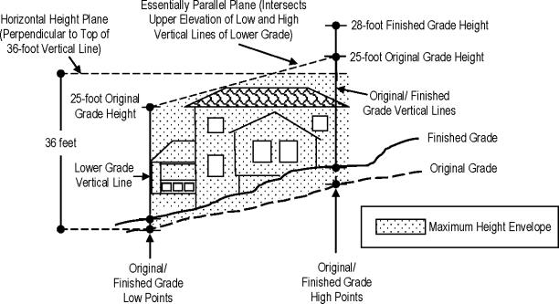
_____
C.
In the R-20, R-30, and SR-30 zones (except where the bonus height standards in Table 16.23.050(C) are used) and in the Medina Heights overlay, height shall be measured as shown in Figure 16.23.060(C) and as set forth in the following procedures:
1.
The original grade shall be established as set forth in MMC 16.23.080;
2.
The base elevation for measuring height shall be taken at two points where the outside of the exterior walls/sides of the building or structure intersect the following:
a.
The lowest point of original grade;
b.
The lowest point of finished grade;
3.
Starting at the two base elevation points ascertained under subsection (C)(2) of this section, a vertical line shall be extended by the distance of the applicable maximum height prescribed in Table 16.23.050(A);
4.
The grade (original or finished) and corresponding vertical line established under subsection (C)(3) of this section that has the lower upper elevation (measured from a zero-elevation surface) shall be used to measure maximum height;
5.
Maximum height shall be a horizontal plane intersecting the upper elevation of the vertical line established in subsection (C)(4) of this section for measuring maximum height and shall be perpendicular to the same vertical line as shown in Figure 16.23.060(C);
6.
The maximum height envelope shall be the area between the applicable grade (original or finished) and the horizontal height plane established in this section and shown in Figure 16.23.060(C);
7.
No part of the building or structure, including roof lines, shall protrude above the maximum height envelope, except as allowed otherwise by law;
8.
See subsection (E) of this section for establishing the height plane parameter and subsection (G) of this section for height calculation exemptions.
_____
Figure 16.23.060(C): R-20, R-30, SR-30, and Medina Heights,
Height Measurements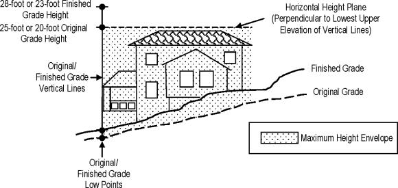
_____
D.
Where the bonus height standards in Table 16.23.050(C) are used, height shall be measured as shown in Figure 16.23.060(D) and as set forth in the following procedures:
1.
The original grade shall be established as set forth in MMC 16.23.080;
2.
The base elevation for measuring height shall be taken at four points where the outside of the exterior walls/sides of the building or structure intersect the following:
a.
The lowest point of the original grade;
b.
The highest point of the original grade;
c.
The lowest point of finished grade; and
d.
The highest point of finished grade;
3.
Starting at the four base elevation points ascertained under subsection (D)(2) of this section, a vertical line shall be extended by the distance of the applicable maximum height prescribed in Table 16.23.050(C);
4.
The grade (original or finished) and corresponding vertical line established under subsection (D)(3) of this section that has the lower upper elevation (measured from a zero-elevation surface) shall be used to measure maximum height;
5.
Maximum height shall be a horizontal plane intersecting the upper elevation of the vertical line established in subsection (D)(4) of this section for measuring maximum height and shall be perpendicular to the same vertical line as shown in Figure 16.23.060(D);
6.
The maximum height envelope shall be the area between the applicable grade (original or finished) and the horizontal height plane established in this section and shown in Figure 16.23.060(C);
7.
No part of the building or structure, including roof lines, shall protrude above the maximum height envelope, except as allowed otherwise by law;
8.
See subsection (E) of this section for establishing the height plane parameter and subsection (G) of this section for height calculation exemptions.
_____
Figure 16.23.060(D): Bonus Height Measurements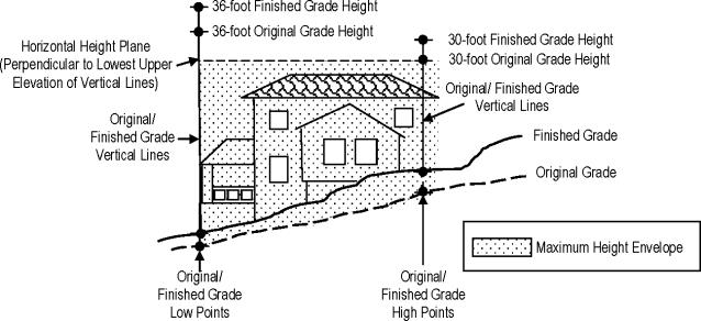
E.
The parameters of a maximum height plane shall be parallel to a parameter created by the smallest rectangle that can be drawn around the footprint of the building or structure. See Figure 16.23.060(E).
Figure 16.23.060(E): Height Plane Parameters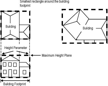
F.
Where a building or structure is placed within the R-16 zone on a slope, the property owner may elect for the slant of the essentially parallel height plane to be in the direction of either:
1.
The front facade of the building where the primary entrance of the building is located; or
2.
The building facade facing a public street or private lane.
3.
Figure 16.23.060(F) provides further direction on determining the orientation of the height plane slant.
Figure 16.23.060(F): Direction of Slant
for Essentially Parallel Height Plane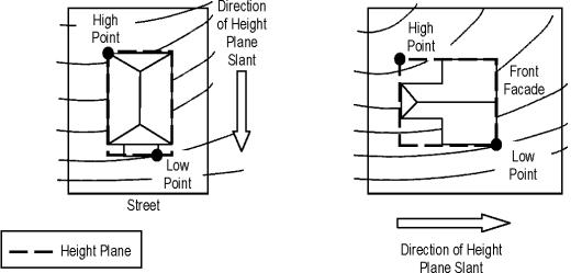
_____
G.
The following shall be excluded as part of the outside exterior wall/side of a building or structure for purposes of measuring height:
1.
Walls adjoining window wells where the area inside of the window well does not exceed 15 square feet of open surface area;
2.
Attached structures (e.g., uncovered decks, porches, steps, etc.), not exceeding 30 inches above original or finished grade, whichever is lower;
3.
Uncovered decks, porches, and verandas not qualifying for the exemption in subsection (G)(2) of this section where the space below the structure is not enclosed and not more than 25 percent of the ground surface below the structure is hardscape; and
4.
Areas under roof eaves including gutters and areas under balconies provided they extend 24 inches or less from the exterior wall. Gutters extending six inches or less from the outer edge of the roof eaves shall be excluded from counting towards the 24-inch limit.
(Code 1988 § 20.23.060; Ord. No. 932 § 12, 2016; Ord. No. 900 § 4 (Att. A), 2013)
16.23.070. - Building and structure height exceptions.
The following are exempt from the height standards in MMC 16.23.050:
A.
Spires, belfries and domes of religious facilities not intended for human occupancy provided the height is approved as part of the nonadministrative special use permit for the religious facility;
B.
Flag poles, provided the pole does not exceed:
1.
A height of 45 feet above the existing grade; and
2.
A width of 12 inches diameter at the widest point of the pole;
C.
Chimneys, chase, mechanical equipment, vents or other essential building elements required by the building codes provided:
1.
The structure or equipment does not project more than three feet above the maximum height otherwise allowed on the lot;
2.
The structure or equipment does not exceed five feet in horizontal width above the maximum height otherwise allowed on the lot;
D.
Photovoltaic (PV) panels; provided, that:
1.
The panels do not project more than six inches above the maximum height otherwise allowed on the lot; and
2.
Where feasible, the support structure of a roof-mounted panel is screened by extended parapets or other architecturally integrated screening;
E.
Wireless communication facilities approved pursuant to Chapter 16.37 MMC; and
F.
Exceptions specifically granted elsewhere in the Medina Municipal Code.
(Code 1988 § 20.23.070; Ord. No. 979 § 2, 2019; Ord. No. 900 § 4 (Att. A), 2013)
16.23.080. - Determining original grade.
The following outlines the general procedures to establish the original grade on a lot. These procedures may be administratively modified by the director pursuant to subsection (F) of this section on a case-by-case basis to fit unique circumstances.
A.
The placement of proposed exterior walls/sides of the building/structure on the lot is identified first and these locations are marked on the property. It is preferred, but not required, that a surveyor stake the proposed exterior wall corners of the building or structure.
B.
A geotechnical engineer shall conduct an investigation of the soils along the parameters of the proposed exterior walls/sides to determine the elevations of the original grade:
1.
The investigation should include exploring and testing a reasonable number of test pits to substantiate the findings of the geotechnical engineer; and
2.
Based on the findings of the soil investigation, the geotechnical engineer shall determine the original grade underneath the entire building or structure.
C.
A surveyor shall set the vertical elevations of the applicable low and high base points required to measure height using the determination of original grade by the geotechnical engineer.
Figure 16.23.080: Confirmation of Original Grade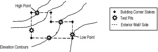
D.
A written report of the determination of original grade shall be prepared by the geotechnical engineer for submission to the city. The content of the report shall at a minimum include the following:
1.
The applicant's and property owner's name and contact information;
2.
Project location (include parcel number);
3.
Written narrative regarding the scope of work for which the original grade determination is being made;
4.
The name and qualification of the persons preparing the report;
5.
Written narrative of the investigation and findings;
6.
A site plan showing:
a.
An outline of the footprint of the building or structure on the lot;
b.
The locations of the test pits where the soil exploration was performed;
c.
The location and vertical elevation of the assumed high and low base points of the original grade, as applicable, for measuring height;
d.
Reserved;
e.
Topographical information including contour intervals of five feet or less, as appropriate; and
7.
Other pertinent information determined to be necessary by the director in supporting an original grade determination.
E.
The applicant must obtain approval from the city for an original grade determination. An approved determination of original grade report shall be used in determining plan review compliance with height standards prior to issuing construction permits.
F.
The director may approve modifications to these procedures if:
1.
The modification is evaluated and applied on a case-by-case basis;
2.
The modification is to address a unique circumstance on the property such as an inability to conduct site investigation due to existing buildings and structures;
3.
Modifications are based on accepted methods and/or practices found within the geotechnical engineer's profession;
4.
The applicant requests the modification in writing to the director and provides justification for the modification; and
5.
The modification is processed as a Type 1 decision pursuant to the review procedures in Chapter 16.80 MMC.
(Code 1988 § 20.23.080; Ord. No. 975, 2019; Ord. No. 971 § 1, 2019; Ord. No. 900 § 4 (Att. A), 2013)