
Midwest City City Zoning Code
SECTION 8
- DEFINITIONS
8.1. - General Provisions
For the purpose of these regulations, certain numbers, abbreviations, terms, and words used herein shall be used, interpreted, and defined as set forth in this section.
(Ord. No. 3131, § 2, 10-26-10)
8.2. - Clarification and Relationship of Terms
8.2.1. Usage. For the purpose of these regulations words used in the present tense shall include the future tenses; words in the singular number include the plural and words in the plural number include the singular, except where the natural construction of the writing indicates otherwise. The word "shall" is mandatory and not discretionary. The word "should" is that which ought to occur, but is not mandatory. The word "should" allows for interpretation.
8.2.2. Terminology. "Person" includes an individual, partnership, organization, association, trust or corporation; a "building" includes any part thereof; "used" or "occupied," as applied to any land or building, shall be construed to include the words "intended, arranged, or designed to be used or occupied".
8.2.3. Standard Wording. Words not herein defined shall conform to standard American-English usage.
8.2.4. Examples. Examples and lists shall not be considered to be all-inclusive unless the content clearly states to the contrary.
(Ord. No. 3131, § 2, 10-26-10)
8.3. - Words and Terms Defined
8.3.1. Abuts/Abutting. Having a common border with, or being separated from such common border by an alley or easement. This term implies a closer proximity than the term "adjacent."
8.3.2. Access. A means of vehicular or pedestrian approach, entry to, or exit from a property.
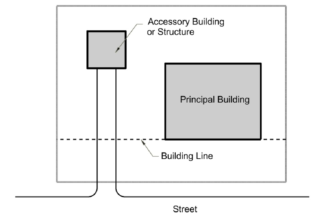
8.3.3. Accessory Building or Structure. Except for buildings authorized by the City Council pursuant to Ordinance No. 2535, an accessory building or structure is a building customarily incidental and appropriate and subordinate to the main building or use, or a proposed main building or use, and located on the same lot with the main building.
(A)
Illustrative example of an accessory building.
8.3.4. Accessory Use. Any use customarily incidental, appropriate and subordinate to the principal use of land or buildings located upon the same premises.
8.3.5. Adjacent. Lying near or close to. (See Abutting).
8.3.6. Adult Entertainment Enterprise. For definitions see 4.4.2. Adult Entertainment Enterprise (Page 55) within this Zoning Ordinance.
8.3.7. Advertising Sign or Structure. Any cloth, card, paper, metal, painted, glass, wooden, plastic, plaster, stone sign or other sign, device or structure of any character whatsoever, including statuary, placed for outdoor advertising purposes on the ground or on any tree, well, bush, rock, post, fence, building or structure.
The term "placed" shall include erecting, constructing, posting, painting, printing, tacking, nailing, gluing, sticking, carving, or otherwise fastening, affixing or making visible in any manner whatsoever.
The area of an advertising structure other than a sign shall be determined as the area of the largest cross section of such structure.
Neither directional, warning nor other signs posted by public officials in the course of their public duties nor merchandise or materials being offered for sale shall be construed as advertising signs for the purpose of this definition.
8.3.8. Alley. A right-of-way or easement dedicated to public use which gives a secondary means of vehicular access to the back or side of properties otherwise abutting a street, and which may be used for public utility purposes.
8.3.9. Apartment House. See Dwelling, Multifamily.
8.3.10. Amusement Center, Family. Any place of business lawfully containing eight (8) or more amusement devices, including but without limitation, coin-operated devices, bowling alleys, card tables or pool and billiard tables, operated in conjunction therewith, where persons of all ages and either sex are permitted on the premises.
8.3.11. Automobile. A self-propelled mechanical vehicle designed for use on streets and highways for the conveyance of goods and people including but not limited to the following: passenger cars, trucks, buses, motor scooters, and motorcycles.
8.3.12. Basement. A story partly or wholly underground. For purposes of height measurement a basement shall be counted as a story when more than one-half of its height is above the average level of the adjoining ground.
8.3.13. Boarding House. A dwelling other than a hotel where, for compensation and by prearrangement for a definite period, meals or lodging and meals are provided for three (3) or more but not exceeding twelve (12) persons.
8.3.14. Bed and Breakfast Inn or Facility(s). A dwelling or grouping of dwellings at which breakfast is served and sleeping accommodations are provided/offered in not more than fifteen (15) rooms or unattached units (e.g., cabins) for transient guests for compensation.
8.3.15. Building. Any structure intended for the shelter, housing or enclosure of any individual, animals, process, equipment, goods or materials of any kind or nature. When separated by dividing walls without openings, each portion of such structure so separated shall be deemed a separate structure.
8.3.16. Building, Main. A building in which the primary use of the lot on which the building is located is conducted. In any residential zoning district a dwelling shall be deemed to be a main building on the lot on which it is situated.
8.3.17. Building Height. The vertical distance from the grade plane to the highest point of the roof surface.
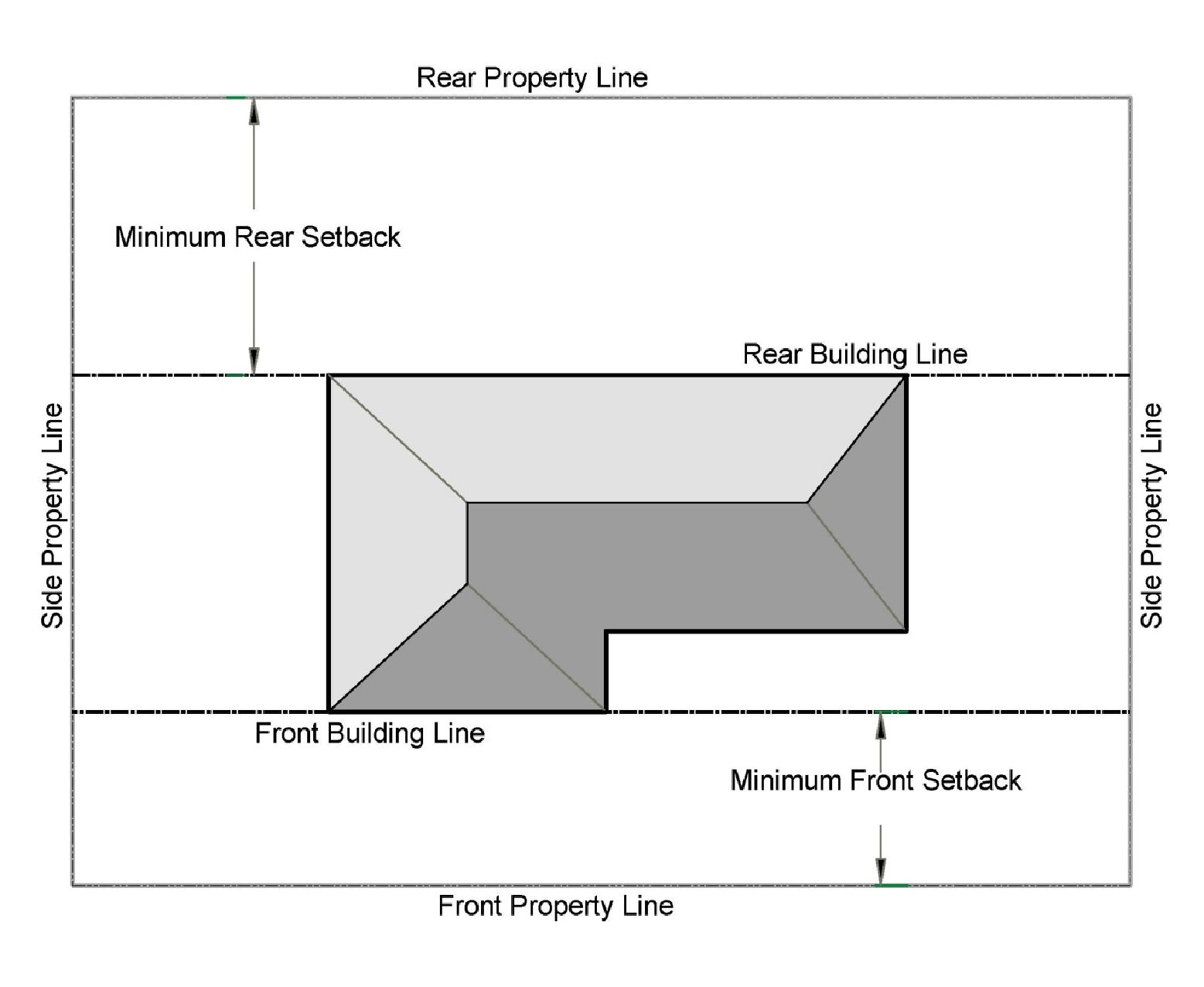
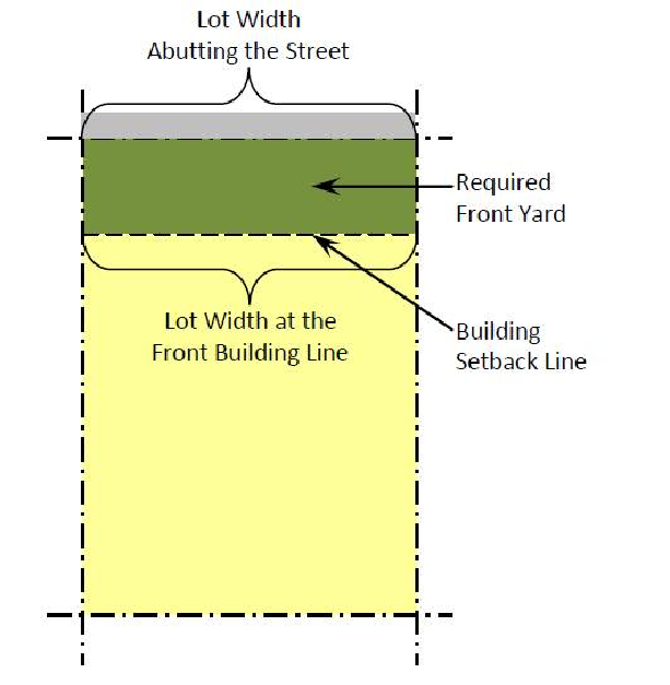
8.3.18. Building Line or Setback Line. A line parallel, or approximately parallel, to any property line at a specific distance therefrom, marking the minimum distance from the property line that a building may be erected, and marking the building envelope, the area in which a building may be erected.
(A)
Illustrative example of building or setback lines.
8.3.19. Building Site. A single parcel of land occupied or intended to be occupied by a building or structure.
8.3.20. Business Day. A business day is any day of the week that is not Saturday or Sunday and does not include holidays observed by the City of Midwest City.
8.3.21. Carport. A permanent roofed structure permanently open on at least two (2) sides, designed for or occupied by private passenger vehicles.
8.3.22. Certificate of Occupancy. Official certification which permits the use of a building in accordance with the approved plans and specifications and which certifies compliance with the provisions of law for the use and occupancy of the building in its several parts together with any special stipulations or conditions of the building permit.
8.3.23. Child Care Center. For definition see 4.4.17. Child Care Center and Adult Day Care Center (Page 59) within this Zoning Ordinance.
8.3.24. City Council. The governing or legislative authority of the City of Midwest City.
8.3.25. Compatibility. The characteristics of different uses or activities that permit them to be located near each other in harmony and without conflict.
8.3.26. Comprehensive Plan. An official document, adopted by the City Council of the City of Midwest City, containing policies concerning present conditions and future growth of Midwest City.
8.3.27. Condominium. A building, or group of buildings, in which dwelling units, offices, or floor area are owned individually and the structure, common areas, and facilities are owned by all the owners on a proportional, undivided basis.
8.3.28. Conversion. Changing the original purpose of a building to a different use or a room within a building or any portion thereof.
8.3.29. Court. An open space other than a yard on the same lot with a building or group of buildings and which is bordered on two (2) or more sides by such building or buildings.
(A)
Illustrative example of a court.
8.3.30. Court, Inner. A court other than an outer court. The length of an inner court is the minimum horizontal dimension measured parallel to its longest side. The width of an inner court is the minimum horizontal dimension measured at right angles to its length.
(A)
Illustrative example of inner and outer courts.
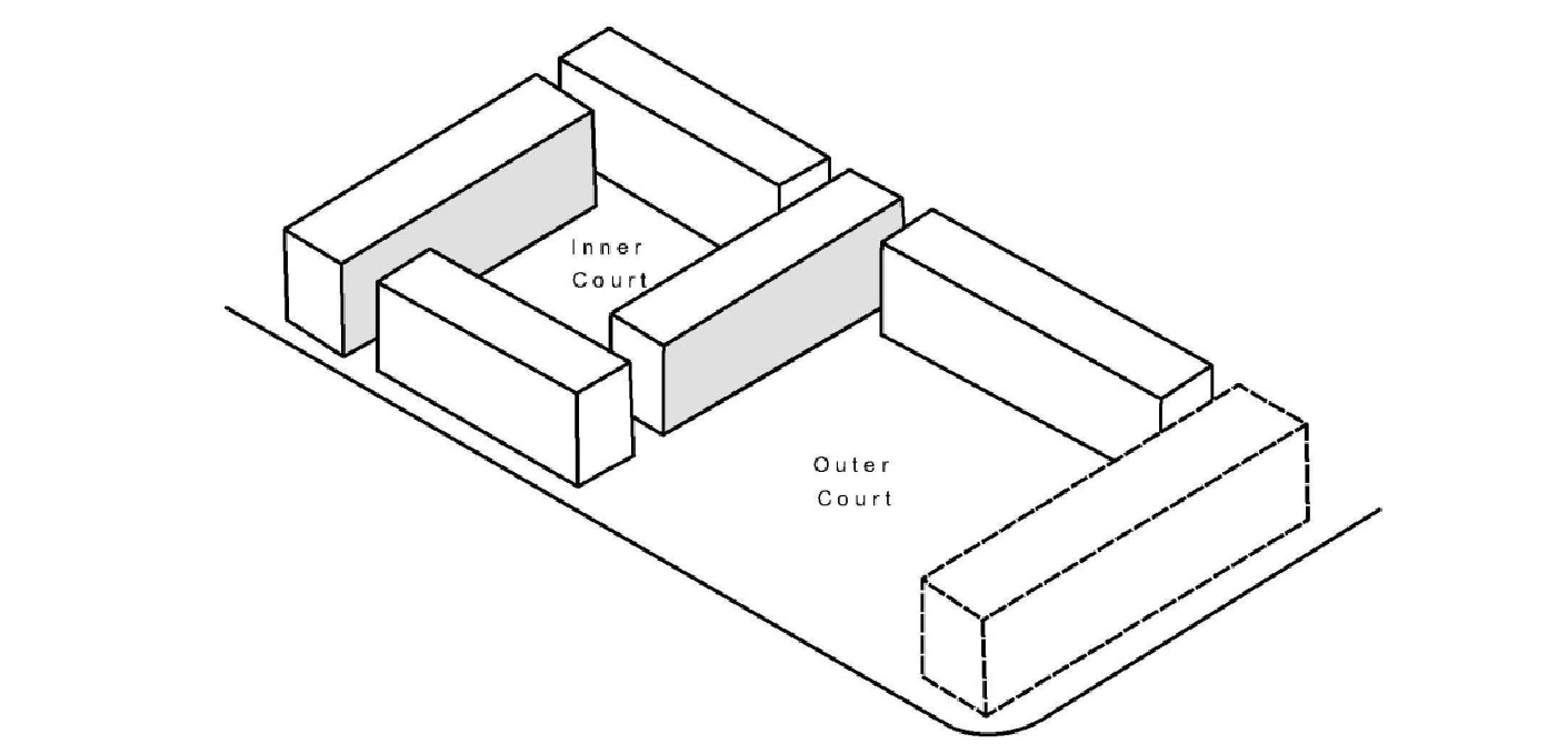
8.3.31. Court, Outer. A court the full width of which opens onto a required yard, or street or alley. The width of an outer court is the minimum horizontal dimension measured in the same general direction as the yard, street or alley upon which the court opens. The depth of an outer court is the minimum horizontal dimension measured at right angles to its width.
(A)
Illustrative example of outer court shown in 8.3.30. Court, Inner.
8.3.32. Covenant. A private legal restriction on the use of land, contained in the deed to the property or otherwise formally recorded.
8.3.33. Coverage, Building. The percentage of lot area covered by all buildings (e.g., main and accessory buildings), but shall exclude all overhanging roofs, covered or uncovered patios, porches and carports.
8.3.34. Coverage, Impervious Surface. The percentage of lot area covered by any impervious surfaces, such as main and accessory buildings, driveways, concrete patios, carports, and other surfaces that do not absorb water.
8.3.35. Cul-de-sac. A local street with only one outlet and having an appropriate terminal for the safe and convenient reversal of traffic movement.
8.3.36. Deed. A document under seal that states a conveyance of title to real property.
8.3.37. Deed Restriction. A form of covenant contained in a deed of conveyance.
8.3.38. Density. The average number of housing units per unit of land generally expressed as "dwelling units per acre." May be specified as either gross density (i.e., the number of dwelling units per acre based on total land area being considered) or net density (i.e., the number of dwelling units per acre excluding area in street right-of-way and publicly owned property).
8.3.39. Community Development Director. The Community Development Director of the City of Midwest City, Oklahoma, or the city manager's representative.
8.3.40. District. See Zoning District.
8.3.41. Dormitory. A building intended or used principally for sleeping accommodations where such building is related to an educational or public institution, including religious institutions.
8.3.42. Duplex. See Dwelling, Two-family.
8.3.43. Dwelling. Any building, or portion thereof, which is designed or used as living quarters for one or more families, but not including house trailers, mobile homes or travel trailers.
8.3.44. Dwelling Unit. A single unit providing complete, independent living facilities for a family including permanent provisions for living, sleeping, eating, cooking and sanitation.
8.3.45. Dwelling, Attached. A dwelling having any portion of one or more of its walls in common with adjoining dwelling(s).
8.3.46. Dwelling, Detached. A dwelling having open space on all sides.
8.3.47. Dwelling, Single-Family. A building designed to be occupied by one family.
8.3.48. Dwelling, Two-family. A building designed to be occupied by two (2) families living independently of each other.
8.3.49. Dwelling, Multifamily. A building designed for occupancy by three (3) or more families living independently of each other. All of the units, however, are located on one lot under one ownership. The units may or may not be separately owned.
8.3.50. Dwelling, Townhouse. A building designed for occupancy by three (3) or more families living independently of each other. The three (3) or more units are placed adjacent to one another, with structural parts touching. Each of the units, however, are located on a separate lot.
8.3.51. Easement. A grant, not in fee simple, by a property owner to the use of land by the public, a corporation, or persons for specific purposes such as the construction of utilities, drainage ways, and roadways.
8.3.52. Evergreen Vegetation. A plant or tree growth that retains its foliage throughout the year.
8.3.53. Facility. A structure, building, or group of buildings built or installed to perform a particular or specific function.
8.3.54. Family. An individual, or two (2) or more persons related by blood or marriage, including adopted children, or a group of not to exceed five (5) unrelated persons, not all related by blood or marriage, occupying premises and living as a single nonprofit housekeeping unit; as distinguished from a group occupying a boarding or lodging house or a hotel.
8.3.55. Floor Area, Gross. The sum of the gross horizontal areas of all of floors of a building or buildings, measured from the exterior faces of exterior walls or from the center line of walls separating two (2) buildings, and including but not limited to, the following spaces:
Basements;
Elevator shafts and stairwells at each floor;
Floor space for mechanical equipment with structural headroom of seven (7) feet;
Penthouses;
Attic space providing headroom of seven (7) feet or more;
Interior balconies, mezzanines and enclosed covered porches and enclosed steps;
Accessory uses in enclosed covered space, but not including space used for off-street parking.
8.3.56. Floor Area, Net. The total floor area within a building devoted or intended to be devoted to a particular use, with structural headroom of seven (7) feet or more, whether above or below the finished lot grade, excluding (a) elevators, stairwells, hallways, walls and partitions, and (b) floor space permanently devoted to a parking space or parking spaces, mechanical equipment, closets, washrooms, or other items permanently preventing the floor space from being occupied by persons while engaged in the use.
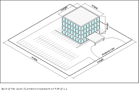
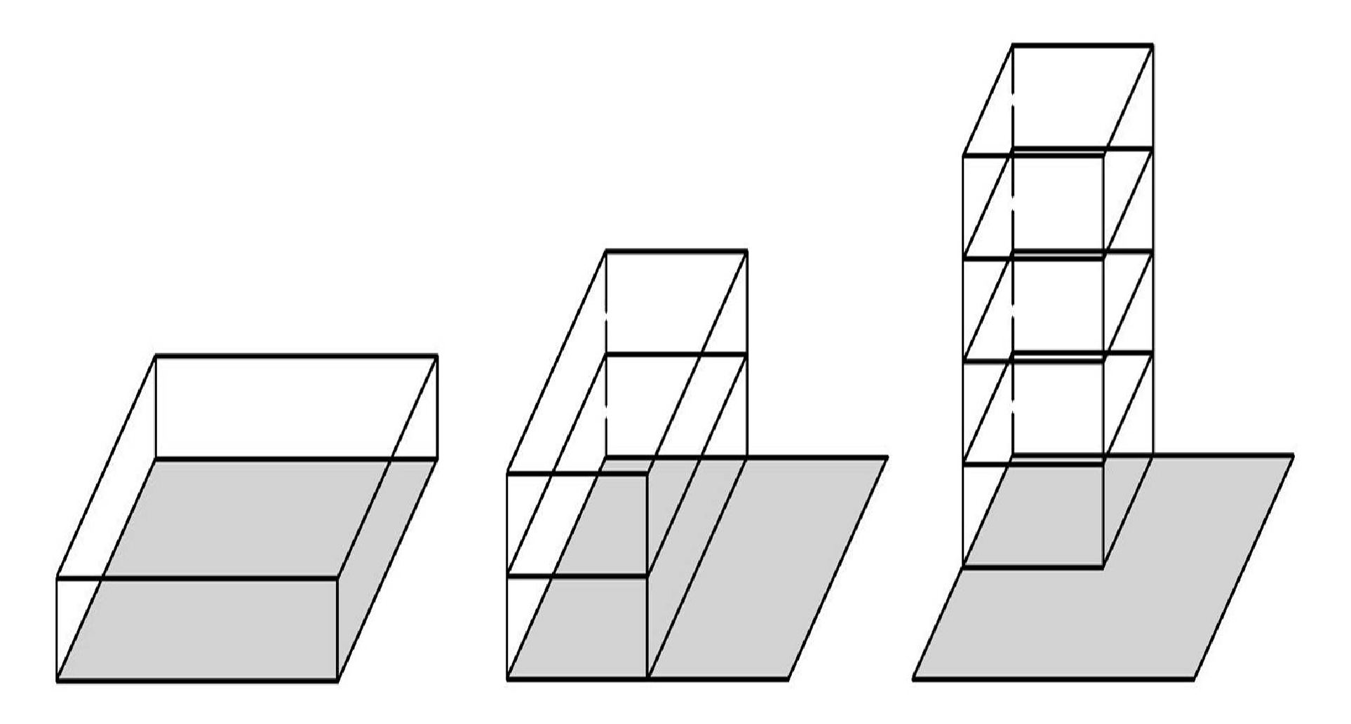
8.3.57. Floor Area Ratio. A mathematical expression determined by dividing the gross floor area of a building by the area of the lot on which it is located.
(A)
Illustrative example of floor area ratio (F.A.R.) calculations
8.3.58. Frontage. Property on one (1) side of a street measured along the line of the street.
8.3.59. Garage Apartment. A dwelling unit for one (1) family erected above a private garage.
8.3.60. Garage, Private. An accessory building or a part of a main building used for storage purposes only for automobiles used solely by the occupants and their guests of the building to which it is accessory.
8.3.61. Garage, Public. A building or portion thereof, other than a private or storage garage, designed or used for equipping, servicing, repairing, hiring, selling, storing, or parking motor driven vehicles.
8.3.62. Gross Leasable Area. The total floor area designed for occupancy and exclusive use. The area of tenant occupancy is measured from the center lines of joint partitions to the outside of the tenant walls.
8.3.63. Height Regulations. Regulations that limit the height of buildings within particular zoning districts. Such regulations may establish both a basic maximum height of a structure and a maximum height based on the relationship of a structure to surrounding properties.
8.3.64. Home Occupation. An occupation carried on in a dwelling unit by the resident thereof, provided that the use is limited in extent and incidental and secondary to the use of the dwelling unit for residential purposes and does not change the character thereof.
8.3.65. Intensity. The degree to which land is used, referring to the relative level of activity of a land use, including, but not limited to, a floor area ratio, building coverage ratio, or impervious surface ratio.
8.3.66. Kennels. See Chapter 8 of the Midwest City Code.
8.3.67. Landscaping. The improvement of a lot, parcel, or tract of land with grass, shrubs, and/or trees. Landscaping may include pedestrian walks, flowerbeds, ornamental objects, such as fountains, statuary and other familiar natural or artificial objects.
8.3.68 Lodging House. A dwelling other than a hotel or boarding house providing rooms for four (4) or more persons not related by blood or marriage, being used to house multiple occupants for compensation and by pre-arrangement for a definite period, regardless of other provisions or personal accommodations.
8.3.68.5. Lot. A subdivision of a block or other parcel intended as a unit for the transfer of ownership or for development.
(A)
Illustrative example of lot types
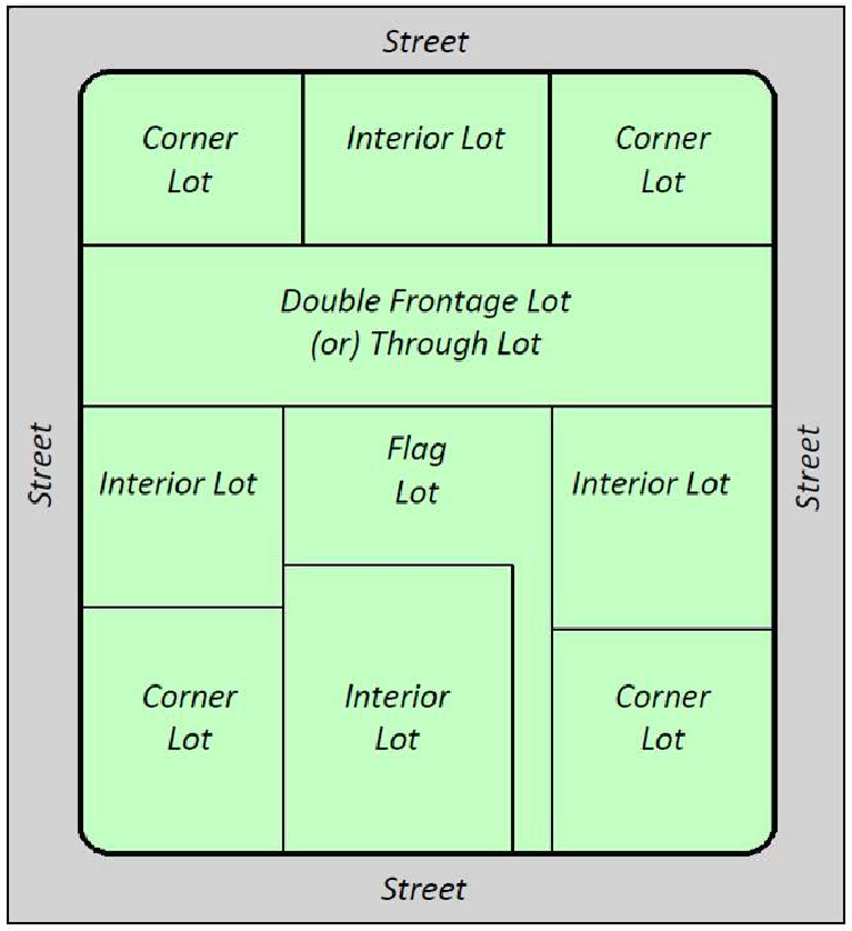
8.3.69. Lot, Corner. A lot of which at least two (2) adjacent sides abut for their full lengths on a street, provided that the interior angle at the intersection of such two (2) sides is less than one hundred thirty-five (135) degrees.
(A)
Illustrative example shown in 8.3.68. Lot.
8.3.70. Lot Area. The total horizontal area included within the lot lines.
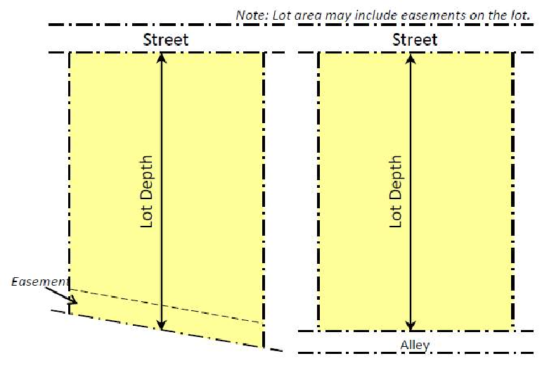
8.3.71. Lot Depth. The average horizontal distance between the front and rear lot lines.
(A)
Illustrative example of lot depth.
8.3.72. Lot, Double Frontage. A lot having a frontage on two (2) nonintersecting streets, as distinguished from a corner lot.
(A)
Illustrative example shown in 8.3.68. Lot.
8.3.73. Lot, Frontage. That dimension of a lot or portion of a lot abutting on a street, excluding the side dimension of a corner lot.
8.3.74. Lot, Interior. A lot other than a corner lot and bounded by a street on only one (1) side.
(A)
Illustrative example shown in 8.3.68. Lot.
8.3.75. Lot Lines. The lines bounding a lot.
(A)
Illustrative example shown in 8.3.18. Building Line or Setback Line.
8.3.76. Lot Line Adjustment. A relocation of the lot lines of two (2) or more lots included in a plat which is filed of record, for the purpose of making necessary adjustments to building sites.
8.3.77. Lot of Record. A lot which is a part of an approved plat or metes and bounds subdivision, the map of which has been recorded in the office of the county registrar of deeds.
8.3.78. Lot, Reverse Frontage. A double frontage lot that is designed to be developed with the rear yard abutting a major street and with the primary means of ingress and egress provided on a minor street.
(A)
Illustrative example of reverse frontage lots.
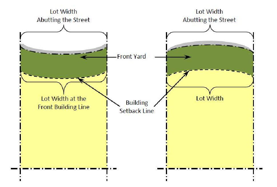
8.3.79. Lot Width. The horizontal distance between the side lines of a lot measured parallel to the front lot line at the minimum required building setback line.
(A)
Illustrative example of measuring lot width on straight lots.
(B)
Illustrative example of measuring lot width on curved lots.
8.3.80. Medical Marijuana Dispensary. An entity licensed by the Oklahoma County Health Department that is allowed to purchase medical marijuana from a licensed commercial medical marijuana grower or medical marijuana processor and sell medical marijuana only to qualified patients, or their parents or legal guardian(s) if applicable and caregivers.
8.3.81. Metes and Bounds. A system of describing and identifying land by measures (metes) and direction (bounds) from an identifiable point of reference such as a monument or other marker; the corner of intersection streets.
8.3.82. Manufactured Home. A factory-built, single-family structure, which is manufactured or constructed under authority of 42 U.S.C. Sec. 5403, Federal Manufactured Home Construction and Safety Standards, and is to be used as a place for human habitation and is constructed with a permanent chassis and displays a HUD sanctioned certification tag.
8.3.83. Manufactured Home Park. A parcel (or contiguous parcels) of land under single ownership which has been so designated and improved that it contains two (2) or more manufactured home sites available to the general public for the placement thereon of manufactured homes for occupancy regardless of whether or not a change is made for such accommodations.
8.3.84. Manufactured Home Subdivision. A unified development of contiguous delineated and designated lots divided for the purpose of individual ownership of manufactured home sites and which is governed by the requirements for land subdivision in the City of Midwest City.
8.3.85. Mezzanine. Shall be defined as currently specified within Midwest City's adopted building codes.
8.3.86. Modular Home. A factory-built home, other than a manufactured home, which meets all of the following requirements:
Is not designed to be moved once so erected or installed;
Is designed and manufactured to comply with a nationally recognized model building code or an equivalent local code, or with a state or local modular building code recognized as generally equivalent to building codes for site-built housing; or to the manufacturer's knowledge;
Is assembled in sections on-site; and
Is not intended to be used other than on a site built permanent foundation.
8.3.87. Municipal/City Attorney. The licensed attorney designated by the City Council to furnish legal assistance for the administration of these regulations.
8.3.88. Nonconformities/Noncompliance. Lots, structures, uses of land and structures, and characteristics of uses, which are prohibited under the terms of the Zoning Ordinance but were lawful at the date of enactment of this Ordinance.
8.3.89. Off-Site. Any real property not located within the area of the property to be subdivided, whether or not in the same ownership of the applicant for subdivision approval.
8.3.90. Off-Site Improvements. Any utility, paving, grading, drainage, structure, or modification of topography which is, or will be, located on property not within the boundary of the property to be developed.
8.3.91. On-Site. Any real property located within the area of the property to be subdivided, whether or not in the same ownership of the applicant for subdivision approval.
8.3.92. Ordinance. Enactments of the legislative body of the municipal corporation that has the force of law, including any amendment or repeal of any ordinance.
8.3.93. Outdoor Storage. Articles or material stored outside the confines of the building in connection with the uses of a building or lot.
8.3.94. Parcel. A contiguous area of land described in a single description in a deed or as one of a number of lots on a plat; separately owned, either publicly or privately; and capable of being separately conveyed.
For ease of indexing data, a segment of a street, highway, railroad, right-of-way, pipeline or other utility easement may be treated as though it were a parcel.
8.3.95. Parking Space. A permanently surfaced area, enclosed or unenclosed, sufficient in size to store one automobile together with a driveway connecting the parking space with a street or alley and permitting ingress and egress of an automobile.
8.3.96. Patio Home (Zero Lot Line Residence). A single-family dwelling on a separate lot with no side setback on one side.
8.3.97. Planned Unit Development. A planned unit development, referred to as a PUD, is a special zoning district that provides an alternate approach to land use controls and development regulations specified within an existing zoning district to produce unique, creative, progressive, or quality land developments using a master development plan.
8.3.98. Planning Commission or Commission. The Planning Commission of the City of Midwest City, unless the context indicates otherwise.
8.3.99. Professional Engineer. An engineer licensed and registered in the State of Oklahoma.
8.3.100. Professional Land Planner or Designer. An individual with formal training in planning, architecture, landscape architecture and/or civil engineering and/or several years experience in land development, subdivision design and/or subdivision review.
8.3.101. Property Owners' Association. An incorporated organization operating under recorded land agreements which represents each homeowner or unit of ownership in a planned unit development or other described land area and charges each lot and/or property owner for a proportionate share of the activities of the organization.
8.3.102. Property, Personal. Property owned by an individual or business not affixed to or associated with the land, such as trucks and other equipment.
8.3.103. Property, Real. That which consists of land, buildings and anything affixed to the land of a permanent immovable nature.
8.3.104. Public Improvement. Any improvements consisting of drainage, water, sanitary sewer, paving, sidewalks, or other facilities for which the local government may ultimately assume the responsibility for maintenance and operation, or which may affect an improvement for which local government responsibility is established.
8.3.105. Public Use. Any area, building or structure held, used, or controlled exclusively for public purposes by any department or branch of any government, without reference to the ownership of the building or structure.
8.3.106. Public Use, Quasi. Any use which is essentially public and not for profit which is under private ownership or control.
8.3.107. Public Utility. Under certain rules and regulations, a business or service that is engaged in regularly supplying the public with some commodity or service which is of public consequence and need, such as electricity, gas, water, transportation or communications.
8.3.108. Public Way. Any street, waterway, viaduct, sidewalk, bridge, waterfront, parkway, playground, square, park, aviation field, and other public ground and open space which the public has a right to use.
8.3.109. Rear Lot Line. Ordinarily that line of a lot which is opposite and furthest from the front lot line or as designated on the plat for corner lots.
(A)
Illustrative example shown in 8.3.18. Building Line or Setback Line.
8.3.110. Residential Cluster Development. A development design technique or development form that concentrates buildings in specific areas on a site to allow the remaining land to be used for recreation, common open space, or the preservation of historically or environmentally sensitive features.
A cluster development typically focuses dwelling units on the most buildable portion of the site and preserves natural drainage systems, vegetation, open space and other significant natural features that help control stormwater runoff and soil erosion. Cluster developments also promote infrastructure cost savings by reducing the street length and amount of utilities needed to service a development. Cost savings continue to occur throughout the life of the development by the maintenance of fewer or shorter streets and utilities.
(A)
Illustrative example comparing a typical residential design (top illustration) and a residential cluster development (bottom illustration).
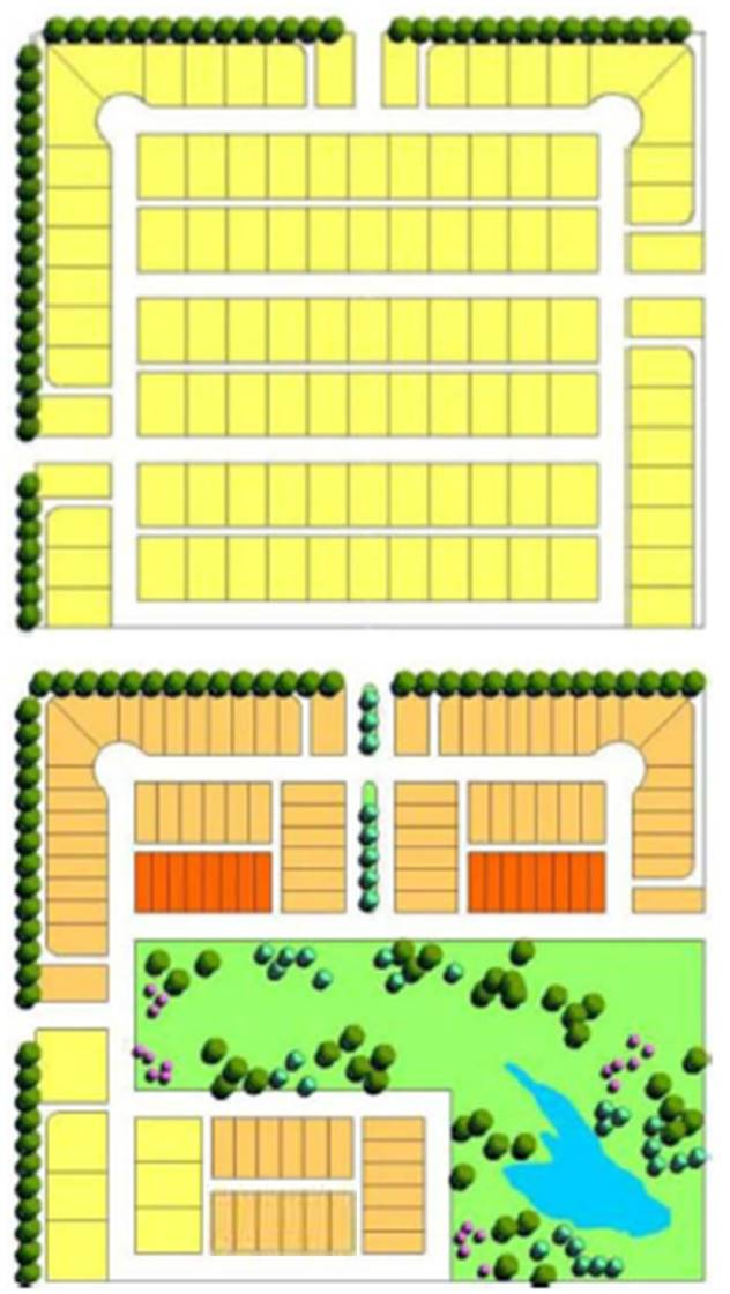 | Typical Residential Development | |
|---|---|---|
| Total Site Acreage: | 29 Acres | |
| Lots: | 102 Lots | |
| Average Lot Size: | 8,800 Sq.ft. | |
| Street - Linear Length: | 5,730 Feet | |
| Street - Area of Paving: | 158,425 Sq.ft. | |
| Alley - Linear Length: | 6,020 Feet | |
| Alley - Area of Paving: | 60,693 Sq.ft. | |
| Open Space: | 0 Sq.ft. | |
| Residential Cluster Development | ||
| Total Site Acreage: | 29 Acres | |
| Lots: | 102 Lots | |
| Average Lot Size: | 10,000 Sq.ft. | |
| Average Lot Size: | 4,500 Sq.ft. | |
| Average Lot Size: | 3,250 Sq.ft. | |
| Street - Linear Length: | 5,566 Feet | |
| Street - Area of Paving: | 152,941 Sq.ft. | |
| Alley - Linear Length: | 4,558 Feet | |
| Alley - Area of Paving: | 45,980 Sq.ft. | |
| Open Space: |
423,185 Sq.ft.
or 9.7 Acres | |
8.3.111. Restrictive Covenant. See Covenant.
8.3.112. Rezoning. An amendment to or change in the zoning status of a lot, tract or parcel of land.
8.3.113. Right-of-Way. A strip of land acquired by reservation, dedication, prescription, or condemnation and intended to be occupied by a street, crosswalk, sidewalk, railroad, electric transmission line, oil or gas pipeline, water line, wastewater line, stormwater line, other public utilities or facilities, or other similar use.
The usage of the term "right-of-way" for land-platting purposes shall mean that every right-of-way hereafter established and shown on the final plat is to be separate and distinct from the lots or parcels adjoining such right-of-way and not included within the dimensions or areas of such lots or parcels.
(A)
Illustrative example of right-of-way.
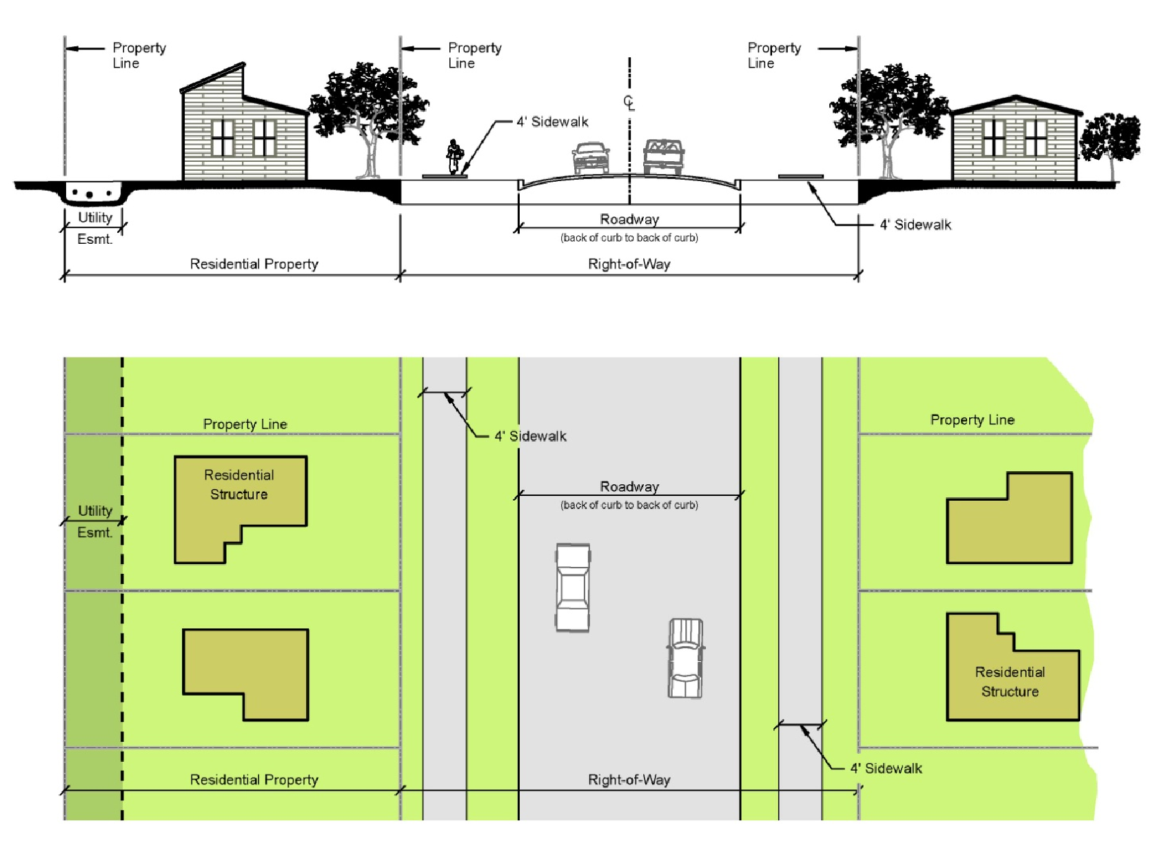
8.3.114. Right-of-Way Line. The lines that form the boundaries of a right-of-way.
8.3.115. Roadway. The improved or unimproved portion of a street intended for the accommodation of vehicular traffic.
(A)
Illustrative example shown in 8.3.112. Right-of-Way.
8.3.116. Setback. See Building Line.
8.3.117. Sketch Plan. A sketch or informal plan prepared prior to the preparation of the preliminary plat describing the proposed design of the subdivision to be reviewed during the pre-application review process.
8.3.118. Sidewalk. A pedestrian way being and improved surface usually adjacent and parallel to a roadway.
(A)
Illustrative example shown 8.3.112. Right-of-Way.
8.3.119. Sight-Proof Screening. Decorative fencing, evergreen vegetation or landscaped earth berms maintained for the purpose of concealing from view the property or structure behind such fence, evergreen vegetation, or berms.
8.3.120. Site Plan. A plan that shows the exact size, shape, and dimensions of the property. The existing and proposed topographic characteristics of the site are shown at a contour interval of not more than two (2) feet. The location of all existing and proposed buildings and structures, the location of all parking spaces and loading facilities, public and private easements, existing utilities, exterior lighting, all ingress and egress driveways, and any drainage facilities are shown also.
8.3.121. Special Use Permit. An approval for a specific use that has been determined to be more intense or to have a potentially greater impact than a use permitted-by-right within the same zoning district.
8.3.122. Story. That portion of a building, other than a basement, included between the surface of any floor and the surface of the floor next above it, or if there is not a floor above it, then the space between the floor and the ceiling next above it.
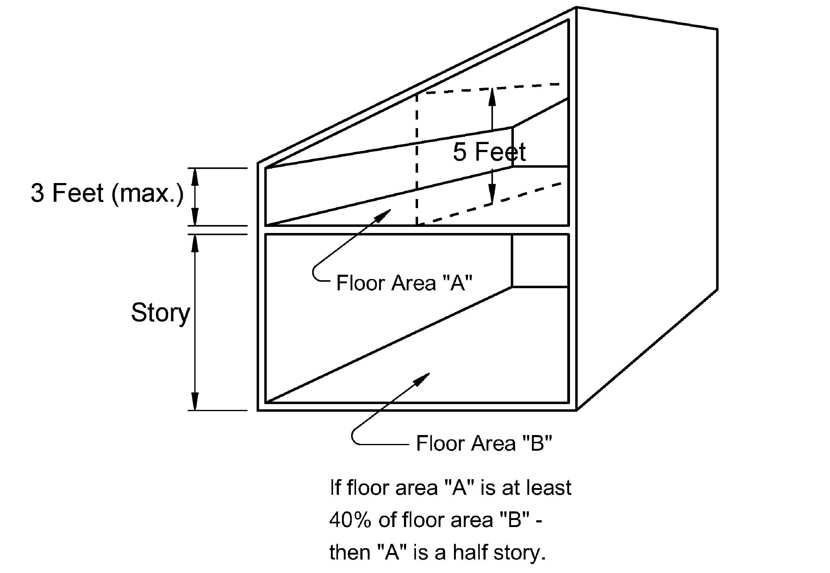
8.3.123. Story, Half. A space under a sloping roof that has the line of intersection of roof decking and wall face not more than three (3) feet above the top floor level and in which space the possible floor area with headroom of five (5) feet or less occupies at least forty (40) percent of the total floor area of the story directly beneath.
(A)
Illustrative example of half story.
8.3.124. Street. Any right-of-way intended as the primary means of access to abutting property.
8.3.125. Street, Approved. A street which has been approved in one of the following manners:
(A)
Dedication and acceptance. A street which has been dedicated to and accepted by the city.
(B)
Previous dedication and acceptance involving the county. A street which has been dedicated to and accepted by the county prior to annexation by the city.
(C)
Fifteen years of public access. A street which has been open for public access for a period of at least fifteen (15) years.
(D)
Private road. A private road which meets private road standards, and the requirements of these regulations.
(E)
Accepted for maintenance. A street which has been accepted for maintenance by the city or county.
8.3.126. Street, Collector. A street located within a neighborhood or other integrated use area which collects and distributes traffic from local streets and connects with arterial streets or community or neighborhood facilities.
8.3.127. Street, Freeway. A divided multi-lane arterial street designed for rapid unimpeded movement of large volumes of traffic with full control of access and grade separation at intersections.
8.3.128. Street, Intersecting. Any street which joins another street at an angle, whether or not it crosses the other.
8.3.129. Street, Local. A street which collects and distributes traffic between parcels of land and collector or arterial streets, with the principal purpose to provide access to abutting property.
8.3.130. Street, Major. All freeways and primary and secondary arterial streets so designated on the transportation plan map of the city.
8.3.131. Street, Minor. All collector streets, local streets and streets not otherwise designated a major street according to the transportation plan map.
8.3.132. Street, Primary Arterial. A multi-lane arterial street designed primarily for traffic movement and secondarily for providing access to abutting properties and with a minimum number of at-grade intersections.
8.3.133. Street, Secondary Arterial. A multi-lane facility for traffic movement and for giving access to abutting property which provides connections from local and collector streets to the primary arterials and freeways, and which provides movement of relatively large volumes of traffic for short distances within the community.
8.3.134. Strip Zoning. Designation of a ribbon pattern of zoning, generally commercial, which fronts one or both sides of a roadway in a narrow band.
8.3.135. Structure. Anything constructed or erected, the use of which requires permanent location on the ground or which is attached to something having a permanent location on the ground. This includes but is not limited to advertising signs, billboards, antennae, wind generators, fence, poster panels and buildings.
8.3.136. Structural Alterations. Any change in the supporting members of a building, such as bearing walls, partitions, columns, beams, or girders, or any substantial change in the roof or in the exterior walls.
8.3.137. Townhouse. See Dwelling, Townhouse.
8.3.138. Trailer, Hauling. Any vehicle constructed that it is suitable for being attached to a motor vehicle and capable of being used for transporting livestock, goods, materials, or equipment, including boats.
8.3.139. Trailer, Travel or Camping. A portable or mobile living unit used for temporary human occupancy away from the place of residence of the occupants, and not constituting the principal place of residence of the occupants.
8.3.140. Transition Zone. A buffer between two (2) or more zoning districts or incompatible uses.
8.3.141. Travel Trailer Park. Any lot of ground upon which two (2) or more dependent travel trailers or independent travel trailers, occupied for dwelling or sleeping purposes, are located regardless of whether or not a charge is made for such accommodations.
8.3.142. Utility. A service provided to the public by either a private or public agency.
8.3.143. Vacate/Vacation. To make legally void.
8.3.144. Vested Rights Petition. A request for relief from one or more standards of this Zoning Ordinance based on an assertion that the petitioner has acquired a vested right requiring the City to review and decide the application under standards in effect prior to the effective date of the standards of this Zoning Ordinance. Such petition is regulated under 7.9 Vested Rights Petition Page (193).
8.3.145. Variance. A procedure by which certain requirements established in these regulations may be modified.
8.3.146. Wind Energy Conversion Systems (WECS). Any device which converts wind energy to a form of usable energy.
8.3.147. Yard. An open space at grade between the main building(s) and the adjoining lot lines, unoccupied and unobstructed by any portion of a structure from the ground upward except where otherwise specifically provided in this Ordinance that an accessory building may be located in a portion of a yard required for a main building.
In measuring a yard for the purpose of determining the width of the side yard, the depth of a front yard or the depth of a rear yard, the least horizontal distance between the lot line and the main building shall be used.
(A)
Illustrative example of front, side, and rear yards.
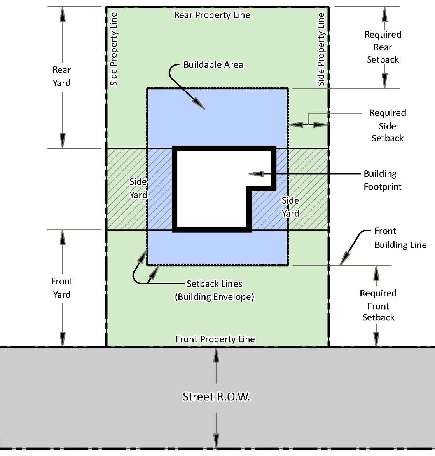
8.3.148. Yard, Front. An open area located in front of the front elevation of a building and extending across a lot and being the minimum horizontal distance between the front property line and the main building or any projections thereof, other than steps.
(A)
Illustrative example shown in 8.3.146. Yard.
8.3.149. Yard, Rear. An open area extending across the rear of a lot measured between lot lines and being the minimum horizontal distance between the rear lot line and the rear of the main building or any projections other than steps, unenclosed balconies or unenclosed porches.
On both corner lots and interior lots the rear yard shall in all cases be at the opposite end of the lot from the front yard.
(A)
Illustrative example shown in 8.3.146. Yard.
8.3.150. Yard, Side. An open area between the building and the sideline of the lot and extending from the front lot line to the rear lot line and being the minimum horizontal distance between a side lot line and the side of the main building or any projections other than steps.
(A)
Illustrative example shown in 8.3.146. Yard.
8.3.151. Zero Lot Line. A lot where the outside wall of a structure is located on the side property line.
(A)
Illustrative example of zero lot line development.
8.3.152. Zoning Classification. A section of the city delineated on the Zoning District Map in which requirements for the use of land, building and development standards are prescribed in the Zoning Ordinance text. Uses permitted and special use permits are treated separately.
8.3.153. Zoning District. A section of the city designated in the Zoning Ordinance text and delineated on the Zoning District Map in which requirements for the use of land, building, and development standards are prescribed. Uses permitted and special use permits are both included.
8.3.154. Zoning District Map. The official map, adopted as a part of the Zoning Ordinance, which graphically identifies the zoning district classification of all property within the corporate boundaries.
(Ord. No. 3131, § 2, 10-26-10; Ord. No. 3241, § 1, 8-11-15; Ord. No. 3353, § 4, 10-9-18)