
Milliken City Zoning Code
ARTICLE V
Subdivision Regulations
Sec. 16-5-100. - Applicability of Regulations.
(a)
The provisions of this Article, in conjunction with all other provisions of this Chapter, shall apply to any and all development of land within the municipal boundaries of the Town. All development shall comply with the applicable terms, conditions, requirements, standards, and procedures established in these Regulations in conjunction with the Zoning Code and the Milliken Design Criteria and Construction Specifications.
(b)
Jurisdiction. These regulations are applicable to and shall include the subdivision of all land located within the legal boundaries of the Town and limited only to control with reference to a major street plan
(c)
Specific Exemptions from These Regulations. Due to the nominal impact upon the residents of the Town, the following divisions of property, even though included within the definition of subdivision, are hereby determined by the Planning Commission and Board of Trustees not to be within the purpose of this Code and are hereby exempted from compliance with this Article.
(1)
A survey map which does not in fact create any new parcel or tract of land, but is a survey of metes and bounds parcels and tracts which were in existence at the time of the original adoption of this title shall be exempted from these regulations; provided, however, that said tracts and parcels must be under separate ownership at the time of the original passage of this title.
(2)
Any division of property shall be exempted from the terms of these regulations that is necessitated by the existence of a prescriptive easement or encroachment of a building or fence in existence at the time of the original adoption of these regulations, and which does not create a new building site., The division of land by conveyance of real property to or from the Town in satisfaction of land dedication, subdivision, condemnation, annexation or other Town requirements is exempt from these regulations.
Sec. 16-5-105. - Intent.
(a)
This Article is designed and enacted for the purpose of promoting the health, safety, convenience, order, prosperity, and welfare of the present and future inhabitants of the Town by:
(1)
Encouraging new subdivision developments to relate to the Town's historic development pattern.
(2)
Promoting compact, well-defined, sustainable neighborhoods that enhance the Town's character.
(3)
Facilitating good planning practices by ensuring the most effective utilization of land within the Town.
(4)
Creating livable neighborhoods that foster a sense of community and reduce dependency on private vehicles.
(5)
Encouraging the proper arrangement of streets in relation to existing or planned streets and ensuring streets are safe, efficient, and pleasant for walking, biking, and driving.
(6)
Providing a variety of lot sizes and housing types within the Town.
(7)
Protecting sensitive natural and historic areas and the Town's environmental quality.
(8)
Providing for adequate and convenient open space for traffic, utilities, access of fire apparatus, recreation, light, air and for the avoidance of congestion of population.
(9)
Providing open spaces for adequate storm water management.
(10)
Providing adequate spaces for educational facilities.
(11)
Providing protection from geologic hazards and flood-prone areas.
(12)
Ensuring compliance with the Comprehensive Plan, and all other adopted plans, codes, and regulations of the Town.
(13)
Encouraging development to utilize green building techniques and ideas and alternative sources of energy.
(14)
Regulating such other matters as the Board of Trustees may deem necessary in order to protect the best interest of the public.
Sec. 16-5-110. - Administration.
(a)
Plat Required. An approved plat shall be required for every subdivision within the municipal limits of the Town. It is unlawful to file or record a plat of a subdivision of land with the Weld County Clerk and Recorder, or to use any plat of a subdivision of land for purposes of sale or building development until such plat is approved by the Town.
(b)
All streets or highways proposed for public use, and all land proposed for subdivision or building lots, shall be platted and dedicated to a public use or to the use of purchasers or owners of lots fronting thereon or adjacent thereto. Said plat shall be submitted to the Planning Commission and Board of Trustees for review and subsequent approval, conditional approval or disapproval. No plat shall be recorded in any public office unless the same shall bear thereon, by endorsement or otherwise the approval of the Planning Commission and/or Board of Trustees. Acceptance of proposed dedications by the public shall be given by separate action of the Board of Trustees.
(c)
In their interpretation and application, the provisions of this Article shall be held to be minimum requirements for the promotion of the public health, safety, and welfare. If any provision of this Article conflicts with the requirements of any other applicable and lawfully adopted rules, regulations, or ordinances, the more restrictive or that imposing the higher standards shall govern.
Sec. 16-5-115. - Acceptance of Property and Improvements
Approval of a subdivision shall not constitute an acceptance by the Town of the roads, streets, alleys, bicycle paths, water and sewer facilities or other public lands or facilities indicated on the plat for dedication to the Town for maintenance. The dedication of any of these lands or facilities indicated for public use shall be accepted only by the express act of the Board of Trustees.
Sec. 16-5-200. - Types of Subdivision.
The division of land into separate parcels, lots, sites, tracts, or interests is a subdivision and is regulated by the provisions of this Article. The following types of subdivision are regulated by this Article:
(a)
Major Subdivisions. The major subdivision process shall consist of two (2) separate phases, preliminary and final plat.
(b)
Minor Subdivisions. The minor subdivision process shall consist of one (1) phase, final plat.
(c)
Administrative Plat Amendment. The plat amendment process shall consist of one (1) phase, final plat and is an administrative process. Plat amendments do not create additional lots or interests in property but are subdivision actions to the extent that: lot lines may be relocated as part of a boundary line adjustment; lots may be merged as part of a lot consolidation; or plat amendments may be used to correct errors on an existing approved subdivision plat.
Sec. 16-5-205. - Procedure for Submittal of the Preliminary Plat, and Final Plat and Accompanying Materials.
Sec. 16-5-210. - Major Subdivision.
(a)
Major Subdivisions. A new subdivision shall be classified as a major subdivision when it would create six (6) or more new lots, parcels, tracts, outlots, parcels or interests or when public infrastructure is proposed or required by this Chapter to be constructed in association with the subdivision.
(b)
Planning Commission Hearing. The Planning Commission shall hold a properly noticed public hearing on the application, and following such hearing, may recommend to the Board of Trustees the approval, approval with conditions, or deny the application.
(c)
The Board of Trustees shall hold a properly noticed public hearing on the application and shall approve, approve with conditions, or deny the application. The Board of Trustee's decision shall be final, subject only to judicial review pursuant to C.R.C.P. 106(a)(4).
Sec. 16-5-215. - Minor Subdivision.
(a)
Minor subdivision shall meet the following criteria.
(1)
A minor subdivision is permitted under the following criteria.
a.
The property has previously been platted within the Town;
b.
There is no public right-of-way dedication;
c.
The resulting subdivision will create five (5) or fewer lots,
d.
There will be no exceptions to the Subdivision Design Standards.
(2)
Required Process.
a.
A preapplication conference shall be conducted with the applicant and Town staff to discuss Town regulations and standards, the review process, submittal requirements and the schedule.
b.
Upon receipt of a minor subdivision application, the Community Development Department shall make a written recommendation to the Town Administrator, as to the approval or denial of the minor subdivision.
c.
Within ten (10) business days, the Town Administrator shall accept or reject the recommendation of the Community Development Department. In order to ensure creation of minor subdivisions is public knowledge, property owners within a 300' radius of the area to be subdivided shall be notified of the application by first class mail upon receipt of a complete application to the Town.
d.
Mineral interest owners, mineral and oil and gas lessees, utility providers and applicable referral agencies shall be notified of the application by first class mail upon receipt of a complete application to the Town.
e.
The recommendation of the Community Development Department and the Town Administrator shall be provided in summary form to both the Board of Trustees and the Planning Commission within five (5) business days after approval or rejection. Each of these bodies shall have twenty (20) business days in which to provide any written objection to the determination made by the Town Administrator. If any objections are received, the application shall be forwarded to the Planning Commission and Board of Trustees for public hearing in accordance with the final plat procedures in Section 16-5-305 of the Municipal Code.
f.
If neither the Board of Trustees nor the Planning Commission makes any written objection to staff's approval or denial, the minor subdivision plat shall be recorded with the Weld County Clerk and Recorders Office.
(3)
Minor Subdivision Plat Review Criteria. The Town shall use the following criteria to evaluate the applicant's request:
a.
The land use mix within the project conforms to the zoning district map and furthers the goals and policies of the Comprehensive Plan, including:
1.
The proposed development promotes the Town's small-Town rural character;
2.
Proposed residential development adds diversity to the Town's housing supply;
3.
Proposed commercial development will benefit the Town's economic base;
4.
Parks and open space are incorporated into the site design;
5.
The proposed project protects the Town's environmental quality; and
6.
The development enhances cultural, historical, and/or educational, opportunities.
b.
The minor subdivision plat represents a functional system of land use and is consistent with the rationale and criteria set forth in this Code, the Milliken Comprehensive Plan, the Transportation Plan, the Johnstown/Milliken Parks, Trails, Recreation and Open Space Master Plan and the Community Design Principles and Development Standards in Division 2 of the Milliken Land Use Code.
c.
The utility and transportation design is adequate, given existing and planned capacities of those systems.
d.
Negative impacts on adjacent land uses have been identified and satisfactorily mitigated.
1.
There is a need or desirability within the community for the applicant's development and the development will help achieve a balance of land use and/or housing types within the Town, according to the Town's goals.
Sec. 16-5-220. - Administrative Plat Amendment.
(a)
Administrative Plat amendments are intended to provide a prompt, efficient process to correct clerical and other non-material errors in approved plats, and to approve minor lot line adjustments in cases meeting the requirements of Subsection (b) below.
(b)
For the purposes of this Section, administrative plat amendment means a subdivision of lands already in an approved plat which meets one or more of the following criteria:
(1)
The amendment involves minor lot line adjustments, including the consolidation of contiguous lots under common ownership, which do not increase the number of lots previously included within the area involved in the amendment, and which meet the requirements of zoning district in which the lots are located.
(2)
The amendment effects minor adjustments in the boundaries of street right of way or utility easements.
(3)
The amendment corrects minor errors on a plat including, but not limited to:
a.
Typographical and spelling errors or transpositions,
b.
Incorrect seal,
c.
Incorrect dates,
d.
Monumentation incorrectly noted or drawn,
e.
Missing or incorrectly displayed arrows or symbols.
(4)
The plat amendment does not result in any lot or lots that cannot be built upon in accordance with requirements of this Code;
(5)
The requirements of any utility companies serving the property have been satisfied.
(6)
The plat amendment does not require any new utility easements unless such easements are duly recorded with the Weld County Clerk and Recorders Office through separate instrument prior to the recordation of the plat amendment. Such new easements of record shall be noted on the plat amendment by the reception number of the recorded instrument.
(c)
Required Process.
(1)
A preapplication conference shall be conducted with the applicant and Town staff to discuss Town regulations and standards, the review process, submittal requirements and the schedule.
(2)
Upon receipt of an administrative plat amendment application, the Community Development Department shall make a written recommendation to the Town Administrator, as to the approval or denial of the administrative plat amendment.
(3)
Within ten (10) business days, the Town Administrator shall accept or reject the recommendation of the Community Development Department. In order to ensure creation of administrative plat amendments are public knowledge, property owners within a 300' radius of the area to be platted shall be notified of the application by first class mail upon receipt of a complete application to the Town.
(4)
Mineral interest owners, mineral and oil and gas lessees, utility providers and applicable referral agencies shall be notified of the application by first class mail upon receipt of a complete application to the Town.
(5)
The recommendation of the Community Development Department and the Town Administrator shall be provided in summary form to both the Board of Trustees and the Planning Commission within five (5) business days after approval or rejection. Each of these bodies shall have twenty (20) business days in which to provide any written objection to the determination made by the Town Administrator. If any objections are received, the application shall be forwarded to the Planning Commission and Board of Trustees for public hearing in accordance with the final plat procedures in Section 16-5-305 of the Municipal Code.
(6)
If neither the Board of Trustees nor the Planning Commission makes any written objection to staff's approval or denial, the administrative plat amendment shall be recorded with the Weld County Clerk and Recorders Office.
Sec. 16-5-225. - Resubdivision.
The resubdivision of any lots, tracts or parcels, or the relocation or addition of streets within a subdivision, shall be considered a resubdivision (also known as a "replat") and shall be prepared and submitted in compliance with the requirements for a final subdivision plat as set forth in this Article. In the event that any dedicated streets are relocated as a result of a resubdivision, it is necessary for the Town to first vacate those existing streets, with said vacation to be effective prior to, or as part of the approval of the final plat.
Sec. 16-5-300. - Preliminary Plat Application Process.
(a)
Preliminary Plat Application Process
(1)
Step 1: Preapplication Conference. The applicant may request a preapplication conference with a representative from the Town before the applicant submits a preliminary plat application.
(2)
Step 2: Preliminary Plat Application Submittal. The applicant shall submit one (1) copy of the complete preliminary plat application to the Town. The application must be submitted a minimum of forty-five (45) days prior to the Planning Commission meeting at which the application will be reviewed. The preliminary plat application package shall include the following items:
a.
Land Use Application Form.
b.
A signed waiver stating that the 30-day requirement pursuant to C.R.S. 31-23-215 as amended, shall not apply.
c.
Application Fee and Fee Agreement. A nonrefundable fee is collected to cover the cost of review by Town Staff and notice and publication expenses. A deposit and fee agreement is necessary to cover costs for review of any other expert whom the Town may wish to employ. Actual costs may exceed the deposit; in this case, the applicant is liable for costs in excess of the deposit. The Town shall provide the applicant with a copy of the most current fee schedule and fee agreement form.
d.
Title Commitment. The title commitment must be current and dated no more than thirty (30) days from the date of preliminary plat application submittal.
e.
Mineral Rights Affidavit. The mineral rights affidavit must be current and must be dated no more than thirty (30) days prior to application submittal.
f.
Preliminary Plat. Two copies of the preliminary plat which shall be twenty-four (24) inches high by thirty-six (36) inches wide and provide the following information:
1.
Title of project.
2.
North arrow, scale (not greater than 1" = 100') and date of preparation.
3.
Vicinity map.
4.
Names and addresses of owners, applicant, designers, engineers, and surveyors.
5.
Legal description.
6.
Total acreage of property.
7.
Existing contours at two-foot intervals (contours shall be based on USGS datum).
8.
Name and location of abutting subdivisions or owners of abutting property (if land is not platted).
9.
Lots, blocks, and street layout with approximate dimensions and square footage for each lot.
10.
Consecutive numbering of all lots and blocks.
11.
Existing and proposed rights-of-way and easements on and adjacent to the property.
12.
Existing and proposed street names for all streets on and adjacent to the property.
13.
Existing and proposed zoning on and adjacent to property.
14.
Location and size of existing and proposed sewer lines, water lines and fire hydrants. (Note: The applicant must consult with the appropriate utility service providers regarding the design of all utilities within and through the subdivision.)
15.
Existing and proposed curb cuts on and adjacent to subject property.
16.
Location by field survey or aerial photography of existing and proposed water courses and bodies of water such as irrigation ditches and lakes. Water courses shall include direction of flow.
17.
Floodplain boundary with a note regarding source of information (if a floodplain does not exist on the property, please state this on the plan).
18.
General location of existing surface improvements such as buildings, fences or other structures which will remain on the property as part of the subdivision.
19.
Location and acreage of sites, if any, to be dedicated for parks, playgrounds, schools, or other public uses.
20.
Location, function, ownership, and manner of maintenance of any private open space.
21.
Land use table. The table shall include land uses, approximate acreage of each land use and percentage of each land use (including how the public/ semipublic requirement will be met (per Article II, Division 4 of this Chapter).
22.
Total number of lots.
23.
Number of each type of dwelling unit proposed.
(a)
General Development Information. Provide a written description of the existing conditions on the site and explain how the proposed plat is consistent with the Land Use Code and Comprehensive Plan.
(b)
Preliminary Grading and Drainage Plan and Report. This plan and report must be certified by a Colorado registered professional engineer, including storm drainage concepts such as locations for on-site detention or downstream structural improvements and soil erosion and sedimentation control plans and specifications. It must also discuss the impacts on and to any existing floodways and/or floodplains on and adjacent to the site as well as any FEMA applications required.
(c)
Master Utility Plan. This plan shall be prepared by a Colorado registered professional engineer. It is necessary that the engineer consult with the appropriate utility service providers regarding the design of all utilities through and within the subdivision.
(d)
Preliminary Landscape Plan. Refer to Article III, Division 3 Landscaping, Buffering, Fence, and Wall Standards of this Code for the preliminary landscape plan requirements.
(e)
Preliminary Open Space and Ecological Characterization Plan. If required by the Community Development Department to be submitted, refer to Article III, Division 5 of this Chapter for the preliminary open space plan and ecological characterization requirements.
(f)
Traffic Study. This study must be prepared by a professional traffic engineer.
(g)
Draft of Proposed Covenants and Architectural Design Guidelines.
(h)
Mineral, Oil and Gas Rights Documentation. Evidence that the applicant has contacted all mineral rights owners and all lessees of mineral, oil and gas rights associated with the site by certified mail and is working towards resolution. Included in the evidence must be the name of the current contact person, his or her phone number and mailing address and a description of the issues.
(i)
Soils Report and Map. A copy of the soils report and map provided at the time of preliminary plat must be provided.
(j)
Colorado Historical Society Records Search. At the discretion of the Staff or Board of Trustees, an applicant may be required to provide the Town with a Colorado Historical Society records listing of historically or archaeologically significant findings on the property being subdivided. If a listing shows a significant finding, a site-specific historic survey is required. The survey shall provide the following information:
(1)
Site identification: Site address; and Site location/access;
(2)
Type and description of finding (what is historic); and
(3)
Owner's name and address.
(4)
Eligibility assessment for historic designation.
(5)
Statement of significance.
(6)
Management and administrative data:
(7)
References;
(8)
Photographs of the site;
(9)
Maps of the site;
(10)
Name, address, phone number and qualifications of person completing survey; and
(11)
Date of completion of survey.
(12)
If, in coordination with the applicant, the Board of Trustees decides to protect an historic resource, a protection plan must be devised.
(k)
Draft Development Agreement.
(l)
Rare species occurrence survey (from U.S. Fish and Wildlife Service).
(m)
Letter from U.S. Fish and Wildlife Service certifying either there are no endangered species on the property, or the project has an approved Habitat Conservation Plan or Mitigation Plan in place.
(n)
Digital copy of all submittal documents submitted as a PDF or other readable format.
(3)
Step 3: Application Certification of Completion. Within a reasonable period of time, Staff shall either certify that the application is complete and in compliance with all submittal requirements or reject it as incomplete and notify the applicant of any deficiencies. If incomplete, the applicant shall then correct any deficiencies in the application package if necessary and submit the required number of copies of the application to the Town. The original application and all documents requiring a signature shall be signed in blue ink.
(4)
Step 4: Refer Application to Parties of Interest. Staff shall send information about the application by regular mail to: adjacent municipalities, Weld County, mineral interest owners of record, mineral and oil and gas lessees for the property, appropriate referral agencies, neighboring property owners within 300 feet, and other parties of interest. Parties receiving a copy of the application and accompanying materials may, within twenty-one (21) days after receipt, forward written reports of its findings and recommendations to the Town. Failure of any reviewing agency or department to respond within the allotted time may be deemed as a response that the agency or department has no comment on the application and submission documents. Failure to submit a written report to the Town shall not be deemed as approval or acceptance of the proposed preliminary plat by such agency. Reports received by the Town after the allotted referral time may, but need not be, accepted by the Commission or the Board of Trustees at any time prior to the Commission's or the Board of Trustees action on the preliminary plat.
(5)
Step 5: Staff Reviews Application and Prepares Comments. Staff will complete a review of the preliminary plat based on the preliminary plat review criteria and referral comments received. Staff will then prepare a report identifying issues of concern for the applicant to address and forward this report to the applicant.
(6)
Step 6: Applicant Addresses Staff Comments. The applicant shall submit the following to the Town:
a.
Letter explaining how all of the comments have been addressed;
b.
Revised maps and other documents, including a digital copy of all resubmitted maps and documents as a PDF or other readable format.
(7)
Step 7: Staff Review. Staff will complete a review of all submitted materials and prepare a report to the Planning Commission explaining how the application is or is not consistent with the preliminary plat review criteria.
(8)
Step 8: Schedule Preliminary Plat Public Hearing and Complete Public Notification Process. The Town Clerk shall schedule a public hearing before the Planning Commission for the purpose of taking action on the preliminary plat. The Town shall publish notice in a newspaper of general circulation and send notice to neighboring property owners within three hundred (300) feet. The hearing may be held no less than fifteen (15) days from the date of advertising.
(9)
Step 9: Planning Commission Public Hearing and Recommendation. The Planning Commission shall hold a public hearing to review the application based on the preliminary plat review criteria. The Planning Commission shall then make a recommendation to the Board of Trustees to approve, conditionally approve or deny the application.
(10)
Step 10: Applicant Addresses Planning Commission Conditions. The applicant shall revise the preliminary plat based on the Planning Commission's conditions of approval and submit it to the Town.
(11)
Step 11: Final Staff Review. Staff will complete a final review of the resubmitted materials and then prepare a report to the Board of Trustees explaining how the application is or is not consistent with the preliminary plat review criteria.
(12)
Step 12: Board of Trustees Public Hearing. The preliminary plat shall be presented to the Board of Trustees for its review and action. The Board of Trustees may approve, conditionally approve, or deny the preliminary plat based on the preliminary plat review criteria. Approval and conditional approval of a preliminary plat shall be effective for one (1) year unless otherwise approved by the Board of Trustees. If the plat is denied, the request or one that is substantially similar may not be heard by the Planning Commission for a period of one (1) year from the date of denial unless otherwise approved by the Planning Commission. If a final plat is not submitted within said time limit or an extension has not been granted, a preliminary plat must again be submitted before action may be taken on a final plat.
(b)
Preliminary Plat Review Criteria. The Town shall use the following criteria to evaluate the applicant's request:
(1)
The preliminary plat represents a functional system of land use and is consistent with the rationale and criteria set forth in this Code and the Comprehensive Plan.
(2)
The land use mix within the project conforms to the zoning district map and furthers the goals and policies of both the Comprehensive Plan, the Transportation Plan and the Milliken Parks, Open Spaces and Trails, including:
a.
The proposed development promotes the Town's small-town character;
b.
Proposed residential development adds diversity to the Town's housing supply;
c.
Proposed commercial development will benefit the Town's economic base;
d.
Functional parks and open space are incorporated into the site design;
e.
The proposed project protects the Town's environmental quality; and
f.
The development enhances cultural, historical, and/or educational opportunities.
g.
The utility and transportation design is adequate, given existing and planned capacities of those systems.
a.
Negative impacts on adjacent land uses have been identified and satisfactorily mitigated.
b.
There is a need or desirability within the community for the applicant's development and the development will help achieve a balance of land use and/or housing types within the Town, according to the Town's goals.
Sec. 16-5-305. - Final Plat Application Process.
(a)
A final plat shall be required for all subdivisions.
(b)
Final plat application process. A final plat application packet shall be submitted within 12 months after approval of the preliminary plat.
(1)
Step 1: A preapplication conference with the Town is required before the applicant may submit a final plat application.
(2)
Step 2: The final plat application shall conform to the preliminary plat as approved at the public hearing and shall address all conditions of approval required by the Board of Trustees. The final plat application for the first phase of development must be submitted not more than twelve (12) months after approval of the preliminary pat unless otherwise approved by the Board of Trustees. The application must be submitted a minimum of forty-five (45) days prior to the Planning Commission meeting at which the application will be reviewed. The applicant shall submit one (1) copy of the complete final plat application package to the Town including a digital copy in PDF or other readable format. The final plat application shall include:
a.
Land Use Application Form.
b.
A signed waiver stating that the 30-day requirement pursuant to C.R.S. 31-23-215 as amended, shall not apply.
c.
Legal Description. An electronic copy of the legal description in MS Word™ Format.
d.
Application Fee and Fee Agreement. A nonrefundable fee is collected to cover the cost of review by the Town Staff and notice and publication expenses. A deposit and fee agreement is necessary to cover costs for review of any other expert whom the Town may wish to employ. Actual costs may exceed the deposit; in this case, the applicant is liable for costs in excess of the deposit. The Town shall provide the applicant with a copy of the most current fee schedule and fee agreement form.
e.
Title Commitment. The title commitment must be current and dated no more than thirty (30) days from the date of final plat application submittal.
f.
Mineral Rights Affidavit. The mineral rights affidavit must be current and must be dated no more than thirty (30) days before the date of the final plat application submittal.
g.
Final Plat. The final plat drawing shall comply with the following standards:
1.
The plat shall be prepared by a registered land surveyor and meet applicable State requirements.
2.
Parcels not contiguous shall not be included in one (1) plat, nor shall more than one (1) plat be made on the same sheet. Contiguous parcels owned by different parties may be included on one (1) plat, provided that all owners join in the dedication and acknowledgment.
3.
Lengths shall be shown to the nearest hundredth of a foot and bearings shall be shown in degrees, minutes, and seconds.
4.
The perimeter survey description of the proposed subdivision shall include at least one (1) tie to an existing section monument of record and a description of monuments. The survey shown shall not have an error greater than one (1) part in ten thousand (10,000).
5.
Bearings, distances, and curve data of all perimeter boundary lines shall be indicated outside the boundary line, not inside, with the lot dimensions.
6.
All signatures shall be made in black drawing ink.
h.
Two copies of the final plat which shall be twenty-four (24) inches high by thirty-six (36) inches wide and shall provide the following information:
1.
Title of project.
2.
North arrow, scale (not greater than 1" = 100') and date of preparation.
3.
Vicinity map.
4.
Legal description.
5.
Basis for establishing bearing.
6.
Names and addresses of owners, applicant, designers, engineers, and surveyors.
7.
Total acreage of subdivision.
8.
Bearings, distances, chords, radii, central angles and tangent links for the perimeter and all lots, blocks, rights-of-way, and easements.
9.
Lot and block numbers, numbered in consecutive order, and square footage of each lot or tract.
10.
Excepted parcels from inclusion noted as "not included in this subdivision" and the boundary completely indicated by bearings and distances.
11.
Existing and proposed rights-of-way in and adjacent to the subject property (labeled and dimensioned).
12.
Existing and proposed street names for all streets on and adjacent to the property.
13.
Existing and proposed easements and their type in and adjacent to the subject property (labeled and dimensioned).
14.
Location and description of monuments.
15.
Floodplain boundary with a note regarding source of information (if a floodplain does not exist on the property, please state this on the plat).
16.
Signature block for the registered land surveyor certifying to accuracy of boundary survey and plat. Town will provide format.
17.
Signature blocks for certification of approval by the Chairperson of the Planning Commission and the Board of Trustees with a signature for the Mayor and Town Clerk. Town will provide format.
18.
Signature blocks for utility providers. Town will provide format.
19.
Certification of ownership and dedication of streets, rights-of-way, easements, and public sites. Town will provide format.
i.
General Development Information. Provide a written description confirming that the final plat conforms with the preliminary plat. In addition, the description shall address how the proposed development conforms with the community design principles and development standards of this Code.
j.
Complete Engineering Plans and Specifications.
1.
Construction Plans and Profiles. The plans and profiles shall be prepared by a registered professional engineer licensed in the State, shall be twenty-four (24) inches high by thirty-six (36) inches wide and provide the following information:
a.
The horizontal to vertical scales shall be chosen to best depict the aspects of the design.
b.
Minimum horizontal scale: 1" = 100'.
c.
Minimum vertical scale: 1" = 10'.
d.
The typical road geometric and structural cross-section is to be shown on each plan sheet.
e.
The plan must show right-of-way lines and widths, road names, lot lines, tangent lengths and bearings, curve radii, delta angles, curve lengths, chord lengths and bearings, stationing at all beginnings of curves and ends of curves, intersections, structures, angles, curb lines, cross pans, traffic control devices (islands, striping, signs, etc.), drive cuts, curb returns and radii and all other features to enable construction in accordance with approved standards and standard engineering practice. Construction plans shall also include water, sewer, sanitary sewer, and any other utilities such as irrigation ditches. (Note: The developer/owner is responsible for coordinating with the appropriate dry utility companies [i.e., gas, electric, telephone, cable]).
f.
The profiles shall include ground lines, grade lines of curb and gutter or centerline of street elevation at point of intersection of vertical curves, intersections and other critical points, structures and all other features required to enable construction in accordance with approved standards.
g.
Signature blocks for all utility providers unless otherwise provided in agreement form.
h.
Structure Details. Sufficient data shall be given to construction of major structures and road appurtenances such as bridges, culverts, gutters, drives, walks, cross pans, etc.; detail shall include orientation line and grade, cross-sections, dimensions, reinforcement schedules, materials, quality specification, etc.
i.
Sewage Collection and Water Supply Distribution Plans, Profiles and Specifications. The plans, profiles and specifications shall be prepared by a registered professional engineer and shall be accompanied by written approvals from the applicable water and sanitation district.
j.
Final Drainage Plans and Reports. Based upon the approved preliminary drainage plan, a final report is to be submitted in accordance with applicable storm drainage design criteria as determined at the initial preapplication conference. The plan and report must provide:
1.
Cross-sections of each water carrier showing high water elevations for one-hundred-year run-off and adjacent features that may be affected thereby.
2.
Written approvals, as may be required, from other agencies or parties that may be affected by the drainage proposals (i.e., FEMA, Weld County, ditch companies).
3.
Supporting calculations for run-offs, times of concentration and flow capacity with all assumptions clearly stated with proper jurisdiction when needed or requested.
4.
Erosion control plans, when required to be submitted as a result of preliminary plan review.
k.
Final Grading Plan. The final grading plan shall be twenty-four (24) inches high by thirty-six (36) inches wide and illustrate existing and proposed contours and lot and block grading details (per FHA requirements if FHA insured).
l.
Soils Reports. The soils reports shall detail special foundation requirements (shall be submitted after over lot grading is complete) and pavement design (may be submitted prior to building permit).
m.
Final Street Lighting Plan. A final street lighting plan shall be prepared in conjunction with electric utility and the Town. The plan must specify the number, kind, and approximate location of streetlights.
n.
Final Landscape Plan. Refer to Article III, Division 3 of this Chapter for the final landscape plan requirements.
o.
Final Open Space and Ecological Characterization Plan. Refer to Sec. 16-6-420. -Open Space and Ecological Characterization (OSEC) Plans.
p.
Special Documents (as needed):
1.
Special improvement district documents.
2.
Maintenance bonds.
3.
Special agreements (as may be required by the Town).
4.
Work in right-of-way permit (from Town).
5.
Floodplain development permit (from Town).
6.
Grading permit (from Town).
7.
State Highway utility permit (from Colorado Department of Transportation).
8.
State Highway access permit (from Colorado Department of Transportation).
9.
Construction dewatering permit (from Colorado Department of Public Health and Environment).
10.
404 permit (from U.S. Army Corps of Engineers) or letter from the U.S. Army Corps of Engineers stating no permit is required for this project.
11.
Air Pollution Emission Notice (APEN) (from Colorado Department of Public Health and Environment).
12.
Work in ditch right-of-way permit (from individual ditch companies).
13.
Rare species occurrence survey (from U.S. Fish and Wildlife Service).
14.
Letter from U.S. Fish and Wildlife Service certifying either there are no endangered species on the property, or the project has an approved Habitat Conservation Plan or Mitigation Plan in place.
15.
Subdivision agreement for public improvements. This agreement assures construction of the required improvements. This document shall be signed by the developer and the Town, the signatures shall be notarized, and the document shall be recorded by the Town Clerk with the County Clerk and Recorder.
16.
General warranty deed. This deed conveys to the Town all public lands other than streets shown on the plat or, in lieu of a deed, a check in an amount to be determined by the Town.
17.
Improvements guarantee. Cash, certified check or a letter of credit from a bank in Colorado or other collateral acceptable to the Town Attorney in the amount stipulated to in the subdivision agreement or other agreements or contracts, posted in favor of the Town in an amount sufficient to assure construction of public improvements for either part or all of the plat, as the Board of Trustees shall determine.
18.
Approved adjudication of water rights and a plan of augmentation (if applicable).
19.
Protective covenants, homeowner's association (HOA) documents, articles of incorporation for HOA and architectural design guidelines finalized and in a form for recording. If there are open space areas to remain in private ownership within the subdivision, the HOA documents must have in place a mechanism which will assure maintenance will be funded in perpetuity.
20.
FEMA approved applications (i.e., Conditional Letter of Map Revisions [CLOMR] or Letter of Map Revisions [LOMR]).
21.
Documentation showing who will own and maintain the open space.
22.
Documentation for dedication of public sites for open space or other civic purposes.
q.
"Clean" Final Plat for Addressing.
1.
Title of project.
2.
North arrow, scale (not greater than 1" = 100') and date of preparation.
3.
Vicinity map.
4.
Lot and block numbers numbered in consecutive order.
5.
Rights-of-way and street names.
6.
Property boundary.
r.
Block Diversity Plan. Refer to Section 16-3-415 of this Chapter for the plan requirements.
s.
Digital copy of all documents as a PDF or other readable format.
(3)
Step 3: Application Certification of Completion. Within a reasonable period of time, Staff shall either certify that the application is complete and in compliance with all submittal requirements or reject it as incomplete and notify the applicant of any deficiencies. If incomplete, the applicant shall then correct any deficiencies in the application package if necessary and submit the required number of copies of the application to the Town. The original application and all documents requiring a signature shall be signed in blue ink.
(4)
Step 4: Refer Application to Parties of Interest. Not less than twenty-one (21) days before the date scheduled for the initial Planning Commission public hearing, staff shall send information about the application by regular mail to adjacent municipalities, Weld County, mineral interest owners of record, mineral and oil and gas lessees for the property, appropriate referral agencies and other parties of interest.
(5)
Step 5: Staff Reviews Application and Prepares Comments. Staff will complete a technical review of the final plat based on the Town's final plat review criteria and referral comments received. Staff will then prepare a report identifying any issues of concern that the applicant will need to address and forward this report to the applicant.
(6)
Step 6: Applicant Addresses Staff Comments. The applicant shall address all of the Staff comments, then submit the following to the Town:
a.
Letter explaining how all of the comments have been addressed;
b.
Revised plats and other documents, including a digital copy of all resubmitted plats and documents as a PDF or other readable format.
(7)
Step 7: Staff Review. Staff will complete a review of all submitted materials and then prepare a report to the Planning Commission explaining how the application is or is not consistent with the final plat review criteria.
(8)
Step 8: Schedule Final Plat Public Hearing and Complete Public Notification Process. The Town Clerk shall schedule a public hearing before the Planning Commission for the purpose of taking action on the final plat. The Town shall publish notice in a newspaper of general circulation and send notices to neighboring property owners within three hundred (300) fee. The hearing may be no less than fifteen (15) days from the date of advertising.
(9)
Step 9: Planning Commission Public Hearing and Recommendation. The Planning Commission shall review the Final Plat application and shall make a recommendation to the Board of Trustees to approve, conditionally approve or deny the application.
(10)
Step 10: Applicant Addresses Planning Commission Conditions. The applicant shall revise the final plat based on Planning Commission's conditions of approval and submit it to the Town Clerk.
(11)
Step 11: Final Staff Review. Staff will complete a final review of all submitted materials and prepare a report to the Board of Trustees explaining how the application is or is not consistent with the final plat review criteria.
(12)
Step 12: Board of Trustees Action. The final plat shall be presented to the Board of Trustees for its review and action. The Board of Trustees may approve, conditionally approve, or deny the final plat based on the final plat review criteria.
(13)
Step 13: Record Final Plat. The subdivider shall provide to the Town Clerk two (2) original Mylar copies and one (1) reproducible copy of the final plat, fully executed and ready for execution by the Town. The appropriate officers of the Town shall execute the plat and file it with the County Clerk and Recorder. The recording fee shall be paid by the developer. The Final Plat shall be recorded at the same time as the approved Subdivision Improvement or Development Agreement.
(14)
Step 14: Post-Approval Actions. Prior to recording the final plat, the applicant shall submit the following documentation to the Community Development Department:
a.
Open Space Deed Restriction. Areas designated as open space shall be protected by a deed restriction or other appropriate method to ensure that they cannot be subdivided or developed in the future and will remain as open space in perpetuity.
b.
Other Certificates, Affidavits, Enforcements or Deductions as required by the Planning Commission or Board of Trustees.
c.
Evidence that all conditions of approval have been met.
d.
Two (2) sets of stamped final engineering drawings for the public improvements, 24"x36" and one digital copy in PDF or other readable format.
(c)
Final Plat Review Criteria. The Town shall use the following criteria to evaluate the applicant's request:
(1)
The final plat conforms to the approved preliminary plat if applicable, and incorporates recommended changes, modifications and conditions attached to the approval of the preliminary plat unless otherwise approved by the Board of Trustees.
(2)
The development will substantially comply with the community design principles and development standards as set forth in Article III of this Chapter, including the requirements for block diversity.
(3)
All applicable technical standards have been met.
Sec. 16-5-310. - Resubdivision (Replat) Application Process.
(a)
Application Process.
(1)
Step 1: Preapplication Conference. The applicant may request a preapplication conference with a representative from the prior to submitting a resubdivision plat application. Topics to be discussed will include:
a.
Town regulations and standards.
b.
The application and review process.
c.
Submittal requirements.
d.
Schedule.
(2)
Step 2: A ressubdivision application and plat shall be processed in accordance with 16-5-305 (Final Plats) of this Chapter.
Sec. 16-5-315. - Vacation of Rights-of-Way, Easements, or Plats.
(a)
Any plat (or portion thereof), public right-of-way, or easement may be vacated upon petition by the owner of the property and approval by the Board of Trustees.
(1)
Public right-of-way and easement vacation proceedings shall be in compliance with Sections 43-2-302 and 43-2-303, C.R.S.
(2)
A plat vacation may occur at any time before the sale of any lots. Once lots have been sold, all lot owners must consent to the proposed vacation.
(b)
The applicant for a vacation of rights-of-way, easements, or plat shall comply with application process outlined below. Comments from the public and utility companies shall be provided by written response to the public notice.
(c)
Vacation of Right-of-Way/Easement or Plat Application Process.
(1)
Step 1: Preapplication Conference. A preapplication conference with the Community Development Department is required before the applicant submits a vacation of right-of-way/easement application. Topics to be discussed will include:
a.
Town regulations and standards.
b.
The application and review process.
c.
Submittal requirements.
d.
Schedule.
(2)
Step 2: Vacation of Right-of-Way/Easement or Plat Application Submittal. The applicant shall submit one (1) complete copy of the vacation of right-of-way/easement application package to the Community Development Department and shall request that the application be reviewed and approved by the Board of Trustees by ordinance. The vacation of right-of-way/easement application shall include:
a.
Land Use Application Form.
b.
Application Fee and Fee Agreement. A nonrefundable fee is collected to cover the cost of review by Staff, and a deposit collected to cover the cost of review by the Town Attorney, Town Engineer, and any other expert whom the Town may wish to employ; and recording fees. Actual costs may exceed the deposit; in this case, the applicant is liable for costs in excess of the deposit. The Town shall provide the applicant with a copy of the most current fee schedule and fee agreement form.
c.
Petition for Vacation of Right-of-Way/Easement or Plat. A blank petition for vacation of right-of-way, vacation of easement or plat is available from the Community Development Department.
d.
Title Commitment. The title commitment must be current and dated no more than thirty (30) days from the date of vacation of right-of-way/easement submittal.
e.
Vacation of Right-of-Way/Easement or Plat Map. The vacation of right-of-way/easement map shall be a minimum of eleven (11) inches by seventeen (17) inches and provide the following information:
1.
Title of map.
2.
North arrow, scale (whatever is appropriate) and date of preparation.
3.
Vicinity map.
4.
Legal description of right-of-way/easement to be vacated.
5.
Graphic representation of property to be vacated.
6.
Acreage of property to be vacated.
7.
Names and boundaries of adjacent subdivisions and streets.
8.
Lot and block numbers of adjacent lots and blocks.
9.
Existing and proposed rights-of-way in and adjacent to the subject property.
10.
Existing and proposed easements in and adjacent to the subject property.
11.
Existing and proposed utility lines and/or facilities in and adjacent to the subject property.
12.
All waterways and ditches in and adjacent to the subject property.
13.
Type and location of existing structures and paved areas on the subject property.
f.
Vacation of Right-of-Way/Easement and Plat Review Criteria Statement. Provide a written description of how the vacation request addresses the four (4) vacation of right-of-way/easement review criteria.
g.
Digital copy. Provide a digital copy as a PDF or other readable format for all documents in the application packet.
(3)
Step 3: Certification of Completion. Within a reasonable period of time, Staff shall either certify that the application is complete and in compliance with all submittal requirements or reject it as incomplete and notify the applicant of any deficiencies. The applicant shall then correct any deficiencies in the application package, if necessary, and submit the required number of copies of the application to the Community Development Department. The original application and all documents requiring a signature shall be signed in blue ink.
(4)
Step 4: Letters of Support from Utility Providers and Other Affected Agencies. Within thirty (30) days from the date the application is deemed complete, the applicant shall provide to the Town letters from all utility providers or other agencies affected by the vacation, if any.
(5)
Step 5: Staff Reviews Application and Prepares Comments. Staff will complete a review of the vacation of right-of-way/easement or plat based on the vacation of right-of-way/easement or plat review criteria. Staff will then prepare a report identifying any issues of concern that the applicant will need to address and forward it to the applicant.
(6)
Step 6: Applicant Addresses Staff Comments. The applicant shall address Town Staff's comments then submit the following to the Community Development Department:
a.
Letter explaining how all of the comments have been addressed; and
b.
Revised maps and other documents.
(7)
Step 7: Final Staff Review and Report to Board of Trustees. Staff shall complete a final review of the resubmitted materials and prepare a report to the Board of Trustees explaining how the application is or is not consistent with the vacation of right-of-way/ easement review criteria.
(8)
Step 9: Board of Trustees Action. Following a public hearing, the Board of Trustees may approve, conditionally approve, or deny the vacation of ROW, easement or plat ordinance based on the review criteria. All approved ordinances must be recorded with the County Clerk and Recorder. If the ordinance is conditionally approved, all conditions of approval must be satisfied by the applicant and certified by the Community Development Department within a time specified by the Board of Trustees before the ordinance can be recorded.
(d)
Vacation of Right-of-Way/Easement and Plat Review Criteria.
(1)
The right-of-way, easement or plat being vacated is not needed in the short- or long-term.
(2)
The right-of-way, easement or plat will be replaced. To replace the right-of-way easement or plat, the vacation application shall be accompanied by a development application that proposes a new right-of-way, easement, or plat.
(3)
The applicant is relocating all public facilities or utilities within the right-of-way or easement.
(4)
The public and surrounding properties will not be negatively impacted by the vacation.
Sec. 16-5-400. - Parks, Open Space and Trails.
(a)
Each subdivision shall include land for parks, open space, and trails dedicated to the Town, HOA, or a District.
(b)
Public Access. All areas reserved or dedicated pursuant to this Section shall be served by public vehicular, pedestrian or bicycle access.
Sec. 16-5-405. - Park, Open space, and Trail Requirements.
(a)
Open Space Includes:
(1)
Areas within the community designated for the common use of the residents of an individual development and/or the community at-large;
(2)
Areas designated for preservation and protection of environmental resources, including floodplains, natural drainage ways, wildlife habitat and wetland areas;
(3)
Areas designated for agricultural preservation; and
(4)
Areas of archeological and historic significance.
(b)
Open Space Shall not Include the Following:
(1)
Required setback areas around oil and gas production facilities;
(2)
Disconnected remnants of land created by division of sites into lots or parcels that do not qualify as functional open space or that preserve environmental resources, unless approved by the Board of Trustees;
(3)
Private yards;
(4)
Tree lawns in street rights-of-way; or
(5)
Required parking lot landscaping associated with all uses including commercial/industrial projects, except parking specifically designated for access to open space areas
(c)
Amount of Open Space Required. The amount of functional open space required in each development will be based on the density of the development, the recreational requirements of the anticipated users and the anticipated opportunities for public recreation within walking distance of the site (one-half [½] mile).
(1)
All residential subdivisions shall dedicate a minimum of twelve percent (12%) of the gross land area for public parks, trails, open space, or other civic purposes at the time of subdivision.
(2)
Nonresidential subdivisions shall dedicate seven percent (7%) of the gross land area for public parks, trails, open space, and other civic purposes at the time of subdivision.
(3)
As determined by the Board of Trustees, the subdivider shall pay a fee-in-lieu of land dedication in those cases where dedication of land is not the Town's preferred alternative. Such payment shall be based on the fair market value of the entire property and the value of the improved open space, to be determined after completion of the platting process. Such payment shall be held by the Board of Trustees for the acquisition of sites and land areas by the Town. At the option of the Board of Trustees, the subdivider may meet the dedication requirements through a combination of fee-in-lieu and land dedication.
(d)
For PUD's approved prior to May 8, 2021, the required amount of open space shall remain twenty-five (25%) percent.
(e)
Type of Open Space Required. Open space shall include one or more of the following types of spaces.
(1)
Developers must provide the land and develop a one-acre pocket park for every two hundred fifty (250) residential units. At a minimum, a pocket park shall include live ground cover, trees, and irrigation plus one (1) of the following: playground equipment, contemplative garden or other active or passive recreation opportunities for the neighborhood, as approved by the Town.
(2)
Projects with less than two hundred fifty (250) units must provide a pocket park or demonstrate that they are within one-half (½) mile of a neighborhood park. If credit is taken for proximity to a neighborhood park, the developer must provide a cash-in-lieu equivalent for its pro rata share of the cost of land and improvements for a pocket park (i.e., provide twenty-five percent [25%] of a pocket park for fifty [50] dwelling units), as approved by the Town.
(3)
The land and amenities of a pocket park may be added to a centrally located neighborhood park. The pocket park amenities placed in a neighborhood park must be within one-half (½) mile of the sub-neighborhood's two hundred fifty (250) residences served.
(4)
Every residential development shall either provide land for a neighborhood park or provide a fair share, cash-in-lieu contribution for the park that will serve the neighborhood. This can be credited toward the twelve percent land dedication required at the time of subdivision. Developers providing land shall submit a conceptual design for the park to demonstrate that it meets the intent of the Johnstown/Milliken Parks, Trails, Recreation and Open Space Master Plan.
(5)
Community Park. Community parks are to be located on or near arterial streets, at the edge of residential areas, or in nonresidential areas to minimize the impact of organized recreational activities such as lighted ball fields.
(6)
District Park. District parks serve the residents of the entire Town as well as people who live outside of the community. These parks are located to take advantage of special natural settings.
(7)
Trails. The trail system shall link neighborhoods, parks, schools, open spaces, employment centers, community facilities, and neighboring communities and thus provide important transportation connections, as well as recreational opportunities and access. Developers must provide trail connections in all areas designated "Parks and Trails" in the Milliken Parks, Open Spaces and Trails Master Plan, as well as connections to the Town's trail system and destinations within the neighborhood.
(8)
Storm Drainage Facilities. Storm drainage facilities, including stormwater detention and stormwater retention ponds, may function as open space for active recreation, trail corridors or habitat enhancement areas if they are designed appropriately. Credit toward the open space dedication requirements will be considered on a case-by-case basis by the Community Development Department and upon approval by the Board of Trustees at the time of platting.
(9)
Pocket parks, landscaped outlots and private recreational facilities shall be owned and maintained by a homeowners' association or the landowner.
(10)
Conservation areas set aside as part of a conservation subdivision shall be owned and maintained by the homeowners' association.
(11)
Stormwater detention and retention areas that function as open space shall be owned and maintained by a homeowners' association or the landowner, unless otherwise recommended by the Town Engineer and approved by the Board of Trustees.
(g)
Open Space Protection. Areas designated as open space shall be protected by a deed restriction or other appropriate method to ensure that they cannot be subdivided or developed in the future and remain open in perpetuity. They may be dedicated to the public or held in private ownership. Appropriate ownership will be determined through the review process in cooperation with the landowner. Future use may include recreational or agricultural activities if approved by the Town.
Sec. 16-5-410. - Fees-in-Lieu of Park, Open Space, or Trail Dedication.
(a)
In lieu of any dedication of land as required by this Division, the Town may request that the applicant make a payment to the Town if:
(1)
The Town determines that the amount or quality of land to be dedicated by the applicant would not be of adequate size or quality to achieve the purpose of the dedication; or
(2)
The Town determines that the dedication of land would not serve the health, safety, or welfare of the public.
(b)
The amount of the payment in lieu of any land dedication shall be determined as follows: multiply the fair market per acre of the entire property proposed for subdivision, as of the date immediately prior to approval of the final plat, by the total acreage of land that is required for dedication.
(c)
The fair market acre value of land, for purposes of determining the amount of a payment in lieu of land dedication, shall be determined by mutual agreement between the Town and the applicant. In the event of inability of the above parties to agree on the fair market acre value of the subject land, an independent real estate appraisal shall be obtained by the Town at the applicant's cost. The value determined by the appraisal shall be binding upon the Town and the applicant.
(d)
Payments made under the requirements of this Section shall be made payable to the Town. All moneys collected by the Town shall be deposited in an interest-bearing account which clearly identifies the category, amount, or fund of capital expenditure for which the moneys were collected. Each such category, account or fund shall be accounted for separately. Any interest or other income earned on such moneys shall be credited to the account. The Town shall receive such funds either upon annexation of the land area to the Town or at the time of final plat approval.
(e)
Funds may be withdrawn from the interest-bearing account only for the acquisition of reasonably necessary sites and land areas or for capital outlay purposes for parks, trails, recreational facilities or development of sites for those purposes, or, as appropriate, for transfer to the School District for growth-related site acquisition and planning functions by the School District for educational purposes.
Sec. 16-5-500. - Scope.
Every public improvement required to be dedicated to the Town, whether associated with a subdivision or otherwise, shall be conveyed to and accepted by the Town in accordance with the provisions of this Article.
Sec. 16-5-505. - Subdivision Improvements and Development Agreements.
(a)
A subdivision improvement and development agreement will be required. The Agreement shall state that the developer agrees to construct any required public improvements shown in the final plat documents, together with collateral, which is sufficient, in the judgment of the Board of Trustees, to make reasonable provision for the completion of said improvements in accordance with design and time specifications, will be required. No subdivision plat shall be signed by the Town or recorded at the office of the County Clerk and Recorder, and no building permit shall be issued for development until a subdivision improvement agreement between the Town and the developer has been executed. Such agreement shall include a list of all agreed-upon improvements, an estimate of the cost of such improvements, the form of guarantee for the improvements and any other provisions or conditions deemed necessary by the Board of Trustees to ensure that all improvements will be completed in a timely, quality and cost-effective manner. A subdivision improvement agreement shall run with and be a burden upon the land described in the agreement.
(b)
Other agreements or contracts setting forth the plan, method, and parties responsible for the construction of any required public improvements shown in the final plat documents may also be required.
(c)
Time for Completion. The required time for the completion of all required improvements shall be two (2) years from the recording date of the final plat. However, the Board of Trustees may extend such time for completion upon request from the subdivider.
(d)
Guarantee of Completion/Warranty Period.
(1)
The applicant shall sign a subdivision improvement agreement agreeing to construct any required public improvement shown in the final plat documents, together with collateral which is sufficient, in the judgment of the Board of Trustees, to make reasonable provision for the completion of said improvements in accordance with design and time specifications; or
(2)
Other agreements or contracts setting forth the plan, method and parties responsible for the construction of any required public improvements shown in the final plat documents, which in the judgment of the Board of Trustees, will make reasonable provision for completion of said improvements in accordance with design and time specifications.
(3)
As improvements are completed as approved by the Board of Trustees, the subdivider shall apply to the Town for inspection of improvements. Upon inspection and approval, the Town shall notify the subdivider that there is a two (2) year guarantee period before release of funds. If the Board of Trustees or respective special district determines that any of the required improvements are not constructed in compliance with specifications, it shall furnish the subdivider with a list of specific deficiencies and shall be entitled to withhold collateral sufficient to ensure such compliance. If the Board of Trustees determines that the subdivider will not construct any or all of the improvements or remedy the deficiencies in accordance with all the specifications, the Board of Trustees may withdraw and employ from the deposit of collateral such funds as may be necessary to construct the improvements or remedy deficiencies in accordance with the specifications.
(e)
The improvements to be constructed as specified in the subdivision improvements agreement shall include the following:
(1)
Road grading and surfacing.
(2)
Curbs.
(3)
Streetlights.
(4)
Sidewalks.
(5)
Sanitary sewer collection system.
(6)
Storm sewers or storm drainage system, as required.
(7)
Potable water distribution, including fire hydrants.
(8)
Utility distribution system for public parks and open space.
(9)
Standard street name signs at all newly opened intersections and such other traffic control signs within the subdivision determined to be necessary by the Town.
(10)
Permanent reference monuments and monument boxes.
(11)
Underground telecommunications, electricity and gas lines.
(12)
Required floodway improvements.
(13)
Berm or fence along major arterial and collector streets. '
(14)
Landscaping and irrigation pursuant to Article III, Division 3. - Landscaping, Buffering, Fence, and Wall Standards.
(15)
Underdrains.
(16)
Required irrigation ditch improvements.
(17)
Other improvements not specifically mentioned herein but found appropriate and necessary due to unusual conditions found on the site shall be constructed at the applicant's expense within such time and in conformance with such specifications as deemed necessary and appropriate by the Board of Trustees.
Sec. 16-5-510. - Probationary Acceptance.
(a)
Request. Upon completion of required public improvements, the developer shall request probationary acceptance and inspections in compliance with the development agreement, Municipal Code, approved plans, construction notes and design specifications, and Milliken Design Criteria and Construction Specifications. Probationary acceptance shall only be granted if improvements have passed all necessary tests and have been approved by all other governmental entities and agencies having jurisdiction.
(b)
Issuance of probationary acceptance by the Town begins the warranty period as specified in the executed development agreement.
Sec. 16-5-515. - Maintenance and Repair.
(a)
Responsibility. Until final acceptance, the developer shall be solely responsible for correction of any and all defects.
(b)
Routine Maintenance. The developer shall, at his or her sole cost, protect the facility and perform all routine maintenance thereon so as to keep it in good repair and operating condition. Such obligations shall include the repair or replacement of any parts thereof damaged as a result of street construction, paving, utility installation, vehicular traffic or other construction or development activities. In addition, the developer shall, at his or her sole cost, correct any soil subsidence or erosion which the Town determines occurred in connection with or as a result of construction of the development.
(c)
Cure of Defects. The developer shall, at his or her sole cost, correct, repair or replace any improvement or part thereof which the Town reasonably determines were not constructed in conformity with the Code, approved plans, construction notes or design specifications, or which the Town determines to be defective or of poor or unworkmanlike quality. If the developer fails to cure the issues, the Town may, in addition to and without waiving any other remedy, perform the work itself and charge the developer for its actual costs incurred in connection therewith.
Sec. 16-5-520. - Final Acceptance.
(a)
Request. At the expiration of two (2) years from the date of Probationary Acceptance, or any longer period of time reasonably determined by the Town, the developer may request the Town to perform a final acceptance and inspections of the improvements.
(b)
Inspection. The Town shall inspect the public improvements and determine whether the improvements have been constructed and connected to Town facilities in conformance with the development agreement, Municipal Code, approved plans and construction notes, design specifications, and the Milliken Design Criteria and Construction Specifications. The inspection shall confirm that improvement have passed all necessary tests, and have been approved for use by all other governmental entities and agencies having jurisdiction.
(c)
Effective Date. The Town's acceptance of the public improvements for maintenance shall be effective as of the date noted therefor on written documentation prepared by the Town. As of such date, all of the developer's right, title, and interest in and to the constructed improvements shall be deemed immediately to pass to and vest in the Town, free and clear of all liens and encumbrances. The developer shall warrant and defend the conveyance of such facility to the Town, its successors and assigns against all and every person whomsoever. As of the date of final acceptance, the Town shall maintain the public improvements at its expense. Notwithstanding final acceptance, the developer or his or her successors and assigns shall own and remain responsibility for all water and sewer service lines and private water and sewer facilities as provided in Chapter 13 of the Code.
Sec. 16-5-525. - Metropolitan/Special Districts.
A developer may create a Metropolitan/Special District with limited powers in order to build the infrastructure and maintain the common open space. All development of land within any such district shall be subject to all Town regulations, codes. and approval of the service plan by the Board of Trustees.
Sec. 16-5-600. - General Standards.
(a)
The design and development of subdivisions shall preserve, insofar as it is possible, the natural terrain, natural drainage, existing topsoil, unusual rock formations, lakes, rivers, streams, and trees.
(b)
Land subject to natural or manmade hazardous conditions shall be identified on the plat and shall not be subdivided until the hazards have been eliminated or mitigated by the subdivision design and construction plans.
(c)
A subdivision shall be designed in such a manner as to be coordinated with adjoining subdivisions with respect to the alignment of street rights-of-way and utility and drainage easements and open space.
Sec. 16-5-605. - Design Standards.
The design standards for the Town of Milliken are adopted by reference, as amended, and one (1) copy of each is on file in the Town Clerk's office. These standards shall be known as the Design Criteria and Construction Specifications, as amended.
Sec. 16-5-610. - Lots and Blocks.
(a)
Intent. The intent of the block and lot standards is to continue Milliken's existing block pattern in a manner that is compatible with site-specific environmental conditions.
(b)
General Provisions.
(1)
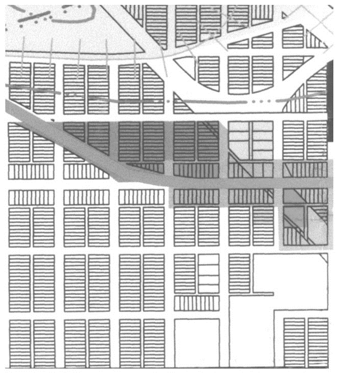
Blocks. Streets shall be designed to create blocks that consider interconnectedness, topography, solar orientation, views, and other design features. The length of blocks in "Old Town" is typically four hundred (400) feet.
Thus, to the greatest extent possible, blocks shall be designed to have a length of between three hundred (300) feet and seven hundred (700) feet (nonresidential streets). The lengths, widths and shapes of blocks shall be determined with due regard to the following:
a.
Provision of adequate building sites suitable to the special needs of the type of use contemplated.
b.
Need for convenient access, control, and safety of vehicular and pedestrian traffic circulation.
c.
Limitations and opportunities of topography.
(2)
Lot Dimension and Configuration.
a.
Lot size, width, depth, shape, and orientation and minimum building setback lines shall conform to Article II "Zoning Districts and Uses" of this Chapter and shall facilitate the placement of buildings with sufficient access, outdoor space, privacy, and view.
b.
Depth and width of properties shall be adequate to provide for off-street parking, landscaping, and loading areas required by the type of use and development contemplated.
b.
Lot Width Frontage. All lots shall have frontage that is either adjacent to or directly accessible to a street. Street frontage shall typically not be less than twenty-five (25%) percent of the lot depth. Flag lots are prohibited unless otherwise approved by the Board of Trustees.
c.
Corner Lots. Corner lots for residential use shall have extra width to accommodate side elevation enhancements, the required building setback and utility easements on both street frontages. For a corner lot, the front of the lot is defined as the side having the shortest street frontage. In the case of a reverse corner lot, both sides abutting a street shall maintain a front yard setback as illustrated below.
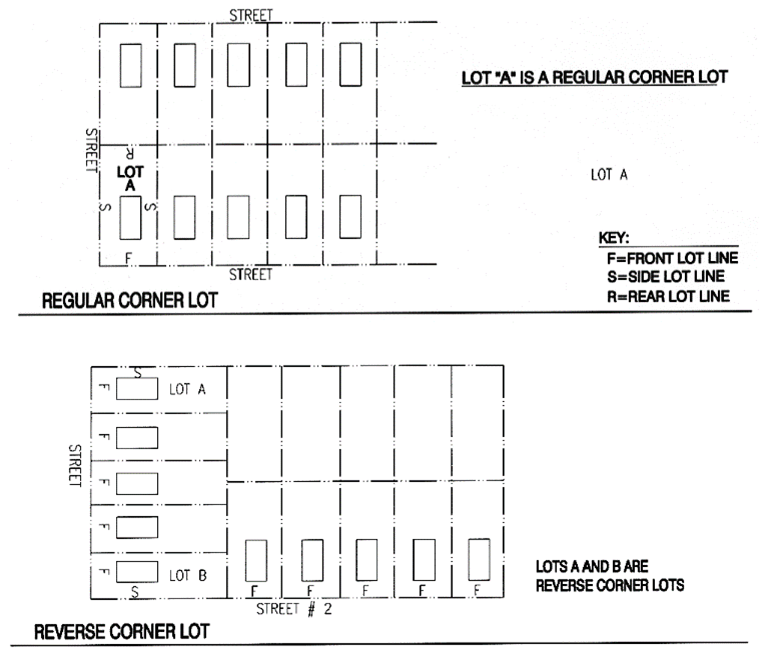
d.
Double Frontage. Double frontage lots for residential shall not be permitted except where essential to provide separation of residential properties from arterial streets or commercial uses, or to overcome specific disadvantage of topography and orientation. A planting screen easement of at least ten (10) feet in width, across which there shall be no vehicular right of access, may be required along the property line of lots abutting an arterial or other disadvantageous use as illustrated below.
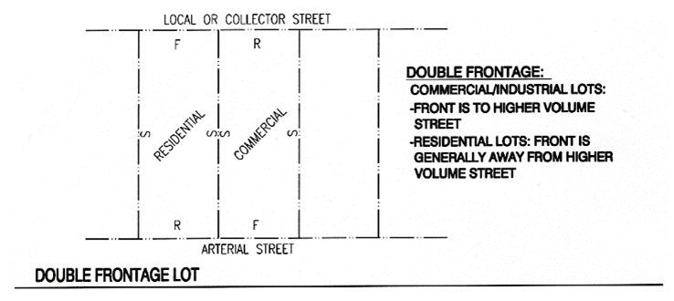
e.
Side Lot Lines. Side lot lines shall be substantially at right angles or radial to road right-of-way lines or centerlines.
f.
Residential Lots Adjacent to Arterial Streets. When residential lots are adjacent to, and the houses do not face, an arterial street (i.e., rear yards abut the street), they shall be a minimum of one hundred fifty (150) feet deep, and direct access to the arterial street shall be prohibited, except for nonconforming situations on unplatted parcels. The setback from the arterial to the house shall be a minimum of seventy-five (75) feet. When houses face the arterial street or are side-loaded relative to the street, the front or side setback to the house, respectively, shall be a minimum of fifty (50) feet. These setbacks do not apply for mixed-use dwelling units in the MU-C-D District.
g.
Residential Lot Access to Adjacent Street.
1.
Driveway access to a local or collector street from a single-family detached residential lot shall be limited to one (1) driveway curb cut or driveway access of no greater than twenty (20) feet in width. A circular drive in which each access to the local or collector street is less than ten (10) feet in width, separated by at least thirty (30) feet and which is constructed as an integral part of the overall architectural design of the single family residence, may be considered as a single driveway access.
2.
Driveway access to a local street from a single-family detached residential lot shall be greater than fifty (50) feet (except for reduced width lots in Mixed Use Zones) from the intersection of the local street and a collector street or one hundred twenty-five (125) feet from the intersection of the local street and an arterial street, as measured from the intersecting right-of-way lines.
3.
Driveway access to a collector street from a single-family detached residential lot shall be greater than one hundred twenty-five (125) feet from the intersection of the collector street and a local street, another collector street or an arterial street as measured from the intersecting right-of-way lines.
h.
Multi-Family Residential, Commercial, Business and Industrial Lot Access to Adjacent Street.
1.
Driveway access to a local or collector street from a multi-family residential, commercial, business, or industrial lot shall be greater than one hundred twenty-five (125) feet from any street intersection as measured from the intersecting right-of-way lines;
2.
Driveway access to an arterial street from a commercial, business or industrial lot shall be not less than two hundred fifty (250) feet from any intersection on the arterial street, or from another commercial, business or industrial lot's access as measured from the intersecting right-of-way lines, or driveways; or
3.
At the sole option of the Town, driveway access to a local street, collector street or arterial street from a multi-family residential, commercial, business, or industrial lot shall be as determined by a traffic study approved by the Town.
Sec. 16-5-615. - Access and Dedication.
(a)
Access. Access to all subdivisions shall be from a public street system. Driveways shall not be permitted to have direct access to arterials or CDOT state highways (principal arterials).
(b)
Street Right-of-Way Dedication. The full width of right-of-way for all streets being platted must be dedicated to the Town. In cases where the perimeter streets have a portion of the proposed right-of-way on an adjacent property, the following standards will apply:
(1)
The subdivider shall either:
a.
Purchase the other one-half (½) of the proposed right-of-way property for the Town at the appraised fair market value and then dedicate the right-of-way to the Town; or
b.
If the landowner of the proposed right-of-way property is unwilling to sell the proposed right-of-way property to the subdivider for its appraised fair market value, the subdivider shall pay for the cost of an appraisal for the proposed right-of-way property and legal fees for the Town Attorney to complete the condemnation process. The subdivider may enter into a reimbursement agreement with the Town to recover costs.
(2)
The subdivider shall finalize an agreement with the Town which guarantees the construction of the street to Town standards.
(3)
Perimeter Streets. When a street is dedicated which ends on the plat, the street right-of-way must be dedicated to the boundary of the plat.
Sec. 16-5-620. - Intersections.
Intersections shall meet the requirements found in "Design Criteria and Construction Specifications" unless otherwise approved by the Town Engineer.
Sec. 16-5-625. - Street Names.
(a)
Names of new streets shall not duplicate names of existing streets. However, new streets which are extensions of, or which are in alignment with, existing streets shall bear the names of such streets. All street, park, and recreation names shall be approved during the subdivision review and approval process.
Sec. 16-5-630. - Minimum Design Standards.
(a)
The width of street right-of-way and the design of the street it contains shall conform to the minimum standards set forth in the adopted Design Criteria and Construction Standards.
(b)
Tree-Lined Streets. All collector and arterial streets shall be lined with trees on both sides.
(c)
Street Layout. The use of cul-de-sacs and other roadways with a single point of access shall be minimized. The integration of traffic-calming features within and adjacent to residential areas shall be utilized when appropriate. To the greatest extent possible, streets shall be designed to have a maximum length of seven hundred (700) feet, from intersection to intersection.
(d)
Controlling Street Access. A strip of land between a dedicated street and adjacent property shall not be reserved for the purpose of controlling access to such street from such property.
(e)
Visibility at Intersections. No shrubs, ground cover, berms, fences, structures or other materials or items greater than thirty (30) inches in height shall be planted, created, or maintained at street intersections within the intersection sight distance triangles. Trees shall not be planted in the intersection sight distance triangles.
(f)
Pedestrian Crossings at Street Intersections and Mid-Block Crossings. Mid-block crossings shall be required and designed to ADA standards as specified in the Design Criteria and Construction Specification Standards.
Sec. 16-5-635. - Irrigation Ditches.
Existing irrigation ditches shall be incorporated within the subdivision plan in a manner such that their function is not impaired. The ditches shall be protected from encroachment.