
Mineral Wells City Zoning Code
ARTICLE 5
- SPECIAL DISTRICTS
Section 5-1. - PD - Planned development district.
A.
GENERAL PURPOSE AND DESCRIPTION: The planned development district "PD" prefix is intended to provide for combining and mixing of uses allowed in various districts with appropriate regulations, and to permit flexibility in the use and design of land and buildings in situations where modification of specific provisions of this ordinance is not contrary to its intent and purpose, or significantly inconsistent with the planning on which it is based, and will not be harmful to the community. A PD district may be used to permit new and innovative concepts in land utilization. While great flexibility is given to provide special restrictions which will allow development not otherwise permitted, procedures are established herein to insure against misuse of the increased flexibility. In addition, the presentation of a planned development shall provide significant amenities to the city by the proposed development, and shall not be used solely to circumvent the regulations of the straight zoned districts.
B.
DEVELOPMENT STANDARDS:
1.
Development standards for each separate PD district shall be set forth in the ordinance granting the PD district and may include but shall not be limited to uses, density, lot area, lot width, lot depth, yard depths and widths, building height, building elevations, coverage, floor area ratio, parking, access, screening, landscaping, accessory buildings, signs, lighting, management associations, and other requirements as the city council may deem appropriate.
2.
The ordinance granting a PD district shall include a statement as to the purpose and intent of the PD granted therein. A specific list is required of the regulations in each PD district and a general statement citing the reason for the PD request.
3.
The planned development district shall conform to all other sections of the ordinance unless specifically exempted in the granting ordinance.
4.
The PD district shall facilitate the use of mixed uses and densities as indicated in the comprehensive land use plan and shall incorporate the elements of pedestrian and vehicular connectivity as encouraged in the plan.
C.
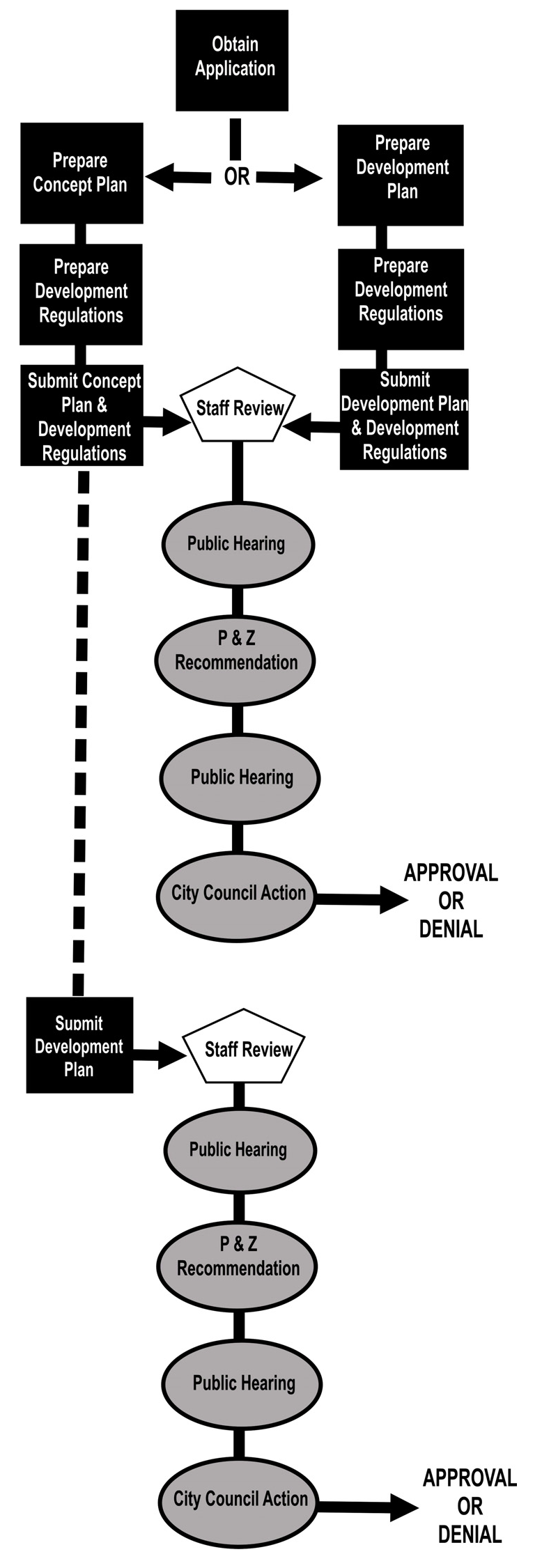
HIERARCHY OF PLANS AND DRAWINGS: Within the planned development process a number of plans or drawings are either optional or may be required. These plans primarily consist of the following:
1.
Concept Plan. The concept plan is an optional document that is provided at the initial stages of the development. These plans show the entire scope of the site to be developed in all future phases. It often may consist of a general "bubble" diagram showing the locations of various uses, sample elevations and the approximate configuration of the development. Attached text documentation will define the regulations and descriptions within the "bubble" area but detailed lot layouts, vehicle and pedestrian circulation, and park and open space layout will only be depicted in the most rudimentary and general manner. Zoning as a planned development district may occur with a concept plan initially; however, a development plan of the site, which is usually in phases, is required to be approved by the planning and zoning commission and city council prior to any platting improvements, or issuing of building permits.
2.
Development plan. The development plan is a required document that is provided to indicate the relationship of proposed land uses with the pedestrian and vehicle circulation system. Configuration of street patterns and locations of pedestrian paths and walkways will be located on the development plan. The development plan will provide acreages of each proposed use as well as show general lot layouts with sizes of proposed lots. Community facilities, public and private parks, landscaped areas, entrance features, and major easements and drainage areas will be depicted on the development plan. Additional information that is unique to the development may be required by staff, planning and zoning commission or city council during the approval process. The development plan may be approved at the time of initial zoning of the property as a PD or may be approved in phases as development occurs; however, a development plan must be approved by the planning and zoning commission and the city council prior to any improvements being made or the issuing of building permits.
3.
Site plan. The site plan is a required document that is generally provided before the issuance of a building permit. However, a site plan may be required at the time of platting, and/or during the course of the planned development zoning process, if deemed necessary by the administrative official, to ensure compatibility between land uses or to coordinate development in sensitive development projects. The site plan is usually focused on commercial or multifamily used property and shows great detail regarding the development. It documents the locations of all proposed improvements, dimensions of buildings, drive lanes, drive ways, sidewalks, setbacks, and physical features. The site plan may include, on the plan or as an attachment, landscape plans, elevations, photometric maps, or other information pertinent to the development. Section 6-1 of this ordinance provides site plan requirements.
D.
CONCEPT AND DEVELOPMENT PLAN: In establishing a planned development district, the city council shall approve and file as part of the amending ordinance appropriate plans and standards for each planned development district. During the review and public hearing process, the city council shall require a concept plan and/or a development plan (or detail site plan) in accordance with these regulations.
1.
Concept plan. This plan may be submitted by the applicant prior to a development plan. The concept plan shall show the applicant's intent for the use of the land within the proposed planned development district in a graphic manner and shall be supported by detailed written documentation of proposed standards for development.
(a)
A concept plan for residential land use shall show general use, thoroughfares, and preliminary lot arrangements. For residential development which does not indicate platted lots at the time of the concept plan, the plan may provide notations of the typical size, type, and location of lots and building sites, access, density, building height, screening, parking areas, landscaped areas, and other pertinent development data.
(b)
A concept plan for uses other than residential uses shall set forth the land use proposals in a manner to adequately illustrate the type and nature of the proposed development. Data which may be submitted by the applicant, or required by the city council, may include but is not limited to the types of use(s), topography, and boundary of the PD area, physical features of the site, existing streets, alleys, and easements, location of future public facilities, building heights and locations, parking ratios, and other information to adequately describe the proposed development and to provide data for approval which is to be used in drafting the final development plan. However, development intent may be provided in general forms such as "bubble" plans provided the subsequent development plan provides detailed proposals for use of the land.
(c)
Changes of detail which do not alter the basic relationship of the proposed development to adjacent property and which do not alter the uses permitted or increase the density, building height, or coverage of the site and which do not decrease the off-street parking ratio, reduce the yards provided at the boundary of the site, or alter the landscape plans as indicated on the approved concept plan may be authorized by the administrative official. If an agreement cannot be reached regarding whether or not a detailed site plan conforms to the original concept plan, the city council shall determine the conformity.
(d)
Planned development zoning may be approved for the site with only an approved concept plan and accompanying detailed development regulations text. However, a development plan must be approved prior to platting, receiving a building permit for any planned development or any phase of a planned development. Approval of the development plan shall require a public hearing and notification as required by law for zoning amendments.
2.
Development plan. This plan shall set forth the final plans for development of the planned development district and shall conform to the data presented and approved on a concept plan, unless a development plan is being submitted in place of a concept plan at the initial zoning request for the planned development. The development plan may be submitted for the total area of the PD or for any section or phase of the total development. A public hearing on approval of the development plan shall be required at the time the development plan is submitted if the development plan is submitted in place of a concept plan with the planned development zoning request. The development plan shall include:
(a)
A site inventory analysis including a scale drawing, existing vegetation, natural water courses, creeks or bodies of water, and an analysis of planned changes in such natural features as a result of the development. This should include a delineation of any flood prone areas.
(b)
Locations of all existing and proposed thoroughfares and local streets, including widths of rights-of-way and paving. All boulevards and special paving treatment shall be indicated on the development plan.
(c)
A tabulation of acres of land uses proposed for the development, including the size and number of lot products, parks, open spaces, common areas, linear feet of pedestrian walkways, the location and nature of all common area features.
(d)
General indication of locations of proposed building complexes, with the exception of single-family residential units, showing the relationship between buildings and property lines, street lines, and alley lines. The development plan should also include the arrangement and provision for off-street parking.
(e)
An indication of the nature and quantity of landscaped areas showing screening walls, ornamental planting, wooded areas, and trees to be planted.
(f)
An architectural plan showing elevations and signage style to be used throughout the development for all uses except single-family and moderate density residential uses, may be required by the city council if deemed appropriate. Any or all of the required information may be incorporated on a single drawing if such drawing is clear and can be evaluated by the city manager.
(g)
An indication of phasing for the total development.
3.
Relationship to the site plan. The development plan does not take the place of a detailed site plan which is required at the time of building permit. However, the site plan must generally conform to the approved development plan. If, in the opinion of the administrative official, the site plan does not conform to the approved development plan, the applicant must either amend the site plan to conform to the development plan or amend the planned development by amending the development plan. Amendment of the planned development requires a zoning amendment according to the process established by state law.
4.
Procedure for establishment. The procedure for establishing a planned development district shall follow the procedure for zoning amendments as set forth in section 1-11, amendments, changes, and administrative procedures. This procedure is expanded as follows for approval of concept and/or development plans.
(a)
The concept plan and the development plan may be submitted simultaneously, or the development plan may suffice for the concept plan if the development plan includes all phases in the proposed PD. Otherwise, a development plan shall be submitted concurrent with the individual PD phase that is being developed.
(b)
Separate public hearings shall be held by the planning and zoning commission and the city council for the approval of the concept plan and the development plan or any section of the development plan, unless a determination, by staff, that a single public hearing is adequate. A single public hearing is adequate when:
1)
The applicant submits adequate data with the request for the planned development district to fulfill the requirements for both the concept plan and the development plan; or
2)
Information on the concept plan is sufficient to determine the appropriate use of the land and the development plan will not deviate substantially from it.
(c)
The ordinance establishing the planned development district shall not be approved until the concept plan is approved, or the development plan is approved if a development plan is submitted in place of a concept plan.
(d)
The development plan may be approved in phases, provided that the development plan is not being submitted in place of a concept plan or that the approved concept plan indicates that the development will be completed in phases. When the development plan is approved in phases, the separate approvals by the city council, with recommendations from planning and zoning commission and appropriate public hearings and notification for the initial and subsequent sections will be required.
E.
WRITTEN REPORT MAY BE REQUIRED: When a PD is being considered, a written report may be requested of the applicant discussing the impact on planning, engineering, water utilities, electric, sanitation, building inspection, tax, police, fire, traffic, and how it meets the applicable elements of the comprehensive land use plan. Written comments from the applicable public school district and from private utilities may be submitted to the city council.
F.
PLANNED DEVELOPMENTS TO BE RECORDED: All planned development districts approved in accordance with the provisions of this ordinance in its original form, or by subsequent amendment thereto, shall be referenced on the zoning district map, and a list of such planned development districts, together with the category of uses permitted therein, shall be maintained in an appendix of this ordinance.
G.
MINOR CHANGES TO AN APPROVED DEVELOPMENT PLAN: Minor changes to an approved development plan, which will not cause any of the following circumstances to occur, may be authorized by the administrative official:
1.
A five percent or greater increase in the gross floor areas of structures.
2.
Any substantial and material changes in such external effects on adjacent property as noise, heat, light, glare and vibration.
3.
A substantial and material reduction in the originally approved separations between buildings.
4.
Any adverse changes in traffic circulation, safety, drainage and utilities.
5.
A five percent or greater increase in the height of structures.
6.
A ten percent or greater reduction in the originally approved setbacks from property lines.
7.
A five percent or greater increase in ground coverage by structures.
8.
A five percent or greater reduction in the ratio of off-street parking and loading space.
9.
A change in the size, height, lighting, flashing, animation or orientation of originally approved signs.
10.
The administrative official shall determine whether changes being requested are minor. This determination may be appealed by the applicant to the zoning board of adjustment. Any change deemed not to be a minor change, as indicated above, shall be processed as a new application in accordance with the provisions of this section.
Section 5-2. - HOD - Heritage overlay district.
A.
DECLARATION OF POLICY: The city council hereby finds and declares as a matter of public policy that the protection, enhancement and use of districts within the city that exhibit the character of the city's early heritage is a public necessity and is required in the interest of the culture, prosperity, education and welfare of the people.
B.
ESTABLISHMENT OF HOD - HERITAGE OVERLAY ZONING DESIGNATION: Any zoning district designation appearing on the zoning district map may be designated with an H overlay district.
C.
DISTRICT REGULATIONS AND REQUIREMENTS: The regulations as established in districts underlying the HOD overlay districts shall apply unless otherwise modified in these district regulations.
D.
CERTIFICATE OF APPROPRIATENESS: Any development, construction, reconstruction or rehabilitation that results in the modification of the exterior of any structure in an HOD overlay district shall be subject to requirements for a certificate of appropriateness in accordance with the city's heritage ordinance, as applicable.
E.
HERITAGE DESIGN STANDARDS: Any development, construction, reconstruction or rehabilitation that results in the modification of the exterior of any structure in any HOD overlay district shall be subject to any City of Mineral Wells regulations that govern HOD overlay districts including any heritage design standards, as applicable.
F.
CRITERIA: The following criteria shall be considered when determining whether an area is eligible for designation as an HOD overlay district.
1.
The architecture within the proposed district is significant to maintaining the character of the city's early heritage.
2.
The area exhibits or represents distinctive characteristics of a type, period or method of construction.
3.
Buildings in the area are representative of the work, or exhibit the characteristics of the work, of a master designer, builder or craftsman.
4.
The area contains established and familiar visual features of the community.
5.
The area is significant in the history, architecture, archeology and/or culture.
6.
The area is associated with events that have made a significant contribution to the patterns of local, regional, state or national history.
7.
The area is associated with the lives of persons significant in the city's past.
G.
COMMERCIAL REGULATIONS: The following regulations shall apply to H overlay districts when the underlying district is zoned for commercial use. In addition all structures and uses within the H overlay district lying within underlying nonresidential zoning districts shall be subject to the architectural standards established by the heritage district design guidelines.
1.
Permitted uses: In the HOD overlay district, no building or land shall be used and no building constructed, reconstructed, altered or enlarged unless for a use permitted in any underlying commercial district and not specifically prohibited within the H overlay district. In addition, residential uses, as shown below, shall be permitted in any H overlay district within an underlying commercial district, providing that no residential dwelling units shall be located on any ground floor.
(a)
Apartment.
(b)
Apartment, loft.
(c)
Apartment, studio.
(d)
Bed and breakfast (hosted and nonhosted).
(e)
Farmers market shall be permitted as a special event. A written application shall be submitted to the administrative official for approval. The administrative official may defer such approval to the city council with a recommendation from the planning and zoning commission.
2.
Prohibited uses: The following uses are prohibited in any HOD overlay district when the underlying district is commercially zoned.
(a)
Animal shelter.
(b)
Athletic field and play field, public/commercial.
(c)
Amusement center, outdoor.
(d)
Campground & related facilities.
(e)
Golf course, miniature.
(f)
Rodeo ground/fair ground.
(g)
Shooting range indoor/outdoor.
(h)
Skating rink.
(i)
Stable, commercial/private.
(j)
Water park, commercial.
(k)
Nursing home.
(l)
Rehabilitation care facility.
(m)
Veterinary hospital.
(n)
Veterinary office, large animal practice.
(o)
Auto auction.
(p)
Auto car wash.
(q)
Auto paint and body shop.
(r)
Auto parts and accessory sales.
(s)
Auto repair garage.
(t)
Auto sales new/used.
(u)
Auto service station (exceeding six pumps).
(v)
Boat sales/rental.
(w)
Body piercing studio.
(x)
Building material sales/lumber yard.
(y)
Cargo container sales and rental.
(z)
Contractor, outside storage.
(aa)
Contractor storage or equipment yard.
(bb)
Cemetery/mausoleum.
(cc)
Collection center.
(dd)
Exterminating service.
(ee)
Flea market.
(ff)
Golf course.
(gg)
Greenhouse/nursery—Commercial.
(hh)
Halfway house.
(ii)
Helistop/heliport.
(jj)
Kennel.
(kk)
Landscape service.
(ll)
Machinery sales or repair.
(mm)
Manufactured or industrialized home sales or rental.
(nn)
Mini-warehouse.
(oo)
Motorcycle sales.
(pp)
Motor sports complex.
(qq)
Parking lot, trucks/trailers.
(rr)
Radio microwave tower.
(ss)
Radio/television station tower.
(tt)
Recreational vehicle park.
(uu)
Recreational vehicle storage.
(vv)
Recreational vehicle sales/rental.
(ww)
Rental yard, commercial/domestic.
(xx)
Sewerage pumping station.
(yy)
Stadium.
(zz)
Storage/warehousing exceeding 500 sq. ft., except by special exception.
(aaa)
Swimming pool.
(bbb)
Tattoo studio.
(ccc)
Telephone switching station.
(ddd)
Water pumping station, private.
(eee)
Water storage facility, private or public.
3.
Permitted signs: Signs are permitted within the underlying commercial districts of an HOD overlay district in accordance with the City of Mineral Wells Sign Ordinance.
4.
Outside display: Commercial products may be displayed in the public rights-of-way on the sidewalk, providing that a minimum of three feet of clear space is provided for pedestrians. Any outside display must be cleared from the public right-of-way each day after business hours.
5.
Outdoor seating: Business establishments may provide outdoor seating in public rights-of-way on the sidewalks adjacent to their property. A site plan approved by the city council shall indicate all proposed outdoor seating areas in relationship to the primary building.
H.
RESIDENTIAL REGULATIONS: Underlying residential districts in the HOD overlay district shall comply with the underlying district requirements, which may permit townhome and patio home developments, and shall be subject to the architectural standards established by the heritage district design guidelines, as applicable.