
Mission Viejo City Zoning Code
CHAPTER 9
01.- INTRODUCTION
Sec. 9.01.005.- Title.
This title shall be known as the "City of Mission Viejo Development Code," hereafter referred to as the "code."
(Ord. No. 98-193, §§ 1—4, 10-19-98)
Sec. 9.01.010. - Purpose.
The purpose of this code is to promote the public health, safety, general welfare and to preserve and enhance the aesthetic quality of the city by providing regulations to ensure an appropriate mix of land uses and orderly land development. In furtherance of this purpose the city desires to achieve a pattern and distribution of land uses which generally:
*
Retain and enhance established residential neighborhoods, commercial and business park districts, regional uses, recreation and amenities.
*
Maintain a balanced distribution of land uses and provide for land use compatibility throughout the city.
*
Allow for the infill and recycling of areas at their prevailing scale and character.
*
Allow for the intensification of commercial uses in the urban core area of the city.
*
Conserve and enhance significant environmental resources.
*
Provide open space resources for passive and active recreational activities, and protect the public from natural safety hazards.
*
Provide a diversity of areas characterized by differing land use activity, scale and intensity, while maintaining community identity and quality development in the city and its neighborhoods.
*
Maintain Mission Viejo as a unique and distinctive place with a high quality of life and an aesthetic, secure environment for the city's residents and businesses.
(Ord. No. 98-193, §§ 1—4, 10-19-98)
Sec. 9.01.015. - Authority and general plan consistency.
This code is the primary tool for implementing the goals and policies of the Mission Viejo General Plan, pursuant to the mandated provisions of the State Planning and Zoning Law (Government Code §§ 65000 et seq.), State Subdivision Map Act (Government Code §§ 66410 et seq.), California Environmental Quality Act (Public Resources Code §§ 21000 et seq.), and other applicable state and local requirements. All development within the unincorporated area of the city's sphere of influence should be consistent with the Mission Viejo General Plan. All development within the incorporated area of the city shall be consistent with the Mission Viejo General Plan.
This code is designed to treat in one unified title those areas of regulation more typically dealt with in separate zoning and subdivision ordinances, and related chapters of the Municipal Code.
(Ord. No. 98-193, §§ 1—4, 10-19-98)
Sec. 9.01.020. - Binding development agreements.
Pursuant to Government Code §§ 65864 through 65869.5, local governments have the authority to enter into binding agreements with persons or entities having legal or equitable interest in real property within its jurisdiction for the development of such property in order to, among other purposes, establish certainty in the development process. Prior to the adoption of the Code, one development agreement between the Mission Viejo Company and the City of Mission Viejo for the development of the Mission Viejo Planned Community is still in effect. On May 28, 1991, the City of Mission Viejo and Mission Viejo Company executed the Public Improvements, Facilities and Benefits Agreement (PIFBA). Unless extended or terminated early, PIFBA shall expire June 28, 2001.
During the term of the development agreement, the Mission Viejo Company or its successor has the right to develop the property covered in the agreement according to the land use ordinances and development approvals in existence or adopted in conjunction with the agreement's enactment. The development of the covered property, however, must comply with the current building ordinances. Subsequent ordinances may be applied to the property covered by the agreement if regulations are not inconsistent or in conflict with the land use ordinances and existing approvals recognized in the agreement and do not materially interfere with the development of the subject property for the uses and to the height, density, intensity and timing as provided for in the agreement. The agreement pertains to the initial development of the properties in question, and redevelopment would not be constrained by the development agreement.
(Ord. No. 98-193, §§ 1—4, 10-19-98)
Sec. 9.01.025. - Review authority.
The development review process involves the participation of the following:
(a)
Planning commission:
(1)
Appointment. The Planning commission shall consist of five members who are appointed by the city council and who serve pursuant to the provisions of Chapter 2.06 of the Municipal Code.
(2)
Duties. The commission shall perform the duties and functions prescribed in this code. The commission shall prepare, recommend adoption of, implement, and periodically review and recommend revisions to the general plan and this code for the desired physical development of the city and any land within its sphere of influence.
(3)
Powers. The commission shall have the power to grant final approval for variances, residential developments encompassing two or more units, commercial developments encompassing 10,000+ square feet, industrial developments encompassing 10,000+ square feet, conditional use permits, architectural review permits, planned sign programs, tentative tract and parcel maps, subject to appeal to the city council. Also the commission shall make recommendations to the city council for final determination regarding the following entitlements: Specific plans, general plan amendments, zoning map amendments, Development Code amendments, development agreements, applicable environmental determination, surface mining and land reclamation plans, and other applicable ordinance or regulations which are zoning in nature.
(b)
Director of community development:
(1)
Appointment. The director of community development shall be appointed by the city manager.
(2)
Duties. The director shall perform the duties and functions provided in this code, in addition to the day-to-day and long-range management of the community development department.
(3)
Powers. The director shall have the power to give final approval authority for certificates of occupancy, home occupation permits, sign permits, temporary use permits, minor modifications, minor exceptions, lot line/boundary adjustments, and planned development permits encompassing developments less than 10,000 square feet and residential developments involving no more than one unit, subject to appeal to the planning commission.
(Ord. No. 98-193, §§ 1—4, 10-19-98)
Sec. 9.01.030. - Establishment of zoning districts.
(a)
Establishment of zones. Mission Viejo shall be divided into zoning districts which consistently implement the general plan. The following districts are established:
(b)
Adoption of zoning map. The boundaries of the zoning districts established by this section shall be shown upon the map designated as the "City of Mission Viejo Official Zoning Map," on file with the city clerk, and available at the department.
(c)
Rules applying to uncertain boundaries on zoning map. The following shall apply in determining uncertain boundaries of a district as shown on the official zoning map:
(1)
Where a boundary follows a public street or alley the centerline of the street shall be the boundary. Where a boundary follows a lot line, the lot line shall be the boundary.
(2)
Where a district boundary divides a parcel, the location of the boundary, unless indicated by dimension, shall be determined by referencing the adopted zoning map and/or legal description of the approved rezoning case for exact dimensions.
(3)
All property in the city, or hereafter annexed, not previously classified by the city, is hereby designated in the OS zoning district.
(4)
In case any uncertainty exists, the director shall determine the location of the district boundary.
(Ord. No. 98-193, §§ 1—4, 10-19-98; Ord. No. 21-341, § 4(Exh. A), 10-12-21)
Sec. 9.01.035. - General requirements.
(a)
Application. All land or structures shall be used and constructed in compliance with the regulations and requirements of this code, including obtaining all applicable permits prior to use inauguration.
(b)
Conflicting permits and licenses to be voided. All permits or licenses shall be issued in compliance with the provisions of this code. Any permit or license issued in conflict with this code shall be null and void.
(c)
Similar uses permitted. When a use is not specifically listed in this code, it shall be understood that the use may be permitted only if it is first determined by the director that the use is similar to other uses listed.
It is further recognized that every conceivable use can not be identified in this code, and anticipating that new uses will evolve over time, this section establishes the director's authority to compare a proposed use and measure it against those listed in this code.
In determining "similarity" the director shall first make all of the following findings:
(1)
That the proposed use shall meet the intent of and be consistent with the goals and policies of the general plan.
(2)
That the proposed use shall meet the stated purpose and general intent of the zoning district in which the use is proposed to be located.
(3)
That the proposed use shall not adversely impact the public health, safety, and general welfare of the city's residents.
(4)
That the proposed use shall share characteristics common with, and not be of greater intensity, density or generate more environmental impact than those uses listed in the zoning district in which the use is proposed to be located.
(d)
Minimum requirements. When interpreting and applying the regulations of this code, the provisions shall be the minimum requirements, unless otherwise stated.
(e)
Conflict with other regulations. Nothing in this code shall be deemed to repeal or amend the Building Code or other ordinance or regulation of the city except as otherwise provided for in this code. Where conflicts occur between the provisions of this code and the Building Code or other regulations of the city, the more restrictive shall apply.
It is not intended that this code shall interfere with, repeal, abrogate, or annul any private easement, covenant, or other agreement in effect at the time of adoption. Where this code imposes a greater restriction upon the use of structures or land, the provisions of this code shall apply.
Nothing contained in this code shall be deemed to repeal or amend any regulation of the city requiring a permit or license or both.
(f)
Language. In interpreting this code, it is understood that "shall" is mandatory, "should" is not mandatory but strongly recommended, and "may" is permissive.
(g)
Prohibited land uses. Any land use that contravenes state or federal law shall be prohibited in all planning areas, districts or zones.
(Ord. No. 98-193, §§ 1—4, 10-19-98; Ord. No. 07-250, § 2, 4-2-07; Ord. No. 07-251, § 2, 4-16-07)
Sec. 9.01.040. - Density and intensity.
The density and intensity limitations established in the land use element of the general plan shall apply to each parcel, respectively, except as provided in this code.
(Ord. No. 98-193, §§ 1—4, 10-19-98)
Sec. 9.01.045. - Partial invalidity.
If any chapter, section, subsection, sentence, clause, or phrase of this code is for any reason held to be invalid or unconstitutional, the decision shall not affect the validity of the remaining portions of this code. The city council hereby declares that it would have adopted this code and each chapter, section, subsection, sentence, clause, or phrase thereof irrespective of the fact that any one or more portions of this code might be declared invalid.
(Ord. No. 98-193, §§ 1—4, 10-19-98)
Sec. 9.01.050. - Definitions.
(a)
The purpose of this section is to provide clear and easily understood definitions for the terms used in this code. As used in this code the specific definitions are as follows:
(1)
Abandoned. The condition of a property or structure that has not been developed or maintained for a specified period of time.
(2)
Abandoned activity. A business or enterprise with no reported sales or activity for a period of at least 90 days. Exceptions are temporary closures for repairs, alterations, or other similar situations.
(3)
Abutting (adjoining). Sharing a common boundary line; lying near or close.
(4)
Access. The place or way by which pedestrian and vehicles shall have safe, adequate, and usable ingress and egress to a property or use as required by this Development Code.
(5)
Accessory building or structure. A structure detached from a principal structure on the same parcel, incidental to the principal structure, and not designed for human habitation.
(6)
Accessory dwelling unit. An accessory dwelling unit or "ADU", as defined in California Government Code Section 65852.2, means an attached or detached residential dwelling unit that provides complete independent living facilities for one or more persons and is located on a lot with a proposed or existing primary residence.
(7)
Accessory use. A use incidental to and customarily associated with a specific principal use located on the same parcel.
(8)
Action. The decision made by the review authority on a land use application, including appropriate findings, environmental determination, and conditions of approval, where applicable.
(9)
Adjacent. Separated only by an alley, street, highway, or recorded easement; lying near or close to each other. Most commonly applied to parcels of land, buildings, or other objects.
(10)
Adjoining (abutting). Sharing a common boundary line; lying near or close.
(11)
Adult businesses. See section 9.15.010 for specific definition of terms.
(12)
Affordable housing. Defined by state law (Government Code § 65589.5).
(13)
Agricultural employee housing. Dwellings with six or fewer agricultural workers to be allowed as a single-family structure and permitted in the same manner as other dwellings of the same type in the same zone, in accordance with California Health and Safety Code Section 17021.5.
(14)
Agriculture. Any land use activity that includes farming, dairying, grazing, horticulture, floriculture, viticulture, apiaries, animal and poultry husbandry, and accessory activities, including but not limited to storage, harvesting, feeding, or maintenance of equipment. Such activity excludes stockyards, slaughtering, or commercial food processing.
(15)
Airport or heliport. Any area of land designated and set aside for the landing and taking off of any aircraft regulated by the Federal Aviation Administration.
(16)
Alley. Any roadway not exceeding 25 feet in width which is primarily used for access to the rear or side entrances of abutting property.
(17)
Alteration. Any interior or exterior change to a structure.
(18)
Animal hospital. A licensed establishment where animals or pets are given medical or surgical treatment and are cared for during the time of the treatment.
(19)
Antenna. See section 9.30.010 for specific definition of terms.
(20)
Apartment. A separate suite, not owner occupied, that includes kitchen facilities and is designed for and rented as the home, residence, or sleeping place of one or more persons living as a single housekeeping unit.
(21)
Applicant. Owner(s) or lessee(s) of property, or their agent(s), who are seeking discretionary approval from the city.
(22)
Arcade. A business establishment having three or more coin or token operated games.
(23)
Attached. The condition of having a wall or roof in common.
(24)
Automobile dismantling. The wrecking or taking apart of motor vehicles or trailers, or the storage, sale, or dumping of dismantled, partly dismantled, or wrecked motor vehicles or their parts.
(25)
Automobile repair specialty shop. A retail and service place of business engaged primarily in light repair and sale of goods and services for automotive vehicles including brakes, muffler and tire shops, and their accessory uses. Heavier automobile repair (i.e., transmission work and engine overhaul) is not included in this definition.
(26)
Automobile service center. A retail place of business for the servicing and repairing of motor vehicles, including the sale of motor vehicle accessories.
(27)
Automobile service station. A retail place of business for the servicing or fueling of motor vehicles, including tube and tire repairs, battery charging, storage of merchandise and supplies related to the servicing of motor vehicles, sale of gasoline and other fuel and lubricants, motor vehicle washing, grease racks, and motor vehicle repairs. Such use excludes body and fender work, engine overhauling and replacement, transmission work, and other similar activities.
(28)
Awning. A nonstructural roof-like cover that is attached to and projects from the wall of a structure.
(29)
Backyard. See: Yard, rear.
(30)
Basement. A story partly or completely underground. A basement shall be counted as a story for purposes of height measurement where any portion of a basement has more than one-half of its height above grade.
(31)
Bed and breakfast. A commercial lodging establishment primarily engaged in providing lodging and morning meals to the general public.
(32)
Berm. A mound or embankment of earth.
(33)
Block. A parcel or parcels of land surrounded by public streets, highways, freeways, railroad rights-of-way, greenbelts, flood control channels, creeks, washes, rivers, or unsubdivided acreage or any combination thereof.
(34)
Boardinghouse. A structure in which lodging and meals for boarders are provided for compensation.
(35)
Building. Any structure having a roof supported by columns or by walls.
(36)
Building area/building envelope. An area delineated on a plan in which all clearing and land disturbance for building construction must be confined. If not delineated, it is the area of a parcel excluding any required front, side, or rear yard setback area, or any recorded easement, or offer of dedication (See diagram).
(37)
Building Code. The ordinances that govern building and construction standards, including but not limited to the structural, electrical, mechanical, swimming pool, plumbing, grading, and fire codes.
(38)
Building coverage. The percent of parcel area which may be covered by all the footprints of structures on the parcel.
(39)
Building height. The vertical distance from the lowest point of the finished grade adjacent to the structure to the highest point of the structure, excluding chimneys and vents.
(40)
Building, principal. A structure in which the principal use is situated.
(41)
Building site. The ground area of a structure together with all open spaces required by this code.
(42)
Carport. A permanent roofed structure that is not completely enclosed and primarily intended to be used for vehicle shelter or storage.
(43)
Certificate of occupancy. A permit issued by the department of building and safety prior to occupancy or change of tenant(s) of a structure to ensure that all defects have been corrected, all construction debris has been removed, the site has been graded to final grade, and the structure is ready to be occupied.
(44)
City. The City of Mission Viejo.
(45)
Clinic. A place for outpatient medical services to patients, human or animal.
(46)
Club. An association of persons (whether or not incorporated) organized for some common nonprofit purpose, but not including a group organized primarily to render a service customarily carried on as a business.
(47)
Code. The City of Mission Viejo Development Code.
(48)
Commercial vehicle. A vehicle customarily used as part of a business for the transportation of goods or people.
(49)
Commission. The Planning and Transportation Commission of the City of Mission Viejo.
(50)
Community care facility. An intermediate care facility providing nonmedical or a combination of medical and nonmedical residential care or day care for children, adults, or both, including physically handicapped and mentally incompetent persons.
(51)
Conditional use permit. A discretionary entitlement granted under the provisions of this code which authorizes a specific use by the planning commission and/or city council for a specific property, subject to compliance with all terms and conditions imposed on this entitlement. Such authorization may be for a specified period of time.
(52)
Condominium. A development consisting of an undivided interest in common for a portion of a parcel coupled with a separate interest in space in a residential or commercial building on the parcel.
(53)
Congregate care/senior housing. A structure or a group of structures providing residence, usually for a group of senior citizens, with a central or private kitchen, dining, and recreational facilities, and with separate bedrooms and/or living quarters.
(54)
Construction commencement. The actual beginning of building, or construction, which takes place when site preparation and grading have been finished; all electrical, plumbing, and air conditioning groundwork has been completed; and a building permit has been issued.
(55)
Cooperative apartment. A development in which an undivided interest in the land is coupled with the right of exclusive occupancy of an apartment located on the land.
(56)
Council. The City Council of Mission Viejo.
(57)
County. The County of Orange.
(58)
Court. An open, unoccupied space, other than a yard, on the same parcel with a structure and bounded on two or more sides by the walls of a structure.
(59)
Day care facility, children. A facility which provides nonmedical care to children under 18 years of age in need of personal services, supervision, or assistance essential for sustaining the activities of daily living or for the protection of the individual on less than a 24-hour basis. Day care facilities include family day care homes, infant centers, preschools, and extended day care facilities.
(60)
Days. Refers to consecutive calendar days unless otherwise stated.
(61)
Density. The number of residential dwelling units per gross acre, unless otherwise stated.
(62)
Density bonus. Defined by state law (Government Code § 65917.5).
(63)
Department. The Mission Viejo Community Development Department.
(64)
Design. Includes all of the planning and engineering required for the following: street alignments, grades, and widths; drainage and sanitary facilities and utilities, including alignment and grades thereof; location and size of all required easements and rights-of-way; fire roads and fire breaks; parcel size and configuration; traffic access; grading; land to be dedicated for park or recreational purposes; building and other specific physical requirements.
(65)
Detached. The condition of not having a wall or roof in common with any other structure.
(66)
Development. Includes all of the following activities: changing the density or intensity of use of land, including, but not limited to, subdivision pursuant to the Subdivision Map Act, and any other division of land, including lot splits, except where the land division is brought about in connection with the purchase of the land by a public agency for public recreational use; changing the intensity of use of water, or of access thereto; constructing, reconstructing, demolishing, or altering the size of any structure, including any facility of any private, public, or municipal utility; discharging or disposing of any dredged material or any gaseous liquid, solid, or thermal waste; grading, removing, dredging, mining, or extraction of any soil or materials; placing or erecting any solid material or structure; and removing any major vegetation. As used in this code, "structure" includes but is not limited to any building, road, pipe, flume, conduit, siphon, aqueduct, telephone line, and electrical power transmission and distribution line. A "project" as defined in state law (Government Code § 65931) is included within this definition.
(67)
Development Code. A unified text incorporating those areas of regulation more typically presented in separate zoning and subdivision ordinances and related chapters of the Municipal Code.
(68)
Director. The Director of the Community Development Department for the City of Mission Viejo.
(69)
Dormitory. A structure which is related to an educational or public institution or is maintained and operated by a recognized nonprofit welfare organization intended principally for sleeping accommodations and which has no individual kitchen facilities.
(70)
Dwelling. A structure or portion thereof designed for residential occupancy, not including hotels or motels.
(71)
Dwelling, multifamily. A residential structure containing two or more dwelling units or a combination of two or more separate single-family dwelling units on a single parcel of land.
(72)
Dwelling, single-family. A residential structure containing not more than one dwelling unit entirely surrounded by open area on a single parcel.
(73)
Dwelling unit. One or more rooms in a building or portion thereof, which are designed, intended to be used, or actually used for occupancy by one family or person for living and sleeping purposes and include bathroom(s), sleeping quarters, and kitchen.
(74)
Easement. An interest in land created by grant or agreement which confers a right upon the owner to some profit, benefit, dominion, or lawful use over the estate of another.
(75)
Educational institution. A school, college, or university supported wholly or in part by public funds or giving general academic instruction equivalent to the standards prescribed by the State Board of Education.
(76)
Entertainment. Any act, play, revue, pantomime, scene, dance act, song act, or any combination thereof, performed by one or more persons whether or not they are compensated for the performance.
(77)
Family. One or more persons related or unrelated, living together as a single nonprofit housekeeping unit, as distinguished from a group occupying a boarding or lodging house, hotel, club, or similar dwelling for group use. A family shall include domestic servants employed by the family but shall not include a fraternal, religious, social, or business group.
(78)
Family day care home. A home which regularly provides care, protection, and supervision of twelve or fewer children, in the provider's own home, for periods less than 24 hours per day, while the parents or guardians are away. Family day care homes are classified as follows:
a.
Large. A home which provides family day care to seven to twelve children, inclusive, including children under the age of ten years who reside at the home and up to fourteen children in accordance with Heath and Safety Code § 1597.465.
b.
Small. A home which provides family day care to six or fewer children, inclusive, including children under the age of ten years who reside at the home and up to eight children in accordance with Health and Safety Code § 1597.44.
(79)
Frontage. The portion of a parcel or structure abutting a street at the front lot line.
Frontage
(80)
Front yard. See: Yard, front.
(81)
Front wall. The nearest wall of a structure to the street upon which the structure faces.
(82)
Garage. An enclosed structure that is used or intended to be used for the parking of vehicles.
(83)
General plan. The general plan written for the City of Mission Viejo and adopted by the council.
(84)
Grade. The lowest horizontal elevation of the finished surface of the ground, paving, or sidewalk at a point where the height is to be measured; the degree of rise or descent of a sloping surface.
(85)
Gross acreage. The total area within a parcel of land.
Gross Acreage
(86)
Gross floor area. The area included within the surrounding exterior finish wall surface of a structure or portion thereof, excluding the courtyards.
(87)
Half story. A story under a gable, hip, or gambrel roof, plates of which are not more than two feet above the floor of the story.
(88)
Home occupation. An activity conducted in compliance with section 9.10.020(b)(5) carried out by an occupant conducted as an accessory use within a dwelling unit.
(89)
Hospital. A licensed institution designed within an integrated campus setting for the diagnosis, care, and treatment of human illness, both mental and physical.
(90)
Hotel/motel. A grouping of guest rooms or suites which are rented as temporary or overnight accommodations.
(91)
Junk and salvage facility. A building and/or yard whose primary use is for storing, dismantling, and/or selling cast-off, unused, scrap, or salvage material of any sort.
(92)
Kennel. Any lot, building, structure, enclosure or premises whereupon or wherein there is a cat kennel (as defined in section 10.01.010), a dog kennel (as defined in section 10.01.010), or the keeping of five or more domesticated animals of any kind or kinds, which are over the age of four months, regardless of whether the keeping is for pleasure, profit, breeding, or exhibition, including places where animals are boarded or kept for sale or hire, except that the keeping of up to four dogs and four cats, shall not be deemed a kennel. Excluded from this definition are veterinary clinics, pet hospitals, and animals kept on a parcel licensed by the city's animal services manager to contain additional animals pursuant to chapter 10.01 of this Code.
(93)
Kitchen. Any space within a building designed, intended to be used, or used for the storage, refrigeration, cooking, and/or the preparation of food.
(94)
Lot. A parcel, tract, or area of land established by plat, subdivision, or as otherwise permitted by law, to be used, developed, or built upon. Lots are classified as follows:
a.
Corner. A lot located at the intersection of two or more streets at an angle of not more than 135 degrees. If the angle is greater than 135 degrees, the lot shall be considered an "interior lot";
b.
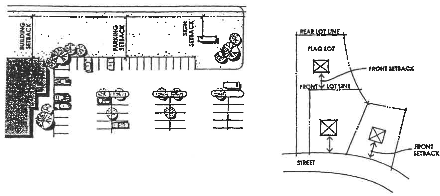
Flag. A lot having access or an easement to a public or private street by a narrow, private right-of-way;
c.
Interior. A lot abutting only one street;
d.
Key. A lot with a side line that abuts the rear line of any one or more adjoining lots;
e.
Reverse corner. A corner lot, the rear of which abuts the side of another lot; and
f.
Through. A lot having frontage on two generally parallel streets, with only one primary access.
(95)
Lot area. The total horizontal area, measured in a horizontal plane, included within the lot lines of a lot or parcel of land.
(96)
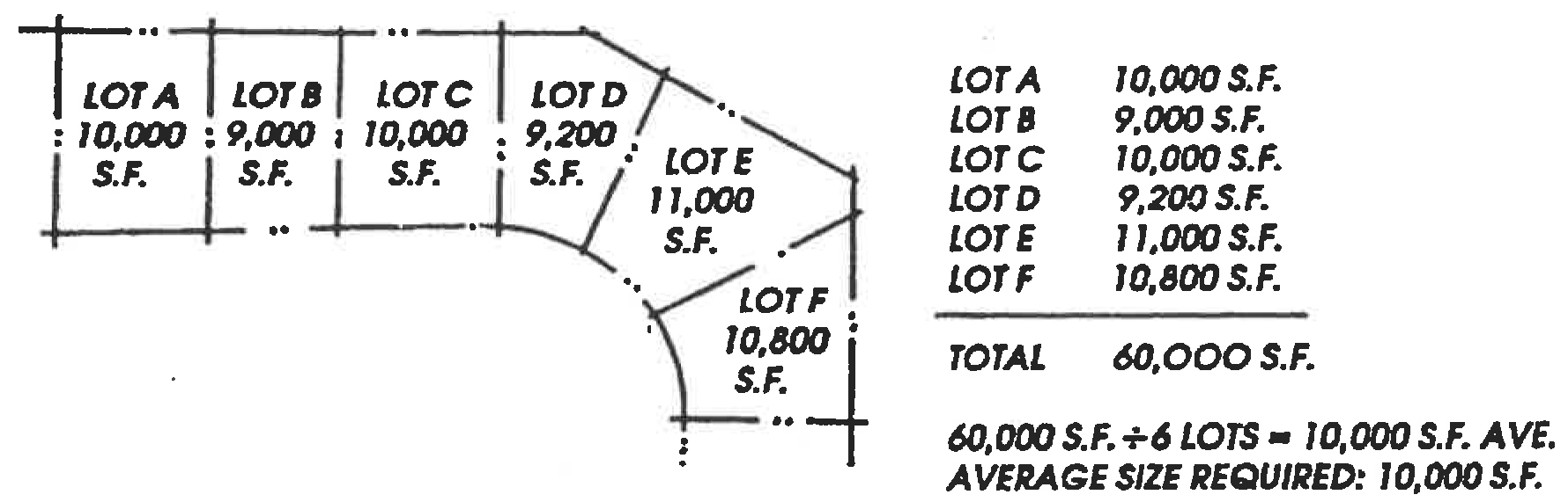
Lot averaging. The design of individual adjoining lots within a residential subdivision in which the average lot area equals the minimum prescribed area for the applicable zoning district. To maintain an average, some lots may be reduced to a maximum of ten percent below the minimum lot size, while a corresponding number of lots shall each maintain a lot area of at least ten percent above the minimum lot size. The allowable density shall be within the prescribed maximums.
(97)
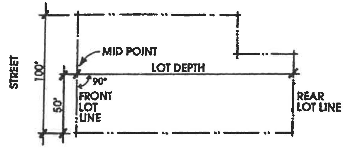
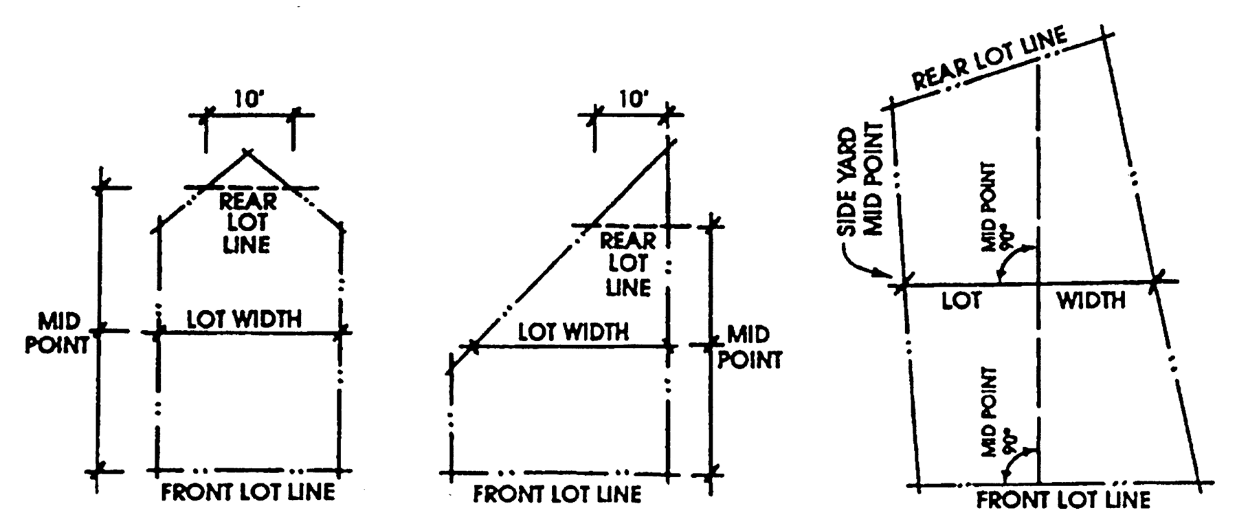
Lot depth. The horizontal distance measured between the midpoints of the front and rear lot lines or between the front line and the intersection of the two side lines if there is no rear line.
(98)
Lot frontage. The portion of the parcel abutting the street.
(99)
Lot line. Any boundary of a parcel. The classifications of lot lines are:
a.
Front. On an interior lot, the line separating the parcel from the street. On a corner lot, the shorter lot line abutting a street. (If the lot lines on a corner lot are equal in length, the front lot line shall be determined by the director.) On a through lot, the lot line abutting the street providing the primary access to the lot;
b.
Interior. Any lot line not abutting a street;
c.
Rear. The lot line not abutting a street which is opposite and most distant from the front lot line. In the case of an irregular-shaped parcel, including a triangular parcel, a line within the parcel, parallel to and at a maximum distance from the front lot line, having a length of not less than ten feet;
d.
Side. Any lot line which is not a front or rear lot line;
e.
Street. Any lot line abutting a street from which access is permitted.
(100)
Lot width. The horizontal distance between the side lot lines measured at right angles to the lot depth at a midway point between the front and rear lot lines (See diagram).
Lot Width
(101)
Low barrier navigation centers. Service-enriched temporary living facilities, with best management practices to reduce barriers to entry, focused on moving people into permanent housing, with qualifying facilities permitted by-right in areas of the city zoned for mixed-use or nonresidential zones permitting multifamily development, in accordance with California Government Code Section 65660 et seq.
(102)
Manufactured home. A structure which is transportable in one or more sections, which is built on a permanent chassis and designed to be used as a dwelling with or without a permanent foundation when connected to required utilities, and which meets all state and federal laws.
(103)
Median. A paved or planted area separating a street or highway into two or more lanes.
(104)
Mixed use development. The development of a parcel or structure with two or more different uses such as, but not limited to, a combination of residential, office, commercial retail, public, or entertainment on a single or in a physically integrated group of structures.
(105)
Mini-storage. A structure containing separate storage spaces of varying sizes that are leased or rented on an individual basis.
(106)
Mobile home. Same as manufactured home, but subject to the National Manufactured Housing Construction and Safety Act of 1974.
(107)
Motel. See: Hotel/motel.
(108)
Net acreage. The total area within a parcel of land after public street easements or other areas to be dedicated or reserved for public use are deducted from the parcel.
(109)
Nonconforming property. Any subdivision of land that was lawfully established and in compliance with all applicable ordinances and laws at the time the property was subdivided but which, because of a subsequently enacted ordinance or law, no longer complies with all of the applicable regulations and standards of the zone in which the property is located.
(110)
Nonconforming structure. Any structure or improvement upon land, including any sign, that was lawfully established and in compliance with all applicable ordinances and laws at the time the structure was built or the improvement made. But which, as a result of a subsequently enacted ordinance or law, no longer complies with all of the applicable regulations and standards of the zone in which the structure, or improvement is located.
(111)
Nonconforming use. Any use of land or property that was lawfully established and in compliance with all applicable ordinances and laws at the time the use was established, but which, because of a subsequently enacted ordinance or law, no longer complies with all of the applicable regulations and standards of the zone in which the use is located.
(112)
Nonconformities. Any nonconforming property, structure, or use.
(113)
Outdoor play/athletic equipment. A structural or nonstructural apparatus designed for recreational enjoyment and/or exercise, either permanent or portable not including patio furniture.
(114)
Outdoor storage. The act of storing merchandise, equipment, materials and other related business items outside of the primary building.
(115)
Parcel. A contiguous quantity of land in the possession of, owned by, or recorded as the property of, the same claimant or person.
(116)
Parkway. The area of a public street that lies between the curb and the adjacent property line or physical boundary definition, such as a fence or wall, which is landscaped and may be used for passive recreational purposes.
(117)
Peddler. Any individual or business that offers merchandise for sale along the street or from door to door.
(118)
Permitted use. ny use allowed in a zoning district and subject to the provisions/regulations applicable to that district.
(119)
Person. Any individual, or group of individuals acting as a unit, including but not limited to a firm, co-partnership, joint venture, association, social club, fraternal organization, company, joint stock association, corporation, estate, trust, business, business trust, public agency, school district, the State of California and its political subdivisions or instrumentalities, any other political subdivision, or a foreign country.
(120)
Planned development permit. A discretionary entitlement granted under the provisions of this code which authorizes a new structure or use.
(121)
Planning commission. The Planning and Transportation Commission of the City of Mission Viejo.
(122)
Principal use. The primary or predominant use of any parcel or structure.
(123)
Private outdoor living space. Usable yard or patio area specifically allocated to each dwelling unit for outdoor recreation and enjoyment by the resident. The usable open space shall have a minimum dimension of six feet in any direction. Private outdoor living space shall not include driveways, walkways, slopes, and common open space.
(124)
Public right-of-way. A strip of land acquired by reservation, dedication, prescription, or condemnation and intended to be occupied by a road, trail, water line, sanitary sewer and/or other public use.
(125)
Quarry. A place where dirt, soil, sand, gravel, rock, ore, stone, and similar materials are excavated and/or processed for sale or for off-site use.
(126)
Quasipublic utility communications facility. A facility that contains one or more antennas that are components of a communications network that benefits the general public, government, and/or business community.
(127)
Queue lane. An area for motor vehicles awaiting a service or other activity.
(128)
Rear yard. See: Yard, rear.
(129)
Recreation vehicle. A vehicle, boat, vessel, or other type of portable structure, with or without a mode of power and without permanent foundation, which can be towed, hauled, sailed, or driven, and is designed primarily for recreational, camping, sailing, and/or travel use, such as, but not limited to, travel trailers, motor homes, buses converted to recreational or other noncommercial uses, vans, trucks with or without camper shells, camper, camping trailers, motorcycles, off-road vehicles, aircraft, boats, personal water craft or other vessels.
(130)
Recycling. The process by which discarded materials are treated and/or transformed for reuse.
(131)
Residential care facility. A family home or group care facility for 24-hour nonmedical care of persons in need of personal services, supervision or assistance for sustaining the activities of daily living or for protection.
(132)
Resort hotel. A group of structures containing guest rooms or suites and offering indoor and outdoor recreational activities.
(133)
Rest home. A facility offering or providing lodging, meals, nursing, dietary or other similar personal services to convalescents, invalids, or aged persons but not requiring either a nurse or physician residing on the premises and not performing surgery, providing physical therapy, or caring principally for persons with contagious or communicable diseases.
(134)
Restaurant. A retail establishment engaged in the preparation and sale of food and beverages. This use includes cafes, coffee shops, sandwich shops, ice cream parlors, fast food establishments, and kitchens engaged in preparing food primarily for take out or delivery and may also include licensed on-site provision of alcoholic beverages for consumption on the premises when accessory to the food service.
(135)
Restaurant, drive-thru. A retail establishment engaged in the preparation and sale of food and beverages, as defined under restaurant above, with the added provision of one or more drive-thru lanes for the ordering and dispensing of food and beverages to patrons remaining in their vehicles.
(136)
Review authority. The person, committee, commission, or council responsible for the review and/or final action on a land use entitlement, map, or amendment.
(137)
Rounding of quantities. The practice of expressing fractions as the nearest higher whole number when the fraction is .5 or more and as the nearest lower whole number when the fraction is less than .5. Distances, parking spaces, unit density, density bonus, and other similar quantities may be treated in this manner, except as otherwise provided in this code.
(138)
Senior housing. See: Congregate care/senior housing.
(139)
Setback. The required distance that a structure must be located from a lot line. On corner lots, the shortest street frontage shall be the front yard in residential zoning districts, while the longest street frontage shall be the front yard in commercial/industrial zoning districts. On flag lots, the rear yard location shall be determined through project review.
(140)
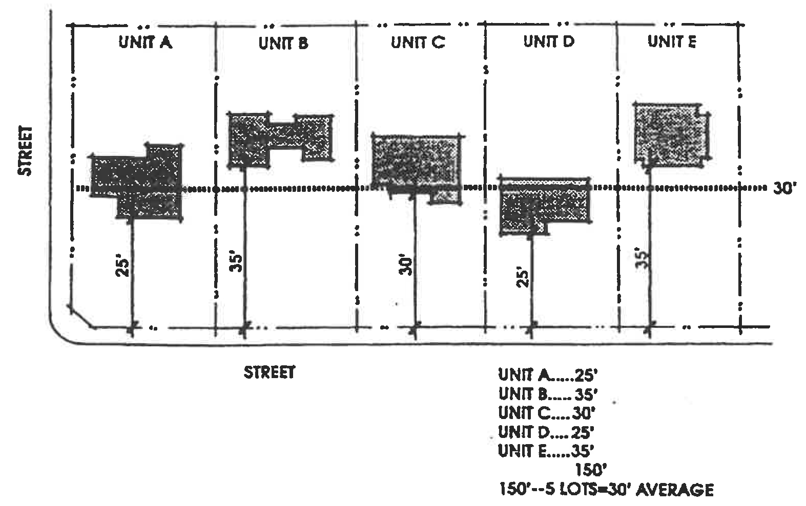
Setback, front/rear average. The average front/rear yard setback of a group of five adjacent dwelling units. The setback on any unit may vary up to ten feet as long as the average setback of all five units equals the minimum required for the zoning district.
(141)
Sidewalk sale. A sale, conducted by one or more businesses, held outside the confines of the structure or structures in which business is normally conducted, and involves the outdoor display of merchandise on the same parcel as the structure(s).
(142)
Side yard. See: Yard, side.
(143)
Side yard easement. An easement granted by one property owner to another which reserves an area between buildings and/or lot lines for drainage, recreation, patio and garden uses.
(144)
Sign. Any device used to attract attention and/or to communicate visually, including all announcements, declarations, demonstrations, displays, illustrations, insignia, or symbols used to advertise or promote the interests of any person, business, group, or enterprise together with all necessary parts, materials, frame and background. (See Chapter 9.29 for sign standards and additional definitions.)
(145)
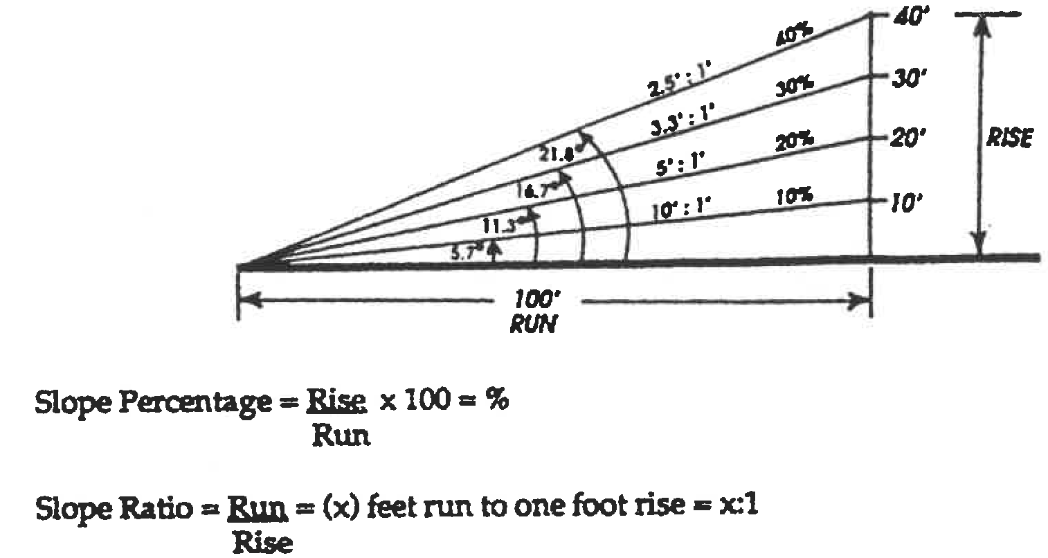
Slope. A hillside; the degree of deviation of a surface from the horizontal, usually expressed in percent or degrees.
(146)
Solar access. The airspace over a parcel which provides access for the absorption of energy from the sun.
(147)
Specific plan. A plan consisting of text, maps, and other documents and exhibits regulating development within a defined area of the city, consistent with the general plan and relevant state law.
(148)
Stable, commercial. A structure for the keeping of horses, mules, or ponies which are rented, ridden, fed, trained, bred, sold, or boarded for compensation.
(149)
Storage. The safekeeping of goods, materials, and/or personal property in a depository, warehouse, or other structure designed especially for that purpose.
(150)
Storage unit. A space or place that is intended to house goods, materials, and/or personal property not currently in regular use.
(151)
Story. That portion of a structure included between the upper surface of any floor and the upper surface of the floor next above it or, if there is no floor above it, then the space between the floor and the ceiling or roof above.
(152)
Street. Any public or private thoroughfare which provides a primary means of access to abutting property.
(153)
Structure. Anything constructed or erected which requires a fixed location on the ground or is attached to something having a fixed location on the ground.
(154)
Supportive housing. Housing with no limit on length of stay, that is occupied by the target population, and that is linked to onsite or offsite services that assist the supportive housing resident in retaining the housing, improving his or her health status, and maximizing his or her ability to live and, when possible, work in the community (HSC Section 50675.14(b)(2)). Supportive housing shall be permitted by-right in zones where multifamily and mixed-uses are permitted, including nonresidential zones permitting multifamily uses, if the proposed housing development meets specified criteria. Qualifying supportive housing shall be treated as a residential use with only those standards and procedures that apply to other residential uses in the same district, in accordance with SB 2 and AB 2162.
(155)
Swap meet (indoor/outdoor). A commercial event designed for temporary or intermittent use to facilitate the retail sale or exchange of new, handcrafted, and/or secondhand merchandise in open compartmentalized spaces by individual vendors.
(156)
Temporary use. A use established for a specified period of time, with the intent to discontinue the use at the end of that period of time.
(157)
Traffic safety sight area. A space that is set aside on a street corner or driveway entrance which prohibits all obstructions, such as structures and plantings, that can prevent visibility and thus be a hazard to vehicular and pedestrian traffic.
(158)
Transitional housing. Buildings configured as rental housing developments, but operated under program requirements that call for the termination of assistance and recirculation of the assisted unit to another eligible program recipient at some predetermined future point in time, which shall be no less than six months (HSC Section 50675.2(h)). Transitional housing shall be treated as a residential use with only those standards and procedures that apply to other residential uses in the same district, in accordance with SB 2.
(159)
Use. The purpose for which either land or structure is arranged, designed, or intended, or for which it is occupied or maintained.
(160)
Use inauguration. The implementation of a use on a parcel, the occupancy of a structure, or the construction of substantial site improvements after a building permit has been issued, subject to determination by the director.
(161)
Variance. A modification of a literal provision of this Code granted by quasijudicial act in accordance with the provisions of this Code.
(162)
Vehicle sales lot. An open area used for the display, sale, and/or rental of new or used automotive vehicles.
(163)
Warehouse and sales outlet. A business that stores large inventories of goods in an industrial style building where these goods are not produced on the site, but are offered to the public for sale.
(164)
Warehousing and distribution. Terminal facilities for handling freight with or without maintenance facilities.
(165)
Wholesale use. A business that stores large stocks of goods for sale in bulk quantities to retail outlets. Sales to the general public do not occur on the site, nor is the location of the business advertised through newspapers, flyers or other media designed to reach the consumer.
(166)
Yard. An open space on a lot or parcel of land, unoccupied and unobstructed from the ground upward except for projections permitted by this Code. The classifications of yard are:
a.
Yard, front. A yard extending across the full width of any building site between the side lot lines, and measured between the front lot line and the nearest line of any building. However, if any road easement or official right-of-way line has been established for the street upon which the site fronts, the front yard shall be measured instead from such easement or right-of-way line to the nearest line of any building;
b.
Yard, rear. A yard extending across the full width of any building site between the side lot lines, and measured between the rear lot line and the nearest line of any building;
c.
Yard, side. A yard extending between the front yard and the rear yard of any lot and measured between the side lot line and the nearest line of any building opposite said lot line.
(Ord. No. 98-193, §§ 1—4, 10-19-98; Ord. No. 03-215, §§ 3, 4, 3-17-03; Ord. No. 05-234, § 12, 9-6-05; Ord. No. 06-242, § 11, 5-15-06; Ord. No. 21-341, § 4(Exh. A), 10-12-21)