
Mona City Zoning Code
10-4 SUPPLEMENTAL
REGULATIONS
10-4-1 INTENT
The intent of this chapter is to accumulate provisions applying to all land and buildings within the incorporated area of the city into one section to avoid unnecessary repetition.
10-4-2 ANNEXATIONS
All land annexed into the city shall be classified into the zoning district identified in the annexation declaration which will have been prepared prior to annexation. After consulting the general plan, the legislative body, the City Council will make the final decision as to the zoning status of approved annexation applications.
- Unless otherwise agreed at the time of annexation, all property hereafter annexed to the City shall be classified in Transitional Holding Zone and all of the zone regulations shall apply thereto until such time that a public hearing is held to consider a change in classification thereof. Such hearing and classification shall be considered in the same manner as any other rezone as set forth in this code at the time of application.
10-4-3 AMENDMENTS TO ORDINANCE AND MAPS
This title and/or its provisions, including the official zoning map, may be petitioned for amendment by any citizen of the city as provided, or through action initiated by the Mayor, City Council, Planning Commission or city staff.
- Intent with Respect to Amendments: This title shall not be amended except to more fully carry out the intent and purpose of the general plan of the city and of this title.
- Procedure: Any person seeking to enact or amend a land use ordinance or the zoning map shall submit to the Planning Commission a written petition designating the change desired and the reasons for the change, and shall pay the required fee to the city. Upon receipt of the petition and the paying of the filing fee, the Planning Commission shall consider the request and shall certify its recommendations to the City Council with respect to the request within 90 days from receipt of the request. Failure on the part of the Planning Commission to certify its recommendations to the City Council within 90 days shall be deemed to constitute a recommendation for approval unless a longer period is granted by the City Council. The fee required shall be nonrefundable. The Planning Commission or City Council may also initiate amendments to this title or map.
- Public Hearing Required Before Amending: A land use ordinance may be adopted only after a public hearing is held before the Planning Commission at which parties in interest and citizens shall have an opportunity to be heard. A notice of the time and place of such hearing shall be published on the city's website and shall meet all other requirements for public hearings as outlined in state code (Utah State Code 10-9a-205).
10-4-4 EFFECT OF STREET PLAN
Wherever a front or side yard is required for a building which abuts on a proposed street which has not been constructed but which has been designated by the Planning Commission as a future street, the depth of such front or side yard shall be measured from the edge of the proposed right-of-way.
10-4-5 FRONTAGE ON PUBLIC STREET
Except in flag lots, and on approved private streets, one side on each lot used as a dwelling site shall abut upon a street which has been designated or dedicated to the public for street purposes. The length of such abutting side measured at the setback line shall be as great or greater than the width required for dwelling sites in the zone in which such building site is located.
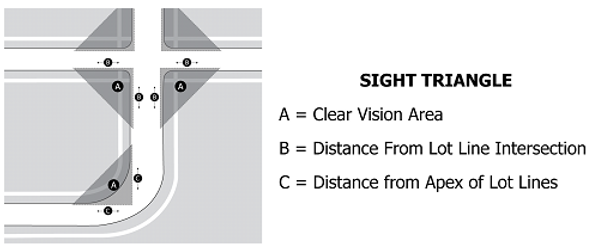
10-4-6 CLEAR VIEW AREAS
- No obstruction which will obscure the view of automobile drivers or pedestrians shall be placed on any corner lot within a triangular area, defined to be the "clear view area," as provided in the following table and diagrammed below:
Design Speed (mph) Triangle Leg Dimensions 25 40 feet x 40 feet 35 50 feet x 50 feet 45+ 70 feet x 70 feet - Where roads of differing speeds intersect, the triangle legs shall have dimensions respectively to the speeds (e.g., a 25 mile per hour road intersecting with a 45 mile per hour road would have clear view areas with triangle legs being 40 feet by 70 feet with the longer viewing distance being along the road with the greater traveling speeds). Three-way intersections may have a 30-foot triangle leg extending perpendicular from the through street of the intersection.
10-4-7 SEWAGE DISPOSAL
All properties containing a property line located within 300 feet of an available public sewer line shall connect to a public sewage system, as per UCA section 10-8-38. Where domestic liquid waste facilities are located farther away than three hundred feet from any available public sewer, a public sewer shall either be extended to connect with such facilities or else the disposal facilities must be constructed in accordance with Juab County health department standards before a building permit shall be issued for the building for which the sewage facilities are to be constructed.