
Mount Dora City Zoning Code
CHAPTER III
ZONING REGULATIONS
3.1.- Applicability.
The City of Mount Dora is divided into zoning districts. All lands in the city shall have a zoning designation and all development shall conform to the standards set forth for the applicable zoning district and other applicable requirements of this code.
3.2. - Mapping of districts.
The boundaries of the various districts are shown on the official zoning map adopted concurrent with this code which shall be maintained by the city. The map shall be by reference a part hereof. The map may be supplemented from time to time by the city council.
3.2.1.
Interpretation of district boundaries. Except as otherwise specifically provided, a district symbol or name shown within district boundaries on the official zoning map indicates that district regulations pertaining to the district extend throughout the whole area surrounded by the boundary line. Where uncertainty exists as to the boundaries of any district, the following rules shall apply:
1.
The boundaries shall be determined by the ordinance establishing the boundaries.
2.
Where boundaries are indicated as approximately following street and alley lines, land lot lines, military district lines or lot lines, such lines shall be construed to be such boundaries.
3.
In unsubdivided property or tracts, where a district boundary divides a lot, the location of such boundaries, unless same are indicated by dimensions, shall be determined by use of the scale of the map.
4.
Where the public road, street or alley is officially vacated or abandoned, the regulations applicable to the property to which it is reverted shall apply to such vacated or abandoned road, street or alley.
5.
Where boundaries are so indicated that they are approximately parallel to the centerlines or street lines of streets or to the centerlines of alleys for the centerlines or right-of-way lines of highways, such boundaries shall be construed as being parallel thereto and at such distance therefrom as indicated on the zoning maps. If no distance is given, such dimension shall be determined from supporting maps or by use of the scale of the map.
3.2.2.
Application of district regulations. The regulations herein set out within each district shall be minimum or maximum limitations, as the case may be, and shall apply uniformly to each class or kind of structure or use on land or water, except as hereinafter provided:
1.
Zoning affects use or occupancy. No building, structure, land or water shall hereafter be used or occupied, and no building, structure or part thereof shall hereafter be erected, constructed, reconstructed, located, moved or structurally altered except in conformity with the regulations herein specified for the district in which it is or will be located.
2.
Multiple use of required open space prohibited. No part of a required yard or other required open space, required off-street parking or loading space, provided in connection with one building, structure, or use shall be included as meeting the requirements for any other building, structure or use, except as allowed by this code.
3.
Reduction of lot area prohibited. No lot or yard existing at the effective date of these zoning regulations shall thereafter be reduced in size, dimension or area of less than the minimum requirements set out herein, except for public purposes such as road widening. Lots or yards created after the effective date of these zoning regulations shall meet at least the minimum requirements established herein.
(Ord. No. 2020-20, § 2, 5-4-21)
3.3. - Procedures for rezoning.
Any owner, or authorized representative thereof, of a parcel of land desiring to change the zoning designation of that land may submit an application requesting consideration by the city of the proposed rezoning.
3.3.1.
Initiation point. Applications for rezoning must be made to the development review coordinator.
3.3.2.\Submittals and fees. The application shall be a form provided by the city, stating at least: the applicant's name, a legal description and survey of the property, the current zoning, the requested zoning, proof of ownership and the reason for the requested change. Appropriate fees shall be paid at the time of submittal.
3.3.3.
Review process.
1.
The development review coordinator shall schedule the application for review by the development review committee and notify all members of the development review committee.
2.
The planning and zoning commission shall review the application and make a recommendation, based on the criteria in subsection 3.3.4, to the city council.
3.
All comments and recommendations shall be presented to the city council at a public hearing.
4.
The city council shall have final authority to approve or deny the request.
5.
An applicant may postpone a rezoning case by submitting a written request to the DRC coordinator. If a postponed case is not reactivated within six months of the postponement request, the application expires and all paid rezoning fees are forfeited.
3.3.4.
Review criteria. The city shall consider the following criteria in reviewing applications for rezoning:
1.
The need and justification for the change;
2.
The effect of the change, if any, on the particular property and on surrounding properties;
3.
The amount of undeveloped land having the same classifications as that requested in the general area and throughout the city;
4.
The relationship of the proposed amendment to the purposes of the city's comprehensive plan, with appropriate consideration as to whether the proposed change will further the purposes of this code and the plan;
5.
The availability and provision of adequate services and facilities;
6.
The impact on the natural environment; and
7.
Other criteria as may be applicable.
3.3.5.
Restrictions on reconsideration.
1.
Whenever the city council has taken action to deny a petition to rezone property, the city shall not:
a.
Consider any further petition for the same rezoning of all or any part of the same property for a period of one year from the date of such action;
b.
Consider a petition for any kind of zoning on all or any part of the same property for a period of six months from the date of such action. However, a motion to reconsider the denial may be entertained by the council.
2.
Whenever the city council has changed the zoning of any property, the planning and zoning commission shall not consider any petition for rezoning of all or any part of the same property for a period of six months from the effective date of the amendatory ordinance.
3.
The time limits of this subsection may be waived by the city council when such action is deemed necessary to prevent injustice.
(Ord. No. 2011-02, § 2, 2-15-11; Ord. No. 2013-13, § 2(Exh. A), 10-1-13; Ord. No. 2020-20, § 2, 5-4-21; Ord. No. 2025-20, § 2, 10-7-25)
3.4. - Establishment of zoning districts.
In order to classify, regulate and restrict the uses of land, water, buildings and structures; to regulate and restrict the height and bulk of buildings; to regulate the area of yards and other spaces around buildings; and to regulate the intensity of land use, the City of Mount Dora is divided into the following zoning districts:
3.4.1.
GB Greenbelt District:
1.
Description of district. This district is established to provide green, undeveloped areas and to protect floodplains, wetlands, other natural resources and agricultural uses. Areas of the city in which this category is most appropriate are designated as "conservation" on the future land use map of the comprehensive plan; however, this district is also permitted within all other land use designations.
2.
Permitted uses:
a.
Groves, livestock, and farms.
b.
Single-family homes and customary accessory uses.
c.
Swamps, wetlands and forests.
d.
Private and public gardens.
e.
Pastures.
f.
Nature preserves.
g.
Poultry husbandry.
h.
Public utility and public facilities
i.
Public parks and recreation facilities
j.
Home occupations (subsection 3.5.12).
3.
Conditional uses:
a.
Private parks.
b.
Golf courses.
c.
Retail or wholesale plant production, nurseries and greenhouses.
d.
Fishing clubs and marinas.
e.
Environmental study centers.
f.
Riding stables.
g.
Cemeteries.
h.
Churches.
4.
Prohibited uses:
a.
Medical marijuana dispensaries.
b.
Non-medical marijuana sales.
c.
Cannabis farms.
d.
All uses not allowed as either a permitted use or a conditional use above are prohibited unless adopted as part of a planned unit development.
5.
Site development standards:
a.
Minimum lot size (for buildings): One acre.
b.
Minimum lot width at building line: 200 feet.
c.
Minimum street frontage: 50 feet.
d.
Minimum building setbacks:
Front yard: 50 feet.
Side yard: 25 feet.
Rear yard: 30 feet.
From any street: 50 feet.
Exempt district defined in this code: No setbacks
Public parks and recreation facilities: No setback
Private park structures and facilities setbacks: All 25 feet
e.
Maximum building height: 35 feet.
f.
Parking: See section 6.5.
g.
Landscaping and buffers: See section 6.6.
h.
Signs: See section 6.7.
i.
Access: See subsection 6.3.7.
j.
Minimum dwelling size (sq. ft.): 2,000.
3.4.2.
R-1AAAA, R-1AAA, R-1AA, R-1A, R-1, R-1B, Single-Family Residential Districts:
1.
Description of districts. These districts are established to identify those geographic areas that are appropriate for the development and maintenance of low, low/medium, and medium-density single-family residential environments. The R-1AAAA, R-1AAA, R-1AA and R-1A districts are most appropriate in low-density residential areas, but are also permitted in low/medium, medium, and high-density residential areas. Areas of the city most appropriate for the R-1 districts are designated as low/medium and medium-density residential on the future land use map of the comprehensive plan; however, these districts are also permitted in high-density residential areas. The R-1B district is appropriate in high-density residential areas.
2.
Permitted uses:
a.
Single-family homes (garages required) and customary accessory uses.
b.
Boathouses, one story, private, for storage of watercraft, not including sea planes, and not for human occupancy.
c.
Public parks and public recreation facilities.
d.
Home occupations (subsection 3.5.12).
3.
Conditional uses (See section 2.5.1.5):
a.
Churches.
b.
Public utility and service facilities.
c.
Schools.
d.
Theaters.
e.
Private parks and recreation facilities.
f.
Temporary sales offices (subsection 3.5.14).
g.
Bed and breakfast establishments in R-1 and R-1B zoning districts (subsection 3.5.17).
4.
Prohibited uses:
a.
Medical marijuana dispensaries.
b.
Non-medical marijuana sales.
c.
Cannabis farms.
d.
All uses not allowed as either a permitted use or a conditional use above are prohibited unless adopted as part of a planned unit development.
_____
5. Site development standards:
| R-1AAAA | R-1AAA | R-1AA | R-1A | R-I | R-1B | ||
|---|---|---|---|---|---|---|---|
| a. | Minimum lot size (sq. ft.) | 43,560 | 15,000 | 12,500 | 10,000 | 7,500 | 5,500 |
| b. | Minimum lot width at building line (ft.) | 150 | 100 | 90 | 90 | 75 | 75 |
| c. | Minimum street front (ft.) | 50 | 25 | 25 | 25 | 25 | 25 |
| d. | Minimum setbacks (ft.) - Note*: | ||||||
| Front yard | 50 | 25 | 25 | 25 | 25 | 20 | |
| Side yard | 20 | 15 | 12 | 10 | 7 | 7 | |
| Rear yard | 50 | 30 | 30 | 25 | 20 | 20 | |
| From any street | 50 | 25 | 25 | 25 | 25 | 20 | |
| Contextual Setback |
The front and side yard setback for additions to existing dwell-
ing units or construction of new dwelling units shall be established by averaging the front and side yard depths of the adjacent four homes on each side of the subject property located on the same side of street. For lots at the end of their block frontage (corner lots or lots at dead ends), the front yard setback shall match the average of the four continuous closest, principal on the same side of the street and on the same block frontage as the subject property. If one or more of the lots required to be included in the averaging calculation are vacant, that vacant lot will be deemed to have a front or side yard setback equal to the minimum yard setback requirement of the zoning district. The front yard setback shall be measured to the front vertical wall of the home. | ||||||
 | |||||||
| Park and recreation facilities setbacks: | All 25 feet | ||||||
| e. | Maximum building height (ft.) | 35 | 35 | 35 | 35 | 35 | 35 |
| Within 100 ft. of Lake Dora | 25 | 25 | 25 | 25 | 25 | 25 | |
| f. | Minimum dwelling size (sq. ft.) | 1,600 | 1,600 | 1,500 | 1,300 | 1,200 | 800 |
| g. | Parking Minimum Spaces: | 2 | 2 | 2 | 2 | 2 | 2 |
| Minimum Garage Type: | 2-Car | 2-Car | 2-Car | 1-Car | 1-Car | 1-Car | |
| (See section 6.5 for other requirements) | |||||||
| h. | Landscaping and buffers | See section 6.6 | |||||
| i. | Signs | See section 6.7 | |||||
| j. | Access | See subsection 6.3.7 | |||||
*Note: Also, see section 3.5.1 for minimum setback averaging in certain cases.
_____
3.4.3.
R-2 Duplex (one- and two-family) Residential District:
1.
Description of district. This district is established to identify those geographic areas that are appropriate for the development and maintenance of medium density duplex and single-family residential environments. Areas of the city in which this category is most appropriate are designated as medium-density residential on the future land use map of the comprehensive plan; however, this district is also permitted in high-density residential designations.
2.
Permitted uses:
a.
Duplexes and customary accessory uses (garages required).
b.
Single-family homes and customary accessory uses (garages required).
c.
Boathouses, one story, private, for storage of watercraft, not including sea planes, and not for human occupancy.
d.
Public parks and public recreation facilities.
e.
Home occupations (subsection 3.5.12).
3.
Conditional uses (See section 2.5.1.5):
a.
Churches.
b.
Public utility and service facilities.
c.
Schools.
d.
Private parks and private recreation facilities.
e.
Temporary sales offices (subsection 3.4.14).
f.
Bed and breakfast establishments.
g.
Hospitals.
h.
Day care centers.
i.
Group homes and adult living facilities (subsection 3.5.13).
j.
Parking associated with adjacent nonresidential uses provided that the vacant land used for the construction of a parking facility is not created as the result of the demolition of an existing structure (subsection 6.5).
4.
Prohibited uses:
a.
Medical marijuana dispensaries.
b.
Non-medical marijuana sales.
c.
Cannabis farms.
d.
All uses not allowed as either a permitted use or a conditional use above are prohibited unless adopted as part of a planned unit development.
_____
5. Site development standards:
*Note: Also, see section 3.5.1 for minimum setback relief for residential dwellings.
_____
6.
Duplex divisions:
a.
Legislative purpose and intent. Duplex structures and duplex lots may be divided, with individual dwelling units being owned in fee simple, so long as such division does not violate the Florida Building Code and this subsection. This subsection shall not be applicable to duplex divisions of ground floor units from upstairs units.
b.
Division of R-2 duplex residential and R-3 multifamily residential district lots. Duplex structures and lots which comply with the minimum standards of this subsection for such uses in the R-2 duplex residential and R-3 multifamily residential districts may be divided so as to create one lot for each dwelling unit, provided that the requirements and site development standards of this subsection are met.
c.
Application and requirements. Applications for division of duplex structures and duplex lots shall be made through the planning and development department. The planning and development director or designee shall review applications relevant to appropriate facts and shall render a decision. The application shall contain, at a minimum, the following:
(1)
Application form available at the planning and development department;
(2)
One original line or stable film drawing and three copies of the proposed division of duplex structure and duplex lot certified by a professional land surveyor registered in the State of Florida and meeting the minimum technical standards set forth in F.S. § 472.027. The proposed division shall measure 24 inches by 36 inches. In addition, the following information shall be shown on the proposed division:
(a)
The lot lines, dimensions, and acreage for the lot proposed to be created, as well as the total tract.
(b)
Metes and bounds descriptions of the total tract and the lots proposed to be created.
(c)
A vicinity map showing the location of the lot to be divided relative to abutting properties and the right-of-way serving the tracts.
(d)
Location of any and all utility and other easements on the total tract.
(e)
A signed and dated certificate of ownership stating: "I hereby certify that I am the owner of the property described herein, which property is within the regulation of the City of Mount Dora, and that I freely adopt this plan of division."
(3)
Any proposed maintenance agreements, deed restrictions, covenants, or other required documents.
(4)
Any existing deed restrictions or covenants affecting the total tract.
(5)
A narrative statement describing the purpose of the division.
(6)
A copy of the original plat, if any.
d.
Utilities and services. Each individual unit shall be independently served by separate heating, air conditioning, sewer, water, electrical power, gas, and other facility and utility services. No individual unit shall be in any way dependent upon such services or utility lines located within or under the structure of another unit. If future access to the adjacent dwelling unit is needed for repairs or improvements, an access easement shall be required, and such easement(s) shall be reviewed and approved by the planning and development director or designee prior to approval of the duplex division. In addition, utility easements shall be executed, or existing utility easements vacated, where necessary, and such utility easements and vacations of utility easements shall be reviewed and approved by the planning and development director or designee prior to approval.
e.
Walls. The individual units in a fee-simple duplex arrangement shall be separated by a party wall meeting all requirements of the Florida Building Code.
f.
Ingress and egress; improvements. No tract may be divided under this subsection unless each individual lot, once divided, abuts an existing dedicated public right-of-way of at least 50 feet in width. No division of duplex structures and duplex lots shall be granted if new improvements for water, sewer or drainage are required.
g.
Site development standards:
All other site development standards under subsection 3.4.3.4 not inconsistent herewith shall be met.
h.
Maintenance of lot and structure. Provisions shall be made to ensure that the construction, structures, and grounds in a division of a duplex structure and duplex lot are conducted and maintained in a satisfactory manner without expense to the general taxpayers of the City of Mount Dora. Therefore, an agreement between the owners of the two units, or alternatively, covenants or deed restrictions, shall be required incorporating provisions including and not limited to methods to ensure cost-sharing, maintenance of all structures, parking areas, common walls, fences, and grounds, and division of construction costs, if applicable. If access easements are required or desirable, an agreement to execute such easement shall be included. The maintenance agreement or covenants or deed restrictions shall be reviewed by the planning and development director or designee and the city attorney only for the purpose of determining compliance with the City's Code. Such agreement or covenants or deed restrictions shall be recorded in the public records of Lake County after approval by the city. No agreement or covenants or deed restrictions shall be subsequently amended without prior approval of the city. A building permit will only be issued for both duplex units. Construction on each unit in the duplex must proceed concurrently.
i.
Payment of attorney's fees and costs. Prior to final approval, applicant(s) shall reimburse all city's attorney fees, costs, and expenses from or relating to the review of the application for division of duplex structures and duplex lots and the review of the maintenance agreement or covenants or deed restrictions. Payment of any such fees and costs shall in no way guarantee approval, and such fees and costs are nonrefundable.
j.
No appeal rights. Individual unit owners may not appeal any development matters regarding division of duplex structures and division of duplex lots if written agreement on building construction, alterations, additions, or maintenance cannot be reached with the abutting unit owner. If agreement is reached, normal regulations pursuant to this subsection shall be followed.
k.
No variances. No variances from this subsection may be applied for or granted.
3.4.4.
R-3 Multifamily Residential District:
1.
Description of district. This district is established to identify those geographic areas that are appropriate for the development and maintenance of high-density, multifamily residential environments. Due to the higher concentration of people and vehicles, this district must have convenient access to arterials or collector streets and have adequate public and commercial services. Areas of the city in which this zoning category is appropriate are designated as high-density residential on the future land use map of the comprehensive plan.
2.
Permitted uses:
a.
Multifamily dwellings and customary accessory uses.
b.
Duplexes meeting R-2 development standards and customary accessory uses.
c.
Single-family dwellings and customary accessory uses including boathouses, for watercraft or human occupancy, of no more than 25 feet in height, meeting at a minimum, the requirements of the R-1B zoning district.
d.
Public parks and public recreation facilities.
e.
Private park and recreation facilities as an accessory use within multiple-family development only.
f.
Home occupations (subsection 3.5.12).
3.
Conditional uses (See section 2.5.1.5):
a.
Churches.
b.
Public utilities and service facilities.
c.
Group homes and adult living facilities (subsection 3.5.13).
d.
Schools.
e.
Private park and recreation facilities other than accessory to a multiple-family development.
f.
Bed and breakfast establishments (subsection 3.5.17).
g.
Hospitals.
h.
Funeral homes.
i.
Day care centers.
j.
Parking associated with adjacent nonresidential uses provided that the vacant land used for the construction of a parking facility is not created as the result of the demolition of an existing structure (subsection 6.5).
4.
Prohibited uses:
a.
Medical marijuana dispensaries.
b.
Non-medical marijuana sales.
c.
Cannabis farms.
d.
All uses not allowed as either a permitted use or a conditional use above are prohibited unless adopted as part of a planned unit development.
5.
Site development standards:
a.
Minimum lot size:
Multifamily: 12,500 square feet.
Duplexes with R-2 site requirements: 8,500 square feet.
Single-family with R-1B site requirements: 5,500 square feet.
b.
Maximum gross dwelling units/acre (du/ac) residential density: 0—12.00; however, the density may increase from 12.01 du/ac to a maximum 18.00 du/ac provided one of each element of the three categories are selected below. Alternative type elements may be considered that meeting or exceed the intent of each category.
1.
Building elements:
■ Renewable energy systems—Solar panels;
■ Heat island effect reducers—Green roofs, green walls, roof decks;
■ Green building materials and finishes—Locally sourced, environmentally responsible manufactured or recycled materials; or
■ Smart home technology—LED lighting, Energy Star certified products, programmable thermostats, electrochromic windows, occupancy sensors, dimmers.
2.
Architecture elements:
■ Cool roofs—Materials with high solar reflectance index (SRI), cool roof shingles, wood roof deck
■ High performance windows—Noise-reducing, heat reducing
■ Soundproofing walls and floors
■ Terraced floor setbacks
■ Secured bicycle storage areas
3.
Site elements:
■ Industry certification submittals—LEED;
■ Enhanced stormwater management—Low impact design (LID) measures that reuse or recycle water for onsite use;
■ Community outdoor space—Urban plazas, green space, parks; or
■ Sculpture art-work approved by the city's public arts commission.
c.
Minimum lot width at building line: 90 feet.
d.
Minimum street frontage: 25 feet.
e.
Minimum multifamily setbacks:
f.
Minimum multifamily setbacks abutting a single-family district (ft.):
g.
Maximum building height: 35 feet.
Within 100 feet of Lake Dora: 25 feet.
h.
Minimum dwelling size: 600 square feet.
i.
Parking (minimum spaces per dwelling): Two.
See section 6.5 for other requirements.
j.
Landscaping and buffers: See section 6.6.
k.
Signs: See section 6.7.
l.
Access: See subsection 6.3.7.
3.4.5.
PUD Planned Unit Development District:
1.
Description of district. This district is established to:
a.
Provide for planned residential communities containing a variety of residential structures and a diversity of building arrangements, with complementary and compatible commercial or industrial uses or both; planned commercial centers with complementary and compatible residential or industrial uses or both; or planned industrial parks with complementary and compatible residential or commercial uses or both developed in accordance with an approved final master plan.
b.
Allow diversification of uses, structures and open spaces in a manner compatible with existing and permitted land uses on abutting properties.
c.
Reduce improvement costs through a more efficient use of land and a smaller network of utilities and streets than is possible through the application of other zoning districts.
d.
Ensure that development will occur according to the limitations of use, design, density, coverage and phasing stipulated on an approved final master plan.
e.
Preserve the natural amenities and environmental assets of the land by encouraging the preservation and improvement of scenic and functional open areas.
f.
Encourage an increase in the amount of usable open space areas by permitting a more economical and concentrated use of building areas than would be possible through conventional subdivision practices.
g.
Provide the maximum opportunity for the application of innovative concepts of site planning in the creation of aesthetically pleasing living, shopping and working environments on properties of adequate size, shape and location. The planned unit development district is permitted within all land use categories shown on the future land use map of the comprehensive plan, unless otherwise specified in this code.
2.
Permitted uses:
a.
Planned residential communities: Complementary and compatible commercial/office uses may be included if they are compatibly and harmoniously designed into the total residential community within a planned unit development district. Nonresidential uses may comprise no more than 25 percent of the total land area.
b.
Planned commercial/office center: Complementary and compatible residential and industrial uses may be included if properly designed into the total commercial center within a planned unit development district. Residential and industrial uses may comprise no more than 25 percent of the land respectively.
c.
Planned industrial parks: Complementary and compatible residential and commercial/office uses may be included if properly related to the total industrial park within a planned unit development district. Residential and commercial/office uses may comprise no more than 25 percent of the land respectively.
d.
Any other private, public or semipublic use complementary to, and compatible with, planned residential, commercial or industrial developments.
3.
Prohibited uses:
a.
Medical marijuana dispensaries.
b.
Non-medical marijuana sales.
c.
Cannabis farms.
d.
All uses not allowed as either a permitted use or a conditional use above are prohibited unless adopted as part of a planned unit development.
4.
Site development standards. Unless modified as provided for herein, the standards of conventional zoning districts and the design standards of this code shall apply. Revised standards may be approved for a PUD project to encourage creative development when the development proposal demonstrates increased protection of natural resources, improved living environment or increased efficiency of service delivery.
a.
A minimum site size of five acres is required unless the site is located within a CRA district whereupon only one acre is required. For the purposes of the Planned Unit Development, site size shall include only land above the 100-year flood plane. Division of uses shall likewise be measured by utilizing only land above the 100 year flood plane.
b.
A single use or any combination of uses may be approved.
c.
Site development standards shall be established for planned unit developments in order to ensure adequate levels of light, air and density to maintain and enhance locally recognized values of community appearance and design, to promote functional compatibility of uses, to promote the safe and efficient circulation of pedestrian and vehicular traffic, to provide for the orderly phasing of development, and otherwise protect the public health, environment, safety and general welfare.
d.
The criteria for establishing standards shall include:
1.
Compatibility with the zoning districts in the vicinity of subject property and with adopted city development plans and policies.
2.
The preservation of natural features and historical and environmental assets of the site.
3.
The provision of landscaped common open spaces for the leisure and recreational uses of the occupants.
4.
The adequacy of public roads, stormwater drainage facilities, utilities, public services and facilities required to serve the development.
e.
The proposed location and arrangement of structures should not be detrimental to existing or prospective adjacent land uses or to the existing or prospective development of the neighborhood.
f.
New developments to provide conservation design and practices, such as but not limited to dark sky lighting principals, energy star, green building design, solar, LEED principals, etc.
g.
Special restrictions for a proposed PUD's located within the Building Height Impact District: Property located within the Building Height Impact District, as defined in sub-section 3.5.6.2, is subject to the building height limitation of the Building Height Impact District. No PUD may exceed the height restrictions of sub-section 3.5.6.2 of this code. Building and/or structure height maximum shall be 35 feet and within 100 feet of the normal high water control level of Lake Dora, shall be at a maximum of 25 feet within the Building Height Impact District.
h.
Site development standards may only be modified or deviated from the current zoning district or Land Development Code as follows:
1.
Density. The maximum density shall not exceed the maximum density permitted within the underlying land use category.
2.
Lot standards. The minimum lot size and lot dimensions for residential and non-residential lots shall be consistent with the current zoning district but may be reduced up to 20 percent. If the current zoning district does not contain lot standards for the intended development, the lot standards of the closest applicable zoning district shall apply but may also be reduced by up to 20 percent.
3.
Building height. Maximum building height shall be consistent with the current zoning district but may be increased up to 20 percent. This provision shall not allow a building height greater than 35 feet within the Building Height Impact District as defined within the Mount Dora Code of Ordinances nor a building height greater than 25 feet within 100 feet of the normal high water control level of Lake Dora.
4.
In no case shall the measurement of building height be modified, altered, revised, or changed as defined in this code for all zoning districts included PUDs. Building height shall be the vertical distance from the finished grade to the highest point of a flat roof or a mansard roof, or, for gable, hip and gambrel roofs or other pitched roofs, to the mean height level between the highest ridge and the highest eave connected to that ridge.
5.
Open space. A minimum of 35 percent of open space shall be provided unless the property is located within a redevelopment district. If the property is located within a redevelopment district, there shall be no minimum open space requirement.
6.
Landscaping. Deviations to the landscaping and tree protection standards established in LDC Chapter 6.6 may only be granted with planning and zoning commission approval. Deviations may only be considered if the proposed plan sufficiently demonstrates compliance with the intent of the landscaping provisions, as determined by the planning and zoning commission.
7.
Parking and loading area. Parking and loading area requirements shall be consistent with the Land Development Code requirements unless the applicant produces alternative data demonstrating that a waiver to the code requirements will not adversely impact traffic circulation or demand for off-street parking spaces.
5.
Approval procedures. The review outlined in section 3.3 of this code shall be followed for first a preliminary master plan and then a final master plan, which shall be adopted by ordinance. The two steps are designed to allow the applicant to gain review and approval of general concepts prior to the preparation of detailed plans. Subdivision plats and/or site plans are required for each separate section of the PUD. However, if the applicant so chooses and is permitted by the development review coordinator, steps may be bypassed or combined in an attempt to reduce the time involved at the applicant's own risk.
6.
Submittals. The following items must be submitted to the development review coordinator:
a.
Preliminary, master plan: The preliminary master plan, consisting of properly identified exhibits and supporting materials, shall clearly indicate the following:
1.
The name, location map, legal description, acreage, type of planned unit development, identification of the present ownership and the developers of the project;
2.
The existing land use and the proposed development by phase of construction identifying for each phase and for the total development the proposed use, the number of dwelling units or the floor area of commercial or industrial use, the gross density, the density by number of dwelling units per net residential acre for each residential category and area (types of residential units and densities may be mixed so long as the overall gross density conforms to the comprehensive plan);
3.
The existing topography and other features including lakes, marshes or swamps, watercourses (USGS map acceptable) and soils, and a general description of the vegetation (natural features shall be preserved and utilized when possible through careful design);
4.
The maximum height of buildings and structures requested;
5.
Applicant's proposed standards for setbacks, landscaping, buffers, parking, signs, access control and other items as necessary for all portions of the PUD;
6.
The priority and phasing of the development and the manner in which each phase of development can exist as an independent unit capable of creating an environment of sustained desirability and stability;
7.
The location of collector and arterial streets and highways proposed in the development, the general location of access points to abutting arterial streets and highways, and projected traffic generation;
8.
The proposed method of providing for all necessary road improvements, sewerage systems, water supply, stormwater management systems and fire protection;
9.
The proposed location of public uses, schools, open spaces and recreation spaces;
10.
Identification of consultants involved in plan preparation.
b.
Final master plan: The final master plan for portions of, or the total PUD, shall include the following submittals:
1.
Development report. An 8½ × 11-inch report with folded drawings, including the following information (electronic submittals of drawings and documents may be considered):
a.
A location map showing the relationship between the area proposed for development, the remainder of the area within the approved preliminary master plan and the surrounding area;
b.
The legal description and gross acreage of the area submitted for final approval;
c.
The name, location, width and layout of existing streets, including abutting arterial highways, within 200 feet of the property in question;
d.
The names, locations, right-of-way width, width of pavement of proposed streets, easements, pedestrian ways, bicycle paths and watercourses;
e.
The locations, dimensions, design elevations or renderings, and uses of all buildings and structures, including proposed property lines, utilities, plants and permanent signs;
f.
Design data:
1. Proposed use;
2. Number of dwelling units;
3. Floor area of commercial or industrial uses;
4. Gross residential density;
5. Net residential density;
6. Commercial and industrial floor area ratios;
7. Building setbacks;
8. Building separations;
9. Maximum impervious surface lot coverage;
10. Heights of structures;
11. Distance of buildings from vehicular accessways and parking areas;
g.
The open space, recreation space and private outdoor living area;
h.
A landscaping and tree planting plan;
i.
The open and covered off-street parking areas, indicating landscaping and external lighting systems;
j.
The walls, fencing or landscaping, where required, between private and common areas, along street or highways, drainage ways, railroads and along the periphery of the development;
k.
Any refuse storage areas and methods of solid waste disposal;
l.
The treatment of street lighting, external lighting and roof-mounted equipment;
m.
The identification of the present ownership and the developers of all land included in the development; and
n.
The identification of consultants involved in plan preparation.
2.
Preliminary engineering plans. To include provisions for:
a.
Roads.
b.
Water.
c.
Sewer.
d.
Fire protection.
e.
Water management.
f.
Environmental impact when required by the city.
3.
Any covenants, conditions, restrictions, agreements and grants which govern the use, maintenance and continued protection of buildings, structures and landscaping within the planned unit development.
4.
A description of all methods and commitments to offset the impact of the project on public facilities and services, including any areas to be conveyed or dedicated, and improved for roadways, parks, parkways, playgrounds, school sites, utilities, public buildings and other similar public and public service uses.
c.
Additional approvals: Based on the scope of the PUD project and the level of detail and scope of the final master plan, additional submittals in the form of a subdivision plat or site plan may be required for any section of the project before authorization can be given to proceed with development of that section. Procedures and submittals outlined in chapters IV and V of this code apply. Combined or concurrent reviews may be allowed as previously described.
d.
Alterations to preliminary or final master plans:
1.
Substantial proposed changes in requested uses, density, phasing or other specifications of the preliminary master plan may be permitted only upon resubmittal to the development review committee and the planning and zoning commission.
2.
Substantial proposed changes in requested uses, density, phasing or other specifications of the final master plan may be permitted following review by the development review committee, the planning and zoning commission and approval by the city council.
3.
Substantial changes are generally considered to be those changes that may have an impact on neighboring properties, existing residents of the PUD, the environment or public service.
e.
Control of development following completion:
1.
Upon the completion of the final master plan or any phase thereof, the development review coordinator shall certify the completion in the official zoning map.
2.
After such certification, the use of land and the construction, modification or alteration of any buildings or structures within the planned unit development will be in accordance with the approved final master plan, rather than with standard provisions of the zoning regulations.
3.
After certification, no changes may be made in the approved final master plan except under the procedure provided below:
a.
Minor extensions, alterations or modifications of existing buildings, structures or utilities which are consistent with the purposes and intent of the final master plan, they may be authorized by the development review coordinator.
b.
Uses not authorized by the final master plan may be added to the final master plan if approved by the city council, which shall hold a public hearing.
c.
A building or structure that is totally or substantially destroyed may be reconstructed only in compliance with the final master plan as approved under the provisions of this part.
f.
Approval expiration:
1.
If a final master plan for all or part of the preliminary master plan has not been submitted within one year following the approval of the preliminary master plan, the preliminary master plan approval shall be void. Upon request by the applicant prior to expiration, the development review committee may review the preliminary master plan and current conditions and determine whether the approved uses are still appropriate. Following this review, the development review committee may take the following action:
a.
If there have been no significant changes in the surrounding area, the development review committee may extend the approval for an additional six months. A second six-month extension may be approved by the planning and zoning commission. A third six-month extension will require a PUD amendment.
b.
If significant changes have occurred in the area that make the approved uses inappropriate, the city council may, after public hearing and recommendations of the planning and zoning commission:
1.
Revise the preliminary master plan; or
2.
Change the zoning classification to a more appropriate district.
2.
Actual construction must begin within the planned unit development within 12 months of approval of the final master plan.
a.
Upon request, an extended timeline may be approved in conjunction with the master plan. Such alternative timeline shall be clearly stated in the approval ordinance for the final planned unit development and shall not exceed five years.
b.
If actual construction has not begun, the final master plan approval and any vesting which may be claimed thereby shall be void. The applicant may request a six-month extension prior to expiration to the development review committee.
c.
Construction shall be deemed to commence upon receipt of a site development permit or building permit for the development. Lapse of said site development or building permit shall constitute a termination of construction. Upon a termination of construction, construction must recommence during that portion of the 12-month period which was not exhausted prior to commencement of construction. If recommencement does not occur in a timely manner the final master plan approval and any vesting which may be claimed thereby shall be void.
g.
Bonds: Improvement bonds for facilities to be owned and maintained by the city shall be posted before the issuance of building permits.
7.
Special Provisions: The planning and zoning commission and city council may deny the planned unit development application or return the PUD to the applicant for revisions. Planned unit developments are not guaranteed or a given by right. Consideration of a PUD is at the sole discretion of the city and may be rejected or denied for any reason including variations to existing development standards such as, but not limited to, building height, floor-area ratio, landscaping requirements, etc.
3.4.6.
C-1 Neighborhood Commercial District:
1.
Description of district. This district is established to provide commercial areas that serve neighborhood needs without damaging the residential character of the neighborhood and without attracting traffic from outside the neighborhood. The architecture of the proposed development shall be compatible with the established neighborhood. Areas of the city in which this district is appropriate are designated as "commercial" on the future land use map of the comprehensive plan and are generally located adjacent to Gorham Street, Grandview Street; and between Grant Avenue and Lincoln Avenue. Other areas may be considered which support neighborhood type commercial uses. Proposed sites must be of sufficient size to allow for required buffers.
2.
Permitted uses.
a.
Any small convenience retail business or service customarily serving residential neighborhoods as opposed to businesses that serve regional areas, including drug stores, shoe repair, hardware stores jewelry stores, banks, florists, camera stores, luggage stores, tailor shops, photographic studios, restaurants, office supplies, paint stores, antique shops, specialty shops, convenience stores, commercial recreation, and other similar retail and office uses as those shown above.
b.
Residential associated with the permitted uses set forth in subparagraph a. above.
3.
Conditional uses (See section 2.5.1.5):
a.
Churches.
b.
Funeral homes.
c.
Day care centers.
d.
Public service and utility facilities.
e.
Gas stations.
f.
Adult living facility.
g.
Nursing homes.
4.
Prohibited uses:
a.
Bars and cocktail lounges.
b.
Liquor stores.
c.
Massage parlors.
d.
Medical marijuana dispensaries.
e.
Non-medical marijuana sales.
f.
Cannabis farms.
g.
All uses not allowed as either a permitted use or a conditional use above are prohibited unless adopted as part of a planned unit development.
5.
Site development standards:
a.
Minimum building setbacks: Buildings shall be set back consistent from property lines with existing, adjacent or nearby buildings so as to provide uniform frontage and spacing without blocking reasonable visibility of existing buildings.
b.
Maximum building height: 35 feet.
Within 100 feet of Lake Dora: 25 feet.
c.
Minimum street frontage (ft.): No minimum street frontage is required, provided that building and fire codes can be met and necessary services are provided.
d.
Parking: The C-1 district as described above is recognized as a pedestrian oriented commercial district. Based on the level of pedestrian activity in the district, parking shall be provided based upon availability of land outside the applicable buffer.
e.
Landscaping/buffers: Building shall be buffered from property lines consistent with existing adjacent, or nearby buildings as to provide uniform landscaping and buffering. Landscape planting requirements shall meet the requirements of a type "a" buffer as described in section 6.6.
f.
Floor area ratio (FAR): 0.25.
3.4.7.
C-2 Downtown Commercial District.
1.
Description of district. This district is established to provide the primary commercial area to meet the retail and service needs of the city and to provide a unique and enjoyable shopping and activity center for the region. This district is most appropriate downtown, with "downtown" generally being considered to be that area of compact and continuous commercial uses radiating from the intersection of Donnelly Street and Fifth Avenue. This district may be allowed in areas designated as "commercial" on the future land use map of the comprehensive plan.
2.
Permitted uses:
a.
Drug stores, shoe repair, hardware stores, jewelry stores, banks, florists, camera stores, luggage stores, tailor shops, photographic studios, liquor stores selling liquor for consumption off premises, restaurants, bars and cocktail lounges associated with restaurant uses, newsstands, office supplies, paint stores, antique shops, similar retail sales activities to those listed above.
b.
Motels and hotels.
c.
Offices.
d.
Specialty shops.
e.
Theaters.
f.
Variety stores.
g.
Parking garages.
h.
Department stores.
i.
Convenience stores.
j.
Museums.
k.
Art galleries.
l.
Photographic and fine arts studios.
m.
Real estate offices.
n.
Bakeries.
o.
Dwellings consistent with the comprehensive plan.
p.
Neighborhood retail.
q.
Personal service establishments.
r.
Residential associated with the permitted uses set forth above.
3.
Conditional uses (See section 2.5.1.5): Any building or structure that is, in the opinion of the development review coordinator, not clearly permitted in the C-2 district may be required to obtain a conditional use permit.
4.
Prohibited uses: The following uses are specifically excluded from the C-2 district:
a.
Gas and oil service centers.
b.
Shopping centers and discount houses.
c.
Any commercial establishment involving manufacturing, warehousing, excessive traffic generating activity, or any activity likely to cause objectionable noise, fumes, vibrations, dust, odor or fire hazard.
d.
Drive-in facilities.
e.
All uses not allowed as either a permitted use or a conditional use above are prohibited unless adopted as part of a planned unit development.
f.
Medical marijuana dispensaries.
g.
Non-medical marijuana sales.
h.
Cannabis farms.
5.
Site development standards:
a.
Minimum building setbacks: At a minimum, buildings shall be set back from property lines consistent with existing adjacent or nearby buildings so as to provide a uniform frontage and spacing without blocking reasonable visibility of existing buildings.
b.
Maximum building heights: 35 feet, and within 100 feet of the normal high water control level of Lake Dora: 25 feet.
c.
Minimum street frontage: No minimum; provided, that building and fire codes can be met and necessary service areas can be provided.
d.
Loading areas: Loading areas as required in section 6.5 will be provided except where such areas are determined to be infeasible for existing buildings.
e.
Landscaping/buffers: Buildings shall be buffered from property lines consistent with existing, adjacent or nearby buildings as to provide uniform landscaping and buffering.
f.
Signs: The requirements of section 6.7 shall apply.
g.
Access: Pedestrian access is of primary importance in the downtown area. Sidewalks shall be provided as needed to provide pedestrian access to the proposed project, to adjacent properties as appropriate and to maintain the overall sidewalk system downtown. Vehicular access will in most cases be limited to rear service areas and parking lots. Front or side yard parking may be permitted when it is demonstrated that the character of the downtown area will not be adversely affected.
h.
Canopies, awnings and arcades: Not withstanding any other city ordinance or codes to the contrary, canopies, awnings and arcades may be utilized. Projection onto or over the public streets, sidewalks or right-of-way will be permitted. However, in order to be approved, the following minimum standards shall be met: the minimum height of the bottom of the canopy, awning or arcade structure shall be seven feet; and, the canopy awning or arcade structure shall be constructed so that the bottom thereof is horizontal.
i.
Building design:
1.
Architectural style is not restricted. Evaluation of the appearance of a project shall be based on the quality of its design and relationship to surroundings.
2.
Buildings shall have good scale and be in harmonious conformance with permanent neighboring development.
a.
Materials shall have good architectural character and be selected for harmony of the building with adjoining buildings.
b.
Materials shall be selected for suitability to the type of buildings and the design in which they are used. Buildings shall have the same materials, or those that are architecturally harmonious, used for all building walls and other exterior building components wholly or partially visible from public ways.
c.
Materials shall be of durable quality.
d.
In any design in which the structural frame is exposed to view, the structural materials shall be compatible within themselves and harmonious with their surroundings.
3.
Building components, such as windows, doors, eaves, and parapets, shall have appropriate proportions and relationships to one another.
4.
Colors shall be harmonious and shall use only compatible accents. Fluorescent colors shall be prohibited.
5.
Mechanical equipment or other utility hardware on roof, ground, or buildings shall be screened from public view with materials harmonious with the building, or they shall be located as not to be visible from any public ways.
6.
Exterior lighting shall be part of the architectural concept. Fixtures, standards, and all exposed accessories shall be harmonious with building design.
7.
Refuse and waste removal areas, service yards, storage yards, recycling areas and exterior work areas shall be screened from view from public ways, using materials as stated in criteria for equipment screening.
8.
Monotony of design in single or multiple building projects shall be avoided. Variation of detail, form, and siting shall be used to provide visual interest. In multiple building projects, variable siting or individual buildings may be used to prevent monotonous appearance.
9.
See section 6.11 (architectural guidelines) for additional standards.
j.
Floor area ratio (FAR):
C-2 within downtown exempt district FAR: 2.00
C-2 outside downtown exempt district FAR: 1.00
3.4.7-A.
C-2-A Peripheral Commercial District.
1.
Description of district. This district is established to provide a commercial area for the retail and service needs of the overall community in addition to those uses permitted in the C-2 Downtown Commercial District. This district is most appropriate along Highland Street, three hundred feet along Fifth Avenue going west from Highland Street and designated "commercial" on the future land use map.
2.
Permitted uses:
a.
Those uses permitted in the C-2 district.
3.
Conditional uses (See section 2.5):
a.
Gas and oil service stations may be permitted as conditional uses at the northwest and southwest corners of the intersection of Highland Street and Fifth Avenue and at the northeast corner of the intersection of First Avenue and Highland Street.
b.
Bus passenger terminals; provided, however, that no vehicle repair or related maintenance operation shall be conducted on the premises.
c.
Any building, structure or use that is, in the opinion of the development review coordinator, not clearly permitted in the C-2-A district and which is not prohibited, may be allowed upon the grant of a conditional use permit.
d.
Single paint bay auto body shops.
In addition to the requirements of section 2.6, the planning and zoning commission may require additional adequate systems to prevent ground, air or noise pollution, and may require setback and landscaping which are adequate for any conditional use.
4.
Prohibited uses:
a.
Any commercial establishment involving manufacturing, warehousing, excessive traffic or any activity which may cause objectionable noise, fumes, vibrations, dust, odor or fire hazard.
b.
Medical marijuana dispensaries.
c.
Non-medical marijuana sales.
d.
Cannabis farms.
e.
All uses not allowed as either a permitted use or a conditional use above are prohibited unless adopted as part of a planned unit development.
5.
Site development standards:
a.
Building setbacks (ft.):
i.
Front yard: Along Highland Street five feet maximum setback. Front setbacks shall be used as pedestrian access or as seating areas with landscaping used as accents rather than as buffers. Additional front setback may be considered provided that the entire front setback area is used for pedestrian access and hardscape features. Other C-2A areas minimum front setback ten feet.
ii.
Side yard setbacks shall be determined by averaging the side yard setbacks on all structures within 100 feet of the proposed site along the same right-of-way.
iii.
Rear yards: Ten feet minimum setback.
b.
Building height maximum: 35 feet and 25 feet within 100 feet of the normal high water control level of Lake Dora.
c.
Adjacent buildings shall be offset by three feet to reduce massing but may not exceed a ten feet setback limit.
d.
In addition to the commercial architectural and site design requirements of section 6.13 of this code, diverse architectural styles, exterior colors and materials shall be utilized to reduce massing of adjacent buildings or groups of buildings.
e.
Minimum street frontage (feet): No minimum street frontage is required, provided that building and fire codes can be met and necessary services are provided.
f.
Parking: Up to eight parking spaces may consist of a stone surface provided parking is located in the rear building and is screened from adjacent property. Development and redevelopment projects adjacent to Highland Street shall receive a 50 percent credit towards required parking spaces if the project is located within 1,000 feet of a public parking lot.
g.
Landscaping/buffers: Buildings shall be buffered from property lines consistent with existing, adjacent or nearby buildings as to provide uniform landscaping and buffering. In addition, a six-foot wall or privacy fence shall be installed adjacent to residential zoning district to completely obstruct the view to the rear of the building from the adjacent residential property. Chain link fences shall be prohibited.
h.
Signs: See section 6.7.
i.
Access: See subsection 6.3.7.
j.
Development review process: Development incentives for proposed development or redevelopment adjacent to Highland Street which shall be granted if one of the following conditions are met: (1) Two or more parcels owned by separate owners apply to combine adjacent lots and create a larger, unitary development area; or (2) the project is developed as a mixed use (commercial/residential) development of more than one story. If one or both of these criteria are met, the following incentives shall be available:
i.
Waive all development review fees; or
ii.
Reimburse impact and building permit fees through the CRA grant program if available and as approved by the city council.
k.
Floor area ratio (FAR):
C-2A within downtown exempt district FAR: 0.50
C-2A outside downtown exempt district FAR: 0.50
3.4.8.
C-3 Highway Commercial District.
1.
Description of district. This district is established to provide concentrated shopping center-type developments at the intersections of major highways without adversely impacting the safety and traffic circulation efficiency of those highways. Areas suitable for shopping center development are generally along S.R. 19A and along U.S. 441, and along Old U.S. Highway 441 west of Morningside Drive, at major intersections or where secondary service roads are provided. This district is appropriate in areas designated as "commercial" or "industrial" on the future land use map of the comprehensive plan.
2.
Permitted uses:
a.
Business establishments with retail sales including: Antiques, arts, bakeries (with baking of products for sale on the premises), bicycles, books, drugs, electrical appliances, florists, gifts, groceries, hardware, jewelry, luggage, music, newsstands, office supplies, paint and wallpaper stores, photographic, plumbing fixtures sales and service, radios and televisions, department stores, restaurants, bars and cocktail lounges and liquor stores.
b.
Service establishments without products, including: Financial institutions, walk-in theaters and health spas.
c.
Personal service establishments including: Art studios, barber shops, beauty shops, photographic studios (excluding processing labs), shoe repair, tailoring and watch and clock repair.
d.
Offices: Administrative, business and professional.
e.
Motels and hotels.
f.
Veterinarian Office and Animal Clinic with no outside housing and no outside overnight boarding. In multiple tenant buildings (shopping centers, etc.) building sound proofing shall be required.
g.
Theaters.
h.
Parking garages.
i.
Convenience stores and gas stations.
j.
Car washes.
k.
Dry cleaners and laundromats.
l.
Accessory uses which are normally associated with uses permitted herein when in conjunction with uses properly licensed for operation on the same site.
3.
Conditional uses (See section 2.5.1.5):
a.
Emergency shelters.
b.
Treatment and recovery facilities.
c.
Group housing.
d.
Adult living facilities.
e.
Automobile sales, (including no more than three recreational vehicles), motorcycle sales, service stations; however, only minor repairs may be made to vehicles provided such repairs are made within an enclosed building.
f.
Bus passenger terminals; provided, however, that no vehicle repair on related maintenance operation shall be conducted on the premises.
g.
Group care facilities.
h.
Public and semipublic uses such as: Private schools, churches, hospitals and clinics (including animals), community centers, libraries, museums, nursing and/or convalescent homes, schools (private, business, trade, vocation, public and professional) and public utilities.
i.
Day care centers, provided the use is located on a single platted lot, is a single building, and is single user.
j.
Other uses which are similar or compatible to the uses permitted herein and which are not specifically permitted in a more permissive district and which are not prohibited and which promote the intent and purposes of this district. This determination shall be made by the planning and zoning commission.
4.
Prohibited uses:
a.
All uses not allowed as either a permitted use or a conditional use above are prohibited unless adopted as part of a planned unit development.
b.
Day care centers located in shopping centers (including multiple unit buildings or sites).
c.
Medical marijuana dispensaries.
d.
Non-medical marijuana sales.
e.
Cannabis farms.
5.
Site development standards:
6.
The City C-3 (Highway Commercial) zoning district is consistent with and incorporates County C-2 (Community Commercial) and C-P (Planned Commercial) zoned districts of the Lake County, Florida Land Development Regulations with regard to uses.
3.4.9.
RP Residential Professional District.
1.
Description of district. This district is established to provide areas where existing residential structures can be utilized for office use and not adversely affect adjacent property owners or traffic patterns. The district would generally be found in transitional neighborhoods along major roads and adjacent to commercial areas to provide a transition to adjacent residential areas. Areas of the city appropriate for this district are included in the residential professional/office designation on the future land use map of the comprehensive plan.
2.
Permitted uses:
a.
Single-family homes and customary accessory uses, including boathouses for storage of watercraft, not including sea planes, and not for human occupancy, of no more than 25 feet in height.
b.
Duplexes meeting R-2 development standards.
c.
Public buildings, public facilities, and public uses.
d.
Fire and police stations.
e.
Home occupations (subsection 3.5.12).
3.
Conditional uses (See section 2.6). Conditional uses should only be approved in those cases where adequate parking can be provided, adjacent residential areas can be properly buffered and adequate landscaping can be provided. Because a conditional use will generate more traffic than a residence, the road access may be required to be improved as a condition of approval. The combining or elimination of curb cuts, cross access easements and rear lot access should all be considered. Sidewalks must be provided along all street frontages. The following conditional uses may be considered:
a.
Professional offices.
b.
Personal service establishments.
c.
Adult living facilities.
d.
Bed and breakfasts.
4.
Prohibited uses:
a.
Medical marijuana dispensaries.
b.
Non-medical marijuana sales.
c.
Cannabis farms.
d.
All uses not allowed as either a permitted use or a conditional use above are prohibited unless adopted as part of a planned unit development.
5.
Site development standards:
a.
Minimum building setbacks for new buildings: Existing structures which do not meet setback, frontage or other site requirements may be granted a conditional use if additional buffering or landscaping is provided.
Front yard: 25 feet.
Side yard: 10 feet.
Rear yard: 30 feet.
From any street: 25 feet.
b.
Minimum street frontage: 75 feet.
c.
Maximum building height: 35 feet.
Within 100 feet of Lake Dora: 25 feet.
d.
Minimum lot size: 8,500 square feet.
e.
Minimum lot width at building line: 75 feet.
f.
Minimum dwelling size: 1,200 square feet.
g.
Parking: See section 6.5.
Parking for conditional uses shall be in rear yards, if possible.
h.
Landscaping/buffers: If provision of minimum buffer widths is prohibitive due to site size, additional landscaping may be provided in lieu of provision of the entire buffer.
i.
Signs: Each site as part of a conditional use may have a wall-mounted identification sign of no more than 20 square feet in area. Design criteria for the sign may be specified as a condition of approval.
j.
Access: Every effort should be made to reduce the number of curb cuts by providing access easements with properties on either side to allow vehicles to go from one parcel to another without entering the public road or by use of other methods. Driving aisle widths may be reduced if parking is provided in the rear of the site and if sight constraints prohibit full aisle widths.
3.4.10.
OP Office Professional District.
1.
Description of district. The intent of the OP Office Professional District is to promote orderly and logical development of land for offices and service activities, and to assure adequate design in order to maintain the integrity of existing or future nearby residential areas. The ultimate site must provide a low intensity of land usage and site coverage to enable the lot to retain a well-landscaped image so as to readily blend with nearby residential areas. It is intended that a minimum number of points of ingress and egress be utilized in order to reduce the traffic impact on adjacent streets and thus enhance traffic movement. The district is most generally located on arterial or collector roadways. Areas of the city appropriate for this district are included in the "office," "commercial" and "industrial" designations on the future land use map of the comprehensive plan.
2.
Permitted uses:
a.
Dental and medical labs and clinics.
b.
General office buildings.
c.
Professional offices.
d.
Financial offices.
e.
Telephone and utility business offices.
f.
Public uses.
g.
Other similar uses if determined to be compatible by the planning and zoning commission.
3.
Conditional uses (See section 2.5.1.5):
a.
Commercial parking facility.
b.
Banks.
c.
Private schools.
d.
Hospital and nursing homes.
e.
Clubs and lodges.
f.
Funeral homes.
g.
Public service and utility facilities.
h.
Churches.
i.
Day care centers.
4.
Prohibited uses:
a.
Medical marijuana dispensaries.
b.
Non-medical marijuana sales.
c.
Cannabis farms.
d.
All uses not allowed as either a permitted use or a conditional use above are prohibited unless adopted as part of a planned unit development.
5.
Site development standards:
* Includes any single-family or duplex residential zoning district.
3.4.11.
WP-1 Workplace District.
1.
Description of district. The WP-1 district is established in order to identify and provide those geographic areas within the city that are appropriate for the development and maintenance of a light industrial, office, manufacturing and warehousing environment. The purpose of this district is to provide light, clean industrial development in attractively designed, park-type settings that allow for the manufacturing and / or distribution of previously prepared materials or finished products or parts including the processing, fabrication, assembly, treatment and packaging of such products. Service and commercial activities relating to the character of the district and supporting its activities and employees are permitted as conditional uses, however, this district is not intended to be commercial in character. Areas of the city in which these districts are appropriate are designated as "industrial" on the future land use map of the comprehensive plan.
2.
Permitted uses:
a.
Trade shops.
b.
Warehouses associated with principal uses other than warehousing.
c.
Commercial distribution centers.
d.
Manufacture or assembly of computer or electronic parts or components.
e.
Manufacture or assembly of furniture or fixtures.
f.
Commercial bakeries.
g.
Manufacture or assembly of pharmaceutical products.
h.
Medical laboratories.
i.
Manufacture or assembly of leather goods without processing facilities.
j.
Data processing services.
k.
Industrial trade schools.
l.
Manufacture or assembly of optical equipment.
m.
Research and development laboratories and facilities.
n.
OP (office professional) permitted uses.
3.
Conditional uses (See section 2.5.1.5):
a.
Outside storage associated with a permitted use listed above.
b.
Service and commercial activities relating to the character of the district and supporting its activities and employees.
c.
Any building or structure that is, in the opinion of the development review coordinator, not clearly permitted in the WP-1 district, but is similar and compatible to the uses listed above, may be required to obtain a conditional use permit.
In addition to the requirements of section 2.5 the planning and zoning commission shall determine that there are adequate systems to prevent ground, air or noise pollution, that the required setback requirements of the WP-1 zoning district are adequate for the proposed conditional use, and that the facility shall conform to the standards set forth in the description of the WP-1 district in subsection 3.4.11.1 above.
4.
Prohibited uses:
a.
Medical marijuana dispensaries.
b.
Non-medical marijuana sales.
c.
Cannabis farms.
d.
All uses not allowed as either a permitted use or a conditional use above are prohibited unless adopted as part of a planned unit development.
5.
Site development standards:
3.4.12.
WP-2 Workplace District.
1.
Description of district. The WP-2 district is established in order to identify and provide those geographic areas within the city that are appropriate for the development and maintenance of a industrial, manufacturing, warehousing and office environment. The purpose of this district is to allow for more intense types of industrial uses that engage in the processing, manufacturing or storage of materials or products predominantly from previously extracted or raw materials. Areas of the city in which these districts are appropriate are designated as "industrial" on the future land use map of the comprehensive plan and are located within 921.03 feet east of U.S. Highway 441, south of East Robie Avenue and within 667.29 feet north of the Orange County Line.
2.
Permitted uses:
a.
Wholesale storage of flammables associated with principal uses other than storage.
b.
Automobile paint and body shops.
c.
Utility trailer rental.
d.
Heavy equipment and tool rentals with outdoor storage.
e.
WP-1 permitted and conditional uses.
3.
Conditional uses (See section 2.5.1.5):
a.
Utility facilities.
b.
Telecommunications towers (subject to subsection 3.5.21).
c.
Any building or structure that is, in the opinion of the development review coordinator, not clearly permitted in the WP-2 district, but is similar and compatible to the uses listed above, may be required to obtain a conditional use permit.
d.
Medical marijuana dispensaries. In addition to all other requirements and conditions, the applicant shall comply with all the following conditions:
i.
Loitering. A medical marijuana dispensary shall provide adequate seating for its patients and business invitees and shall not allow patients or business invitee to stand, sit (including in a parked car), or gather or loiter outside of the building where the dispensary operates, including in any parking areas, sidewalks, right-of-way, or neighboring properties for any period of time longer than that reasonably required to arrive and depart. The medical marijuana dispensary shall post conspicuous signs on at least three sides of the building that no loitering is allowed on the property.
ii.
No drive through service. No medical marijuana dispensary shall have a drive through or drive in service aisle. All dispensing, payment for and receipt of products shall occur from inside the medical marijuana dispensary.
iii.
Alcoholic Beverages. No consumption of alcoholic beverages shall be allowed on the premises on which a medical marijuana dispensary is located, including the parking areas and sidewalks.
iv.
Separation Distances. No medical marijuana dispensary shall operate within two thousand five hundred (2,500) feet of any pre-existing school, day care facility, public park or another medical marijuana dispensary.
v.
Compliance with Other Laws. All medical marijuana dispensaries shall at all times be in compliance with all federal, state and local laws and regulations.
In addition to the requirements of section 2.5 the planning and zoning commission shall determine that there are adequate systems to prevent ground, air or noise pollution, that the required setback requirements of the WP-2 zoning district are adequate for the proposed conditional use, and that the facility shall conform to the standards set forth in the description of the WP-2 district in subsection 3.4.12.1 above.
4.
Prohibited uses:
a.
Non-medical marijuana sales.
b.
Cannabis farms.
c.
All uses not allowed as either a permitted use or a conditional use above are prohibited unless adopted as part of a planned unit development.
5.
Site development standards:
3.4.13.
PLI Public Lands and Institutions District.
1.
Description of district. This district is established to provide areas for public and institutional uses. Areas of the city in which this district is most appropriate are designated as "public lands and institutions" on the future land use map of the comprehensive plan; however, this district is also permitted within all other land use designations.
2.
Permitted uses:
a.
Public buildings, public facilities, and uses.
b.
Private and public schools.
c.
Churches.
d.
General government offices, including, but not limited to, fire stations, police stations, and post offices.
e.
Parks and recreation facilities.
f.
Parking garage.
3.
Conditional uses (See section 2.5.1.5):
a.
Day care centers.
b.
Adult living facilities.
c.
Hospitals.
d.
Museums, libraries, cemeteries, and cultural institution.
e.
Funeral homes.
f.
Any building or structure that is, in the opinion of the development review coordinator, not clearly permitted in the PLI district, but is similar and compatible to the uses listed above, may be required to obtain a conditional use permit.
4.
Prohibited uses:
a.
Medical marijuana dispensaries.
b.
Non-medical marijuana sales.
c.
Cannabis farms.
d.
All uses not allowed as either a permitted use or a conditional use above are prohibited unless adopted as part of a planned unit development.
5.
Site development standards:
a.
Minimum setbacks:
Front yard: 25 feet.
Side yard: 25 feet.
Rear yard: 25 feet.
City facilities and structures not adjacent to residential (all sides): 15 feet.
b.
Maximum building height: 35 feet, and 25 feet within 100 feet of the normal high water control level of Lake Dora.
c.
Parking: See section 6.5.
d.
Landscaping/buffers: See section 6.6.
e.
Signs: See section 6.7.
f.
Access: See subsection 6.3.7.
g.
Floor Area Ratio (FAR): 0.70
3.4.14.
MHP Mobile Home Park District.
1.
Description of district. This district is established in order to identify and stabilize those limited areas within the city that are appropriate for a mobile home subdivision for single-family occupancy. Mobile home sites may be offered for sale, lease, or both, for residential purposes only. Areas of the city for which this zoning category is appropriate are designated on the comprehensive plan as "high-density residential."
2.
Permitted uses:
a.
Only one single-family mobile home (with garage) shall be allowed to be placed on each designated parcel or lot.
b.
Screened porches are allowed but must be attached to the mobile home.
c.
Attached carports with utility or storage areas.
d.
Home occupations (subsection 3.5.12).
3.
Conditional uses (See section 2.5.1.5):
a.
Offices for on-site or rentals.
b.
Community services and facilities.
4.
Prohibited uses:
a.
Medical marijuana dispensaries.
b.
Non-medical marijuana sales.
c.
Cannabis farms.
d.
All uses not allowed as either a permitted use or a conditional use above are prohibited unless adopted as part of a planned unit development.
5.
Site development standards:
a.
Minimum setbacks:
Front yard: 25 feet.
Side yard: 7 feet.
Rear yard: 20 feet.
b.
Maximum building height: 25 feet.
c.
Minimum lot size: 7,500 square feet.
d.
Minimum lot width at building line: 75 feet.
e.
Minimum dwelling size: 1,200 square feet.
f.
Minimum street footage: 25 feet.
g.
Parking (minimum spaces per dwelling): 2.
h.
Landscaping/buffers: See section 6.6.
i.
Signs: See section 6.7.
j.
Access: See section 6.3.7.
6.
Additional requirements:
a.
Each mobile home subdivision shall have a minimum of 15 feet of its total area (defined as the perimeters of real property included within the platted subdivision) set aside for recreation purposes. That area may have a swimming pool, recreational building, and recreation structures thereon.
b.
All MHP developments shall be subject to site plan or subdivision approval in accordance with the Mount Dora Land Development Code.
c.
Each Mobile Home Park shall be not less than five acres nor more than 20 acres in size.
d.
All mobile homes shall have permanent skirting around the bottom in a manner as to prevent the accumulation of debris under the mobile home, for the prevention of fire and the protection of health and welfare.
e.
Mobile homes shall have either gable, hip, or gambrel roofs with average slopes not less than 6:1.
3.4.15.
WBI-E Wolf Branch Innovation Employment and WBI-G Wolf Branch Innovation Gateway Districts.
1.
Description of the districts. The intent of the WBI-E and WBI-G districts are to provide for a variety of office uses, high-tech industrial, multi-family residential, and limited commercial uses that support office uses. These districts are intended to accommodate employment development which exhibits a high level of site and building amenities to include extensive landscaping, plazas and pedestrian/employee-friendly gathering areas, central building entrances, enhanced building and site security features, and accessory uses included within the building footprint. The development standards of the WB-E and WBI-G are calibrated to the varied existing development and desired future character for the property within these districts. If there are conflicts between these standards and standards contained elsewhere in the land development code, the standards in this division shall prevail. Establishment and assignment of the WBI-E and WBI-G districts shall follow the normal rezoning application process of this code.
2.
Purpose. These standards are intended to serve the following purposes:
a.
Ensure sufficient land area designated for employment center uses;
b.
Allow for the development of employment center uses in an effective and efficient configuration;
c.
Create a transportation network with people-oriented transportation focusing on a robust network of street and trail connections rather than a limited system of roads;
d.
Promote the creation of a high quality of place that is consistent with the elements seen in Mount Dora;
e.
Allow for a central node of mixed or multi-use development that focuses activity;
f.
Maintain and enhance property values and quality of life in the surrounding neighborhoods;
g.
Facilitate high quality, high value economic development;
h.
Provide the maximum opportunity for the application of innovative concepts of site planning on properties of adequate size, shape and location; and
i.
Ensure consistent land use patterns and design standards consistent with the WBI-E and WBI-G Districts.
3.
Applicability. The standards set forth in this division shall apply when vacant property is developed. Existing principal structures may be repaired or replaced and additions to principal structures are allowed so long as the use of the property does not change. Subdivision, including lot splits, requires conformance with these standards.
4.
Relationship to other standards. Aspects of development not covered by these standards shall be governed by the standards contained elsewhere in the land development code. Where these standards are silent, the underlying zoning regulations shall apply.
5.
Process and application requirements. WBI-E and WBI-G districts shall follow the uses and design standards of this section. Following assignment of the WBI-E or WBI-G zoning district all other city review site plan and platting processes are required per this code.
6.
Existing uses/structures. Uses and structures that are in existence upon a property at the time of the adoption of this section or at the time the WBI-E or WBI-G zoning district is assigned to the property shall be deemed legally permitted and conforming and such may be reconstructed, remodeled, altered, enlarged and expanded upon the property notwithstanding other provisions of this code. The substitution of occupant(s) of such existing uses and structures with similar businesses and uses is permitted. Waivers to applicable performance standards of the WBI-E and WBI-G zoning districts shall be granted by the city in order to implement the intent of this subsection.
7.
WBI-E Wolf Branch Innovation Employment District development standards are as follows:
a.
Purpose and intent. The purpose of the Wolf Branch Employment (WIB-E) District is to allow and encourage the attraction of a variety of office types, highly specialized and technological industries, research and experimental institutions, light industrial support facilities, and business services. Higher density residential uses and commercial uses are allowed in support of these uses.
b.
In addition to the requirements of this Code, the Wolf Branch Innovation Design Guidelines dated April 20, 2021, or as amended from time to time shall be incorporated herein by reference.
c.
Development standards. The following table summarizes the development standards for the WBI-E District:
d.
Minimum site area requirements: New developments in the WBI-E District require a minimum development three acres in site area.
e.
Intensity bonus. An intensity bonus of up to 1.0 FAR may be allowed at the sole discretion of the city council for any site within the WBI-E District based on the provision of public benefit elements including:
(1)
Dedicated public park open to the public managed privately;
(2)
Additional open space above the required minimum;
(3)
Park and ride lot;
(4)
Off-site infrastructure including streets and trails; and/or
(5)
Land donation for transportation improvements.
f.
WBI-E permitted uses. The following uses are permitted within the WBI-E district:
(1)
Medical and pharmaceutical research complexes.
(2)
General office buildings including: research and development and health care.
(3)
Limited commercial retail trade uses that support office land uses.
(4)
Light industrial uses such as manufacturing, wholesale trade, office/showroom, transportation, communications, electric, gas and sanitary services. Activities are limited to those without off-site impacts and take place primarily within an enclosed building.
(5)
Day care.
(6)
Professional offices.
(7)
Financial, insurance and real estate offices.
(8)
Telephone and utility business offices.
(9)
Public facilities and civic uses (includes public utilities, fire and police stations, or similar).
(10)
Recreation and parks.
(11)
Banking centers.
(12)
Technology based research and development.
(13)
Manufacturing, warehousing and distribution centers associated with corporate headquarters or research and development facilities.
(14)
Hospitals and health services.
(15)
Churches or religious organizations.
(16)
Schools (public or private).
(17)
Assisted (adult) living facilities.
(18)
Multifamily dwellings and customary accessory uses (consistent with the development standards listed the above table sub-section 3.4.15(7.b).
(19)
Single-family attached residential of at least eight DU/Ac (dwelling units per acre).
(20)
Public and private schools, colleges and universities.
(21)
Telecommunication towers (subject to other applicable codes of Section 3.5.6 "Height" and Section 3.5.21 "Communications towers.").
(22)
Other similar uses if determined to be compatible by the planning and zoning commission.
g.
The following uses are prohibited in the WBI-E district:
(1)
Medical marijuana dispensaries.
(2)
Non-medical marijuana sales.
(3)
Cannabis farms.
(4)
Gas stations.
(5)
Single-family detached residential.
(6)
Electrical sub-stations or similar uses.
(7)
Off site advertising sign (billboards).
(8)
Heavy industrial uses.
(9)
Cross-dock truck dependent warehouse and distribution uses.
(10)
Outside flea market or outside sales, outside storage or staging of equipment, activities, or services.
(11)
Single-use highway commercial uses not located within a mixed use building. Mixed use means at least two of the following uses within a single building: commercial, office, or residential. Multiple commercial buildings developed on the same site are not allowed by definition of mixed use. These single-use highway commercial uses are intended to prohibit free-standing highway orientated commercial uses such as but not limited to fast-food restaurants (with or without drive-thru), banks, financial institutions, drug stores, automotive parts or mechanical repair stores/shops of any kind, coffee houses, day care, veterinarian office, animal clinic, grocery/specialty markets, or single tenant standalone retail uses.
8.
WBI-G Wolf Branch Innovation Gateway district development standards are as follows:
a.
Purpose and intent. The purpose of the WBI Gateway (WBI-G) district is to form the 'core' of the Wolf Branch Innovation district where the highest concentration of retail and services are located to conveniently serve the needs of the tenants of the Wolf Branch Innovation district and residents of surrounding neighborhoods. The vertical mixing of uses is encouraged and residential uses are allowed as part of a mixed- or multi-use site.
b.
Development standards. The following table summarizes the development standards for the WBI-G district.
c.
Minimum site area requirements: New developments in the WBI-G district require a minimum development size of two acres in site area. This requirement does not apply to parcels or lots existing as of May 31, 2021.
d.
WBI-G permitted uses. The following uses are permitted within the WBI-G district:
(1)
Medical and pharmaceutical research complexes
(2)
General office buildings
(3)
Professional offices
(4)
Financial offices
(5)
Telephone and utility business offices
(6)
Public facilities and civic uses (includes public utilities, fire and police stations, or similar)
(7)
Recreation and parks
(8)
Banking centers
(9)
Technology based research and development
(10)
Retail and service uses including:
i.
Antique shops.
ii.
Art galleries.
iii.
Banks, finance, and insurance.
iv.
Bakeries.
v.
Bed and breakfast establishments.
vi.
Bars and cocktail lounges.
vii.
Business service establishments, specialty shops, tailor shops, shoe repair, jewelry stores, camera stores, variety stores, and luggage stores.
viii.
Childcare centers.
ix.
Commercial recreational facilities, indoor only.
x.
Convenience stores
xi.
Drug stores.
xii.
Florists.
xiii.
Grocery/specialty markets.
xiv.
Hardware stores, paint stores, office supplies.
xv.
Health spas.
xvi.
Liquor stores selling liquor for consumption off premises.
xvii.
Motels and hotels.
xviii.
Restaurants, including outside seating areas; dining table service only.
xix.
Retail trade establishments, enclosed.
xx.
Personal service establishments.
xxi.
Photographic studios and fine arts studios.
xxii.
Veterinarian office and animal clinic (no overnight boarding)
xxiii.
Theaters, indoor.
xxiv.
Similar retail sales activities to those listed above.
xxv.
Electric vehicle charging stations.
(11)
Multifamily dwellings and customary accessory uses.
(12)
Single-family attached residential of at least eight du/ac.
(13)
Public and private schools, colleges and universities.
(14)
Telecommunication towers per this codes.
(15)
Other similar uses if determined to be compatible by the planning and zoning commission.
(16)
Only the permitted uses under a planned commercial (CP) ordinance previously approved by Lake County and recorded in the public records prior to May 31, 2021 for a property within the WBI-G district or the employment center gateway sub-district future land use. This provision controls over any conflicts with the prohibited use provisions. The above CP ordinances only pertains to permitted uses and all other design standards and conditional uses listed in this code shall apply upon new developments.
(17)
Existing uses on a property that legally existed prior to annexation of a property designated with the WBI-G District zoning or the employment center gateway sub-district future land use. The expansion of such uses and their principal and accessory structures are also permitted. This provision controls over any conflicts with the prohibited use provisions.
e.
WBI-G district conditional use permit (see section 2.5.1.5):
(1)
One single highway commercial use with drive-thru window for the SR 46 frontage within each quadrate of the WBI-G district, subject to the design elements listed below of sub-sub section (e.3).
(2)
One gas station/convenience store use for the SR 46 frontage within each quadrate of the WBI-G district, subject to the design elements listed below of sub-sub section (e.3).
(3)
Design elements: In cases of conditional use permits for the uses listed in the sub-section the following design elements are required in addition to other standards of this code:
i.
Gas convenience store use shall front on SR 46. Gas pumps and canopy must be located behind the rear of the primary building facing SR 46;
ii.
Building placement/site design conducive to shielding gas pump canopy from the primary view shed of the intersection of SR 46 and Round Lake Road shall provide a corner location for a gateway "feature";
iii.
Building with drive-thru would need to have a structured canopy over drive-thru window;
iv.
Each corner of the SR 46 and Round Lake intersection are required to designate for public/common gateway entrance "feature" to be designed and installed by the developer for dedication to the city. Owner/developer shall be subject to initial feature design construction and a special assessment though an annual maintenance, repair and replacement cost;
v.
Dedication of "feature" site (via easement or other restrictions determined appropriate by the city), site design, and/or funding commitment would be required prior to first building permit for each corner;
vi.
Design illustration examples of gateway feature will be provided by the city. Owner/developer may either construction or provide city payment for design feature. A developer's agreement shall be required; and
viii.
Requirement for simultaneous development of other mix of uses with gas station or commercial outparcel, so that they cannot develop before other uses and result in them being stand-alone use of the parcel.
f.
The following uses are prohibited in the WBI-G district:
(1)
Medical marijuana dispensaries
(2)
Non-medical marijuana sales
(3)
Cannabis farms
(4)
Single-family detached residential
(5)
Churches or religious organizations
(6)
Schools (public or private)
(7)
Outside flea market or outside sales, outside storage or staging of equipment, activities, or services
(8)
Vehicle repair and mechanic shops
(9)
Electrical sub-stations or similar uses
(10)
Off Site Advertising sign (billboards)
(11)
Heavy industrial uses
(12)
Cross-dock truck dependent warehouse and distribution uses
(13)
Single-use highway commercial uses, unless granted a Conditional Use Permit under provisions of Section 3.4.15(8.e), not located within a mixed use building. Mixed use means at least two of the following uses within a single building: commercial, office, or residential. Multiple commercial buildings developed on the same site are not allowed by definition of mixed use. These single-use highway commercial uses are intended to prohibit free-standing highway orientated commercial uses such as but not limited to fast-food restaurants (with or without drive-thru), banks, financial institutions, drug stores, automotive parts or mechanical repair stores/shops of any kind, coffee houses, day care, veterinarian office, animal clinic, grocery/specialty markets, or single tenant standalone retail uses.
9.
Streets and blocks with the WBI-E and WBI-G:
a.
Regulating plan. The regulating plan shows the intended location of the WBI-E and WBI-G districts, streets, trails, and wayfinding. Individual development master plans shall demonstrate consistency with the comprehensive plan policies and these following the general street (street-A and street-B) and block layout depicted in the illustration below.

b.
Block structure. A system of connected streets and well-proportioned blocks is a key element of the vision for the WBI-E and WBI-G districts. Consistent with this vision, development of certain areas will require new streets to create this block system. The regulating plan provides a representation of the desired street network and may require adjustments to address site conditions. An alternate but comparable network, consistent with the intent of providing connectivity, may also be considered as part of the development master plan approval process. New streets shall be designed consistent with the standards shown below.
A-Street Section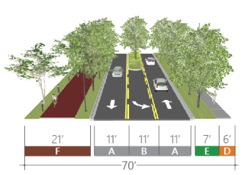 | B-Street Section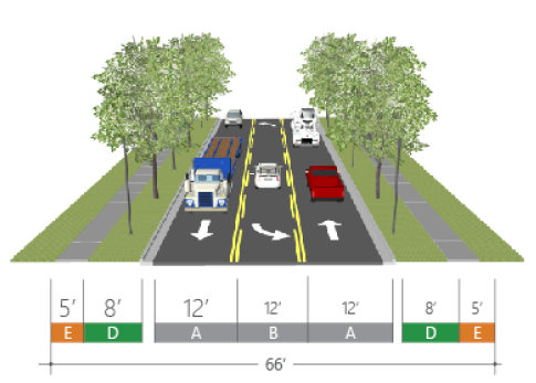 | ||||
| Street design | Street design | ||||
| Right-of-way width | 70 ft | Right-of-way width | 66 ft | ||
| Design speed | 35 mph | Design speed | 35 mph | ||
| Travelway | Travelway | ||||
| A | Travel lanes | 11 ft | A | Travel lanes | 12 ft |
| B | Turn lane/planted median | 11 ft | B | Turn lane/planted median | 12 ft |
| C | Curb and gutter | 2 ft | C | Curb and gutter | 2 ft |
| Streetscape | Streetscape | ||||
| D | Walkway (min) | 6 ft | D | Walkway (min) | 6 ft |
| E | Planting strip | 7 ft | E | Planting strip | 8 ft |
| F | Bikeway (multi-use trail) | 21 ft | |||
10.
Building frontage.
a.
General. Throughout the WBI-E and WBI-G, buildings shall be located and oriented toward the street to create a character of place that is defined by buildings and landscape rather than parking areas. In order to create a consistent building wall along the street, design standards for the area require a significant percentage of each lot to maintain a building frontage within a build-to-zone along all streets. The width of this build-to-zone varies to allow variation in building setbacks to avoid monotony along a street. The standards in this section apply to both the WBI-E and WBI-G Districts.
b.
Build-to zone. Building facades shall be placed in the build-to zone of the applicable street frontage and shall occupy at least the specified percentage of the linear frontage of the site.
c.
Landscape zone. The landscape zone accommodates a consistent landscape identity throughout the WBI-E and WBI-G districts. Buildings are allowed to be located within the landscape zone pursuant to setbacks and the landscape zone planting requirements of this section. Driveway access may cross the landscape zone, however parking is not permitted within this zone.
d.
Parking and service zone. Parking and service areas shall not be located between the principal building and the street, with the exception of the SR 46 frontage. Along SR 46, a single bay of parking is permissible within the build-to-zone so long as the frontage requirements of this section are met. Buildings on corner parcels shall be located up to and address the corner. They are encouraged to wrap the corner where possible. Building service elements (e.g., loading docks, dumpsters, etc.) shall be located at the rear of the building and screened from view of all adjacent streets. New development is encouraged to develop a system of service alleys to provide access to these areas.
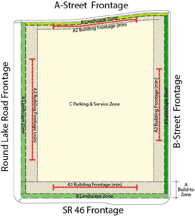
e.
Landscape zone planting. In order to form a cohesive visual character along SR 46 and Round Lake Road, the required landscape zone shall be planted consistent with the standards shown in the figure below.
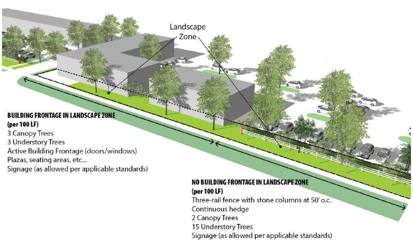
11.
Park systems. The park, trails, and open space systems within the WBI-E and WBI-G districts are intended to serve the day-to-day park needs of residents, employees, and visitors, as well as to frame the spatial organization of the community by linking neighborhoods, workplaces, and service centers with outdoor spaces. The system shall be designed to serve many different functions and may be composed of a range of sizes and types of open spaces connected by pedestrian and cycling pathways. These spaces shall be integrated into the fabric of the WBI along with other public infrastructure systems such as streets, utilities, and stormwater drainage.
a.
Multi-use trails. Multi-use trails shown on the regulating plan must be incorporated into the master plan. Trail alignments may deviate from those shown on the regulating plan, so long as they achieve the origin and destination shown on the regulating plan. Trails shall be designed consistent with the standards in LDC section 6.15.
12.
Site orientation and development standards.
a.
Intent: The intent of the WBI-E and WBI-G districts are to encourage the development of employment center and other supporting uses. These uses often require larger footprint buildings that require special standards. Buildings in the WBI-E and WBI-G should be sited, regardless of their use, in a manner that emphasizes building and landscape more than parking and service/loading areas. While there is not a requirement that buildings be placed at the edge of the sidewalk, the intent of these guidelines is to encourage a varied streetscape that allows buildings with a mix of employment uses in close proximity to each other. Unless noted otherwise, the standards in this section apply to both the WBI-E and WBI-G Districts.
b.
Building placement and site orientation:
(1)
Buildings are encouraged to have a variety of front setbacks in order to avoid the creation of a constant wall of buildings. This is particularly important where proposed buildings have similar heights and massing.
(2)
Large scale parking and service areas shall not be located between the principal building and the street. No more than a single full bay of parking may be located between the principal building and the street at the front of the parcel. Where parking is provided between the building and street, at least 25% of the building frontage must be kept free of parking stalls.
(3)
Parking may be located to the side of the principal building.
(4)
Building service elements (e.g., loading docks, dumpsters, etc.) shall be screened from view of all A-streets, SR 46, and Round Lake Road with landscape screening and/or berms. New development is encouraged to develop a system of service drives to provide access to these areas.
c.
Drive-through standards:
(1)
Drive-through windows and lanes shall be designed to adhere to the following standards:
(2)
Drive-through windows shall not be placed between the right-of-way of SR 46 or Round Lake Road and the associated building.
d.
Pedestrian walkways:
(1)
Purpose and intent. To provide safe opportunities for alternative modes of transportation by connecting with existing and future pedestrian and bicycle pathways within the city and to provide safe passage from the public right-of-way to the commercial building or project, and between alternative modes of transportation.
(2)
Pedestrian access standards. Pedestrian ways, linkages and paths shall be provided from the building entry(s) to surrounding streets, external sidewalks, and outparcels. Pedestrian ways shall be designed to provide access between parking areas and the building entrance(s) in a coordinated and safe manner. Pedestrian ways may be incorporated within a required landscape perimeter buffer, provided said buffer is not less than ten feet in width on average. Shared pedestrian walkways are encouraged between adjacent projects.
(3)
Minimum ratios. Pedestrian ways shall be provided at a minimum ratio of one for each public vehicular entrance to a project, excluding ingress and egress points intended primarily for service, delivery or employee vehicles.
(4)
Minimum dimensions. Pedestrian walkways shall be a minimum of six feet wide.
(5)
Materials. Pedestrian walkways shall be consistent with the provisions of the Americans with Disabilities Act (ADA), the Accessibility Guidelines and the Florida Accessibility Code. Materials may include specialty pavers, concrete, colored concrete or stamped pattern concrete.
(6)
Pedestrian crosswalks at building perimeter. Building perimeter crosswalks shall be designed and coordinated to move people safely to and from buildings and parking areas by identifying pedestrian crossings with signage and variations in pavement materials or markings.
(7)
Shade. Pedestrian walkways shall provide intermittent shaded areas when the walkway exceeds 100 linear feet in length at a minimum ratio of 100 square feet of shaded area per every 100 linear feet of walkway. Shade structures may be natural, manmade or a combination of both.
e.
Stormwater: The shape of a manmade body of water, including wet and dry retention areas, shall be designed to appear natural by having off-sets in the edge alignment that are a minimum of ten feet and spaced 50 feet apart. All bodies of water, including wet and dry retention areas, exceeding 20,000 square feet in area, and which are located adjacent to a public right-of-way, shall incorporate into the overall design of the project at least two of the following items:
i.
A five-foot wide walkway with trees an average of 50 feet on center and shaded benches a minimum of six feet in length or picnic tables with one located every 150 feet.
ii.
A public access pier with covered structure and seating.
iii.
An intermittent shaded plaza/courtyard, a minimum of 200 square feet in area, with benches and/or picnic tables adjacent to the water body.
iv.
A permanent fountain structure of significate size to demonstrate a focal element.
f.
Parking:
(1)
Building exposure shall be maximized and parking areas minimized along all 'A' street frontages, where parking areas should be located behind buildings and be screened from direct view from the street through the use of landscaping, knee walls, etc.
(2)
Parking location. Projects shall be designed to adhere to the following standards:
• Interior lots. No more than 50 percent of the off-street parking for the entire commercial building or project shall be located between any primary facade of the commercial building or project and the abutting street.
• Corner lots. No more than 80 percent of the off-street parking for the entire commercial building or project shall be located between any primary facade of the commercial building or project and the abutting street, with no single side to contain more than 65 percent of the required parking.
(3)
Where parking areas cannot be located behind buildings and are therefore adjacent to public streets, parking areas shall be screened using some combination of landscaping, colonnades, trellises, pergolas, kneewalls, low masonry or concrete walls.
(4)
Off street parking design. Parking shall be designed to be safe, shaded, and easily accessible, but must be located in such a fashion that it does not dominate the development of a site. Parking shall be as provided for in section 6.5, and subject to the following provisions: temporary sales
• Surface parking is to be limited to the minimum required by governing code. Additional parking above code minimum is permitted provided that it is contained within the footprint of a building, in a parking structure, or in a surface lot with enhanced parking lot landscaping and pedestrian circulation to be determined at change in zoning.
• Certain specialized or unique uses may require more surface parking than allowed by code minimum standards and such parking shall be determined at site plan with justification, subject to otherwise applicable code requirements.
• Pedestrian walkways through parking areas are required and should be carefully defined, particularly where pedestrian and vehicle conflicts are unavoidable.
• Pedestrian walkways shall be provided within all parking lots serving commercial, office and multi-family residential development, and be designed to provide direct connections between all building entrances, adjacent rights-of-way, transit stops, and outparcels.
• A minimum of one pedestrian walkway shall be provided for every five head to head parking rows, except where an alternative arrangement is approved as part of a planned unit development.
• At least one pedestrian walkway shall be designed to provide a direct connection from the main pedestrian entrance of any anchor tenant, principle building, or multi-family leasing office to the sidewalk along the perimeter of the development site.
• Pedestrian walkways shall have a minimum width of 14 feet, including a minimum of six feet in width for the sidewalk, and a minimum of eight feet in width for the central landscape strip. All unpaved areas within pedestrian walkways shall have 100 percent landscape coverage in accordance with this Section, and shall conform to the tree spacing requirements provided therein. Shade structures, including pergolas or gazebos, may be substituted for canopy trees.
• Crosswalks connecting pedestrian walkways across parking lot drive aisles shall be designed and constructed to appear visually distinct from the adjacent driving surface through the use of colored or textured concrete.
(5)
Parking structure standards. The primary facade of a parking structure or covered parking facility that is visible from SR 46 or Round Lake Road shall incorporate at least two of the following:
a.
Transparent windows, with clear or lightly-tinted glass, where pedestrian oriented businesses are located along the facade of the parking structure;
b.
Display windows;
c.
Decorative metal grille-work or similar detailing which provides texture and partially and/or fully covers the parking structure opening(s);
d.
Art or architectural treatment such as sculpture, mosaic, glass block, opaque art glass, relief work, or similar features; or,
e.
Vertical trellis or other landscaping or pedestrian plaza area.
g.
Landscaping. In addition to the requirements of the applicable code, the following requirements shall apply.
(1)
Purpose and intent. To provide enhanced landscaping within the vehicular and pedestrian use areas of large commercial buildings and projects. Such landscaping is intended to enhance the visual experience of the motoring and pedestrian public, commonly referred to as the "streetscape". Landscaping should be used to enhance and complement the site design and building architecture.
(2)
Landscape/hardscape. The following requirements, with the exception of building perimeter plantings, shall be counted toward the code-required greenspace and open space requirements.
(3)
Tree and lighting locations shall be designed so as not to conflict with one another.
(4)
Locational requirements for building perimeter plantings:
a.
Perimeter landscape plantings shall be located adjacent to the primary building facade, including building entrance areas, plazas, and courtyards. These areas shall be landscaped with any combination of trees, palms, shrubs and ground covers; and
b.
Building perimeters shall include plantings at a ratio of 100 square feet of planters per 1,000 square feet of building ground floor area. Planters shall either be raised or at ground level and be a minimum of ten feet wide. Seating courtyards, eating areas and plazas may be incorporated within them.
h.
Lighting.
(1)
Purpose and intent. Commercial buildings and sites, including outparcels, shall be designed to provide safe, convenient, and efficient lighting for pedestrians and vehicles. Lighting shall be designed in a consistent and coordinated manner for the entire site. The lighting and lighting fixtures shall be integrated and designed so as to enhance the visual impact of the project on the community and/or blend the project into the surrounding landscape.
(2)
Exterior lighting may be used to illuminate a building and its grounds for safety purposes but in an aesthetic manner. Lighting is not to be used as a form of advertising in a manner that is not compatible to the neighborhood or in a manner that draws considerably more attention to the building or grounds at night than in the day. All fixtures used in exterior lighting are to be selected for functional and aesthetic value. Decorative lighting fixtures in keeping with the architecture style shall be used for commercial wall mount lighting and parking lot light poles. Exterior lighting shall be in accordance with the lighting design standards of this code.
(3)
All new development within the WBI-E and WBI-G districts, including residential, non-residential, and all public rights-of-way shall utilize lighting fixtures designed and located to minimize glare and reduce light trespass and overhead skyglow. All fixtures shall be certified by the International Dark Sky Association's Fixture Seal of Approval program.
(4)
Shielding standards. Lighting shall be designed so as to prevent direct glare, light spillage and hazardous interference with automotive and pedestrian traffic on adjacent streets and all adjacent properties. Illumination onto adjacent right-of-way or adjacent property shall not exceed 0.5 foot candles.
(5)
Fixture height standards. Lighting fixtures shall be a maximum of 30 feet in height within the parking lot and shall be a maximum of 15 feet in height within non-vehicular pedestrian areas.
(6)
Design standards. Lighting shall be used to provide safety while accenting key architectural elements and/or emphasizing landscape features. Light fixtures shall be used as an integral design element that complements the design of the project. This can be accomplished through style, material or color (excluding florescent, primary and secondary colors) or by designing the lighting fixtures to blend into the landscape through the use of dark colors such as bronze, black and forest green. Concrete type poles or mill finish is not permitted. Light pole footers shall not be exposed more than six inches above finish grade.
i.
Fencing.
(1)
Fencing standards. Chain link and wood fencing are prohibited forward of the primary facade, except as provided below, and must be a minimum of 100 feet from a public right-of-way, except as provided in the public realm landscape standards. Chain link and wood fencing facing a public right-of-way shall be buffered at a minimum by an irrigated hedge directly in front of the fence on the side of the right-of-way. Plant material shall be a minimum of 24 inches in height and width and planted to create a continuous visual barrier at time of installation. This plant material shall be maintained at a minimum of three quarter the height of the fencing.
(2)
Fencing forward of the primary facade is permitted under the following conditions:
i.
Fencing does not exceed four feet in height;
ii.
The fencing provides either an open view at a minimum of 25 percent of its length or provides variation in its height for a minimum of 15 percent of its length with a deviation of at least 12 inches; and,
iii.
The fence style must complement building style through material, color and/or design.
13.
Building standards:Industrial and manufacturing buildings.
a.
Intent: Industrial and manufacturing buildings shall be composed with elements that reduce the mass of building walls, reinforce locations of entries, and create architectural interest. This can be done through variations in solid and void composition, color, material, and height.
b.
Building massing: Industrial building frontages shall be broken up and/or screened with landscape at intervals of no more than 100 linear feet. For cross-dock facilities where this is not feasible, additional perimeter landscaping may be substituted (to be determined at WBI-E or WBI-G zoning assignment within the master plan).
c.
Building facades.
(1)
The front façade of every building shall reflect appropriate structural elements and variation of the wall plane through the expression of:
a.
Floors (banding, belt courses, etc.)
b.
Vertical support (columns, pilasters, piers, quoins, etc.)
c.
Foundation (water tables, rustication, etc.)
d.
Variation in wall plane through the use of projecting and recessed elements
e.
Changes in material or material pattern
(2)
The sides of each building on a site, particularly buildings visible from multiple streets, shall be consistent in design and shall be compatible with other development in the immediate vicinity.
d.
Special requirements for landscape, buffers, walls, and fencing on industrial sites. Within the WBI, there should be a focus on creating an image of buildings and landscape rather than parking and service areas. The landscape between the building and public streets is intended to be informal and create a soft appearance over time. Screening landscape is intended to mask the appearance of more industrial elements of sites to allow for integrated uses within the WBI-E and WBI-G districts. The following standards shall apply to all industrial sites:
a.
Where the parking area is visible from a public street or highway, the area will be screened from view by some combination of landscaping, earth berms and decorative walls. Landscape screens consisting of trees, shrubs, ground cover and earth berms are preferred.
b.
All service yards and maintenance equipment must be enclosed and screened from the public right-of-way. Screening may be accomplished with a combination of buildings, walls, landscaping, and/or landscaped earth berms.
c.
Walls and accessory structures shall be consistent with the building materials, finish and colors used in the main building or buildings.
d.
Masonry walls and/or buffer landscaping shall be provided along the side and rear property lines and streets adjacent to property planned or zoned for residential use.
e.
Walls or fences of more than 50' in length should be broken up by landscaping, pilasters, offsets in the alignment of the wall or fence, and/or changes in materials and colors.
14.
Building standards: Commercial and mixed-use buildings.
a.
Considerations: Commercial and mixed-use buildings should be composed with elements that reinforce a pedestrian scale. These elements shall be utilized to create a rhythm and scale consistent with traditional architecture. Large unarticulated facades along the sidewalk are not conducive to a pedestrian experience. The street-front facades of new buildings shall be broken down into a number of smaller bays that relate to the context. Additional interest can be added through variations in solid and void composition, color, material, and height.
b.
Building massing.
i.
No horizontal length or uninterrupted curve of a primary building facade shall exceed 100 linear feet. For arcaded facades, no horizontal length or uninterrupted curve of the arcaded facade shall exceed 120 feet, with varied lengths being desirable. Projections and recesses shall have a minimum depth of three feet with 25 percent of these having a varied length with a minimum differential of one foot.
c.
Building facades.
(1)
All primary facades of a building shall be designed with consistent architectural style and detail and trim features. In the case of outparcel buildings, all exterior facades shall adhere to the requirements of this section with respect to architectural design treatments for primary facades.
(2)
All facades visible from a publicly accessible street or open space shall reflect appropriate structural elements and variation of the wall plane through the expression of:
a.
Floors (banding, belt courses, etc.
b.
Vertical support (columns, pilasters, piers, quoins, etc.)
c.
Foundation (watertables, rustication, etc.)
d.
Variation in wall plane through the use of projecting and recessed elements
e.
Changes in material or material pattern
(3)
In addition to the above standards, all building facades that are adjacent to an A-street, SR 46, and/or Round Lake Road, shall include clear delineation between the first or second level and the upper levels with a cornice, canopy, balcony, arcade, or other architectural feature and shall have two of the following design features:
a.
Windows comprising a minimum of 40 percent of the affected facade;
b.
Projected covered public entry with a minimum of 25 percent of the wall space devoted to windows; or,
c.
Covered walkway (excluding canvas type unless provided with six-inch columns or better) attached to the building, with a minimum width of eight feet and a 60 percent minimum coverage for the affected facade
(4)
Windows shall not appear to be false or applied, except if the primary building is required to be located on the corner street and windows have no functional purpose.
(5)
The first floor of the primary facades shall, at a minimum, utilize windows between the heights of three feet and eight feet above the walkway grade for no less than 30 percent of the horizontal length of the primary building facade.
(6)
Windows shall be recessed, a minimum of one-half inch, and shall include visually prominent sills, shutters, stucco reliefs, or other such forms of framing.
(7)
Blank wall areas. Blank wall areas shall not exceed ten feet in the vertical direction nor 20 feet in the horizontal direction of any primary facade. For facades connected to a primary facade this shall apply to a minimum of 33 percent of the attached facade measured from the connection point. Control and expansion joints within this area shall constitute blank wall area unless used as a decorative pattern and spaced at intervals of six feet or less. Relief and reveal work depth must be a minimum of one-half inch. Landscaping may be used to assist in reducing the blank wall area. Such landscaping shall not be in lieu of architectural treatment.
(8)
Repeating facade treatments. Building facades shall include a repeating pattern and shall include no less than three of the design elements listed below. At least one of these design elements shall repeat horizontally. All design elements shall repeat at intervals of no more than 50 feet horizontally and 15 feet vertically.
a.
Color change;
b.
Texture change;
c.
Material module change;
d.
Expression of architectural or structural bays, through a change in plane of no less than 12 inches in width, such as a reveal, an offset, or a projecting rib;
e.
Architectural banding;
f.
Building setbacks or projections, a minimum of three feet in width on upper level(s); or
g.
Pattern change.
d.
Entryway design.
(1)
Purpose and intent. Entryway design elements and variations are intended to give protection from the sun and adverse weather conditions. These elements are to be integrated into a comprehensive design style for the project.
(2)
Buildings shall feature functional pedestrian entrances. When parking is located to the rear of a street-facing building, entrances shall be provided from both the front and rear or side of the building rather than solely from the parking lot. The following standards shall apply to all buildings:
• Primary entrances shall be both architecturally and functionally designed to demonstrate their prominence.
• All buildings fronting 'A' streets shall have a main entrance from the public sidewalk. In addition, each retail use along these streets shall have an individual public entry from the street.
• Entrances along a public sidewalk shall incorporate arcades, roofs, porches, alcoves or awnings that protect pedestrians from the sun and rain.
(3)
Single use buildings. Single use buildings shall have clearly defined, highly visible customer entrances which shall include the following:
a.
An outdoor patio area adjacent to the customer entrance, a minimum of 200 square feet in area which incorporates the following:
b.
Benches or other seating components;
c.
Decorative landscape planters or wing walls which incorporate landscaped areas; and
d.
Structural or vegetative shading.
e.
A main front entry which shall be set back from the drive a minimum distance of 15 feet.
(4)
Multiple use buildings and projects. Multi-use structures shall include the following:
a.
Anchor tenants shall provide clearly defined, highly visible customer entrances.
b.
Each anchor tenant shall have a front entry which shall be set back from the drive a minimum of 15 feet.
c.
A provision for intermittent shaded outdoor community space at a minimum of one percent of the total gross floor area of the building or commercial project. Said community space shall be located off or adjacent to the circulation path of the complex or main structure and shall incorporate benches or other seating components.
e.
Materials.
(1)
Purpose and intent. Exterior building materials contribute significantly to the visual impact of a building on the community. They shall be well-designed and integrated into a comprehensive design style for the project.
(2)
Exterior building materials, exterior colors, and standards. Predominant exterior building materials shall include, but are not limited to:
a.
Stucco of earth tone;
b.
Natural brick (unpainted, unstained, and untinted);
c.
Textured, other than smooth or ribbed, concrete masonry units of earth tone;
d.
Stone (unpainted, unstained, and untinted), excluding an ashlar or rubble construction look; and
e.
Wooden or composite siding.
(3)
Predominant exterior building materials that are prohibited include:
a.
Plastic or vinyl siding;
b.
Corrugated or reflective metal panels;
c.
Tile;
d.
Smooth or rib faced concrete block; and
e.
Applied stone in an ashlar or rubble look.
(4)
The following colors are prohibited:
• Florescent or day glow colors; or
• Corporate colors or colors used in the marketing of the business occupying the space which are not earth tone shall be calculated towards the allowable signage copy area provided for under applicable code. In such case, a sign permit is required. This section is intended to provide corporations, franchises and corporate chains, with the opportunity to use other exterior colors (other than earth tone), but any such colors shall be considered signage for the purpose of this code.
f.
Roofs.
(1)
Purpose and intent. Variations in roof lines shall be used to add interest to, and reduce the massing of buildings. Roof features shall be in scale with the building's mass and complement the character of adjoining and/or adjacent buildings and neighborhoods. Roofing material should be constructed of durable high quality material in order to enhance the appearance and attractiveness of the community. The following standards identify appropriate roof treatments and features.
(2)
Roof edge and parapet treatment. At a minimum of two locations, the roof edge and/or parapet shall have a vertical change from the dominant roof condition, a minimum of three feet for buildings of 20,000 square feet of gross building area or more, and two feet for all other buildings. At least one such change shall be located on a primary facade adjacent to a collector or arterial right-of-way. One additional roof change must be provided for every 25,000 square foot increment over 50,000 square feet of ground floor space.
(3)
Prohibited roof types and materials. The following types of materials are prohibited:
a.
Asphalt shingles, except laminated, 320-pound, 30-year architectural grade asphalt shingles or better;
b.
Mansard roofs and canopies;
c.
Roofs utilizing less than or equal to a two to 12-pitch unless utilizing full parapet coverage; and
d.
Back-lit awnings used as a mansard or canopy roof.
15.
Building standards: Residential buildings.
a.
Building facades: Residential buildings.
(1)
Considerations: Building facades of residential buildings should create character and visual interest and be composed with elements that reinforce a pedestrian scale. These elements shall be utilized create a rhythm and scale consistent with traditional architecture. The design concept shall utilize architectural elements commonly associated with the chosen style. Additional interest can be added through variations in solid and void composition, color, material, and height.
(2)
All facades visible from a publicly accessible street or open space shall reflect appropriate structural elements and variation of the wall plane through the expression of:
a.
Floors (banding, belt courses, etc.)
b.
Vertical support (columns, pilasters, piers, quoins, etc.)
c.
Foundation (watertables, rustication, etc.)
d.
Variation in wall plane through the use of projecting and recessed elements
e.
Changes in material or material pattern
(3)
Variations in wall planes, rooflines, and other massing elements shall be incorporated to create visual interest in buildings. Large expanses of flat and/or blank walls are prohibited.
(4)
Building entries shall be clearly defined and pedestrian-scaled entries must be a prominent feature of the front elevation.
b.
Roofs.
(1)
Purpose and intent. Variations in roof lines shall be used to add interest to, and reduce the massing of buildings. Roof features shall be in scale with the building's mass and complement the character of adjoining and/or adjacent buildings and neighborhoods. Roofing material should be constructed of durable high quality material in order to enhance the appearance and attractiveness of the community. The following standards identify appropriate roof treatments and features.
(2)
Roof edge and parapet treatment. At a minimum of two locations, the roof edge and/or parapet shall have a vertical change from the dominant roof condition, a minimum of three feet for buildings of 20,000 square feet of gross building area or more, and two feet for all other buildings. At least one such change shall be located on a primary facade adjacent to a collector or arterial right-of-way. One additional roof change must be provided for every 25,000 square foot increment over 50,000 square feet of ground floor space.
(3)
Prohibited roof types and materials. The following types of materials are prohibited:
a.
Asphalt shingles, except laminated, 320-pound, 30-year architectural grade asphalt shingles or better;
b.
Mansard roofs;
c.
Roofs utilizing less than or equal to a two to 12-pitch unless utilizing full parapet coverage; and
d.
Back-lit awnings used as a mansard or canopy roof.
c.
Materials.
(1)
Purpose and intent. Exterior building materials contribute significantly to the visual impact of a building on the community. They shall be well-designed and integrated into a comprehensive design style for the project.
(2)
Exterior building materials, exterior colors, and standards. Predominant exterior building materials shall include, but are not limited to:
i.
Stucco of earth tone;
ii.
Natural brick (unpainted, unstained, and untinted);
iii.
Textured, other than smooth or ribbed, concrete masonry units of earth tone;
iv.
Stone (unpainted, unstained, and untinted), excluding an ashlar or rubble construction look; and
v.
Wooden or composite siding.
(3)
Predominant exterior building materials that are prohibited include:
i.
Plastic or vinyl siding;
ii.
Corrugated or reflective metal panels;
iii.
Tile;
iv.
Smooth or rib faced concrete block; and
v.
Applied stone in an ashlar or rubble look.
Note— Amendments to this section made by Ordinance No. 849 adopted June 15, 2004, shall be prospective in nature and shall not apply to any development for which approvals were granted on or before June 15, 2004.
3.4.16.
MU-1 Mixed Use Traditional and MU-2 Mixed Use Downtown Districts:
1.
Description of districts. The intent of the MU-1 and MU-2 districts is to develop with a minimum of two land uses within a single building or within a single project in separate buildings. These districts encourage a mix of medium/high density residential development with on-site commercial, office, and civic uses. Areas of the city appropriate for these districts include: "Mixed Use Traditional (MU-1)" and "Mixed Use Downtown (MU-2)", as designation on the Future Land Use Map of the Comprehensive Plan. The purpose of these districts are as follows:
a.
Encourage, protect and enhance the pedestrian environment.
b.
Encourage additional street level activity.
c.
Reduce automobile trips.
d.
Create a "sense of place" through architecture and site features.
e.
Provide for the efficient use of land and services.
f.
Allow for a mix of land uses which strengthens opportunities for economic vitality and supports diversity of housing opportunities.
g.
Provide for community gathering places and pedestrian/visitor amenities.
h.
Establish a distinct storefront character associated with the district.
i.
Provide transitions to adjacent neighborhoods and commercial areas, as appropriate.
j.
Maintain and enhance the area's character through design guidelines.
k.
Provide public open space, public gathering places and plazas.
l.
Encourage lake front development and access with appropriate building scale and uses.
m.
Lake views are maintained by transitioning building heights appropriately, by district.
2.
Definitions. The following definitions shall apply to the Mixed Use Districts (MU-1 and MU-2):
Block: An area of land bounded (surrounded on all sides) by streets, or by a combination of streets and public land, railroad rights-of-way, utility right-of-way, waterways, or any other barrier to the continuity of development.
Connectivity: The level or extent to which one or more land uses and parcels within the development have direct accommodations for both vehicles and pedestrians to travel between or among those land uses, and direct vehicular and pedestrian connections with compatible land uses on abutting properties. Direct accommodations for vehicles means that there is one or more alley, road, driveway, or pedestrian connection between the uses on the development site and among compatible uses on abutting sites (parcels), so that vehicles or pedestrians can exit one development and enter the other development (i.e., cross property lines) without exiting onto a public street that provides principal access to the developments. Direct accommodations for pedestrians means that there are one or more sidewalks or other approved paths that allow a pedestrian to go from one development or parcel to another without using the sidewalk along a public street that provides principal access to the developments.
Display window: A window or opening in the exterior wall of any portion of a building used for business purposes, through which merchandise, services, or businesses are displayed or advertised and visible from the ground or sidewalk level.
Floor-area ratio (FAR): The total floor area of the building or buildings on a lot or parcel divided by the gross area of the lot or parcel.


Mixed use, horizontal: Two or more different types of uses are placed next to each other (but not attached), planned as a unit, and connected together with pedestrian and vehicular access. For instance, a subdivision containing single-family dwellings that is adjacent to a neighborhood commercial development and office complex.
Mixed-use development: A single building containing more than one type of land use; or a single development of more than one building and use, where the different types of land uses are in close proximity, planned as a unified complementary, cohesive whole.
Mixed use, vertical: Where two or more different uses occupy the same building usually on different floors. For instance, retail on the ground floor and office and/or residential uses on the second and/or third floors (see figure).

Pedestrian-oriented development: Development designed with an emphasis primarily on the street sidewalk and on pedestrian access to the site and building, rather than on auto access and parking areas. The building is generally placed close to the street and the main entrance is oriented to the street sidewalk. There are generally windows or display cases along building facades which face the street.
Storefront: A business or retail or service use where the façade is aligned directly on the frontage line with the entrance at grade; typical of sidewalk retail. Storefronts often have awnings.
Streetscape: An area that may either abut or be contained within a public or private street right-of-way or accessway that may contain sidewalks, street furniture, trees and landscaping, and similar features. Streetscape also includes the visual image of a street, including the combination of buildings, parking, signs, and hardscapes.
Street furniture: Those features associated with a street that are intended to enhance the street's physical character and use by pedestrians, such as benches, bus shelters, trash receptacles, planting containers, pedestrian lighting, kiosks, etc.
3.
Permitted uses: Uses permitted within the MU-1 and MU-2 districts shall be limited to those specified in Table 1 with additional conditions for specific uses:
TABLE 1
USES PERMITTED IN MIXED USE DISTRICTS MU-1 AND MU-2
a.
Light manufacturing/assembly. Light manufacturing/assembly, meaning production or manufacturing of small scale goods, such as crafts, electronic equipment, candy products, printing and binderies, custom furniture, and similar goods, shall be permitted in storefront or retail areas, subject to compliance with the following:
(1)
Light manufacturing is only allowed when done in conjunction with a permitted retail or service use which is in the storefront location.
(2)
Floor area devoted to light manufacturing is limited to 50 percent of the gross floor area of any individual establishment.
(3)
The light manufacturing operations shall be fully enclosed within a building.
b.
Retail and service components. Enclosed retail trade establishments and personal service establishments should be located in careful relation to other land uses within and outside of the mixed-use development. Such uses shall be scaled to the pedestrian and to the mixed-use development itself. Such uses should be designed and oriented to face the interior of the mixed-use development rather than to passerby traffic exterior to the mixed-use development.
c.
Street-level housing. No more than 50 percent of a single street frontage at ground level may be occupied by residential uses. Every dwelling unit with a front façade facing the street in a pedestrian retail or storefront area, if provided, shall to the maximum extent possible have its primary entrance face the street. Every building containing four or more dwelling units shall have at least one building entry or doorway facing any adjacent street that has on-street parking.
d.
Uses on storefront streets. With some limitations specified in this district, it is the intent that within buildings fronting along designated storefront or pedestrian retail streets, only commercial, office, civic, light industrial/assembly uses should occupy the ground-level floor. Floors above the ground level may be occupied by office or residential uses.
e.
Detached, single-family dwellings. No mixed-use development shall contain more than 50 percent of the dwelling units provided in the mixed-use development as detached, single-family dwellings on individual lots.
4.
Prohibited uses:
a.
Medical marijuana dispensaries.
b.
Non-medical marijuana sales.
c.
Cannabis farms.
d.
All uses not allowed as either a permitted use or a conditional use above are prohibited.
5.
Accessory uses within sidewalk: Certain uses are permitted accessory uses and will be permitted to operate within sidewalk areas, provided that they meet the following:
a.
Minor entertainment. Minor entertainment is allowed, provided by groups of five or fewer performers without electronic amplification; performances have a duration of no more than one hour in any one location within a 50-foot radius, and the hours of minor entertainment fall between the hours of 9:00 a.m. to 9:00 p.m.
b.
Display and other accessory uses generally. All such outdoor displays, sales, service or minor entertainment takes place on private property with the written consent of the owner or agent of the property, or on public property if consistent with the requirements of this code. No display, sales, service or minor entertainment shall be allowed to block entirely the required sidewalk. A clear area with a minimum width of five feet shall be left between the street curb and the building entry or exit.
c.
Equipment and displays. All booths, stalls, carts, or other equipment for outdoor display, sales, service or minor entertainment at the close of business each day shall be removed and secured so as to prevent it from becoming a public safety hazard, nuisance or security risk.
d.
Outdoor dining areas. Outdoor dining areas shall be permitted on a public or private sidewalk area where adjacent to and directly abutting a restaurant located in a building. However, the outdoor dining area shall not reduce the streetscape and public sidewalk width, combined to a width of less than five feet. Tables, chairs, umbrellas, and similar items shall be stored in the interior of the restaurant or in similar enclosed area so that a minimum clear zone of five feet is unobstructed when the outdoor dining area is not in use, because of inclement weather or when the restaurant is closed.
e.
Servicing and solid waste collection. In order to preserve the pedestrian orientation of the storefront or pedestrian retail area, all servicing, loading, and solid waste collection shall take place off-street away from pedestrian walkways, generally in bays provided in the alleys or in screened, internal, rear spaces if alleys are not available. Screening of utilities and Service Function Areas (SFA) shall be in accordance with this code.
6.
Mixed use standards:
a.
Minimum vertical mixed use requirement. When a mixed-use district is established, there shall be at least 50 percent of the total land area within the mixed use development that meets the definition of vertical mixed use. In calculating compliance with this requirement, the street rights-of-way, public or private, within and serving the vertical mixed-use development (i.e., with buildings fronting on both sides of the street) shall be counted as vertical mixed use.
b.
Minimum mixes for horizontal mixed use. For horizontal mixed use, as defined, a minimum of 25 percent of horizontal mixed use development's total land area (or, if vertical mixed-use is included, only those areas that are horizontal mixed use) shall be devoted to residential uses, and a minimum of 50 percent shall be devoted to retail/service, office, and/or civic uses. In calculating compliance with this requirement, the street rights-of-way, public or private, within and serving the development (i.e., with lots and dwellings fronting on both sides of the street) shall be part of such use.
c.
Minimum open space. For horizontal mixed use developments, there shall be at least 20 percent of the total land area within the mixed use development that is passive or active recreation or open space.
d.
Commercial architectural and site design guidelines shall be in accordance with this code at a minimum.
e.
Signs. All signs shall be designed for visual communications to pedestrians and slow-moving vehicular traffic. Signs projecting from the building wall toward the sidewalk are emphasized. A sign master plan shall be required with the mixed use master plan development proposal in accordance with this code.
7.
Site development standards: The following requirements shall be observed in all mixed-use developments, except where the requirement is more specifically attributed to horizontal mixed use, or vertical mixed use, as the case may be.
a.
Minimum site area designated. There are no minimum site area requirements.
b.
Minimum height. Within storefront areas (i.e., vertical mixed use), buildings shall be a minimum of two stories in height, but cannot exceed the height requirements listed below by district.
c.
Maximum height shall be restricted by district as follows:
(1)
MU-1: The height for a vertical mixed use building shall not exceed five stories in height, or 60 feet, whichever is greater. No parking structure shall exceed a height of 50 feet. Multiple story buildings are allowed, so long as redevelopment or new development provided proper setbacks from established residential neighborhood.
(2)
MU-2: Building height is limited to 35 feet and cannot exceed 25 feet in height for buildings that are located within 100 feet of Lake Dora or in any other location in the MU-2 district where surrounding scenic views of Lake Dora cannot be maintained.
d.
Floor-area ratios (FAR). The intensity of all vertical mixed use development, and all horizontal mixed-use development except detached, single-family dwellings each on their own lot, shall be regulated by this subsection and shall not exceed the specified maximums, as applicable. In calculating maximum floor-area ratios, open space shall be counted in the calculation of FAR compliance.
(1)
The maximum floor-area ratio of any mixed-use development, excluding detached, single-family dwellings, each on their own lot, shall not exceed 3.00, including any allowable combination of residential, commercial, office-professional, civic and retail/service uses.
(2)
Non-residential development in a vertical or horizontal mixed-use development shall not exceed a floor area of 3.00.
(3)
The minimum non-residential floor area in a vertical mixed-use development shall be 0.25.
(4)
Maximum residential density shall not exceed 35 du/ac.
(5)
The city may establish more restrictive intensity and density limitations than established in this subsection, as a condition of zoning PUD approval, in order to ensure compatibility with adjacent existing development.
e.
Minimum dwelling (living) area for residential units for Vertical Mixed Use shall be as follows: 600 square feet.
f.
Detached, single-family dwellings. When detached, single-family residential dwellings each on their own lot, or provided in horizontal mixed use development, such uses shall conform to the following requirements.
(1)
Minimum lot size: 5,000 square feet.
(2)
Minimum lot width at building line: 50 feet.
(3)
Minimum dwelling (living) size: 800 square feet.
(4)
Minimum setbacks:
• Front Yard: 15′
• Side Yard: 5′
• Rear Yard: 15′
• From any street: 15′
(5)
Garages are required. Front loaded types garages shall be recessed a minimum of four (4) feet from the building line (i.e. garages projecting beyond the front house facade are not allowed).
g.
Attached, dwellings (townhouses). When attached, single-family residential dwellings (townhomes), each on their own lot, are provided in horizontal mixed-use development such uses shall conform to the following requirements.
(1)
Minimum lot size (townhouse): 2,000 square feet
(2)
Minimum lot width: 20 feet
(3)
Minimum dwelling (living) area: 600 square feet.
h.
Freestanding multi-family dwellings. When apartments or condominiums are provided in a horizontal mixed-use development such uses shall conform to the following requirements.
(1)
Minimum dwelling (living) Area: 600 square feet
(2)
Minimum Setbacks:
• Front Yard: 25′
• Side Yard: 25′
• Rear Yard: 25′
• From any street: 25′
• Between Buildings: 25′
i.
Building setbacks. There shall be no required building setbacks for mixed-use development, except those that may be proposed by the mixed-use developer and/or made a condition of approval by the city. This includes lake front structures.
8.
Building placement and orientation requirements: The purpose of this requirement is to ensure that buildings in the district complement pedestrian activity by providing direct access to the building and business activities from the sidewalk. If an entry is oriented to a parking lot, it diminishes activity from the street and implies that auto access takes precedence. Building presence is reinforced by observing the criteria in this section. All properties with frontage on public and private streets shall upon development with a building have the building or buildings facing said streets in accordance with this section as follows:
a.
The primary building entrance shall face onto (be oriented to) the sidewalk and street. Building entrances may include entrances to individual units, lobby entrances, entrances oriented to pedestrian plazas, or breezeway/courtyard entrances to a cluster of spaces.
b.
On corner lots much as feasible, buildings and their entrances shall be oriented to the street corner as feasible. Corner building entrances should be designed in cases where the building is located on a corner lot. Alternatively, a building entrance may be located away from the corner when the building corner is beveled or incorporates other detailing to reduce the angular appearance of the building at the street corner.
c.
A building may have an entrance facing a side yard when a direct pedestrian walkway is provided between the building entrance and the street right-of-way.
d.
Building frontage requirement. Within a storefront or pedestrian retail area, at least 50 percent of the width of the lot shall occupied by a building at the front setback.
9.
Requirements for pedestrian friendly infrastructure: The following provisions shall be required in storefront and pedestrian retail areas and may be considered appropriate in other parts of the mixed-use district.
a.
Sidewalks and streetscape: Sidewalks shall be built along all public streets in the district. All sidewalks shall have a minimum width of ten feet with a minimum clear zone of ten feet. Alongside the sidewalk and integrated there with shall be a continuous streetscape zone for street trees and street furniture adjacent to the curb which shall not be less than five feet in width; provided, however, that where the existing building line does not presently provide a width of 15 feet, the minimum sidewalk width and streetscape zone width may be reduced to the actual width of the existing sidewalk and streetscape zone.
b.
Pedestrian amenities. The streetscape zone shall be planted with street trees and furnished with street furniture, including but not limited to benches and litter receptacles. The streetscape zone may also include signs, light poles, and other similar items unless otherwise specifically prohibited by this code.
c.
Pedestrian crossings of driveways and intersections. The color and composition of sidewalk shall be continued as it crosses vehicular driveways and street intersections. Where the sidewalk color and composition of the sidewalk is not otherwise distinguishable from the driveway or roadway composition and color, the sidewalk shall be composed of material with color and texture that demarcates the pedestrian crossing. This provision is required to promote safety of pedestrians, as different textures or colors of pedestrian crossings alert or remind the motorist pedestrians are present.
10.
Parking and on-street parking:
a.
On-street parking is required for all newly constructed streets in areas designated as store font or pedestrian retail that have vehicular access, and may be required to be integrated in an existing public street right-of-way.
 |  |
b.
Reduction of maximum parking space requirements. Where another provision of this code or other ordinance requires off-street parking, those requirements may be reduced by up to 20 percent for all uses within vertical mixed-use developments, plus an additional one space for each on-street parking space provided in the vertical mixed use development area.
c.
Off-street parking location limitations. Parking areas or driveways, except for a driveway to reach a side or rear yard or on-site parking facility, are not permitted between the sidewalk and the front of the building. All off-street vehicle parking, including surface lots and garages, shall be oriented to alleys, located in parking areas behind or to the side of the building, or placed underground, where feasible.
d.
Parking garages/Decks. Above-ground parking structures, if they must front on a storefront or pedestrian retail street, shall provide continuous street-fronting ground level commercial or office spaces and uses, except at ingress and egress points into the structure and any required ventilation. Parking garages/decks shall be at a minimum in accordance with section 6.5.6 of this code.

11.
Specific development guideline: Substantial deviation from the provisions contained in this section may serve as a basis for denying the mixed-use development application.
a.
Block size and width. Block length or width should not exceed 600 feet without intervening (mid-block) pedestrian footpaths.
b.
Open space.
(1)
Open spaces should be located and designed to add to the visual amenities of the district and to the surrounding area by maximizing the visibility of internal open space as "terminal vistas" (i.e., the building or landscape seen at the end of a street, or along the outside edges of street curves), and by maximizing the visibility of external open space as a perimeter greenbelt.
(2)
Public plazas, open space, and parks should be spatially defined and distributed throughout the district so that no lot is more than a walking distance of 1,350 feet from a public plaza, open space, or park. Public plazas, open space, and parks shall not be less than 8,000 square feet in area. Public lake front plazas and boardwalks may be included.
(3)
Within the MU-2 district, public spaces such as boardwalks, parks, and plazas shall be an integral part of the project amenities to provided for interconnection between the downtown cores areas, lakefront, and nearby recreation areas.
c.
Street tree planting. Trees should be planted a maximum of 30 feet on center within the streetscape. Street trees might be regularly spaced, or they may be irregularly spaced where opportunities exist.
d.
Buffering and landscape treatments shall be consistent with this code. Buildings shall be buffered from property lines consistent with existing, adjacent or nearby buildings as to provide uniform landscaping and buffering.
e.
Loading/unloading areas. Loading/unloading areas as required in section 6.5. will be provided except where such areas are determined to be infeasible for existing buildings.
f.
Architectural design shall be as follows:
(1)
Detached single-family dwellings architecture: The residential building styles (elevations and facades) contained and illustrated in section 6.11 of this code shall be mandatory architecture for single-family residential dwellings in all mixed use developments. Waivers and/or deviations to these styles may be considered by the city council provided the overall design theme and intent and consistent with these examples of section 6.11 of this code.
(2)
The commercial architectural and site design standards of section 6.13 shall apply to all mixed use developments. Architectural style is not restricted, except for single-family dwellings as listed in the above subsection (1). Evaluation of the appearance of a project shall be based on the quality of its design and relationship to surroundings.
(3)
Buildings should have consistent spacing of similar shaped windows with trim or other decorative molding on all building stories.
(4)
Large display windows should be employed on ground floor storefronts. Display windows should be framed to visually separate the ground floor from the second floor.
(5)
All buildings with a flat roof should have a decorative cornice at the top of the building; or eaves when the building is designed with a pitched roof.
(6)
Cornices or changes in material can be used to differentiate the ground floor of buildings which have commercial uses from the upper floor(s) which may have offices or residential uses. Ground floor facades should utilize cornices, signs, awnings, exterior lighting, display windows and entry insets.
(7)
Canopies, awnings and arcades: Notwithstanding any other city ordinance or codes to the contrary, canopies, awnings and arcades may be utilized. Projection onto or over the public streets, sidewalks or right-of-way will be permitted. However, in order to be approved, the following minimum standards shall be met: the minimum height of the bottom of the canopy, awning or arcade structure shall be seven feet; and, the canopy awning or arcade structure shall be constructed so that the bottom thereof is horizontal.
12.
Phasing plan: A phasing plan shall be required with all mixed use developments with date certain (month/year) of anticipated site work completion consistent with the requirements of this code.
13.
Applicability to other code sections: Mixed Use developments shall be required to meet applicable Land Development Code requirements. Innovative design and deviations may be considered by the city council, provided the intent of mixed use component will result in a higher quality than allowed minimum requirements of this code.
14.
Approval expiration: If a final master plan for all or part of the preliminary master plan has not been submitted within 12 months following the approval of the preliminary master plan, the preliminary master plan approval shall be void. Upon request by the applicant prior to expiration, the city council may review the preliminary master plan and current conditions and determine whether the approved uses are still appropriate. Following this review, the city council may take the following action:
a.
If there have been no significant changes in the surrounding area, the city council may extend the approval for an additional six months.
b.
If significant changes have occurred in the area that make the approved uses inappropriate, the city council may, after public hearing and recommendations of the planning and zoning commission: Revise the preliminary master plan.
15.
Bonds: Improvement bonds for facilities to be owned and maintained by the city shall be posted before the issuance of building permits.
16.
Process and application requirement, the applicant for mixed use development shall in addition provide the following information:
a.
Establishment and assignment of the Mixed Use Traditional (MU-1) and Mixed Use Downtown (MU-2) shall following the normal rezoning application process of this code and include a concept master plan outlining the development plan, uses, and performance standards as shall serve as the development master plan for the proposed mixed-use project.
b.
All mixed use developments should require a final plat. All phases shall be platted as separate tracts within the initial plat.
c.
Where applicable, certificate of appropriateness applications must be reviewed and approved by the historic preservation board.
d.
Mixed use master plans should include:
• Pedestrian connection plan;
• Proposals for transit-friendly amenities and streetscape improvements; and
• Signage master plan/program.
e.
Mixed Use Master Plan shall show the following areas as appropriate:
• Residential neighborhoods;
• Commercial and office-professional areas;
• Civic areas;
• Vertical mixed use areas;
f.
For redevelopment plans, a plan for revising the interior circulation pattern to include greens, landscape islands, etc.;
17.
Existing uses and structures: Existing uses and structures shall be subject to the non-conforming provisions of this code.
(Ord. No. 695, §§ 1, 2, 5-20-97; Ord. No. 714, §§ 2—5, 4-7-98; Ord. No. 719, § 1, 7-7-98; Ord. No. 790, § 4, 7-17-01; Ord. No. 799, § 1, 11-20-02; Ord. No. 813, § 1, 8-6-02; Ord. No. 849, §§ 5—7, 6-15-04; Ord. No. 867, §§ 1, 2, 12-21-04; Ord. No. 2007-934, §§ 3—8, 2-20-07; Ord. No. 2007-947, § 1, 7-3-07; Ord. No. 2008-996, § 2, 5-6-08; Ord. No. 2008-1000, § 2, 6-17-08; Ord. No. 2008-1002, §§ 2, 3, 6-17-08; Ord. No. 2008-1020, § 1, 12-2-08; Ord. No. 2009-03, § 2, 3-17-09; Ord. No. 2011-01, § 4, 2-11-11; Ord. No. 2011-02, § 2, 2-15-11; Ord. No. 2011-03, § 2, 3-15-11; Ord. No. 2013-08, § 2(Exh. A), 10-1-13; Ord. No. 2013-13, § 2(Exh. A), 10-1-13; Ord. No. 2014-05, § 2, 5-20-14; Ord. No. 2014-18, § 2, 2-3-15; Ord. No. 2016-04, § 2, 7-5-16; Ord. No. 2016-15, § 2, 4-19-16; Ord. No. 2017-12, § 3, 1-16-18; Ord. No. 2020-03, § 4, 2-18-20; Ord. No. 2020-20, § 2, 5-4-21; Ord. No. 2022-10, § 2, 9-20-22; Ord. No. 2023-11, § 2, 9-21-23; Ord. No. 2024-14, § 2, 7-16-24; Ord. No. 2025-20, § 2, 10-7-25)
3.5. - Supplemental regulations.
3.5.1.
Setback relief for single-family residential dwellings: The front, street (corner), rear and side yard setback requirements of this code for single-family residential dwellings may be reduced on any lot where the average setback of existing buildings located within 200 feet surrounding the property lines is less than the code requirements. In such cases, the setback on such lot may be less than the required setback but not less than the average of the setbacks of the aforementioned existing buildings. Documentation and evidence of the averaging setback within the prescribed area shall be provided by professional surveyor. In no case shall the reduced setback be less than five feet from the property lines; encroach into the wetland setback; or create a public safety hazard by obstructing vehicular visibility or other means.
3.5.2.
Setbacks for future road widening. In addition to the setback requirements contained in the specific zoning districts, increased setbacks may be required to ensure proper setbacks from the planned right-of-way on any road or street that is programmed for widening under: (1) the traffic circulation element of the comprehensive plan; (2) the current capital improvements program; or (3) the officially adopted Florida State Department of Transportation Five Year Work Program. Required setbacks are listed in Table III-I which follows:
TABLE III-1
Major Roadway System
Mount Dora Planning Area
Setback Requirements
3.5.3.
Measurement of setbacks. Setbacks shall be measured on a perpendicular to the property line to the first vertical plane which intersects any portion of the structure other than a nominal roof overhang.
3.5.4
Accessory buildings/structures and uses in residential district.
1.
When an accessory building is attached to a main structure by a breezeway, passage or otherwise, it shall comply with setback requirements of the main building. No more than two accessory structures shall be permitted on a single lot.
2.
A detached accessory building, also a garage apartment, shall not be closer than five feet to a side or rear lot line; accessory buildings shall not exceed 600 square feet.
3.
Residential districts: Screen rooms (covered roofs are allowed), decks and/or patios shall be five feet from the rear property line and the side yard setback shall be pursuant to the underlying zoning district. Screen rooms, decks, and/or patios are not allowed within any platted easement.
4.
For waterfront lots, accessory buildings/structures shall not be located within 25 feet from the normal high-water control level of the lake (does not include boat dock).
5.
An accessory structure is incidental and subordinate to the principal structure. There must be a permitted principal structure on the same parcel prior to installation and permitting of an accessory structure.
6.
Height limit. No accessory structure shall exceed a height of 25 feet or the height of the dwelling unit, whichever is greater.
7.
Exempt structures: Play equipment and pet shelters. Children's play equipment, movable dog houses, and similar structures may be placed within a required rear setback without limitation on location.
3.5.5.
Yards.
1.
Every part of a required yard shall be open from its lowest point to the sky, unobstructed, except that an overhang or eaves may project into the required yard five feet or half the width of the established setback, whichever is less.
2.
On all lots, the required front yard setback shall be provided from any adjacent right-of-way.
3.5.6.
Height.
1.
Building and structure heights for lands located outside the Building Height Impact District may not exceed 35 feet for all zoning districts, except 60 feet within the MU-1 district, 65 feet within the C-3 district, and 100 feet within the WBI-E and WBI-G districts. Chimneys, water, fire, telecommunication, radio and television towers, church spires, cooling towers, elevator bulkheads, smokestacks, and similar structures, and their necessary mechanical appurtenances may exceed 35 feet, subject to the restrictions herein, and any height limitations placed on such structures by the Federal Aviation Administration. No building, parking garage, or other structure shall exceed 25 feet if such building or structure is to be located within 100 feet of the normal high water control level of Lake Dora, or in any other location where surrounding scenic views of Lake Dora would be destroyed. Flagpoles may not exceed 45 feet in height in all zoning districts.
2.
Building Height Impact District.
a.
The purpose and intent of this section is to help safeguard the cultural heritage, architectural uniqueness and general historic character of the City of Mount Dora, among other objectives as enacted. It accomplishes these purposes by establishing regulatory provisions that regulate unacceptable building and structural heights within the special area designated as the "Building Height Impact District" within the map depiction geographically shown below. Further, the purpose of this sub-section is to promote the preservation and appreciation of properties within this district, to contribute to the overall economic health of the downtown area, to reduce adverse environmental impacts, to help ensure that future development and improvements remain consistent with the prevailing architectural character of the designated area and to help protect stable neighborhoods located within and in the vicinity of the Building Height Impact District.
The Building Height Impact District is pursuant to the provisions of the City of Mount Dora Charter, Article VII, Building Heights, Section 32, Limitations, Exceptions, Variances.
b.
Any proposed text or map changes to Section 3.5.6.2 as it relates to the height of buildings and structures within the Building Height Impact District shall not be considered until it has been placed on a clearly worded ballot and decided by a majority vote (meaning at least one more vote over the minimum majority vote) of Mount Dora electorate.
c.
Height regulations affecting areas and lands within the Building Height Impact District (see map) specific for two distinct areas along with other provisions are as follows:
i.
The allowable height of buildings and structures located within the City's Historic Preservation Review Area as depicted in the City of Mount Dora Comprehensive Plan 2045, Future Land Use Map Series, Map II-2e, shall not exceed 35 feet; excluding but not limited to chimneys, water, fire, telecommunication, radio and television towers, church spires, cooling towers, elevator bulkheads, smokestacks, and similar structures, and any related necessary mechanical appurtenances. In no such case shall such appurtenance as described herein exceed five feet in height, yielding a maximum building height of 40 feet.
ii.
No building or other structure shall exceed 25 feet if such building or structure is to be located within 100 feet of the normal high water control level of Lake Dora. Addition provisions include other location that would visually block 75% or more of surrounding panoramic view of Lake Dora. The maximum height as described herein excludes but not limited to chimneys, water, fire, telecommunication, radio and television towers, church spires, cooling towers, elevator bulkheads, smokestacks, and similar structures, and any related necessary mechanical appurtenances. In no such case shall such appurtenance as described herein exceed five feet in height, yielding a maximum building height of 35 feet.
iii.
All building and structures shall adhere to applicable regulatory provisions as required by the Federal Aviation Administration.
iv.
Flagpoles may not exceed 45 feet in height.
d.
Variances building height requirements within the "Building Height Impact District." The planning and zoning commission shall provide and forward a recommendation to the city council for final action.
Following deliberation and public hearings of the proposed height variance request, the planning and zoning commission and city council shall find that the applicant has provided demonstrable substantial competent evidence that they have met each of the requirements cited below and the failure to meet any one of these items shall result in the planning and zoning commission recommending denial and the city council shall disapprove the variance application. Variance for such request shall provide an application and related fees of this code. City council's action for approval shall be by a supermajority vote (meaning at least one more vote over the minimum majority vote). These requirements and variance criteria are as follows:
i.
No building or structure shall exceed 40 feet in height located within the City's Historic Preservation Review Area as depicted in the City of Mount Dora Comprehensive Plan 2045, Future Land Use Map Series, Map II-2e, except that no building or structure shall exceed 30 feet in height within the 100 feet of the normal high water control level;
ii.
That special conditions and circumstances exist which are peculiar to the land, structure or building involved and which are not applicable to other lands, structures or buildings within otherwise similarly situated properties;
iii.
That the special conditions and circumstances have not resulted from and do not result from the actions of the applicant;
iv.
That granting the variance requested will not confer on the applicant any special privilege that is denied to other lands, buildings or structures in the same zoning district;
v.
That literal interpretation of the provisions would deprive the applicant of rights commonly enjoyed by other similarly situated properties under the terms of the chapter and would effect an unnecessary and undue hardship on the applicant to the extent that the absence of the requested variance would essentially constitute a taking of the property;
vi.
That the variance, if granted, would result in the minimum necessary impact in order to make possible the reasonable use of the land, building or structure;
vii.
That the grant of the variance will be in harmony with the general intent and purpose of this code and the comprehensive plan, will not in any way be detrimental to the subject property, the surrounding neighborhood or the public health, safety or welfare. The planning and zoning commission may recommend and city council may prescribe appropriate conditions to further protect the public, health, safety and welfare;
viii.
Shall provide enhanced architectural standards, elements, features and other design standards; and
ix.
Additional building floors, improvements, or vertical expansions to existing structures are not allowed.
e.
The following public hearing requirements for building or structural height variance applications within the "Building Height Impact District" shall be as follows:
i.
The planning and zoning commission shall hold at least one public hearing with proper public notice of this sub-section and shall provide their recommendation for either approval, approval with conditions, or denial to the city council for consideration and final action.
ii.
Following receipt of the planning and zoning commission recommendation, the city council shall hold a public hearing with proper public notice before taking final action on the variance application under review.
iii.
In the city council public hearing where final action is taken, any approval or approval with condition shall be achieved with at least a supermajority vote (at least one more vote beyond a simple majority) of voting members of council present during these proceedings.
f.
Public notice for publication and posting requirements:
i.
The city shall be required publish notice of a public hearing noticed on a variance application to be prepared and published in a newspaper having general circulation in the city within ten days of scheduled planning and zoning commission or city council public hearings. Notice shall be published in the non-legal (i.e display advertisement) section of the newspaper. Ad size shall be minimum two columns wide.
ii.
Owners of real property within 300 feet of the land subject to an application shall be mailed via United States Postal Service a notice of the variance request; and the owner names and addresses used to mail required notice to owners of neighboring property shall be those shown on the current ad valorem tax rolls of Lake County.
iii.
Public notice requirements (posted sign or signs): The city shall be required to post notice of a minimum size 8½ inches by 17 inches poster size on the land subject to the application for variance, at a location adjacent to each abutting street that is clearly visible to traffic along the street. If no part of the subject land abuts a street, then the notice shall be posted in the right-of-way of the nearest street, and in a manner consistent with the intent of the provisions of this code.
iv.
Posted notice shall be in a manner established by the planning director.
v.
The content of required public notice shall, at a minimum include the following: Identify the application; describe the nature and scope of the proposed variance request or action; and identify the date, time, and location of the public hearing(s) being noticed.
3.5.7.
Nonconforming uses/structures.
1.
Nonconforming uses. Within the districts established by these zoning regulations or amendments that may later be adopted, there may exist uses of land or water and characteristics of uses which were lawful before these zoning regulations were adopted or amended, but which would be prohibited, regulated, or restricted under the terms of these zoning regulations or future amendments. It is the intent of these zoning regulations to permit these nonconformities to continue until they are removed as required by these zoning regulations, but not to encourage their continuance. A nonconformity may be continued so long as it remains otherwise lawful, provided that:
a.
Enlargement, increase, intensification, alteration. No nonconforming use shall be enlarged, intensified, increased, or extended to occupy a greater area of land or water than was occupied at the effective date of adoption or amendment of these ordinances.
b.
Movement. No nonconforming use shall be moved in whole or in part to any portion of the lot or parcel other than that occupied by the use at the effective date of adoption or amendment of these zoning regulations.
c.
Discontinuance. If any nonconforming use is discontinued for any reason for a period of more than 180 days, any subsequent use of the land shall conform to the regulations specified by these zoning regulations for the district in which that land is located, except as otherwise permitted by law. Discontinuance shall be determined by interruption in water service, electric service, or occupational license for the use on the property in question.
d.
Change in tenancy or ownership. There may be a change in tenancy, ownership or management of a nonconforming use, provided there is no change in the nature or character of the nonconforming use.
e.
Casual, temporary or illegal use. The casual, temporary or illegal use of land, or land in combination, shall not be sufficient to establish the existence of a nonconforming use or to create rights in the continuance of such use.
f.
If application for any zoning or development approval is requested, all nonconforming uses must be brought into compliance with this code.
2.
Nonconforming structures. Within the districts established by these zoning regulations or amendments that may later be adopted, there may exist lots or structures which were lawful before these zoning regulations were adopted or amended, but which would be prohibited, regulated, or restricted under the terms of these zoning regulations or future amendments. It is the intent of these zoning regulations to permit these nonconformities to continue until they are removed as required by these zoning regulations, but not to encourage their continuance. A nonconformity may be continued so long as it remains otherwise lawful, provided that:
a.
Enlargement, increase, intensification, alteration. A nonconforming structure may be enlarged, intensified, increased in height, or extended to occupy a greater area of land or water than was occupied at the effective date of adoption or amendments of these zoning regulations provided that the enlargement, intensification, increase in height, alteration or extension is consistent with all applicable codes and regulations.
b.
Except as provided in subparagraph a. above, no nonconforming structure shall be enlarged, intensified, increased in height, or extended to occupy a greater area of land or water than was occupied at the effective date of adoption or amendments of these zoning regulations.
c.
Notwithstanding paragraphs a. and b. above, a nonconforming structure may be maintained and repairs and alterations may be made, except that in a building which is nonconforming as to the regulations, no structural alterations shall be made except those required by law. Repairs such as plumbing or the changing of partitions or other interior alterations are permitted.
d.
Special provisions apply for single-family or duplex garages and carports pursuant to Section 3.5.28.2. of this code.
e.
Movement. No nonconforming structure shall be moved in whole or in part to any portion of the lot or parcel other than that occupied by the use at the effective date of adoption or amendment of these zoning regulations.
f.
Destruction. Should any nonconforming structure or nonconforming portion of a structure be destroyed by any means to an extent of more than 50 percent of its replacement value based upon property appraisal records at time of destruction, it shall not be reconstructed except in conformity with the provisions of these zoning regulations.
g.
Unsafe nonconforming structures because of lack of maintenance. If a nonconforming structure or portion of a structure, or any structure containing a nonconforming use, becomes physically unsafe or unlawful due to lack of repairs or maintenance, and is declared by the duly authorized official of the city to be unsafe or unlawful by reason of its physical condition, it shall not be thereafter be restored, repaired, or rebuilt except in conformity with the regulations of the district in which it is located.
h.
If application for any zoning or development approval is requested, all nonconforming uses must be brought into compliance with this code.
3.5.8.
Fence requirements.
1.
Types of fences. Fences shall be either wood, chainlink, vinyl, concrete masonry wall design, brick, wrought or ornamental iron or decorative wire. Barbed wire fences may be constructed in industrial and greenbelt zoning districts with the approval of the zoning official. Barbed wire fences may be used on fences in excess of six feet in height around retention ponds, commercial pools, lift stations, substations and any local, state and federal land uses where applicable, with the approval of the zoning official.
2.
Height of fences.
a.
Fences in single-family and duplex residential zoning districts shall be limited to six feet in height in the rear yard, side yard and street side yard and four feet in the front yard. Fences four feet or greater in height cannot be installed within the street side yard setback as established by the zoning district.
b.
Where an existing single-family or duplex residential dwelling is located adjacent to existing multi-family structure the side and rear fence height shall be limited to eight feet in lieu of the six feet fence height listed above.
c.
In all other commercial, WBI-E, WBI-G and PLI zoning districts, the fences shall be limited to eight feet in height along the side and rear property line and four feet in front yards.
3.
Property lines. Fences may be constructed along the property line of the lot.
Damage to city-owned utilities, such as water, electric and sewer, during fence installation shall be repaired immediately at the expense of the property owner. Furthermore, the city may enter the easement area without prior notice to make any repairs and maintenance it deems necessary and shall not be responsible for any damage to the fence in the easement area.
If a permanent removal of a section of any fence constructed on an easement is requested by the city, the fence must be removed from the property by the owner within the time specified by the city. No fence shall be constructed which obstructs motorist visibility.
4.
Commercial districts. In the C-2A zoning district fences up to six feet in height shall be permitted along the side and rear property line, while fences of up to four feet in height shall be permitted in front yards.
In all other commercial and PLI zoning districts, the fences shall be limited to eight feet in height along the side and rear property line and four feet in front yards.
5.
Industrial district. Fences in the industrial zoning district shall be of the following types: Chainlink, concrete/masonry wall design, wood and ornamental iron. Barbed wire fence headers may be used with the approval of the zoning official.
Fences in the industrial zoning district shall be limited to eight feet in height.
6.
Greenbelt district. In the greenbelt zoning district, the fences permitted in the industrial zoning district shall be permitted with the addition of hog-wire fences when in an agricultural or similar type land use. Barbed wire fence headers shall be permitted with the approval of the zoning official.
7.
Permit required. All applications for building permits for fences, walls or buffer strips shall state whether such is to be placed at or near a boundary between the property of the applicant and adjoining property, and also whether there is any fill, slanting, elevation or other difference in the level of grade between the properties. In the event there is a grade difference, the zoning official shall, in issuing the permit, cut the height by such amount as will be necessary to compensate for such difference in grade so as to make the fence not in excess of the maximum permitted as the same affects the natural grade of the adjoining property. The purpose of this section is to protect the rights of adjoining property owners, and not have fences in excess of the heights set forth in this code.
Walls or fences authorized by this section must be constructed so that the exposed framing of each section of wall or fence faces the interior yard. Walls or fences must also be constructed so that the finished and most aesthetically pleasing side of the wall faces outward.
The construction of any fence shall require a building permit from the community development department. Before the building permit is issued the applicant shall submit his/her plans which shall show the dimension of the property, the type fence proposed to be constructed and its location on the property. Upon approval by the community development department, a building permit may be issued.
8.
Maintenance. Owners of the property where fences are constructed are required to maintain the fence and to keep it in proper working order, and to ensure that it shall be aesthetically pleasing.
The exposed nib end of any chain link fence shall face the ground when within six feet from any sidewalk. Electrically charged fences are prohibited within the city limits.
The city manager or the city manager's designee shall be authorized to order the removal or reduction in height of any fence, wall or other structure which exceeds the height of this code or which constitutes a hazardous obstruction to the vision of vehicle operators upon the streets, roads and alleys of the city, or is designed or constructed in such a manner as to create a hazard to the public. Failure to comply with a directive issued pursuant to this paragraph shall constitute a code violation.
9.
Nonconforming fences. No nonconforming fence shall be altered, repaired or extended unless brought into conformance with the requirements of this ordinance.
A fence shall be considered to be a nonconforming fence if it was erected without the approval of the community development department and without a building permit having been obtained, or if the fence was constructed contrary to the provisions of a building permit. Any such fence shall be considered unlawful and shall be subject to removal.
10.
Pools and screen enclosure setback requirements:
a.
No pool, including the surrounding patio, shall be located closer to the side yard property line of the lot, parcel, or piece of land upon which the pool is located, than the distance required by the zoning regulations of the city for side yards in the zone in which the property is located; not less than five feet from the rear property line; nor shall any part of the pool structure within and including the coping intrude upon any easement. No pool shall be located nearer to the front line of the lot, parcel, or piece of land than the main or principal building or residence to which the pool is an accessory. For waterfront lots, a pool shall be located not less than 25 feet from the present or proposed high-water control level of the lake. All distances shall be measured from the outside edge of the patio or pool coping, whichever is closer to the property line.
b.
Screen enclosures shall not be located closer to the side yard requirement established by the zoning regulations of the city for the lot, parcel, or piece of land upon which the pool is located; nor closer to the rear property line than five feet. On lakefront property, no screen enclosure shall be erected less than 25 feet from the control water level.
c.
Whenever in this section reference is made to the existing, normal, or control water level, or high-water level, and wherever the control levels have not been established, the zoning official shall determine the approximate natural levels in accordance with available historical data.
11.
Columns. Fence or wall columns may be located at the property-line. The columns however cannot block corner vehicular or pedestrian visibility and shall not exceed the height allowed for a fence by the zoning district.
3.5.9.
Truck parking in residential districts. Truck parking in residential districts is regulated by separate ordinance.
3.5.10.
Garage/carport sales. In any residential area, "garage or carport sales" shall only be permitted after issuance of a permit. Such permit shall be good for not more than three days and no permit for the same parcel shall be issued more often than two times per year. At the conclusion of such sales, all unsold items shall be removed or packed in such manner as not to create an unsightly view as seen from the street or from adjoining properties. Any signs advertising such sales shall be removed from the premises immediately at the conclusion of the sale.
3.5.11.
Automobile service stations.
1.
Clearances required. Gasoline pumps shall be located not less than 30 feet from any street right-of-way and not less than ten feet from any other property line. No gasoline pump shall be located within 50 feet of any property which is residentially zoned.
2.
Protective wall required. There shall be a wall or closed fence of good quality which shall effectively screen out headlights and noise from adjacent uses. Such walls or fences shall be maintained on rear and on side property lines. Such walls or fences shall be a minimum of six feet in height. No fence or wall higher than three feet six inches may be located closer than ten feet from any road right-of-way.
3.5.12.
Home occupations. Home occupations are permitted as a secondary use to a residential dwelling, shall maintain a business tax receipt and shall operate in accordance with Federal law, Florida law and any city code requirements related to parking, signage, equipment or processes that create noise, vibration, heat, smoke, dust, glare, fumes, or noxious odors or with respect to the use, storage, or disposal of any corrosive, combustible, or other hazardous or flammable materials or liquids.
3.5.13.
Community residential homes, group homes and adult living facilities.
1.
Statement of intent. In order to prevent concentration of foster care and group home facilities and the impact on a neighborhood by a high concentration of these facilities, the planning and zoning commission shall exercise care in considering a request to establish a foster care or group home facility by determining that the approval of the new facility or additions to existing facilities when added to the number of other such facilities licensed by the state (excluding foster homes) in the vicinity of the proposed site will not stress the limited capacity of a neighborhood's existing social structures to accommodate foster care and group home facilities. A second intention of this provision is to protect existing foster care and group home facilities from the possibility that an over-concentration of such facilities in a neighborhood might develop which may inadvertently create an institutional setting. Such a setting is an impediment to the successful functioning of foster care and group home facilities.
To help fulfill this intent, the applicant is required to provide a list of the location of all group care facilities indicating the number of clients at each facility within the city. The list is to be certified by the state department having jurisdiction over these facilities.
2.
Standards. Group homes and adult living facilities may be approved by the planning and zoning commission as a conditional use, provided that:
a.
In single- and two-family residential districts, the commission shall determine if the proposed structure (facility) is compatible with the neighborhood in its physical size and residential density. Residential density shall be based upon two persons per household.
b.
In multifamily residential districts, the commission shall determine if the proposed use is compatible with the area in its intensity of land use. Persons per acre may be used as a guide establishing equivalency with density. Based on 2.0 persons per household for multifamily residences in the city, the maximum persons per acre allowed in the R-3 district shall be 24.
c.
A copy of the application to the state department having jurisdiction over these facilities shall accompany the application for the conditional use and requirements of the state department with jurisdiction must be met.
d.
Adequate parking, landscaping and buffering must be provided.
3.
Family residential homes. Homes of six or fewer residents which otherwise meet the definition of a community residential home shall be deemed a single-family unit and a noncommercial, residential use.
a.
Homes of six or fewer residents which otherwise meet the definition of a community residential home shall be allowed in single-family or multifamily zoning districts.
b.
The sponsoring agency shall provide the city with the most recently published data compiled from the licensing entities that identifies all community residential homes within the jurisdictional limits in which the proposed site is to be located in order to show that there is not a home of six or fewer residents which otherwise meets the definition of a community residential home within a radius of 1,000 feet and not a community residential home within a radius of 1,200 feet of the proposed home.
c.
At the time of home occupancy, the sponsoring agency must notify the local government that the home is licensed by the licensing entity.
d.
Family residential homes located within a planned residential community are not subject to the proximity requirements of this section and may be contiguous to each other.
3.5.14.
Temporary sales offices and model homes in new developments. Temporary sales offices and model homes may be placed in new developments, subject to the following conditions:
1.
The structure must comply with applicable construction codes, meet the minimum setback requirements of the zoning district and parking areas must be landscaped in accordance with the landscaping regulations.
2.
The sales office may not be utilized to conduct sales of any product or service other than lots and/or dwellings within the specific development.
3.
Approval for one sales office per plat may be granted for a period not to exceed one year or until 99 percent of the lots in the development are sold, whichever comes first. Renewals may be approved until 99 percent of the lots in the development are sold.
4.
Mulch or paved parking may be permitted on the same lot the sales office is located on or on a lot contiguous thereto. The parking lot shall be removed at the same time the sales office is removed. All parking requirements set forth in the city's Land Development Code shall apply.
5.
New model home requirements:
a.
The construction of model homes may be permitted prior to final platting, when required, provided that no more than four model homes are constructed in each subdivision or phase of a subdivision.
b.
An application for the construction of model homes shall be submitted to the city planning and development department, in a form approved by the city, with model home examples provided locations of model homes within the development specified, and any other information deemed necessary and appropriate by the city, along with the applicable fees. Approval of the application shall be in the sole and exclusive discretion of the city council on a case-by-case basis. Upon approval of a model home application, a city building permits must be obtained before construction of the same can occur.
c.
For purposes of this section model home means a single residential, duplex, townhome or condominium structure built to code for eventual residential use, not occupied as a dwelling unit, but open to the public for inspection, and used solely for demonstration and selling of residential dwellings being constructed in the same subdivision.
d.
No model home shall be used for living purposes, either temporarily or permanently, until after the model home use has ended and at such time the plat has been recorded, when required.
e.
Model homes shall be used for the sole purpose of public inspection and marketing. No other commercial or residential activities shall be permitted.
f.
The construction/final plans for the subdivision must be approved prior to the submission of a model home permit application.
3.5.15.
Front porch in residential districts. For new and existing residential development in single-family residential, duplex, and multi-family zoning districts, a front porch may project into the required front yard no more than eight feet on single-family detached, single-family attached, and duplex units, provided the following conditions are met:
1.
The porch is not enclosed with solid walls or any other material which would obstruct vehicular sight.
2.
At no time may the front porch be placed less than five feet from the front property line.
3.
A porch projecting into the required front yard shall be a maximum one-story porch and shall not exceed 12 feet in height.
4.
The porch shall be designed to complement the architectural style of the residence.
3.5.16.
Boats, recreational vehicles and utility trailers. Boats, recreational vehicles and utility trailers may be stored within all zoning districts subject to the following conditions:
1.
The storing of boats, recreational vehicles and utility trailers is an accessory use and not permitted on vacant lots.
2.
Boats, recreational vehicles and utility trailers shall not be permitted in front yards and shall not be permitted in side yards if the length of the boat, RV, utility trailer and/or motor home exceeds 25 feet in overall length.
3.
In the case of corner lots, boats, recreation vehicles and utility trailers, over 25 feet may be stored in the side yards provided that the yard is enclosed by a six-foot privacy fence.
4.
Recreational vehicles shall not be occupied as a residence permanently or temporarily in any zoning district except for the MHP zoning district.
5.
Refer to Section 42-34 of the Code of Ordinances for additional requirements pertaining to truck and trailer parking and Section 42-35 of the Code of Ordinances for additional requirements pertaining to vehicular parking in residential districts.
3.5.17.
Bed and breakfast establishments existing prior to the adoption of Ordinance No. 2020-03. A bed and breakfast establishment which existed with a conditional use approval prior to the adoption of Ordinance No. 2020-03 shall be considered a legal non-conforming use subject to the provisions of City of Mount Dora Land Development Code, chapter III, section 3.5.7, except for section 3.5.7.1.e.
3.5.18.
Reserved.
3.5.19.
Affordable housing policy.
1.
It is the policy of the city council to assist in the provision of affordable housing in the City of Mount Dora. To achieve these ends, the following criteria shall be established for affordable housing policies in the city:
a.
The city shall waive all water meter and temporary electric fees for applicants which are pre-approved by recognized affordable housing providers in the city. Fees paid for building, permitting, inspections, and plan review may be reimbursed after the certificate of occupancy has been issued depending on available funding.
b.
The city shall recognize Habitat for Humanity, Homes in Partnership, Affordable Housing by Lake, and United Community Development, Inc. as affordable housing providers in the city. Additional providers may be approved by city council.
c.
Any applicant requesting consideration under this section must provide verification, in writing of pre-approval of the affordable housing provider. This letter of eligibility must be presented to the city prior to application for permit. Said letter will be attached to the building permit application.
2.
Density bonuses are available as follows:
Very low-income households: A 25 percent increase of units/acre.
Low-income households: A 15 percent increase of units/acre.
In order to receive the above density bonuses a developer must assure the city:
a.
That the units developed under this option remain affordable to the income households they were built to serve for a period of ten years, and
b.
That necessary infrastructure is available to serve the units being developed.
3.5.20.
Temporary, outdoor, and sidewalk sales and carnivals and amusements. These types of uses shall be permitted under the standards outlined herein. Goods and merchandise shall be allowed to be sold outside of an existing approved retail establishment provided the following criteria are met:
1.
Temporary sales: Temporary sales by only fraternal, charitable, or other not-for-profit organizations or vendors included in an approved special event application shall be allowed on commercial, office and publicly zoned property. Temporary sales permits shall be valid for 30 days only and shall be obtained from the community development department. Only two permits per parcel per year shall be allowed.
The site proposed for these sales must have adequate, improved ingress and egress as to not impede or interfere with the normal traffic flow on the roadway. The area of the sale shall be construed as additional retail space and adequate parking must be provided to serve this space. The site must be cleaned and restored to its prior condition within three days following the event or day in question.
2.
Sidewalk sales: Display and sale of merchandise on sidewalks or in front yards shall be allowed in commercial zoning districts provided at least five feet of clear unobstructed access is provided on the adjacent sidewalk and to the store access. No display or sale of merchandise shall be allowed in parking spaces or driving aisles. All outdoor sales, merchandise, supplies, carts, equipment, etc. at the close of business each day shall be removed and secured so as to prevent it from becoming a public safety hazard, nuisance or security risk.
[3.
Reserved.]
4.
Carnivals and amusements. Temporary carnivals and amusements may be permitted in the city for a period not to exceed 15 days. The carnival or amusement area shall provide adequate parking for the use. The carnival area shall be considered as retail space for the purposes of parking. Permits for this type of use shall be issued by the community development department.
The site must be cleaned and restored to its prior condition within three days following the event.
3.5.21.
Communications towers. Notwithstanding subsection 3.5.6, or any other section of these land development regulations, telecommunications towers shall be allowed only within the WP-1 and WP-2 districts and only upon meeting the following standards:
(1)
Towers shall be limited to a maximum height of 100 feet as measured from the existing natural grade.
(2)
No tower shall be located within 3,000 linear feet, as measured in a straight line, from another tower.
(3)
Towers shall be set back from any residential zoning district a minimum of four times the height of the installed tower.
(4)
A type "C" buffer shall surround the perimeter of the site, regardless of adjoining zoning classifications.
(5)
Any tower visible from a residential zoning district shall be disguised so as to not be recognizable as a telecommunications tower when viewed from the residential district.
(6)
Towers shall be so situated upon the site upon which they are erected to be no closer than the height of the tower from any boundary of the site. For example, a 100-foot tower must be surrounded by at least 100 feet of property in all directions, as measured from the base of the tower, which property shall be owned by the same owner as the property upon which the tower situated.
(7)
Any tower upon which use has been abandoned for more than 180 days shall be removed upon 60 days' notice by the city unless usage resumes within the 60-day period.
(8)
No signage of any type shall be allowed upon any tower erected hereunder.
(9)
Any lighting must be shielded to fall within the confines of the property, unless otherwise required by the Federal Aviation Administration.
(10)
No long-term parking or vehicle or equipment storage shall occur on-site.
3.5.22.
Boat docks.
1.
No boat dock or related water front structure shall be constructed, altered, and/or repaired without a permit.
2.
All boat docks shall meet the applicable setbacks of the zoning district in which they are to be located.
3.
Upon the submission of a properly completed application form provided by the planning and development department and a copy of all applicable state and federal permits or exemptions therefrom, the department shall issue a permit for a boat dock which meets applicable setbacks, the provisions contained in this code section, and the following criteria:
a.
Contains no more than two slips which are constructed to accommodate no more than one watercraft each;
b.
Less than 1,000 square feet in surface area;
c.
Only one dock shall be permitted per upland parcel;
d.
Held in place by pilings or floats that do not involve filling or dredging;
e.
No permit for dock construction or repair shall be issued by the city unless there exists a conforming principal structure upon the upland parcel to which the dock is attached or incorporated with the property legal description; and
f.
No access walkway shall be less than three feet in width for residential use and no less than five feet in width for commercial use.
4.
All other applications must receive approval from city council prior to permit issuance.
5.
All single-family residential boat docks shall be designed by a licensed architect or licensed engineer. All other boat docks shall be designed by a licensed structural engineer. Single-family residential fixed/rigid boat docks shall be designed to support a minimum live load of 60 pounds per square foot, and all other fixed/rigid boat docks shall be designed to support a minimum live load of 100 pounds per square foot.
6.
Floating dock systems used for single family residential use shall be designed to support a minimum live load of 20 pounds per square foot. Nonresidential floating dock systems shall be designed to support a minimum live load of 50 pounds per square foot.
7.
Lake Dora:
a.
For all new or replacement boat docks (except for normal repairs of existing structures) located on Lake Dora, north of the line described as being the north ¼ of Section 31, Township 19 South, Range 27 East, which is general described as being the extended centerline of Fifth Avenue, shall follow the location of the centroid for the eastern lobe based on the Lake County Geodetic Control in the Horizontal Projection of the State Plane East Zone, HPGN 82/90 Adjustment, with units in Feet. The Lake Dora centroid coordinates are as follows: 444,939.6373 feet (X-Coordinate - Easting) by 1,622,482.8125 feet (Y-Coordinate - Northing). Such water front structures located on Lake Dora shall provide a boundary survey drawing, signed and sealed by a professional surveyor, depicting the centroid with lines extending from the property line of the upland parcel for verification and documentation of the required setbacks, per this code.
b.
For all new or replacement boat docks (except for normal repairs of existing structures) located on Lake Dora, on and south of the line described as being the North ¼ of Section 31, Township 19 South, Range 27 East, which is generally described as being the extended centerline of Fifth Avenue, shall extend property lines of the upland parcel over Lake Dora to determine the assumed lake lot lines. A boundary survey drawing, signed and sealed by a professional surveyor, depicting the assumed Lake lot lines extending from the property line shall be required for verification and documentation of the required setbacks, per this code.
8.
Lake Gertrude. For all new or replacement boat docks (except for normal repairs of existing structures) located on Lake Gertrude shall follow the Florida Department of Environmental Protection riparian line methods for establishing lot lines over water.
9.
All boat dock plans submitted for approval to the planning and development department shall be signed and sealed by the architect, engineer, or structural engineer of record. All commercial boat docks must be certified by the structural engineer of record as being built as designed.
3.5.23.
Wellhead protection. The city hereby establishes a protection area of 500 feet in radius measured from the wellhead in question as the wellfield protection zone for each public potable water well. This area shall be designated as a water well protection zone. Within the 500 feet radius, the city shall provide progressive wellhead protections.
75 ft. radius zone (non-hazardous residential and public services)
• Utility and utility support systems including public works, fire and police services.
• Open space, parks, playgrounds, shelters and other recreational structures not serviced by septic tank
• One residential unit per parcel, tract or lot not on septic.
• Accessory structures, utility lines, roads, driveways, parking lots, piped stormwater. 100 ft radius zone [Prohibited by Rule 62-555.312(3)]
• Structures and buildings not on septic
• Businesses that are (exempt small quantity generators of hazardous waste) 200 ft. Radius zone (sanitary hazards)
• Ponds
• Septic tanks 500 ft. radius zone (potentially hazardous facilities/activities to groundwater)
(1)
Landfills;
(2)
Facilities for the bulk storage, handling, or processing of materials on the Florida Substance List;
(3)
Activities that require the storage, use or transportation of restricted substances, agricultural chemicals, petroleum products, hazardous toxic waste, medical waste, etc.;
(4)
Animal feedlots or other commercial animal facilities;
(5)
Wastewater treatment facilities, incinerators, percolation ponds, and similar facilities;
(6)
Mines; and
(7)
Excavation of waterways or drainage facilities which intersect the water table.
3.5.24.
Airport obstructions.
(1)
Definitions.
Approach surface. A surface longitudinally centered on the extended runway centerline and extending upward and outward from each end of the primary surface. An approach surface is applied to each end of each runway based upon the type of approach available or planned for that runway end. The inner edge, the edge abutting the primary surface, is the same width as the primary surface. From the inner edge, the approach surface width expands uniformly over a distance of 5,000 feet, for all utility and visual runways, at an upward and outward slope of one foot of vertical height for every 20 feet of horizontal distance with such horizontal distance being measured from the inner edge, with such width expansion reaching a maximum of 1,250 feet for utility runways with only visual approaches and 1,500 feet for runways other than utility runways with only visual approaches.
Conical surface. A surface extending upward and outward from the periphery of the horizontal surface at a slope of one foot of vertical height for every 20 feet of horizontal distance for a maximum horizontal distance of 4,000 feet.
Horizontal surface. A horizontal plane 150 feet above the established airport elevation, the perimeter of which is constructed by swinging arcs with a radius of 5,000 feet from the center of each end of the primary surface of each runway of the airport in question, and connecting the adjacent arcs by lines tangent to those arcs.
Primary surface.
a.
Utility runways having only visual approaches—A surface of 250 feet in width longitudinally centered on the runway in question ending at each end of that runway. The elevation of any point on the primary surface is the same as the elevation of the nearest point on the runway center line.
b.
Non-utility visual runways having only visual approaches—A surface of 500 feet in width longitudinally centered on the runway in question ending at each end of that runway. The elevation of any point on the primary surface is the same as the elevation of the nearest point on the runway center line.
Transitional surface. A surface at right angles to the runway centerline and the extended runway centerline and extending upward and outward from the sides of the primary surface and the sides of the approach surface at a slope of one foot of vertical height for every seven feet of horizontal distance.
Utility runway. A runway that is constructed for and intended to be used by propeller driven aircraft of 12,500 pounds maximum gross weight and less.
Visual runway. A runway intended solely for the operation of aircraft using visual approach procedures, with no straight-in instrument approach procedure and no instrument designation indicated on an FAA approved airport layout plan, a military service approved military airport layout plan, or by any planning document submitted to the FAA by competent authority.
(2)
Obstructions prohibited. No person shall erect, construct, alter, install or place any structure, object, plant, or vegetation either temporarily or permanently which has a height greater than the surfaces defined in section 3.5.24.1 above, or at a height greater than 500 feet above ground level at the site in question, without first obtaining a permit or waiver therefor from the Federal Aviation Administration or the Florida Department of Transportation as appropriate.
(3)
Notice required.
a.
Any person desiring to erect, construct, alter, install or place any structure, object, plant, or vegetation either temporarily or permanently which has a height greater than the heights established below shall first notify the administrator of the federal aviation administration and receive an acknowledgment thereof. Such notice must be made pursuant to Section 77.17 of Part 77 Code of Federal Regulations. The heights for notice are:
1.
More than 200 feet in height above ground level at the site in question.
2.
Greater than a height of an imaginary slope extending upward and outward at the rate of one foot of vertical height for every 50 feet of horizontal distance with such horizontal distance being measured from the nearest point of the nearest runway, and extending outward horizontally from such point 10,000 feet.
b.
No person shall sell, lease, or offer to sell or lease any property lying under the approach, horizontal, or transitional surfaces of any airport unless the prospective buyer has been provided notice that the property in question lies under the approach, horizontal, or transitional surfaces of the airport in question and that the property may be subjected to airport noise that may be objectionable. Such notice may either be provided in writing, or by recording such declaration in the public records of Lake County, Florida.
3.5.25.
Storage units. Storage units or structures, whether designed to be portable or permanent, shall not be placed upon property within the city in the absence of a building permit being issued by the city for such placement. This section shall not apply to those storage units temporarily placed for the purpose of loading or unloading cargo. Such temporary placement shall be for not longer than 30 days. This section shall also not apply to utility trailers which are in compliance with subsection 3.5.16.
3.5.26
Condemned or boarded structures. Notwithstanding any other provision of this code or the Code of Ordinances to the contrary, structures which have been condemned or boarded for a period of six months or more shall be an unpermitted use and must be eliminated by repair or demolition. The failure of the property owner to eliminate the condemned or boarded condition shall be a separate violation of this code regardless of any previous violations having been determined.
3.5.27.
Driveway permit required. No person shall frame, lay, pour, or otherwise construct or commence construction of any driveway without first obtaining a right-of-way utilization permit through the public works department for driveways located on private property. Surface materials and specifications for driveway and approaches located in rights-of-way shall be in accordance with this code. Alterative driveway materials within the right-of-way may be approved by the public works director or designee, and such alternative materials shall be the sole responsibility and cost of the property owner for repairs and/or replacement. The city's public services department shall process, permit, and inspect all driveways (including within right-of-way and on private property) under this section.
3.5.28.
Garage required.
1.
Garage. All single-family and duplex residential structures constructed in any zoning district within the city shall include a garage consistent with the definition of "garage" provided in this Land Development Code.
2.
Special provisions—Optional storage structure. For existing residential structures (single-family or duplex) classified as nonconforming structures as provided in section 3.5.7 which do not have the required garage per the above paragraph 1., may be allowed to install an optional storage structure in lieu of a garage. The storage structure provisions and criteria are as follows:
a.
Provisions.
(1)
Construction of the optional storage structure shall cause the structure to be lawfully conforming as related to the garage requirement and shall terminate the lawful nonconforming status as related to the garage requirement.
(2)
New residential structures are not eligible for the optional storage structure and must include a garage per above subsection 3.5.28.1.
(3)
Residential nonconforming structures, which do not have a garage may construct certain accessory structures limited to fences, pools, screen rooms, screen enclosures, or decks without requiring a garage. This provision is intended to allow certain accessory structures for nonconforming garage sites without first constructing a garage. Other residential additions or expansions may be allowed under subsection 3.5.7.2.a. of this Code.
(4)
Altering, converting, or expanding an existing carport structure (attached or detached) to another use shall provide a garage or the optional storage structure per this section.
b.
Criteria.
(1)
Any alternative enclosed storage structure must be provided outside the living quarters of the primary structure
(2)
One square foot of storage area shall be provided for each ten square feet of living area within the primary structure with a minimum square footage of 100 square feet and a maximum 600 square feet.
(3)
The storage structure shall be a permanent structure constructed on a foundation having either a concrete slab or a stem wall and meet the minimum requirements of the Florida Building Code.
(4)
The storage structure must be of similar construction and architectural style as the primary structure.
(5)
The driveway area must be paved and of adequate size to park two cars.
(6)
The setback of the storage structure shall be consistent with the applicable zoning district for accessory buildings contained in section 3.5.4 of this code.
3.5.29.
Sidewalk cafe.
1.
Necessity and intent.
a.
There is a need for regulations and standards for the existence and operation of sidewalk cafes to facilitate and ensure a safe environment in these areas.
b.
The establishment of permit conditions and safety standards for sidewalk cafes is necessary to protect and promote the general health, safety and welfare of the residents of the city.
2.
Sidewalk cafe authorized. Restaurant operators, eating and/or drinking establishments located within the C-2 Downtown Commercial Zoning District are allowed to operate a sidewalk cafe that conforms to the requirements of this section and other applicable provisions of this code, and are hereby made exempt from the prohibition of conducting business within a public right-of-way of this code.
3.
Definitions. The followings words, terms, and phrases, when used in this section, shall have meaning ascribed to them in this section, except where the context clearly indicates a different meaning:
Permittee means the recipient of a sidewalks cafe permit under the terms and provisions of this section.
Sidewalk cafe means seating located on a sidewalk or pedestrian mall which is associated with an adjacent eating and/or drinking establishments where food or beverages are delivered for consumption on the premises. It is characterized by movable tables and chairs and may be shaded by umbrellas. Sidewalk cafes shall be permitted only as an accessory use to a licensed restaurant or food/drinking establishment.
4.
Permit and application requirements.
a.
It shall be unlawful for any person to operate a sidewalk cafe on any sidewalk or public right-of-way within the city without obtaining a permit as required by this article. Sidewalk cafes shall only be located where permitted by the city's Land Development Code. No person shall establish a sidewalk cafe on a public sidewalk unless such person has obtained a valid permit to operate that sidewalk cafe pursuant to this code.
b.
The chief of police or designee shall have the right to remove, after 24 hours' notice, any tables, chairs and other objects on public property which are used in connection with a sidewalk cafe which do not have a permit, and shall have the right to immediately remove any tables, chairs or other objects on public property which impede pedestrian traffic or pose a threat to the public health, safety or welfare.
c.
A permit for a sidewalk cafe shall be issued only to the operator of a valid food and/or drink license and operating restaurant who wishes to provide moveable tables and chairs on the sidewalk or pedestrian mall adjacent to the restaurant.
d.
Application forms for permits to operate a sidewalk cafe are provided by the planning and development department.
e.
A scaled drawing of the cafe area shall be required with each sidewalk cafe permit application with measurements outlining the location, boundary, tables, chairs, barriers, stanchions, host or hostess stations, and other features.
f.
A copy of a valid business tax receipt to operate a food and/or drinking establishment in front of which the proposed sidewalk cafe will be located. The number of chairs or seats to be utilized for the sidewalk cafe must be included in the number of seats authorized by the license.
g.
A copy of the state alcoholic beverage license and state approved site plan identifying the extension of this permit to the sidewalk where the cafe seating will operate as required by this Code.
5.
Fees may be required as adopted by resolution of the city council.
6.
Standards and criteria.
a.
Sidewalk cafes shall be located in such a manner that a minimum width of five feet is maintained at all times as an unobstructed pedestrian path.
b.
Sidewalk cafes operating within the Fourth Avenue pedestrian mall may operate within ten feet from the curb of the adjoining business.
c.
Sidewalk cafes are restricted to the usable sidewalk area, pedestrian mall, and adjacent outdoor seating area of the licensed establishment to which the permit is issued or within the usable sidewalk area of the building where the validly licensed restaurant is located.
d.
All tables, chairs, umbrellas, heaters, signs or other personal property will not be permitted within five feet of a pedestrian crosswalk or handicap corner curb cut.
e.
The sidewalk cafe demonstrates that the cafe's seating will not obstruct vehicle passengers from exiting their cars with the placement of their curbside tables.
f.
All furniture shall be stored inside the establishment whenever the business is closed.
g.
The adjacent sidewalk shall be pressure washed with a commercial-grade pressure washer at least quarterly. The permittee must maintain records of each pressure washing and must provide these records to the city upon request. Satisfying this requirement does not absolve the permittee from otherwise keeping the sidewalk cafe area, the adjacent sidewalk clear path, and the adjacent sidewalk cafe; area in a clean and safe condition at all times.
7.
Special restrictions.
a.
Sidewalk cafes shall not be allowed to operate during special events, unless authorized by the sponsoring event coordinator.
b.
Sidewalk cafe operations may be required to cease immediately at the sole discretion of the city.
c.
The sidewalk cafe permit is a license to temporarily use the city's sidewalks or pedestrian mall within the city's rights-of-way. It is not intended and shall not be constructed as an interest in the real property.
d.
For the purpose of public safety, at any time after obtaining a sidewalk cafe permit, the permittee may be limited to use of non-breakable beverage containers after the police department receives complaints or there are observations for the need to amend the sidewalk cafe permit to impose the non-breakable beverage provision.
e.
The permit covers the public sidewalk and right-of-way adjacent to the establishment. Tables and chairs on private property will be governed by other applicable regulations. No additional outdoor seating authorized pursuant to this code shall be used for calculating seating requirements pertaining to applications for or issuance of an alcoholic beverage license for any establishment; nor shall the outdoor seating be used as the basis for computing required seating for restaurants and dining rooms, or as grounds for claiming exemption from such requirements under the provisions of any city ordinance or state law. However, additional outdoor seating authorized pursuant to this code shall be included in determining required plumbing or accessibility fixtures or other fire and building code requirements.
f.
Approval of a sidewalk cafe permit shall be conditioned upon obtaining the necessary state alcoholic beverage license and meeting all state alcoholic beverage requirements. The approved site plan by the state for the state alcoholic beverage license to allow service outside of the establishment must conform to the proposed site plan for the cafe' seating and must be submitted with the application for a sidewalk cafe permit. All tables and chairs must not exceed the boundaries of the state alcoholic beverage plan and the sidewalk cafe plan.
8.
Alcohol service.
a.
Sidewalks cafes are hereby made exempt from the prohibition on the sales and consumption of alcoholic beverages outside of a licensed building as provided by this code.
9.
Liability and indemnification.
a.
Prior to the issuance of a permit, the applicant shall furnish a signed statement indemnifying the city, its officers and employees for any damages to property or injury to persons which may be occasioned by any activity carried under the terms of the permit.
b.
A permittee shall pay, and by its acceptance of a permit specifically agrees to pay, any and all damages or penalties which the city may be legally required to pay as a result of the permittee's operation or maintenance of a sidewalk cafe under this part, whether or not the acts or omissions complained of are authorized, allowed or prohibited by the city.
c.
A permittee shall also pay all expenses incurred by the city in defending itself with regard to any and all damages and penalties mentioned in subsection (a) above. These expenses shall include all out-of-pocket expenses, including a reasonable attorney's fee and the reasonable value of services rendered by any employee of the city.
d.
The permittee shall maintain, throughout the term of the permit, liability insurance insuring the city and the permittee with regard to all damages mentioned in subsection (a) above caused by the grantee or its agents, in the minimum amounts of:
e.
Workers' and unemployment compensation insurance as provided by the laws of this state.
f.
One hundred thousand dollars for property damage, bodily injury, or death payable to any one person and $2,000,000.00 for property damage, bodily injury or death when totaled with all other claims or judgments arising out of the same incident or occurrence.
g.
The insurance policies obtained by a permittee in compliance with this section shall be issued by a company or companies acceptable to the city and a current certificate or certificates of insurance, along with written evidence of payment of all required premiums, shall be filed and maintained with the city during the term of the permit. The policies shall name the city as an additional insured and shall contain a provision that written notice of cancellation or reduction in coverage of the policy shall be delivered by registered mail to the city at least 30 days in advance of the effective date thereof.
h.
An applicant for a permit shall be required to submit evidence of liability insurance in the amount of $1,000,000.00 covering injuries to members of the general public arising out of such permitted activities.
10.
Revocation or suspension; emergencies.
a.
The approval of a sidewalk cafe permit is conditional at all times. A sidewalk cafe permit may be revoked or suspended if it is found that:
(1)
Any necessary business or health permit has been suspended, revoked or canceled.
(2)
The permittee does not have insurance which is correct and effective in the minimum amounts described in this section.
(3)
The permittee exceeds the approved number of seats by placing additional tables, chairs, etc. in or beyond the approved area.
(4)
The permittee has failed to correct violations of this code or conditions of this permit within 24 hours of receipt of the director's notice of such violations delivered in writing to the permittee.
b.
If the permittee fails to remove any tables, chairs and other objects related to sidewalk cafe' within 48 hours of receipt of the chief of police or designee final notice of revocation or suspension, the chief of police or designee shall have the right to remove such objects.
c.
If a permittee is found in violation of the codes and given a written citation on three occasions in a single year as identified as the beginning date of the permit issuance the sidewalk cafe permit shall be suspended for a period of time, or revoked as determined by the chief of police or designee, effective immediately upon receipt of a third violation. In addition, if the chief of police or designee believes that a permittee has engaged or is engaged in conduct warranting the suspension or revocation of the permit, the chief of police or designee shall serve the permittee by certified mail or hand delivery at his business address as disclosed in the application for the permit or at the permitted premises, a written administrative complaint which affords reasonable notice of facts or conduct which warrant the intended action. The permittee shall be given adequate opportunity to request an administrative hearing before the code enforcement unless the chief of police or designee finds that an emergency condition exists involving serious danger to public health, safety or welfare, in which case advance notice and hearing shall not be required. In the case of an emergency suspension or revocation, the permittee shall immediately be advised of the chief of police or designee's action and afforded a prompt post-suspension or revocation hearing in accordance with the procedures set forth in this code. Appeals of applications or cafe seating plans rejected by the city may be heard by the planning and zoning commission for either upholding the decision of the chief of police, further revising and approving the plan or approving the submitted plan.
3.5.30
Backyard chickens: Chickens, other than roosters, shall be allowed for personal use as an accessory use associated with existing single-family or duplex residential dwellings within the GB, R-1AAAA, R-1AAA, R-1AA, R-1A, R-1, R-1B, R-2, and R-3 Zoning Districts subject to the following requirements:
1.
Any person keeping, harboring, raising or maintaining chickens as an accessory to an occupied dwelling unit shall be subject to the following restrictions:
a.
Chickens are prohibited on vacant lots. The lot or parcel must be developed with a residential dwelling;
b.
No more than five chickens may be kept;
c.
Roosters are prohibited;
d.
Slaughtering of chickens is prohibited;
e.
Chickens must be secured within the chicken coop or fenced enclosure at all times;
f.
All feed and other items associated with the keeping of chickens that are likely to attract or to become infested with rodents or other pests shall be kept in a rodent and pest-proof container;
g.
No manure shall be allowed to accumulate on the floor of the coop or ground. A fly-tight bin for storage of manure shall be utilized; the size shall be sufficient to contain all accumulations of manure. The fly-tight bin shall be kept at least 20 feet away from all property lines; and
h.
Composting of chicken manure shall be allowed in an enclosed bin. The composting bin shall be kept at least 20 feet away from all property lines.
2.
Chicken coop or fenced enclosure used to house chickens. Any chicken coop or fenced enclosure used to house chickens shall:
a.
Not be located in the front or side yards; and
b.
Be set back a minimum of 20 feet from all property lines.
(Ord. No. 695, §§ 3, 4, 24, 5-20-97; Ord. No. 714, §§ 6—9, 4-7-98; Ord. No. 730, § 1, 10-20-98; Ord. No. 751, §§ 4—7, 12-7-99; Ord. No. 188a, § 1, 6-20-00; Ord. No. 790, § 6, 7-17-01; Ord. No. 849, §§ 7—10, 6-15-04; Ord. No. 907, § 1, 8-15-06; Ord. No. 2007-934, § 9, 2-20-07; Ord. No. 2007-940, § 2, 5-15-07; Ord. No. 2009-09, § 2, 5-19-09; Ord. No. 2009-01, § 2, 2-17-09; Ord. No. 2009-20, § 2, 12-1-09; Ord. No. 2010-01, § 1, 2-2-10; Ord. No. 2011-03, § 3, 3-15-11; Ord. No. 2011-06, § 2, 5-17-11; Ord. No. 2011-10, § 2, 7-19-11; Ord. No. 2011-17, §§ 3, 4, 10-18-11; Ord. No. 2013-13, § 2(Exh. A), 10-1-13; Ord. No. 2013-19, § 3, 10-15-13; Ord. No. 2014-06, § 2, 5-20-14; Ord. No. 2014-18, § 3, 2-3-15; Ord. No. 2015-07, § 2, 4-21-15; Ord. No. 2015-10, § 2, 5-5-15; Ord. No. 2017-12, § 3, 1-16-18; Ord. No. 2020-03, § 3, 2-18-20; Ord. No. 2020-20, § 2, 5-4-21; Ord. No. 2022-10, § 2, 9-20-22; Ord. No. 2023-10, § 2, 6-20-23; Ord. No. 2023-11, § 2, 9-21-23; Ord. No. 2024-08, § 2, 4-16-24; Ord. No. 2025-20, § 2, 10-7-25)
3.6. - Historic preservation.
3.6.1.
Legislative intent and purpose. The city council of the City of Mount Dora finds as follows:
1.
Located within the city, there are archaeological sites, buildings, structures, improvements and appurtenances, both public and private, that are reminders of past eras, events and persons important in local, state, and national history, or that provide significant examples of architectural styles of the past, or that are unique and irreplaceable assets to the city and its neighborhoods, or that provide for this and future generations examples of the physical surroundings in which past generations lived;
2.
Through this and other dedicated efforts of local public and private groups and individuals, the value of a historic preservation review area and numerous archaeological sites, buildings, structures, improvements and appurtenances, both public and private, has been recognized by their inclusion in, or consideration for, the National Register of Historic Places; the state inventory, maintained by the Division of Archives, History and Records Management, Department of State; the Lake County Historic Preservation Board, and the city's survey of historic sites and review areas; however, many other historic sites and districts remain unidentified;
3.
The recognition, protection, enhancement and use of such resources is a public purpose and is essential to the health, safety, morals and economic, educational, cultural and general welfare of the public, because these efforts result in positive benefits to the city and its residents, including:
a.
The enhancement of property values;
b.
The stabilization and improvement of neighborhoods and areas of the city;
c.
The increase of economic benefits to the city and its residents;
d.
The promotion of local interest;
e.
The enrichment of human life in its educational and cultural dimensions, serving spiritual as well as material needs; and
f.
The fostering of civic pride in the beauty and accomplishments of the past;
[4.
Reserved.]
5.
It is the policy of the city to encourage beautification and general improvement of, and cleanliness within, the city by requiring the installation of appropriate landscaping that will enhance the community's ecological, environmental and aesthetic qualities, and that will preserve and enhance the value of the property;
6.
The city has encouraged and continues to encourage redevelopment of the original center of the city;
7.
The city council wishes to take advantage of all available state and federal laws and programs that may assist in the development of the city;
8.
The federal government has established a program of matching grants-in-aid for projects having as their purpose the preservation of public benefit of properties that are significant in American history, architecture, archaeology and culture;
9.
There are other federal programs and policies providing monies for projects involving the rehabilitation of existing archaeological sites, buildings, structures, improvements and appurtenances;
10.
The policy of the city is to conserve and enhance the existing housing stock and extend the economic life of each housing unit through the rehabilitation of such units under housing and community redevelopment programs in selected areas;
11.
There are other public and private programs providing grants, loans or other monies for the preservation and rehabilitation of existing archaeological sites, buildings, structures, improvements and appurtenances;
12.
The city, in applying for grant funds under the Housing and Community Development Act of 1974, must comply with the requirements of several federal laws relating to the protection of historical, architectural, archaeological and cultural resources as part of the environmental review process;
13.
Inherent in the enactment and implementation of these federal mandates is the policy of the United States government that the spirit and direction of the nation are founded upon and reflected in its historic past; that the historical and cultural foundations of the nation should be preserved as a living part of our community life and development in order to give a sense of orientation to the American people; that in the face of the ever increasing extension of urban centers, highways, and residential, commercial and industrial developments, the present governmental and nongovernmental programs and activities are inadequate to ensure future generations a genuine opportunity to appreciate and enjoy the rich heritage of our nation;
14.
It is the will of the people of the State of Florida as expressed in Article II, Section 7 of the 1968 Constitution that the state's natural resources and scenic beauty be conserved and protected; and
15.
It is the will of the state legislature, as expressed in F.S. ch. 27, that the state's historic sites and properties, buildings, artifacts, treasure troves, and objects of antiquity, which have scientific or historical value, or are of interest to the public, be protected and preserved.
In recognition of these findings, the purpose of this ordinance is to promote the health, morals, economic, educational, aesthetic, cultural and general welfare of the City of Mount Dora and its residents through:
1.
The identification, preservation, protection, enhancement, perpetuation and use of archaeological sites, buildings, structures, improvements, and appurtenances that are reminders of past eras, events, and persons important in local, state or national history, or that provide significant examples of architectural styles of the part, or that are unique and irreplaceable assets to the city and its neighborhoods, or that provide this and future generations with examples of the physical surroundings in which past generations lived;
2.
The enhancement of property values, the stabilization of neighborhoods and business centers of the city, the increase of economic and financial benefits to the city and its residents, and the promotion of local interests;
3.
The encouragement of new structures, buildings and developments that will be in harmony with existing historic structures;
4.
The assistance of the city property owners to become eligible for federal, state and local tax incentives, property tax deferral programs, transfer of development right programs, and other federal, state, local and private programs, designed to encourage and enhance historic preservation;
5.
The preservation and enhancement of varied architectural styles, reflecting the city's cultural, social, economic, and architectural history; and
6.
The enrichment of human life in its educational and cultural dimensions in order to serve the spiritual as well as material needs by fostering knowledge of the living heritage of the past.
3.6.2.
Historic preservation board.
1.
Creation and composition:
a.
There is hereby created a historic preservation board of the City of Mount Dora.
b.
It will consist of seven members who are residents of the city or who owna business in the city. Non-resident members shall be limited to three in number at any one time.
c.
It is intended that members of the historic preservation board will be persons of knowledge, experience, judgment and background, and have personal or professional interest or experience in historic restoration and preservation. They will have the ability and desire to act in the public interest and represent, insofar as possible, the various special personal and professional interests required to make informed and equitable decisions concerning the preservation, conservation and protection of historic preservation review areas and structures.
2.
Terms of office:
a.
The initial terms of four of the members nominated by the committee shall last two years from the day the board is formally established while the initial terms of the remaining three members shall last three years. Thereafter, the terms of all members will be two years.
b.
Reserved.
c.
Any member may be removed with or without cause by a majority vote of the city council. Appointments to replace any member due to death, resignation, or removal will be made by the city council and will last for the unexpired term.
d.
Members of the historic preservation board will serve without compensation or honorarium, but shall be entitled to receive reimbursement for per diem and travel expenses for attendance at meetings or conferences outside the City of Mount Dora, provided that prior approval in writing is given by the city manager.
3.
Organization:
a.
The board will elect a chairman and a vice-chairman from its membership. They will serve terms of one year each. Nothing will prevent the board from electing the chairman and the vice-chairman for an additional term. The chairman will preside over the board and will have the right to vote. In the absence or disability of the chairman, the vice-chairman will perform the duties of the chairman. The city manager's designee shall act as the city historic preservation officer, and will serve as secretary of the board.
b.
A majority of the board (four) will constitute a quorum, but no application for approval of a certificate of appropriateness will be denied except by the vote of a majority of the entire board (four votes of seven total).
c.
The board shall adopt rules and regulations providing for the transaction of its business and consideration of applications, for the time and place of regular meetings, and for the calling of special or emergency meetings. All meetings of the board shall be open to the public and a public record will be kept of the board's resolutions, proceedings, and actions.
d.
The board's rules and regulations shall not conflict with the Constitution and general rules of the State of Florida, nor the City Charter, nor the Code of Ordinances, and will govern and control procedures, hearings and actions of the board. No rules and regulations will become effective until a public hearing upon the proposed rules and regulations has been held before the board. The rules and regulations, with any amendments and modifications thereto, must be approved by the city council and filed with the city clerk. Upon approval by the city council, such rules and regulations will have the force and effect of law within the City of Mount Dora, Florida.
e.
The board will hold regular meetings to consider nominations for designation of historic status, review applications for certificates of appropriateness, and conduct other such duties and business with which the board is charged under this ordinance. Applications and nominations must be submitted on or before the first Monday of each month. The board will meet on the last Wednesday of the month to consider such nominations and applications.
f.
The city council may appropriate funds from general revenues, or collected with appropriate fees and/or received from gifts, state or federal grants, and other sources, in the budget for the historic preservation board for expenses necessary to the conduct of its work. Acceptance of any loans, grants, bequests, gifts or revenues from sources other than fees must be approved by the city council.
4.
Duties, functions and powers of the board generally: The historic preservation board will have the following powers, functions and duties, in addition to such other powers, duties, functions and authority as may be set forth elsewhere in the Code of Ordinances for the City of Mount Dora, Florida:
a.
Develop, maintain and update a survey of archaeological sites, properties, buildings, structures and districts historic preservation review areas of special historic, aesthetic, architectural, cultural or social value or interest. The board will endeavor to improve, expand and make more accurate the survey as additional documents, information, oral histories, and other such materials may become available, and it will periodically reevaluate the survey. The board will work with the Mount Dora Historical Society, the Florida Bureau of Historic Preservation, the Lake County Historic Preservation Board, and other appropriate public and nonprofit organizations in developing this survey.
b.
Nominate properties for designation, and regulate and administer such properties, structures, buildings, sites, historic preservation review areas, etc. so designated as historic sites.
c.
Participate in the National Register program in Florida to the greatest possible extent, as defined by the 1981 and subsequent amendments to the Historic Preservation Act of 1966 and regulations and rules drafted pursuant to those amendments by the National Park Service and the Florida State Bureau of Historic Preservation.
d.
Act as a regulatory body to approve, deny or modify certificates of appropriateness as specified by subsection 3.6.4 of this ordinance.
e.
Make recommendations concerning zoning code amendments to the planning and zoning commission, and building code amendments to the chief building official.
f.
Make determinations, in cases of undue economic hardship, to vary, waive, or supersede provisions of the zoning code when appropriateness as a means of encouraging significant historic preservation. Such determinations will be made only after review and comment by the appropriate city departments, including, but not limited to the community development department and the public services department. The board shall make recommendations to the planning and zoning commission concerning variances of the zoning code for properties within historic districts and for properties designated as historic sites or listed on the Local Register of Historic Places.
g.
Develop, establish and regulate guidelines concerning contemporaneous architectural styles, building materials and so forth for historic sites and within historic districts. Such guidelines will be subject to review by the planning and zoning commission, and will be subject to approval by the city council.
h.
Make recommendations to the city council about facade easements and the imposition of other restrictions.
i.
Increase public awareness of the value of historic preservation by developing, conducting and participating in public education programs.
j.
Make recommendations to the city council concerning the use of grants from federal and state agencies, and the use of city funds to promote the preservation and conservation of historically and aesthetically significant archaeological sites, historic sites and historic districts.
k.
Evaluate, comment upon and make recommendations to the city council concerning the deliberations and decisions of other public agencies affecting the physical development and appearance of historically and aesthetically significant archaeological sites, historic sites and historic districts.
l.
Contact public and private organizations, businesses and individuals and endeavor to arrange agreements to help insure the conservation and preservation of historically and aesthetically significant sites, buildings, structures, and districts for which demolition or destruction is proposed.
m.
In the name of the City of Mount Dora, and only with the express approval of the city council, seek, apply for, solicit, receive and expend any federal, state or private grant, gift or bequest of any funding, property, or interest in property to further the purposes of historic and heritage conservation and preservation.
n.
Make recommendations to the city council, and by referral to the planning and zoning commission, to make historic preservation concepts an integral and on-going part of all city planning and zoning codes, the city land use plan, and any comprehensive use planning required by the State of Florida.
o.
Create and approve standardized historic markers and plaques and issue recognition to designated historic sites and historic districts within the city.
p.
Advise the city council on all matters related to the use, administration and maintenance of city-owned designated historic sites and historic districts.
q.
Execute any other functions which may be approved by ordinance or resolution of the city council.
r.
Demonstrate a spirit of cooperation with and provide administrative assistance to property owners in the conservation and preservation of historic sites and properties within historic districts.
s.
Develop and maintain a historic preservation manual for the City of Mount Dora to help property owners fulfill the regulations and requirements of this ordinance and the regulations for historic preservation developed by the historic preservation board and approved by the city council.
3.6.3.
Designation of historic sites and Historic Preservation Review Area.
1.
Designation standards:
a.
Relationship to zoning districts. The historic preservation board's regulations are intended to preserve, conserve, and protect the historic and architecturally significant buildings, structures, archaeological sites, monuments, streetscapes, landscapes, and neighborhoods of the city. In all zoning districts in which historic preservation review areas, as defined by this ordinance, are established, the regulations for both the zoning districts and the historic preservation ordinance will apply within the historic preservation review area. In zoning districts in which historic sites, as defined by this ordinance, are designated, regulations for both the zoning districts and the historic preservation board will apply only to the designated historic sites within the zoning district. Whenever the regulations of the overall zoning districts and the historic preservation board conflict, the more restrictive regulation will apply.
b.
Classification of structures and buildings. All historic buildings, structures, archaeological sites, historic preservation review areas, neighborhoods, etc. will be classified and designated on the City of Mount Dora Historic Preservation Survey and said survey will be approved by the city council and be made an overlay to the city zoning map and Future Land Use Map Series. Such buildings, structures, historic preservation review areas, neighborhoods, etc. will be divided into two classes:
1.
Contributing. Those buildings, structures, archaeological sites, or areas classified as historic will possess identified historical and architectural merit of a degree warranting their preservation. All buildings, structures, archaeological sites, etc. listed in the City of Mount Dora Historic Master Site File, as adopted and approved by the city council, will be considered worthy of preservation and may be designated as a historic site or a historic preservation area.
2.
Noncontributing. Those buildings and structures, within a historic preservation review area, not listed in the city historic preservation survey.
c.
Preservation standards.
1.
To qualify as a historic site or historic preservation review area, individual properties, structures, sites or buildings, or groups of properties, structures, sites or buildings will have significant character, interest or value as part of the historical, cultural, aesthetic and architectural heritage of the city, state or nation. To qualify as a historic site or historic preservation review area, said property or properties must fulfill one or more of the criteria set forth in paragraphs 2. and 3. following.
2.
A building, structure, site or preservation review area will be deemed to have historical or cultural significance if it meets the following criteria:
a.
Is associated in a significant way with the life or activities of a major person important in city, state or national history (i.e., the homestead of a local founding family), or
b.
Is the site of a historic event with significant effect upon the city, state or nation, or
c.
Is associated in a significant way with a major historic event whether cultural, economic, social, military, or political, or
d.
Exemplifies the historical, political, cultural, economic or social trends of the community in history, or
e.
Is associated in a significant way with a past or continuing institution which has contributed substantially to the life of the city.
3.
A building, structure, site or preservation review area is deemed to have architectural or aesthetic significance if it fulfills one or more of the following criteria:
a.
Portrays the environment in an era of history characterized by one or more distinctive architectural styles, or
b.
Embodies those distinguishing characteristics of an architectural style, period or method of construction, or
c.
Is a historic or outstanding work of a prominent architect, designer, landscape architect, or builder, or
d.
Contains elements of design, detail, material, or craftsmanship of outstanding quality or which represented, in its time, a significant innovation or adaptation to the Central Florida environment.
4.
A building, structure, site, or preservation review area will be deemed to have historic significance if, in addition to or in the place of the previously mentioned criteria, the building, structure, site or zone meets historic development standards as defined by and listed in the regulations of and criteria for the National Register of Historic Places, as prepared by the U.S. Department of the Interior under the Historic Preservation Act of 1966, as amended.
2.
Designation procedures: Buildings, structures, archaeological sites or areas which meet the criteria for historic sites or preservation review areas set forth in subsection 3.6.3 may be designated as historic sites or preservation review areas, and may be listed on the Local Register of Historic Places, according to the procedures set forth in the following sections:
a.
Nomination for historic site designation.
1.
Nominations for historic site or preservation review area designation will be made to the historic preservation board on an application form developed and approved by the board, and made available to the person nominating the building, structure, site, area, zone or area. Nominations for historic site status may be initiated:
a.
By the historic preservation board,
b.
By the city council, or
c.
By the property owner.
Nominations for historic preservation review area status may be initiated:
a.
By the historic preservation board, or
b.
By the city council.
Any resident of the City of Mount Dora may make a recommendation only, and submit same to the historic preservation board, that any building, structure, archaeological site, or preservation review area should be designated a historic site or preservation review area.
3.
A property owner, the board or the city council, making the nomination for historic site designation, is responsible for completing the application form and submitting it, along with any nomination fee or charges, to the historic preservation board. The board may require the property owner who initiates a nomination application form to provide any documentation or supporting evidence the board deems necessary. The board shall bear the expense of filing applications and providing documentation when the board initiates the nomination.
4.
The board will conduct a preliminary evaluation of the information provided on each nomination application form to make sure it generally conforms with the historic status criteria defined in this chapter.
5.
The application form for historic site designation must have attached the written consent of the current property owner. No property, site, building, or structure will be designated without consent of the property owner. The nomination of a preservation review area will require the notification of the affected property owners and a public hearing prior to board action.
6.
The applicant shall provide the following information:
a.
Proposed legal boundaries of the historic building, archaeological site, structure or preservation review area; and
b.
Analysis of historic significance and character of the nominated property.
7.
Following the setting of a date for a public hearing before the historic preservation board for the consideration of a nomination for designation for status as a historic site or historic preservation review area, no permits will be issued by the city for any new construction, alteration, relocation or demolition of the real property included in the nomination. This delay in the issuance of permits will remain in effect until one of the following takes place:
a.
The historic preservation board denies the nomination for historic site designation, and no appeal is filed with the city council within five days of the board's denial; or
b.
The city council formally approves or denies the nomination for historic site or preservation review area status.
b.
Nomination notifications and hearings.
1.
Following submission of the required information, the board will hold a public hearing on each proposed designation with notification as follows:
a.
Owner notification. The board will mail a copy of the agenda and a notice of public hearing to the property owner(s) of record as of the date of nomination. This notice will serve as notification of the intent of the board to consider designation and must be mailed at least five days prior to the public hearing.
b.
Public hearing notification. For each preservation review area nominated for designation, a public hearing will be held within 30 days from the date a formal application is submitted to the board. All property owners within the nominated preservation review area will be notified of the public hearing by mail to the last known address of the party being served. However, failure to receive such notice will not invalidate the notice or hearing. All interested persons will be given an opportunity to be heard at the public hearing.
c.
Board recommendations and appeals.
1.
After a public hearing, if the board finds that the nomination fulfills the proper designation criteria and all procedures have been followed correctly, it will vote on the designation. If a majority of the entire board present and voting agrees, it will transmit the nomination and its findings and recommendations for final approval of the designation to the city council. If the board finds that the nominated site or preservation review area does not fulfill the criteria, no further action will be required unless the actual property owner of record as of the date of nomination on a subsequent bona fide purchase of same appeals to the board's action to the city council.
2.
The city council may, upon recommendation by the historic preservation board, designate historic sites and preservation review areas. Such designations will appear upon the local register as provided by city ordinance.
3.
Within a reasonable time after its public hearing, the city council will vote on the board's recommendation for nomination. A designation of historic status will be deemed to be approved by a majority vote of the entire council (at least four affirmative votes).
4.
Appeals of board denial of a nomination must be presented to the city council, in writing and on forms developed by the board, within ten days of the board's denial. The city council will then hold a public hearing on the appeal within 30 days of the filing of an appeal, and vote to approve or deny the appeal after the public hearing. Only the actual property owner(s) of record or a subsequent bona fide purchase of same as of the date of nomination will have the right to appeal a denial by the board.
d.
Local Register of Historical Places.
1.
If the city council approves the nomination of a property for designation as a historic site or group of properties for designation as a historic preservation review area, said property or group of properties will be listed on the Mount Dora Local Register of Historic Places. The local historic register will be maintained by the board or the city historic preservation officer.
2.
The board will issue an official certificate of historic significance to the owner of properties listed individually on the local historic register or judged as contributing to the character of a historic preservation review area listed on the local historic register.
3.
The listing of a property or preservation review area on the local historic register may modify the regulations and procedures set forth in the Land Development Code to the extent stated in this section.
4.
Structures, buildings, improvements and appurtenances listed individually on the local register or judged as contributing to the character of a designated historic preservation review area will be deemed historic and entitled to modified enforcement of the building codes, as allowed by such code.
3.
Historic Preservation Review Areas
a.
Area Boundaries: The Historic Preservation Review contains the following streets as listed below and as shown on Historic Preservation Review Area Map:
1.
Helen Street, McDonald Street, Alexander Street, and Donnelly Street lying South of 11th Avenue;
2.
Baker Street, Tremain Street, Hackett Street, Grandview Street, Gorham Street, Clayton Street, Johns Street and Highland Street, lying between 11th Avenue and 1st Avenue;
3.
First Avenue through 10th Avenue, inclusive, and Highland Court lying west of Highland Street.
b.
The Historic Preservation Area was created in May 20, 1997 by Ordinance. At that time the regulations did not apply to single family buildings. The majority of the citizens residing within the Preservation Area authorized the application of this section to single-family residential structures on November 4, 1997.
3.6.4.
Certificate of appropriateness.
1.
Basic requirements.
a.
Certificate of appropriateness required.
1.
Historic site. No building, structure, appurtenance, improvement or landscape feature within the City of Mount Dora, which has been designated a historic site, will be erected, altered, restored, renovated, excavated, relocated, or demolished until a certificate of appropriateness regarding any exterior architectural features, landscape features, or site improvements has been approved under the procedures in this section.
2.
Historic preservation review area. A certificate of appropriateness shall be required for the demolition, relocation, alteration, restoration, or renovation of the exterior architectural features of a building located in the historic preservation area:
a.
Fifty years old or older
b.
New construction.
b.
Exterior architectural features. Exterior architectural features include, but are not limited to, the architectural style, scale, massing, siting, general design and general arrangement of the exterior of the building or structure, including the type, style, and material of roofs, windows, doors, siding, masonry, porches, storefronts, and other architectural features.
c.
Landscape features. Landscape features and site improvements will include, but are not limited to, walls, fences, courtyards, signs, and exterior lighting.
d.
Plan approval required. No certificate of appropriateness will be approved unless the architectural plans for said construction, reconstruction, relocation, alteration, excavation, restoration, renovation, or demolition are approved by the board.
e.
Relocation. Relocation of a building or structure will include, but not be limited to, moving a historic building or structure within or out of the City of Mount Dora or any historic preservation review area, and moving a building 50 years old or older within or out of the historic preservation review area.
f.
Certificate not required. A certificate of appropriateness will not be required for general, occasional maintenance and repair. General, occasional maintenance and repair will include, but is not be limited to, lawn and landscaping care, painting and minor repairs that restore or maintain the historic site or current character of the building or structure. General, occasional maintenance and repair will not include any of the activities described and defined in 3.6.4.2 Review Guidelines. A certificate of appropriateness will not be required for any interior alteration, construction, reconstruction, restoration, renovation or demolition.
g.
Other permits and approvals. A certificate of appropriateness shall be considered prerequisite to the issuance of any other permits required by law. The issuance of a certificate of appropriateness shall not relieve the applicant from obtaining other permits or approvals required by the city. A building permit or other city permit shall be invalid if it is obtained without a certificate of appropriateness required for the proposed work.
h.
Energy devices or equipment (air conditioners, solar panels, etc.) should be installed on rear slopes or other locations not highly visible from the roadway when feasible. Should this placement reduce the efficiency of the equipment, a different location may be permissible. Energy equipment should be installed flat or be screened and not alter the slope of the roof. Installation of equipment should not conflict with the intent of the historic integrity of the resource and historic preservation district. This provision is intended to ensure such devices are not visible from the adjacent roadways. Such devices are exempt from the certificate of appropriateness process of this code and are processed through the city's normal permitting.
2.
Review guidelines.
a.
The board will utilize the most recent U.S. Secretary of Interior's Standards for Historic Rehabilitation and Guidelines for Rehabilitation and the Mount Dora Historic Preservation Design Guidelines as the standards by which applications for certificate of appropriateness are to be evaluated. These guidelines are intended to promote the maintenance, restoration, economic viability, improvement in economic values, and adaptive and new uses of the property. In considering proposals for alterations to the exterior of historic buildings and structures and in applying development and preservation standards, the documented, original design of the building may be considered, among other factors.
b.
It is also the intent to promote visually compatible, contemporary designs that are harmonious with the exterior architectural and landscape features of adjacent, neighboring or visually related buildings, structures, sites and streetscapes. Visual compatibility will be defined in terms of the following criteria:
1.
Height. The height of proposed buildings or modifications will be visually compatible in comparison or relation to the height of existing structures and buildings.
2.
Front facade proportion. The front facade of each building or structure will be visually compatible with and in direct relationship to the width of the building and to the height of the front elevation of other adjacent or adjoining buildings within a historic preservation review area.
3.
Proportion of openings (windows and doors). The openings of any building within a historic preservation review area will be visually compatible with the openings exemplified by the prevailing historic architectural styles within the historic preservation review area. The relationship of the width of windows and doors to the height of windows and doors among buildings within the historic preservation review area will be visually compatible.
4.
Rhythm of solids to voids—Front facades. The relationship of solids to voids in the front facade of a building or structure will be visually compatible with the front facades of historic buildings or structures within the historic preservation review area.
5.
Rhythm of buildings on streets. The relationship of building(s) to open space between it or them and adjoining building(s) will be visually compatible with the relationship between historic sites, buildings, structures within a historic preservation review area.
6.
Rhythm of entrance and/or porch projections. The relationship of entrances and porch projections to the sidewalks of a building will be visually compatible with the prevalent architectural styles of entrances and porch projections on historic sites, buildings and structures within a historic preservation review area.
7.
Relationship to materials and texture. The relationship of materials and texture of the facade of a building will be visually compatible with the predominant materials used in the historic sites, buildings and structures within a historic preservation review area.
8.
Roof shapes. The roof shape of a building or structure will be visually compatible with the roof shape(s) of a historic site, building or structure within a historic preservation review area.
9.
Walls of continuity. Appearances of a building or structure such as walls, wrought-iron fences, evergreen landscape masses, or building facades, will form cohesive walls of enclosure along a street to insure visual compatibility of the building to historic buildings, structures or sites to which it is visually related.
10.
Scale of building. The size of a building, the building mass in relation to open spaces, windows, door openings, balconies and porches will be visually compatible with the building size and building mass of historic sites, buildings and structures within a historic preservation review area.
11.
Directional expression of front elevation. A building will be visually compatible with the buildings, structures and sites in its directional character: vertical, horizontal or nondirectional.
3.
Review initiation and procedures.
a.
The following departments and agencies of the City of Mount Dora will require the completion of an application for a certificate of appropriateness if any of the following activities affect any designated historic site, any building, structure or site within a designated historic preservation review area;
1.
Planning and development department. Any request or application for approval of a site plan; any request for a rezoning, conditional use, or a variance; or any other request or application that requires an exercise of the planning and zoning commission's powers and duties that affect any designated historic site, or any building, structure or archaeological site within a designated historic preservation review area.
2.
Building department. Any application for any required building permit that affects the exterior of a building, or for demolition, that affects any designated historic site, or any building, structure or archaeological site within a designated historic preservation review area.
b.
Application for certificates of appropriateness must be made on forms approved and provided by the board. Applications will include required forms and appropriate architectural drawings specifically indicating the proposed changes, photographs, sketches, descriptions, renderings, site plans, surveys, documents, material samples, or other information needed for the board to gain a clear understanding of the applicant's planned alteration, construction, reconstruction, relocation, restoration, or demolition.
c.
An application for certificate of appropriateness must be filed at least three weeks prior to the meeting at which the application is to be considered. The board will consider the application at their next regular meeting on the last Wednesday of each month, which falls more than three weeks after the application filing. The applicant shall pay a filing fee, the amount of which will be determined by the board and approved by the city council, and no application will be accepted by the board unless it contains all required and pertinent information and is accompanied by the required fee.
d.
An applicant may request a preapplication conference with the board or appropriate city staff members to obtain information and guidance. The board may designate subcommittees of at least one member to hold preapplication conferences with potential applicants. The purpose of each conference will be to discuss and clarify preservation objectives and board regulations and guidelines. Such conferences shall be public meetings. However, in no case will any statement or representation made prior to official board review of an application bind the board, the city council, or any city department.
e.
The historic preservation board will act upon the application, provided it is submitted on or prior to the submittal deadline, at the first meeting following the submittal deadline. If a quorum is not present, the board will conduct a special meeting to be held within 14 calendar days after the initial meeting, provided that the application meets the filing requirements as defined in this section. Nothing herein will prohibit a continuation of a hearing on an application which the applicant requests or to which the applicant consents.
f.
The board may advise the applicant and make recommendations in regard to appropriateness of the application. The board may delay final action until its next regularly scheduled meeting to be held within 14 days of the meeting at which the application was first considered. In no case will the board delay final action on any application more than 60 calendar days after such application is formally brought before the board.
g.
The board may approve, modify or deny an application for a certificate of appropriateness. If the board approves the application, a certificate of appropriateness will be issued. Construction for which a certificate of appropriateness is issued shall commence within one year from the date of issuance, and said certificate shall expire if construction is not continuing in a timely manner as outlined in the applicable Building Code. The board may or may not approve extensions for certificates of appropriateness. If the board disapproves the application, a certificate of appropriateness shall not be issued. The board will state its reasons for disapproval in writing and present these written reasons to the applicant.
h.
Decisions of the board regarding applications for certificates of appropriateness may be appealed by applying to the city council on or before five calendar days following the board's notification. The city council will then consider the board's decision and its written explanation of the board's action and hold a hearing within a reasonable time following the filing of an appeal. At this hearing, the applicant may address the application and any supporting material presented to the board; however, no new material or evidence shall be presented or considered. The city council will vote upon the appeal and any approval or disapproval of the appeal must be approved by a majority vote of the city council.
4.
Demolition of historic sites and within historic preservation review areas.
a.
Whenever a property owner clearly demonstrates that a building, structure or appurtenance designated as a historic site, or a contributing building, structure or appurtenance within a designated historic preservation review area, has been condemned by the appropriate city official such building or structure may be demolished if a report from a licensed engineer or architect with experience in rehabilitation states that the building is structurally unsound and unsuitable for rehabilitation.
b.
However, when an applicant seeks a certificate for the purpose of demolition of a noncondemned, contributing building, structure or appurtenance, the applicant must satisfactorily demonstrate to the board that no reasonable alternative, such as relocation, to demolition can be found. The applicant must submit a conceptual building design and/or redevelopment plan for the property if a demolition is approved. A demolition approval may only be granted in conjunction with the approval of such submittal.
c.
No decision of the board shall result in undue economic hardship for the property owner. The board shall have authority to determine the existence of such hardship in accordance with the definition of undue economic hardship found in subsection 3.6.5.8.
d.
The board's refusal to grant a certificate of appropriateness for the purpose of demolition will be supported within 15 calendar days by a written statement describing the public interest that the board seeks to preserve.
e.
The board may grant a certificate of appropriateness for demolition which may provide for a delayed effective date of up to six months from the date of the board's action. The effective date of the certificate will be determined by the board based on the relative significance of the structure and the probable time required to arrange a possible alternative to demolition. In general, the board may delay the demolition of designated historic sites and contributing buildings within historic preservation review areas for up to six months.
f.
During the demolition delay period, the board may take such steps, as it deems necessary to preserve the structure concerned. Such steps may include, but not be limited to, consultation with community groups, public agencies, and interested citizens, recommendations for acquisition of property by public or private bodies or agencies, and exploration of the possibility of moving one or more structures or other features.
g.
In connection with any certificate of appropriateness for demolition of buildings, structures or appurtenances as defined in this chapter, the board will encourage the owner, to salvage and preserve specified classes of building materials, architectural details and ornaments, fixtures, and the like for reuse in the restoration of other historic properties. The board may request the Historic Mount Dora, Inc. or a qualified historic preservation consultant to record the architectural details for archival purposes prior to demolition. The recording may include, but will not be limited to, photographs, documents and scaled architectural drawings.
h.
The board will consider these guidelines in evaluating applications for a certificate of appropriateness for demolition of designated historic sites or buildings, structures or appurtenances within designated historic preservation review areas:
1.
Is the structure of such interest or quality that it would reasonably fulfill criteria for designation for listing on the national register?
2.
Is the structure of such design, craftsmanship or material that it could be reproduced only with great difficulty and/or economically unviable expense?
3.
Is the structure one of the last remaining examples of its kind in the neighborhood, city or designated historic preservation review area?
4.
Would retaining the structure promote the general welfare of the City of Mount Dora by providing an opportunity to study local history, architecture and design, or by developing an understanding of the importance and value of a particular culture and heritage?
5.
Are there definite plans for immediate reuse of the property if the proposed demolition is carried out, and what effect will those plans have on the character of the surrounding area?
6.
Does the building or structure contribute significantly to the historic character of the historic area or preservation review area and to the overall ensemble of buildings in the neighborhood?
7.
Has the building or structure been determined to be structurally unsound and unsuitable for rehabilitation by a qualified engineer or architect?
i.
Notice of application for demolition shall be posted on the premises of the building, structure or appurtenance proposed for demolition in a location and manner clearly visible from the street. Such notice will be posted within three working days of receipt of the application for demolition by the board.
5.
Relocations of historic building within the historic preservation review area.
a.
When an applicant seeks to obtain a certificate of appropriateness for the relocation of a building built before 1956 in the historic preservation review area, the board shall consider the following guidelines in addition to any other applicable guidelines found in this chapter:
1.
What contribution does the building or structure make to its present setting?
2.
Can the building or structure be moved without significant damage to its physical integrity, or change in or significant loss of historic characteristics?
3.
Is the building or structure compatible with its proposed site and adjacent properties?
4.
What is the proximity of the proposed site to the present site?
b.
The board must approve a conceptual building design and/or redevelopment plan for the property if relocation is approved.
c.
In reviewing applications for relocations, the board shall follow the requirements of subsections 3.6.4.4.c., d., and e., inclusive. In those instances, the word relocation shall be substituted for demolition as applicable.
3.6.5.
Special provisions for administration and enforcement.
1.
Variances: The board shall recommend to the planning and zoning commission variances to the appropriate city ordinance requirements specifically regarding setbacks, off-street parking, height, and floor area ratio requirements of those properties designated by the city council as historic sites or buildings, or structures or archaeological sites within designated historic preservation review areas. The board will only recommend a variance to such Code of Ordinances requirements where it is deemed appropriate for the continued preservation of the designated historic site or historic preservation review areas.
2.
Amendments to designations: Applications for amendments to existing designated historic sites or designated historic preservation review areas will be processed according to the provisions and procedures of subsection 3.6.3. However, no action resulting from such application for amendment will have the effect of eliminating the requirement for certificates of appropriateness. Where the board has issued a certificate of appropriateness for demolition or relocation, the local historic register may be changed through the amendment process.
3.
Ordinary maintenance and repair: Nothing in this ordinance shall be construed to prevent the ordinary maintenance and repair of any building, structure, archaeological site, appurtenance or improvement which does not involve a change of design, appearance, or material, or to prevent ordinary maintenance of landscape features.
4.
Enforcement of maintenance and repair provisions: Where the board determines that any improvements within the exterior of a designated historic site, or within a designated historic preservation review area, are endangered by lack of ordinary maintenance and repair, or of deterioration, or that other improvements in visual proximity to a designated site or designated historic preservation review area are endangered by lack of ordinary maintenance, or of deterioration, to such an extent that it detracts from the desirable character of the designated historic site or designated historic preservation review areas, the board may request appropriate officials or agencies of the city government to require correction of such deficiencies under the authority and procedures of applicable ordinances, laws and regulations.
5.
Unsafe structures: In the event the chief building official determines that any structure within a designated historic site or designated historic preservation review area is unsafe pursuant to the applicable Code of Ordinances provisions, the chief building official will immediately notify the board by submitting copies of such findings. Where appropriate and in accordance with applicable ordinances, the chief building official will attempt to have the structure repaired rather than demolished, and will take into consideration any comments and recommendations by the board. The board may also endeavor to negotiate with the owner and interested parties, provided such actions do not interfere with procedures in the applicable ordinances.
6.
Emergency conditions: For the purpose of remedying emergency conditions determined to be imminently dangerous to life, health, or property, nothing contained herein will prevent the making of any temporary construction, reconstruction, demolition of limited scope and effect, or other repairs to a historic building or a building, structure improvement, landscape feature, or archaeological site within a designated historic preservation review area. Such temporary construction, reconstruction or demolition of limited scope and effect will take place pursuant to permission granted by the chief building official, and provided that only such work as is reasonably necessary to correct such conditions may be carried out. The owner of an improvement damaged by fire or natural calamity will be permitted to immediately stabilize the improvement and to rehabilitate it later under the procedures required by this ordinance. The owner may request a special meeting of the board to consider an application for a certificate of appropriateness which would provide for repairs of a more permanent nature.
7.
Inspections: The community development department, building department and the fire department will assist the board by making any appropriate inspections to enforce this section. The chief building official is authorized to stop any work attempted to be accomplished without or contrary to any certificate of appropriateness required by this chapter. The chief building official will endeavor to assure that any work not in accordance with an issued certificate of appropriateness will be voluntarily corrected by the property owner to comply with any certificate of appropriateness, or that authorized civil and/or criminal proceedings be initiated.
8.
Undue economic hardship: In any instance where there is a claim of undue economic hardship, the property owner may submit, by affidavit, to the board prior to the public hearing the following information:
a.
For all property:
1.
The amount paid for the property, the date of purchase and the party from whom purchased;
2.
The assessed value of the land and improvements thereon, according to the two most recent assessments;
3.
Real estate taxes for the previous two years;
4.
Annual debt service, or mortgage payments, if any, for the previous two years;
5.
All appraisals, if any, obtained within the previous two years by the owner(s) or applicant(s) in connection with the purchase, financing or ownership of the property;
6.
Any listing of the property for sale or rent, price asked and offers received, if any; and
7.
Any consideration by the owner as to profitable adaptive uses for the property, including but not limited to possible fair market rents for the property if it were rented or leased in its current condition; and
b.
For income property (actual or potential):
1.
Annual gross income from the property for the previous two years, if any;
2.
Annual cash flow, if any, for the previous two years; and
3.
Status of leases, rentals or sales for the previous two years.
c.
The board may require that an applicant furnish such additional information as the board believes is relevant to the board's determination of any alleged undue economic hardship. The board may also require, in appropriate circumstances, that information be furnished under oath.
d.
In the event that any of the required information is not reasonably available to the property owner and cannot be obtained by the property owner, the property owner shall file with his/her/their affidavit a statement of the information which cannot be obtained and the reasons why such information cannot be reasonably obtained. Where such unobtainable information concerns required financial information, the property owner will submit a statement describing estimates which will be as accurate as are feasible.
9.
Violations of this ordinance: Any person who carries out or causes to be carried out any work in violation of this chapter, shall be required to restore the subject improvement, building, site, structure, appurtenance, or landscape feature, either to its appearance prior to the violation or in accordance with a certificate of appropriateness required by the board. Such person will also be liable for a fine of not less than $100.00 per day between the day on which the work is cited as being in violation of this chapter and the date on which the chief building official certifies and verifies to the board that the violation has been corrected. This civil remedy may be obtained through proceedings before the city's code enforcement board or a court of competent jurisdiction, and shall be in addition to and not in lieu of any other civil or criminal prosecution and/or penalty otherwise provided in the Code of Ordinances of the City of Mount Dora, or the laws of the State of Florida.
(Ord. No. 687, § 3, 2-4-97; Ord. No. 695, §§ 5—19, 5-20-97; Ord. No. 704, § 1, 11-4-97; Ord. No. 714, § 10, 4-7-98; Ord. No. 720, § 1, 10-20-98; Ord. No. 687, § 3, 2-4-97; Ord. No. 751, §§ 8—10, 12-7-99; Ord. No. 786, § 1, 6-20-00; Ord. No. 849, § 11, 6-15-04; Ord. No. 883, § 1, 10-18-05; Ord. No. 893, § 1, 3-21-06; Ord. No. 896, § 1, 4-18-06; Ord. No. 2009-07, § 2, 4-7-09; Ord. No. 2009-09, § 3, 5-19-09; Ord. 2014-09, § 2, 9-16-14; Ord. No. 2020-20, § 2, 5-4-21)