
Mount Dora City Zoning Code
CHAPTER VI
DESIGN STANDARDS
6.1.- Applicability.
These standards shall apply to regulate development allowed by this code. The intent of this chapter is to promote development that is aesthetically pleasing, compatible with the community character of Mount Dora, properly served with necessary public facilities and services and compatible with neighboring uses. Design requirements are included for the following categories:
1.
Drainage.
2.
Roads and sidewalks.
3.
Water and sewer.
4.
Parking.
5.
Landscaping and buffers.
6.
Signs.
7.
Performance standards.
8.
Floodprone areas.
9.
Wetlands.
10.
Architectural standards.
6.1.1.
General requirements.
1.
Phased development. Each phase of any development shall be designed and improvements installed so that the phase can stand on its own if subsequent phases are not developed.
2.
Maintenance. Maintenance of all improvements shall be the responsibility of the developer until such time as the city explicitly accepts maintenance responsibility. Should the developer fail to properly maintain any improvements, the city may, with notice, undertake the necessary maintenance and recover the cost of such maintenance from the developer.
(Ord. No. 2008-977, § 13, 4-15-08; Ord. No. 2016-15, § 3, 4-19-16)
6.2. - Drainage.
6.2.1.
General requirements. Protection of the water resources in Mount Dora is critical to the public health, safety and welfare. Innovative approaches to stormwater management is encouraged and the concurrent control of erosion, sedimentation and flooding is mandatory.
6.2.2.
Policies.
1.
Development projects must be properly designed and engineered to handle drainage retention so as not to adversely impact off-site conditions in terms of both water quality and quantity. The following level of service standards are hereby adopted for drainage for new development and redevelopment:
Stormwater facilities shall be designed to accommodate the 25-year/24-hour storm design event and to meet the following water quality and quantity standards:
a.
Water quantity: Peak post-development runoff shall not exceed peak predevelopment runoff rates.
b.
Water quality: Treatment of stormwater runoff shall be required of all development and redevelopment areas. The stormwater treatment system or systems can be project specific, serve subareas within the city or be a system to serve the entire city. Regardless of the area served, the stormwater treatment systems must provide a level of treatment which meets the requirements of Chapter 40C-42, in particular Section 40C-42.025, Florida Administrative Code (FAC) to ensure that the receiving water quality standards of Chapter 17-302, FAC are met and to ensure that the receiving water bodies and their water quality are not degraded below the minimum conditions necessary to maintain their classification as established in Chapter 17-302, FAC.
Infill residential development within improved residential areas or subdivisions existing prior to the adoption of this comprehensive plan must ensure that its post-development stormwater runoff will not contribute to pollutants which cause the runoff from the entire improved area or subdivision to degrade receiving water quality and their quality as stated above.
Development and redevelopment projects which are not exempt from the St. Johns River Water Management District (SJRWMD) permitting requirements must also meet the requirements of Chapter 40C-4 and 40C-40, FAC, except for areas located within the downtown exempt district described as follows:
Bounded on the south by the railroad right-of-way with the addition of the west 172 feet of Block 19, Section 30, Township 19 South, Range 27 E (Evans Park), the north by 6th Avenue less the north 162 feet of Block 58 of the Mount Dora Subdivision, Section 30, Township 19 South, Range 27 East (Presbyterian Church), the east by Baker Street and the west by McDonald Street.
Exemptions from the water management rules in these areas shall apply. Additionally, all development and redevelopment within the downtown exempt district shall be exempt from locally adopted stormwater retention requirements.
It is intended that all standards are to apply to all development and redevelopment and that the exemptions, exceptions and thresholds of the SJRWMD, including project size thresholds, are not applicable.
A stormwater management system shall be designed and installed for the development that will contain features to provide for pollution abatement; recharge, where possible; and protection from flooding. The intent of these design standards is to encourage environmentally sound stormwater management practices; they should go beyond simply providing drainage facilities. Emphasis should be placed on the use of upland facilities for stormwater control and groundwater recharge. Developments that sacrifice recharge and upland controls in order to maximize numbers of lots will not be allowed. The city's stormwater management perspective includes the control of both water quantity and water quality.
6.2.3.
Pollution abatement. Pollution abatement is required and shall be accomplished by:
1.
Retention with percolation, or detention with filtration, of the greater of:
a.
One-half inch of runoff from developed sites which consist of less than 50 percent impervious surface with drainage area of less than 100 acres; or,
b.
Runoff from the first one inch of rainfall (systems using detention with filtration will be limited to tributary areas of less than ten acres); or,
2.
Detention without filtration (wet detention) of the first inch of runoff or 2.5 inches times the impervious area, whichever is greater; or
3.
Providing an additional level of treatment equal to 50 percent more than described above and providing for off-line retention or detention of the greater of:
a.
One-half inch of runoff from developed sites which consist of less than 50 percent impervious surface with drainage area less than 100 acres; or,
b.
Runoff from the first one inch of rainfall for any areas that discharge to Class I, Class II, or Outstanding Florida Waters (OFW); or,
4.
Providing for the same level of treatment as required above for Class I waters for any areas that discharge to stream-to-sinkhole or to drainage wells which are directly connected to the Floridan Aquifer.
Monitoring may be required by the city in any drainage system in order to provide assurance that the stormwater management facilities are functioning as designed and are not having adverse impacts on the water quantity or quality of receiving water bodies or water courses.
The city highly discourages the use of detention with filtration pollution abatement systems due to their high failure rate and costly maintenance. These systems shall be allowed only if a detention without filtration system cannot be used.
6.2.4.
Recharge where possible. The city strongly endorses the practice of recharge, especially in upland areas to promote the long-term protection of the quantity and quality of potable water supplies in the Floridan Aquifer. Recharge in designated areas where the soils are compatible (Hydrologic Soils Group A as described by the USDA Soil Conservation Service) is required and must be accomplished by providing for retention of three inches runoff from all directly connected impervious areas within a project site. As an alternative, applicants may demonstrate that the post-development recharge capacity is equal to or greater than the pre-development recharge capacity.
6.2.5.
Protection from flooding. Protection from flooding is required and must be accomplished by a design that will provide the following:
1.
Areas contributory to land-locked areas with no positive outlet shall provide extended dry detention or retention of the difference in pre- and post-development stormwater runoff volume from the 25-year, 96-hour storm event.
2.
Areas that are not contributory to land-locked areas shall have their post-developed peak rate of discharge less than or equal to the pre-developed peak rate of discharge during a 10-, and 25-year frequency, 24-hour duration storm event for each contributing subbasin within the site. For areas tributary to small depressional areas, upstream infiltration is encouraged. Use of these depressional areas often causes groundwater mounding at the depression. If these depressions are used for stormwater management, applicants shall demonstrate that groundwater mounding effects will not adversely affect the quantity or quality of ground and surface waters for build-out conditions.
3.
For projects utilizing pump discharges in the Oklawaha River Basin, as defined by the SJRWMD, the total post-development runoff volumes shall not exceed pre-development runoff volumes for the four-day period beginning the third day of the 10- and 25-year, 24-hour storm event.
4.
All proposed commercial, industrial, and residential structures are to be flood free during a 100-year frequency, 24-hour duration storm event. All proposed commercial, industrial and residential structures shall comply with the following requirements:
a.
In addition to plans and data required under the building code, all applications for the erection of buildings or structures shall include a drainage plan indicating elevations at all corners, intermediate elevations and the proposed finish grade elevation to be reviewed by the city engineer or their designee. The drainage plan shall clearly indicate both the manner and direction of the disposal of surface water, consistent with applicable regulations and city approvals. The following standards shall apply:
1.
In general, on lots which are reasonably level, drainage shall be toward the street, or streets, and the minimum floor elevation shall be not less than eight inches above the curb at its highest elevation adjoining the property. In cases where curbs have not been established or installed, the elevation of the crown of the street or road shall be used in place of the curb elevation in establishing the minimum floor elevation;
2.
In general, on lots which grade downward toward the street or road, the minimum floor elevation shall be a minimum of eight inches above the finished grade at all places when measured on the exterior of any wall enclosing the living or business area of the building;
3.
In general, lots which grade downward away from the street or road, the minimum floor elevation shall be as stated in 2. above for lots sloping toward the street or road.
5.
All defined evacuation routes or roads which provide the sole ingress or egress to buildings or houses shall be designed and constructed to be passable (less than six inches of flooding) for the 100-year frequency, 24-hour duration storm event.
6.2.6.
Erosion control. No grading, cutting, or filling shall be commenced until erosion and sedimentation control devices have been installed between the disturbed area and water bodies, watercourses, and wetlands. Vegetated buffer strips shall be created or, where practicable, retained in their natural state along the banks of all watercourses, water bodies, or wetlands. The width of the buffer shall be a minimum of 25 feet on previously developed or platted lots and 50 feet on undeveloped or unplatted lots to prevent erosion, trap the sediment in overland runoff, provide access to the water body, and allow for periodic flooding without damage to structures.
6.2.7.
Disposition of stormwater runoff. All developments must treat the required pollution abatement volume prior to discharge to receiving waters. When pollution abatement volumes and detention volumes to reduce the peak rate of discharge are incorporated into one facility, the volume of water impounded to reduce peak discharges in excess of the pollution abatement volume must be discharged by a positive, nonfiltering system. Off-site easements for stormwater management facilities will be required when either of the following conditions exist:
1.
The discharge is into any manmade facility for which the city does not have either a drainage easement or right-of-way.
2.
The discharge into a natural system is such that the rate or character (i.e., sheet flow vs. concentrated flow) of the flow at the property line has been changed. The easement will be required to a point at which natural conditions are duplicated, and where no adverse impact outside the easement occur. In a situation where an easement already exists, engineering devices (such as skimmers) which are used to minimize the transport of floating debris, oil, and grease remaining in the detention volumes to reduce peak discharges will be incorporated into the design of the outlet control structure. The design of the system will make adequate provision to minimize erosion.
6.2.8.
Development within the flood hazard area shall meet the requirements of Chapter 23 Mount Dora Code of Ordinances.
6.2.9.
Design criteria.
1.
Methods of computing runoff volume and peak rate discharge. The design method used to establish runoff volume and peak rates of discharge must be by acceptable engineering techniques approved by the city engineer.
2.
Design storm (minimum).
Major (hazard classification B&C)/minor (hazard classification A) detention/retention structures are based on A, B, C, hazard classification for dams and impoundments as defined by the SJRWMD's applicant's handbook.
Storm sewers shall be designed for the 10-year storm. If SWMM methodology is used, the duration of the storm shall be 24 hours and the rainfall time increment shall be six minutes. If Rational Formula methodology is used, rainfall intensities are to be obtained from the Florida Department of Transportation Rainfall Curves for Zone 7, and time of concentration values are to be obtained from the Federal Highway Administration Kinetic Wave Formula for sheet or overland flows, and from the Manning Equation for concentrated flows (e.g., gutter flow, ditch flow, pipe flow, etc.)
The design frequency for major drainage systems must be increased if deemed necessary by the city engineer or director of public services to protect upstream or downstream properties or to comply with other regulations.
3.
Storm distribution. Rainfall distribution for stormwater management systems is to be in accordance with Soil Conservation Service Type III Rainfall Distribution. This is also referred to as the SCS Type II Florida Modified contained in the SJRWMD applicant's handbook.
4.
Detention/retention pond criteria.
a.
Design criteria for pollution abatement utilizing retention with percolation. Ponds used for the required retention with percolation may be designed as a separate facility, or pollution abatement may be combined into the design of the retention pond. Ponds shall be designed to reduce the peak rate of flow from the developed site to the peak rate of flow prior to the development of the site. All retention ponds will be designed as dry bottom ponds. The volume of stormwater impounded for pollution abatement will be recovered within a 72-hour time period. The bottom of a required retention pond shall be a minimum of three-feet above the seasonal high water table. Final design infiltration rates will be determined by a Geotechnical Engineer or Professional Geologist. All necessary calculations to support the above shall be submitted to the city.
b.
Design criteria for pollution abatement utilizing detention ponds without filtration (wet detention). Ponds shall be designed for the required detention without filtration may be designed as a separate facility, or pollution abatement may be combined into the design of the detention pond required. Ponds shall be designed to reduce the peak rate of flow from the developed site to the peak rate of flow prior to the development of the site.
1.
The maximum depth of the pond shall not exceed 12 feet, and as shown in the table below, the percent area of the pond shall be limited by the depth of the pond, i.e., the depth to area relationship of the detention pond without filtration shall be as follows:
2.
The pond's water storage volume below the outlet structure's control elevation, or the low season water table, shall provide a minimum residence time of 14 days.
3.
The pond shall be designed with a littoral shelf in accordance with the following:
a.
The littoral zone shall be gently sloped, 6:1 (horizontal:vertical) or flatter. At least 25 percent of the wet detention system surface area shall consist of a littoral zone. The percentage of littoral zone is based on the ratio of vegetated littoral zone to surface area of the pond at the control elevation. Above the outlet structure's control elevation, the steepest side slopes shall be 4:1 (horizontal:vertical).
b.
The pollution abatement volume should not cause the pond level to rise more than 18 inches above the control elevation unless it is demonstrated that the littoral zone vegetation can survive at greater depths.
c.
Eighty percent coverage of the littoral zone by suitable aquatic plants is required within the first 24 months of completion of the system.
d.
To meet the 80 percent coverage requirement, planting of the littoral zone is recommended. As an alternative, portions of the littoral zone may be established by placement of wetland top soils (at least a four-inch depth) containing a seed source of desirable native plants. When utilizing this alternative, the littoral zone must be stabilized by mulching or other means and at least the portion of the littoral zone within 25 feet of the inlet and outlet structures must be planted.
4.
In lieu of the requirements above, the applicant may provide either of the following:
a.
At least 50 percent additional permanent pool volume over that specified above; or
b.
Pretreatment of the stormwater pursuant to subsection 6.2.3 (1 and 2) of the pollution abatement section.
5.
The flow path through the pond must have an average length to width ratio of at least 2:1. The alignment and location of inlets and outlets should be designed to maximize flow paths in the pond. If short flow paths are unavoidable, the effective flow path should be increased by adding diversion barriers such as islands, peninsulas, or baffles to the pond. Inlet structures shall be designed to dissipate the energy of water entering the pond.
6.
The bleed down structure invert elevations must be at or above the estimated post development wet season water table elevation.
7.
Permanent maintenance easements or other acceptable legal instruments to allow for access to and maintenance of the system, including the pond, littoral zone, inlets, and outlets must be provided by the developer.
8.
Outlet structures shall be designed with a V-notch weir, or an orifice, for release of the pollution abatement volume such that no more than half of this volume is discharged in the first 60 hours following a storm event. Outlet structures shall be designed to skim floating debris, oil, and grease from an elevation six inches below the control elevation of the outlet structure to an elevation six inches above the design high water level of the pond.
c.
Design criteria for pollution abatement utilizing detention ponds with filtration. Ponds for the required detention with filtration may be designed as a separate facility, or pollution abatement may be combined into the design of the detention pond. Ponds shall be designed to reduce the peak rate of flow from the developed site to the peak rate of flow prior to the development of the site. All detention ponds with filtration will be designed as dry bottom ponds unless specifically approved otherwise by the city. There will be a minimum of two feet of filter media required for filtering the pollution abatement volume. The volume of stormwater impounded for pollution abatement will be recovered through the filter media within a 72-hour time period. The bottom of a required detention pond with filtration shall be a minimum of three feet above the estimated seasonal high water table. Where this is not possible due to a high water table, the city encourages the use of detention ponds without filtration. Only if a detention pond without filtration cannot be used may the director of public services or city engineer allow under drains to be installed with a minimum invert elevation of one foot below the pond bottom. When placed in the side slope, the under drain shall be installed along the entire perimeter of the pond unless a geotechnical engineer can show to the satisfaction of the city that a lesser amount of under drain can adequately control the high water table and the draw down of the pond. For detention ponds with filtration that are designed to continuously contain water below the under drain, a minimum of six feet of depth below the design low water or "normal" water level shall be designed into the facility.
Final design seepage rates will be determined by a geotechnical engineer or professional geologist. All necessary calculations to support the above shall be submitted to the city.
1.
Filtration systems shall:
a.
Provide the capacity for the specified pollution abatement volume of stormwater within 72 hours following a storm event.
b.
Have pore spaces large enough to provide sufficient flow capacity so that the permeability of the filter is equal to or greater than the surrounding soil. The design shall ensure that the particles within the filter do not move. When sand or other fine textured aggregate other than natural soil is used for filtration, the filter material should be of quality sufficient to satisfy the following requirement:
1. Filter material should be washed (less than one percent silt, clay and organic matter); and
2. Filter material should have a uniformity coefficient of 1.5 or greater but not more than 4.0; and
3. Filter material should have an effective grain size of 0.20 to 0.55 millimeters in diameter. These criteria are not intended to preclude the use of multi-layered filters nor the use of materials to increase ion exchange, precipitation or the pollutant absorption capacity of the filter.
c.
Include, at a minimum, capped and sealed inspection and cleanout ports which extend to the surface of the ground at the following locations for each drainage pipe:
1. The terminus;
2. Every 400 feet; and
3. At any change in direction greater than 45 degrees.
d.
Utilize filter fabric or other means to prevent the filter material from moving or being washed out through the under drain pipe.
e.
Be designed with a safety factor of at least two unless the project engineer affirmatively demonstrates based on plans, test results, calculations or other information that a lower safety factor is appropriate for the specific site conditions. Examples of how to apply this factor include but are not limited to the following:
1. Reducing the design percolation rate by half,
2. Doubling the length of the filtration system, or
3. Designing for the required draw down within 36 hours instead of 72 hours.
f.
Be designed so that the invert elevation of the perforated pipe is above the seasonal high water table elevation or separated by structural means from the hydraulic contribution of the surrounding water table unless the project engineer demonstrates based on plans, test results, calculations or other information that an alternative design is appropriate for the specific site conditions.
2.
Under drain stormwater systems shall:
a.
Provide the capacity for the specified pollution abatement volume of stormwater within 72 hours following a storm event. The storage volume must be provided by a decrease of stored water caused only by percolation through soil with subsequent transport through the under drain pipes, evaporation or evapotranspiration;
b.
Provide at least two feet of indigenous soil between the bottom of the stormwater holding area and the top of the under drain pipe(s);
c.
Be designed with a safety factor of at least two. Examples of how to apply this factor include but are not limited to reducing the design percolation rate by half or designing for the required draw down within 36 hours instead of 72 hours;
d.
Contain areas of standing water only following a rainfall;
e.
Be stabilized with pervious material or permanent vegetative cover;
f.
Include, at a minimum, a capped and sealed inspection and clean out ports which extend to the surface of the ground at the following locations of each drainage lateral:
1. The terminus;
2. Every 400 feet; and
3. At any change in direction greater than 45 degrees.
g.
Utilize filter fabric or other means used to prevent the soil from moving and being washed out through the under drain pipe.
3.
Design criteria of detention facilities to protect from flooding. If the site has multiple drainage basins, each developed drainage basin in the site shall limit its peak rate of discharge, or its volume of runoff, to that discharge rate or volume generated from that site's drainage basin prior to development. Supporting calculations shall be submitted and will contain, as a minimum, a runoff hydrograph for the undeveloped and developed site, stage-storage calculations for the detention facility, stage-discharge calculations for the outlet structure, and a runoff hydrograph after routing through the proposed detention facility. All routing calculations shall account for tail water conditions of the receiving facility, and shall be submitted to the city. Credit for seepage through the pond bottom to further reduce the peak rate of discharge, or runoff volume, will not be allowed unless accompanied by supporting documentation prepared by a geotechnical engineer or professional geologist. A minimum of 80 percent of the total volume of water required to attenuate the peak discharge from the facility in excess of the pollution abatement volume must be recovered within ten days after the passage of the design storm. The remaining 20 percent must be recovered within an additional four days. All storage recovery from detention facilities in excess of the pollution abatement volume will be accomplished by a positive, nonfiltering discharge structure only. The use of under drains is prohibited to accomplish the nonpollution abatement volume recovery. The primary outlet structure shall be designed to skim floating debris, oil, and grease from an elevation six inches below the surface of the pollution abatement volume to an elevation six inches above the design high water level of the pond.
[d.
Reserved.]
e.
Design criteria for recharge facilities. Recharge facilities shall be required on lands where Hydrologic Group A soils are present, as indicated in the Soil Survey of Lake County, Florida, prepared by the USDA Soil Conservation Service.
The applicant can apply for an exception to this criteria only by submitting a detailed soils report, prepared by a Geotechnical Engineer or Professional Geologist, to the city for review prior to the development of final detailed stormwater management plans for the site. The report shall contain a recommendation as to whether or not recharge is feasible on the proposed site. The city, after review of the report and recommendation of the Geotechnical Engineer, shall make a final written decision regarding whether or not recharge will be required.
If recharge is required by the city due to the presence of on-site Hydrologic Soils Group A soils, retention of three inches of runoff from all directly connected impervious areas within the developed site will be required. As an alternative, applicants may demonstrate that the post-development recharge capacity is equal to or greater than the pre-development recharge capacity.
Infiltration rates utilized in the design of the recharge facility will be determined by a Geotechnical Engineer or Professional Geologist registered in the State of Florida. All necessary calculations to support the above shall be submitted to the city.
f.
Design criteria for off-site areas. Off-site areas which discharge to or across a site proposed for development must be accommodated in the stormwater management plans for the development. The stormwater management system for the development must be capable of transporting existing off-site flows through or around the development without increasing stages or flows upstream or downstream of the development. The estimation of the off-site flows must be done separately from the estimation of on-site pre- and post-development flows (i.e., separate off-site and on-site hydrographs must be computed due to the typically significant differences in land use characteristics). It is strongly recommended that the Project Engineer meet with the city staff prior to generating final detailed design calculations in order to establish off-site design requirements for a particular project.
5.
Open channels or retention/detention ponds.
a.
Rights-of-way/easements. Outfall ditches and canals shall have sufficient right-of-way/easements for the facility plus an unobstructed maintenance berm on one or both sides. Said right-of-way/easement shall be contiguous to a public right-of-way/easement and shall allow for suitable access by maintenance equipment. Where the rights-of-way/easement is provided for access only, the minimum width shall be 20 feet. Maintenance berms shall be sloped no steeper than ¼-inch per foot. Ponds shall have a sufficient right-of-way/easement to allow for installation plus an unobstructed maintenance berm all around the perimeter of the pond.
b.
The minimum requirement for maintenance berms is as follows:
c.
Areas adjacent to open channels and ponds shall be graded to preclude the entrance of stormwater except at planned locations. Where retention/detention areas are located on the project periphery, the developer may be required to provide additional landscaping or screening to adequately protect abutting properties.
d.
Maximum side slopes:
1.
Open channels less than four feet deep: 4:1 (horizontal: vertical) maximum side slope.
2.
Ponds: 4:1 (horizontal: vertical) maximum side slope.
3.
The director of public works may approve pond side slope greater than 4:1 (horizontal:vertical) or less than or equal to 0:1 (horizontal:vertical) provided the pond is secured by either a 6 foot decorative wrought iron or aluminum fence with brick pilasters.
e.
Minimum bottom width: The minimum bottom width for ponds and open channels shall be four feet.
f.
Erosion protection:
A dense stand of grass is required to be established within all dedicated rights-of-way and easements.
g.
Fencing: Fenced stormwater facilities are discouraged within the city and shall only be allowed if approved by the director of public services. Stormwater facilities require fencing due to steep side slopes which potentially endanger human life. Steep slopes and, therefore, fences are discouraged. If a fence is the only option, then it must be designed as per the following: six-foot-high vinyl coated chain link fence, or better, (e.g., brick wall) along right-of-way around entire perimeter including maintenance berms with an access for maintenance vehicles.
h.
Freeboard—Open channels and ponds: One-foot minimum above design storm high water elevation.
i.
Open channels: With the exception of roadside swales and natural watercourses, open channels shall not be permitted within 100 feet of residential lots or school sites, unless the open channel is fenced, or approved by the director of public services.
j.
Berms constructed on fill: Where fill berms are proposed, calculations supporting the stability of the fill berms are to be submitted by a geotechnical engineer. The applicant shall design all raised bermed stormwater ponds according to SJRWMD criteria (reference Section 17.0 of the SJRWMD Management and Storage of Surface Water Applicant's Handbook).
6.2.10.
Hydraulic design criteria.
1.
Roadway (pavement) design.
a.
General. Good pavement drainage design consists of the proper selection of grades, cross slopes, curb types, inlet locations, etc., to remove the design storm rainfall from the pavement in a cost-effective manner while preserving the safety, traffic capacity, and integrity of the highway and street system. These factors are generally considered to be satisfactory, provided that excessive spreads of the water are removed from the vehicular traveled way and that siltation at pavement low points is not allowed to occur. The guidelines included herein will accomplish these objectives.
b.
Minimum groundwater and high water clearances. All streets must designed to provide a minimum clearance of one foot between the bottom of the base and the seasonal high groundwater table as established by a geotechnical engineer or professional geologist, or the artificial water table induced by a road underdrain system. All new streets shall be paved and drained utilizing curb and gutter construction. The stormwater facilities shall be designed to accommodate expected flow contributed by the underdrain system. Swales may only be permitted for existing street system renovation projects and within the downtown area where existing development occurs. In such case, where modifications to the existing stormwater design is proposed only in the downtown area, swales may be used at the discretion of the public works director.
c.
Curbs and gutters—Types. All roadway drainage shall be designed as one of the following:
a.
Miami curb and gutter section; or
b.
Standard curb and gutter section.
c.
Design storm frequency. The design storm frequency to be utilized for the design of pavement drainage shall be as follows:
Arterial streets 10-year, hydraulic gradient line 1.0 feet below the gutter
Collector and local 10-year, hydraulic streets gradient line 0.5 feet below the gutter line
[d.
Reserved.]
e.
Runoff determination. The peak rates of runoff for which the pavement drainage system must be designed, shall be determined by the rational method or hydrograph methodology. The time of concentration, individual drainage areas, and rainfall intensity amounts shall be submitted as part of the drainage plans. Minimum time of concentration shall be according to Florida Department of Transportation (FDOT) acceptable methods.
f.
Stormwater spread into traveled lanes. Inlets shall be spaced at all low points, intersections, and along continuous grades to prevent the spread of water from exceeding tolerable limits. The acceptable limits for arterial and collector roadways are defined as approximately one-half the traveled lane width. Acceptable limits for local subdivision roadways are defined as below the crown of the local road.
g.
Maximum inlet interception rates. FDOT single type curb inlets shall be located such that a maximum of five cubic feet per second (cfs) is intercepted. FDOT full curb inlets shall be located such that a maximum of nine cfs is intercepted. Bypass flow is limited to a maximum of one cfs. Off-site flows from impervious areas more than 0.5-acre shall be intercepted prior to the right-of-way line.
h.
Inlet types. Inlet types to be used shall be the latest version of the FDOT, or others approved by the director of public services or city engineer.
i.
Low point inlets. All inlets at low points (bumps) shall be designed to intercept 100 percent of the design flow without exceeding the allowable spread of water onto the traveled lanes as defined above. On arterial roadways, in order to prevent siltation and to provide for a safety factor against the clogging of single inlets in a bump location, it is required to construct multiple inlets at all bump locations. Preferably, three inlets should be constructed on each side of the roadway, one at the low point and one on each side at a point 0.2 feet higher than the low point.
2.
Storm sewer design.
a.
Easements. A 20-foot easement centered on the storm sewer shall be conveyed to the city when the storm sewer is not located within dedicated rights-of-way. Easements shall be contiguous to public rights-of-way and shall allow for suitable access by maintenance equipment.
b.
Design discharges. Storm sewer system design is to be based upon a ten-year frequency event as referenced in design storm section B of the design criteria. The system shall be designed to handle the flows from the contributory area within the proposed subdivision. Then, the system shall be analyzed a second time to insure that any off-site flows can also be accommodated. This second analysis shall consider the relative timing of the on-site and off-site flows in determining the adequacy of the designed system.
c.
Minimum pipe size. The minimum size of pipe to be used in storm sewer systems is 18 inches.
d.
Pipe grade. All storm sewers shall be designed and constructed to produce a minimum velocity of 2.0 feet per second (fps) when flowing full. No storm sewer system or portion thereof shall be designed to produce velocities in excess of ten fps for reinforced concrete pipe, and ten fps for metal pipe, providing that the outlet ends have sufficient energy dissipaters and erosion protection.
e.
Maximum lengths of pipe. The following maximum lengths of pipe shall be used when spacing access structures of any type.
f.
Design tail water. All storm sewer systems shall be designed taking into consideration the tail water of the receiving facility or water body. The tail water elevation used shall be based on the design storm frequency.
g.
Hydraulic gradient line computations. The hydraulic gradient line for the storm sewer system shall be computed taking into consideration the design tail water on the system and the energy losses associated with entrance into and exit from the system, friction through the system, and turbulence in the individual manholes, catch basins, and junctions within the system.
h.
Allowable materials. Allowable material for storm sewers and structures shall be in accordance with Florida Department of Transportation standards and specifications, others approved by the director of public services or city engineer, and all other applicable city codes. However, all storm sewers constructed underneath city streets shall be reinforced concrete pipe.
3.
Culvert design.
a.
Minimum pipe size. The minimum size of pipes to be used for culvert installations under roadways shall be 18 inches. The minimum size of pipes to be used for driveway crossings shall be 15 inches.
b.
Maximum pipe grade. The maximum slope allowable shall be a slope that produces a 10.0-fps velocity within the culvert barrel. Erosion protection and/or energy dissipaters shall be required to properly control entrance and outlet velocities.
c.
Maximum lengths of structure. The maximum length of culvert conveyance structure without access shall be as allowed in the hydraulic design criteria.
d.
Design tail water. All culvert installations shall be designed taking into consideration the tail water of the receiving facility or water body. The tail water elevation used shall be based on the design storm frequency.
e.
Allowable head water. The allowable head water of a culvert installation should be set by the designer for an economical installation. When end walls are used, the head water should not exceed the top of the end wall at the entrance. If the top of the end wall is inundated, special protection of the roadway embankment and/or ditch slope may be necessary for erosion protection.
f.
Design procedure. The determination of the required size of a culvert installation can be accomplished by mathematical analysis or by the use of design nomographs.
g.
Headwalls requirement. Headwalls shall be required at all storm sewer or culvert inlets or outlets to and from open channels or lakes.
6.2.11.
Stormwater management plan requirements.
1.
Stormwater management map. The project engineer or landscape architect shall include in the construction plans a master stormwater management map showing all existing and proposed features. The map is to be prepared on a 24-inch by 36-inch sheet on a scale not to exceed 1″ = 400′. Listed below are the features that are to be included on the map:
a.
Hydrologic boundaries, including all areas flowing to the proposed project.
b.
Project's boundaries and area.
c.
Sufficient topographical information with elevations to verify the location of all ridges, streams, etc. (one-foot contour intervals within the project's boundaries and for proposed off-site improvements).
d.
High water data or critical flood elevations on existing structures upstream of, within, and downstream of the project.
e.
Notes indicating sources of high water data and critical flood elevations.
f.
Notes pertaining to existing standing water, areas of heavy seepage, springs, wetlands, streams, hydrologically sensitive areas, etc.
g.
Existing stormwater management features (ditches, roadways, ponds, etc.). Existing stormwater management features are to be shown a minimum of 1,000 feet downstream of the proposed development unless the ultimate outfall system is a lesser distance.
h.
Subdivision layouts with horizontal and vertical controls.
i.
Stormwater management features, including locations of inlets, swales, ponding areas, and all works, etc.
j.
Delineation and area of pre-development and post-development subbasins.
k.
Delineate retention/detention areas and ingress/egress areas for facilities maintenance.
l.
General type of soils by subbasin (obtain from soil survey of Lake County), and location of soil borings.
m.
Ten-, 25- and 100-year flood elevations for any areas in or within 100 feet of the property. The source of these elevations shall also be shown on the plans.
n.
Description of current ground cover, land use, and imperviousness by subbasin.
2.
Subsoil investigation. A subsoil report shall be prepared by a geotechnical engineer or professional geologist experienced in the preparation of this type of report. The contents of the subsoil report will be in accordance with design criteria, item D, and as a minimum shall include, but not be limited to, soil borings which indicate American Association of State Highway and Transportation Officials (AASHTO) soil classifications, gradation, determination of existing (24-hour test) and wet season water table, field determined vertical and horizontal soils permeability rates, soils porosity values, and the depth of the relative impermeable soil layer for determining the duration of the vertical infiltration. A minimum of two borings will be taken per retention/detention area. Soil boring locations shall be included in the report.
3.
Stormwater calculations. Stormwater calculations, sealed by a professional engineer or landscape architect, for all stormwater works, including design high water elevations for all applicable storm events shall include the following:
a.
Pre- and post-development stormwater flows and stages for the site and retention/detention ponds including, but not limited to the following:
1.
Pre-development hydrograph, post-development runoff hydrograph to the stormwater pond, and the routed post development hydrograph discharged from the stormwater pond.
2.
Pre-development and post-development runoff volumes.
3.
Stage-area-storage calculations for the stormwater pond.
4.
Stage-discharge calculations for the outfall control structure, including tail water assumptions.
5.
Treatment volume and recovery calculations for the stormwater pond and associated swales or works.
6.
Soil storage or curve number calculations per subbasin, including impervious calculations.
7.
Time of concentration calculations per subbasin.
8.
100-year floodplain compensating calculations, if applicable.
9.
Recharge demonstration where required for SCS hydrologic group A soils.
b.
Storm sewer, culvert, and open channel tabulations including, but not limited to, the following:
1.
Location and type of structures.
2.
Length of facility and dimensions including diameter, height, and/or width for pipes. Cross-sections for open channels.
3.
Subbasin areas tributary to each structure.
4.
Runoff coefficient or curve number per subbasin.
5.
Time of concentration to the inlet of each structure.
6.
Each stormwater flow to and from the stormwater structure or junction point.
7.
Hydraulic gradient for the applicable storm event, including losses through structures with friction and local loss coefficients.
8.
Estimated receiving water elevation with sources of information, if available.
9.
Velocities for all facilities and details for provisions to control erosion.
c.
Construction plans including, but not limited to, the following:
1.
Overall project plan of roads, lots, and retention or detention facilities.
2.
Cross-section of retention/detention facilities.
3.
Typical swale, ditch, or canal sections.
4.
Drainage rights-of-way.
5.
Road plan and profile with groundwater elevation shown in profile.
6.
An erosion control plan.
7.
Overall project grading plan (at one-foot contours) and individual lot grading plans.
8.
Scope of project (density, intensity, and land uses).
9.
Natural features (wetlands, water features, flood zones with base flood elevation, and karst features).
10.
Lot grading plans to control final lot grading which delineate the building footprint, include flow arrows, and specify the following:
a.
Finished grade elevations at all lot corners and at every location that the lot slope changes in order to drain according to the lot grading diagram for that lot.
b.
Finished floor elevation of the building.
c.
Finished ground elevations at all exterior corners of the building at least 8-inches lower than the finished floor elevation and comply with Section 6.2.5. Protection from flooding.
6.2.12.
Proof of legal/operation entity eligibility to satisfy this requirement, the permittee must provide written documentation. If the entity is a governmental unit, the Permittee must supply written proof in the appropriate form, by resolution, that the governmental entity will accept the operation and maintenance of all of the stormwater management system, including lakes, easements, etc., prior to staff report approval.
1.
Homeowners, property owners, or master associations. If a homeowners, property owners, or master association is proposed, the permittee must submit the articles of incorporation for the association, and declaration of protective covenants or deed restrictions, as well as a reference map if referred to in documents. After these are approved, the permittee must furnish the certificate of incorporation and the recording information (official book and page number) for the declaration.
2.
Condominium association. If a condominium association is proposed, the permittee must supply the articles of incorporation for the condominium association, and declaration of condominium. After the documents are approved, it will be necessary for the permittee to forward a copy of the letter from the department of business regulation, bureau of condominiums stating that the documents are proper for filing.
3.
Association requirements. The association, be it either a nonprofit association or a condominium association, must comply with the applicable provisions of Florida laws, specifically F.S. chs. 617 or 718.
a.
General powers. The association must have the following general powers which are reflected in the articles of incorporation:
1.
Own and convey property.
2.
Operate and maintain common property; specifically the stormwater management system as permitted by the City of Mount Dora and the Water Management District, if required; including all lakes, retention areas, culverts, and related appurtenances.
3.
Establish rules and regulation.
4.
Assess members and enforce said assessments.
5.
Sue and be sued.
6.
Contract for services (if the association contemplates employing a maintenance company) to provide the services for operation and maintenance.
7.
The association must have as members all the homeowners, lot owners, property owners, or unit owners.
8.
The association shall exist in perpetuity; however, if the association is dissolved, the articles of incorporation must provide that the property consisting of the stormwater management system shall be conveyed to an appropriate agency of local government. If it is not accepted, then the stormwater management system must be dedicated to a similar nonprofit corporation.
9.
All other powers necessary for the purposes for which the association is organized.
b.
Required association stipulations. The declaration of protective covenants, deed restrictions, or declaration of condominium must set forth the following:
1.
That it is the responsibility of the association to operate and maintain the stormwater management system.
2.
The stormwater management system is owned by the association or described therein as common property.
3.
That there be a method of assessing and collecting the assessment for operation and maintenance of the stormwater management system.
4.
That any amendment which would affect the stormwater management system, including the water management portions of the common areas, must have the prior approval of Mount Dora and the water management district, if required.
5.
That the declaration of covenants be in effect for at least 25 years with automatic renewal periods thereafter.
c.
Phased projects.
1.
If a property owner's association is proposed for a project which will be constructed in phases, and subsequent phases will utilize the stormwater management system for the initial phase or phases, the association should be created with the ability to accept future phases into the association.
2.
If the development scheme contemplates independent associations for different phases, a master association should be formed to include all of the various associations with the master association having the responsibility to operate and maintain the stormwater management system for the entire project.
6.2.13.
Lot grading. Lot grading is the movement, extraction and/or placement of soils within the limits of an individual residential lot or parcel boundary.
1.
Lot grading shall not adversely affect surrounding or downstream wetlands, floodplains or neighboring property. Runoff directed to drainage easements shall not be considered an adverse impact. The volume, rate and quality of stormwater runoff shall be consistent with conditions prior to the lot grading, or consistent with approved site or lot grading plans.
2.
It is the intent of this section to minimize alterations of the natural topography of land within the City of Mount Dora. Elevation changes in topography shall not exceed ten feet for residential developments or 15 feet for commercial developments. Any development proposed for a site shall be appropriate to the existing natural topographical characteristics of the site, while recognizing that minimal grade changes are essential to site development. The exception to this rule will be for roads, utilities, and stormwater ponds with approval of the city manager or designee. All other requests for waivers to this section shall be granted by the Planning and Zoning Commission at their sole discretion.
3.
Lot grading requirements in subdivisions where a mass grading plan was approved.
a.
In a subdivision where a mass grading plan was approved by the city in connection with the approval of a subdivision plat, any lot grading which occurs on a lot shall be consistent with the mass grading plan. Building permit shall include information about the grading plans on the individual lot to ensure that the lot grading is consistent with the mass grading plan.
b.
Should an individual lot owner wish to conduct lot grading which is inconsistent with the mass grading plan for the subdivision, prior to the lot grading taking place a lot grading plan shall be required to be submitted and approved by the city.
4.
Impervious surfaces may encroach into the established yard setback, provided a minimum three foot setback is maintained on the property lines and the impervious surfaces do not adversely impact a drainage easement. Driveways are exempt from this requirement.
5.
Additional impervious surface may intrude into the three foot side or rear setback under the following circumstances:
a.
Impervious surface is installed in no more than two areas with a maximum size of four feet by four feet each, for the purpose of supporting mechanical equipment, pool equipment, electric generators, step-off pads and other similar uses; or
b.
A detailed plan is submitted by the owner or applicant demonstrating that stormwater will be conveyed in a way to protect neighboring property. Drainage pipes, underdrains, inlets, or other approved methods may be used to convey the stormwater. The plan shall be reviewed and approved prior to construction of an alternative method of stormwater conveyance.
(Ord. No. 714, § 15, 4-7-98; Ord. No. 2008-1005, § 2, 6-17-08; Ord. No. 2011-02, § 2, 2-15-11; Ord. No. 2012-11, §§ 4, 5, 8-21-12; Ord. No. 2020-20, § 2, 5-4-21; Ord. No. 2023-11, § 2, 9-21-23)
6.3. - Roads.
6.3.1.
General requirements. Adequate paved access must be provided to all development and must be designed to sufficient standards so as to not become an undue burden on city maintenance. The function of arterial and collector roads to move traffic must be preserved. The character, width, grade and location of all streets and bridges shall conform to the standards in this section and shall be considered in their relation to existing and planned streets, to topographical conditions, to public convenience and safety, and in their appropriate relation to the proposed uses of the land to be served by such streets.
6.3.2.
Arrangement of streets. The arrangement of streets in any development shall:
1.
Provide efficient and orderly hierarchy of streets;
2.
Conform with official plans and maps of Mount Dora;
3.
Be integrated with the street system of the surrounding area in a manner which is not detrimental to existing neighborhoods;
4.
Be sure that the use of local streets by through traffic is prevented;
5.
When necessary, as determined by the city, provide two separate and remote entrances to the development unless other provisions, such as easements, are made for emergency ingress and egress, and provided that such entrances will not adversely affect the overall street system;
6.
Facilitate and coordinate with the desirable future development of adjoining property of a similar character and provide for local circulation and convenient access to neighborhood facilities.
7.
New development with 20 residential units or greater should have at least two points of ingress and egress, with at least one access required to lie above the FEMA base flood elevation for emergency services.
8.
New developments should avoid the use of cul-de-sac roadway configuration in order to preserve connectivity through the expanded roadway grid.
6.3.3.
Intersections. Street intersections shall be laid out as follows:
1.
Streets shall intersect as nearly as possible at right angles and no street shall intersect at less than 60 degrees.
2.
Intersections with an arterial street or highway shall be at least 800 feet apart measured from centerline to centerline.
3.
Property lines at street intersections shall be rounded with a minimum radius of 25 feet. At an angle of intersection of less than 75 degrees, a greater radius shall be required.
4.
On any arterial street within 150 feet of its intersection with another arterial street or thoroughfare, the right-of-way width shall be increased by at least ten feet on both sides to permit proper intersection design. This additional right-of-way shall be dedicated or conveyed as a public right-of-way easement.
5.
Intersections shall be designed to avoid the connection of more than two streets.
6.3.4.
Minimum right-of-way and pavement widths. Street minimum rights-of-way and pavement widths shall be as follows unless otherwise indicated or required:
*Or as approved by the public services director.
**Left-turn lanes, acceleration, deceleration lanes, etc., may be required by the public services director.
6.3.5.
Additional right-of-way or pavement width. Additional right-of-way or pavement width may be required to promote public safety and convenience or to ensure adequate access, circulation and parking. Whenever any street shows future need for improvement within the area to be developed, the appropriate right-of-way and pavement shall be required. Where a subdivision or site abuts or contains an existing street of inadequate right-of-way or pavement width, additional right-of-way and pavement in conformance with minimum city standards shall be required.
Half streets shall be prohibited and where a previously dedicated half street, improved or unimproved, abuts or is within a tract to be developed, the second half of the street shall be dedicated and improved according to city standards.
On divided two-lane roads (boulevards), minimum pavement width for each lane shall be 20 feet, exclusive of curbs, if any. On undivided or divided four-lane roads, minimum lane widths shall be 12 feet each, with provisions for left-turn storage, acceleration, deceleration, tapers or channels as may be required by the public services director and/or the department of transportation.
Whenever an island is proposed in the center of a cul-de-sac turnaround, the pavement shall be 20 feet, exclusive of curbs, if any.
Right-of-way requirements shall be based upon a twenty-year planning period according to the most current transportation plan as may be adopted. All rights-of-way shall be transferred to the governing agency by means of a recorded deed, subject to official acceptance by the governing agency.
6.3.6.
Reduced right-of-way and pavement widths.
1.
In certain situations the city may allow for reduced right-of-way and pavement widths. In order to qualify for consideration of these standards the following must be incorporated into site design.
a.
Homes must be designed and constructed in conformance to the architectural standards contained in this chapter.
b.
Two, 3½-inch live oak tress must be planted at the edge of the right-of-way for each lot within the subdivision.
c.
The subdivision plan must conform to the existing grid system of streets currently existing in the city if possible.
2.
The following criteria shall be established for reduction in right-of-way and pavement widths:
a.
This criteria may only be applied to local roads. Collectors and arterials must meet standard right-of-way and pavement width requirements.
b.
Hammer head turns and reduced cul-de-sac radii may be considered in the design.
6.3.7.
Access. Access shall be provided as follows:
1.
The minimum number of access points to adequately serve the development shall be provided.
2.
In order to provide ease and convenience in ingress and egress to private property and the maximum safety with the least interference to the traffic flow on public streets classified major collector and above, the number and location of driveways shall be regulated by the dedication of access rights to the city.
3.
Streets stubs cross-access easements to adjoining undeveloped areas shall be provided when required to give access to such areas, to limit access points, or to provide for proper traffic circulation. Streets stubs in excess of 250 feet shall be provided with a temporary cul-de-sac turnaround.
4.
Tapers, deceleration lanes, acceleration lanes, left-turn lanes, bypass lanes, median modifications or other design features may be required to protect the safe and efficient operation of the access street.
5.
Every lot or parcel shall be served from a publicly dedicated street; however, a developer may retain as private a local street if the following conditions are met:
a.
Public right-of-way is not required in order to serve adjacent development that is existing or projected.
b.
A permanent access easement is granted for service and emergency vehicles and for maintenance of public and semipublic utilities.
c.
A reciprocal easement for ingress and egress is granted all residents of the development.
6.
Pave to nearest paved public road. All lots shall front on a paved road. A development shall abut, or have as its primary access, a street paved to the city standards of this code. The developer shall pave from the entrance of the development to the nearest public paved road. Additional paving may be necessary based upon site conditions and the nature of the use. The director of public services shall determine the extent of the paving necessary to serve the site.
7.
Permits. Necessary roadwork permits from the department of transportation, county and city must be obtained prior to a building permit being issued.
8.
Access limitations shall be as follows:
a.
No new residential development shall create any parcels zoned for single-family or duplex residential uses having access on an arterial or collector.
b.
Parcels fronting on arterial or collector roads shall gain access to the arterial by satisfying the following conditions as applicable:
1.
Access to the parcel is provided jointly through existing cut(s) of an adjacent property; cross-access easements shall be provided.
2.
Access to the parcel is to be provided from a frontage road paralleling the arterial which has been planned and officially approved by the city.
3.
For corner parcels, access will be provided to the collector facility where minimum arterial frontage requirements are not satisfied.
c.
Access rights. All frontages along arterials and collectors exclusive of approved road cuts or driveway cuts shall have the access rights dedicated to the city to prevent future cuts.
d.
Commercial or office development are not allowed the primary access points on residential collectors. Secondary access points on residential collectors shall be ingress-only or egress-only.
e.
Upon redevelopment of existing commercial and office projects, the access points on to residential collectors will be eliminated or converted to ingress-only or egress-only secondary access points as opportunities allow.
6.3.8.
Commercial/industrial driveways and internal circulation.
1.
Vehicular circulation must be completely contained within the property and vehicles located within one portion of the development must have access to all other portions without using the adjacent street system.
2.
Acceptable plans must illustrate that proper consideration has been given to the surrounding street plan, traffic volumes, proposed street improvements, vehicular street capacities, pedestrian movements and safety.
3.
No driveway shall be constructed in the radius return of an intersection.
6.3.9.
Pavement (or curb) radii at intersections. The minimum intersection radii of pavement edge, or back of curb, where used, at all typical intersections approximating a right angle shall be as follows:
A taper or deceleration lane may be required on roads with a functional classification of minor collector or higher or 35 miles per hour or greater. Appropriate special radii shall be designed, subject to approval by the city engineer, for other than right-angle intersections.
6.3.10.
Service drives/frontage roads.
1.
Area of jurisdiction. Service drives/frontage roads shall be provided along both sides of U.S. 441.
2.
Development criteria:
a.
Unless prohibited by natural or topographic limitations, or where it is deemed otherwise inappropriate, impractical, or infeasible, a 35-foot service drive/frontage road easement shall be provided along both sides of U.S. 441 extending the entire length of all parcels of land proposed for development and fronting on the roadway. Said service drive/frontage road shall be dedicated to the City of Mount Dora.
b.
In areas where development is isolated or where it is not feasible for the developer to install a service drive/frontage road at the time of development, the city shall require the developer to enter into an agreement to provide the service drive/frontage road at a time designated by the city. The developer shall post a performance bond in the amount of 110 percent of the total construction cost. The amount of the performance bond must be approved as adequate by the director of public services. Bonding requirements may also be met by, but not limited to the following:
1.
Escrow deposit, cashier check, or certified check, or
2.
Other obligations, as approved by the planning and zoning commission, which may include developer/lender/city agreement for providing public improvements, assignment of interest bearing certificate of deposit, irrevocable letter of credit, or developers agreement.
c.
The service drive/frontage road easement shall be provided beginning at the DOT right-of-way as follows:
1.
A ten-foot area for landscaping and drainage which shall include live oaks meeting the minimum requirements of the landscaping regulations planted at 30-foot intervals; and
2.
Grass ground cover.
d.
The property owners, developers, tenants, agents, and/or successors in title shall be responsible for paying all costs associated with construction of the service drive/frontage road. When completed the city shall become responsible for maintenance of the paved and landscaped areas.
e.
Unless prohibited by natural design limitations, all service drive/frontage road cuts shall coincide with existing median cuts.
f.
The service drive/frontage road shall be constructed to meet minimum standards for roadway construction as adopted in this code.
g.
Building setbacks and buffers shall be measured from the edge of the service drive/frontage road easement.
6.3.11.
Street jogs. Street jogs with centerline offsets of less than 200 feet shall be avoided, except where topographic conditions make this provision impractical.
6.3.12.
Culs-de-sac. Permanent dead-end streets shall not exceed 1,200 feet in length without special permission of the planning and zoning commission where, due to unusual circumstances, a greater length may be deemed necessary. However, in no case, shall more than 45 dwelling units front on any cul-de-sac. There may be provided in the center of the turnaround an unpaved island, surrounded by a curb, improved with grass, and landscaping that will not interfere with sight distance, which has a diameter of not less than 20 feet.
6.3.13.
Street grade. Minimum centerline grade for all streets with curb and gutter shall be 0.24 percent. Maximum centerline grades for arterial streets shall not exceed six percent. Maximum grades for all other streets shall not exceed ten percent.
6.3.14.
Sight distance. All development, with the exception of single-family residential on local streets, shall comply with the sight distance specifications contained in the "F.D.O.T. Green Book."
6.3.15.
Street names. New street names shall not duplicate, or closely approximate phonetically, in spelling or by use of alternative suffixes, such as "lane," "way," "drive," "court," "avenue" or "street," the names of existing streets, except that a new street that is an extension of or in alignment with an existing street shall bear the same name as that borne by such existing street. Street naming shall be as follows:
1.
The names of public or private streets shall not be duplicates of names of existing streets or private way.
2.
The selection of names shall be coordinated with the Lake County Emergency 9-1-1 communications system and city communication systems.
3.
The city and/or developers shall avoid street names that are likely to be confused with the names of existing public streets, private streets, or private ways.
4.
Street name changes must be adopted by resolution, following public hearing. Notice of the public hearing will be provided to all property owners whose property abuts the street to be renamed. Notice will also be provided to any businesses located on the street to be renamed. Public notice shall also be provided in the newspaper in advance of the public hearing. The adopted and signed resolution shall be forwarded to Lake County and duly recorded in the Lake County Clerk of Court. Other agency notifications shall follow the listing maintained by the Planning and Development Department.
5.
No separate name shall be used for a cul-de-sac that provides street frontage for three or less lots. The name shall be the same as that of the intersecting street. Where there is a series of long and short cul-de-sac, however, each should have separate names.
6.
The developer shall be responsible for naming streets within a project. Names should be chosen that relate to the scale and location of a project, which helps establish locational identity. Before preliminary development plan approval the developer shall submit proposed street names to the Planning and Development Department. The final construction plan and plat shall include the overall tract illustrating the proposed street layout and proposed street name.
7.
Unacceptable city street names. Numerical names (such as one, two, three, etc.) except numbers which continue the established grid pattern (such as First Avenue, Second Avenue, etc.); alphabetical letters (A, B, C, etc.); complicated; and compound names (may be used sparingly however) shall be avoided on streets less than 1,000 feet.
8.
Directional type street names shall be prohibited as part of a street name, such as east, west, north, and south; however, such name may only be used to reference the approved grid numbering system (such as 100 East Fifth Avenue).
9.
Definition of thoroughfare designations. All roadway suffix names shall be used for street naming within the city. Street suffixes not mentioned below may be used, provided the developer or property owner obtains approval by the Planning and Development Department.
a.
Alley or alleyway: Located in the rear of residential or commercial lots and used for servicing structures fronting on regularly established roadways.
b.
Avenues: A roadway running in a west-east direction.
c.
Boulevard or parkway: A roadway divided by a landscape center island or median, used as a minor collector and serving as an internal traffic collector.
d.
Circle: Streets which form a ring-like shape. All circles shall contain one name.
e.
Courts: Permanently closed street such as a cul-de-sac generally less than 1,000 feet. All courts shall have one name only.
f.
Drives: Curving or meandering streets generally longer than 1,000 feet.
g.
Lane: One-block roadway in a north-south or east-west direction, generally less than 1,000 feet long.
h.
Loop: Short circular roadway which configuration is a U-shape (horseshoe-shape).
i.
Parkway: (See Boulevard.)
j.
Place: A cul-de-sac or permanent dead-end road.
k.
Road: Thoroughfares or minor arterials that run in any direction.
l.
Street: A roadway running in a north-south direction.
m.
Way: Diagonal street in a northwest-southeast or northeast-southwest direction, generally less than 1,000 feet long.
6.3.16.
Blocks.
1.
General.The length, widths and shapes of blocks shall be determined with due regard to:
a.
Provision of adequate building sites suitable to the special needs of the type of use contemplated.
b.
Zoning requirements as to lot sizes and dimensions.
c.
Needs for convenient access, circulation, control and safety of street and pedestrian traffic, and fire protection.
d.
Limitations and opportunities of topography, with special emphasis on drainage of the proposed subdivision and the possible adverse affects of that drainage on properties surrounding the subdivisions.
e.
Limitations and opportunities of topography, with special emphasis on drainage of the proposed subdivision and the possible adverse affects of that drainage on properties surrounding the subdivisions.
2.
Block length. Block length shall not exceed 500 feet nor be less than 330 feet between intersecting streets, except that the planning and zoning commission may, where special conditions exist, approve blocks of greater length.
3.
Pedestrian crosswalks. Pedestrian crosswalks, where used, shall be in accordance with the "Manual on Uniform Traffic Control Devices."
4.
Nonresidential blocks. Such blocks require length sufficient to serve the intended use without adversely affecting traffic circulation of existing or proposed surrounding streets. The width shall be sufficient to provide adequate service areas and parking without requiring excessive points of ingress and egress on abutting streets or requiring vehicular maneuvering on public rights-of-way. Lots within such blocks shall require a common vehicular access easement dedicated to the use, maintenance and benefit of all lots within the block, or a marginal access street shall be provided to prevent points of ingress and egress from each lot to the abutting street.
6.3.17.
Specifications for improvements.
1.
Clearing and grading of rights-of-way. The developer shall clear all rights-of-way and recovery areas which shall conform to minimum standards, according to the "The Manual of Uniform Minimum Standards for Design, Construction and Maintenance for Streets," prepared by Florida State Department of Transportation, in accordance with F.S. § 335.075. Clearing of trees will be under the direction of the public services director. All grades, including grades for streets, alleys and drainage, shall be consistent with grades approved for the subdivision. All debris shall be removed from rights-of-way.
2.
Paving. All unstable materials, such as muck, peat, plastic clays, or marls, shall be removed from roadbed areas. The areas then shall be back filled with suitable material, and the sub grade stabilized to a depth of ten inches below the base course to 75 pounds per square inch, Florida Bearing Value. The materials to be added for stabilization, if needed, shall be either high-bearing soil, sand clay, ground lime rock or any other material which is suitable. (Muck shall not be used.) For rural sections, subgrade shall be stabilized to include the entire width of both shoulders. Where curb and gutter is utilized, sub grade shall be stabilized underneath the curb and for a distance of one foot beyond the back edge of curbs.
Written test results, taken by a competent testing laboratory, shall be submitted giving Florida Bearing Value sufficient to obtain uniform results for each and every type of soil appearing in the roadbed or at random locations designated by the city.
After the subgrade is mixed, brought to grade and ready for base course construction, it shall be tested for density.
Written test results by a competent testing laboratory shall be submitted showing not less than 95 percent modified maximum density for samples taken not more than every 250 feet apart, alternating from side to center, thence to opposite side and back to center, etc., or, in addition, wherever the city may require, prior to commencing immediately following the density test.
Separate test results will be required if stabilization is performed under curb areas separately from stabilization of the roadbed.
3.
Base courses. Base courses shall be eight inches thick for all arterial streets, and all streets in a commercial or industrial subdivision, and six inches thick for residential collector and local streets.
Base courses shall consist of compacted Ocala lime rock. Soil cement may be used with the approval of the public services director. Base courses shall extend six inches beyond edge of paving where curb and gutter is omitted.
a.
Lime rock base courses, including the materials to be used, shall be constructed in accordance with the latest applicable Florida DOT specifications, and shall be compacted in one layer if six inches thick or two layers if eight inches thick.
Following compaction, written test results shall be submitted showing not less than 95 percent modified maximum density for samples taken not more than every 250 feet apart, alternating from side to center, etc., or in addition, wherever the city may require.
Tests shall be required for each layer if construction is in two layers. The contractor shall make borings in areas designated by the city to enable measures of thickness.
Finished lime rock base courses shall be primed without delay and continuously maintained free of damage until the wearing surface is applied. The wearing surface shall be applied immediately upon completion, but in no case, later than 15 days.
b.
Soil cement base course. The composition and constituents of this base course shall be under the design and construction supervision of a competent commercial engineering and testing laboratory which shall have an engineer registered in Florida as one of the responsible officials of the laboratory. Design mix and test results shall be submitted prior to construction. Sufficient mixing shall be performed to produce a homogeneous mix of uniform color, and the city shall be called and inspection shall be made prior to commencing mixing operations.
Soils cement base courses shall not be constructed until after subgrade construction has been completed and required sub grade test results have been submitted in writing and approved by the city.
The finished base course shall be primed without delay, protected from heavy traffic, and continuously maintained free of damage until the wearing surface is applied. If not barricaded, and light traffic is permitted over the completed and primed base course, it shall be sanded sufficiently to prevent pickup. All bad areas shall be cut out and replaced.
Assuming acceptable curing, the wearing surface shall be applied no sooner than seven days and no later than 30 days after completion.
The contractor shall make borings in areas designated by the city to enable measurement of thickness.
4.
The wearing surface shall be asphaltic concrete structural course conforming to the latest edition of the FDOT Standard Specifications for Road and Bridge Construction, currently Section 334 Superpave Asphalt Concrete. The pavement shall have a performance period of at least 25 years with no major rehabilitation measures required for at least 15 years from the date of construction acceptance.
The pavement design engineer shall file a signed and sealed copy of the design mix with the city that includes a statement that the pavement design satisfies the required performance periods. The developer shall provide a maintenance bond to guarantee the completed road for a period of two years.
The wearing surface shall have a compacted nominal thickness of one and one-fourth inches with a tolerance of one-fourth inch and an absolute minimum of one inch compacted thickness. On all arterial streets and all streets in commercial or industrial subdivisions, the constructed wearing surface shall be no less than one and three-fourth inches thick in any place with a tolerance of one-fourth inch.
Ponded water due to paving inaccuracies shall be limited to a water depth of no greater than one-fourth inch. Ponding in excess of this depth shall require correction.
5.
Driveways. All driveways shall be paved from the edge of the paved road to the property line using asphaltic concrete as specified in this section or cement concrete pavement with 3,000 pounds per square inch (psi) and five inches thick.
6.
Sidewalks. Concrete sidewalks, a minimum of five feet in width (except as indicated hereafter) and four inches thick (six inches thick in driveways) with expansion joints constructed every five feet, shall be constructed on both sides of all streets, except where individual lot sizes are one acre in size or larger, wherein the city may require a concrete sidewalk on one side of the street. If alternative path systems are approved instead of sidewalks, specifications for materials and design shall be approved by the city.
7.
Erosion control. Seeding, mulching, sodding and/or other acceptable methods shall be performed as required to prevent undue erosion during all construction activities. The developer shall be required to keep accumulations of sand and earth out of the curb and gutter. Temporary siltation basins may be required during construction. Maintenance shall be provided by the developer for the two-year period of the road guarantee and for each lot until final inspection is passed.
8.
Street name signs, pavement marking and regulatory signs. Required signs must be in place prior to city acceptance of the street. All signing and pavement marking shall be in accordance with the Florida DOT Manual entitled, "Uniform Traffic Control Devices for Streets and Highways," and shall be approved by the city. If, at any time prior to final acceptance, an unforeseen need becomes apparent for signing or pavement markings that were not shown on the approved plans, the city reserves the right to require the additional sign(s) or markings in the interest of public safety and as a condition of city acceptance.
9.
Street name signs. Street name signs shall be six inches in width with lettering four inches in height on 0.6 inch anodized aluminum. Signs must use silver reflective lettering with green Scotchlite high-intensity reflective background or equivalent. Street name sign poles shall include a two-inch galvanized-type support set in concrete.
Major streets shall be provided with at least two street name signs at the intersection on diagonally opposite corners.
10.
Regulatory signs. The developer shall furnish and erect regulatory signs as required by the city prior to final inspection. Regulatory signs must conform to the specifications in the "Manual on Uniform Traffic Control Devices" (MUTCD). Locations of signs shall be determined based on a traffic engineering study and are subject to approval by the city.
11.
Design of transportation facilities. Design of transportation facilities will use those criteria published on the federal, state, and local level. These include the FDOT Manual of Uniform Minimum Standards for Design, Construction and Maintenance of Streets and Highways, the MUTCD, and the American Association of State Highway and Transportation Engineers Policy on Geometric Design of Highways and Streets.
6.3.18.
Traffic impact analysis.
1.
A developer shall prepare, or have prepared, and provide the city with a traffic impact analysis when determined to be necessary by the city.
2.
The analysis of traffic impacts will provide the following findings and appropriate methodologies utilized in determining the findings:
a.
Total average projected average daily trips for the site in question.
b.
Design capacity of the accessed or impacted road(s).
c.
Average projected peak-hour trip projections for the site in question.
d.
Analysis of projected on- and off-site traffic patterns, e.g., turning movements.
e.
Projected percentage of truck traffic.
f.
Recommended improvements made necessary by the development.
g.
Other related information as required by the city.
h.
Existing and resulting level of service on accessed or affected roads.
3.
The traffic impact analysis shall be prepared by a qualified traffic engineer.
4.
All traffic impact analysis shall be conducted in conformance with the traffic impact study (TIS) guidelines dated March 2008 or most recent version.
6.3.19.
Sidewalks. Concrete sidewalks, a minimum of five feet in width, four inches thick (six inches in driveways), shall be constructed on both sides of all streets, except where the city determines the area to be rural in character and sufficiently served by sidewalks on only one side of the road.
6.3.20.
Standard street lighting. If street lighting is proposed, the lights shall be spaced no greater than 100 feet apart and shall be limited to the following types:
1.
Thirty-foot concrete pole, six-foot extension arm, with a 150-watt cobra high pressure sodium light and underground conductor.
2.
Twenty-five-foot fiberglass pole with a bird cage type head, 100-watt high pressure sodium light and underground conductor (examples installed in Donnelly Village, the Highlands Subdivision and Cobble Hill Subdivision).
3.
Ten-foot fiberglass pole with an acorn type globe, 100-watt high pressure sodium lamp and underground conductor (examples are installed in Sylvan Shores, Highpoint and Dorset Subdivisions).
6.3.21
Turn lanes. Turn lanes consist of left-turn lanes and right-turn lanes (deceleration lanes).
1.
Turn lanes shall be installed on the road which is being accessed at the proposed entrance(s) to the development, as deemed necessary by the city manager or designee. The city manager or designee may also require turn lanes at adjacent or nearby intersections in lieu of, or in addition to, turn lanes at the development entrances.
2.
Conditions which are to be considered in determining the need for turn lanes include the following:
a.
If the property accessing the road is projected to generate 500 or more vehicle trips per day, or 50 or more vehicle trips in any hour;
b.
If a traffic analysis indicates that turn lanes would be necessary to maintain capacity on fronting roads and/or on adjacent or nearby intersections;
c.
If entrances are proposed at locations where grade, topography, site distance, traffic, or other unusual conditions indicate that turn lanes would be needed for traffic safety. The need for turn lanes to accommodate right turn movements and left turn movements shall be based upon anticipated traffic distribution and projected turning movement volumes among other considerations, including traffic safety.
3.
Turn lanes shall be installed in accordance with the standards depicted below.
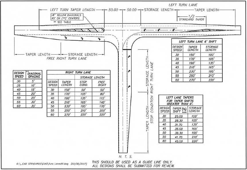
(Ord. No. 714, § 16, 4-7-98; Ord. No. 904, § 3, 8-15-06; Ord. No. 2008-1001, § 2, 6-17-08; Ord. No. 2008-1007, § 2, 6-17-0; Ord. No. 2017-12, § 3, 1-16-18; Ord. No. 2020-20, § 2, 5-4-21; Ord. No. 2023-11, § 2, 9-21-23)
6.4. - Water and sewer.
Water and sewer systems shall be designed according to engineering standards as may be adopted by the city. The following standards shall be followed:
6.4.1.
Water facilities.
1.
All development is required to be on the city's central potable water system, except when prohibited by law or not available. Availability shall be defined as follows:
2.
Applicants for development in areas where the city's central potable water system is not available in accordance with the schedule set forth above shall construct and dedicate a dry line system to the city and submit a plan for future tie-in to the central potable water system, including a method of financing the tie-in.
6.4.2.
Sewer facilities.
1.
All development is required to be on central sewer except as stipulated in subsection 6.4.3.
2.
Access to "201" system interceptor lines that are outside of the adopted utility service areas is prohibited unless other important service and facility requirements are met.
3.
Applicants for development in areas not accessible to existing sewer systems shall construct and dedicate a dry line system to the city and submit a plan for future tie-in to the appropriate area-wide system, including method of financing the tie-in.
4.
For those developers wishing to share the cost of offsite line extensions or improvements, a developer's agreement may be executed which requires that payment for such lines shall be the responsibility of the developer or may be shared with the city. Such agreements may be negotiated on a case by case basis. In no event shall the city be required to agree to any thing more than a reimbursement of the costs attributable to other future users of such lines on a pro-rata basis. All costs of any onsite portion of the sewer system or any individual connection will be borne by the developer.
6.4.3.
Septic tank. Septic tanks are not permitted when central sewer is available on the following basis:
1.
Septic tanks are not permitted when central sewer is available on the following basis:
Developments proposed with individual wells and/or septic tank disposal fields shall conform to the standards of Lake County, the Florida Department of Health and Rehabilitative Services and the Florida Department of Pollution Control, whichever is the more restrictive.
2.
Septic tanks and appurtenances thereto are prohibited in wetland areas, areas adjacent to lakes, areas adjacent to natural karst formations and high aquifer recharge areas consistent with the master wastewater plan of the city.
6.4.4.
Fire flow and hydrant requirements. Central water systems shall be designed and constructed for an economic life of not less than twenty years and in accordance with the fire protection requirements of the Insurance Services Office (ISO). The standard water and sewer construction specifications shall be used as a minimum standards requirement. Where this requirement cannot be achieved through the city water system, design calculations shall be submitted in accordance with the appropriate pamphlet of the National Fire Protection Association, to provide ground or elevated storage and auxiliary pumps. Lines to which hydrants are connected shall be a minimum of eight inches in diameter. All mains shall be looped on the minimum size required for the area, when practical. Fire hydrants shall be spaced every 600 feet along the main in single-family residential areas and 300 feet for other development. Location of all hydrants shall be subject to the approval of the city. Fire-flow tests will be conducted by the city upon completion of construction and must conclusively demonstrate that engineering and construction standards have, in fact, produced the requisite fire flows prior to occupancy of the structure. The minimum fire flow must be 600 gallons per minute (gpm) with 20 pounds per square inch (psi) residual pressure in single-family residential areas and 1,500 gallons per minute (gpm) with 20 pounds per square inch (psi) residual pressure for other development. Any corrective action required will be at the developer's cost and in accordance with the standards above. Exceptions may be made with the approval of the fire chief and the public services director.
6.4.5.
Specifications for vehicle wash facilities.
1.
Vehicle wash facilities are required to be equipped with a self-contained water recycling system. These facilities shall not back wash their filters but instead have their filter properly disposed (potentially as hazardous wastes). Disposal methods shall require approval by the water utilities department.
2.
All vehicle wash facilities shall have a disposal facility including sludge and grit removal. Disposal equipment shall be subject to the approval of the city water utilities department.
3.
Any wastewater discharge to the City of Mount Dora Sanitary Sewer System shall be required to meet all City of Mount Dora Sanitary Sewer Standards.
(Ord. No. 695, §§ 21, 22, 5-20-97; Ord. No. 714, § 17, 4-7-98; Ord. No. 904, §§ 4—6, 8-15-06; Ord. No. 2025-20, § 2, 10-7-25)
6.5. - Parking and loading areas.
6.5.1.
General.
1.
Permanent reservation: Areas reserved for off-street parking or loading in accordance with the requirements of this section shall not be reduced in area or changed to any other use unless the permitted use which it serves is discontinued or modified, except where equivalent parking or loading space is provided.
2.
Determining required off-street parking and loading and unloading spaces:
a.
When units or measurements determining the number of required off-street parking and off-street loading spaces result in a measurement of a fractional space, any fraction up to and including one-half shall be disregarded and fractions over one-half shall require one off-street parking or off-street loading space. Provided, however, the before-mentioned provision waiving fractional units of measurements shall not apply to the first off-street loading and unloading space.
b.
As required under the off-street loading and unloading regulations set out in subsection 6.5.10, the space provided for loading and unloading purposes shall not be construed as providing required off-street parking space.
6.5.2.
Off-street parking requirements. There shall be provided, at the time of erection of any main building or structure, or at the time any main building is enlarged or increased in capacity by adding dwelling units, guest rooms or floor area, minimum off-street parking space with adequate provision for ingress and egress. An off-street parking space shall consist of a minimum net area of 200 square feet, with a minimum width of ten feet and a minimum length of 20 feet, exclusive of access drives or aisles adjacent thereto. The following minimum number of spaces shall be provided:
1.
Dwelling structures:
a.
Single, duplex and multifamily: At least two spaces for each dwelling unit shall be provided. Within R-1B, R-1, R-1A, and R-2 districts at least one space per dwelling unit will be provided by a garage. Within R-1AA, R-1AAA and R-1AAAA both spaces for each dwelling unit will be in a garage. In multifamily areas (all zoning districts), at least one additional space per three units will be provided for visitors.
b.
Hotels and motels: One space for each unit plus one space for each employee plus parking as may be required for accessory uses (including restaurants, conference and banquet rooms and retail store(s). Parking for all accessory uses shall be one space per six people based on occupancy load requirements.
c.
Rooming, boardinghouses or dormitories: One space for each bedroom.
d.
Retirement centers: One space per dwelling unit plus parking as may be required for accessory structures in accordance with established standards.
e.
Adult living facilities: One space for each four licensed beds plus one per employee on the largest shift plus one per company vehicle.
2.
Commercial:
a.
General business or personal service establishments: One space for each 250 square feet of gross floor area.
b.
Office buildings: One space for each 300 square feet of gross floor area.
c.
Restaurants and other eating establishments: One space for each four seats plus one space for each employee on the largest shift.
d.
Furniture and appliance stores: One space for each 200 square feet of gross floor area up to 10,000 square feet and one space for each 600 square feet over 10,000 square feet.
e.
Convenience stores: One space for each 100 square feet of gross area.
f.
Gas and service stations: Three spaces for each bay plus one space for each employee on the largest shift.
g.
Commercial not catering to the retail trade: One space for each two employees on the largest shift plus one space for each company vehicle operating from the premises.
h.
Bowling alleys: Five spaces for each alley.
i.
Commercial recreation (skating rinks, miniature golf, go-cart trucks, etc.): One space for each employee plus one space for each three persons the facility is designated to accommodate.
j.
Flea markets: Three spaces for each table, counter or booth.
k.
Shopping centers: One space for each 250 square feet of leasable floor area.
3.
Manufacturing: One space for each 500 square feet of gross floor area.
4.
Warehouse: One space for each 1,000 square feet of gross floor area.
5.
Hospitals, sanitariums and convalescent homes: Two spaces per bed.
6.
Kennels and animal hospitals: Four spaces plus one space for each 600 square feet of covered area over 3,000 square feet.
7.
Schools and public buildings: One space for each four seats in the main auditorium or place of assembly.
8.
Theaters: One space for each ten seats.
9.
Stadiums and arenas: One space for each five seats.
10.
Child care centers: One space for each employee, plus one space for each ten clients.
11.
Libraries and museums: One space for each 300 feet of area open to the public.
12.
Churches, temples, or places of worship: One space for each three seating places in the main auditorium.
13.
Golf and gun clubs: One space for each five members.
14.
Private clubs or lodges: One space for each ten members.
15.
Alternate data for off-street parking requirements. An adjustment in the required number of off-street parking spaces may be considered by the development review coordinator when evidence is submitted demonstrating that the required number of off-street parking spaces are not required based on estimates of parking demand. Evidence may include recommendations from the Institute of Traffic Engineers (ITE), parking studies, data collected from uses that are the same or comparable to the proposed use, or other relevant information. All evidence submitted shall document the source of data used to justify the reduction in off-street parking spaces.
6.5.3.
Downtown exempt district. The boundary of the downtown exempt district shall be as follows:
Bounded on the south by the southern right-of-way line of the ACL Railroad, with the addition of the west 172 feet of Block 19, Section 30, Township 19 South, Range 27 East (Evans Park), the north by Sixth Avenue, the east by Baker Street and the west by McDonald Street.
Within this district, all new development and redevelopment shall provide off-street parking in the following manner:
1.
Hotels, motels, bed and breakfasts, and health care providers shall be required to provide off-street parking on-site;
2.
Development, other than development set forth above, occurring pursuant to a site plan approved prior to January 1, 2001, with no extension of such site plan being allowed, shall not be required to provide parking;
3.
A redevelopment or change in use of a structure will not result in an increased or decreased parking requirement for that structure.
6.5.4.
Location of off-street parking spaces.
1.
Parking spaces for all dwellings shall be located on the same lot with the main building to be served.
2.
Parking spaces for other uses shall be provided on the same lot or on a lot of not more than 500 feet distance as measured along the nearest pedestrian walkway.
3.
Parking requirements for two or more uses, of the same or different types, may be satisfied by the allocation of the required number of spaces of each use in a common parking facility.
4.
Development and redevelopment projects within the C2-A district adjacent to Highland Street shall receive a 50 percent credit towards required parking spaces if the project is located within 1,000 feet of a public parking lot.
6.5.5.
Parking space and aisle size requirements. Off-street parking areas shall be designed so as to meet the minimum dimensions as shown on the following table:
Minimum aisle widths shall be 12 feet for one-way traffic and 24 feet for two-way traffic.
6.5.6.
Parking garages.
1.
Parking space and aisle dimensions: Dimensions shown in subsection 6.5.4 apply. Depending on the needs of the use being served by a particular parking garage, space and aisle sizes may be reduced subject to the approval of the city.
2.
Compact spaces: Up to 30 percent of the required parking spaces in any parking garage may be designed as compact spaces. Such spaces must be prominently marked and posted. Minimum compact space size shall be 8.5 feet wide and 18.5 feet deep for 90-degree spaces.
6.5.7.
Motorcycle spaces. In building sites containing at least 20 parking spaces, motorcycle parking spaces may be provided in addition to the required number of automobile spaces in accordance with the following standards:
1.
Minimum width = Four feet.
2.
Minimum length = Ten feet.
3.
All motorcycle parking shall be clearly identified through signage or marking as reserved for motorcycles.
6.5.8.
Lighting. Lights used to illuminate any off-street parking facility shall be arranged so as not to create a hazard or nuisance to traffic or to adjacent properties. Light height shall be limited to 35 feet.
6.5.9.
Handicapped access. Handicap accessibility to each principal building shall be provided from rights-of-way and parking areas by means of a pathway leading to at least one entrance generally used by the public. Such pathway shall be clear of all obstructions prior to the opening of the building to the public. Where curbs exist along such pathway, as between a parking lot surface and a sidewalk surface, inclined curb approaches or curb cuts having a gradient of not more than one foot in 12 feet and a width of not less than five feet shall be provided for access by wheelchairs.
1.
Parking space reserved for handicapped. A parking lot servicing each entrance pathway required by this item shall have level parking spaces for physically handicapped persons in the following amounts:
2.
Design standards for reserved spaces. Reserved parking spaces shall be not less than 12 feet in width with a five-foot access aisle and shall be identified by above-grade signs as being reserved for physically handicapped persons. Such spaces shall be located as close as possible to elevators, ramps, walkways and entrances. Parking spaces should be located so that physically handicapped persons are not compelled to wheel or to walk behind parked cars to reach entrances, ramps, walkways and elevators.
_____
6.5.10.
Off-street loading and unloading. All buildings which are erected, enlarged, altered or converted shall provide off-street loading facilities in conformance with the requirements of this section, so that vehicles engaged in loading and unloading of goods and materials will not interfere with the public use of streets, sidewalks and alleys by automotive vehicles and pedestrians.
1.
Loading requirements:
2.
Size and dimension of loading spaces. A loading space is a space located within the main building or on the same lot which provides an area for standing, loading and unloading of trucks. The minimum dimensions of loading bays shall be as follows:
The development review coordinator shall determine the need for single unit or tractor trailer spaces or combination thereof, based upon the specific use.
3.
Changed or enlarged use. When the use of a building or land or any part thereof is changed to a use requiring off-street loading facilities, the full amount of off-street loading space required shall be supplied and maintained. When any building is enlarged or its occupancy requires off-street loading space, the full amount of such space shall be supplied and maintained for the building or use in its enlarged or extended size.
4.
Combined off-street loading. Collective, joint or combined provisions for off-street loading facilities for two or more buildings or uses may be made, provided such loading facilities are equal in size and capacity to the combined requirements of the various buildings or uses, and are designed, located and arranged to be usable thereby. The joint use shall be by recorded easement, at a minimum.
5.
Public right-of-way provision. In no case shall any public right-of-way be used for the loading or unloading of materials, unless in compliance with City Code.
6.
Ingress and egress. There shall be adequate provisions for ingress and egress to all loading areas designed for use by employees, customers, delivery services, sales people and the general public. Where a loading area does not abut a public right-of-way, private alley or access easement, an access drive shall be provided into the loading area, which shall consist of one drive per lane of traffic and shall not be less than 18 feet in width.
6.5.11.
Construction specifications. All parking lots, loading areas and vehicular use areas shall have durable all-weather drainage and surface water control.
1.
Acceptable materials. A durable all-weather surface shall mean an improved surface of concrete, brick, asphalt, permanent porous grating or other permanent dust-free surfaces. Wood chips or similar materials shall only be allowed for lots of four spaces or less. All handicap spaces shall consist of hard surface materials. Parking spaces provided in excess of the minimum required may be constructed of pervious materials, such as turf blocks or grassed parking areas.
2.
Use of stone for parking surfaces. Stone may be used as a parking surface on a limited basis as an alternative material in accordance with the following standards:
a.
The entire parking facility in which the stone surface is used shall not consist of more than six parking spaces.
b.
To ensure that nuisances and safety hazards will not be created by the spilling of stone onto sidewalks and streets, stone shall not be used on any driveway or parking aisle within 15 feet of a street right-of-way.
c.
No limerock or similar material shall be used for stone surfaces.
d.
Parking and driveway located in the front yards of the RP zoning district are restricted to either hard surface materials consisting of either concrete, brick pavers or asphalt for new developments.
3.
Wheel stop standards. A maximum of a two-foot overhang is required from a raised curb or wheel stop onto a nonpaved surface for all off-street parking spaces, except parallel spaces and adjacent to landscaping. In cases where there is a raised curb adjacent to paved walkways wheel stops may be waived, provided there is an additional two-foot area of paved walkway adjacent to the parking space. However, the minimum parking space sizes shall not be reduced in cases where wheel stops are not used in this application. All landscaped areas shall be protected from vehicle encroachment by wheel stops.
4.
Access barriers. Improvements shall be provided as necessary to prevent ingress and egress at any point other than designated driveways.
5.
Marking and signage of parking spaces. All parking spaces shall be marked on the pavement (except where stone or mulch parking surfaces are used). Other directional information to assist traffic flow shall be provided by either pavement marking or signage.
6.
Bicycle racks. For proposed nonresidential uses having an off-site parking requirement of 20 spaces or more, a number of off-street bicycle parking spaces shall be provided equal to five percent of the automobile parking space requirement with a maximum of five racks. All bicycle racks must be the "Inverted U" type. Each inverted U provided will count as two bicycle parking space. Bike rack designs other than the type described above must be approved by the planning and zoning commission during site plan review.
6.5.12.
Unimproved parking areas. The city may authorize that required off-street parking spaces and vehicular use areas remain as unimproved reserved areas as follows:
1.
Reduced need. Up to 25 percent of required spaces may be unimproved, wherever the city finds that one or more of the following circumstances exists:
a.
The expected need for off-street parking is lessened due to unusual characteristics of the use, and comparable data is available to establish that there is no present need for parking.
b.
The use will be immediately adjacent to public transportation facilities serving a significant proportion of residents, employees and/or customers.
c.
The use will provide effective private or company car pool, van pool, bus or similar transportation programs.
d.
There is substantial evidence that a proportion of residents, employees and/or customers utilize, on a regular basis, bicycle or pedestrian transportation alternatives commensurate with reduced parking requirements.
e.
The city recognizes that in some cases the required number of spaces may be more than the intended building use requires. If a developer feels that the parking requirements are excessive for his intended use, he may appeal to the planning and zoning commission for relief of this requirement. They must show sufficient cause for their belief and also show that if the number of parking spaces approved prove to be insufficient, they can and will correct the situation by adding the number of spaces needed to meet the city's minimum standards. The planning and zoning commission shall approve or deny a request for a waiver of the minimum number of parking spaces.
2.
Occasional parking. Up to 40 percent of required parking spaces may be unimproved, where the city finds that the parking lot is to be used for occasional parking only (approximately one or two times per week); and provided that all accessways and aisles shall be paved.
3.
Temporary or interim parking. Up to 100 percent of required parking spaces may be unimproved, where the facility will be used on only a temporary or interim basis (not more than 90 days per year).
4.
Required conditions for reservation. No unimproved reservation of required parking areas permitted by this code shall be authorized unless:
a.
The area covered by the reservation shall be shown on the final site plan.
b.
The property owner shall, at his own expense, enter into a written agreement with the city, recorded in the records of the county and running with the land, that the area covered by the reservation shall never be encroached upon, used, sold or leased for any purpose other than parking for the use it serves, so long as the off-street parking facilities are required by this section.
c.
The written agreement shall include such conditions as may be necessary to guarantee development of the reserved spaces whenever the city shall determine that the need exists, or that the reserved area has not been maintained in a healthy, grassy state. The agreement shall be voided if the reserved spaces are developed or if the off-street parking facilities are no longer required.
(Ord. No. 731, § 1, 10-20-98; Ord. No. 751, § 10, 12-7-99; Ord. No. 2007-949, § 2, 7-3-07; Ord. No. 2008-997, § 2, 5-20-08; Ord. No. 2011-02, § 2, 2-15-11; Ord. No. 2013-13, § 2(Exh. A), 10-1-13; Ord. No. 2025-11, § 2, 9-2-25; Ord. No. 2025-20, § 2, 10-7-25)
6.6. - Landscaping and buffers.
Landscaping areas and buffers are required between certain land uses, along certain corridors, in certain areas, and in paved parking areas to preserve the value of land and buildings on surrounding properties and neighborhoods; to eliminate or minimize potential nuisances such as noise, lights, signs, dirt, litter, unsightly buildings, or parking areas; and to encourage the proliferation of trees and vegetation. Buffers provide spacing to reduce potentially adverse impacts of odor and danger from fire or explosions. Landscaping can aid in erosion prevention, oxygen production, beautification and aesthetic enhancement of improved and vacant land.
6.6.1.
General requirements. The landscape requirements contained herein shall apply to all new development with the exception of city parks.
No additions or improvements may be made on existing developed property unless the development conforms to the regulations contained herein.
City parks shall be exempt from the regulations contained herein; however, landscape improvements shall be required at the discretion of the city council.
In order to fulfill the purposes of this code and to allow for necessary recharge, impervious surface may cover no more than the percentage of the site area (land above the mean high water line) shown below:
The remaining site area shall be devoted to stormwater retention, easements, green areas and the specific landscaping requirements of this code. Areas within the C-2 downtown exempt district C-1, and MU zoning districts shall be guided by these standards. Landscaping standards as outlined in section 3.4 shall apply.
Notwithstanding anything contained within this section 6.6 to the contrary, any site for which a building or other development permit has been issued shall be appropriately landscaped so that no erosion occurs which impacts adjacent sites or parcels of property.
6.6.2.
Buffer standards and requirements.
1.
Location and design: Buffers shall be provided on the outer perimeter of a lot or parcel, in accordance with the requirements and standards contained herein. Buffers shall not be located on any portion of any existing, dedicated, or reserved public or private street or right-of-way. The buffer width is normally calculated parallel to the property line. Design variations are allowed, however, if the average width of the buffer conforms to the standard listed herein. The average width shall be measured at the two end points of the buffer and two additional points which are each approximately equidistant from themselves and from the closest end point.
In order to reduce the monotony of sight design, no more than 33⅓ percent of canopy and understory trees may be of the same species on-sites where a total of 15 or more canopy trees are required.
2.
Use of buffers: A buffer may be used for some forms of passive recreation. It may contain pedestrian, bike or equestrian trails, provided that:
a.
No plant material is eliminated.
b.
The total width of the buffer is maintained.
c.
All other requirements of this code are met. In no event, however, shall the following uses be allowed in buffer areas:
*Playfields
*Tennis courts
*Stables
*Swimming pools
*Other active recreation
The buffer may include a stormwater retention area and/or septic tank.
3.
Required buffer widths: Requirements for buffers are based on the intensity of the proposed development or use, and the use which is developed or designated on all adjacent properties. In order to determine the type of buffer required for a proposed use, the following procedure shall apply:
a.
Identify the zoning classification of the site and all adjacent properties.
b.
Refer to Table VI-1 and/or Table VI-2 for the buffer type required on each boundary.
c.
Refer to buffer type description.
d.
The total required buffer width may be reduced by up to ten feet and the number of required planting materials may be reduced by 20 percent if a six-foot-high brick wall is installed as a part of the buffer.
e.
Regardless of width averaging, in no event shall any portion of a buffer be less than five feet in width nor shall a measurement of any portion of the buffer used in determining the average width exceed 200 percent of the required width.
Table VI-1
Buffer Requirements for Contiguous (Touching) Parcels
Zoning of Contiguous Parcel
*PUD and Mixed Use (MU-1 and MU-2) buffer requirements will generally be the same as those required of the conventional zoning district most similar to each PUD/Mixed Use (MU-1 and MU-2). Based on adjacent unlike uses, more stringent buffering treatments may be required. Requirements may be negotiated.
** Wolf Branch Innovation-Employment (WBI-E) and Wolf Branch Innovation-Gateway (WBI-G) shall follow the buffer and treatments of the Wolf Branch Innovation districts of this code and most recent WBID Design Guidelines adopted by reference.
C-1, C-2, and C-2A zoning district landscape requirements are included in the zoning section of this code.
Table VI-2
Buffer Requirements for Noncontiguous Parcels
(Separated by right-of-way)
Zoning of Noncontiguous Parcel
*PUD/Mixed Use (MU-1 and MU-2) buffer requirements will generally be the same as those required of the conventional zoning district most similar to each PUD/Mixed Use (MU-1 and MU-2). Based on adjacent unlike uses, more stringent buffering treatments may be required. Requirements may be negotiated.
** Wolf Branch Innovation-Employment (WBI-E) and Wolf Branch Innovation-Gateway (WBI-G) shall follow the buffer and treatments of the Wolf Branch Innovation districts of this code and most recent WBID Design Guidelines adopted by reference.
C-1, C-2, and C-2A zoning district landscape requirements are included in the zoning section of this code.
4.
Buffer type description: Each buffer type shall contain the materials described as follows, with the remainder of each buffer area landscaped with grass, ground cover or other landscape treatment:
a.
Buffer type A:
1.
Minimum average width: Twenty-five feet.
2.
Required materials:
Landscaping—
For each 100 linear feet or fraction thereof of boundary, the following plants shall
be provided in accordance with the planting standards and requirements of this section.
Fractional amounts of trees calculated hereunder shall be rounded to the nearest whole
tree.
Three canopy trees.
Five understory trees.
Shrubbery or hedge to provide a continuous visual screen within 36 months of planting,
or immediately upon planting for buffers contiguous to onsite parking lots.
b.
Buffer type B:
1.
Minimum average width: Thirty feet.
2.
Required materials:
Landscaping—
For each 100 linear feet or fraction thereof of boundary, the following plants shall
be provided in accordance with the planting standards and requirements of this section.
Fractional amounts of trees calculated hereunder shall be rounded to the nearest whole
tree.
Four canopy trees.
Five understory trees.
Shrubbery or hedge to provide a continuous visual screen within 36 months of planting,
or immediately upon planting for buffers contiguous to onsite parking lots.
c.
Buffer type C:
1.
Minimum average width: Forty feet.
2.
Required materials:
Landscaping—
For each 100 linear feet or fraction thereof of boundary, the following plants shall
be provided in accordance with the planting standards and requirements of this section.
Fractional amounts of trees calculated hereunder shall be rounded to the nearest whole
tree.
Four canopy trees.
Six understory trees.
Shrubbery or hedge to provide a continuous visual screen within 36 months of planting,
or immediately upon planting for buffers contiguous to onsite parking lots.
3.
Screen: A six-foot-high brick, block, or stucco wall shall be provided. The location of the wall within the buffer may vary. However, all shrubs and a majority of the trees shall be on the neighbor's side of the wall. The wall shall be designed either with maintenance breaks or other access to the adjacent properties side of the wall for maintaining landscaping on both sides.
d.
Buffer type (a):
1.
Minimum average width: Ten feet.
2.
Required materials:
Landscaping—
For each 100 linear feet or fraction thereof of boundary, the following plants shall
be provided in accordance with the planting standards and requirements of this section.
Fractional amounts of trees calculated hereunder shall be rounded to the nearest whole
tree.
Three canopy trees.
Five understory trees.
Shrubbery or hedge to provide a continuous visual screen within 36 months of planting,
or immediately upon planting for buffers contiguous to onsite parking lots.
e.
Buffer type (b):
1.
Minimum average width: Fifteen feet.
2.
Required materials:
Landscaping—
For each 100 linear feet or fraction thereof of boundary, the following plants shall
be provided in accordance with the planting standards and requirements of this section.
Fractional amounts of trees calculated hereunder shall be rounded to the nearest whole
tree.
Three canopy trees.
Ten understory trees.
Shrubbery or hedge to provide a continuous visual screen within 36 months of planting,
or immediately upon planting for buffers contiguous to onsite parking lots.
f.
Buffer type (c):
1.
Minimum average width: Twenty feet.
2.
Required materials:
Landscaping—
For each 100 linear feet or fraction thereof of boundary, the following plants shall
be provided in accordance with the planting standards and requirements of this section.
Fractional amounts of trees calculated hereunder shall be rounded to the nearest whole
tree.
Five canopy trees.
Fifteen understory trees.
Shrubbery or hedge to provide a continuous visual screen within 36 months of planting,
or immediately upon planting for buffers contiguous to onsite parking lots.
For purposes of this section, "continuous visual screen upon planting" shall mean overlapping foliage from one plant to another.
6.6.3.
Parking lot requirements. Landscaping shall be provided for interior vehicular use areas to provide visual and climatic relief from broad expanses of pavement and to channelize and define pedestrian and vehicular traffic.
1.
For developments requiring less than 200 spaces, a minimum of ten percent of the gross square footage of the paved parking lot area and entranceway shall be devoted to landscaping. For developments requiring 200 or more parking spaces, 15 percent of the gross square footage of the paved parking area and entranceway shall be devoted to landscaping.
2.
Interior landscaped areas shall be dispersed so as to define aisles and limit unbroken rows of parking to a maximum of 100 feet. A maximum of ten parking spaces in a row will be permitted, although adjustments may be made to save specimen trees.
3.
One canopy tree shall be required for each landscape break. A two-inch DBH drake elm may be substituted for up to 25 percent of the canopy trees in parking areas. A ground cover such as ivy, juniper, jasmine and lily turf shall be used. Grass or turf is prohibited.
4.
All parking garages shall be required to either:
a.
Provide landscaped hanging baskets and/or landscaped planters around the exterior of the first three levels of the garage structure; or
b.
Provide additional landscaping in other areas of the site.
5.
Parking areas for detached single-family and duplex homes are exempt from these requirements.
6.
To promote preservation of trees in parking areas, the city may reduce the total number of required spaces by up to 15 percent in order to provide adequate area for the trees to survive provided:
a.
Spaces within the dripline are eliminated and a groundcover such as ivy, juniper, jasmine and lily turf is used as a landscape break;
b.
Trees must be at least six inches in diameter to qualify for the parking space reduction.
7.
Interior landscape breaks in parking lots shall be a minimum of ten feet by 20 feet.
6.6.4.
Downtown. See zoning regulations for downtown landscape standards.
6.6.5.
Planting standards and requirements.
1.
Preservation. Preservation of existing landscape materials and land forms is encouraged. Natural existing vegetation may be substituted for the applicable landscape buffer provided canopy trees are greater than six inches in diameter and understory/hedge/shrubbery provides a continuous visual screen from the adjacent property.
2.
Quality. Plant materials used to conform with the provisions of this section shall equal or exceed the Florida No. 1, as given in "Grades and Standards for Nursery Plants," Part I, 1963, and Part III, State of Florida, Department of Agriculture, and amendments thereto.
a.
Trees: Commercial canopy trees shall have a minimum height of eight feet and a caliper requirement of two inches measured six inches above the ground immediately upon planting or where required as replacement planting. Anchoring or staking is not required. Trees of species providing roots known to cause damage to public roadways or other public works shall not be planted closer than 12 feet to such public works, unless the tree root system is completely encased within a container for which the minimum interior dimensions shall be five feet square and five feet deep in compliance with the construction requirements of the city. All rootball wrapping shall be removed prior to planting. Residential canopy trees shall have a minimum height of eight feet and a caliper requirement of two inches measured six inches above the ground immediately upon planting. Anchoring or staking is not required.
Understory trees shall have a minimum height of six feet and a caliber requirement of 1.5 inches measured six inches above the ground with a minimum four feet crown spread at the time of planting. Multi-trunk understory trees shall have no more than three main trunks with combined caliber of 2.5 inches.
b.
Shrubs and hedges: Shrubs shall be a minimum of 24 inches in height immediately upon planting and reach an average height of 36 inches within one year after planting. Hedges shall be of nondeciduous species and planted and maintained so as to form a continuous unbroken solid, visual screen immediately upon planting.
c.
Ground cover: Ground cover such as ivy, juniper and lily turf used in lieu of grass shall be planted in such manner as to present a finished appearance and reasonably complete coverage within three months after planting.
d.
Lawn grass: Grass shall be species normally grown as permanent lawns in the city. However, all species of St. Augustine grass shall be prohibited in new developments. Grass seed shall be clean and reasonably free of weeds and noxious pests or diseases. Grass seed shall be delivered to the job site in containers with Florida Department of Agriculture tags attached indicating the seed grower's compliance with the department's quality control program.
e.
Berm: When a berm is used to form a visual screen in lieu of or in conjunction with a hedge or wall, such berm shall not exceed a slope of 30 degrees and shall be completely covered with shrubs, grass or other living ground cover.
3.
Approved species: The landscaping requirements of this appendix [section] may be achieved by using any of the approved drought tolerant xeriscape species listed in Table VI-3. Other species may also be used if approved in advance by the city as being equivalent in function and quality. The city encourages plant listing and publication of the http://floridayards.org. Pines listed in the approved species list may be counted for landscaping purposes if they exist on site at the time of development; however, pines may not be counted for landscaping purposes if they are planted as a part of new landscaping.
4.
Designation on-site plan: The specific species designated on the approved site plan shall be the species planted in the locations and quantities indicated.
TABLE VI-3
APPROVED TREE AND PLANT SPECIES LIST
1.
Canopy trees—Trees which normally grown to mature height of 40 feet or more:
a.
Live Oak (Quercus Virginiana)
b.
Shumard Oak (Quercus Shumardii)
c.
Red Maple (Acer Rubrum)
d.
American Holly (Ilex Opaca)
e.
Sweetgum (Liquidambar Styraciflua)
f.
Southern Magnolia (Magnolia Grandiflora)
g.
Sweet Bay (Magnolia Virginiana)
h.
Slash Pine (Pinus Elliottii)
i.
Sand Pine (Pinus Clausa)
j.
Longleaf Pine (Pinus palustris)
k.
Loblolly Pine (Pinus taeda)
l.
Bald Cypress (Taxodium Distichum)
2.
Understory trees—Trees which normally grow to a mature height of 15 to 35 feet:
a.
Winged Elm (Ulmus Atata)
b.
Drake Elm*
c.
Chinese Elm (Ulmus Parfolia)
d.
Yaupon Holly (Ilex Vomitoria)
e.
Weeping Bottlebrush (Callistemon Viminalis)
f.
Loquat (Eriobotrya Japonica)
g.
Redbud (Cercis Canadensis)
h.
Dogwood (Cornus Florida)
i.
Jerusalem Thorn (Parkinsonia Aculeata)
j.
Tree of Gold (Tabebuia Argentea)
k.
Cherry Laurel (Prunus Caroliniana)
l.
Chickasaw Plum (Prunus Angustifolia)
m.
Southern Wax Myrtle (Myrica Cerifera)
n.
Crape Myrtle (Lagerstroemia Indica)
o.
Citrus trees (all kinds)
p.
Walter Viburnum (Viburnum Obovatum)
q.
Devilwood (Osmanthus Americanum)
r.
Bumelia (Bumelia Tenax)
s.
Tar Flower (Befaria Racemosa)
t.
Fringe Tree (Chionanthus Virginicus)
*May be used as canopy tree in parking lots with a minimum of 2.5 inch DBH.
3.
Shrubs:
a.
Sandankwa Viburnum (Viburnum Suspensum)
b.
Glossy Privet (Ligustrum Lucidum)
c.
Japanese Privet (Ligustrum Japonicum)
d.
Podocarpus (Podocarpus Macrophylla)
e.
Pittosporum (Pittosporum Tobira)
f.
Surinam Cherry (Eugenia Uniflora)
g.
Cherry Laurel (Prunus Caroliniana)
h.
Wax Myrtle (Myrica Cevifera)
i.
Native Azaleas (Rhododendron Viscosum)
j.
Star Anise (Illicum Parviflorum)
k.
Eleagnus (Eleagnus Pungens)
l.
Florida Lencothoe (Agavista Populifovia)
m.
Walter Viburnum (Viburnum Obovatum)
n.
Sweet Viburnum (Vuburnum Odoratissium)
o.
Devilwood
p.
Red Tip Photinia
4.
Prohibited trees:
a.
Australian Pine (Casuarina species)
b.
Cajeput or Punk Tree (Melaleuca Quinquenervia)
c.
Chinaberry (Melia Azedarach)
d.
Ear Tree (Enterlobium Cyclocarpum)
e.
Eucalyptus species
f.
Florida Holly or Brazilian Pepper (Schninus Terebinthifolius)
g.
Paper Mulberry (Broussonetia Papyrifera)
h.
Camphor Tree (Cinnanonum Camphora)
5.
Safety and protection:
a.
Curbing or wheel stops shall be used to protect landscape areas.
b.
If curbs are used, tree trunks and shrubs shall be set in three feet from either side of a parking space to avoid damage by vehicles.
c.
Street and highway sight distances established by the Florida Department of Transportation Manual of Uniform Minimum Standards for Design, Construction, and Maintenance shall be observed for all street intersections or driveways and streets. Within these sight distances, no landscape material exceeding 2.5 feet in height shall be permitted. Trees shall be permitted when traffic visibility is not obstructed.
6.
Performance standards:
a.
Clustering: In order to provide a more interesting and aesthetically pleasing effect, landscaping may be clustered along perimeter buffers. Clustered landscape plans shall be approved at the discretion of the planning and zoning commission.
b.
Substitutions: Six cabbage palm trees may be substituted for each canopy tree for up to 25 percent of the total number of canopy trees. These trees must be clustered at a maximum six foot on center and have a minimum height of 12 feet.
c.
Shifting: Canopy trees may be shifted within the perimeter buffers provided a minimum of three canopy trees per 100 linear feet be maintained in any one buffer.
d.
Off-site donation: If the applicant finds it difficult to provide the necessary landscape materials to meet minimum code requirements, the planning and zoning commission may consider donation of materials for off-site landscaping. Such landscaping may be located along public rights-of-way and on publicly owned property.
e.
Xeriscape standards: Plant material shall be clustered and located with plants of similar water use requirements. Irrigation systems shall be designed to provide differential zones to accommodate the specific needs for each plant grouping to ensure that over watering does not occur.
6.6.6.
Maintenance. Maintenance shall consist of mowing, removing of litter and dead plant materials, necessary pruning, replacement of dead plantings, watering and fertilizing. Maintenance is required in order to ensure proper functioning.
1.
Responsibility: The owner of any property or the tenant thereof, shall be, as to those parties, jointly and severally responsible for the maintenance of all landscaping on-site and in the unpaved portion of the rights-of-way adjoining the site to present a neat, healthy and orderly appearance, free of refuse and debris. The owner shall have an implied easement on rights-of-way extending from the site to the road pavement to complete the required maintenance.
2.
Irrigation: All landscape areas shall be provided with an automatic underground irrigation system with 100 percent coverage. Rain sensor device required. Irrigation system to be designed with water-friendly conservation practices (Xeriscape standards), per section 6.6.5.6.e of this code. New developments or redevelopments are not required to provide an irrigation plan, however landscape plans shall provide confirmation statements that the design will adhere to the irrigation requirements, as contained in this code.
3.
Enforcement: The city may conduct periodic inspections to assure compliance with the maintenance requirements of this code.
4.
Pruning:
a.
Applicability. The owner of a property, or the tenant thereof, shall not trim, prune, remove living branches or cause the diminution of the crown of any canopy tree without a permit except pursuant to Florida law.
b.
Permit application procedures. The following procedures shall be followed and shall govern the granting of all permits pursuant to this section.
1.
Submittals. The fees associated with a permit application submitted pursuant to this section shall be adopted from time to time by resolution. Each application for permit to alter, trim, prune, or reduce the canopy or crown of trees shall be accompanied by a written statement indicating the reasons for the requested action and two copies of a legible site plan drawn to the largest practicable scale indicating the following:
a.
The portion of the site involved in the operation, and
b.
The trees by type and number to be pruned.
2.
Application review. Upon receipt of the application, the appropriate city staff member as designated by the city manager shall review said application, which may include a field check of the site and referral of the application for recommendations to other appropriate administrative departments or agencies.
c.
Permit exemptions:
1.
If the following tree conditions exist, a permit shall not be required:
a.
The branches to be pruned obstruct vision along a traveled public or private way;
b.
The branches to be pruned interfere with vehicular or pedestrian travel lanes and present a safety hazard;
c.
The branches to be pruned are diseased, damaged, or in danger of falling;
d.
The branches to be pruned interfere with utility lines, or existing or proposed structures so as to endanger such structures;
e.
The removal of specific living parts of the tree will increase fruit or flower production or will facilitate the health of the tree as a whole;
f.
As permitted by Florida law.
2.
Permit form. Permits shall be issued in such form as may be prescribed by the city manager and may set forth in detail the conditions upon which the permit is granted. One permit may cover several trees or groups of trees as long as the same can be clearly identified thereon; however, no permit may be issued for more than one parcel or area of land unless said parcels or areas of land shall be contiguous to one another.
d.
Unauthorized pruning of trees. If a tree not authorized for pruning is altered, pruned, trimmed or diminished in canopy, the property owner shall pay the city $250.00 for each tree pruned.
e.
Appeals procedure. Any person adversely affected by a decision of any city official or employee in the enforcement or interpretation of this subsection, may appeal such decision to the city council who, by a majority vote, may affirm, reverse, or modify the decision. Any decision of the city council is subject to review by the circuit court by certiorari.
6.6.7.
Preservation of existing trees.
1.
Tree removal and replacement program requirements:
a.
Removal of an approved tree for construction, new developments, or developments, shall require the owner to replace said tree on-site at the replacement ratios listed below. Definition of approved tree: Any living, self-supporting, perennial plant which has a trunk diameter of at least six inches measured four feet above grade (at the base of the tree) and normally grows a minimum overall height of 15 feet.
b.
Relocation of trees may be allowed provided a tree relocation plan prepared by a certified arborist is submitted for city review and approval. Such plan shall include at a minimum the tree specifications, root trimming specification, relocation details, etc. In cases where relocated trees do not survive within 12 months of replanting, the owner shall replace said tree pursuant to the requirements of this code. Relocation of existing trees is not a city preferred tree mitigation, as the survivability of replaced trees is not favorable.
c.
All trees replaced shall have an oxygen-producing capacity at least equal to that of the tree removed, and of a type to reach an eventual height of at least 15 feet with a trunk diameter of at least three and one-half inches measured six inches above the ground, at the time of planting.
d.
Tree sized six inches to 23.99 inches: In the event the tree removed is an approved tree is size if six inches to 23.99 inches in diameter when measured four feet above the ground, the owner shall provide one approved canopy type tree specimen or each tree removed (replacement ratio of tree replaced for tree removed) removed of a type to reach an eventual height of at least 15 feet with a trunk diameter of at least 3½ inches measured six inches above the ground, at the time of planting, with the oxygen producing capacity of the removed tree upon maturity.
e.
Tree sized 24 inches or greater: In the event the tree removed is an approved canopy tree greater than or equal to 24 inches in diameter when measured four feet above the ground, the owner shall provide one approved canopy tree for each six inches of diameter (replacement ratio of 1:6) removed of a type to reach an eventual height of at least 15 feet with a trunk diameter of at least 3½ inches measured six inches above the ground, at the time of planting, with the oxygen producing capacity of the removed tree upon maturity.
f.
In the event the replacement trees required would be too numerous to be placed upon the site, the owner may elect to provide fewer replacement trees so long as the tree inches provided as replacement tree inches are greater than or equal to the tree inches required.
g.
Replacement trees shall not be counted toward the buffer requirement, but may be planted within the buffer with the approval of planning and zoning commission.
h.
City tree bank contributions: In cases where there are no opportunities to replace tree inches on site for tree inches proposed for removal, the owner may make a tree bank contribution in the amount equal to the retail price of a canopy type specimen tree for the remaining tree replacement inches. Tree bank contributions shall be used for the purpose of planting trees throughout the city at the sole discretion of the city. Replacement retail cost shall be based on a Live Oak (Quercus Virginiana) sized minimum three and one-half inches, eight to ten feet in height, and Florida Number one grade or better. Payment of tree bank funds must be made prior to issuance of arbor permit (when required), site development permit or as authorized by the city, or as specified by the city.
i.
Existing trees and trees proposed for removal shall be shown on a landscape plan with the following tree data (applicant to fill-in blanks):
Total existing number of trees sized 6"—23.99":_______
Total existing number of trees sized 6"—23.99" removed:_______
Total existing number of trees sized 24" or greater:_______
Total existing number of tree sized 24" or greater removed:_______
Total number of trees replaced at ratio 1:1 for trees removed 6'—23.99":_______
Total number of trees placed at ratio 1:6 (for trees removed 24" or greater):_______
Total number of trees replaced:_______
Total number of tree deficient (not being replaced) for tree bank contribution and includes total dollar amount of contribution funds: $_______
2.
Erection of protective barriers. During construction, builders shall be required to erect protective barriers around trees that might be injured. These barriers shall be constructed of wood and extend to the drip line of the tree to be protected. Tree barriers shall be installed and inspected by the city prior to any authorized and permitted tree removal.
3.
Other protection. It shall be unlawful for any person to allow machinery, soil deposits, harmful liquids or any substance that would cause disease or destruction of any trees protected by this section to encroach into or be stored within the drip line of the tree.
4.
Appeals. Any person adversely affected by a decision of the zoning official or his representative may appeal to the planning and zoning commission through written notice filed with the City Clerk of the City of Mount Dora. The notice shall set forth all grounds for the appeal.
5.
Public property. Trees on public parks and public rights-of-way and on city properties shall be subject to this section.
6.
Emergency waivers. In case of emergencies, such as storms, a written permit for removal may be waived in the event the tree is endangering the public health, welfare or safety and requires immediate removal. Verbal authorization may be given by the city manager, the fire or police chief, the community development director or public services director or their designees.
7.
Parking areas. No parking areas for more than two cars, public or private, shall be approved until a drawing has been presented to the zoning official showing site plan, existing trees, and plans for planting of trees to provide shade and aesthetic relief from the barrenness of open paving.
6.6.8.
Decorative entrances. Decorative entrances, structures or landscaping shall not be permitted in a public right-of-way unless it can be shown to not conflict with any existing or proposed utilities and may be required to be removed if maintenance within the right-of-way is required. All decorative entrances must be approved by the public services director.
6.6.9
Residential lot tree. New residential developments or in cases when a new single-family or duplex dwelling is constructed a minimum one canopy tree as contained in this section shall be planted in the front yard. The canopy tree must be a minimum two-inch caliper, eight feet in height, and Florida number one grade or better. Said lot canopy shall be planted on each residential lot at a distance of three feet from the right-of-way line or any utility easement adjacent to the right-of-way, whichever is further from the center line of the road right-of-way for the lot in question. Addition trees and sizes are listed in section 6.14. residential design standards overlay zoning district.
(Ord. No. 714, §§ 18—20, 4-7-98; Ord. No. 720, § 2, 10-20-98; Ord. No. 751, §§ 11, 12, 12-7-99; Ord. No. 790, § 3, 7-17-01; Ord. No. 821, § 1, 10-1-02; Ord. No. 849, §§ 15—19, 6-15-04; Ord. No. 2007-937, § 2, 3-20-07; Ord. No. 2007-956, § 2, 8-21-07; Ord. No. 2008-1001, § 3, 6-17-08; Ord. No. 2008-1022, § 2, 10-21-08; Ord. No. 2011-02, § 2, 2-15-11; Ord. No. 2013-13, § 2(Exh. A), 10-1-13; Ord. No. 2020-20, § 2, 5-4-21; Ord. No. 2021-09, § 2, 7-20-21; Ord. No. 2023-11, § 2, 9-21-23)
6.7. - Signs.
6.7.1
General.
1.
Purpose and intent. The purpose and intent of this section is to establish regulations for the size, color, illumination, movement, materials, location, height and condition of all signs placed on private property for exterior observation within the city. These regulations are hereby established in order to promote the overall economic well-being of the businesses in the city, while at the same time providing for the health, safety and welfare of its citizens by reducing any adverse effects of signs and displays on driver and roadway safety, aesthetics, property value, neighborhood character, and the enjoyment of the scenic beauty of the city.
2.
Message neutrality. Any commercial or noncommercial constitutionally protected copy or image placed on any sign display area, which is allowed under this section may be substituted with any constitutionally protected commercial or noncommercial copy without any additional approval or permitting. The purpose of this provision is to prevent any inadvertent favoring of content. This provision shall take precedence over any more specific provision to the contrary.
The message substitution set forth hereinabove is a continuing right that may be exercised any number of times. Substitution of message applies to the whole or any part of any legally existing sign display area. The substitution right shall apply to the sign owner and to any other message sponsor displaying copy or an image on the sign display area with the owner's consent, regardless of whether a fee or any other consideration is given for the right to use the sign display area.
3.
Relationship to Florida Building Code. These sign regulations are intended to complement the requirements of the Florida Building Codes adopted by the Florida Legislature. Wherever there is inconsistency between these regulations, the Florida Building Codes as adopted from time to time shall apply.
6.7.2
Definitions. Words and terms used in this code shall have the meanings given in this section. Unless expressly stated otherwise, any pertinent word or term not part of this listing but vital to the interpretation of this ordinance, shall be construed to have their legal definition, or in absence of a legal definition, their meaning as commonly accepted by practitioners including civil engineers, surveyors, architects, landscape architects, and planners. Terms and definitions not listed in this section are also contained within article VIII of this code.
Apartment sign: A sign designating the name of a particular apartment complex which is erected at an entryway.
Awning sign: Information painted on, or imprinted on, awnings. An awning is defined as a sheltering screen, usually of canvas fabric, extending over or before any place which has windows, doors, outside walks or the like, and providing shelter or protection against the weather. Awning signs shall be calculated as a portion of the square footage allowed for on the site as outlined in this code.
Balloon sign: A bag of varying types of material, inflated with gas, either attached to or located on a site used for the purpose of attracting attention to the business or location.
Banner sign: A sign intended to be hung either with or without frames, possessing characters, letters, illustrations or ornamentation applied to paper, plastic or fabric of any kind. National flags, flags of political subdivisions, symbolic flags of any institution or business, or information painted or imprinted on awnings, as defined in this article, shall not be considered banners for the purpose of this article, such definition shall not include over-highway announcement signs erected by the city.
Bench sign: A sign located on any part of the surface of a bench or seat placed on or adjacent to a public right-of-way, except for publicly installed bench signs.
Beacon lighting: A source of electric light, whether portable or fixed, the primary purpose of which is to cast a concentrated beam of light generally skyward as a means of attracting attention to its location rather than to illuminate any particular sign, structure, or other object.
Building frontage: The maximum linear width of a building measured in a single straight line parallel, or essentially parallel, with the abutting public street or parking lot.
Community center sign: A sign associated with and erected by a community center. For this purpose, community centers are defined as those building or structures open to the general public which are owned and operated by a governmental, public, or not-for-profit entity for the purpose of hosting an assemblage of persons.
Construction sign: Any sign giving the name or names of principal contractors, architects and lending institutions responsible for construction on the site where the sign is placed, together with other information included thereon.
Directional sign: A sign of a variety that indicates ingress and egress points only. The intent of these signs is to allow for vehicular visibility to access points for nonresidential development. Directional language and logos may be incorporated into the sign design but may not exceed the sign area requirements.
Directory sign: A sign on which the names and locations of occupants or the use of a building is given. This shall include office building and church directories.
Electronic variable message sign: A sign or portion thereof that displays electronic images, graphics and/or text information, defined by a small number of matrix elements using different combinations of light emitting diodes (LED's), fiber optics, light bulbs or other illumination devices within the display area where the message change sequence is accomplished immediately or by means of fade or repixalization. Electronic variable message signs include, but are not limited to, computer programmable, microprocessor controlled electronic or digital displays.
Flag: A cloth, plastic, canvas, or other similar flexible material typically attachable by one edge, and used as a decoration, signaling device and/or symbol or emblem of a governmental institution or other entity.
Freestanding sign: A mobile or portable sign structure, not structurally secured to the ground or to any other structure.
Ground sign: A sign which is supported by structures in or upon the ground and independent of support from any building.
Illuminated sign: A sign illuminated in any manner by an artificial light source.
Inflatable sign: A sign that is a gas- or air-inflated object, which may be of various shapes, made of flexible fabric, resting on the ground or structure and may be equipped with a portable blower motor that provides a constant flow of air into the device.
Integral sign: Memorial signs or tablets, names of buildings and/or date of erection when cut into any masonry surface or when constructed of bronze or other incombustible materials mounted on the face of a building. This definition shall include memorial plaques placed on city-placed benches for public seating.
Marquee sign: A sign attached to and made a part of a marquee. A marquee is defined as a permanent roof-like structure projecting beyond a building wall at an entrance to a building or extending along and projecting beyond the building's wall and generally designed and constructed to provide protection against the weather.
Menu board: A sign which carries only the name of a restaurant and the current list and prices of food or food preparations available in that restaurant.
Monument sign: A sign which has the vertical structure supports concealed in an enclosed base which has the same or greater width and depth dimension as the sign.
Mural: A painting or other work of art executed directly on a wall, a vertical enclosure, or surface of a structure, as defined herein.
Nonconforming sign: A sign which does not conform to the regulations of this code.
Occupant identification sign: A sign which carries only the name of the firm, major enterprise or products offered for sale on the premises, lot or parcel of land.
Outdoor advertising sign: Sign which advertises a business, organization, event, person, place or thing not on the premises of said business, organization, event, person, place or thing.
Pedestal sign: A movable sign constructed of permanent materials able to withstand the elements and supported by a base so as to allow the sign to stand in an upright position.
Personal expression sign: An on-premises sign that expresses an opinion, interest, position, or other non-commercial message.
Pole sign: A sign placed on or affixed to a pole which is not concealed from public view.
Projecting sign. A sign other than a wall sign affixed to any building or wall whose leading edge extends beyond such building or wall and projects no more than 48 inches beyond the face of such wall. All projecting signs shall maintain a seven-foot six-inch vertical clearance from public or private sidewalks, walkways or paths.
Public sign: Governmental information or direction signs, historical markers, signs relating to national defense and security and other emergency signs, and ornamental signs of a permanent character displaying only the name of a commonly known and accepted name of a section of the city, deemed by the city council to be of general public interest, may be located in any zoning district. Public signs shall also include street banner signs at city designated locations which meet the following criteria:
1.
The applicant is a public body or is a fraternal, benevolent, charitable, eleemosynary, philanthropic, altruistic, civic, community, veteran, educational organization or other organization of like or similar nature;
2.
The sign solely advertises an event, function or thing of general public interest;
3.
The location of the sign will not interfere with the traffic or public safety;
4.
The copy of the sign does not violate any provision of this article;
5.
Signs shall be permitted for a maximum of 14 days.
Roof sign: Any sign erected or constructed wholly upon and over the roof of any building and supported solely on the roof structure.
Sandwich board: A two-sided, self-supporting sign with the base of the sign being the supporting structure and the connecting point located at the top of the sign.
Security sign: An on-premises sign regulating the use of the premises, such as a "no trespassing," "no hunting," or "no soliciting" sign. (Also known as warning sign).
Sidewalk sign: A sandwich board or pedestal sign.
Signs: A letter, figure, character, mark, plane, point, marquee sign, design, poster, pictorial, picture, illustration, stroke, stripe, line, trademark, reading matter, or illuminated surface, which shall be so constructed, placed, attached, painted, erected, fastened, or manufactured in any manner whatsoever, so that the same shall be used for the attraction of the public to any place, subject, person, firm, corporation, public performance, article, machine, or merchandise, whatsoever, which is displayed in any manner whatsoever.
Site: A tract, lot, or parcel of land or combination of tracts, lots, or parcels of land which is in one ownership, or contiguous and in diverse ownership where development is to be performed as part of a unit, subdivision, or project.
Snipe sign: A sign of any material whatsoever that is attached in any way to a utility pole, tree, fence post or any other similar object, or placed within public property or within a public right-of-way without city approval.
Subdivision development sign: A sign advertising a subdivision development of property which denotes the owner, developer, architect, construction contractor(s) and or lot layout.
Subdivision sign: A sign denoting the name of a subdivision as a means of identifying the development. Subdivision signs may be placed on entry walls or be constructed as a separate monument sign. In nonresidential subdivisions, these signs shall not be calculated toward the overall allowable signage for the particular site. These signs must be located at the entrance to the subdivision.
Swing sign: A sign projecting from the outside wall or walls of any building, or from an awning, which has a horizontal dimension equal to or exceeding its vertical dimension, and which is suspended from a projecting structure in such a manner that neither the sign itself, nor any part thereof, is attached directly to the building or wall.
Trailer sign: Any sign on a vehicle normally licensed by the State of Florida as a trailer and used for advertising or promotional purposes.
Wall sign: A sign painted on or attached to an erected structure parallel to the face of, or erected and confined within the limits of, the outside wall of any building and supported by such wall or building and which displays only one advertising surface.
Walking or human sign: Signs held, carried, balanced or worn by any person, including hand-held, walking signs, mascots, costumes and characters intended to advertise or attract attention to sales, products, services, businesses, activities, events or issues, and which are visible from a public right-of-way, adjacent property, or a public area. "Human sign" means a sign that is held or worn by a person.
Window sign: A permanent sign placed inside or upon a window facing the outside and which is intended to be seen from the exterior. Permanently attached signs (i.e. illuminated, painted, affixed by mechanical means, etc.) shall be calculated in the total allowable sign area. Temporary and signs integrally related to business operation (i.e. open/closed signs, hours of operation, etc.) shall be allowed but not be included in the allowable copy area.
6.7.3
Applicability. All signs placed upon lands within the City of Mount Dora shall conform to the standards set forth in this code except where deviations have been permitted by PUD zoning or an applicable development order.
6.7.4
Signs.
1.
Generally. The city recognizes that there are persons and entities that have an interest in communicating with the public using signs that serve to identify businesses and services, residences and institutions, and provide for expression of opinions. Every sign and sign structure shall be designed as a compatible architectural element and shall be in scale with the building to which it relates, the building's site and adjacent structures, and the neighborhood in which it is located.
2.
Specifically. The regulations contained in this subsection shall provide uniform sign criteria that regulates the size, height, number and placement of signs in a manner that is compatible with the character of Mount Dora:
a.
Sign types: No sign shall be constructed, installed or erected within the city unless the sign is included within one of the following construction classifications:
1.
Awning
2.
Integral
3.
Marquee
4.
Menu
5.
Monument
6.
Pedestal
7.
Projecting
8.
Sandwich board
9.
Swing
10.
Wall
11.
Window
12.
Temporary signs as set forth in this code
b.
C-2 central business sign district: For the purpose of this sign code, special sign provisions and standards are provided for the "C-2 Central Business Sign District." Those lands that are zoned C-2 and are located within the boundary depicted in illustration 1 are defined as being described as the "C-2 Central Business Sign District" as subject to special sign standards: Bounded on the south by the railroad right-of-way, on the north by 6th Avenue, on the east by Baker Street, and on the west by McDonald Street. The C-2 central business sign district may be revised from time to time by the City of Mount Dora through the adoption of a resolution.
c.
Illustration 1: C-2 central business sign district sign uses: The following sign uses shall be allowed under the conditions and criteria indicated. Additionally, except for temporary and public signs, the following sign uses shall be allowed if they only indicate the name of the enterprise located on the premises and/or the products and/or services for sale thereon:
d.
Additional regulations (general): The following standards shall apply to all signs within the City of Mount Dora:
1.
Frontage calculations.
a.
A building façade facing a secondary street is allowed additional sign area calculated at one square foot for each linear foot of the building for the building façade facing the secondary street, provided the overall total wall signage copy area does not exceed the sign limitations of this code.
b.
In developments where creative designs are utilized and the building has no adjacent public street frontage, the customary building frontage shall be utilized to determine the building frontage area.
c.
For purposes of this subsection, "architectural design to indicate front street orientation" shall mean:
1)
For new construction to which the architectural guidelines found in subsection 6.13.3 apply, those design characteristics required in subsection 6.13.3 for front façades.
2)
For existing structures of 20,000 square feet of gross building area or more, the façade in question must have a minimum of a public entry and be comprised of 55 percent windows or must be comprised of a minimum of 60 percent windows with no public entry. For existing structures between 5,000 and 19,999 square feet, inclusive, of gross building area, the façade in question must have a minimum of a public entry and be comprised of 45 percent windows or must be comprised of a minimum of 55 percent windows with no public entry. For existing structures of less than 5,000 square feet of gross building area, the façade in question must have a minimum of a public entry and be comprised of 35 percent windows or must be comprised of a minimum of 50 percent windows with no public entry. Windows shall not appear to be false or applied.
2.
Copy calculations: In computing sign area in square feet, standard mathematical forms for known common shapes will be used. In the case of irregular shapes, straight lines drawn closest to the extremities of the shape will be used. On any sign with more than one face, only the face or faces visible from any one direction at one time will be counted; provided, however, that all faces of a multi-faced sign shall be equal in size and contained within a common perimeter. Double-faced ground signs with an interior angle greater than 30 degrees will be considered two signs for square footage calculations.
3.
Location: One ground-mounted (monument) sign may be permitted when the lot upon which it is to be placed has a minimum of 40 linear feet of frontage. If any lot shall have 40 linear feet or more of frontage, then no ground sign shall be erected closer than 40 feet to any other ground sign. No part of any such sign shall be located within five feet of any right-of-way line in OP, C-1, C-2, C-3 or C-2A zoning districts nor be located to interfere with the sight triangle of an intersection.
4.
Exposed sign structure: No structure or framework may be exposed by removal of sign faces or advertising copy for a period in excess of ten days without approval from the zoning official.
5.
Historic signs: Any sign determined to possess historical value by the Mount Dora Historic Preservation Board will be allowed to remain, be repaired and maintained notwithstanding any provision of this section.
6.
Sign height: The height of any sign shall be measured as the difference between the highest point of the structure and the grade of the site directly adjacent to the sign base. For purposes of this measurement, any mounding of the site upon which the sign is located shall be considered part of the sign base.
7.
Sign clearance: Signs that project over public rights-of-way shall meet the following clearance standards:
a.
All signs over pedestrian ways shall provide a minimum of seven feet six inches of clearance.
b.
All signs over vehicular ways shall provide a minimum of 13 feet six inches of clearance.
8.
Distance between signs: where a minimum distance between signs is specified, that distance shall be measured by radius from the leading edge of the base of the sign structure.
e.
Additional regulations (specific): The following standards shall apply to sign types or uses as noted below:
1.
Signs in WP-1 and C-3 zoning districts:
a.
All signs shall be located at least 20 feet from all property lines in all WP-1 zoning districts.
b.
All signs in WP-1 and C-3 zoning districts shall maintain the minimum distance from all residential districts as follows:
2.
Monument signs:
a.
Monument sign design requirements: A sign which has the vertical structure supports concealed in an enclosed base. The width of such enclosed base shall be equal to at least the horizontal width of the sign surface. A planter structure or alternative landscaping shall enclose the foot of the base. The planter shall be between two and three feet in height above the ground, with a minimum length equal to the width of the sign and a minimum width of three feet. The base and planter shall be of brick or compatible material matching the finish of the primary structure. In lieu of a brick planter the sign may be located in a landscaped buffer provided low-growing shrubbery is planted to conceal the base of the sign.
b.
Monument signs may not be located closer than five feet from the adjacent right-of-way and may not obstruct any sight triangles at intersections or driveways.
c.
Monument sign height OP, C-1, C-2 and C-2A zoning districts: Six feet.
d.
Monument sign height WP-1 and WP-2 zoning districts: Ten feet.
e.
Monument sign height C-3 zoning district: Per this code.
f.
Monument signs may not be located closer than five feet from the adjacent right-of-way and may not obstruct any sight triangles at intersections or driveways.
3.
Illumination of signs: Any light from any illuminated sign shall be shaded, shielded or directed so that the light intensity or brightness shall not adversely affect the surrounding or facing premises or affect adversely the safe vision of operators of vehicles moving on public or private roads, highways or parking areas. Light shall not shine directly on or into residential structures. Illumination of signs is regulated as follows:
a.
Illuminated signs facing water bodies shall not create a hazard to or nuisance to navigation by boaters and shall not be directed on the water surface more than 20 feet from the sign.
b.
Sign lighting shall not be designed or located to cause confusion with traffic or emergency vehicle lights. Internal illumination allowed for directional, directory and historic monument signs.
c.
Internal illumination allowed, except on awning signs, for occupant identification signs in RP, OP, C-1, C-2, C-2A, C-3, WP-1, WP-2 and PLI zoning districts.
d.
Within the C-2 central business sign district the use of neon, fluorescent colors, backlit, and signs using lights to form letters or images are prohibited.
6.7.5
Temporary signs.
1.
Generally. It is the intent of this section to provide uniform criteria for temporary signs in order to place the fewest possible restrictions on personal liberties, property rights, commerce and the free exercise of constitutional rights, while achieving the city's goal of creating a healthy and safe environment that does not contain clutter or visual distractions for motorists, bicyclists and pedestrians, and maintains the aesthetic quality and scenic beauty of the city.
2.
Specifically. Temporary signs are unlawful unless they meet the following standards:
a.
Permitted:
1.
Zoning districts: All as set forth herein.
2.
Construction type: All signs approved in subsection 6.7.4.2 and including pole signs.
b.
Placement of all temporary signs:
1.
Must not be located within any right-of-way whether dedicated as an easement or owned in fee simple; and
2.
Must only be located on property with the permission of the property owner; and
3.
Must not be placed on any utility pole, streetlight, similar object or on public property; and
4.
Must not be illuminated; and
5.
Must not be placed for more than 70 days prior to the Subject which is the basis of the sign; and
6.
Must be removed within ten days after the conclusion of the Subject which is the basis for the sign.
7.
For purposes of this section related to temporary signs, the term "subject" shall mean a specific person, place or thing.
c.
Limits on all temporary signs:
1.
A property owner of a non-residential property, except if the property is located in the C-2 central business sign district, may place one-sided or two-sided temporary signs, subject to the placement requirements set forth hereinabove, so long as the aggregate size of all temporary signs located on the same property does not exceed 24 square feet at any time, on a property that is one acre or less in size. Six additional square feet of temporary signage shall be permitted for each additional one acre of contiguous property under the same ownership with a maximum total aggregate size of all temporary signs on the property not exceeding 48 square feet. Only one temporary sign, representing each subject, may be placed on a property at any one time.
2.
A property owner of a non-residential property in the C-2 central business sign district,may place one-sided or two-sided temporary signs, subject to the placement requirements set forth hereinabove, so long as the aggregate size of all temporary signs does not exceed six square feet at any time on a property. Only one temporary sign, representing each subject, may be placed on a property at any one time. For purposes of this section related to temporary signs, the lessee of a property is considered the same as the record property owner. If there are multiple lessees of a property, each lessee has equal rights and duties as set forth herein.
3.
A property owner of a residential property may place one-sided or two-sided temporary signs, subject to the placement requirements set forth hereinabove, of no larger than six square feet each, for any one sign placed on the property so long as the aggregate size of all temporary signs does not exceed 24 square feet at any time on the property. Only one temporary sign, representing each subject, may be placed on a property at any one time.
d.
Additional temporary signs for all zoning districts:
1.
One additional one-sided or two-sided temporary sign may be placed on a property, not to exceed six square feet in size, on a day when the property owner is opening the property to the public.
2.
One additional one-sided or two-sided temporary sign may be placed on the property, not to exceed six square feet in size, for one day not to exceed six separate days in a calendar year.
3.
Temporary sign height. Temporary signs are limited to the following heights based on the zoning district or use of the property on which it will be erected as follows:
a.
GB, C-2, C-2A, RP, PLI, and OP: five feet.
b.
Residential uses: six feet.
c.
Non-residential uses: ten feet.
6.7.6.
Off-site advertising signs.
1.
Generally. Off-site outdoor advertising signs are defined as signs erected on premises other than where the goods, services or occupants listed or advertised upon the sign in question are located.
2.
Specifically. Off-site signs shall be allowed within the City of Mount Dora only if they meet the following requirements:
a.
Zoning districts allowed: WP-1 and WP-2.
b.
Sign size: Maximum size of outdoor advertising signs shall not exceed a maximum gross area of 120 square feet.
c.
Other criteria:
1.
Shall be permitted only if approved as a conditional use in industrial zoning.
2.
Shall be set back in accordance with the applicable building setback requirements for the zoning district but shall not be allowed within 100 feet of any public right-of-way and shall not be located nearer than 200 feet to a residential district.
3.
Shall be no closer than 2,000 feet from any other outdoor advertising sign, nor closer than 100 feet from any occupant identification sign on the same side of the road.
4.
The number of signs on any one street shall be limited to a maximum of two in any ten-mile distance if these signs advertise the same business, product or activity.
5.
No single-faced billboard shall have an interior angle from road to face of sign in excess of 30 degrees and shall be installed to minimize a view of the rear of a sign. No multi-faced outdoor advertising sign shall be permitted.
6.
No sign may project more than 15 feet in height or above the crown of the road which the sign is designed primarily to serve.
6.7.7.
Off-premise advertising signs.
1.
Generally. Off-premise advertising signs special provisions for Spring Harbor Boulevard and Lake Park Court Developed parcels that are zoned C-3, OP, or R-3 without U.S. Highway 441 parcel frontage with frontage along Spring Harbor Boulevard and Lake Park Court may be allowed off-site advertising sign copy area for an existing or proposed monument sign, if they comply with the following standards.
2.
Specifically. Off-premise advertising signs must meet the following regulations:
a.
An off-site advertising sign shall be located within 2,000 feet of the subject being advertised. This is measured from the property line of the subject property to the off-site advertising sign structure. The off-site advertising sign structure must be located on a parcel with U.S. Highway 441 frontage and has access to Spring Harbor Boulevard.
b.
Off-site advertising signs shall only be allowed for uses located on parcels that do not have frontage on U.S. Highway 441.
c.
The conversion or installation of a monument sign to share other off-site business advertising is allowed. Sign advertising panels must be included to accommodate all users.
d.
The maximum sign copy area allowed shall comply with the host sign requirements (height, copy area, sign type, landscaping, setbacks, etc.) for the district in which the sign is located. No additional sign copy area is allowed nor may be transferred.
e.
Assign easement(s) to share the off-site advertising monument sign is optional between the host business parcel and the off-site parcel user(s).
f.
In cases where an off-site advertising sign is proposed to be placed on a nonconforming sign, the nonconforming sign shall comply with the current sign code requirements of the underlying zoning district.
g.
Off-premise advertising signs which provide four or more individual sign panels at least four square feet per panel may be allowed additional size as follows: The sign copy area for off-premise sign may be allowed additional 25 square feet in addition to the allowable sign copy area by zoning district per this code.
h.
Off-premise advertising signs which provide four or more individual sign panels at least four square feet per panel may be allowed additional sign height as follows: The maximum height may increase three feet in addition to the height of the allowable monument sign by code.
6.7.8.
Off-premise directional signs.
1.
Generally. An off-premise directional sign helps travelers access a business, activity, product or service not located on the premises where the sign is installed.
2.
Specifically. Off-premise directional signs shall be allowed within the City of Mount Dora only if they meet the following requirements:
a.
Zoning district allowed: C-3 (Highway Commercial).
b.
Size type: Ground mounted monument sign with a clearly defined base flush with the ground and a decorative cap distinguishable from the sign column, similar to the construction design shown Illustration 2.
c.
Sign size: Maximum width of the sign shall be three feet and the maximum height, including decorative cap, shall be ten feet.
Illustration 2:
Off-Premise Directional Sign Example
d.
Sign location: Signs may be located at the following US 441 intersections: Spring Harbor Boulevard, Eudora Road and Lake Park Court. Signs shall be oriented so that wayfinding guidance is toward the traffic flow on US 441. Must be located at intersections only. Only in cases where there is an existing frontage road, such sign structures may be located in right-of-way subject to applicable state, county, and city permits.
e.
Other criteria:
1.
The sign shall be constructed of brick in a pattern and color like that found on Mount Dora gateway signs.
2.
The sign shall have a designated area for directional information, designed to accommodate up to six panels of equal size for up to four separate and distinct development names. The maximum panel height shall be eight inches. Lettering shall be four inches in height and match the font used on existing Mount Dora gateway (brick and stone) signs.
3.
Only the name, type and/or logo under which a development is known or designated, and a directional arrow, shall be permitted on the panels.
4.
Developments identified on off-premise directional signs shall be subject to the following:
a.
The development is a non-residential use.
b.
The site/parcel is located no further than one-quarter mile (1,320-ft.) from the intersection where said sign is located.
c.
The development does not have direct access to US 441.
d.
One off-sign per developed site/parcel.
e.
Those business sites with lot frontage greater than 50 linear feet or have an existing permitted free-standing sign (i.e. existing monument sign) along US Highway 441 are not eligible for the off-premise sign of this section.
f.
For the purposes of this section, distances shall be measured by drawing a straight line, without regard to intervening structures or objects, between the closest property lines of the proposed or existing business site to the off-premises directional sign structure. Measurement shall be made in a straight line, without regard to municipal boundaries.
5.
The sign may be illuminated but shall not cause glare to motorists.
6.
Signs shall be located so that no part of the sign encroaches within the minimum clear vision triangle at intersections, as determined by the City of Mount Dora or by the Florida Department of Transportation, whichever is more restrictive.
7.
Signs may be placed at property line, provided it does not obstruct vehicle or pedestrian corner visibility. Off-premises signs shall be placed in such manner as not visually obstruct existing on-site signs.
8.
No off-premise directional sign shall be located closer than 20 feet from any on-site sign.
6.7.9.
Prohibited signs.
1.
Generally. It shall be unlawful to erect, cause to be erected, maintain or cause to be maintained, any sign not expressly authorized by, or exempted from, this section. Generally, signs are prohibited as set forth in sub-section 6.7.9.2.
2.
Specifically. The following signs are prohibited within the City of Mount Dora:
a.
Banner (except as authorized by the city for specific public events or informational/instructional purposes).
b.
Bench.
c.
Electronic variable message sign, except for permitted gas station fuel price displays and signs placed on city owned property.
d.
Freestanding (except pedestal signs and sandwich boards where expressly permitted by this section).
e.
Offsite (except those signs permitted in subsection 6.7.4).
f.
Pole (except if erected as a public sign or temporary sign).
g.
Roof (except those roof signs attached to the lower vertical section of a gambrel roof located in the C-2, C-2 central business district, and C-2A zoning districts).
h.
School bus stop shelters used for advertising.
i.
Snipe.
j.
Signs which bear or contain statements, words or pictures of an obscene pornographic or immoral character, or which contain advertising matter which is untruthful.
k.
Signs on private property which in any way simulate emergency traffic control signs or devices.
l.
Any private sign placed on public property.
m.
Any vehicle with a sign or signs attached thereto or placed thereon subject to the following exceptions:
1.
Any vehicle parked on private property when parked within the confines of a building or in some other manner which provides for effective screening so as not to allow the sign or signs on the vehicle to be viewed from any public street.
2.
Any vehicle upon which is placed a sign identifying the firm or its principal products or services if such vehicle is one which is operated during the normal course of business.
3.
Buses, taxicabs and similar common carrier vehicles which are licensed or certified by the city.
n.
Except as provided elsewhere in this section, any sign incorporating or consisting of banners, pennants, ribbons, streamers, spinners or wind-operated devices. These devices, when not an integral and functional part of any sign, are similarly prohibited.
o.
Any advertisement which uses a series of two or more signs placed in a line parallel to the roadway or in a similar fashion, and carrying a single advertising message, part of which is contained on each sign.
p.
Any sign which the Mount Dora Police Department determines obstructs sight lines at intersections and/or driveways.
q.
Any sign which incorporates a beacon light or lights.
r.
Balloon signs.
s.
Outdoor mobile sandwich board signs consisting of two placards fastened together at the top with straps supported on the shoulders of the carrier.
t.
String of lights, bulbs, rope lights, of similar illumination used on commercially developed parcels to frame windows, doors, or used as light bands for the building or landscaping, except has permitted in this code.
u.
Inflatable signs.
v.
Walking or human signs.
6.7.10.
Administration.
1.
Generally. In no event shall any sign be erected within the City of Mount Dora except in conformance with this section.
If any part, subsection, paragraph, sentence, phrase, term or word within this section is declared unconstitutional by the valid judgment or decree of any court of competent jurisdiction, the declaration of such unconstitutionality shall not affect any other part, subsection, paragraph, sentence, phrase, term or word within this section.
2.
Permit application. No person shall erect, alter, repair or relocate any sign without first obtaining a building permit for such work from the city. No permit shall be issued until the planning and development department determines that such work is in accordance with the requirements contained in this section:
a.
Drawing: Every application shall be accompanied by scaled drawings (plan and elevation as appropriate) of the proposed sign showing the location, height, size and distances from other signs, where applicable, and all other information required to determine zoning compliance.
b.
All signs shall be designed and installed in compliance with the requirements of the building and electrical codes of the City of Mount Dora.
c.
Certification: Signs over 32 square feet in area, signs that project perpendicularly from the surface to which they are attached and are more than 12 square feet in area, and/or signs that are higher than six feet above grade shall be designed and certified by a State of Florida registered engineer or architect for structural integrity and wind loading.
d.
Exception for changeable copy sign: The changing of advertising copy or message on signs which are specifically designed and approved for the use of replaceable copy shall not require a building permit.
e.
Fees: Fees shall be adopted by the city by resolution and may be amended from time to time as appropriate.
3.
Permit review, approval and/or appeal. Upon receipt of a fully completed application, a permit shall either be issued or denied within 30 working days thereof. A permit not issued within this 30-day period shall be deemed to be denied. An applicant who has been denied a permit hereunder or who has been granted a permit with conditions may appeal such denial or grant with conditions to the planning and zoning commission. Any such appeal must be filed in writing within ten calendar days of the permit denial or grant with conditions. The appeal before the commission shall be de novo. Any person aggrieved by a decision of the planning and zoning commission may file a petition for writ of certiorari in the Circuit Court of the Fifth Judicial Circuit in and for Lake County, Florida. In order to be valid, any petition for writ of certiorari must be filed within 30 days of the date of final action by the planning and zoning commission.
4.
Exemptions. The following signs are exempt from the requirements of this section, provided they are not placed or constructed to create a hazard of any kind:
a.
Flags provided the following:
(1)
Flags and flagpoles shall not be located within any right-of-way.
(2)
Flagpole height and flag size—Non-residential: A free standing flagpole shall have a maximum height of 45 feet in non-residential districts. The following are the maximum allowable flag sizes for a flag placed on a flagpole in a non-residential district:
(3)
Flagpole height and flag size—Residential: A free standing flagpole shall have a maximum height not to exceed the existing building height of the primary residential structure or 35 feet whichever height is less. The following are the maximum allowable flag sizes for a flag placed on a flagpole in a residential district:
(4)
Number. No more than three flags per lot in residential districts, and no more than five flags per lot in all other districts or non-residential uses.
(5)
Size of flags. Maximum flag size for a flag not located on a flagpole is 24 square feet in residential districts and 35 square feet in all other districts or non-residential uses.
(6)
Flags containing commercial messages may be used as permitted freestanding or projecting signs, and, if so used, the area of the flag shall be included in, and limited by the computation of allowable area for signs on the property.
(7)
Flags up to three square feet in area containing noncommercial messages are considered personal expression signs.
b.
Art and murals, provided such signs do not contain any commercial messaging.
c.
Personal expression signs of any sign type, including flags, provided that they do not exceed three square feet in area per side, are non-commercial in nature, and not illuminated.
d.
Signs that are not designed or located to be visible from any street or adjoining property.
e.
Traffic control signs and street name signs installed by the city and that bear no commercial message.
f.
Transportation signs such as those indicating bus stops, taxi and valet stands, train stations and similar transportation facilities.
g.
Signs required by federal or state statute or regulation, or local ordinance or regulation.
h.
Wayfinding or informational signs located within city right-of-way.
i.
Signs erected by a public utility, where such signs convey safety and/or warning information and are erected and displayed incidental to the public interest.
j.
Works of art that do not constitute advertising.
k.
Merchandise displays behind storefront windows so long as no part of the display moves or contains flashing lights.
l.
Incidental objects such as small decals affixed to window or door panes that indicate membership in business organizations or acceptance of certain credit cards.
m.
No trespassing, no dumping, no solicitation, private property, vacancy/no vacancy signs and other similar declarations not exceeding two square feet in area.
n.
Nameplate and street address signs not exceeding one square foot in area.
o.
Public signs.
p.
Signs associated with approved special event permits authorized by this code.
q.
Legal notices.
r.
Security and warning signs. These limitations shall not apply to the posting of conventional "no trespassing" signs in accordance with state law.
(1)
Residential districts. Signs not to exceed two sq. ft. in area.
(2)
Non-residential districts. Maximum of one large sign per property, not to exceed five sq. ft. in area. All other posted security and warning signs may not exceed two sq. ft. in area.
s.
Temporary signs placed in compliance herewith.
5.
Enforcement. Enforcement shall be pursuant to the City of Mount Dora Code Enforcement system as set forth in City of Mount Dora Code of Ordinances, chapter 2, administration.
a.
Maintenance: Signs and sign structures shall maintain a neat and clean appearance. All parts and supports of any sign shall be maintained, treated and/or painted to be safe, prevent rust or deterioration, and to maintain their appearance. All electrical parts and lighting fixtures shall be maintained in accordance with all building and electrical codes. The vegetation around, in front of, behind, and underneath the base of ground signs for ten feet shall be kept trimmed and free of trash and debris.
b.
Inspection: The city may inspect at any time each sign or other advertising structure regulated by this section for the purposes of ascertaining whether the structure is safe, in need of repair or maintenance, not in conformance with the approved permit or otherwise in violation of the provisions of this section. If it is determined that a violation has occurred, the city shall give written notice to the owner or lessee of such structure. If the owner or lessee fails to remove or alter the structure to comply with the regulations set forth in this section within the time prescribed in the notice, such sign or other advertising structure may be removed or altered to comply by the city at the expense of the owner or lessee of the property upon which it is located.
c.
Unsafe signs: The city may cause any sign or other advertising structure that presents an immediate peril to persons or property to be removed at the expense of the owner or lessee of the property upon which the sign is located.
d.
Abandoned signs: Signs shall be removed by the owner or lessee of the premises upon which a sign is located when the business which a sign advertises is no longer conducted on the premises. If the owner or lessee fails to remove the sign within 90 days from the termination of the business which was conducted on the premises, the sign may be removed at the expense of the owner or lessee of the property upon which the sign is located. Conforming sign structures may be retained if the message is deleted.
6.
Non-conforming signs. It is the intent of this section to allow nonconforming signs permitted before the adoption of this code to continue under the provisions of this subsection until they are no longer used, or become hazardous, but not to encourage their survival. Such signs are hereby declared to be incompatible with the overall intent of this section.
a.
All nonconforming signs and their supporting members shall be completely removed from the premises or brought into conformance not later than five years from the effective date of these land development regulations, unless allowed to remain by state law.
b.
Any sign which lawfully existed on property annexed into the city limits of the city may continue in existence, although such sign does not conform to all of the provisions contained herein, provided that all such nonconforming signs and their supporting members shall be completely removed from the premises or brought into conformance not later than five years from the date of annexation; and further providing that nothing herein shall be construed as permitting the continuance of any prohibited sign.
c.
No existing nonconforming sign shall be altered structurally, repaired or moved unless brought into conformation with the requirements of this section; however, this restriction shall not apply to the change of copy or changeable copy signs. "Repaired" shall mean repairs which cost in excess of 50 percent of the replacement cost of the sign, such cost of repairs to include the cost of labor and materials.
d.
No sign shall be considered to be a nonconforming sign if it was erected without the approval of the planning and development department and a building permit having been obtained or if the sign was erected contrary to the provisions or limitations of a building permit. Any such sign shall be considered unlawful and shall be subject to removal in accordance with the provisions of this section.
(Ord. No. 714, § 21, 4-7-98; Ord. No. 751, §§ 14, 15, 12-7-99; Ord. No. 806, § 1, 2-5-01; Ord. No. 790, § 5, 7-17-01; Ord. No. 801, § 1, 12-4-01; Ord. No. 849, §§ 20—23, 6-15-04; Ord. No. 2007-934, § 10, 2-20-07; Ord. No. 2007-943, § 2, 5-15-07; Ord. No. 2008-1012, §§ 2—5, 8-5-08; Ord. No. 2008-1025, § 2, 12-2-08; Ord. No. 2009-11, § 2, 6-16-09; Ord. No. 2009-12, § 1, 7-7-09; Ord. No. 2009-21, §§ 2, 3, 4, 3, 4, 5, 12-1-09; Ord. No. 2010-03, §§ 3, 4, 4, 5, 2-16-10; Ord. No. 2011-03, §§ 4, 5, 3-15-11; Ord. No. 2013-13, § 2(Exh. A), 10-1-13; Ord. No. 2013-20, § 2, 11-19-13; Ord. No. 2020-12, § 3, 11-3-20; Ord. No. 2023-11, § 2, 9-21-23)
6.8. - Murals.
6.8.1. Purpose.Mural art is widely considered one of the oldest methods of artistic expression. The purpose of this mural code is to permit and encourage murals on a content-neutral basis with certain allowable time, place and considerations. Murals comprise a unique medium of expression that serve the public interest and have purposes distinct from signs. Murals confer different benefits and can increase community identity and foster a sense of place. The goal for regulating mural art in the City of Mount Dora is to ensure a continued visual aesthetic complementing the community character while allowing for compatible artistic and creative expression in appropriate locations, in an appropriate manner and of appropriate material.
6.8.2. Definitions. For the purposes of this section, the following definitions shall apply:
Alteration: Any substantial change to a permitted mural, including but not limited to any change to the image(s), materials, colors or size, Minor changes to the permitted mural that result from maintenance or repair shall not constitute alteration. Such minor changes may include slight and unintended deviations from the original image, colors or materials that occur when the mural is repaired due to the passage of time or because of vandalism.
Commercial elements: Any message that uses trademarks, service marks, colors or patterns, copy, lettering, symbols or other references used elsewhere in the marketplace directly related to the promotion of a specific product, business, profession, trade or service.
Facade: The exterior face of a building.
Graffiti: Graffiti shall mean writings, drawings, inscriptions, figures or marks of paint, ink, chalk, dye or other similar substances on public or private buildings, structures, fences/walls or places that are not authorized by the property owner or occupant or permitted by the city.
Mural: A work of visual art which is produced, tiled, painted directly upon, or affixed directly to an exterior surface, building, structure or fence/wall, Murals may contain a subject matter consistent with the theme of a business but should not contain commercial copy in conflict with sign regulations of this Code.
6.8.3. Permit required. A property owner desiring to place a mural on its property shall first obtain a permit from the city. In order to obtain a permit, the property owner must submit a permit application, on the form approved by the city, and applicable application fee to the city for consideration. The application fee shall be established and revised from time to time by resolution adopted by the city.
6.8.4. Review criteria. Review shall be related to location, manner and materials of the Mural display in order to preserve the aesthetic appeal which the City of Mount Dora has cultivated and in order to promote appropriate visual expression. The following guidelines will be used by the City in evaluating mural applications:
1.
Location.
a.
Murals may be located on all facades on a structure used for residential purposes.
b.
Murals may not be located on the primary facade of a structure used for non-residential purposes. In instances where a building has two primary facades, murals may not be placed on either facade (except for facades on alleyways).
c.
No part of the mural shall be placed over life safety elements, and/or utility structures or facilities, in a way that would obscure or obstruct.
d.
If a mural is to be affixed on a historic or landmark building, or in the Historic District, the application must also be presented to the Mount Dora Historic Preservation Board for a recommendation and then presented to the public arts commission for final approval.
e.
In areas with residential zoning, a mural shall not exceed 20 percent of the area of the facade of any structure.
f.
in areas with non-residential zoning, a mural shall not exceed 60 percent of the area of the facade of any structure.
g.
In both residential and non-residential zonings, a mural may occupy 100 percent of the area of a utility box or similar structure. The mural should be appropriate within the character of the area and complement and enhance the building, architectural features, and site.
h.
No part of the mural shall exceed the height of the structure to which it is affixed;
i.
No part of the mural shall extend more than six inches from the plane of the surface upon which it is affixed.
2.
Manner.
a.
The artist name(s) may be incorporated into the mural but should be discreet and not exceed five percent of the design area or two square feet in area, whichever is less.
b.
No mural shall be illuminated in a manner that produces a light intensity greater than 0.5 foot-candles at the property lines.
c.
Murals must be allowed under First Amendment protections to express ideology, beliefs, opinions and/or other societal images; however, these protections do not extend to the following elements that are grounds for permit denial - explicit nudity or sexually explicit conduct, obscenities, defamation, symbols denoting gang affiliations, any expression that could be deemed to be hate speech or displays so shocking that it likely would create a public safety issue by impeding the safe flow of traffic.
d.
Murals may contain limited commercial elements as long as they are not considered commercial copy pursuant to the sign regulations of this Code.
e.
Commercial elements are subject to the sign regulations of this Code.
f.
Prior to alteration of a mural, a new mural application must be submitted and permit issued, unless the structure and or/surface is being brought back to its original state.
3.
Materials.
a.
The mural should be constructed with materials designed to be resistant to weather and vandalism.
b.
Chemical or physical treatments, such as sandblasting, that may cause damage to any architectural feature, should not be used.
c.
Paint utilized should be intended for exterior use that will not corrode or compromise the integrity of the material to which it is applied.
d.
Reflective, neon and fluorescent paints shall not be used.
e.
If necessary, murals shall be coated with a topcoat that helps protect the mural from fading and deterioration, as well as makes it easy to clean if vandalized.
6.8.5. Maintenance. All murals shall be kept in a proper state of repair and preservation. It is a violation of this Code to own, keep or maintain any mural in a dilapidated or deteriorated condition or to permit or allow a mural to be kept in such condition.
1.
At all times during and after application, murals shall be considered the property of the owner and/or occupant of the structure to which it is applied, and said owner and/or occupant shall be responsible for maintenance and upkeep of the mural,
2.
The property owner and/or occupant of any building, structure or fence/wall that has been marked by Graffiti shall remove said Graffiti within seven calendar days of notification by the city.
3.
A mural that is kept, maintained, or allowed to remain in a dilapidated or deteriorated condition may be declared a public nuisance and the city may pursue all available legal remedies, including code enforcement or court action
4.
As a supplemental means of enforcement, if an property owner fails to repair or remove a dilapidated or deteriorated mural, by order of the city's magistrate, the city may initiate removal of the mural by means it deems appropriate and thereafter record a lien in the public records of Lake County for any costs associated with the removal.
5.
Removal of a mural shall be accomplished by physical removal, of the paint or other material of which the mural is composed, from the building, wall, structure or fence and/or by covering the mural with paint or other material. With either removal or covering, the mural must be rendered completely invisible while maintaining the structural and architectural integrity of the structure upon which the mural was applied.
6.8.6. Existing murals. Murals in place when this section takes effect will be considered legal non-conforming murals.
6.8.7. Appeal. Any person aggrieved by a decision of the public arts commission, denying a permit for a mural, may appeal to the city council by submitting a written request to the city manager within ten calendar days of the rendition of the decision by the public arts commission. The decision rendered by the city council shall be final.
(Ord. No. 2021-16, § 2, 10-19-21)
6.9. - Wetlands.
The city shall ensure the protection of natural functions of wetlands. In the interest of maintaining the ecological function of wetlands, residential densities of one unit per five acres will be permitted within wetland areas. All development will be required to be clustered away from all wetland areas on the site and an upland buffer will be provided adjacent to the wetlands. The buffer width will be a minimum of 25 feet and shall consist of preserved or planted canopy and ground cover. An additional 25 feet will be required on previously undeveloped and unplatted parcels in order to provide sufficient habitat for wildlife. For sites or parcels recorded on or before the date of this plan adoption, which do not contain sufficient uplands to permit development, fill and clearing of natural vegetation will be allowed only in conjunction with a minimal accessway and a minimum amount beneath one residential structure, provided the direction and rate of historical water flow are not altered.
All structures must be elevated on pilings and septic systems are prohibited. Subsequent to plan adoption the city shall not allow lots or parcels to be created without sufficient uplands.
The location of wetlands shall be accurately identified at the time of site development review. The alteration of wetland areas is prohibited unless no other alternative exists. If alteration is necessary after it is proven that no other alternative exists, it shall be accompanied by a mitigation plan at a ration of 2:1 so that twice as much wetlands are created or restored as lost. The purpose of mitigation is to ensure that the ecological value and extent of the wetlands is maintained. The plan must provide the city with assurances that the mitigation plan will be maintained.
The definition of wetlands shall be a comprehensive definition which encompasses the definitions used by the water management district, the Florida Department of Environmental Protection, and the U.S. Army Corps of Engineers and is based upon soils and vegetation. This comprehensive definition shall include both the wetlands regulated by these agencies and those that are not within their regulatory jurisdiction.
6.10. - Concurrency management and consistency determination.
6.10.1.
Purpose and intent. Pursuant to F.S. § 163.3180, sanitary sewer, solid waste, drainage, and potable water are the only public facilities and services subject to the concurrency requirement on a statewide basis. Concurrency is a finding that the public facilities and services necessary to support a proposed development are available, or will be made available, concurrent with the impact of development. The provisions of this section are designed to provide a systematic process for the review and evaluation of all proposed development for its impact on basic public facilities and services in order to meet the requirements of statutory concurrency requirements.
6.10.2.
Concurrency, general provisions.
1.
No final development order shall be issued by the city after the adoption of these regulations and no previously approved development may cause a change in use upon a parcel of property unless there is sufficient available capacity of concurrency public facilities to meet the standards for levels of service as established in the Mount Dora Comprehensive Plan for the existing population, vested development as projected by the community development department and for the proposed development according to the following time requirements:
a.
As to potable water, sanitary sewer, solid waste and drainage concurrency public facilities, the necessary concurrency public facilities must be:
1.
Available and in place at the time the development is authorized in accordance with the Mount Dora Comprehensive Plan; or
2.
The development order or permit is issued subject to the condition that the necessary concurrency public facilities will be in place when the impacts of the development occur; or
3.
The necessary concurrency public facilities are under construction at the time the development is authorized; or
4.
The necessary concurrency public facilities are guaranteed in an enforceable development agreement which requires that the necessary facilities will be in place when the impacts of the development occur.
b.
All final development orders shall be conditioned on the requirement that building permits shall not be issued for the subject property until the capacity of the public facility or facilities set forth in this subsection meet the adopted levels of service standards for said concurrency public facility or facilities. As to solid waste, the level of service standard shall be a citywide standard. As to stormwater management, the level of service standard shall be a site specific standard. As to potable water and sanitary sewer, the level of service standard shall be based upon the appropriate service areas as set forth in the Mount Dora Comprehensive Plan.
c.
Parks, including land and facilities, must be available to serve the development within 12 months of the issuance of the subject final development order. The parks' level of service standard shall be citywide standard.
d.
On-site potable water wells and septic tanks which meet all applicable laws, rules, standards, and regulations shall be deemed to be concurrent for the purposes of this section as to potable water and sanitary sewer concurrency public facility level of service requirements; provided, however, this provision shall not be construed to limit the city's authority to require central potable water and sanitary sewer services as a condition of development approval.
2.
Approved plans of development which are specifically exempted from or specifically determined to be vested from the concurrency requirements of the Mount Dora Comprehensive Plan by the city pursuant to applicable ordinances shall not be subject to concurrency review unless the exemption or vesting has been eliminated, waived, expired or withdrawn pursuant to law or has otherwise lapsed and thereby having become of no further force nor effect. Notwithstanding the foregoing, the city may use the concurrency review process to account for the impacts upon and utilization of concurrency public facilities by vested developments.
6.10.3.
Concurrency base line statement and monitoring system.
1.
On or before October 1 of each year, the community development department shall develop a concurrency public facility base line statement which shall be effective for one year after its issuance. Nothing herein precludes, however, the issuance and effectiveness of more frequent amendments to concurrency base line statement by the community development department.
6.10.4.
Preliminary and final development orders.
1.
Development orders and development permits are designated preliminary or final under the development review process, as delineated below:
a.
Type I—Preliminary (No concurrency test. Capacity reservation not available).
1.
Variance.
2.
Abandonment/vacation.
b.
Preliminary (Internal concurrency test. Capacity reservation optional).
1.
Comprehensive plan amendment.
2.
Rezoning.
c.
Preliminary (Concurrency test/encumbrance. Capacity reservation optional).
1.
Preliminary subdivision plan.
2.
Conditional use.
d.
Final (Concurrency test/capacity reservation required).
1.
DRI.
2.
All development permits except as exempted in subsection 6.11.8.
3.
Final site plan.
4.
Final subdivision plan and plat.
5.
Conditional use.
2.
Each applicant for a final development order, except as provided in subsection 6.10.7 shall pay the appropriate concurrency reservation fees and apply for a certificate of capacity.
3.
Each applicant for a preliminary development order: Concurrency option, except as provided in subsection 6.10.7 shall elect one of the following options:
a.
Pay the capacity reservation fee and apply for a certificate of capacity; or
b.
Execute a nonconcurrency affidavit.
6.10.5.
Concurrency test requirements.
1.
The city shall perform a concurrency test for each development application, except as provided in subsection 6.11.8. The community development department shall be responsible for conducting all concurrency tests as required by this section. Concurrency tests shall be initiated upon receipt of a concurrency test application form provided by the city, accompanied by the appropriate, nonrefundable, application fee.
2.
Each development application will be reviewed on a first-come, first-served basis. As each application is reviewed, capacity that is available will be encumbered until the final disposition of the application is determined. If the application is approved, the reservation becomes permanent upon payment of the capacity reservation fee (See subsection 6.10.8.6). If the application is denied, the temporary reservation returns to the pool of capacity. If an application cannot be approved because of encumbrances preceding it, the application will be returned to the applicant unless the city determines that it can supersede an earlier application according to the following procedure.
An application that is ready for final disposition can supersede or "advance over" the temporary reservation by an application ahead of it upon early payment of the capacity reservation fee. There are three criteria which restrict the ability to "advance over":
a.
Applicants cannot "advance over" other applicants that have been in the system less than six months;
b.
An applicant can be "advanced over" only after written notice has been given to all preceding applicants, and they have received ten working days to pay reservation fees and complete the concurrency review process.
3.
For development that requires one or more public facilities which are provided by entities other than the city, the city shall condition the issuance of any final development order for the same parcel on the availability of such public facilities (See section 6.10.11).
4.
If the capacity of available public facilities is equal to or greater than the capacity required to maintain the level of service standard for the impact of development, the concurrency test is passed.
5.
If the capacity of available public facilities is less than the capacity required to maintain the level of service standard for the impact of the development, the concurrency test is not passed and the applicant shall select one of the following options:
a.
Amend the application to reduce the need for public facilities to the capacity that is available; or
b.
Arrange to provide for public facilities that are not otherwise available; or
c.
Reapply for a certificate of capacity not less than six months following the denial of an application for a certificate of capacity; or
d.
Appeal the denial of the application for a certificate of capacity, pursuant to the provisions of subsection 6.10.10.
6.
If no option under subsection 6.10.5(5) above is exercised within five working days by the applicant, the application shall be deemed abandoned.
6.10.6.
Concurrency management/concurrency reservation application procedures.
1.
Capacity of public facilities for a project will move from the encumbered status to the reserved status for final development orders that pass the concurrency test and satisfy payment of capacity reservation fees.
2.
The city has specific time limits for most types of development orders, and the capacity certificate will be valid for the same period of time as the underlying development order.
3.
The process for each type of preliminary of final development order is outlined below:
a.
Preliminary development order—Variance or abandonment.
1.
Submit application.
2.
No concurrency test.
3.
Capacity reservation not available.
b.
Preliminary development order—Rezoning or comprehensive plan amendment.
1.
Submit concurrency and other applicable application and pay application review fee.
2.
Internal concurrency test.
3.
Capacity determined for maximum or specified uses, densities and intensities.
4.
Encumbrance or reservation option:
a.
Capacity encumbered while plan amendment or rezoning is under review.
b.
Capacity reservation at applicant's option. No development order or certificate of capacity is issued.
c.
If applicant chooses not to reserve capacity, an affidavit is signed acknowledging that future rights to develop the property are subject to future concurrency and no rights have been granted by the city or acquired by the applicant.
c.
Preliminary development order—Preliminary subdivision plan or conditional use.
1.
Submit concurrency application and pay application review fee.
2.
Concurrency test/encumbrance.
3.
Encumbrance and reservation option:
a.
Capacity encumbered while plan is under review. Following approval, capacity will be encumbered for an additional six months to allow for final plan submission. No certificate of capacity is issued.
b.
Capacity reservation at applicant's option. Capacity reservation fees are paid.
c.
If applicant chooses not to reserve capacity and affidavit is signed acknowledging that future rights to develop the property are subject to future concurrency and no rights have been granted by the city or acquired by the applicant.
d.
Final development order. Site plan, final subdivision, DRI.
1. Submit concurrency application if not previously completed.
2. Concurrency test/encumbrance if not previously performed.
3. Capacity determined for specified uses, densities and/or intensities.
4. Encumbrance and reservation option:
a. Encumbrance while plan is under review.
b. Capacity reservation fee must be paid or nonconcurrency affidavit submitted prior to issuance of final development order.
c. Final development order issued and certificate of capacity is released following payment of capacity reservation fee.
4.
Concurrency determination analysis is required only once, provided all applicable deadlines are met.
5.
Projects can obtain site development permits for new construction without obtaining building permits. Site work development (site work includes clearing and preparation of property and installation of infrastructure) will not be considered to expand or extend the capacity reservation. A capacity reservation is not, by issuance of a site development permit, extended and the applicant will need to seek such extensions as necessary if the capacity reservation will expire prior to receipt of all development approvals.
6.
The city will specifically identify its conditions of approval of the capacity reservation application within an enforceable development agreement or binding contract, including necessary off-site infrastructure or facility improvements that are needed to support the project, whether or not the needed facility is public or private if necessary.
a.
If the applicant chooses not to reserve capacity for subdivision lots, development may take place on a site by site basis provided capacity is available. The applicant will be required to sign an affidavit of nonconcurrency acknowledging that future rights to develop the property are subject to capacity availability at the time of issuance of a building permit.
7.
Following final plan approval, recording of plat and receipt of performance and maintenance bond, the city will prepare the final development order. The final development order and certificate of capacity will be released to the appropriate party following payment of the capacity reservation fee or filing of nonconcurrency affidavit and submittal of all applicable documents related to the development. If payment or affidavit is not received within six months after final approval, approval will be null and void.
8.
If a concurrency public facility to be provided by an applicant is not available at the time of the development's impacts upon concurrency public facilities, further development will cease until all required concurrency public facilities are constructed. If a concurrency public facility to be provided by an applicant is included in a binding contract, but the construction is behind schedule, development may continue, but no releases for final electrical service or certificates of occupancy will be issued until the facility has been accepted or approved by the city. If, however, a concurrency public facility is to be provided by the city and is not completed on time, development can continue within the conditions of the development order; provided, however, that no certificate of occupancy or releases for final electrical service will be issued until potable water, sanitary sewer and solid waste capacity are available.
9.
Certificates of concurrency are not transferable to another parcel or parcels of real property. Certificates of concurrency shall benefit and run with the parcel of real property to which the application related, subject to the limits prescribed in this section, and shall contain detailed information relating to limitations on uses and development densities and intensities.
6.10.7.
Exemptions for concurrency test.
1.
The following development orders and permits are exempt from this article, and may commence development without a certificate of capacity:
a.
Any addition to a residence;
b.
Interior completion of a shell-only structure for uses with same or less intensity as identified on an approved site plan;
c.
Interior renovations with no change in use;
d.
Accessory structure to a residence;
e.
Storage addition to a nonresidential use;
f.
Replacement structure, except for a nonconforming use, in accordance with the land development code provisions on nonconforming uses;
g.
Temporary construction trailers;
h.
Wells and septic tanks;
i.
Driveway or resurfacing parking lot paving;
j.
Re-roofing of structures;
k.
Demolitions;
l.
Occupational license for a change in tenant space similar to the previous business tenant in the space;
m.
Single-family and duplex residences on lots which were platted prior to adoption of this code;
n.
The following items: public utility and service structures, attached or detached guest house to a residence, accessory parking for passenger vehicles when intended for a permitted adjacent commercial use;
o.
Development permits including, specifically, building permits, which do not require an additional final development order prior to their issuance shall not require a concurrency review as a condition of issuance of said permits;
p.
Sign permits.
2.
Development that is determined to be vested.
6.10.8.
Fees.
1.
The city council shall establish from time to time by the adoption of a resolution the fees required by this section. The fees shall provide for the costs relating to the review and analysis related to applications including, but not limited to, city staff time and expenses resulting from the review of matters such as, by way of example and not limitation, calculations, traffic studies or mitigation studies presented to the city by an applicant.
2.
Fees shall be established for concurrency review determinations for each concurrency review application and shall be paid at the time of the filing of the application.
3.
Fees shall also be established to provide for the recovery of costs to the city relating to informal inquiries relating to matters involving the concurrency management system. Fees for raw data (public records) shall be charged in accordance with the provisions of Chapter 119, Florida Statutes, or its successor provision, as implemented by the city.
4.
Fees shall also be established for appeals, administrative determinations and the extension of certificates of concurrency resulting from the approval of extending final development orders or the extension of a final development order.
5.
The city shall establish by resolution, fees for concurrency testing, both formal and informal, for inquiries which require substantially the same research as a full scale concurrency test; for time required to review alternative demand data which an applicant may provide as well as any traffic studies or mitigation plans which an applicant requests be reviewed as part of a concurrency test; and for capacity reservations.
6.
For each concurrency public facility the facility reservation fee shall apply to all development and shall be an amount equivalent to the then applicable Mount Dora and Lake County Impact Fee for each concurrency facility type. All impact fees shall be required to be assessed and paid as a condition of receiving a building permit pursuant to the impact fee rate schedules in effect at the time a building permit is issued. However, each facility reservation fee is a per unit fixed-dollar deduction from the applicable impact fee in place at the time of building permit issuance.
7.
At the time of the issuance of a final development order, all of the said fees must be paid; provided, however, that if a development agreement or a contingent development order provides that the final development order is not effective until a preconstruction conference occurs, said fees may be delayed until that date; provided further, that if the fees are not paid, the development order shall be null and void and of no further force or effect.
8.
If a final development order is not issued, expires or is surrendered pursuant to an amending development order issued by the city or an amending development agreement, an applicant may request in writing and the city shall issue a refund of facility reservation fees if the following condition is met:
a.
For all concurrency public facilities, capacity shall be surrendered, and thereupon a refund shall be made by the city at the occurrence of the following event: a determination has been made by the public services director that such refund will not require or result in the elimination, deferral or delay of a project which is needed to maintain adopted level of service standards and which is listed in the adopted capital improvements element schedule of improvements.
6.10.9.
Enforcement of concurrency requirements.
1.
The requirements of this section shall be enforced by the community development department. Whenever the community development department determines that a violation of this part has occurred or is occurring, the department shall issue written notice to any persons believed to be in violation, identifying the nature and location of the violation and specifying the remedial actions required to bring the violation into compliance. Such alleged violations may be brought before the Mount Dora Code Enforcement Board or otherwise enforced in accordance with the provisions of this code.
2.
The community development department shall have the authority to immediately issue a stop work order if it is found that the application intentionally provided incorrect or inaccurate information in order to obtain a certificate of concurrency or factual circumstances demonstrate that development is occurring without a certificate of concurrency.
6.10.10.
Appeals.
1.
An applicant may appeal a denial of a certificate of capacity on two grounds:
a.
A technical error;
b.
The applicant provided alternative data or traffic mitigation plan that was rejected by the city;
2.
The appeal of a denial of a certificate of capacity shall be filed in writing within five days of the date of denial with the community development department detailing the exact grounds for the appeal. No other information will be considered in the appeal process. A recommendation will be formulated by the community development department with regard to the appeal and transmitted to the city manager within 30 days of the receipt of request for appeal. A final decision will be made by the city manager within 15 days upon receipt of the staff recommendation. Appeal of a denial of a certificate of capacity by the city manager shall be made by requesting a hearing before the city council within five days of the denial. The city manager shall forward his/her recommendation to the city council for final disposition. Appeal of a denial by the city council can be made by filing a petition for the Circuit Court of the Fifth Judicial Circuit Court in and for Lake County, Florida, within 30 days of the date of notice of denial by the city council.
3.
If an applicant is denied a development order on concurrency grounds, the applicant may not resubmit the same application for a period of six months from the date the application was denied. If the applicant makes material or significant reductions to the densities and intensities of use in the application, it may be resubmitted at any time.
6.10.11.
Reserved.
6.11. - Residential architectural guidelines.
6.11.1.
Purpose and intent. It is the purpose of this section to provide general guidelines relating to the architectural design of development and redevelopment in the city. These guidelines apply to residential development or redevelopment where special conditions or circumstances arise where it is desirable to deviate from standard code requirements.
6.11.2.
Applicability. These architectural guidelines shall apply to development where the applicant finds it difficult to meet, or desirous to deviate from standard code requirements. In these cases, waivers may be granted to the applicable development provided that the structure(s) conform to the general guidelines contained herein. New residential developments or redevelopments within the Mixed Use (MU-1 and MU-2) zoning district shall be required to meet the design examples of this code.
6.11.3.
Enforceability. The planning and zoning commission shall act as the Design Review Committee for review of applications which apply to the architectural guidelines.
6.11.4.
Submittals. The applicant shall submit, with the appropriate applications, elevation drawings with enough detail to ensure that the intent of this section is met.
6.11.5.
Architectural standards.
1.
Facades and elevations.
a.
Buildings or structures which are part of a present or future group or complex shall have a unity of character and design. The relationship of forms and the use, texture and color of materials shall be such as to create a harmonious whole. When the area involved forms an integral part of, is immediately adjacent to, or otherwise clearly affects the future of any established section of the city, the design, scale and location on-site shall enhance rather than detract from the character, value and attractiveness of the surroundings.
b.
Buildings or structures located along strips of land or on single sites and not a part of a unified multi-building complex shall strive to achieve visual harmony with the surroundings. If the buildings are in undeveloped areas, three primary requirements must be met: proper design concepts, honest design construction and appropriateness to surroundings.
c.
All facades visible to public or adjacent property shall be designed to create a harmonious whole. Materials shall express their function clearly and not appear as a material foreign to the rest of the building.
d.
It is not to be inferred that buildings must look alike to be of the same style or to be harmonious. Harmony can be achieved through the proper consideration of scale, proportions, site planning, materials and color.
e.
Look-alike buildings are not allowed unless, in the opinion of the board, there is sufficient separation to preserve the aesthetic character of the present or evolving neighborhood. This is not to be construed to prohibit duplication of floor plans and exterior treatment in a planned development or developments which depend upon or are enhanced by the look-alike buildings and their relationship to each other.
f.
Buildings which are of symbolic design for reasons of advertising and buildings which are not compatible to the surroundings will not be approved. Symbols attached to buildings will not be allowed unless they are secondary in appearance to the building and landscape and are an aesthetic asset to the building project and neighborhood.
g.
Exterior lighting may be used to illuminate a building and its grounds for safety purposes but in an aesthetic manner. Lighting is not to be used as a form of advertising in a manner that is not compatible to the neighborhood or in a manner that draws considerably more attention to the building or grounds at night than in the day. Lighting following the form of the building or part of the building will not be allowed if the overall effect will be garish or detrimental to the environment. All fixtures used in exterior lighting are to be selected for functional and aesthetic value.
h.
All exterior forms, attached or not attached to buildings, shall be in conformity to and secondary to the building. They shall be an asset both to the aesthetics of the site and the neighborhood.
i.
Guidelines: The following guidelines are intended to be general in nature to provide flexibility to the applicant in providing structure(s) which are in keeping with the architectural styles of the neighborhoods in which they are located:
1.
The following architectural factors shall be considered of primary importance when reviewing for consistency:
a.
Open air front or wrap around porches;
b.
Gable, hipped or mansard type roofs;
c.
Second story balconies;
d.
Decorative roof treatments, including but not limited to, pediments, dormers, ridge cresting, entablature, decorative bridgeboard, decorative shingles, etc.;
e.
Decorative window treatments, including but not limited to, louvered shutters, double-hung windows, arched windows, transoms, stained glass, etc.
2.
To provide further guidance, the following examples of architectural design are provided. These styles should not be considered as mandatory designs in all zoning districts except MU-1 and MU-2, rather as general indications of the types of styles considered by the city to be consistent with historical development trends. Specific architectural attributes or characteristics may be mixed between the period structures shown to produce an aesthetically pleasing design. The following drawings were excerpted from Vogt, 1989.
(Ord. No. 790, § 1, 7-17-01; Ord. No. 2013-13, § 2(Exh. A), 10-1-13)
6.12. - Aquatic vegetation.
6.12.1. No person shall control, eradicate, destroy, remove, or otherwise alter any aquatic weeds, plants or vegetation found within any wetland or within any waters within the city unless a permit for such activity has been issued by the Florida Department of Environmental Protection ("DEP"), or unless the activity is in waters expressly exempted by DEP rule or is expressly exempted in subsection 6.12.2 below.
6.12.2. As an exemption to all permitting requirements in this section 6.12 and any other requirements of any other governmental body or agency unless expressly required by state law, a riparian owner may physically or mechanically remove herbaceous aquatic plants and semiwoody herbaceous plants, such as shrub species and willow, within an area delimited by up to 50 percent of the property owner's frontage or 50 feet, whichever is less, and by a sufficient length waterward from, and perpendicular to, the riparian owner's shoreline to create a corridor to allow access for a boat or swimmer to reach open water. All unvegetated areas shall be cumulatively considered when determining the width of the exempt corridor. Physical or mechanical removal does not include the use of any chemicals or any activity that requires a permit pursuant to F.S. ch. 373, part IV.
(Ord. No. 763, 1, 4-18-00)
6.13. - Commercial architectural and site design requirements.
6.13.1. Purpose and intent. The purpose of these standards and guidelines is to supplement existing development criteria with specific criteria that apply to the design of commercial buildings and projects. Commercial development depends on high visibility from major public streets. In turn, their design of building(s) and site determines much of the image and attractiveness of the streetscapes and character of a community. Massive and/or generic developments that do not contribute to, or integrate with, the community in a positive manner can be detrimental to a community's image, and sense of place. The goal is to create and maintain a positive ambiance and strong community image and identity by providing for architectural and site design treatments that will enhance the visual appearance of commercial development in the City of Mount Dora, while still providing for design flexibility. These standards are intended to enhance the quality of life in City of Mount Dora.
These standards and guidelines incorporate a basic level of architectural design with site design features which incorporate safe and convenient vehicular use areas and pedestrian ways, and landscape and lighting treatments intended to result in a comprehensive plan for building design and site development consistent with the goals, policies and objectives of the City of Mount Dora Comprehensive Plan and the purpose and intent of this code.
6.13.2.
Applicability. Provisions of this section are applicable in all non-residential zoning districts, commercial and office components of PUD, MU-1, and MU-2 districts, office park districts, and industrial zoned areas (public building and facilities are exempt from these requirements), as provided below:
1.
Renovations and redevelopment. In the case of additions or renovations to, or redevelopment of, an existing building or project, where the cost of such addition, renovation, or redevelopment exceeds 50 percent of the value of the existing structure(s), or 20 percent of the square footage of the existing structures, the provisions of this section shall apply.
2.
Non-conforming structures and uses. The provisions of section 3.5.7 of this code shall apply to this section.
3.
Required site development or improvement plan. Compliance with the standards set forth in this section shall be demonstrated by submittal of architectural drawings and a site development plan or site improvement plan in accordance with Chapter V of this code.
4.
Illustrations. Illustrations provided in section 6.13. are intended to provide a graphic example of a specific provision or provisions set forth herein. Variations from these illustrations which nonetheless adhere to the provisions of this section, are allowed.
5.
[Permit; approval.] No building permit nor site plan approval shall be issued unless the applicant therefor submits as part of the application architectural drawings and a site development plan which meets or exceeds the standards set forth in this Section 6.13, in addition to all other submittals which may be required by this code.
6.
The WBI-E and WBI-G zoning districts shall follow the standards and guidelines of the zoning districts as listed in this code.
6.13.3.
Architectural and site design standards.
1.
Building design.
a.
Purpose and intent. This section provides standards to maintain and enhance the attractiveness of the streetscape and the existing architectural design of the community. Buildings shall have architectural features and patterns that provide visual interest from the perspective of the pedestrian; reduce the massing aesthetic; recognize local character, and be site responsive. Facades shall be designed to reduce the mass/scale and uniform monolithic appearance of large unadorned walls, while providing visual interest that will be consistent with the community's identity and character through the use of detail and scale. Articulation of buildings shall be accomplished by varying the buildings' mass in height and width so that they appear to be divided into distinct massing elements and details that can be perceived at the scale of the pedestrian (see Illustration 1 below).
Buildings and structures on corner lots at an intersection of two or more arterial or major collector roads shall be designed with additional architectural embellishments, such as corner towers, or other such design features, to emphasize their location as gateways and transition points within the community. Signage may not be located upon or within these additional architectural embellishments.
b.
Building orientation standards. (see illustration 2 below)
1.
For buildings of 20,000 square feet of gross building area or more, facades that are adjacent to an arterial or collector street, or a navigable waterway, shall have two of the following design features:
a.
Windows comprising a minimum of 40 percent of the affected facade;
b.
Projected covered public entry with a minimum of 25 percent of the wall space devoted to windows; or,
c.
Covered walkway (excluding canvas type unless provided with six-inch columns or better) attached to the building, with a minimum width of eight feet and a 60 percent minimum coverage for the affected facade;
2.
For buildings of between 5,000 and 19,999 square feet, inclusive, of gross building area, facades facing a public street shall have two of the following design features:
a.
Windows comprising a minimum of 33 percent of the affected facade
b.
Projected covered public entry with a minimum of 20 percent of the wall space devoted to windows.
c.
Covered walkway (excluding canvas type unless provided with six-inch columns or better) attached to the building, with a minimum width of six feet and a 50 percent minimum coverage for the affected facade.
3.
For buildings of less than 5,000 square feet of gross building area, facades facing a public street shall have one of the following design features:
a.
Windows comprising a minimum of 25 percent of the affected facade
b.
Projected covered public entry with a minimum of 20 percent of the wall space devoted to windows.
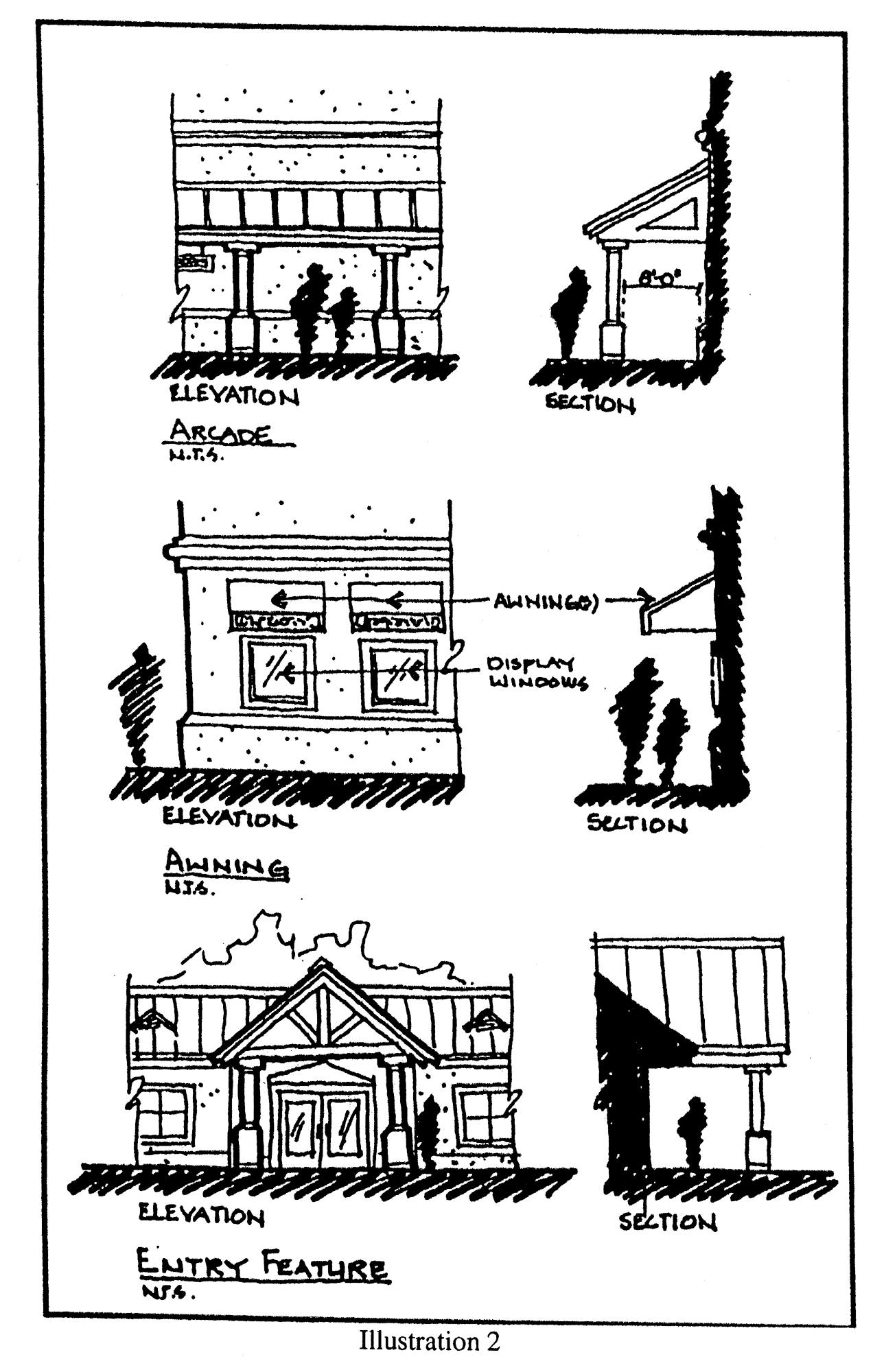
Illustration 2
c.
Facade/wall height transition. New structures that are proposed to be located within 300 feet of an existing building, and are more than twice the height of any existing building within 300 feet shall provide transitional massing elements to transition between the existing buildings of lower height within 300 feet, and the proposed structures. The transitional massing element can be no more than 100 percent taller than the average height of the adjacent buildings (see Illustration 3 below).
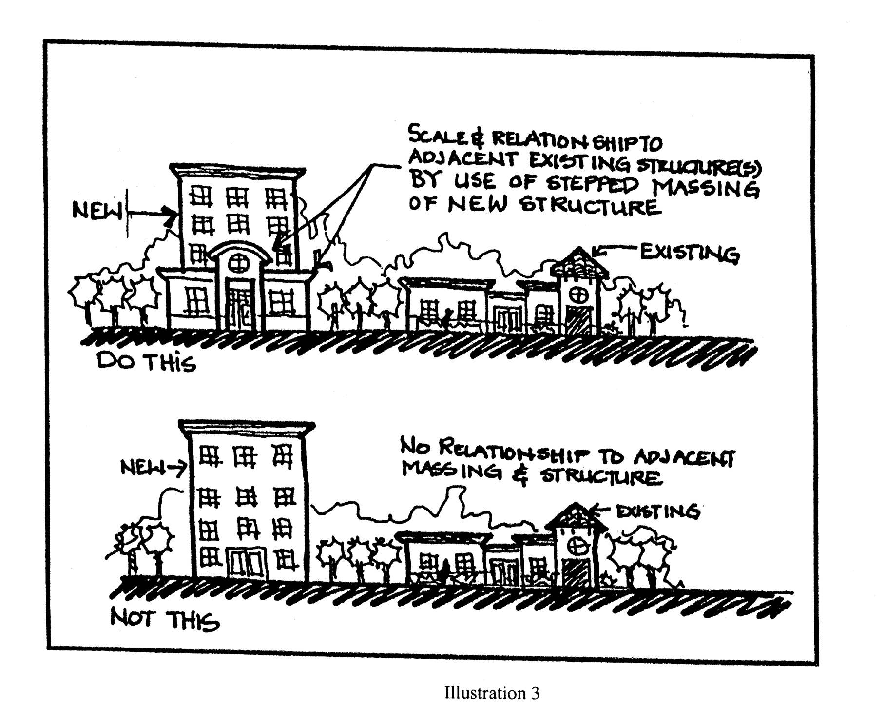
Illustration 3
d.
Facade standard. All primary facades of a building shall be designed with consistent architectural style and detail and trim features. Facades attached to a primary facade shall incorporate features of the primary facade for a minimum of 33 percent of the overall wall length measured from the attached primary facade. In the case of outparcel buildings, all exterior facades shall adhere to the requirements of this section with respect to architectural design treatments for primary facades.
e.
Window standards. Windows shall not appear to be false or applied.
f.
Awning standards. These standards apply to awnings associated with and attached to a building/structure. (See Illustration 4)
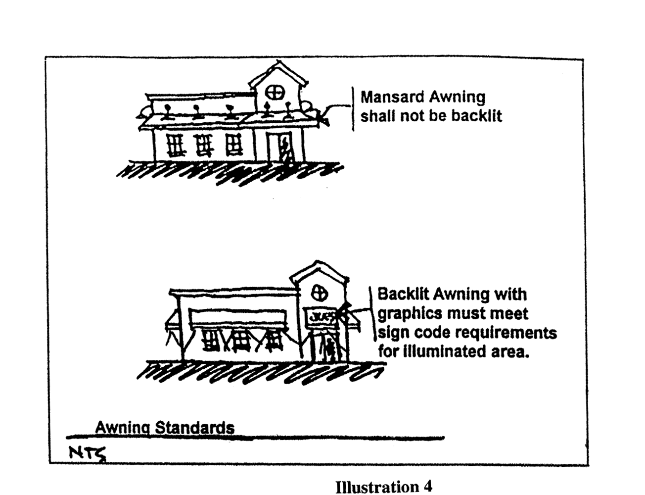
Illustration 4
Mansard awnings are permitted provided they do not extend above the roofline of the building and are not backlit.
All other awnings shall adhere to the following standards:
1.
Awnings may be backlit provided the illuminated portion of the awning with graphics does not exceed the size limitations and standards of this code.
2.
Automobile sales parking lot awnings. Shade awnings may be erected in automobile sales parking lots subject to the following requirements and standards:
a.
No shade awning structure shall be constructed within 75 feet of any public or private street.
b.
No one shade awning structure may exceed an area sufficient to provide cover for more than 20 automobiles.
c.
The minimum separation between shade awning structures shall be 100 feet.
d.
Multi-colored shade awning structures are prohibited and the use of black, gray, florescent, primary and/or secondary colors is prohibited. Earth-tone colors are encouraged.
g.
Overhead doors: Overhead doors facing one another may be treated as interior space provided that the buildings meet all other requirements of section 6.13 of this code. (See Illustration 5)
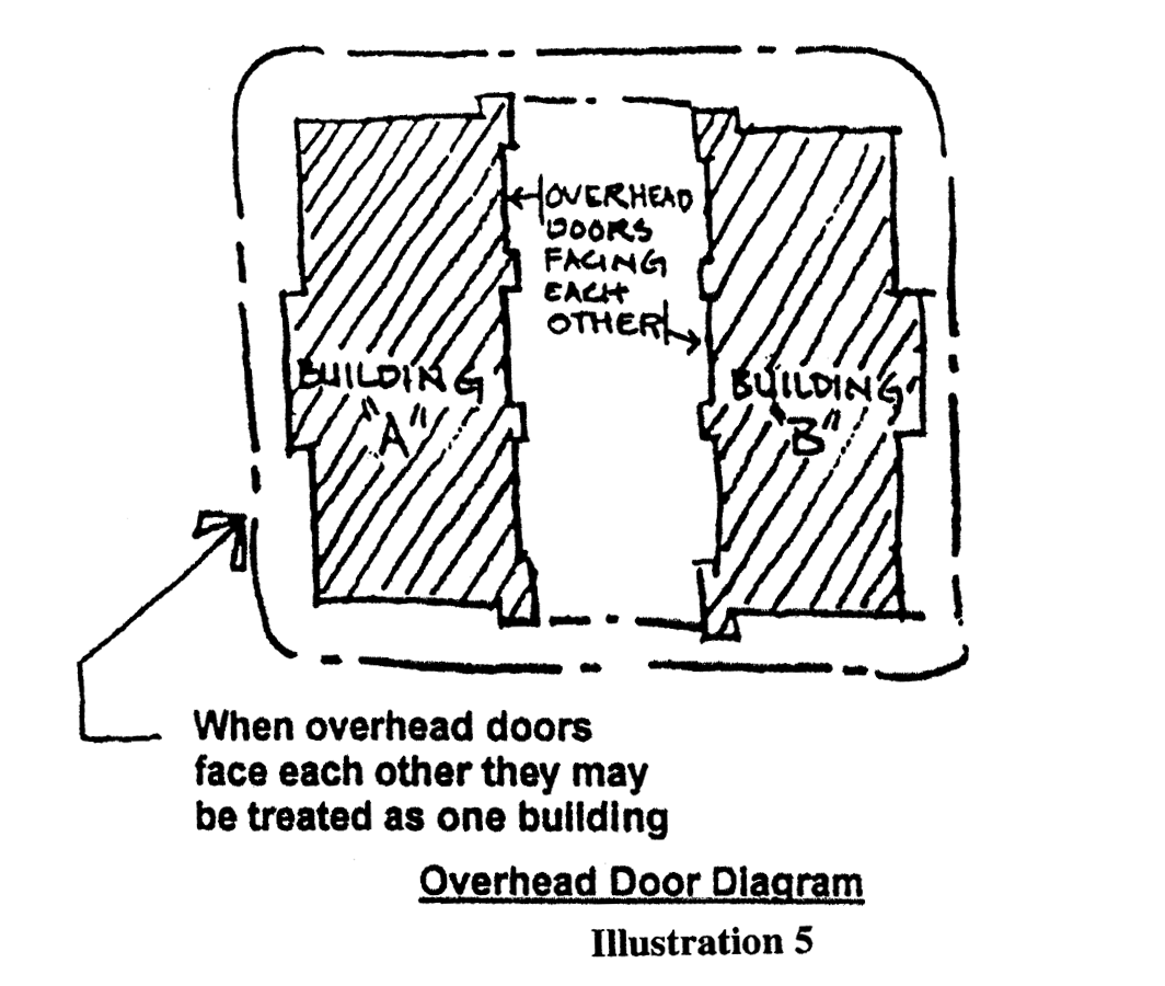
Illustration 5
h.
Massing standards. Exterior facades shall be designed to employ the following design treatments:
1.
For buildings of 20,000 square feet of gross building area or more;
a.
No horizontal length or uninterrupted curve of a primary building facade shall exceed 100 linear feet. For arcaded facades, no horizontal length or uninterrupted curve of the arcaded facade shall exceed 120 feet, with varied lengths being desirable. Projections and recesses shall have a minimum depth of three feet with 25 percent of these having a varied length with a minimum differential of one foot (See Illustration 6).
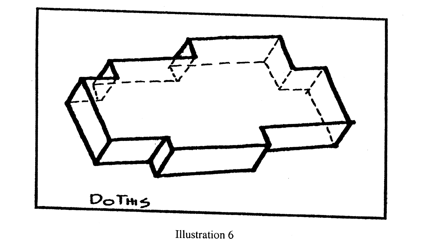
Illustration 6
b.
Exterior wall planes shall not constitute more than 60 percent of each affected facade.
c.
Primary facades on the ground floor shall have features along a minimum of 50 percent of their horizontal length per affected side. These features include, but are not limited to: arcades, a minimum of six feet clear in width; display windows; entry areas; or other such design elements. Awnings are included in this calculation at 1.5 times the window width when associated with windows/doors and are in increments of 20 feet in length or less.
2.
For buildings of between 5,000 and 19,999 square feet, inclusive, of gross building area;
a.
No horizontal length or uninterrupted curve of any primary facade shall exceed 50 feet, For arcaded facades, no horizontal length or uninterrupted curve of any primary facade shall exceed 80 feet, with varied lengths being desirable. Projections and recesses shall have a minimum depth of two feet.
b.
Exterior wall planes shall not constitute more than 50 percent of each affected facade.
c.
Primary facades on the ground floor shall have features along a minimum of 33 percent of their horizontal length per affected side. These features include, but are not limited to: arcades, a minimum of six feet clear in width; display windows; entry areas; or other such design elements. Awnings are included in this calculation at 1.5 times the window width when associated with windows/doors and are in increments of 10 feet in length or less.
3.
For buildings of less than 5,000 square feet of gross building area;
a.
No horizontal length or uninterrupted curve of any primary facade shall exceed 35 linear feet. For arcaded facades, no horizontal length or uninterrupted curve of the arcaded facade shall exceed 60 feet, with varied lengths being desirable. Projections and recesses shall have a minimum depth of one foot.
4.
All buildings shall provide a minimum of one offset per public street or navigable waterway.
i.
Design Elements.
1.
All commercial buildings shall have a minimum of four of the following building design treatments (see Illustrations 7 and 8 below):
a.
Canopies or porticos, integrated with the building=s massing and style;
b.
Overhangs, minimum of three feet;
c.
Arcades, minimum of eight feet for buildings of 20,000 square feet of gross building area or more, and six feet for all other buildings, clear in width;
d.
Sculptured artwork;
e.
Raised cornice or building banding with a minimum of two reliefs;
f.
Peaked roof forms;
g.
Arches;
h.
Ornamental and structural architectural details, other than cornices; which are integrated into the building structure and overall design;
i.
Clock bell towers or other such roof treatment (e.g. dormers, belvederes, cupolas);
j.
Emphasized building base, minimum of three feet high and minimum projection from the wall of two inches;
k.
Additional roof articulation above the minimum standards, (see Section 6.13.3.2);
l.
Metal or tile roof as the dominant roof material; or
m.
Any other treatment which, in the opinion of the Development Review Coordinator, meets the intent of this section.
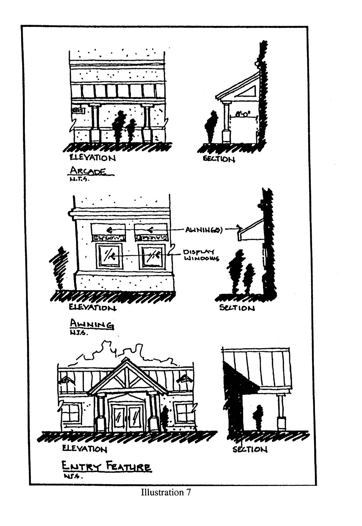
Illustration 7
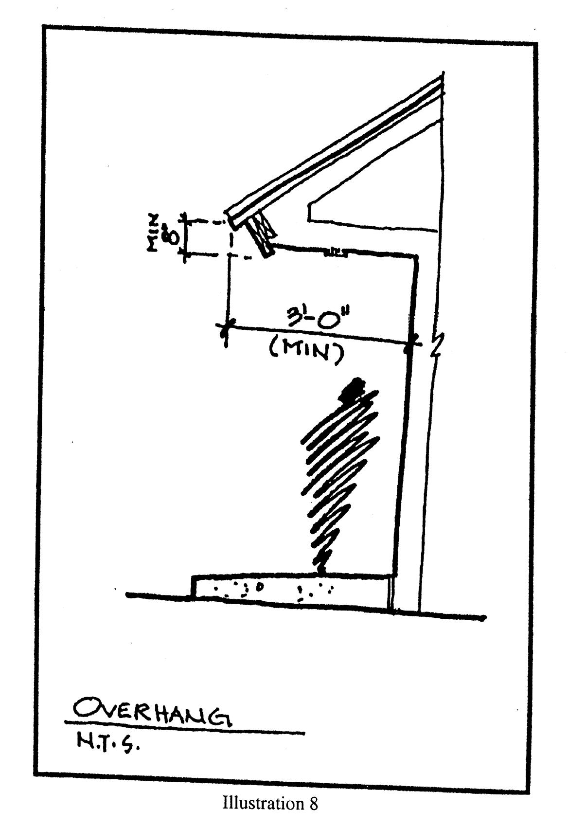
Illustration 8
2.
All commercial sites shall have at least one of the following site design elements:
a.
Decorative landscape planters or planting areas, a minimum of five feet wide, and areas for shaded seating consisting of a minimum of 100 square feet;
b.
Integration of specialty pavers, or stamped concrete along the building's walkway. Said treatment shall constitute a minimum of 60 percent of walkway area;
c.
Water element(s), a minimum of 150 square feet in area; or
d.
Two accent or specimen trees (in addition to the minimum required landscaping) along the front facade with a minimum diameter of four inches measured four feet above the ground and a minimum height of 18 feet at planting.
j.
Detail Features
1.
Purpose and intent. The design elements in the following standards shall be integral parts a building's exterior facade and shall be integrated into the overall architectural style. These elements shall not consist solely of applied graphics, or paint.
2.
Blank wall areas. Blank wall areas shall not exceed ten feet in the vertical direction nor 20 feet in the horizontal direction of any primary facade. For facades connected to a primary facade this shall apply to a minimum of 33 percent of the attached facade measured from the connection point. Control and expansion joints within this area shall constitute blank wall area unless used as a decorative pattern and spaced at intervals of six feet or less. Relief and reveal work depth must be a minimum of one-half inch. Landscaping may be used to assist in reducing the blank wall area. Such landscaping shall not be in lieu of architectural treatment. (See Illustration 9 and 10 below).
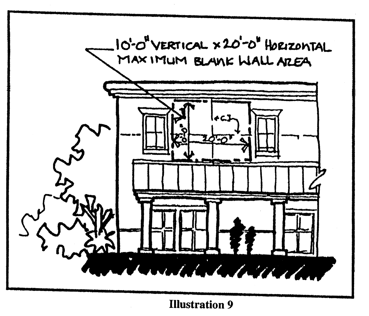
Illustration 9
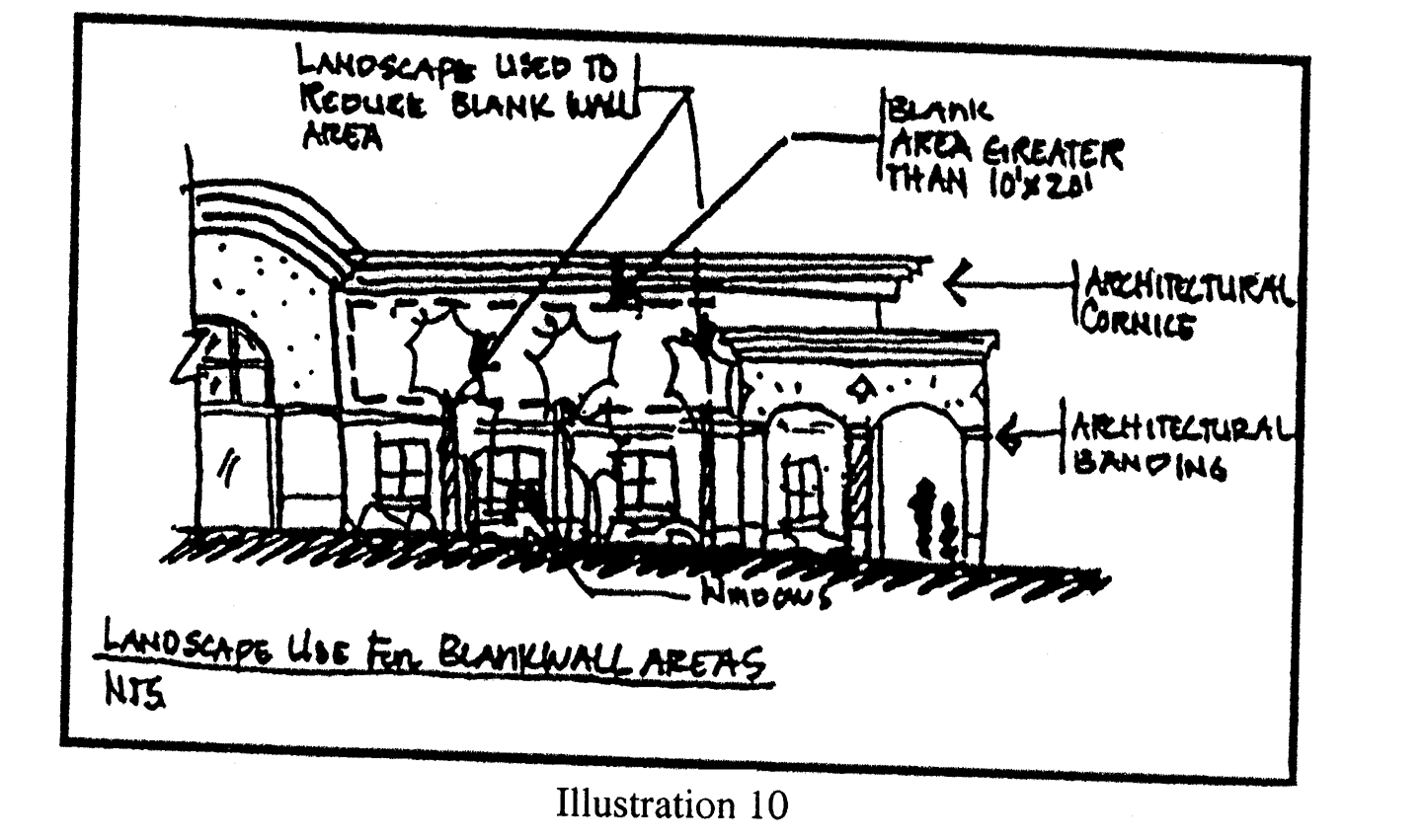
Illustration 10
3.
Repeating facade treatments. Building facades shall include a repeating pattern and shall include no less than three of the design elements listed below. At least one of these design elements shall repeat horizontally. All design elements shall repeat at intervals of no more than 50 feet for buildings of 20,000 square feet of gross building area or more, and 25 feet for all other buildings, horizontally, and a maximum of 15 feet vertically for all buildings.
a.
Color change;
b.
Texture change;
c.
Material module change;
d.
Expression of architectural or structural bays, through a change in plane of no less than 12 inches in width, such as a reveal, an offset, or a projecting rib (see Illustration 11 below);
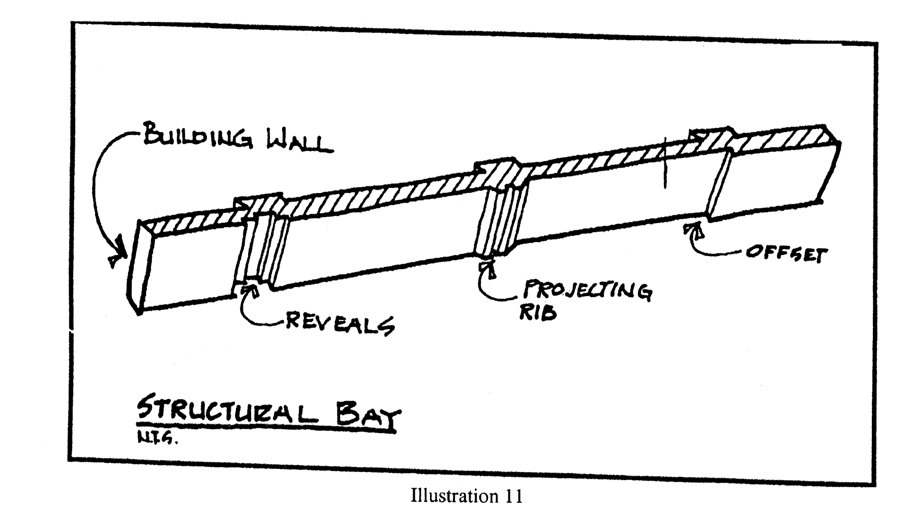
Illustration 11
e.
Architectural banding;
f.
Building setbacks or projections, a minimum of three feet in width on upper level(s) or,
g.
Pattern change
k.
Additional facade design treatments for multiple use buildings
1.
Purpose and intent. The presence of buildings with multiple tenants creates variety, breaks up large expanses of uninterrupted facades, and expands the range of the site's activities. Windows and window displays of such stores shall be used to contribute to the visual interest of exterior facades. The standards in this section are directed toward those situations where more than one retailer, with separate exterior customer entrances, are located within the principal building.
2.
First floor primary facade treatments.
a.
The first floor of the primary facades shall, at a minimum, utilize windows between the heights of three feet and eight feet above the walkway grade for no less than 30 percent of the horizontal length of the building facade.
b.
Windows shall be recessed, a minimum of one-half inch, and shall include visually prominent sills, shutters, stucco reliefs, or other such forms of framing.
2.
Roof treatments
a.
Purpose and intent. Variations in roof lines shall be used to add interest to, and reduce the massing of buildings. Roof features shall be in scale with the building's mass and complement the character of adjoining and/or adjacent buildings and neighborhoods. Roofing material should be constructed of durable high quality material in order to enhance the appearance and attractiveness of the community. The following standards identify appropriate roof treatments and features.
b.
Roof edge and parapet treatment. At a minimum of two locations, the roof edge and/or parapet shall have a vertical change from the dominant roof condition, a minimum of three feet for buildings of 20,000 square feet of gross building area or more, and two feet for all other buildings. At least one such change shall be located on a primary facade adjacent to a collector or arterial right-of-way (see Illustration 12 below). One additional roof change must be provided for every 25,000 square foot increment over 50,000 square feet of ground floor space.
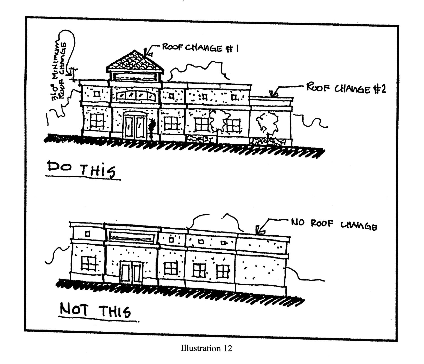
Illustration 12
c.
Roofs shall meet the following requirements: (See Illustration 13 below)
1.
Parapets shall be used to conceal roof top equipment and flat roofs;
2.
Except where an overhang is not possible due to a parapet wall treatment, overhangs shall be provided and shall be no less than three feet beyond the supporting walls. Where overhangs on existing buildings being renovated are less than three feet they shall be provided with a band or cornice, a minimum of eight inches in width, at least eight inches below the soffit at the wall;
3.
Fascia shall be a minimum of eight inches;
4.
Tile, metal, or 320-pound, 30-year architectural grade asphalt shingles of earth tone as the dominant roof material;
5.
Canopies covering fueling islands must match the roof treatment of the primary structure.
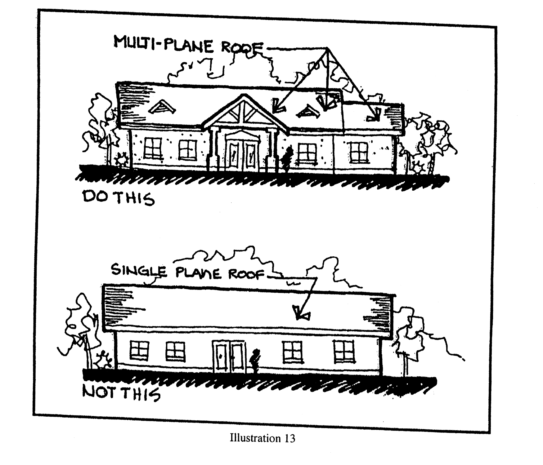
Illustration 13
d.
Prohibited roof types and materials. The following types of materials are prohibited:
1.
Asphalt shingles, except laminated, 320-pound, 30-year architectural grade asphalt shingles or better;
2.
Mansard roofs and canopies except as specifically provided for herein;
3.
Roofs utilizing less than or equal to a two to 12-pitch unless utilizing full parapet coverage; and
4.
Back-lit awnings used as a mansard or canopy roof.
3.
Entryways/customer entrance treatments.
a.
Purpose and intent. Entryway design elements and variations are intended to give protection from the sun and adverse weather conditions. These elements are to be integrated into a comprehensive design style for the project.
b.
Entryways/customer entrance standards. These standards identify appropriate entry features.
1.
For buildings of 20,000 square feet of gross building area or more;
a.
Single use buildings. Single use buildings shall have clearly defined, highly visible customer entrances which shall include the following:
1.
An outdoor patio area adjacent to the customer entrance, a minimum of 200 square feet in area which incorporates the following:
a.
Benches or other seating components;
b.
Decorative landscape planters or wing walls which incorporate landscaped areas; and
c.
Structural or vegetative shading.
2.
A main front entry which shall be set back from the drive a minimum distance of 15 feet.
b.
Multiple use buildings and projects. Multi-use structures shall include the following:
1.
Anchor tenants shall provide clearly defined, highly visible customer entrances.
2.
Each anchor tenant shall have a front entry which shall be set back from the drive a minimum of 15 feet.
3.
A provision for intermittent shaded outdoor community space at a minimum of one percent of the total gross floor area of the building or commercial project. Said community space shall be located off or adjacent to the circulation path of the complex or main structure and shall incorporate benches or other seating components.
2.
For buildings of between 10,000 and 19,999 square feet, inclusive, of gross building area;
a.
An outdoor patio area adjacent to the customer entrance, a minimum of 50 square feet in area and which incorporates one of the following:
1.
Benches or other seating components
2.
A provision for intermittent shaded outdoor community space at a minimum of one percent of the total gross floor area of the building or commercial project. Said community space shall be located off or adjacent to the circulation path of the complex or main structure and shall incorporate benches or other seating components.
b.
A main front entry which shall be set back from the drive a minimum of 15 feet.
4.
Materials.
a.
Purpose and intent. Exterior building materials contribute significantly to the visual impact of a building on the community. They shall be well-designed and integrated into a comprehensive design style for the project.
b.
Exterior building materials, exterior colors, and standards.
1.
Predominant exterior building materials shall include, but are not limited to:
a.
Stucco of earth tone;
b.
Natural brick (unpainted, unstained, and untinted);
c.
Textured, other than smooth or ribbed, concrete masonry units of earth tone;
d.
Stone (unpainted, unstained, and untinted), excluding an ashlar or rubble construction look;
e.
Wooden or composite siding;
f.
The following colors are prohibited: Use of florescent or day glow colors; or
g.
Corporate colors or colors used in the marketing of the business occupying the space which are not earth tone shall be calculated towards the allowable signage copy area provided for under Section 6.7 of this code. In such case, a sign permit is required. This section is intended to provide corporations, franchises, and corporate chains, the opportunities to use other exterior colors (other than earth tone), but these colors be considered signage for the purpose of this code.
2.
Predominant exterior building materials that are prohibited include:
a.
Plastic or vinyl siding;
b.
Corrugated or reflective metal panels;
c.
Tile;
d.
Smooth or rib faced concrete block; and
e.
Applied stone in an ashlar or rubble look.
3.
Automotive and other special type service buildings may utilize prefabricated metal buildings under the following conditions:
a.
Metal buildings are more than 250 feet from any right-of-way;
b.
Metal buildings are located directly behind the main showroom/sales center [or primary structure] so as not to be a dominant facade along the street;
c.
At least 80 percent of the front elevation of any such building and accompanying showroom/sales center must be the elevation of the accompanying showroom/sales center.
5.
Drive-through window standards. Drive-through windows and lanes shall be designed to adhere to the following standards:
a.
Drive-through windows shall not be placed between the right-of-way of a primary collector or arterial roadway and the associated building, unless the vegetation required by a Type "B" landscape buffer is installed within the buffer width required for the project and maintained along the entire length of the drive-through stacking and exit lanes between the drive-through lane and the adjacent right-of-way. A permanent covered porte-cochere type structure, other than awning/canvass type structure(s), may be installed extending the width of the drive-through and covering the service window(s). Such structure shall be integrated structurally and architecturally into the design of the building.
b.
Stacking lanes must be provided. Stacking spaces and lanes for drive-through stations shall not impede on- and off-site traffic movements by blocking vehicular or pedestrian circulation.
6.
Service function areas (SFA) including but not limited to loading, storage, mechanical equipment, and solid waste disposal.
a.
Purpose and intent. To diminish, in a safe manner, the visual impacts of service functions that may detract or have a negative impact on the streetscape, landscape and/or the overall community image.
b.
Buffering and screening standards. Loading or docking, outdoor storage, trash collection, mechanical equipment, trash compaction, vehicular storage, excluding new and used cars, recycling, roof top equipment and other service function areas shall be fully screened from adjacent properties and road way corridors at ground and pedestrian level.
c.
Materials and design standards. Screening material and design shall be consistent with design treatment of the primary facades of the commercial building or project and the landscape plan.
7.
Outside play structures. Outside play structures are prohibited, except in conjunction with those personal service type and institutional uses for which an outside play area is an integral part of the use (e.g. day cares, pre-schools, and schools).
8.
Pedestrian walkways.
a.
Purpose and intent. To provide safe opportunities for alternative modes of transportation by connecting with existing and future pedestrian and bicycle pathways within the city and to provide safe passage from the public right-of-way to the commercial building or project, and between alternative modes of transportation.
b.
Pedestrian access standards. Pedestrian ways, linkages and paths shall be provided from the building entry(s) to surrounding streets, external sidewalks, and outparcels. Pedestrian ways shall be designed to provide access between parking areas and the building entrance(s) in a coordinated and safe manner. Pedestrian ways may be incorporated within a required landscape perimeter buffer, provided said buffer is not less than ten feet in width on average. Shared pedestrian walkways are encouraged between adjacent commercial projects.
c.
Minimum ratios. Pedestrian ways shall be provided at a minimum ratio of one for each public vehicular entrance to a project, excluding ingress and egress points intended primarily for service, delivery or employee vehicles.
d.
Minimum dimensions. Pedestrian walkways shall be a minimum of five feet wide.
e.
Materials. Pedestrian walkways shall be consistent with the provisions of the Americans with Disabilities Act (ADA), the Accessibility Guidelines and the Florida Accessibility Code. Materials may include specialty pavers, concrete, colored concrete or stamped pattern concrete.
f.
Pedestrian crosswalks at building perimeter. Building perimeter crosswalks shall be designed and coordinated to move people safely to and from buildings and parking areas by identifying pedestrian crossings with signage and variations in pavement materials or markings.
g.
Shade. Pedestrian walkways shall provide intermittent shaded areas when the walkway exceeds 100 linear feet in length at a minimum ratio of 100 square feet of shaded area per every 100 linear feet of walkway. Shade structures may be natural, manmade or a combination of both.
9.
Lighting.
a.
Purpose and intent. Commercial buildings and sites, including their outparcels, shall be designed to provide safe, convenient, and efficient lighting for pedestrians and vehicles. Lighting shall be designed in a consistent and coordinated manner for the entire site. The lighting and lighting fixtures shall be integrated and designed so as to enhance the visual impact of the project on the community and/or blend the project into the surrounding landscape.
Exterior lighting may be used to illuminate a building and its grounds for safety purposes but in an aesthetic manner. Lighting is not to be used as a form of advertising in a manner that is not compatible to the neighborhood or in a manner that draws considerably more attention to the building or grounds at night than in the day. All fixtures used in exterior lighting are to be selected for functional and aesthetic value. Decorative lighting fixtures in keeping with the architecture style shall be used for commercial wall mount lighting and parking lot light poles. Exterior lighting shall be in accordance with the lighting design standards of this code.
b.
Shielding standards. Lighting shall be designed so as to prevent direct glare, light spillage and hazardous interference with automotive and pedestrian traffic on adjacent streets and all adjacent properties. Illumination onto adjacent right-of-way or property shall not exceed 0.5 foot candles.
c.
Fixture height standards. Lighting fixtures shall be a maximum of 30 feet in height within the parking lot and shall be a maximum of 15 feet in height within non-vehicular pedestrian areas (see Illustration 14 below).
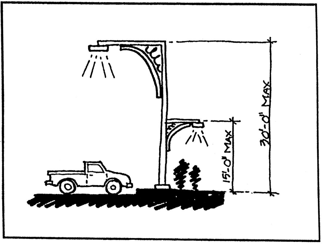
Illustration 14
d.
Design standards. Lighting shall be used to provide safety while accenting key architectural elements and/or emphasizing landscape features. Light fixtures shall be used as an integral design element that complements the design of the project. This can be accomplished through style, material or color (excluding florescent, primary and secondary colors) or by designing the lighting fixtures to blend into the landscape through the use of dark colors such as bronze, black and forest green. Concrete type poles or mill finish is not permitted. Light pole footers shall not be exposed more than six inches above finish grade.
10.
Fencing standards. Chain link and wood fencing are prohibited forward of the primary facade, except as provided below, and must be a minimum of 100 feet from a public right-of-way. Chain link and wood fencing facing a public right-of-way shall be buffered at a minimum by an irrigated hedge directly in front of the fence on the side of the right-of-way. Plant material shall be a minimum of 24 inches in height and width and planted to create a continuous visual barrier at time of installation. This plant material shall be maintained at a minimum of three quarter the height of the fencing. (See Illustration 15).
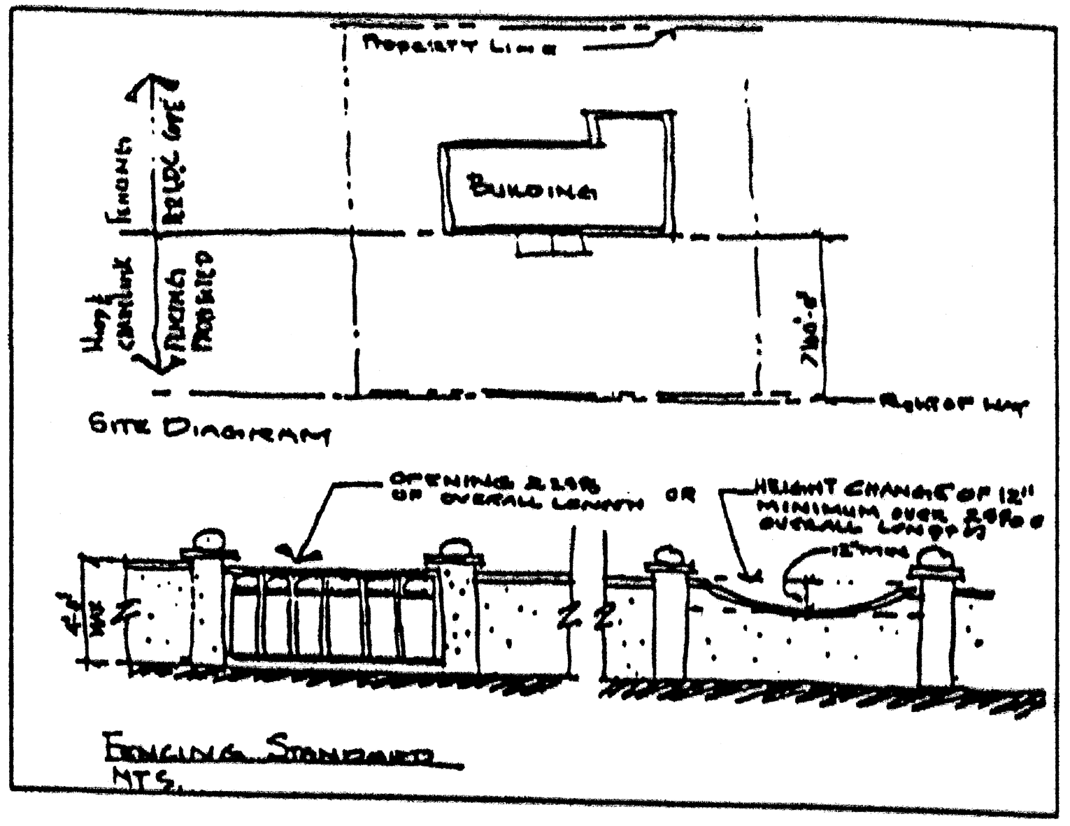
Illustration 15
Fencing forward of the primary facade is permitted under the following conditions:
a.
Fencing does not exceed four feet in height;
b.
The fencing provides either an open view at a minimum of 25 percent of its length or provides variation in its height for a minimum of 15 percent of its length with a deviation of at least 12 inches; and,
c.
The fence style must complement building style through material, color and/or design.
11.
Outparcels.
a.
Purpose and intent. To provide unified architectural design and site planning between outparcel structures and the main structure on the site in order to enhance the visual impact of the structures and to provide for safe and convenient vehicular and pedestrian access and movement within the site.
b.
Outparcel design. All exterior facades of an outparcel structure shall be considered primary facades and shall employ architectural, site, and landscaping design elements which are integrated with and common to those used on the primary structure on site. These common design elements shall include colors and materials associated with the main structure. When the use of common wall, side by side development occurs, continuity of facades and consolidated parking for several businesses on one parking lot may be used. Outparcels that are adjacent to each other shall have vehicular connection between their respective parking lots and interconnected pedestrian walkways.
12.
Natural and manmade bodies of water including wet and dry retention areas for buildings of 20,000 sq. ft. or more (exceeding 12 feet in width). The shape of a manmade body of water, including wet and dry retention areas, shall be designed to appear natural by having off-sets in the edge alignment that are a minimum of ten feet and spaced 50 feet apart. On sites with buildings of 20,000 square feet of gross building area or more, all bodies of water, including wet and dry retention areas, exceeding 20,000 square feet in area, and which are located adjacent to a public right-of-way, shall incorporate into the overall design of the project at least two of the following items: (see Illustration 16 below).
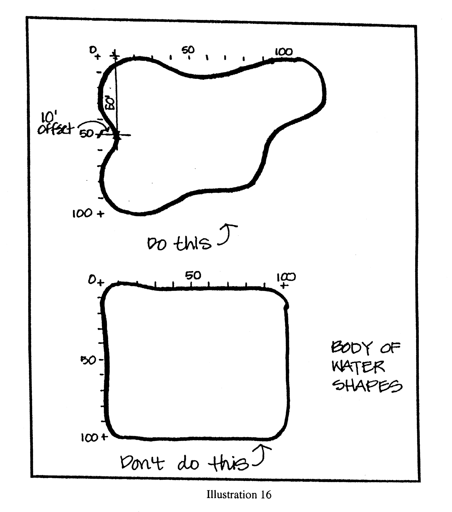
Illustration 16
a.
A five-foot wide walkway with trees an average of 50 feet on center and shaded benches a minimum of six feet in length or picnic tables with one located every 150 feet.
b.
A public access pier with covered structure and seating.
c.
An intermittent shaded plaza/courtyard, a minimum of 200 square feet in area, with benches and/or picnic tables adjacent to the water body.
d.
A permanent fountain structure.
6.13.4. Architectural and site design standards and guidelines for commercial buildings and projects with a gross building area of 20,000 square feet or larger.
1.
Off street parking design. As provided for in section 6.5, and subject to the following provisions:
a.
Purpose and intent. Commercial buildings and sites, including their outparcels, shall be designed to provide safe, convenient, and efficient access for pedestrians and vehicles. Parking shall be designed in a consistent and coordinated manner for the entire site. The parking area shall be integrated and designed so as to enhance the visual appearance of the community.
b.
Design standards. Parking, utilizing the same degree of angle, shall be developed throughout the site to provide efficient and safe traffic and pedestrian circulation. A single bay of parking provided along the perimeter of the site may vary in design in order to maximize the number of spaces provided on-site. The mixture of one-way and two-way parking aisles, or different degrees of angled parking within any parking area is prohibited, except as noted above, or where individual parking areas are physically separated from one another by a continuous landscape buffer, a minimum ten feet in width with limited access. Landscape buffers for these locations shall use landscape material other than grass for separation of parking areas (See Illustrations 17 and 18).
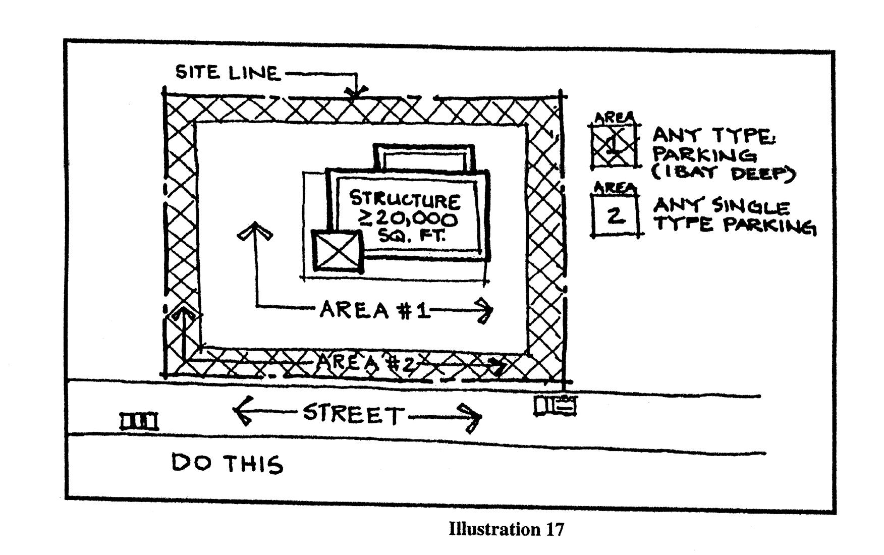
Illustration 17
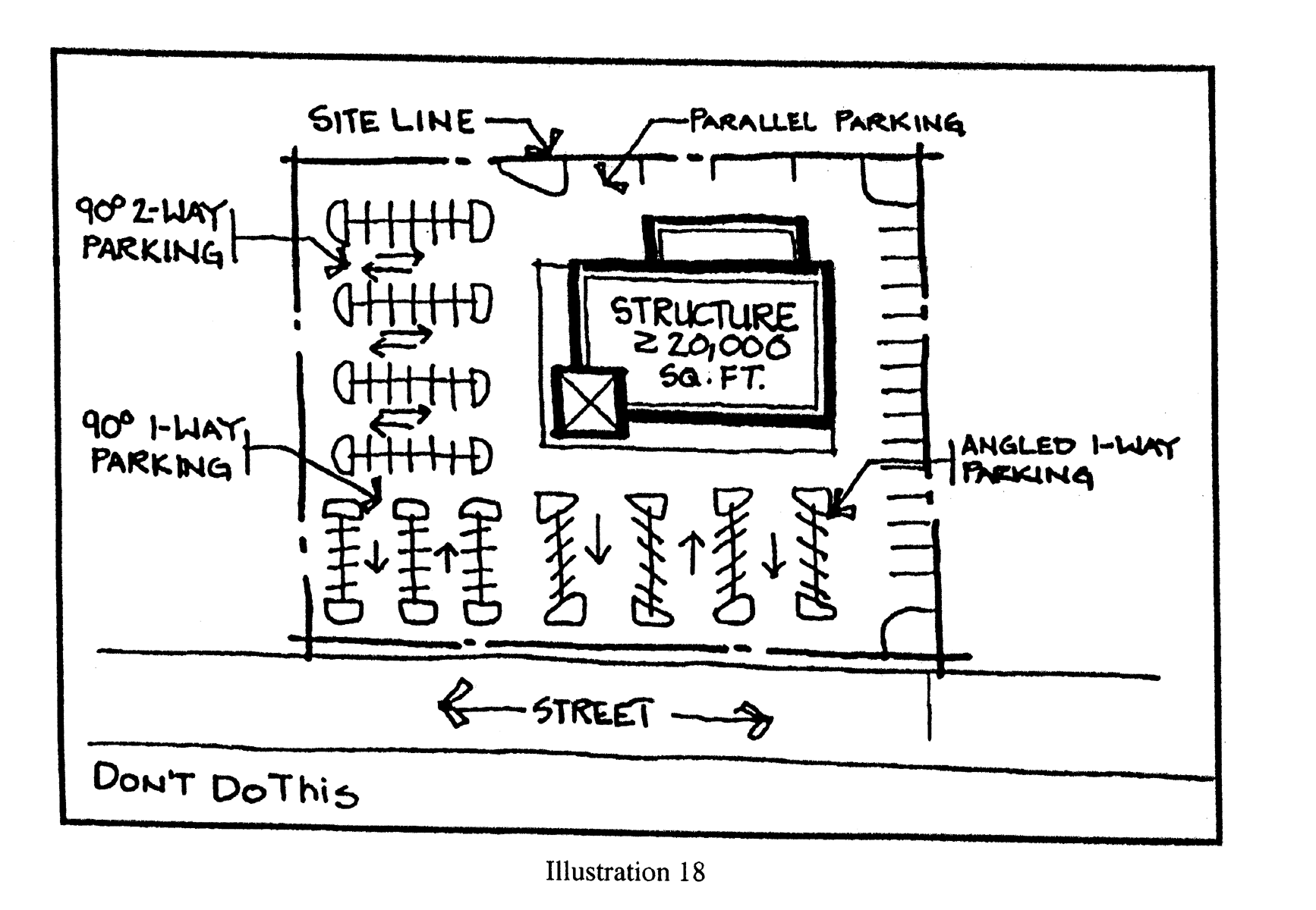
Illustration 18
c.
Maximum parking. Parking in excess of the minimum parking requirements shall consist of grassed parking surface as opposed to paved or paver block surfaces. These parking spaces shall be located furthest from the main building on the site.
d.
Parking location. Projects shall be designed to adhere to the following standards:
1.
Interior lots. No more than 50 percent of the off-street parking for the entire commercial building or project shall be located between any primary facade of the commercial building or project and the abutting street or navigable waterway. (See Illustration 19 below).
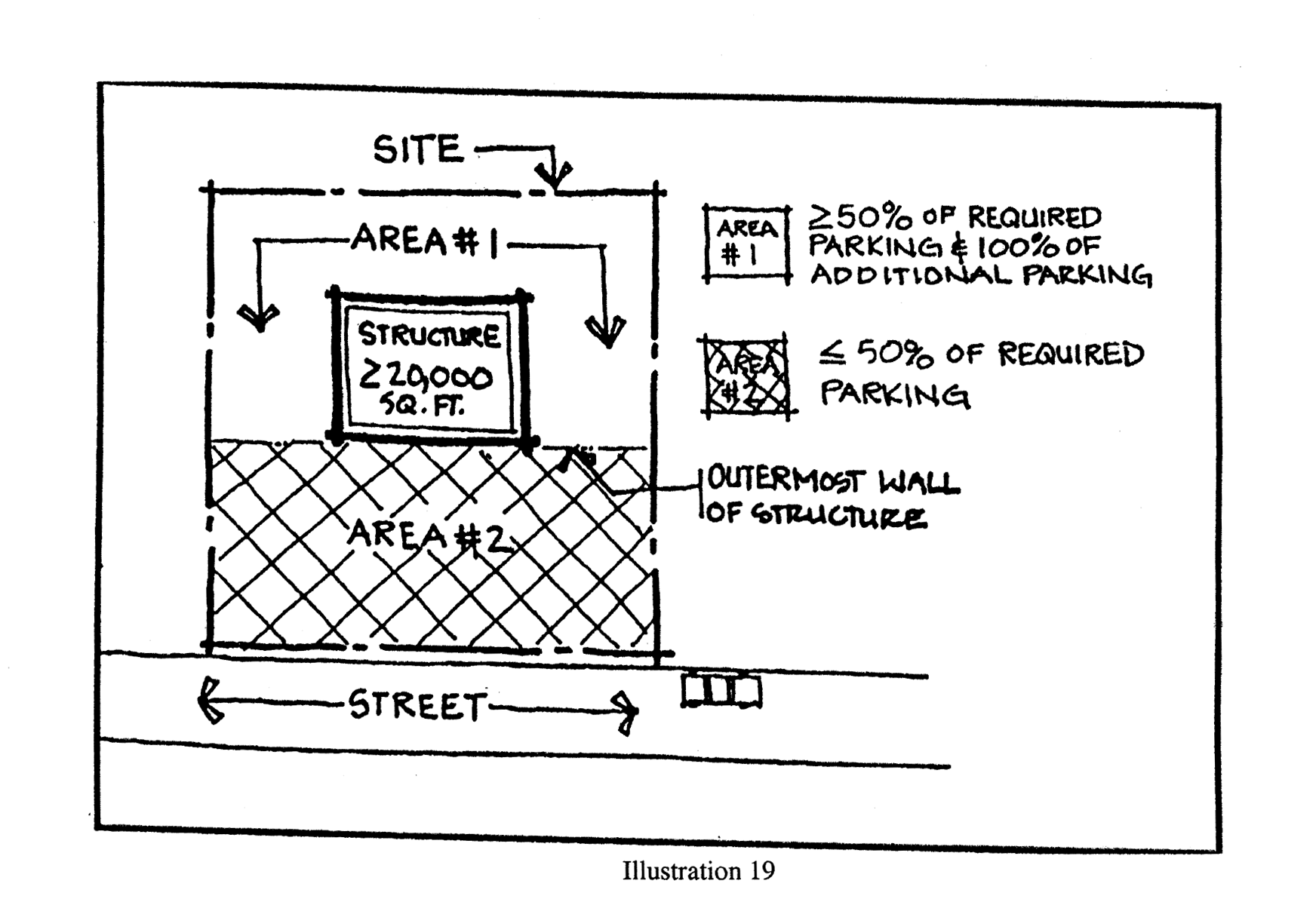
Illustration 19
2.
Corner lots. No more than 80 percent of the off-street parking for the entire commercial building or project shall be located between any primary facade of the commercial building or project and the abutting street or navigable waterway area, with no single side to contain more than 65 percent of the required parking. (See illustration 20 below).
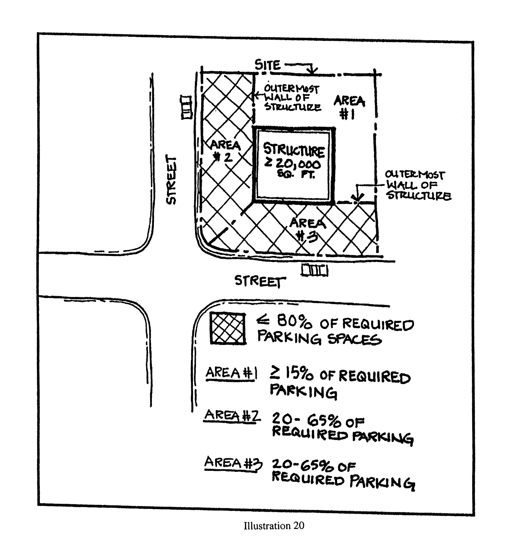
Illustration 20
e.
Parking structure standards. A minimum of 60 percent of any primary facade of a parking structure or covered parking facility shall incorporate two of the following (see Illustration 21 below for examples):
1.
Transparent windows, with clear or lightly-tinted glass, where pedestrian oriented businesses are located along the facade of the parking structure;
2.
Display windows;
3.
Decorative metal grille-work or similar detailing which provides texture and partially and/or fully covers the parking structure opening(s);
4.
Art or architectural treatment such as sculpture, mosaic, glass block, opaque art glass, relief work, or similar features; or,
5.
Vertical trellis or other landscaping or pedestrian plaza area.
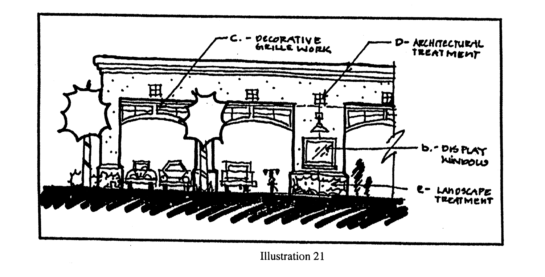
Illustration 21
2.
Landscaping. In addition to the requirements of section 6.6., "Landscaping and buffering" the following requirements shall apply.
a.
Purpose and intent. To provide enhanced landscaping within the vehicular and pedestrian use areas of large commercial buildings and projects. Such landscaping is intended to enhance the visual experience of the motoring and pedestrian public, commonly referred to as the "streetscape", while adhering to the purpose and intent set forth in section 6.6. of this code. Landscaping should be used to enhance and complement the site design and building architecture.
b.
Landscaping. The following requirements, with the exception of building perimeter plantings, shall be counted toward the required greenspace and open space requirements of section 6.6 of this code.
c.
Tree and lighting locations shall be designed so as not to conflict with one another (see Illustration 22 below).
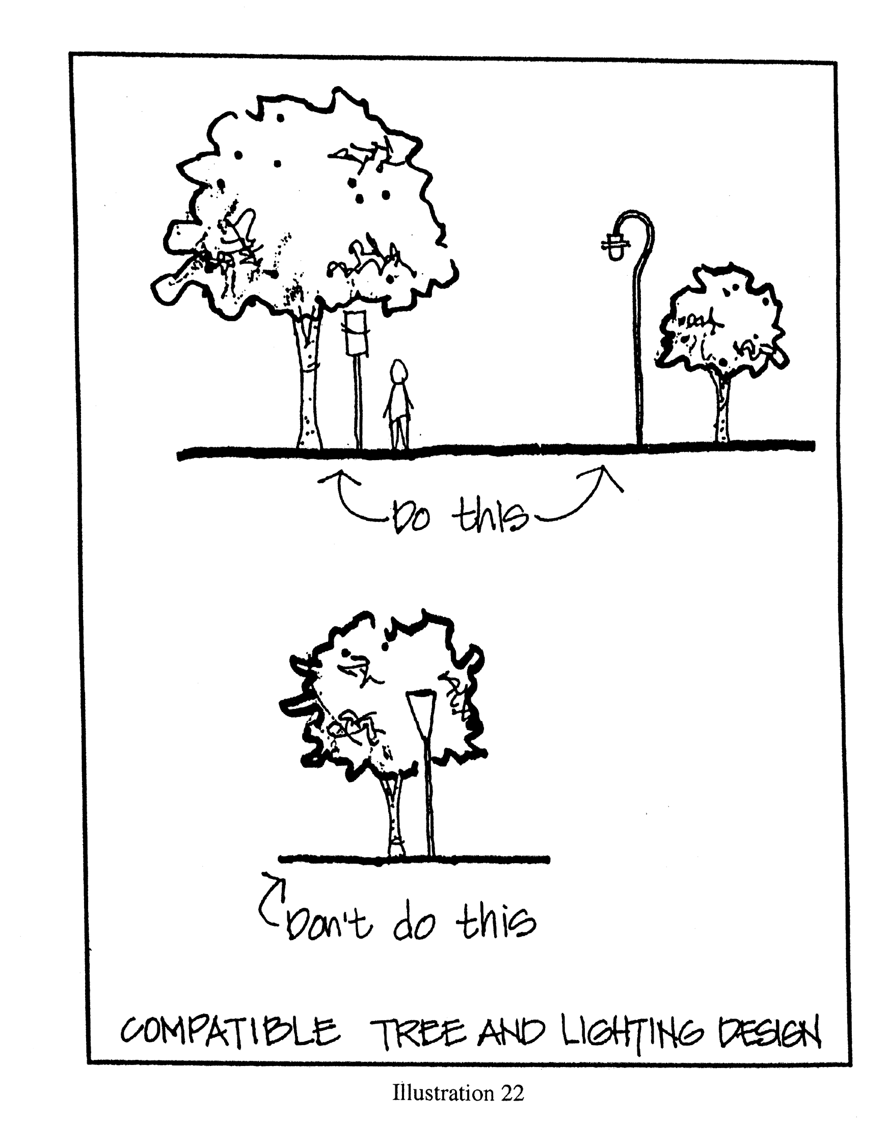
Illustration 22
d.
Locational requirements for building perimeter plantings as required by section 6.6 of this code
1.
Perimeter landscape plantings shall be located adjacent to the primary building facade, including building entrance areas, plazas, and courtyards. These areas shall be landscaped with any combination of trees, palms, shrubs and ground covers (see Illustrations 23 and 24 below).
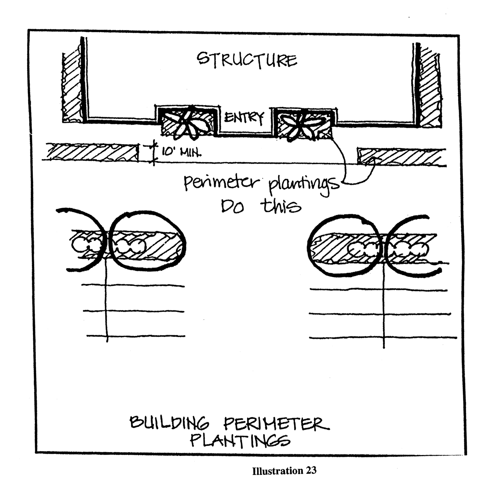
Illustration 23
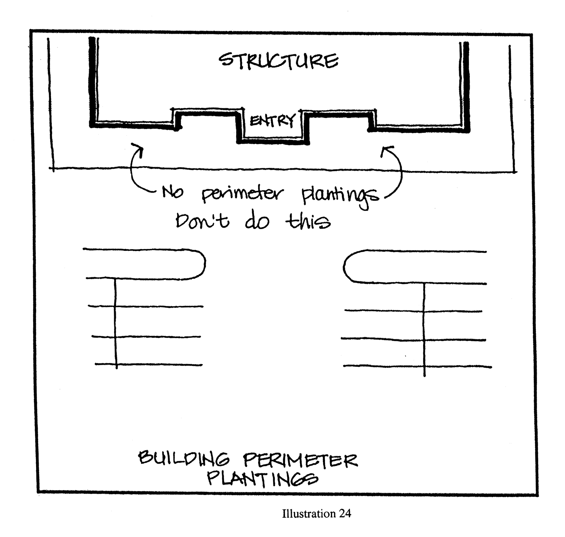
2.
Building perimeters shall include plantings at a ratio of 100 square feet of planters per 1,000 square feet of building ground floor area. Planters shall either be raised or at ground level and be a minimum of ten feet wide. Seating courtyards, eating areas and plazas may be incorporated within them (see Illustration 25 below).
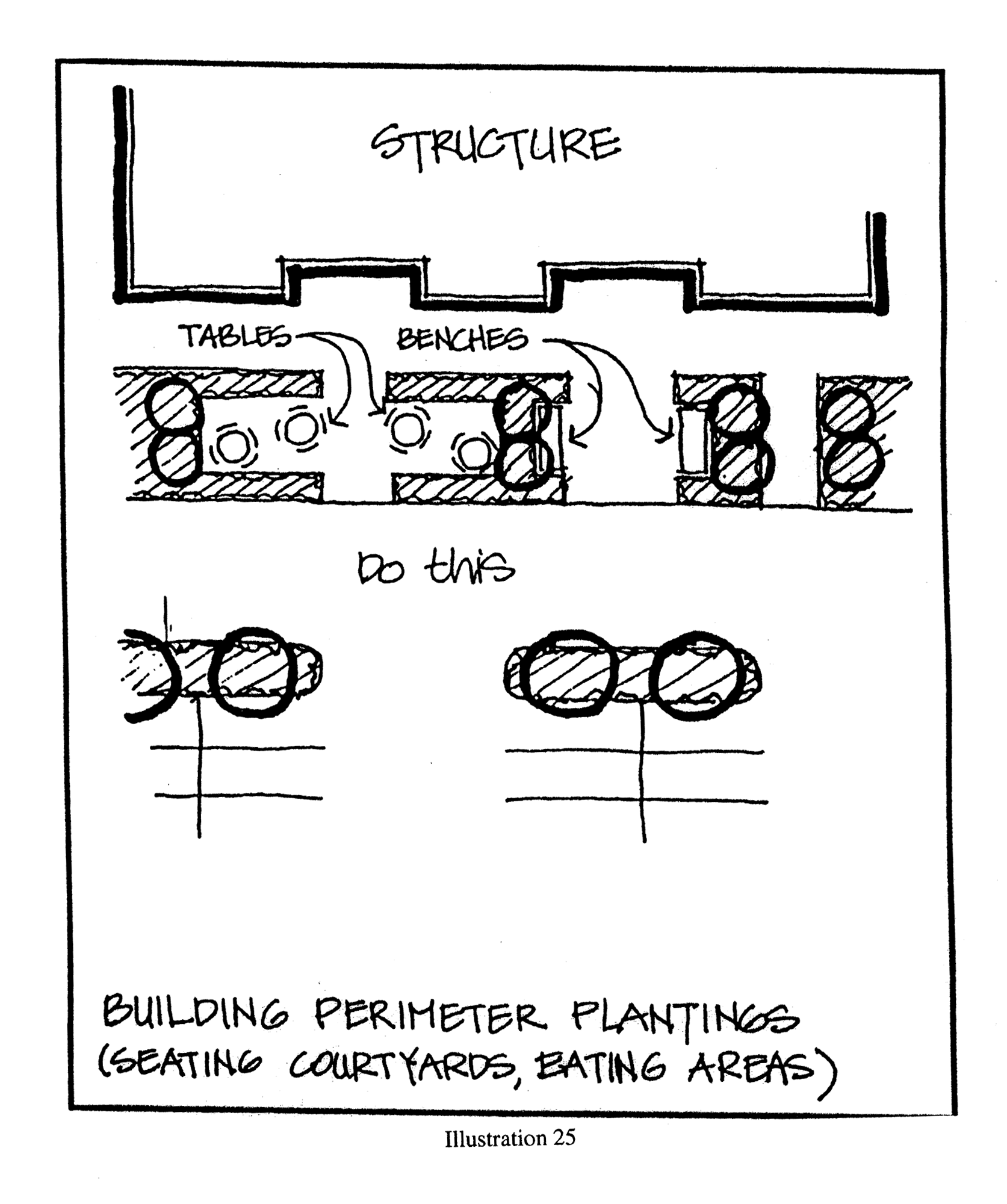
6.13.5.
Shopping center design standards. To maintain common architectural themes and to maintain architectural integrity of shopping centers, design and material standards shall be enforced.
1.
Shopping centers shall be constructed of split face, ribbed or salted block or other material as approved by the planning and zoning commission.
2.
Development on outparcels of the shopping center shall maintain the same architectural features, colors and textures as the shopping center.
3.
Standard architectural themes shall be maintained on all sides of buildings.
4.
Signs shall be constructed of the same or similar materials at the shopping center and outparcels.
6.13.6. Exceptions and interpretations.
1.
Exceptions. Exceptions to the provisions of this section may be granted by the city council in the form of a PUD zoning district where it can be demonstrated that such exceptions are necessary to allow for innovative design which, while varying from one or more of the provisions of this section, nonetheless are deemed to meet the overall purpose and intent set forth herein. In the case of individual commercial buildings or projects, where site specific factors may impact the ability to meet these standards, variance from one or more of the provisions of this section may be requested pursuant to the procedures set forth in section 2.5 of this code.
2.
Interpretations. During the course of review should an applicant and staff be unable to concur on the application of a specific provision or provisions of this section, the development review coordinator shall be authorized to make a final determination. The development review coordinator shall render his finding in writing within 15 days of receipt of a written request from the applicant. The applicant may appeal the determination of the development review coordinator to the planning and zoning commission, pursuant to the procedures set forth in this code.
(Ord. No. 790, § 2, 7-17-02; Ord. No. 849, §§ 24—26, 6-15-04; Ord. No. 903, § 1, 8-15-06; Ord. No. 2011-03, §§ 6, 7, 3-15-11; Ord. No. 2013-13, § 2(Exh. A), 10-1-13; Ord. No.2020-20, § 2, 5-4-21)
6.14. - Residential design standards overlay zoning district.
6.14.1.
Purpose and intent. It is the purpose of this section to provide general guidelines relating to the neighborhood and architectural design of development in certain portions of the city. These guidelines apply to new residential development in the overlay zone established in 6.14.3.
6.14.2.
Applicability. These neighborhood and architectural guidelines shall apply to any new single-family or duplex subdivision of land within the overlay zone, where 12 or more new residential platted lots are proposed, and where the applicant advocates, proposes, suggests, or exhibits a proposed plan, map, or plat of development of land or proposes to create a street, right-of-way, or easement that joins or connects to an existing public street. Existing development with a valid and active planned unit development, preliminary plat, or final construction plan shall not be required to meet these enhanced neighborhood and architectural requirements but are permitted to comply with the same. All other new single-family and duplex developments shall be required to adhere to the requirements of this code section.
6.14.3.
Overlay zone. The overlay zone shall include all lands graphically depicted on the map shown on illustration 1, generally described as being located south of S.R. 44 and east of U.S. Highway 441.
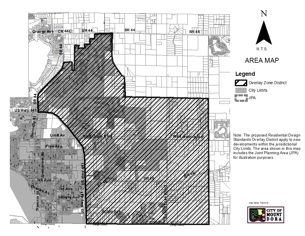
Illustration 1
6.14.4.
Development plans. Any new preliminary plat, final construction plan, or preliminary/final planned unit development shall comply with this Code, except existing development with a valid and active planned unit development, preliminary plat or final construction plan shall not be required to meet these enhanced neighborhood and architectural requirements but are permitted to comply with the same.
6.14.5.
Submittal process. The applicant shall submit, with the appropriate applications, a conceptual lotting plan, building elevations, and floor plans with sufficient detail to ensure that the intent of this Section is met.
6.14.6.
Design standards and guidelines.
1.
General neighborhood design and layout.
a.
Lot sizes and patterns within a neighborhood shall be varied to avoid monotonous streetscapes and to provide a diverse range of housing styles. The widths and depths of lots should vary at the discretion of the developer; however, no lot shall be less than the minimum standards established for the zoning district. Larger building types set on large lots are encouraged for corners and at prominent intersections. Smaller lots are encouraged surrounding or adjacent to common open spaces.
b.
Neighborhood design should respect the character of the existing topography and maximize preservation of environmental areas and native vegetation.
c.
Front elevations shall be designed to emphasize entries, porches and other residential use features and to de-emphasize vehicular use areas and garages.
d.
A higher level of elevation design and finish shall be maintained on both faces of corner lots with similar articulation and detail on both street-facing facades.
e.
Driveways on corner lots are encouraged to be located as far as possible from street intersections.
2.
Housing models and style varieties.
a.
Each development of 50 or more homes shall have at least seven base models, developments of less than 50 units but more than 20 units shall have at least five base models, and developments of less than 20 units shall have at least three base models. Each base model proposed may have multiple variations and design options available for customization.
b.
Each single-family residence or duplex building shall present an individual character through building placement, floorplan, exterior elevation, and color. No two buildings with the same exterior elevation shall be located adjacent to one another. Flexibility in the building elevation variation requirements may be considered at the discretion of the development review committee provided the overall intent of this section is maintained.
3.
Architectural styles and components.
a.
While the city does not wish to discourage creativity or uniqueness in housing design, architectural styles that represent identifiable historic styles are preferred in order to promote quality neighborhood design and community identity.
b.
Desired architectural components. The following list of architectural components represents a partial list of desired elements associated with traditional residential architecture. Not all residential styles or buildings will contain every element in the list, but must include components consistent with the established style.
1)
Open air front or wrap around porches;
2)
Stoops;
3)
Overhangs and awnings;
4)
Gable or hip type roofs;
5)
Second story balconies;
6)
Decorative roof treatments, including, but not limited to pediments, dormers, ridge cresting, decorative bridgeboard, stickwork, brackets, rafter tails, and decorative shingles; and
7)
Decorative window treatments, including, but not limited to double-hung windows, arched windows, transoms, bay windows, and louvered shutters.
c.
Prohibited architectural components. The residential architectural components described below are prohibited:
1)
"Garage-dominated" styles;
2)
Front-facing garage doors that exceed 35 percent of the street primary front facade;
3)
Homes that have massive entryway features that are or appear to be two-stories tall; and
4)
Homes that have less than two windows on the front facing façade.
d.
The mixing of elements from multiple architectural styles within a single residential building is discouraged.
4.
Roof elements.
a.
All roof projections, including chimneys, dormers, flues and vents shall be compatible in scale, height and material with the structure from which they project. Chimney hardware must be screened within an architectural feature such as a decorative chimney cap in keeping with the architectural style of the home.
b.
Gutters and downspouts are highly encouraged as long as they are consistent with the established architectural style of the residential building.
c.
When overhangs and awnings are included, they shall be no less than two feet deep when measured perpendicular to the building face, to function as an energy conservation measure and/or to protect people and the house from inclement weather. Required setbacks shall be measured from the bearing wall of the primary structure and not the overhang/awning.
5.
Windows and doors.
a.
All front, street-facing facades shall have windows and doors covering at least 25 percent of the primary front façade (exclusive of the garage façade in calculating this area).
b.
The front entry of the residential unit should be in scale with the façade and designed appropriate to the established architectural style of the building.
6.
Exterior finishes.
a.
Exterior finishes shall be consistent with the established architectural style of the residential building.
b.
Acceptable finishes may include wood, cement board, brick, rock and masonry. Stucco is acceptable if consistent with the established architectural style of the building.
c.
Prohibited finishes include EIFS, foam moldings, and vinyl siding.
d.
Simulated materials such as synthetic brick siding/paneling and stone veneer will be held to a higher level of scrutiny to assess quality and natural appearance. Samples of such materials may be required to be submitted with the application for review and approval by the development review committee.
7.
Garages.
a.
Garages are encouraged to be located to the side or rear of a residential lot. Illustration 2 shows several recommended alternative locations for garages.
b.
Garages shall not comprise more than 35 percent of the front of the residence.
c.
Garages facing the street shall be recessed at least five feet from the primary front facade of the home.
d.
Garage doors should be simple in design with door patterns and accent colors complementary to the architectural character of the home. Windows are encouraged to reduce the visual impact.
e.
Side-facing garage doors must incorporate a minimum of 15 percent in area windows and trim on the wall facing the front street.
f.
No more than 75 percent of the lots in a proposed subdivision are permitted to contain front loaded garages. If a project is proposed in multiple phases, each phase must meet this requirement individually.
g.
One-car garage must be a minimum of 12 feet by 20 feet interior size, consistent with this Code. The number of garage spaces required shall be consistent with the underlying zoning district of this Code.
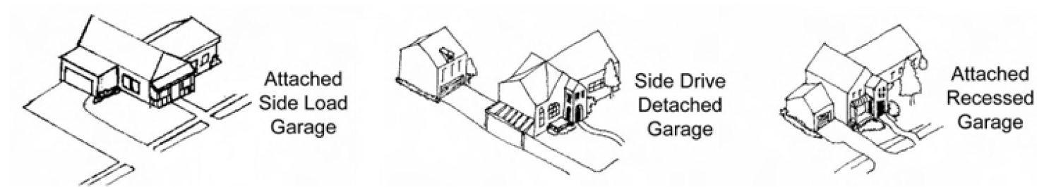
Illustration 2
8.
Lot trees. Each single-family lot is required to plant a minimum of three trees on the lot prior to issuance of the certificate of occupancy. A minimum of one canopy type tree must be located in the front yard. The size of the trees must be a minimum caliper of 3.0 inches, Florida Number One Grade or Better, and eight to 12 feet in height upon planting.
6.14.7.
Neighborhood identity. Special design elements located at the periphery and entrances of residential developments strengthen Mount Dora's image and also create a distinctive image for the neighborhood. These entrances shall be designed as thresholds to change from public thoroughfares to quiet neighborhood streets with slower design speeds.
1.
All single-family and duplex subdivisions of 12 units or more are required to construct a development entrance with residential-scaled landscaping, signage and streetscape patterns/furniture. Entrance features of consistent design are required at both primary and secondary entrances of each project to enhance the visual identity of the development.
2.
Gates at entrances are discouraged because of the reduced potential for connectivity, increased traffic congestion, and the sense of isolation that they create.
3.
Streets within residential neighborhoods shall be designed for people, as well as vehicles. A minimum five-foot sidewalk is required on both sides of residential streets. Each residential unit shall have direct access to a sidewalk. Residential streets should be designed to encourage slower speeds.
4.
Pedestrian and bicycle connections shall be provided to promote access to surrounding areas, including schools, public buildings, parks and nearby commercial areas.
5.
Street lighting:
a.
Lighting along roadways in developments should provide a smooth, even pattern that eliminates glare or light flow intrusion onto adjacent properties. Fixtures should be installed according to optimum spacing as recommended by the manufacturer. Light poles should not exceed 30 feet in height. Illumination for vehicles in residential neighborhoods should be approximately 0.50 foot-candles. Street lighting shall be designed consistent with the International Dark-Sky Association lighting principals.
b.
Decorative light fixtures are required to be provided consistently throughout the development and must be approved by the development review committee.
(Ord. No. 2018-14, § 2, 1-15-2019)
6.15. - Trail design guideline requirements.
6.15.1.
Purpose and intent. The purpose of these standards is to provide a community wide trail network which links neighborhoods, parks, schools, shopping areas and opens spaces. The intent is to provide comprehensive guidelines for the design and construction of various trail types and compliance with American Association of Street and Highway Transportation Officials (AASHTO) standards, Uniform Federal Accessibility standards and the "American with Disabilities Act Accessibility Guidelines".
6.15.2.
Applicability. These guidelines shall apply to shared-use trails, multi-use trails, park/nature trails, community paths/trails, and urban bicycle/pedestrian corridors.
6.15.3.
Design standards. Trails are required in the following situations:
1.
When a trail corridor traverses or is adjacent to a proposed development. Trails shall be provided within, or as close as possible to the delineated trail corridor.
2.
To link public transit stops, schools, recreation facilities, park sites and/or to public areas interior or exterior to the proposed development.
3.
When a trail is shown on an approved development plan.
4.
To continue existing planned and/or platted trails, from adjoining developments.
6.15.4.
Trail type and construction.
1.
Trails shall be designed and built to the following dimensions, unless otherwise approved. The City of Mount Dora Standard Details, incorporated herein by reference, are Figures 1—7, which shows typical sections (engineering drawings) for use in the design of construction plans.
a.
Regional shared-use trails. These trails are intended to provide long distances of travel for recreational users by connecting major trail systems. The width of the trail is typically 12 to 15 feet and consists of asphalt or concrete surface.
b.
Shared use trails. These trails are characterized by their interconnection between neighborhoods and the downtown core area as well as their connections to regional shared-use trails. They are a minimum of ten feet in width and consist of an asphalt or concrete surface.
c.
Park and nature trails. These trails are intended to provide recreational opportunities such as nature watching, exercise, family time, and meditation. They are constructed within existing parks, nature areas, and open spaces. trails could be constructed as three-foot wide dirt paths or 12-foot wide shared-use facilities. They are typically six to ten feet in width and consist of a variety of trail surfaces and settings.
d.
Community paths and trails. These trails connect homes to the larger trail systems. New developments will construct these types of trails as part of the development process. The focus of this type of trail is their connection between the "front door" of residences and local destinations and places of work. These walkways are eight to ten feet in width and consist of an asphalt or concrete surface.
2.
Shoulders. Shoulders shall be cleared of tree trunks, limbs, logs and brush. A minimum two-foot graded area shall be maintained adjacent to both sides of the pavement. Grades shall not exceed a 1:2 maximum slope
3.
Trail speed and turning radius. Design speed and trail curve radii shall be designed to minimize hazards for all users and shall be in compliance with Florida DOT - Manual of Uniform Minimum Standards and Design, Construction and Maintenance for Street and Highways, latest edition. Provide adequate turning radii and trailhead access to maintenance and emergency vehicles.
4.
Trail stops and rest areas. A long shared-use path or trail network needs areas for users to rest. These should be at intermediate points, at scenic areas or near amenities such as restaurants, stores, picnic areas and other recreational areas. Rest stops should be constructed such that trail users can pull off the trail and not block traffic. A rest stop at a minimum should have, at a minimum, a bench, a shade structure, and a trash receptacle. Rest stops should be constructed every one to two miles on a rural trail. Within the urban core, trail stops are integrated within the streetscape.
5.
Trails shall be in compliance with handicap accessibility requirements.
6.15.5.
Signage.
1.
Auto. Wayfinding signs direct motorist to trailhead parking facilities and often provide visual cues at trail crossings that help build awareness of the trail as a community feature.
2.
Trail. Wayfinding signs direct trail users at road crossings, trail intersections and decision points. Signs can incorporate the trail logo, directional arrows, and distances to key destinations along the trail.
3.
Traffic safety. Pavement marking and signage shall be included on construction plans. Pavement markings and sign design shall conform to all criteria contained in the following publications:
a.
Florida DOT - Manual of Uniform Minimum Standards and Design, Construction and Maintenance for Street and Highways, latest edition.
b.
U.S. Department of Transportation, Federal Highway Administration - Manual of Uniform Traffic Control Devices for Streets and Highways, latest edition.
4.
Intersections.
a.
Street/road crossings shall be near as possible to right angles.
b.
Highway crossings shall be constructed to minimize hazardous conditions and shall be approved by Florida DOT.
c.
Crossings shall be highly visible to motorist on both parallel and intersecting streets.
d.
The intersection area must be free of obstructions, such as poles for traffic signal mast arms or lighting.
e.
Crossings at intersecting streets must be clearly marked, consistent with AASHTO standards. Acceptable markings include horizontal striping and use of a contrasting pavement surface, pattern, or color.
f.
Right turn bypasses should be employed at sidepath crossings to control turns or from major arterial streets.
6.15.6.
Easements. Trail easements shall be dedicated to the appropriate party to ensure access for the trails' intended use.
6.15.7.
Approval. The trail plans shall be prepared and signed by a qualified landscape architect or an engineer registered in the State of Florida. Plans for engineered structures shall be prepared and signed by a professional engineer, registered in the State of Florida and qualifying in the field of civil engineering. The trail plan(s) shall be approved as part of the development approval process.