
Mulberry City Zoning Code
CHAPTER 214
Overlay Zoning Districts
Section 214-10.- Interpretation and Applicability of Overlay Districts.
214-10.1 Purpose and Intent.
A.
This Chapter establishes standards that apply to the development, use, or alteration of land, buildings, and structures within the boundaries of an overlay district.
B.
The overlay districts in this Chapter contain development procedures and standards that are supplemental to other provisions of this UDO. All development and building permits for lots located within an overlay district contained in this Chapter shall meet all of the requirements of the base zoning district in which it is located, all conditions of rezoning or special use permit approvals and, in addition, shall meet the requirements of the overlay district applicable to the lot.
214-10.2 Applicability.
A.
The procedures and standards contained in the overlay districts in this Chapter apply to each application for a permit for the development, use, or alteration, or modification of any structure where the subject property lies within the boundaries of an overlay district as established by the Board of Commissioners and recorded on the Gwinnett County Zoning Maps, as they may be amended from time to time.
B.
The procedures and standards of overlay districts apply only to property within the boundaries of the overlay districts as established by the Board of Commissioners.
C.
In any case where the standards and requirements of an overlay district in this Chapter conflict with those of the base zoning district, the standards and requirements of the overlay district shall govern.
D.
In any case where the conditions of approval for rezoning or special use permit approved by the Board of Commissioners conflict with the provisions of an overlay district, the conditions shall take precedence.
214-10.3 Map Amendments. No change in the boundary of an Overlay district shall be authorized, except by the Gwinnett County Board of Commissioners pursuant to procedures in Chapter 270.
(Ord. No. UDOA2023-00002(GCID 2023-0604), Exh. A(§ 22), 9-26-2023; Ord. No. GCID 2024-1128(UDOA2024-00003), Exh. A, 12-3-2024)
Section 214-20. - Activity Center/Corridor Overlay District.
214-20.1 Findings and Purposes. The Activity Center/Corridor Overlay District is intended to enhance the viability and livability of the area surrounding major activity centers in Gwinnett County as designated by the Board of Commissioners. The purpose of the Overlay District is to achieve and maintain a unified and pleasing aesthetic/visual quality in landscaping, architecture, and signage; and to promote alternative modes of transportation within the district through the provision of pedestrian and local public transit.
214-20.2 Applicability.
A.
The requirements of the Overlay District shall apply to all non-residential and attached residential properties within the unincorporated areas as shown on:
1.
Mall of Georgia Overlay District Map.
2.
Grayson/Highway 20 Corridor Overlay District Map.
3.
Centerville/Highway 124 Corridor Overlay District Map.
4.
Highway 124/324/Hamilton Mill Road Overlay District Map.
5.
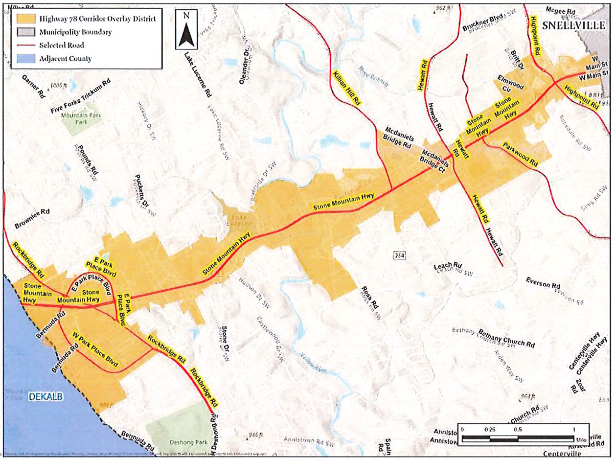
Highway 78 Corridor Overlay District Map.
6.
These standards shall apply to all new construction and shall apply to the applicable and affected portions of a redeveloped site or refurbished building as determined by the Director of Planning and Development.
214-20.3 Design Requirements.
A.
Transportation/Infrastructure.
1.
Provide interparcel vehicle access points between all contiguous multifamily, commercial, office, industrial or attached residential tracts. This requirement may be waived by the Director only if it is demonstrated that an interparcel connection is not feasible due to traffic safety or topographic concerns.
2.
All new utility lines shall be located underground.
3.
Sidewalks shall be required adjacent to all public rights-of-way and into and throughout attached residential developments. The location of sidewalks shall be reviewed and approved by the Gwinnett or Georgia Department of Transportation. A sidewalk that is a minimum of four feet wide shall connect entrance(s) of buildings to the public rights-of-way.
4.
At the following locations, sidewalks shall be constructed with an additional 2-foot by 8-foot concrete pad, located outside of the right-of-way, designed to accommodate future pedestrian amenities such as benches, planters, and trash containers.
a.
At intersections of the corridor with an arterial, major collector or minor collector identified on the Gwinnett County Long Range Road Classification Map.
b.
At locations along the corridor designated for a transit stop or future transit stop by Gwinnett County Department of Transportation.
c.
At locations along the corridor designated for a school bus stop by the Gwinnett County Board of Education.
d.
Such pedestrian amenity sidewalk pads shall not be required closer than 300 feet from another such pad on the same side of the street.
5.
Amenity pads located along an existing transit route shall include pedestrian amenities at time of installation. All amenities required and listed above shall be decorative, commercial-quality fixtures. Sidewalk design and placement of any of these amenities shall be reviewed and approved by the Gwinnett or Georgia Department of Transportation. Locations of pedestrian amenity sidewalk pads shall be coordinated to avoid locations of curb inlets, guardrails, and bridges.
B.
Streetlights.
1.
Provide streetlights along all public rights-of-way utilizing decorative light poles/fixtures. Streetlights shall be staggered, 150 feet on-center, along both sides of the roadway. All street lighting shall be subject to review and approval of the Gwinnett County Department of Transportation. Where applicable, streetlights shall be placed adjacent to required pedestrian amenity sidewalk pads. Specifications of light fixtures are provided in Table 214.1.
Table 214.1: Light Fixture Requirements for Public Rights-of-Way
2.
Refer to Section 240-100 for lighting in parking lot requirements.
C.
Greenway Access. Where required, construction of greenway or greenway access, or dedication of greenway easement shall be in accordance with the Gwinnett County Open Space and Greenway Master Plan and be maintained in accordance with Section 900-10 and other applicable sections of the UDO. If a project abuts a greenway, then a multi-use path shall be provided to connect the greenway for pedestrian and bicyclist use. Final location of the greenways or greenway access shall be coordinated with the Department of Community Services.
D.
Landscaping Requirements.
1.
Provide, at a minimum, 20 Tree Density Units per acre for all non-residential development. Type and size of plantings shall be in compliance with this UDO. At least 50 percent of plantings shall consist of trees 3 inches caliper or greater.
2.
Landscape islands shall be provided within parking lots no farther apart than every 15 parking spaces, meeting all other requirements of this UDO.
3.
Provide a minimum 10-foot-wide landscaped strip between all road rights-of-way and the back-of-curb of abutting off-street paved parking lots. At a minimum, landscaped strips shall be planted in accordance with this UDO.
4.
Provide street trees spaced 50 feet on-center or grouped at 120 feet on-center adjacent to the right of way on the following roads:
a.
Mall of Georgia Overlay:
i.
Buford Drive
ii.
Woodward Crossing Boulevard
iii.
Mall of Georgia Boulevard
b.
Grayson/Highway 20 Overlay:
i.
Grayson Highway
ii.
Loganville Highway
iii.
Sugarloaf Parkway
iv.
Webb Gin House Road
v.
Hillside Drive
vi.
Cooper/Ozora Road
vii.
Oak Grove Road
viii.
Hope Hollow Road
ix.
Hoke O'Kelly Mill Road
x.
Brand Road
c.
Centerville/Highway 124 Overlay:
i.
Scenic Highway
ii.
Centerville Highway
iii.
Highpoint Road
iv.
Everson/Springdale Road
v.
Bethany Church/Zoar Road
vi.
Zoar Church Road
vii.
Annistown/Centerville-Rosebud Road
viii.
Campbell Road
ix.
Lee Road
x.
Anderson-Livsey Lane
d.
Highway 124/324/Hamilton Mill Overlay
i.
Braselton Highway
ii.
Gravel Springs Road
iii.
Auburn Road
iv.
Hamilton Mill Road
e.
Highway 78 Overlay
i.
E. Park Place Blvd
ii.
Hewatt Road
iii.
Highpoint Road
iv.
Killian Hill Road
v.
Parkwood Road
vi.
Rockbridge Road
vii.
Stone Mountain Highway
viii.
W. Park Place Blvd.
5.
All street trees shall be a minimum 3-inch caliper at the time of planting. Street trees shall be located between the sidewalk and back-of-curb within a minimum 5-foot-wide landscape strip, or hardscape strip if adjacent to on-street parking, subject to review and approval of the Georgia or Gwinnett Department of Transportation. Street trees shall be chosen from the Tree Species List in the UDO Appendix.
6.
Natural vegetation shall remain on the property until issuance of a development permit.
E.
Parking and Accessory Structures.
1.
For retail developments exceeding 125,000 square feet of gross floor area, at least ten percent of all provided parking spaces shall be provided in parking areas of porous paving or grass paving systems, such as "Grasscrete" or "Grasspave," not to exceed 1,000 parking spaces or as approved by the Director of Planning and Development.
2.
Up to 25 percent of the provided parking spaces for any development may be compact spaces reduced in total area, width, or depth for designated compact vehicle parking. Each compact vehicle parking space shall not be less than eight feet in width and 17 feet in depth.
3.
No more than 10 percent of parking spaces may be located between the front building line of a building and the right-of-way. This parking shall be limited to no more than one double row of parking. No more than 30 percent of off-street parking areas may be located to the sides of building(s), with the balance of parking located to the rear the building(s).
4.
Primary building facades and entrances shall be located no more than 70 feet from the public rights-of-way and shall be oriented toward the street and shall provide a sidewalk connecting the front entrance to a continuous sidewalk placed parallel to the street.
5.
Decorative, commercial-quality, bicycle racks subject to all bicycle parking regulations of this UDO shall be provided for all multifamily, commercial, and office developments.
6.
Benches and trash receptacles shall be required for all multifamily, retail, and office developments adjacent to the public sidewalk., and outside of the right-of-way.
7.
Shopping cart corrals located in the parking areas of retail developments shall be of decorative quality.
8.
Vending machines, if provided, shall be located within a building.
F.
Signage; Temporary Uses; Peddling.
1.
Except as contained herein, sizes and amount of signage shall not exceed the requirements of the Sign Ordinance.
2.
Oversized Signs or Billboards shall not be permitted.
3.
Ground signs shall be limited to monument-type signs. Base and sign structure shall be constructed of materials such as brick, stone, stucco, wood, or metal consistent with the architecture and exterior treatment of the building.
4.
Canopy and awning sign(s) shall be limited to 15 square feet per road frontage. If lighted, lettering shall be individually formed and lighted. No spreader bar signage shall be allowed except as required by the State Fire Marshall.
5.
Blinking, exposed neon, portable, inflatable, and temporary signage shall be prohibited.
6.
Peddlers shall be prohibited.
G.
Architectural Standards/ Design.
1.
Refer to the Gwinnett County Architectural Design Standards and UDO Design Guidelines. All development in the Activity Center/ Corridor Overlay District shall be in conformity with the Gwinnett County Architectural Design Standards and in substantial conformity to the UDO Design Guidelines.
2.
Building plans shall be subject to review and approval of the Director prior to issuance of a building permit. Building designs that are inconsistent with these standards shall be denied. Denial of the Director's decision shall be subject to appeal pursuant to Chapter 270, Procedures, of this UDO.
(Ord. No. UDOA2023-00002(GCID 2023-0604), Exh. A(§ 22), 9-26-2023; Ord. No. GCID 2024-1128(UDOA2024-00003), Exh. A, 12-3-2024)
Section 214-30. - Venture Drive Redevelopment Overlay District.
214-30.1 Purpose and Intent. The purpose of the Venture Drive Redevelopment Overlay District is to promote a mix of high-end, dense, residential housing; commercial businesses and office buildings in an urban setting while offering the residents opportunities for recreation and alternative modes of transportation. Specifically, the Overlay District is intended to:
A.
Encourage efficient land use and redevelopment plans forming a live-work-play environment that offers residents and employees the opportunity to fulfill their daily activities with minimal use of single-occupant vehicle trips.
B.
Allow and encourage development densities and land use intensities that will provide for productive use of alternative transportation modes such as bus transit, rail transit, ridesharing, bicycling, and walking.
C.
Encourage the revitalization of underutilized commercial areas into pedestrian-oriented developments that provide a complementary mix of uses, including a variety of residential options, within convenient walking distance.
D.
Encourage formation of a well-designed, pedestrian-friendly activity center with high-density residential, commercial and office development that increases choices for safe living environments for the citizens of Gwinnett County.
E.
Promote development standards that incorporate the design of innovative projects providing for current and future trends in urban design, public amenities, and green space concepts.
F.
Promote a distinct, unified theme that will reinforce the branding process and improve the market attractiveness of the area for investments by the private and public sectors.
G.
Provide appropriate incentives to encourage redevelopment consistent with the Gwinnett County Unified Plan.
H.
Provide for connectivity of streets and sidewalks for improved vehicular and pedestrian circulation and reduce the dependence on automobile uses by increasing the ease of movement and opportunities for alternative modes of travel.
I.
Encourage design that improves public safety and security.
214-30.2 Applicability.
A.
The boundaries of the Venture Drive Redevelopment Overlay District shall be as shown on the official overlay district map, maintained by the Department of Planning and Development, and which may be amended from time to time by the Board of Commissioners. (See Exhibit A)
B.
The Venture Drive Redevelopment Overlay District shall function as an overlay zoning, wherein the underlying zoning at the time of enactment of the overlay remains effective until such time as the property owner elects to proceed with a redevelopment project in accordance with Venture Drive Redevelopment Overlay District provisions. Once property is proposed for development under the requirements of the Venture Drive Redevelopment Overlay District each parcel of land remains subject to all of the terms and conditions of the Venture Drive Redevelopment Overlay and the Concept Plan approved for the property as a whole and in perpetuity.
C.
Redevelopment Overlay Exhibit reviews, and any subsequent plat approvals, land disturbance permits, development permits, and building permits for each parcel located within this district shall meet all applicable requirements of this UDO and the applicable UDO Design Guidelines.
D.
Each applicant for a Redevelopment Project within the Venture Drive Redevelopment Overlay shall provide evidence of the unified control of the entire parcel or parcel assemblage. During the development process, more than one owner may participate in the development of the approved plan provided that each parcel of land remains subject to all of the terms and conditions of the Concept Plan approved for the property as a whole.
214-30.3 Definitions. The following words, terms, and phrases shall have the following meanings when used in this ordinance:
A.
Active Uses — space serviced by plumbing, heating and electricity and are limited to uses permitted within this ordinance.
B.
Block Length — the dimension of a block defined by continuous frontage between streets and/or pedestrian ways.
C.
Block Area — total land area within the rights of way forming such block.
D.
Director — the director of planning and development or designee.
E.
Gross Land Area — the entirety of a panel of land prior to designation of any portion thereof to streets.
F.
Open Space — usable, generally publicly available land meeting the standards of Section 214-30.10.
G.
Pedestrian Way — an external area permitting public accessibility to pedestrian-only traffic containing an unobstructed pedestrian path meeting all requirements of Section 214-30.9.
H.
Sidewalk Level — any building floor located within 5 vertical feet of the adjacent sidewalk, supplemental zone, or pedestrian way.
I.
Supplemental Zone — the area located between any sidewalk zones and/or pedestrian ways and a building façade.
214-30.4 Permitted Uses. Uses permitted in the Venture Drive Redevelopment Overlay District are listed here below:
214-30.5 Accessory Uses and Structures. Accessory uses and structures shall be permitted in the Venture Drive Redevelopment Overlay District in accordance with the provisions of this UDO.
214-30.6 Special Uses. Special Uses may be permitted in the Venture Drive Redevelopment Overlay District. Special uses shall be subject to approval of a Special Use Permit as provided in Section 270-30 and may be subject to the additional Supplemental Use Standards established in Chapter 211 of this UDO.
214-30.7 Density, Height, and Bulk Requirements.
A.
The maximum allowable density within the Venture Drive Overlay is a 5.0 FAR.
B.
Building setbacks are established as the outer edge of the prescribed sidewalk and supplemental zones.
C.
FAR is based upon gross land area prior to the removal of land associated with proposed streets and/or pedestrian ways.
D.
On projects containing more than one block, FAR may be distributed in any manner desired so long as the total allowable FAR for the entire property is not exceeded.
214-30.8 Block Standards and Connectivity Requirements (See Exhibit A).
A.
Block sizes — New developments shall be planned containing new streets and/or pedestrian ways such that no block within the development shall contain a block frontage greater than 500 feet in one direction and 400 feet in the opposite direction without an intervening street or pedestrian way.
B.
Developments shall extend streets and/or pedestrians ways to adjoining property in a manner that facilitates their future extension or provide easements for such future extensions
C.
Streets and pedestrian ways for projects containing multiple blocks may be phased with respect to traffic and pedestrian circulation needs relative to each phase. Phasing will be such to complete block as developed.
214-30.9 Street and Pedestrian Way Standards (See Exhibits A & B).
A.
Streets. All proposed streets will contain:
1.
Minimum 12-foot-wide travel lanes.
2.
Minimum 8-foot-wide parallel parking spaces on both sides of the street.
3.
Minimum 6-inch-wide header curb.
4.
Minimum 15-foot-wide sidewalks measured from back of curb consisting of minimum 5-foot-wide street tree, lighting, and furniture zone and 10 foot wide clear zone for circulation.
5.
An additional minimum 5-foot-wide supplemental zone is required which may be either paved or landscape as appropriate to the adjacent use.
6.
Street lighting will be provided (Gwinnett CID Standards).
7.
Street furnishing will be provided (Gwinnett CID Standards).
8.
The right of way will extend to the edge of the outer clear zone on each side of the street.
B.
Pedestrian Ways.
1.
Will be a minimum of 45 feet in width from building-to-building facades.
2.
Will contain a minimum 30-foot-wide public zone consisting of landscape, seating, pedestrian level lighting and a minimum 8 foot wide clear zone sidewalk.
214-30.10 Open Space Requirements (See Exhibit A).
A.
All development shall provide 20% of net lot area as open space.
B.
All clear zone and supplemental zone sidewalk areas may be counted as open space.
C.
The minimum 30-foot-wide public zone of pedestrian ways may count as open space.
D.
On projects containing multiple blocks the required open space may be distributed across multiple blocks or aggregated within a single block, so long as the total required open space is achieved.
E.
Open space which includes the accommodation of stormwater management as an amenitized element of the open space is allowed and encouraged.
F.
Where a development proposes to aggregate the required open space of a phased development, such open space must be built with the first phase of such a development. When a strict adherence of this requirement is deemed infeasible for site development, the Director of Planning may grant a reduction in the amount of open space required for the initial phase. Such a variance in no way relieves the obligation for the ultimate total open space requirements of the development.
G.
All areas utilized to meet the open space requirements will be generally accessible to the public and will be designed to support gathering, social interaction, dining (including outdoor areas specific to restaurants) and special events. Open spaces may be predominately paved or landscape and will be designed to facilitate adequate pedestrian circulation.
H.
All areas counted as open space must be within 5 feet of elevation (above or below) adjoining street/sidewalk elevations. In cases where an open space is utilized for stormwater management, the base pool elevation may be 8 feet below the adjoining street/sidewalk elevation, so long as the dimension from the edge of any adjoining public sidewalk is a minimum of 40 feet from the center of the proposed pool.
214-30.11 Parking Requirements.
A.
The following parking requirements are established:
B.
On-street parking provided does not count towards maximum retail parking in full and multi-family parking.
C.
Shared parking is allowed and encouraged.
D.
No surface parking lots shall be permitted between any street and the front building line of any building.
E.
Surface parking lots shall provide internal landscape islands at the end of all parking stalls and within parking lots at least every 15 parking spaces, subject to the planting requirements of this UDO.
F.
Bicycle parking shall be provided at a minimum ratio of one (a) bicycle parking spaces per 30 automobile parking spaces. No single building shall provide less than two (2) bicycle parking spaces or be required to provide more than 30 bicycle rack spaces. Multifamily buildings shall provide indoor lockable bicycle storage.
G.
At least one public transit shelter shall be provided along each external street with transit service, subject to the review and approval of the Georgia or Gwinnett Department of Transportation.
214-30.12 Architectural Requirements.
A.
Pedestrian Level Facades. All building facades facing a street (public or private), or pedestrian way utilized to define specified block requirements shall be subject to the following requirements:
1.
Building facades greater than 50 feet of continuous length shall include variety in façade treatments. Treatments may be in the form of materials, textures, and window and door patterns and colors.
2.
The length of a façade oriented toward a sidewalk or street without intervening fenestration shall be 20 feet.
3.
All residential and/or office buildings shall provide at least one major entry via a sidewalk level lobby. The lobby door must address and be clearly visible for the adjoining sidewalk. Lobbies shall be clearly articulated.
4.
All retail uses shall provide direct access to adjoining sidewalks or pedestrian ways. All entrances shall be clearly articulated.
5.
All facades must contain at least 50% fenestration at the sidewalk level. The total building facade shall contain an overall average of 40% fenestration.
6.
Glass for windows and doors shall utilize clear or tinted glass. Tinted glass shall have a minimum transmittance factor of 50% and a visible light reflectance factor of ten or less.
7.
Arcades or deeply recessed retail or office facades are discouraged. Where utilized, size and spacing of arcade columns must all clear visibility to 65% of the retail or office storefront from any parallel point on the sidewalk.
8.
Parking structure facades shall incorporate finish materials that are consistent and complementary with the façade finish of the primary buildings.
B.
Sidewalk Level Active Uses.
1.
Active uses shall be provided along all designated streets and/or pedestrian ways.
2.
The finished floor elevation of any active use will be set no greater than five feet above or below the adjacent sidewalk. Where strict adherence to this requirement cannot be achieved due to existing topographical challenges, a variance may be granted by the Planning Director.
3.
Active uses shall be a minimum of 20 feet of depth measured from the sidewalk street level building façade.
4.
Sidewalk level active uses exclude storage areas and parking.
5.
Queueing lanes or driveways parallel to the adjoining street are not allowed in the active use zone.
6.
The following use shall be placed within a building or parking structure and are subject to the active use provisions, except at their automotive ingress and egress points:
a.
Structures which feature fueling stations with accessory fueling pumps, service bays, and/or car washes.
b.
Drive-thru windows for any use including all areas associated with queueing.
C.
General.
1.
Each building shall display a street address number clearly visible from the public sidewalk. Said address numbers shall be a minimum of 6 inches in height.
2.
No up-lighting shall be placed a height of less than 8 feet above the required adjoining public sidewalk.
3.
External storefront security grilles shall:
a.
Be designed as to appear as part of the building architecture.
b.
Be fully retractable.
c.
Not be solid or opaque.
d.
Allow visibility into the store when in use.
214-30.13 Service, Loading, Mechanical, and Accessory Features.
A.
All external dumpsters and trash compactors shall be located to the rear of buildings and be enclosed with decorative masonry walls and decorative gates to a height of 8 feet or located within a building or parking structure.
B.
All loading and service areas shall be located and oriented in a manner that minimizes visibility for any public or private street or pedestrian way that is utilized to meet the block requirements or located within a building or parking structure.
C.
Any mechanical and accessory features (including satellite dishes) shall be:
1.
Prohibited between the building and any street.
2.
Located on the roofs of buildings.
3.
Screened to a height equal to the height of the units.
4.
Wall mounted utility equipment shall be screened and/or painted to match the adjacent façade finish.
D.
No barbed wire, razor wire, or similar elements shall be permitted.
214-30.14 Submittals and Approvals Process.
A.
Any new construction and renovation of more than 60% of the principal structure of an existing property requires the issuance of a Special Administrative Permit (SAP) prior to the application for any demolition, land disturbance or building permit.
B.
Applicants needing a SAP shall schedule a pre-application meeting with the Director of Planning (or the designee) prior to the submission for any SAP. Said meeting will be scheduled within 14 days and held withing 30 days of an applicant's request. The purpose of the meeting will be to:
1.
Ensure the applicant's understanding of the overlay requirement and approvals process.
2.
Inform the staff of the applicant's vision and limits of property.
C.
Requirements for the submittal of a SAP are as follows:
1.
Property boundary survey no more than 2 years old from date of application.
2.
Site plan indicating proposed block divisions and street/pedestrian way locations.
3.
Calculations of required and provided open space.
4.
Plans indicating all building locations and streetscape requirements.
5.
Design including materials for all park or plaza spaces utilized to meet open space requirements.
6.
Building elevation illustrating requirements set forth in Architectural Standards.
7.
Notification to planning for any and all variations from the standards established, whether by result of hardship or meeting the goals of the ordinance through equal or superior methods.
D.
Review and Response.
1.
Within 4 weeks of submittal, the Director will establish a meeting with the applicant and present to the applicant any comments relative to the lack of compliance with the standards of the ordinance. If the Director has no comments and the application is deemed to be in compliance, a SAP will be issued on that date.
2.
The applicant shall make amendments to plans and resubmit as noted. If all changes are in accordance with the comments rendered in the review meeting, the Director will issue the SAP within 30 days of resubmittal.
E.
Variations. The Director of Planning may grant variation from any of the standards set forth in this ordinance with the exception that there will be no will be no variations granted for uses not listed as permitted. Variations may be granted when in the opinion of the Director:
1.
The strict adherence to a provision creates a hardship due to extreme topographical or site conditions.
2.
The applicant proposes a solution which meets and exceeds the minimum standards of this ordinance in a manner that in the opinion of the Director provides a superior environment.
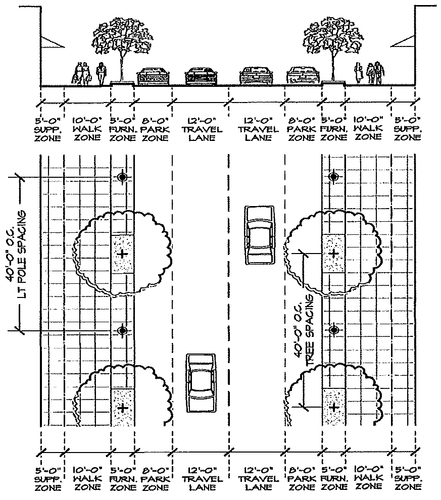
EXHIBIT A
STREET STANDARDS
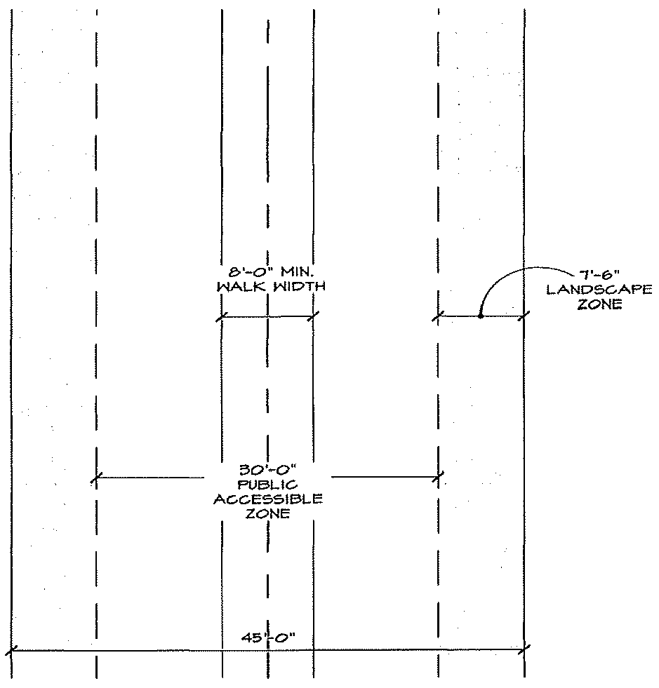
EXHIBIT B
PEDESTRIAN WAY STANDARDS
(Ord. No. UDOA2023-00002(GCID 2023-0604), Exh. A(§ 22), 9-26-2023; Ord. No. GCID 2024-1128(UDOA2024-00003), Exh. A, 12-3-2024)
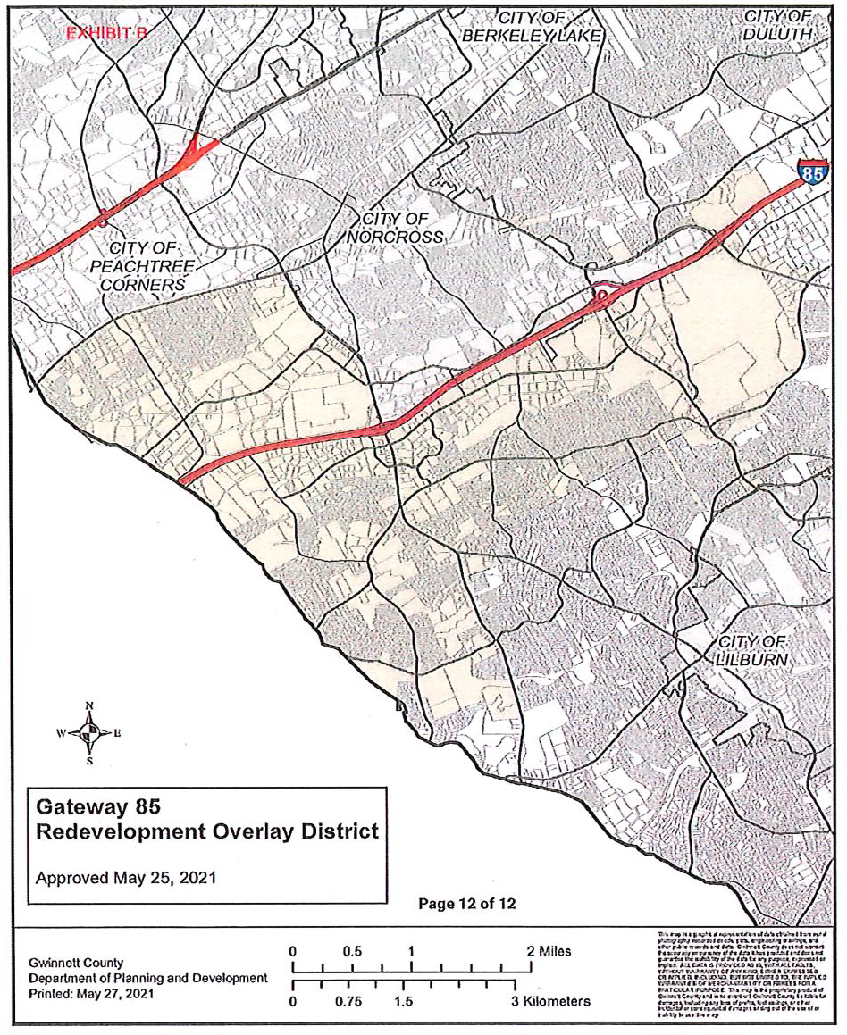
Section 214-40. - Gateway 85 Overlay District.
214-40.1 Purpose and Intent. The purpose of the Gateway 85 Overlay District is to enhance the vitality and livability of the Gateway 85 business district. Specifically, the district is intended to:
A.
Create an attractive setting for business growth that supports the tax base, provides jobs, and promotes the district's continued success;
B.
Promote quality redevelopment that will reinforce the district's brand and improve its market attractiveness for investment;
C.
Encourage the revitalization of underutilized commercial and industrial properties;
D.
Reduce and eliminate incompatible land uses;
E.
Achieve and maintain a unified and pleasing aesthetic quality in landscaping, site planning, and signage;
F.
Establish standards for high-quality, useable open space in commercial and mixed-use projects;
G.
Promote safe and convenient vehicular, pedestrian, bicycle, and transit mobility; and
H.
Encourage design that improves public safety and security.
214-40.2 Applicability
A.
The boundaries of the Gateway 85 Overlay District shall be as shown on the official overlay district map, except that this overlay does not apply to areas zoned exclusively for single-family detached or attached residential development.
B.
The Gateway 85 Overlay District shall function as an overlay zoning, wherein the underlying zoning district standards remain in effect and the standards of this overlay apply in addition. Whenever this overlay imposes a standard that is more or less restrictive, the requirements of this Overlay District shall govern.
C.
All buildings, structures, or land, in whole or in part, shall be used, occupied, erected, constructed, moved, enlarged, or structurally altered, in conformance with this overlay according to Section 220.40.3.
D.
Nothing in this overlay shall require any change in the plans, construction or intended use of a building or structure for which a lawful permit has been issued or a lawful permit application has been accepted before the effective date of this overlay, provided that the construction under the terms of such permit is diligently followed until its completion subject to all applicable provisions of this UDO.
E.
It is not the intent of this overlay to interfere with or abrogate or annul any easements, covenants or other agreements between parties; provided, however, that where this overlay imposes a greater restriction upon the use of property or requires more space than is imposed or required by other resolutions, rules or regulations, or by easements, covenants or agreements, the provisions of this overlay shall govern.
F.
Definitions. The following term shall have the following meaning when used in this overlay:
1.
Priority Corridor. High visibility corridors that are held to a higher design standard, including:
a.
Beaver Ruin Road;
b.
Buford Highway;
c.
Crescent Drive;
d.
Dawson Boulevard;
e.
Indian Trail Road;
f.
Jimmy Carter Boulevard;
g.
Oakbrook Parkway;
h.
Rockbridge Road;
i.
Singleton Road; and
j.
South Norcross Tucker Road.
214-40.3 Redevelopment Thresholds
A.
Redevelopment thresholds.
1.
Renovations. Renovations, alterations, adaptations, restorations, repairs, or other physical modification to a structure or portion of a structure that existed before adoption of this overlay, shall be subject to the Non-conforming Use provisions of this UDO.
2.
Expansion. Expansions to any building or use shall be subject to the provisions of this overlay with the exception of Section 214.40.5 Streetscape Standards and Section 214.40.8 Access Management.
3.
Site Disturbance. Any Site disturbance or modifications shall be subject to the provisions of this overlay with the exception of Section 214.40.8 Access Management.
4.
Change of use. Change from a use that existed before adoption of this overlay shall be subject to the provisions of this overlay with the exception of Section 214.40.5 Streetscape Standards and Section 214.40.8 Access Management.
5.
Multiple thresholds. When a proposed activity includes multiple thresholds identified in "2" through "4" immediately above, the provisions of each applicable threshold shall apply.
214-40.4 Use Provisions.
A.
General. Uses shall be in accordance with the underlying zoning district, except as specifically otherwise stated in this section.
B.
Prohibited Uses. The following use are prohibited in this overlay:
1.
Adult entertainment;
2.
Salvage operation or junk yard;
3.
Pawn shops; and
4.
Used tire sales as a principal use or accessory to any use.
C.
Used automobile sales and rental use standards. The minimum lot size shall be 2-acres.
D.
Vehicle repairs. All vehicle repairs shall be fully conducted indoors, regardless of whether the vehicle repairs are a principal or accessory use.
E.
Used vehicle sales. Used vehicles shall not be displayed for sale on any premises unless the premises is used for a conforming automobile sales, car dealership use, or unless such used vehicle sales is a continuation of an activity that was a legally occurring on the premises on the effective date of this overlay.
F.
Outdoor display or sales standards.
1.
Prohibited outdoor displays or sales. In addition to the conditional use requirements of this UDO for outdoor storage in non-residential districts, the following are prohibited:
a.
Outdoor display or sales of merchandise associated with a pawn shop;
b.
Outdoor display or sales of used merchandise associated with any use;
c.
Outdoor display of tires for sale, rental, or storage; and
d.
Outdoor display of or sales of appliances associated with any use.
G.
Convenience Stores with Fuel Pumps. Shall be prohibited in the C-1, Neighborhood Business District and shall require a Special Use Permit in the C-2, General Business District and C-3, Highway Business District.
214-40.5 Streetscape Standards.
A.
Streetscapes shall be installed along public rights-of-way as specified in Table 214.4: Streetscape Table, except as provided in "B" immediately below for an alternative multi-use trail. Streetscapes shall include a sidewalk landscape strip adjacent to the roadway, a sidewalk, and a landscape strip at the back of the sidewalk on private property.
B.
A multi-use trail may be required instead of a sidewalk landscape strip and sidewalk where identified as a multi-use trail in the Gwinnett County Trails Master Plan.
C.
Sidewalks shall be constructed with an additional 2-foot by 8-foot concrete pad, located outside of the right-of-way, designed to accommodate existing or future pedestrian amenities such as benches, planters, and trash containers, at the following locations:
1.
At intersections of Priority Corridors with an arterial, major collector or minor collector identified on the Gwinnett County Long Range Road Classification Map;
2.
At locations along Priority Corridors designated for a transit stop or future transit stop by Gwinnett County Department of Transportation;
3.
At locations along Priority Corridors designated for a school bus stop by the Gwinnett County Board of Education; and
4.
Such pedestrian amenity sidewalk pads shall not be required closer than 300 feet from another such pad on the same side of the Priority Corridor.
D.
All amenities required and listed above shall be decorative, commercial-quality fixtures. Sidewalk design and placement of any of these amenities shall be reviewed and approved by the Gwinnett and/or Georgia Department of Transportation. Locations of pedestrian amenity sidewalk pads shall be coordinated to avoid locations of curb inlets, guardrails, and bridges.
E.
All new utility lines shall be buried.
F.
Streetlights shall be provided. (Gwinnett CID Standards)
Table 214.4 Streetscape Table
214-40.6 Lighting Standards.
A.
Rope lighting is prohibited, including on the interior of a building when visible from the exterior.
214-40.7 Pedestrian Access.
A.
A walkway shall be provided from all buildings to an adjacent public right-of-way, as follows:
1.
Parcels under 2 acres shall provide a walkway with a minimum width of 5 feet, except as specified in "3" immediately below.
2.
Parcels 2 acres or larger shall provide a walkway with a minimum width of 5 feet and a landscape strip with a minimum width of 5 feet along both sides of the required walkway, except as specified in "C" immediately below.
3.
Walkways and landscape strips are not required for existing buildings or uses when the applicant demonstrates that their installation would do any of the following:
a.
Render the parcel non-conforming with regards to parking; or
b.
Result in a 10% or more reduction in the number of parking spaces on the parcel; or
c.
Require the construction of retaining walls, site grading, site excavation, or site fill; or
d.
Is determined by the Director of Planning and Development to be infeasible because of topographic or other site-specific constraints.
4.
The required or provided walkway surface shall be hardscape but may not be asphalt.
B.
The required or provided landscape strip shall be planted in accordance with the standards of Section 620-20.
214-40.8 Access Management.
A.
Driveways may not be located on a Priority Corridor when vehicular access is available from a right-of-way that is not classified as a Priority Corridor, except where the Director of Planning and Development determines it is infeasible due to conflicts with adjacent land uses.
214-40.9 Building Design.
A.
Foundation plantings. All building foundations along a Priority Corridor shall conform to these standards, except as provided for in "3" immediately below:
1.
All portions of foundations that extend more than 12 inches above finished grade shall be screened from Priority Corridors with continuous evergreen or semi-evergreen shrubs;
2.
At the time of installation, the screening shall be at least 1 foot in height and reach a height of 3 feet within 3 years of planting; and
3.
Foundation plantings are not required adjacent to ground floor commercial storefronts when said plantings would obstruct views into the commercial establishments, subject to approval of the Director of Planning and Development.
214-40.10 Screening.
A.
Wall-mounted equipment. Wall-mounted equipment shall be screened from Priority Corridors as follows:
1.
Wall-mounted equipment located on any surface shall be screened from Priority Corridors by an opaque fence or wall, or landscaping;
2.
The screening design shall be compatible with the principal building in terms of texture, quality, material, and color; and
3.
Screening shall be of a height equal to or greater than the height of the mechanical equipment being screened.
214-40.11 Site Accessories.
A.
Fences and walls. This section applies to all fences and walls, regardless of whether they are intended to satisfy screening requirements.
1.
Chain link fencing is prohibited, except in M-1 and M-2 zoning districts and only when the change link fencing is not visible from a Priority Corridor.
2.
Barbed wire, razor wire, or similar elements are prohibited, except in M-1 and M-2 zoning districts and only when not visible from any street.
3.
Any wall or fence which extends into the required front yard shall be ornamental or decorative and either constructed as:
a.
A solid wall faced in brick, stucco, or stacked stone wall; or
b.
As a wrought iron-style fence with brick or stacked stone columns (maximum 30-feet on-center).
4.
When fences or walls are located within the streetscape landscape strip listed in Sec. 214-40.5, they shall be set back at least 5 feet from the public right-of-way to provide landscaping between the fence and the sidewalk.
B.
Shopping cart corals. Shopping cart corrals located in the parking areas of retail developments shall be of decorative quality. Shopping cart storage shall be screened from view from the parking lot.
214-40.12 Common Area.
A.
At least 5 percent of the net project acreage (total acreage of the project excluding 100-year floodplain and wetland areas) of all new non-industrial developments over 10 acres in size shall be provided as Common Area as required by this section.
B.
Required Common Area shall be provided outdoors and appropriately improved as a pedestrian amenity and/or for aesthetic appeal.
C.
Common Area may be met in one contiguous open area or in multiple open areas on a parcel; however, to receive credit, the area shall be at least 20 feet in width and length, and at least 50% of the required amenity space shall be located in one contiguous open area.
D.
All Common Area, other than rooftop areas shall be located at grade.
E.
Common Area may be roofed provided it is part of the Common Area facilities and it is not enclosed.
F.
Common Area shall not be parked or driven upon, except for emergency access and permissible temporary events.
G.
In calculating the minimum Common Area requirement, the following or similar facilities may be included:
1.
Ground-level Common Area facilities such as sidewalks/walkways, swimming pool, playground, sport court, dog park, garden, community garden, park, green pavilion, seating area or plaza, landscape areas, bio-retention areas (when designed as an amenity), pond/lakes, and water features.
2.
Upper-level Common Area facilities such as a common balcony, rooftop deck or rooftop garden.
3.
Required buffers and/or State stream buffer may not be considered Common Area.
(Ord. No. UDOA2023-00002(GCID 2023-0604), Exh. A(§ 22), 9-26-2023; Ord. No. GCID 2024-1128(UDOA2024-00003), Exh. A, 12-3-2024)
Section 214-50. - Innovation Overlay Zoning District.
214-50.1 Purpose and Intent. The purpose of the Innovation Overlay Zoning (IOZ) District is to promote sustainable, environmental stewardship; to facilitate a knowledge community including medical, agricultural, and environmental research uses, and a mix of housing options; and to provide civic space and parks; entertainment and hospitality amenities; and businesses and entrepreneurial space in a cohesively designed setting. The IOZ District encourages opportunities for recreation and alternative modes of transportation throughout the district. The entirety of the district is conceived as a place where a focus on people and ideas creates special environments. The district shall be guided by a series of unifying principles:
A.
Respect for the natural contour of the land;
B.
Provide a diversity of housing types;
C.
Create highly collaborative environments supportive of programing for the arts, music, and education;
D.
Inspire settings where people can feel, touch, experience and create the future; and
E.
Promote access to a wide variety of people, companies, and institutions.
Specifically, the IOZ District is intended to:
A.
Allow for a range of innovation and research facilities, and the broad exchange of ideas between residents and employees;
B.
Promote a framework for innovative design solutions with respect to environmental resources and functions within the landscape;
C.
Allow development that will support and benefit from alternative transportation modes such as bus transit, rail transit, ridesharing, bicycling, and walking;
D.
Support the clustering of land uses and development patterns that support pedestrian circulation;
E.
Encourage formation of pedestrian-friendly activity centers with residential, commercial, and office development that incorporate safe living environments for the residents of Gwinnett County;
F.
Promote development standards that incorporate the design of innovative projects providing for current and future trends in urban design, public amenities, and green space concepts;
G.
Provide a distinct district that will improve the market attractiveness of the area for investments by the private and public sectors;
H.
Provide appropriate guidelines to encourage development consistent with the 2040 Unified Plan, as amended;
I.
Provide for connectivity of streets, multipurpose trails, and sidewalks for improved vehicular and pedestrian circulation and reduce the dependence on automobile uses by increasing the ease of movement and opportunities for alternative modes of travel; and
J.
Provide for the integration and preservation of open space which incorporates a multiuse trail system that provides connectivity within the district and to the larger region, when possible.
214-50.2 Applicability
A.
The boundaries of the Innovation Overlay Zoning District shall be as shown on the official Overlay District Map, maintained by the Department of Planning and Development.
B.
The Innovation Overlay Zoning District shall function as an overlay zoning, wherein the underlying zoning at the time of enactment of the overlay remains effective. Whenever this overlay imposes a standard that is more restrictive or less restrictive, the requirements of this Overlay District shall govern per the redevelopment thresholds in Section 214.50-4.
C.
All buildings, structures, or land, in whole or in part, shall be used, occupied, erected, constructed, moved, enlarged, or structurally altered, in conformance with this Overlay according to Section 214-50.4
D.
It is not the intent of this Overlay to interfere with or abrogate or annul any easements, covenants, or other agreements between parties; provided, however, that where this overlay imposes a greater restriction upon the use of property or requires more space than is imposed or required by other resolutions, rules or regulations, or by easements, covenants or agreements, the provisions of this Overlay shall govern.
E.
All properties located in the Rowen Innovation Subdistrict shall be developed in conformity with the Rowen Design Guidelines, adopted by the Board of Commissioners on September 27, 2022, incorporated herein by reference, including any amendments thereto.
214-50.3 Reserved
214-50.4 Redevelopment Thresholds and Nonconforming Uses
A.
Renovations, expansions, and site disturbance of any structure or site existing before the adoption of this Overlay shall be subject to the provisions of Chapter 260-Non-Conformation Uses, of this UDO, with the following exceptions:
1.
Renovation. Renovations to a structure, or portion of a structure, that existed before adoption of this Overlay in the Rowen Innovation Subdistrict shall apply if they impact 60 percent or more of a building.
2.
Expansion. Expansions to any building or use by more than 10 percent shall be subject to the provisions of this Overlay, except for 214.50.6.D and 7.D Street Standards.
3.
Site Disturbance. Site disturbance greater than 5,000 square feet shall be subject to the provisions of this Overlay, except 214.50.6.A and 7.A Permitted Uses, 214.50.6.C and 7.C Building Standards, and 214.50.6.D and 7.D Street Standards.
4.
Change in Use. Any change in use from one occupancy classification to another shall be subject to the following provision of this Overlay: 214.50.6.A and 7.A Permitted Uses.
214-50.5 Use and Development Standards. The Rowen Innovation Subdistrict is intended to accommodate a critical mass of innovation and research facilities representing a wide range of industries.
A.
Permitted Uses
1.
Low and medium density research and office uses limited to research, professional office, and some incidental assembly; and
2.
High density mixed use.
B.
Prohibited Uses. The following uses are prohibited:
1.
Adult Establishments
2.
Ambulance or Medical Transport Company
3.
Appliance Repair Shop
4.
Automobile Brokerage
5.
Automobile, Truck, Motorcycle, ATV, Recreational Vehicle or Marine Related Uses including any establishment selling, installing, repairing, or servicing vehicles in any manner, including:
a.
Accessories Sales and Installation
b.
Auction
c.
Brokerage
d.
Customization, Modification, and Rebuilding
e.
Emissions Inspections
f.
Parts Store
g.
Rental (unless as an accessory use to a hotel and located entirely within a parking structure)
h.
Repair or Lubrication
i.
Sales and Related Service
j.
Tire Sales and/or installation
k.
Washing and/or Detailing
6.
Bail Bonding Company
7.
Bank or Financial Service with Drive-Thru
8.
Blood Plasma Donation Center
9.
Building Materials Sales
10.
Carpet and Upholstery Cleaning Service
11.
Cement, Concrete, or Masonry Plant
12.
Cemetery or Mausoleum
13.
Check Cashing or Payday Loan Facilities
14.
Contractor's Office with Outdoor Storage
15.
Convenience Stores with Fuel Pumps
16.
Driving Instruction
17.
DUI School
18.
Electronics Waste (e-waste) Collection/Recycling
19.
Funeral Home
20.
Golf Driving Range
21.
Ice Vending Machines, Bulk
22.
Janitorial and Maid Services
23.
Kennel or Pet Boarding
24.
Lawn Treatment Service
25.
Manufactured Building or Mobile Home Sales
26.
Lawn and Garden Equipment Sales and Service
27.
Outdoor Sales and Storage
28.
Pawn Shop
29.
Recreational Vehicle Park or Campground
30.
Restaurant with drive-in or drive-thru service
31.
Self-Storage or Mini-Warehouse Facility
32.
Shooting and Archery Ranges and similar outdoor recreation facilities
33.
Shooting Ranges, indoor
34.
Smoke Shop or Novelty Shop
35.
Sports Training Facility, outdoor
36.
Standalone ATM
37.
Standalone Parking Lots
38.
Stone Yard and Stone Cutting
39.
Swimming Pool Sales and Supply Stores
40.
Taxi or Limousine Service
41.
Title Loan Facility
C.
General District Requirements: All development and/or redevelopment of property within the district shall adhere to the Rowen Design Guidelines, per Section 214-50.2.E, with the exception of the standards outlined below.
1.
Development of individual sites with the Rowen Innovation Subdistrict shall be developed according to the applicable character area in which they are located, as indicated in the Rowen Design Guidelines. The development of these sites shall meet the following minimum standards:
a.
Low Density Office/Research Character Area:
i.
Maximum Site Coverage: 60%
ii.
Density: Maximum 0.9 Floor Area Ratio (FAR)
iii.
Maximum Building Height: 5 stories
b.
Medium Density Office/Research Character Area:
i.
Maximum Site Coverage: 75%
ii.
Density: Maximum 1.25 Floor Area Ratio (FAR)
iii.
Maximum Building Height: 8 stories
c.
Village Character Area:
i.
Density: Maximum 2.5 Floor Area Ratio (FAR)
ii.
Maximum Building Height: 8 stories
D.
Submittal and Approval Process
1.
Special Administrative Permit (SAP) Required: Applicants shall submit an SAP application on forms provided by the Department of Planning and Development prior to submittal of a land development or building permit application.
2.
SAP applicants shall schedule a pre-application meeting with the Director (or designee) prior to the submission of an SAP application on forms provided by the Department of Planning Development. The purpose of the meeting will be to:
a.
Ensure the applicant's understanding of the Overlay requirement and approvals process.
b.
Inform the staff of the applicant's plan for developing the property.
3.
Minimum submittal requirements for an SAP application are as follows:
a.
Official approval documentation from the Rowen Architectural Guidance and Design Review Board.
b.
Approved plans, building elevations, and other documents approved by the Rowen Architectural Guidance and Design Review Board.
c.
Any other required information to demonstrate compliance with this overlay district and the Rowen Design Guidelines.
d.
Any other requirements determined necessary by the Department of Planning and Development.
4.
SAP application review procedures, include:
a.
Upon acceptance of a complete application, the Department of Planning and Development shall review the submitted application and provide a list of comments to the applicant.
b.
The applicant shall make amendments to plans and resubmit, as noted.
c.
A meeting with the applicant may be requested, if necessary, to discuss any application deficiencies.
d.
Once the application is approved, an SAP shall be issued which is required prior to submittal of a land development application.
(Ord. No. UDOA2023-00002(GCID 2023-0604), Exh. A(§ 22), 9-26-2023; Ord. No. GCID 2024-1128(UDOA2024-00003), Exh. A, 12-3-2024)
Section 214-60. - Gwinnett Place Overlay District.
214-60.1. Purpose and Intent.
The purpose of the Gwinnett Place Overlay District is to enhance the vitality and livability of the former Gwinnett Place site by encouraging redevelopment of the area. Specifically, the district is intended to:
A.
Promote the vision for the redevelopment of the former mall site and surrounding area as envisioned in the Gwinnett Place Mall Equitable Redevelopment Plan, the Gwinnett Place Mall Site Revitalization Strategy, and the Gwinnett County Unified Plan.
B.
Promote and improve the market attractiveness of Gwinnett Place for investment by the private and public sectors.
C.
Provide a range of high quality and aesthetically compatible housing options to accommodate a variety of housing needs within the County.
D.
Encourage the revitalization of underutilized commercial areas and large areas of surface parking into pedestrian-oriented developments that provide a complementary mix of uses, including a variety of residential options, within convenient walking distance.
E.
Allow and encourage development densities and land use intensities that will provide for productive use of active transportation modes such as transit, bicycling, and walking.
F.
Promote a range of usable and interconnected open spaces including parks, plazas, multimodal trails, and squares that contribute to the redevelopment of the site and the creation of a sense of place and community for residents.
G.
Provide connectivity of street and sidewalk networks for enhanced transit, vehicular, and pedestrian circulation thereby reducing the dependence on automobiles and providing opportunities for alternative modes of travel.
H.
Encourage design that is harmonious and orderly to secure the redevelopment of Gwinnett Place through these regulations.
214-60.2. Applicability.
A.
The boundaries of the Gwinnett Place Overlay District shall be as shown on the official zoning map, maintained by the Department of Planning and Development, and which may be amended from time to time by the Board of Commissioners.
B.
The Gwinnett Place Overlay District shall function as an overlay zoning, wherein the standards of this overlay apply in addition to those of the underlying zoning. Whenever this overlay imposes a standard that is in conflict with the provisions of any other statute or conditions of zoning approval, the requirements of the Overlay District shall govern.
C.
All buildings, structures, or land, in whole or in part, shall be used, occupied, erected, constructed, moved, enlarged, or structurally altered, in conformance with this overlay, subject to Section 214-60.4. Redevelopment Thresholds.
D.
Nothing in this overlay shall require any change in the plans, construction or intended use of a building or structure for which a lawful permit has been issued provided that the construction under the terms of such permit is diligently followed until its completion, or a lawful permit application has been accepted before the effective date of this overlay as detailed in Section 100-50 of this UDO.
214-60.3. Definitions.
The following words, terms, and phrases shall have the following meanings when used in this overlay:
A.
Active uses. Space within a building serviced by plumbing, heating, and electricity and limited to uses permitted within this overlay.
B.
Director. The Director of Planning and Development or their designee.
C.
Overlay, this. The Gwinnett Place Overlay District.
D.
Pedestrian way. An area external to any building or structure permitting unrestricted public accessibility to pedestrian-only traffic containing an unobstructed pedestrian path meeting the requirements of Section 214-60.7.
E.
Stub-out. A shortened thoroughfare which is intended to provide connectivity at some point in the future and which provides all necessary easements for such connectivity.
F.
Underlying zoning district. The base zoning district applicable to a parcel shown on the official zoning map.
214-60.4. Redevelopment Thresholds.
A.
Redevelopment thresholds.
1.
Renovations. Renovations, alterations, adaptations, restorations, repairs, or other physical modification to a structure or portion of a structure that existed before adoption of this overlay shall be subject to the provisions of Chapter 260 of this UDO, unless the requirements of "2" through "4" immediately below otherwise apply.
2.
Expansion. Expansions to any building or use in which the floor area is increased by at least 25% of the existing floor area shall be subject to the provisions of this overlay, with the exception of Section 214-60.7 Street and Pedestrian Way Standards.
3.
Site Disturbance. Site disturbance or modifications shall be subject to the provisions of Section 214-60.8 of this overlay.
4.
Change of use. Change from a use that existed before adoption of this overlay shall be subject to the provisions of this overlay with the exception of Section 214-60.7 Street and Pedestrian Way Standards.
5.
Multiple thresholds. When a proposed activity includes multiple thresholds identified in "2" through "4" immediately above, the provisions of each applicable threshold shall apply.
214-60.5. Use Provisions.
A.
General. Uses within the Gwinnett Place Overlay are as listed below.
B.
Permitted Residential Uses. Permitted residential uses within this overlay shall be those uses listed in the HRR district in Section 210-130 of this UDO, including all applicable conditional use standards.
C.
Permitted Nonresidential Uses. Permitted nonresidential uses within this overlay shall be those uses listed in the C-2 district in Section 211-80 of this UDO, except as specified in "D" below.
D.
Prohibited Uses. The following use are prohibited in this overlay:
1.
Aircraft Landing Field, private.
2.
Ambulance or medical transport company.
3.
Animal Care Establishment, with outdoor pens or runs.
4.
Carpet or Upholstery Cleaning Service.
5.
Carpet or Upholstery Cleaning Service Office.
6.
Cemetery or Mausoleum.
7.
Check cashing/payday loan establishments.
8.
Collection bin.
9.
Convenience store with fuel pumps.
10.
Crematory.
11.
Discount, dollar, or thrift store.
12.
Drive Through
13.
Extended stay facility.
14.
Firework sales, Principal Use.
15.
Funeral home.
16.
Garden supply center.
17.
Hookah or Vapor Lounge.
18.
Landscaping Contractors Office.
19.
Outdoor storage.
20.
Personal Care Homes.
21.
Private parking lot, standalone.
22.
Recreational Vehicle Park or Campground.
23.
Restaurant, with drive-in or drive-thru service.
24.
Self-storage facility.
25.
Shelters, community or residential.
26.
Smoke, Novelty, or CBD Shop.
27.
Stone yard or stone cutting establishment.
28.
Title loan facility.
29.
Vehicle Rental and Related Service Establishments.
30.
Vehicle Repair, Service, and Body Work Establishments.
31.
Vehicle Sales and Related Service Establishments.
214-60.6. Density, Height, and Bulk Requirements.
A.
There shall be no maximum FAR in this Overlay.
B.
A minimum FAR of 2.0 is required for all new development, except as follows:
1.
Additional floor area is being added to an existing structure; or
2.
All existing floor area is demolished to create a vacant lot; or
3.
Parks and open space is the principal use of the lot.
C.
There shall be no maximum height limit within this Overlay. All new buildings must be a minimum of 2 stories in height.
D.
Buildings shall be setback from the back of the required sidewalk a maximum of 10 feet.
214-60.7. Street and Pedestrian Way Standards.
A.
Streets.
1.
New streets shall be incorporated and constructed as indicated on the New Roadways map in Appendix A, unless granted a variation by the Director in accordance with Section 214-60.13. When conditions exist which would prohibit the construction of new streets in accordance with the New Roadways map, alternative locations for roadways may be considered by the County. Such alternative locations shall require the approval from the Department of Planning and Development and the Department of Transportation.
2.
Streets shall be designed in accordance with the roadway design standards for future development type "Urban High" as outlined in the 2045 Unified Plan. Alternative standards for the design of streets may be permitted upon approval from the Department of Planning and Development and the Department of Transportation.
3.
Developments shall extend streets or pedestrian ways to adjoining property in a manner that facilitates their future extension.
4.
Cul-de-sacs or dead-end streets are prohibited with the exception of stub-outs reserved for future connections.
B.
Pedestrian ways.
1.
Pedestrian ways shall be incorporated and constructed as indicated on the New Roadways map in Appendix A.
2.
Pedestrian ways shall be designed in accordance with the design standards in Appendix B. Alternative standards for the design of pedestrian ways may be permitted upon approval from the Department of Planning and Development and the Department of Transportation.
3.
In addition to the design standards, pedestrian ways shall incorporate landscaping, seating, and pedestrian level lighting subject to review and approval by the Director.
C.
With approval from the Director, streets and pedestrian ways for projects containing multiple blocks may be phased with respect to traffic and pedestrian circulation needs relative to each phase. Phasing must be such to complete the block as developed.
214-60.8. Streetscape Standards.
A.
Streetscapes shall be installed along all public and private rights-of-way as specified in Table 214.5: Streetscape Standards. Trees selected for planting shall be a species listed in the Gwinnett County Streetscape Tree Species List. Trees shall be planted to avoid conflict with utilities. This may include the installation of impermeable rigid tree root barriers, as determined by the County.
B.
Bio-retention areas within sidewalk landscape strips are permitted subject to the review and approval of the Director.
C.
A multi-use trail may be required instead of a sidewalk where identified as a multi-use trail in the current version of the Gwinnett County Trails Master Plan adopted by the Board of Commissioners.
D.
All existing and new utility lines shall be buried.
E.
Streetscape Lighting. Required lights shall conform to the following:
1.
Streetlights shall be provided as required by the Department of Planning and Development and the Department of Transportation.
2.
Pedestrian lights shall be provided at regular intervals of 80 feet on center between every other street tree within the sidewalk landscape strip.
Table 214.5 Streetscape Standards
1- Trees are to be provided in the sidewalk adjacent to a building with tree wells
at least 4 feet in width and 8 feet in length.
2- Type E streets are pedestrian ways.
3- Trees are to be provided in the sidewalk with tree wells at least 4 feet in width
and 8 feet in length.
F.
Property owners abutting public streets shall be responsible to maintain the sidewalk landscape strip and all vegetation within, in accordance with the maintenance standards of the Department of Transportation.
214-60.9. Parking and Loading.
A.
Vehicular Parking.
1.
There shall be no minimum required parking within this overlay.
2.
Maximum parking shall be as follows:
a.
Residential uses:
i.
2 spaces for every dwelling with two or fewer bedrooms.
ii.
2.5 spaces for every dwelling with more than two bedrooms.
b.
Nonresidential uses:
i.
As provided in Chapter 240.
3.
Shared parking between uses is allowed and encouraged.
4.
No surface parking lots shall be permitted between any street and any building.
5.
Surface parking lots may be constructed of alternative paving methods designed to mitigate stormwater, subject to the approval of the Director.
6.
Off-street parking spaces provided within a parking structure or on-street parking shall not be subject to maximum parking requirements.
7.
Electric vehicle charging shall be required as provided in Section 240-140.
B.
On-street Parking.
1.
Newly created on-street parking on public or private streets shall meet the following standards:
a.
Parking spaces shall be a minimum of eight (8) feet in width and 20 feet in length.
b.
A bulb-out shall be provided for every four (4) on-street parking spaces.
c.
Bulb-outs shall be at least 10 feet in length and must be planted with at least one tree. Trees must be a minimum of three (3) inches caliper at the time of planting. Trees shall be planted to avoid conflict with utilities. This may include the installation of impermeable rigid tree root barriers, as determined by the County.
d.
When on-street parking is provided, sidewalk landscape strips may be replaced with hardscape material, provided that all required trees are planted with area sufficient to accommodate future growth.
C.
Bicycle Parking.
1.
Bicycle parking shall be provided as follows:
a.
At least one bicycle parking space shall be provided for every 30 vehicular parking spaces.
b.
In no instance shall any building provide less than 2 bicycle parking spaces or be required to provide more than 30 bicycle parking spaces.
c.
Bicycle parking shall be located within 50 feet of the primary entrance of a building or as close as the nearest vehicular parking space, whichever is less.
d.
Multifamily residential structures with more than 10 units must provide long-term bicycle parking areas for residents.
i.
One long-term bicycle parking space must be included for every 10 units. No more than 30 spaces shall be required.
ii.
Parking areas must be provided in an enclosed bicycle storage locker, a room within a building, or within a parking structure. Such areas shall be secure, weather resistant, and provided with lighting at all hours.
iii.
Parking areas shall be located on the ground floor and shall be accessible to building occupants from public streets, multi-use trails, or public entrances and walkways without the use of stairs or elevators.
D.
Parking structures. In addition to the standards of Section 230.110.10, the following shall apply to all parking structures.
1.
Parking structures shall be designed to minimize the impacts of such structures at street level. These structures shall be placed behind buildings if possible.
2.
Parking structures shall be no taller than the principal building.
3.
When a parking structure fronts a Type A, Type C, or Type G roadway, its ground story shall have active uses as detailed in Section 214-60.11.C.
4.
Where any portion of structured parking is visible from a street it must be screened so that cars and ramps are not visible from ground level view from the adjacent street or sidewalk. Screening includes:
a.
Evergreen trees, vines, or landscaping that is physically attached to the parking structure; or
b.
A facade having the appearance of a horizontal storied building; or
c.
A combination of "a" and "b" above.
d.
Similar or alternative means of screening may be used subject to approval by the Director.
E.
Loading.
1.
Loading areas for new buildings shall not be located along a street-facing facade and shall be located to the rear of buildings.
2.
When provided, loading areas must be screened with the following:
a.
A wall or fence at least 8 feet in height and compatible with the principal building in terms of texture, quality, material, and color; or
b.
Evergreen plant material that can be expected to reach a height of 8 feet with a spread of 4 feet within three years of planting. Material should be staggered to provide the maximum screening at mature height.
3.
A self-closing gate with an architectural finish compatible with the principal structure in terms of texture, quality, material, and color must be installed to screen openings into loading areas.
F.
Driveways and access.
1.
Driveways shall be spaced at least 200 feet apart.
2.
Driveways shall be no more than 24 feet in width for two-way entrances and 12 feet for one-way entrances.
3.
All sidewalk paving materials shall continue across any intervening driveway at the same prevailing grade and cross-slope as the adjacent sidewalk.
4.
No driveway shall be permitted on an arterial street or Type C Roadway when access can be provided from another street.
5.
Driveways shall be perpendicular to the street. Parking areas or driveways, except for a driveway to reach a side or rear yard or on-site parking facility, are not permitted between the sidewalk and the front of the building.
214-60.10. Landscaping and Screening.
A.
General. Walls and fences required by this section shall conform to the following:
1.
Walls and fence surfaces shall consist of one or more of the following: stained poured-in place concrete, architectural block, brick, stone, cast-stone, stucco, prefinished metal, or painted or stained wood.
2.
Walls and fences may not be faced in any of the following: chain link fencing (with or without slats), concrete masonry units, unpainted or unstained wood, repurposed pallets, garbage, repurposed vehicles, plastic, canvas, netting, or corrugated metal.
3.
Barbed wire, razor wire, or similar elements are prohibited.
B.
Parking lot landscaping. All parking lots shall meet the landscaping standards of the UDO and the following additional standards:
1.
Landscaped areas within the interior of the parking area may be designed as bio-retention areas, using inwardly draining swales without curbs, in lieu of raised planting areas surrounded by curbs, provided that each parking space provides a wheel stop and provided that depressed areas adjacent to driving aisles are surrounded by painted lines or flush curbing to separate landscaping from driving aisles.
2.
The use of native plant and landscape materials is encouraged. Refer to Appendix 3.0 of this UDO for appropriate landscape materials.
C.
Foundation plantings. All building facades along a street or pedestrian way shall conform to these standards, except as provided in "3" immediately below:
1.
All portions of foundations that extend more than 12 inches above finished grade shall be screened with continuous evergreen or semi-evergreen shrubs.
2.
At the time of installation, the screening shall be at least 1 foot in height and reach a height of 3 feet within 3 years of planting.
3.
Foundation plantings are not required adjacent to ground floor commercial storefronts when said plantings would obstruct views into the commercial establishments, subject to approval of the Director.
D.
Service areas. Service areas shall be screened in all locations as follows:
1.
Trash and recycling collection and other similar service areas, when not located within a parking structure, shall be located to the side or rear of buildings and shall not be between a building and the street.
2.
Trash and recycling collection and other similar service areas, when not located within a parking structure, shall be screened on three sides by an opaque wall and on the fourth side by an opaque gate at least 6 feet in height. The gate shall be self-locking and maintained in good working order.
3.
The screening design shall be compatible with the principal building in terms of texture, quality, material, and color.
E.
Roof-mounted equipment. Roof-mounted equipment shall be screened from adjacent streets as follows:
1.
Roof-mounted equipment shall be set back at least 10 feet from the edge of the roof and screened from ground level view from the abutting parcel or street.
2.
New buildings shall provide a parapet wall or other architectural element that is compatible with the principal building in terms of texture, quality, material, and color that fully screens roof-mounted equipment from ground level view.
3.
For existing buildings with no or low parapet walls, roof mounted equipment shall be screened on all sides by an opaque screen compatible with the principal building in terms of texture, quality, material, and color.
F.
Wall mounted and ground mounted equipment. All wall mounted and ground mounted equipment shall meet the standards of Section 230-110.
G.
Maintenance of landscaping. The property owner is responsible for maintaining all required landscaping and screening in good health and condition.
214-60.11. Open Space.
A.
All development shall provide at least 15% of the net lot area as open space.
B.
The following may be used to satisfy open space requirements:
1.
Pedestrian Ways.
2.
Parks, squares, plazas or similar elements intended for public use and accessible by the general public by adjacent sidewalks or pedestrian ways.
3.
Outdoor dining areas adjacent to a public street or pedestrian way.
4.
Outdoor amenity space or common space for residents or occupants.
5.
Rooftop decks, balconies, porches, or patios.
6.
Green roofs designed to mitigate stormwater runoff.
7.
Stormwater management facilities when designed as a publicly accessible amenity by a registered landscape architect.
C.
The following may not be used to satisfy open space requirements:
1.
Areas used for vehicles, except for incidental service, maintenance, or emergency access.
2.
Stormwater management facilities, except when designed as a publicly accessible amenity by a registered landscape architect.
D.
Open Space shall include at least one conveniently-located publicly-accessible open space area, with related amenities and improvements, in the form of a square, green, park, plaza, or similar approved element that is accessible by the general public from multiple points of entry along adjacent sidewalks.
E.
Each square foot of publicly accessible open space provided, including but not limited to squares, greens, parks, and plazas, shall count as 2 square feet of open space when the following requirements are met:
1.
The finished ground surface of the open space is located at the same grade as the adjacent sidewalk.
2.
A minimum of 25% of the open space perimeter abuts and is directly accessible from the sidewalk along a street or pedestrian way.
3.
The open space must be accessible to the public and may not be intended solely for residential use.
F.
On projects containing multiple blocks the required open space must be met for each individual block.
214-60.12. Building Design.
A.
This section applies to all new buildings, additions to existing buildings, and any change to a building facade except for ordinary maintenance and repairs.
B.
Architectural requirements. In addition to the architectural requirements of Section 230-110 for each applicable building type, the following design standards shall apply within this overlay:
1.
All new building facades along a street or pedestrian way shall use one of the following to divide the facade into vertical divisions with a maximum facade width of 100 feet, measured along the base of the facade, as illustrated in Figure 214-60.12:
a.
A change of facade material and window systems from grade to roof, and change of building height of at least one story; or
b.
A change in facade composition and/or architectural style from grade to the roof; or
c.
An open space or pedestrian passage with a minimum width of 10 feet and a minimum depth of 30 feet.
d.
Similar means intended to convey the impression of separate buildings.
Change in color alone, setback alone, or any combination of the two may not be used to satisfy this requirement.
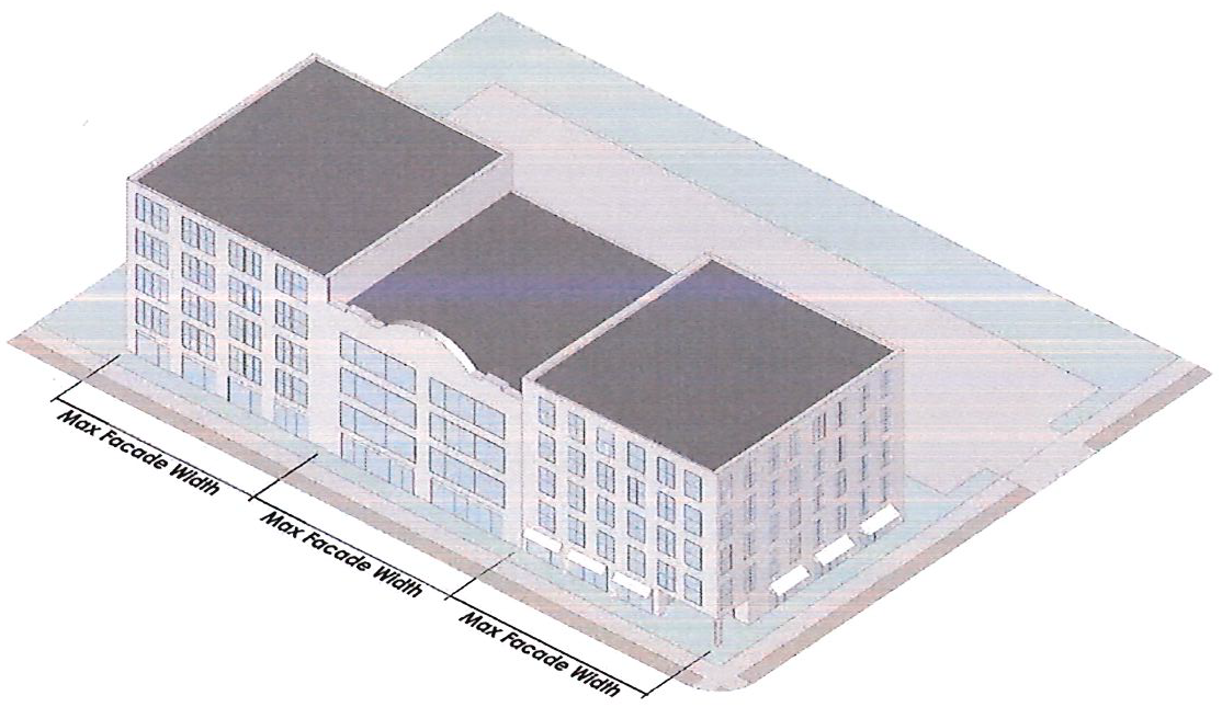
Figure 214-60.11: Maximum facade with illustration
2.
In addition to the above, building facades greater than 200 feet in length shall be articulated with recesses a minimum of 25 feet in depth and 25 feet in width, or with a break in the building facade of at least 25 feet in width which opens into an interior courtyard or plaza.
3.
Facades shall provide visual divisions between the ground story and second story through architectural means such as courses, awnings, or a change in materials.
4.
Facades shall delineate all stories above the ground story with windows, belt courses, balconies, cornice lines or similar architectural detailing.
5.
Each building facade along a street or pedestrian way shall provide fenestration as follows:
a.
Fenestration shall mean the minimum percentage of window and door glass that must cover a given facade. It shall be calculated based on facade area and by floor.
b.
Residential uses shall provide at least 15% fenestration on all stories.
c.
Nonresidential uses shall provide at least 60% fenestration on the ground story and at least 20% fenestration on upper stories.
d.
The length of facade without intervening fenestration shall be no more than 20 feet.
e.
Glass for windows and doors shall utilize clear or tinted glass. Tinted glass shall have a maximum transmittance factor of 70% and a visible light reflectance factor of ten or less.
6.
All multifamily residential or office buildings shall provide at least one major ground story lobby entrance. Lobbies shall be clearly articulated within the building design.
7.
Buildings with residential uses adjacent to a sidewalk or pedestrian way shall have individual entrances to such units which are directly accessible from the sidewalk or pedestrian way.
C.
Ground story.
1.
The ground story of all buildings shall be no more than 5 feet above or below the adjacent sidewalk or pedestrian way.
2.
The ground story of all buildings along any public or private street or pedestrian way shall contain active uses a minimum depth of 20 feet.
D.
Pedestrian Access. All buildings must include a street-facing pedestrian entrance. Said entrance shall be operable to residents at all times and operable to customers, visitors, and employees during business hours.
1.
A walkway shall be provided from all buildings and building entrances to any adjacent public or private right-of-way, pedestrian way, multi-use trail, or publicly accessible park or open space.
2.
The walkway shall be a minimum of 5 feet in width.
3.
Walkways are not required for existing buildings or uses when the applicant demonstrates that their installation would do any of the following:
a.
Create a hardship due to the construction of retaining walls, site grading, site excavation, or site fill; or
b.
Is determined by the Director to be infeasible because of topographic or other site-specific constraints.
4.
Where a building has frontage on both a street and a pedestrian way, a pedestrian entrance is required along both frontages.
214-60.13. Submittal and Approval Process.
A.
Applicants shall submit a Special Administrative Permit (SAP) application on forms provided by the Department of Planning and Development prior to the submittal of a land development or building permit application.
B.
Applicants shall schedule a pre-application meeting with the Director (or designee) prior to the submission of an SAP application. The purpose of the meeting will be to:
1.
Ensure the applicant's understanding of the Overlay requirements and approval process.
2.
Inform the staff of the applicant's plan for developing the property.
C.
All submittals for an SAP application shall provide the following:
1.
Property boundary survey drawn by a registered land surveyor no more than 2 years prior to the date of application.
2.
Site plan indicating the compliance with all requirements of this overlay, including:
a.
Locations of all buildings.
b.
Calculation and location of provided open space.
c.
Locations of new streets or pedestrian ways.
d.
Streetscape standards.
3.
Proposed design of any publicly accessible open space used to satisfy the requirements of this Overlay.
4.
Building elevations illustrating compliance with Section 214-60.11 and 230-110, as applicable.
5.
A written request for any variations as provided for in part E of this section.
D.
SAP Review and Response.
1.
Within four weeks of acceptance of a complete application, the Department of Planning and Development shall provide a list of comments to the applicant relative to the lack of compliance with the standards of the ordinance. If the Department of Planning and Development has no comments and the application is deemed to be in compliance, a SAP will be issued.
2.
The applicant shall make amendments to plans and resubmit as noted. If all changes are in accordance with the comments provided, the Department of Planning and Development will issue the SAP within four weeks of resubmittal.
E.
The Director may grant a variation from any of the standards set forth in this Overlay with the exception of uses and any associated provisions. Variations may be granted when, in the opinion of the Director, strict adherence to a provision creates a hardship due to extreme topographical or site provisions.
Appendix A
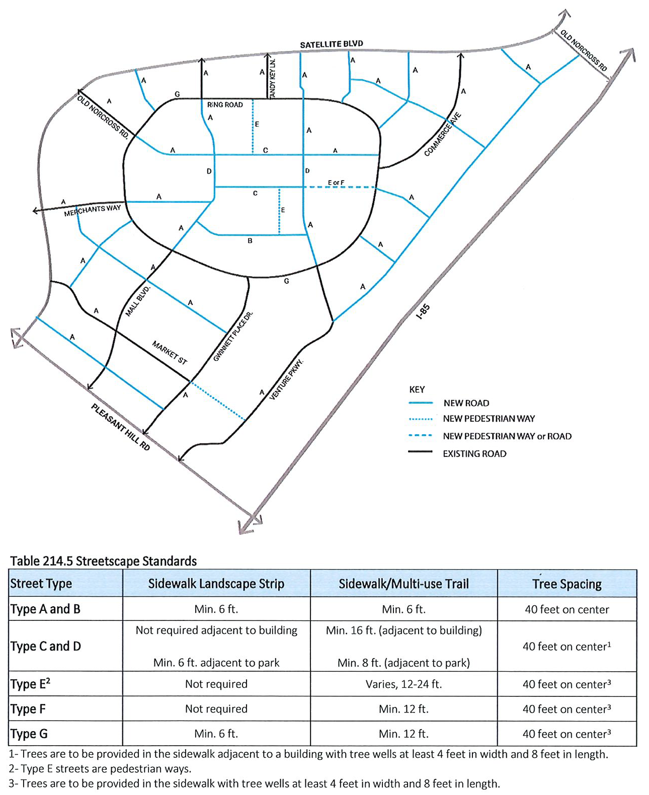
Appendix B
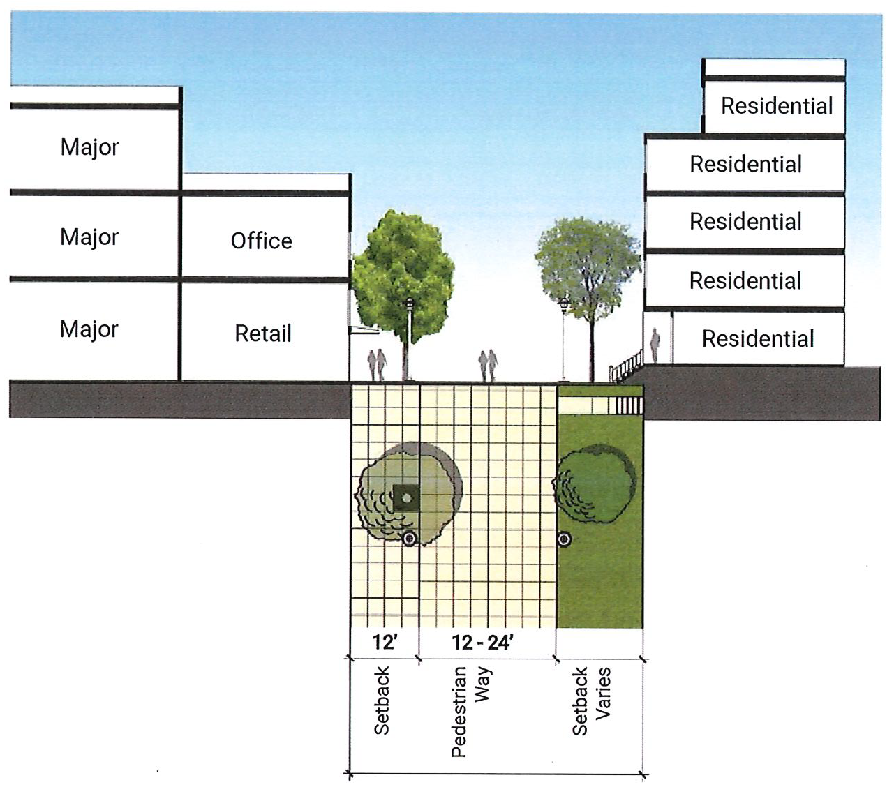
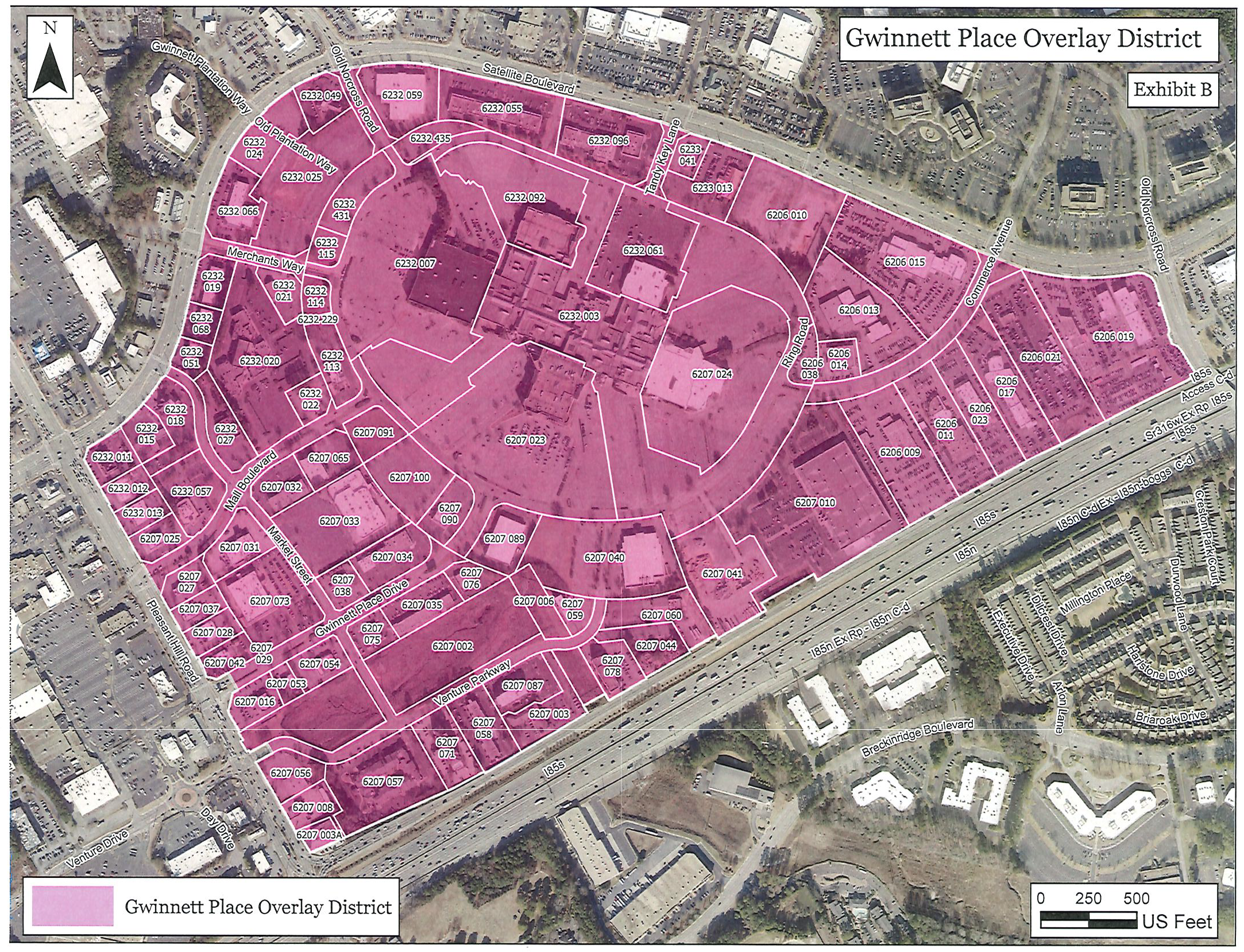
(Ord. No. GCID 2024-0901(UDOA2024-00002), Exh. A, 10-22-2024)
Section 214-70. - Civic Center Overlay District.
214-70.1 Findings and Purposes. The Civic Center Overlay District is intended to enhance the viability and livability of the areas shown on the Civic Center Overlay Map. The purpose of the Overlay District is to achieve and maintain a unified and pleasing aesthetic/visual quality in landscaping, architecture, and signage; and to promote alternative modes of transportation within the district through the provision of pedestrian and local public transit.
214-70.2 Applicability. The requirements of the Overlay District shall apply to all non-residential and attached residential properties within the unincorporated areas as shown on the Civic Center Overlay Map. These standards shall apply to all new construction and shall apply to the applicable and affected portions of a redeveloped site or refurbished building as determined by the Director of Planning and Development.
214-70.3 Design Requirements.
A.
Transportation/Infrastructure.
1.
Provide interparcel vehicle access points between all contiguous multifamily, commercial, office, industrial or attached residential tracts. This requirement may be waived by the Director only if it is demonstrated that an interparcel connection is not feasible due to traffic safety or topographic concerns.
2.
All new utility lines shall be located underground.
3.
Sidewalks shall be required adjacent to all public rights-of-way and into and throughout attached residential developments. The location of sidewalks shall be reviewed and approved by the Gwinnett or Georgia Department of Transportation. A sidewalk that is a minimum of four feet wide shall connect entrance(s) of buildings to the public rights-of-way.
4.
At the following locations, sidewalks shall be constructed with an additional 2-foot by 8-foot concrete pad, located outside of the right-of-way, designed to accommodate future pedestrian amenities such as benches, planters, and trash containers.
a.
At intersections of the corridor with an arterial, major collector or minor collector identified on the Gwinnett County Long Range Road Classification Map.
b.
At locations along the corridor designated for a transit stop or future transit stop by Gwinnett County Department of Transportation.
c.
At locations along the corridor designated for a school bus stop by the Gwinnett County Board of Education.
d.
Such pedestrian amenity sidewalk pads shall not be required closer than 300 feet from another such pad on the same side of the street.
5.
Amenity pads located along an existing transit route shall include pedestrian amenities at time of installation. All amenities required and listed above shall be decorative, commercial-quality fixtures. Sidewalk design and placement of any of these amenities shall be reviewed and approved by the Gwinnett or Georgia Department of Transportation. Locations of pedestrian amenity sidewalk pads shall be coordinated to avoid locations of curb inlets, guardrails, and bridges.
B.
Streetlights.
1.
Provide streetlights along all public rights-of-way utilizing decorative light poles/fixtures. Streetlights shall be staggered, 150 feet on-center, along both sides of the roadway. All street lighting shall be subject to review and approval of the Gwinnett County Department of Transportation. Where applicable, streetlights shall be placed adjacent to required pedestrian amenity sidewalk pads. Specifications of light fixtures are provided in Table 214.6.
Table 214.6: Light Fixture Requirements for Public Rights-of-Way
2.
Refer to Section 240-100 for lighting in parking lot requirements.
C.
Greenway Access. Where required, construction of greenway or greenway access, or dedication of greenway easement shall be in accordance with the Gwinnett County Open Space and Greenway Master Plan and be maintained in accordance with Section 900-10 and other applicable sections of the UDO. If a project abuts a greenway, then a multi-use path shall be provided to connect the greenway for pedestrian and bicyclist use. Final location of the greenways or greenway access shall be coordinated with the Department of Community Services.
D.
Landscaping Requirements.
1.
Provide, at a minimum, 20 Tree Density Units per acre for all non-residential development. Type and size of plantings shall be in compliance with this UDO. At least 50 percent of plantings shall consist of trees 3 inches caliper or greater. Landscape islands shall be provided within parking lots no farther apart than every 15 parking spaces, meeting all other requirements of this UDO.
2.
Provide a minimum 10-foot-wide landscaped strip between all road rights-of-way and the back-of-curb of abutting off-street paved parking lots. At a minimum, landscaped strips shall be planted in accordance with this UDO.
3.
Provide street trees spaced 50 feet on-center or grouped at 120 feet on-center adjacent to the right of way on the following roads:
a.
Sugarloaf Parkway
b.
Satellite Boulevard
c.
Duluth Highway
d.
Old Peachtree Road
e.
Meadow Church Road
f.
North Brown Road
4.
All street trees shall be a minimum 3-inch caliper at the time of planting. Street trees shall be located between the sidewalk and back-of-curb within a minimum 5-foot-wide landscape strip, or hardscape strip if adjacent to on-street parking, subject to review and approval of the Georgia or Gwinnett Department of Transportation. Street trees shall be chosen from the Tree Species List in the UDO Appendix.
5.
Natural vegetation shall remain on the property until issuance of a development permit.
E.
Parking and Accessory Structures.
1.
For retail developments exceeding 125,000 square feet of gross floor area, at least ten percent of all provided parking spaces shall be provided in parking areas of porous paving or grass paving systems, such as "Grasscrete" or "Grasspave," not to exceed 1,000 parking spaces or as approved by the Director of Planning and Development.
2.
Up to 25 percent of the provided parking spaces for any development may be compact spaces reduced in total area, width, or depth for designated compact vehicle parking. Each compact vehicle parking space shall not be less than eight feet in width and 17 feet in depth.
3.
No more than 10 percent of parking spaces may be located between the front building line of a building and the right-of-way. This parking shall be limited to no more than one double row of parking. No more than 30 percent of off-street parking areas may be located to the sides of building(s), with the balance of parking located to the rear the building(s).
4.
Primary building facades and entrances shall be located no more than 70 feet from the public rights-of-way and shall be oriented toward the street and shall provide a sidewalk connecting the front entrance to a continuous sidewalk placed parallel to the street.
5.
Decorative, commercial-quality, bicycle racks subject to all bicycle parking regulations of this UDO shall be provided for all multifamily, commercial, and office developments.
6.
Benches and trash receptacles shall be required for all multifamily, retail, and office developments adjacent to the public sidewalk., and outside of the right-of-way.
7.
Shopping cart corrals located in the parking areas of retail developments shall be of decorative quality.
8.
Vending machines, if provided, shall be located within a building.
F.
Signage; Temporary Uses; Peddling.
1.
Except as contained herein, sizes and amount of signage shall not exceed the requirements of the Sign Ordinance.
2.
Oversized Signs or Billboards shall not be permitted.
3.
Ground signs shall be limited to monument-type signs. Base and sign structure shall be constructed of materials such as brick, stone, stucco, wood, or metal consistent with the architecture and exterior treatment of the building.
4.
Canopy and awning sign(s) shall be limited to 15 square feet per road frontage. If lighted, lettering shall be individually formed and lighted. No spreader bar signage shall be allowed except as required by the State Fire Marshall.
5.
Blinking, exposed neon, portable, inflatable, and temporary signage shall be prohibited.
6.
Peddlers shall be prohibited.
G.
Architectural Standards/ Design.
1.
Refer to the Gwinnett County Architectural Design Standards and UDO Design Guidelines. All development in the Civic Center Overlay District shall be in conformity with the Gwinnett County Architectural Design Standards and in substantial conformity to the UDO Design Guidelines.
2.
Building plans shall be subject to review and approval of the Director prior to issuance of a building permit. Building designs that are inconsistent with these standards shall be denied. Denial of the Director's decision shall be subject to appeal pursuant to Chapter 270, Procedures, of this UDO.
H.
Satellite Boulevard/Sugarloaf Parkway Suboverlay District
1.
Purpose. The purpose of the Satellite Boulevard/Sugarloaf Parkway Suboverlay District is to enhance the vitality and livability of the Satellite Boulevard/Sugarloaf Parkway area by encouraging redevelopment of the area.
2.
Applicability.
a.
The boundaries of the Satellite Boulevard/Sugarloaf Parkway Suboverlay District shall be as shown on the official overlay district map, maintained by the Department of Planning and Development, and which may be amended from time to time by the Board of Commissioners.
b.
The Satellite Boulevard/Sugarloaf Parkway Suboverlay District shall function as a suboverlay zoning, wherein the standards of this suboverlay apply in addition to those of the underlying zoning and the Civic Center Overlay District. Whenever this suboverlay imposes a standard that is in conflict with the provisions of any other statute or conditions of zoning approval, the requirements of the suboverlay shall govern.
c.
All buildings, structures, or land, in whole or in part, shall be used, occupied, erected, constructed, moved, enlarged, or structurally altered in conformance with this suboverlay.
d.
Each applicant for development within the Satellite Boulevard/Sugarloaf Parkway Suboverlay shall provide evidence of the unified control of the entire parcel or parcel assemblage. During the development process, more than one owner may participate in the development of the approved plan provided that each parcel of land shall remain subject to all the terms and conditions of the Concept Plan approved for the property as a whole.
e.
Nothing in this suboverlay shall require any change in the plans, construction or intended use of a building or structure for which a lawful permit has been issued provided that the construction under the terms of such permit is diligently followed until its completion, or a lawful permit application has been accepted before the effective date of this suboverlay as detailed in Section 100-50 of this UDO.
3.
Use Provisions.
a.
General. Uses with the Satellite Boulevard/Sugarloaf Parkway Suboverlay District are as listed below.
b.
Permitted Residential Uses. The following residential uses shall be permitted within this suboverlay, subject to the applicable standards of Section 210-140 of this UDO:
i.
Dwelling, live/work.
ii.
Dwelling, multifamily.
iii.
Dwelling, townhouses.
No more than 25% of the residential units shall be townhouses.
c.
Permitted Nonresidential Uses. Permitted nonresidential uses within this suboverlay shall be those uses listed in the C-2 district in Section 211-80 of this UDO, except as specified in "d" below.
d.
Prohibited Uses. The following uses are prohibited in this suboverlay:
i.
Aircraft Landing Field, private.
ii.
Ambulance or medical transport company.
iii.
Animal Care Establishment, with outdoor pens or runs.
iv.
Carpet or Upholstery Cleaning Service.
v.
Carpet or Upholstery Cleaning Service Office.
vi.
Cemetery or Mausoleum.
vii.
Check cashing/payday loan establishments.
viii.
Collection bin.
ix.
Convenience store with fuel pumps.
x.
Crematory.
xi.
Discount, dollar, or thrift store.
xii.
Extended stay facility.
xiii.
Firework sales, Principal Use.
xiv.
Funeral home.
xv.
Garden supply center.
xvi.
Hookah or Vapor Lounge.
xvii.
Landscaping Contractors Office
xviii.
Outdoor storage.
xix.
Personal Care Homes.
xx.
Private parking lot, standalone.
xxi.
Recreational Vehicle Park or Campground.
xxii.
Restaurant, with drive-in or drive-thru service.
xxiii.
Self-storage facility.
xxiv.
Shelters, community or residential.
xxv.
Smoke, novelty, or CBD shop
xxvi.
Stone yard or stone cutting establishment.
xxvii.
Title loan facility.
xxviii.
Vehicle Rental and Related Service Establishments.
xxix.
Vehicle Repair, Service, and Body Work Establishments.
xxx.
Vehicle Sales and Related Service Establishments.
e.
All multifamily development shall include at least one nonresidential use chosen from the general commercial uses category. No single land use category shall constitute less than 10 percent of the gross floor area. A minimum of 50% of the required non-residential uses shall be located on the ground floor. Up to 50% of non-residential ground floor uses may be constructed as convertible space for future non-residential occupancy or constructed as live-work units.
4.
Density, Height, and Bulk Requirements.
a.
The maximum allowable density within this suboverlay is a 3.0 FAR. Additional bonus as listed in Section 213-70.B. may be granted by the Director, subject to the approval of a site-specific concept plan.
b.
The maximum allowable height is 75 feet.
c.
Buildings shall be setback from the back of the required sidewalk a maximum of 15 feet.
5.
Open Space.
a.
All new development and/or expansion in which the floor area is increased by at least 25% of the existing floor area shall provide at least 15% of the lot area as open space.
b.
The following may be used to satisfy open space requirements:
i.
Parks, squares, plazas or similar elements intended for public use and accessible by the general public by adjacent sidewalks.
ii.
Outdoor dining areas adjacent to a public street.
iii.
Outdoor amenity space or common space for residents or occupants.
iv.
Rooftop decks, balconies, porches, or patios.
v.
Green roofs designed to mitigate stormwater runoff.
vi.
Stormwater management facilities when designed as a publicly accessible amenity by a registered landscape architect.
c.
The following may not be used to satisfy open space requirements:
i.
Areas used for vehicles, except for incidental service, maintenance, or emergency access.
ii.
Stormwater management facilities, except when designed as a publicly accessible amenity by a registered landscape architect.
d.
Open Space shall include at least one conveniently-located publicly-accessible open space area, with related amenities and improvements, in the form of a square, green, park, plaza, or similar approved element that is accessible by the general public from multiple points of entry along adjacent sidewalks.
e.
Each square foot of publicly accessible open space provided, including but not limited to squares, greens, parks, or plazas, shall count as 2 square feet of open space when the following requirements are met:
i.
The finished ground surface of the open space is located at the same grade as the adjacent sidewalk.
ii.
A minimum of 25% of the open space perimeter abuts and is directly accessible from the sidewalk along a street.
iii.
The open space must be accessible to the public and may not be intended solely for residential use.
iv.
The open space must be amenitized for the use by the occupants, invitees, guests of the development and the public.
f.
On projects containing multiple blocks the required open space must be met for each individual block.
6.
Building Design
a.
This section applies to all new buildings, additions to existing buildings, and any change to a building facade except for ordinary maintenance and repairs.
b.
Architectural requirements. In addition to the architectural requirements of Section 230-110 for each applicable building type, the following design standards shall apply within this suboverlay:
i.
All new building facades along a street shall use one of the following to divide the facade into vertical divisions with a maximum facade width of 100 feet, measured along the base of the facade, as illustrated in the figure below:
a)
A change of facade material and window systems from grade to roof, and change of building height of at least one story; or
b)
A change in facade composition and/or architectural style from grade to the roof; or
c)
An open space or pedestrian passage with a minimum width of 10 feet and a minimum depth of 30 feet.
d)
Similar means intended to convey the impression of separate buildings.
Change in color alone, setback alone, or any combination of the two may not be used to satisfy this requirement.
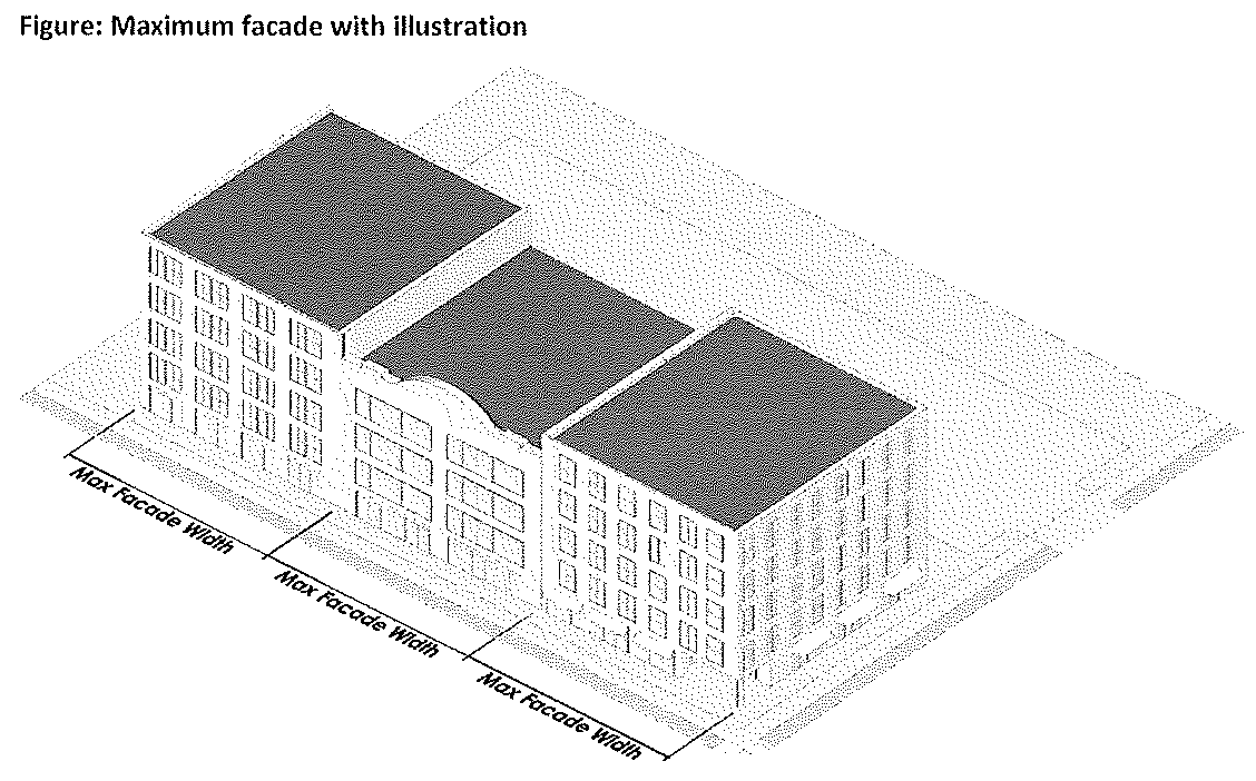
ii.
In addition to the above, building facades greater than 200 feet in length shall be articulated with recesses a minimum of 25 feet in depth and 25 feet in width, or with a break in the building facade of at least 25 feet in width which opens into an interior courtyard or plaza.
iii.
Facades shall provide visual divisions between the ground story and second story through architectural means such as courses, awnings, or a change in materials.
iv.
Facades shall delineate all stories above the ground story with windows, belt courses, balconies, cornice lines or similar architectural detailing.
v.
Each building facade along a street shall provide fenestration as follows:
a)
Fenestration shall mean the minimum percentage of window and door glass that must cover a given facade. It shall be calculated based on facade area and by floor.
b)
Residential uses shall provide at least 15% fenestration on all stories.
c)
Nonresidential uses shall provide at least 60% fenestration on the ground story and at least 20% fenestration on upper stories.
d)
The length of facade without intervening fenestration shall be no more than 20 feet.
e)
Glass for windows and doors shall utilize clear or tinted glass. Tinted glass shall have a maximum transmittance factor of 70% and a visible light reflectance factor of ten or less.
vi.
All multifamily residential or office buildings shall provide at least one major ground story lobby entrance. Lobbies shall be clearly articulated within the building design.
vii.
Buildings with residential uses adjacent to the sidewalk shall have individual entrances to such units which are directly accessible from the sidewalk.
c.
Ground Story.
i.
The ground story of all buildings shall be no more than 5 feet above or below the adjacent sidewalk.
ii.
The ground story of all buildings along any public or private street shall contain active uses within a minimum depth of 20 feet.
d.
Pedestrian Access. All buildings must include a street-facing pedestrian entrance. Said entrance shall be operable to residents at all times and operable to customers, visitors, and employees during business hours.
i.
A walkway shall be provided from all buildings and building entrances to any adjacent public or private right-of-way, multi-use trail, or publicly accessible park or open space.
ii.
The walkway shall be a minimum of 5 feet in width.
iii.
Walkways are not required for existing buildings or uses when the applicant demonstrates that their installation would do any of the following:
a)
Create a hardship due to the construction of retaining walls, site grading, site excavation, or site fill; or
b)
Is determined by the Director to be infeasible because of topographic or other site-specific constraints.
iv.
Where a building has two frontages, a pedestrian entrance is required along both frontages.
7.
Phasing. Mixed-use construction shall be sequenced in accordance with a project build-out schedule submitted for review as part of the building permit and approved by the Department of Planning and Development. Project proposals shall adhere to the following sequencing requirements:
a.
Building permits for up to 50 percent of the residential square footage as shown on the site plan as required by Section 214-70.3.8. may be issued prior to commencing any non-residential construction.
b.
Building permits for 51 to 79 percent of the residential square footage as shown on the site plan as required by Section 214-70.3.H.8. may only be issued after the issuance of building permits for at least 25 percent of non-residential square footage as shown on the master plan and commencement of said non-residential construction.
c.
Building permits for the final 20 percent of residential square footage as shown on the site plan as required by Section 214-70.3.8. may only be issued after the issuance or the Certificate of Occupancy for at least 80 percent of the non-residential square footage as shown on the master plan.
d.
Any of the above-mentioned requirements may be adjusted or waived by the Director, as long as the applicant provides a binding assurance that the remaining major use types shown in the master plan will be built.
8.
Submittal and Approval Process
a.
Any new construction and renovation of more than 25% of the principal structure of an existing property requires the issuance of a Special Administrative Permit (SAP) prior to the application for any demolition, land disturbance or building permit.
b.
Applicants shall schedule a pre-application meeting with the Director or designee prior to the submission of an SAP application. The purpose of the meeting will be to:
i.
Ensure the applicant's understanding of the suboverlay requirements and approval process.
ii.
Inform the staff of the applicant's plan for developing the property.
c.
All submittals for an SAP application shall provide the following:
i.
Property boundary survey drawn by a registered no more than 2 years old from date of application.
ii.
Site plan indicating the compliance with all requirements of this suboverlay, including:
a)
Locations of all buildings.
b)
Calculation and location of provided open space.
c)
Locations of new streets.
d)
Streetscape standards.
iii.
Proposed design of any publicly accessible open space used to satisfy the requirements of this suboverlay.
iv.
Building elevations illustrating compliance with Section 214-60.11 and 230-110, as applicable.
v.
A written request for any variations as provided for in part E of this section.
d.
SAP Review and Response.
i.
Within four weeks of acceptance of a complete application, the Department of Planning and Development shall provide a list of comments to the applicant relative to the lack of compliance with the standards of the ordinance. If the Department of Planning and Development has no comments and the application is deemed to be in compliance, a SAP will be issued.
ii.
The applicant shall make amendments to plans and resubmit as noted. If all changes are in accordance with the comments provided, the Department of Planning and Development will issue the SAP within four weeks of resubmittal.
e.
The Director may grant a variation from any of the standards set forth in this suboverlay with the exception of uses and any associated provisions. Variations may be granted when, in the opinion of the Director, strict adherence to a provision creates a hardship due to extreme topographical or site provisions.
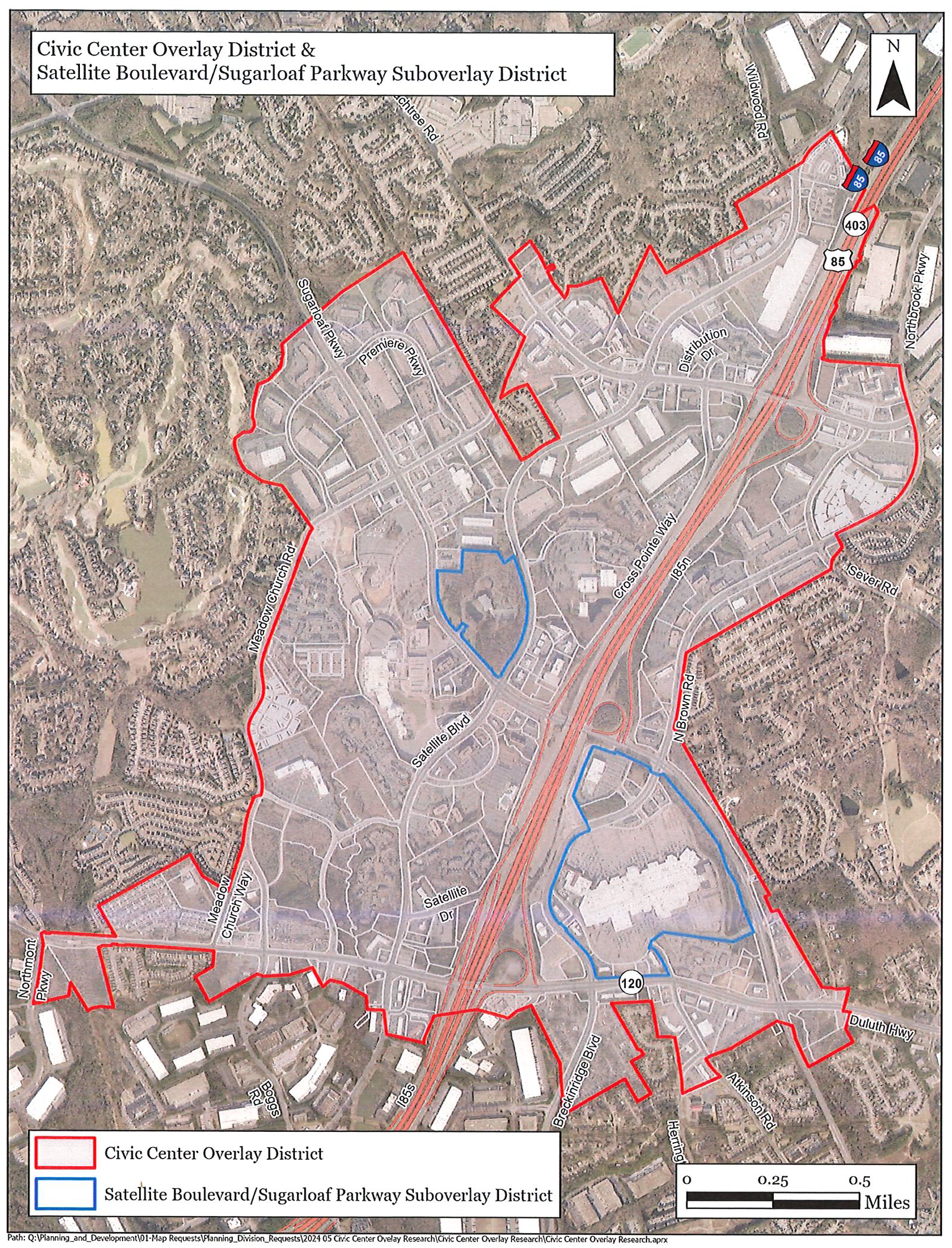
(Ord. No. GCID 2024-1128(UDOA2024-00003), Exh. A, 12-3-2024)