
Naples City Zoning Code
ARTICLE II
- ZONING DISTRICTS
Sec. 58-51.- District purpose.
The RE district is intended to apply to an area of low density single-family residences in a semi-rural environment and permits all necessary residential activities as well as the keeping of limited agricultural animals as specified in this division.
(Comp. Dev. Code 1990, § 7-4-1(A); Code 1994, § 102-51)
Sec. 58-52. - Uses permitted.
In the RE district, no building or structure, or part thereof, shall be erected, altered or used, or land or water used, in whole or in part, for other than the following:
(1)
Single-family residences.
(2)
Guest units in conformance with the requirements of section 56-91.
(3)
Accessory structures which are incidental to and customarily associated with the uses permitted in this district.
(4)
Keeping of animals of the equine class, not to exceed two per acre. Any roofed structure for the shelter and feeding of such animals shall be no less than 20 feet from any lot line and at least 100 feet from any existing residence located on adjacent property. No open feedlot for animals shall be permitted.
(5)
Keeping of fowl or poultry not to exceed 25 in total number, provided such fowl or poultry are kept in an enclosure located 30 feet or more from any lot line and at least 100 feet from any existing residence located on adjacent property.
(6)
Keeping of bees, not to exceed five hives, provided such hives are located 30 feet or more from any lot line and at least 100 feet from any existing residence located on adjacent property.
(Comp. Dev. Code 1990, § 7-4-1(B); Code 1994, § 102-52; Ord. No. 01-9152, § 1, 4-18-2001)
Sec. 58-53. - Conditional uses.
Conditional uses in the RE district are recreational facilities as listed in section 56-94.
(Comp. Dev. Code 1990, § 7-4-1(C); Code 1994, § 102-53; Ord. No. 01-9152, § 1, 4-18-2001)
Sec. 58-54. - Minimum lot area.
Minimum lot area in the RE district is 2¼ acres.
(Comp. Dev. Code 1990, § 7-4-1(D); Code 1994, § 102-54)
Sec. 58-55. - Minimum lot width.
Minimum lot width in the RE district is 150 feet.
(Comp. Dev. Code 1990, § 7-4-1(E); Code 1994, § 102-55)
Sec. 58-56. - Minimum yards.
Minimum yards in the RE district are as follows:
(1)
Front yard: 75 feet.
(2)
Side yard: 15 feet. This side yard applies to the first 15 feet of vertical height measured from the greater of:
a.
The lowest floor elevation as required by the Florida Building Code for the first habitable floor height requirement;
b.
Eighteen inches above the state department of environmental protection requirement for the first habitable floor structural support;
c.
Eighteen inches above the elevation of the average crown of the adjacent roads; or
d.
The average natural grade.
Additional height must remain within a 12:12 slope beyond the initial setback.
(3)
Rear yard: 75 feet.
(Comp. Dev. Code 1990, § 7-4-1(F); Code 1994, § 102-56; Ord. No. 20-14463, § 3, 3-4-2020; Ord. No. 24-15349, § 2, 4-3-2024)
Sec. 58-57. - Minimum floor area.
Minimum floor area in the RE district is as follows:
(1)
One-story buildings: 1,000 square feet.
(2)
Two-story buildings: 1,250 square feet.
(Comp. Dev. Code 1990, § 7-4-1(G); Code 1994, § 102-57)
Sec. 58-58. - Maximum height.
Maximum height of structures in the RE district is 30 feet, measured from the greater of:
(1)
The lowest floor elevation as required by the Florida Building Code for the first habitable floor height requirement;
(2)
Eighteen inches above the state department of environmental protection requirement for the first habitable floor structural support;
(3)
Eighteen inches above the elevation of the average crown of the adjacent roads; or
(4)
The average natural grade (natural contours of a land area generally unaltered by human intervention).
* In the case where the lowest floor elevation as determined by the May 16, 2012 Federal Emergency Management Agency Flood Insurance Rate Maps (FIRM) is higher than the lowest floor elevation required by the current FIRM, the applicant can choose to utilize the 2012 elevation for the first habitable floor. If the higher 2012 elevation is chosen, maximum building height will be measured from this elevation.
(Comp. Dev. Code 1990, § 7-4-1(H); Code 1994, § 102-58; Ord. No. 20-14463, § 3, 3-4-2020; Ord. No. 24-15349, § 3, 4-3-2024)
Sec. 58-59. - Minimum off-street parking.
Minimum off-street parking in the RE district is two spaces per residence, located within the permitted building area.
(Comp. Dev. Code 1990, § 7-4-1(I); Code 1994, § 102-59)
Sec. 58-60. - Maximum building area.
(a)
For purposes of this section, building area includes that portion of lot coverage which is the sum total of all lot area covered by roof and which is enclosed by walls or another enclosure system. Mesh screening shall not be considered a wall or enclosure system.
(b)
Building area is calculated as the area within the outermost perimeter of the enclosing walls or enclosure system.
(c)
Maximum building area in the RE district is as follows:
(Comp. Dev. Code 1990, § 7-4-1(J); Code 1994, § 102-60)
Sec. 58-81.- District purpose.
The R1-E district is the city's beach estate district. Larger lots and larger homes are required in this district than are typical in other districts.
(Comp. Dev. Code 1990, § 7-4-2(A); Code 1994, § 102-81; Ord. No. 95-7437, § 1, 5-17-1995)
Sec. 58-82. - Uses permitted.
In the R1-E district, no building or structure, or part thereof, shall be erected, altered or used, or land or water used, in whole or in part, for other than the following:
(1)
Single-family residences.
(2)
One guest unit, pursuant to the requirements of section 56-91.
(3)
Accessory structures which are incidental to and customarily associated with the use permitted in this district.
(Comp. Dev. Code 1990, § 7-4-2(B); Code 1994, § 102-82; Ord. No. 95-7437, § 1, 5-17-1995; Ord. No. 01-9152, § 1, 4-18-2001)
Sec. 58-83. - Conditional uses.
Conditional uses in the R1-E district are:
(1)
Additional guest units or staff residence beyond the single unit permitted.
(2)
Recreational facilities as listed in section 56-94.
(Comp. Dev. Code 1990, § 7-4-2(C); Code 1994, § 102-83; Ord. No. 95-7437, § 1, 5-17-1995; Ord. No. 01-9152, § 1, 4-18-2001)
Sec. 58-84. - Minimum lot area.
Minimum lot area in the R1-E district is 67,500 square feet.
(Comp. Dev. Code 1990, § 7-4-2(D); Code 1994, § 102-84; Ord. No. 95-7437, § 1, 5-17-1995)
Sec. 58-85. - Minimum lot width.
Minimum lot width in the R1-E district is 150 feet.
(Comp. Dev. Code 1990, § 7-4-2(E); Code 1994, § 102-85; Ord. No. 95-7437, § 1, 5-17-1995)
Sec. 58-86. - Minimum yards.
Minimum yards in the R1-E district are as follows:
(1)
Front yard: 50 feet.
(2)
Side yard: 15 feet. This side yard applies to the first 15 feet of vertical height measured from the greater of:
a.
The lowest floor elevation as required by the Florida Building Code for the first habitable floor height requirement;
b.
Eighteen inches above the state department of environmental protection requirement for the first habitable floor structural support;
c.
Eighteen inches above the elevation of the average crown of the adjacent roads; or
d.
The average natural grade.
Additional height must remain within a 12:12 slope beyond the initial setback. Guesthouses and staff residences must meet the above setback plus 0.5 feet for every foot of height above the first 15 feet of vertical height as measured above.
(3)
Rear yard: 35 feet.
a.
Rear yards abutting a public alley may be reduced to 15 feet for garages and carports that have direct vehicular access from the alley or utility sheds not exceeding 100 square feet in area.
b.
Unroofed pools or pools enclosed only with open mesh screening may be located in rear yard setback areas but may not be closer than 15 feet to any rear lot line, provided that no pool or pool enclosure shall be placed within a utility or drainage easement.
(Comp. Dev. Code 1990, § 7-4-2(F); Code 1994, § 102-86; Ord. No. 95-7437, § 1, 5-17-1995; Ord. No. 20-14463, § 3, 3-4-2020; Ord. No. 24-15349, § 4, 4-3-2024)
Sec. 58-87. - Minimum floor area.
Minimum floor area in the R1-E district is as follows:
(1)
One-story buildings: 2,000 square feet.
(2)
Two-story buildings: 2,500 square feet.
(Comp. Dev. Code 1990, § 7-4-2(G); Code 1994, § 102-87; Ord. No. 95-7437, § 1, 5-17-1995)
Sec. 58-88. - Maximum height.
Maximum height of structures in the R1-E district is 35 feet, measured from the greater of:
(1)
The lowest floor elevation as required by the Florida Building Code for the first habitable floor height requirement;
(2)
Eighteen inches above the state department of environmental protection requirement for the first habitable floor structural support;
(3)
Eighteen inches above the elevation of the average crown of the adjacent roads; or
(4)
The average natural grade (natural contours of a land area generally unaltered by human intervention).
* In the case where the lowest floor elevation as determined by the May 16, 2012 Federal Emergency Management Agency Flood Insurance Rate Maps (FIRM) is higher than the lowest floor elevation required by the current FIRM, the applicant can choose to utilize the 2012 elevation for the first habitable floor. If the higher 2012 elevation is chosen, maximum building height will be measured from this elevation.
(Comp. Dev. Code 1990, § 7-4-2(H); Code 1994, § 102-88; Ord. No. 95-7437, § 1, 5-17-1995; Ord. No. 20-14463, § 3, 3-4-2020; Ord. No. 24-15349, § 5, 4-3-2024)
Sec. 58-89. - Minimum off-street parking.
Minimum off-street parking in the R1-E district is two spaces per residence, located within the permitted building area.
(Comp. Dev. Code 1990, § 7-4-2(I); Code 1994, § 102-89; Ord. No. 95-7437, § 1, 5-17-1995)
Sec. 58-90. - Maximum building area.
(a)
For the purposes of this section, building area includes that portion of lot coverage which is the sum total of all lot area covered by roof and which is enclosed by walls or other enclosure system. Mesh screening shall not be considered a wall or enclosure system.
(b)
Building area is calculated as the area within the outermost perimeter of the enclosing walls or enclosure system.
(c)
Maximum building area in the R1-E district is as follows:
(Comp. Dev. Code 1990, § 7-4-2(J); Code 1994, § 102-90; Ord. No. 95-7437, § 1, 5-17-1995)
Sec. 58-111.- District purpose.
The R1-15A district is a single-family residence district.
(Comp. Dev. Code 1990, § 7-4-2.1(A); Code 1994, § 102-111; Ord. No. 99-8638, § 1, 9-15-1999)
Sec. 58-112. - Uses permitted.
In the R1-15A district, no building or structure, or part thereof, shall be erected, altered or used, or land or water used, in whole or in part, for other than the following:
(1)
Single-family residences.
(2)
Accessory structures which are incidental to and customarily associated with the uses permitted in this district.
(Comp. Dev. Code 1990, § 7-4-2.1(B); Code 1994, § 102-112; Ord. No. 99-8638, § 1, 9-15-1999)
Sec. 58-113. - Conditional uses.
Conditional uses within the R1-15A district are:
(1)
Guest units in conformance with section 56-91.
(2)
Recreational facilities as listed in section 56-94.
(Comp. Dev. Code 1990, § 7-4-2.1(C); Code 1994, § 102-113; Ord. No. 99-8638, § 1, 9-15-1999; Ord. No. 01-9152, § 1, 4-18-2001)
Sec. 58-114. - Minimum lot area.
(a)
Minimum lot area in the R1-15A district is one platted lot identified in the following plats: Lantern Lake Section Port Royal at Plat Book 1, page 100; Cutlass Cove Section Port Royal at Plat Book 1, page 101, less and except Block A of the plat and the Cutlass Anchorage; Replat of Part of Cutlass Cove Section Port Royal at Plat Book 2, page 106; Addition to Lantern Lake Section Port Royal at Plat Book 3, page 19; Galleon Drive and Spyglass Island Sections of Port Royal at Plat Book 3, pages 32-34; King's Town Drive to Admiralty Parade Section Port Royal at Plat Book 3, pages 74-78; and Half Moon Lake Addition to Port Royal at Plat Book 12, page 33. For properties abutting Half Moon Lake, a platted lot less that portion conveyed to create Half Moon Lake, will be deemed one platted lot.
(b)
Notwithstanding anything set forth in the referenced plats, the city recognizes that portions of lots may be combined to form one single-family lot that meets the minimum lot area requirement prescribed herein provided the sum of the portions combined is equal to or greater than one platted lot and no parcels are left that are less than one platted lot. Subject to the standards of chapter 54, the combination of portions of lots to create one single-family lot will be accomplished by any of the following methods and a single-family lot thus created will be deemed to meet the minimum lot area requirement of this section:
(1)
Lots in the R1-15A district may be split and combined such that the area of the resulting property equals 100 percent of the combined percentages of the adjacent platted lots. For example, 25 percent of the area of one platted lot combined with 75 percent of the area of an adjacent platted lot will constitute 100 percent of a single-family lot and meet this standard; or
(2)
Fractional portions of platted lots in the R1-15A district may be split and combined to create one whole single-family lot such that the fractional portion of the adjacent platted lots will be measured along the platted front and rear property lines in equivalent fractional measurements. For example, one-third of a platted lot as measured one-third of the length of the front and rear platted property lines, can be combined with two-thirds of the adjacent platted lot measured two-thirds of the length of the front and rear property lines, to create one single-family lot; or
(3)
City approved platted lots, or lots otherwise approved by the city prior to the effective date of this ordinance, will be considered buildable single-family lots.
(Comp. Dev. Code 1990, § 7-4-2.1(D); Code 1994, § 102-114; Ord. No. 99-8638, § 1, 9-15-1999; Ord. No. 20-14456, § 1, 2-19-2020)
Sec. 58-115. - Minimum lot width.
Minimum lot width in the R1-15A district is 100 feet. Platted lots in the R1-15A district may be reestablished whether or not the platted lots meet the minimum lot width of 100 feet and regardless of their prior combination with adjacent lots.
(Comp. Dev. Code 1990, § 7-4-2.1(E); Code 1994, § 102-115; Ord. No. 99-8638, § 1, 9-15-1999; Ord. No. 20-14456, § 2, 2-19-2020)
Sec. 58-116. - Minimum yards.
Minimum yards in the R1-15A district are as follows:
(1)
Front yard: 40 feet.
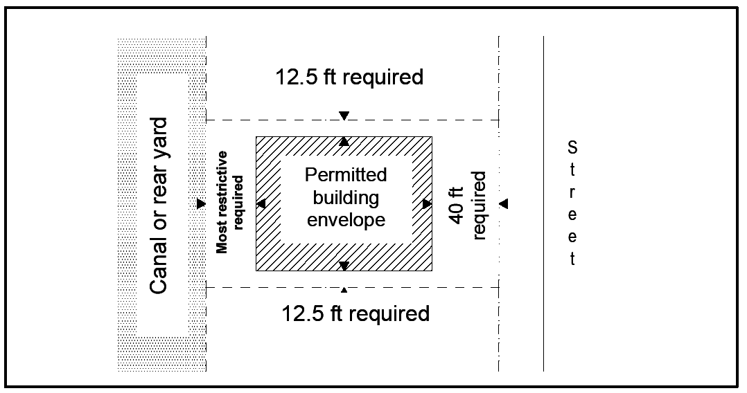
Figure 1. Illustration of Required Setbacks
(2)
Side yard: 12½ feet. This side yard applies to the first 12½ feet of vertical height measured from the greater of:
a.
The lowest floor elevation as required by the Florida Building for the first habitable floor height requirement;
b.
Eighteen inches above the state department of environmental protection requirement for the first habitable floor structural support;
c.
Eighteen inches above the elevation of the average crown of the adjacent roads; or
d.
The average natural grade (natural contours of a land area generally unaltered by human intervention).
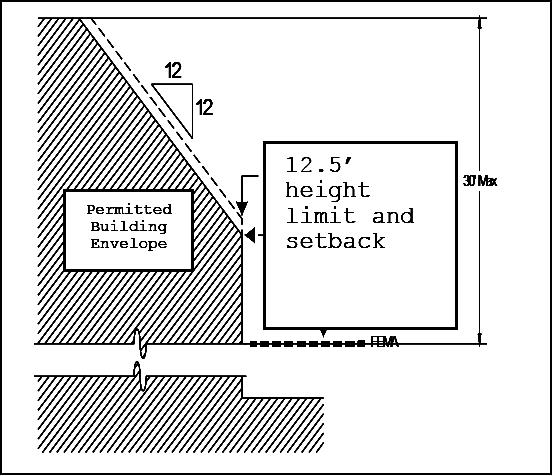
Figure 2. Illustrations of Side Yard Setbacks
Additional height must remain within a 12:12 slope beyond the initial setback.
(3)
Rear yard: 30 feet. The setback for a non-gulf facing waterfront rear yard shall be the most restrictive of the following:
a.
Thirty feet from the mean high-water line; or
b.
The platted waterfront building line.
(4)
Mechanical equipment. Mechanical equipment screening and elevation, including air conditioning, pool equipment, generators or other noise generating machinery.
a.
Permanent screening shall be required around all mechanical equipment. The equipment shall be fully screened as viewed from the street, neighboring properties and adjacent waterways.
b.
Mechanical equipment may be placed on a second story roof only if it is recessed and completely concealed by the roof structure.
c.
When mechanical equipment is located on the side of the residence it shall be located with its base no more than six inches above the greater of either the minimum FEMA first habitable floor elevation or the State Department of Environmental Protection requirement for first habitable floor.
(5)
Encroachments. No encroachments other than those listed below shall be permitted.
a.
Cornices, overhangs, awnings, eaves, gutters, trellises, pergolas, arched arbors, and other elements as listed in section 56-54 shall not be permitted to encroach into any side or rear yard setback, or extend beyond any platted building line, in the R1-15A zoning district.
b.
Structures less than 36 inches in height, as measured from the crown of the road shall not be considered as encroachments, except that under no circumstances shall air conditioning, pool mechanical equipment or generators encroach into any required setback area, provided, however, that,
c.
Notwithstanding subsection (5)b. above, on lawful building sites which contain three front yards but do not contain a platted waterfront building line, unscreened and unroofed decks, with or without pools, are permitted to extend into required primary structure rear yards and side yards provided that these decks must not exceed a height of 30 inches above the crown of the road with an additional six inches of height for every 12 inches of horizontal distance from either the side or rear property lines, whichever is closer, up to a maximum of the height of the minimum finished floor height or six feet above the crown of the road, whichever is greater. The minimum finished floor height is determined by the requirements of FEMA and the Florida Building Code. Pool and spa coping may extend up to one foot vertically above the deck. Safety railings may project above the pool deck the minimum necessary to meet the Florida Building Code requirements for safety railings.
d.
Crown of the road is defined as the height measurement of the road adjacent to the property. If the road slopes the length of the property the average of the highest and lowest crown elevations shall be used as the base point.
(6)
Side yard exception is as follows:
Gable roofs. Gable roof ends not more than 20 feet in height may encroach into the 12:12 slope beyond the initial side yard setback, provided that:
a.
They shall be set back more than ten feet from both the front and rear yard setback lines;
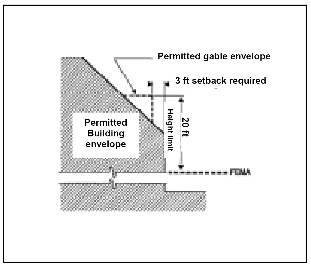
Figure 3. Illustration of Permitted Gable Encroachment
b.
The wall plane of the gable shall be set back a minimum of three feet from the wall plane below the gable;
c.
No individual gable roof end shall exceed 20 feet in width; and
d.
The maximum cumulative width of all gable wall encroachments along each individual side yard setback line shall not exceed 40 feet.
(7)
Reduction of front yard setback. On lots which front on more than one street, one of the front yards may be reduced to 35 feet. The property owner may choose which setback to reduce, subject to the approval of the city manager.
(Comp. Dev. Code 1990, § 7-4-2.1(F); Code 1994, § 102-116; Ord. No. 94-7249, § 1, 8-17-1994; Ord. No. 95-7594, § 24, 12-20-1995; Ord. No. 99-8638, § 1, 9-15-1999; Ord. No. 00-9037, § 1, 12-20-2000; Ord. No. 01-9069, § 1, 1-17-2001; Ord. No. 02-9910, § 1, 12-18-2002; Ord. No. 06-11496, § 1, 12-20-2006; Ord. No. 08-12048, §§ 1—3, 5-7-2008; Ord. No. 11-12910, § 2, 6-1-2010; Ord. No. 13-13240, § 1, 2-6-2013; Ord. No. 17-14043, § 1, 10-18-2017; Ord. No. 20-14463, § 3, 3-4-2020; Ord. No. 24-15329, § 1, 3-4-2024; Ord. No. 24-15349, § 6, 4-3-2024)
Sec. 58-117. - Minimum floor area.
In the R1-15A district, the ground floor of the main dwelling shall not contain less than the following floor area:
(1)
One-story buildings: 1,750 square feet.
(2)
Two-story buildings: 1,600 square feet.
This floor area does not include garages, covered walkways or open porches.
(Comp. Dev. Code 1990, § 7-4-2.1(G); Code 1994, § 102-117; Ord. No. 99-8638, § 1, 9-15-1999)
Sec. 58-118. - Maximum height.
Maximum height in the R1-15A district is 30 feet, measured from the greater of:
(1)
The lowest floor elevation as required by the Florida Building Code for the first habitable floor height requirement;
(2)
Eighteen inches above the state department of environmental protection requirement for the first habitable floor structural support;
(3)
Eighteen inches above the elevation of the average crown of the adjacent roads; or
(4)
The average natural grade (natural contours of a land area generally unaltered by human intervention).
Architectural embellishments may extend five feet above the maximum height requirement.
* In the case where the lowest floor elevation as determined by the May 16, 2012 Federal Emergency Management Agency Flood Insurance Rate Maps (FIRM) is higher than the lowest floor elevation required by the current FIRM, the applicant can choose to utilize the 2012 elevation for the first habitable floor. If the higher 2012 elevation is chosen, maximum building height will be measured from this elevation.
(Comp. Dev. Code 1990, § 7-4-2.1(H); Code 1994, § 102-118; Ord. No. 99-8638, § 1, 9-15-1999; Ord. No. 06-11496, § 2, 12-20-2006; Ord. No. 08-12048, 4, 5-7-2008; Ord. No. 20-14463, § 3, 3-4-2020; Ord. No. 24-15349, § 7, 4-3-2024)
Sec. 58-119. - Minimum off-street parking.
Minimum off-street parking in the R1-15A district is two spaces per residence, located within the permitted building area.
(Comp. Dev. Code 1990, § 7-4-2.1(I); Code 1994, § 102-119; Ord. No. 99-8638, § 1, 9-15-1999)
Sec. 58-120. - Maximum building area.
(a)
Within the R1-15A district, building area is calculated as the area within the outermost perimeter of the roof structure, including covered porches, entryways and screen enclosures, both solid and screen roofed, except as noted in subsection (c) of this section.
(b)
Maximum building area is as follows:
(c)
Exceptions are as follows:
(1)
Roof overhangs. The first 18 inches of roof overhang shall not be counted against maximum building area. Roof overhangs are subject to side yard setback requirements in their entirety.
(2)
Screen enclosures. Screen pool enclosures, lanais and other similar structures, which may be roofed but are open on at least one side, and which are no higher than 15 feet above the minimum flood elevation, shall be included in building area calculations at 50 percent of their actual square footage. Such structures which are taller than 15 feet for any portion of their roof height shall be counted 100 percent against maximum building area for their entire floor area.
(Comp. Dev. Code 1990, § 7-4-2.1(J); Code 1994, § 102-120; Ord. No. 99-8638, § 1, 9-15-1999)
Sec. 58-121. - Pier location and dimensions.
Within the R1-15A district, piers are permitted accessory structures at all developed, waterfront residential properties, subject to the following restrictions and standards:
(1)
Piers cannot be covered.
(2)
Pier and walkway elevation cannot exceed the elevation of the natural grade of the upland property adjacent to the pier, and no pile, pile cap, nor boat lift structure can be elevated more than plus 10.5 feet MHWL.
(3)
Side yard setbacks.
a.
The side yard setback for all piers, including floating piers, pilings, vessels moored to piers, boat lifts, and vessels supported on boat lifts, constructed on or after September 15, 1999, the effective date of Ordinance No. 99-8638, is 20 feet from the side property lines and riparian lines, extended into the waterway. The setback shall be measured at a right angle to the extended property line.
b.
The side yard setback for all piers, including floating piers, pilings, vessels moored to piers, boat lifts, and vessels supported on boat lifts, constructed prior to September 15, 1999, the effective date of Ordinance No. 99-8638, is 12⅓ feet from the side property lines and riparian lines, extended into the waterway. The setback shall be measured at a right angle to the extended property line.
c.
This Section 58-121(3) ratifies and confirms the city's long-standing, consistently-applied code interpretation that in any and all instances, irrespective of when the pier was constructed, the applicable side yard setback applies to not only the pier, floating pier, pilings, and boat lift, but also to the vessel(s) moored to, attached to, or supported by the pier, floating pier, pilings or boat lift.
(4)
The most waterward edges of piers, including lift systems, shall not extend more than 25 feet waterward of the toe of the riprap revetment (the largest original stones at the bottom of the existing riprap), with the following exceptions:
a.
Piers on Naples Bay and Gordon Pass may extend beyond 25 feet in order to reach a maximum depth of five feet, mean low water, which is the maximum depth for maintenance dredging, as defined in F.A.C. 62-312.050(1)(e). The most waterward edge of the pier, pilings or lift cannot extend beyond this point. Depth shall be determined by an independent third party licensed surveyor using NAVD 88 and measurements shall be taken no more than every five feet starting at the toe of the riprap.
1.
For every one foot beyond the 25-foot limit that the pier extends, the side yard setback shall increase by two feet for the entire length of the pier and pilings, including anything attached to them.
2.
If the increased setback results in a pier that is centered along the rear lot line and the length of the pier is still inadequate to provide a depth of five feet MLW, the pier can be extended the additional distance needed to provide a depth of five feet MLW. A pier is considered to be centered when the combined mass of pier and vessel moored to it are positioned opposite the midpoint of the rear lot line.
3.
A dock that is centered must be a shore normal pier and lift system. No parallel piers or lifts are permitted beyond 25 feet waterward of the toe of the riprap revetment.
4.
The maximum shore-parallel width of the pier and lifts shall not exceed 25 percent of the shore-parallel length of the waterfront lot line.
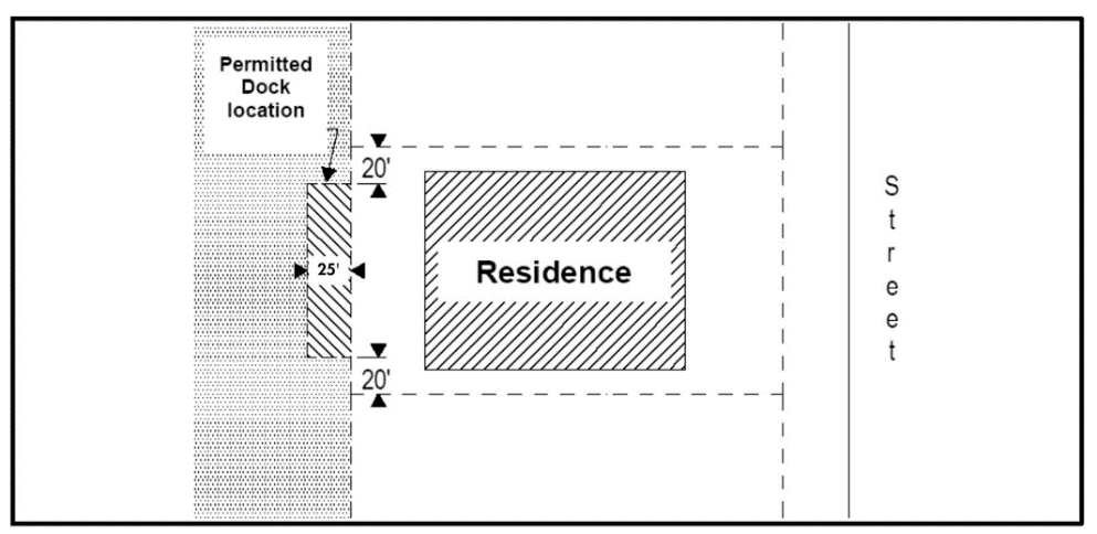
Figure 4. Permitted Dock Location
b.
Piers may extend beyond 25 feet only if the permit applicant demonstrates to the city manager, by depth survey and bottom habitat characteristics, that such an extension is necessary to preserve productive intertidal and subtidal habitat. The distance extended off-shore shall be governed by the width of the habitat to be preserved, thus limited maintenance dredging may also be needed to achieve adequate depth waterward of the pier. For every one foot beyond the 25-foot limit that the pier extends, the side yard setback shall increase by two feet for the entire length of the pier and pilings including anything permanently attached to them.
c.
Off-shore mooring piles, limited to two, with widths or diameters no greater than 14 inches, located a maximum of 20 feet waterward of a pier, are permitted at all properties fronting Naples Bay and Gordon Pass, and at certain other locations, as indicated on the Port Royal Association, Inc., Map, labeled "Exhibit F, Area Map Showing Specific Properties which are Permitted to Have Mooring Pilings 30 Feet From Shoreline," incorporated herein, and on file at the city offices. Off-shore mooring anchors may be installed so long as the mooring pennants are submerged and do not create a hazard to navigation.
d.
For lots 1 and 2 in Old Harbour Cove and lots 25, 26, 27, 28 and 29 in Cutlass Cove which are in dead-end coves where extended property lines converge, the following rules apply:
1.
Piers shall be positioned as close to the toe of the riprap as possible.
2.
Lifts may be positioned on the ends of the piers, or along the off-shore side.
3.
Outboard walkways accessible from the pier are prohibited.
4.
The side setback shall be 12.5 feet from the side property lines extended into the waterway for all portions of the pier, pilings, boatlift and vessel.
(5)
Pile and beam supported boat lifts shall be subject to the same regulations as fixed and floating piers. Lift systems are allowed only on the inshore sides of piers, or in a shore-normal alignment. Side yard setback restrictions shall apply to any vessel stored on a lift. If the city manager considers it environmentally necessary to install a lift system on the off-shore side of a pier, in excess of the 25-foot limit, the lift system shall be freestanding, without additional pier or catwalk structures attached to it, and for every one foot beyond the 25-foot limit that the lift extends, the side yard setback shall increase by two feet. An offshore lift installation must comply with subsection (11) of this section.
(6)
Pier dimensions shall not exceed the following:
a.
Shore-normal or perpendicular walkway providing access to shore-parallel pier: Six feet in width.
b.
Shore-normal pier: Eight feet in width.
c.
Shore-parallel pier: Eight feet in width. The maximum length of a shore-parallel pier cannot exceed 100 feet as measured parallel to the shore. Maximum dockage per property shall not exceed a combined 100 feet in length as measured parallel to the shore.
d.
Catwalk providing access to side of vessel, boat lift, or mooring pile: Four feet in width.
e.
For lots containing a single dock, a dock shall be constructed within a construction envelope that is determined based on the maximum allowable size dock on a given lot and in compliance with the minimum setback restrictions and pier dimensions outlined in this section (see Figures 5 and 6 below).
Figure 5. Three examples of placement of construction envelope on a given lot
Figure 6. An example of a 60' dock built within the construction envelope on a given
lot
(7)
A maximum of two docks per lot, as defined in section 44-8, are permitted.
(8)
For lots containing two docks: a construction envelope determined by the maximum allowable dock per property (up to 100 feet maximum) may be applied to one dock. The secondary dock must comply with the setback requirements outlined in section 58-121 (see Figure 7).
Figure 7. Example of a secondary dock
(9)
No piers or other over-water structures of any kind shall be permitted on Lantern Lake or Half Moon Lake.
(10)
All proposed piers and docks shall be reviewed by the city manager to ensure compliance with environmental regulations and habitat preservation.
(11)
Any proposed expansion of or addition (including boat lifts) to an existing nonconforming pier or dock shall require that all portions of the existing dock be brought into conformance with the requirements of this article. Total replacement of a dock requires conformity with current code. Replacement of decking material or replacement of piles within the existing footprint shall be exempt from the requirements of this article.
(12)
No combination of pier or dock, moored vessel, or boat lift shall exceed 25 percent of the width of the waterway adjacent to the subject property. If no vessel beam is specified in the permit application a beam of 13 feet shall be assumed. In consideration of the fact that some waterways have irregular, nonparallel shorelines, the aforementioned 25 percent may have to be reduced in order to ensure that a minimum centerline channel width of 50 percent of the waterway width is maintained for the length of the subject property. Navigation in both marked and unmarked channels shall not be hindered.
(13)
Applications to modify or construct piers or docks and boat lifts shall be accompanied by a scaled, plan-view drawing superimposed on a scaled survey showing the subject shoreline and the neighboring shorelines and piers. The elevations of the proposed walkways, piers, and piles and the distance to the opposite shoreline shall also be provided. Applications requesting encroachments under subsection (4)b. of this section shall include the necessary depth profiles presented on a cross-section drawing, and the required environmental information.
(Code 1994, § 102-121; Ord. No. 94-7248, § 1, 8-17-1994; Ord. No. 97-8104, § 1, 10-15-1997; Ord. No. 99-8638, § 1, 9-15-1999; Ord. No. 00-8902, §§ 1, 2, 8-16-2000; Ord. No. 01-9068, § 3, 1-17-2001; Ord. No. 03-9947, § 1, 2-5-2003; Ord. No. 13-13240, § 1, 2-6-2013; Ord. No. 17-14043, § 1, 10-18-2017; Ord. No. 25-15762, § 2, 11-5-2025)
Sec. 58-122. - Seawalls, boat slips and revetments.
(a)
Within the R1-15A district, seawalls and recessed boat slips are not permitted, subject to the following exceptions:
(1)
For Lots 1 through 12, Galleon Drive Section and Lots 23, and 46 through 53, Lantern Lake Section a seawall that extends no higher than or beyond the seawalls of neighboring properties on the Jamaica Channel is permitted.
(2)
For Lots 1 through 12, Galleon Drive Section: A recessed boat slip that extends no more than 60 feet from the platted lot line is permitted. A boat slip may be covered or roofed, in accordance with section 56-53; however, the width or diameter of the vertical supports for the roof shall be no greater than 14 inches. There shall be no architectural embellishments, such as arches, gingerbread, or fretwork, between the supports or beneath the horizontal roof support beams. The horizontal support beams shall be no deeper than 24 inches. Boat shelter roofs may be peaked or flat. Sun decks or viewing platforms are prohibited. The vertical distance between the grade of the rear yard and the boat shelter roof horizontal support beams shall not exceed 20 feet. Boat slips cannot encroach into the 20-foot side yard setback. Repairs are allowed in accordance with the foregoing.
(b)
Land or fill shall not be extended into any bay, cove, canal or channel beyond the original toe stones or existing seawall. The existing contour of the shoreline shall not be altered by excavation or construction; however, deteriorated riprap can be restored. On vacant or redeveloping lots the restoration shall be at a slope not to exceed one foot vertically for every two feet horizontally (1:2). On developed lots the restoration can be at the existing slope. Any proposed placement of fill beyond the existing toe of the riprap is considered a dredge and fill activity and it requires permits from the city council, the state department of environmental protection, and the U.S. Army Corps of Engineers. The required recommended design for riprap repair is shown in Figure 5. Riprap repair permits must be accompanied by a scaled survey showing the existing toe stones and plotted lot line, top of riprap and mean high water line. An as-built scaled survey must be submitted prior to final building inspection.
Figure 5. Recommended Design for Riprap Repair
(c)
Seawall, retaining wall, and riprap construction and repair shall comply, at a minimum, with the technical specifications referenced in section 16-254. The use of alternative technologies, as described in subsection 16-254(c), is prohibited in the R1-15A zone.
(Code 1994, § 102-122; Ord. No. 99-8638, § 1, 9-15-1999; Ord. No. 03-9947, § 2, 2-5-2003; Ord. No. 06-11496, § 3, 12-20-2006; Ord. No. 08-12048, 5, 5-7-2008; Ord. No. 13-13240, § 1, 2-6-2013)
Sec. 58-123. - Architectural requirements.
Structures in the R1-15A zoning district shall be subject to the following requirements:
(1)
Roof pitch. The main or predominant portion of the roof of the main dwelling and accessory buildings shall have a pitch of not less than eight to 12. This shall not preclude a roof with two slopes so long as one has a pitch of not less than eight to 12, or a flat deck roof atop a slope of the required eight to 12 pitch.
(2)
Utility connections. All telephone, electric or other wires of all kinds must be underground from the poles of the transmission cable located within the platted utility easements to the building or use connection.
(Code 1994, § 102-123; Ord. No. 99-8638, § 1, 9-15-1999)
Sec. 58-124. - Driveway entries, walls and fences.
(a)
General standards. Within the R1-15A district, driveway entry treatments, walls, and fences are permitted on all properties subject to the following restrictions and standards, with no provision for administrative or standard waivers as enumerated in subsection 56-37(e). Property owners are encouraged to screen walls and fences from street view and adjacent properties with landscaping.
(1)
Definitions. As used in this section:
Base point for height measurement. Outside the building envelope, the elevation at the crown of the road adjacent to the property is the base point for measurement of height. If the road slopes the length of the property, the average of the highest and lowest crown elevations shall be used as the base point. Inside the building envelope, finished grade at the entry treatment, wall or fence location is the base point for measurement.
Building envelope means the buildable area of a property as determined by the applicable setbacks.
Main driveway means access provided for vehicular ingress and egress. A property may have a maximum of two main driveways. Third driveways are considered subordinate to main driveways and are subject to different standards.
Maximum height means finished height, including wall, column or post footings, caps, lighting, finials, and all other architectural embellishments, except as otherwise provided.
(2)
Maximum entry treatment height. Height of main driveway gates, entry columns and posts shall be based upon the lot frontage distance and the distance which such entry treatment is set back from the adjacent paved travelway. A property may have a maximum of two main driveways, with a maximum of two main entry columns or posts per driveway.
a.
Properties east of Gordon Drive. See table below for locations east of Gordon Drive.
b.
Properties west of Gordon Drive. See table below for locations west of Gordon Drive.
c.
Gate height exceeding six feet. For any gate exceeding six feet in height, the portions of the gate above six feet must be at least 70 percent open and transparent.
d.
Clarification of column and post types.
1.
At a main driveway, no more than two columns or posts shall be treated as main entry columns or posts, with such height limitations as described in the tables of subsections (a)(2)a and b above. Up to 32 inches is permitted on top of a main entry column or post to allow for finished installation of light fixtures. This shall not increase the maximum permitted height of the finished main entry column or post.
2.
At a main driveway, no more than two columns or posts shall be treated as secondary entry columns or posts. The maximum height for such columns or posts is the greater of: four feet six inches or 50 percent of the maximum permitted height for main entry columns or posts.
3.
Any other column or post in the front yard outside the building envelope shall be treated as a secondary column or post, with a maximum height of four feet six inches, and minimum spacing of six feet.
e.
Third driveways and pedestrian gates. Notwithstanding any other provision of this section, for third driveways and pedestrian access from the street, the maximum height of a gate and no more than two entry columns or posts is six feet.
f.
Entry transition. A transitional wall or fence area sloping downward from an entry column or post is permitted, provided that the length of such wall or fence area does not exceed 50 percent of the maximum permitted entry column or post height. Such transitional wall or fence area shall terminate at a maximum height of the greater of: four feet six inches or 50 percent of the maximum permitted entry column or post height in the case of main driveways, and shall terminate at a maximum height of four feet six inches in the case of third driveways.
(3)
Maximum column and post width. For any columns or posts, the maximum finished width, including caps, facings, footings, and embellishments, is two feet six inches, except that the maximum finished width for main entry columns or posts with a height greater than eight feet is two feet ten inches.
(4)
Maximum wall and fence height.
a.
Front yard outside the building envelope. Walls and fences shall be limited to a maximum height of four feet. An additional 18 inches of metalwork that is at least 50 percent open and transparent is allowed on top of such wall or fence. Columns or posts other than entry columns or posts can be positioned along a wall or fence or can stand alone. Maximum height of these columns or posts shall be four feet six inches, and minimum spacing shall be six feet.
b.
Front yard inside the building envelope. Walls and fences shall be limited to a maximum height of six feet except that columns or posts are permitted to be six feet six inches and minimum spacing shall be six feet.
c.
Side yard, rear yard, and adjacent building envelope. Walls, fences, columns and posts are limited to a maximum height of five feet, in the side yards up to the rear waterfront building line. Outside the rear waterfront building line, height must comply with subsection 58-116(4). Pool fences may exceed these height requirements up to the minimum required to meet the Florida Pool Safety Act.
(b)
Width of driveways and openings.
(1)
Where no gate is present, driveway width is not limited.
(2)
On properties with one gated driveway, driveway width measured at the gate opening is limited to 20 feet.
(3)
On properties with more than one gated driveway, driveway width measured at the gate opening is limited to 15 feet. No lighting, sculptures or other architectural appurtenances shall be allowed on the fence or wall that accommodates more than one gated driveway.
(4)
A maximum of two fence or wall openings that do not accommodate a driveway are permitted. Each such opening is limited to ten feet in width, and minimum spacing between such openings is 30 feet.
(c)
Prohibited materials.
(1)
Barbed wire fences are prohibited.
(2)
Chainlink fences are prohibited in front yards except on a temporary basis as expressly permitted in section 16-291 (Construction site management).
(d)
Additional regulations.
(1)
Horticultural growth and support therefore, including arched arbors or trellises, are regulated by subsection 58-116(4).
(2)
Gate houses are regulated by section 56-38.
(Code 1994, § 102-124; Ord. No. 02-9910, § 3, 12-18-2002; Ord. No. 06-11496, § 4, 12-20-2006; Ord. No. 11-12910, § 3, 6-1-2010; Ord. No. 17-14043, § 1, 10-18-2017)
Sec. 58-141.- District purpose.
The R1-15 district is a single-family residence district.
(Comp. Dev. Code 1990, § 7-4-3(A); Code 1994, § 102-141)
Sec. 58-142. - Uses permitted.
In the R1-15 district, no building or structure, or part thereof, shall be erected, altered or used, or land or water used, in whole or in part, for other than the following:
(1)
Single-family residences.
(2)
Accessory structures which are incidental to and customarily associated with the uses permitted in this district.
(Comp. Dev. Code 1990, § 7-4-3(B); Code 1994, § 102-142)
Sec. 58-143. - Conditional uses.
Conditional uses in the R1-15 district are:
(1)
Guest units in conformance with section 56-91.
(2)
Recreational facilities as listed in section 56-94.
(Comp. Dev. Code 1990, § 7-4-3(C); Code 1994, § 102-143; Ord. No. 01-9152, § 1, 4-18-2001)
Sec. 58-144. - Minimum lot area.
Minimum lot area in the R1-15 district is 15,000 square feet.
(Comp. Dev. Code 1990, § 7-4-3(D); Code 1994, § 102-144)
Sec. 58-145. - Minimum lot width.
Minimum lot width in the R1-15 district is 100 feet.
(Comp. Dev. Code 1990, § 7-4-3(E); Code 1994, § 102-145)
Sec. 58-146. - Minimum yards.
Minimum yards in the R1-15 district are as follows:
(1)
Front yard: 40 feet.
(2)
Side yard: Ten feet. This side yard applies to the first 15 feet of vertical height measured from the greater of:
a.
The lowest floor elevation as required by the Florida Building Code for the first habitable floor height requirement;
b.
Eighteen inches above the state department of environmental protection requirement for the first habitable floor structural support;
c.
Eighteen inches above the elevation of the average crown of the adjacent roads; or
d.
The average natural grade.
Additional height must remain within a 12:12 slope beyond the initial setback.
(3)
Rear yard: 30 feet.
a.
Rear yards abutting a public alley may be reduced to 15 feet for garages and carports that have direct vehicular access from the alley or utility sheds not exceeding 100 square feet in area.
b.
Unroofed pools or pools enclosed only with open mesh screening may be located in rear yard setback areas but may not be closer than 15 feet to any rear lot line, provided that no pool or pool enclosure shall be placed within a utility or drainage easement.
(4)
On lots which front on more than one street, one of the front yards may be reduced to 35 feet. The property owner may choose which setback to reduce, subject to the approval of the city manager.
(Comp. Dev. Code 1990, § 7-4-3(F); Code 1994, § 102-146; Ord. No. 20-14463, § 3, 3-4-2020; Ord. No. 24-15349, § 8, 4-3-2024)
Sec. 58-147. - Minimum floor area.
Minimum floor area in the R1-15 district is as follows:
(1)
One-story buildings: 1,400 square feet.
(2)
Two-story buildings: 2,000 square feet.
(Comp. Dev. Code 1990, § 7-4-3(G); Code 1994, § 102-147)
Sec. 58-148. - Maximum height.
Maximum height of structures in the R1-15 district is 30 feet, measured from the greater of:
(1)
The lowest floor elevation as required by the Florida Building Code for the first habitable floor height requirement;
(2)
Eighteen inches above the state department of environmental protection requirement for the first habitable floor structural support;
(3)
Eighteen inches above the elevation of the average crown of the adjacent roads; or
(4)
The average natural grade (natural contours of a land area generally unaltered by human intervention).
* In the case where the lowest floor elevation as determined by the May 16, 2012 Federal Emergency Management Agency Flood Insurance Rate Maps (FIRM) is higher than the lowest floor elevation required by the current FIRM, the applicant can choose to utilize the 2012 elevation for the first habitable floor. If the higher 2012 elevation is chosen, maximum building height will be measured from this elevation.
(Comp. Dev. Code 1990, § 7-4-3(H); Code 1994, § 102-148; Ord. No. 20-14463, § 3, 3-4-2020; Ord. No. 24-15349, § 9, 4-3-2024)
Sec. 58-149. - Minimum off-street parking.
Minimum off-street parking in the R1-15 district is two spaces per residence, located within the permitted building area.
(Comp. Dev. Code 1990, § 7-4-3(I); Code 1994, § 102-149)
Sec. 58-150. - Maximum building area.
(a)
For purposes of this section, building area includes that portion of lot coverage which is the sum total of all lot area covered by roof and which is enclosed by walls or another enclosure system. Mesh screening shall not be considered a wall or enclosure system.
(b)
Building area is calculated as the area within the outermost perimeter of the enclosing walls or enclosure system.
(c)
Maximum building area in the R1-15 district is as follows:
(Comp. Dev. Code 1990, § 7-4-3(J); Code 1994, § 102-150)
Sec. 58-171.- District purpose.
The R1-10 district is a single-family residence district.
(Comp. Dev. Code 1990, § 7-4-4(A); Code 1994, § 102-171)
Sec. 58-172. - Uses permitted.
In the R1-10 district, no building or structure, or part thereof, shall be erected, altered or used, or land or water used, in whole or in part, for other than the following:
(1)
Single-family residences.
(2)
Accessory structures which are incidental to and customarily associated with the uses permitted in this district.
(Comp. Dev. Code 1990, § 7-4-4(B); Code 1994, § 102-172)
Sec. 58-173. - Conditional uses.
Conditional uses in the R1-10 district are:
(1)
Guest units in conformance with section 56-91.
(2)
Recreational facilities as listed in section 56-94.
(Comp. Dev. Code 1990, § 7-4-4(C); Code 1994, § 102-173; Ord. No. 01-9152, § 1, 4-18-2001)
Sec. 58-174. - Minimum lot area.
Minimum lot area in the R1-10 district is 10,000 square feet.
(Comp. Dev. Code 1990, § 7-4-4(D); Code 1994, § 102-174)
Sec. 58-175. - Minimum lot width.
Minimum lot width in the R1-10 district is as follows:
(1)
Corner lots: 87½ feet.
(2)
Interior lots: 75 feet.
(Comp. Dev. Code 1990, § 7-4-4(E); Code 1994, § 102-175)
Sec. 58-176. - Minimum yards.
Minimum yards in the R1-10 district are as follows:
(1)
Front yard: 30 feet.
(2)
Side yard: 7½ feet. This side yard applies to the first 15 feet of vertical height measured from the greater of:
a.
The lowest floor elevation as required by the Florida Building Code for the first habitable floor height requirement;
b.
Eighteen inches above the state department of environmental protection requirement for the first habitable floor structural support;
c.
Eighteen inches above the elevation of the average crown of the adjacent roads; or
d.
The average natural grade.
Additional height must remain within a 12:12 slope beyond the initial setback.
(3)
Rear yard: 25 feet.
a.
Rear yards abutting a public alley may be reduced to 15 feet for garages and carports that have direct vehicular access from the alley or utility sheds not exceeding 100 square feet in area.
b.
Unroofed pools or pools enclosed only with open mesh screening may be located in rear yard setback areas but may not be closer than 15 feet to any rear lot line, provided that no pool or pool enclosure shall be placed within a utility or drainage easement.
(4)
On lots which front on more than one street, one of the front yards may be reduced to 25 feet. The property owner may choose which setback to reduce, subject to the approval of the city manager.
(5)
For the properties abutting Sand Dollar Lane and Seagate Drive within the Seagate Subdivision, annexed into the City of Naples in 1988 by Ordinance 88-5464 and subsequent referendum, the yard abutting Seagate Drive will be treated as a rear yard.
(Comp. Dev. Code 1990, § 7-4-4(F); Code 1994, § 102-176; Ord. No. 20-14463, § 3, 3-4-2020; Ord. No. 24-15349, § 10, 4-3-2024; Ord. No. 24-15381, § 1, 6-5-2024)
Sec. 58-177. - Minimum floor area.
Minimum floor area in the R1-10 district is as follows:
(1)
One-story buildings: 1,200 square feet.
(2)
Two-story buildings: 1,600 square feet.
(Comp. Dev. Code 1990, § 7-4-4(G); Code 1994, § 102-177)
Sec. 58-178. - Maximum height.
Maximum height of structures in the R1-10 district is 30 feet, measured from the greater of:
(1)
The lowest floor elevation as required by the Florida Building Code for the first habitable floor height requirement;
(2)
Eighteen inches above the state department of environmental protection requirement for the first habitable floor structural support;
(3)
Eighteen inches above the elevation of the average crown of the adjacent roads; or
(4)
The average natural grade (natural contours of a land area generally unaltered by human intervention).
* In the case where the lowest floor elevation as determined by the May 16, 2012 Federal Emergency Management Agency Flood Insurance Rate Maps (FIRM) is higher than the lowest floor elevation required by the current FIRM, the applicant can choose to utilize the 2012 elevation for the first habitable floor. If the higher 2012 elevation is chosen, maximum building height will be measured from this elevation.
(Comp. Dev. Code 1990, § 7-4-4(H); Code 1994, § 102-178; Ord. No. 20-14463, § 3, 3-4-2020; Ord. No. 24-15349, § 11, 4-3-2024)
Sec. 58-179. - Minimum off-street parking.
Minimum off-street parking in the R1-10 district is one space per residence, located within the permitted building area.
(Comp. Dev. Code 1990, § 7-4-4(I); Code 1994, § 102-179)
Sec. 58-180. - Maximum building area.
(a)
For purposes of this section, building area includes that portion of lot coverage which is the sum total of all lot area covered by roof and which is enclosed by walls or other enclosure system. Mesh screening shall not be considered a wall or enclosure system.
(b)
Building area is calculated as the area within the outermost perimeter of the enclosing walls or enclosure system.
(c)
Maximum building area in the R1-10 district is as follows:
(Comp. Dev. Code 1990, § 7-4-4(J); Code 1994, § 102-180)
Sec. 58-201.- District purpose.
The R1-10A district is a single-family residence district.
(Code 1994, § 102-181; Ord. No. 98-8361, § 1, 9-16-1998)
Sec. 58-202. - Uses permitted.
In the R1-10A district, no building or structure, or part thereof, shall be erected, altered or used, or land or water used, in whole or in part, for other than the following:
(1)
Single-family residences.
(2)
Accessory structures which are incidental to and customarily associated with the uses permitted in this district.
(Code 1994, § 102-182; Ord. No. 98-8361, § 1, 9-16-1998)
Sec. 58-203. - Conditional uses.
Conditional uses in the R1-10A district are:
(1)
Guest units in conformance with section 56-91.
(2)
Recreational facilities as listed in section 56-94.
(Code 1994, § 102-183; Ord. No. 98-8361, § 1, 9-16-1998; Ord. No. 01-9152, § 1, 4-18-2001)
Sec. 58-204. - Minimum lot area.
Minimum lot area in the R1-10A district is 10,000 square feet.
(Code 1994, § 102-184; Ord. No. 98-8361, § 1, 9-16-1998)
Sec. 58-205. - Minimum lot width.
Minimum lot width in the R1-10A district is as follows:
(1)
Corner lots: 87½ feet.
(2)
Interior lots: 75 feet.
(Code 1994, § 102-185; Ord. No. 98-8361, § 1, 9-16-1998)
Sec. 58-206. - Minimum yards.
Minimum yards in the R1-10A district are as follows:
(1)
Front yard: 30 feet; 40 feet for lots on Crayton Road and Park Shore Drive.
(2)
Side yard: Ten feet. This side yard applies to the first 15 feet of vertical height measured from the greater of:
a.
The lowest floor elevation as required by the Florida Building Code for the first habitable floor height requirement;
b.
Eighteen inches above the state department of environmental protection requirement for the first habitable floor structural support;
c.
Eighteen inches above the elevation of the average crown of the adjacent roads; or
d.
The average natural grade.
Additional height must remain within a 12:12 slope beyond the initial setback.
(3)
Rear yard: 25 feet.
a.
Rear yards abutting a public alley may be reduced to 15 feet for garages and carports that have direct vehicular access from the alley or utility sheds not exceeding 100 square feet in area.
b.
Unroofed pools or pools enclosed only with open mesh screening may be located in rear yard setback areas but may not be closer than 15 feet to any rear lot line, provided that no pool or pool enclosure shall be placed within a utility or drainage easement.
(4)
On lots which front on more than one street, one of the front yards may be reduced to 25 feet, except that corner lots on Crayton Road and Park Shore Drive must maintain at least a 35-foot front yard on one of those roads. The property owner may choose which setback to reduce, subject to the approval of the city manager.
(Code 1994, § 102-186; Ord. No. 98-8361, § 1, 9-16-1998; Ord. No. 08-12049, § 1, 5-7-2008; Ord. No. 20-14463, § 3, 3-4-2020; Ord. No. 24-15349, § 12, 4-3-2024)
Sec. 58-207. - Minimum floor area.
Minimum floor area in the R1-10A district is as follows:
(1)
One-story buildings: 1,400 square feet.
(2)
Two-story buildings: 1,600 square feet.
(Code 1994, § 102-187; Ord. No. 98-8361, § 1, 9-16-1998; Ord. No. 08-12049, § 2, 5-7-2008)
Sec. 58-208. - Maximum height.
Maximum height of structures in the R1-10A district is 30 feet, measured from the greater of:
(1)
The lowest floor elevation as required by the Florida Building Code for the first habitable floor height requirement;
(2)
Eighteen inches above the state department of environmental protection requirement for the first habitable floor structural support;
(3)
Eighteen inches above the elevation of the average crown of the adjacent roads; or
(4)
The average natural grade (natural contours of a land area generally unaltered by human intervention).
* In the case where the lowest floor elevation as determined by the May 16, 2012 Federal Emergency Management Agency Flood Insurance Rate Maps (FIRM) is higher than the lowest floor elevation required by the current FIRM, the applicant can choose to utilize the 2012 elevation for the first habitable floor. If the higher 2012 elevation is chosen, maximum building height will be measured from this elevation.
(Code 1994, § 102-188; Ord. No. 98-8361, § 1, 9-16-1998; Ord. No. 20-14463, § 3, 3-4-2020; Ord. No. 24-15349, § 13, 4-3-2024)
Sec. 58-209. - Minimum off-street parking.
Minimum off-street parking in the R1-10A district is one space per residence, located within the permitted building area. Open-side or open-end carports over terminated driveways are not permitted. All garages shall be attached to the principal structure and shall be limited to a capacity sufficient to house no more than three vehicles.
(Code 1994, § 102-189; Ord. No. 98-8361, § 1, 9-16-1998; Ord. No. 08-12049, § 3, 5-7-2008)
Sec. 58-210. - Maximum building area.
(a)
For purposes of this section, building area includes that portion of lot coverage which is the sum total of all lot area covered by roof and which is enclosed by walls or other enclosure system. Mesh screening shall not be considered a wall or enclosure system.
(b)
Building area is calculated as the area within the outermost perimeter of the enclosing walls or enclosure system.
(c)
Maximum building area in the R1-10A district is as follows:
(Code 1994, § 102-190; Ord. No. 98-8361, § 1, 9-16-1998)
Sec. 58-211. - Fences.
(a)
No fence shall be allowed running parallel to the rear lot line of a waterfront lot nearer than 15 feet to the rear lot line.
(b)
No fence shall be allowed forward of the rear of the residence constructed upon the lot except that fences are allowed to encompass one side yard attributable to a residence from the area between the rear line of the house and front line of the house. Fencing required to conceal existing mechanical equipment may be constructed forward of the rear of the residence. Fences are prohibited in front yards.
(c)
Fences must be constructed of materials such as wood, masonry, or other decorative building materials. Chain link fences are prohibited unless suitable landscaping is planted adjacent to such fence around its entire boundaries. All fences must be constructed as to not present the appearance of a solid wall and must be sufficiently open by at least 50 percent to allow passage of light and air.
(d)
On waterfront lots, all hedges and plantings beyond the rear building line shall be maintained to a height of no more than 48 inches so as not to materially obstruct the waterway view from adjoining and nearby properties.
(Ord. No. 08-12049, § 4, 5-7-2008)
Sec. 58-231.- District purpose.
The R1-7.5 district is a single-family residence district.
(Comp. Dev. Code 1990, § 7-4-5(A); Code 1994, § 102-201)
Sec. 58-232. - Uses permitted.
In the R1-7.5 district, no building or structure, or part thereof, shall be erected, altered or used, or land or water used, in whole or in part, for other than the following:
(1)
Single-family residences.
(2)
Accessory structures which are incidental to and customarily associated with the uses permitted in this district.
(Comp. Dev. Code 1990, § 7-4-5(B); Code 1994, § 102-202)
Sec. 58-233. - Conditional uses.
Conditional uses in the R1-7.5 district are recreational facilities as listed in section 56-94.
(Comp. Dev. Code 1990, § 7-4-5(C); Code 1994, § 102-203; Ord. No. 01-9152, § 1, 4-18-2001)
Sec. 58-234. - Minimum lot area.
Minimum lot area in the R1-7.5 district is 7,500 square feet.
(Comp. Dev. Code 1990, § 7-4-5(D); Code 1994, § 102-204)
Sec. 58-235. - Minimum lot width.
Minimum lot width in the R1-7.5 district is as follows:
(1)
Corner lot: 75 feet.
(2)
Interior lot: 60 feet.
(Comp. Dev. Code 1990, § 7-4-5(E); Code 1994, § 102-205)
Sec. 58-236. - Minimum yards.
Minimum yards in the R1-7.5 district are as follows:
(1)
Front yard: 25 feet.
(2)
Side yard: 7½ feet. This side yard applies to the first 15 feet of vertical height measured from the greater of:
a.
The lowest floor elevation as required by the Florida Building Code for the first habitable floor height requirement;
b.
Eighteen inches above the state department of environmental protection requirement for the first habitable floor structural support;
c.
Eighteen inches above the elevation of the average crown of the adjacent roads; or
d.
The average natural grade.
Additional height must remain within a 12:12 slope beyond the initial setback.
(3)
Rear yard: 20 feet.
a.
Rear yards abutting a public alley may be reduced to 15 feet for garages and carports that have direct vehicular access from the alley or utility sheds not exceeding 100 square feet in area.
b.
Unroofed pools or pools enclosed only with open mesh screening may be located in rear yard setback areas but may not be closer than 15 feet to any rear lot line, provided that no pool or pool enclosure shall be placed within a utility or drainage easement.
(4)
On lots which front on more than one street, one of the front yards may be reduced to 20 feet. The property owner may choose which setback to reduce, subject to the approval of the city manager.
(Comp. Dev. Code 1990, § 7-4-5(F); Code 1994, § 102-206; Ord. No. 20-14463, § 3, 3-4-2020; Ord. No. 24-15349, § 14, 4-3-2024)
Sec. 58-237. - Minimum floor area.
Minimum floor area in the R1-7.5 district is as follows:
(1)
One-story buildings: 1,000 square feet.
(2)
Two-story buildings: 1,250 square feet.
(Comp. Dev. Code 1990, § 7-4-5(G); Code 1994, § 102-207)
Sec. 58-238. - Maximum height.
Maximum height of structures in the R1-7.5 district is 30 feet, measured from the greater of:
(1)
The lowest floor elevation as required by the Florida Building Code for the first habitable floor height requirement;
(2)
Eighteen inches above the state department of environmental protection requirement for the first habitable floor structural support;
(3)
Eighteen inches above the elevation of the average crown of the adjacent roads; or
(4)
The average natural grade (natural contours of a land area generally unaltered by human intervention).
* In the case where the lowest floor elevation as determined by the May 16, 2012 Federal Emergency Management Agency Flood Insurance Rate Maps (FIRM) is higher than the lowest floor elevation required by the current FIRM, the applicant can choose to utilize the 2012 elevation for the first habitable floor. If the higher 2012 elevation is chosen, maximum building height will be measured from this elevation.
(Comp. Dev. Code 1990, § 7-4-5(H); Code 1994, § 102-208; Ord. No. 20-14463, § 3, 3-4-2020; Ord. No. 24-15349, § 15, 4-3-2024)
Sec. 58-239. - Minimum off-street parking.
Minimum off-street parking in the R1-7.5 district is one space per residence, located within the permitted building area.
(Comp. Dev. Code 1990, § 7-4-5(I); Code 1994, § 102-209)
Sec. 58-240. - Maximum building area.
(a)
For purposes of this section, building area includes that portion of lot coverage which is the sum total of all lot area covered by roof and which is enclosed by walls or another enclosure system. Mesh screening shall not be considered a wall or enclosure system.
(b)
Building area is calculated as the area within the outermost perimeter of the enclosing walls or enclosure system.
(Comp. Dev. Code 1990, § 7-4-5(J); Code 1994, § 102-210)
Sec. 58-261.- District purpose.
The R3-6 district provides for single-family and low profile multifamily residences.
(Comp. Dev. Code 1990, § 7-4-6(A); Code 1994, § 102-231)
Sec. 58-262. - Uses permitted.
In the R3-6 district, no building or structure, or part thereof, shall be erected, altered or used, or land or water used, in whole or in part, for other than the following:
(1)
Single-family residences.
(2)
Multifamily residences.
(3)
Accessory structures which are incidental to and customarily associated with the permitted uses in this district listed in subsections (1) and (2) of this section.
(Comp. Dev. Code 1990, § 7-4-6(B); Code 1994, § 102-232)
Sec. 58-263. - Conditional uses.
Conditional uses in the R3-6 district are as follows:
(1)
Child care centers.
(2)
Cluster homes.
(3)
Nursing or rest homes (up to six units per net acre).
(4)
Recreation areas or facilities that are a part of one of the permitted uses listed in subsections (1) through (3) of this section.
(Comp. Dev. Code 1990, § 7-4-6(C); Code 1994, § 102-233; Ord. No. 12-13094, § 3, 4-4-2012)
Sec. 58-264. - Minimum lot area.
Minimum lot area in the R3-6 district is 6,000 square feet.
(Comp. Dev. Code 1990, § 7-4-6(D); Code 1994, § 102-234)
Sec. 58-265. - Minimum lot width.
Minimum lot width in the R3-6 district is 60 feet.
(Comp. Dev. Code 1990, § 7-4-6(E); Code 1994, § 102-235)
Sec. 58-266. - Minimum yards.
Minimum yards in the R3-6 district are as follows:
(1)
Single-family dwellings:
a.
Front yard: 25 feet.
b.
Side yard:
1.
One-story buildings: 7½ feet.
2.
Two-story buildings: Ten feet for yards abutting properties outside the project development site. Side yards no less than 7½ foot may be approved for single-family homes on individually platted lots abutting other single-family homes on individually platted lots within the same development through the site plan review process.
3.
Unroofed pools or pools enclosed only with open mesh screening may be located 7½ feet from the side property line, provided that no pool or pool enclosure shall be placed within a utility or drainage easement.
c.
Rear yard: 20 feet.
1.
Unroofed pools or pools enclosed only with open mesh screening may be located in rear yard setback areas but may not be closer than 15 feet to any rear lot line, provided that no pool or pool enclosure shall be placed within a utility or drainage easement.
(2)
Multifamily dwellings:
a.
Front yard: 35 feet.
b.
Side yard: 15 feet.
c.
Rear yard: 30 feet.
1.
Unroofed pools or pools enclosed only with open mesh screening may be located in rear yard setback areas but may not be closer than 15 feet to any rear lot line, provided that no pool or pool enclosure shall be placed within a utility or drainage easement.
(Comp. Dev. Code 1990, § 7-4-6(F); Code 1994, § 102-236; Ord. No. 13-13238, § 1, 2-6-2013; Ord. No. 15-13617, § 2, 3-4-2015)
Sec. 58-267. - Minimum floor area.
Minimum floor area in the R3-6 district is as follows:
(1)
Single-family dwellings:
a.
One-story buildings: 1,000 square feet.
b.
Two-story buildings: 1,250 square feet.
(2)
Multifamily dwellings: 750 square feet.
(Comp. Dev. Code 1990, § 7-4-6(G); Code 1994, § 102-237)
Sec. 58-268. - Maximum height.
Maximum height of structures in the R3-6 district is 30 feet.
(Comp. Dev. Code 1990, § 7-4-6(H); Code 1994, § 102-238)
Sec. 58-269. - Minimum off-street parking.
Minimum off-street parking requirements in the R3-6 district shall comply with chapter 50.
(Comp. Dev. Code 1990, § 7-4-6(I); Code 1994, § 102-239; Ord. No. 09-12468, § 2, 6-17-2009)
Sec. 58-270. - Maximum lot coverage by all buildings.
(a)
In the R3-6 district, maximum building area for individual single-family residences constructed on individual parcels of land is as follows:
(b)
Maximum lot coverage for all other buildings is 25 percent.
(Comp. Dev. Code 1990, § 7-4-6(J); Code 1994, § 102-240; Ord. No. 23-15082, § 1, 5-3-2023)
Sec. 58-271. - Maximum allowable density.
The maximum allowable density imposed upon lands and property zoned R3-6 is six dwelling units per net acre.
Sec. 58-291.- District purpose.
The R3-12 district is a residential district which is designed to accommodate a mixture of single-family homes and one-, two- and three-story apartments.
(Comp. Dev. Code 1990, § 7-4-7(A); Code 1994, § 102-261)
Sec. 58-292. - Uses permitted.
In the R3-12 district, no building or structure, or part thereof, shall be erected, altered or used, or land or water used, in whole or in part, for other than the following:
(1)
Single-family residences.
(2)
Multifamily residences.
(3)
Accessory structures which are incidental to and customarily associated with the permitted uses in this district listed in subsections (1) and (2) of this section.
(Comp. Dev. Code 1990, § 7-4-7(B); Code 1994, § 102-262)
Sec. 58-293. - Conditional uses.
Conditional uses in the R3-12 district are as follows:
(1)
Child care centers.
(2)
Nursing or rest homes (up to 12 units per net acre).
(3)
Parking lots, noncommercial, with no meters or on-site parking fee collection.
(4)
Recreation areas or facilities that are part of one of the permitted uses listed in subsections (1) through (3) of this section.
(Comp. Dev. Code 1990, § 7-4-7(C); Code 1994, § 102-263; Ord. No. 12-13094, § 5, 4-4-2012)
Sec. 58-294. - Minimum lot area.
Minimum lot area in the R3-12 district is 6,000 square feet.
(Comp. Dev. Code 1990, § 7-4-7(D); Code 1994, § 102-264)
Sec. 58-295. - Minimum lot width.
Minimum lot width in the R3-12 district is 40 feet.
(Comp. Dev. Code 1990, § 7-4-7(E); Code 1994, § 102-265)
Sec. 58-296. - Minimum yards.
Minimum yards in the R3-12 district are as follows:
(1)
Front yard: 25 feet, six feet of which shall be landscaped in accordance with the landscaping requirements of chapter 50.
(2)
Side yard:
a.
One-story buildings: 7½ feet.
b.
Two-story buildings: 10 feet.
c.
Three-story buildings: 12½ feet.
d.
Side yards no less than 7½ foot may be approved for single-family homes on individually platted lots abutting other single-family homes on individually platted lots within the same development through the site plan review process.
e.
Unroofed pools or pools enclosed only with open mesh screening may be located 7½ feet from the side property line, provided that no pool or pool enclosure shall be placed within a utility or drainage easement.
(3)
Rear yard: 20 feet.
a.
Unroofed pools or pools enclosed only with open mesh screening may be located in rear yard setback areas but may not be closer than 15 feet to any rear lot line, provided that no pool or pool enclosure shall be placed within a utility or drainage easement.
(Comp. Dev. Code 1990, § 7-4-7(F); Code 1994, § 102-266; Ord. No. 13-13238, § 2, 2-6-2013; Ord. No. 15-13617, § 3, 3-4-2015)
Sec. 58-297. - Minimum floor area.
Minimum floor area in the R3-12 district is as follows:
(1)
One-family dwellings:
a.
One-story buildings: 1,000 square feet.
b.
Two-story buildings: 1,250 square feet.
(2)
Two-family dwellings: 1,000 square feet per dwelling unit.
(3)
Three- or more family dwellings: 600 square feet per dwelling unit.
(4)
Manager's apartment: 600 square feet per dwelling unit.
(Comp. Dev. Code 1990, § 7-4-7(G); Code 1994, § 102-267)
Sec. 58-298. - Maximum height.
Maximum height of structures in the R3-12 district is 30 feet, except that the development on any R3-12 property immediately adjacent to, or across an alley from, any R1 zoned property will be limited to two stories in height. For the purposes of this section, height will be measured from the greatest of the following:
(1)
The lowest floor elevation as required by article III of chapter 16 for the first habitable floor height requirement;
(2)
Eighteen inches above the state department of environmental protection requirement for the first habitable floor structural support;
(3)
Eighteen inches above the elevation of the average crown of the adjacent roads; or
(4)
The average grade to the highest point of a flat roof, the deck line of a mansard roof or the mean height between the eaves and ridge of a gable, hip or gambrel roof.
(Comp. Dev. Code 1990, § 7-4-7(H); Code 1994, § 102-268; Ord. No. 94-7199, § 1, 5-18-1994; Ord. No. 20-14463, § 3, 3-4-2020)
Sec. 58-299. - Minimum off-street parking.
Minimum off-street parking requirements in the R3-12 district shall comply with chapter 50.
(Comp. Dev. Code 1990, § 7-4-7(I); Code 1994, § 102-269; Ord. No. 09-12468, § 3, 6-17-2009)
Sec. 58-300. - Maximum lot coverage by all buildings.
(a)
In the R3-12 district, maximum building area for individual single-family residences constructed on individual parcels of land is as follows:
(b)
Maximum lot coverage for all other buildings is 25 percent.
(Comp. Dev. Code 1990, § 7-4-7(J); Code 1994, § 102-270; Ord. No. 23-15082, § 2, 5-3-2023)
Sec. 58-301. - Maximum allowable density.
The maximum allowable density imposed upon lands and property zoned R3-12 is 12 dwelling units per net acre.
Sec. 58-321.- District purpose.
The R3T-12 district is a low-rise apartment district, in which the dwelling units are primarily intended to serve residents. A limited number of transient lodging facilities may be permitted, if controlled as to number, area, location, relation to the neighborhood and compatibility with permitted uses.
(Comp. Dev. Code 1990, § 7-4-8(A); Code 1994, § 102-291)
Sec. 58-322. - Uses permitted.
In the R3T-12 district, no building or structure, or part thereof, shall be erected, altered or used, or land or water used, in whole or in part, for other than the following:
(1)
Single-family residences.
(2)
Multifamily residences.
(3)
Accessory structures which are incidental to and customarily associated with the permitted uses in this district listed in subsections (1) and (2) of this section.
(Comp. Dev. Code 1990, § 7-4-8(B); Code 1994, § 102-292)
Sec. 58-323. - Conditional uses.
Conditional uses in the R3T-12 district are as follows:
(1)
Child care centers.
(2)
Nursing or rest homes (up to 12 units per net acre).
(3)
Parking lots, noncommercial, with no meters or on-site parking fee collection.
(4)
Recreation areas or facilities that are a part of one of the permitted uses listed in subsections (1) through (3) of this section.
(5)
Transient lodging facilities (up to 12 transient lodging units per net acre).
(Comp. Dev. Code 1990, § 7-4-8(C); Code 1994, § 102-293; Ord. No. 12-13094, § 7, 4-4-2012)
Sec. 58-324. - Minimum lot area.
Minimum lot area in the R3T-12 district is 15,000 square feet.
(Comp. Dev. Code 1990, § 7-4-8(D); Code 1994, § 102-294)
Sec. 58-325. - Minimum lot width.
Minimum lot width in the R3T-12 district is 100 feet.
(Comp. Dev. Code 1990, § 7-4-8(E); Code 1994, § 102-295)
Sec. 58-326. - Minimum yards.
Minimum yards in the R3T-12 district are as follows:
(1)
Front yard: 25 feet, six feet of which shall be landscaped in accordance with the landscaping requirements of chapter 50.
(2)
Side yard:
a.
One-story buildings: 7½ feet.
b.
Two-story buildings: 10 feet.
c.
Three-story buildings: 12½ feet.
d.
Side yards no less than 7½ foot may be approved for single-family homes on individually platted lots abutting other single-family homes on individually platted lots within the same development through the site plan review process.
e.
Unroofed pools or pools enclosed only with open mesh screening may be located 7½ feet from the side property line, provided that no pool or pool enclosure shall be placed within a utility or drainage easement.
(3)
Rear yard: 20 feet.
a.
Unroofed pools or pools enclosed only with open mesh screening may be located in rear yard setback areas but may not be closer than 15 feet to any rear lot fine, provided that no pool or pool enclosure shall be placed within a utility or drainage easement.
(Comp. Dev. Code 1990, § 7-4-8(F); Code 1994, § 102-296; Ord. No. 13-13238, § 3, 2-6-2013; Ord. No. 15-13617, § 4, 3-4-2015)
Sec. 58-327. - Minimum floor area.
Minimum floor area in the R3T-12 district is as follows:
(1)
One-family dwellings:
a.
One-story buildings: 1,000 square feet.
b.
Two-story buildings: 1,250 square feet.
(2)
Two-family dwellings: 1,000 square feet per dwelling unit.
(3)
Three- or more family dwellings: 600 square feet per dwelling unit.
(4)
Manager's apartment: 600 square feet per dwelling unit.
(5)
Transient lodging facilities:
a.
Dwelling units without cooking facilities: 300 square feet.
b.
Dwelling units with cooking facilities: 400 square feet.
(Comp. Dev. Code 1990, § 7-4-8(G); Code 1994, § 102-297)
Sec. 58-328. - Maximum height.
Maximum height of structures in the R3T-12 district is 30 feet, except that the development on any R3T-12 property immediately adjacent to, or across an alley from, any R1 zoned property shall be limited to two stories in height. For the purpose of this section, height will be measured from the greatest of the following:
(1)
The lowest floor elevation as required by article III of chapter 16 for the first habitable floor height requirement;
(2)
Eighteen inches above the state department of environmental protection requirement for the first habitable floor structural support;
(3)
Eighteen inches above the elevation of the average crown of the adjacent roads; or
(4)
The average grade to the highest point of a flat roof, the deck line of a mansard roof or the mean height between the eaves and ridge of a gable, hip or gambrel roof.
(Comp. Dev. Code 1990, § 7-4-8(H); Code 1994, § 102-298; Ord. No. 94-7199, § 2, 5-18-1994; Ord. No. 20-14463, § 3, 3-4-2020)
Sec. 58-329. - Minimum off-street parking.
Minimum off-street parking in the R3T-12 district shall comply with chapter 50.
(Comp. Dev. Code 1990, § 7-4-8(I); Code 1994, § 102-299; Ord. No. 09-12468, § 4, 6-17-2009)
Sec. 58-330. - Maximum lot coverage by all buildings.
(a)
In the R3T-12 district, maximum building area for individual single-family residences constructed on individual parcels of land is as follows:
(b)
Maximum lot coverage for all other buildings is 25 percent.
(Comp. Dev. Code 1990, § 7-4-8(J); Code 1994, § 102-300; Ord. No. 23-15082, § 3, 5-3-2023)
Sec. 58-331. - Maximum allowable density.
The maximum allowable density imposed upon lands and property zoned R3T-12 is 12 dwelling units per net acre.
Sec. 58-351.- District purpose.
The R3-15 district is a mid-rise apartment district.
(Comp. Dev. Code 1990, § 7-4-9(A); Code 1994, § 102-321)
Sec. 58-352. - Uses permitted.
In the R3-15 district, no building or structure, or part thereof, shall be erected, altered or used, or land or water used, in whole or in part, for other than the following:
(1)
Single-family residences.
(2)
Multifamily residences.
(3)
Accessory structures which are incidental to and customarily associated with the permitted uses in this district listed in subsections (1) and (2) of this section.
(Comp. Dev. Code 1990, § 7-4-9(B); Code 1994, § 102-322)
Sec. 58-353. - Conditional uses.
Conditional uses in the R3-15 district are as follows:
(1)
Child care centers.
(2)
Nursing or rest homes (up to 15 units per net acre).
(3)
Parking lots, noncommercial, with no meters or on-site parking fee collection.
(4)
Recreation areas or facilities that are a part of one of the permitted uses listed in subsections (1) through (3) of this section.
(Comp. Dev. Code 1990, § 7-4-9(C); Code 1994, § 102-323; Ord. No. 12-13094, § 9, 4-4-2012)
Sec. 58-354. - Minimum lot area.
Minimum lot area in the R3-15 district is 15,000 square feet.
(Comp. Dev. Code 1990, § 7-4-9(D); Code 1994, § 102-324)
Sec. 58-355. - Minimum lot width.
Minimum lot width in the R3-15 district is 100 feet.
(Comp. Dev. Code 1990, § 7-4-9(E); Code 1994, § 102-325)
Sec. 58-356. - Minimum yards.
Minimum yards in the R3-15 district are as follows:
(1)
Front yard: 25 feet, plus one foot for each one foot of building height over 30 feet, six feet of which shall be landscaped in accordance with the landscaping requirements of chapter 50.
(2)
Side yard: 15 feet, plus one foot for each one foot of building height over 30 feet.
a.
Unroofed pools or pools enclosed only with open mesh screening may be located 15 feet from the side property line, provided that no pool or pool enclosure shall be placed within a utility or drainage easement.
(3)
Rear yard: 25 feet, plus one foot for each one foot of building height over 30 feet.
a.
Unroofed pools or pools enclosed only with open mesh screening may be located in rear yard setback areas but may not be closer than 15 feet to any rear lot line, provided that no pool or pool enclosure shall be placed within a utility or drainage easement.
(4)
Side yards no less than 7½ foot may be approved for single-family homes on individually platted lots abutting other single-family homes on individually platted lots within the same development through the site plan review process.
(Comp. Dev. Code 1990, § 7-4-9(F); Code 1994, § 102-326; Ord. No. 13-13238, § 4, 2-6-2013; Ord. No. 15-13617, § 5, 3-4-2015)
Sec. 58-357. - Minimum floor area.
Minimum floor area in the R3-15 district is as follows:
(1)
One-family dwellings:
a.
One-story buildings: 1,000 square feet.
b.
Two-story buildings: 1,250 square feet.
(2)
Two- or more family dwellings: 1,000 square feet per dwelling unit.
(3)
Manager's apartment: 600 square feet per dwelling.
(Comp. Dev. Code 1990, § 7-4-9(G); Code 1994, § 102-327)
Sec. 58-358. - Maximum height.
Maximum height of structures in the R3-15 district is 60 feet; however, an additional 12 feet is permitted only if all of the following are met:
(1)
At least 75 percent of the ground floor is devoted to automobile parking;
(2)
There are no dwelling units located on the ground floor except one manager's dwelling unit; and
(3)
The structure is not subject to the coastal construction control line.
(Comp. Dev. Code 1990, § 7-4-9(H); Code 1994, § 102-328; Ord. No. 01-9292, § 1, 9-5-2001)
Sec. 58-359. - Minimum off-street parking.
Minimum off-street parking in the R3-15 district shall comply with chapter 50.
(Comp. Dev. Code 1990, § 7-4-9(I); Code 1994, § 102-329; Ord. No. 09-12468, § 5, 6-17-2009)
Sec. 58-360. - Maximum lot coverage by all buildings.
(a)
See chapter 56 for lot coverage regulations for multifamily residences.
(b)
In the R3-15 district, the maximum building area for individual single-family residences constructed on individual parcels of land is as follows:
(c)
Maximum lot coverage for all other buildings is 25 percent.
(Comp. Dev. Code 1990, § 7-4-9(J); Code 1994, § 102-330; Ord. No. 23-15082, § 4, 5-3-2023)
Sec. 58-361. - Maximum allowable density.
The maximum allowable density imposed upon lands and property zoned R3-15 is 15 dwelling units per net acre.
Sec. 58-381.- District purpose.
The R3-15 multifamily Coquina Sands (CS) district is a mid-rise apartment district.
(Code 1994, § 102-801; Ord. No. 98-8166, § 2, 1-21-1998)
Sec. 58-382. - Uses permitted.
In the R3-15 multifamily Coquina Sands (CS) district, no building or structure, or part thereof, shall be erected, altered or used, or land or water used, in whole or in part, for other than the following:
(1)
Single-family residences.
(2)
Multifamily residences.
(3)
Accessory structures which are incidental to and customarily associated with the permitted uses in this district listed in subsections (1) and (2) of this section.
(Code 1994, § 102-802; Ord. No. 98-8166, § 2, 1-21-1998)
Sec. 58-383. - Conditional uses.
Conditional uses in the R3-15 multifamily Coquina Sands (CS) district are as follows:
(1)
Child care centers.
(2)
Nursing or rest homes (up to 15 units per net acre).
(3)
Parking lots, noncommercial, with no meters or on-site parking fee collection.
(4)
Recreation areas or facilities that are a part of one of the permitted uses listed in subsections (1) through (3) of section 58-382.
(Code 1994, § 102-803; Ord. No. 98-8166, § 2, 1-21-1998; Ord. No. 12-13094, § 11, 4-4-2012)
Sec. 58-384. - Minimum lot area.
Minimum lot area in the R3-15 multifamily Coquina Sands (CS) district is 15,000 square feet.
(Code 1994, § 102-804; Ord. No. 98-8166, § 2, 1-21-1998)
Sec. 58-385. - Minimum lot width.
Minimum lot width in the R3-15 multifamily Coquina Sands (CS) district is 100 feet.
(Code 1994, § 102-805; Ord. No. 98-8166, § 2, 1-21-1998)
Sec. 58-386. - Minimum yards.
Minimum yards in the R3-15 multifamily Coquina Sands (CS) district are as follows:
(1)
Front yard: 25 feet, plus one foot for each one foot of building height over 30 feet, six feet of which shall be landscaped in accordance with the landscaping requirements of chapter 50.
(2)
Side yard: 15 feet, plus one foot for each one foot of building height over 30 feet.
a.
Unroofed pools or pools enclosed only with open mesh screening may be located 15 feet from the side property line, provided that no pool or pool enclosure shall be placed within a utility or drainage easement.
(3)
Rear yard: 25 feet, plus one foot for each one foot of building height over 30 feet.
a.
Unroofed pools or pools enclosed only with open mesh screening may be located in rear yard setback areas but may not be closer than 15 feet to any rear lot line, provided that no pool or pool enclosure shall be placed within a utility or drainage easement.
(4)
Side yards no less than 7½ foot may be approved for single-family homes on individually platted lots abutting other single-family homes on individually platted lots within the same development through the site plan review process.
(Code 1994, § 102-806; Ord. No. 98-8166, § 2, 1-21-1998; Ord. No. 13-13238, § 5, 2-6-2013; Ord. No. 15-13617, § 6, 3-4-2015)
Sec. 58-387. - Minimum floor area.
Minimum floor area in the R3-15 multifamily Coquina Sands (CS) district is as follows:
(1)
1-family dwellings:
a.
One-story buildings: 1,000 square feet.
b.
Two-story buildings: 1,250 square feet.
(2)
Two- or more family dwellings: 1,000 square feet per dwelling unit.
(3)
Manager's apartment: 600 square feet per dwelling.
(Code 1994, § 102-807; Ord. No. 98-8166, § 2, 1-21-1998)
Sec. 58-388. - Maximum height.
Maximum height of structures in the R3-15 multifamily Coquina Sands (CS) district is two habitable stories, up to a maximum height of 35 feet, as measured from the average grade of the property to the ceiling of the highest story, plus six feet from the ceiling to the highest point of a flat roof, parapet wall or mansard detail, or six feet from the ceiling to the mean distance between the eaves and ridge of a gable, hip or gambrel roof.
(Code 1994, § 102-808; Ord. No. 98-8166, § 2, 1-21-1998)
Sec. 58-389. - Minimum off-street parking.
Minimum off-street parking in the R3-15 multifamily Coquina Sands (CS) district shall comply with chapter 50.
(Code 1994, § 102-809; Ord. No. 98-8166, § 2, 1-21-1998; Ord. No. 09-12468, § 6, 6-17-2009)
Sec. 58-390. - Maximum lot coverage by all buildings.
(a)
See chapter 56 for lot coverage regulations for multifamily residences.
(b)
In the R3-15 multifamily Coquina Sands (CS) district, the maximum building area for individual single-family residences constructed on individual parcels of land is as follows:
(c)
Maximum lot coverage for all other buildings is 25 percent.
(Code 1994, § 102-810; Ord. No. 98-8166, § 2, 1-21-1998; Ord. No. 23-15082, § 5, 5-3-2023)
Sec. 58-391. - Design guidelines for ground floor parking.
(a)
Ground floor parking facilities shall be fully enclosed by walls with the exception of the entrances. The entrances for ground floor parking shall not face a public street. Yards opposite the entrances shall contain a six-foot-wide landscape buffer the entire length of the property line that contains at a minimum the following:
(1)
A continuous three-foot hedge at the time of planting with a mature height of at least five feet.
(2)
One tree per 30 linear feet of the entire property line of said yard.
(b)
The ground level facade shall be finished in a material that is complementary to or compatible with the habitable portion of the building, as determined by the city manager, and shall contain architectural features, trim detail, and wall treatments consistent with the habitable portion of the building.
(c)
Structures that contain a common entrance or lobby shall have such feature oriented toward the public street.
(d)
A ten-foot landscaped area shall be provided directly in front of the street side facade that contains at a minimum the following:
(1)
One shrub two feet in height spaced at least every 24 feet.
(2)
One tree per 20 feet of building width.
(e)
Carports shall be permitted provided that they are located in the side or rear yard and are constructed of a material that is complementary to or compatible with the principal structure, as determined by the city manager.
(Code 1994, § 102-811; Ord. No. 98-8166, § 2, 1-21-1998)
Sec. 58-392. - Maximum allowable density.
The maximum allowable density imposed upon lands and property zoned R3-15 multifamily Coquina Sands (CS) is 15 dwelling units per net acre.
Sec. 58-411.- District purpose.
The R3-15 multifamily Moorings (MOR) district is a mid-rise apartment district.
(Code 1994, § 102-831; Ord. No. 98-8166, § 2, 1-21-1998)
Sec. 58-412. - Uses permitted.
In the R3-15 multifamily Moorings (MOR) district, no building or structure, or part thereof, shall be erected, altered or used, or land or water used, in whole or in part, for other than the following:
(1)
Single-family residences.
(2)
Multifamily residences.
(3)
Accessory structures which are incidental to and customarily associated with the permitted uses in this district listed in subsections (1) and (2) of this section.
(Code 1994, § 102-832; Ord. No. 98-8166, § 2, 1-21-1998)
Sec. 58-413. - Conditional uses.
Conditional uses in the R3-15 multifamily Moorings (MOR) district are as follows:
(1)
Child care centers.
(2)
Nursing or rest homes (up to 15 units per net acre).
(3)
Parking lots, noncommercial, with no meters or on-site parking fee collection.
(4)
Recreation areas or facilities that are a part of one of the permitted uses listed in subsections (1) through (3) of section 58-412.
(Code 1994, § 102-833; Ord. No. 98-8166, § 2, 1-21-1998; Ord. No. 12-13094, § 13, 4-4-2012)
Sec. 58-414. - Minimum lot area.
Minimum lot area in the R3-15 multifamily Moorings (MOR) district is 15,000 square feet.
(Code 1994, § 102-834; Ord. No. 98-8166, § 2, 1-21-1998)
Sec. 58-415. - Minimum lot width.
Minimum lot width in the R3-15 multifamily Moorings (MOR) district is 100 feet.
(Code 1994, § 102-835; Ord. No. 98-8166, § 2, 1-21-1998)
Sec. 58-416. - Minimum yards.
Minimum yards in the R3-15 multifamily Moorings (MOR) district are as follows:
(1)
Front yard: 25 feet, plus one foot for each one foot of building height over 30 feet, six feet of which shall be landscaped in accordance with the landscaping requirements of chapter 50
(2)
Side yard: 15 feet, plus one foot for each one foot of building height over 30 feet.
a.
Unroofed pools or pools enclosed only with open mesh screening may be located 15 feet from the side property line, provided that no pool or pool enclosure shall be placed within a utility or drainage easement.
(3)
Rear yard: 25 feet, plus one foot for each one foot of building height over 30 feet.
a.
Unroofed pools or pools enclosed only with open mesh screening may be located in rear yard setback areas but may not be closer than 15 feet to any rear lot line, provided that no pool or pool enclosure shall be placed within a utility or drainage easement.
(4)
Side yards no less than 7½ foot may be approved for single-family homes on individually platted lots abutting other single-family homes on individually platted lots within the same development through the site plan review process.
(Code 1994, § 102-836; Ord. No. 98-8166, § 2, 1-21-1998; Ord. No. 13-13238, § 6, 2-6-2013; Ord. No. 15-13617, § 7, 3-4-2015)
Sec. 58-417. - Minimum floor area.
Minimum floor area in the R3-15 multifamily Moorings (MOR) district is as follows:
(1)
One-family dwellings:
a.
One-story buildings: 1,000 square feet.
b.
Two-story buildings: 1,250 square feet.
(2)
Two- or more family dwellings: 1,000 square feet per dwelling unit.
(3)
Manager's apartment: 600 square feet per dwelling.
(Code 1994, § 102-837; Ord. No. 98-8166, § 2, 1-21-1998)
Sec. 58-418. - Maximum height.
Maximum height of structures in the R3-15 multifamily Moorings (MOR) district is three habitable stories, up to a maximum height of 50 feet, as measured from the average grade of the property to the ceiling of the highest story, plus six feet from the ceiling to the highest point of a flat roof, parapet wall or mansard detail, or six feet from the ceiling to the mean distance between the eaves and ridge of a gable, hip or gambrel roof.
(Code 1994, § 102-838; Ord. No. 98-8166, § 2, 1-21-1998)
Sec. 58-419. - Minimum off-street parking.
Minimum off-street parking in the R3-15 multifamily Moorings (MOR) district shall comply with chapter 50.
(Code 1994, § 102-839; Ord. No. 98-8166, § 2, 1-21-1998; Ord. No. 09-12468, § 7, 6-17-2009)
Sec. 58-420. - Maximum lot coverage by all buildings.
(a)
See chapter 56 for lot coverage regulations for multifamily residences.
(b)
In the R3-15 multifamily Moorings (MOR) district, the maximum building area for individual single-family residences constructed on individual parcels of land is as follows:
(c)
Maximum lot coverage for all other buildings is 25 percent.
(Code 1994, § 102-840; Ord. No. 98-8166, § 2, 1-21-1998; Ord. No. 23-15082, § 6, 5-3-2023)
Sec. 58-421. - Design guidelines for ground floor parking.
(a)
Ground floor parking facilities shall be fully enclosed by walls with the exception of the entrances. The entrances for ground floor parking shall not face a public street. Yards opposite the entrances shall contain a six-foot-wide landscape buffer the entire length of the property line that contains at a minimum the following:
(1)
A continuous three-foot hedge at the time of planting with a mature height of at least five feet.
(2)
One tree per 30 linear feet of the entire property line of said yard.
(b)
The ground level facade shall be finished in a material that is complementary to or compatible with the habitable portion of the building, as determined by the city manager, and shall contain architectural features, trim detail, and wall treatments consistent with the habitable portion of the building.
(c)
Structures that contain a common entrance or lobby shall have such feature oriented toward the public street.
(d)
A ten-foot landscaped area shall be provided directly in front of the street side facade that contains at a minimum the following:
(1)
One shrub two feet in height spaced at least every 24 feet.
(2)
One tree per 20 feet of building width.
(e)
Carports shall be permitted provided that they are located in the side or rear yard and are constructed of a material that is complementary to or compatible with the principal structure, as determined by the city manager.
(Code 1994, § 102-841; Ord. No. 98-8166, § 2, 1-21-1998)
Sec. 58-422. - Maximum allowable density.
The maximum allowable density imposed upon lands and property zoned R3-15 multifamily Moorings (MOR) is 15 dwelling units per net acre.
Sec. 58-441.- District purpose.
The R3-18 district is an apartment district in which the city's tallest buildings are permitted.
(Comp. Dev. Code 1990, § 7-4-11(A); Code 1994, § 102-381)
Sec. 58-442. - Permitted uses.
In the R3-18 district, no building or structure, or part thereof, shall be erected, altered or used, or land or water used, in whole or in part, for other than the following:
(1)
Single-family residences.
(2)
Multifamily residences.
(3)
Accessory structures which are incidental to and customarily associated with the uses permitted in this district listed in subsections (1) and (2) of this section.
(Comp. Dev. Code 1990, § 7-4-11(B); Code 1994, § 102-382)
Sec. 58-443. - Conditional uses.
Conditional uses in the R3-18 district are as follows:
(1)
Child care centers.
(2)
Nursing or rest homes (up to 18 units per net acre).
(3)
Parking lots, noncommercial, with no meters or on-site parking fee collection.
(4)
Recreation areas or facilities that are a part of one of the permitted uses listed in subsections (1) through (3) of section 58-442.
(Comp. Dev. Code 1990, § 7-4-11(C); Code 1994, § 102-383; Ord. No. 12-13094, § 15, 4-4-2012)
Sec. 58-444. - Minimum lot area.
Minimum lot area in the R3-18 district is 25,000 square feet.
(Comp. Dev. Code 1990, § 7-4-11(D); Code 1994, § 102-384)
Sec. 58-445. - Minimum lot width.
Minimum lot width in the R3-18 district is 150 feet.
(Comp. Dev. Code 1990, § 7-4-11(E); Code 1994, § 102-385)
Sec. 58-446. - Minimum yards.
Minimum yards in the R3-18 district are as follows:
(1)
Front yard: 30 feet, plus one foot for each two feet of building height over 45 feet, six feet of which shall be landscaped in accordance with the landscaping requirements of chapter 50.
(2)
Side yard: 15 feet, plus one foot for each two feet of building height over 45 feet.
a.
Unroofed pools or pools enclosed only with open mesh screening may be located 15 feet from the side property line, provided that no pool or pool enclosure shall be placed within a utility or drainage easement.
(3)
Rear yard: 25 feet, plus one foot for each two feet of building height over 45 feet.
a.
Unroofed pools or pools enclosed only with open mesh screening may be located in rear yard setback areas beat may not be closer than 15 feet to any rear lot line, provided that no pool or poof enclosure shall be placed within a utility or drainage easement.
(Comp. Dev. Code 1990, § 7-4-11(F); Code 1994, § 102-386; Ord. No. 15-13617, § 8, 3-4-2015)
Sec. 58-447. - Minimum floor area.
Minimum floor area in the R3-18 district is as follows:
(1)
One-family dwellings:
a.
One-story buildings: 1,000 square feet.
b.
Two-story buildings: 1,250 square feet.
(2)
Two- or more family dwellings: 1,000 square feet per dwelling unit.
(3)
Manager's apartment: 600 square feet per unit.
(Comp. Dev. Code 1990, § 7-4-11(G); Code 1994, § 102-387)
Sec. 58-448. - Maximum height.
Maximum height of structures in the R3-18 district is 75 feet; however, an additional 12 feet is permitted only if all of the following are met:
(1)
At least 75 percent of the ground floor is devoted to automobile parking;
(2)
There are no dwelling units located on the ground floor except one manager's dwelling; and
(3)
The structure is not subject to the coastal construction control line.
(Comp. Dev. Code 1990, § 7-4-11(H); Code 1994, § 102-388; Ord. No. 01-9292, § 2, 9-5-2001)
Sec. 58-449. - Minimum off-street parking.
Minimum off-street parking in the R3-18 district shall comply with chapter 50.
(Comp. Dev. Code 1990, § 7-4-11(I); Code 1994, § 102-389; Ord. No. 09-12468, § 8, 6-17-2009)
Sec. 58-450. - Maximum lot coverage by all buildings.
(a)
See chapter 56 for lot coverage requirements for multifamily residences.
(b)
In the R3-18 district, the maximum building area for individual single-family residences constructed on individual parcels of land is as follows:
(c)
Maximum lot coverage for all other buildings is 25 percent.
(Comp. Dev. Code 1990, § 7-4-11(J); Code 1994, § 102-390; Ord. No. 23-15082, § 7, 5-3-2023)
Sec. 58-451. - Maximum allowable density.
The maximum allowable density imposed upon lands and property zoned R3-18 is 18 dwelling units per net acre.
Sec. 58-471.- District purpose.
The R3T-18 district is an apartment district, with limited transient lodging uses permitted, in which the city's tallest buildings are permitted.
(Comp. Dev. Code 1990, § 7-4-10(A); Code 1994, § 102-351)
Sec. 58-472. - Uses permitted.
In the R3T-18 district, no building or structure, or part thereof, shall be erected, altered or used, or land or water used, in whole or in part, for other than the following:
(1)
Single-family residences.
(2)
Multifamily residences.
(3)
Accessory structures which are incidental to and customarily associated with the permitted uses in this district listed in subsections (1) and (2) of this section.
(Comp. Dev. Code 1990, § 7-4-10(B); Code 1994, § 102-352)
Sec. 58-473. - Conditional uses.
Conditional uses in the R3T-18 district are as follows:
(1)
Child care centers.
(2)
Nursing or rest homes (up to 18 units per net acre).
(3)
Parking lots, noncommercial, with no meters or on-site parking fee collection.
(4)
Recreation areas or facilities that are a part of one of the permitted uses listed in subsections (1) through (3) of section 58-472.
(5)
Restaurants, conventional, and cocktail lounges which do not include dancing or staged entertainment, which do not have exterior advertising or identification, and which are an integral part of and a subordinate use in a multifamily complex or transient lodging facility.
(6)
Transient lodging facilities (up to 16 units per net acre).
(Comp. Dev. Code 1990, § 7-4-10(C); Code 1994, § 102-353; Ord. No. 12-13094, § 17, 4-4-2012)
Sec. 58-474. - Minimum lot area.
Minimum lot area in the R3T-18 district is 25,000 square feet.
(Comp. Dev. Code 1990, § 7-4-10(D); Code 1994, § 102-354)
Sec. 58-475. - Minimum lot width.
Minimum lot width in the R3T-18 district is 150 feet.
(Comp. Dev. Code 1990, § 7-4-10(E); Code 1994, § 102-355)
Sec. 58-476. - Minimum yards.
Minimum yards in the R3T-18 district are as follows:
(1)
Front yard: 30 feet, plus one foot for each two feet of building height over 45 feet, six feet of which shall be landscaped in accordance with the landscaping requirements of chapter 50.
(2)
Side yard: 15 feet, plus one foot for each two feet of building height over 45 feet.
a.
Unroofed pools or pools enclosed only with open mesh screening may be located 15 feet from the side property line, provided that no pool or pool enclosure shall be placed within a utility or drainage easement.
(3)
Rear yard: 25 feet, plus one foot for each two feet of building height over 45 feet.
a.
Unroofed pools or pools enclosed only with open mesh screening may be located in rear yard setback areas but may not be closer than 15 feet to any rear lot line, provided that no pool or pool enclosure shall be placed within a utility or drainage easement.
(Comp. Dev. Code 1990, § 7-4-10(F); Code 1994, § 102-356; Ord. No. 15-13617, § 9, 3-4-2015)
Sec. 58-477. - Minimum floor area.
Minimum floor area in the R3T-18 district is as follows:
(1)
One-family dwellings:
a.
One-story buildings: 1,000 square feet.
b.
Two-story buildings: 1,250 square feet.
(2)
Two- or more family dwellings: 1,000 square feet per dwelling unit.
(3)
Manager's apartment: 600 square feet per dwelling unit.
(4)
Transient lodging facilities:
a.
Dwelling units without cooking facilities: 300 square feet.
b.
Dwelling units with cooking facilities 400 square feet.
(Comp. Dev. Code 1990, § 7-4-10(G); Code 1994, § 102-357)
Sec. 58-478. - Maximum height.
Maximum height of structures in the R3T-18 district is 75 feet, plus an additional 12 feet if at least 75 percent of the ground floor is devoted to automobile parking, and if there are no dwelling units located on the ground floor except one manager's apartment.
(Comp. Dev. Code 1990, § 7-4-10(H); Code 1994, § 102-358)
Sec. 58-479. - Minimum off-street parking.
Minimum off-street parking in the R3T-18 district shall comply with chapter 50.
(Comp. Dev. Code 1990, § 7-4-10(I); Code 1994, § 102-359; Ord. No. 09-12468, § 9, 6-17-2009)
Sec. 58-480. - Maximum lot coverage by all buildings.
(a)
See chapter 56 for lot coverage regulations for multifamily residences and transient lodging facilities.
(b)
In the R3T-18 multifamily district, the maximum building area for individual single-family residences constructed on individual parcels of land is as follows:
(c)
Maximum lot coverage for all other buildings is 25 percent.
(Comp. Dev. Code 1990, § 7-4-10(J); Code 1994, § 102-360; Ord. No. 23-15082, § 8, 5-3-2023)
Sec. 58-481. - Maximum allowable density.
The maximum allowable density imposed upon lands and property zoned R3T-18 is 18 dwelling units per net acre.
Sec. 58-501.- District purpose.
The HC district provides for general commercial development along arterial or major highways. Development in this district is intended to be planned and provided in integrated units, of high quality, visually attractive and designed so as to control the impact of traffic on arterial or major streets. See chapter 46 for regulations pertaining to general development and site plan review.
(Comp. Dev. Code 1990, § 7-4-12(A); Code 1994, § 102-411)
Sec. 58-502. - Uses permitted.
In the HC district, no building or structure, or part thereof, shall be erected, altered or used, or land or water used, in whole or in part, for other than the following, and all merchandise shall be stored and displayed in an enclosed building:
(1)
General retail sales establishments, including shopping centers (see chapter 56) or department stores. Retail sales establishments may include incidental processing, repair and rental services except rental of motor vehicles which requires a conditional use, provided they are accessory and subordinate to the retail sales use, and provided that all storage, processing and repair of merchandise occurs within the principal building. Retail sales of secondhand merchandise shall require conditional use approval.
(2)
Art or photography studios.
(3)
Bakery, retail, with baking on the premises, with all baked goods sold at retail on the premises.
(4)
Convenience service establishments such as tailoring, garment alteration and repair, shoe repair and the like.
(5)
Financial institutions, excluding drive-up windows, which are permitted only by conditional use petition approval.
(6)
Laundry or dry cleaning pickup establishments, with no laundering or dry cleaning on the premises.
(7)
Medical offices or clinics (not animal).
(8)
Parking lots, noncommercial, with no meters or on-site parking fee collection.
(9)
Personal service establishments such as barbershops and beauty shops.
(10)
Professional, business, financial, civic or public utility offices.
(11)
Restaurants, conventional, with or without cocktail lounges. Dancing or staged entertainment facilities are permitted only by conditional use petition approval.
(12)
Accessory uses or structures which are incidental to and customarily associated with the permitted uses in this district listed in subsections (1) through (11) of this section.
(Comp. Dev. Code 1990, § 7-4-12(B); Code 1994, § 102-412; Ord. No. 96-7880, § 1, 12-18-1996; Ord. No. 97-8105, § 2, 10-15-1997; Ord. No. 10-12696, § 2, 6-2-2010)
Sec. 58-503. - Conditional uses.
Conditional uses in the HC district are as follows:
(1)
Amusement parlors having coin-operated amusement games.
(2)
Automobile agencies franchised to sell new automobiles.
(3)
Bowling alleys.
(4)
Child care centers.
(5)
Churches.
(6)
Cultural facilities, including libraries or museums, and publicly owned buildings.
(7)
Drive-up windows which are accessory to permitted uses.
(8)
Gasoline service stations. See chapter 56 for regulations pertaining to gasoline service stations.
(9)
Motion picture theaters or live theaters (no drive-in theaters).
(10)
Nursing, rest or community residential homes. Maximum density shall not apply to nursing homes, rest homes or group homes in Highway Commercial District; except that, when nursing homes include any units with kitchens or cooking facilities, the maximum density for such facilities shall be 18 units per net acre.
(11)
Parking garages.
(12)
Pool or billiard parlors.
(13)
Residential dwelling units when such dwelling units are compatible with a permitted use and are located within the same building or group of buildings as the permitted use (up to eight units per net acre).
(14)
Schools and colleges, and commercial schools.
(15)
Transient lodging facilities (up to 26 units per net acre).
(16)
Cocktail lounges.
(17)
Rental of motor vehicles accessory and subordinate to the retail sales use.
(18)
Retail sale of secondhand merchandise.
(19)
Funeral homes, with or without crematories.
(20)
On-site laundry and dry cleaning services.
The planning advisory board may, through the review and approval of a conditional use petition and with the approval of the city council, permit other uses which are similar to and no more intense than those enumerated for this district.
(Comp. Dev. Code 1990, § 7-4-12(C); Code 1994, § 102-413; Ord. No. 96-7880, § 2, 12-18-1996; Ord. No. 97-8105, § 3, 10-15-1997; Ord. No. 99-8593, § 3, 8-4-1999; Ord. No. 10-12696, § 3, 6-2-2010; Ord. No. 12-13094, § 19, 4-4-2012; Ord. No. 12-13124, § 1, 5-16-2012; Ord. No. 16-13747, § 2, 1-20-2016)
Sec. 58-504. - Minimum lot area.
Minimum lot area in the HC district is 30,000 square feet.
(Comp. Dev. Code 1990, § 7-4-12(D); Code 1994, § 102-414)
Sec. 58-505. - Minimum lot width.
Minimum lot width in the HC district is 150 feet.
(Comp. Dev. Code 1990, § 7-4-12(E); Code 1994, § 102-415)
Sec. 58-506. - Minimum yards required.
Minimum yards in the HC district are as follows:
(1)
Front yard: 20 feet, all of which shall be landscaped in accordance with the landscaping requirements of chapter 50.
(2)
Side yard: Ten feet, except where the adjoining lot is in a residential district, in which case a minimum side yard of 25 feet shall be provided.
(3)
Rear yard: 25 feet.
(Comp. Dev. Code 1990, § 7-4-12(F); Code 1994, § 102-416)
Sec. 58-507. - Minimum floor area.
Minimum floor area in the HC district is as follows:
(1)
Nonresidential buildings: 1,000 square feet per building on the ground floor.
(2)
Transient lodging facilities:
a.
Dwelling units without cooking facilities: 300 square feet.
b.
Dwelling units with cooking facilities: 400 square feet.
(3)
Residential units: 600 square feet per unit.
(Comp. Dev. Code 1990, § 7-4-12(G); Code 1994, § 102-417)
Sec. 58-508. - Maximum height.
In the HC district, the maximum height shall be limited to 3 stories and 42 feet, measured from the 1st-floor FEMA elevation to the peak of the roof or the highest point of any appurtenance attached to the roof, except that the development of any HC zoned property adjacent to or across the street from any R1 zoned property shall be limited to 2 stories in height.
(Comp. Dev. Code 1990, § 7-4-12(H); Code 1994, § 102-418; Ord. No. 00-8872, § 1, 6-21-2000)
Sec. 58-509. - Minimum off-street parking.
See chapter 50 for parking requirements in the HC district. No parking shall be permitted in required front yard areas.
(Comp. Dev. Code 1990, § 7-4-12(I); Code 1994, § 102-419)
Sec. 58-510. - Maximum lot coverage by all buildings.
Maximum lot coverage by all buildings in the HC district is 30 percent, except see chapter 56 for regulations pertaining to transient lodging facilities, nursing, rest or community residential homes, and shopping centers.
(Comp. Dev. Code 1990, § 7-4-12(J); Code 1994, § 102-420)
Sec. 58-511. - Landscaping.
In the HC district, in addition to the parking, vehicular use and front yard setback area landscaping requirements, all areas not improved for parking per city ordinance requirements, or occupied by a structure, paved walkway or the like, shall be landscaped in accordance with the landscaping requirements of chapter 50.
(Comp. Dev. Code 1990, § 7-4-12(K); Code 1994, § 102-421)
Sec. 58-512. - Maximum gross leasable area of shopping centers.
No shopping center, except property described as Coastland Mall, shall exceed 750,000 square feet of gross leasable area in size.
(Code 1994, § 102-422; Ord. No. 94-7186, § 1, 5-4-1994; Ord. No. 94-7198, § 1, 5-18-1994; Ord. No. 94-7198, § 5, 5-18-1994)
Sec. 58-531.- District purpose.
The C1 district is intended to accommodate the city's prestige shopping areas and a limited amount of residential development. It is more restrictive and specialized than the C2 general commercial district.
(Comp. Dev. Code 1990, § 7-4-13(A); Code 1994, § 102-441)
Sec. 58-532. - Uses permitted.
In the C1 district, no building or structure, or part thereof, shall be erected, altered or used, or land or water used, in whole or in part, for other than the following, and all merchandise shall be stored and displayed in an enclosed building:
(1)
Small-scale retail sales establishments other than shopping centers. Retail sales establishments may include incidental processing, repair and rental activities except rental of motor vehicles which requires a conditional use, provided they are accessory and subordinate to the retail sales use, and provided that all storage, processing and repair of merchandise occurs within the principal building.
(2)
Art or photography studios.
(3)
Bakery, retail, with baking on the premises, with all baked goods sold at retail on the premises.
(4)
Convenience service establishments such as tailoring, garment alterations and repair, shoe repair and the like.
(5)
Cultural facilities, including libraries and museums, and publicly owned buildings.
(6)
Financial institutions, excluding drive-up windows, which are permitted only by conditional use petition approval.
(7)
Laundry or dry cleaning pickup establishments, with no laundering or dry cleaning on the premises.
(8)
Medical offices and clinics (not animal).
(9)
Parking lots, noncommercial, with no meters or on-site parking fee collection.
(10)
Personal service establishments such as barbershops or beauty shops.
(11)
Professional, business, financial, civic or public utility offices.
(12)
Restaurants, conventional, with or without cocktail lounges. Dancing or staged entertainment facilities are permitted only by conditional use petition approval.
(13)
Accessory uses or structures which are incidental to and customarily associated with the permitted uses in this district listed in subsections (1) through (12) of this section.
(Comp. Dev. Code 1990, § 7-4-13(B); Code 1994, § 102-442; Ord. No. 96-7880, § 3, 12-18-1996; Ord. No. 97-8105, § 4, 10-15-1997)
Sec. 58-533. - Conditional uses.
Conditional uses in the C1 district are as follows:
(1)
Drive-up windows which are accessory to permitted uses (not to include restaurants).
(2)
Motion picture theaters or live theaters (no drive-in theaters).
(3)
Parking garages and commercial parking lots.
(4)
Residential dwelling units when such dwelling units are compatible with a permitted use and are located within the same building or group of buildings as the permitted use (up to eight units per net acre).
(5)
Transient lodging facilities provided, however, there is no maximum density for transient lodging facilities in the C1 Retail District.
(6)
Cocktail lounges.
(7)
Rental of motor vehicles accessory and subordinate to the retail sales use.
(8)
Noncommercial boat docks. Boat docks shall not be utilized for commercial purposes or for the mooring of charter boats. Boat docks shall be subject to approval by the city manager.
(9)
Veterinarians, no outside animal runs and boarding for hospitalized patients only.
(10)
On-site laundry and dry cleaning services.
The planning advisory board may, through the review and approval of a conditional use petition and with the approval of the city council, permit other uses which are similar to and no more intense than those enumerated for this district.
(Comp. Dev. Code 1990, § 7-4-13(C); Code 1994, § 102-443; Ord. No. 96-7880, § 4, 12-18-1996; Ord. No. 97-8105, § 5, 10-15-1997; Ord. No. 99-8583, § 1, 8-4-1999; Ord. No. 99-8593, § 4, 8-4-1999; Ord. No. 10-12739, § 1, 9-1-2010; Ord. No. 12-13094, § 20, 4-4-2012; Ord. No. 13-13265, § 1, 4-3-2013; Ord. No. 16-13747, § 3, 1-20-2016)
Sec. 58-534. - Minimum lot area.
There is no minimum lot area requirement for the C1 district.
(Comp. Dev. Code 1990, § 7-4-13(D); Code 1994, § 102-444)
Sec. 58-535. - Minimum lot width.
There is no minimum lot width requirement for the C1 district.
(Comp. Dev. Code 1990, § 7-4-13(E); Code 1994, § 102-445)
Sec. 58-536. - Minimum yards required.
Minimum yards in the C1 district are as follows:
(1)
Front yard: 10 feet.
(2)
Side yard: Buildings may be placed either on the side lot line or a minimum of 10 feet from it, except when the adjoining lot is in another zone with a different side yard requirement, in which case a minimum side yard of 10 feet shall be provided.
(3)
Rear yard: 25 feet.
(Comp. Dev. Code 1990, § 7-4-13(F); Code 1994, § 102-446)
Sec. 58-537. - Minimum floor area.
Minimum floor area in the C1 district is as follows:
(1)
Nonresidential buildings: 1,000 square feet per building on the ground floor.
(2)
Transient lodging facilities:
a.
Dwelling units without cooking facilities: 300 square feet.
b.
Dwelling units with cooking facilities: 400 square feet.
(3)
Residential units: 600 square feet per unit.
(Comp. Dev. Code 1990, § 7-4-13(G); Code 1994, § 102-447)
Sec. 58-538. - Maximum height.
In the C1 district, the maximum height shall be limited to 3 stories and 42 feet, measured from the 1st-floor FEMA elevation to the peak of the roof or the highest point of any appurtenance attached to the roof, except that the development on any C1 zoned property adjacent to or across the street from any R1 zoned property shall be limited to 2 stories in height.
(Comp. Dev. Code 1990, § 7-4-13(H); Code 1994, § 102-448; Ord. No. 00-8872, § 1, 6-21-2000)
Sec. 58-539. - Minimum off-street parking.
See chapter 50 for parking requirements in the C1 district.
(Comp. Dev. Code 1990, § 7-4-13(I); Code 1994, § 102-449)
Sec. 58-540. - Maximum lot coverage by all buildings.
Maximum lot coverage by all buildings in the C1 district is 45 percent.
(Comp. Dev. Code 1990, § 7-4-13(J); Code 1994, § 102-450)
Sec. 58-541. - Landscaping.
In the C1 district, in addition to the parking and vehicular use area landscaping requirements, all areas not improved for parking per city ordinance requirements, or occupied by a structure, paved walkway or the like, shall be landscaped in accordance with the landscaping requirements of chapter 50.
(Comp. Dev. Code 1990, § 7-4-13(K); Code 1994, § 102-451)
Sec. 58-561.- District purpose.
The C1-A district is intended to accommodate the city's commercial core, which includes prestige shopping, financial institutions, real estate and brokerage firms, and a wide range of office and service uses. It is more restrictive and specialized than the C2 general commercial district.
(Comp. Dev. Code 1990, § 7-4-14(A); Code 1994, § 102-471)
Sec. 58-562. - Uses permitted.
In the C1-A district, no building or structure, or part thereof, shall be erected, altered or used, or land or water used, in whole or in part, for other than the following, and all merchandise shall be stored and displayed in an enclosed building:
(1)
Small-scale retail sales establishments other than shopping centers. Retail sales establishments may include incidental processing, repair and rental activities except rental of motor vehicles which requires a conditional use, provided they are accessory and subordinate to the retail sales use, and provided that all storage, processing and repair of merchandise occurs within the principal building.
(2)
Art or photography studios.
(3)
Bakery, retail, with baking on the premises, with all baked goods sold at retail on the premises.
(4)
Convenience service establishments such as tailoring, garment alteration and repair, shoe repair and the like.
(5)
Cultural facilities, including libraries or museums, and publicly owned buildings.
(6)
Financial institutions, excluding drive-up windows, which are permitted only by conditional use petition approval.
(7)
Laundry or dry cleaning pickup establishments, with no laundering or dry cleaning on the premises.
(8)
Medical offices and clinics (not animal).
(9)
Parking lots, noncommercial, with no meters or on-site parking fee collection.
(10)
Personal service establishments such as barbershops and beauty shops.
(11)
Professional, business, financial, civic or public utility offices.
(12)
Restaurants, conventional, with or without cocktail lounges. Dancing or staged entertainment facilities are permitted only by conditional use petition approval.
(13)
Accessory uses or structures which are incidental to and customarily associated with the permitted uses in this district listed in subsections (1) through (12) of this section.
(Comp. Dev. Code 1990, § 7-4-14(B); Code 1994, § 102-472; Ord. No. 96-7880, § 5, 12-18-1996; Ord. No. 97-8105, § 6, 10-15-1997)
Sec. 58-563. - Conditional uses.
Conditional uses in the C1-A district are as follows:
(1)
Drive-up windows which are accessory to permitted uses (not to include restaurants).
(2)
Motion picture theaters or live theaters (no drive-in theaters).
(3)
Parking garages.
(4)
Radio and television broadcasting offices and studios, with no tower.
(5)
Residential dwelling units when such dwelling units are compatible with a permitted use and are located within the same building or group of buildings as the permitted use (up to eight units per net acre).
(6)
Transient lodging facilities provided, however, there is no maximum density for transient lodging facilities in the C1-A District.
(7)
Cocktail lounges.
(8)
Rental of motor vehicles accessory and subordinate to the retail sales use.
(9)
On-site laundry and dry cleaning services.
The planning advisory board may, through the review and approval of a conditional use petition and with the approval of the city council, permit other uses which are similar to and no more intense than those enumerated in this section.
(Comp. Dev. Code 1990, § 7-4-14(C); Code 1994, § 102-473; Ord. No. 96-7880, § 6, 12-18-1996; Ord. No. 97-8105, § 7, 10-15-1997; Ord. No. 99-8593, § 5, 8-4-1999; Ord. No. 12-13094, § 21, 4-4-2012; Ord. No. 13-13265, § 2, 4-3-2013; Ord. No. 16-13747, § 4, 1-20-2016)
Sec. 58-564. - Minimum lot area.
There is no minimum lot area requirement for the C1-A district.
(Comp. Dev. Code 1990, § 7-4-14(D); Code 1994, § 102-474)
Sec. 58-565. - Minimum lot width.
There is no minimum lot width requirement for the C1-A district.
(Comp. Dev. Code 1990, § 7-4-14(E); Code 1994, § 102-475)
Sec. 58-566. - Minimum yards required.
Minimum yards in the C1-A district are as follows:
(1)
Front yard: 10 feet.
(2)
Side yard: Buildings may be placed either on the side lot line or a minimum of 10 feet from it, except when the adjoining lot is in another zone with a different side yard required, in which case a minimum side yard of 10 feet shall be provided.
(3)
Rear yard: 25 feet.
(Comp. Dev. Code 1990, § 7-4-14(F); Code 1994, § 102-476)
Sec. 58-567. - Minimum floor area.
Minimum floor area in the C1-A district is as follows:
(1)
Nonresidential buildings: 1,000 square feet per building on the ground floor.
(2)
Transient lodging facilities:
a.
Dwelling units without cooking facilities: 300 square feet.
b.
Dwelling units with cooking facilities: 400 square feet.
(3)
Residential units: 600 square feet per unit.
(Comp. Dev. Code 1990, § 7-4-14(G); Code 1994, § 102-477)
Sec. 58-568. - Maximum height.
In the C1-A district, the maximum height shall be limited to 3 stories and 42 feet, measured from the 1st-floor FEMA elevation to the peak of the roof or the highest point of any appurtenance attached to the roof, except that the development on any C1-A zoned property adjacent to or across the street from any R1 zoned property shall be limited to 2 stories in height.
(Comp. Dev. Code 1990, § 7-4-14(H); Code 1994, § 102-478; Ord. No. 00-8872, § 1, 6-21-2000)
Sec. 58-569. - Minimum off-street parking required.
See chapter 50 for parking requirements in the C1-A district.
(Comp. Dev. Code 1990, § 7-4-14(I); Code 1994, § 102-479)
Sec. 58-570. - Maximum lot coverage by all buildings.
Maximum lot coverage by all buildings in the C1-A district is 45 percent.
(Comp. Dev. Code 1990, § 7-4-14(J); Code 1994, § 102-480)
Sec. 58-571. - Landscaping.
In the C1-A district, in addition to the parking and vehicular use area landscaping requirements, all areas not improved for parking per city ordinance requirements, or occupied by a structure, paved walkway or the like, shall be landscaped in accordance with the landscaping requirements of chapter 50.
(Comp. Dev. Code 1990, § 7-4-14(K); Code 1994, § 102-481)
Sec. 58-591.- District purpose.
The C2 district permits a broad range of retail sales and services, professional, business and personal services and financial institutions, with a limited number of transient lodging facilities.
(Comp. Dev. Code 1990, § 7-4-15(A); Code 1994, § 102-501)
Sec. 58-592. - Uses permitted.
In the C2 district, no building or structure, or part thereof, shall be erected, altered or used, or land or water used, in whole or in part, for other than the following, and all merchandise shall be stored and displayed in an enclosed building:
(1)
General retail sales establishments, including shopping centers (see chapter 56) or department stores. Retail sales establishments may include incidental processing, repair and rental services except rental of motor vehicles which requires a conditional use, provided they are accessory and subordinate to the retail sales use, and provided that all storage, processing and repair of merchandise occurs within the principal building. Retail sales of secondhand merchandise shall require conditional use approval.
(2)
Art or photography studios.
(3)
Bakery, retail, with baking on the premises, with all baked goods sold at retail on the premises.
(4)
Commercial laundry or dry cleaning pickup establishments, with no laundering or dry cleaning on the premises. Coin-operated laundry cleaning establishments with washing, drying and dry cleaning machines are permitted.
(5)
Convenience service establishments such as tailoring, garment repair and alteration, shoe repair and the like.
(6)
Cultural facilities, including libraries and museums, and publicly owned buildings.
(7)
Financial institutions, excluding drive-up windows, which are permitted by conditional use petition approval.
(8)
Medical offices or clinics (not animal).
(9)
Parking lots.
(10)
Personal service establishments such as barbershops and beauty shops.
(11)
Pet shops, including pet grooming, with no outside kenneling.
(12)
Printing, reproduction or publishing.
(13)
Professional, business, financial, civic or public utility offices.
(14)
Radio or television broadcasting offices or studios, with no towers.
(15)
Repair of small appliances.
(16)
Restaurants, conventional, with or without cocktail lounges; or restaurants, carryout.
(17)
Accessory uses or structures which are incidental to and customarily associated with the permitted uses in this district listed in subsections (1) through (16) of this section.
(Comp. Dev. Code 1990, § 7-4-15(B); Code 1994, § 102-502; Ord. No. 96-7880, § 7, 12-18-1996; Ord. No. 97-8105, § 8, 10-15-1997; Ord. No. 10-12696, § 4, 6-2-2010)
Sec. 58-593. - Conditional uses.
Conditional uses in the C2 district are as follows:
(1)
Amusement parlors having coin-operated amusement games.
(2)
Automobile agencies franchised to sell new automobiles.
(3)
Automobile cleaning businesses, including car washing facilities.
(4)
Automobile rental, but not truck or trailer rentals.
(5)
Bowling alleys.
(6)
Child care centers.
(7)
Churches.
(8)
Drive-up windows which are accessory to permitted uses.
(9)
Funeral homes or undertaking establishments (no crematoriums).
(10)
Gasoline service stations (see chapter 56 for regulations pertaining to gasoline service stations).
(11)
Motion picture theaters or live theaters (no drive-in theaters).
(12)
Nursing, rest or community residential homes. Maximum density shall not apply to nursing homes, rest homes or group homes in C2 general commercial district; except that, when nursing homes include any units with kitchens or cooking facilities, the maximum density for such facilities shall be 18 units per net acre.
(13)
Parking garages.
(14)
Plant nurseries.
(15)
Pool or billiard parlors.
(16)
Restaurants, drive-in.
(17)
Schools and colleges, including commercial schools.
(18)
Transient lodging facilities provided, however, there is no maximum density for transient lodging facilities in the C2 district.
(19)
Cocktail lounges.
(20)
Rental of motor vehicles accessory and subordinate to the retail sales use.
(21)
Retail sale of secondhand merchandise.
(22)
Veterinarians, no outside animal runs and boarding for hospitalized patients only.
(23)
On-site laundry and dry cleaning services.
(24)
Residential dwelling units on the second floor and above (up to 12 units per net acre).
The planning advisory board may, through the review and approval of a conditional use petition and with the approval of the city council, permit other uses which are similar to and no more intense than those enumerated in this section.
(Comp. Dev. Code 1990, § 7-4-15(C); Code 1994, § 102-503; Ord. No. 96-7880, § 8, 12-18-1996; Ord. No. 97-8105, § 9, 10-15-1997; Ord. No. 99-8593, § 6, 8-4-1999; Ord. No. 10-12696, § 5, 6-2-2010; Ord. No. 10-12739, § 2, 9-1-2010; Ord. No. 12-13094, § 22, 4-4-2012; Ord. No. 13-13265, § 3, 4-3-2013; Ord. No. 16-13747, § 5, 1-20-2016; Ord. No. 16-13883, § 1, 11-2-2016)
Sec. 58-594. - Minimum lot area.
There is no minimum lot area requirement for the C2 district.
(Comp. Dev. Code 1990, § 7-4-15(D); Code 1994, § 102-504)
Sec. 58-595. - Minimum lot width.
There is no minimum lot width requirement for the C2 district.
(Comp. Dev. Code 1990, § 7-4-15(E); Code 1994, § 102-505)
Sec. 58-596. - Minimum yards.
Minimum yards in the C2 district are as follows:
(1)
Front yard: Ten feet, six feet of which shall be landscaped in accordance with the landscaping requirements of chapter 50.
(2)
Side yard: Buildings may be placed either on the side lot line or a minimum of ten feet from it, except when the adjoining lot is in another zone with a different side yard requirement, in which case a minimum side yard of ten feet shall be provided.
(3)
Rear yard: 25 feet.
(Comp. Dev. Code 1990, § 7-4-15(F); Code 1994, § 102-506)
Sec. 58-597. - Minimum floor area.
Minimum floor area in the C2 district is as follows:
(1)
Nonresidential uses: 1,000 square feet per building on the ground floor.
(2)
Transient lodging facilities:
a.
Dwelling units without cooking facilities: 300 square feet.
b.
Dwelling units with cooking facilities: 400 square feet.
(Comp. Dev. Code 1990, § 7-4-15(G); Code 1994, § 102-507)
Sec. 58-598. - Maximum height.
In the C2 district, the maximum height shall be limited to three stories and 42 feet, measured from the 1st floor FEMA elevation to the peak of the roof or the highest point of any appurtenance attached to the roof, except that the development on any C2 zoned property adjacent to or across the street from any R1 zoned property shall be limited to two stories in height.
(Comp. Dev. Code 1990, § 7-4-15(H); Code 1994, § 102-508; Ord. No. 00-8872, § 1, 6-21-2000)
Sec. 58-599. - Minimum off-street parking required.
See chapter 50 for parking requirements in the C2 district.
(Comp. Dev. Code 1990, § 7-4-15(I); Code 1994, § 102-509)
Sec. 58-600. - Maximum lot coverage by all buildings.
Maximum lot coverage by all buildings in the C2 district is 40 percent.
(Comp. Dev. Code 1990, § 7-4-15(J); Code 1994, § 102-510)
Sec. 58-601. - Landscaping.
In the C2 district, in addition to the parking and vehicular use area and front yard setback area landscaping requirements, all areas not improved for parking per city ordinance requirements, or occupied by a structure, paved walkway or the like, shall be landscaped in accordance with the landscaping requirements of chapter 50.
(Comp. Dev. Code 1990, § 7-4-15(K); Code 1994, § 102-511)
Sec. 58-621.- District purpose.
This district provides for a wide range of marine-oriented uses, limited office and commercial uses and limited residential uses intended to serve the residents and visiting public and enhance economic viability of the Naples Bay waterfront area. District regulations are especially designed to promote water-dependent and water-related activities, encourage the retention and development of marine service facilities and offer incentives for the provision of public access to Naples Bay.
(Comp. Dev. Code 1990, § 7-4-16(A); Code 1994, § 102-531; Ord. No. 94-7286, § 1, 10-19-1994)
Sec. 58-622. - Uses permitted.
No building or structure, or part thereof, shall be erected, altered or used, or land or water used, in whole or in part, for other than the following:
(1)
Art or photograph studios.
(2)
Bakery, retail (baking on premises with all baked goods sold at retail on-premises).
(3)
Boat and marine motor sales, rentals (including slip rentals) or display.
(4)
Boatyards and boat ways.
(5)
Fish and seafoods, wholesale or retail sales.
(6)
Fishing boats, including charter boats with a carrying capacity of 149 passengers or less.
(7)
Marinas. Incidental loading and unloading of marine supplies is permitted provided it is accessory and subordinate to the principal use.
(8)
Marine-oriented research, development and testing operations.
(9)
Parking lots (noncommercial; no meters or on-site parking fee collection).
(10)
Personal service establishments such as barbershops and beauty shops.
(11)
Professional and business offices (no drive-up or drive-through windows).
(12)
Repair and servicing of boating accessories and marine equipment, provided that all such activities are conducted either under roof, in rear yards, or at dockside, or are screened from off-premises view by an ornamental buffer.
(13)
Residential uses which are part of a mixed-use development and are not located on the ground floor (up to eight units per net acre).
(14)
Restaurants, conventional, or restaurants, carry-out; no drive-through windows.
(15)
Retail sales establishments, other than shopping centers. Sales establishments may include incidental processing, repair, and rental activities except rental of motor vehicles which requires a conditional use, provided they are accessory and subordinate to the retail sales uses, and provided that display, storage, processing, and repair of merchandise occurs within the principal building.
(16)
Yacht or sailing clubs.
(17)
Accessory uses and structures which are incidental to and customarily associated with the permitted uses in this district listed in subsections (1) through (16) of this section. These accessory uses shall include amenities which enhance the use and enjoyment of the waterfront by the public, such as pools, gazebos, restroom/shower facilities, docks and environmental furniture (benches, arbors, etc.).
(Comp. Dev. Code 1990, § 7-4-16(B); Code 1994, § 102-532; Ord. No. 94-7286, § 1, 10-19-1994; Ord. No. 94-7340, § 2, 12-21-1994; Ord. No. 96-7879, § 1, 12-18-1996; Ord. No. 97-8105, § 10, 10-15-1997; Ord. No. 98-8390, § 1, 10-21-1998; Ord. No. 12-13094, § 23, 4-4-2012)
Sec. 58-623. - Conditional uses.
Conditional uses in the C2-A district are as follows:
(1)
Cultural facilities (including libraries or museums).
(2)
Parking structures, subject to the following:
a.
Limitation of one level above grade.
b.
Addition of an ornamental buffer between said structure and any adjacent residential use or district.
c.
Limitation of light fixture height to a maximum of 24 feet above grade.
(3)
Recreation areas or facilities, other than those defined as accessory uses under subsection 58-622(17).
(4)
Transient lodging facilities provided, however, there is no maximum density for transient lodging facilities in the C2-A district.
(5)
Timeshare lodging facilities (up to 12 units per net acre).
(6)
Rental of motor vehicles accessory and subordinate to the retail sales use.
(7)
Fishing boats, including charter boats with a carrying capacity of 150 passengers or more.
(8)
On-site laundry and dry cleaning services.
The planning advisory board may, through the review and approval of a conditional use petition and with the approval of the city council, permit other uses which are similar to and no more intense than those enumerated in this section.
(Comp. Dev. Code 1990, § 7-4-16(C); Code 1994, § 102-533; Ord. No. 94-7286, § 1, 10-19-1994; Ord. No. 97-8105, § 11, 10-15-1997; Ord. No. 98-8390, § 2, 10-21-1998; Ord. No. 99-8593, § 7, 8-4-1999; Ord. No. 12-13094, § 24, 4-4-2012; Ord. No. 13-13265, § 4, 4-3-2013; Ord. No. 16-13747, § 6, 1-20-2016)
Sec. 58-624. - Minimum lot area.
Minimum lot area in the C2-A district is 10,000 square feet.
(Comp. Dev. Code 1990, § 7-4-16(D); Code 1994, § 102-534; Ord. No. 94-7286, § 1, 10-19-1994)
Sec. 58-625. - Minimum lot width.
Minimum lot area in the C2-A district is 65 feet.
(Comp. Dev. Code 1990, § 7-4-16(E); Code 1994, § 102-535; Ord. No. 94-7286, § 1, 10-19-1994)
Sec. 58-626. - Minimum yards.
Minimum yards in the C2-A district are as follows:
(1)
Front yard: 20 feet, six feet of which shall be landscaped in accordance with the landscaping requirements of chapter 50.
(2)
Side yard: Buildings may be placed either on the side lot line or a minimum of ten feet from it, except when the adjoining lot is in another zone with a different side yard requirement, in which case a minimum side yard of ten feet shall be provided.
(3)
Rear yard:
a.
25 feet, except that no rear yard is required for boat service buildings or marinas, nor is a rear yard required for structures and docks which are integrally related in usage and function to each other, or where an existing structure is, in part, supported by pilings.
b.
Permitted encroachment: Outdoor seating and outdoor dining areas covered only by canvas awnings, open on three sides, may encroach into a required waterfront rear yard setback area provided a five-foot-wide public pedestrian walkway is maintained.
(Comp. Dev. Code 1990, § 7-4-16(F); Code 1994, § 102-536; Ord. No. 94-7286, § 1, 10-19-1994)
Sec. 58-627. - Minimum floor area.
Minimum lot area floor area in the C2-A district is as follows:
(1)
Nonresidential: 1,000 square feet per principal building on the ground floor.
(2)
Transient lodging facilities: Dwelling units without cooking facilities: 400 square feet.
(3)
All other dwelling units: 750 square feet.
(Comp. Dev. Code 1990, § 7-4-16(G); Code 1994, § 102-537; Ord. No. 94-7286, § 1, 10-19-1994)
Sec. 58-628. - Maximum height.
In the C2-A district, the maximum height shall be limited to three stories and 42 feet, measured from the 1st-floor FEMA elevation to the peak of the roof or the highest point of any appurtenance attached to the roof, except that the development on any C2-A zoned property which is adjacent to, or across the street from, any R1 zoned property shall be limited to two stories in height and C2-A property north of U.S. 41 is limited to a maximum height of 35 feet measured from the 1st floor FEMA elevation to the peak of the roof or the highest point of any appurtenance attached to the roof.
(Comp. Dev. Code 1990, § 7-4-16(H); Code 1994, § 102-538; Ord. No. 94-7286, § 1, 10-19-1994; Ord. No. 99-8451, § 1, 1-20-1999; Ord. No. 00-8872, § 1, 6-21-2000)
Sec. 58-629. - Minimum off-street parking.
Parking requirements shall be as provided for by chapter 50, article IV (Parking and Loading), except as noted below.
(1)
Public access credit. Where a property within the waterfront commercial district provides permanent, public access to the waterfront which is open and available for use of the general public, that property shall receive a credit of 5 percent of its total parking requirement. For the purpose of this subsection "public access" shall be defined as physical accommodation made to facilitate the access of the general public to the waterfront or its view of the waterfront and its surroundings.
(2)
Right-of-way parking. Where a commercial property owner in the C2-A waterfront commercial district improves the right-of-way adjacent to such person's property, that property may receive a credit of up to 50 percent of the right-of-way parking spaces provided adjacent to the commercial building frontage upon specific approval of the city council. Qualifying improvements must include all parking, sidewalk and drainage improvements as may be required by city staff.
(3)
Unrestricted parking. Where a property owner permanently designates a commercial parking area as unrestricted and open to all customers of commercial property within the C2-A waterfront commercial district, that property may receive a parking credit of up to 15 percent of its required parking upon the specific approval of city council.
(4)
Shared parking agreement. Where a property owner does not provide unrestricted parking but does enter into a shared parking agreement with another C2-A waterfront commercial district property owner or owners, a credit of up to 15 percent of the additional available spaces may be applied upon the specific approval of the city council.
(5)
Credit for patron moorings. Up to 5 boat mooring spaces per waterfront commercial district property may be applied against parking requirements in those instances where shortterm mooring spaces are made permanently available to patrons arriving by boat. Eligible patron mooring spaces must be identified as "shortterm patron mooring" and not less than 20 feet in length.
(6)
Bicycle rack credit. A credit of 1 parking space shall be applied to each waterfront commercial district property which provides a bicycle rack in an accessible location.
(Comp. Dev. Code 1990, § 7-4-16(I); Code 1994, § 102-539; Ord. No. 94-7286, § 1, 10-19-1994)
Sec. 58-630. - Maximum lot coverage by all buildings.
Maximum lot coverage by all buildings is as follows:
(1)
Marinas or marine research, development and testing operations: 50 percent.
(2)
All other buildings: 40 percent.
(Comp. Dev. Code 1990, § 7-4-16(J); Code 1994, § 102-540; Ord. No. 94-7286, § 1, 10-19-1994)
Sec. 58-631. - Minimum landscaping.
In addition to the parking, vehicular use and front yard setback area landscaping requirements, all areas not improved for parking, per city ordinance requirements, or occupied by a structure, paved walkway or the like shall be landscaped in accordance with the requirements of chapter 50, article III (landscaping and tree protection).
(Comp. Dev. Code 1990, § 7-4-16(K); Code 1994, § 102-541; Ord. No. 94-7286, § 1, 10-19-1994)
Sec. 58-651.- District purpose.
The C3 district is a utilitarian business district which is intended to accommodate the building and service trades, plus a broad range of retail, wholesale, storage and repair uses. Material and merchandise which are not stored or displayed within an enclosed building, except authorized motor vehicle sales or motor vehicle rental businesses, shall be screened from off-premises view by an ornamental buffer which shall be at least 75 percent opaque.
(Comp. Dev. Code 1990, § 7-4-17(A); Code 1994, § 102-561)
Sec. 58-652. - Uses permitted.
In the C3 district, no building or structure, or part thereof, shall be erected, altered or used, or land or water used, in whole or in part, for other than the following:
(1)
All those uses permitted in the C2 general commercial district.
(2)
Automobile agencies, sale of new or used vehicles.
(3)
Bakeries, wholesale or retail.
(4)
Building supply outlets.
(5)
Clothing fabrication and repair.
(6)
Contractors' fabrication, storage and supply establishments.
(7)
Laundry and dry cleaning establishments.
(8)
Locksmith shops.
(9)
Maintenance, repair and renovation businesses.
(10)
Plant nursery.
(11)
Rental businesses except rental of motor vehicles.
(12)
Transportation, communication and utilities businesses.
(13)
Warehousing, wholesaling or distribution facilities.
(14)
Accessory uses and structures which are incidental to and customarily associated with the permitted uses in this district listed in subsections (1) through (13) of this section.
(Comp. Dev. Code 1990, § 7-4-17(B); Code 1994, § 102-562; Ord. No. 97-8105, § 12, 10-15-1997)
Sec. 58-653. - Conditional uses.
Conditional uses in the C3 district are as follows:
(1)
Amusement or recreation uses not listed as permitted uses.
(2)
Automobile cleaning businesses.
(3)
Drive-in businesses engaging in permitted sales or services, including drive-in restaurants.
(4)
Gasoline service stations (see section 56-124).
(5)
Parking garages.
(6)
Veterinarians or boarding kennels, with no outside animal runs.
(7)
Rental of motor vehicles.
The planning advisory board may, through the review and approval of a conditional use petition and with the approval of the city council, permit other uses which are similar to and no more intense than those enumerated in this section.
(Comp. Dev. Code 1990, § 7-4-17(C); Code 1994, § 102-563; Ord. No. 97-8105, § 13, 10-15-1997; Ord. No. 99-8593, § 8, 8-4-1999)
Sec. 58-654. - Minimum lot area.
There is no minimum lot area requirement for the C3 district.
(Comp. Dev. Code 1990, § 7-4-17(D); Code 1994, § 102-564)
Sec. 58-655. - Minimum lot width.
There is no minimum lot width requirement for the C3 district.
(Comp. Dev. Code 1990, § 7-4-17(E); Code 1994, § 102-565)
Sec. 58-656. - Minimum yards.
Minimum yards in the C3 district are as follows:
(1)
Front yard: 10 feet, 6 feet of which shall be landscaped in accordance with the landscaping requirements of chapter 50.
(2)
Side yard: Buildings may be placed either on the side lot line or a minimum of 10 feet from it, except when the adjoining lot is in another zone with a different side yard requirement, in which case a minimum side yard of 10 feet shall be provided.
(3)
Rear yard: 25 feet.
(Comp. Dev. Code 1990, § 7-4-17(F); Code 1994, § 102-566)
Sec. 58-657. - Minimum floor area.
Minimum floor area in the C3 district for nonresidential uses is 1,000 square feet per building on ground floor.
(Comp. Dev. Code 1990, § 7-4-17(G); Code 1994, § 102-567)
Sec. 58-658. - Maximum height.
In the C3 district, the maximum height shall be limited to 3 stories and 42 feet, measured from the 1st-floor FEMA elevation to the peak of the roof or the highest point of any appurtenance attached to the roof, except that the development on any C3 zoned property which is adjacent to or across the street from any R1 zoned property shall be limited to 2 stories in height.
(Comp. Dev. Code 1990, § 7-4-17(H); Code 1994, § 102-568; Ord. No. 00-8872, § 1, 6-21-2000)
Sec. 58-659. - Minimum off-street parking.
See chapter 50 for parking requirements in the C3 district.
(Comp. Dev. Code 1990, § 7-4-17(I); Code 1994, § 102-569)
Sec. 58-660. - Maximum lot coverage by all buildings.
Maximum lot coverage by all buildings in the C3 district is 50 percent.
(Comp. Dev. Code 1990, § 7-4-17(J); Code 1994, § 102-570)
Sec. 58-681.- District purpose.
The C4 district is a limited commercial zone district intended to accommodate only the Naples Municipal Airport, its related commercial and light industrial uses, related service facilities, and a limited range of non-airport-related commercial uses.
(Comp. Dev. Code 1990, § 7-4-18(A); Code 1994, § 102-591)
Sec. 58-682. - Uses permitted.
(a)
None of the permitted uses listed in this section are permitted to have direct ingress or egress to Airport Road.
(b)
Provided that an overall master development plan for all airport properties is first submitted to the city planning advisory board for a recommendation and is then approved by the city council, based on a submittal and review process as required under chapter 46 for development and site plan review for development of significant impact, and provided that any proposed development is in accordance with the provisions of the lease agreement for the airport property between the city and the airport authority or any approved sublease, no building or structure, or part thereof, shall be erected or altered or used, or land or water used, in whole or in part, in the C4 district, that is not in substantial compliance with the approved overall master development plan and for other than the following:
(1)
Airport passenger and freight terminals and accessory uses and structures which are incidental to and customarily associated with such facilities, including but not limited to locations of landing fields, aircraft hangars and repair facilities, administration buildings, control towers, fuel storage areas, navigation equipment, approach and clear zones and the like.
(2)
Aircraft sales and service and flight instruction.
(3)
Airport-related light industrial uses that are primarily dependent upon the airport for goods, services or economic support. The principal activity of such users shall be directly related to the airport and not merely located on airport property as a convenience.
(4)
Airport-related commercial uses that are located within the airline or general aviation terminal buildings or in their vicinity and that are primarily intended to serve the needs of the public using the airport travel facilities, such as auto rentals, restaurants, cocktail lounges, newsstands, gift shops, insurance outlets and the like.
(5)
Within the area designated for commercial and industrial development on the approved master plan, the following non-aviation-related uses:
a.
Small-scale retail sales establishments other than shopping centers. Retail sales establishments may include incidental processing, repair and rental activities except rental of motor vehicles which requires a conditional use, provided they are accessory and subordinate to the retail sales use, and provided that all sales, displays, and storage, processing and repair of merchandise occurs within the principal building.
b.
Art or photography studios.
c.
Convenience service establishments such as tailoring, garment alteration and repair, shoe repair and the like.
d.
Cultural facilities, including libraries or museums, and publicly owned buildings.
e.
Financial institutions, excluding drive-up windows, which are permitted only by conditional use petition approval.
f.
Medical offices and clinics.
g.
Professional, business, financial, civic or public utility offices.
h.
Accessory uses or structures which are incidental to and customarily associated with the permitted uses in this district.
(Comp. Dev. Code 1990, § 7-4-18(B); Code 1994, § 102-592; Ord. No. 97-8105, § 14, 10-15-1997)
Sec. 58-683. - Conditional uses.
(a)
Within the area of the C4 district designated for commercial and industrial development on the approved master plan, the following uses shall be included as conditional uses:
(1)
Drive-up windows which are accessory to permitted uses (not to include restaurants).
(2)
Motion picture theaters or live theaters (no drive-in theaters).
(3)
Radio and television broadcasting offices and studios, with no tower.
(4)
Rental of motor vehicles accessory and subordinate to the retail sales use.
The planning advisory board may, through the review and approval of a conditional use petition and with the approval of the city council, permit other uses which are similar to and no more intense than those enumerated in this subsection.
(b)
None of the conditional uses listed in this section are permitted to have direct ingress or egress to Airport Road.
(Comp. Dev. Code 1990, § 7-4-18(C); Code 1994, § 102-593; Ord. No. 97-8105, § 15, 10-15-1997)
Sec. 58-684. - Minimum lot area.
There is no minimum lot area requirement for the C4 district.
(Comp. Dev. Code 1990, § 7-4-18(D); Code 1994, § 102-594)
Sec. 58-685. - Minimum lot width.
There is no minimum lot width requirement for the C4 district.
(Comp. Dev. Code 1990, § 7-4-18(E); Code 1994, § 102-595)
Sec. 58-686. - Minimum yards.
Minimum yards in the C4 district are as follows:
(1)
Front yard: 10 feet, 6 feet of which must be landscaped in accordance with the landscaping requirements of chapter 50.
(2)
Side yard: Buildings may be placed either on the side lot line or a minimum of 10 feet from it, except when the adjoining lot is in another zone with a different side yard requirement, in which case a minimum side yard of 10 feet shall be provided.
(3)
Rear yard: 25 feet.
(Comp. Dev. Code 1990, § 7-4-18(F); Code 1994, § 102-596)
Sec. 58-687. - Minimum floor area.
Minimum floor area in the C4 district is 1,000 square feet per building.
(Comp. Dev. Code 1990, § 7-4-18(G); Code 1994, § 102-597)
Sec. 58-688. - Maximum height.
In the C4 district, the maximum height shall be limited to 3 stories and 42 feet, measured from the 1st-floor FEMA elevation to the peak of the roof or the highest point of any appurtenance attached to the roof.
(Comp. Dev. Code 1990, § 7-4-18(H); Code 1994, § 102-598; Ord. No. 00-8872, § 1, 6-21-2000)
Sec. 58-689. - Minimum off-street parking.
See chapter 50 for parking requirements in the C4 district.
(Comp. Dev. Code 1990, § 7-4-18(I); Code 1994, § 102-599)
Sec. 58-690. - Maximum lot coverage by all buildings.
Maximum lot coverage by all buildings in the C4 district is 40 percent.
(Comp. Dev. Code 1990, § 7-4-18(J); Code 1994, § 102-600)
Sec. 58-691. - Maximum declared distance of runway.
The maximum declared distance of each runway shall be 5,000 feet. For purposes of this provision, "declared distance" shall mean the distance the Naples Airport Authority declares for an aircraft's (1) take-off run (the runway length declared available and suitable for the ground run of an airplane taking off), and (2) landing distance available (the runway length declared available and suitable for a landing airplane). Any increase to declared distance shall require city council approval. Extension of the existing stop way or additional stop ways, or the additional paving of runways or safety zones, shall require conditional use approval.
(Code 1994, § 102-601; Ord. No. 96-7725, § 1, 6-5-1996; Ord. No. 00-8841, § 1, 5-17-2000)
Sec. 58-711.- District purpose.
The I district is a utilitarian district characterized by storage, repair, manufacturing, processing, wholesaling and trucking activities. The storage or display of used vehicle parts, used building materials, used household fixtures or appliances or similar material shall be screened from off-premises view. The dismantling of vehicles for salvage purposes is not permitted.
(Comp. Dev. Code 1990, § 7-4-19(A); Code 1994, § 102-621)
Sec. 58-712. - Uses permitted.
In the I district, no building or structure, or part thereof, shall be erected, altered or used, or land or water used, in whole or in part, for other than the following, and nothing contained in this section shall be construed to permit the operation of junkyards:
(1)
Retail, service, wholesale, rental except rental of motor vehicles which requires a conditional use, distribution, auction or storage of new or used goods.
(2)
Gasoline service stations (see chapter 56).
(3)
Maintenance, repair, reconditioning, cleaning (including auto cleaning), transportation, utilities, printing, cooking, processing, packaging, testing, manufacturing or assembling operations.
(4)
Professional, business, financial, civic or public utility offices.
(5)
Research and development establishments.
(6)
Veterinarians or boarding kennels.
(7)
Accessory uses and structures which are incidental to and customarily associated with the uses permitted in this district.
(Comp. Dev. Code 1990, § 7-4-19(B); Code 1994, § 102-622; Ord. No. 97-8105, § 16, 10-15-1997)
Sec. 58-713. - Conditional uses.
Conditional uses in the I district are restaurants, lounges and rental of motor vehicles. The planning advisory board may, through the review and approval of a conditional use petition and with the approval of the city council, permit other uses which are similar to and no more intense than those enumerated in this section.
(Comp. Dev. Code 1990, § 7-4-19(C); Code 1994, § 102-623; Ord. No. 97-8105, § 17, 10-15-1997)
Sec. 58-714. - Minimum lot area.
There is no minimum lot area requirement for the I district.
(Comp. Dev. Code 1990, § 7-4-19(D); Code 1994, § 102-624)
Sec. 58-715. - Minimum lot width.
There is no minimum lot width requirement for the I district.
(Comp. Dev. Code 1990, § 7-4-19(E); Code 1994, § 102-625)
Sec. 58-716. - Minimum yards.
Minimum yards in the I district are as follows:
(1)
Front yard: 25 feet, 6 feet of which shall be landscaped in accordance with the landscaping requirements of chapter 50.
(2)
Side yard: Buildings may be placed either on a side lot line or a minimum of 10 feet from it, except when the adjoining lot is in another zone with a different side yard requirement, in which case a minimum side yard of 10 feet shall be provided.
(3)
Rear yard: 15 feet.
(Comp. Dev. Code 1990, § 7-4-19(F); Code 1994, § 102-626)
Sec. 58-717. - Maximum height.
In the I district, the maximum height shall be limited to 3 stories and 42 feet, measured from the 1st-floor FEMA elevation to the peak of the roof or the highest point of any appurtenance attached to the roof.
(Comp. Dev. Code 1990, § 7-4-19(G); Code 1994, § 102-627; Ord. No. 00-8872, § 1, 6-21-2000)
Sec. 58-718. - Minimum off-street parking.
See chapter 50 for parking requirements in the I district.
(Comp. Dev. Code 1990, § 7-4-19(H); Code 1994, § 102-628)
Sec. 58-719. - Maximum lot coverage by all buildings.
Maximum lot coverage by all buildings in the I district is 60 percent.
(Comp. Dev. Code 1990, § 7-4-19(I); Code 1994, § 102-629)
Sec. 58-741.- District purpose.
The M district is a district intended to accommodate medically oriented businesses and facilities.
(Comp. Dev. Code 1990, § 7-4-20(A); Code 1994, § 102-651)
Sec. 58-742. - Uses permitted.
In the M district, no building or structure, or part thereof, shall be erected, altered or used, or land or water used, in whole or in part, for other than the following:
(1)
Pharmacies, limited primarily to retail sales of drugs and medicine only.
(2)
Medical offices and clinics (not animal).
(3)
Nursing or rest homes. Maximum density shall not apply to nursing homes, rest homes or group homes in M Medical district; except that, when nursing homes include any units with kitchens or cooking facilities, the maximum density for such facilities shall be 18 units per net acre.
(4)
Parking lots.
(5)
Accessory uses or structures which are incidental to and customarily associated with the permitted uses in this district listed in subsections (1) through (4) of this section.
(Comp. Dev. Code 1990, § 7-4-20(B); Code 1994, § 102-652; Ord. No. 12-13094, § 25, 4-4-2012)
Sec. 58-743. - Conditional uses.
Conditional uses in the M district are as follows:
(1)
Hospitals.
(2)
Residential uses which are compatible and have a direct service relationship to the permitted uses in this district. Residential uses shall follow the R3-12 district requirements for minimum lot width, minimum yards, minimum floor area, maximum height and minimum off-street parking rather than those of this district (up to 12 units per net acre).
(3)
Commercial uses which are compatible with and have a direct service relationship to the uses of the district.
(4)
Parking garages.
(5)
As defined in section 44-8 and as provided in section 56-122 (b), medical marijuana dispensaries and medical marijuana treatment centers, are specifically prohibited in all districts within the city. However, if the prohibition contained herein is determined to be unconstitutional or invalid by a court of competent jurisdiction, they may be permitted as a conditional use in the M Medical District. This does not include non-medical marijuana sales or marijuana farms, which are strictly prohibited in all districts.
(Comp. Dev. Code 1990, § 7-4-20(C); Code 1994, § 102-653; Ord. No. 12-13094, § 26, 4-4-2012; Ord. No. 14-13540, § 3, 10-15-2014)
Sec. 58-744. - Minimum lot area.
There is no minimum lot area requirement for the M district.
(Comp. Dev. Code 1990, § 7-4-20(D); Code 1994, § 102-654)
Sec. 58-745. - Minimum lot width.
There is no minimum lot width requirement for the M district.
(Comp. Dev. Code 1990, § 7-4-20(E); Code 1994, § 102-655)
Sec. 58-746. - Minimum yards.
Minimum yards in the M district are as follows:
(1)
Front yard: 20 feet, 6 feet of which must be landscaped in accordance with the landscaping requirements of chapter 50.
(2)
Side yard: Buildings may be placed either on the side lot line or a minimum of 7½ feet from it, except when the adjoining lot is in another zone with a different side yard requirement, in which case a minimum side yard of 7½ feet shall be provided.
(3)
Rear yard: 20 feet.
(Comp. Dev. Code 1990, § 7-4-20(F); Code 1994, § 102-656)
Sec. 58-747. - Minimum floor area.
Minimum floor area in the M district is 1,000 square feet per building on the ground floor.
(Comp. Dev. Code 1990, § 7-4-20(G); Code 1994, § 102-657)
Sec. 58-748. - Maximum height.
Maximum height of structures in the M district is 30 feet measured from the 1st-floor FEMA elevation to the peak of the roof, with exceptions as allowed by section 56-39, except that the development on any M zoned property which is adjacent to or across the street from any R1 zoned property shall be limited to 2 stories in height.
(Comp. Dev. Code 1990, § 7-4-20(H); Code 1994, § 102-658; Ord. No. 00-8872, § 1, 6-21-2000)
Sec. 58-749. - Minimum off-street parking.
See chapter 50 for parking requirements in the M district.
(Comp. Dev. Code 1990, § 7-4-20(I); Code 1994, § 102-659)
Sec. 58-750. - Maximum lot coverage by all buildings.
Maximum lot coverage by all buildings in the M district is as follows:
(1)
Nursing or rest homes and other residential buildings: 25 percent.
(2)
All other buildings: 40 percent.
(Comp. Dev. Code 1990, § 7-4-20(J); Code 1994, § 102-660)
Sec. 58-771.- District purpose.
The O district is a district intended to accommodate office uses of various types, and serves to buffer residential districts from commercial districts.
(Comp. Dev. Code 1990, § 7-4-21(A); Code 1994, § 102-681)
Sec. 58-772. - Uses permitted.
In the O district, no building or structure, or part thereof, shall be erected, altered or used, or land or water used, in whole or in part, for other than the following:
(1)
Professional, business, financial, civic or public utility offices.
(2)
Medical offices and clinics (not animal).
(3)
Accessory uses and structures which are incidental to and customarily associated with the permitted uses in this district listed in subsections (1) and (2) of this section.
(Comp. Dev. Code 1990, § 7-4-21(B); Code 1994, § 102-682)
Sec. 58-773. - Conditional uses.
The planning advisory board may, through the review and approval of a conditional use petition and with the approval of the city council, permit in the O district other uses which are similar to and no more intense than any conditional uses which may be enumerated for the district. (No conditional uses are presently listed for the O district.)
(Comp. Dev. Code 1990, § 7-4-21(C); Code 1994, § 102-683)
Sec. 58-774. - Minimum lot area.
There is no minimum lot area requirement for the O district.
(Comp. Dev. Code 1990, § 7-4-21(D); Code 1994, § 102-684)
Sec. 58-775. - Minimum lot width.
There is no minimum lot width requirement for the O district.
(Comp. Dev. Code 1990, § 7-4-21(E); Code 1994, § 102-685)
Sec. 58-776. - Minimum yards.
Minimum yards in the O district are as follows:
(1)
Front yard: 20 feet, 6 feet of which shall be landscaped in accordance with the landscaping requirements of chapter 50.
(2)
Side yard: Buildings may be placed either on the side lot line or a minimum of 10 feet from it, except when the adjoining lot is in another zone with a different side yard requirement, in which case a minimum side yard of 10 feet shall be provided.
(3)
Rear yard: 20 feet.
(Comp. Dev. Code 1990, § 7-4-21(F); Code 1994, § 102-686)
Sec. 58-777. - Minimum floor area.
Minimum floor area in the O district is 1,000 square feet per building on the ground floor.
(Comp. Dev. Code 1990, § 7-4-21(G); Code 1994, § 102-687)
Sec. 58-778. - Maximum height.
Maximum height of structures in the O district is 30 feet measured from the first floor FEMA elevation to the peak of the roof, with exceptions as allowed by section 56-39, except that the development on any O zoned property which is adjacent to or across the street from any R1 zoned property shall be limited to two stories in height.
(Comp. Dev. Code 1990, § 7-4-21(H); Code 1994, § 102-688; Ord. No. 00-8872, § 1, 6-21-2000)
Sec. 58-779. - Minimum off-street parking.
See chapter 50 for parking requirements in the O district.
(Comp. Dev. Code 1990, § 7-4-21(I); Code 1994, § 102-689)
Sec. 58-780. - Maximum lot coverage by all buildings.
Maximum lot coverage by all buildings in the O district is 40 percent.
(Comp. Dev. Code 1990, § 7-4-21(J); Code 1994, § 102-690)
Sec. 58-801.- District purpose.
The PD district is intended to allow for the consideration of innovative and well-designed development that are sensitive to surrounding land uses and to the natural environment and is consistent with the comprehensive plan. The district is intended to offer flexibility of design and to encourage imaginative, exceptional, functional, high-quality land planning development which is compatible with adjacent and nearby lands and activities. If such development necessitates varying from the underlying zoning, the applicant must demonstrate that it is in the best interest of the public, provides community benefits, and/or fulfills a public need. A PD district may not be used as a tool to deviate from the provisions of the Land Development Code in a way that contradicts its intent.
(Comp. Dev. Code 1990, § 7-4-22(A); Code 1994, § 102-711; Ord. No. 23-15040, § 2, 2-15-2023)
Sec. 58-802. - Uses permitted.
No specific list of uses permitted is established for the PD district. Land proposed for development under the PD district may contain a mixture of residential, commercial, recreational and other uses. Uses and residential densities in the PD district shall be limited by the future land use designation of the comprehensive plan. Where the comprehensive plan does not specify a limit on residential density, the PD district shall be limited to eight dwelling units per net acre for permanent residential units. Maximum density shall not apply to nursing homes, rest homes or group homes in a PD district, except that, when nursing homes include any units with kitchens or cooking facilities, the maximum density for such facilities shall be 18 units per net acre. Residential density within a PD district that covers more than one future land use category shall be calculated based on the land area within each category.
(Comp. Dev. Code 1990, § 7-4-22(B); Code 1994, § 102-712; Ord. No. 12-13094, § 27, 4-4-2012; Ord. No. 13-13265, § 5, 4-3-2013; Ord. No. 23-15040, § 2, 2-15-2023)
Sec. 58-803. - Application for PD zoning.
Applicants seeking to rezone lands to the PD district shall make the submittals as required under the provisions of chapter 46 relating to the rezoning petition process and as required for site plan review. The applicant shall pay the petition fee for change of zone to PD.
(Comp. Dev. Code 1990, § 7-4-22(C); Code 1994, § 102-713; Ord. No. 08-12280, § 3, 12-3-2008)
Sec. 58-804. - Procedure for approval of PD zoning.
The city manager shall review the application and required exhibits submitted pursuant to this division and shall determine that the documents are adequate as to form and informational content. The city manager shall then review the submittal with the appropriate city departments for their comments. Subsequent to the review, comments and discussion of the submittal, and of such modifications as the developer may make to it, the city manager shall prepare a recommendation and present it and the applicant's petition to the planning advisory board at a public hearing before the board, which has been advertised once in a newspaper of general circulation at least 15 days prior to the public hearing and in accordance with section 46-45. For further details regarding the procedure for rezoning property, see chapter 46.
(Comp. Dev. Code 1990, § 7-4-22(D); Code 1994, § 102-714; Ord. No. 23-15040, § 2, 2-15-2023)
Sec. 58-805. - Standards for approval of PD zoning.
In their analysis of the rezone petition and the proposed development plan submitted pursuant to this division, and prior to official action recommending in favor of or approving the petition and plan, the planning advisory board and city council shall ensure that the following standards and conditions are met and shall deny the request if any of the following standards are not met:
(1)
Land uses within the development shall be appropriate in their proposed location, in their relationships to each other, and in their relationships with uses and activities on adjacent and nearby properties. The district shall be sensitive to surrounding land uses and the natural environment.
(2)
The development shall comply with the comprehensive plan, as well as all applicable city plans and planning policies, and shall have a beneficial effect both upon the area of the city in which it is proposed to be established and upon the city as a whole.
(3)
The applicant has demonstrated that the development standards within the proposed planned development, where different from those in the underlying zoning district, are necessary to achieve the goals of the project and comply with these standards and will result in a development that is more beneficial to the community than could be achieved through the underlying zoning.
(4)
The total land area within the development and the area devoted to each functional portion of the development shall be adequate to serve its intended purpose.
(5)
Streets, utilities, drainage facilities, recreation areas, building heights, sizes and yards, and vehicular parking and loading facilities shall be appropriate for the particular use involved, and shall equal or exceed the level of design and construction quality and quantity required of similar land development elsewhere in the city.
(6)
Visual character and community amenities shall be equal or better in quality than that required by standard zoning districts for similar development.
(7)
A minimum of ten percent of open space and green space shall be provided that is contiguous, meaningful, and the maximum achievable for the type of development and the population densities proposed.
(8)
Areas proposed for common ownership shall be subject to a reliable and continuing maintenance guarantee.
(9)
In the case of developments which are to be constructed in several units, the proposed units shall be shown on the overall development plan. The proposed construction units shall individually comply with the standards set forth in this section in order that, if for any reason construction ceases prior to completion of the entire planned development, the resulting partially complete project will adequately serve its purchasers and occupants and will not cause a general public problem.
(10)
All instances where the proposed PD varies from the underlying zoning regulations shall be clearly delineated in the application.
(Comp. Dev. Code 1990, § 7-4-22(E); Code 1994, § 102-715; Ord. No. 23-15040, § 2, 2-15-2023)
Sec. 58-806. - Effect of PD zoning.
Upon the rezoning of land to a PD district, the approved development plan, along with such requirements, safeguards, modifications or stipulations as may have been included by the city council in its rezoning action, shall be substantially complied with relative to the issuance of all building permits, zoning clearances and certificates of occupancy by the city. Deviation from the approved development plan or failure to comply with any requirement, safeguard, modification or stipulation imposed by the city at the time of rezoning land to the PD district shall constitute a violation of this chapter.
(Comp. Dev. Code 1990, § 7-4-22(F); Code 1994, § 102-716)
Sec. 58-807. - Changes in development plan.
Any proposed significant change of an approved development plan submitted pursuant to this division shall be submitted and processed in the same manner as an original application for establishment of a PD district. A significant change shall consist of an increase of total floor area of greater than ten percent above that approved by city council, any increase in residential density, any addition of permitted or conditional uses and any substantial changes to traffic circulation, landscaping or parking. Changes that are not significant by these standards may require design review and site plan review.
(Comp. Dev. Code 1990, § 7-4-22(G); Code 1994, § 102-717; Ord. No. 08-12280, § 4, 12-3-2008)
Sec. 58-808. - Provision of polling places.
(a)
At the time the city council approves a zoning request to a planned development (PD) or at the time the city council approves a PD amendment, any residential or commercial project within the planned development which will have a community recreation/public building/public room shall be required to provide polling places in the community recreation/public building/public room if a polling place is determined to be necessary by the city council. The city council shall consider the recommendation of the county supervisor of elections in reaching such determination.
(b)
If the PD or a residential or commercial project within the PD is a private development with a restricted or monitored entrance which limits access to residents or owners of that development, their guests and necessary maintenance workers, a polling place may be required by the city council to be provided in any community recreation/public building/public room or similar facility. However, the controlling entity of that private development may limit the use of the polling places to the residents of that private development.
(c)
This commitment shall be guaranteed through the following mechanism: an agreement recorded in the official records of the clerk of the circuit court of the county which shall be binding upon any and all successors in interest that acquire ownership of such common areas, including but not limited to, condominium associations, homeowners' associations or tenants' associations. This agreement shall provide for the community recreation/public building/public room or similar common facility to be used for a polling place if determined to be necessary in accordance with this section. The commitment also shall be included within the PUD document.
(d)
The supervisor of elections of the county shall be responsible for arranging use of the community recreation/public building/public room or other common facility for a polling place with the entity which controls the common facility prior to the election.
(Comp. Dev. Code 1990, § 7-4-22(H); Code 1994, § 102-718)
Sec. 58-809. - Building height.
Within the planned development district, the maximum height of all commercial buildings shall be limited to three stories and 42 feet, measured from the first floor FEMA elevation to the peak of the roof or the highest point of any appurtenance attached to the roof.
(Code 1994, § 102-719; Ord. No. 00-8872, § 1, 6-21-2000)
Sec. 58-810. - Time limitations.
(a)
Upon the effective date of an ordinance authorizing a PD district, in all cases construction shall commence within 24 months if the PD district encompasses less than five acres or within 36 months if the PD district encompasses five acres or more, and all construction shall be completed within five years or a specified period of time.
(b)
Upon application filed prior to or on the date of commencement set forth in subsection (a) of this section, the city manager may grant a one-year extension of the commencement date upon a determination that a good faith effort to commence construction prior to the commencement date has been made. Thereafter, the city council by super majority approval at a public hearing of a resolution may grant a one-year extension of the commencement date upon a determination that a good faith effort to commence construction prior to the commencement date has been made. The date of commencement set forth in subsection (a) of this section shall not be extended through the approval of an individual PD district, except by a super majority vote of city council.
(c)
Upon failure to commence construction within the specified time or failure to comply with section 104.5 of the Florida Building Code:
(1)
The ordinance creating the PD district shall stand repealed;
(2)
The zoning for the PD district shall revert to the zoning that existed for the PD district prior to approval thereof; and
(3)
No further development shall occur and no building permit or development order shall be issued thereafter under the terms of the PD district.
(d)
After the commencement date described in subsection (a) of this section, no building permit or development order for a new or expanded structure shall be issued under the terms of the PD district without city council approval. Authorization of the PD district shall not create a right to such issuance.
(e)
"Construction," for purposes of this section, shall mean obtaining a building permit for a structure or structures authorized in the PD district and initiating substantial site and structural improvements, not including land clearing, land filling and soil compaction.
(Code 1994, § 102-720; Ord. No. 02-9774, § 1, 9-4-2002; Ord. No. 23-15040, § 2, 2-15-2023)
Sec. 58-831.- District purpose.
The PS district is intended to accommodate a variety of public and semipublic institutional, recreational and service facilities which provide a significant benefit to the citizens and residents of the City of Naples.
(Comp. Dev. Code 1990, § 7-4-23(A); Code 1994, § 102-741; Ord. No. 22-14933, § 1, 9-21-2022)
Sec. 58-832. - Uses permitted.
There are no permitted uses in the PS district.
(Comp. Dev. Code 1990, § 7-4-23(B); Code 1994, § 102-742)
Sec. 58-833. - Conditional uses.
Provided that a conditional use petition has been processed and approved, no building or structure shall be erected, altered or used, or land or water used, in whole or in part, in the PS district, that is not in substantial compliance with the approved conditional use and for other than the following:
(1)
Boat launching and docking areas.
(2)
Churches.
(3)
Clubs, private or public, including golf or country clubs, beach clubs, yacht clubs and the like.
(4)
Cultural facilities, including libraries or museums, publicly owned buildings, and community theaters (1) .
(5)
Public utilities.
(6)
Recreation areas or facilities, public or private.
(7)
Schools and colleges.
(8)
Community hospitals (2) .
(9)
Accessory uses and structures which are incidental to and customarily associated with the permitted uses in this district listed in subsections (1) through (8) of this section.
The planning advisory board may, through the review and approval of a conditional use petition and with the approval of the city council, permit other uses which are similar to and no more intense than those enumerated in this section.
(1)
Community theater is defined as theater primarily produced by and for residents of the City of Naples or the Naples regional geographical area. The primary distinctive characteristic of community theater is that auditions are announced and open to members of the general public.
(2)
Community hospital is defined as any establishment that:
a.
Offers services more intensive than those required for room, board, personal services, and general nursing care, and offers facilities and beds for use beyond 24 hours by individuals requiring diagnosis, treatment, or care for illness, injury, deformity, infirmity, abnormality, disease, or pregnancy; and
b.
Regularly makes available at least clinical laboratory services, diagnostic X-ray services, and treatment facilities for surgery or obstetrical care, or other definitive medical treatment of similar extent, except that a critical access hospital, as defined in under F.S. § 408.07(14), shall not be required to make available treatment facilities for surgery, obstetrical care, or similar services as long as it maintains its critical access hospital designation and shall be required to make such facilities available only if it ceases to be designated as a critical access hospital. However, as stated in F.S. ch. 395, its provisions do not apply to any institution conducted by or for the adherents of any well-recognized church or religious denomination that depends exclusively upon prayer or spiritual means to heal, care for, or treat any person; and
c.
Licensed under F.S. ch. 395, and which is locally governed, independent, and established as a not for profit public charity under applicable provisions of the Internal Revenue Code: (i) in order to serve the community and fulfill the needs of the community with specialized services; and (ii) enabling it to receive tax deductible philanthropic support from community members for capital improvements and operations.
(Comp. Dev. Code 1990, § 7-4-23(C); Code 1994, § 102-743; Ord. No. 22-14929, § 1, 9-21-2022; Ord. No. 22-14933, § 1, 9-21-2022)
Sec. 58-834. - Minimum lot area.
Minimum lot area in the PS District is 30,000 square feet, provided however there is no minimum lot area for municipally owned land in the PS Public Service District and used by the city for public utilities, public services, passive parks, infrastructure, and other similar uses.
(Comp. Dev. Code 1990, § 7-4-23(D); Code 1994, § 102-744; Ord. No. 23-15253, § 2, 11-1-2023)
Sec. 58-835. - Minimum lot width.
Minimum lot width in the PS District is 150 feet, provided however there is no minimum lot width for municipally owned land in the PS Public Service District and used by the city for public utilities, public services, passive parks, infrastructure, and other similar uses.
(Comp. Dev. Code 1990, § 7-4-23(E); Code 1994, § 102-745; Ord. No. 23-15253, § 2, 11-1-2023)
Sec. 58-836. - Minimum yards.
Each yard requirement in the PS District shall be the same as the yard requirement for the most restrictive adjacent zone district, but yard requirements shall in no case be less than the following:
(1)
Front yard: 20 feet, six feet of which shall be landscaped in accordance with the landscaping requirements of chapter 50.
(2)
Side yard: 10 feet.
(3)
Rear yard: 25 feet.
(Comp. Dev. Code 1990, § 7-4-23(F); Code 1994, § 102-746)
Sec. 58-837. - Minimum floor area.
Minimum floor area in the PS District is 1,000 square feet per principal building on the ground floor.
(Comp. Dev. Code 1990, § 7-4-23(G); Code 1994, § 102-747)
Sec. 58-838. - Maximum height.
Maximum height of structures in the PS District is 30 feet for principal buildings. Because of the wide diversity of uses allowed, structures in excess of this height (church spires, water towers, etc.) may be approved as a part of the conditional use process provided that they do not affect public health, safety or welfare.
(Comp. Dev. Code 1990, § 7-4-23(H); Code 1994, § 102-748)
Sec. 58-839. - Minimum off-street parking.
See chapter 50 for parking requirements in the PS District.
(Comp. Dev. Code 1990, § 7-4-23(I); Code 1994, § 102-749)
Sec. 58-840. - Maximum lot coverage by all buildings.
Maximum lot coverage by all buildings in the PS District is 45 percent.
(Comp. Dev. Code 1990, § 7-4-23(J); Code 1994, § 102-750)
Sec. 58-841. - Regulations pertaining to community theaters on city owned land.
City council has determined that, because a community theater operated by a not for profit organization is a civic and cultural use, a public service district located on land owned by the City of Naples containing only a community theater operated by a not for profit organization is not a commercial zoning district as defined in section 44-8 of the Naples Code of Ordinances. It is accordingly stipulated that, notwithstanding anything to the contrary contained in the foregoing district regulations, if city council approves a community theater operated by a not for profit organization as a conditional use in a public service district located on land owned by the City of Naples, city council shall have final review and approval authority for site plans and amendments to site plans within such public service district. As part of its review and approval of such site plans and amendments to site plans, city council shall establish the standards for minimum yards, maximum height, minimum off-street parking, maximum lot coverage and signage for such community theater operated by a not for profit organization. For approved community theater conditional uses, such standards shall supersede the standards otherwise provided in these district regulations or elsewhere in the Naples Land Development Code.
(Ord. No. 22-14929, § 1, 9-21-2022)
Sec. 58-842. - Regulations pertaining to community hospitals.
A community hospital in a public service district is not a commercial use or activity as defined in section 44-8, or that would be subject to or governed by section 14.1 of the City of Naples Charter and/or subsection 56-39(d) or other applicable sections of the Naples Code of Ordinances which regulate commercial uses. It is accordingly stipulated that, notwithstanding anything to the contrary contained in the foregoing district regulations, if city council approves a community hospital as a conditional use in a public service district, city council shall have final review and approval authority for site plans and amendments to site plans within such Public Service District. As part of its review and approval of such site plans and amendments to site plans, city council shall establish the development standards including, but not limited to, maximum height limitations, provided that they do not adversely affect public health, safety or welfare and city council has determined specifically that exceeding the height limit is appropriate for the principal building or structures to properly achieve their intended purpose of serving the community and providing a significant benefit and will be compatible with adjacent buildings. For approved community hospital conditional uses, such standards may supersede the standards otherwise provided in these district regulations or elsewhere in the Land Development Code.
(Ord. No. 22-14933, § 1, 9-21-2022)
Sec. 58-861.- District purpose.
The Conservation Zoning District includes those areas having significant ecological, hydrological, physical or socioeconomic importance to the public. The principal consideration concerning uses within the Conservation Zoning District is the preservation of the natural functions and benefits of these areas while allowing natural uses and low intensity development which follows the guidelines outlined for each subcategory in this division. Preserving the integrity of these areas enhances the aesthetics and quality of life for city residents and visitors, provides a degree of natural protection against storms, helps maintain air and water quality, promotes marine and wildlife diversification and productivity and promotes soil stabilization. Therefore, development which would diminish the integrity of such areas should be avoided.
(Comp. Dev. Code 1990, § 7-4-24(A); Code 1994, § 102-771)
Sec. 58-862. - District structure.
The conservation areas of the city shall be designated by two zoning districts: the Conservation Zoning District and the Transitional Conservation District. High-hazard areas are found in conservation areas and are defined as follows: "areas seaward of the most restrictive of the following: State of Florida Coastal Construction Control Line or Federal Emergency Management Agency designated velocity zones (FEMA V zones), and erosion-prone bay frontage."
_____
CONSERVATION AREAS
_____
Each of these districts has subcategories as listed in section 58-863. Each subcategory has its own standards, with the exception of high-hazard areas, which are regulated by the subcategories in which they are found.
(Comp. Dev. Code 1990, § 7-4-24(B); Code 1994, § 102-772)
Sec. 58-863. - District subcategories.
(a)
The Conservation Zoning District includes marine grass beds, tidal swamp and marsh areas, freshwater swamp and marsh areas, gulf beaches and dunes, and shorelines of Class II waters. High-hazard areas are located within the gulf beach and dune system and the tidal swamp and marsh. These high-hazard areas are also within CBRA (Coastal Barrier Resources Act of 1982, 16 USC 3501 et seq.) areas seaward of the coastal construction control line adopted June 1989.
(b)
The Transitional Conservation District includes transitional land, Class III waters, and passive park, recreation and major open space areas. This district also includes high-hazard areas that are unplatted at the time of the comprehensive plan (January 1989), and non-CBRA areas seaward of the coastal construction control line (not including wetlands) which was adopted in June 1989, or any adopted change which would locate the line farther landward.
(Comp. Dev. Code 1990, § 7-4-24(C); Code 1994, § 102-773)
Sec. 58-864. - Designation of districts; identification of district boundaries.
(a)
Conservation District. The future land use designation of the Conservation Zoning District areas is conservation/vital. The zoning designation shall be "C, Conservation." These areas are considered vital lands. Development which potentially could diminish the integrity of such areas will not be permitted.
(b)
Transitional Conservation District. The future land use designation of the Transitional Conservation Zoning District areas is conservation/limited development. The zoning designation shall be "TC, Transitional Conservation." The TC district includes those areas of the coastal zone which have resource benefits, and areas which have substantial benefits that are less susceptible to adverse effects from alteration or use than is the case in the Conservation Zoning District.
(c)
Identification of boundaries of TC district. Conservation/limited development areas are generally located on the future land use map. These transitional conservation lands are found within the Conservation Zoning District and are suitable for limited development. However, a clear boundary of these areas cannot be established without an environmental assessment. Therefore, these lands shall also be zoned C, Conservation, until such time as an environmental assessment (DSEI), a general development and site plan, and a rezone to TC are completed, which will identify the exact location and related characteristics of the transitional land. A preliminary determination of the boundary between C and TC districts will be determined by the city manager upon application by the property owner. The preliminary determination shall be based upon the appropriate regulatory line, vegetative distribution and topography. The city manager's determination may be appealed to the planning advisory board and city council. The property owner shall provide the city manager with a survey of any regulatory line, and vegetation distribution information and topography. The property owner may present a different boundary through the rezone process.
(Comp. Dev. Code 1990, § 7-4-24(D); Code 1994, § 102-774)
Sec. 58-865. - Definitions and general standards.
The following definitions and general standards shall apply for purposes of this division:
Armoring (shoreline) means rigid coastal and shore protection structures such as seawalls, bulkheads, revetments, groins and breakwaters.
Artificially enhanced dune means a human-made mound made by placement of sand into a dune configuration and planted with dune-stabilizing vegetation. It may have a stabilizing core of sandbags. If a concrete mixture is used, sandbags may consist of only five percent concrete, and 95 percent sand. Sand fencing may be used to protect the newly planted dune.
Boardwalks means elevated wooden walkway structures. The site and construction of the boardwalk will provide for the least amount of disturbance to the natural area. The width of boardwalks in conservation areas should be minimized. Generally the following guidelines should be followed: If boardwalks lead to a public access site, then their width should be no greater than eight feet, to allow for a small vehicle to collect trash from that area; and boardwalks for pedestrian passage only should be narrower and should not disturb an area of greater width than five feet. Construction should follow state department of environmental protection standards for boardwalk construction.
CBRA means the Coastal Barrier Resources Act of 1982 (16 USC 3501 et seq.), which designated undeveloped coastal barrier areas nationwide.
Clearing.
(1)
Understory and tree removal shall be permitted only in those areas specifically required to facilitate a residential dwelling or other structure permitted through the conditional use process. Clearing of native vegetation for lakes shall be discouraged, and if unavoidable should be the minimum area required for water management.
(2)
Clearing should not exceed the following open space ratio for each individually identified habitat type; however, the ratio may vary slightly based upon the quality and viability of the habitat and offsetting mitigation such as restoration or creation of appropriate habitats. The exact ratio for each individually identified habitat type will be determined during the development approval process.
*These are further defined under Habitat types in this section.
**All exotic vegetation must be removed and 20 percent of the area must be designated as open space after replanting.
***Does not include limited disturbance for boardwalks, beach access, nature trails etc.
Cluster development. A cluster development is one in which a number of dwelling units are grouped, leaving some land for common use. Residential projects of three or more units, or over ½ acre in size, may employ the concept of clustered development whereby residential units are grouped to provide a more efficient design of infrastructure and to provide usable open space for the residents. Clustered developments must comply with the density, and lot coverage requirements may be decreased provided the land thus saved is allocated to usable open space areas for the residents of the project. The maintenance of the open space areas is the responsibility of the owners.
Development means any proposed activity or material change in the use or character of land, including but not limited to, the placement of any structure, utility, fill or site improvement on land, and any act which requires a building permit.
Development of significant environmental impact (DSEI). A development of significant environmental impact assessment is a site-specific analysis which includes a review of soils, natural hazards, substrata, surface water and groundwater analysis, water management, erosion, streams and water bodies, flora and fauna, archaeological and historical resources, environmental impact summary, impact on coastal barrier if applicable, beach management and mosquito control.
Disturbed area means land that is identified by exotic vegetation cover or by development.
Exotic vegetation includes Australian pines, Brazilian pepper, melaleuca and downy rose-myrtle.
GDSP means a general development site plan as identified in this land development code.
Habitat types.
(1)
Habitats of special concern.
a.
High-quality special vegetation area means an area characterized by the dominance, as determined by the city manager, of any of the following habitats: coastal strand, sand pine scrub community, coastal hammock, or beach and dune system. Clearing is generally not permitted.
b.
Medium-quality special vegetation area means an area characterized by the composition of site having isolated stands which are defined as habitats of special concern. These isolated stands must be incorporated into preservation areas.
(2)
Mangrove wetlands means a jurisdictional or isolated wetland characterized by the presence of 1 or more species of mangrove trees.
(3)
Freshwater wetlands means areas associated with tidal swamp and marsh areas, either through streams or as transition areas between uplands and estuarine wetlands.
(4)
Palm hammock means areas characterized by an abundance and density of thatch palms such that they are 50 percent of the dominant canopy plants.
(5)
Salt marsh and buttonwood association means a grassy marsh area dominated by salt grasses combined with buttonwood trees (reference section 58-871).
(6)
Pinelands means areas characterized by canopy dominance by slash pines which can be managed by prescribed burning or other forest management techniques.
(7)
Coastal hammock means a mixed hardwood dominated plant assemblage on high ground in a coastal zone, which frequently occurs in isolated stands surrounded by wetlands. This is a habitat of special concern.
Intent to develop means a written document from the developer or owner of the property which explains in detail the proposed disturbance to or construction on the affected area. The document shall include acreage by natural forest community and the total acreage of the property, tree and understory survey, and a general development site plan showing the proposed development. Typically this document would accompany a rezone to TC since all conservation areas are initially zoned C.
Landscape replacement plan means a drawing containing proposed tree and understory removal, tree replacement planting, tree relocation and preservation areas.
Marina means a boat docking facility containing 10 or more slips (also see the definition in section 44-8).
Native plant species means plants having a geographic distribution indigenous to all or part of southwest Florida.
Natural forest community means assemblages of native temperate or tropical tree species and their associated understory. These assemblages shall have at least 75 percent of the number of all trees and understory species as native plant species.
Nature trails. Nature trails shall be aligned to a path of least disturbance to the natural area and delineated with mulch or other appropriate natural material. Generally, their width shall not exceed 4 feet in order to discourage motor vehicles.
Observation tower means a wooden platform designed to enable the public to see a natural area from an elevated location which does not exceed 35 feet in height. The square footage for an observation deck shall not exceed 144 square feet.
Open space means natural features such as trees, shrubs, grass and water with the absence of development. Landscaping as required by this land development code, or parking areas, are not considered open space.
(1)
Natural open space means natural features and greenery completely void of any structure or development of any type.
(2)
Passive recreation means natural features and greenery with limited human-made additions such as walkways and benches.
(3)
Active recreation means human-made additions to natural open space which promote activity, such as swing sets, ballfields, swimming pools or recreation buildings.
Preservation area means portions of a site that are to be protected from alterations, such as hydrological changes that would cause longterm vegetation changes not likely to occur otherwise, and from any tree or understory removal. Preservation areas shall be naturally maintained without any development. The landowner is responsible for these areas.
Protective barrier means a temporary fence or other structure built to restrict passage into an area surrounding a tree or stand of trees for the purpose of preventing any disturbance to the roots, trunk or branches of the tree.
Storm protection. In both conservation districts, passive devices such as beach restoration or renourishment and revegetated or reconstructed dunes can be used. If core structure is required for dune reconstruction, the core shall be sandbags (reference Artificially enhanced dune).
Transfer of density means the transfer of 1 unit per 5 net acres density from conservation/vital areas which are classified as high-hazard areas to immediately adjacent developable land under the same ownership. This transfer shall be focused into previously disturbed areas whenever possible and shall meet all standards of the area in which they are transferred. The transfer of density provides for density credit only for uplands within the gulf beach and dune vital areas. In no case may the density of an adjacent upland area be increased by more than 33 percent.
Tree means any woody or fibrous perennial plant with a trunk having a minimum diameter at breast height of 3 inches and an overall height of 12 or more feet. Diameter at breast height means the diameter of a tree's trunk measured at a position 4.5 feet above the ground surface. All specimens of mangroves shall be deemed to be trees by this definition, including seedlings, propagules and saplings.
Tree survey means a drawing overlaid directly upon the site plan sufficient to provide the location, plotted by accurate techniques, in relation to all proposed development, which generally identifies existing trees and tree groupings which are proposed to be destroyed, relocated or preserved. The common and scientific name of each tree species shall also be provided. The level of detail of the tree survey can be finalized with the city manager.
Understory means the complex of woody, fibrous, herbaceous and graminoid plant species that are typically associated with a natural forest community.
(Comp. Dev. Code 1990, § 7-4-24(E); Code 1994, § 102-775)
Cross reference— Definitions generally, § 1-2.
Sec. 58-866. - Submittal requirements for permitted uses.
Permitted uses in the conservation or transitional conservation district which involve changes or alterations to the site shall require a submittal including:
(1)
A general development and site plan of proposed permitted use which addresses the changes to the natural area and identification;
(2)
A tree survey;
(3)
A site survey and flagging of preservation areas;
(4)
Field verification by the city manager;
(5)
A complete development of significant environmental impact assessment;
(6)
The application fee; and
(7)
A rezone application to TC or PD, if appropriate. A proposal to rezone to TC for property that is under 40,000 square feet in area does not require a variance to the rezone criteria, as it shall not be considered a spot zoning since it is a subcategory of conservation zoned areas. A planned development rezone must meet all submittal requirements listed in this land development code.
(Comp. Dev. Code 1990, § 7-4-24(F); Code 1994, § 102-776)
Sec. 58-867. - Submittal requirements for conditional uses.
Submittal requirements for conditional uses in the conservation or transitional conservation district shall include:
(1)
A preapplication discussion of intent to develop, and a site visit evaluation with the city manager;
(2)
A general development and site plan;
(3)
Identification, survey and flagging of preservation areas;
(4)
A tree survey and sites of proposed tree or understory removal;
(5)
A landscape replacement plan;
(6)
A water management plan which creates minimal impact;
(7)
Proposed placements of protective barriers during the construction stage;
(8)
A complete development of significant environmental impact assessment;
(9)
The applicable fee; and
(10)
A rezone application to TC or PD, if appropriate. A proposal to rezone to TC for property that is under 40,000 square feet in area does not require a variance to the rezone criteria. A planned development rezone must meet all submittal requirements listed in this land development code.
(Comp. Dev. Code 1990, § 7-4-24(G); Code 1994, § 102-777)
Sec. 58-868. - Review of submittals by city.
Review by the city of information submitted pursuant to this division shall include:
(1)
Departmental review, including site verification by the city manager.
(2)
Public advertisement process.
(3)
Formal staff report.
(4)
Planning advisory board recommendation through the public hearing process.
Final action shall be decided by the city council.
(Comp. Dev. Code 1990, § 7-4-24(H); Code 1994, § 102-778)
Sec. 58-869. - Monitoring of conditional uses; violations.
(a)
Conditional uses which are approved through the process set out in this division must be monitored for compliance every 6 months or at another appropriate interval as approved by the city council due to the environmental sensitivity of the conservation districts. Specific monitoring requirements will be stipulated in the rezone resolution. The property owner is responsible for submitting a report to the city manager that identifies the status of the conditional use. A site visit by the city manager will take place to document the monitoring report.
(b)
Any unlawful destruction or removal of trees or understory in conservation areas, or any other action inconsistent with this chapter, is a violation of this chapter, with each tree removed being defined as a separate offense. If, after illegal clearing, the number of trees removed is impossible to determine, an estimate which is satisfactory to the city manager shall be made based on similar habitat areas. Mitigation plans accepted by the city manager are required in addition to the penalties described in this section.
(Comp. Dev. Code 1990, § 7-4-24(I); Code 1994, § 102-779)
Sec. 58-870. - Marine grass beds.
(a)
Description. Tropical seagrass communities are highly productive habitats which shelter and nourish a broad group of organisms, especially juvenile fish and crustaceans. The grasses are a food source for a variety of animals, including the endangered West Indian manatee.
(b)
Identification. Marine grass beds should be identified on a project-by-project basis through the normal local, state and federal dredge and fill permitting procedures, bulkhead and dock construction and maintenance dredging permitting, through the general development and site plan review process, the development of significant environmental impact assessment, or the state's development of regional impact process.
(c)
Location. Marine grass beds are found on suitable substrates off the gulf beaches and in areas of Naples and Dollar Bays where light penetration and substrate are adequate. Their exact locations are not specified at this time.
(d)
Suitability for development. Marine grass beds are easily destroyed and are vulnerable to pollution of all types, including thermal discharges, and are particularly vulnerable to turbidity from dredging, shoreline construction and excessive wave and wake activity. Some areas may be suitable for the establishment of marine grass beds, which shall be permitted upon approval by the city manager.
(e)
Permitted uses. Permitted uses are as follows (see submittal requirements):
(1)
Natural propagation of sport and commercial fish; and
(2)
Natural waterfowl and wading bird food production.
(Comp. Dev. Code 1990, § 7-4-24(J); Code 1994, § 102-780)
Sec. 58-871. - Tidal swamp and marsh areas.
(a)
Description. Tidal swamp and marsh areas include salterns, which are areas characterized by the presence of 1 or more species of wetlands plants as listed in F.A.C. 62-301.400, and below the yearly high storm elevation. High-hazard areas are also present in these areas and are referenced in section 58-873.
(b)
Identification. Tidal swamp and marsh areas include all areas where brackish water or saltwater is contained at or above the soil surface for a sufficient period during the yearly water cycle, often resulting in the establishment of natural communities of salt-tolerant vegetation that are characteristic of wetland areas. Within the city, the predominant vegetation is 1 or more species of mangrove tree.
(c)
Location. The general locations of tidal swamps and marshes have been identified in the Rookery Bay land use studies and the master plans for Water Management Districts 6 and 7. They occur in isolation and in association with natural and human-made waterways from Clam Bay south to Dollar Bay, often as a narrow fringe of vegetation.
(d)
Suitability for development. Serious disturbances occur when the natural pattern of water movement through the system is altered. Structures or excavations which alter water flow could create serious disturbances to such a system. Development in such areas would destroy or diminish the system's other significant functions and benefits.
(e)
Permitted uses. Permitted uses are as follows (see submittal requirements):
(1)
Natural storm protection;
(2)
Prevention of shore erosion, through natural vegetation and berms, or artificially enhanced natural features, such as mitigation revegetation;
(3)
Natural wildlife and fisheries habitat and propagation;
(4)
Natural water quality improvement; and
(5)
Aesthetic enjoyment.
(f)
Conditional uses. Conditional uses are as follows (see submittal requirements):
(1)
Limited mangrove pruning and removal and dredging for a single-family boat dock, or educational activities;
(2)
Limited mangrove pruning and removal for boardwalks, nature trails and observation towers (see section 58-865).
(Comp. Dev. Code 1990, § 7-4-24(K); Code 1994, § 102-781)
Sec. 58-872. - Freshwater swamp and marsh areas.
(a)
Description. In the city urban area most freshwater wetlands are associated with tidal swamp and marsh areas, either through streams or as transition areas between uplands and estuarine wetlands. They function as aquifer recharge areas and provide a barrier to saltwater intrusion.
(b)
Identification. Freshwater swamps and marshes are areas with water contained at or above the soil surface for sufficient time throughout the year to result in the establishment of natural communities of wetland plants as listed in F.A.C. 62-301.400.
(c)
Location. The general locations of freshwater wetlands in the city area have been identified in the master plans for Water Management Districts 6 and 7 and in the Rookery Bay land use studies. Few undisturbed freshwater wetlands still remain within the city. Several marshes exist on Key Island and along the Gordon River, but the majority of this habitat lies further east in the county.
(d)
Suitability for development. Freshwater swamps and marshes are sensitive to human-induced changes. The vitality of these areas is dependent upon the inflow of upland runoff. Ecological disturbances occur when the natural pattern of water movement through the system is altered by development.
(e)
Permitted uses. Permitted uses are as follows (see submittal requirements):
(1)
Freshwater retention, providing there is minimal disturbance to the existing system;
(2)
Natural saltwater intrusion barrier (no alteration shall be permitted);
(3)
Storm and flood protection, through natural vegetation and berms, or artificially enhanced natural features, such as mitigation revegetation;
(4)
Natural wildlife habitat; and
(5)
Aquifer recharge.
(f)
Conditional uses. Conditional uses are as follows (see submittal requirements): boardwalks, nature trails and observation towers (see section 58-865).
(Comp. Dev. Code 1990, § 7-4-24(L); Code 1994, § 102-782)
Sec. 58-873. - Gulf beaches and dunes.
(a)
Description. Gulf beaches and dunes include ocean-fronting beaches extending landward of the mean high-water line (MHWL) and may include 1 or more low dune ridges. These areas are subject to flooding from tidal or storm surges, with superimposed velocity waves which make them unsuitable for residential development.
(b)
Identification. The landward extent of the beach and dune system which must be protected lies between the shoreline and the coastal construction control line, as identified and established pursuant to F.S. ch. 161 and by relevant city ordinances. A site-specific survey is necessary to establish the exact position of both city setback lines, which are defined as being 150 feet landward of the mean high-water line and 75 feet landward of the vegetation line, and the position of the coastal construction control line.
(c)
Location. The gulf beach and dune system within the city is approximately 8 miles in length and is the western land boundary of the city limits. The coastal construction control line is surveyed and referenced to fixed monuments, which are placed at approximately 1,000-foot intervals for the length of the shoreline. The FEMA V zone is plotted on the official flood insurance rate maps of FEMA.
(d)
Suitability for development. Development within the beach and dune system is extremely hazardous due to storm surges, wind and the dynamics of natural beach erosion cycles. The destruction of native dune strand vegetation and dune areas increases erosion potential and reduces storm buffer capabilities. The most serious erosion problems along the Naples Beach have occurred in the areas where shore protection structures, primarily seawalls, were installed on or in front of the dune system. No armoring of the beach and dune system will be permitted in the CBRA area. In the remainder of the conservation zoning district, existing armoring can be maintained and new armoring may be permitted, subject to both city and state department of environmental protection variance and permitting requirements.
(e)
Permitted uses. Permitted uses are as follows (see submittal requirements):
(1)
Passive recreation activities which do not require a permanent structure and do not adversely impact the environment, and open space;
(2)
Storm and erosion protection by naturally occurring features and artificially enhanced dunes (no armoring or artificial dune enhancement is permitted in the CBRA areas);
(3)
Transfer of density (see section 58-865); a PD rezone is required for transfer of density;
(4)
Aesthetic enjoyment; and
(5)
Protection of dunes and dune vegetation with dune walkovers.
(f)
Conditional uses. Conditional uses are as follows (see submittal requirements): recreation activities which require a permanent structure, and land improvements, such as boardwalks, gazebos and observation towers or similar facilities, which require only minimal alteration, if such alterations are easily expendable to erosion. No alteration shall damage the beach and dune system or interfere with the natural dynamics of the beach and dune system.
(Comp. Dev. Code 1990, § 7-4-24(M); Code 1994, § 102-783)
Sec. 58-874. - Class II waters and their shorelines.
(a)
Description. Class II waters are coastal saline and brackish waters which can support shellfish propagation and harvesting.
(b)
Identification. Class II waters are identified and designated by the state department of environmental protection in F.A.C. 62-302.400.
(c)
Location. Class II waters include Naples Bay, Dollar Bay, Clam Bay and the Moorings Bay system.
(d)
Suitability for development. Class II waters and their bottom system are sensitive to development activities along the shoreline. Urban stormwater runoff, wastewater effluent, dredge and fill operations and boating activities can degrade water quality.
(e)
Permitted uses. Permitted uses are as follows (see submittal requirements):
(1)
Natural shellfish propagation and harvesting.
(2)
Individual boat docks on single-family residentially zoned property.
(f)
Conditional uses. Conditional uses are as follows (see submittal requirements):
(1)
Circulation fountains, within the water, which improve the oxygen content of the water.
(2)
Passive recreation which has minimal impact on the environment, such as boardwalks and nature trails (see section 58-865 for clarification).
(3)
Marinas, in compliance with the city's marina siting criteria. A development of significant environmental impact assessment is required, as well as a petition for a conditional use.
(4)
Dredging activities.
(Comp. Dev. Code 1990, § 7-4-24(N); Code 1994, § 102-784; Ord. No. 98-8411, § 1, 11-18-1998)
Sec. 58-875. - Transitional conservation district.
(a)
Purpose. The transitional conservation district shall function in part as a buffer area to ensure compatible development adjacent to the conservation zoning district. There would be little practical benefit to establish strict controls over development in the conservation zoning district while permitting indiscriminate development to occur on its boundaries. TC district areas require special precautions and attention prior to development because of their resource value, potential hazards that may exist, and their proximity and relationship to conservation zoning district areas. Failure to consider these limitations may result in direct or indirect consequences harmful to the public health, safety and welfare.
(b)
District structure. See section 58-862.
(c)
District subcategories. The transitional conservation district includes transitional land, class III waters, and passive park, recreation and major open space areas. This district also includes high-hazard areas that are unplatted non-CBRA areas seaward of the coastal construction control line (not including wetlands) which was adopted in June 1989, or any adopted change which would locate the line farther landward.
(d)
Land use and zoning designation.
(1)
Land use designation. The land use designation for the TC district is Conservation/Limited Development.
(2)
Zoning designation. Because of their critical environmental concern, these lands are zoned C, Conservation, which is the designation for vital lands. Within such areas, there may be smaller parcels which are suitable for limited development zoning; however, these areas cannot be clearly separated from vital lands without an environmental assessment.
(e)
General definitions. Reference section 58-865.
(Comp. Dev. Code 1990, § 7-4-24(O); Code 1994, § 102-785)
Sec. 58-876. - Transitional land.
(a)
Description. Because of such conditions as low elevation, poor drainage or other physical restrictions, transitional lands are only marginally developable and require a major alteration in order to be made suitable for urban development. For these reasons, only recreational facilities and very low residential density uses may be reasonable developments. These areas are identified as marginal land by the comprehensive plan, adopted in January 1989.
(b)
Identification. Transitional lands are undeveloped or relatively unimproved dry lands which are characterized by 1 or more of the following conditions:
(1)
They are below 5 feet elevation above mean sea level (MSL or NAVD 88), and are not vital lands, according to an environmental assessment;
(2)
They are lands contiguous to a conservation zoning district area; or
(3)
They are lands without existing or easily provided access from developed areas.
Transitional lands are defined by their elevation, location or accessibility. Topographic maps, soil surveys, field surveys, and local, state and federal permitting and review procedures may be used to identify these areas.
(c)
Location. Transitional lands are found on Key Island, the east shore of Naples Bay, and both sides of the Gordon River.
(d)
Suitability for development.
(1)
Portions of the east shore of Naples Bay and all of Key Island are not accessible by existing improved roads. This lack of accessibility requires special consideration for providing city services, such as emergency services, garbage collection and utility services. Potential disturbance related to accessibility or services should be minimized by limiting clearing, as defined by the district provisions, and grouping utilities and other service areas.
(2)
The physical characteristics of transitional lands are generally more tolerant relative to alteration than are conservation zoning district (vital) areas. However, there is a significant hazard of relatively frequent flooding as a result of unusually high tides or storms.
(3)
Due to the fact that virtually all of the transitional lands are contiguous to conservation zoning district areas, any development must not threaten the integrity, diminish the benefits, or interfere with the functions of the designated Conservation zoning district areas.
(e)
Permitted uses. Permitted uses are as follows (see submittal requirements):
(1)
Natural water quality maintenance;
(2)
Natural wildlife habitat; and
(3)
Open space area.
(f)
Conditional uses. Conditional uses are as follows (see submittal requirements):
(1)
Passive, low intensity recreation, such as hiking footpaths, boardwalks and nature trails (see section 58-865);
(2)
Marinas, in compliance with marina siting criteria (see section 52-94). A PD rezone is required which also meets all conditional use criteria; and
(3)
Active recreation facilities and low density single-family or clustered residential development with typical accessory uses or structures with the following standards. A PD rezone is required which also meets all conditional use criteria.
a.
Density shall not exceed 1 unit per 5 net acres. This may be increased only through transfer of density; see section 58-865.
b.
Maximum cleared or disturbed area per homesite is 10,000 square feet.
c.
Maximum building envelope is to be determined through a site check, in accordance with clearing provisions and percentage requirements applicable to specific vegetative cover of the site.
d.
Maximum height is 35 feet.
e.
Maximum disturbed area, excluding areas heavily impacted by exotics, shall not exceed 10 percent of the total upland portion of the TC zoned area to maintain natural communities to the greatest extent possible.
f.
Any existing disturbed areas in a transitional conservation district shall be required to be developed before undisturbed areas.
g.
Landscaping shall utilize xeriscape design. Native species should predominate, but xeric nonnative landscape species can be used. Existing exotic vegetation shall be removed and replaced with native vegetation. In defined habitat types, such as pinelands and palm hammocks, landscaping shall be limited to those plants that normally occur in those assemblages.
h.
Only organic pesticides and fertilizers as approved by the city manager shall be permitted in these areas, subject to evidence of minimal impact and any monitoring required by the planned development.
i.
Site grading is permitted within the building envelope area, and fill shall be limited to no more than 18 inches within the envelope to provide adequate drainage.
j.
Utilities shall be grouped together to limit the disturbance to the area. The preferred method of managing sewage is central public wastewater treatment and disposal. However, if that is not physically or legally possible, then an on-site central treatment system, or, as a last resort, septic tanks, may be allowed subject to a complete development of significant environmental impact assessment which shows no adverse environmental impacts, and other local and state regulations. The development of significant environmental impact assessment should also analyze the location and density of proposed drainfield sites and shall determine the appropriate siting and number which are compatible with the natural environmental conditions.
k.
Clearing shall be limited by the open space ratio provisions listed in the definition of "clearing" in section 58-865.
l.
Water management provisions shall be examined by the city manager and shall achieve runoff control with absolute minimum impact to the natural area. Lakes are discouraged.
m.
Clustered homesites are encouraged in disturbed areas in order to reduce the impact to native habitat in the entire tract. In undisturbed areas, 80 to 90 percent of the area must be left as open space, depending on the habitat in that area.
n.
Hurricane evacuation plans shall be developed which enable the residents to evacuate as soon as possible. Evacuation plans shall address adequate shelter space.
o.
Public expenditures for new development in coastal high-hazard areas will be limited to the few remaining existing undeveloped platted lots.
p.
A person or organization shall be responsible for maintenance and protection of areas not included in residential lots.
(Comp. Dev. Code 1990, § 7-4-24(P); Code 1994, § 102-786)
Sec. 58-877. - Passive park, recreation and open space areas within conservation areas.
(a)
Description. Passive park, recreation and open space areas are devoted to passive outdoor recreational activities. Passive recreation is defined by the lack of permanent structures or land improvements. These areas may include passive city and county parks within the city limits, historical and archaeological sites, and privately owned lands dedicated to passive recreational use.
(b)
Identification. Park and recreational lands in the city are typically zoned PS, Public Service, regardless of the activities present at the site. Future lands dedicated to passive park, recreation and open space shall be designated TC, Transitional Conservation. Those PS public service sites which are identified as passive park and recreation areas shall be regulated by this section.
(c)
Suitability for development. These areas should be adequately protected from noise and air pollution and congestion caused by traffic and other uses. Noncompatible land uses within these areas can diminish the land's value for passive recreational purposes and will not be permitted.
(d)
Permitted uses. Permitted uses are as follows (see submittal requirements):
(1)
Aesthetics and open space; and
(2)
Passive recreation uses which do not require a permanent structure or land improvements.
(e)
Conditional uses. Conditional uses are as follows (see submittal requirements):
(1)
Intensification of active recreation uses; and
(2)
Land use buffers.
(Comp. Dev. Code 1990, § 7-4-24(Q); Code 1994, § 102-787)
Sec. 58-878. - Class III waters and their shorelines.
(a)
Description. Class III waters include all coastal waters not otherwise classified in section 58-874, including streams, lakes, ponds and coastal water of the Gulf of Mexico, which have the capability or potential of supporting fish and wildlife propagation or water contact sports.
(b)
Identification. Class III waters are identified and designated by the state department of environmental protection.
(c)
Location. The Gordon River, the human-made residential canals and the various tributaries of Naples Bay are designated as class III waters.
(d)
Suitability for development. These waters and their bottom systems are sensitive to development activities along their shoreline and adjacent upland areas.
(e)
Permitted uses. Permitted uses are as follows (see submittal requirements):
(1)
Natural fish and wildlife propagation;
(2)
Recreation; and
(3)
Natural maintenance of water quality standards.
(f)
Conditional uses. Conditional uses are marinas, in compliance with the city's marina siting criteria. A development of significant environmental impact assessment is required (see submittal requirements).
(Comp. Dev. Code 1990, § 7-4-24(R); Code 1994, § 102-788; Ord. No. 98-8411, § 2, 11-18-1998)
Sec. 58-901.- District purpose.
The D downtown district (the "district") is intended to contain a mixture of uses including commercial, medical, office, service, restaurant, cultural, institutional, and residential. The primary function of the district is:
(1)
To promote the orderly redevelopment of the downtown area;
(2)
To improve the aesthetics and physical appearance of the downtown area;
(3)
To provide for a prosperous, viable downtown;
(4)
To encourage fulltime residential use in the downtown area;
(5)
To recognize and promote the role of the medical community in the area;
(6)
To retain and promote the establishment of a variety of consumer and service businesses so that the needs of the area's residential and working populations will be satisfied;
(7)
To reinforce the role of the downtown as a community center and a meeting place for residents, tourists, and visitors;
(8)
To encourage mixed-use, infill development, particularly residential and retail;
(9)
To promote pedestrian-friendly streets.
(Code 1994, § 102-842; Ord. No. 03-10093, § 1, 6-18-2003)
Sec. 58-902. - Definitions.
For the purposes of this division, the following definitions apply:
Auto repair shop means a business which provides the service of automobile repair, including but not limited to the repair of engines, tires, mufflers and accessory parts of automobile and light passenger pickup trucks, but not including vehicle body repair.
Build-to line means an alignment which dictates the front yard setback from a street right-of-way, to be followed by buildings or structures fronting thereon, and shall mean that line to which a building facade must be built, not a minimum distance.
Commercial corridor means U.S. 41, Central Avenue, 10th Street, and Goodlette-Frank Road.
Commercial use means any retail, restaurant, office, convenience service, or personal service use.
Façade means the vertical surface of a building, which is set parallel to a frontage line.
Frontage line means the front property line(s) of a parcel.
Ground sign means any sign other than a pole sign which is placed upon or supported by structures or footings placed upon the ground and not attached to any building.
Parapet means a low, protective wall at the edge of a terrace, balcony, or roof, especially that part of an exterior wall that rises above the roof.
Parking structure means any form of parking elevated over grade.
Primary frontage line means, for properties which front on more than one street, the "main" frontage. In making this determination, U.S. 41 takes precedence over the avenues, and the avenues take precedence over all streets except U.S. 41.
Principal pedestrian streets means all frontages in zones A, B and C. Refer to Diagram 1 of downtown district setback zones.
Public open space means an outdoor, at-grade space of at least 1,000 square feet in contiguous area that is accessible to the public at all times, and may include parks, plazas, squares, courtyards, gardens, and vias. Public open space shall not include water retention/detention or areas within setbacks.
Setback zone means the required front yard area, and shall be determined to follow the parameters defined for zone A, B, C, D, and G in section 58-909 (building placement) and section 58-912 (standards for building design), and assigned according to Diagrams 1 through 4 of this division.
Sign band means a continuous horizontal band or area on the facade of a building in which signage shall be located.
Via means a pedestrian walkway or passageway through or adjacent to a building, which is located either between two buildings or within an individual building.
(Code 1994, § 102-843; Ord. No. 03-10093, § 1, 6-18-2003; Ord. No. 11-12963, § 1, 10-5-2011)
Cross reference— Definitions generally, § 1-2.
Sec. 58-903. - Uses permitted.
The following uses are permitted in the downtown district:
(1)
Art and photography studios.
(2)
Auto rental (office only; no lots).
(3)
Bakery.
(4)
Child care center.
(5)
Church.
(6)
Convenience store.
(7)
Cultural facilities.
(8)
Financial institution.
(9)
Hospital.
(10)
Laundry/dry cleaning.
(11)
Locksmith shop.
(12)
Medical office.
(13)
Office.
(14)
Personal service establishment.
(15)
Pet shop.
(16)
Plant nursery.
(17)
Printing.
(18)
Radio/TV studio.
(19)
Rental business.
(20)
Residential units above a commercial 1st floor. (2)
(21)
Residential-only building not fronting U.S. 41, Central Ave, 10th Street or Goodlette-Frank Road. (2)
(22)
Restaurant, with or without cocktail lounge.
(23)
Retail sales including the retail sales of secondhand merchandise.
(24)
School/college.
(25)
Small appliance repair.
(26)
Theater, live or motion picture.
(27)
Warehousing, as accessory to permitted use only.
(28)
Outdoor display of merchandise accessory to a permitted use - see section 58-921.
(1) See specific performance standards.
(2) Minimum size: efficiency or 1-bedroom, 700 square feet; 2-bedroom, 900 square feet.
(Code 1994, § 102-844; Ord. No. 03-10093, § 1, 6-18-2003; Ord. No. 04-10653, § 1, 11-17-2004; Ord. No. 14-13531, § 1, 10-1-2014)
Sec. 58-904. - Conditional uses.
The following uses are conditional in the downtown district and require city council approval of a conditional use petition:
(1)
Assisted living facilities.
(2)
Auto repair (east of U.S. 41 only). (1)
(3)
Auto sales (office only; no lots).
(4)
Boat sales (office only; no lots).
(5)
Building supplies with outside storage (east of U.S. 41 only).
(6)
Carwash (not on U.S. 41 frontage and north of 1st Avenue South only).
(7)
Clothing fabrication.
(8)
Drive-up windows.
(9)
Funeral home.
(10)
Gas station on Goodlette-Frank Road only.
(11)
Maintenance business.
(12)
Manufacturing.
(13)
Nursing home. Maximum density shall not apply to nursing homes in D-Downtown District, except that, when nursing homes include any units with kitchens or cooking facilities, the maximum density for such facilities shall be 18 units per net acre.
(14)
Parking structures on lots of 30,000 square feet or more, as accessory to a permitted or conditional use having materials, design, and architecture consistent with the principal structure, or otherwise fully screened from view.
(15)
Recreational uses.
(16)
Residential-only building fronting U.S. 41, Central Ave, 10th Street, or Goodlette-Frank Road. (2)
(17)
Transient lodging facilities. (3)
(18)
Transportation, excluding vehicle storage and depots.
(19)
Veterinarians.
(20)
Storage, cleaning and maintenance of rental vehicles, provided that the vehicles shall be stored, cleaned and maintained in a fully-enclosed facility with vehicle access facing away from any adjacent residential areas.
(1) See specific performance standards.
(2) Minimum size: efficiency or one-bedroom, 700 square feet; two-bedroom, 900 square feet.
(3) There is no maximum density for transient lodging facilities in the D-Downtown District.
(Refer to section 58-907.) The city council may, through the review and approval of a conditional use petition, permit other uses which are similar to and no more intense than those enumerated in this section.
(Code 1994, § 102-844; Ord. No. 03-10093, § 1, 6-18-2003; Ord. No. 04-10653, § 1, 11-17-2004; Ord. No. 11-12963, § 2, 10-5-2011; Ord. No. 12-13094, § 28, 4-4-2012; Ord. No. 13-13265, § 6, 4-3-2013; Ord. No. 14-13531, § 3, 10-1-2-2014; Ord. No. 16-13763, § 1, 2-17-2016)
Sec. 58-905. - Minimum lot area.
(a)
Generally. The minimum lot size in the downtown district for newly created lots is 15,000 square feet.
(b)
Exception for fee-simple townhomes. A property may be subdivided for the purpose of creating fee-simple lots for townhomes of a consistent architectural character constructed as part of a single development. Each townhome lot shall have a minimum area of 2,000 square feet.
(Code 1994, § 102-845; Ord. No. 03-10093, § 1, 6-18-2003)
Sec. 58-906. - Minimum lot width.
(a)
Generally. The minimum lot width in the downtown district for newly created lots is 100 feet.
(b)
Exception for fee-simple townhomes. A property may be subdivided for the purpose of creating fee-simple townhome lots, as provided in section 58-905. Each townhome lot in such cases shall be a minimum of 20 feet wide.
(Code 1994, § 102-846; Ord. No. 03-10093, § 1, 6-18-2003)
Sec. 58-907. - Maximum residential density.
(a)
Generally. The maximum residential density in the downtown district is 12 dwelling units per acre.
(b)
Downtown public open space trust fund. The Naples Downtown Public Open Space Trust Fund account is established into which all payments made by projects pursuant to previously approved increases in residential density were deposited. Money deposited into said account shall be used by the city for the exclusive purpose of paying the cost of acquiring land and for the construction or reconstruction of public open space in the district. Said cost includes the cost of all labor and materials, the cost to acquire all lands, property, rights, and easements required, the cost of financing charges, the cost of interest prior to and during construction, and, for one year after completion of construction, discount on the sale of municipal bonds, the cost of plans and specifications, the cost of engineering and legal services, and such other costs and expenses necessary or incident to determining the feasibility or practicability of such construction or reconstruction, administrative expenses, and such other expense as may be necessary or incident to the construction or reconstruction of public open space, or its financing.
(Code 1994, § 102-847; Ord. No. 03-10093, § 1, 6-18-2003; Ord. No. 08-12165, § 1, 9-2-2008; Ord. No. 11-12963, § 3, 10-5-2011; Ord. No. 22-14812, § 1, 3-23-2022)
Sec. 58-908. - Illustrations.
Illustrations provided in this division are intended to provide a graphic example of a specific provision or provisions set forth herein. Variations from these illustrations, which nonetheless adhere to the provisions of this division, are encouraged.
(Code 1994, § 102-848; Ord. No. 03-10093, § 1, 6-18-2003)
Sec. 58-909. - Building placement.
See Diagram 1 for setback zones.
(1)
Front yard.
a.
Setback zone A: 20 feet minimum, 30 feet maximum, measured from property line. The first ten feet of the setback zone shall contain landscaping only, and shall contain trees as specified in subsection 58-915(b)(8). The existing public sidewalk shall be removed at the time of redevelopment, and the area between the property line and the curbline shall be landscaped in accordance with the city's streetscape master plan.
b.
Setback zone B: Build-to line ten feet from property line.
c.
Setback zone C: Ten-foot minimum; 20-foot maximum measured from the property line. The first five feet of the setback zone shall contain landscaping only, and shall contain trees as specified in subsection 58-915(b)(8). Pedestrian hardscape may be placed within the remaining setback area.
d.
Setback zone D: Ten-foot minimum; 25-foot maximum.
e.
The sidewalk locations and landscaping areas identified above apply unless the property is located on a street that has been improved as a unified streetscape by the city. Areas that would otherwise be required for sidewalks can contain landscaping only with the provision for access.
f.
Setback zone G: As required by the Goodlette Road corridor management standards found in sections 58-1041 through 58-1051.
(2)
Side yard. If adjacent to an alley, a ten-foot setback is required; otherwise, buildings may be placed on the side yard line or a minimum of ten feet from it.
(3)
Rear yard. A ten-foot setback, i.e., not a build-to line, is required with a five-foot landscaped strip.
(Code 1994, § 102-849; Ord. No. 03-10093, § 1, 6-18-2003; Ord. No. 23-15111, § 1, 6-7-2023)
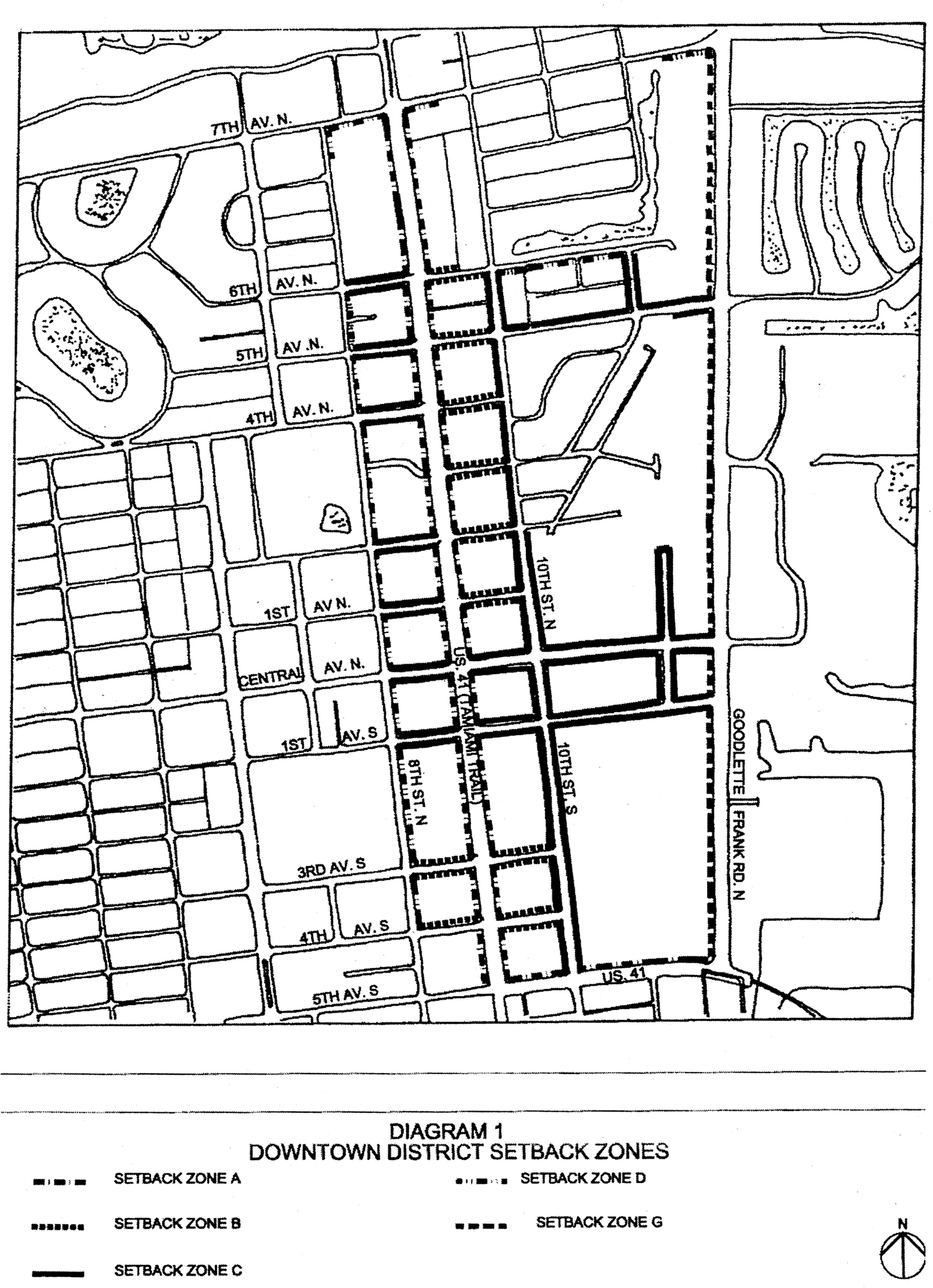
Diagram 1. Downtown District Setback Zones
Sec. 58-910. - Maximum building height.
Throughout the downtown district, the maximum height for any building, including residential, shall be limited to three stories and 42 feet, measured from the 1st-floor FEMA elevation to the peak of the roof or the highest point of any appurtenance attached to the roof, except where commercial property is adjacent to, or across the street or alley from, property zoned residential, buildings at the street line cannot be higher than the height permitted in the residential zone.
(Code 1994, § 102-850; Ord. No. 03-10093, § 1, 6-18-2003)
Sec. 58-911. - Standards for site design.
Sites shall be designed to incorporate safe and convenient vehicular use areas and pedestrian ways, with landscape, lighting, and signage treatments intended to result in a comprehensive design. Site design should promote the use of crime prevention through environmental design (CPTED) principles, including: visibility (visibility for law enforcement and other people in the area), natural surveillance (placing areas of activity where they can be seen), and defensible space (designing areas which people will take as their own and not be willing to relinquish this space to undesirable activities). Buildings shall have architectural features and patterns that provide visual interest from the perspective of the pedestrian, reduce massing, recognize local character, and are site responsive.
(1)
Uses along frontage lines:
a.
Parking structures or buildings elevated over parking shall have occupiable ground floor space for a minimum depth of 20 feet from the frontage lines.
b.
On corner property with a frontage line along one of the four commercial corridors (U.S. 41, Central Ave, 10th Street or Goodlette-Frank Road), residential 1st floors are permitted beyond a depth of 50 feet from that frontage line. On corner property fronting two or more commercial corridors, residential 1st floors fronting the road require conditional use approval.
(2)
Buildings shall have a principal pedestrian entrance on a primary frontage line. For residential-only property abutting an alley, vehicular access shall be provided from the alley rather than a frontage line.
(3)
Residential first floors subject to FEMA elevation requirements shall meet the following criteria:
a.
Between a frontage line and the facade of the building, fill is not to exceed two feet above the crown of the road.
b.
The first floor elevation at the front of the building shall not exceed one foot more than the FEMA elevation requirement. Stemwall construction must be used to connect the first floor elevation with grade.
(4)
Commercial first floors may not be elevated more than 1½ feet above the level of the adjacent sidewalk. If the FEMA elevation exceeds 1½ feet above the level of the adjacent sidewalk, the building must be floodproofed.
(5)
All buildings must address the street at the pedestrian level. Buildings shall be located to front towards and relate to public streets, both functionally and visually, to the greatest extent possible. Buildings shall not be oriented to front toward a parking lot.
(6)
Loading docks and service areas may not be located on primary frontage lines but shall be placed to the rear or side of buildings in visually unobtrusive locations and shall be screened by landscaping or fencing to prevent direct views of the loading area and its driveways from adjacent properties and from the public right-of-way and to prevent spill-over glare, noise or exhaust fumes.
(7)
Newspaper vending machines are not permitted on primary frontage lines.
(8)
Outdoor storage areas accessory to permitted uses must be fully screened from off-site view using solid walls, fences, and/or landscaping.
(9)
Any new building or change to an existing building where the cost of the improvements will exceed 50 percent of the appraised value of the improvements shall be required to relocate all telephone, electric and other wires of all kinds underground from the poles of the transmission cables located within platted utility easements to the building or the connection.
(10)
Mechanical equipment and screening for such equipment must be designed as an integral part of the building and located away from the frontage line.
(11)
Initial site design must consider the need for dumpsters and their enclosures and required backflow preventers and fire department connections.
(Code 1994, § 102-851; Ord. No. 03-10093, § 1, 6-18-2003; Ord. No. 20-14463, § 3, 3-4-2020)
Sec. 58-912. - Standards for building design.
Buildings shall have architectural features and patterns that provide visual interest from the perspective of the pedestrian, reduce massing, recognize local character, and are site responsive. Facades shall be designed to reduce the mass, scale and uniform monolithic appearance of large unadorned walls, while providing visual interest that will be consistent with the community's identity and character through the use of detail and scale.
(1)
Build-to line requirements. The following requirements shall apply within each setback zone:
a.
In setback zone A, 100 percent of the lot frontage at the first floor level, except for the required setback areas and building entry or access conditions, must be addressed either by building facade or referenced by use of porticos, arcades, or decorative walls to a minimum height of the first story. A minimum of ⅓ of the length must be building facade. The public sidewalk shall be placed on private property within an easement dedicated to the city, in a form provided by the city, and shall be a minimum of eight feet wide, located within the zone between ten feet and 20 feet from the property line. The area between the edge of the sidewalk and the building face shall be either widened sidewalk in matching pavement, or landscaped. No part of porches, stoops, or elevated terraces projecting beyond the building face shall project beyond the setback line. Refer to Diagram 2.
b.
In setback zone B, 100 percent of the lot frontage at the first floor level, except for the required setback areas and building entry or access conditions, must be addressed either by building facade or referenced by use of porticos, arcades, or decorative walls to a minimum height of the first story. The public sidewalk shall be placed on private property within an easement dedicated to the city, in a form provided by the city, and shall occupy the entire ten feet of required setback. Arcades, awnings or overhangs may shelter the sidewalk. Columns may support these elements so long as they provide a minimum passage width of eight feet. Refer to Diagram 3.
c.
In setback zone C, no part of porches, stoops, or elevated terraces projecting beyond the building face shall project beyond the setback line. Refer to Diagram 4.
d.
In setback zone D, the sidewalk shall be located in the public right-of-way, abutting the property line in accordance with the city's streetscape master plan. At least 70 percent of the area between the property line and the building face shall be landscaped. Refer to Diagram 5.
e.
The sidewalk locations and landscaping areas identified above apply unless the property is located on a street that has been improved as a unified streetscape by the city. Areas that would otherwise be required for sidewalks can contain landscaping only with the provision for access.
f.
Standards for paving materials shall be recommended by the committee and shall be approved by council.
g.
Second and third floor: 60 percent maximum of the building's facade length may be on the build-to line.
h.
The minimum facade step-back that constitutes a break from the build-to line is eight feet. Any facade run that steps back less than eight feet from the build-to line shall be considered as on the build-to line for the percentage calculations listed above. Exception: For properties with less than 50 feet of frontage, at least four of the following design features may be incorporated to qualify for the facade step-back:
1.
Recessed porches;
2.
Balconies with ornamental railing;
3.
Pilasters;
4.
Character line, such as a molding detail between stucco, to distinguish a break;
5.
Raised cornice parapets over doors;
6.
Peaked roof forms;
7.
Shutters surrounding windows and doors;
8.
Ornamental and structural architectural details, other than cornices, which are integrated into the building structure and overall design;
9.
Quoins on the corners of the building;
10.
Decorative light fixtures;
11.
Decorative landscape planters or planting areas, a minimum of five feet in width;
12.
Any other architectural detail approved by the committee.
(2)
Roofing and projection requirements.
a.
Sloped roofs must be within a 4:12 to 12:12 slope range.
b.
Roof eaves and overhangs may extend no more than four feet from the build-to line. Roofs must continue a minimum of eight feet back from the build-to line. Cantilevered mansard roofs are not permitted.
c.
Flat roofs must have parapets of solid construction; such parapets must be a minimum of two feet in height.
d.
Habitable balconies and other architectural facade elements may project up to four feet beyond the build-to line.
(3)
Facade design.
a.
General standards.
1.
Facade elements are to be arranged in an orderly manner.
2.
First floor window, door, and storefront head heights are to be a minimum of eight feet for nonresidential applications.
3.
Floor to ceiling height for first floors will be a minimum of 12 feet (measured to the structural main ceiling) for all commercial applications. For all residential applications, floor to ceiling height (measured to the structural main ceiling) will be not less than nine feet.
4.
A transition line will be provided at the top of the first story. The transition will be expressed by a material change, by a trim line, or by a balcony no more than four feet deep.
5.
Building facades which do not face frontage lines will incorporate the same surface materials and similar design elements and will provide attractive rear entrances and consideration of pedestrian pass-throughs.
b.
Windows and doors.
1.
Windows and doors, excluding ground-level storefront, shall be vertical in proportion or a combination of multiple vertically proportioned windows.
2.
The glazed area of a facade, excluding ground-level storefront, shall be a minimum of 20 percent of the total facade area for all facades visible from public rights-of-way.
3.
Sliding glass doors are not permitted, except in transient lodging or residential applications with the provision that they emulate French doors in appearance.
4.
Glass on the 1st floor (ground level) shall be clear or lightly tinted only.
c.
Storefronts.
1.
1st-floor commercial (ground level) facades on principal pedestrian streets shall be detailed and glazed as storefronts.
2.
Retail occupancies shall have glazed storefront areas equal to at least 65 percent of the ground level portion of the facade.
d.
Awnings and other shade structures.
1.
First-floor awnings or other shade structures are to be no more than ten feet high at the lower drip edge.
2.
First-floor awnings and other shade structures may extend past the four-foot maximum facade projection requirement into the pedestrian right-of-way. Awnings and other shade structures that extend past this requirement must include column or post supports.
e.
Building styles not accepted.
1.
Fantasy architecture: ships, castles, animals, etc.
2.
Corporate architecture: predesigned or standardized designs (custom-designed architecture for corporations is allowed).
(4)
Materials. Exterior building materials and colors contribute significantly to the visual impact of a building on the community. They shall be well-designed and integrated into a comprehensive design style for the project.
a.
Exterior walls. The primary exterior finish material on all facades shall be limited to stucco (including synthetics), masonry, tile, stone and concrete clapboard. Exposed, nontextured flat masonry block is not accepted.
b.
Roof. The materials for pitched roofs shall be limited to concrete or clay tile, metal, asphalt or fiberglass shingles, and slate or synthetic slate. Flat roofs may be any acceptable membrane system as permitted in the Florida Building Code.
c.
Accessory materials. Highlight or detail materials shall be limited to metal, stone, cast concrete, wood or synthetic wood, smooth fiberglass or smooth molded high density polymer.
d.
Exterior colors. The exterior of buildings, including trim, shall be compatible with surrounding buildings. Exterior color schemes that attract undue attention, or that cause the building to appear as a sign, are not permitted.
e.
New materials. Additional materials may be permitted by review of the building official.
(5)
Plan preparation. For any project involving a building addition of 500 square feet or more or a building permit value of $100,000.00 or greater, the plans must be prepared by a licensed architect.
(6)
Maximum uninterrupted building length requirements. Where a building or a series of buildings form a continuous street wall that exceeds 150 feet in length, a via shall be provided at the ground floor. The via shall be not less than 6 feet in width and not less than 10 feet in height. A via may be roofed. A via shall be open to the public. A via qualifies as public open space if it is unroofed and open to the sky, at least 1,000 square feet in contiguous area and dedicated to the city.
(Code 1994, § 102-852; Ord. No. 03-10093, § 1, 6-18-2003; Ord. No. 21-14751, § 1, 12-1-2021; Ord. No. 23-15111, § 2, 6-7-2023)
Sec. 58-913. - Specific requirements for auto repair shops.
The following are specific requirements for auto repair shops:
(1)
Repair bays shall not open onto the street but may open onto an alley.
(2)
All repairs must be performed within an enclosed repair bay.
(3)
Parking areas and bay access areas must be screened from the street by a 3-foot-high hedge and trees every 50 feet on center.
(4)
No access to auto repair shops from 10th Street or U.S. 41 is permitted.
(5)
Maximum opening onto the street for access purposes is 24 feet.
(6)
Right-of-way parking cannot be credited for building square footage.
(7)
Setbacks shall be as per base district requirements.
(8)
Permitted hours of operation: Monday—Saturday, 7:00 a.m. to 7:00 p.m.
(9)
Storage of vehicles to be repaired cannot be in a fenced or locked yard, but must be in a standard parking lot configuration.
(10)
Parking lot area must consist of "down lighting" on poles with a maximum height of 12 feet as measured at the base of the luminaire.
(11)
No storage of cars visible from rights-of-way for more than seven days is permitted.
(12)
No storage of wrecked or junked cars is permitted.
(13)
The shop shall not be contiguous to or across a street or alley from residential zoning.
(Code 1994, § 102-853; Ord. No. 03-10093, § 1, 6-18-2003)
Sec. 58-914. - Signage.
Signs are intended to be designed to complement rather than detract from the visual impact of a commercial development by utilizing design elements consistent with those employed in the structure's architecture.
(1)
Address numbers. Address numbers, a minimum of six inches and a maximum of eight inches in height, shall be placed on each building or storefront in such a manner as to be readily visible and legible from the street. Address numbers must be Arabic-style and reflective.
(2)
Sign band. A sign band or zone may be applied to the facade of each building, providing that it shall not exceed 2½ feet in vertical dimension. The horizontal dimension may be of any length. The bottom of such sign band shall be located at least ten feet above sidewalk grade. The sign band or zone may contain multiple individual signs but all must refer to a tenant of the building. A maximum of two sign bands may be placed on the facade of each building, each on a separate story. Within each sign band, signs shall be complementary in terms of color, material, lettering or graphic style, and method of illumination.
Sign Band
(3)
Awning signs. In lieu of a sign band, the vertical drip edge of an awning may be stenciled with letters no more than 8 inches in vertical dimension by any length. Both awning signs and a sign band are not permitted on a single building. Individual shop signs in a single building should relate to each other in design, size, color, lettering style, and method of illumination.
(4)
Perpendicular signs. Additional signs or shingles may be attached to a building perpendicular to the facade, extending up to 6 feet from the facade. The bottom of the sign shall be no less than 8 feet above sidewalk grade. The distance from the building wall to the sign shall not exceed 1 foot. The height of the lettering or numbers shall not exceed 10 inches. Graphics or logos may be larger. There may be 1 perpendicular sign for each ground floor business. Perpendicular signs may not exceed 8 square feet in area, with a maximum dimension of 4 feet.
(5)
Sign illumination. External signs shall not be translucent but may be externally lit or backlit. Signs using exposed neon tubes are not permitted.
(6)
Window signs. Signs on the interior of a window or painted on the window shall be limited to no more than 30 percent of a window, up to a maximum of 12 square feet in area.
(7)
Wall-mounted building directory sign. One wall-mounted building directory sign for each street or major pedestrian way upon which the building faces, identifying the occupants of a commercial building, including upper-story tenants, is permitted. Each such directory sign is limited to a maximum of 20 square feet.
(8)
Restaurants/cafes. In addition to other signage, restaurants and cafes shall be permitted the following, limited to 1 sign per business:
a.
Menu case. A wall-mounted display featuring the actual menu contained within a shallow glass-fronted case. The display case shall be located next to the main entrance, may be lighted, and shall not exceed a total area of 2 square feet.
b.
Sandwich board signs. No sandwich board signs are permitted in the district.
(9)
Ground signs/pole signs: U.S. 41 and Goodlette-Frank Road. Properties which front on U.S. 41 or Goodlette-Frank Road are permitted 1 60-square-foot ground sign if the property has 150 feet of frontage on U.S. 41 or Goodlette-Frank Road. Such ground signs are limited to 5½ feet in height, may be located on the front property line, and, on corner locations, must be a minimum distance of 50 feet from the intersection of the extended curblines. Ground signs must be located so as not to present visual hazards for pedestrians. Ground signs are permitted. Pole signs are not permitted.
Ground Signs/Pole Signs
(10)
Combination of signs. A project is permitted a combination of any 2 of the following types of signs: sign band, awning sign, ground sign.
(Code 1994, § 102-854; Ord. No. 03-10093, § 1, 6-18-2003)
Sec. 58-915. - Parking facilities generally; landscaping.
(a)
Commercial buildings shall be designed to provide safe, convenient, and efficient access for pedestrians and vehicles. Parking shall be designed in a consistent and coordinated manner for the site. The parking area shall be integrated and designed so as to enhance the visual appearance of the community. Landscaping is intended to enhance the visual experience of the motoring and pedestrian public. Landscaping should be used to enhance and complement the site design and building architecture.
(b)
These requirements shall supersede the requirements of chapter 50 within the downtown district.
(1)
Number of parking spaces required.
a.
Commercial uses: Three spaces per 1,000 square feet (gross) of commercial building area.
b.
Dwelling units as a part of a mixed-use development: Two spaces per unit except that, for every parking space provided by the commercial use, the commercial parking space may also count equally as a residential parking space for 50 percent of the required parking for the residential use. Restaurants that serve dinner are excluded from the credit.
c.
Dwelling units developed as a residential-only project: Two spaces per unit.
d.
Transient lodging units: One and one-quarter spaces per unit.
e.
Places of seated assembly such as churches and theaters: One space per four seats.
f.
Uses not listed: Parking determined through a parking needs analysis approved by the city council.
g.
Existing uses grandfathered: The above parking requirements shall not apply to existing uses on lots smaller than 30,000 square feet. For any such existing use that expands or adds on to its total building area after this Code is adopted, the above parking requirements shall be applied to the added area only. Total required parking in such cases shall be the sum of the existing parking and the added required parking. Also, refer to section 58-918.
(2)
Alternatives to providing required number of parking spaces. Where it is technically not feasible to provide the required number of parking spaces, the following alternatives may be considered:
a.
For properties of 100,000 square feet or less, available on-street parking may be allocated to meet the required minimum parking. Refer to section 58-916.
b.
Payment may be made into a payment in-lieu-of parking fund. Refer to section 58-920.
(3)
Use of parking areas. Where off-street parking is required, such parking areas shall be used for vehicular parking only, with no sales, rental, dead storage (including boat and trailer storage), repair work, dismantling or servicing of any kind.
(4)
Parking in yard areas. Parking is not permitted closer to a front property line than the facade of the building it serves except in setback G. Side and rear yard areas may be used for parking. Parking fronting a public street must be completely screened from view by vegetation. For residential-only property abutting an alley, vehicular access shall be provided from the alley rather than a frontage line.
Parking in Yard Areas
(5)
Design of parking facilities.
a.
Joint use of commercial and mixed-use parking areas. Where possible, all new off-street parking facilities shall be designed for joint use by abutting properties.
b.
Driveways, accessways, and access aisles of commercial and mixed-use property shall be interconnected with all existing driveways, accessways, and access aisles in parking areas already developed on abutting commercial and mixed-use property.
c.
Where abutting property is not developed, driveways, accessways, and access aisles of commercial and mixed-use property shall be brought to the common property line so that future interconnection is possible.
d.
Where existing abutting property is developed in such a manner that interconnection of driveways, accessways, or access aisles is physically impossible, no connection shall be required.
e.
All required off-street parking spaces meet the dimensional requirements of section 50-103(b)(1), the surfacing requirements of section 50-103(c), and the handicapped parking requirements of section 50-103(d).
f.
Parking lot layout shall take into consideration pedestrian circulation. Pedestrian crosswalks shall be provided where necessary and appropriate, shall be distinguished by textured or special paving, and shall be integrated into the wider network of pedestrian walkways and sidewalks.
g.
Reserved parking is not allowed for commercial uses.
(6)
Loading spaces. Loading spaces are not required.
(7)
Landscaping of parking lots.
a.
At least 30 square feet of landscaping shall be provided for each on-site parking space.
b.
Landscaping, and on-site water retention as referenced in section 30-342, shall be located in such a manner as to divide and break up the expanse of paving and provide a measure of shade and visual relief.
c.
Landscaping shall be located so as to enable the interconnection of parking aisles on abutting properties.
d.
Each separate landscaping area shall have a minimum dimension of 5 feet and a minimum area of 30 square feet.
e.
Trees used for parking lot landscaping shall be canopy trees and must be a minimum of 10 feet in height at the time of planting.
f.
All landscaping areas must be irrigated and maintained.
g.
Each separate landscaped area shall include at least 1 tree, with the remaining area adequately landscaped with shrubs, ground cover, or other approved landscaping material. The total number of trees shall not be less than 1 for each 100 square feet or fraction thereof of required landscaping.
h.
The front of a vehicle may encroach upon any landscaped area when the area is at least 5 feet in depth per immediately abutting parking space and protected by wheel stops or curbing. Two feet of such landscaped area or walkway may be part of the required depth of each abutting parking space.
(8)
Landscaping of front yards. Refer to sections 58-909 and 58-912. Trees required in setback areas adjacent to streets as required setback zones are as follows:
a.
General standards. All materials shall meet grade Florida #1 or better, as prescribed in Grades and Standards for Nursery Plants, latest edition. Existing trees that are of sufficient size and health may be retained to meet the provisions of this section. All trees shall be planted 30 feet on center. Minimum size at time of planting for canopy-type trees shall be 16 to 18 feet overall height with minimum 3½-inch caliper. Minimum size at time of planting for palm trees shall be 10 feet of grey wood.
b.
Authorized trees. The following trees are authorized for the following areas:
1.
U.S. 41: Live oak (Quercus virginiana). However, royal palm (Roystonea regia) may be substituted for live oak to accentuate building main entranceways, for up to 30 percent of the total trees required under this provision.
2.
10th Street: Royal palm (Roystonea regia) or consistent with city's implemented street design.
3.
Central Avenue: Black olive (Bucida buceras "Shady Lady") or consistent with city's implemented street design.
4.
8th Street: Mahogany (Swietenia mahagoni) or consistent with city's implemented street design.
5.
6th Avenue North: Hong Kong orchid (Bauhinia blakeana); or from 10 th Street North to dead end: Sabal palm (Sabal palmetto).
6.
5th Avenue North: Mahogany (Swietenia mahagoni) or Royal palm (Roystonea regia).
7.
4th Avenue North: Golden rain tree (Koelreuteria elegans).
8.
2nd Avenue North: Silver trumpet tree (Tabebuia caraiba).
9.
1st Avenue South: Mahogany (Swietenia mahagoni) or Royal palm (Roystonea regia).
10.
12th Street: Mahogany (Swietenia mahagoni) or Royal palm (Roystonea regia).
(Code 1994, § 102-855; Ord. No. 03-10093, § 1, 6-18-2003; Ord. No. 04-10653, § 1, 11-17-2004; Ord. No. 11-12963, § 4, 10-5-2011; Ord. No. 23-15111, § 3, 6-7-2023)
Sec. 58-916. - Standards for on-street parking.
(a)
On-street parking may be allocated to meet the required parking for private property that is 100,000 square feet or less if the following standards are met:
(1)
The district is divided into two geographic areas: north of Central Avenue and south of Central Avenue. The on-street parking must be located in the same geographic area as the private property.
(2)
On-street parking allocation fees are as set forth in Appendix A to this Code.
(3)
The payment of the per-space fee shall be made to the city Parking Trust Fund at the time of issuance of a building permit.
(4)
Once an allocation of parking to a private property owner for new construction is approved, the owner has one year to obtain a building permit. If a building permit is not obtained within that timeframe, the allocated parking spaces shall be returned to the parking pool and shall be available to any property owner within that geographic area.
(5)
Refunds. Where a project has not commenced construction after issuance of a building permit, requests for refunds of on-street parking space fees must be made in writing and will be considered on an individual basis and approved by the city council. After determination of the city council at a public meeting that the property owner is entitled to a refund, the city shall return the amount so determined. Any interest that may have been earned on such amounts shall not be refundable.
(b)
The parking models shown below may be modified due to specific site conditions, including, but not limited to, driveway cuts, storefront locations, and utility locations, upon written approval of the city manager.
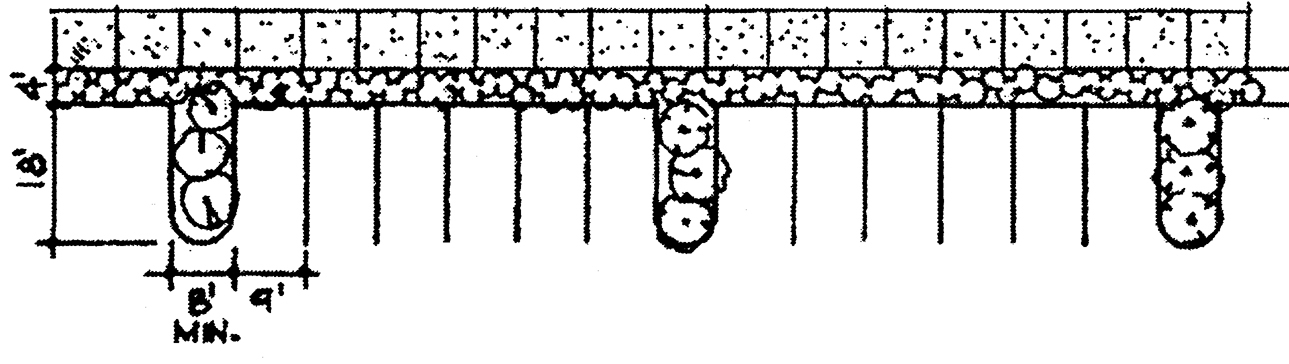
Perpendicular Model
6 spaces maximum between landscape islands; minimum 8-foot-wide island, 16-foot island at ends of block; minimum 4-foot strip of landscape in front of cars, if possible; best engineering practices.
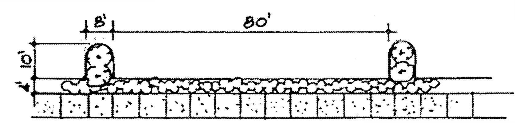
Parallel Model
80 feet maximum between bulb-outs; minimum 8-foot bulb-out, 16-foot at corner locations; best engineering practices.
(Code 1994, § 102-856; Ord. No. 03-10093, § 1, 6-18-2003; Ord. No. 04-10653, § 1, 11-17-2004; Ord. No. 11-12963, § 5, 10-5-2011)
Sec. 58-917. - Waivers.
(a)
The city council may waive the requirements of this division for additions, alterations, or rehabilitation of buildings which do not meet the design standards of this division upon finding that the following criteria are met:
(1)
The property does not conform to the standards of this division and the existing nonconformities are such that meeting the requirements of this division are impractical or will not meet the intent of this division.
(2)
The proposed addition, alteration, or rehabilitation is compatible with adjacent buildings, achieves the requirements of this division as closely as is practicable, and is consistent with the intent of this division.
(b)
Waivers shall not be granted for matters relating to use.
(c)
Waivers shall not be granted to increase a building size over what is allowed by this Code.
(Code 1994, § 102-857; Ord. No. 03-10093, § 1, 6-18-2003)
Sec. 58-918. - Nonconformities.
(a)
Notwithstanding any other provision of the Code, this division shall not apply to any property unless and until the property or business, or both, is the subject of a petition or application for a substantial renovation or alteration, i.e., more than 50 percent of preapplication value of the structure; or addition, i.e., more than 50 percent of the preapplication square footage of the structure; or for removal and reconstruction.
(b)
Specifically, without limiting subsection (a) of this section, a property owner shall not, by virtue of this division:
(1)
Lose permitted uses, parking allocations, setbacks, driveways or sidewalk areas existing at the date of adoption of the ordinance from which this division is derived;
(2)
Be required to remove, or make to conform, existing nonconforming signage unless the sign is more than 50 percent destroyed or must be repaired to the extent of more than 50 percent;
(3)
Be required to remove, or make to conform, existing nonconforming signage when there is merely a change of copy on the sign; or
(4)
Be required to fund additional on-site landscaping improvements than those provided through tax increment financing revenue.
(c)
If for any reason a nonconforming use of land, structure or sign ceases for a period of 12 consecutive months, it shall thereafter be made to conform to the requirements of this division. An affected property owner may request the city manager to approve up to 2 6-month extensions of time.
(Code 1994, § 102-858; Ord. No. 03-10093, § 1, 6-18-2003)
Sec. 58-919. - Improvement and redevelopment review.
(a)
Community redevelopment agency advisory board. The city community redevelopment agency advisory board (CRAAB) shall be authorized to administer this division on matters outlined in chapter 2, article V, division 8.
(b)
Procedures for design review. The city design review board shall determine compliance with this division and with the provisions of chapter 2, article V, division 4 (design review board) and section 50-241 (architectural and landscape architectural design standards) for any improvements affecting the exterior of a building or site on private land, except as provided in section 58-918, including construction, reconstruction, alteration, rehabilitation; changing the color of a building; landscaping; and demolition of buildings and appurtenances. No building permit shall be issued before the project receives approval from the design review board.
(Code 1994, § 102-859; Ord. No. 03-10093, § 1, 6-18-2003; Ord. No. 04-10654, § 1, 11-17-2004; Ord. No. 08-12207, § 6, 10-1-2008)
Sec. 58-920. - Parking alternatives for nonresidential uses.
(a)
Developer's option. In lieu of providing up to but not more than 25 percent of the parking spaces required for nonresidential uses located in the district, a developer may pay into the city payment in-lieu-of parking trust fund a sum of money that is the product of the number of parking spaces required but not provided and the current cost to provide a single parking space in the district.
(b)
Fees. The city council shall by resolution adopt fees to be charged for parking spaces and shall be as set forth in Appendix A to this Code.
(c)
Payment in-lieu-of parking trust fund established. The city payment in-lieu-of parking trust fund account is hereby established, into which shall be deposited all payments made by developers pursuant to this section. The city shall use monies deposited into said account for the exclusive purpose of paying the cost of construction or reconstruction of parking spaces in the district. Said cost includes the cost of all labor and materials, the cost to acquire all lands, property, rights, easements, and franchises acquired, the cost of financing charges, the cost of interest prior to and during construction and, for one year after completion of construction, discount on the sale of municipal bonds, the cost of plans and specifications, surveys of estimates of costs and of revenues, the costs of engineering and legal services, and such other costs and expenses necessary or incident to determining the feasibility or practicability of such construction or reconstruction, administrative expenses, and such other expense as may be necessary or incident to the construction or reconstruction of its financing.
(d)
Time of payment. Payments made pursuant to this section shall be made at the issuance of a building permit for any portion or phase of a development project to which the parking spaces that are required for a nonresidential use but are not provided relate.
(e)
Reimbursement. For developments that provide dedicated, public parking spaces over and above the required minimum parking, the developer will be reimbursed from the payment-in-lieu-of parking trust fund a sum of money equal to the product of the excess spaces and the current reimbursement cost. The determination of such excess public spaces shall be subject to the following conditions:
(1)
The public parking spaces shall be readily apparent to the public and have direct access to a public way. At no time shall the use of these spaces be limited by liftgates, traffic cones or other means.
(2)
A reasonable minimum number of contiguous public spaces, sufficient to be easily interpreted as a public parking amenity, shall be provided. This reimbursement is not intended for the odd one or two excess spaces that may result in a particular development layout, but rather, is intended to reimburse a concerted effort to add to the public parking pool.
(3)
The quantity and suitability of such excess public parking spaces is subject to the review and determination of the committee.
(f)
Dedicated ground floor public parking. For developments that dedicate the entire ground floor of a parking structure to public parking, the developer, through the conditional use process, may be permitted to provide supplemental parking on the third floor rooftop. Rooftop parking areas shall be screened with a parapet. The structure, including the rooftop parking areas, shall be designed, landscaped and maintained so as to be compatible with surrounding structures and so as to prevent undue interference with the view from surrounding structures.
(g)
Fees. The city council shall by resolution adopt the amount to be reimbursed for a single public parking space in the district and shall be as set forth in Appendix A to this Code.
(h)
Excess parking. A development may construct parking in excess of that which is required by this Code, including spaces in a parking structure, in its project. The excess spaces may be leased or sold to a second development within one of the geographic areas defined in section 58-916 in which the development is located, or to the city. The leased or purchased parking may be used in meeting the parking requirements under this Code by the second development.
(i)
Refunds. Where a project has not commenced construction after issuance of a building permit, requests for refunds of parking space fees must be made in writing and will be considered on an individual basis and approved by the city council. After determination of the city council at a public meeting that the property owner is entitled to a refund, the city shall return the amount so determined. Any interest that may have been earned on such amounts shall not be refundable.
(Code 1994, § 102-860; Ord. No. 03-10093, § 1, 6-18-2003; Ord. No. 11-12963, § 6, 10-5-2011)
Sec. 58-921. - Specific requirements for outdoor display of merchandise.
The outdoor display of merchandise may be permitted subject to the limitations listed below. A plan depicting the location of the merchandise shall be submitted to the city for review and approval and the city manager reserves the right to deny the plan based on safety, aesthetics, or inadequate space.
(1)
All merchandise on display outdoors must be appropriate for outdoor display and weather resistant. All merchandise must be in good condition. Items on display may include but are not limited to plants, landscaping supplies, outdoor furniture, and recreational equipment intended for outdoor use. Motorized vehicles, vending machines, construction equipment and the bulk storage of construction materials are not permitted for outdoor display unless otherwise permitted in the district as an allowable use.
(2)
Merchandise displayed outdoors must be also be available for sale inside the adjacent commercial establishment and the merchandise shall only be displayed outside of the establishment where the merchandise is sold.
(3)
All merchandise sales transactions must be indoors.
(4)
Outdoor display areas may not be sublet or subleased to a separate business entity.
(5)
Outdoor display of merchandise is not intended to expand retail space or assist in liquidating clearance or discarded items.
(6)
Displays must be located on private property, immediately adjacent to the commercial business and conforming to all required setbacks or build-to lines. Displays cannot hinder pedestrian circulation, extend into the public sidewalk or impede emergency egress.
(7)
No required parking space, parking aisle, loading space or landscaped area shall be used for display purposes.
(8)
No additional signage is permitted. Merchandise may not be used as signage and may not have signage attached to it.
(9)
No additional parking is required for outdoor display areas not exceeding 100 square feet. Display areas exceeding 100 square feet will be required to supply parking at the current required ratio for the display area that exceeds 100 square feet.
(10)
Outdoor display areas existing as of the effective date of this ordinance and exceeding 100 square feet are exempt from providing required parking provided a plan depicting the location of the merchandise is submitted for review and approval.
Sec. 58-931.- District purpose.
The BP district is a utilitarian, business and service district characterized by a broad range of retail, services, manufacturing, distribution, storage, repair and civic uses. In order to provide for utilitarian businesses and related general commercial uses to be located in proximity to one another, a blend of light industrial, commercial, professional, business and service uses shall be permitted within the Business Park district.
(Ord. No. 08-12205, § 1, 10-1-2008)
Sec. 58-932. - Uses permitted.
In the BP district, no building or structure, or part thereof, shall be erected, altered or used, or land or water used, in whole or in part, for other than the following:
(1)
Retail, service, wholesale, distribution, indoor storage, auction or rental of new or used goods - excluding rental of motor vehicles.
(2)
Gasoline service stations.
(3)
Light industrial uses to include: maintenance, repair, reconditioning, cleaning, including dry cleaning and auto cleaning, printing, cooking, processing, packaging, testing, manufacturing or assembling operations.
(4)
Contractors' fabrication, storage and supply establishments and furniture refinishing.
(5)
Bakeries, wholesale or retail.
(6)
Professional, business, financial, civic or public utility offices and government facilities, including drive up windows.
(7)
Medical offices, counseling services, laboratories and out-patient clinics- excluding in-patient, residential clinics.
(8)
Research and development establishments.
(9)
Veterinarians, pet shops and grooming.
(10)
Art and photography studios.
(11)
Convenience services, such as tailoring, garment alteration and repair, shoe repair and the like.
(12)
Cultural facilities, including libraries, motion picture or live theaters, dance studios, museums and similar publicly owned buildings - excluding drive in theaters.
(13)
Churches.
(14)
Personal service establishments, including barber and beauty shops.
(15)
Schools and colleges, including commercial schools, dance, arts and athletic instruction.
(16)
Transportation, communication and utilities businesses.
(17)
Radio or television broadcasting offices or studios, including satellite dishes, however no towers exceeding 42 feet in height.
(18)
Restaurants, conventional and carryout - excluding cocktail lounges.
(19)
Accessory uses and structures which are incidental to and customarily associated with the uses permitted in this district.
(Ord. No. 08-12205, § 1, 10-1-2008)
Sec. 58-933. - Conditional uses.
Conditional uses in the BP district are as follows:
(1)
Rental of motor vehicles.
(2)
Amusement or recreation uses not listed as permitted uses.
(3)
Drive up or drive through windows not listed as permitted.
(4)
Daycare centers.
(5)
Animal daycare centers, boarding kennels and outdoor kennel runs—No breeding kennels.
(6)
Parking garages, as a primary or accessory use.
(7)
Outdoor storage with screening as accessory to permitted uses.
(8)
Fuel and chemical storage and wholesale.
The planning advisory board may, through the review and approval of a conditional use petition and with the approval of the city council, permit other uses which are similar to and no more intense than those enumerated in this section.
(Ord. No. 08-12205, § 1, 10-1-2008)
Sec. 58-934. - Minimum lot area.
Minimum lot area in the BP district is 20,000 square feet.
(Ord. No. 08-12205, § 1, 10-1-2008)
Sec. 58-935. - Minimum lot width.
Minimum lot width in the BP district is 100 feet.
(Ord. No. 08-12205, § 1, 10-1-2008)
Sec. 58-936. - Minimum yards.
Minimum yards in the BP district are as follows:
(1)
Front yard: 25 feet, six feet of which shall be landscaped in accordance with the landscaping requirements of chapter 50.
(2)
Side yard: The total of all side yards shall equal 20 percent of lot width, maximum of 50 feet total. No side yard shall be less than ten feet. A unified plan is allowed for lots under common ownership. For lots adjacent to residential zoning district, minimum side yard is 50 feet.
(3)
Rear yard: 15 feet, except for lots adjacent to a residential zoning district, on which the minimum rear yard requirement is 50 feet; and for lots adjacent to a water body, on which the minimum rear yard requirement is 25 feet.
(Ord. No. 08-12205, § 1, 10-1-2008)
Sec. 58-937. - Minimum floor area.
Minimum floor area in the BP district is 1,000 square feet per building on ground floor.
(Ord. No. 08-12205, § 1, 10-1-2008)
Sec. 58-938. - Maximum height.
In the BP district, the maximum height shall be limited to three stories and 42 feet, measured from the first floor FEMA elevation to the peak of the roof or the highest point of any appurtenance attached to the roof.
(Ord. No. 08-12205, § 1, 10-1-2008)
Sec. 58-939. - Minimum off-street parking.
See chapter 50 for parking requirements in the BP district.
(Ord. No. 08-12205, § 1, 10-1-2008)
Sec. 58-940. - Maximum lot coverage.
Maximum lot coverage by all buildings in the BP district is 60 percent.
(Ord. No. 08-12205, § 1, 10-1-2008)