
Naples City Zoning Code
ARTICLE III
SPECIAL OVERLAY DISTRICTS
DIVISION 4. - AIRPORT OVERLAY DISTRICT[2]
Editor's note— Exhibits A—E referred to in this division are not set out herein, but are on file and available for inspection in the offices of the city.
DIVISION 6. - 5TH AVENUE SOUTH SPECIAL OVERLAY DISTRICT[3]
Editor's note— Ord. No. 08-12207, § 7, adopted October 1, 2008, amended Div. 6, in its entirety, to read as herein set out. Prior to inclusion of said ordinance, Div. 6 pertained to similar subject matter. See also the Code Comparative Table.
Sec. 58-1021. - District purpose.
The cone of influence special overlay district provides for the protection of health, life, resources and property through regulation of hazardous substances, sewage disposal, well construction, stormwater management, earth mining, solid waste and other related aspects of land use and development in the vicinity of public water supply wells.
(Comp. Dev. Code 1990, § 7-5-1(A); Code 1994, § 102-921)
Sec. 58-1022. - Designation; administration.
The cone of influence special overlay district shall be derived from the county groundwater protection ordinance and administered by the county pollution control department or any other person or agency designated by the board of county commissioners. If this district conflicts with the provisions of the base district, the more restrictive regulations shall apply.
(Comp. Dev. Code 1990, § 7-5-1(B); Code 1994, § 102-922)
Sec. 58-1041. - Definition.
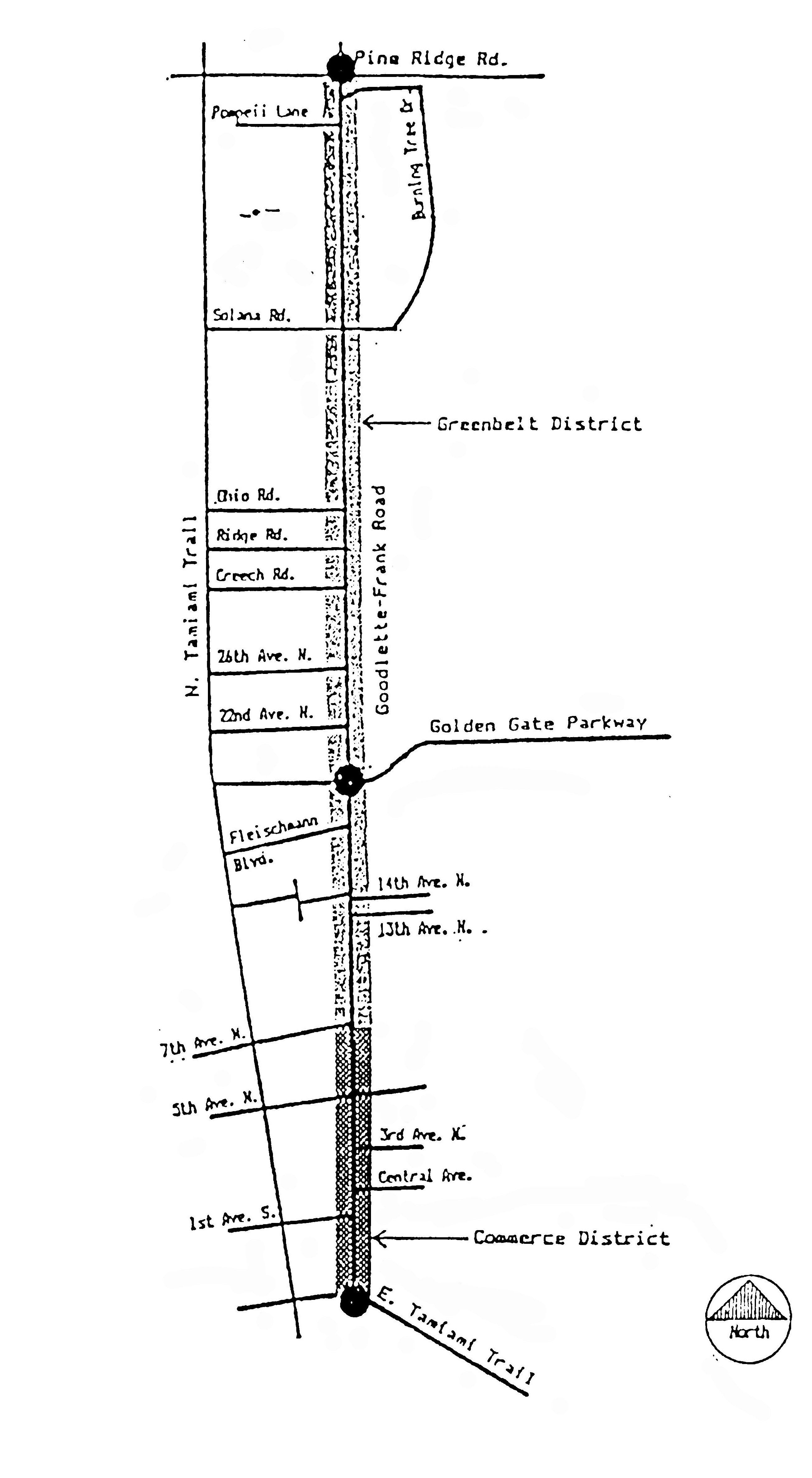
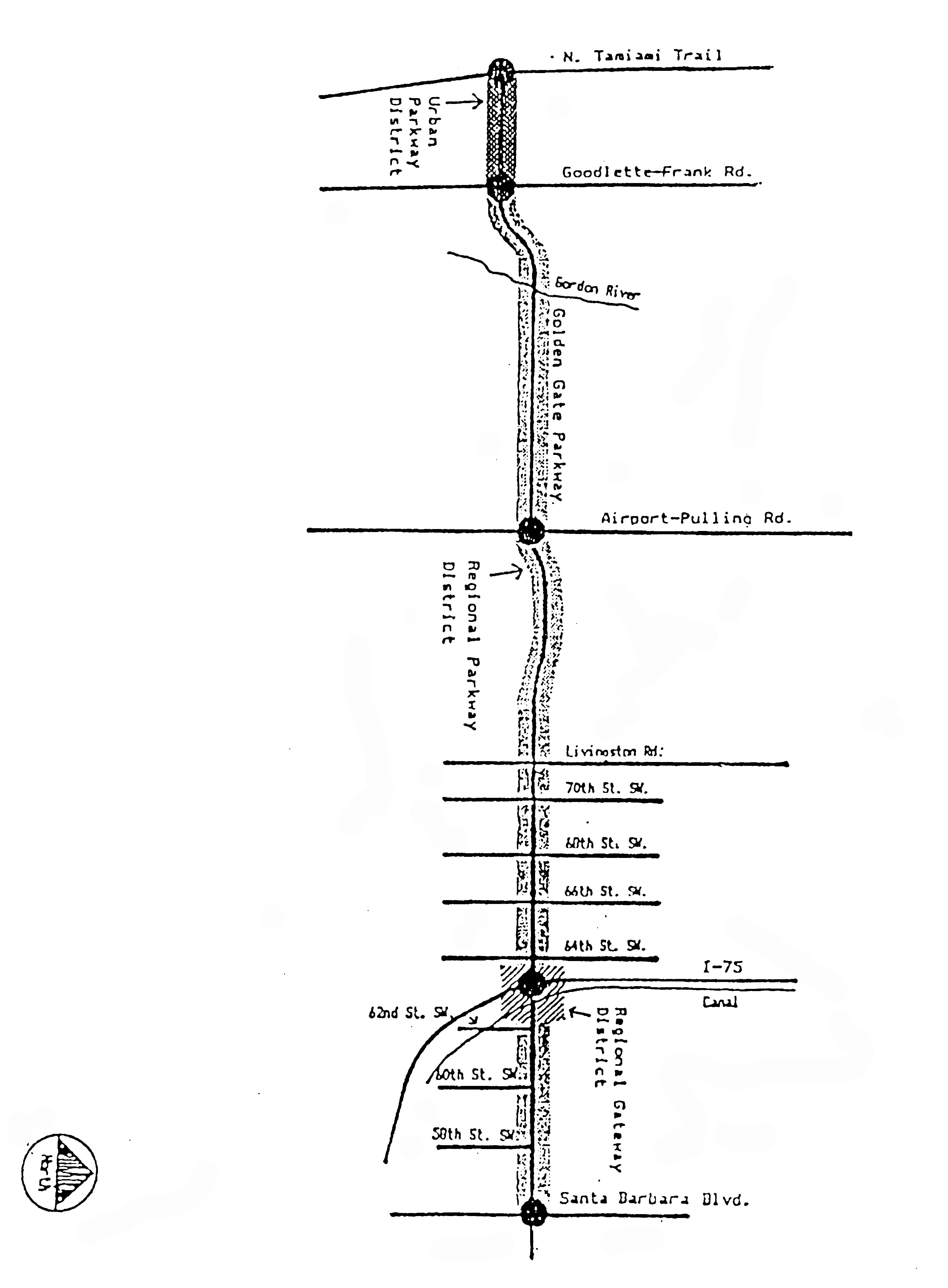
Corridors are defined as the major roadways and abutting lands adjacent to Golden Gate Parkway and Goodlette-Frank Road.
(Comp. Dev. Code 1990, § 7-5-2(A); Code 1994, § 102-941)
Cross reference— Definitions generally, § 1-2.
Sec. 58-1042. - District purpose; applicability.
This division serves as a supplement to existing zoning standards for lands defined in section 58-1043. These regulations recognize that 2 separate jurisdictions govern these land uses, and they are designed to develop greater consistency in land uses and design standards for these corridors, which are located between the city and the county. Development standards which are not addressed in this division are subject to the underlying zoning standards. Development agreements approved prior to October 1989 which conflict with the standards of this division shall not be required to meet these standards. All standards of this division which do not conflict with those within the development agreement shall apply to the development.
(Comp. Dev. Code 1990, § 7-5-2(B); Code 1994, § 102-942)
Sec. 58-1043. - Location.
This division pertains to all land adjacent to the rights-of-way of Goodlette-Frank Road from U.S. 41 to Pine Ridge Road and along Golden Gate Parkway from U.S. 41 to the city limits as measured perpendicular from the abutting right-of-way for a distance of 330 feet (see the location maps following this division).
(Comp. Dev. Code 1990, § 7-5-2(C); Code 1994, § 102-943)
Sec. 58-1044. - Permitted, conditional or provisional uses.
Permitted, conditional or provisional uses in the corridor management overlay district shall be as provided for in the underlying zoning districts.
(Comp. Dev. Code 1990, § 7-5-2(D); Code 1994, § 102-944)
Sec. 58-1045. - Setbacks; maximum height.
The regulations set out in this section pertain to front yard setbacks only. Regulations for side and rear yards are the same as for the underlying zoning districts. Required setbacks in the corridor management overlay district are as follows:
(1)
Golden Gate Parkway: 50 feet for commercially zoned property and in activity centers, 100 feet for all other areas.
(2)
Goodlette-Frank Road: 50 feet.
These setback standards apply to ground floors only. For each additional story which is developed, each additional story shall be set back an additional 25 feet beyond the 1st-floor story so that development follows a 1:2 view plane slope. Maximum height is determined by the underlying zoning district.
(Comp. Dev. Code 1990, § 7-5-2(E); Code 1994, § 102-945)
Sec. 58-1046. - Signage.
Sign regulations in the corridor management overlay district are the same as provided in chapter 50, article II.
(Comp. Dev. Code 1990, § 7-5-2(F); Code 1994, § 102-946)
Sec. 58-1047. - Access.
In the corridor management overlay district, 2-way ingress and egress to the primary arterial shall be at least 330 feet from street intersections. One-way ingress and egress shall be at least 150 feet from intersections. Curb cuts and access shall be shared wherever possible. Parking lots of separate developments should be connected when possible to provide for greater open space. Development will be reviewed for compliance with such requirements prior to issuance of building permits.
(Comp. Dev. Code 1990, § 7-5-2(G); Code 1994, § 102-947)
Sec. 58-1048. - Landscaping and design guidelines generally; landscape plan.
The landscaping and design guidelines set out in sections 58-1049 through 58-1051 shall be used for development along each roadway in the corridor management overlay district. Interior landscaping standards are the same as designated in chapter 50, with the additional equivalent of 1 tree to be required for each landscaped area. In addition, specific public landscaping and design improvements which are compatible will be developed for each corridor. For any new development or significant redevelopment of a 10 percent change in the subject structure, a 24-inch by 36-inch landscaping site plan is required to be submitted for review and approval by the city manager. Additional landscape design detail drawings may be required.
(Comp. Dev. Code 1990, § 7-5-2(H); Code 1994, § 102-948)
Sec. 58-1049. - Landscaping standards for Goodlette-Frank Road.
Landscaping plans for Goodlette-Frank Road must comply with the general standards set out in this land development code as well as specific district standards. The landscaping area shall be a minimum of 10 feet in width abutting the right-of-way property line. Landscaping shall include canopy trees a minimum of 10 feet in height with a minimum 5-foot canopy spread. Trees must be placed every 30 feet in landscaped areas. Palm trees are not permitted. Designs should include berming or contouring land if possible, the use of shrubs and ground cover in massed groupings, and xeriscape materials. The following district guidelines shall be utilized:
(1)
Greenbelt District, Pine Ridge Road to 7th Avenue North. Landscaping shall consist of pine trees and canopy trees only, including oak, black olive, Hong Kong orchids and golden rain trees planted in massed groupings spaced at 30-foot intervals.
(2)
Commerce District, 7th Avenue North to U.S. 41. Landscaping shall consist of structured plantings using canopy trees of oak or black olive spaced 30 feet apart. Shrubs and hedges are required as buffering along the perimeter of parking lots. In addition, the city may enhance landscaping if a 10-foot-wide easement is granted to the city running adjacent to the property for use as a landscaped buffer area and for urban design improvements such as street furniture, lighting and pedestrian walkways. Additional landscaping and design improvements will then be provided by the city.
(Comp. Dev. Code 1990, § 7-5-2(I); Code 1994, § 102-949)
Sec. 58-1050. - Landscaping standards for Golden Gate Parkway.
Landscaping plans for Golden Gate Parkway must comply with the general standards set out in this land development code as well as specific district standards. Landscaped areas shall be 25 feet in width abutting the right-of-way property line. Indigenous species or species compatible with the existing streetscape shall be provided. All trees shall have a 20-foot canopy at maturity with a 15-foot canopy when planted. Slash pines may substitute for canopy trees. Pine trees and native vegetation shall be retained.
(1)
Urban Parkway District, U.S. 41 to Goodlette-Frank Road. Landscaping shall consist of major canopy trees such as oak planted every 30 feet, with continuous hedges along the property line abutting the corridor at least 2 feet in height planted along the interior property line. In addition, the city may enhance landscaping requirements in exchange for a 10-foot-wide easement along the entire exterior property line which abuts the public right-of-way. This will be used as a landscaped buffer area and for urban design improvements such as street furniture, lighting and pedestrian walkways. Additional landscaped design improvements will then be provided by the city.
(2)
Corridor terminus at U.S. 41. The lands immediately adjacent to the terminus may be given relief from the requirements of the corridor management overlay zoning district by rezoning the property to a planned development, with an urban planned development land use designation. The minimum building setback shall be 50 feet, of which a minimum of 20 feet shall be landscaped.
(3)
Regional Parkway District, Goodlette-Frank Road to city limits. Landscaping shall be designed to preserve greenbelt vistas and pine trees within setback areas, except at driveway entrances, which should be shared wherever possible. Berming is permitted but is not to adversely impact existing vegetation. Canopy trees of oak or myrtle are permitted only if interspersed with natural vegetation. Proposed landscaping plans should also be provided to the county for its records since this corridor is split north and south by city and county jurisdictions.
(4)
Regional Gateway District. The standards for this district are provided for in the county corridor management overlay standards.
(Comp. Dev. Code 1990, § 7-5-2(J; Code 1994, § 102-950))
Sec. 58-1051. - Screening and walls.
The requirements set out in this section are in addition to existing standards. In the corridor management overlay district, vegetative screens are required within the minimum setback areas, with a minimum height of 2 feet and a maximum height of 4 feet. Perimeter walls are permitted provided they are at least 75 percent screened by plant materials or buffered by berming. Entranceway walls are permitted without screening for a distance of 50 feet from such entrances.
(Comp. Dev. Code 1990, § 7-5-2(K); Code 1994, § 102-951)
DISTRICTS WITHIN GOODLETTE-FRANK ROAD
DISTRICTS WITHIN GOLDEN GATE PARKWAY
Sec. 58-1071. - District purpose.
(a)
The purpose of the airport overlay district (AOD) is to provide for adoption, administration and enforcement of airspace protection and land use compatibility measures for the airport hazard area of the City of Naples Municipal Airport (airport) or portions thereof, located within the municipal limits of the City of Naples and operated by the City of Naples Airport Authority (NAA) in accordance with the requirements of Florida Statutes (F.S.) ch. 333. This division is intended to:
(1)
Promote the public safety and general welfare of residents and property on the ground within the AOD;
(2)
Promote the safety of flight of aircraft operating to, from and at the airport;
(3)
Protect the utility, the public investment of the public-use airport, and the fiscal sustainability thereof;
(4)
Establish minimum compatible development criteria and administer supporting land use compatibility standards for land uses within the prescribed AOD associated with the normal operation of the airport;
(5)
Establish maximum height standards for structures, objects of natural growth or terrain located within the AOD and other zones prescribed by Title 14, Code of Federal Regulations, Part 77 (14 CFR Part 77) Federal Aviation Administration (FAA) Regulations, and provide for administration and enforcement of such standards through the use of a permitting process, established in accordance with F.S. ch. 333, or a local process not inconsistent with F.S. ch. 333; and
(6)
Provide for enforcement of these regulations in compliance with state and federal laws, intergovernmental coordination with the NAA, and administration of related local government processes in accordance with F.S. ch. 333 in a manner which provides the greatest degree of safety, comfort, and well-being to both the users of the airport facility and the property owners within the airport hazard area.
(b)
The regulations set forth in this division are adopted, administered and enforced pursuant to the requirements and authority conferred by F.S. ch. 333. It is hereby determined that an airport hazard has the potential to endanger the lives and well-being of airport users and persons and property on the ground in the vicinity of the obstruction. An obstruction may reduce the size of areas available for the taking off, maneuvering, and landing of aircraft; thus tending to impair or destroy the utility of the airport and the public investment therein; and affecting the character of normal operations at the airport. It is hereby found that excessive aircraft noise may be an annoyance or may be objectionable to residents in the city. Accordingly, it is declared that:
(1)
The creation or establishment of airport hazards and incompatible use of land which reduce the size of the areas available for such operations, or which inhibit the safe and efficient use of airspace or the airport, create a public nuisance and injury to the city and no obstruction permit or variance to this ordinance shall be granted by the city to the extent that it will authorize any such hazard or incompatible use of land;
(2)
It is in the interest of the public health, safety and welfare that the creation of airport hazards and incompatible use of land within the AOD or the airport noise zones be prevented;
(3)
The creation or establishment of anything affecting the safety of flight for the users of the airport, or which inhibits the safe operation of aircraft operating to or from the airport shall be prevented; and
(4)
The prevention of these hazards and incompatible land uses is required by F.S. ch. 333 and shall be accomplished to the extent legally possible and provided by the statute.
(c)
It is further declared that the prevention of the creation of airport hazards and incompatible land uses, and the elimination, removal, alteration, mitigation or marking and lighting of proposed or existing airport obstructions, are public purposes for which the city may raise and expend public funds and acquire land or interests in land.
(Code 1994, § 102-1032; Ord. No. 02-9648, § 2, 6-5-2002; Ord. No. 18-14162, § 1, 6-6-2018)
Sec. 58-1072. - Definitions.
The following definitions shall apply for purposes of this division:
Airport means any area of land owned or administered by the NAA and designed and set aside for the landing or taking off of aircraft and used or to be used in the interest of the public for such purpose, located within the city.
Airport hazard means an obstruction to air navigation which affects the safe and efficient use of navigable airspace or the operation of planned or existing air navigation and communication facilities.
Airport hazard area means any area of land or water upon which an airport hazard or obstruction might be established.
Airport land use compatibility zoning means airport zoning regulations restricting or regulating the use and density or intensity of land use adjacent to or in the immediate vicinity of an airport or along the extended runway center line in the manner prescribed in F.S. ch. 333 to activities and purposes compatible with the conduct of normal airport operations including landing, maneuvering and takeoff of aircraft at the airport.
Airport layout plan means a set of scaled drawings that provide a graphic representation of the existing and future development plan for the airport and demonstrate the preservation and continuity of safety, utility and efficiency of the airport.
Airport noise impact zones means areas within specific airport generated noise impact Ldn contour lines in which land use should be limited to activities that are not noise sensitive, or where appropriate noise level reduction measures for construction of certain buildings and avigation easements and disclosure statements may be required for land uses which may be otherwise unacceptable.
Educational facility means any structure, land or use that includes a public or private kindergarten through 12 th grade school, charter school, magnet school, college campus or university campus. The term does not include space used for educational purposes within a multi-tenant building.
Ldn means a day/night 24-hour average sound level measurement, expressed in decibels, obtained after an addition of ten decibels to sound levels occurring during the nighttime period from 10:00 p.m. to 7:00 a.m.
Obstruction means any existing or proposed object, terrain or structure construction or alteration that exceeds the federal obstruction standards contained in 14 C.F.R., Part 77, Subpart C. The term includes:
(a)
Any object of natural growth or terrain;
(b)
Permanent or temporary construction or alteration, including equipment or materials used and any permanent or temporary apparatus; or
(c)
Alteration of any permanent or temporary existing structure by a change in the structure's height, including appurtenances, lateral dimensions, and equipment or materials used in the structure.
Runway means a defined area on an airport prepared for landing and take-off of aircraft along its length.
Runway protection zone means an area at ground level beyond the runway end established to enhance the safety and protection of people and property on the ground.
Sound level means the quantity in decibels measured by an instrument satisfying the requirements of American Standard Specification for Type 1 Sound Level Meters. The sound level shall be the frequency weighted sound pressure level obtained with the frequency weighting "A" and the standardized dynamic characteristic "SLOW."
Sound level requirement (SLR) means maximum Ldn permitted in interior spaces for specific land uses.
Structure means any object constructed, erected, altered, or installed, including but not limited to: buildings, towers, smokestacks, utility poles, power generation equipment, and overhead transmission lines.
(Code 1994, § 102-1033; Ord. No. 02-9648, § 2, 6-5-2002; Ord. No. 18-14162, § 1, 6-6-2018)
Cross reference— Definitions generally, § 1-2.
Sec. 58-1073. - Establishment of airport obstruction evaluation surfaces; and notice requirements.
(a)
Airport obstruction evaluation surfaces. There are hereby created and established certain imaginary surfaces which include all of the land underlying the approach, transitional, primary, horizontal, conical and other surfaces upon which an obstruction may be established, as they apply to the airport. These surfaces are established to define the maximum height of potential hazards to air navigation in the airport vicinity, and to establish the obstruction evaluation height criteria for structures, vegetation and terrain located in the areas in proximity of the airport. An area located in more than one of the described zones is subject to the lowest or most restrictive obstruction evaluation surface. The airport imaginary surfaces (Title 14 CFR Part 77 surfaces) for the airport are hereby established as follows (in accordance with Exhibit A, on file in the city clerk's office):
(1)
Primary surface. An area longitudinally aligned along the runway centerline, extending 200 feet beyond each end of the runway. The width is 1,000 feet for Runway 5/23 and 500 feet for Runway 14/32. The height of the area is equal to the height of the nearest point on the respective runway's centerline.
(2)
Horizontal surface. A horizontal plane, located 150 feet above the established airport elevation. The perimeter of the surface is constructed by swinging arcs with 10,000-foot radii from the center of each end of the primary surface of each runway of the airport and connecting the adjacent arcs by lines tangent to those arcs.
(3)
Conical surface. The area extending outward and upwards from the periphery of the horizontal surface for a horizontal distance of 4,000 feet. The height of this surface is 150 feet above the airport height at the inner boundary with permitted height increasing one foot vertically for every 20 feet of horizontal distance measured outward from the inner boundary to a height of 358 feet above mean sea level (MSL) at the outer boundary.
(4)
Approach surfaces. Areas longitudinally centered on the extended runway centerlines and extending outward and upward from each end of the primary surface. The inner width equals the width of the respective primary surface. The outer width of the approach surface is prescribed for the most precise instrument approach procedure, existing or planned, for that runway end expanding uniformly. The outer width of the approach surface for Runway 5/23 is 4,000 feet and the outer width for Runway 14/32 is 3,500 feet. Permitted heights within these areas underlying approach surfaces shall not exceed the height of the respective runway end (six feet for the ends of Runway 5, 23 and 14, seven feet for the end of Runway 32) at the inner edge and increases at specific slopes, uniformly with the increase in horizontal distance away from the respective runway end along the extended runway centerline. The approach surface slope for Runway 5/23 is 34:1, meaning one foot vertically for every 34 feet horizontally for 10,000 feet. The approach surface slope for Runway 14/32 is 34:1 meaning one foot vertically for every 34 feet horizontally for 10,000 feet.
(5)
Transitional surface. Transitional surfaces extend outward and upward at a slope of 7:1 at right angles to the runway centerline and the runway centerline extended, at a slope of 7:1 from the sides of the primary surface and from the sides of the approach surfaces.
(6)
Other areas. In addition to the height limitations imposed above, no obstruction will be permitted which exceeds the following:
a.
A height of 500 feet above ground level (AGL) at the site of the object;
b.
A height of 200 feet AGL or above the airport elevation within three miles of the airport reference point (Exhibit B on file in the office of the city clerk), and that height increases in the proportion of 100 feet for each additional nautical mile from the airport up to a maximum of 500 feet;
c.
A height that would cause the minimum obstacle clearance altitude, minimum descent altitude, decision height or a minimum vectoring altitude to increase; or
d.
A height of 350 feet AGL within the lateral confines of the airport's traffic pattern airspace.
(b)
FAA and airport authority notice requirements. Each petitioner who proposes construction or alteration that exceeds an imaginary surface extending outward and upward at a slope of 100:1 for a horizontal distance of 20,000 feet from the nearest point of the nearest runway at the airport, or 200 feet AGL at proposed site, shall notify the Federal Aviation Administration (FAA) in the form and manner prescribed in 14 CFR Part 77. All proposals that meet notification requirements contained in 14 CFR Part 77 shall be forwarded to the executive director of the NAA for review and comment.
(c)
No structure, vegetation or terrain located within the lateral boundaries and exceeding the height limitations of the airport's imaginary surfaces, described in this section and shown in Exhibit A or Exhibit B, both on file in the office of the city clerk, may be constructed, erected, moved, repaired, allowed to grow, maintained, altered, or modified resulting in an increase in height, unless an application for an obstruction permit has been submitted to the city manager. No permit shall be issued unless the FAA has reviewed the proposed construction or alteration and issued a final and unexpired airspace determination of the proposal and evaluation in accordance with 14 CFR Part 77. Notice to the FAA via FAA Form 7460-1 (Exhibit C on file in the office of the city clerk) is also required for any temporary or permanent building or structure, including construction equipment, cranes, balloons, etc., the height of which exceeds the aforementioned criteria.
(Code 1994, § 102-1034; Ord. No. 02-9648, § 2, 6-5-2002; Ord. No. 18-14162, § 1, 6-6-2018)
Sec. 58-1074. - Airport overlay district permitting, procedures and criteria for permit approval.
(a)
Review of potential obstructions by executive director of airport authority. No proposal for development will be approved for construction and no permit for construction will be issued for any proposal to construct any structure or permit growth of any vegetation that is determined by the city manager to be a potential airport obstruction without first receiving comments from the executive director of the NAA.
(b)
Exemptions from permitting regulations. Any proposed development that is determined by the FAA, through the issuance of a DNE (Does Not Exceed) determination issued in accordance with 14 CFR Part 77, not to be a potential airport obstruction is exempt from any airport overlay district permitting requirements contained herein.
(c)
Granting of permits; appeals. Any applicant affected by the height notification criteria contained in section 58-1073 must apply to the city manager for an airspace obstruction permit. In accordance with the requirements of F.S. ch. 333, a permit may not be issued if it would allow the establishment or creation of an airport hazard, or if it would permit a nonconforming obstruction to become a greater hazard to air navigation than it was when the applicable airport protection zoning regulation was adopted which allowed the establishment or creation of the obstruction, or than it is when the application for a permit is made.
(1)
Procedures for obtaining an airspace obstruction permit.
a.
Applicants shall submit to the city manager a completed application form provided by the city manager, a copy of FAA Form 7460-1, notice of proposed construction or alteration, submitted for the project. The application must be submitted at least 90 days prior to the date an application for a construction permit is intended to be filed. A copy of the application form and supporting materials must be concurrently submitted to NAA staff for review and comment. The city manager may consider permit requests concurrent with development plan approval consideration.
b.
In accordance with F.S. ch. 333, upon receipt of a complete permit application, the city must provide a copy of the application and supporting materials to the Florida Department of Transportation Aviation and Spaceports Office (FDOT ASO). To evaluate technical consistency with the requirements of F.S. ch. 333, the office shall have a 15-day review and comment period following receipt of the application, which will run concurrently with the local government permitting process.
(2)
Criteria for granting an airspace obstruction permit proposal.
a.
Where the FAA has reviewed a proposal and determined that the proposal would exceed the obstruction standards (determination of no hazard to air navigation) contained in 14 CFR Part 77, but would not have any substantial adverse effect on air navigation, the proposal must undergo further review by the city in coordination with the NAA staff and an airport obstruction permit will be required.
b.
As part of the request for an airspace obstruction permit the applicant shall submit the following:
1.
A copy of the notice of proposed construction form submitted to the FAA (FAA Form 7460-1); and
2.
A valid final and unexpired airspace determination issued by the FAA based on its review of the applicant's Form 7460-1.
c.
Where the FAA and the NAA staff have reviewed the proposal, and determined its construction would exceed any of the obstruction standards contained in 14 CFR Part 77, but will not result in a substantial adverse effect on air navigation, the city may grant an airspace obstruction permit for a proposal if it determines that a literal enforcement of the regulations would result in practical difficulty or an unnecessary hardship where the relief granted would not be contrary to the public interest provided that:
1.
A condition is attached to the permit to require that the approved structure is marked and lighted in accordance with the standards of FAA Advisory Circular AC-70-7460-1, as may be amended. Where such marking or lighting is required, such requirement shall be satisfied prior to the issuance of a certificate of occupancy for the affected structure;
2.
As a part of the permitting review the following shall be considered:
i.
The impact of the proposal on the safety of persons on the ground and in the air.
ii.
The impact of the proposal on the safe and efficient use of navigable airspace.
iii.
The nature of the surrounding terrain and height of existing structures.
iv.
The effect of the construction or alteration on the state licensing standards for a public use airport contained in F.S. ch. 330 and Administrative Code rules adopted thereunder.
v.
The character of existing and planned flight operations and developments at the airport.
vi.
Impacts by the proposal on federal airways, visual flight rules, airspace, flyways and corridors, and day and night instrument approaches and departure procedures, as established by the FAA.
vii.
The effect of the construction or alteration of the proposed structure on the minimum descent altitudes or the decision heights at the affected airport.
viii.
The cumulative effects on navigable airspace of the proposal and all existing structures and other known proposed structures in the area.
ix.
Potential impact of the proposed development on existing noise abatement and noise mitigation measures.
x.
FDOT comments and recommendations issued as a result of the agency review conducted in accordance with F.S. ch. 333.
xi.
Comments and recommendations from NAA representatives.
xii.
Other testimony and findings of aviation operations and safety experts, where applicable.
d.
If the proposal is found to have no substantial adverse effect on existing or planned operations and development at the airport, the city manager may grant the permit for the proposal. The owner/operator of the obstruction shall be required to install, operate and maintain thereon in perpetuity and at his or her own expense, obstruction marking and lighting in conformance with the standards contained in the FAA AC 70/7460-1.
e.
Where the FAA has reviewed the proposal and determined its construction or alteration would exceed obstruction standards contained in 14 CFR Part 77 and result in a hazard to air navigation (final determination of hazard), the city manager shall not grant the permit for the proposal.
(3)
Appeals. Actions of the city manager relating to granting or denying a permit may be appealed within 15 days of the decision rendered. Appeals shall be filed with the city manager, heard by the city council, or by a board or special magistrate it may designate, and may be filed by the applicant, staff, any person specifically aggrieved, governing body of a political subdivision, NAA, or FDOT. All appeals shall be filed, reviewed, and heard within 90 days unless waived in a manner consistent with F.S. ch. 333. Council may establish a reasonable appeal fee.
(Code 1994, § 102-1035; Ord. No. 02-9648, § 2, 6-5-2002; Ord. No. 18-14162, § 1, 6-6-2018)
Sec. 58-1075. - Airport land use compatibility regulations.
(a)
Generally. Notwithstanding any other provision of this division, no use may be made of land or water within, on or under any zone, surface or area established by this AOD or within or under class D airspace or controlled airspace as defined by 14 CFR Part 77 in such a manner as to interfere with the operation of an airborne aircraft. The following special requirements shall apply to each permitted use within the city limits:
(1)
All lights or illuminations used in conjunction with streets, parking, signs or use of land or structures shall be arranged and operated in such a manner that it is not misleading to pilots or dangerous to aircraft operating to and from the airport.
(2)
All floodlights, spotlights/laser lights, or any type of pulsating, flashing, rotating or oscillating lights shall be modified or prohibited if determined to be a possible risk to safety or aircraft operations by the executive director of the NAA.
(3)
No operations of any type shall produce smoke, glare, or other visual impairment to pilots within the city corporate limits.
(4)
No operations of any type shall produce electronic interference with navigation signals or radio communication between the aircraft and the air traffic control facility.
(5)
Land within the runway protection zones shall be prohibited from use for residential use, educational facilities, hospitals, storage of explosives or flammable material, assemblages of large groups of people or any other use that could produce a major catastrophe as a result of an aircraft crash. Any changes to use of land or increase in density or intensity of use is subject to additional coordination with and approval by FAA. The runway protection zones for each runway are depicted on Exhibit A (on file with the city).
(6)
Any solid waste management facility (not including horticultural facilities) or any other significant bird attractor located so that it places the runways or approach and departure paths or patterns of an airport between bird feeding, water or roosting areas shall be considered an incompatible use and is therefore prohibited in and around the airport. Additionally, no new landfills shall be permitted within 10,000 feet from the nearest point of any runway at the airport.
(7)
Any type of tethered dirigible, balloon, or other type of hovering or floating object the height of which exceeds the airspace notification limits outlined in section 58-1073 shall be limited to a height not to exceed the obstruction surface criteria listed in section 58-1073.
(8)
No structure of any height, type or material shall be constructed or altered so as to cause interference with any radio or electronic navigational aids or systems as determined by the FAA, or by the executive director of the NAA.
(9)
Launching of any type of object, such as powered rockets, fireworks, power parachutes, ultralights, unregulated aircraft, etc., from within the city limits into class D airspace is prohibited without the written authorization of the FAA and the executive director of the NAA.
(b)
Nonconforming uses; regulations not retroactive. The regulations prescribed by this section shall not be construed to require the removal, lowering or other changes or alteration of any structure or natural vegetation not conforming to the regulations as of the effective date of the ordinance from which this section is derived, or to otherwise interfere with the continuance of any nonconforming use except as provided in F.S. ch. 333. However, no pre-existing nonconforming structure, natural vegetation, or use shall be replaced, rebuilt, altered, or replanted so as to constitute an increase in the degree of nonconformity with these regulations, or in a manner not conforming with the regulations if the city determines that a nonconforming obstruction has been abandoned or is more than 80 percent torn down, destroyed, deteriorated or decayed. Nothing herein contained shall require any change in the construction, alteration, or intended use of any structure, the construction or alteration of which was begun prior to the effective date and which has been issued a building permit which is diligently pursued.
(c)
Future uses. Except as specifically provided herein, no material change shall be made in the use of land and no structure or tree shall be erected, altered, planted or otherwise established in any zone hereby created except in compliance with the requirements of this division.
(d)
Existing uses. No building permit, or obstruction permit, shall be issued that would allow the establishment or creation of an airport hazard or permit a nonconforming use or structure to be made, or become higher, or to become a greater hazard to air navigation, than it was on the initial effective date of the ordinance from which this division is derived.
(e)
Appeals. Actions of the city manager relating to granting or denying a permit may be appealed within 15 days of the decision rendered and will be conducted in the same manner as in section 58-1074.
(Code 1994, § 102-1036; Ord. No. 02-9648, § 2, 6-5-2002; Ord. No. 18-14162, § 1, 6-6-2018)
Sec. 58-1076. - Reserved.
Editor's note— Ord. No. 18-14162, § 1, adopted June 6, 2018, deleted § 58-1076, entitled "School impact area regulations," which derived from: Code 1994, § 102-1037; and Ord. No. 02-9648, § 2, adopted June 5, 2002.
Sec. 58-1077. - Airport noise impact zones established.
There is hereby created and established as an overlay zone on the adopted city zoning atlas an "airport noise impact zone" as depicted on the Naples Airport Noise Contour Plan (Exhibit D on file in the office of the city clerk) for areas surrounding the airport. The airport noise impact zone is an area with restricted land uses and special construction standards to minimize the impact of noise produced by aircraft operations. The airport noise impact zone map contained herein is based on projected future aircraft operations and is defined as follows:
(1)
Noise impact zone A. The entire interior area of the curvilinear figure delineated by the outermost boundary of line A on the noise zone map. The contour of noise zone A approximates the 75 Ldn line.
(2)
Noise impact zone B. That area commencing at the boundary indicated on the noise zone map as the boundary of noise zone A and extending outward therefrom to the boundary indicated on the noise zone map as B. The contour of noise zone B approximates the 70 Ldn line.
(3)
Noise impact zone C. That area commencing at the boundary indicated on the noise zone map as the outer boundary of noise zone B and extending outward therefrom to the boundary indicated on the noise zone map as C. The contour of noise zone C approximates the 65 Ldn line.
(4)
Noise impact zone D. That area commencing at the boundary indicated on the noise zone map as the outer boundary of noise zone C and extending therefrom to the boundary indicated on the noise zone map as D. The contour of noise zone D approximates the 60 Ldn lines as further modified based upon property lines and zoning district boundaries.
(Code 1994, § 102-1038; Ord. No. 02-9648, § 2, 6-5-2002; Ord. No. 18-14162, § 1, 6-6-2018)
Sec. 58-1078. - Airport noise impact zone land use regulations.
(a)
Purpose. The purpose of this section is to establish standards for land use with respect to exterior noise resulting from the legal and normal operations at the airport within the city. Section 58-1077 establishes four specific noise zones of differing intensities. This section shall address specific land use in the vicinity of the airport, as identified in the most recent Naples Airport FAA Part 150 Study as it now exists or may be hereafter amended or established from time to time in accordance with federal regulations; establishes permitted and prohibited land uses in the noise zones; establishes the appeal process, establishes soundproofing requirements for development within the noise zones; and establishes notification procedures.
_____
TABLE 1. LAND USES REGULATION CHART
Note: This table is a general regulation. The responsibility for determining the acceptable and permissible land uses remains in the city council. All other land uses not specified above shall be permitted in the noise zones pursuant to the applicable zoning district and shall not be required to meet sound level requirement (SLR).
*Criteria for evaluating conditional use application:
1.
Ability to meet and maintain sound level requirement of 45 Ldn for interior spaces.
2.
Extent and location of outdoor assembly areas designed for active recreation purposes.
3.
Extent and location of outdoor living areas including patios, porches, lanais, and balconies.
4.
Other sound attenuation measures utilized.
5.
Mixture of uses and project density.
6.
Fleet mix (i.e., number and types of aircraft using the runway, including the number and type of engines used and gross weight of aircraft).
7.
Inbound approach or outbound departure flight paths relative to the extended runway centerline.
8.
Proximity of the site to runways.
_____
(b)
Appeals. Determinations made by the city manager, relating to use interpretations involving Table 1, may be appealed in the same manner as set out in section 58-1074.
(c)
Permitted and restricted activities. Land uses shall be permitted in the noise zone pursuant to the applicable zoning district and as provided in Table 1. Those activities and land uses not specifically listed in the land use regulation chart are permitted or restricted in the noise zones based on their similarity to noise tolerance as exhibited by the activities and land uses which are listed in the regulation chart.
(d)
Parcels in more than one zone. Where boundaries of more than one noise impact zone are shown on a parcel, provisions of the most restrictive zone shall apply.
(e)
Parcels partly in impact zone. Where boundaries of an entire parcel noise impact zone traverse a portion of a parcel, only the land within the zone is subject to the regulations of this section.
(f)
Nonconforming uses. The regulations prescribed by this section shall not be construed to require the sound conditioning or other changes or alteration of any preexisting structure not conforming to this section as of the effective date of the ordinance from which this section is derived, or to otherwise interfere with the continuance of any such pre-existing nonconforming use. Nothing herein contained shall require any such change in the construction of or alteration of a structure which has commenced construction prior to such effective date and which is diligently pursued.
(g)
Sound level requirement (SLR) for buildings or structures. The provisions of these special regulations shall apply to the construction of a new building and the major redevelopment of existing buildings:
(1)
Redevelopment of an existing structure containing residential uses which triggers the need for compliance with the Federal Emergency Management Agency's floor elevations will also require compliance with the sound level requirement of 45 Ldn.
(2)
Buildings or structures moved into the established noise zone must comply with applicable provisions.
(h)
Compliance with sound isolation performance standards. Compliance with the aircraft sound isolation performance standards shall be established by certification from a registered professional architect or engineer so that, when constructed in accordance with the approved plans and with quality workmanship, the building shall achieve the specified interior noise levels, or by the use of assemblies having the sound transmission class ratings.
(i)
Notification of potential noise impact.
(1)
Public notice of the existence of maps depicting noise impacted areas shall be published at least three times in a newspaper of general circulation in Collier County.
(2)
The airport noise zones are identified on the city zoning map including any revisions or reconfigurations and shall be available for public inspection at the city offices.
(3)
Upon any revision of the maps depicting potential noise impacted areas, the city manager shall record in the public records of the county a notice of potential noise impacted areas with maps depicting the noise contours shown thereon. Said notice shall provide constructive notice to existing and prospective purchasers of property within the noise impacted area and elsewhere.
(j)
Avigation easements. New development or redevelopment of property located within the land use zones described in Table 1 of this section shall be evaluated to determine the appropriateness of requiring an avigation easement, or its functional equivalent, in favor of the NAA. Such evaluation shall be based upon the criteria for evaluating conditional uses outlined in Table 1 of this section. Any avigation easement, or its functional equivalent, shall have an essential nexus to a legitimate public purpose and be roughly proportionate to the impacts of the proposed development or redevelopment.
(k)
Disclosure statement. Any person (entity) in a first sale from the developer selling any interest in real property located within the noise impact zone shall disclose in writing in the sales contract or addendum the following information to the purchaser prior to the sale:
(1)
The noise impact zone within which the real property lies; and
(2)
A statement that the real property lies within an area where airport noise may be present and objectionable.
Said written notice shall also contain a statement substantially as follows: "The undersigned purchaser of said interest in real property hereby certifies that the purchaser has read and understands the above disclosure made by the seller and acknowledges the pre-existence of the airport and the potential for objectionable noise affecting the use and enjoyment of the real property."
Although the disclosures required by this paragraph (k) shall not apply to resales of improved real property existing as of the effective date of the ordinance from which this division is derived, it shall not operate to obviate any disclosures regarding the existence of the airport or the effect of the airport noise zone on the property that may otherwise exist at law or in equity.
(l)
Developer requirements prior to issuance of certificate of occupancy. Prior to the issuance of a certificate of occupancy for new development or redevelopment located within the noise impact zones, the developer shall provide deed restrictions or a declaration of condominium stating that the property is located in an airport noise impact zone.
(Code 1994, § 102-1039; Ord. No. 02-9648, § 2, 6-5-2002; Ord. No. 18-14162, § 1, 6-6-2018)
Sec. 58-1101. - District purpose.
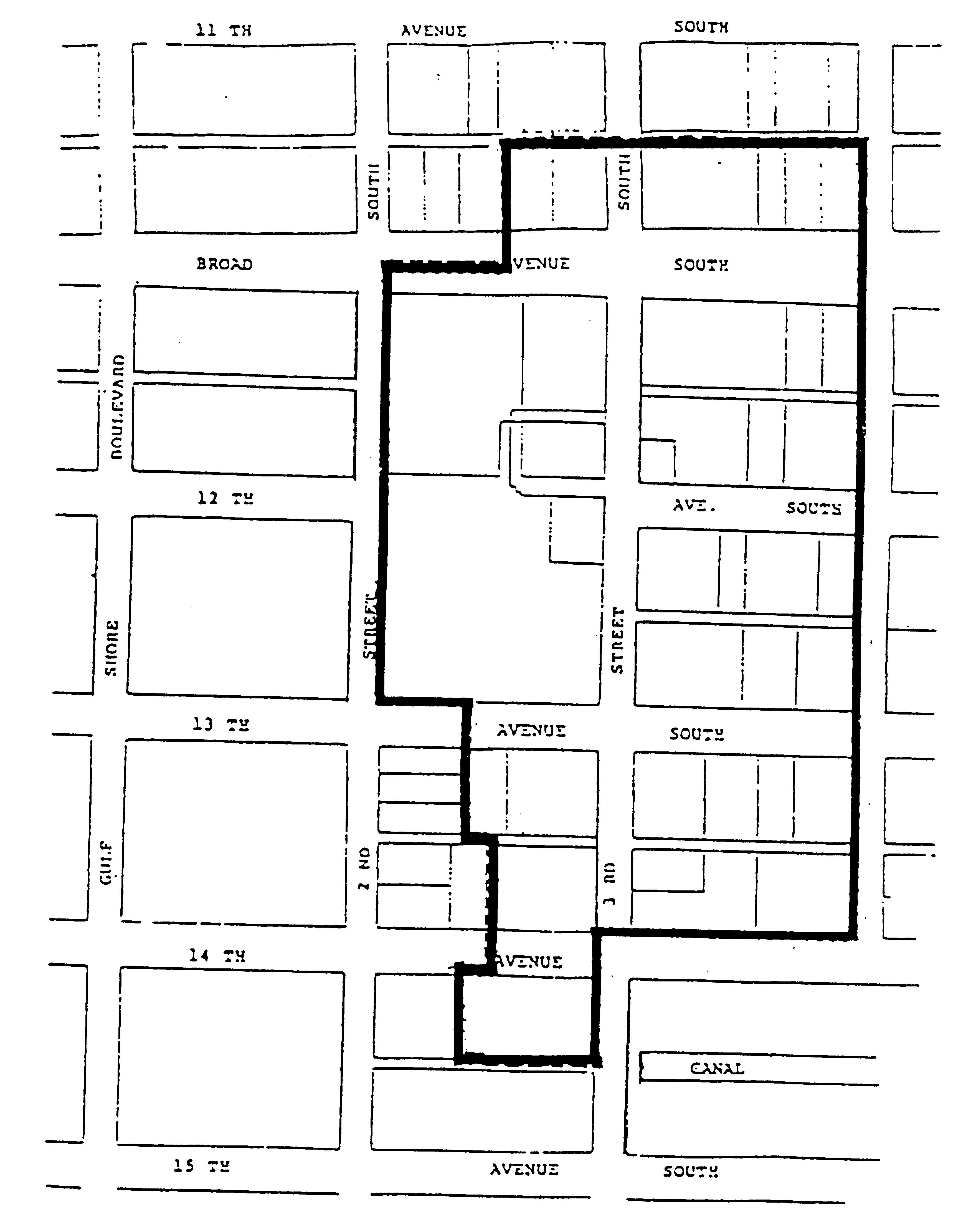
This district provides for the protection of the health and economic viability of properties within the 3rd Street commercial area as shown on the map following this section, and is intended to implement the long range plan (the "plan") of the 3rd Street Association (the "association"). In order to assure that the plan of the association is being implemented, the city will act in reliance on approvals given by the association in implementing this division. This overlay allows certain limited deviations from the signage and vending cart regulations of the zoning districts contained within the area as noted in this section.
(Code 1994, § 102-1071; Ord. No. 93-7085, § 1, 12-15-1993)
Sec. 58-1102. - Permit/permission approval process.
Applicants for permits or permission for any of the signage or vending carts as noted shall seek approval of the association. However, failure to apply for such approval shall be deemed a denial by the association. The city shall consider the determination of the association as well as standards listed in this division.
(Code 1994, § 102-1072; Ord. No. 93-7085, § 1, 12-15-1993)
Sec. 58-1103. - Signage.
(a)
Permitted signs subject to issuance of building permit. The following signage may be allowed by the city, in addition to, or as alternatives to, signs allowed in chapter 50, article II, subject to the issuance of a building permit:
(1)
Restaurant menu boards/boxes (signs which display the menu for a restaurant, which may include prices and daily specials) may be allowed in addition to the signage allowed in chapter 50, article II, subject to the following conditions:
a.
There shall be only one sign per restaurant.
b.
The total area of the sign shall not exceed six square feet.
c.
The sign may be permanently installed on private property with no setback required, or within the right-of-way with the approval of the city manager.
(2)
Projecting signs (signs which project more than 12 inches from the wall of the building to which they are attached) may be allowed in addition to the types of signage allowed in chapter 50, article II, subject to the maximum number allowed in chapter 50, article II, and subject to the following conditions:
a.
Signs may project a maximum of six feet from the face of the building to which they are attached.
b.
Signs may not exceed a total area of 24 square feet.
c.
Signs may not be internally illuminated.
d.
Signs may extend a maximum of six feet into the right-of-way, provided a minimum clearance of eight feet is maintained over pedestrian walkways.
(b)
Signage exempt from building permit. The following signage may be allowed by the city, in addition to those signs allowed in chapter 50, article II. The signs listed in this subsection (b) are exempt from the issuance of a building permit, but must be approved by the city manager.
(1)
Portable valet parking signs.
a.
There shall be only one sign per valet operation.
b.
The total sign area shall not exceed six square feet.
c.
The sign shall be displayed only during hours of operation of valet service.
d.
The sign may be displayed on private property or within the right-of-way in such a manner as not to interfere with pedestrian or vehicular traffic.
(2)
Portable restaurant menu boards/boxes (as defined above).
a.
There shall be only one sign per restaurant.
b.
The total sign area shall not exceed six square feet.
c.
The sign shall be displayed only during hours of operation of restaurant.
d.
The sign may be displayed on private property or within the right-of-way in such a manner as not to interfere with pedestrian or vehicular traffic.
(3)
Coordinated banners identifying the 3rd Street commercial area hung vertically on light poles or individual poles at regular intervals.
(4)
Directory ground signs identifying building name and tenants within a building, subject to the following conditions:
a.
Only one sign for each street or major pedestrian way upon which a building faces shall be allowed.
b.
The sign must be installed on private property with no setback required.
c.
The maximum total dimensions shall be seven feet in height and three feet in width.
(c)
Permitted signs subject to issuance of temporary use permit. The following signage may be permitted by the city, subject to the issuance of a temporary use permit:
(1)
Special event signs as requested by the association for areawide events.
(2)
Individual businesses may obtain a temporary use permit for a six-month period for periodic and occasional display of portable signs advertising special events, subject to the following conditions:
a.
Specific dates for the special events must be listed on the application.
b.
Signs may not exceed a total area of six square feet.
c.
Signs may be displayed only during the hours of operation of the business.
d.
Signs must be displayed in such a manner as not to interfere with pedestrian or vehicular traffic.
(Code 1994, § 102-1073; Ord. No. 93-7085, § 1, 12-15-1993)
Sec. 58-1104. - Vending carts.
Vending carts may be placed throughout the district, with no additional parking required, subject to the written approval of the city manager, the issuance of the required occupational license, and the following conditions:
(1)
Maximum cart dimensions shall not exceed six feet by ten feet.
(2)
All carts must be located so as not to impede pedestrian or vehicular traffic.
(3)
Signs used must be attached to the cart and shall be limited to six square feet for vendor identification and six square feet for display of price information.
(4)
A maximum of five vending carts may be approved.
(Code 1994, § 102-1074; Ord. No. 93-7085, § 1, 12-15-1993)
Sec. 58-1131. - District purpose.
The purpose of this division is to encourage and direct development within the 5th Avenue South district. This division shall ensure that new buildings are encouraged; that such buildings be compatible with each other while also relating to the pedestrian; that retail be safeguarded along specific street frontages; that development opportunities be equitable for all scales of ownership; that no significant additional traffic impacts will be added to surrounding residential neighborhoods; and that the permitting process be simplified and facilitated. The design of buildings within the 5th Avenue South district shall be regulated and approved in accordance with the provisions of this division.
(Ord. No. 08-12207, § 7, 10-1-2008)
Sec. 58-1132. - Definitions.
Terms used throughout this division shall take their commonly accepted meaning unless herein defined. When there are conflicts between the definitions herein and other definitions in this Land Development Code, these shall take precedence.
Artisanal use means premises used primarily for the repair, manufacture and sale of domesticfurniture, arts and crafts. The work must take place entirely within an enclosed structure using only handheld and/or table-mounted manual and electrical tools.
Awning means temporary canvas or other material covering extending from and attached to the facade of a building, without ground supports, primarily used for sun protection.
Awning roof structure means a semipermanent canvas or other material covering with ground supports, open on all sides except where attached to a building.
Civic use means premises used primarily for education, cultural performances, gatherings and displays administered by nonprofit cultural, education, and religious organizations.
Commercial use means premises used generally for the conduct of artisanal, retail, restaurant, transient lodging, professional business, governmental service, or cultural entertainment activities, but excluding prohibited uses. Establishments with liquor licenses which require city council approval through the conditional use petition process must be located no closer than 250 feet together, as measured from front door to front door via the path of normal pedestrian travel; other establishments with liquor licenses are specifically permitted with no required separation from other businesses or licensees.
Facade means the vertical surface of a building which is set parallel to a frontage line.
Frontage line means certain property lines of a lot or the edge of an open space as designated on the regulating plan.
Height means the vertical distance measured from the FEMA 1st habitable floor height requirement to the peak of the roof or the highest point of any appurtenance attached to the roof.
Net building area means the enclosed area of a building, measured to the exterior of the exterior wall, excluding unglazed porches, colonnades, balconies, decks, patios, courtyards and exterior walkways and stairways.
Permitted uses means all uses permitted in the C1-A district as well as defined as commercial uses in this section.
Prohibited uses means uses which are not listed as permitted including the following:
(1)
Automatic food and drink vending machines, newspaper vending machines at frontage lines;
(2)
Any commercial use which encourages patrons to remain in their automobiles while receiving goods or services, except bank and pharmacy drive-throughs;
(3)
Manufacturing, storage or distribution as a primary use except as defined by artisanal use;
(4)
Enameling, painting, or plating, except as an artist's studio;
(5)
Outdoor advertising or billboard as a principal use;
(6)
Carting, moving or hauling yard, except delivery goods to businesses;
(7)
Single-room occupancy hotels, prisons, detention centers or halfway houses;
(8)
Manufacture, storage, or disposal of hazardous waste materials;
(9)
Scrap yards;
(10)
Mobile homes;
(11)
Kennels, except as ancillary to a veterinarian and as ancillary use to police station;
(12)
Any use which produces adverse impacts as determined by the city manager.
Residential use means premises used primarily for human habitation. Units shall not be less than 750 square feet in net area except that limited lodging use may have smaller units.
Setback means the mandatory distance between the lot line or frontage line and a facade. This area must be left free of structures that are higher than three feet, excluding streetwalls.
Shared parking means parking spaces assigned to general use to encourage renovation and new construction.
Storefront means that portion of a building at the first story of a frontage line.
Story means a habitable floor level within a building, no more than 14 feet high from floor to ceiling.
Streetwall means an opaque freestanding wall aligned with the facade of an adjacent building with the purpose of masking parking from the street.
Terminated vistas means a building or portion thereof which terminates a view as designated on the regulating plan.
Transient lodging facility shall have the same meaning as in section 44-8.
Transition line means a horizontal line the full width of a facade expressed by a material change, by a trim line, or by a balcony no more than two and one-half feet deep.
Yards. For the purpose of determining setbacks, lots shown with frontage lines on both 5th Avenue South and a street are deemed to have two front yards and two side yards.
(Ord. No. 08-12207, § 7, 10-1-2008; Ord. No. 08-12309, § 3, 12-17-2008)
Sec. 58-1133. - General provisions.
(a)
Conflicts with other land development regulations. The provisions of this division, when in conflict, shall take precedence over the other provisions of this Land Development Code.
(b)
Conflicts with Florida Building Code. The provisions of the Florida Building Code, when in conflict, shall take precedence over the provisions of this division.
(c)
Applicability.
(1)
Buildings abutting frontage line. This division shall govern the design of all properties on frontage lines as designated on the regulating plan.
(2)
Buildings not abutting frontage line. The provisions of the underlying zoning district shall govern the use of buildings which do not abut a frontage line as designated on the regulating plan. The city manager may grant a a deviation from the minimum yard requirements following design review approval, where applicable, and upon a finding that the project meets the general intent of the district and master plan and that the exception does not exceed the minimum yard requirements of the 5th Avenue South special overlay district.
(d)
Design of civic buildings. The design of civic buildings shall not be subject to the specific standards of this division which regulate building height, building placement, building use, parking, signage, and architectural standards but shall be reviewed by the DRB.
(e)
Terminated vistas. Locations designated on the regulating plan for terminated vistas shall receive special attention. These locations shall be provided with architectural features of enhanced character and visibility.
(f)
Special landscape treatment. Areas marked on the regulating plan for special landscape treatment shall be subject to cooperative design by the property owners and the city.
(g)
Location of parking garages and civic buildings. Locations designated on the regulating plan for parking garages or civic buildings shall be as designated in the following Exhibit A.
(Ord. No. 08-12207, § 7, 10-1-2008)
Sec. 58-1134. - Specific provisions.
(a)
Building height. The various elements of building height shall be determined as follows:
(1)
Buildings shall be a maximum of three stories and 42 feet in height measured from the FEMA first habitable floor height requirement to the peak of the roof or the highest point of any appurtenance attached to the roof.
(2)
Stories at sidewalk level shall be no less than 12 feet in height from finished floor to finished ceiling.
(3)
A transition line shall be provided at the top of the first story. The transition shall be detailed to receive an awning. A transition line shall be expressed by a material change, by a trim line, or by a balcony no more than three feet deep.
(4)
Parking garages shall be no more than one deck above grade except as approved by city council upon a finding that the project meets the general intent of the district and master plan.
(b)
Building placement. Buildings and their elements shall be placed on their lots as follows:
(1)
Front setback.
a.
First story. First story facades shall have no front setback. Awnings, awning roof structures, arcades, or other similar attached structures may satisfy this requirement.
b.
Second story. Second story facades shall have a mandatory setback of no less and no more than ten feet from the property line. When the first story extends into the front ten-foot yard, second story balconies which extend over the 1st story shall extend across the entire front facade. Awnings and the required supports for the awnings are permitted over second story balconies but no other permanent improvements are allowed above the height of the railing. A balcon (a small balcony that extends no more than one foot from the facade of the building and extends no more than eight inches from either side of a door or window opening) is permitted.
c.
Third story. Third story facades shall have a mandatory setback of ten feet. Third story balconies shall be recessed, shall not extend beyond the second story facade and shall be enclosed by the plane of the roof. A balcon (a small balcony that extends no more than one foot from the facade of the building and extends no more than eight inches from either side of a door or window opening) is permitted.
(2)
Streetwall. In the absence of a building facade, a streetwall shall be built aligned with an adjacent building facade. Streetwalls shall be between 2½ and 3½ feet in height and made of a material matching the adjacent building or a continuous, maintained hedge. Streetwalls may have openings no greater than 25 feet to allow automobile and pedestrian access.
(3)
Side setbacks. Side setbacks are not required.
(4)
Rear setback.
a.
Rear setback—Interior lots. Rear facades on interior lots shall be set back a minimum of 50 feet from the midpoint of the alley. Balconies may extend into the rear setback by ten feet.
b.
Rear setback—Corner lots. Rear facades on corner lots shall be set back a maximum of 20 feet from the mid point of the alley for a distance of no more than 50 feet from the front property line.
c.
Carports. Carports may encroach into the required rear setback subject to the following:
1.
The carport must be designed in keeping with the design of the building.
2.
The carport must be open on all four sides (except where attached to the principal building, if applicable).
3.
The carport roof must be made of fabric.
4.
The carport must be a minimum of 15 feet from the centerline of the alley.
(5)
Adjacent preexisting setbacks. In the event of adjacent preexisting setbacks, a variance may be approved by the council upon a finding that the project meets the general intent of the district and the master plan.
(6)
Awnings. Awnings may encroach the sidewalk in its entirety but must avoid the municipal planters areas. Approval must be obtained from the city manager.
(7)
Loading docks and service areas. Loading docks and service areas shall not be permitted on frontage lines.
(8)
Surface parking lots. Surface parking lots shall not be permitted on a frontage line or within 30 feet of the frontage line.
(9)
Principal pedestrian entrance. All buildings shall have their principal pedestrian entrance on a frontage line.
(10)
Lot coverage. Lot coverage shall be limited only by setback requirements.
(11)
Nonconforming buildings due to rear setbacks. An existing nonconforming building which does not conform to the required 50-foot rear setback may maintain the existing building setback when additional stories are added as long as the additional stories meet the required setback. The roof of the nonconforming existing first or second story may be used for a balcony.
(c)
Building uses. Buildings will accommodate the following range of uses:
(1)
Uses permitted. All non-residential uses permitted in the C1-A district as well as uses defined as commercial uses in this section are permitted. All non-residential uses that are conditional uses in the C1-A district are conditional uses in this district. Residential uses are permitted uses with densities as limited by parking. Uses which are not listed as uses permitted are prohibited, including the following:
a.
Automatic food and drink vending machines, newspaper vending machines at frontage lines;
b.
Any commercial use which encourages patrons to remain in their automobiles while receiving goods or services, except bank and pharmacy drive-throughs;
c.
Manufacturing, storage, or distribution as a primary use except as defined by "artisanal use";
d.
Enameling, painting, or plating, except as an artist's studio;
e.
Outdoor advertising or billboard as a principal use;
f.
Carting, moving, or hauling yard, except delivery goods to businesses;
g.
Single-room occupancy hotels, prisons, detention centers, or halfway houses;
h.
Manufacture, storage, or disposal of hazardous waste materials;
i.
Scrap yards;
j.
Mobile homes;
k.
Kennels, except as ancillary to a veterinarian and as ancillary use to police station;
l.
Any use which produces adverse impacts as determined by the city manager.
(2)
First stories will be for commercial use only. Transient lodging is not permitted on first stories. Second stories may be for commercial, transient lodging, or residential use, except that notwithstanding the provisions in subsection (a) herein, restaurants or cocktail lounges are not permitted on second stories. Third stories are limited to transient lodging and residential use only, with the exception of rooftop restaurants, as provided in subsection (a) herein.
a.
Notwithstanding anything to the contrary in this section, rooftop restaurants are conditional uses, subject to the conditional use process provided in section 46-34 of this Code, and in compliance with the following additional conditions:
1.
Are located on the second or third stories of existing buildings within the 800 block of Fifth Avenue South;
2.
Are located no less than 500 feet from residentially zoned property located outside the Fifth Avenue South Special Overlay District;
3.
All elements of the restaurant and dining are compliant with the 42-foot height limitation as described in subsection 58-1134(a) of this Code; and
4.
Implement best practices for stormwater runoff.
(3)
All commercial and residential uses are required to be a minimum depth of 30 feet from the frontage line on all stories. The remaining depth may be used for parking. Parking exposure on a frontage line must be an opening not wider than 25 feet.
(4)
Seating for outdoor dining will be permitted to encroach the public sidewalks adjacent to the private property leaving a five-foot clear pedestrian passage between the outdoor dining and the right-of-way landscaping or paved roadway. Outdoor dining will require a permit and is regulated per section 56-126.
(5)
Newspaper vending machines will not be permitted along the 5th Avenue frontages.
Editor's note— Section 3 of Ord. No. 21-14663 states the following: "Section 58-1134(c)(2)(a) of this ordinance will expire and have no force and effect five years from the date of adoption. No vested rights are implied or granted beyond the five years the ordinance is in effect. Any permitted rooftop use shall be a nonconforming use beyond the five years Section 58-1134(c)(2)(b) is in effect."
(d)
Building area. The permitted building area shall be calculated as a function of the number of parking spaces provided on the lot as follows:
(1)
There shall be a minimum of three off-street parking spaces for each 1,000 square feet of commercial use and two parking spaces for each residential unit and one for each lodging unit. Both parking spaces for each residential unit shall be located on-site in addition to required handicapped parking. Parking requirements shall be calculated by the net building area. There shall be no parking requirement for outdoor dining use.
(2)
The council may make public parking available for allocation to meet the required parking for new construction or to replace lost parking spaces due to new construction or to restructure the existing parking. If public parking is used to support new construction, that new construction shall be furthering the purpose of the 5th Avenue South special overlay district. Parking spaces may be allocated by the council after preliminary or final design review and the review and recommendation of the CRAAB. Once spaces are allocated to a specific property for new construction, the property owner shall have one year to obtain a building permit for the construction and pay any required fees for the parking. If a building permit is not obtained within one year, the spaces shall be made available for reallocation. The city manager shall maintain a waiting list, on a first-come basis, of property owners who have requested and received a parking allocation. A property owner who has been allocated parking spaces and does not obtain a building permit within one year may reapply and if there is a waiting list shall be placed at the end of the list.
(3)
This building area may be increased as follows: The calculated number of parking spaces provided shall be increased by 40 percent upon the assignment of such spaces to the shared parking program. At least 80 percent of the parking spaces provided shall be dedicated to the shared parking program. When at least 80 percent but less than 100 percent of the total parking spaces are allocated to the shared parking program then only the parking spaces provided to the shared parking program shall be increased by 40 percent.
(4)
The above parking requirements shall be applied to additional square footage only. Total required parking shall be the sum of the existing parking and the added required parking.
(5)
Parking requirements in this district shall not be reduced by variance or a parking needs analysis. A parking needs analysis may be used to establish the parking required for a use that is not listed.
(6)
Retractable awnings shall be exempt from fire sprinkler requirements. Fixed awnings under 1,450 square feet shall be subject to sprinkler requirements but only from the potable water supply without requirements for backflow prevention.
(e)
Architectural standards. Buildings shall be subject to the following physical requirements:
(1)
Exterior finish material. The exterior finish material on all facades shall be limited to smooth stucco and/or stone veneer.
(2)
Exterior colors. Exterior building shall be white or colored in the cream to coral range. Trim shall be white. Doors, shop fronts, window frames and shutters shall be any color at any saturation. Buildings in single ownership shall be of uniform facade and trim color unless there are architectural elements such as pilasters or engaged columns or a change in the plane of the facade defining the separate tenant spaces.
(3)
Glass color. Glass shall be clear or lightly tinted only.
(4)
Balconies, railings and porch structures. Balconies, railings, and porch structures shall be metal, cast concrete, or stone.
(5)
Facade openings. Facade openings, including porches, windows, and colonnades, shall be square or vertical in proportion.
(6)
Sliding doors and windows; automatic doors. Sliding doors and sliding windows are not permitted along frontage lines. Automatic doors may be permitted by the DRB if the board finds that the design of the building achieves the requirements of this division as closely as possible and is consistent with the intent of this division.
(7)
Flat roofs. Flat roofs may be used for balconies which shall have railings. Flat roofs not used as balconies shall be enclosed by parapets no less than 42 inches high or as required to conceal equipment.
(8)
Visible roofs. Buildings with roofs visible from the Avenue shall have symmetrical pitched roofs with slopes no less than 5:12. Porches and first floors may have shed roofs with pitch no less than 2:12.
(9)
Mansard roofs. Cantilevered mansard roofs are not permitted.
(10)
Glazed area above first floor. The glazed area of a facade above the first floor shall be at least 20 percent but shall not exceed 35 percent of the total area with each facade being calculated independently.
(11)
Facade design.
a.
Facades on frontage lines. The facades on frontage lines at first floor level shall be detailed and glazed as storefronts. The wood or metal armature of such storefronts shall be painted. Storefronts shall be directly accessible from sidewalks. Each storefront must have glazed areas, equal to 70 percent of its portion of the facade, between two and eight feet from the ground. Storefronts shall have the mullion system, doorways and signage integrally designed and painted. Storefronts shall incorporate surface materials and design proportions similar to those on the facades of the building located on a frontage lines.
b.
Facades not on frontage lines. The exteriors of buildings not facing frontage lines shall incorporate the same surface materials and similar design elements such as similar proportions, with attractive rear entrances and consideration of pedestrian pass-throughs.
(12)
Awnings.
a.
Generally. Facades may be supplemented by awnings which shall be straight sheds without side flaps, not cubed or curved, with a drip edge no greater than 12 inches. Awnings shall be no less than eight feet high at the lower drip edge and shall not have ground supports. Awnings used in conjunction with a second story balcony shall not extend beyond the edge of the balcony railing and shall have no minimum height requirement from the finished floor. Awning roof structures may be approved by the city manager, but must meet all of the same standards as a building.
b.
Nonconforming buildings. The city manager may approve awnings that do not strictly conform to this division if the following conditions are met:
1.
The building is an existing building.
2.
The architectural style of the building does not conform to this division.
3.
The building facade is such that an awning which would conform to this division would not be architecturally compatible or complimentary to the building.
4.
The proposed awning is the most appropriate style for the building, is compatible with adjacent buildings, and the awning achieves the requirements of this division as closely as possible and is consistent with the intent of this division.
When the city manager approves an awning based on the criteria above, that awning style/design will become the standard style/design for all awnings for that particular building.
(13)
Outside dining tables and chairs. Outside dining tables and chairs shall be primarily metal, cast concrete, wood or suitable composite material. Plastic chairs are prohibited but plastic tables may be permitted if covered with linens. Outside dining tables located in the right-of-way shall be temporary and portable. Outdoor dining in this district shall require the approval of the design review board for the design of the space, furniture, and any landscape/hardscape improvements. The DRB shall not approve the outdoor dining use, which will be reviewed and approved pursuant to section 56-126.
(14)
Dumpsters. Dumpsters shall be placed in accordance with the dumpster regulations contained elsewhere in the Code. Wherever possible, dumpsters shall be shared between property owners.
(15)
Telephone and utility wires. Any new building or substantial change shall be required to relocate all telephone, electric and other wires of all kinds underground from the poles of the transmission cables located within the platted utility easements to the building or the connection.
(16)
External lighting.
a.
Permanent lighting fixtures attached to the façade of the building require the approval of the design review board subject to the determination that such lighting is compatible with the design of the building and the ambiance of the district. All such lighting shall be white in color. In addition to permanent fixtures, strings of low-voltage light emitting diode (LED) type lights may be approved for year-round use by the city manager subject to the following:
1.
Lighting shall not exceed the following:
i.
On the public sidewalk: 3.0 foot candles.
ii.
On private property: 5.0 foot candles.
2.
All lighting shall be powered by a source located on the private property and no wiring associated therewith shall cross a sidewalk or means of egress;
3.
All lighting shall be maintained in a safe and neat condition, proper working order and functioning in a safe manner;
4.
All lighting shall be white with the exception of lighting that the design review board has determined is consistent with the design theme of a building or business;
5.
All lighting shall be within the following temperature range:
i.
Minimum—2,700 Kelvin.
ii.
Maximum—4,000 Kelvin.
6.
No twinkling or flashing light sources shall be permitted;
7.
Lighting shall consist of visible light sources, shall be attached to the drip edge of an awning or other horizontal façade feature in a linear fashion and shall be either "icicle" (individual light sources arranged vertically) or "strip" (individual light sources arranged horizontally) provided that in no instance shall the lighting hang below the minimum vertical clearance required for awnings;
8.
Wherever either icicle or strip lighting is installed, such lighting shall be installed uniformly to all awnings abutting the business or establishment to which they are affixed;
9.
No window frame lighting utilizing visible light sources shall be permitted in either inside or outside installation;
10.
Indirect lighting with no visible light sources may be permitted under awnings, arcades and overhangs;
11.
Lighting consisting of individual light sources may be installed on trees, plants, shrubs and other similar landscape features located on private property;
12.
Lighting shall be allowed on the first floor of the building only;
13.
In addition to the foregoing standards, the lighting shall be compatible with the structure on which it is located and the ambiance of the district. Should the city manager find that the proposed lighting is not compatible or if the petitioner wishes to deviate from any of these standards, the petition shall be referred to the design review board for review and approval.
b.
Temporary lighting is permitted throughout the Fifth Avenue South Special Overlay District from November 15th through the following January 15th, or by approval of a special event permit approved by the city council. Temporary lighting shall be limited to the same provisions of subsection 58-1134(e)(16)a. above except that multicolored lighting shall be allowed and such lighting shall not be required to be arranged in a linear, icicle or strip configuration.
(17)
Landscape and hardscape palette for the 5thAvenue South and Sugden Plaza area defined in Exhibit A.
a.
Hardscape palette. In the event that the following materials are unavailable, a similar or equivalent material, manufacturer type/model, and/or color/finish may be substituted with approval by the city manager.
1.
Sidewalk 24X24 Paver
Manuf.: DC Kerchoff
Type: Cast Stone Paver
Color: Rico
Finish: Acid Wash
2.
Dining Area 24x24 Paver
Manuf.: DC Kerchoff
Type: Cast Stone Paver
Color: Aruba
Finish: Acid Wash
3.
Accent Bands 12x12 Paver
Manuf.: DC Kerchoff
Type: Cast Stone Paver
Color: Aruba
Finish: Regular
4.
Landing Zones
Manuf.: Unilock
Type: Optilock Ped. Paver
Color: Natural
Finish: Standard
Laying Pattern: A
5.
Detectable Warning 24x24 Paver
Manuf.: Tectura
Type: ADA Conc. Paver
Color: ADA-50
ADA Pattern: ADA-2
6.
Vehicular Pavement
Manuf.: Unilock
Type: Optilock Veh. Paver
Finish: Standard
Laying Pattern: A
7.
Seatwalls:
(i)
Cast Stone Cap
Manuf.: DC Kerchoff
Type: Cast Stone Cap with Flat Top
Color: Rico
Finish: Smooth Texture
(ii)
Wall Finish
Integral Color Stucco with Sand Finish
Color: Buff
8.
Pre-Cast Landscape Pots
Manufacturer: QCP
Model: QR-CE3012P
QR-CE3030P
QR-CE3036P
Color: Latte
b.
Landscape palette.
1.
Shade/Canopy Trees
Swietenia mahagoni - Mahogany
Quercus virginiana - Live oak
2.
Palm Trees
Phoenix dactylifera - Medjool Date Palm
Roystonea regia - Royal Palm
Coco nucifera - Coconut Palm
Ptychosperma macarthurii - Macarthur Palm
3.
Flowering Trees
Tabebuia cariba - Silver Trumpet
Delonix regia - Royal Poinciana
4.
Shrubs
Podocarpus macrophylla - Podocarpus
Ficus microcarpa "Green Island" - Green Island Ficus
Clusia rosea "Nana" - Dwarf Clusia
Ilex vomitoria "Nana" - Dwarf Yaupon Holly
Rhaphiolespsis indica - Indian Hawthorn
Carissa macrocarpa "Natal Plum" - Natal Plum
Chrysobalanus icaco "Red Tip" - Red Tip Cocoplum
Hamelia patens "Compacta" - Dwarf Firebush
Ixora maui - Dwarf Ixora
Schefflera arboricola "Trinette" - Trinette Schefflera
Bougainvillea "Helen Johnson" - Dwarf Bougainvilea
Plumbago auriculata - Plumbago
Gardenia jasminoides "Radicans" - Dwarf Gardenia
Nephrolepis biserrate - Macho Fern
Asparagus densiflora "Myers" - Foxtail Fern
5.
Groundcover
Trachelospermum asiaticum - Asiatic Jasmine
Archis glabrata "Ecoturf" - Perennial Peanut
Juniperus "Parsonii" - Parsons Juniper
Liriope muscari - Liriope
Dianella tasmanica - Flax Lily
Evolvulus glomeratus - Blue Daze
Mimosa strigillosa - Sunshine Mimosa
6.
Color/Accents
Muhlenbergia capillaris - Pink Muhly Grass
Pennisetum setaceum "Rubrum" - Red Fountain Grass
Pennisetum setaceum "Alba" - White Fountain
Heliconia spp. - False Bird of Paradise
Canna generalis - Canna Lily
Alpinia zerumbet "Variegata" - Variegated Ginger
Cordyline spp. - Ti Plant/Red Sister
Agapanthus africanus - Lily of the Nile
Codiaeum variegatum var. - Crotons
Hibiscus rosa-sinensis - Hibiscus varieties
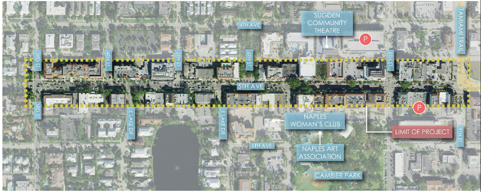
Exhibit A - 5thAvenue South and Sugden Plaza Landscape and Hardscape Area
(18)
Procedures for design review. The city design review board shall determine compliance with this division and with the provisions of chapter 2, article V, division 4 (Design Review Board) for any improvements meeting the thresholds of section 2-475.
(f)
Signage standards. Signage, when provided, shall be as follows:
(1)
Address numbers. Address numbers shall be no larger than eight inches in vertical dimension.
(2)
Sign band. A single external sign band or zone may be applied to the facade of each building, providing that it shall not exceed two feet in vertical dimension by any length. The sign band or zone may contain multiple individual signs but all must refer to a tenant of the building. The sign shall consist of letters applied directly on the facade of the building and shall not be on a board unless a sign plan is approved for the building by the city manager. A maximum of two sign bands may be placed on the facade of each building.
(3)
Additional pedestrian signs. Additional pedestrian signs or shingles may be attached to a building perpendicular to the facade extending up to four feet from the facade or may be placed underneath an awning structure and attached to the awning structure. These signs shall not exceed 1½ feet by four feet. There may be one individual pedestrian sign for each business located on the first floor.
(4)
Lettering on awnings. In addition, the vertical drip of an awning may be stenciled with letters no more than eight inches in vertical dimension by any length.
(5)
Illumination; window signs. External signs shall not be translucent, but may be externally lit or backlit with white light. Signs on the interior of a window within two feet of the window shall be limited to no more than 20 percent of a window up to a maximum of 12 square feet in area. No sign, or window tinting shall be placed on or adjacent to any window that would interfere with a clear and unobstructed view of the interior of the establishment from the outside. Neon signs are permitted as interior window signs providing they do not exceed 20 percent of a window up to a maximum of four square feet in area and shall be counted towards the maximum of 12 square feet permitted for interior window signs.
(6)
Sign identifying primary entrance. A perpendicular sign identifying the primary entrance shall not exceed one foot in vertical dimension nor two feet in horizontal dimension.
(7)
Nonconforming buildings. The city manager may approve a sign plan or a new sign that does not conform strictly to this division if the following conditions are met:
a.
The building is an existing building.
b.
The building does not have a sign band.
c.
The building facade is such that meeting the requirements of this division is not possible or is impractical.
d.
If the sign is on an awning, the lettering shall consist of individual letters painted on the background of the awning and not on a panel or within a border. The sloped surface of an awning shall not be used for a new sign.
e.
The design is in context with the signage and facade of the building.
f.
The sign plan or sign achieves the requirements of this division as closely as possible and is consistent with the intent of this division.
g.
When the city manager approves a new sign based on the criteria above, that sign will establish the sign plan for that particular building.
(8)
Restaurant menu boards. The city manager may approve restaurant menu boards/boxes (signs which display the menu for a restaurant, which may include prices and daily specials) subject to the following criteria:
a.
There shall be only one sign per restaurant.
b.
The total area of the sign shall not exceed six square feet.
c.
The sign may be permanently installed on private property with no setback required, or within the right-of-way with the approval of the city manager.
(9)
Portable restaurant and valet signs; standards for valet parking. The city manager may approve (no building permit is required) one portable restaurant menu sign and one valet portable sign if the standard design is used. The city manager shall consider the following criteria:
a.
The sign shall be displayed only during hours of operation of the restaurant.
b.
The sign may be displayed on private property or within the right-of-way in such a manner as not to interfere with pedestrian or vehicular traffic.
c.
Portable restaurant signs shall be A-frame design with a dimension of 24 inches wide and 48 inches high.
d.
Valet signs shall be freestanding, may be two-sided, and shall be 24 inches wide and 30 inches high with the total height not exceeding 42 inches.
(10)
Directory sign. The city manager may approve a directory sign identifying the building name and tenants within a building, subject to the following conditions:
a.
Only one sign for each street or major pedestrian way upon which a building faces shall be allowed.
b.
The sign must be installed on private property with no setback required.
c.
The maximum total dimensions shall be seven feet in height and three feet in width.
(g)
Parking design standards. The design standards found in chapter 50, article III (Landscaping and Tree Protection) and chapter 50, article IV (Parking and Loading) shall be met except as provided below when providing shared parking with adjacent lots:
(1)
Section 50-74 (Development Standards) and section 50-103 (Design and Construction Standards) shall be met unless a property owner participates in the shared parking program in which case the following requirements may be waived by the city manager.
(2)
Subsection 50-103(a)(1), which requires access from one section of an on-site parking area to another to be provided on-site, may be waived by the city manager when access from one section of an on-site parking area to another uses an alley.
(3)
Subsection 50-103(a)(6) (access aisles or maneuvering areas), which does not allow vehicles to back onto a public right-of-way, may be waived by the city manager when the public right-of-way is an alley.
(4)
Subsection 50-74(b) (vehicular use areas adjacent to public right-of-way), which requires landscaping adjacent to a public right-of-way, may be waived by the city manager if the public right-of-way is an alley.
(5)
Subsection 50-74(c)(2) (areas adjacent to commercial or industrial uses), which requires landscaping adjacent to the interior property lines, may be waived by the city manager. Parking may extend over property lines with a cross easement agreement approved by the city attorney. Landscaping may be required by the city manager in context with the redesign of the parking lot to meet the intent of the landscaping required by subsection 50-74(c)(2).
(h)
Off-street loading facilities. The design standards found in section 50-105 (Off-street loading facilities) may be waived by the city manager if the city manager determines that such facilities are not necessary for the specific building or that alternate facilities are available for the type of deliveries anticipated to be required for the building.
(Code 1994, § 102-1094; Ord. No. 94-7163, § 1, 3-16-1994; Ord. No. 95-7370, § 4, 2-15-1995; Ord. No. 97-7897, § 1, 1-15-1997; Ord. No. 97-8045, § 1, 8-20-1997; Ord. No. 08-12207, § 7, 10-1-2008; Ord. No. 08-12281, § 1, 12-3-2008; Ord. No. 08-12285, § 4, 12-3-2008; Ord. No. 11-12919, § 4, 6-15-2011; Ord. No. 11-12920, § 1, 6-15-2011; Ord. No. 15-13608, § 1, 2-18-2015; Ord. No. 21-14663, § 2, 6-16-2021; Ord. No. 21-14749, § 1, 12-1-2021; Ord. No. 22-14861, § 1, 6-15-2022; Ord. No. 24-15348, § 6, 4-3-2024)
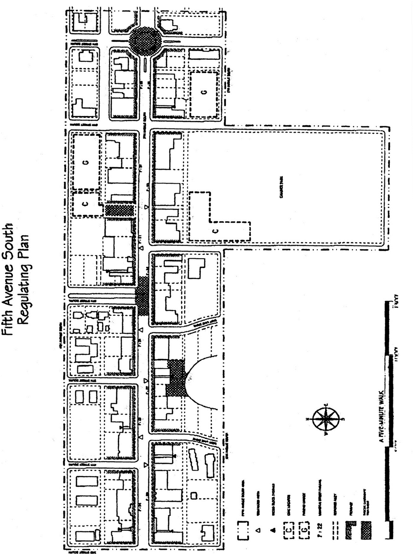
Exhibit A
(Ord. No. 21-14750, § 1, 12-1-2021)
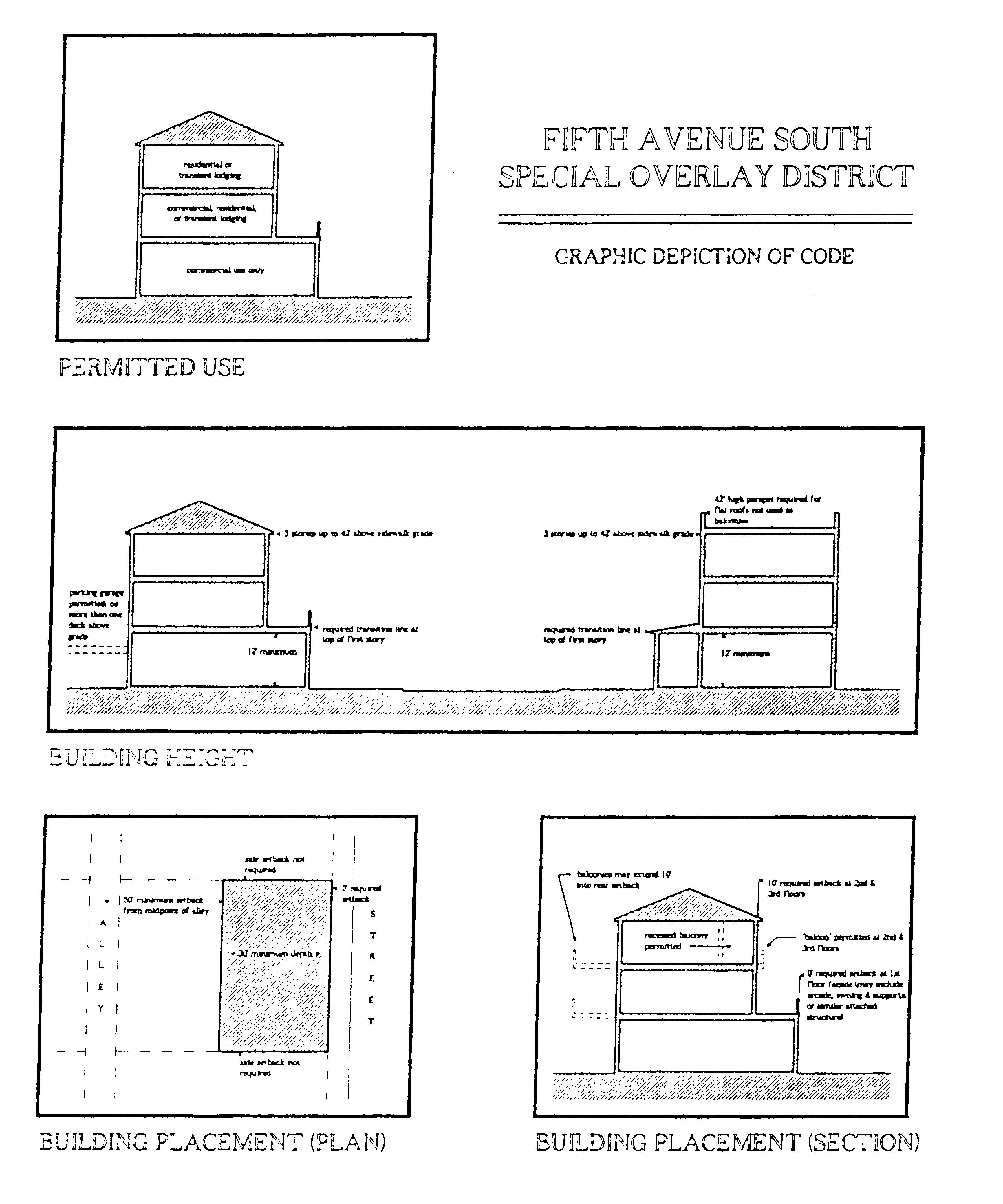
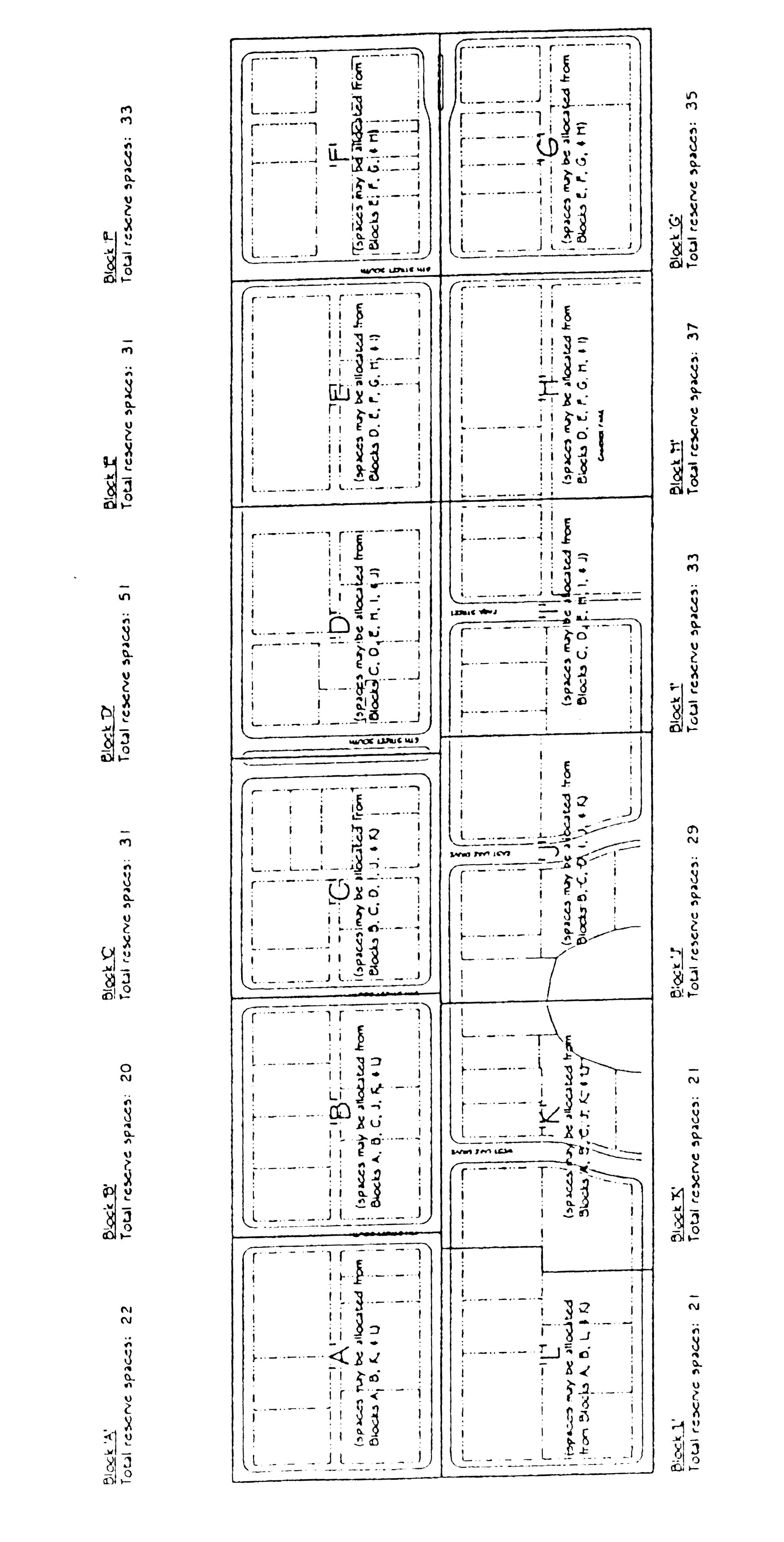
Parking Reserve Allocation
Sec. 58-1161. - District purpose.
The purpose of this division is to provide standards for storage of recreational vehicles on residential properties.
(Code 1994, § 102-1096; Ord. No. 99-8681, § 1, 10-20-1999)
Sec. 58-1162. - District applicability.
The regulations provided in this division shall be applied as an overlay district on a neighborhood-by-neighborhood basis. Areas with such restrictions will be designated on the zoning map as RVSOD (i.e., R1-10, RVSOD). A rezoning will be required to designate an area as RVSOD.
(Code 1994, § 102-1097; Ord. No. 99-8681, § 1, 10-20-1999)
Sec. 58-1163. - "Recreational vehicle" defined.
For purposes of this division, recreational vehicles include, but are not limited to, boats/vessels, personal watercraft, motor homes, campers, travel trailers, off-road vehicles (including swamp buggies, race cars, all-terrain vehicles, and other vehicles not intended for or licensed for use on public streets), and other vehicles which require transport by means of a trailer or other towing device.
(Code 1994, § 102-1098; Ord. No. 99-8681, § 1, 10-20-1999)
Sec. 58-1164. - Storage of recreational vehicle in open carport.
A recreational vehicle shall not be stored in an open carport. Recreational vehicles may be stored in an enclosed carport or garage, provided that the carport or garage is enclosed on all sides by a structural wall or door.
(Code 1994, § 102-1099; Ord. No. 99-8681, § 1, 10-20-1999)
Sec. 58-1165. - Storage of recreational vehicle in front yard area.
A recreational vehicle shall not be stored in a front yard area. The term "front yard area" is defined as any yard that faces a street or the Gulf of Mexico and shall include the entire portion of a lot between the principal building and the corresponding front property line.
(Code 1994, § 102-1100; Ord. No. 99-8681, § 1, 10-20-1999)
Sec. 58-1166. - Storage of recreational vehicle in side yard area.
A recreational vehicle shall not be stored in a side yard area. For the purposes of this section, the term "side yard area" shall mean the entire portion of a lot between the principal building and the corresponding side property line.
(Code 1994, § 102-1101; Ord. No. 99-8681, § 1, 10-20-1999)
Sec. 58-1167. - Storage of recreational vehicle in rear yard area of waterfront properties.
A recreational vehicle shall not be stored in a rear yard area of a waterfront property. For the purposes of this section, the term "rear yard area" shall mean the entire portion of a lot between the principal building and the corresponding rear property line. Boats/vessels and personal watercraft may be hung on davits at the bulkhead or landward of the bulkhead.
(Code 1994, § 102-1102; Ord. No. 99-8681, § 1, 10-20-1999)
Sec. 58-1168. - Storage of recreational vehicle in rear yard area of corner lot properties abutting an alley.
A recreational vehicle shall not be stored in a "rear yard area" on corner lot properties abutting an alley. For the purposes of this section, the term "rear yard area" shall mean the entire portion of a lot between the principal building and the corresponding rear property line.
(Code 1994, § 102-1103; Ord. No. 99-8681, § 1, 10-20-1999)