
National City City Zoning Code
DIVISION 2
ZONING DISTRICTS AND ALLOWABLE LAND USES
18.20.010 - Purpose.
This section identifies the zones that apply to property within the city and adopts the city's zoning map. National City is organized into zones that implement the General Plan, which are identified on the zoning map.
(Ord. No. 2024-2529, 4-2-2024)
18.20.020 - Zones and zoning map.
A.
Official Zoning Map. The official zoning map of the city is a zoning regulation within the context of and adopted pursuant to this title.
B.
Zone Boundaries—Determination in Cases of Uncertainty. The location of zone boundaries may be determined by the rules for interpretation pursuant to this title.
C.
Zone Boundary Changes—Procedure. Changes in the boundaries of the zones shall be made by ordinance adopting an amended official zoning map.
D.
Pre-Zoning of Unincorporated Lands.
1.
Areas outside of city limits, but within National City's sphere of influence are unincorporated lands and governed by the County of San Diego until such time as those areas are annexed into the city. These areas have been pre-zoned with city zones to identify the regulations that would apply once the land is annexed into the city.
2.
Pre-zone changes may be initiated and heard, in the manner provided for zone changes in this title, prior to the effective date of annexation to be effective upon annexation.
E.
Effect of Specific Plans. Lands within an adopted specific plan are governed by the zoning regulations of that specific plan. If the requirements of any specific plan are either more restrictive or less restrictive than the zoning regulations of this title, the requirements of the specific plan shall take precedence. If the specific plan is silent with regard to a development standard that is addressed within the provisions of this title, the provisions of this title shall apply. Specific plans referred to in this title shall be adopted in compliance with the procedural requirements of the California Government Code.
F.
Zone Classifications Established. The following zone classifications are established and applied to the city as shown on the official zoning map.
_____
TABLE 18.20.020
Zone Classifications
;sz=8q; 1 ADUs and JADUs permitted subject to Sections 18.30.380 and 18.30.390
(Ord. No. 2024-2529, 4-2-2024)
_____
18.20.030 - Prohibited land uses.
Land uses not specifically allowed in a zone are prohibited in that zone; in addition, the following are specifically prohibited.
A.
In all zones, no structure of a temporary nature shall be used as a residence, neither temporarily nor permanently, including:
1.
Boats (except in marinas).
2.
Camper shells (except in recreational vehicle parks).
3.
Mobile homes (except in mobilehome parks).
4.
Recreational vehicles (except in recreational vehicle parks).
5.
Shacks.
6.
Sheds.
7.
Shipping containers.
8.
Storage units.
9.
Tarpaulins.
10.
Tents (except in recreational vehicle parks).
11.
Trailers (except in recreational vehicle parks).
12.
Buildings or structures of a temporary nature.
B.
In all zones, the following shall not be used for temporary or permanent sleeping areas, with the exception of those that have been converted into an accessory dwelling unit as stipulated in Section 18.21.050:
1.
Attics.
2.
Basements.
3.
Cellars.
4.
Decks.
5.
Game rooms.
6.
Garages.
7.
Nonresidential buildings.
8.
Patios.
9.
Porches.
10.
Rooftops.
C.
In all zones, outdoor storage is prohibited except as specifically allowed by the zone.
D.
In all zones, outdoor storage or parking of the following is prohibited unless specifically allowed by the zone:
1.
Boats within any required front, side, exterior, or street setback.
2.
Camper shells within any required front, side, exterior, or street setback.
3.
Mobile homes (except in mobile home parks).
4.
Recreational vehicles within any required front, side, exterior, or street setback.
5.
Trailers within any required front, side, exterior, or street setback.
(Ord. No. 2024-2529, 4-2-2024)
18.21.010 - Purpose.
This section lists the land uses allowed within the residential zones. The purposes of the individual residential zones and the manner in which they are applied are as follows:
A.
Large Lot Residential (RS-1). The purpose of the RS-1 zone is to provide for areas of single-family detached residences on large lots (ten thousand square feet minimum and a density of up to five dwelling units per acre).
B.
Small Lot Residential (RS-2). The purpose of the RS-2 zone is to provide for areas of single-family detached residences on small lots (five thousand square feet minimum and a density of six to nine dwelling units per acre).
C.
Medium-Low Density Residential (RS-3). The purpose of the RS-3 zone is to provide for low-rise, medium-low density (ten to fifteen units per acre) single-family attached and multiple family residential areas. The RS-3 zone is intended to retain characteristics found in the single-family zones, such as private yards and patios and privately maintained open space.
D.
Residential Single-Family (RS-4). The purposes of the RS-4 zone are to provide for areas of single-family attached and detached homes on minimum lot sizes of two thousand five hundred square feet; and provide for small lot single-family development within the Westside Specific Plan area. The RS-4 zone permits one attached or detached single-family dwelling for each full two thousand five hundred square feet of lot area provided there is no more than one single-family residence for each two thousand five hundred square feet of lot area. It also allows for the continuation of the existing mixture of housing types and encourages infill with single-family zones on vacant properties and where existing parcels may be further subdivided as provided herein.
E.
Medium Density Multi-Unit Residential (RM-1). The purpose of the RM-1 zone is to provide for low-rise, medium density (sixteen to twenty-three dwelling units per acre) multiple family residential areas. The RM-1 zone is a transitional zone between higher density residential uses and lesser intensity single-family areas.
F.
High Density Multi-Unit Residential (RM-2). The purpose of the RM-2 zone is to provide for low- to mid-rise, high density (twenty-four to forty-eight dwelling units per acre) multiple family residential.
G.
Very High Density Multi-Unit Residential (RM-3). The purpose of the RM-3 zone is to provide for mid- to high-rise, very high density (forty-nine to seventy-five dwelling units per acre) multiple family residential.
(Ord. No. 2024-2529, 4-2-2024)
18.21.020 - Allowed land uses and permit requirements.
A.
Residential Land Uses.
1.
Table 18.21.020 identifies the uses of land allowed in each residential zone.
2.
Table 18.21.020 does not apply to the RS-4 zone. See Appendix A, Land Use Table, within the Westside Specific Plan for the list of permitted uses in the RS-4 zone.
3.
Within the RS-4 zone, existing multi-family and duplexes may continue as a permitted use. Existing churches and religious services may continue as a permitted use whereas new churches and religious facilities and expansions to existing churches and religious facilities are permitted pursuant to approval of a conditional use permit. Parks and open space are permitted uses.
_____
TABLE 18.21.020 Allowed Land Uses Residential Zones
(Ord. No. 2024-2529, 4-2-2024)
_____
18.21.030 - Accessory uses.
A.
Home Occupations. A home occupation permit granted by the planning division pursuant to Section 18.12.090 (Home Occupation Permits) shall be required. The home occupation shall comply with the provisions included within the definition as provided in the glossary.
B.
Roomers and Boarders. In a dwelling unit occupied as a private residence, one or two rooms may be rented and table board provided for a maximum of two paying guests in all residential zones. Renting to more than two paying guests in a private residence is considered a rooming or boarding house and is subject to approval of a conditional use permit.
C.
Limitations on Accessory Uses and Structures.
1.
Accessory uses and structures are prohibited without a permissible main building.
2.
Each accessory structure is allowed no more than one half bath unless it has been converted into an accessory dwelling unit as stipulated in Section 18.30.380.
D.
Recreational Facilities. Recreational facilities serving a multi-unit residential development may be permitted. Typical facilities include:
1.
Swimming pools, gymnasiums/fitness centers, and hut tubs/spas;
2.
Tennis, badminton, volleyball, croquet, and similar courts;
3.
Playgrounds, sitting areas, and picnic/barbeque areas.
(Ord. No. 2024-2529, 4-2-2024)
18.21.040 - General development standards.
Development standards for residential zones are set forth in Table 18.21.040.
Table 18.21.040
Development Standards
Residential Zones
Notes:
(a)
Stoops and porches may extend into the front yard up to the front property line or in the case of a corner parcel, to the side property line. Garages shall maintain a fifteen-foot front yard setback.
(b)
A zero foot minimum side yard, for one side yard on the parcel, is permitted provided that there is a six-foot separation to the adjacent residential structure and that there is a minimum three-foot side yard setback on the opposite side.
(c)
Except for stoops and porches, accessory structures shall not be located in the front yard setback. Porches or stoops should be at least six feet deep.
(d)
No single accessory structure shall have a footprint greater than that of half of the primary structure excluding area dedicated to an ADU.
(Ord. No. 2024-2529, 4-2-2024)
18.22.010 - Purpose.
A.
Purposes. The general purposes of commercial zones are to:
1.
Provide areas in which business may be conducted, goods sold and distributed, public and private services rendered, and such other activities provided which are related to the function of commercial development;
2.
Ensure compatibility of the various commercial areas with adjacent land uses;
3.
Implement the General Plan by concentrating the locations of intensive commercial uses.
B.
Commercial Automotive (CA). The purpose of the commercial automotive (CA) zone is to provide for automobile and truck sales and services and sales and services that support such uses. Uses may also include alternative fuel vehicle sales, services and related supplies, and rental car facilities.
C.
Limited Commercial (CL). The purposes of the limited commercial (CL) zone are to:
1.
Provide for small scale, limited convenience retail shopping facilities at the neighborhood level, typically including food and convenience stores, small retail and service shops, professional offices, and artisan activities such as studios, galleries, production space, and small performance venues. The sale of all merchandise shall be retail only.
2.
Ensure that the character of the CL zone will be compatible with and will complement the surrounding residential area.
D.
Service Commercial (CS). The purpose of the service commercial (CS) zone is to provide for intensive commercial activities; specialized service establishments; wholesaling, and distribution uses that operate in a clean and quiet manner; and supporting and complimentary uses.
E.
Tourist Commercial (CT). The purpose of the CT zone is to provide areas catering specifically to the needs of automobile-oriented trade, such as transient accommodations and services, certain specialized retail outlets, commercial amusement enterprises and compatible residential development.
(Ord. No. 2024-2529, 4-2-2024)
18.22.020 - Allowed land uses and permit requirements.
Table 18.22.020 identifies the uses of land allowed in each commercial zone. This table does not apply to the CL zone. For a list of allowable uses in the CL zone, please refer to Appendix A of the Westside Specific Plan.
_____
TABLE 18.22.020
Allowed Land Uses
Commercial Zones
(Ord. No. 2024-2529, 4-2-2024; Ord. No. 2026-2559, § 4, 1-20-2026)
_____
18.22.030 - Accessory uses.
A.
Commercial Uses in Hotels and Motels. Accessory uses and services incidental to the principal use may be permitted; and accessory businesses intended for the convenience or necessity of the guests of the principal use, including bars, cafes, restaurants, lunchrooms, coffee shops, gift shops, florists, barbershops, beauty shops, news and tobacco shops, travel and car rental agencies, business centers, valet service (agency for laundering, cleaning, and pressing of clothing), letting of space for professional offices, operated in conjunction with the uses permitted in this section and not as a separate enterprise, and located on the same premises may be permitted, provided there shall be no entrance to such accessory uses except from the lobby or the interior of a principal building or buildings or patio.
B.
Storage Buildings and Garages. Storage buildings and garages incidental to principal uses on the same premises are permitted.
C.
Sale of Gasoline. The sale of gasoline may be permitted as an accessory use in any zone where gasoline service stations are permitted, subject to the issuance of a conditional use permit.
D.
Auctions. Auctions, in conjunction with used furniture or antique sales, may be permitted subject to the issuance of a conditional use permit.
E.
Games of Skill or Amusement.
1.
In the commercial and mixed-use zones, games of skill or amusement, as an incidental or accessory use, shall be limited to four machines per establishment, two of which may be multiple-player machines.
2.
Bowling alleys shall be limited to thirty games of skill or amusement as an incidental use. All such machines shall be located in the main concourse of the facility within the line-of-sight of a supervising adult employed by the business proprietor, whom shall be continuously present at all times that machines are being used.
3.
The use of games of skill or amusement as an incidental or accessory use may be permitted within an existing establishment only if a conditional use permit is granted.
4.
Limitations on location of games of skill and amusement.
a.
No games of skill and amusement accessible for use by minors shall be maintained, operated, conducted or used, nor kept for such purposes, in or on the premises of any establishment whose primary business is the sale of alcoholic beverages. This shall not prohibit the operation of amusement machines in a bona fide establishment with an on-sale liquor license or restaurants which are not licensed to sell alcoholic beverages.
b.
No games of skill and amusement shall be maintained, operated, conducted or uses, nor kept for such purposes, within any place which is closer than three hundred feet from any public or private school which conducts classes for any grades from kindergarten to twelfth grade.
F.
Catering Services. Catering services for retail food preparation and party supplies may be permitted; provided said use is conducted in conjunction with a permitted restaurant, retail store, or commercial office; and further provided that the wholesaling or warehousing of merchandise does not occur in the operation of the catering business.
(Ord. No. 2024-2529, 4-2-2024)
18.22.040 - General development standards.
Development standards for commercial zones are set forth in Table 18.22.040. Refer to the Westside Specific Plan for additional requirements in the CL zone.
_____
TABLE 18.22.040
Development Standards
Commercial Zones
Notes:
(b)
Automobile service stations shall have a minimum lot area of fifteen thousand square feet.
(c)
Automobile and truck repair facilities shall have a minimum lot area of seven thousand five hundred square feet.
(d)
Automobile service stations shall have a minimum street frontage of one hundred feet.
(e)
Ten feet if adjacent to an existing single-family or multi-family development without commercial/office uses.
(Ord. No. 2024-2529, 4-2-2024)
_____
18.22.050 - Uses to be conducted in enclosed buildings.
All uses shall be conducted in enclosed buildings; provided, however, that businesses such as auto and truck dealers, landscape nurseries, gas stations, sidewalk cafes/outdoor dining, and similar uses that customarily include outdoor use, may be permitted outside of a completely enclosed building. This section shall not restrict incidental loading, parking, property maintenance, or special promotions as provided by this title.
(Ord. No. 2024-2529, 4-2-2024)
18.23.010 - Purpose.
The purpose of the MCR-1 and MCR-2 zones is to provide an area within the Westside Specific Plan area for either commercial or multi-family residential development or a commercial and multi-family development constructed on a single parcel or as components of a single development on an assemblage of parcels.
(Ord. No. 2024-2529, 4-2-2024)
18.23.020 - Allowed land uses and permit requirements.
The uses permitted in the MCR-1 and MCR-2 zones are listed in Appendix A of the Westside Specific Plan.
(Ord. No. 2024-2529, 4-2-2024)
18.23.030 - General development standards.
The development standards for the MCR-1 and MCR-2 zones are identified in Table 18.23.030. Refer to the Westside Specific Plan for additional requirements in the MCR-1 and MCR-2 zones.
_____
TABLE 18.23.030
Development Standards
MCR-1 AND MCR-2 Zones
Notes:
(a)
Ten feet if adjacent to single-family or multi-family development without commercial/office uses.
(b)
Maximum density if forty-five dwelling units per acre in the MCR-2 civic center drive district and sixty dwelling units per acre in the MCR-2 transit oriented development district.
(c)
Required for each unit over three units.
(Ord. No. 2024-2529, 4-2-2024)
_____
18.24.010 - Purpose.
The purpose of the mixed-use corridor and district zones is to create vibrant, mixed-use places that support a dynamic economy, affordable housing and environmental sustainability along major roadways. The mixed-use zones establish standards relating to building form and placement, building frontages, land use, parking, civic spaces, and streets. These standards are intended to create transit-oriented development with high quality architecture, pedestrian-oriented streets, a variety of housing options, accessible civic spaces, and a fine-grained mixture of land uses and activities. These standards differ from conventional zones by de-emphasizing land use regulations and instead focusing on physical form and building design. The mixed-use corridor and district zones implement policies relating to neighborhood design in the Land Use and Community Character Element of the National City General Plan.
(Ord. No. 2024-2529, 4-2-2024)
18.24.020 - Mixed-use zones.
A.
Mixed-Use Corridor, Minor (MXC-1). The MXC-1 zone supports the creation of mixed-use corridors at a scale compatible with adjacent single-family residential neighborhoods. Development in the zone is intended to create a pedestrian-oriented development that enhances the quality of life within the corridor and for adjacent residential neighborhoods. Buildings in the zone are built at or near front property lines to create a well-defined public realm. Parking areas are de-emphasized by being located adjacent to or behind buildings. Multi-family residential and mixed-use buildings provide a diversity of housing choices for existing and new residents. Commercial uses provide goods and services for residents and jobs for the community.
B.
Mixed-Use Corridor, Major (MXC-2). The MXC-2 zone supports the creation of mixed-use corridors that function as important activity centers within the community. Development in the zone is intended to create vibrant places at an urban scale. Buildings in the zone are built to the property lines to create a clearly defined street edge with building frontages that are active and inviting for pedestrians. Residents in mixed-use buildings with housing above retail support commercial establishments within the corridor. High quality architectural design and a distinctive sense of place make the zone an attractive destination to work, shop, and play for residents and visitors.
C.
Mixed-Use District, Minor (MXD-1). The MXD-1 zone supports the creation of mixed-use districts at a scale compatible with adjacent single-family residential neighborhoods. New development within the zone may be oriented towards an existing public street or a new street or civic space within the development site. A mixture of land uses within the zone will support a neighborhood feel and increase the ability for workers and residents to walk to destinations. New streets established in the zone support a pedestrian-oriented environment and accommodate all modes of transportation. New civic spaces required for large redevelopment projects create a lively focal point within the district that functions as a gathering place for residents and workers within the district.
D.
Mixed-Use District, Major (MXD-2). The MXD-2 zone supports the creation of mixed-use districts that serve as primary activity centers within the city. These activity centers will function as twenty-four-hour neighborhoods for residents, workers, and visitors. Housing, employment, retail, and recreational uses located within close proximity to one another will reduce dependence on the automobile. Urban-scale development will contribute to a lively, dynamic, and unique sense of place. Streets established in the zone support a pedestrian-oriented environment and accommodate all modes of transportation. New civic spaces required for large redevelopment projects will reinforce the urban design character of the district and provide a gathering place for residents, workers, and visitors.
E.
Mixed-Use Transition (MXT). The MXT zone supports the creation of transitional mixed-use areas between single-family residential neighborhoods and retail and commercial districts and corridors. Development in this zone is intended to facilitate an integrated pattern of uses and activities that complement and enhance the quality of life of the adjacent residential neighborhoods. Buildings in the zone are built at or near front property lines to create a well-defined public realm. Parking areas are de-emphasized by being located adjacent to or behind buildings. Multi-family residential and mixed-use buildings provide a diversity of housing choices for existing and new residents. Commercial uses provide goods and services for residents and jobs for the community.
(Ord. No. 2024-2529, 4-2-2024)
18.24.030 - General provisions.
The requirements of this chapter (Mixed-Use Corridor and District Zones) take precedence over the regulations found elsewhere in Title 18. In the event of a conflict between this chapter and another portion of the Land Use Code, the provisions of this chapter shall govern.
(Ord. No. 2024-2529, 4-2-2024)
18.24.040 - Building form and placement.
A.
Purpose. This section establishes standards for building form and placement, including building height, bulk, mass, and parking placement within the mixed-use corridor and district zones.
B.
Intent. The intent of these standards is to ensure excellence in site planning and building design in order to create a vibrant and well-defined public realm that is pedestrian-friendly and supportive of a sustainable way-of-life. The images below illustrate the intent of these standards.
C.
Mixed-Use Transit Corridor, Minor (MXC-1). Development in the MXC-1 zone shall comply with the standards in Table 18.24.040A (MXC-1 Zone Building Form and Placement).
TABLE 18.24.040A
MXC-1 Zone Building Form and Placement
Notes:
(a)
Mixed use shall be defined as both vertical mixed use (e.g., residential or office above ground floor commercial) and horizontal mixed use (e.g., residential and commercial uses in separate buildings located on a single parcel or site). A mixed use development that is primarily residential shall contain a minimum often percent commercial floor area. A mixed use development that is primarily commercial shall contain a minimum twenty percent residential floor area.
(b)
Does not apply when parking is not visible from any point six feet above finish grade along property lines adjacent to public rights-of-way.
Building Setback Standards in the MXC-1 Zone
Building Setback Standards in the MXC-1 Zone
Building Volume Standards in the MXC-1 Zone
Parking Setback Standards in the MXC-1 Zone
D.
Mixed-Use Corridor, Major (MXC-2) Standards. Development in the MXC-2 zone shall comply with the standards in Table 18.24.040B (MXC-2 Zone Building Form and Placement).
TABLE 18.24.040B
MXC-2 Zone Building Form and Placement
Notes:
(a)
Mixed use shall be defined as both vertical mixed use (e.g., residential or office above ground floor commercial) and horizontal mixed use (e.g., residential and commercial uses in separate buildings located on a single parcel or site). A mixed use development that is primarily residential shall contain a minimum often percent commercial floor area. A mixed use development that is primarily commercial shall contain a minimum twenty percent residential floor area.
(b)
Does not apply when parking is not visible from any point six feet above finish grade along property lines adjacent to public rights-of-way.
Building Setback Standards in MXC-2 Zone
Building Volume Standards in MXC-2 Zone
Parking Setback Standards in the MXC-2 Zone
E.
Mixed-Use Transition (MXT). Development in the MXT zone shall comply with the standards in Table 18.24.040C (MXT Zone Building Form and Placement).
TABLE 18.24.040C
MXT Zone Building Form and Placement
Notes:
(a)
Mixed use shall be defined as both vertical mixed use (e.g., residential or office above ground floor commercial) and horizontal mixed use (e.g., residential and commercial uses in separate buildings located on a single parcel or site). A mixed use development that is primarily residential shall contain a minimum often percent commercial floor area. A mixed use development that is primarily commercial shall contain a minimum twenty percent residential floor area.
(b)
Does not apply when parking is not visible from any point six feet above finish grade along property lines adjacent to public rights-of-way.
Building Setback Standards in teh MXT Zone
Building Volume Standards in the MXT Zone
Parking Setback in the MXT Zone
F.
Mixed-Use District (MXD-1) Standards. Development in the MXD-1 zone shall comply with the standards in Table 18.24.040D (MXD-1 Zone Building Form and Placement).
TABLE 18.24.040D
MXD-1 Zone Building Form and Placement
Notes:
(a)
Mixed use shall be defined as both vertical mixed use (e.g., residential or office above ground floor commercial) and horizontal mixed use (e.g., residential and commercial uses in separate buildings located on a single parcel or site). A mixed use development that is primarily residential shall contain a minimum often percent commercial floor area. A mixed use development that is primarily commercial shall contain a minimum twenty percent residential floor area.
(b)
Does not apply when parking is not visible from any point six feet above finish grade along property lines adjacent to public rights-of-way.
Building Setback Standards in the MXD-1 Zone
Building Volume Standards in the MXD-1 Zone
Parking Setback Standards in the MXD-1 Zone
G.
Mixed-Use District, Major (MXD-2) Standards. Development in the MXD-2 zone shall comply with the standards in Table 18.24.040E (MXD-2 Zone Building Form and Placement).
TABLE 18.24.040E
MXD-2 Zone Building Form and Placement
Notes:
(a)
Mixed use shall be defined as both vertical mixed use (e.g., residential or office above ground floor commercial) and horizontal mixed use (e.g., residential and commercial uses in separate buildings located on a single parcel or site). A mixed use development that is primarily residential shall contain a minimum often percent commercial floor area. A mixed use development that is primarily commercial shall contain a minimum twenty percent residential floor area.
(b)
Does not apply when parking is not visible from any point six feet above finish grade along property lines adjacent to public rights-of-way.
Building Setback Standards in the MXD-2 Zone
Building Volume Standards in the MXD-2 Zone
Parking Setback Standards in the MXD-2 Zone
(Ord. No. 2024-2529, 4-2-2024; Ord. No. 2025—2548, § 2, 10-7-2025)
18.24.050 - Allowed land uses and permit requirements.
A.
Purpose. This section identifies permitted uses within the mixed-use zones.
B.
Permitted Land Uses. Land uses permitted in the mixed-use zones shall be as specified in Table 18.24.050 (Allowed Land Uses - Mixed-Use Zones).
_____
TABLE 18.24.050
Allowed Land Uses Mixed-Use Zones
Notes:
(a)
Visitor serving, tourist commercial, and recreational uses are prioritized in the coastal zone.
(b)
Residential uses are not permitted in the coastal zone west of 1-5.
(Ord. No. 2024-2529, 4-2-2024)
_____
18.24.060 - Accessory uses.
A.
Commercial Uses in Hotels and Motels. Accessory uses and services incidental to the principal use may be permitted; and accessory businesses intended for the convenience or necessity of the guests of the principal use, including bars, cafes, restaurants, lunchrooms, coffee shops, gift shops, florists, barbershops, beauty shops, news and tobacco shops, travel and car rental agencies, business centers, valet service (agency for laundering, cleaning, and pressing of clothing), letting of space for professional offices, operated in conjunction with the uses permitted in this section and not as a separate enterprise, and located on the same premises may be permitted, provided there shall be no entrance to such accessory uses except from the lobby or the interior of a principal building or buildings or patio.
B.
Storage Buildings and Garages. Storage buildings and garages incidental to principal uses on the same premises are permitted. Storage buildings and garages may be attached to or contain accessory dwelling units as stipulated in Section 18.30.380.
C.
Recreational Facilities. Recreational facilities serving the customer or patron of a principal use may be permitted. Typical facilities include:
1.
Swimming pools, gymnasiums/fitness centers, and hot tubs/spas;
2.
Tennis, badminton, volleyball, croquet, and similar courts;
3.
Playgrounds, sitting areas, and picnic/barbeque areas.
D.
Sale of Gasoline. The sale of gasoline may be permitted as an accessory use in any zone where gasoline service stations are permitted, subject to the issuance of a conditional use permit.
E.
Auctions. Auctions, in conjunction with used furniture or antique sales, may be permitted subject to the issuance of a conditional use permit.
F.
Games of Skill or Amusement.
1.
In the commercial and mixed-use zones, games of skill or amusement, as an incidental or accessory use, shall be limited to four machines per establishment, two of which may be multiple-player machines.
2.
Bowling alleys shall be limited to thirty games of skill or amusement as an incidental use. All such machines shall be located in the main concourse of the facility within the line-of-sight of a supervising adult employed by the business proprietor, whom shall be continuously present at all times that machines are being used.
3.
The use of games of skill or amusement as an incidental or accessory use may be permitted within an existing establishment only if a conditional use permit is granted.
4.
Limitations on location of games of skill and amusement.
a.
No games of skill and amusement accessible for use by minors shall be maintained, operated, conducted or used, nor kept for such purposes, in or on the premises of any establishment whose primary business is the sale of alcoholic beverages. This shall not prohibit the operation of amusement machines in a bona fide establishment with an on-sale liquor license or restaurants which are not licensed to sell alcoholic beverages.
b.
No games of skill and amusement shall be maintained, operated, conducted or uses, nor kept for such purposes, within any place which is closer than three hundred feet from any public or private school which conducts classes for any grades from kindergarten to twelfth grade.
G.
Catering Services. Catering services for retail food preparation and party supplies may be permitted; provided said use is conducted in conjunction with a permitted restaurant, retail store, or commercial office; and further provided that the wholesaling or warehousing of merchandise does not occur in the operation of the catering business.
(Ord. No. 2024-2529, 4-2-2024)
18.24.070 - Building frontage standards.
A.
Purpose. This section identifies permitted frontage types for each mixed-use zone and establishes design standards that apply to each frontage type.
B.
Frontage Types Defined. Frontage types refer to the design and function of street-facing wall building facades. Frontage types define the way a structure engages the street and provides a transition between the public and private realm.
C.
Permitted Frontage Types.
1.
MXC-1, MXC-2, and MXT Zones. Exterior building walls in the MXC-1 and MXC-2 zones facing a street shall feature a permitted frontage type as shown in Table 18.24.070 (Building Frontage Types).
2.
MXD-1 and MXD-2 Zones. Exterior building walls in the MXD-1 and MXD-2 zones facing a collector or arterial street shall feature a permitted frontage type as shown in Table 18.24.070 (Building Frontage Types). Within the MXD-1 and MXD-2 zones, frontage type requirements do not apply to building walls facing other types of streets.
_____
TABLE 18.24.070
Building Frontage Types in Mixed-Use Zones
Notes:
(a)
Permitted only for exterior building walls fronting one or more existing single-family home.
_____
D.
Residential Transitions.
1.
Required Frontage Types. The portion of a building facing and located across a street from one or more detached single-family home shall feature either a porch or a stoop frontage type.
2.
Distinct Volumes. Frontages as required by Subsection (1) above shall read as a series of distinct volumes, each no greater than fifty feet in width. Variation in building color, breaks in the horizontal plane, architectural detailing, and other similar methods may be used to comply with this requirement. Unarticulated facades are not permitted.
E.
Frontage Type Standards. Frontage types shall comply with the following standards.
1.
Porch.
a.
Porch Defined. A porch is a covered but unenclosed projection from the front wall of a structure generally surrounding the main entry to a dwelling unit.
b.
Dimensions. A porch shall comply with the following dimension standards:
i.
Depth: Eight feet minimum.
ii.
Width: Twelve feet minimum.
iii.
Height: Eight feet minimum from finished floor to ceiling.
c.
Maximum Elevation. The elevation of a porch floor shall not exceed four feet from adjacent grade.
d.
Maximum Fence Height. The height of a fence located at the front sidewalk shall not exceed forty-eight inches from adjacent grade.
e.
Open Sides Required. Full or partial enclosure of porches greater than forty-two inches in height is prohibited.
Porch and Fence Standards: Section View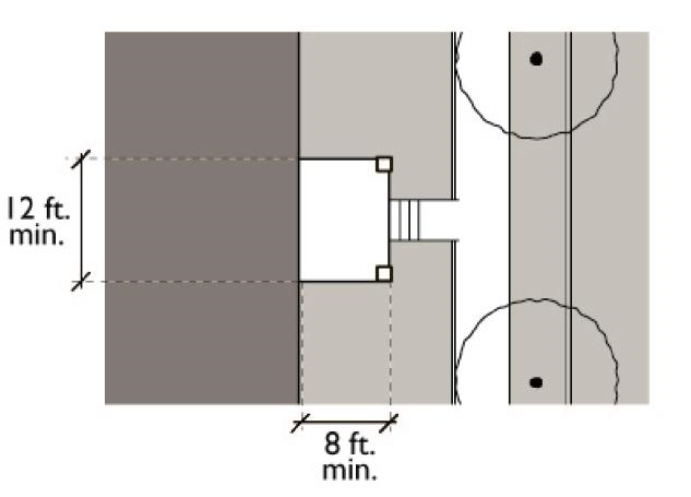
Porch and Fence Standards: Plan View
2.
Stoop.
a.
Stoop Defined. A stoop is an uncovered unenclosed elevated platform projecting from the front wall of a structure providing access to the ground level of a building.
b.
Dimensions. A stoop shall comply with the following dimension standards:
i.
Depth: Six feet minimum.
ii.
Width: Four feet minimum.
c.
Maximum Elevation. The elevation of a stoop floor shall not exceed six feet from adjacent grade.
d.
Maximum Fence, Handrail, or Wall Height. The height of a fence, handrail, or wall surrounding a stoop shall not exceed forty-two inches as measured from the stoop floor.
e.
Open Sides Required. Full or partial enclosure of stoops greater than forty-two inches in height is prohibited.
Stoop Standards: Section View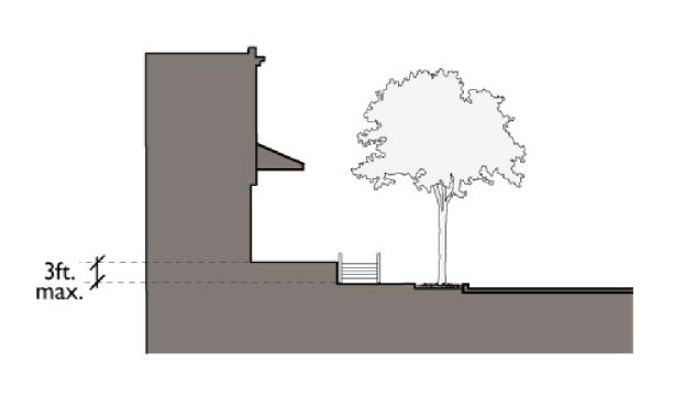
Stoop Standards: Plan View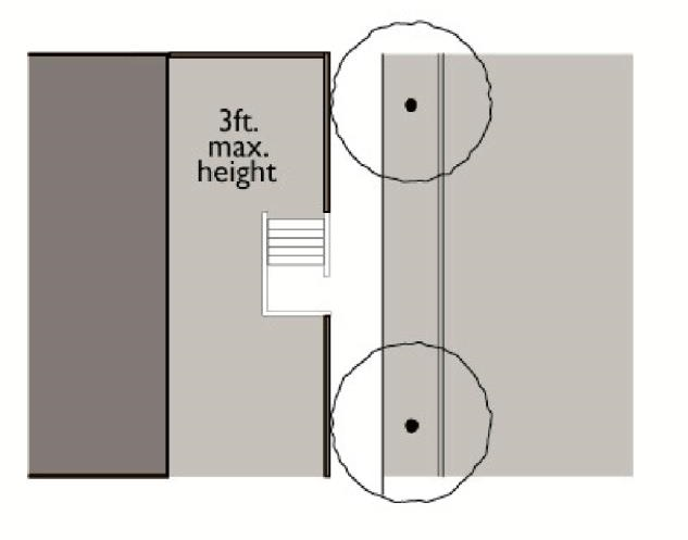
3.
Lightcourt.
a.
Lightcourt Defined. A lightcourt is a sunken front yard area that buffers residential uses from adjacent sidewalks.
b.
Maximum Depth. The lower level of a building accessed by a lightcourt shall be no more than six feet below adjacent grade.
c.
Maximum Stoop Elevation. The maximum elevation of the stoop portion of a lightcourt shall not exceed six feet from adjacent grade.
Lightcourt Standards: Section View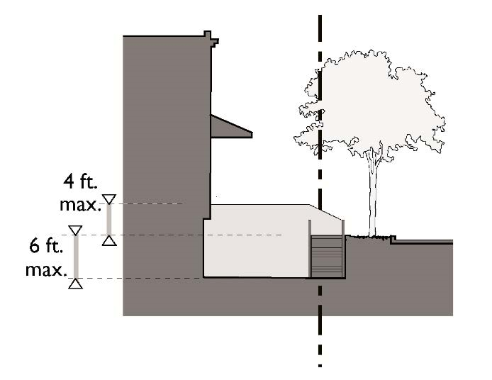
Lightcourt Standards: Plan View
4.
Dooryard.
a.
Dooryard Defined. A dooryard is a garden or terrace in the front yard area elevated from the adjacent sidewalk.
b.
Maximum Garden or Terrace Elevation. The maximum elevation of an elevated garden or terrace shall be three feet from adjacent grade.
c.
Open Sides Required. Full enclosure of an elevated garden or terrace is prohibited.
Dooryard Standards: Section View
Dooryard Standards: Plan View
Dooryard Standards: Plan View
5.
Forecourt.
a.
Forecourt Defined. A forecourt is an open area partially surrounded by building walls that opens to a public sidewalk.
b.
Minimum Dimensions. The area of a forecourt surrounded by building walls shall comply with the following dimension standards:
i.
Depth: Six feet minimum.
ii.
Width: Twenty feet minimum, fifty feet maximum.
c.
Maximum Elevation. The elevation of a forecourt floor shall not exceed six feet from adjacent grade.
d.
Minimum Transparency. The minimum area of a forecourt's street-facing walls consisting of transparent windows shall be forty percent for residential uses and sixty percent for commercial uses.
Forecourt Standards: Plan View
Forecourt Standards: Plan View
6.
Shopfront.
a.
Shopfront Defined. A shopfront is a building facade that consists primarily of transparent glass with access to a commercial space located at street level.
b.
Minimum Transparency, Ground Floor. A minimum of sixty-five percent of the street-facing walls of a ground floor shopfront shall consist of transparent windows or doors with views into the building
c.
Minimum Transparency, Upper Floors. A minimum of forty percent of the street-facing walls of upper floors shall consist of transparent windows or doors.
d.
Ground Floor Doors. A minimum of eighty percent of the area of any door providing access to ground floor commercial uses shall consist of transparent glass.
e.
Upper Floor Window Proportions. Facade openings and windows on upper stories shall be vertically proportioned, with a greater height than width. The height-width ratio of windows and openings shall be no less than 1.5:1.
f.
Ground and Upper Floor Windows. The percentage of building facade consisting of windows shall be greater on the ground floor than on upper floors.
g.
Awning and Canopy Dimensions. An awning or canopy attached to the exterior of a shopfront shall comply with the following dimension standards.
i.
Maximum projection from building wall: Eight feet, or two-thirds of the sidewalk width, whichever is greater.
ii.
Minimum eight feet clearance above sidewalk.
h.
Awning and Canopy Location. Awnings and canopies may be permitted along storefronts and doors only.
i.
Doors and Windows. Doors and windows shall not open or project into the public right-of-way.
Shopfront Standards: Section View
Shopfront Standards: Plan View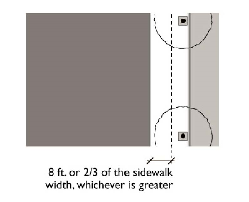
7.
Gallery.
a.
Gallery Defined. A gallery is a storefront with a covered walkway supported by columns or arches that may project over a sidewalk or walkway.
b.
Minimum Transparency. A minimum of sixty percent of the primary frontage of a gallery shall consist of transparent windows or doors with views into the building.
c.
Minimum Dimensions. A gallery shall comply with the following minimum dimension standards:
i.
Minimum dimensions of twelve feet wide, six feet deep, and ten feet high.
ii.
Maximum three feet distance between curb face and edge of gallery column or arch.
d.
Doors and Windows. Doors and windows shall not open or project into the public right-of-way.
Gallery Standards: Section View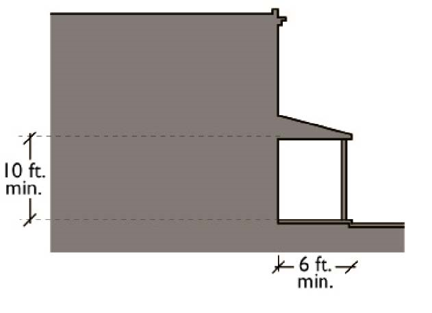
Gallery Standards: Plan View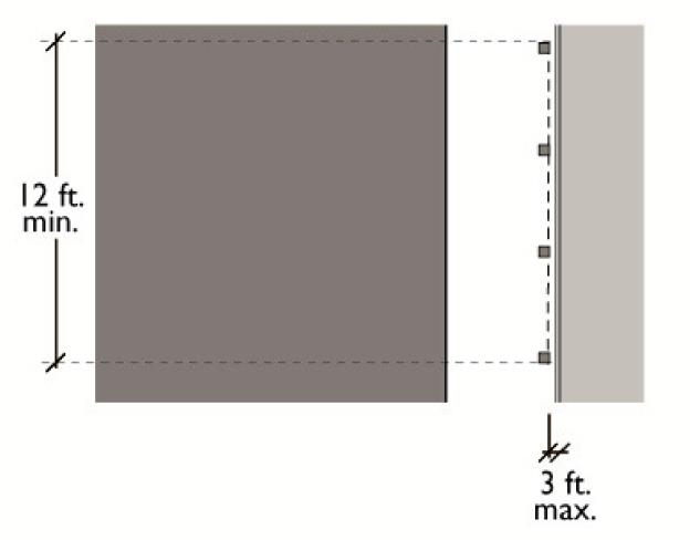
8.
Arcade.
a.
Arcade Defined. An arcade is a shopfront with a habitable upper story that projects over a sidewalk supported by columns or arches.
b.
Minimum Transparency, Ground Floor. A minimum of sixty percent of the street-facing ground floor frontage of an arcade shall consist of transparent windows or doors with views into the building.
c.
Minimum Transparency, Upper Floors. A minimum of forty percent of the upper floors of the street-facing frontage of an arcade shall consist of transparent windows or doors.
d.
Minimum Dimensions. An arcade shall comply with the following minimum dimension standards:
i.
Minimum dimensions of twelve feet wide, ten feet deep, and ten feet high
ii.
Maximum three feet distance between curb face and edge of arcade
e.
Doors and Windows. Doors and windows shall not open or project into the public right-of-way
Arcade Standards: Section View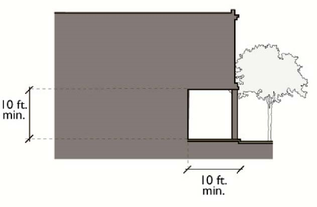
Arcade Standards: Plan View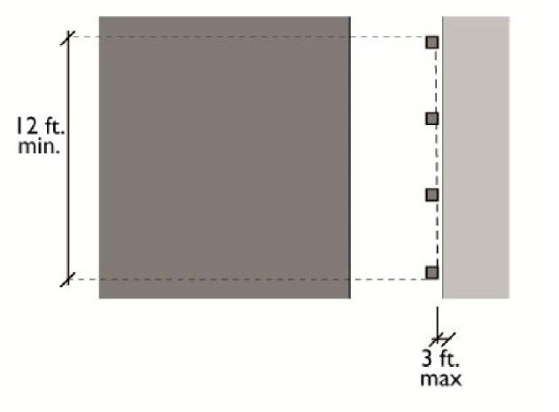
9.
Lobby.
a.
Lobby Defined. A lobby is a building facade that includes transparent glass with access to a lobby space located at street level.
b.
Minimum Transparency. The minimum area of a lobby's street-facing walls consisting of transparent windows shall be forty percent for residential uses and sixty percent for commercial uses.
c.
Maximum Elevation. The elevation of a lobby floor shall not exceed three feet from adjacent grade.
d.
Entrances. Entrance may be inset or flush with building facade
e.
Doors and Windows. Doors and windows shall not open or project into the public right-of-way.
Lobby Standards: Section View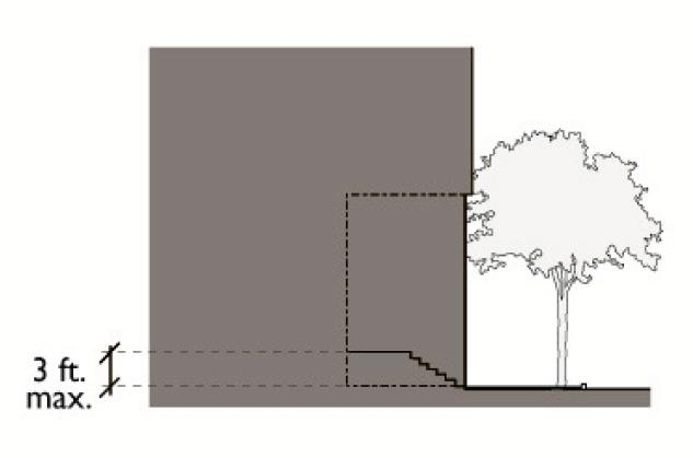
Lobby Standards: Plan View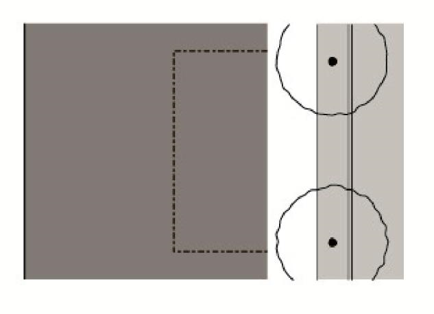
F.
Commercial Service Location and Screening.
1.
Service activities associated with commercial uses shall be setback a minimum of fifteen feet from any property line abutting a parcel occupied by a detached single-family home.
2.
Outdoor storage, trash collection, and loading areas shall located and screened from view such that they are not visible from any parcel occupied by a detached single-family home.
G.
Noise Generating Activities. Outdoor dining, amplified music, and other noise-generating activities as determined by the Director shall be setback a minimum of one hundred fifty feet from the property line of any parcel occupied by a detached single-family home.
(Ord. No. 2012-2372, Exh. B-1, 2-7-2012)
18.24.080 - Parking requirements.
A.
Purpose. This section establishes parking standards that apply to the mixed-use zones.
B.
Required On-Site Parking. Off-street parking shall be provided pursuant to Chapter 18.45.
C.
Parking Structures. All multi-story parking structures shall be lined with commercial, retail or residential uses on the ground floor at street frontages, except for the pedestrian and vehicular entries into the parking structure.
D.
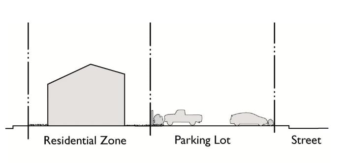
Parking Buffers.
1.
Surface parking lots abutting a public sidewalk or street shall provide a landscaped buffer a minimum of two feet in width and three feet in height along the perimeter of the parking lot abutting the sidewalk or street.
2.
A landscaped buffer at least three feet in width and six feet in height shall be provided for any surface parking lot abutting a residential zone.
Landscaped Parking Buffer Standards
E.
Parking Costs.
1.
The payment of parking costs shall be separate from rent payments or purchase prices for all uses located within the mixed-use zones.
2.
All places of employment within the mixed-use zone shall offer a parking cash-out program that allows employees to receive either owner-subsidized free parking or a cash payment equal to the value of the parking subsidy.
F.
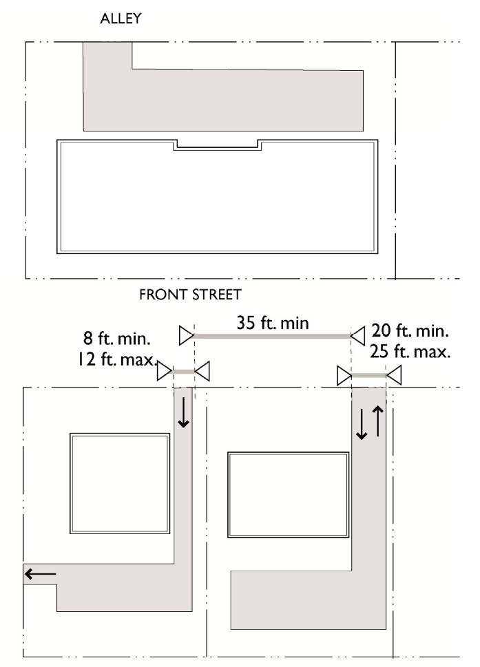
Alley Access. For new development on property adjacent to a rear alley, vehicle and service access to the property shall be provided only through the rear alley.
G.
Driveways.
1.
New driveways comply with the following standards.
a.
Dimensions. Driveways shall comply with the dimension standards shown in Table 18.24.080B (Driveway Dimension Standards).
b.
Number. No more than one driveway approach shall be provided for every fifty feet of street frontage.
c.
Proximity. A new curb cut providing access to a driveway from a public street shall be separated a minimum distance of thirty-five feet from any other curb cut.
d.
Parking. Parking spaces shall not be located along the sides of a driveway.
_____
TABLE 18.24.080B
Driveway Dimension Standards
_____
2.
The Community Development Director may approve exceptions to the driveway requirements in Subsection (1) above in the case of shared or joint use of driveways and parking lots.
Vehicles Access Standards
(Ord. No. 2024-2529, 4-2-2024)
18.24.090 - Civic space standards.
A.
Purpose. This section establishes requirements and standards for civic spaces in the MXD-1 and MXD-2 zones. Civic spaces are areas within neighborhoods where people can gather, interact and enjoy access to recreational and open space amenities.
B.
Applicability. Any commercial or mixed-use redevelopment project on a site three acres or greater in the MXD-1 or MXD-2 zones shall include a publicly-accessible civic space consistent with the standards established in this section.
C.
Types of Civic Spaces. Permitted types of civic spaces in the MXD-1 and MXD-2 zones are greens, squares, plazas, and playgrounds, as defined in Subsection (E) (standards for specific types of civic spaces) below.
D.
General Standards. The following standards apply to all civic spaces and new development adjacent to civic spaces.
1.
The on-site parking of vehicles within a civic space is prohibited.
2.
All areas with playground equipment shall be visible from the street edge.
3.
All sides of a civic space shall front either a public street, the primary frontage of a building, or a natural physical barrier such as a hillside or creek.
4.
All building walls fronting a civic space shall feature a frontage type permitted within the applicable zone as specified in Section 18.24.070 (Building Frontage Standards).
5.
Quasi-public activities, such as outdoor seating serving a restaurant, are permitted to occupy no more than twenty-five percent of the area of a civic space.
6.
Civic spaces shall be designed and located so as to be clearly visible from one or more public streets.
7.
All civic spaces shall front onto a public street for a minimum distance of fifty feet.
E.
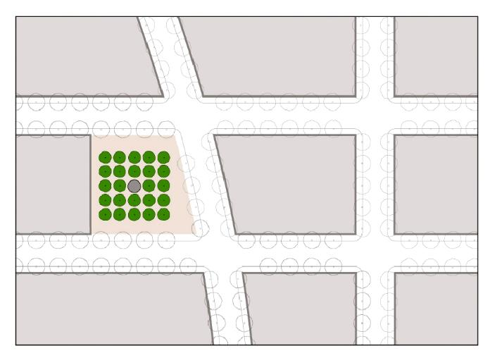
Standards for Specific Types of Civic Spaces. Specific types of civic spaces within the MXD-1 and MXD-2 zones, when required by Subsection (B) (applicability) above, shall comply with the following standards.
1.
Green. A green shall comply with the following standards.
a.
The size of all greens shall be a minimum of 0.5 acres and a maximum of five acres.
b.
All greens shall front on a minimum of one public street.
c.
Permitted improvements include playgrounds, ball parks, picnic shelters, benches, pergolas, bandstands and other similar improvements.
d.
Landscape within parks shall feature lawns generally unobstructed with limited trees naturalistically arranged and a maximum fifty percent irrigated turf.
e.
Hardscape within greens shall be limited to the minimum needed for circulation and amenities.
f.
No more than ten percent of a green shall be covered with impervious surfaces.
2.
Square. A square shall comply with the following standards.
a.
The size of all squares shall be a minimum of 0.5 acres and a maximum of three acres.
b.
All squares shall front on a minimum of three public streets.
c.
Permitted improvements within squares include paths, benches, pergolas, public art, fountains, gazebos, bandstands, small structures such as kiosks and restrooms and other similar improvements.
d.
Landscape within squares shall include lawns and trees formally arranged and a maximum ten percent irrigated turf.
e.
Hardscape within squares shall feature pathways and amenities formally arranged around a central point of interest. No more than twenty-five percent of a green shall be covered with impervious surfaces.
Green - Plan Illustration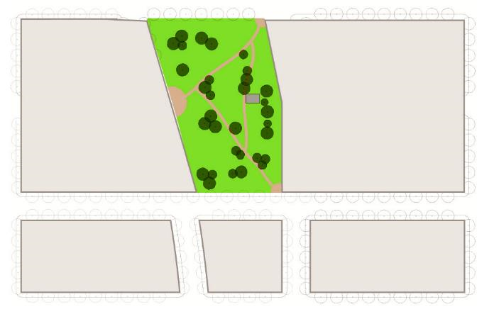
Square - Plan Illustration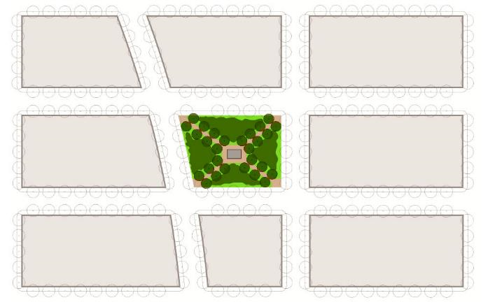
3.
Plaza. A plaza shall comply with the following standards.
4.
Playground. A playground shall comply with the following standards.
Plaza - Plan Illustration
Playground - Plan Illustration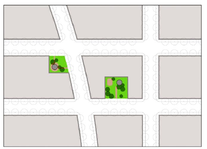
(Ord. No. 2024-2529, 4-2-2024)
18.25.010 - Purpose.
This section lists the land uses allowed within the industrial zones and provides basic standards for site layout and building use. The purposes of the individual industrial zoning districts and the manner in which they are applied are as follows:
A.
Light Industrial (IL). The IL light industrial zone is intended to accommodate warehousing operations, storage, office, and research and development facilities and establishments engaged in the manufacturing, assembling, packaging, treatment and processing of products other than those that which may be obnoxious or offensive to adjacent residential and business districts due to reason of odor, dust, smoke, gas, noise, vibration or other nuisances.
B.
Medium Industrial (IM). The IM medium industrial zone is designed to provide for the development of medium manufacturing and industrial uses that operate without excessive noise, dust, odor or other nuisances and yet may be objectionable to other non-industrial uses.
C.
Heavy Industrial (IH). The IH heavy industrial zone is intended to provide for manufacturing facilities and industries that may be obnoxious by reason of emission of odor, dust, smoke, gas, noise, vibration or similar causes and therefore require isolation from many other kinds of land uses.
(Ord. No. 2024-2529, 4-2-2024)
18.25.020 - Allowed land uses and permit requirements.
Table 18.25.020 identifies the uses of land allowed in each industrial zone.
_____
TABLE 18.25.020
Allowed Land Uses
Industrial Zones
(Ord. No. 2024-2529, 4-2-2024)
_____
18.25.030 - Accessory uses.
Accessory uses and the conditions of their use are set out in Subsections (A) through (C) below.
A.
Storage Buildings and Garages. Storage buildings and garages incidental to principal uses on the same premises are permitted.
B.
Sale of Gasoline. The sale of gasoline may be permitted as an accessory use in any zone where gasoline service stations are permitted, subject to the issuance of a conditional use permit.
C.
Auctions. Auctions, in conjunction with used furniture or antique sales, may be permitted subject to the issuance of a conditional use permit.
(Ord. No. 2024-2529, 4-2-2024)
18.25.040 - General development standards.
_____
TABLE 18.25.040
Development Standards
Industrial Zones
Notes:
(a)
Automobile service stations shall have a minimum lot area of fifteen thousand square feet.
(b)
Automobile service stations shall have a minimum street frontage of one hundred feet.
(Ord. No. 2024-2529, 4-2-2024)
_____
18.25.050 - Uses to be adequately housed in completely enclosed buildings.
All uses in the industrial zones shall be housed in completely enclosed buildings; provided, however, that businesses such as lumber yards, building material yards, gas stations, recycling facilities, metal processing yards, vehicle storage, storage lots, and similar uses that customarily include outdoor use, may be permitted outside of a completely enclosed building when screened from public view.
(Ord. No. 2024-2529, 4-2-2024)
18.26.010 - Purpose.
The purpose of the institutional (I) zone is to provide for a wide range of institutional and accessory uses including public, quasi-public, and private facilities that address health, safety, educational, cultural, and welfare needs of the community and neighborhoods. Allowed uses include educational facilities, government offices and courts, community centers, libraries, museums and cultural centers, hospitals and medical centers, retirement communities, public safety facilities (i.e., fire and police stations), neighborhood gardens and community farms, public utilities, and similar uses.
(Ord. No. 2024-2529, 4-2-2024)
18.26.020 - Allowed land uses and permit requirements.
Table 18.26.020 identifies the uses of land allowed in the institutional zone.
_____
TABLE 18.26.020
Allowed Land Uses
Institutional Zone
_____
(Ord. No. 2024-2529, 4-2-2024)
18.26.030 - General development standards.
Design regulations for the institutional zone are set out in Division 4, unless specified in this chapter.
TABLE 18.26.030
Development Standards
Institutional Zone
_____
_____
(Ord. No. 2024-2529, 4-2-2024)
18.27.010 - Purpose.
The purpose of the open space (OS) zone is to provide for public and private improved and unimproved open space. Allowed land uses include urban agriculture and recreational areas such as parks, golf courses, athletic fields, playgrounds, community gardens and farms, recreational trails, nature and wildlife preserves, marshes and wetlands, water bodies, public utility areas, flood control channels, and other scenic and open space areas.
(Ord. No. 2024-2529, 4-2-2024)
18.27.020 - Allowed land uses and structures and permit requirements.
Table 18.27.020 identifies the uses of land allowed in the open space zone.
TABLE 18.27.020
Allowed Land Uses and Permit Requirements
Open Space Zone
_____
_____
(Ord. No. 2024-2529, 4-2-2024)
18.27.030 - General development standards.
The maximum FAR in the open space zone is 0.25 and the maximum height limit is thirty-five feet.
(Ord. No. 2024-2529, 4-2-2024)
18.28.010 - Purpose.
The intent of the open space reserve zone is to provide a use category to preserve and protect public and private open space lands, salt marsh and coastal wetlands, water areas, uninhabited agricultural lands, flood control channels, and other scenic or biological open space areas by restricting development in such areas.
(Ord. No. 2024-2529, 4-2-2024)
18.28.020 - Allowed land uses and permit requirements.
Table 18.28.020 identifies the uses of land allowed in the open space reserve zone.
_____
TABLE 18.28.020
Allowed Land Uses and Permit Requirements
Open Space Reserve Zone
_____
(Ord. No. 2024-2529, 4-2-2024)
18.29.010 - Purpose.
The purpose of overlay zones is to provide supplemental regulations that have been tailored to specific geographic areas of the city. Overlay zones are applied in conjunction with a base zone and modify or add to the regulations of the base zone to address specific issues such as development within the coastal zone, special height restrictions, or supplemental processing requirements.
(Ord. No. 2024-2529, 4-2-2024)
18.29.020 - Overlay Zone designations.
Overlay zones are designated on the zoning map as indicated below:
A.
Coastal Zone (CZ). The coastal zone designates all properties located within the coastal zone subject to the development standards and specific requirements of the local coastal plan.
B.
Height Restriction (H). The height limit restriction overlay zone places a restriction on allowable building height, lower than otherwise permitted by the City's development regulations.
C.
Mobile Home Park (MHP). The mobile home park overlay zone identifies where mobile home parks are permitted in the city and establishes standards for the development of new mobile home parks and the preservation of existing mobile home parks.
(Ord. No. 2024-2529, 4-2-2024)
18.29.030 - Coastal Zone (CZ).
A.
Purpose. The intent and purpose of the coastal zone is to identify and give notice that properties within this zone are affected by the city's local coastal program. The purpose of the coastal overlay zone is to protect and enhance the quality of public access and coastal resources.
B.
Applicability. When any property bears on the zoning map of the city, in addition to its zone designation, the symbol CZ, the provisions of this chapter shall apply.
C.
Regulations. In addition to meeting the requirements of the underlying zone, any use on a property bearing the symbol CZ on the zoning map must in addition meet the provisions of the city's local coastal program.
(Ord. No. 2024-2529, 4-2-2024)
18.29.050 - Height Limit Restriction Overlay Zone (H).
A.
Applicability. Whenever any property bears, on the zoning map of the city, in addition to its zone designation, the symbol "H" followed by a numerical figure, the provisions of this chapter shall apply insofar as height limitations for any buildings or structures located, or to be located, upon such property are concerned.
B.
Formula. No building or structure shall be erected upon any property in any zone, which property bears on the zoning map the symbol "H" together with a numerical figure following, exceeding a building height, of a distance measured in feet, equal to the numerical figure following the symbol "H."
(Ord. No. 2024-2529, 4-2-2024)
18.29.060 - Mobile Home Park Overlay Zone (MHP).
A.
Purpose. The purpose of the MHP overlay zone is to provide for appropriate locations for mobile home parks to be established, maintained, and protected. This overlay zone provides for a greater range and choice of housing types, recognizes the potential for higher standards offered by mobile home design and technology, and is intended to create attractive mobile home parks that will preserve and enhance the character of surrounding areas. This zone also sets forth procedures for the conversion of an existing mobile home park to another use and is intended to minimize the adverse impacts of displacing mobile home park tenants whenever an existing mobile home park or portion thereof is converted to another use.
B.
Applicability. When any property bears on the zoning map of the city, in addition to its zone designation, the symbol MHP, the provisions of this section shall apply.
C.
Permitted Uses.
1.
New mobile home parks are subject to conditional use permit approval.
2.
Accessory structures limited to awnings, cabanas, storage cabinets, renewable energy infrastructure, fences or windbreaks, carports, garages, and porches are permitted.
3.
Accessory uses such as recreational facilities, parks and open space, playgrounds, clubhouses, laundries, community centers, and similar uses are permitted; provided, that such uses are designed for and limited to use by residents of the mobile home park and their guests and that such uses are not authorized on the individual mobile home lots within the mobile home park.
4.
Minor utility facilities are permitted; major utility facilities require conditional use permit approval.
5.
Home occupations are permitted subject to the approval of a home occupation permit pursuant to Section 18.12.090.
6.
Small family day care homes are permitted subject to Section 18.30.080.
7.
Large family day care homes are permitted subject to the approval of a minor use permit and provided they comply with Section 18.30.080.
D.
Development Standards.
1.
Mobile home parks shall comply with the maximum density of the applicable general plan designation and underlying zone and all other development standards of the underlying zone (unless otherwise constrained by Section 18000 et seq. of the Health and Safety Code) with the exception of the following:
a.
The front yard setback shall be a minimum of twenty-five feet.
b.
The interior side yard setback shall be a minimum of ten feet.
2.
When located on a lot adjoining another residential use, mobile home parks shall be permanently screened from such adjoining property by a fence or wall and suitable landscaping, adjacent to or opposite the other residential use.
E.
Discontinuance Procedures.
1.
The application for discontinuance of a mobile home park shall be accompanied by:
a.
A relocation plan to provide for the tenants who will be displaced by the discontinuance of the property as a mobile home park or the conversion of mobile home spaces to other uses.
b.
A phasing plan indicating the timing and manner in which the existing mobile home units will be discontinued.
(Ord. No. 2024-2529, 4-2-2024)
18.29.070 - Floodway (-FW), Floodway Fringe (-FF-1), Floodway Fringe Shallow Flooding (-FF-2), Floodway Fringe Riverine Flooding (-FF-3), and Coastal High Hazard Flooding (-FF-4) zones.
A.
Statement of Purpose. It is the purpose of this chapter to promote the public health, safety and general welfare, and to minimize public and private losses due to flood conditions in specific areas by provisions designed to:
1.
Protect human life and health;
2.
Minimize expenditure of public money for costly flood control projects;
3.
Minimize the need for rescue and relief efforts associated with flooding and generally undertaken at the expense of the general public;
4.
Minimize prolonged business interruptions;
5.
Minimize damage to public facilities and utilities such as water and gas mains, electric, telephone and sewer lines, streets and bridges located in areas of special flood hazard;
6.
Help maintain a stable tax base by providing for the second use and development of areas of special flood hazard so as to minimize future flood blight areas;
7.
Ensure that potential buyers are notified that property is in an area of special flood hazard; and
8.
Ensure that those who occupy the areas of special flood hazard assume responsibility for their actions.
B.
Methods of Reducing Flood Losses. In order to accomplish its purposes, this chapter includes methods and provisions to:
1.
Restrict or prohibit uses which are dangerous to health, safety and property due to water or erosion hazards, or which result in damaging increases in erosion or flood heights or velocities;
2.
Require that uses vulnerable to floods, including facilities which serve such uses, be protected against flood damage at the time of initial construction;
3.
Control the alteration of natural floodplains, stream channels and natural protective barriers, which help accommodate or channel floodwaters;
4.
Control filling, grading, dredging, and other development which may increase flood damage; and
5.
Prevent or regulate the construction of flood barriers which will unnaturally divert floodwaters or which may increase flood hazards in other areas.
C.
Warning and Disclaimer of Liability. The degree of flood protection required by this chapter is considered reasonable for regulatory purposes and is based on scientific and engineering considerations. Larger floods can and will occur on rare occasions. Flood heights may be increased by man-made or natural causes. This chapter does not imply that land outside the areas of special flood hazards or uses permitted within such areas will be free from flooding or flood damages. This chapter shall not create liability on the part of the city, any officer or employee thereof, the state of California or the Federal Insurance Administration, Federal Emergency Management Agency for any flood damages that result from reliance on this chapter or any administrative decision lawfully made thereunder.
D.
Abrogation and Greater Restrictions. This chapter is not intended to repeal, abrogate or impair any existing easements, covenants or deed restrictions. However, where this chapter and another chapter, easement, covenant or deed restrictions conflict or overlap, whichever imposes the more stringent restriction shall prevail.
E.
Definitions. Unless specifically defined below, or in this title, words or phrases used in this chapter shall be interpreted so as to give them the meaning they have in common usage and to give this chapter its most reasonable application.
1.
"Accessory use" means a use which is incidental and subordinate to the principal use of the parcel of land on which it is located.
2.
"Adversely affects" means, for purposes of this chapter, that the cumulative effect of the proposed development when combined with all other existing and anticipated development will increase the water surface elevation of the base flood more than one foot at any point.
3.
"Alluvial fan" means a geomorphologic feature characterized by a cone- or fan-shaped deposit of boulders, gravel, and fine sediments that have been eroded from slopes, transported by flood flows, and then deposited on the valley floor, and which is subject to flash flooding, high velocity flows, debris flows, erosion, sediment movement and deposition, and channel migration.
4.
"Apex" means the point of highest elevation on an alluvial fan, which on undisturbed fans is generally the point where the major stream that formed the fan emerges from the slope.
5.
"Appeal" means a request for a review of the floodplain administrator's interpretation of any provision of this chapter.
6.
"Area of shallow flooding" means a designated AO or AH zone on the flood insurance rate map (FIRM). The base flood depths range from one to three feet; a clearly defined channel does not exist; the path of flooding is unpredictable and indeterminate; and velocity flow may be evident. Such flooding is characterized by ponding or sheet flow.
7.
"Area of special flood hazard"—see "special flood hazard area."
8.
"Base flood" means a flood which has a one percent chance of being equaled or exceeded in any given year (also called the "one hundred-year flood"). Base flood is the term used throughout this chapter.
9.
"Base flood elevation" (BFE) means the elevation shown on the flood insurance rate map for Zones AE, AO, A1—30, VE and V1—V30 that indicates the water surface elevation resulting from a flood that has a one percent or greater chance of being equaled or exceeded in any given year.
10.
"Basement" means any area of the building having its floor subgrade—i.e., below ground level—on all sides.
11.
"Breakaway walls" are any type of walls, whether solid or lattice, and whether constructed of concrete, masonry, wood, metal, plastic or any other suitable building material which is not part of the structural support of the building and which is designed to break away under abnormally high tides or wave action without causing any damage to the structural integrity of the building on which they are used or any buildings to which they might be carried by flood waters. A breakaway wall shall have a safe design loading resistance of not less than ten and no more than twenty pounds per square foot. Use of breakaway walls must be certified by a registered engineer or architect and shall meet the following conditions:
a.
Breakaway wall collapse shall result from a water load less than that which would occur during the base flood; and
b.
The elevated portion of the building shall not incur any structural damage due to the effects of wind and water loads acting simultaneously in the event of the base flood.
12.
"Building"—see "structure."
13.
"Coastal high hazard area" means an area of special flood hazard extending from offshore to the inland limit of a primary frontal dune along an open coast and any other area subject to high velocity wave action from storms or seismic sources. It is an area subject to high velocity waters, including coastal and tidal inundation or tsunamis. The area is designated on a flood insurance rate map (FIRM) as Zone V1-V30, VE, or V.
14.
"Development" means any man-made change to improved or unimproved real estate, including but not limited to buildings or other structures, mining, dredging, filling, grading, paving, excavation or drilling operations, or storage of equipment or materials.
15.
"Encroachment" means the advance or infringement of uses, plant growth, fill, excavation, buildings, permanent structures or development into a floodplain which may impede or alter the flow capacity of a floodplain.
16.
"Exception." See "variance."
17.
"Existing manufactured home/mobile home park or subdivision" means a manufactured home park or subdivision for which the construction of facilities for servicing the lots on which the manufactured homes/mobile homes are to be affixed (including, at a minimum, the installation of utilities, the construction of streets, and either final site grading or the pouring of concrete pads) is completed before February 15, 1979.
18.
"Expansion to an existing manufactured home/mobile home park or subdivision" means the preparation of additional sites by the construction of facilities for servicing the lots on which the manufactured homes/mobile homes are to be affixed (including the installation of utilities, the construction of streets, and either final site grading or pouring of concrete pads).
19.
"Flood, flooding or floodwater" means a general and temporary condition of partial or complete inundation of normally dry land areas from the overflow of inland or tidal waters, and/or the unusual and rapid accumulation or runoff of surface waters from any source.
20.
"Flood boundary and floodway map (FBFM)" means the official map on which the Federal Emergency Management Agency or Federal Insurance Administration has delineated both the areas of special flood hazards and the floodway.
21.
"Flood hazard boundary map" means the official map on which the Federal Emergency Management Agency or Federal Insurance Administration has delineated the areas of flood hazards.
22.
"Flood insurance rate map (FIRM)" means the official map on which the Federal Emergency Management Agency or the Federal Insurance Administration has delineated both the areas of special flood hazards and the risk premium zones applicable to the community.
23
"Flood insurance study" means the official report provided by the Federal Insurance Administration that includes flood profiles, the flood insurance rate map, the flood boundary and floodway map, and the water surface elevation of the base flood.
24.
"Floodplain or flood-prone area" means any land area susceptible to being inundated by water from any source—see "flooding."
25.
"Floodplain administrator" means the individual appointed to administer and enforce the floodplain management regulations. This individual shall be the city engineer of the city.
26.
"Floodplain management" means the operation of an overall program of corrective and preventive measures for reducing flood damage and preserving and enhancing, where possible, natural resources in the floodplain, including but not limited to emergency preparedness plans, flood control works, floodplain management regulations, and open space plans.
27.
"Floodplain management regulations" means this chapter and other zoning ordinances, subdivision regulations, building codes, health regulations, special purpose ordinances (such as grading and erosion control) and other applications of police power which control development in flood-prone areas. The term describes federal, state or local regulations in any combination thereof which provide standards for preventing and reducing flood loss and damage.
28.
"Flood-proofing" means any combination of structural and nonstructural additions, changes or adjustments to structures which reduce or eliminate flood damage to real estate or improved real property, water and sanitary facilities, structures and their contents.
29.
"Floodway" means the channel of a river or other watercourse and the adjacent land areas that must be reserved in order to discharge the base flood without cumulatively increasing the water surface elevation more than one foot. Also referred to as "regulatory floodway."
30.
"Floodway encroachment lines" means the lines marking the limits of floodways on the effective flood insurance rate map.
31.
"Floodway fringe" means that area of the floodplain on either side of the "regulatory floodway" where encroachment may be permitted. These areas are identified on the effective flood insurance rate map as 'Zone AE' and 'Zone AO'.
32.
"Fraud and victimization," as related to Subsection (CC) (conditions for variances) of this chapter, means that the variance granted must not cause fraud on or victimization of the public. In examining this requirement, the planning commission will consider the fact that every newly constructed building adds to government responsibilities and remains a part of the community for fifty to one hundred years. Buildings that are permitted to be constructed below the base flood elevation are subject, during all those years, to increased risk of damage from floods, while future owners of the property and the community as a whole are subject to all the costs, inconvenience, danger, and suffering that those increased flood damages bring. In addition, future owners may purchase the property, unaware that it is subject to potential flood damage, and can be insured only at very high flood insurance rates.
33.
"Functionally dependent use" means a use which cannot perform its intended purpose unless it is located or carried out in close proximity to water. The term includes only docking facilities, port facilities that are necessary for the loading and unloading of cargo or passengers, and ship building and ship repair facilities, and does not include long-term storage or related manufacturing facilities.
34.
"Habitable floor" means any floor usable for living purposes, which includes working, sleeping, eating, cooking or recreation, or a combination thereof. A floor used only for storage purposes is not a "habitable floor."
35.
"Hardship," as related to (CC) (conditions for variances) of this chapter, means the unusual hardship that would result from a failure to grant the requested variance. The planning commission requires that the variance be unusual and peculiar to the property involved. Mere economic or financial hardship alone is not exceptional. Inconvenience, aesthetic considerations, physical handicaps, personal preferences, or the disapproval of one's neighbors likewise cannot, as a rule, qualify as an exceptional hardship. All of these problems can be resolved through other means without granting a variance, even if the alternative is more expensive, or requires the property owner to build elsewhere or put the parcel to a different use than originally intended.
36.
"Highest adjacent grade" means the highest natural elevation of the ground surface prior to construction next to the proposed walls of a structure.
37.
"Historic structure" means any structure that is:
a.
Listed individually in the National Register of Historic Places (a listing maintained by the Department of Interior) or preliminarily determined by the Secretary of the Interior as meeting the requirements for individual listing on the National Register;
b.
Certified or preliminarily determined by the Secretary of the Interior as contributing to the historical significance of a registered historic district or a district preliminarily determined by the Secretary to qualify as a registered historic district;
c.
Individually listed on a state inventory of historic places in states with historic preservation programs which have been approved by the Secretary of Interior; or
d.
Individually listed on a local inventory of historic places in communities with historic preservation programs that have been certified either by an approved state program as determined by the Secretary of the Interior or directly by the Secretary of the Interior in states with approved programs.
38.
"Levee" means a man-made structure, usually an earthen embankment, designed and constructed in accordance with sound engineering practices to contain, control or divert the flow of water so as to provide protection from temporary flooding.
39.
"Levee system" means a flood protection system which consists of a levee, or levees, and associated structures, such as closure and drainage devices, which are constructed and operated in accord with sound engineering practices.
40.
"Lowest floor" means the lowest floor of the lowest enclosed area, including basement. An unfinished or flood resistant enclosure, usable solely for parking of vehicles, building access or storage in an area other than a basement area (see "basement") is not considered a building's lowest floor, provided that such enclosure is not built so as to render the structure in violation of the applicable non-elevation design requirements of this title. (Note: This definition allows attached garages to be built at grade. Below grade garages are not allowed as they are considered to be basements).
41.
"Manufactured home" or "mobile home" means a structure, transportable in one or more sections, which is built on a permanent chassis and is designed for use with or without a permanent foundation when connected to the required utilities. The term "manufactured home" does not include "recreational vehicles" or "travel trailers."
42.
"Manufactured home/mobile home park or subdivision" means a parcel (or contiguous parcels) of land divided into two or more manufactured home lots for sale or rent.
43.
"Mean sea level" means, for purposes of the National Flood Insurance Program, the National Geodetic Vertical Datum (NGVD) of 1929, North American Vertical Datum (NAVD) of 1988, or other datum, to which base flood elevations shown on a community's flood insurance rate map are referenced.
44.
"New construction" for floodplain management purposes means structures for which the "start of construction" commenced on or after February 15, 1979, and includes any subsequent improvements to such structures.
45.
"New manufactured home/mobile home park or subdivision" means a manufactured home/mobile home park or subdivision for which the construction of facilities for servicing the lots on which the manufactured homes/mobile homes are to be affixed (including, at a minimum, the installation of utilities, the construction of streets, and either final site grading or the pouring of concrete pads) is completed on or after February 15, 1979.
46.
"Obstruction" means and includes, but is not limited to, any dam, wall, wharf, embankment, levee, dike, pile, abutment, protection, excavation, channelization, bridge, conduit, culvert, building, wire, fence, rock, gravel, refuse, fill, structure, vegetation or other material in, or along, across or projecting into any watercourse which may alter, impede, retard or change the direction and/or velocity of the flow of water, or due to its location, its propensity to snare or collect debris carried by the flow of water, or its likelihood of being carried downstream.
47.
"One hundred-year flood"—see "base flood."
48.
"Primary frontal dune" means a continuous or nearly continuous mound or ridge of sand with relatively steep seaward and landward slopes immediately landward and adjacent to the beach and subject to erosion and overtopping from high tides and waves during major coastal storms. The inland limit of the primary frontal dune occurs at the point where there is a distinct change from a relatively mild slope.
49.
"Principal structure" means a structure used for the principal use of the property as distinguished from an accessory use.
50.
"Public safety and nuisance," as related to Subsection (CC) (conditions for variances) of this chapter, means that the granting of an variance must not result in anything which is injurious to the safety or health of an entire community or neighborhood, or any considerable number of persons, or unlawfully obstructs the free passage or use, in the customary manner, of any navigable lake, or river, bay, stream, canal or basin.
51.
"Recreational vehicle" means a vehicle which is:
a.
Built on a single chassis;
b.
Four hundred square feet or less when measured at the largest horizontal projection;
c.
Designed to be self-propelled or permanently towable by a light-duty truck; and
d.
Designed primarily not for use as a permanent dwelling but as temporary living quarters for recreational, camping, travel, or seasonal use.
52.
"Regulatory floodway" means the channel of a river or other watercourse and the adjacent land areas that must be reserved in order to discharge the base flood without cumulatively increasing the water surface elevation more than one foot.
53.
"Riverine" means relating to, formed by, or resembling a river (including tributaries), stream, brook, etc.
54.
"Sheet flow"—see "area of shallow flooding."
55.
"Special flood hazard area (SFHA)" means an area having special flood or flood-related erosion hazards, and shown on a FBHM or FIRM as Zone A, AO, A1-A30, AE, A99, AH, V1-V30, VE or V.
56.
"Start of construction" means and includes substantial improvement and other proposed new development, and means the date the building permit was issued, provided the actual start of construction, repair, reconstruction, rehabilitation, addition, placement, or other improvement was within one hundred eighty days from the date of the permit. The actual start means either the first placement of permanent construction of a structure (other than a manufactured home) on a site, such as the pouring of slab or footings, the installation of piles, the construction of columns, or any work beyond the stage of excavation; or the placement of a manufactured home on a foundation. Permanent construction does not include land preparation, such as clearing, grading, and filling; nor does it include the installation of streets and/or walkways; nor does it include excavation for a basement, footings, piers or foundations or the erection of temporary forms; nor does it include the installation on the property of accessory buildings, such as garages or sheds not occupied as dwelling units or not part of the main structure. For a substantial improvement, the actual start of construction means the first alteration of any wall, ceiling, floor, or other structural part of a building, whether or not that alteration affects the external dimensions of the building. For a structure (other than a mobile home) without a basement or poured footings, the "start of construction" includes the first permanent framing or assembly of the structure or any part thereof on its piling or foundation. For mobile homes not within a mobile home park or mobile home subdivisions, "start of construction" means the affixing of the mobile home to its permanent site. For mobile homes within mobile home parks or mobile home subdivisions, "start of construction" is the date on which the construction of facilities for servicing the site on which the mobile home is to be affixed (including, at a minimum, the construction of streets, either final site grading or the pouring of concrete pads, and installation of utilities) is completed.
57.
"Structure" means a walled and roofed building that is principally aboveground. This includes a gas or liquid storage tank or manufactured/mobile home.
58.
"Substantial damage" means damage of any origin sustained by a structure whereby the cost of restoring the structure to its before damaged condition would equal or exceed fifty percent of the market value of the structure before the damage occurred.
59.
"Substantial improvement" means any reconstruction, rehabilitation, addition or other proposed new development of a structure, the cost of which equals or exceeds fifty percent of the market value of the structure before the "start of construction" of the improvement. This term includes structures which have incurred "substantial damage," regardless of the actual work performed. The term does not, however, include either:
a.
Any project for improvement of a structure to correct violations or to comply with state or local health, sanitary, or safety code specifications which have been identified by a local code conformance official and which are solely necessary to assure safe living conditions; or
b.
Any alteration of a "historic structure" provided that the alteration will not preclude the structure's continued designation as a "historic structure."
60.
"V zone" — see coastal high hazard area.
61.
"Variance," as used in this chapter, means a grant of relief from the requirements of this chapter which permits construction in a manner that would otherwise be prohibited by this chapter.
62.
"Violation" means the failure of a structure or other development to be fully compliant with the community's floodplain management regulations. A structure or other development without the elevation certificate, other certifications, or other evidence of compliance required in this chapter is presumed to be in violation until such time as that documentation is provided.
63.
"Water surface elevation" means the height, in relation to the National Geodetic Vertical Datum (NGVD) of 1929, North American Vertical Datum (NAVD) of 1988 (or other datum, where specified), of floods of various magnitudes and frequencies in the floodplains of coastal or riverine areas.
64.
"Watercourse" means a lake, river, creek, stream, wash, arroyo, channel or other topographic feature on or over which waters flow at least periodically. Watercourse includes specifically designated areas in which substantial flood damage may occur.
F.
Lands to which Chapter Applies. This chapter shall apply to all areas of special flood hazards within the jurisdiction of National City.
1.
No structure or land shall hereafter be constructed, located, extended, converted or altered without first submitting an application for a flood hazard area development permit to the flood plain administrator.
G.
Basis for Establishing the Areas of Special Flood Hazard. The areas of special flood hazard as shown on the special flood hazard map as floodway (FW), floodway fringe (FF-1), and floodway fringe-shallow flooding (FF2) zones and conforming with the areas of special flood hazard identified by the Federal Insurance Administration (FIA) of the Federal Emergency Management Agency (FEMA) in the flood insurance study (FIS) for National City dated August 4, 1988, and accompanying flood insurance rate maps (FIRMs) and flood boundary and floodway maps (FBFMs), dated August 4, 1988, and all subsequent amendments and/or revisions, are adopted by reference and declared to be a part of this chapter without an further action by the city council. This FIS and attendant mapping is the minimum area of applicability of this chapter and may be supplemented by studies for other areas which allow implementation of this chapter and which are recommended to the planning commission by the floodplain administrator. The study, FIRMs and FBFMs are on file at the office of the floodplain administrator at 1243 National City Boulevard, National City, California, 91950.
H.
Compliance. No structure or land shall hereafter be constructed, located, extended, converted or altered without full compliance with the terms of this chapter and other applicable regulations. Violation of the requirements (including violations of conditions and safeguards established in connection with conditions) shall constitute a misdemeanor. Nothing herein shall prevent the city from taking such lawful action as is necessary to prevent or remedy any violation.
I.
Interpretation. In the interpretation and application of this chapter, all provisions shall be:
a.
Considered as minimum requirements;
b.
Liberally construed in favor of the city; and
c.
Deemed neither to limit nor repeal any other powers granted under state statutes.
J.
Severability. This chapter and the various parts thereof are declared to be severable. Should any section of this chapter be declared by the courts to be unconstitutional or invalid, such decision shall not affect the validity of the chapter as a whole, or any portion thereof other than the section so declared to be unconstitutional or invalid.
K.
Floodway Zone (FW) Established. There is established, on the special flood hazard map, a designated floodway zone. The FW zone shall be applied to those areas of special flood hazard designated as floodways on the flood boundary and floodway map of the flood insurance study.
L.
Floodway Fringe Zone (FF-1) Established. There is established, on the special flood hazard map, a designated floodway fringe zone. The FF-1 zone shall be applied to those areas of special flood hazard designated as floodway fringe on the flood boundary and floodway map of the flood insurance study but excluding areas of shallow flooding designated AO or AH on the flood insurance rate map (FIRM).
M.
Floodway Fringe—Shallow Flooding Zone (FF-2) Established. There is established, on the special flood hazard map, a designated floodway fringe-shallow flooding zone. The FF-2 zone shall be applied to those areas of special flood hazard designated as floodway fringe on the flood boundary and floodway map of the flood insurance study and designated as areas of shallow flooding AO or AH on the flood insurance rate map (FIRM).
N.
Floodway Fringe—Riverine Flooding Zone (FF-3) established. There is established, on the special flood hazard map, a designated riverine flooding zone. The FF-3 zone is that area of the floodplain on either side of the "regulatory floodway" where encroachment may be permitted.
O.
Floodway Fringe—Coastal High Hazard Flooding Zone (FF-4) established. There is established, on the special flood hazard map, a designated coastal high hazard flooding zone. The FF-4 zone shall be applied to those areas of special flood hazard designated as areas of coastal flooding VE or V on the flood insurance rate map (FIRM).
P.
Standards Applicable to All Areas of Special Flood Hazard. In all areas of special flood hazards including the FW, FF-1, FF-2, FF-3, and FF-4 zones, the following standards are required:
1.
Anchoring.
a.
All new construction and substantial improvements, shall be adequately anchored to prevent flotation, collapse or lateral movement of the structure resulting from hydrodynamic and hydrostatic loads, including the effects of buoyancy.
b.
All manufactured/mobile homes shall meet the anchoring standards of Subsection (S).
2.
Construction Materials and Methods. All new construction and substantial improvements, including manufactured homes, shall be constructed:
a.
With materials and utility equipment resistant to flood damage
b.
Using methods and practices that minimize flood damage;
c.
With electrical, heating, ventilation, plumbing, and air conditioning equipment and other service facilities that are designed and/or located so as to prevent water from entering or accumulating within the components during conditions of flooding; and
d.
Within Zones AH or AO, so that there are adequate drainage paths around structures on slopes to guide flood waters around and away from proposed structures.
3.
Elevation and Flood-proofing. (See Section (E) definitions for "new construction," "substantial damage" and "substantial improvement.")
a.
Residential construction, new or substantial improvement, shall have the lowest floor, including basement:
i.
In an AO zone, elevated above the highest adjacent grade to a height exceeding the depth number specified in feet on the FIRM by at least one foot, or elevated at least three feet above the highest adjacent grade if no depth number is specified;
ii.
In an AE, AH, or A1—30 zones, elevated at least one foot above the base flood elevation, as determined by the city;
iii.
In an A (unnumbered/approximate A zone) zone, without base flood elevations specified on the FIRM, elevated at least one foot above the base flood elevation, as determined by the city;
Upon the completion of the structure, the elevation of the lowest floor including basement shall be certified by a registered professional civil engineer or surveyor to be properly elevated. Such certification or verification shall be provided to the floodplain administrator.
b.
Nonresidential construction, shall either be elevated to conform with Subsection (3)a of this section or together with attendant utility and sanitary facilities:
i.
Be completely flood-proofed below the elevation recommended under Subsection (C)(1) of this section so that the structure is watertight with walls substantially impermeable to the passage of water; and
ii.
Have structural components capable of resisting hydrostatic and hydrodynamic loads and effects of buoyancy; and
iii.
Be certified by a registered professional civil engineer that the standards of this Subsection (3)b of this section are satisfied. Such certification shall be provided to the floodplain administrator.
c.
All new construction and substantial improvements with fully enclosed areas below the lowest floor (excluding basement) that are usable solely for parking vehicles, building access or storage, and which are subject to flooding shall be designed to automatically equalize hydrostatic flood forces on exterior walls by allowing for the entry and exit of floodwaters. Designs for meeting this requirement must exceed the following minimum criteria:
i.
Be certified by a registered professional civil engineer; or
ii.
Be certified to comply with a local flood-proofing standard approved by the Federal Insurance Administration, Federal Emergency Management Agency; or
iii.
Have a minimum of two openings having a total net area of not less than one square inch for every square foot of enclosed area subject to flooding. The bottom of all openings shall be no higher than one foot above adjacent natural grade. Openings may be equipped with screens, louvers, valves or other coverings or devices provided that they permit the automatic entry and exit of floodwaters.
d.
Manufactured homes shall also meet the standards in Subsection (3)c of this section and Subsection (S).
4.
Storage of Material and Equipment.
a.
The storage or processing of materials that are, in time of flooding, flammable, explosive, or could be injurious to human, animal or plant life is prohibited.
b.
Storage of other material or equipment may be allowed if not subject to major damage by floods and firmly anchored to prevent flotation or if readily removable from the area within the time available after flood warning.
Q.
Standards for Utilities.
1.
All new and replacement water supply and sanitary sewage systems shall be designed to minimize or eliminate:
a.
Infiltration of floodwaters into the systems; and
b.
Discharge from the systems into floodwaters.
2.
On-site waste disposal systems shall be located to avoid impairment to them, or contamination from them during flooding.
R.
Standards for Subdivision.
1.
All preliminary subdivision proposals, including proposals for manufactured home parks and subdivisions, greater than fifty lots or five acres, whichever is the lesser, shall identify the flood hazard area and the elevation of the base flood.
2.
All subdivision plans will provide the elevation of the lowest floors of all proposed structure(s) and pad(s). If the site is filled above the base flood elevation, the final first floor and pad elevations shall be certified by a registered professional civil engineer or surveyor and provided as part of an application for a letter of map revision based on fill (LOMR-F) to the floodplain administrator.
3.
All subdivision proposals shall be consistent with the need to minimize flood damage.
4.
All subdivision proposals shall have public utilities and facilities such as sewer, gas, electrical and water systems located and constructed to minimize flood damage.
5.
All subdivisions shall provide adequate drainage to reduce exposure to flood hazards.
S.
Standards for Manufactured Homes/Mobile Homes.
1.
All manufactured homes that are placed or substantially improved, within Zones A1—30, AH, AE, V1—30, VE, or V on the flood insurance rate map, on sites located:
a.
Outside of a manufactured home park or subdivision;
b.
In a new manufactured home park or subdivision;
c.
In an expansion to an existing manufactured home park or subdivision; or
d.
In an existing manufactured home park or subdivision on a site upon which a manufactured home has incurred "substantial damage" as the result of a flood, shall be elevated on a permanent foundation such that the lowest floor of the manufactured home is elevated at least one foot above the base flood elevation and be securely anchored to an adequately anchored foundation system to resist flotation, collapse and lateral movement. Within Zones V1-30, V, and VE on the flood insurance rate map shall meet the requirements of Subsection (R).
2.
All manufactured homes to be placed or substantially improved on sites in an existing manufactured home park or subdivision within Zones A1—30, AH, AE, V1-30, V, and VE on the flood insurance rate map that are not subject to the provisions of Subsection (A) of this section shall be securely fastened to an adequately anchored foundation system to resist flotation, collapse, and lateral movement, and be elevated so that either:
a.
The lowest floor of the manufactured home is at least one foot above the base flood elevation; or
b.
The manufactured home chassis is supported by reinforced piers or other foundation elements of at least equivalent strength that are no less than thirty-six inches in height above grade.
3.
All mobile homes/manufactured homes shall be anchored to resist flotation, collapse or lateral movement by providing over-the-top and frame ties to ground anchors. Specific requirements shall be that:
a.
Over-the-top ties be provided at each of the four corners of the mobile home, with two additional ties per side at intermediate locations, with mobile homes less than fifty feet long requiring only one additional tie per side;
b.
Frame ties be provided at each corner of the home with five additional ties per side at intermediate points, with mobile homes less than fifty feet long requiring only four additional ties per side;
c.
All components of the anchoring system be capable of carrying a force of four thousand eight hundred pounds; and
d.
Any additions to the mobile home shall be similarly anchored.
T.
Standards for Recreational Vehicles.
1.
All recreational vehicles placed on sites within Zones A1—30, AH, AE, V1-30, VE, and V on the community's flood insurance rate map will either:
a.
Be on the site for fewer than one hundred eighty consecutive days; or
b.
Be fully licensed and ready for highway use—a recreational vehicle is ready for highway use if it is on its wheels or jacking system, is attached to the site only by quick disconnect type utilities and security devices, and has no permanently attached additions; or
c.
Meet the permit requirements of Subsection (W) of this chapter and the elevation and anchoring requirements for manufactured homes in Subsection (S)(1)a.
2.
Recreational vehicles placed on sites within Zones V1—30, V, and VE on the community's flood insurance rate map will meet the requirements of Subsection (R) and Subsection (S).
U.
Floodways (FW). Located within areas of special flood hazard established in Subsection (G) are areas designated as floodways to which the following provisions apply:
1.
Until a regulatory floodway is adopted in Zone A areas, no new construction, substantial development, or other development (including fill) shall be permitted within Zones A1—30 and AE, unless it is demonstrated that the cumulative effect of the proposed development, when combined with all other development, will not increase the water surface elevation of the base flood more than one foot at any point within the city of National City.
2.
Within an adopted regulatory floodway, the city of National City shall prohibit encroachments, including fill, new construction, manufactured homes, substantial improvements, and other development within Zones A1—30 and AE, unless certification by a registered professional civil engineer is provided demonstrating that the proposed encroachment shall not result in any increase in flood levels during the occurrence of the base flood discharge.
3.
If Subsection (U)(2) is satisfied, all new construction, substantial improvements, and other new development shall comply with all other applicable flood hazard reduction provisions of Subsections (P) through (U) and require approval of a Conditional Use Permit pursuant to Title 18 of the National City Municipal Code.
V.
Coastal High Hazard Area. Within coastal high hazard areas, Zones V, V1—30, and VE, as established under Subsection (E)(13), the following standards shall apply:
1.
All new residential and nonresidential construction, including substantial improvement/damage, shall be elevated on adequately anchored pilings or columns and securely anchored to such pilings or columns so that the bottom of the lowest horizontal structural member of the lowest floor (excluding the pilings or columns) is elevated to or above the base flood level. The pile or column foundation and structure attached thereto is anchored to resist flotation, collapse, and lateral movement due to the effects of wind and water loads acting simultaneously on all building components. Water loading values used shall be those associated with the base flood. Wind loading values used shall be those required by applicable state or local building standards.
2.
All new construction and other development shall be located on the landward side of the reach of mean high tide.
3.
All new construction and substantial improvement shall have the space below the lowest floor free of obstructions or constructed with breakaway walls as defined in Subsection (E) of this chapter. Such enclosed space shall not be used for human habitation and will be usable solely for parking of vehicles, building access or storage.
4.
Fill shall not be used for structural support of buildings.
5.
Man-made alteration of sand dunes which would increase potential flood damage is prohibited.
6.
The floodplain administrator shall obtain and maintain the following records:
a.
Certification by a registered engineer or architect that a proposed structure complies with this section; and
b.
The elevation (in relation to mean sea level) of the bottom of the lowest horizontal structural member of the lowest floor (excluding pilings or columns) of all new and substantially improved structures, and whether such structures contain a basement.
W.
Establishment of Development Permit. A development permit shall be obtained concurrently with or before issuance of any building, grading, conditional use, planned development, planned unit development permit, or site plan approval, including manufactured homes, and before construction or development begins within any area of special flood hazard established in Subsection (G). Application for a development permit shall be on forms furnished by the floodplain administrator and may include, but not be limited to: plans in duplicate drawn to scale showing the nature, location, dimensions and elevation of the area in question; existing or proposed structures, fill, storage of materials, drainage facilities; and the location of the foregoing. Specifically, the following information is required:
1.
Identify and describe the work to be covered by the permit for which application is made;
2.
Describe the land on which the proposed work is to be done by lot, block, tract, house and street address; or similar description that will readily identify and definitely locate the proposed building or work;
3.
Indicate the use or occupancy for which the proposed work is intended;
4.
Be accompanied by plans and specifications for proposed construction;
5.
Be signed by the permittee or his authorized agent who may be required to submit evidence to indicate such authority;
6.
Proposed elevation in relation to mean sea level of the lowest floor (including basement) of all structures in AO zone elevation of highest adjacent grade and proposed elevation of lowest floor of all structures;
7.
Proposed elevation in relation to mean sea level to which any structure will be flood-proofed, if required in Subsection (P)(3)c;
8.
All appropriate certifications listed in Subsection (Y)(5) of this chapter;
9.
Description of the extent to which any watercourse will be altered or relocated as a result of the proposed development;
10.
Give such other information as reasonably may be required by the floodplain administrator, including but not limited to:
a.
A typical valley cross-section showing the channel of the stream, elevation of land areas adjoining each side of the channel, cross-sectional areas to be corrupted by the proposed development and higher water information,
b.
Locations and elevations of streets, water supply, sanitary facilities, photographs showing existing land uses and vegetation upstream and downstream, soil types and other pertinent information,
c.
Profile showing the slope of the bottom of the channel or flow line of the stream;
11.
Evidence of prior or concurrent approval of any conditional use permit which may be required by Subsection (Y) for alteration of watercourses.
X.
Designation of the Floodplain Administrator. The city engineer is appointed to administer, implement and enforce this chapter by granting or denying development permits in accord with its provisions.
Y.
Duties and Responsibilities of the Floodplain Administrator. The duties of the floodplain administrator shall include, but not be limited to the following:
1.
Permit Review. Review all development permits to determine that:
a.
Permit requirements of this chapter have been satisfied; including determination of substantial improvement and substantial damage of existing structures;
b.
All other required state and federal permits have been obtained;
c.
The site is reasonably safe from flooding; and
d.
The proposed development does not adversely affect the carrying capacity of the areas where base flood elevations have been determined but a floodway has not been designated.
e.
All letters of map revision (LOMRs) for flood control projects are approved prior to the issuance of building permits. Building permits must not be issued based on conditional letters of map revision (CLOMRs). Approved CLOMRs allow construction of the proposed flood control project and land preparation as specified in the "start of construction" definition.
2.
Review Use and Development of any Other Base Flood Data. When base flood elevation data have not been provided in accordance with Subsection (G), the floodplain administrator shall obtain, review and reasonably utilize any base flood and floodway elevation data available from a federal or state agency or other source, in order to administer Subsections (P) through (U), inclusive. Any such information shall be submitted to the city for adoption.
3.
Information to be Obtained and Maintained.
a.
Obtain and record the actual elevation (in relation to mean sea level) of the lowest habitable floor (including basement) of all new or substantially improved structures;
b.
For all new or substantially improved flood-proofed structures:
i.
Verify and record the actual elevation (in relation to mean sea level); and
ii.
Maintain the flood-proofing certifications required in Subsection (3)a, b, and c of Subsection (P), part (2) of Subsection (R), and part (2) of Subsection (U);
c.
Maintain for public inspection all records pertaining to the provisions of this chapter.
4.
Conditional Use Permit Required. In alteration or relocation of a watercourse, a conditional use permit shall be required by the planning commission. Such permit shall include the following conditions:
a.
Notification of adjacent communities and the California Department of Water Resources prior to alteration or relocation;
b.
Submission of evidence of such notification to the Federal Insurance Administration, Federal Emergency Management Agency;
c.
Assurance that the flood carrying capacity within the altered or relocated portion of said watercourse is maintained;
d.
The new channel shall be completed before the old channel is abandoned.
5.
Base flood elevations are changed due to physical alterations:
a.
Within six months of information becoming available or project completion, whichever comes first, the floodplain administrator shall submit or assure that the permit applicant submits technical or scientific data to FEMA for a letter of map revision (LOMR).
b.
All letters of map revision (LOMRs) for flood control projects are approved prior to the issuance of building permits. Building permits must not be issued based on conditional letters of map revision (CLOMRs). Approved CLOMRs allow construction of the proposed flood control project and land preparation as specified in the "start of construction" definition.
6.
Changes in corporate boundaries: Notify FEMA in writing whenever the corporate boundaries have been modified by annexation or other means and include a copy of a map of the community clearly delineating the new corporate limits.
7.
Documentation of Floodplain Development. Obtain and maintain for public inspection and make available as needed the following:
a.
Certification required by Subsection (N)(3)a (floor elevations);
b.
Certification required by Subsection (N)(3)b (elevation or flood-proofing of nonresidential structures);
c.
Certification required by Subsection (N)(3)c (wet flood-proofing standard);
d.
Certification of elevation required by Subsection (P)(2) (subdivision standards);
e.
Certification required by Subsection (S)(1) (floodway encroachments).
8.
Remedial Action. Take action to remedy violations of this chapter as specified in Subsection (H).
Z.
Map Determination. The boundaries of the FW, FF-1, FF-2, FF-3 and FF-4 zones shall be determined by the scale contained on the special flood hazard map. Where interpretation is needed to the exact location of said boundaries (for example where there appears to be a conflict between a mapped boundary and actual field conditions), the planning commission shall make such determination in accordance with this title based upon:
1.
The recommendation of the floodplain administrator; and
2.
A review of the flood hazard boundary maps adopted by reference and declared to be a part of this chapter; and
3.
Technical evidence which may be presented by the applicant.
The regulatory flood elevation for the point in question shall be the governing factor in locating the boundary on land. The person contesting the location of the boundary shall be given a reasonable opportunity to appeal the interpretation as provided in Subsection (AA).
AA.
Appeals. The planning commission shall hear and decide appeals when it is alleged there is an error in any requirement, decision or determination made by the floodplain administrator in the enforcement or administration of this chapter. Appeals may be filed and shall be processed in the same manner as for site plan review as provided in this title.
BB.
Variances.
1.
Applications for variances from the terms of this chapter shall be submitted and processed in the same manner as conditional use permits, as provided in this title.
2.
In passing upon such applications for variances, the planning commission shall consider all technical evaluations, all relevant factors, standards specified in other sections of this chapter and the:
a.
Danger that materials may be swept onto other lands to the injury of others;
b.
Danger to life and property due to flooding or erosion damage;
c.
Susceptibility of the proposed facility and its contents to flood damage and the effect of such damage on the individual owner and future property owners;
d.
Importance of the services provided by the proposed facility to the community;
e.
Necessity to the facility of a waterfront location where applicable;
f.
Availability of alternative locations for the proposed use which are not subject to flooding or erosion damage;
g.
Compatibility of the proposed use with existing and anticipated development;
h.
Relationship of the proposed use to the comprehensive plan and floodplain management program for that area;
i.
Safety of access to the property in times of flood for ordinary and emergency vehicles;
j.
Expected heights, velocity, duration, rate of rise, and sediment transport of the floodwaters expected at the site; and
k.
Costs of providing governmental services during and after flood conditions, including maintenance and repair of public utilities and facilities such as sewer, gas, electrical and water systems, and streets and bridges.
3.
Any applicant to whom a variance is granted shall be given written notice over the signature of a community official that:
a.
The issuance of a variance to construct a structure below the base flood level will result in increased premium rates for flood insurance; and
b.
Such construction below the base flood level increases risks to life and property.
c.
A copy of the notice shall be recorded by the floodplain administrator in the office of the San Diego County Recorder and shall be recorded in a manner so that it appears in the chain of title of the affected parcel of land.
4.
The floodplain administrator will maintain a record of all variance actions, including justification for their issuance, and report such variances issued in its biennial report submitted to the Federal Insurance Administration, Federal Emergency Management Agency.
CC.
Conditions for Variances.
1.
Generally, variances may be issued for new construction and substantial improvements and other proposed development to be erected on a lot of one-half acre or less in size contiguous to and surrounded by lots with existing structures constructed below the base flood level, providing items in Subsections (P) through (X), inclusive, of this chapter have been fully considered. As the lot size increases beyond one-half acre, the technical justification required for issuing the variance increases.
2.
Variances may be issued for the repair or rehabilitation of "historic structures" (as defined in Subsection (E) of this chapter) upon a determination that the proposed repair or rehabilitation will not preclude the structure's continued designation as a historic structure and the variance is the minimum necessary to preserve the historic character and design of the structure.
3.
Variances shall not be issued within any mapped regulatory floodway if any increase in flood levels during the base flood discharge would result.
4.
Variances shall only be issued upon a determination that the variance is the "minimum necessary," considering the flood hazard, to afford relief. "Minimum necessary" means to afford relief with a minimum of deviation from the requirements of this chapter. For example, in the case of variances to an elevation requirement, this means the planning commission need not grant permission for the applicant to build at grade, or even to whatever elevation the applicant proposes, but only to that elevation which the planning commission believes will both provide relief and preserve the integrity of this chapter.
5.
Variances shall only be issued upon:
a.
A showing of good and sufficient cause;
b.
A determination that failure to grant the variance would result in exceptional hardship to the applicant; and
c.
A determination that the granting of a variance will not result in increased flood heights, additional threats to public safety, extraordinary public expense, create nuisances, cause fraud on or victimization of the public as identified in Subsection (E) of this chapter, or conflict with existing local laws or ordinances.
6.
Variances may be issued for new construction, substantial improvement, and other proposed development necessary for the conduct of a functionally dependent use provided that the provisions of Subsections (CC)(1) through (5) are satisfied and that the structure or other development is protected by methods that minimize flood damages during the base flood and does not result in additional threats to public safety and does not create a public nuisance.
7.
Upon consideration of the factors of Subsection (BB) and the purposes of this chapter, the planning commission may attach such conditions to the granting of variances as it deems necessary to further the purposes of this chapter.
8.
The floodplain administrator will maintain a record of all variance actions, including justification for their issuance, and report such variances issued in its biennial report submitted to the Federal Emergency Management Agency.
DD.
Fees.
1.
A nonrefundable fee as established in the fee schedule adopted by the city shall be paid to the city at the time of filing an application for a development permit pursuant to Subsection (W).
2.
A nonrefundable fee as established in the fee schedule adopted by the city shall be paid to the city at the time of filing an appeal pursuant to Subsection (AA).
3.
A nonrefundable fee as established in the fee schedule adopted by the city shall be paid to the city at the time of filing for a variance pursuant to Subsection (BB).
(Ord. No. 2024-2529, 4-2-2024)
18.29.080 - Mixed-Use Overlay Zone (MU).
A.
Purpose. The purpose of the MU overlay zone is to facilitate progress towards an integrated land use pattern where housing is well-supported by services and amenities and create a better transition over time to surrounding residential neighborhoods. This overlay allows a combination of uses, which may include residential, commercial, office, industrial, institutional, or recreational uses.
B.
Applicability. When any property bears on the zoning map of the city, in addition to its zone designation, the symbol MU, the provisions of this section shall apply.
C.
Permitted Uses.
1.
The uses permitted in the MU overlay zone are listed in Appendix A of the Westside Specific Plan.
D.
Development Standards.
1.
The development standards established in Section 18.23.030 for the MCR-1 zone shall apply to the MU overlay zone.
(Ord. No. 2024-2535, § 1, 11-19-2024)