
New Albany City Zoning Code
TITLE THREE
ZONING DISTRICTS AND REGULATIONS
CHAPTER 1125 - DISTRICTS ESTABLISHED; ZONING MAP[10]
Cross reference— Basis of districts - see ORC 713.10; Zoning of annexed areas - see ORC 303.25, 519.18
CHAPTER 1127 - GENERAL REGULATIONS[11]
Cross reference— Uses defined - see P. & Z. Ch. 1105
CHAPTER 1129 - AGRICULTURAL DISTRICT[12]
Cross reference— District established - see P. & Z. Ch. 1125; Agriculture defined - see P. & Z. 1105.02
CHAPTER 1131 - R-1 RESIDENTIAL ESTATE DISTRICT[13]
Cross reference— District established - see P. & Z. Ch. 1125; Lots and yards - see P. & Z. 1165.01 et seq.; Accessory uses - see P. & Z. 1165.06; Home occupations - see P. & Z. 1165.07
CHAPTER 1133 - R-2, R-3 AND R-4 SINGLE-FAMILY RESIDENTIAL DISTRICTS[14]
Cross reference— District established - see P. & Z. Ch. 1125; Lots and yards - see P. & Z. 1165.01 et seq.; Accessory uses - see P. & Z. 1165.06; Home occupations - see P. & Z. 1165.09
CHAPTER 1135 - R-5 HISTORIC VILLAGE SINGLE-FAMILY RESIDENTIAL DISTRICT[15]
Cross reference— District established - see P. & Z. Ch. 1125; Lots and yards - see P. & Z. 1165.01 et seq.; Accessory uses - see P. & Z. 1165.06; Home occupations - see P. & Z. 1165.09
CHAPTER 1137 - R-6 TWO-FAMILY RESIDENTIAL DISTRICT[16]
Cross reference— District established - see P. & Z. Ch. 1125; Lots and yards - see P. & Z. 1165.01 et seq.; Accessory uses - see P. & Z. 1165.06; Home occupations - see P. & Z. 1165.09
CHAPTER 1139 - R-7 URBAN DENSITY RESIDENTIAL DISTRICT[17]
Cross reference— District established - see P. & Z. Ch. 1125; Lots and yards - see P. & Z. 1165.01 et seq.; Accessory uses - see P. & Z. 1165.06; Home occupations - see P. & Z. 1165.09
CHAPTER 1141 - OR OFFICE-RESIDENTIAL DISTRICT[18]
Cross reference— District established - see P. & Z. Ch. 1125; Lots and yards - see P. & Z. 1165.01 et seq.; Accessory uses - see P. & Z. 1165.06; Home occupations - see P. & Z. 1165.09
CHAPTER 1143 - O OFFICE DISTRICT[19]
Cross reference— District established - see P. & Z. Ch. 1125.01; Off-street parking and loading - see P. & Z. Ch. 1167; Signs - see P. & Z. Ch. 1169
CHAPTER 1144 - OCD OFFICE CAMPUS DISTRICT[20]
Cross reference— District established - see P & Z Chap. 1125.01; Off-street parking and loading - see P & Z Chap. 1167; Signs - see P & Z Chap. 1169; Satellite signal receiving antennas - see P & Z Chap. 1177
CHAPTER 1145 - C-1 NEIGHBORHOOD BUSINESS DISTRICT[21]
Cross reference— District established - see P. & Z. Ch. 1125.01; Off-street parking and loading - see P. & Z. Ch. 1167; Signs - see P. & Z. Ch. 1169
CHAPTER 1147 - C-2 GENERAL BUSINESS (COMMERCIAL) DISTRICT[22]
Cross reference— District established - see P. & Z. Ch. 1125.01; Off-street parking and loading - see P. & Z. Ch. 1167; Signs - see P. & Z. Ch. 1169; Service stations - see P. & Z. 1165.09
CHAPTER 1149 - C-3 HIGHWAY BUSINESS DISTRICT[23]
Cross reference— District established - see P. & Z. Ch. 1125.01; Off-street parking and loading - see P. & Z. Ch. 1167; Signs - see P. & Z. Ch. 1169; Service stations - see P. & Z. 1165.09
CHAPTER 1153 - LI LIMITED INDUSTRIAL AND GE GENERAL EMPLOYMENT DISTRICTS[24]
Cross reference— Districts established - see P. & Z. Ch. 1125; Noxious or offensive odors - see GEN. OFF. 521.09
CHAPTER 1155 - FLOOD DAMAGE REDUCTION[25]
Editor's note— Ord. No. O-39-2016, § 1(Exh. A), adopted Dec. 6, 2016, repealed Ch. 115, §§ 115.01—115.08, and reenacted a new Ch. 115, §§ 115.01—115.06, as set out herein. Former Ch. 115 pertained to FP Flood Plain Overlay District and derived from Ord. 20-90, passed June 19, 1990 and Ord. 29-95, passed Aug. 15, 1995.
Cross reference— County flood control aid to governmental units - see ORC 307.77; Basis of zoning districts - see ORC 713.10; Construction permits and prohibitions for dams, dikes or levees - see ORC 1521.06; Flood hazards; marking flood areas - see ORC 1521.14; Review of flood plain ordinances - see ORC 1521.18
CHAPTER 1157 - ARD ARCHITECTURAL REVIEW OVERLAY DISTRICT[26]
Cross reference— Historic Village District - see P. & Z. Ch. 1135
CHAPTER 1159 - PUD PLANNED UNIT DEVELOPMENT DISTRICT[27]
Cross reference— District established - see P. & Z. 1125.01
1125.01 - ZONING DISTRICTS ESTABLISHED.
The following zoning districts are hereby established for the Municipality of New Albany:
AG - Agricultural District
R-1 - Residential Estate District
R-2 - Low-Density Single-Family Residential District
R-3 - Medium Density Single-Family Residential District
R-4 - Suburban Single-Family Residential District
R-5 - Historic Village Single-Family Residential District
R-6 - Two Family Residential District
R-7 - Urban Density Residential District
UC - Urban Center District
OR - Office Residential District
O - Office District
OCD - Office Campus District
C-1 - Neighborhood Business District
C-2 - General Business District
C-3 - Highway Business District
CF - Community Facilities District
LI - Limited Industrial District
GE - General Employment District
TMD - Technology Manufacturing District
FP - Flood Plain Overlay District
ARD - Architectural Review Overlay District
I-PUD - Infill Planned Unit Development District
C-PUD - Comprehensive Planned Unit Development District
Limited Overlay District
(Ord. 20-90. Passed 6-19-90; Ord. 16-99. Passed 6-15-99; Ord. O-1-2012. Passed 1-24-12; Ord. O-04-2022. Passed 3-1-22.)
1125.02 - OFFICIAL ZONING MAP.
The districts established in Section 1125.01 are shown on the official Zoning Map, which together with all notations, references, data, district boundaries and other explanatory information, is hereby adopted as a part of this Ordinance. The official Zoning Map shall be identified by the signatures of the Mayor and the Council Clerk, and shall be on file in the municipal offices. The Zoning Ordinance, along with its component map, may be purchased by interested parties at Village Hall. In case of a conflict between the Ordinance and the Official Zoning Map, the text of the Ordinance shall govern.
(Ord. O-1-2012. Passed 1-24-12.)
1125.03 - REPLACING THE ZONING MAP.
No changes of any nature shall be made on the Official Zoning Map or matter shown thereon except in conformity with the procedures set forth in this Ordinance. In the event that the Official Zoning Map becomes damaged, destroyed, lost or difficult to interpret because of the nature or number of changes and additions, the City Council may by ordinance adopt a new Official Zoning Map which shall supersede the prior Official Zoning Map. The new Official Zoning Map may correct drafting or other errors or omissions in the prior Official Zoning Map, but no such correction shall have the effect of amending the original Official Zoning Map or any subsequent amendment thereof.
(Ord. O-1-2012. Passed 1-24-12.)
1125.04 - INTERPRETATION OF ZONING DISTRICT BOUNDARIES.
Where uncertainty exists as to the boundaries of a zoning district shown on the official Zoning Map, the following rules for interpretation shall apply:
(a)
Where district boundaries are indicated as approximately following street or highway, the actual street, or highway lines shall be construed as the boundaries.
(b)
Where district boundaries are indicated as approximately following lot lines, the lot lines shall be construed to be the boundaries.
(c)
Where a district boundary follows a stream, lake, or other body of water, the boundary line shall be construed to be at the jurisdictional limit of the Municipality, unless otherwise indicated.
(d)
Where a boundary between two (2) zoning districts divides a lot or parcel which was in single ownership and/or parcel which was in single ownership and of record at the time of enactment of this Ordinance, the district boundary lines shall be determined by use of the scale shown on the Zoning Map.
(e)
Where district boundary lines are undefined or their locations uncertain, the matter shall be determined by the Planning Commission.
(Ord. O-1-2012. Passed 1-24-12.)
1125.05 - NEWLY ANNEXED AREAS.
All territory which is annexed into the Municipality after May 2, 1996, shall, immediately upon the effective date of the annexation, be zoned into the Agricultural District and shall be subjected to the regulations and restrictions pertaining thereto. If such territory encompasses uses prohibited in the Agricultural District, such uses shall be considered legal nonconforming uses within the meaning of Chapter 1117.
If current use of such territory is agricultural or residential at the time of annexation, such territory shall remain in the Agricultural District until rezoning to a higher use, as provided by Chapter 1111 occurs.
If the current use of such territory is other than agriculture or residential at the time of annexation, within thirty (30) days of the effective date of the annexation, an owner of property included therein may apply for a change in the zoning of the property to the Municipality's zoning district comparable to the previously applicable township county zoning for such property. During this thirty (30) day period such applicant is exempt from paying any required filing fee.
(Ord. 30-96. Passed 4-2-96; Ord. O-1-2012. Passed 1-24-12.)
1125.06 - COMPLIANCE WITH ANY EXISTING NEW COMMUNITY AUTHORITY.
(a)
The Municipality shall not enact any legislation accepting the following territory for annexation under ORC 709.04 until there has been compliance with the following requirements relating to any existing New Community Authority established within the Municipality pursuant to ORC Ch. 349 (the applicable "Authority"):
(1)
If the newly annexed area is greater than seven (7) acres and the current use is agricultural or residential, the property shall be irrevocably added to the applicable Authority, such addition effective upon annexation, but shall not be subject to any community development charge levied by the applicable Authority until such time as the property or property owner requests and is granted a rezoning to a higher use.
(2)
If the current use of the newly annexed area is other than agricultural or residential, regardless of its size, the property shall be irrevocably added to the applicable Authority, such addition effective upon annexation, and thereafter shall be subject to any community development charge levied by the applicable Authority.
(b)
If the newly annexed area is seven (7) acres or less and the current use is agricultural or residential, the Municipality shall not enact any legislation rezoning the territory to a higher use until there has been compliance with this requirement relating to the applicable Authority: The property shall be irrevocably added to the applicable Authority at the time of and effective upon rezoning to a higher use, and thereafter shall be subject to any community development charge levied by the applicable Authority.
(Ord. 1-96. Passed 1-23-96; Ord. O-1-2012. Passed 1-24-12; Ord. O-32-2016. Passed 10-18-16)
Editor's note— Ord. No. o-32-2016, § 1(Exh. A), adopted Oct. 18, 2016, amended § 1125.06 and in so doing changed the title of said section from "Compliance With New Albany Community Authority" to "Compliance With any Existing New Community Authority," as set out herein.
1127.01 - REGULATION OF THE USE AND DEVELOPMENT OF LAND OR STRUCTURES.
Regulations pertaining of the use of land and/or structures, and the physical development thereof within each of the zoning districts as established in Chapter 1125, are hereby established and adopted.
1127.02 - RULES OF APPLICATION.
(a)
Identification of Uses. Listed uses are to be defined by their customary name or identification, except as specifically defined or limited in this Ordinance.
(b)
Permitted Uses. Only a use designated as permitted shall be allowed as a matter of right in any zoning district, and any use not so designated shall be prohibited except, when in character with the zoning district, such additional uses may be added to permitted uses by formal amendment, in conformance with the procedures specified in Chapter 1111.
(c)
Accessory Uses. An accessory use or structure is a subordinate use or structure clearly incidental to and customary in connection with the principal permitted building or use, and located on the same lot with such principal building or use. Accessory uses or structures shall be allowed in accordance with the specific district regulations, and the requirements of Section 1159.06.
(d)
Conditional Uses. A use designated as a conditional use shall be allowed in the zoning district where the designation occurs, when such use, its location, extent and method of development will not substantially alter the character of the vicinity, or unduly interfere with or adversely impact the use of adjacent lots. To this end, the Planning Commission shall, in addition to the development standards for the specific district, set forth additional requirements as will render the conditional use compatible with existing and future use of adjacent lots in the vicinity, in accordance with Chapter 1115.
(e)
Similar Uses. Determination as to whether a use is similar to uses permitted by right shall be considered as an expansion of use regulations of the district and not as a variance applying to a particular situation. Any use found similar shall thereafter be considered as a permitted use in that district.
Applications for zoning permits for uses not specifically listed in the permitted building or use classifications of the zoning district, which the applicant feels qualify as a similar use under the provisions of this section, shall be submitted to the Planning Commission except for similar uses in the Technology Manufacturing District (TMD) where the Community Development Director or his/her designee shall be responsible for making this determination.
Prior to taking action on the inclusion of a use as a similar use, the Planning Commission shall hold a public hearing. The public hearing shall be advertised according to the requirements of Section 1111.05.
Within thirty (30) days after the public hearing, the Planning Commission shall determine whether the requested use is similar to those uses permitted in the specific district. In order to find that a use is similar, the Planning Commission shall find that all of the following conditions exist:
(1)
Such use is not listed as a permitted or conditional use in another zoning district.
(2)
Such use conforms to basic characteristics of the classification to which it is to be added and is more appropriate to it than to any other classification.
(3)
Such use creates no danger to health and safety and creates no offensive noise, vibration, dust, heat, smoke, odor, glare, or other objectionable influences to an extent greater than normally resulting from uses listed in the classification to which it is to be added.
(4)
Such use does not create traffic congestion to a greater extent than uses listed in the classification to which it is to be added.
(f)
Development Standards. Development standards set forth shall be the minimum allowed for development in a district. If development standards are in conflict with requirements of any other lawfully adopted rule, regulation, or law, the most restrictive standard shall govern. However, the provisions found in Chapter 1154 (TMD) shall take precedence over all other conflicting regulations contained in the Codified Ordinances as it pertains to that property.
(g)
Essential Services. Essential services, as defined and specified in Chapter 1105 of this Ordinance, shall be permitted in any and all zoning districts within the Municipality. Buildings housing those activities related to such services shall be permitted in the CF District.
(h)
Obscene Material. Commercial establishments will not be permitted to sell material pandering obscenity, as defined in ORC Title 29, to adults and/or juveniles.
(i)
Home-Based Religious Services. Nothing in this Ordinance shall be construed to prohibit the conducting of private religious services, such as prayer meetings and/or Bible study, within the confines of a personal residence.
(j)
The commercial cultivation, processing and dispensing of recreational or medical marijuana, as defined in Section 1105.02 (mmm), shall not be permitted in any zoning district within the city.
(Ord. O-19-2017. Passed 11-28-17; Ord. O-04-2022. Passed 3-1-22; Ord. O-24-2024. Passed 2, 8-6-24.)
1129.01 - PURPOSE.
This district is established to encourage the existence of agricultural uses, to permit a degree of low-density residential development in areas not requiring public water and sewer for their present or future uses, and to physically conserve areas as needed for intensive development.
(Ord. 08-2006. Passed 9-5-06.)
1129.02 - AGRICULTURAL USES DEFINED.
"Agricultural use" means use of land for growing crops in the open, dairying pasturage, horticulture, floriculture and necessary accessory uses, including structures necessary for carrying out farming operations and the residence of the person who owns or operates the farm and family thereof, provided such agricultural use shall not include:
(a)
Maintenance and operation of commercial greenhouses or hydroponic farms, except in zoning districts in which such uses are expressly permitted.
(b)
Wholesale or retail sales as an accessory use unless specifically permitted by this chapter.
(c)
Feeding, grazing or sheltering of animals or poultry, in pens or confined areas within two hundred (200) feet of any residential use.
"Agriculture" does not include feeding garbage to animals, raising poultry or fur-bearing animals as a principal use, or operation or maintenance of a commercial stockyard or feed yard.
(Ord. 08-2006. Passed 9-5-06.)
1129.03 - PERMITTED USES.
(a)
Agricultural uses, customary agricultural buildings and structures incidental to the carrying out of the principal agricultural activity, and/or no more than one single-family detached dwelling.
(b)
Home occupations, subject to the requirements of Section 1165.09.
(c)
Publicly-owned parks, playgrounds and open space.
(Ord. 44-92. Passed 8-4-92.)
(d)
Religious exercise facilities and related uses provided that they occupy a lot of not less than five (5) acres.
(Ord. 08-2006. Passed 9-5-06.)
1129.04 - ACCESSORY USES.
(a)
Private detached garages or carports.
(b)
Tool or garden sheds.
(c)
Temporary buildings for uses incidental to construction work, which shall be removed upon completion or abandonment of construction work.
(d)
Private swimming pools and tennis courts, for primary use by occupants of the principal use of the property on which the pool is located, and subject to the regulations of Chapter 1173.
(e)
Dishes or other devices for the reception of television signals, provided such device is for the sole use of occupants of the principal use of the property on which the device is located, and such device is not located in any front or side yard, and complies with the provisions of Chapter 1177.
(f)
Temporary roadside stands, offering for sale only agricultural products grown on the premises.
(Ord. 08-2006. Passed 9-5-06.)
1129.05 - CONDITIONAL USES.
(a)
Animal boarding facilities.
(b)
Animal hospitals or clinics.
(c)
Privately-owned recreation areas and open space.
(d)
Public schools offering general educational courses and having no rooms regularly used for housing or sleeping of students, providing they occupy an amount of acreage that meets or exceeds state standards.
(Ord. 44-92. Passed 8-4-92; Ord. 08-2006. Passed 9-5-06.)
1129.06 - DEVELOPMENT STANDARDS.
(a)
Lot Area. For each principal permitted use, the lot area shall be not less than five (5) acres.
(b)
Minimum Lot Frontage. Two hundred (200) feet frontage on a dedicated, improved street or highway.
(c)
Minimum Front Yard Depth (From Edge of Road Right-of-Way). Fifty (50) feet.
(d)
Minimum Side Yard Width. Twenty (20) feet.
(e)
Minimum Sum of Side Yard Widths. Forty (40) feet.
(f)
Minimum Rear Yard Depth. Fifty (50) feet.
(g)
Maximum Building Height. Forty-five (45) feet for buildings. Silos, windmills, or any other structure listed as a permitted, accessory or conditional use may exceed this height provided such structures maintain a distance equal to their height to any adjacent property or zoning district.
(Ord. 08-2006. Passed 9-5-06.)
1129.07 - LOT AND AREA REGULATIONS; ALL NONRESIDENTIAL USES.
The area or parcel of land for nonresidential uses shall not be less than that required to provide a site adequate for the principal and accessory buildings, off-street parking and other accessory buildings, off-street parking and other accessory uses, setbacks, yards and open spaces to accommodate the facility and maintain the character of the neighborhood, and in no case shall be less than five (5) acres.
(Ord. 08-2006. Passed 9-5-06.)
1131.01 - PURPOSE.
This district is established to accommodate single-family residential development at low densities, similar to what exists in particular areas on the periphery of the Village not served by public water and sewer facilities, and to discourage large concentrations of intensive development where that intensity would be inconsistent with the existing character of the area.
(Ord. 08-2006. Passed 9-5-06.)
1131.02 - PERMITTED USES.
(a)
Single-family detached dwellings.
(b)
Publicly-owned parks, playgrounds and open space.
(c)
Religious exercise facilities and related uses.
(Ord. 34-95. Passed 9-19-95; Ord. 08-2006. Passed 9-5-06.)
1131.03 - ACCESSORY USES.
(a)
Private detached garages or carports.
(b)
Tool and/or garden sheds.
(c)
Temporary buildings for uses incidental to construction work, which shall be removed upon completion or abandonment of the construction work.
(d)
Private swimming pools and tennis courts, for primary use by occupants of the principal use of the property. Private swimming pools shall be subject to the regulations of Chapter 1173.
(e)
Dishes or other devices for the reception of television signals, provided such device is for sole use by occupants of the principal use of the property on which the device is located, such device is not located in any front or side yard, and is located not less than forty (40) feet from any adjoining property lines and complies with the provisions of Chapter 1177.
(f)
Home occupations, subject to the regulations of Section 1165.09.
(Ord. 08-2006. Passed 9-5-06.)
1131.04 - CONDITIONAL USES.
(a)
Golf courses and/or country clubs, provided a development plan showing location of all facilities is submitted and approved by the Planning Commission.
(b)
Privately-owned parks and recreation areas.
(c)
Public schools offering general educational courses and having no rooms regularly used for housing or sleeping of students, providing they occupy an amount of acreage that meets or exceeds state standards.
(d)
Residential model homes and temporary lot sales offices. These are newly-constructed homes or temporary structures placed in a newly-constructed subdivision and used by a homebuilder or developer to display home styles and lot availability in a subdivision to promote the sale of new housing units. The model home or sales office may be staffed and furnished.
(1)
When making its decision to approve, disapprove or approve with conditions an application for a residential model home, the Planning Commission shall consider that the model home:
A.
Is appropriately located within the community and sited so that it is easily accessible without creating a nuisance or hazard to nearby properties.
B.
Is integrated into the residential character of the neighborhood with external lighting in conformity with customary residential lighting.
C.
Is approved with a limited duration which shall be determined by the Planning Commission after consultation with the applicant. Extensions of time may be granted by the Planning Commission, but decisions must be based on the same criteria as outlined in this section.
D.
Is identified by no more than one sign which shall be in compliance with regulations governing signage.
E.
Shall not be used as a general real estate brokerage office where the sale of properties not owned or previously owned wholly or in part by the applicant occurs.
(2)
The Planning Commission shall also consider and may set conditions on the following as part of its decision to allow a residential model home:
A.
Hours of operation.
B.
Number and types of employees; and maximum number of employees to be on the site at any one time.
C.
Provisions for parking for employees and customers.
D.
Size, lighting, content and location of signage (no internally lighted signage shall be permitted).
E.
Landscaping and screening.
(3)
The use of temporary sales offices (i.e., manufactured homes, mobile homes or trailers) on the site of a newly constructed subdivision shall be discouraged. In addition to the above-listed criteria for model homes, permission to occupy a temporary sales office for the purpose of home and lot sales within a newly constructed subdivision shall be granted only if the following conditions are met:
A.
Such facility is located on a main arterial roadway or highway.
B.
Such facility is substantially screened by the use of landscaping and/or mounding.
C.
Such facility shall not create a nuisance to surrounding properties.
D.
Such other conditions as the Planning Commission deems appropriate.
E.
Sales offices in trailers or mobile homes are permitted for a duration of twelve (12) months. Users of such facilities may apply to the Planning Commission for an extension of an additional twelve (12) months.
(e)
Feeding, grazing or sheltering of poultry, in pens or confined areas. "Poultry" shall mean domestic fowl, such as chickens, turkeys, ducks, geese, and similar animals.
(1)
The Planning Commission shall consider and may set conditions on the following as part of its decision to allow the feeding, grazing or sheltering of poultry: type of poultry, location/distance from property lines, limiting the number of animals, enclosures/structure requirements, fence requirements, noise conditions, sanitary standards, prohibition of specific animals such as rooster(s), sale of animal products and the killing/slaughter animals on site.
(Ord. 34-95. Passed 9-19-95; Ord. 08-2006. Passed 9-5-06; Ord. O-24-2021. Passed 6-6-21.)
1131.05 - DEVELOPMENT STANDARDS.
(a)
Lot Area. The minimum lot size shall be as required by the Franklin County Health Department, but in no case shall be less than forty thousand (40,000) square feet exclusive of rights-of-way or easements.
(b)
Minimum Lot Width. For each principal use, there shall be lot width of not less than one hundred fifty (150) feet with frontage on a publicly dedicated, improved street or highway. Minimum lot width on curved street shall be one hundred (100) feet.
(c)
Minimum Front Yard Depth. Fifty (50) feet.
(d)
Minimum Side Yard Width. Twenty (20) feet.
(e)
Minimum Sum of Side Yard Widths. Forty (40) feet.
(f)
Minimum Rear Yard Depth. Fifty (50) feet.
(g)
Maximum Building Height. Forty-five (45) feet.
(g)
Maximum Building Height. Forty-five (45) feet.
(Ord. 08-2006. Passed 9-5-06.)
1131.06 - LOT AND AREA REGULATIONS; ALL NONRESIDENTIAL USES.
The area or parcel of land for nonresidential uses shall not be less than that required to provide a site adequate for the principal and accessory buildings, off-street parking and other accessory buildings, off-street parking and other accessory uses, setbacks, yards and open spaces to accommodate the facility and maintain the character of the neighborhood.
(Ord. 08-2006. Passed 9-5-06.)
1133.01 - PURPOSE.
The districts are established to accommodate a variety of single-family residential housing environments, at densities consistent with that which exist in the respective area. The objective is to discourage large concentrations of intensive development in specific areas where such intensity would be inconsistent with the existing character of the area.
(Ord. 08-2006. Passed 9-5-06.)
1133.02 - PERMITTED USES.
(a)
One-family detached dwellings.
(b)
Publicly-owned parks, playgrounds and open space.
(c)
Religious exercise facilities and related uses.
(Ord. 34-95. Passed 9-19-95; Ord. 08-2006. Passed 9-5-06.)
1133.03 - ACCESSORY USES.
Any use or structure specified as an accessory use in the R-1 District.
(Ord. 08-2006. Passed 9-5-06.)
1133.04 - CONDITIONAL USES.
(a)
Golf courses and/or country clubs, provided a development plan showing location of all facilities is submitted and approved by the Planning Commission.
(b)
Privately-owned parks and recreation areas.
(c)
Public schools offering general educational courses and having no rooms regularly used for housing or sleeping of students, providing they occupy an amount of acreage that meets or exceeds state standards.
(d)
Residential model homes and temporary lot sales offices. These are newly-constructed homes or temporary structures placed in a newly-constructed subdivision and used by a homebuilder or developer to display home styles and lot availability in a subdivision to promote the sale of new housing units. The model home or sales office may be staffed and furnished.
(1)
When making its decision to approve, disapprove or approve with conditions an application for a residential model home, the Planning Commission shall consider that the model home:
A.
Is appropriately located within the community and sited so that it is easily accessible without creating a nuisance or hazard to nearby properties.
B.
Is integrated into the residential character of the neighborhood with external lighting in conformity with customary residential lighting.
C.
Is approved with a limited duration which shall be determined by the Planning Commission after consultation with the applicant. Extensions of time may be granted by the Planning Commission, but decisions must be based on the same criteria as outlined in this section.
D.
Is identified by no more than one sign which shall be in compliance with regulations governing signage.
E.
Shall not be used as a general real estate brokerage office where the sale of properties not owned or previously owned wholly or in part by the applicant occurs.
(2)
The Planning Commission shall also consider and may set conditions on the following as part of its decision to allow a residential model home:
A.
Hours of operation.
B.
Number and types of employees; and maximum number of employees to be on the site at any one time.
C.
Provisions for parking for employees and customers.
D.
Size, lighting, content and location of signage (no internally lighted signage shall be permitted).
E.
Landscaping and screening.
(3)
The use of temporary sales offices (i.e., manufactured homes, mobile homes or trailers) on the site of a newly constructed subdivision shall be discouraged.
In addition to the above-listed criteria for model homes, permission to occupy a temporary sales office for the purpose of home and lot sales within a newly constructed subdivision shall be granted only if the following conditions are met:
A.
Such facility is located on a main arterial roadway or highway.
B.
Such facility is substantially screened by the use of landscaping and/or mounding.
C.
Such facility shall not create a nuisance to surrounding properties.
D.
Such other conditions as the Planning Commission deems appropriate.
E.
Sales offices in trailers or mobile homes are permitted for a duration of twelve (12) months. Users of such facilities may apply to the Planning Commission for an extension of an additional twelve (12) months.
(Ord. 34-95. Passed 9-19-95; Ord. 08-2006. Passed 9-5-06.)
1133.05 - DEVELOPMENT STANDARDS.
The standards for the arrangement and development of land and buildings in the R-2, R-3 and R-4 Districts shall be according to the following schedule:
(Ord. 08-2006. Passed 9-5-06.)
1133.06 - LOT AND AREA REGULATIONS; ALL NONRESIDENTIAL USES.
The area or parcel of land for nonresidential uses shall not be less than that required to provide a site adequate for the principal and accessory buildings, off-street parking and other accessory buildings, off-street parking and other accessory uses, setbacks, yards and open spaces to accommodate the facility and maintain the character of the neighborhood.
(Ord. 08-2006. Passed 9-5-06.)
1135.01 - PURPOSE.
This district is established to provide for single-family residential housing sites within the older portions of the Municipality at densities consistent with existing development on platted lots, thereby increasing the diversity of housing choice and encouraging the revitalization of existing areas, while maintaining adequate standards.
(Ord. 08-2006. Passed 9-5-06.)
1135.02 - PERMITTED USES.
(a)
Two-family dwelling units.
(b)
Publicly-owned parks, playgrounds and open space.
(c)
Religious exercise facilities and related uses.
(Ord. 34-95. Passed 9-19-95; Ord. 08-2006. Passed 9-5-06.)
1135.03 - ACCESSORY USES.
Any use or structure specified as an accessory use in the R-1 District.
(Ord. 08-2006. Passed 9-5-06.)
1135.04 - CONDITIONAL USES.
(a)
Single-family dwelling units, provided these dwellings meet the standards of the R-4 District.
(b)
Home occupations, as regulated in Section 1165.09.
(c)
Privately-owned parks and recreation areas.
(d)
Public schools offering general educational courses and having no rooms regularly used for housing or sleeping of students, providing they occupy an amount of acreage that meets or exceeds state standards.
(e)
Residential model homes and temporary lot sales offices. These are newly-constructed homes or temporary structures placed in a newly-constructed subdivision and used by a homebuilder or developer to display home styles and lot availability in a subdivision to promote the sale of new housing units. The model home or sales office may be staffed and furnished.
(1)
When making its decision to approve, disapprove or approve with conditions an application for a residential model home, the Planning Commission shall consider that the model home:
A.
Is appropriately located within the community and sited so that it is easily accessible without creating a nuisance or hazard to nearby properties.
B.
Is integrated into the residential character of the neighborhood with external lighting in conformity with customary residential lighting.
C.
Is approved with a limited duration which shall be determined by the Planning Commission after consultation with the applicant. Extensions of time may be granted by the Planning Commission, but decisions must be based on the same criteria as outlined in this section.
D.
Is identified by no more than one sign which shall be in compliance with regulations governing signage.
E.
Shall not be used as a general real estate brokerage office where the sale of properties not owned or previously owned wholly or in part by the applicant occurs.
(2)
The Planning Commission shall also consider and may set conditions on the following as part of its decision to allow a residential model home:
A.
Hours of operation.
B.
Number and types of employees; and maximum number of employees to be on the site at any one time.
C.
Provisions for parking for employees and customers.
D.
Size, lighting, content and location of signage (no internally lighted signage shall be permitted).
E.
Landscaping and screening.
(3)
The use of temporary sales offices (i.e., manufactured homes, mobile homes or trailers) on the site of a newly constructed subdivision shall be discouraged.
In addition to the above-listed criteria for model homes, permission to occupy a temporary sales office for the purpose of home and lot sales within a newly constructed subdivision shall be granted only if the following conditions are met:
A.
Such facility is located on a main arterial roadway or highway.
B.
Such facility is substantially screened by the use of landscaping and/or mounding.
C.
Such facility shall not create a nuisance to surrounding properties.
D.
Such other conditions as the Planning Commission deems appropriate.
E.
Sales offices in trailers or mobile homes are permitted for a duration of twelve (12) months. Users of such facilities may apply to the Planning Commission for an extension of an additional twelve (12) months.
(Ord. 34-95. Passed 9-19-95; Ord. 08-2006. Passed 9-5-06.)
1135.05 - DEVELOPMENT STANDARDS.
(a)
Lot Area. For each principal use, there shall be a lot area of not less than five thousand (5,000) square feet.
(b)
Minimum Lot Width. Fifty (50) feet of lot with frontage on a publicly dedicated, improved street or highway.
(c)
Minimum Front Yard Depth. Twenty-five (25) feet.
(d)
Minimum Side Yard Width. Five (5) feet.
(e)
Minimum Rear Yard Depth. Thirty-five (35) feet.
(f)
Maximum Building Height. Thirty-five (35) feet.
(g)
Alleys. All new lots developed within the R-5 District shall have alleys running along the rear lines of such lots. Such alleys shall have a minimum right-of-way of twenty-five (25) feet, be improved to standards for local streets in the New Albany Subdivision Regulations, and be publicly dedicated.
(Ord. 08-2006. Passed 9-5-06.)
1135.06 - LOT AND AREA REGULATIONS; ALL NONRESIDENTIAL USES.
The area or parcel of land for nonresidential uses shall not be less than that required to provide a site adequate for the principal and accessory buildings, off-street parking and other accessory buildings, off-street parking and other accessory uses, setbacks, yards and open spaces to accommodate the facility and maintain the character of the neighborhood.
(Ord. 08-2006. Passed 9-5-06.)
1137.01 - PURPOSE.
This district is established to encourage the orderly development of two-family residential dwellings, and customary related facilities.
(Ord. 08-2006. Passed 9-5-06.)
1137.02 - PERMITTED USES.
(a)
Two-family dwelling units.
(b)
Publicly-owned parks, playgrounds and open space.
(c)
Religious exercise facilities and related uses.
(Ord. 34-95. Passed 9-19-95; Ord. 08-2006. Passed 9-5-06.)
1137.03 - ACCESSORY USES.
Any use specified as an accessory use in the R-1 District.
(Ord. 08-2006. Passed 9-5-06.)
1137.04 - CONDITIONAL USES.
(a)
Single-family dwelling units, provided these dwellings meet the standards of the R-4 District.
(b)
Home occupations, as regulated in Section 1165.09.
(c)
Privately-owned parks and recreation areas.
(d)
Public schools offering general educational courses and having no rooms regularly used for housing or sleeping of students, providing they occupy an amount of acreage that meets or exceeds state standards.
(e)
Residential model homes and temporary lot sales offices. These are newly-constructed homes or temporary structures placed in a newly-constructed subdivision and used by a homebuilder or developer to display home styles and lot availability in a subdivision to promote the sale of new housing units. The model home or sales office may be staffed and furnished.
(1)
When making its decision to approve, disapprove or approve with conditions an application for a residential model home, the Planning Commission shall consider that the model home:
A.
Is appropriately located within the community and sited so that it is easily accessible without creating a nuisance or hazard to nearby properties.
B.
Is integrated into the residential character of the neighborhood with external lighting in conformity with customary residential lighting.
C.
Is approved with a limited duration which shall be determined by the Planning Commission after consultation with the applicant. Extensions of time may be granted by the Planning Commission, but decisions must be based on the same criteria as outlined in this section.
D.
Is identified by no more than one sign which shall be in compliance with regulations governing signage.
E.
Shall not be used as a general real estate brokerage office where the sale of properties not owned or previously owned wholly or in part by the applicant occurs.
(2)
The Planning Commission shall also consider and may set conditions on the following as part of its decision to allow a residential model home:
A.
Hours of operation.
B.
Number and types of employees; and maximum number of employees to be on the site at any one time.
C.
Provisions for parking for employees and customers.
D.
Size, lighting, content and location of signage (no internally lighted signage shall be permitted).
E.
Landscaping and screening.
(3)
The use of temporary sales offices (i.e., manufactured homes, mobile homes or trailers) on the site of a newly constructed subdivision shall be discouraged.
In addition to the above-listed criteria for model homes, permission to occupy a temporary sales office for the purpose of home and lot sales within a newly constructed subdivision shall be granted only if the following conditions are met:
A.
Such facility is located on a main arterial roadway or highway.
B.
Such facility is substantially screened by the use of landscaping and/or mounding.
C.
Such facility shall not create a nuisance to surrounding properties.
D.
Such other conditions as the Planning Commission deems appropriate.
E.
Sales offices in trailers or mobile homes are permitted for a duration of twelve (12) months. Users of such facilities may apply to the Planning Commission for an extension of an additional twelve (12) months.
(Ord. 34-95. Passed 9-19-95; Ord. 08-2006. Passed 9-5-06.)
1137.05 - DEVELOPMENT STANDARDS.
(a)
Minimum Lot Area.
(1)
Four thousand (4,000) square feet per dwelling unit for two-family dwellings. All lots within the R-6 District shall be served by public water and sewer facilities.
(2)
Only one permitted or conditional use shall be allowed on a zoning lot, and lot shall be covered no more than thirty percent (30%) by the structure.
(b)
Minimum Lot Width. Seventy-five (75) feet of lot width with frontage on publicly dedicated and improved street or highway.
(c)
Minimum Front Yard Depth. Twenty-five (25) feet.
(d)
Minimum Side Yard Width. Ten (10) feet.
(e)
Minimum Rear Yard Depth. Forty (40) feet, or twenty percent (20%) of lot depth, whichever is less.
(f)
Maximum Building Height. Forty-five (45) feet.
(Ord. 08-2006. Passed 9-5-06.)
1137.06 - LOT AND AREA REGULATIONS; ALL NONRESIDENTIAL USES.
The area or parcel of land for nonresidential uses shall not be less than that required to provide a site adequate for the principal and accessory buildings, off-street parking and other accessory buildings, off-street parking and other accessory uses, setbacks, yards and open spaces to accommodate the facility and maintain the character of the neighborhood.
(Ord. 08-2006. Passed 9-5-06.)
1139.01 - PURPOSE.
This district is established to accommodate multiple-family residences at overall housing densities consistent with those existing in the area. The objective is to provide for the continuance, redevelopment and/or limited expansion of multiple-family developments in areas best equipped to accommodate such higher density development.
(Ord. 08-2006. Passed 9-5-06.)
1139.02 - PERMITTED USES.
(a)
Multiple family structures having two (2) or more dwellings per structure.
(b)
Publicly-owned parks, playgrounds and open space.
(c)
Religious exercise facilities and related uses.
(Ord. 34-95. Passed 9-19-95; Ord. 08-2006. Passed 9-5-06.)
1139.03 - ACCESSORY USES.
(a)
Uses incidental and accessory to multiple-family dwellings and for exclusive use of their residents, to include common recreational facilities, community swimming pools, and offices for the rental and management of units therein.
(b)
Temporary buildings for uses incidental to construction work, which shall be removed upon the completion or abandonment of construction work.
(Ord. 08-2006. Passed 9-5-06.)
1139.04 - CONDITIONAL USES.
(a)
Nursery schools and day care centers.
(b)
Privately-owned parks and recreation areas.
(c)
Public schools offering general educational courses and having no rooms regularly used for housing or sleeping of students, providing they occupy an amount of acreage that meets or exceeds state standards.
(d)
Residential model homes and temporary lot sales offices. These are newly-constructed homes or temporary structures placed in a newly-constructed subdivision and used by a homebuilder or developer to display home styles and lot availability in a subdivision to promote the sale of new housing units. The model home or sales office may be staffed and furnished.
(1)
When making its decision to approve, disapprove or approve with conditions an application for a residential model home, the Planning Commission shall consider that the model home:
A.
Is appropriately located within the community and sited so that it is easily accessible without creating a nuisance or hazard to nearby properties.
B.
Is integrated into the residential character of the neighborhood with external lighting in conformity with customary residential lighting.
C.
Is approved with a limited duration which shall be determined by the Planning Commission after consultation with the applicant. Extensions of time may be granted by the Planning Commission, but decisions must be based on the same criteria as outlined in this section.
D.
Is identified by no more than one sign which shall be in compliance with regulations governing signage.
E.
Shall not be used as a general real estate brokerage office where the sale of properties not owned or previously owned wholly or in part by the applicant occurs.
(2)
The Planning Commission shall also consider and may set conditions on the following as part of its decision to allow a residential model home:
A.
Hours of operation.
B.
Number and types of employees; and maximum number of employees to be on the site at any one time.
C.
Provisions for parking for employees and customers.
D.
Size, lighting, content and location of signage (no internally lighted signage shall be permitted).
E.
Landscaping and screening.
(3)
The use of temporary sales offices (i.e., manufactured homes, mobile homes or trailers) on the site of a newly constructed subdivision shall be discouraged.
In addition to the above-listed criteria for model homes, permission to occupy a temporary sales office for the purpose of home and lot sales within a newly constructed subdivision shall be granted only if the following conditions are met:
A.
Such facility is located on a main arterial roadway or highway.
B.
Such facility is substantially screened by the use of landscaping and/or mounding.
C.
Such facility shall not create a nuisance to surrounding properties.
D.
Such other conditions as the Planning Commission deems appropriate.
E.
Sales offices in trailers or mobile homes are permitted for a duration of twelve (12) months. Users of such facilities may apply to the Planning Commission for an extension of an additional twelve (12) months.
(Ord. 34-95. Passed 9-19-95; Ord. 08-2006. Passed 9-5-06.)
1139.05 - DEVELOPMENT STANDARDS.
(a)
Minimum Lot Area. Four thousand (4,000) square feet per dwelling unit for two-family dwellings. Three thousand five hundred (3,500) square feet per dwelling unit for all other multiple-family dwellings.
(b)
Minimum Lot Frontage. Eighty (80) feet of frontage on a publicly dedicated and improved street or highway.
(c)
Minimum Front Yard Depth. Thirty (30) feet.
(d)
Minimum Side Yard Width. Ten (10) feet.
(e)
Minimum Rear Yard Depth. Forty (40) feet.
(f)
Maximum Building Height. Forty-five (45) feet.
(g)
Trash and Garbage Control. All trash and garbage shall be stored in container systems which are located and enclosed so as to effectively screen them from view. Screening of trash and garbage areas shall meet the requirements of Chapter 1171.
(h)
Landscaping. If side or rear yards are located adjacent to any district where single-family residences are a permitted use, landscaping and screening of those yards shall be required to meet the requirements of Chapter 1171.
(i)
Open/Play Area. Buildings or structures shall not occupy more than 60 percent (60%) of the total lot. For each five (5) units or portion thereof, there shall be provided an open space or play area of not less than one thousand (1,000) square feet in size. The design and configuration of such open area shall be approved by the Planning Commission. Such open area shall be maintained by the owner of the multiple-family complex.
(Ord. 08-2006. Passed 9-5-06.)
1139.06 - LOT AND AREA REGULATIONS; ALL NONRESIDENTIAL USES.
The area or parcel of land for nonresidential uses shall not be less than that required to provide a site adequate for the principal and accessory buildings, off-street parking and other accessory buildings, off-street parking and other accessory uses, setbacks, yards and open spaces to accommodate the facility and maintain the character of the neighborhood.
(Ord. 08-2006. Passed 9-5-06.)
1140.01 - ADOPTION.
The Urban Center District is hereby established and the Urban Center Code is hereby adopted and incorporated by reference, as if set out at length herein.
(Ord. O-09-2011. Passed 5-17-11.)
1140.02 - PURPOSE.
This Urban Center District is established to provide for a mix of residential and commercial uses within the area defined by the New Albany Strategic Plan as the Village Center. Development in the Village Center should be developed in a traditional town center form. The Urban Center Code standards adopted herein establish the "form" for the Village Center, and encourage redevelopment by providing flexible and multiple options for building style, as well as a mix of uses. The Urban Center Code is intended to be implemented in conjunction with the New Albany Design Guidelines and Requirements.
(Ord. O-09-2011. Passed 5-17-11.)
1140.03 - REQUEST FOR ADDITIONAL BUILDING TYPOLOGIES.
(a)
Any person owning or having an interest in property within the Urban Center District may file an application to obtain additional building typology(ies) not identified in the Urban Center Code for approval from the Architectural Review Board (ARB). The application for building typology approval shall be made on such forms as prescribed by the City of New Albany, along with such plans, drawings, specifications and other materials as may be needed by staff or the ARB to make a determination.
(1)
The materials that shall be required in an application to the ARB include, but are not limited to:
A.
Graphic exhibits and lot standards that correspond to the desired placement in an Urban Center Sub-District.
B.
Written description of the proposed typology.
C.
Legal description of property as recorded in the Franklin County Recorder's office.
D.
A plot plan drawn to an appropriate scale showing the following as applicable:
1.
The boundaries and dimensions of the lot.
2.
The size and location of proposed structures.
3.
The proposed use of all parts of the lots and structures, including accesses, walks, off-street parking and loading spaces, and landscaping.
(2)
The City staff reserves the right to require that the applicant submit more documentation than set forth in 1140.03(a)(1), or less, based upon the facts and circumstances of each application.
(b)
In considering the request for an additional building typology(ies), the ARB shall only grant the request if the applicant demonstrates that the proposed typology:
(1)
Provides a design, building massing and scale appropriate to and compatible with the building typologies allowed in the subarea;
(2)
Provides an attractive and desirable site layout and design, including, but not limited to, building arrangement, exterior appearance and setbacks, etc. that achieves an Urban Center form;
(3)
Demonstrates its ability to fit within the goals of the New Albany Strategic Planning documents and policies; and
(4)
Demonstrates its ability to fit within the goals of the New Albany Design Guidelines and Requirements.
(Ord. O-09-2011. Passed 5-17-11.)
1140.04 - WAIVERS.
On a particular property, extraordinary circumstances may exist making strict enforcement of the requirements of this chapter unreasonable. Therefore, a property owner within the Urban Center District may apply for a waiver from the requirements of this chapter unless otherwise specified. The variance procedures set forth in Chapter 1113 shall apply to the waiver process. However, the ARB and not the Board of Zoning Appeals shall hear and decide upon requested waivers from the requirements of this chapter. Deviations from the Street and Network Standards shall not be considered waivers and shall follow the variance process in Chapter 1187 unless otherwise specified.
(Ord. O-09-2011. Passed 5-17-11.)
1140.05 - APPEALS.
The ARB shall hear and decide appeals from any decisions or interpretations made by City staff under this chapter. Any such appeal shall be in conformance with the criteria standards and procedures set forth in Chapter 1113.
(Ord. O-09-2011. Passed 5-17-11.)
1140.99 - PENALTY.
(a)
Whoever constructs, reconstructs, alters, or modifies any exterior architectural or environmental feature now or hereafter within the Urban Center District in violation of this chapter, shall be subject to the penalties specified in Section 1109.99.
(b)
Any individual or individual property owner that demolishes a structure within the Urban Center District in violation of this chapter shall be subject to a fine of up to ten thousand dollars ($10,000.00).
(c)
Any partnership, association, business entity, etc. that demolishes or causes the demolition of a structure within the Urban Center District in violation of this chapter shall be subject to a fine of up to fifty thousand dollars ($50,000.00).
(Ord. O-09-2011. Passed 5-17-11.)
1141.01 - PURPOSE.
The OR District is to be used in residential areas along major thoroughfares that are subject to development pressure for commercial use. The intent of the district is to provide for low-intensity small administrative and professional office use in a regulated environment that will retain the area's residential character.
(Ord. 08-2006. Passed 9-5-06.)
1141.02 - PERMITTED USES.
(a)
Any use or structure specified as permitted in the R-1 District.
(b)
Two-family dwellings.
(c)
Home occupations, as regulated in Section 1165.09.
(Ord. 08-2006. Passed 9-5-06.)
1141.03 - ACCESSORY USES.
(a)
Private detached garages or carports; storage sheds and buildings.
(b)
Temporary buildings for uses incidental to construction work which shall be removed upon completion or abandonment of the construction work.
(c)
Dishes and other devices for reception of television signals provided such device is for the sole use by the occupants of the principal use of the property and such device is not located in a front or side yard.
(Ord. 08-2006. Passed 9-5-06.)
1141.04 - CONDITIONAL USES.
(a)
Administrative and business offices not carrying on retail trade with the public and having no stock of goods maintained for sale to customers, consisting of:
(1)
Brokers and dealers in securities and investments, not including commercial banks and savings institutions.
(2)
Insurance agents and brokers.
(3)
Real estate sales and associated services.
(b)
Offices for professional services, such as physicians, dentists, lawyers, architects, engineers and similar professions, but not including veterinarians.
(Ord. 08-2006. Passed 9-5-06.)
1141.05 - SPECIAL CONDITIONS FOR CONDITIONAL USES.
(a)
Hours. Permitted uses shall be conducted principally in daylight hours.
(b)
Nuisance. Permitted uses shall not create a nuisance from noise, smoke or odor.
(c)
Appearance. Structures shall maintain a residential appearance and be compatible with surrounding residences, in size and scale.
(d)
Lighting. Lighting shall be limited to those types customarily found in residential neighborhoods. Any lights shall be arranged so as to not shine on adjacent properties.
(e)
Signage. Exterior signage shall be limited to a single nameplate not more than two (2) square feet in size. No signs shall be internally illuminated.
(f)
Storage. Storage of materials and equipment shall be within an enclosed building.
(g)
Parking. Sufficient off-street parking shall be provided as specified in Chapter 1167. All parking shall be located in the rear yard.
(Ord. 08-2006. Passed 9-5-06.)
1141.06 - DEVELOPMENT STANDARDS.
Minimum lot area, minimum lot width, minimum front yard depth, minimum side yard width, minimum sum of side yard widths, minimum rear yard depth, and maximum building height for all permitted and conditional uses shall be as required for the R-5 District.
(Ord. 08-2006. Passed 9-5-06.)
1141.07 - ADDITIONAL INFORMATION REQUIRED FOR ZONING AMENDMENT.
Due to special conditions inherent to this district, additional information may be required of an applicant seeking a rezoning of property to the OR Zoning District. Such information shall be specified by the Planning Commission and may include site layout, dimensions of driveways and entrances, vehicular circulation patterns, location of off-street parking spaces, and landscaping.
(Ord. 08-2006. Passed 9-5-06.)
1141.08 - LOT AND AREA REGULATIONS; ALL NONRESIDENTIAL USES.
The area or parcel of land for nonresidential uses shall not be less than that required to provide a site adequate for the principal and accessory buildings, off-street parking and other accessory buildings, off-street parking and other accessory uses, setbacks, yards and open spaces to accommodate the facility and maintain the character of the neighborhood.
(Ord. 08-2006. Passed 9-5-06.)
1143.01 - PURPOSE.
The purpose of the O Office District is to provide locations for administrative, business and professional offices, recognizing that such uses may provide a suitable transition between residential areas and commercial areas which have a higher intensity of use. Development standards are provided to ensure the compatibility of such office uses with the area to which they are adjacent while still meeting the needs of the general office user related to traffic accessibility and visibility.
(Ord. 08-2006. Passed 9-5-06.)
1143.02 - PERMITTED USES.
(a)
Administrative and business offices not carrying on retail trade with the public and having no stock of goods maintained for sale to customers consisting of:
(1)
Brokers and dealers in securities, investments and associated services, not including commercial banks and savings institutions.
(2)
Insurance agents and brokers and associated services.
(3)
Real estate sales and associated services.
(b)
Professional offices engaged in providing services to the general public consisting of:
(1)
Medical and medical-related activities, but not including veterinary offices or animal hospitals.
(2)
Other health or allied medical facilities.
(3)
Professional, legal, engineering and architectural services, not including the outside storage of equipment.
(4)
Accounting, auditing and other bookkeeping services.
(c)
Organizations and associations organized on a profit or non-profit basis for promotion of membership interests, including:
(1)
Business associations.
(2)
Professional membership organizations.
(3)
Civic, social and fraternal organizations.
(4)
Charitable organizations.
(d)
Religious exercise facilities and related uses.
(Ord. 08-2006. Passed 9-5-06.)
1143.03 - CONDITIONAL USES.
(a)
Limited personal services, generally involving the care of the person and/or personal effects, consisting of:
(1)
Commercial photography.
(2)
Barber and beauty shops, having not more than two (2) chairs or work stations.
(3)
Funeral homes, mortuaries and related facilities.
(b)
Veterinary offices and animal hospitals, not including facilities for outside boarding or exercising of animals.
(c)
Nursery schools and/or day care facilities.
(d)
Limited educational institutions offering educational courses and having no rooms regularly used for housing or sleeping of students, as well as ancillary uses typical of that found on a school campus including, but not limited to, parking lots, signs, gymnasiums, auditoriums, cafeterias, administrative offices, and indoor or outdoor recreational facilities. Limited educational institutions include:
(1)
Secondary schools.
(2)
Higher education institutions including junior colleges, community colleges, colleges, and universities.
(Ord. 08-2006. Passed 9-5-06; Ord. O-03-2022. Passed 3-1-22.)
1143.04 - DEVELOPMENT STANDARDS.
(a)
Minimum Lot Area. No minimum lot area is required; however, the lot size shall be adequate to provide for parking and yard requirements.
(b)
Minimum Lot Width. No minimum lot width is required; however, all lots shall abut a publicly dedicated and improved street or highway, and shall have adequate width to provide for yard space requirements pursuant to this section.
(c)
Minimum Front Yard Depth. Twenty-five (25) feet.
(d)
Minimum Side Yard Width. Fifteen (15) feet to any structure; however, if the yard is located adjacent to any district where residences are a permitted use, the minimum side yard width shall be fifteen (15) feet to any paved area, and twenty-five (25) feet to any structure.
(e)
Minimum Rear Yard Depth. Twenty (20) feet to any structure; however, if the yard is located adjacent to any district where residences are a permitted use, the minimum rear yard depth shall be twenty (20) feet to any paved area, and forty-five (45) feet to any structure.
(f)
Maximum Building Height. Forty-five (45) feet.
(g)
Parking and Loading. Parking and loading requirements shall be as specified in Chapter 1165. In addition, parking spaces shall be designated to allow a minimum of five (5) feet between any structure and any parked vehicle.
(h)
Landscaping. The landscape of parking and service areas shall be required to meet the requirements of Chapter 1171. If side or rear yards are located adjacent to any district where residences are a permitted use, landscaping and screening shall be required in those yards to meet the requirements of Chapter 1171.
(i)
Trash and Garbage Control. All trash and garbage shall be stored in container systems which are located and enclosed so as to effectively screen them from view. Screening of trash and garbage areas shall meet the requirements of Chapter 1171.
(Ord. 20-90. Passed 6-19-90; Ord. 72-92. Passed 12-15-92; Ord. 08-2006. Passed 9-5-06.)
1144.01 - PURPOSE.
The purpose of the Office Campus District (OCD) is to provide for office and public recreation uses to be developed in a "campus setting." Development standards are provided to ensure the compatibility of such uses within the District and with adjacent properties, while still meeting the needs of the uses related to traffic, accessibility and visibility. The Office Campus District is intended to accommodate multiple or large acreage users.
(Ord. 82-96. Passed 1-21-97; Ord. 08-2006. Passed 9-5-06; Ord. 07-2007. Passed 2-20-07; Ord. O-33-2025. passed 8-19-25.)
1144.02 - PERMITTED USES.
(a)
Administrative business and professional offices as specified in Sections 1143.02(a), (b), and (c).
(b)
General offices and general office buildings designed for leased space, including but not limited to, operational, administrative and executive offices for personnel engaged in general administration, operations, purchasing, accounting, telemarketing, credit card processing, bank processing, other administrative processing, and other similar business activities in accordance with Section 1127.02(e) of the Planning and Zoning Code.
(c)
The following uses are permitted as accessory uses within any building whose primary use is permitted under divisions (a) or (b):
(1)
Drug Store.
(2)
Deli/Restaurant/Food Service.
(3)
Office Supply and Service.
(4)
Travel Agent.
(5)
Personal Services such as Barber/Beauty Salons, Dry Cleaning Pickup Station, ATM, and Health Offices.
(6)
Newsstand.
(7)
Health and Fitness Center.
(8)
Training Facility.
(9)
Storage Facilities.
(10)
Day Care Facility.
(11)
Other similar uses in accordance with Section 1127.02(e) of the Planning and Zoning Code.
(d)
Religious exercise facilities and related uses.
(e)
Temporary parking lots in accordance with Chapter 1167 of the Planning and Zoning Code.
(f)
A park-and-ride facility providing daily parking as the principle use which may include accessory shelters for mass transit passengers or carpooling that typically includes parking lots and associated structures located along or near public transit routes.
(g)
Data Centers.
(h)
Indoor and outdoor public recreational facilities, including parks, recreational fields, health and fitness centers, training facilities, concession stands, playgrounds, nature preserves, indoor swimming pools, and similar facilities, not including such facilities developed for private use. Administrative and maintenance structures, scoreboards, and signs, that are associated with indoor and outdoor public recreation facilities shall be also permitted within this zoning district.
(Ord. 82-96. Passed 1-21-97; Ord. 08-2006. Passed 9-5-06; Ord. 07-2007. Passed 2-20-07; Ord. O-15-2013. Passed 6-4-13; Ord. O-07-2015. Passed 3-3-15; Ord. O-33-2025. passed 8-19-25.)
1144.03 - CONDITIONAL USES.
The following uses shall be allowed in the Office Campus District (OCD), subject to approval in accordance with Chapter 1115, Conditional Uses:
(a)
Drive-through facilities to be developed in association with a permitted use.
(b)
Research facility for research, analysis, and development, which can be characterized as clean, non-hazardous and light use, and activities incidental or necessary to the conduct of such research, analysis, and development.
(c)
Miscellaneous accessory uses when the primary use of the building is permitted in Section 1144.02(a) or (b), such as show room, distribution, repair shop, light assembly and similar ancillary uses.
(d)
Hotel/Motel including conference and banquet facilities.
(e)
Limited educational institutions offering educational courses and having no rooms regularly used for housing or sleeping of students, as well as ancillary uses typical of that found on a school campus including, but not limited to, parking lots, signs, gymnasiums, auditoriums, cafeterias, and administrative offices. Limited educational institutions include:
(1)
Secondary schools.
(2)
Higher education institutions including junior colleges, community colleges, colleges, and universities.
(f)
Outdoor public swimming pools.
(Ord. 82-96. Passed 1-21-97; Ord. 08-2006. Passed 9-5-06; Ord. 07-2007. Passed 2-20-07; Ord. O-03-2022. Passed 3-1-22; Ord. O-33-2025. passed 8-19-25.)
1144.04 - DEVELOPMENT STANDARDS.
(a)
Minimum Lot Area. No minimum lot areas required, however, the lot size shall be adequate to provide for on-site parking/loading and yard requirements.
(b)
Minimum Lot Width. No minimum lot width is required, however, all lots shall abut a publicly dedicated and improved street or highway, and shall have adequate width to provide for yard space requirements pursuant to this section.
(c)
Minimum Front Yard Depth. Fifty-five (55) feet except fences, gate houses, entry features and ancillary structures shall be allowed in the front yard setback when approved by the Community Development Director or their designee.
(d)
Minimum Side Yard Width. Fifteen (15) feet to any paved area and thirty (30) feet to any structure.
(e)
Minimum Rear Yard Depth. Twenty (20) feet to any paved area and forty (40) feet to any structure.
(f)
Lot Coverage. The total lot coverage, which includes all areas of parking and building coverage, shall not exceed eighty percent (80%) of the total lot area.
(g)
Maximum Building Height. Sixty-five (65) feet, except an increased height may be approved by the Planning Commission upon a showing that the height of the building is harmonious and in accordance with the general objectives, or with any specific objectives or purpose, of the Zoning Ordinance.
(h)
Parking and Loading.
(1)
Except as otherwise provided herein, parking and loading requirements shall be as specified in Chapter 1167. Parking spaces shall be designated to allow a minimum of five (5) feet between any structure and any parked vehicle.
(2)
Where appropriate, adequate provisions shall be made for the use of public transportation by employees and visitors.
(3)
All entry drives shall be coordinated with improvements in road rights-of-way and with landscaping within the site.
(4)
Indoor and Outdoor Recreational Facilities: In instances where compliance with the off- street parking and loading space requirements of Chapter 1167 may impede the purpose of this zoning district, the number of required parking and loading spaces may be adjusted, provided such adjustments are substantiated by evidence-based standards. Such adjustments shall be subject to review and approval by the Community Development Director or their designee.
(i)
Service Areas and Dumpsters. All service areas including loading docks, exterior storage of materials, supplies, equipment or products and trash containers shall be screened from all public roads and/or adjacent properties at ground level with walls or landscaping. Any walls shall be of the same materials used on the building walls and shall be complemented with landscaping.
(j)
Signage. Signage standards shall comply with those delineated in Chapter 1169. However, the sign area for a wall or free standing sign may be one square foot of sign (as measured in Section 1169.06) per one thousand (1,000) square feet of usable floor space but shall not exceed a maximum sign area of one hundred twenty (120) square feet per side. A building less than thirty-two thousand (32,000) square feet usable floor space may have a sign of thirty-two (32) square feet per side. Signs shall be located so that no part of the sign shall protrude beyond the wall on which it is located. The use of neon roof mounted and internally illuminated signs is prohibited.
(k)
Satellite Signal Receiving Antennas. Roof mounted dish antennas shall be permitted as an accessory use to permitted uses in this District, and upon application for installation of a satellite signal receiving antenna, it shall be reviewed for safety, compatibility with surrounding development, and for other design measures that screen or otherwise make the dish antenna appear less obtrusive. Otherwise, the standards set forth in Chapter 1177 shall apply to the placement of satellite signal receiving antennas.
(l)
Utilities. All utility lines including water supply, sanitary sewer service, electricity, telephone and gas, and their connections or feeder lines shall be placed underground. Meters, transformers, etc. may be placed above ground, but must be clustered and screened from view. To the extent possible utility line placement shall be sensitive to existing vegetation.
(m)
Mechanical Equipment. Any external mechanical equipment shall be totally screened from all public roads and/or adjacent properties from ground level with materials that are similar to or the same as used on the majority of the building or if screened by landscaping the landscaping shall provide one hundred percent (100%) opacity. This section includes rooftop equipment, satellite dishes (excluding communication devices where technically impracticable), as well as ground mounted equipment. The screening of the mechanical equipment shall be coordinated with the rest of the architecture so as to avoid being seen as an "add on".
(n)
Lighting.
(1)
All external lighting shall be cut off type fixtures and down cast to reduce "spillage".
(2)
All types of parking, pedestrian and other lighting fixtures shall be of the same type and style and shall be wall mounted cut-off fixtures or located on poles having a maximum height of thirty (30) feet.
(3)
Luminaries should have a minimum cut-off of forty-five (45) degrees, so as to provide glare control to pedestrian and vehicular traffic, as well as a distinct beam cut-off on the outer perimeter of the setback areas.
(4)
All light poles and standards shall be in dark color.
(5)
Landscape uplighting from a concealed source shall be permitted. All upright fixtures must be screened by landscaping.
(6)
No permanent colored lights or neon lights shall be used when visible from the exterior of the building. Flood lighting of buildings is prohibited, except that accent lighting, from a concealed source, is permitted. Nothing in this subsection shall prohibit lighting required for employee security
(o)
Architecture. As part of the plans, front, rear and side building elevations shall be shown indicating building material color and height. The following elements shall be considered:
(1)
Materials, texture and color compatibility.
A.
Earth tones, muted and natural tones are permitted. Brighter hues are permitted only as accent features (such as awnings, doors, limited trim, etc.).
B.
Materials: Brick, precast wall panels, stone, concrete, coated metals and woods are permitted. Other materials may be permitted, but are subject to approval for intent and compatibility. All glass or highly reflective buildings (or buildings that appear as such), prefabricated metal or untreated masonry block buildings are not permitted.
(2)
Signage with relationship to the building and building facade.
(p)
Landscaping. Landscaping shall follow the guidelines herein established except that incidental modifications may be approved by the Community Development Director or their designee. The developer may also deviate from the landscape guidelines if an alternate landscape plan is approved by the Planning Commission.
(1)
Areas not developed may remain in their natural state or may be used for agriculture purposes, otherwise all undeveloped areas shall be maintained at a maximum of eighteen (18) inch field height and provide an appearance of rural character.
(2)
Pond(s) which are located within the setback areas shall be designed and landscaped to be rural in character.
(3)
Side lot landscaping shall be planted with a mixture of deciduous shade trees and evergreen trees and shrubs. Five (5) trees shall be planted per one hundred (100) L.F. of side lot and one deciduous shrub per tree. All side lot areas not landscaped shall have grass (seed or sod).
(4)
Interior landscaping within parking areas shall be a minimum of five percent (5%) of the total area of the parking lot pavement. The landscaped areas shall be arranged in such a manner so as to visually break up large expanses of pavement and provide landscaped walking paths between parking lots and the main buildings.
(5)
Shrubbery should be Native Deciduous Shrubs and shall be a minimum size of thirty (30) inches height at installation.
(6)
The minimum tree size at installation shall be as follows:
(7)
No existing trees within the undeveloped areas shall be removed or destroyed unless they are shown to be diseased, interfere with utilities, or are part of a development plan.
(8)
Street areas shall be landscaped and maintained in accordance with Section 1171.04.
(9)
Where a required side yard abuts any district where a residence is a permitted use landscaping in accordance with Section 1171.05 shall be provided.
(Ord. 82-96. Passed 1-21-97; Ord. 08-2006. Passed 9-5-06; Ord. 07-2007. Passed 2-20-07; Ord. O-33-2025. passed 8-19-25.)
1145.01 - PURPOSE.
The purpose of the Neighborhood Business District is to provide for the orderly development of neighborhood shopping facilities serving the regular day-to-day convenience shopping and personal service needs of nearby residents. In that, commercial establishments within the C-1 District will be more closely associated with the residential land uses at the neighborhood level, more restrictive requirements related to size and scale, open space, and landscaping are necessitated than in other commercial districts.
(Ord. 08-2006. Passed 9-5-06.)
1145.02 - PERMITTED USES.
(a)
Administrative, business and professional offices as specified in Section 1143.02(a) and (b).
(b)
Retail stores primarily engaged in selling merchandise for personal or household consumption, and rendering services incidental to the sale of those goods; provided all storage and display of merchandise shall be within the principal structure, including:
(1)
Food and food products, consisting of: grocery stores, meat and fish markets, fruit stores and vegetable markets, and specialty stores such as bakery, candy or confectionery.
(2)
Proprietary drug and hardware stores.
(3)
Similar retail stores, consisting of: florists, gift, antique or second-hand stores, books and newspapers, sporting goods, jewelry, optical goods, and other retail stores which conform to the purpose and intent of the Neighborhood Business District and subject to the requirements of Section 1127.01(e). Retail stores will not be permitted to sell items pandering obscenity, as defined in ORC Title 29, to adults/juveniles.
(c)
Personal services, involving the care of the person and his/her personal effects, including consumer services generally involving the care and maintenance of tangible personal consumption, including:
(1)
Restaurants, but not including restaurants with drive- through facilities.
(2)
Banks, savings and loans, and credit agencies, but not including establishments with drive-through facilities.
(3)
Barber and beauty shops, having no more than three (3) work stations.
(4)
Funeral services.
(5)
Human medical clinics.
(6)
Radio, television or small appliance repair.
(7)
Commercial photography.
(8)
On-premises duplication and reproduction services.
(d)
Nursery schools and day care facilities.
(e)
Religious exercise facilities and related uses.
(Ord. 08-2006. Passed 9-5-06.)
1145.03 - CONDITIONAL USES.
(a)
Veterinary offices, not including outside boarding of animals.
(b)
Multiple-family residences, subject to the development standards of the R-7 District.
(Ord. 08-2006. Passed 9-5-06.)
1145.04 - DEVELOPMENT STANDARDS.
(a)
Lot Area. No minimum lot area is required; however, lot area shall be adequate to provide the required parking and yard areas.
(b)
Lot Width. No minimum lot width is required; however all lots shall abut an improved public street designated on the New Albany Thoroughfare Plan as having not less than collector status. All lots shall have adequate width to provide for required parking and yard area.
(c)
Front Yard Setback. The minimum front yard setback shall be the average of the existing adjacent commercial structures on the same side of the street and facing thereon within the same block. Where there are not adjacent commercial structures, the front yard setback shall not be less than thirty (30) feet measured from the street right-of-way.
(d)
Side Yards. For new principal structures, including service and loading areas, the required side yard shall be not less than one-fourth (1/4) the sum of the height and depth of the building but in no case shall be less than fifteen (15) feet.
(e)
Rear Yards. For new principal structures, the required rear yard shall be not less than one-fourth (1/4) the sum of the height and depth of the building, but in no case shall be less than twenty (20) feet.
(f)
Additional Yard and Pedestrian Areas. Where new development in the C-1 District is located adjacent to a district where residences are a permitted use, the Planning Commission may require that at least five percent (5%) of the lot area, exclusive of parking areas and public rights-of-way, shall be devoted to landscaped yards or pedestrian space.
(g)
Maximum Building Size. Individual uses within C-1 District shall have usable floor area of not more than four thousand (4,000) square feet. Individual buildings containing multiple uses within the C-1 District shall have a usable floor area of not more than twenty-five thousand (25,000) square feet.
(h)
Lighting. Lighting fixtures within the C-1 District shall be so arranged, shielded and directed so as to not shine directly on any adjacent residential property.
(i)
Parking and Loading. Parking and loading requirements shall be as specified in Chapter 1167. In addition, parking spaces shall be designed to allow a minimum of five (5) feet between any structure and any parked vehicle.
(Ord. 20-90. Passed 6-19-90.)
(j)
Landscaping. The landscaping of all parking and service areas shall meet the requirements of Chapter 1171. If side or rear yards are located adjacent to any areas where single-family or two-family residence are permitted uses, landscaping and screening shall also be required in those yards to meet the requirements of Chapter 1171.
(k)
Trash and Garbage Control. All trash and garbage shall be stored in container systems which are located and enclosed so as to effectively screen them from view.
(Ord. 20-90. Passed 6-19-90; Ord. 72-92. Passed 12-15-92; Ord. 08-2006. Passed 6-5-06.)
1147.01 - PURPOSE.
The purpose of the General Business District is to provide for the orderly development of a wide range of commercial and retail activity. The General Business District is intended to provide for a more intense type of commercial activity than in the C-1 District and should generally not be located adjacent to a single-family residential district.
(Ord. 37-2004. Passed 8-17-04; Ord. 08-2006. Passed 9-5-06.)
1147.02 - PERMITTED USES.
(a)
Any use or structure specified as a permitted use in the C-1 District.
(b)
Administrative, business and professional offices as permitted in Section 1143.02(a) and (b).
(c)
Retail stores primarily engaged in selling merchandise for personal or household consumption, and rendering services incidental to the sale of these goods:
(1)
Food and food products, consisting of: grocery, meat, fish, fruit or vegetable markets or combinations thereof, dairy or bakery products, specialty food stores such as candy or confectionery, and miscellaneous food stores which conform to the purpose of the General Business District.
(2)
General merchandise, consisting of: department stores, and limited price variety stores.
(3)
Home furnishings, consisting of: furniture and equipment sales, radio, television, and music stores.
(4)
Building material retail stores, not having outside storage of material, consisting of: plumbing and electrical supplies, paint, wall paper, upholstery, and interior decorating stores, and hardware stores.
(5)
Apparel, consisting of: clothing, furnishings, and accessory items for men, women and children, custom tailor shops and combined apparel sales and personal service operations, and miscellaneous apparel and accessory stores.
(6)
Similar retail stores, including: drug stores, florists, gift and novelty stores, books and newspapers, camera, photographic and optical goods, jewelry, and other retail stores which conform to the purpose and intent of the General Business District.
(d)
Personal services, involving the care of the person and his/her personal effects, including consumer services generally involving the care and maintenance of tangible property or the provision of tangible services for personal consumption including:
(1)
Restaurants, but not including restaurants with drive- through facilities.
(2)
Banks, savings and loans, and credit agencies, but not including establishments with drive-through facilities.
(3)
Barber and beauty shops.
(4)
Self-service laundries.
(5)
Dry-cleaning establishments.
(6)
Funeral services.
(7)
Human medical and dental clinics.
(8)
Radio, television, or small appliance repair.
(9)
Public and private parking areas.
(10)
On-premises duplication and reproduction facilities.
(11)
Equipment rental or leasing, not including outdoor storage of material.
(e)
Business services engaged in the providing of services to business establishments on a fee or contract basis, consulting services, protective services, office equipment rental, lease or purchase, commercial research and development.
(f)
Religious exercise facilities and related uses.
(g)
Similar uses, as determined by the Planning Commission, in accordance with the provisions of Section 1127.02(e).
(Ord. 37-2004. Passed 8-17-04; Ord. 08-2006. Passed 9-5-06; Ord. O-17-2016. Passed 8-16-16.)
1147.03 - CONDITIONAL USES.
(a)
Drive-through facilities to be developed in association with a permitted use.
(b)
New and used car sales and service, provided all operations except for display and sales are located completely within an enclosed building.
(c)
Gasoline service stations, or retail convenience stores selling gasoline as an ancillary activity.
(d)
Veterinary offices and animal hospitals.
(Ord. 37-2004. Passed 8-17-04; Ord. 08-2006. Passed 9-5-06.)
1147.04 - DEVELOPMENT STANDARDS.
(a)
Lot Area. No minimum lot area is required; however, lot area shall be adequate to provide the required parking and yard areas.
(b)
Lot Width. No minimum lot width is required; however, all lots shall abut an improved public street designated on the New Albany Thoroughfare Plan as having not less than minor arterial status.
(c)
Front Yard Setback. The minimum front yard setback shall be the average of existing commercial structures on the same side of the street and facing thereon within the same block. Where there are not adjacent commercial structures, the front yard setback shall be not less than fifty (50) feet measured from the street right-of-way.
(d)
Side Yards. Fifteen (15) feet to any structure.
(e)
Rear Yards. Twenty (20) feet to any structure.
(f)
Parking and Loading. Parking and loading requirements shall be as specified in Chapter 1167. In addition, parking spaces shall be designed to allow a minimum of five (5) feet between any structure and any parked vehicle.
(g)
Landscaping. The landscaping of all parking and service areas shall meet the requirements of Chapter 1171. If side or rear yards are adjacent to any district where single-family or two-family residences are a permitted use, landscaping and screening shall also be required in those yards to meet the requirements of Chapter 1171.
(h)
Trash and Garbage Control. All trash and garbage shall be stored in container systems which are located and enclosed so as to effectively screen them from view.
(Ord. 37-2004. Passed 8-17-04; Ord. 08-2006. Passed 9-5-06.)
1149.01 - PURPOSE.
The Highway Business District is established to provide areas for the growth of business uses that generate a high degree of activity dependent on high traffic volumes. These uses, by their nature, increase traffic congestion on abutting public roadways and cause specific impacts on adjacent uses. The intent of the C-3 District is to encourage the most compatible relationship between permitted uses and overall traffic movement within the Village, while minimizing negative impacts on adjacent land uses.
(Ord. 08-2006. Passed 9-5-06.)
1149.02 - PERMITTED USES.
(a)
Any use or structure specified as a permitted or conditional use in the C-2 District.
(b)
Commercial recreational facilities such as community and public swimming pools, skating rinks, bowling alleys, physical fitness centers.
(c)
Lumber and home improvement sales.
(d)
Motor vehicle sales and service establishments.
(e)
Hotels and motels.
(f)
Garden centers.
(g)
Carry out food and beverage establishments with drive- through facilities.
(h)
Religious exercise facilities and related uses.
(i)
Similar uses, as determined by the Planning Commission, in accordance with the provision by Section 1127.02.
(Ord. 08-2006. Passed 9-5-06.)
1149.03 - CONDITIONAL USES.
(a)
Self-service car washes.
(b)
Temporary or seasonal outdoor sales lots having a maximum operating duration of four (4) months, provided all other permits are obtained.
(Ord. 08-2006. Passed 9-5-06.)
1149.04 - DEVELOPMENT STANDARDS.
(a)
Minimum Lot Area. No minimum lot area is required; however, lot area shall be adequate to provide for the required parking and yard areas.
(b)
Minimum Lot Width. One hundred (100) feet of frontage on a publicly dedicated and improved street or highway which is designated as not less than arterial status on the New Albany Thoroughfare Plan.
(c)
Minimum Front Yard Depth. Forty (40) feet.
(d)
Minimum Side Yard.
(1)
When abutting a nonresidential zoning district: twenty (20) feet for structures, ten (10) feet for paved areas.
(2)
When abutting a residential zoning district: fifty (50) feet for structures, thirty- five (35) feet for paved areas.
(e)
Minimum Rear Yard.
(1)
When abutting a nonresidential zoning district: thirty (30) feet for structures, ten (10) feet for paved areas.
(2)
When abutting a residential zoning district: fifty (50) feet for structures, thirty-five (35) feet for paved areas.
(f)
Building Height. Thirty-five (35) feet.
(g)
Parking and Loading. Parking and loading requirements shall be specified in Chapter 1167. In addition, parking spaces shall be designed to allow a minimum of five (5) feet between any structure and any parked vehicle.
(h)
Landscaping. The landscaping of all parking and service areas shall meet the requirements of Chapter 1171. If side or rear yards are located adjacent to any district where single-family or two-family residences are a permitted use, landscaping and screening shall also be required in those yards to meet the requirements of Chapter 1171.
(i)
Trash and Garbage Control. All trash and garbage shall be stored in container systems which are located and enclosed so as to effectively screen them from view.
(Ord. 20-90. Passed 6-19-90; Ord. 72-92. Passed 12-15-92; Ord. 08-2006. Passed 9-5-06.)
1151.01 - PURPOSE.
"Community facilities" as used throughout this Zoning Code, means facilities classified as principal and accessory uses listed in Section 1151.02. The Community Facilities District and regulations are established in order to achieve the following purposes:
(a)
To provide a proper zoning classification for governmental, civic, welfare and recreational facilities in proper locations and extent so as to promote the general public safety, convenience, comfort and welfare;
(b)
To protect community facilities and institutions from the encroachment of certain other uses and to make such uses compatible with adjoining residential uses; and
(c)
To regulate the location of such facilities so as to ensure their proper functioning in consideration of traffic, access, and general compatibility.
(Ord. 20-90. Passed 6-19-90; Ord. 72-92. Passed 12-15-92; Ord. 08-2006. Passed 9-5-06.)
1151.02 - PERMITTED USES.
Buildings and land within the CF District shall be utilized only for the uses set forth in the following schedule:
(Ord. 08-2006. Passed 9-5-06; Ord. O-15-2013. Passed 6-4-13.)
1151.03 - LOT AND AREA REGULATIONS.
The area or parcel of land for a permitted public facility shall not be less than that required to provide a site adequate for the principal and accessory buildings, off-street parking and other accessory buildings, off-street parking and other accessory uses, set backs, yards and open spaces to accommodate the facility and maintain the character of the neighborhood. The area or parcel of land for a permitted community facility shall be approved by the Planning Commission, pursuant to Section 1151.05.
(Ord. 08-2006. Passed 9-5-06; Ord. 08-2006. Passed 9-5-06.)
1151.04 - YARD REGULATIONS.
(a)
Front Yards. The front yard setback shall not be less than the largest required front yard setback for any adjacent zoning district.
(b)
Side and Rear Yards. The yards for each public facility building shall be not less than the criteria set forth in the following schedule when adjacent to any district where residences are a permitted use.
(c)
If the proposed community facility is located adjacent to a nonresidential zoning district, then the side and rear yards shall be not less than the largest yard required in that district.
(d)
Driveways, Parking Areas, Play Areas. Driveways and parking areas serving the public facility may be located within the side or rear yard set forth in the above schedule but driveways shall be located not less than ten (10) feet and parking areas less than twenty (20) feet from adjacent lot line, and play areas shall not be located less than fifty (50) from any adjacent district where residences are a permitted use.
(Ord. 08-2006. Passed 9-5-06.)
1151.05 - APPROVAL BY PLANNING COMMISSION.
In addition to the material required for the application for a zoning amendment, as specified in Section 1111.03, a development plan shall be submitted for land proposed to be zoned into the CF District. Such development plan shall include a site plan for the proposed public facility, as well as any other information deemed necessary to determine compliance with this Zoning Code.
The development plan shall be reviewed by the Planning and Commission and considered in making its recommendation to Council. The Planning Commission shall display the development plan at any public hearing held pursuant to Section 1111.05. Criteria for reviewing a development plan for a community facility are as follows:
(a)
The proposed building or use shall be located properly in accordance with this chapter.
(b)
The proposed public facility shall be located on a major arterial or collector street as shown on the Thoroughfare Plan, so as to generate a minimum of traffic on local streets. Elementary schools, playgrounds or parks intended for neighborhood use may, however, be located on local streets.
(c)
The location, design and operation of the community facility shall not impose undue adverse impacts on surrounding residential neighborhoods.
(Ord. 08-2006. Passed 9-5-06.)
1151.06 - ACTION BY COUNCIL.
In approving the redistricting of land into the CF District, Council may specify appropriate conditions and safeguards applying to the specific proposed facility.
(Ord. 08-2006. Passed 9-5-06.)
1151.07 - COMPLIANCE WITH DEVELOPMENT PLAN.
The construction of all buildings and the development of the site with the CF District shall be in conformity and compliance with the approved development plan.
(Ord. 08-2006. Passed 9-5-06.)
1153.01 - PURPOSE.
(a)
These regulations are established to provide for a range of industrial and other employment-generating activity, while protecting the health, safety and welfare of the users of the district and residents of the City. Two (2) separate industrial districts are established.
(1)
LI - Limited Industrial District. This district provides areas where most industrial and industrial related activities may locate. Retail activities are limited and residential uses are prohibited. The district is intended for areas which are primarily undeveloped, having larger lots and irregular block patterns.
(2)
GE - General Employment District. This district provides areas for a wider range of employment opportunities. The district allows for a more restricted range of industrial activities, but a wider range of office, business and retail uses. As with the LI District, this district is intended for areas which are primarily undeveloped.
(b)
Nothing in this Chapter shall limit the authority of City Council to also adopt a limited overlay district in the LI - Limited Industrial or GE - General Employment District as provided in Chapter 1160.
(Ord. 08-2006. Passed 9-5-06; Ord. 07-2007. Passed 2-20-07; Ord. 20-2008. Passed 7-15-08; Ord. O-15-2011. Passed 8-16-11; Ord. O-07-2015. Passed 3-3-15; Ord. O-37-2025. Passed 9-16-25.)
1153.02 - PERMITTED AND CONDITIONAL ACTIVITIES.
Permitted and conditional activities in each district are as shown on the following table. Descriptions and characteristics of activity categories listed are contained in Section 1153.03.
(Ord. 36-2003. Passed 1-13-04; Ord. 08-2006. Passed 9-5-06; Ord. 07-2007. Passed 2-20-07; Ord. 20-2008. Passed 7-15-08; Ord. O-15-2011. Passed 8-16-11; Ord. O-15-2013. Passed 6-4-13; Ord. O-07-2015. Passed 3-3-15; Ord. O-16-2021. Passed 4-20-21; Ord. O-03-2022. Passed 3-1-22.)
1153.03 - ACTIVITY CATEGORIES FOR INDUSTRIAL AND GENERAL EMPLOYMENT DISTRICTS.
(a)
Industrial and General Employment Categories.
(1)
Industrial product sales.
A.
Characteristics. Firms are involved in the sale, rent or lease of products generally intended for industrial or commercial users. Sales may be wholesale or retail. Emphasis is on on-site sales or order taking and may include display areas. Products may be delivered to the customer.
B.
Accessory activities. Accessory activities may include administrative offices, product repair, and warehouses.
C.
Examples. Industrial product sales activities may include: sale of machinery, and equipment, special trade tools, electrical supplies, janitorial supplies, restaurant equipment, office furniture, and store fixtures. Industrial product sales also include industrial equipment and vehicle rentals.
D.
Exceptions. Firms that primarily engage in retail sales to the general public are classified as retail product, sales and service.
(2)
Industrial service.
A.
Characteristics. Firms are engaged in the repair or servicing of industrial, business or consumer machinery, equipment or products. Few customers especially the general public, come to the site.
B.
Accessory activities. Accessory activities may include administrative offices.
C.
Examples. Industrial service activities may include welding shops; machine shops; tool and appliance repair; electric motor repair, truck and large equipment repair, storage and salvage; headquarters for building, heating, plumbing, or electrical contractors; printing, publishing and blueprinting; janitorial and building maintenance services; laundry, dry-cleaning, and carpet cleaning plants; and photofinishing laboratories.
(3)
Industrial manufacturing and assembly.
A.
Characteristics. Firms are involved in heavy manufacturing, processing, fabrication, packaging, or assembly of goods for industrial or construction industries. Raw, secondary, or partially completed materials may be used. Goods are generally not displayed or sold on-site. Relatively few customers come to the manufacturing site.
B.
Accessory activities. Accessory activities may include administrative offices, cafeterias, employee recreational facilities, warehouse, storage yards, outlets, and caretaker's quarters. Retail outlets as an accessory to industrial manufacturing and assembly plants shall be treated as retail product sales and service.
C.
Examples of heavy industrial manufacturing and assembly include, but are not limited to, metal stamping; pressing and buffing; tool and die shops; machine, sheet metal and welding shops; construction related and building material manufacturing (including milling, planning and joining); vehicle and/or vehicle part manufacturing and fabrication; construction equipment and/or construction equipment part manufacturing; recycling or creation of materials, textiles, lumber, paper, rubber, batteries, etc.
(4)
Manufacturing and production.
A.
Characteristics. Firms are involved in the manufacturing, processing, packaging, or assembly of goods or materials using clean or advanced automated or semi-automated technology. Raw, secondary, or partially completed materials may be used. Products may be finished or semi-finished and are generally made for the wholesale market, for transfer to other plants, or to order for firms or consumers. Goods are generally not displayed or sold on-site. Relatively few customers come to the manufacturing site.
B.
Accessory activities. Accessory activities may include administrative offices, cafeterias, employee recreational facilities, warehouse, storage yards, outlets, caretaker's quarters, scientific research facilities, and medical and dental laboratories. Retail outlet as an accessory to manufacturing plants shall be treated as retail product sales and service.
C.
Exceptions. Manufacturing of goods to be sold primarily on-site and to the general public are classified in the retail product sales and service category. Manufacturing of products related to research activities under Section 1153.03(a)(5).
(5)
Warehouse and distribution.
A.
Characteristics. Firms are involved in the movement, storage and/or sales of goods for themselves or other firms. Goods are generally delivered to other firms or the final consumer. The category includes wholesale sales which are not open to the general public and where on-site sales are low.
B.
Accessory activities. Accessory activities may include administrative offices, truck fleet parking and maintenance areas, repackaging of goods, and showrooms or display areas, but generally not for direct sale.
C.
Examples. Warehouse and distribution firms may include warehouse used by retail stores such as furniture and appliance stores; food and hardware distributors; household moving and general freight storage; distribution of industrial items; building materials, plumbing and electrical distributors; truck terminals; parcel services; major post offices; mail order houses; and public mini-warehouses.
(6)
Research and production.
A.
Characteristics. Firms engaged in research, synthesis, analysis, development and testing laboratories, including the fabrication, assembly, mixing and preparation of equipment, materials (raw and processed) and components incidental or convenient or necessary to the conduct of such activities. The category also includes production facilities that require the continual or recurrent application of research knowledge and activity as an integral part of the manufacturing process. Such production facilities may produce commercial quantities of products intended for wholesale sales and distribution. An allowed use in this district shall operate entirely within an enclosed structure, emitting no vibrations, dust, smoke, noxious gas, odor or toxic fumes. Noise shall not be emitted past the property limits, if such sound levels exceed typical traffic background noise.
B.
Accessory activities. Accessory activities may include administrative and executive offices for personnel engaged in general administrative, supervisory, purchasing, accounting and other functions related to office operations.
C.
Examples. Firms engaged in pharmaceutical, food science, life science, medical, research, production, development, clinical testing facilities, synthesis, analysis, development, pharmaceutical compounding and testing laboratories; technology and biotechnology firms.
D.
HVAC equipment, emergency power systems and similar operating equipment shall be screened from public rights-of-way and residential districts in accordance with Chapter 1171 of these Codified Ordinances.
(b)
Sales and Service Categories.
(1)
General office activities and data centers.
A.
Characteristics. Firms where activities are conducted in an office setting and generally focus on business or personal services. If the office activity is part of a larger firm, it does not need to be on the same site as the primary activity. Most people coming to the site are employees.
B.
Accessory activities. Accessory uses may include: cafeterias, health facilities, or other amenities primarily for the use of employees in the firm or building.
C.
Examples. Examples include professional services such as lawyers, accountants, engineers, or architects; financial businesses such as brokerage houses, lenders, or realtors; data-processing; sales offices; industrial or commercial company headquarters when not adjacent with other portions of the firm; and government offices.
(2)
Personal service.
A.
Characteristics. These establishments provide on-site personal services or entertainment to the general public or business person.
B.
Accessory activities. Accessory uses may include administrative offices, product sales and laboratories.
C.
Examples. Examples include barbers, hair salons and personal care services; banks, savings and loans, and credit unions; continuous entertainment activities such as arcades, bowling alleys, ice rinks libraries, and museums; cafes, restaurants, bars, and taverns, day care facilities; laundromats; business and trade schools; dance and martial arts schools; health clubs, gyms, racquet centers, membership clubs, and lodges; medical related offices such as doctors, dentists, optometrist and veterinarians; public service agencies such as employment offices, social service agencies, and permit issuing offices.
(3)
Retail product sales and service.
A.
Characteristics. Firms are involved in the sale, lease or rent of used products or goods to the general public and/or provide on-site product repair or services for consumer and business goods. Goods are displayed and sold on-site, and use or consumption is primarily off-site. Goods are generally taken off-site by the customer at the time of sale or may be delivered by the firm. For items being serviced, customers generally deliver and pick up the items and spend little time at the site.
B.
Accessory activities. Accessory uses may include: offices, storage and display of goods.
C.
Examples. Examples include stores selling apparel, housewares, furniture, hardware, auto parts, flowers, personal care items, sporting goods, office products and machines, and computers; food, produce or meat markets; delicatessens and caterers; tool rental and household moving centers; sales of cars, motorcycles, boats, and recreational vehicles; repair of TVs, appliances, shoes, precision instruments, and business machines; laundry or dry cleaning drop-off; on-site launderer; photo drop-off; quick printing or reproducing; tailors; locksmiths; upholsterers; and furniture refinishing.
D.
Exceptions.
1.
Lumber yards and similar building material sales which sell primarily to contractors and do not have a retail orientation are classified in the industrial product sales category.
2.
Repair and service of consumer vehicles is classified in the vehicle service category. Repair of motor vehicles in conjunction with vehicle sale is classified in the vehicle service category.
3.
Repair and service of industrial vehicles and equipment is classified in the industrial service category.
(4)
Vehicle services.
A.
Characteristics. Firms servicing automobiles, light trucks and other consumer vehicles such as motorcycles, boats and recreational vehicles.
B.
Accessory activities. Accessory uses may include offices and sales of parts.
C.
Examples. Examples may include gas stations, vehicle repair, auto body shop, alignment shop, auto upholstery shop, tire sales and mounting, towing and vehicle storage; and surface or garage fee parking.
(c)
Other Activity Categories.
(1)
Radio or television broadcast facility. Characteristics. Any and all devices, equipment, machinery, structures or supporting elements necessary to produce nonionizing, electromagnetic radiation within the range of frequencies from one hundred (100) KHz to three hundred (300) GHz and operating as a discrete unit to produce a signal or message.
(2)
Off-premises signs. Subject to regulations of Section 1169.08.
(3)
Sexually oriented businesses as defined, regulated and licensed by Chapter 743 entitled "Sexually Oriented Business Establishments" provided the proposed location of such use is more than seven hundred fifty (750) feet (as measured from property line to property line) from all of the following uses:
A.
Any other place licensed to operate a sexually oriented business.
B.
Any elementary school, middle school or high school.
C.
Any child day-care center or nursery school.
D.
Any park, playground, playfield or community center publicly owned or operated.
E.
Any residential use or residential zoning district.
F.
Any place licensed for the sale of beer or intoxicating liquor for consumption on the premises.
G.
Any place of worship.
H.
Any public library.
(4)
Religious exercise facilities and related uses.
(5)
Fleet parking. Shall only be used to park car fleets and truck fleets (fleet parking) providing services directly to and for the benefit of a primary business located on a contiguous real estate parcel as set forth herein. In addition to meeting all of the requirements of this chapter, fleet parking shall also require conditional use approval pursuant to Chapter 1115 of this Zoning Code.
A.
Characteristics. Fleet parking is permitted only as a conditional use and only when used in conjunction with a contiguous parcel containing the primary business served by the fleet parking (primary business parcel). For the purposes of this chapter, contiguous shall mean that the proposed fleet parking parcel shares a contiguous boundary with the primary business parcel for a continuous length of at least fifteen percent (15%) of the perimeter of the property upon which fleet parking is proposed. The fleet parking parcel cannot be used as a junkyard, salvage yard, impound lot, or similar facility, or for car or truck vehicle repair or service, even if the permitted business use would allow such activities on the primary business parcel.
B.
Location. Fleet parking shall be located on a parcel which is contiguous with the parcel that contains a permitted primary business associated with the parking area;
C.
Justification. In addition to the conditional use provisions set forth in Chapter 1115 of this Zoning Code, an applicant for fleet parking must also demonstrate to the Planning Commission that sufficient space for fleet parking does not exist on the primary business parcel, and that it is not practicable to combine the proposed fleet parking parcel with the primary business parcel;
D.
Setbacks. Fleet parking shall be set back from the public right-of-way at least forty (40) feet; and
E.
Landscaping. Landscaping shall be provided as follows, subject to the approval of the City Landscape Architect or designee:
1.
Car fleet parking:
a)
A minimum three (3) foot tall mound but no greater than five (5) feet tall, shall be provided between the public right-of-way and parking area. The mound shall have a slope no steeper than 4:1 on that part of the slope that abuts the parking area. The mound shall have a slope no steeper than 9:1 that part of the slope that abuts the public right-of-way. If necessary due to site constraints and upon a showing of extenuating circumstances, the Planning Commission may approve a steeper slope as part of the conditional use approval for only that part of the slope that abuts the abuts the public right-of-way. In no instance, however, shall the Planning Commission approve a slope steeper than 6:1 for that part of the slope.
b)
The mound shall be planted with deciduous shade trees at the rate of ten (10) trees per one hundred (100) linear feet. Some evergreen trees may be used as appropriate in the context of the location and to the design intent of the site, subject to City Landscape Architect approval. Trees shall be planted with random spacing (naturalized) within tree groupings approximately eight (8) to fifteen (15) feet on center.
c)
Trees planted on the mound facing public right-of-way shall be located as follows: Trees shall be planted in naturalized massings. Massings shall include no less than three (3) trees and no more than twenty-five (25) trees. No more than ten percent (10%) of massings shall include three (3) trees and no less than fifty percent (50%) of massings shall include less than eight (8) trees. Massings shall be separated by varying distances, from twenty (20) feet to fifty (50) feet. Massings shall be planted on upper ½ of mound, but staggered along contours to avoid the impression that trees are planted in a line.
d)
Tree species shall be native to central Ohio and varied to promote diversity as follows: no given species shall account for more than twenty percent (20%) of the overall quantity of trees. At least five (5) different species shall be used. Tree plant lists must be submitted for review.
2.
Truck fleet parking:
a)
A minimum nine (9) foot mound but no greater than fifteen (15) foot tall shall be provided between the public right-of-way and parking area. The mound shall have a slope no steeper than 4:1 on that part of the slope that abuts the parking area. The mound shall have a slope no steeper than 9:1 that part of the slope that abuts the public right-of-way. If necessary due to site constraints and upon a showing of extenuating circumstances, the Planning Commission may approve a steeper slope as part of the conditional use approval for only that part of the slope that abuts the public right-of-way. In no instance, however, shall the Planning Commission approve a slope steeper than 6:1 for that part of the slope.
b)
The mound shall be planted with deciduous shade trees at the rate of twelve (12) trees per one hundred (100) linear feet. Some evergreen trees may be used as appropriate in the context of the location and to the design intent of the site, subject to City Landscape Architect approval. Trees shall be planted with random spacing within tree groupings approximately eight (8) to fifteen (15) feet on center.
c)
Trees planted on the mound facing public right-of-way shall be located as follows: Trees shall be planted in naturalized massings. Massings shall include no less than three (3) trees and no more than twenty-five (25) trees. No more than ten percent (10%) of massings shall include three (3) trees and no less than fifty percent (50%) of massings shall include less than eight (8) trees. Massings shall be separated by varying distances, from twenty (20) feet to fifty (50) feet. Massings shall be planted on upper ½ of mound, but staggered along contours to avoid the impression that trees are planted in a line.
d)
Tree species shall be native to central Ohio and varied to promote diversity as follows: no given species shall account for more than twenty percent (20%) of the overall quantity of trees. At least five (5) different species shall be used. Tree plant lists must be submitted for review.
(6)
Park-and-ride facility. A facility providing daily parking as the principle use which may include accessory shelters for mass transit passengers or carpooling that typically includes parking lots and associated structures located along or near public transit routes.
(7)
Limited educational institutions.
A.
Characteristics. Facilities offering educational courses and having no rooms regularly used for housing or sleeping of students, including:
1.
Secondary schools.
2.
Higher education institutions including junior colleges, community colleges, colleges, and universities.
B.
Accessory activities. Ancillary uses typical of that found on a school campus including, but not limited to, parking lots, signs, gymnasiums, auditoriums, cafeterias, administrative offices, and indoor or outdoor recreational facilities.
(Ord. 36-2003. Passed 1-13-04; Ord. 08-2006. Passed 9-5-06; Ord. 07-2007. Passed 2-20-07; Ord. 20-2008. Passed 7-15-08; Ord. O-15-2011. Passed 8-16-11; Ord. O-15-2013. Passed 6-4-13; Ord. O-07-2015. Passed 3-3-15; Ord. O-16-2021. Passed 4-20-21; Ord. O-03-2022. Passed 3-1-22.)
1153.04 - LOT AND YARD REQUIREMENTS.
(a)
Minimum Lot Area. No minimum lot area is required in the LI or GE Districts; however, lot area shall be sufficient to provide for all yards and distances as required by this Zoning Code.
(b)
Lot Width. All lots shall abut a public or private street and have adequate lot width to provide for yards and distances as required by this Zoning Code.
(c)
Side Yards. For any structure or service area within the LI or GE Districts, the required side yard shall be not less than twenty-five (25) feet from any interior lot line.
(d)
Rear Yards. For any structure or service area within the LI or GE Districts, the required rear yard shall not be less than twenty-five (25) feet from any interior lot line.
(e)
Maximum Lot Coverage. For structures and paved areas within the LI or GE Districts the maximum lot coverage shall be seventy-five percent (75%). The remainder of the site shall be landscaped in natural vegetation.
(f)
Distance From Residential Districts. In no case shall any structure, service area, or parking area in any LI District be located less than fifty (50) feet from any district where residences are a permitted use. In no case shall any structure, service area or parking area in any GE District be located less than fifty (50) feet from any district where residences are a permitted use.
(g)
Elimination of Setbacks. In the event that a parcel zoned GE or LI District and an adjacent parcel zoned GE or LI District (a) come under common ownership or control, and (b) are zoned to allow compatible non-residential uses, but (c) cannot be combined into a single parcel due to the parcels being situated within separate Ohio counties, then any minimum building, pavement, or landscaping setbacks set forth in this chapter shall no longer apply where these parcels' lot lines abut on Ohio county boundaries.
(Ord. 08-2006. Passed 9-5-06; Ord. 07-2006. Passed 2-20-07; Ord. 20-2008. Passed 7-15-08; Ord. O-15-2011. Passed 8-16-11; Ord. O-07-2015. Passed 3-3-15; Ord. O-14-2018. Passed 6-19-18.)
1153.05 - ARCHITECTURE.
(a)
Except as otherwise expressly provided in this Chapter, this section shall apply in the Limited Industrial (LI) and General Employment (GE) Districts in addition to the provisions of the Architectural Review Overlay District in Chapter 1157, including the New Albany Design Guidelines and Requirements (DGRs) as provided in Section 1157.01.
(1)
Building Design.
A.
Building designs shall not mix architectural elements or ornamentation from different styles.
B.
Buildings shall be required to employ a comparable use of materials on all elevations.
C.
The number, location, spacing, and shapes of windows and door openings shall be carefully considered. Primary entrances to buildings shall be made sufficiently prominent that they can be easily identified from a distance.
D.
For office buildings and complexes, achieving a human or pedestrian scale is of less concern. When achieving such a scale is desired, it may be achieved by careful attention to width of facades, size and spacing of window and door openings, and floor-to-floor heights on exterior walls.
E.
Use of elements such as shutters, cupolas, dormers, and roof balustrades shall be avoided in building designs that are not based on traditional American architectural styles. Such elements may be employed only when they are common elements of a specific style, and this style shall be replicated in its entirety. When shutters are employed, even if they are non-operable, they must be sized and mounted in a way that gives the appearance of operability.
F.
Elements such as meter boxes, utility conduits, roof and wall projections such as vent and exhaust pipes, basement window enclosures, and trash containers shall be designed, located, or screened so as to minimize their visibility and visual impact from off-site. Solar energy systems shall be excluded from the requirements of this section.
G.
Accessory or ancillary buildings, whether attached or detached, shall be of similar design, materials, and construction as the nearest primary structure. Fenestration themes that employ windows, panels, and piers that are consistent with the architectural vocabulary of the building are encouraged.
H.
Service areas and loading docks shall be screened to limit visibility from off-site.
I.
When a building is designed for retail use, commercial storefront design shall employ the use of traditional features, including a bulkhead, display window, and transom.
J.
Office buildings shall be designed to have an equal degree of design and finish on all sides/elevations. Building additions, whether attached or detached, shall be complementary in design.
K.
Warehouse/distribution buildings shall be designed to be harmonious in character with other warehouse/distribution buildings on the campus. Façade colors and materials shall be coordinated to complement each other.
L.
Buildings should be sited in relationship to each other to provide convenient pedestrian connections between each building.
(2)
Building Form.
A.
All building elevations shall be designed to be compatible with each other and to reflect a consistent design approach.
B.
Gable or hip roofs shall be avoided unless a building design replicates a traditional American architectural style that employs such roof forms. In non-stylistic contemporary designs, low or flat roofs may be employed. Roof visibility shall be minimized.
(3)
Materials.
A.
Exterior building materials shall be appropriate for contemporary suburban designs and shall avoid overly reflective surfaces. Traditional materials such as, but not limited to, wood, stone, brick, and concrete shall be permitted, along with contemporary materials such as, but not limited to, aluminum, metal, glass, stucco, or cementitious fiberboard (e.g., Hardiplank or equivalent) shall be permitted on buildings not employing traditional styles. The use of reflective or mirrored glass shall be prohibited.
B.
Generally, the quantity of materials selected for a building shall be minimized. A single material selection for the independent building components of roof, wall, and accents is permitted (i.e., Architectural Grade shingle roof with Brick Masonry wall and EIFS Cornice and Accents).
C.
Loading docks are not required to have the same degree of finish as a main entry unless they are visible from a public right-of-way.
D.
Roof-Mounted Equipment: Complete screening of all roof-mounted equipment shall be required on all four (4) sides of buildings with materials that are consistent and harmonious with the building's façade and character. Such screening shall be provided in order to screen the equipment from offsite view and to buffer sound generated by such equipment. Solar energy systems shall be excluded from the requirements of this section.
E.
Building color palettes shall be simple and unobtrusive. Buildings shall avoid overly bright and jarring colors.
(4)
Regulations for Advanced Fabric Structures: A site with a development proposal on a single parcel or multiple contiguous parcels containing at least three hundred (300) acres shall be permitted to include Advanced Fabric Structures as primary or accessory buildings. "Advanced Fabric Structures" shall be defined to mean "a clear-span building with a durable, tensioned fabric used as the primary exterior finish material for its roof, all or some of its exterior facades, or both." When installed, such structures shall comply with the following:
A.
Utilize tensioned fabric that is certified by its manufacturer as having a useful life of at least twenty (20) years and being able to withstand wind speeds of at least one hundred (100) miles per hour.
B.
Have a building substructure that consists of aluminum, steel, or some other metallic materials to ensure durability and longevity for the building.
C.
Have a climate-controlled interior.
D.
Not exceed sixty-five (65) feet in height at the highest point of the roof.
E.
Not be required to include windows if the lack of windows is needed for security reasons and/or for temperature control.
F.
Must adhere to the building and pavement setback requirements of this zoning district, or any limitation text that applies to the property on which they are located, whichever is more restrictive.
(b)
The provisions of the New Albany Design Guidelines and Requirements (DGRs), provided in Section 1157.01, shall not apply to warehousing, distribution, manufacturing, industrial, research and production facilities, and data centers in the Limited Industrial (LI) District and General Employment (GE) District.
(Ord. O-37-2025. Passed 9-16-25.)
1153.06 - EXTERIOR DEVELOPMENT.
(a)
Exterior Operations. Exterior operations include: outdoor processing, assembly or fabrication of goods; movement of bulk goods not in containers or pipelines; maintenance, repair and salvage of equipment. Exterior operations shall not be permitted in the GE District.
(b)
Exterior Storage. Exterior storage includes the outdoor storage of: raw or finished goods (packaged or bulk) including gases, chemicals, gravel, building materials; packing materials; salvage goods; machinery; equipment; damaged vehicles, etc. Exterior storage shall be permitted in the LI District but not permitted in the GE District, unless an acceptable plan for screening such storage is submitted to and approved by the Planning Commission.
(c)
Exterior Display. Exterior display includes the display of products, vehicles, equipment and machinery for sale or lease. Display items are intended to be viewed by customers and are not just being stored or parked. Exterior display does not include damaged vehicles, vehicles or equipment being serviced, bulk goods and materials, or other such products. Exterior display shall not be permitted in the LI District but shall be permitted in the GE District.
(Ord. 08-2006. Passed 9-5-06; Ord. 07-2007. Passed 2-20-07; Ord. 20-2008. Passed 7-15-08; Ord. O-15-2011. Passed 8-16-11; Ord. O-07-2015. Passed 3-3-15; Ord. O-37-2025. Passed 9-16-25.)
1153.07 - OFF-SITE IMPACTS.
No land or structure in the LI or GE Districts shall be used or occupied in such a manner so as to create any dangerous, injurious, noxious or otherwise objectionable impact on any land which is located in any other zoning district. Such impacts may result from noise, vibration, odor, smoke or dust, or glare. Statements in writing that such uses comply or will comply with such uses may be required by the Planning Commission from the owner. In cases of doubt, the Municipality shall select and arrange for an independent survey by a professional engineer qualified in the particular field and the costs for such service shall be paid by the owner.
(a)
Noise. The sound pressure level of any operation on a lot within the LI or GE Districts shall not exceed the average intensity of street traffic noise in the nearest residential districts, and no sound shall be objectionable due to intermittence, best frequency or shrillness.
(b)
Vibration. No vibrations which are perceptible without the aid of instruments shall be permitted, as measured on the lot within the non-industrial district.
(c)
Odor. No emission of odorous matter in any quantities so as to produce a public nuisance shall be permitted, as measured on the lot within the non-industrial district.
(d)
Dust and Smoke. The emission of smoke, soot, fly ash, fumes, dust or other types of pollutants borne by the wind shall be controlled so that the rate of emission and quantity deposited do not create a public nuisance, as measured on the lot within the non-industrial district.
(e)
Glare. Exterior lighting shall be used in a manner that produces no glare on public highways or non-industrial zoned land.
(Ord. 08-2006. Passed 9-5-06; Ord. 07-2007. Passed 2-20-07; Ord. 20-2008. Passed 7-15-08; Ord. O-15-2011. Passed 8-16-11; Ord. O-07-2015. Passed 3-3-15; Ord. O-37-2025. Passed 9-16-25.)
1154.01 - CONFLICT.
Technology Manufacturing Zoning Districts may be established by application in accordance with Chapter 1111. Once property is designated in the TMD classification, the provisions of this chapter and the requirements contained herein, including the provisions of the New Albany Technology Manufacturing District Landscape and Architecture Standards Plan, which are incorporated by reference (see Section 1154.09), shall take precedence over all other conflicting regulations contained in the Codified Ordinances as it pertains to that property.
(Ord. O-46-2021. Passed 12-14-21.)
1154.02 - PURPOSE.
These regulations are established to provide for a range of manufacturing, production, industrial and other employment-generating activity contained within or supporting at least one (1) significant use or user. The TMD is intended to further the economic vitality of the City while protecting the health, safety and welfare of the users of the district and residents of the Municipality. It is also intended to streamline review procedures for new development, redevelopment, and expansions of existing development in order to efficiently address market demands, provide certainty of processes, and foster economic growth.
(Ord. O-46-2021. Passed 12-14-21.)
1154.03 - ELIGIBILITY.
In order for property to be eligible to be classified with the TMD designation, it must be included within a zoning application pertaining to a minimum of five hundred (500) contiguous acres. Alternatively, a property will be so eligible if, when zoned with the TMD designation, its acreage plus the acreage contained within the continuous perimeter of contiguous property that is already zoned in the TMD classification together will equal at least five hundred (500) acres. Properties separated by a public right-of-way shall be considered to be contiguous for purposes of this provision.
Upon a rezoning of property into the TMD zoning classification, it shall be designated as "TMD" on the City's zoning map. The Community Development Director or his/her designee shall determine which of the project categories set forth in Section 1154.04 applies to an application for a permit for construction or improvements for development of property with a TMD classification. The review of the application shall be undertaken using the standards that apply to such category as provided in this Chapter.
(Ord. O-46-2021. Passed 12-14-21.)
1154.04 - PROJECT CATEGORIES.
(a)
Flagship Project. A Flagship Project shall be any development proposal on a single parcel or multiple contiguous parcels containing at least five hundred (500) acres which are under common ownership or control by a single person or business entity (and, if applicable, its affiliated persons or business entities). This category also shall include modifications to or expansions of an existing Flagship Project. Properties separated by a public right-of-way shall be considered to be contiguous for purposes of this provision.
(b)
Primary Project. A Primary Project shall be any development proposal that is not a Flagship Project and which contains, as its primary use, at least one (1) use which is permitted in the TMD.
(Ord. O-46-2021. Passed 12-14-21.)
1154.05 - PERMITTED USES.
(a)
Any use specified as a permitted use or conditional use in the LI, Limited Industrial District under Section 1153 shall be a permitted use within the TMD, except that personal service (Section 1153.03(b)(2)) and retail product sales and service (Section 1153.03(b)(3)), shall be allowed only as accessory uses to a permitted use in this Zoning District and in accordance with Section 1154.07(a).
(b)
A park-and-ride facility providing daily parking as the principal use which may include accessory shelters for mass transit passengers or carpooling that typically includes parking lots and associated structures located along or near public transit routes.
(c)
Off-site parking.
(d)
Parking structures.
(e)
Agriculture.
(f)
Bulk storage tanks, pads and distribution consisting of tanks, containers, and other similar structures used for the storage and eventual distribution of large quantities of liquids, chemicals, fuels, oils, or similar items to be used in, or are a waste byproduct of, manufacturing processes. Bulk storage tanks and pads may be located above ground and/or below ground, provided that above ground storage tanks and pads shall be subject to the required minimum building setbacks as provided in this Chapter 1154.
(g)
Essential services which for purposes of this Chapter 1154 shall mean the erection, construction, alteration, or maintenance, by public utilities or municipal or other governmental agencies, of underground or overhead gas, electrical, steam, or water transmission or distribution systems; collection, communication, supply, or disposal systems, including poles, wires, mains, drains, sewers, pipes, conduits, cables, traffic signals, hydrants and other similar equipment and accessories in connection therewith, reasonably necessary for the furnishing of adequate service by such public utilities or municipal or other governmental agencies or for the public health, safety, or general welfare.
(h)
Water/wastewater treatment facilities consisting of private or public facilities and related infrastructure for the treatment of water and/or wastewater that serve a Flagship Project and are intended to and have projected capacity also to serve one (1) or more Primary Projects. These facilities shall be required to utilize processes and infrastructure that provide environmental benefits such as (but not limited to) conservation, reduction of pollution, and reuse of water.
(i)
Bulk gas yards including generation, storage, and distribution that consists of facilities for the creation, manufacturing, production, and distribution of bulk gases used in electronics manufacturing and other industries. Such facilities are necessary in order to scale such production and distribution and to reduce costs, ensure adequate supplies to nearby uses, and achieve consistent purity of product. Typical components of these facilities may include compressors, water cooling plants, pre-purification units, and bulk tanks for storage, among others.
(j)
Electric Switch Yards.
(k)
Concrete batch plants within a Flagship Project. These include the operation of a combination of equipment within and/or outside of a structure which bring together water, air, cementitious mixtures, and other aggregate materials to produce concrete for different application types, with the primary purpose of serving uses and users within the TMD.
(l)
Solar panels that are ground-mounted, on structures or over paved parking areas.
(m)
Truck cell phone lots. Characterized as short-term parking lots that are designated primarily for use by commercial trucks with drivers waiting to be alerted by cell phone or other means to pick up or drop off freight, supplies, and/or other materials and which may be used for overnight truck parking. Drivers of other vehicles also shall be permitted to use these lots. For purposes of this definition, the term "truck" shall include, but not be limited to: Semi-trailers, flatbeds, tankers, step deck trucks, box freight trucks, dump trucks, slinger trucks, tipper trucks, and cement trucks. These types of lots shall be paved if located within three hundred (300) feet of a public street right-of-way. Otherwise, they may be gravel, provided that (i) measures are taken to eliminate the migration of dust from the lot off-site and (ii) a wheel wash is provided for trucks when leaving a lot where wet or muddy conditions are present.
(n)
Similar uses, as provided in Section 1127.02(e), except that in the TMD, the Community Development Director or his/her designee shall be responsible for making this determination.
(Ord. O-46-2021. Passed 12-14-21.)
1154.06 - CONDITIONAL USES.
Concrete batch plants located within a Primary Project shall be conditional uses within the TMD. The Planning Commission shall review these uses in accordance with the procedures and standards contained within Chapter 1115. In addition, in order to approve a concrete batch plant as a conditional use within a Primary Project, the Planning Commission must determine that the operation of the use will not materially negatively impact the operations, safety, or viability of any existing uses within a Flagship Project. No concrete batch plants located within one thousand five hundred (1,500) feet of any perimeter boundary of a Flagship Project shall be reviewed by the Planning Commission unless all owners of real property within the Flagship Project have been provided with written notice of the date, time, and location of the hearing on the conditional use application at least fifteen (15) days prior to the date of the hearing. The approval of a conditional use pursuant to this Section 1154.06 shall be effective through the fourth anniversary of the date of the Planning Commission's order to approve the same. The operation of a concrete batch plant beyond this time shall require the filing, review, and approval of an additional conditional use application which, if approved, also shall be effective for a period of four (4) years.
(Ord. O-46-2021. Passed 12-14-21.)
1154.07 - ACCESSORY USES.
(a)
Personal service and retail product sales and services.
(1)
Characteristics. These uses involve the sale, leasing, or rental of products or goods by the property owner of or tenant on a property, their affiliates, or third parties unrelated to the owner or tenant. They also include the provision of on-site product repair or services for consumer and business goods and/or on-site personal services or entertainment. Goods are displayed and sold on-site, and use or consumption is primarily on-site. Uses in this category are not permitted to be provided to the general public, but shall be provided to employees, contractors, and business visitors of the particular Flagship Project or Primary Project which they serve.
(2)
Examples. Examples include, but are not limited to, dry cleaning, restaurants (without drive-throughs) and cafeterias, medical, eye, and dental clinics, pharmacies, fitness centers (indoor and outdoor), child day cares, banks/credit unions.
(b)
Private or public security facilities.
(c)
Security check points and gate houses.
(d)
Public or private bus and shuttle transit stops.
(e)
Satellite dishes.
(f)
Wireless telecommunications facilities.
(Ord. O-46-2021. Passed 12-14-21.)
1154.08 - PARCEL AND YARD REQUIREMENTS.
The following requirements shall apply in the TMD to the exclusion of those found in Chapter 1165:
(a)
Minimum Parcel Area. There shall be a minimum parcel area of fifteen (15) acres for Flagship Projects and a minimum parcel area of five (5) acres for Primary Projects.
(b)
Parcel Frontage. All parcels shall abut a public street, or may instead abut a private drive if either (i) an adjacent parcel or parcels is under common ownership and has frontage on a public street, or (ii) a legally binding perpetual vehicular access easement over adjacent property(ies) that are not under common ownership is placed of record with the office of the recorder in the county in which the parcel is located or will be of record prior to the issuance of a Planning and Design Permit for that parcel, as contemplated in Section 1154.10.
(c)
Parcel Width. All parcels shall have adequate width to provide for yards and distances as required by this chapter.
(d)
Setbacks from Public Rights-of-Way. The following minimum setbacks shall apply to developments that are adjacent to public rights-of-way unless otherwise specifically provided elsewhere in this chapter:
(1)
Principal Arterial Streets. Minimum three hundred (300) feet for pavement and five hundred (500) feet for buildings from the rights-of-way of Principal Arterial Streets, as identified in the City's Strategic Plan. A mound that is a minimum of six (6) feet in height and a maximum of eight (8) feet in height shall be provided within the required minimum pavement setback. Notwithstanding the foregoing, (A) the minimum pavement setback shall be reduced to two hundred (200) feet and the minimum building setback shall be reduced to four hundred (400) feet provided that a mound that is a minimum of ten (10) feet in height and a maximum of twelve (12) feet in height is provided within the required minimum pavement setback, and (B) the minimum pavement setback shall be reduced to one hundred (100) feet and the minimum building setback shall be reduced to three hundred (300) feet provided that a mound that is a minimum of thirteen (13) feet in height and a maximum of fifteen (15) feet in height is provided within the required minimum pavement setback. All mounds shall include plantings as detailed in the New Albany Technology Manufacturing District Landscape and Architecture Standards Plan that is contemplated in Section 1154.09. The mounding requirements of this subsection may be waived by the Community Development Director or his/her designee where existing tree stands or forested areas achieve similar or better screening as would be present with the mounding. Accessory structures such as security facilities, gate houses, security checkpoints, solar panels, and bus and shuttle transit stops and related improvements may be located as close as one hundred (100) feet of the rights-of-way for Principal Arterial Streets and to the front or rear of required mounding.
(2)
Major Collector, Other Public Streets, and Front Yards. Minimum twenty-five (25) feet pavement and fifty (50) feet building setbacks from (A) all rights-of-way other than those containing or planned to contain Principal Arterial Streets and (B) from any front property line that does not abut a public street right-of-way.
(3)
Construction Site Setup. For Flagship Projects, during any phases of construction there shall be a minimum one hundred fifty (150) foot setback for pavement, material laydown and storage tanks and a minimum two hundred-foot setback for trailers, structures, buildings, and related items necessary for the construction of improvements. All construction site setup areas within Flagship Projects shall be screened so that they are not visible from adjacent public street rights-of-way.
(e)
Side and Rear Yards. The required minimum setbacks from side and rear parcel lines which are not contiguous with a public street right-of-way shall be twenty-five (25) feet for buildings, structures, service areas, loading areas, and paved parking areas.
(f)
Residential Setbacks. Subject to the requirements in Section 1154.14(b), there shall be a one hundred-foot building and pavement setback from any district where residences are a permitted use. For Flagship Projects when the requirements of Section 1154.08(d)(1) do not apply, provided, however, that if a building exceeds sixty-five (65) feet in height, the minimum required building setback shall be three hundred (300) feet. The setback requirements in the immediately preceding sentence shall not apply when (i) the property located within the district where residences are a permitted use is under common ownership with the relevant property or (ii) the owner(s) of the property or properties that are protected by this minimum setback requirement sign an affidavit that waives this requirement, which shall be filed with the City. If two (2) contiguous properties have an intervening public street between them, they shall be considered to be abutting.
(g)
Interior Setbacks. There shall be a zero minimum building and pavement setback requirement from interior parcel lines when the parcels on each side of a parcel line are under common ownership.
(h)
Riparian Corridors. Development in the TMD shall comply with the provisions of Chapter 1155 unless expressly provided in this subsection (h). All streams with a drainage area greater than fifty (50) acres and their riparian corridors shall be preserved. The corridor width shall be a minimum of one hundred (100) feet, with at least twenty-five (25) feet on each side of the centerline of the stream. No pavement, structures, or other impermeable surfaces or improvements shall be permitted in riparian corridors, except for paved leisure trails, benches, and bridges. New vegetation shall be permitted to be planted within these corridors.
(i)
Maximum Parcel Coverage. There shall be a maximum impervious parcel coverage of eighty-five percent (85%) on parcels containing Flagship Projects and seventy-five percent (75%) on parcels containing Primary Projects.
(j)
Connectivity. Leisure trails shall be provided in accordance with the requirements in the New Albany Technology Manufacturing District Landscape and Architecture Standards Plan which is referenced in Section 1154.09. The requirements of Section 1165.06 shall not apply in the TMD.
(k)
Public Streets. The developer shall dedicate property to the City or other relevant political subdivision as necessary to provide a minimum of one hundred (100) feet of right-of-way for Principal Arterial Streets or Major Collector Streets, provided, however, that the minimum required right-of-way to be dedicated to the City or other political subdivision for a Major Collector Street may be reduced to eighty (80) feet if approved by the City Engineer. For public street typologies other than Principal Arterial Streets or Major Collector Streets, the developer shall dedicate property to the City or other relevant political subdivision as necessary to provide a minimum of sixty (60) feet of right-of-way. The property owner shall grant easements to the City which are adjacent to the aforementioned rights-of-way to the minimum extent necessary to provide for the installation and maintenance of streetscape improvements and/or utilities.
(Ord. O-46-2021. Passed 12-14-21; Ord. O-17-2025. Passed 5-6-25.)
1154.09 - DISTRICT LANDSCAPE AND ARCHITECTURE STANDARDS PLAN.
(a)
There is hereby adopted, and incorporated by reference, the New Albany Technology Manufacturing District Landscape and Architecture Standards Plan, as if set out at length herein [and available at the following link: https://municode.com/webcontent/15494/StandardsPlan.pdf]. The New Albany Technology Manufacturing District Landscape and Architecture Standards Plan is meant to minimize references to other sections of the Planning and Zoning Code. The requirements contained therein shall take precedence over and supersede all other regulations contained in the Codified Ordinances, other than those contained in this Chapter 1154. Without limiting the foregoing, the buffering and screening requirements of Section 1171.05 and 1171.06 shall not be required and Chapter 1175 shall not apply to the TMD.
(b)
Phasing of Screening: Unless otherwise specifically provided elsewhere in this chapter, required mounding and landscaping as required by the New Albany Technology Manufacturing District Landscape and Architecture Standards Plan shall be installed along the entirety of public street frontages and Residential Property (defined in 1154.14(b)) lines abutting the TMD concurrent with building construction unless construction of multiple buildings is phased, in which case required mounding and landscaping may be installed in phases. For each phase of development in the TMD, such required mounding and landscaping shall be installed when it is anticipated (as provided in plans associated with relevant permits) that buildings, paved parking areas, or above-ground equipment or utility infrastructure, once constructed within that phase, will be located within eight hundred (800) feet of the relevant perimeter boundary line. At a minimum for each phase, this mounding and landscaping shall be installed along the portion of the relevant perimeter boundary line of the relevant property between two (2) points which are determined by extending two (2) straight lines from the perimeter boundary line of the property to the furthest distance on each side where planned improvements are to be constructed in that phase, and then adjusting those lines so that they are an additional distance of one hundred fifty (150) [feet] apart. The following illustration is being provided as an example of this requirement:
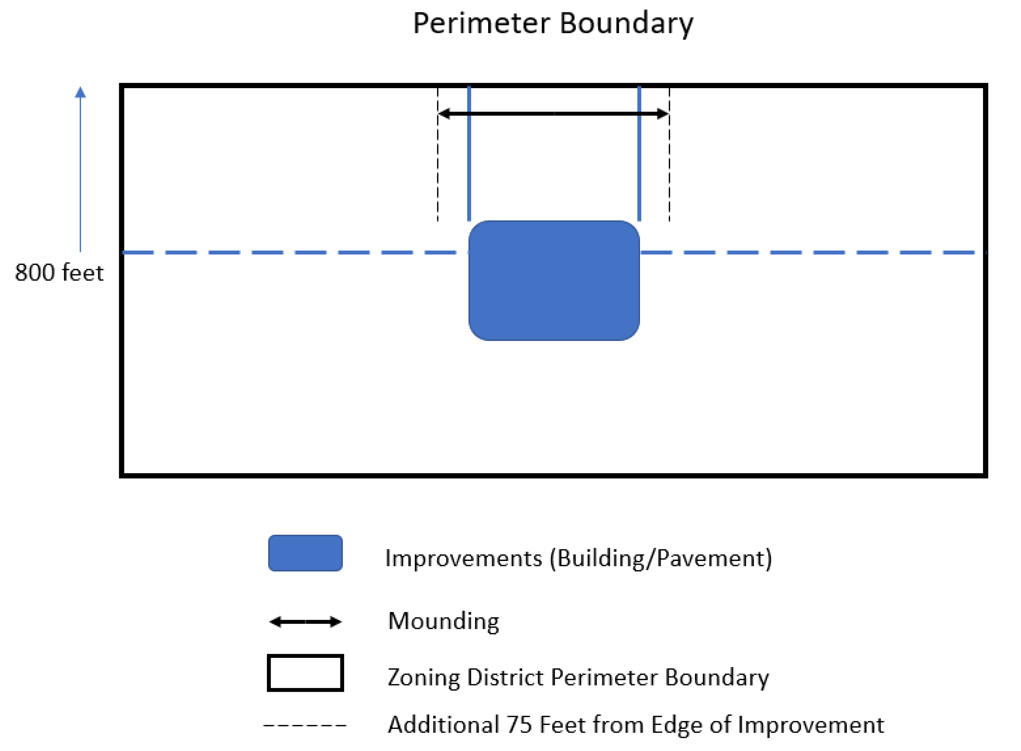
(Ord. O-46-2021. Passed 12-14-21; Ord. O-17-2025. Passed 5-6-25.)
1154.10 - SUBMITTAL CONTENT AND REQUIREMENTS.
(a)
A Planning and Design Permit is required for Flagship Projects and Primary Projects for any of the following:
(1)
Construction or structural alteration of any building, including accessory buildings, paved areas, and site improvements other than landscaping that are visible in whole or in part from the public right-of-way. For purposes of this Chapter 1154, (A) a building or accessory building shall be deemed to be "visible" if its first or second floor can be viewed from any public street right-of-way at a height of six (6) feet above the grade of any portion of that right-of-way, and (B) paved areas and site improvements other than landscaping shall be deemed to be "visible" if they are located within five hundred (500) feet of a public street right-of-way and can be seen from that public street right-of-way at a height of six (6) feet above the grade of any portion of that right-of-way.
(2)
Change in use of an existing building or accessory building.
(b)
At a minimum, an application for a Planning and Design Review Permit shall contain the following information in text or map form for the construction or structural alteration of any building, including accessory buildings, and/or other site improvements that are visible in whole or in part from the public right-of-way:
(1)
Completed Planning and Design Permit Application;
(2)
Memorandum of Understanding (MOU) for a traffic analysis detailing the potential impact of vehicular traffic to be generated from the proposed project unless the City waives this requirement;
(3)
Dimensioned Site plan showing location of proposed improvements;
(4)
Architectural renderings indicating building height, material, color palette and screening designs for each building façade;
(5)
Master landscaping and grading plans including streetscape;
(6)
Tree preservation plan where applicable;
(7)
Sign plans indicating illustrations with height and area dimensions, lighting, dimensioned location on the site, materials, and colors; and
(8)
Number and dimensions of existing and proposed off-street parking and/or loading spaces.
(c)
Zoning Permits, as contemplated in Sections 1109.02 through 1109.09, shall not be required in the TMD.
(d)
Any property zoned in the TMD classification shall not be considered to be located within the Architectural Review District as contemplated in Chapter 1157 and shall be exempt from all requirements contained in that Chapter.
(Ord. O-46-2021. Passed 12-14-21.)
1154.11 - PERMITTING PROCEDURE.
(a)
The developer of a Flagship Project or Primary Project shall submit separate application submittals for independent review by each respective discipline:
(1)
Planning and Design Permit Application.
(2)
Engineering Application.
(3)
Commercial Building Permit Application.
(b)
The applicant shall have the option of filing the Planning and Design, engineering, and building permits as full or phased submittals. Under the phased plan review process, projects for construction may be broken into one (1) or more phases for construction permits and work.
(c)
The applications for Planning and Design, engineering, and building permits shall be made on such forms as prescribed by the staff of the City of New Albany along with such plans, drawings, specifications and other materials as required by this Chapter 1154 and as otherwise may be needed by staff.
(d)
Once the submittal has been made, the materials for each permit type shall be reviewed by relevant City departments for compliance with: Chapter 1154, the New Albany Technology Manufacturing District Landscape and Architecture Standards Plan, uses, the submittal requirement checklists and all applicable codes and ordinances.
(Ord. O-46-2021. Passed 12-14-21.)
1154.12 - STORAGE; HAZARDOUS MATERIALS.
(a)
Outdoor Storage. Outdoor storage of materials, equipment, and supplies shall be permitted. Outdoor storage areas for these items are not required to be screened if they are located so that they are not visible from a public street right-of-way or from ground level at a distance of two hundred (200) feet from any perimeter boundary line of a parcel that is not under common ownership. Otherwise, such outdoor storage areas shall be fully screened to a height of eight (8) feet. Outdoor storage areas (whether screened or unscreened) shall comply with minimum setback requirements for pavement.
(b)
Hazardous Materials. Due to the nature of the permitted uses in the TMD, hazardous waste and materials storage and processing is anticipated. When such storage and/or processing are desired:
(1)
The nature of the storage and processing shall be described in a detailed written statement that shall be submitted as part of an application for a Planning and Design Permit. This statement also shall provide details regarding the safety measures and protocols that are proposed to prevent the migration of any hazardous materials outside of designated containment areas and procedures that will be implemented upon the occurrence of an event that does or has the potential to damage the environment, persons, or property. This information shall be provided so that relevant City departments and public safety providers will have notice of the presence of these storage and processing operations.
(2)
All such storage and/or processing shall comply in all respects with state and federal law and regulations, and shall not be undertaken until such time as all necessary state and federal permits are received and copies of the same are provided to the City.
(3)
No such storage and/or processing shall occur within the greater of (A) two hundred (200) feet of any perimeter boundary of a parcel that is not under common ownership and (B) an otherwise applicable minimum building setback.
(4)
If such storage or processing is undertaken outside of a structure, then all exterior areas where these activities are occurring shall be surrounded by a masonry wall that is at least ten (10) feet in height, but only if they are wholly or partially visible in whole or in part from a public street right-of-way. Building facades may be used to meet this requirement. Any gates or doors shall include enhanced security features to ensure that unauthorized individuals cannot gain access to the area.
(Ord. O-46-2021. Passed 12-14-21.)
1154.13 - ARCHITECTURE.
(a)
Flagship Projects. Flagship Projects shall not be subject to the requirements of the DGRs, provided that such projects meet the requirements of the New Albany Technology Manufacturing District Landscape and Architecture Standards Plan.
(b)
Primary Projects. The requirements of this Section 1154.13(b) shall apply only to Primary Projects:
(1)
General Regulations for all Primary Projects.
A.
Service and Loading Areas: Service areas and loading docks shall be screened to limit visibility from off-site.
B.
Building designs shall not mix architectural elements or ornamentation from different styles.
C.
Buildings shall be required to employ a comparable use of materials on all elevations.
D.
The number, location, spacing, and shapes of windows and door openings shall be carefully considered. Primary entrances to buildings shall be made sufficiently prominent that they can be easily identified from a distance.
E.
For office buildings and complexes, achieving a human or pedestrian scale is of less concern. When achieving such a scale is desired, it may be achieved by careful attention to width of facades, size and spacing of window and door openings, and floor to floor heights on exterior walls.
F.
Use of elements such as shutters, cupolas, dormers, and roof balustrades shall be avoided in building designs that are not based on traditional American architectural styles. Such elements may be employed only when they are common elements of a specific style, and this style shall be replicated in its entirety. When shutters are employed, even if they are non-operable, they must be sized and mounted in a way that gives the appearance of operability.
G.
Elements such as meter boxes, utility conduits, roof and wall projections such as vent and exhaust pipes, basement window enclosures, and trash containers shall be designed, located, or screened so as to minimize their visibility and visual impact from off-site. Solar energy systems shall be excluded from the requirements of this section to the extent the requirements prevent or limit functionality and/or accessibility to direct sunlight.
H.
Accessory or ancillary buildings, whether attached or detached, shall be of similar design, materials and construction as the nearest primary structure, if they are visible from a public street right-of-way. Fenestration themes that employ windows, panels and piers that are consistent with the architectural vocabulary of the building are encouraged. Notwithstanding the foregoing, the requirements of this subsection shall not apply to detached accessory structures serving or associated with Advanced Fabric Structures (as defined in Section 1154.14(b)(3)).
I.
Roof-Mounted Equipment. Complete screening of all roof-mounted equipment shall be required on all four (4) sides of buildings with materials that are consistent and harmonious with the building's façade and character. Such screening shall be provided in order to screen the equipment from off-site view and to buffer sound generated by such equipment. Solar energy systems shall be excluded from the requirements of this section to the extent the requirements prevent or limit functionality and/or accessibility to direct sunlight.
J.
All building elevations shall be designed to be compatible with each other and to reflect a consistent design approach.
K.
Gable or hip roofs shall be avoided unless a building design replicates a traditional American architectural style that employs such roof forms. In non-stylistic contemporary designs, low or flat roofs may be employed. Roof visibility shall be minimized.
L.
Exterior building materials for all buildings other than Advanced Fabric Structures shall be appropriate for contemporary suburban designs and shall avoid overly reflective surfaces. Traditional materials such as, but not limited to, wood, stone, brick, and concrete shall be permitted, along with contemporary materials such as, but not limited to, aluminum, metal, glass, stucco, or cementitious fiberboard (e.g., hardiplank or equivalent) shall be permitted on buildings not employing traditional styles. The use of reflective or mirrored glass shall be prohibited.
M.
Prefabricated metal buildings, untreated masonry block structures, and buildings featuring poured concrete exterior walls are prohibited. Notwithstanding the foregoing, ancillary structures built and operated for the purpose of enclosing equipment and which are not occupied by a tenants or persons on a regular basis may be constructed using pre-engineered metal.
N.
Generally, the quantity of materials selected for a building shall be minimized. A single material selection for the independent building components of roof, wall and accents is permitted (i.e., Architectural Grade shingle roof with Brick Masonry wall and EIFS Cornice and Accents).
O.
Loading docks are not required to have the same degree of finish as a main entry unless they are visible from a public right-of-way.
P.
Buildings and structure shall be designed to be harmonious in character to other buildings and structures within the same Flagship project or Primary Project, as appliable. Façade colors shall be coordinated to complement each other.
(2)
Additional Standards for Non-Office Buildings within Primary Projects: Buildings that are constructed to accommodate certain uses are not governed by the City's Design Guidelines and Requirements (DGRs). For example, buildings that are constructed for the operation of data centers, manufacturing, warehousing and/or distribution uses are not subject to the DGRs and can present challenges in meeting the community standard for architectural design. Such buildings are necessarily large and typically include long walls that together form a square or rectangular box. The goal for the development of buildings that are not subject to the DGRs is to balance the practical needs of these buildings with the desire to provide exterior designs that are attractive and complimentary to the architecture that will be found elsewhere in the TMD.
Architecture by its nature is a subjective medium, meaning that the adoption of strict objective standards in all instances may not provide the best means for achieving appropriate design. In recognition of this fact, the standards set forth herein provide guidelines and suggestions for designing buildings that are not subject to the DGRs in an effort to set expectations for the quality of architecture that will be expected for these structures. On the other hand, these standards are meant to allow for some flexibility to encourage innovative design provided that the spirit and intent of these provisions are met.
In designing such buildings (other than Advanced Fabric Structures), the user or applicant shall take into account the following, which are intended to set a level of expectation for the quality of design:
A.
Architectural design for all portions of a building or structure that are visible from a public right-of-way (excluding public rights-of-way whose primary purpose is to accommodate truck traffic or service loading areas) shall meet the community standard in terms of quality while taking into account the unique nature of the use(s) that will be found therein.
B.
Uninterrupted blank wall facades shall be prohibited to the extent that they are visible from a public right-of-way. Design variations on long exterior walls shall be employed in order to create visual interest. Examples of such design variations include, but are not limited to, the use of offsets, recesses and/or projections, banding, windows, and/or reveals; scoring of building facades; color changes; texture or material changes; and variety in building height.
C.
The use of one (1) or more architectural or design elements may be used to soften the aesthetics of the building, such as, but not limited to, canopies, porticos, overhangs, arches, outdoor patios, community spaces, or similar devices.
D.
Contemporary exterior designs, while not required, shall be encouraged in order to create architecture that does not look aged or dated even many years after the facility is built.
E.
Landscaping and/or the use of existing vegetation shall be utilized where appropriate to enhance the aesthetics of the building and to lessen its visual impact when viewed from public rights-of-way.
F.
Utility yards, essential service areas, bulk storage areas and similar may be paved or gravel. HVAC, generators and similar equipment and associated gravel or concrete yards or pads shall be located subject to the minimum building setbacks.
(3)
Regulations for Advanced Fabric Structures: A Primary Project with a development proposal on a single parcel or multiple contiguous parcels containing at least one hundred (100) acres shall be permitted to include Advanced Fabric Structures as primary or accessory buildings. "Advanced Fabric Structures" shall be defined to mean "a clear-span building with a durable, tensioned fabric used as the primary exterior finish material for its roof, all or some its exterior facades, or both." Advanced Fabric Structures shall be permitted only within a Primary Project. Advanced Fabric Structures, when installed, shall:
A.
Utilize tensioned fabric that is certified by its manufacturer as having a useful life of at least twenty (20) years and being able to withstand wind speeds of at least one hundred (100) miles per hour.
B.
Have a building substructure that consists of aluminum, steel, or some other metallic materials to ensure durability and longevity for the building.
C.
Have a climate-controlled interior.
D.
Not exceed sixty-five (65) feet in height at the highest point of the roof.
E.
Not be required to include windows if the lack of windows is needed for security reasons and/or for temperature control.
F.
Have a minimum building setback of one hundred (100) feet from all perimeter boundary lines of the parcel on which it is located and of two hundred (200) feet from any public street right-of-way.
(Ord. O-46-2021. Passed 12-14-21; Ord. O-17-2025. Passed 5-6-25.)
1154.14 - LANDSCAPING.
(a)
Tree Preservation Zones shall be established within areas that will be preserved pursuant to applicable federal and state permits and determinations, once they are approved and issued by the Ohio Environmental Protection Agency and the U.S. Army Corps of Engineers. These Preservation Areas shall be maintained, protected, and preserved in accordance with such permits. If allowed under applicable permits, trees within Preservation Zones may be removed if they present a potential danger to persons or property. Preservation Zones shall not include those areas where trees and/or wetland areas are allowed to be removed or filled by relevant permits. The final boundaries of the Preservation Zones shall be the same as the boundaries of the portions of the site that will be required to be preserved under applicable federal and state permits, as may be amended from time-to-time.
(b)
Residential Buffering. For all perimeter boundaries where the minimum setbacks set forth in Section 1154.08(f) apply and which are not adjacent to a Principal Arterial Street (any real property meeting either of the foregoing criteria to be referred to herein as "Residential Property"), a minimum ten-foot high mound shall be installed along the property line which shall include a landscape buffer on the mound which shall consist of a mixture of deciduous trees, evergreens and bushes to provide an opacity of seventy-five percent (75%) on the date that is five (5) years after planting to a total height of fourteen (14) feet above the top of the mound. The plan for these areas must be reviewed and approved by the City's Landscape Architect. In areas where existing tree stands or forested areas are present, the City's Landscape Architect shall not require such mounding and landscaping where the height and opacity requirements can be met by preserving and/or supplementing the tree stands or forested areas.
(Ord. O-46-2021. Passed 12-14-21.)
1154.15 - SIGNAGE.
(a)
All signage shall conform to the standards set forth in Chapter 1169 of the Codified Ordinances of the City of New Albany unless otherwise included in the New Albany Technology Manufacturing District Landscape and Architecture Standards Plan.
(b)
Flagship Project Address and Directional Signs. The quantity, locations, and area dimensions of address, directional and wayfinding signage internal to Flagship Projects and not visible from a public street right-of-way shall be permitted without any City permits based on the needs of the project to ensure safe flow of pedestrian and vehicular traffic.
(c)
Signage as required by other local, state, and federal governmental agencies and regulations shall be permitted by right.
(Ord. O-46-2021. Passed 12-14-21.)
1154.16 - LIGHTING.
(a)
All parking lot and private drive lighting shall be cut-off type fixtures and down cast. Parking lot lighting shall be from a controlled source in order to minimize light spilling beyond the boundaries of the site. All parking lot and private drive lighting shall be of the same light source type and style. All light poles within parking lots and along private drives shall be black or New Albany green and constructed of metal. Light poles shall not exceed thirty (30) feet in height, except that light poles located within three hundred (300) feet of properties where residential uses exist or are permitted shall be no more than eighteen (18) feet in height
(b)
No permanent colored lights or neon lights shall be used on the exterior of any building.
(c)
All lighting standards and requirements which are not addressed in this Chapter 1154 shall be in accordance with other applicable provisions of the Codified Ordinances.
(d)
Public street lighting must meet the City standards and specifications.
(e)
No light spillage onto properties which are adjacent to property which is zoned in the TMD classification shall be permitted from lighting sources within the TMD.
(Ord. O-46-2021. Passed 12-14-21.)
1154.17 - PARKING AND LOADING.
(a)
Flagship Projects shall not have any requirement to provide a minimum or maximum amount of vehicular parking spaces or loading spaces. Drive aisles, parking space, and loading space quantity and dimensions shall conform to the standards set forth in the New Albany Technology Manufacturing District Landscape and Architecture Standards Plan.
(b)
Primary Projects shall conform to the standards set forth in Chapter 1167 of the Codified Ordinances of the City of New Albany.
(Ord. O-46-2021. Passed 12-14-21.)
1154.18 - VARIANCES, WAIVERS, AND DEVIATIONS.
(a)
Variances. Variances from the requirements of this Chapter 1154 or any other applicable provision of the Zoning Ordinance may be requested by an applicant with property that is zoned in the TMD classification. The Planning Commission shall hear and decide variance requests for property within the TMD. Any such variance shall be reviewed in accordance with the criteria, standards, and procedures set forth in Chapter 1113. Waivers or deviations from the New Albany Technology Manufacturing District Landscape and Architecture Standards Plan shall not be considered to be variances, and instead shall be reviewed in accordance with Section 1154.18(b).
(b)
Waivers and Deviations. The Community Development Director or his/her designee shall decide requests for waivers or deviations from the requirements of the New Albany Technology Manufacturing District Landscape and Architecture Standards Plan in conjunction with review of a Planning and Design Permit application, and such requests shall not be deemed to be variances. A waiver or deviation shall be approved if the Community Development Director or his/her designee finds:
(1)
The proposed waiver or deviation will result in a condition that is equal to or better than the condition or standard which was intended to be achieved by the strict application of the standard for which the request is made; and
(2)
The proposal will not cause adverse impacts to surrounding areas, or if such impacts may occur, they are reasonably mitigated.
(Ord. O-46-2021. Passed 12-14-21.)
1155.01 - GENERAL PROVISIONS.
(a)
Constitutional and Statutory Authority. The City of New Albany is a home rule charter municipality with the authority that has all powers possible for a municipality to have under the Constitution and laws of the State of Ohio (New Albany Charter Section 2.01). This authority includes the authority to hear appeals and variances in accordance with Chapter 1113 of the New Albany Codified Ordinances.
(b)
Findings of Fact. The City of New Albany has special flood hazard areas that are subject to periodic inundation which may result in loss of life and property, health and safety hazards, disruption of commerce and governmental services, extraordinary public expenditures for flood protection and relief, and impairment of the tax base. Additionally, structures that are inadequately elevated, floodproofed, or otherwise protected from flood damage also contribute to the flood loss. In order to minimize the threat of such damages and to achieve the purposes hereinafter set forth, these regulations are adopted.
(c)
Statement of Purpose. It is the purpose of these regulations to promote the public health, safety and general welfare, and to:
(1)
Protect human life and health;
(2)
Minimize expenditure of public money for costly flood control projects;
(3)
Minimize the need for rescue and relief efforts associated with flooding and generally undertaken at the expense of the general public;
(4)
Minimize prolonged business interruptions;
(5)
Minimize damage to public facilities and utilities such as water and gas mains, electric, telephone and sewer lines, streets and bridges located in areas of special flood hazard;
(6)
Help maintain a stable tax base by providing for the proper use and development of areas of special flood hazard so as to protect property and minimize future flood blight areas;
(7)
Ensure that those who occupy the areas of special flood hazard assume responsibility for their actions;
(8)
Minimize the impact of development on adjacent properties within and near flood prone areas;
(9)
Ensure that the flood storage and conveyance functions of the floodplain are maintained;
(10)
Minimize the impact of development on the natural, beneficial values of the floodplain;
(11)
Prevent floodplain uses that are either hazardous or environmentally incompatible; and
(12)
Meet community participation requirements of the National Flood Insurance Program.
(d)
Methods of Reducing Flood Loss. In order to accomplish its purposes, these regulations include methods and provisions for:
(1)
Restricting or prohibiting uses which are dangerous to health, safety, and property due to water hazards, or which result in damaging increases in flood heights or velocities;
(2)
Requiring that uses vulnerable to floods, including facilities, which serve such uses, be protected against flood damage at the time of initial construction;
(3)
Controlling the alteration of natural floodplains, stream channels, and natural protective barriers, which help accommodate or channel flood waters;
(4)
Controlling filling, grading, dredging, excavating, and other development which may increase flood damage; and,
(5)
Preventing or regulating the construction of flood barriers, which will unnaturally divert flood, waters or which may increase flood hazards in other areas.
(e)
Lands to Which These Regulations Apply. These regulations shall apply to all areas of special flood hazard within the jurisdiction of the City of New Albany as identified in chapter 1155.01(f), including any additional areas of special flood hazard annexed by the City of New Albany.
(f)
Basis for Establishing the Areas of Special Flood Hazard. Any revisions to the maps and/or studies are hereby adopted by reference and declared to be a part of these regulations. Such maps and/or studies are on file at the City of New Albany, 7800 Bevelhymer Road, New Albany, Ohio 43054. For the purposes of these regulations, the following studies and/or maps are adopted:
(1)
Flood Insurance Rate Map for Franklin County, Ohio and Incorporated Areas, dated June 17, 2008.
(2)
Flood Insurance Rate Map for Licking County, Ohio and Incorporated Areas, dated July 31, 2024.
(3)
Flood Insurance Study for Franklin County, Ohio and Incorporated Areas, dated June 17, 2008.
(4)
Flood Insurance Study for Licking County, Ohio and Incorporated Areas, dated July 31, 2024.
(5)
Other studies and/or maps published by federal or state agencies, which may be relied upon for establishment of the flood protection elevation, delineation of the 100-year floodplain, floodways or delineation of other areas of special flood hazard, as designated for this purpose by the City Manager.
(6)
Any hydrologic and hydraulic engineering analysis authored by a registered Professional Engineer in the State of Ohio which has been approved by the City of New Albany as required by chapter 1155.04(c), Subdivisions and Other New Developments.
(g)
Abrogation and Greater Restrictions. These regulations are not intended to repeal any existing ordinances including subdivision regulations, zoning or building codes. In the event of a conflict between these regulations and any other ordinance, the more restrictive shall be followed. These regulations are not intended to repeal, abrogate or impair any existing easements, covenants or deed restrictions. However, where this ordinance and another ordinance, easement, covenant or deed restriction conflict or overlap, whichever imposes the more stringent restrictions shall prevail.
(h)
Interpretation. In the interpretation and application of these regulations, all provisions shall be:
(1)
Considered as minimum requirements;
(2)
Liberally construed in favor of the governing body; and,
(3)
Deemed neither to limit nor repeal any other powers granted under state statutes.
Where a provision of these regulations may be in conflict with a state or federal law, such state or federal law shall take precedence over these regulations.
(i)
Warning and Disclaimer of Liability. The degree of flood protection required by these regulations is considered reasonable for regulatory purposes and is based on scientific and engineering considerations. Larger floods can and will occur on rare occasions. Flood heights may be increased by man-made or natural causes. These regulations do not imply that land outside the areas of special flood hazard or uses permitted within such areas will be free from flooding or flood damage. These regulations shall not create liability on the part of the City of New Albany, any officer or employee thereof, or the Federal Emergency Management Agency, for any flood damage that results from reliance on these regulations or any administrative decision lawfully made thereunder.
(j)
Severability. Should any section or provision of these regulations be declared by the courts to be unconstitutional or invalid, such decision shall not affect the validity of the regulations as a whole, or any part thereof, other than the part so declared to be unconstitutional or invalid.
(Ord. O-39-2016. Passed 12-6-16; Ord. O-08-2025. Passed 3-18-25.)
1155.02 - DEFINITIONS.
Unless specifically defined below, words or phrases used in these regulations shall be interpreted so as to give them the meaning they have in common usage and to give these regulations the most reasonable application.
(a)
"Accessory structure" means a structure on the same lot with, and of a nature customarily incidental and subordinate to, the principal structure.
(b)
"Appeal" means a request for review of the floodplain administrator's interpretation of any provision of these regulations or a request for a variance.
(c)
"Base flood" means the flood having a one percent chance of being equaled or exceeded in any given year. The base flood may also be referred to as the one percent chance annual flood or 100-year flood.
(d)
"Base (100-year) Flood Elevation (BFE)" means the water surface elevation of the base flood in relation to a specified datum, usually the National Geodetic Vertical Datum of 1929 or the North American Vertical Datum of 1988, and usually expressed in feet mean sea level (MSL). In Zone AO areas, the base flood elevation is the lowest adjacent natural grade elevation plus the depth number (from one to three (3) feet).
(e)
"Basement" means any area of the building having its floor subgrade (below ground level) on all sides.
(f)
"Compensatory storage" means a design practice to ensure that an equivalent or greater amount of storage volume is provided to offset the loss of existing flood storage volume due to development.
(g)
"Development" means any manmade change to improved or unimproved real estate, including, but not limited to, buildings or other structures, mining, dredging, filling, grading, paving, excavation or drilling operations or storage of equipment or materials.
(h)
"Enclosure below the lowest floor" see "lowest floor."
(i)
"Executive Order 11988 (Floodplain Management)" means the issue by President Carter in 1977, this order requires that no federally assisted activities be conducted in or have the potential to affect identified special flood hazard areas, unless there is no practicable alternative.
(j)
"Federal Emergency Management Agency (FEMA)" means the agency with the overall responsibility for administering the National Flood Insurance Program.
(k)
"Fill" means a deposit of earth material placed by artificial means.
(l)
"Flood" or "flooding" means a general and temporary condition of partial or complete inundation of normally dry land areas from:
(1)
The overflow of inland or tidal waters, and/or
(2)
The unusual and rapid accumulation or runoff of surface waters from any source.
(m)
"Flood Insurance Rate Map (FIRM)" means an official map on which the Federal Emergency Management Agency or the U.S. Department of Housing and Urban Development has delineated the areas of special flood hazard.
(n)
"Flood insurance risk zones" means zone designations on FHBMs and FIRMs that indicate the magnitude of the flood hazard in specific areas of a community. Following are the zone definitions:
(1)
"Zone A" means special flood hazard areas inundated by the 100-year flood in any given year; base flood elevations are not determined.
(2)
"Zone AE" means special flood hazard areas inundated by the 100-year flood in any given year; base flood elevations are determined.
(3)
"Zone AO" means special flood hazard areas inundated by the 100-year flood in any given year; with flood depths of one to three (3) feet (usually sheet flow on sloping terrain); average depths are determined.
(4)
"Zone AH" means special flood hazard areas inundated by the 100-year flood in any given year; flood depths of one to three (3) feet (usually areas of ponding); base flood elevations are determined.
(5)
"Zone X (shaded)" means areas of 500-year flood; areas subject to the 100-year flood with average depths of less than one foot or with contributing drainage area less than one square mile; and areas protected by levees from the base flood.
(6)
"Zone X (unshaded)" areas determined to be outside the 500-year floodplain.
(o)
"Flood Insurance Study (FIS)" means the official report in which the Federal Emergency Management Agency or the U.S. Department of Housing and Urban Development has provided flood profiles, floodway boundaries, and the water surface elevations of the base flood.
(p)
"Floodproofing" means any combination of structural and non-structural additions, changes, or adjustments to structures which reduce or eliminate flood damage to real estate or improved real property, water and sanitary facilities, structures and their contents.
(q)
"Flood protection elevation" means the flood protection elevation, or FPE, is the base flood elevation plus two (2) feet of freeboard. In areas where no base flood elevations exist from any authoritative source, the flood protection elevation can be historical flood elevations, or base flood elevations determined and/or approved by the floodplain administrator.
(r)
"Floodway" means a floodway is the channel of a river or other watercourse and the adjacent land areas that have been reserved in order to pass the base flood discharge. A floodway is typically determined through a hydraulic and hydrologic engineering analysis such that the cumulative increase in the water surface elevation of the base flood discharge is no more than a designated height. In no case shall the designated height be more than one foot at any point within the community. The floodway is an extremely hazardous area, and is usually characterized by any of the following: Moderate to high velocity flood waters, high potential for debris and projectile impacts, and moderate to high erosion forces.
(s)
"Freeboard" means a factor of safety usually expressed in feet above a flood level for the purposes of floodplain management. Freeboard tends to compensate for the many unknown factors that could contribute to flood heights greater than the height calculated for a selected size flood and floodway conditions, such as wave action, obstructed bridge openings, debris and ice jams, and the hydrologic effect of urbanization in a watershed.
(t)
"Historic structure" means any structure that is:
(1)
Listed individually in the National Register of Historic Places (a listing maintained by the U.S. Department of Interior) or preliminarily determined by the Secretary of the Interior as meeting the requirements for individual listings on the National Register;
(2)
Certified or preliminarily determined by the Secretary of the Interior as contributing to the historical significance of a registered historic district or a district preliminarily determined by the Secretary to qualify as a registered historic district;
(3)
Individually listed on the State of Ohio's inventory of historic places maintained by the Ohio Historic Preservation Office; or
(4)
Individually listed on the inventory of historic places maintained by the City of New Albany, which program is certified by the Ohio Historic Preservation Office.
(u)
"Hydrologic and hydraulic engineering analysis" means an analysis performed by a professional engineer, registered in the State of Ohio, in accordance with standard engineering practices as accepted by FEMA, used to determine flood elevations and/or floodway boundaries.
(v)
"Letter of Map Change (LOMC)" means a Letter of Map Change is an official FEMA determination, by letter, to amend or revise effective Flood Insurance Rate Maps, Flood Boundary and Floodway Maps, and Flood Insurance Studies. LOMCs are broken down into the following categories:
(1)
"Letter of Map Amendment (LOMA)" means a revision based on technical data showing that a property was incorrectly included in a designated special flood hazard area. A LOMA amends the current effective Flood Insurance Rate Map and establishes that a specific property is not located in a special flood hazard area.
(2)
"Letter of Map Revision (LOMR)" means a revision based on technical data that, usually due to manmade changes, shows changes to flood zones, flood elevations, floodplain and floodway delineations, and planimetric features. One common type of LOMR, a LOMR-F, is a determination concerning whether a structure or parcel has been elevated by fill above the base flood elevation and is, therefore, excluded from the special flood hazard area.
(3)
"Conditional Letter of Map Revision (CLOMR)" means a comment by FEMA regarding a proposed project that would, upon construction, affect the hydrologic or hydraulic characteristics of a flooding source and thus result in the modification of the existing regulatory floodway, the effective base flood elevations, or the special flood hazard area. A CLOMR does not amend or revise effective Flood Insurance Rate Maps, Flood Boundary and Floodway Maps, or Flood Insurance Studies.
(w)
"Lowest floor" means the lowest floor of the lowest enclosed area (including basement or window wells) of a structure. This definition excludes an "enclosure below the lowest floor" which is an unfinished or flood resistant enclosure usable solely for parking of vehicles, building access or storage, in an area other than a basement area, provided that such enclosure is built in accordance with the applicable design requirements specified in these regulations for enclosures below the lowest floor.
(x)
"Manufactured home" means a structure, transportable in one or more sections, which is built on a permanent chassis and is designed for use with or without a permanent foundation when connected to the required utilities. The term "manufactured home" does not include a "recreational vehicle". For the purposes of these regulations, a manufactured home includes manufactured homes and mobile homes as defined in ORC Ch. 4781.
(y)
"Manufactured home park" means as specified in the Ohio Adm. Code 4781-12-01(K), a manufactured home park means any tract of land upon which three (3) or more manufactured homes, used for habitation are parked, either free of charge or for revenue purposes, and includes any roadway, building, structure, vehicle, or enclosure used or intended for use as part of the facilities of the park. A tract of land that is subdivided and the individual lots are not for rent or rented, but are for sale or sold for the purpose of installation of manufactured homes on the lots, is not a manufactured home park, even though three (3) or more manufactured homes are parked thereon, if the roadways are dedicated to the local government authority. Manufactured home park does not include any tract of land used solely for the storage or display for sale of manufactured homes.
(z)
"Mean sea level" means, for purposes of the National Flood Insurance Program, the National Geodetic Vertical Datum (NGVD) of 1929 or other datum, to which base flood elevations shown on a community's Flood Insurance Rate Map are referenced.
(aa)
"National Flood Insurance Program (NFIP)" means a Federal program enabling property owners in participating communities to purchase insurance protection against losses from flooding. This insurance is designed to provide an insurance alternative to disaster assistance to meet the escalating costs of repairing damage to buildings and their contents caused by floods. Participation in the NFIP is based on an agreement between local communities and the Federal government that states if a community will adopt and enforce floodplain management regulations to reduce future flood risks to all development in special flood hazard areas, the Federal government will make flood insurance available within the community as a financial protection against flood loss.
(bb)
"New construction" means structures for which the "start of construction" commenced on or after the effective date of a floodplain regulation adopted by the City of New Albany and includes any subsequent improvements to such structures.
For the purposes of determining insurance rates, structures for which the "start of construction" commenced on or after the effective date of an initial FIRM [August 2, 1995] and includes any subsequent improvements to such structures.
(cc)
"Person" means and includes any individual or group of individuals, corporation, partnership, association, or any other entity, including state and local governments and agencies. An agency is further defined in the ORC 111.15(A)(2) as any governmental entity of the state and includes, but is not limited to, any board, department, division, commission, bureau, society, council, institution, state college or university, community college district, technical college district, or state community college. "Agency" does not include the general assembly, the controlling board, the adjutant general's department, or any court.
(dd)
"Recreational vehicle" means a vehicle which is (1) built on a single chassis, (2) four hundred (400) square feet or less when measured at the largest horizontal projection, (3) designed to be self-propelled or permanently towable by a light duty truck, and (4) designed primarily not for use as a permanent dwelling but as temporary living quarters for recreational, camping, travel, or seasonal use.
(ee)
"Registered professional architect" means a person registered to engage in the practice of architecture pursuant to ORC 4703.01 and 4703.19.
(ff)
"Registered professional engineer" a person registered as a professional engineer pursuant to ORC Ch. 4733.
(gg)
"Registered professional surveyor" means a person registered as a professional surveyor pursuant to ORC Ch. 4733.
(hh)
"Riparian area" means a transitional area between flowing water and land covered by terrestrial vegetation that provides a continuous exchange of nutrients and woody debris between land and water. This area is at least periodically influenced by flooding. Riparian areas, if appropriately sized and managed, help to stabilize banks, limit erosion, reduce flood size floes and/or filter and settle out runoff pollutants, or perform other functions consistent with the purposes of these regulations.
(ii)
"Special flood hazard area" means also known as "areas of special flood hazard," it is the land in the floodplain subject to a one percent or greater chance of flooding in any given year. Special flood hazard areas are designated by the Federal Emergency Management Agency on Flood Insurance Rate Maps and Flood Insurance Studies as Zones A, AE, AH, or AO. Special flood hazard areas may also refer to areas that are flood prone and designated from other federal state or local sources of data including, but not limited to, historical flood information reflecting high water marks, previous flood inundation areas, and flood prone soils associated with a watercourse.
(jj)
"Start of construction" means the date the building permit was issued, provided the actual start of construction, repair, reconstruction, rehabilitation, addition, placement, or other improvement was within one hundred eighty (180) days of the permit date. The actual start means either the first placement of permanent construction of a structure on a site, such as the pouring of slab or footings, the installation of piles, the construction of columns, or any work beyond the stage of excavation; or the placement of a manufactured home on a foundation. Permanent construction does not include land preparation, such as clearing, grading, and filling; nor does it include the installation of streets and/or walkways; nor does it include excavation for a basement, footings, piers, or foundations or the erection of temporary forms; nor does it include the installation on the property of accessory buildings, such as garages or sheds not occupied as dwelling units or not part of the main structure. For a substantial improvement, the actual start of construction means the first alteration of any wall, ceiling, floor, or other structural part of a building, whether or not that alteration affects the external dimensions of a building.
(kk)
"Structure" means a walled and roofed building, manufactured home, or gas or liquid storage tank that is principally above ground.
(ll)
"Substantial damage" means damage of any origin sustained by a structure whereby the cost of restoring the structure to the 'before damaged' condition would equal or exceed fifty percent (50%) of the market value of the structure before the damage occurred.
(mm)
"Substantial improvement" means any reconstruction, rehabilitation, addition, or other improvement of a structure, the cost of which equals or exceeds fifty percent (50%) of the market value of the structure before the "start of construction" of the improvement. This term includes structures, which have incurred "substantial damage," regardless of the actual repair work performed. The term does not, however, include:
(1)
Any project for improvement of a structure to correct existing violations of state or local health, sanitary, or safety code specifications which have been identified by the local code enforcement official and which are the minimum necessary to assure safe living conditions; or
(2)
Any alteration of a "historic structure," provided that the alteration would not preclude the structure's continued designation as a "historic structure."
(nn)
"Variance" means a grant of relief from the standards of these regulations.
(oo)
"Violation" means the failure of a structure or other development to be fully compliant with these regulations.
(Ord. O-39-2016. Passed 12-6-16; Ord. O-08-2025. Passed 3-18-25.)
1155.03 - ADMINISTRATION.
(a)
Designation of the Floodplain Administrator. The City Manager or designee is hereby appointed to administer and implement these regulations and is referred to herein as the Floodplain Administrator.
(b)
Duties and Responsibilities of the Floodplain Administrator. The duties and responsibilities of the Floodplain Administrator shall include, but are not limited to:
(1)
Evaluate applications for permits to develop in special flood hazard areas.
(2)
Interpret floodplain boundaries and provide flood hazard and flood protection elevation information.
(3)
Issue permits to develop in special flood hazard areas when the provisions of these regulations have been met, or refuse to issue the same in the event of noncompliance.
(4)
Inspect buildings and lands to determine whether any violations of these regulations have been committed.
(5)
Make and permanently keep all records for public inspection necessary for the administration of these regulations including Flood Insurance Rate Maps, Letters of Map Amendment and Revision, records of issuance and denial of permits to develop in special flood hazard areas, determinations of whether development is in or out of special flood hazard areas for the purpose of issuing floodplain development permits, elevation certificates, floodproofing certificates, variances, and records of enforcement actions taken for violations of these regulations.
(6)
Enforce the provisions of these regulations.
(7)
Provide information, testimony, or other evidence as needed during variance hearings.
(8)
Coordinate map maintenance activities and FEMA follow-up.
(9)
Conduct substantial damage determinations to determine whether existing structures, damaged from any source and in special flood hazard areas identified by FEMA, must meet the development standards of these regulations.
(c)
Floodplain Development Permits. It shall be unlawful for any person to begin construction or other development activity including, but not limited to, filling, grading, construction, alteration, remodeling, or expanding any structure; or alteration of any watercourse wholly within, partially within or in contact with any identified special flood hazard area, as established in chapter 1155.01(f), until a floodplain development permit is obtained from the Floodplain Administrator. Such floodplain development permit shall show that the proposed development activity is in conformity with the provisions of these regulations. No such permit shall be issued by the Floodplain Administrator until the requirements of these regulations have been met.
(d)
Application Required. An application for a floodplain development permit shall be required for all development activities located wholly within, partially within, or in contact with an identified special flood hazard area. Such application shall be made by the owner of the property or his/her authorized agent, herein referred to as the applicant, prior to the actual commencement of such construction on a form furnished for that purpose. Where it is unclear whether a development site is in a special flood hazard area, the Floodplain Administrator may require an application for a floodplain development permit to determine the development's location. Such applications shall include, but not be limited to:
(1)
Site plans drawn to scale showing the nature, location, dimensions, and topography of the work area to be covered by the proposed floodplain development permit; the location of existing or proposed structures, fill, storage of materials, drainage facilities, and the location of the foregoing.
(2)
Elevation of the existing, natural ground where structures are proposed.
(3)
Elevation of the lowest floor, including basement, of all proposed structures.
(4)
Such other material and information as may be requested by the Floodplain Administrator to determine conformance with, and provide enforcement of these regulations.
(5)
Technical analyses conducted by the appropriate design professional registered in the State of Ohio and submitted with an application for a floodplain development permit when applicable:
A.
Floodproofing certification for non-residential floodproofed structure as required in chapter 1155.04(e).
B.
Certification that fully enclosed areas below the lowest floor of a structure not meeting the design requirements of chapter 1155.04(d)(5) are designed to automatically equalize hydrostatic flood forces.
C.
Description of any watercourse alteration or relocation that the flood carrying capacity of the watercourse will not be diminished, and maintenance assurances as required in chapter 1155.04(i)(3).
D.
A hydrologic and hydraulic analysis demonstrating that the cumulative effect of proposed development, when combined with all other existing and anticipated development will not increase the water surface elevation of the base flood by more than one foot in special flood hazard areas where the Federal Emergency Management Agency has provided base flood elevations but no floodway as required by chapter 1155.04(i)(2).
E.
A hydrologic and hydraulic engineering analysis showing impact of any development on flood heights in an identified floodway as required by chapter 1155.04(i)(1).
F.
Generation of base flood elevation(s) for subdivision and other new developments as required by chapter 1155.04(c).
G.
Documentation of meeting the compensatory floodplain volume requirement per chapter 1155.04(j).
(6)
A floodplain development permit application fee established by the City.
(e)
Review and Approval of a Floodplain Development Permit Application.
(1)
Review.
A.
After receipt of a complete application, the Floodplain Administrator shall review the application to ensure that the standards of these regulations have been met. No floodplain development permit application shall be reviewed until all information required in chapter 1155.03(d) has been received by the Floodplain Administrator.
B.
The Floodplain Administrator shall review all floodplain development permit applications to assure that all necessary permits have been received from those federal, state or local governmental agencies from which prior approval is required. The applicant shall be responsible for obtaining such permits as required including permits issued by the U.S. Army Corps of Engineers under Section 10 of the Rivers and Harbors Act and Section 404 of the Clean Water Act, and the Ohio Environmental Protection Agency under Section 401 of the Clean Water Act.
(2)
Approval. Within thirty (30) days after the receipt of a complete application, the Floodplain Administrator shall either approve or disapprove the application. If the Floodplain Administrator is satisfied that the development proposed in the floodplain development application conforms to the requirements of this ordinance, the Floodplain Administrator shall issue the permit. All floodplain development permits shall be conditional upon the commencement of work within one hundred eighty (180) days. A floodplain development permit shall expire one hundred eighty (180) days after issuance unless the permitted activity has been substantially begun and is thereafter pursued to completion.
(f)
Inspections. The Floodplain Administrator shall make periodic inspections at appropriate times throughout the period of construction in order to monitor compliance with permit conditions.
(g)
Post-Construction Certifications Required. The following as-built certifications are required after a floodplain development permit has been issued:
(1)
For new or substantially improved residential structures, or nonresidential structures that have been elevated, the applicant shall have a Federal Emergency Management Agency Elevation Certificate completed by a registered professional surveyor to record as-built elevation data. For elevated structures in Zone A and Zone AO areas without a base flood elevation, the elevation certificate may be completed by the property owner or owner's representative.
(2)
For all development activities subject to the standards of chapter 1155.03(k)(1), a Letter of Map Revision.
(3)
For new or substantially improved nonresidential structures that have been floodproofed in lieu of elevation, where allowed, the applicant shall supply a completed floodproofing certificate for non-residential structures completed by a registered professional engineer or architect together with associated documentation.
(h)
Revoking a Floodplain Development Permit. A floodplain development permit shall be revocable, if among other things, the actual development activity does not conform to the terms of the application and permit granted thereon. In the event of the revocation of a permit, an appeal may be taken to the Appeals Board in accordance with chapter 1155.05 of these regulations.
(i)
Exemption from Filing a Development Permit. An application for a floodplain development permit shall not be required for maintenance work such as roofing, painting, and basement sealing, or for small nonstructural development activities (except for filling and grading) valued at less than two thousand five hundred dollars ($2,500.00.)
(j)
State and Federal Development.
(1)
Development that is funded, financed, undertaken, or preempted by state agencies shall comply with minimum NFIP criteria.
(2)
Before awarding funding or financing or granting a license, permit, or other authorization for a development that is or is to be located within a 100-year floodplain, a state agency shall require the applicant to demonstrate to the satisfaction of the agency that the development will comply with minimum NFIP criteria and any applicable local floodplain management resolution or ordinance as required by ORC 1521.13. This includes, but is not limited to:
A.
Development activities in an existing or proposed manufactured home park that are under the authority of the Ohio Department of Commerce and subject to the flood damage reduction provisions of the Ohio Administrative Code Section 4781-12.
B.
Major utility facilities permitted by the Ohio Power Siting Board under ORC Ch. 4906.
C.
Hazardous waste disposal facilities permitted by the Hazardous Waste Siting Board under ORC Ch. 3734.
(3)
Development activities undertaken by a federal agency and which are subject to Federal Executive Order 11988 - Floodplain Management.
A.
Each federal agency has a responsibility to evaluate the potential effects of any actions it may take in a floodplain; to ensure that its planning programs and budget request reflect consideration of flood hazards and floodplain management; and to prescribe procedures to implement the policies and requirements of EO 11988.
(k)
Map Maintenance Activities. To meet National Flood Insurance Program minimum requirements to have flood data reviewed and approved by FEMA, and to ensure that the City of New Albany's flood maps, studies and other data identified in chapter 1155.01(f) accurately represent flooding conditions so appropriate floodplain management criteria are based on current data, the following map maintenance activities are identified:
(1)
Requirement to Submit New Technical Data.
A.
For all development proposals that impact floodway delineations or base flood elevations, the community shall ensure that technical data reflecting such changes be submitted to FEMA within six (6) months of the date such information becomes available. These development proposals include:
1.
Floodway encroachments that increase or decrease base flood elevations or alter floodway boundaries;
2.
Fill sites to be used for the placement of proposed structures where the applicant desires to remove the site from the special flood hazard area;
3.
Alteration of watercourses that result in a relocation or elimination of the special flood hazard area, including the placement of culverts; and
4.
Subdivision or other new development proposals requiring the establishment of base flood elevations in accordance with chapter 1155.04(c).
B.
It is the responsibility of the applicant to have technical data, required in accordance with chapter 1155.03(k)(1), prepared in a format required for a Conditional Letter of Map Revision or Letter of Map Revision, and submitted to FEMA. Submittal and processing fees for these map revisions shall be the responsibility of the applicant.
C.
The Floodplain Administrator shall require a Conditional Letter of Map Revision prior to the issuance of a floodplain development permit for:
1.
Proposed floodway encroachments that increase the base flood elevation; and
2.
Proposed development which increases the base flood elevation by more than one foot in riverine areas where FEMA has provided base flood elevations but no floodway.
D.
Floodplain development permits issued by the Floodplain Administrator shall be conditioned upon the applicant obtaining a Letter of Map Revision from FEMA for any development proposal subject to chapter 1155.03(k)(1)(A).
(2)
Right to Submit New Technical Data. The Floodplain Administrator may request changes to any of the information shown on an effective map that does not impact floodplain or floodway delineations or base flood elevations, such as labeling or planimetric details. Such a submission shall include appropriate supporting documentation made in writing by the City Manager (or designee) of the City of New Albany, and may be submitted at any time.
(3)
Annexation/Detachment. Upon occurrence, the Floodplain Administrator shall notify FEMA in writing whenever the boundaries of the City of New Albany have been modified by annexation or the community has assumed authority over an area, or no longer has authority to adopt and enforce floodplain management regulations for a particular area. In order that the City's Flood Insurance Rate Map accurately represent the City's boundaries, include within such notification a copy of a map of the City suitable for reproduction, clearly showing the new corporate limits or the new area for which the City has assumed or relinquished floodplain management regulatory authority.
(l)
Data Use and Flood Map Interpretation. The following guidelines shall apply to the use and interpretation of maps and other data showing areas of special flood hazard:
(1)
In areas where FEMA has not identified special flood hazard areas, or in FEMA identified special flood hazard areas where base flood elevation and floodway data have not been identified, the Floodplain Administrator shall review and reasonably utilize any other flood hazard data available from a federal, state, or other source.
(2)
Base flood elevations and floodway boundaries produced on FEMA flood maps and studies shall take precedence over base flood elevations and floodway boundaries by any other source that reflect a reduced floodway width and/or lower base flood elevations. Other sources of data, showing increased base flood elevations and/or larger floodway areas than are shown on FEMA flood maps and studies, shall be reasonably used by the Floodplain Administrator.
(3)
The Floodplain Administrator shall make interpretations, where needed, as to the exact location of the flood boundaries and areas of special flood hazard. A person contesting the determination of the location of the boundary shall be given a reasonable opportunity to appeal the interpretation as provided in chapter 1155.05, Appeals and Variances.
(4)
Where an existing or proposed structure or other development is affected by multiple flood zones, by multiple base flood elevations, or both, the development activity must comply with the provisions of this ordinance applicable to the most restrictive flood zone and the highest base flood elevation affecting any part of the existing or proposed structure; or for other developments, affecting any part of the area of the development.
(m)
Use of Preliminary Flood Insurance Rate Map and/or Flood Insurance Study Data.
(1)
Zone A:
A.
Within Zone A areas designated on an effective FIRM, data from the preliminary FIRM and/or FIS shall reasonably utilized as best available data.
B.
When all appeals have been resolved and a notice of final food elevation determination has been provided in a Letter of Final Determination (LFD), BFE and floodway data from the preliminary FIRM and/or FIS shall be used for regulating development.
(2)
Zones AE, AH, and AO:
A.
BFE and floodway data from a preliminary FIS or FIRM restudy are not required to be used in lieu of BFE and floodway data contained in an existing effective FIS and FIRM. However:
1.
Where BFEs increase in a restudied area, communities have the responsibility to ensure that new or substantially improved structures are protected. Communities are encouraged to reasonably utilize preliminary FIS or FIRM data in instances where BFEs increase and floodways are revised to ensure that the health, safety, and property of their citizens are protected.
2.
Where BFEs decrease, preliminary FIS or FIRM data should not be used to regulate floodplain development until the LFD has been issued or until all appeals have been resolved.
B.
If a preliminary FIRM or FIS has designated floodways where none had previously existed, communities should reasonably utilize this data in lieu of applying the encroachment performance standard of chapter 1155.04(i)(2) since the data in the draft or preliminary FIS represents the best data available.
(3)
Zone X:
A.
Use of BFE and floodway data from a preliminary FIRM or FIS are not required for areas designated as Zone X on the effective FIRM which are being revised to Zone AE, AH, or AO. Communities are encouraged to reasonably utilize preliminary FIS or FIRM data to ensure that the health, safety, and property of their citizens are protected.
(n)
Substantial Damage Determinations. Damages to structures may result from a variety of causes including flood, tornado, wind, heavy snow, fire, etc. After such a damage event, the Floodplain Administrator shall:
(1)
Determine whether damaged structures are located in special flood hazard areas;
(2)
Conduct substantial damage determinations for damaged structures located in special flood hazard areas; and
(3)
Require owners of substantially damaged structures to obtain a floodplain development permit prior to repair, rehabilitation, or reconstruction.
(4)
Additionally, the Floodplain Administrator may implement other measures to assist with the substantial damage determination and subsequent repair process. These measures include issuing press releases, public service announcements, and other public information materials related to the floodplain development permits and repair of damaged structures; coordinating with other federal, state, and local agencies to assist with substantial damage determinations; providing owners of damaged structures materials and other information related to the proper repair of damaged structures in special flood hazard areas; and assist owners of substantially damaged structures with increased cost of compliance insurance claims.
(Ord. O-39-2016. Passed 12-6-16; Ord. O-08-2025. Passed 3-18-25.)
1155.04 - USE AND DEVELOPMENT STANDARDS FOR FLOOD HAZARD REDUCTION.
The following use and development standards apply to development wholly within, partially within, or in contact with any special flood hazard area as established in chapter 1155.01(f), 1155.03(l)(1), or 1155.03(m):
(a)
Use Regulations.
(1)
Permitted Uses. All uses not otherwise prohibited in this section or any other applicable land use regulation adopted by the City of New Albany are allowed provided they meet the provisions of these regulations.
(b)
Water and Wastewater Systems. The following standards apply to all water supply, sanitary sewerage and waste disposal systems in the absence of any more restrictive standard provided under the Ohio Revised Code or applicable state rules:
(1)
All new and replacement water supply systems shall be designed to minimize or eliminate infiltration of floodwaters into the systems;
(2)
New and replacement sanitary sewerage systems shall be designed to minimize or eliminate infiltration of flood waters into the systems and discharge from the systems into flood waters; and,
(3)
On-site waste disposal systems shall be located to avoid impairment to or contamination from them during flooding.
(c)
Subdivisions and Other New Developments.
(1)
All subdivision proposals and all other proposed new development shall be consistent with the need to minimize flood damage and are subject to all applicable standards in these regulations;
(2)
All subdivision proposals and all other proposed new development shall have public utilities and facilities such as sewer, gas, electrical, and water systems located and constructed to minimize or eliminate flood damage;
(3)
All subdivision proposals and all other proposed new development shall have adequate drainage provided to reduce exposure to flood damage; and
(4)
In all areas of special flood hazard where base flood elevation data are not available, the applicant shall provide a hydrologic and hydraulic engineering analysis that generates base flood elevations for all subdivision proposals and other proposed developments containing at least fifty (50) lots or five (50 acres, whichever is less.
(5)
The applicant shall meet the requirement to submit technical data to FEMA in chapter 1155.03(k)(1)(A)(4) when a hydrologic and hydraulic analysis is completed that generates base flood elevations as required by chapter 1155.04(c)(4).
(d)
Residential Structures. The requirements of chapter 1155.04(d) apply to new construction of residential structures and to substantial improvements of residential structures in zones A, AE, AO, and AH, when designated on the community's effective FIRM, and when designated on a preliminary or final FIRM issued by FEMA under the circumstances provided in chapter 1155.03(m).
(1)
New construction and substantial improvements shall be anchored to prevent flotation, collapse, or lateral movement of the structure resulting from hydrodynamic and hydrostatic loads, including the effects of buoyancy. Where a structure, including its foundation members, is elevated on fill to or above the flood protection elevation, the requirements for anchoring (1155.04(d)(1)) and construction materials resistant to flood damage (1155.04(d)(2)) are satisfied.
(2)
New construction and substantial improvements shall be constructed with methods and materials resistant to flood damage.
(3)
New construction and substantial improvements shall be constructed with electrical, heating, ventilation, plumbing and air conditioning equipment and other service facilities that are designed and/or elevated so as to prevent water from entering or accumulating within the components during conditions of flooding.
(4)
New construction and substantial improvement of any residential structure, including manufactured homes, shall have the lowest floor, including basement, elevated to or above the flood protection elevation.
(5)
New construction and substantial improvements, including manufactured homes, that do not have basements and that are elevated to the flood protection elevation using pilings, columns, posts, or solid foundation perimeter walls with openings to allow the automatic equalization of hydrostatic pressure may have an enclosure below the lowest floor provided the enclosure meets the following standards:
A.
Be used only for the parking of vehicles, building access, or storage; and
B.
be designed and certified by a registered professional engineer or architect to automatically equalize hydrostatic flood forces on exterior walls by allowing for the entry and exit of floodwaters; or
C.
have a minimum of two (2) openings on different walls having a total net area not less than one square inch for every square foot of enclosed area, and the bottom of all such openings being no higher than one foot above grade. The openings may be equipped with screens, louvers, or other coverings or devices provided that they permit the automatic entry and exit of floodwaters.
(6)
Manufactured homes shall be affixed to a permanent foundation and anchored to prevent flotation, collapse or lateral movement of the structure resulting from hydrodynamic and hydrostatic loads, including the effects of buoyancy. Methods of anchoring may include, but are not limited to, use of over-the-top or frame ties to ground anchors.
(7)
Repair or rehabilitation of historic structures upon a determination that the proposed repair or rehabilitation will not preclude the structure's continued designation as a historic structure and is the minimum necessary to preserve the historic character and design of the structure, shall be exempt from the development standards of chapter 1155.04(d).
(e)
Nonresidential Structures. The requirements of chapter 1155.04(e) apply to new construction and to substantial improvements of nonresidential structures in zones A, AE, AO, and AH, when designated on the community's effective FIRM, and when designated on a preliminary or final FIRM issued by FEMA under the circumstances provided in chapter 1155.03(m).
(1)
New construction and substantial improvement of any commercial, industrial or other nonresidential structure shall meet the requirements of chapter 1155.04(d)(1)—(3) and (5)—(7).
(2)
New construction and substantial improvement of any commercial, industrial or other non-residential structure shall either have the lowest floor, including basement, elevated to or above the level of the flood protection elevation; or, together with attendant utility and sanitary facilities, shall meet all of the following standards:
A.
Be dry floodproofed so that the structure is watertight with walls substantially impermeable to the passage of water to the level of the flood protection elevation;
B.
Have structural components capable of resisting hydrostatic and hydrodynamic loads and effects of buoyancy; and,
C.
Be certified by a registered professional engineer or architect, through the use of a Federal Emergency Management Agency Floodproofing Certificate, that the design and methods of construction are in accordance with chapter 1155.04(e)(2)(A) and (B).
(f)
Accessory Structures. Structures that are six hundred (600) square feet or less which are used for parking and storage only are exempt from elevation or dry floodproofing standards within zones A, AE, AO, and AH designated on the community's FIRM. Such structures must meet the following standards:
(1)
They shall not be used for human habitation;
(2)
They shall be constructed of flood resistant materials;
(3)
They shall be constructed and placed on the lot to offer the minimum resistance to the flow of floodwaters;
(4)
They shall be firmly anchored to prevent flotation;
(5)
Service facilities such as electrical and heating equipment shall be elevated or floodproofed to or above the level of the flood protection elevation; and
(6)
They shall meet the opening requirements of chapter 1155.04(d)(5)(C);
(g)
Recreational Vehicles. Recreational vehicles on sites within zones A, AE, AO, or AH must meet at least one of the following standards:
(1)
They shall not be located on sites in special flood hazard areas for more than one hundred eighty (180) days, or
(2)
They must be fully licensed and ready for highway use, or
(3)
They must be placed on the site pursuant to a floodplain development permit issued under chapters 1155.03(c) and chapter 1155.03(d), and meet all standards of chapter 1155.04(d).
(h)
Gas or Liquid Storage Tanks. Within zone A, AE, AO, or AH, new or substantially improved above ground gas or liquid storage tanks shall be anchored to prevent flotation or lateral movement resulting from hydrodynamic and hydrostatic loads.
(i)
Assurance of Flood Carrying Capacity. Pursuant to the purpose and methods of reducing flood damage stated in these regulations, the following additional standards are adopted to assure that the reduction of the flood carrying capacity of watercourses is minimized:
(1)
Development in Floodways.
A.
In floodway areas, development shall cause no increase in flood levels during the occurrence of the base flood discharge. Prior to issuance of a floodplain development permit, the applicant must submit a hydrologic and hydraulic analysis, conducted by a registered professional engineer, demonstrating that the proposed development would not result in any increase in the base flood elevation; or
B.
Development in floodway areas causing increases in the base flood elevation may be permitted provided all of the following are completed by the applicant:
1.
Meet the requirements to submit technical data in chapter 1155.03(k)(1);
2.
An evaluation of alternatives, which would not result in increased base flood elevations and an explanation why these alternatives are not feasible;
3.
Certification that no structures are located in areas that would be impacted by the increased base flood elevation;
4.
Documentation of individual legal notices to all impacted property owners within and outside the community, explaining the impact of the proposed action on their property; and
5.
Concurrence of the City Manager (or their designee) of the City of New Albany and the Chief Executive Officer (or their designee) of any other communities impacted by the proposed actions.
6.
Submittal to and approval of a CLOMR by FEMA.
(2)
Development in Riverine Areas with Base Flood Elevations but No Floodways.
A.
In riverine special flood hazard areas identified by FEMA where base flood elevation data are provided but no floodways have been designated, the cumulative effect of any proposed development, when combined with all other existing and anticipated development, shall not increase the base flood elevation more than one foot at any point. Prior to issuance of a floodplain development permit, the applicant must submit a hydrologic and hydraulic analysis, conducted by a registered professional engineer, demonstrating that this standard has been met; or,
B.
Development in riverine special flood hazard areas identified by FEMA where base flood elevation data are provided but no floodways have been designated causing more than one foot increase in the base flood elevation may be permitted provided all of the following are completed by the applicant:
1.
An evaluation of alternatives which would result in an increase of one foot or less of the base flood elevation and an explanation why these alternatives are not feasible;
2.
Chapter 1155.04(i)(1)(B), items (1) and (3)—(5).
(3)
Alterations of a Watercourse. For the purpose of these regulations, a watercourse is altered when any change occurs within its banks. The extent of the banks shall be established by a field determination of the "bankfull stage." The field determination of "bankfull stage" shall be based on methods presented in Chapter 7 of the USDA Forest Service General Technical Report RM-245, Stream Channel Reference Sites: An Illustrated Guide to Field Technique or other applicable publication available from a Federal, State, or other authoritative source. For all proposed developments that alter a watercourse, the following standards apply:
A.
The bankfull flood carrying capacity of the altered or relocated portion of the watercourse shall not be diminished. Prior to the issuance of a floodplain development permit, the applicant must submit a description of the extent to which any watercourse will be altered or relocated as a result of the proposed development, and certification by a registered professional engineer that the bankfull flood carrying capacity of the watercourse will not be diminished.
B.
Adjacent communities, the U.S. Army Corps of Engineers, and the Ohio Department of Natural Resources, Division of Water, must be notified prior to any alteration or relocation of a watercourse. Evidence of such notification must be submitted to the Federal Emergency Management Agency.
C.
The applicant shall be responsible for providing the necessary maintenance for the altered or relocated portion of said watercourse so that the flood carrying capacity will not be diminished. The Floodplain Administrator may require the permit holder to enter into an agreement with the City of New Albany specifying the maintenance responsibilities. If an agreement is required, it shall be made a condition of the floodplain development permit.
D.
The applicant shall meet the requirements to submit technical data in chapter 1155.03(k)(1)(A)(3) when an alteration of a watercourse results in the relocation or elimination of the special flood hazard area, including the placement of culverts.
(j)
Compensatory Storage Required for Development. Development (including the placement of fill) within the area of special flood hazard shall result in no net loss of natural flood storage volume.
(1)
The volume of the loss of floodwater storage due to development (including the placement of fill) in the special flood hazard area shall be offset by providing additional flood storage volume by excavation or other compensatory measures at or adjacent to the development site. The additional flood storage volume provided shall be one hundred five percent (105%) or greater than the volume of floodwater storage loss due to development.
(2)
The compensation area must have an unrestricted hydraulic connection to the affected watercourse. First consideration shall be applied to expanding the existing 100-year floodplain of the watercourse.
(k)
Riparian Area Protection. Refer to the requirements of chapter 1171.03 of the New Albany Codified Ordinances.
(Ord. O-39-2016. Passed 12-6-16; Ord. O-08-2025. Passed 3-18-25.)
1155.05 - APPEALS AND VARIANCES.
(a)
Appeals Board Established. The City of New Albany Planning Commission shall serve as the Appeals Board for matters relating to administration of this chapter. Records of the Appeals Board shall be kept and filed at Village Hall, 99 W. Main Street, New Albany, Ohio.
(b)
Powers and Duties.
(1)
The Appeals Board shall hear and decide appeals where it is alleged there is an error in any order, requirement, decision or determination made by the Floodplain Administrator in the administration or enforcement of these regulations.
(2)
Authorize variances in accordance with chapter 1155.05(d) of these regulations.
(c)
Appeals. Any person affected by any notice and order, or other official action of the Floodplain Administrator may request a hearing on the matter before the Appeals Board, following the process established in Chapter 1113 of the New Albany Codified Ordinances, provided however that such appeal shall be heard and decided by the Appeals Board as established in chapter 1155.05(a) of these regulations.
(d)
Variances. Any person believing that the use and development standards of these regulations would result in unnecessary hardship may file an application for a variance as set forth in Chapter 1113 of the New Albany Codified Ordinances, provided however that such appeal shall be heard and decided by the Appeals Board established in chapter 1155.05(a) of these regulations. The Appeals Board shall have the power to authorize, in specific cases, such variances from the standards of these regulations, not inconsistent with Federal regulations, and as otherwise set forth in Chapter 1113 of the New Albany Codified Ordinances. Hearings shall be conducted as outlined in Chapter 159 of the New Albany Codified Ordinances.
(1)
Application for a Variance.
A.
Any owner, or agent thereof, of property for which a variance is sought shall make an application for a variance by filing it with the Floodplain Administrator, who upon receipt of the variance shall transmit it to the Appeals Board.
B.
Such application at a minimum shall contain the following information: Name, address, and telephone number of the applicant; legal description of the property; parcel map; description of the existing use; description of the proposed use; location of the floodplain; description of the variance sought; and reason for the variance request.
(2)
Public Hearing. At such hearing the applicant shall present such statements and evidence as the Appeals Board requires. In considering such variance applications, the Appeals Board shall consider and make findings of fact on all evaluations, all relevant factors, standards specified in other sections of these regulations and the following factors (supporting factors):
A.
The danger that materials may be swept onto other lands to the injury of others.
B.
The danger to life and property due to flooding or erosion damage.
C.
The susceptibility of the proposed facility and its contents to flood damage and the effect of such damage on the individual owner.
D.
The importance of the services provided by the proposed facility to the community.
E.
The availability of alternative locations for the proposed use that are not subject to flooding or erosion damage.
F.
The necessity to the facility of a waterfront location, where applicable.
G.
The compatibility of the proposed use with existing and anticipated development.
H.
The relationship of the proposed use to the comprehensive plan and floodplain management program for that area.
I.
The safety of access to the property in times of flood for ordinary and emergency vehicles.
J.
The expected heights, velocity, duration, rate of rise, and sediment transport of the floodwaters and the effects of wave action, if applicable, expected at the site.
K.
The costs of providing governmental services during and after flood conditions, including maintenance and repair of public utilities and facilities such as sewer, gas, electrical, and water systems, and streets and bridges.
Variances shall only be issued upon (evaluation criteria):
1.
A showing of good and sufficient cause.
2.
A determination that failure to grant the variance would result in exceptional hardship due to the physical characteristics of the property. Increased cost or inconvenience of meeting the requirements of these regulations does not constitute an exceptional hardship to the applicant.
3.
A determination that the granting of a variance will not result in increased flood heights beyond that which is allowed in these regulations; additional threats to public safety; extraordinary public expense, nuisances, fraud on or victimization of the public, or conflict with existing local laws.
4.
A determination that the structure or other development is protected by methods to minimize flood damages.
5.
A determination that the variance is the minimum necessary, considering the flood hazard, to afford relief.
Upon consideration of the above factors and the purposes of these regulations, the Appeals Board may attach such conditions to the granting of variances, as it deems necessary to further the purposes of these regulations.
(e)
Other Conditions for Variances.
(1)
Variances shall not be issued within any designated floodway if any increase in flood levels during the base flood discharge would result.
(2)
Generally, variances may be issued for new construction and substantial improvements to be erected on a lot of one-half (½) acre or less in size contiguous to and surrounded by lots with existing structures constructed below the base flood level, providing items in chapter 1155.05(d)(2)(A) to (K) have been fully considered. As the lot size increases beyond one-half (½) acre, the technical justification required for issuing the variance increases.
(3)
Any applicant to whom a variance is granted shall be given written notice that the structure will be permitted to be built with a lowest floor elevation below the base flood elevation and the cost of flood insurance will be commensurate with the increased risk resulting from the reduced lowest floor elevation.
(f)
Appeal to the Court. Those aggrieved by the decision of the Appeals Board may appeal such decision to the Franklin County or Licking County Court of Common Pleas, pursuant to ORC. Ch. 2506.
(Ord. O-39-2016. Passed 12-6-16; Ord. O-08-2025. Passed 3-18-25.)
1155.06 - ENFORCEMENT.
(a)
Compliance Required.
(1)
No structure or land shall hereafter be located, erected, constructed, reconstructed, repaired, extended, converted, enlarged or altered without full compliance with the terms of these regulations and all other applicable regulations which apply to uses within the jurisdiction of these regulations, unless specifically exempted from filing for a development permit as stated in chapter 1155.03(i).
(2)
Failure to obtain a floodplain development permit shall be a violation of these regulations and shall be punishable in accordance with chapter 1155.06(c).
(3)
Floodplain development permits issued on the basis of plans and applications approved by the Floodplain Administrator authorize only the use, and arrangement, set forth in such approved plans and applications or amendments thereto. Use, arrangement, or construction contrary to that authorized shall be deemed a violation of these regulations and punishable in accordance with chapter 1155.06(c).
(b)
Notice of Violation. Whenever the Floodplain Administrator determines that there has been a violation of any provision of these regulations, he shall give notice of such violation to the person responsible therefore and order compliance with these regulations as hereinafter provided. Such notice and order shall:
(1)
Be put in writing on an appropriate form;
(2)
Include a list of violations, referring to the section or sections of these regulations that have been violated, and order remedial action, which, if taken, will affect compliance with the provisions of these regulations;
(3)
Specify a reasonable time for performance;
(4)
Advise the owner, operator, or occupant of the right to appeal;
(5)
Be served on the owner, occupant, or agent in person. However, this notice and order shall be deemed to be properly served upon the owner, occupant, or agent if a copy thereof is sent by registered or certified mail to the person's last known mailing address, residence, or place of business, and/or a copy is posted in a conspicuous place in or on the dwelling affected.
(c)
Violations and Penalties. Violation of the provisions of these regulations or failure to comply with any of its requirements shall be deemed to be a strict liability offense, and shall constitute a fourth degree misdemeanor. Any person who violates these regulations or fails to comply with any of its requirements shall upon conviction thereof be fined or imprisoned as provided by the laws of the City of New Albany. Each day such violation continues shall be considered a separate offense. Nothing herein contained shall prevent the City from taking such other lawful action as is necessary to prevent or remedy any violation. The City shall prosecute any violation of these regulations in accordance with the penalties stated herein.
(Ord. O-39-2016. Passed 12-6-16; Ord. O-08-2025. Passed 3-18-25.)
1157.01 - ADOPTION.
There is hereby adopted and incorporated by reference, the New Albany Design Guidelines and Requirements (DGRs), as if set out at length herein.
Section 1: Design Principles and American Architectural Precedent.
Section 2: Village Center Residential.
Section 3: Village Center Commercial.
Section 4: Existing Buildings.
Section 5: Residential Outside Village Center.
Section 6: Commercial Outside Village Center.
Section 7: Isolated Sites.
Section 8: Civic and Institutional Buildings.
Section 9: Small Cell Design Guidelines and Requirements.
(Ord. 26-2007. Passed 8-21-07; Ord. O-08-2011. Passed 5-17-11; Ord. O-37-2025. Passed 9-16-25.)
1157.02 - PURPOSE.
(a)
The City of New Albany contains numerous architectural and environmental assets that establish an environmental character. This environmental character is directly linked to the economic, social, historical and cultural health and well being of the community. The purpose of the Architectural Review District is to protect and preserve these assets, by regulating the architectural characteristics of structures and their surroundings, as well as the preservation and protection of buildings of architectural or historical significance throughout the City. The Architectural Review District has also been created to recognize, preserve and enhance the architectural and historical character of the community and to prevent intrusions and alterations within the established zoning districts which would be incompatible with their established character.
(b)
The Architectural Review District is an Overlay District. This means that the requirements of this chapter are requirements which must be met in addition to the established requirements and standards of the base district over which the Architectural Review District is placed.
(Ord. 10-98. Passed 8-4-98; Ord. 26-2007. Passed 8-21-07; Ord. O-08-2011. Passed 5-17-11.)
1157.03 - DEFINITIONS.
As used in this chapter, the following words shall be defined as:
(a)
"Applicant" means any person, persons, association, organization, partnership, unit of government, public body or corporation who applies for a certificate of appropriateness in order to undertake an environmental change within the District.
(b)
"Board" means the Architectural Review Board of the City of New Albany.
(c)
"Certificate of Appropriateness" means a certificate authorizing any environmental change within the Architectural Review District.
(d)
"Design Guidelines and Requirements (DGRs)" means the building, construction and design standards that apply to any environmental change within the City of New Albany. The Design Guidelines and Requirements shall have the force and effect of law.
(e)
"District" means the Architectural Review Overlay District.
(f)
"Environmental change" means new construction or alterations which change, modify, reconstruct, remove or demolish any exterior features of an existing structure.
(g)
"Hamlet" or "Hamlet Area" means that area defined as a Hamlet in the Strategic Plan of the City of New Albany.
(h)
"Preserve" or "preservation" means the process, including maintenance, or treating of an existing building to arrest or slow future deterioration, stabilize the structure, and provide structural safety without changing or adversely affecting the character or appearance of the structure.
(i)
"Owner" means the owner of record, and the term shall include the plural as well as the singular.
(j)
"Village Center" or "Village Center Area" means that area defined as the Village Center in the Village Center Strategic Plan of the City of New Albany.
(Ord. 10-98. Passed 8-4-98; Ord. 12-99. Passed 10-5-99; Ord. 26-2007. Passed 8-21-07; Ord. O-08-2011. Passed 5-17-11; Ord. O-23-2022. Passed 7-19-22; Ord. O-37-2025. Passed 9-16-25.)
1157.04 - DISTRICT BOUNDARIES.
The Architectural Review District shall consist of all zoning districts in the City of New Albany other than the Technology Manufacturing District (TMD) and except as otherwise provided in the Limited Industrial (LI) and General Employment (GE) District. The ARD shall apply to all environmental changes: private, municipal, and to the extent municipal design review is not pre-empted by state or federal law, all other government environmental changes.
(Ord. 10-98. Passed 8-4-98; Ord. 26-2007. Passed 8-21-07; Ord. O-08-2011. Passed 5-17-11; Ord. O-04-2022. Passed 3-1-22; Ord. O-37-2025. Passed 9-16-25.)
1157.05 - ARCHITECTURAL REVIEW BOARD.
(a)
The Architectural Review Board is hereby established and shall consist of seven (7) members, any two (2) of which may be members of the New Albany Planning Commission.
(b)
All members shall be appointed by Council for terms of three (3) years. Initial term lengths shall be staggered so as to provide continuity of membership on the Board. Initially, two (2) persons shall be appointed to one-year terms, two (2) members shall be appointed to two-year terms, and three (3) members shall be appointed to three-year terms. Thereafter, all members shall be appointed to three-year terms.
(c)
Except in special circumstances outlined in this paragraph, all members shall be residents of the City of New Albany. At least two (2) members of the Architectural Review Board shall be professionals in the following fields: architecture, landscape architecture, city planning, interior design, industrial design, engineering or other allied design professions. If no residents within the Municipality of New Albany who are members of these professions wish to serve on the Architectural Review Board, then applicants from the unincorporated area of Plain Township who are in these professions may be appointed. Each time a Township resident's term expires, Council shall advertise to determine if a municipal resident is qualified and desires to take the seat. Council shall select a qualified municipal resident for membership over a qualified Township resident.
(Ord. 10-98. Passed 8-4-98; Ord. 26-2007. Passed 8-21-07; Ord. O-08-2011. Passed 5-17-11.)
1157.06 - CERTIFICATE OF APPROPRIATENESS REQUIRED.
No environmental change shall be made to any property within the City of New Albany until a certificate of appropriateness (COA) has been properly applied for, and issued by staff or the Board. No building permit or zoning permit shall be issued for any major or minor environmental change now or hereafter in the Architectural Review District or subject to the architectural review process, unless a certificate of appropriateness has been issued. In cases where a standard is not required by the zoning text or code, then a "no permit required" certificate may be issued by staff.
(Ord. 10-98. Passed 8-4-98; Ord. 26-2007. Passed 8-21-07; Ord. O-08-2011. Passed 5-17-11.)
1157.07 - MAJOR AND MINOR ENVIRONMENTAL CHANGES.
Environmental changes are divided into two (2) categories as follows:
(Ord. O-08-2011. Passed 5-17-11; Ord. O-23-2022. Passed 7-19-22.)
1157.08 - PROCEDURE FOR CERTIFICATE OF APPROPRIATENESS.
(a)
The application for a certificate of appropriateness shall be made on such forms as prescribed by the staff of the City of New Albany, along with such plans, drawings, specifications and other materials as may be needed by staff or the Board to make a determination.
(1)
The materials that may be required include, but are not limited to:
A.
A dimensioned site plan showing existing conditions including all structures, pavement, curb-cut locations, natural features such as tree masses and riparian corridors, and rights-of-way.
B.
A dimensioned site plan showing the proposed site change including structures, pavement, revised curb-cut locations and landscaping.
C.
Illustration of all existing building elevations to scale.
D.
Illustrations of all proposed building elevations to scale.
E.
Samples of proposed building materials.
F.
Color samples for proposed roof, siding, etc.
(2)
For review of signage, the following submittal requirements apply:
A.
Illustrations of all existing site signage including wall and ground.
B.
Illustrations of proposed signage to scale.
C.
A dimensioned site plan showing location of existing ground mounted signs.
D.
A dimensioned site plan showing the proposed location of ground mounted signs.
E.
Samples of proposed sign materials.
F.
Color samples of proposed sign(s).
G.
Proposed lighting plan for sign(s).
(b)
(1)
Any major environmental change, or zoning change, to any property located within the Village Center Area, requires a certificate of appropriateness from the Architectural Review Board. Applicants shall file an application for a Certificate of Appropriateness at least thirty (30) days prior to the Architectural Review Board meeting.
(2)
In the case of a Certificate of Appropriateness application for a property in a Planned Unit Development (PUD) Zoning District within the Village Center Area, the Architectural Review Board shall review the proposal and make a recommendation to the Planning Commission at the time of rezoning or the preliminary development plan. After the preliminary development plan, any alterations, modifications or other environmental changes to the zoning requirements of a Planned Unit Development within the Village Center require a Certificate of Appropriateness issued by the Planning Commission.
(3)
In the case of a Certificate of Appropriateness application for a property in a Hamlet Area, the Architectural Review Board shall review the proposal and make a recommendation to the Planning Commission at the time of final development plan. After the final development plan, any alterations, modifications or other environmental changes to the zoning requirements for a Hamlet Area will be subject to the review and approval of the Planning Commission.
(c)
Any major environmental change to a property located outside the Village Center Area, requires a certificate of appropriateness issued by the City Manager's designee.
(d)
Any minor environmental change requires a Certificate of Appropriateness issued by the City Manager's designee.
(e)
Any major or minor environmental change which requires a waiver to the requirements of this chapter requires a Certificate of Appropriateness to be issued by the Architectural Review Board.
(f)
Upon review of the application for a certificate of appropriateness, the ARB or staff member shall determine whether the proposed environmental change promotes, preserves and enhances the architectural and historical Architectural Review District, set forth in Section 1157.02. As a part of its review, the ARB or staff member will ensure that, at a minimum, the proposed environmental change complies with the criteria set forth in Section 1157.08 and the design Guidelines and Requirements incorporated into this section by reference. Upon completion of its review, the ARB or staff member will issue or deny a certificate of appropriateness to the applicant.
(g)
In determining the appropriateness of specific environmental change, the Board shall conduct a public meeting on the project and/or solicit input from staff members or other consultants to the Municipality.
(Ord. 12-99. Passed 10-5-99; Ord. 26-2007. Passed 8-21-07; Ord. O-08-2011. Passed 5-17-11; Ord. O-23-2022. Passed 7-19-22.)
1157.09 - CRITERIA FOR EVALUATION OF APPLICATION FOR CERTIFICATION OF DESIGN APPROPRIATENESS.
In considering the appropriateness of any proposed environmental change, including landscaping or exterior signage, the Architectural Review Board or City staff member shall consider the following, as a part of its review:
(a)
The compliance of the application with the Design Guidelines and Requirements. The proposed environmental change is to comply with the Design Guidelines and Requirements of the City, incorporated by reference.
(b)
The visual and functional components of the building and its site, including but not limited to landscape design and plant materials, lighting, vehicular and pedestrian circulation, and signage.
(c)
The distinguishing original qualities or character of a building, structure, site and/or its environment shall not be destroyed. The removal or alteration of any historic material or distinctive architectural or environmental features should be avoided when possible.
(d)
All buildings, structures and sites shall be recognized as products of their own time. Alterations that have no historical basis and which seek to create an earlier appearance inconsistent or inappropriate to the original integrity of the building shall be discouraged.
(e)
Distinctive stylistic features or examples of skilled craftsmanship which characterize a building, structure or site shall be created with sensitivity.
(f)
The surface cleaning of masonry structures shall be undertaken with methods designed to minimize damage to historic building materials. Cleaning methods that will damage building materials should be avoided.
(g)
Wherever possible, new additions or alterations to structures shall be done in such a manner that if such additions or alterations were to be removed in the future, the essential form and integrity of the original structure would be unimpaired. Additions to the least significant and least visible of historic properties should be given priority over other designs.
(h)
Where, prior to the effective date of the Design Guidelines and Requirements (September 20, 2007), certificates of appropriateness have been previously issued for 33.3% of the total number of approved homes within a residential PUD, a certificate of appropriateness which differs from the applicable Design Guidelines and Requirements may be issued for additional homes/new house elevations within such PUD. Provided however that any such additional homes/new house elevations which deviate from the Design Guidelines and Requirements shall utilize previously-approved architectural features consistent with those of homes already permitted within such PUD, and shall also comply with any architectural-feature provisions set forth in the applicable zoning text. In such cases:
(1)
The request for use of the same architectural features shall be made as part of the certificate of appropriateness application. The request should include a written description of the feature proposed with addresses and photos of the copied architectural features; however, additional information may be required for review. Several architectural features may be proposed for one house on a single request/application. Each request will be evaluated individually on a house-by-house basis.
(2)
For the purposes of this division (h), "architectural feature" shall mean the elements of the house, not approved by a variance, that contribute to the house style, which may include the mixing of architectural features from different architectural styles. Examples of such architectural features include pediments, window styles and details, eave details, door details, porches, etc. However, shutters shall not be undersized for the windows with which they are associated.
(Ord. 10-98. Passed 8-4-98; Ord. 26-2007. Passed 8-21-07; Ord. 01-2008. Passed 2-5-08; Ord. O-08-2011. Passed 5-17-11.)
1157.10 - DEMOLITION OF STRUCTURES.
In cases where an applicant applies for a certificate of appropriateness to demolish a structure, the ARB or staff member shall grant the demolition and issue a certificate of appropriateness when at least one of the following conditions prevails.
(a)
The structure contains no features of architectural and historic significance to the character of the individual precinct within which it is located.
(b)
There exists no reasonable economic use for the structure as it exists or as it might be restored, and that there exists no feasible and prudent alternative to demolition.
(c)
Deterioration has progressed to the point where it is not economically feasible to restore the structure.
(Ord. 10-98. Passed 8-4-98; Ord. 26-2007. Passed 8-21-07; Ord. O-08-2011. Passed 5-17-11.)
1157.11 - MAINTENANCE.
Nothing in this chapter shall be construed to prevent ordinary maintenance or repair of any property within the Architectural Review District, nor shall anything in this chapter be construed to prevent any change, including the construction, reconstruction, alteration or demolition of any feature which in the view of the Zoning Inspector is required for the public safety because of an unsafe, insecure or dangerous condition.
(Ord. 10-98. Passed 8-4-98; Ord. 26-2007. Passed 8-21-07; Ord. O-08-2011. Passed 5-17-11.)
1157.12 - WAIVERS.
Any person or entity owning or having an interest in property that seeks to perform an environmental change may file an application to obtain a waiver from the requirements of this chapter in conformance with the criteria standards, and procedures set forth in Chapter 1113.
(Ord. O-08-2011. Passed 5-17-11.)
1157.13 - APPEALS.
The Architectural Review Board shall hear and decide appeals from any decisions or interpretations made by City staff under this chapter. Any such appeal shall be in conformance with the criteria standards and procedures set forth in Chapter 1113.
(Ord. O-08-2011. Passed 5-17-11.)
1157.99 - PENALTY.
(a)
Whoever constructs, reconstructs, alters, or modifies any exterior architectural or environmental feature now or hereafter within the Architectural Review District in violation of this chapter, shall be subject to the penalties specified in Section 1109.99.
(b)
Any individual or individual property owner that demolishes a structure within the Architectural Review District in violation of this chapter shall be subject to a fine of up to ten thousand dollars ($10,000.00).
(c)
Any partnership, association, business entity, etc. that demolishes or causes the demolition of a structure within the Architectural Review District in violation of this chapter shall be subject to a fine of up to fifty thousand dollars ($50,000.00).
(Ord. 10-98. Passed 8-4-98; Ord. 26-2007. Passed 8-21-07; Ord. O-08-2011. Passed 5-17-11.)
1158.01 - ADOPTION.
The Urban Center Overlay District is hereby established and the Urban Center Form-Based Code is hereby adopted and incorporated by reference, as if set out at length herein. The full Code can be found at https://newalbanyohio.org/wp-content/uploads/2023/07/23-0509-NA-Urban-Center-Code_Update.pdf .
(Ord. O-09-2011. Passed 5-17-11.)
1158.02 - PURPOSE.
This Urban Center Overlay District is established to provide guidance and direction for Planned Unit Developments located within the area defined by the New Albany Strategic Plan as the Village Center. The Urban Center Code standards adopted herein establish the "form" for the Village Center, and the standards encourage redevelopment by providing flexible and multiple options for building style, as well as a mix of uses. The Urban Center Code is intended to be implemented in conjunction with the New Albany Design Guidelines and Requirements.
(Ord. O-09-2011. Passed 5-17-11.)
1158.03 - SCOPE AND APPLICATION.
(a)
Property Subject to UCO. This chapter shall apply to all lands located within the Village Center Area (as identified by the current New Albany Strategic Plan) with the zoning designation of Planned Unit Development.
(b)
Overlay District Designation. The Village Center Area (as identified by the current New Albany Strategic Plan) shall be shown as an overlay district on the Official Zoning District map and designated as the Urban Center Overlay (UCO) District.
(c)
Effect on Planned Unit Development Texts. Planned Unit Development (PUD) districts in existence and all associated zoning texts and development plans adopted prior to the effective date of this Chapter 1158 shall continue in effect and shall be considered to be legally conforming under this code. Subject to Section 1158.03.D below, property that has a PUD zoning designation on or after the effective date of this ordinance may be developed, at the election of the property owner or applicant, in one of the following manners:
(1)
Pursuant to the terms of the approved zoning text and development plan(s) for the relevant PUD, provided that if the approved zoning text and/or development plan(s) are silent on any particular matter, issue, restriction or requirement that is addressed in the Urban Center Code, then the Urban Center Code shall apply to that matter, issue, restriction or requirement; or
(2)
In accordance with the requirements of the Urban Center Code, provided that in this circumstance the approved PUD zoning text and/or development plan(s) for the property shall not apply.
(3)
Notwithstanding the provisions of subsection C.(2) herein, all infrastructure development commitments approved or otherwise committed to as set forth in approved PUD districts, zoning texts and development plans adopted prior to or after the effective date of this chapter 1158 shall continue in effect, unless the Planning Commission determines that such infrastructure development commitment is no longer necessary.
(d)
Partial Development of Planned Unit Development Districts. The following provisions shall apply to an election made under Section 1158.03.C:
(1)
The property owner making an election under Section 1158.03.C shall specify the election that has been made on a form that is provided by the Director of Community Development and signed by the property owner, and shall submit the form to the Director of Community Development along with a legal description of the property to which the election is to apply. The Director of Community Development or designee shall take administrative action to approve the form and legal description if the election is in conformance with the requirements of this Section 1158.03 and the UCO District. A property owner may submit the aforementioned form and legal description to the Director of Community Development at any time, but in no event shall a building permit or certificate of zoning compliance be issued by the City on real property that is subject to the provisions of this Section 1158.03 until such form and legal description have been approved as required hereunder.
(2)
To the extent that the property for which an election under Section 1158.03.C has been made contains less than the entirety of the applicable PUD district, then the owner(s) of the balance of the property within that PUD district shall have the continuing future right to make the election described in Section 1158.03.C with respect to all or any portion of the PUD district for which the election has not been made. Notwithstanding the foregoing, in the event that a final plat for a residential subdivision has been approved by the City, the form and legal description specified in subsection D(1) above must be approved by the City prior to the time that the City signs the final plat. Upon the recording of the final plat, all of the property that is subject to the final plat shall be developed in accordance with the zoning standards that the property owner has elected to apply to that property, and there shall be no continuing right to make the election under Section 1158.03.C with respect to individual lots or tax parcels that have been created pursuant to the final plat.
(3)
When an election has been made to develop less than the entirety of a PUD district in accordance with Section 1158.03.C(2) and a property owner or other applicant later elects to develop all or a portion of the remaining property in that PUD district in accordance with Section 1158.03.C(1) then the following provisions shall apply:
A.
Density. The permitted density to be developed on the remaining property within the PUD shall be calculated using the per-acre density permitted within the applicable subarea of the PUD district immediately prior to any elections having been made for the PUD district as permitted in Section 1158.03.C and D.
B.
Parkland Dedication and Open Space. The requirements set forth in 1187.15, Parkland Dedication and 1187.16, Open Space on the remaining property shall be calculated utilizing the per-acre requirements that existed for Parkland Dedication and Open Space within the applicable subarea of the PUD district immediately prior to any elections having been made for the PUD district as permitted in Section 1158.03.C and D. It is the general intent of this provision that such parkland and open space be allocated appropriately by between both the property selected for development under the Urban Center Code and the remaining PUD district property.
(Ord. O-09-2011. Passed 5-17-11; Ord. O-47-2015. Passed 12-15-15.)
1158.04 - APPROVAL PROCEDURE.
(a)
Property to be Developed in Accordance with PUD Regulations. Any property owner or applicant that desires to develop its property in accordance with Section 1158.03(c)(1) shall be required to file and obtain approval of preliminary and final development plan applications as required under Chapter 1159 of the Codified Ordinances.
(b)
Property to be Developed in Accordance with Urban-Center Code. Any property owner or applicant that desires to develop its property in accordance with Section 1158.03(c)(2) shall be required to follow all of the procedures required for approval of developments under the Urban Center Code, and the provisions of Chapter 1159 of the Codified Ordinances shall not apply. Once a building permit has been issued for development as contemplated in Section 1158.03(c)(2), all future development, redevelopment, alterations, or reconstruction of improvements on a property zoned with a PUD designation shall occur in accordance with the requirements of the Urban Center Form-Based Code.
(Ord. O-09-2011. Passed 5-17-11.)
1158.05 - REQUEST FOR ADDITIONAL BUILDING TYPOLOGIES.
(a)
Any person owning or having an interest in property within the Urban Center Overlay District, may file an application to obtain additional building typology(ies) not identified in the Urban Center Code for approval from the Architectural Review Board (ARB). The application for building typology approval shall be made on such forms as prescribed by the City of New Albany, along with such plans, drawings, specifications and other materials as may be needed by staff or the ARB to make a determination.
(1)
The materials that shall be required in an application to the ARB include, but are not limited to:
A.
Graphic exhibits and lot standards that correspond to the desired placement in an Urban Center Sub-District.
B.
Written description of the proposed typology.
C.
Legal description of property as recorded in the Franklin County Recorder's office.
D.
A plot plan drawn to an appropriate scale showing the following as applicable:
1.
The boundaries and dimensions of the lot.
2.
The size and location of proposed structures.
3.
The proposed use of all parts of the lots and structures, including accesses, walks, off-street parking and loading spaces, and landscaping.
(2)
The City staff reserves the right to require that the applicant submit more documentation than set forth in 1158.05(a)(1), or less, based upon the facts and circumstances of each application.
(b)
In considering the request for an additional building typology(ies) the ARB shall only grant the request if the applicant demonstrates that the proposed typology:
(1)
Provides a design, building massing and scale appropriate to and compatible with the building typologies allowed in the subarea;
(2)
Provides an attractive and desirable site layout and design, including, but not limited to, building arrangement, exterior appearance and setbacks, etc. that achieves an Urban Center form;
(3)
Demonstrates its ability to fit within the goals of the City Strategic Planning documents and policies; and
(4)
Demonstrates its ability to fit within the goals of the New Albany Design Guidelines and Requirements.
(Ord. O-09-2011. Passed 5-17-11.)
1158.06 - WAIVERS.
Extraordinary circumstances may exist making strict enforcement of the requirements of this Chapter unreasonable. Therefore, a Planned Unit Development property owner within the Urban Center Overlay District may apply for a waiver from the requirements of this chapter. The variance procedures set forth in Chapter 1113 shall apply to the waiver process. However, the ARB and not the Board of Zoning Appeals shall hear and decide upon requested waivers from the requirements of this chapter.
(Ord. O-09-2011. Passed 5-17-11.)
1158.07 - APPEALS.
The ARB shall hear and decide appeals from any decisions or interpretations made by City staff under this chapter. Any such appeal shall be in conformance with the criteria standards and procedures set forth in Chapter 1113.
(Ord. O-09-2011. Passed 5-17-11.)
1158.99 - PENALTY.
(a)
Whoever constructs, reconstructs, alters, or modifies any exterior architectural or environmental feature now or hereafter within the Urban Center Overlay District in violation of this chapter, shall be subject to the penalties specified in Section 1109.99.
(b)
Any individual or individual property owner that demolishes a structure within the Urban Center Overlay District in violation of this Chapter shall be subject to a fine of up to ten thousand dollars ($10,000.00).
(c)
Any partnership, association, business entity, etc. that demolishes or causes the demolition of a structure within the Urban Center Overlay District in violation of this Chapter shall be subject to a fine of up to fifty thousand dollars ($50,000.00).
(Ord. O-09-2011. Passed 5-17-11.)
1159.01 - CONFLICT.
Planned Unit Development Zoning Districts may be established by application in accordance with the provisions of this chapter and the requirements contained herein which shall take precedence over all other conflicting regulations contained in the Zoning Code and/or platting ordinances.
(Ord. 44-97. Passed 12-16-97; Ord. 25-2007. Passed 7-10-07.)
1159.02 - PURPOSE AND INTENT.
The application of flexible and creative land use regulations to the development of land is often difficult or impossible within traditional zoning district standards. In order to permit the use of more flexible land use regulations and to facilitate use of the most advantageous techniques of land development, it is often necessary to establish a Planned Development District designation in which development is in harmony with the general purpose and intent of this Code, and the Strategic Plan. The objective of a Planned Development District is to encourage ingenuity, imagination and design efforts on the part of builders, architects, site planners and developers, to produce development that is in keeping with overall land use intensity and open space objectives of this Code and the Strategic Plan, while departing from the strict application of the dimensional standards of the traditional Districts. Planned Development Districts are intended to allow design flexibility and provide performance standards that may:
(a)
Ensure that future growth and development occurs in general accordance with the Strategic Plan;
(b)
Minimize adverse impacts of development on the environment by preserving native vegetation, wetlands and protected animal species to the greatest extent possible;
(c)
Increase and promote the use of pedestrian paths, bicycle routes and other non-vehicular modes of transportation;
(d)
Result in a desirable environment with more amenities than would be possible through the strict application of the minimum commitment to standards of a standard zoning district;
(e)
Provide for an efficient use of land, and public resources, resulting in co-location of harmonious uses to share facilities and services and a logical network of utilities and streets, thereby lowering public and private development costs;
(f)
Foster the safe, efficient and economic use of land, transportation, public facilities and services;
(g)
Encourage concentrated land use patterns which decrease the length of automobile travel, encourage public transportation, allow trip consolidation and encourage pedestrian circulation between land uses;
(h)
Enhance the appearance of the land through preservation of natural features, the provision of underground utilities, where possible, and the provision of recreation areas and open space in excess of existing standards;
(i)
Avoid the inappropriate development of lands and provide for adequate drainage and reduction of flood damage;
(j)
Ensure a more rational and compatible relationship between residential and non-residential uses for the mutual benefit of all;
(k)
Provide an environment of stable character compatible with surrounding areas; and
(l)
Provide for innovations in land development, especially for affordable housing and infill development.
(Ord. 44-97. Passed 12-16-97; Ord. 25-2007. Passed 7-10-07.)
1159.03 - DEFINITIONS.
For the purpose of this chapter, the following definitions shall apply unless the context clearly indicates or requires a different meaning.
(a)
"Comprehensive Planned Unit Development (C-PUD)." A "C-PUD" means an area of land consisting of a minimum of one hundred (100) acres in which a variety of housing types and/or commercial facilities may be accommodated in a pre-planned environment under more flexible standards than those restrictions that would normally apply under this Zoning Code. The process in a C-PUD shall consist of a Comprehensive Plan which shall constitute the rezoning of the property; Preliminary Development Plan which shall consist of more detailed plans for a subarea or subareas of the Comprehensive Plan and a Final Development Plan which shall consist of a detailed development and engineering plans for a subarea or portion of a subarea.
(b)
"Infill Planned Unit Development (I-PUD)." An "I-PUD" means an area of land consisting of no more than one hundred (100) contiguous acres in which one use or a variety of uses may be accommodated in a pre-planned environment under more flexible standards than those restrictions that would normally apply under this Zoning Code. The process in an I-PUD shall consist of a Preliminary Development Plan which shall constitute the act of zoning; and a Final Development Plan which shall consist of a detailed development plan for all, a portion of the area, or subareas within the Preliminary Development Plan.
(c)
"Subarea." A "subarea" is a distinct area of land within a C-PUD or an I-PUD. Each subarea shall designate acreage, land use, development standards, architectural standards, landscape standards, thoroughfare subarea standards, conceptual road alignments, gross density (as defined in Section 1105.02(w)) and such other standards as may be required by the Planning Commission and Council.
(Ord. 44-97. Passed 12-16-97; Ord. 25-2007. Passed 7-10-07.)
1159.04 - USES.
Within the Planned Unit Development (PUD) Zoning District, permitted uses shall include all uses allowable under the Zoning Code or a compatible combination of any or all of these uses provided the proposed location of any of the uses will not adversely affect adjacent property and/or public health, safety and general welfare.
(Ord. 44-97. Passed 12-16-97; Ord. 25-2007. Passed 7-10-07.)
1159.05 - GENERAL PROCEDURES.
Procedures and conditions set forth for determination of Planned Unit Development Districts and development(s) therein shall be strictly followed except when the Planning Commission and Council have approved a written statement submitted with the rezoning application, by the applicant clearly showing that such procedures or conditions do not apply in the specific case.
(Ord. 44-97. Passed 12-16-97; Ord. 25-2007. Passed 7-10-07.)
1159.06 - OWNERSHIP.
A Planned Unit Development shall be in joint or common ownership or control at the time the rezoning application is made for a Planned Unit Development District, or where joint or common ownership and/or control does not exist, each owner within the Planned Unit Development shall sign the application for rezoning. Any transfer of land within the Development resulting in ownership within the development by two (2) or more parties after an application has been filed shall not alter the applicability of the regulations contained herein. A Development Plan approved hereunder shall be binding upon the applicant(s), their successors and assigns and shall limit and control the issuance of validity of all Certificates of Zoning approval.
(Ord. 44-97. Passed 12-16-97; Ord. 25-2007. Passed 7-10-07.)
1159.07 - PLAN CONTENTS.
(a)
The following described contents shall be provided to secure approval for Planned Unit Development (PUD) District zoning. The basic process shall require submittal and approval of:
(1)
Comprehensive Plan in a C-PUD
(2)
Preliminary Development Plan in a C-PUD and I-PUD
(3)
Final Development Plan in a C-PUD and I-PUD
(b)
All plans shall be drawn to a scale suitable to the scope of the project and acceptable to the Municipality. Thirteen (13) copies of each plan shall be submitted to the Zoning Officer.
(1)
Contents of Comprehensive Plan. It is the intent of these regulations that the Comprehensive Plan indicate the following in text or map form:
A.
Overall design of the proposed PUD project
B.
Show accurate boundaries of the entire project
C.
North point and scale
D.
Location of the site in the Municipality
E.
A subarea plan which shows allocation of land use by acreage, type, and density
F.
Architectural guidelines for each subarea
G.
General location of principal thoroughfares and open space
H.
General location of any lands to be dedicated to any public agency
I.
Estimated population of the project together with anticipated combination of housing types
J.
The relationship of the proposed project to the surrounding area
K.
Topography with slope classification system
L.
Existing roads, buildings and permanent facilities
M.
Jurisdictional boundaries
N.
Easements, rights-of-way, abutting property boundaries
O.
Physical features and natural conditions of the site including the location of substantial tree masses
P.
Surface drainage and areas subject to flooding
Q.
Existing utility systems
R.
Regional transportation system
S.
A written statement regarding the potential impact of the proposed development on the student population of the local school district(s).
T.
Verification that an application, if required, has been submitted to the Ohio Environmental Protection Agency in compliance with Section 401 of the Clean Water Act in which anyone who wishes to discharge dredged or fill material into waters of the United States must obtain a Water Quality Certification Permit from the Ohio Environmental Protection Agency. In the case of an isolated wetland either a general state or individual state isolated wetland permit must be obtained from the Ohio Environmental Protection Agency (Sections 6111.021. - 6111.024. of House Bill 231).
U.
Verification that an application, if required, has been submitted to the U.S. Army Corps of Engineers in compliance with Section 404 of the Clean Water Act in which anyone who wishes to discharge dredged or fill material into waters of the United States must obtain either a nationwide or individual permit from the U.S. Army Corps of Engineers.
(2)
Contents of Preliminary Development Plan. It is the intent of these regulations that, in addition to complying with the provisions of Section 1159.07(b)(1), the Preliminary Development Plan indicates the following in text or map form:
A.
North point and scale
B.
The location and size of areas of residential use, indicating dwelling unit densities, dwelling unit types, the total number of dwelling units for each density area, and the total number of dwelling units in the development plan.
C.
The size, location and use of nonresidential portions of the tract, including usable open areas, parks, playgrounds, school sites and other public areas and open spaces with the suggested ownership of such areas.
D.
The provision of water, sanitary sewer and surface drainage facilities, including engineering feasibility studies or other evidence of reasonableness. All utility services shall be underground.
E.
The traffic circulation patterns, including public and private streets and parking areas, indicating their relationship to topography and existing streets, or showing other evidence of reasonableness.
F.
The schedule of site development, construction of structures and associated facilities. Such schedule shall include the proposed use or reuse of existing features such as topography, streets, easements and natural areas.
G.
The relationship of the development to existing and future land use in the surrounding areas, the street system, community facilities, services and other public improvements.
H.
An affidavit of the applicant listing all property owners within the two hundred (200) feet, contiguous to, and directly across the street from the parcel(s) included in the Preliminary Development Plan and their addresses as appearing on the Franklin County Auditor's current tax list.
I.
A written statement regarding the potential impact of the proposed development on the student population of the local school district(s).
J.
Verification that an application, if required, has been submitted to the Ohio Environmental Protection Agency in compliance with Section 401 of the Clean Water Act in which anyone who wishes to discharge dredged or fill material into waters of the United States must obtain a Water Quality Certification Permit from the Ohio Environmental Protection Agency. In the case of an isolated wetland either a general state or individual state isolated wetland permit must be obtained from the Ohio Environmental Protection Agency (Sections 6111.021. - 6111.024. of House Bill 231).
K.
Verification that an application, if required, has been submitted to the U.S. Army Corps of Engineers, in compliance with Section 404 of the Clean Water Act in which anyone who wishes to discharge dredged or fill material into waters of the United States must obtain either a nationwide or individual permit from the U.S. Army Corps of Engineers.
(3)
Contents of Final Development Plan. Following approval of the Preliminary Development Plan, a Final Development Plan may be submitted for all or any part of the approved Preliminary Development Plan provided that no details of any Final Development Plans shall necessitate revision of portions of the approved Preliminary Development Plan located outside of the area to be included within boundaries of the Final Development Plan. If revision of any portion of the Preliminary Development Plan is required, a revised Preliminary Development Plan shall be approved by the Planning Commission and all in accordance with the provisions of this Code before approval of the Final Development Plan. If the application involved is an I-PUD, Council shall also be required to approve any change to the Preliminary Development Plan and the rezoning. Final Development Plans are intended to be detailed representations of the total aspects of the approved Preliminary Development Plan. Contents of the Final Development Plan shall include:
A.
The boundaries of the property which is the subject of the Final Development Plan with accurate distances and bearings from an established monument on the project to the three (3) nearest established street lines or official monuments;
B.
All municipal, corporation, township and county lines and section lines traversing or immediately adjacent to the property which is the subject of the Final Development Plan, and adjacent subdivision boundaries within two hundred (200) feet of such property, accurately referenced to the boundaries of the project by bearings and distances;
C.
A bar scale, north point, legal description and total acreage of the area which is the subject of the Final Development Plan;
D.
Accurate location of all monuments, which shall be concrete six (6) inches by six (6) inches by thirty (30) inches with iron pipe cast in center, one such monument to be placed at each corner and at each change of direction of the boundary, at each street intersection and at the beginning and end of curves on one side of the street;
E.
A certificate by a surveyor registered in the State of Ohio that the plan represents a survey made by him and that the monuments shown actually exist and that all dimensional and geodetic details are correct;
F.
Accurate outlines, dimensions and legal descriptions of any areas to be dedicated or reserved for public use, with the purposes indicated thereon, and of any area to be reserved by deed covenant for the common use of all property owners, and the acreage of such reserved areas;
G.
The lines of adjoining streets and alleys with their width and names;
H.
All lot lines and easements with their dimensions;
I.
Radii, arcs, points of tangency, central angles for all curvilinear streets, and radii for all rounded corners;
J.
The dimensions and locations of proposed structures, buildings, streets, parking areas, yards, playgrounds, school site, open spaces and other public or private facilities; (This provision shall not apply to those areas of the Final Development Plan indicated for development of one or two (2) family building sites. However, all lots intended to be so developed shall have building setback lines indicated thereon);
K.
A detailed statement of all uses proposed to be established indicated in the areas to be occupied by each use and the anticipated density of population and building intensity;
L.
Detailed engineering plans for the provision of all streets and utilities including provisions for off-site connections and facilities necessary to serve the entire areas which are the subject of the Final Development Plan;
M.
Detailed engineering site grading plans including proposed finished grades (This provision shall not apply to those areas of the Final Development Plan indicated for development of one or two (2) family buildings sites.);
N.
Proposed drainage facilities;
O.
Detailed landscaping plans (This provision shall not apply to those areas of the Final Development Plan indicated for development of single family detached homes, except that detailed landscaping shall be provided as to all residential entry features.);
P.
Architectural drawings demonstrating the design and character of the proposed structures, buildings, uses and facilities and the physical relationship of all elements; (In a one or two (2) story building site this provision is intended to demonstrate the exterior design, character and general element of and within the plan and it is not intended to require a detailed presentation by the applicant. However, it should provide sufficient detail to enable the Planning Commission to make a decision.);
Q.
All proposed restrictions or reference made thereto and proper acknowledgment of owners and/or holders of mortgages accepting such restrictions;
R.
Evidence that the applicant has sufficient control over the land in question to initiate the proposed project within five (5) years;
S.
A certificate to the effect that the owner will dedicate to public use the appropriate uses, streets, parks and other lands intended for public use, provided those areas are acceptable to the Municipality;
T.
A tabulation showing the exact area of each lot, reserve or other parcel shown on the plan (other than streets and alleys), such areas to be computed inclusive of and after the extension of lot or parcel lines to the center lines of contiguous public ways, such as streets and parking areas;
U.
Approval of detailed water and sewer engineering plans by the appropriate Departments of Health;
V.
Space for signature of the Planning Commission chair, vice chair or designee and the date of Commission approval;
W.
Location and character of all signs;
X.
The proposed size, location, ownership and use of nonresidential portions of the tract, including usable open areas, parks, playgrounds, school sites, other public areas and open spaces, and the methods of access whereby all residents of the PUD can have ingress to and egress from the aforesaid areas or portions of the tract whether such areas have been previously established or will be established in the future;
Y.
An affidavit of the applicant listing all property owners within the two hundred (200) feet, contiguous to, and directly across the street from the parcel(s) included in the Final Development Plan and their addresses as appearing on the Franklin County Auditor's current tax list;
Z.
Evidence that the Ohio Environmental Protection Agency has considered the applicant's application and, if required, granted such permit. If a permit was granted, four (4) copies shall be supplied by the owner to the Zoning Officer for distribution;
AA.
Evidence that the U.S. Army Corps of Engineers has considered the applicant's application and, if required, granted such permit. If a permit was granted, four (4) copies shall be supplied by the owner to the Zoning Officer for distribution.
(4)
Public area requirements. Open space for residential development shall conform to Subdivision Standards for Public Areas, Section 1187.15.
(Ord. 44-97. Passed 12-16-9; Ord. 29-2004. Passed 6-15-04; Ord. 25-2007. Passed 7-10-077.)
1159.08 - BASIS OF PLAN APPROVAL.
The basis for approval of a Comprehensive Plan in a C-PUD and the Preliminary Development Plan in an I-PUD shall be:
(a)
That the proposed development is consistent in all respects with the purpose, intent and applicable standards of the Zoning Code;
(b)
That the proposed development is in general conformity with the Strategic Plan or portion thereof as it may apply;
(c)
That the proposed development advances the general welfare of the Municipality;
(d)
That the benefits, improved arrangement and design of the proposed development justify the deviation from standard development requirements included in the Zoning Ordinance;
(e)
Various types of land or building proposed in the project;
(f)
Where applicable, the relationship of buildings and structures to each other and to such other facilities as are appropriate with regard to land area; proposed density of dwelling units may not violate any contractual agreement contained in any utility contract then in effect;
(g)
Traffic and circulation systems within the proposed project as well as its appropriateness to existing facilities in the surrounding area;
(h)
Building heights of all structures with regard to their visual impact on adjacent facilities;
(i)
Front, side and rear yard definitions and uses where they occur at the development periphery;
(j)
Gross commercial building area;
(k)
Area ratios and designation of the land surfaces to which they apply;
(l)
Spaces between buildings and open areas;
(m)
Width of streets in the project;
(n)
Setbacks from streets;
(o)
Off-street parking and loading standards;
(p)
The order in which development will likely proceed in complex, multi-use, multi-phase developments;
(q)
The potential impact of the proposed plan on the student population of the local school district(s);
(r)
The Ohio Environmental Protection Agency's 401 permit, and/or isolated wetland permit (if required);
(s)
The U.S. Army Corps of Engineers 404 permit, or nationwide permit (if required).
(Ord. 29-2004. Passed 6-15-04; Ord. 25-2007. Passed 7-10-07.)
1159.09 - PROCEDURE FOR APPROVAL OF COMPREHENSIVE PLANNED UNIT DEVELOPMENT (C-PUD).
Except as provided in Section 1159.12 hereof, the following procedures shall be used to secure approval of a Comprehensive Planned Unit Development (C-PUD) and the appropriate change of zoning resulting therefrom.
(a)
The Comprehensive Plan together with an application shall be filed with the Administrator. Within thirty (30) days of the submittal, the Comprehensive Plan and accompanying documents shall be forwarded to Council where an ordinance shall be drawn concerning the requested zoning change. The Comprehensive Plan, accompanying documents and ordinance shall then be forwarded to the Planning Commission for study and recommendation. Copies of the Comprehensive Plan shall also be forwarded to the Municipal Engineer, Municipal Planner, and Solicitor for preparation of a comprehensive staff report, which report shall have been received by the Planning Commission prior making its recommendations to Council.
(b)
The Planning Commission shall have a reasonable time not less than thirty (30) days to consider the ordinance, the Comprehensive Plan, comprehensive staff report and to report its recommendations to Council. When the report and recommendations of the Planning Commission are received by Council, Council shall establish a date for a public hearing on the ordinance and the Comprehensive Plan giving notice in accordance with the provisions of Section 1111.07. Such public hearing by Council shall be held within ninety (90) days after the receipt of the Planning Commission's report unless such time period is extended by mutual agreement of the parties. The report of recommendations of the Planning Commission on the Comprehensive Plan and the ordinance, as well as the plan and the ordinance, shall be available for public inspection immediately preceding the public hearing. Adoption of the ordinance including the Comprehensive Plan shall constitute a rezoning of the property included in the Comprehensive Plan, subject to the applicant's compliance with the provisions of subsection (c) through (g) hereof prior to the development or the construction of improvements contained in the Final Development Plan.
At any time the applicant and/or his/her successors in title to the property may submit an amended Comprehensive Plan. In such event the same procedures shall be followed as in the case of an original Comprehensive Plan and if approved such amended Comprehensive Plan shall in all respects be considered as if it were the originally adopted Comprehensive Plan.
(c)
Within two (2) years of Village Council approval of a Comprehensive Plan, the applicant shall submit a Preliminary Development Plan for at least one subarea of the Comprehensive Plan. Upon good cause shown by the applicant and by a majority vote of the Planning Commission, the Commission may extend the two-year period if the request is submitted prior to the expiration date. Submittal of the Preliminary Development Plan shall be to the Administrator. The failure to submit a Preliminary Development Plan within such two-year period (or any such extended period) shall invalidate any prior zoning approval given, forfeit fee payments and the property shall revert to its previous zoning classification. Within thirty (30) days of official submittal, the Preliminary Development Plan and accompanying documents shall be forwarded to the Planning Commission for study and approval. Copies of the Preliminary Development Plan shall also be forwarded to the Municipal Engineer, Municipal Planner and Solicitor for a comprehensive staff report, which report shall have been received by the Planning Commission prior to the Commission's action on the Final Development Plan.
(d)
Following receipt of a Preliminary Development Plan and accompanying documents from the Administrator, it shall be the duty of the Planning Commission to review such plan and determine whether it complies with regulations of this chapter, that it represents a detailed expansion and delineation of the previously approved Comprehensive Plan, that it complies with all conditions which may have been given at the time of the Comprehensive Plan approval, or that before it can be considered, the proposed Preliminary Plan requires an amendment to the Comprehensive Plan on the basis that the Preliminary Development Plan includes or contains a significant deviation from the approved Comprehensive Plan. The Zoning Officer shall notify all owners of neighboring properties as set out in the applicant's affidavit, of the time and place of the public meeting at which such Preliminary Development Plan will be considered. Such notices shall be served by first class mail posted at least ten (10) days before the date of the proposed hearing.
(e)
If the Planning Commission finds that the Preliminary Development Plan complies with the regulations of this chapter and the previously approved Comprehensive Plan, the Commission shall approve the plan and the Commission chair, vice chair or designee shall affix his/her signature and approval date thereto attesting to such approval. If the Commission finds that the Preliminary Development Plan necessitates revision of portions of the approved Comprehensive Plan located outside of the area to be included within the boundaries of the Preliminary Development Plan, it shall be required that an amended Comprehensive Plan be submitted and approved in accordance with the provisions of Section 1159.07(b)(1), 1159.08 and 1159.09 hereof before considering the Preliminary Development Plan. At such time as the amended Comprehensive Plan is approved, consideration of the Preliminary Development Plan shall be given by the Commission in accordance with this subsection (c), subsection (d) and subsection (e) hereof. Following approval of the Preliminary Development Plan and the attestation of such action by the Commission chair, vice chair or designee, the applicant shall provide one mylar copy of all plans, as part of the Preliminary Development Plan, for records of the Municipality.
At any time, the applicant and/or his/her successors in title to the property may submit an amended Preliminary Development Plan. In such event the same procedures shall be followed as in the case of an original Preliminary Development Plan and if approved such amended Preliminary Development Plan shall in all respects be considered as if it were the originally adopted Preliminary Development Plan.
Following approval of the Preliminary Development Plan, a Final Development Plan may be submitted for all or any part of the approved Preliminary Development Plan provided that no details of any Final Development Plans shall necessitate revision of portions of the approved Comprehensive and Preliminary Development Plans located outside of the area to be included within boundaries of the Final Development Plan. If revision of any portion of the Preliminary Development Plan is required, a revised Preliminary Development Plan shall first be presented to the Planning Commission in accordance with the provisions of this Code before approval is granted to the Final Development Plan. Final Development Plans are intended to be detailed representations of the total aspects of the approved Comprehensive and Preliminary Development Plans.
(f)
Following receipt of a Final Development Plan and accompanying documents from the Administrator, it shall be the duty of the Planning Commission to review such plan and determine whether it complies with regulations of this chapter, that it represents a detailed and precise expansion and delineation of the previously approved Preliminary Development Plan and that it complies with all conditions which may have been given at the time of approval of the Preliminary Development Plan. The Zoning Officer shall notify all owners of neighboring properties as set out in the applicant's affidavit, of the time and place of the public meeting at which such Preliminary Development Plan will be considered. Such notices shall be served by first class mail posted at least ten (10) days before the date of the proposed hearing.
(g)
If the Planning Commission finds that the Final Development Plan complies in all respects with the regulations of this chapter and the previously approved Comprehensive and Preliminary Development Plans, the Commission shall approve the plan and the chair, vice chair or designee of the Commission shall affix his/her signature and approval date thereto attesting to such approval.
Following approval of the Final Development Plan and the attestation of such action by the chair, vice chair or designee of the Commission, the applicant shall provide one mylar copy of all plans which are part of the Final Development Plan for records of the Municipality.
(h)
The applicant shall have the option of filing the Preliminary and Final Development Plan as one application.
(i)
A final subdivision plat prepared in accordance with applicable requirements of the subdivision regulations for the area covered by the Final Development Plan shall be approved by Council prior to appropriate recording.
(Ord. 22-2003. Passed 9-16-03; Ord. 25-2007. Passed 7-10-07; Ord. O-12-2014. Passed 6-3-14.)
1159.10 - PROCEDURE FOR APPROVAL OF AN INFILL PLANNED UNIT DEVELOPMENT (I-PUD).
The following procedures shall be used to secure approval of an Infill Planned Unit Development (I-PUD) and the appropriate changes of zoning resulting therefrom.
(a)
The Preliminary Development Plan together with an application shall be filed with the Administrator. Within thirty (30) days of the submittal, the Preliminary Development Plan and accompanying documents shall be forwarded to Council where an ordinance shall be drawn concerning the requested zoning change. The Preliminary Development Plan, accompanying documents and ordinance shall then be forwarded to the Planning Commission for study and recommendation. Copies of the Preliminary Development Plan shall also be forwarded to the Municipal Engineer, Municipal Planner and Solicitor for a comprehensive staff report, which report shall have been received by the Planning Commission prior to the Commission's recommendations being made to Council.
(b)
The Planning Commission shall have a reasonable time not less than thirty (30) days to consider the ordinance and the plan and to report its recommendations to Council. When the report and recommendations of the Commission are received by Council, Council shall establish a date for public hearing on the ordinance and the plan giving notice in accordance with the provisions of Section 1111.07. Such public hearing by Council shall be held within ninety (90) days after the receipt of the report of the Commission unless such time period is extended by mutual agreement of the parties.
The report of recommendations of the Planning Commission on the Preliminary Development Plan and the ordinance, as well as the plan and the ordinance, shall be available for public inspection immediately preceding the public hearing. Adoption of the ordinance including the Preliminary Development Plan shall constitute a rezoning of the property included in the Preliminary Development Plan subject to the applicant's compliance with the provisions of subsections (c) through (f) hereof prior to the development or the construction of improvements contained in the preliminary plan.
(c)
Within two (2) years of notice of approval of the Preliminary Development Plan the applicant shall submit a Final Development Plan for at least twenty percent (20%) of the gross area contained within the approved Preliminary Development Plan. Such area submitted shall consist of the substantive part of the development and shall not be comprised of open spaces, parklands, etc., to the extent of more than one-fourth of the area submitted in the Final Development Plan. Upon good cause shown by the applicant and by a majority vote of the Planning Commission, the Commission may extend the two-year period if the request is submitted prior to the expiration date. Submittal of such plan shall be to the Administrator. The failure to submit a Final Development Plan within such two-year period (or any such extended period) shall invalidate any prior zoning approval given, forfeit fee payments and the property shall revert to its previous zoning classification. Within thirty (30) days of official acceptance, the Final Development Plan and accompanying documents shall be forwarded to the Planning Commission for study and approval. Copies of the Final Development Plan shall also be forwarded to the Municipal Engineer, Municipal Planner, and Solicitor for preparation of a comprehensive staff report, which report shall have been received by the Planning Commission prior to the Commission's action on the Final Development Plan.
(d)
Following approval of the Preliminary Development Plan, a Final Development Plan may be submitted for all or any part of the approved Preliminary Development Plan provided that no details of any Final Development Plan shall necessitate revision of portions of the approved Preliminary Development Plan located outside of the area to be included within boundaries of the Final Development Plan. If revision of any portion of the Preliminary Development Plan is required, a revised Preliminary Development Plan shall be approved by the Planning Commission and all in accordance with the provisions of this Code before approval is granted to the Final Development Plan. Council shall be required to approve the change. Public notice shall be given in conformance with Section 1111.07.
Final Development Plans are intended to be detailed representations of and in conformance with all aspects of the approved Preliminary Development Plan. Following receipt of a Final Development Plan and accompanying documents from the Administrator, it shall be the duty of the Planning Commission to review such plan and determine whether it complies with regulations of this chapter, that it represents a detailed and precise expansion and delineation of the previously approved Preliminary Development Plan, that it complies with all conditions which may have been given at the time of approval of the Preliminary Development Plan, or that before it can be considered, it requires an amendment of the Preliminary Development Plan.
The Zoning Officer shall notify all owners of neighboring properties as set out in the applicant's affidavit, of the time and place of the public meeting at which such Preliminary Development Plan will be considered. Such notices shall be served by first class mail posted at least ten (10) days before the date of the proposed hearing.
(e)
If the Planning Commission finds that the Final Development Plan complies in all respects with the regulations of this chapter and the previously approved Preliminary Development Plan, the Commission shall approve the plan and the Commission chair, vice chair or designee shall affix his/her signature and approval date thereto attesting to such approval. Following approval of the Final Development Plan and the attestation of such action by the Commission chair, vice chair or designee, the applicant shall provide one mylar copy of all plans as part of the Final Development Plan for records of the Municipality.
At any time the applicant and/or his/her successors in title to the property may submit an amended Preliminary Development Plan. In such event the same procedures shall be followed as in the case of an original Preliminary Development Plan and if approved such amended Preliminary Development Plan shall in all respects be considered as if it were the originally adopted Preliminary Development Plan.
(f)
A final subdivision plat prepared in accordance with applicable requirements of the subdivision regulations for the area covered by the Final Development Plan shall be prepared for Council approval prior to appropriate recording.
(Ord. 22-2003. Passed 9-16-03; Ord. 25-2007. Passed 7-10-07; Ord. O-12-2014. Passed 6-3-14.)
1159.11 - RECORDING AND TRANSFER.
When a final plat is approved by Council, the owner shall file and record the same in the Office of the County Recorder within twelve (12) months unless such time is, for good cause shown, extended by resolution of Council. If not recorded within this time, the approval of Council shall become null and void. If construction is not begun within two (2) years of approval of the Final Development Plan, all approvals and permits shall be invalidated and canceled. Original tracings will become the permanent record of the County Recorder. One copy of this tracing, reproduced on mylar, showing the date and place of recording, shall be supplied by the owner to Council as local public records. Such two (2) year period may be extended by the Commission for good cause.
(Ord. 44-97. Passed 12-16-97; Ord. 25-2007. Passed 7-10-07.)
1159.12 - APPEAL.
If the Planning Commission disapproves the Preliminary Development Plan or Final Development Plan in a C-PUD application or the Final Development Plan in a I-PUD application the applicant shall have thirty (30) days in which to file an appeal with the Council for review. Such appeal shall be in writing, filed within thirty (30) days of the disapproval, and shall be filed with the Administrator. Council shall then act within a reasonable time.
(Ord. 44-97. Passed 12-16-97; Ord. 25-2007. Passed 7-10-07.)
1160.01 - PURPOSE.
This district is established to address situations where the underlying straight zoning district is overly broad in terms of permitted or conditional uses or where increasing one or more of the minimum development standards or adding conditions for items not covered in the underlying zoning would be appropriate. The use of this district, which is voluntary on the part of the applicant, is designed to address situations where special circumstances or conditions exist as to a particular parcel of land that do not generally apply to other parcels within the same underlying zoning districts.
Further, the objective is to provide an alternative to a Planned Unit Development District where the applicant is seeking to limit the uses or increase the minimum development standards as set forth above.
All standards of the underlying zoning district shall be applicable unless specifically superseded by the Limited Overlay District text contained within the ordinance establishing such a zoning district for any particular real estate parcel within the Village.
(Ord. 16-99. Passed 6-15-99.)
1160.02 - APPLICATION.
An applicant for a Limited Overlay District shall file an application as to any lot proposed to be rezoned to any of the zoning districts set forth in Chapters 1129 through 1154 of the Zoning Code, on a form provided by or otherwise approved by Village Staff. This application will be processed together with the application to rezone the subject property and will be reviewed in the same manner as the rezoning application by Staff, the Municipal Planning Commission and Village Council.
(Ord. 16-99. Passed 6-15-99; Ord. O-04-2022. Passed 3-1-22.)
1160.03 - LIMITED OVERLAY DISTRICT DEVELOPMENT PLAN.
(a)
In addition to filing the underlying rezoning application, an applicant shall provide a signed, dated Limited Overlay District Development Plan composed of the text and site plan, as required by Staff, setting forth the reasons justifying the rezoning to this district and specifically identifying the following:
(1)
Any and all limitation(s) to be imposed on the existing conditional or permitted uses set forth in the underlying zoning district;
(2)
Any and all increases in the minimum development standard(s) for the underlying zoning district;
(3)
Any additional limitations or conditions to be imposed.
(b)
All of the standards set forth in the underlying zoning district shall be applicable within this district unless the Limited Overlay District Development Plan specifically stipulates a more stringent standard. This Limited Overlay District Development Plan shall be used only to increase the standards within the underlying district and shall not be utilized or construed so as to grant a variance from or to in any way decrease the standards or requirements set forth within the underlying zoning district.
(c)
The Limited Overlay Development Plan shall set forth with specificity each characteristic of the proposed limitations and conditions and shall be specifically referenced in the body of the ordinance establishing a limited overlay for the subject site.
(Ord. 16-99. Passed 6-15-99.)
1160.04 - PROJECT SCOPE.
An application may include more than one lot provided that all lots in a specific application are contiguous to each other. For the purpose of this section, lots separated only by a public highway, street or alley are considered contiguous.
(Ord. 16-99. Passed 6-15-99.)
1160.05 - PERMITTED USES.
In accordance with all other pertinent Code provisions within the Limited Overlay District, the premises or building may be used in accordance with the underlying zoning, unless the normal range of permitted or conditional uses is specifically limited by the Development Plan referenced in the ordinance passed by Council, in which event, only the more limited use or range of permitted or conditional uses shall apply.
(Ord. 16-99. Passed 6-15-99.)
1160.06 - STANDARDS.
Any use of a lot within a Limited Overlay District shall meet or exceed each development standard of the underlying zoning classification unless more limited standards are specifically identified in the Limited Overlay Development Plan referenced in the ordinance passed by Council, in which event, the more limiting standard shall apply.
The Limited Overlay District standards shall in all cases be reasonable related to the accomplishment of the specified goals in the planning process and all related planning documents and shall be clear, understandable and enforceable.
(Ord. 16-99. Passed 6-15-99.)
1160.07 - CONDITIONS AND LIMITATIONS.
The use of any lot subject to a Limited Overlay District shall conform to each and every condition or limitation specifically identified and imposed in the development plan referenced in the ordinance passed by Council. These conditions or limitations shall be strictly construed.
(Ord. 16-99. Passed 6-15-99.)
1160.08 - AMENDMENT.
The procedures set forth in Chapter 1111, "Amendments" and all other general procedures for amending the Zoning Ordinance shall be applied to amendment of any Limited Overlay District.
(Ord. 16-99. Passed 6-15-99.)
1160.09 - EFFECT OF APPROVAL OF LIMITED OVERLAY DISTRICT DEVELOPMENT PLAN.
A development plan approved pursuant to the provisions set forth herein shall run with the land to the same nature and extent as the underlying zoning.
(Ord. 16-99. Passed 6-15-99.)