
Newberry City Zoning Code
ARTICLE 4
- ZONING REGULATIONS2
State Law reference— Adoption of zoning ordinances, F.S. § 166.041; field of regulation of firearms and ammunition preempted, F.S. § 790.33.
Section 4.1.- Zoning districts.
4.1.1. Establishment of districts. In order to classify, regulate, and restrict the use of land, buildings, and structures; to regulate the area of yards and open spaces about buildings; to regulate the intensity of land use; and to promote orderly growth within areas subject to these Land Development Regulations, the following zoning districts are established:
4.1.2. Official zoning atlas. The land areas subject to these Land Development Regulations are hereby divided into zoning districts as set out in this article above and as shown on the official zoning atlas of the city. The official zoning atlas, which may consist of one or more maps, together with all explanatory material shown therein is hereby declared to be part of these Land Development Regulations. The official zoning atlas is and shall remain on file in the office of the land development regulation administrator.
If, in accordance with the provisions of these Land Development Regulations, changes are made in district boundaries or other subject matter portrayed on the official zoning atlas, such changes shall be made on the official zoning atlas by the land development regulation administrator promptly after the amendment has been adopted by the city commission.
All changes made on the official zoning atlas or matter shown thereon shall be in conformity with the procedures set forth in these Land Development Regulations.
The official zoning atlas, which shall be located in a designated place easily accessible to the public, shall be the final authority as to the current zoning status of land and water areas, as well as, buildings and other structures in areas subject to these Land Development Regulations.
Prior zoning atlases or remaining portions thereof, which have had the force and effect of official zoning maps or atlases for areas subject to these Land Development Regulations, shall be retained as a public record and as a guide to the historical zoning of land and water areas.
4.1.3. Rules for interpretation of district boundaries.
4.1.3.1. District regulations extend to all portions of districts surrounded by boundaries. Except as otherwise specifically provided, district symbols or names shown within district boundaries on the official zoning atlas indicate that district regulations pertaining to the district extend throughout the entire area surrounded by the boundary line.
4.1.3.2. Rules where uncertainty exists. Where uncertainty exists as to the boundaries of districts as shown on the official zoning atlas, the following rules shall apply:
1.
Centerlines. Boundaries shown as approximately following the centerlines of dedicated streets, highways, alleys, or rights-of-way shall be construed as following such centerlines as they exist on the ground, except where variation of actual location from mapped location would change the zoning status of a lot or parcel, in which case the boundary shall be interpreted in such a manner as to avoid changing the zoning status of any lot or parcel. In case of a street vacation, the boundary shall be construed as remaining in its location except where ownership of the vacated street is divided other than at its center, in which case the boundary shall be construed as moving with the ownership.
2.
Lot lines. Boundaries shown as approximately following lot lines or public property lines shall be construed as following such lines; provided, however, that where such boundaries are adjacent to a dedicated street, alley, highway, or right-of-way and the zoning status of the street, highway, alley, or right-of-way is not indicated, the boundaries shall be construed as running to the middle of the street, highway, alley, or right-of-way. In the event of street vacation, interpretation shall be as provided in (1) above.
3.
Municipal. Boundaries shown as approximately following municipal limits shall be construed to follow such municipal limits.
4.
Railroad tracks. Boundaries shown as following railroad tracks shall be construed to be midway between the main tracks.
5.
Mean high water lines; centerlines of streams, canals, lakes, or other bodies of water. Boundaries indicated as following mean high water lines or centerlines of streams, canals, lakes, or other bodies of water shall be construed as following such mean high water lines or centerlines. In case of a change in mean high water line or of the course or extent of bodies of water, the boundaries shall be construed to move with the change, except where such move would change the zoning status of a lot or parcel. In such case, the boundary shall be interpreted in a manner as to avoid changing the zoning status of any lot or parcel.
6.
Body of water. Boundaries shown as entering any body of water but not continuing to intersection with other zoning boundaries or with the limits of jurisdiction of the city shall be construed to continue in the direction in which they enter the body of water and intersection with another zoning boundary or with the limits of jurisdiction of the city.
7.
Boundaries parallel. Boundaries shown as parallel to or extensions of features indicated in (1) through (6) above shall be construed to be parallel to or extensions of such features.
8.
Measurement of district boundaries. Distances not specifically shown on the official zoning atlas shall be determined by the scale of the map showing the property in question.
4.1.3.3. Cases not covered by section 4.1.3.2. In cases not covered by section 4.1.3.2 above, the land development regulation administrator shall interpret the official zoning atlas in accord with the intent and purpose of these Land Development Regulations. Appeal from the interpretation of the land development regulation administrator shall be only to the board of adjustment in conformity with article 12 of these Land Development Regulations.
4.1.4. Schedule of district regulations. The restrictions and controls intended to regulate development in each zoning district are set forth in the schedule of district regulations within this article and are supplemented by section 4.2 (supplementary district regulations) and section 2.3 (nonconformities).
4.1.5. Application of district regulations. The regulations, set by these Land Development Regulations, within each district shall be minimum or maximum limitations, as appropriate to the use, and shall apply uniformly to each class or kind of structure, use, land, or water. Except as hereinafter provided:
4.1.5.1. Zoning affects use or occupancy. No structure, land, or water shall hereafter be used or occupied, and no structure or part thereof shall hereafter be erected, constructed, reconstructed, located, moved, or structurally altered except in conformity with the regulations specified in these Land Development Regulations for the district in which it is located.
4.1.5.2. Zoning affects height of structures, population density, lot coverage, yards, and open spaces. No structure shall hereafter be erected or altered:
1.
To exceed height, bulk, or floor area;
2.
To provide a greater number of dwelling units per acre;
3.
To provide less lot area per dwelling unit or to occupy a smaller lot; or
4.
To occupy a greater percentage of lot area; or to provide narrower or smaller yards, courts, or open spaces; or lesser separation between buildings or structures or portions of buildings or structures, than herein required; or in any other manner contrary to the provisions of these Land Development Regulations.
4.1.5.3. Multiple use of required space prohibited. No part of a required yard or other required open space, or off-street parking or off-street loading space, provided in connection with one structure or use shall be included as meeting the requirements for any other structure or use, except where specific provision is made in these Land Development Regulations.
4.1.5.4. Reduction of lot area prohibited. No lot or yard existing at the effective date of these Land Development Regulations shall thereafter be reduced in dimension or area below the minimum requirements set forth herein, except by reason of a portion being acquired for public use in any manner such as dedication, condemnation or purchase.
Lots or yards created after the effective date of these Land Development Regulations shall meet at least the minimum requirements established by these Land Development Regulations.
4.1.6. Definitions of groupings of various districts.
Where the phrases "all conservation districts," "conservation districts," "zoned conservation," "conservation zone," or phraseology of similar intent are used in these Land Development Regulations, the phrases shall be construed to include the following district:
CSV Conservation
Where the phrases "all agricultural districts," "agricultural districts," "zoned agriculturally," "agricultural zone," "agriculturally zoned," or phraseology of similar intent are used in these Land Development Regulations, the phrases shall be construed to include the following district:
A Agricultural
Where the phrases "one-family residential districts," "one-family residential district," "zoned for one-family residential purposes," or phraseology of similar intent are used in these Land Development Regulations, the phrases shall be construed to include the following districts:
Where the phrase "Agriculture technology district" "AT District" or "Agriculture and Food Technology Zoning" "Agri-Tech District" or phraseology or similar intent are used in these land development regulations, the phases shall be constructed to include the following district:
AT Agriculture Technology
RSF-1,2,3 Residential, Single-Family
RSF/MH-1,2,3 Residential, (Mixed) Single-Family/Mobile Home RMH-1,2,3 Residential, Mobile Home
Where the phrases "all residential districts," "residential district," "zoned residentially," "residentially zoned," "zoned for residential purposes" or phraseology of similar intent are used in these Land Development Regulations, the phrases shall be construed to include the following districts:
RSF-1,2,3 Residential, Single-Family
RSF/MH-1,2,3 Residential, (Mixed) Single-Family/Mobile Home RMH-1,2,3 Residential, Mobile Home
RMH-P Residential, Mobile Home Park RMF-1,2 Residential, Multiple-Family
Where the phrases "commercial districts," "zoned commercially," "commercially zoned," "commercial zoning," or phraseology of similar intent are used in these Land Development Regulations, the phrases shall be construed to include the following districts:
CN Commercial, Neighborhood CH Commercial, Highway
CG Commercial, General
C-CBD Commercial, Central Business District CI Commercial, Intensive
CA Commercial, Automotive
Where the phrases "public facilities districts," "PF districts," "zoned PF," "PF zoned," or phraseology of similar intent, are used in these Land Development Regulations, the phraseology shall be construed to include the following district:
PF Public Facilities
(Ord. No. 2022-59, § 1, 2-13-2023; Ord. No. 2025-10, § 1, 6-23-2025)
Section 4.2. - Supplementary district regulations.
4.2.1. Scope. Provisions set forth in this section apply to all areas subject to these Land Development Regulations, and all zoning districts therein, unless exceptions are specifically provided relating to one or more zoning districts, or except as otherwise provided in these Land Development Regulations.
4.2.2. Accessibility for the physically disabled or handicapped. The public interest, welfare, and safety requires that buildings and uses erected after the effective date of these Land Development Regulations shall be accessible to the physically disabled and handicapped.
4.2.2.1. Application. The requirements of section 4.2 shall apply to all levels and areas of buildings and uses, and to all types of uses, with the exceptions that one-family and two-family (duplex) dwellings are exempted from these requirements.
4.2.2.2. Requirements for access to buildings and uses.
1.
Pathway. Accessibility to buildings and uses shall be provided from rights-of-way and parking areas by means of a pathway leading to at least one entrance generally used by the public. Such pathway shall have been cleared of all obstructions related to construction activity, prior to the opening of the building to the general public. Where curbs exist along such pathway, as between a parking lot surface and a sidewalk surface, inclined curb approaches or curb cuts having a gradient of not more than one foot in 12 feet and a width of not less than four feet shall be provided for access by wheelchairs.
2.
Handicapped parking. Except as otherwise specified herein, required off-street parking areas shall have off-street parking space reserved for the physically handicapped. (See section 4.2.15.5 (off-street parking: handicapped parking spaces) for the number, dimensions, and other requirements for handicapped parking spaces.)
4.2.3. Access control. In order to provide ease and convenience in ingress and egress to private property, but more importantly to provide the maximum safety with the least interference to the traffic flow on public streets, the number and location of curb breaks shall be regulated relative to the intensity or size of the property served and the amount of frontage which that property has on a given street.
Further, for roadways which are part of the State of Florida highway system the number and location of curb breaks shall be in conformance with F.A.C. chs. 14-96 and 14-97, Rules of the Florida Department of Transportation, and the department's Access Management Manual.
4.2.3.1. Number and location of curb breaks. A curb break is a driveway or any other point of access or opening for vehicles onto a public street. The number and location of curb breaks shall be regulated as follows:
1.
Generally. One curb break shall be permitted for ingress and egress purposes to a single property or development provided, however, that more than one curb break may be permitted in accordance with paragraphs 2, 3 and 4 below.
2.
20-foot intervals. Two curb breaks entering on a particular street from a single property or development may be permitted if all other requirements of this section are met and if the minimum distance between the two curb breaks equals or exceeds 20 feet.
3.
100-foot intervals. Three curb breaks entering on a particular street from a single property or development may be permitted if all other requirements of this section are met and if the minimum distance between adjacent curb breaks equals or exceeds 100 feet.
4.
1,000-foot intervals. More than three curb breaks entering on a particular street may be permitted from a single property or development where the minimum distance between adjacent curb breaks equals or exceeds 1,000 feet.
4.2.3.2. Width of curb break.
1.
General limits. The width of a curb break shall be within the minimum and maximum limits as specified below:
2.
Measurement. All curb break widths shall be measured at the street right-of-way line.
3.
Minimum width. In no case shall a curb break width be less than 12 feet.
4.2.3.3. Areas of limited street improvements.
1.
Radius return. No curb break shall be constructed in the radius return (curved arc between intersecting street pavements) of an intersection.
2.
Distance from intersection. No curb break shall be constructed nearer than ten feet from the intersection of street right-of-way lines.
3.
Distance from property line. No curb break shall be constructed nearer than five feet from any interior property line.
4.
Curb or parking stops. To prevent vehicle overhang on private property in the vicinity of curb breaks, off-street parking areas, and off-street loading areas, a six-inch raised curb and/or parking stops shall be constructed a minimum distance of three feet inside the street right-of-way line or property line.
5.
Public facilities. No curb break shall be permitted to include any public facility such as traffic signal standards, catch basins, fire hydrants, utility poles, fire alarm supports, or other similar type structures.
4.2.3.4. Curb break permit. No curb break shall be established or altered without a permit issued by the land development regulation administrator.
4.2.4. Accessory uses and structures. Unless otherwise provided in these Land Development Regulations, in all districts accessory uses and structures shall not be located in required front, side, or waterfront yards but may be located in rear yards not less than ten feet from the rear lot line; provided, however, (1) that accessory structures for the housing of persons, such as guest houses, shall not be located in any required yard, nor shall air conditioner compressor units be located in any front yard; (2) structures used for water related activities such as boat docks, boat houses, and similar uses may be located anywhere in a required waterfront yard; (3) temporary structures such as utility sheds that are not permanently mounted on a foundation and/or slab may be placed in a rear yard within five feet of any property line; and (4) prefabricated carports not permanently mounted on a foundation and/or slab may be placed in a side or rear yard within five feet of any property line.
No separate accessory building shall be located within five feet of any building.
4.2.4.1. Administrative Approval process to allow permanent and temporary accessory structures within required rear yard setbacks based on specific criteria.
The land development regulation administrator, or his/her designee, is authorized to administratively approve applications for permanent or temporary accessory structures located within the required rear yard setback up to the rear property line, provided that the rear yard backs up to and directly abuts non-residential property which is designated as one of the following:
a.
Publicly or privately owned and/or maintained stormwater management detention/retention area, common open space, conservation area, or roadway.
b.
Commercially zoned land.
4.2.4.2. Accessory dwelling units.
In the A, RSF, RSF/MH, RMH, PRRD, MU, PRD, and PD zoning districts, located within the Agricultural, Low Density, or Medium Density Residential land use designations a single accessory dwelling unit is allowed as an accessory use to a principal structure, subject to the following standards.
(1)
Location. An accessory dwelling unit may be attached or detached from the principal building.
(2)
Style. An accessory dwelling unit shall be designed in a similar architectural style as the principal building, except for lots located in the A, RSF/MH, or RMH districts where either the primary or accessory dwelling unit is a manufactured or mobile home.
(3)
Parking and access.
(A)
Off-street parking for the accessory dwelling, if provided, shall be located on the lot on which the principal building is located.
(B)
An accessory dwelling unit and any off-street parking spaces shall be served by the same driveway as the principal building.
(4)
Standards. The accessory dwelling unit shall comply with all standards applicable within the zoning district, including required setbacks and building height limits.
(5)
Owner occupancy required. Property owner residency in either the primary or accessory dwelling unit shall be a requirement for permitting of accessory dwelling units.
(A)
Existing residential areas. Prior to the issuance of a building permit for the construction of an accessory dwelling unit in an existing residential area, the applicant shall provide proof of homestead exemption status establishing ownership and principal residence of the lot unless building permits for both units are being applied for together, in which case an affidavit must be submitted stating the property owner intends to reside on the lot.
(B)
New developments. Prior to the issuance of a building permit for the construction of an accessory dwelling unit in a new development, the applicant shall provide proof of deed restrictions or covenants requiring that an accessory unit may not be inhabited unless homestead status is maintained on the lot.
(6)
Building size. The living area of the unit shall be a maximum of 50 percent of the principal residence or 1,700 square feet, whichever is greater.
(7)
Water and wastewater services. Unless located in the A (Agricultural) district in the Agricultural land use designation, an accessory dwelling unit is required to connect to the central water and sewer system and shall have separate services, with the exception of an attached ADU designed with a single bedroom, which may connect to the water and wastewater service of the principal residence. Where central water and sewer service is not available, the accessory dwelling unit shall be required to connect to the septic system and well of the primary residence in accordance with all applicable requirements of the Florida Department of Environmental Protection, except when a parcel is (i) within the Agricultural future land use designation, (ii) contains 10 acres or more, and (iii) septic and well permit has been approved by the Florida Department of Environmental Protection provided and all other applicable requirements of this section have been met, the connection to the principal residence's septic may not be required.
(8)
Subdivision. An accessory unit may not be sold separately unless properly subdivided in accordance with Article 5, Subdivision Regulations. A plot plan showing future subdivision must be provided prior to approval if the septic tank meets the provisions above and is not connected to the primary residence.
(9)
Minimum lot size in the rural/agricultural land use category.
(A)
The minimum lot size on which an accessory dwelling unit may be allowed on properties with an Agricultural future land use designation shall be five acres, except as provided in item (B) below. In no case shall a lot have less than one acre of buildable area outside the limits of any regulated conservation areas.
(B)
An accessory dwelling unit may be permitted on lots as small as one acre, provided the total estimated daily flow for the primary and secondary unit combined does not exceed 700 gallons per day as determined by the Florida Department of Environmental Protection.
4.2.5. Alcoholic beverages. Indications in the schedule of district regulations that the sale of alcoholic beverages is permitted in any zoning district shall not in any way be deemed to limit, qualify, or repeal any other local regulations or regulations of the State of Florida relating to the licensing, dispensing, or sale of such beverages or the location of alcoholic beverage establishments.
4.2.6. Automotive service and self-service stations. The following regulations shall apply to the location, design, construction, operation, and maintenance of automotive service and self-service stations (with the exception that for automobile self-service stations where self-service gasoline pumps in conjunction with retail and commercial outlets for sale of food, hardware and drugs, there shall be no outside sales of oil, grease, parts or accessories for automobiles and no service except for self-service water, air or carwash).
4.2.6.1. Lot dimensions and area. An automotive service station lot shall be of adequate width and depth to meet all setback requirements, but in no case shall a corner lot have less than 150 feet of frontage on each street side, and an interior lot shall have a minimum width of at least 150 feet. A corner lot shall have a minimum area of not less than 20,000 square feet and an interior lot a minimum area of not less than 15,000 square feet.
4.2.6.2. Lighting. All lights and lighting for an automotive service station shall be so designed and arranged that no source of light shall be visible from any residential district.
4.2.6.3. Location of pumps and structures. No main or accessory building, no sign of any type, and no gasoline pump shall be located within 25 feet of the lot line of any property that is zoned for residential purposes. No gasoline pump shall be located within 15 feet of any street right-of-way line; where a greater street setback line has been established, no gasoline pump shall be located within 15 feet of such setback line.
4.2.6.4. Curb breaks. A curb break is a driveway or any other point of access or opening for vehicles onto a public street. The number of curb breaks for each automotive service station shall not exceed two for each 150 feet of street frontage, each break having a width of no more than 30 feet exclusive of transitions and located not closer than 15 feet of right-of-way lines of any intersection. Curb breaks shall not be closer than 15 feet to any other property line. There shall be a minimum distance of 20 feet between curb breaks.
4.2.6.5. Trash storage. Adequate, enclosed trash storage facilities shall be provided on the site.
4.2.7. Erection of more than one principal structure on a platted lot. Whenever any land is subdivided, a building permit for the construction of a building or other principal structure (excluding commercial buildings under common ownership or unified control) shall not be issued for any such structure on less than a lot as platted within such subdivided land.
4.2.8. Exclusions from height limitations. The height limitations contained in the schedule of district regulations do not apply to spires, belfries, cupolas, antennae, water tanks, ventilators, chimneys, elevator shaft enclosures, airport control towers, observation towers, or other appurtenances usually required to be placed above the roof level and, excepting airport control towers and observation towers, not intended for human occupancy; however, the heights of these structures or appurtenances thereto shall not exceed any height limitations prescribed by the Federal Aviation Agency or airport zoning regulations within the flight-approach zone of airports.
4.2.9. Future land use plan amendment for public buildings and facilities. Public buildings and facilities, including public schools, which do not meet the definition of "essential services" as stated in article 14 of these Land Development Regulations, shall require an amendment to the Future Land Use Plan Map of the Comprehensive Plan to "Public Land Use," prior to submission of an application for approval as a special exception.
4.2.10. Fences, walls, and hedges. Notwithstanding other provisions of these Land Development Regulations, fences, walls, and hedges may be permitted in any required yard or along the edge of any yard; provided that no solid fence, solid wall, or hedge located within the required front yard shall constitute an obstruction to visibility between 2½ and six feet above the centerline grade of the adjacent street. For the purposes of this section the required front yard of a corner lot shall be determined by the orientation of the front facade of the structure (the remaining front yard of the corner lot shall be deemed a side yard for the purposes of the location of a privacy fence).
4.2.11. Landscaped buffer areas. The use of properly planted and maintained buffer areas may reduce and ease potential incompatibility between or among different uses of land in proximity to each other.
4.2.11.1. Requirements. For those areas which are identified within these land development areas requiring a landscaped buffer and in addition, for all new development activity as follows:
(A)
For more than one residential dwelling unit within a single-family residential zoning district where such dwelling units abut active agriculture uses (i.e., row crops, cattle ranches or dairy farms), or multifamily, commercial and industrial zoning districts;
(B)
For all multiple-family units within a multiple-family zoning district where such dwelling units abut agriculture, single-family, commercial and industrial zoning districts;
(C)
For all commercial and industrial uses, which abut agriculturally zoned lands containing dwelling units, residentially zoned districts and districts zoned multifamily.
Landscaped buffers shall be provided as follows:
A ten-foot wide landscaped buffer the full length of the property line excepting the property line abutting a dedicated right-of-way (if a buffer has been previously provided this section is hereby interpreted to only require one buffer).
1.
The buffer shall be established with native trees, of a species, which will grow to a height of ten feet within a five-year period. As a minimum requirement the trees shall be planted in three tiered and staggered rows to create the maximum tree cover possible. Existing natural areas may be augmented with additional plantings to meet the buffering requirements. Fences and walls may be provided within the buffer for security purposes, but shall not exempt the planted buffer requirement.
The landscaped buffer area width shall be measured at right angles to property lines and shall be established along the entire length of and contiguous to the designated property line or lines.
2.
Types and numbers of plantings for landscaped buffers shall be submitted with application for site and development plan for unified tracts of multifamily, commercial or industrial development or in the case of planned, mixed use or platted development applications, at the time of the construction drawing review. No building permit shall be issued without such data, where these Land Development Regulations require a landscaped buffer area or areas.
3.
Where questions may arise as to the suitability of proposed plant materials to meet this requirement, final determination of suitability shall be made by the land development regulation administrator.
4.
The remainder of the required landscaped buffer area not covered by planting shall be landscaped with grass, ground cover, or other landscape treatment; except as otherwise provided herein, structures including buildings and off-street parking and loading areas shall not be located in any required landscaped buffer area.
5.
The landscaped buffer area shall be maintained by the property owner and successors and continued so long as the main use continues. Failure to maintain the landscaped buffer area as set out above shall be a violation of these Land Development Regulations.
6.
The city commission or board of adjustment, as the case may be, may require more stringent requirements for landscaped buffers where proposed uses abut industrial or mining operations, in addition to the additional landscape buffer requirements the city commission or board of adjustment, may require that the sales agreements for all lots sold within the proposed development shall identify that the adjacent property is being used for active mining or industrial uses, as the case may be.
4.2.11.2. Substitution for landscaped buffer area. Except when otherwise specifically provided by these Land Development Regulations, a six-foot-high masonry or wood opaque structure may be substituted for the six-foot-high, planted buffer within these supplementary regulations; provided, however, that where the masonry or wood opaque structure is located in the required front yard, it shall not exceed 2½ feet in height.
4.2.11.3. Waiver by land development regulation administrator. When the land development regulation administrator finds that the public safety requires, he or she may waive or modify the buffer requirements set out in section 4.2 at street and alley frontages adjacent to any entrance; the finding of the land development regulation administrator shall be in writing and shall be filed with the approved building permit. The finding shall demonstrate that the buffer is not required for a certain number of feet back from the street or alley entrance in order to afford protection to pedestrian or vehicular traffic entering or leaving the lot on which the landscaped buffer area is required by these Land Development Regulations.
4.2.11.4. Waiver by board of adjustment. Where by the terms of these Land Development Regulations a nonresidential use is required to provide a landscaped buffer along a property line which is contiguous to another nonresidential use, the board of adjustment may waive the landscaped buffer requirements if evidence is presented to the board that the buffer will serve no useful purpose. Such evidence shall be heard in the same manner as a request for variances, and adjoining property owners must be notified in writing of the board of adjustment meeting when the request will be heard.
4.2.11.5. Application where these Land Development Regulations set out different requirements. In those instances where these Land Development Regulations set out a different buffering requirement (e.g., greater height of landscaped buffer, or a different type of buffer), then the specific provisions of these Land Development Regulations applicable to the particular type of use shall govern.
4.2.12. Minimum living area. Minimum living area requirements are specified in article 9 of these Land Development Regulations.
4.2.13. Mobile home—replacement of existing mobile homes. For the purposes of these Land Development Regulations, the phrase "existing mobile homes" shall mean mobile homes which existed as of the effective date of adoption or amendment of these Land Development Regulations. In those districts which do not permit the erection of new mobile homes but do permit existing mobile homes, such existing mobile homes may be removed and replaced by another mobile home, provided:
1.
Period of removal. That a period of not greater than six consecutive months elapses between the removal of one mobile home and the erection of another mobile home; and
2.
Failure to replace. Where a mobile home is removed and is not replaced for a period greater than six consecutive months for any reason (except where governmental action impedes access to the premises), such mobile home shall not be replaced and any subsequent use shall conform to the regulations for the district in which the use is located.
4.2.14. Moving of buildings and structures. No building or structure shall be moved from one lot to another lot, or moved to another location on the same lot, unless such building or structure shall thereafter conform to all of the applicable provisions of these Land Development Regulations and to all other regulations and ordinances of the city.
4.2.15. Off-street parking and loading. It is the intent of these Land Development Regulations that the public interest, welfare, and safety requires that buildings and uses erected after the effective date of these Land Development Regulations shall be provided with adequate off-street parking facilities (including in certain specified cases, off-street parking facilities for the handicapped) for the use of occupants, employees, visitors, customers, or patrons. It is also the intent of these Land Development Regulations that the public interest, welfare, and safety require that certain uses provide adequate off-street loading facilities. Such off-street parking and off-street loading facilities shall be maintained and continued so long as the main use continues. (For definitions of "loading space, off-street," "parking space, handicapped," and "parking space, off-street," see definitions, section 2.1.)
4.2.15.1. Off-street parking and off-street loading: general.
1.
Alteration without increase in area. Off-street parking and loading facilities shall be provided as set out in these Land Development Regulations. Conforming buildings and uses existing as of the effective date of these Land Development Regulations may be modernized, altered, or repaired without providing additional off-street parking or off-street loading facilities, providing there is no increase in floor area or capacity.
2.
Use enlarged. Where a conforming building or use existed as of the effective date of these Land Development Regulations and such building or use is enlarged in floor area, volume, capacity, or space occupied, off-street parking and off-street loading as specified in these Land Development Regulations shall be provided for the additional floor area, volume, capacity, or space so created or used.
3.
Parking, loading space; amount added. Change in use of a building or use existing as of the effective date of these Land Development Regulations shall require additional off-street parking and/or off-street loading facilities to the extent that the use shall provide additional parking spaces and/or off-street loading facilities amounting to the difference between the required number of parking spaces and/or off-street loading facilities for the new use and the required number of parking spaces for the previous use.
4.
One- and two-family dwellings. The design, construction, and arrangement regulations herein set out for off-street parking and off-street loading facilities do not apply to one- and two-family (duplex) dwellings.
5.
Prohibited uses. Required off-street parking areas shall not be used for sales or display, dead storage, repair, dismantling, or servicing of any type or kind, nor shall areas devoted to such activities count as meeting off-street parking requirements.
6.
Use of yards. Unless otherwise specified and subject to meeting required landscaped buffer requirements, all required yards may be used for off-street parking.
4.2.15.2. Off-street parking and off-street loading facilities: identification, surfacing, drainage, lighting, access. The required off-street parking and off-street loading facilities shall be:
1.
Identification. Identified as to purpose and location when not clearly evident.
2.
Surface. Unless as provided below, all off-street parking shall be surfaced with one inch of Type II asphaltic concrete surface course or the equivalent as approved as meeting standards established by the city and maintained in a smooth, well-graded condition.
A.
Driveways, access aisles, and parking spaces for public and private schools offering academic courses may be surfaced with grass or lawn.
B.
Driveways, access aisles, and parking spaces for special exceptions, within agricultural and residential zoning districts, may be surfaced with mulch, gravel or other material found acceptable by the board of adjustment, in lieu of an asphaltic concrete surface.
C.
Driveways, access aisles, and parking spaces for permitted uses generating less than 200 trips per day within commercial districts may be surfaced with mulch, gravel or other material found acceptable by the board of adjustment, in lieu of an asphaltic concrete surface. In addition, the applicant must prove by the submission of substantial and competent evidence that the exemption from paving is both appropriate and safe.
3.
Drainage. Drained so as not to cause any nuisance on adjacent property.
4.
Lighting. So lighted as to prevent glare or excessive light on adjacent property.
5.
Access; safety. Arranged for convenient access and safety of pedestrians and vehicles.
6.
Curb breaks. Designed to conform to curb break requirements (see section 4.2.3).
7.
Backing. So arranged that no vehicle shall be required to back from such facilities directly onto public streets.
8.
Curbs; vehicle stops. Designed to provide curbs or motor vehicle stops or similar devices so as to prevent vehicles from overhanging on or into public right-of-way or adjacent property.
9.
Areas for three or more vehicles. Required off-street parking areas for three or more automobiles shall be designed, maintained, and regulated so that no parking or maneuvering incidental to parking shall be on a public street or walk, and so that an automobile may be parked and unparked without moving another automobile.
4.2.15.3. Off-street parking: location. The required off-street parking facilities shall be located on the same lot or parcel of land they are intended to serve; provided, however, that the board of adjustment may allow the establishment of such off-street parking facilities within 300 feet of the premises they are intended to serve when (1) practical difficulties prevent the placing of the facilities on the same lot as the premises they are designed to serve; (2) the owner of the said parking area shall enter into a written agreement with the city with enforcement running to the city providing that the land comprising the parking area shall never be disposed of except in conjunction with the sale of the building which the parking area serves so long as the facilities are required; and (3) the owner agrees to bear the expense of recording the agreement and agrees that the agreement shall be voided by the city if other off-street facilities are provided in accord with these Land Development Regulations.
4.2.15.4. Off-street parking: dimensional standards. Each off-street parking space, with the exception of handicapped parking spaces, shall be a minimum of ten feet by 20 feet in size. Minimum aisle width shall be as follows:
For purposes of rough computation, an off-street parking space and necessary access and maneuvering room may be estimated at 300 square feet. However, off-street parking requirements will be considered to be met only where actual spaces meeting the requirements above are provided and maintained, improved in the manner required by these Land Development Regulations, and in accordance with all ordinances and regulations of the city.
4.2.15.5. Off-street parking: handicapped parking spaces. Except as otherwise specified herein, required off-street parking areas shall have a number of level parking spaces, as set forth in the following table, identified by above-grade signs as being reserved for physically handicapped persons. Each parking space so reserved shall be not less than 12 feet in width and 20 feet in length.
PARKING SPACES FOR HANDICAPPED
Parking spaces for the physically handicapped shall be located as close as possible to elevators, ramps, walkways, and entrances. These parking spaces shall be located so that physically handicapped persons are not compelled to wheel or walk behind parked cars to reach entrances, ramps, walkways, and elevators. (See section 4.2.2 for additional provisions regarding accessibility for physically handicapped persons.)
4.2.15.6. Off-street parking: plans required. A plan shall be submitted with every application for a building permit for any building or use that is required to provide off-street parking. The plan shall accurately designate the required parking spaces, access aisles, and driveways, and the relation of the off-street parking facilities to the uses or structures such facilities are designed to serve.
4.2.15.7. Off-street parking: combined off-street parking. Two or more owners or operators of buildings or uses requiring off-street parking facilities may make collective provision for such facilities, provided that the total of such parking spaces when combined or used together shall not be less than the sum of the requirements computed separately. Any arrangement for combined off-street parking shall be subject to the filing of a deed restriction satisfactory to the city attorney ensuring that such off-street parking will be maintained in the future so long as a use or uses requiring such off-street parking continue.
No part of an off-street parking area required for any building or use shall be included as a part of an off-street parking area similarly required for another building or use unless the board of adjustment shall find that the type of use indicates that the period of usage will not overlap or be concurrent with each other.
4.2.15.8. Off-street parking: fractional measurements. When units or measurements determining number of required off-street parking spaces result in requirement of a fractional space, then such fraction equal or greater than one-half shall require a full off-street parking space.
4.2.15.9. Off-street parking: minimum requirement. Irrespective of any other requirement of these Land Development Regulations, each and every separate individual store, office, or other business shall be provided with at least one off-street parking space, unless specific provision to the contrary is made herein.
4.2.15.10. Off-street parking: landscaping requirements. Wherever in any zoning district off-street parking facilities are provided, such off-street parking facilities shall conform to the minimum landscaping requirements set forth in this section, except that one-family and two-family (duplex) residential dwellings and multiple level parking structures shall be exempt from such requirements.
1.
Area landscaped. Except as otherwise noted herein, a minimum of ten percent of any off-street parking area shall be landscaped with grass, plants, shrubs, and/or trees. Required landscaping may, in part, be located around the periphery of the off-street parking area; however, a portion of the required landscaping shall also be located within the interior of the off-street parking area and shall be located in such a manner as to divide and break up the expanse of paving and guide traffic flow and direction.
2.
Separate areas. Each separate landscaped area shall contain a minimum of 50 square feet and shall have a minimum dimension of at least three feet, and shall include at least one tree with the remaining area adequately landscaped with shrubs, ground cover, or other landscaping material.
3.
Trees. The total number of trees shall not be less than one for each 200 square feet or fraction thereof of required landscaping. Trees shall be a minimum of four feet overall height immediately after planting. Trees shall not be planted closer than six feet to any public street or other public works, unless the tree root system is completely contained within a barrier for which the minimum interior dimensions shall be five feet square and five feet deep, and for which the construction requirements shall be four-inch-thick concrete reinforced with #6 road mesh (6 × 6 × 6) or equivalent.
4.
Maintenance. Required landscaped areas shall be maintained by the property owner and continued so long as the main use continues. Failure to maintain required landscaped area shall be a violation of these Land Development Regulations.
5.
Visibility. See also section 4.2.24 (visibility at intersections and curb breaks).
4.2.15.11. Off-street loading: specifications, amounts. Off-street loading facilities are required by these Land Development Regulations so that vehicles engaged in unloading will not encroach on or interfere with public use of streets and alleys. Off-street loading facilities supplied to meet the needs of one use may not be considered as meeting the needs of another use. Off-street parking facilities may not be used or counted as meeting off-street loading requirements.
When the use of a structure or land or any part thereof is changed to a use requiring off-street loading facilities, the full amount of off-street loading space required shall be supplied and maintained. When any structure is enlarged or any use extended so that the size of the resulting occupancy requires off-street loading space, the full amount of such space shall be supplied and maintained for the structure or use in its enlarged or extended size.
Each off-street loading space shall be directly accessible from a street or alley without crossing or entering any other required off-street loading space. Such loading space shall be arranged for convenient and safe ingress and egress by motor truck and/or trailer combination.
4.2.15.12. Off-street loading: dimensional standards. Each off-street loading space shall have clear horizontal dimensions of 12 feet by 30 feet exclusive of platforms and piers and a clear vertical dimension of 14 feet.
4.2.15.13. Off-street loading: plans required. A plan shall be submitted with every application for a building permit for any use or structure required to provide off-street loading facilities. The plan shall accurately designate the required off-street loading spaces, access thereto, dimensions, and clearance.
4.2.15.14. Off-street loading: combined off-street loading. Collective, joint, or combined provisions for off-street loading facilities for two or more buildings or uses may be made, provided that such off-street loading facilities are equal in size and capacity to the combined requirements of the several buildings or uses and are designed, located, and arranged to be usable thereby.
Any arrangement for combined off-street loading shall be subject to the filing of a deed restriction satisfactory to the city attorney ensuring that such off-street loading will be maintained in the future so long as a use or uses requiring such off-street loading continue.
4.2.15.15. Off-street loading requirements. Off-street loading spaces shall be provided and maintained as follows:
1.
Retail, wholesale establishments, etc. Each retail commercial store, service establishment, storage warehouse, wholesale establishment, research or industrial plant, factory, freight terminal, restaurant, dry cleaning and laundry package plant, funeral home, or similar use which has an aggregate floor area of:
Plus one additional off-street loading space for each additional 90,000 square feet over 290,000 square feet or major fraction thereof.
2.
Multiple dwelling units. For each multiple dwelling unit having at least 20 dwelling units but not over 50 dwelling units: two spaces. For each multiple dwelling unit having over 50 dwelling units: two spaces, plus two spaces for each additional 50 dwelling units, or major fraction thereof.
3.
Auditoriums, motels, etc. For each auditorium, convention hall, exhibition hall, museum, motel, hotel, bank or financial institution, office building, sports arena, stadium, hospital, or similar use which has an aggregate floor area of: Over 10,000 square feet but not over 40,000 square feet: one space; plus for each additional 60,000 square feet over 40,000 square feet or major fraction thereof: one space.
4.
Other uses. For any use not specifically mentioned, the requirements for off-street loading facilities for a use which is so mentioned and to which the unmentioned use is similar shall apply.
4.2.16. Parking, storage, or use of major recreational equipment. Major recreational equipment is hereby defined as including boats and boat trailers, travel trailers, pickup campers or coaches (designed to be mounted on automotive vehicles), motorized dwellings, tent trailers, houseboats, and the like, and cases or boxes used for transporting recreational equipment, whether occupied by such equipment or not. No major recreational equipment shall be used for living, sleeping, or housekeeping purposes when parked or stored on a lot in a residential district, or in any other location not approved for such use. In residential districts, major recreational equipment may be parked or stored in a rear or side yard, but not in a required front yard; provided however, that such equipment may be parked anywhere on residential premises for a period not to exceed 24 hours during loading and unloading.
4.2.17. Parking and storage of certain vehicles. In residential districts, automotive vehicles or trailers of any type without current license plates shall not be parked or stored other than in completely enclosed buildings.
4.2.18. Performance standards. All uses and activities permitted in any district within these Land Development Regulations shall conform to the standards of performance described below:
4.2.18.1. Fire and explosion hazards. In any zoning district, all uses shall comply with applicable standards set forth in the rules and regulations of the state fire marshal.
4.2.18.2. Smoke, dust, dirt, visible emissions, and open burning. Regulations controlling smoke, dust, dirt, or visible emissions shall be the same as those contained in F.A.C. ch. 17-2. Regulations controlling open burning shall be the same as those contained in F.A.C. ch. 17-5.
4.2.18.3. Fumes, vapors, and gases. Regulations controlling the emission of any fumes, vapors, or gases of a noxious, toxic, or corrosive nature shall be the same as those contained in F.A.C. ch. 17-2.
4.2.18.4. Heat, cold, dampness, or movement of air. Activities which may produce any adverse effect on the temperature, motion, or humidity of the atmosphere beyond the lot line shall not be permitted, with the exception that in the I Industrial district, this standard shall be applied at the boundaries of the I district and not at the lot lines of the individual properties located within the I district.
4.2.18.5. Noise. The permitted level of noise or sound emission at the property line of the lot on which the principal use is located shall not at any time exceed the average noise level prevailing for the same hour, as generated by street and traffic activity, with the exception that in the I Industrial district, this standard shall be applied at the boundaries of the I district and not at the lot lines of the individual properties located within the I district. The determination of noise level shall be measured with a sound level meter that conforms to specifications published by the American Standards Association.
4.2.18.6. Odor. Regulations controlling the emission of objectionable odorous gases or other odorous matter, except those associated with normal agricultural practices, shall be the same as those contained in F.A.C. ch. 17-2.
4.2.18.7. Glare. There shall be no direct glare visible from any residential district caused by unshielded floodlights or other sources of high intensity lighting.
4.2.19. Railroad right-of-way. Existing railroad right-of-way, but not including switching, freight, or storage yards and railroad buildings or maintenance structures, is a permitted use in all zone districts. Switching, freight, or storage yards and railroad buildings or maintenance structures are permitted only where expressly allowed by these Land Development Regulations.
4.2.20. Signs. The provisions of these Land Development Regulations shall govern the sizes, location, and character of signs which may be permitted as a principal or accessory use. No signs shall be permitted in any location except in conformity with these Land Development Regulations.
4.2.20.1. Purpose. The purpose of this section is to achieve harmony between a variety of community goals. The intent of this section is to provide opportunity for the expression of speech, while protecting the city's scenic beauty, aesthetics, and rural character.
4.2.20.2. Compliance with relevant ordinances and codes. In addition to the provisions of this section, signs shall be constructed and maintained in accordance with the following city, state and federal ordinances and codes:
a.
Florida Building Code, as amended from time to time.
b.
Federal Highway Administration's (FHWA) Manual on Uniform Traffic Control Devices (MUTCD) adopted by the State of Florida as Rule 14-15.010, F.A.C.
c.
City of Newberry Land Development Regulations.
d.
City of Newberry Code of Ordinances.
4.2.20.3. Definitions. Definitions for the purposes of sign regulation under these Land Development Regulations are set out in section 2.1.
4.2.20.4. Prohibited signs. It shall be a violation of these Land Development Regulations, to erect, place, use, or maintain:
a.
Signs which are obscene, as defined by F.S. ch. 847.
b.
Signs erected within the right-of-way of any street, road or public way, except as specifically provided by these Land Development Regulations.
c.
Signs on public property, except signs erected by a public authority for a public purpose, such as:
i.
Public signs erected by or on behalf of a governmental body to post legal notices, identify public property, convey public information, and direct or regulate pedestrian or vehicular traffic.
ii.
Bus stop signs erected by a public transit company authorized to operate in the city.
iii.
Informational signs of a public utility regarding its poles, lines, pipes, or other facilities.
iv.
Other signs appurtenant to a use of public property permitted under a franchise or lease agreement with the city.
d.
Signs preventing free ingress or egress from any door, window or fire escape.
e.
Roof signs.
f.
Freestanding signs more than eight feet in height along arterial roads. Freestanding signs more than three feet in height in any designated historic district. Freestanding signs more than six feet in height along any collector or local road. Freestanding signs more than 25 feet in height within a mixed use development or planned development districts.
g.
Illuminated signs which result in glare or reflection of light on residential property in the surrounding area.
h.
Canopy, marquee, projecting, or hanging signs with less than a nine feet minimum clearance between the bottom of the sign and the ground surface.
i.
Flashing signs, except for warning signs erected or placed temporarily by officials of any public authority, when the design and operation of such warning signs conforms to standards of the current Manual of Uniform Traffic Control Devices.
j.
Portable signs, except "A-frame" signs as permitted by section 4.2.20.10., or as a sign without a commercial message.
k.
Signs legible from a public right-of-way containing more than 15 items of information on each sign face. An item of information is a word, an initial, a logo, an abbreviation, or a number.
This prohibition shall not apply to signs posted to conform to statutory requirements or judicial orders, where clear language of the statute or the order requires that such sign contain more than 15 items of information.
l.
Flags This section does not prohibit the flying of the flag of the United States of America, the flag of the State of Florida, or any military branch flag.
4.2.20.5. Sign permits. An application for a new sign or for a modification of an existing sign (excepting substitution of messages per section 4.2.20.12) shall be accompanied by detailed drawing to show the dimensions, design, structure, and location of each particular sign. One application and permit may include multiple signs on the same development site.
a.
All sign permit applications shall be submitted to the Land Development Regulations administrator in accordance with application specifications published by the city.
b.
Each application for a sign permit shall be accompanied by the applicable fees, which shall be established by the city commission from time-to-time by resolution.
c.
Within five business days of receiving a sign permit application, the Land Development Regulations administrator shall review it for completeness. If the Land Development Regulations administrator finds that it is complete, the application shall then be processed. If the Land Development Regulations administrator finds that it is incomplete, the administrator shall within such five-day period, send to the applicant a notice of the specific ways in which the application is deficient, with appropriate references to the Land Development Regulations.
d.
Within seven days of the acceptance of a complete sign permit application, the Land Development Regulations administrator shall either:
i.
Issue the sign permit and authorize the applicant to apply for a building permit; or
ii.
Deny the sign permit if the subject sign(s) fail(s) in any way to conform to this section or other applicable provisions of the Land Development Regulations. In case of a denial, the Land Development Regulations administrator shall specify in the notice of rejection the applicable portions of the Land Development Regulations with which the sign(s) are not consistent.
4.2.20.6. General sign permit granted. A general sign permit is granted for the following types of signs in any district (unless stated otherwise), provided that the signs are erected and maintained in compliance with the standards of this section.
a.
Signs not exceeding one square foot in area and bearing only property address, mail box numbers, names of occupants of premises, or other identification of premises not bearing a commercial message.
b.
Traffic control signs which conform to the standards of the Federal Highway Administration's (FHWA) Manual on Uniform Traffic Control Devices (MUTCD) adopted by the State of Florida as Rule 14-15.010, F.A.C., and the Standard Highway Signs, English Edition, 2004, as amended, and bear no commercial message.
c.
On-site permanent signs providing directions to distinct sub-areas of a development provided that such signs shall:
i.
Bear no commercial message that is legible from a public street or sidewalk; for purposes of this subsection, words like "map," "directory," or "information" shall not be considered commercial messages;
ii.
Not exceed six square feet in sign area, four feet in length, and two feet in height; and
iii.
Shall be located at least 150 feet from any other private directional sign on the same lot or site.
d.
Signs within buildings, but which are not visible from a public street or sidewalk.
e.
Incidental signs, such as wall signs or freestanding signs of less than two square feet providing information or instructions, such as "exit," "restrooms," "telephone," or "no trespassing," and containing no commercial message. If freestanding, such incidental signs shall not be more than two feet in height.
f.
Temporary signs allowed under section 4.2.20.8, except for accessory signs for new development, temporary construction signs, A-frame signs, and temporary banners shall be erected in conformance with this section.
g.
Performing required or routine maintenance, on a sign, except that this general sign permit shall not waive the requirement to obtain building or electrical permits when the nature of the work requires such permits under the Florida Building Code. This provision does not apply to nonconforming signs.
h.
Temporary signs required to provide notice or for other purposes under federal or state law or local permit or by order of a court of competent jurisdiction shall be allowed. Such signs shall be removed at the end of the period of required posting. The size limitations applicable to other temporary signs in these districts shall not apply to signs posted to conform to statutory requirements or judicial orders, where the clear language of the statute or the order requires that such sign be larger or taller than would otherwise be permitted under this section.
4.2.20.7. Computation of sign area and sign height. The following principles shall control the computation of sign area and sign height:
a.
Computation of area of individual signs:
i.
For signs with fixed boundaries, frames, and edges: The area shall be computed by calculating the area within and including the exterior boundaries, frames, or edges enclosing the letters or graphics which compose each sign surface.
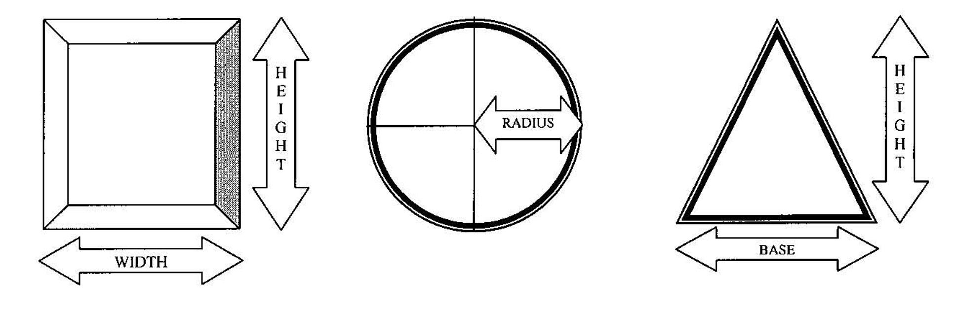
For signs that are rectangular: For signs that are circular: For signs that are triangular:
Area = Width × Height Area = Radius 2 × 3.14 Area = (Base × Height)°2
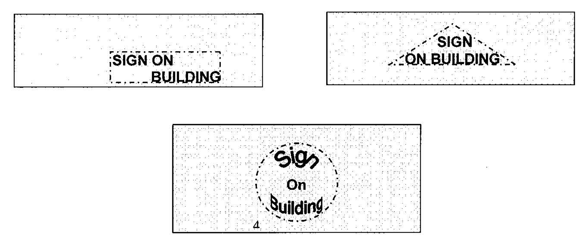
ii.
For signs with no fixed boundaries frames or edges: The area shall be computed on the basis of the smallest triangle, rectangle, square, or circle encompassing the outermost exteriors of the outermost letters, words, numbers, or graphics which yields the least total square footage area.
This provision would apply to signs which are composed of separate letters which are
placed upon or against a building, window, or other surface not designed, framed,
or edged specifically for sign presentation, for example.
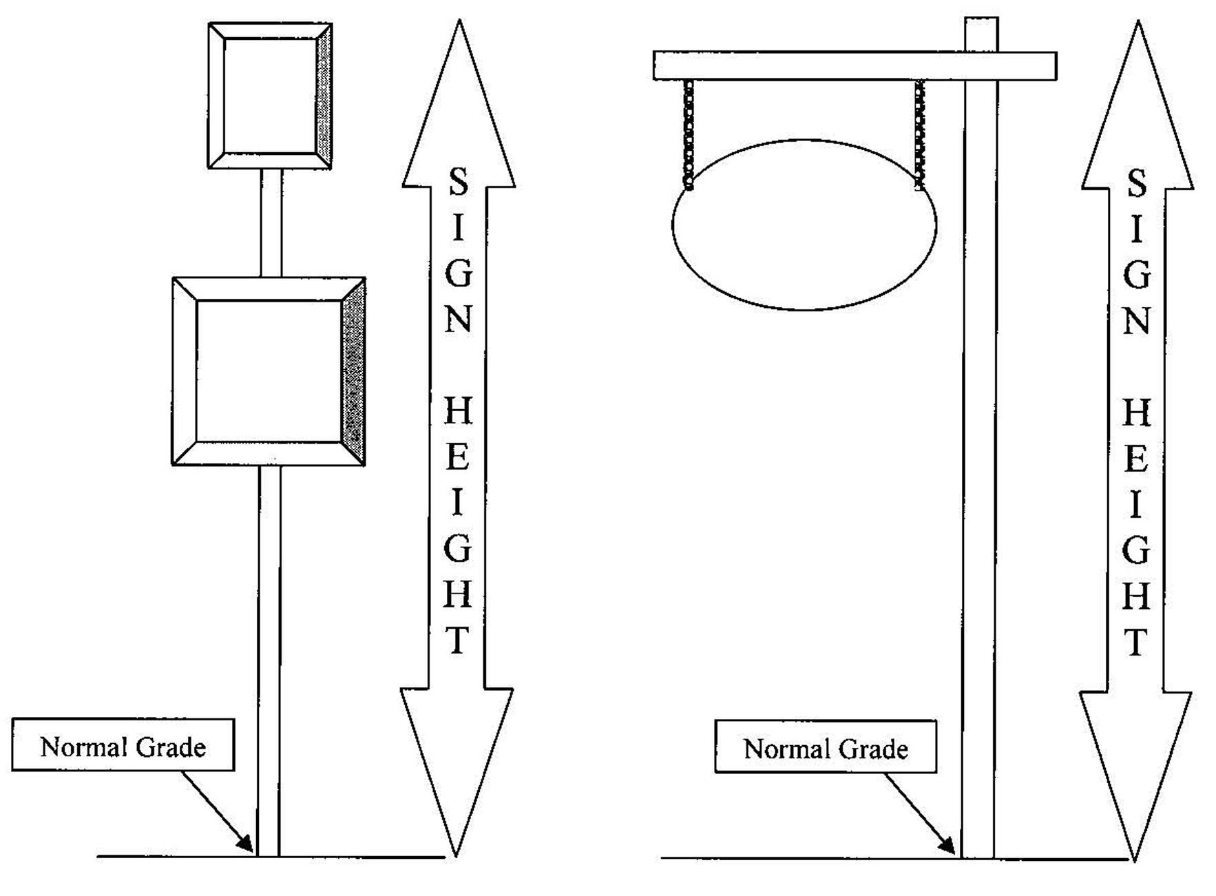
b.
Computation of freestanding sign height: The height of a freestanding sign shall be the distance from the base of the sign at normal grade to the top of the highest attached component of the sign. For the purposes of this measurement, excepting freestanding architectural signs in mixed use development or planned development districts, normal grade shall be construed to be the newly established grade after sign construction exclusive of any filling, berming, mounding, or excavating solely for the purpose of locating the sign. Freestanding architectural signs within mixed use districts planned developments may use filling, mounding or berming for aesthetic landscape purposes, but in no case may the berm or mound exceed the height of the crown of the adjacent roadway and sign exceed the height limitation as specified on the table under Section 4.2.4.20.8.
4.2.20.8. Signs permitted. The following permanent and temporary signs are allowed:
* Width determined by building code (i.e. wind loading requirements, et al).
4.2.20.9. Design standards for permanent signs.
a.
Obstruction of vision. Signs shall not be located within the vision triangle of an intersection as required under section 4.2.24.
b.
Residential neighborhood identification signs.
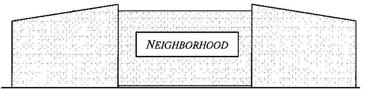
i.
Signs shall be located no farther than 200 feet from the primary entrance to such neighborhood from a collector or arterial street of the city;
ii.
Each such sign must be located on private property in a designated common area of the neighborhood, controlled by the owner of the common area, where applicable, or by a property or home owners' association representing property owners within the neighborhood;
iii.
Such sign may be located on a wall or other entrance feature or may be freestanding. If freestanding, such sign shall not exceed eight feet in height and shall have a continuous foundation or other support under it in the style of what is commonly called a "monument sign";
iv.
Lighting for such sign shall be limited to external, direct white light; indirect and internal lighting and changeable copy are expressly prohibited;
v.
The sign must bear no commercial message;
vi.
The location and type of the sign shall be shown on the preliminary plat for the neighborhood;
vii.
For an existing neighborhood as of August 28, 2006, the applicant requesting a sign under this subsection shall submit an application for a sign permit;
viii.
The applicant for the sign must own or have the authority to represent the owners of at least 50 percent of the land area within the neighborhood to be identified by the sign.
c.
Wall signs.
i.
Each wall sign shall be attached to the building and supported throughout its entire length by the facade of the building.
ii.
Wall signs shall not be erected above the roof line of the building, except that, where there is a parapet, a wall sign may extend to the top of the parapet. Such sign shall not be considered a roof sign.
d.
Address. The E-911 address may be included on the sign face or on the sign structure. Inclusion of the E-911 address will not be included in the calculation of the maximum area of the sign face, nor will it cause the sign structure to be included in the calculation of the maximum area of the sign face.
e.
Changeable copy signs. Where changeable copy signs are permitted and only where electronic message boards are specifically allowed, an electronic message board or other sign on which the message can be changed electronically may be used as the changeable copy sign, provided that such sign shall be programmed so that it will not change the message more often than one time per minute.
f.
Window signs.
i.
Window signs shall not exceed 20 percent of the total window area.
ii.
Lettering and graphics shall be silk-screened, vinyl or etched.
iii.
Window signs shall count against the maximum sign area allowed.
4.2.20.10. Design standards for temporary signs.
a.
Such signs may be installed only by the property owner or occupant or with such person's permission.
b.
There shall be no more than two temporary signs bearing a limited commercial message on a single lot or tract at any time, where the message is limited to a commercial message related to real estate, or advertising a garage or yard sale, which may be lawfully held on the lot or parcel on which it is located. No other commercial message is allowed.
c.
There shall be no limit on the number of temporary signs which do not bear a commercial message on a lot or tract.
d.
Accessory signs for new developments. As an accessory sign to the temporary business of real estate development in accordance with these Land Development Regulations, temporary signs advertising the sale of lots or dwellings in the development shall be allowed in accordance with the following standards:
i.
One such sign shall be allowed for the development for which subdivision plats have been approved and in which less than 80 percent of the available lots, dwellings or dwelling units have been sold;
ii.
Such sign shall not be separately illuminated or may be illuminated only by external, direct, white light which does not cause spillover or glare exceeding one-half footcandles at the property line; and
iii.
Such sign shall be removed on the earlier of the following:
(a)
One year after the approval of the sign permit for such sign; or
(b)
Upon the transfer of title to 80 percent or more of the available lots, dwellings or dwelling units included in the approved plat.
e.
Temporary construction sign. During the time that a property is under development or construction, one temporary detached sign that conforms in size, height and location with the standards for permanent signs shall be allowed. Such temporary sign shall be removed upon the earlier of the following: 60 days after issuance of a certificate of occupancy for the premises; or installation of the permanent sign.
f.
Banners.
i.
On private property.
(a)
One temporary banner may be displayed on property no more than two times per year. The banner may be displayed for a period not to exceed 30 days per occurrence.
(b)
The temporary banner shall be installed only on property, buildings, or structures owned or occupied by the permittee. The banner shall be firmly attached to a secure structure at all four corners.
(c)
No temporary banner may be displayed without the issuance of a no cost banner permit that is based upon the guidelines providing specific criteria and that are not based upon the content of the banner.
(d)
Temporary banners shall not be permitted over public space or street rights-of-way.
ii.
On public property or right-of-way. Temporary banners shall not be permitted over public space or street rights-of-way, except that banners of a temporary nature may be permitted under the following conditions:
(a)
The message on the banner relates to an event meeting all of the following criteria:
(1)
The primary sponsor of such event is a governmental entity in the State of Florida or a nonprofit organization with a current tax exemption under Section 501(c) of the Internal Revenue Code; and
(2)
The event is held in the City of Newberry or for the benefit of an organization based in the City of Newberry.
(b)
If the right-of-way is under the jurisdiction of the Florida Department of Transportation and the proposed banner has met or can reasonably be expected to meet the requirements of Chapter 14-43 of the Rules of Procedure of the department.
(c)
If support of the banner or access to the location for erecting the banner requires entry onto or use of private property owned by a person other than the applicant, the applicant provides written consent from each affected landowner.
(d)
The temporary banner provides at least 20 feet of vertical clearance to the public space below, is constructed of less than eight-ounce canvas, or similar material, and is supported by not less than one-quarter inch stranded cable sewn into its hem.
g.
Period of posting. For the purpose of advertising real estate; or for expressing support for a candidate for office or a ballot issue; or expressing an opinion on any other matter deemed by the person expressing the view to be of public interest, such sign may contain a message related to that purpose and is subject to the following periods of posting:
i.
If such sign relates to an election or other specific event, it shall be removed with ten days after the occurrence of the event.
ii.
If the sign relates to the viewing, sale, rent, or lease of property, it shall be removed within five days of the completion of the open house, execution of a lease or rental agreement, closing of a sale, or actual occupancy of the property by a new owner or tenant, whichever shall first occur.
h.
A-frame signs.
i.
One temporary A-frame sign may be displayed on property no more than than four times per year. The A-frame sign may be displayed for a period not to exceed 30 days per occurrence, with a minimum of 45 days between each occurrence.
ii.
The temporary A-frame sign shall be installed only on property owned or occupied by the permittee. The A-frame sign faces shall not exceed six square feet per side, with a maximum letter height of four inches. The A-frame sign shall be made a durable materials and placed in front of the building only. Placement of the A-frame sign shall not interfere with pedestrian or vehicular movement.
iii.
No temporary A-frame sign may be displayed without the issuance of a no-cost sign permit that is based upon the guidelines providing specific criteria and that are not based upon the content of the A-frame sign.
iv.
Temporary A-frame signs shall not placed within the public right-of-way.
4.2.20.11. Signs within historic districts or on historic properties outside of historic districts.
a.
Signs erected or displayed within historic districts, unless specified otherwise within these regulations, or on historic properties outside of historic districts shall maintain the character of the district or structure by the following:
i.
Signs shall be of a size and shape characteristic of the historic period of the district or property.
ii.
Sign graphics, lettering styles, colors and materials shall be characteristic of the historic period of the district or property.
iii.
Types of signage shall be characteristic of the historic period of the district or property.
b.
If the sign is denied by the land development regulation administrator, the applicant may appeal such decision to the city historic architectural review board by applying for a certificate of appropriateness.
4.2.20.12. Substitution of messages. Any on-site sign allowed under this section or a predecessor section, by sign permit, by special permit or special exception, or by variance, may contain, in lieu of any other message or copy, any lawful message that does not direct attention to a business operated for profit, or to a product, commodity, or service for sale or lease, or to any other commercial interest or activity, so long as said sign complies with the size, height, area, and other requirements of this section and the Land Development Regulations. Such substitution shall be permitted without a sign permit.
Any off-site sign allowed by these Land Development Regulations may change the message on the sign face, so long as said sign is not enlarged. Such substitution shall be permitted without a sign permit.
4.2.20.13. Design, construction and maintenance.
a.
Permanent installation required. All permanent signs shall be constructed of durable materials and shall be permanently attached to the ground, a building, or another structure by direct attachment to a rigid wall, frame or structure.
b.
Maintenance. All signs shall be maintained in good structural condition, in compliance with all building and electrical codes, and in conformance with this section at all times.
Specifically:
i.
No more than 20 percent of a sign's surface area may be covered with disfigured, cracked, ripped, or peeling paint, poster paper, or other material for a period of time of more than 30 successive days;
ii.
A sign shall not stand with bent or broken sign facing, with broken supports, with loose appendages or struts, or lean more than 15 degrees from vertical for a period of more than 30 successive days;
iii.
Any sign which becomes or has become at least 50 percent destroyed shall be deemed a public nuisance and shall be removed by the owner of the premises upon which the sign is situated;
iv.
A sign shall not have weeds, trees, vines, or other vegetation growing upon it, or obscuring the view of the sign from the street or right-of-way from which it is to be viewed, for a period of no more than 30 successive days;
v.
An internally illuminated sign shall be allowed to stand with only partial illumination for a period of no more than 30 successive days;
vi.
The area around a lighted sign shall be maintained so that there are no weeds within a radius of ten feet of the sign and no rubbish or debris shall be permitted so near to the sign that it constitutes a fire hazard.
4.2.20.14. Nonconforming signs. It is the policy of the City of Newberry to require that all signs within Newberry be brought into compliance with the requirements of this section 4.2.20.
a.
A sign which was lawfully erected prior to the effective date of this section but which does not conform in one or more respects with the requirements of this section 4.2.20 may remain in use, subject to the requirements of this section 4.2.20 and other applicable requirements of the City of Newberry ordinances.
b.
Any of the following types of signs which do not conform to this section shall be removed within 260 days from the effective date of this section:
i.
Portable signs;
ii.
Temporary signs;
iii.
Banners;
iv.
Flags;
v.
Pennants;
vi.
Streamers;
vii.
Balloons;
viii.
Inflatable signs; and
ix.
Any other similar sign made of flexible material (such as paper, cloth, or flexible plastic) or not permanently fastened to a foundation or to a structural wall of a building.
c.
Any sign which does not conform to this section 4.2.20 because of a lack of required maintenance or deferred maintenance shall be removed or made conforming on or before December 31, 2012.
d.
Limitations on other nonconforming signs. Except as otherwise provided in this section 4.2.20, any on-premises sign which is located on property which becomes vacant and unoccupied for a period of at least 12 months, or any sign which pertains to a time, event or purpose which is no longer imminent or pending shall be deemed to have been abandoned. Permanent signs applicable to a business temporarily suspended because of a change of ownership or management shall not be deemed abandoned unless the property remains vacant for a period of 12 months. Abandoned signs are prohibited and shall be removed by the owner of the sign or the owner of the premises.
i.
Any other nonconforming sign that shall cease being used or cease being leased for a continuous period of 12 months shall be considered abandoned.
ii.
Any person obtaining a permit from the city for construction of a new building, for expansion of an existing building by more than 1,000 square feet or ten percent of its floor area, whichever is less, or for any improvements valued for permitting purpose at more than $25,000.00 shall, as a part of the work or at the same time as the work is performed, remove all nonconforming signs from the property. Nonconforming signs shall be replaced only with signs fully conforming with the requirements of this section 4.2.20. If the property affected is a multi-tenant property, then the person obtaining the permit shall be required only to remove the nonconforming signs directly appurtenant to the portion of the premises for which the permit is issued.
4.2.21. Transitional use area requirements. It is the intent of these requirements to ease the frictions between residential and nonresidential uses by creating a transition area in which certain intensive nonresidential uses are prohibited.
Where a commercial or industrial district adjoins a residential district, along the same frontage and without an intervening street, the following uses shall not be located within 100 feet of the residential district:
1.
Drive-in restaurants or refreshment stands.
2.
Bars, taverns and cocktail lounges.
3.
Car washes.
4.
Outdoor storage yards, wrecking yards, automobile wrecking yards, junk yards, yards used in whole or in part for scrap or salvage operations, or for processing, storage, display, or sales of any scrap, salvage, or secondhand building materials, junk automotive vehicles, or secondhand automotive parts.
5.
Bulk storage of flammable liquids or explosives.
4.2.22. Travel trailer parks and campgrounds. The following regulations apply to the construction and operation of travel trailer parks and campgrounds.
1.
Permitted vehicles, etc. Sites in travel trailer parks and campgrounds shall be occupied primarily by travel trailers, pickup coaches, tents, camping trailers, and other vehicular accommodations.
2.
Area, location of sites. Each site in a travel trailer park or campground shall be at least 1,200 square feet in area. No part of a travel trailer or other unit placed on a travel trailer or campground site shall be closer than 25 feet to any lot line.
4.2.23. Use of land in a residential district for access. No land in a residential district shall be used for driveway, walkway, or access purposes to any land which is in a commercial or industrial district, or used for any purpose not permitted in a residential district except for ingress and egress to an existing use which does not abut on a street.
4.2.24. Visibility at intersections and curb breaks.
4.2.24.1. Visibility at intersections. On a corner lot in all zoning districts, no fence, wall, hedge, landscaping, or structure shall be erected, placed, planted, or allowed to grow in such a manner as to obstruct vision between a height of 2½ feet and six feet above the centerline grades of the intersecting streets in the area bounded by the street lines of such corner lots and a line joining points along said street lines 25 feet from the point of such intersection.
4.2.24.2. Visibility at curb breaks. In all zone districts, where a curb break intersects a public right-of-way, no fence, wall, hedge, landscaping, or structure shall be erected, placed, planted, or allowed to grow in such a manner as to obstruct cross-visibility between a height of 2½ and six feet within the areas of property on both sides of the curb break formed by the intersection of each side of the curb break and public right-of-way lines with two sides of each triangle being ten feet in length from the point of intersection and the third being a line connecting the end of the two other sides.
4.2.24.3. Retaining walls. The requirements of this section shall not be deemed to prohibit any necessary retaining wall.
4.2.24.4. Trees. Trees shall be permitted in the clear space provided that foliage is cut away within the prescribed heights.
4.2.25. Waterfront yards—Minimum requirement. Waterfront yard requirements for streams and creeks are provided for in article 4 (zoning districts, minimum yard requirements, special provisions). For all other waterfront yards, no structure shall be located closer than 50 feet to the mean high water line.
Exceptions regarding accessory structures for all waterfront yards are provided for in section 4.2.4.
4.2.26. Yard encroachments. Every part of every required yard shall be open and unobstructed from the ground to the sky except as hereinafter provided or as otherwise permitted in these Land Development Regulations:
1.
Sills, belt courses. Sills and belt courses may project not over 12 inches into a required yard.
2.
Awnings. Movable awnings may project not over three feet into a required yard, provided that where the yard is less than five feet in width the projection shall not exceed one-half the width of the yard.
3.
Chimneys, fireplaces, etc. Chimneys, fireplaces, bay windows, or pilasters may project not over two feet into a required yard.
4.
Fire escapes, etc. Fire escapes, stairways, and balconies which are unroofed and unenclosed may project not over five feet into a required rear yard, or not over three feet into a required side yard of a multiple dwelling, hotel or motel.
5.
Hoods, canopies, etc. Hoods, canopies, roof overhangs, or marquees may project not over three feet into a required yard, but shall not come closer than one foot to the lot line.
6.
Fences, walls, hedges. Fences, walls, and hedges are permitted in required yards, subject to the provisions of this section.
7.
Cornices, eaves, gutters. Cornices, eaves, or gutters may project not over three feet into a required yard, provided that where the required yard is less than six feet in width, such projection shall not exceed one-half of the width of the yard.
8.
Landscaping, gardening generally. Except as provided herein, nothing in these Land Development Regulations shall be so construed as to prohibit any type of landscaping or private, nonprofit, gardening on any lot.
4.2.27. Airport land use restrictions.
1.
Use restrictions. Not withstanding any other provisions of these Land Development Regulations, no use may be made of land or water adjacent to any airport which is not in conformance with Federal Aviation Regulations Part 77 and F.S. ch. 333, and that will interfere with the operation of an airborne aircraft. The following special requirements shall apply to each permitted use. If there is any conflict between the following requirements and the federal and/or state regulations cited above, the federal and/or state regulations shall prevail:
a.
Lights. All lights or illumination used in conjunction with street, parking, signs, or use of land and structures shall be arranged and operated in such a manner that it is not misleading or dangerous to aircraft operating from the airport or in vicinity thereof.
b.
Visual hazards. No operations from any land use type shall produce smoke, glare, or other visual hazards within three statute miles of any usable runway of the airport.
c.
Electronic interference. No operations from any land use type shall produce electronic interference with navigation signals or radio communication between the airport and aircraft.
d.
Congested uses. Use of land for residential uses, schools, hospitals, storage of explosive material, assemblage of large groups of people, or any other use that could produce a significant loss of life or property as a result of an aircraft crash, shall be prohibited within 5,000 feet of the approach or departure end of a runway.
e.
Height of structures. No structure exceeding 150 feet in height above the established airport elevation shall be permitted within 5,000 feet of the approach or departure end of a runway.
4.2.28. Special right-of-way requirements.
4.2.28.1. For all new arterial and collector roadways extra right-of-way, as provided within the Florida Department of Transportation Bicycle Facilities Planning and Design Manual, Official Standards, Revised Edition, 1982, shall be provided for integrated or parallel bicycle ways or lanes.
4.2.28.2. All new structures shall provide a minimum setback of 75 feet as measured from the centerline of the right-of-way for new or realigned collector or arterial roads.
4.2.29. Home occupation, cottage industry, and bed and breakfast inn requirements.
4.2.29.1. Purpose and intent. The conduct of business restricted to certain types of occupations may be permitted as a permitted principal use in residential units. More intensive uses, i.e., cottage industries and bed and breakfast inns, shall require further review by the city commission, as special permits, as provided herein. It is the intent of this section to ensure that:
(1)
Residential neighborhood. The use will not be contrary to the growth and development trends of the surrounding or adjacent residential neighborhood. The fact that other business uses are located nearby shall not be controlling if the home occupation represents an extension or intrusion of business uses into the neighborhood.
(2)
Public resources. The use will not overburden public resources in the vicinity, including streets and sidewalks, utilities, recreation spaces, and fire or emergency medical protection facilities.
(3)
Property values. The use will not be detrimental to property values of other residences in the neighborhood.
(4)
Traffic. The use will not create problems of reasonable access for vehicular or pedestrian traffic to the subject property or other properties, and will not create conflicts in movement of vehicles or persons with resulting lack of safety, or otherwise create any unsafe conditions.
(5)
Land uses. The use will be compatible with the buildings, structures and other land uses in the vicinity.
(6)
Character of neighborhood. The use will not be contrary to the traditional character of the neighborhood, will not offend the integrity of the neighborhood in which it is located, and will not constitute an intrusion into the residential neighborhood.
(7)
Children. The use will not be an attraction or danger to children who may be in the neighborhood.
(8)
Noise. The use will not create or intensify noise of an intensity or type which would not be compatible with the quiet, residential character and traditions of the neighborhood.
(9)
Visual effect. The use will not be visually offensive to other residents of the neighborhood because of exterior signs, painting of the building, or other promotional, advertising or notice reasons.
(10)
Lighting. The use will not generate either interior or exterior lighting which would be sufficiently bright or of such character as to annoy, disrupt, or offend residents of the neighborhood, or interfere with their enjoyment of their own property.
4.2.29.2. Examples of home occupations.
Generally. The following examples are typical of uses which often can be conducted within the limits of the conditions and performance standards herein. Home occupations are not limited to those named in this subsection, nor does the listing of a use in this subsection automatically qualify it as a home occupation: Architectural service; art restoration or studio; baby-sitting (but not family day care or child care facilities as defined elsewhere in the regulations); consulting services; drafting and graphic services; dressmaking, sewing, alterations, tailoring, contract sewing (one machine); electronic assembly; engineering service; financial planning, investment services; flower arranging; graphic design; home crafts (including ceramics with kiln up to six cubic feet); house cleaning service; insurance sales or broker; interior design; jewelry making; laundry, ironing service; locksmith; legal consultation or services; arranging and copying services; notary services; millinery; music lessons (private); writing, typing, editing, proofreading, word or data processing service; computer programming; watch repair; telemarketing; mail order (not including retail sales from site); tutoring; real estate sales or broker; tax return preparation and consultation; and other occupations permitted for office use only with no on-site storage or activity: such as sales representative; building contractor; carpentry, masonry, painting, plumbing, or electrical contractors and trades.
4.2.29.3. Prohibited home occupations. The following uses are prohibited as home occupations: Automobile related industries including over-the-counter part sales, repairs, upholstery, or on-site detailing or washing; boardinghouse; barber, hair styling, or cosmetology; time-share condominium; cabinet making; ceramics (kiln of six cubic feet or more); health studios, gyms, dance studios, aerobic exercise studios, massage; helium balloons; limousine service; medical or dental office; mortician, hearse service; palm reading, psychic, fortune-telling, clairvoyant; private clubs; religious services or instruction; restaurant, tavern, food preparation; jeweler; retail sales from site including direct sale product distribution; towing service; furniture upholstery; veterinary services (including on-site care, grooming, or boarding); gardening, lawn, and landscape maintenance; and pest control services. Any use or structure not specifically, provisionally, or by reasonable implication permitted herein as a home occupation.
Note: No home occupation shall be conducted within an accessory building.
4.2.29.4. Conditions and performance standards for home occupations. Whenever a home occupation permit is granted, the following conditions shall be met:
(1)
Employees. Only two additional persons other than the residents residing on the premises shall be employed or engaged in the home occupation at the premises. However, there shall be no restriction on the number of persons employed or engaged in activities related to the home occupation off the premises.
(2)
Incidental use. The use of the dwelling unit for the home occupation shall be clearly incidental and subordinate to its use for residential purposes by the occupants. Under no circumstances shall the residential character of the dwelling be changed. For purposes of this section, the dwelling unit may be occupied by individuals other than those undertaking the home occupation or the home may be a second residence or vacation home for the persons conducting the home occupation. The primary condition of the city in determining the use as a home occupation is maintenance of the residential character of the structure.
(3)
Outside appearance. No change in the outside appearance of the building or premises shall be made, or other visible evidence of the conduct of such home occupation other than one sign, not exceeding two square feet in area, non-illuminated, attached to and mounted flat against the wall of the principal building.
(4)
Accessory building. No home occupation shall be conducted in an accessory building, nor shall any accessory building be constructed to warehouse or store materials and supplies solely for the purpose of such home occupation.
(5)
Use of first floor. No home occupation shall occupy more than 30 percent of the first floor area of the residence, exclusive of the area of any open porch, attached garage, or similar space not suited or intended for occupancy as living quarters of a dwelling. No rooms that have been constructed as an addition to the residence, nor any attached porch or garage that has been converted into living quarters, shall be considered as floor area for the purpose of this definition until two years after the date of completion thereof.
(6)
Traffic; parking. No more than two additional parking spaces shall be provided to service the needs of the home occupation, which parking spaces shall be located off the street and in another place other than the required front yard. No traffic or parking of vehicles shall be generated by such home occupation in greater volume than would normally be expected in a residential neighborhood.
(7)
Sense impressions; hazards. No equipment or process shall be used in a home occupation which creates noise, vibration, glare, fumes, odors, or electrical interference detectable to the normal senses off the lot, if the occupation is conducted in a single-family residence, or outside the dwelling unit if conducted in other than a single-family residence. Nor shall there be any combustible materials located anywhere on the premises in violation of the city fire prevention code or other fire prevention regulations. Nor shall there be any hazardous materials located anywhere on the premises in violation of the city's Land Development Regulations. In the case of electrical interference, no equipment or process shall be used which will create visual or audible interference in any radio or television receivers off the premises, or otherwise interfere with the off-premises use and enjoyment of electric or electronic devices of any kind.
(8)
Utilities. No home occupation shall cause a substantial increase in the use of any one or more utilities (water, sewer, electricity, garbage, etc.) so that the combined total use for dwelling and home occupation purposes exceeds the average for residences in the neighborhood.
4.2.29.5. Administrative approval of home occupations; permit procedure. The land development regulation administrator shall approve or deny requests for a home occupation permit based upon the intent of the home occupation provisions and ability of the applicant to meet the conditions and performance standards. Anyone aggrieved by a decision of the land development regulation administrator may appeal by filing for relief to the board of adjustment as provided in these Land Development Regulations.
The applicant shall provide the following information or any other information as deemed necessary by the land development regulation administrator, including but not limited to:
(1)
Name. Name of business or type of activity.
(2)
Property. Address and legal description of the property where the home occupation will be located.
(3)
Name of property owners. If other than the applicant, a notarized letter of authorization signed by the property owner is required.
(4)
Conditions. The applicant shall agree in writing to the conditions and performance standards established herein.
(5)
Grant of permit. A home occupation permit may be granted for a term of one year, with review for possible continuation at the discretion of the land development regulation administrator. An applicant shall acquire no vested rights to continuation of any business uses within the dwelling beyond the period of time originally approved in the permit. A permit may be withdrawn or revoked by the land development regulation administrator after notice, and after opportunity for public hearing if requested by the applicant, upon a showing that any of the conditions of this section are not met, or that the home occupation does not meet, or fails to continue to meet, the criteria herein.
(6)
Premises sold. If the premises are sold where a home occupation has been granted, the permit shall be considered terminated by the city, and the buyer of the premises shall acquire no vested rights to the continuation of the home occupation.
(7)
Existing permits. All persons possessing a home occupation permit at the effective date of this section shall be phased into the annual process upon expiration of their current permit or any conditional renewals. The city shall not automatically renew each home occupation permit previously granted, but shall scrutinize all applications, either original or renewal, to ensure that permitted home occupations are in compliance with this section.
(8)
Change in use; revocation of permit. Any change in use or any change in extent or nature of use, or area of the dwelling unit being used, that is different from that specified in the previously granted home occupation permit form, that is not first approved by the land development regulation administrator shall be grounds for the revocation of a previously granted home occupation permit. The operator of a home occupation must apply for a new home occupation permit prior to any such changes.
(9)
Noncompliant conditions. Any change in use, extent of use, area of the dwelling unit being used, or mechanical or electrical equipment being used that results in conditions not in accordance with the provisions of the required conditions of this section or the provisions of section 4.2.18 of these Land Development Regulations shall result in immediate revocation of the home occupation permit.
(10)
Occupational license. Failure to maintain a valid city occupational license shall result in the loss of the home occupation permit.
4.2.29.6. Cottage industry. Cottage industries are uses which are also a form of home occupation, but due to the intensity of the use, are only allowed within the Agricultural zoning district and only upon review and approval by the city commission, after conducting a public hearing duly noticed in conformance with article 13 of these Land Development Regulations.
Examples of cottage industries.
Generally. The following examples are typical of uses which often can be conducted within the limits of the conditions and performance standards herein. Cottage industries are not limited to those named in this subsection, nor does the listing of a use in this subsection automatically qualify it as a cottage industry: Appliance repair (no outdoor repair or storage); art or photographic studio; automotive repair; off-site auto detailing and washing; small engine repair; barber, hairstyling, or cosmetology; carpentry and cabinet making; dance studios; jeweler; electronic assembly; gardening, lawn, and landscape maintenance (excluding application of herbicides and pesticides); retail or wholesale mail-order sales (no walk-in sales from home); veterinary services within an air-conditioned/soundproofed portion of the residence or accessory structure (including on-site care, grooming and boarding in association with the veterinary medical services only); watch repair; welding; and for office use only with no outside storage: contracting, masonry, painting, plumbing, upholstery, or electrical service.
Prohibited cottage industries: Automobile over-the-counter part sales; boardinghouse; health studios, gyms, aerobic exercise studios; massage; medical or dental office; mortician, hearse service; palm reading, fortune telling, clairvoyant, psychic; private clubs; religious services or instruction; restaurant, tavern; and towing service; pest control service; limousine service; taxi service; and child care centers. Any use or structure not specifically, provisionally or by reasonable implication permitted herein as a cottage industry.
4.2.29.7. Conditions and performance standards for cottage industries. Whenever a special permit for a cottage industry is granted, the following conditions shall be met:
(1)
Area. The site shall have a minimum area of five acres, and shall meet the lot size requirements of the agriculture zoning district and provided that floor area devoted to the cottage industry does not exceed 1,000 square feet. The following cottage industries may be conducted in a freestanding accessory building, subject to meeting the requirements stated herein.
(2)
Incidental use. The cottage industry shall be incidental to the use of the property for dwelling purposes and shall be less than 50 percent of the living area of the dwelling. This square footage limitation includes outdoor assembly and storage areas, but not required parking areas.
(3)
Employees. Only two additional persons other than the residents residing on the premises shall be employed or engaged in the cottage industry at the premises. However, there shall be no restriction on the number of persons employed or engaged in activities related to the cottage industry off the premises.
(4)
Character of dwelling. Under no circumstances shall the residential character of the dwelling be changed. For purposes of this section, the dwelling unit may be occupied by individuals other than those undertaking the cottage industry or the home may be a second residence or vacation home for the persons conducting the cottage industry. The primary condition of the city in determining the use as a cottage industry is maintenance of the residential character of the structure.
(5)
Outside appearance. No change in the outside appearance of the building or premises shall be made, or other visible evidence of the conduct of such cottage industry other than one sign, not exceeding two square feet in area, non-illuminated, attached to and mounted flat against the wall of the principal building.
(6)
Accessory building. A cottage industry may be housed within an accessory building, but no structure on the premises shall be constructed or used to warehouse or store materials and supplies solely for the purpose of such cottage industry.
(7)
Traffic; parking. No more than two additional parking spaces shall be provided to service the needs of the cottage industry, which parking spaces shall be located off the street and in another place other than the required front yard. No traffic or parking of vehicles shall be generated by such cottage industry in greater volume than would normally be expected in the area.
(8)
Sense impressions; hazards. No equipment or process shall be used in a cottage industry which creates noise, vibration, glare, fumes, odors, or electrical interference detectable to the normal senses off the lot, if the cottage industry is conducted in a single-family residence, or outside the dwelling unit if conducted in other than a single-family residence. Nor shall there be any combustible materials located anywhere on the premises in violation of the city fire prevention code or other fire prevention regulations. Nor shall there be any hazardous materials located anywhere on the premises in violation of the city's Land Development Regulations. In the case of electrical interference, no equipment or process shall be used which will create visual or audible interference in any radio or television receivers off the premises, or otherwise interfere with the off-premises use and enjoyment of electric or electronic devices of any kind.
(9)
Utilities. No cottage industry shall cause a substantial increase in the use of any one or more utilities (water, sewer, electricity, garbage, etc.) so that the combined total use for dwelling and cottage industry purposes exceeds the average for residences in the area.
4.2.29.8. Administrative approval of cottage industries; permit procedure. The land development regulation administrator shall accept applications for a cottage industry special permit. The applicant shall provide the following information or any other information as deemed necessary by the land development regulation administrator, including but not limited to:
(1)
Name. Name of business or type of activity.
(2)
Property. Address and legal description of the property where the cottage industry will be located.
(3)
Owners. Name of property owners. If other than the applicant, a notarized letter of authorization signed by the property owner is required.
(4)
Conditions. The applicant shall agree in writing to the conditions and performance standards established herein.
(5)
Premises sold. If the premises are sold where a cottage industry has been granted, the permit shall be considered terminated by the city, and the buyer of the premises shall acquire no vested rights to the continuation of the cottage industry.
(6)
Change in use; revocation of permit. Any change in use or any change in extent or nature of use, or area of the dwelling unit being used, that is different from that specified in the previously granted cottage industry, that is not first approved by the city commission shall be grounds for therevocation of a previously granted cottage industry special permit. The operator of a cottage industry must apply for a new cottage industry permit prior to any such changes.
(7)
Noncompliant conditions. Any change in use, extent of use, area of the dwelling unit being used, or mechanical or electrical equipment being used that results in conditions not in accordance with the provisions of the required conditions of this section or the provisions of section 4.2.18 of these Land Development Regulations shall result in immediate revocation of the cottage industry special permit.
(8)
Occupational license. Failure to maintain a valid city occupational license shall result in the loss of the cottage industry permit.
(9)
Site plan; landscaping. A site plan shall be submitted as part of the application for the special permit, and approval by the city commission shall be required. Landscaping shall be required to screen cottage industry uses from the view of adjacent landowners and public roads.
(10)
Compatibility. Increased setbacks and/or additional screening may be required to ensure that any proposed structure is compatible with the surrounding residential or agricultural area, or for any activity that could potentially detract from a residential area but that is not deemed incompatible with the neighborhood, including but not limited to employee parking areas, loading zones, outdoor storage and outdoor working areas.
4.2.29.9. Bed and breakfast inn requirements. Bed and breakfast inns may be considered by special permit approved by the city commission, upon conducting a public hearing, after due public notice has been provided in accordance with provisions of article 13 of these Land Development Regulations and in accordance with the following criteria:
(1)
Residential character. The dwelling unit may be occupied by individuals other than those undertaking the bed and breakfast operation or the home may be a second residence or vacation home for the persons conducting the bed and breakfast operation. The primary condition of the city determining the use as a bed and breakfast is the maintenance of the residential character of the structure, or construction of a structure which maintains the residential characteristic of the neighborhood;
(2)
Bathrooms. Toilet and bathing facilities for the use of guests must be provided;
(3)
Daily rental. Rentals shall be on a daily, weekly, or monthly basis. The maximum stay for an individual guest shall be 180 consecutive days in a 12-month period. Each 180 day period must be separated by a period of 30 consecutive days;
(4)
Cooking. No cooking facilities shall be allowed in guest rooms, unless full kitchens are provided;
(5)
Codes; licenses. Bed and breakfast establishments must comply with appropriate health permits, building and fire codes and business licenses as applicable to such use;
(6)
Signage. Signage, excepting accessibility requirements and historical markers located by federal, state, county or city agencies, shall be limited as provided in these Land Development Regulations;
(7)
Rooms. The maximum number of rooms for guests shall be as follows:
(8)
Dining facilities. Bed and breakfasts may have a dining facility for the service of guests at special events, such as weddings;
(9)
Catering. Bed and breakfasts may conduct food service (catering) for on-premises guests, as well as for off-premises events;
(10)
Antiques; gifts. Bed and breakfasts may sell antiques and gifts as an ancillary use to the bed and breakfast, and not to exceed a display area within one room of the house;
(11)
Within residentially zoned districts. No structure shall be constructed for the sole purpose of being utilized as a bed and breakfast inn. It is intended that a bed and breakfast inn be a converted or renovated single-family residence, and that this principal function be maintained. The exterior appearance of the structure shall not be altered from its single-family dwelling character;
(12)
Within agriculturally, commercially, or planned development zoned districts. Bed and breakfasts are encouraged to utilize and renovate a single family residence, although new construction shall be permitted for the location of the bed and breakfast subject to the new construction following vernacular residential architectural designs (not to include modular units, manufactured housing or metal buildings). The architectural designs shall be in conformance with the city's design standards to insure the construction of structures that blend with surrounding uses. Bed and breakfast inns within agriculturally, commercially, or planned development zoned districts shall conform to the maximum number of rooms provided in subsection (7) herein. Ancillary and accessory buildings to the main inn may be constructed to complement the primary residential structure and meet the design standards, as provided within these Land Development Regulations. These accessory buildings shall be limited to providing additional lodging and limited catering and meeting facilities within the same property as the inn. In addition the accessory building may not exceed 5,000 square feet. Further, the maximum occupancy of structures shall meet all applicable state and local building and fire code requirements, and in addition the following conditional requirements:
(a)
The total occupancy of the structures used for catering and meeting rooms shall not exceed 250 persons per event;
(b)
Meeting room operation hours shall not be later in the evening than 11:00 p.m.
4.2.30. Special septic tank requirements. Existing septic tanks shall be allowed to remain in service until such time as a centralized sanitary sewer service is accessible, conditioned on the following requirements:
1.
Building permit. A building permit shall not be issued for construction of a building or facility where sanitary sewage is proposed to be disposed using an on-site sewage disposal system in an area zoned industrial on the city's official zoning atlas, or used for industrial or manufacturing purposes, or its equivalent, where the city's centralized sanitary sewer system is available within one-quarter mile of the area used or zoned industrial or manufacturing, or where a likelihood exists that the on-site sewage disposal system may receive toxic, hazardous or industrial waste;
2.
Occupational license. An occupational license shall not be issued to the owner or tenant of a building located in an area zoned industrial on the city's official zoning atlas, or used for industrial or manufacturing purposes, or its equivalent, when such site is served by an on-site sewage disposal system without first obtaining an annual operating permit from the county health department; and
3.
Certificate of compliance. A certificate of land development regulation compliance shall not be issued to a new owner or tenant of a building located in an area zoned industrial on the city's official zoning atlas, or used for industrial or manufacturing purposes, or its equivalent, or who operates a business which has the potential to generate toxic, hazardous or industrial wastewater, when such site is served by an on-site sewage disposal system without first obtaining an annual operating permit for an on-site sewage disposal system from the county health department.
4.2.31. Provisions for residential design manufactured housing. Residential design manufactured homes as defined in section 2.1 shall be installed in accordance with the following:
1.
Foundation; anchoring. A permanent foundation and anchoring according to F.A.C. 15C-1.10;
2.
Underfloor area. Underfloor area of the home shall be permanently enclosed (e.g., masonry block stem wall);
3.
Transportation equipment. All transportation equipment shall be removed.
4.2.32. Special community residential home requirements. Homes of six or fewer residents which otherwise meet the definition of a community residential home and community residential homes, as defined in section 2.1, shall be located in accordance with the following:
4.2.32.1. Spacing. The city shall not permit homes of six or fewer residents which otherwise meet the definition of a community residential home to be located within a radius of 1,000 feet of an existing home of six or fewer residents which otherwise meets the definition of a community residential home.
4.2.32.2. Exceptions. The city shall permit the siting of a community residential home, unless the city determines that the siting of the home meets the following criteria:
1.
Licensing. The site selected does not meet applicable licensing criteria established and determined by the state agency for health care administration, including requirements that the home be located to assure the safe care and supervision of all clients in the home.
2.
Character of area. The site selected would result in such a concentration of community residential homes in the area in proximity to the site selected, or would result in a combination of such homes with other residences in the community, such that the nature and character of the area would be substantially altered. (A home that would be located within a radius of 1,200 feet of another existing community residential home shall be considered to be an over concentration of such homes that substantially alters the nature and character of the area. A home that would be located within a radius of 500 feet of a one-family residential district shall be considered to substantially alter the nature and character of the area.)
State Law reference— Assisted living facilities, F.S. § 400.401 et seq.
4.2.33. Special child care center facility requirements.
4.2.33.1. Purpose and intent. Child care centers, as defined within these Land Development Regulations, are listed either as a special exception or permitted principal use, and are only allowed (as specified) within several of the zoning districts of these Land Development Regulations. Please refer to the permitted principal uses or the uses permitted by special exception, within each district to determine if a child care center is permitted within that district. It is the intent of these Land Development Regulations, that child care centers, as defined herein, be located in a manner which provides a safe and sanitary environment for the child and does not adversely impact the quality of life within the surrounding neighborhood or district. The following sub sections provide specific performance relationships required for each specified district, which govern the approval of any location for a child care center.
4.2.33.2. General requirements for all child care centers, regardless of zoning district location.
1.
Evidence shall be provided at the time any application is filed with the city that licensure, child care personnel requirements, capacity requirements, and staff to child ratios comply with the Florida Department of Children and Families requirements and chapter 67, Alachua County Code of Ordinances (Countywide licensure requirements);
2.
The proposed facility shall be inspected (and be approvable for occupancy) by the city fire department and the city building department. The applicant shall meet all requirements for occupancy of the facility as required by the fire department and building department prior to an application being accepted by the land development regulation administrator;
3.
The proposed access to the child care center shall be inspected by the city public works department to determine if such access and on-site vehicular storage is safe and provides for safe traffic flow and circulation. The applicant shall meet all requirement for vehicular access, storage and traffic circulation, as required by the public works department, prior to an application being accepted by the land development regulation administrator; and
4.
Day child care centers shall be limited to activities which are conducted between 6:30 a.m. and 7:00 p.m. No outdoor play activities shall be conducted before 8:00 a.m., or after 7:00 p.m.
4.2.33.2[a]. General requirements for all child care centers, within general agriculture zoning district(s) (in addition to general requirements provided in section 4.2.33.2).[3]
1.
Minimum site size for the location of a child care facility within an agriculturally zoned district shall be one acre.
2.
Play areas shall be completely enclosed with a minimum six-foot-high fence, which is constructed of a material to secure the play area and prevent intruders from entering the premises.
3.
A site and development plan shall be provided as required by article 14 of these Land Development Regulations. In addition to the requirements stated within article 14, the applicant shall provide a floor plan of the structure(s) to be occupied. The following site requirements shall be provided:
a.
Indoor square footage shall be a minimum of 35 square feet per child;
b.
Outdoor square footage of the play areas shall be a minimum of 60 square feet per child;
c.
The applicant shall provide evidence at the time of application that the facility contains the minimum toilets, sinks and bathing facilities required by the Florida Department of Children and Families;
d.
Minimum yard requirements shall be as provided within the agriculture zoning district(s). The required yards (setbacks) shall include the play areas provided.
e.
Off-street parking shall be as provided for child care centers within the agriculture zoning district(s), except that where there are more than six employees, there shall be an additional parking space for each employee exceeding the initial six employees.
f.
If stacking lanes have been identified as being required by the city public works department, all such required stacking of vehicles for drop-off and pick-up shall be calculated based upon a formula of 20 linear feet per vehicle with a minimum of 120 feet of linear stacking capability on-site. The city public works department shall determine any additional stacking requirements and/or the need for the construction of off-site acceleration of deceleration laneage, based upon application of standard traffic engineering methodology for such calculation of need.
4.2.33.3. General requirements for all child care centers within residential single-family 1, 2, and 3 zoning districts; and residential single-family/mobile home 1, 2, and 3 districts (in addition to general requirements provided in section 4.2.33.2).
1.
Minimum site size for the location of a child care facility shall be based upon the required child/square footage ratios for the site. Such required square footage of indoor and outdoor uses shall not exceed 55 percent of the site.
2.
Play areas shall be completely enclosed with a minimum six-foot-high fence, which is constructed of a material to secure the play area and prevent intruders from entering the premises.
3.
A site and development plan shall be provided as required by article 14 of these Land Development Regulations. In addition to the requirements stated within article 14, the applicant shall provide a floor plan of the structure(s) to be occupied. The following site requirements shall be provided:
a.
Indoor square footage shall be a minimum of 35 square feet per child;
b.
Outdoor square footage of the play areas shall be a minimum of 60 square feet per child;
c.
The applicant shall provide evidence at the time of application that the facility contains the minimum toilets, sinks and bathing facilities required by the Florida Department of Children and Families;
d.
Minimum yard requirements shall be as provided within the residential zoning district(s). The required yards (setbacks) shall include the play areas provided.
e.
Off-street parking shall be as provided for child care centers within the residential single-family and residential single-family/mobile home zoning district(s), except that where there are more than six employees, there shall be an additional parking space for each employee exceeding the initial six employees.
f.
If stacking lanes have been identified as being required by the city public works department, all such required stacking of vehicles for drop-off and pick-up shall be calculated based upon a formula of 20 linear feet per vehicle with a minimum of 120 feet of linear stacking capability on-site. The city public works department shall determine any additional stacking requirements and/or the need for the construction of off-site acceleration of deceleration laneage, based upon application of standard traffic engineering methodology for such calculation of need.
4.2.33.4. General requirements for all child care centers, within residential multiple-family and mobile home park zoning districts (in addition to general requirements provided in section 4.2.33.2). Shall only be permitted where they are developed as part of the overall plan for such development. Where child care centers are located within these zoning districts, they shall be located on a minimum site of one acre and shall be completely integrated with the amenities to be provided within the development.
1.
Play areas shall be completely enclosed with a minimum six-foot-high fence, which is constructed of a material to secure the play area and prevent intruders from entering the premises.
2.
The child care center shall be part of an overall unified development plan for the multiple-family or mobile home park development. In addition, the applicant shall provide a floor plan of the structure(s) to be occupied. The following site requirements shall be provided:
a.
Indoor square footage shall be a minimum of 35 square feet per child;
b.
Outdoor square footage of the play areas shall be a minimum of 60 square feet per child;
c.
The applicant shall provide evidence at the time of application that the facility contains the minimum toilets, sinks and bathing facilities required by the Florida Department of Children and Family Services;
d.
Minimum yard requirements shall be as provided within the agriculture zoning district(s). The required yards (setbacks) shall include the play areas provided.
e.
Off-street parking shall be as provided for child care centers within the residential single-family and residential single-family/mobile home zoning district(s), except that where there are more than six employees, there shall be an additional parking space for each employee exceeding the initial six employees.
f.
If stacking lanes have been identified as being required by the city public works department, all such required stacking of vehicles for drop-off and pick-up shall be calculated based upon a formula of 20 linear feet per vehicle with a minimum of 120 feet of linear stacking capability on-site. The city public works department shall determine any additional stacking requirements and/or the need for the construction of off-site acceleration of deceleration laneage, based upon application of standard traffic engineering methodology for such calculation of need.
4.2.33.5. Special exceptions. Where child care centers are considered for approval as special exceptions, the applicant shall provide substantial and competent evidence to the city that:
(1)
The child care center will not overburden public resources in the vicinity, including streets and sidewalks, utilities, recreation spaces, and fire or emergency medical protection facilities.
(2)
The child care center will not be detrimental to property values of other residences in the neighborhood.
(3)
The child care center will not create problems of reasonable access for vehicular or pedestrian traffic to the subject property or other properties, and will not create conflicts in movement of vehicles or persons with resulting lack of safety, or otherwise create any unsafe conditions.
(4)
The child care center will be compatible with the building structure and other land uses in the vicinity.
(5)
The child care center will not be contrary to the traditional character of the neighborhood, will not offend the integrity of the neighborhood in which it is located, and will not constitute an intrusion into the residential neighborhood.
(6)
The child care center will not create or intensify noise of an intensity or type which would not be compatible with the quiet, residential character and traditions of the neighborhood.
(7)
The child care center will not be visually offensive to other residents of the neighborhood because of exterior signs, painting of the building, or other promotional, advertising or notice reasons.
(8)
The child care center will not generate either interior or exterior lighting which would be sufficiently bright or of such character as to annoy, disrupt, or offend residents of the neighborhood, or interfere with their enjoyment of their own property.
4.2.34. Restaurant drive-in service windows and drive-in or walk-up tellers. Restaurant drive-in service windows and drive-in tellers are allowed within commercial zoning districts which allow restaurants, banks and financial institutions upon approval of a site and development plan. The approval of the site and development plan shall be subject to the following conditions and restrictions:
1.
That each application for such use shall be made to the planning department with appropriate fee as established within the city's fee schedule;
2.
The site plan shall show location and dimensions of all proposed structures, adequate on site storage or stacking lanes, adequate landscaping, adequate refuse and service areas, adequate yards and open space and provisions for ingress and egress of traffic and pedestrians. The plans shall also show all proposed signs and lighting. The operation of such restaurant drive-in and/or walk-up tellers shall be so conducted that it will not interfere with the circulation of pedestrian or vehicular traffic on the adjoining streets, alleys, or sidewalks; and
3.
That each application for a walk-up automatic teller machine (ATM) or walk-up teller window use shall: include architectural plans, including a location map, site plan, elevations and manufacture's ATM cut sheet drawings. The plan shall show lighting for night use; mirrors for customer safety; landscaping and physical barriers around ATM; pedestrian public access in vicinity of ATM; visual security; and customer protection from natural elements.
4.2.35. Open-air restaurant and open sided commercial pavilions. Open-air dining, or open sided commercial pavilions for commercial uses, hereinafter referred as commercial pavilions, may be approved as a special exception by the board of adjustment within commercial zoning districts. Open-air dining shall be limited to commercial districts which allow restaurants.
4.2.35.1 Open-air dining operated on private property in conjunction with an established cafe or restaurant shall be subject to the following conditions and restrictions:
1.
That each application for such use shall be made to the planning department with the appropriate fee as established within the city's fee schedule;
2.
That the application shall include architectural plans, including a site plan, which shall show the floor plan, erection of any structures, setbacks, type of paving, proposed landscaping, location of refuse containers, all proposed signs and lighting, layout of all tables, chairs, benches and other furniture and pedestrian ingress and egress. Plans shall also be submitted showing the street elevations of buildings on adjacent properties;
3.
That the operation of such open-air dining shall not be conducted in such a way as to become a public nuisance and that the operation of such business shall not interfere with the circulation of pedestrian or vehicular traffic on the adjoining streets, alleys or sidewalks;
4.
That any open-air dining at a retail food establishment shall be in compliance with all state and local regulations and applicant shall be required to submit a maintenance plan for review and approval by the board of adjustment;
5.
That the service of patrons of the open-air dining shall be at tables only and no counter service, self-service, or pass through window for use by customers shall be permitted;
6.
That the open-air dining areas shall be unenclosed and shall be open except that it may be covered with a canvas cover or structural canopy of a building's arcade, loggia or overhang;
7.
That all kitchen equipment used to service the open-air dining areas shall be located within the kitchen of the primary restaurant or business;
8.
That the open-air dining area shall be kept free from refuse and debris;
9.
That in approving open-air dining for a restaurant, the board of adjustment may prescribe appropriate conditions and safeguards in conformity with the provisions of these Land Development Regulations.
4.2.35.2. Open-air dining operated on public property in conjunction with an established restaurant shall be subject to the following conditions and restrictions:
1.
All requirements apply as established in subsection 4.2.35.1, except were specifically required otherwise herein;
2.
A permit issued for an open-air dining located on public property shall be limited to a one-year period, renewable annually by the board of adjustment. Such permit shall not be transferable in any manner;
3.
The special exception permitting open-air dining may be revoked by the board of adjustment upon a finding that one or more conditions of this section have been violated, or the open-air restaurant is being operated in a manner, which constitutes a nuisance, that unduly impedes or restricts the movement of pedestrians or in any way constitutes a liability;
4.
There shall be an annual permit renewal fee of $250.00. The renewal shall not require public notice unless complaints have been filed whereby the applicant for renewal shall pay all public notification costs prior to renewal of the permit;
5.
Open-air dining shall be restricted to the length of the sidewalk or public right-of-way immediately fronting the restaurant. The utilization of space extending not more than 25 linear feet on either side beyond the subject property frontage may be authorized subject to annual written consent provided by tenants in front of whose businesses the outdoor dining service would occur;
6.
That shall be maintained a minimum of five-foot clear distance or 50 percent of public sidewalk width, whichever is greater, free of all obstructions, in order to allow adequate pedestrian movement. The minimum distance shall be measured from the portion of the open-air dining area nearest either the curb line or the nearest obstruction;
7.
No awning, canopy or covering of any kind, except individual table umbrellas, shall be allowed over any portion of the open-air dining area located on public property except as allowed under separate covenant process;
8.
No perimeter structures such as fences, railings, planters or other such barriers shall surround the open-air dining area, which would restrict the free and unobstructed pedestrian flow or discouraging the free use of the tables or chairs by the general public;
9.
No signage shall be permitted on the public portion of the property;
10.
Where possible, all open-air dining areas shall be at the same elevation as the adjoining sidewalk or public right-of-way, where there is an elevation difference safety precautions shall be provided to address the elevation difference;
11.
Under no circumstances shall any open air dining interfere with the free and unobstructed public access to any bus stop, crosswalks, public seating areas and conveniences, street intersections, alley, service easements, handicap facilities or access to adjacent commercial establishments;
12.
The property owner. Operator shall be responsible for maintaining the outdoor dining area in a clean and safe condition. All trash and litter shall be removed daily;
13.
The hours of operation shall coincide with that of the primary restaurant. Tables, chairs and all other furniture used in the operation of an outdoor dining area shall not be anchored or restrained in an visible manner as with a chain, rope or wire;
14.
Open-air dining may be suspended by the city manager for community or special events, utility, sidewalk or road repairs, or emergency situations or violations of provisions contained herein. The length of suspension shall be the duration as determined necessary by the city manager. Removal of all street furniture and related obstructions shall be the responsibility of the restaurant owner/operator;
15.
Prior to the approval of the special exception the applicant shall provide the city with a signed statement from the owner of the restaurant that the owner shall hold harmless the city, its officers and employees and shall indemnify the city, its offices and employees for any claims for damages to property or injury to persons which may be occasioned by any activity carried on under the terms of the special exception. Proof of workers compensation coverage shall also be provided;
16.
The applicant shall furnish and maintain such public liability, food products liability, and property damage from all claims and damage to property or bodily injury, including death, which may arise from operations under the special exception or in connection therewith. Such coverage shall be provided by an insurance company admitted by the State of Florida and having an A-6 rating or better and shall provide coverage of not less than $1,000,000.00 for bodily injury, and property damage respectively per occurrence. Such insurance shall be without prejudice to coverage otherwise existing therein and shall name as additional insured the city, its officers and employees, and shall further provide that the policy shall not terminate or be canceled prior to the completion of the special exception permit without 30 days' written notice to the city manager.
4.2.35.3 Free standing commercial pavilions operated on private property shall be subject to the following conditions and restrictions:
1.
That each application for such use shall be made to the planning department with the appropriate fee as established within the city's fee schedule;
2.
That the application shall include architectural plans, which conform to the city's design standards as adopted herein, including a site plan, which shall show the floor plan, erection of any structures, setbacks, type of paving, proposed landscaping, location of refuse containers, all proposed signs and lighting, layout of all tables, chairs, benches and other furniture and pedestrian ingress and egress. Plans shall also be submitted showing the street elevations of buildings on adjacent properties;
3.
That the operation of the commercial pavilion shall not be conducted in such a way as to become a public nuisance and that the operation of such business shall not interfere with the circulation of pedestrian or vehicular traffic on the adjoining streets, alleys or sidewalks;
4.
That the commercial pavilion may be a temporary roof over structure for a period of one year, subject to design approval of the board of adjustment. After the initial one-year period, the commercial pavilion shall be constructed of materials meeting all building and wind load requirements of the Uniform Building Code. Designs of the permanent pavilion shall be in accordance with the City's design standards and approved by the board of adjustment. All power, potable water and sanitary sewer applications to the temporary roof over, as well as, the permanent structure shall meet all building requirements as stated within the Uniform Building Code;
5.
That the commercial pavilion shall be kept free from refuse and debris;
6.
That in approving a commercial pavilion, the board of adjustment may prescribe appropriate conditions and safeguards in conformity with the provisions of these Land Development Regulations.
4.2.36. Reserved.
4.2.37. Recreational vehicle parks and commercial campgrounds.
4.2.37.1. Purpose. The purpose of this chapter shall be to ensure that recreational vehicle parks and commercial campgrounds are located, developed and occupied in accordance with standards and regulations which will protect the health, safety, general welfare and convenience of the occupants of such parks and the residents of the city.
4.2.37.2. Special exception approval required. A recreational vehicle park and/or commercial campgrounds shall be permitted only upon the issuance of a special exception approval. The owner, operator and occupants of a recreational vehicle park and/or commercial campgrounds shall develop and use the park in strict compliance with the conditions imposed by the special exception approval.
4.2.37.2.1. Accessory uses.
1.
Accessory uses: Management buildings, recreational facilities, restrooms, showers, laundry facilities, other uses, and structures customarily incidental to operation of a recreational vehicle park and/or commercial wing/campgrounds are deemed to be permitted accessory uses in a recreational vehicle park and/or commercial campgrounds.
2.
In addition, grocery stores and convenience shops shall be permitted as accessory uses and are subject to the following restrictions:
a.
Such establishments and the parking area primarily related to their operations shall neither occupy more than 3,500 square feet per building nor, in the aggregate, more than five percent of the gross area of the park or campground.
b.
Such establishments shall present not visible evidence from any street outside the park or commercial campgrounds of their commercial character that would attract customers other than occupants of the park or campground.
c.
The structures housing such facilities shall not be located closer than 50 feet to any public street and shall not be directly accessible from any public street, but shall be accessible only from a street within the park or campground.
3.
Maintenance buildings, recreation and similar buildings must be permanent structures. Permanent structures do not include recreational vehicles, recreational vehicles on foundations or shipping containers of any kind.
4.2.37.3. Park administration. The owner of a recreational vehicle park shall be responsible for the development and maintenance of the park in strict conformity with the approved plan and conditions of the special exception approval, and all applicable laws and ordinances. Each park shall have a manager available 24-hours per day, seven days per week.
4.2.37.4. General requirements (sections 4.2.37.2 through 4.2.37.8 pertain to recreational vehicle parks; section 4.2.37.9 pertains to commercial campgrounds).
1.
No recreational vehicle shall be occupied overnight unless the same is parked inside an approved recreational vehicle park. Further, no recreation vehicle, excepting park models, may be stored (unoccupied) within an approved recreational vehicle park.
2.
No recreational vehicle shall be occupied for commercial purposes; except units used for job shacks at commercial construction sites with valid special temporary use permit.
3.
No recreational vehicle shall be used as a permanent place of abode, or dwelling, except for park management, for indefinite periods of time. Single occupancy in a park shall not be time-limited, but park tenants are prohibited from establishing legal residency in the park. Placement of the unit on a foundation or any action toward removal of wheels of a recreational vehicle, except for temporary purposes of repair, is hereby prohibited.
4.
Except portable awnings, screens and open porches that are attached to and carried with the recreational vehicle, no external appurtenances, such as carports, cabanas or patios may be attached to any recreational vehicle while it is in a park.
5.
No space within a recreational vehicle park shall be rented for any purpose other than those expressly allowed by this section. Spaces for park model recreational vehicles shall be limited to 30 percent of all spaces permitted.
6.
No person, company or corporation shall establish or modify a recreational vehicle park without first complying with the provisions of this section.
4.2.37.5. Completion prior to occupancy phasing. All required site improvements, and other conditions of the special exception shall be met prior to occupancy of any site by a recreational vehicle; provided, that completion may be accomplished by phases if such phases are identified and approved in the special exception.
4.2.37.6. Recreational vehicle park location criteria. The location of recreational vehicle parks shall be reviewed for harmony with adjoining properties. Recreational vehicle parks may only be established on property which meets the following criteria:
1.
Recreational vehicle parks may be permitted only in the A, CH, CI, and CA zoning districts.
2.
The recreational vehicle park parcel shall not be located adjacent to any other recreational vehicle park or developed subdivision containing single family residential dwellings.
3.
The minimum site area of a park shall be five acres.
4.2.37.7. Design standards. The following are minimum design standards for recreational vehicle parks:
1.
Density. The number of recreational vehicles permitted in a park shall not exceed a density of 20 units per gross acre. The special permit may limit density further to ensure compatibility with the surrounding areas.
2.
Spacing and site width. There shall be a minimum side to side dimension of 15 feet between vehicles and an end to end dimension of 12 feet. Each recreational vehicle space shall have a minimum width of 24 feet and a minimum of 1,200 square feet.
3.
Site access. Entrances and exits to the park shall be designed for safe and convenient movement of traffic into and out of the park and to minimize friction with free movement of traffic on adjacent streets. All traffic into and out of the park shall be through such entrances and exits. No entrance or exit shall require a turn at an acute angle for vehicles moving in the direction intended, and radii of curbs and pavement at intersections shall be such as to facilitate easy turning movements for vehicles with trailers attached. No material impediment to visibility shall be created or maintained which obscures the view of an approaching driver in the right lane of the street within 100 feet of the intersection within the park entrance.
4.
Parking. At least one parking space for each eight sites shall be provided for visitor parking in the park.
5.
Internal park roads. All internal park roads shall be privately owned and maintained. They shall be paved and meet standards, as approved by the city general services department. Park roads shall have a minimum improved width as follows:
a.
The main or central road through the park shall have a right-of-way width of not less than 28 feet exclusive of parking lanes.
b.
Roads other than the main road shall have a right-of-way width of not less than 14 feet per each travel lane.
c.
One way roads shall be permitted only where drive through RV spaces are provided. One way roads shall have a right-of-way width of not less than 12 feet.
d.
Parking lanes shall have a width of not less than ten feet.
e.
All walkways shall not be less than four feet in width.
6.
Open space/recreational facilities. A minimum of 20 percent of the site shall be set aside and maintained as open space for the recreational use of park occupants. Such space shall be accessible and usable by all residents of the park for passive or active recreation. Parking spaces, driveways, access streets, and storage areas are not considered to be usable open space. The percentage requirement may be reduced to 15 percent of the site if substantial and appropriate recreational facilities (such as recreational buildings, swimming pool or tennis courts) are provided.
7.
Setbacks. No recreational vehicle site shall be closer than 50 feet from any exterior park property line abutting upon a major street or 25 feet from any other exterior park property line. Permanent structures within a park shall have minimum front and rear yards of 15 feet each, and minimum side yards of ten feet each. Yard space shall be measured from the wall of the vehicle or structure. Building yard setbacks do not supersede other more restrictive setbacks.
8.
Landscaping/screening. All areas of recreational vehicle parks including perimeter setback areas not utilized for roadways, pathways, buildings maintenance yards and recreational facilities shall be landscaped. Landscaping shall consist of a combination of live vegetative ground cover, lawn, shrubs, trees, flower beds and ornamental shrub beds. All landscaping plans shall be approved in conjunction with the special permit process and shall be guided by the following:
a.
The first 15 feet of the park exterior abutting upon a major street shall be landscaped. Said landscaped area shall contain one shade (one and one-half-inch caliper) tree for every 40 feet and a grouping of three or more small trees or shrubs every 50 feet. The remainder of the setback area exposed to public view shall be treated with lawn or various ground cover.
b.
The first ten feet of all park exterior abutting properties other than those described in subsection (a) above shall be treated with landscaping as provided in subsection (a) above.
c.
All exterior boundaries of a recreational vehicle park shall contain a six-foot solid wood, brick, concrete or painted block fence. Required fencing along park exterior boundaries abutting upon a major street shall be setback 15 feet from the property line(s).
d.
One shade tree (one and one-half-inch caliper) shall be required for every three recreational vehicle sites.
e.
All management offices, club houses and recreational buildings shall have border and foundation plantings on at least two sides of the building.
f.
All utility areas of park buildings shall be screened with landscaping, solid wood, brick, concrete or painted block fencing or combination thereof.
g.
All maintenance yards shall be sight screened by a solid wood, brick, concrete or painted block fence and various landscape elements.
9.
Landscaping/screening design and maintenance. All landscaping and screening shall be designed and maintained to be aesthetically pleasing to ensure the general welfare of the community is enhanced. All trees, flowers, lawns and other landscaping features shall be maintained by the park management in a healthy growing condition at all times.
10.
Signs. Signs and advertising shall be prohibited in recreational vehicle parks except:
a.
One freestanding sign in accordance with the City sign regulations.
b.
One identifying sign at each entrance of the park which may be indirectly lighted, but not flashing. Said sign(s) shall comply with the city sign regulations.
c.
Directional and information signs for the convenience of occupants of the park.
11.
Utilities. All utilities within the park shall be constructed and maintained in accordance with all applicable state and local codes.
a.
Electricity: Electricity shall be provided to each recreational vehicle site.
b.
Watering station: Each recreational vehicle park shall be provided with one or more easily accessible water supply outlets for filling recreational vehicle water storage tanks.
c.
Water: Water shall be provided to each recreational vehicle. Within the urban service area the park shall be connected to the city's community water system if the system is available within 200 feet of the park. If the system is not within an urban service area or is within the urban service area, but is not within 200 feet of the city water system, the park shall be served by a non-community drinking water system (as defined in Rule 62, F.A.C.). Community systems (per Rule 62, F.A.C.) are limited to parks within urban service areas.
e.
Sewer service: Sewer service shall be provided to all recreational vehicles. Within the urban service area the park shall be connected to the city's community sanitary sewer system if the system is available within 200 feet of the park. If the system is not within an urban service area or is within the urban service area, but is not within 200 feet of the city sanitary sewer system, the park shall be served by an individual wastewater treatment facility in accordance with the rules of the health department or the Florida Department of Environmental Protection. Authorized waste water flow shall be as prescribed by the Department of Health for onsite septic systems.
Community sanitary sewer systems per the city's Comprehensive Plan are limited to parks within urban service areas.
f.
Sanitary stations: Each recreational vehicle park shall be provided with sanitary dumping stations in the ratio of one for every 100 recreational vehicle sites or fractional part thereof. Sanitary stations shall consist of at least a trapped four inch sewer riser pipe connected to the sewage disposal system and surrounded at the inlet end by a concrete apron sloped to the drain and provided with a suitable hinged cover; and, a water outlet, with the necessary appurtenances connected to the water supply system to permit periodic wash down of the immediate adjacent areas. A sign shall be posted near the water outlet indicating that this water is for flushing and cleaning purposes only, not for drinking.
g.
Solid waste disposal: Refuse containers shall be placed throughout the park in convenient locations. Refuse containers must be screened from public view on three sides. All recreational vehicle parks shall be maintained free of litter and garbage. In addition to the refuse containers placed throughout the park, at least one large (four yards or greater) container shall be located near the management building.
12.
Storm water management. All storm water drainage shall be contained on the park or as part of a permitted master storm water system. Storm water control facilities require the design of a licensed Florida Engineer and approval of the Suwannee River Water Management District prior to approval of the special exception.
13.
Surfacing of sites. All spaces except tent sites shall have a hard surfaced pad of the same minimum dimensions as the largest unit permitted to occupy that space. Sites utilized for tents need not be hard surfaced, however, tent spaces shall not be greater than ten percent of the total number of sites.
4.2.37.8. Recreational vehicle park application procedure.
1.
The applicant shall apply for the special exception application on forms provided by the planning department.
2.
The application shall include the special exception fee.
3.
The application shall further be accompanied by 12 copies of a site plan which shall be drawn at a scale of not less than 100 feet to the inch, and shall be clear and precise. If necessary, the site plan can consist of more than one drawing. The site plan shall contain, but not necessarily be limited to, the following:
a.
Name of the owner and operator, with address and phone numbers; and the name of the proposed recreational vehicle park.
b.
Legal description of the subject tract of land.
c.
Name, address and phone number of the person or firm preparing the site plan.
d.
Scale of the drawing and north arrow.
e.
The area and dimensions of the tract of land.
f.
The number, size and location of all recreational vehicle spaces.
g.
The number, location and size of all off-street parking spaces.
h.
The location and width of all streets and walkways.
i.
The location of service buildings, management offices, sanitary stations, recreation areas, and any other proposed facilities or structures. Restroom and shower facilities shall be provided for each gender shall be properly identified, and each shall contain showers and toilets and hand washing fixtures. The minimum number of fixtures in each facility shall be two toilets, one hand washing fixture and one shower for each gender, for every 25 recreational vehicle sites. Further, the restroom, shower and laundry facilities shall be connected to the city's sewer utility when located within 200 feet of the centralized city sanitary sewer system and are located within the urban service area.
j.
Location of all utility easements.
k.
Specifications of the water supply, sewage disposal, electrical supply, and refuse collection systems.
l.
Drainage plan (may be submitted on a separate drawing).
m.
Landscaping plan (may be submitted on a separate drawing).
n.
Topography at an appropriate contour interval unless specifically waived by the engineer.
o.
A vicinity map indicating the names and locations of all streets within at least a quarter mile radius of the subject area.
p.
Signage.
q.
Fencing and screening.
4.
Special exception review. Once a complete application has been received by the city, the planning department will schedule a hearing before the planning and zoning board. The application will then continue through the standard special exception process until a special permit is approved or denied by the board of adjustment.
4.2.37.9. Commercial campgrounds.
1.
Approval of plans required. In order to insure the provision of adequate, properly designed sanitation facilities at commercial campgrounds, any campground shall have a minimum size of 20 acres and any person planning construction, major alteration or extensive addition to any campground shall, prior to the initiation of any such construction, submit to the City of Newberry Planning Department for review by the Newberry Board of Adjustment a Special Exception application, which includes complete plans or statements which show the following:
a.
The proposed method and location of sewage disposal.
b.
The proposed sources and location of the water supply.
c.
The number, location and dimensions of all campsites.
d.
The number, description and location of proposed sanitary facilities such as toilets, dump stations, sewer lines, etc.
e.
Name and address of applicant.
f.
Location, boundaries and dimensions of the proposed project site.
g.
Such other pertinent information as the city may deem necessary.
1.
Reserved.
2.
When, upon review of the plans, the Newberry Planning Department is satisfied that the proposed plans, if executed, will meet the requirements of this regulation and other pertinent laws and regulations designed to protect the public health, such application shall be scheduled for public hearing before the board of adjustment to consider a special exception approval issuance.
3.
When, upon review of the plans, the city determines that the proposed plans preclude a safe, sanitary operation, the plans shall be disapproved and the applicant shall be notified of any deficiency in the plans that constitute the basis for disapproval.
4.
No person shall begin construction, major alteration or addition to a commercial campgrounds until written approval has been granted by the City of Newberry.
5.
If construction is not begun within one year from the date of the approval of the plans, such approval shall be considered null and void.
6.
All construction, reconstruction or alteration shall be done in accordance with and limited to work covered by the plans and recorded changes, which have been approved by the city.
2.
Inspection of campgrounds.
a.
The city or the city's designee is hereby authorized and directed to make such inspections as are necessary to determine satisfactory compliance with this section.
b.
It shall be the duty of the operator or occupant(s) of a commercial campgrounds to give the city or the city's designee reasonable access to such premises at reasonable times for the purpose of inspection.
c.
A register shall be kept indicating name and address of the camper, the date of the campsite occupancy, and the number of the campsites occupied. Such register shall be made available to the city or the city's designee, upon request, during his inspection of the campgrounds.
3.
Enforcement, notices, and hearings.
a.
Whenever the city finds violations of this section, an inspection report shall be filled out and delivered to the owner of the campgrounds or to such person as the owner may designate in writing to the city. Such inspection report shall be legible, contain written notation of the alleged violation and the proposed remedial action to be taken to cure the alleged violation.
b.
If, after a reasonable time has elapsed for the correction of alleged violation, the violation is found to continue to exist, a formal notice shall be issued which:
(1)
Includes a written statement of the reasons for its issuance;
(2)
Sets forth a time for the performance of the corrections;
(3)
Is served upon the owner, operator or his agent; provided: That such notice shall be deemed to have been properly served upon such owner, operator or agent when a copy has been sent by certified mail to the owner's last known address; or when the owner has been served with such notice by any other method authorized or required by the laws of the city, State of Florida or federal government;
(4)
Contains an outline of remedial action which, if taken, will cure the alleged violation;
(5)
Informs the person to whom the notice is directed of his right to a hearing before the Newberry Code Enforcement Board, and of his responsibility to request the hearing and to whom the request should be made.
c.
Periods of time between notation of the violation on the inspection report and issuance of a formal notice shall depend upon the nature and seriousness of the violation, but shall generally not exceed 30 days. Upon receipt of the notice of alleged violation, the owner, operator or agent shall have 30 days to cure the violation without further penalty, except in the case of a declared emergency, which is governed by subsection 3d herein.
d.
Whenever the city finds that an emergency exists which requires immediate action to protect the public health, the city may, without notice or hearing, issue an order declaring the existence of such an emergency and the bases for the declaration, and requiring that such action be taken as the city may deem necessary to meet the emergency, including the suspension of the permit. Notwithstanding any other provisions of this section, such order shall be effective immediately. Any person to whom such an order is directed shall comply therewith immediately, but upon petition to the city, shall be afforded a hearing within ten business days of the emergency order notwithstanding any timeframes to the contrary in article 3 of these Land Development Regulations.
e.
Any person affected by any notice which has been issued in connection with the enforcement of any provision of this section may request and shall be granted a hearing in accordance with the provisions of article 3 of these Land Development Regulations.
f.
If a request for a hearing is not made within ten days after the receipt of a formal notice of violation of this section, or correction of the violation has not taken place within the prescribed time, the permit may be revoked and the continued operation of the campground shall be considered unlawful.
g.
Nothing in this section shall be construed as preventing the city from making efforts to obtain voluntary compliance through warning, conference or any other appropriate means.
4.
Location.
a.
Each campground shall be located on ground which has good surface drainage and which is free of natural and man-made hazards. Campgrounds shall not be located on ground which is in or adjacent to swamps, marshes, landfills or abandoned landfills, or breeding places for insects or rodents of public health importance unless adequate, approved safeguards or preventive measures are taken.
b.
The density of campsites in campgrounds shall not exceed an average of 20 campsites per acre inclusive of service roads, toilet buildings, and recreational areas.
c.
Each campsite (including parking space) shall provide a minimum of 1,600 square feet of space and shall not be less than 25 feet at its narrowest point.
d.
Each campsite shall be identified by number and section. Camping units within a campground shall locate within the designated campsites.
5.
Utilities required. All utilities within campgrounds shall be constructed and maintained in accordance with all applicable state and local codes.
a.
Water. Water shall be provided to each campsite, cabin or cottage. Within the urban service area the campgrounds shall be connected to the city's community water system if the system is available within 200 feet of the campgrounds. If the system is not within an urban service area or is within the urban service area, but is not within 200 feet of the city water system, the campground shall be served by a non-community drinking water system (as defined in Rule 62, F.A.C.). Community systems (per Rule 62, F.A.C.) are limited to parks within Urban Service Areas.
b.
Sewer service. Sewer service shall be provided to all cottages or cabins and to any service buildings within primitive camping areas.
Within the urban service area the campground shall be connected to the city's community sanitary sewer system if the system is available within 200 feet of the campground. If the system is not within an urban service area or is within the urban service area, but is not within 200 feet of the city sanitary sewer system, the campground shall be served by an individual wastewater treatment facility in accordance with the rules of the health department or the Florida Department of Environmental Protection. Authorized waste water flow shall be as prescribed by the department of health for onsite septic systems.
Community sanitary sewer systems per the city's Comprehensive Plan are limited to parks within urban service areas.
c.
Solid waste disposal. Refuse containers shall be placed throughout the campground in convenient locations. Refuse containers must be screened from public view on three sides. All primitive site and cabin sites shall be maintained free of litter and garbage. In addition to the refuse containers placed throughout the campground, at least one large (four yards or greater) container shall be located near the management building.
d.
Storm water management. All storm water drainage shall be contained on the campground or as part of a permitted master storm water system. Storm water control facilities require the design of a licensed Florida Engineer and approval of the Suwannee River Water Management District prior to approval of the special exception.
e.
Electricity. Electricity shall be provided to each campsite, cabin or cottage.
6.
Permanent rental cottage/cabin standards. Permanent rental cottages or cabins shall not be considered dwelling units but shall be considered commercial campground cottages/cabins. No permanent rental cottage/cabin shall be used as a permanent place of abode, or dwelling, except for campgrounds management, for indefinite periods of time. Single occupancy in a campground shall not be time-limited, but campground tenants are prohibited from establishing legal residency in the campground. These rental cottages/cabins shall meet the definition of "independent camping unit" as defined herein. The following are minimum design standards for the location of permanent rental cottages/cabins within a commercial campground:
a.
Density. The number of independent camping units permitted in a campground shall not exceed a density of 20 units per gross acre if connected to the city's potable water and sanitary sewer system. Densities for independent camping units (hereinafter referred to as cottages or cabins) not located on city water and sewer facilities, shall be limited to the requirements of the Florida Department of Health or Florida Department of Environmental Protection depending on the location of the campground as prescribed below. All units shall maintain the requirements of the minimum housing code as adopted within these Land Development Regulations.
b.
Site layout. Cottages and cabins shall be clustered within a forested area of the site, to the extent practicable. Each site shall contain a privacy area for outdoor activities, which shall be a minimum of twice the square footage of the cottage unit. Each site shall be buffered for privacy. If existing site is forested, then clearing is not required.
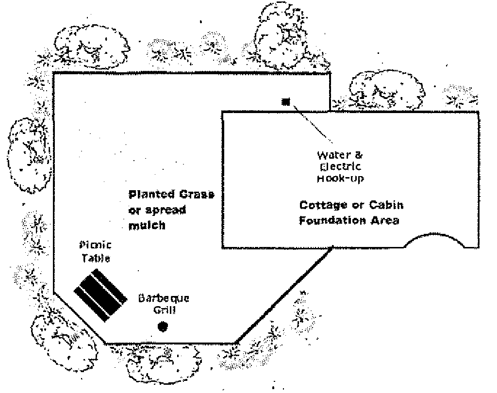
c.
Site access. Entrances and exits to the campground shall be designed for safe and convenient movement of traffic into and out of the campground and to minimize friction with free movement of traffic on adjacent streets. All traffic into and out of the campground shall be through such entrances and exits. No entrance or exit shall require a turn at an acute angle for vehicles moving in the direction intended, and radii of curbs and pavement at intersections shall be such as to facilitate easy turning movements for vehicles with trailers attached. No material impediment to visibility shall be created or maintained which obscures the view of an approaching driver in the right lane of the street within 100 feet of the intersection within the campground entrance.
d.
Parking. At least one parking space for each eight sites shall be provided for visitor parking in the campground.
e.
Internal campground roads. All internal campground roads shall be privately owned and maintained.
They shall be paved and meet standards, as approved by the city general services department. Campground roads shall have a minimum improved width as follows:
1.
The main or central road through the campground shall have a right-of-way width of not less than 28 feet exclusive of parking lanes.
2.
Roads other than the main road shall have a right-of-way width of not less than 14 feet per each travel lane.
3.
All walkways shall not be less than four feet in width.
f.
Open space/recreational facilities. A minimum of 20 percent of the site shall be set aside and maintained as open space for the recreational use of campground occupants. Such space shall be accessible and usable by all residents of the campground for passive or active recreation. Parking spaces, driveways, access streets, and storage areas are not considered to be usable open space. The percentage requirement may be reduced to 15 percent of the site if substantial and appropriate recreational facilities (such as recreational buildings, swimming pool or tennis courts) are provided.
g.
Setbacks. No cottage or cabin site shall be closer than 50 feet from any exterior campground property line abutting upon a major street or 25 feet from any other exterior campground property line.
h.
Landscaping/screening. All areas of campgrounds including perimeter setback areas not utilized for roadways, pathways, buildings maintenance yards and recreational facilities shall be landscaped. Landscaping shall consist of a combination of live vegetative ground cover, lawn, shrubs, trees, flowerbeds and ornamental shrub beds. All landscaping plans shall be approved in conjunction with the special exception process and shall be guided by the following:
1.
The first 15 feet of the campground perimeter shall [have] a natural vegetative buffer to obscure all campground activities from adjacent properties and roadways.
2.
All management offices, club houses and recreational buildings shall have border and foundation plantings on at least two sides of the building.
3.
All utility areas of park buildings shall be screened with landscaping, solid wood, brick, concrete or painted block fencing or combination thereof.
4.
All maintenance yards shall be sight screened by a solid wood, brick, concrete or painted block fence and various landscape elements.
i.
Landscaping/screening design and maintenance. All landscaping and screening shall be designed and maintained to be aesthetically pleasing to ensure the general welfare of the community is maintained. All trees, flowers, lawns and other landscaping features shall be maintained by the campgrounds management in a healthy growing condition at all times.
j.
Signs. Signs and advertising shall be prohibited in commercial campgrounds except:
1.
One freestanding sign in accordance with the city sign regulations.
2.
One identifying sign at each entrance of the campground, which may be indirectly lighted, but not flashing. Said sign(s) shall comply with the city sign regulations.
3.
Directional and information signs for the convenience of occupants of the campground.
k.
Utilities. All utilities within the campground shall be constructed and maintained in accordance with all applicable state and local codes.
l.
Electricity. Electricity shall be provided to each cabin or cottage.
m.
Water. Water shall be provided to each cabin or cottage. Within the urban service area the campground shall be connected to the city's community water system if the system is available within 200 feet of the campground. If the system is not within an urban service area or is within the urban service area, but is not within 200 feet of the city water system, the campground shall be served by a non-community drinking water system (as defined in Rule 62, F.A.C.). Community systems (per Rule 62, F.A.C.) are limited to parks within urban service areas.
n.
Sewer service. Sewer service shall be provided to all cottages or cabins. Within the urban service area the campground shall be connected to the city's community sanitary sewer system if the system is available within 200 feet of the campground. If the system is not within an urban service area or is within the urban service area, but is not within 200 feet of the city sanitary sewer system, the campground shall be served by an individual wastewater treatment facility in accordance with the rules of the health department or the Florida Department of Environmental Protection. Authorized waste water flow shall be as prescribed by the department of health for onsite septic systems.
Community sanitary sewer systems per the city's Comprehensive Plan are limited to parks within urban service areas.
o.
Solid waste disposal. Refuse containers shall be placed throughout the campground in convenient locations. Refuse containers must be screened from public view on three sides. All cabin sites shall be maintained free of litter and garbage. In addition to the refuse containers placed throughout the campground, at least one large (four yards or greater) container shall be located near the management building.
p.
Storm water management. All storm water drainage shall be contained on the campground or as part of a permitted master storm water system. Storm water control facilities require the design of a licensed Florida Engineer and approval of the Suwannee River Water Management District prior to approval of the special exception.
8.
Service buildings.
a.
Each campground shall be provided with one or more service buildings, which contain an adequate number of toilet and sanitary facilities. The minimum ratio of sanitary facilities to the number of campsites shall be provided according to the following schedule:
_____
* The providing of showers in the service building(s) is optional on the part of the campground owner, but when they are provided the following schedule will apply.
_____
b.
For campgrounds having more than 150 campsites located, in the opinion of the board of adjustment, contiguously to the service building or buildings required by the schedule in this section, there shall be provided one toilet seat and one lavatory for each sex for each additional 30 campsites, and one additional shower for each additional 40 campsites and one additional men's urinal for each 100 campsites. When a section or sections of a campground are found to be contiguous, the board of adjustment applies the schedule in the above section in determining the adequacy of the fixtures for such section. Whenever the number of campsites falls in between the numbers listed above, the larger number of required fixtures shall apply when a major fraction of the difference in the two numbers is attained.
c.
Primitive camps shall be exempted from the provisions for lavatories and showers. If, however, any showers are provided at a campground designated as a primitive camp, the schedule stated above shall apply.
d.
Where urinal troughs are used, two feet of urinal trough shall constitute one urinal.
e.
A slop sink or suitable drain shall be provided within 500 feet of all campsites for the disposal of liquid wastes unless a sanitary station is accessible for this purpose. Adequate provision shall be made by the operator of a campground to assure that the slop sink or other suitable drain, if necessary, is kept in a sanitary condition and is used for the purpose for which it was intended such as the disposal of dish water and wash water.
f.
Lavatories shall be provided adjacent to the toilet fixtures.
g.
When a campground is operated in connection with a resort or other business establishment, the total number of sanitary facilities shall be in excess of those required by the aforementioned schedules and shall be based on the total number of persons using such facilities.
h.
Service buildings shall be located no farther than 500 feet from any campsite served by such building, nor closer than 30 feet to any campsite. When two or more service buildings exist, the ratio of fixtures as specified in the above schedule shall be in approximate relation to the number of campsites located within a 500-foot radius of each building.
i.
All service buildings and the commodes, urinals, lavatories, shower and other appurtenances located therein shall be maintained in a state of good repair and shall be kept in a clean and sanitary condition at all times.
j.
All doors to the exterior from service buildings shall be self-closing.
k.
Toilet rooms, shower rooms and other areas receiving heavy camper use shall not be used for miscellaneous storage during operation of the camp.
l.
Toilet tissue shall be provided at each privy or toilet seat.
m.
Shower compartments, whether individual type with partitions or group type without partitions, shall have not less than 1,024 square inches in floor area and, if rectangular, square or triangular in plan, shall be not less than 30 inches in shortest dimension.
n.
In a campground where there is a combination of campsites, part of which are provided with a water connection and a sewer outlet, the minimum number of fixtures as required in the schedule above may be adjusted by the appropriate city and State of Florida permitting agency based on individual conditions.
9.
Structural requirements for service buildings.
a.
All portions of the structure shall be properly protected from damage by ordinary use and by decay and corrosion. Exterior portions shall be of such material and be so constructed and protected as to prevent entrance or penetration of moisture and weather.
b.
Effective ventilation of all service buildings shall be provided to prevent condensation, moisture and odors.
c.
Interior of service buildings shall be finished in a light color and provided with adequate natural or artificial illumination, or both.
d.
The floors of toilet and shower rooms shall be sloped to a properly trapped floor drain connected to the sewerage system.
e.
Partitions between flush toilets in the same room shall be raised a minimum of eight inches from the floor to permit easy cleaning.
f.
The interior finish of such buildings shall be of moisture resistant and easily cleanable material, which will withstand frequent washing and cleaning. Special attention shall be given wall finishes immediately around lavatories, urinals, and commodes and in showers to insure a surface in these heavily used areas, which will withstand commercial use.
g.
The floors shall be constructed of material impervious to water and be of easily cleanable material. Duck boards or walkways made of wood or other absorptive material shall not be permitted.
h.
All windows and openings to the outside from areas containing commodes and urinals shall be provided with fly-proof screening material of at least 16 mesh per inch.
i.
Water closets and bathing facilities shall not be located in the same compartment.
j.
Permanent service buildings shall be provided with an artificial light at the entrance to the building to facilitate its use at night: Provided that primitive camps with privies may be exempted from this requirement.
k.
Service buildings shall have appropriate signs to denote its use such as "men's toilet," "women's toilet," "showers," etc.
l.
Showers shall be equipped with a drain or drains, which will prevent the shower water from running across floors that are used for other purposes.
m.
All fixtures shall be of durable material, which will be capable of withstanding the heavy usage which public facilities receive.
10.
Garbage and refuse disposal.
a.
All garbage and refuse shall be stored in durable, watertight, rodent-proof, fly-proof containers with tight-fitting covers. All containers shall be maintained in a state of good repair, and shall be kept clean.
b.
Collection and disposal of garbage and refuse shall be in an approved manner, and of such frequency as to prevent a nuisance or health hazard to campers or adjacent areas.
c.
An adequate number of containers shall be provided for the depositing of garbage and refuse.
d.
Containers for garbage and refuse shall be supported in such a manner as to minimize tipping or spillage and the area around such containers shall be kept clean.
11.
Insect, rodent and weed control.
a.
Campsites shall be kept free from cans, jars, buckets, old tires and other articles which may hold water and provide temporary breeding places for mosquitoes. Mosquito control measures and supplemental larvicidal measures shall be undertaken by the owner when the need is indicated.
b.
Fly breeding shall be controlled by eliminating the insanitary practices which provide breeding places. The area surrounding the garbage cans shall not be permitted to become littered with garbage nor saturated with waste liquid from garbage.
c.
The growth of weeds, grass, poison ivy or other noxious plants shall be controlled as a safety measure and as a means toward the elimination of ticks and chiggers. Pesticidal measures shall be applied, if necessary provided the pesticide and its use is in accordance with State of Florida requirements.
d.
The campsite and the premises shall be maintained in a clean and orderly manner.
12.
Swimming pools and outdoor bathing facilities. The construction, modification, maintenance, operation and use of any swimming pool at a campground, if provided, shall be subject to the applicable requirements of the State of Florida and the uniform building code.
13.
Safety.
a.
The electrical installation and electrical hook-up provided campsites, and other similar units shall be in accordance with the provisions of the uniform building code of the State of Florida.
b.
Adequate precautions shall be exercised by the operator to prevent the outbreak of fires. If open fires are permitted, there shall be a definite area provided within the bounds of each campsite for the building of fires by the camper, with a cleared area surrounding the fire site to aid in fire control.
c.
Adequate precautions shall be taken by the operator in the storage and handling of gasoline, gas cylinders or other explosive materials, in accordance with local, state and national safety standards.
d.
The operator shall make adequate provisions for the use and control of mini-bikes, trail bikes and other similar vehicles within the confines of the camping area to prevent accidents to small children and campers.
e.
Broken bottles, glass and other sharp objects shall not be allowed to create a hazard to children or others.
14.
Storage and handling of liquefied petroleum gases. Filling plants may be located in the campground provided that the entire operation, including the storage container, is located not less than 50 feet from the nearest campsite; important buildings, or group of buildings, or line of adjoining property which may be built upon, and not less than 25 feet from any public street or highway. Such filling plant and storage containers shall be enclosed by man-proof fencing or otherwise protected from tampering or physical damage. The access to the enclosed area shall be kept locked when unattended.
15.
Control of animals and pets.
a.
Every pet permitted in a campground shall be maintained under control at all times and not be permitted to create a public health problem. Dogs shall be kept on leash at all times. Dung shall be removed immediately and be buried in a location, which will not interfere with the site for camping purposes.
b.
Any kennels, pens or other facilities provided for such pets shall be maintained in a sanitary condition at all times.
16.
Overflow areas.
a.
It shall be unlawful for any person operating a campground to exceed the design capacity of the campground as stated on the special exception permit by the use of certain unequipped areas as an overflow area for campers, camping clubs or rallies unless and until the overflow area and its proposed use have been approved by the city in writing as to the specific location of the overflow area, number and location of sanitary facilities, size and number of campsites and such other factors as may be deemed necessary to prevent overcrowding and the accompanying insanitary conditions.
b.
The length of stay of any camping unit permitted to use an area specifically designated and approved as an overflow area shall be limited to a 12-hour period.
17.
Waiver. One or more of the provisions in the above regulation may be waived in whole or in part when, in the opinion of the board of adjustment, there are factors or circumstances which render compliance with such provision(s) unnecessary; provided that such provision shall be specifically exempt in writing by the city.
4.2.38. Urban agriculture supplementary regulations.*
Urban agriculture is the growing of plants and raising animals within and around urbanized areas of the city. Urban agriculture may be applied to single family residential zoned districts to help create more sustainable and secure local food system by increasing opportunities to grow food.
These Land Development Regulations recognize the following different urban agriculture uses: Animal husbandry, community gardens.
4.2.38.1. Animal husbandry. Is a use where animals are reared or kept in order to sell the animals or their products, such as meat, fur or eggs, but does not include pet daycare centers, animal shelters, large scale breeding facilities or kennels.
Agricultural zoning districts. Permitted by right.
Residential zoning districts. Not permitted except through the following regulations related to the keeping of small livestock and domestic fowl.
Commercial zoning districts. Permitted only as specifically provided for by operation of a permitted use or special exception.
Industrial zoning districts. Permitted as provided in section 4.16.2.20 and section 4.16.12.
4.2.38.2. Keeping of small livestock in single-family residential zoning districts. Within single family residential zoning districts on a parcel greater than or equal to 20,000 square feet or more, the keeping of small livestock primarily as pets is not considered animal husbandry and may be permitted as a special exception.
4.2.38.3. Chickens, ducks, pigeons and pheasants in single-family residential zoning districts. Within single family residential zoning districts on a parcel greater than or equal to 10,000 square feet.
a.
Roosters are not permitted;
b.
Structures housing chickens, ducks, pigeons and pheasants must be located at least ten feet away from any residential structure on an adjacent lot;
c.
The keeping of said birds shall not exceed a total of four birds.
4.2.38.4. Reserved.
4.2.38.5. Reserved.
4.2.38.6. Community garden. A community garden is land managed or owned by a public or not-for-profit organization or group of individuals that is used to grow and sell plants and harvest and sell crops that were grown in the community garden. Community gardens are allowed in all zoning districts, subject to the following provisions:
a.
The total gross floor area of all structures for community garden use may not exceed 100 square feet on any parcel.
b.
Structures are limited to ten feet in height, including pitched roof.
c.
Structures are subject to the development standards of the applicable zoning district as applied to accessory structures. All structures require a building permit.
4.2.39. Rooftop solar photovoltaic systems.
1.
Rooftop solar photovoltaic systems, as defined in section 2.1, definitions, general, of these regulations, shall be allowed as a permitted use in all zoning districts.
2.
Within the historic district and for individually listed historic structures, additional regulations for installations shall apply as indicated article 11, historic sites and structures preservation regulations.
4.2.40. Solar energy facilities (Solar farms).
1.
Permitted districts. Solar energy facilities (Solar farms), as defined in section 2.1., definitions, general, of these regulations, shall be allowed as a permitted use in all agricultural, industrial, Planned Development and Planned Rural Residential Development districts.
2.
Permitted supporting facilities. Administrative buildings, control rooms/offices, storage and maintenance facilities, accessory equipment buildings, access roads, stormwater management facilities, substations, distribution and transmissions towers, parking, power lines and battery and similar solar energy systems are deemed to be permitted supporting facilities for solar farms.
3.
Performance standards. Solar farms (and their permitted supporting facilities) shall be consistent with the following performance standards:
a.
Provide no less than 25-foot setbacks on all sides of the site except for ingress and egress corridors. If natural vegetation is present in the setback area, it must be left undisturbed. Where the perimeter is adjacent to an existing residence, a 20-foot vegetative buffer shall be planted by the applicant within the setback area, such that the view of the solar facility from the residence is effectively obscured within five years. The vegetative buffer shall be planted with native species of trees and shrubs that will mature to full opacity within five years of initial planting, and shall be maintained by the applicant until fully established. Setback areas may contain access roads, barriers or security walls, fences, and crossings by linear facilities, provided that any required vegetative buffers are maintained;
b.
Provide compensatory storage for development in the 100-year floodplain consistent with local and state standards;
c.
Connect to central sanitary sewer, if available, or provide onsite treatment for domestic wastewater. Septic tanks shall be allowed in accordance with applicable provisions of local and/or state regulations, including the Comprehensive Plan.
4.
If supporting buildings are erected to support operation of the electrical generating facility, such buildings shall:
a.
Occupy no more than five percent of the total acreage of the site;
b.
Provide sufficient parking spaces for permanent employees and operational business activities;
c.
Be a maximum of 35 feet in height;
d.
Provide a minimum front yard of 30 feet, a minimum side yard of 15 feet, and a minimum rear yard of 25 feet. No landscaping shall be required within the yard. One-half of the yard may be used for parking.
5.
The following maximum height provisions shall apply:
a.
Security fencing: eight feet,
b.
Project signs nine feet,
c.
Solar panels or modules: 15 feet,
d.
Transmission lines or substations: None.
6.
A minimum 20-foot wide, clear access way with a 12-foot wide, stabilized access path shall be permitted for access, maintenance and operation of solar facilities and transmission lines.
7.
A minimum 20-foot wide, stabilized access path shall be permitted for access, maintenance and operation of administration buildings, accessory buildings and substations.
8.
Site and development plans review procedures for solar farms:
a.
Site and development plans shall be submitted in accordance with section 14.12.1.
b.
Five sets of data required for site and development plan approval shall be submitted to the Land Development Regulation Administrator together with the payment an application fee established by the city.
c.
The Land Development Regulation Administrator shall circulate the plans to any other city official or department which may have responsibility for some aspect of the site and development plan.
d.
A site and development plan for a solar farm consistent with all the standards outlined in this section and all other applicable LDR requirements shall be approved, approved with conditions, or denied by the Land Development Regulation Administrator within 30 days of receipt of the initial application. Site and development plans for a solar farm that require a variance or modification to the standards outlined in this section or any other applicable LDR section shall be approved, approved with conditions, or denied in accordance with the process outlined in LDR Section 14.12.
4.2.41. Commercial kennels, veterinary clinics and small animal boarding facilities.
1.
Commercial kennels, veterinary clinics and small animal boarding facilities located on an arterial highway within the agricultural zoning district may be allowed by special exception, subject to conformance with the following standards:
a.
The minimum lot area shall be four acres.
b.
The structures housing the dogs or other domesticated animals (excepting horses and livestock, which are listed separately) shall be completely enclosed and designed to suppress noise. Noise from the boarded animals at the property line shall be subject to the City's noise regulations.
c.
The structures housing dogs or other domesticated animals and any outdoor areas allocated for use by such animals shall be located a minimum of 50 feet from any property line and 200 feet from any residential zoning district.
d.
A minimum of a 25-foot landscape buffer shall be provided between the facility and adjacent properties.
e.
The use of outdoor areas by the animals shall occur no earlier than 7:00 a.m. and no later than 9:00 p.m.
f.
Overnight boarding shall be limited to no more than 30 consecutive days.
g.
Veterinary clinics that do not provide overnight boarding services are not subject to the four-acre minimum lot size requirement.
4.2.42. Tiny home neighborhoods.
4.2.42.1. Intent. Tiny home neighborhoods are intended to provide opportunities for creative, diverse and high quality infill development, promoting a sense of community, and offering a variety of housing types and sizes available within the development to meet the needs of a population diverse in age, income, and household composition; provide a more efficient use of land while encouraging creation of more usable open space for neighborhood residents; and provide a means to maximize resident- and pedestrian-oriented outdoor spaces and minimize the impact of automobile traffic and parking.
4.2.42.2. Tiny home neighborhoods are allowed only by special exception in the A, RSF-2, RSF-3, RSF/MH-2, RSF/MH-3, RMH, RMH-P, and RMF Zoning Districts when incorporated into existing residential districts. In the MU, PRD, and PD zoning districts, tiny home neighborhoods may be developed as part of an approved development order and master plan, provided that the tiny home neighborhood portion of the development constitutes no more than 30 percent of the overall residential component of the development. Further, within the MU, PRD, and PD zoning districts, tiny homes are allowed only in a tiny home neighborhood within the larger development and are not allowed to be individually scattered throughout the development.
4.2.42.3. Requirements, general.
1.
Tiny home. A tiny home, as defined in section 2.1, shall be built consistent with the requirements set forth in these regulations. The size of tiny homes is based on the Florida Building Code as to minimum living space requirements with a maximum of 600 SF allowed. Tiny homes may be located on individually platted lots or on a common ownership lot that is not platted and may be provided as single units or as duplex buildings. Homes must be site built or of modular construction on an approved permanent foundation; manufactured homes constructed and inspected in accordance with federal regulatory requirements may only be permitted in areas zoned for manufactured homes.
2.
Neighborhood size. In all residential districts, tiny home neighborhoods shall be on lots a minimum of one acre in size, and a maximum of three acres. A minimum of four homes and a maximum of 12 homes per acre are allowed around any common area in a tiny home neighborhood. In Agricultural districts, tiny home neighborhoods are limited to a minimum of five-acres and a maximum of ten acres, with a maximum of three tiny homes per each five acres. Tiny home neighborhoods may be incorporated by right within new Mixed Use, Planned Residential Developments and Planned Developments, or within specified existing residential districts by Special Exception, unless otherwise provided in these regulations, and must be developed consistent with the development and design standards provided in Section 4.2.42.
3.
Common area. A centralized common area shall be provided in the development in accordance with the design requirements for tiny home neighborhoods provided herein.
4.
Common buildings. One community building per neighborhood is allowed. Community buildings may contain, but are not limited to, a club house, a common dining area, kitchen, bathroom, laundry facilities, one sleeping quarters for guests and/or storage. The maximum size of a community building is 2,500 square feet. Common buildings shall meet Florida Building Code and Florida Fire Prevention Code standards for Occupancy Classification of the structure.
5.
Density. In accordance with the City of Newberry Comprehensive Plan's Future Land Use Element policies for tiny home developments in the Agriculture, Low Density Residential, Medium Density Residential, Mixed Use and Planned Development Future Land Use categories, tiny home neighborhoods may develop at two times the maximum units per acre of the zoning district designation.
6.
Lot requirements. Tiny home neighborhoods may be developed either by platting separate lots for each home, or by locating all homes on a common ownership community lot. All lots are exempt from the lot size and dimension requirements of the zoning district in which they are located; instead, the following requirements apply:
a.
For tiny home neighborhoods with individually platted lots, the minimum lot area per dwelling unit shall be in accordance with the minimum lot width and depth standards provided below, with a maximum lot coverage of 40 percent for structure, and 30 percent for porches and drives. Excluding those lots required for open space, stormwater management, and other site functions, the following minimums apply:
i.
Width. Minimum lot width shall be 20 feet.
ii.
Depth. Minimum lot depth shall be 50 feet.
iii.
For tiny home neighborhoods on a common ownership lot that is not platted, lot requirements specific to each tiny home neighborhood development shall be specified on the approved site plan.
7.
Access. Tiny home neighborhoods shall have direct access to a paved, publicly maintained street, with a maximum two points of ingress/egress allowed serving internal driveways and parking. All private roads, drives or alleys shall be consistent with Section 5.26 - Streets.
8.
Emergency access. For neighborhoods with common parking areas, stabilized access shall be provided such that the farthest distance from a structure to the stabilized surface is 150 feet. The stabilized access shall be consistent with Section 5.26 - Streets.
9.
Setbacks. All zoning district setbacks shall be applicable from the property boundaries and not from internal individual platted lots. Required buffers may be located within the setback.
a.
Modified setbacks specific to each tiny home neighborhood development shall be specified on the approved site plan.
b.
No portion of a tiny house or appurtenance shall be constructed as to project into any commonly owned open space.
c.
No structure or portion thereof shall be closer than ten feet to any structure on the same lot or on an adjacent lot.
10.
Neighborhood boundary buffers. A 15-foot wide landscaped buffer area, shall be required along property lines adjacent to existing platted subdivisions or lots in excess of 7,500 square feet with an existing single family residence.
11.
Landscaping. Landscaping shall be consistent with section 4.2.11. "Landscaped buffer areas", and in compliance with the additional design requirements for tiny home neighborhoods provided herein.
12.
Open Space. Open Space shall be provided in accordance with an approved special exception or development order and master plan specific to each tiny home neighborhood, per the zoning district in which the tiny home neighborhood is located, subject to the additional design requirements for tiny home neighborhoods provided herein.
13.
Stormwater. Stormwater management provision shall be consistent with Article 7. - Stormwater Management Regulations and any additional design requirements for tiny home neighborhoods provided herein.
14.
Utilities. Tiny home neighborhoods shall be served by potable water and centralized sanitary sewer where available. In the Agriculture zoning district, where central water and sewer are not available, a maximum three tiny home dwelling units per five acres is allowed.
15.
Maintenance of open space, common areas, roads and drives, and utilities. The applicant shall ensure that joint use and maintenance of common areas and open space, community facilities, private roads and drives, and all other commonly owned and operated property is guaranteed through a recorded maintenance plan, covenants, deeds and/or homeowners' association by-laws. As part of any application for development approval of a tiny home neighborhood, a copy of proposed language for these documents shall be submitted for review by the city. For platted developments, such documents and conveyances shall be accomplished and be recorded, as applicable, with the county as a condition precedent to the filing of any final plat of the property or division thereof, except that the conveyance of land to a homeowners' association may be recorded simultaneously with the filing of the final plat.
4.2.42.4. Design Requirements.
1.
Centralized common area. Each tiny home neighborhood shall have a centralized common open space area which includes usable public spaces such as lawn, community gardens, patios, plazas or scenic viewing area. Common tables, chairs and benches are encouraged, with all houses having access. The centralized common area shall be designed to meet the following:
a.
A minimum 400 square feet of common open space is required per unit.
b.
The principal common area shall be centrally located to the development. Additional common open space may account for up to 25 percent of the total requirement with trails and pathways connecting the total development. Passive trails are allowed and may count towards the common open space requirement.
c.
Community buildings or clubhouses may be counted towards the common open space calculation.
d.
Tiny homes shall surround the centralized common open space on a minimum of two sides of the open space area.
e.
The centralized common area may include stormwater management facilities incorporating low impact development designs provided that a minimum of 400 square feet per dwelling unit is usable by the residents for active or passive recreation.
2.
Porches. All homes shall include a useable open-air covered front porch.
a.
The porch shall be oriented toward the common open space. Porches shall be of a usable size on the common open space side of the building.
b.
Alternatives to the required front porch may be considered if justified by the design characteristics of the architectural style chosen.
c.
Secondary entrances facing parking and sidewalk shall have a minimum five-by-five-foot porch.
3.
Parking. Parking may be provided in a common lot or a common garage. Parking may alternately be co-located with the tiny homes when accessed by drive aisles. All parking must meet the following standards:
a.
A minimum of 1.5 spaces per unit shall be provided.
b.
All common parking areas and associated drive aisles adjacent to neighboring residential property must be screened in addition to the required landscaped buffer area.
c.
Under no circumstances shall common parking areas be located on or directly access public rights of way.
d.
Designated common area for the parking of campers, travel trailers, recreational trailers and vehicles, boats and boat trailers, and other similar vehicles may be provided by the developer. Where these dedicated common storage areas are proposed, they shall be screened from view from adjacent properties by a minimum eight-foot tall opaque fence and a 15-foot wide landscaped buffer.
4.
Pedestrian access. A system of interior walkways shall be provided to connect all homes with each other, the parking areas, common areas and open space, and any sidewalks along the public street(s) bordering the tiny home neighborhood. Interior walkways shall meet applicable ADA accessibility requirements.
5.
Fencing Fencing within the development is limited to a maximum of 50 percent opacity and no greater than four feet in height may be used to delineate private yards. gardens or other areas. Solid fencing may be allowed along external borders not bordering streets.
6.
Architectural Design. Florida Vernacular is the preferred architectural style. However, Other architectural styles are permissible, provided that the architectural style is applied to each structure in the tiny home neighborhood. Architectural design plans, including renderings of the overall neighborhood as well as individual house elevation plans, shall be submitted and approved as part of the development approval for any tiny home neighborhood. The approved architectural style is also required for any shared common buildings. Architectural elevations shall include features based on the following options:
a.
Roof. Architectural shingles or galvalume metal roof acceptable. A metal panel five-seam or metal shake roof is acceptable. A five-tab 25-year dimensional shingle roof or manufactured equivalent of a wood shake roof is acceptable. Three-tab shingles, barrel vaulted tiles or corrugated roof systems are not permissible. A hipped and/or gable main roof is acceptable, as well as use of exposed rafters and secondary roofline features.
b.
Front porch. The required useable open-air covered porch must encompass an area greater than 50 percent of the front façade (see "2. Porches" earlier in these design requirements).
c.
Exterior finish. Manufactured brick or materials that have the appearance of brick are acceptable. Horizontally struck stucco, exterior insulated finish system stucco panels, board and batten, wood or vinyl siding, and stained hardwood panels shall also be considered acceptable finishes. Brick wainscot may also be used.
d.
Color. If applying the Florida Vernacular stye, the predominant exterior color shall be consistent with the historic palates of North Florida. These include but are not limited to pastel shades, white; earth tones and brick. The predominant exterior color shall be applied to all sides of the structure regardless of architectural style.
e.
Trim. Gingerbread trim and/or porch railings, columns or posts shall have the appearance of light frame wood construction. Trim shall be considered railings, columns, door and window surrounds, soffits, shutters, gutters and downspouts, and other decorative elements. Trim finishes shall be of a contrasting compatible color to the primary building color.
f.
Blank wall area limits. No contiguous blank wall area shall exceed 400 square feet that remains unadorned by architectural features that include, but are not limited to, windows, doors, lights, banding trim or porch elements.
g.
Metal-clad structures that meet the required approved design standards are permissible. Internal bracing must be certified to accept additional finishes or structures applied to the exterior metal panels. No external "X" bracing is to be visible on any exterior surface. Finish panels must be able to accept a painted finish. All exterior wall finishes must match the primary building color. The use of corrugated, metal, synthetic or fiberglass panels is prohibited on any exterior wall or roof surface. All design requirements must be met for metal-clad structures as for any other new structure.
h.
Compliance with the requirements set forth in this subsection shall be demonstrated by submittal of building front elevations and color and material samples at the time of site plan review.
i.
Before approval is granted, the applicant shall submit covenants, deeds and homeowners' association bylaws and other documents that specify the Florida Vernacular or other architectural design requirements, and guaranteeing maintenance and common fee ownership of public open space, community facilities, private roads and drives, and all other commonly owned and operated property.
4.2.43. Small-scale rural subdivisions.
4.2.43.1. Intent. Small-scale rural subdivisions allow for the development of estate-style residences in areas that generally lack public services and facilities necessary for higher density development and provisions for ancillary low-intensity agricultural uses within the "A" Agricultural zoning district. The small-scale rural subdivision shall ensure the compatibility of development within the agricultural areas of the city, encourage the highest and best use of agricultural lands, mitigate urban sprawl and impacts on existing active agricultural uses, protect historical and natural resources, and provide housing and economic opportunity.
1.
Permitted uses specific to the small-scale rural subdivision special exception:
a.
Site-built, detached single-family dwelling units.
b.
Low-intensity agricultural uses and storage ancillary to same.
c.
Common area, open space, and common/community buildings incidental to the development.
d.
Accessory dwelling units consistent with Appendix B, Article 4, Section 4.2.4.2 of the City of Newberry Code of Ordinances.
2.
Prohibited uses:
a.
Any use not specifically permitted in Section 4.2.43.1.1 above.
3.
Lot requirements (area, width, maximum lots, etc.). Minimum lot area: Two (2) gross acres. Maximum lot area: Five (5) gross acres. Minimum lot width: 150 feet.
In no case shall the total number of developable lots exceed 25.
4.
Common area requirements.
a.
Minimum common area: 15% of gross subdivision area.
i.
Common areas and required site improvements shall not have a maximum area requirement except those minimums set out herein.
ii.
Common areas shall not be encumbered by required storm water management or retention areas.
iii.
Common areas shall be active or passive open space uses incidental to a residential development.
iv.
All common area spaces and facilities must be completed or occupiable prior to the issuance of a Certificate of Occupancy for the first dwelling unit.
b.
Subdivisions with a density equal to or greater than one (1) unit per three (3) gross acres are exempt from providing common area.
5.
Separation requirements. Small-scale rural subdivisions shall not be located within 2,000 linear feet of another as measured from the centerline of the access driveway(s) of the subdivision.
6.
Location requirements. Small-scale rural subdivisions must be bordered on 100% of its perimeter by agricultural zoning districts, excluding the subdivision boundary abutting the public right-of-way, and in no case shall the subdivision abut intensive agricultural uses, active mining operations, or land pending approval of a mining license.
7.
Minimum yard requirements (depth of front and rear yard, width of side yard).
a.
All permitted uses and structures (unless otherwise specified):
Front yard: 35 feet.
Side yard: 25 feet. Rear yard: 50 feet.
8.
Maximum height of structures. No portion shall exceed 35 feet (see also Section 4.2).
a.
In no case shall a primary or accessory structure or appurtenances thereto be located within 80 feet of the abutting public right-of-way, as measured from the adjacent subdivision boundary line or limit.
9.
Supplemental site development requirements.
a.
Building orientation. Permitted structures must face and be oriented towards the internal access road.
b.
Access.
i.
Small-scale rural subdivisions must have direct access to a paved, publicly maintained right-of-way with a maximum of two (2) points of ingress/egress connecting to internal driveways.
ii.
Ingress or egress to a State of Florida owned or maintained right- of-way shall be prohibited.
iii.
All internal private roads, drives, or alleys shall be consistent with Standard C of the Street Improvement Schedule referenced in Appendix B, Article 5, Section 5.26 - Streets of the City of Newberry Code of Ordinances.
iv.
All internal roads, drives, or alleys shall be owned and maintained in perpetuity by the entity which holds rights to the homeowners' association.
v.
Driveway connection to a public road requires issuance of a permit by the authority having jurisdiction over same.
c.
Stormwater management basins and on-site water retention requirements. Stormwater management basins and on-site water retention areas shall be located, to the greatest extent possible, in the yard abutting the internal, private right(s)-of-way. Exceptions due to topology may be granted by the Land Development Regulation Administrator as evidenced by justification from the governing drainage or water management district.
d.
Buffer requirements.
i.
Subdivisions shall have a 25-foot undisturbed perimeter buffer except where access is provided or other natural features, including but not limited to, wetlands, rocky outcrop, bluff, or other natural feature would otherwise prevent the planting and cultivation of a sustainable tree line.
ii.
A 5-foot path may be cleared at the exterior perimeter of the undisturbed buffer for the sole purpose of construction and maintenance of a perimeter fence or wall.
iii.
Subdivisions shall provide not less than 50 feet of undisturbed buffer along the subdivision boundary lines that abut a public right-of-way, except where that subdivision abuts more than one (1) public right- of-way, then the 50-foot buffer shall be provided along the shortest street frontage.
iv.
Undisturbed buffers along subdivision boundary lines abutting a public right-of-way that do not have 100% canopy coverage, exempting areas designated for access to public right-of-way, shall require the planting of canopy trees, understory trees, and ground cover to provide opaque screening at maturity.
v.
All required buffers must be established in a buffer easement created by separate instrument and recorded into the public records of Alachua County prior to the issuance of a Certificate of Completion or Occupancy.
e.
Utilities.
i.
Small-scale rural subdivisions shall be required to maintain on-site septic and well facilities unless within 800 feet of public potable and wastewater services or otherwise required by a local or regional water management or drainage district, utility purveyor, state agency, or federal agency to connect to public potable and sanitary sewer facilities.
ii.
Within individual lots, residential development shall connect to a single septic system.
iii.
Electrical lines shall be located and buried under and adjacent to internal road or within an easement in the front yard.
f.
Dark-Sky requirements.
i.
All exterior light fixtures and bulbs shall be generally compliant with Dark-Sky requirements by providing a fully shielded light source or is a fixture that has aftermarket shields available that provide for same.
ii.
LEDs and bulbs measuring less than or equal to 3000-kelvin shall be permitted.
iii.
Individual lots shall not exceed a maximum of 2 footcandles at any point measured within the lot.
iv.
Light spillage as measured at the property line shall not exceed 0.5 footcandles excluding lot lines abutting public rights-of-way or internal roads.
v.
Photometric plans shall be required to demonstrate compliance with iii and iv of this subsection if it is determined by the Land Development Regulation Administrator that excessive lighting is proposed or a property is the subject of an active Code Enforcement violation related to lighting inconsistent with these regulations.
g.
Fences and walls.
i.
Where provided, all fencing and walls abutting, adjacent, or visible from the public right-of-way shall be thematically consistent with the development design, decorative in nature, and incorporate drought tolerant ground cover at the base.
ii.
Blank areas of walls shall not exceed 400 square feet in area.
iii.
Fences and walls may be permitted at the external edge of the undisturbed buffer.
iv.
Field and chain-link fencing are permitted interior to the perimeter undisturbed buffer and shall not, in any case, be visible from the public rights-of-way.
v.
Perimeter fences and walls shall not 6 feet in height.
vi.
Access driveway gates shall not exceed 8 feet in height including decorative elements.
vii.
Interior lot fences shall not exceed 4 feet in height beyond the front plane of the primary structure.
viii.
Decorative elements may project 2 feet above the maximum height of the permitted fence and/or wall height.
ix.
Retaining walls shall not exceed 3 feet above the adjacent grade as measured 1 foot outward from the face of the retaining wall.
x.
Fencing may be placed on retaining or knee walls at the height to not exceed the allowable height of the retaining wall and fence, however, if located in the required front yard, fencing placed on top of retaining walls must be less than 50% opaque.
h.
Parking requirements. There shall be no minimum parking requirement, however, all parking and storage of agricultural vehicles shall be wholly screened from view from the public rights-of-way.
i.
Establishment of a homeowners' association. The applicant shall submit covenants, deeds, and homeowners' association bylaws and/or other documents that guarantee maintenance and common fee ownership of public open space, community facilities, private roads and drives, and all other commonly owned and operated property which shall be recorded into the Public Records of Alachua County, Florida prior to the issuance of a Certificate of Completion or Occupancy.
j.
Tree preservation requirements.
i.
Prior to the commencement of work or issuance of a building permit, a good faith effort must be made by the landowner to identify and preserve "champion trees" eligible for listing on the National Register of Champion Trees published by the American Forests Organization in the form of a mitigation plan signed and sealed by a Florida registered or licensed professional.
ii.
To the greatest extent possible, existing trees adjacent to the internal access road shall be preserved.
k.
Further subdivision of lots. No lot within a Small-Scale Rural Subdivision may benefit from the subdivision of lots from its original platted boundaries as provided in Appendix B, Section 14.9 of the City of Newberry Code of Ordinances, entitled "Special permits for family lots," and shall be noted on the face of the plat recorded into the public records of Alachua County, Florida.
(Ord. No. 7-03, § 1, 6-9-2003; Ord. No. 16-03, § 1, 9-8-2003; Ord. No. 10-04, § 1, 7-12-2004; Ord. No. 3-05, § 1(4.2.10), 1-24-2005; Ord. No. 13-05, § 1(4.2.11.1), 4-25-2005; Ord. No. 18-06, § 1, 8-28-2006; Ord. No. 07-07, § 1, 3-12-2007; Ord. No. 12-08, § 1, 5-12-2008; Ord. No. 19-08, § 1, 8-11-2008; Ord. No. 21-08, § 1, 10-27-2008; Ord. No. 04-10, § 1, 5-24-2010; Ord. No. 07-10, § 1, 5-24-2010; Ord. No. 08-10, § 2, 5-24-2010; Ord. No. 11-11, § 1, 1-9-2012; Ord. No. 13-11, § 1, 11-14-2011; Ord. No. 03-12, § 2, 5-14-2012; Ord. No. 08-12, § 2, 6-11-2012; Ord. No. 16-12, § 5, 11-26-2012; Ord. No. 2015-09, § 2, 8-24-2015; Ord. No. 2016-06, § 1, 5-23-2016; Ord. No. 2018-01, § 1, 3-26-2018; Ord. No. 2019-03, § 1, 3-25-2019; Ord. No. 2019-13, § 1, 6-10-2019; Ord. No. 2019-15, § 1, 7-22-2019; Ord. No. 2021-01, § 1, 3-8-2021; Ord. No. 2021-10, § 1, 4-12-2021; Ord. No. 2021-15, § 1, 4-12-2021; Ord. No. 2022-19, § 1, 3-14-2022; Ord. No. 2022-27, § 2, 7-25-2022; Ord. No. 2024-06, § 1, 3-11-2024; Ord. No. 2025-05, § 1, 6-9-2025; Ord. No. 2025-74, § 1, 2-9-2026)
Editor's note— Ord. No. 16-12, § 5, adopted November 26, 2012, set out provisions intended for use as § 4.2.37. For purposes of classification, and at the editor's discretion, these provisions have been included as § 4.2.38.
Editor's note— Ord. No. 10-04 contained two subsections numbered "4.2.33.2."
Section 4.3. - CSV Conservation.
4.3.1. Districts and intent. The CSV Conservation category includes one zone district: CSV. Lands within this district are devoted to the conservation of the unique natural functions. To conserve these lands, no use other than forestry in accordance with the city's Comprehensive Plan and nonintensive resource-based recreation activities.
4.3.2. Permitted principal uses and structures.
1.
Nonintensive resource-based recreation activities.
2.
Forestry in accordance with the city's Comprehensive Plan.
4.3.3. Permitted accessory uses and structures.
1.
Uses and structures which:
a.
Are customarily accessory and clearly incidental and subordinate to nonintensive resource-based recreation activities.
2.
Examples of permitted accessory uses and structures include:
a.
Forestry stations and scientific stations for the study of the natural resources within the conservation district.
b.
Residential facilities for caretakers.
c.
Boat docks and boat ramps.
4.3.4. Prohibited uses and structures.
1.
Residential uses (except forestry stations or scientific stations for the study of the natural resources within the conservation district and residential facilities for caretakers).
2.
Any use or structure not specifically, provisionally or by reasonable implication permitted herein or permissible as a special exception.
4.3.5. Special exceptions. (See also articles 12 and 13.)
1.
Recreational activities such as campsites and similar uses.
4.3.6. Minimum lot requirements. None, except to meet other requirements as set out herein.
4.3.7. Minimum yard requirements. (See section 4.2 for right-of-way setback requirements.)
Special provisions:
The location of any structure (except permitted docks, walkways and piers) shall be set back a minimum of 35 feet from wetlands.
The location of any structure (except permitted docks, walkways and piers) shall be set back a minimum of 35 feet from perennial streams and creeks.
4.3.8. Maximum height of structures. No portion shall exceed 35 feet (see section 4.2, exclusion from height limitations).
4.3.9. Maximum lot coverage by all buildings. None.
4.3.10. Minimum landscaped buffering requirements. None.
4.3.11. Minimum off-street parking requirements. None.
(Ord. No. 7-03, § 2, 6-9-2003; Ord. No. 16-03, § 2, 9-8-2003)
Section 4.4. - "A" Agricultural.
4.4.1. Districts and intent. The "A" Agricultural category includes one zone district: A. Lands in this district are intended to provide for areas primarily consisting of agricultural and residential uses consistent with the areas as designated agricultural within the city's Comprehensive Plan.
4.4.2. Permitted principal uses and structures.
1.
All agricultural activities (excepting intensive agriculture, material-oriented industrial development, mining activities as defined in section 2.1 and as provided for as a special permit in article 14 herein and not including livestock or poultry slaughterhouses), including the raising of livestock and poultry, the production of dairy and poultry products, the cultivation of field crops and fruits and berries, forestry in accordance with the Comprehensive Plan, apiculture, and similar uses; provided, that no structure used for housing of animals or any commercial feed lot operation shall be located within 300 feet of any lot line, and no structure used for housing domestic animals shall be located within 100 feet of any lot line (excepting that the keeping of no more than two horses in on parcels less than 10 acres in size may be housed in a barn or stable that is located within 25 feet of the adjacent properties).
2.
The processing, storage, and sale of agricultural products and commodities which are raised on the premises (but not including livestock or poultry slaughterhouses); provided, that no building used for these activities shall be located within 300 feet of any side or rear lot line.
3.
Single-family dwellings.
4.
Mobile homes.
5.
Plant nurseries and greenhouses.
6.
Homes of six or fewer residents which otherwise meet the definition of a "community residential home" (see section 4.2).
7.
Solar energy facilities (solar farms) as defined in Section 2.1. Solar Farms shall be regulated in accordance with Section 4.2.40.
4.4.3. Permitted accessory uses and structures.
1.
Uses and structures which:
a.
Are customarily accessory and clearly incidental and subordinate to permitted uses and structures.
b.
Are located on the same lot as the permitted principal use or structure or on a contiguous lot in the same owner
c.
Do not involve operations or structures not in keeping with the character of the district.
d.
Are Accessory Dwelling Units as defined in Section 4.2.4.2.
e.
Are utility sheds and carports, (refer to Section 4.2.4.).
f.
Are administratively approved permanent or temporary accessory structures within the required rear yard setback up to the rear property line, complying with Section 4.2.4.1.
2.
Examples of permitted accessory uses and structures include:
a.
Barns and stables;
b.
Private garages;
c.
Private swimming pools;
d.
On-site signs (see section 4.2); and
e.
Residential facilities for caretakers whose work requires residence on the premises or for employees who will be quartered on the premises.
f.
Administration and maintenance buildings, transmission lines, substations, energy storage equipment, and related accessory uses and structures for solar farms.
4.4.4. Prohibited uses and structures. Junk yard or automobile wrecking yard, intensive agricultural uses as defined in section 2.1 and located within areas designated as high groundwater aquifer recharge as identified on the map entitled "Recharge Potential of the Florida Aquifer System, Alachua County, Florida", prepared by the Suwannee River Water Management District, as of December 2004; and any use or structure not specifically, provisionally or by reasonable implication permitted herein as a special exception.
4.4.5. Special exceptions. (See also articles 12 and 13.)
1.
The processing, storage and sale of agricultural products and commodities which are not raised on the premises; provided, that no building used for these activities shall be located within 300 feet of any side or rear lot line.
2.
Livestock auction arenas.
3.
Livestock or poultry slaughterhouses; provided, that no building used for these activities shall be located within 300 feet of any lot line.
4.
Sawmills and planing mills; provided that no building used for these activities shall be located within 300 feet of any side or rear lot line.
5.
Agricultural equipment and related machinery sales.
6.
Agricultural feed and grain packaging, blending, storage and sales.
7.
Agricultural fertilizer storage and sales.
8.
Agricultural fairs and fairground activities.
9.
Riding or boarding stables; provided that no building used for housing of animals shall be located within 300 feet of any lot line.
10.
Commercial kennels, veterinary clinics and animal shelters; provided that no open runs or open-air structures used for housing of animals shall be located within 300 feet of any lot line. Commercial kennels, veterinary clinics, and animal shelters meeting the criteria outlined in Section 4.2.41 may be located within 50 feet of any adjacent property line.
11.
Group living facilities.
12.
Crematories.
13.
Airplane landing fields.
14.
Public buildings and facilities, unless otherwise specified (see section 4.2).
15.
Private clubs and lodges.
16.
Off-site signs (see also section 4.2).
17.
Churches and other houses of worship, and accessory parochial elementary, middle schools and high schools offering curricula comparable to that of public schools.
18.
Cemeteries and mausoleums.
19.
Child care centers (see also section 4.2.33).
20.
Recreational vehicle parks and commercial campgrounds.
21.
Public and private recreational uses related to the city's sports tourism economic development program, to include but not be limited to competitive sport venues, equestrian parks, waterparks, arenas and amphitheaters, motor sport competition venues including racetracks and accessory uses such as associated resorts, campgrounds, recreational vehicle parks.
22.
Tiny Home Neighborhoods, as defined in Section 2.1 and regulated in accordance with Section 4.2.42.
23.
Small-scale rural event centers related to agricultural uses, agritourism, wedding venues, and/or wellness retreats to include but not be limited to recreation, entertainment, and/or educational experiences, and accessory uses such as associated sales of agricultural products grown on or off premises, beer gardens, farm-to-table cafes, food truck plazas, outdoor health & wellness activities. For the purposes of this small-scale rural event center special exception, "small-scale" is defined as 300 or fewer participants/attendees.
24.
Small-scale rural subdivisions, subject to the policies and regulations provided in the supplemental district regulations referenced in Appendix B, Article 4, Section 4.2.43 of the City of Newberry Code of Ordinances.
4.4.6. Minimum lot requirements (area, width).
1.
Single-family dwellings, mobile homes and group living facilities:
Minimum lot area: Five acres.
Minimum lot width: 270 feet.
2.
All other permitted uses and structures (unless otherwise specified):
None, except as necessary to meet other requirements as set out herein.
4.4.7. Minimum yard requirements (depth of front and rear yard, width of side yard). (See section 4.2 for right-of-way setback requirements.)
1.
All permitted uses and structures (unless otherwise specified):
Front: 30 feet.
Side: 25 feet.
Rear: 25 feet.
Special provisions:
The location of any structure (except permitted docks, walkways and piers) shall be set back a minimum of 35 feet from wetlands.
The location of any structure (except permitted docks, walkways and piers) shall be set back a minimum of 35 feet from perennial streams and creeks.
4.4.8. Maximum height of structures. (See also section 4.2 for exceptions.)
No portion shall exceed: 72 feet (see section 4.2, exclusion from height limitations).
4.4.9. Maximum lot coverage by all buildings.
20 percent.
Note: In addition to meeting the required lot, yard, building height, lot coverage, landscaped buffering, and off-street parking requirements of this section, no structure shall exceed a 1.0 floor area ratio.
4.4.10. Minimum landscaped buffering requirements. (See also section 4.2.)
1.
All permitted uses and structures (unless otherwise specified):
None, except as necessary to meet other requirements as set out herein.
4.4.11. Minimum off-street parking requirements. (See also section 4.2.)
1.
Residential dwelling units: Two spaces for each dwelling unit.
2.
Elementary and junior high schools: Two spaces for each classroom or office room, plus one space for each three seats in any auditorium or gymnasium.
3.
Senior high school: Four spaces for each classroom or office room, plus two spaces for each three seats in any auditorium or gymnasium.
4.
Churches or other houses of worship: One space for each six permanent seats in the main auditorium.
5.
Public buildings and facilities (unless otherwise specified): One space for each 200 square feet of floor area.
6.
Private clubs and lodges: One space for each 300 square feet of floor area.
7.
Group living facilities: One space for each bedroom.
8.
Livestock or poultry slaughterhouse; saw mills and planing mills; crematories; agricultural feed and grain packaging, blending, storage and sales; agricultural fertilizer storage and sales: One space for each 500 square feet of floor area.
9.
Livestock auction arenas; agricultural equipment and related machinery sales; agricultural fairs and fairground activities; drive-in theaters; racetracks and speedways; golf and archery ranges; rifle, shotgun and pistol ranges; commercial kennels; veterinary clinics; and animal shelters: One space for each 350 square feet of floor area, plus, where applicable, one space for each 1,000 square feet of lot or ground area outside buildings used for any type of sales, display or activity.
10.
Child care centers: One space for each 300 square feet of floor area devoted to child caring activities.
11.
For other special exceptions as specified herein: To be determined by findings in the particular case.
(Ord. No. 7-03, § 2, 6-9-2003; Ord. No. 16-03, § 2, 9-8-2003; Ord. No. 10-04, § 2, 7-12-2004; Ord. No. 8-05, § 1(4.4.8), 2-28-2005; Ord. No. 18-06, § 2, 8-28-2006; Ord. No. 25-08, § 2, 11-10-2008; Ord. No. 05-10, § 1, 5-24-2010; Ord. No. 08-10, § 3, 5-24-2010; Ord. No. 08-12, § 3, 6-11-2012; Ord. No. 16-12, § 2, 11-26-2012; Ord. No. 24-14, § 1, 10-13-2014; Ord. No. 2018-01, § 1, 3-26-2018; Ord. No. 2019-03, § 1, 3-25-2019; Ord. No. 2019-13, § 1, 6-10-2019; Ord. No. 2019-15, § 2, 7-22-2019; Ord. No. 2021-01, § 1, 3-8-2021; Ord. No. 2021-10, § 1, 4-12-2021; Ord. No. 2022-18, § 1, 1-24-2022; Ord. No. 2022-27, § 1, 7-25-2022)
Section 4.5. - RSF Residential, Single-Family.
4.5.1. Districts and intent. The RSF Residential, Single-Family category includes three zone districts: RSF-1, RSF-2, and RSF-3. It is the intent of these districts to provide for single-family areas of low to medium density together with public and semipublic buildings and facilities and accessory structures as may be desirable and compatible with such development, as well as surrounding development. Nonresidential uses in these districts may be subject to restrictions and requirements necessary to preserve and protect the single-family residential character of these districts. Variation among the RSF-1, RSF-2, and RSF-3 districts is in requirements for lot area, width and certain yards.
4.5.2. Permitted principal uses and structures.
1.
Single-family dwellings.
2.
Public parks and recreational areas.
3.
Homes of six or fewer residents which otherwise meet the definition of a "community residential home" (see section 4.2).
4.
Public or private elementary and middle schools offering curricula comparable to that of public schools (site and development plan approval required).
5.
Home occupations (see section 4.2).
4.5.3. Permitted accessory uses and structures.
1.
Uses and structures which:
a.
Are customarily accessory and clearly incidental and subordinate to permitted uses and structures;
b.
Are located on the same lot as the permitted principal use or structure, or on a contiguous lot in the same ownership;
c.
Are not of a nature likely to attract visitors in larger numbers than would normally be expected in a residential neighborhood; and
d.
Do not involve operations or structures not in keeping with the character of single-family residential development.
e.
Are Accessory Dwelling Units as defined in Section 4.2.4.2.
f.
Are utility sheds and carports, (refer to Section 4.2.4.).
g.
Are administratively approved permanent or temporary accessory structures within the required rear yard setback up to the rear property line, complying with Section 4.2.4.1.
2.
Examples of permitted accessory uses and structures include:
a.
Private garages;
b.
Private swimming pools;
c.
Non-commercial greenhouses and plant nurseries; and
d.
On-site signs (see section 4.2).
4.5.4. Prohibited uses and structures. Trade or service establishments or storage in connection with such establishments; storage or overnight parking of commercial or industrial vehicles in excess of one ton capacity; storage of building materials (except in connection with active construction activities on the premises); signs unless specifically permitted; except under the conditions of section 4.2.38 (urban agriculture), the keeping of horses, cows, swine, sheep, goats, or poultry; and any use or structure not specifically, provisionally, or by reasonable implication permitted herein as a special exception.
4.5.5. Special exceptions. (See also articles 12 and 13.)
1.
Churches and other houses of worship.
2.
Golf courses, country clubs, and racquet and tennis clubs.
3.
Cemeteries and mausoleums.
4.
Private clubs and lodges.
5.
Parks maintained by any private association of persons residing in the district.
6.
Public buildings and facilities in keeping with the character and requirements of the district, except those otherwise specified.
7.
Commercial greenhouses and plant nurseries.
8.
Child care centers (see also section 4.2.33).
9.
In the "RSF-2" and "RSF-3" Districts only, Tiny Home Neighborhoods, as defined in Section 2.1 and regulated in accordance with Section 4.2.42, that are incorporated into existing residential districts.
4.5.6. Minimum lot requirements (area, width).
1.
Single-family dwellings:
2.
Other permitted uses and structures: None, except as needed to meet all other requirements herein set out.
4.5.7. Minimum yard requirements (depth of front and back yard, width of side yards). (See section 4.2 for right-of-way setback requirements.)
1.
Single-family dwellings:
2.
Public and private schools, child care centers, churches, other houses of worship, private clubs and lodges, and all other permitted uses unless otherwise specified:
Front: 35 feet.
Side: 25 feet for each side yard.
Rear: 35 feet.
Special provisions:
The location of any structure (except permitted docks, walkways and piers) shall be set back a minimum of 35 feet from wetlands.
The location of any structure (except permitted docks, walkways and piers) shall be set back a minimum of 35 feet from perennial streams and creeks.
4.5.8. Maximum height of structures. (See also section 4.2 for exceptions.) No portion shall exceed 35 feet.
4.5.9. Maximum lot coverage by all buildings.
1.
Single-family dwellings and duplexes, including their accessory buildings: 40 percent.
2.
Other permitted buildings in connection with permitted uses, including their accessory buildings: 35 percent.
Note: In addition to meeting the required lot, yard, building height, lot coverage, landscaped buffering, and off-street parking requirements of this section, no structure shall exceed a 1.0 floor area ratio.
4.5.10. Minimum landscaped buffering requirements. (See also section 4.2.)
1.
Churches, other houses of worship, private clubs and lodges, child care centers, commercial greenhouses and plant nurseries, public buildings (but not public schools):
Where a use listed under (1) above is erected or expanded on land abutting either (a) a residential district or (b) property used for residential purposes in a residential/office district, then the proposed use shall provide a landscaped buffer which shall not be less than ten feet in width along the affected rear and/or side yards as the case may be.
2.
All other permitted uses (unless otherwise specified):
None, except as necessary to meet other requirements set out herein.
4.5.11. Minimum off-street parking requirements. (See also section 4.2.)
1.
Each residential dwelling unit: Two spaces for each dwelling unit.
2.
Elementary and middle schools: Two spaces for each classroom or office room, plus one space for each three seats in any auditorium or gymnasium.
3.
Churches or other houses of worship: One space for each six permanent seats in the main auditorium.
4.
Public buildings and facilities (unless otherwise specified): One space for each 200 square feet of floor area.
5.
Private clubs and lodges: One space for each 300 square feet of floor area.
6.
Child care centers: One space for each 300 square feet of floor area devoted to child care activities.
7.
Commercial greenhouses and plant nurseries: One space for each 150 square feet of non-storage floor area.
8.
Child care centers: One space for each 300 square feet of floor area devoted to child caring activities.
9.
For other special exceptions as specified herein: To be determined by findings in the particular case.
(Ord. No. 7-03, § 2, 6-9-2003; Ord. No. 16-03, § 2, 9-8-2003; Ord. No. 10-04, § 2, 7-12-2004; Ord. No. 16-12, § 2, 11-26-2012; Ord. No. 2018-01, § 1, 3-26-2018; Ord. No. 2019-13, § 1, 6-10-2019; Ord. No. 2021-01, § 1, 3-8-2021; Ord. No. 2021-10, § 1, 4-12-2021)
Section 4.6. - RSF/MH Residential, (Mixed) Single-Family/Mobile Home.
4.6.1. Districts and intent. The RSF/MH Residential, (Mixed) Single-Family/Mobile Home category includes three zone districts: RSF/MH-1, RSF/MH-2, and RSF/MH-3. It is the intent of these districts to provide for single-family residential areas of low to medium density for single-family dwellings and individual mobile homes. In addition to providing for mixed single-family/mobile home areas, this district also provides for public and semipublic buildings and facilities and accessory structures as may be desirable and compatible with mixed single-family/mobile home residential development. In these districts, permitted nonresidential uses and special exceptions may be subject to restrictions and requirements necessary to preserve and protect the single-family residential character of these districts.
4.6.2. Permitted principal uses and structures.
1.
Single-family dwellings.
2.
Mobile home dwellings.
3.
Public parks and recreational areas.
4.
Homes of six or fewer residents which otherwise meet the definition of a "community residential home" (see section 4.2).
5.
Public or private elementary and middle schools offering curricula comparable to that of public schools (site and development plan approval required).
6.
Home occupations (see section 4.2).
4.6.3. Permitted accessory uses and structures.
1.
Uses and structures which:
a.
Are customarily accessory and clearly incidental and subordinate to permitted uses and structures;
b.
Are located on the same lot as the permitted principal use or structure, or on a contiguous lot in the same ownership;
c.
Are not of a nature likely to attract visitors in larger numbers than would normally be expected in a residential neighborhood; and
d.
Do not involve operations or structures not in keeping with the character of residential development.
e.
Are Accessory Dwelling Units as defined in Section 4.2.4.2.
f.
Are utility sheds and carports, (refer to Section 4.2.4.).
g.
Are administratively approved permanent or temporary accessory structures within the required rear yard setback up to the rear property line, complying with Section 4.2.4.1.
2.
Examples of permitted accessory uses and structures include:
a.
Private garages;
b.
Private swimming pools;
c.
Noncommercial greenhouses and plant nurseries; and
d.
On-site signs (see section 4.2).
4.6.4. Prohibited uses and structures. Trade or service establishments or storage in connection with such establishments; storage or overnight parking of commercial or industrial vehicles in excess of one ton capacity; storage of building materials (except in connection with active construction activities on the premises); mobile home parks; signs unless specifically permitted; except under the conditions of section 4.2.38 (urban agriculture), the keeping of horses, cows, swine, sheep, goats, or poultry; and any use or structure not specifically, provisionally, or by reasonable implication permitted herein as a special exception.
4.6.5. Special exceptions. (See also articles 12 and 13.)
1.
Churches and other houses of worship.
2.
Golf courses, country clubs, racquet and tennis clubs.
3.
Cemeteries and mausoleums.
4.
Private clubs and lodges.
5.
Parks maintained by any private association of persons residing in the district.
6.
Public buildings and facilities in keeping with the character and requirements of the district, except those otherwise specified (see section 4.2).
7.
Commercial greenhouses and plant nurseries.
8.
Child care centers (see also section 4.2.33).
9.
In the "RSF/MH-2" and "RSF/MH-3" Districts only, Tiny Home Neighborhoods, as defined in Section 2.1 and regulated in accordance with Section 4.2.42,, that are incorporated into existing residential districts.
4.6.6. Minimum lot requirements (area, width).
1.
Single-family dwellings and mobile homes:
Minimum area for single-family/mobile home district: ten acres.
[2.
Reserved.]
3.
Other permitted uses and structures: None, except as needed to meet all other requirements herein set out.
4.6.7. Minimum yard requirements (depth of front and rear yard, width of side of yards). (See section 4.2 for right-of-way setback requirements.)
1.
Single-family dwellings and mobile homes:
2.
Single-family dwellings and mobile homes:
3.
Public and private schools, child care centers, churches, other houses of worship, private clubs and lodges, and all other permissible uses unless otherwise specified:
Front: 35 feet.
Side: 25 feet for each side yard.
Rear: 35 feet.
Special provisions:
The location of any structure (except permitted docks, walkways and piers) shall be set back a minimum of 35 feet from wetlands.
The location of any structure (except permitted docks, walkways and piers) shall be set back a minimum of 35 feet from perennial streams and creeks.
4.6.8. Maximum height of structures. (See also section 4.2 for exceptions.) No portion shall exceed 35 feet.
4.6.9. Maximum lot coverage by all buildings.
1.
One-family dwellings and duplexes, including their accessory buildings: 40 percent.
2.
Other permitted buildings in connection with permitted uses, including their accessory buildings: 35 percent.
Note: In addition to meeting the required lot, yard, building height, lot coverage, landscaped buffering, and off-street parking requirements of this section, no structure shall exceed a 1.0 floor area ratio.
4.6.10. Minimum landscaped buffering requirements. (See also section 4.2.)
1.
Churches, other houses of worship, private clubs and lodges, child care centers, commercial greenhouses and plant nurseries, public buildings (but not public schools):
Where a use listed under (1) above is erected or expanded on land abutting either (a) a residential district or (b) property used for residential purposes in a residential/office district, then the proposed use shall provide a landscaped buffer which shall not be less than ten feet in width along the affected rear and/or side yards as the case may be.
2.
All other permitted uses (unless otherwise specified):
None, except as necessary to meet other requirements set out herein.
4.6.11. Minimum off-street parking requirements. (See also section 4.2.)
1.
Residential dwelling units: Two spaces for each dwelling unit.
2.
Elementary and middle schools: Two spaces for each classroom or office room, plus one space for each three seats in any auditorium or gymnasium.
3.
Churches or other houses of worship: One space for each six permanent seats in the main auditorium.
4.
Public buildings and facilities (unless otherwise specified): One space for each 200 square feet of floor area.
5.
Private clubs and lodges: One space for each 300 square feet of floor area.
6.
Commercial greenhouses and plant nurseries: One space for each 150 square feet of non-storage floor area.
7.
Child care centers: One space for each 300 square feet of floor area devoted to child caring activities.
8.
For other special exceptions as specified herein: To be determined by findings in the particular case.
4.6.12. Additional requirements for mobile homes.
1.
Anchoring. Each mobile home shall be located on a stand permitting each unit to be sufficiently supported and anchored as in compliance with the state standards for anchoring mobile homes. In addition, each mobile home shall have the wheels and axles removed, shall be placed as close to the ground as can be practically accomplished and shall have the tongue or hitch portion of the mobile home removed unless permanently attached in such a manner that it cannot be readily removed.
2.
Skirting. A skirt or apron which is continually and properly maintained by the owner of the mobile home shall surround each mobile home between the bottom of the unit and the ground.
(Ord. No. 7-03, § 2, 6-9-2003; Ord. No. 16-03, § 2, 9-8-2003; Ord. No. 10-04, § 2, 7-12-2004; Ord. No. 16-12, § 4, 11-26-2012; Ord. No. 2018-01, § 1, 3-26-2018; Ord. No. 2019-13, § 1, 6-10-2019; Ord. No. 2021-01, § 1, 3-8-2021; Ord. No. 2021-10, § 1, 4-12-2021)
Section 4.7. - RMH Residential, Mobile Home.
4.7.1. Districts and intent. The RMH Residential, Mobile Home category includes three zone districts: RMH-1, RMH-2, and RMH-3. It is the intent of these districts to provide for low to medium density mobile home subdivision development together with public and semipublic buildings and facilities and accessory structures as may be desirable and compatible with such development as well as surrounding development. Nonresidential uses in these districts may be subject to restrictions and requirements necessary to protect the residential character of these districts.
4.7.2. Permitted principal uses and structures.
1.
Mobile homes.
2.
Public parks and recreational areas.
3.
Homes of six or fewer residents which otherwise meet the definition of a "community residential home" (see section 4.2).
4.
Home occupations (see section 4.2).
4.7.3. Permitted accessory uses and structures.
1.
Uses and structures which:
a.
Are customarily accessory and clearly incidental and subordinate to permitted uses and structures;
b.
Are located on the same lot as the permitted principal use or structure, or on a contiguous lot in the same ownership;
c.
Are not of a nature likely to attract visitors in larger numbers than would normally be expected in a residential neighborhood; and
d.
Do not involve operations or structures not in keeping with the character of residential development.
e.
Are Accessory Dwelling Units as defined in Section 4.2.4.2.
f.
Are utility sheds and carports, (refer to Section 4.2.4.).
g.
Are administratively approved permanent or temporary accessory structures within the required rear yard setback up to the rear property line, complying with Section 4.2.4.1.
2.
Examples of permitted accessory uses and structures include:
a.
Private garages;
b.
Private swimming pools;
c.
Non-commercial greenhouses and plant nurseries; and
d.
On-site signs (see section 4.2).
4.7.4. Prohibited uses and structures. Trade or service establishments or storage in connection with such establishments, storage or overnight parking of commercial or industrial vehicles in excess of one ton capacity, storage of building materials (except in connection with active construction activities on the premises), new single-family dwelling units, mobile home parks, signs except as specifically permitted, the keeping of horses, cows, swine, sheep, goats, or poultry, and any use or structure not specifically, provisionally, or by reasonable implication permitted herein as a special exception.
4.7.5. Special exceptions. (See also articles 12 and 13.)
1.
Churches and other houses of worship.
2.
Golf courses, country clubs, and racquet and tennis clubs.
3.
Cemeteries and mausoleums.
4.
Private clubs and lodges.
5.
Parks maintained by any private association of persons residing in the district.
6.
Public buildings and facilities in keeping with the character and requirements of the district, except those otherwise specified (see section 4.2).
7.
Commercial greenhouses and plant nurseries.
8.
Tiny Home Neighborhoods, as defined in Section 2.1 and regulated in accordance with Section 4.2.42, that are incorporated into existing residential districts.
4.7.6. Minimum lot requirements (areas, width).
1.
Mobile homes:
2.
Other permitted uses and structures: None, except as needed to meet all other requirements herein set out.
4.7.7. Minimum yard requirements (depth of front and rear yard, width of side yards). (See section 4.2 for right-of-way setback requirements.)
1.
Mobile homes:
2.
Public and private schools, child care centers, churches, other houses of worship, private clubs and lodges, and all other permitted uses unless otherwise specified:
Front: 35 feet.
Side: 25 feet for each side yard.
Rear: 35 feet.
Special provisions:
The location of any structure (except permitted docks, walkways and piers) shall be set back a minimum of 35 feet from wetlands.
The location of any structure (except permitted docks, walkways and piers) shall be set back a minimum of 35 feet from perennial streams and creeks.
4.7.8. Maximum height of structures. (See also section 4.2 for exceptions.) No portion shall exceed 35 feet.
4.7.9. Maximum lot coverage by all buildings.
1.
Mobile home dwellings including their accessory buildings: 40 percent.
2.
Other permitted building in connection with permitted uses, including their accessory buildings: 35 percent.
Note: In addition to meeting the required lot, yard, building height, lot coverage, landscaped buffering, and off-street parking requirements of this section, no structure shall exceed a 1.0 floor area ratio.
4.7.10. Minimum landscaped buffering requirements. (See also section 4.2.)
1.
Churches, other houses of worship, private clubs and lodges, child care centers, commercial greenhouses and plant nurseries, public buildings (but not public schools):
Where a use listed under (1) above is erected or expanded on land abutting either (a) a residential district or (b) property used for residential purposes in a residential/office district, then the proposed use shall provide a landscaped buffer which shall be not less than ten feet in width along the affected rear and/or side yards as the case may be.
2.
All other permitted uses (unless otherwise specified):
None, except as necessary to meet other requirements set out herein.
4.7.11. Minimum off-street parking requirements. (See also section 4.2.)
1.
Residential dwelling units: Two spaces for each dwelling unit.
2.
Churches or other houses of worship: One space for each six permanent seats in the main auditorium.
3.
Public buildings and facilities (unless otherwise specified): One space for each 200 square feet of floor area.
4.
Private clubs and lodges: One space for each 300 square feet of floor area.
5.
Commercial greenhouses and plant nurseries: One space for each 150 square feet of non-storage floor area.
6.
For other special exceptions as specified herein: To be determined by findings in the particular case.
4.7.12. Additional requirements for mobile homes.
1.
Anchoring. Each mobile home shall be located on a stand permitting each unit to be sufficiently supported and anchored as in compliance with the state standards for anchoring mobile homes. In addition, each mobile home shall have the wheels and axles removed, shall be placed as close to the ground as can be practically accomplished and shall have the tongue or hitch portion of the mobile home removed unless permanently attached in such a manner that it cannot be readily removed.
2.
Skirting. A skirt or apron which is continually and properly maintained by the owner of the mobile home shall surround each mobile home between the bottom of the unit and the ground.
(Ord. No. 7-03, § 2, 6-9-2003; Ord. No. 16-03, § 2, 9-8-2003; Ord. No. 2018-01, § 1, 3-26-2018; Ord. No. 2019-13, § 1, 6-10-2019; Ord. No. 2021-01, § 1, 3-8-2021; Ord. No. 2021-10, § 1, 4-12-2021)
Section 4.8. - RMH-P Residential, Mobile Home Park.
4.8.1. Districts and intent. The RMH-P Residential, Mobile Home Park category includes one zone district: RMH-P. It is the intent of this district to provide for mobile homes in approved parks, occupied as one-family dwellings. This is a medium density district designed to create an environment of residential character and permitting only those uses, activities, and services which are compatible with the residential environment. The RMH-P district is a residential district, not a commercial district. The minimum size for a mobile home park shall be ten acres in order to avoid spotty development and to provide enough area for adequate site design.
4.8.2. Permitted principal uses and structures.
1.
Mobile home parks.
2.
Homes of six or fewer residents which otherwise meet the definition of "community residential home" (see section 4.2).
3.
Child care centers (only when designed and approved as part of the overall development plan of the park—see also section 4.2.33.)
4.
Home occupations (see section 4.2).
For uses under (1) above: Site and development plan approval is required (see article 14).
4.8.3. Permitted accessory uses and structures.
1.
Uses and structures which:
a.
Are customarily accessory and clearly incidental and subordinate to permitted uses and structures;
b.
Are located on the same lot as the permitted principal use or structure, or on a contiguous lot in the same ownership;
c.
Are not of a nature likely to attract visitors in larger numbers than would normally be expected in a residential neighborhood; and
d.
Do not involve operations or structures not in keeping with the character of residential development.
e.
Are utility sheds and carports, (refer to Section 4.2.4.).
f.
Are administratively approved permanent or temporary accessory structures within the required rear yard setback up to the rear property line, complying with Section 4.2.4.1.
2.
Examples of permitted accessory uses and structures include:
a.
Private garages;
b.
Private swimming pools;
c.
Noncommercial greenhouses and plant nurseries;
d.
Storage rooms;
e.
Mobile home park administrative/management offices and recreational and laundry facilities intended for use solely by the residents of the mobile home park and their guests; and
f.
On-site signs (see section 4.2).
4.8.4. Prohibited uses and structures. Trade or service establishments or storage in connection with such establishments, retail commercial outlets for sale of new and used mobile homes, storage or overnight parking of commercial or industrial vehicles in excess of one ton capacity, storage of building materials (except in connection with active construction activities on the premises), signs except as specifically permitted, the keeping of horses, cows, swine, sheep, goats, or poultry, and any use or structure not specifically, provisionally, or by reasonable implication permitted herein as a special exception.
4.8.5. Special exceptions. (See also articles 12 and 13.)
1.
Churches and other houses of worship.
2.
Golf courses, country clubs, and racquet and tennis clubs.
3.
Cemeteries or mausoleums.
4.
Private clubs and lodges.
5.
Public parks; parks maintained by any private association of persons residing in the district.
6.
Public buildings and facilities in keeping with the character and requirements of the district, except those otherwise specified (see section 4.2).
7.
Conference centers.
8.
Tiny Home Neighborhoods, as defined in Section 2.1 and regulated in accordance with Section 4.2.42, that are incorporated into existing residential districts.
4.8.6. Minimum lot requirements (area, width).
1.
Mobile home parks:
Site requirements:
Minimum site area: ten acres.
Minimum site width: 400 feet.
Minimum land area per dwelling unit: 5,445 square feet. (Density: eight dwelling units per acre).
Mobile home stand requirements:
Minimum mobile home stand size: 3,500 square feet.
Minimum average width of mobile home stand: 40 feet.
2.
Other permitted uses and structures: None, except as needed to meet all other requirements herein set out.
4.8.7. Minimum yard requirements (depth of front and rear yard, width of side yards). (See section 4.2 for right-of-way setback requirements.)
1.
Mobile home parks (to be applied at site perimeter):
Front: 35 feet.
Side: 25 feet for each side yard.
Rear: 25 feet.
Special provisions:
In a mobile home park, no mobile home shall be located closer than 20 feet to (a) another mobile home, or (b) a mobile home park access or circulation drive.
The location of any structure (except permitted docks, walkways and piers) shall be set back a minimum of 35 feet from wetlands.
The location of any structure (except permitted docks, walkways and piers) shall be set back a minimum of 35 feet from perennial streams and creeks.
2.
Public and private schools, child care centers, churches, other houses of worship, private clubs and lodges, conference centers and all other permitted uses unless otherwise specified:
Front: 35 feet.
Side: 25 feet for each side yard.
Rear: 35 feet.
4.8.8. Maximum height of structures. (See also section 4.2 for exceptions.) No portion shall exceed 35 feet.
4.8.9. Maximum lot coverage by all buildings.
1.
Mobile home parks, including all accessory buildings: 30 percent.
2.
Other permitted buildings in connection with permitted uses, including their accessory buildings: 35 percent.
Note: In addition to meeting the required lot yard, building height, lot coverage, landscaped buffering, and off-street parking requirements of this section, no structure shall exceed a 1.0 floor area ratio.
4.8.10. Minimum landscaped buffering requirements. (See also section 4.2.)
1.
Mobile home parks:
Where a use under (1) above is erected or expanded on land abutting a one-family residential district, then the proposed use shall provide a landscaped buffer which shall be not less than 15 feet in width along the affected rear and/or side yards as the case may be.
2.
Churches, other houses of worship, private clubs and lodges, conference centers, child care centers, public buildings (but not public schools):
Where a use listed under (2) above is erected or expanded on land abutting a residential district, then the proposed use shall provide a landscaped buffer which shall be not less than ten feet in width along the affected rear and/or side yards as the case may be.
3.
All other permitted uses (unless otherwise specified):
None, except as necessary to meet other requirements set out herein.
4.8.11. Minimum off-street parking requirements. (See also section 4.2.)
1.
Residential dwelling units: Two spaces for each dwelling unit.
2.
Churches or other houses of worship: One space for each six permanent seats in the main auditorium.
3.
Public buildings and facilities (unless otherwise specified): One space for each 200 square feet of floor area.
4.
Child care centers: One space for each 300 square feet of floor area devoted to child care activities.
5.
Private clubs and lodges: One space for each 300 square feet of floor area.
6.
Child care centers: One space for each 300 square feet of floor area devoted to child caring activities.
7.
For other special exceptions as specified herein: To be determined by findings in the particular case.
4.8.12. Additional requirements for mobile home parks.
1.
Mobile home stands. The following requirements shall apply:
a.
Each mobile home shall be located on a stand that will permit each unit to be sufficiently supported and anchored as in compliance with the state standards for anchoring mobile homes.
b.
Each approved mobile home stand shall be clearly defined by stakes or other markers which physically delineate the location of each stand within the mobile home park.
c.
A skirt or apron shall surround each mobile home between the bottom of the unit and the ground. This skirt or apron shall be continually and properly maintained by the owner of the mobile home.
2.
Street or driveway improvements. All streets and drives shall be constructed using generally accepted engineering practices so as to allow proper drainage of the entire area, and to provide access to each mobile home site.
a.
Pavement base. Six inches of compacted limerock.
b.
Wearing surface. One inch of Type II asphalt or concrete surface course or the equivalent as approved as meeting standards established by the city commission.
c.
Pavement width. All streets shall have a minimum pavement width of 20 feet.
3.
Street lighting. All streets or driveways within the park shall be lighted at night with electric lights providing a minimum illumination of 0.2 footcandles.
4.
Usable open space. A minimum of 15 percent of the gross land area within the mobile home park shall be designed for recreational purposes.
5.
Parking. No parking shall be allowed on any mobile home park access or circulation drive.
6.
State regulations. In addition to the requirements listed above, the mobile home park shall comply with all applicable rules and regulations of the State of Florida including F.A.C. ch. 10D-26.
(Ord. No. 7-03, § 2, 6-9-2003; Ord. No. 16-03, § 2, 9-8-2003; Ord. No. 10-04, § 2, 7-12-2004; Ord. No. 2019-13, § 1, 6-10-2019; Ord. No. 2021-01, § 1, 3-8-2021; Ord. No. 2021-10, § 1, 4-12-2021)
Section 4.9. - RMF Residential, Multiple-Family.
4.9.1. Districts and intent. The RMF Residential, Multiple-Family category includes two zone districts: RMF-1 and RMF-2. It is the intent of these districts to provide for residential areas of medium to high density and only when community potable water systems and centralized sanitary sewer systems are available and accessible. These zoning districts allow for a desirable variety of housing types together with public and semipublic buildings and facilities and accessory structures as may be compatible with residential development. Nonresidential uses in these districts may be subject to restrictions and requirements necessary to preserve and protect the residential character of these districts. Variation between the RMF-1 and RMF-2 districts is in requirements for density (land area per dwelling unit).
4.9.2. Permitted principal uses and structures.
1.
Single-family dwellings.
2.
Duplex dwellings.
3.
Multiple-family dwellings.
4.
Public parks and recreational areas.
5.
Homes of six or fewer residents which otherwise meet the definition of a "community residential home" (see section 4.2).
6.
Community residential homes (see section 4.2).
7.
Public or private elementary, middle and high schools offering curricula comparable to that of public schools.
8.
Child care centers (only when designed and approved as part of an overall or unified development plan for a multi-facility development—see also section 4.2.33).
9.
Home occupations (see section 4.2).
Excepting single-family and duplex dwellings uses. Site and development plan approval is required.
4.9.3. Permitted accessory uses and structures.
1.
Uses and structures which:
a.
Are customarily accessory and clearly incidental and subordinate to permitted uses and structures;
b.
Are located on the same lot as the permitted principal use or structure, or on a contiguous lot in the same ownership;
c.
Are not of a nature likely to attract visitors in larger numbers than would normally be expected in a residential neighborhood; and
d.
Do not involve operations or structures not in keeping with the character of residential development.
e.
Are utility sheds and carports, (refer to Section 4.2.4.).
f.
Are administratively approved permanent or temporary accessory structures within the required rear yard setback up to the rear property line, complying with Section 4.2.4.1.
2.
Examples of permitted accessory uses and structures include:
a.
Private garages;
b.
Private swimming pools;
c.
Noncommercial greenhouses and plant nurseries;
d.
For multiple-family dwellings: administrative/management offices for the multiple-family complex and recreational and laundry facilities intended for use solely by the residents of the multiple-family complex and their guests; and
e.
On-site signs (see section 4.2).
4.9.4. Prohibited uses and structures. Trade or service establishments or storage in connection with such establishments, storage or overnight parking of commercial or industrial vehicles, in excess of one ton capacity, storage of building materials (except in connection with active construction activities on the premises), signs except as specifically permitted, the keeping of horses, cows, swine, sheep, goats, or poultry, and any use or structure not specifically, provisionally, or by reasonable implication permitted herein as a special exception.
4.9.5. Special exceptions. (See also articles 12 and 13.)
1.
Churches and other houses of worship.
2.
Golf courses, country clubs, and racquet and tennis clubs.
3.
Cemeteries and mausoleums.
4.
Private clubs and lodges.
5.
Parks maintained by any private association of persons residing in the district.
6.
Public buildings and facilities in keeping with the character and requirements of the district, except those otherwise specified (see section 4.2).
7.
Group living facilities.
8.
Nursing homes and residential homes for the aged.
9.
Tiny Home Neighborhoods, as defined in Section 2.1 and regulated in accordance with Section 4.2.42, that are incorporated into existing residential districts.
4.9.6. Minimum lot requirements (area, width).
1.
Single-family dwellings:
Minimum lot area: 7,500 square feet.
Minimum lot width: 50 feet.
2.
Duplexes:
Minimum lot area: 10,000 square feet.
Minimum lot width: 85 feet.
3.
Multiple-family development:
Minimum site area: 16,335 square feet.
Minimum site width: 80 feet.
Minimum land area per dwelling unit:
RMF-1: 5,445 square feet.
RMF-2: 2,178 square feet.
4.
Other permitted uses and structures: None, except as needed to meet all other requirements herein set out.
4.9.7. Minimum yard requirements (depth of front and rear yards, width of side yards). (See section 4.2 for right-of-way setback requirements.)
1.
Single-family dwellings, mobile homes and duplexes:
Front: 20 feet.
Side: ten feet for each side yard.
Rear: 15 feet.
Special provisions:
The location of any structure (except permitted docks, walkways and piers) shall be set back a minimum of 35 feet from wetlands.
The location of any structure (except permitted docks, walkways and piers) shall be set back a minimum of 35 feet from perennial streams and creeks.
2.
Multiple-family dwellings: (to be applied to site perimeter)
Front: 30 feet.
Side: 15 feet for each side yard.
Rear: 20 feet.
Special provisions: Where two or more multiple-family structures are located together on one site, no detached residential structure shall be closer than 20 feet to another.
3.
Public and private schools, child care centers, churches, other houses of worship, private clubs and lodges, nursing homes, residential homes for the aged, group living facilities, and all other permitted uses unless otherwise specified:
Front: 35 feet.
Side: 25 feet for each side yard.
Rear: 35 feet.
4.9.8. Maximum height of structures. (See also section 4.2 for exceptions.) No portion shall exceed 72 feet.
4.9.9. Maximum lot coverage by all buildings.
1.
Single-family dwellings, including their accessory buildings: 40 percent.
2.
Duplexes and multiple-family development, including their accessory buildings: 40 percent.
3.
Other permitted buildings in connection with permitted uses, including their accessory buildings: 35 percent.
Note: In addition to meeting the required lot yard, building height, lot coverage, landscaped buffering, and off-street parking requirements of this section, no structure shall exceed a 1.0 floor area ratio.
4.9.10. Minimum landscaped buffering requirements. (See also section 4.2.)
1.
In the RMF-2 district only, multiple-family dwellings:
Where a use listed under (1) above is erected or expanded on land abutting a one-family residential district, then the proposed use shall provide a landscaped buffer which shall not be less than 15 feet in width along the affected rear and/or side yards as the case may be.
2.
Churches, other houses of worship, private clubs and lodges, and conference centers, child care centers, public buildings (but not public schools):
Where a use listed under (2) above is erected or expanded on land abutting a residential district, then the proposed use shall provide a landscaped buffer which shall be not less than ten feet in width along the affected rear and/or side yards as the case may be.
3.
All other permitted uses (unless otherwise specified):
None, except as necessary to meet other requirements set out herein.
4.9.11. Minimum off-street parking requirements. (See also section 4.2.)
1.
Each residential dwelling unit: Two spaces for each dwelling unit.
2.
Elementary and middle schools: Two spaces for each classroom or office room, plus one space for each three seats in any auditorium or gymnasium.
3.
Senior high schools: Four spaces for each classroom or office room, plus two spaces for each three seats in any auditorium or gymnasium.
4.
Churches or other houses of worship: One space for each six permanent seats in the main auditorium.
5.
Public buildings and facilities (unless otherwise specified): One space for each 200 square feet of floor area.
6.
Private clubs and lodges and conference centers: One space for each 300 square feet of floor area.
7.
Group living facilities: One space for each bedroom.
8.
Nursing homes: One space for each two beds.
9.
Residential homes for the aged: One space for each dwelling unit.
10.
Child care centers: One space for each 300 square feet of floor area devoted to child caring activities.
11.
For other special exceptions as specified herein: To be determined by findings in the particular case.
(Ord. No. 7-03, § 2, 6-9-2003; Ord. No. 16-03, § 2, 9-8-2003; Ord. No. 10-04, § 2, 7-12-2004; Ord. No. 8-05, § 1(4.9.8), 2-28-2005; Ord. No. 2019-13, § 1, 6-10-2019; Ord. No. 2021-01, § 1, 3-8-2021; Ord. No. 2021-10, § 1, 4-12-2021)
Section 4.9A. - "RO" Residential/Office.
4.9A.1. Districts and intent. The "RO" Residential/Office category includes one zone district: RO. This district is intended for single-family and multiple-family residences together with small scale business and professional offices which are not incompatible with residential uses, and public and semi-public buildings and facilities and accessory structures as may be desirable with such development, as well as surrounding development. This district is not to be deemed a commercial district, and is to be applied either as a comprehensive zoning district or as individually approved within residential as follows.
General performance standards for an RO location.
1.
The office use shall be located on a functionally classified collector or arterial street located within the city's designated historic district or where adjacent to a commercial zoning district;
2.
The office use shall maintain the character of the residential unit for existing buildings and for infill the architecture of the office building shall maintain a residential character compatible with the surrounding residential uses;
3.
Multifamily units, shall be allowed only in conformance with the residential density established within the Newberry Comprehensive Plan; and
4.
All signage shall maintain the signage requirements of the city's historic district.
4.9A.2 Permitted principal uses and structures.
1.
Conventional single-family dwellings.
2.
Duplexes.
3.
Multiple-family dwellings (where land use densities permit).
4.
Medical and dental offices, clinics, and laboratories.
5.
Business and professional offices.
6.
Homes of six or fewer residents which otherwise meet the definition of a "community residential home" (see section 2.1).
7.
Community residential facilities (see section 2.1).
8.
Home occupations.
9.
As a home occupation, family daycare homes and large family child care homes, as defined in F.S. § 402.313.
10.
Bed and breakfast inns.
For uses under 4., 5. and 7., above: Site and development plan approval is required (see article 14).
For uses under 3., above: Site and development plan approval is required for multiple-family developments consisting of five or more dwelling units or two or more separate buildings (see article 14).
4.9A.3 Permitted accessory uses and structures.
1.
Uses and structures which:
a.
Are customarily accessory and clearly incidental and subordinate to permitted or permissible uses and structures;
b.
Are located on the same lot as the permitted or permissible principal use or structure, or on a contiguous lot in the same ownership; and
c.
Are not of a nature likely to be incompatible with residential development due to traffic, noise, dust, glare, odor, or fumes.
d.
Are administratively approved permanent or temporary accessory structures within the required rear yard setback up to the rear property line, complying with Section 4.2.4.1.
2.
Examples of permitted accessory uses and structures include:
a.
Private garages;
b.
Private swimming pools and cabanas;
c.
Noncommercial greenhouses and plant nurseries.
d.
For multiple-family dwellings (where land use densities permit): administrative/management offices for the multiple-family complex and recreational and laundry facilities intended for use solely by the residents of the multiple-family complex and their guests; and
e.
On-site signs (see also Section 4.2).
f.
For utility sheds and carports, refer to Section 4.2.4.
4.9A.4 Prohibited uses and structures. Any use or structure not specifically, provisionally or by reasonable implication permitted herein or permissible by special exception, including the following which are listed for emphasis:
1.
Sales, display, or outside storage of goods or merchandise.
2.
Restaurants (excepting dining facilities as may be provided within a bed and breakfast inn).
3.
Automotive service stations and car washes.
4.
Bars, cocktail lounges, taverns, and package store for sale of alcoholic beverages.
4.9A.5 Special exceptions (see also articles 12 and 13).
1.
Public or private schools offering curricula comparable to that of public schools (see section 4.2).
2.
Parks maintained by any private association of persons residing in the district.
3.
Group living facilities.
4.
Public buildings and facilities, except those otherwise specified (see section 4.2).
5.
Art galleries, community or little theaters (but not moving picture theaters or drive-in movies).
6.
Private clubs and lodges.
7.
Churches and other houses of worship.
8.
Funeral homes without crematories.
9.
Nursing homes, and residential homes for the aged.
10.
Professional, business, and technical schools, provided all activities are conducted in completely enclosed buildings.
11.
Child care centers and overnight child care centers provided:
a.
No outdoor play activities shall be conducted before 8 a.m. or after 8 p.m.
b.
Provision is made for areas for off-street pick-up and drop-off of children.
12.
Dance, art and music studios.
13.
Recovery homes.
14.
Residential treatment facilities.
15.
Pharmacies.
4.9A.6 Minimum lot requirements (area, width).
1.
Conventional single-family dwellings:
Minimum lot area; 7,500 square feet.
Minimum lot width; 50 feet.
2.
Duplexes:
Minimum lot area; 10,000 square feet.
Minimum lot width; 85 feet.
3.
Multiple-family development:
Minimum site area; 16,335 square feet.
Minimum site width; 80 feet.
RMF-1; 5,445 square feet.
RMF-2; 2,178 square feet.
4.
Other permitted or permissible uses and structures:
None, except as needed to meet other requirements herein set out.
4.9A.7 Minimum yard requirements (depth of front and rear yard, width of side yards).
1.
Conventional single-family dwellings and duplexes:
Front; 20 feet.
Side; 10 feet for each side yard.
Rear; 15 feet.
2.
Multiple-family dwellings: (to be applied at site perimeter)
Front; 30 feet.
Side; 15 feet for each side yard.
Rear; 20 feet.
Special Provisions: Where two or more multiple-family structures are located together on one site, no detached residential structure shall be located closer than 20 feet to another.
3.
Public and private schools, child care centers, overnight child care centers, churches and other houses of worship, private clubs and lodges, nursing homes, residential homes for the age, group living facilities, public buildings and facilities (unless otherwise specified):
Front; 35 feet.
Side; 25 feet.
Rear; 35 feet.
4.
Medical and dental offices, clinics, and laboratories; business and professional offices; and all other permitted or permissible uses unless otherwise specified:
Front; 30 feet.
Side; 20 feet for each side yard.
Rear; 20 feet.
Special Provisions: As a minimum, no less than one-half the depth of any required front yard shall be maintained as a landscaped area; the remainder may be used for off-street parking, but not for buildings. The depth of this landscaped area shall be measured at right angles to property lines and shall be established along the entire length of and contiguous to the designated property line or lines. This landscaped area may be penetrated at right angles by driveways.
4.9A.8 Maximum height of structures: no portion shall exceed: (see also section 4.2)
35 feet.
4.9A.9 Maximum lot coverage by all buildings.
1.
Conventional single-family dwellings including their accessory buildings:
40 percent.
2.
Duplexes and multiple-family development, including their accessory buildings:
40 percent.
3.
Other permitted buildings in connection with permitted or permissible uses, including their accessory buildings:
35 percent.
4.9A.10 Minimum landscaped buffering requirements (see also section 4.2).
1.
Medical and dental offices, clinics, and laboratories; business and professional offices; art galleries; community or little theaters; dance, art, and music studios; funeral homes; nursing homes; churches; other houses of worship; private clubs and lodges; child care centers; overnight child care centers; public buildings (but not public schools).
Where a use listed under 1., above is erected or expanded on land abutting either: (a) a residential district; or (b) property used for residential purposes in a residential/office district, then the proposed use shall provide a landscaped buffer as required within the supplementary regulations of this article. Such buffer shall be not less than ten feet in width along the affected rear and/or side yards as the case may be.
3. [2.]
All other permitted or permissible uses (unless otherwise specified):
None, except as necessary to meet other requirements set out herein.
4.9A.11 Minimum off-street parking requirements (see also section 4.2).
1.
Each residential dwelling unit: Two spaces for each dwelling unit.
2.
Medical or dental offices, clinics, and laboratories: One space for each 150 square feet of floor area.
3.
Business and professional offices: One space for each 200 square feet of floor area.
4.
Public buildings and facilities (unless otherwise specified): One space for each 200 square feet of floor area.
5.
Art galleries: One space for each 300 square feet of floor area.
6.
Community or little theaters: One space for each four seats.
7.
Dance, art, and music studios: One space for each 350 square feet of floor area.
8.
Private clubs and lodges: One space for each 300 square feet of floor area.
9.
Churches and other houses of worship: One space for each six permanent seats in the main auditorium.
10.
Funeral homes: One space for each three seats in the chapel.
11.
Elementary and junior high schools: Two spaces for each classroom or office room, plus one space for each three seats in any auditorium or gymnasium.
12.
Senior high school: Four spaces for each classroom or office room, plus two spaces for each three seats in any auditorium or gymnasium.
13.
Professional, business, and technical schools: One space for each 200 square feet of floor area.
14.
Nursing homes: One space for each two beds.
15.
Child care centers and overnight child care centers: One space for each 300 square feet of floor area devoted to child care activities.
16.
Residential homes for the aged: One space for each dwelling unit.
17.
Recovery homes: One space for each bedroom.
18.
Residential treatment facilities: One space for each bed.
19.
Pharmacies: One space for each 150 square feet of nonstorage floor area.
20.
For other special exceptions as specified herein: To be determined by findings in the particular case.
(Ord. No. 7-03, § 2, 6-9-2003; Ord. No. 16-03, § 2, 9-8-2003; Ord. No. 10-04, § 2, 7-12-2004; Ord. No. 8-05, § 1(4.9.8), 2-28-2005; Ord. No. 06-07, § 1, 3-12-2007; Ord. No. 2019-13, § 1, 6-10-2019; Ord. No. 2021-10, § 1, 4-12-2021)
Section 4.10. - Commercial, Neighborhood (CN).
4.10.1. Districts and intent. The CN Commercial, Neighborhood category includes one zone district: CN. It is the intent of this district to provide for small scale retail and service developments which serve the convenience needs of a limited population and/or geographic area (i.e., a neighborhood). In accordance with the Comprehensive Plan, this district is not intended to accommodate major or large scale commercial or service activities. The CN district is intended to be oriented to and compatible with the neighborhood to be served, and shall be located on a collector or arterial road.
4.10.2. Permitted principal uses and structures.
1.
Retail commercial outlets for sale of food, hardware and drugs.
2.
Service establishments such as a barber or beauty shop, shoe repair shop, self-service laundry or dry cleaner, laundry or dry cleaning pick-up station.
The above uses are subject to the following limitations: (1) floor area of each individual outlet or establishment shall not exceed 3,000 square feet; (2) sale, display, preparation, and storage to be conducted within a completely enclosed building, and no more than 20 percent of floor area to be devoted to storage; (3) products to be sold only at retail; and (4) site and development plan approval is required for all developments (see article 14).
4.10.3. Permitted accessory uses and structures.
1.
On the same premises and in connection with permitted principal uses and structures, dwelling units only for occupancy by owners or employees thereof.
2.
On-site signs (see Section 4.2).
3.
Uses and structures which:
a.
Are customarily accessory and clearly incidental and subordinate to permitted uses and structures;
b.
Are located on the same lot as the permitted use or structure, or on a contiguous lot in the same ownership; and
c.
Do not involve operations or structures not in keeping with the character of the district.
d.
For utility sheds and carports, refer to Section 4.2.4.
4.10.4. Prohibited uses and structures.
1.
Any use or structure not specifically, provisionally, or by reasonable implication permitted herein.
2.
Residential uses, except as specified under CN accessory uses.
3.
Off-site signs.
4.
Large-scale retail establishments.
4.10.5. Special exceptions. (See also articles 12 and 13.)
1.
Automotive service and self-service stations (see section 4.2 for special design standards for automotive service and self-service stations).
2.
Child care centers and overnight child care centers, provided:
a.
No outdoor play activities shall be conducted before 8:00 a.m. or after 8:00 p.m.
b.
Provision is made for areas for off-street pick-up and drop-off of children.
3.
Banks and financial institutions.
4.
Public buildings and facilities.
4.10.6. Minimum lot requirements (area, width). None, except as necessary to meet other requirements as set out herein.
4.10.7. Minimum yard requirements (depth of front and rear yard, width of side yards). (See section 4.2 for right-of-way setback requirements.)
1.
Commercial and service establishments (unless otherwise specified):
Front: 25 feet.
Side: ten feet for each side yard.
Rear: 15 feet.
2.
Child care centers and overnight child care centers:
Front: 20 feet.
Side: ten feet for each side yard.
Rear: 15 feet.
Special provisions:
The location of any structure (except permitted docks, walkways and piers) shall be set back a minimum of 35 feet from wetlands.
The location of any structure (except permitted docks, walkways and piers) shall be set back a minimum of 35 feet from perennial streams and creeks.
4.10.8. Maximum height of structures. (See also section 4.2 for exceptions.) No portion shall exceed 72 feet.
4.10.9. Maximum lot coverage by all buildings. 40 percent.
Note: In addition to meeting the required yard, building height, lot coverage, landscaped buffering, and off-street parking requirements of this section, no structure shall exceed the following floor area ratio requirements:
4.10.10. Minimum landscaped buffering requirements. (See also section 4.2.)
1.
All permitted uses (unless otherwise specified):
Where a use listed under (1) above is erected or expanded on land abutting a residential district, then the proposed use shall provide a landscaped buffer which shall be not less than 20 feet in width along the affected rear and/or side yards as the case may be.
4.10.11. Minimum off-street parking requirements. (See also section 4.2.)
1.
Commercial and service establishments (unless otherwise specified): One space for each 150 square feet of non-storage floor area.
2.
Child care centers and overnight child care centers: One space for each 300 square feet of floor area devoted to child care activities.
3.
Public buildings and facilities (unless otherwise specified): One space for each 200 square feet of floor area.
4.
Banks and financial institutions: One space for each 150 square feet of non-storage floor area.
5.
Each residential dwelling unit: Two spaces for each dwelling unit.
Note: Off-street loading required (see section 4.2).
(Ord. No. 4-05, § 1(4.10.9), 1-24-2005; Ord. No. 8-05, § 1 (4.10.8), 2-28-2005; Ord. No. 2019-13, § 1, 6-10-2019; Ord. No. 2025-05, § 1, 6-9-2025)
Section 4.11. - Commercial, Highway (CH).
4.11.1. Districts and intent. The CH Commercial, Highway category includes one zone district: CH. This district is intended for limited highway oriented retail commercial, office and service activities which serve a market area larger than a neighborhood and shall be located within or within a one-mile radius of a community potable water system or a centralized sanitary sewer system service area. While some of the same types of uses are found in CN and CG areas, the BH areas are generally limited in scale and intensity to serve the retail and service needs of commuters. Businesses in this category require locations convenient to automotive traffic and ample off-street parking is required.
4.11.2. Permitted principal uses and structures.
1.
Retail commercial outlets for sale of food, wearing appeal, fabric, toys, sundries and notions, books and stationery, leather goods and luggage, paint, glass, wallpaper, jewelry (including repair) art, cameras or photographic supplies (including camera repair), sporting goods, hobby shops and pet shops (but not animal kennel), musical instruments, optical goods, television and radio (including repair incidental to sales), florist or gift shop, delicatessen, bake shop (but not wholesale bakery), drugs, plants and garden supplies (including outside storage of plants and materials), automotive vehicle parts and accessories (but not junk yards or automotive wrecking yards), and similar uses.
2.
Retail commercial outlets for sale of home furnishings (furniture, floor coverings, draperies, upholstery) and appliances (including repair incidental to sales), office equipment or furniture, hardware, second-hand merchandise in completely enclosed buildings, and similar uses.
3.
Service establishments such as barber or beauty shop, shoe repair shop, restaurant, interior decorator, photographic studio, art or dance or music studio, reducing salon or gymnasium, animal grooming, self-service laundry tailor or dressmaker, laundry or dry cleaning pickup station, and similar uses.
4.
Service establishments such as radio or television station (but not television or radio towers or antennae); funeral home, radio and television repair shop, appliance repair shop, letter shops, and similar uses.
5.
Medical or dental offices.
6.
Business and professional offices.
7.
Banks and financial institutions. (see section 4.2.34 for drive-in and walk-up tellers.)
8.
Commercial recreational facilities in completely enclosed, soundproof buildings, such as indoor motion picture theater, community or little theater, billiard parlor, bowling alley, and similar uses.
9.
Hotels and motels.
10.
Automotive self-service station. (see section 4.2 for special design standards for automotive self-service stations.)
11.
Rental of automotive vehicles, trailers and trucks.
12.
Public buildings and facilities.
13.
Residential dwelling units, which lawfully existed within this district on the date of adoption or amendment of the Comprehensive Plan.
14.
Churches and other houses of worship.
15.
Private clubs and lodges.
Unless otherwise specified, the above uses are subject to the following limitations:
(1)
Sale, preparation and storage to be conducted within a completely enclosed building, or secured within a fenced area and no more than 30 percent of floor space to be devoted to storage. Display may be conducted outside of the building if merchandise is stored within the enclosed building, or secured within a fenced area after business hours. In no case may public right-of-way be used for display purposes;
(2)
Products to be sold only at retail; and
(3)
Site and development plan approval (see article 14) is required for the following uses:
1.
All commercial developments.
4.11.3. Permitted accessory uses and structures.
1.
Uses and structures which:
a.
Are customarily accessory and clearly incidental and subordinate to permitted uses and structures;
b.
Are located on the same lot as the permitted use or structure, or on a contiguous lot in the same ownership; and
c.
Do not involve operations or structures not in keeping with the character of the district.
d.
For utility sheds and carports, refer to Section 4.2.4.
2.
On-site signs (see Section 4.2).
4.11.4. Prohibited uses and structures.
1.
Manufacturing activities.
2.
Warehousing or storage, except in connection with a permitted use.
3.
Off-site signs.
4.
Retail commercial outlets for sale of new and used automobiles, motorcycles, trucks and tractors, mobile homes, boats, heavy machinery and equipment, lumber and building supplies and monuments.
5.
Motor vehicle body shop.
6.
Any other uses or structures not specifically, provisionally or by reasonable implication permitted herein. Any use which is potentially dangerous, noxious or offensive to neighboring uses in the district or to those who pass on public ways by reason of smoke, odor, noise, glare, fumes, gas, vibration, threat of fire or explosion, emission of particulate matter, interference with radio or television reception, radiation, or likely for other reasons to be incompatible with the character of the district. Performance standards apply (see section 4.2).
4.11.5. Special exceptions. (See also articles 12 and 13.)
1.
Open-air restaurant (see section 4.2.35).
2.
Recreational vehicle parks and commercial campgrounds.
3.
Large-scale retail establishments.
4.11.6. Minimum lot requirements (area, width).
1.
All permitted uses and structures (unless otherwise specified):
None, except as needed to meet other requirements set out herein.
4.11.7. Minimum yard requirements (depth of front and rear yard, width of side yards). (See section 4.2 for right-of-way setback requirements.)
1.
All permitted uses and structures (unless otherwise specified):
Front: 20 feet.
Side: None, except where a side yard is provided, then a side yard of at least ten feet must be provided.
Rear: 15 feet.
Special provisions:
The location of any structure (except permitted docks, walkways and piers) shall be set back a minimum of 35 feet from wetlands.
The location of any structure (except permitted docks, walkways and piers) shall be set back a minimum of 35 feet from perennial streams and creeks.
4.11.8. Maximum height of structures. (See also section 4.2 for exceptions.)
No portion shall exceed 72 feet.
4.11.9. Maximum lot coverage by all buildings.
40 percent.
Note: In addition to meeting the required yard, building height, lot coverage, landscaped buffering, and off-street parking requirements of this section, no structure shall exceed the following floor area ratio requirements:
4.11.10. Minimum landscaped buffering requirements. (See also section 4.2.)
1.
All permitted uses (unless otherwise specified):
Where a use listed under subsection 1., above is erected or expanded on land abutting a residential district, then the proposed use shall provide a landscaped buffer which shall be not less than ten feet in width along the affected rear and/or side yards as the case may be.
4.11.11. Minimum off-street parking requirements. (See also section 4.2.)
1.
Commercial and service establishments (unless otherwise specified): One space for each 150 square feet of nonstorage floor area.
2.
Commercial establishments selling home furnishings and major appliances, and office equipment and furniture: One space for each 500 square feet of nonstorage floor area.
3.
Restaurants: One space for each three seats in public rooms.
4.
Funeral homes: One space for each three seats in the chapel.
5.
Medical or dental offices: One space for each 150 square feet of floor area.
6.
Business and professional offices: One space for each 200 square feet of floor area.
7.
Public buildings and facilities (unless otherwise specified): One space for each 200 square feet of floor area.
9.
Banks and financial institutions: One space for each 150 square feet of nonstorage floor area.
10.
Community and little theaters, indoor motion picture theaters: One space for each four seats.
11.
Hotels and motels: One space for each sleeping room, plus two spaces for the owner or manager, plus required number of spaces for each accessory use such as restaurant, bar, etc. as specified.
12.
Each residential dwelling unit: Two spaces for each dwelling unit.
15.
Churches and houses of worship: One space for each six permanent seats in main auditorium.
16.
Dance, art and music studios: One space for each 350 square feet of floor area.
17.
Private clubs and lodges: One space for each 300 square feet of floor area.
18.
For other special exceptions as specified herein: To be determined by findings in the particular case.
Note: Off-street loading required (see section 4.2).
(Ord. No. 4-05, § (4.11.9), 1-24-2005; Ord. No. 8-05, § 1(4.11.8), 2-28-2005; Ord. No. 07-07, § 2, 3-12-2007; Ord. No. 08-10, § 3, 5-24-2010; Ord. No. 08-12, § 3, 6-11-2012; Ord. No. 2019-13, § 1, 6-10-2019; Ord. No. 2025-05, § 1, 6-9-2025)
Section 4.12. - Commercial, General (CG).
4.12.1. Districts and intent. The CG Commercial, General category includes one zone district: CG. This district is intended for general retail commercial, office and service activities which serve a market area larger than a neighborhood and which are located within a community potable water and centralized sanitary sewer system service area. While some of the same types of uses are found in CN areas, the CG areas are generally greater in scale and intensity. Businesses in this category require locations convenient to automotive traffic and ample off-street parking is required, however; pedestrian traffic may also be found in this district. This district is not suitable for highly automotive-oriented uses.
4.12.2. Permitted principal uses and structures.
1.
Retail commercial outlets for sale of food, wearing apparel, fabric, toys, sundries and notions, books and stationery, leather goods and luggage, paint, glass, wallpaper, jewelry (including repair) art, cameras or photographic supplies (including camera repair), sporting goods, hobby shops and pet shops (but not animal kennel), musical instruments, optical goods, television and radio (including repair incidental to sales), florist or gift shop, delicatessen, bake shop (but not wholesale bakery), drugs, plants and garden supplies (including outside storage of plants and materials), automotive vehicle parts and accessories (but not junk yards or automotive wrecking yards), and similar uses.
2.
Retail commercial outlets for sale of home furnishings (furniture, floor coverings, draperies, upholstery) and appliances (including repair incidental to sales), office equipment or furniture, hardware, second-hand merchandise in completely enclosed buildings, and similar uses.
3.
Service establishments such as barber or beauty shop, shoe repair shop, restaurant, interior decorator, photographic studio, art or dance or music studio, reducing salon or gymnasium, animal grooming, self-service laundry, tailor or dressmaker, laundry or dry cleaning pickup station, and similar uses.
4.
Service establishments such as radio or television station (but not television or radio towers or antennae); funeral home, radio and television repair shop, appliance repair shop, letter shops and similar uses.
5.
Medical or dental offices, clinics and laboratories.
6.
Business and professional offices.
7.
Newspaper offices.
8.
Banks and financial institutions. (see section 4.2.34 for drive-in and walk-up tellers.)
9.
Professional, business and technical schools.
10.
Commercial recreational facilities in completely enclosed, soundproof buildings, such as indoor motion picture theater, community or little theater, billiard parlor, bowling alley, and similar uses.
11.
Hotels and motels.
12.
Art galleries.
13.
Miscellaneous uses such as telephone exchange and commercial parking lots and parking garages.
14.
Recovery homes.
15.
Residential treatment facilities.
16.
Automotive self-service station. (see section 4.2 for special design standards for automotive self-service stations)
17.
Rental of automotive vehicles, trailers and trucks.
18.
Hospitals and nursing homes.
19.
Child care centers and overnight child care centers, provided:
a.
No outdoor play activities shall be conducted before 8 a.m., or after 8 p.m.; and
b.
Provision is made for areas for off-street pick-up and drop-off of children.
20.
Public buildings and facilities.
21.
Residential dwelling units, which lawfully existed within this district on the date of adoption or amendment of the Comprehensive Plan.
22.
Churches and other houses of worship.
23.
Private clubs and lodges (see definition in section 2.1).
Unless otherwise specified, the above uses are subject to the following limitations:
(1)
Sale, preparation, and storage to be conducted within a completely enclosed building, or secured within a fenced area, and no display may be conducted outside of the building if merchandise is stored within the enclosed building, or secured within a fenced area after business hours. In no case may public right-of-way be used for display purposes more than 30 percent of floor space to be devoted to storage;
(2)
Products to be sold only at retail; and
(3)
Site and development plan approval (see article 14) is required for the following uses:
1.
All commercial developments.
4.12.3. Permitted accessory uses and structures.
1.
Uses and structures which:
a.
Are customarily accessory and clearly incidental and subordinate to permitted uses and structures;
b.
Are located on the same lot as the permitted use or structure, or on a contiguous lot in the same ownership; and
c.
Do not involve operations or structures not in keeping with the character of the district.
d.
For utility sheds and carports, refer to Section 4.2.4.
2.
On-site signs (see Section 4.2).
4.12.4. Prohibited uses and structures.
1.
Manufacturing activities, except as specifically permitted.
2.
Warehousing or storage, except in connection with a permitted use.
3.
Off-site signs.
4.
Retail commercial outlets for sale of new and used automobiles, motorcycles, trucks and tractors, mobile homes, boats, heavy machinery and equipment, lumber and building supplies, and monuments.
5.
Motor vehicle body shop.
6.
Any other uses or structures not specifically, provisionally or by reasonable implication permitted herein. Any use which is potentially dangerous, noxious or offensive to neighboring uses in the district or to those who pass on public ways by reason of smoke, odor, noise, glare, fumes, gas, vibration, threat of fire or explosion, emission of particulate matter, interference with radio or television reception, radiation, or likely for other reasons to be incompatible with the character of the district. Performance standards apply (see section 4.2).
4.12.5. Special exceptions. (See also articles 12 and 13.)
1.
Open-air restaurant (see section 4.2.35).
2.
Large-scale retail establishments.
4.12.6. Minimum lot requirements (area, width).
1.
All permitted uses and structures (unless otherwise specified):
None, except as needed to meet other requirements set out herein.
4.12.7. Minimum yard requirements (depth of front and rear yard, width of side yards). (See section 4.2 for right-of-way setback requirements.)
1.
All permitted uses and structures (unless otherwise specified):
Front: 20 feet.
Side: None, except where a side yard is provided, then a side yard of at least ten feet must be provided.
Rear: 15 feet.
2.
Child care centers and overnight child care centers:
Front: 20 feet.
Side: ten feet for each side yard.
Rear: 15 feet.
Special provisions:
The location of any structure (except permitted docks, walkways and piers) shall be setback a minimum of 35 feet from wetlands.
The location of any structure (except permitted docks, walkways and piers) shall be setback a minimum of 35 feet from perennial streams and creeks.
4.12.8. Maximum height of structures. (See also section 4.2 for exceptions.)
No portion shall exceed 72 feet.
4.12.9. Maximum lot coverage by all buildings.
40 percent.
Note: In addition to meeting the required yard, building height, lot coverage, landscaped buffering, and off-street parking requirements of this section, no structure shall exceed the following floor area ratio requirements:
4.12.10. Minimum landscaped buffering requirements. (See also section 4.2.)
1.
All permitted uses (unless otherwise specified):
Where a use listed under 1., above is erected or expanded on land abutting a residential district, then the proposed use shall provide a landscaped buffer which shall be not less than ten feet in width along the affected rear and/or side yards as the case may be.
2.
Existing single-family dwellings and mobile homes:
None, except as necessary to meet other requirements set out herein.
4.12.11. Minimum off-street parking requirements. (See also section 4.2.)
1.
Commercial and service establishments (unless otherwise specified): One space for each 150 square feet of nonstorage floor area.
2.
Commercial establishments selling home furnishings and major appliances, and office equipment and furniture: One space for each 500 square feet of nonstorage floor area.
3.
Restaurants: One space for each three seats in public rooms.
4.
Funeral homes: One space for each three seats in the chapel.
5.
Medical or dental offices, clinics, or laboratories: One space for each 150 square feet of floor area.
6.
Business and professional offices: One space for each 200 square feet of floor area.
7.
Newspaper office: One space for each 350 square feet of floor area.
8.
Public buildings and facilities (unless otherwise specified): One space for each 200 square feet of floor area.
9.
Banks and financial institutions: One space for each 150 square feet of nonstorage floor area.
10.
Professional, business, and technical schools: One space for each 200 square feet of floor area.
11.
Community and little theaters, indoor motion picture theaters: One space for each four seats.
12.
Hotels and motels: One space for each sleeping room, plus two spaces for the owner or manager, plus required number of spaces for each accessory use such as restaurant, bar, etc. as specified.
13.
Each residential dwelling unit: Two spaces for each dwelling unit.
14.
Churches and houses of worship: One space for each six permanent seats in main auditorium.
15.
Art galleries: One space for each 300 square feet of floor area.
16.
Dance, art, and music studios: One space for each 350 square feet of floor area.
17.
Private clubs and lodges: One space for each 300 square feet of floor area.
18.
Hospitals: One space for each bed.
19.
Nursing homes: One space for each three beds.
20.
Telephone exchange, motor bus or other transportation terminals: One space for each 350 square feet of floor area.
21.
Child care centers and overnight child care centers: One space for each 300 square feet of floor area devoted to child care activities.
22.
For other special exceptions as specified herein: To be determined by findings in the particular case.
Note: Off-street loading required (see section 4.2).
(Ord. No. 4-05, § (4.12.9), 1-24-2005; Ord. No. 8-05, § 1(4.12.8), 2-28-2005; Ord. No. 07-07, § 2, 3-12-2007; Ord. No. 2019-13, § 1, 6-10-2019; Ord. No. 2025-05, § 1, 6-9-2025)
Section 4.13. - Commercial, Central Business District (C-CBD).
4.13.1. Districts and intent. The C-CBD Commercial, Central Business District category includes one zone district: C-CBD. It is the intent that this district be applied only to that area which forms the city's center for financial, commercial, governmental, professional, cultural, and associated activities. The intent of this district is to encourage the development of the central business district as a focal point for the community which provides the services for people to live, work, and shop. The regulations in this section are designed to: (1) protect and enhance the district's suitability for activities which need a central location; (2) discourage uses which do not require a central location; and (3) discourage uses which may create friction with pedestrian traffic and the primary activities for which the district is intended. Heavily automotive-oriented uses are, as a rule, prohibited.
4.13.2. Permitted principal uses and structures. As for CG, and in addition:
1.
Convention centers and auditoriums;
2.
Wholesaling from sample stocks only, providing no manufacturing or storage for distribution is permitted on the premises;
4.
Conventional single-family, duplex, and multiple-family dwellings; and
5.
Compound uses (defined as any use of land or building for either conventional single-family, duplex, or multiple-family residential use and nonresidential use, either of which may be the principal use).
6.
Public buildings and facilities (see section 4.2).
7.
Churches and other houses of worship.
8.
Private clubs and lodges.
For all permitted uses and structures, site and development plan approval is required (see article 14). Display may be conducted outside of the building if merchandise is stored within the enclosed building, or secured within a fenced area after business hours. In no case may public right-of-way be used for display purposes.
4.13.3. Permitted accessory uses and structures.
1.
Uses and structures which:
a.
Are customarily accessory and clearly incidental and subordinate to permitted or permissible uses and structures;
b.
Are located on the same lot as the permitted or permissible use or structure, or on a contiguous lot in the same ownership; and
c.
Do not involve operations or structures not in keeping with the character of the district.
d.
For utility sheds and carports, refer to Section 4.2.4.
2.
On-site signs (see also Section 4.2).
4.13.4. Prohibited uses and structures.
1.
Manufacturing, except goods for sale at retail on the premises.
2.
Warehousing and storage except as accessory to be permitted principal use.
3.
Sales, service, or storage of goods except in completely enclosed buildings.
4.
Retail commercial outlets for sale of new and used automobiles, motorcycles, trucks and tractors, mobile homes, boats, heavy machinery and equipment, lumber and building supplies, and large-scale retail establishments.
5.
Off-site signs.
6.
Any other uses or structures not specifically, provisionally, or by reasonable implication permitted herein.
4.13.5. Special exceptions. (See also articles 12 and 13.)
Open-air restaurants (see section 4.2.35).
4.13.6. Minimum lot requirements (area, width).
None, except as needed to meet other requirements as set out herein.
4.13.7. Minimum yard requirements (depth of front and rear yard, width of side yard).
None, except as needed to meet other requirements herein set out.
Special provisions:
The location of any structure (except permitted docks, walkways and piers) shall be setback a minimum of 35 feet from wetlands.
The location of any structure (except permitted docks, walkways and piers) shall be setback a minimum of 35 feet from perennial streams and creeks.
4.13.8. Maximum height of structures. (See also section 4.2 for exceptions.)
No portion shall exceed 72 feet.
4.13.9. Maximum lot coverage by all buildings. Unrestricted, except as necessary to meet the following floor area ratio requirements:
4.13.10. Minimum landscaping buffering requirements. (See also section 4.2.)
1.
All permitted or permissible uses (unless otherwise specified):
Where a use listed under 1., above is erected or expanded on land abutting either: (a) a residential district; or (b) property used for residential purposes in a residential/office district, then the proposed use shall provide a landscaped buffer which shall not be less than ten feet in width along the affected rear and side yards or both as the case may be.
2.
Existing one- and two-family dwellings:
None, except as necessary to meet other requirements set out herein.
4.13.11. Minimum off-street parking requirements. (See also section 4.2.)
1.
Churches and other houses of worship: One space for each six permanent seats in main auditorium.
2.
Private clubs and lodges: One space for each 300 square feet of floor area.
3.
Each residential dwelling unit: Two spaces for each dwelling unit.
4.
Other permitted or permissible uses: None.
5.
Public buildings and facilities (unless otherwise specified): One space for each 200 square feet.
6.
For other special exceptions as specified herein: To be determined by findings in the particular case.
Note: Off-street loading required (see section 4.2).
(Ord. No. 4-05, § (4.13.9), 1-24-2005; Ord. No. 8-05, § 1(4.13.8), 2-28-2005; Ord. No. 07-07, § 2, 3-12-2007; Ord. No. 2019-13, § 1, 6-10-2019; Ord. No. 2025-05, § 1, 6-9-2025)
Section 4.14. - Commercial, Intensive (CI).
4.14.1. Districts and intent. The CI Commercial, Intensive category includes one zone district: CI. This district is intended for intensive, highly automotive-oriented uses that require a conspicuous and accessible location convenient to streets carrying large volumes of traffic. Such activities generally require large land areas, do not cater directly in appreciable degree to pedestrians, and require ample off-street parking and off-street loading space. This district permits certain uses not of a neighborhood or general commercial type and serves the entire city.
4.14.2. Permitted principal uses and structures. As for CG, and in addition:
1.
Retail commercial outlets for sale of lumber and building supplies, and outdoor retail commercial display areas associated with sale of said items.
2.
Service establishments such as car wash, auction house (but not including livestock auction arena), laundry or dry cleaning establishment, animal boarding kennels in soundproof buildings, plant nursery or landscape contractor, building trades contractor, home equipment rental, upholstery shop.
3.
Commercial recreation facilities such as golf driving range, miniature golf course, skating rink, skateboard arena, go-cart track and similar uses.
4.
Miscellaneous uses such as express or parcel delivery office, motor bus or other transportation terminal.
5.
Wholesaling and warehousing or storage use in buildings of 2,500 gross square feet or larger.
6.
Sales and service of vehicles limited to those propelled by an electric engine (no limitation on power), or combustion engine size of 1,500cc or less, more specifically mopeds, scooters, and motorcycles as defined by the Florida Department of Motor Vehicles, and off-road vehicles not licensed by the State of Florida for on-road use. The sales and service shall be conducted with the following conditions and restrictions applied to the use. Any deviation of these special conditions shall be deemed a violation of these Land Development Regulations.
a.
All sales and service shall be conducted within an enclosed soundproofed building. All noise levels emanating from the site shall meet the noise level provisions for commercial uses as established within the City Code of Ordinances;
b.
The use shall be buffered by landscaping as required for commercial uses within these Land Development Regulations and in addition a fence or masonry wall shall be required, which is constructed in a manner to visually buffer the use as well as provide additional noise abatement for noise emanating from the site;
c.
Sales operations may occur between the hours of 7:00 a.m. and 10:00 p.m. seven days a week. Service operations shall be limited to the hours of 8:00 a.m. to 6:00 p.m. Monday through Saturday;
d.
Test driving of scooters and motorcycles shall be limited to vehicles that are appropriately tagged and registered and shall only be driven by individuals who are licensed to operate scooters or motorcycles in the State of Florida. Test driving shall only occur between the hours of 8:00 a.m. and 6:00 p.m., Monday through Saturday and shall only be conducted on the state road system; no local roads may be used for test driving of vehicles. In addition, no off-road vehicles shall be allowed to be test driven; and
e.
Special events (i.e., changes to the conditions and hours stated above) shall be approved by special permit by the city commission.
Site and development plan approval (see article 14) is required for the following uses:
1.
All commercial developments.
4.14.3. Permitted accessory uses and structures.
1.
Uses and structures which:
a.
Are customarily accessory and clearly incidental and subordinate to permitted uses and structures;
b.
Are located on the same lot as the permitted use or structure, or on a contiguous lot in the same ownership; and
c.
Do not involve operations or structures not in keeping with the character of the district.
d.
For utility sheds and carports, refer to Section 4.2.4.
2.
On-site signs (see also Section 4.2).
3.
Outdoor storage yard in connection with permitted use only; provided, this provision shall not permit wrecking yards (including automobile wrecking yard), junk yards, or yards used in whole or in part for scrap or salvage operations or for processing, storage, display, or sales of any scrap, salvage, or second-hand building materials, junk automotive vehicles, or second-hand automotive parts.
4.14.4. Prohibited uses and structures.
1.
Manufacturing activities, except as specifically permitted.
2.
Any other uses or structures not specifically, provisionally or by reasonable implication permitted herein. Any use which is potentially dangerous, noxious or offensive to neighboring uses in the district or to those who pass on public ways by reason of smoke, odor, noise, glare, fumes, gas, vibration, threat of fire or explosion, emission of particulate matter, interference with radio or television reception, radiation or likely for other reasons to be incompatible with the character of the district. Performance standards apply (see section 4.2).
4.14.5. Special exceptions. (See also articles 12 and 13.)
1.
Package store for sale of alcoholic beverages, bar, tavern or cocktail lounge.
2.
Off-site signs (see also section 4.2).
3.
Automotive service stations (see section 4.2 for special design standards for automotive service stations).
4.
Service establishments such as crematory.
5.
Commercial tourist attractions.
6.
Open-air restaurants (see section 4.2.35).
7.
Recreational vehicle parks and commercial campgrounds.
8.
Large-scale retail establishments.
4.14.6. Minimum lot requirements (area, width).
1.
All permitted uses and structures (unless otherwise specified):
None, except as needed to meet other requirements set out herein.
4.14.7. Minimum yard requirements (depth of front and rear yard, width of side yard). (See section 4.2 for right-of-way setback requirements.)
1.
All permitted uses and structures (unless otherwise specified):
Front: 20 feet.
Side: None, except where a side yard is provided, then a side yard of at least ten feet must be provided.
Rear: 15 feet.
Special provisions:
The location of any structure (except permitted docks, walkways and piers) shall be setback a minimum of 35 feet from wetlands.
The location of any structure (except permitted docks, walkways and piers) shall be setback a minimum of 35 feet from perennial streams and creeks.
4.14.8. Maximum height of structures. (See also section 4.2 for exceptions.)
No portion shall exceed 72 feet.
4.14.9. Maximum lot coverage by all buildings. In addition to meeting the required yard, building height, landscaped buffering, and off-street parking requirements of this section, no structure shall exceed the following floor area ratio requirements:
4.14.10. Minimum landscaped buffering requirements. (See also section 4.2.)
1.
All permitted uses (unless otherwise specified):
Where a use listed under subsection 1., above is erected or expanded on land abutting a residential district, then the proposed use shall provide a landscaped buffer which shall be not less than ten feet in width along the affected rear and/or side yards, as the case may be.
4.14.11. Minimum off-street parking requirements. (See also section 4.2.)
1.
For uses specifically listed under CG: As for CG off-street parking requirements.
2.
Commercial or service establishments (unless otherwise specified): One space for each 1,000 square feet of lot or ground area outside buildings used for any type of sales, display or activity.
3.
Express or parcel delivery office, motor bus or other transportation terminal: One space for each 350 square feet of floor area.
4.
Wholesale establishments: One space for each 500 square feet of floor area.
5.
Warehouse or storage use only: One space for each 1,500 square feet of floor area.
6.
Each existing residential dwelling unit: Two spaces for each dwelling unit.
7.
Public buildings and facilities (unless otherwise specified): One space for each 200 square feet of floor area.
8.
Churches and houses of worship: One space for each six permanent seats in the main auditorium.
9.
Private clubs and lodges: One space for each 300 square feet of floor area.
10.
For other special exceptions as specified herein: To be determined by finding in the particular case.
Note: Off-street loading required (see section 4.2).
(Ord. No. 4-05, § (4.14.9), 1-24-2005; Ord. No. 8-05, § 1(4.14.8), 2-28-2005; Ord. No. 07-07, § 2, 3-12-2007; Ord. No. 18-08, § 1, 12-8-2008; Ord. No. 08-10, § 3, 5-24-2010; Ord. No. 08-12, § 3, 6-11-2012; Ord. No. 17-12, § 1, 11-26-2012; Ord. No. 2019-03, § 1, 6-10-2019; Ord. No. 2025-05, § 1, 6-9-2025)
Section 4.15. - Commercial, Automotive (CA).
4.15.1 Districts and intent. The CA Commercial, Automotive category includes one zone district: CA. This district is intended specifically for intensive retail sales and service uses and is automotive-oriented which requires a conspicuous and accessible location convenient to streets carrying large volumes of traffic. Such activities generally require large land areas, do not cater directly in appreciable degree to pedestrians, and require ample off-street parking and off-street loading space. This district permits specific automotive-oriented uses, which are not permitted within the other commercial districts and this district serves the entire city.
4.15.2. Permitted principal uses and structures. As for CI, and in addition:
1.
Retail commercial outlets for sale of new and used automobiles, motorcycles, trucks and tractors, mobile homes, boats, heavy machinery and equipment, and outdoor retail commercial display areas associated with sale of said items.
2.
Service establishments such as repair and service garage, motor vehicle body shop, car wash, marina and boat sales, rental of automotive vehicles, trailers and trucks.
3.
Truck stops and automotive service stations (see section 4.2 for special design standards for automotive service stations).
4.
Public buildings and facilities.
Site and development plan approval (see article 14) is required for the following uses:
1.
All developments.
4.15.3. Permitted accessory uses and structures.
1.
Uses and structures which:
a.
Are customarily accessory and clearly incidental and subordinate to permitted uses and structures;
b.
Are located on the same lot as the permitted use or structure, or on a contiguous lot in the same ownership; and
c.
Do not involve operations or structures not in keeping with the character of the district.
d.
For utility sheds and carports, refer to Section 4.2.4.
2.
On-site signs (see also Section 4.2).
3.
Outdoor storage yard in connection with permitted use only; provided, this provision shall not permit wrecking yards (including automobile wrecking yard), junk yards, or yards used in whole or in part for scrap or salvage operations or for processing, storage, display, or sales of any scrap, salvage, or second-hand building materials, junk automotive vehicles or second-hand automotive parts.
4.15.4. Prohibited uses and structures.
1.
Manufacturing activities.
2.
Any other uses or structures not specifically, provisionally or by reasonable implication permitted herein. Any use which is potentially dangerous, noxious or offensive to neighboring uses in the district or to those who pass on public ways by reason of smoke, odor, noise, glare, fumes, gas, vibration, threat of fire or explosion, emission of particulate matter, interference with radio or television reception, radiation or likely for other reasons to be incompatible with the character of the district. Performance standards apply (see section 4.2).
4.15.5. Special exceptions. (See also articles 12 and 13.)
1.
Open-air restaurants (see section 4.2.35).
2.
Recreational vehicle parks and commercial campgrounds.
3.
Large-scale retail establishments.
4.15.6. Minimum lot requirements (area, width).
1.
All permitted uses and structures (unless otherwise specified):
None, except as needed to meet other requirements set out herein.
4.15.7.Minimum yard requirements (depth of front and rear yard, width of side yard). (See section 4.2 for right-of-way setback requirements.)
1.
All permitted uses and structures (unless otherwise specified):
Front: 20 feet.
Side: None, except where a side yard is provided, then a side yard of at least ten feet must be provided.
Rear: 15 feet.
Special provisions:
The location of any structure (except permitted docks, walkways and piers) shall be setback a minimum of 35 feet from wetlands.
The location of any structure (except permitted docks, walkways and piers) shall be setback a minimum of 35 feet from perennial streams and creeks.
4.15.8. Maximum height of structures. (See also section 4.2 for exceptions.)
No portion shall exceed 72 feet.
4.15.9. Maximum lot coverage by all buildings. In addition to meeting the required yard, building height, landscaped buffering, and off-street parking requirements of this section, no structure shall exceed the following floor area ratio requirements:
4.15.10. Minimum landscaped buffering requirements. (See also section 4.2.)
1.
All permitted uses (unless otherwise specified):
Where a use listed under subsection 1., above is erected or expanded on land abutting a residential district, then the proposed use shall provide a landscaped buffer which shall be not less than ten feet in width along the affected rear and/or side yards, as the case may be.
4.15.11. Minimum off-street parking requirements. (See also section 4.2.)
1.
Commercial or service establishments (unless otherwise specified): One space for each 350 square feet of floor area, plus, where applicable, one space for each 1,000 square feet of lot or ground area outside buildings used for any type of sales, display or activity.
2.
Public buildings and facilities (unless otherwise specified): One space for each 200 square feet of floor area.
3.
For other special exceptions as specified herein: To be determined by finding in the particular case.
Note: Off-street loading required (see section 4.2).
(Ord. No. 4-05, § (4.15.9), 1-24-2005; Ord. No. 8-05, § 1(4.15.8), 2-28-2005; Ord. No. 18-06, § 3, 8-28-2006; Ord. No. 07-07, § 2, 3-12-2007; Ord. No. 08-10, § 3, 5-24-2010; Ord. No. 08-12, § 3, 6-11-2012; Ord. No. 2019-03, § 1, 6-10-2019; Ord. No. 2025-05, § 1, 6-9-2025)
Section 4.16. - "ILW" Industrial, Light and Warehousing.
4.16.1. Districts and intent. The "ILW" Industrial, Light and Warehousing category includes one zone district: ILW. This district is intended for light manufacturing, processing, storage and warehousing, wholesaling, and distribution. Service and commercial activities relating to the character of the district and supporting its activities are permitted. Certain commercial uses relating to automotive and heavy equipment sales and repair are permitted, but this district shall not be deemed commercial in character. Regulations for this district are intended to prevent or reduce adverse impacts between the uses in this district, and also to protect nearby residential and commercial districts. Performance standards are applied at lot lines (see section 4.2).
4.16.2. Permitted principal uses and structures.
1.
Wholesaling, warehousing, storage or distribution establishments and similar uses.
2.
Research laboratories and activities in completely enclosed buildings.
3.
Light manufacturing, assembling, processing (including food processing, but not slaughterhouses), packaging or fabricating in completely enclosed building and not using water or a regulated material (as defined in section 2.1) as part of the manufacturing process.
4.
Printing, lithographing, publishing, photographic processing, blue printing or similar establishments.
5.
Outdoor storage yards and lots (except for the storage of regulated materials as defined in section 2.1), provided, this provision shall not permit wrecking yards (including automobile wrecking yards), junk yards, or yards used in whole or in part for scrap or salvage operations or for processing, storage, display, or sales of any scrap, salvage, or second-hand building materials, junk automotive vehicles, or second-hand automotive parts.
6.
Retail commercial establishments for sale, repair, and service of new and used automobiles, motorcycles, trucks and tractors, mobile homes, boats, heavy machinery and equipment, and farm equipment; motor vehicle body shop; establishments for sale of farm supplies, lumber and building supplies, monuments, automotive vehicle parts and accessories (but not junk yards or automotive vehicle wrecking yards), and similar uses.
7.
Service establishments catering to commerce and industry including linen supply, freight movers, communications services, business machine services, canteen service, restaurant, employment agency sign company, pest control, water softening establishment and similar uses.
8.
Service establishments such as crematory.
9.
Vocational, technical, trade, or industrial schools and similar uses.
10.
Medical clinic in connection only with industrial activity.
11.
Miscellaneous uses such as express or parcel delivery office, telephone exchange, commercial parking lots and garages, motor bus or truck or other transportation terminal.
12.
Radio and television stations.
13.
Building trades contractor including on premises storage yard for materials and equipment, but no manufacturing of concrete or asphalt is permitted.
14.
Railroad switching, freight, and storage yards; railroad buildings and maintenance structures.
15.
Off-site signs (see also section 4.2).
16.
Truck stops and automotive service and self-service stations (see section 4.2 for special design standards for automotive service stations).
17.
Public buildings and facilities.
18.
Bulk propane gas storage and sales.
19.
Business and professional offices and general offices associated with the industrial use.
20.
The breeding of non-venomous animals, excluding birds, for wholesale distribution to commercial retailers. (Please refer to section 4.16.12 for conditions and restrictions related to this use.)
Site and development plan approval (article 14) is required for the following uses:
1.
All commercial or industrial developments.
4.16.3. Permitted accessory uses and structures.
1.
Uses and structures which are customarily accessory and clearly incidental and subordinate to permitted principal uses and structures.
2.
On-site signs (see Section 4.2).
3.
For utility sheds and carports, refer to Section 4.2.4.
4.16.4. Prohibited uses and structures. Any uses or structures not specifically, provisionally, or by reasonable implication permitted herein, including the following, which are listed for purposes of emphasis:
1.
Petroleum bulk storage and sales.
2.
Yards or lots for scrap or salvage operations or for processing, storage, display, or sale of any scrap, salvage, or second-hand building materials and automotive vehicle parts.
3.
Wrecking yards (including automotive vehicle wrecking yards) and junk yards.
4.
Manufacturing activities not in completely enclosed buildings.
5.
Any use not conforming with performance standards of section 4.2.
4.16.5. Special exceptions. (See also articles 12 and 13.) None.
4.16.6. Minimum lot requirements (area, width).
1.
All permitted and structures (unless otherwise specified):
None, except as needed to meet other requirements as set out herein.
4.16.7. Minimum yard requirements (depth of front and rear yard, width of side yard). (See section 4.2 for right-of-way setback requirements.)
1.
All permitted or permissible uses and structures (unless otherwise specified):
Front: Twenty feet, of which no less than one-half the depth shall be maintained as a landscaped area; the remainder may be used for off-street parking, but not for buildings. The depth of this landscaped area shall be measured at right angles to property lines and shall be established along the entire length of and contiguous to the designated property line or lines. This landscaped area may be penetrated at right angles by driveways.
Side and rear: Ten feet side and 15 feet rear, except where railroad spur abuts side or rear property line, in which case no yard is required.
Special provisions:
The location of any structure (except permitted docks, walkways and piers) shall be setback a minimum of 35 feet from wetlands.
The location of any structure (except permitted docks, walkways and piers) shall be setback a minimum of 35 feet from perennial streams and creeks.
4.16.8. Maximum height of structures. (See also section 4.2 for exceptions.) No portion shall exceed 72 feet.
4.16.9. Maximum lot coverage by all buildings. In addition to meeting the required yard, building height, landscaped buffering, and off-street parking requirements of this section, no structure shall exceed floor area ratios of 0.25 floor area ratio.
4.16.10. Minimum landscaped buffering requirements. (See also section 4.2.)
1.
All permitted uses (unless otherwise specified):
Where a use listed under (1) above is erected or expanded on land abutting a residential district, then the proposed use shall provide a landscaped buffer which shall be not less than 25 feet in width along the affected rear and/or side yards as the case may be.
4.16.11. Minimum off-street parking requirements. (See also section 4.2.)
1.
Warehousing and storage only: One space for each 1,500 square feet of floor area. Excepting mini-warehousing, which does not provide administrative office space, shall not be required to provide off-street parking.
2.
Retail commercial establishments for sale, repair, and service of new and used automobiles, motorcycles, trucks and tractors, mobile homes, boats, heavy machinery and equipment, and farm equipment; motor vehicle body shops; retail establishments for sale of farm supplies, lumber and building supplies, monuments, and automotive vehicle parts and accessories; crematories; and similar uses: One space for each 350 square feet of floor area, plus, where applicable, one space for each 1,000 square feet of lot or ground area outside buildings used for any type of sales, display, or activity.
3.
Restaurants: One space for each three seats in public rooms.
4.
Miscellaneous uses such as express or parcel delivery office, telephone exchange, motor bus or truck or other transportation terminal: One space for each 350 square feet of floor area.
5.
For uses specifically listed under CI: As for CI off-street parking requirements.
6.
Other permitted uses (unless otherwise specified): One space for each 500 square feet of floor area.
[7.
Reserved.]
8.
Public buildings and facilities (unless otherwise specified): One space for each 200 square feet of floor area.
9.
For other special exceptions as specified herein: To be determined by finding on the particular case.
Note: Off-street loading required (see section 4.2).
4.16.12. Conditions and restrictions for the breeding of non-venomous animals, excluding birds. The breeding of non-venomous animals, excluding birds, for wholesale distribution to commercial retailers shall be conducted as follows:
1.
All animal activity other than local and unloading of animals, materials and supplies shall be conducted completely within an enclosed climate controlled building;
2.
All facilities engaged in such animal breeding shall be further restricted to the operation's ability to completely attenuate the effects of noise, odor, and refuse of by-products in a manner that meets all federal, state and local guidelines and requirements;
3.
The building area shall be completely enclosed within a perimeter fence and security cameras shall be installed for security purposes;
4.
A structural insulated panel shall be constructed within the exterior wall for further containment and to provide additional insulation for climate control;
5.
Expired animals shall either: (1) be bagged and held in freezers until waste pick up day; or (2) held in freezers until disposed of in an approved crematorium;
6.
No animal waste or expired animals shall be deposited in the city sanitary sewer system;
7.
Effluent content emanating from this use shall meet federal, state, county and city guidelines.
8.
All appropriate federal and state licenses shall be active and in force.
(Ord. No. 4-05, § (4.16.9), 1-24-2005; Ord. No. 8-05, § 1(4.16.8), 2-28-2005; Ord. No. 19-06, § 1, 6-26-2006; Ord. No. 20-06, § 1, 6-26-2006; Ord. No. 18-06, § 5, 8-28-2006; Ord. No. 15-12, § 1, 11-7-2012; Ord. No. 2019-03, § 1, 6-10-2019)
Editor's note— Ord. No. 20-06, adopted June 26, 2006, amended § 4.16.12 by enacting provisions designated as §§ 9—16; however, at the direction of the city, such provisions have been designated as §§ 1—8 in order to preserve the format of the appendix.
Section 4.17. - "I" Industrial.
4.17.1. Districts and intent. The "I" Industrial category includes one zone district: "I". This district is intended primarily for manufacturing and closely related uses. It is intended to preserve such lands for the functions of industrial activity, wholesaling, warehousing and distribution. To allow maximum latitude for operations, performance standards are applied at district boundaries, so that uses which might not otherwise be permitted are allowable in the portions of the district not adjacent to the district boundary lines.
4.17.2. Permitted principal uses and structures. As for ILW, and in addition:
1.
Any industrial use which is otherwise lawful (except those uses requiring special controls and permissible as special exceptions) and which conforms to performance standards as set out in section 4.2.
2.
Solar energy facilities (solar farms) as defined in Section 2.1. Solar Farms shall be regulated in accordance with Section 4.2.40.
Site and development plan approval (see article 14) is required for the following uses:
1.
All industrial developments.
4.17.3. Permitted accessory uses and structures.
1.
Uses and structures which are customarily accessory and clearly incidental and subordinate to permitted principal uses and structures.
2.
On-site signs (see Section 4.2).
3.
For utility sheds and carports, refer to Section 4.2.4.
4.17.4. Prohibited uses and structures. The following uses shall be prohibited if they are located within areas designated as high groundwater aquifer recharge as identified on Illustration B-1 found in Appendix B of these Land Development Regulations.
1.
Wrecking yards (including automobile wrecking yard); junk yards; or yards used for scrap, salvage, second-hand building materials, junk automotive vehicles, or second-hand automotive parts; provided any such yard shall be completely enclosed by an opaque fence or wall not less than six feet high; provided that this fence or wall shall not be built of tin or galvanized metal sheets.
2.
Bulk storage yards including bulk storage of flammable liquids, subject to provisions of local and state fire codes.
3.
Chemical and fertilizer manufacture.
4.
Paint, oil (including linseed), shellac, turpentine, lacquer or varnish manufacture.
5.
Paper and pulp manufacture.
6.
Petroleum refining.
7.
Rendering plant.
8.
Storage, sorting, collecting or baling of rags, iron or junk (except for a recycling use conducted completely within an enclosed building).
9.
Hazardous waste disposal sites.
10.
Electric or gas generating plants.
11.
Asphalt or concrete batching plants, except by Special Use Permit as outlined in Section 14.7.
12.
Any uses or structures not specifically, provisionally, or by reasonable implication permitted herein, including any use not conforming to performance standards of section 4.2.
4.17.5. Special exceptions. (See also articles 12 and 13.)
1.
Off-site signs (see section 4.2).
4.17.6. Minimum lot requirements (area, width).
1.
All permitted uses and structures (unless otherwise specified):
None, except as to meet other requirements as set out herein.
4.17.7. Minimum yard requirements (depth of front and rear yard, width of side yards). (See Section 4.2 for right-of-way setback requirements.)
1.
All permitted uses and structures (unless otherwise specified):
Front: Twenty feet.
Side and rear: Side ten feet and rear 15 feet, except where railroad spur abuts side or rear property line, in which case no yard is required.
Special provisions:
The location of any structure (except permitted docks, walkways and piers) shall be setback a minimum of 35 feet from wetlands.
The location of any structure (except permitted docks, walkways and piers) shall be setback a minimum of 35 feet from perennial streams and creeks.
4.17.8. Maximum height of structures (see also section 4.2). No portion shall exceed 72 feet.
4.17.9. Maximum lot coverage by all buildings. In addition to meeting the required yard, building height, landscaped buffering, and off-street parking requirements of this section, no structure shall exceed shall exceed floor area ratios a 0.25 floor area ratio.
4.17.10. Minimum landscaped buffering requirements (see also section 4.2).
1.
All permitted uses (unless otherwise specified):
Where a use listed under (1) above is erected or expanded on land abutting a residential district, then the proposed use shall provide a landscaped buffer which shall be not less than 25 feet in width along the affected rear and/or side yards as the case may be.
4.17.11. Minimum off-street parking requirements (see also section 4.2).
1.
Warehousing and storage only: One space for each 1,500) square feet of floor area. Excepting mini-warehousing, which does not provide administrative office space, shall not be required to provide off street parking.
2.
Retail commercial establishments for sale, repair, and service of new and used automobiles, motorcycles, trucks and tractors, mobile homes, boats, heavy machinery and equipment, and farm equipment; motor vehicle body shops; retail establishments for sale of farm supplies, lumber and building supplies, monuments, and automotive vehicle parts and accessories; wrecking yards; and similar uses: One space for each 350 square feet, of floor area, plus where applicable, one space for each 1,000 square feet, of lot or ground area outside buildings used for any type of sales, display, or activity.
3.
Restaurants: One space for each three seats in public rooms.
4.
Miscellaneous uses such as express or parcel delivery office, telephone exchange, motor bus or truck or other transportation terminal: One space for each 350 square feet of floor area.
5.
For uses specifically listed under ILW: As for ILW off-street parking requirements.
6.
Other permitted uses (unless otherwise specified): One space for each 500 square feet of floor area.
7.
Public buildings and facilities (unless otherwise specified): One space for each 200 square feet of floor area.
8.
For other special exceptions as specified herein: To be determined by findings in the particular case.
Note: Off-street loading required (see Section 4.2).
4.17.12. Conditions and restrictions for the breeding of non-venomous animals, excluding birds. The breeding of non-venomous animals, excluding birds and mammals, for wholesale distribution to commercial retailers shall be conducted as follows:
1.
All animal activity other than local and unloading of animals, materials and supplies shall be conducted completely within an enclosed climate controlled building;
2.
All facilities engaged in such animal breeding shall be further restricted to the operation's ability to completely attenuate the effects of noise, odor, and refuse of by-products in a manner that meets all federal, state and local guidelines and requirements;
3.
The building area shall be completely enclosed within a perimeter fence and security cameras shall be installed for security purposes;
4.
A structural insulated panel shall be constructed within the exterior wall for further containment and to provide additional insulation for climate control;
5.
Expired animals shall either (1) be bagged and held in freezers until waste pick up day; or (2) held in freezers until disposed of in an approved crematorium;
6.
No animal waste or expired animals shall be deposited in the city sanitary sewer system;
7.
Effluent content emanating from this use shall meet federal, state, county and city guidelines; and
8.
All appropriate federal and state licenses shall be active and in force.
(Ord. No. 12-03, § 1, 7-28-2003; Ord. No. 4-05, § (4.17.9), 1-24-2005; Ord. No. 8-05, § 1(4.17.8), 2-28-2005; Ord. No. 19-06, § 2, 6-26-2006; Ord. No. 20-06, § 2, 6-26-2006; Ord. No. 15-12, § 2, 11-7-2012; Ord. No. 2017-16, § 1, 2-12-2018; Ord. No. 2019-03, § 1, 3-25-2019; Ord. No. 2019-13, § 1, 6-10-2019)
Editor's note— Ord. No. 20-06, adopted June 26, 2006, amended § 4.17.12 by enacting provisions designated as §§ 9—16; however, at the direction of the city, such provisions have been designated as §§ 1—8 in order to preserve the format of the appendix.
Section 4.18. - PRRD Planned Rural Residential Development.
4.18.1. Districts and intent. The PRRD Planned [Rural] Residential Development category includes one zone district: PRRD. The purpose of this district is to permit planned rural residential developments within agricultural classified lands as identified within the Comprehensive Plan, which are intended to:
(1)
Encourage the development of planned residential development of land;
(2)
Encourage flexible and creative concepts of site planning;
(3)
Preserve the natural amenities of the land by encouraging scenic and functional open areas;
(4)
Accomplish a more desirable environment than would be possible through strict application of the minimum requirements of these Land Development Regulations;
(5)
Provide for an efficient use of land resulting in smaller networks of utilities and streets and thereby lowering development and housing costs; and
(6)
Provide a stable environmental character compatible with surrounding areas.
4.18.2. Permitted principal uses and structures.
1.
Residential dwellings including single-family dwellings, duplex dwellings and multiple-family dwellings.
2.
Public or private schools offering curricula comparable to that of public schools.
3.
Churches and other houses of worship.
4.
Public buildings and facilities.
5.
Within the designated undeveloped areas, limited agricultural activities, including the raising of livestock (not to exceed one head per three acres of undeveloped area), the cultivation of field crops and fruits and berries, silviculture, in accordance with the Comprehensive Plan and apiculture; provided, that no structure used for housing of livestock or bees shall be located within 150 feet of any residential lot line.
6.
Homes of six or fewer residents which otherwise meet the definition of a "community residential home" (see section 4.2).
7.
Home occupations (see section 2.1).
8.
Solar energy facilities (solar farms) as defined in Section 2.1. Solar Farms shall be regulated in accordance with Section 4.2.40. Solar farms are only permitted in areas designated as, "undeveloped areas," on the PRRD master plan.
4.18.3. Permitted accessory uses and structures. The following uses may be located either within the developed or undeveloped area of the planned rural residential development.
1.
On-site signs (see also section 4.2).
2.
Community swimming pools and associated pavilions (pavilions may contain community meeting rooms).
3.
Community storage areas for boats, trailers and recreational vehicles (areas must be enclosed with a fence and completely screened from view at the pedestrian level).
4.
Community-wide walking or hiking paths (improved or unimproved), bridle paths and multi-purpose recreational fields.
5.
Uses and structures which:
a.
Are customarily accessory and clearly incidental and subordinate to permitted uses and structures;
b.
Are located on the same lot as the permitted use or structure, or on a contiguous lot in the same ownership; and
c.
Do not involve operations or structures not in keeping with the character of the district.
d.
Are Accessory Dwelling Units as defined in in Section 4.2.4.2.
e.
Reserved.
f.
Are utility sheds and carports, (refer to Section 4.2.4.).
g.
Are administratively approved permanent or temporary accessory structures within the required rear yard setback up to the rear property line, complying with Section 4.2.4.1.
4.18.4. Special exceptions. (See also articles 12 and 13.)
1.
Riding or boarding stables; provided that no building used for housing of animals shall be located within 300 feet of any lot line.
2.
Airplane landing fields.
3.
Public buildings and facilities, unless otherwise specified (see section 4.2).
4.
Campgrounds and recreational vehicle parks.
4.18.5. Definitions. In addition to the definitions contained in article 2, the following terms, phrases, words and derivations shall have the following meaning.
1.
Applicant. Applicant is a landowner agent of the landowner who files a petition for a zoning amendment to a planned rural residential development district.
2.
Building site. Building site means the total horizontal area included within lot lines, less that portion calculated for streets or roads (see section 4.18.6.15 [4.18.6.14]). The lots platted within a planned rural residential development shall be defined as building sites. Streets, whether public or private, shall be dedicated on the final plat for public or private ingress and egress for the building sites and undeveloped areas and shall not be platted as part of the building site.
3.
Density. Density is the total number of dwelling units divided by the total number of acres within the perimeter boundaries of a planned rural residential development.
4.
Developed area. Developed area is the area within a planned rural residential development where, streets, areas provided for rights-of-way and lots provided for residential dwellings (including single-family dwellings, duplex dwellings and multiple-family dwellings), public or private schools, churches and other houses of worship and public buildings and facilities.
5.
Development plan. Development plan is the proposal for development of a planned rural residential development, including a plat of subdivision, all covenants, grants of easement and other conditions relating to use, location and bulk of building, density of development, undeveloped area and public facilities.
6.
Lot size. Lot size is the total horizontal area included within the building site including the proportionate area for streets or roads (see section 4.18.6.15 [4.18.6.14]).
7.
Planned rural residential development. Planned rural residential development (PRRD), (a) is a concept which requires land to be under unified control, planned and developed as a whole in a single development or approved, programmed series of developments for dwelling units and related uses and facilities; (b) is a plan which, when adopted, becomes the Land Development Regulations for the land to which it is applied; (c) includes principal and accessory structures substantially related to the character of the development itself and the surrounding area of which it is a part; and (d) is a concept which, when implemented, allows for development according to comprehensive and detailed plans which include not only streets, utilities, building sites, and the like, but also site plans and elevations for all buildings as intended to be located, constructed, used, and related to each other, and detailed plans for other uses, and improvements on the land as related to the buildings.
8.
Undeveloped area. Undeveloped area means area(s) within a planned rural residential development, which are designed and intended for the principal uses of agriculture and silviculture, as well as, accessory and the limited special exception uses as listed within section 4.18.4 of these Land Development Regulations. It is not the intent that such undeveloped area(s) be established perpetually. Therefore, at some future time when centralized water and sewer services are provided to these area(s), the land use and zoning map may be amended to allow uses other than those specified in section 4.18.4 to occur within the undeveloped area.
4.18.6. Development standards for planned rural residential developments.
4.18.6.1. Density permitted. The density permitted within a planned rural residential development shall not exceed one dwelling unit per five acres.
4.18.6.2. Minimum lot size and minimum undeveloped area required. Lot sizes do not include undeveloped areas as defined above. Lot sizes are intended to be within a range of one to three acres and are subject to the percentage of undeveloped area provided as follows:
Minimum lot sizes may exceed three acres in size, although the percentage of undeveloped area shall remain at 30 percent of the total area of the development. Undeveloped area for lot sizes which are larger or smaller than the sizes provided above shall be the larger percentage for the interval (i.e., lot sizes greater than two acres, but less than 2.5 acres, shall have a corresponding 60 percent undeveloped area).
4.18.6.3. Minimum size parcel. The minimum size parcel for planned rural residential development shall be 20 acres.
4.18.6.4. Conformance with the Comprehensive Plan. Planned rural residential developments shall be based upon and consistent with the Comprehensive Plan. No final development plan may be approved unless it is in conformance with the Comprehensive Plan.
4.18.6.5. Relationship to zoning district. An approved planned rural residential development is a separate zoning district in which the final development plan, as approved, establishes the restrictions and regulations according to which the development shall occur. Upon approval, the official zoning atlas shall be changed to indicate the area as a planned rural residential development.
4.18.6.6. Residential density and housing types. Any combination of residential density and housing types is permitted for a planned rural residential development, as long as the overall density does not exceed the prescribed total number of dwelling units of the Comprehensive Plan land use classifications contained on the project site.
4.18.6.7. Dimensional and bulk restriction. The location of all proposed building sites shall be shown on the final development plan subject to minimum lot sizes, setback lines, lot coverage and floor area, specified by the preliminary master plan as approved by the city commission.
4.18.6.8. Internal compatibility. All land uses proposed within a planned rural residential development shall be compatible with other proposed uses; that is, no use may have any undue adverse impact on any neighboring use. An evaluation of the internal compatibility by a planned rural residential development shall be based on the following factors.
a.
The existence or absence of and the location of undeveloped areas and recreational areas;
b.
The use of existing and proposed landscaping;
c.
The treatment of pedestrian ways;
d.
The use of topography, physical environment and other natural features;
e.
The traffic and pedestrian circulation pattern;
f.
The use and variety of building setback lines, separations and buffering;
g.
The variety and design of dwelling types;
h.
The proposed land uses and the conditions and limitations thereon;
i.
The form of ownership proposed for various uses; and
j.
Any other factor deemed relevant to the privacy, safety, preservation, protection or welfare of any proposed use within the planned rural residential development.
4.18.6.9. External compatibility. All land uses proposed within a planned rural residential development shall be compatible with existing and planned uses of properties surrounding the planned rural residential development; that is, no internal use may have any avoidable or undue adverse impact on any existing or planned surrounding use, nor shall any internal use be subject to undue adverse impact from existing or planned surrounding uses. An evaluation of the external compatibility of a planned rural residential development should be based on the following factors.
a.
All of these factors listed in this section, with particular attention to those areas of the planned rural residential development located on or near its perimeter;
b.
The uses proposed near the planned rural residential development perimeter and the conditions and limitations thereon;
c.
The type, number and location of surrounding external uses;
d.
The Comprehensive Plan designation and zoning on surrounding lands; and
e.
Any other factor deemed relevant to the privacy, safety, preservation, protection or welfare of lands surrounding the planned rural residential development and any existing or planned use of such lands.
4.18.6.10. Intensity of development. The residential density and intensity of use of a planned rural residential development shall be compatible with, and shall have no undue adverse impact upon, the physical and environmental characteristics of the site and surrounding lands, and they shall comply with the policies and density limitations set forth in the Comprehensive Plan. Specific densities and intensity of uses within a planned rural residential development shall be determined based on the following factors.
a.
The locations of various proposed uses within the planned rural residential development and the degree of compatibility of such uses with each other and with surrounding uses;
b.
The amount and type of protection provided for the safety, habitability, and privacy of land uses both internal and external to the planned rural residential development;
c.
The existing residential density and intensity of use of surrounding lands;
d.
The availability and location of utility services and public facilities and services;
e.
The amount and size of undeveloped areas;
f.
The existence and treatment of any environmentally sensitive areas on the planned rural residential development property or surrounding lands;
g.
The compatibility of and suitability of proposed roads with existing external transportation systems and arteries; and
h.
Any other factor deemed relevant to the limitation of the intensity of development for the benefit of the public health, safety and welfare.
4.18.6.11. Required resource setbacks.
The location of any structure (except permitted docks, walkways, and piers) shall be set back a minimum of 35 feet from wetlands.
The location of any structure (except permitted docks, walkways and piers) shall be set back a minimum of 50 feet from all perennial rivers, streams and creeks.
4.18.6.12. Access and parking. All streets, thoroughfares, and accessways shall be designed to relate to the traffic circulation plans of the area. Adequate off-street parking shall meet the requirements specified for the uses found in the district regulations and section 4.2 of these Land Development Regulations.
4.18.6.13. External transportation access. A planned rural residential development shall provide direct access to a major street (arterial or collector).
4.18.6.14. Internal transportation access. Every dwelling unit or other use permitted in a planned rural residential development shall have access to a public or private street. All streets, whether public or private, shall be constructed according to city specifications as found within article 5 of these Land Development Regulations. If the planned rural residential development contains private streets, such private streets shall be owned and maintained by the applicant or dedicated to a homeowners' association or similar group.
a.
General requirements.
(1)
The arrangements, character, extent, width, grade and location of all streets shall conform with the Comprehensive Plan, where applicable, and shall be considered in their relation to existing and planned streets, to topographical conditions, to public convenience and safety, and to the proposed uses of land to be served by such streets.
(2)
Work performed under these Land Development Regulations concerning street right-of-way clearing and grubbing, earthwork, stabilizing and construction of a base and surface course shall meet the minimum requirements of the Florida Department of Transportation Standard Specifications for Road and Bridge Construction, latest edition and amendments, where applicable, and the Manual of Uniform Minimum Standards for Design, Construction and Maintenance of Streets and Highways, as prepared by the Florida Department of Transportation, as amended, unless stated otherwise herein. These specifications are intended to govern the equipment, materials, construction methods and quality control of the work unless otherwise provided herein. The provisions of those specifications pertaining to basis of payment are not applicable to these Land Development Regulations.
4.18.6.15. Perimeter requirements. Structures, buildings and streets located at the perimeter of the development shall be permanently screened by providing a landscaped buffer area (see section 4.2).
4.18.7. Procedure for approval of a preliminary master plan for a planned rural residential development.
Processing the planned rural residential development zoning application and preliminary master plan submittals: When the land development regulation administrator has received the application and submittals, and has determined that the application and submittals are complete, the application shall be processed as any other zoning application in accordance with the provisions of these Land Development Regulations.
The city commission may permit or require the phasing of a planned rural residential development. When provisions for phasing are included in the preliminary master plan, each phase of development shall be so planned and so related to previous development, surrounding properties, and available public facilities and services so that a failure to proceed with subsequent phases of development will have no adverse impact on the planned rural residential development or surrounding properties.
If the planned rural residential development is to be constructed in phases, a development agreement in form and content as stipulated by the city attorney shall be required to be executed between the city and the applicant. This agreement shall be submitted for approval by the city at the time the preliminary master plan is submitted. The development agreement shall indicate the location and timing of each phase and shall include a utility statement describing (1) existing drainage and sewer lines; (2) the disposition of sanitary waste and stormwater; (3) the source of potable water; (4) location and width of all utility easements or rights-of-way; and (5) plans for the special disposition of stormwater drainage when it appears that said drainage could substantially harm a body of surface water. In addition, a buffering plan shall be provided showing (1) buffer areas; (2) location, height, and material for walks, fences, walkways, and other manmade landscape features; and (3) any special landscape features such as, but not limited to, manmade lakes, land sculpture and waterfalls.
4.18.8. Approval of a preliminary master plan for a planned rural residential development. Approval of a preliminary master plan shall be valid for the period specified within the development agreement. If the project is not to be constructed in phases, and a development agreement is not required by the city, the preliminary master plan shall be valid for a period of 18 months, but may be extended by a request from the applicant and approved by the city commission. The land development regulation administrator shall cause the planned rural residential development district to be removed from the official zoning atlas and reinstate the zoning district in effect prior to approval of the planned rural residential development if the applicant does not comply with the filing requirements for the final development plan. The city commission may extend the above stated 18-month period for a period not to exceed an additional 12 months, provided the request for extension is made by the applicant prior to the expiration of the initial approval period. Additional extensions may be granted by the city commission for periods not to exceed 12 months, provided the requests for such extensions are made by the applicant prior to the expiration of the most recently granted extension period.
No construction of the required planned rural residential development improvements shall be commenced until the city commission has reviewed and approved construction plans, which have been prepared as provided within article 5 (subdivision regulations).
In lieu of the construction of the required planned rural residential development improvements, the developer shall post a surety device that complies with the requirements of Section 5.39.
4.18.9. Revision of a preliminary master plan for a rural residential development. A proposed substantial change in the approved preliminary master plan which affects the intent and character of the development, the density or land use patterns, proposed buffers, the location or dimensions of arterial or collector streets, or similar substantial changes, shall be reviewed by the planning and zoning board and the city commission in the same manner as the initial application. A request for a revision of the preliminary master plan shall be supported by a written statement and by revised plans demonstrating the reasons the revisions are necessary or desirable. All revisions to the approved preliminary master plan shall only be approved if they are consistent with the original purpose, intent, overall design and integrity of the approved preliminary master plan.
Minor changes, and/or deviations from the preliminary master plan which do not affect the intent or character of the development shall be reviewed and approved by the land development regulation administrator and shall only be approved if they are consistent with the original purpose, intent, overall design and integrity of the approved preliminary master plan. Upon approval of the revision, the applicant shall make revisions to the plans and submittals and file the revised plans with the land development regulation administrator within 30 days.
Examples of substantial and minor changes are as follows:
Substantial changes are as follows:
1.
Perimeter changes.
2.
Major street relocation.
3.
Change in building height, density, land use patterns or buffers.
Minor changes are as follows:
1.
Change in alignment, location or length of local street.
2.
Adjustments or minor changes in dwelling unit mixes, not resulting in increased overall density.
4.18.10. Procedure for approval of a final development plan for a planned rural residential development. The requirements for the content, size and scale of the final development plan shall be provided in the form of a final plat, which is suitable for recording and prepared in accordance with article 5 (subdivision regulations).
(Ord. No. 19-12, §§ 1, 2, 12-10-2012; Ord. No. 2018-01, § 1, 3-26-2018; Ord. No. 2018-21, § 1, 1-28-2019; Ord. No. 2019-03, § 1, 3-25-2019; Ord. No. 2019-13, § 1, 6-10-2019; Ord. No. 2021-10, § 1, 4-12-2021)
Section 4.19. - MU Mixed Use Development.
4.19.1. Districts and intent. The MU Mixed Use Development category includes one zone district: MU. The purpose of this district is to permit planned developments within areas which are classified as mixed use on the city's Future Land Use Plan Map of the Comprehensive Plan and which are intended to encourage the development of planned residential, commercial and recreational development of land in a manner providing a stable environmental character compatible with surrounding areas.
4.19.2. Definitions. The definitions contained within article 2 of these Land Development Regulations shall be applied to this section, except where they are more specifically applied to this district by the following definitions:
1.
Applicant. Applicant is a landowner or the agent of the landowner who files a petition for a zoning amendment to a mixed use development district.
2.
Common open space. Common open space is an area of land, or an area of water, or a combination of land and water within the area of a mixed use development in common. Common open space may contain such plazas, open courtyards, pocket parks, trails, recreational structures and improvements as are desirable and appropriate for the common benefit and enjoyment of residents of the mixed use development. Retention or detention facilities may be considered as common open space where they are landscaped and provide an aesthetic function in addition to stormwater management.
3.
Development plan. Development plan is the proposal for development of a mixed use development, all covenants, grants of easement and other conditions relating to use, location and bulk of building, density of development, common open space, and public facilities.
4.
Floor area ratio. For the purposes of the mixed use district, floor area ratio means the ratio of the nonresidential gross floor area to the area established for commercial, office, recreational and public uses within the mixed use development. Residential uses (square footage) located within a structure in which nonresidential uses are also located shall not be calculated within the floor area ratio of the structure.
5.
Gross density. Gross residential density is the total number of dwelling units divided by the total number of acres within the area of the mixed use development. Gross density calculations shall determine the required minimum and maximum number of residential units allowed within the mixed use development.
6.
Mixed use development. Mixed use development (MU), is: (a) [a] plan which requires land to be under unified control, planned and developed as a whole in a single development or an approved, programmed series of developments for a mix of residential, commercial, recreational and public use, and may include public and charter elementary, middle and high schools, community colleges and public universities; (b) a plan which, when adopted, becomes the Land Development Regulations for the land to which it is applied; (c) may include principal and accessory structures substantially related to the character of the development itself and the surrounding area of which it is a part; and (d) a plan which, when implemented, allows for development according to comprehensive and detailed plans which include not only streets, utilities, building areas, and the like, but also generalized design standards or graphic representations of structures, and how they will be related to each other, as well as, detailed plans for other uses, and improvements on the land as related to the buildings. To achieve the intent of a mixed use development, no single use shall exceed 70 percent of the permitted uses within a mixed use zoning district.
7.
Mixed use residential street. A mixed use residential street is a small scale, low speed thoroughfare providing access for mixed residential areas.
8.
Neighborhood center alley. A neighborhood center alley is a narrow route providing commercial/retail and residential access in the neighborhood center.
9.
Neighborhood center boulevard. A neighborhood center boulevard is a thoroughfare providing long distance connections between the neighborhood center and the periphery of the mixed use development.
10.
Neighborhood center main street. A neighborhood center main street is a primary commercial/retail street within a mixed use development.
4.19.3. Required mix of uses and structures. Lands within the mixed use zoning district shall be required to develop a mix of residential, commercial and recreational uses as a unified development as follows (Note: No single use shall exceed 70 percent of the permitted uses within a mixed use land use classification. In addition, any mix of the following uses may occur within the same building or building complex.):
1.
Residential dwellings, which may include conventional single-family dwellings, duplex dwellings and multiple-family dwellings (including community residential homes and assisted living facilities), and tiny home neighborhoods, in accordance with Section 4.2.42.
(a)
Residential uses shall comprise a minimum of 35 percent of the gross acreage of the development.
(b)
Residential single-family and duplex dwellings densities shall not exceed four dwelling units per acre except as provided within the City of Newberry Comprehensive Plan for the subject property.
(c)
Multiple-family dwellings consisting of townhouse-type developments may have a density of up to eight dwelling units per acre. Multiple-family dwellings, consisting of apartment buildings or units, which are integrated with nonresidential use, may have a density of up to 20 dwelling units per acre except as provided within the City of Newberry Comprehensive Plan for the subject property.
2.
Commercial uses (which shall be limited to uses specified as permitted principal uses within the Commercial, General (CG) and Commercial Intensive (CI) zoning districts of these Land Development Regulations).
Commercial uses shall include retail and commercial service uses which shall comprise a minimum of five percent of the gross acreage of the development and business, professional offices and/or medical offices and clinics, which shall have a minimum of five percent of the gross acreage of the development. Commercial uses shall be clustered within nodes or centers. If the commercial uses abut or are developed along a principal arterial, the access to such arterial shall comply with Florida Intrastate Highway System (FIHS) access management standards. Frontage streets and interconnectivity of street systems with internal uses shall be encouraged to minimize the need to use external streets to access the commercial uses.
3.
Public and private recreation facilities.
(a)
Public and private recreation facilities shall comprise a minimum of five percent of the gross acreage of the development.
4.
Public buildings and facilities, public and private schools offering curricula comparable to that of public schools, churches and other houses of worship, private clubs and lodges and other similar civic and institutional uses.
(a)
Public buildings and facilities, public and private schools offering curricula comparable to that of public schools, churches and other houses of worship, private clubs and lodges and other similar civic and institutional uses are not a mandatory mixed use, but are encouraged.
4.19.4. Permitted accessory uses and structures.
1.
On-site signs (see also section 4.2).
2.
Uses and structures which:
a.
Are customarily accessory and clearly incidental and subordinate to permitted uses and structures; and
b.
Operations or structures which are in keeping with the character of the district.
c.
Home occupations (see section 2.1).
d.
Are Accessory Dwelling Units as defined in Section 4.2.4.2.
e.
Are utility sheds and carports, (refer to Section 4.2.4.).
f.
Are administratively approved permanent or temporary accessory structures within the required rear yard setback up to the rear property line, complying with Section 4.2.4.1.
4.19.5. Special exceptions. (see also articles 12 and 13)
1.
None.
4.19.6. Procedure for approval of a preliminary master plan for a mixed use development. When the land development regulation administrator has received the application and submittals, and determined that the application and submittals are complete, the application shall be processed as any other zoning application in accordance with the provisions of these Land Development Regulations.
1.
Contents of a preliminary master plan for a mixed use development and specific requirements for each content items of the preliminary master plan:
a.
A statement of objectives describing the following items.
(1)
The general purpose of the proposed development; and
(2)
The general character of the proposed development.
b.
A vicinity map showing the location of the proposed mixed use development in relation to the following items. The vicinity map shall be drawn at a scale to show an area of no less than 1,000 feet surrounding the property. A larger area may be required if the land development regulation administrator determines information on a larger vicinity is needed.
(1)
Surrounding streets and thoroughfares;
(2)
Existing zoning on the site and surrounding areas; and
(3)
Existing land use on the site and surrounding areas.
c.
A boundary survey and legal description of the property.
d.
A topographic survey. The most recent United States Geological Service topographic survey may be used if better topographic information is not available.
e.
A site analysis map at the same scale as the preliminary master plan described below shall be submitted. The site analysis map shall indicate floodprone areas, areas with slopes greater than five percent, areas of soils which are marginally suited for development purposes and tree cover.
f.
Maximum height of buildings.
g.
A table showing allocations of every land use category (acreage and units for residential and acreage and square footage for commercial).
h.
A table identifying the floor area ratio of each nonresidential use (i.e., office, commercial, etc.).
i.
A statement describing proposed public facility and utility services to be provided by the development.
(1)
The public utility service statement shall include sanitary sewers, stormwater drainage and potable water supply, showing general locations of major water and sewer lines, plant location, lift stations, and indicating whether gravity or forced systems are planned. Size of lines, specific locations and detailed calculations are not required at this stage.
j.
A statement indicating the type of legal instruments that will be created to provide for the management of common areas and any private roads.
2.
A preliminary master plan layout drawn at a scale suitable for presentation, showing the following items:
(a)
Proposed land uses.
(b)
Lot sizes; the lot sizes should be indicated either by lot lines drawn in their proposed location or a statement on the face of the preliminary master plan concerning proposed lot sizes.
(c)
Building setbacks; building setbacks should be noted and shall define the distance buildings will be set back from the following items.
(1)
Surrounding property lines;
(2)
Proposed and existing streets;
(3)
building and structural setbacks;
(4)
The generally recognized bank of rivers, streams and canals;
(5)
The high water line of lakes; and
(6)
Other manmade or natural features which would be affected by building encroachment.
(d)
Arterial and collector streets and thoroughfares; local access streets and interior circulation should be shown on the preliminary master plan.
(e)
Common outside storage areas; and
(f)
Screening, buffering, and landscaped buffer areas.
(g)
Location of community accessory uses.
3.
Phasing plan, if applicable. The phasing plan shall be included within the development agreement.
The city commission may permit or require the phasing of a mixed use development. When provisions for phasing are included in the preliminary master plan, each phase of development shall be so planned and so related to previous development, surrounding properties, and available public facilities and services so that a failure to proceed with subsequent phases of development will have no adverse impact on the mixed use development or surrounding properties.
If the mixed use development is constructed in phases, a development agreement in form and content as stipulated by the city attorney shall be required to be executed between the city and the applicant. This agreement shall be submitted for approval by the city at the time the preliminary master plan is submitted. The development agreement shall indicate the location and timing of each phase and shall include a statement of utility service provision describing (1) existing drainage and sewer lines; (2) the disposition of sanitary waste and stormwater; (3) the source of potable water; (4) width of rights-of-way; and the indication and general location of any temporary easements to be provided; (5) plans for the special disposition of stormwater drainage when it appears that said drainage could substantially harm a body of surface water. In addition, a landscaping plan shall be provided showing (1) buffer areas; (2) stipulation as to the location, height, and material for walks, fences, walkways, and other manmade landscape features; and (3) any special landscape features such as, but not limited to, manmade lakes, land sculpture and waterfalls.
Note: All development within the mixed use district shall be required to connect to the central potable water system of the city and sanitary sewer system of the city.
4.19.7. Revision of a preliminary master plan for a mixed use development. A proposed substantial change in the approved preliminary master plan which affects the intent and character of the development, the density or land use patterns, proposed buffers, the location or dimensions of arterial or collector streets, or similar substantial changes, shall be reviewed by the planning and zoning board and the city commission in the same manner as the initial application. A request for a revision of the preliminary master plan shall be supported by a written statement and by revised plans demonstrating the reasons the revisions are necessary or desirable. All revisions to the approved preliminary development plan shall only be approved if they are consistent with the original purpose, intent, overall design and integrity of the approved preliminary master plan.
Minor changes, and/or deviations from the preliminary master plan which do not affect the intent or character of the development shall be reviewed by the land development regulation administrator and shall be approved only if they are consistent with the original purpose, intent and overall design and integrity of the approved preliminary master plan. Upon approval of the revision, the applicant shall make revisions to the plans and submittals and file the revised plans with the land development regulation administrator within 30 days.
Examples of substantial and minor changes are as follows:
Substantial changes are as follows:
1.
Perimeter changes.
2.
Major street relocation.
3.
Change in building height, density, land use patterns or buffers.
Minor changes are as follows:
1.
Change in alignment, location or length of local street.
2.
Adjustments or minor shifts in dwelling unit mixes, not resulting in increased overall residential density and floor area ratio.
3.
Changes in phasing lines, subject to boundary lines furthering the intent to insure that each phase is not dependent on future phases and that subsequent phases of development will have no adverse impact on the development or surrounding properties.
4.19.8. Procedure for approval of a final development plan for a mixed use development. If the preliminary master plan for the mixed use development is approved, the applicant shall submit a final development plan covering all or part of the approved preliminary master plan within the times specified within the development agreement. If the project is not to be constructed in phases, and a development agreement is not required by the city, the preliminary master plan for mixed use development shall be valid for a period of 18 months, but may be extended by a request from the applicant and approved by the city commission. The land development regulation administrator shall cause the mixed use district to be removed from the official zoning atlas and reinstate the zoning district in effect prior to approval of the mixed use development if the applicant does not comply with the filing requirements for the final development plan. The city commission may extend the deadline not to exceed an additional 12-month period, provided the request for extension is made by the applicant prior to the expiration of the initial approval period. Additional extensions may be granted by the city commission for periods not to exceed 12 months, provided the requests for such extensions are made by the applicant prior to the expiration of the most recently granted extension period.
No construction of the required mixed use development improvements shall be commenced until the city commission has reviewed and approved construction plans, which have been prepared as provided within article 5 (subdivision regulations).
In lieu of the construction of the required mixed-use development improvements, the developer shall post a surety device that complies with the requirements of Section 5.39.
4.19.9. Development standards for mixed use developments.
1.
Minimum size parcel. There is no minimum size parcel for mixed use development as this type of development may be applied as infill development, where appropriate.
2.
Conformance with the Comprehensive Plan. Densities for mixed use developments shall be based upon and consistent with the Comprehensive Plan. No final development plan may be approved unless it is in conformance with the Comprehensive Plan.
3.
Relationship to zoning district. An approved mixed use development is a separate zoning district in which the final development plan, as approved, establishes the restrictions and regulations according to which the development shall occur. Upon approval, the official zoning atlas shall be changed to indicate the area as a mixed use development.
4.
Internal compatibility. All land uses proposed within a mixed use development shall be compatible with other proposed uses; that is, no use may have any undue adverse impact on any neighboring use. An evaluation of the internal compatibility by a mixed use development shall be based on the following factors.
a.
The existence or absence of and the location of common open spaces and recreational areas;
b.
The use of existing and proposed landscaping;
c.
The treatment of pedestrian ways;
d.
The use of topography, physical environment and other natural features;
e.
The traffic and pedestrian circulation pattern;
f.
The use and variety of building setback lines, separations and buffering;
g.
The use and variety of building groupings;
h.
The use and variety of building sizes;
i.
The separation and buffering of parking areas and sections of parking area;
j.
The variety and design of dwelling types;
k.
The proposed land uses and the conditions and limitations thereon;
l.
The form of ownership proposed for various uses; and
m.
Any other factor deemed relevant to the privacy, safety, preservation, protection or welfare of any proposed use within the mixed use development.
5.
External compatibility. All land uses proposed within a mixed use development shall be compatible with existing and future land uses of properties surrounding the mixed use development; that is, no internal use may have any avoidable or undue adverse impact on any existing or future land use of surrounding properties, nor shall any internal use be subject to undue adverse impact from any existing or future land uses. An evaluation of the external compatibility of a mixed use development should be based on the following factors.
a.
All of these factors listed in this section, with particular attention to those areas of the mixed use development located on or near its perimeter;
b.
The uses proposed near the mixed use development perimeter and the conditions and limitations thereon;
c.
The type, number and location of surrounding external uses;
d.
The Comprehensive Plan designation and zoning on surrounding lands; and
e.
Any other factor deemed relevant to the privacy, safety, preservation, protection, or welfare of lands surrounding the mixed use development and any existing or future land use of such lands.
6.
Intensity of development. The residential density and intensity of use of a mixed use development shall be compatible with, and shall have no undue adverse impact upon, the physical and environmental characteristics of the site and surrounding lands, and they shall comply with the policies and density limitations set forth in the Comprehensive Plan. Specific densities and intensities of uses within a mixed use development shall be determined based on the following factors.
a.
The locations of various proposed uses within the mixed use development and the degree of compatibility of such uses with each other and with surrounding uses;
b.
The amount and type of protection provided for the safety, habitability, and privacy of land uses both internal and external to the mixed use development;
c.
The existing residential density and intensity of use of surrounding lands;
d.
The availability and location of utility services and public facilities and services;
e.
The amount and size of common open spaces and recreation areas;
f.
The existence and treatment of any environmentally sensitive areas on the mixed use development property or surrounding lands;
g.
The access to and suitability of transportation arteries proposed within the mixed use development and existing external transportation systems and arteries; and
h.
Any other factor deemed relevant to the limitation of the intensity of development for the benefit of the public health, safety and welfare.
7.
Common open space. A minimum of ten percent of the area covered by a final development plan shall be usable, common open space owned and operated by the applicant or dedicated to a homeowner association or similar group, provided that in establishing the density per gross acre the city commission may increase the percentage of common open space in order to carry out the intent and purpose set forth in this article.
A minimum of five percent of the development shall be developed for recreation activities. The recreation uses shall provide either resource based or activity based recreation facilities for the residents of the development, but may also provide such activities to other residents of the city at large.
A minimum 35-foot natural buffer shall be required from all wetlands, perennial rivers, streams, creeks, lakes and ponds. The location of any structure (except permitted docks, walkways and piers) shall be prohibited within these buffer areas, although non-intensive resource-based recreation activities shall be permitted within wetland buffer areas.
8.
Access and parking. All streets, thoroughfares and accessways shall be designed to relate to the traffic circulation plans of the area. Adequate parking shall meet the requirements specified for the uses found in the district regulations (section [article] 4 of these Land Development Regulations) and the design requirements of section 4.2 of these Land Development Regulations.
9.
External transportation connectivity. A mixed use development shall provide direct connection to, a major street (arterial or collector) unless, due to the size of the mixed use development and the type of uses proposed, it will not adversely affect the traffic on adjoining minor (local) streets.
10.
Internal transportation access. Every dwelling unit or other use permitted in a mixed use development shall have access to a public street either directly or by way of a private street or alley. Permitted uses are not required to front on a dedicated public street. Private streets and alleys shall be constructed according to city specifications as found herein. If the mixed use development contains private streets, such private streets shall be owned and maintained by the applicant or dedicated to a homeowners' association or similar group.
a.
General requirements.
(1)
The arrangements, character, extent, width, grade and location of all streets shall conform with the Comprehensive Plan, where applicable, and shall be considered in their relations to existing and planned streets, to topographical conditions, to public convenience and safety, and to the proposed uses of land to be served by such streets.
(2)
Work performed under these Land Development Regulations concerning street right-of-way clearing and grubbing, earthwork, stabilizing and construction of a base and surface course shall meet the minimum requirements of the Florida Department of Transportation Standard Specifications for Road and Bridge Construction, latest edition and amendments, where applicable, and the Manual of Uniform Minimum Standards for Design, Construction and Maintenance of Streets and Highways, as prepared by the Florida Department of Transportation, as amended, unless stated otherwise herein. These specifications are intended to govern the equipment, materials, construction methods and quality control of the work unless otherwise provided herein. The provisions of those specifications pertaining to basis of payment are not applicable to these Land Development Regulations.
b.
Street improvement schedule. Street improvements shall be provided as required by the following schedule. Improvements shall conform to the following standards.
(1)
For a neighborhood center boulevard. The boulevard shall be divided by a median planted with trees spaced between 30 feet and 50 feet apart along its length.
(2)
For a neighborhood center main street. A main street is the commercial spine for the mixed use district and shall be designed to encourage pedestrian activity.
(3)
For a mixed use residential street.
(4)
For a neighborhood center alley. Loading areas, trash collection, utility location and access to parking lots shall be accommodated by the alley.
(5)
Perimeter requirements. Structures, buildings and streets located at the perimeter of the development shall be permanently screened by a landscaped buffer area. This requirement shall not apply where structures within the development front upon an existing street (see section 4.2).
Where the proposed mixed use district includes an existing street, said street shall also be improved as required to conform to this schedule. This requirement shall not apply to any abutting street which is not connected with the proposed street system of the mixed use district.
a.
Mixed use residential streets shall be improved as follows:
(1)
Minimum 20-foot wearing surface and minimum right-of-way of 48 feet.
b.
Neighborhood center alleys shall be improved as follows:
(1)
Minimum 16-foot wearing surface and minimum right-of-way of 20 feet.
c.
The following standards shall apply to all new streets constructed within a mixed use development:
1.
Grading and centerline gradients shall be:
(a)
A maximum of eight percent and a minimum of 0.3 percent.
2.
Curb and gutter shall be provided, as follows:
(a)
Type E curb or Type F curb within commercial areas and residential lot sizes of 10,000 square feet or less (excepting alleys).
(b)
Mountable concrete curb, Iowa concrete curb, Miami concrete curb within areas of residential lots sizes greater than 10,000 square feet (excepting alleys).
3.
Subgrade shall have a compacted thickness of 12 inches, stabilized to a minimum Limerock Bearing Ratio (LBR) of 40 and compacted as required by the Florida Department of Transportation Standard Specifications for Road and Bridge Construction, latest edition. Also, soil material classified as AASHO (American Association of State Highway Officials) soil groups A-6 or A-7 encountered in the subgrade, shall be removed to a minimum depth of 24 inches below the pavement base and replaced with acceptable material. Soil material classified as AASHO soil group A-8 encountered in the subgrade shall be removed, replaced with suitable soils as determined by the city engineer.
4.
Pavement base shall be improved as follows:
(1)
Eight inches of compacted limerock.
5.
Wearing surface shall be improved, as follows:
(a)
1½ inches for a neighborhood center boulevard and 1¼ inches for all other street types to be comprised of Type S-1 or S III AC asphaltic concrete surface course.
6.
Grassing shall be provided as follows:
(a)
Seeding, sodding and mulching shall be performed in areas within the right-of-way, except for that part of the right-of-way covered by a wearing surface, curbs and sidewalks.
7.
Concrete sidewalks shall be required as provided within article 5 (subdivision regulations) herein. Sidewalks shall be installed by the developer. Curb cuts for bicycles and handicapped access shall also be provided by the developer. Further, sidewalks shall be constructed at least four feet in width and shall be at least and four inches thick.
8.
Quality control. The developer shall be required to have a qualified soils and materials testing laboratory certify to the city commission that all materials and improvements entering into the completed work are in compliance with these Land Development Regulations. Costs for such certification shall be borne by the developer and copies of the test results shall be submitted to the city commission. There shall be a minimum of one density test on subgrade and base for every 1,000 square yards each. In addition, there shall be a minimum of one Limerock Bearing Ratio (LBR) test for every one-half mile of roadway or fraction thereof. Additional tests for Limerock Bearing Ratio (LBR) shall be required, where in the opinion of the city, a change of soil is apparent.
9.
Street names. Street names (if provided in addition to E-911 street addressing) shall be established during the preliminary master plan process, as follows:
(a)
No two streets shall have the same name. All named streets shall also be issued numbers to conform to the 911 addressing system.
(b)
Streets in a proposed mixed use development which are extensions of existing streets shall have the same name as the existing street.
(c)
No street names will be used which will duplicate or be confused with names of existing or other proposed streets.
(d)
Street names shall conform with the street naming and addressing system of the city.
(e)
The city commission shall have final authority to approve the names of streets.
10.
Street and street name signs.
(a)
Street signs are traffic control signs such as stop signs and speed limit signs. Street and street name signs shall be designed in number and location to meet Florida Department of Transportation standards and shall be shown on the construction plans. Prior to approval of the required subdivision plat, the developer shall install such street and street signage as approved by the city commission and shall maintain and repair such signage. In lieu of installation of such signage prior to the approval of the required subdivision plat, the posting of a surety device in accordance with article 5 of these Land Development Regulations shall be filed, approved and accepted by the city commission.
(b)
Street name signs are signs within a mixed use development which identify street names. Street name signs shall be placed by the developer at all intersections within or abutting the development by the developer. The type and location of street name signs shall be approved by the city commission, as part of the construction plan approval process.
11.
Streetlights. Installation of streetlights is required. Streetlights shall be installed by the developer and constructed according to the standards of the public works department.
12.
Intersections.
(a)
Excepting round-abouts, streets shall be laid out so as to intersect as nearly as possible at right angles. A proposed intersection of two new streets at an angle of less than 75 degrees shall not be acceptable. An oblique street should be curved approaching an intersection and should be approximately at right angles for at least 100 feet therefrom. No more than two streets shall intersect at any point unless specifically approved by the city commission.
(b)
Proposed intersections along one side of an existing street shall, where practical, coincide with any existing intersections on the opposite side of such street. Street jogs with centerline offsets of less than 150 feet shall not be permitted. Where proposed streets intersect major streets, their alignment shall be continuous. Intersections of arterial streets shall be at least 800 feet apart.
(c)
Minimum curb radii at intersections of two streets other than a neighborhood center boulevard shall be at least 30 feet, and minimum curb radii at an intersection involving a neighborhood center boulevard shall be at least 50 feet. Abrupt changes in alignment within a block shall have corners smoothed in accordance with standard engineering practice to permit safe vehicular movement. Minimum curb radii at intersections of streets with alleyways shall be at least 25 feet, but may be reduced not to be less than 17.5 feet upon approval of the city engineer.
13.
Widening and realignment of existing streets. Where the mixed use development borders on an existing street or where the Comprehensive Plan, Land Development Regulations, plan or program of the city, or other local, regional or state agency indicates realignment or widening of a street and requiring use of some of the land in the mixed use development, the applicant shall dedicate at his or her expense such areas for widening or realignment of such streets.
14.
Control of area following completion. After completion of a mixed use development, the use of the land and/or modification or alteration of any buildings or structures within the area covered by the final development plan shall continue to be regulated in accordance with the approved final development plan.
(Ord. No. 5-05, § 1(4.19), 2-28-2005; Ord. No. 20-08, § 1, 8-11-2008; Ord. No. 2018-01, § 1, 3-26-2018; Ord. No. 2018-21, § 1, 1-28-2019; Ord. No. 2019-13, § 1, 6-10-2019; Ord. No. 2021-01, § 1, 3-8-2021; Ord. No. 2021-10, § 1, 4-12-2021)
Section 4.20. - PRD Planned Residential Development.
4.20.1. Districts and intent. The PRD Planned Residential Development category includes one zone district: PRD. The purpose of this district is to permit planned residential developments, which are intended to:
(1)
Encourage the development of planned residential development of land;
(2)
Encourage flexible and creative concepts of site planning;
(3)
Preserve the natural amenities of the land by encouraging scenic and functional open areas;
(4)
Accomplish a more desirable environment than would be possible through strict application of the minimum requirements of these Land Development Regulations;
(5)
Provide for an efficient use of land resulting in smaller networks of utilities and streets and thereby lowering development and housing costs; and
(6)
Provide a stable environmental character compatible with surrounding areas.
4.20.2. Permitted principal uses and structures.
1.
Residential dwellings including conventional single-family dwellings, duplex dwellings, and multiple-family dwellings.
2.
Public or private schools offering curricula comparable to that of public schools.
3.
Churches and other houses of worship.
4.
Golf courses, country clubs, and racquet and tennis clubs.
5.
Public buildings and facilities.
6.
Homes of six or fewer residents which otherwise meet the definition of a "community residential home" (see section 4.2).
7.
Community residential homes in areas where there are multiple-family dwelling units (see section 4.2).
8.
Home occupations (see section 2.1).
9.
Tiny Home Neighborhoods, as defined in Section 2.1 and regulated in accordance with Section 4.2.42.
4.20.3. Permitted accessory uses and structures.
1.
On-site signs (see also section 4.2).
2.
Uses and structures which:
a.
Are customarily accessory and clearly incidental and subordinate to permitted uses and structures;
b.
Are located on the same lot as the permitted use or structure, or on a contiguous lot in the same ownership; and
c.
Do not involve operations or structures not in keeping with the character of the district.
d.
Are Accessory Dwelling Units as defined in Section 4.2.4.2.
e.
Are utility sheds and carports, (refer to Section 4.2.4.).
f.
Are administratively approved permanent or temporary accessory structures within the required rear yard setback up to the rear property line, complying with Section 4.2.4.1.
4.20.4. Special exceptions. (See also articles 12 and 13.)
1.
None.
4.20.5. Definitions. In addition to the definitions contained in article 2, the following terms, phrases, words, and derivations shall have the following meaning:
1.
Applicant. Applicant is a landowner or the landowner's agent who files a petition for a zoning amendment to a Planned Residential Development district.
2.
Development plan. Development plan is the proposal for development of a planned residential development, including a plat of subdivision, all covenants, grants of easement and other conditions relating to use, location and bulk of building, density of development, common open space, and public facilities.
3.
Common open space. Common open space is an area of land, or an area of water, or a combination of land and water within the area of a planned residential development in common. Common open space may contain such recreational structures and improvements as are desirable and appropriate for the common benefit and enjoyment of residents of the planned residential development.
4.
Gross density. Gross density is the total number of dwelling units divided by the total number of acres within the perimeter boundaries of a planned residential development.
5.
Net residential acreage. Net residential acreage is the total number of acres within the perimeter boundaries of a planned residential development excluding areas devoted to streets, rights-of-way, easements, lakes, public and private open space, recreation, and other permitted nonresidential uses.
6.
Planned residential development. Planned residential development (PRD), (a) is a concept which requires land to be under unified control, planned and developed as a whole in a single development or approved, programmed series of developments for dwelling units and related uses and facilities; (b) is a plan which, when adopted, becomes the Land Development Regulations for the land to which it is applied; (c) includes principal and accessory structures substantially related to the character of the development itself and the surrounding area of which it is a part; and (d) is a concept which, when implemented, allows for development according to comprehensive and detailed plans which include not only streets, utilities, building sites, and the like, but also site plans and elevations for all buildings as intended to be located, constructed, used, and related to each other, and detailed plans for other uses, and improvements on the land as related to the buildings.
4.20.6. Procedure for approval of a planned residential development. The procedure for obtaining a change in zoning for the purpose of undertaking a planned residential development shall be as follows:
1.
Planned residential development zoning and preliminary development plan approval. The applicant shall submit to the land development regulation administrator a request for change to a planned residential development zoning district containing the following exhibits:
a.
A statement of objectives describing:
(1)
The general purpose of the proposed development; and
(2)
The general character of the proposed development.
b.
A vicinity map showing the location of the proposed planned residential development in relation to:
(1)
Surrounding streets and thoroughfares;
(2)
Existing zoning on the site and surrounding areas; and
(3)
Existing land use on the site and surrounding areas.
The vicinity map shall be drawn at a scale to show an area of no less than 1,000 feet surrounding the property. A greater area may be required if the planning and zoning board determines information on a larger vicinity is needed.
c.
A boundary survey and legal description of the property.
d.
A topographic survey from the most recent United States Geological Service topographic survey may be used if more detailed topographic information is not available.
e.
A site analysis map at the same scale as the preliminary development plan described below shall be submitted indicating floodprone areas, areas with slopes greater than five percent, areas of soils which are marginally suited for development purposes and tree cover.
f.
A preliminary development plan drawn at a scale suitable for presentation, showing:
(1)
Proposed land uses;
(2)
Lot sizes indicated either by lot lines drawn in their proposed location or a statement on the face of the preliminary development plan concerning proposed lot sizes, including minimum lot sizes; and
(3)
Building setbacks defining the distance buildings will be set back from:
(a)
Surrounding property lines;
(b)
Proposed and existing streets;
(c)
Other proposed buildings;
(d)
The centerline of streams and creeks;
(e)
The high water line of lakes; and
(f)
Other manmade or natural features which would be affected by building encroachment.
(4)
Maximum height of buildings;
(5)
Common open spaces;
(6)
Arterial and collector streets and thoroughfares. Local access streets and interior circulation should be shown on the preliminary development plan for planned residential developments which have no planned arterial or collector streets within the projects;
(7)
Common outside storage areas; and
(8)
Screening, buffering, and landscaped buffer areas.
Special provisions:
The location of any structure (except permitted docks, walkways and piers) shall be set back a minimum of 35 feet from wetlands.
The location of any structure (except permitted docks, walkways and piers) shall be set back a minimum of 35 feet from perennial streams and creeks.
g.
A table showing acreage for each category of land use.
h.
A statement concerning gross density and net residential acreage (see section 4.20.5 for definition of gross density and net residential acreage).
i.
A statement concerning proposed floor area ratios (percent of lot in relation to building floor area) and the maximum building coverage expressed as a percent of the total site area.
j.
A preliminary utility service plan including sanitary sewers, storm drainage, and potable water supply, showing general locations of major water and sewer lines, plant location, lift stations, and indicating whether gravity or forced systems are planned. Size of lines, specific locations, and detailed calculations are not required at this stage.
k.
A statement indicating the type of legal instruments that will be created to provide for the management of common areas and any private roads.
2.
Processing the planned residential development zoning application and preliminary development plan submittals. When the land development regulation administrator has received the application and submittals, and is satisfied that the application and submittals are complete, the application shall be processed as any other zoning application in accordance with the provisions of these Land Development Regulations.
The planning and zoning board shall make a recommendation to the city commission. The city commission's actions shall be one of the following:
a.
Approval as submitted.
b.
Conditional approval.
c.
Disapproval.
3.
Final development plan. If the preliminary development plan for the planned residential development is approved, the applicant shall submit a final development plan covering all or part of the approved preliminary development plan within 12 months to the land development regulation administrator. Thirty days prior to any lapse date, the land development regulation administrator shall notify the city commission and the applicant of such date. Such notice to the applicant shall be mailed via certified mail, return receipt requested. If a final development plan is not submitted within this 12-month period or an additional 12-month period granted by the city commission, the land development regulation administrator shall cause the planned residential development district to be removed from the official zoning atlas and reinstate the zoning district in effect prior to approval of the planned residential development. The city commission may extend this lapse date for a period not to exceed an additional 12 months, provided the request for extension is made in writing to the land development regulation administrator by the applicant prior to the expiration of the initial approval period.
The final development plan shall include the following exhibits:
a.
A statement of objectives:
(1)
The general purpose of the proposed development.
(2)
The general character of the proposed development.
b.
A topographic map drawn at a scale of 100 feet to one inch by a surveyor or engineer registered in the State of Florida showing:
(1)
The location of existing private and public property rights-of-way, streets, buildings, water courses, transmission lines, sewers, bridges, culverts, and drain pipes, water mains, and any public utility easements;
(2)
Wooded areas, streams, lakes, marshes, and any other physical conditions affecting the site; and
(3)
Existing contours at intervals of one foot.
c.
A final development plan drawn at a scale of 100 feet to one inch and showing:
(1)
The boundaries of the site, topography, and proposed grading plan;
(2)
Width, location, and names of surrounding streets;
(3)
Surrounding land use;
(4)
Proposed streets and street names and other vehicular and pedestrian circulation systems including off-street parking;
(5)
The use, size, and location of all proposed building sites; and
(6)
Location and size of common open spaces and public or semipublic areas.
d.
A utility service plan showing:
(1)
Existing drainage and sewer lines;
(2)
The disposition of sanitary waste and storm water;
(3)
The source of potable water;
(4)
Location and width of all utility easements or rights-of-way; and
(5)
Plans for the special disposition of stormwater drainage when it appears that said drainage could substantially harm a body of surface water.
e.
A landscaping plan showing:
(1)
Landscaped areas;
(2)
Location, height, and material for walks, fences, walkways, and other manmade landscape features; and
(3)
Any special landscape features such as, but not limited to, manmade lakes, land sculpture, and waterfalls.
f.
Statistical information:
(1)
Total acreage of the site;
(2)
Maximum building coverage expressed as a percent of the area;
(3)
Area of land devoted to landscaping and/or common open space usable for recreation purposes expressed as a percent of the total site area; and
(4)
Calculated gross density and net residential acreage for the proposed development (see section 4.20.5 for definition of gross density and net residential acreage).
g.
The substance of covenants, grants, easements, or other restrictions to be imposed on the use of the land, buildings, and structures, including proposed easements for public and private utilities. All such legal documents, including homeowners' associations and deed restrictions, shall be approved by the city attorney before final approval of the plan.
4.20.7. Issuance of building permits. No building permit shall be issued for any portion of a proposed planned residential development until the final development plan has been approved.
4.20.8. Revision of a planned residential development. A proposed substantial change in the approved preliminary development plan which affects the intent and character of the development, the density or land use patterns, proposed buffers, the location or dimensions of arterial or collector streets, or similar substantial changes, shall be reviewed by the planning and zoning board and the city commission in the same manner as the initial application. A request for a revision of the preliminary development plan shall be supported by a written statement and by revised plans demonstrating the reasons the revisions are necessary or desirable. All revisions to the approved preliminary development plan shall only be approved if they are consistent with the original purpose, intent, overall design, and integrity of the approved preliminary development plan.
Minor changes, and/or deviations from the preliminary development plan which do not affect the intent or character of the development shall be reviewed by the land development regulation administrator and shall be approved only if they are consistent with the original purpose, intent and overall design and integrity of the approved preliminary development plan.
Upon approval of the revision, the applicant shall make revisions to the plans and submittals and file the revised plans with the land development regulation administrator within 30 days.
Examples of substantial and minor changes are:
Substantial changes:
1.
Perimeter changes;
2.
Major street relocation; and
3.
Change in building height, density, land use patterns, or buffers.
Minor changes:
1.
Change in alignment, location, or length of local street;
2.
Adjustments or minor shifts in dwelling unit mixes, not resulting in increased overall density; and
3.
Reorientation or slight shifts in building locations.
4.20.9. Planned residential development time limitations. If substantial construction, as determined by the land development regulation administrator, has not begun within two years after approval of the final development plan, the approval of the planned residential development will lapse. Thirty days prior to any lapse date, the land development regulation administrator shall notify the city commission and the applicant of such date. Such notice to the applicant shall be mailed via certified mail, return receipt requested. The city commission may extend the period for beginning construction, at the request of the applicant, for a period not to exceed an additional two years, provided the request for extension is made in writing to the land development regulation administrator prior to the expiration of the initial approval period. If the planned residential development lapses under this provision, the land development regulation administrator shall cause the planned residential development district to be removed from the official zoning atlas and reinstate the zoning district which was in effect prior to the approval of the planned residential development.
4.20.10. Deviation from the final development plan. Any unapproved deviation from the accepted final development plan shall constitute a breach of agreement between the applicant and the city commission. Such deviation may cause the city to immediately revoke the final development plan until such time as the deviations are corrected or become a part of the accepted final development plan.
4.20.11. Phasing. The city commission may permit or require the phasing of a planned residential development. When provisions for phasing are included in the final development plan, each phase of development shall be so planned and so related to previous development, surrounding properties, and available public facilities and services so that a failure to proceed with subsequent phases of development will have no adverse impact on the planned residential development or surrounding properties.
4.20.12. Development standards for planned residential developments.
1.
Minimum size parcel. The minimum size parcel for planned residential development shall be five acres.
2.
Conformance with the Comprehensive Plan. Densities for planned residential developments shall be based upon and be consistent with the Comprehensive Plan. No final development plan may be approved unless it is in conformance with the Comprehensive Plan.
3.
Relationship to zoning district. An approved planned residential development is a separate zoning district in which the final development plan, as approved, establishes the restrictions and regulations according to which the development shall occur. Upon approval, the official zoning atlas shall be changed to indicate the area as a planned residential development.
4.
Residential density and housing types. Any combination of residential density and housing types is permitted for a planned residential development, as long as the overall gross density does not exceed the prescribed total number of dwelling units of the Comprehensive Plan land use classifications contained on the project site.
5.
Dimensional and bulk restriction. The location of all proposed building sites shall be shown on the final development plan subject to minimum lot sizes, setback lines, lot coverage and floor area specified by the preliminary development plan as approved by the city commission.
6.
Internal compatibility. All land uses proposed within a planned residential development shall be compatible with other proposed uses; that is, uses shall be able to coexist in relative proximity to other uses in a stable fashion over time such that no other uses are unduly, negatively impacted, directly or indirectly by such uses. An evaluation of the internal compatibility by a planned residential development shall be based on the following factors:
a.
The existence or absence of and the location of common open spaces and recreational areas;
b.
The use of existing and proposed landscaping;
c.
The treatment of pedestrian ways;
d.
The use of topography, physical environment, and other natural features;
e.
The traffic and pedestrian circulation pattern;
f.
The use and variety of building setback lines, separations and buffering;
g.
The use and variety of building groupings;
h.
The use and variety of building sizes;
i.
The separation and buffering of parking areas and sections of parking area;
j.
The variety and design of dwelling types;
k.
The proposed land uses and the conditions and limitations thereon;
l.
The form of ownership proposed for various uses; and
m.
Any other factor deemed relevant to the privacy, safety, preservation, protection, or welfare of any proposed use within the planned residential development.
7.
External compatibility. All land uses proposed within a planned residential development shall be compatible with existing and planned uses of properties surrounding the planned residential development; that is, internal uses shall be able to coexist in relative proximity to existing or planned surrounding uses in a stable fashion over time such that neither internal nor surrounding uses are unduly, negatively impacted, directly or indirectly by such uses. An evaluation of the external compatibility of a planned residential development should be based on the following factors:
a.
All of these factors listed in this section, with particular attention to those areas of the planned residential development located on or near its perimeter;
b.
The uses proposed near the planned residential development perimeter and the conditions and limitations thereon;
c.
The type, number, and location of surrounding external uses;
d.
The Comprehensive Plan designation and zoning on surrounding lands; and
e.
Any other factor deemed relevant to the privacy, safety, preservation, protection, or welfare of lands surrounding the planned residential development and any existing or planned use of such lands.
8.
Intensity of development. The residential density and intensity of use of a planned residential development shall (1) be compatible with the physical and environmental characteristics of the site, (2) be able to coexist in relative proximity to existing or planned surrounding uses in a stable fashion over time such that neither internal nor surrounding uses are unduly, negatively impacted, directly or indirectly by such densities and intensities of use, and (3) comply with the policies and density limitations set forth in the Comprehensive Plan. Specific densities and intensity of uses within a planned residential development shall be determined based on the following factors:
a.
The locations of various proposed uses within the planned residential development and the degree of compatibility of such uses with each other and with surrounding uses;
b.
The amount and type of protection provided for the safety, habitability, and privacy of land uses both internal and external to the planned residential development;
c.
The existing residential density and intensity of use of surrounding lands;
d.
The availability and location of utility services and public facilities and services;
e.
The amount and size of common open spaces and recreation areas;
f.
The existence and treatment of any environmentally sensitive areas on the planned residential development property or surrounding lands;
g.
The access to and suitability of transportation arteries proposed within the planned residential development and existing external transportation systems and arteries; and
h.
Any other factor deemed relevant to the limitation of the intensity of development for the benefit of the public health, safety and welfare.
9.
Common open space. At least 15 percent of the area covered by a final development plan shall be usable, common open space owned and operated by the applicant or dedicated to a homeowner association or similar group, provided that in establishing the density per gross acre the city commission may increase the percentage of common open space in order to carry out the intent and purpose set forth in this article; and provided that any planned residential development which only consists of one-family dwellings with individually deeded lots shall only be required to have five percent usable, common open space. Not more than one-half of the total common open space area may be in a floodplain, buffer area, and/or water bodies.
Special provisions:
The location of any structure (except permitted docks, walkways and piers) shall be set back a minimum of 35 feet from wetlands.
The location of any structure (except permitted docks, walkways and piers) shall be set back a minimum of 35 feet from perennial streams and creeks.
10.
Access and parking. All streets, thoroughfares and accessways shall be designed to relate to the traffic circulation plans of the area. Adequate off-street parking shall meet the requirements specified for the uses found in the district regulations and section 4.2 of these Land Development Regulations.
11.
External transportation access. A planned residential development shall provide direct access to a major street (arterial or collector) unless, due to the size of the planned residential development and the type of uses proposed, it will not adversely affect the traffic on adjoining minor (local) streets.
12.
Internal transportation access. Every dwelling unit or other use permitted in a planned residential development shall have access to a public street either directly or by way of a private road. Permitted uses are not required to front on a dedicated public road. Private roads shall be constructed according to city specifications as found in article 5 (subdivision regulations). If the planned residential development contains private roads, such private roads shall be owned and maintained by the applicant or dedicated to a homeowners' association or similar group.
13.
Perimeter requirements. Structures, buildings and streets located at the perimeter of the development shall be permanently screened by a landscaped buffer area (see section 4.2).
14.
Control of area following completion. After completion of a planned residential development, the use of the land and/or modification or alteration of any buildings or structures within the area covered by the final development plan shall continue to be regulated in accordance with the approved final development plan except as otherwise provided for herein.
a.
Minor extensions, alterations or modifications of existing buildings or structures may be permitted after review and approval by the land development regulation administrator provided they are substantially consistent with the original purpose, intent, overall design and integrity of the final development plan.
b.
Substantial change in permitted uses, location of buildings, or other specifications of the final development plan may be permitted following public hearing and approval by the city commission upon receipt of the recommendation of the planning and zoning board, as long as such changes are consistent with the original purpose, intent, overall design and integrity of the final development plan.
(Ord. No. 2018-01, § 1, 3-26-2018; Ord. No. 2019-13, § 1, 6-10-2019; Ord. No. 2021-01, § 1, 3-8-2021; Ord. No. 2021-10, § 1, 4-12-2021)
Section 4.21. - "PD" Planned Development.
4.21.1. Districts and intent. The "PD" Planned Development (PD) district encourages innovative development design in conformance with the provisions of the objectives and policies City of Newberry Comprehensive Plan, especially as they relate to the designated urban service area and provisions to prevent urban sprawl. All uses shall ultimately be served by city potable water and city centralized sanitary sewer facilities. In addition, all uses shall access a paved road or if accessing a graded roadway, such road shall be improved as part of the planned development to standards approved by the city or applicable maintenance authority. Responsibility for all improvements shall be borne by the applicant.
Planned Development districts may be approved by the city commission within the following areas as designated within the Newberry Comprehensive Plan:
1.
Economic development overlay areas. Planned Development districts approved within these areas do not require a future land use plan map amendment to planned development prior to approval of the PD district.
2.
Lands within the urban service area(s) as designated within the Newberry Comprehensive Plan, but not within an economic development overlay area. Planned Development districts located within these areas shall first obtain approval of an amendment to the City of Newberry Future Land Use Plan Map to a classification of economic development overlay area or planned development future land use.
4.21.2. Permitted principal uses and structures.
1.
Planned developments within the designated Historic District/Main Street area. The area designated on the urban service area map (within the City of Newberry Comprehensive Plan) as the Historic District/Main Street area may allow single-family, duplex and multiple-family residential uses; recreation uses; public uses; and commercial uses (consistent with Commercial General and Commercial, Intensive districts). These uses may occur as mixed uses or as a single use at the discretion of the city commission.
2.
Planned Developments within the transportation enhancement project area. The area designated on the urban service area map (within the City of Newberry Comprehensive Plan) as the transportation enhancement project area may allow single-family, duplex and multiple-family residential uses; recreation uses; public uses; and commercial uses (consistent with Commercial General and Commercial, Intensive districts); recreation uses; public uses; commercial uses; solar energy facilities (solar farms) as defined in Section 2.1. and regulated in accordance with Section 4.2.40; and, light manufacturing (consistent with Light Industrial district) uses which are conducted entirely within an enclosed sound-proof building, or in compliance with the Alachua County Code of Ordinance, chapter 110, Noise Ordinance. These uses may occur as a mix of uses or as a single use at the discretion of the city commission.
3.
Planned development within the designated urban service area outside of the areas described in items (1) and (2) above. This area may allow single-family, duplex and multiple-family residential uses; recreation uses; public uses; and commercial uses (consistent with Commercial General and Commercial, Intensive districts); recreation uses; public uses; commercial uses; solar energy facilities (solar farms) as defined in Section 2.1. and regulated in accordance with Sec. 4.2.40; and, light manufacturing uses, which are entirely conducted within an enclosed sound-proof building, or in compliance with the Alachua County Code of Ordinance, chapter 110, Noise Ordinance. These uses may occur as a mix of uses or as a single use at the discretion of the city commission.
4.
Planned developments may include Tiny Home Neighborhoods, as defined in Section 2.1 and regulated in accordance with Section 4.2.42.
4.21.3. Permitted accessory uses and structures (all areas permitting PD).
1.
On-site signs (see also section 4.2).
2.
Uses and structures which:
a.
Are customarily accessory and clearly incidental and subordinate to permitted uses and structures;
b.
Are located on the same lot as the permitted use or structure, or on a contiguous lot in the same ownership; and
c.
Do not involve operations or structures not in keeping with the character of the district.
d.
Are Accessory Dwelling Units as defined in Section 4.2.4.2.
e.
Are utility sheds and carports, (refer to Section 4.2.4.).
f.
Are administratively approved permanent or temporary accessory structures within the required rear yard setback up to the rear property line, complying with Section 4.2.4.1.
4.21.4. Special exceptions (all areas permitting PD). (see also articles 12 and 13)
1.
Outdoor dining facilities (cafes); drive through and walk up windows.
4.21.5. Prohibited uses and structures.
1.
Planned developments within the Historic District/designated Main Street area. The area designated on the urban service area map (within the City of Newberry Comprehensive Plan) as the Historic District/Main Street area may not include light or general industrial uses as provided for within these Land Development Regulations, material-oriented industrial development, intensive agricultural uses, mining activities, warehousing and storage except as accessory to the permitted principal use, sales, service or storage of goods except in completely enclosed buildings, off-site signs, and any other uses or structures not specifically, provisionally or by reasonable implication permitted herein.
2.
Planned developments within the transportation enhancement project area. The area designated on the urban service area map (within the City of Newberry Comprehensive Plan) as the transportation enhancement project area may not include general industrial uses as provided for within these Land Development Regulations, material-oriented industrial development, intensive agricultural uses, mining activities, off-site signs, and any other uses or structures not specifically, provisionally or by reasonable implicate permitted herein.
3.
Planned development within the designated urban service area outside of the areas described in items (1) and (2) above. This area may not include material-oriented industrial development, intensive agricultural uses, mining activities, off-site signs, and any other uses or structures not specifically, provisionally or by reasonable implicate permitted herein.
4.21.6. Procedure for approval of a planned development. The procedure for obtaining a change in zoning for the purpose of undertaking a planned development shall be as follows:
1.
Pre-application conference. Prior to the submittal of an application for a rezoning to a Planned Development district, the applicant shall request and participate in a pre-application conference with the land development regulation administrator. The land development regulation administrator may request the attendance of other city departments as deemed applicable, to provide a more comprehensive discussion of the proposal.
2.
Planned development zoning and preliminary development plan submission for approval. The applicant shall submit to the land development regulation administrator a request for change to a Planned Development zoning district containing the following exhibits:
a.
A statement of objectives describing:
(1)
The general purpose of the proposed development; and
(2)
The general character of the proposed development.
b.
The name and address of the owner and, if applicable, evidence of the assignment of an agent who represents the owner.
c.
Evidence of unified control of the entire area within the planned development with all owners within the area of same identified.
d.
An agreement by all owners within the Planned development, which included their commitment to:
(1)
Proceed with the proposed development in accordance with the Comprehensive Plan and Land Development Regulations and such conditions and safeguards as may be set by the city commission in such approval of the planned development; and
(2)
Be responsible for the mitigation of impact as set out in the several collective ordinances of the city. Specifically, impacts to city facilities as a result of the planned development where it is determined by the city due to the impacts of development that the city facility will not meet or exceed the adopted level of service standard. The applicant, at the discretion of the city commission, may enter into a binding capacity enhancement agreement with the city to specify on-site and off-site improvements, which will be provided by the applicant to maintain concurrency.
e.
A vicinity map showing the location of the proposed planned development in relation to:
(1)
Surrounding streets and thoroughfares;
(2)
Existing zoning on the site and surrounding areas; and
(3)
Existing land use on the site and surrounding areas.
The vicinity map shall be drawn at a scale to show an area of no less than 1,000 feet surrounding the property. A greater area may be required if the land development regulation administrator determines information on a larger vicinity is needed.
f.
A legal description of the property.
g.
A topographic survey or the most recent United States Geological Service topographic survey, or comparable data, may be used if more detailed topographic information is not available.
h.
A site analysis map, at the same scale as the preliminary development plan described below, shall be submitted indicating flood prone areas, areas with slopes greater than five percent, areas of soils which are marginally suited for development purposes and tree cover.
i.
A preliminary development plan drawn at a scale suitable for presentation, showing:
(1)
Proposed land uses in the form of a zoning plan, which shall include the requirement for all multifamily and nonresidential buildings to conform to the city's design standards;
(2)
Lot sizes indicated either by lot lines drawn in their proposed location or a statement on the face of the preliminary development plan concerning proposed lot sizes, including minimum lot sizes;
(3)
Building setbacks defining the distance buildings will be set back from:
(a)
Surrounding property lines;
(b)
Proposed and existing streets;
(c)
Other proposed buildings;
(d)
The centerline of rivers, streams and/or creeks;
(e)
The high-water line of lakes; and
(f)
Other manmade or natural features, which would be affected by building encroachment.
(4)
Maximum building heights;
(5)
Common open spaces;
(6)
The internal road system and all proposed future connections to the external road system shall be shown on the preliminary development plan (refer to internal transportation access within this section);
(7)
Common outside storage areas;
(8)
Screening, buffering, and landscaped buffer areas:
Special provisions:
The location of any structure (except permitted docks, walkways and piers) shall be setback a minimum of 35 feet from wetlands.
The location of any structure (except permitted docks, walkways and piers) shall be setback a minimum of 35 feet from perennial streams and creeks.
(9)
Phasing plan, to include the location of each development phase; the number of acres within each phase; the number and type of dwelling units within each phase; the amount of nonresidential square footage of development within each phase; the overall phasing plan, indicating the approximate date when development of each phase will begin and the completion date of each phase, including an indication that each phase will be viable with regard to proper access, circulation, drainage, open space and utilities; and
(10)
The development standards and zoning plan to be applied to the project, the applicant shall address at a minimum the required development standards for the appropriate development areas within the urban service area as provided within this article.
a.
A statement concerning gross density and intensity and net residential acreage (see section 2.1 for definition of gross density and net residential acreage).
b.
A statement concerning proposed floor area ratios (percent of lot in relation to building floor area) and the maximum building coverage expressed as a percent of the total site area.
c.
A table providing: (1) the minimum and maximum total dwelling units by type and to include square footage for each multifamily type; (2) the nonresidential square footage; (3) the acreage for common open space to be provided, public uses and other planned uses; (4) gross and net acreages by use type; (5) total intensity of nonresidential uses listed by use and square footage by use calculated to that portion of the development set aside for the nonresidential use; and (6) areas within rights-of-way by acreage or square footage.
d.
A preliminary utility service plan including sanitary sewers, storm drainage, and potable water supply, showing general locations of major water and sewer lines, plant location, lift stations and indicating whether gravity or force main systems are planned.
e.
A statement indicating the type of legal instruments that will be created to provide for the management of common areas and any private roads.
3.
Processing the planned development zoning application and preliminary development plan submittals. When the land development regulation administrator has received the application and submittals, and is satisfied that the application and submittals are complete, the application shall be processed as any other zoning application in accordance with the provisions of these Land Development Regulations.
The planning and zoning board shall make a recommendation to the city commission. The city commissions' actions shall be one of the following:
a.
Approval as submitted;
b.
Approval with conditions; or
c.
Denial.
4.
Final development plan. If the preliminary development plan for the planned development is approved, the applicant shall submit to the land development regulation administrator a final development plan covering all or part of the approved preliminary development plan within the period stipulated within an approved development agreement, or in the case that no agreement was part of the approval of the preliminary master plan, within 12 months of preliminary development plan approval.
Thirty days prior to any lapse date, the land development regulation administrator shall notify the city commission and the applicant of such date. Such notice to the applicant shall be mailed via certified mail, return receipt requested.
The city commission may extend this lapse date for a period not to exceed an additional 12 months, provided the request for extension is made in writing to the land development regulation administrator by the applicant prior to the expiration of the initial approval period.
If a final development plan is not submitted in accordance with the development agreement or in absence of such, within this 12-month period or an additional 12-month period granted by the city commission, the land development regulation administrator shall cause the Planned Development district to be removed from the official zoning atlas and reinstate the zoning district in effect prior to approval of the planned development.
The final development plan shall include the following (if the planned development is to be constructed in phases, each phase may be submitted as that portion of the final development plan):
a.
Construction plans, which have been prepared as provided within article 5 (subdivision regulations). For the multifamily and nonresidential portions of the planned development a proposed plot plan for each building site in the plan shall show the existing and proposed buildings indicating maximum and minimum distance between buildings, between building and property or building site boundaries, percentage of building coverage, percentage of landscaping and paving and other areas to be landscaped; parking and loading areas drawn to scale; preliminary floor plans for the proposed structures; preliminary elevations of all proposed structures drawn to scale (i.e. building heights, materials, fenestrations, colors compatible with the general appearance of existing and proposed structures); landscaping plan; fencing and trash disposal and recycling storage areas.
b.
In lieu of the construction of the required planned rural residential development improvements, the developer shall post a surety device that complies with the requirements of Section 5.39.
c.
A final plat prepared in conformance with article 5 of these Land Development Regulations and all requirements thereof.
d.
The covenants, grants, easements or other restrictions to be imposed on the use of the land, buildings and structures, including proposed easements for public and private utilities. All such legal documents, including homeowners associations and deed restrictions, shall be approved by the city attorney before final approval of the plan.
4.21.7. Issuance of building permits. No building permit shall be issued for any portion of a proposed planned development until the final development plan has been approved and minimum requirements for fire safety and building codes have been satisfied.
4.21.8. Revision of a planned development. A proposed substantial change in the approved preliminary development plan, which affects the intent and character of the development, the density or land use patterns, proposed buffers, the location or dimensions of arterial or collector streets, or similar substantial changes, shall be reviewed by the planning and zoning board and the city commission in the same manner as the initial application. A request for a revision of the preliminary development plan shall be supported by a written statement and by revised plans demonstrating the reasons the revisions are necessary or desirable. All revisions to the approved preliminary development plan shall only be approved if they are consistent with the original purpose, intent, overall design and integrity of the approved preliminary development plan.
Minor changes, and/or deviations from the preliminary development plan which do not affect the intent or character of the development shall be reviewed by the land development regulation administrator and shall be approved only if they are consistent with the original purpose, intent and overall design and integrity of the approved preliminary development plan.
Upon approval of the revision, the applicant shall make revisions to the plans and submittals and file the revised plans with the land development regulation administrator within 30 days. Examples of substantial and minor changes are:
Substantial changes:
1.
Perimeter changes;
2.
Major street relocation; or
3.
Change in building height, density, land use patterns or buffers.
Minor changes:
1.
Change in alignment, location or length of local street;
2.
Adjustments or minor shifts in dwelling unit mixes, not resulting in increased overall density; or
3.
Reorientation or slight shifts in building locations.
4.21.9. Planned development time limitations. If substantial construction, as determined by the land development regulation administrator, has not begun within two years after approval of the final development plan, the approval of the planned development will lapse.
Thirty days prior to any lapse date, the land development regulation administrator shall notify the city commission and the applicant of such date. Such notice to the applicant shall be mailed via certified mail, return receipt requested.
The city commission may extend the period for beginning construction, at the request of the applicant for a period not to exceed an additional two years, provided the request for extension is made in writing to the land development regulation administrator prior to the expiration of the initial approval period.
If the planned development lapses under this provision, the land development regulation administrator shall cause the Planned Development district to be removed from the official zoning atlas and reinstate the zoning district which was in effect prior to the approval of the planned development.
4.21.10. Deviation from the final development plan. Any unapproved deviation from the accepted final development plan shall constitute a breach of agreement between the applicant and the city commission. Such deviation may cause the city to immediately revoke the final development plan until such time as the deviations are corrected or become a part of the accepted final development plan.
4.21.11. Phasing. The city commission may permit or require the phasing or staging of a planned development. The term of each phase is solely at the discretion of the city Commission and shall be based upon the availability of public services. When provisions for phasing are included in the preliminary development plan, each phase may be so planned and so related to previous development, surrounding properties and the available public facilities and services that a failure to proceed with subsequent phases will have no adverse impact on the planned development or surrounding properties. Concurrency certification is not reserved by planned development phasing unless provisions are made as part of a concurrency enhancement agreement approved by the city commission.
4.21.12 Development standards for planned developments.
1.
The minimum size parcel for planned development shall be as follows:
a.
Within the Main Street/Historic area: no minimum;
b.
All other areas within the designated urban service area; a unified parcel surrounded by a street system or public uses, or a minimum of ten acres.
2.
Conformance with the comprehensive plan. No final development plan may be approved unless it is in conformance with the comprehensive plan.
3.
Relationship to zoning district. An approved planned development is a separate zoning district in which the final development plan, as approved, establishes the restrictions and regulations according to which the development shall occur. Upon approval, the official zoning atlas shall be changed to indicate the area as a planned development.
4.
Residential density and housing types. Any combination of residential density and housing types is permitted for a planned development. The following densities may be permitted at the discretion of the city commission:
a.
For a planned development limited to single-family dwelling units the density shall be limited to less than or equal to four dwelling units per acre.
b.
For a planned development having a mix of dwelling units types (i.e. single-family, duplex, townhomes, patio homes and apartments) the density shall be limited to less than or equal to ten dwelling units per acre.
c.
For a planned development containing both residential and nonresidential uses, the density shall be limited to less than or equal to 12 dwelling units per acre, although mixed use nonresidential/residential buildings, which contain less than 50 percent residential square footage are exempt from the density limitation. In no case shall densities exceed the maximums established in the Comprehensive Plan.
5.
Internal compatibility. All land uses proposed within a planned development shall be compatible with other proposed uses; that is, uses shall be able to coexist in relative proximity to other uses in a stable fashion over time such that no other uses are unduly, negatively impacted, directly or indirectly by such uses. An evaluation of the internal compatibility by a planned development shall be based on the following factors:
a.
The existence or absence of and the location of common open spaces and recreational areas. Open spaces to be located within the central areas accessible to the majority of the surrounding units. The open space shall be usable areas;
b.
The use of existing and proposed landscaping;
c.
Encouraged;
d.
The use of topography, physical environment and other natural features;
e.
The traffic and pedestrian circulation pattern;
f.
The use and variety of building setback lines, separations and buffering;
g.
The use and variety of building groupings. Clustering of multifamily units throughout the development. Building orientation to provide opportunities for public spaces for recreation and for general open space;
h.
The use and variety of building sizes;
i.
The separation and buffering of parking areas and sections of parking area;
j.
The variety and design of dwelling types. The location and arrangement of structures should not be detrimental to existing or prospective adjacent dwellings or to the exiting or prospective development of the neighborhood;
k.
Incorporation of facilities into the development to reduce impacts on the state road system;
l.
Provision of multi-modal opportunities by providing transit-oriented design feature in a manner that will accommodate public transit facilities when available;
m.
The proposed land uses and the conditions and limitations thereon. Adjacent residential and nonresidential uses shall be separated as is necessary to maintain a livable residential environment. This may be achieved with masonry walls, landscaping, berms, building orientation and activity limitation;
n.
The form of ownership proposed for various uses; and
o.
Any other factor deemed relevant to the privacy, safety, preservation, protection or welfare of any proposed use within the planned development.
6.
External compatibility. All land uses proposed within a planned development shall be compatible with existing and planned uses of properties surrounding the planned development; that is, internal uses shall be able to coexist in relative proximity to existing or planned surrounding uses in a stable fashion over time such that neither internal, nor surrounding uses are unduly, negatively impacted, directly or indirectly by such uses. An evaluation of the external compatibility of a planned development should be based on the following factors:
a.
All of these factors listed in this section, with particular attention to those areas of the planned development located on or near its perimeter;
b.
The uses proposed near the planned development perimeter and the conditions and limitations thereon;
c.
The type, number and location of surrounding external uses;
d.
The comprehensive plan designation and zoning on surrounding lands; and
e.
Any other factor deemed relevant to the privacy, safety, preservation, protection or welfare of lands surrounding the planned development and any existing or planned use of such lands. The city commission shall determine the depth of the required perimeter setback; access and the buffering methods selected, which shall be included within the preliminary master plan. These buffers may vary in different areas or phases of the planned development.
7.
Intensity of development. The residential density and intensity of use of a planned development shall: (1) be compatible with the physical and environmental characteristics of the site; (2) be able to coexist in relative proximity to existing or planned surrounding uses in a stable fashion over time such that neither internal, nor surrounding uses are unduly, negatively impacted, directly or indirectly by such densities and intensities of use; and (3) comply with the policies and density limitations set forth in the Comprehensive Plan. Specific densities and intensity of uses within a planned development shall be determined based on the following factors:
a.
Planned developments within the Historic District/designated Main Street area. The area designated on the urban service area map (within the City of Newberry Comprehensive Plan) as the Historic District/Main Street area shall not exceed intensities of a 3.0 floor area ratio. Building heights shall be restricted to maintain a proportional relationship with surrounding land uses as well as with the fire department's ability to provide adequate fire suppression services;
b.
Planned developments within the transportation enhancement project area. The area designated on the urban service area map (within the City of Newberry Comprehensive Plan) as the transportation enhancement project area shall be limited to intensities not to exceed a 1.0 floor area ratio. Building heights shall be restricted to maintain a proportional relationship with surrounding land uses as well as with the fire department's ability to provide adequate fire suppression services;
c.
Planned development within the designated urban service area outside of the areas described in items (a) and (b) above, shall be limited to intensities not to exceed a .75 floor area ratio. Building heights shall be restricted to maintain a proportional relationship with surrounding land uses as well as with the fire department's ability to provide adequate fire suppression services;
d.
The locations of various proposed uses within the planned development and the degree of compatibility of such uses with each other and with surrounding uses;
e.
The amount and type of protection provided for the safety, habitability and privacy of land uses both internal and external to the planned development;
f.
The existing residential density and intensity of use of surrounding lands;
g.
The availability and location of utility services and public facilities and services;
h.
The amount and size of common open spaces and recreation areas;
i.
The existence and treatment of any environmentally sensitive areas on the planned development property or surrounding lands;
j.
The access to and suitability of transportation arteries proposed within the planned development and existing external transportation systems and arteries; and
k.
Any other factor deemed relevant to the limitation of the intensity of development for the benefit of the public health, safety and welfare.
8.
Dimensional and bulk restriction. The location of all proposed building sites be shown on the final development plan and show dimensions of lots, setback lines, lot coverage and floor area (for nonresidential uses) as specified by the preliminary development plan approved by the city commission.
9.
Common open space. At least 15 percent of the area covered by a final development plan shall be usable, common open space owned and operated by the applicant or dedicated to a homeowner association or similar group, provided that in establishing the density per gross acre the city commission may increase the percentage of common open space in order to carry out the intent and purpose set forth in this article; and provided that any planned development which only consists of one-family dwellings with individually deeded lots shall only be required to have ten percent usable, common open space. Not more than one-half of the total common open space area may be in a floodplain, buffer area, and/or water bodies.
Special provisions:
The location of any structure (except permitted docks, walkways and piers) shall be setback a minimum of 35 feet from wetlands.
The location of any structure (except permitted docks, walkways and piers) shall be setback a minimum of 35 feet from perennial streams and creeks.
10.
Access and parking. All streets, thoroughfares and access ways shall be designed to relate to the traffic circulation plans of the area. Adequate off-street parking shall meet the requirements specified for the uses found in the district regulations and section 4.2 of these Land Development Regulations.
11.
External transportation access. A planned development shall provide direct access to, a major street (arterial or collector) unless, due to the size of the planned development and the type of uses proposed, it will not adversely affect the traffic on adjoining minor (local) streets. In addition, the planned development shall make connection to the city grid road system when available or as planned.
12.
Internal transportation access. Every dwelling unit or other use permitted in a planned development shall have access to a public street either directly or by way of a private road. Permitted uses are not required to front on a dedicated public road. Private roads shall be constructed according to city specifications as found in article 5 Subdivision Regulations. If the planned development contains private roads, such private roads shall be owned and maintained by the applicant or dedicated to a homeowners' association or similar group.
An interconnected street system is necessary in order to promote orderly and safe development by ensuring that streets function in an interdependent manner, provide adequate access for emergency and service vehicles, enhance access by ensuring connected transportation routes, and provide continuous and comprehensible traffic routes.
The internal road system shall be required to meet the following minimum grid requirements of the external road system:
a.
Connectivity defined:
(1)
Connectivity is defined by the ratio of links to nodes in the development. Connectivity ratio is the number of street links divided by the number of nodes or end links, including cul-de-sac heads.
(2)
A link is any portion of a street defined by a node at each end or at one end. Stubs to adjacent property shall be considered links. Alleys shall not be considered links.
(3)
A node is the terminus of a street or the intersection of two or more streets.
(4)
Any location where a street mane changes shall be considered a node.
(5)
Any curve or bend of a street that exceeds 75 degrees shall receive credit as a node. Any curve or bend of a street that does not exceed 75 degrees shall not be considered a node.
b.
Required ratio:
(1)
The street network for any development with internal roads or access to any public road shall achieve a connectivity ratio of not less than 1.40 measured within the planned development.
(2)
A higher connectivity ratio in surrounding areas shall not provide justification to reduce the required connectivity of a proposed planned development.
c.
Sample calculation: The following simple calculation shows how the street connectivity ratio for a planned development shall be calculated:
13.
Perimeter requirements. Structures, buildings and streets located at the perimeter of the development shall be permanently screened by a landscaped buffer area. This buffered setback area shall be adequate to protect the privacy and amenity of adjacent existing uses. The setback/buffer area shall be landscaped using one or a combination of the following methods:
a.
Landscaped buffer yards and transition areas as specified in the city's design standards;
b.
Density transition areas;
c.
Berms; and
d.
Landscaping or screening.
The city commission shall determine the depth of the setback area and the buffering methods selected, which shall be included within the preliminary master plan. These may vary in different areas or phases of the planned development.
14.
Control of area following completion. After completion of a planned development, the use of the land and/or modification or alteration of any buildings or structures within the area covered by the final development plan shall continue to be regulated in accordance with the approved final development plan except as otherwise provided for herein.
a.
Minor extensions, alterations or modifications of existing buildings or structures may be permitted after review and approval by the land development regulation administrator provided they are substantially consistent with the original purpose, intent, overall design, and integrity of the final development plan.
b.
Substantial change in permitted uses, location of buildings, or other specifications of the final development plan may be permitted following public hearing and approval by the city commission upon receipt of the recommendation of the planning and zoning board, as long as such changes are consistent with the original purpose, intent, overall design, and integrity of the final development plan.
(Ord. No. 11-08, § 1, 5-12-2008; Ord. No. 2018-01, § 1, 3-26-2018; Ord. No. 2018-21, § 1, 1-28-2019; Ord. No. 2019-03, § 1, 3-25-2019; Ord. No. 2019-13, § 1, 6-10-2019; Ord. No. 2021-01, § 1, 3-8-2021; Ord. No. 2021-10, § 1, 4-12-2021)
Sec. 4.22. - Gateway Overlay Districts.
4.22.1 Purpose and intent. Lands in the city may be classified into one of the base zone districts in S ections 4.3 through 4.21 of the Land Development Regulations, and one of the overlay districts set forth in this section. Where land is classified into an overlay district and a base zone district, the regulations governing development in the overlay district and the base zone district shall apply. In the event of a conflict between the standards governing a base zone district and an overlay district, the standards governing the overlay district shall control.
4.22.2 District.
(A)
State Road 26 and US Highway 27/41 Gateway Overlay District.
(1)
General purposes. In recognition of the importance of promoting the city as an attractive, vibrant, and economically prosperous community, and in keeping with the city's rural, small-town character, the city hereby creates the State Road 26 and US Highway 27/41 (SR 26 and US 27/41) Gateway Overlay District which is included in the Official Zoning Atlas of the City of Newberry and incorporated herein by reference, for the purpose of:
(a)
Welcoming existing and future residents and visitors to the city;
(b)
Promoting Newberry as an attractive, vibrant, and economically prosperous community;
(c)
Establishing consistent and harmonious design standards in order to unify the visual quality of the Gateway Overlay District;
(d)
Creating enhanced visual gateways to areas that serve as the main entrances to the city;
(e)
Improving the sense of place and community;
(f)
Creating a positive impression of the city, reflecting community values, including the city's rural, small-town character;
(g)
Maintaining and enhancing property values; and
(h)
Protecting the public health, safety, and welfare.
(2)
Applicability.
(a)
The standards of this section shall apply to all lands that lie within the Gateway Overlay District.
(b)
The Gateway Overlay District consists of parcels, or portions thereof, within 500 feet of the SR 26 and US 27/41 rights-of- way and are located within the City of Newberry municipal limits as measured by perpendicular line from the ultimate right(s)-of-way line.
(c)
The standards of this section shall apply to the whole unified parcel of land when a portion of the parcel is located within the Gateway Overlay District.
(d)
All proposed uses on property subject to the Gateway Overlay District standards shall comply with all the requirements of this section.
(e)
For regulations not addressed in this section, the relevant Land Development Regulations section(s) shall govern.
(f)
All proposed uses on property subject to the Gateway Overlay District shall be subject to the development standards set forth in the underlying zoning district, unless a more or less restrictive standard is established in this section.
(g)
Existing legally approved development on property located within the Gateway Overlay District that does not meet the standards outlined in this overlay district shall be considered a legal nonconformity subject to the nonconformity requirements set forth in article 2, section 2.3.
(3)
Exemptions.
(a)
Properties located within the historic district.
(b)
A waiver may be granted for portions or all of Section 4.22.2(A) for parcels or portions of a parcel that would otherwise be included in the Gateway Overlay District, based on one or more of the following findings:
(i)
An application possesses exceptional design, as determined by the Board of Adjustment, that would, in whole or in part, otherwise be prohibited or constrained by these design standards; or
(ii)
The property is proposed to be developed with a residential, passive recreation, or agricultural related use located on an individual parcel that is not part of a subdivision permitted after the effective date of these regulations; or
(iii)
Unique lot configuration not due to actions of the owner, entities or persons, or an immediate heir, successor, or assign of the owner, would otherwise cause the application of these regulations to cause undue burden. Burden of proof to demonstrate and justify hardship shall accompany the relevant application for development permit.
(iv)
Minor changes and deviations which do not significantly alter the location or design of buildings, stormwater facilities, parking lots, roadway buffers, or otherwise alter an approved development permit below the standards established in this Section may be authorized by the City Manager or their designee.
(4)
Prohibited and special exception uses including exterior finishes.
(a)
Permitted and special exception uses allowed in the underlying zoning designation shall be allowed in the SR 26 and US 27/41 Gateway Overlay District, unless modified by the Overlay District standards of this section. The following uses shall be prohibited within the SR 26 and US 27/41 Gateway Overlay District:
(i)
Automobile body shop.
(ii)
Commercial parking lot or parking structure as a principal use.
(iii)
Machine shop.
(iv)
Outdoor kennel.
(v)
Recycling drop-off center.
(vi)
Sexually oriented businesses.
(vii)
Outdoor storage as a primary use except as ancillary to a permitted by-right or special exception use.
(viii)
Motor, mobile, and manufactured home sales and leases.
(b)
The following uses shall be special exceptions within the SR 26 and US 27/41 Gateway Overlay District:
(i)
Automobile sales.
(ii)
Recreational vehicle, boat, or ATV sales.
(c)
Corrugated metal panels as a primary exterior finish is discouraged unless approval is granted by the Board of Adjustment.
(5)
Development standards. These development standards ensure efficient use of land, quality of construction, and maintain the small-town character of the City. The below Table 1 provides required design standards and Table 2 provides additional required standards which only (1) from each category must be implemented in the design of the building and/or site. These standards also address large-scale retail establishments through standards for building location, orientation, massing, and providing direction on architectural elements of buildings.
(a)
Building and site design standards.
Table 1: Requirements for building and site design.
Diagram 1: Building massing/shapes.
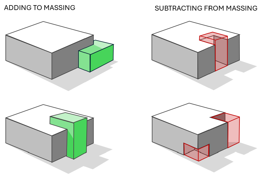
Table 2: Options for building as site design.
(b)
Maximum Building Height.
(i)
No building shall exceed 42 feet except for stair and elevator bulkheads and structural projections which do not provide inhabitable space.
(c)
Loading and service.
(i)
Loading and service areas, including but not limited to docks, waste collection and storage, drive-throughs, and other functionally similar uses, shall be located to the rear or side of buildings and shall be screened by 100% opaque wall or landscaping. In no instance shall the loading and service area be located between the building and SR 26 or US 27/41, regardless of building orientation.
a.
Failure to maintain landscape screening to provide shall constitute a violation of these regulations.
(d)
Fencing.
(i)
Fences within SR 26 or US 27/41 roadway buffers allowed per Section 4.22.2(A)(5)(g) are limited to a maximum height of four feet and shall not be galvanized or corrugated metal sheets or chain link. Fences required to screen accessory uses (section 4.22.2(A)(5)(d)) within the roadways buffers may utilize a combination of berm, landscaping, and fencing to achieve specific use screening standards (Section 4.22.2(A)(5)(e) and (h).
(e)
Accessory uses.
(i)
All accessory outdoor storage areas will be screened from view from all property lines and adjacent rights-of-way by a landscape earthen berm, or an opaque fence or wall between six feet and eight feet in height. A fence or wall shall incorporate at least one of the predominant materials and one of the predominant colors used in the primary structure. Materials may not be stored higher than the height of the screening. The perimeter of the fence or wall shall be landscaped with a three-foot-wide strip containing a minimum three-foot-high hedge with plantings not more than three feet-on-center.
(ii)
Such screening requirements apply to trash collection and the parking of all commercial vehicles which may be visible from the SR 26 and/or US 27/41 rights-of-way.
(iii)
Provided off-street parking stalls shall not exceed 10% of the minimum required off-street parking standards.
(f)
Specific use standards.
(i)
The following uses shall meet these use-specific standards in addition to applicable standards outlined in section 4.2.
a.
Car-wash. Tunnels shall not be oriented towards the SR 26, US 27/41, or a residential use within 100 feet.
b.
Self-storage. Storage unit roll-up doors shall not be visible from SR 26 or US 27/41 and shall be properly screened from view or interior to a building.
c.
Automobile repair shop. Bay doors shall not be oriented towards or wholly visible from the SR 26, US 27/41, or a residential use within 100 feet. Automobiles being serviced shall be screened from view from all public rights-of-way.
d.
Outdoor display. Outdoor display of any type of motorized vehicles, boats, storage buildings, or equipment for sale or rental, except for automobile rentals associated with hotels or motels, shall be screened from view from SR 26 or US 27/41.
(g)
Site landscaping requirements.
(i)
Preservation of champion trees, as defined by the Florida Department of Agriculture and Consumer Services, shall be required and a landowner shall enter into a Florida Champion Tree Property Owner Agreement, in a form acceptable to the City Attorney which shall be recorded in the Official Records of Alachua County, Florida, prior to the commencement of construction activity, including tree removal, clearing and grubbing, grading, depositing of fill and similar materials, staging of construction equipment and materials, and/or installation of temporary access drives. Champion trees shall be nominated by the City Manager or their designee for entry into the Florida Champion Tree Register maintained by the Florida Department of Agriculture.
(ii)
All plant material within the Overlay District shall be native or adapted species and shall meet the following minimum standards:
a.
All nursery plants, including trees, shrubs and groundcovers shall conform to standards for Florida Grade #1 or better according to the current, most recent edition of "Grades and Standards for Nursery Plants" published by the Florida Department of Agriculture and Consumer Services, Division of Plant Industry and available from the Florida Nursery, Growers, and Landscape Association (FNGLA).
b.
All trees, except those meeting stormwater basin landscaping requirements, shall be a minimum of 30-gallon, two-inch diameter at breast height, at time of installation. Trees meeting stormwater basin landscaping requirements shall be a minimum of seven gallons, ¾" caliper size, at the time of installation. All shrubs and groundcovers shall be a minimum of three-gallon size at time of installation.
(iii)
Applicants shall select from the following list of approved trees to create a consistent and uniform planting program for the required landscaping within the Gateway Overlay District.
a.
Shade trees:
i.
Magnolia grandiflora, Southern Magnolia;
ii.
Ulmus alata, Winged Elm;
iii.
Acer rubrum, Red Maple;
iv.
Betula nigra, River Birch;
v.
Pinus palustris, Longleaf Pine;
vi.
Pinus elliottii, Slash Pine;
vii.
Planus occidentalis, Sycamore;
viii.
Quercus austrina, Bluff Oak;
ix.
Quercus geminata, Sand Live Oak;
x.
Quercus michauxii, Swamp Chestnut Oak;
xi.
Quercus shumardii, Shumard Oak;
xii.
Quercus virginiana, Southern Live Oak; or
xiii.
Taxodium distichum, Bald Cypress.
b.
Ornamental trees:
i.
Cercus canadensis, Redbud;
ii.
Chionanthus virginicus, Fringe Tree;
iii.
Ilex cassine, Dahoon Holly;
iv.
Ilex x attenuata 'East Palatka', East Palatka Holly;
v.
Ilex x atenuata 'Savannah', Savannah Holly;
vi.
Ilex x 'Nellie R. Stevens', Nellie R. Stevens Holly;
vii.
Lagerstroemia indica, Crape Myrtle;
viii.
Prunus angustifolia, Chickasaw Plum;
ix.
Sabalpalmetto, Cabbage Palm; or
x.
Viburnum obovatum, Walter's Viburnum.
(h)
Roadway buffers.
(i)
Buffering for properties with frontage along SR 26 and/or US 27/41 shall meet the following requirements of this section.
(ii)
General provisions:
a.
Buffers on residential developments shall be designated as common areas and shall not be included within lots;
b.
Buffers on non-residential sites may be included within lots and counted toward building setback requirements;
c.
No buildings or parking are permitted in buffers;
d.
Sidewalks, above and underground utility infrastructure, drainage facilities, freestanding signs, lighting, screening, and other improvements deemed necessary by the LDR administrator may be in buffers;
e.
Buffer areas may include all or portions of the stormwater management system if the applicant demonstrates that the character and intent of the buffer is not diminished;
f.
Utility lines may exist in the buffer provided that the buffer's purpose is not compromised or minimized and the specified number of plantings required must be met;
g.
Pedestrian access and trails within a buffer may be permitted provided the character and intent of the buffer is not diminished;
h.
Existing native trees and vegetation may be used to fulfill roadway buffering and screening requirements where such existing natural vegetation is of sufficient size and opacity to provide an effective buffer. Credit for preservation of existing trees shall be provided in accordance with Section 74-66;
i.
All buffers shall be maintained to remove invasive exotic trees and vegetation; and
(iii)
The landscaped buffer width and minimum quantity of landscape plantings are determined based on the site's location within one of three roadway buffer zones. Zone boundary limits:
Table 3: Defined Roadway Buffer Zones
(iv)
Trees can be clustered and do not need to be evenly spaced, as long as the distribution is balanced within the buffer corridor. Buffers shall contain a mix of shrubs, ornamental grasses, and groundcovers not to exceed spacing of four feet on center. Bedlines should be natural, organic, and non-linear, where possible. Width of planting areas within the buffer shall be varied, with minimum width not to exceed those shown in Diagram A. Gaps of sod or mulch between landscaped areas shall not exceed 20 feet in width. Driveway widths shall be excluded from the buffer corridor calculation.
(v)
Diagram 2: Required Buffer Plantings
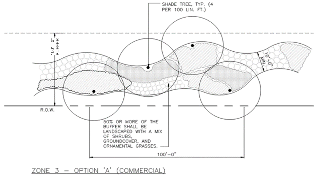
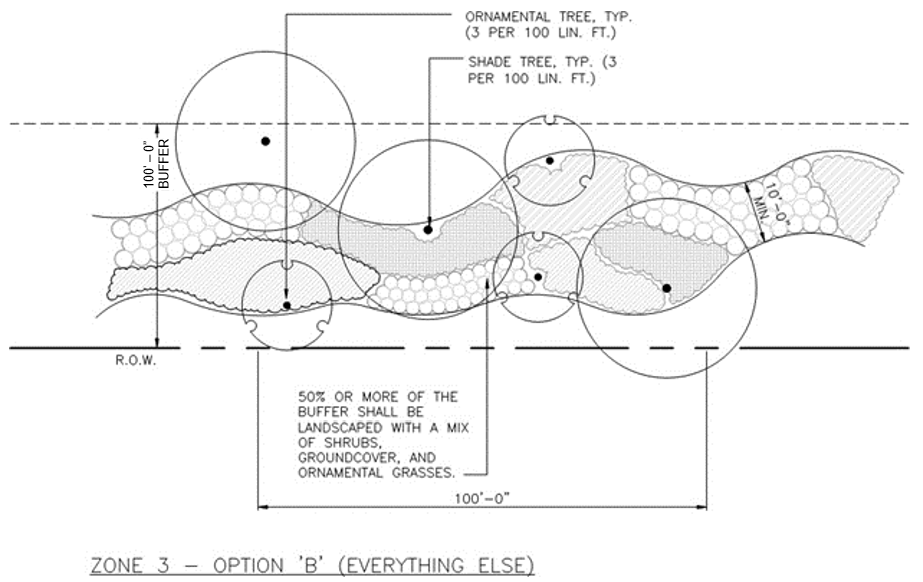
(i)
Where the sides or rear of residential lot lines are visible from SR 26 or US 27/41, additional screening is required in accordance with the following:
(i)
Option A: A berm of four (4) feet high minimum combined with plantings to achieve a total screen minimum height of six (6) feet at time of planting as measured from the abutting crown of road or grade of adjacent residential property, the greater thereof. Berm slopes shall be a maximum of 3:1. Berms shall be of irregular shape and shall have no parallel sides;
(ii)
Option B: A minimum six (6) feet tall opaque fence and decorative masonry columns;
(iii)
Option C: Landscape plantings including trees, shrubs, groundcovers to achieve a minimum six feet (6) height screen, to reach 75-percent opacity in two years;
(iv)
Option D: A combination of the above options to achieve a minimum six (6) feet height and 100-percent opacity in two (2) years.
(j)
Landscaping in vehicular use areas.
(i)
Screening shall be provided where a vehicular use area is visible from any adjacent property and/or street right(s)-of-way. The screening shall consist of:
a.
A single row of shrubs spaced at a maximum four (4) feet on center, minimum, to provide a visual screen not less than 50-percent opaque upon planting. Shrubs shall be planted in a strip no less than five (5) feet in width and may be planted in the required street buffer;
b.
An average of two (2) shade trees for every 100 linear feet, or fraction thereof, of the paved vehicular use area, excluding driveway widths. The distance between such trees shall be planted between 25 to 55 feet apart; and
c.
Plant material provided as part of the vehicular use area landscaping of the same standard of the applicable roadway buffer zone and parallel to the roadway buffer and within 50 feet of same may count towards buffer requirements.
(ii)
One (1) shade tree is required within each landscape island.
(iii)
Required landscape islands may be replaced by low-infiltration drainage systems parallel to the drive aisle they abut not less than an average eight (8) feet wide with an acceptable shade tree planted not less than every thirty-five (35) feet.
(k)
Landscaping in stormwater management facilities.
(i)
When visible from the right-of-way, stormwater management facilities ( "SMF") shall be planted with one native tree per 35 linear feet, or fraction thereof, of basin perimeter. Native shrubs, groundcover, and/or ornamental grass shall be provided to cover 25-percent of the basin slope area. The basin slope area shall be measured from the basin's top closed contour to the basin's lowest closed contour, not including maintenance paths.
(ii)
Trees shall be placed no closer than 20 feet from stormwater structures.
(l)
Cross access. Vehicular and/or multi-modal cross access shall be required, except if prohibited due to utilities or topography.
(m)
Signage. Except as stated below, signs within the Gateway Overlay District shall comply and be subject to the standards in section 4.2.20.
(i)
Under no circumstances shall a sign's illumination mechanism be visible to vehicles, pedestrians, or other modes of transportation. All illumination must be internal or directed upon the sign's face with no direct line of sight to the bulb(s) or lighting fixtures.
(ii)
Prohibited signs.
a.
Billboards.
b.
Signs that display video or images.
c.
Balloons, streamers, and air- or gas-filled figures, except for promotional purposes for a limited period determined by the city manager or designee.
d.
Promotional beacons, searchlights, and/or laser lights/images, except for promotional purposes for a limited period determined by the city manager or designee.
e.
Signs that emit audible sounds, smoke, vapor, particles, or odor.
f.
Signs on utility poles or trees.
g.
Signs or advertising devices attached to any vehicle or trailer to be visible from public right- of-way, including vehicles with for sale signs and excluding vehicles used for daily transportation, deliveries, or parked while business is being conducted on-site.
h.
Pylon signs.
(iii)
Freestanding signs.
a.
Freestanding signs, as monument or ground- based podiums, shall be permitted within the Gateway Overlay District.
b.
Sign dimensional criteria are based on the roadway speed limit. Sign dimensions shall be computed consistent with LDR 4.2.20.7.
i.
Residential subdivision signs:
ii.
Non-residential signs:
iii.
Multi-tenant signs:
c.
A sign and its structural base or body shall be composed of materials identical to or similar in appearance, color, and texture to the materials used for the building to which the sign is accessory or advertising.
d.
Changeable copy signs shall only be allowed to comprise up to 50 percent of the total sign area for commercial signs and up to 30 percent of the total sign area for multi-tenant signs.
(iv)
Window signs.
a.
Window signs shall be incorporated into the overall sign area allowed for wall signage as per section 4.2.20.9.c.
b.
Signage on any individual window shall not comprise more than 25 percent of the window area.
(v)
Landscaping and buffering.
a.
All freestanding signs shall provide a landscaped area around base of the sign meeting the following standards:
i.
Installation of a minimum three-foot-wide landscaped buffer around the base of the sign.
ii.
Such buffers must be landscaped with a mixture of groundcover and/or other ornamental grasses.
(vi)
Nonconforming signs.
a.
Nonconforming signs shall be subject to the nonconforming standards as established in section 4.2.20.14.
(Ord. No. 2022-25, § 1, 6-27-2022; Ord. No. 2025-05, § 1, 6-9-2025)
Section 4.23. - "PF" Public Facilities.
4.23.1. Districts and intent. The "PF" Public Facilities category includes one zoning district: PF. Any land acquired, owned or leased by the city or any other governmental entity/agency may be given a zoning designation of PF by initiating the rezoning process set forth in F.S. § 166.041, and Appendix B, Article 16 of the Code of Ordinances, and this section.
To permit residential, non-residential, and/or any combination of each on tracts of land that are owned or leased by the city or any other governmental entity or agency to be planned and developed as a whole, as a single operation or in phases with a greater amount of flexibility by removing some of the detailed restrictions of conventional zoning.
4.23.2. Permitted principal uses and structures. Government buildings and uses (such as but not limited to Federal, State, County, and/or city buildings and/or facilities; schools, offices, parks, public golf courses etc.). Any use approved by the City Commission for the private development (lease, air-rights etc.) of governmentally owned property. All uses must be consistent with the Comprehensive Plan, zoned according to state law, and must adequately demonstrate the development will serve a public purpose.
1.
Accessory uses and structures. Any use that is customarily associated with the main permitted use.
4.23.3. General development regulations for property within PF Public Facilities District.
1.
Procedures and requirements for rezoning to a PF Development.
a.
Application. An application for rezoning to PF development shall be made only by the governmental entity or agency that owns or leases the subject property and processed in the same manner as other applications for change of zoning of land in accordance with state law and pursuant to Appendix B, Article 16 of the Code of Ordinances.
[1.]
The Planning and Zoning Board or the City Commission may require a site and development plan application be considered concurrently with the petition for change of zoning designation.
[2.]
Should the Planning and Zoning Board or City Commission deem a site and development plan is necessary to ensure compatibility with surrounding properties and protection of public interest, no further action may be taken on the petition for change of zoning, except as required by state law, until such petition for site and development plan approval is presented to the requesting board.
b.
Zoning designation. Upon the sale of publicly owned or leased property that is currently zoned PF, the governmental entity or agency shall initiate a zoning designation change pursuant to F.S. § 166.041, as amended from time to time, and in accordance with the procedures set forth in Appendix B, Article 16 of the Code of Ordinances. If a governmental entity or agency acquires property to be utilized for a public purpose or desires to develop property it owns or leases for the purposes set forth in 4.23. above, then the rezoning procedures set forth below shall be followed.
c.
Consideration by the City Commission. Upon receiving the recommendation of the Planning and Zoning Board, the City Commission shall conduct a public hearing to consider the rezoning petition in accordance with the rezoning procedures set forth in Appendix B, Article 16 of the Code of Ordinances and the Site and Development Plan pursuant to Appendix B, Article 14, Section 14.12 of the Code of Ordinances.
4.23.4. Development regulations for PF property requiring Site and Development Plan Review. When the city or any other governmental entity/agency owning or leasing public property within a PF district desires to develop the property, Land Development Regulation Administrator in accordance with Appendix B, Article 14, Section 14.12 of the Code of Ordinances and other applicable Articles of the Land Development Regulations is required and the following development regulations shall be followed:
1.
Unified control. All land included for the purpose of development within a PF district shall be under the control of the city, any other governmental entity or agency. The city or other governmental entity/agency shall present satisfactory legal documents to constitute evidence of the unified control of the entire area within the proposed PF district, which shall be reviewed by the Land Development Regulation Administrator and the City Attorney.
2.
Land use and design regulations.
a.
Maximum density.
1.
Density. The maximum permitted density shall be determined by the City Commission, but in no event shall it exceed the limits set forth in the Comprehensive Plan.
2.
For purposes of this section. Community Residential Home shall equal one-half of one dwelling unit, and any residential unit shall be equal to one dwelling unit.
b.
Minimum plot size, distance between structures, frontage and setbacks.
1.
No minimum plot size shall be required with a PF development.
2.
No minimum distance between structures shall be required within a PF district, except as required by the Florida Building Code. The appropriate distance between structures shall be evaluated on an individual development basis after considering the type and character of the building types within a development.
3.
Setbacks. There are no required setbacks or yards except for those imposed by the City Commission, upon recommendation of the Planning and Zoning Board, and the Florida Building Code, as amended from time to time.
c.
Maximum height of structures. No maximum height of structures shall be required within a PF district. The City Commission upon recommendation of the Planning and Zoning Board shall determine the appropriate height limitations on an individual development basis after considering the character of the surrounding area, the character of the proposed development, and the goals for community development as stated in the Comprehensive Plan.
d.
Total site coverage. The floor area ratio of proposed development shall be consistent with those adopted in the Comprehensive Plan for the Public future land use classification.
3.
PF District Site and Development Plan. The Site and Development Plan petition shall be submitted to the Land Development Regulation Administrator pursuant to Appendix B, Article 14, Section 14.12 of the Code of Ordinances. The Land Development Regulation Administrator shall review the PF Site Plan in accordance with the procedures set forth in Appendix B, Article 14, Section 14.12 of the Code of Ordinances and shall forward their recommendation to the Planning and Zoning Board.
4.
Consideration by the City Commission. The City Commission shall evaluate the Site and Development Plan in accordance with the requirements set forth in Appendix B, Article 14, Section 14.12 of the Code of Ordinances. In addition, the Board shall evaluate the suitability of the proposed development with the Comprehensive Plan and the relevant land development regulations. The Planning and Zoning Board may recommend reasonable conditions, safeguards and stipulations be attached to the approval of the Site and Development Plan. Upon reviewing the Site and Development Plan, the Planning and Zoning Board shall forward its recommendation to the City Commission. Within Appendix B, Article 14, Section 14.12 of the Code of Ordinances, references to the Board of Adjustment shall be interpreted to mean the City Commission as it relates to land zoned PF or subject to rezoning to same. The City Commission shall evaluate the proposed development in the same manner as required of the Board of Adjustment. Consideration of the Site and Development Plan by the City Commission may occur at the same or later public hearing for lands subject to rezoning to PF.
5.
Conformance to the approved Site and Development Plan.
a.
Permits. After rezoning to PF district, no permits shall be issued by the city and no development shall commence unless in conformance with the approved Site and Development Plan approved by the City Commission. The PF development may be developed in phases; however, such phases shall be an element of the Site and Development Plan approved by the City Commission.
b.
Major and minor changes to the Site and Development Plan shall be made pursuant to Appendix B, Article 14, Section 14.12 of the Code of Ordinances.
c.
Transfer of ownership. No land within an approved PF district may be transferred in ownership or in any other way removed from unified control without a written agreement between the city and the parties to which such transfer is made, stipulating their understanding and agreement to a condition that such transferred land shall continue under the full terms and provisions of the PF development approval, or unless rezoned to a district consistent with the current use of the land.
(Ord. No. 2022-59, § 1, 2-13-2023)
Sec. 4.24. - AT Agriculture Technology.
4.24.1. Intent. The proposed district is established to support economic development through the creation of the proposed Agriculture Technology Park located within the corporate limits of the City of Newberry. The district is intended to facilitate the development of the Agri-Tech Food Park, and to ensure growth is orderly, consistent, and aligned with the mission of the park and the city of Newberry. The district also aims to safeguard adjacent residential and commercial areas from potential impacts associated with the Park's uses and future expansion. These efforts contribute to the broader goal of preserving property values and maintaining a strong tax base for the City of Newberry. All permitted and special uses within this district must align with the core purpose and mission of the Agriculture Technology Park or its related activities.
4.24.2. Permitted Principal uses and Structures.
(1)
Agricultural uses, such as crop production, greenhouses, hydroponic farms, mushroom farms and similar activities.
(2)
Facilities intended for production or light assembly and warehousing of agricultural and food products and bio-based products produced by plants and microorganisms, for testing or distribution,
(3)
Laboratories and related facilities intended for basic and applied research, development of technology-based products and services, or testing of technology-based products and services. Excluding research facilities for quarantining or animal testing.
(4)
Business incubators and offices.
(5)
Conference center/Event Center.
(6)
Public, private, and charitable agriculture-related and food technology-related research and educational facilities, and agricultural and food service organizations and consultants, as well as biotechnology research leading to bio-based products produced by plants and microorganisms.
(7)
Public utility services for the immediate vicinity, including only minor structures not more than 500 square feet in area.
(8)
Technology-dependent and/or computer-based facilities dedicated to the processing of data and analysis of information, provided that these information services support on-site research or product development.
4.24.3. Permitted Accessory uses and Structures.
1.
On-site signs (see also Section 4.2).
2.
Uses and structures which:
a.
Are customarily accessory and clearly incidental and subordinate to permitted uses and structures;
b.
Are located on the same lot as the permitted use or structure, or on a contiguous lot in the same ownership;
c.
Do not involve operations or structures in keeping with the character of the district;
e.
Are utility sheds and carports, (refer to Section 4.2.4.); and
f.
Are administratively approved permanent or temporary accessory structures within the required rear yard setback up to the rear property line, complying with Section 4.24.1.
4.24.4. Special exceptions.
(1)
Services and retail use incidental to, and in support of, the permitted uses such as limited food-service facilities in support of principal permitted uses, day-care facilities and athletic facilities, provided that these uses are in support of a permitted principal use.
(2)
Livestock facilities and animal processing facilities, subject to the nuisance regulations stipulated herein.
(3)
Accessory storage facilities, including outdoor storage yards either as allowed uses or with a special exception permit.
(4)
Uses similar in purpose and scale to those permitted, but not specifically identified, subject to determination of appropriateness by the Board of Adjustment.
4.24.5. Prohibited Uses.
(1)
Parked farm or agriculture-related heavy vehicle or equipment (including tractors, cultivators, sprayers, and similar equipment) except by special exception.
(2)
The use of tires, plastics, or plastic derived materials as a fuel source or as a feedstock is prohibited.
(3)
Heavy Industrial activity as provided in Section 4.17. "I" Industrial of these Land Development Regulations.
4.24.5 Dimensional and design requirements**.
(1)
Where the AT District abuts the Newberry Gateway corridor, the design requirements will follow the Overlay District design standards (Section 4.22 of these Land Development Regulations).
(2)
Buildings situated along interior public roads shall, to the greatest extent practicable, be situated such that the fronts of the buildings are aligned with the roadway and with other buildings facing that roadway.
(3)
The maximum height shall be 72 feet including any stacks, air handling units or other building appurtenances, unless approved by BOA.
(4)
Building setback, buffer, and landscaping requirements if the site is not abutting the Newberry Gateway Corridor:
(a)
For the buildings along interior streets, a 10-foot setback is required from the front lot line.
(b)
It is the intent of these regulations that landscaping should be designated in a manner that allows each site to contribute to the park like quality of the overall development. Each owner is encouraged to plant and maintain flowering annuals in beds. Such plantings must be maintained by the owner.
(c)
A minimum of 10-foot buffer along interior and rear lot lines with existing and planted natural vegetation in an undisturbed state shall be maintained.
(d)
All plant material within the AT district shall be native or adapted species and shall follow the minimum standards provided in Section 4.22.(5) of these Land Development Regulations.
(5)
Buildings should be compatible and harmonious with those existing, not by mimicking the architectural style or building materials, but by compatibility of styles, materials, shape, height, massing, orientation, and siting. Overall, the building must be well-designed and visually interesting in terms of both massing and details.
(6)
Lighting shall follow the Dark Sky friendly requirements as follows:
i.
All exterior light fixtures and bulbs shall be generally compliant with Dark-Sky requirements by providing a fully shielded light source or is a fixture that has aftermarket shields available that provide for same.
ii.
LEDs and bulbs measuring less than or equal to 3000-kelvin shall be permitted.
iii.
Individual lots shall not exceed a maximum of 2 footcandles at any point measured within the lot.
iv.
Light spillage as measured at the property line shall not exceed 0.5 footcandles excluding lot lines abutting public rights-of-way or internal roads
v.
Photometric plans shall be required to demonstrate compliance with iii and iv of this subsection if it is determined by the Land Development Regulation Administrator that excessive lighting is proposed or a property is the subject of an active Code Enforcement violation related to lighting inconsistent with these regulations.
(7)
Any outdoor fixtures in public areas, such as benches, trash containers, planters, sculptures, etc. shall be compatible with and harmonious with the surroundings and shall be approved at the Site and Development phase stage.
(8)
Parking and loading areas:
(a)
Parking: The minimum parking requirement will be based on use and will follow the recommendations provided in the Commercial Intensive (CI) or Industrial (I) zoning district.
i.
* Off-street loading required (see section 4.2).
(b)
No contiguous surface parking area, excluding drive aisles, shall exceed 10,000 square feet without being subdivided by landscaped islands at intervals of no more than 300 feet.
(c)
Pedestrian access: The continuous pedestrian access paths and entrances (not including truck loading areas) shall be connected by sidewalks of a minimum of 5 feet in width and include designated crosswalk areas, landscaping where appropriate. Sidewalks of a minimum of 5 feet in width shall be constructed to connect each site to the adjoining site(s) along the road right of ways, so as to provide a continuous pedestrian walkway throughout the park prior to issuance of certificate of occupancy (CO).
(9)
Fencing, berms, and appropriate landscaping shall be used to screen views of loading and service areas and to reduce noise and light infiltration into adjacent areas. Overall use of extensive landscaping shall be encouraged in order to screen and buffer the buildings and parking areas.
(10)
Additional dimensional requirements may be required as part of the development plan review process. This process shall be governed by the goal of creating a campus environment consistent with existing land use patterns and density and within the purpose of this district.
**
Functional agricultural uses, such as green houses, will be exempted from building design standards.
4.24.6. Performance standards.
All uses shall be conducted in such a manner to preclude any nuisance, hazard, or traffic impacts including creation or emission of dust, gas, smoke, noise, fumes, fumes, odors, vibrations, particulate matter, chemical compounds, electrical disturbance, humidity, glare, or night illumination, or any other adverse impact on public health.
4.24.7 Procedure for approval and development plan review.
1.
Pre-application conference: Prior to the submittal of an application for a site and development plan approval in an AT district, the applicant shall request and participate in a pre-application conference with the representatives of the City of Newberry. The City Manager or their designee may request the attendance of other city departments as deemed applicable, to provide a more comprehensive discussion of the proposal.
2.
Site and development plan:
a)
Following pre-application, three (3) hard copies submissions along with a digital submission of site and development plan and fees attached are required for review. Submission requirement for Site and Development Plan as provided in Section 14.12.
b)
A justification report addressing the performance standard of the use.
c)
As a part of submission, the owner shall submit a mitigation plan for any kind of nuisance mitigation, if necessary.
(Ord. No. 2025-10, § 1, 6-23-2025)