
North Crows Nest City Zoning Code
CHAPTER 740
GENERAL PROVISIONS1
Editor's note— Ord. No. 64, 2015, § 1(Exhibit), passed September 28, 2015, effective April 1, 2016, repealed the former Chs. 730—735, and enacted new Chs. 740—744 as set out herein. The former Chs. 730—735 pertained to Zoning—General Provisions, Dwelling zoning districts; Zoning—Commercial Districts, Zoning—Industrial Commercial Districts, Sign Regulations, Zoning—Other Districts. See Code Comparative Table for complete derivation.
Sec. 740-101. - Title.
This chapter and Chapters 741, 742, 743 and 744 shall officially be known as the Zoning Ordinance for Marion County, Indiana (hereinafter "the Zoning Ordinance"). The regulations in the Zoning Ordinance shall apply to all lands within Marion County, Indiana.
(G.O. 64, 2015, § 2)
Sec. 740-102. - Purposes.
The purposes of the Zoning Ordinance are to:
A.
Implement those plans for the future development of Marion County, Indiana, including but not limited to comprehensive plans, land use plans, thoroughfare plans, transportation plans adopted by the Metropolitan Development Commission.
B.
Protect and improve the quality of life in Marion County, Indiana, by improving the number and quality of housing and transportation options, improving global economic competitiveness, and protecting and improving strong neighborhoods.
C.
Protect and improve residential, commercial, institutional, industrial, and mixed-use real property values in Marion County, Indiana, and to promote the efficient development and redevelopment of vacant properties in the county.
D.
To promote development and redevelopment that reduces crime and opportunities for crime in Marion County, Indiana.
E.
To promote development and redevelopment patterns that reduce the length and frequency of automobile trips and offer increased opportunities for efficient public transit service in order to reduce carbon dioxide emissions, improve access to employment, and improve the efficiency of infrastructure use and investment.
F.
To protect and enhance tree cover in Marion County, Indiana, in order to realize the numerous benefits and services to city residents, including increased property values, reduced storm water runoff and soil erosion with associated cost savings, noise buffering, improved aesthetics, reduced energy costs from shade in summer and windbreaks in winter, removal of greenhouse gases and other pollutants from the air, and protection of the city's water quality while recognizing the need to remove some trees for development, safety, view preservation and other purposes.
G.
To ensure that parking in Marion County, Indiana, is adequate but not excessive for the associated use, and that the design and construction of parking areas minimizes their impact on the city's water resources by utilizing low-impact development techniques to manage stormwater and reduce urban heat island effects.
(G.O. 64, 2015, § 2)
Sec. 740-103. - Establishment of zoning map.
A.
The county is divided into zoning districts, as shown on the official zoning map, which together with all explanatory matter thereon, is adopted by reference and declared to be a part of the Revised Code of the Consolidated City and County for Indianapolis-Marion County, Indiana.
B.
Where a zoning boundary line follows the edge of or lies within the rights-of-way of a street, alley, thoroughfare or freeway within Marion County, that zoning boundary shall be extended to the centerline of that right-of-way and shall be construed as following the centerline of the right-of-way.
C.
Where a zoning boundary line approximately follows section lines, city corporate limit lines or platted lot lines, that zoning boundary shall be construed as following such lines.
D.
Where a zoning boundary line approximately follows the centerlines of streams, rivers, canals, lakes or other body of water, that zoning boundary shall be construed as following such centerlines. Where a zoning boundary line approximately follows shore lines, that zoning boundary shall be construed as following such lines, and in event of change in that shore line, it shall be construed as moving with the actual shore line.
E.
The official zoning map shall be maintained in electronic form, and depicted in various formats and scales as appropriate. The Director of the Department of Metropolitan Development shall be the custodian of the official zoning map.
F.
When changes are made in zoning district boundaries, such changes shall be made on the official zoning map promptly after the amendment has been adopted in accordance with IC 36-7-4-600 Series.
G.
No changes shall be made to the official zoning map except in conformity with the requirements and procedures set forth in the Zoning Ordinance and state law.
(G.O. 64, 2015, § 2; G.O. 44, 2016, § 1)
Sec. 740-104. - Compliance.
A.
The Zoning Ordinance shall be in full force and effect the first day of the month that is six months after the date of adoption in compliance with IC 36-7-4.
B.
Nothing in the form standards shall require any change in the plans, construction, size, or designated use of a building or part of a building for which a building permit was granted, or building plans were on file with the Department of Metropolitan Development or the Department of Code Enforcement before the first day of the month that is six months after the date of adoption, provided that construction pursuant to that permit is completed within three years of the issuance date of the permit.
(G.O. 64, 2015, § 2)
Sec. 740-201. - Construction of language.
The language of this article shall be interpreted in accordance with the following regulations:
A.
General.
1.
The particular shall control the general.
2.
In the case of any difference of meaning or implication between the text of this article and any illustration or diagram, the text shall control.
3.
The words "must", "will", "shall" and "may not" are always mandatory and not discretionary. The word "may" is permissive.
4.
Words used in the present tense shall include the future; and words used in the singular number shall include the plural, and the plural the singular, unless the context clearly indicates the contrary.
5.
A "building" or "structure" includes any part of the building or structure.
6.
When used with numbers, "up to X", "not more than X" and "a maximum of X" all include X.
7.
The phrase "used for" includes "arranged for," "designed for," "intended for," "maintained for," or "occupied for."
8.
Unless the context clearly indicates the contrary, where a regulation involves two or more items, conditions, provisions, or events connected by the conjunction "and," "or," or "either … or," the conjunction shall be interpreted as follows:
a.
"And" indicates that all the connected items, conditions, provisions, or events shall apply.
b.
"Or" indicates that the connected items, conditions, provisions, or events may apply singly or in any combination.
c.
"Either … or" indicates that all the connected items, conditions, provisions, or events shall apply singly but not in combination.
B.
References to other regulations. Unless specifically stated otherwise, any reference to other city, county, state, or federal regulations are for informational purposes, and do not constitute a complete list of such regulations. These references do not imply any responsibility by the city for enforcement.
C.
Current versions and citations. All references to other city, county, state, or federal laws or regulations refer to the most current version and citation for those regulations, unless expressly indicated otherwise.
D.
Successor departments and agencies. All references to a federal, state, regional, or Indianapolis governmental or quasi-governmental department or agency that no longer exists shall refer to the successor agency or agencies charged with those responsibilities, as determined by the administrator.
E.
Lists and examples. Unless otherwise expressly indicated, lists of items or examples that use "including", "such as", or similar terms are intended to provide examples only. They are not to be construed as exhaustive lists of all possible included terms.
F.
Catch lines. Catch lines of sections in the Zoning Ordinance are intended to indicate the title, contents and application of the sections.
G.
Abbreviations. Abbreviations are used and if not otherwise indicated their common usage meaning is intended. Frequently used abbreviations, in upper or lowercase, include:
a/k/a means also known as.
ft. means foot or feet.
sq. means square.
sf means square-foot or square-feet.
ac means acre or acres.
Sec. means section.
w/in means within.
w/o means without.
in. means inch or inches.
min. means minimum.
max. means maximum.
n/a means not applicable.
ht means height.
H.
Citation format. Through the Zoning Ordinance, references to other portions of the Zoning Ordinance are given. An abbreviated citation format may be used and is generally the chapter number followed by a hyphen followed by the article and section numbers followed by a period followed by the subsection letters and numbers each separated by a period. Example is below:
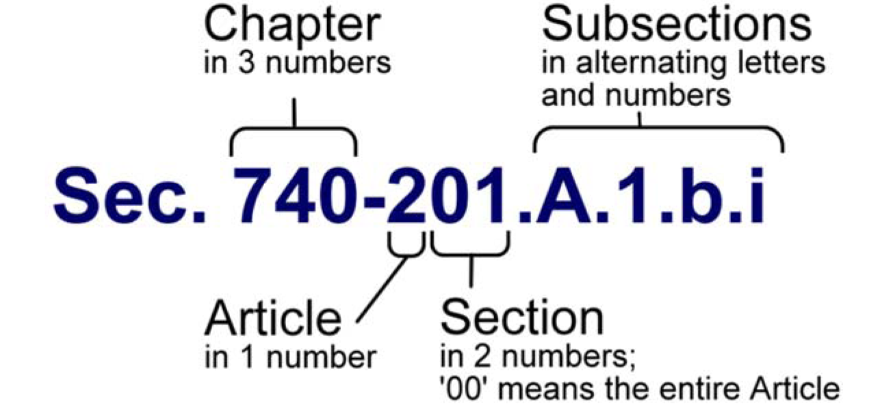
A citation can end after the chapter, section, or subsection. All sections and subsections contained within the referenced citation would be applicable. A citation in which the section number ends with '00' is referencing the entire article. The name of the chapter or section may follow the alpha-numeric citation as a parenthetical.
(G.O. 64, 2015, § 2)
Sec. 740-202. - Definitions.
The words in the text or illustrations of this article shall be interpreted in accordance with the following definitions. The illustrations and diagrams in this section provide graphic representation of the concept of a definition; the illustration or diagram is not to be construed or interpreted as a definition itself.
A.
A-frame sign: A portable sign containing two sign faces and whose framing is hinged at the apex at an angle less than 45 degrees.
Abandoned well: A well, the use of which has been permanently discontinued or that is in a state of disrepair such that it cannot be used for its intended purpose or for observation purposes.
Abandoned sign: Any sign or its supporting sign structure which remains without a message or whose display surface remains blank for a period of: a. one year or more (for a sign or its supporting sign structure which conforms to this chapter at the time of adoption); or b. 60 days (for a sign or its supporting sign structure which does not conform to the provisions of this chapter at the time of adoption); or any sign which pertains to a time, event or purpose which no longer applies, shall be deemed to have been abandoned.
Aboveground storage tank: Any one or combination of tanks, including underground pipes connected thereto, that is used to contain an accumulation of potential groundwater contaminants and the volume of that, including the volume of underground pipes connected thereto, is less than 10% beneath the surface of the ground. Flow-through process tanks are excluded from the definition of aboveground storage tanks.
Abut: To physically touch or border upon, or to share a common property line.
Access: The way by which vehicles shall have ingress to and egress from a land parcel or property to the street fronting along said property or parcel or an abutting alley.
Accessory: A subordinate structure, building or use that is customarily associated with, and is appropriately and clearly incidental and subordinate in use, size, bulk, area and height to the primary structure, building, and use, and is located on the same lot as the primary building, structure, or use.
ADA: The Americans with Disabilities Act.
Administrator: Administrator of the Division of Planning of the Department of Metropolitan Development, or the Administrator's appointed and authorized representative.
Adult bookstore: An establishment having at least 25% of its:
1.
Retail floor space used for the display of adult products; or
2.
Stock in trade consisting of adult products; or
3.
Weekly revenue derived from adult products.
For purposes of this definition, the phrase adult products means books, films, magazines, motion pictures, periodicals or other printed matter, or photographs, video cassettes, slides, tapes, records or other forms of visual or audio representations that are distinguished or characterized by their emphasis on matter depicting, describing or relating to specified sexual activities or specified anatomical areas. For purposes of this definition, the phrase adult products also means a device designed or marketed as useful primarily for the stimulation of human genital organs, or for sadomasochistic use or abuse. Such devices shall include, but are not limited to bather restraints, body piercing implements (excluding earrings or other decorative jewelry), chains, dildos, muzzles, non-medical enema kits, phallic shaped vibrators, racks, whips, and other tools of sado-masochistic abuse.
Adult cabaret: A night club, bar, theatre, restaurant or similar establishment that regularly features:
1.
Live performances by bottomless or topless dancers, exotic dancers, go-go dancers, strippers, or similar entertainers, where such performances are distinguished or characterized by an emphasis on specified sexual activities or by exposure of specified anatomical areas;
2.
Films, motion pictures, slides, video cassettes, or other photographic reproductions which are distinguished or characterized by an emphasis upon the depiction or description of specified sexual activities or specified anatomical areas for observation by patrons;
3.
Persons who appear in a state of nudity or semi-nudity as defined in Chapter 807, Article I of the Revised Code of the Consolidated City and County; or
4.
Persons who engage in erotic dancing or performances that are intended for the sexual interests or titillation of an audience or customer.
Adult drive-in theatre: An open lot or part thereof, with appurtenant facilities, devoted primarily to the presentation of films, motion pictures, theatrical productions, and other forms of visual productions, for any form of consideration, to persons in motor vehicles or on outdoor seats in which a preponderance of the total presentation time is devoted to the showing of materials distinguished or characterized by an emphasis on matter depicting, describing or relating to specified sexual activities or specified anatomical areas for observation by patrons.
Adult entertainment business: An adult bookstore, adult mini motion picture theatre, adult motion picture theatre, adult motion picture arcade, adult cabaret, adult drive-in theatre, adult live entertainment arcade or adult services establishment.
Adult entertainment business, retail: See "adult entertainment business."
Adult live entertainment arcade: Any building or structure which contains or is used for commercial entertainment where the patron directly or indirectly is charged a fee to view from an enclosed or screened area or booth a series of live dance routines, strip performances or other gyrational choreography, which performances are distinguished or characterized by an emphasis on specified sexual activities or by exposure to specified anatomical areas.
Adult mini motion picture theatre: An enclosed building with a capacity of more than five but less than 50 persons, used for presenting films, motion pictures, slides, video cassettes, or similar photographic reproductions in which a preponderance of the total presentation time is devoted to the showing of materials which are distinguished or characterized by an emphasis on matter depicting, describing, or relating to specified sexual activities or specified anatomical areas for observation by patrons therein.
Adult motel: A hotel, motel or similar establishment offering public accommodations, for any form of consideration, that offers a sleeping room for rent for a period of time that is less than 10 hours or allows a tenant or occupant of a sleeping room to sub-rent the room for a period of time that is less than 10 hours, and that provides patrons, upon request, with closed-circuit television transmissions, films, motion pictures, slides, video cassettes, or other photographic reproductions that are distinguished or characterized by an emphasis upon the depiction or description of specified sexual activities or specified anatomical areas.
Adult motion picture arcade: Any place to which the public is permitted or invited wherein coin- or slug-operated or electronically, electrically or mechanically controlled still or motion picture machines, projectors or other image-producing devices are maintained to show images to five or fewer persons per machine at any one time, and where the images so displayed are distinguished or characterized by an emphasis on depicting or describing specified sexual activities or specified anatomical areas.
Adult motion picture theatre: An enclosed building with a capacity of 50 or more persons used for presenting films, motion pictures, slides, video cassettes, or similar photographic reproductions in which a preponderance of the total presentation time is devoted to showing of materials which are distinguished or characterized by an emphasis on matter depicting, describing or relating to specified sexual activities or specified anatomical areas for observation by patrons therein.
Adult service establishment: Any building, premises, structure or other facility, or part thereof, under common ownership or control which provides a preponderance of services involving specified sexual activities or display of specified anatomical areas.
Affected land: For purposes of Gravel, Sand, and Borrow regulations, the area of land from which overburden has been removed, or upon which cast overburden, refuse from mining operations, or minerals have been deposited, or that is disturbed or utilized incidental to mining operation.
Agricultural machinery and equipment sales, rental, or repair: Sale, rental, or repair of equipment, farm equipment, large and small animal equipment, and related infrastructure or vehicles used for agricultural, horticultural, or animal husbandry operations.
Agricultural sciences R&D: An industry sector dealing with the research of production, breeding, and management of crops, horticulture, floriculture, viticulture, and animal and poultry husbandry. Definition does not include onsite agricultural uses, buildings and structures.
Agricultural uses, buildings and structures: The land use of animal and poultry husbandry, farming, cultivation of crops and timber, dairying, pasturage, floriculture, horticulture, viticulture, apiaries (beekeeping), aquaculture (fish farm), hydroponics, together with necessary, accompanying accessory uses, buildings, or structures for housing, composting, packing, treating, or storing of agricultural products, on a site larger than three acres in size in common or related ownership. An inherent characteristic of this use is the outside operations, such as plowing, harvesting, storage of equipment, and is considered a primary facet of the use; therefore the buildings and structures, such as barns and silos, are not considered as accessory outdoor storage and operation, but rather part of the primary activity. This definition includes associated dwellings for those involved in agricultural uses. This use does not include any operation meeting the definition of a confined feeding operation or concentrated animal feeding operations as defined under IC Title 13 Article 11.
Air-filled sign: A temporary sign that uses air or wind or other gas to inflate or move. For illustrative purposes only, examples include balloon signs, wind signs.
Airport conical surface area: The land area designated as "airport conical surface area" on the official zoning map, beginning at the periphery of the horizontal surface area and thence extending outwardly a distance of 4,000 feet - such conical surface area not including, however, the instrument and noninstrument approach surface areas and transitional surface area.
Airport horizontal surface area: The land area designated as "airport horizontal surface area" on the official zoning map, the perimeter of which is determined by projecting arcs from the center of the inner line of each instrument and noninstrument approach surface area (the dimension of such arcs for instrument approach surface areas being 10,000 feet and for noninstrument approach connecting adjacent arcs by lines tangent thereto - not including, however, as a part of the horizontal surface area, the instrument and noninstrument approach surface areas and transitional surface area).
Airport instrument approach surface area: The land area designated as "airport instrument approach surface area" on the official zoning map, located at each end of each instrument runway for landings and take-offs - such surface area having a width of 1,000 feet at a horizontal distance of 200 feet beyond each end of the runway and widening thereafter uniformly to a width of 16,000 feet at a horizontal distance of 50,200 feet beyond each end of the runway, its centerline being the continuation of the runway centerline.
Airport noninstrument approach surface area: The land area designated as "airport noninstrument approach surface area" on the official zoning map, located at each end of each noninstrument runway for noninstrument landings and take-offs - such surface area having a width of 500 feet at a horizontal distance of 200 feet beyond each end of the runway and widening thereafter uniformly to a width of 3,500 feet at a horizontal distance of 10,200 feet beyond each end of the runway, its centerline being the continuation of the runway centerline.
Airport transitional surface area: The land area designated as "airport transitional surface area" on the official zoning map, located adjacent to each instrument and noninstrument runway - such surface area extending outward as indicated on the official zoning map from a line 250 feet on either side of the centerline of a noninstrument runway, for the length of such runway plus 200 feet at each end thereof, to the inner line of the horizontal surface area, and from a line 500 feet of either side of the centerline of an instrument runway plus 200 feet at each end thereof, to the inner line of the horizontal surface area; further symmetrically located adjacent to each instrument and noninstrument runway approach surface area, on each side thereof, having variable widths, as indicated on the official zoning map, and extending the entire length of such approach surface areas to their intersection with the outline of the conical surface area; and further located beyond such points of intersection, beginning at the outlines of all instrument approach surface areas and extending a horizontal distance of 5,000 feet therefrom, measured at right angles to the continuation of the runway centerline, as indicated on the official zoning map.
Airspace hazard: Any structure, tree, object or use of land which obstructs the airspace or is otherwise hazardous to the flight of aircraft in landing or taking-off at a public airport or heliport, as determined to constitute an "airspace," "airport" or "heliport" hazard either by the Federal Aviation Administration, the Aeronautics Commission of Indiana or the Indianapolis Airport Authority.
Alley: A public right-of-way that has been dedicated or deeded to and accepted by the public for public use as a secondary means of public access to a lot otherwise abutting upon a public street and not intended for traffic other than services and circulation to and from abutting lots. Typically has a right-of-way width of less than 35 feet
Alteration: Any change in type of occupancy, or any change, addition or modification in construction of the structural members of an existing structure, such as walls, or partitions, columns, beams or girders, as well as any change in doors or windows or any enlargement to or diminution of a structure, whether it be horizontally or vertically.
Amateur radio antenna: A device that is designed to transmit and receive radio frequency for the purposes of private recreation.
Amenity zone: The area of the streetscape that provides a buffer between people walking on sidewalks and the street. It typically includes elements such as lights, trees, bicycle racks, landscaping, benches, signs, public art, transit facilities and green infrastructure. Policies and designs for this area are more specifically defined by policies and standards for public rights-of-way.
Amusement arcade: A type of indoor commercial amusement/recreation establishment where amusement machines are available to the public.
Amusement machine: An amusement device operated by means of the insertion of a coin, token, or similar object for the purpose of entertainment, amusement or skill and for the playing of which a fee is charged. "Amusement machine" does not include vending machines which do not incorporate gaming amusement or skill features, nor does the term include any coin-operated mechanical musical device.
Ancillary sign: Freestanding, permanent sign accessory to the primary use of land that is smaller than any frontage sign located on the lot and located at least 40 feet away from the right-of-way of any arterial or freeway, and 10 feet away from any other right-of-way. For illustrative purposes only, examples may include a sign identifying directions, clubhouse rules, menu options, list of tenants.
Animal, large: Large animals include horses, ponies, cows, calves, mules, alpacas, sheep, rams, lambs, burros, goats, swine, emus, jacks, jennets and other animals that the administrator determines to be of similar size, weight, and impact on the land.
Animal, small: Any animal of a species that generally does not exceed 100 pounds in weight and that is not included in the definition of a large animal.
Animal care, boarding, veterinarian services: A business involved in the care, diagnosis, treatment or hospitalization of animals, and including the boarding of animals. This definition includes uses such as animal day care, kennels, stables, pet shops, animal grooming, obedience schools, and veterinarian services. This use does not include any operation meeting the definition of a Confined Feeding Operation (CFO) or Concentrated Animal Feeding Operation (CAFO) under Indiana statutes.
Animated sign: Any sign that includes movement or change of lighting to depict action or create motion, a special effect or a scene. Any changeable copy sign on which the message changes more than eight times per day shall be considered an animated sign.
Antenna, radio or television broadcasting: A device that is designed to transmit:
1.
Direct broadcast satellite service, including direct-to-home satellite services; or
2.
Video programming services via multipoint distribution services, including multichannel multipoint distribution services, instructional television fixed services, and local multipoint distribution services; or
3.
Television broadcast signals.
Applicant: The owners, legal and equitable, of land within the territorial limits of Marion County, Indiana, or persons authorized by the owner, who submit an application for land use or permit approval under the provisions of the Zoning Ordinance.
Art: Original works created by an individual or team that is experienced in their discipline. In general, art is a creative expression by an individual or design team that also ultimately controls the aesthetic outcome. Art does not advertise a business, product, service or activity. The following disciplines are included as having the potential for producing original creative works: (1) Artists - visual arts, performing arts and literary arts, (2) Craftsmen - glass, metal, weaving, quilting, pottery, etc., or (3) Design professionals - architecture, landscapes, interiors, engineers, etc. This definition excludes the use of commercial trademarks, logos and any other commercial message.
Articulation: The means of dividing a structure's façade into distinct and significant parts through the use of windows, change in building materials, building façade insets, artwork, etc. in order to add scale to a structure and break up large expanses of unadorned walls.
Artisan food and beverage: Small-scale production or preparation of food made on site with limited to no automated processes involved and may include direct sales to or consumption by consumers. This definition includes uses such as small-batch bakeries, micro-breweries (manufacturing 15,000 barrels per year or less) as regulated by the State of Indiana, artisan distilleries (manufacturing 10,000 barrels per year or less) as regulated by the State of Indiana, small-batch candy shops, and local cheese makers. This use may or may not have outdoor seating or patio as an accessory use depending on the zoning district in which it is located.
Artisan manufacturing: Application, teaching, making, or fabrication of crafts or products by an artist, artisan or craftsperson either by hand or with minimal automation and may include direct sales to consumers. This definition includes uses that employ activities and processes such as small-scale fabrication, welding, and coating, that are typically not permitted in non-industrial zoning districts. This definition shall not include artisan food and beverage preparation or sales.
As-built condition: The state of being of a structure or building immediately following its construction or placement.
Assisted living facility: A residential facility that provides a combination of housing, social activity, supportive services, personalized assistance, and health care, designed to foster independent living, yet respond to the individual needs of those who need help with activities of daily living, such as walking, eating, dressing, bathing, toileting, and transfer between, or in and out of a chair or bed, doing laundry, cleaning of living areas, meal preparation, engaging in recreational or leisure activities, taking medications properly, managing money and conducting business affairs, using public transportation, writing letters, or using the telephone. Supportive services are available 24 hours a day to meet scheduled and unscheduled needs of residents. Facilities have single- or double-occupancy living units that contain most dwelling unit features, such as lockable units, a food preparation area, and a full bathroom facility. This definition shall not include a licensed nursing home.
Attached nonhabitable accessory enclosure: For purposes of flood control regulation, an enclosed area of a structure below the elevated first floor used solely for parking vehicles, building access or storage that satisfies all requirements for such a structure as set forth in this article.
Auctioneering and liquidating services: Service where the property of others, such as objects of art, furniture, and other goods (except livestock), are offered by a broker or auctioneer for sale to persons who bid on the items in competition with each other at scheduled sales periods or events. The use may include short-term storage. This use shall not include the sale of automobiles or other vehicles. See "automobile and vehicle storage or auction".
Automated Teller Machine (ATM): A machine that performs limited banking functions for customers such as deposits, withdrawals and transfers of funds upon insertion of a customer identification card, password, or similar device.
Automobile and light vehicle wash: The cleaning, polishing, waxing, washing of the interior or exterior of automobiles or light vehicles, using production line methods with a chain conveyor, blower, steam cleaning device, or other mechanical devices; or providing space, water, equipment, or soap for the complete or partial hand-washing of such automobiles, whether by operator or by customer. This definition shall not include facilities for vehicles with a gross vehicle weight rating over 14,000 pounds.
Automobile and vehicle storage or auction: The keeping of operable or temporarily inoperable towed vehicles, automobiles, trucks, buses and recreational vehicles in an impound yard or storage area, and may include related towing, recovery, repossession, or auction sales services. This definition shall not include a wrecking or salvage facility, commercial parking garages, or primary or accessory surface parking lots or parking garages where the primary use is for short term (under 48 hours) parking of vehicles.
Automobile fueling station: The retail dispensing or sale of vehicle fuels, including but not limited to gasoline, gas/oil mixtures, diesel fuel, compressed natural gas, electricity, and hydrogen, through fixed approved dispensing equipment by customers or employees. Accessory uses may include uses such as the sale of convenience items, food, lubricants, batteries, car washes, and similar accessory uses. This definition shall not include any facility meeting the definition of an automobile, motorcycle and light vehicle service or repair use or other vehicle sales, rental, or repair use, or any facility providing any automotive services or repairs such as oil changes, tire-rotation, and lubrication services.
Automobile, motorcycle, and light vehicle sales or rental: The storage, display, sale, lease, or rental of new or used vehicles, including automobiles, motorcycles, trucks, vans, trailers, scooters, all-terrain vehicles, and similar vehicles under 14,000 pounds gross vehicle weight rating (GVWR). An inherent characteristic of this use is the outside display of vehicles which is considered a primary facet of the use; as a primary use, this display must meet the development standards as a primary use and not the standards associated with an accessory use. This definition includes uses such as new and used automobile dealers; tractor, truck, and bus dealers under 14,000 GVWR; passenger automobile leasing; passenger automobile rental; motorcycle rental; and motorcycle dealers. Accessory uses include repairs to any vehicles permitted to be sold or rented, and sales of vehicle parts for any vehicles permitted to be sold or rented. This definition shall not include a wrecking or salvage facility, a facility meeting the definition of truck or heavy vehicle sales, rental, or repair, or any facility for the sales or rental of farm equipment, recreational vehicles over 14,000 GVWR, mobile homes, or manufactured homes.
Automobile, motorcycle, and light vehicle service or repair: The major or minor repair and maintenance of automobiles, motorcycles, trucks, vans, trailers, scooters, all-terrain vehicles, and similar vehicles under 14,000 pounds gross vehicle weight rating (GVWR). This definition includes uses such as automobile oil change or lubrication shop; automobile tune up shop; engine repair shop; air conditioning equipment repair; automobile body repair/paint shop; brake system repair or service; detailing/trim shop; exhaust system (muffler) repair shop; glass replacement shop; rust proofing; speed/tuning shop; parts and supply store; tire alignment, retreading, or repair shop; tire dealers; motorcycle paint shop; motorcycle repair shop; and transmission repair and service shop.
Automobile rental station: A portion of a legally established parking area or parking garage that serves as the location for the parking, storage, pick-up and drop-off of a rental automobile.
Awning: A roof-like cover, often of fabric, metal or glass designed and intended to either protect from the weather or as a decorative embellishment, and which is supported and projects from a wall or parapet of a structure over a window, walk, door, or a similar feature.
Awning sign: A building sign or graphic printed on or in some fashion attached directly to the awning material.
B.
Balcony: An unenclosed platform structure supported by and projecting from or inset into the exterior side of a building gaining sole access from said building, and designed and intended for either decorative purposes or lounging, dining, and similar activities.
Balloon sign: A temporary sign consisting of a bag made of light-weight material that is filled with a gas lighter than air and designed to rise or float in the atmosphere (refer to Sign Diagram 30).
Banner: Any temporary sign of light-weight fabric or similar material mounted to a pole or a building at one or more edges by a permanent frame. Flags of any government or political subdivision shall not be considered banners (refer to Sign Diagram 30).
Bar or tavern: Facility regulated by the State of Indiana for the serving of liquor by the drink to the general public, but where minors cannot be within the use, and where food or packaged liquors may be served or sold only as accessory to the primary use. This definition shall not include dancing or entertainment facilities.
Basement: That portion of a building with an interior vertical height clearance of not less than 78 inches and having one-half or more of its interior vertical height clearance below grade level.
Base flood: Also known as the regulatory flood. That flood having a one percent chance of being equaled or exceeded in any given year.
Base flood elevation: The elevation of the one percent chance flood.
Base panel: The horizontal piece that forms the lowest member of a façade located between grade level and the base of a window (see Diagram A).
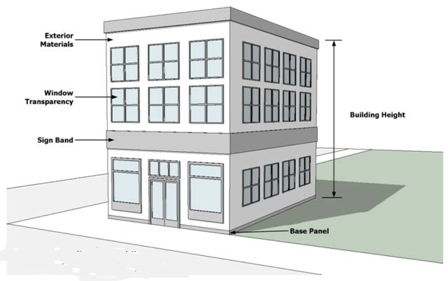
Diagram A Building Elements
Batching plant: A facility which manufactures or prepares bituminous paving materials, aggregate concrete, or bulk cement.
Bathhouse: An accessory building of one or more rooms, not open to the public, designed and intended for exclusive use by occupants of the primary use and their guests as dressing rooms and may or may not include sanitary facilities.
Beacon: Any light with one or more beams directed into the atmosphere or directed at one or more points not on the same lot as the light source. Also, any light with one or more beams that rotate or move.
Bed and breakfast: The commercial rental of up to six bedrooms within a private, owner-occupied, single-family detached dwelling unit, and providing temporary accommodations, typically including a morning meal, to overnight guests. This use may also include the temporary accommodation of daytime meetings or receptions for guests for a fee.
Best available data: For purposes of flood control regulation, information including but not limited to available topographic mapping, survey data, historic flood records, engineering studies, channel ratings, and engineering judgment, used by the Bureau of License and Permit Services to make Flood Control zoning district determinations pursuant to Section 742-203 (Flood Control Secondary zoning districts) when detailed floodplain data are not available for a particular site.
Best Management Practice (BMP): A single practice or combination of practices that are used to meet the stormwater quality standard. BMP can be structural or non-structural; structural BMPs can be natural or manufactured.
Bicycle sharing: Service in which bicycles are made available for shared use to individuals on a very short term basis.
Bioretention area: Structural stormwater controls, including bioretention areas, micro-bioretention areas, and rain gardens, that capture and temporarily store stormwater using soils and vegetation in landscaped areas to remove pollutants from stormwater runoff in accordance with Chapter 700 of the Stormwater Specifications Manual, January 2011, of the City of Indianapolis.
Blasting: For purposes of Gravel, Sand, and Borrow regulations, the use of explosives to break up or otherwise aid in the extraction or removal of rock or other consolidated natural formation.
Blended transitions: Portion of a walkway with a grade less than 5% that provides the connection between the level of the pedestrian walkway and the level of the crosswalk (See Diagram B).
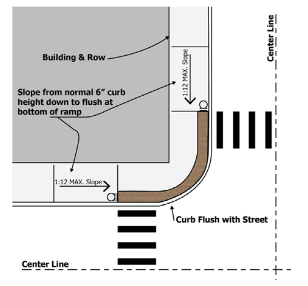
Diagram B Blended Transitions
Board: The Board of Zoning Appeals (BZA) of Indianapolis, unless the context clearly indicates that a different board is clearly intended.
Boardinghouse: A building, other than hotels, motels, hostels, bed and breakfasts or multifamily dwellings, containing accommodation facilities in common where lodging, typically with meals reserved solely for the occupants of the facility, is provided for a fee.
Buffer strip: For purposes of Gravel, Sand, and Borrow regulations, the minimum horizontal distance established by ordinance between a structure or activity and the boundary of a designated protected area, such as a floodplain, wetland, wildlife habitat for threatened or endangered species. (See Diagrams in Section 742-206)
Building: Any structure designed or intended for the support, enclosure, shelter, or protection of persons, animals, or property of any kind, having an enclosed space and a permanent roof supported by columns or walls.
Building sign: Any sign accessory to the primary use of land that is attached to any part of a building. Also known as a business sign.
Building marker: Small, on-premises, freestanding or building sign accessory to the primary use of land that is located on or in proximity of a building's pedestrian entrance or exit. For illustrative purposes only, examples may include signs indicating an address, owner's name, construction date, or building's historic significance.
Bulk storage of commercial or industrial liquids: The storage of commercial and industrial liquids, including but not limited to petroleum products, in aboveground containers for subsequent resale to distributors or retail dealers or outlets. This definition shall not include the dispensing of fuel to individual retail customers.
Bureau of License and Permit Services or Bureau: The Bureau of License and Permit Services of the Department of Code Enforcement.
Business, art, or other post-secondary proprietary school: A school conducted as a commercial enterprise for teaching skills such as art school; barber college/school; beauty or cosmetology college/school; business and secretarial school; clerical school; correspondence school; dance school; computer technology school; junior college; karate or martial arts school; language school; music school; or photography school. This definition shall not include the incidental instructional services in conjunction with another primary use.
C.
Camouflage: A structural design or treatment, including colors, intended to conceal and make a Wireless Communications Facility visibly compatible with the surrounding area.
Canopy: A roof-like cover, often of fabric, metal, plastic, fiberglass, or glass on a support, that is supported in total or in part from the ground, providing shelter over, for example, a doorway, outside walk or parking area.
Canopy sign: Any sign that is part of or attached to a canopy, made of fabric, plastic, or structural protective cover over a door, entrance, or window. A canopy sign is not a marquee and is different from pump island canopy signs.
Carport: A roofed structure designed and intended to shelter the automotive vehicle of the premises' occupant or owner, with at least one side permanently open to the weather.
Centerline of the highway: A line equidistant from the edges of the existing right-of-way separating the main-traveled ways of a divided interstate highway, freeway, expressway, or the centerline of the main-traveled way of a nondivided interstate highway, freeway or expressway.
Certificate of appropriateness (COA): The written determination by the Indianapolis Historic Preservation Commission that the construction, reconstruction, alteration, or demolition described in an application is not in conflict with the Historic Area Preservation Plan. A COA is also needed prior to any zoning matter in an Historic District.
Changeable copy sign: A sign or portion thereof with characters, letters, or illustrations that can be changed or rearranged electronically or non-electronically without altering the face or the surface of the sign. The message copy of a changeable copy sign can be changed manually in the field, through the use of changeable letters, numbers, symbols and similar characters, changeable pictorial panels or through the use of rotating panels and other similar devices that are not controlled through remote electronic or electric techniques. A sign on which the message changes more than eight times per day shall be considered an animated sign and not a changeable copy sign.
Check cashing or validation service: An establishment that, for compensation, engages in the business of cashing checks, warrants, drafts, money orders, or other commercial paper serving the same purpose. This definition shall not include a bank, savings and loan association, or credit union or other facility meeting the definition of financial and insurance services, and does not include establishments selling retail consumer goods, such as grocery stores, where the cashing of checks or money orders is incidental to the main purpose of the business.
Child: An individual who is less than 18 years of age, as per IC 12-7-2.
Child care, per IC 12-7-2-28.2: A service that provides for the care, health, safety, and supervision of a child's social, emotional, and educational growth, as per IC 12-7-2.
Child care home: A residential structure and the residence of a child care provider in which, as per IC 12-7-2, at least six children (not including the children for whom the provider is a parent, stepparent, guardian, custodian or other relative or any child who is at least 14 years of age and does not require child care) at any time receive child care from a provider:
a.
While unattended by a parent, legal guardian, or custodian;
b.
For regular compensation; and
c.
For more than four hours but less than 24 hours in each of 10 consecutive days per year, excluding intervening Saturdays, Sundays, and holidays.
The term includes a Class I Child Care Home; a Class II Child Care Home.
Class I Child Care Home, per IC 12-7-2: A Child Care Home that serves any combination of full-time and part-time children, not to exceed at any one time 12 children plus three children during the school year only who are enrolled in at least full-day kindergarten. Except as provided in IC 12-17.2-5-6.3(b), the addition of three school age children may not occur during a break in the school year that exceeds four weeks. A child for whom the provider of care is a parent, stepparent, guardian, custodian or other relative and who is at least seven years of age; or who is at least 14 years of age and does not require child care; shall not be counted in determining whether the Child Care Home is within the limit set forth by definition.
Class II Child Care Home, per IC 12-7-2: A Child Care Home that serves more than 12 children but not more than any combination of 16 full-time and part-time children at any one time. A child for whom the provider of care is a parent, stepparent, guardian, custodian or other relative and who is at least seven years of age; or who is at least 14 years of age and does not require child care; shall not be counted in determining whether the Child Care Home is within the limit set forth by definition.
Clean energy R&D: An industry sector focused on the research and application of techniques to generate energy that is designed to reduce dependence on fossil fuels. Includes research and services related to biofuels, alternative battery solutions, hybrid engines, hydrokinetic power, wind power generation, solar power generation, geothermal production, and hydrogen fuel production.
Clear sight triangular area: An area, as prescribed by this ordinance, in which no buildings, structures, landscaping, or other elements may be located within, unless otherwise exempted by this ordinance.
Club or lodge: Nonresidential organization of persons for special purposes or for the promulgation of sports, arts, literature, politics, or other common goals, interests or activities, characterized by membership qualifications, dues, or regular meetings. This definition includes uses such as fraternal lodge; singing society; and social membership club. This definition shall not include residential facilities.
Cluster subdivision, or cluster: A form of development for single-family residential subdivisions that permits a reduction in the minimum lot: area, width, setback and open space requirements and to concentrate development in specific areas of the subdivision while the remaining land is reserved in perpetuity. Recreational purposes, common open space and preservation of environmentally sensitive features are examples of some purposes of the remaining land.
Commercial amusement/recreation establishment, indoor: Same as "Indoor Recreation and Entertainment."
Commercial and Building Contractor: Establishment or activity that supplies materials and labor to fulfill work at a remote site, typically a building trade or activity associated with construction or maintenance. This definition may include offices for operation of the contracting business, but does not include retail sales of goods to the public, unless such retail sales are permitted by the district. This includes uses such as contractors for awning; building/construction; carpentry work; concrete; decorating; demolition; electrical; excavation; extermination/disinfection; fence; flooring; home remodeling; masonry/stonework/tile/setting; painting; pest control; plastering/drywall; plumbing; roofing; septic system; sheet metal; siding; sign; storm door; window; construction companies, contractors, lumber yards; swimming pool installation and services; home remodeling companies; heating; air conditioning; landscaping; lawn services; tree services; and water softener services.
Commercial parking garage: Same as "Parking Garage, Commercial."
Commercial vehicle: A vehicle that meets one or more of the following attributes.
1.
Any vehicle designed to operate on the road, if appropriately licensed, with a gross vehicle weight rating (GVWR) of more than 10,000 pounds; or
2.
Any vehicle, regardless of weight, used or designed to be used as a box truck, bucket truck, bus (carrying 10 or more passengers), commercial tree-trimming equipment, construction or excavating equipment, dump truck, flatbed truck, food truck, garbage truck, package delivery truck, step van, tank truck, tar truck, tow-truck; or
3.
Any vehicle with a US DOT number licensed by the State of Indiana as a commercial vehicle or commercial truck; or
4.
Any trailer, open or enclosed, with a cargo holder measuring more than 12 feet in length; or
5.
Any trailer, open or enclosed, holding landscaping or construction equipment including but not limited to mowers, trimmers, wood chippers or shredders, excavator, or front-loader.
This definition does not include a vehicle meeting the definition of a recreational vehicle.
Commission: The Metropolitan Development Commission (MDC) of Marion County, Indiana.
Committee: The Plat Committee of the Metropolitan Development Commission of Marion County, Indiana, or, in the case of a combined hearing as permitted under IC 36-7-4 and Section 740-600 (Application and Nonconformities) of the Zoning Ordinance, the hearing examiner of the Metropolitan Development Commission.
Commitment: Agreement made regarding property in accordance with IC 36-7-4.
Community center: Public or quasi-public facilities used for recreational, social, educational and cultural activities of a neighborhood or community. This definition includes facilities designed for the conduct of sport and leisure time activities and other customary and usual recreational activities such as athletic clubs; auditoriums; assembly halls; community, multi-service, neighborhood, or senior citizens' centers, swimming pools, and game courts.
Compost: Relatively stable decomposed organic matter or collected and managed decomposing organic matter for use in agricultural and other growing practices usually consisting of materials such as grass, leaves, yard waste, worms, and also including raw and uncooked kitchen food wastes, but specifically excluding bones, meat, fat, grease, oil, raw manure, and milk products.
Comprehensive Plan: The applicable comprehensive or master plan for Marion County, Indiana, or a part of that county, adopted by the Metropolitan Development Commission of Marion County, Indiana, pursuant to IC 36-7-4-500 Series, and any amendments to that plan.
Condition: An official agreement between the municipality and the applicant concerning the use or development of the land as specified in the letter of grant of a petition, variance, or special exception as signed by the Administrator or secretary of the applicable appointed land use body.
Condominium: A building, group of buildings, or portion thereof, in which units are owned individually as provided for by the lawful recordation of condominium instruments, and the structure, common areas, or facilities are owned by all the owners on a proportional, undivided basis as per IC 32-25.
Connected piping: In the Wellfield Protection zoning districts, any underground piping including valves, elbows, joints, flanges, and flexible connectors attached to a tank system.
Construction activity: The conduct of land alterations, watercourse alterations, erection, construction, placement, repair, alteration, conversion, maintenance, moving, or remodeling of any new or existing building or structure or any part thereof, or the construction, installation, extension, repair, alteration, conversion, removal or maintenance of building or structure equipment.
Consumer services or repair of consumer goods: Businesses engaged in the repair or servicing of common household or light commercial goods in which the service or repair is typically conducted on-site rather than at the end-users location. This definition includes uses such as: pick-up stations for dry cleaning or laundry; garment pressing; cleaning and maintenance services; interior decorator; key duplicating shop; locksmith; photocopying services, copy centers and document preparations, parcel packing/mailing service (excluding industrial); photo finishing; photography studio; plumbing sales and service (excluding contractor); radio or television service; security system services; tailor, seamstress or dressmaker; portable air conditioner service or repair; antique repair or restoration; bicycles; cameras; household, clocks, watches, or jewelry; computers; dental instruments; furniture reupholstery or refinishing; gas appliances; lawn mowers; leather goods; musical instruments; optical goods; radio or television; shoes; sewing machines; mobile phones and devices, glass installation and repair (excluding auto glass repair and installation); internet sales consignment facility.
Container: In the Wellfield Protection zoning districts, a receptacle for holding goods or wastes such as tanks, drums, and barrels.
Containment area: An aboveground area with floors and sidewalls that have been constructed of a material that prevents migration of fluids into the groundwater.
Convenience market: A retail establishment selling staple groceries, snacks, household items and sundries. The establishment may also provide an accessory facility where gasoline and other motor fuels are stored and subsequently dispensed by use of fixed, approved dispensing equipment on a self-service basis. This use is classified under "Retail, Light General."
Coping: A cap on a wall for protection of the structure from weather elements. Typically made of metal, masonry, or tile.
Cost: For purposes of flood control regulation, the actual value of the work to be performed based on a method approved by FEMA.
Covenant: A private legal restriction on the use of land contained in the deed, plat and other legal documents pertaining to the property.
Convenience market: A retail establishment selling staple groceries, snacks, household items and sundries. The establishment may also provide an accessory facility where gasoline and other motor fuels are stored and subsequently dispensed by use of fixed, approved dispensing equipment on a self-service basis. This use is classified under "retail, light general."
Covered open space: See "Open Space, Covered."
Crematorium: A freestanding facility containing furnaces for the reduction of dead bodies to ashes by incineration.
Critical facilities: For purposes of flood control regulation, those facilities that: are critical to the community's public health and safety; are essential to the orderly functioning of a community; store or produce highly volatile, toxic or water reactive materials that must be protected to prevent further harm or house occupants that may be insufficiently mobile to avoid loss of life or injury. For the purposes of the Zoning Ordinance, wastewater treatment plants and water treatment plants are not considered to be critical facilities regulated by these provisions.
CRS: Community Rating System. A program developed by the Federal Insurance Administration to provide incentives for those communities in the NFIP that have gone beyond the minimum floodplain management requirements to develop extra measures to provide protection from flooding.
Curb cut: The opening along the curb line, exclusive of curb ramps, at which point vehicles may enter or leave the street, also known as an access cut (see Diagram C).
Curb line: A line located on either edge of the pavement, but within the right-of-way (see Diagram C).
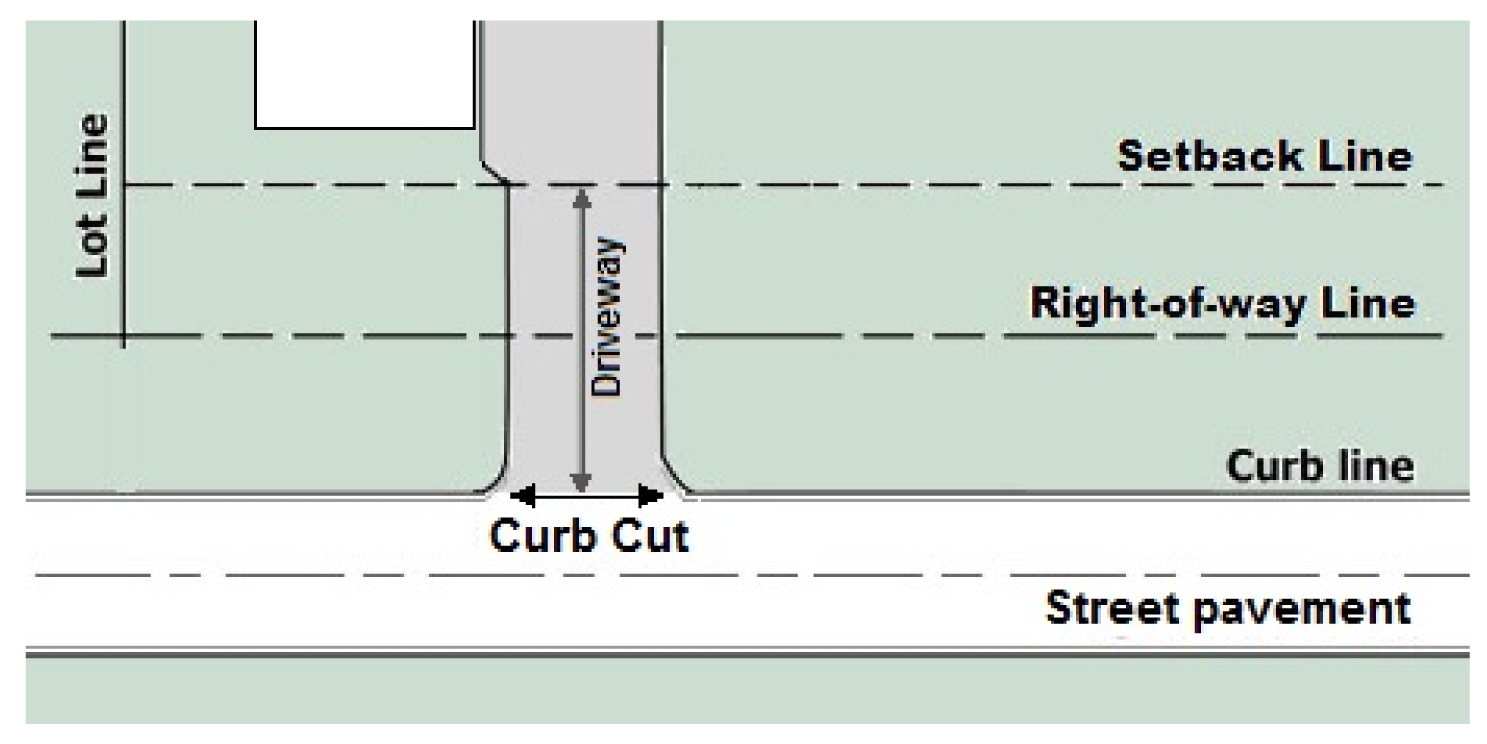
Diagram C Curbs
Cutoff: A means of defining the light distribution of a light fixture based on candela per 1,000 lamp lumens. Light fixtures are rated as Full Cutoff, Cutoff, Semi-Cutoff, or Non-Cutoff (see Diagram D).
Full cutoff: A light fixture with a distribution where zero candela intensity occurs at an angle of 90 degrees above nadir and all greater angles from nadir. Additionally the candela per 1,000 lamp lumens does not numerically exceed 100 (10%) at an angle of 80 degrees above nadir. This applies to all lateral angles around the light fixture.
Cutoff: A light fixture with a distribution where the candela per 1,000 lamp lumens does not numerically exceed 25 (2.5%) at an angle of 90 degrees above nadir, and 100 (10%) at a vertical angle of 80 degrees above nadir. This applies to all lateral angles around the light fixture.
Semi-cutoff: A light fixture with a distribution where the candela per 1,000 lamp lumens does not numerically exceed 50 (5%) at an angle of 90 degrees above nadir, and 200 (20%) at a vertical angle of 80 degrees above nadir. This applies to all lateral angles around the light fixture.
Non-cutoff: A light fixture with a distribution where there is no intensity (candela) limitation in the zone above maximum intensity.
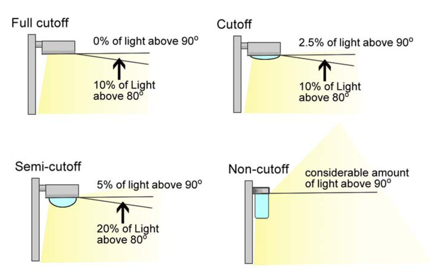
Diagram D Light Fixtures Cutoff ratings
D.
Day care center or nursery school: Either of the two types of institutions listed below.
1.
Any institution or place operated for the purpose of providing care, maintenance, supervision or instruction to children who are less than six years old and are separated from their parents, guardian, or custodian for more than four hours but less than 24 hours a day for ten or more consecutive workdays, where tuition, fees or other forms of compensation are charged, and that is licensed by and approved to operate as a day care center in accordance with the requirements of the State of Indiana. This definition does not include a Child Care Home.
2.
A facility that provides supervised activities as a principal use, on a daily basis, for adults who do not require specialized care and do not remain on the premises overnight.
DBH: Diameter at breast height (of a tree).
Deck: A ground-supported, unenclosed, accessory platform structure, usually constructed of wood, designed and intended for the recreational enjoyment of the occupants and guests of the primary structure or use.
Department store: Building or use primarily engaged in light merchandise retail use having a gross floor area greater than 50,000 square feet with no one merchandise line predominating. Merchandise lines are normally arranged in separate departments, with or without central customer checkout facilities. Accessory uses include personal services such as hair and body care salon or service; eating establishments; garment pressing or tailoring; photograph studios; and jewelry, watch, or eyeglass sales and repair.
Design capacity: When used in the context of parking or occupancy regulations, the approved capacity of building or facility based on applicable fire and building codes.
Designated enforcement entity: The Administrator, Inspector, Law Enforcement officer, or other person or agency, acting within their legal authority and jurisdiction, authorized by the Metropolitan Development Commission of Marion County, Indiana, to act upon the Commission's behalf to execute the authority extended to them by the Commission.
Design Manual for Speedway: The Development Design Manual for Speedway as adopted and amended by the Speedway Town Council and the Metropolitan Development Commission.
Development: For purposes of flood control regulation, any man-made change to improved or unimproved real estate including, but not limited to:
1.
Construction, reconstruction, or placement of a structure or any addition to a structure;
2.
Installing a manufactured home on a site, preparing a site for a manufactured home or placing a recreational vehicle on a site for more than 180 days;
3.
Installing utilities, erection of walls and fences, construction of roads, or similar appurtenances;
4.
Construction of flood control structures such as levees, dikes, dams, channel improvements;
5.
Mining, dredging, filling, grading, paving, excavation, or drilling operations;
6.
Construction or reconstruction of bridges or culverts;
7.
Storage of equipment or materials; or
8.
Any other activity that changes the direction, height, or velocity of flood or surface waters.
This definition does not include maintenance of existing structures and facilities such as painting, re-roofing, resurfacing roads; or agricultural practices such as gardening, plowing; or activities that do not involve filling, grading, or excavation. This definition does not include ordinary maintenance and repair conducted under Department of Public Works maintenance programs, such as mowing and activities required as part of necessary maintenance of drainage or flood control facilities so that the facilities will perform the function for which it was designed and constructed, provided that the maintenance of drainage or flood control facilities does not include any activities identified in subparagraphs 1. through 8. above.
Development Plan: As enabled by 1400 Series - Development Plans in IC 36-7-4-1400—through IC 36-7-4-1499.
Dewatering: In the Gravel Sand Borrow zoning district, removal of water from solid material by wet classification, centrifugation, filtration, or similar solid-liquid separation techniques. Removing or draining water from an enclosure or a structure, such as a riverbed, or caisson, by pumping or evaporation.
Disabled: An individual who has a physical or mental impairment that substantially limits one or more of the major life activities of an individual; a record of such an impairment; or being regarded as having such impairment.
Disposal: For purposes of wellfield protection regulation, discharge, deposit, injection, dumping, spilling, leaking, or placing of any potential groundwater contaminants into or on any land or water.
Diversion center: A facility that houses non-violent criminal offenders in lieu of incarceration. Diversion centers house offenders who maintain jobs during the day and are housed in a secure, locked facility at night. Diversion centers are reviewed on a case-by-case basis and require rezoning to a Special Use District.
Division of Inspections: The Division of Inspections of the Department of Code Enforcement.
DMD: The Department of Metropolitan Development of the City of Indianapolis.
Double dwelling: Same as "Two-Family Dwelling."
Double-faced sign: A sign consisting of two parallel faces supported by a single structure.
Drip line: The perimeter of a tree's spread measured to the outermost tips of the branches and extending downward to the ground.
Drive-in: See "eating establishment or food preparation."
Drive, interior access: A minor roadway for vehicular movement providing access within the boundaries of a project beginning at the required setback line, or direct ingress/egress between two or more abutting projects or parcels (see Diagram G under Parking).
Driveway: Access for vehicular movement to egress/ingress between the right-of-way of private or public streets and the building setback line. (See Diagram G under Parking.)
Drive-through: An accessory feature of an establishment including service units and stacking spaces that permits customers to receive services or obtain goods while remaining in or on a motor vehicle.
Dry cleaning plant or industrial laundry: Establishment that cleans garments, fabrics, draperies, etc., with solvents, steam or water with detergents. The plant is generally not visited by individual customers, but rather is served by collection vehicles. This definition includes uses such as rug cleaning or repair service; pressing of garments or fabrics; carpet or upholstery; power laundry; industrial launderers; and linen supply.
Duplex: Same as "Two-Family Dwelling."
Dwelling unit: One or more rooms connected together in a residential building or residential portion of a building, that are arranged, designed, used and intended for use by one or more human beings living together as a family and maintaining a common household for owner occupancy or rental or lease on a weekly, monthly, or longer basis; and that includes lawful cooking, eating, sleeping space and sanitary facilities reserved solely for the occupants of the unit.
E.
Eating establishment or food preparation: An establishment where food and drink are prepared on the premises to be served or consumed by the general public within the primary building, on the premises, or off the premises. This definition includes uses such as any type of restaurant; caterer; commissary restaurant; and commercial kitchens. The establishment may have a separate area, or lounge where alcoholic beverages are served without full food service, provided the area is accessory to the primary use in square feet and sales. The establishment may or may not have accessory drive-through facilities depending on the zoning district in which they are located.
Educational services: See "schools: elementary, middle, or high schools;" "business, art, or other post-secondary proprietary school."
Electronic variable message sign (EVMS): A sign, or component of a sign, such as an electrically or electronically controlled message center, where the characters, letters, or illustrations can be changed or rearranged either in the field, or from a remote location, without physically altering the face or the surface of the sign.
Elevation certificate: For purposes of flood control regulations, developed by FEMA to collect surveyed elevations and other information about a building that is necessary to verify compliance with the flood control ordinance and regulations and to obtain flood insurance, it is the most recently published official elevation certificate document issued by FEMA.
Emergency shelter, daily: A facility that provides congregate style temporary lodging with or without meals and ancillary services on the premises to those seeking relief from social issues, primarily the homeless, for more than four weeks in any calendar year. This definition does not include the provision of lodging to any individual (1) who is required because of age, mental disability or other reason to reside either in a public or private institution or (2) who is imprisoned or otherwise detained pursuant to either federal or state law and does not include a diversion center.
Employee living quarters: Living space for persons employed in the dwelling or facility where the employee living quarters are located. This definition includes living space for employees such as caretakers, property managers, facilities and janitorial services, and operations crew.
Enlargement (pertaining to adult entertainment only): An increase in the size of the building, structure or premises in which the adult entertainment business is conducted by either construction or use of an adjacent building or any portion thereof whether located on the same or an adjacent lot or parcel of land.
Equipment structure: Any structure needed to house apparatus needed for the operation and maintenance of a wireless communication antenna, and located on the same site as the wireless communication antenna.
Entrance roadway: Any public street or turning roadway, including acceleration lanes, by which traffic may enter the main-traveled way of an interstate highway, freeway or expressway from the general street system within Marion County, irrespective of whether traffic may also leave the main-traveled way by such street or turning roadway.
Erect: Activity of constructing, building, raising, assembling, placing, affixing, attaching, creating, or any other way of bringing into being or establishing.
Established front setback line: The line that parallels the front lot line and is located at the closest point of any legally established building on the lot to the front lot line, measured at grade level.
Establishing an adult entertainment business: Shall mean and include any of the following:
1.
The opening or commencement of any such business as a new business;
2.
The conversion of an existing business, whether or not an adult entertainment business, to any of the adult entertainment businesses defined herein;
3.
The relocation of any such business.
Excavation: Breaking of ground, digging, mining, removal, or displacement of the natural surface of the earth, whether sod, dirt, soil, sand, gravel, stone, loam, rock, clay, silt, or other naturally-deposited material, whether alone or in combination. For purposes of wellfield protection regulation, this does not include activities in a personal garden, ground care, or agricultural activities.
Existing mobile dwelling project or subdivision: A mobile dwelling project for which the construction of facilities for servicing the lots on which the mobile dwellings are to be affixed (including, at a minimum, the installation of utilities, construction of streets and either final site grading or pouring of concrete pads) is completed before December 20, 1989.
Exit roadway: Any public street or turning roadway, including deceleration lanes, by which traffic may leave the main-traveled way of an interstate highway, freeway or expressway to reach the general street system within Marion County, irrespective of whether traffic may also enter the main-traveled way by such street or turning roadway.
Expansion to an existing mobile dwelling project or subdivision: The preparation of additional sites for an existing mobile dwelling project by the construction of facilities for servicing the lots on which the mobile dwellings are to be affixed (including the installation of utilities, the construction of streets, and either final site grading or the pouring of concrete pads).
Extension: For purposes of sign regulation, any vertical or horizontal embellishments to an advertising sign designed as a part of, and integrally incorporated into, the announcement, declaration, device, demonstration or insignia used as a part of such sign (refer to Sign Diagram 35).
F.
Façade: An exterior wall of a building or structure that faces a public or approved private street.
Family: One or more human beings related by blood, marriage, adoption, foster family care or guardianship together with incidental domestic servants and temporary guests that do not pay compensation for lodging; or, not more than four human beings not so related, occupying a dwelling unit and living as a single housekeeping unit.
Farmers' market: A market held in an open area or structure where a group of individual producers offer for sale to the public items such as fresh produce, seasonal fruits, fresh flowers, items created from those products, and food and beverages dispensed from booths located on-site.
FEMA: The Federal Emergency Management Agency.
Fence: A type of structural barrier usually made of posts supporting such items, by way of example, as chain link, wood pickets, lattice-work, and similar items.
Fill: For purposes of flood control regulations, soil material placed upon the ground, compacted and graded for the purpose of elevating the surface of the ground.
Financial and insurance services: Economic services such as mortgage lending, insurance, asset and risk management, and similar services to individuals and businesses and may include the on-site circulation of cash money. Includes bank; savings and loan; credit union; stock brokerage, insurance brokerage and financial consultation. This definition does not include check cashing or validation services. Accessory uses may include automated teller machines and offices. Financial institutions may or may not have accessory drive-through services depending on the zoning district in which they are located.
Finished floor area: That portion of floor area constructed, completed and usable for living purposes with normal living facilities that includes sleeping, dining, cooking, sanitary, or combination thereof. A floor area or portion thereof that remains unfinished and used only for storage purposes and not equipped with the facilities previously identified is not considered finished floor area.
Firearm sales: A business in which at least 10% of the gross floor area is used for or 10% of sales revenues are earned from, the wholesale or retail sale of firearms and ammunition, the repair of firearms, or the creation or fitting of special barrels, stocks, or trigger mechanisms for firearms.
Fireworks sales, on-going: The on-going, nonseasonal sale of fireworks in a permanent building for commercial or home use. This definition does not include "tent"-type temporary fireworks sales or other seasonal fireworks sales.
FIRM: Flood Insurance Rate Map. The official map of a community, on which FEMA has delineated both the areas of special flood hazard and the risk premium zones applicable to a community.
Flag: Any fabric or similar light-weight material attached at one end of the material, usually to a staff or pole, so as to allow movement of the material by atmospheric changes.
Flashing sign: A directly or indirectly illuminated sign that exhibits changing light, color or effect by any means, so as to provide intermittent illumination, or that includes the illusion of intermittent or flashing light by means of animation.
Flea market: An indoor or outdoor premises where any person or aggregation, congregation or assembly of vendors, whether professional or non-professional, offers for sale, trade or barter, whether new or used, any household goods, personal effects, tools, art work, small household appliances, and similar merchandise, objects, or equipment in small quantities, in broken lots or parcels, not in bulk, for the use or consumption by the immediate purchaser. The term "flea market" does not include wholesale sales establishments or rental services establishments, retail sidewalk sales, or garage sales.
Fleet terminals: A central facility for the distribution, storage, loading and repair of fleet vehicles, with or without associated dispatch services and offices. This definition includes uses such as ambulance services; courier, delivery, and express services; cleaning services; key and lock services; security services; motor truck terminals; limousine services; armored car services; and taxi services. This definition does not include waste or recycling transfer facilities. An inherent characteristic of this use is the parking of operable vehicles which is considered a primary facet of the use; as a primary use, this area is not be construed as outside storage.
Flood: A general and temporary condition of partial or complete inundation of normally dry land areas from the overflow, the unusual and rapid accumulation, or the runoff of surface waters from any source.
Flood insurance study (FIS) base flood profile: The base flood elevation profile included in the official hydraulic and hydrologic report (flood insurance study) provided by FEMA. The report contains flood profiles, as well as the FIRM, and the water surface elevation of the base flood.
Floodplain: The channel proper and the areas adjoining any wetland, lake, or watercourse that has been or may be covered by the regulatory flood. The floodplain includes both the floodway and the floodway fringe.
Floodplain administrator: Employee authorized and directed to enforce the provisions of the Flood Control Secondary Zoning District Ordinance.
Floodproofing: A method of protecting a nonresidential structure that ensures that the structure, together with attendant utilities and sanitary facilities, is watertight to the floodproofed design elevation with walls that are substantially impermeable to the passage of water. All structural components of these walls are capable of resisting hydrostatic and hydrodynamic flood forces, including the effects of buoyancy, and anticipated debris impact forces.
Floodproofing certificate: The most recently published official document for floodproofing certificate for nonresidential structures issued by FEMA. This form developed by FEMA to certify compliance for nonresidential structures as an alternative to elevating structures to or above the FPG. This certification must be by a Registered Professional Engineer or Architect.
Flood protection grade: The elevation above the base flood plus two feet at any given location in the SFHA.
Floodwater: The water of any lake or watercourse that is above the banks or outside the channel and banks of such watercourse.
Floodway: The channel of a river or stream and those portions of the floodplains adjoining the channel which are reasonably required to efficiently carry and discharge the peak flood flow of the regulatory flood of any river or stream.
Floodway fringe: The portion of the regulatory floodplain lying outside of the floodway.
Floor area: The sum of all horizontal surface areas of all floors of all roofed portions of a building measured from the exterior faces of the exterior walls or roofs, or the centerlines of party walls separating abutting buildings or portions thereof. However, this does not include the following:
a.
Areas with a vertical height clearance less than 78 inches;
b.
Exterior open balconies, and open porches;
c.
Floor or basement floor area devoted to off-street parking or loading facilities, including aisles, ramps, and maneuvering space.
Floor area, gross: The sum of all horizontal surface areas with a vertical height clearance of at least 78 inches of all floors of all roofed portions of a building, or specified portion of a building, measured from the exterior faces of the exterior walls or from the centerline of walls separating abutting buildings.
Floor area, main: The area of a horizontal plane, fully bound by the exterior walls of the primary building or structure, of the floor surface at or above grade level exclusive of vent shafts, decks, garages, uncovered or covered open space.
Foster family care: The provision of food, lodging, healthcare, supervision, education, and training for a child or children not related to the caretaker by blood or adoption on a regular 24-hour-a-day basis, provided that such child or children is received from any state operated institution for child care or from any child placement agency.
Fourplex: A building designed for residential occupancy by four families, or later approved by the city for occupancy by four families, living independently of each other that contain four, legally complete, dwelling units and no dwelling unit may be located on a separate lot. Each unit in a fourplex is completely separated from the other by either an unpierced wall extending from ground to roof; or an unpierced ceiling and floor extending from exterior wall to exterior wall, except for a common stairwell exterior to two or more of the dwelling units. Dwelling units may be a part of a condominium as defined by Chapter 551.
Fraternity or sorority: A building containing sleeping rooms, bathrooms, common rooms, and a central kitchen and dining room maintained exclusively for fraternity or sorority members and their guests or visitors and affiliated with an institution of higher learning.
Freestanding sign: Any sign that has supporting framework that is placed on, or anchored in, the ground and is independent from any building or other structure.
Frontage: The common line of contact of a property with the right-of-way along a lot line that may allow unobstructed, direct access to the property. Frontages may be further distinguished by the type of right-of-way or type of property abutted.
Frontage, street (street frontage): A frontage in which the right-of-way is a street. Public or private may be distinguished as well.
Front building line: When established as a requirement for location of the principal building, the distance or a range from the front lot line, at or within which distance the front building line of the principal structure shall be established. When expressed as a requirement to measure something else (i.e. parking or accessory buildings located behind the front building line), the front building line shall mean the actual linear which the front of the building is established, extending across the entire lot. (See "established front setback line")
Front building line, required: The percentage of the lot frontage which must be occupied by at least a portion of the front building.
Frontage (private): The area at the front of lots that is generally between the established front setback line and the front lot line, which establishes the relationship between the private lot and building and the public streetscape. Private frontage types in this code are applied to private property; however, the specific frontage types may be used to coordinate policies and standards for public rights of way based on the context.
Fuel dispensing location: Any facility or premise where fuel, typically gasoline or diesel, is dispensed from an underground or aboveground storage tank.
Fugitive dust: Dust that is generated by non-point sources like movement of equipment and the effects of wind and rain on stockpiles and areas stripped of vegetation.
Full control of access: The condition where the right of the owner or occupant of abutting property, or of other persons, to access said property, including the location and connection with public streets, is limited and controlled by public authority to give preference to through vehicular traffic movement, by restricting access connections to selected public streets only, by limiting crossings at grade level and by prohibiting direct driveway connections. Such frontages include, but are not limited to, the frontages along: Binford Boulevard; North Shadeland Avenue between 48 th Street to the Fall Creek waterway; and North Keystone Avenue between Woodfield Crossing Boulevard and 96 th Street. See related "Partial Control of Access."
G.
Game courts: An outdoor recreation facility that consists of an unpaved or paved, accessory, surface area of ground open and essentially unobstructed to the sky, on the same lot as the primary structure, designed and intended for the playing of a recognized sport as an accessory, recreational activity. Game courts may include fencing, screening, nets, goals, or other necessary appurtenances required for the recreational use.
Garage, residential: A building accessory to a residential use, or an enclosed area attached or integrated into a residential building, that is primarily designed and intended to be used for the storage of the private vehicles for the occupants of said residence and is not a separate commercial enterprise available to the general public.
Garden as a primary use: An area of land managed and maintained by one individual or a group of individuals to cultivate fruits, flowers, vegetables, or ornamental plants, for personal or group use, consumption or donation. Garden as a primary use may be divided into separate plots for cultivation by one or more individuals or collectively. Garden as a primary use may include bee-keeping (apiculture) and may include common areas maintained and used by group members.
Governmental sign: Signs designed for control of, or to provide information to, traffic and other regulatory functions and signs of public service companies indicating danger and aids for service or safety that are erected by the order of a public officer in the performance of his/her public duty. See related "Public Sign".
Grade, established street: The elevation of the street pavement abutting the property as fixed by the appropriate government agency measured at the crown of the street, which is the highest point, most often at the centerline, of a street cross-section of the street pavement between the curb lines.
Grade level: The lowest point of elevation of the finished surface of the ground, paving or sidewalk and similar surface improvements. For purposes of sign regulation, grade level is the lower of 1) existing grade prior to construction, or 2) existing grade after construction, exclusive of any filling, berming, mounding, or excavating solely for the purpose of locating the sign.
Greenbelt: The portion of a front yard of a lot that is immediately adjacent and parallel to a street right-of-way and specified as such for landscaping purposes.
Green roof: The roof of a building that is partially or completely covered with vegetation and soil, or a growing medium, planted over waterproofing membrane.
Greenway: A linear open space that is open to the public and connects parklands, improves recreational opportunities, and aids in the protection of wildlife and scenic regions. Greenways include the corridors described in the Indy Greenways Full Circle 2014-2024 Master Plan.
Grocery store: A commercial establishment, primarily engaged in the retail sale of canned foods and dry goods, such as tea, coffee, spices, sugar, and flour; fresh fruits and vegetables; and fresh and prepared meats, fish and poultry. This definition includes uses such as supermarket, food store, and delicatessen. Accessory uses may include providing services to customers such as banking and check-cashing, rental of household equipment or medical supplies, pharmacy services, bakery services, or eating establishment or food preparation.
Grocery store (Transit-Oriented Development Secondary District): For the Transit-Oriented Development Secondary District, the following refined categories apply:
Convenience grocery store (3,000 square feet or less)—A convenience type grocery and/or sundry store with 3,000 or less square feet of gross leasable area.
Small grocery store (3,001—10,000 square feet)—A grocery store with between 3,001 and 10,000 square feet of gross leasable area.
Medium grocery store (10,001—30,000 square feet)—A grocery store with between 10,001 and 30,000 square feet of gross leasable area.
Large grocery store (30,001—50,000 square feet)—A grocery store with between 30,001 and 50,000 square feet of gross leasable area.
Supermarket grocery store (50,000 or more square feet)—A grocery store with more than 50,000 square feet of gross leasable area.
Gross leasable area: The total floor area that is designed for the tenant's occupancy and exclusive use.
Ground cover: Low-growing herbaceous plants less than 18 inches in height with a spreading growth habit, used to provide protection from erosion and drought, and typically to improve aesthetic appearance, such as grasses, vines, flowers. This definition does not include noxious weeds as defined by IC 15-16-7-2.
Ground floor: That story that contains finished floor area closest to, but not below, grade level. In cases in which the only story with finished floor area is below grade level, that story with finished floor area closest to grade level is considered the ground floor.
Ground sign: Any freestanding sign constructed in or on the ground surface with its sign face extending downward to or near the ground surface and is supported on a frame by one or more uprights or braces.
Groundwater: For purposes of wellfield protection regulation, any water existing within the zone of saturation in a geologic formation beneath the surface of the earth. The zone of saturation is the area in which the pore spaces between the soil and rock particles are completely filled with water; the water table is the top of the zone of saturation.
Group home: A residential facility for two or more individuals meeting the definition of a handicapped person under the Federal Fair Housing Act and court decisions interpreting that act. This definition includes community residential facilities for persons with developmental disabilities (as defined by IC 12-7-2-61) as licensed by the Division of Disability and Rehabilitative Services - Bureau of Developmental Disabilities Services, per 460 IAC 9-2. This definition includes residential living facilities for persons with psychiatric disorders or addictions as licensed by the Division of Mental Health and Addiction, per 440 IAC 7.5. For purposes of this definition, the term handicapped does not include persons currently using or addicted to alcohol or controlled substances who are not in a recognized recovery program, nor does it include half-way houses for individuals in the criminal justice system, or diversion centers.
GVWR: Gross vehicle weight rating. GVWR is the maximum total weight of the vehicle, passengers, and cargo that the vehicle can safely handle. The GVWR for a vehicle can typically be found inside the driver's side door.
H.
Habitable space: For purposes of flood control regulation, the enclosed area of any building used for living area including but not limited to bedrooms, bathrooms, kitchens, living rooms, family rooms, dining rooms, recreation rooms, utility rooms and workshops.
Hair and body care salon or service: The provision of services generally to individuals involving the care of a person's appearance, such as haircare, manicure, pedicure, tanning, and massage therapy. Massage therapy must be provided by a practitioner licensed by the State of Indiana. This definition does not include an adult entertainment business or any business where a massage is distinguished or characterized by an emphasis on specified sexual activities, or involving specified anatomical areas.
Hard-surfaced: For purposes of wellfield protection regulation, a quality of an outdoor area being solidly constructed of asphalt, concrete, or other material approved by the technically qualified person. For all other purposes, a quality of an outer area being solidly constructed of pavement, brick, paving stone, tile, wood, or a combination of those materials.
Hardware store: A commercial establishment primarily engaged in the retail sale of a number of basic hardware lines, such as tools, builders' hardware, paint and glass, housewares and household appliances, and cutlery.
Haulageway: For purposes of Gravel, Sand, and Borrow regulations, any road utilized for mining operations, together with that area of land over which material is transported, that are located within the land controlled by the operator.
Hazardous material: For purposes of wellfield protection regulation, any material present in large enough quantity to pose a significant physical or health hazard to public health, public safety or the environment due to its chemical composition. For all other purposes of the Zoning Ordinance, a hazardous material can be a pure chemical substance or a mixture, a raw material, a product or a waste material.
Heavy equipment sales, service or repair: The sales, service, leasing and repair of heavy equipment including, but not limited to, tire recapping, crane repair, construction equipment repair, and other large equipment repairs. For purposes of this definition, equipment does not include self-propelled vehicles. This definition does not include any facility meeting the definition of a truck or heavy vehicle sales rental and repair use. An inherent characteristic of this use is the outside display of vehicles offered for sale which is considered a primary facet of the use; as a primary use, this display must meet the development standards as a primary use and not the standards associated with an accessory use.
Heavy outdoor storage: See "outdoor storage, heavy."
Heavy vehicle wash: The cleaning, polishing, waxing, washing of the interior or exterior of vehicles, equipment, fleet vehicles, trucks or buses that exceed 14,000 GVWR.
Hedge: A row or rows of closely planted shrubs, bushes, or combination thereof creating a vegetative barrier.
Height, building: The vertical distance above grade level measured to the highest point of the coping of a flat roof or to the deck line of a mansard roof or to the height of the highest gable of a pitched or hipped roof. Refer to Section 740-303 (Building Measurements and Calculations) for calculation.
Heliport or helistop: An area of land, water or structural surface that is intended for the lawful landing and takeoff of helicopters. Heliports provide appurtenant areas that are intended for use for heliport buildings and auxiliary facilities, such as, parking areas, waiting rooms, fueling, storage and maintenance equipment areas, and helistops are without any appurtenant areas or auxiliary facilities.
Heliport or helistop approach surface area: The land area designated as "heliport approach surface area" on the official zoning map, located at the edge of the heliport landing and take-off area and widening thereafter uniformly to a width of 500 feet at a horizontal distance of 4,000 feet from the landing and take-off area.
Heliport or helistop landing and take-off area: The area of the heliport used for the landing and taking-off of helicopters.
Heliport or helistop primary surface area: That area coinciding in size and shape with the heliport landing and take-off area.
Heliport or helistop transitional surface area: The land area designated as transitional surface area on the official zoning map, located adjacent to the heliport primary surface area - such surface extends outward perpendicular to the centerline of the primary and approach surfaces for a horizontal distance of 250 feet.
Heritage tree: A tree over 18 inches diameter at breast height (DBH) and one of the heritage tree species. Heritage tree species include: Sugar Maple (Acer saccharum), Shagbark Hickory (Carya ovata), Hackberry (Celtis occidentalis), Yellowwood (Cladrastus kentukea), American Beech (Fagus grandifolia), Kentucky Coffeetree (Gymnocladus diocia), Walnut or Butternut (Juglans), Tulip Poplar (Liriodendron tulipifera), Sweet Gum (Liquidambar styraciflua), Black Gum (Nyssa sylvatica), American Sycamore (Platanus occidentalis), Eastern Cottonwood (Populus deltoides), American Elm (Ulmus americana), Red Elm (Ulmus rubra) and any oak species (Quercus, all spp.)
High impact project: For purposes of Regional Center regulations, projects that are: new construction valued at a hard cost value exceeding a specific threshold value; remodeling or modification of existing development values at a hard cost value exceeding a specific threshold value; proposing a floor area exceeding a specific threshold value measured in square footage; proposing an area of surface parking exceeding a specific threshold value measured in square footage; or demolition of historic structure, as determined by the Administrator. The threshold values of high impact projects are established by a resolution of the Metropolitan Development Commission.
High-power electric transmission line: A line segment in an electric utility system having an operating voltage of 69,000 volts or greater.
Historic District: A Historic District established under IC 36-7-11.1.
Historic structure: Any structure that is:
1.
Listed individually in the National Register of Historic Places (a listing maintained by the Department of Interior) or preliminarily determined by the Secretary of the Interior as meeting the requirements for individual listing on the National Register;
2.
Certified or preliminarily determined by the Secretary of the Interior as contributing to the historical significance of a registered Historic District or a District preliminarily determined by the Secretary to qualify as a registered Historic District;
3.
Individually listed on a state inventory of historic places in accordance with state historic preservation programs that have been approved by the Secretary of the Interior; or
4.
Individually listed on a local inventory of historic places in communities with historic preservation programs that have been certified either by the Secretary of the Interior or by an approved state program as determined by the Secretary of the Interior; or.
5.
Individually listed on the local inventory in the Historic District plan of a locally-designated Historic District.
Historic preservation plan: A plan, prepared by the Indianapolis Historic Preservation Commission (as per IC 36-7-11.1-6) and adopted by the Metropolitan Development Commission (MDC), designating one or more historic areas or structures as having historic or architectural significance. This historic preservation plan, once adopted by the MDC, shall be considered a part of the county's comprehensive plan.
Home improvement store/center: A facility for the sale of home, lawn, and garden materials and supplies, brick, lumber, hardware items and other similar materials. This use is classified as "heavy general retail."
Home occupation: An occupation, profession, craft, service, or business activity carried on within a legally established dwelling unit, or associated legally established accessory building, by a resident of a dwelling unit on the same lot or parcel, where the occupation or business activity is clearly incidental and subordinate to the residential use. Examples of professional services that are permitted home occupations include but are not limited to accounting, counseling, cabinet making, computer programming, web design, graphic design, law, medicine, dentistry, architecture, engineering, sewing, real estate brokerage, tailoring, weaving, therapy provided by a practitioner licensed by the State of Indiana, tutoring, writing, painting, photography, music instruction, web design, and such services as are provided by clergyman, insurance agents, and manufacturer's agents. A Child Care Home is not a home occupation. Foster family care is included in the definition of a family and is not a home occupation. Produce sales is not a home occupation.
Hospital: An institution that provides primary health services and psychological, medical or surgical care to persons suffering from illness, disease, injury, deformity and other physical or mental conditions, that provides overnight accommodation for persons receiving treatment, and that includes as an integral part of the institution, related facilities such as laboratories, outpatient or training facilities.
Hotel, motel, or hostel: Any building or group of buildings containing guest rooms designed or intended to be occupied for sleeping purposes by guests for a fee, often with general kitchen and dining room facilities provided within the building or an accessory building, and that caters to the traveling public. The use may include associated administrative offices; the sale of food, beverages, and convenience items; and meeting rooms.
I.
ICC: Increased Cost of Compliance. For purposes of flood control regulations, a program offered through FEMA to offset the additional cost to bring a repetitively and/or substantially damaged structure into current compliance with the Flood Control Zoning Ordinance.
IDNR: The Indiana Department of Natural Resources.
Illuminated sign: Any sign that contains an auxiliary design element designed to emanate artificial light internally or externally from the sign, including signs illuminated from the exterior by spotlights or other lighting apparatus directed upon the sign structure either from the ground or from a lighting fixture attached to the exterior of the sign structure.
IMUTCD: Indiana Manual on Uniform Traffic Control Devices.
INRC: The Indiana Natural Resources Commission.
Incidental sign: Small, permanent, freestanding or building sign accessory to the primary use of land that is located on or within five feet of specific areas of a site including pedestrian entrances and exits, parking areas, loading areas, service areas, drive-through service areas, natural landscaping areas, rain gardens, bioswales and storm water management features, and hazardous materials areas.
Indoor recreation and entertainment: The offering of entertainment or games of skill to the general public within a fully enclosed building. This definition includes uses such as amusement arcade; bowling alleys; billiard parlor; ballroom; bathhouse; bingo establishment; dancing; firing (gun) range; gymnasium; instruction in baseball, basketball, gymnastics; miniature golf; ice or roller skating rink; or other similar indoor commercial amusement/recreation establishment. This definition shall not include off-track mutuel wagering facilities or Adult Entertainment Business.
Indoor spectator venue: The offering of entertainment for the general public to watch within a fully enclosed building, typically beginning at a specific time. This definition includes uses such as theater, auditorium, cinema, convention space, exhibition space. This definition shall not include off-track mutuel wagering facilities or Adult Entertainment Business or Adult Entertainment Theater.
Information technology R&D: An industry sector focused on the research and development of information technology such as software; geographic information systems; computer sciences; cell chip technology; fiber optics; application development; or wireless technologies.
Informational site: An area or site established and maintained within or adjacent to the right-of-way of a highway on the interstate system by or under the supervision or control of a state highway department, wherein panels for the display of signs may be erected and maintained.
Inoperable vehicle:
1.
A motor vehicle, racing vehicle, recreational vehicle, trailer, camper, boat, airplane, bus, truck, or similar vehicle from which there has been removed engine, transmission or differential parts or that is otherwise partially dismantled or mechanically inoperable; or
2.
Any motor vehicle, racing vehicle, recreational vehicle, trailer, camper, boat, airplane, bus, truck, or similar vehicle, that cannot be driven, towed or hauled on a city street without being subject to the issuance of a traffic citation by reason of its operating condition or the lack of a valid license plate.
Inspector: An employee of the Division of Inspections authorized to enter, examine and survey all lands within Marion County to accomplish the enforcement of all Codes and land use regulations of Marion County; and employees of the Marion County Public Health Department authorized by the Administrator to enter, examine and survey all lands within Marion County in the Wellfield Protection zoning districts, Gravel, Sand and Borrow Districts, and Flood Control zoning districts to accomplish the enforcement of the Zoning Ordinance and land use regulations of Marion County.
Instrument runway: A runway equipped or to be equipped with electronic or visual air navigation aids adequate to permit the landing of aircraft under restricted visibility conditions.
Integrated center: An area of development (commercial, industrial or any combination of commercial, industrial and residential uses) that includes multiple businesses or uses in one or more buildings that share common-site facilities. Specifically, an area of development with a single building that includes two or more separate businesses or uses is classified as an integrated center. Two or more buildings are classified as an integrated center if the development encompassing and serving the two or more buildings:
1.
Is three acres or more in size;
2.
Is comprised of one or more lots;
3.
May include any combination of commercial or industrial uses; and
4.
Has three or more of the following characteristics:
a.
Two or more separate businesses or uses occupy the buildings.
b.
Shared vehicle access to a public street.
c.
Common property ownership.
d.
Development is regulated by shared conditions of approval of a land use petition.
e.
Included in the common naming of the property or shared marketing of the property.
In addition, any lot that abuts a lot determined to be an integrated center is also considered a part of the integrated center if the abutting lot shares vehicle access to a public street with that integrated center and does not have its own direct vehicle access to a public street.
Interior access drive: Same as "drive, interior access."
Interior sign: Any sign not visible from the exterior of the building or structure and located within the interior of any building or structure, or within an enclosed lobby or court of any building.
Interstitial monitoring: For purposes of wellfield protection regulation, a system designed, constructed and installed to detect a leak from any portion of a storage tank or connected piping that routinely contains potential groundwater contaminants by monitoring the space between the primary (inner) tank and connected piping and the secondary (outer) tank or connected piping.
Isoseismic study: For purposes of Gravel, Sand, and Borrow regulation, an analysis of blasting events and local geologic conditions by qualified and independent vibration experts to determine the optimum conditions under which blasting can be accomplished to reduce ground vibration and structural response.
J.
Junk yard: See "wreckage and salvage facility."
K.
Kennel: See "animal care, boarding, veterinarian services."
L.
Land alteration: For purposes of flood control regulation, any change in the topography of land caused by activities including but not limited to excavation, filling, deposit or stockpiling of materials and construction of ponds, dams, or levees outside of a watercourse. For purposes of flood control regulation, land alterations do not include the construction, placement of, or other activities involving buildings or nonbuilding structures or those activities that are defined as open land use in this article, or ordinary maintenance and repair of an IDNR approved land alteration.
Landing area: The area of the airport, heliport or helistop used for the landing, taking-off or taxiing of aircraft.
Land use petition: A rezoning petition, variance petition, approval petition, special exception petition, or any other petition permitted by the Rules of Procedure adopted by the Metropolitan Development Commission of Marion County or the Metropolitan Board of Zoning Appeals.
Landscaping: Any combination of vegetation, such as trees, shrubs, ground cover, thickets or grasses, that are planted, preserved, transplanted, maintained and groomed to develop, articulate and enhance the aesthetic quality of the area as well as provide erosion, drainage and wind control. Landscaping may include hardscape elements, such as walks, terraces, sculpture, fountains, and pools.
Laundromats: An establishment providing washing or drying machines on the premises for rental use by the general public and may include incidental drop-off laundry service. This definition includes automatic, self-service only, coin-operated, or hand laundries. This definition shall not include a dry cleaning plant or industrial laundry, and shall not include dry cleaning or processing with any solvents.
Law enforcement officer: Any sworn member of the Marion County Sheriff's Department, Indianapolis Metropolitan Police Department, Beech Grove Police Department, Lawrence Police Department, Southport Police Department, Speedway Police Department or Cumberland Police Department, acting within their legal authority and jurisdiction.
Legally established nonconforming building or structure: Any continuous, lawfully established building or structure erected or constructed prior to the time of adoption, revision or amendment of the Zoning Ordinance, or granted variance of the Zoning Ordinance, but that fails, by reason of such adoption, revision, amendment or variance, to conform to the present requirements of the Zoning Ordinance.
Legally established nonconforming sign: Any sign and its support structure lawfully erected prior to the effective date of the adoption of this ordinance that fails to conform to the requirements of this chapter. A sign that was erected in accordance with a variance granted prior to the adoption of this chapter and does not comply with this chapter shall be deemed to be a legal nonconforming sign. A sign that was unlawfully erected shall be deemed to be an illegal sign.
Legally established nonconforming use: Any continuous, lawful land use having commenced prior to the time of adoption, revision or amendment of the Zoning Ordinance, or granted a variance of the Zoning Ordinance, but that fails, by reason of such adoption, revision, amendment or variance to conform to the present requirements of the Zoning Ordinance.
Legible: Capable of being read with certainty without visual aid by a person of normal visual acuity.
Letter of final determination (LFD): A letter issued by FEMA during the mapping update process which establishes final elevations and provides the new flood map and flood study to the community. The LFD initiates the six-month adoption period. The community must adopt or amend its floodplain management regulations during this six-month period unless the community has previously incorporated an automatic adoption clause.
Letter of map change (LOMC) is a general term used to refer to the several types of revisions and amendments to FEMA maps that can be accomplished by letter. They include letter of map amendment (LOMA), letter of map revision (LOMR), and letter of map revision based on fill (LOMR-F). The definitions are presented below:
Letter of map amendment (LOMA) means an amendment by letter to the currently effective FEMA map that establishes that a property is not located in a SFHA through the submittal of property specific elevation data. A LOMA is only issued by FEMA.
Letter of map revision (LOMR) means an official revision to the currently effective FEMA map. It is issued by FEMA and changes flood zones, delineations, and elevations.
Letter of map revision based on fill (LOMR-F) means an official revision by letter to an effective NFIP map. A LOMR-F provides FEMA's determination concerning whether a structure or parcel has been elevated on fill above the BFE and excluded from the SFHA.
Life sciences R&D: An industry sector focused on the research and development in the fields of science related to living organisms, including but not limited to human beings, animals, and plants, including related fields such as medicine, and medical technology. Life sciences include biology, microbiology, zoology, botany, anatomy, genetics, bio-engineering, and neuroscience.
Liquid: For purposes of wellfield protection regulation, a substance or mixture that is fluid at 68 degrees Fahrenheit (20 degrees Centigrade).
Liquid transfer area: For purposes of wellfield protection regulation, an off-street area maintained and intended for temporary parking of a commercial vehicle while transferring potential groundwater contaminant to and from a facility.
Liquor store: A facility principally for the retail sale of alcoholic beverages for off-premises consumption.
Live/Work unit: A unit containing an integrated living and working space with shared access that is intended to function predominately as business workspace with incidental residential use that has bathing facilities. The unit typically has the workspace, public display area, or show-room on the ground floor of the unit and the majority of the residence located either on an upper floor or at the back of the unit.
Livestock: Animals commonly regarded as farm animals, including but not limited to, cattle, horses, goats, llamas, sheep, rabbits, poultry, and domestic fowl but excluding pet and companion animals such as dogs and cats.
Livability space (LS): The non-vehicular area within a project that is outdoors and available for use and enjoyment. For calculations refer to Section 740-303 (Building Measurements and Calculations).
Livability space ratio (LSR): Expresses the relationship between the size of the development and the size of the outdoor, natural areas. For calculations refer to Section 740-303 (Building Measurements and Calculations).
Loading area: A hard-surfaced off-street area maintained and intended for the maneuvering and temporary parking of vehicles while transferring goods or materials to and from a facility.
Loading space: A hard-surfaced, off-street area used for the temporary parking of a commercial vehicle while transferring goods or materials to and from a facility.
Local street: Same as "Street, Local."
Lodging: A commercial use providing accommodations for temporary, short-term overnight occupancy, and accessory uses associated with typical guest services such as food service, recreation or similar accommodations to support overnight-guests. For the purposes of the Transit Oriented Secondary District, lodging is refined to the following scales based on building type, format and intensity of use.
Lodging, bed and breakfast. A small residential building used for short-term lodging with one or more meals for compensation and shared living space between the primary occupants and patrons and includes at least two but no more than five guest rooms.
Lodging, inn. A large residential building or small commercial building providing accommodations for short-term overnight occupancy for at least six but less than 20 guest rooms.
Lodging, small hotel. A commercial building providing accommodations for short-term overnight occupancy for at least 21 but less than 100 guest rooms.
Lodging, large hotel. A commercial building providing accommodations for short-term overnight occupancy for 101 or more guest rooms.
Logistics R&D: An industry sector focused on the research and development of logistics services, such as cargo and shipment industry; delivery service; warehousing for online shipments; technological components for digital industry; and port services.
Lot: A piece, parcel, plot or tract of land designated by its owner or developer to be used, developed or built upon as a unit under single ownership or control and occupied or intended for occupancy by a use permitted by the Zoning Ordinance, including one or more main buildings, accessory uses, and the yards required by the Zoning Ordinance, which may consist of:
1.
A single lot of record; or
2.
A portion of a lot of record; or
3.
A combination of complete lots of record, or complete lots of record and portions of lots of record, or of portions of lots of record.
Lot area: The area of a horizontal plane bounded on all sides by the front, rear, and side lot lines that is available for use or development and does not include any area lying within the right-of-way of any public or private street or easement for surface access ingress or egress into the subject lot or adjoining lots.
Lot line: The legal boundary of a lot as recorded in the Office of the Marion County Recorder.
Lot lines (See Diagram E)
Front lot line: The lot line separating the lot from street rights-of-way; in the case of a corner lot, both lot lines separating the lot from the street rights-of-way are considered front lot lines; or, in the case of a through lot, the lot line that most closely parallels the primary entrance of the primary structure is considered the front lot line. However, on corner lots in the D-3, D-4, D-5, D5II, and D-8 Districts in the Compact Context Area, the front lot line is along the street that has the greater number of lots fronting upon it and the other lot line along a right-of-way is to be considered a side lot line.
Rear lot line: A lot line that is opposite and most distant from the front lot line, or in the case of a triangularly shaped lot, a line 10 feet in length within the lot, parallel to and at the maximum distance from the front lot line. However, in the case of a corner lot line, any lot line that intersects with a front lot line is not to be considered a rear lot line.
Side lot line: Any lot line not designated as a front or rear lot line.
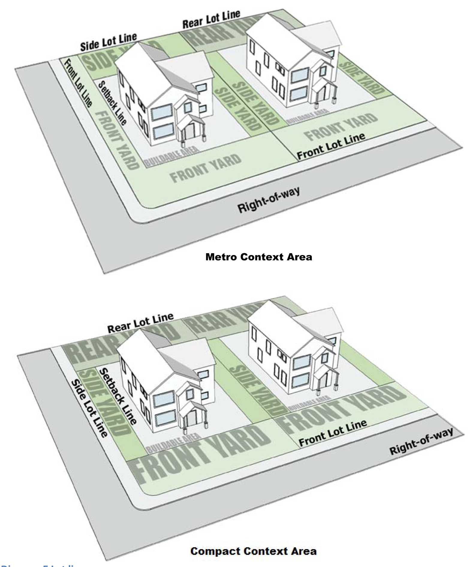
Diagram E Lot Lines
Lot of Record: A lot that is part of a subdivision or a lot or a parcel described by metes and bounds, the description of which has been so recorded in the Office of the Recorder of Marion County, Indiana. A lot of record is not necessarily a piece, parcel, plot or tract designated or used for single ownership.
Lots (See Diagram F)
Corner lot: A lot abutting upon two or more streets at their intersections, or upon two parts of the same street forming an interior angle of less than 135 degrees.
Freestanding lot: A lot that is not located in or a part of an industrial park, integrated center, or project.
Through lot: A lot that fronts upon two parallel streets, or that fronts upon two streets that do not intersect at the boundaries of the lot.
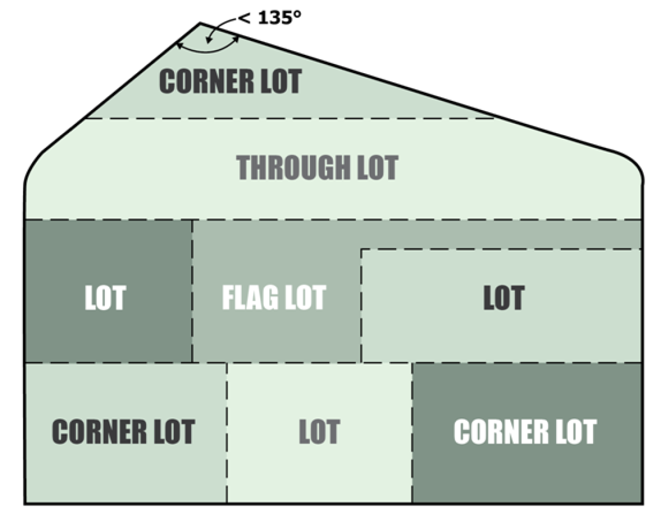
Diagram F Lot Types
Lot width: The horizontal distance between side lines measured along a line that is parallel to the front lot line. The lot width shall be measured at the front building setback line.
Low-impact development (LID): Approach to land development using techniques that simultaneously protect and use on-site natural features to manage stormwater and are prescribed in Chapter 700 of the Indianapolis Stormwater Specifications Manual and the Green Infrastructure Supplemental Document. LID techniques may be integrated with engineered, small-scale hydrologic controls as well. Most LID techniques are also pre-approved BMPs.
Lower level building sign: A permanent building sign located in its entirety on either the first 26 feet of building height, or the building height, whichever is lesser (measured from grade level). Examples include wall, projecting, awning, canopy, marquee, or window sign.
Lowest adjacent grade: For purposes of flood control regulation, the lowest elevation, after completion of construction, of the ground, sidewalk, patio, deck support, or basement entryway immediately next to the structure.
Lowest floor: The lowest elevation described among the following:
1.
The top of the lowest level of the structure.
2.
The top of the basement floor.
3.
The top of the garage floor, if the garage is the lowest level of the structure.
4.
The top of the first floor of a structure elevated on pilings or pillars.
5.
The top of the floor level of any enclosure, other than a basement, below an elevated structure where the walls of the enclosure provide any resistance to the flow of flood waters unless:
a.
The walls are designed to automatically equalize the hydrostatic flood forces on the walls by allowing for the entry and exit of flood waters by providing a minimum of two openings (in addition to doorways and windows) in a minimum of two exterior walls; if a structure has more than one enclosed area, each shall have openings on exterior walls;
b.
The total net area of all openings shall be at least one square inch for every one square foot of enclosed area; the bottom of all such openings shall be no higher than one foot above the exterior grade or the interior grade immediately beneath each opening, whichever is higher; and,
c.
Such enclosed space shall be usable solely for the parking of vehicles and building access.
M.
Maintain: For purposes of sign regulation, maintain is to repair, service or refurbish a sign or structure or any part thereof, in an identical manner or change any identical component of the sign.
Main-traveled way: The traveled way of a highway on which through traffic is carried. In the case of a divided highway, the traveled way of each of the separated roadways for traffic in opposite directions is a main-traveled way. The term "main-traveled way" does not include such facilities as frontage roads, turning roadways or parking areas.
Manufactured home: A unit that is fabricated in one or more modules at a location other than the home site, by assembly-line type production techniques or by other construction methods unique to an off-site manufacturing process. Every module must bear a label certifying that it is built in compliance with the Federal Manufactured Home Construction and Safety Standards. The unit must have been built after January 1, 1981, and must exceed 23 feet in width. This definition does not include recreational vehicles or mobile dwellings.
Manufacturing, hazardous materials or objectionable substances: Any light, medium or heavy manufacturing operation or food manufacturing that stores materials on-site or produces materials on-site in sufficient enough quantities to create an immediate risk of impacts beyond the boundaries of the facility. These risks of impacts include those resulting from explosion, fire, migration to waterways, toxic gas release or release of radioactive gases. This definition includes uses such as manufacturing of batteries, storage of primary batteries, wet or dry; cement, lime and gypsum; creosote, including treatment of products; explosives, matches, and fireworks; fertilizer; oil and other petroleum products, including refining or processing; and granaries, grain processing, and milling.
Manufacturing, heavy: Creation or production of a non-edible item that includes some transformation by way of heating, chilling, adding a liquid, adding a coating, or chemical or biochemical reaction or alteration. This use may also involve packaging, repackaging, assembling, or mechanical reshaping. This definition includes the manufacturing of bicycles, motorcycles, and parts; boats; ceramic and clay products; computers and computer equipment; electric lighting and wiring equipment; cosmetics, perfumes; glass or glass products; leather tanning and curing; major household appliances; construction machinery and equipment; processing of forest products; detergents and soaps; and engines and turbines.
Manufacturing, light: The packaging, repackaging, fabricating or producing a non-edible item by means of physically assembling solid parts. This definition includes the manufacturing of carpets and rugs; clocks and watches; cloth products; fabricated steel metal products; leather products; light component parts of products; paper box and paper products; pre-manufactured parts, subassemblies, or components; prefabricated wood buildings or structural members; and upholstering shops.
Manufacturing, medium: The creation or production of a non-edible item that includes some transformation by way of mechanical reshaping. This use may also involve packaging, repackaging, or assembling solid parts. This definition includes the manufacturing of jewelry; unfinished cabinets; cutlery; mattresses; and optical instruments.
Marina: A facility or area for storing, servicing, fueling, berthing, securing, and launching of private pleasure craft that may include the sale of fuel and incidental supplies for the boat owners, crews and guests. This definition includes uses such as boat and canoe rentals.
Market value: For purposes of flood control regulation, the market value of the structure itself, not including the associated land, landscaping or detached accessory structures. The market value must be determined by a method approved by FEMA and the Bureau of License and Permit Services. If an appraisal is used, the appraiser must have at least one of the following designations:
1.
Member of the American Institute of Real Estate Appraisers (MAI);
2.
Residential member of the American Institute of Real Estate Appraisers (RM);
3.
Senior real estate analyst of the Society of Real Estate Appraisers (SREA);
4.
Senior residential appraiser of the Society of Real Estate Appraisers (SREA);
5.
Senior real property appraiser of the Society of Real Estate Appraisers (SRPA);
6.
Senior member of the American Society of Appraisers (ASA);
7.
Accredited rural appraiser of the American Society of Farm Managers and Rural Appraisers (ARA); or
8.
Accredited appraiser of the Manufactured Housing Appraiser Society.
Marquee: Any permanent roof-like structure projecting beyond a building or extending along and projecting beyond the wall of a building, generally designed and constructed to provide protection from the weather.
Marquee sign: Any building sign painted, mounted, constructed or attached in any manner on a marquee (refer to Sign Diagram 24).
Massage therapist: A person licensed by the State of Indiana to provide massage therapy.
Massage therapy: The application of massage techniques to the human body, including (a) the use of touch, pressure, percussion, kneading, movement, positioning, nonspecific stretching, stretching within the normal anatomical range of movement, and holding, with or without the use of massage devices that mimic or enhance manual measures; and (b) the external application of heat, cold, water, ice, stones, lubricants, abrasives, and topical preparations that are not classified as prescription drugs. This use does not include spinal manipulation or the diagnosis or prescribing drugs for which a license is required.
Medical or dental offices, centers, or clinics: A facility principally engaged in providing services for health maintenance, diagnosis or treatment of human illness, disease, pain, injury, deformity or physical condition. This use may include medical or dental laboratories as an accessory activity. This definition includes facilities such as blood donor stations; chiropractor offices and clinics; dentist offices and clinics; immediate care facilities; nursing care (skilled) facilities; optometrist offices and clinics; osteopathic physician offices and clinics; outpatient clinics; physician (MD) offices and clinics; and podiatrist offices and clinics. This use does not include a plasma center.
Medical or dental laboratories: A facility for conducting medical or dental research, investigation, testing, experimentation or the production of customized medical or dental appliances.
Message center: A sign or component of a sign that contains a changing display within the copy area that turns on and off or changes electrically or electronically for a specific period of time.
Methadone clinic or treatment facility: A clinic or facility engaged in dispensing Methadone (dolophine) for the purpose of elimination or reduction of opiate use by drug addicts and abusers.
Mile Square: The geographic area within the Regional Center and North Meridian Street Corridor secondary zoning district bound by North Street, East Street, South Street, and West Street and including any lot with frontage on North Street, East Street, South Street, and West Street.
Mine: An excavation in the earth for extracting earthen materials.
Minerals: Any naturally-formed, usually inorganic rocks, stone, gravel, sand, soil, clay, limestone, or other naturally occurring chemical element or compound located on or below the surface of the earth, excluding geothermal resources, natural gas, and petroleum.
Mini-barn (or shed): A freestanding, completely enclosed, accessory building constructed of stone, brick, metal or wood designed with a rural character and intended for the storage of personal property solely of the occupants of the primary use on the lot. Same as "shed." This is classified under "minor residential structure."
Mini-warehouses (or self storage facility): A building or group of buildings containing one or more individual compartmentalized storage units for the inside storage of customers' goods or wares, where no unit exceeds 600 square feet in area.
Mining face: The exposed vertical or near vertical portion of soil or rock that results from mining operations.
Mining operation: The activity of surface, underwater, or underground extraction and treatment of deposits of minerals, ores, and other solid matter using techniques including, but not limited to, excavating, dredging, drilling, crunching, grinding, sorting, sifting, sizing, washing, drying, blasting, trimming, punching, splitting, gauging, and sawing and cutting of stone. The term also includes the construction and use of buildings, facilities and equipment to carry out similar activities, exclusive of manufacturing processes, and includes the removal of overburden to provide access to minerals. The term also includes processes related to the preparation or processing of mineral aggregates obtained from the site, including, but not limited to, stockpiling of materials, dewatering, and grading of land. The term does not include the excavation, removal and disposition of minerals from construction projects or excavations in aid of agricultural activities.
Mining pit: All of the land area used in the excavation, processing, or storage of sand, gravel, crushed stone, or soil, and all of the land owned by the same owner that is contiguous to an excavated area unless the owner can show that some portion of that land cannot or will not be used as a site for extraction or excavation.
Minor emergency repairs: Those maintenance repairs necessitating an immediate solution yet not posing an immediate life-safety hazard, nor altering the existing character of the structure. See also "alteration."
Minor mobile home structures: Structures that are incidental and secondary to the primary mobile home use of a property, such as carports, canopies, covered patios, storage rooms, mini-barns, porches, awnings, swings and other play structures or equipment, and other accessory buildings or structures similar and comparable in character to these uses.
Minor residential features: Structures that are incidental to a dwelling unit, characterized as less than 18 inches in height, or having a footprint of 50 square feet or less, and not elsewhere defined as an accessory use. Examples include decks or patios that are less than 18 inches in height, wheelchair ramps, outdoor fireplaces, personal gardens, raised planting beds, awnings, canopies, children's playhouses, swings or other play structures or equipment, walkways, driveways.
Minor residential structures: Structures that are subordinate and secondary to the primary residential use of a property, such as garages, carports, porches, decks or patios 18 inches or greater in height, mini-barns, sheds, workshops, swimming pools, hot tubs, porte-cocheres, bathhouses, cabanas, secondary dwelling unit, shelters for personal livestock, greenhouses, and other accessory buildings or structures similar and comparable in character to these uses. This definition does not include minor mobile home structures or residential support facility or amenity.
Mobile dwelling (or mobile home): A movable or portable unit fabricated in one or more modules at a location other than the home site, by assembly-line type production techniques or by other construction methods unique to an off-site manufacturing process. The unit is designed for occupancy by one family, and erected or located as specified by Section 536-831 et seq. of the Revised Code of the Consolidated City and County, and that was either:
1.
Constructed prior to June 15, 1976, and bears a seal attached under Indiana Public Law 135, 1971, certifying that it was built in compliance with the standards established by the Indiana Administrative Building Council; or,
2.
Constructed on or subsequent to June 15, 1976, and bears a seal certifying that it was built in compliance with the Federal Mobile Home Construction and Safety Standards law.
Mobile home display: A mobile dwelling unit representative of other mobile dwellings or units offered for sale or lease within a mobile dwelling project.
Mobile dwelling project:
1.
An area of contiguous land separated only by a street upon which three or more mobile dwellings are designated spaces or lots for the purpose of being occupied as primary residences and includes all real and personal property used in the operation of the mobile dwelling project; or
2.
An area of contiguous land separated only by a street, that is subdivided and contains individual lots that are or intended to be sold, leased or similarly contracted for the purpose of being occupied as a primary residence, is a mobile dwelling project if three or more lots or sites are designated specifically to accommodate mobile dwellings.
Model home: A dwelling or dwelling unit representative of other dwellings or units offered for sale or lease or to be built in an area of residential development. A model home may be used as a residential real estate sales office for the development in which it is located before occupancy by a family.
Modular home dwelling: A unit that is fabricated in one or more modules at a location other than the home site, by assembly-line type production techniques or by other construction methods unique to an off-site manufacturing process, designed for occupancy by one family unit. Every module must bear the seal certified that it was built in compliance with Indiana Public Law 360. The unit must have been built in compliance with the CABO One- and Two-Family Dwelling Code.
Monitoring station: For purposes of Gravel, Sand, and Borrow regulations, a physical location identified by city, county, state, or federal authorities where measurement of environmental conditions may be required.
Mortuary, funeral home: An establishment for the preparation of the deceased for burial and the display of the deceased and rituals connected with, and conducted before burial or cremation. This definition includes columbaria and may include a facility for the permanent storage of cremated remains of the dead. This definition does not include freestanding crematoria facility.
Motor truck terminal: A building or area in which trucks, including tractor or trailer units are parked, stored, or serviced, including the transfer, loading or unloading of goods. A terminal may include facilities for the temporary storage of loads prior to transshipment. This definition does not include waste or recycling transfer facilities. See "fleet terminals."
Motorsports industry: An industry or industry sector focused on the research, development, and application of motorsports technologies. This definition includes uses such as engine testing; racing logistics and engineering; performance technology; race team facilities, and other associated uses to the motorsports industry or speedway logistics.
Mulch: A protective covering of organic substances placed around plants to control weeds and prevent evaporation of moisture or freezing. Plastic, loose gravel, stones or rocks are not considered as mulch.
Multifamily dwelling: A building for residential purposes with five or more dwelling units, having common or party walls, on a single lot. Each unit is totally separated from the other by an unpierced wall extending from ground to roof or an unpierced ceiling and floor extending from exterior wall to exterior wall, except for common or individual stairwells exterior to any dwelling units. Includes vertically stacked dwelling units such as apartment buildings.
Municipal bus bench: A seating structure caused to be erected, maintained and managed by Indianapolis Public Transportation Corporation, or their successor, to provide temporary seating for people waiting to use or ride public transportation.
Municipal bus shelter: A roofed structure caused to be erected, maintained and managed by or on behalf of the Indianapolis Public Transportation Corporation, or their successor, to provide temporary protection of people waiting to use or ride public transportation.
Municipal bus stop: A location designated by Indianapolis Public Transportation Corporation or their successor, for people waiting to use or ride public transportation that is located next to a roadway served by an operational public transit corridor.
Mural: A design or representation painted, drawn or similarly applied on the exterior surface of a structure and the only text includes the artist's name and date of installation.
Museum, library, art gallery: A facility or area that is open to the public and is intended for the acquisition, preservation, study, and exhibition of works of artistic, cultural, literary, historical or scientific value. This definition includes facilities such as planetariums, and public and semipublic structures.
N.
Native vegetation: The growth of various grasses, sedges, rushes, forbs (wildflowers), ferns, trees, shrubs, and vines identified as species native to the Indianapolis area in commonly accepted publications, such as Flora of Indiana by Charles C. Deam; 101 Trees of Indiana: A Field Guide by Dr. Marion T. Jackson; and Go Native! Gardening with Native Plants and Wildflowers in the Lower Midwest by Carolyn Harstad.
Natural landscaping: Any landscaping technique in a yard or on a development site that preserves or uses primarily native vegetation in a design intended to exhibit the character and spirit of nature by arrangement of the plants and drainage patterns similar to the arrangements of natural prairie, woodland, or wetland plant communities and drainage.
New mobile dwelling project or subdivision: A mobile dwelling project or subdivision for which the construction of facilities for servicing the lots on which the mobile dwellings are to be affixed (including the installation of utilities, the construction of streets, and either final site grading or the pouring of concrete pads) is completed on or after December 12, 1989.
NFIP: National Flood Insurance Program, a voluntary agreement between the federal government and participating communities in which the federal government offers subsidized flood insurance to communities that agree to adopt and enforce a flood ordinance that, at a minimum, meets the federal standards to reduce future flood risk to new construction in floodplains.
Night club or cabaret: An establishment engaged primarily in offering entertainment to the general public in the form of music for dancing or live and recorded performances. The establishment may engage in the preparation and retail sale of alcoholic beverages for consumption on the premises. An establishment of a similar nature that caters to, or markets itself predominantly to, persons under 21 years of age is not a night club but an indoor recreation and entertainment facility. This definition does not include adult entertainment business.
Nonbuilding structure: For purposes of flood control regulation, structures other than buildings including but not limited to public utilities, on-site wastewater disposal systems, water supply systems, sanitary sewers, on-site wastewater treatment systems, lift stations, transmission towers, well pumps, electrical units, bridges, culverts, and any other structures determined by the Bureau of License and Permit Services to constitute a potential hazard to life, health, safety or property caused by exposure to floodwaters during the base flood.
Nonconforming adult entertainment business: Any building, structure or land lawfully occupied by an adult entertainment business or lawfully situated at the time of passage of General Ordinance 44, 1984, adopted on July 9, 1984, or amendments to that ordinance, that does not conform after the passage of that ordinance or amendments thereto with the regulations of this chapter.
Noninstrument runway: A runway other than an instrument runway.
Nonresidential premises: A platted lot or part of a lot or an unplatted lot or parcel of land, with or without a structure or building, and including any structure, building, accessory structure, adjoining alley, easement or drainage way not intended for residential use. This definition does not include mixed-use developments with both residential and nonresidential uses.
Nonsubstantial addition: For purposes of flood control regulation, a structural enlargement of a structure, the cost of which is less than 50% of the market value of the structure before the start of construction.
Nonsubstantial damage: For purposes of flood control regulation, damage of any origin sustained by a structure and not intentionally caused or inflicted by the owner or occupant whereby the cost of restoring the structure to its pre-damaged condition would be less than 50 percent of the market value of the structure before the damage occurred. See related "substantial damage" and "substantial improvement."
Nonsubstantial improvement: For purposes of flood control regulation, any structural improvement of a structure that does not consist of a structural enlargement or repair of damage, the cost of which is less than 50% of the market value of the structure before the start of construction of the improvement. This term does not include either:
1.
Any project for improvement of a structure to correct existing violations of state or local health, sanitary, or safety code specifications that have been identified by the local code enforcement official and that are the minimum necessary to assure safe living conditions;
2.
Any alteration of an "historic structure," provided that the alteration will not preclude the structure's continued designation as an "historic structure;" or
3.
Ordinary maintenance and repair as defined in the Zoning Ordinance.
North Meridian Street Corridor: The geographic area within the Regional Center and North Meridian Street Corridor secondary zoning district bounded on the:
1.
North by 30th Street;
2.
South by 16th Street;
3.
East by Talbott Street, north of Fall Creek; the first alley east of Pennsylvania Street from Fall Creek to 17th Street; and then Talbott Street from 17th Street to 16th Street;
4.
West by the first alley west of Illinois Street extended from 30th Street to 16th Street.
Nursing home: Licensed facilities primarily engaged in providing shelter, food and intermediate or long term nursing and health related care for individuals that may include assisted living facilities, but does not include hospitals, clinics or similar institutions devoted primarily to the diagnosis and treatment of the sick or injured. This definition includes uses such as convalescent care.
O.
Objectionable substance: Substances that are: (1) of a quantity and a type so as to damage waters; and (2) present for a duration and in a location so as to damage waters.
Off-street: A location completely within the boundaries of the lot, and completely off of public or private rights-of-way or alleys or any interior surface access easement for ingress and egress.
Office: Business, Professional or Government: An enclosed building in which executive, management, administrative, government, or professional services are provided. Includes, but is not limited to, fraternity and sorority offices; business or personal service; professional offices; governmental office complex; automobile owner's association or club; condominium association, contractor's association; data processing and analysis center; farm bureau or grange; governmental offices (including social services); homeowner's association; radio and television stations (but not antennas, which are an accessory use, or broadcast towers, which are included under substations and utility distribution nodes); tenant association; and manufacturer's institute.
Office (Transit-Oriented Secondary District): For the Transit Oriented Secondary District, the following refined categories apply:
Office - small (under 10,000 square feet)—An office use with under 10,000 square feet of gross leasable area.
Office - medium (10,001—50,000 square feet)—An office use with between 10,001 and 50,000 square feet of gross leasable area.
Office - large (50,000 + square feet)—An office use with more than 50,000 square feet of gross leasable area.
Off-premises sign: A sign that directs attention to a business, profession, commodity, or service offered on the property other than that on which the sign is located. This limitation does not apply to the content of noncommercial messages.
On center: Distance at grade level between the center of one element to the center of the next, such as trees.
On-premises sign: A sign that directs attention to a business, profession, commodity, or service offered on the property on which the sign is located. This limitation does not apply to the content of noncommercial messages.
One percent annual chance flood: The flood that has a one percent chance of being equaled or exceeded in any given year. Any flood zone that begins with the letter A is subject to the one-percent annual chance flood. See "regulatory flood".
One-time event sign: A temporary sign that is authorized for a three-day or 10-day period. One-time event signs may be a freestanding or building sign. One-time event signs may be made of nondurable materials, such as pennants, banner, flags (unofficial or official), air-filled, as well as more durable materials such as wood, metal, plastic.
Open land use: For purposes of flood control regulations, the production of crops, pasture, forests, parks, and recreational uses that do not involve any structure, obstruction, construction, excavation or deposit in a floodway as defined by IDNR, or any land alteration or watercourse alteration as otherwise defined in the Zoning Ordinance. The following specific activities are classified as open land use:
1.
Excavation of cemetery grave;
2.
Exploratory excavations or soil testing under the direction and control of professional engineers, soil engineers, geologists, civil engineers, architects or land surveyors, that are backfilled;
3.
Ordinary cultivation of agricultural land including tilling, construction of minor open ditches, and crop irrigation; and
4.
The planting and tilling of gardens, flower beds, shrubs, trees and other common uses and minor landscaping of land appurtenant to residences.
Open space: The land area that is exposed to the weather. For calculations refer to Section 740-303 (Building Measurements and Calculations).
Open space, covered: The land area that is exposed to the weather, but not open above to the sky. For calculations refer to Section 740-303 (Building Measurements and Calculations).
Open space ratio: Expresses the relationship between the size of the building development and the remaining land area. For calculations refer to Section 740-303 (Building Measurements and Calculations).
Open space, uncovered: The land area that is not roofed or similiarly covered. For calculations refer to Section 740-303 (Building Measurements and Calculations).
Operations plan: For purposes of Gravel, Sand, and Borrow regulations, a plan of activities to be performed by an operator to mine the land over the life of the mine, including description of the proposed method of mining, map and phasing schedule of mining operations, and measures taken to minimize environmental impacts, with special emphasis on minimizing negative impacts to surrounding residential areas.
Operator: For purposes of Gravel, Sand, and Borrow regulations, any person, whether individually, jointly, or through subsidiaries, agents, employees, contractors, or subcontractors who is engaged in, or who has applied for a permit to engage in, mining operations.
Ordinary maintenance and repair: For purposes of flood control regulations, construction activity commonly accomplished in or on an existing structure or existing building equipment for the purposes of preventing deterioration or performance deficiencies, maintaining appearance, or securing the original level of performance. Preventing deterioration or deficient performance include such activities as caulking windows, painting, pointing brick, oiling machinery and replacing filters. Maintaining appearance does include such activities as sandblasting masonry and cleaning equipment. Securing the original level of performance does include such activities as replacing broken glass, patching a roof, disassembling and reassembling a piece of building equipment, welding a broken part and replacing a component of a heating system (but not a furnace) with an identical component. Ordinary maintenance and repair does not include any construction activity that alters the prior or initial capacity, performance, specifications, type or required energy of functional features of an existing structure or building equipment.
Other vehicle sales, rental, or repair: Sales, rental, or repair of vehicles not included in automobile, motorcycle, and light vehicle sales or rental; or truck or heavy vehicle sales, rental, or repair. This definition includes uses such as boat dealers; recreational vehicle dealers; mobile home dealers, and manufactured home dealers. An inherent characteristic of this use is the outside display of vehicles offered for sale which is considered a primary facet of the use; as a primary use, this display must meet the development standards as a primary use and not the standards associated with an accessory use.
Outdoor advertising off-premise sign: Any off-premises sign that directs attention to any business, profession, product, activity, commodity, or service that is offered, sold, or manufactured on property or premises other than that upon which the sign is located. This limitation does not apply to the content of noncommercial messages. Same as billboard or advertising sign.
Outdoor display and sales, ongoing: An accessory use that places products or materials offered for sale or exchange outside of a permanent building. The use must be associated with a business in a building on the site. Examples include stacks of bagged materials, bundles of firewood, and racks of items for sale such as lumbe or plants. This definition does not include farmers' market; sidewalk café; vending machines or self-service kiosks; or outdoor seating area or patio.
Outdoor display and sales, temporary: The offering or sale of products or services outside of a permanent building for a specified period of time. The use may or may not be associated with a business in a building on the site. The use does not include the construction or alteration of any permanent building or structure. This definition includes the activities conducted by transient merchants. Examples include the retail sale of seasonal products like Christmas trees, pumpkins and live plants. This definition does not include temporary outdoor events, temporary fireworks sales, farmers' markets, outdoor seasonal produce sales, sidewalk café, vending machines or self-service kiosks, outdoor seating area or patio, or the on-site preparation of food.
Outdoor recreation and entertainment, general: An open area offering entertainment or sports, athletics or games of skill to the general public. This definition includes facilities such as golf courses, swimming pools, baseball/softball fields; live entertainment or performances; boat and canoe rentals (as accessory use to a fishing lake operation); fishing lake operations (commercial or private); go cart raceways; scenic railroads; and drive-in theaters. This definition does not include sports stadium.
Outdoor seasonal produce sales: A market held in an open area or under a temporary structure where a single merchant offers for sale to the public only such items as fresh produce, seasonal fruits, fresh flowers, or items created from those products, dispensed from a booth or booths located on-site. It shall not include food items prepared for sale and consumption on-site.
Outdoor seating or patio (nonresidential): On-site service facilities or seating areas accessory to a restaurant or establishment serving items to be consumed on site. This definition does not include sidewalk cafes in the public right-of-way.
Outdoor storage and operations: An outdoor area used for the long-term deposit (more than 24 hours) of any goods, material, merchandise, vehicles or junk as an accessory use to and associated with a primary use on the property. Outdoor operations include activities outside of a building that are associated with the primary use, such as the cutting and loading of pipe from an outdoor stockpile. See related "outdoor storage, heavy."
Outdoor storage, heavy: The keeping of any goods, material, or merchandise outdoors and typically weighing more than 75 pounds for the long-term deposit (more than 24 hours) and does not meet the definition of automobile and vehicle storage or auction. This definition includes uses such as storage of heavy equipment; railroad equipment; rail yard and terminal; and utility pole yards and pipe yards. See related "outdoor storage and operations."
Overburden: Earth, vegetation, topsoil, subsoil, caprock or non-specification material that must be removed to provide access to minerals.
P.
Parapet (wall): That portion of a building wall that rises above the roof level.
Park or playground: Public or private land area that is developed and maintained for active or passive recreational use and is open for the general public's use and enjoyment, or for the use of customers, residents, or guests of a related facility. A park may include public playfields, courts, and other recreation facilities, or may include greenways, water features, picnic areas, natural areas, boating facilities, fishing facilities, arboreta, and botanic gardens.
Parking area: An area of paving other than an open exhibition or display area, not inclusive of interior access drives, and driveways intended for the temporary storage of automotive vehicles including parking spaces and the area of access for the parking spaces and the area of access for the egress/ingress of automotive vehicles to and from the actual parking space (see Diagram G).
Parking bay: The parking module consisting of one or two rows of parking spaces and the aisle from which motor vehicles enter and leave the spaces (Refer to Figure 740-306-A in Measurements and Calculations).
Parking garage: A structure or part of a structure used primarily for the housing, parking, or temporary short-term placement of motor vehicles including parking spaces, and the area of access for the egress/ingress of automotive vehicles to and from the actual parking space.
Parking garage, commercial: A parking garage that is a primary use of land.
Parking lot: A hard-surfaced area other than an open exhibition or display area, inclusive of interior access drives and driveways intended for the temporary placement of vehicles, including parking spaces, bicycles and bicycle sharing facilities, and the area of access for the egress/ingress of vehicles and bicycles to and from the actual parking space (see Diagram G).
Parking lot, commercial: A parking lot that is a primary use of land.
Parking space: An off-street portion of the parking area that is used only for the temporary placement of an operable vehicle (see Diagram G).
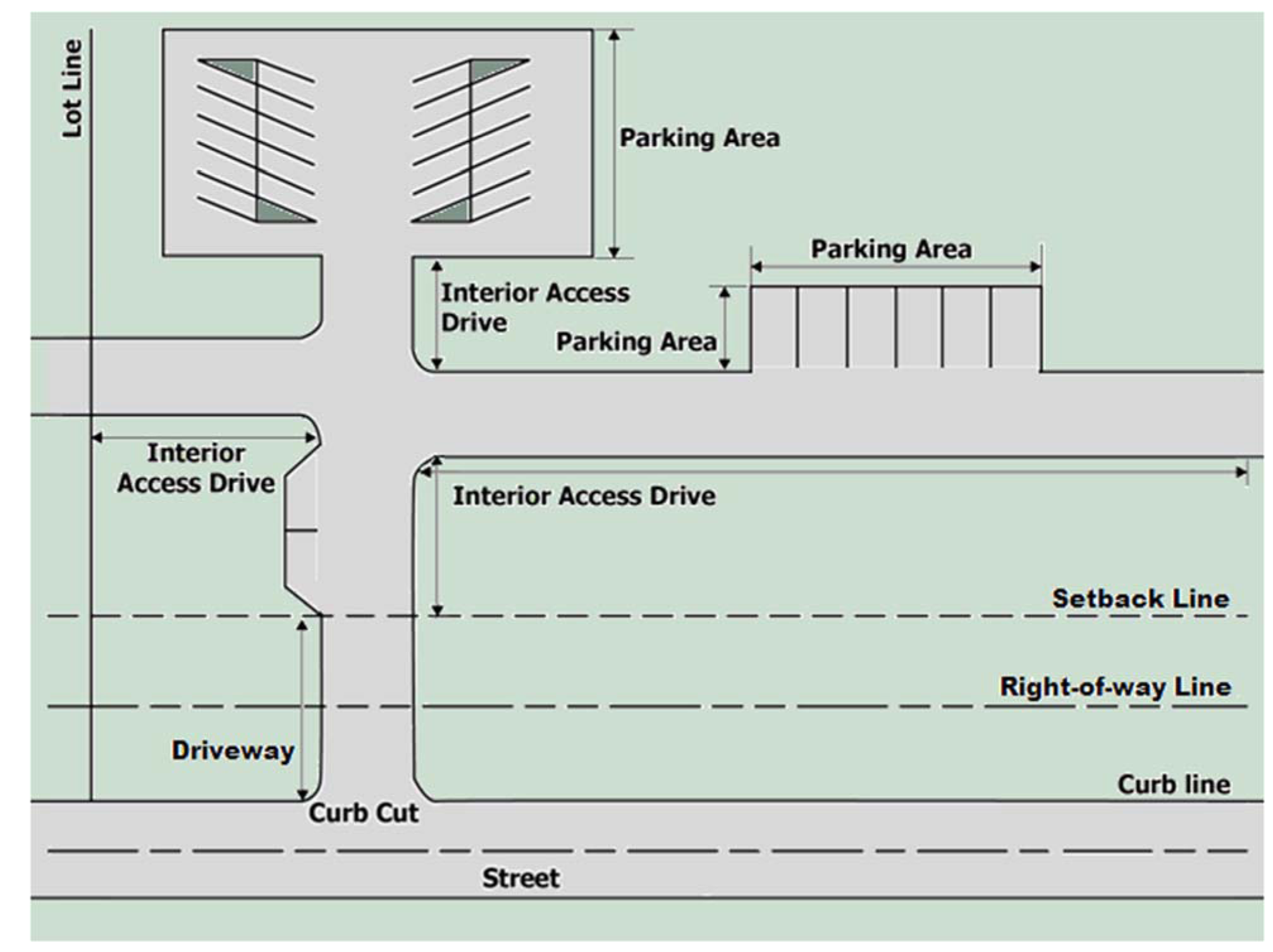
Diagram G Parts of Vehicle and Parking Areas
Partial control of access: The condition where the right of the owner or occupant of abutting property, or of other persons, to access said property, including the location and connection with public streets, is controlled by public authority. Partial control of access gives preference to through vehicular traffic movement to a degree that, in addition to access connections with selected public streets, there may be crossings at grade level and some driveway connections. See related "full control of access."
Patio: A hard-surfaced area accessory to the primary structure or use of which the horizontal area is at grade level with at least one side open to the weather and essentially unobstructed to the sky. This area is specifically designed and intended for the recreational enjoyment of the occupants and guests of the primary structure or use and not designed or intended for use by automotive vehicles. See related "Deck."
Patio, covered: A hard-surfaced area accessory to the primary structure or use of which the horizontal area is at grade level with at least one side open to the weather and permanently roofed or similarly covered. This area is specifically designed and intended for the recreational enjoyment of the occupants and guests of the primary structure or use and not designed or intended for use by automotive vehicles.
Paved stand: A permanent area specifically designed and intended for the location, securing, and use of a mobile dwelling on a non-temporary basis encompassing completely the area immediately below or covered by such dwelling including necessary plumbing, power, and other utility installations. The mobile dwelling's foundation, consisting of runners, ribbons or piers, usually made of concrete for the purpose of blocking the dwelling, are within this area.
Pavement (or paving): A layer of concrete, asphalt or coated macadam or a layer of bricks, modular pavers, used on street, parking areas, sidewalks, walkways, or airport surfacing; or permeable paving materials when approved by the city for specific portions of a site as an alternative to concrete, asphalt, or coated macadam.
Pawn shop: An establishment where money is loaned on the security of personal property pledged in the keeping of the business owner or operator. Accessory uses include the retail sales of primarily used items after the property securing the loan becomes the property of the business owner or operator.
Pedestrian ramp: An inclined access opening along the curb line at which point pedestrians, unassisted or assisted by a wheelchair, walker or similar feature, may enter or leave the street; or, an incline providing pedestrians, unassisted or assisted by a wheelchair, walker or similar feature, access from the ground to an elevated surface.
Pedestrian sign: Small freestanding sign that is located in pedestrian areas, such as sidewalks or plazas, and that is less than 40 lbs. and movable. Pedestrian sign may be an A- or T-framed sign. Banner may be a pedestrian sign if located on fencing or a landscaping wall.
Pergola: A minor residential feature with a permanently open framed roof, often latticed, supported by regularly spaced posts or columns.
Permanent sign: A nontemporary sign designed and intended for long-term use.
Permit application: A complete application with all accompanying information required by the Zoning Ordinance or regulations adopted pursuant to the Zoning Ordinance, and including both an initial application and any applicable renewal application of an existing permit, such as in the GSB District, that has not expired.
Permitted use: Any use authorized by right in a particular zoning district and subject to the restrictions applicable to that use and zoning district.
Personal garden: A private facility or area for the cultivation of vegetables, grasses, fruits, flowers, shrubs, vines, trees, and domesticated bees as an accessory use by a resident or occupant of the site whether it be for purposes of producing food or materials. This definition includes the composting of on-site materials. This definition does not include high weeds and grass, nor does it include farming or beekeeping for commercial purposes.
Personal livestock: Accessory activity of raising domesticated poultry, rabbits, sheep, donkeys, mules, alpacas, llamas, horses, and goats, of which may be standard-sized or miniature, pygmy or dwarf for use by the resident or occupant of the property. This definition does not include domestic dogs or cats, and does not include animals associated with a business activity, such as an agricultural use (farm) or boarding.
Pick-up station for dry cleaning or laundry: A facility, which may be attended or not, where dry cleaning or laundry is dropped off or picked up by customers but does not include any on-site laundry, cleaning or dry cleaning activities.
Planned unit development: A development designed to accommodate varied types of residential development in patterns or layouts not otherwise permissible in other zoning districts of the Zoning Ordinance. Planned unit developments are designed to provide additional amenities or benefits to the city in return for flexibility in the design, layout, and dimensions of the development.
Plasma (blood) center: A facility at which individuals donate plasma, blood, or other blood products in return for money or other consideration.
Plat: An officially recorded map, as recorded in the Office of the Marion County Recorder, or a map to be recorded indicating the subdivision of land including, but not limited to, boundaries and locations of individual properties, streets, and easements.
Pole sign: Any freestanding sign that has its supportive structures anchored in the ground and has a sign face elevated above ground level (refer to Sign Diagram 31).
Porch: A roofed structure with at least one side exposed to the weather, supported from the ground and attached to or part of the building providing a surface at the door facilitating access into the building from the ground. Screens and curtains on the porch are considered open to the weather. A porch is considered covered open space. See related "porch, open."
Porch, open: An unenclosed structure, open to the sky, supported from the ground and attached to or a part of a building providing a surface at the door facilitating access into the building from the ground, also known as a stoop. See related "porch."
Portable storage: A container designed and rented or leased for the temporary storage of commercial, industrial, or residential items, and does not contain a foundation or wheels for movement. This definition includes facilities such as piggyback containers that can be transported by mounting on a chassis, and "POD" type boxes that can be transported on a flatbed or other truck; but do not include prefabricated sheds that are not designed for transport after erection, or commercial trailers used by construction or other uses in the regular performance of their business.
Porte-cochere: A roofed, sheltering structure supported from the ground and attached to or a part of a building, that projects over an entrance/exit, walkway, driveway, or similar feature. A porte-cochere is considered covered open space.
Potential groundwater contaminant: Any material that because of its toxicity, persistence, or mobility in groundwater, poses a significant hazard to the quality of groundwater resources used for public water supply. Potential groundwater contaminants does include objectionable substances or hazardous materials.
Power generating facility, local: A plant that is used for the production of electricity to a defined area including at least five buildings, including appurtenant yards, equipment and facilities for local or district-wide service, and that is not owned or operated by a public utility. This definition is exclusively limited to compressed natural gas conversion; solar; wind; and geothermal facilities. For on-site accessory power generation, see "Renewable Energy Facility, Solar and Geothermal" or "Renewable Energy Facility, Wind."
Power generating facility, major: A large-scale facility or area that generates electricity from mechanical power produced by the firing of fossil fuels; or that produces heat or steam for space heating and other similar uses from thermal plants or biomass facilities; or does not otherwise meet the definition of a power generating facility, local.
Premises: A platted lot or part of a lot or an unplatted lot or parcel of land, either occupied or unoccupied by any structure, and including any such building, accessory structure, adjoining alley, easement, or drainage way.
Primary building: The building in which the permitted primary use of the lot is conducted.
Primary residential structure: For purposes of flood control regulation, the residential building in which the permitted primary use of the lot is conducted.
Primary street façade: The building façade facing the street from which the building gets its street address.
Principal homestead: The dwelling unit in which the primary users of the agricultural use reside.
Printing services: A commercial facility that reproduces a large quantity of copies or books and other printed material including newspapers and magazines. Includes newspaper publishing and printing; and blueprinting and engraving. This definition does not include uses such as copy centers and document preparation, and photo finishing services, which are included in consumer services or repair of consumer goods.
Processing: In general use, processing means a series of operations, usually in a continuous and regular action or succession of actions, taking place or carried on in a definite manner. For purposes of Gravel, Sand, and Borrow regulations, processing means washing, crushing, grinding, sorting, sizing, and other activities undertaken to prepare extracted materials for productive use, and the operation of plants, machinery, dams, ponds, canals, power lines, pipe lines, telephone lines, roads, stockpile areas, buildings or offices, and any other machinery or equipment required for the processing of minerals, but not including manufacturing processes.
Processing and packaging of food and beverages: The packaging, repackaging, processing, or production of an edible substance, ice, beverage, or ingredient used or intended for use or for sale in whole or in part for animal or human digestion, or chewing gum. This definition includes uses such as bottling of alcoholic or nonalcoholic beverages; canning, bottling, processing, and packaging of food; bakery; coffee roasting; food products (initially processed off the premises); oleomargarine; malt products, brewing; and distillation of liquor and spirits. This definition does not include slaughtering of animals or fowl, establishments for retail sales directly to the consumer, or artisan food and beverage uses.
Processing of extracted materials: The extraction of minerals, sand, gravel, and ores, from their natural occurrences on affected land and processing and distribution of extracted materials. This definition includes uses such as sand, gravel, and aggregate washing, sorting, sizing or processing.
Produce sales: A structure or land area used for the accessory retail sale of fresh fruits, vegetables, flowers, herbs or plants grown on the same parcel of land where the stand is located, including but not limited to a "pick your own" establishment where customers gather their own produce from the fields for purchase and off-site consumption. This definition includes, when accessory to a primary use of the property, the sale of items such as: other unprocessed foodstuffs, home processed food products such as jams, jellies, pickles, sauces or baked goods, and homemade handicrafts, provided that no commercially packaged handicrafts or commercially processed or packaged foodstuffs are sold. Produce sales is not considered as temporary outdoor display and sales.
Professional architect: An architect registered under 804 IAC 1 authorized IC 25-4-1.
Professional engineer: An engineer registered under 864 IAC 1 authorized IC 25-31-1.
Professional geologist: A geologist licensed under 305 IAC 1 authorized by IC 25-17.6-3.
Professional surveyor: A surveyor registered under 865 IAC 1 authorized IC 25-21.5.
Project: A lot or parcel or multiple lots, parcels, or sites of contiguous land to be developed for a use or uses that at the time of development is under one ownership or control, and in accordance with Chapter 741 Subdivision Regulations, may subsequently be subdivided, developed, or conveyed into smaller lots or parcels.
Project area: The area within the perimeter lot lines encompassing an entire project.
Projecting sign: Any sign that is affixed to a building or wall in such a manner that its leading edge extends more than 18 inches beyond the surface of such building or wall face (refer to Sign Diagram 31).
Protected areas: All areas inside the boundaries of Marion County which are adjacent to and within 660 feet of the edge of the right-of-way of all highways within the county. When a highway terminates at a county boundary that is not perpendicular or normal to the centerline of the highway, the term "protected areas" also refers to all areas inside the boundary of such county which are within 660 feet of the edge of the right-of-way of the highway in the adjoining county.
Protected District. Specific classes of zoning districts that, because of their low intensity or the sensitive land uses permitted by them, require buffering and separation when abutted by certain more intense classifications of land use. A Protected District does include any Dwelling District, Historic Preservation District, Hospital District, Parks District, University Quarter District, SU-1 (Church) District or SU-2 (School) District.
Protected structure: For purposes of Gravel, Sand, and Borrow regulations, any occupied building, or other structure designated as a protected structure by the Administrator that is, or may be, impacted by blasting or other processes of an operation. This term does not include structures owned and operated by the operator.
Public airport or heliport: An airport or heliport publicly owned or operated.
Public area: Land owned or controlled by a governmental unit for public use, including but not limited to sidewalks, plazas and parks.
Public notice: Official notice posted by public officers or their representative in the performance of their duties.
Public improvement: Any drainage way or easement, street, culvert, pedestrian way, sidewalk, street sign, monument, flood control or storm drainage system, sewage disposal system, art installation, entry/gateway feature, or other facility for which the municipality may ultimately assume the responsibility for maintenance and operation, or that may affect an improvement for which municipal responsibility is established.
Public safety facility or post office: A public facility meant to protect or serve the general safety and welfare of the public. Includes fire stations, police stations, emergency operation centers, and post offices.
Public sign: Any sign required or specifically authorized for a public purpose by any law, statute or ordinance which may be of any type, number, area, height above grade, location, illumination or animation, required by the law, statute or ordinance under which the signs are erected. See also "governmental sign."
Public way: A right-of-way for transportation purposes among other purposes, such as a highway, street, transit line, avenue, boulevard, road, lane, or alley.
Pump island canopy sign: Any sign that is part of or attached to the pump island canopy.
Pump island sign: Any sign either affixed directly to a fuel pump or otherwise attached to the pump or pump island (refer to Sign Diagram 25).
Pylon sign: Any freestanding sign anchored in the ground with its sign face extending upward from the ground surface and has a height exceeding four feet (refer to Sign Diagram 31).
Q. [Reserved]
R.
Reclamation: For purposes of Gravel, Sand, and Borrow regulations, the rehabilitation of a surface mine's affected area to establish a land use specified in a reclamation plan required by this article, and including removal or reuse of refuse from mining operations; replacement of removed or stored topsoil; backfilling, grading and compaction of the mining operation; stabilization of soil conditions; re-establishment of vegetative cover; control of surface water and groundwater; prevention of environmental pollution; and the protection and enhancement of wildlife and aquatic resources.
Reclamation plan: For purposes of Gravel, Sand, and Borrow regulations, a description of activities to be performed by an operator to reclaim the mine's affected area over the life of the mine, including the proposed method of reclaiming the affected land and a description of continuing reclamation concurrent with phases of the mining operation, and including grading plans, erosion and sedimentation control plans, and revegetation plans.
Reconstruction (pertaining to adult entertainment only): The rebuilding or restoration of any nonconforming adult entertainment business that was damaged or partially destroyed by an exercise of the power of eminent domain, or by fire, flood, wind, explosion or other calamity or act of God, if the damage or destruction exceeds two-thirds of the value of the structure or the facilities affected.
Recreation facility, private: A recreation facility provided as an accessory use on the same lot as the principal permitted use and designed to be used primarily by the occupants of the principal use and their guests without a fee.
Recreational vehicle: A vehicle including any associated transport trailer, which may be motorized, non-motorized, self-propelled or towed, designed and intended specifically for non-commercial use, such as temporary living, travel, and leisure activities. Examples include but not limited to boats, jet skis, race cars, all-terrain bikes, motor homes, travel trailers and camping trailers. For a trailer with a cargo holder measuring more than 12 feet in length to qualify as a recreational vehicle it must be loaded with the water craft or other recreational item it is used to transport.
For the purpose of flood control regulation, a vehicle which is:
1.
Built on a single chassis;
2.
400 square feet or less when measured at the largest horizontal projections;
3.
Designed to be self-propelled or permanently towable by a light duty truck; and
4.
Designed primarily not for use as a permanent dwelling, but as quarters for recreational camping, travel or seasonal use.
Recreational vehicle parking: The location of operable recreational vehicles owned by a resident of the site as an accessory to the primary use of the property.
Recycling collection point: An unstaffed location where individuals bring household recyclable materials, such as cans, newspapers, books, clothing, or cardboard, to drop off without compensation, or to redeem the materials for monetary compensation. Completely enclosed containers are provided for the recyclable materials to be placed within while awaiting shipment to a recycling facility. Examples of such completely enclosed containers are recycling containers such as "igloos," kiosks, reverse vending machines, covered trailers, or similar structures. Recycling collection points are accessory to a primary use of the property. Initial sorting of materials, but no other processing of the material, may take place at the location. This definition does not include recycling receptacles for individuals for private collection.
Recycling facility: A recycling operation, the process by which waste products of any type are reduced to raw materials and may further be transformed into new and often different materials.
Recycling station: A manned collection site operated by a private or governmental entity for the acceptance by donation, redemption or purchase of recyclable materials from the public, including but not limited to bottle exchanges. Sorting but no other processing of the material takes place at the site. This use may include the crushing or compacting of aluminum recyclable materials, such as cans, in order to facilitate their handling and transport. This processing step is considered to be an incidental aspect of the center, rather than a characteristic of the use itself.
Regional Center Hearing Examiner: An employee or contracted employee of the City of Indianapolis, appointed by the Metropolitan Development Commission, with specific knowledge and experience in urban design.
Regulatory flood: See "base flood".
Regulatory flood profile: A longitudinal profile along the thread of a stream showing the maximum water surface elevation attained by the base flood.
Release: For purposes of wellfield protection regulation, any spilling, leaking, pumping, pouring, emitting, emptying, discharging, injecting, escaping, leaching, dumping, or disposing of any objectionable substance into the environment (surface water, groundwater, drinking water supply, land surface, subsurface strata).
Religious use: A land use and all related buildings and structures devoted primarily to the purpose of divine worship, together with reasonably related accessory uses including but not limited to, educational, instructional, social, or residential activities.
Renewable energy facility, solar and geothermal: The accessory use of solar collectors or other devices or structural design features of a structure that rely upon sunshine as an energy source and is capable of collecting, distributing or storing the sun's radiant energy for a beneficial use; or land area and equipment for the conversion of natural geothermal energy into energy for beneficial use.
Renewable energy facility, wind: The accessory use of wind energy turbines, wind chargers, windmills, and related accessory equipment such as utility lines and battery banks, in a configuration necessary to convert the power of wind into mechanical or electrical energy.
Repetitive loss: A structure that has sustained flood-related damages on two or more separate occasions during a 10-year period for which the cost of repairs at the time of each such flood event, on the average, equaled or exceeded 25 percent of the market value of the structure before the damage occurred.
Replat: Resubdivision of land.
Research and development, other: A facility or group of facilities that engage in research, synthesis, analysis, development of new products, materials, or processes, and related testing laboratories, including the fabrication, assembly, mixing and preparation of equipment and components incidental to those activities, and that does not meet the definition of an artisan, light, medium, heavy, or hazardous substances and objectionable materials manufacturing use. This definition includes facilities such as engineering and research laboratories.
Residential building: For purposes of flood control regulation, any building that possesses the architectural features, traits and qualities indicating or constituting those distinguishing attributes of a residence, such as height, bulk, materials, detailing and similar features.
Residential in character: Possessing the architectural features, traits and qualities that distinguish residential areas and structures from nonresidential areas and structures, such as, height, bulk, materials, roof types, landscaping, trees, detailing and similar features.
Residential support facility or amenity: An accessory structure provided for the exclusive comfort and convenience of residents and their guests of more than one unit in a multifamily dwelling, residential subdivision, or mobile home dwelling community, and incidental and secondary to the primary dwelling use, such as a clubhouse, exercise room, laundry, or management office for the dwelling units.
Restaurant, drive-in or drive-through: Any eating establishment designed to permit or facilitate the serving of food or beverages directly to, or permitted to be consumed by, patrons in or on motor vehicles parking or stopped on the premises.
Resumption (pertaining to adult entertainment only): Shall mean the reuse or reoccupation of a nonconforming adult entertainment business that has been discontinued for a period of six or more consecutive months.
Retail, light general: Establishments engaged in offering or selling goods or merchandise to the general public for personal or household consumption that typically weighs 75 lbs. or less and removed immediately by the consumer, or if the goods or merchandise is larger, then the size of the establishment is limited to 15,000 square feet or less. Goods and merchandise may be delivered from an off-site warehouse, or occasionally delivered from the site. The establishment typically serves the neighborhood and may also render services incidental to the sale of such goods. The establishment typically buys goods for resale to the public. This definition includes uses such as shoe store; luggage and leather; clothing, apparel, and accessories; computers or computer software; antique store; religious goods; tobacco; variety store; music, recorded; instrument, sheet; camera store; bait and tackle; bike; book store; card store; stationer and scrapbooking; trophy shop; paint, wallpaper, window coverings; small-scale furniture, flooring and appliance stores; hardware; pool or billiard tables; sporting goods store; second hand store; office supply store; office machines; optical goods; drapery or fabric; florist; gift shop; hobby, toys, games; jewelry; telephone store; radio, TV, computer or consumer electronics store; drug store; and convenience market.
Retail, heavy general: Establishments not included in light general retail that are engaged in offering or selling goods or merchandise to the general public for personal or household consumption that are large in size and typically weigh more than 75 lbs. The establishment may sell products that often require special delivery or delivery directly from the site. The establishment typically draws from a wide area and may also render services incidental to the sale of such goods. The establishment typically buys goods for resale to the public. This definition includes uses such as garage and outbuilding sales; gravestones and monuments; furniture; flea market; tool leasing; appliance store; flooring; playground equipment; air conditioner sales; hot tub sales; gymnasium equipment sales; swimming pool sales; building materials and garden supplies; home improvement store/center; hospital and sick room sales; lumber and other building materials; garden shop, nursery; and lawn and garden supply stores.
Retail sales and service (Transit-Oriented Development Secondary District): For the Transit-Oriented Development Secondary District, the following refined categories apply:
Micro retail sales and service (< 1,000 square feet)—A general retail or service use with under 1,000 square feet of gross leasable area.
Small retail sales and service (1,001—3,000 square feet)—A general retail or service use with between 1,000 and 3,000 square feet of gross leasable area.
Medium retail sales and service (3,001—8,000 square feet)—A general retail or service use with between 3,001 and 8,000 square feet of gross leasable area.
Large retail sales and service (8,001—20,000 square feet)—A general retail or service use with between 8,001 and 20,000 square feet of gross leasable area.
Extra-large retail sales and service (20,001 + square feet)—A general retail or service use with more than 20,000 square feet of gross leasable area.
Right-of-way: Specific and particularly described strip of land, property, or interest therein devoted to and subject to the lawful use, typically for general transportation purposes or conveyance of utilities whether or not in actual fact improved or actually used for such purposes, as officially recorded by the Office of the Marion County Recorder. Right-of-way can be public or private; it is to be assumed to pertain to both public and private unless it is specifically identified as one or the other.
Right-of-way, private: A specific and particularly described strip of privately held land, property, or interest in privately held land or property, devoted to and subject to use for general transportation purposes or conveyance of utilities whether or not in actual fact improved or actually used for such purposes, as officially recorded by the Office of the Marion County Recorder.
Right-of-way, proposed: A specific and particularly described land, property, or interest in the Official Thoroughfare Plan as adopted and amended by the Metropolitan Development Commission and identified for public use, typically for general transportation purposes or conveyance of utilities.
Right-of-way, public: A specific and particularly described strip of land, property, or interest in land of property dedicated to and accepted by the municipality to be devoted to and subject to use by the general public for general transportation purposes or conveyance of utilities whether or not in actual fact improved or actually used for such purposes, officially recorded by the Office of the Marion County Recorder.
Roof line: The uppermost edge of the water-carrying surface of a building or structure.
Roof-integral sign: Any building sign erected or constructed as an integral or essentially integral part of a normal roof structure of any design, so that no part of the sign extends vertically above the roof (refer to Sign Diagrams 10 and 31).
Roof sign: Any building sign erected and constructed wholly on and over the roof of a building, supported by the roof structure, and extending vertically above the roof (refer to Sign Diagram 31).
Rotating sign: Any sign or portion of a sign designed to revolve or move in a similar manner by means of electrical power.
ROW: Right-of-way.
Runway: The surface of the airport used for landing and taking-off of aircraft.
S.
Sanitary landfill: A method of disposing of refuse on land without creating nuisances or hazards to public health, safety, or welfare by utilizing principals of engineering to confine the refuse to the smallest practical area, to reduce it to the smallest practical volume, covering it with a layer of suitable cover at the conclusion of each day's operation or at more frequent intervals as necessary. This definition includes uses such as disposal of hazardous, medical, or construction waste if all applicable licenses for those purposes have been obtained.
Satellite dish antenna: A device that is designed to receive direct broadcast satellite service, including direct-to-home satellite services. This definition includes all satellite antennas exempted under federal law.
Schools: Elementary, middle, or high schools: An educational institution that satisfies the compulsory education laws of the State of Indiana for students in the elementary grades, middle school grades, or high school grades, respectively. This definition includes both public schools and private non-boarding schools that have a curriculum similar to that in the permitted public schools.
Scenic area: An area of particular scenic interest or historical significance which is designated by or pursuant to local or state law as a scenic area.
Screening: A method of visually shielding or obscuring a nearby structure, building or use on an abutting or adjacent property or lot from another by fencing, walls, berms, or densely planted vegetation.
Secondary containment: For purposes of wellfield protection regulation, a second barrier or an outer wall of a double enclosure constructed of materials and constructed in such a way that any leak or spill from the primary container would be contained.
Secondary dwelling unit: A dwelling unit that is subordinate and accessory to a single-family detached dwelling.
Secondary plat: A map indicating the subdivision of land, intended to be recorded and prepared in accordance with the requirements of the Zoning Ordinance.
Semipublic use: A service or facility offered by a not-for-profit organization to the general public for either no charge or a nominal fee.
Service bay: Individual area within an automobile repair or service facility where services, including but not limited to vehicle washes, oil changes and repairs, are performed on a motor vehicle.
Service area: An area accessory to the primary use that is occupied by structures, equipment and maneuvering areas necessary to handle pick-up and delivery of materials in support of the primary use of site, such as waste and recycling containers, compactors, and loading docks.
Service area enclosure: An accessory structure enclosed on all sides, possessing a solid, securable door or gate for access designed and intended to completely screen waste and recycling receptacles, compactors and other service area elements from view on all sides, and to prevent debris from dispersal outside the receptacles or enclosure.
Service unit, drive-through (or service unit): A single element of a drive-through facility, including but not limited to a service window, menu board, order station, or service bay, which facilitates customers receiving goods or services in exchange for monetary compensation, or through which other business is transacted.
Services involving specified sexual activity or display of specified anatomical areas: Any combination of two or more of the following activities:
1.
The sale or display of books, magazines, periodicals or other printed matter, or photographs, films, motion pictures, video cassettes, slides, tapes, records or other forms of visual or audio representation that are characterized by an emphasis upon the depiction or description of specified sexual activities or specified anatomical areas;
2.
The presentation of films, motion pictures, video cassettes, slides, or similar photographic reproductions that are distinguished or characterized by an emphasis upon the depiction or description of specified sexual activities or specified anatomical areas for observation by patrons;
3.
The operation of coin- or slug-operated or electronically, electrically or mechanically controlled still or motion picture machines, projectors, or other image producing devices per machine at any one time and where the images so displayed are distinguished or characterized by an emphasis on depicting or describing specified sexual activities or specified anatomical areas;
4.
Live performances by topless or bottomless dancers, go-go dancers, exotic dancers, strippers, or similar entertainers, where such performances are distinguished or characterized by an emphasis on specified sexual activities or specified anatomical areas;
5.
The operation of an unlicensed massage school, unlicensed massage parlor, unlicensed massage therapy clinic, bathhouse, escort service, body painting studio or nude modeling studio, as these terms are defined in Chapter 911 of the Revised Code of the Consolidated City and County.
Setback line: A line that establishes the distance a building, structure, or portion thereof, can be located from a lot line or right-of-way line (see Diagram H).
Setback: The horizontal distance established by ordinance between a right-of-way line or a lot line and the setback line (see Diagram H).
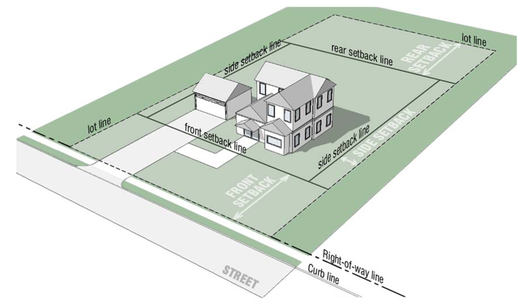
Diagram H Setbacks
SFHA: Special Flood Hazard Area. The land area defined on the flood insurance rate map subject to inundation by the one percent annual chance or regulatory flood. These areas are shown on the FIRM as Zone AE, AH, AO, A.
Shed: Same as "mini-barn."
Shop area: A production or repair area equipped with tools and machinery.
Shopping center: A group of commercial establishments planned, constructed and managed as a total entity with customer and employee parking provided on-site, provision for goods delivery separated from customer access and often with protection from the elements.
Shrub: A woody plant of relatively low height branching from the base not exceeding 10 to 12 feet in height. A Type 1, 2, or 3 deciduous shrub as defined by the American Standard for Nursery Stock (ANSI Z60.1-2004) that is listed on the Indianapolis Selected Plant List, as adopted by the Commission. Type 1 deciduous shrub is a small shrub and Type 2 and 3 deciduous shrubs are considered large shrubs.
Side yard: Same as "yard, side."
Sidewalk: A hard-surfaced walk or raised path and any curb ramps or blended transitions along and generally paralleling the side of the street for pedestrians. Sidewalks do not include the curb or gutter structures.
Sidewalk café: An outdoor seating area accessory to an establishment that serves food or beverage such as a restaurant, coffee shop, café, bar or tavern in the public right-of-way, for consuming of goods purchased from the primary use of the property. See related "outdoor seating or patio (nonresidential)."
Sight distance: The length of roadway visible to a driver.
Sign: Any structure, fixture, placard, announcement, declaration, device, demonstration or insignia used for direction, information, identification or to advertise or promote any business, product, goods, activity, services or any interests.
Sign band: The horizontal piece of a façade framework, within which a sign is permitted, located between the top of a first story window or first story door and the base of a second story window (see Diagram A under "Base Panel").
Sign encroachment: The placement of any sign or sign support structure or the extension of any part of a sign or sign structure into a required yard, street right-of-way or alley right-of-way.
Sign face: The surface of the sign upon, against, or through which the message of the sign is exhibited.
Sign structure: Any structure, including the supports, uprights, bracing and framework that supports or is capable of supporting any sign.
Sign type: Itemized categories of freestanding or building signs.
Single-family attached dwelling: A dwelling unit designed originally for residential occupancy by one family joined by a common wall to another legally complete dwelling unit designed originally for occupancy by another family. Also known as a townhouse or row house. Each dwelling unit is on its own legally established lot or is a part of a condominium as defined by Chapter 551. Each dwelling unit is completely separated from the other by (1) an unpierced wall extending from ground to roof; or (2) an unpierced ceiling and floor extending from exterior wall to exterior wall, except for a common stairwell exterior to the dwelling units. This use does not include a secondary dwelling unit.
Single-family detached dwelling: A building designed originally for residential occupancy by one family on a lot or parcel containing no other primary building.
Site improvement: The erection, construction, placement, repair, alteration, conversion, removal, demolition, maintenance, moving, razing or remodeling of any new or existing structure or any part thereof; or any activity for which an Improvement Location Permit is required.
Site plan: The development plan, or series of plans, drawn to scale, for one or more lots on which is shown the existing and proposed location and conditions of the lot as required by the Zoning Ordinance or by administrative regulations or standards applicable to the type of application being submitted.
Skirting: The rigid physical attachments to a mobile dwelling designed and intended to completely screen, shelter, and protect the unit's base and entire area between the unit's floor surface and the ground surface, that includes, but not limited to, all electrical and plumbing conduits, insulation material, and undercarriage.
Sky exposure plane: An imaginary sloping surface, consisting of 3 types, rises over designated lots in the CBD-1 and CBD-2, as specified in Sections 742-106.B. and C. for purposes of limiting height of building, signs and other structures. See Section 740-309 (Measurements and Calculations).
Spandrel: A roof-like structure that covers the fuel dispenser serving as a second-tier canopy, may be a lighting source for the dispensing area, may serve to identify the individual fuel dispensers or pumps, and may display signage (see Sign Diagram 25).
Spandrel sign: Any sign that is a part of or attached to the spandrel structure (see Sign Diagram 25).
Specified anatomical areas: Any of the following:
1.
Less than completely and opaquely covered human genitals, pubic region, buttocks, anus or female breasts below a point immediately above the top of the areolae; or
2.
Human male genitals in a discernibly turgid state, even if completely and opaquely covered.
Specified sexual activities: Any of the following:
1.
Human genitals in a state of sexual stimulation or arousal;
2.
Acts of human masturbation, sexual intercourse or sodomy;
3.
Fondling or other erotic touching of human genitals, pubic regions, buttocks or female breasts;
4.
Flagellation or torture in the context of a sexual relationship;
5.
Masochism, erotic or sexually oriented torture, beating or the infliction of pain;
6.
Erotic touching, fondling or other such contact with an animal by a human being; or
7.
Human excretion, urination, menstruation, vaginal or anal irrigation as a part of or in connection with any of the activities set forth in subsections 1. through 6. above.
Spill Prevention Control and Countermeasure (SPCC) Plan: The plan required by the United States Environmental Protection Agency to prevent spills from reaching navigable waters of the United States.
Sports stadium: A facility designed for professional sporting events, exhibitions, shows or convocations.
Stacking space, off-street: An area, separate from or in addition to, the required parking area, reserved for the temporary retention of vehicles that are queuing up or utilizing the services of a drive-through service unit.
Staff: The staff of the Metropolitan Development Commission in the Department of Metropolitan Development.
Standard flood insurance policy: The flood insurance policy issued by the federal insurance administrator, or an insurer pursuant to an arrangement with the federal insurance administrator pursuant to federal statutes and regulations.
Standard proctor: For purposes of flood control regulation, the maximum dry density of a backfill material as determined by the methods set forth within ASTM D 698. The percent standard proctor density is a ratio of the in-place dry density of a backfill material, determined by those methods set forth within ASTM D 1556, to the maximum dry density (determined by Test Method 698). The resulting quotient must be multiplied by 100, and the value obtained must meet or exceed the minimum values specified in the Zoning Ordinance.
Start of construction: For purposes of flood control regulation, the date that a floodplain development permit was issued, provided the actual start of construction, repair, reconstruction, rehabilitation, addition, placement, or other improvement was within 180 days of the permit issuance date.
Stock yards and processing of stock: The holding and feeding of livestock, poultry, pigs, or other domesticated animals for commercial purposes in lots, pens, ponds, sheds or buildings for further shipping or processing where food is supplied primarily by means other than grazing, foraging, or other natural means, or a facility for the slaughtering and processing of animals and the refining of their byproducts. This definition includes leather curing and tanning; slaughtering or meat packing; and fat rendering. This definition does not include Confined Feeding Operations or Concentrated Animal Feeding Operations as defined IC Title 13 Article 11.
Stockpiling: For purposes of Gravel, Sand, and Borrow regulations, storage of an aggregate product or material in a large mound for later use, sale or disposal.
Storage: For purposes of wellfield protection regulation, the deposit and holding of goods, material, merchandise, or vehicles typically for more than 24 hours.
Storage, outdoor: See "outdoor storage and operations."
Storage room: An enclosed area integrated into and sharing a common or party wall or walls within a primary building, while designed and intended for the purpose of reserving property for a future use.
Story: That part of a building, with an open height of not less than seven feet six inches, except a mezzanine, included between the upper surface of one floor and the lower surface of the next floor, or if there is no floor above, then the ceiling next above. A basement constitutes a story only if it provides finished floor area.
Story, half: The space under a sloping roof that has a line of intersection of the roof and exterior wall face not more than two feet above the floor level, and where the possible floor area with head room of seven feet or more is no greater than 60% of the total floor area of the story directly beneath.
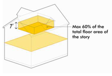
Stream: A surface watercourse with a well-defined bed and bank, either natural or artificial that confines and conducts continuous or periodic flowing water.
Stream bank: The sloping land that contains the stream channel and the normal flows of the stream.
Stream base flow: Flows of groundwater origin distinguished by any of the following physical indicators:
1.
Hydrophytic vegetation, hydric soil, or other hydrologic indicators in the area where groundwater enters the stream channel, in the vicinity of the stream headwaters, channel bed or channel banks;
2.
Flowing water not directly related to a storm event;
3.
Historical records of a local high groundwater table, such as well and stream gauge records.
Stream channel: Part of a watercourse that contains an intermittent or perennial base flow of groundwater origin.
Stream, Category Two: An intermittent stream that flows in a well-defined channel during wet seasons of the year but not necessarily for the entire year. These streams generally exhibit signs of water velocity sufficient to move soil, material, litter, and fine debris. Aquatic organisms, such as fish, are often difficult to find or not present at all in these streams. These streams are identified on the United States Geological Survey (USGS) topographic maps and on the Department of Natural Resources Conservation Service (NRCS) soils maps.
Stream, Category One: A perennial stream that flows in a well-defined channel throughout most of the year under normal climatic conditions. Some may dry up during drought periods or due to excessive upstream uses. Aquatic organisms such as some fish are normally present and easily found in these streams. The Category One Streams are listed in Table 744-205-2: Category One Streams.
Stream protection corridor: A vegetated area, including trees, shrubs, and herbaceous vegetation, that exists or is established to protect a stream system, lake, or reservoir, and where alteration is strictly limited. Functionally, stream protection corridors provide erosion control, improve water quality (lower sedimentation and contaminant removal), offer flood water storage, provide habitat, and improve aesthetic value.
Street: An improved public way, in which the right-of-way is typically 35 feet or more in width. See also "streets."
Streets (see Diagram I)
Collector street: A street primarily designed and intended to collect traffic from an area and move it to an arterial while also providing substantial service to abutting land uses.
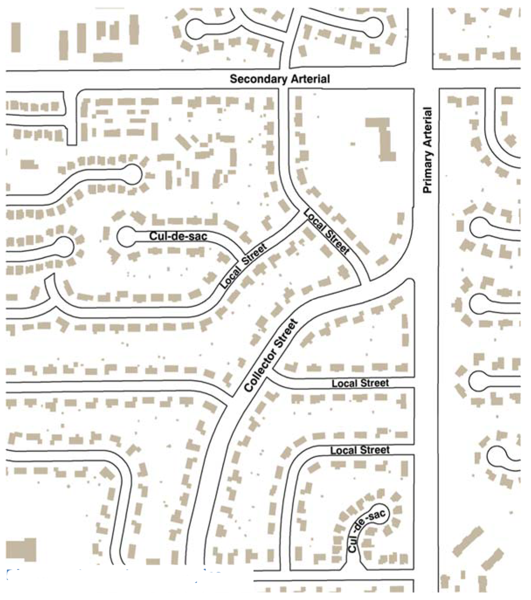
Diagram I Street Type examples
Corridor street: Principal streets within the SZ-1 and SZ-2 Districts, more specifically defined as 16th Street, Holt Road, and 10th Street.
Cul-de-sac: A street having only one open end that is permanently terminated by a vehicle turnaround.
Eligible public street: Pertaining only to sidewalks, that portion of a public street abutting a lot or project, or that portion of a public street between the lot lines extended from which a lot or project can gain access.
Expressway: A street so designated by the Official Thoroughfare Plan for Marion County, as amended, primarily designed as access controlled routes with design and operational characteristics similar to freeways, with some intersections at grade level. Access control is usually obtained by using medians, frontage roads, and by selectively locating intersections. These roads are designed for relatively high speed operation.
Freeway: A street so designated by The Official Thoroughfare Plan for Marion County, as amended, primarily designed as divided highways with full control of access and grade-separated interchanges. Primary function is movement of traffic, in particular long trips made within and through the study area. These roads are designed for relatively high-speed operation (e.g. 55 mph). Also known as an interstate.
Interior street: Streets within the SZ-1 and SZ-2 Districts that are not identified as corridor streets are considered interior streets.
Local street: A street primarily designed and intended to carry low volumes of vehicular traffic movement at low speeds (e.g. 20 to 30 mph) within the immediate geographic area. Their primary function is to service abutting land-uses.
Marginal access street (or marginal access road): A local street with control of access auxiliary to and located on the side of an arterial, thoroughfare, expressway, or freeway for service to abutting property.
Parkway: A street serving through vehicular traffic and generally equal to or more than 5,280 feet in length, the adjoining land on one or both sides of which is predominantly dedicated or used for park purposes, and conforms to the Comprehensive Plan and the Official Thoroughfare Plan for Marion County, Indiana, as amended. Partial control of access to a parkway permits access connections only at street intersections.
Primary arterial: A Street so designated by The Official Thoroughfare Plan for Marion County, as amended, primarily designed and intended to have greater traffic-carrying capabilities and higher levels of service than other grade level routes to channel major traffic movements. They either carry higher volumes than other adjacent routes or have the potential to carry higher volumes. They serve as connecting routes to the freeway system and to other primary arterials, and are oriented primarily to moving through traffic rather than serving abutting land use.
Private Street: A privately held right-of-way, with the exception of alleys, essentially open to the sky for the purposes of vehicular and pedestrian travel affording access to abutting property, whether referred to as a street, road, expressway, arterial, thoroughfare, highway, or any other term commonly applied to a right-of-way for said purposes. A private street may be comprised of pavement, shoulders, curbs, sidewalks, parking space, and similar features.
Public Street: A publicly dedicated, accepted and maintained right-of-way, with the exception of alleys, essentially open to the sky and open to the general public for the purposes of vehicular and pedestrian travel affording access to abutting property, whether referred to as a street, road, expressway, arterial, thoroughfare, highway, or any other term commonly applied to a public right-of-way for said purposes. A public street may be comprised of pavement, shoulders, gutters, curbs, sidewalks, parking space, and similar features.
Secondary arterial: A street so designated by The Official Thoroughfare Plan for Marion County, as amended, primarily designed and intended to serve a higher percentage of short trips than do primary arterials. They carry significant volumes and are needed to provide system continuity.
Structural alteration: Any change that would prolong the life of the supporting members of a building or structure such as bearing walls, columns, beams or girders, except such changes as are ordered made pursuant to the provisions of the Unsafe Building Law, IC 36-7-9-1, and any amendments to that law.
Structural barrier: A physical structure, such as a fence, wall, or railing that forms a boundary between, or enclosure to, portions of a property or acts as a division between properties.
Structural soil: A product that consists of stone, voids and a soil matrix. Originally developed by Cornell University, the product is designed to be used under pavements that are adjacent to landscape islands for the purpose of expanding the potential root zone area of the landscape island.
Structure: A combination or manipulation of materials to form a construction, erection, alteration or affixation for use, occupancy, or ornamentation, whether located or installed on, above, or below the surface of land or water, and whether permanently affixed to the ground, temporary, or mobile, including but not limited to signs, fences, and underground storage tanks. For purposes of flood control regulations, anything that can be constructed, altered, repaired or erected on the ground or attached to the ground, including, but not limited to, buildings, factories, sheds, detached garages, gas or liquid storage tanks, cabins, manufactured homes, recreational vehicles to be placed on a site for more than 180 consecutive days, and other similar items.
Subdivision: The division of any parcel of land into two or more lots, parcels, sites or other divisions executed in the manner defined and prescribed by Chapter 741 for the purpose, whether immediate or future, of sale, transfer, gift, or lease which results in one or more new building sites.
Suspended sign: Any building sign that is suspended from the underside of a horizontal plane surface and is connected to this surface (refer to Sign Diagrams 13 and 32).
Substance abuse treatment facility: A facility, the primary function of which is to administer or dispense a schedule II controlled substance (as listed under IC 35-48-2-6(b) or (c)) to a narcotic addict for maintenance or detoxification treatment. This definition does not include a methadone clinic or treatment facility.
Substantial addition: For purposes of flood control regulations, a structural enlargement of the enclosed space of a structure, the cost of which equals or exceeds 50% of the market value of the structure before the start of construction. See related "nonsubstantial addition."
Substantial damage: For purposes of flood control regulations, damage of any origin sustained by a structure and not intentionally caused or inflicted by the owner or occupant, whereby the cost of restoring the structure to its before damaged condition would equal or exceed 50% of the market value of the structure before the damage occurred. See related "nonsubstantial damage" and "substantial improvement".
Substantial improvement: For purposes of flood control regulations, any structural improvement of a structure that does not consist of a structural enlargement or repair of damage, the cost of which equals or exceeds 50% of the market value of the structure before the "start of construction" of the improvement. The term includes any improvements to repair, replace or reconstruct damage or demolition intentionally caused or inflicted by the owner or occupant. The term does not include either:
1.
Any project for improvement of a structure to correct existing violations of state or local health, sanitary, or safety code specifications that have been identified by the local code enforcement official and that are the minimum necessary to assure safe living conditions;
2.
Any alteration of an "historic structure," provided that the alteration will not preclude the structure's continued designation as an "historic structure;" or
3.
Ordinary maintenance and repair as defined in the Zoning Ordinance.
Substations and utility distribution nodes: A hub or distribution facility for any physically connected utility systems such as electricity, gas, cable/fiber optic communications, telephone, and water services, including facilities that transform electric voltage or natural gas pressure to the level supplied to the distribution system, but not including any facility that occupies less than 16 square feet of ground area and is less than eight feet in height.
Surface, impervious: A surface that has been compacted or covered with a layer of material so that it is highly resistant to infiltration by water.
Surface, permeable (or pervious surface): A surface that permits water to enter the ground by virtue of its porous nature or by large spaces in the material.
Surface impoundment: For purposes of wellfield protection regulation, a natural topographic depression, man-made excavation, or diked area formed primarily of earthen materials (although it may be lined with man-made materials) that is not an injection well.
Swimming pool or hot tub: Any man-made, structurally confined body of water exceeding 200 square feet in water surface area, or greater than 18 inches in depth, designed, used, or intended to be used for swimming or bathing purposes. This definition does not include ponds or lakes.
T.
T-frame sign: A portable sign utilizing an inverted "T" style of framing structure to support the sign (refer to Sign Diagram 30).
Tailings: For purposes of Gravel, Sand, and Borrow regulations, material of inferior quality or value resulting from the removal, preparation, or processing of minerals.
Tandem parking: A parking space in which two vehicles are parked end to end or stacked vertically using lift equipment and in which one vehicle must be moved before the second vehicle can access a street, driveway, alley, or parking lot or parking garage driving aisle.
Tank: For purposes of wellfield protection regulation, a type of container designed to fully enclose and hold an accumulation of liquid or gas, and is constructed of nonearthen materials such as concrete or steel.
Tattoo parlor: A facility where permanent marks, scars, or designs are made on the skin by a process of pricking and ingraining an indelible pigment or by raising scars; or in which other bodily decorations, such as piercing, are provided.
Technically qualified person (or TQP): For purposes of wellfield protection regulation, either an employee of the Department of Metropolitan Development, or any person with whom the Department of Metropolitan Development has a services contract for the review of Wellfield activities, who is competent to evaluate site and development plans for contamination risk to groundwater quality. Examples include professional engineers, certified professional geologists and environmental and other scientists with specialized training and experience in hydrogeology, contaminant transport, and hazardous materials management.
Temporary construction yard, office, or equipment storage: The temporary use of land prior, during, and after construction activities that involve equipment, storage, loading or unloading of construction materials or equipment, or offices, and accessory structures such as fences, walls, buildings, and barricades. Includes temporary construction offices; temporary real estate offices.
Temporary fireworks sales: Temporary facility in a "tent-type" or permanent structure properly registered with the State Fire Marshal's office through the Indiana Department of Homeland Security, engaged in the sale of fireworks for either commercial or home use, pursuant to all state and federal regulations.
Temporary outdoor event: Use limited in duration to typically less than 14 days including recreational and amusement activities; carnivals; festivals; concerts; car washes by not for profit organizations; block parties; garage sales; yard sales; estate sales. This definition does not include temporary outdoor display and sales, or temporary fireworks sales.
Temporary sign: Any sign that is not permanently affixed or installed, and is intended to be displayed for a limited period only. For illustrative purposes only, examples of such signs may include signs posted by a realtor or candidate, banners, pennants, wind and balloon signs.
Temporary use: An impermanent land use established for a limited and fixed period of time with the intent to discontinue such use upon the expiration of the time period.
Terrace: An open, raised bank or banks of earth having a vertical or sloping side and a horizontal top.
Thoroughfare: A public way serving vehicular traffic that is included in the Official Thoroughfare Plan of Marion County, Indiana. The term includes the entire right-of-way for public use of the thoroughfare and all surface and subsurface improvements on it, such as sidewalks, curbs, shoulders, and utility lines and mains. Examples are freeways, expressways, primary thoroughfares, and secondary thoroughfares.
Thoroughfare Plan: The Thoroughfare Plan for Marion County, Indiana as most recently adopted or amended by the Commission. The Thoroughfare Plan is a segment of the Comprehensive Plan for Marion County, Indiana pursuant to IC 36-7-4 that sets forth the location, alignment, dimensions, identification and classification of freeways, expressways, highways, primary arterials, secondary arterials, or other public ways as a plan for the development, redevelopment, improvement, and extension and revision thereof.
Topsoil: The top layer of soil that is predominantly fertile and ordinarily moved in tillage and which is the natural medium for plant growth, or the equivalent in uncultivated soils.
Tower: A structure designed and intended to support one or more antennas. This term includes lattice-type structures, either guyed or self-supporting, and monopoles, that are self-supporting pole-type structures, tapering from base to top and supporting a fixture designed to hold one or more antennas.
Transient merchant: A person or entity licensed under Chapter 987 that is engaged in the offering of goods or the provision of services for payment or benefit, at a non-permanent outdoor location that is not owned or leased long-term by the operator to which consumers come to the merchant. This definition includes uses such as mobile car wash, mobile oil change, and retail sales. This definition does not include on-site preparation of food, or activities authorized by a special event license issued under Chapter 986.
Transit center: A single facility designed to facilitate transfers between multiple transit routes. Transit centers vary in size and service characteristics.
Transit corridor: Corridors that have existing local or regional transit routes including all variations of frequency and operating characteristics.
Transit station: A location served by the Indianapolis Public Transportation Corporation (IndyGo) where transit users can board or disembark. Transit stations include facilities of substantial physical investment along transit emphasis corridors that are intended to serve transit routes that have limited stop locations.
Transit stop: A location served by the Indianapolis Public Transportation Corporation (IndyGo) where transit users can board or disembark. Transit stops include facilities of minimal (signage, waiting pads) or moderate (shelters) physical investment, and are intended to serve transit routes that have many stop locations.
Transit emphasis corridor: Key arterial corridors built or recommended for enhanced transit service according to the Indianapolis Public Transportation Corporation (IndyGo) Comprehensive Operational Analysis (a/k/a Bus Plan). These corridors may include high-frequency, rapid, limited stop, and/or express route service, and may connect to major destinations in Central Indiana that lie outside of Marion County.
Transitional building: Building or portion of a building located within 100 feet of a lot line shared by an abutting lot that is improved with a single-family detached dwelling or is adjacent to a lot separated by a right-of-way less than 30 feet that is improved with a single-family detached dwelling.
Transitional living quarters: A residential facility providing temporary lodging for families or individuals in immediate need. The facility may also provide limited temporary counseling, referral, mediation and similar human service functions. This definition does not include a group home, daily emergency shelter, diversion center, or residential facilities or shelters for residents who are required to leave during the day for work or other purposes.
Transparent: Having the property of transmitting rays of light and not reflect more than 30 percent of visible light through its substance so that bodies situated on both sides can be distinctly seen.
Transparency: Expressing the level of visibility provided and maintained between an inside and outside activity area of the building, which is usually through the windows and doors; this ratio is expressed as a percentage. Transparency must be maintained and unobstructed to allow visibility between the two areas. For calculations, refer to Section 740-303 (Building Measurements and Calculations).
Transportation facilities and accessories (ground): Uses accessory or incidental to transportation facilities such as waiting rooms; bus and other transit stops; vending machines, and storage and associated commercial uses at transportation hubs or facilities.
Traveled way: The portion of a roadway for the movement of vehicles, exclusive of shoulders.
Tree, overstory (or shade tree): A Type 1 or Type 2 Shade tree as defined by the American Standard for Nursery Stock (ANSI Z60.1-2004) that is listed on the Indianapolis Selected Plant List, as adopted by the Commission.
Tree, ornamental (or understory tree): A Type 3 Shade tree or Type 4 small upright tree as defined by the American Standard for Nursery Stock (ANSI Z60.1-2004) that is listed on the Indianapolis Selected Plant List, as adopted by the Commission.
Tree survey: An inventory of all trees on a lot or project before construction, alteration or excavation activity occurs identifying species, location, caliper, and drip line of trees. In the case of tree stands 600 square feet or larger in area and with 75% or greater branch coverage of the ground surface, the location of the outer boundary of the drip line of the tree stands with a listing of the predominant species and caliper is often substituted for a detailed inventory.
Triplex: A building designed originally for residential occupancy by three families, or later approved by the city for residential occupancy by three families, living independently of each other that contains three legally complete, dwelling units and no dwelling unit may be located on a separate lot. Dwelling units may be a part of a condominium as defined by Chapter 551. Each unit in a triplex is completely separated from the other by an unpierced wall extending from ground to roof; or an unpierced ceiling and floor extending from exterior wall to exterior wall, except for a common stairwell exterior to one or more of the dwelling units. This use also includes townhouses or larger residences split into three dwellings.
Truck or heavy vehicle sales, rental, or repair: The storage, display, sale, lease, rental, or repair of new or used self-propelled vehicles, including trailer, truck or bus rental; truck or bus rustproofing; truck or bus maintenance garage; and truck or bus dealer (of any load capacity). This definition does not include any use or activity included in the definition of other or light vehicle sales, rental, or repair. An inherent characteristic of this use is the outside display of vehicles offered for sale which is considered a primary facet of the use; as a primary use, this display must meet the development standards as a primary use and not the standards associated with an accessory use.
Truck stop: An establishment engaged primarily in the fueling, servicing, repair or parking of tractor trucks and similar heavy commercial vehicles, including the sale of accessories and equipment for such vehicles, including chartered bus stations and dispatch facilities. This definition includes facilities such as showers and restaurant facilities primarily for the use of truck crews or bus passengers.
Turfgrass: Areas covered with turf or perennial sod forming grass.
Two-family dwelling: A building designed originally for residential occupancy by two families, or later approved by the city for residential occupancy by two families, living independently of each other that contains two, legally complete, dwelling units, and each dwelling unit may or may not be located on a separate lot and may be a part of a condominium as defined by Chapter 551. Also known as a duplex or double. Each unit in a two-family dwelling is completely separated from the other by an unpierced wall extending from ground to roof; or an unpierced ceiling and floor extending from exterior wall to exterior wall, except for a common stairwell exterior to one of the dwelling units.
U.
Uncovered open space: In D-6, D-6II, D-7, D-8 (other than single-family and two-family dwellings), D-9, D-10, and D-11 Districts: the lot area, minus the building area, plus the usable roof area. In D-A, D-S, D-1, D-2, D-3, D-4, D-5, D-5II and D-8 (Single-Family and Two-Family Dwellings) Districts: the lot area, minus the building area.
Underground storage tank: For purposes of wellfield protection regulation, any one or combination of tanks and underground pipes connected to the tanks that are regulated under 40 CFR Part 280. Notwithstanding the exceptions in 40 CFR Part 280, for purposes of wellfield protection regulation this definition also includes:
1.
A tank that would otherwise be regulated by 40 CFR Part 280 but for the fact that it contains hazardous waste as regulated under Subtitle C of the Federal Solid Waste Disposal Act.
2.
A tank that would otherwise be regulated by 40 CFR Part 280 but for the fact that it is used to store heating oil for consumptive use on the premises where stored.
Underground storeroom or safe room: A hardened structure specifically designed to provide near absolute protection or survival supply in extreme weather or manmade events. These are either attached to a permitted structure or constructed separately entirely beneath the finished floor elevation.
Upper level building sign: A permanent building sign, located in its entirety, on a building façade above 26 feet in height, measured from grade level. Examples include wall, projecting, or roof-integral signs.
Usable roof area: The total roof area, within the project or residential buildings, garages and accessory buildings that has been improved for outdoor uses of occupants. Roof areas used for the storage of automotive vehicles are not included.
Utility lines: Electrical, telephone, data and cablevision distribution and service wires and cables accessory to primary uses, excluding, without limitation, all transmission lines, main feeder distribution lines and other similar nonaccessory lines, the function of which is not to serve exclusively the end consumer.
Utility pole: Any pole or structure utilized for electric, telephone, telegraph, cable television, radio, microwave, television services, street lights, other lighting standards, or comparable purposes.
V.
Valance: A vertically hanging or suspended fringe on an awning or canopy, often used as a decorative element.
Variance: A grant of relief from the terms of the Zoning Ordinance approved by the Board of Zoning Appeals.
Variety store: Commercial establishments primarily engaged in the retail sale of a variety of merchandise in the low price range. Sales usually are made on a cash-and-carry basis, with the open-selling method of display and customer selection of merchandise. These stores generally do not carry a complete line of merchandise, are not departmentalized, do not carry their own charge service, and generally do not deliver merchandise. See related "retail, light general."
Vehicle area: Uncovered or covered area used for vehicular traffic, maneuvering and parking. Included are all parking, loading, and stacking areas, parking lots, driveways, interior access drives and rights-of-way of all streets and alleys within the project.
Vehicle entry point sign: Freestanding, permanent on-premises sign accessory to the primary use of land that is located within 10 feet of the right-of-way and the pavement of a driveway. Refer to diagram below.
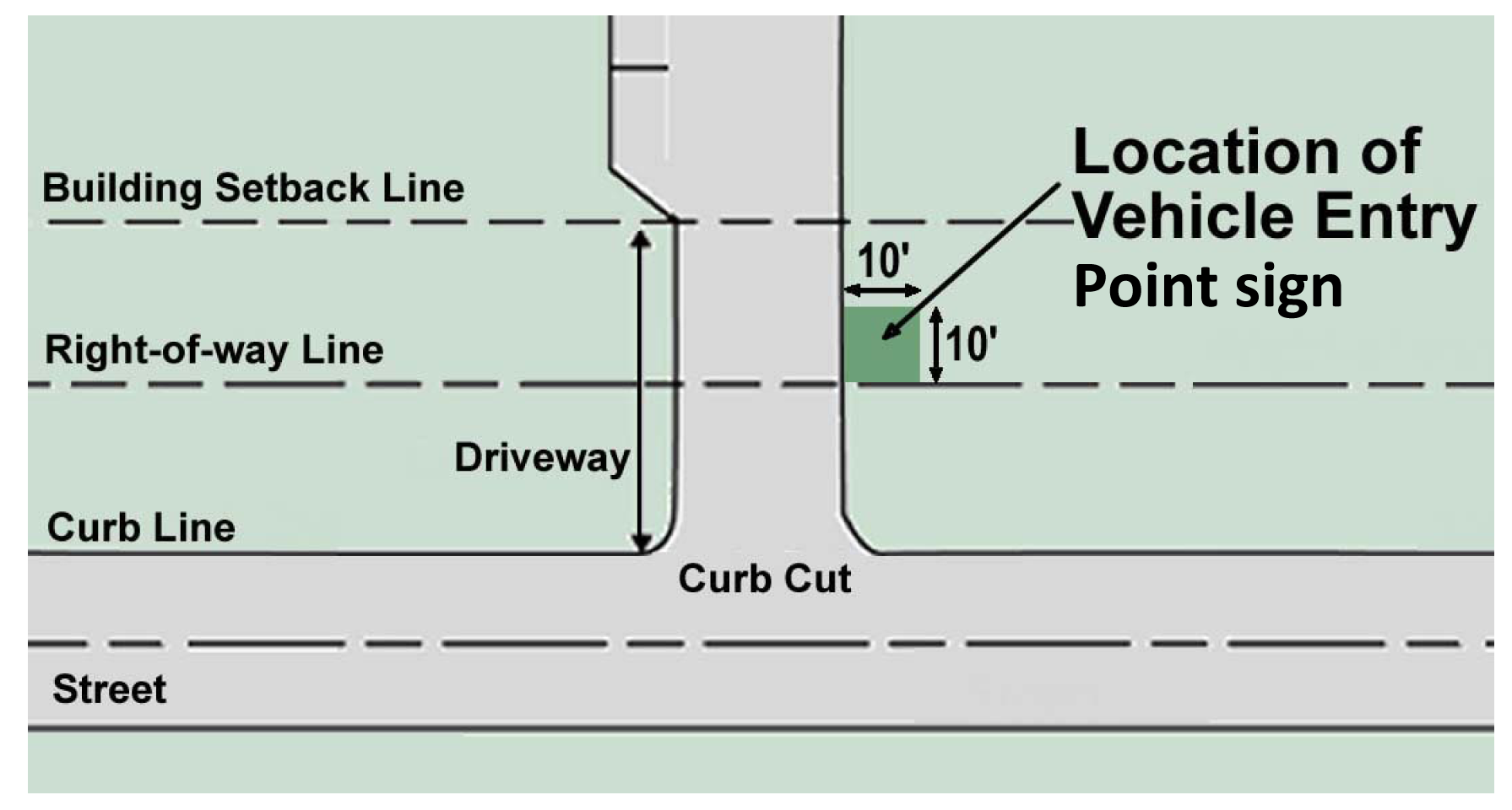
Vehicle or equipment repair area: For purposes of wellfield protection regulation, an area designated, designed and intended for the purpose of repairing automotive vehicles or equipment.
Vehicle wash: See "heavy vehicle wash" or "automobile and light vehicle wash."
Vending machine: An outside automatic device that dispenses goods or services to the customer upon receipt of monetary compensation, or dispenses monetary compensation to a customer in return for the deposit of goods or materials. This use includes self-service kiosks and reverse vending machines, but does not include indoor vending machines or Automatic Teller Machines (ATMs).
Violation: The failure of a structure or development or use to be fully compliant with the Zoning Ordinance. For purposes of flood control regulation, this includes a structure or use or development without the elevation certificate, other certifications, or other evidence of required compliance with the flood control regulations in the Zoning Ordinance.
Visibly obstructed: The view of an object that is blocked by a building or other manmade structure so as to be incapable of being seen from that line of sight.
Vocational, technical, or industrial school or training facility: A school conducted as a commercial enterprise for teaching skills and vocations, or skills in which machinery is employed as a means of instruction including vocational or technical school, and industrial schools and training facilities. This definition includes training in areas such as masonry; truck driving; carpentry; welding; and machining. This definition does not include the incidental instructional services in conjunction with another primary use.
W.
Walk-up window: An accessory use incidental to an establishment where customers may walk up to the window to purchase goods rather than entering the structure or using a drive-through. Examples are walk-up eating establishments and walk-up pharmacies.
Walkway: A hard-surfaced walk or raised path for pedestrians.
Wall sign: Any building sign attached parallel to, but within 18 inches of, a wall, painted on the wall surface of, or erected on an outside wall of any building or structure, that is supported by such wall or building with no more than 50% of the sign structure extending above the wall, to a maximum extension of four feet, and displays only one sign surface (refer to Sign Diagram 32).
Warehousing, wholesaling and distribution: Establishments or places of business primarily engaged in handling freight (with or without maintenance); selling merchandise to retailers, to industrial, commercial, institutional, or professional business users, or to other wholesalers, or acting as agents or brokers and buying merchandise for, or selling merchandise to, such individuals or companies; or the intake of goods and merchandise, individually or in bulk, the short-term holding or storage of such goods or merchandise, or the breaking up into lots or parcels and subsequent shipment off-site of such goods and merchandise. This definition includes facilities such as distribution operation; storage and transfer establishments; and distribution from truck yards.
Waste or recycling transfer facility: A site or facility where solid waste is unloaded from collection vehicles and transferred onto transport vehicles, either immediately or following a temporary storage period, aggregation, composting, or sorting. The facility may feature sorting, use of a crushing apparatus, and the storage of the material until it is transported. The definition includes solid waste and recyclables that are transferred from a vehicle or container to another vehicle or container for transportation purposes. This definition does not include motorized vehicles or vehicle parts, which is instead included in a wrecking or salvage facility.
Water tank: A structure or piece of equipment for storing water or maintaining water pressure, but not including a container for collecting rooftop or site rainwater with a capacity of less than 100 gallons.
Watercourse: Natural streams, man-made ditches, lakes, reservoirs, ponds, retention or detention basins, and drainage swales. A watercourse is distinguished from overland flow, sheet flow, shallow swale flow, and storm sewer flow by the following characteristics that must be present to constitute a watercourse:
1.
Defined and distinguishable stream banks under natural conditions; and
2.
Regularity of flow in the channel evidenced by a distinguishable waterline vegetation limit or hydrologic characteristics.
Watercourse alteration: Any encroachment, diversion, relocation, impoundment, draining, damming, repair, construction, reconstruction, dredging, enclosing, widening, deepening, filling or other modification of a watercourse. Watercourse alteration does not include the clearing of dead or dying vegetation, debris or trash from the channel, nor does it include ordinary maintenance and repair of an IDNR approved watercourse alteration.
Well: A bored, drilled or driven shaft, or a dug hole, whose depth is greater than the largest surface dimension.
Wetland: Those areas not influenced by tidal fluctuations, that are inundated or saturated by surface or groundwater at a frequency and duration sufficient to support, and that under normal circumstances do support, a prevalence of vegetation typically adapted for life in saturated soil conditions.
Wheelchair ramp: A structure built with durable materials, designed to convey a wheelchair and occupant from the finished floor elevation of a building to a suitable offloading location, such as a public sidewalk, and designed to conform to ADA Standards for slope and geometry.
Wind sign: A sign of light-weight fabric or similar material attached at one end to a pole or similar apparatus so as to swing freely, inflate and flutter by movement of the wind (refer to Sign Diagram 30).
Window sign: Any sign that is placed: 1) inside of, and within two feet of, a window; or 2) upon the window panes of glass, and is visible from the exterior of the window (refer to Sign Diagram 32).
Wireless communications facility (WCF): Any facility used by a licensed commercial wireless telecommunications provider to provide service, such as cellular, personal communication services, specialized mobilized radio, enhanced specialized mobilized radio, paging, and other similar services that are marketed to the general public.
WCF design package: Information used to portray all visual aspects of wireless communications facilities, and the apparatus needed to attach it to a structure, including, but not limited to, dimensions, colors, and materials.
Wrecking or salvage facility: A service in which towing or emergency services are provided to disabled automotive vehicles or equipment. This definition includes activities such as junk or salvage storage or operation; vehicle wrecking and salvage operation; shredder; and vehicle storage (wrecked or inoperable).
X. [Reserved]
Y.
Yard (See Diagram J)
Yard, front: An open space unobstructed to the sky, extending fully across the lot while situated between the front lot line and a line parallel to the front lot line, that passes through the nearest point of any building and terminates at the intersection of any side lot line.
Yard, interior: An open space unobstructed to the sky, extending fully across the mobile dwelling site while situated between the edge of pavement of the street or interior access drive and a line paralleling thereto, that passes through the nearest point of any building and terminates at the intersection of the individual mobile dwelling site's boundary lines.
Yard, perimeter: An open space unobstructed to the sky, required in addition to the front yard, situated between and extending along the project boundary or lot line that abuts adjoining property or an alley and an interior line paralleling thereto. The width of said yard is determined by the applicable zoning district of the ordinance.
Yard, rear: An open space unobstructed to the sky, extending fully across the lot situated between the rear lot line and a line parallel to the rear lot line that passes through the nearest point of any building and terminates at the intersection of any side lot line.
Yard, required: That portion of any yard, unobstructed to the sky, abutting a lot line having a minimum depth as required by the particular zoning district in which it is located.
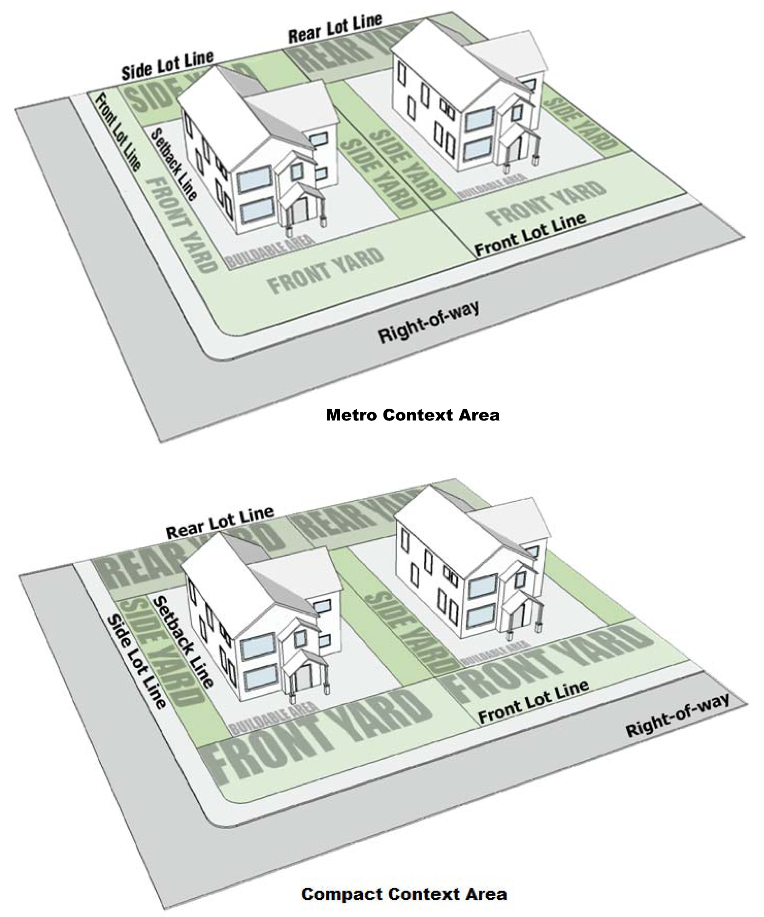
Diagram J Yards
Yard, side: An open space unobstructed to the sky extending the length of the lot situated between a side lot line and a line parallel to the side lot line that passes through the nearest point of any building and terminates at the point of contact with any rear or front yards or any lot line, whichever occurs first.
Yard, transitional: That portion of any yard abutting a protected district having a minimum depth as required by the particular zoning district in which it is located and acting as a buffer between two or more land uses of different intensity. A transitional yard is provided in lieu of the minimum required front, side or rear yard specified for the district in which it is located when an above noted protected district abuts.
Yard signs: Freestanding sign accessory to the primary use of land that is located in the yard of a lot, may be permanent or temporary, and may be either an on-premises or off-premises sign. For illustrative purposes only, examples may include signs posted by a realtor or home improvement company, sign expressing an opinion, and garage sale advertising.
Z.
Zone A: Areas within the floodplain established by the flood insurance rate maps where no base flood elevation is provided.
Zone AE: Areas within the floodplain established by the flood insurance rate maps where base flood elevations are provided.
Zone AO: Areas within the floodplain established by the flood insurance rate maps that are subject to sheet flow, ponding, or shallow flooding and where base flood depths (feet above grade level) are provided.
Zone AH: Areas within the floodplain established by the flood insurance rate maps that are subject to shallow flooding and where base flood elevations are provided.
Zone X, shaded: Areas between limits of the one percent annual chance flood, also known as, 100-year flood and 0.2% percent annual chance flood, also known as 500-year flood; certain areas subject to one percent annual chance flooding with average depths less than one foot or with drainage areas generally less than one square mile; and areas protected by levees from the base flood.
Zone X, unshaded: Areas where the annual exceedance probability of flooding is less than 0.2 percent, also known as, 500-year flood.
Zoo: A facility, indoor or outdoor, where animals are kept for viewing by the public. Office, retail, and other commercial uses commonly established in such facilities and related parking structures are allowed as accessory appurtenances.
(G.O. 64, 2015, § 2; G.O. 72, 2015, § 4; G.O. 11, 2016, § 2; G.O. 15, 2016, § 8; G.O. 53, 2017, § 1; G.O. 37, 2018, § 1; G.O. 26, 2021, § 1; G.O. 23, 2023, § 1)
Sec. 740-301. - Airspace measurements and calculations.
A.
Determining the airspace height. Height limits in the Airspace zoning district shall be computed from the applicable runway elevation, airport elevation, or heliport landing and takeoff area elevation.
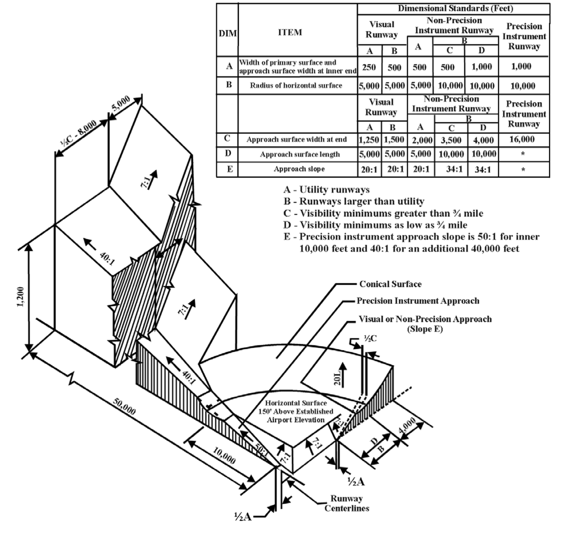
(G.O. 64, 2015, § 2)
Sec. 740-302. - Lot measurements and calculations.
A.
Lot area. Lot area is the total horizontal area of the land bounded on all sides by the front, rear, and side lot lines. Neither public nor private right-of-way is included in the lot area.
Floodway and Floodway Fringe areas are included in the calculation.
Easements for surface access ingress or egress into the subject lot or adjoining lots are included in the calculation.
B.
Lot coverage. Lot coverage is the ratio between the building area and the lot area.

C.
Minimum lot width. Any plat of a subdivision consisting of five or more lots, submitted for approval in accordance with Chapter 741, may reduce the required minimum lot width, as measured at the required setback line, by up to 10%, for up to 20% of the proposed lots.
(G.O. 64, 2015, § 2; G.O. 37, 2018, § 2)
Sec. 740-303. - Building measurements and calculations.
A.
Building area. When looking perpendicularly from above, the total horizontal area of ground, within the lot or project, covered by the primary structures plus area covered by all accessory buildings, all minor residential structures and all residential support facilities or amenities.
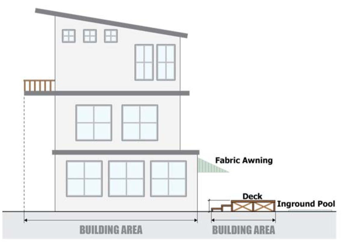
Diagram K Example of what is included in Building Area
Permanent overhangs, balconies, eaves and similar extensions are included in building area. The ground area of the extension not provided with surrounding exterior walls is the area immediately under the extension, projection of the roof, or the floor above (see Diagram K). Temporary extensions, such as fabric awnings, are not included.
Building area does not include improvements at grade level or within 18 inches of grade level, such as patios, inground pools, gardens, or walkways. The following types of improvements are not included in Building Area:
1.
Amateur Radio Antenna;
2.
Fences or similar structural barrier;
3.
Reserved;
4.
Geothermal, Solar or Wind Renewable Energy Facility;
5.
Minor Residential Features;
6.
Personal Garden;
7.
Satellite Dish Antenna;
8.
Underground Storeroom or Safe Room;
9.
Walkways and driveways.
B.
Building height. For buildings in which the highest roof is a flat roof, the vertical distance from the grade level abutting the façade measured to the highest point of the coping of the flat roof.
For buildings in which the highest roof is a mansard roof, the vertical distance from the grade level abutting the façade measured to the deck line of a mansard roof.
For buildings in which the highest roof is a pitched or gabled roof, the vertical distance from the grade level abutting the façade measured to the height of the highest gable of a pitched or hipped roof (see Diagram L).
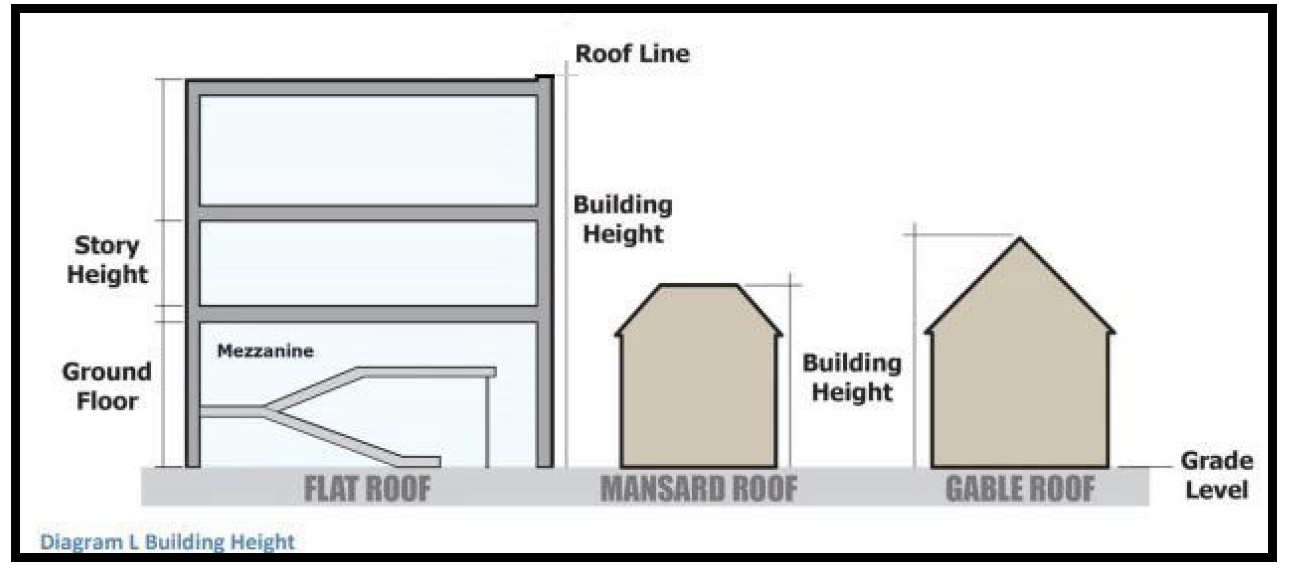
Diagram L Building Height
C.
Floor area calculations.
1.
Calculating floor area. Floor area is the sum of all horizontal surface areas of all floors of all roofed portions of a building measured from the exterior faces of the exterior walls or roofs, or the centerlines of party walls separating abutting buildings or portions thereof.
However, this does not include the following:
a.
Areas with a vertical height clearance less than 78 inches;
b.
Exterior open balconies, and open porches;
c.
Floor or basement floor area devoted to off-street parking or loading facilities, including aisles, ramps, and maneuvering space.
2.
Calculating floor area ratio. Floor area ratio is the ratio of total square footage of all floors in all buildings within the project to the square footage of the project. The sum of the floor area for each floor in all buildings within the project is divided by the lot area of the project to yield the floor area ratio.
3.
Calculating net floor area. Net floor area is the sum of the gross horizontal areas of the floors and basements of the building devoted to permitted uses, except floor areas devoted primarily to storage purposes; floor area devoted to off-street parking or loading facilities, such as aisles, ramps, and maneuvering space; floor area used for utilities, elevator shafts, main corridors and stair wells, or floor area for toilets, lounges, or cafeterias for the use of employees only. Provided, however, for the purposes of determining off-street loading requirements, net floor area shall include floor area devoted primarily to storage purposes, but shall otherwise be defined as above.
D.
Open space calculations.
1.
Calculating uncovered open space. In the D-A, D-S, D-1, D-2, D-3, D-4, D-5, D-5II Districts and in the D-8 District on lots improved with a single-family detached dwelling, or two-family dwelling, uncovered open space is the lot area minus the building area. Any Game Court area counts as Building Area.
In other instances, Uncovered Open Space is the Lot Area, minus the Building Area plus the Usable Roof Area.
2.
Calculating covered open space. Covered open space is the horizontal area of all exterior space within the lot or project that is open and exposed to the weather, but not open above to the sky, and is not used for vehicles. It includes total horizontal area of all exterior balconies over 25 square feet in size, porches, and exterior spaces covered by portions of buildings.
3.
Calculating open space. In the D-A, D-S, D-1, D-2, D-3, D-4, D-5, D-5II Districts and in the D-8 District on lots improved with a single-family detached dwelling, or two-family dwelling, open space is uncovered open space.
In other instances, open space is the total of uncovered open space plus covered open space.
4.
Calculating open space ratio. In the D-A, D-S, D-1, D-2, D-3, D-4, D-5, D-5II Districts and in the D-8 District on lots improved with a single-family detached dwelling, or two-family dwelling, the open space is divided by the lot area and then multiplied by 100 to yield the percentage of open space.
In other instances, open space ratio is the ratio of the area of all open space to all of the floor area. The open space is divided by the floor area to yield the open space ratio for the project.
E.
Livability space calculations. Livability space is the lot area minus total building area minus all vehicle areas plus covered open space plus usable roof area.
Livability space ratio is the livability space divided by the total floor area within the project.
F.
Transparency calculations.
1.
Calculating ground floor transparency. Each side of the building is measured separately. Any reference to building width does not include eaves, awnings or similar projections.
Determination of ground floor wall area:
On any facade or side of a primary building that is located 50 feet or more of a local, collector or arterial street and has a public pedestrian entrance, the height between three feet and eight feet above grade level (i.e. five feet) is multiplied by the portion of the width of that side of the building that is located within 50 feet of each side of each entrance.
On any facade or side of a primary building that is located within 50 feet of a local, collector or arterial street, the height between three feet and eight feet above grade level (i.e. five feet) is multiplied by the total width of that side of the building.
Within this ground floor wall area, the transparent areas are those in which a person with normal acuity is able to see in and out of the building. These transparent areas may be covered with glass, plastic or completely open and may be incorporated into the wall or part of a door.
The sum of the transparent areas of the ground floor wall area is divided by the ground floor wall area and then multiplied by 100 to yield the percentage of transparency.

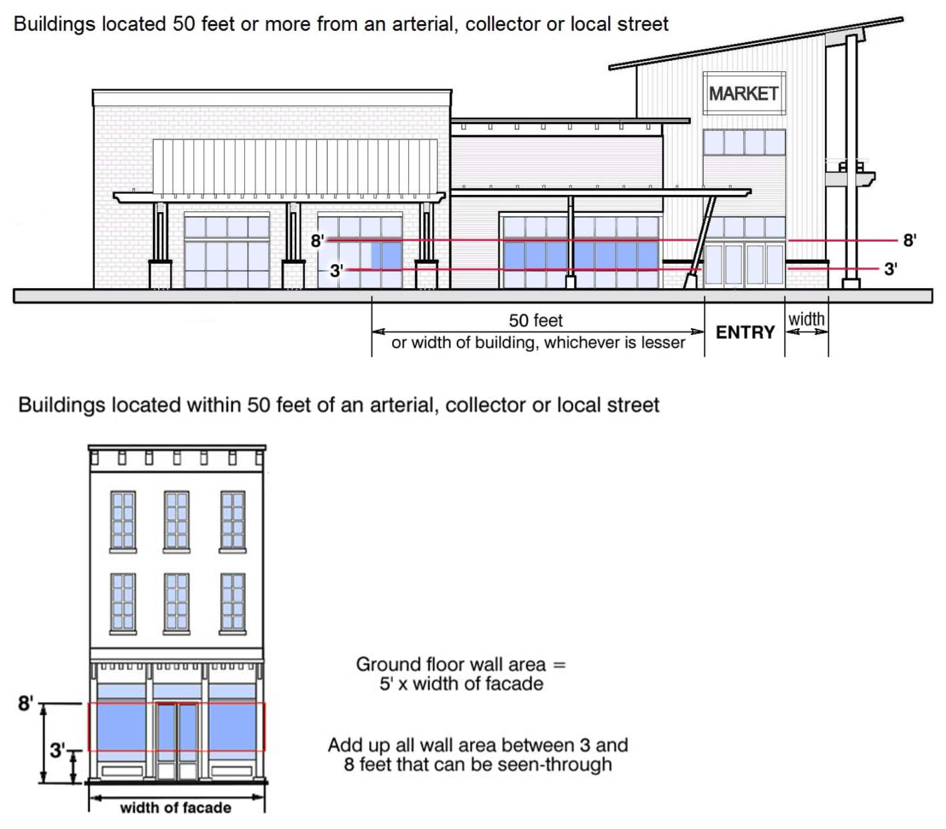
Diagram M Ground floor transparency
2.
Calculating transparency of upper floors. Each upper floor is measured separately. Each side of the building is measured separately.
The distance between the floor level and the ceiling of the floor is multiplied by the width of that side of the building at that floor level; this is the wall area. Building width does not include eaves, awnings, balconies or similar projections. Within this wall area, the areas in which a person with normal acuity is able to see in and out of the building are totaled; these transparent areas may be covered with glass, plastic or completely open. The sum of the transparent areas of the wall area is divided by the wall area and then multiplied by 100 to yield the percentage of transparency.

Each floor must meet the minimum transparency standard except for the top floor of any building five or more floors in height.
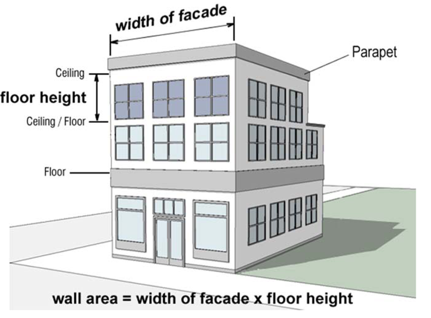
Diagram N Upper floor transparency — Facade
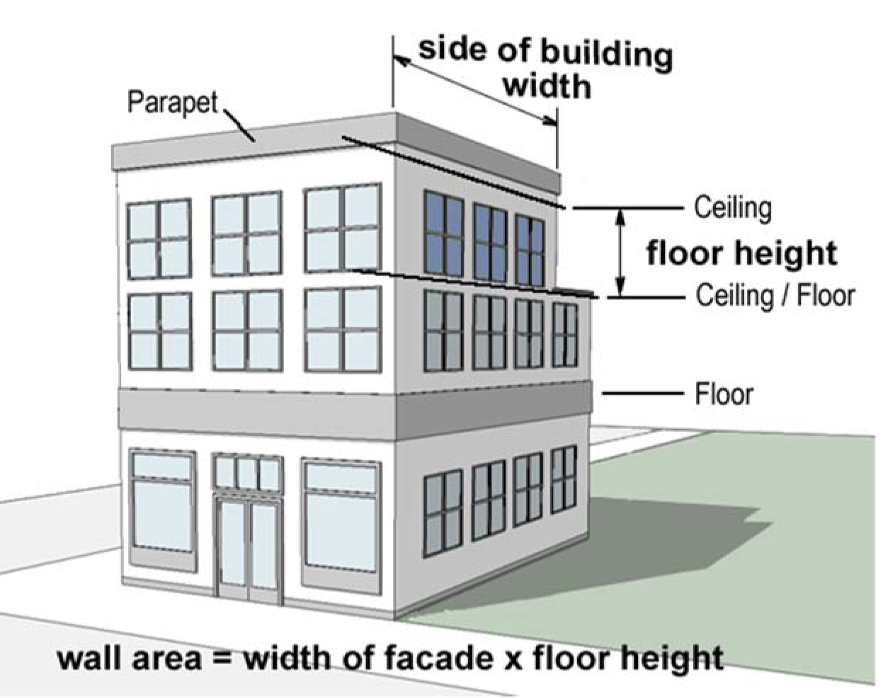
Diagram O Upper floor transparency — Side of building
(G.O. 64, 2015, § 2; G.O. 37, 2018, § 2; G.O. 23, 2023, § 2)
Sec. 740-304. - Clear sight measurements and calculations.
A.
Clear sight triangular area in Non-Industrial Districts. The clear sight triangular area is formed by the right-of-way centerline and the centerline of the driveway and the line connecting the two end points.
In Districts other than Industrial Districts, the distance along the centerline of the driveway must extend 20 feet from the street edge of pavement extended across the driveway. The distance along the right-of-way centerline must be as indicated in Table 740-304-A: Clear Sight distances for Non-Industrial Districts (see Diagram Q).
B.
Clear sight triangular area in Industrial Districts and GSB District. The clear sight triangular area is formed by the right-of-way centerline and the centerline of the driveway and the line connecting the two end points.
In Industrial Districts and any active mining operation in the GSB District, the distance along the centerline of the driveway must be 65 feet from the street edge of pavement extended across the driveway. The distance along the right-of-way centerline must be as indicated in Table 740-304-B: Clear Sight distances for Industrial and GSB Districts (see Diagram P).
C.
Clear sight triangular area at intersections of rights-of-ways. The clear sight triangular area is formed by the intersecting centerlines of each right-of-way and the line connecting the two end points of each extended centerline. The distance along the right-of-way centerlines must be as indicated in Table 740-304-C: Clear Sight distances at intersections of ROW (see Diagram R).
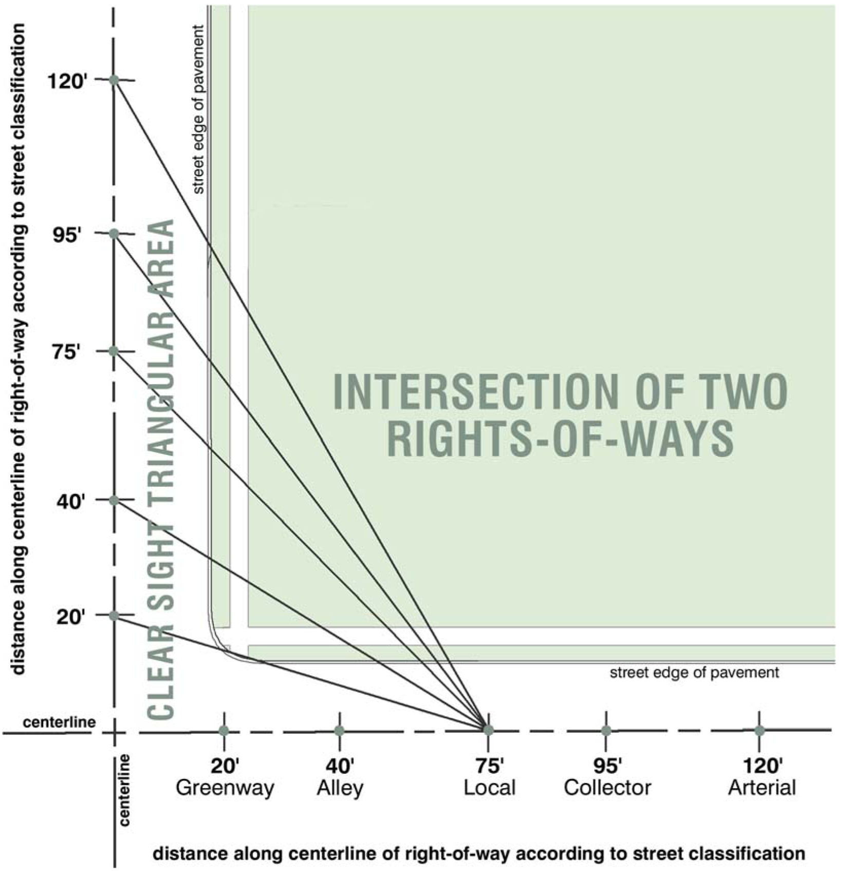
Diagram R Clear Sight Triangular Area - Intersection of 2 ROWs; illustrates Local
Street intersecting with another ROW
(G.O. 64, 2015, § 2)
Sec. 740-305. - Flood control measurements and calculations.
A.
Calculating 50% limit. In the Flood Control zoning districts, the maximum amount of work allowed in or on a legally established nonconforming use before the work is not eligible for the special allowances provided for restoration of nonsubstantial damage, nonsubstantial improvements and nonsubstantial additions as provided herein. The proposed work shown on an application for a floodplain development permit in or on a legally established nonconforming use shall be evaluated to determine whether the 50% limit has been exceeded by taking the ratio of the projected cost of the work divided by the market value of the structure upon which the work is to be accomplished before the start of construction of the legally established nonconforming use (excluding the value of the land or detached structures) as a percentage.

(G.O. 64, 2015, § 2)
Sec. 740-306. - Reserved.
Editor's note— G.O. 23, 2023, § 2, repealed § 740-306, which pertained to parking measurements and calculation and derived from G.O. 64, 2015, § 2.
Sec. 740-307. - Landscape measurement and calculations.
A.
Calculating amount of landscape elements. Where tree planting requirements are based on linear street frontage, areas occupied by driveways or other structures shall be included when calculating the number of trees required to be planted.
When a computation of required trees or plantings results in a fraction, the number of required trees or plantings shall be rounded up to the next whole number.
Landscaping may be counted as interior landscaping for a parking lot if it is located within eight feet of the parking lot and is not part of the street frontage landscaping, the minimum side or rear yard, transitional yard or edge buffering required by this ordinance.
B.
Measuring fences and walls. The measurement of a fence or wall height must be taken from grade level to the top of the fence, exclusive of fence posts. Changes in grade level over two feet must be included in the height calculation of the fence or wall. Mounding that increases the elevation of the fence or wall and is inconsistent with the ground level of the land surrounding the fence or wall must be included in the measurement of the fence height.
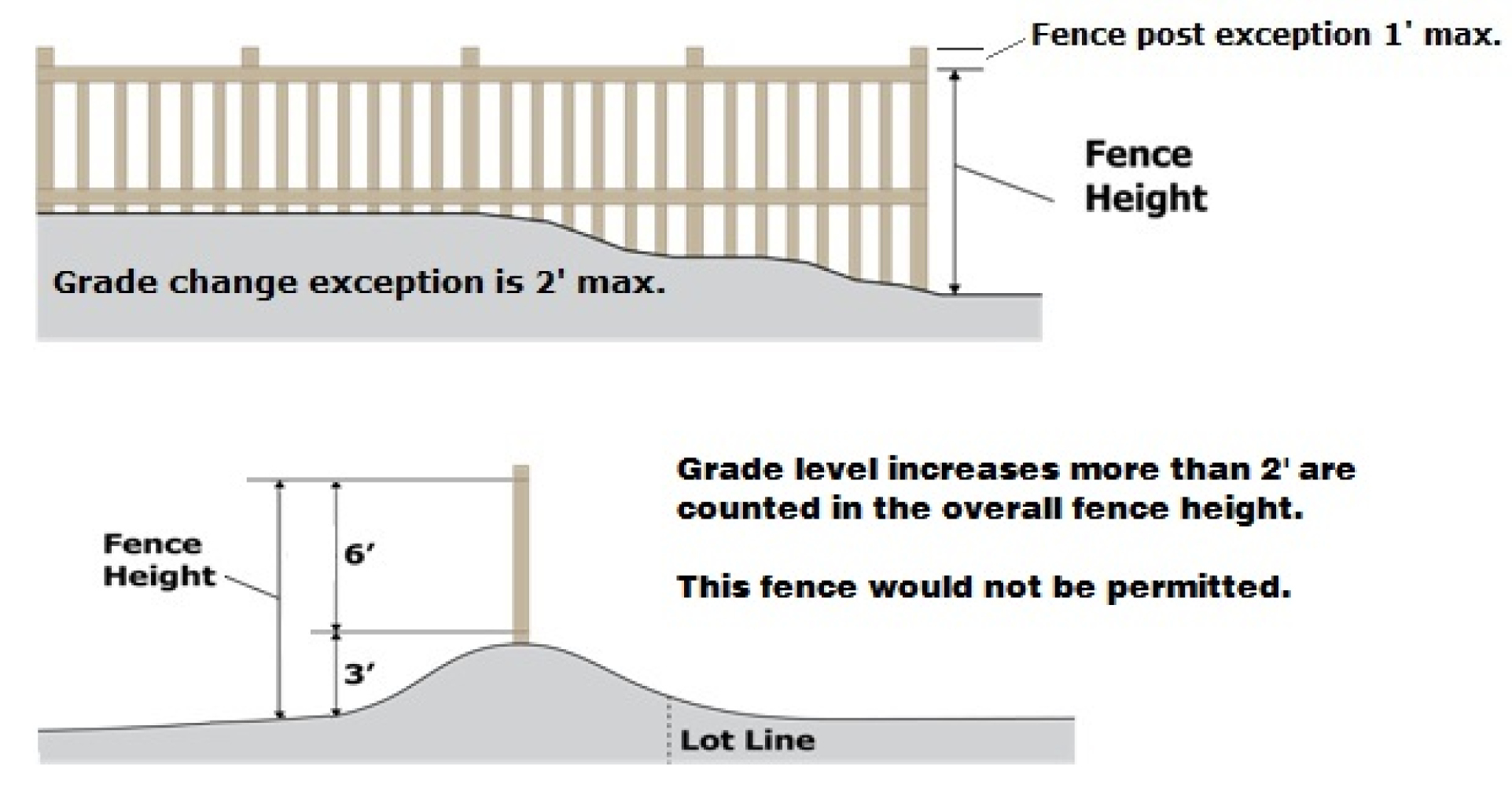
Diagram S Fence Height
C.
Measuring tree size. Diameter at breast height (DBH) is the primary method of measuring the diameter of a tree trunk. Diameter measurement is taken 54 inches above the ground. If the tree splits into multiple trunks at a height below 54 inches, but above the ground, the diameter is measured at the highest point beneath the split.
D.
Measuring tree drip line. The perimeter of a tree's spread measured to the outermost tips of the branches and extending downward to the ground.
(G.O. 64, 2015, § 2)
Sec. 740-308. - Building separation measurements and calculations.
A.
Measuring the distance between a use and a Protected District. Measured in any direction, the measurement must be taken from the exterior of the building (or the tenant bay of the establishment if the use is in an integrated center) to the zoning boundary of the protected district. When there is an intervening street, the entirety of the right-of-way will be included in the calculation. (see Diagram T).
Diagram T Buffer from Protected Districts
B.
Measuring the distance between a use and another use. Measured in any direction, the measurement must be taken from the exterior of the building (or the tenant bay of the establishment if the use is in an integrated center) to the property line of the other use or establishment.
(G.O. 64, 2015, § 2; G.O. 23, 2023, § 2)
Sec. 740-309. - Sky exposure plane measurements and calculations.
A.
Determining Sky Exposure Plane One.
1.
The Sky Exposure Plane One applies to lots in the CBD-1 District, excepting Monument Circle, that abut the following streets: New York Street, Ohio Street, Market Street, Washington Street, Maryland Street, Capitol Avenue, Illinois Street, Meridian Street, Pennsylvania Street, Delaware Street, Indiana Street, Massachusetts Avenue, Kentucky Avenue, and Virginia Avenue.
2.
The Sky Exposure Plane One also applies to lots within the CBD-2 District abutting the following:
a.
The north side of New York Street between Illinois Street and Capitol Avenue;
b.
The east side of Delaware Street between New York Street and Maryland Street;
c.
The south side of Maryland Street between Delaware Street and Capitol Avenue; or
d.
The west side of Capitol Avenue between New York Street and Maryland Street.
Diagram U Sky Exposure Plane One
3.
Sky Exposure Plane One must have a base that is coincident with the centerline of the street (See Diagram U).
4.
The elevation of that base is the average elevation of the street centerline from the intersection of one street center to the intersection of the next; and
5.
The Sky Exposure Plane One is inclined at an angle of 78 degrees measured from the horizontal; and
6.
Extending from the base to a vertical elevation of 300 feet above the base; and
7.
Then continues vertically to infinity at an angle of 90 degrees measured from the horizontal.
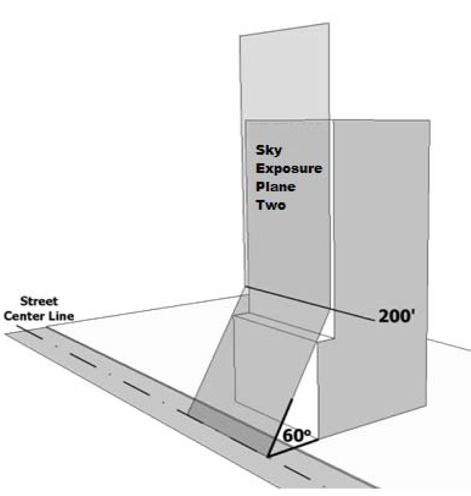
Diagram V Sky Exposure Plane Two
B.
Determining Sky Exposure Plane Two.
1.
The Sky Exposure Plane Two applies to all lots in the CBD-2 District except those designated for Sky Exposure Plane One (see Diagram V).
2.
Sky Exposure Plane Two must have a base that is coincident with the centerline of the street; and
3.
The elevation of that base is the average elevation of the street centerline from the intersection of one street centerline to the intersection of the next; and
4.
Sky Exposure Plane Two is inclined at an angle of 60 degrees measured from the horizontal; and
5.
Extending from the base to a vertical elevation of 200 feet above the base; and
6.
Then continues vertically to infinity at an angle of 90 degrees measured from the horizontal.
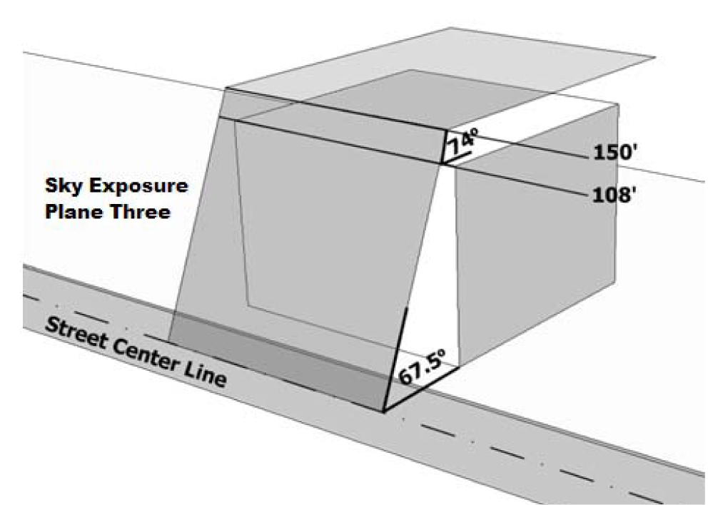
Diagram W Sky Exposure Plane Three
C.
Determining Sky Exposure Plane Three.
1.
The Sky Exposure Plane Three applies to all lots abutting Monument Circle (See Diagram W).
2.
Sky Exposure Plane Three must have a base that is coincident with the centerline of the street; and
3.
The elevation of that base is the average elevation of the street centerline from the intersection of one street centerline to the intersection of the next; and
4.
Sky Exposure Plane Three is inclined at an angle of 67.5 degrees measured from the horizontal; and
5.
Extending from the base to a vertical elevation of 108 feet above the base; and
6.
Then continues at an angle of 74 degrees measured from the horizontal; and
7.
Extending to a vertical elevation of 150 feet above the base; and
8.
Then continues horizontally at an angle of zero degrees measured from the horizontal; and
9.
Extending to the alleys known as Wabash, Scioto, Bird and Court Streets.
(G.O. 64, 2015, § 2)
Sec. 740-310. - Sign measurements and calculations.
A.
Clearance. The distance measured from the bottom of a sign face which is elevated above grade level and the grade level below (refer to Diagram X)
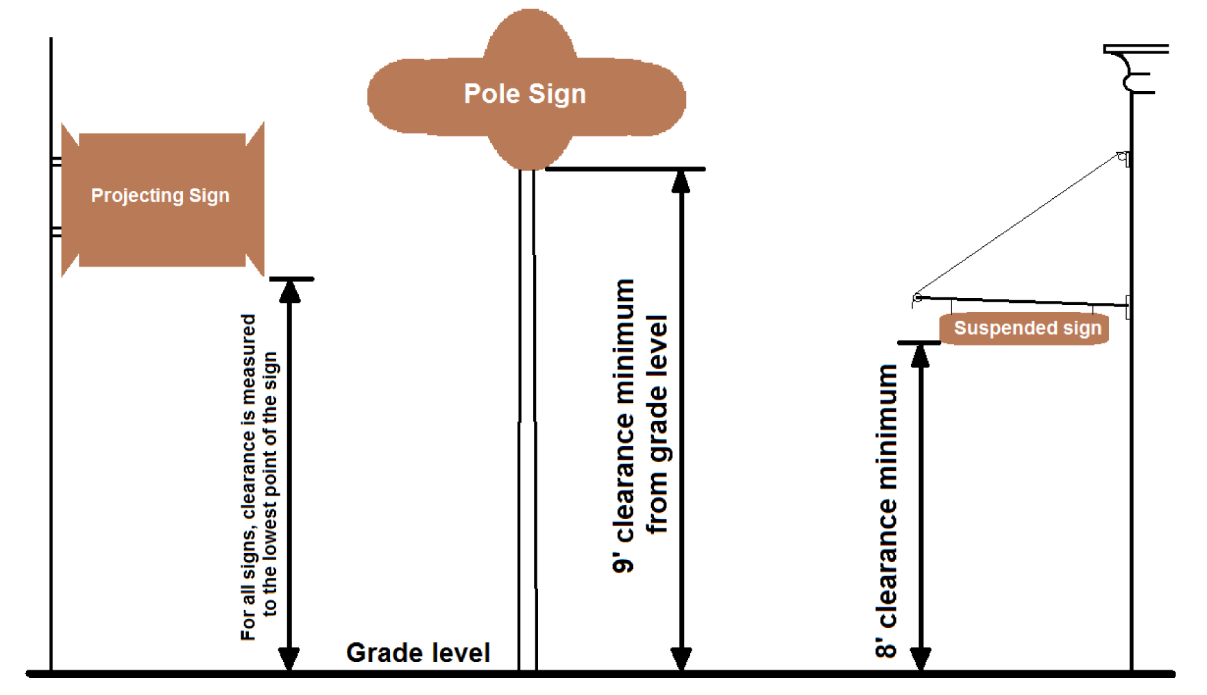
Diagram X Sign Clearance
B.
Sign area. The area of a sign face (which is also the sign area of a wall sign or other sign with only one face). Sign area shall be computed by using the smallest square, rectangle, or combination thereof that will encompass the extreme limits of the writing, representation, emblem, or other display, together with any material or color forming an integral part of the background of the display or used to differentiate the sign from the backdrop or structure against which it is placed, but not including any supporting framework, bracing, or decorative fence or wall when such fence or wall otherwise meets zoning ordinance regulations and is clearly incidental to the display itself (refer to Diagram Y).
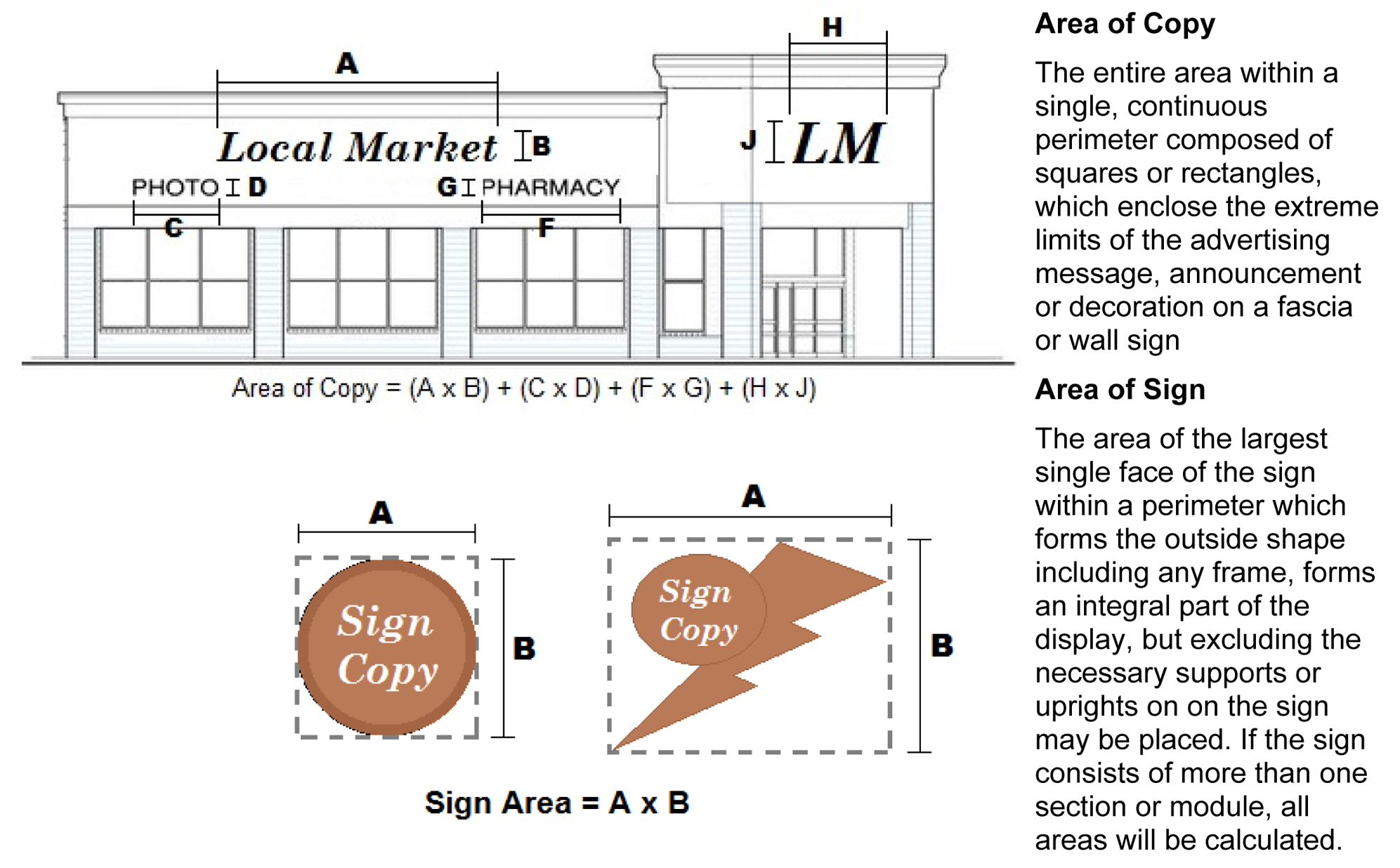
Diagram Y Sign Area Calculation
C.
Sign height. The height of the sign shall be computed as the vertical distance measured from the base of the sign at grade to the top of the highest attached component of the sign (refer to Diagram Z).
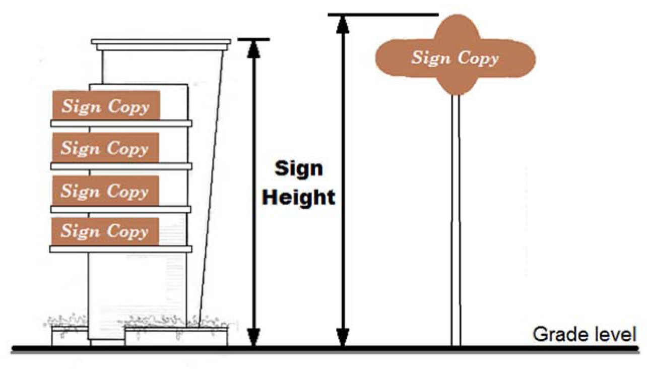
Diagram Z Sign Height
(G.O. 64, 2015, § 2)
Sec. 740-401. - Performance standards.
A.
Applicability. All uses established or placed into operation after April 8, 1969 shall comply with the following performance standards. No use in existence on April 8, 1969 shall be so altered or modified as to conflict with these standards.
B.
Standards that apply to all Districts.
1.
Vibration. No use shall cause earth vibrations or concussions beyond the lot lines endangering the public health, safety or welfare, or causing injury to property.
2.
Smoke, dust or particulate matter. Smoke, dust, particulate matter and any other airborne material shall be subject to the standards and regulations of Chapter 511 of the Revised Code of the Consolidated City and County. The standards and regulations noted in Chapter 511 of the Revised Code of the Consolidated City and County for the emissions of smoke, dust and particulate matter are hereby incorporated by reference and made a part hereof.
3.
Noxious matter. No use shall discharge across the lot lines noxious, toxic or corrosive matter, liquids, fumes, or gases in such concentration as to be detrimental to or endanger the public health, safety, or welfare or cause injury to property.
4.
Odor. No use shall emit across the lot lines odorous matter in such quantities as to be readily detectible at any point along the lot lines and as to be detrimental to or to endanger the public health, safety, or welfare, or to cause injury to property.
5.
Noise. No use shall emit sound beyond the lot lines in such a manner or intensity to endanger the public health, safety, or welfare, or cause injury to property.
6.
Heat or glare. No use shall produce heat or glare of such intensity beyond the lot lines as to endanger the public health, safety, or welfare, or cause injury to property.
7.
Waste matter. No use shall accumulate within the lot or discharge beyond the lot lines any waste matter, whether liquid or solid, in violation of the applicable standards and regulations of the Division of Public Health of the Health and Hospital Corporation of Marion County, Indiana; the Indiana State Board of Health; the Indiana Department of Environmental Management; and the Department of Public Works of Indianapolis, Indiana; or in such a manner as to endanger the public health, safety or welfare; or cause injury to property.
8.
Stormwater drainage. No use shall discharge beyond the lot lines any surface storm water in violation of the applicable standards and regulations of the Department of Public Works of Indianapolis, Indiana; or in such a manner to endanger the public health, safety or welfare; or cause injury to property.
C.
Standards that apply to Industrial Districts.
1.
Fire and explosive hazards. The storage, utilization or manufacture of all products or materials shall conform to the standards prescribed by the National Fire Protection Association for the storage, utilization or manufacture of all products or materials are hereby incorporated by reference and made a part hereof. Such storage, utilization or manufacturing shall not produce a hazard or endanger the public health, safety or welfare.
(G.O. 64, 2015, § 2)
Sec. 740-402. - Maintenance standards.
A.
Continual provision. All requirements of this zoning ordinance shall be met and maintained at all times thereafter in a manner that fulfills the requirements of this zoning ordinance. Alterations, replacements, or failure to maintain improvements to a site pertaining to any requirement of this zoning ordinance may not cause a nonconformity nor shall the degree of any legally-established nonconformity be increased except as provided for by this zoning ordinance.
B.
Maintenance responsibility. All outdoor landscaping, fencing, lighting, parking areas, outdoor equipment, or other items including without limitation playground equipment, dumpster enclosures, outdoor display and sales areas, recycling collection points, street furniture, recreational facilities, and art installations, shall be maintained in a safe, serviceable, and rust-free condition by the owner of the property on which they are located.
1.
All outdoor play equipment that through age, deterioration, damage, or lack of maintenance becomes a hazard to children shall be promptly removed by the owner of the property on which they are located.
2.
If any items or improvements required to be installed pursuant to the Zoning Ordinance or an approval granted pursuant to the Zoning Ordinance, then are required to be installed pursuant to the Zoning Ordinance or an approval granted pursuant to the Zoning Ordinance, then:
a.
If such items are later damaged, they shall be promptly repaired by the owner of the property on which they are located.
b.
If such items are later destroyed, damaged beyond repair, or removed, other than as part of an approved redevelopment plan for the property, they shall be promptly replaced by the owner of the property on which they are located.
(G.O. 64, 2015, § 2)
Sec. 740-501. - Context areas.
In order to address the wide variety of land use and development contexts in Marion County, Indiana, the Zoning Ordinance has adopted the Primary and Secondary Districts identified in Chapter 742. In addition, there are some cases where an existing zoning district has been applied in areas that were platted and developed prior to 1945 and areas platted after that date. In order to tailor development standards to promote compatible development and redevelopment in these two types of areas, the Zoning Ordinance sometimes includes different development standards for the following two types of context areas.
A.
Compact Context (C) areas were generally platted and developed before 1945 and areas platted after that date that are generally characterized by smaller platted lots, narrower platted streets, greater walkability, a more varied mix of uses, and a need to promote redevelopment of lots and parcels that may not meet modern platting standards.
B.
Metro Context (M) areas were generally platted and developed after 1945 and are generally characterized by larger lots and wider streets designed for higher levels of automobile ownership, access, and circulation, greater separation of uses, and a mix of developed and undeveloped land.
(G.O. 64, 2015, § 2)
Sec. 740-502. - Context Area map.
The Department of Metropolitan Development, through the City of Indianapolis Information Services Agency and IndyGIS shall maintain a current map of all parcels and their designation within the Compact and Metro Context areas.
(G.O. 64, 2015, § 2; G.O. 50, 2019, § 1)
Sec. 740-601. - Application and exceptions.
A.
Application.
1.
Use or occupancy.
a.
With the exception of legally established nonconforming uses, and except as set forth in subsection B., no land, building, structure, premises or part thereof shall be used or occupied except in conformity with these regulations and for uses permitted by this Zoning Ordinance.
b.
The property containing a nonconforming use may replace that nonconforming use with another nonconforming use from the same land use category (e.g. "commercial and building contractors", "financial and insurance services"), provided however, the replacement use meets all use-specific standards and does not include activities that include alcohol.
2.
Buildings or structures. No building, structure, premises or part thereof shall be constructed, erected, altered, converted, enlarged, extended, reconstructed or relocated except in conformity with these regulations and for uses permitted by the Zoning Ordinance.
3.
Creation of nonconformity prohibited. A lot may be subdivided into two or more lots in accordance with Chapter 741, provided that all resulting lots and all buildings thereon shall comply with all the applicable provisions of the Zoning Ordinance. If such a lot, however, is occupied by a nonconforming building, such lot may be subdivided provided such subdivision does not create a new noncompliance or increase the degree of noncompliance of such building.
B.
Legal establishment of nonconforming uses that were not legally initiated prior to April 8, 1969.
1.
Any nonconforming use in a District of the Zoning Ordinance shall be deemed to be legally established if the use:
a.
Existed prior to April 8, 1969; and
b.
Has continued to exist from April 8, 1969, to the present; and
c.
Has not been abandoned; and
d.
Of the entire building has not been vacant voluntarily for any period of 365 consecutive days.
A certificate stating the use and development of a property are legally established under this section shall be available from the Administrator on the presentation of sufficient evidence. The rules of procedure of the Metropolitan Development Commission shall outline the procedure to be followed in order to obtain an official certificate.
2.
All construction, erection, conversion (including, but not limited to, the addition of dwelling units), enlargement, extension, reconstruction or relocation occurring after April 8, 1969, must have been done in conformity with the Zoning Ordinance in place at the time and have been done for uses permitted at that time. Any such future activity shall not be permitted except in conformity with these regulations and for uses permitted by the Zoning Ordinance.
3.
This subsection shall have no effect upon the powers of the Consolidated City of Indianapolis, Marion County, or any unit or agency thereof, or the Health and Hospital Corporation of Marion County, Indiana, to enforce other public health and safety laws and ordinances affecting real property, including those contained in IC 34-1-52-1 through 34-1-52-4 (Codification of Common Law Nuisance) and shall not relieve any property of the legal obligation to comply with conditions or commitments which lawfully apply to the property made in connection with any variance, rezoning, platting, or other zoning decision.
C.
Legally established schools. All legally established nonconforming uses for an elementary, middle, junior high or high school (including any structures, facilities, and parking areas accessory thereto) located in a Dwelling District may be converted, enlarged, extended, reconstructed or relocated for such school use on the same lot or parcel as it existed on August 8, 1966, provided such school building, structure, facilities and parking area shall conform to the minimum yard and setback requirements of the applicable Dwelling District.
(G.O. 64, 2015, § 2; G.O. 37, 2018, § 3)
Sec. 740-602. - Restoration of nonconformities.
A.
Restoration of legally established nonconforming uses, structures, buildings.
1.
Legally established nonconforming uses and structures or buildings not located in any Flood Control zoning district that are damaged or partially destroyed by flood, tornado, fire, explosion, act of God, or the public enemy, may be restored to their original dimensions and conditions if:
a.
The use, structure, or building is a residential use in an originally designed and constructed single-family attached dwelling, single-family detached dwelling, or two-family dwelling, or
b.
The damage or destruction does not exceed two-thirds of the gross floor area of the building or structure affected, however, all land within any Wellfield Protection District shall, also, be subject to all of the requirements of Chapter 742-204 Wellfield Protection.
2.
A legally established, detached, accessory garage serving and located on the same lot as a single-family attached dwelling, single-family detached dwelling, or two-family dwelling and not located in any Flood Control zoning district may be reconstructed on an existing foundation, even though such reconstruction would not comply with required side or rear yards.
(G.O. 64, 2015, § 2)
Sec. 740-603. - Discontinuation of nonconforming uses.
A.
Restoration of legally established nonconforming uses, structures, buildings. The lawful nonconforming use or occupancy of any lot, in any District, existing on April 8, 1969, may be continued as a nonconforming use, but if such nonconforming use is discontinued, any future use or occupancy of such land shall be in conformity with the use provisions of the Zoning Ordinance. If a portion of the premises occupied by the nonconforming use is discontinued, the future use of that portion discontinued shall be in conformity with this ordinance. A nonconforming use is considered discontinued if the premises used by the nonconforming use is vacant for five consecutive years or replaced by a conforming use.
(G.O. 64, 2015, § 2)
Sec. 740-701. - Metropolitan Development Commission; rules.
The Metropolitan Development Commission shall make rules governing the time that the Commission holds its hearings, the voting procedures of the commission, and the procedures for conducting its business as authorized under IC 36-7-4. All proceedings brought under the Zoning Ordinance shall be subject to the Rules of Procedure of the Commission, where not inconsistent with the procedure otherwise stated in the Zoning Ordinance.
For matters pertaining to a zoning map amendment within the corporate boundaries of an excluded city, the Commission shall refer the matter to the excluded city's legislative body, who, at their first regularly scheduled meeting, may conduct the public hearing within 30 days of that meeting in accordance with IC 36-7-4-604(h).
(G.O. 64, 2015, § 2)
Sec. 740-702. - Board of Zoning Appeals.
A.
The Metropolitan Board of Zoning Appeals is established, as per IC 36-7-4-901, and comprised of three divisions. Each division of the Metropolitan Board of Zoning Appeals consists of five members as follows: Two citizen members appointed by the Mayor of the City of Indianapolis; two citizen members appointed by the City-County Council of the City of Indianapolis; and one citizen member, who may also be a member of the Metropolitan Development Commission, appointed by the Commission.
B.
The Metropolitan Board of Zoning Appeals has territorial jurisdiction over all the land subject to the Zoning Ordinance, except for the corporate boundaries of the excluded cities of Lawrence, Speedway, and Beech Grove. The Municipal Board of Zoning Appeals established by an excluded city shall have jurisdiction within the corporate boundaries of that municipality. All divisions of the Metropolitan Board of Zoning Appeals have concurrent territorial jurisdiction throughout the remainder of the county. The legislative body of the consolidated city may adopt ordinances to regulate the time of the meetings and the voting procedures of the Metropolitan Board of Zoning Appeals.
C.
The municipal board of zoning appeals for an excluded city shall consists of five members as follows: Three citizen members appointed by the legislative body of the excluded city, and two citizen members, who may also be members of the Metropolitan Development Commission, appointed by the Commission.
D.
The Metropolitan Board of Zoning Appeals shall make rules prescribing the time of the meetings, the voting procedures of the Metropolitan Board of Zoning Appeals, and the procedures for conducting its business.
(G.O. 64, 2015, § 2)
Sec. 740-703. - Combined hearing.
A.
Authority to conduct combined hearing. The Metropolitan Development Commission is authorized to designate a hearing examiner or Committee of the Commission to conduct a combined hearing procedure relative to developments that require more than one hearing under IC 36-7-4. In conducting this combined hearing procedure, the hearing examiner or Committee of the Commission may exercise the following:
Powers of the hearing examiner under IC 36-7-4-402(d) in relation to the 600 series of IC 36-7-4.
Powers of the Plat Committee under the 700 series of IC 36-7-4.
Powers of the Board of Zoning Appeals under the 900 series of IC 36-7-4.
Powers of the staff or hearing examiner or Committee of the Commission under the 1400 series of IC 36-7-4.
B.
Appeals and exceptions. Decisions of the hearing examiner or Committee of the Metropolitan Development Commission under the combined hearing procedure may be excepted to or appealed as follows:
1.
Decisions under the authority of IC 36-7-4-402(d) in relation to powers under the 600 series of IC 36-7-4 shall be excepted to in the same manner as exceptions may be filed to decisions of the hearing examiner or Committee under IC 36-7-4-402(d).
2.
Decisions under the authority of the 700 series of IC 36-7-4 shall be appealed to the Metropolitan Development Commission, in the same manner as decisions of the Plat Committee may be appealed.
3.
Decisions under the authority of the 900 series of IC 36-7-4 may be appealed to the Metropolitan Development Commission within five days after the decision is rendered and the Commission shall consider the petition in the same manner as the petition would be considered by a Board of Zoning Appeals.
C.
Rules. The Metropolitan Development Commission shall make rules governing the hearing of cases under the combined hearing procedure. The rules may not require a petitioner or an applicant to use the combined hearing procedure.
(G.O. 64, 2015, § 2)
Sec. 740-704. - Powers in Historic Districts.
A.
Authority for Indianapolis Historic Preservation Commission. The Indianapolis Historic Preservation Commission is authorized to exercise the powers of the Commission under the 600 series as authorized in IC 36-7-4-402 within an historic area or a Historic zoning district established under IC 36-7-11.1. The Indianapolis Historic Preservation Commission is authorized to exercise the powers of a Board of Zoning Appeals within an historic area or a Historic zoning district established under IC 36-7-11.1. However, this authorization does not eliminate the need for the Indianapolis Historic Preservation Commission to issue a Certificate of Appropriateness before the approval of a variance by either:
1.
A Board of Zoning Appeals; or
2.
The Indianapolis Historic Preservation Commission exercising the powers of a Board of Zoning Appeals.
B.
Rules. The Indianapolis Historic Preservation Commission shall make rules governing the hearing of cases under this section.
(G.O. 64, 2015, § 2)
Sec. 740-705. - Special exceptions.
The Board of Zoning Appeals is hereby authorized to grant special exceptions to permit those uses designated as requiring a special exception in Table 743-1: Use Table, in the zoning districts indicated in that table, subject to the following requirements:
A.
A petition for special exception shall be filed with the Board of Zoning Appeals in accordance with the Board's Rules of Procedure. In addition to the site plan and area map filing requirements of the Board's Rules of Procedure and special exception petition forms, the petitioner shall file with the special exception petition:
1.
An area map, drawn to scale, indicating the existing zoning classification of all land within 500 feet of the perimeter of the site and any elementary school, junior high school, or high school, as defined in IC 20-10.1-1, located within such distance.
2.
Proposed detailed findings of fact in support of the determinations by the Board in subsection B. below. The petition, or evidence presented to the Board at the public hearing, may include any additional pertinent exhibits, such as photographs depicting the site or other land uses and properties in the area; neighborhood or community economic, social, land use or environmental impact statements; or other relevant evidence.
B.
A special exception may be granted following public hearing of the petition and only upon the Board's determination that:
1.
The proposed use meets the definition of that use in Chapter 740, Article II.
2.
The proposed use will not injure or adversely affect the adjacent area or property values in that area.
3.
The grant will not materially and substantially interfere with the lawful use and enjoyment of adjoining property.
4.
The proposed use will be compatible with the character of the District, land use authorized therein and the Comprehensive Plan for Marion County.
5.
The proposed use conforms to the development standards in Chapter 744 applicable to the zoning district in which it is located.
6.
The proposed use conforms to all provisions of the Zoning Ordinance, including the performance standards in Chapter 740 and the development standards in Chapter 744 applicable to the zoning district in which it is located.
7.
The proposed use conforms to all of the use-specific standards in Chapter 743 for that use, including any special exception standards for that use.
C.
The Board may impose reasonable restrictions or conditions in connection with the grant of any special exception, including restrictions and conditions that are more restrictive than the applicable development standards, to ensure compliance with the standards above. All such conditions shall be imposed by the Board to ensure compliance with standards above. Such conditions may include any reasonable site, development, operational and performance standards, requirements and restrictions. The grant of the special exception may be for a limited period of time, as specified by the Board.
D.
The grant of such special exception shall be conditioned upon conformance all provisions of the Zoning Ordinance, including the performance standards in Chapter 740 and the development standards in Chapter 744 applicable to the zoning district in which it is located, except as specifically modified by the grant of the special exception.
(G.O. 64, 2015, § 2)
Sec. 740-801. - Applicability of regulations.
A.
Requirement.
1.
Within Marion County, Indiana, no structure shall be located, erected, altered or repaired unless the use, character and location of the structure are in conformity with the provisions of the applicable Codes, Official Thoroughfare Plan for Marion County, Indiana, and other ordinances relating to land use, including the Zoning Ordinance.
2.
No structure shall be located, erected, altered or repaired upon any land within Marion County, Indiana, until an Improvement Location Permit has been applied for by the owner (or authorized agent) thereof and issued by the Metropolitan Development Commission of Marion County, Indiana, through the Bureau of License and Permit Services, unless specifically exempted in the Section 740-801.A.3. below.
3.
An Improvement Location Permit (ILP) shall not be required for the creation or alteration of the following structures or for accomplishing the following types of improvements. All provisions and regulations of the Zoning Ordinance applicable in the particular situation shall continue to apply to exempted structures and improvements:
a.
Air conditioning units;
b.
Antennas;
c.
Children's play equipment for exclusive use by a household (not common area), including aboveground pools that have 200 square feet or less in water surface area, or are 18 inches or less deep;
d.
Enclosure of a portion of a residential building that already lawfully has a foundation and a roof;
e.
Fences or structural barriers;
f.
Landscape strips and landscape plantings;
g.
Mini-barns or sheds that are 200 square feet or less and are not on a permanent foundation;
h.
Minor residential structures that extend less than 18 inches above grade level (measurement excludes handrails);
i.
Movable, temporary construction yard, office, or equipment storage utilized during construction projects for which a valid Improvement Location Permit or structural permit has been issued;
j.
Pergolas;
k.
Raised planting beds;
l.
Repairs or alterations that do not change the height, size or lateral bulk of the structure;
m.
Residential awnings with a projection of 48 inches or less;
n.
Sign face replacement that does not change the size, bulk, or materials and is outside the Regional Center and North Meridian Street Corridor District;
o.
Walkways on private property out of the public right-of-way;
p.
Waste receptacles, recycling containers, and associated screening;
q.
Wheelchair ramp.
(G.O. 64, 2015, § 2)
Sec. 740-802. - Application for permit.
A complete application for Improvement Location Permits shall be made upon forms prescribed by the Administrator, shall include a legal description of the lot, and shall be accompanied by the following:
A.
Required site plan. An accurate site plan in duplicate, drawn to scale, showing major circulation; specific location and dimensions of buildings, structures, and parking areas; open space areas, recreation facilities, and other details to indicate the character of the proposed development and its compliance with the zoning ordinance. The submission shall also include:
1.
Boundary lines, dimensions and acreage of the entire development site;
2.
Address of proposed structure or use, as assigned by the Department of Code Enforcement;
3.
Location of right-of-way line or lines of all streets, alleys and easements located adjacent to or within the lot. Location of centerline of all streets and dimension to right-of-way lines;
4.
Names of all adjacent streets, private drives and interior access roads;
5.
Location and dimensions of existing and proposed frontage lanes and passing blisters;
6.
Location, boundaries and name of any stream, creek, ditch, legal drain or other water course that traverses or abuts the property;
7.
Location of any on-site or adjacent transit facilities;
8.
Existing structures (location, dimensions to lot lines and size), except structures to be razed prior to or contemporaneously with construction pursuant to the permit;
9.
Proposed location of structures on lot, indicating dimensions to all lot lines;
10.
Accurate dimensions and height of structures proposed;
11.
Setbacks, minimum required front, side and rear yards;
12.
Location and dimensions of existing and proposed curb cuts, driveways and interior access drives, including connection to public streets;
13.
Parking schedule with quantity of vehicle and bike parking, and calculations and credits indicated;
14.
For non-residential facilities, design capacity and amount of any seating;
15.
For commercial parking facilities, (i) the width of driveways; (ii) location of driveways from the nearest point of two intersecting street rights-of-way; and (iii) the design and location of frontage lanes and passing blisters;
16.
Off-street and on-street parking areas, loading areas, stacking spaces and circulation patterns for vehicles, truck, equipment and bicycles showing dimensions; and tabulation of the number of off-street and on-street parking, loading, and stacking spaces in a conspicuous place on the plan;
17.
Signs, including location, dimensions to lot lines, type, illumination and size.
B.
Elevations. For all proposed buildings, additions and parking garages, exterior elevation plans shall be provided. Exterior elevation plans of existing and proposed (front, rear, left and right sides) must indicate:
1.
Type of exterior finishing and textures;
2.
Floor and ceiling heights;
3.
Dimensions of doors, windows, roof overhangs;
4.
Height, location, and materials of foundation;
5.
Door and window schedule listing the details of each, quantity used on site, and the transmissivity rating and reflectivity rating of the glass;
6.
Table with transparency calculations for each side and each floor;
7.
Location, and dimensions of all roof elements, such as chimney, HVAC, elevator housing.
C.
Landscaping plan. For all development that is required to provide landscaping by the Zoning Ordinance, a landscape plan must be provided. The landscape plan shall be drawn upon a copy of the site plan and shall indicate:
1.
If the development is subject to the Green Factor requirements, a completed Green Factor worksheet;
2.
Location of existing trees and landscaping materials, indicating size, species (common and botanical name) and if it is to be removed;
3.
Placement of proposed trees and landscaping materials, indicating size at time of planting and species (common and botanical name);
4.
Existing and proposed screens, walls, and fences, indicating materials, height, and location;
5.
Placement of all proposed drainage facilities, indicating type of facility and if the facility is to be designed to be wet or dry;
6.
Square footage of each area used in calculating the green factor requirements;
7.
Other information demonstrating compliance with Chapter 744, Article IV: Landscaping and Screening.
D.
Lighting plan. For all proposed buildings, additions and parking garages 1,000 square feet or greater, except for single-family detached dwellings, single-family attached dwellings, and two-family dwellings, a lighting plan shall be provided indicating all exterior lighting fixtures existing and proposed on site, and the proposed light fixture locations and a light fixture schedule listing the cutoff details of each light fixture, quantity used on site, and lumens rating.
In addition, for all proposed buildings, additions and parking garages 45,000 square feet or greater, a photometric layout shall be provided with the lighting plan indicating all photometric calculations including foot-candle levels on a regular grid across the site and extending beyond the lot; and the aiming direction of the light fixtures.
E.
Other required information and submission.
1.
Any other information, plans or exhibits required by or to indicate compliance with applicable Codes, this article, covenants, commitments and conditions of grants of variance.
2.
All other applicable information, plans or exhibits required by the Improvement Location Permit form, including but not limited to:
a.
Evidence of the applicant's submission of required plans to the Bureau of License and Permit Services; and
b.
Evidence of the applicant's submission of a required drainage plan to the Bureau of License and Permit Services. Provided, however:
1.
The Improvement Location Permit issuance may be withheld for a period not to exceed five business days if in the opinion of the administrator of the Bureau of License and Permit Services commencement under such plan may result in a hazard to the public health, safety or general welfare.
2.
If the bureau approves such plan, or at the expiration of such five business days has neither approved nor disapproved the plan, the permit shall be issued.
3.
If the bureau disapproves the plan, the permit shall not be issued except in accordance with the following:
In the event of disapproval of the drainage plan by the bureau, a written statement of the reasons for disapproval shall be provided to the administrator and to the applicant. The Administrator of the Bureau of License and Permit Services may then authorize issuance of the Improvement Location Permit if the applicant shows an immediate hardship will accrue if such permit is not issued, the applicant covenants to comply with the requirements of any drainage permit, and the administrator of the Bureau of License and Permit Services, upon consultation with the bureau, determines that proceeding with construction would not result in a hazard to the public health, safety or general welfare.
(G.O. 64, 2015, § 2)
Sec. 740-803. - Additional application requirements in the Wellfield Protection zoning districts.
In addition to the application and documents required indicated in Section 740-802 above, the following information on or with the site and development plan shall also accompany any application for an Improvement Location Permit for all development in a W-1 or W-5 District:
1.
Description of slopes near containment vessels and waste storage areas, in the form of topographic maps.
2.
Interior plumbing and floor plans.
3.
Sewage disposal facilities.
4.
Vicinity map.
5.
Brief history of the site and the new building or addition (usage, historical environmental concerns, abandoned wells, underground storage tanks, septic tanks, etc.)
6.
Paved and unpaved areas.
7.
Existing and proposed utility lines (inside and outside structures) including sanitary sewers, storm sewers, storm retention ditches, basins, French drains, dry wells, etc. The following shall be identified and labeled:
a.
Floor drain locations and outlets;
b.
Product storage locations;
c.
Waste storage locations;
d.
Liquid transfer areas;
e.
Site surface water bodies (streams, rivers, ponds);
f.
Existing and proposed underground storage tanks; and
g.
Existing and proposed aboveground storage tanks.
8.
List and quantities of all on-site chemicals.
9.
Detailed drawing of any existing or proposed containment areas (area, height, materials, construction specifications, etc.)
10.
Description of proposed operations such as hazardous materials or objectionable substances used or generated, product storage area descriptions, waste generation quantities, equipment cleaning processes, maintenance procedures, heating source (oil, gas, electric, etc.), liquid transfer or loading areas.
11.
Methods and locations of receiving, handling, storing, and shipping hazardous materials or objectionable substances.
12.
Response measures and reporting procedures in the event of a release or spill of a hazardous material or objectionable substance.
(G.O. 64, 2015, § 2)
Sec. 740-804. - Additional application requirements for mining operations.
In addition to the application and documents required for an Improvement Location Permit indicated in Section 740-802, all development in a GSB District shall provide the following additional information on or with the site and development plan:
1.
A legal description and stated acreage of the proposed affected land.
2.
A vicinity map of the area in a scale sufficient to show: the affected land, any dedicated right-of-way or easement, and the boundaries of all parcels lying within 600 feet of the affected land and mining operation, or a depth of two property ownerships, whichever is less.
3.
The name and address of the following:
a.
The mine operator if the operator is someone other than the applicant;
b.
Every legal owner of the affected land;
c.
Every legal owner of the mining operation (surface and mineral);
d.
Every owner of any leasehold interest in the affected land;
e.
Every owner of any leasehold interest in the mining operation;
f.
All purchasers of record of the affected land under a real estate contract;
g.
All purchasers of record of the mining operation under a real estate contract;
h.
The single proprietor, if the applicant is a single proprietor;
i.
The highest ranking officer, member or partner that resides in the State of Indiana, if the applicant is a partnership, corporation, association or other business entity other than a single proprietor; and
j.
All registered agents required by the Secretary of State.
4.
If the applicant is a partnership, corporation, association, or other business entity other than a single proprietor a list of names under which the applicant, partner, or principal shareholder previously operated a mine within the State of Indiana within five years preceding the date of application shall be provided.
5.
The names and addresses of the property owners of property lying within 660 feet of the affected land and mining operation, or a depth of two property ownership, whichever is less, as shown by records of the Marion County Assessor and dated not more than 45 days prior to the date of application.
6.
A copy of all applications, approvals, or permits required by other city, county, state or federal agencies for the proposed mining operation or affected lands.
7.
Financial guarantee, pursuant to Section 742-206 (Gravel, Sand, and Borrow Secondary zoning district).
8.
An operations plan, pursuant to Section 742-206 (Gravel, Sand, and Borrow Secondary zoning district).
9.
A Reclamation Plan, pursuant to Section 742-206 (Gravel, Sand, and Borrow Secondary zoning district).
10.
A spill prevention control and countermeasure plan, pursuant to Section 742-206 (Gravel, Sand, and Borrow Secondary zoning district).
(G.O. 64, 2015, § 2)
Sec. 740-805. - Additional review procedures for mining operations.
The following describes the general procedure for the processing of an Improvement Location Permit application for a mining operation.
Before an application is submitted, the applicant shall request a pre-application meeting with the Administrator to discuss the proposed operation and to clarify application requirements.
1.
At any time during the review of an Improvement Location Permit application, the Administrator may request, in writing, additional information that is reasonably necessary to make any findings, determinations, or decisions on an application. A request for additional information shall specify a date by which the Administrator is to receive the additional information. Failure to provide information in a timely manner may be grounds for denial of the application.
2.
The Administrator shall review the Improvement Location Permit application and make a determination of completeness within 30 days of receipt of the application. In determining whether or not the application is complete or incomplete, the Administrator shall communicate this determination in writing to the applicant. In the event that the Administrator determines that the application is incomplete, a new completeness review period of 30 days shall commence from the date of receipt of the missing or inadequate information. If the Administrator fails to make a determination of a complete application within the time frames specified above, the application will be deemed complete.
3.
Once an Improvement Location Permit application has been determined to be complete, the applicant shall be required to submit a full and complete copy of the application to the Marion County Soil and Water Conservation District, Marion County Surveyor, Marion County Public Health Department, the appropriate water utility, and Indianapolis Department of Public Works, or their successors.
4.
The Administrator shall render a decision on the Improvement Location Permit application within 90 days from the acceptance of a complete application, or the latest request for information, whichever occurs last. If the Administrator does not approve or deny the application within 90 days of the determination of a complete application, the application shall be deemed to be approved.
(G.O. 64, 2015, § 2)
Sec. 740-806. - Conformity required.
A.
No permit shall be issued for any structure or use unless the use, character and location thereof shall be in conformity with the provisions of all applicable Codes, Official Thoroughfare Plan for Marion County, Indiana, and other ordinances relating to land use.
B.
No permit shall be issued for any structure or use unless the use, character and location thereof shall be in conformity with all provisions of the locally designated Historic District or the Meridian Street Preservation Area, if such structure or use is under their jurisdiction.
C.
No permit shall be issued for any structure or use authorized by variance unless the use, character and location thereof shall be in conformity with all requirements and conditions of the variance.
D.
No permit shall be issued for any structure or use unless the use, character and location thereof shall be in conformity with all conditions and commitments applicable to the land.
E.
Provided, however, a petition to modify plans, conditions or commitments may be filed with the appropriate public body (Commission, Board of Zoning Appeals or Indianapolis Historic Preservation Commission) in compliance with all requirements of the applicable body's rules of procedure.
(G.O. 64, 2015, § 2)
Sec. 740-807. - Street frontage requirements.
No permit shall be issued for any use or structure unless the lot abuts upon and has adequate frontage on a public street (the right-of-way of which has been dedicated and accepted for maintenance by governmental agency having jurisdiction thereof, or the construction of which is bonded in accordance with the standards and requirements of the applicable municipal agency having jurisdiction) in accordance with the requirements of all applicable ordinances, except as otherwise specifically authorized in zoning districts permitting private drives or interior access roads or by variance.
(G.O. 64, 2015, § 2)
Sec. 740-808. - Fees.
The Commission shall establish a fee schedule for Improvement Location Permits and other official actions in accordance with IC 36-7-4-411. The fees established in the Commission's Rules shall be provided and collected prior to the issuance of any permit.
(G.O. 64, 2015, § 2)
Sec. 740-809. - Automatic revocation.
Every permit shall be automatically revoked if active work thereunder is not commenced within two years of its issue, excepting, however, the Administrator may, upon good cause shown, grant extensions thereof for periods not to exceed 180 days.
(G.O. 64, 2015, § 2)
Sec. 740-810. - Revocation in event of violation.
Construction or development under any permit shall proceed according to the applicable ordinances, the site plan filed with the permit application, and the conditions or commitments of any applicable variance, rezoning or other approval grant. If the Administrator determines that construction or development is proceeding or has proceeded in violation of such ordinances, site plan or approval grant, or that the permit was issued in violation of an ordinance or the conditions of commitments of such approval grant, the Administrator may revoke such permit. The Administrator shall send written notice of the revocation to the permit applicant.
(G.O. 64, 2015, § 2)
Sec. 740-901. - Permit application and review procedures.
A.
The Bureau of License and Permit Services shall review all applications for a floodplain development permit for all sites that have been identified by the bureau as lying in a Flood Control zoning district. The Bureau of License and Permit Services shall verify that the site is in a Flood Control zoning district by referring to the flood insurance rate map. In cases where the floodplain status of the site cannot be fully determined through the use of these maps, the bureau shall use the best available data to determine the floodplain status of the site, in accordance with Section 742-203.A.
B.
If the permit application is for a site located in an identified Floodway (FW) District, then the Bureau of License and Permit Services shall direct the applicant to apply to IDNR for a state permit for construction in a floodway. A floodplain development permit shall not be issued for the proposed activity until the IDNR has issued a certificate of approval of construction in a floodway or a letter stating that IDNR approval is not required, and the bureau determines that the application complies with all other applicable requirements of this article.
C.
If the permit application is for a site located in a Floodway Fringe (FF) District, then the Bureau of License and Permit Services may approve the application upon compliance with the applicable requirements of this Section 740-901.
D.
In both Floodway (FW) and Floodway Fringe (FF) Districts, the Bureau of License and Permit Services will require such modifications to the design and materials of the proposed activity as the bureau may deem appropriate under this article.
E.
In reviewing applications for floodplain development permits for compliance with the requirements of this article, the Bureau of License and Permit Services shall assure that all necessary permits related to floodplain management objectives from state, federal, and local agencies have been obtained.
F.
The Bureau of License and Permit Services will maintain a file of all floodplain development permits issued in a Flood Control zoning district, and will make these floodplain development permits available to representatives of FEMA, IDNR and other interested parties.
G.
National Flood Insurance Program (NFIP) elevation certificates.
1.
The Bureau of License and Permit Services will file the NFIP elevation certificate, and the floodproofing certificate if applicable, for each building and structure in a Flood Control zoning district with the floodplain development permit.
2.
The Bureau of License and Permit Services will make available to insurance agents and lenders, upon request, copies of the NFIP elevation certificate and the floodproofing certificate to assist in the actuarial rating of the structure for flood insurance purposes.
3.
The applicant shall notify an adjacent community and IDNR prior to any alteration or relocation of a watercourse in a riverine situation and submit copies of such notification to the Bureau of License and Permit Services and FEMA.
(G.O. 64, 2015, § 2)
Sec. 740-1001. - Statement of purpose.
This article is remedial and shall be construed in such a manner as to effectuate its purpose of promoting the public health, safety, comfort, morals, convenience and general welfare by enforcement of all Codes for all lands within Marion County, Indiana.
(G.O. 64, 2015, § 2)
Sec. 740-1002. - Jurisdiction.
A.
The Commission may institute a suit for injunctive and monetary relief in the municipal, circuit, or superior courts of Marion County, Indiana; such suit is to brought in the name of and captioned as "The Metropolitan Development Commission of Marion County, Indiana," versus the person, persons or entity charged with violating the provisions of any Code or land use regulations of Marion County, Indiana.
B.
The Commission may also institute a suit for mandatory injunction directing a person, persons or entity to remove a structure erected in violation of any Codes or land use regulations of Marion County, Indiana.
C.
A structure erected, raised, or converted, or land or premises used in violation of any zoning or land use ordinance of Marion County, Indiana, shall and hereby is declared to be a common nuisance and the owner or possessor of the structure, land, or premises shall be liable for maintaining a common nuisance pursuant to IC 36-7-4-1012.
(G.O. 64, 2015, § 2)
Sec. 740-1003. - Inspection of property.
A.
The Administrator, Inspectors and Law Enforcement Officers are authorized to make inspections of all lands located within Marion County in order to enforce all zoning ordinances and land use regulations of Marion County, Indiana.
B.
In order to execute inspections, the Administrator, Inspectors and Law enforcement officers shall have the right to enter upon any premises at any reasonable time for the purpose of carrying out their duties in the enforcement of Codes and land use regulations of Marion County, Indiana, unless the owner or occupant of the premises refuses to permit entry to the Administrator, Inspectors or Law Enforcement Officers when such entry is sought pursuant to this section. In the event of such refusal, the Administrator may make application to any judge of the municipal, circuit or superior courts of Marion County, Indiana, for the issuance of an administrative search warrant. Such application shall identify the premises upon which entry is sought and the purpose for which entry is desired. The application shall state the facts giving rise to the belief that a condition which is a violation of a Code or land use regulation of Marion County, Indiana, exists on such premises, or that a violation in fact exists and must be abated, and that the condition or violation is not a lawful nonconforming use to the best of the affiant's belief. Any warrant issued pursuant to such application shall order such owner or occupant to permit entry to the Administrator, Inspectors or Law Enforcement Officers for the purposes stated therein. In no event shall the Administrator, Inspectors or Law Enforcement Officers have the right to enter a residential structure or other structures not open to the public without the permission of the owner or occupant or an administrative search warrant first obtained. Prior to entering such residential structure or other structure not open to the public, the Administrator, Inspectors or Law Enforcement Officers shall advise the owner or occupant that such owner or occupant is not required to grant entry without the presentation of an administrative search warrant.
(G.O. 64, 2015, § 2)
Sec. 740-1004. - Stop-work order.
A.
The Administrator is empowered to issue an order requiring the suspension of land improvement of any kind when any of the following circumstances exist:
1.
Site improvement is occurring without an Improvement Location Permit or any other permit required by a Code having first been obtained;
2.
Site improvement is occurring in violation of the terms or conditions of any special exception or variance granted under the metropolitan development law as contemplated by IC 36-7-4; in violation of conditions or commitments imposed by the Plat Committee under the metropolitan development law; in violation of covenants made in connection with the platting of a subdivision that is approved by the Plat Committee; in violation of commitments made in accordance with IC 36-7-4-607 or IC 36-7-4-921; or in violation of the terms, conditions or provisions of any Marion County Code; and
3.
Site improvement is occurring for which a certificate of appropriateness from the Indianapolis Historic Preservation Commission is required pursuant to IC 36-7-11.1-1 et seq., without a certificate of appropriateness having first been issued.
B.
The stop-work order shall be posted on the property in a conspicuous place, or personally delivered to the owner, possessor, person in charge, or person causing the violation and state the conditions under which construction or other activity may be resumed. The Administrator or Inspector shall meet with the recipient of a stop-work order upon request to explain the conditions under which construction or other activity may be resumed.
C.
The designated enforcement entity may institute a suit in a court of competent jurisdiction to enforce the provision of a stop-work order.
D.
Enforcement activity may be pursued against owner, possessor, person in charge, person causing the violation, or combination thereof.
(G.O. 64, 2015, § 2)
Sec. 740-1005. - Civil zoning violations.
A.
It shall be unlawful for any person who is the owner or contract vendee of, or who has a possessory interest in, real property located in Marion County to cause, suffer or allow any of the following civil zoning violations to occur on such property:
1.
The location, erection, or maintenance of any sign not specifically permitted by the Zoning Ordinance;
2.
The failure to obtain an Improvement Location Permit when one is required by the terms and provisions of the Zoning Ordinance;
3.
The outdoor storage of junk, trash, or debris in any zoning district, the provisions of which do not specifically permit such a use;
4.
The outdoor storage of inoperable vehicles or vehicle parts in any zoning district, the provisions of which do not specifically permit such a use;
5.
The parking or storage of a commercial vehicle in any zoning district, when the provisions of which do not specifically permit such a use. However, this provision does not apply to motorized commercial vehicles which do not exceed a gross vehicle weight rating (GVWR) of 10,000 pounds and are not categorized as a commercial vehicle by Item 2 in the definition of a commercial vehicle;
6.
The outdoor storage or display of merchandise or goods in any zoning district, the provisions of which do not specifically permit such a use or in violation of zoning district development standards regulating such use;
7.
The conduct of any activity in a zoning district, not specifically enumerated as a permitted primary or accessory use in that zoning district, and which activity has not been legally established by a currently valid variance, special exception or other approval grant;
8.
Failure to comply with use-specific standards and zoning district development standards, including but not limited to landscaping, paving or striping of parking areas, minimum parking space requirements, service area enclosure, fencing or screening requirements;
9.
The failure to comply with the terms, provisions, conditions or commitments of a variance grant, special exception, ordinance, or other approval grant.
B.
Each day a civil zoning violation remains uncorrected constitutes a second or subsequent violation. It shall be a defense to an action to enforce a civil zoning violation that the use or activity alleged to be a civil zoning violation is a legally established nonconforming use.
(G.O. 64, 2015, § 2; G.O. 53, 2017, § 3)
Sec. 740-1006. - Enforcement of civil zoning violations.
A.
The first civil zoning violation in a 12-month period shall be subject to admission of violation and payment of the designated civil penalty through the ordinance violations bureau in accordance with Chapter 103 of the Revised Code of the Consolidated City and County.
B.
In addition to the procedures listed in Chapter 103 of the Revised Code of the Consolidated City and County, a person who has been cited for a violation of this section may elect to file a land use petition. The filing of a land use petition, or subsequent issuance of a variance, special exception, rezoning or other approval of the land use petition, shall not constitute a defense of any civil zoning violation that occurs prior to the issuance of the variance, special exception, rezoning or other approval.
C.
All second and subsequent violations in a 12-month period are subject to the enforcement procedures and penalties provided in Section 103-3 of the Revised Code of the Consolidated City and County.
D.
If the Commission, Board of Zoning Appeals, Indianapolis Historic Preservation Commission, or designated enforcement entity is successful in an action brought under this article, the respondent shall bear the costs of the action.
(G.O. 64, 2015, § 2)
Sec. 740-1007. - Violations of floodplain regulations.
A.
Construction or development authorized by the floodplain development permit shall proceed according to the requirements of Section 742-203, the development plan and supporting documents filed with the permit application, and the conditions of an applicable variance grant to the requirements of Section 742-203. If the Bureau of License and Permit Services determines that construction or development is proceeding or has proceeded in violation of Section 742-203, the development plan or supporting documents, or variance grant, or that the permit was issued in violation of an ordinance or the conditions of such variance grant, the Bureau may revoke said permit. Written notice of the revocation shall be provided to the permit applicant.
B.
A violation of Section 742-203 shall be enforceable through any means available for enforcement of other violations of the Zoning Ordinance or of the Revised Code of the Consolidated City and County.
C.
A violation may lead to the cancellation of a standard flood insurance policy. The Bureau shall inform the owner that any such violation is considered a willful act to increase flood damages and therefore may cause coverage by the standard flood insurance policy to be suspended.
(G.O. 64, 2015, § 2)
Sec. 740-1008. - Severability.
If any provision of the Zoning Ordinance shall be held invalid, its invalidity shall not affect any other provisions of the Zoning Ordinance that can be given effect without the invalid provision, and for this purpose the provisions of the Zoning Ordinance are hereby declared to be severable.
(G.O. 64, 2015, § 2)