
North Miami Beach City Zoning Code
ARTICLE V
- ZONING USE DISTRICTS
Sec. 24-41 - RS-1 Residential Single-Family District.
(A)
Purpose and Intent. The purpose and intent of this district is to provide suitable sites for the development of detached single-family dwellings on large lots in areas consistent with the City's Comprehensive Plan Land Use Element. Densities shall not exceed eight (8) units per net acre.
(B)
Uses Permitted.
(1)
Single-family residential dwellings;
(2)
Family day care home;
(3)
Residential accessory uses;
(4)
Public parks and playgrounds.
(C)
Uses Permitted Conditionally. Utility transformer or transmission facilities, provided that all such uses shall be directly related to and supportive of the immediate residential neighborhood.
(D)
Site Development Standards.
(1)
Minimum lot area: Eight thousand (8,000) square feet.
(2)
Minimum lot width: Eighty (80) feet.
(3)
Minimum yard setbacks:
(4)
Reserved.
(5)
Maximum building height: Two (2) stories or thirty (30) feet above centerline of road.
(6)
Minimum floor area: Two thousand five hundred (2,500) square feet per unit.
(7)
Maximum lot coverage: Forty (40%) percent.
(8)
Minimum pervious lot area: Thirty-five (35%) percent; at least twenty-five (25%) percent of the required front yard shall be pervious.
(9)
Special regulations: Anything in this Code to the contrary notwithstanding, the following special regulations shall apply for this district:
(a)
Roofing: See Section 24-80.5.
(b)
Docks: Docks, piers, mooring posts or combinations thereof, shall not extend beyond eight (8) feet from the lot line. Dolphin piling may be installed beyond said distance, but shall not extend beyond twenty-five (25) feet. No anchored boat shall interfere in any way with navigation in any waterway. No boat houses shall be permitted.
(c)
Solid waste: All garbage or trash containers, shall be located in walled-in areas so that they are not visible from adjoining properties.
(d)
Clothes drying: Outside clothes drying areas shall be permitted in any rear yard. In the case of corner lots, clothes drying areas may not be placed within forty (40) feet of the side street line. On waterfront lots, permitted rear yard clothes drying areas shall be shielded from public view through the use of landscaping.
(e)
Landscaping: Sodding of all properties shall extend to the street pavement line and shall be maintained twelve (12) months of the year.
(f)
Structural similarity: No residence shall be structurally similar in front elevation to another residence within seven hundred fifty (750) feet.
(g)
Maintenance of premises: All vacant lots shall be level, free of debris, with no undergrowth exceeding one (1) foot and all developed lots shall be properly maintained and aesthetically appealing.
(h)
Underground utilities: All new construction shall be served by underground utilities, except on platted lots where overhead utilities have already been established.
(i)
No carports, stripped driveways, storage sheds or canvas-covered structures shall be permitted.
(j)
Driveways: Driveways must have a concrete or asphalt base.
(k)
Signs: See Sections 24-147.1 through 24-147.2.
(l)
Parking:
1.
Parking of trucks: No commercial vehicles or motor homes of any kind shall be permitted to be parked for a period of more than four (4) hours unless the same is present in actual construction or repair of buildings located on the land. No trucks or commercial vehicles shall be parked overnight.
2.
Parking of boats or boat trailers: No boat or boat trailers shall be permitted to be parked, stored or kept, except under the following conditions only:
a.
Only one (1) boat and/or boat trailer may be parked, stored or kept, providing the owner of the residential property, his spouse, or a member of his household, actually has legal title to same or a valid lease on same; and
b.
Said boat and/or boat trailer, when parked, stored or kept, does not abut onto or encroach upon any portion of the front yard commencing at the front building line; and
c.
The area upon which the said boat and/or boat trailer is parked, stored or kept is properly screened, except for access thereto, by an appropriate hedge, landscaping, wall or fence as approved in advance by the chief building administrator and the Beautification Committee of the City of North Miami Beach; and
d.
At no time shall any repairs be made to said boat and/or boat trailer except for so-called minor and noiseless repairs; and
e.
Said boat and/or boat trailer shall not be used at any time for sleeping or living quarters while so parked, stored or kept.
(m)
See Section 24-80(c)(3).
(n)
Animals, etc.: No animals, birds or reptiles of any kind shall be raised, bred or kept on any lot, except that dogs, cats and other household pets may be kept, provided that they are not kept, bred or maintained for any commercial purpose. No animal, bird or reptile shall be kept in such a manner as to constitute a nuisance, either public or private.
(o)
Garbage containers: All garbage or trash containers, oil tanks and bottle gas tanks must be placed in walled-in areas so that they shall not be visible from the adjoining properties.
(p)
Plans: No permit will be issued for a residence deemed to be like or similar in site elevation within seven hundred fifty (750) feet in the same area.
(q)
Reserved.
(r)
No fishing shall be permitted on any property without the specific consent of the property owner.
(s)
Seawalls: Seawalls must be prefabricated concrete or cement, which may be augmented at the base only by decorative material (rip-rap), shall be similar in height and appearance to adjoining lots, the degree of the uniformity to be appropriate to field conditions as determined by the City Manager or designee, and shall conform to all requirements of DERM and/or any other regulatory agency having jurisdiction.
(t)
All vacant lots having a property line on Northeast 35th Avenue shall be fenced in a manner to be approved by the Director of Community Development.
(u)
Additional kitchen facilities: A limited second kitchen as provided herein and commonly known as a "kitchenette" may be permitted, as a conditional use, as part of a self-contained servant's or in-law's quarters in residences larger than five thousand (5,000) square feet of gross floor area. However, separate kitchen facilities are for the use of domestic employees or extended family only and may not be rented or otherwise used as a separate dwelling unit. Second kitchens ("kitchenette") shall only be processed as a conditional use, through the regular planning and zoning process, shall be limited to an area no greater than six (6') feet by eight (8') feet, and shall be further limited as to design criteria (including limited appliance application as to size and type) within the discretion of and subject to the prior approval of the Director of Community Development.
(v)
Boat Length: The maximum length of a boat is regulated as follows:
1.
The length of a boat is measured as the distance from the furthest most point of the front (bow) of a boat to the furthest most point at the rear (aft) of the boat, including all attachments thereto.
2.
On lots with one (1) property line adjacent to the water's edge, in a straight line, the maximum length of a boat shall be limited to the length of that side of the property, less three (3) feet.
3.
On lots with an inward curve or angle (toward the land) adjacent to the water's edge, the maximum length of a boat shall be limited to the distance determined by extending the two (2) side property lines into the water fifteen (15) feet from the adjacent property line to a point, then measuring the distance between these two (2) points, less three (3) feet.
4.
On lots with an outward curve or angle (away from the land) adjacent to the water's edge, the maximum length of a boat shall be limited to the length of that side of the property, less three (3) feet.
5.
Disagreements between property owners regarding boat length and placement shall be resolved between the property owners in a court of competent jurisdiction.
(E)
Other Regulations. See supplemental and special regulations in Articles VIII—XIII.
(Ord. No. 93-2, § 2, 9/7/93; Ord. No. 94-16, § 2, 6/21/94; Ord. No. 2006-01, § 4, 2/21/06; Ord. No. 2012-10, § 1, 6-5-12; Ord. No. 2012-13, § 1, 8-7-12; Ord. No. 2013-6, § 2, 6-18-13; Ord. No. 2013-7, § 2, 6-18-13; Ord. No. 2015-1, § 2, 1-20-15; Ord. No. 2015-2, § 2, 1-20-15)
Sec. 24-42 - RS-2 Residential Single-Family District.
(A)
Purpose and Intent. The purpose and intent of this district is to provide suitable sites for the development of detached single-family dwellings on moderately large lots in areas consistent with the City's Comprehensive Plan Land Use Element. The density shall not exceed eight (8) units per net acre.
(B)
Uses Permitted.
(1)
Single-family residential dwellings;
(2)
Family day care home;
(3)
Residential accessory uses;
(4)
Public parks and playgrounds.
(C)
Uses Permitted Conditionally. Utility transformer or transmission facilities, provided that all such uses shall be directly related to and supportive of the immediate residential neighborhood.
(D)
Site Development Standards.
(1)
Minimum lot area: Seven thousand (7,000) square feet.
(2)
Minimum lot width: Seventy (70) feet.
(3)
Minimum yard setbacks:
(4)
Reserved.
(5)
Maximum building height: Two (2) stories or thirty (30) feet.
(6)
Minimum floor area: One thousand four hundred (1,400) square feet per unit.
(7)
Maximum lot coverage: Forty (40%) percent.
(8)
Minimum pervious lot area: Thirty-five (35%) percent; at least twenty-five (25%) percent of the required front yard shall be pervious.
(E)
Other Regulations. See also supplemental and special regulations in Articles VIII—XIII.
(Ord. No. 2012-10, § 2, 6-5-12; Ord. No. 2013-7, § 3, 6-18-13)
Sec. 24-43 - RS-3 Residential Single-Family District.
(A)
Purpose and Intent. The purpose and intent of this district is to provide suitable sites for the development of detached single-family residential dwellings on moderately small lots in areas consistent with the City's Comprehensive Plan Land Use Element. The density shall not exceed eight (8) units per net acre.
(B)
Uses Permitted.
(1)
Single-family residential dwellings;
(2)
Family day care home;
(3)
Residential accessory uses;
(4)
Public parks and playgrounds.
(C)
Uses Permitted Conditionally. Utility transformer or transmission facilities, provided that all such uses shall be directly related to and supportive of the immediate residential neighborhood.
(D)
Site Development Standards.
(1)
Minimum lot area: Six thousand (6,000) square feet.
(2)
Minimum lot width: Sixty (60) feet.
(3)
Minimum yard setbacks:
(4)
Reserved.
(5)
Maximum building height: Two (2) stories or thirty (30) feet from center line of road.
(6)
Minimum floor area: One thousand two hundred (1,200) square feet per unit.
(7)
Maximum lot coverage: Forty (40%) percent.
(8)
Minimum pervious lot area: Thirty (30%) percent; at least twenty-five (25%) percent of the required front yard shall be pervious.
(E)
Other Regulations. See also supplemental and special regulations in Articles VIII—XIII.
(Ord. No. 2012-10, § 3, 6-5-12; Ord. No. 2013-7, § 4, 6-18-13)
Sec. 24-44 - RS-4 Residential Single-Family District.
(A)
Purpose and Intent. The purpose and intent of this district is to provide suitable sites for the development of detached single-family residential dwellings on small lots in areas consistent with the City's Comprehensive Plan Land Use Element. The density shall not exceed eight (8) units per net acre.
(B)
Uses Permitted.
(1)
Single-family residential dwellings;
(2)
Family day care home;
(3)
Residential accessory uses;
(4)
Public parks and playgrounds.
(5)
Places of public assembly, provided that:
(a)
The minimum site area shall be ten thousand (10,000) square feet;
(b)
All such uses shall be located on and oriented to an arterial or collector roadway;
(c)
All such uses shall be located on a single use stand alone building; and
(d)
The parking requirement of Section 24-95 is complied with.
(e)
Site development standards for this district as set forth in paragraph (D) below shall apply unless specifically addressed herein.
(C)
Uses Permitted Conditionally.
(1)
Utility transformer or transmission facilities, provided that all such uses shall be directly related to and supportive of the immediate residential neighborhood.
(D)
Site Development Standards.
(1)
Minimum lot area: Five thousand (5,000) square feet.
(2)
Minimum lot width: Fifty (50) feet.
(3)
Minimum yard setbacks:
(4)
Maximum building height: Two (2) stories or thirty (30) feet.
(5)
Minimum floor area: One thousand one hundred (1,100) square feet per unit.
(6)
Maximum lot coverage: Forty (40%) percent.
(7)
Minimum pervious lot area: Thirty (30%) percent; at least twenty-five (25%) percent of the required front yard shall be pervious.
(E)
Other Regulations. See also supplemental and special regulations in Articles VIII—XIII.
(Ord. No. 2008-4 § 2, 3/4/08; Ord. No. 2013-7, § 5, 6-18-13)
Sec. 24-44.1 - RS-5 Residential Single-Family District.
(A)
Purpose. The purpose and intent of this district is to provide suitable sites for the development of detached single-family residential dwellings (CBS construction) on small lots in areas consistent with the City's Comprehensive Plan Land Use Element.
(B)
Uses Permitted.
(1)
Single-family residential dwellings of CBS construction;
(2)
Residential accessory uses, i.e., porches, screen rooms, utility sheds, etc., provided they meet setback requirements listed below.
(C)
Uses Permitted Conditionally. None.
(D)
Site Development Standards.
(1)
Minimum lot area: Twelve hundred (1,200) square feet.
(2)
Minimum lot width: Thirty (30) feet.
(3)
Minimum yard setbacks:
(4)
Maximum building height: Building or structure shall not be erected to exceed a height of one (1) story or fifteen (15) feet, except when such building or structure is erected on two (2) or more lots, at which time the height shall not exceed two (2) stories or twenty-four (24) feet.
(5)
Maximum floor area:
(a)
Five hundred (500) square feet on one (1) lot.
(b)
One thousand (1,000) square feet on two (2) lots.
(c)
One thousand five hundred (1,500) square feet on three (3) lots.
(d)
Two thousand (2,000) square feet on four (4) lots.
(6)
Off-street parking: Each site shall provide at least one (1) paved parking space, with a minimum dimension of nine (9) by eighteen (18) feet, which space shall have unobstructed access to the street. No parking of any vehicles shall be permitted on the public street.
Sec. 24-44.2 - MH-1 Mobile Home Subdivision District (previously RS-6).
(A)
Purpose. The purpose and intent of this district is to provide suitable sites for mobile homes in areas consistent with the City's Comprehensive Plan Land Use Element. Zoning map amendments for new MH-1 districts in the area east of Biscayne Boulevard and north of Sunny Isle Boulevard (the coastal zone) are prohibited.
(B)
Uses Permitted.
(1)
Single-family detached dwellings of CBS construction and mobile homes;
(2)
Residential accessory uses, e.g., porches, screen rooms and utility sheds provided they meet setback requirements listed below. Opaque fences or walls are prohibited except as screening at the district boundary.
(C)
Uses Permitted Conditionally. None.
(D)
Site Development Standards.
(1)
Minimum lot area: One thousand two hundred (1,200) square feet.
(2)
Minimum lot width: Thirty (30) feet.
(3)
Minimum yard setbacks:
Only one (1) mobile home, occupied by only one (1) family, shall be placed on any one (1) lot.
(4)
Maximum building height: No mobile home or travel trailer shall exceed one (1) story or fifteen (15) feet. No CBS dwelling constructed on two (2) or more lots shall exceed two (2) stories or twenty-four (24) feet.
(5)
Skirting: Skirting or other attachments must be installed by mobile home owner and must harmonize with the architectural style of the mobile home. Decorative masonry and fencing may be permitted in lieu of skirting at the base of the unit.
(6)
Off-street parking: Each site shall provide at least one (1) paved parking space, with a minimum dimension of nine (9) by eighteen (18) feet, which space shall have unobstructed access to the street. No parking of any vehicles shall be permitted on the public streets.
(7)
Porches and additions:
(a)
Structures of a permanent nature, such as enclosed porches, screen enclosures, and other additions to the uses permitted in subsection (B) shall conform to all applicable provisions of the North Miami Beach Code of Ordinances and the Florida Building Code.
(b)
All canvas, portable or demountable awnings, roofs, porches or appurtenances shall be dismantled and stored either within the residence or in some permanent building during the following circumstances:
1.
Within one (1) hour after all hurricane alerts by the U.S. Weather Bureau;
2.
If the residence is not to be occupied for a period of thirty (30) days or more.
(8)
Health and sanitation:
(a)
All permitted uses listed under subsections (B)(1) through (2) must be individually connected to electric service and septic tanks or sanitary sewers in conformance with the requirements of the Florida Building Code. All electric service shall be underground; all meters shall be on a CBS wall, five (5) feet above the ground.
(b)
Provision shall be made for the regular removal of all garbage, trash and refuse and the owner/occupant of the property shall pay all required sanitation fees to the City of North Miami Beach.
(c)
Water supply shall be provided by the City of North Miami Beach to each site and the owner/occupant of the property shall pay required water deposits to the City of North Miami Beach.
(d)
The number of occupants of a residence within this zoning classification shall be limited to the sleeping accommodations for which the residence was designed.
(9)
Permit required: All owners/occupants of mobile homes must obtain a permit for placement of same on a form available from the community development department. A dimensioned plot plan must be submitted, drawn to scale, indicating the location of said mobile home and location of parking space, septic tank, etc. Owners/occupants of said vehicles must also furnish proof that all water and sanitation deposits have been paid. Said mobile home must be anchored and secured in accordance with the provisions outlined below. An inspection is required to insure compliance with all provisions of the North Miami Beach Code of Ordinances and the Florida Building Code. A permit fee shall be charged in accordance with the Land Development Code fee schedule which is an appendix to this Code.
(10)
Foundations, piers and anchors:
(a)
All mobile homes and travel trailers used as housing, shall be anchored and secured in accordance with the provisions of this chapter.
(b)
The following mandatory provisions are substantially the minimum standards set forth by the department of highway safety and motor vehicles, division of motor vehicles, for blocking, anchoring and securing mobile homes and travel trailers used as housing:
1.
Foundation and piers:
a.
Pier foundations shall be provided upon each main supporting beam running lengthwise in the frame of mobile homes. Such foundations shall not exceed ten (10) feet center-to-center and shall be so located that the supporting beams extend no more than two (2) feet beyond the center line of the foundations, front or rear.
All grass and other organic material shall be removed and the pier foundations shall be placed on stable soil, level rock or gravel, or embedded at least four (4) inches in sand or loam soil. Pier foundations shall be sixteen (16) inches by sixteen (16) inches by four (4) inches thick solid concrete precast, poured-in-place, or the equivalent.
Corner piers shall be double blocked and all other piers shall be constructed of approved eight (8) inch by eight (8) inch by sixteen (16) inch long wood plates, treated in accordance with paragraph 2304.11 of the Florida Building Code, shall be placed on top of each pier with shim shingles fitted and driven tight between the wood plate and the main frame where necessary to provide uniform bearing.
b.
Single block piers shall be installed perpendicular to the main supporting beams.
c.
Piers over forty (40) inches in height shall be double-blocked tiers, each tier turned ninety (90) degrees from the tier below and capped with four (4) inches of concrete, poured or the equivalent, and cushioned with pressure-treated wood shims or wood plate.
d.
Other equivalent types of foundations and piers may be provided when approved by the building official.
2.
Tie-downs:
a.
Each structure shall be provided with minimum anchorage according to Table I and all anchorage products and their installation shall be approved by the building official.
*Required around the perimeter only. (Outside main frame members only of both single-wide and double-wide structures).
**Perimeter frame-tie ground anchors may be located so as to provide common anchorage with over-roof ties. Over-roof ties are not required for double-wide units.
*This table only applies to those newly installed mobile homes or motor vehicles used as housing located within the coastal general flood hazard district designated "A" upon the official flood hazard boundary map issued and approved by the Federal Department of Housing and Urban Development on October 26, 1976, in accordance with the National Flood Insurance Program.
b.
Frame ties shall be attached to the main framing members (chassis) in a manner not allowing release under vibratory loading. Frame ties shall include approved one-half (½) inch drop-forged steel turnbuckles with welded eyes connected to approved ground anchors with wire rope having a breaking strength of not less than four thousand seven hundred fifty (4,750) pounds, or the equivalent. End ties shall attach not more than twenty-four (24) inches from each end of the frame.
Intermediate ties shall be spaced at equal intervals according to the requirements tabulated in Table I-A.
c.
Over-roof ties shall not contact with structure except adequately reinforced areas where additional load will not damage such structure.
(i)
Over-roof ties shall be approved straps capable of resisting an uplift force of not less than thirty (30) pounds per square foot. The intermediate strap shall be located midway between the end straps.
(ii)
End over-roof ties shall be installed not more than twenty-four (24) inches from the end of the structure, or at the first stud-and-truss, and attach to the same ground anchor as the frame ties. Where frames do not extend to the rear wall of structure, frame ties shall attach not less than six (6) inches from the rear end of the frame. Intermediate over-roof ties shall then be located as midway between end ties as is feasible.
d.
Other equivalent types of ground anchors, frame ties and over-roof ties may be provided where the design and installation procedure are approved by the Building Official.
3.
Ground anchors: Ground anchors shall be of approved design and shall be one (1) of the following:
a.
A steel screw auger not less than six (6) inches in diameter at one end of a minimum five-eighths (⅝) inch diameter steel rod and a welded eye at the other end.
(i)
Where installed, such augers shall penetrate the ground not less than three and one-half (3½) feet.
b.
A five-eighths (⅝) inch diameter steel rod providing a six (6) inch hook at one end and a welded eye at the other, or a bent U-shaped five-eighths (⅝) inch rod with two (2) three (3) inch hooks, cast into a reinforced concrete slab not less than four (4) inches thick and one hundred (100) square feet in area.
c.
An eye bolt or U-shaped anchor rod as described in subparagraph (b) above, cast at least six (6) inches into a poured in-place concrete deadman at least six (6) inches in diameter and embedded not less than two (2) feet deep in rock.
4.
Exceptions:
a.
Single-wide mobile structures of a model year prior to 1971 shall be considered as complying with the provisions of this section where at least one (1) over-roof tie is provided at each end of such structure. Frame ties shall, however, be provided as tabulated in Table I-A herein.
b.
End frame-ties only may be provided where mobile structures are located adjacent to a concrete slab, as set forth in subparagraph (3)(b) herein, providing the underside of the structure floor is twelve (12) inches or less above the surface of such slab and sixteen (16) inches or less above the ground surface beneath the structure, measured vertically.
c.
Where a minimum of two-thirds (⅔) the length of the frame of a mobile unit is supported by and attached to a structure which meets the requirements for uplift and overturning for permanent construction, as set forth in Chapter 16 of the Florida Building Code, the tie-down provisions of this chapter shall be considered as having been met.
(E)
Prohibited Uses. The permissible uses enumerated in (B) above shall not be construed to include, either as a principal or accessory use, any of the following which are listed for emphasis:
(1)
Display or sale of used mobile homes, travel trailers, except an occupied mobile home or an unoccupied mobile home previously occupied on the same site, may be sold on that site by its owner or licensed dealer.
(2)
No secondhand or used merchandise shall be offered for sale, displayed or stored on the premises except as incidental to the bona fide sale of a mobile home.
(3)
No reptiles, insects, poultry or fowl, or other undomesticated animals shall be raised or kept on any premises.
(4)
Occupancy of camping trailers, travel trailer, truck campers, motor homes as living units shall not be permitted.
(5)
No mobile home or travel trailer, except those already in existence at the time of adoption of this section, shall be permitted to extend into more than one (1) lot unless the owner/occupant obtains a variance as provided herein.
(6)
No camping trailers, truck campers, or motor homes as previously defined above, shall be permitted to be used as residential living units within this zoning district.
(7)
No outside storage shall be permitted, except lawn furniture, unless storage facilities are erected under permit, conforming to Code requirements, of metal construction after obtaining any necessary variances.
(8)
No parcel, site or residence used as mobile home or travel trailer may be used for commercial purposes and no signs of any kind, other than signs identifying owner/ occupants, i.e. name and address, shall be permitted.
(9)
No major repairs or overhaul work on mobile homes or travel trailer shall be made or performed on the site (or any other work performed thereon which would constitute a nuisance).
(10)
It shall be unlawful for the owner/occupant of any lot or parcel of land, unoccupied as well as occupied, to maintain or permit to remain thereon any mobile homes, travel trailers, auxiliary buildings, accessory buildings, or like structures which are not secured adequately to the ground.
(F)
Supplemental Regulations.
(1)
A mobile home, as defined elsewhere in this Code, regardless of its actual use, shall be subject only to a license tax unless classified and taxed as real property. A mobile home is to be considered real property only when the owner of the mobile home is also the owner of the land on which the mobile home is situated and said mobile home is permanently affixed thereto. Any prefabricated or modular housing unit or portion thereof not manufactured upon an integral chassis or undercarriage for travel over the highways shall be taxed as real property even though transported over the highways to a site for erection or use.
(2)
Each single-family mobile home manufactured in this state or manufactured outside this state but sold or offered for sale in this state shall meet the federal mobile home construction and safety standards, promulgated by the Department of Housing and Urban Development. Each duplex mobile home manufactured in this state or manufactured outside this state but sold or offered for sale in this state shall meet the Uniform Standards Code ANSI Book A-119.1 approved by the American National Standards Institute. Such standards shall include, but not be limited to, standards for body and frame construction and the installation of plumbing, heating and electrical systems.
(3)
Each travel trailer, as defined elsewhere in this Code, manufactured in this state or manufactured outside this state but sold or offered for sale in this state shall meet the Uniform Standards Code ANSI Book A-119.2, approved by the American National Standards Institute. Such standards shall include, but not be limited to, standards for the installation of plumbing, heating, electrical systems, and fire and life safety in recreational vehicle-type units.
(4)
Each used mobile home or travel trailer manufactured after January 1, 1968, and sold or offered for sale in this state by a mobile home dealer or manufacturer shall meet the standards of the Used Mobile Home Vehicle Code, Florida Statutes. The provisions of said Code shall insure safe and livable housing and shall not be more stringent than those standards required to be met in the manufacture of mobile homes. Such provisions shall include, but not be limited to, standards for structural adequacy, plumbing, heating, electrical systems, and fire and safety.
(Ord. No. 2006-01 § 5, 2/21/06; Ord. No. 2019-06, § 2, 11-19-19)
Sec. 24-45 - RD Residential Two-Family (Duplex) District.
(A)
Purpose and Intent. The purpose and intent of this district is to provide suitable sites for the development of two-family (duplex) residential dwellings in areas consistent with the City's Comprehensive Plan Land Use Element. The density shall not exceed seventeen (17) units per net acre.
(B)
Uses Permitted.
(1)
Two-family (duplex) residential dwellings;
(2)
Single-family residential dwellings;
(3)
Family day care home;
(4)
Residential accessory uses;
(5)
Public parks and playgrounds.
(6)
Places of public assembly, provided that:
(a)
The minimum site area shall be ten thousand (10,000) square feet;
(b)
All such uses shall be located on and oriented to an arterial or collector roadway;
(c)
All such uses shall be located in a single use stand alone building; and
(d)
The parking requirement of Section 24-95 is complied with.
(e)
Site development standards for this district as set forth in paragraph (D) below shall apply unless specifically addressed herein.
(C)
Uses Permitted Conditionally.
(1)
Public and private schools, provided that:
(a)
The minimum site area shall be two (2) acres;
(b)
No structure or play equipment shall be located less than seventy-five (75) feet from any adjacent residential property;
(c)
Educational activities are of a secondary level or below with a curriculum substantially similar to that of a general public school curriculum.
(2)
Utility transformer or transmission facilities, provided that all such uses shall be directly related to and supportive of the immediate residential neighborhood.
(3)
Day care centers and nurseries for more than five (5) children, provided that:
(a)
The minimum site area shall be ten thousand (10,000) square feet;
(b)
The minimum gross floor area per establishment shall be two thousand (2,000) square feet; and
(c)
All outdoor activity areas shall be effectively screened from adjacent residential properties.
(D)
Site Development Standards.
(1)
Minimum lot area: Five thousand (5,000) square feet. A duplex dwelling must have at least two thousand five hundred (2,500) square feet of lot area per unit.
(2)
Minimum lot width: Fifty (50) feet.
(3)
Minimum yard setback:
(4)
Maximum building height: Two and one half (2½) stories or thirty (30) feet above center line of road, except church spires which may not exceed fifty (50) feet.
(5)
Maximum lot coverage: Forty (40%) percent.
(6)
Minimum pervious lot area: Thirty (30%) percent.
(7)
Minimum floor area:
(a)
Two-family dwelling: Seven hundred (700) square feet per unit;
(b)
Single-family dwelling: One thousand one hundred (1,100) square feet per unit.
(E)
Other Regulations. See also supplemental and special regulations in Articles VIII—XIII.
(Ord. No. 2008-4 § 2, 3/4/08)
Sec. 24-47 - RM-19 Residential Low-Rise Multifamily (Medium Density) District.
(A)
Purpose and Intent. The purpose and intent of this district is to provide suitable sites for the development of well planned, environmentally compatible medium density multifamily residential uses in area consistent with the City's Comprehensive Plan Land Use Element. The density shall not exceed nineteen (19) units per net acre.
(B)
Uses Permitted.
(1)
Multifamily and two-family residential dwellings;
(2)
Single-family residential dwellings (including family day care homes), subject to the site development standards set forth in the RS-4 district;
(3)
Community residential home as defined in Article II and with a review process in conformance with Chapter 89-372 FAS;
(4)
Residential accessory uses;
(5)
Public parks and playgrounds.
(C)
Uses Permitted Conditionally: None.
(D)
Site Development Standards.
(1)
Maximum density: Nineteen (19) dwelling units per net acre.
(2)
Minimum lot area: Nine thousand (9,000) square feet.
(3)
Minimum lot width: Eighty-five (85) feet.
(4)
Minimum yard setbacks:
(5)
Maximum building height: Three (3) stories or thirty five (35) feet, whichever is less.
(6)
Maximum lot coverage:
1 story ..... 30 percent
2 or 3 stories ..... 25 percent
(7)
Minimum pervious lot area: Thirty (30%) percent.
(8)
Minimum floor area: Efficiency units shall not exceed fifteen (15%) percent of the total number of units within a building.
(9)
Special regulations: Anything in this Code to the contrary notwithstanding, the following special regulations shall apply for this district:
(a)
Driveways: Driveways must have a concrete or asphalt base.
(b)
Signs: See Sections 24-147.1 through 24-147.2.
(c)
Docks: Docks, piers or mooring posts shall not be constructed so as to extend beyond a distance of eight (8) feet from the lot line, or as provided by government authorities. Dolphin piling may be installed beyond said distance, not to extend beyond a distance of twenty-five (25) feet from the seawall. No houseboat shall be constructed on or adjacent to any of the waterfront lots in the subdivision, nor shall any boat, canal or slip be dug or excavated into any of the waterfront lots. No vessel or boat shall be anchored offshore in any of the waterways adjacent to the subdivision so that the same shall in any way interfere with navigation.
(d)
Parking of trucks: No commercial vehicles, boat trailers, motor homes or recreational vehicles of any kind shall be permitted to be parked for a period of more than four (4) hours, unless the same is present in the actual construction or repair of buildings located on the land. No trucks, commercial vehicles, motor homes or recreational vehicles or boat trailers shall be parked overnight, unless garaged in the underbuilding parking area.
(e)
Walls: No fence or wall shall exceed six (6) feet in height. Pedestrian and vehicular gates may be increased by one (1) additional foot for decorative features. Waterfront walls and fences shall not be permitted in excess of three (3) feet in height. The heights of elevation of any wall shall be measured from the minimum finish floor elevation. Any questions as to such heights may be conclusively determined by a registered civil engineer, registered land surveyor or an architect. Fences around tennis courts will be permitted to a height of ten (10) feet.
(f)
Animals: No animals, birds or reptiles of any kind shall be raised, bred or kept on any lot except that dogs, cats and other household pets may be kept, provided that they are not kept, bred or maintained for any commercial purpose. No animal, bird or reptile shall be kept in such a manner as to constitute a nuisance, either public or private.
(g)
Garbage containers: All garbage or trash containers, oil tanks and bottle gas tanks must be placed in walled-in areas so that they shall not be visible from the adjoining properties.
(h)
Clothes drying area: No outside clothes drying area shall be allowed except in the rear yard, and in the case of corner lots may not be placed within forty (40) feet of the side street line. On waterfront lots the clothes drying area shall be on the side of the lot and shall be shielded from view through the use of shrubbery.
(i)
Maintenance of premises:
Vacant lots: All vacant lots must be level, free from debris, with no undergrowth exceeding one (1) foot.
Occupied lots: All homes must be properly maintained and aesthetically appealing to the neighborhood as a whole.
(j)
Reserved.
(k)
Lawns and landscaping: All landscaping in front of the property shall extend to the pavement line. No gravel or blacktop or paved parking strips are to be allowed except as approved on the plot plan of the plans and specifications.
(l)
Construction bonds: A one thousand five hundred dollar ($1,500.00) cash bond will be required before a permit for a new residence is issued to insure site cleanup and compliance with the landscaping plans.
(m)
Landscape plans: All plans for new residences must include minimum landscaping plans.
(n)
Utilities: All new construction shall be required to have utility service underground.
(o)
Fishing: No fishing shall be permitted on any property without the specific consent of the property owner.
(p)
Seawalls: Seawalls must be prefabricated concrete or cement, which may be augmented at the base only by decorative material (rip-rap), shall be similar in height and appearance to adjoining lots, the degree of the uniformity to be appropriate to field conditions as determined by the City Manager or designee, and shall conform to all requirements of DERM and/or any other regulatory agency having jurisdiction.
(q)
All vacant lots shall be fenced off with continuous four (4) foot chain link fence or other material approved by the City Manager or designee, along the property lines on all sides except along sides that are adjacent to a developed lot or to the waterfront. Where a single property owner owns more than one (1) lot, where such lots are contiguous, or where separate owners of contiguous lots agree in writing, the fence may be placed on the outside property lines of the combined lots, without a fence along the common interior property lines of the lots, at the discretion of the City Manager or designee. The City Manager shall have the discretion to fashion the required fence configuration in order to accommodate field conditions and accomplish the goals of this section, including the enclosure in some form of all vacant lots in order to block street access to those lots. All vacant lots having a property line on N.E. 35th Avenue shall be fenced in a manner to be approved by the Director of Community Development.
(r)
Boat Length: The maximum length of a boat is regulated as follows:
The length of a boat is measured as the distance from the furthest most point of the front (bow) of a boat to the furthest most point at the rear (aft) of the boat, including all attachments thereto.
1.
On lots with one (1) property line adjacent to the water's edge, in a straight line, the maximum length of a boat shall be limited to the length of that side of the property, less three (3) feet.
2.
On lots with an inward curve or angle (toward the land) adjacent to the water's edge, the maximum length of a boat shall be limited to the distance determined by extending the two (2) side property lines into the water fifteen (15) feet from the adjacent property line to a point, then measuring the distance between these two (2) points, less three (3) feet.
3.
On lots with an outward curve or angle (away from the land) adjacent to the water's edge, the maximum length of a boat shall be limited to the length of that side of the property, less three (3) feet.
4.
Disagreements between property owners regarding boat length and placement shall be resolved between the property owners in a court of competent jurisdiction.
(E)
Other Regulations. See also supplemental and special regulations in Articles VIII—XIII.
(Ord. No. 93-2, § 3, 9/7/93; Ord. No. 94-16, § 3, 6/21/94; Ord. No. 2006-1 § 6, 2/21/06; Ord. No. 2010-6 § 3, 4/20/10; Ord. No. 2012-13, § 2, 8-7-12)
Sec. 24-48 - RM-23 Residential Mid-Rise Multifamily (High Density) District.
(A)
Purpose. The purpose and intent of this district is to provide suitable sites for the development of well planned, environmentally compatible high density multifamily residential use in areas consistent with the City's Comprehensive Plan Land Use Element. The density shall not exceed twenty-three (23) units per net acre.
(B)
Uses Permitted.
(1)
Multifamily and two-family residential dwellings;
(2)
Single-family residential dwellings (including family day care homes), subject to the site development standards set forth in the RS-4 district;
(3)
Community residential home as defined in Article II and with a review process in conformance with Chapter 89-372 FAS;
(4)
Residential accessory uses;
(5)
Public parks and playgrounds.
(6)
Places of public assembly, provided that:
(a)
All such uses shall be located on and oriented to an arterial or collector roadway;
(b)
All such uses shall be located in a single use and stand alone building; and
(c)
The parking requirement of Section 24-95 is complied with.
(d)
Site development standards for this district as set forth in paragraph (D) below shall apply unless specifically addressed herein.
(C)
Uses Permitted Conditionally.
(1)
Public and private schools, provided that:
(a)
The minimum site area shall be two (2) acres;
(b)
No structure or play equipment shall be located less than seventy-five (75) feet from any adjacent residential property; and
(c)
Educational activities are of a secondary level or below with a curriculum substantially similar to that of a general public school curriculum.
(2)
Public facilities and utilities, provided that:
(a)
No structure shall be located less than fifty (50) feet from any adjacent residential property; and
(b)
All such uses shall be directly related to and supportive of surrounding residential neighborhoods.
(3)
Day care centers and nurseries for more than five (5) children, provided that:
(a)
The minimum site area shall be ten thousand (10,000) square feet;
(b)
The minimum gross floor area per establishment shall be two thousand (2,000) square feet; and
(c)
All outdoor activity areas shall be effectively screened from adjacent residential properties.
(4)
Community care facilities (as defined in Article II), provided that:
(a)
There is reasonable proximity to bus lines;
(b)
There is no existing community care facility within one thousand (1,000) feet;
(c)
The facility is licensed by DCF;
(d)
The clients either meet the requirements of a community residential home or are at least sixty (60) years of age.
(D)
Site Development Standards.
(1)
Maximum density: Twenty-three (23) dwelling units per net acre.
(2)
Minimum lot area: Fifteen thousand (15,000) square feet.
(3)
Minimum lot width: One hundred (100) feet.
(4)
Minimum yard setbacks:
(5)
Maximum building height: Three (3) stories or thirty-five (35) feet, whichever is less except that as a conditional use, City Council may authorize up to six (6) stories or sixty-five (65) feet.
(6)
Maximum lot coverage:
1 story ..... 30 percent
2 to 6 stories ..... 25 percent
(7)
Minimum pervious lot area: Thirty (30%) percent.
(8)
Minimum floor area:
(E)
Other Regulations. See also supplemental and special regulations in Articles VIII—XIII.
(Ord. No. 2008-4 § 2, 3/4/08)
Sec. 24-49 - RM-32 Residential High-Rise Multifamily (High Density) District.
(A)
Purpose and Intent. The purpose and intent of this district is to provide suitable sites for the development of well planned, environmentally compatible high density, multifamily residential use in areas consistent with the City's Comprehensive Plan Land Use Element. The density shall not exceed thirty-two (32) units per net acre.
(B)
Uses Permitted.
(1)
Multifamily residential dwellings;
(2)
Residential accessory uses;
(3)
Community residential home as defined in Article II and with a review process in conformance with Chapter 89-372 FAS;
(4)
Places of public assembly, provided that:
(a)
All such uses shall be located on and oriented to an arterial or collector roadway;
(b)
All such uses shall be located in a single use stand alone building; and
(c)
The parking requirement of Section 24-95 is complied with.
(d)
Site development standards for this district as set forth in Section (D) below shall apply unless specifically addressed herein.
(C)
Uses Permitted Conditionally. None
(D)
Site Development Standards.
(1)
Maximum density: Thirty-two (32) dwelling units per net acre.
(2)
Minimum lot area: Fifteen thousand (15,000) square feet.
(3)
Minimum lot width: One hundred (100) feet.
(4)
Minimum yard setbacks:
(5)
Maximum building height: Fifteen (15) stories or one hundred fifty (150) feet.
(6)
Maximum lot coverage: Forty (40%) percent.
(7)
Minimum pervious lot area: Thirty (30%) percent.
(8)
Minimum floor area:
(E)
Other Regulations. See also Supplemental and Special Regulations in Articles VIII—XIII.
(Ord. No. 2008-4 § 2, 3/4/08)
Sec. 24-50 - RO Residential Office District.
(A)
Purpose. The purpose and intent of this district is to provide suitable sites for the development of office structures of a low-rise single-family residential character which accommodate low traffic generating uses and can serve as a transitional land use element between single-family residential neighborhoods and major streets or more intensive commercial areas as may be consistent with the City's Comprehensive Plan Land Use Plan.
(B)
Uses Permitted.
(1)
Single-family residential dwellings, subject to the RS-3 regulations.
(2)
Public parks and playgrounds.
(3)
Places of public assembly, provided that:
(a)
The minimum site area shall be ten thousand (10,000) square feet;
(b)
All such uses shall be located on and oriented to an arterial or collector roadway;
(c)
All such uses shall be located in a single use stand alone building; and
(d)
The parking requirement of Section 24-95 is complied with.
(e)
Site development standards for this district as set forth in paragraph (D) below shall apply unless specifically addressed herein.
(C)
Uses Permitted Conditionally.
(1)
Office uses (with or without an accessory residential dwelling for the owner of the business), limited to:
(a)
Abstract and title offices;
(b)
Advertising agencies;
(c)
Business management consultants;
(d)
Family and marriage counselors;
(e)
Insurance agencies;
(f)
Investigative services;
(g)
Investment counselors, excluding brokerage offices;
(h)
Notary publics;
(i)
Professional services: Accountants, architects, auditors, appraisers, City planners, economists, engineers, lawyers, psychologists, and licensed medical and dental practitioners and health related services;
(j)
Public relations agencies;
(k)
Secretarial and steno-graphic services;
(l)
Telephone answering services.
(m)
Other office uses which are similar in nature to the uses permitted above, but not specifically permitted in the B-1, B-2, B-3, or B-4 districts.
(2)
Public facilities and utilities, provided that:
(a)
No structure shall be located less than fifty (50) feet from any adjacent residential property; and
(b)
All such uses shall be directly related to and supportive of surrounding residential neighborhoods.
(3)
Day care centers and nurseries, provided that:
(a)
The minimum site area shall be ten thousand (10,000) square feet; and
(b)
All outdoor activity areas shall be effectively screened from adjacent residential properties.
(D)
Site Development Standards.
(1)
Minimum lot area: Six thousand (6,000) square feet.
(2)
Minimum lot width: Sixty (60) feet.
(3)
Minimum yard setbacks:
(4)
Minimum pervious area: Thirty (30%) percent of total lot area.
(5)
Maximum building height: One (1) story or fifteen (15) feet.
(6)
Maximum floor area: Two thousand five hundred (2,500) square feet.
(7)
Structural character: The exterior design of all structures, whether new or remodeled, shall be of a single-family residential character. Flat type roofs shall not be permitted.
(E)
General Regulations.
(1)
Site plan review procedures, see Article XV;
(2)
Off-street parking and loading requirements, see Article IX;
(3)
Landscaping provisions, see Article XI;
(4)
Sign regulations, see Article XIII.
(Ord. No. 2008-4 § 2, 3/4/08)
Sec. 24-51 - B-1 Limited Business District.
(A)
Purpose and Intent. The purpose and intent of this district is to provide suitable sites for development of office, retail and service uses of a convenience nature, which satisfy the essential and frequent needs of adjacent residential neighborhoods in areas consistent with the City's Comprehensive Plan.
(B)
Uses Permitted.
(1)
Any permitted or conditional business, office or commercial use allowed in the RO district.
(2)
Additional office uses, limited to:
(a)
Office, business and professional uses;
(b)
Studio schools: Art, dance, music, drama, sculpture, and similar instruction;
(c)
Vocational schools: Airline, business, cosmetology, secretarial and similar instruction;
(3)
Retail and service establishments, shall be limited to a maximum of three thousand (3,000) gross square feet and, shall be limited to:
(a)
Retail uses (general retail);
(b)
Personal services uses;
(c)
Restaurants, including fast food excluding drive-thru;
(4)
Places of public assembly;
(5)
Public parks and playgrounds;
(6)
Public utilities;
(7)
Other uses which are similar in nature to the uses permitted above, but not specifically permitted in the B-2, B-3, B-4 or B-5 districts shall be permitted upon a finding by the Community Development Director that the characteristics of and activities associated with the use are substantially similar to one (1) or more of the listed uses, and will not involve greater impacts than the uses listed in the district and the use will be consistent with the purposes of the applicable zoning district.
(C)
Uses Permitted Conditionally.
(1)
Residential, multifamily: In conformance with the RM-23 provisions of Section 24-48 and conditioned upon compatible adjacent uses that will not adversely impact residential units.
(2)
Pharmacies.
(3)
Medical marijuana dispensaries/medical marijuana treatment centers.
(4)
Animal boarding; provided that all activities relating to any such uses are conducted entirely within an air conditioned, soundproofed building and that no such use shall be located within three hundred (300') feet of such premises and any residential districts.
(D)
Site Development Standards.
(1)
Minimum lot area: Five thousand (5,000) square feet.
(2)
Minimum lot width: One hundred (100) feet.
(3)
Minimum yard setbacks:
(4)
Maximum building height: Two (2) stories or thirty (30) feet, whichever is less.
(5)
Minimum pervious area: Twenty (20%) percent of total lot area.
(6)
Maximum lot coverage: Forty (40%) percent.
(7)
Maximum floor area: Three thousand (3,000) square feet per establishment.
(8)
Special regulations:
(a)
Enclosed activities: All activities relating to the uses permitted herein shall be conducted entirely within an enclosed and roofed structure.
(b)
Fencing: A solid masonry wall of not less than six (6) feet in height shall be located along all lot lines which abut properties of a residential zoning classification.
(c)
Lighting: All necessary lighting shall be so oriented as to prevent any direct glare or nuisance of any kind on or to adjacent properties or public rights-of-way.
(E)
General Regulations. See also Supplemental and Special Regulations in Articles VIII—XIII.
(F)
Special Limited Conditional Uses. See Section 24-177.
(Ord. No. 99-1 § 1, 06/01/99; Ord. No. 2011-10 § 3, 9/26/11; Ord. No. 2006-1 § 7, 2/21/06; Ord. No. 2008-4 § 2, 3/4/08; Ord. No. 2011-10 § 3, 9/26/11; Ord. No. 2017-12, § 3, 1-16-18; Ord. No. 2018-7, § 3, 6-19-18; Ord. No. 2024-02, § 3, 4-16-24)
Sec. 24-52 - B-2 General Business District.
(A)
Purpose and Intent. The purpose and intent of this district is to provide suitable sites for development of retail and service commercial uses of a general nature which serve the diverse consumer needs of the entire community, in areas consistent with the City's Comprehensive Plan Land Use Element.
(B)
Uses Permitted.
(1)
All office, retail and service uses permitted in the B-1 district.
(2)
Additional retail and service establishments, limited to:
(a)
Bars and lounges provided that any such use shall not be located within five hundred (500') feet of the real property that comprises a public or private elementary school, middle school or secondary school (as amended by Section 562.45(2)(a), Florida Statutes);
(b)
Microbrewery, winery or distillery, only within the legal boundaries defined as the Community Redevelopment Agency (CRA) for the City of North Miami Beach;
(c)
Movie theaters;
(d)
Museums;
(e)
Personal services uses;
(f)
Recording studios and radio stations, provided that that any such use shall be located entirely within an air conditioned, soundproofed building;
(g)
Restaurants, including fast food, excluding drive-thru, including outdoor dining;
(h)
Retail uses (general retail);
(i)
Trade schools for real estate, tax preparation and similar vocations.
(3)
Public parks and playgrounds.
(4)
Places of public assembly.
(5)
Public utilities.
(6)
Other uses which are similar in nature to the uses permitted above but which are not specifically permitted in the B-3, B-4, or B-5 districts shall be permitted upon a finding by the Community Development Director that the characteristics of and activities associated with the use are substantially similar to one (1) or more of the listed uses, and will not involve greater impacts than the uses listed in the district and the use will be consistent with the purposes of the applicable zoning district.
(C)
Uses Permitted Conditionally.
(1)
Animal hospitals and kennels; provided that all activities relating to any such uses are conducted entirely within an air conditioned, soundproofed building and that no such use shall be located less than three hundred (300') feet from any residential district.
(2)
Automotive sales and rental uses.
(3)
Barbeque restaurants (open air).
(4)
Package liquor stores; provided that any such use shall not be located within five hundred (500') feet of any other bar, lounge or package liquor store.
(5)
Bonding companies (bail).
(6)
Drug/alcohol rehabilitation service, including residential detoxification service.
(7)
Funeral homes; provided that any such use shall have a site area of not less than fifteen thousand (15,000) square feet, that it shall be located not less than three hundred (300') feet from any residential district, and that the front yard setback area shall be entirely landscaped.
(8)
Hotels and motels; provided that any such use shall have a site area of not less than two (2) acres.
(9)
Microbrewery, winery or distillery.
(10)
Pain management clinic.
(11)
Parking garages; provided that parked vehicles shall not be visible from surrounding properties or public street rights-of-way and that any such structure shall be well landscaped.
(12)
Psychiatric and psychological services (drug/alcohol and violent/dangerous behavior, counseling or treatment).
(13)
Residential detoxification services.
(14)
Residential, multifamily or mixed use: In conformance with the RM-23 provisions of Section 24-48 and conditioned upon compatible adjacent uses that will not adversely impact residential units.
(15)
Restaurants, fast food with drive-thru.
(16)
Service stations as defined in Article II; provided that any such use shall not have any outside display of merchandise, that there shall not be any rental, sale or storage of trucks, trailers, motorcycles or automobiles, that there shall be no major mechanical repairs or body work conducted on-premises, and that automobile washing be limited to washing by hand in one (1) bay only as an accessory use to gasoline sales.
(17)
Social service agencies.
(18)
Medical marijuana dispensaries/medical marijuana treatment centers.
(19)
Pharmacies.
(20)
Animal boarding; provided that all activities relating to any such uses are conducted entirely within an air conditioned, soundproofed building and that no such use shall be located within three hundred (300') feet of such premises and any residential districts.
(D)
Site Development Standards.
(1)
Minimum lot area: Five thousand (5,000) square feet except one (1) acre for lots with frontage on SR 826 and three (3) acres for a lot with frontage on Biscayne Boulevard. See Section 24-89.
(2)
Minimum lot width: One hundred (100) feet.
(3)
Minimum yard setbacks: The following setbacks shall apply to all structures of three (3) stories or less in height and shall be increased by five (5) feet each for every story thereafter.
(4)
Maximum building height: Fifteen (15) stories or one hundred fifty (150) feet, whichever is less.
(5)
Minimum pervious area: Twenty (20%) percent of total lot area.
(6)
Minimum floor area: One thousand (1,000) square feet per structure.
(7)
Special regulations:
(a)
Enclosed activities: All activities relating to the uses permitted herein shall be conducted entirely within an enclosed and roofed structure except for outdoor dining areas.
(b)
Fencing: A solid masonry wall of not less than six (6) feet in height shall be located along all lot lines which abut properties of a more restrictive zoning classification.
(c)
Lighting: All necessary lighting shall be so oriented as to prevent any direct glare or nuisance of any kind on or to adjacent properties or public right-of-way.
(E)
Other Regulations. See also Supplemental and Special Regulations in Articles VIII—XIII.
(F)
Special Limited Conditional Uses. See Section 24-177.
(Ord. No. 99-1, § 2, 06/01/99; Ord. No. 2006-1, §§ 8, 9, 2/21/2006; Ord. No. 2008-4 § 2, 3/4/08; Ord. No. 2011-1 § 3, 2/1/11; Ord. No. 2011-5 § 3, 4/26/11; Ord. No. 2012-12, § 2, 8-7-12; Ord. No. 2016-14, § 3, 11-15-16; Ord. No. 2017-12, § 3, 1-16-18; Ord. No. 2018-7, § 3, 6-19-18; Ord. No. 2024-02, § 3, 4-16-24)
Sec. 24-53 - B-3 Intensive Business District.
(A)
Purpose and Intent. The purpose and intent of this district is to provide suitable sites for business establishments which are generally either amusement-related or oriented to the automobile. Such uses shall be located and designed in a manner so as to avoid any deleterious effects upon nearby residential uses and shall be consistent with the City's Comprehensive Plan Land Use Element.
(B)
Uses Permitted.
(1)
All uses permitted in the B-2 district.
(2)
Additional retail and service establishments, limited to:
(a)
Automotive sales and rental uses;
(b)
Boats and marine uses;
(c)
Check cashing/cash advance/money wire; providing such use shall not be located on Biscayne Boulevard, State Road 826, or Northeast 164 Street or within two hundred (200) feet of any residential use or zone;
(d)
Drug/alcohol rehabilitation services;
(e)
Funeral homes;
(f)
Game rooms, sports and amusement facilities;
(g)
Laundries/self-serve coin operated, provided that no such use be located on Biscayne Boulevard, State Road 826 or N.E. 164 Street, or within two hundred (200) feet of residential use or zone;
(h)
Microbrewery, winery or distillery;
(i)
Night clubs and discotheques;
(j)
Service stations, as defined in Article II.
(3)
Other uses which are similar in nature to the uses permitted above, but which are not specifically permitted in the B-4 or B-5 districts shall be permitted upon a finding by the Community Development Director that the characteristics of and activities associated with the use are substantially similar to one (1) or more of the listed uses, and will not involve greater impacts than the uses listed in the district and the use will be consistent with the purposes of the applicable zoning district.
(C)
Uses Permitted Conditionally.
(1)
Animal hospitals and kennels; provided that all activities relating to any such uses are conducted entirely within an air conditioned, soundproofed building and that no such use shall be located less than three hundred (300') feet from any residential district.
(2)
Barbeque restaurants (open air).
(3)
Blood banks.
(4)
Hotels and motels; provided that any such use shall have a site area of not less than two (2) acres.
(5)
Residential detoxification service.
(6)
Residential, multifamily. In conformance with the RM-23 provisions of Section 24-48 and conditioned upon compatible adjacent uses that will not adversely impact residential units.
(7)
Medical marijuana dispensaries/medical marijuana treatment centers.
(8)
Pharmacies.
(9)
Animal boarding; provided that all activities relating to any such uses are conducted entirely within an air conditioned, soundproofed building and that no such use shall be located within three hundred (300') feet of such premises and any residential districts.
(D)
Site Development Standards.
(1)
Minimum lot area: Ten thousand (10,000) square feet except one (1) acre for lots with frontage on SR 826 and three (3) acres for a lot with frontage on Biscayne Boulevard. See Section 24-89.
(2)
Minimum lot width: One hundred (100) feet.
(3)
Minimum yard setbacks: The following setbacks shall apply to all structures of three (3) stories or less in height and shall be increased by five (5) feet each for every story thereafter.
(4)
Maximum building height: Fifteen (15) stories or one hundred fifty (150) feet.
(5)
Minimum pervious area: Twenty (20%) percent of total lot area.
(6)
Minimum floor area: One thousand (1,000) square feet per structure.
(7)
Special regulations:
(a)
Enclosed activities: All activities relating to the uses permitted herein shall be conducted entirely within an enclosed and roofed structure, except for merchandise which is being displayed for immediate sales purposes only.
(b)
Fencing: A solid masonry wall of not less than six (6) feet in height shall be located along all lot lines which abut properties of a more restrictive zoning classification.
(c)
Lighting: All necessary lighting shall be so oriented as to prevent any direct glare or nuisance of any kind on or to adjacent properties or public rights-of-way.
(E)
Other Regulations. See also Supplemental and Special Regulations in Articles VIII—XIII.
(F)
Special Limited Conditional Uses. See Section 24-177.
(Ord. No. 99-1 § 3, 06/01/99; Ord. No. 2006-1 § 10, 2/21/06; Ord. No. 2011-1, 2/1/11; Ord. No. 2017-12, § 3, 1-16-18; Ord. No. 2018-7, § 3, 6-19-18; Ord. No. 2024-02, § 3, 4-16-24)
Sec. 24-54 - B-4 Distribution Business and Light Industrial District.
(A)
Purpose and Intent. The purpose and intent of this district is to provide suitable sites for the development of uses of an intensive retail, service, wholesale and light industrial or processing nature which generally play a distributive or supporting role to the overall business community and do not require immediate access to the consumer public. Such uses shall be located in areas consistent with the City's Comprehensive Plan Land Use Element.
(B)
Uses Permitted.
(1)
All uses permitted in the B-3 district.
(2)
Retail, service and wholesale establishments, limited to:
(a)
Automotive sales and rental uses including outdoor display;
(b)
Light industrial uses;
(c)
Mechanical and automotive equipment sales and service;
(d)
Motion picture, radio and television production studios;
(e)
Warehousing and distribution uses.
(3)
Other uses which are similar in nature to the uses permitted above, but which are not specifically permitted in the B-5 districts shall be permitted upon a finding by the Community Development Director that the characteristics of and activities associated with the use are substantially similar to one (1) or more of the listed uses, and will not involve greater impacts than the uses listed in the district and the use will be consistent with the purposes of the applicable zoning district.
(C)
Uses Permitted Conditionally.
(1)
Assembly plants; assembly of smaller machinery, appliances and other products that does not involve heavy equipment which emits noise beyond the property line.
(2)
Barbeque restaurants (open air).
(3)
Blood banks.
(4)
Concrete plants; provided that any such use shall not be located less than one thousand (1,000') feet from any residential use, and that any such use shall be approved by the City Commission at a public hearing.
(5)
Driver's license (with road test).
(6)
Driving schools (with driving).
(7)
Palm readers/fortune tellers.
(8)
Pawn shops.
(9)
Petroleum and gas storage (bulk); provided that any such use shall not be located less than one thousand (1,000') feet from any residential use, that all storage tanks shall meet the requirements of the National Board of Fire Underwriters, and the regulations governing installation and use of same by Miami-Dade County, and that any such use shall be approved by the City Commission at a public hearing.
(10)
Residential detoxification service.
(11)
Salvage yards and automobile crushing operations; provided that any such use shall be entirely surrounded by an eight (8) foot high solid masonry wall, excepting only exits and entrances, which shall be equipped with solid wooden gates, that no materials shall be piled higher than said perimeter walls, and that any such use shall be approved by the City Commission at a public hearing.
(12)
Shooting ranges.
(13)
Hotels and motels; provided that any such use shall have a site area of not less than two (2) acres.
(14)
Medical marijuana dispensaries/medical marijuana treatment centers.
(15)
Pharmacies.
(16)
Residential, multifamily. In conformance with the RM-23 provisions of Section 24-48 and conditioned upon compatible adjacent uses that will not adversely impact residential units.
(17)
Animal boarding; provided that all activities relating to any such uses are conducted entirely within an air conditioned, soundproofed building and that no such use shall be located within three hundred (300') feet of such premises and any residential districts.
(D)
Site Development Standards.
(1)
Minimum lot area: Fifteen thousand (15,000) square feet.
(2)
Minimum lot width: One hundred (100) feet.
(3)
Minimum yard setbacks:
(4)
Maximum building height: Four (4) stories or forty-five (45) feet.
(5)
Minimum pervious area: Fifteen (15%) percent of total lot area.
(6)
Minimum floor area: One thousand (1,000) square feet per structure.
(7)
Special regulations:
(a)
Enclosed activities: All retail, service, wholesale and manufacturing activities relating to the uses permitted herein shall be conducted entirely within an enclosed and roofed structure.
(b)
Fencing: A solid masonry wall of not less than six (6) feet in height shall be located along all lot lines which abut properties of a more restrictive zoning classification.
(c)
Lighting: All necessary lighting shall be so oriented as to prevent any direct glare or nuisance of any kind on or to adjacent properties or public rights-of-way.
(E)
Other Regulations. See also Supplemental and Special Regulations in Articles VIII—XIII.
(F)
Special Limited Conditional Uses. See Section 24-177.
(Ord. No. 99-1 § 4, 06/01/99; Ord. No. 2006-1 § 11, 2/21/06; Ord. No. 2016-14, § 4, 11-15-16; Ord. No. 2017-12, § 3, 1-16-18; Ord. No. 2018-7, § 3, 6-19-18; Ord. No. 2024-02, § 3, 4-16-24)
Sec. 24-54.1 - B-5 Distribution Business and Medium Industrial District.
(A)
Purpose and Intent. The purpose and intent of this district is to provide suitable sites for the development of uses of an intensive retail, service, wholesale and medium industrial or processing nature which generally play a distributive or supporting role to the overall business community and do not require immediate access to the consumer public. Such uses shall be located in areas consistent with the City's Comprehensive Plan Land Use Element.
(B)
Uses Permitted.
(1)
All uses permitted in the B-4 district.
(2)
Assembly plants; assembly of smaller machinery, appliances and other products that does not involve heavy equipment which emits noise beyond the property line.
(3)
Adult entertainment establishments.
(4)
Check cashing/cash advance/money wire.
(5)
Drivers license (with road test).
(6)
Driving schools (with driving).
(7)
Escort services.
(8)
Flea markets/swap shops.
(9)
Laundries/self-service coin operated.
(10)
Motion picture, radio and television production studios.
(11)
Palm readers/fortune tellers.
(12)
Parking lots.
(13)
Parking garages; provided that parked vehicles shall not be visible from surrounding properties or public street rights-of-way and that any such structure shall be well landscaped.
(14)
Pawn shops.
(15)
Warehousing and distribution uses.
(C)
Uses Permitted Conditionally.
(1)
Barbeque restaurants (open air).
(2)
Breweries.
(3)
Canning factories.
(4)
Concrete plants; provided that any such use shall not be located less than one thousand (1,000') feet from any residential use, and that any such use shall be approved by the City Commission at a public hearing.
(5)
Fruit packing and fruit preserving.
(6)
Grinding shops.
(7)
Ice manufacturing.
(8)
Petroleum and gas storage (bulk); provided that any such use shall not be located less than one thousand (1,000') feet from any residential use, that all storage tanks shall meet the requirements of the National Board of Fire Underwriters, and the regulations governing installation and use of same by Miami-Dade County, and that any such use shall be approved by the City Commission at a public hearing.
(9)
Radio and television stations.
(10)
Shooting ranges.
(11)
Medical marijuana dispensaries/medical marijuana treatment centers.
(12)
Pharmacies.
(13)
Salvage yards and automobile crushing operations; provided that any such use shall be entirely surrounded by an eight (8) foot high solid masonry wall, excepting only exits and entrances, which shall be equipped with solid wooden gates, that no materials shall be piled higher than said perimeter walls, and that any such use shall be approved by the City Commission at a public hearing.
(14)
Animal boarding; provided that all activities relating to any such uses are conducted entirely within an air conditioned, soundproofed building and that no such use shall be located within three hundred (300') feet of such premises and any residential districts.
(D)
Site Development Standards.
(1)
Minimum lot area: Fifteen thousand (15,000) square feet.
(2)
Minimum lot width: One hundred (100) feet.
(3)
Minimum yard setbacks:
(4)
Maximum building height: Four (4) stories or forty-five (45) feet.
(5)
Minimum pervious area: Fifteen (15%) percent of total lot area.
(6)
Minimum floor area: One thousand (1,000) square feet per structure.
(7)
Special regulations.
(a)
Enclosed activities: To the extent possible, as determined by the City Manager, all retail, service, wholesale and manufacturing activities relating to the uses permitted herein shall be conducted entirely within an enclosed and roofed structure.
(b)
Fencing: A solid masonry wall of not less than six (6) feet in height shall be located along all lot lines which abut properties of a more restrictive zoning classification.
(c)
Lighting: All necessary lighting shall be so oriented as to prevent any direct glare or nuisance of any kind on or to adjacent properties or public rights-of-way.
(E)
Other Regulations. See also Supplemental and Special Regulations in Articles VIII—XIII.
(F)
Special Limited Conditional Uses. Uses permitted only in the B-5 Zoning District, whether by Permitted Use or Conditional Use, shall not be transferable to any other zoning district specifically through the use of a Special Limited Conditional Use as contained in Section 24-177, nor generally by any other mechanism.
(Ord. No. 94-6, 4-5-94; Ord. No. 99-1 § 5, 06/01/99; Ord. No. 2016-14, § 5, 11-15-16; Ord. No. 2017-12, § 3, 1-16-18; Ord. No. 2018-7, § 3, 6-19-18; Ord. No. 2024-02, § 3, 4-16-24)
Sec. 24-55 - CF Community Facility District.
(A)
Purpose. The purpose and intent of this district is to provide suitable sites for the development of community facilities of both a public and quasi-public nature to serve surrounding residential neighborhoods in areas consistent with the City's Comprehensive Plan.
(B)
Uses Permitted.
(1)
Cemeteries;
(2)
Community care facilities as defined in Article II;
(3)
Day care centers and nurseries;
(4)
Governmental administration buildings;
(5)
Hospitals and clinics; hospitals are prohibited in the coastal zone (the area east of Biscayne Boulevard);
(6)
Libraries;
(7)
Museums and art galleries;
(8)
Parks and playgrounds;
(9)
Places of public assembly. All such uses shall be located on and oriented to an arterial or collector roadway;
(10)
Police and fire stations;
(11)
Public works facilities;
(12)
Public utilities;
(13)
Other uses which are similar in nature to the above permitted uses.
(C)
Uses Permitted Conditionally. None.
(D)
Site Development Standards.
(1)
Minimum lot area: One (1) gross acre.
(2)
Minimum lot width: One hundred (100) feet.
(3)
Minimum yard setbacks: The following setbacks shall apply to all one-story structures and shall be increased by five (5) feet for every story thereafter:
(4)
Maximum building height: Three (3) stories or thirty-five (35) feet, whichever is less. A height in excess of three (3) stories may be approved by City Council as a conditional use. See Section 24-83 for height exceptions.
(5)
Minimum pervious area: Twenty-five (25%) percent of total lot area.
(E)
Other Regulations. See also Supplemental and Special Regulations in Articles VIII—XIII.
(Ord. No. 2008-4 § 2, 3/4/08)
Sec. 24-56 - Government Center Neighborhood Improvement District.
(A)
A Safe Neighborhood Improvement District is hereby established to be hereinafter referred to as the "Government Center Neighborhood Improvement District" as more specifically described as being located north of the Snake Creek Canal, south of 171st Street, east of 19th Avenue and west of West Dixie Highway. (See Exhibit "A")
(B)
The Government Center Neighborhood Improvement District shall exist, function and act in strict accordance with the "Safe Neighborhood Act" as set forth in Chapter 163.501—522, Florida Statutes.
(C)
The Government Center Neighborhood Improvement District may take the appropriate steps to request the approval and delivery of grant monies from the Safe Neighborhood Trust Fund as is administered by the Florida Department of Community Affairs.
(D)
The City Council of the City of North Miami Beach shall be designated as the Board of Directors of the Government Center Neighborhood Improvement District.
(E)
The Advisory Council to the Board of Directors shall be established by separate Resolution which said board shall be comprised of property owners and residents of the Government Center Neighborhood Improvement District.
(Ord. No. 92-16, § 2, 8-18-92)
Sec. 24-57 - Washington Park Neighborhood Improvement District.
(A)
A Safe Neighborhood Improvement District is hereby established to be hereinafter referred to as the "Washington Park Neighborhood Improvement District" as more specifically described as being located north of 151st Street, south of 155th Street, east of 14th Avenue and west of 16th Avenue. (See Exhibit "A")
(B)
The Washington Park Neighborhood Improvement District shall exist, function and act in strict accordance with the "Safe Neighborhood Act" as set forth in Chapter 163.501—522, Florida Statutes.
(C)
The Washington Park Neighborhood Improvement District may take the appropriate steps to request the approval and delivery of grant monies from the Safe Neighborhoods Trust and as is administered by the Florida Department of Community Affairs.
(D)
The City Council of the City of North Miami Beach shall be designated as the Board of Directors of the Washington Park Neighborhood Improvement District.
(E)
An Advisory Council to the Board of Directors shall be established by separate Resolution which said Board shall be comprised of property owners and residents of the Washington Park Neighborhood Improvement District.
(Ord. No. 92-17, § 2, 8-28-92)
Sec. 24-58 - Mixed Use (MU) District.
The following general intent, provisions and regulations shall apply to all mixed use districts in the City:
(A)
Purpose. Mixed-use districts may be applied to limited areas in the City to permit the efficient use of the land, as well as a clustering of different land uses to employ the principles of good urbanism in the planning and development of the City. Mixed-use districts allow residential and nonresidential uses, as defined in the Future Land Use Element of the City's Comprehensive Plan and as established in the specific approved neighborhood master plan.
(B)
Establishment of Mixed-Use Districts. Mixed-use districts may be established by amendment of the official zoning map, or as an overlay district, for tracts of land suitable in location, extent, and character for the structures and uses proposed as stated in the specific neighborhood master plan.
(C)
General Provisions and Requirements. General provisions and requirements for Mixed-use districts shall be as follows:
(1)
Neighborhood Master Plan and the City's Strategic Plan. A neighborhood master plan must be adopted by the City Commission prior to the rezoning of property to a Mixed-use zoning district and shall reflect the goals and objectives of the City's Strategic Plan, when applicable.
(2)
Conflict With Other Regulations. The provisions of this section shall apply generally to the creation and regulation of all Mixed-use districts. Where conflicts exist between these Mixed-use provisions and general zoning, subdivision, or other applicable regulations, the Mixed-use regulations shall apply.
(3)
Mixed-Use District Required Elements. Each individual Mixed-use district must contain the following elements:
a.
District boundaries.
b.
Building height.
c.
Building placement.
d.
Building use.
e.
Parking and loading.
f.
Design standards.
g.
Signage standards.
h.
Landscaping.
i.
Publicly accessible open space.
j.
Streetscape.
k.
Lot size.
(4)
Effect of Mixed-Use Approval. When approved pursuant to the provisions of this chapter, the neighborhood master plan and all information and documents formally incorporated in the application shall constitute an amendment to this chapter. Development within a Mixed-use district shall occur in conformity with the approved neighborhood master plan.
(D)
Limitations on Mixed-Use Districts.
(1)
A rezoning to a Mixed-use district does not guarantee an increase in the height or density allowed by the existing zoning district.
(2)
Each individual neighborhood master plan will outline the land uses that will be allowed within that particular Mixed-use district. The preferred locations of new neighborhood uses as provided by the neighborhood master plan shall be identified on a lot by lot basis.
(3)
New Planned Unit Developments (PUDs) are not permitted in Mixed-use districts.
(4)
Applicability — The applicability of Mixed-use district regulations to existing nonconforming uses and buildings and those uses and buildings made nonconforming by the adoption of a Mixed-use district will be governed by the regulations related to nonconformities in Article IV, Section 24-34.
(E)
Process for Establishment of a Mixed-Use District.
(1)
The neighborhood master plan required for the enacting of a Mixed-use district may only be initiated by the City.
(2)
The City Commission must approve the neighborhood master plan through the public hearing process. After approval of the neighborhood master plan by the City Commission, a comprehensive plan text amendment shall be required to place the neighborhood plan in the appropriate City subarea description.
(3)
Any specific Mixed-use district zoning regulations must be approved by the City Commission, through the public hearing process, and must reflect the goals set forth in the corresponding neighborhood master plan and the City's Strategic Plan, when applicable.
(F)
Incentives. Incentives such as, but not limited to, tax increment rebates and increases in the building height or density may be provided in a Mixed-use district in order to accomplish the stated goals and objectives of the neighborhood master plan and the City's Strategic Plan, when applicable. Any tax increment rebate incentive will subject to the North Miami Beach Community Redevelopment Agency's adopted guidelines and policies.
(G)
Regulating Plans and Diagrams. The mixed use districts are governed by a series of regulating plans and diagrams. The Regulating Plans and Diagrams demonstrate development standards in both words and diagrams, and include maps designating the locations where the various standards apply. Unless otherwise noted, all development shall be in compliance with the Regulating Plans and Diagrams specified for each mixed use district. The Regulating Plans and Diagrams for the mixed use districts include the following, where applicable:
(1)
The Sub-areas Regulating Plan, which divides the mixed use district into Sub-areas. The highest density and intensity within the mixed use district shall be allocated to the Core Sub-area, a Mixed-use area in the heart of the district. The densities and intensities shall then gradually decrease from the Core to the Transition Sub-area where Mixed-uses are still permitted and then further decrease to the Edge Sub-area which is characterized by single uses, including low density residential adjacent to existing low density residential, where applicable.
(2)
The Street Network Connectivity Regulating Plan, which shows the location of existing and the required new streets needed to create the prescribed network of streets within the mixed-use district. This Plan also establishes the hierarchy of the streets.
(3)
The Designated Publicly Accessible Open Spaces and Urban Greenway Systems Regulating Plan, which designates the approximate location of the required publicly accessible open spaces and urban greenway system in the mixed-use district.
(4)
The Building Heights Regulating Plan, which establishes the maximum building height permitted in each sub-area of the mixed-use district.
(5)
The Building Typology and Placement Regulating Diagrams, which provide a schematic representation of the various building typologies. The diagrams demonstrate the required lot standards and profiles of structures. The Building Typology and Placement Regulating Diagrams are shown in Figures MU-8 through MU-15.
(H)
Definitions. The definitions within this section shall apply to all Mixed-use districts. If a term is not defined in this section, the definition in Article II shall apply.
(1)
Active use means a use within an enclosed building designed for human occupation with a direct view to adjacent streets or publicly accessible open space.
(2)
Active use, ground floor means an active use that attracts pedestrian activity, provides access to the general public, and conceals uses designed for parking and other non-active uses if present. Ground floor active uses generally include, but are not limited to, retail, other commercial, restaurants, coffee shops, libraries, institution, educational and cultural facilities, residential, and entrance lobbies.
(3)
Active use liner means an active use that serves to conceal uses designed for parking and other non-habitable uses. Active liner uses generally include, but are not limited to, commercial, residential, hotel, office and the commercial uses associated with live/work.
(4)
Active use-non means a building use which is generally not intended for human occupation. Non-active uses include, but are not limited to, parking and building service areas such as storage, mechanical, electrical and trash. Architectural treatment shall be provided for all non-active use facade elevations.
(5)
Architectural features means building components attached to or part of a facade and consisting generally of projections intended to provide architectural character and facade articulation.
(6)
Architectural treatment means the provision of architectural and/or landscape elements on a facade which serve to visually screen non-active uses.
(7)
Auto-oriented uses means any use that discourages walkability such as but not limited to, large surface parking lots, drive-thru facilities, motor vehicle sales, service and repair, motor vehicle fuel sales and service and similar uses that, by their nature, are built with special accommodations for service directly to the automobile or the occupants of automobiles and require the extensive use of automobiles as part of their primary function.
(8)
Awning means a roof-like projection without vertical supports placed above windows and doorways to provide pedestrian protection from sun and rain, and to enhance building facades and storefronts with color and dimension.
(9)
Building frontage means the percentage of a building façade that is generally parallel, facing, or oriented toward a street and that lies within the minimum and maximum setback area allowed and shall include a principal building and active use.
(10)
Canopy means a roof-like projection without vertical supports generally placed above primary building entrances or along building facades to provide facade hierarchy, pedestrian orientation and accentuation.
(11)
Courtyard building type means a building characterized as having a central open space that is open to the sky and enclosed by habitable space on at least three (3) sides.
(12)
Courtyard house means a dwelling unit distinguished by the provision of an open-air courtyard or atrium. The courtyard is enclosed on at least three (3) sides by habitable space and shall provide penetrable openings such as windows and doors between the interior of the dwelling and the courtyard.
(13)
Courtyard, garden means a public or semi-public open space that is partly surrounded by walls or buildings and is open to a public right-of-way or public space on at least one (1) side or portions of its sides, with a higher percentage of vegetated area.
(14)
Courtyard, interior means a private open space that is wholly or partly surrounded by walls or buildings.
(15)
Covered structuresmeans non-habitable areas such as storage areas, restroom facilities, vertical circulation access ways, open air structures such as cabanas, gazebos, trellis and other similar structures which accommodate outdoor common areas.
(16)
Encroachment means the maximum allowed projection of a building element beyond the minimum setback or into an adjacent public right-of-way.
(17)
Facade means the vertical exterior surface of a building or parking structure which faces a right-of-way or property line.
(18)
Facade articulation means the provision of architectural features or treatment on a facade.
(19)
Facade elevation means the entire area of a facade that is visible in a two (2) dimensional architectural elevation drawing, but not including facade areas that abut buildings on separate lots with zero setbacks and are therefore fully hidden from view.
(20)
Fenestration means the arrangement and design of windows, doors, and openings in a building.
(21)
Flex building type means a building that is designed to respond to changes of function in a flexible way. The flex building type is able to accept different internal configurations and easily adapt to its surroundings.
(22)
Forecourt means an open area, in front of the building, surrounded by walls on at least three (3) sides.
(23)
Greenways, urban means an improved outdoor area in an urban environment, set aside for recreational use or pedestrian connectivity.
(24)
Ground floor means the street-level story of a building.
(25)
Height means the maximum vertical extent of a building or structure that is measured as a number of stories not to exceed a vertical dimension in feet.
(26)
Liner building type means a building that conceals a garage, or other faceless building, that is designed for active use.
(27)
Live/work means a type of Mixed-use development that combines a nonresidential use with a residential dwelling unit.
(28)
Mezzanine means a partial story that may occur anywhere in the building and shall be utilized for functions ancillary to the floor in which it is located. The height of the mezzanine is not included in the height of a story, provided it does not cause the building to exceed the maximum allowable height.
(29)
Open space means an improved outdoor area open to the sky, that meets the requirements in Section 24-58(M).
(30)
Open space, private means open space that is intended solely for the use of building occupants.
(31)
Open space, public or publicly accessible means a ground floor open space for public use and public accessibility abutting a public street on at least one (1) side and with unencumbered pedestrian access from the public sidewalk or right-of-way for the general public at all times.
(32)
Open space, semi-public means a ground floor open space intended primarily for use by building occupants but may have limited public access.
(33)
Pedestrian Passageway means an open space that provides a pedestrian-only cross-block connection from two (2) or more public rights-of-way or public spaces.
(34)
Podium means the lower portion of the tower building type on which the tower rests.
(35)
Projection, horizontal means any facade surface or building component which protrudes from the main building facade plane, including, but not limited to, architectural features, awnings, balconies, canopies, colonnades and porches.
(36)
Sideyard house [means] a detached dwelling distinguished by the provision of an unenclosed porch on the side of the house. The side porch is screened from the view of the street by a wall or fence.
(37)
Story means the vertical space in a building measured between the upper surface of any floor and the surface of the next floor above, or if there is no floor above, then the space between the floor and the uppermost surface of the ceiling assembly or roof above. The number of stories is used to calculate building height.
(38)
Street designation means a street classification system that regulates the characteristics of streets and rights-of-way with respect to spatial dimension, pedestrian and vehicular mobility and building active uses. Street designations vary in each mixed-use district and generally consist of four (4) types: primary, secondary, tertiary and alleys.
(39)
Street Vista means a view down a street or corridor that ends with a building serving as the focal point.
(40)
Tower building type means a multi-level building organized around a central core where a part of the building is higher in proportion.
(41)
Transit Facilities means structures, appurtenances and improvements related to the support and function of effectively providing mass transit such as stops (bus, train, water taxi) including the shelters, structures, signs and furniture associated with those stops; designated park and ride parking spaces; and other transit-related infrastructure.
(I)
Use Standards. The following use standards shall apply to development in all mixed-use districts in addition to any applicable use specific standards in other sections of the Code:
(1)
The vertical mixing of residential uses with nonresidential uses within a single project or building, with residential development on upper floors, is encouraged. The horizontal mixing of stand-alone residential developments and adjacent stand-alone nonresidential or mixed-use developments in the district is allowed, provided the developments are well integrated in terms of complementary uses, access and circulation, and compatible design.
(2)
The incorporation of high-activity nonresidential uses such as retail shops and restaurants at street level is encouraged, especially along those building facades abutting or most visible from primary streets, other major arterial streets, major pedestrian walkways, or public spaces.
(3)
New auto-oriented uses are prohibited.
(J)
Street Standards. The following standards shall apply to development in all mixed-use districts:
(1)
The periphery of any site fronting on a public right-of-way shall be improved by the provision of sidewalks, streetlights, street furniture, street trees and other elements, covering the entire area from face of curb to face of building.
(2)
Where a sidewalk or other pedestrian walkway crosses a parking lot, street, or driveway the following standards shall apply:
a.
The intersection shall be clearly marked and lighted for safety;
b.
The sidewalk shall be continuous and remain at a constant level at all instances; and
c.
A change of tactile surface texture shall be installed at all street crossings.
(3)
Street Network Connectivity Regulating Plan and Street Standards. The Street Network Connectivity Regulating Plan for each mixed-use district shows the approximate location of existing and required new streets needed to create the prescribed network of streets within each mixed-use district. This plan also establishes the hierarchy of the streets within the district. In addition, the following shall apply:
a.
All streets shall be located according to the Street Network Connectivity Regulating Plan for each mixed use district.
i.
All Primary and Secondary Streets shall be required in the same general location as shown on the Street Network Connectivity Regulating Plan and may be modified with respect to alignment. The full width of all primary and secondary streets shall be open to the sky for a minimum of ninety-five (95%) percent of the entire length of the street. Structures, such as but not limited to, pedestrian bridges and canopies shall be permitted to span over a portion of the street.
ii.
Tertiary Streets and Alleys shown on the Street Network Connectivity Regulating Plan are encouraged to promote connectivity and to conform to block length requirements. Unless otherwise specified in the mixed-use district, tertiary streets and alleys may be modified or deleted for the purpose of assembling parcels for development.
b.
The modification or deletion of any street requires the following conditions are satisfied:
i.
The modification/deletion is reviewed and recommended by the Director of Community Development Department or his/her designee who shall review the proposed modification for compliance with these regulations.
ii.
The modification/deletion is reviewed and recommended by the Community Redevelopment Agency (CRA), where applicable, who shall review the proposed modification for compliance with the CRA goals and objectives.
iii.
The modification/deletion is reviewed and recommended by the Director of Engineering and Public Works who shall review the proposed modification for traffic and safety issues.
iv.
The modification/deletion does not diminish the general size and approximate location of an open space shown in the Designated Publically Accessible Open Space and Urban Greenways Systems Regulating Plan.
v.
The modification/deletion maintains connectivity to the surrounding area.
vi.
The modification/deletion enhances pedestrian safety.
vii.
The modification/deletion is compatible with the surrounding area.
viii.
The modification/deletion allows for the appropriate use of private property.
ix.
The modification/deletion does not create block lengths that exceed the maximum allowed, thereby limiting walkability.
x.
The modification/deletion complies with the requirements for vacating and closing streets and alleys, as applicable, in accordance with the City of North Miami Beach Code of Ordinances.
c.
The design of new streets and modifications of existing streets shall comply with the following requirements:
i.
All streets and alleys shall connect to other streets or alleys. Cul-de-sacs, T- turnarounds, and dead end streets shall be prohibited; except for such cul-de-sacs, T-turnarounds and dead-end streets terminating at the Snake Creek Canal.
ii.
All streets shall allow general public access. Privately built streets shall provide an approved plat restriction to allow general public access. No gates that impede through traffic are permitted along streets.
iii.
Where there is insufficient area for the streetscape improvements within the existing right-of-way, the City may require an easement or dedication at its discretion. Additionally, the development and ongoing maintenance of the required streetscape improvements along the entire property shall be the responsibility of the developer/property owner.
iv.
Except as modified through the prescribed public urban greenway and/or street types in each mixed use district, all streets and alleys shall be designed according to the typical street and alley sections provided in Figures MU-1 through MU-4 and the following standards shall apply:
1.
For streets only, a minimum landscaped strip of five (5) feet shall be provided along the street edge.
2.
For streets only, tree grates a minimum of five (5) feet by five (5) feet may be utilized in place of the required landscape strip. The use of tree grates is appropriate when on-street parking is provided. When no on-street parking is provided, landscape strips are preferred.
3.
For streets only, a minimum sidewalk width of five (5) feet shall be provided adjacent to the landscaped area.
4.
For streets only, a minimum unobstructed area of sixty (60) inches shall be provided in the sidewalk.
5.
For streets only, where a colonnade is provided, free and clear use of a continuous unobstructed area of at least ten (10) feet shall be provided within the colonnade.
6.
For streets only, no utility poles, fire hydrants or any other temporary or permanent structures shall be permitted within the unobstructed area.
7.
For streets only, overhead utilities are not permitted. Existing overhead utilities shall be relocated underground where feasible.
8.
For streets only, where on-street parking is provided on both sides of the street, the minimum right-of way width shall be sixty (60) feet.
9.
For alleys only, the minimum right-of-way width shall be thirty (30) feet.
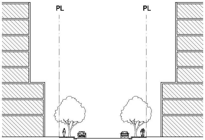
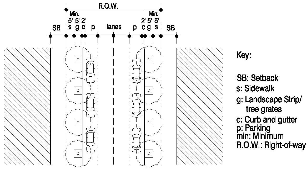
Figure MU-1: Typical street section with parking on both sides
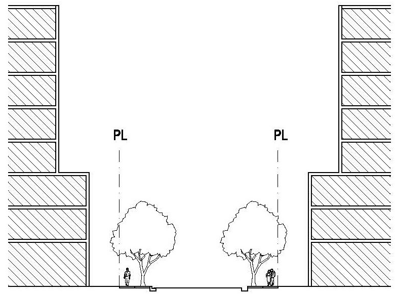
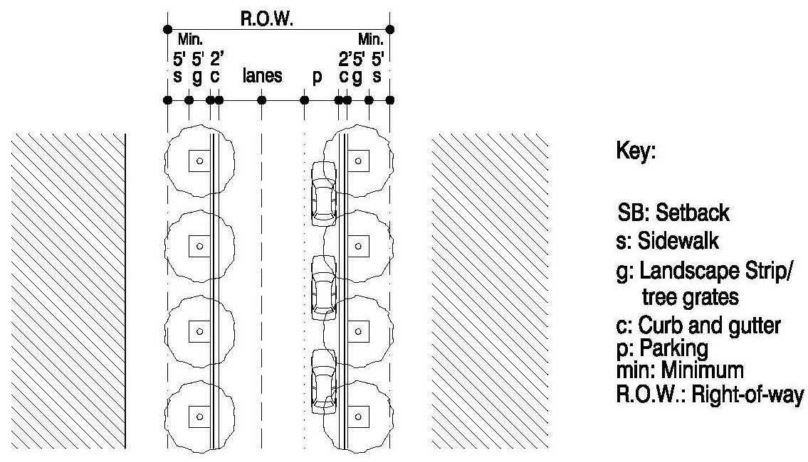
Figure MU-2: Typical street section with parking on one side
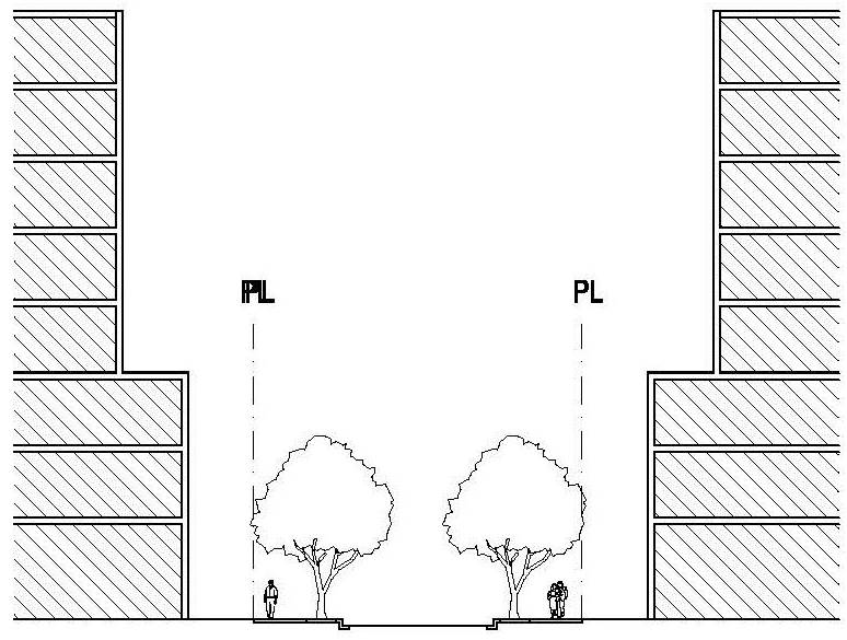
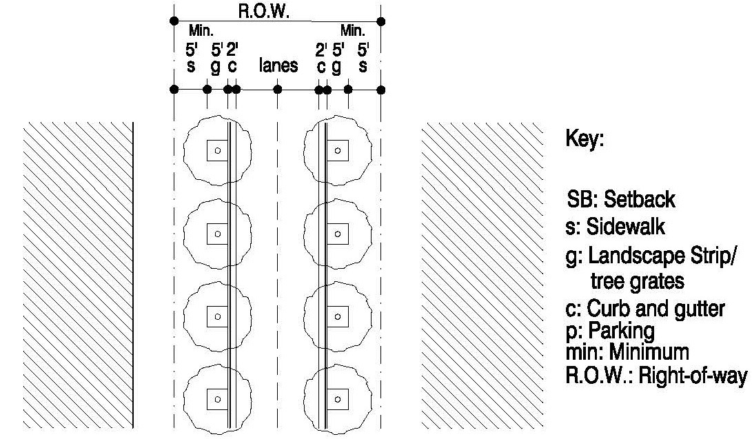
Figure MU-3: Typical street section with no parking
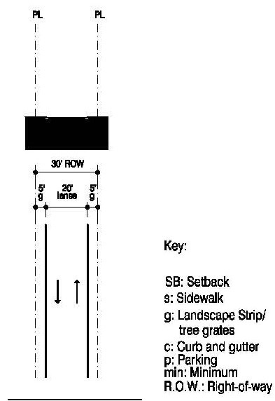
Figure MU-4: Typical alley section
d.
Street Furniture. Street furniture includes but is not limited to outdoor benches, waste containers, planters, phone booths, bus shelters, bicycle racks, tree grates, decorative stamped concrete or stamped asphalt crosswalks, banners, water fountains, newspaper dispensers and bollards whether within or outside the public right-of-way. Street furniture provided on site shall be compatible with the architecture of the surrounding buildings, the character of the area and other elements of the streetscape. Consistency in the selection and location of the various elements of street furniture is critical for maximum effect and functional use. All street furniture shall be subject to the approval of the City.
(K)
Vehicular Access and Circulation, Parking and Loading Standards. The following standards shall apply to development in all the mixed-use districts:
(1)
Vehicular Access and Circulation. Vehicular access and circulation developed in compliance with the standards in Article IX (Off-Street Parking and Loading) is required, with the following modifications:
a.
Driveway access shared between adjoining lots shall be required, where feasible, for non-residential and mixed-use development in order to limit direct vehicular access along streets or comply with driveway intersection spacing requirements.
b.
Parking facilities on adjoining lots may share access points, driveways and parking subject to a recorded covenant running with the property on which the facilities are located.
(2)
Parking. Parking developed in compliance with the standards in Article IX (Off-Street Parking and Loading) is required, with the following modifications:
a.
Surface Parking Lots. Surface level parking lots, whether stand-alone or part of a larger development, shall comply with the following standards:
i.
Surface parking shall be located to the side or rear of the property and accessed off an alley or tertiary street when possible. If the parking lot is accessed from a primary or secondary street, there shall be only one (1) point of access to the parking lot area.
ii.
Openings off any street shall not exceed two (2) lanes in width and twenty-four (24) feet maximum per entrance/exit. Entrances/exits on alleys are exempt from this requirement.
iii.
All parking areas shall have direct pedestrian access to a public walkway.
iv.
Except along an alley, parking lots may either be screened by a Liner building or in compliance with the standards in Article XI (Landscaping).
v.
New stand-alone surface parking lots shall only be permitted if constructed, owned and/or operated by the City and/or CRA.
vi.
Wheel stops shall be prohibited and continuous curbing shall be placed two (2) feet from the front of all parking spaces, except those in a parallel configuration.
b.
Parking Garages. Multi-level parking garage structures, whether stand-alone or part of a larger development, shall comply with the following standards:
i.
Except along an alley or a pedestrian passageway all levels of the garage shall be screened along all frontages by a Liner building containing a minimum depth of twenty (20) feet of habitable space. The requirement for a Liner building along the side and rear frontage may be waived by the Director of the Community Development Department or his/her designee if the applicant demonstrates compliance with the standards below:
1.
All architectural elements that face a street or a publicly accessible open space shall appear consistent and harmonious with that of habitable space;
2.
No vehicles parked within the garage shall be visible from the street;
ii.
Openings off any street shall not exceed two (2) lanes in width and twenty-four (24) feet maximum per entrance/exit. Entrances/exits on alleys are exempt from this requirement.
iii.
The garage shall be accessed from an alley or tertiary street, when possible. If the garage is accessed from a primary or secondary street, there shall be only one (1) point of access to the garage area.
iv.
All parking garages shall have direct pedestrian access to a public walkway.
v.
New stand-alone parking garages shall only be permitted if constructed, owned and/or operated by the City and/or CRA.
vi.
Electric car charging stations shall be encouraged to be located within parking structures.
c.
Joint and Shared Use Parking. Joint and Shared Use parking, developed in compliance with the standards in Section 24-92(B) (Joint and Shared Use Facilities) is permitted, with the following modifications for non-residential uses only:
i.
The maximum distance between the primary pedestrian entrance of the joint and shared use parking lot or parking garage and the primary pedestrian entrance of the use served by the parking shall be one thousand three hundred twenty (1,320) feet.
d.
Shared Parking. Shared parking, developed in compliance with the standards in Section 24-99 (Shared Parking) is permitted.
e.
Location of Parking. Parking, developed in compliance with the standards in Section 24-92(D) (Location of Parking) is permitted, with the following modifications for existing non-residential uses only:
i.
Existing nonresidential uses which need to add spaces to accommodate proposed expansion, may provide for such additional parking on a separate nonresidentially zoned parcel, provided that the maximum distance between the primary pedestrian entrance of the off-site parking lot or parking garage and the primary pedestrian entrance of the use served by the parking shall be one thousand three hundred twenty (1,320) feet.
ii.
Existing nonresidential uses which need to add spaces to accommodate their existing parking requirements and no expansion is proposed, may provide for such additional parking on a separate nonresidentally zoned parcel, provided that the maximum distance between the primary pedestrian entrance of the off-site parking lot or parking garage and the primary pedestrian entrance of the use served by the parking shall be one thousand three hundred twenty (1,320) feet.
iii.
All parcels used for remote parking purposes shall be joined with the parcel on which the principal use is located by a recorded easement and/or operational agreement, which shall be approved by the City Attorney. Those parties having any right, title or interest in and to the parcel being served by the remote parking shall execute and place in the public records of Miami-Dade County, Florida at their expense, a covenant, approved by the City Commission, that the nonresidential use, or portion thereof, that requires the remote parking in order to obtain the necessary permits or licenses, shall cease and terminate upon the loss and elimination of the remote parking, and that no nonresidential use may be made of the portion of the property requiring remote parking until the required parking facilities are available and provided. This covenant shall run with the land and be binding on the heirs, successors, assigns and lessees, and shall contain a provision that the City may collect costs and attorney's fees if litigation is necessary to enforce this covenant.
(3)
Loading. Properties within the mixed use districts shall comply with the standards for Off-Street Loading in Section 24-96 (Off-Street Loading Requirements) and Section 24-97 (Minimum Loading Space Requirements). Loading for properties within the mixed-use districts shall be provided on-site. Where it is unfeasible to provide loading on-site, loading shall be permitted off an alley. Where an alley is not existing, proposed or feasible, loading shall also be permitted on-street subject to the following conditions:
a.
The loading area shall be located within the on-street parking along a tertiary street;
b.
An On-Street Loading Plan, subject to Site Plan approval, is required. The On-Street Loading Plan shall demonstrate the location of the loading space(s), the hours for loading and unloading, and a list of the uses on abutting properties and their respective hours of operation; and
c.
The hours of loading and unloading, as demonstrated in the On-Street Loading Plan, shall not create a conflict with the current or proposed uses on abutting properties. Should the hours of loading and unloading create a conflict with current or future uses on abutting properties, the on-street loading plan shall be revised and/or revoked accordingly.
(L)
Landscape Standards. The following standards shall apply in addition to any applicable standards in Article XI (Landscaping) not modified herein.
(1)
Modified Standards.
a.
Tree specifications shall be as per Section 24-119 (Minimum Landscaping Requirements for All Zoning Districts) except for the following:
i.
A maximum of twenty-five (25%) percent of all required trees shall be of a palm species.
b.
Utilization of berms to screen parking and/or vehicular use areas from public thoroughfares and adjacent residential uses shall be prohibited.
c.
Perimeter landscape requirements: The requirement of a continuous buffer strip of not less than five (5) feet in width, along the perimeter of a property adjacent to any street right-of-way only, shall not be required.
(2)
Additional Standards.
a.
Building setback shall be adjusted to preserve existing native tree canopies, where feasible.
b.
Landscape strips shall only be placed between the sidewalk and the back of curb.
c.
Use of trees to provide shade, color, and interest, and use of vines, or trained plant materials is appropriate.
d.
Street Trees.
i.
Street trees are required and shall be spaced at a maximum of thirty (30) feet on center.
ii.
Street trees shall not be required when colonnades are being provided along the street and the colonnade is placed at a maximum of five (5) feet from the back of curb.
iii.
When a landscape strip is not provided, street trees shall be placed in tree pits covered with ADA compliant grates. Tree grates shall be sized appropriately for each tree species at maturity. The use of tree grates is appropriate when on-street parking is provided. When no on-street parking is provided, landscape strips are preferred.
iv.
Adequate clearance to the building facade for uniform development of the street tree canopy shall be demonstrated for the type and species selected.
(3)
Passageways.
a.
Pedestrian passageways shall be a minimum clear width of fifteen (15) feet between buildings.
b.
A minimum of fifty (50%) percent of the pedestrian passageway shall be shaded and may include a combination of landscaping and architectural elements.
c.
If provided, tree placement shall be in planters or tree grates a minimum of five (5) feet by five (5) feet.
d.
Pedestrian scaled lighting shall be provided.
(M)
Open Space Standards. Open space areas may be one (1) of three (3) types: designated publicly accessible, semi-public or private.
(1)
Designated Publicly Accessible Open Spaces. The Designated Publicly Accessible Open Spaces and Urban Greenway Systems Regulating Plan for each mixed-use district shows the approximate location of existing public and new designated publicly accessible open spaces throughout the mixed-use district, where applicable. New designated publicly accessible open spaces are small in scale, largely devoted to natural landscaping and tend to have few structures. Accessory structures may include, statuary, fountains, etc. New designated publicly accessible open spaces shall be subject to the following requirements:
a.
The minimum size of a new designated publicly accessible open space shall be four thousand eight hundred (4,800) square feet unless otherwise specified in the zoning district.
b.
New designated publicly accessible open spaces shall be provided at grade level.
c.
New designated publicly accessible open spaces shall provide shaded areas, and their ground surface shall be a combination of paving materials, lawn, or ground cover.
d.
Off-street parking shall not be required for new designated publicly accessible open spaces.
e.
Fences, walls and hedges are permitted around the perimeter of a new designated publicly accessible open space at a maximum height of thirty-six (36) inches, provided the enclosure does not prohibit public access.
f.
The development and ongoing maintenance of a new designated publicly accessible open space area shall be the responsibility of the developer/property owner.
g.
Properties that provide new designated publicly accessible open space shall be permitted relief from the minimum and maximum building setback requirements along the portion of the building fronting the open space specifically for the purpose of accommodating the open space.
(2)
Semi-public Open Spaces.
a.
Semi-public open space shall only be permitted where residential dwelling units are on the ground floor.
b.
Semi-public open space shall count towards the minimum private open space requirement.
c.
Semi-public open space shall abut a public sidewalk and be visible from the street.
d.
The development and ongoing maintenance of a new semi-public open space area shall be the responsibility of the developer/property owner.
e.
Off-street parking shall not be required for semi-public open spaces.
f.
Fences, walls and hedges are permitted around the perimeter of a semi-public open space at a maximum height of thirty-six (36) inches.
g.
Properties that provide semi-public open space shall be permitted relief from the minimum and maximum building setback requirements along the portion of the building fronting the open space specifically for the purpose of accommodating the open space.
(3)
Private Open Spaces.
a.
Private open spaces shall be provided in the form of colonnades, courtyards, terraces, and lawns. Corridors, walkways, lobbies, parking courts and parking lot buffers shall not count towards the private open space requirement.
b.
The minimum area required for private open space shall be as specified in each mixed-use district.
c.
Private open spaces shall provide shaded areas, and their ground surface shall be a combination of paving materials, lawn, or ground cover.
(4)
Open Space Type Configuration and Design. New designated publicly accessible open spaces and new semi-public open spaces shall be developed in the form of greens, plazas or squares.
a.
Greens.
i.
Greens shall have more than fifty (50%) percent of their property lines surrounded by residential uses.
ii.
Exclusive of dedicated rights-of-way, the maximum impervious surface area is twenty (20%) percent. The pervious surface areas shall consist primarily of sod, trees, and garden structures.
Figure MU-5: Green
b.
Plazas.
i.
Plazas shall have more than fifty (50%) percent of their property lines surrounded by nonresidential uses.
ii.
Exclusive of dedicated rights-of-way, the minimum impervious surface area is fifty (50%) percent and the maximum impervious surface area is seventy-five (75%) percent. The pervious surface areas shall consist primarily of sod, trees that are regularly spaced, and garden structures. The impervious surfaces shall consist of paved areas, permanent architecture such as archways, statues and gazebos or water-oriented features.
Figure MU-6: Plaza
c.
Squares.
i.
Squares shall be flanked by streets on at least three (3) sides.
ii.
Exclusive of dedicated rights-of-way, the maximum impervious surface area is fifty (50%) percent. The pervious surface areas shall consist primarily of sod and trees that are regularly spaced. The impervious surfaces shall consist of hard-surfaced walks.
Figure MU-7: Square
(N)
Designated Publicly Accessible Urban Greenways Systems. The Designated Publicly Accessible Open Spaces and Urban Greenways Systems Regulating Plan for each mixed-use district shows the approximate location of the required publicly accessible urban greenways system throughout the mixed-use district. The property owner shall dedicate the land for the publicly accessible urban greenway or provide an easement, at the City's discretion, for public access along the entire length of the greenway abutting the property. Additionally, the development and ongoing maintenance of the required designated publicly accessible urban greenways shall be the responsibility of the developer/property owner along the urban greenway. The design and dimensional requirements for the required greenways are specified in each mixed-use district.
(O)
Mechanical Equipment and Service Utilities. The following standards shall apply in addition to any applicable standards in Section 24-81 (Setback Encroachments) not modified herein:
(1)
Mechanical equipment, backflow preventers, television antennas, satellite dishes, communication devices and similar systems and service areas shall not be visible from the public sidewalk and shall be located to the rear of a building or on an alley where feasible.
(2)
Window air conditioning units shall not be visible from any street.
(3)
Utility connections and service boxes shall not be visible from any street.
(P)
Fences, Walls and Hedges. The following standards shall apply in addition to any applicable standards in Section 24-80 (Fences, Walls and Hedges) not modified herein.
(1)
Fences, walls and hedges in non-residential and mixed-use buildings shall only be permitted when used in conjunction with the following:
a.
Screening of mechanical equipment;
b.
Screening of off-street loading, trash and service areas;
c.
Required perimeter buffer; and
d.
Screening of off-street parking lots.
(2)
Fences, walls and hedges in residential buildings located within the front setback shall not exceed forty-eight (48) inches in height.
(3)
No fence or wall may be constructed, installed or maintained which includes barbed wire, broken glass, electrical elements, or other hazardous materials.
(Q)
Light Pole Standards. The following standards shall apply for light poles:
(1)
Light poles shall not exceed an overall height of 17.5 feet above grade;
(2)
No cobra head lights are permitted;
(3)
All lighting shall be LED or light-emitting diode; and
(4)
All lighting shall be weather and vandal resistant (i.e., resistant to graffiti, shattering etc.).
(5)
All lighting shall be constructed from steel, cast iron, spun aluminum, colored concrete or granite.
(6)
All wiring shall be underground.
(7)
On-site lighting poles shall be of a consistent architectural style and shall complement the predominant architectural theme of the project.
(R)
Height Standards. The height of buildings shall be measured in stories and in feet. The maximum overall building height shall not exceed the maximum building height allowed for the district. Additionally, the following shall apply:
(1)
Building height is the vertical distance above the centerline of the adjacent fronting road to the highest point of the building, or in the case of pitched roofs, to the average height between the bottom of the eave and the peak of the roof. In a Special Flood Hazard Area (SFHA) the building height shall be measured from the minimum finished flood elevation required in the SFHA. Only accessory structures permitted elsewhere in these regulations to extend beyond the height of the building are exempt from the maximum allowable building height requirements.
(2)
Unless specified in the mixed use district regulations, the following height regulations shall apply:
a.
Ground level stories shall be a maximum height of twenty (20) feet.
b.
Second level stories shall be a maximum height of twenty (20) feet.
c.
Each story above the second story shall be a maximum height of fourteen (14) feet.
d.
Every building shall permit a single (1) specialty amenity story above the third story and above the fourteen (14) foot limit, for a maximum of twenty (20) feet.
e.
For portions of interior spaces in buildings in mixed use districts that permit land uses that typically have higher story heights, such as movie theaters, auditoriums, television or other types of media studios, penthouse residential units, and similar land uses. The Community Development Director may waive the maximum story height
(3)
When the mezzanine area is greater than fifty (50%) percent of the floor area in which it is in, it shall count as a full story when calculating building height.
(4)
Parking garages shall be measured in levels.
(5)
Each parking garage level at the frontage line(s) shall equal one (1) story for the purposes of measuring building height.
(6)
Any parking garage levels that are fully concealed by a habitable story and use for a minimum depth of twenty (20) feet from the frontage line(s) are not restricted in the number of levels, provided that the overall height of the garage does not exceed the overall height of the habitable stories at the frontage line.
(S)
Design Standards. The following design standards shall apply:
(1)
Building Configuration and Design.
a.
Building Length. The maximum horizontal dimension of a building shall be three hundred (300) feet.
b.
Building Separation. For tower building types only, when a building is constructed at the maximum building length, a minimum thirty-foot separation at the podium level shall be required between the subject building and any subsequent building.
c.
Projects with three (3) or more distinctly separate buildings/building groups shall have substantially different front elevations. Substantially different front elevations shall include but not be limited to variations in fenestration, material, massing and color.
d.
The primary entrance of a building shall provide access to a public right-of-way, urban greenway or an open space.
e.
The primary entrance to the upper levels of a mixed-use building shall be from a public right-of-way.
f.
Porticoes, canopies, colonnades and roofs shall be guttered, and drainage shall be deposited on-site.
g.
Active Use Standards. Active uses shall be required along all building frontages and the following shall apply:
i.
Ground Floor Active Use. Storefronts are active uses located along the ground floor of a building. Storefronts shall be provided in compliance with the following standards:
1.
They shall be provided on the ground floor of all mixed-use and non-residential buildings;
2.
They shall be directly accessible from a street frontage, urban greenway or an open space;
3.
For properties with two (2) or more frontages, they shall be located on a minimum of two (2) frontages, with priority given to frontages on an urban greenway, open space and the highest ranking street;
4.
They shall have a transparent clear glazed area of not less than seventy (70) percent of the façade area;
5.
Ground floor window sills shall be placed at a maximum height of twenty-four (24) inches above grade; and
6.
Security enclosures, if any, shall be of the mesh type that pedestrians can see through, and shall be located behind storefront displays.
ii.
Active Use Liner. The minimum depth of an active use liner is measured generally perpendicular to the building frontage.
1.
The minimum depth of the active use liner shall be twenty (20) feet.
2.
Those portions of active use liners which exceed the minimum frontage requirements may have a minimum depth of fifteen (15) feet.
3.
When a parking structure is the primary use, the active use liner may be reduced to a minimum of fifteen (15) feet.
h.
Facade Articulation Requirements.
i.
Architectural features or architectural treatment shall be provided for all facade elevations.
ii.
The following shall be permitted, but shall not be considered architectural features or architectural treatments acceptable as facade articulation: inward or recessed projections resulting from required setbacks; paint; faux treatments; building signs; construction joints, scoring, or material applications less than four (4) inches in height, width or depth.
i.
Architectural Treatment Standards.
i.
Architectural treatment shall be provided for all non-active use facade elevations and shall be integrated with the design of adjacent active use facades.
ii.
Architectural treatment shall be provided through a combination of two (2) or more treatments including, but not limited to, the use of materials and construction assemblies; the continuation of fenestration patterns, architectural features, articulation and rhythm; the application of architectural screens, meshes, louvers, and glass; the incorporation of vegetated surfaces and planters; and architectural lighting.
iii.
Architectural treatment does not include the application of paint and faux treatments; scoring, construction joints or material projections less than four (4) inches in height, width or depth. These elements are permitted, but they do not fulfill the requirements of architectural treatment.
j.
Fenestration Standards. All building types, except single-family, shall comply with the following fenestration standards:
i.
Except for storefronts, a minimum of thirty (30) percent of all ground floor street walls shall be fenestrated with windows;
ii.
Mirror type glass shall be prohibited;
iii.
All glazing shall be of a type that permits view of human activities and spaces within the structure; and
iv.
Colonnade column spacing, windows, and doors shall be proportioned such that the height of each opening is greater than its width.
k.
Colonnade Standards.
i.
Colonnades built to satisfy building frontage requirements shall be attached to the principal structure.
ii.
In no case shall the depth of the colonnade exceed the colonnade's height.
iii.
The finished floor elevation of the colonnade shall match the adjoining sidewalk, when applicable.
l.
Awnings. The type of awning used and its form, materials and color shall be consistent with the design character of the building to which it is attached and shall be subject to the following requirements:
i.
Awnings shall be located between, rather than across, significant vertical architectural features that make up the composition of the facade, such as pilasters or protruding columns. Awning framing shall align with storefront framing.
ii.
Awnings shall be rectangular in shape with straight edges except when located above an archway or arched fenestration.
iii.
Vinyl and plastic awnings are prohibited unless treated in a manner so as to appear similar to canvas or other natural materials in texture and color.
iv.
Valances shall not exceed eight (8) inches in height.
v.
When used, lighting for awnings shall be from fixtures located above the awning and shall be designed and placed to enhance the appearance of the building. Internally illuminated awnings are prohibited.
vi.
A waiver may be granted administratively by the Director of the Community Development Department or his/her designee in order to maintain the architectural character of a structure, or in the event that site features, such as, but not limited to, utility line poles or street trees, restrict the applicant from full compliance.
m.
Automatic food and drink machines and telephones must be located inside buildings.
n.
Dwelling Units. Dwelling units shall not be less than five hundred fifty (550) square feet. In multiple dwelling unit buildings, the cumulative average of all dwelling units shall not be less than eight hundred (800) square feet.
o.
Live-Work Units. Both the non-residential and the residential uses in the live-work unit shall be occupied by a common owner or tenant and shall comply with the following standards:
i.
The nonresidential use's space shall be located on the ground floor and shall be directly accessible from the street frontage, urban greenway or an open space;
ii.
The ground floor shall be restricted to those non-residential uses permitted within the mixed use districts. The full conversion of the unit or lease space into all residential use or all non-residential uses shall be prohibited;
iii.
The nonresidential use's facade shall have a transparent clear glazed area of not less than seventy (70%) percent; and
iv.
If the entrance of the residential component of a live-work unit is separate from the nonresidential use's portion of the unit then the primary entrance of the residential component shall directly lead to a street frontage, urban greenway or an open space.
p.
Rooftop Terraces. These regulations are intended to guide the nonhabitable use of rooftops for buildings built to the maximum story height limit to allow rooftop terraces. Rooftop terraces and rooftop amenities, such as roof gardens, observation decks, swimming pools, and running tracks, are encouraged to create unique gathering spaces to aid in the reduction of the urban heat index in the mixed-use district area, and to add aesthetic value to the buildings. Rooftop terraces are not intended to add additional story height for uses that could otherwise occupy space within the building, such as, but not limited to, fitness centers, restaurants, locker rooms, and other similar amenities. Rooftop terraces shall be subject to the following criteria:
i.
Rooftop terraces shall be architecturally compatible with the design of the overall building.
ii.
Rooftop terraces that are entirely open to the sky may occupy one hundred (100%) percent of the total gross roof area.
iii.
Rooftop terraces shall be hardscaped with materials such as, but not limited to, patterned concrete, pavers, or wood decking.
iv.
Rooftop terraces shall provide shaded seating areas.
v.
Rooftop terraces shall be landscaped over a minimum of fifteen (15%) percent of the rooftop terrace area. Landscaping shall consist of trees, shrubs, ground cover, and vines.
q.
Covered Structures.
i.
Covered structures above the maximum allowable building height are permitted to cover a maximum area of thirty (30%) percent of the gross rooftop area. For the purposes of calculating the maximum area, the term "covered structures" shall not include enclosures for screening mechanical systems.
ii.
Covered structures above the maximum allowable building height shall not be designed in any manner that would permit the conversion of such structure from non-habitable to habitable space, and shall not include commercial uses. Covered structures shall be compatible with and in proportion to the architecture of the overall building. The following restrictions apply:
1.
Climate-controlled structures are limited to the minimum area necessary to accommodate uses which are secondary and incidental to the primary rooftop amenity. These structures may include saunas and steam rooms and code-required restrooms.
2.
The supporting restroom facilities shall not exceed one hundred ten (110%) percent of the size required by the health department.
3.
Refreshment service areas are permitted provided such areas do not include cooking facilities and are not climate-controlled.
4.
Open air structures located on the ground floor shall not be subject to these requirements.
r.
Swimming Pools. Swimming pools and/or whirlpools are permitted in rooftop terraces subject to the following criteria:
i.
Swimming pools and/or whirlpools are permitted provided the top of the surrounding deck does not exceed eight (8) feet above the top of the main rooftop.
ii.
Swimming pools and/or whirlpools shall be surrounded by a minimum five-foot-wide walkway.
iii.
Facilities associated with swimming pools shall comply with the standards for covered structures.
(2)
Block Requirements. The following standards for blocks shall apply:
a.
In the Mixed-Use Town Center (MU/TC), Mixed-Use Employment Center (MU/EC), Mixed-Use Neighborhood Center (MU/NC), Eastern Mixed-Use Waterfront (Eastern MU/WF), and Arch Creek Mixed-Use Corridor (MU/C) the maximum length of a block shall be six hundred (600) feet and the maximum perimeter shall be one thousand nine hundred (1,900) feet. The perimeter of a block is the sum of the sides of the block.
b.
In the South Mixed-Use Waterfront (South MU/WF) and Northern Mixed-Use Waterfront (Northern MU/WF) the maximum length of a block shall be four hundred (400) feet and the maximum perimeter shall be one thousand four hundred (1,400) feet. The perimeter of a block is the sum of the sides of the block.
(3)
Building Typology and Placement Regulating Diagrams and Dimensional Standards.
a.
Building Typology. All new buildings shall conform to one (1) of the permitted building typologies. The building typologies are demonstrated in the Building Typology and Placement Regulating Diagrams as shown in Figures MU-8 through MU-15. The diagrams provide a schematic representation of the various building typologies and demonstrate the required setbacks, lot standards, and profiles of structures. Not all building typologies are permitted in each mixed-use district. Each mixed-use district specifies the allowable building types permitted in each district. Existing buildings which do not fit a prescribed typology, shall follow the standards required for the Flex building typology.
EXAMPLES OF TOWER CONFIGURATION
TOWER FLOORPLATE:
The average shall be calculated as the total cumulative tower floorplate area divided
by the number of tower stories. The maximum average floorplate is dependant on the
tower's primary use as follows: Office of Mixed Use - average up to 35,000 square
feet and a maximum of 45,000 square feet for any single tower floorplate; Residential
or Hotel - average up to 20,000 square feet and a maximum of 30,000 square feet for
any single tower floorplate. The total cumulative floorplate area at any given story
shall not exceed maximum permitted footprint.
TOWER SETBACK:
The minimum setback for the tower shall be 15 feet from the podium. Where the portion
of the tower is at the end of a street vista, the minimum setback shall be 0 feet
from the podium.
ILLUSTRATIVE EXAMPLES
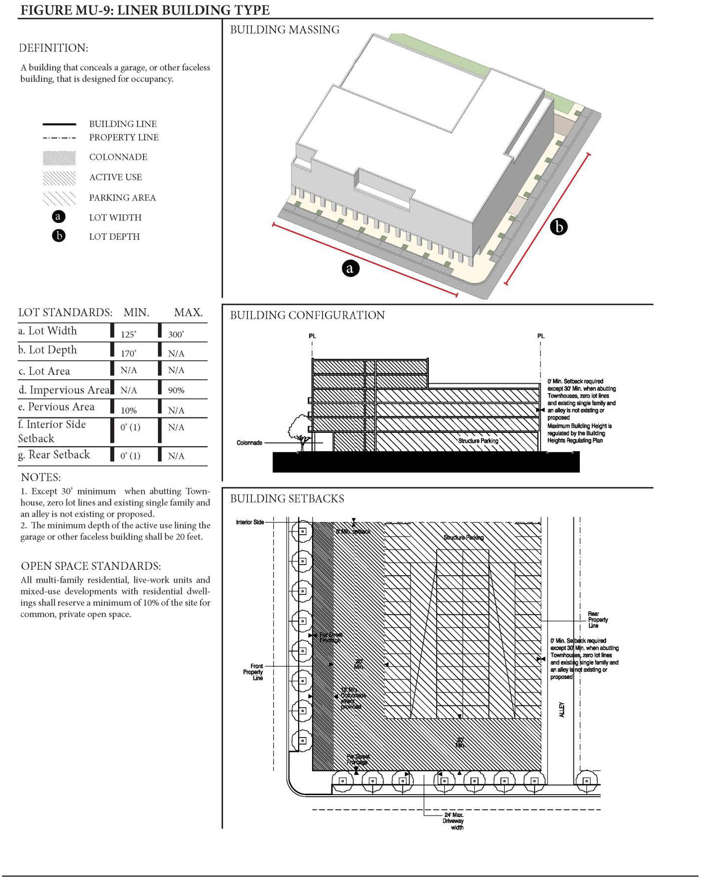
EXAMPLES OF LINER CONFIGURATION
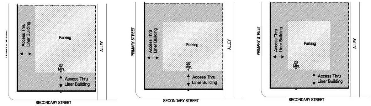
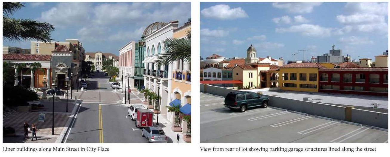
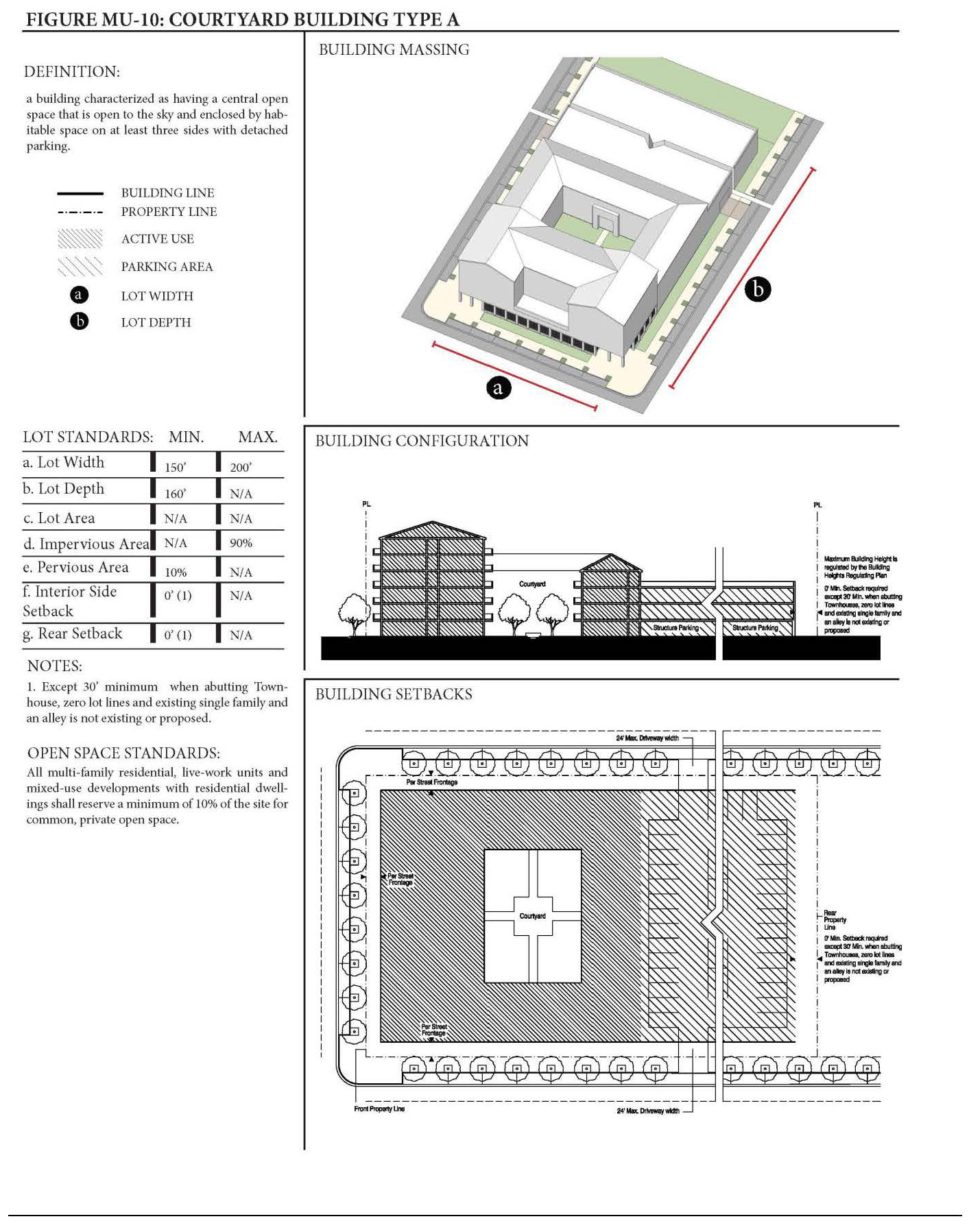
EXAMPLES OF BUILDING CONFIGURATION
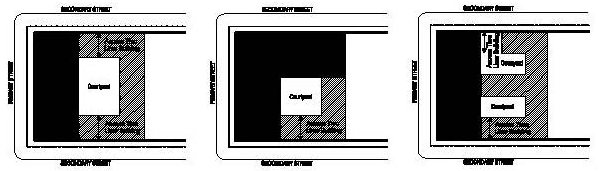
ILLUSTRATIVE EXAMPLES
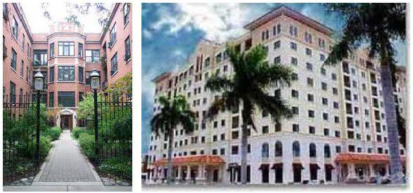
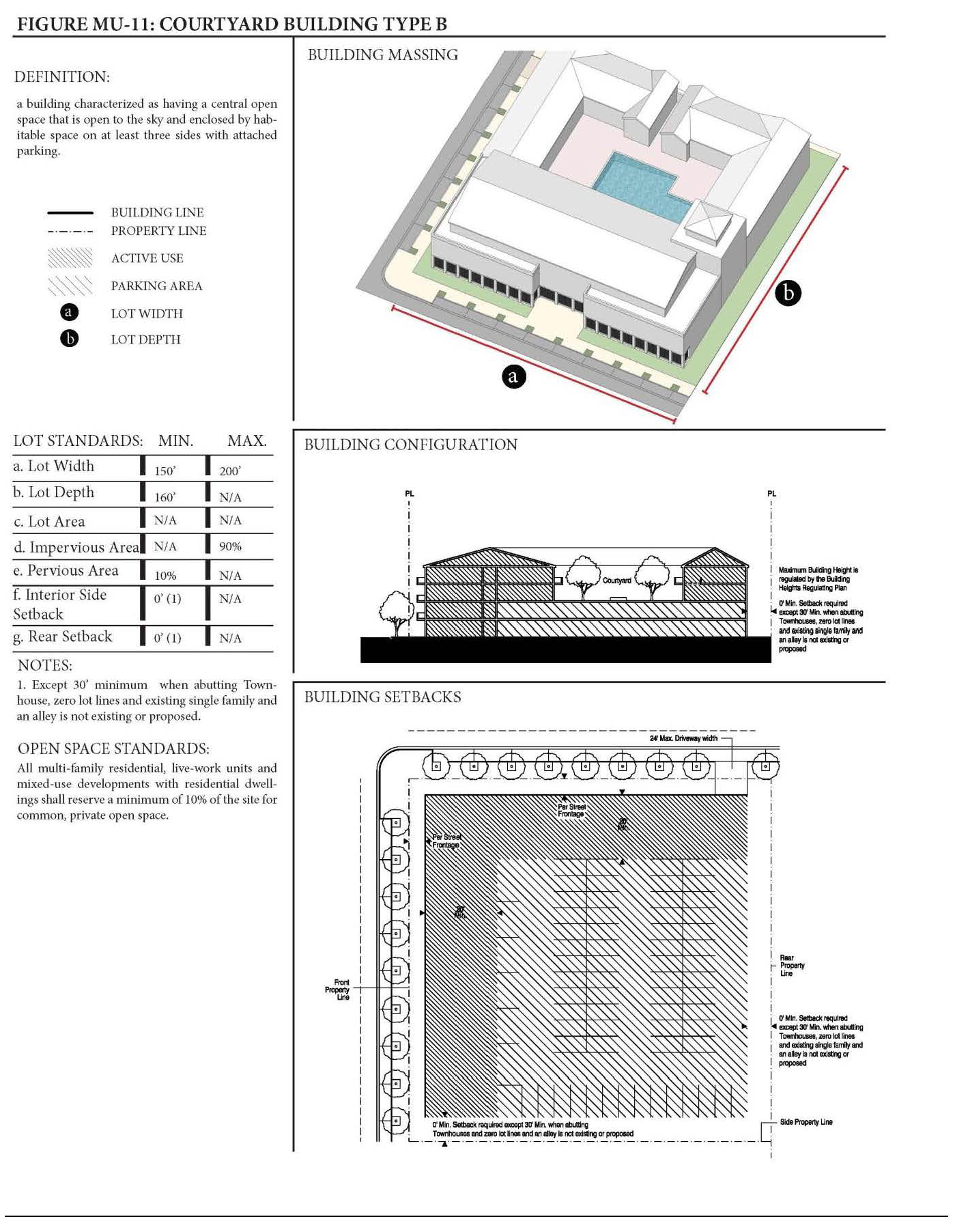
EXAMPLES OF BUILDING CONFIGURATION
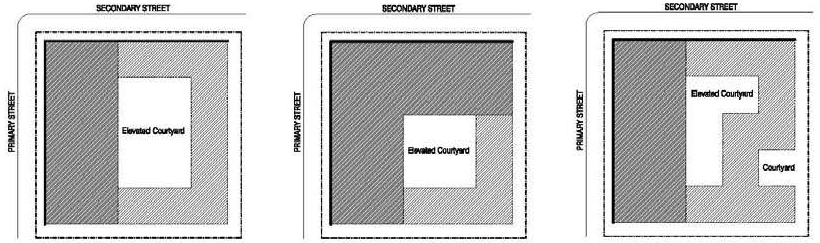
ILLUSTRATIVE EXAMPLES
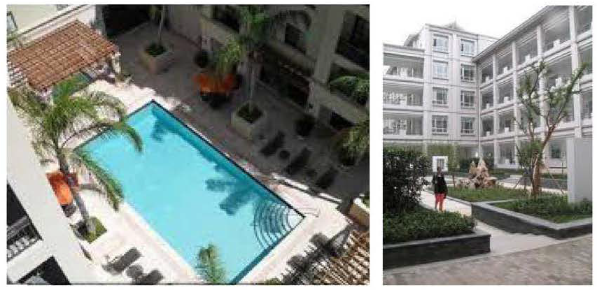
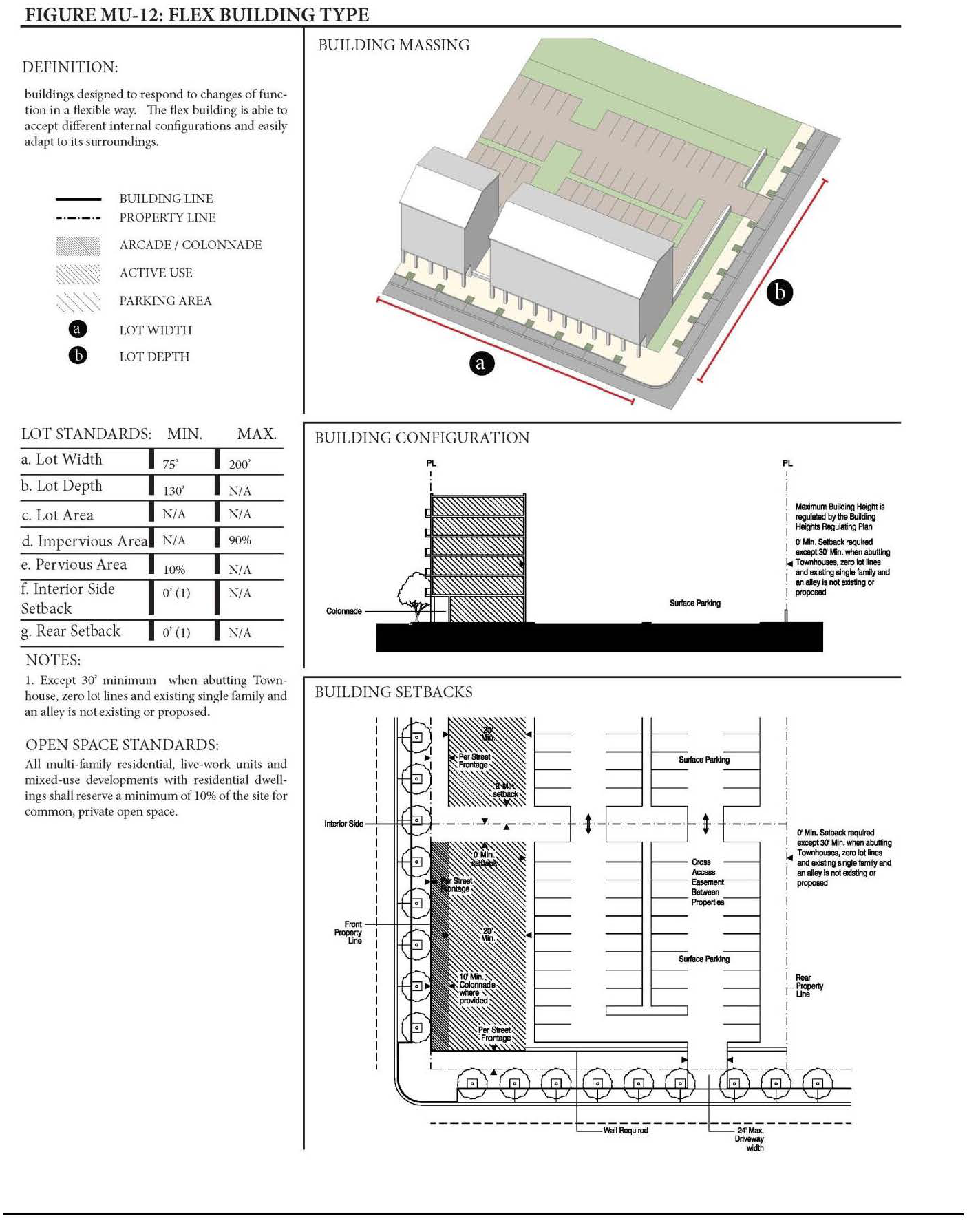
EXAMPLES OF BUILDING CONFIGURATION
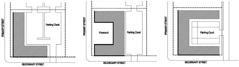
ILLUSTRATIVE EXAMPLES
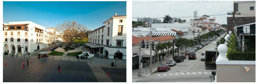
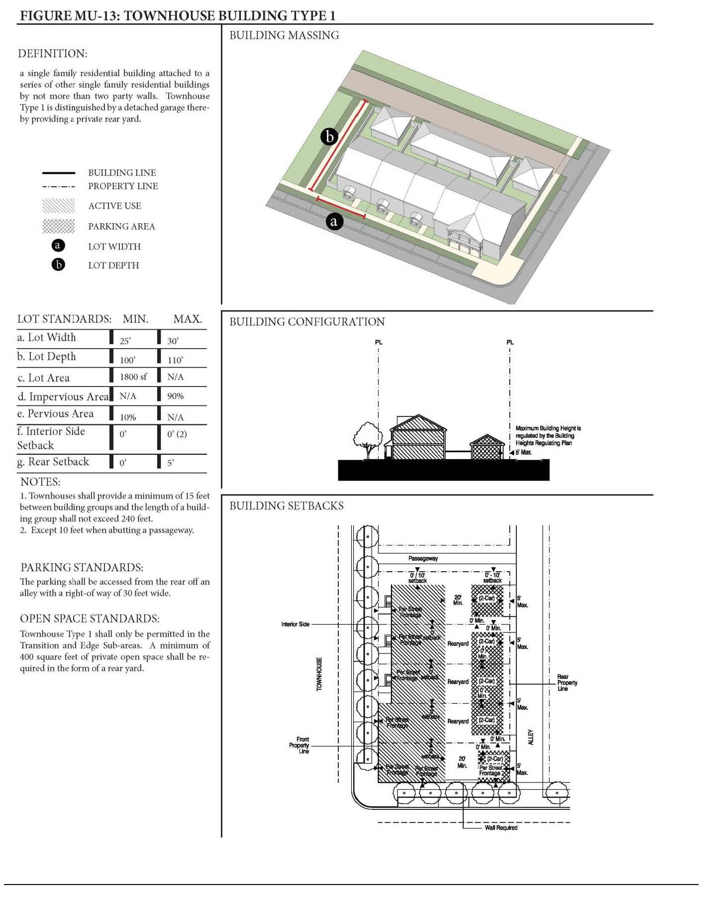
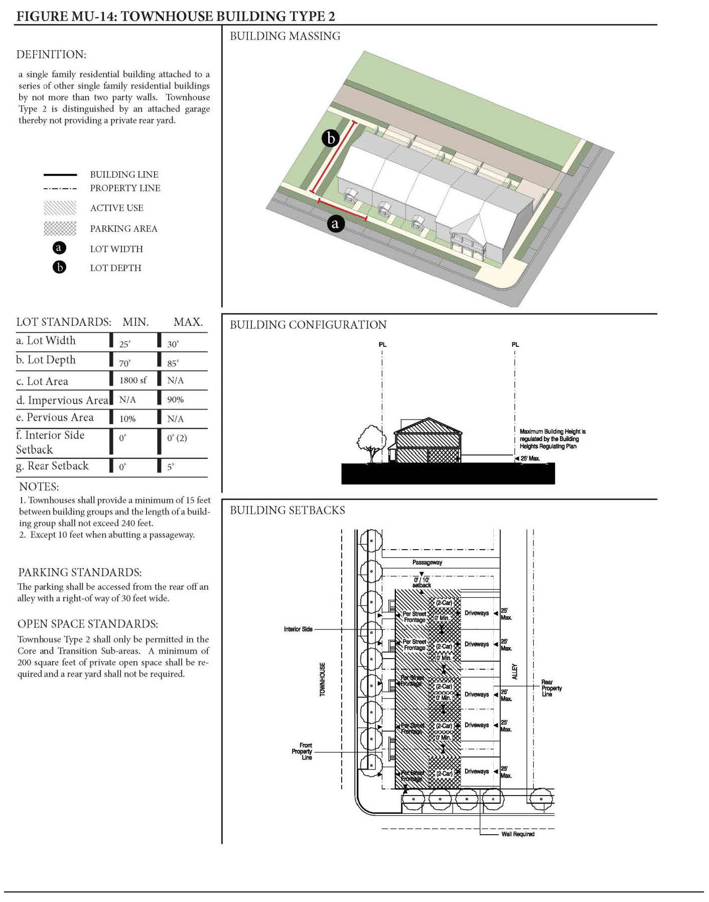
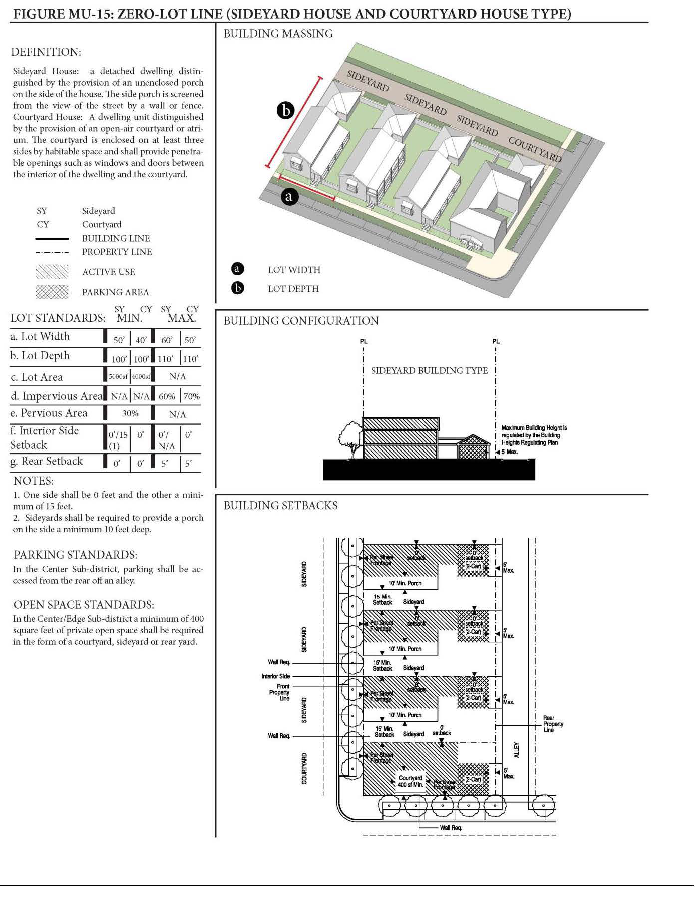
ILLUSTRATIVE EXAMPLES
TOWNHOUSE BUILDING TYPE
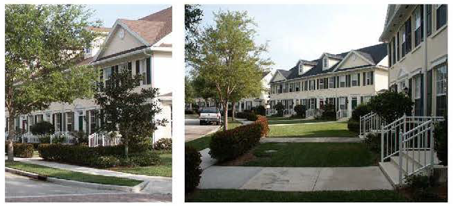
ZERO-LOT LINE (SIDEYARD HOUSE TYPE)
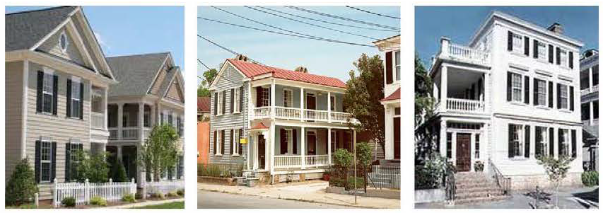
ZERO-LOT LINE (COURTYARD HOUSE TYPE)
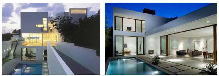
ZERO-LOT LINE (SIDEYARD HOUSE TYPE)
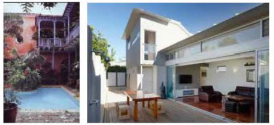
b.
Setbacks and Building Frontage.
i.
Front and Street Side Setbacks and Building Frontage. Front and Street Side setbacks are determined based on the street the building fronts and is specified in each mixed-use district. For purposes of the building frontage, a forecourt shall be considered as a principal building. Where a forecourt is provided, the following shall apply:
1.
The portion of the building fronting the forecourt may be set back up to twenty-five (25) feet from the property line to accommodate a forecourt.
2.
Where there is an outdoor eating area installed on the street frontage, the building frontage may be altered by providing a forecourt. The forecourt shall not exceed sixty (60%) percent of the building frontage as shown in Figure MU-16.
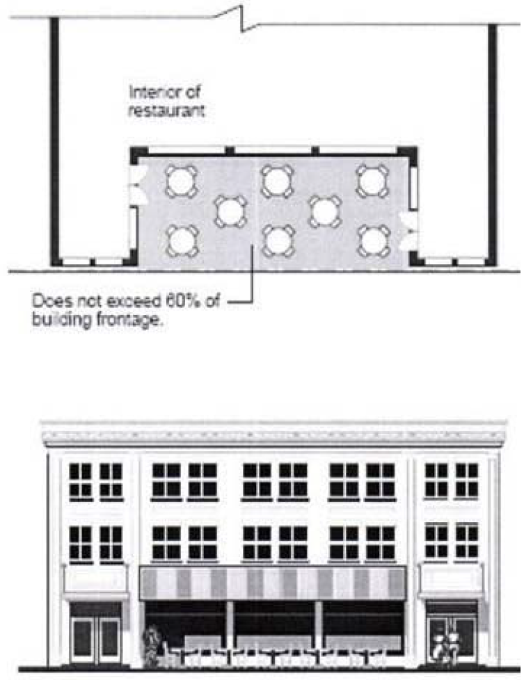
Figure MU-16: Forecourt
ii.
Interior Side and Rear Setbacks. Interior Side and Rear Setbacks are determined based on the selected building typology. Table MU-1 lists the minimum interior side setbacks based on building typology.
iii.
Tower Regulations.
1.
Tower Floorplate Standard. The average shall be calculated as the total cumulative tower floorplate area divided by the number of tower stories. The maximum average floorplate is dependent on the tower's primary use as follows: Office or Mixed-use — average up to thirty-five thousand (35,000) square feet and a maximum of forty-five thousand (45,000) square feet for any single tower floorplate; Residential or Hotel — average up to twenty-two thousand (22,000) square feet and a maximum of thirty thousand (30,000) square feet for any single tower floorplate.
2.
Tower Separation. The minimum allowable horizontal distance between two (2) or more tower floorplates shall be sixty (60) feet.
3.
Tower Orientation. Tower Orientation shall be specified toward terminating Street Vistas and along Designated Publically Accessible Urban Greenways and Open Spaces, where applicable. The placement of the tower shall be such that it is near, fronting or adjacent to a specified Designated Publically Accessible Urban Greenway and/or Open Space.
c.
Lot Standards. Lot standards, including but not limited to lot dimensions and impervious surface area, are determined based on the selected building typology. Table MU-2 lists the lot standards.
(4)
Projections and Encroachments. Projections and encroachments including, but not limited to, architectural features; awnings; balconies; canopies; colonnades; porches; decorative roofs; covered structures; parapets; mechanical rooms and swimming pools shall comply with Table MU-3. Additionally, the following shall apply:
a.
In no case shall encroachments occur within four (4) feet of the back of curb.
b.
Encroachments shall not interfere with street tree placement and the normal trunk and canopy envelope created by street tree growth.
(T)
Development Permit Review Procedures. The following development permit review procedure will apply to all mixed-use districts:
(1)
The review procedures set out in Article XV and Section 24-171 (Concurrency) will apply within the mixed-use districts.
(2)
Preapplication Conference: For those development permit requests that require a Pre-Application Conference, the specific issues identified in the Comprehensive Plan and zoning regulations for the specific mixed-use district must be reviewed by the Applicant and addressed with staff at the Preapplication Conference.
(a)
In addition to the submittal requirements in Article XV and Section 24-171 (Concurrency), the required plans submitted for review for the Pre-Application conference shall demonstrate the Applicant's general approach to comply with the requirements noted above in Section 24-58(C)(3) as described herein and within the applicable mixed-use district per the district's:
(1)
Sub-Areas Regulating Plan.
(2)
Street Network and Connectivity Regulating Plan.
(3)
Designated Publicly Accessible Open Spaces and Urban Greenways Regulating Plan.
(4)
Building Heights Regulating Plan.
(5)
Building Typology.
(3)
Applications that include a development agreement shall be subject to the additional notice and hearings set forth in Article XIX.
(Ord. No. 2015-5, § 2(Exh. A), 3-17-15; Ord. No. 2018-6, § 2, 5-24-18; Ord. No. 2020-07, § 2, 11-10-20; Ord. No. 2023-07, § 2, 10-17-23)
Editor's note— Ord. No. 2015-5, § 2(Exh. A), adopted March 17, 2015, repealed the former § 24-58, and enacted a new § 24-58 as set out herein. The former § 24-58 pertained to FCC Fulford City Center (Mixed-Use) District.
Sec. 24-58.1 - Fulford Mixed-Use Town Center District (MU/TC).
(A)
Purpose and Intent. The purpose of these regulations is to implement policies that guide the design of development within the Fulford Mixed-Use Town Center District (MU/TC). The intent is to enable transit-oriented development that contributes to the creation of an urban downtown and the formation of a quality pedestrian-oriented, Mixed-use district. The objective is to shape development to create a "place," an exciting, enlivened social gathering point and a destination, which encourages the establishment of a wide mix of commercial and residential uses that offer the flexibility to meet a variety of market needs. The aim of these regulations is to create an environment that attracts day and evening activities so that the street is occupied by visitors, residents, business owners and operators who have a clear and vested interest in the vitality of the Fulford Mixed-Use Town Center District (MU/TC). This purpose will be fulfilled by:
(1)
Ensuring high quality, architecturally compatible, consistently landscaped development throughout the District;
(2)
Stimulating commercial and retail trade activities;
(3)
Ensuring that new development or redevelopment projects enhance the visual character of the District;
(4)
Encouraging the development of pleasant shopping areas with attractive pedestrian spaces;
(5)
Encouraging people to reside in the District;
(6)
Encouraging the beautification of the Snake Creek Canal greenway; and
(7)
Encouraging public access to the waterfront.
(B)
District Boundaries. The development standards shall be utilized for properties located within the Fulford Mixed-Use Town Center district (MU/TC).
(C)
Administration. In order to maintain predictability in development, Planned Unit Developments (PUDs) shall be prohibited. Variances from the dimensional requirements or waivers from any other criterion may be approved by the applicable review board for projects, provided that the applicant meets the standards pertaining to such variance or waiver. The applicable board shall hear and decide appeals where it is alleged there is an error in any order, requirement, decision, or determination made by the Director of the Community Development Department or his/her designee in the enforcement of these development regulations.
(D)
General Development Standards.
(1)
In addition to the standards contained herein, Section 24-58 Mixed-Use (MU) district standards shall be applicable to development within the Fulford Mixed-Use Town Center district (MU/TC). The applicable regulations contained in Articles IV, VIII, IX, X, XI, XII, XIII, and XIV shall also apply, except as modified herein and may be further modified by the City Manager or his/her designee to meet the purpose and intent of the Fulford City Center (Mixed-use) District.
(2)
The provisions of the MU/TC code, when in conflict, shall take precedence over the existing zoning and land development regulations.
(3)
The provisions of the building code, when in conflict, shall take precedence over the provisions of the MU/TC code.
(4)
Existing buildings may be destroyed or removed, however they must be replaced according to the MU/TC regulations. Existing buildings may not be destroyed or removed unless they are to be replaced according to MU/TC regulations and only after a building permit is issued.
(5)
Existing buildings and uses within the MU/TC area, which are legally established but do not conform to provisions of the MU/TC regulations as of the effective date of these regulations shall be considered nonconforming and may not be replaced, restored, or modified, except in conformity with the regulation for nonconformities contained in Article IV of this chapter. When a nonconforming structure is destroyed by windstorm, flood, or nature disaster, it may be replaced by a new structure of the same or lesser size, and reoccupied by the same use, if construction of such structure is commenced within eighteen (18) months of destruction.
(6)
Proposed development with site plan approved under the 2002 FCC MUTC regulations shall commence construction within the time frame allotted in the development order or site plan approval letter. If commencement of construction does not occur within the allotted time frame, the site plan approval shall automatically expire without further action by the City.
(E)
Regulating Plans and Diagrams. The MU/TC is governed by a series of regulating plans and diagrams. The Regulating Plans and Diagrams demonstrate MU/TC development standards in both words and diagrams, and include maps designating the locations where the various standards apply. Unless otherwise noted, all development shall be in compliance with the Regulating Plans and Diagrams contained herein and with the Building Typology and Placement Regulating Diagrams in Section 24-58 Mixed-Use (MU) district. The Regulating Plans and Diagrams for the MU/TC include the following:
(1)
The Sub-areas Regulating Plan, which divides the MU/TC into three (3) Sub-areas: Core, Transition and Edge. The highest density and intensity within the MU/TC shall be allocated to the Core Sub-area, a mixed-use area in the heart of the district. The densities and intensities shall then gradually decrease from the Core to the Transition Sub-area where mixed-uses are still permitted and then further decrease to the Edge Sub-area which is characterized by single uses, including low density residential adjacent to existing low density residential. The Sub-areas Regulating Plan is shown in Figure MU/TC-1.
(2)
The Street Network Connectivity Regulating Plan, which shows the approximate location of existing and the required new streets needed to create the prescribed network of streets within the MU/TC. This Plan also establishes the hierarchy of the streets as shown in Figure MU/TC-2.
(3)
The Designated Publically Accessible Open Spaces and Urban Greenway Systems Regulating Plan, which designates the approximate location of the required publically accessible open spaces and urban greenway system as shown in Figure MU/TC-3.
(4)
The Building Heights Regulating Plan, which establishes the maximum building height as shown in Figure MU/TC-4.
Figure MUTC-1: Sub-Areas Regulating Plan
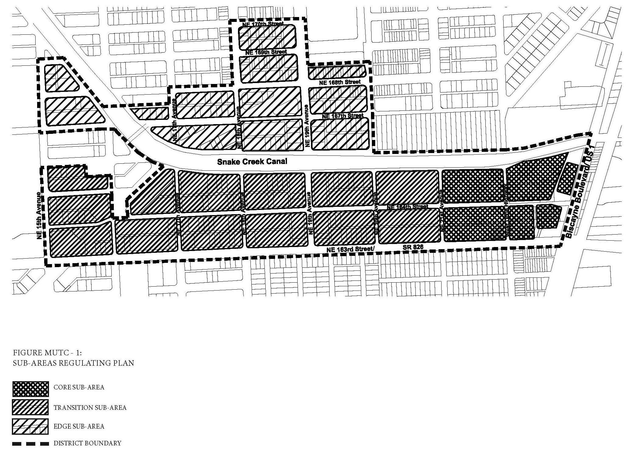
Figure MUTC-2: Street Network Connectivity Regulating Plan
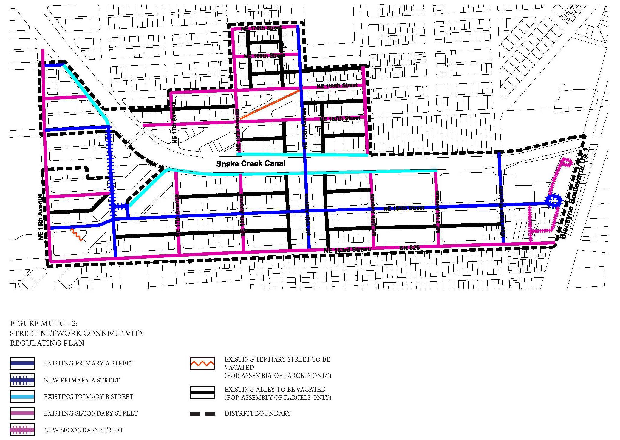
Figure MUTC-3: Designated Publically Accessible Open Spaces and Greenway Systems
Regulating Plan
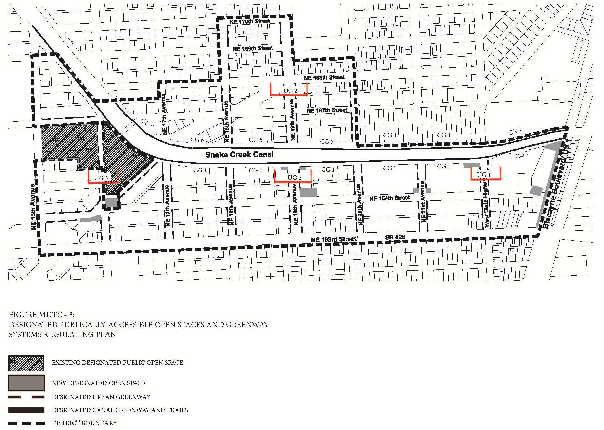
Figure MUTC-4: Building Heights Regulating Plan
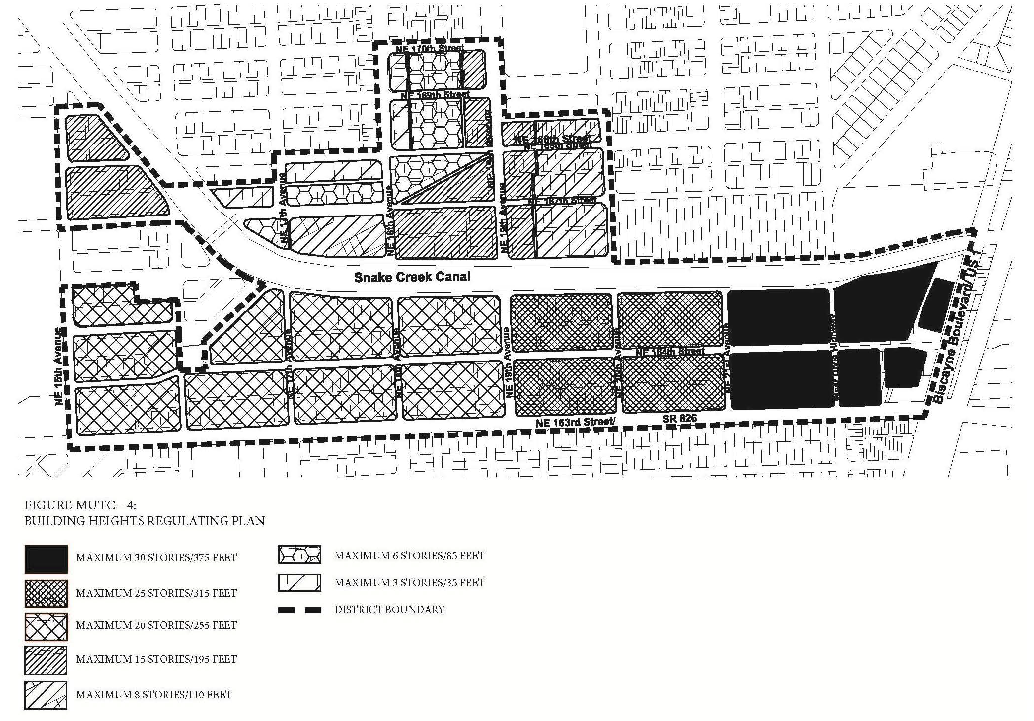
(F)
Sub-Areas Regulating Plan. All new and existing development shall review first their location within the Sub-Areas Regulating Plan as shown in Figure MU/TC-1.
(G)
Permitted Uses.
(1)
Land Use Principles.
a.
The MU/TC District shall be developed as an identifiable place and shall act as an important destination for living, working, shopping and entertainment. The mix of uses within the District, the streets and the architectural character of individual buildings shall blend together to contribute to a coherent identity and sense of place.
b.
Along NE 164th street, east of NE 21st Avenue only, the ground floor of all buildings shall be limited to commercial uses, including but not limited to office and retail uses. On all other levels, both non-residential and residential uses shall be permitted. In order to support transit, residential uses shall be required and shall be permitted to be vertically or horizontally integrated.
c.
Along NE 164th streets, west of NE 21st Avenue only, commercial uses including but not limited to office and retail uses are encouraged along the ground floor of all buildings. On all levels, both non-residential and residential uses shall be permitted.
d.
Along NE 19th Avenue and NE 163rd Street, commercial uses including but not limited to office and retail uses are required along the ground floor of all buildings. On the second level and above, both non-residential and residential uses shall be permitted.
e.
Along all other streets, commercial uses including but not limited to office and retail uses are encouraged along the ground floor of all buildings. On all levels, both non-residential and residential uses shall be permitted.
(2)
Permitted Use Table MU/TC-1 includes the principal uses permitted in the MU/TC along with any required restrictions on such uses, for each of the sub-areas. Principal uses not included in Table MU/TC-1 are not permitted in the MU/TC. The MU/TC shall be subject to the Supplemental Regulations as provided for in Article VIII unless modified herein. Uses which are similar in nature to the uses permitted herein, but not enumerated in higher density use areas, shall be permitted upon a finding by the Community Development Director that the characteristics of, and activities associated with the use are substantially similar to one (1) or more of the listed uses, and will not involve greater impacts than the uses listed in the district and the use will be consistent with the purposes of the applicable zoning district and use areas.
(3)
Special Limited Conditional Uses. See Section 24-177.
(H)
Street Network Connectivity Regulating Plan and Street Standards. Figure MU/TC-2 shows the approximate location of existing and required new streets needed to create the prescribed network of streets within the MU/TC. This plan also establishes the hierarchy of the streets within the district. The street standards specified in Section 24-58(J) Mixed-use District shall apply except as modified herein:
(1)
All streets shall be located according to the Street Network Connectivity Regulating Plan for the MU/TC.
(2)
All existing Primary A, new Primary A and existing Secondary Streets shall be required in the same general location as shown on the Street Network Connectivity Regulating Plan but may be modified with respect to alignment. No existing Primary A, new Primary A and existing Secondary Streets shall be deleted or otherwise vacated or removed.
(3)
All existing Primary B Streets may be modified or deleted for the purpose of establishing a continuous greenway along the Snake Creek Canal. The modifications of the existing streets shall be per the Canal Greenway Sections as provided in Section 24-58.1(I).
(4)
All new Secondary Streets are encouraged to promote connectivity and accessibility between multiple modes of transportation including vehicles, mass transit and/or rail systems. All new Secondary Streets may be modified or deleted for the purpose of assembling parcels for development and no mass transit and/or rail systems are in place.
(5)
Tertiary Streets and Alleys shown on the Street Network Connectivity Regulating Plan are encouraged to promote connectivity and to conform to block length requirements. Tertiary streets and alleys may be modified or deleted for the purpose of assembling parcels for development.
(6)
All streets shall be designed according to the typical street sections and standards provided in Section 24-58(J) and Section 24-58 (L) Mixed-Use District except as modified for the following specific streets within the MU/TC:
a.
Type S1: NE 164th Street (East of West Dixie Highway) (Figure MU/TC-5).
i.
A minimum landscaped strip of five (5) feet shall be provided along the street edge.
ii.
Tree grates a minimum of five (5) feet by five (5) feet may be utilized in place of the required landscape strip.
iii.
A minimum sidewalk width of 7.5 feet shall be provided adjacent to the landscaped area.
iv.
Bulb-outs may be provided.
v.
A median shall be provided a minimum of fourteen (14) feet in width.
vi.
On-street parking shall be provided on both sides of the street.
vii.
Where applicable, a maximum of twenty (20%) percent of the area within the setback shall be landscaped and shall consist primarily of sod, ground cover or ornamental grass.
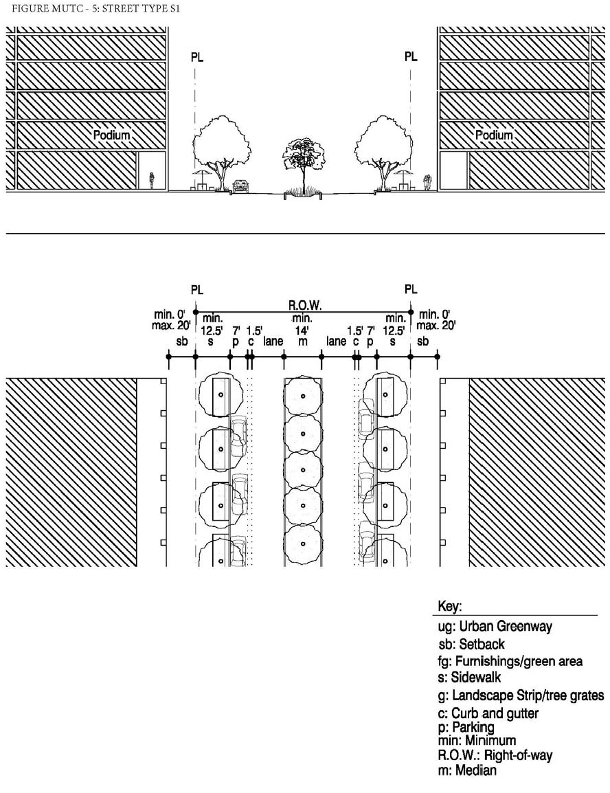
b.
Type S2: NE 164th Street (Between NE 20th Avenue and West Dixie Highway) (Figure MU/TC-6).
i.
Tree grates a minimum of five (5) feet by five (5) feet shall be utilized for consistency with existing conditions.
ii.
A minimum sidewalk width of thirteen (13) feet where feasible shall be provided adjacent to the tree grates.
iii.
Bulb-outs may be provided.
iv.
A median shall be provided a minimum of fourteen (14) feet in width.
v.
On-street parking shall be provided on both sides of the street.
vi.
Where applicable, a maximum of twenty (20%) percent of the area within the setback shall be landscaped and shall consist primarily of sod, ground cover or ornamental grass.
vii.
Along Hanford Boulevard, the treatment of streetscape elements within the right-of-way, limited to landscape features, paving surface areas, and street furnishings shall be as prescribed in the NMB Hanford Boulevard Public Streetscape Kit-Of-Parts.
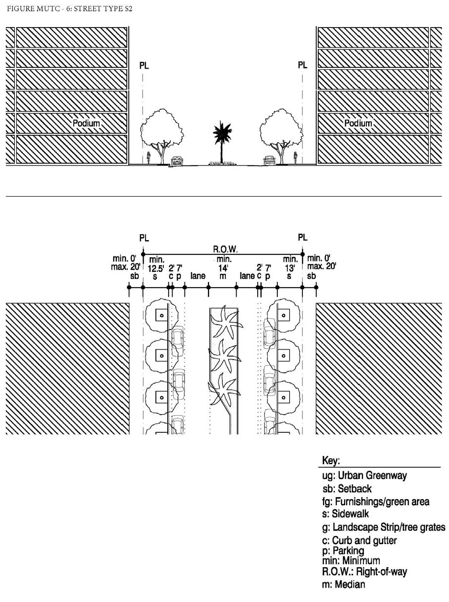
c.
Type S3: NE 164th Street (Between NE 15th Avenue and NE 20th Avenue) (Figure MU/TC—7).
i.
Tree grates a minimum of five (5) feet by five (5) feet shall be utilized for consistency with existing conditions.
ii.
A minimum sidewalk width of 13.5 feet where feasible shall be provided adjacent to the tree grates.
iii.
Bulb-outs may be provided.
iv.
A median shall be provided a minimum of fourteen (14) feet in width.
v.
On-street parking shall be provided on both sides of the street.
vi.
Where applicable, a maximum of twenty (20%) percent of the area within the setback shall be landscaped and shall consist primarily of sod, ground cover or ornamental grass.
vii.
Along Hanford Boulevard, the treatment of streetscape elements within the right-of-way, limited to landscape features, paving surface areas, and street furnishings shall be as prescribed in the NMB Hanford Boulevard Public Streetscape Kit-Of-Parts.
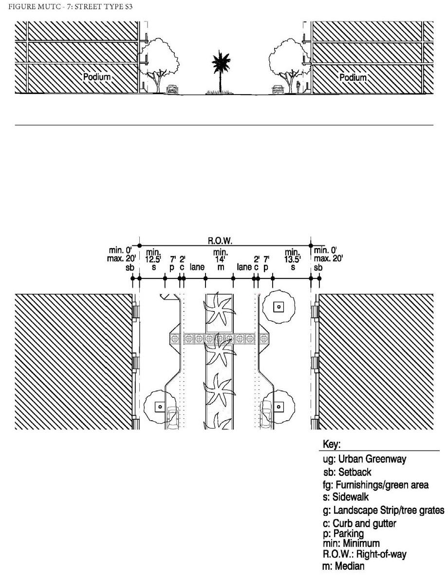
d.
Type S4: NE 167 Street (west of NE 18 Avenue) and NE 17 Avenue (between the alley and NE 167 Street).
i.
A minimum landscaped strip of five (5) feet shall be provided along the street edge.
ii.
Tree grates a minimum of five (5) feet by five (5) feet may be utilized in place of the required landscape strip. The use of tree grates is appropriate when on-street parking is provided.
iii.
A minimum sidewalk width of five (5) feet shall be provided adjacent to the landscape strip and/or tree grates.
iv.
Bulb-outs may be provided.
v.
On-street perpendicular parking, with six (6) inch wide Type D Curb in the edge of the landscape strip at the heads of the spaces and two (2) feet gutter at the edge of the travel lane, shall be provided on both sides of the street in a manner that minimizes the ability for illegally parking in swale areas, subject to Figures MU/TC— 8.
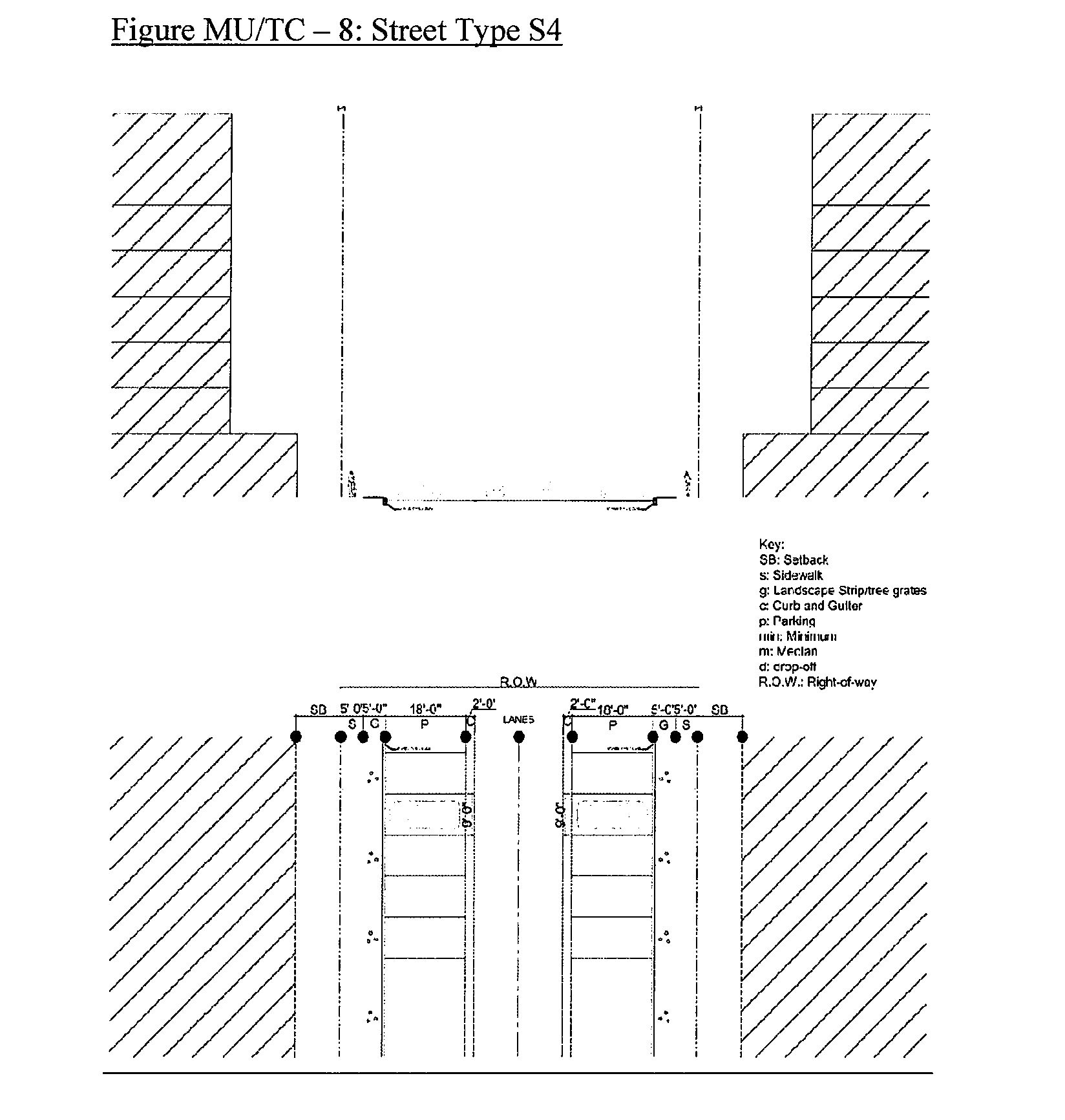
e.
Type S5: South side of NE 168 Street (between NE 17 Avenue and NE 18 Avenue), east side of NE 17 Avenue (between the alley and NE 168 Street) and west side of NE 18 Avenue (south of NE 168 Street).
i.
A minimum landscaped strip of five (5) feet shall be provided along the street edge.
ii.
Tree grates a minimum of five (5) feet by five (5) feet may be utilized in place of the required landscape strip. The use of tree grates is appropriate when on-street parking is provided.
iii.
A minimum sidewalk width of five (5) feet shall be provided adjacent to the landscape strip and/or tree grates.
iv.
Bulb-outs may be provided.
v.
On-street perpendicular parking, with six (6) inch wide Type D curb in the edge of the landscape strip at the heads of the spaces and two (2) feet gutter at the edge of the travel lane, shall be provided on one (1) side of the street in a manner that minimizes the ability for illegally parking in swale areas, subject to Figures MU/TC—9.
vi.
Notwithstanding the above, on-street parallel parking shall be permitted on the opposite side of the street pursuant to application street type.
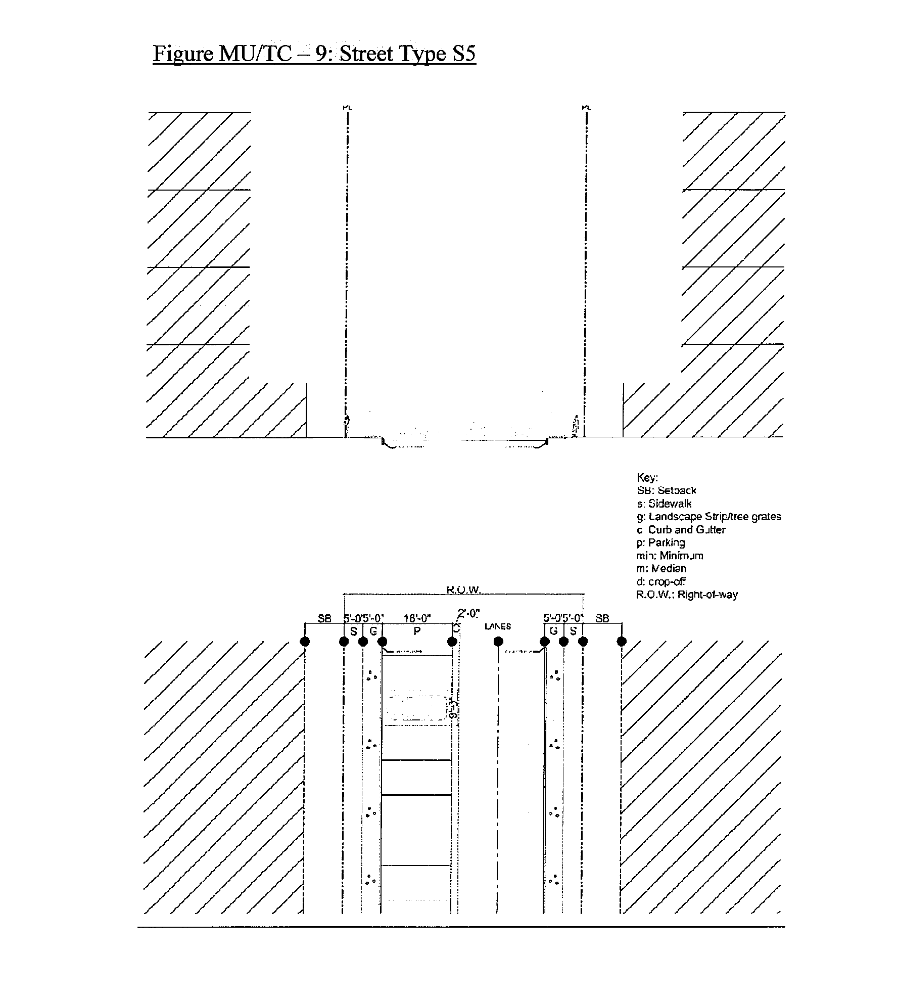
f.
Type S6: NE 167 Street (Drop-off areas West of NE 18 Avenue).
i.
Except where the drop-off abuts the private property, a minimum landscaped strip of five (5) feet shall be provided along the street edge.
ii.
Tree grates a minimum of five (5) feet by five (5) feet may be utilized in place of the required landscape strip. The use of tree grates is appropriate when on-street parking is provided.
iii.
A five (5) feet median planted with grass shall be located between the travel lane and the drop-off lanes.
iv.
A minimum sidewalk width of five (5) feet shall be provided adjacent to the drop-off area. If the right-of-way does not allow for the minimum five (5) feet, the property owner shall dedicate an easement to the City for public access for the width needed to combine with the right-of-way for the minimum five (5) feet sidewalk.
v.
Bulb-outs may be provided.
vi.
No more than two (2) on-street drop-off areas per block, with twenty (20) feet wide drop-off areas, sidewalks abutting the property lines, five (5) feet median and six (6) inch wide Type D Curbs on either side of the median, subject to Figure MU/TC—10a (drop-off on one (1) side of the street) or Figure MU/TC—10b (drop-off on both sides of the street).
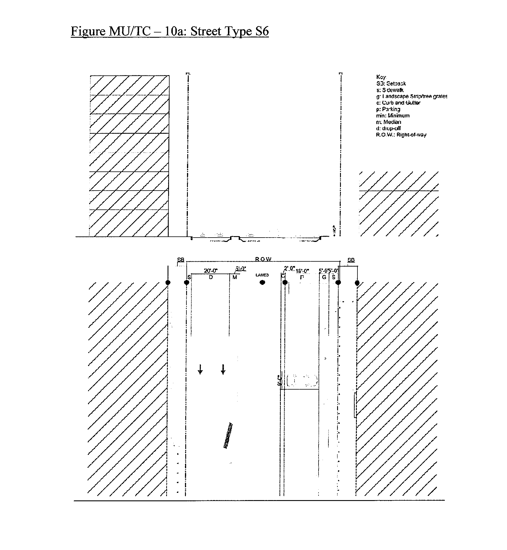
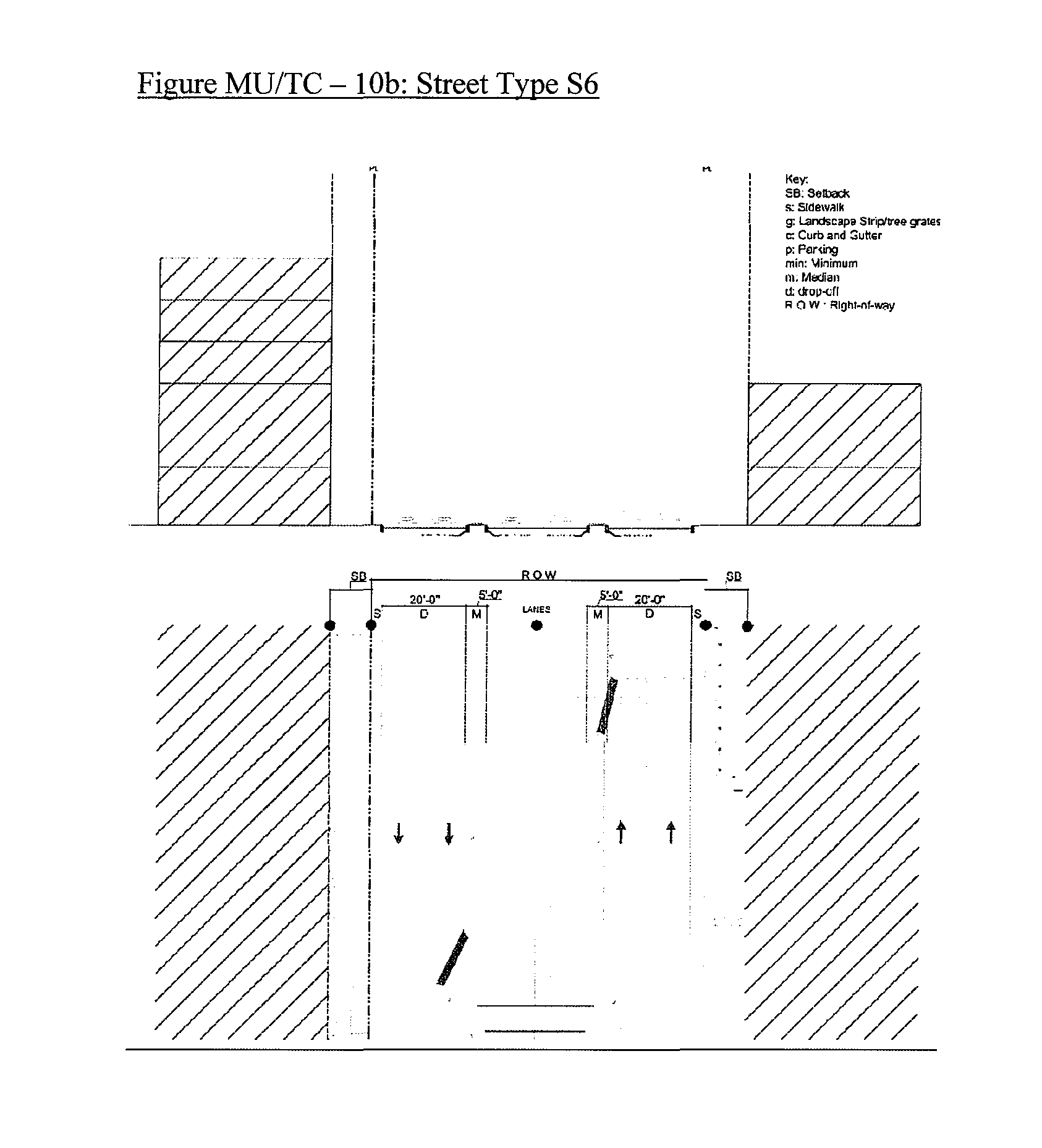
g.
Type S7: NE 167 Street (between West end of NE 17 Avenue and Snake Creek Canal).
i.
A minimum landscaped strip of three (3) feet shall be provided along the street edge.
ii.
Tree grates a minimum of five (5) feet by five (5) feet may be utilized in place of the required landscape strip. The use of tree grates is appropriate when on-street parking is provided.
iii.
A minimum sidewalk width of five (5) feet shall be provided adjacent to the landscape strip and/or tree grates.
iv.
Bulb-outs may be provided.
v.
The west end of NE 167 Street at the Snake Creek Canal shall have a circular turnaround for passenger vehicles with two (2) feet curb and gutter, three (3) feet minimum landscape strip and five (5) feet minimum sidewalk, and include a T-turnaround for emergency vehicles, subject to Figure MU/TC—11.
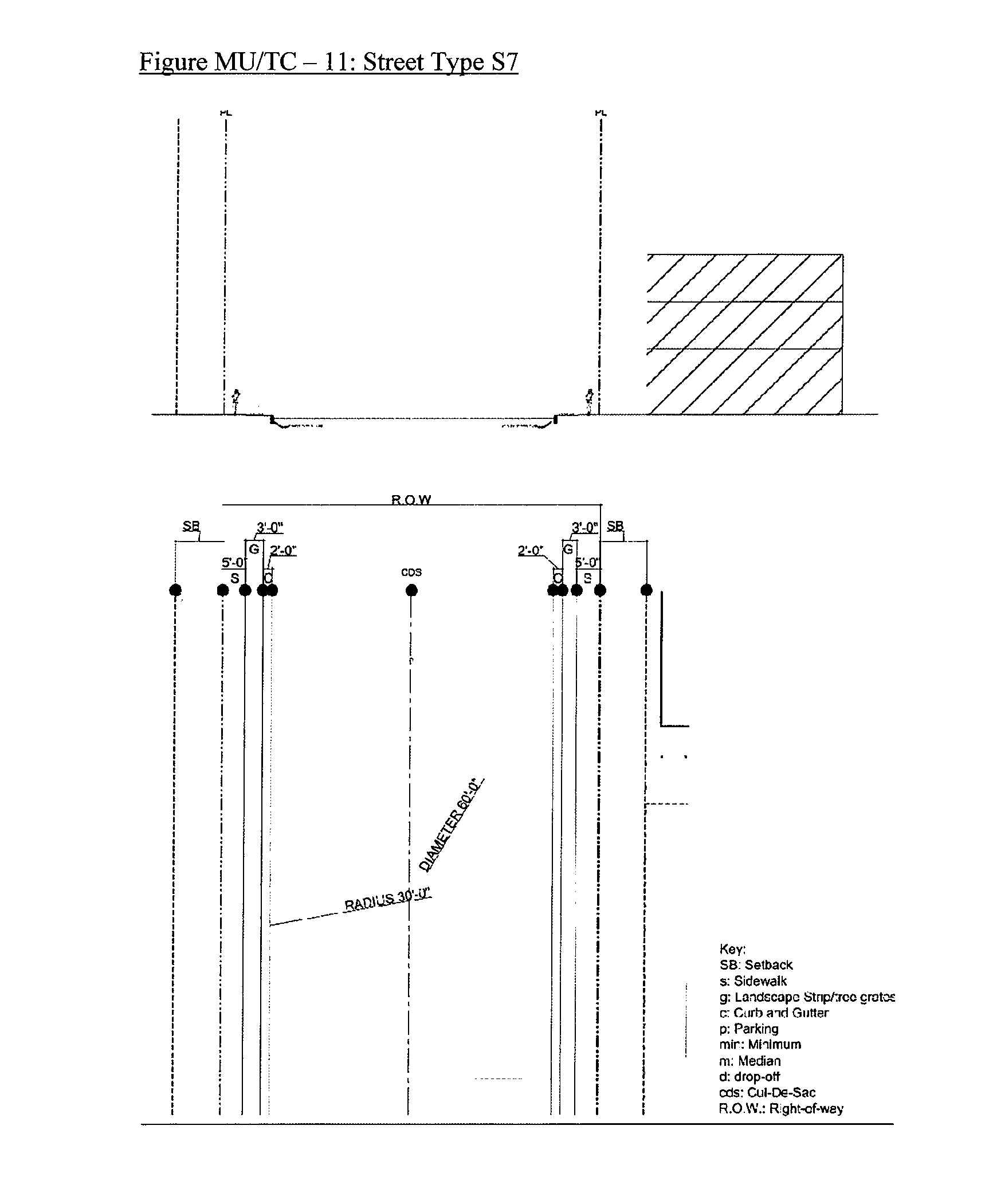
(I)
Designated Publically Accessible Open Spaces and Urban Greenway Systems Regulating Plan. In the MU/TC there are two (2) general greenway types: the urban greenways, which occur along streets and the canal greenways, which occur along the Snake Creek Canal. The designated publically accessible greenways system shall be one (1) of the following types depending on the location within the MU/TC and as generally shown in the Designated Publically Accessible Open Spaces and Urban Greenways Systems Regulating Plan (Figure MU/TC-3).
(1)
Urban Greenway Types.
a.
Type UG 1a and 1b: Along West Dixie Highway (Figure MU/TC-8a and Figure MU/TC-8b.
i.
The minimum width of the greenways shall be fifteen (15) feet where feasible.
ii.
On the East side of West Dixie Highway, there shall be a minimum setback of fifteen (15) feet to accommodate the required urban greenway.
iii.
Where applicable, a minimum of twenty (20%) percent of the length of the portion of the greenway within the setback shall be landscaped and shall consist primarily of sod, ground cover or ornamental grass.
iv.
Tree grates a minimum of five (5) feet by five (5) feet may be utilized in place of the required landscape strip.
b.
Type UG 2: Along NE 19th Avenue (Figure MU/TC-9).
i.
The minimum width of the greenways shall be twenty-four (24) feet.
ii.
Where applicable, a minimum of twenty (20%) percent of the length of the portion of the greenway within the setback shall be landscaped and shall consist primarily of sod, ground cover or ornamental grass.
iii.
Tree grates shall not be utilized in place of the required landscape strip.
c.
Type UG 3: Along NE 16th Avenue (Figure MU/TC-10).
i.
The minimum width of the greenways shall be twenty-one (21) feet where feasible.
ii.
Where applicable, a minimum of twenty (20%) percent of the length of the portion of the greenway within the setback shall be landscaped and shall consist primarily of sod, ground cover or ornamental grass.
iii.
Tree grates shall not be utilized in place of the required landscape strip.
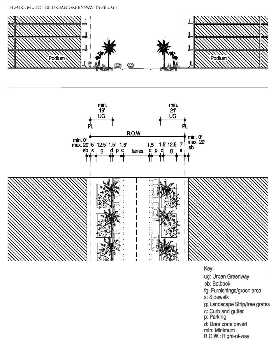
(2)
Canal Greenway Types.
a.
Type CG 1a: Between NE 17th Avenue and West Dixie Highway (South of canal) (Figure MU/TC-11).
i.
Where there is an existing or proposed roadway along the canal, the minimum width of the greenway shall be twenty-five (25) feet where feasible.
ii.
The greenway shall consist of a bike lane a minimum of five (5) feet wide and a pedestrian trail a minimum of five (5) feet wide along the canal side.
iii.
Tree grates shall not be utilized in place of the required landscape strip.
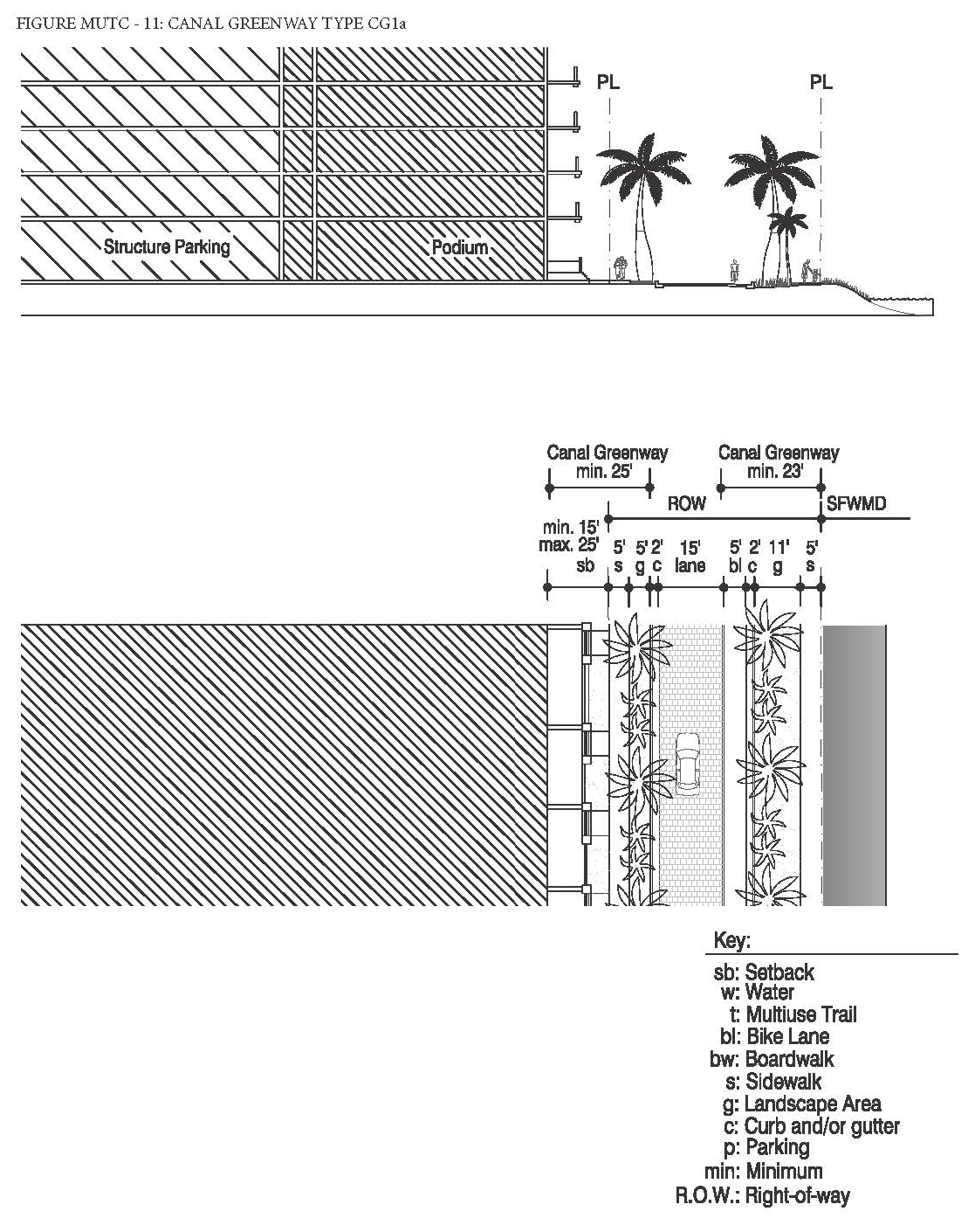
b.
Type CG 1b: Between NE 17th Avenue and West Dixie Highway (South of canal) (Figure MU/TC-12).
i.
Where there is no existing or proposed roadway along the canal, the minimum width of the greenway shall be sixty-five (65) feet.
ii.
The greenway shall consist of a multi-purpose trail a minimum of fifteen (15) feet wide for bikes and pedestrians.
iii.
A minimum of eighty (80%) percent of the length of the portion of the greenway within the setback shall be landscaped and shall consist primarily of sod, ground cover or ornamental grass.
iv.
Tree grates shall not be utilized in place of the required landscape strip.
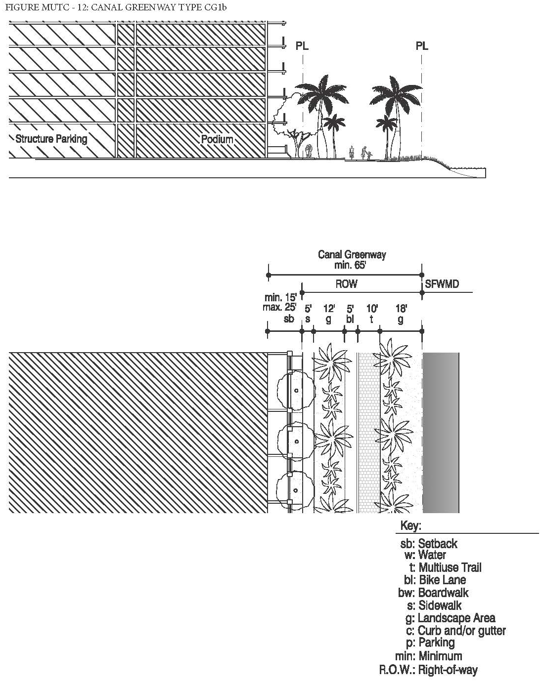
c.
Type CG 2: East of West Dixie Highway (South of canal) (Figure MU/TC-13).
i.
The minimum width of the greenway shall be twenty-two (22) feet.
ii.
The greenway shall consist of a boardwalk a minimum of ten (10) feet wide for pedestrians.
iii.
Eighty (80%) percent of the length of the portion of the greenway within the setback shall be landscaped and shall consist primarily of sod, ground cover or ornamental grass.
iv.
Tree grates shall not be utilized in place of the required landscape strip.
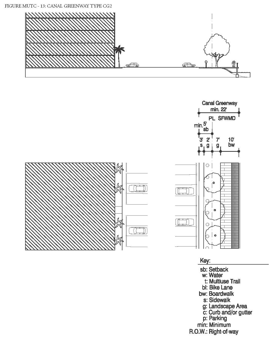
d.
Type CG 3: East of West Dixie Highway (North of canal) (Figure MU/TC-14).
i.
The minimum width of the greenway shall be fifty-two (52) feet.
ii.
The greenway shall consist of a multi-purpose trail a minimum of fifteen (15) feet wide for bikes and pedestrians.
iii.
Except for the multi-purpose trail, one hundred (100%) percent of the length of the portion of the greenway within the setback shall be landscaped and shall consist primarily of sod, ground cover or ornamental grass.
iv.
Tree grates shall not be utilized in place of the required landscape strip.
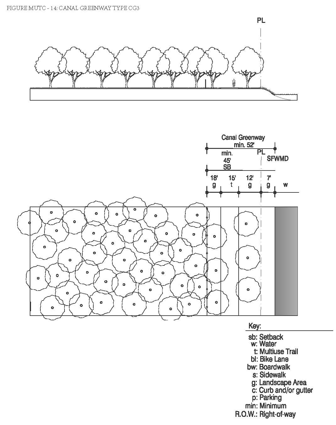
e.
Type CG 4: Between NE 20th Avenue and West Dixie Highway (North of canal) (Figure MU/TC-15).
i.
The minimum width of the greenway shall be forty-four (44) feet.
ii.
The greenway shall consist of a boardwalk a minimum of ten (10) feet wide for pedestrians.
iii.
Eighty (80%) percent of the length of the portion of the greenway within the setback shall be landscaped and shall consist primarily of sod, ground cover or ornamental grass.
iv.
Tree grates shall not be utilized in place of the required landscape strip.
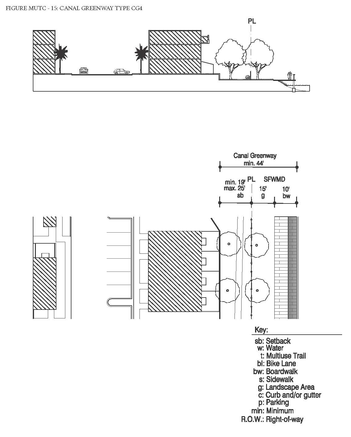
f.
Type CG 5: Between NE 18th Avenue and NE 20th Avenue (North of canal) (Figure MU/TC-16).
i.
The minimum width of the greenway shall be twenty (20) feet where feasible.
ii.
The greenway shall consist of a boardwalk a minimum of ten (10) feet wide for pedestrians.
iii.
Eighty (80%) percent of the length of the portion of the greenway within the setback shall be landscaped and shall consist primarily of sod, ground cover or ornamental grass.
iv.
Tree grates shall not be utilized in place of the required landscape strip.
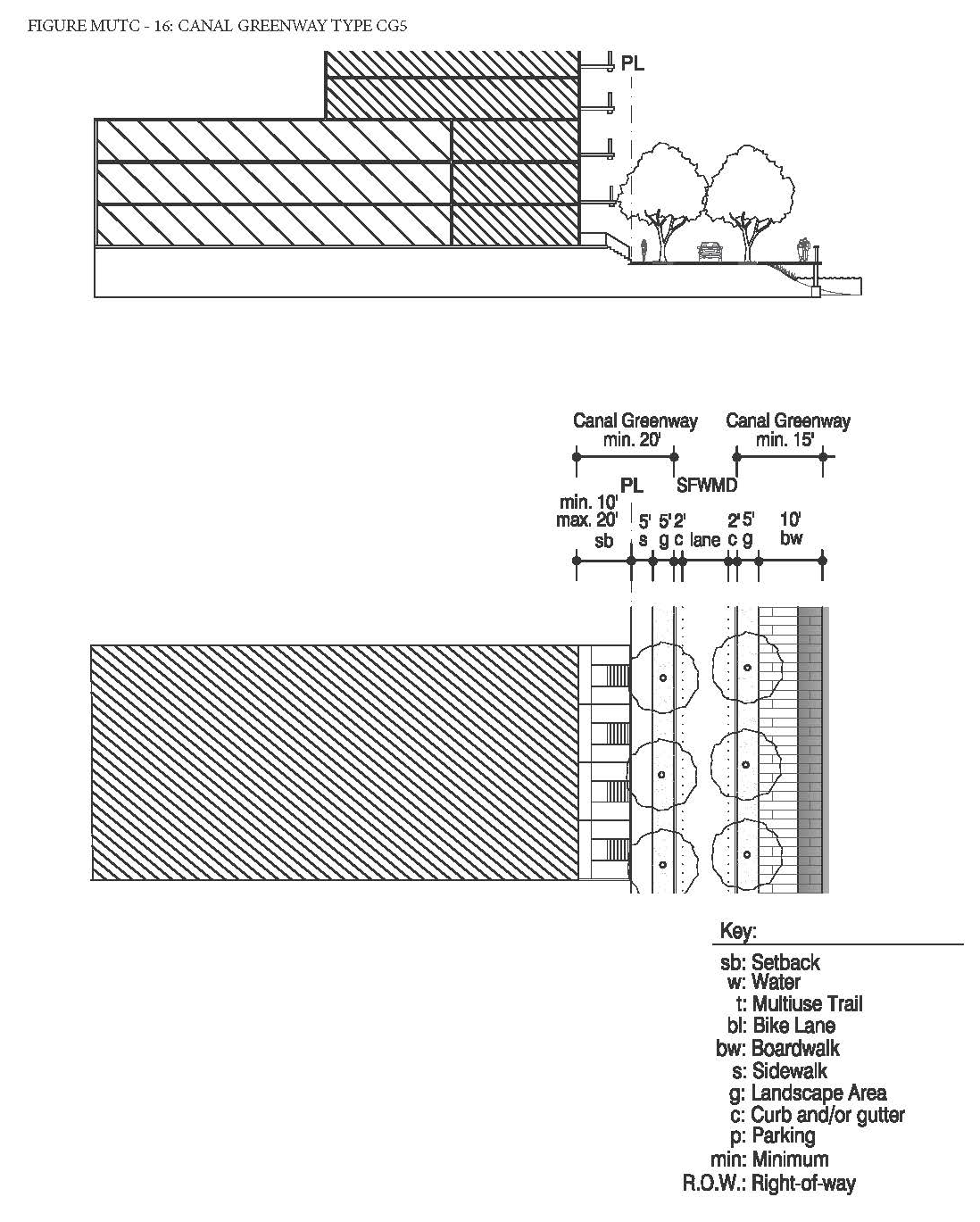
g.
Type CG 6: West of NE 18th Avenue (North of canal) (Figure MU/TC-17).
i.
The minimum width of the greenway shall be forty-five (45) feet.
ii.
The greenway shall consist of a multi-purpose trail a minimum of fifteen (15) feet wide for bikes and pedestrians.
iii.
A minimum of twenty (20%) percent of the length of the portion of the greenway within the setback shall be landscaped and shall consist primarily of sod, ground cover or ornamental grass.
iv.
Tree grates shall not be utilized in place of the required landscape strip.
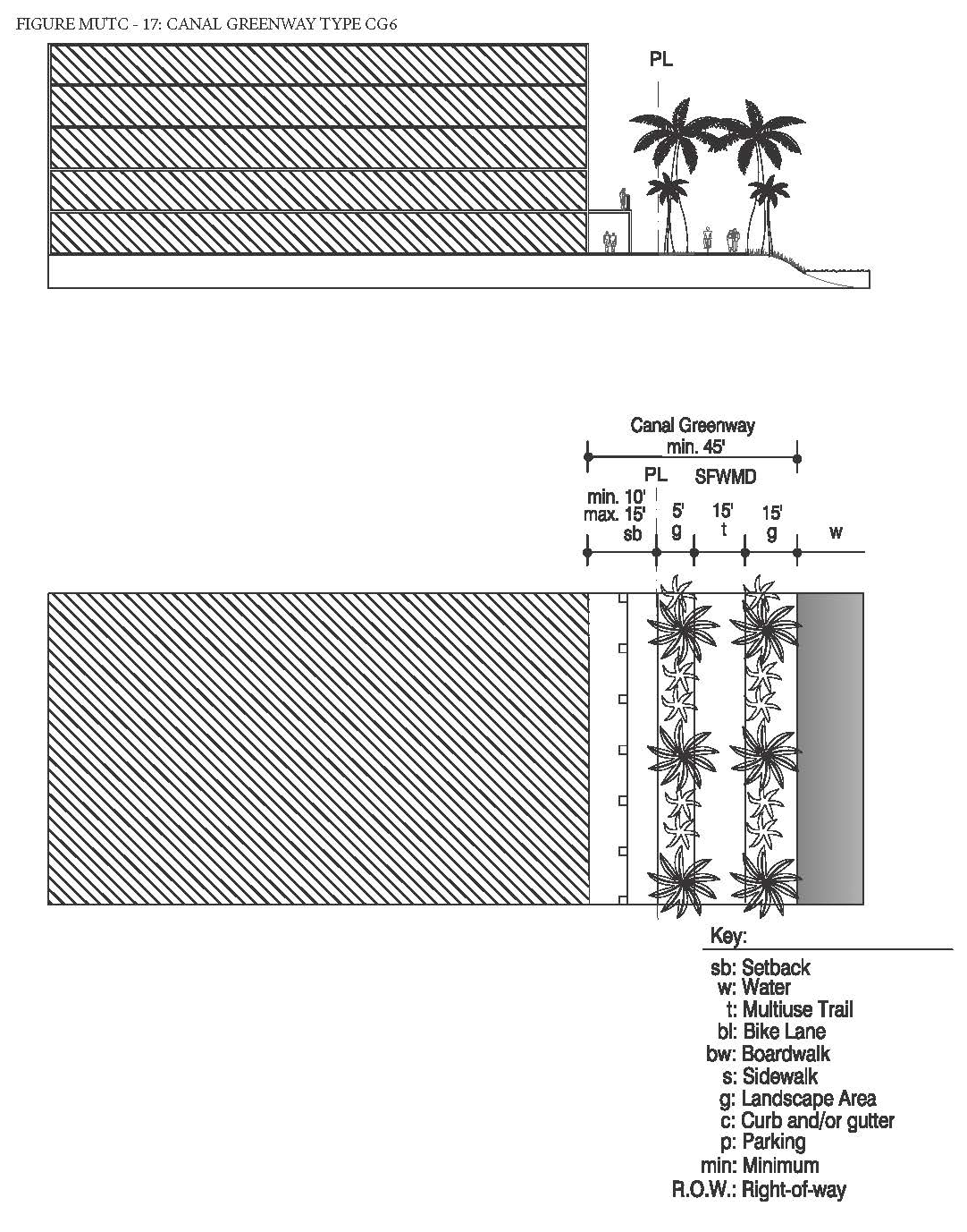
(3)
The designated public urban greenways system shall be designed to enhance the visual character of specific streets along the urban greenways and ensure pedestrian connectivity by:
a.
Providing tree species that provide continuous shade for a minimum of seventy (70%) percent of the frontage along the urban greenways. Palm trees alone are not acceptable and the maximum spacing of the shade trees shall be thirty (30) feet on center.
b.
Providing street furnishings such as benches, trash receptacles, bike racks, drinking water fountains, etc.
c.
Providing a landscape plan illustrating a coherent design with significant tree species along the urban greenways that are distinguishably different from the other streets along the property in terms of color, type and shape.
d.
No plant material other than trees shall be higher than twenty-four (24) inches within the greenways.
e.
Tree specifications shall be as per Section 24-58(L).
(J)
Building Heights Regulating Plan and Additional Height Standards. All new and existing development shall comply with the standards found within the Building Heights Regulating Plan as shown in (Figure MU/TC-4). Table MU/TC-2 provides a summary of the heights per sub-area, however, since maximum building heights vary within the sub-areas and are dependent on location, the Building Height Regulating Plan shall be referred to.
(K)
Building Typology and Dimensional Standards.
(1)
Building Typologies. All new buildings shall conform to one (1) of the permitted building typologies as demonstrated in the Building Typology and Placement Regulating Diagrams in Section 24-58 Mixed-use District. The diagrams provide a schematic representation of the various building typologies and demonstrate the required setbacks, lot standards, and profiles of structures. Existing buildings which do not fit a prescribed typology, shall follow the standards required for the Flex building typology. Not all building typologies are permitted in each mixed-use district. The building typologies permitted in the MU/TC and their allowable sub-area locations are listed below in Table MU/TC-3.
(2)
Setbacks and Building Frontage.
a.
Front and Street Side Setbacks and Building Frontage. Front and Street Side setbacks are determined based on the street the building fronts. Table MU/TC-4 lists the minimum required front and street side setbacks and building frontage per street type. The interior side and rear setbacks as well as the lot standards shall be as specified per building type in Section 24-58 Mixed-Use District.
(L)
On-site Parking Standards.
(1)
All parking within the MU/TC shall comply with the Access, Circulation, Parking and Loading Standards specified in Section 24-58 Mixed-Use District.
(2)
On-site parking shall comply with Table MU/TC-5. Uses not listed herein shall comply with the parking requirements specified in Article IX.
(3)
Guest parking shall comply with Table MU/TC-5. Guest parking shall be designated and prominently marked on-site as "Guest Parking" and shall not be restricted in any manner to use by a single tenant, owner, unit, or other user.
(M)
Bicycle Racks and Bicycle Storage Standards. Bicycle racks and storage shall be required as follows:
(1)
Bicycle racks and bicycle storage for commercial uses. Commercial developments, excluding hotel uses, shall provide:
a.
Secure bike racks and/or storage at a ratio of one (1) bicycle parking space per every fifteen (15) required parking spaces; and
b.
A minimum of one (1) shower and changing facility shall be provided to be available for all tenants and shall be located within the building, or within two hundred (200) feet of the building entrance, for developments greater than fifty thousand (50,000) square feet in gross building area.
(2)
Bicycle racks and bicycle storage for residential uses. One (1) bicycle parking space shall be provided per every fifteen (15) required parking spaces. Required residential bicycle parking spaces shall be provided in a secured area, covered from the elements.
(3)
Mixed-use developments. Mixed-use developments shall provide secure bicycle parking spaces for both the commercial and residential components of the development as calculated separately pursuant to the requirements of this section.
(N)
Signage Standards. Signage shall comply with the standards in Article XIII except as modified herein.
(1)
Signs affixed to the exterior of a building shall be architecturally compatible with the style, composition, materials, colors, and details of the building, as well as with other signs used on the building or its vicinity.
(2)
Signs shall fit within the existing facade features, shall be confined to signable areas, and shall not interfere with door and window openings, conceal architectural details or obscure the composition of the facade where they are located.
(3)
Whenever possible, signs located on buildings within the same block-face shall be placed at the same height in order to create a unified sign band.
(4)
Wood and painted metal are the preferred materials for under-awning, hanging signs. Flat signs should be framed with raised edges. Wood signs shall use only high-quality exterior grade wood with suitable grade finishes.
(5)
Sign colors should be compatible with the colors of the building façade. A dull or matte finish is recommended for reduction of glare and enhancement of legibility.
(6)
Signs shall be either spot- or backlit with a diffused light source. Spotlighting shall require complete shielding of all light sources, shall be contained within the sign frame, and shall not significantly spill over to other portions of the building or site. Backlighting shall illuminate the letters, characters, or graphics on the sign, but not its background. Warm fluorescent bulbs may be used to illuminate the interior of display cases. Neon signs placed inside the display case shall insure low intensity colors.
(7)
Signs shall be mounted so that the method of installation is concealed. Signs applied to masonry surfaces should be mechanically fastened to mortar joints only and not directly into brick or stone. Drilling to provide electrical service should also follow the same rule.
(8)
Billboards are prohibited.
(O)
Assessments.
(1)
Public Infrastructure and Streetscape Assessment and Fund.
a.
All new development, or renovation or remodeling of existing buildings within the MU/TC, where total vertical construction costs of the development, renovation or remodeling is equal to or greater than five hundred thousand ($500,000.00) dollars shall pay a public infrastructure and streetscape assessment per dwelling unit or square foot to receive any allowable tax incentive, which may be available from the North Miami Beach Community Redevelopment Agency, if any. Such public infrastructure and streetscape assessment shall be paid prior to issuance of a building permit for the development, renovation or remodeling. All public infrastructure and streetscape assessments shall be deposited into the public infrastructure and streetscape fund.
b.
Ordinary property maintenance is exempt from the public infrastructure and streetscape assessment. Repairs and restoration resulting from fire, flood, windstorm or other natural disaster, as determined by the building official, are exempt from the public infrastructure and streetscape assessment.
c.
The amount of the public infrastructure and streetscape assessment shall be established by resolution of the City Council and may be adjusted from time to time.
d.
A separate public infrastructure and streetscape fund shall be established by the City. All public infrastructure and streetscape assessment payments from new development, or renovation or remodeling of existing buildings within the MU/TC shall be deposited into this fund and the funds shall be kept separate from any other City funds. The public infrastructure and streetscape fund shall be used by the City for improvement to and maintenance of the public infrastructure and streets in the MU/TC. Use of such funds shall be determined by the City Council. Any monies not expended in the fund in any fiscal year shall be carried over in the fund into the following year. Any interest earned on the funds shall be retained in the fund.
(2)
Public Open Space Assessment and Fund.
a.
All new development, or renovation or remodeling of existing buildings within the MU/TC, where total vertical construction costs of the development, renovation or remodeling is equal to or greater than five hundred thousand ($500,000.00) dollars shall pay a public open space assessment per dwelling unit or square foot to receive any allowable tax incentive which may be available from the North Miami Beach Community Redevelopment Agency, if any. Such public open space assessment shall be paid prior to issuance of a building permit for the development, renovation or remodeling. All public open space assessments shall be deposited into the public open space fund.
b.
Ordinary property maintenance is exempt from the public open space assessment. Repairs and restoration resulting from fire, flood, windstorm or other natural disaster, as determined by the building official, are exempt from the public open space assessment.
c.
The amount of the public open space assessment shall be established by resolution of the City Council and may be adjusted from time to time.
d.
A separate public open space fund shall be established by the City. All public open space assessment payments from new development, or renovation or remodeling of existing buildings within the MU/TC shall be deposited into this fund and the funds shall be kept separate from any other City funds. The public open space fund shall be used by the City for improvement to and maintenance of the Snake Creek Canal Greenway, public parks, public open spaces and recreational areas and facilities in the MU/TC. Use of such funds shall be determined by the City Council. Any monies not expended in the fund in any fiscal year shall be carried over in the fund into the following year. Any interest earned on the funds shall be retained in the fund.
(3)
Public Art Assessment and Fund.
a.
All new development, or renovation or remodeling of existing buildings within the MU/TC, where total vertical construction costs of the development, renovation or remodeling is equal to or greater than five hundred thousand ($500,000.00) dollars shall pay a public art assessment to receive any allowable tax incentive which may be available from the North Miami Beach Community Redevelopment Agency, if any. Such public art assessment shall be paid prior to issuance of a building permit for the development, renovation or remodeling. All public art assessments shall be deposited into the public art fund.
b.
Ordinary property maintenance is exempt from the public art assessment. Repairs and restoration resulting from fire, flood, windstorm or other natural disaster, as determined by the building official, are exempt from the public art assessment.
c.
The amount of the public art assessment shall be established by resolution of the City Council and may be adjusted from time to time.
d.
A separate public art fund shall be established by the City. All public art assessment payments from new development, or renovation or remodeling of existing buildings within the MU/TC shall be deposited into this fund and the funds shall be kept separate from any other City funds. The public art fund shall be used by the City for the construction of, improvement to and maintenance of public art. Use of such funds shall be determined by the City Council. Any monies not expended in the fund in any fiscal year shall be carried over in the fund into the following year. Any interest earned on the funds shall be retained in the fund. Such public art assessment shall be paid prior to issuance of a building permit for the development, renovation or remodeling. All public art assessments shall be deposited into the public art fund.
(P)
Development Permit Review Procedures. The following development permit review procedure will apply to this district:
(1)
The review procedures set out in Article XV will apply within this district.
(2)
Preapplication Conference: For those development permit requests that require a Pre-Application Conference, the specific issues identified below must be reviewed by the Applicant and addressed with staff at the Preapplication Conference:
(a)
Utility locations and alleys, treatment of the Snake Creek Canal, placement of public art, eligibility for tax increment rebates and other development incentives.
(b)
In addition to the submittal requirements in Article XV, the required plans submitted for review for the Pre-Application conference shall demonstrate the Applicant's general approach to comply with the requirements noted above and shown on the MU/TC District's:
(1)
Sub-Areas Regulating Plan.
(2)
Street Network and Connectivity Regulating Plan.
(3)
Designated Publically Accessible Open Spaces and Urban Greenways Regulating Plan.
(4)
Building Heights Regulating Plan.
(5)
Building Typology.
(3)
Applications that include a development agreement shall be subject to the additional notice and hearings set forth in Article XIX.
(Ord. No. 2015-5, § 2(Exh. A), 3-17-15; Ord. No. 2016-6, § 2, 7-5-16; Ord. No. 2017-12, § 3, 1-16-18; Ord. No. 2018-6, § 2, 5-24-18; Ord. No. 2018-7, § 3, 6-19-18; Ord. No. 2024-02, § 3, 4-16-24; Ord. No. 2023-07, § 2, 10-17-23; Ord. No. 2024-07, § 2, 6-27-24)
Editor's note— Ord. No. 2015-5, § 2(Exh. A), adopted March 17, 2015, repealed the former § 24-58.1, and enacted a new § 24-58.1 as set out herein. The former § 24-58.1 pertained to purpose and intent, and derived from Ord. No. 2002-20, § 2, adopted Nov. 19, 2002; and Ord. No. 2008-4, § 2, adopted March 4, 2008.
Sec. 24-58.2 - Mixed-Use Employment Center District (MU/EC).
(A)
Purpose and Intent. The purpose of these regulations is to implement policies that guide the design of development within the Mixed-Use Employment Center District (MU/EC). The intent is to enable economic development supportive of high technology and service-based activities that are compatible with residential uses. Limited auto-oriented uses are considered acceptable in this district but are required to be designed in a manner that encourages pedestrian and transit use. Mixed-use may be vertically or horizontally integrated based on compatibility and other factors. Stand-alone office park-style development as well as live-work buildings are equally appropriate in this district as are stand-alone residential buildings. This purpose will be fulfilled by:
(1)
Ensuring high quality, architecturally compatible, consistently landscaped development throughout the District;
(2)
Stimulating commercial, high technology and service-based activities;
(3)
Ensuring that new development or redevelopment projects enhance the visual character of the District;
(4)
Encouraging people to reside in the District;
(5)
Encouraging the beautification of West Dixie Highway; and
(6)
Encouraging new publically accessible open spaces.
(B)
District Boundaries. The development standards shall be utilized for properties located within the Mixed-Use Employment Center District (MU/EC).
(C)
Administration. In order to maintain predictability in development, Planned Unit Developments (PUDs) shall be prohibited. Variances from the dimensional requirements or waivers from any other criterion may be approved by the applicable review board for projects, provided that the applicant meets the standards pertaining to such variance or waiver. The applicable board shall hear and decide appeals where it is alleged there is an error in any order, requirement, decision, or determination made by the Director of the Community Development Department or his/her designee in the enforcement of these development regulations.
(D)
General Development Standards.
(1)
In addition to the standards contained herein, Section 24-58 Mixed-Use (MU) district standards shall be applicable to development within the Mixed-Use Employment Center District (MU/EC). The applicable regulations contained in Articles IV, VIII, IX, X, XI, XII, XIII, and XIV shall also apply, except as modified herein and may be further modified by the City Manager or his/her designee to meet the purpose and intent of the Mixed-Use Employment Center District (MU/EC).
(2)
The provisions of the MU/EC code, when in conflict, shall take precedence over the existing zoning and land development regulations.
(3)
The provisions of the building code, when in conflict, shall take precedence over the provisions of the MU/EC code.
(4)
Existing buildings may be destroyed or removed, however they must be replaced according to the MU/EC regulations. Existing buildings may not be destroyed or removed unless they are to be replaced according to MU/EC regulations and only after a building permit is issued.
(5)
Existing buildings and uses within the MU/EC area, which are legally established but do not conform to provisions of the MU/EC regulations as of the effective date of these regulations shall be considered nonconforming and may not be replaced, restored, or modified, except in conformity with the regulation for nonconformities contained in Article IV of this chapter. When a nonconforming structure is destroyed by windstorm, flood, or nature disaster, it may be replaced by a new structure of the same or lesser size, and reoccupied by the same use, if construction of such structure is commenced within eighteen (18) months of destruction.
(6)
Proposed development with site plan approved under the previous zoning regulations shall commence construction within the time frame allotted in the development order or site plan approval letter. If commencement of construction does not occur within the allotted time frame, the site plan approval shall automatically expire without further action by the City.
(E)
Regulating Plans and Diagrams. The MU/EC is governed by a series of regulating plans and diagrams. The Regulating Plans and Diagrams demonstrate MU/EC development standards in both words and diagrams, and include maps designating the locations where the various standards apply. Unless otherwise noted, all development shall be in compliance with the Regulating Plans and Diagrams contained herein and with the Building Typology and Placement Regulating Diagrams in Section 24-58 Mixed-Use (MU) district. The Regulating Plans and Diagrams for the MU/EC are based on two (2) development scenarios for the area adjacent to the existing single family residential district and include the following:
(1)
The Sub-areas Regulating Plan, which divides the MU/EC into three (3) Sub-areas: Core, Transition and Edge. The highest density and intensity within the MU/EC shall be allocated to the Core Sub-area, a mixed-use area in the heart of the district. The densities and intensities shall then gradually decrease from the Core to the Transition Sub-area where mixed-uses are still permitted and then further decrease to the Edge Sub-area which is characterized by single uses, including low density residential adjacent to existing low density residential. The Sub-areas Regulating Plan for each development scenario is shown in Figures MU/EC-1a and 1b.
(2)
The Street Network Connectivity Regulating Plan, which shows the approximate location of existing and required new streets needed to create the prescribed network of streets within the MU/EC. This Plan also establishes the hierarchy of the streets for each development scenario as shown in Figures MU/EC-2a and 2b.
(3)
The Designated Publically Accessible Open Spaces and Urban Greenway Systems Regulating Plan, which designates the approximate locations of required publically accessible open spaces and urban greenway system for each development scenario as shown in Figures MU/EC-3a and 3b.
(4)
The Building Heights Regulating Plan, which establishes the maximum building height for each development scenario as shown in Figures MU/EC-4a and 4b.
Figure MU/EC-1a: Sub-Areas Regulating Plan (Scenario 1)
Figure MU/EC-2a: Street Network Connectivity Regulating Plan (Scenario 1)
Figure MU/EC-3a: Designated Publically Accessible Open Spaces and Greenway Systems
Regulating Plan (Scenario 1)
Figure MU/EC-4a: Building Heights Regulating Plan (Scenario 1)
Figure MU/EC-1b: Sub-Areas Regulating Plan (Scenario 2)
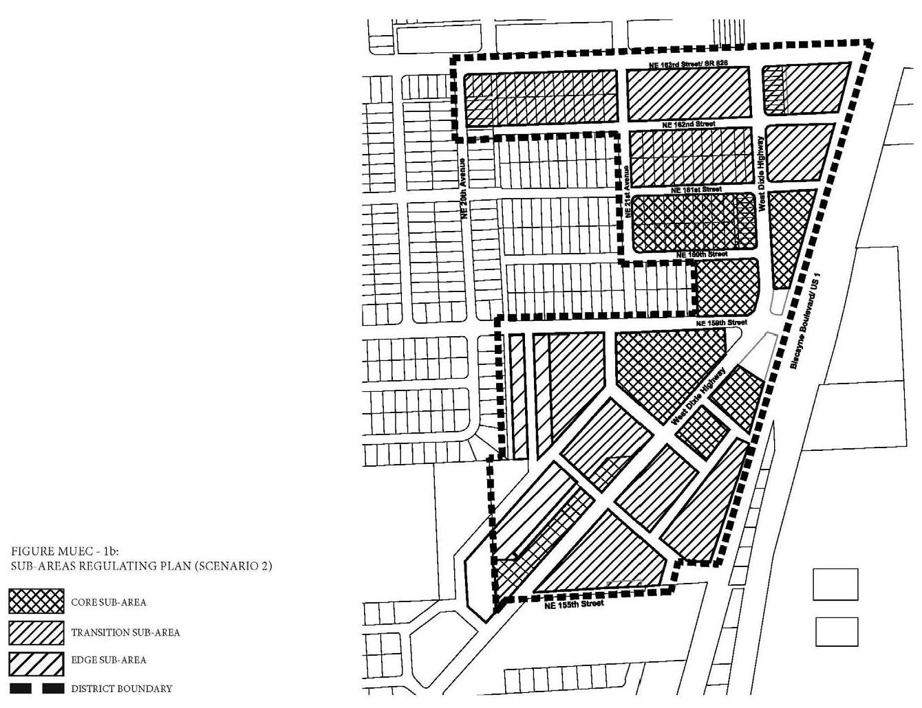
Figure MU/EC-2b: Street Network Connectivity Regulating Plan (Scenario 2)
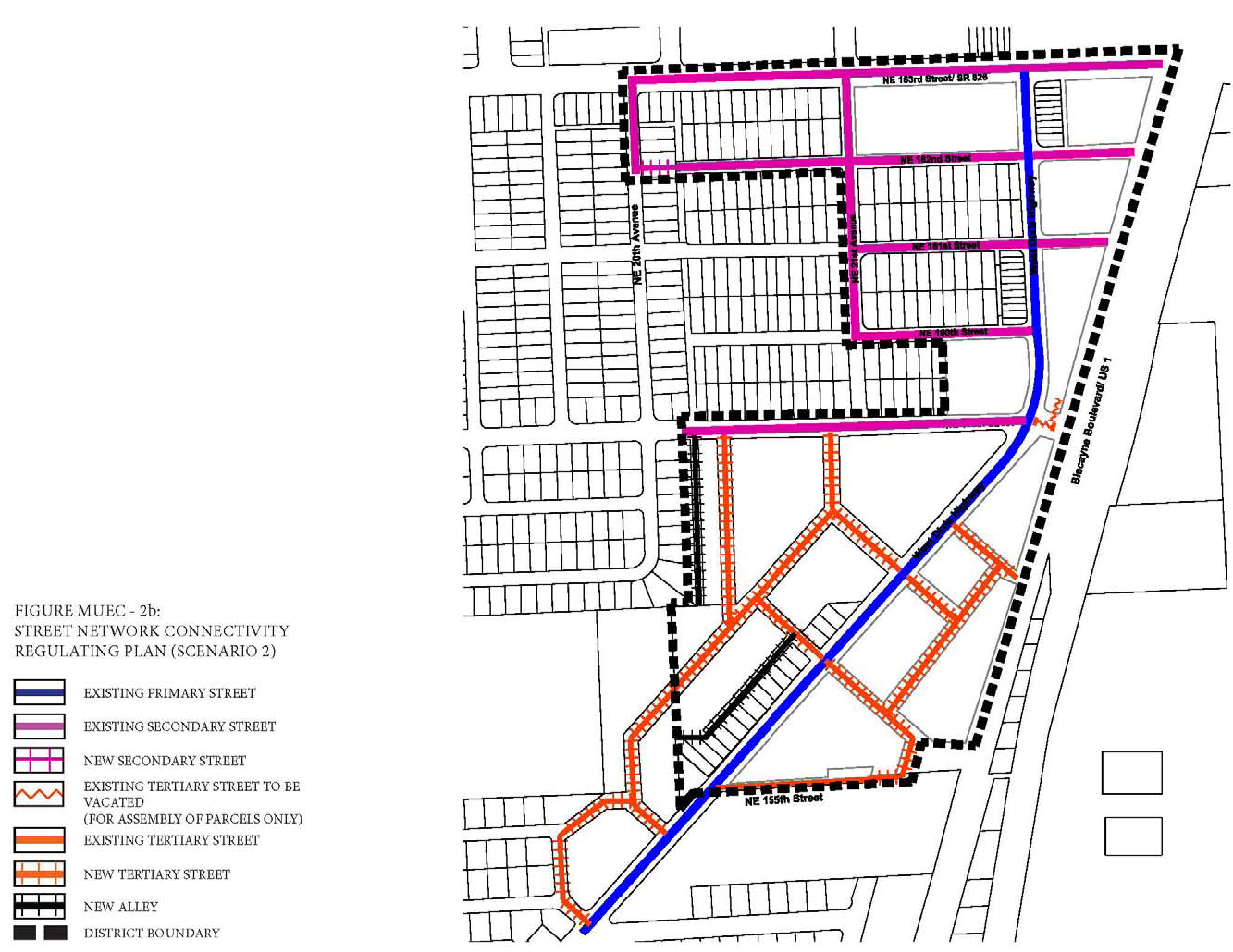
Figure MU/EC-3b: Designated Publically Accessible Open Spaces and Greenway Systems
Regulating Plan (Scenario 2)
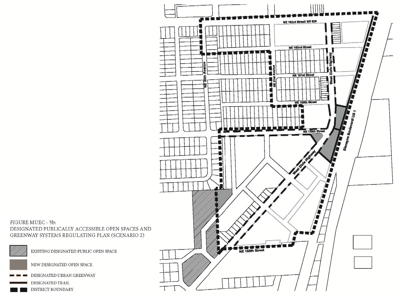
Figure MU/EC-4b: Building Heights Regulating Plan (Scenario 2)
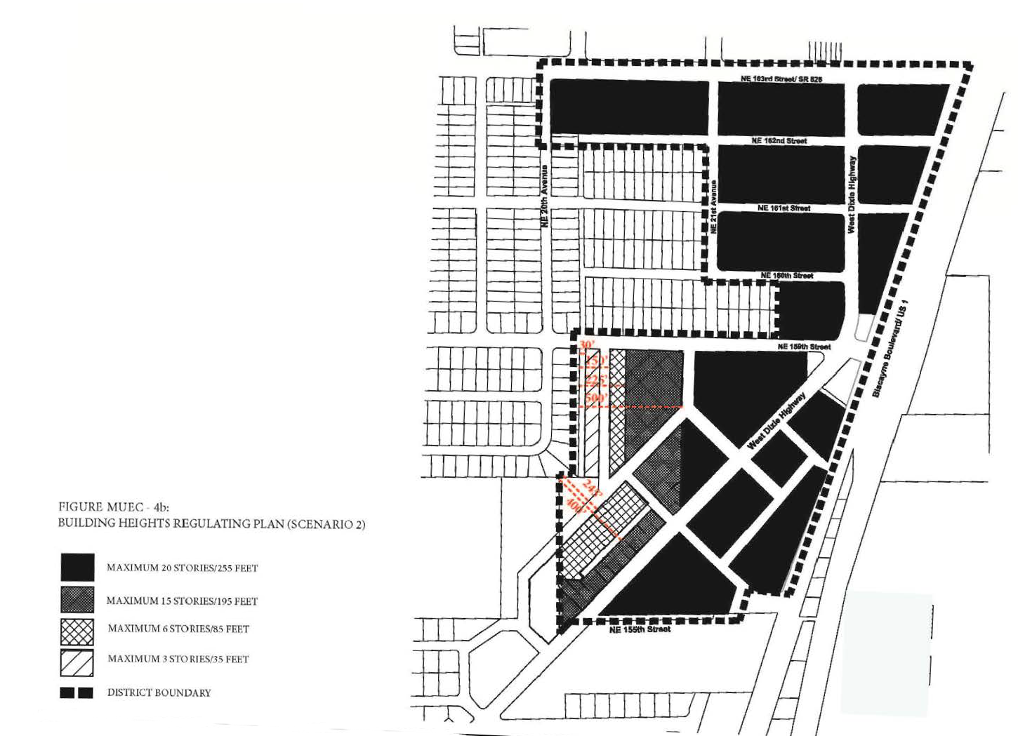
(F)
Sub-Areas Regulating Plan. All new and existing development shall review first their location within the Sub-Areas Regulating Plan as shown in Figure MU/EC-1.
(G)
Permitted Uses.
(1)
Land Use Principles.
a.
The MU/EC District shall be developed as an identifiable place and shall act as an important center for living and working. The mix of uses within the District, the streets and the architectural character of individual buildings shall blend together to contribute to a coherent identity and sense of place.
b.
The MU/EC District is anticipated to have a mix of intense non-residential uses and higher density residential uses that are both vertically and horizontally integrated. Compatibility of adjacent uses shall be addressed through building and site design elements. Service and/or high production areas associated with new intense non-residential uses shall be fully enclosed and concealed from the view of the residential use. Entrances for the non-residential uses shall be kept separate from the entrance to the residential use. Noise shall also be addressed through the use of appropriate sound barriers in the building construction.
c.
New residential or mixed-use development adjacent to existing intense non-residential uses shall be designed in a manner that the adjacent intense non-residential use is entirely screened along the adjacent side and not visible from the residential portion of the building. Walls, landscaped buffers and parking areas shall be utilized to screen the intense non-residential use.
d.
New auto oriented uses, as defined and permitted herein, shall only be permitted when fully enclosed in a building and/or parking structure and concealed from the view of residential and mixed-uses.
e.
Irrespective of the standards applicable in the Mixed-Use (MU) District or in the MU/EC, the following existing auto-oriented uses and auto-oriented use categories shall continue to be permitted in the MU/EC, provided they shall only be permitted at locations where they already existed or that had a site plan approved for such use prior to March, 2015:
i.
All boat-related uses such as Commercial: Boat and Marine Sales and Service Uses;
ii.
All auto-oriented use types, including but not limited to Car Wash or Auto Detailing uses, Commercial: Motor Vehicle Sales and Service Uses; and
iii.
Any use including Drive-Through Service. The entire principal use associated with the Drive-Through Service shall also be considered as permitted.
1.
Until such time that the permitted auto-oriented use converts to a new principal use type, the permitted auto-oriented uses shall be exempt from compliance with all Mixed-Use (MU) and MU/EC Standards.
f.
Until such time that the permitted auto-oriented use converts to a new principal use type, the permitted auto-oriented uses, including the structures and lots, shall be governed by the development standards for the previous Zoning District in Article V, including but not limited to, all applicable Development Review Procedures in Article XV, Nonconformities Standards in Article IV, if applicable; and the applicable Supplemental Regulations in Article VIII.
g.
Along West Dixie Highway and NE 163rd Street, the ground floor of all buildings shall be limited to non-residential uses, including but not limited to employment, office and retail uses. On the second level and above, both non-residential and residential uses shall be permitted.
h.
Along all other streets and on all levels, both non-residential and residential uses shall be permitted.
i.
Where a proposed development is adjacent to an existing single family property and/or district, the proposed development shall either provide a landscaped buffer or a development of lower intensity adjacent to the existing single family residential district, as shown in the two (2) development scenarios and as specified below.
i.
In scenario number one (1), where the proposed development provides a landscaped buffer, the proposed development shall:
a.
Create a one hundred-foot wide landscaped buffer within the proposed project property along the property line, between the proposed development and the adjacent single family residential district. The landscaped buffer shall not contain any structures, driveways, or roads, except sidewalks, bike paths, transit shelters or similar; and
b.
There shall be a Transitional Area adjacent to the single family residential district. The Transitional Area shall include the one hundred-foot wide landscaped buffer. The Transitional Area shall extend for the length of the portion of the proposed development that lies adjacent to and directly faces the adjacent single family property. The Transitional Area shall be between three hundred (300) and three hundred seventy (370) feet in depth as shown in the Building Heights Regulating Plan Figure MU/EC-4a. Any road, canal, waterway, park or alley between the adjacent single family residential district and the proposed development, or within the Transitional Area of the proposed development, shall be counted toward the depth necessary to comply with this section.
The Transitional Area shall be developed as follows:
1.
The height of the proposed development, within the Transitional area, adjacent to the single family residential district shall be four (4) stories as specified in the Building Heights Regulating Plan Figure MU/EC-4a.
2.
Within the first one hundred fifty (150) feet of the Transitional Area, the proposed development shall be limited to residential uses.
3.
All or part of the Transitional Area may be developed as landscaped open space and/or recreational uses.
ii.
In scenario number two (2), where the proposed development does not provide a landscaped buffer and provides a development of low intensity adjacent to the existing single family residential district, the proposed development shall:
a.
Provide a Transitional Area adjacent to the single family residential district. The Transitional Area shall extend for the length of the portion of the proposed development that lies adjacent to and directly faces the adjacent single family residential district. The Transitional Area shall be between two hundred twenty-five (225) to four hundred (400) feet in depth as shown in the Building Heights Regulating Plan Figure MU/EC-4b. Any road, canal, waterway, park or alley between the adjacent single family residential district and the proposed development, or within the Transitional Area of the proposed development, shall be counted toward the depth necessary to comply with this section.
The Transitional Area shall be developed as follows:
1.
Depending on the location on the Building Heights Regulating Plan Figure MU/EC-4b, the height of the proposed development, within the Transitional area, adjacent to the single family residential district shall be:
a.
A maximum of three (3) stories for the first one hundred fifty (150) feet and a maximum of six (6) stories beyond the first one hundred fifty (150) feet and up to two hundred twenty-five (225) feet, as specified in the Building Heights Regulating Plan Figure MU/EC-4b; or
b.
Zero stories for the first two hundred forty-five (245) feet and a maximum of six (6) stories beyond two hundred forty-five (245) feet and up to four hundred (400) feet, as specified in the Building Heights Regulating Plan Figure MU/EC-4b.
2.
Where applicable, within the first one hundred fifty (150) feet of the Transitional Area, the proposed development shall be limited to residential uses.
3.
Where applicable, the minimum setback of the proposed development within the first one hundred fifty (150) feet of the Transitional Area, shall be thirty (30) feet.
4.
Where applicable, beyond two hundred forty-five (245) feet and up to four hundred (400) feet of the Transitional Area, the proposed development shall be limited to residential uses.
b.
Provide additional requirements as specified in Section 24-58.2.J — Building Heights Regulating Plan and Additional Building Height Standards.
(2)
Permitted Use Table MU/EC-1 includes the principal uses permitted in the MU/EC along with any required restrictions on such uses, for each of the sub-areas. Principal uses not included in Table MU/EC — 1 are not permitted in the MU/EC. The MU/EC shall be subject to the Supplemental Regulations as provided for in Article VIII unless modified herein. Uses which are similar in nature to the uses permitted herein, but not enumerated in higher density use areas, shall be permitted upon a finding by the Community Development Director that the characteristics of, and activities associated with the use are substantially similar to one (1) or more of the listed uses, and will not involve greater impacts than the uses listed in the district and the use will be consistent with the purposes of the applicable zoning district.
Notes: (1) Subject to Design Criteria
(3)
Special Limited Conditional Uses. See Section 24-177.
(H)
Street Network Connectivity Regulating Plan and Street Standards. Figures MU/EC-2a and MU/EC-2b show the approximate location of existing and required new streets, for each development scenario, needed to create the prescribed network of streets within the MU/EC. This plan also establishes the hierarchy of the streets within the district. The street standards specified in Section 24-58(J) Mixed-Use District shall apply except as modified herein:
(1)
All streets shall be located according to the Street Network Connectivity Regulating Plan for the MU/EC.
(2)
All existing Primary, existing Secondary and new Secondary Streets shall be required in the same general location as shown on the Street Network Connectivity Regulating Plan but may be modified with respect to alignment. No Primary and Secondary Streets shall be deleted or otherwise vacated or removed.
(3)
Tertiary Streets and Alleys shown on the Street Network Connectivity Regulating Plan are encouraged to promote connectivity and to conform to block length requirements. Tertiary streets and alleys may be modified or deleted for the purpose of assembling parcels for development.
(I)
Designated Publically Accessible Open Spaces and Urban Greenway Systems Regulating Plan. The designated public urban greenways system shall be one (1) of the following types depending on the location within the MU/EC and as shown in the Designated Publically Accessible Open Spaces and Urban Greenways Systems Regulating Plan for each development scenario (Figures MU/EC-3a and MU/EC-3b).
(1)
Greenway Types.
a.
Type UG: Along West Dixie Highway (Figure MU/EC-5).
i.
The minimum width of the urban greenways shall be ten (10) feet.
ii.
A maximum of twenty (20%) percent of the length of the portion of the urban greenway within the setback shall be landscaped and shall consist primarily of sod, ground cover or ornamental grass.
iii.
Tree grates a minimum of five (5) feet by five (5) feet may be utilized in place of the required landscape strip.
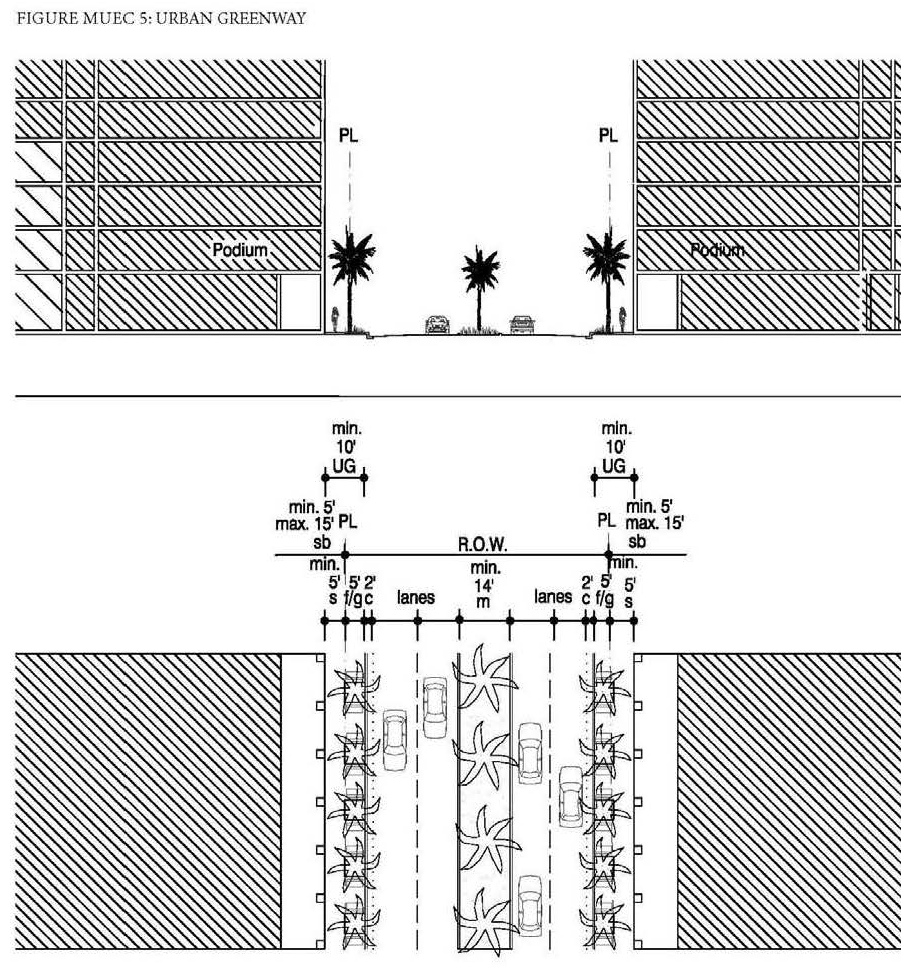
(2)
The designated public urban greenways system shall be designed to enhance the visual character of specific streets along the urban greenways and ensure pedestrian connectivity by:
a.
Providing tree species that provide continuous shade for a minimum of seventy (70%) percent of the frontage along the urban greenways. Palm trees alone are not acceptable and the maximum spacing of the shade trees shall be thirty (30) feet on center.
b.
Providing street furnishings such as benches, trash receptacles, bike racks, drinking water fountains, etc.
c.
Providing a landscape plan illustrating a coherent design with significant tree species along the urban greenways that are distinguishably different from the other streets along the property in terms of color, type and shape.
d.
No plant material other than trees shall be higher than twenty-four (24) inches within the urban greenway.
e.
Tree specifications shall be as per Section 24-58(L).
(J)
Building Heights Regulating Plan and Additional Height Standards. All new and existing development shall comply with the standards found within the Building Heights Regulating Plan for each development scenario as shown in (Figures MU/EC-4a and MU/EC-4b). Table MU/EC-2 provides a summary of the heights per sub-area for the two (2) regulating plan height scenarios, however, since maximum building heights vary within the sub-areas and are dependent on location, the Building Height Regulating Plan shall be referred to.
(K)
Building Typology and Dimensional Standards.
(1)
Building Typologies. All new buildings shall conform to one (1) of the permitted building typologies as demonstrated in the Building Typology and Placement Regulating Diagrams in Section 24-58 Mixed-use District. The diagrams provide a schematic representation of the various building typologies and demonstrate the required setbacks, lot standards, and profiles of structures. Existing buildings which do not fit a prescribed typology, shall follow the standards required for the Flex building typology. Not all building typologies are permitted in each Mixed-use district. The building typologies permitted in the MU/EC and their allowable sub-area locations are listed below in Table MU/EC-3:
(2)
Setbacks and Building Frontage.
a.
Front and Street Side Setbacks and Building Frontage. Front and Street Side setbacks are determined based on the street the building fronts. Table MU/EC-4 lists the minimum required front and street side setbacks and building frontage per street type. The interior side and rear setbacks as well as the lot standards shall be as specified per building type in Section 24-58 Mixed-use District.
(L)
On-site Parking Standards.
(1)
All parking within the MU/EC shall comply with the Access, Circulation, Parking and Loading Standards specified in Section 24-58 Mixed-use District.
(2)
On-site parking shall comply with Table MU/EC-5. Uses not listed herein shall comply with the parking requirements specified in Article IX.
(3)
Guest parking shall comply with Table MU/EC-5. Guest parking shall be designated and prominently marked on-site as "Guest Parking" and shall not be restricted in any manner to use by a single tenant, owner, unit, or other user.
(M)
Bicycle Racks and Bicycle Storage Standards. Bicycle racks and storage shall be required as follows:
(1)
Bicycle Racks and Bicycle Storage for Commercial Uses. Commercial developments, excluding hotel uses, shall provide:
a.
Secure bike racks and/or storage at a ratio of one (1) bicycle parking space per every fifteen (15) required parking spaces; and
b.
A minimum of one (1) shower and changing facility shall be provided to be available for all tenants and shall be located within the building, or within two hundred (200) feet of the building entrance, for developments greater than fifty thousand (50,000) square feet in gross building area.
(2)
Bicycle Racks and Bicycle Storage for Residential Uses. One (1) bicycle parking space shall be provided per every fifteen (15) required parking spaces. Required residential bicycle parking spaces shall be provided in a secured area, covered from the elements.
(3)
Mixed-Use Developments. Mixed-use developments shall provide secure bicycle parking spaces for both the commercial and residential components of the development as calculated separately pursuant to the requirements of this section.
(N)
Signage Standards. Signage shall comply with the standards in Article XIII except as modified herein.
(1)
Signs affixed to the exterior of a building shall be architecturally compatible with the style, composition, materials, colors, and details of the building, as well as with other signs used on the building or its vicinity.
(2)
Signs shall fit within the existing facade features, shall be confined to signable areas, and shall not interfere with door and window openings, conceal architectural details or obscure the composition of the facade where they are located.
(3)
Whenever possible, signs located on buildings within the same block-face shall be placed at the same height in order to create a unified sign band.
(4)
Wood and painted metal are the preferred materials for under-awning, hanging signs. Flat signs should be framed with raised edges. Wood signs shall use only high-quality exterior grade wood with suitable grade finishes.
(5)
Sign colors should be compatible with the colors of the building façade. A dull or matte finish is recommended for reduction of glare and enhancement of legibility.
(6)
Signs shall be either spot- or backlit with a diffused light source. Spotlighting shall require complete shielding of all light sources, shall be contained within the sign frame, and shall not significantly spill over to other portions of the building or site. Backlighting shall illuminate the letters, characters, or graphics on the sign, but not its background. Warm fluorescent bulbs may be used to illuminate the interior of display cases. Neon signs placed inside the display case shall insure low intensity colors.
(7)
Signs shall be mounted so that the method of installation is concealed. Signs applied to masonry surfaces should be mechanically fastened to mortar joints only and not directly into brick or stone. Drilling to provide electrical service should also follow the same rule.
(8)
Billboards are prohibited.
(O)
Assessments.
(1)
Public Infrastructure and Streetscape Assessment and Fund.
a.
All new development, or renovation or remodeling of existing buildings within the MU/EC, where total vertical construction costs of the development, renovation or remodeling is equal to or greater than five hundred thousand ($500,000.00) dollars shall pay a public infrastructure and streetscape assessment per dwelling unit or square foot to receive any allowable tax incentive which may be available from the North Miami Beach Community Redevelopment Agency, if any. Such public infrastructure and streetscape assessment shall be paid prior to issuance of a building permit for the development, renovation or remodeling. All public infrastructure and streetscape assessments shall be deposited into the public infrastructure and streetscape fund.
b.
Ordinary property maintenance is exempt from the public infrastructure and streetscape assessment. Repairs and restoration resulting from fire, flood, windstorm or other natural disaster, as determined by the building official, are exempt from the public infrastructure and streetscape assessment.
c.
The amount of the public infrastructure and streetscape assessment shall be established by resolution of the City Council and may be adjusted from time to time.
d.
A separate public infrastructure and streetscape fund shall be established by the City. All public infrastructure and streetscape assessment payments from new development, or renovation or remodeling of existing buildings within the MU/EC shall be deposited into this fund and the funds shall be kept separate from any other City funds. The public infrastructure and streetscape fund shall be used by the City for improvement to and maintenance of the public infrastructure and streets in the MU/EC. Use of such funds shall be determined by the City Council. Any monies not expended in the fund in any fiscal year shall be carried over in the fund into the following year. Any interest earned on the funds shall be retained in the fund.
(2)
Public Open Space Assessment and Fund.
a.
All new development, or renovation or remodeling of existing buildings within the MU/EC, where total vertical construction costs of the development, renovation or remodeling is equal to or greater than five hundred thousand ($500,000.00) dollars shall pay a public open space assessment per dwelling unit or square foot to receive any allowable tax incentive which may be available from the North Miami Beach Community Redevelopment Agency, if any. Such public open space assessment shall be paid prior to issuance of a building permit for the development, renovation or remodeling. All public open space assessments shall be deposited into the public open space fund.
b.
Ordinary property maintenance is exempt from the public open space assessment. Repairs and restoration resulting from fire, flood, windstorm or other natural disaster, as determined by the building official, are exempt from the public open space assessment.
c.
The amount of the public open space assessment shall be established by resolution of the City Council and may be adjusted from time to time.
d.
A separate public open space fund shall be established by the City. All public open space assessment payments from new development, or renovation or remodeling of existing buildings within the MU/EC shall be deposited into this fund and the funds shall be kept separate from any other City funds. The public open space fund shall be used by the City for improvement to and maintenance of the Snake Creek Canal Greenway, public parks, public open spaces and recreational areas and facilities in the MU/EC. Use of such funds shall be determined by the City Council. Any monies not expended in the fund in any fiscal year shall be carried over in the fund into the following year. Any interest earned on the funds shall be retained in the fund.
(3)
Public Art Assessment and Fund.
a.
All new development, or renovation or remodeling of existing buildings within the MU/EC, where total vertical construction costs of the development, renovation or remodeling is equal to or greater than five hundred thousand ($500,000.00) dollars shall pay a public art assessment to receive any allowable tax incentive which may be available from the North Miami Beach Community Redevelopment Agency, if any. Such public art assessment shall be paid prior to issuance of a building permit for the development, renovation or remodeling. All public art assessments shall be deposited into the public art fund.
b.
Ordinary property maintenance is exempt from the public art assessment. Repairs and restoration resulting from fire, flood, windstorm or other natural disaster, as determined by the building official, are exempt from the public art assessment.
c.
The amount of the public art assessment shall be established by resolution of the City Council and may be adjusted from time to time.
d.
A separate public art fund shall be established by the City. All public art assessment payments from new development, or renovation or remodeling of existing buildings within the MU/EC shall be deposited into this fund and the funds shall be kept separate from any other City funds. The public art fund shall be used by the City for the construction of, improvement to and maintenance of public art. Use of such funds shall be determined by the City Council. Any monies not expended in the fund in any fiscal year shall be carried over in the fund into the following year. Any interest earned on the funds shall be retained in the fund. Such public art assessment shall be paid prior to issuance of a building permit for the development, renovation or remodeling. All public art assessments shall be deposited into the public art fund.
(P)
Development Permit Review Procedures. The following development permit review procedure will apply to this district:
(1)
The review procedures set out in Article XV will apply within this district.
(2)
Preapplication Conference: For those development permit requests that require a Pre-Application Conference, the specific issues identified below must be reviewed by the Applicant and addressed with staff at the Preapplication Conference:
(a)
Treatment of the western interface with lower density residential uses requiring a Transition Area as defined in the Heights Regulating Plan for this district (two (2) scenarios).
(b)
Treatment of the historically designated structure on property located at 15779 West Dixie Highway.
(c)
Documentation that the required site clean-up has received clearance for development by applicable environmental regulatory agencies.
(d)
In addition to the submittal requirements in Article XV, the required plans submitted for review for the Pre-Application conference shall demonstrate the Applicant's general approach to comply with the requirements noted above and shown on the MU/EC District's:
(1)
Sub-Areas Regulating Plan.
(2)
Street Network and Connectivity Regulating Plan.
(3)
Designated Publically Accessible Open Spaces and Urban Greenways Regulating Plan.
(4)
Building Heights Regulating Plan (identify which of the two (2) scenarios will apply).
(5)
Building Typology.
(3)
Applications that include a development agreement shall be subject to the additional notice and hearings set forth in Article XIX.
(Ord. No. 2015-5, § 2(Exh. A), 3-17-15; Ord. No. 2016-6, § 2, 7-5-16; Ord. No. 2017-12, § 3, 1-16-18; Ord. No. 2018-6, § 2, 5-24-18; Ord. No. 2018-7, § 3, 6-19-18; Ord. No. 2024-02, § 3, 4-16-24)
Editor's note— Ord. No. 2015-5, § 2(Exh. A), adopted March 17, 2015, repealed the former § 24-58.2, and enacted a new § 24-58.2 as set out herein. The former § 24-58.2 pertained to land uses, and derived from Ord. No. 2002-20, § 2, adopted Nov. 19, 2002; Ord. No. 2006-01, § 12, adopted Feb. 21, 2006; Ord. No. 2006-3, § 2, adopted March 21, 2006; Ord. No. 2008-4, § 2, adopted March 4, 2008; and Ord. No. 2011-10, § 3, adopted Sept. 6, 2011.
Sec. 24-58.3 - Mixed-Use Neighborhood Center District (MU/NC).
(A)
Purpose and Intent. The purpose of these regulations is to implement policies that guide the design of development within the Mixed-Use Neighborhood Center District (MU/NC). The intent is to support a balanced mix of land uses characterized by compactness, pedestrian friendly design, neighborhood-scale and framed by architecture and landscape design appropriate to local history and the natural environment. Development patterns shall generally reflect planning and design principles such as walkable neighborhoods oriented around the five-minute walk, primary orientation towards public transit systems, a centrally located community-serving land use or land uses and greater integration of housing, employment, shopping and recreation at the neighborhood level. This purpose will be fulfilled by:
(1)
Ensuring high quality, architecturally compatible, consistently landscaped development throughout the District;
(2)
Stimulating neighborhood commercial and retail activities;
(3)
Ensuring that new development or redevelopment projects enhance the visual character of the District;
(4)
Encouraging the development of pleasant shopping areas with attractive pedestrian spaces;
(5)
Encouraging people to reside in the District;
(6)
Encouraging the beautification of West Dixie Highway; and
(7)
Encouraging new publicly accessible open spaces.
(B)
District Boundaries. The development standards shall be utilized for properties located within the Mixed-Use Neighborhood Center District (MU/NC).
(C)
Administration. In order to maintain predictability in development, Planned Unit Developments (PUDs) shall be prohibited. Variances from the dimensional requirements or waivers from any other criterion may be approved by the applicable review board for projects, provided that the applicant meets the standards pertaining to such variance or waiver. The applicable board shall hear and decide appeals where it is alleged there is an error in any order, requirement, decision, or determination made by the Director of the Community Development Department or his/her designee in the enforcement of these development regulations.
(D)
General Development Standards.
(1)
In addition to the standards contained herein, Section 24-58 Mixed-Use (MU) district standards shall be applicable to development within the Mixed-Use Neighborhood Center District (MU/NC). The applicable regulations contained in Articles IV, VIII, IX, X, XI, XII, XIII, and XIV shall also apply, except as modified herein and may be further modified by the City Manager or his/her designee to meet the purpose and intent of the Mixed-Use Neighborhood Center District (MU/NC).
(2)
The provisions of the MU/NC code, when in conflict, shall take precedence over the existing zoning and land development regulations.
(3)
The provisions of the building code, when in conflict, shall take precedence over the provisions of the MU/NC code.
(4)
Existing buildings may be destroyed or removed, however they must be replaced according to the MU/NC regulations. Existing buildings may not be destroyed or removed unless they are to be replaced according to MU/NC regulations and only after a building permit is issued.
(5)
Existing buildings and uses within the MU/NC area, which are legally established but do not conform to provisions of the MU/NC regulations as of the effective date of these regulations shall be considered nonconforming and may not be replaced, restored, or modified, except in conformity with the regulation for nonconformities contained in Article IV of this chapter. When a nonconforming structure is destroyed by windstorm, flood, or nature disaster, it may be replaced by a new structure of the same or lesser size, and reoccupied by the same use, if construction of such structure is commenced within eighteen (18) months of destruction.
(6)
Proposed development with site plan approved under the previous zoning regulations shall commence construction within the time frame allotted in the development order or site plan approval letter. If commencement of construction does not occur within the allotted time frame, the site plan approval shall automatically expire without further action by the City.
(E)
Regulating Plans and Diagrams. The MU/NC is governed by a series of regulating plans and diagrams. The Regulating Plans and Diagrams demonstrate MU/NC development standards in both words and diagrams, and include maps designating the locations where the various standards apply. Unless otherwise noted, all development shall be in compliance with the Regulating Plans and Diagrams contained herein and with the Building Typology and Placement Regulating Diagrams in Section 24-58 Mixed-Use (MU) district. The Regulating Plans and Diagrams for the MU/NC include the following:
(1)
The Sub-areas Regulating Plan, which divides the MU/NC into two (2) Sub-areas: Core, and Transition. The highest density and intensity within the MU/NC shall be allocated to the Core Sub-area, a mixed-use area in the heart of the district. The densities and intensities shall then gradually decrease from the Core to the Transition Sub-area, which is adjacent to existing medium density residential, and mixed-uses are still permitted. The Sub-areas Regulating Plan is shown in Figure MU/NC-1.
(2)
The Street Network Connectivity Regulating Plan, which shows the approximate location of existing and required new streets needed to create the prescribed network of streets within the MU/NC. This Plan also establishes the hierarchy of the streets as shown in Figure MU/NC-2.
(3)
The Designated Publicly Accessible Open Spaces and Urban Greenway Systems Regulating Plan, which designates the approximate location of required publicly accessible open spaces and urban greenway system as shown in Figure MU/NC-3.
(4)
The Building Heights Regulating Plan, which establishes the maximum building height as shown in Figure MU/NC-4.
Figure MU/NC-1. Sub-Areas Regulating Plan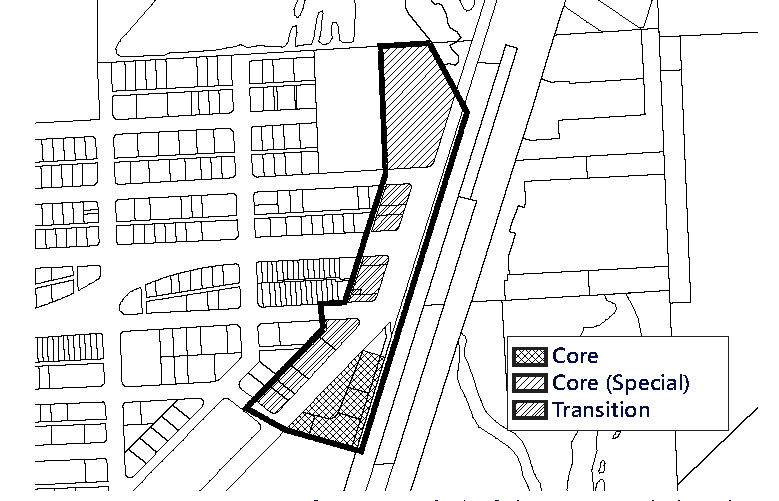
Figure MU/NC-2. Street Network Connectivity Regulating Plan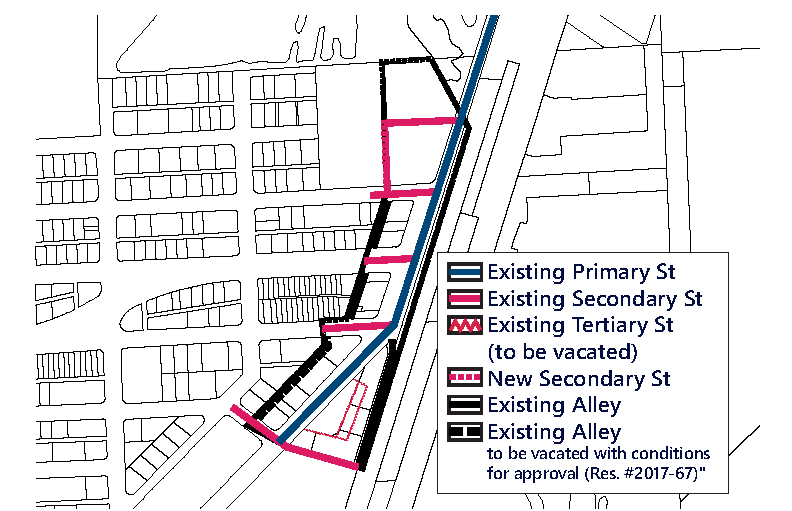
Figure MU/NC-3. Designated Publicly Accessible Open Spaces and Greenway Systems Regulating
Plan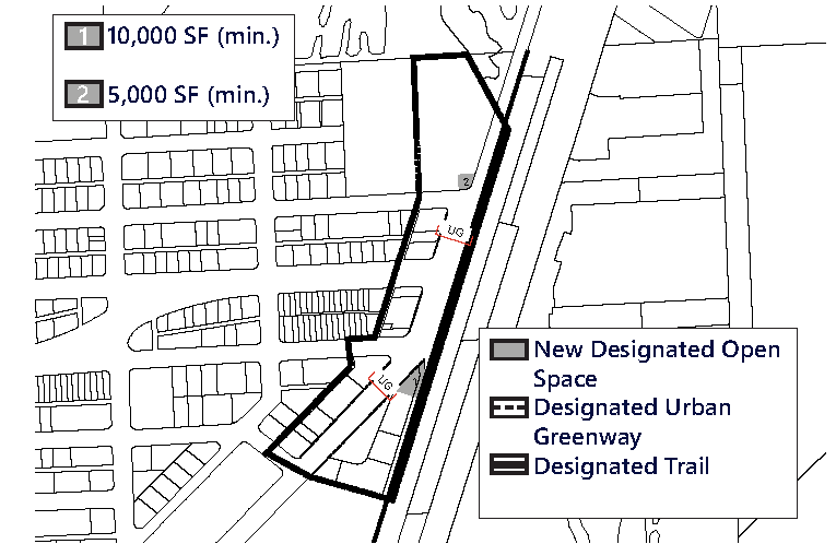
Figure MU/NC-4. Building Heights Regulating Plan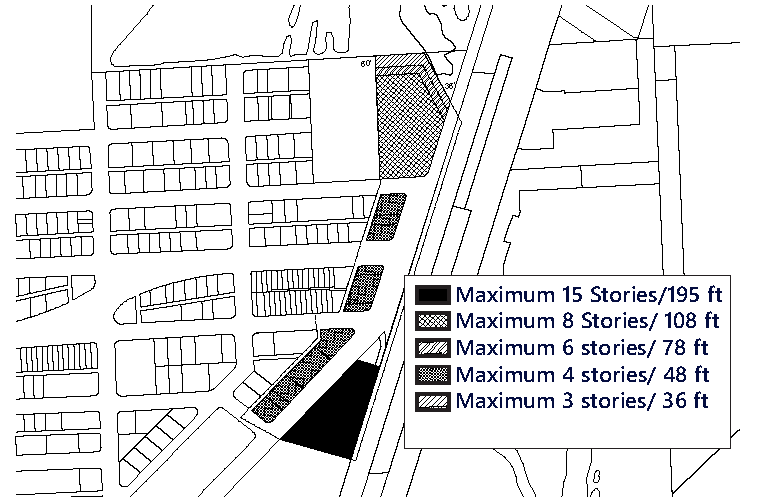
(F)
Sub-Areas Regulating Plan. All new and existing development shall review first their location within the Sub-Areas Regulating Plan as shown in Figure MU/NC-1.
(G)
Permitted Uses.
(1)
Land Use Principles.
a.
The MU/NC District shall be developed as an identifiable place and shall act as an important center for living, working, shopping and entertainment. The mix of uses within the District, the streets and the architectural character of individual buildings shall blend together to contribute to a coherent identity and sense of place.
b.
Along all streets and on all levels, both non-residential and residential uses shall be permitted.
(2)
Permitted Use Table MU/NC-1 includes the principal uses permitted in the MU/NC along with any required restrictions on such uses, for each of the sub-areas. Principal uses not included in Table MU/NC-1 are not permitted in the MU/NC. The MU/NC shall be subject to the Supplemental Regulations as provided for in Article VIII unless modified herein. Uses which are similar in nature to the uses permitted herein, but not enumerated in higher density use areas, shall be permitted upon a finding by the Community Development Director that the characteristics of, and activities associated with the use are substantially similar to one (1) or more of the listed uses, and will not involve greater impacts than the uses listed in the district and the use will be consistent with the purposes of the applicable zoning district and use areas.
(3)
Special Limited Conditional Uses. See Section 24-177.
(H)
Street Network Connectivity Regulating Plan and Street Standards. Figure MU/NC-2 shows the approximate location of existing and required new streets needed to create the prescribed network of streets within the MU/NC. This plan also establishes the hierarchy of the streets within the district. The street standards specified in Section 24-58(J) Mixed-use District shall apply except as modified herein:
(1)
All streets shall be located according to the Street Network Connectivity Regulating Plan for the MU/NC.
(2)
All Primary and Secondary Streets shall be required in the same general location as shown on the Street Network Connectivity Regulating Plan and may be modified with respect to alignment. No Primary and Secondary Streets shall be deleted or otherwise vacated or removed.
a.
At the second story and above, development shall be permitted to bridge above the new secondary street, provided that it covers no more than thirty (30%) percent (maximum) of the overall ROW area's view to the open sky.
(3)
Tertiary Streets and Alleys shown on the Street Network Connectivity Regulating Plan are encouraged to promote connectivity and to conform to block length requirements. Tertiary streets and alleys may be modified or deleted for the purpose of assembling parcels for development.
(I)
Designated Publicly Accessible Open Spaces and Urban Greenway Systems Regulating Plan. The designated public urban greenways system shall be one (1) of the following types depending on the location within the MU/NC and as shown in the Designated Publicly Accessible Open Spaces and Urban Greenways Systems Regulating Plan (Figure MU/NC-3).
(1)
Greenway Types.
a.
Type UG: Along West Dixie Highway (Figure MU/NC-5).
i.
The minimum width of the urban greenways shall be twenty-eight (28) feet.
ii.
A minimum of twenty (20%) percent of the length of the portion of the urban greenway within the setback shall be landscaped and shall consist primarily of sod, ground cover or ornamental grass.
Figure MU/NC-5. Urban Greenway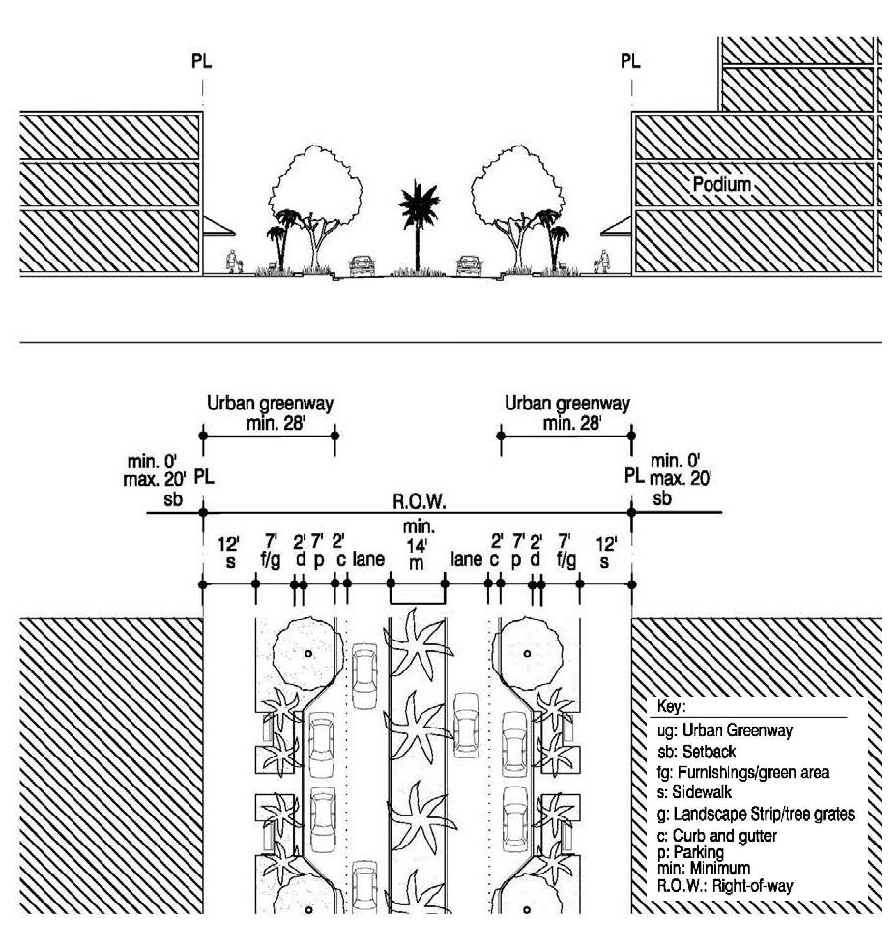
iii.
Tree grates a minimum of five (5) feet by five (5) feet may be utilized in place of the required landscape strip.
(2)
The designated public urban greenways system shall be designed to enhance the visual character of specific streets along the urban greenways and ensure pedestrian connectivity by:
a.
Providing tree species that provide continuous shade for a minimum of seventy (70%) percent of the frontage along the urban greenways. Palm trees alone are not acceptable and the maximum spacing of the shade trees shall be thirty (30) feet on center.
b.
Providing street furnishings such as benches, trash receptacles, bike racks, drinking water fountains, etc.
c.
Providing a landscape plan illustrating a coherent design with significant tree species along the urban greenways that are distinguishably different from the other streets along the property in terms of color, type and shape.
d.
No plant material other than trees shall be higher than twenty-four (24) inches within the urban greenway.
e.
Tree specifications shall be as per Section 24-58(L).
(3)
The designated publicly accessible open spaces shall meet the minimum requirements for area and maintain the general proportion as identified in Figure MU/NC-3.
(J)
Building Heights Regulating Plan and Additional Height Standards. All new and existing development shall comply with the standards found within the Building Heights Regulating Plan as shown in (Figure MU/NC-4). Table MU/NC-2 provides a summary of the heights per sub-area, however, since maximum building heights vary within the sub-areas and are dependent on location, the Building Height Regulating Plan shall be referred to.
(K)
Building Typology and Dimensional Standards.
(1)
Building Typologies. All new buildings shall conform to one (1) of the permitted building typologies as demonstrated in the Building Typology and Placement Regulating Diagrams in Section 24-58 Mixed-use District. The diagrams provide a schematic representation of the various building typologies and demonstrate the required setbacks, lot standards, and profiles of structures. Existing buildings which do not fit a prescribed typology, shall follow the standards required for the Flex building typology. Not all building typologies are permitted in each Mixed-use district. The building typologies permitted in the MU/NC and their allowable sub-area locations are listed below in Table MU/NC-3.
(2)
Setbacks and Building Frontage.
a.
Front and Street Side Setbacks and Building Frontage. Front and Street Side setbacks are determined based on the street the building fronts. Table MU/NC-4 lists the minimum required front and street side setbacks and building frontage per street type. The interior side and rear setbacks as well as the lot standards shall be as specified per building type in Section 24-58 Mixed-use District.
(L)
On-site Parking Standards.
(1)
All parking within the MU/NC shall comply with the Access, Circulation, Parking and Loading Standards specified in Section 24-58 Mixed-use District.
(2)
On-site parking shall comply with Table MU/NC-5. Uses not listed herein shall comply with the parking requirements specified in Article IX.
(3)
Guest parking shall comply with Table MU/NC-5. Guest parking shall be designated and prominently marked on-site as "Guest Parking" and shall not be restricted in any manner to use by a single tenant, owner, unit, or other user.
(M)
Bicycle Racks and Bicycle Storage Standards. Bicycle racks and storage shall be required as follows:
(1)
Bicycle Racks and Bicycle Storage for Commercial Uses. Commercial developments, excluding hotel uses, shall provide:
a.
Secure bike racks and/or storage at a ratio of one (1) bicycle parking space per every fifteen (15) required parking spaces; and
b.
A minimum of one (1) shower and changing facility shall be provided to be available for all tenants and shall be located within the building, or within two hundred (200) feet of the building entrance, for developments greater than fifty thousand (50,000) square feet in gross building area.
(2)
Bicycle Racks and Bicycle Storage for Residential Uses. One (1) bicycle parking space shall be provided per every fifteen (15) required parking spaces. Required residential bicycle parking spaces shall be provided in a secured area, covered from the elements.
(3)
Mixed-Use Developments. Mixed-use developments shall provide secure bicycle parking spaces for both the commercial and residential components of the development as calculated separately pursuant to the requirements of this section.
(N)
Signage Standards. Signage shall comply with the standards in Article XIII except as modified herein.
(1)
Signs affixed to the exterior of a building shall be architecturally compatible with the style, composition, materials, colors, and details of the building, as well as with other signs used on the building or its vicinity.
(2)
Signs shall fit within the existing facade features, shall be confined to signable areas, and shall not interfere with door and window openings, conceal architectural details or obscure the composition of the facade where they are located.
(3)
Whenever possible, signs located on buildings within the same block-face shall be placed at the same height in order to create a unified sign band.
(4)
Wood and painted metal are the preferred materials for under-awning, hanging signs. Flat signs should be framed with raised edges. Wood signs shall use only high-quality exterior grade wood with suitable grade finishes.
(5)
Sign colors should be compatible with the colors of the building façade. A dull or matte finish is recommended for reduction of glare and enhancement of legibility.
(6)
Signs shall be either spot- or backlit with a diffused light source. Spotlighting shall require complete shielding of all light sources, shall be contained within the sign frame, and shall not significantly spill over to other portions of the building or site. Backlighting shall illuminate the letters, characters, or graphics on the sign, but not its background. Warm fluorescent bulbs may be used to illuminate the interior of display cases. Neon signs placed inside the display case shall insure low intensity colors.
(7)
Signs shall be mounted so that the method of installation is concealed. Signs applied to masonry surfaces should be mechanically fastened to mortar joints only and not directly into brick or stone. Drilling to provide electrical service should also follow the same rule.
(8)
Billboards are prohibited.
(9)
A projecting sign, generally two-sided and mounted with a decorative support or projecting building feature, and perpendicular to the building's facade shall be permitted within the MU/IB, provided it does not exceed a maximum area of one-hundred (100) square feet.
(O)
Assessments.
(1)
Public Infrastructure and Streetscape Assessment and Fund.
a.
All new development, or renovation or remodeling of existing buildings within the MU/NC, where total vertical construction costs of the development, renovation or remodeling is equal to or greater than five hundred thousand ($500,000.00) dollars, shall pay a public infrastructure and streetscape assessment per dwelling unit or square foot to receive any allowable tax incentive, which may be available from the North Miami Beach Community Redevelopment Agency, if any. Such public infrastructure and streetscape assessment shall be paid prior to issuance of a building permit for the development, renovation or remodeling. All public infrastructure and streetscape assessments shall be deposited into the public infrastructure and streetscape fund.
b.
Ordinary property maintenance is exempt from the public infrastructure and streetscape assessment. Repairs and restoration resulting from fire, flood, windstorm or other natural disaster, as determined by the building official, are exempt from the public infrastructure and streetscape assessment.
c.
The amount of the public infrastructure and streetscape assessment shall be established by resolution of the City Council and may be adjusted from time to time.
d.
A separate public infrastructure and streetscape fund shall be established by the City. All public infrastructure and streetscape assessment payments from new development, or renovation or remodeling of existing buildings within the MU/NC shall be deposited into this fund and the funds shall be kept separate from any other City funds. The public infrastructure and streetscape fund shall be used by the City for improvement to and maintenance of the public infrastructure and streets in the MU/NC. Use of such funds shall be determined by the City Council. Any monies not expended in the fund in any fiscal year shall be carried over in the fund into the following year. Any interest earned on the funds shall be retained in the fund.
(2)
Public Open Space Assessment and Fund.
a.
All new development, or renovation or remodeling of existing buildings within the MU/NC, where total vertical construction costs of the development, renovation or remodeling is equal to or greater than five hundred thousand ($500,000.00) dollars shall pay a public open space assessment per dwelling unit or square foot to receive any allowable tax incentive, which may be available from the North Miami Beach Community Redevelopment Agency, if any. Such public open space assessment shall be paid prior to issuance of a building permit for the development, renovation or remodeling. All public open space assessments shall be deposited into the public open space fund.
b.
Ordinary property maintenance is exempt from the public open space assessment. Repairs and restoration resulting from fire, flood, windstorm or other natural disaster, as determined by the building official, are exempt from the public open space assessment.
c.
The amount of the public open space assessment shall be established by resolution of the City Council and may be adjusted from time to time.
d.
A separate public open space fund shall be established by the City. All public open space assessment payments from new development, or renovation or remodeling of existing buildings within the MU/NC shall be deposited into this fund and the funds shall be kept separate from any other City funds. The public open space fund shall be used by the City for improvement to and maintenance of the Snake Creek Canal Greenway, public parks, public open spaces and recreational areas and facilities in the MU/NC. Use of such funds shall be determined by the City Council. Any monies not expended in the fund in any fiscal year shall be carried over in the fund into the following year. Any interest earned on the funds shall be retained in the fund.
(3)
Public Art Assessment and Fund.
a.
All new development, or renovation or remodeling of existing buildings within the MU/NC, where total vertical construction costs of the development, renovation or remodeling is equal to or greater than five hundred thousand ($500,000.00) dollars shall pay a public art assessment to receive any allowable tax incentive, which may be available from the North Miami Beach Community Redevelopment Agency, if any. Such public art assessment shall be paid prior to issuance of a building permit for the development, renovation or remodeling. All public art assessments shall be deposited into the public art fund.
b.
Ordinary property maintenance is exempt from the public art assessment. Repairs and restoration resulting from fire, flood, windstorm or other natural disaster, as determined by the building official, are exempt from the public art assessment.
c.
The amount of the public art assessment shall be established by resolution of the City Council and may be adjusted from time to time.
d.
A separate public art fund shall be established by the City. All public art assessment payments from new development, or renovation or remodeling of existing buildings within the MU/NC shall be deposited into this fund and the funds shall be kept separate from any other City funds. The public art fund shall be used by the City for the construction of, improvement to and maintenance of public art. Use of such funds shall be determined by the City Council. Any monies not expended in the fund in any fiscal year shall be carried over in the fund into the following year. Any interest earned on the funds shall be retained in the fund. Such public art assessment shall be paid prior to issuance of a building permit for the development, renovation or remodeling. All public art assessments shall be deposited into the public art fund.
(P)
Development Permit Review Procedures. The following development permit review procedure will apply to this district:
(1)
The review procedures set out in Article XV and Section 24-171 (Concurrency) will apply within this district.
(2)
Preapplication Conference: For those development permit requests that require a Pre-Application Conference, the Applicant must address with staff:
(a)
The submittal requirements in Article XV and Section 24-171 (Concurrency) and the required plans submitted for review shall demonstrate the Applicant's general approach to comply with the requirements noted above and shown on the MU/NC District's:
(1)
Sub-Areas Regulating Plan.
(2)
Street Network and Connectivity Regulating Plan.
(3)
Designated Publicly Accessible Open Spaces and Urban Greenways Regulating Plan.
(4)
Building Heights Regulating Plan.
(5)
Building Typology.
(3)
Applications that include a development agreement shall be subject to the additional notice and hearings set forth in Article XIX.
(Ord. No. 2015-5, § 2(Exh. A), 3-17-15; Ord. No. 2016-6, § 2, 7-5-16; Ord. No. 2017-12, § 3, 1-16-18; Ord. No. 2018-6, § 2, 5-24-18; Ord. No. 2018-7, § 3, 6-19-18; Ord. No. 2020-11, § 2, 3-16-21; Ord. No. 2024-02, § 3, 4-16-24)
Editor's note— Ord. No. 2015-5, § 2(Exh. A), adopted March 17, 2015, repealed the former § 24-58.3, and enacted a new § 24-58.3 as set out herein. The former § 24-58.3 pertained to site design, and derived from Ord. No. 2002-20, § 2, adopted Nov. 19, 2002; Ord. No. 2006-3, § 2, adopted March 21, 2006; and Ord. No. 2008-4, § 2, adopted March 4, 2008.
Sec. 24-58.4 - Arch Creek Mixed-Use Corridor District (MU/C).
(A)
Purpose and Intent. The purpose of these regulations is to implement policies that guide the design of development within the Arch Creek Mixed-Use Corridor District (MU/C). The intent is to support a balanced mix of land uses characterized by compactness, pedestrian friendly design, neighborhood-scale and framed by architecture and landscape design appropriate to local history and the natural environment. Development patterns shall generally reflect planning and design principles such as walkable neighborhoods oriented around the five-minute walk, primary orientation towards public transit systems, a centrally located community-serving land use or land uses and greater integration of housing, employment, shopping and recreation at the neighborhood level. This purpose will be fulfilled by:
(1)
Ensuring high quality, architecturally compatible, consistently landscaped development throughout the District;
(2)
Stimulating neighborhood commercial and retail activities;
(3)
Ensuring that new development or redevelopment projects enhance the visual character of Biscayne Boulevard in terms of massing and scale;
(4)
Encouraging the development of pleasant shopping areas with attractive pedestrian spaces;
(5)
Encouraging people to reside in the District; and
(6)
Encouraging new publicly accessible open spaces.
(B)
District Boundaries. The development standards shall be utilized for properties located within the Arch Creek Mixed-Use Corridor District (MU/C).
(C)
Administration. In order to maintain predictability in development, Planned Unit Developments (PUDs) shall be prohibited. Variances from the dimensional requirements or waivers from any other criterion may be approved by the applicable review board for projects, provided that the applicant meets the standards pertaining to such variance or waiver. The applicable board shall hear and decide appeals where it is alleged there is an error in any order, requirement, decision, or determination made by the Director of the Community Development Department or his/her designee in the enforcement of these development regulations.
(D)
General Development Standards.
(1)
In addition to the standards contained herein, Section 24-58 Mixed-Use (MU) district standards shall be applicable to development within the Arch Creek Mixed-Use Corridor District (MU/C). The applicable regulations contained in Articles IV, VIII, IX, X, XI, XII, XIII, and XIV shall also apply, except as modified herein and may be further modified by the City Manager to meet the purpose and intent of the Arch Creek Mixed-Use Corridor District (MU/C).
(2)
The provisions of the MU/C code, when in conflict, shall take precedence over the existing zoning and land development regulations.
(3)
The provisions of the building code, when in conflict, shall take precedence over the provisions of the MU/C code.
(4)
Existing buildings may be destroyed or removed, however they must be replaced according to the MU/C regulations. Existing buildings may not be destroyed or removed unless they are to be replaced according to MU/C regulations and only after a building permit is issued.
(5)
Existing buildings and uses within the MU/C area, which are legally established but do not conform to provisions of the MU/C regulations as of the effective date of these regulations shall be considered nonconforming and may not be replaced, restored, or modified, except in conformity with the regulation for nonconformities contained in Article IV of this chapter. When a nonconforming structure is destroyed by windstorm, flood, or nature disaster, it may be replaced by a new structure of the same or lesser size, and reoccupied by the same use, if construction of such structure is commenced within eighteen (18) months of destruction.
(6)
Proposed development with site plan approved under the previous zoning regulations shall commence construction within the time frame allotted in the development order or site plan approval letter. If commencement of construction does not occur within the allotted time frame, the site plan approval shall automatically expire without further action by the City.
(E)
Regulating Plans and Diagrams. The MU/C is governed by a series of regulating plans and diagrams. The Regulating Plans and Diagrams demonstrate MU/C development standards in both words and diagrams, and include maps designating the locations where the various standards apply. Unless otherwise noted, all development shall be in compliance with the Regulating Plans and Diagrams contained herein and with the Building Typology and Placement Regulating Diagrams in Section 24-58 Mixed-Use (MU) district. The Regulating Plans and Diagrams for the MU/C include the following:
(1)
The Sub-areas Regulating Plan, which divides the MU/C into three (3) Sub-areas: Core, Transition and Edge. The highest density and intensity within the MU/C shall be allocated to the Core Sub-area, a mixed-use area in the heart of the district. The densities and intensities shall then gradually decrease from the Core to the Transition Sub-area where mixed-uses are still permitted and then further decrease to the Edge Sub-area which is characterized by single uses, including low density residential adjacent to existing low density residential. The Sub-areas Regulating Plan is shown in Figure MU/C-1.
(2)
The Street Network Connectivity Regulating Plan, which shows the approximate location of existing and the required new streets needed to create the prescribed network of streets within the MU/C. This Plan also establishes the hierarchy of the streets as shown in Figure MU/C-2.
(3)
The Designated Publicly Accessible Open Spaces and Urban Greenway Systems Regulating Plan, which designates the approximate location of the required publicly accessible open spaces and urban greenway system as shown in Figure MU/C-3.
(4)
The Building Heights Regulating Plan, which establishes the maximum building height as shown in Figure MU/C-4.
Figure MU/C-1: Sub-Areas Regulating Plan
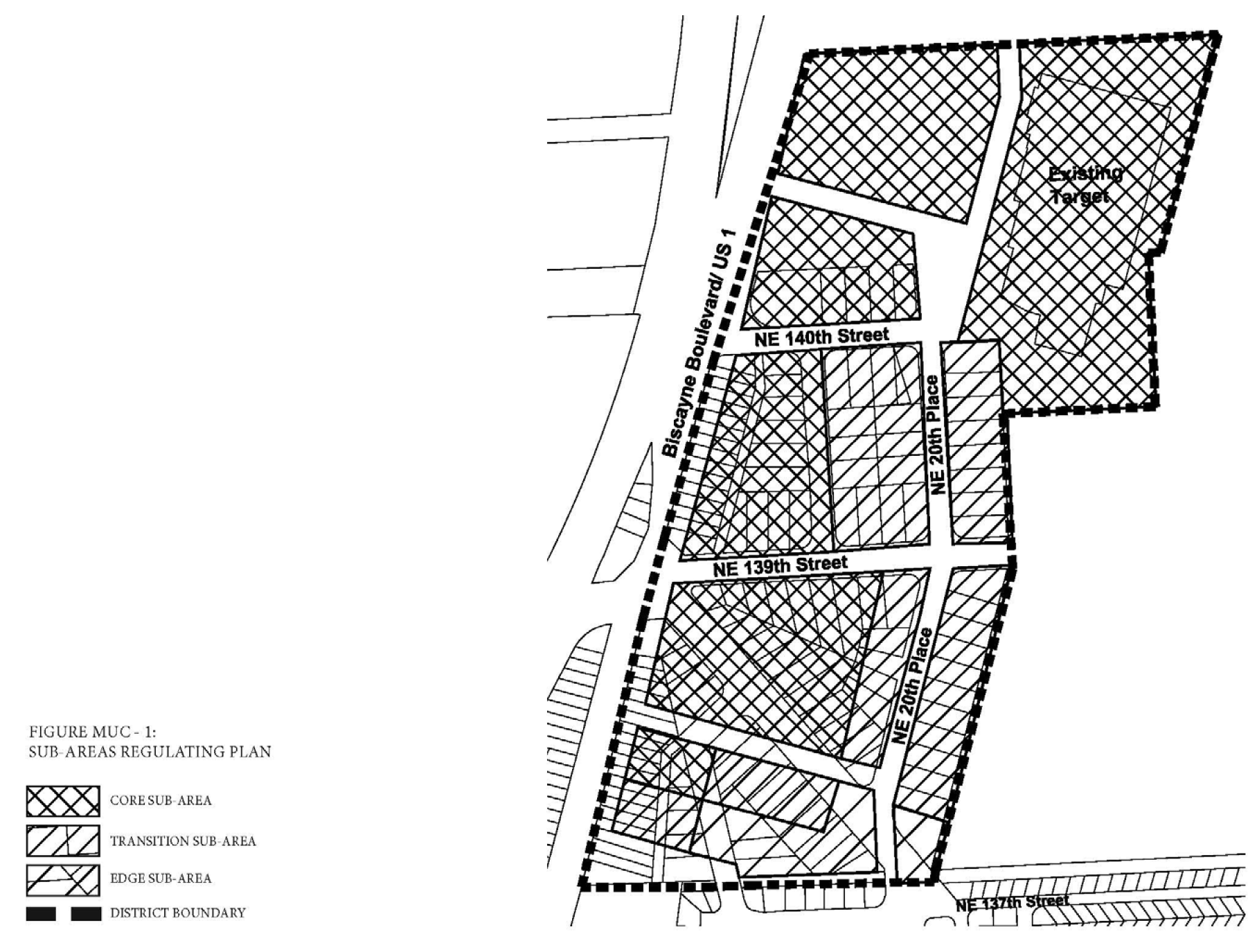
Figure MU/C-2: Street Network Connectivity Regulating Plan
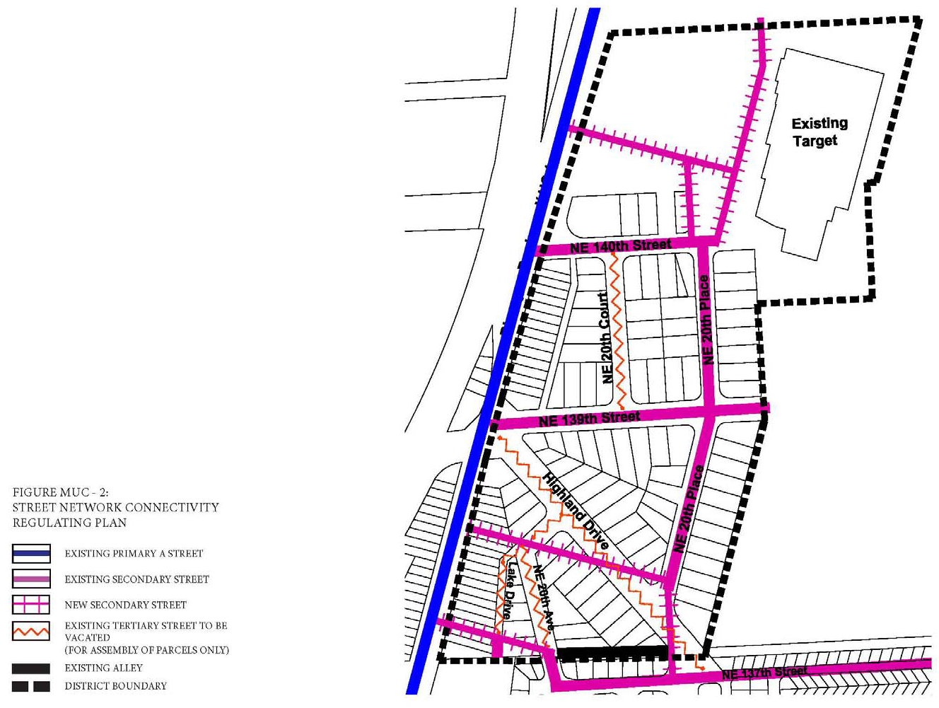
Figure MU/C-3: Designated Publicly Accessible Open Spaces and Greenway Systems
Regulating Plan
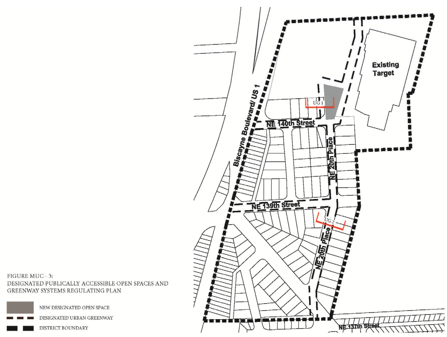
Figure MU/C-4: Building Heights Regulating Plan
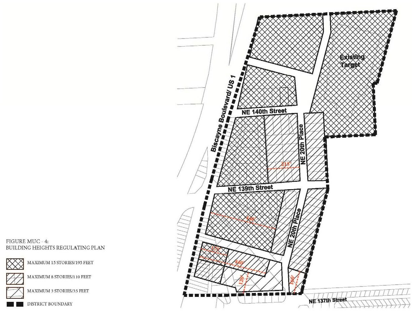
(F)
Sub-Areas Regulating Plan. All new and existing development shall review first their location within the Sub-Areas Regulating Plan as shown in Figure MU/C-1.
(G)
Permitted Uses.
(1)
Land Use Principles.
a.
The MU/C District shall be developed as an identifiable place and shall act as an important center for living, working, shopping and entertainment. The mix of uses within the District, the streets and the architectural character of individual buildings shall blend together to contribute to a coherent identity and sense of place.
b.
The MU/C District is anticipated to have a mix of intense non-residential uses, such as big box retail establishments and office park style developments, and higher density residential uses that are both vertically and horizontally integrated. Compatibility of adjacent uses shall be addressed through building and site design elements. Service and/or non-active use areas associated with new intense non-residential uses shall be fully enclosed and concealed from the view of the residential use. Entrances for the non-residential uses shall be kept separate from the entrance to the residential use. Noise shall also be addressed through the use of appropriate sound barriers in the building construction.
c.
Along NE 20th Place only, south of NE 140th Street, all levels of the portion of the buildings fronting NE 20th Place shall be limited to residential uses.
d.
Along all other streets and on all levels, both non-residential and residential uses shall be permitted.
e.
Where a proposed development is adjacent to the Highland Village Neighborhood, the proposed development shall:
i.
There shall be a Transitional Area adjacent to the single family property. The Transitional Area shall extend for the length of the portion of the proposed development that lies adjacent to and directly faces the adjacent Highland Village Neighborhood. The depth of the Transitional Area shall be as specified in the Building Heights Regulating Plan. Any road, canal, waterway, park or alley between the adjacent single family property and the proposed development, or within the Transitional Area of the proposed development, shall be counted toward the depth necessary to comply with this section.
The Transitional Area shall be developed as follows:
1.
The height of the proposed development adjacent to the Highland Village Neighborhood shall be as specified in the Building Heights Regulating Plan Figure MU/C-4.
2.
Within the first one hundred twenty (120) feet of the Transitional Area, the proposed development shall be limited to residential uses.
3.
All or part of the Transitional Area may be developed as landscaped open space and/or recreational uses.
(2)
Permitted Use Table MU/C-1 includes the principal uses permitted in the MU/C along with any required restrictions on such uses, for each of the sub-areas. Principal uses not included in Table MU/C-1 are not permitted in the MU/C. The MU/C shall be subject to the Supplemental Regulations as provided for in Article VIII unless modified herein. Uses which are similar in nature to the uses permitted herein, but not enumerated in higher density use areas, shall be permitted upon a finding by the Community Development Director that the characteristics of, and activities associated with the use are substantially similar to one or more of the listed uses, and will not involve greater impacts than the uses listed in the district and the use will be consistent with the purposes of the applicable zoning district and use areas.
(3)
Special Limited Conditional Uses. See Section 24-177.
(H)
Street Network Connectivity Regulating Plan and Street Standards. Figure MU/C-2 shows the approximate location of existing and required new streets needed to create the prescribed network of streets within the MU/C. This plan also establishes the hierarchy of the streets within the district. The street standards specified in Section 24-58(J) Mixed-use District shall apply except as modified herein:
(1)
All streets shall be located according to the Street Network Connectivity Regulating Plan for the MU/C.
(2)
All Primary and Existing Secondary Streets shall be required in the same general location as shown on the Street Network Connectivity Regulating Plan and may be modified with respect to alignment. No Primary and Existing Secondary Streets shall be deleted or otherwise vacated or removed.
(3)
New Secondary Streets shown on the Street Network Connectivity Regulating Plan are encouraged to promote connectivity and establish a block system within the district. New Secondary streets may be modified or deleted for the purpose of assembling parcels for development provided the block pattern conforms to block length requirements.
(4)
Existing Tertiary Streets shown on the Street Network Connectivity Regulating Plan may be deleted for the purpose of assembling parcels for development provided the block pattern conforms to block length requirements.
(I)
Designated Publically Accessible Open Spaces and Urban Greenway Systems Regulating Plan. The designated public urban greenways system shall be the following type as shown in the Designated Publically Accessible Open Spaces and Urban Greenways Systems Regulating Plan (Figure MU/C-3).
(1)
Greenway Type.
a.
Type UG 1: Along NE 20th Place North of NE 140th Street (Figure MU/C-5).
i.
The minimum width of the urban greenways shall be fifteen (15) feet.
ii.
A minimum of twenty (20%) percent of the urban greenway shall be landscaped and shall consist primarily of sod, ground cover or ornamental grass.
iii.
Tree grates a minimum of five (5) feet by five (5) feet may be utilized in place of the required landscape strip.
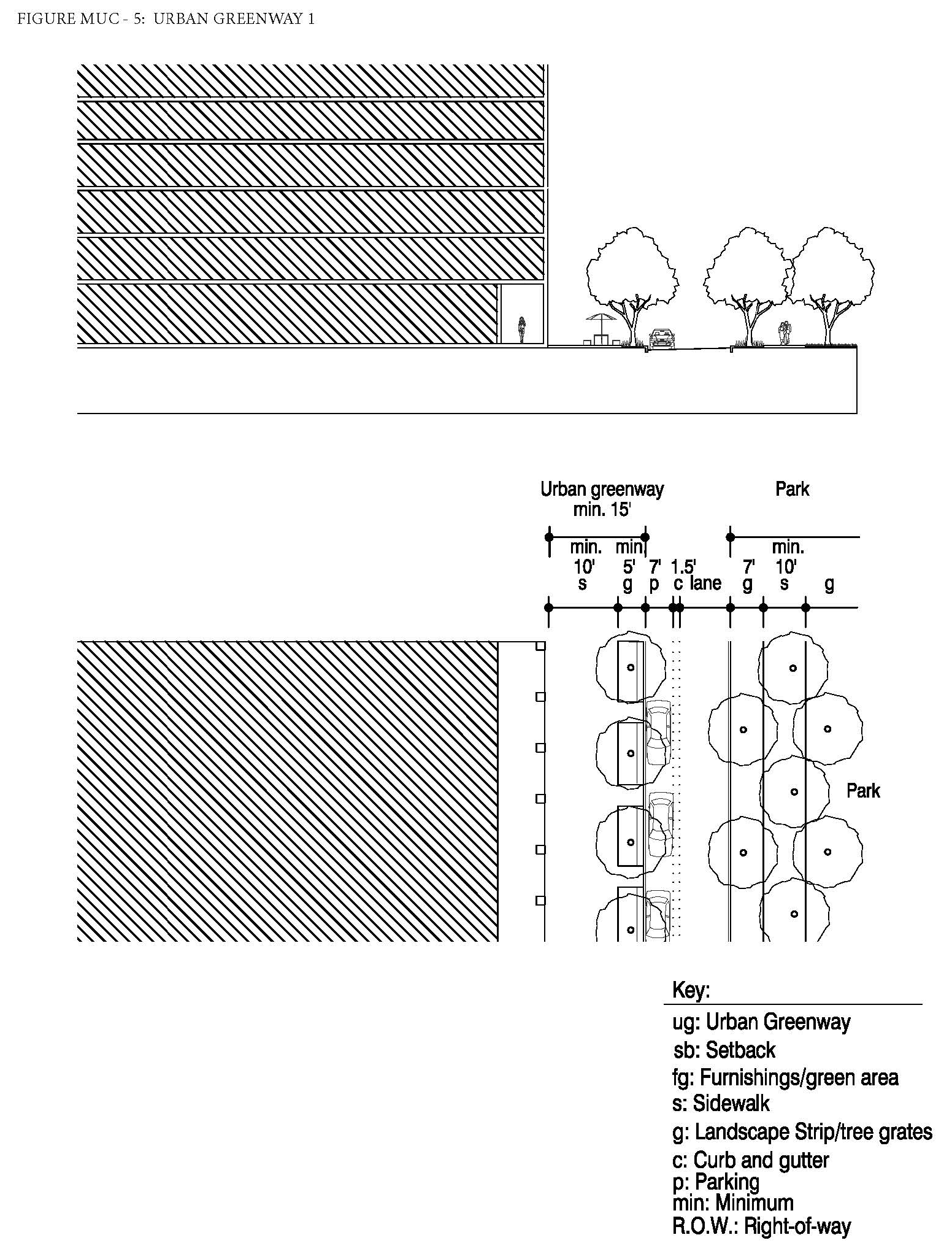
b.
Type UG 2: Along NE 20th Place South of NE 140th Street (Figure MU/C-6).
i.
The minimum width of the urban greenways shall be twenty-three (23) feet.
ii.
A minimum of sixty (60%) percent of the length of the portion of the urban greenway within the setback shall be landscaped and shall consist primarily of sod, ground cover or ornamental grass.
iii.
Tree grates shall not be utilized in place of the required landscape strip.
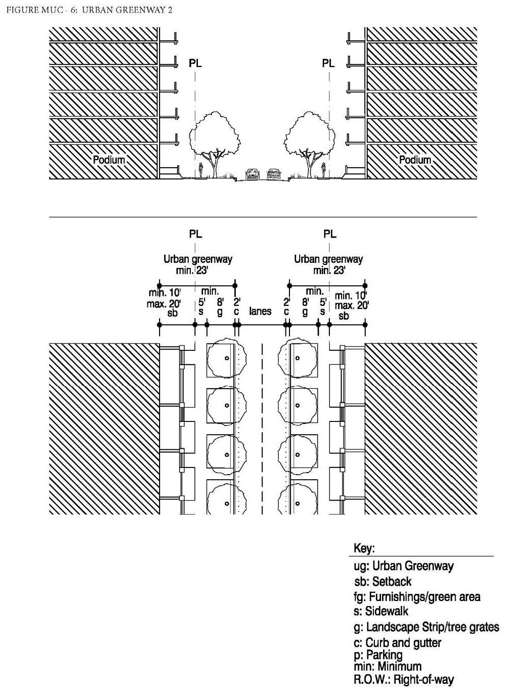
(2)
The designated public urban greenways system shall be designed to enhance the visual character of specific streets along the urban greenways and ensure pedestrian connectivity by:
a.
Providing tree species that provide continuous shade for a minimum of seventy (70%) percent of the frontage along the urban greenways. Palm trees alone are not acceptable and the maximum spacing of the shade trees shall be thirty (30) feet on center.
b.
Providing street furnishings such as benches, trash receptacles, bike racks, drinking water fountains, etc.
c.
Providing a landscape plan illustrating a coherent design with significant tree species along the urban greenways that are distinguishably different from the other streets along the property in terms of color, type and shape.
d.
No plant material other than trees shall be higher than twenty-four (24) inches within the urban greenway.
e.
Tree specifications shall be as per Section 24-58(L).
(J)
Building Heights Regulating Plan and Additional Height Standards. All new and existing development shall comply with the standards found within the Building Heights Regulating Plan as shown in (Figure MU/C-4). Table MU/C-2 provides a summary of the heights per sub-area, however, since maximum building heights vary within the sub-areas and are dependent on location, the Building Height Regulating Plan shall be referred to.
(K)
Building Typology and Dimensional Standards.
(1)
Building Typologies. All new buildings shall conform to one (1) of the permitted building typologies as demonstrated in the Building Typology and Placement Regulating Diagrams in Section 24-58 Mixed-use District. The diagrams provide a schematic representation of the various building typologies and demonstrate the required setbacks, lot standards, and profiles of structures. Existing buildings which do not fit a prescribed typology, shall follow the standards required for the Flex building typology. Not all building typologies are permitted in each Mixed-use district. The building typologies permitted in the MU/C and their allowable sub-area locations are listed below in Table MU/C-3.
(2)
Setbacks and Building Frontage.
a.
Front and Street Side Setbacks and Building Frontage. Front and Street Side setbacks are determined based on the street the building fronts. Table MU/C-4 lists the minimum required front and street side setbacks and building frontage per street type. The interior side and rear setbacks as well as the lot standards shall be as specified per building type in Section 24-58 Mixed-use District.
(L)
On-site Parking Standards.
(1)
All parking within the MU/C shall comply with the Access, Circulation, Parking and Loading Standards specified in Section 24-58 Mixed-use District.
(2)
On-site parking shall comply with Table MU/C-5. Uses not listed herein shall comply with the parking requirements specified in Article IX.
(3)
Guest parking shall comply with Table MU/C-5. Guest parking shall be designated and prominently marked on-site as "Guest Parking" and shall not be restricted in any manner to use by a single tenant, owner, unit, or other user.
(M)
Bicycle Racks and Bicycle Storage Standards. Bicycle racks and storage shall be required as follows:
(1)
Bicycle Racks and Bicycle Storage for Commercial Uses. Commercial developments, excluding hotel uses, shall provide:
a.
Secure bike racks and/or storage at a ratio of one (1) bicycle parking space per every fifteen (15) required parking spaces; and
b.
A minimum of one (1) shower and changing facility shall be provided to be available for all tenants and shall be located within the building, or within two hundred (200) feet of the building entrance, for developments greater than fifty thousand (50,000) square feet in gross building area.
(2)
Bicycle Racks and Bicycle Storage for Residential Uses. One (1) bicycle parking space shall be provided per every fifteen (15) required parking spaces. Required residential bicycle parking spaces shall be provided in a secured area, covered from the elements.
(3)
Mixed-Use Developments. Mixed-use developments shall provide secure bicycle parking spaces for both the commercial and residential components of the development as calculated separately pursuant to the requirements of this section.
(N)
Signage Standards. Signage shall comply with the standards in Article XIII except as modified herein.
(1)
Signs affixed to the exterior of a building shall be architecturally compatible with the style, composition, materials, colors, and details of the building, as well as with other signs used on the building or its vicinity.
(2)
Signs shall fit within the existing facade features, shall be confined to signable areas, and shall not interfere with door and window openings, conceal architectural details or obscure the composition of the facade where they are located.
(3)
Whenever possible, signs located on buildings within the same block-face shall be placed at the same height in order to create a unified sign band.
(4)
Wood and painted metal are the preferred materials for under-awning, hanging signs. Flat signs should be framed with raised edges. Wood signs shall use only high-quality exterior grade wood with suitable grade finishes.
(5)
Sign colors should be compatible with the colors of the building façade. A dull or matte finish is recommended for reduction of glare and enhancement of legibility.
(6)
Signs shall be either spot- or backlit with a diffused light source. Spotlighting shall require complete shielding of all light sources, shall be contained within the sign frame, and shall not significantly spill over to other portions of the building or site. Backlighting shall illuminate the letters, characters, or graphics on the sign, but not its background. Warm fluorescent bulbs may be used to illuminate the interior of display cases. Neon signs placed inside the display case shall insure low intensity colors.
(7)
Signs shall be mounted so that the method of installation is concealed. Signs applied to masonry surfaces should be mechanically fastened to mortar joints only and not directly into brick or stone. Drilling to provide electrical service should also follow the same rule.
(8)
Billboards are prohibited.
(O)
Development Approval Conditions.
(1)
Public Services.
a.
Development sites greater than one hundred fifty thousand (150,000) square feet in land area shall be required to develop and maintain in perpetuity a neighborhood park or plaza, as approximately located and shown in the Designated Publically Accessible Open Spaces and Urban Greenway Systems Regulating Plan (Figure MU/C-3), for the district. The new park or plaza shall be publically accessible and shall be a minimum of fifteen thousand (15,000) square feet in size.
b.
The developer shall be required to provide streetscape improvements generally in accordance with the Street Network Connectivity Regulating Plan and Street Standards.
(P)
Development Permit Review Procedures. The following development permit review procedure will apply to this district:
(1)
The review procedures set out in Article XV and Section 24-171 (Concurrency) will apply within this district.
(2)
Preapplication Conference: For those development permit requests that require a Pre-Application Conference, the specific issues identified below must be reviewed by the Applicant and addressed with staff at the Preapplication Conference:
(a)
Awareness of the Biscayne Landing project to the east including the environmental cleanup and potential off-site impacts, floodplain encroachment and possibility of increased flooding, connectivity and crime prevention.
(b)
In addition to the submittal requirements in Article XV, the required plans submitted for review for the Pre-Application conference shall demonstrate the Applicant's general approach to comply with the requirements noted above and shown on the MU/C District's:
(1)
Sub-Areas Regulating Plan.
(2)
Street Network and Connectivity Regulating Plan.
(3)
Designated Publically Accessible Open Spaces and Urban Greenways Regulating Plan.
(4)
Building Heights Regulating Plan.
(5)
Building Typology.
(3)
Applications that include a development agreement shall be subject to the additional notice and hearings set forth in Article XIX.
(Ord. No. 2015-5, § 2(Exh. A), 3-17-15; Ord. No. 2016-6, § 2, 7-5-16; Ord. No. 2017-12, § 3, 1-16-18; Ord. No. 2018-6, § 2, 5-24-18; Ord. No. 2018-7, § 3, 6-19-18; Ord. No. 2024-02, § 3, 4-16-24)
Editor's note— Ord. No. 2015-5, § 2(Exh. A), adopted March 17, 2015, repealed the former § 24-58.4, and enacted a new § 24-58.4 as set out herein. The former § 24-58.4 pertained to building design, and derived from Ord. No. 2002-20, § 2, adopted Nov. 19, 2002; and Ord. No. 2008-4, § 2, adopted March 4, 2008.
Sec. 24-58.5 - Southern Mixed-Use Waterfront District (MU/SWF).
(A)
Purpose and Intent. The purpose of these regulations is to implement policies that guide the design of development within the SOUTHERN Mixed-Use Waterfront District (SOUTHERN MU/WF). The intent of the SOUTHERN MU/WF district is to establish a Mixed-use area that provides for multi-family housing that enables residents to live on the waterfront. Providing new publically accessible open spaces as well as public access to and beautification of the waterfront are primary principals of the SOUTHERN MU/WF district. Development patterns shall generally reflect planning and design principles such as walkable neighborhoods oriented around the five-minute walk. Additionally, there shall be primary orientation towards the waterfront, integration of housing, employment, shopping and recreation at the neighborhood level. This purpose will be fulfilled by:
(1)
Ensuring high quality, architecturally compatible, consistently landscaped development throughout the District;
(2)
Ensuring that new development or redevelopment projects enhance the visual character of Biscayne Boulevard in terms of massing and scale;
(3)
Stimulating neighborhood commercial and retail activities;
(4)
Encouraging people to reside in the District;
(5)
Ensuring public access to and the beautification of the waterfront;
(6)
Ensuring new publically accessible open space; and
(7)
Ensuring appropriate screening from residential views related to the electrical substation.
(B)
District Boundaries. The development standards shall be utilized for properties located within the SOUTHERN Mixed-Use Waterfront District (SOUTHERN MU/WF).
(C)
Administration. In order to maintain predictability in development, Planned Unit Developments (PUDs) shall be prohibited. Variances from the dimensional requirements or waivers from any other criterion may be approved by the applicable review board for projects, provided that the applicant meets the standards pertaining to such variance or waiver. The applicable board shall hear and decide appeals where it is alleged there is an error in any order, requirement, decision, or determination made by the Director of the Community Development Department or his/her designee in the enforcement of these development regulations.
(D)
General Development Standards.
(1)
In addition to the standards contained herein, Section 24-58 Mixed-Use (MU) district standards shall be applicable to development within the SOUTHERN Mixed-Use Waterfront District (SOUTHERN MU/WF). The applicable regulations contained in Articles IV, VIII, IX, X, XI, XII, XIII, and XIV shall also apply, except as modified herein and may be further modified by the City Manager or his/her designee to meet the purpose and intent of the SOUTHERN Mixed-Use Waterfront District (SOUTHERN MU/WF).
(2)
The provisions of the SOUTHERN MU/WF code, when in conflict, shall take precedence over the existing zoning and land development regulations.
(3)
The provisions of the building code, when in conflict, shall take precedence over the provisions of the SOUTHERN MU/WF code.
(4)
Existing buildings may be destroyed or removed, however they must be replaced according to the SOUTHERN MU/WF regulations. Existing buildings may not be destroyed or removed unless they are to be replaced according to SOUTHERN MU/WF regulations and only after a building permit is issued.
(5)
Existing buildings and uses within the SOUTHERN MU/WF area, which are legally established but do not conform to provisions of the SOUTHERN MU/WF regulations as of the effective date of these regulations shall be considered nonconforming and may not be replaced, restored, or modified, except in conformity with the regulation for nonconformities contained in Article IV of this chapter. When a nonconforming structure is destroyed by windstorm, flood, or nature disaster, it may be replaced by a new structure of the same or lesser size, and reoccupied by the same use, if construction of such structure is commenced within eighteen (18) months of destruction.
(6)
Proposed development with site plan approved under the previous zoning regulations shall commence construction within the time frame allotted in the development order or site plan approval letter. If commencement of construction does not occur within the allotted time frame, the site plan approval shall automatically expire without further action by the City.
(E)
Regulating Plans and Diagrams. The SOUTHERN MU/WF is governed by a series of regulating plans and diagrams. The Regulating Plans and Diagrams demonstrate SOUTHERN MU/WF development standards in both words and diagrams, and include maps designating the locations where the various standards apply. Unless otherwise noted, all development shall be in compliance with the Regulating Plans and Diagrams contained herein and with the Building Typology and Placement Regulating Diagrams in Section 24-58 Mixed-Use (MU) district. The Regulating Plans and Diagrams for the SOUTHERN MU/WF include the following:
(1)
The Street Network Connectivity Regulating Plan, which shows the approximate locations of the existing and required new streets needed to create the prescribed network of streets within the SOUTHERN MU/WF. This Plan also establishes the hierarchy of the streets as shown in Figure MU/SWF-1.
(2)
The Designated Open Spaces and Urban Greenway Systems Regulating Plan, which designates the approximate location of the required publically accessible open spaces, urban greenway system and publically accessible waterfront promenades as shown in Figure MU/SWF-2.
(3)
The Building Heights Regulating Plan, which establishes the maximum building height as shown in Figure MU/SWF-3.
Figure MU/SWF-1: Street Network Connectivity Regulating Plan
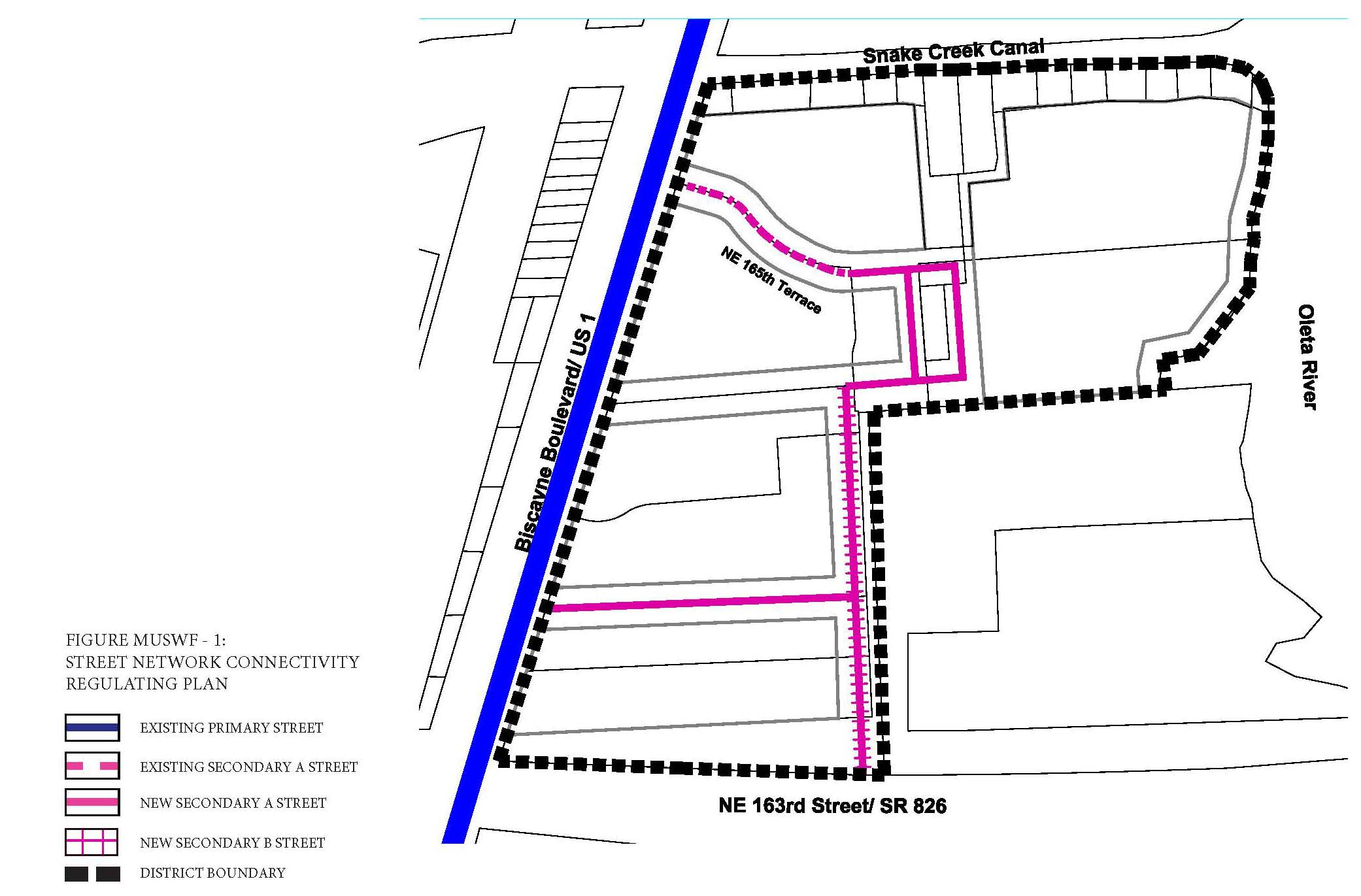
Figure MU/SWF-2: Designated Publically Accessible Open Spaces and Greenway Systems
Regulating Plan
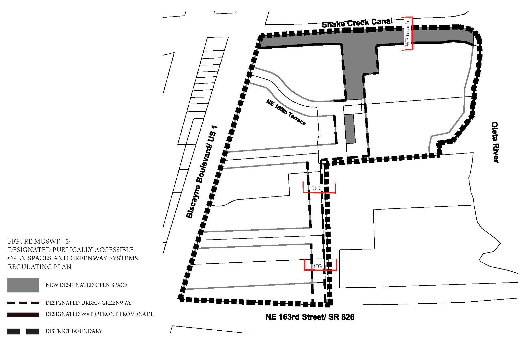
Figure MU/SWF-3: Building Heights Regulating Plan
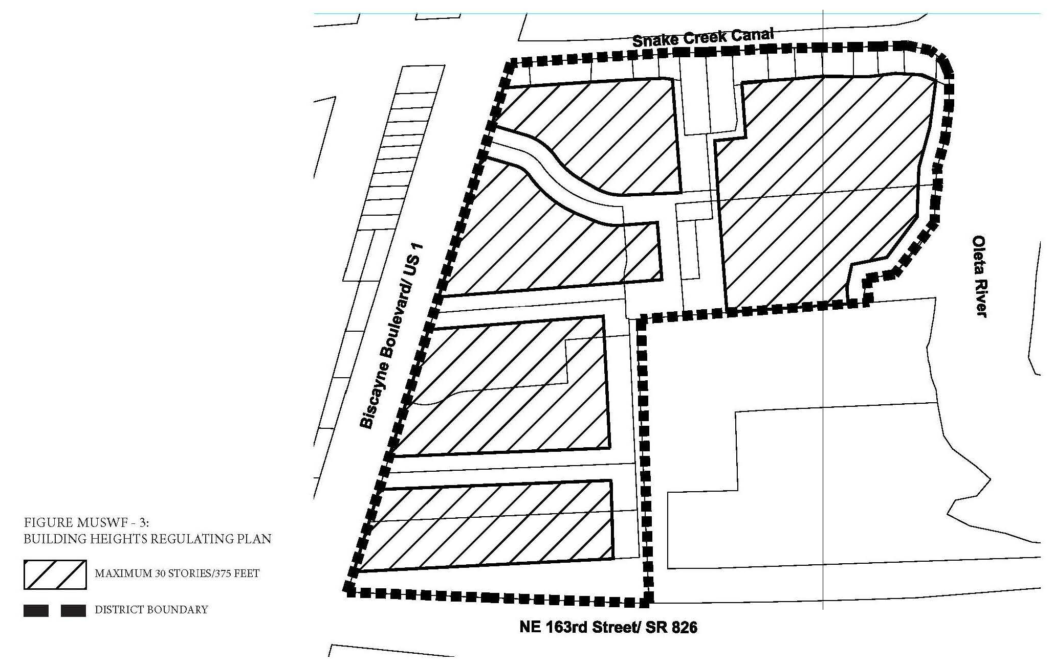
(F)
Permitted Uses.
(1)
Land Use Principles.
a.
The SOUTHERN MU/WF District shall be developed as an identifiable place and shall act as an important center for living, working, shopping and entertainment. The mix of uses within the District, the streets and the architectural character of individual buildings shall blend together to contribute to a coherent identity and sense of place.
b.
Along all streets and on all levels, both non-residential and residential uses shall be permitted.
c.
Buildings fronting the waterfront shall be permitted to have both non-residential and residential uses and shall contain active use along all levels fronting the waterfront.
d.
Buildings fronting Biscayne Boulevard shall contain active use along the ground floor only fronting Biscayne Boulevard.
e.
New residential or Mixed-use development adjacent to the existing electrical substation shall be designed in a manner that the adjacent electrical substation is substantially screened along the adjacent side to reasonably reduce visibility from the public right-of-way along the ground floor. Walls, landscaped buffers and parking areas may be utilized to screen the electrical substation.
(2)
Permitted Use Table MU/SWF-1 includes the principal uses permitted in the SOUTHERN MU/WF along with any required restrictions on such uses, for each of the sub-areas. Principal uses not included in Table MU/SWF-1 are not permitted in the SOUTHERN MU/WF. The SOUTHERN MU/WF shall be subject to the Supplemental Regulations as provided for in Article VIII unless modified herein. Uses which are similar in nature to the uses permitted herein, but not enumerated in higher density use areas, shall be permitted upon a finding by the Community Development Director that the characteristics of, and activities associated with the use are substantially similar to one or more of the listed uses, and will not involve greater impacts than the uses listed in the district and the use will be consistent with the purposes of the applicable zoning district and use areas.
(3)
Special Limited Conditional Uses. See Section 24-177.
(G)
Street Network Connectivity Regulating Plan and Street Standards. Figure MU/SWF-1 shows the approximate location of existing and required new streets needed to create the prescribed network of streets within the SOUTHERN MU/WF. This plan also establishes the hierarchy of the streets within the district. The street standards specified in Section 24-58(J) Mixed-use District shall apply except as modified herein:
(1)
All streets shall be located according to the Street Network Connectivity Regulating Plan for the SOUTHERN MU/WF.
(2)
All Primary Streets shall be required in the same approximate location as shown on the Street Network Connectivity Regulating Plan and may be modified with respect to alignment. No Primary Streets shall be deleted or otherwise vacated or removed.
(3)
Secondary Streets shown on the Street Network Connectivity Regulating Plan are encouraged to promote connectivity and establish a block system within the district. Secondary streets may be modified or deleted for the purpose of assembling parcels for development provided the block pattern conforms to block length requirements.
(H)
Designated Publically Accessible Open Spaces and Urban Greenway Systems Regulating Plan. The designated publically accessible waterfront promenade shall be the following type as shown in the Designated Publically Accessible Open Spaces and Urban Greenways Systems Regulating Plan (Figure MU/SWF-2).
(1)
Urban Greenway Type.
a.
Type UG: Along New Secondary Street (Figure MU/SWF-4).
i.
The minimum width of the greenway shall be seventeen (17) feet on the west side and thirty (30) feet on the east side.
ii.
A minimum of twenty (20%) percent of the length of the portion of the greenway on the west side shall be landscaped and shall consist primarily of sod, ground cover or ornamental grass.
iii.
A minimum of eighty (80%) percent of the length of the portion of the greenway on the east side shall be landscaped and shall consist primarily of sod, ground cover or ornamental grass.
iv.
Tree grates a minimum of five (5) feet by five (5) feet may be utilized in place of the required landscape strip on the west side only.
v.
On the east side:
1.
A wall a minimum of eight (8) feet high shall be provided along the east property line to substantially screen the adjacent electrical substation;
2.
A hedge a minimum of four (4) feet high shall be provided in front of the wall screening the electrical substation;
3.
A minimum of seventy (70%) percent of the surface of the wall above four (4) feet shall be covered with plant material;
4.
A trellis shall be provided a minimum of ten (10) feet wide for pedestrians.
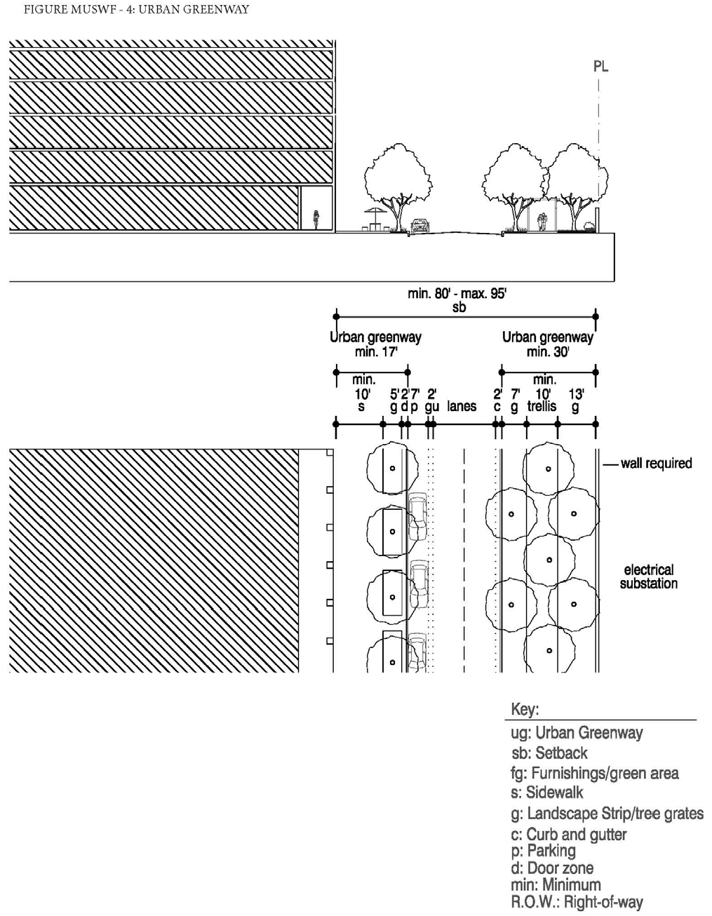
(2)
Waterfront Promenade Type.
a.
Type WP 1a and 1b: Along entire waterfront edge (Figures MU/SWF-5a and 5b).
i.
The minimum width of the waterfront promenade shall be twenty (20) feet.
ii.
A minimum of sixty (60%) percent of the waterfront promenade shall be landscaped and shall consist primarily of sod, ground cover or ornamental grass.
iii.
Tree grates shall not be utilized in place of the required landscape strips.
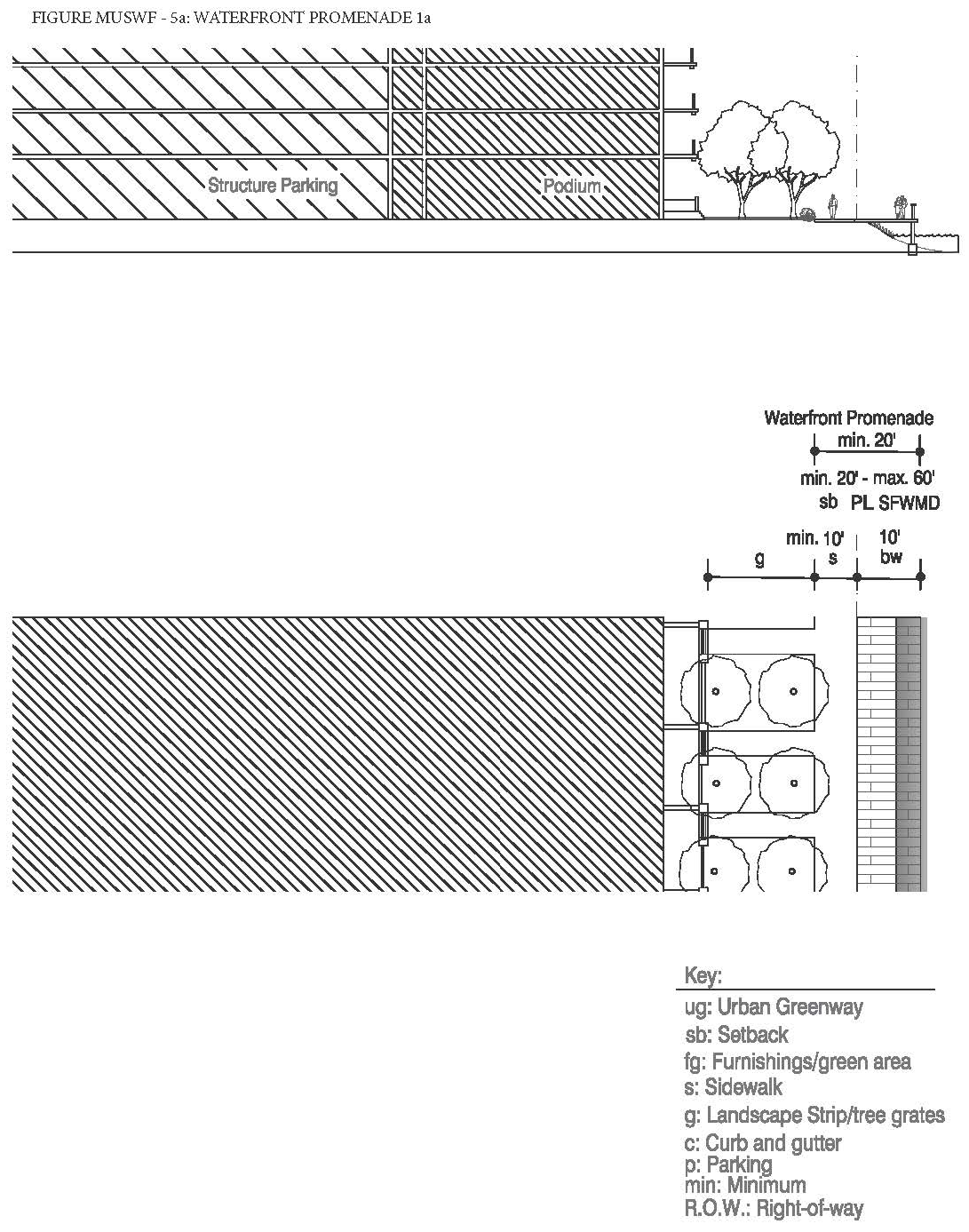
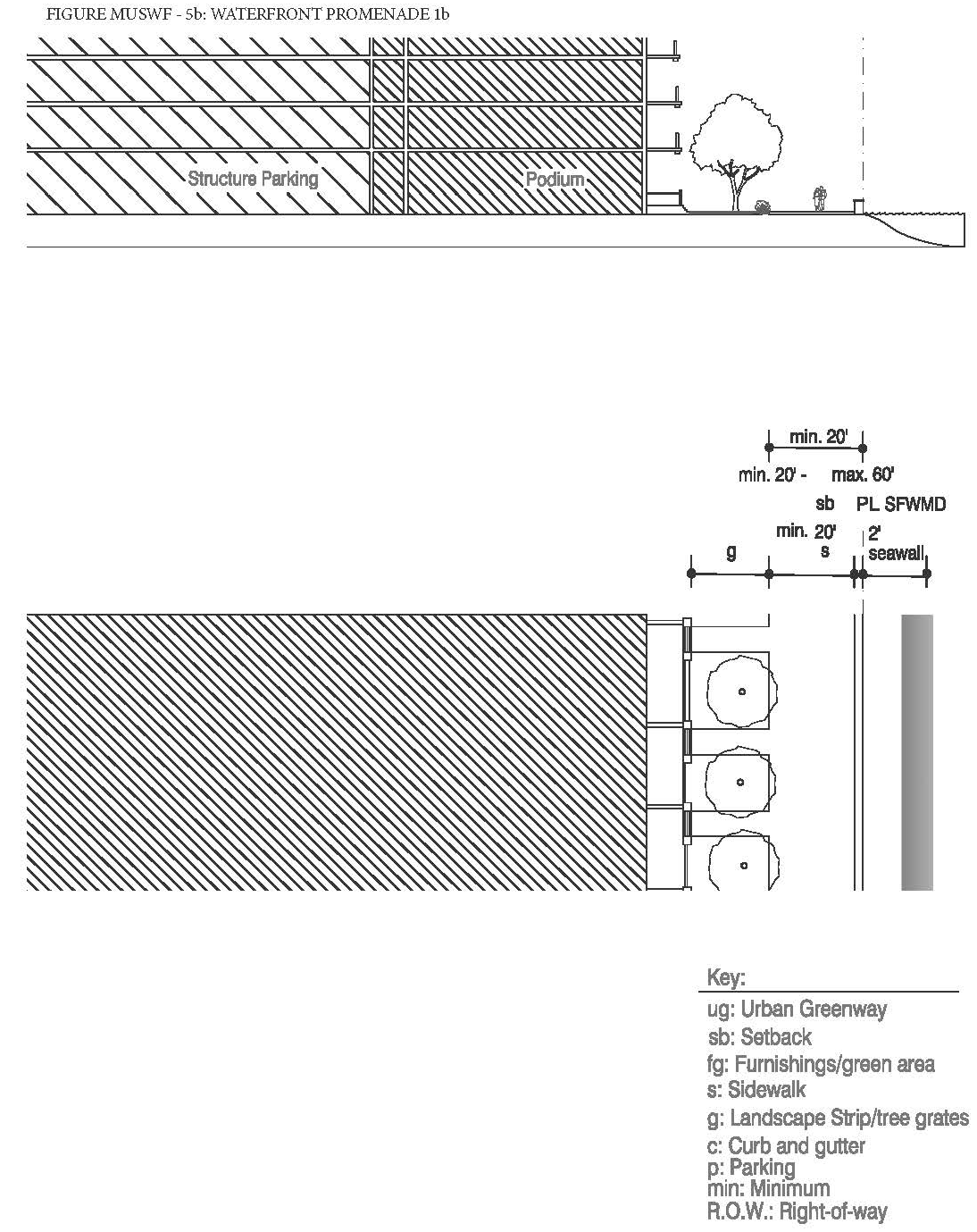
(3)
The designated public urban greenways system and publically accessible waterfront promenades shall be designed to enhance the visual character of the waterfront and specific streets along the urban greenways and ensure pedestrian connectivity by:
a.
Providing tree species that provide continuous shade for a minimum of seventy (70%) percent of the frontage along the urban greenways. Palm trees alone are not acceptable and the maximum spacing of the shade trees shall be thirty (30) feet on center.
b.
Providing street furnishings such as benches, trash receptacles, bike racks, drinking water fountains, etc.
c.
Providing a landscape plan illustrating a coherent design with significant tree species along the urban greenways and waterfront promenade that are distinguishably different from the other streets along the property in terms of color, type and shape.
d.
Tree specifications shall be as per Section 24-58(L).
(I)
Building Heights Regulating Plan and Additional Height Standards. All new and existing development shall comply with the standards found within the Building Heights Regulating Plan as shown in (Figure MU/SWF-3). Table MU/SWF-2 provides a summary of the heights permitted in the district.
(J)
Building Typology and Dimensional Standards.
(1)
Building Typologies. All new buildings shall conform to one (1) of the permitted building typologies as demonstrated in the Building Typology and Placement Regulating Diagrams in Section 24-58 Mixed-use District. The diagrams provide a schematic representation of the various building typologies and demonstrate the required setbacks, lot standards, and profiles of structures. Existing buildings which do not fit a prescribed typology, shall follow the standards required for the Flex building typology. Not all building typologies are permitted in each Mixed-use district. The building typologies permitted in the SOUTHERN MU/WF are listed below in Table MU/SWF-3:
(2)
Setbacks and Building Frontage.
a.
Front and Street Side Setbacks and Building Frontage. Front and Street Side setbacks are determined based on the street the building fronts. Table MU/SWF-4 lists the minimum required front and street side setbacks and building frontage per street type. The interior side and rear setbacks as well as the lot standards shall be as specified per building type in Section 24-58 Mixed-use District.
(K)
On-site Parking Standards.
(1)
All parking within the SOUTHERN MU/WF shall comply with the Access, Circulation, Parking and Loading Standards specified in Section 24-58 Mixed-use District.
(2)
On-site parking shall comply with Table MU/SWF-5. Uses not listed herein shall comply with the parking requirements specified in Article IX.
(3)
Guest parking shall comply with Table MU/SWF-5. Guest parking shall be designated and prominently marked on-site as "Guest Parking" and shall not be restricted in any manner to use by a single tenant, owner, unit, or other user.
(L)
Bicycle Racks and Bicycle Storage Standards. Bicycle racks and storage shall be required as follows:
(1)
Bicycle Racks and Bicycle Storage for Commercial Uses. Commercial developments, excluding hotel uses, shall provide:
a.
Secure bike racks and/or storage at a ratio of one (1) bicycle parking space per every fifteen (15) required parking spaces and
b.
A minimum of one (1) shower and changing facility shall be provided to be available for all tenants and shall be located within the building, or within two hundred (200) feet of the building entrance, for developments greater than fifty thousand (50,000) square feet in gross building area.
(2)
Bicycle Racks and Bicycle Storage for Residential Uses. One (1) bicycle parking space shall be provided per every fifteen (15) required parking spaces. Required residential bicycle parking spaces shall be provided in a secured area, covered from the elements.
(3)
Mixed-Use Developments. Mixed-use developments shall provide secure bicycle parking spaces for both the commercial and residential components of the development as calculated separately pursuant to the requirements of this section.
(M)
Signage Standards. Signage shall comply with the standards in Article XIII except as modified herein.
(1)
Signs affixed to the exterior of a building shall be architecturally compatible with the style, composition, materials, colors, and details of the building, as well as with other signs used on the building or its vicinity.
(2)
Signs shall fit within the existing facade features, shall be confined to signable areas, and shall not interfere with door and window openings, conceal architectural details or obscure the composition of the facade where they are located.
(3)
Whenever possible, signs located on buildings within the same block-face shall be placed at the same height in order to create a unified sign band.
(4)
Wood and painted metal are the preferred materials for under-awning, hanging signs. Flat signs should be framed with raised edges. Wood signs shall use only high-quality exterior grade wood with suitable grade finishes.
(5)
Sign colors should be compatible with the colors of the building façade. A dull or matte finish is recommended for reduction of glare and enhancement of legibility.
(6)
Signs shall be either spot- or backlit with a diffused light source. Spotlighting shall require complete shielding of all light sources, shall be contained within the sign frame, and shall not significantly spill over to other portions of the building or site. Backlighting shall illuminate the letters, characters, or graphics on the sign, but not its background. Warm fluorescent bulbs may be used to illuminate the interior of display cases. Neon signs placed inside the display case shall insure low intensity colors.
(7)
Signs shall be mounted so that the method of installation is concealed. Signs applied to masonry surfaces should be mechanically fastened to mortar joints only and not directly into brick or stone. Drilling to provide electrical service should also follow the same rule.
(8)
Billboards are prohibited.
(N)
Development Approval Conditions.
(1)
Public Services.
a.
The developer shall be required to develop and maintain in perpetuity a single or series of neighborhood parks or plazas within the district, as conceptually shown in the Designated Publically Accessible Open Spaces and Urban Greenway Systems Regulating Plan (Figure MU/SWF-3), for the district. The new parks or plazas shall be publically accessible and shall together combined provide a minimum of fifteen thousand (15,000) square feet of publically accessible open space in the district. In addition, each park or plaza shall be a minimum of five thousand (5,000) square feet in size.
b.
The developer shall be required to develop and maintain in perpetuity a neighborhood park or plaza along the waterfront, as conceptually shown in the Designated Publically Accessible Open Spaces and Urban Greenway Systems Regulating Plan (Figure MU/SWF-3), for the district. The new park or plaza shall be publically accessible and shall be a minimum of twelve thousand (12,000) square feet in size.
c.
The developer shall be required to develop and maintain in perpetuity a publically accessible waterfront promenade, as conceptually shown in the Designated Publically Accessible Open Spaces and Urban Greenway Systems Regulating Plan (Figure MU/SWF-3). The new publically accessible waterfront promenade shall extend along the entire site boundary edge adjacent to the water.
d.
The developer shall be required to provide streetscape improvements generally in accordance with the Street Network Connectivity Regulating Plan and Street Standards.
(O)
Development Permit Review Procedures. The following development permit review procedure will apply to this district:
(1)
The review procedures set out in Article XV and Section 24-171 (Concurrency) will apply within this district.
(2)
Preapplication Conference: For those development permit requests that require a Pre-Application Conference, the specific issues identified below must be reviewed by the Applicant and addressed with staff at the Preapplication Conference:
(a)
Appropriate screening and residential views related to the electrical substation, and public access to the waterfront.
(b)
In addition to the submittal requirements in Article XV and Section 24-171 (Concurrency), the required plans submitted for review for the Pre-Application conference shall demonstrate the Applicant's general approach to comply with the requirements noted above and shown on the MU/SWF District's:
(1)
Sub-Areas Regulating Plan.
(2)
Street Network and Connectivity Regulating Plan.
(3)
Designated Publically Accessible Open Spaces and Urban Greenways Regulating Plan.
(4)
Building Heights Regulating Plan.
(5)
Building Typology.
(3)
Applications that include a development agreement shall be subject to the additional notice and hearings set forth in Article XIX.
(Ord. No. 2015-5, § 2(Exh. A), 3-17-15; Ord. No. 2016-6, § 2, 7-5-16; Ord. No. 2017-12, § 3, 1-16-18; Ord. No. 2018-6, § 2, 5-24-18; Ord. No. 2018-7, § 3, 6-19-18; Ord. No. 2024-02, § 3, 4-16-24)
Editor's note— Ord. No. 2015-5, § 2(Exh. A), adopted March 17, 2015, repealed the former § 24-58.5, and enacted a new § 24-58.5 as set out herein. The former § 24-58.5 pertained to supplemental regulations, and derived from Ord. No. 2002-20, § 2, adopted Nov. 19, 2002; and Ord. No. 2008-4, § 2, adopted March 4, 2008.
Sec. 24-58.6 - Northern Mixed-Use Waterfront District (MU/NWF).
(A)
Purpose and Intent. The purpose of these regulations is to implement policies that guide the design of development within the Northern Mixed-Use Waterfront District (NORTHERN MU/WF). The intent of the NORTHERN MU/WF district is to establish a Mixed-use area that provides for multi-family housing that enables residents to live on the waterfront. Providing new publically accessible open spaces as well as public access to and beautification of the waterfront are primary principals of the NORTHERN MU/WF district. Development patterns shall generally reflect planning and design principles such as walkable neighborhoods oriented around the five-minute walk. Additionally, there shall be primary orientation towards the waterfront, integration of housing, employment, shopping and recreation at the neighborhood level. This purpose will be fulfilled by:
(1)
Ensuring high quality, architecturally compatible, consistently landscaped development throughout the District;
(2)
Ensuring that new development or redevelopment projects enhance the visual character of Biscayne Boulevard in terms of massing and scale;
(3)
Stimulating neighborhood commercial and retail activities;
(4)
Encouraging people to reside in the District;
(5)
Ensuring public access to and the beautification of the waterfront; and
(6)
Ensuring new publically accessible open space.
(B)
District Boundaries. The development standards shall be utilized for properties located within the Northern Mixed-Use Waterfront District (NORTHERN MU/WF).
(C)
Administration. In order to maintain predictability in development, Planned Unit Developments (PUDs) shall be prohibited. Variances from the dimensional requirements or waivers from any other criterion may be approved by the applicable review board for projects, provided that the applicant meets the standards pertaining to such variance or waiver. The applicable board shall hear and decide appeals where it is alleged there is an error in any order, requirement, decision, or determination made by the Director of the Community Development Department or his/her designee in the enforcement of these development regulations.
(D)
General Development Standards.
(1)
In addition to the standards contained herein, Section 24-58 Mixed-Use (MU) district standards shall be applicable to development within the Northern Mixed-Use Waterfront District (NORTHERN MU/WF). The applicable regulations contained in Articles IV, VIII, IX, X, XI, XII, XIII, and XIV shall also apply, except as modified herein and may be further modified by the City Manager or his/her designee to meet the purpose and intent of the Northern Mixed-Use Waterfront District (NORTHERN MU/WF).
(2)
The provisions of the NORTHERN MU/WF code, when in conflict, shall take precedence over the existing zoning and land development regulations.
(3)
The provisions of the building code, when in conflict, shall take precedence over the provisions of the NORTHERN MU/WF code.
(4)
Existing buildings may be destroyed or removed, however they must be replaced according to the NORTHERN MU/WF regulations. Existing buildings may not be destroyed or removed unless they are to be replaced according to NORTHERN MU/WF regulations and only after a building permit is issued.
(5)
Existing buildings and uses within the NORTHERN MU/WF area, which are legally established but do not conform to provisions of the NORTHERN MU/WF regulations as of the effective date of these regulations shall be considered nonconforming and may not be replaced, restored, or modified, except in conformity with the regulation for nonconformities contained in Article IV of this chapter. When a nonconforming structure is destroyed by windstorm, flood, or nature disaster, it may be replaced by a new structure of the same or lesser size, and reoccupied by the same use, if construction of such structure is commenced within eighteen (18) months of destruction.
(6)
Proposed development with site plan approved under the previous zoning regulations shall commence construction within the time frame allotted in the development order or site plan approval letter. If commencement of construction does not occur within the allotted time frame, the site plan approval shall automatically expire without further action by the City.
(E)
Regulating Plans and Diagrams. The NORTHERN MU/WF is governed by a series of regulating plans and diagrams. The Regulating Plans and Diagrams demonstrate NORTHERN MU/WF development standards in both words and diagrams, and include maps designating the locations where the various standards apply. Unless otherwise noted, all development shall be in compliance with the Regulating Plans and Diagrams contained herein and with the Building Typology and Placement Regulating Diagrams in Section 24-58 Mixed-Use (MU) district. The Regulating Plans and Diagrams for the NORTHERN MU/WF include the following:
(1)
The Street Network Connectivity Regulating Plan, which shows the approximate location of existing and required new streets needed to create the prescribed network of streets within the NORTHERN MU/WF. This Plan also establishes the hierarchy of the streets as shown in Figure MU/NWF-1.
(2)
The Designated Publically Accessible Open Spaces and Urban Greenway Systems Regulating Plan, which designates the approximate location of the required publically accessible open spaces, urban greenway system and publically accessible waterfront promenades as shown in Figure MU/NWF-2.
(3)
The Building Heights Regulating Plan, which establishes the maximum building height as shown in Figure MU/NWF-3.
Figure MU/NWF-1: Street Network Connectivity Regulating Plan
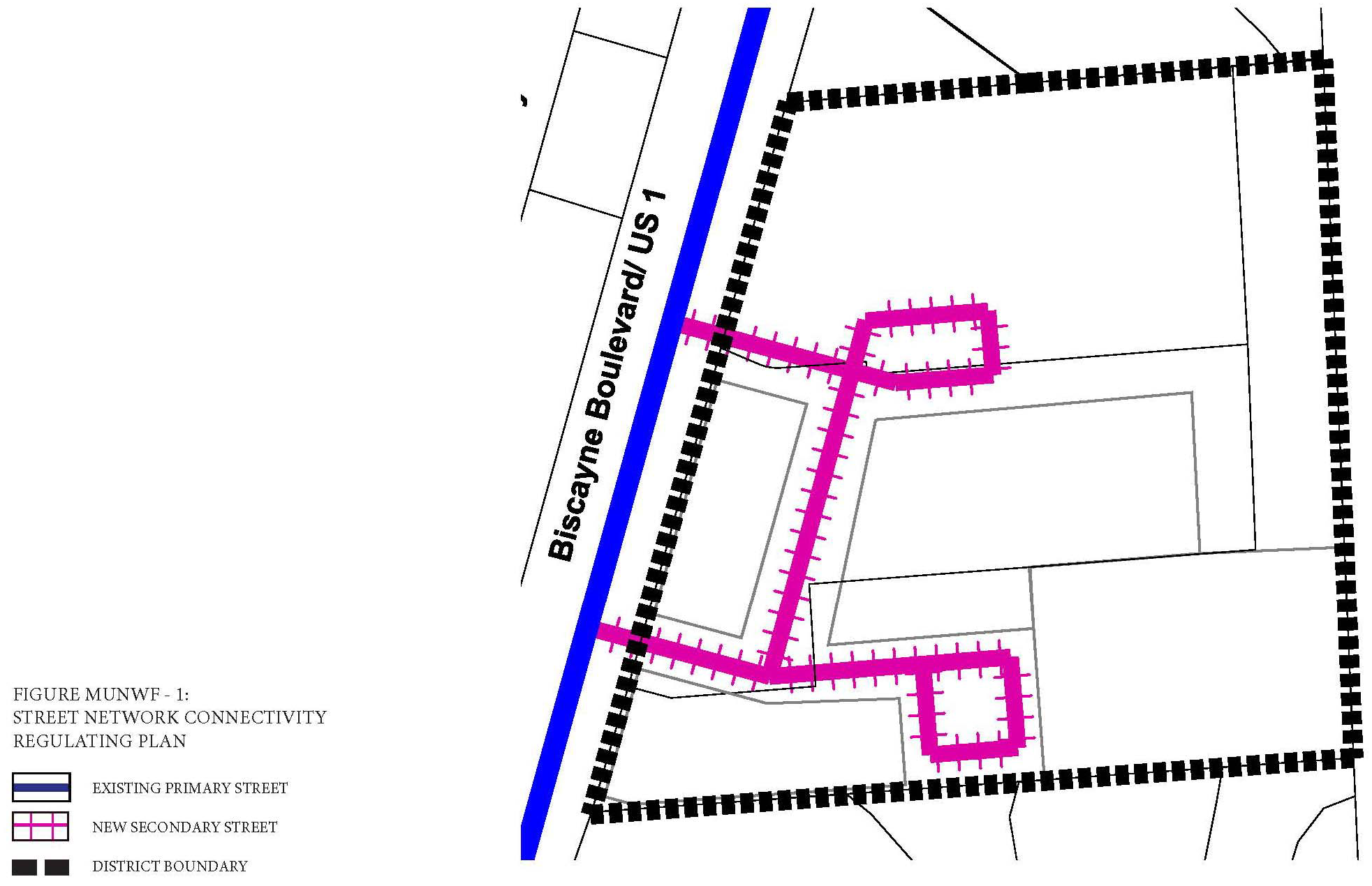
Figure MU/NWF-2: Designated Publically Accessible Open Spaces and Greenway Systems
Regulating Plan
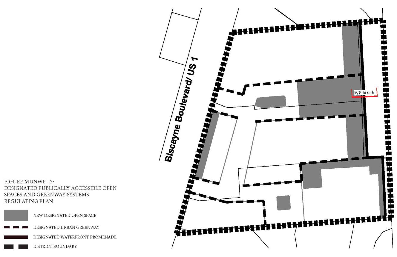
Figure MU/NWF-3: Building Heights Connectivity Regulating Plan
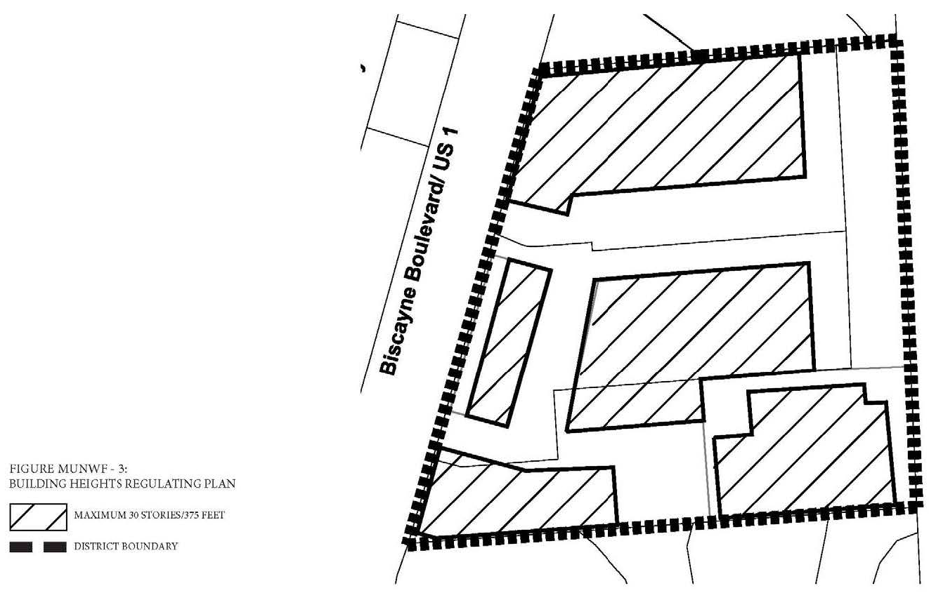
(F)
Permitted Uses.
(1)
Land Use Principles.
a.
The NORTHERN MU/WF District shall be developed as an identifiable place and shall act as an important center for living, working, shopping and entertainment. The mix of uses within the District, the streets and the architectural character of individual buildings shall blend together to contribute to a coherent identity and sense of place.
b.
Along all streets and on all levels, both non-residential and residential uses shall be permitted.
c.
Buildings fronting the waterfront shall be permitted to have both non-residential and residential uses and shall contain active use along all levels fronting the waterfront.
d.
Buildings fronting Biscayne Boulevard shall contain active use along the ground floor only fronting Biscayne Boulevard.
(2)
Permitted Use Table MU/NWF-1 includes the principal uses permitted in the NORTHERN MU/WF along with any required restrictions on such uses, for each of the sub-areas. Principal uses not included in Table MU/NWF-1 are not permitted in the NORTHERN MU/WF. The NORTHERN MU/WF shall be subject to the Supplemental Regulations as provided for in Article VIII unless modified herein. Uses which are similar in nature to the uses permitted herein, but not enumerated in higher density use areas, shall be permitted upon a finding by the Community Development Director that the characteristics of, and activities associated with the use are substantially similar to one or more of the listed uses, and will not involve greater impacts than the uses listed in the district and the use will be consistent with the purposes of the applicable zoning district and use areas.
(3)
Special Limited Conditional Uses. See Section 24-177.
(G)
Street Network Connectivity Regulating Plan and Street Standards. Figure MU/NWF-1 shows the approximate location of existing and required new streets needed to create the prescribed network of streets within the NORTHERN MU/WF. This plan also establishes the hierarchy of the streets within the district. The street standards specified in Section 24-58(J) Mixed-Use District shall apply except as modified herein:
(1)
All streets shall be located according to the Street Network Connectivity Regulating Plan for the NORTHERN MU/WF.
(2)
All Primary Streets shall be required in the same general location as shown on the Street Network Connectivity Regulating Plan and may be modified with respect to alignment. No Primary Streets shall be deleted or otherwise vacated or removed.
(3)
Secondary Streets shown on the Street Network Connectivity Regulating Plan are encouraged to promote connectivity and establish a block system within the district. Secondary streets may be modified or deleted for the purpose of assembling parcels for development provided the block pattern conforms to block length requirements.
(H)
Designated Publically Accessible Open Spaces and Urban Greenway Systems Regulating Plan. The designated publically accessible waterfront promenade shall be the following type as generally shown in the Designated Publically Accessible Open Spaces and Urban Greenways Systems Regulating Plan (Figure MU/NWF-2).
(1)
Waterfront Promenade Type.
a.
Type WP 1a and 1b: Along east side of property (Figures MU/NWF-4a and 4b).
i.
The minimum width of the waterfront promenade shall be forty-five (45) feet.
ii.
A minimum of sixty (60%) percent of the waterfront promenade shall be landscaped and shall consist primarily of sod, ground cover or ornamental grass.
iii.
Tree grates shall not be utilized in place of the required landscape strips.
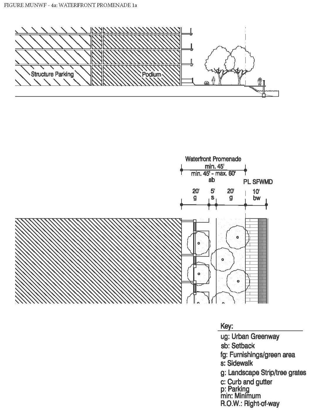
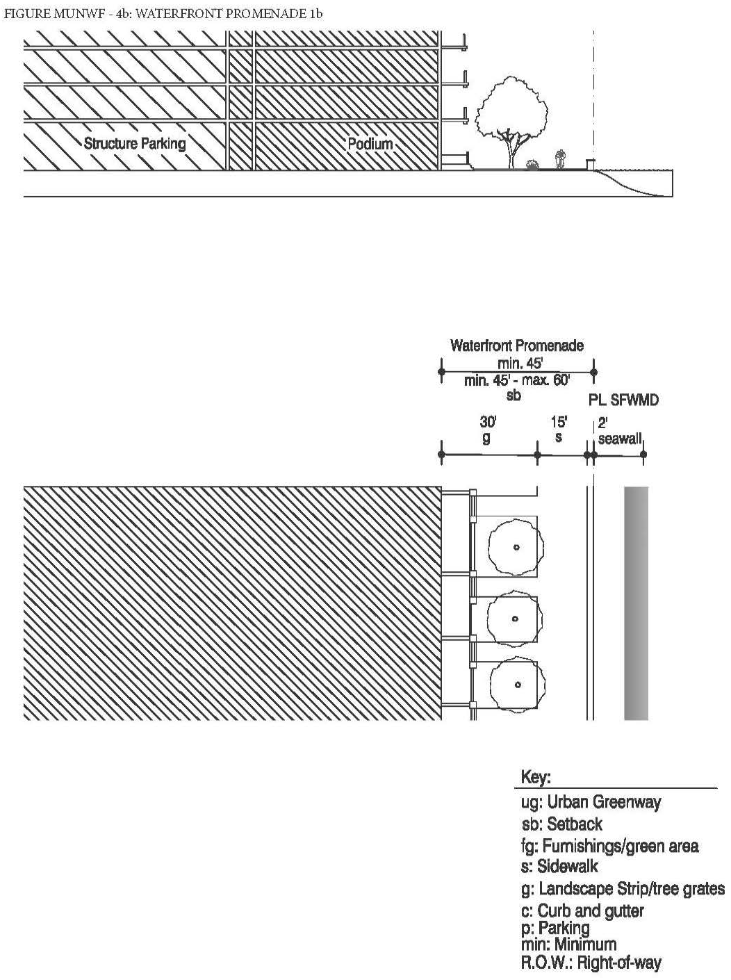
(2)
The designated publically accessible waterfront promenade shall be designed to enhance the visual character of the waterfront and ensure pedestrian connectivity by:
a.
Providing tree species that provide continuous shade for a minimum of seventy (70%) percent of the frontage along the urban greenways. Palm trees alone are not acceptable and the maximum spacing of the shade trees shall be thirty (30) feet on center.
b.
Providing street furnishings such as benches, trash receptacles, bike racks, drinking water fountains, etc.
c.
Providing a landscape plan illustrating a coherent design with significant tree species along the publically accessible waterfront promenade that are distinguishably different from the other streets along the property in terms of color, type and shape.
d.
Tree specifications shall be as per Section 24-58(L).
(I)
Building Heights Regulating Plan and Additional Height Standards. All new and existing development shall comply with the standards found within the Building Heights Regulating Plan as shown in (Figure MU/NWF-3). Table MU/NWF-2 provides a summary of the heights permitted in the district.
(J)
Building Typology and Dimensional Standards.
(1)
Building Typologies. All new buildings shall conform to one (1) of the permitted building typologies as demonstrated in the Building Typology and Placement Regulating Diagrams in Section 24-58 Mixed-use District. The diagrams provide a schematic representation of the various building typologies and demonstrate the required setbacks, lot standards, and profiles of structures. Existing buildings which do not fit a prescribed typology, shall follow the standards required for the Flex building typology. Not all building typologies are permitted in each mixed-use district. The building typologies permitted in the NORTHERN MU/WF are listed below in Table MU/NWF-3.
(2)
Setbacks and Building Frontage.
a.
Front and Street Side Setbacks and Building Frontage. Front and Street Side setbacks are determined based on the street the building fronts. Table MU/NWF-4 lists the minimum required front and street side setbacks and building frontage per street type. The interior side and rear setbacks as well as the lot standards shall be as specified per building type in Section 24-58 Mixed-use District.
(K)
On-site Parking Standards.
(1)
All parking within the NORTHERN MU/WF shall comply with the Access, Circulation, Parking and Loading Standards specified in Section 24-58 Mixed-use District.
(2)
On-site parking shall comply with Table MU/NWF-5. Uses not listed herein shall comply with the parking requirements specified in Article IX.
(3)
Guest parking shall comply with Table MU/NWF-5. Guest parking shall be designated and prominently marked on-site as "Guest Parking" and shall not be restricted in any manner to use by a single tenant, owner, unit, or other user.
(L)
Bicycle Racks and Bicycle Storage Standards. Bicycle racks and storage shall be required as follows:
(1)
Bicycle Racks and Bicycle Storage for Commercial Uses. Commercial developments, excluding hotel uses, shall provide:
a.
Secure bike racks and/or storage at a ratio of one (1) bicycle parking space per every fifteen (15) required parking spaces; and
b.
A minimum of one (1) shower and changing facility shall be provided to be available for all tenants and shall be located within the building, or within two hundred (200) feet of the building entrance, for developments greater than fifty thousand (50,000) square feet in gross building area.
(2)
Bicycle Racks and Bicycle Storage for Residential Uses. One (1) bicycle parking space shall be provided per every fifteen (15) required parking spaces. Required residential bicycle parking spaces shall be provided in a secured area, covered from the elements.
(3)
Mixed-Use Developments. Mixed-use developments shall provide secure bicycle parking spaces for both the commercial and residential components of the development as calculated separately pursuant to the requirements of this section.
(M)
Signage Standards. Signage shall comply with the standards in Article XIII except as modified herein.
(1)
Signs affixed to the exterior of a building shall be architecturally compatible with the style, composition, materials, colors, and details of the building, as well as with other signs used on the building or its vicinity.
(2)
Signs shall fit within the existing facade features, shall be confined to signable areas, and shall not interfere with door and window openings, conceal architectural details or obscure the composition of the facade where they are located.
(3)
Whenever possible, signs located on buildings within the same block-face shall be placed at the same height in order to create a unified sign band.
(4)
Wood and painted metal are the preferred materials for under-awning, hanging signs. Flat signs should be framed with raised edges. Wood signs shall use only high-quality exterior grade wood with suitable grade finishes.
(5)
Sign colors should be compatible with the colors of the building façade. A dull or matte finish is recommended for reduction of glare and enhancement of legibility.
(6)
Signs shall be either spot- or backlit with a diffused light source. Spotlighting shall require complete shielding of all light sources, shall be contained within the sign frame, and shall not significantly spill over to other portions of the building or site. Backlighting shall illuminate the letters, characters, or graphics on the sign, but not its background. Warm fluorescent bulbs may be used to illuminate the interior of display cases. Neon signs placed inside the display case shall insure low intensity colors.
(7)
Signs shall be mounted so that the method of installation is concealed. Signs applied to masonry surfaces should be mechanically fastened to mortar joints only and not directly into brick or stone. Drilling to provide electrical service should also follow the same rule.
(8)
Billboards are prohibited.
(N)
Development Approval Conditions.
(1)
Public Services.
a.
The developer shall be required to develop and maintain in perpetuity a single or series of neighborhood parks or plazas along the waterfront, as conceptually located and shown in the Designated Publically Accessible Open Spaces and Urban Greenway Systems Regulating Plan (Figure MU/NWF-3), for the district. The new parks or plazas shall be publically accessible and shall together combined provide a minimum of fifteen thousand (15,000) square feet of publically accessible open space in the district. In addition, each park or plaza shall be a minimum of five thousand (5,000) square feet in size.
b.
The developer shall be required to develop and maintain in perpetuity a publically accessible waterfront promenade, as generally located and shown in the Designated Publically Accessible Open Spaces and Urban Greenway Systems Regulating Plan (Figure MU/NWF-3). The new publically accessible waterfront promenade shall generally extend along the entire eastern site boundary edge adjacent to the water.
c.
The developer shall be required to provide streetscape improvements generally in accordance with the Street Network Connectivity Regulating Plan and Street Standards.
(O)
Development Permit Review Procedures. The following development permit review procedure will apply to this district:
(1)
The review procedures set out in Article XV and Section 24-171 (Concurrency) will apply within this district.
(2)
Preapplication Conference: For those development permit requests that require a Pre-Application Conference, the specific issues identified below must be reviewed by the Applicant and addressed with staff at the Preapplication Conference:
(a)
Public access to the waterfront.
(b)
In addition to the submittal requirements in Article XV and Section 24-171 (Concurrency), the required plans submitted for review for the Pre-Application conference shall demonstrate the Applicant's general approach to comply with the requirements noted above and shown on the MU/NWF District's:
(1)
Sub-Areas Regulating Plan.
(2)
Street Network and Connectivity Regulating Plan.
(3)
Designated Publically Accessible Open Spaces and Urban Greenways Regulating Plan.
(4)
Building Heights Regulating Plan.
(5)
Building Typology.
(3)
Applications that include a development agreement shall be subject to the additional notice and hearings set forth in Article XIX.
(Ord. No. 2015-5, § 2(Exh. A), 3-17-15; Ord. No. 2016-6, § 2, 7-5-16; Ord. No. 2017-12, § 3, 1-16-18; Ord. No. 2018-6, § 2, 5-24-18; Ord. No. 2018-7, § 3, 6-19-18; Ord. No. 2024-02, § 3, 4-16-24)
Sec. 24-58.7 - Eastern Mixed-Use Waterfront District (MU/EWF).
(A)
Purpose and Intent. The purpose of these regulations is to implement policies that guide the design of development within the Eastern Mixed-Use Waterfront District (EASTERN MU/WF). The intent of the EASTERN MU/WF district is to establish a Mixed-use area that serves as the center of activity for the entire Eastern Shores neighborhood. The district shall provide for multi-family housing that enables residents to live on the waterfront. Providing new publicly accessible open spaces as well as public access to and beautification of the waterfront are primary principals of the EASTERN MU/WF district. The district shall also improve the fire rescue station and provide a police sub-station to enhance the public services in the Eastern Shores neighborhood. Development patterns shall generally reflect planning and design principles that reduce traffic by designing a walkable neighborhood oriented around the five-minute walk. Additionally, there shall be primary orientation towards the waterfront, integration of housing, employment, shopping and recreation at the neighborhood level. This purpose will be fulfilled by:
(1)
Ensuring high quality, architecturally compatible, consistently landscaped development throughout the District;
(2)
Ensuring that new development or redevelopment projects enhance the visual character of the District and does not create incompatibility with the adjacent single family properties in terms of massing and scale;
(3)
Encouraging the development of a neighborhood main street with pleasant shopping areas and attractive pedestrian spaces;
(4)
Stimulating neighborhood commercial and retail activities;
(5)
Encouraging people to reside in the District;
(6)
Ensuring the mitigation of traffic issues such as providing additional access points into the site, where feasible;
(7)
Ensuring public access to and the beautification of the waterfront;
(8)
Ensuring the development and maintenance of new publicly accessible open space; and
(9)
Retaining and enhancing the existing rescue station and addition of a police substation.
(B)
District Boundaries. The development standards shall be utilized for properties located within the Eastern Mixed-Use Waterfront District (EASTERN MU/WF).
(C)
Administration. In order to maintain predictability in development, Planned Unit Developments (PUDs) shall be prohibited. Variances from the dimensional requirements or waivers from any other criterion may be approved by the applicable review board for projects, provided that the applicant meets the standards pertaining to such variance or waiver. The applicable board shall hear and decide appeals where it is alleged there is an error in any order, requirement, decision, or determination made by the Director of the Community Development Department or his/her designee in the enforcement of these development regulations.
(D)
General Development Standards.
(1)
In addition to the standards contained herein, Section 24-58 Mixed-Use (MU) district standards shall be applicable to development within the Eastern Mixed-Use Waterfront District (EASTERN MU/WF). The applicable regulations contained in Articles IV, VIII, IX, X, XI, XII, XIII, and XIV shall also apply, except as modified herein and may be further modified by the City Manager or his/her designee to meet the purpose and intent of the Eastern Mixed-Use Waterfront District (EASTERN MU/WF).
(2)
The provisions of the EASTERN MU/WF code, when in conflict, shall take precedence over the existing zoning and land development regulations.
(3)
The provisions of the building code, when in conflict, shall take precedence over the provisions of the EASTERN MU/WF code.
(4)
Existing buildings may be destroyed or removed, however they must be replaced according to the EASTERN MU/WF regulations. Existing buildings may not be destroyed or removed unless they are to be replaced according to EASTERN MU/WF regulations and only after a building permit is issued.
(5)
Existing buildings and uses within the EASTERN MU/WF area, which are legally established but do not conform to provisions of the EASTERN MU/WF regulations as of the effective date of these regulations shall be considered nonconforming and may not be replaced, restored, or modified, except in conformity with the regulation for nonconformities contained in Article IV of this chapter. When a nonconforming structure is destroyed by windstorm, flood, or nature disaster, it may be replaced by a new structure of the same or lesser size, and reoccupied by the same use, if construction of such structure is commenced within eighteen (18) months of destruction.
(6)
Proposed development with site plan approved under the previous zoning regulations shall commence construction within the time frame allotted in the development order or site plan approval letter. If commencement of construction does not occur within the allotted time frame, the site plan approval shall automatically expire without further action by the City.
(E)
Regulating Plans and Diagrams. The EASTERN MU/WF is governed by a series of regulating plans and diagrams. The Regulating Plans and Diagrams demonstrate EASTERN MU/WF development standards in both words and diagrams, and include maps designating the locations where the various standards apply. Unless otherwise noted, all development shall be in compliance with the Regulating Plans and Diagrams contained herein and with the Building Typology and Placement Regulating Diagrams in Section 24-58 Mixed-Use (MU) district. The Regulating Plans and Diagrams for the EASTERN MU/WF include the following:
(1)
The Sub-areas Regulating Plan, which divides the EASTERN MU/WF into three (3) Sub-areas: Core, Transition and Edge. The highest density and intensity within the Eastern MU/WF shall be allocated to the Core Sub-area, a mixed-use area at the eastern end of the district. The densities and intensities shall then gradually decrease from the Core to the Transition Sub-area where mixed-uses are still permitted and then further decrease to the Edge Sub-area which is adjacent to existing low density residential. The Sub-areas Regulating Plan is shown in Figure MU/EWF-1.
(2)
The Street Network Connectivity Regulating Plan, which shows the approximate location of existing and required new streets needed to create the prescribed network of streets within the EASTERN MU/WF. This Plan also establishes the hierarchy of the streets as shown in Figure MU/EWF-2.
(3)
The Designated Publicly Accessible Open Spaces and Urban Greenway Systems Regulating Plan, which designates the approximate location of the required publicly accessible open spaces, urban greenway system and publicly accessible waterfront promenades as shown in Figure MU/EWF-3.
(4)
The Building Heights Regulating Plan, which establishes the maximum building height as shown in Figure MU/EWF-4.
Figure MU/EWF-1: Sub-Areas Regulating Plan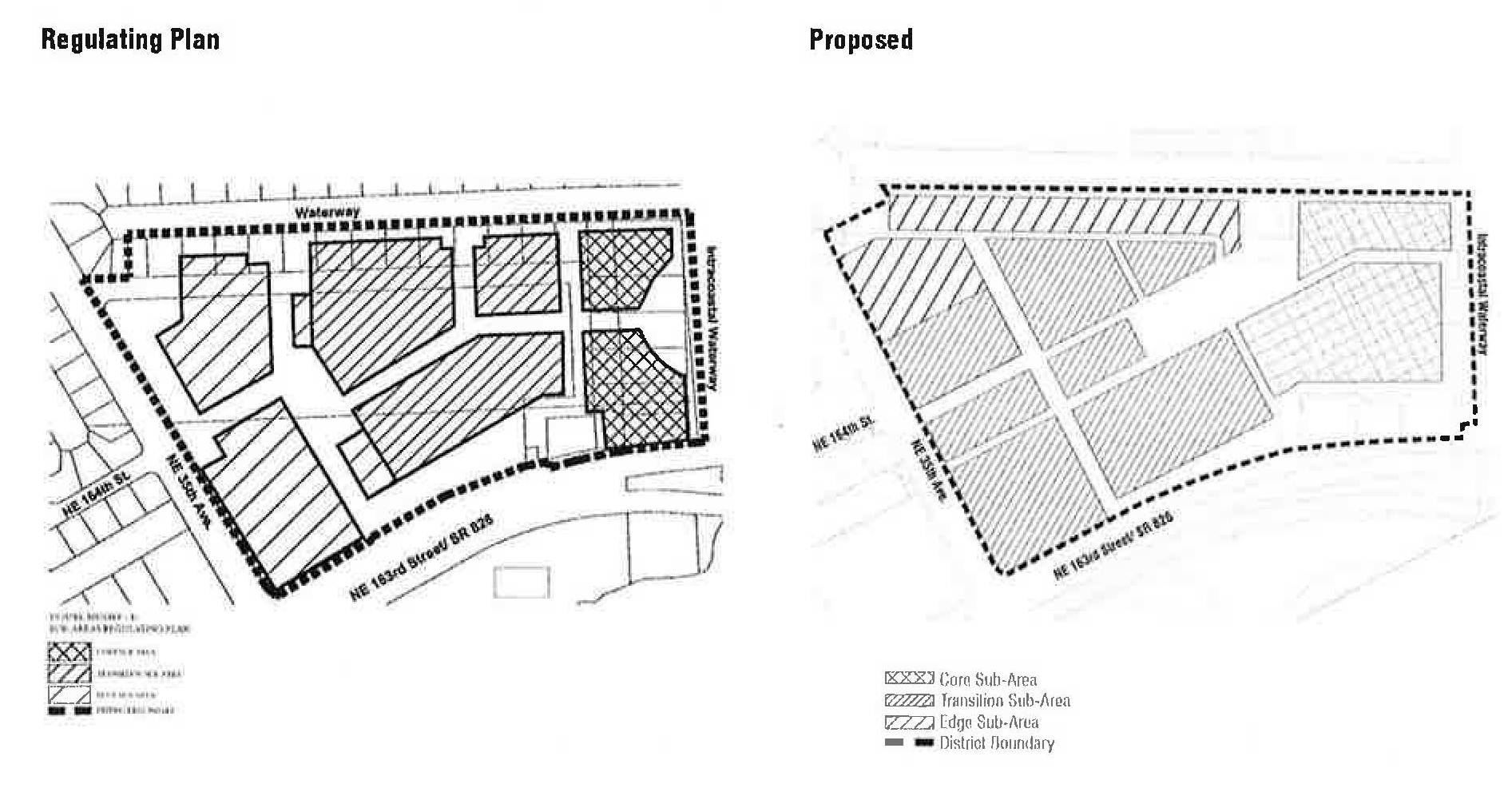
Figure MU/EWF-2: Street Network Connectivity Regulating Plan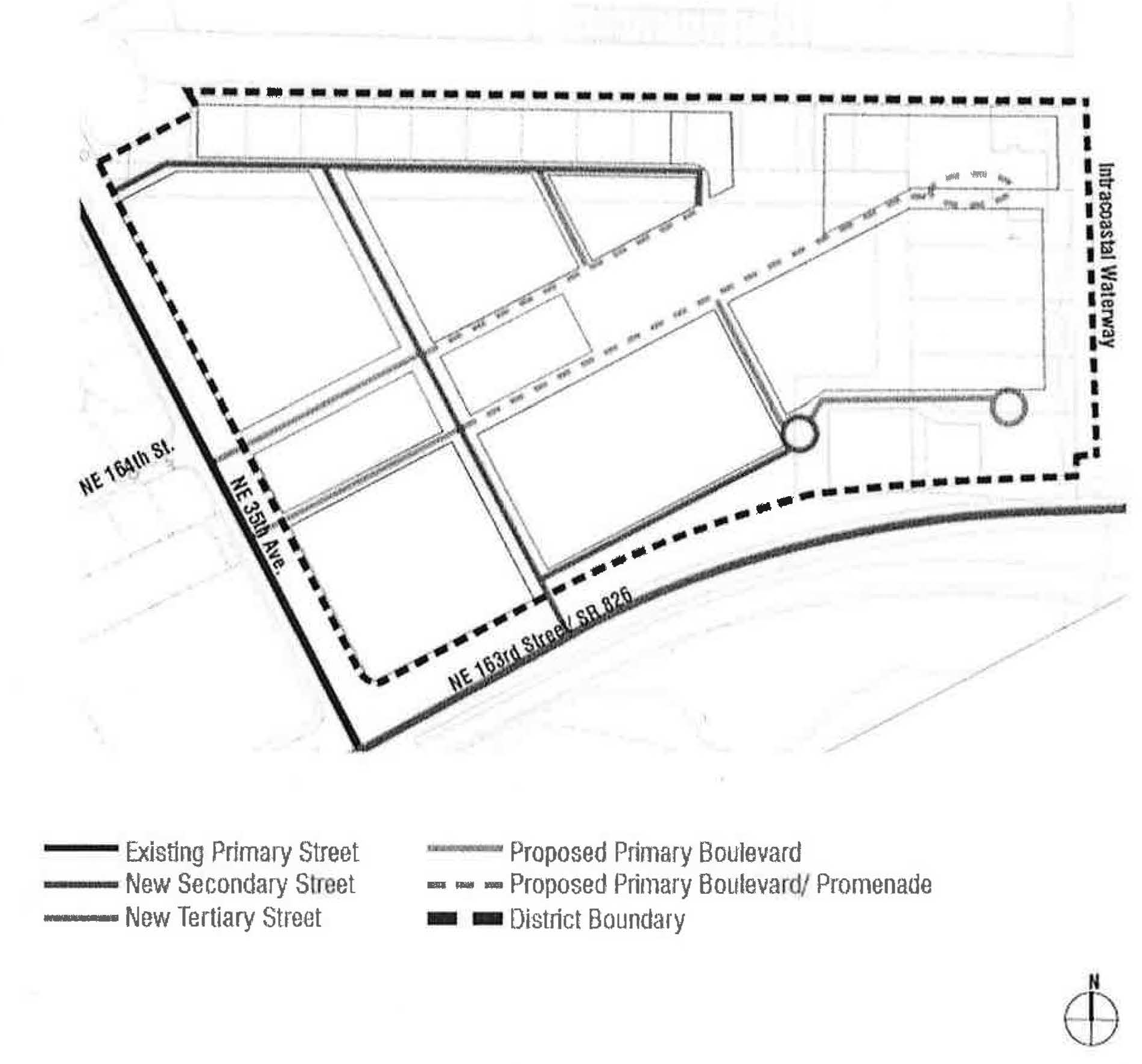
Figure MU/EWF-3: Designated Publicly Accessible Open Spaces and Greenway Systems Regulating
Plan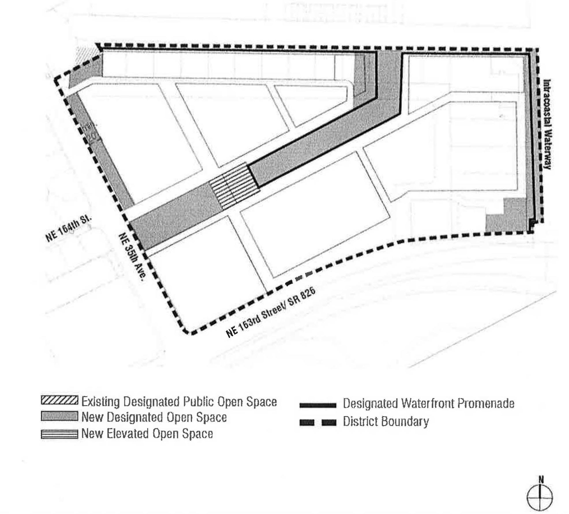
Figure MU/EWF-4: Building Heights Regulating Plan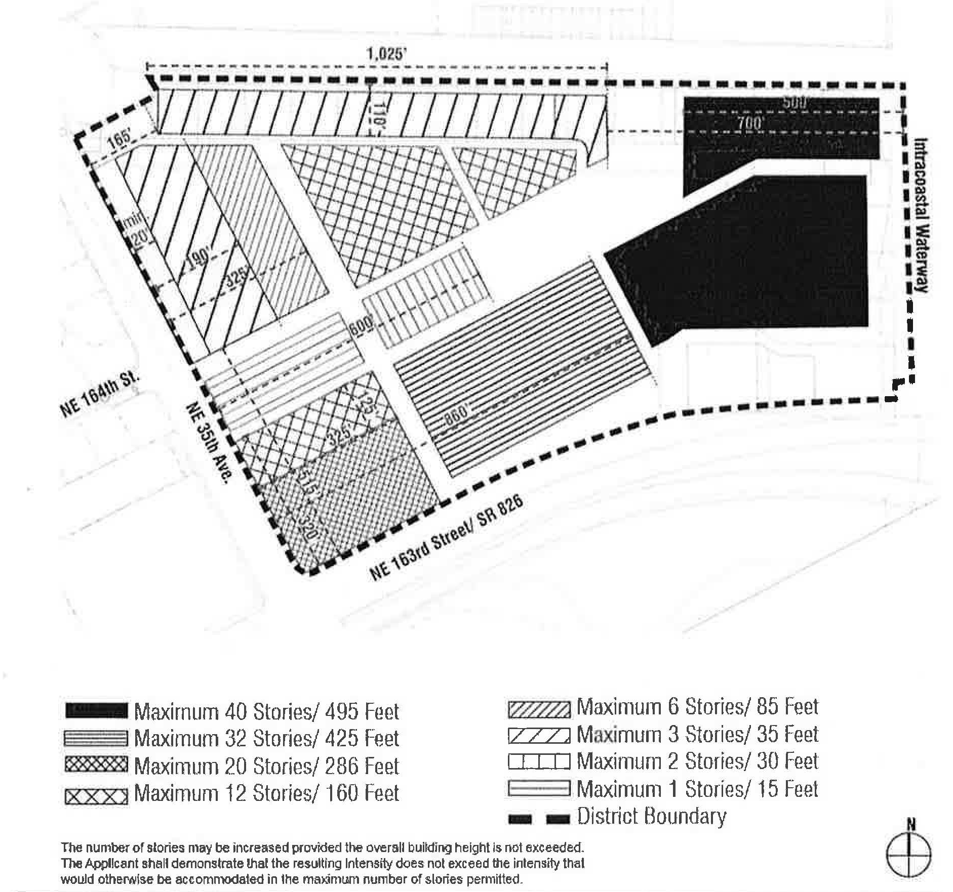
(F)
Sub-Areas Regulating Plan. All new and existing development shall review first their location within the Sub-Areas Regulating Plan as shown in Figure MU/EWF-1.
(G)
Permitted Uses.
(1)
Land Use Principles.
a.
The EASTERN MU/WF District shall be developed as an identifiable place and shall act as an important center for living, working, shopping and entertainment. The mix of uses within the District, the streets and the architectural character of individual buildings shall blend together to contribute to a coherent identity and sense of place.
b.
Along all streets and on all levels, both non-residential and residential uses shall be permitted.
c.
Buildings fronting the waterfront shall be permitted to have both non-residential and residential uses and shall contain active use along all levels fronting the waterfront.
d.
Buildings fronting NE 35th Avenue, north of NE 164th Street, shall contain active use along all levels fronting NE 35th Avenue.
e.
Buildings fronting NE 35th Avenue, south of NE 164th Street, shall contain active use for a minimum of twenty-five (25%) percent of the building frontage along the ground floor only fronting NE 35th Avenue.
f.
New residential or mixed-use development adjacent to the existing electrical substation shall be designed in a manner that the adjacent electrical substation is substantially screened along the adjacent side to reasonably reduce visibility from the public right-of-way along the ground floor. Walls, landscaped buffers and parking areas may be utilized to screen the electrical substation.
g.
Where a proposed development is adjacent to NE 35th Avenue, the proposed development shall:
i.
Create a fifty-foot-wide landscaped buffer within the proposed project property along the property line, between the proposed development and that portion of NE 35th Avenue as specified in the Designated Publicly Accessible Open Space and Greenways Systems Regulating Plan Figure MU/EWF-3. The landscaped buffer shall not contain any structures, except connecting driveways or roads to the development, liner buildings, sidewalks, bike paths, transit shelters or similar; and
ii.
There shall be a Transitional Area adjacent to NE 35th Avenue. The Transitional Area shall include the fifty-foot-wide landscaped buffer. The Transitional Area shall extend for the length of the portion of the proposed development that lies adjacent to and directly facing NE 35th Avenue. The depth of the Transitional Area shall be as specified in the Building Heights Regulating Plan Figure MU/EWF-4. Any road, canal, waterway, park or alley between NE 35h Avenue and the proposed development, or within the Transitional Area of the proposed development, shall be counted toward the depth necessary to comply with this section. The Transitional Area shall be developed as follows:
1.
The height of the proposed development adjacent to NE 35th Avenue shall be as specified in the Building Heights Regulating Plan Figure MU/EWF-4.
2.
All or part of the Transitional Area may be developed as landscaped open space and/or recreational uses.
h.
The maximum horizontal dimension of a building shall be four hundred sixty-five (465) feet.
(2)
Permitted Use Table MU/EWF-1 includes the principal uses permitted in the EASTERN MU/WF along with any required restrictions on such uses, for each of the sub-areas. Principal uses not included in Table MU/EWF-1 are not permitted in the EASTERN MU/WF. The EASTERN MU/WF shall be subject to the Supplemental Regulations as provided for in Article VIII unless modified herein. Uses which are similar in nature to the uses permitted herein, but not enumerated in higher density use areas, shall be permitted upon a finding by the Community Development Director that the characteristics of, and activities associated with the use are substantially similar to one or more of the listed uses, and will not involve greater impacts than the uses listed in the district and the use will be consistent with the purposes of the applicable zoning district and use areas.
(3)
Special Limited Conditional Uses. See Section 24-177.
(H)
Street Network Connectivity Regulating Plan and Street Standards. Figure MU/EWF-2 shows the approximate location of existing and required new streets needed to create the prescribed network of streets within the EASTERN MU/WF. This plan also establishes the hierarchy of the streets within the district. The street standards specified in Section 24-58(J) Mixed-use District shall apply except as modified herein:
(1)
All streets shall be located according to the Street Network Connectivity Regulating Plan for the EASTERN MU/WF.
(2)
All Primary and Secondary Streets shall be required in the same general location as shown on the Street Network Connectivity Regulating Plan and may be modified with respect to alignment. No Primary and Secondary Streets shall be deleted or otherwise vacated or removed.
(3)
Tertiary Streets shown on the Street Network Connectivity Regulating Plan are encouraged to promote connectivity and to conform to block length requirements. Tertiary streets may be modified or deleted for the purpose of assembling parcels for development.
(I)
Designated Publicly Accessible Open Spaces and Urban Greenway Systems Regulating Plan. The designated publicly accessible urban greenways system and publicly accessible waterfront promenades shall be one (1) of the following types depending on the location within the EASTERN MU/WF and as generally shown in the Designated Publicly Accessible Open Spaces and Urban Greenways Systems Regulating Plan (Figure MU/EWF-3).
(1)
Urban Greenway Types.
a.
Type UG: New north-south connection to waterfront (Figure MU/EWF-5).
i.
The minimum width of the greenway shall be sixty (60) feet.
ii.
A minimum of sixty (60%) percent of the greenway shall be landscaped and shall consist primarily of sod, ground cover or ornamental grass.
iii.
Tree grates shall not be utilized in place of the required landscape strips.
iv.
The greenway shall have decorative paving in the hardscaped areas.
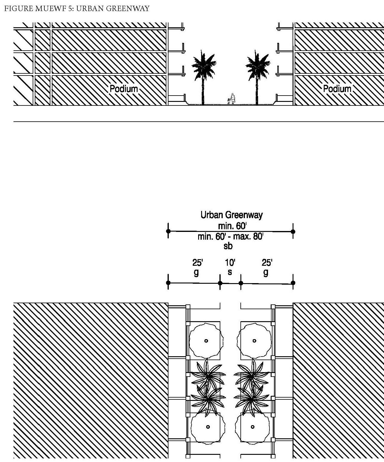

(2)
Waterfront Promenade Types.
a.
Type WP 1a and 1b: Along north side of property (Figures MU/EWF-6a and 6b).
i.
The minimum width of the waterfront promenade shall be forty-five (45) feet.
ii.
A minimum of sixty (60%) percent of the waterfront promenade shall be landscaped and shall consist primarily of sod, ground cover or ornamental grass.
iii.
Tree grates shall not be utilized in place of the required landscape strips.
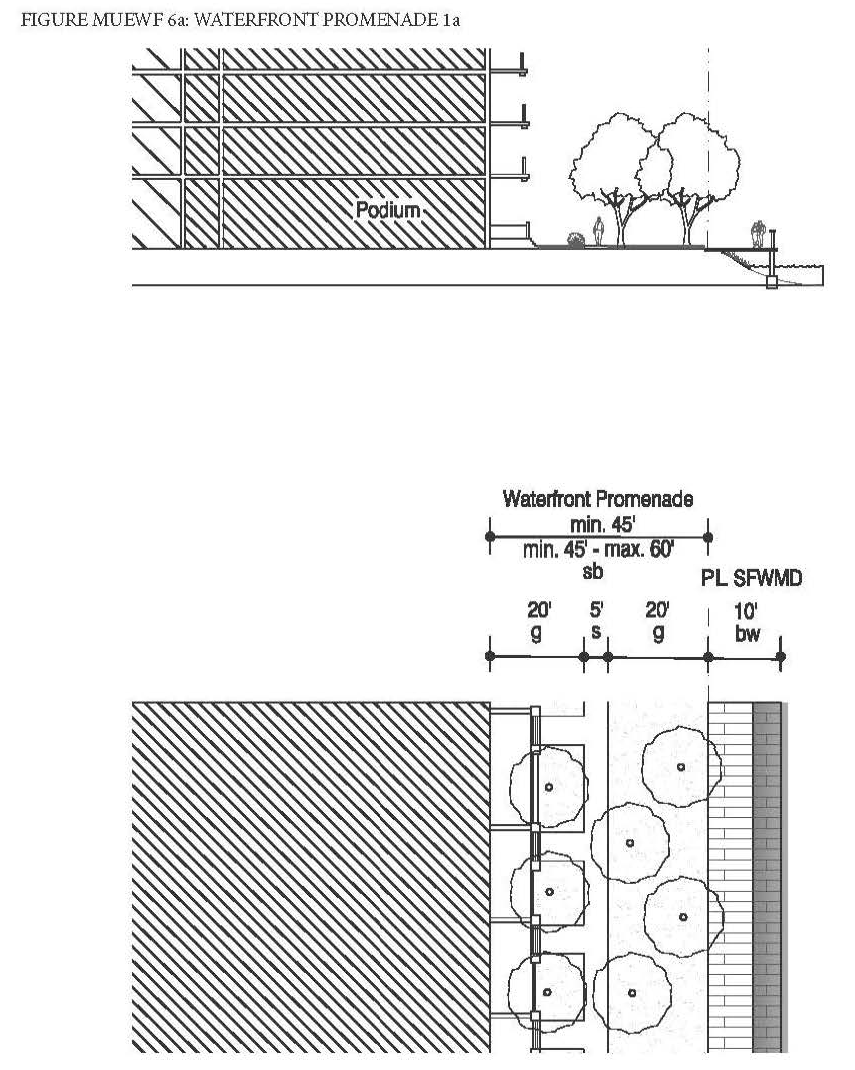
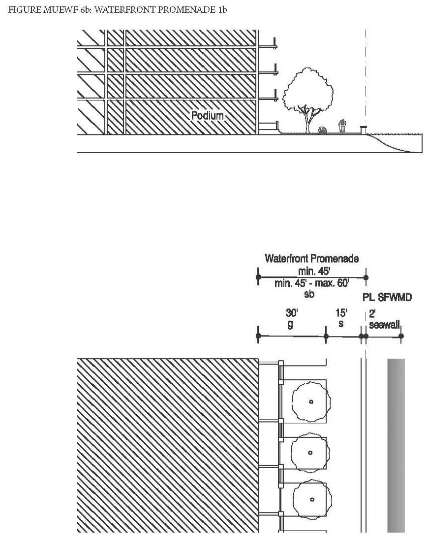
b.
Type WP 2: Along east side of property (Figure MU/EWF-7).
i.
The minimum width of the waterfront promenade shall be sixty (60) feet.
ii.
A minimum of forty (40%) percent of the waterfront promenade shall be landscaped and shall consist primarily of sod, ground cover or ornamental grass.
iii.
Tree grates a minimum of five (5) feet by five (5) feet may be utilized in place of the required landscape strip.
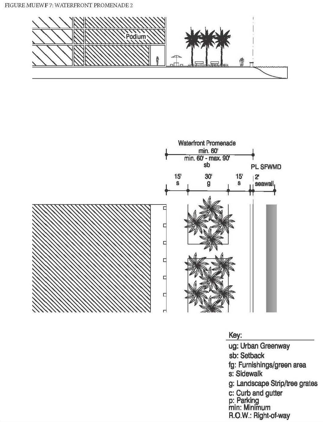
(3)
The designated publicly accessible urban greenways system and publicly accessible waterfront promenades shall be designed to enhance the visual character of the waterfront and specific streets along the urban greenways and ensure pedestrian connectivity by:
a.
Providing tree species that provide continuous shade for a minimum of seventy (70%) percent of the frontage along the urban greenways. Palm trees alone are not acceptable and the maximum spacing of the shade trees shall be thirty (30) feet on center.
b.
Providing street furnishings such as benches, trash receptacles, bike racks, drinking water fountains, etc.
c.
Providing a landscape plan illustrating a coherent design with significant tree species along the urban greenways and waterfront promenade that are distinguishably different from the other streets along the property in terms of color, type and shape.
d.
Tree specifications shall be as per Section 24-58(L).
(J)
Building Heights Regulating Plan and Additional Height Standards. All new and existing development shall comply with the standards found within the Building Heights Regulating Plan as shown in (Figure MU/EWF-4). Table MU/EWF-2 provides a summary of the heights per sub-area, however, since maximum building heights vary within the sub-areas and are dependent on location, the Building Height Regulating Plan shall be referred to.
(K)
Building Typology and Dimensional Standards.
(1)
Building Typologies. All new buildings shall conform to one (1) of the permitted building typologies as demonstrated in the Building Typology and Placement Regulating Diagrams in Section 24-58 Mixed-use District. The diagrams provide a schematic representation of the various building typologies and demonstrate the required setbacks, lot standards, and profiles of structures. Existing buildings which do not fit a prescribed typology, shall follow the standards required for the Flex building typology. Not all building typologies are permitted in each Mixed-use district. The building typologies permitted in the EASTERN MU/WF and their allowable sub-area locations are listed below in Table MU/EWF-3.
(2)
Setbacks and Building Frontage.
a.
Front and Street Side Setbacks and Building Frontage. Front and Street Side setbacks are determined based on the street the building fronts. Table MU/EWF-4 lists the minimum required front and street side setbacks and building frontage per street type. The interior side and rear setbacks as well as the lot standards shall be as specified per building type in Section 24-58 Mixed-use District.
(L)
On-site Parking Standards.
(1)
All parking within the EASTERN MU/WF shall comply with the Access, Circulation, Parking and Loading Standards specified in Section 24-58 Mixed-use District.
(2)
On-site parking shall comply with Table MU/EWF-5. Uses not listed herein shall comply with the parking requirements specified in Article IX.
(3)
Guest parking shall comply with Table MU/EWF-5. Guest parking shall be designated and prominently marked on-site as "Guest Parking" and shall not be restricted in any manner to use by a single tenant, owner, unit, or other user.
(M)
Bicycle Racks and Bicycle Storage Standards. Bicycle racks and storage shall be required as follows:
(1)
Bicycle Racks and Bicycle Storage for Commercial Uses. Commercial developments, excluding hotel uses, shall provide:
a.
Secure bike racks and/or storage at a ratio of one (1) bicycle parking space per every fifteen (15) required parking spaces; and
b.
A minimum of one (1) shower and changing facility shall be provided to be available for all tenants and shall be located within the building, or within two hundred (200) feet of the building entrance, for developments greater than fifty thousand (50,000) square feet in gross building area.
(2)
Bicycle Racks and Bicycle Storage for Residential Uses. One (1) bicycle parking space shall be provided per every fifteen (15) required parking spaces. Required residential bicycle parking spaces shall be provided in a secured area, covered from the elements.
(3)
Mixed-Use Developments. Mixed-use developments shall provide secure bicycle parking spaces for both the commercial and residential components of the development as calculated separately pursuant to the requirements of this section.
(N)
Signage Standards. Signage shall comply with the standards in Article XIII except as modified herein.
(1)
Signs affixed to the exterior of a building shall be architecturally compatible with the style, composition, materials, colors, and details of the building, as well as with other signs used on the building or its vicinity.
(2)
Signs shall fit within the existing facade features, shall be confined to signable areas, and shall not interfere with door and window openings, conceal architectural details or obscure the composition of the facade where they are located.
(3)
Whenever possible, signs located on buildings within the same block-face shall be placed at the same height in order to create a unified sign band.
(4)
Wood and painted metal are the preferred materials for under-awning, hanging signs. Flat signs should be framed with raised edges. Wood signs shall use only high-quality exterior grade wood with suitable grade finishes.
(5)
Sign colors should be compatible with the colors of the building façade. A dull or matte finish is recommended for reduction of glare and enhancement of legibility.
(6)
Signs shall be either spot- or backlit with a diffused light source. Spotlighting shall require complete shielding of all light sources, shall be contained within the sign frame, and shall not significantly spill over to other portions of the building or site. Backlighting shall illuminate the letters, characters, or graphics on the sign, but not its background. Warm fluorescent bulbs may be used to illuminate the interior of display cases. Neon signs placed inside the display case shall insure low intensity colors.
(7)
Signs shall be mounted so that the method of installation is concealed. Signs applied to masonry surfaces should be mechanically fastened to mortar joints only and not directly into brick or stone. Drilling to provide electrical service should also follow the same rule.
(8)
Billboards are prohibited.
(O)
Development Approval Conditions.
(1)
Public Infrastructure and Streetscape Assessment and Fund.
a.
All new residential development, or renovation or remodeling of residential units within the EASTERN MU/WF, where total vertical construction costs of the development, renovation or remodeling is equal to or greater than five hundred thousand ($500,000.00) dollars shall pay a public infrastructure and streetscape assessment per dwelling unit. Such public infrastructure and streetscape assessment shall be paid prior to issuance of a building permit for the development, renovation or remodeling. All public infrastructure and streetscape assessments shall be deposited into the public infrastructure and streetscape fund.
b.
Ordinary property maintenance is exempt from the public infrastructure and streetscape assessment. Repairs and restoration resulting from fire, flood, windstorm or other natural disaster, as determined by the building official, are exempt from the public infrastructure and streetscape assessment.
c.
The amount of the public infrastructure and streetscape assessment shall be established by resolution of the City Council and may be adjusted from time to time.
d.
A separate public infrastructure and streetscape fund shall be established by the City. All public infrastructure and streetscape assessment payments from residential development, or renovation or remodeling of residential units within the EASTERN MU/WF shall be deposited into this fund and the funds shall be kept separate from any other City funds. The public infrastructure and streetscape fund shall be used by the City for improvement to and maintenance of the public infrastructure and streets in the EASTERN Shores Neighborhood. Use of such funds shall be determined by the City Council. Any monies not expended in the fund in any fiscal year shall be carried over in the fund into the following year. Any interest earned on the funds shall be retained in the fund.
(2)
Public Services.
a.
The developer shall be required to relocate, rebuild, improve, enhance or otherwise address per the direction of the City/County, the existing fire rescue station onsite.
b.
The developer shall be required to provide, or otherwise address per City direction, a police substation onsite.
c.
The developer shall be required to develop and maintain in perpetuity a minimum of six (6) acres of publicly accessible open space in the District. Part of this six (6) acres shall be a new publicly accessible neighborhood park, conveniently located for access by residents of the Eastern Shores Neighborhood, a minimum of sixty-five thousand (65,000) square feet in size.
d.
The developer shall be required to develop and maintain in perpetuity a publicly accessible waterfront promenade, the general location of which is approximately shown in the Designated Publicly Accessible Open Spaces and Urban Greenway Systems Regulating Plan (Figure MU/EWF-3). The new publicly accessible waterfront promenade shall generally extend along the entire northern and eastern site boundary edges adjacent to the water.
e.
The developer shall be required to provide for multiple access points with direct east and west access to and from SR 826 and traffic mitigation such that the development does not over burden NE 35th Avenue.
f.
The developer shall be required to provide streetscape improvements within the MU/EWF property generally in accordance with the Street Network Connectivity Regulating Plan and Street Standards.
(P)
Development Permit Review Procedures. The following development permit review procedure will apply to this district:
(1)
The review procedures set out in Article XV and Section 24-171 (Concurrency) will apply within this district.
(2)
Preapplication Conference: For those development permit requests that require a Pre-Application Conference, the specific issues identified below must be reviewed by the Applicant and addressed with staff at the Preapplication Conference:
(a)
Provide a traffic study that shows multiple access points with direct east and west access to and from SR 826 and traffic mitigation such that the development does not over burden NE 35th Avenue. Show plans to provide public access to the waterfront; improve, enhance, relocate, rebuild or otherwise address per City/County direction the Miami-Dade Rescue Station; address, per City direction, the addition of a police substation; and address the long term maintenance of designated publicly accessible open spaces.
(b)
In addition to the submittal requirements in Article XV and Section 24-171 (Concurrency), the required plans submitted for review for the Pre-Application conference shall demonstrate the Applicant's general approach to comply with the requirements noted above and shown on the MU/EWF District's:
(1)
Sub-Areas Regulating Plan.
(2)
Street Network and Connectivity Regulating Plan.
(3)
Designated Publicly Accessible Open Spaces and Urban Greenways Regulating Plan.
(4)
Building Heights Regulating Plan.
(5)
Building Typology.
(3)
Applications that include a development agreement shall be subject to the additional notice and hearings set forth in Article XIX.
(Ord. No. 2015-5, § 2(Exh. A), 3-17-15; Ord. No. 2016-6, § 2, 7-5-16; Ord. No. 2017-12, § 3, 1-16-18; Ord. No. 2018-6, § 2, 5-24-18; Ord. No. 2018-7, § 3, 6-19-18; Ord. No. 2020-07, § 2, 11-10-20; Ord. No. 2024-02, § 3, 4-16-24)
Sec. 24-58.8 - International Boulevard District (MU/IB).
PART I. INTRODUCTION
(A)
Purpose and Intent. The purpose of these regulations is to implement the standards and policies that guide the development of the International Boulevard District (MU-IB). The intent of these regulations is to enable a pedestrian scaled, transit accessible pattern of mixed-use development along the NE 167th Street/NE 163rd Street Corridor, between North Miami Avenue east to NE 21st Avenue. Development patterns shall generally reflect planning and design principles such as walkable neighborhoods oriented around the five-minute walk. Additionally, there shall be a primary orientation towards the corridor, with strong consideration taken towards creating an identifiable sense of place that establishes this corridor as an attractive option for development that improves the City and provides additional options for residents to live, work and play. This purpose will be fulfilled by:
(1)
Ensuring high quality, architecturally compatible, consistently landscaped development throughout the District;
(2)
Ensuring that new development or redevelopment projects enhance the visual character of the NE 167th/163rd Street Corridor in terms of massing and scale;
(3)
Stimulating neighborhood commercial and retail activities with an emphasis on the development of mixed-use nodes at highly trafficked/accessible locations, which are connected by improved development along the corridor;
(4)
Encouraging people to reside and work in the district;
(5)
Encouraging the landscaped beautification and pedestrianization of the thoroughfares;
(6)
Ensuring new publicly accessible open spaces; and
(7)
Ensuring the appropriate screening and transition to reduce the impact on any surrounding single-family neighborhoods and low density residential districts.
(8)
Encouraging the creation of multi-cultural or business districts, such as a "Chinatown."
(B)
District Boundaries. The development standards shall be utilized for properties located within the Mixed-Use International Boulevard District (MU-IB), FIGURE MU/IB- 1.
Figure MU/IB-1. Mixed-Use International Boulevard Boundary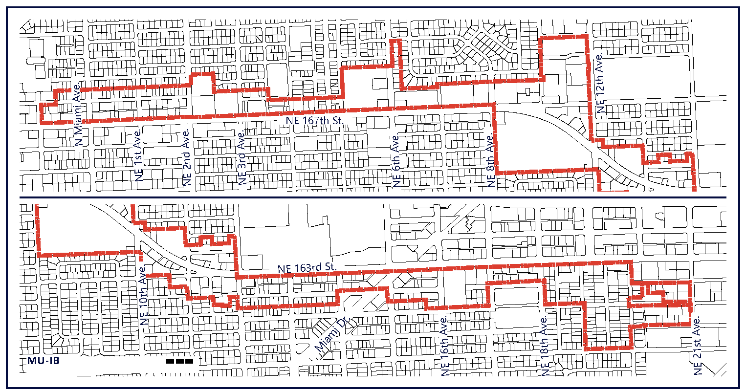
(C)
Administration. In order to maintain predictability in development, Planned Unit Developments (PUDs) shall be prohibited. Variances from the dimensional requirements or waivers from any other criterion may be approved by the applicable review board for projects, provided that the applicant meets the standards pertaining to such variance or waiver. The applicable board shall hear and decide appeals where it is alleged there is an error in any order, requirement, decision, or determination made by the Director of the Community Development Department or his/her designee in the enforcement of these development regulations.
(D)
General Development Standards.
(1)
In addition to the standards contained herein, Section 24-58 Mixed-Use (MU) district standards shall be applicable to development within the Mixed-Use International Boulevard (MU-IB). The applicable regulations contained in Articles IV, VIII, IX, X, XI, XII, XIII, and XIV shall also apply, except as modified herein and may be further modified by the City Manager or his/her designee to meet the purpose and intent of the Mixed-Use International Boulevard (MU-IB).
(2)
The provisions of the MU/IB code, when in conflict, shall take precedence over the existing zoning and land development regulations.
(3)
The provisions of the building code, when in conflict, shall take precedence over the provisions of the MU/IB code.
(4)
Existing buildings may be destroyed or removed, however they must be replaced according to the MU/IB regulations. Existing buildings may not be destroyed or removed unless they are to be replaced according to MU/IB regulations and only after a building permit is issued.
(5)
Existing buildings and uses within the MU/IB area, which are legally established but do not conform to provisions of the MU/IB regulations as of the effective date of these regulations shall be considered nonconforming and may not be replaced, restored, or modified, except in conformity with the regulation for nonconformities contained in Article IV of this chapter. When a nonconforming structure is destroyed by windstorm, flood, or nature disaster, it may be replaced by a new structure of the same or lesser size, and reoccupied by the same use, if construction of such structure is commenced within eighteen (18) months of destruction.
a.
Projects approved in 2019 or later, prior to the adoption of these regulations shall be exempt from the above regulation and shall be permitted to be reconstructed, as permitted in the previous zoning and as approved in the original site plan.
(6)
Proposed development with site plan approved under the previous zoning regulations shall commence construction within the time frame allotted in the development order or site plan approval letter. If commencement of construction does not occur within the allotted time frame, the site plan approval shall automatically expire without further action by the City.
(E)
Assessments.
(1)
Public Infrastructure and Streetscape Assessment and Fund.
a.
All new development, or renovation or remodeling of existing buildings within the MU/IB, where total vertical construction costs of the development, renovation or remodeling is equal to or greater than five hundred thousand ($500,000.00) dollars, shall pay a public infrastructure and streetscape assessment per dwelling unit or square foot to receive any allowable tax incentive, which may be available from the North Miami Beach Community Redevelopment Agency, if any. Such public infrastructure and streetscape assessment shall be paid prior to issuance of a building permit for the development, renovation or remodeling. All public infrastructure and streetscape assessments shall be deposited into the public infrastructure and streetscape fund.
b.
Ordinary property maintenance is exempt from the public infrastructure and streetscape assessment. Repairs and restoration resulting from fire, flood, windstorm or other natural disaster, as determined by the building official, are exempt from the public infrastructure and streetscape assessment.
c.
The amount of the public infrastructure and streetscape assessment shall be established by resolution of the City Commission and may be adjusted from time to time.
d.
A separate public infrastructure and streetscape fund shall be established by the City. All public infrastructure and streetscape assessment payments from new development, or renovation or remodeling of existing buildings within the MU/IB shall be deposited into this fund and the funds shall be kept separate from any other City funds. The public infrastructure and streetscape fund shall be used by the City for improvement to and maintenance of the public infrastructure and streets in the MU/IB. Use of such funds shall be determined by the City Commission. Any monies not expended in the fund in any fiscal year shall be carried over in the fund into the following year. Any interest earned on the funds shall be retained in the fund.
(2)
Public Open Space Assessment and Fund.
a.
All new development, or renovation or remodeling of existing buildings within the MU/IB, where total vertical construction costs of the development, renovation or remodeling is equal to or greater than five hundred thousand ($500,000.00) dollars shall pay a public open space assessment per dwelling unit or square foot to receive any allowable tax incentive, which may be available from the North Miami Beach Community Redevelopment Agency, if any. Such public open space assessment shall be paid prior to issuance of a building permit for the development, renovation or remodeling. All public open space assessments shall be deposited into the public open space fund.
b.
Ordinary property maintenance is exempt from the public open space assessment. Repairs and restoration resulting from fire, flood, windstorm or other natural disaster, as determined by the building official, are exempt from the public open space assessment.
c.
The amount of the public open space assessment shall be established by resolution of the City Commission and may be adjusted from time to time.
d.
A separate public open space fund shall be established by the City. All public open space assessment payments from new development, or renovation or remodeling of existing buildings within the MU/IB shall be deposited into this fund and the funds shall be kept separate from any other City funds. The public open space fund shall be used by the City for improvement to and maintenance of the Snake Creek Canal Greenway, public parks, public open spaces and recreational areas and facilities in the MU/IB. Use of such funds shall be determined by the City Commission. Any monies not expended in the fund in any fiscal year shall be carried over in the fund into the following year. Any interest earned on the funds shall be retained in the fund.
(3)
Public Art Assessment and Fund.
a.
All new development, or renovation or remodeling of existing buildings within the MU/IB, where total vertical construction costs of the development, renovation or remodeling is equal to or greater than five hundred thousand ($500,000.00) dollars shall pay a public art assessment to receive any allowable tax incentive, which may be available from the North Miami Beach Community Redevelopment Agency, if any. Such public art assessment shall be paid prior to issuance of a building permit for the development, renovation or remodeling. All public art assessments shall be deposited into the public art fund.
b.
Ordinary property maintenance is exempt from the public art assessment. Repairs and restoration resulting from fire, flood, windstorm or other natural disaster, as determined by the building official, are exempt from the public art assessment.
c.
The amount of the public art assessment shall be established by resolution of the City Commission and may be adjusted from time to time.
d.
A separate public art fund shall be established by the City. All public art assessment payments from new development, or renovation or remodeling of existing buildings within the MU/IB shall be deposited into this fund and the funds shall be kept separate from any other City funds. The public art fund shall be used by the City for the construction of, improvement to and maintenance of public art. Use of such funds shall be determined by the City Commission. Any monies not expended in the fund in any fiscal year shall be carried over in the fund into the following year. Any interest earned on the funds shall be retained in the fund. Such public art assessment shall be paid prior to issuance of a building permit for the development, renovation or remodeling. All public art assessments shall be deposited into the public art fund.
(F)
Public Benefits Program. The Public Benefits Program is established in this section to allow bonus Building Height (additional stories) in addition to what is permitted by right in the Core and Transition Sub-District areas within the MU-IB. The additional Building Height shall be provided in exchange for the developer's contribution to specified areas that provide benefits to the public.
(1)
Upon providing a binding commitment for the specified public benefits as provided below, the proposed development project shall be allowed to build additional development (bonus stories no greater than maximum permitted floor plate size) subject to the standards provided in the MU-IB, up to the maximum number of stories with bonus height. The only square footage accommodated above the maximum permitted height is that achieved through the bonus program.
(G)
Public Benefits Fund. The City of North Miami Beach shall create and operate the City of North Miami Beach Mixed-Use International Boulevard District Public Benefits Fund for contributions that benefit the public. The contributions to this fund shall be distributed to improve the quality, quantity and character of landscape, streetscape and public urban greenway facilities within the MU/IB, as well as the construction and maintenance of public open spaces. This fund shall also be used to improve the pedestrian mobility experience within the MU/IB, including the installation of street furnishings, uniquely branded transit refuge structures, pedestrian and bicycle facilities.
(H)
Bonus Opportunities. The following Bonus Opportunities shall be offered to developers in exhange for contributions that benefit the public in the MU/IB District:
(1)
Cash Contributions. For a cash contribution, the development project shall be allowed additional Floor Area up to the bonus height maximum. The cash contribution shall be determined based on a percentage of the market value of the per square foot price being charged for units at projects within the market area, where the proposed project seeking the bonus is located. The calculation assumes a land value per saleable square foot within the market area to equate to between ten (10) to fifteen (15) percent of market area's weighted average sales price per square foot. The cash contributions may be adjusted on an annual basis to reflect market conditions effective October 1 of every year.
(2)
Dedication of Public Open Space. For each square foot of dedicated public park or open space provided on-site, and accessible directly from public right-of-way, the development shall be allowed an equivalent amount of development floor area up to the bonus height maximum. The location and design of the dedicated public open space shall be approved by the Planning Director.
(3)
Dedication of Public Schools Space. For each square foot of dedicated land or building area provided on-site for the use of Public Schools, and accessible directly from public right-of-way, the development shall be allowed an equivalent amount of development floor area up to the bonus height maximum. The location and design of the dedicated area shall be approved by the Planning Director.
PART II. REGULATORY FRAMEWORK
(A)
Regulating Plans and Diagrams. The MU/IB is governed by a series of regulating plans and diagrams. The Regulating Plans and Diagrams demonstrate MU/IB development standards in both words and diagrams, and include maps designating the locations where the various standards apply. Unless otherwise noted, all development shall be in compliance with the Regulating Plans and Diagrams contained herein and with the Building Typology and Placement Regulating Diagrams in Section 24-58 Mixed-Use (MU) district. The Regulating Plans and Diagrams for the MU/IB include the following:
(1)
The Sub-Areas Regulating Plan. Divides the MU/IB into three (3) Sub-areas: Core, Transition and Edge. The highest density and intensity within the MU/IB shall be allocated to the Core Sub-area, a mixed-use area at the heart of the district. The densities and intensities shall then gradually decrease from the Core to the Transition Sub-area where mixed-uses are still permitted and then further decrease to the Edge Sub-area which is characterized by single uses, including lower density residential adjacent to existing low density residential. The Sub-areas Regulating Plan is shown in FIGURE MU/IB- 2. The maximum density permitted within each of the sub-districts is listed in the table below.
Figure MU/IB-2. Sub-Areas Regulating Plan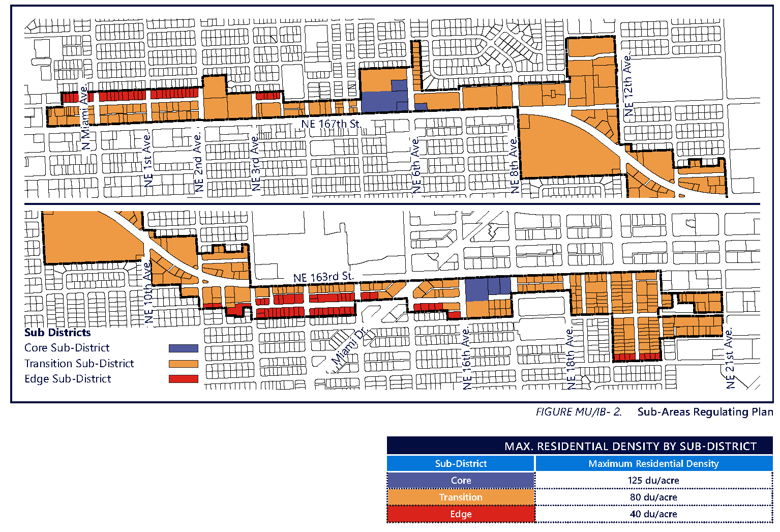
(2)
Street Network Connectivity Plan. Shows the approximate location of existing and required new streets needed to create the prescribed network of streets within the MU/IB. This Plan also establishes the hierarchy of the streets as shown in Figure MU/IB-3. The street standards specified in Section 24-58 (J) Mixed-Use District shall apply except as modified herein. All streets shall be located according to the Street Network Connectivity Plan for the MU/IB.
Figure MU/IB-3. Street Network Connectivity Plan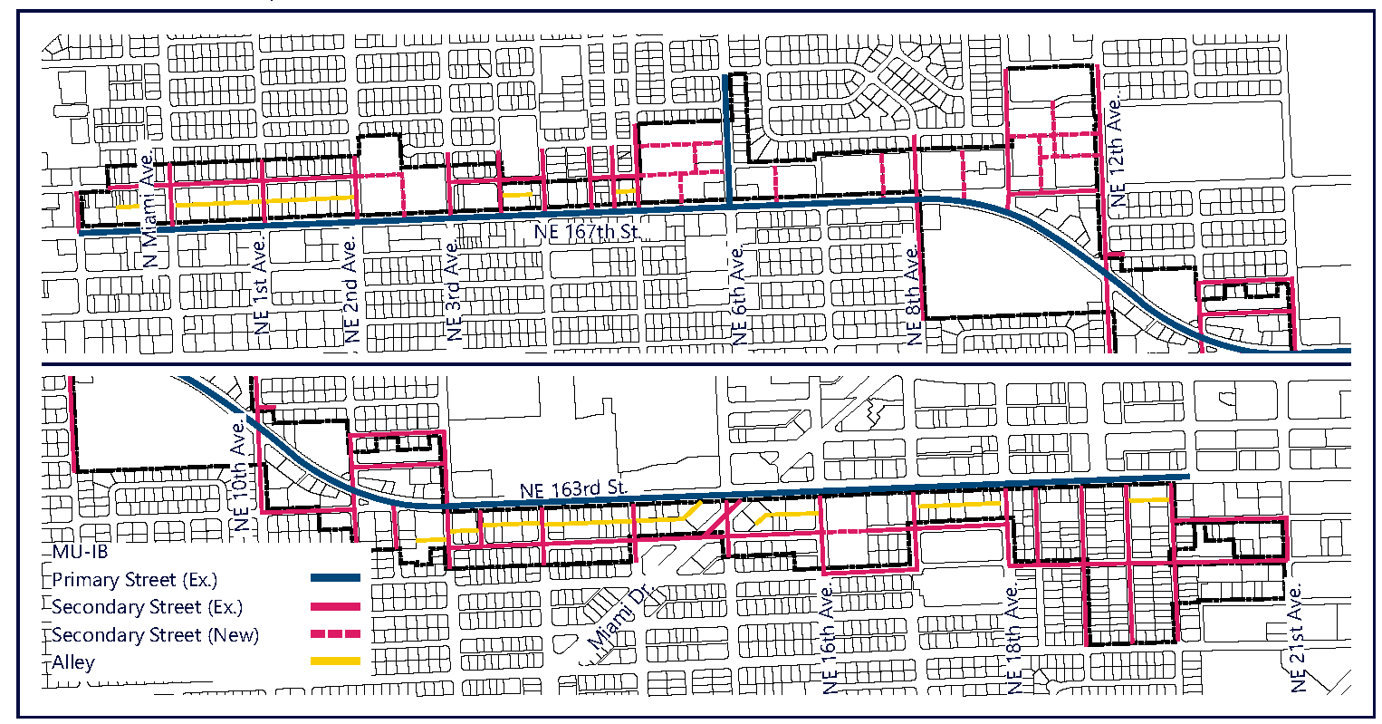
a.
All streets shall be located according to the Street Network Connectivity Plan for the MU/IB.
b.
The design of new streets and modification of existing streets shall comply with Section 24-58(J) unless otherwise detailed below.
c.
All Primary and Secondary Streets shall be required in the same general locations as shown on the Street Network Connectivity Plan and may be modified with respect to alignment. No Primary or Secondary Streets shall be deleted or otherwise vacated or removed.
i.
All streets are encouraged to promote connectivity and accessibility between multiple modes of transportation including pedestrians, vehicles and/or mass transit systems.
d.
Secondary Streets shown on the Street Network Connectivity Plan are required to promote connectivity and establish an improved street network and block system within the MU/IB.
i.
Certain New Secondary Streets are proposed to break up the potential for super blocks and demonstrate compliance with maximum block length requirements.
ii.
Secondary Streets, where located in a core/transition sub-area, street section shall include on-street parking, at a minimum.
e.
Existing Alleys may be vacated only for the purpose of assembling parcels.
(3)
Designated Publicly Accessible Open Spaces and Urban Greenway Systems Plan. Designates the approximate location of the required publicly accessible open spaces and urban greenway system as shown in Figure MU/IB-4.
Figure MU/IB-4. Designated Publicly Accessible Open Spaces and Urban Greenways Systems
Plan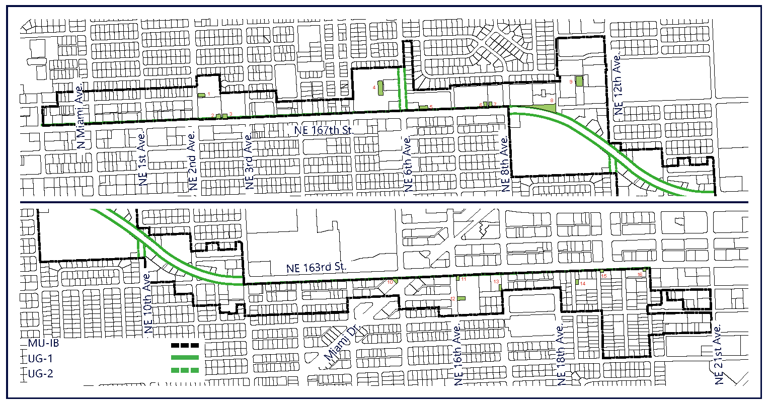
a.
The Designated Publicly Accessible Open Spaces identified within Figure MU/IB-4 shall be provided with the minimum areas as identified in Table MU/IB- 1.
i.
So long as publicly designated open space size and general proportion is provided as indicated in the regulating plan (Figure MU/IB-4), the precise location of the public open space may be shifted/rotated to provide flexibility for specific design concept.
b.
Urban Greenways.
i.
Type UG-1 shall run parallel to the corridor along the north side of NE 167th Street and be composed as described below and in Figure MU/IB-5.
1.
The total width of the urban greenway shall be no less than fourteen (14) feet and be measured from the back of curb (including existing sidewalk), to the facade of the building.
2.
A minimum six (6) feet of sidewalk shall be added parallel to the ROW line and abutting the existing sidewalk, to equal a total width of fourteen (14) feet of sidewalk, measured from the back of curb along the corridor.
3.
The new sidewalk shall be finished to match and appear as a single sidewalk.
4.
Street Trees shall be planted providing minimum distance from the curb, as specified by FDOT and within tree grates a minimum of six (6) feet by six (6) feet, within this zone.
Figure MU/IB-5. UG-1 Dimension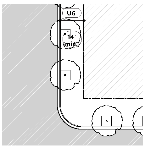 | Figure MU/IB-6. UG-2 Dimension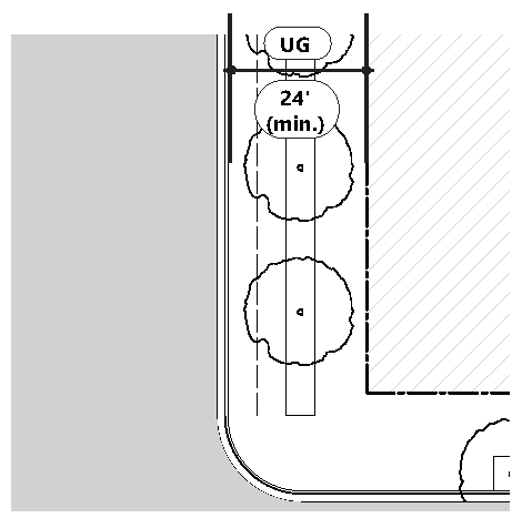 |
ii.
Type UG-2 (Figure MU/IB-6) may be provided within private properties as indicated in the locations depicted in Figure MU/IB-4. The City of North Miami Beach Transportation Master Plan has identified improvements to both NE 6th and NE 10th Avenue to include bicycle improvements, which include dedicated bicycle lanes.
1.
Should any redevelopment wish to provide these bicycle lanes along the street frontage within their development parcel, for public use, additional bonus' shall be permitted as indicated in Public Benefits Program.
2.
The total width of the UG-2 shall be no less than fourteen (24) feet and be measured from the back of curb (including existing sidewalk), to the facade of the building.
3.
UG-2 shall be composed of the existing sidewalk, a five (5) foot minimum bicycle track, with [a] five (5) foot landscape bicycle buffer and minimum eight (8) foot minimum sidewalk along the building frontage.
c.
The designated public urban greenways system shall be designed to enhance the visual character of specific streets along the urban greenways with the following:
i.
Street Trees shall provide a continuous canopy coverage over the pedestrian zone, for the length of the greenway's frontage.
1.
Street trees shall not be in conflict with overhead wires. Where overhead wires are present, street trees shall be in compliance with FPL guidelines for street trees.
2.
The maximum spacing of the street trees shall be average thirty (30) feet on center for the length of the property frontage.
3.
All street trees within the ROW shall be planted with Silva Cell, or method of equal intent, from back of curb to face of building to promote root growth and health of trees.
ii.
Street furnishings such as benches, trash receptacles, bike racks, drinking water fountains, etc. shall be provided.
1.
All details and specifications, with photos/drawings, for selections shall be included in the Site Plan submission for review.
iii.
A landscape plan illustrating a coherent design with significant tree species along the urban greenways that are distinguishably different from the other streets along the property in terms of color, type and shape shall be provided.
iv.
No plant material other than trees shall be higher than twenty-four (24) inches within the urban greenway.
v.
Tree specifications shall be as per Section 24-58(L).
(4)
Building Heights Plan. Establishes the maximum building height with and without bonus' as shown in Figure MU/IB- 7.
Figure MU/IB-7. Building Heights Plan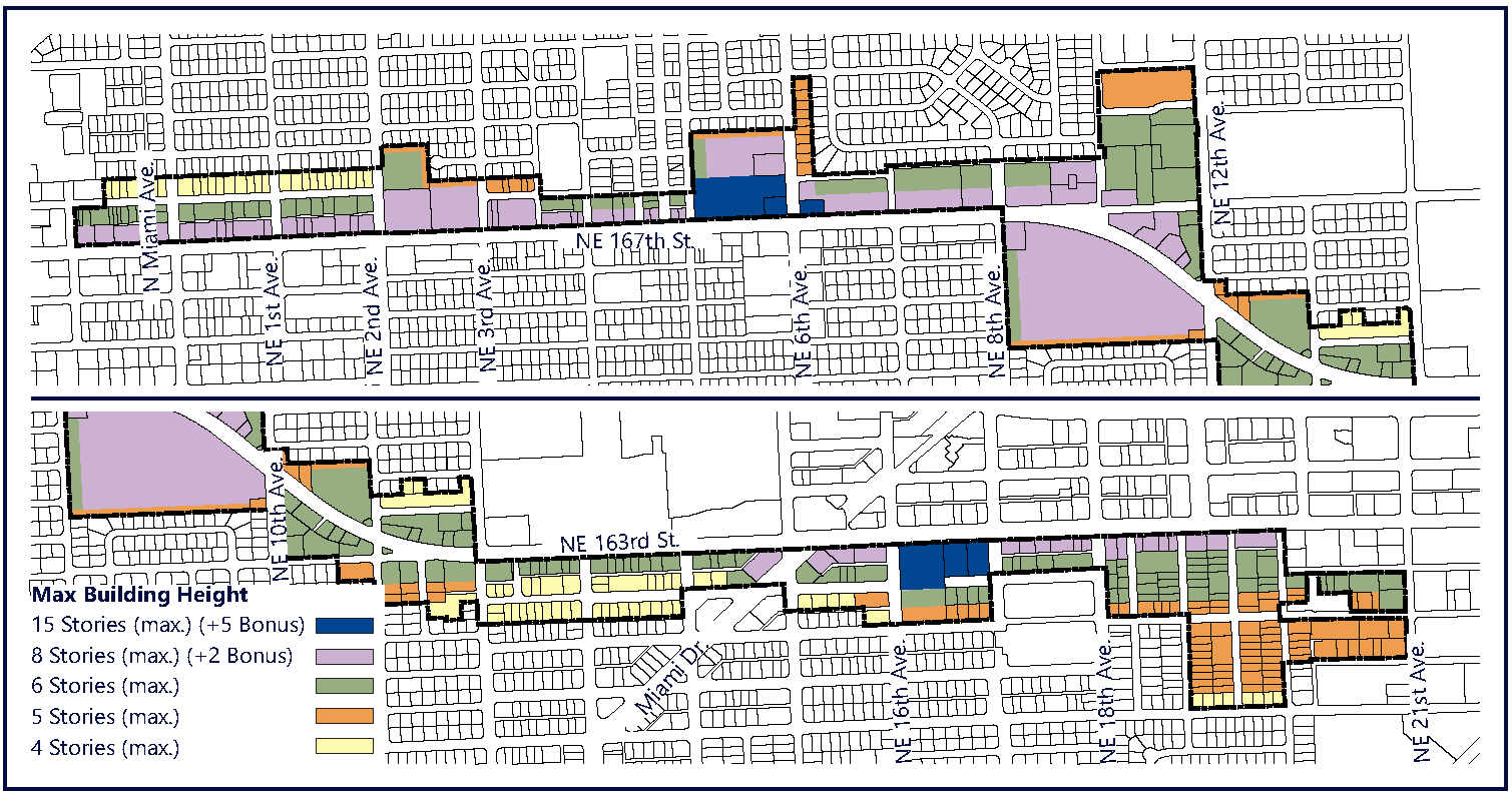
a
i.
Where maximum height is designated as six (6) stories maximum, development shall be limited to six (6) stories for a minimum of ninety (90) feet, measured from the property line, in order to provide adequate transition of building height from lower adjacent development.
ii.
Where maximum height is designated as six (6) stories maximum, development shall be limited to six (6) stories for a minimum of ninety (90) feet, measured from the property line, in order to provide adequate transition of building height from lower adjacent development.
iii.
Where maximum height is designated as five (5) stories, development shall be limited to five (5) stories for a minimum of fifty (50) feet, measured from the property line, in order to provide adequate transition of building height from lower adjacent development.
b.
All new development shall comply with the standards illustrated within Figure MU/IB-7. A summary of the heights permitted in the MU/IB is provided in Table MU/IB-2. This table is only a summary of maximum heights in the district. Further breakdown of heights shall be prescrbed in Figure MU/IB-7.
i.
Ground level stories shall be permitted a maximum height of twenty (20) feet.
ii.
Second level stories shall be permitted a maximum height of twenty (20) feet.
iii.
Each story, above the second story, shall be permitted a maximum height of fourteen (14) feet.
iv.
Every building shall be permitted a single (1) specialty amenity story above the third story and above the fourteen (14) feet limit, for a maximum of twenty (20) feet.
(1) Buildings higher than eight (8) stories shall only be developed per the Tower Building type standards.
(B)
Permitted Uses.
(1)
Land Use Principles.
a.
The MU/IB District shall be developed as an identifiable place and shall act as an important destination for living, working, shopping and entertainment. The mix of uses within the District, the streets and the architectural character of individual buildings shall blend together to contribute to a coherent identity and sense of place. Thematic areas, are permitted to maintain their own unique architectural identity, provided that their massing, orientation and frontage meet the requirements of this code.
b.
Building frontage along NE 167th/163rd Street shall be developed as non-residential at the ground level.
c.
At a minimum, the building facades along NE 167th/163rd street shall contain active use along the first level.
i.
On all other levels, both non-residential and residential uses shall be permitted. To support transit, residential uses are encouraged and shall be permitted to be vertically or horizontally integrated.
d.
All parking garage structures within the MU/IB are required to be fully screened on all sides with an active use liner building, unless otherwise noted. Where a waiver of an active use liner building is sought, parking structures shall be screened at a minimum on the 2nd Floor and above by a uniquely designed architectural screen. All methods of screening shall meet applicable requirements for ventilation of the parking structure.
(2)
Permitted Use Table. Table MU/IB-4 includes the principal uses permitted in the MU/IB along with any required restrictions on such uses, for each of the sub-areas. Principal uses not included in Table MU/IB-4 are not permitted in the MU/IB. The MU/IB shall be subject to the Supplemental Regulations as provided for in Article VIII unless modified herein. Uses which are similar in nature to the uses permitted herein, but not enumerated in higher density use areas, shall be permitted upon a finding by the Community Development Director that the characteristics of, and activities associated with the use are substantially similar to one (1) or more of the listed uses, and will not involve greater impacts than the uses listed in the district and the use will be consistent with the purposes of the applicable zoning district and use areas.
(3)
Special Limited Conditional Uses. See Section 24-177.
PART III. URBAN DESIGN STANDARDS
(A)
Lot Dimensions and Building Standards.
(1)
Setbacks and Building Frontage. Front and Side setbacks are determined based on the street that the building fronts. Table MU/IB-5 lists the setbacks and building frontage occupation required for each street type within the MU/IB. The interior and rear setbacks, as well as the lot standards shall be as specified per building type in Section 24-58 Mixed-Use District.
Notes:
(1) For Schools located on Secondary Streets with lot depth of one hundred (100) feet
or less, minimum setback along the front of the property shall be zero (0) feet.
(2) For Schools located on Secondary Streets with lot depth of one hundred (100) feet
or less, and frontages on two (2) or more streets, the minimum Building Frontage percent
shall only be required to be met along the front of the property.
(2)
Building Typologies. All new buildings shall conform to one (1) of the permitted building typologies as demonstrated in the Building Typology and Placement Regulating Diagrams in Section 24-58 Mixed-use District. The diagrams provide a schematic representation of the various building typologies and demonstrate the required setbacks, lot standards, and profiles of structures. Existing buildings which do not fit a prescribed typology, shall follow the standards required for the Flex building typology. Not all building typologies are permitted in each Mixed-use district. The building typologies permitted in the MU/IB are listed below in Table MU/IB-6:
Notes:
(1) Existing single-family and multi-family dwellings that were legally established
on or before the adoption of these regulations shall be considered legal nonconforming.
(2) The Planning Director shall have the authority to waive administratively the requirements
for minimum lot coverage, pervious area, lot depth and lot width.
(3) For Flex Building Type, a reduction to twenty (20) feet minimum interior side
and rear setback for Schools four (4) stories or less when abutting townhouses, zero-lot
lines and/or existing single family residential, and an alley is not existing or proposed.
a.
Residential components of multi-family residential uses shall be any combination of the following dwelling units, and illustrated in Figure MU/IB-8.
i.
Flat. A single (1) story dwelling unit, occupied by one (1) household.
ii.
Loft. A double-story height dwelling unit, with or without mezzanine, occupied by one (1) household.
iii.
Rowhouse. A two (2) or more story dwelling unit, occupied by one (1) household.
Figure MU/IB-8. Residential Unit Types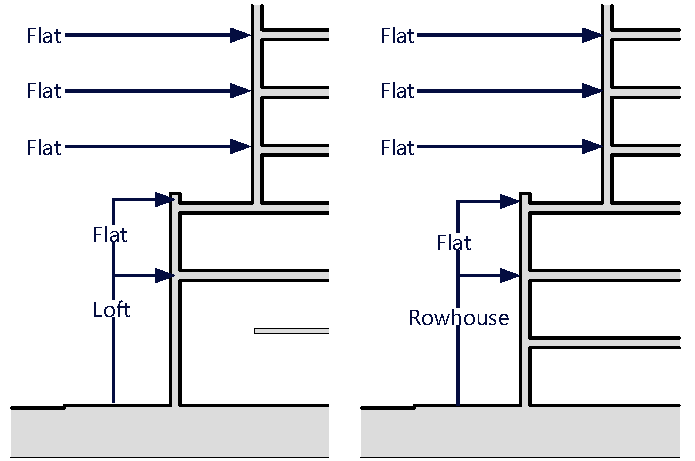
(B)
Access Standards.
(1)
Where an alley is present, all vehicular access to development shall occur from the alley. Figure MU/IB-9.
Figure MU/IB-9. Access Via Alley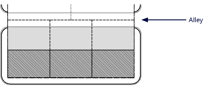
(2)
Where no alley is present, vehicular access shall occur from the secondary street frontage. Figure MU/IB-10.
Figure MU/IB-10. Access Access Via Street Frontage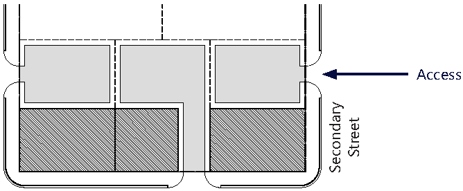
(3)
Shared access between adjacent properties via a cross-access agreement is encouraged to reduce curb cuts along the street frontage and provide consolidated parking areas. Figure MU/IB-11.
Figure MU/IB-11. Shared Access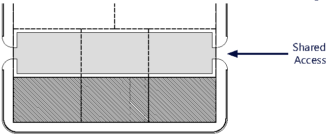
(4)
The main pedestrian access to the building shall occur from the parcel's primary frontage.
(5)
For all mixed-use/multi-family development, the main access to the units on floors two (2)+ shall occur from a ground level lobby/courtyard accessed from the parcel's primary frontage.
(6)
For Schools, queuing and drop-off/pick-up lanes may be located within required building setback areas for a maximum of thirty (30%) percent of the overall length of the School property.
(C)
On-Site Parking Standards.
(1)
Vehicular Parking.
a.
All parking within the MU/IB shall comply with the Access, Circulation, Parking and Loading Standards specified in Section 24-58 Mixed-Use District.
b.
On-site parking shall comply with Table MU/IB-7. Uses not listed herein shall comply with the parking requirements specified in Article IX.
c.
Guest parking shall comply with Table MU/IB-7. Guest parking shall be designated and prominently marked on-site as "Guest Parking" with signage and shall not be restricted in any manner to use by a single tenant, owner, unit, or other user.
(2)
Bicycle Racks and Bicycle Storage Standards. Bicycle racks and storage shall be required as follows:
a.
For Commercial Uses (except hotel uses).
i.
Secure bike racks and/or storage at a ratio of one (1) bicycle parking space for every fifteen (15) required parking spaces and;
ii.
A minimum of one (1) shower and changing facility shall be provided to be available for all tenants and shall be located within the building, or within two hundred (200) feet of the building entrance, for developments greater than fifty thousand (50,000) square feet in gross building area.
b.
For Residential Uses. One (1) bicycle parking space shall be provided for every fifteen (15) required parking spaces. Required residential bicycle parking spaces shall be provided in a secured area, covered from the elements.
c.
For Mixed-Use Developments. Mixed-Use developments shall provide secure bicycle parking spaces for both the commercial and residential components of the development as calculated separately pursuant to the requirements of this section.
(D)
Services Standards.
(1)
All loading and service areas shall be located along the rear of the parcel. Where parcel has frontage on multiple streets, the loading and service area shall be located along the lowest ranking street.
a.
All loading and service areas shall be prohibited from being placed adjacent to a primary street.
b.
Where no alley is present, all loading and service areas shall be placed along secondary/tertiary streets, whichever frontage is lowest ranking.
(E)
Signage Standards. Signage shall comply with the standards in Article XIII except as modified herein.
(1)
Signs affixed to the exterior of a building shall be architecturally compatible with the style, composition, materials, colors, and details of the building, as well as with other signs used on the building or its vicinity.
a.
All signage shall be prohibited on any facade directly fronting the canal frontage and within view of the residential areas to the north.
(2)
Signs shall fit within the existing facade features, shall be confined to signable areas, and shall not interfere with door and window openings, conceal architectural details or obscure the composition of the facade where they are located.
(3)
Whenever possible, signs located on buildings within the same block-face shall be placed at the same height in order to create a unified sign band.
(4)
Wood and painted metal are the preferred materials for under-awning, hanging signs. Flat signs should be framed with raised edges. Wood signs shall use only high-quality exterior grade wood with suitable grade finishes.
(5)
Sign colors should be compatible with the colors of the building façade. A dull or matte finish is recommended for reduction of glare and enhancement of legibility.
(6)
Signs shall be either spot- or backlit with a diffused light source. Spotlighting shall require complete shielding of all light sources, shall be contained within the sign frame, and shall not significantly spill over to other portions of the building or site. Backlighting shall illuminate the letters, characters, or graphics on the sign, but not its background. Warm fluorescent bulbs may be used to illuminate the interior of display cases. Neon signs placed inside the display case shall insure low intensity colors.
a.
Signage containing any light source shall be prohibited on any frontage along the canal and visible by existing single-family residential uses outside of the MU/IB.
(7)
Signs shall be mounted so that the method of installation is concealed. Signs applied to masonry surfaces should be mechanically fastened to mortar joints only and not directly into brick or stone. Drilling to provide electrical service should also follow the same rule.
(8)
Billboards are prohibited.
(9)
A Projecting Sign, generally two-sided and mounted with a decorative support or projecting building feature, and perpendicular to the building's facade shall be permitted within the MU/IB, provided it does not exceed a maximum area of one-hundred (100) square feet.
(F)
Development Permit Review Procedures. The following development permit review procedure will apply to this district:
(1)
The review procedures set out in Article XV and Section 24-171 (Concurrency) will apply within this district.
(2)
Preapplication Conference: For those development permit requests that require a Pre-Application Conference, the Applicant must address with staff:
a.
The submittal requirements in Article XV and Section 24-171 (Concurrency) and the required plans submitted for review shall demonstrate the Applicant's general approach to comply with the requirements noted above and shown on the MU/NC District's:
1.
Sub-Areas Regulating Plan.
2.
Street Network and Connectivity Regulating Plan.
3.
Designated Publicly Accessible Open Spaces and Urban Greenways Regulating Plan.
4.
Building Heights Regulating Plan.
5.
Building Typology.
(3)
Applications that include a development agreement shall be subject to the additional notice and hearings set forth in Article XIX.
(Ord. No. 2020-11, § 2(Exh. 1), 3-16-21; Ord. No. 2024-02, § 3, 4-16-24)
Sec. 24-59 - Conservation Zoning District.
The Conservation (CNS) District is intended to provide for only those uses compatible with the continuing conservation of the natural resources located within the district. This zoning district may be applied to land designated on the City's Future Land Use Map as Water or Parks and Recreation.
Uses Permitted: No building or structure or part thereof within the district shall be erected altered or used or land used in whole or part for other than one (1) or more of the following specific uses:
(a)
Passive Outdoor recreational uses such as wildlife sanctuaries and feeding stations nature centers and trails, outdoor research stations and walkways;
(b)
Fishing, boating, sailing, water sports and camping facilities;
(c)
Structures used for flood control drainage and water storage;
(d)
Wetlands;
(e)
Uses which do not impair the natural environment or disturb the natural ecosystem of the area and which are not in conflict with applicable water management and wildlife protection policies of local state and federal agencies;
(f)
Waterways.
(Ord. No. 2015-14, § 2, 10-20-15)