
North Port City Zoning Code
ARTICLE I
- IN GENERAL
Sec. 3.1.1. - Comprehensive Plan consistency.
A.
The City of North Port's Comprehensive Plan, specifically the Future Land Use Element and Future Land Use Map Series, has established and defined land use classifications determining allowed and prohibited activities within each land use district. The City of North Port is divided into zoning districts for regulating and restricting the use of land and the erection, construction, reconstruction, alteration, relocation, and utilization of buildings and structures.
B.
Zoning districts implement the Comprehensive Plan's vision of the City and shall be consistent with the Future Land Use classification as depicted in Table 3.1.1.1.
TABLE 3.1.1.1.
Implementing Zoning Districts
Sec. 3.1.2. - Zoning district descriptions.
A.
Residential Districts:
(1)
Agriculture (AG), The Agriculture district supports very low-density residential uses and low-intensity agricultural uses.
(2)
Residential, Low (R-1). The Residential, Low district supports traditional, detached single-family dwelling units.
(3)
Residential, Medium (R-2). The Residential, Medium district supports one-and-two-family dwelling units. Development in this zoning district may include cluster housing, tiny homes, co-living or cohousing developments, townhomes, and other types of single-and-two-family structures. Single-family dwelling units may be attached or detached.
(4)
Residential, Multi-Family (R-3). The Residential, Multi-Family district supports high-density residential development emphasizing multi-family use. Development in this district may include quadplexes, townhomes, build-to-rent communities, low-and-mid-rise multi-family structures, and other types of dense residential structures.
(5)
Manufactured Home Community (MH). The Manufactured Home Community district applies to areas of the city already developed as manufactured home communities. The City does not anticipate additional areas to be redesignated to this zoning district.
B.
Non-Residential Districts.
(1)
Commercial (C). The commercial district supports all types of commercial and office uses.
(2)
Industrial, Light (I-1). The industrial, light district supports light manufacturing, processing, storage and warehousing, wholesaling and distribution, office, and commercial uses.
(3)
Industrial, Heavy (I-2). The industrial, heavy district is intended to support all types of industrial uses, including heavy industrial and commercial uses.
C.
Environmental Conservation and Government Use.
(1)
Environmental Conservation (EC). The environmental conservation district indicates properties with natural limitations to development due to environmental concerns. This zoning district protects environmentally sensitive lands.
(2)
Government Use (GU). The government use district supports federal, state, or local governmental uses. Development in GU districts shall be completed by government agencies or private entities in partnership with a government agency.
D.
Corridor Districts.
(1)
Corridor, Transitional (CT). The corridor, transitional district is generally located along arterial and collector roads. This district allows medium-density residential and medium-intensity non-residential uses in which non-residential uses may be developed separately or in combination with residential development subject to the use standards in Section 3.2.3.C.
(2)
Corridor (COR). The corridor district is generally located along arterial roads. This district allows high-density residential and high-intensity non-residential uses in which non-residential uses may be developed separately or in combination with residential development subject to the use standards in Section 3.2.3.C.
E.
Activity Centers.
(1)
Activity Center 1 (AC-1). Activity Center 1, located along US-41, is an established commercial corridor. The AC-1 district supports commercial, light industrial, office and retail use to provide employment and amenities to the adjacent residential neighborhoods.
(2)
Activity Center 2 (AC-2). Activity Center 2, located in vicinity of S. Sumter Blvd. and W. Price Blvd. and includes portions of the Heron Creek Development of Regional Impact and the City Center. AC-2 supports civic, commercial, medical, mixed-use, office, residential and other uses in a pedestrian-friendly, mixed-use environment.
(3)
Activity Center 3 (AC-3). Activity Center 3, located at the intersection of Interstate 75 and N. Sumter Blvd., is a major gateway to the City. AC-3 supports commercial, medical, destination recreational and residential uses.
(4)
Activity Center 4 (AC-4). Activity Center 4, another major gateway to the City, located along Toledo Blade Blvd. and Interstate 75, Includes the Panacea and North Port Gardens Developments of Regional Impact and supports commercial, entertainment, industrial, medical, office, recreational, and residential uses.at a scale serving the city and region.
(5)
Activity Center 5 (AC-5). Activity Center 5, located along N. and S. Toledo Blade Blvd, bisected by E. and W. Price Blvd., is the midway point of the City. AC-5 supports commercial, light industrial, and residential uses.
(6)
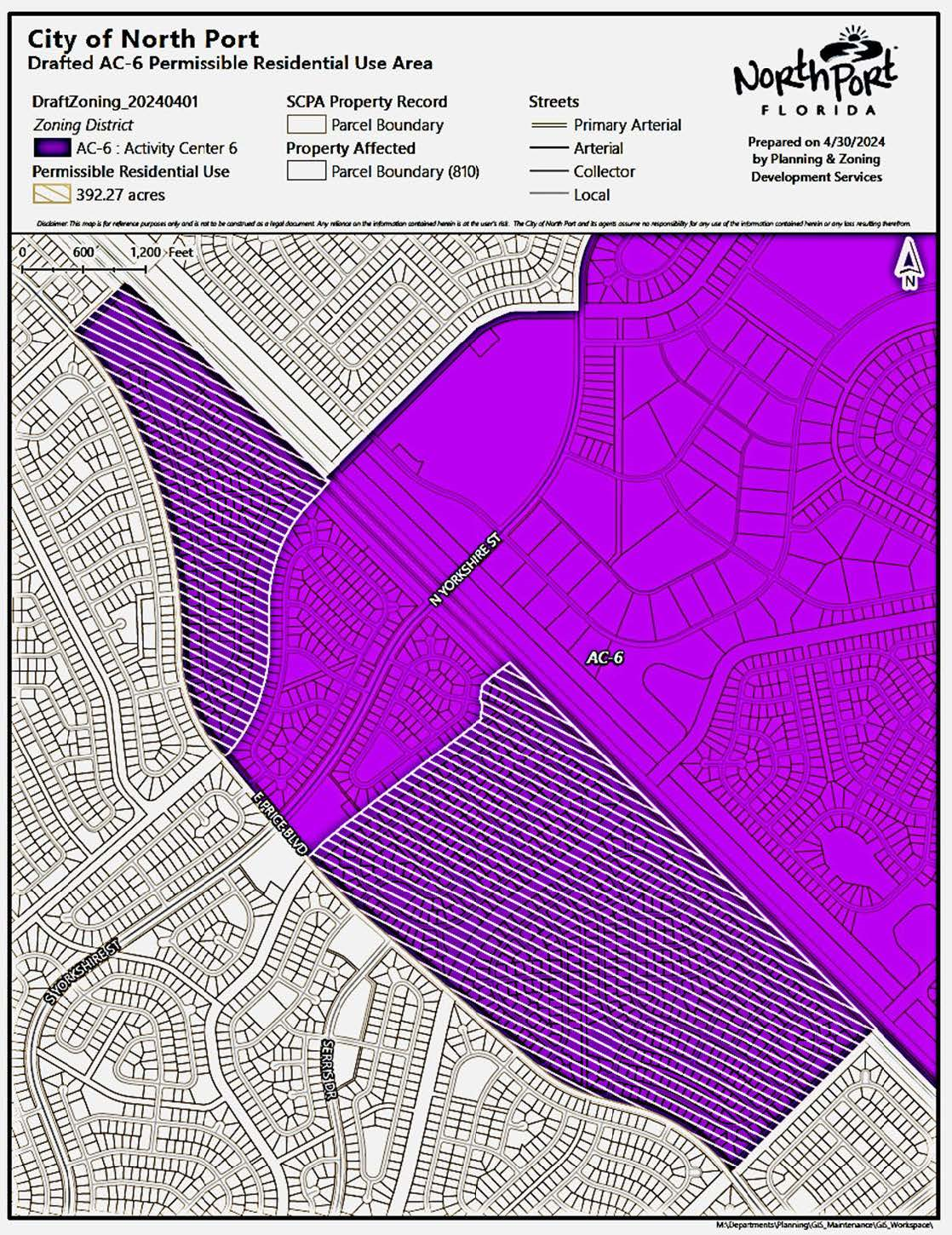
Activity Center 6 (AC-6). Activity Center 6, located in the southeastern corner of the City along Yorkshire Blvd and Interstate 75, is intended to be an employment epicenter. AC-6 supports intense commercial, industrial, and residential uses. One-and-two-family residential is permissible in limited areas only as shown in the map exhibit below, and further described by subdivision, block, and lot.
(7)
Activity Center 7 (AC-7). These lands include the city-owned property on which Warm Mineral Spring Park exists. Uses include parks and recreation, culture, and supporting commercial enterprises.
(8)
Activity Center 7A (AC-7A). These lands include property to the south and southwest of Warm Mineral Springs Park, bisected by Ortiz Blvd., portions of which abut the creek flowing from Warm Mineral Springs to the Myakka River. Uses include commercial, office and residential.
(9)
Activity Center 7B (7-B). These lands include the City-owned property lying east of Warm Mineral Springs Park. Uses may include cultural and community facilities, commercial, hotel/resort, office and residential.
(10)
Activity Center 8 (AC-8). Activity Center 8 is located along River Road adjacent to Wellen Park. AC-8 supports mixed-use development with commercial, institutional, office, and residential uses.
(11)
Activity Center 9 (AC-9). Activity Center 9 is located in the vicinity of US-41 bounded by North Port Blvd. and S. Sumter Blvd. on the west and east, and between Greenwood Ave. and Appomattox Dr. on the south and north. AC-9 supports commercial, light industrial, medical, and residential uses to serve the surrounding neighborhoods.
(12)
Activity Center 10 (AC-10). Activity Center 10 is located at the southeast corner of the City along the border with Charlotte County, near Interstate 75. AC-10 supports a variety of commercial and industrial uses, as well as limited residential uses.
F.
Village Districts, Village (V). The Village district is a designation for master-planned communities. Existing Villages have an approved Village District Pattern Plan (VDPP) and Village District Pattern Book (VDPB) regulating development. Future Villages will be governed by a Master Concept Plan.
[Added 8-6-2024 by Ord. No. 2024-13, § 3.03(Exh. A)]
Sec. 3.1.3. - Terminology and abbreviations.
A.
Density calculations apply to residential development and are expressed as units per acre. When a development subdivides a large parcel into multiple smaller parcels exclusively for residential development, the gross acreage of the large parcel is used to determine the allowable density.
B.
Intensity is expressed as Floor Area Ratio (FAR). FAR is calculated by multiplying the permitted FAR by the gross area of the site, expressed in square feet, which yields the permitted size of a structure. Unless the density and intensity tables for a zoning district specifies density, where the development contains residential uses within the vertical mixing of uses or horizontal mixing of uses in a development, the dwelling units are dictated by FAR, instead of residential density.
C.
The City of North Port's zoning districts are divided into three (3) categories: Standard, Activity Center, and Village. The following Zoning Districts are included in each category:
TABLE 3.1.3.1.
Zoning Categories and Districts
D.
This Chapter utilizes the following abbreviations throughout:
TABLE 3.1.3.2.
Abbreviations