
North Ridgeville City Zoning Code
TITLE FOUR
SUBDIVISION REGULATIONS
CHAPTER 1220 GENERAL PROVISIONS AND DEFINITIONS
CROSS REFERENCES
Original plats - see Ohio R.C. 711.01 et seq.
Municipal corporation may adopt general rules and regulations; violations; effective date - see Ohio R.C. 711.101 et seq.
Vacating plats - see Ohio R.C. 711.17 et seq.
Revision of plats - see Ohio R.C. 711.28 et seq.
Lost or destroyed records - see Ohio R.C. 711.34 et seq.
CHAPTER 1222 ADMINISTRATION, ENFORCEMENT AND PENALTY
CROSS REFERENCES
Planning Commission - see CHTR. Art. VIII; P. & Z. Ch. 1210
Original plats - see Ohio R.C. 711.01 et seq.
Municipal corporation may adopt general rules and regulations; violations; effective date - see Ohio R.C. 711.101 et seq.
Vacating plats - see Ohio R.C. 711.17 et seq.
Revision of plats - see Ohio R.C. 711.28 et seq.
Lost or destroyed records - see Ohio R.C. 711.34 et seq.
CHAPTER 1224 PLATTING PROCEDURE
CROSS REFERENCES
Original plats - see Ohio R.C. 711.01 et seq.
Municipal corporation may adopt general rules and regulations; violations; effective date - see Ohio R.C. 711.101 et seq.
Vacating plats - see Ohio R.C. 711.17 et seq.
Revision of plats - see Ohio R.C. 711.28 et seq.
Lost or destroyed records - see Ohio R.C. 711.34 et seq.
CHAPTER 1226 DESIGN STANDARDS
CROSS REFERENCES
Original plats - see Ohio R.C. 711.01 et seq.
Municipal corporation may adopt general rules and regulations; violations; effective date - see Ohio R.C. 711.101 et seq.
Vacating plats - see Ohio R.C. 711.17 et seq.
Street or alley name changing, vacating or narrowing procedure - see S.U. & P.S. Ch. 1022
Sidewalks - see S.U. & P.S. Ch. 1024
Street trees - see S.U. & P.S. Ch. 1030
Sewers generally - see S.U. & P.S. Ch. 1040
Official Thoroughfare Plan - see P. & Z. Ch. 1214
Off-street parking and loading - see P. & Z. Ch. 1285
CHAPTER 1228 IMPROVEMENTS
CROSS REFERENCES
Original plats - see Ohio R.C. 711.01 et seq.
Municipal corporation may adopt general rules and regulations; violations; effective date - see Ohio R.C. 711.101 et seq.
Vacating plats - see Ohio R.C. 711.17 et seq.
Revision of plats - see Ohio R.C. 711.28 et seq.
Lost or destroyed records - see Ohio R.C. 711.34 et seq.
Drainage improvements - see S.U. & P.S. Ch. 1028
Cluster area improvements - see P. & Z. 1282.12
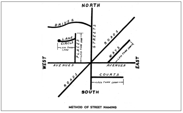
APPENDIX I METHOD OF STREET NAMING
 (Ord. 165-63. Passed 5-20-63.)
APPENDIX II STREET STANDARDS
The owner or his or her representative shall provide the City Engineer with adequate soil information indicating whether additional base and/or pavement depth is required. The City Engineer shall base his or her decision on this soil information so the minimum standards are met. The decision by the City Engineer shall be considered final. All construction shall be in accordance with the Ohio Department of Transportation (ODOT) Construction and Materials Specifications, latest edition, except as modified herein.
Subbase: Graded and compacted in accordance with ODOT Item 203, Subgrade Compaction.
Base: 4-inch minimum, or as required by the City Engineer, ODOT Item 304, Aggregate Base.
Pavement: 8-inch minimum, ODOT Item 452, Plain Concrete Pavement with ODOT Type 3A Curbing.
OR
* 8-inch minimum, ODOT Item 301, Bituminous Aggregate Base.
2-inch ODOT Item 402, Asphalt Concrete, AC-20
1-1/2 inch ODOT Item 404, Asphalt Concrete, AC-20
* With asphalt concrete pavement, curbing shall be concrete, combination curb and gutter, 2-1/2 foot width, and shall be constructed in accordance with ODOT Item 609, Curbing, Type 3.
Drainage: Underdrains shall be constructed, entire length, each side, according to ODOT Item 605, Shallow Pipe Underdrains. Pipe shall meet the specifications of Perforated Corrugated Polyethylene Drainage Tubing 707.15 or Polyvinyl Chloride Plastic Pipe 707.17.
Catch basin or inlets shall be constructed in accordance with ODOT standard designs and meet all applicable specifications.
Public and private streets shall be constructed in accordance with City standards or with the approval of the City Engineer.
All Ohio Department of Transportation references used herein shall be current specifications in accordance with the Ohio Department of Transportation (ODOT) Construction and Materials Specifications, latest edition, or as are from time to time amended or modified by the Ohio Department of Transportation. (Ord. 2584-91. Passed 9-16-91; Ord. 3615-00. Passed 9-18-00.)
Pavement: 8-inch minimum, ODOT Item 452, Plain Concrete Pavement as per Section 1228.01(f)
OR
With asphalt concrete pavement, curbing shall be concrete, combination curb and gutter, 2-1/2 foot width, and shall be constructed in accordance with Section 1228.01(f).
(Ord. 4154-2005. Passed 5-16-05.)
1220.01 TITLE
The official name of these Regulations and this document shall be the "Subdivision Regulations of the City of North Ridgeville, Ohio," hereinafter referred to as "these Subdivision Regulations" or "these Regulations."
(Ord. 165-63. Passed 5-20-63.)
1220.02 PURPOSES
These Subdivision Regulations are adopted to secure and provide for:
- The proper arrangement of streets or other highways in relation to existing or planned streets or highways or to City or regional plans.
- Adequate and convenient open spaces for traffic, utilities, access of fire-fighting apparatus, recreation, light, air and the avoidance of congestion of population.
(Ord. 165-63. Passed 5-20-63.)
1220.03 SCOPE
These Subdivision Regulations shall apply to all subdivisions hereinafter made of all land within the City.
(Ord. 165-63. Passed 5-20-63.)
1220.04 INTERPRETATION; CONFLICTS
The provisions of these Subdivision Regulations shall be held to be minimum requirements. Where these Regulations impose a greater restriction than is required by existing laws, covenants, rules, regulations or restrictions, the provisions of these Regulations shall govern.
(Ord. 165-63. Passed 5-20-63.)
1220.05 CONFORMANCE TO ZONING PLAN
Whenever a proposed subdivision is located in an area that is zoned under the provisions of Ohio R.C. Chapter 713 or the Zoning Code, it shall conform to the requirements of the zoning plan, except as specified in Section 1220.04.
(Ord. 165-63. Passed 5-20-63.)
1220.06 APPLICATION
- Divisions of Land Not Subject to These Regulations. The following divisions of land shall not be subject to the provisions of these Subdivision Regulations:
- The division or partition of land into parcels of more than five acres not involving any new streets or easements of access.
- The sale or exchange of parcels between adjoining lot owners, where such sale or exchange does not create additional building sites, as defined in the Zoning Code or these Regulations, or reduce the original tract below the requirements of the Zoning Code or these Regulations.
- The establishment of private streets serving industrial structures on their own property where there is no division of land.
- Divisions of Land Subject to These Regulations. All divisions of land as set forth in the definition of the term "subdivision," as provided in Section 1220.11(28), which are not specifically exempted by subsection (a) hereof, shall be subject to the provisions of these Regulations.
(Ord. 165-63. Passed 5-20-63.)
1220.07 FRONTAGE REQUIREMENTS; NONCONFORMING PARCELS
- No parcels of property within the City shall be divided in a manner that would result in the creation of any parcel that would not have frontage on a public or private road right-of-way.
- Every parcel created by any division shall have frontage equal to either sixty feet or to the minimum requirements of the zoning classification for which such property is classified so long as such minimum requirement does not conflict with Charter Section 9.10 regarding RS-2 Districts.
- In the event the division of parcels will result in the creation of a non-conforming parcel or parcels of property, the property owner or owners may make application to the Board of Zoning and Building Appeals for a variance prior to the division of such parcel or parcels, but in no case will any variance be granted which will result in lots with less frontage than sixty feet or the minimum requirements of the zoning classification for which such property is classified. Lot sizes may not diminish appreciably from the frontage requirement to the building line.
- The Board of Zoning and Building Appeals may grant a variance from the frontage requirement only in instances of a showing of the higher standard of unnecessary or undue hardship where the physical size, shape or other characteristic of the premises or adjoining premises necessitate the variance.
(Ord. 5080-2013. Passed 11-4-13.)
1220.08 APPLICATION OF COUNTY HEALTH DEPARTMENT REQUIREMENTS
Health requirements shall be in accordance with the regulations adopted by the County Health Department July 11, 1959, as amended. Such health requirements shall be administered by and enforced by the County Health Department.
(Ord. 165-63. Passed 5-20-63.)
1220.09 COURT PARTITIONS
Whenever land is to be divided by the process of partition in court pursuant to Ohio R.C. 5307.06, all petitions for the partition shall be submitted to the Commission, which shall take action thereon within the time limit specified in the Ohio Revised Code or within such additional time as agreed by the petitioners.
(Ord. 165-63. Passed 5-20-63; Ord. 3253-97. Passed 9-2-97.)
1220.10 SEPARABILITY; CONFLICTS WITH COUNTY RULES, REGULATIONS, ETC.
- If any section, clause, phrase, word, provision or portion of these Subdivision Regulations is held to be unconstitutional or invalid by any court of competent jurisdiction, such holding or decision shall not affect the validity of these Regulations as a whole, or any part thereof other than the section, clause, phrase, word, provision or portion so held to be invalid.
- Existing and subsequent rules, regulations and ordinances of the City shall take precedence over rules and regulations of any County department which may be mentioned in these Regulations.
(Ord. 165-63. Passed 5-20-63.)
1220.11 DEFINITIONS
For purposes of these Subdivision Regulations, certain terms and words are herein defined as follows:
- "City" means the City of North Ridgeville, Ohio.
- "Comprehensive plan", "General plan" and "Master plan" mean the Plan made and adopted by the Planning Commission, as amended and supplemented, indicating the general locations recommended for the principal streets, parks, public buildings and zoning districts of the City, the character and extent of community development and other physical aspects of urban and rural planning, or portions thereof, on file in the office of the County Recorder and in the office of the Commission.
- "County" means Lorain County, State of Ohio.
- "Crosswalk" means a right of way, thirty feet or more in width, which cuts across a block to facilitate pedestrian access to adjacent streets and properties.
- "Developer" means any person, partnership or corporation, or duly authorized agent thereof, who or which constructs or contracts to construct improvements on subdivided land.
- "Easement" means a right to some profit, benefit or use out of or over the land of another, created by grant or prescription.
- "Engineer" means a registered engineer authorized to practice civil engineering, as defined by Ohio R.C. Chapter 4733.
- "Flood plain" means that portion of a river or creek valley adjacent to a river or creek channel which is covered with water when the river or creek overflows its banks at flood stage.
- "Improvements" means street pavements, with or without curb or gutter, sidewalks, crosswalks, water mains, sanitary and storm sewers. street trees and other appropriate items.
- "Inspection fee" means the cost to the City of supervising construction, to be paid by the subdivider or developer.
- "Key (location) map" means a drawing, at a reduced scale, located on the plat which shows legibly, by dimension and/or other means, enough area beyond the bounds of the proposed subdivision to locate and orient the subdivision within the City and the relationship of the site to the community facilities which serve or influence the property. (Ord. 165-63. Passed 5-20-63.)
- "Lot" means a parcel of land having its full frontage on a public or private street. (Ord. 5078-2013. Passed 11-4-13.)
- "Lot, corner" means a lot abutting upon two or more streets at their intersections.
- "Official Thoroughfare Plan" means the system of major thoroughfares for the City as adopted by the Commission, on file in the office of the County Recorder and in the office of the Commission, together with all amendments thereto.
- "Performance bond" and "surety bond" mean a personal or corporate suretyship agreement between a subdivider and such surety in favor of the City, guaranteeing the completion of physical improvements according to plans and specifications within the time prescribed by the subdivider's agreement.
- "Planning Commission" and "Commission" mean the duly appointed Planning Commission of the City which controls the platting of land within the corporate limits of the City, or within a distance of three miles of the corporate limits, when a plan for such area, as provided for in Ohio R.C. 711.09, has been adopted.
- "Plat" means a map upon which the subdivider's plan of subdivision is presented and which he or she submits for approval and intends to record in the final form.
- "Regulations" and "Subdivision regulations" mean these Subdivision Regulations.
- "Reproducible tracing" means a sepia, brownline or other translucent drawing from which a print may be directly taken.
- "Road or street right of way" means the width, between property lines, of a street, crosswalk or easement.
- "Setback line, building" means a line indicating the minimum horizontal distance between the street, easement or right of way line and buildings or any projection thereof, other than steps or permanently open porches, unless otherwise specifically defined.
- "Street, arterial" (major, secondary, primary, etc.) means a public thoroughfare which is used primarily for fast or heavy traffic.
- "Street, auxiliary" means a public thoroughfare which carries traffic from minor streets to the major system of arterial streets and highways, including the principal entrance streets of a residential development and streets for circulation within such a development.
- "Street, marginal access" means a minor street which is generally parallel and contiguous to an expressway, freeway, parkway or major or minor street and which is designed so as to intercept, collect and distribute traffic desiring to cross, enter or leave such traffic artery, and which provides access to abutting properties and protection from through traffic.
- "Street, minor" means public streets which are used primarily for access to the abutting properties.
- "Subdivider" means any person, firm or corporation, or duly authorized agent thereof, who undertakes the subdivision of land as defined in subsection (28) hereof.
- "Subdivider's or developer's agreement" means an agreement by and between a subdivider and/or developer and the City that sets forth the manner in which the subdivider and/or developer agrees to proceed with the construction of public improvements and the disposition of lots in the subject subdivision.
- "Subdivision" means:
- The division of any parcel of land, shown as a unit or as contiguous units on the last preceding tax roll, into two or more parcels, sites or lots, any one of which is less than five acres, for the purpose, whether immediate or future, of transfer of ownership, provided, however, that the division or partition of land into parcels of more than five acres, not involving any new streets or easements of access, and the sale or exchange of parcels between adjoining lot owners where such sale or exchange does not create additional building sites, shall be exempted from the provisions of these Regulations; or
- The improvement of one or more parcels of land for residential, commercial or industrial structures or groups of structures involving the division or allocation of land for the opening, widening or extension of any street or streets, except private streets serving industrial structures; and the division or allocation of land as open spaces for common use by owners, occupants or lease holders, or as easements for the extension and maintenance of public sewer, water, storm drainage or other public facilities.
- "Surveyor" means a professional surveyor, as defined in Ohio R.C. 4733.01.
- "Width, average" means the distance measured between the midpoint of the sides of a lot. When the two sides are not straight, the Commission shall determine the average width.
(Ord. 165-63. Passed 5-20-63.)
1222.01 AUTHORITY OF PLANNING COMMISSION; ADOPTION OF RULES AND REGULATIONS
The Planning Commission derives its authority to regulate subdivisions by virtue of and in accordance with Article VIII, Section 8.6, of the City Charter and Ohio R.C. Chapter 711. The Commission is hereby authorized to adopt rules and regulations governing plats and subdivisions of land falling within its jurisdiction.
(Ord. 165-63. Passed 5-20-63.)
1222.02 ADMINISTRATION GENERALLY
It shall be the responsibility of the Planning Commission to administer these Subdivision Regulations, except where specific authority is given to some other City or County office as set forth in these Subdivision Regulations.
(Ord. 165-63. Passed 5-20-63.)
1222.03 ENFORCEMENT
It shall be the duty of the Planning Commission and its designated official, together with other appropriate City or County offices, to enforce these Subdivision Regulations within all areas under the subdivision jurisdiction of the Commission.
(Ord. 165-63. Passed 5-20-63.)
1222.04 NOTICE OF VIOLATIONS; FAILURE TO COMPLY; REMEDIES OF CITY
The Chief Building Official of the City shall serve a written notice or order upon a person responsible for a violation of these Subdivision Regulations whenever he or she is satisfied that any work is being done or any transactions are being made in violation of the provisions of these Subdivision Regulations, or in violation of a detailed statement or plan submitted and approved by the Planning Commission, the Chief Building Official or the City Engineer. Such notice shall direct the discontinuance of any illegal action and the remedying of the conditions that are in violation of the provisions and requirements of these Regulations.
In case such notice or order is not promptly complied with, the Chief Building Official of the City shall notify the other public offices, utility companies and officials concerned therewith and shall request the same to withhold their approval and to stop all services to the property where such violation exists and to refuse such services until these Regulations are complied with. The enforcement officer of the City, in any case, may also request the Director of Law to institute an appropriate action or proceeding at law or in equity to restrain, correct, remove or prosecute such violation.
(Ord. 165-63. Passed 5-20-63.)
1222.05 APPEALS
Rights of appeal shall be as set forth in Ohio R.C. Chapter 711 or other applicable sections of the Ohio Revised Code.
(Ord. 165-63. Passed 5-20-63.)
1222.99 PENALTY
Whoever violates any of the provisions of Ohio R.C. Chapter 711 or of these Subdivision Regulations is subject to the penalties set forth in Ohio R.C. Chapter 711.
(Ord. 165-63. Passed 5-20-63.)
1224.01 PLATS AND DATA FOR CONDITIONAL APPROVAL OF PRELIMINARY PLANS
- Residential Developments. The preliminary plan for residential developments shall be drawn to a scale of not less than 100 feet to the inch, and shall indicate:
- The location of the property, the City, Township, County or other political subdivision and legally established districts, streets, watercourses, topography, other features within the area to be subdivided and similar facts regarding conditions of land immediately adjacent thereto.
- The proposed location and width of streets, lots, crosswalks and easements, and a plan for all the land owned.
- Existing sanitary and storm sewers, water mains, culverts and other underground structures within the tract and adjacent thereto.
- The general location and size of the nearest water main and sanitary or storm sewer or outlet.
- The title under which the proposed subdivision is to be recorded and the names of the owner, subdivider and surveyor platting the tract.
- The names of owners of large tracts, or the subdivision title abutting the boundary of the proposed subdivision.
- A north point, scale and date.
- The zoning classification of the property to be subdivided.
- Plans or written and signed statements regarding planted areas, parks and playgrounds, where applicable.
- Topographic information, which must accompany the preliminary plan on a separate sheet or on the drawing itself. The elevations shown thereon must be based on sea level datum as determined by the United States Coast and Geodetic Survey. Contours at an interval of not more than two feet shall be required.
- A key map.
- Commercial and Industrial Developments. Subdividers or developers of shopping centers and other commercial and industrial uses must comply with the same requirements as residential developers, with the exception of paragraph (a)(9) hereof. Plans or written and signed statements regarding planted or open areas may be required where applicable.
- Other Land Uses. Any other land use which may either alter the existing street or road pattern, materially change or disrupt the existing street or road pattern, or materially change or disrupt the existing flow of traffic, shall be reviewed by the Planning Commission, and a plat may be required if the Commission is of the opinion that such a plat should be recorded.
- Construction of Improvements Before Recording of Plats. If the subdivider or developer of a residential, commercial or industrial subdivision wishes to build streets or make other improvements before the subdivision plat is recorded, he or she shall comply with the requirements of both the preliminary plan and the subdivision plat and comply with the improvement requirements set forth in Chapters 1226 and 1228.
(Ord. 165-63. Passed 5-20-63.)
1224.02 PLATS AND DATA FOR FINAL APPROVAL OF SUBDIVISION PLATS
- Residential Developments. The subdivision plat for a residential development must be drawn on a scale to fit on 24 x 36 paper. If more than two sheets are required, an index sheet of the same dimensions must be filed, showing the entire subdivision on one sheet, with all areas shown on other sheets indicated thereon.
All copies of the plat drawings required by Planning Commission shall include one full size 24 x 36 original set and nine additional copied sets to be of lesser size as long as legible and no smaller than 11 x 17. (Ord. 5385-2016. Passed 7-18-16.)
The final plat must show:- The boundary lines of the area being subdivided, in heavy lines with accurate distances and bearings, including original lot, Township, corporations and County lines and road centerlines.
- The property lines of all proposed streets with their widths, names, bearings and centerline measurements.
- The accurate boundary lines of all grounds for public use and the acreage of the same.
- All common boundary corners of all adjoining lands and adjacent streets with their widths and names, the names of adjoining subdivisions and the names of record owners of adjoining parcels of unplatted land.
- All lot lines with as many bearings as necessary to describe each line and a system for identification of lots, blocks and other areas.
- Easements for public uses, services or utilities and their dimensions.
- All dimensions, linear and angular, boundary locations, lots, streets, easements and areas for public or private uses, expressed in decimals of a foot, and the number of acres of each reserve, park, playground and other public area.
- Radii and chords, points of tangency, control angles for all curvilinear street centerlines and radii for all rounded corners.
- Arcs, chord lengths, bearings of chords and points of tangency of the property lines of the curvilinear lines.
- The name of the subdivision and a description of the property subdivided, showing its location and extent, points of compass, scale of plan, dedication of streets and other public open spaces, and the names of the owner and subdivider, together with appropriate evidence of ownership of the subdivision.
- Certification by a surveyor, licensed or registered in the State, to the effect that the plan represents a survey made by him or her in which the traverse of the exterior boundaries of the tract and of each block, when computed from field measurements of the ground, closed within a limit of error of one foot to 10,000 feet of the perimeter before balancing the survey, and that all the required survey monuments are correctly shown thereon and that those which are necessary for construction of improvements are in place on the site, with any remaining survey monuments to be properly placed upon completion of construction.
- A key map.
- Proper acknowledgment of consent on the plat by all parties having any record, legal right, title or interest in the property.
- Building setback lines, with dimensions.
Upon recording of a subdivision plat, a reproducible tracing shall become the property of the City and shall remain on file in the office of the City Engineer, except when it is out for reproduction. - Commercial and Industrial Developments. Subdividers and developers of commercial and industrial areas must comply with the same requirements as those of residential developments.
- Other Land Uses. Any other land use which may either alter the existing street or road pattern, materially change or disrupt the existing street or road pattern, or materially change or disrupt the existing flow of traffic, shall be reviewed by the Commission, and a plat may be required if the Commission is of the opinion that such a plat should be recorded.
(Ord. 165-63. Passed 5-20-63.)
1224.03 REQUIRED STATEMENTS AND SIGNATURES TO BE AFFIXED ON PLATS
The following statements and signatures shall be affixed on subdivision plats:
Situated in the City of North Ridgeville, County of Lorain, State of Ohio, and being of original lot number _____, containing ___________ acres, and being the same tract as conveyed to ______________ and described in deed recorded in Deed Book Page ___________, Recorder's Office, Lorain County, Ohio.
The undersigned (set forth all parties having record legal title interest in the parcel) ______________________________________ hereby certify that the attached plat correctly represents their "_____________________" a subdivision of lots ________________ to _______________, inclusive, do hereby acknowledge this plat of same and dedicate to use as such, all or parts of the roads, boulevards, cul-de-sacs, parks, planting strips, etcetera shown herein and not heretofore dedicated.
The undersigned further agrees that any use or improvements made on this land shall be in conformity with all existing platting, health or other lawful rules and regulations including the applicable off-street parking and loading requirements of the City of North Ridgeville, Ohio, for the benefit of themselves and all other subsequent parties taking title from, under or through the undersigned.
The dimensions of the lots and streets are shown on the plat in feet and decimal parts thereof. Easements are reserved where indicated on the plat for public utility purposes above and beneath the surface of the ground.
In witness thereof the undersigned have hereunto set their hands this _____ day of ___________, 19___.
Witness ____________ Signed ___________________
Surveyed and Platted by ___________________________
Civil Engineers and Surveyors
We do hereby certify that we have surveyed the premises and prepared the attached plat and that said plat is correct.
Dimensions on curves are arc measurements.
By ___________________________________
Registered Surveyor
STATE OF OHIO, COUNTY OF LORAIN
Before me, a Notary Public in and for said County, appeared ____________________ who acknowledged the signing of the foregoing instrument to be their voluntary act and deed for the uses and purposes therein expressed. In witness thereof I have hereunto set my hand and affixed my official seal this _____ day of ___________, 19___.
_____________________________
Notary Public
Within the City of North Ridgeville
Approved this _____ day of ___________ 19__ ______________
Secretary (or responsible official) City Planning Commission
Approved this _____ day of __________ 19__ _______________
Mayor (or designated member of Council)
Approved this _____ day of __________ 19__ _______________
City Engineer
Approved this _____ day of __________ 19__ _______________
Lorain County District Board of Health
Transferred this _____ day of __________ 19__ _____________
Lorain County Auditor
Filed for record this _____ day of __________ 19__ at __ __M.
Recorded this _____ day of __________ 19__ in Plat Book ____ Page No. ____
_______________________________
Lorain County Recorder
Note: If a public sewer and water are available, the plat need not be signed by the Lorain County District Board of Health.
(Ord. 165-63. Passed 5-20-63.)
1224.04 APPROVAL PROCEDURE FOR SUBDIVISIONS INVOLVING FIVE LOTS OR LESS
- Whenever a division of a parcel of land shown as a unit on the last preceding tax roll (duplicate) is proposed along an existing public street, not involving the opening, widening or extension of any street or road, and involving no more than five lots, the division shall be submitted to the Planning Commission for action without a plat. If the Commission, acting through a designated official, is satisfied that such proposed division is not contrary to applicable platting, subdividing or zoning regulations, it shall, within seven working days after submission, approve such proposed division. On presentation of a conveyance of such parcel, the same shall be stamped, "Approved, City of North Ridgeville Planning Commission," and signed by the authorized official.
- A drawing, based on a survey showing the location of the property and giving such other information as may be necessary, shall be required.
(Ord. 165-63. Passed 5-20-63.)
1224.05 APPROVAL PROCEDURE FOR SUBDIVISIONS INVOLVING MORE THAN FIVE LOTS
- Preliminary Plan. No person, firm or corporation proposing to lay out or have laid out, within the territorial jurisdiction of these Subdivision Regulations, a subdivision which includes more than five lots, shall proceed with any construction work on the proposed subdivision, including grading, before obtaining from the Planning Commission the approval of the preliminary plan of the proposed subdivision as follows:
- Required. The subdivider shall have prepared a preliminary plan, together with plans, a preliminary title report and preliminary plans and specifications of improvements, as required by Chapter 1228.
- Filing. Copies of the preliminary plan and of the supplementary material specified shall be submitted to the Planning Commission in the form as specified in Section 1224.02(a) with written application for conditional approval.
- Approval.
- The Commission, acting through the City Engineer, shall, within forty-five days or within such further time as the applicant may agree to, review the preliminary plan and other material submitted for conformity thereof to these Regulations and discuss with the subdivider any changes deemed advisable.
- The Commission shall inform the subdivider as to which public offices must be contacted by him or her to determine the nature and extent of the improvements required.
- Upon completion of the review, the action of the Commission shall be noted on three copies of the preliminary plan referenced and attached to any conditions determined to be necessary for approval. One copy shall be retained by the Commission, one copy shall be returned to the subdivider and one copy shall be retained by the Building Department.
- Approval or conditional approval of the preliminary plan shall not constitute approval of the subdivision plat. Rather, it shall be deemed an expression of approval of the layout as returned to the subdivider on the preliminary plan, as a guide to the preparation of the subdivision plat which will be submitted for approval of the Commission, and for recording upon fulfillment of the requirements of these Regulations and the conditions of conditional approval, if any.
- If the Commission does not render a conditional approval of the preliminary plan within the forty-five days stipulated in paragraph (a)(3)A. hereof, or such further time as may be agreed upon, nothing in these Regulations shall prohibit the subdivider from officially filing his or her subdivision plat with the Commission.
- Final Plat.
- Conformance to Preliminary Plan. The final subdivision plat shall conform to the preliminary plan, except where changes are agreed upon between the Commission and the subdivider, and it may constitute only that portion of the approved preliminary plan which the subdivider proposes to record and develop at the time, provided that such portion conforms with all the requirements of these Regulations.
- Submission of Plans. After receiving notice of conditional approval of the preliminary plan, the subdivider shall proceed to file:
- Copies of the subdivision plat required under Section 1224.02(a), together with:
- A certificate from the City Engineer that all improvements required by these Regulations have been installed; or
- A certificate from the City Engineer that a performance agreement and bonds, or other guarantee or security acceptable to the City, have been duly filed to secure the construction of such improvements.
- A written application for approval upon compliance with the formal provisions of these Regulations, the application form to be provided by the Commission.
- Cross-sections and profiles of streets and all other plans and construction drawings related to the improvements to be constructed in the subdivision as required in these Regulations.
These plans and drawings are to be transmitted to the proper City or County office by the subdivider as directed by the Commission or the City Engineer. (Ord. 165-63. Passed 5-20-63; Ord. 5386-2016. Passed 7-18-16.)
- Copies of the subdivision plat required under Section 1224.02(a), together with:
- Filing. The subdivision plat shall be filed with the Commission not later than twenty-four months after the date of conditional approval of the preliminary plan; otherwise, it shall be considered void unless an extension is requested by the developer and granted by the Commission. For larger subdivisions only the plat for the first phase must be submitted to Planning Commission within 24 months. All subsequent phases may be submitted to Planning Commission for approval at any time following conditional approval of the preliminary plan. The subdivision plat shall be considered officially filed (submission of plat for approval) after it has been examined by the Commission, after reports have been received from the City Engineer, the County District Board of Health or any other applicable agency involved, and after it is found to be in full compliance with the formal provisions of these Regulations. The official filing shall take place at least five working days prior to the meeting at which it is to be considered by the Commission.
- Commission Approval. The approval or disapproval of the Commission shall take place within thirty days after the submission of the plat for approval, or within such further time as the applying party may agree to; otherwise, such plat shall be deemed approved, and the certificate of the Commission as to the date of the submission of the plat for approval and the failure to take action thereon within such time shall be sufficient in lieu of the written endorsement or evidence of approval required by this section. The grounds for refusal of approval of any plat submitted, including citation of or reference to the rule or regulation violated by the plat, shall be stated upon the record of the Commission.
The subdivider shall be notified of the final action of the Commission, and he or she shall record the subdivision plat in the office of the County Recorder within twenty-four months after the date of approval, unless an extension is agreed to by the Commission; otherwise, the Commission may recall the plat for its reconsideration. The subdivider shall, immediately upon recording, furnish the Commission with an eighteen-inch by twenty-four inch photostat of the recording plat. (Ord. 165-63. Passed 5-20-63; Ord. 4457-2007. Passed 9-4-07; Ord. 5693-2019. Passed 12-16-19.) - Dedication of Land for Public Use; Easements; Acceptance of Streets and Utilities. If the final plat indicates land for public use, the Planning Commission's approval of the plat and Council's formal approval of Planning Commission's action shall constitute the acceptance of any land dedicated for public use and acceptance of any easement. Following approval, the City shall sign the plat for recording with the County. The acceptance of any street, improvement or utility for public use and maintenance by the municipality shall be by separate action of Council.
(Ord. 5394-2016. Passed 9-6-16.)
1226.01 CONFORMITY OF SUBDIVISIONS WITH OFFICIAL THOROUGHFARE PLAN
All proposed subdivisions shall conform to the Official Thoroughfare Plan of the City and any subsequent revisions thereof.
(Ord. 165-63. Passed 5-20-63.)
1226.02 STORM AND SANITARY SEWERS; PROTECTION OF NATURAL DRAINAGE COURSES
- The Commission shall not approve any subdivision having inadequate storm and/or sanitary drainage, as determined by the City Engineer.
- No natural drainage course shall be altered, and no fill, building or structure shall be placed in any such natural drainage course, unless recommended by the City Engineer and approved by Council.
(Ord. 165-63. Passed 5-20-63.)
1226.03 STREET TREES
Street trees may be located within the street right-of-way if they are of a species designated by the City Arborist to be less likely to be destructive to adjacent improvements or subterranean utilities, and shall be planted in such a manner as to not impair visibility for vehicular or pedestrian traffic.
(Ord. 4492-2007. Passed 12-17-07.)
1226.04 SUBDIVISION NAMES
A subdivision name shall not duplicate, be similar to, or be in conflict with, the names of any existing subdivisions in the City and the County, or any previously planned subdivision under consideration by the Planning Commission.
(Ord. 165-63. Passed 5-20-63.)
1226.05 STREET NAMES
Names of new streets shall not duplicate or be similar to existing dedicated streets. New streets which are extensions of or in alignment with existing streets shall bear the name of the existing streets. All new streets shall be named as shown on the plan titled "Method of Street Naming," which follows the text of these Subdivision Regulations as Appendix I.
(Ord. 165-63. Passed 5-20-63.)
1226.06 NUMBERING OF LOTS; BOUNDARY MARKERS
- All lots shall be numbered by progressive numbers throughout the proposed subdivision. The lots in numbered additions bearing the same name shall be consecutive throughout the several additions. Where land is subdivided into more than one subdivision by the same developer, the lots in each subdivision shall be numbered so that the lots will bear the same consecutive numbers. (Ord. 165-63. Passed 5-20-63.)
- All lots shall have permanent boundary markers, such as iron pins or other similar acceptable survey markers, at each corner of the lot so as to be readily available for identification at all times.
(Ord. 966-74. Passed 6-10-74.)
1226.07 OFF-STREET PARKING AND LOADING
Off-street parking and loading requirements shall be in accordance with those specified in Chapter 1285.
(Ord. 165-63. Passed 5-20-63.)
1226.08 EASEMENTS
Private and public utility easements shall have a minimum width of twelve feet, or such additional width as may be required for necessary access to the utility involved. Such easements shall be located along rear or side lot lines with six-feet thereof being located one each side of such lot lines, except under special circumstances where the Planning Commission may require them in other locations. For lots facing curvilinear streets , the rear easement shall consist of straight lines with a minimum of points of deflection. All easements shall conform to Section 1226.03.
(Ord. 4342-2006. Passed 11-20-06.)
1226.09 STREETS
- Conformity with Official Thoroughfare Plan. The arrangement, character, extent, width, grade and location of all streets shall conform to the Official Thoroughfare Plan, or subsequent amendments thereof, and shall be considered in their relation to existing and planned streets, to topographical conditions, to public convenience and safety and to the proposed use of the land to be served by such streets.
As to arrangement, the subdivider shall provide, within the boundaries of the subdivision plat, the necessary right of way for the widening, continuance or alignment of such streets in conformity with the Official Thoroughfare Plan by one of the following methods:- Dedicating the necessary right of way for the continuation, extension or connection of any present or planned thoroughfare.
- When subdividing land fronting on an existing City road or street not designated on the Official Thoroughfare Plan as being of equal or of greater importance than an auxiliary street, making reasonable provision for necessary rights of way or easements for traffic, utilities and drainage.
- Protection of Residential Properties from Through and Local Traffic.
- Where a subdivision abuts or contains an existing or proposed street of equal or greater width than a secondary thoroughfare as shown on the Official Thoroughfare Plan, the Planning Commission may require any of the following:
- Marginal access streets.
- Reverse frontage with planting contained in a nonaccess reservation along the rear property line or a planting strip of a minimum width of twenty feet on the rear of the lots with no vehicular access across such strip.
- Such other treatment as may be necessary for adequate protection of residential properties and to afford separation of through and local traffic.
- Where a subdivision borders on or contains a railroad right of way or a limited access highway right of way, the Commission may require a street approximately parallel to and on each side of such right of way at a distance suitable for necessary traffic circulation.
- Where a subdivision abuts or contains an existing or proposed street of equal or greater width than a secondary thoroughfare as shown on the Official Thoroughfare Plan, the Planning Commission may require any of the following:
- Layout.
- Discouragement of Through Traffic. Minor streets, as defined in Section 1220.11(25) and in the Official Thoroughfare Plan, shall be laid out so that their use by through traffic will be discouraged.
- Access to Adjacent Unsubdivided Property. The street layout shall make provision for the proper projection and continuance of streets into adjacent, unsubdivided acreage where it is deemed appropriate and desirable by the Commission. Reserve strips controlling access to streets shall be prohibited.
- Sketch of Future Street System for Unsubdivided Property. Where the plat to be submitted includes only part of the tract owned by the subdivider, the Commission may require a sketch of a tentative future street system for the unsubdivided portion.
- Alignment.
- Horizontal.
- Jogs. No street layouts with centerline offsets of less than 125 feet shall be permitted without the consent of the Commission.
- Angles of Intersections. Streets shall be laid out so as to intersect as nearly as possible at right angles, and no street shall intersect any other street at less than sixty degrees.
- Intersection Approaches. Approaches to street intersections shall be perpendicular for a distance of at least 100 feet from the centerline of the street intersected.
- Reverse Curves. A tangent at least 200 feet long shall be introduced between reverse curves on all but minor, marginal access and auxiliary streets, where approved by the City Engineer.
- Vertical; Grades at Intersections. Approaches to intersections shall be reduced to a grade not exceeding three percent for a distance of at least 150 feet. The Commission may modify this requirement when an unreasonable hardship would result from its strict enforcement.
- Horizontal.
- Classification. In approving each street in a proposed subdivision, the Commission shall be governed by the standards set forth in the following table:* Requirements will vary and be dependent upon the design of the highway.
Street Classification Minimum Right of Way (ft.) Maximum Degree of Curvature Minimum Radius of Curvature (ft.) Maximum Grade (%) Controlled, limited access or expressway 200 * * * Primary 120 3 1910 4 Secondary 100 5 1150 5 Auxiliary 80 10 575 6 Minor for apartments and two-family dwellings 60 10 575 6 Minor for commercial uses 60 10 575 6 Minor for industrial uses 60 10 575 6 Minor for family residences 60 20 290 7 Marginal access 50 20 290 7 - Corner Radii at Intersections. Property lines at street right of way intersections should be rounded with a radius of twenty feet or of a greater radius where the Commission may deem it necessary.
- Dead-End Streets.
- Permanent; Cul-De-Sac and T-Type Streets.
- It is suggested that permanent dead-end streets (cul-de-sacs) be not longer than 600 feet. However, this is not intended to limit the designer to this distance. So long as good design practice and sound judgment are exercised, this requirement may be waived.
- Cul-de-sacs shall be provided at the closed end with a turn-around having a right of way diameter of at least 120 feet. The street right of way line and turn-around should be joined by tangent arcs of fifty feet minimum radius.
- A T-type, back-around terminus may be approved within the normal right of way.
- Temporary.
- Where streets are extended to the boundary of a subdivision to provide for their continuance at such time as the adjacent land is subdivided, they may be terminated in the same manner as required for permanent dead-end streets of 350 feet or less.
- If a street extends only one lot depth past a street intersection, no turn-around is required.
- Permanent; Cul-De-Sac and T-Type Streets.
- Half Streets. Half streets shall be prohibited, except under one of the following conditions:
- There exists a half street which should logically be continued to a reasonable intersection.
- There exists a dedicated or platted half street adjacent to the tract to be subdivided, in which case the other half shall be platted if deemed necessary by the Commission.
(Ord. 165-63. Passed 5-20-63.)
1226.10 BLOCKS
- In General. The lengths, widths and shapes of blocks shall be determined with due regard to:
- Provision of adequate building sites suitable to the special needs of the type of use contemplated.
- Zoning requirements and the requirements contained in these Subdivision Regulations as to lot size and dimension.
- Needs for convenient access, circulation, control and safety of street traffic.
- Limitations and opportunities of topography.
- Length. Blocks shall not exceed 1,200 feet in length, except where topographical conditions require longer blocks.
- Width. Blocks shall contain two rows of lots, except where double and reverse-frontage lots are allowed.
(Ord. 165-63. Passed 5-20-63.)
1226.11 LOTS
- Conformance With Zoning Code and Other Legal Requirements; Depth to Width Ratio. Lots shall meet all lawful requirements as adopted by the various governmental subdivisions or public agencies having jurisdiction. The Planning Commission may limit, to a maximum ratio of three and one-half to one, the depth to width ratio of lots for the most efficient use of land. All lots shall conform to the area requirements of the Zoning Code.
- Extra Width for Corner Lots. Corner lots for residential use shall have extra width where necessary to permit a required building setback from and orientation to both streets. (Ord. 165-63. Passed 5-20-63.)
- Frontage on Public Streets Required. The subdividing of land shall be such as to provide each lot with frontage on a public or private street, unless otherwise allowed by the Planning Commission. (Ord. 5079-2013. Passed 11-4-13.)
- Double and Reverse Frontage. Double frontage and reverse-frontage lots may be allowed where they are essential to provide for the separation of a residential development from traffic arteries or to overcome specific disadvantages of topography and orientation. A planting screen easement of at least twenty feet, across which there would be no right of access, shall be provided along the line of lots abutting such traffic arteries.
- Side Lot Lines. Side lot lines shall be substantially at right angles or radial to street lines.
- Conformance of Building Setback Lines to Zoning Code. Building setback lines shall be in accordance with those specified in the Zoning Code.
(Ord. 165-63. Passed 5-20-63.)
1226.12 NEIGHBORHOOD UNIT-TYPE DEVELOPMENTS
- In General. Neighborhood unit-type development is encouraged by the Planning Commission. Where large subdivisions designed on the basis of neighborhood units are being reviewed, consideration will be given to the placement of commercial areas and public areas in relation both to the neighborhood unit being developed and to other units that might be developed. Where small subdivisions are being reviewed, the Commission shall coordinate such subdivisions, to the extent practicable, into units so that the same relationship with respect to commercial areas and public areas may be realized.
- Variances. Whenever a subdivision is developed as a neighborhood unit, with adequate parks or playgrounds provided, and such neighborhood is protected from through traffic, the Commission may vary the requirements of Sections 1226.09 to 1226.11 to allow the subdivider more freedom in the arrangement of streets and lots. However, the Commission shall ensure the convenience, health, welfare and safety of future residents of the subdivisions and the adjacent property, the general welfare of the City and the intent of these Regulations.
(Ord. 165-63. Passed 5-20-63.)
1226.13 SIDEWALKS
Sidewalks shall be required in accordance with Chapters 1024 and 1228.
(Ord. 165-63. Passed 5-20-63.)
1226.14 STREET AND TRAFFIC SIGNS
- Developers of approved subdivisions within the City shall install, provide and implement, at their cost, adequate and appropriate street name signs in accordance with engineering standards and safety forces requirements established by the City.
- Developers of all subdivisions shall be charged and other development projects may be charged as deemed necessary by the City Engineer, for the costs incurred by the City for the installation of all traffic control devices of any kind associated with the development of the subdivision, including subdivisions currently under construction.
- The City shall generate an itemized cost of installation including, but not limited to, traffic control device purchase costs, labor costs whether internal or subcontracted by the City, and related inspection fees, if any, for all traffic control devices installed by the City which are necessitated by and appurtenant to the development of the subdivision or other development project.
(Ord. 3539-00. Passed 2-7-00; Ord. 3862-02. Passed 12-2-02.)
1226.15 STREET LIGHTS
Subdivider agreements shall contain a provision requiring a developer to install street lights at all intersections and at any other location specified by the City Engineer, in consultation with the Chief of Police.
(Ord. 3292-98. Passed 1-20-98.)
1226.16 STANDARD CONSTRUCTION DETAILS
- The City of North Ridgeville does hereby adopt certain Standard Construction Details evaluated by the City Engineering Department and determined by Engineering to be the most appropriate standards for both residential and commercial development within the City.
- Drawings containing such Standard Construction Details shall be available at all regular business hours in the Engineering Department for use by developers and contractors who will be and are hereby held to the standards so contained. All construction plans submitted to the City shall have attached copies of the Standard Construction Details applicable to that design.
- Such standards shall be amended by the City Engineering Department on a regular basis to reflect the best practices for the City of North Ridgeville. Each amendment shall be dated as to when adopted by the Engineering Department and older standards will be retained as reference for as long as the Department requires.
(Ord. 4625-2009. Passed 1-5-09.)
1228.01 DUTIES OF CITY ENGINEER; CONSTRUCTION SPECIFICATIONS AND REGULATIONS
The City Engineer is responsible for the design, inspection and enforcement of all street, storm drainage and other improvements as set forth in the following specifications and regulations:
- Construction Plans; Materials and Construction Specifications In General. The subdivider or developer shall submit to the City Engineer for his or her approval a set of construction plans for roads, streets or other improvements, prepared by a registered professional engineer. The City Engineer shall, within forty-five days after receiving the plans, approve, disapprove, or approve with modification, such plans. Otherwise, after such forty-five day period, such plans shall be deemed to be satisfactory. The construction plans shall include the title of the plan, general notes, a location map, a topographic map with contours, plan views, profile views, miscellaneous engineering details and an estimate of quantities. A completed cross-section, as required by the City Engineer, shall also be submitted with these plans. Sample sets of plans may be inspected at the office of the City Engineer.
When the subdivider or developer submits for approval a construction plan for a street improvement in part of a subdivision area, preliminary street grades and proposed drainage facilities for the entire subdivision shall also be presented.
All materials and construction procedures shall be in accordance with the current Construction and Material Specifications of the Ohio Department of Transportation (ODOT) and the specifications of the City. The construction plans and specifications, as herein required to be submitted to the Engineer Department for the improvement of roads or streets, shall be in accordance with the City's "Street Standards," which follows the text of these Subdivision Regulations as Appendix II. All elevations shown must be sea-level data. (Ord. 165-63. Passed 5-20-63.) - Subdivider's Agreement. Before any subdivision plat or construction plan is given final approval, the subdivider or developer shall have executed a subdivider's agreement with the City or with any applicable City or County department acting through the City Engineer as its agent. Such subdivider's or developer's agreement shall contain:
- A provision for the posting of performance bonds for the amount of the estimated construction costs, as determined by the developer and approved by the City Engineer; (Ord. 2187-87. Passed 4-20-87; Ord. 4186-2005. Passed 10-17-05.)
- A provision for the deposit of fees for review, testing, inspection and any other costs incurred by the City reasonably attributable to actions or omissions on the development site in a sum estimated to be the costs calculated at the then existing hourly rate for the drafting and execution of the Subdivider’s Agreement and for all other legal services rendered by the City Law Department which are related to and/or are performed in response to issues created by the developer’s project; (Ord. 4662-2009. Passed 5-18-09.)
- A provision for the posting of a maintenance bond, irrevocable letter of credit, or similar guaranty or surety instrument deemed sufficient by the City Engineer, or, alternatively, a cash deposit in an escrow account maintained by the City, each being in the amount of ten percent of the construction costs to cover all streets, sidewalks, water and/or sewer lines, rear and side-yard drainage, and all other appurtenant improvements thereto, for a period of three years. The provision shall state that the maintenance bond, irrevocable letter of credit, or similar guaranty or surety instrument shall be posted prior to, and shall be a condition of the issuance of any building permit. (Ord. 4751-2010. Passed 5-17-10.)
- A provision, where practical, as determined by the City Engineer, requiring the developer to have at least two exits from the subdivision to major roads;
- A provision, where possible, as determined by the City Engineer, requiring the developer to construct a road for the ingress and egress of equipment and trucks to prevent residential road failure. In lieu of an access road, the contractor shall be required to repair all street damage which has been caused by construction equipment or truck traffic, as determined by the City Engineer.
- A provision requiring the developer to keep access streets clean and free from hazards during the construction phase, including, but not limited to, a provision for the cleaning of streets at least twice per week and more often if necessary;
- A provision requiring that any model home constructed be located within the area under construction; (Ord. 2187-87. Passed 4-20-87.)
- A provision requiring the developer to provide to the City Engineer one set of reproducible, as-built drawings, with improvements noted upon completion of the project and whenever available, an AutoCAD copy of as-built drawings compatible with the City’s format, shall additionally or in place of, be transmitted to the Engineering Department in addition to or in place of any alternate format; (Ord. 4662-2009. Passed 5-18-09.)
- A provision requiring that three sets of prints be provided to the City Engineer before final approval of the construction plans is obtained; and (Ord. 2205-87. Passed 9-8-87.)
- Such other provisions as may be required by the City Engineer or ordinances of the City.
- Construction Drawings. Construction drawings shall be prepared in ink or some other equally substantial and distinct material, from which clear, legible prints may be made. Freehand linear drawings must not be attempted, nor shall other principals of goods surveying, engineering or draftsmanship be offended. The material upon which drawings are made shall measure twenty-two inches by thirty-four inches. Poorly drawn or illegible plans are sufficient cause for rejection. (Ord. 5387-2016. Passed 7-18-16; Ord. 5823-2021. Passed 4-19-21.)
- Title Sheet. The title sheet shall contain the name of the subdivision, the street, road and/or court name, and the name of the City and County in which the subdivision is located. Scales, an index and a location map shall also be included. The name of the firm submitting the plans shall be shown in the lower right-hand corner. Space shall be provided on the title sheet or the first sheet of the plans for approval of the proper authorities.
- Plan View and Profile View; Street Grades; Nonpassing Sight Distances. The plan view shall be drawn to a scale of one inch equals twenty feet. The plan view shall show the proposed street, road or court alignment, the right of way, pavement width, centerline stationing, curve or radius data and existing and proposed drainage. Any other significant features or factors shall also be shown on the plans. The centerline of streets, roads or courts shall coincide with the centerline of the right of way. Any change from the same shall be at the discretion of the City Engineer or his or her representative. The profile view shall have a horizontal scale of one inch equals twenty feet and a vertical scale of one inch equals five feet. The existing and proposed centerline profile, elevations, gradient, existing and proposed drainage systems and vertical curves shall be shown. The maximum street gradient shall be seven percent, and the minimum street gradient shall be 0.30 percent. Any change from the same shall be with the approval of the City Engineer or his or her representative. When establishing the street, avenue or court gradient, fullest consideration shall be given to the abutting property. Vertical curves shall be used at all points where there is a change of grade. The minimum nonpassing sight distance shall be 200 feet on vertical curves.
- Miscellaneous Engineering Details.
- Drainage. The subdivider or developer shall provide the necessary means to assure complete drainage in and adjacent to his or her property. When curb-type pavement is used, provision shall be made for an adequate storm drainage system to ensure proper drainage of the pavement and abutting property. All circular culverts shall be of reinforced concrete pipe, or its equivalent, with sealed joints having a diameter of not less than twelve inches. Where special drainage designs are necessary, such as masonry or concrete structures, such designs, in detail, must be submitted to the City Engineer for approval in advance of the completion of the construction plans. All trenches for water lines, sewers, utilities, etc., within the pavement or driveway areas, shall be backfilled with granular material to a point within a minimum of six inches of the subgrade and to a point three feet outside the pavement's edge, or three feet back of the curb, if the curb is used. The subdivider or developer will submit a topographical plan of storm drainage improvements with all areas shown that are tributary to the improvement. This plan will be accompanied by the appropriate drainage calculations. Existing open road side ditches abutting the subdivision shall be closed by the developer where deemed advisable.
- Curb and Pavement Radii at Intersections; Visibility. At intersections with curbs, the minimum curb radius shall be twenty feet to the face of the curb. At intersections without curbs, the minimum pavement radius shall be thirty feet to the edge of the pavement. An area of clear vision at street intersections shall be provided.
- Driveways. The maximum grade of driveways shall be twelve percent. Driveway pipe shall be reinforced concrete pipe, or its equivalent, with a minimum diameter of twelve inches and a minimum length of twenty feet. (Ord. 386-67. Passed 4-3-67.)
- Sidewalks. Sidewalks shall be constructed in accordance with the provisions of Section 1024.02 of the Streets, Utilities and Public Services Code.
- Guardrails, Seeding, Backfilling and Other Special Conditions. The necessity of guardrails, seeding, the type of backfill, or other special conditions, shall be determined with the assistance of the City Engineer or his or her representative before completion of the construction plan.
- Pavement on Cul-De-Sacs. The paved area within the circular space at the termination of a cul-de-sac shall have a minimum outside curb radius of fifty feet. (Ord. 4013-2004. Passed 4-19-04; Ord. 5823-2021. Passed 4-19-21.)
- Construction of T-Type Turn-Arounds. The construction of T-type turn-arounds shall be determined with the assistance of the City Engineer or his or her representative. A T-type turn-around shall extend the entire width of the right of way and shall have a minimum width of fifteen feet along the property lines, with the flared portions rounded by a minimum radius of fifteen feet.
- Street-Name Signs. Appropriate street signs of suitable material shall be installed by the developer as necessary for convenient identification of streets and roads, as approved by the City Engineer.
- Installation of Public Utilities Prior to Street Improvements. Where public utilities, including electricity, telephone, gas, water, street lighting and sewers, are available, provision shall be made for the installation of the same before the street improvement is made, if it is at all feasible and possible. Laterals to gas, water and sewer lines shall be sufficient in number to accommodate all possible users and shall extend to or beyond the street lines. Gas, water and sewer lines shall have sufficient capacity to provide service to all users and to all users who may in the future be added to the extension of such lines.
- Monumental Permanent Development Identification Sign. Regulation of monumental permanent development identification signs shall also be subject to the guidelines contained in Section 1286.03(f). Approval of such signage and payment of a permit fee is pursuant to Section 1286.03(f). (Ord. 165-63. Passed 5-20-63; Ord. 3817-02. Passed 7-1-02.)
- Pavement Width. All public residential streets shall have a width, back of curb to back of curb, as follows. The widths listed apply to two lane roads only, each additional lane shall be a minimum of 12 feet in width.
- Residential, Light Traffic, 24-feet minimum. A light traffic residential road is a dead end road, with no future ability to extend, serving less than 25 sublots.
- Residential, Medium Traffic, 26-feet minimum. A medium traffic residential road is a dead end road serving more than 25 sublots or a road passing through a residential area but out of line of main through traffic such as urban single and multi-family developments.
- Collector Roads, 28-feet minimum. A collector road connects local roads with arterial roads.
- Major Arterials, 28-feet minimum. Major arterials connect significant generators of traffic and accommodate high traffic volumes for through movements.
- Commercial and Industrial, 30-feet minimum. Commercial and industrial roads are roads in a subdivision having commercial and/or industrial enterprises served by trucks.
- Pavement Drainage. All roads, public and private, shall drain from the center of the road to the curb unless in a super-elevated section. Roads with inverted drainage systems that drain from the curb to the center of the road will not be permitted.
- Pavement Curbs. Collector, Arterial, Commercial and Industrial streets shall have Ohio Department of Transportation (ODOT) Type 2, 6-inch up-right curb. All other streets shall have ODOT Type 3-A roll-top curbs. (Ord. 4154-2005. Passed 5-16-05.)
- Estimates of Quantities. An estimate of the quantities of all work specified or indicated on the construction plans shall be shown
- Materials; Construction Procedure.
- Materials. Unless otherwise indicated on the plans, with advance approval of the City Engineer or his or her representative, materials shall meet the requirements of and shall be in accordance with the "Material Details" of the current volume of Construction and Material Specifications of ODOT. The materials will be referred to by material grade or section number of the same current volume.
- Conformance to Construction Plans; Grading of Streets; Interpretation of Plans. All items of work covered and stipulated in the construction plans, altered work or extra work shall be performed in accordance with the lines, grades, typical cross-sections and dimensions shown on the construction plans. All streets shall be graded the full width of the right of way. The setting and marking of all line, profile and grade stakes necessary for the proper prosecution of the work in accordance with the construction plans will be performed only by an authorized engineer or surveyor. Should any misunderstanding arise as to the intent or meaning of the construction plans, or should any discrepancy appear in the same or in the proper method of setting and marking the construction stakes, the decision of the City Engineer in such cases shall be final.
- Inspections by City Engineer. Inspection of the work shall be made by the City Engineer or his or her representative. Forty-eight hours notice will be required before any work or inspection takes place. Failure to comply with the above may result in the rejection of the work and the projects. Failure to reject any defective work or material shall not in any way prevent later rejection when such defects are discovered, or obligate the City to final acceptance.
- Acceptance of Work. When the work has been completed, the City Engineer or his or her representative shall be notified. The improvement shall then be inspected by the City Engineer or his or her representative. If the work is found to be satisfactory, the City Engineer shall make a recommendation to Council for final acceptance of the improvement.
(Ord. 165-63. Passed 5-20-63; Ord. 3817-02. Passed 7-1-02.)
1228.02 WATER AND SEWER SERVICE
The City Engineer is responsible for the design, inspection and enforcement of all public sewer, public water, group sewer or group water developments outlined as follows:
- Public Water and Sewage Disposal Systems. In the event that a public water supply and a public sewage disposal system can reasonably be made available by the extension and construction of water mains and sanitary sewers, the developer will be required to provide such utilities.
The design of such utilities, together with the preparation of drawings and specifications and the construction thereof, shall be done by or under the supervision and direction of the City Engineer.
When it is necessary to obtain the permission and approval of a political subdivision to extend or use any existing utilities or to occupy any street or right of way, the obtaining of such permission and approval shall be the responsibility of the developer. - Private Water and Sewage Disposal Systems. In the event that a public water supply and a public sewage disposal system cannot reasonably be made available, or where the approval specified in subsection (a) hereof cannot be obtained within a reasonable time, the developer shall submit proof satisfactory to the City Engineer and to the County Health Department that a safe and adequate source of water for domestic use and a safe and adequate means of sewage disposal can and will be provided.
- Group or Community Water and Sewage Disposal Systems. In the event that a group or community-type of sewage treatment plant or water supply, or both, are deemed necessary by the County Health Department, the plans and specifications therefor shall meet the requirements of and be approved by the City Engineer and the County Health Department.
- Costs of Improvements. The entire cost of preparing drawings and specifications, including engineering supervision and overhead, together with the inspection of construction, shall be borne by the developer. If required by the City Engineer, the estimated cost to the City or County of such work shall be deposited with the City prior to approval of the subdivision plat.
- Surety Requirements; Bonds. The developer shall submit to the City Engineer satisfactory proof that the conditions herein stipulated will be conformed to. If required by the City or County, a performance bond for the estimated amount of the construction cost shall be deposited with an authorized officer of the City, conditioned on the faithful performance of the requirements herein stated or referred to.
- Compliance With Rules and Regulations of the City and the County Sanitary Engineer's Department Re Water Lines. All applicable rules and regulations of the City and of the County Sanitary Engineer's Department shall be complied with in respect to the design, installation and specifications for water lines. A design manual stating the rules and regulations of the County Sanitary Engineer regarding design, drafting and construction of water lines may be obtained from such office.
(Ord. 165-63. Passed 5-20-63.)
1228.03 SURVEY AND PERMANENT MONUMENTS
- Location of Survey Monuments. One monument satisfactory to the City Engineer shall be placed at each corner at each change in direction of the boundary, and two such monuments shall also be placed at each street intersection on the right of way line and at the beginning and end of curves on both sides of the street on the right of way line.
- Permanent Monuments. Permanent monuments shall be placed in the same locations as required for survey monuments. A permanent monument shall be concrete with a minimum size of six inches by six inches, or six inches in diameter by forty-eight inches with a reinforcing bar or pipe cast in the center. In lieu of this type of monument, a survey monument may be converted to a permanent monument by using an iron pipe with a minimum length of forty-eight inches as a survey monument and then encasing it in the center with concrete at least six inches by six inches, or six inches in diameter by forty-eight inches. The top of all permanent monuments shall not extend above the finished grade.
- Certification of Permanent Monuments. Before final acceptance of street improvements by the City, the subdivider or developer shall, through a registered engineer or registered surveyor, certify to the City that all required permanent monuments are in place or that those removed during construction have been replaced.
(Ord. 165-63. Passed 5-20-63.)
1228.04 COMPLETION OF IMPROVEMENTS; PERFORMANCE BONDS
No lot, proposed lot or parcel of land which is subject to these Subdivision Regulations shall be sold or leased, nor shall there be any building permit issued for the improvement of such lot or parcel of land, until the improvements required by these Subdivision Regulations have been completed or until assurance has been given of their completion. The assurance of completion of improvements shall be satisfied by the furnishing of a performance bond or other guarantee or security as set forth in other sections of these Regulations.
(Ord. 165-63. Passed 5-20-63.)
1228.05 UNDERGROUND COMMUNICATION, ELECTRIC POWER AND STREET LIGHTING; VARIANCES
- In all subdivisions of five or more lots:
- The preliminary plat, with respect to any new subdivision, shall be submitted to all utility companies serving the subdivision as well as to the Chief Building Official and the Planning Commission.
- Utility easements ten feet in width for communication, electric power and street lighting distribution lines and facilities shall be provided on all front lot lines and along certain side or rear lot lines where necessary.
- Prior to granting final approval, the subdivider shall have installed or shall have furnished an adequate bond in an amount to be determined by the City Engineer for the ultimate installation, in accordance with the provisions of the Building and Housing Code, of the following:
- Underground communication cables;
- Underground distribution cables for power and street lighting from a common distribution system, and the equipment and housing necessary for the operation of such distribution system; and
- Adequate provision for street light lamps and standards in accordance with a design approved by the Planning Commission.
- The Board of Zoning and Building Appeals, subject to approval by Council, may authorize a variance from this section when undue hardship may result from strict compliance. In granting any variance, the Board shall prescribe only conditions that it deems necessary or desirable for the public interest, provided that it finds that there are special circumstances or conditions affecting the property such that the strict application of the provisions of this section would deprive the applicant of the reasonable use of his or her land.
(Ord. 1483-79. Passed 4-2-79.)
1228.06 POST-TYPE STREET LIGHTING INSTALLATIONS
- All developers of future subdivisions which are approved after the passage of this amending Ordinance 5558-2018, passed July 2, 2018, are hereby required to install post-type street lighting twelve feet above the ground, utilizing utility LED lighting per the Ohio Edison Company's electrical specifications. (Ord. 5558-2018. Passed 7-2-18.)
- All installations of post-type street lighting shall generally follow the American National Standard Practice for Roadway Lighting (ANSI/IESNA RP-8-00) as a guideline for installation as practicable, depending on the site and as approved by the City Engineer.
(Ord. 1587-80. Passed 3-18-80; Ord. 3988-2004. Passed 1-20-04.)