
Oak Grove City Zoning Code
ARTICLE VIII
SHORELAND MANAGEMENT5
State Law reference— Shoreland development, Minn. Stats. § 103F.201 et seq.; municipal shoreland management, Minn. Stats. § 103F.221; Riparian protection and water quality practices, Minn. Stats. § 103F.48.
Sec. 109-281.- Definitions.
Unless specifically defined below, words or phrases used in this article shall be interpreted so as to give them the same meaning as they have in common usage and so as to give this article its most reasonable application.
Accessory structure means any building or improvement subordinate to a principal use which, because of the nature of its use, can reasonably be located at normal structure setbacks or greater than normal structure setbacks.
Best management practices (BMP) plan means a plan that incorporates practicable voluntary methods that are capable of preventing and minimizing degradation of groundwater, considering economic factors, availability, technical feasibility, implementability, effectiveness, and environmental effects. Best management practices apply to schedules of activities, design and operation standards, restrictions of practices, maintenance procedures, waste and hazardous waste management plans, practices to prevent site releases, spillage or leaks, application and use of chemicals, drainage from raw materials storage, operating procedures, treatment requirements, and other activities causing groundwater degradation.
Bluff means a topographic feature such as a hill, cliff, or embankment having the following characteristics (an area with an average slope of less than 18 percent over a distance of 50 feet or more shall not be considered part of the bluff):
(1)
Part or all of the feature is located in a shoreland area;
(2)
The slope rises at least 25 feet above the ordinary high water level of the water body;
(3)
The grade of the slope from the toe of the bluff to a point 25 feet or more above the ordinary high water level which averages 25 percent or greater; and
(4)
The slope must drain toward the water body.
Bluff impact zone means a bluff and land located within 20 feet from the top of a bluff.
Boathouse means a structure designed and used solely for the storage of boats or boating equipment.
Building line means a line parallel to a lot line or the ordinary high water level at the required setback beyond which a structure may not extend.
Commercial use means the principal use of land or buildings for the sale, lease, rental, or trade of products, goods, and services.
Commissioner means the commissioner of the department of natural resources.
Conditional use means a land use or development as defined by ordinance that would not be appropriate generally, but may be allowed with appropriate restrictions as provided by official controls upon a finding that certain conditions as detailed in chapter 109 exist, the use of development conforms to the comprehensive land use plan of the community, and the use is compatible with the existing neighborhood.
Deck means a horizontal, unenclosed platform with or without attached railings, seats, trellises, or other features, attached or functionally related to a principal use or site and at any point extending more than three feet above ground.
Dwelling site means a designated location for residential use by one or more persons using a temporary or movable shelter, including camping and recreational vehicles sites.
Dwelling unit means any structure or portion of a structure or other shelter designed as short-or long-term living quarters for one or more persons, including rental or timeshare accommodations such as motel, hotel, and resort rooms and cabins.
Extractive use means the use of land for surface or subsurface removal of sand, gravel, rock, industrial minerals, other nonmetallic minerals, and peat not regulated under Minn. Stats. §§ 93.44 to 93.51.
Hardship means the same as that term is defined in Minn. Stats. ch. 462.
Height of building means the vertical distance between the highest adjoining ground level at the building or ten feet above the lowest ground level, whichever is lower, and the highest point of a flat roof or average height of the highest ridge of a pitched or hipped roof.
Industrial use means the use of land or buildings for the production, manufacture, warehousing, storage or transfer of goods, products, commodities or other wholesale items.
Intensive vegetation clearing means the complete removal of trees or shrubs in a contiguous patch, strip, row, or block.
Lift means a machine or device designed to pick up, raise, or carry a person or object above the water.
Lot means a parcel of land designated by plat, metes and bounds, registered land survey, auditor's plot, or other accepted means and separated from other parcels or portions by said description for the purpose of sale, lease, or separation.
Lot width means the shortest distance between lot lines measured at the midpoint of the building line.
Nonriparian lot means a lot that does not have frontage on a stream, river or other watercourse.
Ordinary high water level. The boundary of public waters shall be an elevation delineating the highest water level that has been maintained for a sufficient period of time to leave evidence upon the landscape, commonly that point where the natural vegetation changes from predominantly aquatic to predominantly terrestrial.
Public waters means any waters as defined in Minn. Stats. § 103G.005, subd. 15.
Public works design manual means the manual that provides a reference for developers, builders, and their engineers as well as city engineering and consultant engineering personnel, for use in design, construction, and connection to public infrastructure within the city.
Residential planned unit development means a use where the nature of residency is nontransient and the major or primary focus of the development is not service-oriented. For example, residential apartments, timeshare condominiums, townhouses, cooperatives, and full fee ownership residences would be considered as residential planned unit developments. To qualify as a residential planned unit development, a development must contain at least five dwelling units or sites.
Riparian means a lot that has frontage on a stream, river or other watercourse.
Setback means the minimum horizontal distance between a structure, sewage treatment system, or other facility and an ordinary high water level, sewage treatment system, top of a bluff, road, highway, property line, or other facility.
Sewage treatment system means a septic tank and soil absorption system or other individual or cluster type sewage treatment system as described and regulated in section 109-297.
Sewer system means pipelines or conduits, pumping stations, force mains, and all other construction, devices, appliances, or appurtenances used for conducting sewage or industrial waste or other wastes to a point of ultimate disposal.
Shore impact zone means land located between the ordinary high water level of a public water and a line parallel to it at a setback of 50 percent of structure setback.
Shoreland means land located the following distances from the ordinary high water level of public waters: 1,000 feet from the ordinary high water level of a lake, pond or flowage and 300 feet from a river or stream or the landward extent of a floodplain designated by ordinance on a river or stream, whichever is greater. When approved by the commissioner, the limits of shorelands may be reduced whenever the waters involved are bounded by topographic divides that extend landward from the waters for lesser distances. For the purposes of this article, any existing parcel where 50 percent or more of the parcel by area is contained within 1,000 feet from the ordinary high water level, as determined by the zoning administrator, shall be subject to the requirements of this article.
Steep slope means land having average slopes over 12 percent, as measured over horizontal distances of 30 feet or more, that are not bluffs.
Structure means any building or appurtenance, including decks, except aerial or underground utility lines, such as sewer, electric, telephone, telegraph, gas lines, towers, poles, and other supporting facilities.
Subdivision means land that is divided for the purpose of sale, rent, or lease, including planned unit developments.
Variance means the same as that term defined or described in Minn. Stats. ch. 462 and this chapter.
Water oriented accessory structure or facility means a small, aboveground building or other improvement, except stairways, fences, docks, and retaining walls, which, because of the relationship of its use to a surface water feature, reasonably needs to be located closer to the public waters than the normal structure setback. Examples of such structures and facilities include boathouses, gazebos, screen houses, fish houses, pump houses and detached decks.
Wetland means lands transitional between terrestrial and aquatic systems where the water table is usually at or near the surface, or the land is covered by shallow water. For purposes of this article, a wetland must:
(1)
Have a predominance of hydric soils;
(2)
Be inundated or saturated by surface water or groundwater at a frequency and duration sufficient to support a prevalence of hydrophytic vegetation typically adapted for life in saturated soil conditions; and
(3)
Under normal circumstances, support a prevalence of hydrophytic vegetation.
Wetland area means a portion of a wetland or the wetland.
(Prior Code, ch. 1105)
Sec. 109-282. - Purpose.
It is the purpose of this article to provide for the wise utilization of shoreland areas in order to preserve the quality and natural character of the public waters of the city.
(Prior Code, ch. 1102, subd. 1)
Sec. 109-283. - Statutory authorization.
This article is adopted pursuant to the authorization and policies contained in Minn. Stats. § 103F.221, Minn. Rules pts. 6120.2500—6120.3900, and the planning and zoning enabling legislation in Minn. Stats. ch. 462.
(Prior Code, ch. 1102, subd. 2)
Sec. 109-284. - Policy.
The uncontrolled use of shorelands of the affects the public health, safety and general welfare, not only by contributing to pollution of public waters, but also by impairing the local tax base. Therefore, it is in the best interest of the public health, safety and welfare to provide for the wise subdivision, use and development of shorelands of public waters. The state legislature has delegated responsibility to local governments of the state to regulate the subdivision, use and development of shorelands of public waters and thus preserve and enhance the quality of surface waters, conserve the economic and natural environmental values of shorelands, and provide for the wise use of waters and related land resources. This responsibility is hereby recognized by the city.
(Prior Code, ch. 1102, subd. 3)
Sec. 109-285. - Jurisdiction.
The provisions of this article shall apply to the shorelands of the public water bodies as classified in section 109-290. A body of water created by a private user where there was no previous shoreland may, at the discretion of the city council, be exempt from this section.
(Prior Code, ch. 1102, subd. 4)
Sec. 109-286. - Abrogation and greater restrictions.
It is not intended by this article to repeal, abrogate, or impair any existing easements, covenants, or deed restrictions. However, where this article imposes greater restrictions, the provisions of this article shall prevail.
(Prior Code, ch. 1102, subd. 5)
Sec. 109-287. - Permits required.
(a)
A permit is required for the construction of buildings or building additions (and including such related activities as construction of decks and signs), the installation and/or alteration of sewage treatment systems, and those grading and filling activities. Application for a permit shall be made to the city building official on the forms provided. The application shall include the necessary information so that the city building official can determine the site's suitability for the intended use and that a compliant sewage treatment system will be provided.
(b)
A permit authorizing an addition to an existing structure shall stipulate that an identified nonconforming sewage treatment system, as defined by section 109-298, shall be reconstructed or replaced in accordance with the provisions of this article.
(c)
The building official shall issue a permit for each activity requiring a permit as specified in subsection (a) of this section. This permit will specify that the use of land conforms to the requirements of this article. Any use, arrangement, or construction at variance with that authorized by permit shall be deemed a violation of this article.
(Prior Code, ch. 1106, subd. 1)
Sec. 109-288. - Notification to the department of natural resources.
(a)
Copies of all notices of any public hearing to consider variances, amendments, or conditional uses under local shoreland management controls shall be sent to the commissioner or his designee and postmarked at least ten days before the hearings. Notices of hearings to consider proposed subdivisions/plats shall include copies of the subdivision/plat.
(b)
A copy of approved amendments and subdivisions/plats and final decisions granting variances or conditional uses under local shoreland management controls shall be sent to the commissioner or to his designee and postmarked within ten days of final action.
(c)
All amendments to this shoreland ordinance must be submitted to the Department of Natural Resources for review and approval for compliance with the statewide shoreland management rules. The City of Oak Grove will submit the proposed ordinance amendments to the commissioner or the commissioner's designated representative at least 30 days before any scheduled public hearings.
(d)
All notices of public hearings to consider variances, ordinance amendments, or conditional uses under shoreland management controls must be sent to the commissioner or the commissioner's designated representative at least ten days before the hearings. Notices of hearings to consider proposed subdivisions/plats must include copies of the subdivision/plat.
(e)
All approved ordinance amendments and subdivisions/plats, and final decisions approving variances or conditional uses under local shoreland management controls must be sent to the commissioner or the commissioner's designated representative and postmarked within ten days of final action. When a variance is approved after the Department of Natural Resources has formally recommended denial in the hearing record, the notification of the approved variance shall also include the summary of the public record/testimony and the findings of facts and conclusions which supported the issuance of the variance.
(f)
Any request to change the shoreland management classification of public waters within (insert local government name) must be sent to the commissioner or the commissioner's designated representative for approval, and must include a resolution and supporting data as required by Minnesota Rules, part 6120.3000, subp.4.
(g)
Any request to reduce the boundaries of shorelands of public waters within the City of Oak Grove must be sent to the commissioner or the commissioner's designated representative for approval and must include a resolution and supporting data The boundaries of shorelands may be reduced when the shoreland of water bodies with different classifications overlap. In these cases, the topographic divide between the water bodies shall be used for adjusting the boundaries.
(Prior Code, ch. 1106, subd. 2; Ord. No. 23-04, § 2, 9-11-2023)
Sec. 109-289. - Variances.
(a)
Variances shall also meet the criteria set forth in section 109-48.
(b)
Variances may only be granted in accordance with Minn. Stats. ch. 462, as applicable. A variance may not circumvent the general purpose and intent of this article. No variance may be granted that would allow any use that is prohibited in the zoning district in which the subject property is located. Conditions may be imposed in the granting of a variance to ensure compliance and to protect adjacent properties and the public interest. In considering a variance request, the planning commission and city council must also consider whether the property owner has reasonable use of the land without the variance, whether the property is used seasonally or yearround, whether the variance is being requested solely on the basis of economic consideration, and the characteristics of development on adjacent properties.
(c)
The planning commission and city council shall hear and decide requests for variances in accordance with the rules that it has adopted for the conduct of business. When a variance is approved after the department of natural resources has formally recommended denial in the hearing record, the notification of the approved variance required in section 109-288 shall also include the planning commission's summary of the public record/testimony and the findings of facts and conclusions which supported the issuance of the variance.
(d)
For existing developments, the application for a variance shall clearly demonstrate whether a conforming sewage treatment system is present for the intended use of the property. The variance, if issued, shall require reconstruction of a nonconforming sewage treatment system.
(Prior Code, ch. 1106, subd. 3)
Sec. 109-290. - Shoreland classification system.
The public waters of the city have been classified below, consistent with the criteria found in Minn. Rules pt. 6120.3300 and the protected waters inventory map for the county.
(1)
Lakes and ponds.
(2)
Rivers and streams.
a.
Scenic. Rum River from the northwest corner of the northeast quarter of section 5 to the southwest corner of the southeast quarter of section 31, city of Oak Grove.
b.
Tributary.
1.
Cedar Creek from the east line of northeast quarter of section 24 to the southwest corner of section 32, City of Oak Grove.
2.
Seelye Brook from the north line of the northwest quarter of section 6 to the midline of the southwest quarter of section 8, City of Oak Grove.
3.
All protected watercourses in the city shown on the protected waters inventory map for the county, a copy of which is hereby adopted by reference, but not given a classification in subsections (a) or (b) of this section, shall be considered tributary.
The Rum River is designated as a scenic river and Seelye Brook is classified as a designated tributary of the Rum River. All lands within the Rum River scenic land use district adjacent to these rivers shall also be regulated by provisions of the city's Rum River Scenic Ordinance No. 1500 and amendments thereto and any other applicable ordinance provision, whichever is more restrictive.
(Prior Code, ch. 1108)
Sec. 109-291. - Lot area and width standards.
The lot area (in square feet) and lot width standards (in feet) for single-family residential lots created after the date of enactment of the ordinance from which this section is derived for the lake and river/stream classifications are the following:
(1)
Unsewered lakes. All types: natural environment, recreational development and general development.
(2)
Sewered lakes. All Types: natural environment, recreational development, and general development.
(3)
River/stream lot width standards. The minimum lot size requirements for rivers and streams is two acres, with the exception of the Rum River. The minimum lot size above the ordinary high water level for the Rum River is four acres. The lot width standards for single-family residential developments for the six river/stream classifications are:
(4)
Additional special provisions.
a.
Only land above the ordinary high water level of public waters can be used to meet lot area standards, and lot width standards shall be met at both the ordinary high water level and at the building line. The sewered lot area dimensions in subsection (2) of this section can only be used if publicly owned sewer system service is available to the property;
b.
Lots intended as controlled accesses to public waters or as recreation areas for use by owners of nonriparian lots within subdivisions are permissible and shall meet or exceed the following standards:
1.
They must meet the width and size requirements for residential lots as zoned, and be suitable for the intended uses of controlled access lots;
2.
If docking, mooring, or over-water storage of more than six watercraft is to be allowed at a controlled access lot, then the width of the lot (keeping the same lot depth) must be increased by the percent of the requirements for riparian residential lots for each watercraft beyond six, consistent with the following table:
CONTROLLED ACCESS LOT FRONTAGE REQUIREMENTS
3.
They must be jointly owned by all purchasers of lots in the subdivision or by all purchasers of nonriparian lots in the subdivision who are provided riparian access rights on the access lot; and
4.
Covenants or other equally effective legal instruments shall be developed that specify which lot owners have authority to use the access lot and what activities are allowed. The activities may include watercraft launching, loading, off-season boat storage, beaching, mooring, or docking. They shall also include other outdoor recreational activities that do not significantly conflict with general public use of the public water or the enjoyment of normal property rights by adjacent property owners. Examples of the nonsignificant conflict activities include swimming, sunbathing, or picnicking. The covenants shall limit the total number of vehicles allowed to be parked and the total number of watercraft allowed to be continuously moored, docked, or stored over water, and shall require centralization of all common facilities and activities in the most suitable locations on the lot to minimize topographic and vegetation alterations. They shall also require all parking areas, storage buildings, and other facilities to be screened by vegetation or topography as much as practical from view from the public water, assuming summer, leaf-on conditions.
(Prior Code, ch. 1110, subd. 1; Ord. No. 04-03)
Sec. 109-292. - Placement, design and heights of structures.
(a)
Placement of structures on lots. When more than one setback applies to a site, structures and facilities shall be located to meet all setbacks. Where structures exist on the adjoining lots on both sides of a proposed building site, structure setbacks may be altered without a variance to conform to the adjoining setbacks from the ordinary high water level, provided that the proposed building site is not located in a shore impact zone or in a bluff impact zone.
(1)
Location. Structures shall be located as follows:
STRUCTURE AND ON-SITE SEWAGE SYSTEM SETBACKS (IN FEET)
FROM ORDINARY HIGH WATER LEVEL
(2)
Additional structure setbacks. The following additional structure setbacks apply, regardless of the classification of the water body:
(3)
Bluff impact zones. Structures and accessory facilities, except stairways and landings, shall not be placed within bluff impact zones.
(4)
Commercial uses without water-oriented needs. Commercial uses without water-oriented needs must be located on lots or parcels without public water frontage, or, if located on lots or parcels with public water frontage, must either be set back double the normal ordinary high water level setback or be substantially screened from view from the water by vegetation or topography, assuming summer, leaf-on conditions.
(b)
Design criteria for structures.
(1)
High water elevations. Structures must be placed in accordance with any floodplain regulations applicable to the site. Where these controls do not exist, the elevations to which the lowest floor, including basement, is placed or flood-proofed must be determined as follows:
a.
For lakes, by placing the lowest floor at a level at least three feet above the highest known water level, or three feet above the ordinary high water level, whichever is higher.
b.
For rivers and streams, by placing the lowest floor at least three feet above the flood of record if data are available. If data are not available, by placing the lowest floor at least three feet above the ordinary high water level, or by conducting a technical evaluation to determine effects of proposed construction upon flood stages and flood flows and to establish a flood protection elevation. Under all three approaches, technical evaluations must be done by a state-licensed engineer consistent with Minn. Rules pts. 6120.5000—6120.6200 governing the management of floodplain areas. If more than one approach is used, the highest flood protection elevation determined must be used for placing structures and other facilities; and above the ordinary high water level, whichever is higher.
c.
Water-oriented accessory structures may have the lowest floor placed lower than the elevation determined in this item if the structure is constructed of flood-resistant materials to the elevation; electrical and mechanical equipment is placed above the elevation; and, if long duration flooding is anticipated, the structure is built to withstand ice action and wind-driven waves and debris.
(2)
Water-oriented accessory structures. Each lot may have one water-oriented accessory structure not meeting the normal structure setback as set forth in subsection (a) of this section if this water-oriented accessory structure complies with the following provisions:
a.
The structure or facility shall not exceed ten feet in height, exclusive of safety rails, and cannot occupy an area greater than 250 square feet, and in the Lake George 3 (LG-3) zoning district, the facility shall not exceed eight feet in height, exclusive of safety rails, and 144 square feet in area. Detached decks shall not exceed eight feet above grade at any point;
b.
The setback of the structure or facility from the ordinary high water level shall be at least ten feet;
c.
The structure or facility shall be treated to reduce visibility as viewed from public waters and adjacent shorelands by vegetation, topography, increased setbacks or color, assuming summer, leaf-on conditions;
d.
The roof may be used as a deck with safety rails, but shall not be enclosed or have a roof or canopy used as a storage area; and
e.
The structure or facility shall not be designed or used for human habitation and shall not contain water supply or sewage treatment facilities.
f.
Fences. Fences between principal structures and the waterbody are allowed if fences are:
a.
Not higher than six feet.
b.
Not located within the SIZ and BIZ, except for farm fences.
c.
Not located in the regulatory floodplain, except for farm fences.
g.
Lighting. Within the OHWL setback:
a.
Lighting shall be fully shielded and directed away from the water.
b.
Uplighting viewable from the water is prohibited.
(3)
Stairways, lifts, walks, trails and landings. Stairways and lifts are the preferred alternative to major topographic alterations for achieving access up and down bluffs and steep slopes to shore area. All accesses shall meet the following design requirements:
a.
Stairways, walks, trails, and lifts shall not exceed four feet in width on residential lots. Six-foot stairways may be used for commercial properties, public open-space and recreational properties;
b.
Landings on residential lots shall not exceed 32 square feet in area. Landings larger than 32 square feet may be used for commercial properties, public open-space recreational and properties;
c.
Canopies or roofs are not allowed on stairways, lifts or landings;
d.
Stairways, lifts, and landings may be either constructed above the ground on posts or pilings or placed into the ground, provided that they are designed and built in a manner that ensures control of soil erosion;
e.
Stairways, lifts, walks, trails, and landings shall be located in the most visually inconspicuous portions of lots, as viewed from the surface of the public water, assuming summer, leaf-on conditions, whenever practical; and
f.
Facilities such as ramps, lifts, or mobility paths for persons with disabilities are also allowed for achieving access to shore area, provided that the dimensional and performance standards of items (a) to (e) of this subsection are complied with in addition to the requirements of Minn. Rules ch. 1341.
(4)
Significant historic sites. No structure may be placed on a significant historic site in a manner that affects the values of the site unless adequate information about the site has been removed and documented in a public repository.
(c)
Height of structures. All structures in residential districts, except churches and nonresidential agricultural structures, must not exceed 35 feet in height.
(Prior Code, ch. 1110, subd. 2; Ord. No. 04-02; Ord. No. 04-03; Ord. No. 23-04, § 3, 9-11-2023)
Sec. 109-293. - Shoreland alterations.
Alterations of vegetation and topography shall be regulated to prevent erosion into public waters, fix nutrients, preserve shoreland aesthetics, preserve historic values, prevent bank slumping, and protect fish and wildlife habitat.
(1)
Steep slopes. The city engineer shall evaluate possible soil erosion impacts and development visibility from public waters before issuing a permit for construction of sewage treatment systems, roads, driveways, structures, or other improvements on steep slopes. When determined necessary, conditions shall be attached to issued permits to prevent erosion and to preserve existing vegetation screening of structures, vehicles, and other facilities as viewed from the surface of public waters, assuming summer, leaf-on vegetation.
(2)
Vegetation alterations. Vegetation removal or alteration within shore and bluff impact zones and on steep slopes shall be subject to the following standards:
a.
Clear-cutting of trees and shrubs is prohibited.
b.
Limited clearing, pruning, and trimming of trees and shrubs to provide a view from the principal site and to accommodate the placement of permitted stairways and landings, access paths, beach and watercraft access areas and water-oriented accessory structures or facilities may be permitted provided that:
1.
The screening of structures, vehicles, or other facilities as viewed from the water, assuming summer, leaf-on conditions, is not substantially reduced; and
2.
Along rivers, existing shading of water surfaces is preserved.
3.
Cutting debris or slash shall be scattered and not mounded on the ground; and
4.
Perennial ground cover is retained.
5.
Picnic areas, access paths, livestock watering areas, beaches and watercraft access areas are prohibited in bluff impact zones.
c.
Controlled vegetative cutting near the Rum River shall be 150 feet from the ordinary high water level and 30 feet from the bluff line. Controlled vegetative cutting near Seelye Brook shall be 100 feet from the ordinary high water level.
d.
Subsections (a)—(c) of this subsection are not applicable to the removal of trees, limbs, or branches that are dead, diseased, or pose safety hazards.
e.
Violations of the vegetation standards shall be subject to a Restoration Order including vegetation restoration plan and a three-year maintenance plan prepared by the land owner and approved by the zoning administrator. Near shore or highly erodible locations are to be restored with a mix of deep-rooted woody and herbaceous vegetation with high stem-density, suitable for the location.
(3)
Topographic alterations/grading and filling.
a.
Grading and filling and excavations necessary for the construction of structures, sewage treatment systems, and driveways under validly issued construction permits for these facilities do not require the issuance of a separate grading and filling permit. However, the grading and filling standards in this subsection must be incorporated into the issuance of permits for construction of structures, sewage treatment systems, and driveways. A grading and filling permit shall be required for:
1.
The movement of more than ten cubic yards of material on steep slopes or within shore or bluff impact zones.
2.
The movement of more than 50 cubic yards of material outside of steep slopes and shore or bluff impact zones.
3.
Placement of retaining walls, including boulder walls within the Shore Impact Zone and Bluff Impact Zone provided that:
(i)
If the project includes work at or below the OHWL, the commissioner has already approved or permitted the project.
(ii)
The structures are used only to correct a documented existing erosion problem and not for aesthetic reasons.
(iii)
The height and length are the minimum necessary to control the erosion problem and are not higher than four feet or longer than ten feet, unless the zoning administrator determines that a larger wall is necessary to correct the erosion problem; and
(iv)
Walls are screened by vegetation to not be visible from the waterbody.
4.
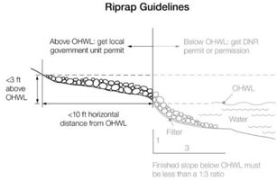
Placement of natural rock rip rap, including associated grading of the shoreline and placement of a filter blanket is permitted if:
(i)
If the project includes work at or below the OHWL, the commissioner has already approved or permitted the project;
(ii)
The finished slope does not exceed three feet horizontal to one-foot vertical;
(iii)
The landward extent of the riprap is within ten feet of the ordinary high water level; and
(iv)
The height of the riprap above the ordinary high water level does not exceed three feet (see Figure 10).
(v)
A vegetative buffer, consisting of deep rooted and woody vegetation, is to be established at a distance no less than ten feet from the landward extent of the riprap.
(vi)
Figure 10. Riprap Guidelines
b.
The following considerations and conditions shall be adhered to during the issuance of construction permits, grading and filling permits, conditional use permits, variance, and subdivision approvals:
1.
Grading or filling in any wetland must be evaluated to determine how extensively the proposed activity would affect the following functional qualities of the wetland. This evaluation must also include a determination of whether the wetland alteration being proposed requires permits, reviews, or approvals under the Wetland Conservation Act or by other local, state, or federal agencies such as a watershed district, the state department of natural resources, or the United States Army Corps of Engineers. The applicant will be so advised.
(i)
Sediment and pollutant trapping and retention;
(ii)
Storage of surface runoff to prevent or reduce flood damage;
(iii)
Fish and wildlife habitat;
(iv)
Recreational use;
(v)
Shoreline or bank stabilization; and
(vi)
Noteworthiness, including special qualities such as historic significance, critical habitat for endangered plants and animals, or others.
2.
Alterations shall be designed and conducted in a manner that ensures only the smallest amount of bare ground is exposed for the shortest time possible.
3.
Mulches or similar materials shall be used, where necessary, for temporary bare soil coverage, and a permanent vegetation cover must be established as soon as possible.
4.
Methods to minimize soil erosion and to trap sediments before they reach any surface water feature shall be used.
5.
Altered areas shall be stabilized to acceptable erosion control standards consistent with the field office technical guides of the local soil and water conservation districts and the United States Soil Conservation Service.
6.
Fill or excavated material shall not be placed in a manner that creates an unstable slope.
7.
Plans to place fill or excavated material on steep slopes must be reviewed by the city engineer for continued slope stability and shall not create finished slopes of 30 percent or greater.
8.
Fill or excavated material shall not be placed in bluff impact zones.
9.
Any alterations below the ordinary high water level of public waters shall first be authorized by the commissioner under Minn. Stats. § 103G.405 or 103G.407.
10.
Alterations of topography will only be allowed if they are accessory to permitted or conditional uses and do not adversely affect adjacent or nearby properties.
11.
Placement of natural rock riprap, including associated grading of the shoreline and placement of a filter blanket, is permitted if the finished slope does not exceed three feet horizontal to one foot vertical, the landward extent of the rip-rap is within ten feet of the ordinary high water level, and the height of the rip-rap above the ordinary high water level does not exceed three feet.
12.
At the end of excavation or filling operations, the disturbed areas shall be restored with topsoil or other approved cover material and shall be reseeded within one growing season with native indigenous vegetation.
13.
Excavation on shorelands where the intended purpose is connection to a public water shall require a permit from the city before construction is begun. Such permit may be obtained only after the commissioner of the department of natural resources has issued a permit for work in the beds of public waters.
c.
Connections to public waters. Excavations to connect boat slips, canals, lagoons, and harbors to public waters require a public waters permit and must comply with Minnesota Rules, Chapter 6115.
(Prior Code, ch. 1110, subd. 3; Ord. No. 23-04, § 4, 9-11-2023)
Sec. 109-294. - Placement and design of roads, driveways, and parking areas.
(a)
All roads and parking areas shall be designed to take advantage of natural vegetation and topography to achieve maximum screening from view from public waters. Documentation shall be provided by a qualified individual that all roads and parking areas are designed and constructed to minimize and control erosion to public waters consistent with the field office technical guides of the local soil and water conservation district, or other applicable technical materials.
(b)
Roads, driveways, and parking areas shall meet structure setbacks and shall not be placed within bluff and shore impact zones when other reasonable and feasible placement alternatives exist. If no alternatives exist, they may be placed within these areas and must be designed to minimize adverse impacts.
(c)
Public and private watercraft access ramps, approach roads, and access-related parking areas may be placed within shore impact zones, provided that the vegetative screening and erosion control conditions of this section are met. For private facilities, the grading and filling provisions of section 109-293 shall be met.
(Prior Code, ch. 1110, subd. 4)
Sec. 109-295. - Stormwater management.
The following general and specific standards shall apply:
(1)
General standards.
a.
When possible, existing natural drainageways, wetlands, and vegetated soil surfaces must be used to convey, store, filter, and retain stormwater runoff before discharge to public waters.
b.
Development must be planned and conducted in a manner that will minimize the extent of disturbed areas, runoff velocities, erosion potential and reduce and delay runoff volumes. Disturbed areas must be stabilized and protected as soon as possible and facilities or methods used to retain sediment on the site.
c.
When development density, topographic features, and soil and vegetation conditions are not sufficient to adequately handle stormwater runoff using natural features and vegetation, various types of constructed facilities such as diversions, settling basins, skimming devices, dikes, waterways, and ponds may be used. Preference must be given to designs using surface drainage, vegetation, and infiltration rather than buried pipes and manmade materials and facilities.
d.
New constructed stormwater outfalls to public waters must provide for filtering or settling of suspended solids and skimming of surface debris before discharge.
e.
Riparian buffers and water quality practices shall meet all requirements of Minn. Stats. §103F.48 Riparian Protection and Water Quality Practices.
(2)
Specific standards.
a.
Impervious surface coverage of lots must not exceed 25 percent of the lot area.
b.
When constructed facilities are used for stormwater management, documentation must be provided by a qualified individual that they are designed and installed consistent with the current edition of the city stormwater pollution prevention plan, the public works design manual and the local surface water management plan.
c.
Prior to beginning construction, the contractor must obtain a general stormwater permit for construction activities from the state pollution control agency.
(Prior Code, ch. 1110, subd. 5; Ord. No. 19-04, § 1, 6-10-19)
Sec. 109-296. - Conditional uses.
Conditional uses allowable within shoreland areas shall be subject to the review and approval procedures, and criteria and conditions for review of conditional uses established community-wide. The following additional evaluation criteria and conditions apply within shoreland areas:
(1)
Evaluation criteria. Thorough evaluation of the water body and the topographic, vegetation, and soil conditions on the site shall be made to ensure:
a.
The prevention of soil erosion or other possible pollution of public waters, both during and after construction.
b.
The visibility of structures and other facilities as viewed from public waters is limited.
c.
The site is adequate for water supply and on-site sewage treatment, if applicable.
d.
The types, uses, and numbers of watercraft that the project will generate are compatible in relation to the suitability of public waters to safely accommodate these watercraft.
(2)
Conditions attached to conditional use permits. The city council, upon consideration of the criteria listed in subsection (1) of this section and the purposes of this article, may attach such conditions to the issuance of the conditional use permits as it deems necessary to fulfill the purposes of this article and said conditions may be more restrictive than this article.
(Prior Code, ch. 1110, subd. 6)
Sec. 109-297. - Water supply and sewage treatment.
(a)
Water supply. Any public or private supply of water for domestic purposes shall meet or exceed standards for water quality of the state department of health and the state pollution control agency.
(b)
Sewage treatment. Any premises used for human occupancy must be provided with an adequate method of sewage treatment as follows:
(1)
Publicly owned sewer systems must be used where available.
(2)
All private sewage treatment systems shall meet or exceed the state pollution control agency's standards for individual sewage treatment systems contained Minn. Rules ch. 7080 without appendices, a copy of which is hereby adopted by reference and declared to be a part of this article.
(3)
On-site sewage treatment systems must be set back from the ordinary high water level in accordance with the setbacks contained in section 109-292.
(4)
All proposed sites for individual sewage treatment systems shall be evaluated in accordance with the evaluation criteria in subsection (4) of this section. If the determination of a site's suitability cannot be made with publicly available, existing information, it shall then be the responsibility of the applicant to provide sufficient soil borings, a percolation test or other necessary information from on-site field investigation.
a.
Depth to the highest known or calculated groundwater table or bedrock;
b.
Soil conditions, properties, and permeability;
c.
Slope; and
d.
The existence of lowlands, local surface depressions, and rock outcrops.
(5)
Nonconforming sewage treatment systems shall be regulated and upgraded in accordance with this section.
(Prior Code, ch. 1110, subd. 7)
Sec. 109-298. - Nonconforming sewage treatment systems.
(a)
A sewage treatment system not meeting the requirements of this article shall be upgraded, at a minimum, at any time a permit or variance of any type is required for any improvement on or use of the property. For the purposes of this section, a sewage treatment system shall not be considered nonconforming if the only deficiency is the sewage treatment system's improper setback from the ordinary high water level.
(b)
The city council has by formal resolution notified the commissioner of its program to identify nonconforming sewage treatment systems. The city will require upgrading or replacement of any nonconforming system identified by this program within a reasonable period of time which will not exceed two years. Sewage systems installed according to all applicable local shoreland management standards adopted under Minn. Stats. §§ 103F.201—103F.227 in effect at the time of installation may be considered as conforming unless they are determined to be failing, except that systems using cesspools, or systems with less soil treatment area separation above groundwater than required by the Minn. Rules ch. 7080 without appendices, as adopted by the city, not as written, for design of on-site sewage treatment systems, shall be considered nonconforming.
(c)
After initial inspection for conformance, all on-site individual sewage treatment systems shall be inspected biennially for proper operation. A system shall be determined failing if it shows signs of surface discharge or seepage from a soil treatment system to the ground surface, abandoned wells, bodies of surface water, or into any rock or soil formation the structure which is not conducive to purification by filtration or into any well or other excavation in the ground.
(d)
All properties that are found to have nonconforming on-site individual sewage treatment systems shall be required to have their wells tested and the appropriate action taken in conformance with state department of health.
(Prior Code, ch. 1112; Ord. No. 12-03, § 1, 4-30-2012)
Sec. 109-299. - Subdivision/platting provisions.
(a)
Land suitability. Each lot created through subdivision, including planned unit developments authorized under section 109-305 must be suitable in its natural state for the proposed use with minimal alteration. Suitability analysis by the local unit of government shall consider susceptibility to flooding; existence of wetlands, soil and rock formations with severe limitations for development; severe erosion potential; steep topography; inadequate water supply or sewage treatment capabilities; near-shore aquatic conditions unsuitable for water-based recreation; important fish and wildlife habitat; presence of significant historic sites; or any other feature of the natural land likely to be harmful to the health, safety, or welfare of future residents of the proposed subdivision or of the community. The city, through zoning regulations and certain environmental regulations contained within this Code, prohibits dwelling units other than single-family. Duplexes, triplexes, and multiple-family dwellings are prohibited due to the lack of public utilities. Centralized sewer systems are only allowed with city council approval. Density is calculated at 2½ acres per dwelling unit. Within a planned unit development (see section 109-102), lot size may be reduced to 1.5 acres to preserve natural features; however, overall density within a particular development will be calculated based upon 2½ acres per dwelling unit.
(b)
Consistency with other controls. Subdivisions must conform to all official controls of this community. A subdivision will not be approved where a later variance from one or more standards in official controls would be needed to use the lots for their intended purpose. In areas not served by publicly owned sewer and water systems, a subdivision will not be approved unless a domestic water supply is available and a sewage treatment system consistent with 109-297 can be provided for every lot. Each lot shall meet the minimum lot size and dimensional requirements of section 109-291, including at least a minimum contiguous lawn area that is free of limiting factors sufficient for the construction of two standard soil treatment systems. Lots that would require use of holding tanks must not be approved.
(c)
Information requirements. Sufficient information must be submitted by the applicant for the community to make a determination of land suitability. The information shall include at least the following:
(1)
Topographic contours at two-foot intervals or less from United States Geological Survey maps or more accurate sources, showing limiting site characteristics.
(2)
The surface water features required in Minn. Stats. § 505.021, to be shown on plats, obtained from the United States Geological Survey quadrangle topographic maps or more accurate sources.
(3)
Adequate soils information to determine suitability for building and on-site sewage treatment capabilities for every lot from the most current existing sources or from field investigations such as soil borings, percolation tests, or other methods.
(4)
Information regarding adequacy of domestic water supply; extent of anticipated vegetation and topographic alterations; near-shore aquatic conditions including depths, types of bottom sediments, and aquatic vegetation; and proposed methods for controlling stormwater runoff and erosion, both during and after construction activities.
(5)
Location of 100-year floodplain areas and floodway districts from existing adopted maps or data.
(6)
A line or contour representing the ordinary high water level, the toe and the top of bluffs, and the minimum building setback distances from the top of the bluff and the lake or stream.
(d)
Platting. All subdivisions that create two or more lots or parcels that are two acres in size shall be processed as a plat in accordance with Minn. Stats. ch. 505. No permit for construction of buildings or sewage treatment systems shall be issued for lots created after these official controls were enacted unless the lot was approved as part of a formal subdivision.
(e)
Controlled access or recreational lots. Lots intended as controlled accesses to public waters or for recreational use areas for use by nonriparian lots within a subdivision must meet or exceed the sizing criteria in section 109-291.
(Prior Code, ch. 1114, subds. 1—5)
Sec. 109-300. - Standards for commercial, industrial, public, and semipublic uses.
(a)
Surface water-oriented commercial uses and industrial, public, or semipublic uses with similar needs to have access to and use of public waters may be located on parcels or lots with frontage on public waters. Those uses with water-oriented needs must meet the following standards:
(1)
In addition to meeting impervious coverage limits, setbacks, and other zoning standards in this article, the uses must be designed to incorporate topographic and vegetative screening of parking areas and structures;
(2)
Uses that require short-term watercraft mooring for patrons must centralize these facilities and design them to avoid obstructions of navigation and to be the minimum size necessary to meet the need; and
(3)
Uses that depend on patrons arriving by watercraft may use signs and lighting to convey needed information to the public, subject to the following general standards:
a.
No advertising signs or supporting facilities for signs may be placed in or upon public waters. Signs conveying information or safety messages may be placed in or on public waters by a public authority or under a permit issued by the county sheriff;
b.
Signs may be placed, when necessary, within the shore impact zone if they are designed and sized to be the minimum necessary to convey needed information. They must only convey the location and name of the establishment and the general types of goods or services available. The signs must not contain other detailed information such as product brands and prices, must not be located higher than ten feet above the ground, and must not exceed 32 square feet in size. If illuminated by artificial lights, the lights must be shielded or directed to prevent illumination out across public waters; and
c.
Other outside lighting may be located within the shore impact zone or over public waters if it is used primarily to illuminate potential safety hazards and is shielded or otherwise directed to prevent direct illumination out across public waters. This does not preclude use of navigational lights.
(b)
Uses without water-oriented needs must be located on lots or parcels without public waters frontage, or, if located on lots or parcels with public waters frontage, must either be set back double the normal ordinary high water level setback or be substantially screened from view from the water by vegetation or topography, assuming summer, leaf-on conditions.
(Prior Code, ch. 1114, subd. 6)
Sec. 109-301. - Agriculture use standards.
(a)
General cultivation farming, grazing, nurseries, horticulture, truck farming, sod farming, and wild crop harvesting are permitted uses if steep slopes and shore and bluff impact zones are maintained in permanent vegetation or operated under an approved conservation plan (Resource management systems) consistent with the field office technical guides of the local soil and water conservation districts or the United States Soil Conservation Service, as provided by a qualified individual or agency. The shore impact zone for parcels with permitted agricultural land uses is equal to a line parallel to and 50 feet from the ordinary high water level.
(b)
Animal feedlots must meet the following standards:
(1)
New feedlots must not be located in the shoreland of watercourses or in bluff impact zones and must meet a minimum setback of 300 feet from the ordinary high water level of all public waters basins; and
(2)
Modifications or expansions to existing feedlots that are located within 300 feet of the ordinary high water level or within a bluff impact zone are allowed if they do not further encroach into the existing ordinary high water level setback or encroach on bluff impact zones.
(Prior Code, ch. 1114, subd. 7)
Sec. 109-302. - Forest management standards.
The harvesting of timber and associated reforestation must be conducted consistent with the provisions of the Minnesota Nonpoint Source Pollution Assessment-Forestry and the provisions of Water Quality in Forest Management "Best Management Practices in Minnesota."
(Prior Code, ch. 1114, subd. 8)
Sec. 109-303. - Extractive use standards.
(a)
Site development and restoration plan. An extractive use site development and restoration plan must be developed, approved, and followed over the course of operation of the site. The plan must address dust, noise, possible pollutant discharges, hours and duration of operation, and anticipated vegetation and topographic alterations. It must also identify actions to be taken during operation to mitigate adverse environmental impacts, particularly erosion, and must clearly explain how the site will be rehabilitated after extractive activities end.
(b)
Setbacks for processing machinery. Processing machinery must be located consistent with setback standards for structures from ordinary high water levels of public waters and from bluffs.
(Prior Code, ch. 1114, subd. 9)
Sec. 109-304. - Mining of metallic minerals and peat.
Mining of metallic minerals and peat, as defined in Minn. Stats. §§ 93.44—93.51, shall be a permitted use provided the provisions of Minn. Stats. §§ 93.44—93.51 are satisfied.
(Prior Code, ch. 1114, subd. 10)
Sec. 109-305. - Planned unit developments (PUDs)
(a)
Site evaluation. Proposed new or expansions to existing planned unit developments (PUDs) shall be evaluated using the following procedures and standards. Preliminary plans shall be submitted to the city in accordance with this chapter. Prior to the enactment of these plans, the commissioner of the department of natural resources must grant approval.
(1)
The project parcel shall be divided into tiers by locating one or more lines approximately parallel to a line that identifies the ordinary high water level at the following intervals, proceeding landward:
SHORELAND TIER DIMENSIONS
(2)
The area within each tier is next calculated by excluding from the tier area all wetlands, bluffs, or land below the ordinary high water level of public waters. This area and the proposed project are then subjected to either the residential or commercial planned unit development density evaluation steps to arrive at an allowable number of dwelling units or building sites.
(b)
Maintenance and design criteria.
(1)
Maintenance and administration requirements.
a.
Before final approval of a planned unit development, adequate provisions shall be developed for preservation and maintenance in perpetuity of open spaces and for the continued existence and functioning of the development as a community.
b.
Deed restrictions, covenants, permanent easements, public dedication and acceptance, or other equally effective and permanent means must be provided to ensure long-term preservation and maintenance of open space. The instruments must include all of the following protections:
1.
Commercial uses prohibited;
2.
Vegetation and topographic alterations other than routine maintenance prohibited;
3.
Construction of additional buildings or storage of vehicles and other materials prohibited; and
4.
Uncontrolled beaching prohibited.
(2)
Facility and structure design and centralization requirements.
a.
Residential and commercial planned unit developments must be connected to publicly owned water supply and sewer systems, if available. On-site water supply and sewage treatment systems must be centralized and designed and installed to meet or exceed applicable standards or rules of the state department of health and the state pollution control agency. On-site sewage treatment systems must be located on the most suitable areas of the development, and sufficient lawn area free of limiting factors must be provided for a replacement soil treatment system for each sewage system.
b.
Dwelling units or sites must be clustered into one or more groups and located on suitable areas of the development. They must be designed and located to meet or exceed the following dimensional standards for the relevant shoreland classification: setback from the ordinary high water level, elevation above the surface water features, and maximum height. Setbacks from the ordinary high water level must be increased for developments with density increases.
c.
Shore recreation facilities, including, but not limited to, swimming areas, docks, watercraft mooring areas and launching ramps, must be centralized and located in areas suitable for them. Evaluation of suitability must include consideration of land slope, water depth, vegetation, soils, depth to groundwater and bedrock, or other relevant factors. The number of spaces provided for continuous beaching, mooring, or docking of watercraft must not exceed one for each allowable dwelling unit or site in the first tier. Launching ramp facilities, including a small dock for loading and unloading equipment, may be provided for use by occupants of dwelling units or sites located in other tiers. Not more than one centralized boat launching facility for each cluster shall be located in the shoreland zone.
d.
Structures, parking areas, and other facilities must be treated to reduce visibility as viewed from public waters and adjacent shorelands by vegetation, topography, increased setbacks, color, or other means acceptable to the city administrator or designee, assuming summer, leaf-on conditions. Vegetative and topographic screening must be preserved, if existing, or may be required to be provided.
e.
Water-oriented accessory structures and facilities may be allowed if they meet or exceed design standards contained in section 109-292(b)(2) and are centralized.
f.
Accessory structures and facilities may be allowed if they meet or exceed standards in section 109-292(b).
(3)
Erosion control and stormwater management.
a.
Erosion control and stormwater management plans shall be developed and the PUD shall be designed and constructed to effectively manage reasonably expected quantities and qualities of stormwater runoff.
b.
For residential PUDs, impervious surface for the entire project site must not exceed 25 percent. For commercial PUDs, impervious surface coverage within any tier shall not exceed 25 percent of the tier area.
c.
The likelihood of serious erosion occurring either during or after construction shall be minimized by limiting the amount and length of time of bare ground exposure. Temporary ground covers, sediment entrapment facilities, vegetated buffer strips or other appropriate techniques shall be used to minimize erosion impacts on surface water features. Erosion control plans approved by a soil and water conservation district may be required if project size and site physical characteristics warrant.
(c)
Conversions. Existing resorts or other land uses and facilities may be converted to residential planned unit developments if all of the following standards are met:
(1)
Proposed conversions must be initially evaluated using the same procedures and standards presented in this part for developments involving all new construction. Inconsistencies between existing features of the development and these standards must be identified.
(2)
Deficiencies involving water supply and sewage treatment, structure color, impervious coverage, open space, and shore recreation facilities must be corrected as part of the conversion or as specified in the conditional use permit.
(3)
Shore and bluff impact zone deficiencies must be evaluated and reasonable improvements made as part of the conversion. These improvements must include, where applicable, the following:
a.
Removal of extraneous buildings, docks, or other facilities that no longer need to be located in shore or bluff impact zone.
b.
Remedial measures to correct erosion sites and improve vegetative cover and screening of buildings and other facilities as viewed from the water.
c.
If existing dwelling units are located in shore or bluff impact zones, conditions are attached to approvals of conversions that preclude exterior expansions in any dimension or substantial alterations. The conditions must also provide for future relocation of dwelling units, where feasible, to other locations, meeting all setback and elevation requirements when they are rebuilt or replaced.
d.
Existing dwelling unit or dwelling site densities that exceed standards in this part may be allowed to continue but must not be allowed to be increased, either at the time of conversion or in the future. Efforts must be made during the conversion to limit impacts of high densities by requiring seasonal use, improving vegetative screening, centralizing shore recreation facilities, installing new sewage treatment systems, or other means.
(d)
Open space requirements. Planned unit developments must contain open space meeting all of the following criteria:
(1)
At least 50 percent of the total project area must be preserved as open space.
(2)
Dwelling units or sites, road rights-of-way, or land covered by road surfaces, parking areas, or structures, except water-oriented accessory structures or facilities, are developed areas and shall not be included in the computation of minimum open space.
(3)
Open space must include areas with physical characteristics unsuitable for development in their natural state, and areas containing significant historic sites or unplatted cemeteries.
(4)
Open space may include outdoor recreational facilities for use by owners of dwelling units or sites, by guests staying in commercial dwelling units or sites, and by the general public.
(5)
Open space may include subsurface sewage treatment systems if the use of the space is restricted to avoid adverse impacts on the systems.
(6)
Open space must not include commercial facilities or uses, but may contain water-oriented accessory structures or facilities.
(7)
The appearance of open space areas, including topography, vegetation, and allowable uses, must be preserved by use of restrictive deed covenants, permanent easements, public dedication and acceptance, or other equally effective and permanent means.
(8)
The shore impact zone, based on normal structure setbacks, must be included as open space. For residential PUDs, at least 50 percent of the shore impact zone area of existing developments or at least 70 percent of the shore impact zone area of new developments must be preserved in its natural or existing state. For commercial PUDs, at least 50 percent of the shore impact zone must be preserved in its natural state.
(e)
Erosion control and stormwater management. Erosion control and stormwater management plans must be developed and the PUD must:
(1)
Be designed, and the construction managed, to minimize the likelihood of serious erosion occurring either during or after construction. This must be accomplished by limiting the amount and length of time of bare ground exposure. Temporary ground covers, sediment entrapment facilities, vegetated buffer strips, or other appropriate techniques must be used to minimize erosion impacts on surface water features. A general stormwater permit for construction activities must be obtained from the state pollution control agency and a grading plan shall be developed in accordance with the current edition of the city stormwater pollution prevention plan, the public works design manual and the local surface water management; and
(2)
Be designed and constructed to effectively manage reasonably expected quantities and qualities of stormwater runoff.
Impervious surface coverage within any tier must not exceed 25 percent of the tier area, except that for commercial PUDs 35 percent impervious surface coverage may be allowed in the first tier of general development lakes with an approved stormwater management plan and consistency with section 109-295.
(Prior Code, ch. 1116;; Ord. No. 04-03; Ord. No. 23-04, § 5, 9-11-2023)