
Oakley City Zoning Code
13-5 Development
Review Processes And Procedures
13-5-1 Purpose And Process Overview
The purpose of this chapter is to provide clear and predictable standards of review and processes for the administration of development, subdivisions, and uses within Oakley City.

13-5-2 Lot/Parcel Requirement For Development, Subdivisions And/or Uses
- A Conforming Parcel: A conforming parcel is defined as one of the following:
- A lot within a recorded subdivision which was created through a lawful Oakley City Land Management and Development Code land division process and which is intended for development purposes;
- A parcel which was created through a lawful Oakley City Land Management and Development Code land division process after Oakley City adopted its first zoning ordinance in 1980, and which conforms to the minimum size requirements of the applicable zone at the time of a development application;
- A parcel created under Utah Code Annotated section 10-9a-605(4), as amended;
- A grandfathered parcel; or
- A parcel created by a bona fide division or partition of land for agricultural activities.
- A Non-Conforming Parcel: A non-conforming parcel is a parcel not meeting the definition of a conforming parcel. A decision by the City Planner determining that a parcel is a non-conforming parcel may be appealed to the City Council within ten (10) calendar days from the date of the decision in accordance with section 13-1-16 of this Title.
- Eligibility for Development:
- For development purposes and in order to apply for development, a parcel must be a conforming parcel.
- A non-conforming parcel is eligible for development of a single-family dwelling, subdivision, or other development action, permit, or use identified in section 13-4-19 of this Title, by an action of the City through one of the following development processes, as defined and outlined in this Title, provided all criteria can be met.
- Parcel Boundary Adjustment: Parcel boundary adjustment, including the combination of a non-conforming parcel with a conforming parcel.
- Subdivision: In cases where property descriptions were created in a manner not consistent with this Title, a retroactive subdivision may be considered. The application shall include all associated properties from which the non-conforming parcel was derived.
- Subdivision Plat Amendment: Subdivision plat amendment, including the expansion of a subdivision to include land outside of a subdivision, regardless of whether said land is a conforming parcel or a non-conforming parcel.
- New Subdivision: A new subdivision or Master Planned Development (MPD) in complete conformance with this Title, using the entitled lot count of the non-conforming parcels in a new subdivision using a more preferred layout, planning, and possible bonus density associated therewith.
- Standards for Verification: The following factors shall be taken into consideration in determining "conforming parcel" status, namely:
- If a government action creates a public road that bisects a "conforming parcel", the parcels on either side of the road are considered to be separate "conforming parcels". If a government action results in the widening of a road within a "conforming parcel", the parcel shall maintain its "conforming parcel" status.
- If the Weber-Provo Canal divides a "conforming parcel", then the parcels on either side of the canal are considered to be separate "conforming parcels".
- If a property owner petitions to have only a portion of a "conforming parcel" annexed into a city, the portion of the property remaining under County jurisdiction loses its "conforming parcel" status unless the property is subdivided in accordance with this Title prior to or concurrent with the annexation.
- Government survey lot(s), although shown as individual lots on ownership plat maps, are not considered to be "conforming parcels" unless the lot(s) otherwise conform to the definition of "conforming parcel" and there is clear evidence that the government survey lot was owned, conveyed or patented independent of the quarter section of which it was part.
- Section lines do not divide a parcel into two (2) or more "conforming parcels" unless the parcel(s) otherwise conform to the definition of a "conforming parcel".
- If the description of a "conforming parcel" has changed due to an updated survey for the purpose of confirming property boundaries, and the description does not create additional, separately described parcels, the "conforming parcel" status will remain intact.
- Multiple accessor parcel or Property Tax identification numbers are not conclusive proof of "conforming parcel".
13-5-3 Permits Required
No development, subdivision, or use may be undertaken within Oakley City unless all permits applicable to the proposed development, subdivision, or use are issued in accordance with the provisions of this Title.
13-5-4 Exemption From Plat Necessity
- Agricultural Land:
- Applications to subdivide agricultural land are exempt from the preliminary and final plat requirements (but not the other application requirements) of Section 14.02.100 if the resulting parcels:
- Qualify as land in agricultural use under Utah Code §59-2-502;
- Meet the minimum size requirement of applicable City land use ordinances; and
- Are not used and will not be used for any nonagricultural purpose.
- For subdivision applications for which this exception applies, a land use applicant may submit to the City—in place of a plat—a record of survey map that illustrates the boundaries of the parcels.
- If the City approves a subdivision application based on a record of survey map, the applicant shall record the map, signed by the City, with the County Recorder’s Office. This shall be done in the same manner as is done for a plat under Sections 14.02.140 and 14.02.150.
- If a parcel resulting from a subdivision under this exception ever ceases to be used for agriculture, the subdivision shall become invalid. The City may, in its discretion, impose the penalty outlined in Section 14.02.040 and/or require a subdivision amendment before issuing a building permit.
- Applications to subdivide agricultural land are exempt from the preliminary and final plat requirements (but not the other application requirements) of Section 14.02.100 if the resulting parcels:
- Public Street and Municipal Utility Easement Vacations:
- For a plat exemption for a public street or utility easement vacation, the following is needed:
- A statement that the party must submit a petition that includes (at least): (§10-9a-609.5(2))
- The name and address of each owner of record of land that is:
- adjacent to the public street or municipal utility easement between the two nearest public street intersections; or
- accessed exclusively by or within 300 feet of the public street or municipal utility easement;
- The name and address of each owner of record of land that is:
- Proof of written notice to operators of utilities and culinary water or sanitary sewer facilities located within the bounds of the public street or municipal utility easement sought to be vacated; and
- The signature of each owner who consents to the vacation.
- A statement that the party must submit a petition that includes (at least): (§10-9a-609.5(2))
- For evaluating petitions, the City Council must hold a public hearing to determine whether the petition meets the following requirements:
- Good cause exists for the vacation, and
- the public interest or any person will be materially injured by the proposed vacation in accordance with Utah Code §10-9a-609.5(3).
- Upon determining these requirements are satisfied, the City Council may adopt an ordinance granting the petition for the public street or public utility easement vacation.
- If the City Council approves a petition to vacate a street/utility easement, the City shall record with the County either
- a plat reflecting the vacation or
- the ordinance and a legal description of the public street to be vacated in accordance with Utah State Code §10-9a-609.5(5).
- The City Council cannot approve a petition to vacate a public street under this section unless the vacation identifies and preserves any easements owned by a culinary water authority and sanitary sewer authority for existing facilities located within the public street as per Utah State Code §10-9a-609.5(8).
- For a plat exemption for a public street or utility easement vacation, the following is needed:
- Minor Subdivisions:
- Applications to subdivide land are exempt from the preliminary and final plat requirements (but not the other application requirements) of Section 13-5-6 if the subdivision:
- Results in no more than 3 parcels;
- Is not traversed by the mapped lines of a proposed street (as shown in the General Plan), City easement, or any other land required for public purposes;
- Has been approved by the culinary water authority and the sanitary sewer authority; and
- Is located in a zoned area.
- Minor subdivisions are exempt from the public improvement requirements outlined this chapter.
- For subdivision applications for which this exception applies, a land use applicant shall submit to the City—in place of a plat—both:
- A record of survey map that illustrates the boundaries of the parcels; and
- A legal metes-and-bounds description that describes the parcels illustrated by the survey map.
- If the City approves a subdivision application based on a record of survey map and metes-and-bounds description, the applicant shall record the map and description, signed by the City, with the County Recorder’s Office. This shall be done in the same manner as is done for a plat under Sections 13-5-9 and 13-5-10, except that the City shall also provide the notice required in Utah Code §10-9a-605(1).
- Applications to subdivide land are exempt from the preliminary and final plat requirements (but not the other application requirements) of Section 13-5-6 if the subdivision:
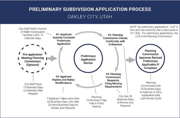
13-5-5 Pre-Application Meeting And Concept Plan Review
- A party intending to submit a subdivision application under this Chapter may request a pre-application meeting with the Planning Commission for the purpose of reviewing any element of the party’s proposed subdivision application. The proposed application need not be complete for purposes of this meeting.
- If a party requests a pre-application meeting, the City staff shall schedule the meeting within 15 business days after the request. The meeting shall occur at the next regularly scheduled Planning Commission meeting for which appropriate public notice is attainable.
- Potential subdivision applicants are strongly encouraged to submit a concept plan to the Planning Commission in advance of the pre-application meeting. It is strongly recommended that this concept plan consist of at least a simple layout of:
- Existing utilities, drainage, and water courses, including irrigation supply and waste ditches in relation to the existing and planned streets within ¼ mile of the development; and
- The proposed streets, lots, major buildings, utilities, and drainage channels.
- The Planning Commission shall conduct the meeting, provide feedback on materials as requested by the potential applicant, and shall provide or have available on the City website the following at the time of the meeting:
- Copies of applicable land use regulations,
- A complete list of standards required for the project, and
- Relevant application checklists.
- The pre-application meeting in no way shall be construed to constitute approval of any development. The primary purpose of the pre-application meeting is to permit the potential applicant to review with the Planning Commission the general concept of the proposed development and to review informal feedback from the Planning Commissioners as to whether the development appears feasible, whether there appear to be obvious defects in the development scheme, and whether the proposed development is in harmony with the General Plan and City ordinances. This meeting is intended to aid the applicant in the preparation of the plans and documents before incurring potentially unnecessary expenses of a detailed preliminary application.
- At the conclusion of the pre-application meeting, if it is determined that a zone change is necessary, the potential applicant must submit an application for the zone change before proceeding with a preliminary subdivision application
13-5-6 Subdivision Application Requirements
- The City shall not approve, nor shall a party record, any plat or other creating instrument for a new subdivision unless the party has properly applied under this Chapter and received both a preliminary approval and a final approval from the respective Land Use Authorities.
- In certain cases (such as, but not limited to, steep topography, significant changes in grade, subdivision proposals in the Sensitive Lands Overlay Zone District, or development affecting identified ridgelines), additional regulations may apply.
- To considered complete, a preliminary subdivision application must include at least the following elements:
- An approved land use application that describes how the property will be used after it is subdivided.
- If the intended use is permitted by right under City ordinances, the land use application must include citations to the specific ordinance(s) that the applicant believes authorizes the intended use.
- If the intended use requires a conditional use permit or is otherwise conditioned on City approval, the land use application must include an approved, City-issued permit authorizing the intended use. Should an applicant seek a use permit concurrently with a related subdivision application, the subdivision application shall be considered incomplete until the use permit is issued.
- If the intended use is prohibited under City ordinances and requires a variance, the land use application must include an approved, City-issued variance authorizing the intended use. Should an applicant seek a variance concurrently with a related subdivision application, the subdivision application shall be considered incomplete until the variance is issued.
- A preliminary plat. The preliminary plat must be drawn to scale, in detail, and in accordance with generally accepted surveying standards and the acceptable filing standards of the County Recorder’s Office. The preliminary plat must include:
- The proposed subdivision name, which must be distinct from any subdivision name on a plat recorded in the County Recorder's office.
- The boundaries, course, and dimensions of all proposed parcels.
- The lot or unit reference; block or building reference; street or site address; street name or coordinate address; acreage or square footage for all parcels, units, or lots; and length and width of the blocks and lots intended for sale.
- Every existing right-of-way and recorded easement located within the plat for underground, water, and utility facilities.
- Any known and unrecorded water conveyance facility located, entirely or partially, within the plat.
- Whether any parcel is intended to be used as a street or for any other public use.
- Whether any parcel is reserved or proposed for dedication for a public purpose.
- Approval from the local culinary water and sanitary sewer authorities.
- If any portion of the proposed subdivision is within 300 feet of an Agriculture Protection Area, the notice language found in Utah Code §17-41-403(4).
- If any portion of the proposed subdivision is within 1,000 feet of an Industrial Protection Area, the notice language found in Utah Code §17-41-403(4).
- If any portion of the proposed subdivision is within 1,000 feet of a Critical Infrastructure Materials Protection Area, the notice language found in Utah Code §17-41-403(4).
- If any portion of the proposed subdivision is within 1,000 feet of a Mining Protection Area, the notice language found in Utah Code §17-41-403(4).
- If any portion of the proposed subdivision is within 1,000 feet of a Vested Critical Infrastructure Materials Operation (extracting, excavating, processing, or reprocessing sand, gravel, or rock aggregate where that use is not permitted by City ordinances), the notice language found in Utah Code §10-9a-904.
- If the subdivision includes a condominium, the requirements found in Utah Code §57-8-13, as amended.
- A traffic study, if one is required by an applicable UDOT Access Management Plan.
- An improvement plan, created in accordance with applicable portions of chapters of this Title, for all public improvements proposed by the applicant or required by City ordinances.
- In addition to the requirements in this chapter, the improvement plan must contain an engineer’s estimate of the cost of completing the required improvements.
- Mandatory declarations (applicable to all subdivision proposals) including:
- "Further subdivision of such lands, whether by deed, bequest, divorce, decree, or other recorded instrument, shall not result in a buildable lot until the same has been approved in accordance with the Oakley City Land Management and Development Code."
- "The owners of property within Oakley City recognize the importance of agricultural lands and operations and small rural business enterprises. It is recognized that agricultural lands and operations and rural business enterprises have unique operating characteristics that must be respected. Owners of each lot platted in this subdivision/the owner of the residence constructed upon this lot have/has been given notice and recognize(s) that there are active agriculture lands and operations and rural business enterprises within Oakley City and acknowledge(s) and accept(s) that, so long as such lands and operations exist, there may be dust, noise, odor, prolonged work hours, use of roadways for the purposes of herding/moving livestock, and other attributes associated with normal agricultural operations and rural businesses."
- “All lot owners served by Oakley City (the City) within this plat agree to abide by all of the Water and Wastewater (if applicable) Rules, Regulations, and other Construction related Standards and Specifications of the City, including payment of all necessary fees prior to the issuance of a building permit. Lot owners also recognize that the City’s service area spans a large mountainous area with extreme vertical relief resulting in numerous pressure regulation facilities. As such, the owners recognize that fluctuations (albeit infrequent) in water pressure may pose a risk to properties served by said system.
- Owners agree to install and be responsible for the proper operation of any necessary pressure regulation and backflow devices to protect any plumbing facilities and fire sprinkling systems. Further, the City shall have the right to install, repair, maintain, replace, enlarge, extend, and operate their equipment above and below ground and all other related facilities within any easements identified on this plat as may be necessary or desirable in providing water services within and without the lots identified herein, including the rights of access to such facilities and the right to require the removal of any obstruction including structures and trees, that may have been placed within the easements. The City may require the lot owner to remove all structures and vegetation within the easement at the lot owner’s expense. At not time may any permanent structures, including trees and retaining walls, be placed within the easements or any other obstruction which interferes with the access and use of the easements without the prior written approval of the City. The City is further granted rights of access to any and all non-exclusive easements, including emergency or non-emergency access roads contained within this plat to enlarge and/or extend its services to any adjoining properties and plats.
- Situational declarations that include any and all of the following that are relevant to the proposed development:
- “This subdivision includes formerly irrigated properties. As such, any non-agricultural development constructed over or added to this subdivision in the future, including possible re-subdividing action, must deed to Oakley City water rights or agricultural irrigation shares in an acceptable quantity that can fully service the residential units and/or commercial development(s) in its final form. Permission from any relevant irrigation company will also be provided to enable the City to better file change or exchange application(s) to convert the water rights or agricultural water shares to municipal type uses within it established service boundaries and as withdrawn from any or all approved points of diversion of Oakley City. Water rights and irrigation company shares must be properly deeded to the City before building permits or development approvals can be finalized.”
- “Oakley City has committed to providing water service to the lots included in this plat.”
- If serviced by a private water system: "Water has not been approved for this site. It shall be the responsibility of each lot owner to demonstrate that water of adequate quality and quantity is available for each lot prior to the issuance of a building permit. This shall be accomplished with a memorandum of decision from the state engineer for a private well, spring or a written commitment from a private water company."
- Certifications, including:
- An affidavit from the applicant certifying that the submitted information is true and accurate.
- The signature of each owner of record of land described on the preliminary plat, signifying their consent to the preliminary subdivision application and their intent to dedicate portions of the preliminary plat to the public as described in the application.
- Certification that the surveyor who prepared the plat:
- Holds a license in accordance with Utah Code 58-22; and
- Either
- Has completed a survey of the property described on the plat in accordance with state requirements and has verified all measurements;
- Has referenced a record of survey map of the existing property boundaries shown on the plat and verified the locations of the boundaries; and
- Has placed monuments as represented on the plat and has completed the designated responsibilities in Utah State Code 10-9a-603.
- An electronic copy of all plans in PDF format.
- Three 11” x 17” (or larger) printed copies of the complete application, delivered to the City office, for review.
- A copy of the plat drawn on Mylar for signing and recording. The applicant may wait to produce this recording-form copy until the Land Use Authority has completed two review cycles, but in such case, the Land Use Authority need not approve the application until this copy has been produced and reviewed.
- Payment of any preliminary-application-processing fees required by the City.
- An approved land use application that describes how the property will be used after it is subdivided.
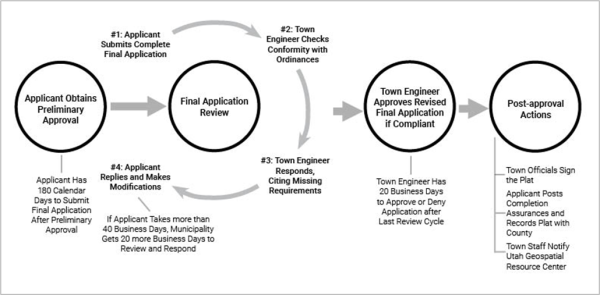
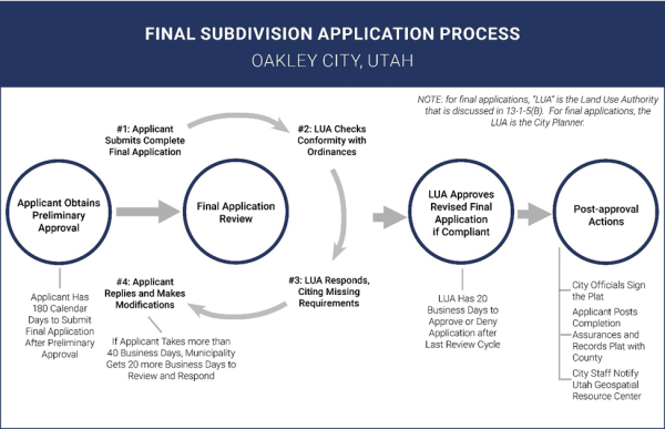
- To be considered complete, a final subdivision application must include the following:
- Land Use Authority approval of the applicant’s preliminary application, given within the last 365 calendar days.
- The approved land use application that was accepted during the preliminary application review process.
- A final plat. The final plat should be the version of the preliminary plat approved by the City during the preliminary application review process, plus any other additions and immaterial changes (e.g., formatting) necessary to comply with the recording requirements of the County Recorder’s Office.
- The improvement plan that the City approved during the preliminary application review process.
- A completion assurance for all public improvements required by the approved improvement plan, or a statement that such improvements will be completed before development occurs on the proposed subdivision and before the applicant records the plat, as required by chapter 13-5-9 of this Title.
- Certifications, including:
- A Title Report or Title Insurance Policy for the land to be subdivided verifying property ownership.
- A Tax Clearance Certificate from the state indicating that all taxes, interest, and penalties owing on the land have been paid.
- An affidavit from the applicant certifying that the submitted information is true and accurate.
- The signature of each owner of record of land described on the plat, signifying their consent to the final subdivision application and their dedication and approval of the final plat.
- Certification that the surveyor who prepared the plat:
- Holds a license in accordance with Utah Code 58-22; and
- Either
- Has completed a survey of the property described on the plat in accordance with state requirements and has verified all measurement; or
- Has referenced a record of survey map of the existing property boundaries shown on the plat and verified the locations of the boundaries; and
- Has placed monuments as represented on the plat.
- The plat describes:
- Any water conveyance facility located, entirely or partially, within the plat that:
- Is not recorded; and
- Of which the owner of the land has actual or constructive knowledge, including from information made available to the owner of the land:
- In the state engineer's inventory of canals; or
- From a surveyor under §10-9a-603(6)(c)) (§10-9a-603(2)(e))
- Any water conveyance facility located, entirely or partially, within the plat that:
- Binding dedication documents, including:
- As applicable, formal, irrevocable offers for dedication to the public of streets, City uses, utilities, parks, easements, or other spaces.
- If the plat is to be part of a community association, signed and binding documents conveying to the association all common areas, according to Title 57, Chapter 8a, the Community Association Act.
- Copies, including:
- One electronic copy of the final plat in AutoCAD format (DWG or DXF), Geodatabase format (GDB), or Shapefile format (SHP), with a projection assigned to the file(s) and with the proper metadata that describes what coordinate system/projection the data is assigned to; and
- A PDF document of the final plat and all other plans and supporting documents required by this Chapter.
- Payment of any final-application-processing fees required by the City’s fee schedule
- The Land Use Authority shall produce, maintain, and make available to the public a list of the specific items that comprise complete preliminary and final applications and a breakdown of any fees due upon submission or approval of the applications.
- The Land Use Authority may require, and the applicant shall provide, additional information beyond the requirements of this Section or those published by the City relating to an applicant’s plans to ensure compliance with City ordinances and approved standards and specifications for construction of public improvements and to protect the health and safety of City residents. This should especially be expected in certain cases such as, but not limited to, steep topography, significant changes in grade, development in the Sensitive Lands Overlay Zone District, or Development affecting identified ridgelines.
- If additional information is requested and modifications are made, the City shall record the requests in an index of modifications. Such modifications cannot be requested after the final review.
13-5-7 Notice To Affect Entities
- Within 15 calendar days after receiving a complete subdivision application under this Chapter, City staff shall provide written notice of the proposed subdivision to the facility owner of any water conveyance facility located, entirely or partially, within 100 feet of the subdivision plat.
- To determine whether any water conveyance facility is located within 100 feet of a proposed subdivision, the Land Use Authority shall review information:
- From the facility owner under Utah Code §10-9a-211, using mapping-grade global positioning satellite units or digitized data from the most recent aerial photo available to the facility owner;
- From the state engineer's inventory of canals; or
- From a licensed surveyor who has consulted with a representative of an existing water conveyance facility that services an area near the land the application concerns.
- To determine whether any water conveyance facility is located within 100 feet of a proposed subdivision, the Land Use Authority shall review information:
- To give water conveyance facilities time to provide feedback on subdivision applications, the Land Use Authorities shall not approve a subdivision application under this Chapter sooner than 20 calendar days after the applicant submits a complete application. This waiting period does not apply to revised applications the applicant may submit during the application review process.
- A water conveyance facility owner's failure to provide comments to the Land Use Authority about a subdivision application does not affect or impair the Land Use Authority’s authority to approve the subdivision application.
13-5-8 Review
- The Land Use Authorities shall review all subdivision applications under this Chapter in accordance with the requirements of this Section before approving or denying a subdivision application.
- The review process begins when an applicant submits a complete application.
- The Land Use Authorities shall not review an incomplete subdivision application, except to determine whether the application is complete.
- If the Land Use Authorities determine that an application is not complete, it shall notify the applicant of the incompleteness, highlighting any insufficiencies and explaining that the application will not be reviewed until completed.
- After the applicant submits a complete application, the Land Use Authorities shall review and provide feedback to the applicant in a series of “review cycles.”
- A review cycle consists of the following phases (See exhibits below:)
- Phase #1: The applicant submits a complete application (or, if after the first cycle, submits a revised version of the complete application).
- Phase #2: The Land Use Authorities review the application in detail and assess whether the application conforms to local ordinances.
- Phase #3: The Land Use Authorities respond to the applicant, citing any missing requirements or areas of noncompliance and providing a detailed list of necessary revisions to the applicant, within the timeframe specified in Table 13-5-8. For any required modification or addition to the application or request for more information, the Land Use Authority shall be specific and include citations to ordinances, standards, or specifications that require the modification and shall provide the applicant with an index of all requested modifications or additions.
- Phase #4: The applicant revises the application, addressing each comment or requirement the Land Use Authorities made. The applicant must submit both revised plans and a written explanation in response to the City’s review comments, identifying and explaining the applicant’s revisions and reasons for declining to make revisions, if any. If the applicant fails to respond to a comment made by the Land Use Authorities in its review, the review cycle is not complete and will remain open until the applicant addresses all comments.
- A review cycle consists of the following phases (See exhibits below:)
- The Land Use Authorities shall not (nor shall any other representative of the City) exceed the number of review cycles of the deadlines in Table 13-5-8. If no further revisions are needed, the Land Use Authorities may end the review period early and approve or deny the application.
- This provision notwithstanding, for any subdivision application that affects property within an identified geological hazard area, the City is exempt from limits on the number of permitted review cycles and the City’s deadlines for reviewing and responding (Phases #2 and #3).
- If the applicant makes a material change to an application not requested by the City at any point in the review process, the Land Use Authority may restart the review process, but only with respect to the portion of the application that the material change substantively affects.
- If an applicant takes longer than 40 business days to submit a revised subdivision improvement plan responding to the City’s requests for modifications and additions (in Phases #1 and #4), the City shall have an additional 20 business days to review and respond to the revised application (Phases #2 and #3 of the next review cycle or issuing an approval decision).
- If an applicant takes longer than180 calendar days to submit a revised application and respond to the City’s requests for modifications and additions (Phases #1 and #4), the application shall, at the option of the Land Use Authority, expire. If an application expires, the applicant must restart the subdivision application process.
- After the last review cycle is complete, the Land Use Authorities shall approve or deny the application within 20 business days.
- If the Land Use Authorities have not approved or denied the application within 20 business days after the last review, the applicant may request a final decision. After such a request, the City shall, within 10 business days:
- For a dispute arising from the subdivision improvement plans, assemble an appeal panel in accordance with Utah Code §10-9a-508(5)(d) to review and approve or deny the final revised set of plans; or
- For a dispute arising from the subdivision ordinance review, advise the applicant, in writing, of the deficiency in the application and of the right to appeal the determination to the designated Appeal Authority.
- If the Land Use Authorities have not approved or denied the application within 20 business days after the last review, the applicant may request a final decision. After such a request, the City shall, within 10 business days:
- After the Land Use Authorities provide comments in the last review cycle, the City shall not require further modifications or corrections in that review phase unless those modifications or corrections are needed to protect public health and safety or to enforce state or federal law or unless the review cycle reset due to the applicant making a material change that the Land Use Authorities did not request.
- With the exception of modifications or corrections that are needed to protect public health and safety, that are needed to enforce state or federal law, or that arise from the review cycle being reset, the municipality waives noncompliant subdivision-related requirements that the Land Use Authorities do not identify during the review process.
- The applicant shall make reasonable changes, unless prohibited otherwise by a contract or deed, to the subdivision application to accommodate the water conveyance facility to the extent required by Utah Code §73-1-15.5.
- The Planning Commission may conduct one (but no more than one) public hearing for the purpose of asking questions of the applicant and receiving commentary on the technical aspects of the application from affected entities, interested parties, and the public. If the Planning Commission elects to hold this public hearing, the hearing must occur before the end of the Planning Commission’s review period in the last review cycle of the preliminary review phase. Scheduling issues shall not extend the review and approval deadlines in this Chapter.
- The City shall approve any preliminary or final plat that is compliant with the City’s ordinances, any additional requirements in state law §10-9a-6, and is approved by the culinary water authority and the sanitary sewer authority, after reviewing a complete subdivision application as described in this Chapter.
| Table 13-5-8 – Review Cycles, Hearings, and Timelines by Subdivision Use Type | |||||
Use Type | Approval Stage | Max Review Phases | Max Public Hearings | City Turnaround Deadline** | Applicant Turnaround Deadline*** |
1-2
Family Residential* | Preliminary | 4 | 1 | 30
Business Days | 180
Calendar Days |
Final | 1 | 0 | 30
Business Days | 180
Calendar Days | |
All
Other Uses
| Preliminary | 6 | 2 | 30
Business Days | 180
Calendar Days |
Final | 1 | 0 | 30
Business Days | 180
Calendar Days | |
|
* Includes single-family homes, duplexes, and townhomes. **Describes the total time (per review cycle) the City may take to complete both Phase #2 and Phase #3. ***Describes the total time (per review cycle) the applicant may take to submit a revised application before the application expires. | |||||
13-5-9 Approval
- The Land Use Authorities shall approve any complete subdivision application made under this Chapter that complies with City ordinances and state law. The Land Use Authorities shall issue all approvals in writing.
- After approval by the Land Use Authorities, the final plat shall be signed by the owners of the land to be subdivided, the Planning Commission Chair, and the Mayor.
- The signatures on the plat of the owners of the land and of the Mayor, when recorded, functions as an acceptance of the dedication of any streets or public places and vests the fee of those parcels of land in the City for the public for the uses named or intended in the plat. However, such a dedication does not impose liability upon the City for public streets and other public places that are dedicated in this manner but are unimproved unless adequate financial assurance has been provided in addition to the City accepting the dedication.
- The signatures on the plat of the owners of the land and of the Mayor, when recorded, functions as an acceptance of the dedication of any streets or public places and vests the fee of those parcels of land in the City for the public for the uses named or intended in the plat. However, such a dedication does not impose liability upon the City for public streets and other public places that are dedicated in this manner but are unimproved unless adequate financial assurance has been provided in addition to the City accepting the dedication.
13-5-10 Post-Approval Actions
- The owner shall record the approved subdivision plat with the County Recorder’s Office within 365 calendar days after the City approves the subdivision application, provided that the applicant has provided all improvement guarantees required by this Chapter. The applicant shall not record the approved subdivision plat until the applicant has provided all such required guarantees.
- An approved plat not properly recorded within the timeline specified in Subsection 13-5-9 is void, unless the Planning Commission approves an extension.
- An approved plat, the required improvements for which are not completed or guaranteed before recording, is void, unless the Planning Commission approves an extension.
- City staff shall work with the County Recorder to submit, within 30 calendar days after a final plat is approved, to the Utah Geospatial Resource Center either:
- An electronic copy of the approved plat; or
- Geospatial data that depict any new streets and site addresses proposed for construction within the bounds of the approved plat.
- If requested by the Utah Geospatial Resource Center, Oakley City shall:
- Coordinate with the Utah Geospatial Resource Center to validate the information the municipality submitted about the final plat; and
- Assist the Utah Geospatial Resource Center in creating electronic files that contain the information described in the final plat for inclusion in the unified statewide 911 emergency service database.
13-5-11 Subdivision Plat Amendments
- All subdivision plat amendments, including lot line and boundary amendments will comply this section. If there is discovered any conflict with current Utah State statute regarding any portion of this section, said statute shall prevail where applicable.
- Submission Requirements: Any request for a proposed vacation, alteration or amendment of a final subdivision plat, any portion of such final subdivision plat, or any public or private road or lot contained in such plat shall require the application for a subdivision plat amendment. An application for a subdivision plat amendment shall include the information set forth below. The City Planner may waive specific submittal requirements if he or she determines that the submittal requirement(s) are not necessary to demonstrate compliance with the provisions of this chapter.
- Completed subdivision plat amendment application including a description of all proposed amendments to the final subdivision plat;
- Proof that property taxes for the applicable property have been paid;
- Subdivision plat amendment application fee payment;
- Name and address, including email address and telephone number, of the owner(s), and citation of last instrument conveying title to each parcel of the property involved in the subdivision plat amendment, giving grantor, grantee, date, and land records reference;
- The signature of each owner who consents to the subdivision plat amendment;
- Two (2) copies (one 11" x 17" copy and one 24" x 36" copy) of the proposed subdivision plat amendment and one (1) electronic copy of a scaled final subdivision plat prepared by a surveyor or civil engineer licensed in the State of Utah, including:
- The subdivision plat amendment name and date of plat creation.
- The name of the land surveyor;
- Approximate true north arrow;
- The plat scale and the location and dimensions of all boundary lines of the property (expressed in feet and in decimals of a foot), the locations, dimensions, and areas of all proposed lot, rights-of-way, easements; and remainder parcels (if applicable);
- Consecutively numbered or lettered lots with addresses authorized by the City;
- Notation of any self-imposed plat restrictions or revisions thereof;
- Signature blocks for the Summit County Recorder, City Planner, City Engineer, Public Health Officer, City Attorney, Fire District, local power and gas providers (if applicable), and local culinary water provider (if different from the City);
- Endorsement on the plat by every person having a security interest in the property which sets forth that he/she is subordinating his/her liens to all covenants, servitude and easements imposed on the property, and all conditions of development approval proposed by the City;
- All monuments erected, corners, and other points established in the field;
- Following final action on the subdivision plat amendment which results in an approval, a current (within 30 days) preliminary title report covering all property located within the subdivision;
- Following final action on the subdivision plat amendment which results in an approval, a 24" x 36" mylar of a scaled (1" = 100') final subdivision plat prepared by a surveyor or civil engineer licensed in the State of Utah, including all items listed in subsection E1f of this section.
- Lot Combinations and Lot Line Adjustments:
- Land Use Authority: The City Planner shall be the Land Use Authority for all subdivision plat amendments resulting in the combination of lots and adjusting and/or altering lot lines within a final subdivision plat.
- Written Notice: Prior to the approval of a subdivision plat amendment the City Planner shall provide written notice by first class mail a minimum of ten (10) days in advance of the requested action to all affected entities.
- Review and Decision: The City Planner shall take final action on an application for a subdivision plat amendment based on the standards set forth in this chapter and Utah State law. The final action shall become effective on the date that the final subdivision plat is signed by the City Planner.
- Referral of Application by City Planner to Planning Commission: The City Planner may refer any subdivision plat amendment application to the Planning Commission if the City Planner determines the application to be complex or to result in a significant change to the property or the surrounding area; or if a written objection against the application is received within ten (10) calendar days of the mailed notice set forth in subsection E7a of this section. The Planning Department shall schedule the matter before the Planning Commission for a public hearing and possible action. Following the public hearing, the Planning Commission shall make a recommendation to the City Planner approving, approving with conditions, or denying of the application.
- Other Subdivision Plat Amendments Not Involving A Private or Public Road:
- Land Use Authority: The Planning Commission shall be the Land Use Authority for all subdivision plat amendments that result in building pad adjustments, subdivision title changes, plat note revisions, altering of utility easements, vacations and all other amendments that do not affect a public or private road.
- Public Hearing: The Planning Commission shall hold a public hearing prior to taking final action on a proposed subdivision plat amendment.
- Subdivision Plat Amendments Altering or Vacating A Private Road:
- Land Use Authority: The Planning Commission shall be the Land Use Authority for subdivision plat amendments involving the alteration or vacation of a private road.
- Public Hearing: The Planning Commission shall hold a public hearing prior to taking final action on a request to alter a private road within a final subdivision plat.
- Subdivision Plat Amendments Altering or Vacating A Public Road:
- Land Use Authority: The City Council shall be the Land Use Authority for subdivision plat amendments involving the alteration or vacation of a public road within a subdivision. The final action of the City Council shall be based upon compliance with State law and shall be in the form of an ordinance.
- Public Hearing by Planning Commission: The Planning Commission shall hold a public hearing in accordance with this chapter. The Planning Commission shall forward a recommendation to the City Council.
- Public Hearing by City Council: The City Council shall hold a public hearing in accordance with this chapter prior to taking final action on a request to alter or vacate a public road shown on a final subdivision plat.
- Subdivision Plat Amendments Which Amount to a Re-Subdivision: Re-subdivisions shall conform to the minimum lot size within the zone, comply with all applicable regulations of this Title, honor existing plat note restrictions, and follow the appropriate processes of this Title.
- Notice of Public Hearings for Subdivision Plat Amendments: In the event that a public hearing is required or the City Planner elects to hold a public hearing, the following requirements shall apply:
- Written Notice: The Planning Department shall give written notice of any proposed subdivision plat amendment and associated public hearing. Notice shall be by first class mail a minimum of ten (10) calendar days in advance of the requested action to all owners of property located within the subdivision, to each owner of property within one thousand feet (1,000') from the lots being amended, and to all affected entities.
- Private or Public Road Vacation, Alteration, or Amendment Notice: If the proposed subdivision plat amendment involves the vacation, alteration, or amendment of a private or public road, the Planning Department shall give notice of the date, place, and time of the public hearing by mailing notice, as required in this chapter and following procedures as per 13-1-20 of this Title.
- Required Public Hearing Timeframe: Once a subdivision plat amendment application is filed and it is determined that a public hearing is required, the Land Use Authority shall hold the public hearing within forty-five (45) days following the receipt of a complete application.
- Waiver of The Public Hearing Requirement for Subsection A3: At the discretion of the City Planner, any public hearing requirement may be waived for subdivision plat amendments if the following criteria are met:
- The name and address and consenting signatures of all owners of record of the land contained in the entire subdivision are submitted with the application; or
- The signatures of all owners within the subdivision acknowledging consent to the amendment are submitted with the application.
- General Criteria
- Upon final approval of the subdivision plat amendment, the following signatures are required on the amended final subdivision plat:
- Owners: Notarized signatures of each owner of record of the portion of the final subdivision plat that is amended is required.
- City Planner: If the subdivision plat amendment results in a lot combination or lot line adjustment set forth in subsection A2 of this section, the signature of the City Planner is required.
- Planning Commission: If the subdivision plat amendment results in either the alteration or vacation of a private road in accordance with subsection A4 of this section, or the adjustment of a building pad, subdivision title change, plat note revision, and any other amendments that do not affect a public road as set forth in subsection A3 of this section, the signature of the Chair of the Planning Commission is required.
- City Council: If the subdivision plat amendment results in an alteration or vacation of a public road on a final subdivision plat pursuant to subsection A5 of this section, the signature of the City Mayor is required.
- Other Signatures: The signatures of the County Recorder, City Engineer, City Attorney, and County Assessor are required. A Certificate of Consent from any and all mortgagors, lien holders, or others with a real property interest in the affected parcels is also required.
- Once the application is approved and all applicable signatures are obtained on the amended final subdivision plat mylar, the City Attorney shall review a preliminary title report for acceptability.
- Upon approval of the City Attorney, and once all required signatures are obtained on the mylar, the amended final subdivision plat shall be recorded in the records of the Summit County Recorder.
- Upon final approval of the subdivision plat amendment, the following signatures are required on the amended final subdivision plat:
- Grounds for Vacating or Amending A Subdivision Plat Not Involving A Private or Public Road:
- If the Land Use Authority is satisfied that the public interest will not be materially injured by the proposed vacation, alteration or amendment, and there is good cause for the vacation, alteration or amendment, the Land Use Authority, may vacate, alter or amend the final subdivision plat, or any portion of the final subdivision plat.
- No subdivision plat amendment shall be approved which results in an increase in density unless the requirements set forth in subsection A6 of this section for a re-subdivision have been satisfied.
- Grounds for Vacating or Amending A Public or Private Road Within A Subdivision Plat:
- If the Land Use Authority is satisfied that there is good cause for the vacation, alteration or amendment, and the public interest or any person shall not be materially injured by the proposed vacation, alteration or amendment, the Land Use Authority may vacate, alter or amend a public or private road within a final subdivision plat.
- No subdivision plat amendment that vacates, alters or amends a public or private road shall be approved which results in an increase in density except as provided in subsection A10 of this section.
- Appeal: An aggrieved party may appeal the final action on a subdivision plat amendment in accordance with the appeals procedures set forth in section 13-1-16 of this Title.
- Submission Requirements: Any request for a proposed vacation, alteration or amendment of a final subdivision plat, any portion of such final subdivision plat, or any public or private road or lot contained in such plat shall require the application for a subdivision plat amendment. An application for a subdivision plat amendment shall include the information set forth below. The City Planner may waive specific submittal requirements if he or she determines that the submittal requirement(s) are not necessary to demonstrate compliance with the provisions of this chapter.
- Parcel Boundary Adjustments:
- A property owner:
- May execute a parcel boundary adjustment by quitclaim deed or by boundary line agreement as described in Utah Code Annotated section 10-9a-522, 10-9a-523, or 57-1-45.
- Shall record the quitclaim deed or boundary line agreement in the Office of the Summit County Recorder.
- A parcel boundary adjustment is not subject to the review of the Land Use Authority.
- Creation of any new legal description through this process does not affect the status of the parcel as a conforming parcel.
- A property owner:
- Divisions of Land for Non-Development Purposes:
- A division of a parcel for agricultural activity is not a subdivision for purposes of this chapter.
- A division of a parcel without conformance to the final subdivision plat requirements of this chapter or the certificate required by Utah Code Annotated section 10-9a-605(1), as amended, does not create a conforming parcel for purposes of this chapter. However, in conformance with Utah Code Annotated section 10-9a-605(3), as amended, such divisions of land can be recorded for purposes of conveying property ownership.
13-5-12 Conditional Use Permit
- Purpose: It is recognized that there are activities which, because of the nature of the intended use and potential impact upon the enjoyment of neighboring properties, require special review. These uses, referred to as conditional uses, are identified in section 13-4-19, "Chart of Allowed and Permitted Uses", of this Title. Conditional uses shall be reviewed in accordance with the following criteria and procedures.
- Findings for Approval: Before an application for a conditional use permit is approved, the Planning Commission must conclude that factual evidence exists to verify the following findings:
- The proposed use, as conditioned, shall be appropriate in the particular location, taking into account the nature of the use, its relationship to surrounding uses and its impact on the natural environment.
- The proposed use, as conditioned, shall be in compliance with the development evaluations standards in chapter 3 of this Title.
- The applicant shall present evidence to show approval of the landowner for the particular use, unless the land is owned by the applicant and, in such case, the applicant shall submit proof of ownership.
- There are reasonable conditions that can be imposed which mitigate the reasonably anticipated detrimental effects of the proposed use.
- Standards used for review and approvals must be based on objective standards, which emphasizes that approvals with conditions are not based merely on subjective or personal preferences.
- Review Procedure:
- The applicant shall submit a completed application for a conditional use permit and all information set forth herein. The City Planner may waive specific submittal requirements based on a finding that the information is not necessary to evaluate the project's compliance with the standards of this chapter and Title. The City Planner or Planning Commission may require additional information based upon a finding that the information is necessary to evaluate the project's compliance with the standards of this chapter.
- The City Planner shall review the application and shall make findings and recommendations and shall schedule a review before the Planning Commission as soon thereafter as may be practicable.
- The Planning Commission shall review the project and the staff report. After holding a public hearing noticed as per Section 13-1-21, the Planning Commission shall take final action on the application for a conditional use permit.
- If a large or complex application could present significant changes to the property use or potentially impact the surrounding area(s), the City Planner or Planning Commission may refer the application to City Council for final approval. The City Council may also request the opportunity to review an application prior to final approval
- If the City Planner or Planning Commission determines that the application will require a second approval by the City Council, A second public hearing will be scheduled by the City Council and noticed as per Section 13-1-20. The City Council shall take final action on the application for a conditional use permit which may include additional or modified conditions to those recommended by the Planning Commission.
- Time Limit for Action: Unless otherwise approved by the Planning Commission, conditional use permits shall expire in one (1) year from the date of Planning Commission's written approval unless the conditional use permit activity has commenced. Once such activity has commenced, the conditional use permit shall vest and run with the land.
- Periodic Review Process: Conditional use permits are subject to periodic reviews by the City Planner to assess if the conditions of approval are being satisfied. If the original conditions associated with the conditional use permit are not being satisfied, the Planning Commission may commence a review of the conditional use permit and possible revocation action.
- Establishment of a Conditional Use Permit: Final action on an application for a conditional use permit shall be in the form of a signed letter or a recordable agreement (on more complex permits) issued by the City Planner to the applicant specifically identifying each condition together with the approved Final Site Plan and any other accompanying documents determined to be relevant by the City Planner.
- Amendments to Conditional Use Permits:
- Minor Amendment: A minor amendment is defined as an amendment that does not increase the square footage, density, or intensity of a previously approved conditional use permit. A minor amendment may be approved by the City Planner. No public hearing is required.
- Major Amendment: A major amendment is defined as an amendment that increases square footage, density, and/or intensity of a previously approved conditional use permit. A major amendment may be commenced by filing an application for a conditional use permit and paying the fee for the review thereof. The application shall follow the review process set forth in subsection C of this section.
- Adult/Sex-Oriented Facilities: See appendix C of this Title for adult/sex-oriented facilities and businesses requirements.
- Additional Criteria for Oil Wells, Gas Wells and Steam Wells: An application for a conditional use permit shall be reviewed and approved for oil, gas, and steam wells according to the following additional criteria:
- Access to the drill site shall utilize existing private and public roads as much as possible.
- Any required grading and associated cut and fill areas shall be re-vegetated and contoured to maintain existing drainage patterns.
- Erosion control best management practices in accordance with City engineering regulations shall be applied to all disturbed areas, including private and public roads, staging areas and drill site.
- The drilling and production operation shall be conducted in such a manner as to minimize, so far as practicable, dust, noise, vibration, and odors.
- All waste shall be disposed of in such a manner as to comply with the air and water quality regulations of the State, County, and City.
- Firefighting apparatus and supplies, as approved by the County Wildland Fire Marshal or the South Summit Fire District, shall be maintained on the drilling site at all times during drilling and production operations.
- Upon completion or abandonment of the well, all disturbed areas, including the drill site and staging areas shall be reclaimed by re-contouring the area to blend with the natural terrain, replacing topsoil and re-vegetating. A weed mitigation plan shall be implemented as part of the re-vegetation plan for all disturbed areas.
- Drill sites and/or staging areas located on sensitive lands such as steep slopes and ridgelines or within one (1) mile of a residential area (including recreational cabins) or public buildings shall be subject to additional review criteria such as hours of operation, screening and buffering, fencing, traffic, and lighting.
- Additional Criteria for Wind Power Generation Facilities: An application for a conditional use permit shall be reviewed and may be approved for wind power generation facilities according to the following additional criteria:
- Access to the site shall utilize existing private and public roads as much as possible.
- Any required grading and associated cut and fill areas shall be re-vegetated and contoured to blend into the natural terrain and maintain existing drainage patterns. A weed mitigation plan shall be implemented as part of the re-vegetation plan for all disturbed areas.
- Erosion control Best Management Practices in accordance with City engineering regulations shall be applied to all disturbed areas, including private and public roads, staging areas and facility site.
- Transmission and distribution lines shall be located along existing roadways where possible or in other locations that avoid vegetation disturbance and visual scaring of prominent hillsides.
- All electrical distribution lines will be buried.
- Facility sites located on sensitive lands such as steep slopes, ridgelines, view corridors or within one mile of a residential area (including recreational cabins) or public buildings shall be subject to additional review criteria such as screening, height, colors, and security fencing.
13-5-13 Low Impact Permits
- Purpose: The purpose of the low impact permit is to provide a process and procedure for reviewing and approving, approving with conditions, or denying a low impact use. Low impact uses are identified in section 13-4-19, "Chart of Allowed and Permitted Uses", of this Title. Upon compliance with the provisions of this section, a low impact permit may be granted by the City Planner, with reasonable conditions necessary for the protection and preservation of the public health, safety, and welfare.
- Applicability: A low impact permit is utilized to obtain administrative approval for projects determined to be low intensity and which are in conformance with the development evaluation standards and general regulations of this Title. An application for approval of a low impact permit shall be commenced by filing a plan and paying the applicable fee with the Planning Department.
- Review Procedure:
- The applicant shall provide a development plan and description of the proposed project. The plan shall contain enough information, in graphic and text form, to adequately describe to the satisfaction of the City Planner the applicant's intentions with regard to use, site layout and compliance with this chapter, and any applicable ordinance, development permit, or development agreement.
- In proposals where the City Planner determines that potential issues may arise or additional comment is needed or has been received from the community, a public hearing on the application may be scheduled with the Planning Commission. Following the public hearing, the Planning Commission shall make a recommendation to the City Planner to either approve, approve with conditions or deny the low impact permit.
- The City Planner shall determine whether the application is sufficient and in compliance with the provisions of this chapter. The City Planner may require the applicant to submit such additional information as may be necessary to determine whether the application conforms to the requirements of this chapter.
- The City Planner shall take final action on the application for a low impact permit and shall communicate the decision to the applicant. The City Planner may impose all reasonable conditions necessary to ensure compliance with any applicable provisions of this Title. The City Planner may also provide written notice of such decision to any persons who have requested notice of such decision. Any person aggrieved by such decision may appeal the final action in accordance with the provisions of this Title.
- The Planning Commission shall periodically be provided with a list of the low impact permits that have been issued by the City Planner.
- Unless otherwise approved by the City Planner, Low Impact Permits shall expire in one (1) year from the date of the City Planner’s written approval unless the Low Impact Permit activity has commenced. Once such activity has commenced, the Low Impact permit shall vest and run with the land.
- Findings for Approval: Before a low impact permit is approved, the City Planner must conclude that factual evidence exists to verify the following findings:
- The use conforms to all applicable requirements of this chapter and State and Federal regulations.
- The use is consistent with the goals and policies of the General Plan.
- The use conforms to all requirements in chapter 3, "Development Evaluation Standards", of this Title.
- The use is not detrimental to public health, safety and welfare.
- The use is appropriately located with respect to public facilities and services.
- The natural topography, ridgelines, soils, critical areas, greenspaces, watercourses and vegetation shall be preserved where possible through careful site planning and design of access routes, circulation areas, buildings and other structures, parking areas, utilities, drainage facilities and other features.
- The use is aesthetically compatible with adjoining uses and architecture.
13-5-14 Temporary Use Permits
- Purpose: Upon compliance with the provisions of this section, a temporary use permit may be granted, upon reasonable conditions necessary for the protection and preservation of the public health, safety, and welfare. This section is intended to provide a process and procedure for reviewing and approving, approving with conditions, or denying a temporary use.
- Findings for Approval: Before an application for a temporary use permit is approved, the City Planner must conclude that factual evidence exists to verify the following findings:
- The use shall not adversely affect, in a significant manner, the public health, safety, and welfare.
- The proposed use shall be appropriate, on a temporary basis, in the particular location, taking into account the nature of the use, its relationship to surrounding uses and its impact on the natural environment.
- The proposed use shall be in compliance with the development evaluations standards in chapter 3 of this Title.
- The applicant shall present evidence to show approval of the landowner for the particular use, unless the land is owned by the applicant and, in such case, the applicant shall submit proof of ownership.
- The site shall be returned to its original condition or, when significant disturbance has occurred, to a condition approved by the City Planner.
- Review Procedure:
- Permit Application: Temporary uses shall be permitted for a period not to exceed one (1) year. The applicant shall submit a completed application for a temporary use permit and all information deemed necessary and reasonable by the City Planner to permit the City the opportunity to conduct a detailed assessment of the impacts of the proposed use. The City Planner shall take final action on the application for a temporary use permit and shall communicate the decision to the applicant. Approval of a temporary use permit shall not be considered valid unless a specific period of time during which the use may exist and operate is designated. The City Planner may consider and approve one (1) 6-month extension of a temporary use permit beyond the one (1) year approval period after which the temporary use permit is no longer valid.
- Referral of Application by City Planner to Planning Commission: The City Planner may refer any application for a temporary use permit or an extension of a temporary use permit to the Planning Commission due to the complexity of the application or the significance in change to the property or the surrounding area. The Planning Department shall schedule the matter before the Planning Commission for a public hearing. Following the public hearing, the Planning Commission shall make a recommendation to the City Planner regarding an approval, approval with conditions or denial of the temporary use permit.
13-5-15 Master Planned Developments
- Intent: A Master Planned Development (MPD) is a comprehensive project design strategy to create projects that best address site conditions, the characteristics of the surrounding properties, as well as community and market demands. The master planned development process also creates tools to promote the efficient use of land resources as well as efficient public infrastructure and utility services. The goal of this strategy is to produce superior project design through flexibility and innovation so as to advance the goals of the General Plan and this chapter.
- Applicability: The master planned development process shall be required in all zones for the following applications:
- Any application for a rezone.
- Any application to subdivide at base density resulting in four (4) or more lots or parcels.
- Any application which includes the movement of base density or uses between zones on a single parcel which results in the creation of four (4) or more lots or parcels.
- Any application which includes a density bonus within a residential zone. This applicability can apply to a Minor Subdivision (3 or less lots).
- All applications for commercial uses, retail commercial establishments, offices, institutional uses or industrial uses with more than twenty thousand (20,000) square feet of floor area.
- Uses: A master planned development can only contain uses which are permitted or conditional within the zone(s) in which such are located, including rezones. When the project area includes parcels with differing zones, uses may be relocated across zone boundaries so long as the application is for a rezone and the Planning Commission and City Council determines that relocation results in a project design that advances the goals set forth in the General Plan.
- Process:
- Pre-Application Conference: A required pre-application conference shall be held with staff in order for the applicant to become acquainted with the master planned development procedures and related City requirements and schedules. This shall be done at the request of the applicant. Staff may give preliminary feedback to the applicant based on information available at the conference and may inform the applicant of potential issues or special requirements which may result from the proposal.
- The Master Planned Development Application: A plan for the master planned development shall be submitted with a completed application form supplied by the City. A list of minimum requirements will accompany the application form. The application must include written consent by all owners of the property to be included in the master planned development. Once an application is received, the City planner will review the application for completeness. The applicant will be informed if additional information is necessary to constitute a complete application.
- When an application for a Master Planned Development is for 1-2 family residential structures, the application process and requirements shall follow those outlined in subsections 13-5-3 through 13-5-10 of this chapter, not those outlined in this subsection.
- When an application for a Master Planned Development is for 1-2 family residential structures, the application process and requirements shall follow those outlined in subsections 13-5-3 through 13-5-10 of this chapter, not those outlined in this subsection.
- Planning Commission Review and Public Hearing; City Council Action: The City Council is the Land Use Authority for master planned developments. Prior to final action by the City Council, the Planning Commission is required to hold a minimum of one (1) public hearing prior to forwarding a recommendation to the City Council. This public hearing may be concurrent or in addition to the public hearings as may be required in the preliminary subdivision plat approval process as outlined in this chapter. The City Council shall take final action on the application for a master planned development. City Council action shall be in the form of written findings of fact, conclusions of law, and in the case of approval, conditions of approval. Large or complex projects will necessitate that the conditions of the final approval be provided through a development agreement as per Section 13-9-9.
- Vesting of Approval:
- Master Planned Developments Not Associated with A Final Subdivision Plat: Construction within the MPD area will be required to commence within five (5) years of the date of the City Council MPD approval. After construction commences, the MPD shall remain valid as long as it is consistent with the approved specific project-phasing plan as set forth in the approved Final Site Plan and associated documents. It is anticipated that the specific project-phasing plan may require review and re-evaluation of the project at specified points in the development of the project.
- Master Planned Developments Not Associated with A Rezone, but Requiring A Final Subdivision Plat: A final subdivision plat must be recorded within five (5) years of the date of the City Council MPD approval. Additionally, construction within the MPD area will be required to commence within five (5) years of the date of the City Council MPD approval. In the event that the required final subdivision plat recordation and construction commencement has not taken place in the prescribed timeframe, the MPD shall expire and the final subdivision plat shall be void.
- Master Planned Developments Associated with A Rezone, but Not Requiring A Final Subdivision Plat: Construction within the MPD area will be required to commence within five (5) years of the date of the City Council MPD approval. After construction commences, the MPD shall remain valid as long as it is consistent with the approved specific project-phasing plan as set forth in the approved final site plan and associated documents. It is anticipated that the specific project-phasing plan may require review and re-evaluation of the project at specified points in the development of the project. In the event that the required construction commencement has not taken place in the prescribed timeframe, the MPD shall expire and the zone shall revert to the previous zone designation.
- Master Planned Developments Associated with A Rezone and Final Subdivision Plat: Unless otherwise extended per the provisions set forth in this chapter, a final subdivision plat associated with a rezone must be recorded within five (5) years of the date of the City Council MPD approval. Additionally, construction within the MPD area will be required to commence within five (5) years of the date of the City Council MPD approval. In the event that the required final subdivision plat recordation and construction commencement has not taken place in the prescribed timeframe, the MPD shall expire and the zone shall revert to the previous zone designation. After recordation of the final subdivision plat and the commencement of construction, the MPD shall remain valid as long as it is consistent with the approved specific project plan and associated documents.
- Master Planned Developments Associated with A Density Bonus and Final Subdivision Plat: A final subdivision plat associated with a density bonus must be recorded within five (5) years of the date of the City Council MPD approval. For phased developments, it shall be necessary to record the Phase 1 final subdivision plat within the prescribed five (5) year timeframe to vest the entire master planned development and density bonus. Additionally, construction within the MPD area will be required to commence within five (5) years of the date of the City Council MPD approval. In the event that the required final subdivision plat recordation and construction commencement has not taken place in the prescribed timeframe, the MPD shall expire and the final subdivision plat shall be void.
- Master Planned Development Extensions: An MPD applicant may apply to the City Council for an extension beyond the vesting limitations listed in this section, provided that extenuating circumstances can be clearly demonstrated, and that the public or City is not harmed by the extension.
- MPD Modifications:
- Minor Amendment: A minor amendment is defined as an amendment that does not increase square footage, density, or intensity of the previously approved master planned development. A minor amendment shall be processed as a low impact permit.
- Major Amendment: A major amendment is defined as an amendment that increases square footage, density, or intensity of the previously approved master planned development. A major amendment shall be processed as a master planned development.
- MPD Requirements: All applications for a master planned development shall meet the following minimum requirements. Additional project information necessary for the project analysis may be required at the discretion of the City Planner, Planning Commission, or City Council.
- Density: The maximum density permitted on the project site will be determined as a result of a site analysis. The maximum density shall not exceed that set forth in the proposed or existing zone, except as otherwise provided in this section. In cases where a project site contains more than one (1) zone, the City Council may permit the clustering of density irrespective of zone boundaries so long as the relocation results in the project advancing the goals set forth in the General Plan.
- Density Bonus: A density bonus may be permitted based on a site analysis and in accordance with the provisions and formula outlined in appendix B of this Title. Bonus density is a negotiated process and is not an entitlement or guarantee. Bonus density may be granted through a development agreement by one or more of the following as detailed in Appendix B:
- Provision of permanent deed restricted open space.
- Protection of the Weber River corridor.
- Provision of public non-motorized trails.
- Provision of water efficient landscape designs.
- Other critical public infrastructure contributions
- Setbacks: The minimum setback around the exterior boundary of an MPD shall match the setbacks of the more restrictive/larger abutting zone setback. In some cases, that setback may be increased to create an adequate buffer to adjacent uses. The City Council may reduce or increase setbacks within the project from those otherwise required provided the project meets minimum Building Code and Fire Code requirements and can demonstrate that such change:
- Maximizes agricultural land or open space; and/or
- Avoids important natural features of the site.
- Building Height: The maximum building height for all structures within a master planned development shall not exceed the zone standard. The City Council may grant additional building height beyond the maximum zone standard up to forty-five feet (45') based on demonstrated good cause related, but not limited to, structured parking, affordable housing, deed restricted open space, community outdoor common area improvements or superior architectural design.
- Reduction of Minimum Lot Size Requirements: The City Council may reduce the minimum lot size specified in a zone if it finds the proposed decrease in minimum lot size improves the site design, clustering of buildings, and/or preservation of agricultural land or open space.
- Open Space: Master planned developments shall provide for open space or greenspace of at least ten percent (10%) of the site area regardless of any possible bonus density approved. This minimum open space does not need to be permanently deed restricted but may be part of the existing lots and designated as such.
- Off-Street Parking: Master planned developments shall meet the following off-street parking standards:
- Residential uses:
- Single family dwelling unit (Minimum 2 spaces/unit)
- Duplex dwelling unit (Minimum 2 spaces/unit [total of 4/building])
- Accessory dwelling unit (Minimum 1 space/unit)
- Guest house (Minimum 1 space/unit)
- Multi-unit (3 or more units) (Minimum 1 space/unit)
- Non-residential uses:
- Commercial/retail: (3 spaces/1,000 sq. ft. of net leasable floor area)
- Commercial/restaurant-café: 3 spaces/1,000 sq. ft. of net leasable floor area.
- Hotel/lodging: 1 space/guest room or suite; 2 spaces/1,000 sq. ft. support commercial
- Offices: 2.5 spaces/1,000 sq. ft. net leasable area The off-street parking requirements for any other uses not listed above shall be determined by the City Council based on a project-specific parking study. The City Council may reduce or increase the overall parking requirement for a master planned development based upon the applicant demonstrating reasonable justifications for the increase/decrease in parking spaces. The City Council may grant additional exterior/surface parking provided such parking is designed to include permeable surfaces, additional landscaping and buffering. Additional off-street parking regulations are found in section 13-9-22.
- Residential uses:
- Designing with The Topography: Master planned developments shall be designed to fit into the topography of the site. The City Council may consider flexibility in the siting of development so as to best fit into the natural terrain, minimize excessive site grading and mitigate impacts on the natural environment and resources of the surrounding area. The project design shall demonstrate the preservation of watercourses, drainage areas, wooded areas, rough terrain and similar natural features and areas.
- Designing with Adjacent Uses: The master planned development plan shall take adjacent land uses into consideration. Development along the project perimeter shall adequately mitigate any potentially adverse effects, including but not limited to flooding, erosion, subsidence, sloping of the soil or other dangers and nuisances.
- Access: All master planned developments shall have vehicular access from a public road or suitable private road. All projects of eight (8) or more lots shall have a secondary point of access/emergency access unless otherwise mitigated to the satisfaction of the City Engineer and/or Fire Marshal. All roads/streets shall follow the natural contours of the site wherever possible to minimize the amount of grading.
- Utilities: Existing or proposed utilities, including private and public services for master planned developments will be adequate to support the proposed project at normal service levels and will be designed in a manner to avoid adverse impacts on adjacent land uses, public services, and utility resources. Unless otherwise permitted by this chapter, all master planned developments shall comply with all requisite infrastructure standards found in chapter 9 of this Title.
- Building Locations: All buildings shall be located to avoid, to the extent practicable, valuable greenspaces, wetlands, riparian areas, steep slopes and ridgelines. Building locations and associated lot configurations should be oriented to encourage active and passive solar design principles wherever practicable.
- Connectivity: Internal and external vehicular/pedestrian/bicycle circulation should be demonstrated at the time of application as deemed necessary by the City Council. Pedestrian/equestrian/bicycle circulation trails and paths should be separated from vehicular circulation wherever reasonable.
- Snow Storage: Master planned developments shall include adequate areas for snow removal and snow storage. An appropriate form of landscaping plan shall allow for snow storage areas. Structures shall be set back from any hard surfaces so as to provide adequate areas to remove and store snow. The assumption is that snow should be able to be stored on site and not removed to an off-site location.
- Outdoor Lighting: All outdoor lighting shall meet the City’s Dark Sky standards and will be down directed and fully shielded. All outdoor lighting shall be designed and installed to prevent light trespass on adjacent properties. See section 13-9-18 for further regulations.
- Compliance with Development Evaluation Standards: Unless otherwise permitted by this chapter, all master planned developments shall comply with all requisite development evaluation standards found in chapter 3 of this Title.
- Site Design Narrative: An application for a master planned development shall include a written explanation of how the project plan addresses the following design questions:
- Neighborhood Connectivity: How does the proposed development interconnect and the surrounding properties, neighborhood, and area? Including but not limited to:
- Where will vehicles enter and exit the site?
- Where will new streets be developed?
- Is there a need for pedestrian and bicycle routes (including trails and sidewalks) through the project area? If so, how are such needs addresse
- Availability of Neighborhood Facilities and Services: Is the location of the proposed development within reasonable proximity (including walking and biking) to community facilities such as schools, retail centers, parks, etc.?
- Meeting Housing Needs: How does the proposed development advance the community need for a mix of housing types and affordability?
- Character: What are the architectural design character objectives of the proposed development? How do these design objectives address the local context, climate, and/or community needs?
- Site Design: How is the proposed development designed to take advantage of the existing topography, landscape features, trees, wildlife corridors, existing structures, minimize site grading, etc.?
- Complete Street Design: How is the proposed development street/circulation system designed to accommodate a variety of transportation modes (where appropriate), easy route finding, and safe speeds?
- Parking Areas: How does the proposed development balance the need for parking with the need to design parking areas in a manner that minimize visibility, site grading, and exterior lighting?
- Public and Private Outdoor Spaces: What are the proposed development's need(s) for outdoor space, open space, greenspace, habitat/wildlife areas, parks, or outdoor amenity areas? How does the proposed development address these needs?
- External Storage: How does the proposed project address needs for garbage collection, equipment storage, etc.
- Neighborhood Connectivity: How does the proposed development interconnect and the surrounding properties, neighborhood, and area? Including but not limited to:
- Required Findings and Conclusions of Law: The City Council must find sufficient evidence that supports the following conclusions in order to approve a master planned development. In some cases, conditions of approval will be attached to the final action to ensure compliance.
- The master planned development is designed to fit well into the natural terrain, minimize excessive site grading and protect and preserve the surrounding area.
- The master planned development makes suitable provisions for the protection, preservation, and enhancement of greenspaces, watercourses, drainage areas, wooded areas, rough terrain and similar natural features.
- The master planned development takes adjacent land uses into consideration and mitigates potential impacts, including but not limited to flooding, erosion, subsidence, sloping of the soil or other dangers and nuisances, through careful planning.
- The master planned development has direct vehicular access from a public road or suitable private road or driveway access meeting all requirements of the City Engineer and Fire Marshal.
- The master planned development has a secondary point of access/emergency access or other mitigation satisfactory to the Oakley City Engineer and Fire Marshal.
- All roads/streets and trails within the master planned development follow the natural contours of the site wherever possible to minimize the amount of grading.
- Existing or proposed utility and public services are adequate to support the proposed master planned development at normal service levels and are designed in a manner to avoid adverse impacts on adjacent land uses, public services, and utility resources.
- The proposed structures within the master planned development are located on reasonably developable portions of the site. The open areas and greenspaces within the master planned development are designed so that existing significant vegetation can be maintained to the greatest degree possible.
- The master planned development includes adequate internal vehicular and, where deemed necessary, pedestrian/equestrian/bicycle circulation.
- The master planned development includes adequate areas for snow removal and snow storage.
- All exterior lighting within the master planned development is down directed and fully shielded.
- The master planned development, as conditioned, complies with all the requirements of this chapter.
- The master planned development, as conditioned, is consistent with the General Plan.
- The master planned development has been noticed and a public hearing held in accordance with this chapter and as per this Title.
- An approval is received from the Summit County Health Department.
13-5-16 Vesting Of Approvals
The following table shows in more detail the vesting processes for various types of key planning and zoning approvals and permits (NOTE: Temporary Use Permits do not vest and run with the land): Table of Vesting of Approvals
| Master Planned Development (MPD) | Development Agreement (DA) | Zoning Change | Conditional Use Permit (CUP) or Low Impact Permit (LIP) | |
| Construction commences within 5 years | Remains valid | Remains valid | As described in the MPD, DA, and Rezone Ordinance | Expires if construction does not commence within 1 year (unless extension granted). |
| Construction does not commence within 5 years | Expires | Expires | Reverts to original (previous) zone per the Code (by Rezone Ordinance) | Expires after 1 year |
| Construction is completed per approved plans. | Remains valid if consistent with approval. | Remains valid until expiration date agreed to in DA. | Remains as described in the MPD, DA, and Rezone Ordinance | Remains valid, "runs with the land." |
| Changes to project prior to 5-year expiration | May require new MPD application | May require amendment to DA | Remains as described in the MPD, DA, and Rezone Ordinance. | If not expired, may require an additional application. |
| Changes after 5-year expiration (if nothing constructed.) | May require a new MPD application | May require new DA | Subject to original (previous) zoning requirements. | May require a new CUP or LIP, depending on the proposed use. |
| Changes requested after construction complete and DA expires | May require new or amended MPD application | May require new DA, depending on change | Remains as described in the Rezone Ordinance unless a new Rezone is requested. | May require a new CUP or LIP, depending on the proposed use. |