
Oakley City Zoning Code
13-9 General
Regulations
13-9-1 Public Hearing Requirements
Unless otherwise stated in this Title, all notices required under this section shall follow 13-1-20 of this Title and be posted at least ten (10) days before the date of any public hearing and in accordance with State law. Published notice shall state the nature of the request for which the application has been made, and the time, place and date of the public hearing on the matter.
13-9-2 Nonconforming Uses, Structures, And Lots
- Purpose: Within the zone districts established in chapter 4 of this Title, there may be existing lots, structures, and uses of land and structures, which were lawfully established before the adoption of this Title, but which are now prohibited, regulated, or restricted. It is the intent of this section to allow these uses and structures to continue until such time as they are removed or otherwise brought into conformance with this Title.
- Burden on Owner to Establish Legality: The property owner bears the burden of establishing that any nonconforming use or nonconforming structure lawfully exists.
- New Nonconforming Use Structure Prohibited: No lot, parcel of land, or interest therein, shall be transferred, conveyed, sold, subdivided or acquired either in whole or in part so as to create a new nonconforming use, structure, or lot/parcel, or to avoid or circumvent the requirements of this Title. No building permit will be issued for any lot, parcel, or structure which has been transferred, conveyed, sold, subdivided or acquired in violation of this Title.
- Nonconformance of Area Per Dwelling Unit: A parcel/lot that was lawfully created but does not conform to the minimum area per dwelling unit requirement of the zone district in which it is located shall be considered a lot of record and is entitled to one, but no more than one dwelling unit thereon (lot of record) if it can meet the Land Management and Development Code criteria.
- Maintenance and Repair of a Nonconforming Structure: A nonconforming structure may be repaired, maintained, or improved, provided such repair, maintenance, or improvement is in compliance with the provisions of this Title. A nonconforming structure may be altered to decrease its nonconformity or to be brought into compliance with the provisions of this Title.
- Removal of a Nonconforming Use or Nonconforming Structure: If any such nonconforming use, nonconforming structure or nonconforming portion thereof is demolished or removed at the will of the property owner, any subsequent use, structure or portion thereof shall thereafter be required to conform to the regulations specified in this Title for the zone district in which the use or structure is located.
- Replacement of a Nonconforming Use or Nonconforming Structure: If any nonconforming use, nonconforming structure, or nonconforming portion thereof, is destroyed by fire or other natural cause, it may be replaced. If all necessary development permits are not obtained to repair or replace the damaged structure or use within one year from the date of loss, the structure or use may not be reconstructed or replaced, except in conformance with the provisions of this Title. The City Planner or designated planning staff member may grant a onetime, one-year extension upon finding that special circumstances, such as construction schedules, seasonal weather conditions, renewed business demand, or other similar circumstances exist which warrant such an extension. In order to grant an extension, the property owner shall file a written request to the Planning department requesting such extension and be under due diligence in replacing or rebuilding the use or structure, prior to the end of the original one-year period.
- Enlargement of a Nonconforming Residential, Agricultural, or Accessory Structure: A nonconforming residential, agricultural, or accessory structure may be enlarged according to the following criteria:
- Building Permit Required: Any portion of a nonconforming residential or accessory structure that complies with the setback requirements for the zone district in which the structure is located may be enlarged through the building permit process only, if the enlargement will further comply with all applicable zoning requirements. See figure 1 of this section.
FIGURE 1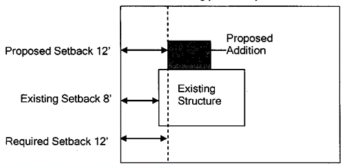
Figure 1: Addition proposed that complies with the zone required setbacks. Building permit required. - Agricultural Structure: Any portion of a nonconforming agricultural structure that complies with the setback requirements for the zone district in which the structure is located may be enlarged through the building permit process or if applicable, the agricultural use exemption, if the enlargement will further comply with all applicable zoning requirements. See figure 1 of this section.
- Low Impact Permit Required: Any portion of a nonconforming residential, agricultural, or accessory structure that does not comply with the setback requirements for the zone district in which the structure is located may be enlarged through the low impact permit process described in section 13-5-16 of this Title and according to the following criteria:
- At least fifty percent (50%) of the existing structure walls to be expanded, from which the setback is measured, must be nonconforming. See figure 2 of this section.
FIGURE 2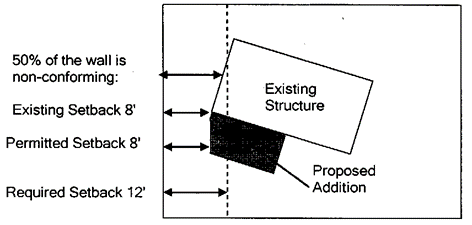
Figure 2: At least fifty percent (50%) of the wall proposed to be enlarged shall be nonconforming. Low impact permit required. - Additions to nonconforming residential, agricultural, or accessory structures may extend to the existing nonconforming setback line, but may not encroach further into the setback. See figure 3 of this section.
FIGURE 3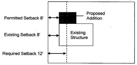
Figure 3: Addition proposed to the existing nonconforming setback line, but not further into the setback. Low impact permit required. - In no case shall the addition be closer than fifty percent (50%) of the zone required setback. See figure 4 of this section.
FIGURE 4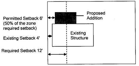
Figure 4: Addition proposed to the existing nonconforming setback line, but not closer than fifty percent (50%) of the zone required setback. Low impact permit required. - Nonconforming residential, agricultural, or accessory structures may not be enlarged for the purpose of increasing density.
- At least fifty percent (50%) of the existing structure walls to be expanded, from which the setback is measured, must be nonconforming. See figure 2 of this section.
- Building Permit Required: Any portion of a nonconforming residential or accessory structure that complies with the setback requirements for the zone district in which the structure is located may be enlarged through the building permit process only, if the enlargement will further comply with all applicable zoning requirements. See figure 1 of this section.
- Enlargement of A Nonconforming Commercial or Industrial Structure: A nonconforming commercial or industrial structure may be enlarged according to the following criteria:
- Building Permit Required: Any portion of a nonconforming commercial or industrial structure that does not comply with the setback requirements for the zone district in which the structure is located may be enlarged through the building permit process, only if the enlargement will further comply with all applicable zoning requirements. This provision only applies to commercial or industrial nonconforming structures that contain a conforming use. See figure 1 of this section.
- Low Impact Permit Required: A nonconforming commercial or industrial structure shall not be enlarged in any way that increases the nonconformity, except through the low impact permit process described in section 13-5-16 of this Title and according to the criteria found in this section. A public hearing shall be held before the commission. Following the public hearing, the commission shall make a recommendation to the City Planner regarding an approval, approval with conditions, or denial of the application.
- Enlargement or Conversion of a Nonconforming Commercial or Industrial Use: A nonconforming commercial or industrial use may be enlarged or converted to another nonconforming use according to the following criteria:
- Low Impact Permit Required: A nonconforming commercial or industrial use shall not be enlarged in any way that increases the nonconformity except through the low impact permit process described in section 13-5-16 of this Title and according to the criteria found in this section. A public hearing shall be held before the commission. Following the public hearing, the commission shall make a recommendation to the City Planner regarding an approval, approval with conditions or denial of the application.
- Abandonment or Loss of Nonconforming Commercial or Industrial Use: A nonconforming commercial or industrial use that is discontinued for a continuous period of one year is presumed abandoned and shall not thereafter be reestablished or resumed. The property owner shall have the burden of establishing that any claimed abandonment has not in fact occurred. Any party claiming that a nonconforming use has been abandoned shall have the burden of establishing such abandonment. All evidence either providing non-abandonment or abandonment shall be submitted to the City Planner who shall make a final determination of abandonment status. Any subsequent use of the building, structure, or land must conform to the regulations specified in this Title for the zone district in which the use is located.
- Special Standards that Shall Be Met for Expansions or Conversions of Nonconforming Commercial or Industrial Uses:
- The use does not significantly increase vehicular traffic or interfere with traffic flow;
- The use does not significantly increase the demand for parking;
- The use does not significantly intensify the likelihood of pedestrian and vehicular conflicts;
- The use does not create unsightly conditions or impacts to the environment including, but not limited to, unscreened storage and other environmental concerns;
- The use does not significantly intensify noise levels or odors;
- The use does not create significant dust and dirt conditions, which cannot be adequately mitigated;
- The use does not significantly intensify lighting and glare conditions;
- The use does not create a significant change in privacy for adjacent property owners; and
- The use will not adversely affect, in a significant manner, the public health, safety, and welfare.
- Sensitive Lands:
- Prohibited: Any portion of a nonconforming residential, agricultural, accessory, or commercial structure or any portion of a nonconforming use that is located within sensitive lands (wetlands, slopes greater than 30 percent, and streams) shall not be enlarged.
13-9-3 Home Occupations
- Purpose: The purpose of this section is to ensure that the owners of one-family dwelling units may undertake occupations on the premises, so long as the home occupation is not intrusive to surrounding land uses or will not alter the essential character of the neighborhood. Home occupations may be established, maintained and expanded, so long as they are consistent with the standards described below. Home occupations that meet these standards do not require further approval by the City, but the operator may be required to obtain and maintain a valid business license.
- Standards: All home occupations shall comply with the following standards:
- Home occupation may take place within the residential building, an accessory building, or outside on the parcel/lot. The use of the dwelling unit, accessory building or parcel/lot must be clearly incidental and subordinate to its use for residential purposes;
- The impacts of related activity outside of the dwelling shall create minimum impact on surrounding residential uses. Screened outside storage of materials as viewed from neighboring properties is required. Home occupations shall generate minimal dust, odor, fumes, noise, light, and other similar impacts that are not customary to the permitted dwelling unit alone;
- Vehicular traffic associated with the home occupation shall not exceed that which would normally be expected in the residential area in which it is located;
- Exterior advertising for home occupations on the premises is not permitted;
- Retail sales and rentals shall not be considered home occupations; and
- Home occupations shall comply with all applicable development evaluation standards described in chapter 3 of this Title.
- Home occupations that correspond to or resemble a use as found in 13-4-19 shall be governed by that section and may require further permitting.
13-9-4 Signs
No sign shall be erected, relocated or enlarged until the plan for such sign has been approved and a permit issued by the City Planner or designated planning staff member. Nameplates, property signs, service signs, and temporary signs conforming to the provisions of this Title may be erected without such approval or permit.
- Number of Freestanding Signs:
- Lots with less than three hundred feet (300') of street frontage on one street shall be allowed one freestanding sign.
- Lots with more than three hundred feet (300') of street frontage on one street shall be allowed two (2) freestanding signs.
- Location of Freestanding Signs: Freestanding signs shall be set back at least five feet (5') from any property or right of way line.
- Size of Signs:
- One square foot of sign area shall be permitted for every five feet (5') of continuous linear building frontage upon which such sign is mounted, up to a maximum of thirty (30) square feet. Freestanding signs shall not exceed forty (40) square feet.
- Lighting of Signs: No spotlight, floodlight, luminous tubes or lighted sign shall be installed in any way which will permit the direct rays of such light to penetrate into any residential zone or onto any property used for residential purposes. All lighted signs must comply with 13-9-18 of this chapter.
- General Restrictions: No light, sign or other advertising structure shall be erected at the intersection of any streets in such a manner as to obstruct free and clear vision or at any location where, by reason of the position, shape or color, it may interfere with, obstruct the view of, or be confused with any authorized traffic sign, signal or device; or which makes use of the words "stop", "look", "danger", or any word, phrase, symbol, or character in such a manner as to interfere with, mislead or confuse traffic.
- Signs on Public Property: No sign shall be erected on or project over publicly owned land, except signs erected by a public agency for the direction and safety of the general public.
- Real Estate Signs: No real estate sales sign shall be located within thirty feet (30') of the edge of an adjacent road surface or no closer than an existing fence line that is parallel to the road, whichever distance is less.
- Campaign Signs: Campaign signs are exempt from obtaining a sign permit; however, they must still comply with the following guidelines. Campaign signs shall not exceed three (3) square feet of area and four feet (4') in height, measured from the top of the sign to the grade directly below the sign. Campaign signs are permitted in any zone district, provided they are located a minimum of ten feet (10') back from the edge of the curb or edge of pavement, where there is no curb on the street which the sign fronts. If the ten-foot (10') distance would be within a structure, the sign may be within three feet (3') of the front of the structure. Illumination of campaign signs is prohibited. These signs shall only be permitted on private property with the permission of the property owner and are not permitted in the public right of way. City personnel may remove and impound these signs if notice to remove the signs has been sent to the property owner or candidate and they have failed to comply with that notice.
- Off Premises Signs Prohibited: No sign shall be erected or maintained on a parcel, lot or project area other than the specific lot or parcel on which the use or activity advertised on the sign is located.
- Nonconforming Signs: Nonconforming signs, excluding billboards, shall be required to conform or be removed as follows. On the happening of any of the events described below, or where any of the following conditions apply, the sign or signs shall be brought into compliance within one year after the effective date hereof, and a new permit shall be secured therefor, or shall be removed.
- The cost of the nonconforming sign is valued at less than one hundred dollars ($100.00). Sign value shall be determined based on an actual sales receipt for the sign or a cost estimate for the replacement cost provided by a qualified professional.
- When a nonconforming sign is destroyed or damaged to an extent in excess of fifty percent (50%) of the sign value.
- The sign is relocated in any manner.
- If the sign is altered structurally, or if more than fifty percent (50%) of the copy, as measured by the sign area, is altered, except for changeable copy signs and maintenance.
- If the business or service for which the nonconforming sign was installed is expanded or modified. All improvements to a single business or use within any twelve (12) month period shall be treated cumulatively in the administration of this subsection.
- Nothing in this section shall be deemed to prohibit the City from removing a billboard without providing just compensation in accordance with the procedures set forth in this subsection if the City Council provides reasonable notice of the proceedings and, following a public hearing, finds:
- The applicant made a false or misleading statement in any application to the City necessary to establish or change the billboard;
- The billboard is unsafe or presents a hazard to persons or property;
- The billboard is in a state of disrepair; or
- The billboard has been abandoned for at least twelve (12) months.
13-9-5 Accessory Dwelling Units
- Scope: When designated in section 13-4-19 of this Title, an accessory dwelling unit or an agricultural employee dwelling unit may be approved by the City. When approved through the conditional use process, both an accessory dwelling unit and an agricultural employee dwelling unit (if allowed in the zone) may be approved on the same parcel/lot.
- Accessory Dwelling Unit:
- An accessory dwelling unit shall not exceed one thousand (1,000) square feet of gross square footage, as measured from exterior wall to exterior wall of the dwelling unit itself.
- An accessory dwelling unit may be placed within or attached to a larger detached accessory structure (such as a barn or garage), but the dwelling unit itself shall be limited to one thousand (1,000) square feet. This use is still defined as a detached accessory dwelling unit.
- If permitted by subdivision CCR’s, one accessory dwelling may be allowed within or attached to an existing home, i.e. basement apartment in the Community Residential (CR) zones. Detached accessory dwelling units are not allowed in subdivisions in the CR zones. Building permits are required for all indoor or attached accessory dwelling units.
- Building permits and other provisions of this Title will apply to the size and permitting of any detached accessory dwelling unit structure.
- Any type of constructed walkway, skyway, hallway, or breezeway connecting the accessory dwelling unit to the primary residence does not make the accessory dwelling unit an attached or internal accessory dwelling unit.
- Any type of internal accessory dwelling unit which requires an addition to the square footage of the primary unit will be treated as an attached accessory dwelling unit.
- Internal Accessory Dwelling Units (ADU’s) are a permitted use in all zones and are subject to the following limitations and conditions:
- The ADU is constructed entirely within an existing single-family residential dwelling without changing the appearance of the dwelling as a single-family dwelling or adding to the dwelling’s footprint.
- The primary dwelling must be occupied by the owner.
- The dwelling must provide one additional parking spot for the ADU in addition to normal parking requirements for the dwelling and any parking lost by the construction of the ADU.
- The dwelling must be on a lot of at least 6,000 square feet and served by an adequate sewer or septic system.
- The ADU cannot be used as a short-term nightly rental (i.e., Air BnB).
- The ADU cannot have separate utility connections.
- The ADU must satisfy all City building and local fire codes.
- Agricultural Employee Dwelling Unit: An agricultural employee dwelling unit is a one-family dwelling unit of up to but not to exceed two thousand (2,000) square feet. Before an agricultural employee dwelling unit is approved, it must be demonstrated that the property on which the dwelling will be located contains a viable "agricultural operation", as defined in appendix A of this Title. An agricultural employee dwelling unit shall be located in reasonable proximity to the primary residential dwelling unit as determined through the conditional use review. An agricultural employee dwelling unit can be constructed prior to the primary structure as long as the low impact permit or conditional use criteria is satisfied.
- Deed or Restrictive Use Covenant Required: An accessory dwelling unit and an agricultural employee dwelling unit shall be connected by deed or restrictive use covenant to the principal dwelling unit or structure on the parcel/lot and shall not be eligible for subdivision or condominiumization and conveyance to another person.
- Nightly Rental Units: If an accessory dwelling unit is to be used at any time (as declared in the application) as a nightly rental unit, further regulations and approvals will be necessary as per 13-9-20 of this chapter.
13-9-6 Equipment Enclosures, Utility Structures And Related Facilities
Equipment enclosures, utility structures, and related facilities shall address the following issues: screening, noise level, odors/air quality, lighting, landscaping, architectural screening/buffering, proximity, etc. The length, size, and architectural character of the proposed structure must be compatible with the residential uses in the area and must comply with the setback requirements for the zone in which it is located.
- Purpose: The purpose of this section is to ensure that all utility facilities/structures are located, installed, buffered/screened and maintained in a manner that will minimize the impact of such facilities/structures on nearby landowners and will not adversely affect the rural, agricultural, small town character and scenic beauty of Oakley City.
- Application: All applicants wishing to submit an application to construct utility facilities/structures shall: 1) submit to staff the latitude and longitude of proposed utility facilities/structures; 2) meet or exceed the following criteria in addition to the conditional use criteria in section 13-5-7 of this Title:
- Site Location/Proximity: The equipment enclosures and facilities/structures shall be located in a manner that reduces, to the maximum extent possible, the visibility from any major highway, roadway and/or adjacent development. Such facilities and related uses shall also be required to be consistent with the aesthetics of the neighborhood, and particular care shall be taken to reduce all potential impacts on adjacent residential uses.
- Site Layout and Design: Such development shall be integrated into the site in a manner that is sensitive to the existing topography, vegetation and any nearby structures, and which utilizes the existing site features, to the maximum extent possible, to screen the facilities from nearby landowners and sensitive view corridors.
- Fencing shall be within five feet (5') or less from structures and allowance of two (2) parking stalls for temporary parking and maintenance requirements within enclosure. Fence setbacks from structures can be varied upon review of application if there are site limitations or applicant maintenance requirements.
- Hard surface and gravel areas outside of proposed structures shall not extend to property boundaries, but shall instead be minimized, to the greatest extent possible, with appropriate landscape buffering as described in subsection B4 of this section.
- Architectural Screening: When appropriate and/or necessary to meet the requirements of subsection A of this section, architectural screening shall be utilized to disguise the facilities/structures as typical farm type outbuildings which are consistent with the rural, agricultural character of the area. Long, unbroken facades and rooflines shall be avoided as well as the use of industrial type material and finishes.
- Landscape Buffering: When appropriate and/or necessary to meet the requirements of subsection A of this section, landscaping and/or berming techniques shall be utilized to mitigate the visual and other related impacts of utility facilities/structures. Such landscaping and berming shall emulate the natural, rural landscape. All disturbed areas shall be revegetated with appropriate plant materials. Temporary irrigation shall be required for initial establishment and long term support of new landscaping and revegetation of disturbed areas.
- Lighting: Lighting shall be the minimum required for maintenance and security purposes. Fixtures shall be fully shielded with light directed down and shall be controlled by motion detectors such that the lights are off unless needed for maintenance access or tripped on by motion detectors. Flood type area lighting is prohibited. Wall mounted fixtures shall be installed no higher than eight feet (8') above the finished grade immediately below the fixture. See 13-9-18 of this chapter for further regulations.
- Noise: The development shall not generate noise which would result in materially adverse impacts to the adjacent land or its occupants. A noise study may be required to make this determination.
- Security Fencing: Security fencing shall be as unobtrusive as possible and shall blend in with the surrounding environment.
- Fuel Storage/Handling: On site fuel storage (for backup generator, etc.) shall be designed for full, backup containment in the event of primary tank failure and/or spillage during refueling. Any and all fuel spills or spills of any hazardous materials shall be immediately cleaned up, removed from the site and disposed of in accordance with all federal, state and local regulations.
- Outdoor Storage: Outdoor storage of materials and equipment shall be prohibited.
- Maintenance: At all times, all site improvements, including any required landscaping, fencing, buildings, finishes, etc., shall be maintained to an acceptable standard such that the facilities and related site improvements shall not adversely affect, in a significant manner, the public health, safety and welfare.
13-9-7 Wireless Communications
- Purposes: The purpose of this section is:
- To ensure that all telecommunications facilities comply with federal, state and City regulations.
- To regulate telecommunications services, antennas and support structures, and related electronic equipment and equipment enclosures.
- To provide for the orderly establishment of telecommunications facilities in the City.
- To minimize the number of antenna support structures by encouraging the collocation of multiple antennas on a single structure, and by encouraging the location of antennas on preexisting support structures.
- To establish siting, appearance and safety standards that will help mitigate potential impacts related to the construction, use and maintenance of telecommunications facilities.
- To comply with the telecommunications act of 1996 by establishing regulations that:
- Do not unreasonably discriminate among providers of functionally equivalent services.
- Do not prohibit or have the effect of prohibiting the provision of telecommunications services.
- Are not based on any claimed environmental effects of radio frequency emissions to the extent that such facilities comply with the federal communication commission's regulations concerning such emissions.
- Ensure that all utility facilities/structures are located, installed, buffered/screened and maintained in a manner that will minimize the impact of such facilities/structures on nearby landowners and will not adversely affect the rural, agricultural, small town character and scenic beauty of Oakley City.
- General Provisions:
- Independent Review: The City may, if it deems necessary, cause the applicant to submit an impact study from a qualified, third party radio frequency engineer, to ensure that the proposed telecommunications facility will not interfere with existing radio, television, and emergency signals. The purpose of this review shall be to determine if other sites are available which can achieve an equivalent signal distribution without significantly affecting the existing telecommunications operations within the City. Such review may be required when an applicant indicates that no other acceptable site exists. The cost for such review shall be borne by the applicant.
- Permitted: Telecommunications facilities applications shall be permitted in accordance with section 13-4-19 of this Title.
- Construction Standards:
- Building Codes and Safety Standards: To ensure the structural integrity of telecommunications facilities, the owner of a telecommunications facility shall ensure that it is maintained in compliance with the standards contained in applicable Building Codes and application standards for such telecommunications facility, as amended.
- Letter of Intent: All applicants who apply to build a tower shall provide one letter of intent from a telecommunications company that will locate on the tower.
- General Requirements:
- Setbacks: A telecommunications facility shall be set back one hundred fifteen percent (135%) of the tower's height from the property line, or such facility shall meet the zone required setback, whichever is greater. The telecommunications facility shall be at least one hundred feet (100') from any public trail, park or outdoor recreation area. Guywire anchors shall be set back at least twenty feet (20') from any property line. The City Planner or designated planning staff member can approve varied setbacks if the telecommunications facility can be screened more appropriately by topography, vegetation or existing structures; however, the adjacent landowner(s) must sign a written agreement authorizing the decreased setback(s) from their property line(s). If telecommunications facilities are located in commercial or industrial zones or on City owned property, they shall only be allowed in the rear yard.
- Signage: Signs shall be limited to nonilluminated warning and equipment identification signs, unless additional signs are warranted by the FAA, FCC, or any other agency of the State or Federal government with the authority to regulate telecommunications facilities.
- Access Roads: Access roads shall be limited to ten feet (10') in width, unless otherwise approved by the fire district or Oakley City Engineering Office because of safety considerations. Access roads shall contain gravel or other nonpaved surface. Existing roads shall, whenever possible, be upgraded the minimum amount necessary.
- Collocation: An applicant proposing to erect a new telecommunications facility shall provide documentary evidence that a legitimate attempt has been made to locate the new telecommunications facility on existing buildings or structures or as a collocation on an existing antenna support structure. Such evidence shall include a radio frequency engineering analysis of the potential suitability of existing buildings or structures or collocation sites in the radio frequency coverage area for the proposed telecommunications facility. Efforts to secure such locations may be documented through correspondence between the applicant and the property owner(s) of the existing buildings, structures or collocation sites.
- Equipment Enclosures: Every effort shall be made so that equipment enclosures or other structures are designed whereby the incorporation of stealth design technology or other visual screening (topography or vegetation) is utilized that readily conceals the appearance of the structure.
- Master Plan Requirements: A master plan shall be completed by each company submitting an application for a development review. The master plan shall include:
- Where the applicant's proposed, existing and future telecommunications facilities are within the City. The master plan may be amended as needed by the carrier for future site applications.
- The number of possible collocations that can be obtained on the proposed tower.
- A copy of the applicant's current FCC license.
- A signed agreement, stating that the applicant will:
- Allow collocation with other users, provided all safety, structural and technological requirements are met. This agreement shall also state that any future owners or operators will allow collocation on the tower;
- Restore site to its former condition. (See non-maintained or abandoned facilities.)
- A security program or system that addresses unauthorized access and vandalism.
- Non-maintained or Abandoned Facilities: The director or designated planning staff member may require each non-maintained or abandoned telecommunications facility to be removed when such a telecommunications facility has not been repaired or put into use by the owner, person having control, or person receiving benefit of such structure within six (6) months after written notice of non-maintenance or abandonment is given to the owner, person having control, or person receiving the benefit of such structure.
13-9-8 Infrastructure Standards
- Fire Protection Standards:
- All development, including a single-family dwelling on an individual lot or parcel, which does not have year-round access or is located within the wildland fire urban interface zone, is subject to the fire protection measures required by the 2006 Utah wildland fire urban interface code and the respective fire district and/or fire warden.
The wildland urban interface (WUI) zone map was developed using the roads to the outside of the valley floors as a simplified boundary. The areas within the valley floors typically have a water supply or are in areas with irrigated fields/modified vegetation and are in the vicinity of maintained roads that lower the wildland fire potential, and are therefore excluded from the WUI zone. Areas within two hundred fifty feet (250') of these road centerlines are also excluded from the WUI zone, as fire equipment can typically access these buildings within National Fire Protection Association (NFPA) requirements for hose length. The two hundred fifty foot (250') buffer is to be measured from centerline of the road across the ground to the build(s) by way of the normal access provided.
For wildland/urban fire requirement purposes, the following criteria shall be used by the applicable Fire District when reviewing development applications in Oakley City:
- Location of building with respect to designated wildland urban interface (WUI) area based on the City and state approved map.
- Response time for responding fire units.
- Access, including road and bridge weight limits.
- Space at the building for sufficient fire equipment to adequately and safely fight or defend the building(s).
- Type and density of vegetation around the buildings.
- Separation of buildings from vegetation as to prevent a building fire from spreading to wildland.
- Type of road or driveway, length, and grade, as well as type of access (seasonal versus year-round).
- Distance from established water supply and the ability to get that water to the fire based on pump capacity, access, and space at the building and turnarounds.
- Other criteria that shall be used are the following state adopted laws and rules:
- The state fire code adoption act.
- Utah code subsection 65A-8-203(3)a (re: cooperative fire protection agreements with counties).
- Utah administrative code R652-122-200 minimum standards for wildland fire ordinance.
- Utah administrative code R309-550-5 water main design.
- 2006 Utah wildland urban interface code.
- Other provisions of this Title.
- The 2009 international fire code (IFC) or newer as adopted by the state of Utah. Based on this review, applicants may be required to enact a variety of measures to minimize the level of fire hazard. The fire protection measures may include the following: a. Connection to a community or private water system, well or spring with a minimum five thousand (5,000) gallon water storage tank, pond, or other accessible water body with a dry hydrant. b. Defensible space around each dwelling. c. Noncombustible roofing materials. d. Internal fire sprinkler systems. Based upon specific site characteristics (e.g., a meadow or irrigated field within the WUI zone) and the applicant's ability to provide an adequate combination of the above listed building or on-site improvements, the fire district may waive certain requirements. All applicants for new development shall, at the time of application, acknowledge that they have reviewed the "Summit County Living with Fire" information pamphlet and consulted the building department, insurance companies, builders and fire districts/fire warden regarding fire protection.
- All development, including a single-family dwelling on an individual lot or parcel, which does not have year-round access or is located within the wildland fire urban interface zone, is subject to the fire protection measures required by the 2006 Utah wildland fire urban interface code and the respective fire district and/or fire warden.
The wildland urban interface (WUI) zone map was developed using the roads to the outside of the valley floors as a simplified boundary. The areas within the valley floors typically have a water supply or are in areas with irrigated fields/modified vegetation and are in the vicinity of maintained roads that lower the wildland fire potential, and are therefore excluded from the WUI zone. Areas within two hundred fifty feet (250') of these road centerlines are also excluded from the WUI zone, as fire equipment can typically access these buildings within National Fire Protection Association (NFPA) requirements for hose length. The two hundred fifty foot (250') buffer is to be measured from centerline of the road across the ground to the build(s) by way of the normal access provided.
For wildland/urban fire requirement purposes, the following criteria shall be used by the applicable Fire District when reviewing development applications in Oakley City:
- Wildfire Hazard Guidelines:
- All proposed developments within the High Risk zone of the Fire Hazard Zone map of the current General Plan shall be analyzed and rated on its wildfire risk using the fire hazard severity scale developed by the state, division of state lands and forestry. A development shall be rated based on the following criteria. The composite score will categorize the hazard level of the proposed development as moderate, high, or extreme. This rating, based on the following, shall be submitted to the City as part of any sketch plan:
- Slope of the site on which the development is proposed;
- Aspect, or the general direction in which the surface of the ground faces;
- Response time of the responsible fire agency as measured in minutes;
- Vegetation density to measure the fuel loading of the area; and
- Type of vegetation to identify rates of spread, resistance to control and other factors.
- Hazardous fuels in the form of native vegetation will be cleared around structures and around the perimeter of subdivisions where appropriate to assist in wildfire prevention. Fuel breaks are not intended as complete vegetation removal; but rather, they shall serve as a change in fuel continuity, type of fuel, and degree of flammability of fuel in a strategically located area to reduce or hinder the rate of fire spread. The amount of vegetation to be removed/left within a fuel break area shall be recommended by the appropriate fire district. Fuel breaks around residential dwelling units shall be in place before the issuance of a certificate of occupancy.
- Fuel break clearing limits shall be as follows:
TYPE MODERATE HIGH EXTREME Structures 30 feet 50 feet 75 feet Development Perimeter None 75 feet 100 feet - As part of a recorded plat for a subdivision in the high-risk fire zone areas, fuel break easement shall be identified, and a note shall be placed on the plat stating the following:
The fuel break easement is granted for the benefit of the Utah state area forester. Fuel breaks shall be maintained by the landowner or homeowners' association. Failure of the landowner to maintain the fuel break shall cause the area forester to cause the maintenance of the fuel break and charge the landowner for costs incurred.
- All proposed developments within the High Risk zone of the Fire Hazard Zone map of the current General Plan shall be analyzed and rated on its wildfire risk using the fire hazard severity scale developed by the state, division of state lands and forestry. A development shall be rated based on the following criteria. The composite score will categorize the hazard level of the proposed development as moderate, high, or extreme. This rating, based on the following, shall be submitted to the City as part of any sketch plan:
- Road Standards: Public and private roads in subdivisions shall meet the following minimum right of way, surface, shoulder width, and other standards. Road surfaces shall be capable of providing all weather, year around access as approved by the Fire District and the City:
- Width of Surface:
DESIGN VOLUME DESIGN SPEED
<25 25-250 251-699 700-999 1,000-2,499 2,500-5,000 5,001+ 20 mph 14 16 20 22 22 24 24 30 mph 16 18 20 22 22 24 24 40 mph 18 20 22 22 22 24 24 50 mph - 20 22 22 22 24
Roads designed to carry a large traffic volume per day at higher speeds may be required to be wider than described. This will be based on a determination of the specific design volume, speed, terrain and other characteristics to be calculated at the time of development application. Public roads, to be owned and maintained by the City, shall be a minimum of twenty-four feet (24') of paved surface width. In special circumstances, providing safety standards are met, the City Engineer and Planning Commission may reduce this width standard on a case-by-case basis to protect sensitive lands, hill sides, reduce visibility, or minimize maintenance. - Width of Shoulder:
DESIGN VOLUME DESIGN SPEED <25 25-250 251-699 700-999 1,000-2,499 2,500-5,000 5,001+ All Speeds 1'- 2' 1'- 4' 2' - 4' 2' - 6' 2' - 6' 2' - 6'
Shoulders may be required to be compacted road base, asphalt or other suitable hard surface, or a combination thereof. - Width of Right-Of-Way: The minimum right-of-way width for a public road shall be sixty feet (60'). The requirements may increase as the paved surface width increases due to traffic volumes, as described above. The minimum right-of-way for private roads shall be double the driving surface of the road. Exceptions may be made by the Planning Commission in certain constrained areas.
- Road Terrain: Streets, roadways and private driveways shall follow as nearly as possible the natural terrain.
- Ingress and Egress: At least one (1) ingress and one (1) egress routes shall be provided for each subdivision of eight (8) lots or greater, unless there is a crash gate or the extension of a future stub street that will provide additional access.
- Emergency Access: Points of access shall be provided to all developed and undeveloped areas for emergency and firefighting equipment. Driveways located upon each lot extending from a public road or private right-of-way shall have sufficient width and design to admit and accommodate firefighting equipment (and comply with all City engineering standards).
- Road Curvature: Centerline curvatures shall not be less than a one hundred (100) foot radius on any curved street pattern. To accommodate emergency vehicles, inner curvatures of the road surface cannot be less than twenty-six (26) foot radius
- Variations: Variations of the street design standards developed to solve special hillside visual and functional problems may be presented to the planning commission for consideration and approval. Examples of such variations may be the use of split roadways to avoid deep cuts, one-way streets, round-about, and modifications of surface drainage treatments, sidewalk design, non-paved road surfaces on private roads, or the extension of a cul-de-sac.
- Public Lands: Developments adjacent to public lands shall provide for access by fire protection equipment.
- Construction Standards: Roads shall be designed to meet the City road base, asphalt, grading, and compaction standards.
- Road Grades: The maximum road grade of an arterial road shall be eight percent (8%). On all other roads, a grade of less than eight percent (8%) is encouraged and preferred. However, road grades in excess of eight percent (8%), up to a maximum of ten percent (10%), may be allowed for short distances when, in the opinion of the City, it is in the best interest of preserving the natural environment and when approved by the appropriate fire district. Short distances shall not exceed five hundred feet (500') within any one-thousand-foot (1,000') segment.
- Intersections: The road grade at an intersection shall not exceed four percent (4%) for a minimum distance of one hundred feet (100') on each leg of the intersection, and flatter grades are desired.
- Turnaround/Cul-De-Sacs: Cul-de-sacs will be a maximum of one thousand three hundred feet (1,300') in length for developments with a moderate fire hazard rating, nine hundred feet (900') in high fire hazard rated areas, and five hundred feet (500') in areas of extreme fire hazard. No cul-de-sac shall have a driving surface width of less than twenty feet (20'), and twenty-four feet (24') from public roads. All cul-de-sacs shall have a turnaround of not less than ninety-six feet (96') in diameter. All cul-de-sacs must have a sign indicating that the road is a "dead end" road, to be located within one hundred feet (100') of the outlet. On certain low occupancy private roads, a “Hammerhead” or “Y” turnaround may be approved by the Planning Commission provided the total length of the “Hammerhead” or “Y” is one hundred twenty (120) feet in length.
- Bridges and Culverts: Bridges and culverts on public roads shall be designed to support an HS-20 highway loading requirement. Permanent culverts will be installed at all intermittent and perennial stream crossings. Specifications for bridges, culverts and other stream crossings shall take into account at least the 100-year frequency storm for bridges and the 25-year frequency storm for culverts. At a minimum, roads and bridges on public and private roads shall be capable of supporting the imposed load of fire apparatus weighing up to 75,000 pounds.
- Width of Surface:
- Gated Communities: All proposed gated communities must comply with 13-3-5E.
- Driveway Access: The maximum grade of a driveway shall not exceed ten percent (10%). Twelve percent (12%) grades may be allowed for up to but not to exceed two hundred fifty (250) linear feet. The minimum width of a driveway shall be twelve feet (12').
- Irrigation Ditch Easements: An unobstructed easement at least sixteen feet (16') in width shall be provided and shown on the subdivision plats or site plans, to ensure proper access and maintenance of irrigation ditches and canals.
- Water Storage for Firefighting Purposes: New development shall be required to meet the minimum water storage requirements for firefighting purposes as established by the fire district.
- Revised Standards Applicable: Development is subject to revised general engineering standards and ordinances which are in effect at the time the application is submitted for review and approval by the City.
- Curbs, Gutters, Trails, and Sidewalks: Curbs, gutters, trails and/or sidewalks may be installed on all existing and proposed streets and along the frontage of any lot within a subdivision in conformance with the City's standard specifications and details for municipal construction, as adopted. Trails and paths will generally be preferred to sidewalks and will meet current or proposed trails construction standards and comply with the City’s General Plan, including trails master plan or maps (if adopted). See Section 13-9-25 for more details.
- Fire Hydrants: Fire hydrants shall be installed by the developer in accordance with the City's specifications and details for municipal construction, the International Fire Code, and other local ordinances, at locations designated by the Fire Department as shown on the preliminary plat and City approved construction drawings.
- Storm Drainage Systems: Surface water runoff drainage systems shall be designed to handle all runoff generated within the subdivision by a ten-year storm and routing of water generated by a one hundred (100) year storm will be provided. Such systems shall be designed and installed by the developer according to the City's specifications and details for municipal construction and must be approved by the City Engineer.
- Water Infrastructure: All projects connecting to the City’s water infrastructure must comply with all City Water Ordinances, Rules and Regulations, Conservation Plans, and Construction Standards and Specifications. All relevant fees must be paid, and water system designs, materials, and construction plans, processes, and guarantees must be approved by the City Engineer.
To conserve City culinary water sources and reduce the impacts upon the water distribution system, any new commercial development, MPD, or subdivision which develops agricultural property serviced by an existing unpressurized or pressurized irrigation system may be required to connect to and irrigate all or a portion of landscaping with either an existing or a newly developed pressurized irrigation system. All culinary water demands; landscaping, water conservation designs, and alternate supplies of irrigation water must be evaluated. If a subdivision is to be served by City water which was previously irrigated with water from an irrigation company, additional analysis and determinations will need to be made by the City as a condition to project approval.- Can the subdivision be irrigated fully or partially by a pressurized irrigation system using its current ditch company water rights? If so, the plans must show which portions of land are to be irrigated with existing raw ditch water, which portions are to be left in a natural state, and which portions will be irrigated with City water. This evaluation must include the supply and maintenance of any proposed water features and ponds.
- Can the water rights associated with the developed property be moved through a change application with the State Engineer to the City’s culinary water sources? If so, will they have a priority and quantity (after the change) to adequately service the property?
- If there are plans to service the area with a new larger or regional pressure system in the foreseeable future, secondary piping and appurtenant facilities may be required to be installed and maintained to be utilized in the future when a proper connection can be made.
- Bonus density in an MPD (as described in Appendix B) may be available for developments serviced by sustainable secondary irrigation systems.
- Sewer Infrastructure: All projects connecting to the City’s sewer infrastructure must comply with all City Sewer Ordinances, Rules and Regulations, and Construction Standards and Specifications. All relevant fees must be paid, and sewer system designs, materials, and construction plans, processes, and guarantees must be approved by the City Engineer. Sewer collection systems situated in the Weber River bottoms, wetlands, or high-water table areas must be designed, inspected, and tested to ensure that no ground water or irrigation water can infiltrate the collection system. The system must be further designed to only service typical indoor wastewater needs and must not be connected to any roof drains, pool or pond drains, or any possible land or storm drainage collection systems.
13-9-9 Development Agreements
- Authority: The City may, but under no circumstances is it required to, enter into a development agreement with a property owner or applicant for development approval. The City, at its sole discretion, may opt to use a development agreement when it determines that such an approach to development promotes and protects the public health, safety and general welfare. Development agreements shall be used to implement a specific plan under an MPD development or zoning designation, as indicated in section 13-5 of this Title.
- Binding Agreement: Whenever the City opts to enter into a development agreement, the agreement shall constitute a binding contract between the applicant and the City. It shall contain those terms and conditions agreed to by the applicant and the City. The agreement shall describe all limitations, restrictions and parameters associated with the development of the subject property. The agreement shall describe all processes and procedures for obtaining final approval and building permits. The agreement shall not allow the sale or transfer of individual parcels or components of the entire project unless specifically provided for in the agreement or as otherwise allowed under state law.
- Effect of Approval: Upon approval of the development agreement, it shall constitute a vested right in the specific terms and proposals for a period of five (5) years from the date of the approval, or longer when specifically allowed in the agreement, subject to any conditions agreed to and incorporated into the agreement.
- Criteria for Approval: The criteria for approval are as follows:
- The development agreement has been duly adopted in accordance with the provisions stated in this section.
- The development agreement includes written consent by each landowner whose properties are included within the area described.
- The City Council, after receipt of a recommendation from the Planning Commission and review and consideration of the development agreement, finds that the specific proposals, terms and conditions contained in the agreement are consistent with the intent of the general plan, result in benefits to the general public that would not otherwise occur under the literal application of this Title, and provides a more flexible way to more effectively protect the health, safety and general welfare of the public.
- Development allowed under a development agreement shall comply with the development evaluation standards in chapter 3 of this Title, the infrastructure standards in this chapter, and all other criteria described in pertinent sections of this Title.
- When appropriate, based on the size of the project, the landowner or applicant agrees to, at a minimum, contribute all capital improvements and facilities necessary to mitigate the impacts of the project on the City and special districts.
- The landowner or applicant will mitigate all fiscal impacts on the general public.
- Development shall not be permitted to create unacceptable construction management impacts.
- While a creative approach to the development and use of the land and related physical facilities may be allowed by a development agreement, all development approved in the agreement shall meet or exceed development quality objectives of this Title.
- The development shall be consistent with the goal of orderly growth and minimize construction impacts on public infrastructure within Oakley City.
- The development shall protect life and property from natural and manmade hazards.
- The development shall prevent harm to neighboring properties and lands, including nuisances.
- Development agreements cannot include language that restricts the City’s legislative discretion, such as, a development agreement cannot bind the City’s future actions regarding ordinances, annexations, rezones, development rights, etc.
- Any development agreement that modifies or conflicts with a normal development requirement, such as land or water dedication requirements, open space requirements, density, or lot size limitations, etc., must be approved in the same way as a land use ordinance amendment as found in Chapter 13-8, and shall include all relevant public hearing(s) and reviews by the Planning Commission.
- Procedure for Approving Agreements: All development agreements shall be reviewed and approved in accordance with the procedures for a MPD, as described in section 13-5 of this Title.
13-9-10 Reapplication Following Denial
If any application for development approval is denied for failure to meet the substantive requirements of this Title, an application for all or a part of the same property shall not be considered for a period of one year from the date of denial unless the subsequent application for development is substantially different from the previously denied proposal.
13-9-11 Revocation Of Approvals And/Or Permits
- Authority: An approval or permit may be reconsidered and revoked by the land use authority that granted the permit in accordance with the procedures set forth herein if it is determined that the application, decision, approval or permit was based on materially inaccurate or incomplete information, or where the applicant is in violation of the issued permit or approval.
- Duties of City Planner; Hearing: If the City Planner determines, based on inspection by City staff, that there are reasonable grounds for revocation of a development permit approval authorized by this Title, the City Planner shall set a hearing before the land use authority that granted the permit.
- Notice and Public Hearing: Reasonable notice of the proceeding to revoke the development permit or approval shall be given to the applicant.
- Required Findings: The land use authority may revoke the development permit upon making one or more of the following findings:
- That the development permit was issued on the basis of erroneous or misleading information or misrepresentation provided by the applicant;
- That the terms or conditions of approval of the permit relating to establishment or operation of the use approved have been violated or that other laws or regulations of the City, state, federal or regional agencies applicable to the development have been violated.
- Decision and Notice: Within ten (10) working days of the conclusion of the hearing, the land use authority shall render a decision, and shall notify the holder of the permit and any other person who has filed a written request for such notice in the manner provided herein.
- Effect: A decision to revoke a development permit shall become final ten (10) days after the date notice of the decision was given. After such effective date, all activities pursuant to such permit thereafter shall be deemed in violation of this Title.
- Right Cumulative: The City's right to revoke a development permit, as provided in this section, shall be cumulative to any other remedy allowed by law. Where an applicant is in violation of his permit, the City may deem it a violation of this Title and proceed under section 13-1-14 of this Title.
13-9-12 Failure To Comply With Conditions
Approval of any development may be made with or without conditions, and the failure to fully abide by the terms of any conditional approval will result in a forfeiture of any vested property right associated with the development approval.
13-9-13 Effective Period Of Approvals
- Sketch Plan Review: Upon the completion of a sketch plan review, a formal development application, as required in this Title, shall be submitted within six (6) months from the completion of the sketch plan review.
- Preliminary Plan: The approval of a preliminary plan, when required in this Title, shall be effective for a period of one year from the date of its approval. At the end of the one-year period, the applicant shall have submitted a complete application for final development review. If a complete final plan application is not submitted within one year, the preliminary approval shall be considered null and void, and the applicant shall be required to submit a new sketch plan and development application in accordance with the provisions of this Title in effect at that time.
- Final Plan; Vested Right: Upon approval of any final plan/plat, it shall constitute a vested right in the specific terms and proposals identified in the approval for a period of one year from the date of the approval, at which time the final plat shall be recorded in the office of the Summit County recorder. This provision reflects the City Council's position that no developer has a vested right in perpetuity, and that in the interest of the health, safety and general welfare, developers must proceed with development approvals with due diligence. Therefore, development projects, including subdivision plats and site plans, which were approved before Oakley City adopted its first Zoning Ordinance in 1980, in which no development has taken place, are not entitled to vested rights under this Title. The establishment of a vested right does not exempt the property owner from requirements for building permits or other necessary permits. The establishment of a vested right shall not preclude the application from the requirements of the building code, fire code, plumbing code, electrical code, mechanical code or other requirements necessary for the protection of the public health, safety and welfare.
- Development Permit Extension: One 6-month extension of a development permit may be granted by the City Planner upon his finding that special circumstances exist which warrant such an extension, including, but not limited to, a delay caused by a government review agency or natural disaster.
13-9-14 Issuance Of Building Permits
- Water, Sewer and Access Requirements: A building permit will not be issued for a new dwelling unit or commercial or industrial structure until all water, sewer/septic and access requirements are met.
- Address: An address in conformance with the City and/or County addressing system must be assigned before issuance of a building permit.
- Lot Conformance: Before a building permit can be granted to any property, the parcel/lot shall lawfully conform to all applicable provisions of this Title (lot of record). There are parcels/lots within Oakley City that, while their existence may be recorded in the office of the Summit County recorder, were not lawfully created in accordance with the laws of the City. The City will not issue a building permit for such parcels/lots.
- Prior To Completion and Acceptance of Improvements: Building permits may be issued for construction in subdivisions and other projects prior to the completion and acceptance by the City of the required property improvements, provided minimum access and safety standards can be met and a bond or escrow fund is estimated and established for the required infrastructure. In such cases, the City Planner or designated planning staff member may require that the applicant for building permit sign a statement indicating the following:
- The applicant is aware of the terms of the bond or escrow account established to guarantee completion of required improvements to the satisfaction of the City.
- There may be private infrastructure improvements required in the subdivision or project area, which may not be complete, over which the City has no influence or authority regarding completion of work and that the applicant accepts the associated risk.
- The applicant releases the City from liability for installation, maintenance or repair of the required public improvements until the same have been completed by the developer or under the terms of the escrow agreement, and accepted by the City.
- The applicant assumes all risk in connection with construction on the subject property.
- Site Plan Requirements: Three (3) copies of a site plan, a minimum size of eleven inches by seventeen inches (11"x17") (must be legible) and a maximum size of thirty-six inches by forty-eight inches (36"x48") shall be submitted with all building permit applications for all new construction, including additions, accessory buildings, and garages.
- Preparation of Site Plan: If any of the following criteria apply, the site plan shall be prepared by a licensed surveyor, architect, landscape architect, or engineer, registered in the state of Utah:
- Parcels/lots that contain a designated building pad identified on a subdivision plat.
- Building areas or building pads having an average grade steeper than five percent (5%) (some elevation information may be required to verify grade).
- Proposed structure heights greater than twenty-eight feet (28').
- Proposed structure setbacks closer than three feet (3') to the required setback line, excluding decks, lean-tos, or other similar structures.
- Agricultural exempt buildings that comply with section 10-9a-605 of the Utah Code Annotated are excluded from these site plan requirements. However, agricultural exempt buildings closer than three feet (3') to the required setback line or are greater than twenty-eight feet (28') in height will require an inspection by the Planning department to ensure that setback and height requirements for the zone district in which they are located are being met.
- Parcels/lots that do not have existing property corners set by a licensed surveyor.
- Site Plan Information Required: When the site plan is required to be prepared by a licensed surveyor, architect, landscape architect, or engineer, each copy shall be wet stamped by each professional involved in its preparation. Redline corrections/additions to the site plan or elevation page items may be accepted if determined by staff to be minor in nature. All corrections shall be approved by the person who stamped the site plan. The site plan shall contain the following information:
- Scale.
- North arrow.
- Information box showing the name of the applicant, subdivision and lot number or parcel number (tax identification number), address, section, township, and range, acreage (or square footage) of the lot or parcel.
- Map of the parcel. For parcels larger than one acre, provide large scale drawing of the entire parcel (i.e., vicinity map, 1 inch=100 feet), with bearing and distance calls, and a smaller scale (1 inch=20 feet), detailed map of the area of the parcel being developed. The map shall contain the following minimum information:
- Property lines, designated building pad, platted setback lines, rights of way and easements, all adjacent streets/roadways.
- Proposed setbacks of all new structures to the property lines.
- A topographical map prepared by a licensed surveyor including both existing and proposed contours. Two foot (2') minimum contour intervals are required for all parcels/lots which have an average grade greater than five percent (5%) (some elevation information may be required to verify grade) and/or structure heights that exceed twenty-eight feet (28') (measure from the ridgeline to existing grade). Existing contours must be shown through the proposed structures.
- For lots/parcels one acre or less in size, contours are required for the entire lot/parcel.
- For lots/parcels greater than one acre in size, contours are required one hundred feet (100') on each side of all proposed structures and all other areas of disturbance proposed for the lot/parcel, such as the driveway, accessory structures and yard areas. The contour map must include the opposite side of any existing roadway adjacent to the property.
- One fixed point near the proposed construction labeled "Benchmark" showing the elevation. The point may be a manhole cover, fire hydrant, or survey pin set so that it cannot be removed. The elevation of the point must be identified on a stake placed at or near the point.
- All elevations for the structure and driveway shall be referenced from the benchmark.
- All existing and proposed improvements including structures, driveways, and retaining walls.
- All drainageways, ditches, streams, and wetlands within two hundred feet (200') of any proposed structure, area of disturbance and driveway, even if located on an adjoining parcel/lot.
- The footprint of proposed structures. The footprint shall show roof ridgelines and their elevations.
- The proposed driveway width.
- Proposed elevations, including:
- Top of the foundation walls at four (4) major corners.
- Roof ridge elevation(s) from existing grade.
- Garage floor elevations.
- Center of the driveway at the street, at twenty feet (20') from the street, at each grade break and at the edge of the "flat" parking area outside the garage.
- An erosion control plan including:
- Perimeter controls (straw wattle, straw bales, silt fence) on the downhill side of all disturbed areas when required by this Title.
- Stabilized construction access.
- Protection measures of adjoining drainage features including storm drain, ditches, streams, etc.
- Construction mitigation plan that identifies the location of dumpster(s), portable toilet(s), material storage, and parking. The following notes shall be on the plan:
- Construction parking/traffic may not block the street without a permit.
- Mud tracked onto the street must be cleaned prior to the end of the workday.
- The construction site must be maintained in a neat manner. Trash and other debris may not accumulate outside the dumpster.
- Roadside parking is not allowed from November 1 through April 1.
- Site Plan Certification: When a site plan is prepared by a licensed surveyor in conjunction with an architect, landscape architect, and/or engineer, the site plan must be certified by each of the professionals preparing the site plan for that portion of the plan that is their responsibility. The parcel/lot survey prepared and certified by the licensed surveyor, including topography may be submitted on a separate sheet from the site plan prepared by the architect, landscape architect, and/or engineer; however, all survey information from the parcel/lot survey shall be included on the site plan.
- A form of the following certifications must appear on the parcel/lot survey and/or site plan:
Surveyor Certificate
I, do hereby certify that I am a licensed Professional Land Surveyor registered in the State of Utah, license no. ______, as prescribed under the laws of Utah. I further certify that a survey of the land shown and described herein, and that the representation shown on the site plan is a correct representation of the land surveyed and has been prepared on conformity with the minimum standard and requirements of the Law. Signature (over seal) Date Architect/LandscapeArchitect/Engineer CertificateI, do hereby certify that I am a licensed Architect/Landscape Architect/Engineer registered in the State of Utah, license no. _______, as prescribed under the laws of Utah. I further certify that I am fully responsible for the design of the structure(s), structure location(s), driveway, drainage, and other improvements/development to the land shown on the site plan. Signature (over seal) Date
- A form of the following certifications must appear on the parcel/lot survey and/or site plan:
Surveyor Certificate
- Building Elevations Pages: Two (2) copies of the building elevations pages must be submitted with all building permit applications. Plans shall provide elevation views of all four (4) sides of the building. These views shall identify where the existing and proposed grade lines will strike the building wall line. Top of foundation, floor lines, eave lines, and ridgelines shall be shown and referenced to the known point on the site plan.
- Certificate of Survey/Elevation: A certificate of survey/elevation of the structure shall be submitted whenever a site plan is required to be prepared and certified by a licensed surveyor under the criteria set forth above. The certificate of survey/elevation must be prepared by a licensed surveyor registered in the state of Utah. The certificate must be submitted prior to receiving an inspection of the shear wall or the "four-way".
- The certificate must verify the elevations of the top of foundation walls/roof ridge elevations with respect to the existing grades and the structure location, with respect to setbacks and shall contain the following information:
- All property lines and building envelope (if applicable) when the parcel is one acre or less. When the parcel is larger than one acre, the two (2) closest property lines and building envelope (if applicable).
- Required setback lines.
- Structure footprint.
- Dimension lines from the structure to all shown property lines (see subsection F5a(1) of this section).
- "As constructed" top of foundation elevations or top of roof ridge elevations.
- An original wet stamped copy of the certificate of survey/elevation must be submitted to the building department and engineering department prior to requesting a shear wall inspection.
- A form of the following certification must appear on the survey:
Certificate of Survey/Elevation
I, do hereby certify that I am a licensed Professional Land Surveyor/Engineer registered in the State of Utah, license no._______, as prescribed under the laws of Utah. I further certify that I have reviewed the plans for Permit No._______, located at (street address) -______________ on Lot ______ of the _____________ Subdivision and have surveyed the property to verify that the structure is situated on the lot as shown on this map. I further certify that the elevations of the foundation walls and roof ridges are as shown on this map. Signature (over seal) Date
- The certificate must verify the elevations of the top of foundation walls/roof ridge elevations with respect to the existing grades and the structure location, with respect to setbacks and shall contain the following information:
- Preparation of Site Plan: If any of the following criteria apply, the site plan shall be prepared by a licensed surveyor, architect, landscape architect, or engineer, registered in the state of Utah:
13-9-15 Project Closure Due To Inaction
- Recognizing the length of the planning review process will vary with the size and complexity of each proposal, applicants must move their applications either to approval or denial in a reasonably expeditious manner. The City may close applications which remain inactive for nine (9) months or longer due to acts of omissions by the applicant.
- When the City Planner or designated planning staff member determines an application inactive, he/she may close the files with respect to the application. No application may be closed on the basis of inaction without giving twenty-one (21) calendar days' certified written notice to the applicant. Such notice must state the intent of the City Planner or designated planning staff member to have the project closed because of inaction and what the applicant must submit in order to maintain an active file status.
- An application shall be deemed inactive and subject to closure on the basis of inactivity if, through the act or omission of the applicant and not the City:
- More than nine (9) months have passed since the last meeting of staff and the applicant.
- More than nine (9) months have passed since a request for additional information was made by staff, which request has not been complied with or reasons for noncompliance are not stated or indicated by the applicant.
- The applicant is more than thirty (30) days in default of the payment of any fee assessed by ordinance.
- The applicant has stated intent to abandon the project.
Delays caused entirely by internal delays of the City Planner or designated planning staff member, City Engineer, Planning Commission, City Mayor, City Council, or Appeal Authority shall not be a cause for file closure.
13-9-16 Residential Care Facilities For The Elderly Or Disabled
- A residential care facility for the elderly or disabled may not be established unless:
- A conditional use permit has been issued;
- Development review and approval of a final site plan has occurred and a building permit has been issued.
- Residential care facilities shall be permitted in accordance with the chart of allowed and conditional uses provided they are:
- Licensed or certified by the Utah State department of human services;
- Reasonably dispersed throughout the City and the facility is not within three-fourths (3/4) of a mile of another residential care facility for elderly persons or disabled;
- Limited by the number of occupants with a minimum of four (4) occupants. The maximum number of occupants shall be determined by the amount of bedrooms with no more than two (2) occupants per bedroom;
- The facility is capable of use as a residential care facility without structural alterations to an existing building or landscaping that would change the structure's residential character or impose adverse impacts to the residential neighborhood;
- The traffic flow will not negatively impact the existing residential neighborhood and adequate off-street parking space has been provided in accordance with the provisions of this Title;
- No person being treated for alcoholism or drug abuse will be placed in a residential care facility for elderly persons;
- Placement in a residential care facility for disabled and elderly persons is on a strictly voluntary basis and is not part of, or in lieu of, confinement, rehabilitation or treatment in a correctional facility.
13-9-17 Hazardous Liquids Or Materials Transmission Pipelines
- Purpose: The purpose of this section is to mitigate the aesthetic and environmental impacts while minimizing potential damage to essential public facilities from hazardous liquids or materials transmission pipelines by:
- Minimizing the likelihood of inadvertent or accidental damage from and to hazardous liquids or materials transmission pipelines due to external forces, such as construction activity, by ensuring early communication between those developing property and hazardous liquids or materials transmission pipeline operators.
- Minimizing the risk of injury or damage to essential public facilities in the event of a hazardous liquids or materials transmission pipeline failure.
- Mitigating potential adverse aesthetic impacts from the siting, construction, operation, and maintenance of a hazardous liquids or materials transmission pipeline.
- Ensuring adequate protection of the environment in the event of a hazardous liquids or materials transmission pipeline failure.
- Ensuring there is adequate protection of existing hazardous liquids or materials transmission pipelines from damage.
- Limiting the exposure of land uses with on-site populations that are difficult to evacuate, as well as land uses that serve emergency functions from the effects of a pipeline failure.
- Supplementing existing federal and state regulations related to transmission pipeline corridor management.
- Applicability: Regulations in this section apply to all proposed pipelines. Applications to install hazardous liquids or materials transmission pipelines shall be processed as conditional uses in all zone districts. To the extent any regulations within this section conflict with state or federal regulations or laws regulating hazardous liquids or materials transmission pipelines, those state or federal regulations and laws shall take precedence over these regulations. The City adopts by reference the definitions set forth in the hazardous liquid pipeline safety act of 1979, as amended, and recodified in 49 USC 601 and 49 CFR 190-199.
- Definitions:
ESSENTIAL PUBLIC FACILITIES: Those public facilities which are required in order to provide basic health and safety services to residents and visitors of Oakley City, including, without limitation, water sanitation plants, water treatment plants, sewer treatment plants, water storage facilities, telecommunication towers, police stations, fire stations, jails, courthouses, public health facilities, and emergency operations centers.
HAZARDOUS LIQUIDS OR MATERIALS: Any hazardous or toxic waste, substance or material, including petroleum, petroleum products, and anhydrous ammonia as defined by the comprehensive environmental response, compensation and liability act, 42 USCA section 9601 et seq.; the hazardous materials transportation act, 49 USCA section 5101 et seq.; the resource conservation and recovery act, 42 USCA section 6901 et seq.; the toxic substances control act, 15 USCA section 2601 et seq.; the federal water pollution control act, 33 USCA section 1251 et seq.; the hazardous liquid pipeline safety act, 49 USCA section 60101 et seq.; the Utah safe drinking water act, Utah Code Annotated section 19-4-101 et seq.; the Utah water quality act, Utah Code Annotated section 19-5-101 et seq.; the Utah solid and hazardous waste act, Utah Code Annotated section 19-6-101 et seq.; 49 CFR 195.2, and any successor state or federal environmental laws which define hazardous substances. Hazardous material, without limiting the scope of the foregoing, shall include, without limitation, hazardous liquids as defined by 49 CFR part 195.2, but shall not include natural gas, including liquefied natural gas.
HAZARDOUS LIQUIDS OR MATERIALS TRANSMISSION PIPELINE CORRIDOR OR TRANSMISSION PIPELINE CORRIDOR: The pipeline pathway defined by rights of way and easements in which the pipelines and facilities of a hazardous liquids or materials transmission pipeline are located, including rights of way and easements over and through public or private property.
HAZARDOUS LIQUIDS OR MATERIALS TRANSMISSION PIPELINE OR TRANSMISSION PIPELINE: A pipeline, whether above or below ground, which transports or is designed to transport hazardous liquids or materials. As used herein, a transmission pipeline includes all parts of those physical facilities through which hazardous material moves in transportation, including pipes, valves, and other appurtenances attached to pipes, compressor units, pumping stations, metering stations, regulator stations, delivery stations, holders, breakout tanks, fabricated assemblies, and other surface pipeline appurtenances. A hazardous liquids or materials transmission pipeline includes a "hazardous liquid pipeline".
HIGH CONSEQUENCE LAND USE: A land use that if located in the vicinity of a hazardous materials transmission pipeline represents an unusually high risk to life in the event of a transmission pipeline failure due to the characteristics of the inhabitants or functions of the use. High consequence land uses include:
- Commercial childcare;
- Houses of worship, including churches and other religious institutions;
- Hospitals;
- Residential care facilities;
- Institutional uses including private schools and public or quasi-public buildings; and
- Essential public facilities.
JURISDICTIONAL WETLANDS: An area delineated and approved as a wetland by the United States army corps of engineers consistent with Utah Code Annotated section 10-9a-520. MANMADE OR NATURAL RESERVOIR: A natural or artificial water body where water is collected and stored for use. QUASI-PUBLIC BUILDINGS: Buildings that are open to the general public. SOURCE PROTECTION ZONE: The surface water source protection zones designated as water source protection zone 1, zone 2 and/or zone 3, as set forth in Utah Department of Environmental Quality, Division of Drinking Water Rules. TRANSMISSION PIPELINE OPERATOR: The company or person responsible for the operation, maintenance and management of the transmission pipeline.
- Development Standards for the Construction of New Hazardous Liquids or Materials Transmission Pipelines:
- Hazardous Liquids or Materials Transmission Pipeline Corridor: A fifty-foot (50') easement or right of way (or such other widths as shall be approved and accepted by the City Planner and City Engineer for any given property along the course of the transmission pipeline, based upon individual topographical and/or site condition requirements) shall be recorded in the office of the Summit County Recorder for all new hazardous liquids or materials transmission pipelines.
- Setbacks: In order to mitigate the aesthetic and environmental impacts of hazardous liquids or materials transmission pipelines, while minimizing potential damage or interruption to essential public facilities caused by transmission pipelines, the following setbacks shall be observed:
- Except as set forth in subsection D3 of this section or unless approved by the City Engineer as part of the conditional use permit process, where adequate mitigation measures have been demonstrated by the applicant to the satisfaction of the City engineer, hazardous liquids or materials transmission pipeline corridors shall not be located closer than two thousand five hundred feet (2,500') in zone 1, one thousand feet (1,000') in zone 2, and five hundred feet (500') in zone 3, from the Weber River and its tributaries, as set forth in the established source protection zone. However, conditions such as slope and terrain may require additional mitigation as identified in the conditional use permit process.
- Except as set forth in subsection D3 of this section, hazardous liquids or materials transmission pipelines shall not be located closer than one hundred feet (100') from: 1) any jurisdictional wetland, and 2) any year-round naturally occurring creek, stream, river, private or public well, or pond, unless approved by the City Engineer as part of the conditional use permit process where adequate mitigation measures have been demonstrated by the applicant.
- An aboveground hazardous liquids or materials transmission pipeline facility or appurtenance shall not be located closer than one thousand feet (1,000') from any high consequence land use structure or essential public facility structure, unless otherwise approved by the City engineer based upon independent modeling.
- Basis of Conditional Use Permits: Crossings of jurisdictional wetlands, year-round naturally occurring creeks, streams, ponds, the Weber River and its tributaries, or manmade or natural reservoirs along the Weber River may be allowed as part of the conditional use permit process, on the following basis:
- Open cut trench excavation of jurisdictional wetlands, and year-round naturally occurring creeks, streams, rivers or ponds (except for the Weber River, and natural or manmade reservoirs along the Weber River) based upon the best engineering practices is permitted at the discretion of the City Engineer. However, if in the opinion of the City Engineer, circumstances warrant, horizontal directional drilling or jack and bore construction methods as set forth in subsection D3b of this section may be required.
- Crossing of the Weber River, or natural or manmade reservoirs along the Weber River, unless otherwise approved by the City Engineer, shall be by horizontal directional drilling or jack and bore construction methods. Jack and bore sending and receiving pits must be located outside of the 10-year frequency storm limits and/or the required clearance distances from the thalweg, whichever is greater, and must have the approval of the FEMA floodplain administrator if within the one percent (1%) chance annual floodplain (100-year storm). Directional drilling pits shall be constructed well beyond the top of the bank. A soils engineering report and/or engineering geology report may be required at the discretion of the City Engineer. Armoring of the pipeline may be required as determined by hydraulic modeling and approved by the City Engineer. The consultant designing the crossing shall assure proper depth of utility to prevent exposure from localized scouring caused by improvements in the stream corridor. Applicant shall coordinate with the local floodplain administrator to determine appropriate scour protection depths. Pipeline minimum depth is ten feet (10') under channel grade to the top of the pipeline.
- City Engineer shall review the engineering spill analysis and associated hydraulic reports and may require additional isolation valves immediately adjacent to both sides of jurisdictional wetlands, year-round naturally occurring creeks, streams, rivers, ponds, the Weber River, or manmade or natural reservoir crossings in order to minimize spills or leaks.
- Design Techniques: Every effort shall be made so that pipeline related equipment enclosures and other structures shall be appropriately designed to mitigate their visual impact on the natural environment. This may include stealth design techniques and/or other visual screening methods as approved by the City.
- Applicability: Unless otherwise modified by this section, all criteria set forth in section 13-3-4, "Natural Resources" and section 13-3-5, "City Infrastructure, Facilities and Services", of this Title shall apply to hazardous liquids or materials transmission pipelines.
- In the event that it becomes necessary for a hazardous liquids or materials transmission pipeline to traverse a hillside or natural grade slope of greater than thirty percent (30%), adequate mitigation shall be required to ensure the alignment is sensitively sited so as to encourage stabilization of the disturbed slopes, minimize excavation, and the conservation of the natural appearance and grade of the hillside. The transmission pipeline alignment shall be integrated into the site, using topography, vegetation and other reasonable techniques, in a manner that causes it to blend into the hillside.
13-9-18 Lighting And Dark Sky Regulations
- Purpose: The purpose of this Section is to:
- Balance the environmental and sustainability goals set forth in the Oakley City General Plan with the need to provide safe lighting practices.
- To minimize light pollution for the enjoyment of the City’s residents and visitors.
- To prevent the degradation of the nighttime visual environment by production of unsightly and dangerous glare;
- To create lighting practices that promote the health and safety of the City’s residents and visitors (including healthy sleep) as well as the safety of wildlife and livestock;
- To prevent unnecessary waste of energy and resources in the production of excessive light or wasted light;
- To prevent interference in the use or enjoyment of property which is not intended to be illuminated at night and the loss of the scenic view of the night sky due to increased urban sky-glow and light trespass.
- Applicability: All exterior outdoor lighting installed after the effective date of this section in all zones in Oakley City shall conform to the requirements established by this section.
- This section does not apply to indoor lighting.
- All existing outdoor lighting that does not meet the requirements of this section and is not exempted by this section shall be considered a nonconforming use and as such shall be regulated as outlined in section 13-9-2 of this chapter.
- Should this Chapter be found to be in conflict with other sections of this Code, or a Development Agreement, Settlement Agreement or other regulation, the more restrictive shall apply.
- Amortization of Nonconforming Outdoor Lighting:
Amortization: The City shall require the termination of use of any and all nonconforming outdoor lighting fixtures, structures, lamps, bulbs or other devices that emit or generate light which are not otherwise exempted by this Section, pursuant to the amortization schedule contained in this Section.
Schedule of Amortization: All outdoor lighting legally existing and installed prior to the effective date of this Section and which is not exempted shall be considered nonconforming and shall be brought into compliance by the property owner as follows:
- Immediate abatement as a condition for approval upon application for a building permit, sign permit, conditional use permit, design development review or similar City permit or review when said site improvements, construction, reconstruction, expansion, alteration or modification of existing sites, structures, or uses individually or cumulatively equal or exceed one thousand five hundred (1,500) square feet. Projects less than one thousand five hundred (1,500) square feet will not be subject to immediate abatement.
- All damaged or inoperative nonconforming lighting shall be replaced or repaired only with lighting equipment and fixtures compliant with this chapter.
- All outdoor lighting not previously scheduled for amortization or otherwise exempted shall be brought into conformance with this chapter within five (5) years from the effective date of this chapter.
- Application and Review Procedures: All Development Permit applications or submittals that propose exterior outdoor lighting or street lighting shall include a lighting plan that shows evidence that the proposed lighting fixtures and light sources comply with this Section and shall include the following:
- Plans or drawings indicating the proposed location of lighting fixtures, height of lighting fixtures on the premises, and type of illumination devices, lamps, supports, shielding and reflectors used and installation and electrical details.
- Illustrations, including but not limited to a manufacturer's catalog cuts, of all proposed lighting fixtures. For commercial, resort and industrial uses, photometric diagrams of proposed lighting fixtures are also required. In the event photometric diagrams are not available, the applicant must provide sufficient information regarding the light fixture, lumens, degrees kelvin, and shielding mechanisms for the Planning Commission or Community Development Director to be able to determine compliance with the provisions of this Section.
- A table showing the total number of proposed exterior lights, by fixture type, degrees kelvin, lumens, and lamp type.
- Full Cutoff Fixture Requirements:
- Unless specifically exempted by this Section, all outdoor lighting shall use full cutoff fixtures and shall be installed so light is directed downward with no light emitted above the horizontal plane of the fixture (See Figures).
- Lighting must not be placed at a location, angle, or height that directs illumination or horizontal trespass outside the property boundaries where the light fixtures are located.
- In order to qualify as a "full cutoff" fixture, a light fixture must have the top and sides made of completely opaque material so that light only escapes through the bottom of the fixture. Fixtures with translucent or transparent sides, or sides with perforations or slits, do not qualify as full cutoff. Any glass or diffuser on the bottom of the fixture must be flush with the fixture (no drop lenses). Merely placing a light fixture under an eave, canopy, patio cover, or other similar cover does not qualify as full cutoff.
- Exemptions to Full Cutoff Fixture Requirements: Fixtures having a total light output less than one thousand (1,000) lumens (allowing a maximum of a 60-watt incandescent a 15 watt compact fluorescent bulb or LED equivalent) are exempted from the full cutoff requirement provided:
- The fixture has a top that is completely opaque such that no light is directed upwards.
- The fixture has sides that completely cover the light source and are made of opaque or semi opaque material. Fixtures with opaque sides may have incidental decorative perforations that emit small amounts of light.
- Semi opaque material such as dark tinted glass or translucent plastic may be used if the light source is not discernable behind the material.
- Completely transparent materials, such as clear glass, are not allowed.
- The bulb or lamp must not be visible from any point outside the property on which the fixture is located.
- Light Trespass Standard: All light fixtures, including security lighting, shall be aimed and shielded so that the direct illumination shall be confined to the property boundaries of the source. Motion sensing light fixtures shall be fully shielded and properly adjusted, according to the manufacturer’s instructions, to turn off when detected motion ceases.
- Ridgeline Development: In certain cases (such as, but not limited to, steep topography, significant changes in grade, Development in The Sensitive Lands Overlay Zone District, or Development affecting identified ridgelines), additional shielding may be required to mitigate glare or light trespass. The need for additional shielding will be considered as part of the review processes described in section this Title.
- Exemptions: The following shall be exempt from the requirements and review standards of this Section:
- Holiday lighting: Winter holiday lighting which is temporary in nature and which is illuminated only between and including November 15 and March 1 shall be exempt from the provisions of this Chapter, provided that such lighting does not create dangerous glare on adjacent streets or properties, is maintained and does not constitute a public hazard.
- Traffic control signals and devices.
- Temporary emergency lighting in use by law enforcement or government agencies or at their direction.
- The lighting of federal or state flags, provided that the light is a narrow beam aimed and shielded to illuminate only the flag. Flag lighting should use appropriate illumination levels (1,500 lumens or less) to light the flag, while at the same time fulfilling the purposes of this Section.
- Low voltage LED lights and solar lights used to illuminate pathways in residential areas, provided the lights are installed no more than eighteen inches (18") above the adjacent ground level and are downward directed.
- Agricultural Lighting: Lighting for agricultural activities or agricultural buildings as defined in appendix A of this Title is exempt from the requirements of this section, provided such lighting is down directed and shielded to prevent glare to the level of a nuisance on adjacent streets or properties.
- Prohibited Lighting: The following types of lights are prohibited:
- Floodlights or spotlights affixed to buildings for the purpose of lighting parking lots or sales display lot areas.
- Architectural lighting intended to accent or draw attention to architectural features of a building or structure.
- Landscape lighting intended to accent or draw attention to landscape elements of the property.
- Search lights, laser source lights or any similar high intensity lighting is prohibited except in emergencies by police and fire personnel or at their direction.
- Up lighting to illuminate buildings and other structures.
- Flashing, blinking, intermittent or other lights that move or give the impression of movement.
- Neon or luminous tube lighting except as permitted in Commercial zones by a low impact or conditional use permit.
- Window display lighting between the hours of 10 p.m. and 7 a.m.
- Electronic message signs or billboards. Exceptions are made for signs owned or operated by the City or other governments for public safety purposes.
- Color Temperature: The maximum correlated color temperature for Outdoor Light Fixtures is as follows (Color temperature is a way to describe the light appearance provided by a light fixture. It is measured in degrees of kelvin on a scale from 1,000 to 10,000):
- All lighting shall make use of lamps whose correlated color temperature does not exceed 3,000 degrees kelvin. To reduce the amount of blue light within the lighting spectrum, the goal of the City is that all new lighting subject to this Section will strive to implement color temperatures of 2,200K to 2,700K (softer light that appears more amber in color). This color approximates older high pressure sodium style lighting fixtures. Some lighting systems may also utilize filters which are designed for the fixture to achieve this level.
- The correlated color temperature of lighting may exceed 3,000 degrees kelvin in situations where the Planning Director determines that accurate color rendition is crucial to public safety or the activities of law enforcement. In no case shall the correlated color temperature of such critical lighting exceed 5,000 degrees kelvin.
- Lumens per Fixture: The maximum lumens allowed for Outdoor Light Fixtures are as follows (The acceptability of a particular light is decided by its Lumen output, not wattage; check manufacturer’s specifications):
- For single-family residential Uses, fixtures up to 2,000 Lumens output per lamp.
- For commercial, industrial, Resort, and Multi-Family Uses, fixtures up to 2,500 lumens output per lamp.
- The total outdoor light output, excluding streetlights used to illuminate public Rights-of-Way, shall not exceed the following limits averaged over the entire project (values listed are total initial lamp Lumens per Acre and per residence):
- For Single-Family Detached Dwellings and Duplexes the maximum outdoor light output shall not exceed 20,000 lumens per residence.
- For commercial, industrial and multi-family Dwelling Units the maximum outdoor light output shall not exceed 100,000 lumens per acre. Allowed lumen output shall correspond with the size of the Parcel, for example a Parcel that is .75 acres shall have a maximum output of 75,000 lumens, or a parcel that is 1.5 acres shall have a maximum output of 150,000 lumens.
- Mounting Height: The total outdoor light output shall not exceed the following limits when mounted at the heights prescribed below:
Mounting Height (Feet) Maximum Lumens Allowed 6 1,000 8 1,600 10 2,000 12 or above 2,500
- Specific Requirements for Lighting Applications and Fixtures: These fixtures shall be located at the necessary distance from property boundary in order to ensure light does not trespass onto adjacent properties. The Applicant shall demonstrate appropriate placement on the required lighting plan.
- Wall Mounted Area Lighting: All wall mounted or building mounted fixtures shall not exceed twelve feet (12') above Finished Grade, measured directly below the light fixture. In cases where there is second Story access directly from the outdoors, a single fixture may be placed above or adjacent to the access.
- Parking Lot Lighting:
- Pole top mounted fixtures shall not be mounted more than sixteen feet (16') above Finished Grade, as measured to the top of the fixture or a horizontal plane being lit by the fixture.
- All parking lot lighting shall use full cutoff fixtures.
- All pole top mounted parking lot lights shall be set back from property lines a distance equal to two and one-half (2 ½) times the height of the pole.
- Pole mounted fixtures shall be limited to two light sources per pole.
- Spot or flood lighting of parking lots from a building or other structure is prohibited.
- On parking lots greater than one (1) acre in size, programmable full cut off fixtures shall be used. These fixtures shall be dimmable and paired with motion sensors that are incorporated into the lighting system.
- Walkway/Pathway Lighting: All pathway pole top symmetric distribution fixtures shall not be mounted more than ten feet (10') above Finished Grade directly below the fixture, as measured to the top of the fixture.
- Roadway Lighting: Streetlights are prohibited unless required by the City of Oakley, the Summit County Public Works Director, or required by UDOT to ensure the safety of the public. All streetlights shall utilize lamp types that are energy efficient and minimize sky glow and other unintended impacts of artificial lighting and feature the lowest illumination design that meets the minimum illumination requirements set by UDOT shall be used.
- Gas Station Canopies:
- Lighting levels on gasoline station canopies shall be to illuminate the activities taking place under the canopy, not to attract attention to the business.
- Gas station canopies may be illuminated provided all light fixtures are mounted on the undersurface of the canopy and all light fixtures are full cutoff. Light fixtures mounted on canopies shall be recessed so that the lens cover is recessed or flush with the bottom surface of the canopy and/or shielded by the fixture or the edge of the canopy.
- The undersurface of the canopy shall be nonreflective (built or painted with low reflectivity colors or materials).
- Soffit Lighting:
- For Detached Single-Family Dwellings if lighting an area with fixtures mounted in the soffit of a building, the fixture cannot be mounted above twelve feet (12’), as measured from the fixture to Finished Grade.
- For commercial, industrial and Multi-Family Dwellings, If lighting an area with fixtures mounted in the soffit of a building, the fixture cannot be mounted above twenty feet (20'), as measured from the fixture to Finished Grade.
- Light fixtures mounted on soffits shall be recessed so that the lens cover is recessed or flush with the bottom surface of the soffit and/or shielded by the fixture or the edge of the soffit.
- Lighting for Public Outdoor Recreation and Athletic Facilities:
- The recreational lighting has provisions for minimizing glare, spill light and up light by the use of louvers, hoods, or shielding.
- The recreational lighting will only illuminate the field or court area with no direct illumination falling outside of those areas.
- Pole mounted recreational lighting shall be limited to eighteen feet (18') in height.
- Pole mounted recreational lighting must be set back a minimum of sixty feet (60') from adjacent residential properties.
- Lighting for sports fields should be shut off no later than eleven o'clock (11:00) P.M. unless a temporary use permit has been issued by the City Planner.
- The lighting for non-field and non-court areas shall conform to all provisions of this Chapter.
- Exemption: Because of their unique requirements for nighttime visibility and their limited hours of operation, lighting fixtures for baseball diamonds, playing fields, tennis courts, and rodeo arenas may exceed the eighteen foot (18’) height limit subject to the following:
- Planning Commission review. All applications for pole height greater than eighteen feet (18’) shall be reviewed by the Planning Commission.
- In no case shall any lighting fixture exceed seventy feet (70’) in height as measured from the top of the fixture to the adjacent grade or the horizontal plane being lit by the fixture.
- Lighting fixtures shall be subject to all other requirements in this Chapter.
- Lighting for Private Outdoor Recreation and Athletic Facilities:
- The recreational lighting has provisions for minimizing glare, spill light and up light by the use of louvers, hoods, or shielding.
- The recreational lighting will only illuminate the field or court area with no direct illumination falling outside of those areas.
- The light source for the recreational light will not be visible from adjacent properties.
- Pole mounted recreational lighting shall be limited to eighteen feet (18') in height.
- Pole mounted recreational lighting must be set back a minimum of sixty feet (60') from adjacent properties.
- Lighting for sports fields should be shut off no later than eleven o'clock (11:00) P.M.
- The lighting for non-field and non-court areas shall conform to all provisions of this Chapter.
- Towers:
- All monopole, antenna, tower or support facility lighting not required by the Federal Aviation Administration (FAA) or the Federal Communication Commission (FCC) is prohibited.
- When lighting is required by the FAA or the FCC, such lighting shall not exceed the minimum requirements of those agencies. Collision markers should have a dual mode for day and night to minimize impact to the night sky and migrating birds.
- All other lighting used on the property not regulated by the FAA or FCC shall conform to this Chapter.
- Lighting Figures:
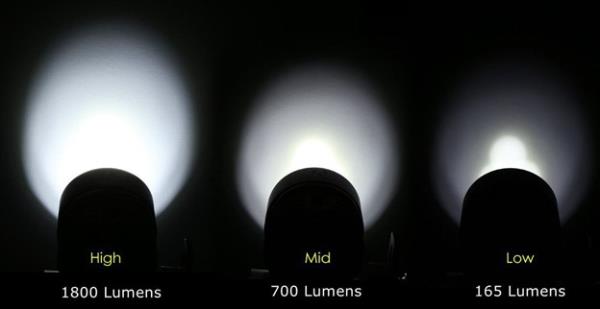 Figure 9-18-1 Lumen Examples
 Figure 9-18-2 Color Temperature Example (degrees Kelvin
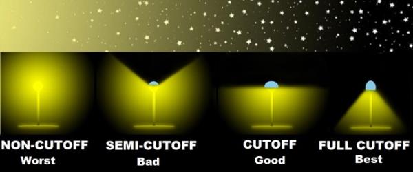 Figure 9-18-3 Non-Cutoff to Full Cutoff
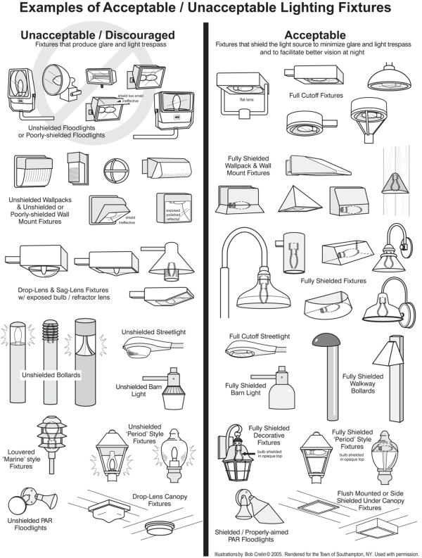 Figure 9-18-4 Examples of Good and Bad Fixtures
 Figure 9-18-5 Example of Poor Landscape Lighting
 Figure 9-18-6 Example of Poor Architectural Lighting
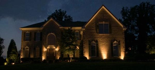 Figure 9-18-7 Example of Poor Up Lighting
13-9-19 Adaptive Reuse Of Historically Significant Structures
Historically significant buildings are valued in Oakley City based upon their contribution to the general welfare, aesthetics and values of property and historical education of Oakley City. Historically significant buildings tell the story of Oakley City and provide architectural and/or cultural significance. The purpose of these regulations is to provide for the adaptive reuse of a historically significant building with a new use that meets the criteria set forth in this Code.
- No Increase in Density: No increase in density above those uses in the underlying zoning district is or shall be granted through these provisions except as provided for by this section.
- Use Must Be Contained Within the Historic Structure: The adaptive reuse of a historically significant building must be confined to the building itself.
- Exception: The adaptive reuse may include exterior patios and decks, provided they are associated with the use, and the patios and decks do not detract from the historical character of the building.
- Determination of Historic Significance Required: Prior to any review for an adaptive reuse of the property, the property owner must demonstrate that the structure is "historically significant". Determinations of historical significance shall be made by the Planning Commission, who must find that the structure or building meets at least one of the following definitions set forth in subsection D of this section.
- Historically Significant Within Oakley City Is Defined As:
- The building or structure is identified with important events of Oakley City history, or exemplifies significant contributions to the broad cultural, economic or social history of Oakley City;
- Is associated with the lives of historic personages important to Oakley City history; or
- Embodies the distinctive characteristics of a style, type, period, or method of construction; or represents a notable work of a master designer, builder, or architect whose individual genius broadly influenced Oakley City.
- Additional Uses Allowed: In addition to the allowed, conditional and low impact uses designated in the underlying zoning district, the following uses may be approved as a conditional use in a historically significant building in any zoning district:
- Professional office;
- Restaurant; and
- Retail commercial establishments.
- Qualifying Provisions: In order to qualify for conditional use review under section 13-5-7, "Conditional Use Permits", of this Title, the applicant must first demonstrate compliance with all of the following to the Planning Commission:
- The building is designated as historically significant by the Planning Commission. The designation process must be completed prior to the City accepting a conditional use permit application for the structure unless the City Planner determines that it is in the best interest of the City to process the designation and conditional use permit applications together.
- The adaptive reuse will require minimal physical change to the building as these features are important in defining the overall historic character of the building and environment.
- The adaptive reuse is contained entirely within the historically significant structure, unless specifically excepted in subsection B1 of this section.
- If applicable, significant archaeological resources affected by the project shall be protected and preserved. If such resources, for the adaptive reuse, must be disturbed, mitigation measures may be undertaken and approved by the City Planner. Disturbances to archaeological resources shall be kept to a minimum.
- Distinctive features, finishes, and construction techniques or examples of craftsmanship that characterize the property shall be preserved.
- The adaptive reuse will not have a material net cumulative adverse impact on the neighborhood or the City due to:
- Traffic;
- Parking;
- Signs;
- Lighting;
- Removal of landscaping; and
- Noise, fumes or odors.
- Deed or Restrictive Use Covenant Required: As a condition of the adaptive reuse of a historically significant structure conditional use permit, the property owner shall record a deed or restrictive use covenant to benefit the City, which protects the historical structure from demolition and changes contrary to the intent of the preservation of historical structures provision herein.
13-9-20 Temporary Homes, Tiny Homes, Tourist Homes, And Nightly Rentals
This section addresses non-typical dwellings and the commercial short-term nightly rental of units for periods less than one month at a time.
- Definitions: MANAGING AGENCY OR AGENT: A local person, firm or agency, whether local, distant, or online, representing a tourist or nightly homeowner. The responsible party must be available by telephone twenty-four (24) hours per day for contact by renter, emergency services, and applicable Oakley City representatives. PARK MODEL RECREATIONAL VEHICLES (PMRV): Transportable enclosed structure built on a single chassis, mounted on axel(s) and wheels. Generally designed and constructed as temporary human occupancy housing accommodation for recreation, camping or seasonal use. They do not meet HUD standards for construction and manufacturing. PMRV’s are typically a “Tiny Home”, or stick-built structure constructed on a single chassis and mounted on axel(s) and wheels. A PMRV is not permitted as an accessory dwelling. They may be approved as a temporary use permit for campgrounds in approved rural recreation grounds and facilities for stays exceeding 30 days. RECREATIONAL VEHICLE (RV): A vehicle, regardless of size, which is not designed to be used as a permanent dwelling, and in which the plumbing, heating and electrical systems contained therein may be operated without connection to outside utilities and which are self-propelled or towed by a light duty vehicle. Designed for recreational use, camping or temporary occupancy. An RV is not permitted as an accessory dwelling or rented as nightly rentals. RV’s require a temporary use permit for long-term (exceeding 30 days) occupancy on private property or privately permitted campgrounds in the City. City Campgrounds are regulated by appropriate City rules and regulations. RECREATION, COMMERCIAL OUTDOOR: Any business, group or individual that receives monetary gain for providing specialized equipment, guided tours, access to private land, and outdoor activities and adventure. Including but not limited to skiing, boating, fishing, canoeing, rafting, climbing, canyoneering, horse rides, ATV riding, mountain biking, and four wheeling. RURAL RECREATION GROUNDS AND FACILITES: Facilities for use by owner, operating organization, members and/or paying or non-paying guest. Facilities may include amenities such as cabins, lodges, reception centers, social halls, campgrounds, swimming pools, tennis and pickle ball courts, golf course, petting zoos, fishing ponds, recreational vehicle pads, temporary structures or enclosures such as tents, park models, yurts or other facilities designed for short term stays. Facilities may include single-family dwellings if the dwellings are under the same ownership or operating organization. TEMPORARY STRUCTURE OR ENCLOSURE: Any moveable, tent-like structure or enclosure intended as a temporary dwelling such as a tent, yurt, tepee, RV, trailer, park models; or any moveable structure intended to provide protection from the elements such as a temporary garage or storage unit (not exceeding 90 days). Such temporary enclosures are considered structures under this definition, and as such are governed by the same setback requirements as other structures. Such uses are allowed under a Low Impact Permit use in Open Space, Commercial, Agricultural Zones, Rural Residential Zones, Forestry Zone, Public Facilities Zones, and in approved campgrounds and where rural recreation grounds and facilities have been approved. Tents set up for special occasions are specifically exempted from this definition unless used as a dwelling or for storage as listed above. Tent type structures for long-term residential type habitation or nightly rentals can only be allowed through a conditional use permit and must conform to this Title, meet Summit County Health department codes, are placed and secured properly on a permanent foundation, are tied to water and sewer (or septic as approved by the Summit County Health Department), and have all other necessary utilities and emergency access to provide for a safe environment. TINY HOME: A tiny home is any home which is 400 square feet or less of living space, mounted on a permanent foundation, connected to permanent utilities, provided with essential sanitation facilities, and meet applicable building codes and regulations. Tiny homes are permitted under a Low Impact Permit as an accessory dwelling unit (wherever accessory dwelling units are allowed), provided they blend into the architecture and landscapes of the adjoining residence as much as possible. Tiny homes may not be less than 140 square feet of living space. TOURIST HOME: An establishment used for short term dwelling purposes in which the entire dwelling or rooms within a dwelling, with or without meals, are rented or otherwise made available to transient guests for compensation; including establishments listed, or advertised online, or known as bed and breakfasts or nightly rentals. Some accessory dwelling units may be permitted as a tourist home. All tourist homes shall fit the zone specified in 13-4-19 and shall be required to register their business with the state, obtain a business license and a low impact permit from the City, and complete the tourist home rental application with the City. The license or permit for such use may specify conditions, such as the maximum number of guests or vehicles allowed, etc. The licensee for tourist homes shall be the homeowner who shall be deemed the responsible party for the tourist home. All tourist homes must have an on-site or off-site managing agent, approved by the City and with full contact information on file with the City, who will serve as the primary contact for the tourist home. All tourist homes shall be properly managed by a readily accessible managing agent or live-in proprietor. As a condition to holding a valid business license for a tourist home, or homes, the licensee agrees to provide or arrange for adequate property management services including: housekeeping, yard maintenance, structural maintenance and compliance with general building health and safety requirements, trash collection which ensures that trash cans are not left on the street for any period in excess of twenty-four (24) hours, and assurance and enforcement of guests meeting the requirements of good neighbor practices. Good neighbor practices include: no loud music, unruly parties, guest vehicles shall be parked on off street parking and be courteous to neighbors. Failure to comply by the above-mentioned rules may result in a citation, fines and/or the business license being revoked.
- Regulation of Nightly Rentals: All nightly rental Homes or Units must be inspected by the Building Department and issued a City business license before being offered for rent.
- Licensee: The business licensee for rentals under this Section shall be the owner. The local representative shall be deemed the responsible party.
- Management Standards: The authorized lodging must be properly managed. As a condition to holding a valid license, the licensee agrees to provide or arrange for adequate property management services. In the event an owner's association exists, it shall be responsible for property maintenance. In the event an owner agrees to be responsible for property maintenance, the licensee must present a statement to that effect signed by the owner. The minimum services and management regulations required include:
- Snow removal during winter months to a level that allows safe access to the building over the normal pedestrian access to the Unit;
- Snow removal service to off-street parking facilities associated with the rental property so that off-street parking is at all times available for occupant use;
- Summer yard maintenance, including landscaping, weed control, and irrigation to a level that is consistent with the level of landscaping and maintenance on adjoining and nearby properties;
- Structural maintenance to preserve substantial code compliance as described herein is required;
- Routine upkeep, including painting and repair to a level that is consistent with the level of maintenance on adjoining or nearby properties;
- Trash collection which ensures that trash cans are not left at the curb for any period in excess of twenty-four (24) hours; the property must be kept free from accumulated garbage and refuse;
- Housekeeping service as a part of hotel or property management company included in property management license;
- On-street parking for nightly rental uses shall not result in an obstruction to traffic and pedestrian circulation or public safety;
- No outdoor display of goods and merchandise shall be permitted as part of any nightly rental use
- Unless expressly permitted under the Sign Code of this Title, no signs will be permitted for nightly rental uses;
- Nightly rentals may not be used for commercial uses not otherwise permitted in the zone. Nightly rentals may not be converted to Corporate Sponsor or Business houses which are used primarily to distribute retail products or personal services to invitees for marketing or similar purposes, regardless of whether such products or services are charged for. A Corporate Sponsor is any Business enterprise or combination of Business enterprises which provide funding for any special event in the amount of fifty percent (50%) or more of the funds necessary to promote the event or account for fifty percent (50%) or more of the event operating expenditure budget.
- Noise and Occupancy Control: The licensee and the owner of rentals under this Section are responsible for regulating the occupancy of the Unit and noise created by the occupants of the Unit. Violation of the Noise Ordinance, violation of occupancy loads, failure to use designated off-street parking, illegal conduct, or any other abuse, which violates any law regarding use or occupancy of the premises, is grounds for revocation. Failure to collect and deposit sales tax is also a violation of the license and grounds for revocation.
- Review Criteria: In determining whether or not a Business license for rental authorized under this Section shall be issued, the application shall be reviewed to see if, in addition to standards and conditions applicable to issuance of all Business licenses, the following conditions and standards are met:
- The Unit is located within a zone and subzone designated as allowing rentals for the period which the license is applied for and a low impact permit (with possible conditions) is approved. The City may further adopt and amend at any time a map specifying detailed zones or areas where nightly rentals are permitted.
- The City is allowed under this section to adopt a limit on the amount of nightly rental units allowed in the City. If a limit is set, the license issued must fall under such limits currently established.
- The access to the rental Unit and the layout of the Unit is such that noise and physical trespass from the proposed rental Unit is not likely to be a substantial intrusion to the adjoining properties. If the proposed rental Unit is a single-family home or duplex and shares an access, hallway, common wall, or driveway with another dwelling, written consent of the owner of the other dwelling is required.
- The applicant must designate a responsible party if other than an on-premises caretaker. The responsible party must be a property management company, realtor, lawyer, owner, or other individual, who resides within a 1-hour drive of the property, or, in the case of a company, has offices in Summit County. The responsible party is personally liable for the failure to properly manage the rental. The responsible party must be available by telephone, or otherwise, twenty-four (24) hours per day, and must be able to respond to telephone inquiries within twenty (20) minutes of receipt of such inquiries. The responsible party is also designated as the agent for receiving all official communications under this Title from Oakley City. If the licensee is a property management company or individual other than the owner, such company or individual must comply with applicable state law, including the Securities Division Real Estate Division in the Utah Code, as amended, which requires those who receive valuable consideration to lease property to have a Utah State license;
- The application must bear a sales tax collection and accounting number for the rental operation. This number may be the sales tax accounting number used by the property management company responsible for that Unit, or may be specific to the Unit, but no license will be effective until the sales tax number is provided.
13-9-21 Panhandle Or Flag Lots
“Panhandle” or “Flag” type lots can have their place in certain developments and areas and if planned properly can reduce impact on public infrastructure, increase affordability, and reduce the visibility of dwellings. However, they can also pose problems by creating the potential for a proximity impact on adjacent residents. These types of lots are allowed within Oakley City under certain circumstances provided the following issues can be addressed and satisfied:
- Residential and other accessory dwellings or structures can only be constructed within the “flag” or “pan”' portion of the lot through a Low Impact approval process and must be situated in an envelope approved by the City Planner. An approved Final Site Plan establishing this envelope will be recorded with the property.
- No structure will be allowed within the "pole” or “handle” portion of the lot.
- All utilities, including water and sewer laterals will be paid for and installed in the “pole” or “handle” section of the lot, to be ready for connection concurrently with the completion of any foundation excavation work.
- There must be constructed a viable access drive which is approved by the City Planner and City Engineer which is in compliance with Chapter 10 of this Title. This drive shall have a width no less than fourteen (14) feet and will be fully usable to access the approved envelope prior to issuance of a building permit. This access will be established prior to any excavation or construction on the site and will be subject to the City's building inspection process.
- Before issuance of an occupancy permit, the drive must be inspected and have a finished surface as per approved plans and specifications.
13-9-22 Parking And Vehicle Storage
- No portion of a front yard (with the exception of the required driveway) as defined in this Title shall be used for permanent parking of motor vehicles, recreational vehicles or recreational equipment. Permanent parking, as it applies to this chapter, shall mean parking for a consecutive period in excess of twenty-four (24) hours.
- No trucks, motor vehicles, or commercial trailers which exceed the rated capacity of one and one-half (1.5) tons shall be stored or parked on any lot or parcel within any residential zone, nor shall any contracting and/or earth moving equipment be stored or parked on any lot or parcel in a residential zone. Exceptions may be found in 13-4-19.
- It shall be unlawful to park, store, or leave or to permit the parking, storing or leaving of any licensed or unlicensed motor vehicle of any kind or part(s) thereof, which is in a wrecked, junked, partially dismantled, inoperative, or abandoned condition, whether attended or not, upon any private property within the city limits of the city of Oakley for a period of time in excess of seventy-two (72) hours, except that two (2) or less such vehicles or parts thereof may be stored if within a building or placed behind an opaque screening fence; and except that said vehicles and parts may be within a junk yard or automobile wrecking yard lawfully established pursuant to the provisions of this Code. The accumulation and storage of more than two (2) such vehicles or part(s) thereof, as defined above, on private property except as set forth above, shall constitute a nuisance detrimental to the health, safety, and welfare of the inhabitants of Oakley City. It shall be the duty of the owner of such vehicle or part(s) thereof or lessee or other person in possession of private property upon which such vehicle or parts(s) thereof are located, to remove the same from such property.
- Vehicles and equipment associated with any type of permanent construction or contracting business which do not meet the limits and requirements of 13.4.19 of this Title, must receive and maintain a valid conditional use permit for such parking and storage. Limits on sizes, noise, types of equipment, quantity of equipment, storage of materials, and the proper provision of off-street parking and screening may be part of any conditional use permit.
- Off-Street Loading and Parking: All off-street parking facilities required by this Title shall be located on the same lot or parcel of land as the use they are intended to serve. The city planner shall disapprove such plans if found that the required spaces are not usable for standard sized automobiles or do not comply with the requirements for off street parking as set forth in this ordinance. The following regulations are established to increase safety and lessen congestion in the public streets, to provide adequately for parking needs associated with the development of land and increased automobile usage, to set standards for off-street parking according to the amount of traffic generated by each use, and to reduce the on-street storage of vehicles.
- Number of Spaces- the following required off-street parking spaces for the particular use are minimum requirements:
- Residential Structures require two (2) spaces per dwelling unit (Spaces may not be provided in tandem). As a means to encourage the occupants of multiple dwellings to use the required off street parking space in preference to on street parking, entrances to the buildings shall be provided that are direct and convenient to the required off street parking spaces as are the fronting streets.
- Combined Parking Areas: The required off street parking and loading facilities may be provided collectively for two (2) or more buildings or uses, provided that the total number of parking spaces shall be not less than the sum of the requirements for each individual use.
- Mixed Uses: In the event that two (2) or more uses occupy the same zoning lot, or parcel of land, the total requirements for off street parking and off-street loading space shall be the sum of the requirements of the various uses computed separately.
- Access to Parking Facilities:
- Access driveways shall be provided for ingress to and egress from all parking and loading facilities. Each parking and loading space shall be easily accessible to the intended user.
- Access to all off street parking facilities shall be designed in a manner which will not interfere with the movements of vehicular and pedestrian traffic.
- Commercial Loading Spaces: For every building having a gross floor area of five thousand (5,000) square feet or more to which goods, material, merchandise, or supplies are received or distributed by vehicle, there shall be provided at least one (1) off street loading space. One (1) additional loading space shall also be provided for each additional twenty thousand (20,000) square feet of gross floor area of such building or for each vehicle which must be loaded or unloaded at the same time, whichever requirement is greater. Each required off street loading space shall be not less than ten (10) feet in width, twenty-five (25) feet in length, and fourteen (14) feet in height.
- Location of Parking Facilities Restricted: Parking and loading facilities may be located any place on the premises except for areas that are required to be landscaped. Off street parking space which is required in connection with a use shall be constructed to be a part of that use and shall not be located within a zone unless expressly permitted therein.
- Lighting of Parking Areas: Any lighting used to illuminate off street parking facilities or vehicle sales areas shall conform to the Dark Sky lighting standards of this Chapter and be arranged as to reflect the light away from the adjoining premises in any residential zone in accordance with this Title.
- Continuing Obligation: The required off street parking and loading facilities shall be a continuing obligation of the property owner so long as the use requiring vehicle parking or vehicle loading facilities continues. It shall be unlawful for an owner of any building or use to discontinue or dispense with the required parking or loading facilities without providing other vehicle parking or loading area which meets the requirements of this ordinance.
- Site Plan Approval Required: At the time a building permit is requested for any building or structure, or at the time the use of land is changed which requires additional off street parking space, a site plan shall be submitted showing the location and layout of such required space along with access aisles, roadways, curbs and curb cuts.
- Convalescent, nursing, and other such institutions shall have one (1) visitor parking space per three (3) patient beds, plus one (1) parking space for each employee at work in the facility during daylight hours.
- Hotels and motels shall have one (1) parking space per room or suite, plus one (1) parking space for each employee at work on the premise during daylight hours.
- Restaurants, taverns, and lounges shall have one (1) parking space per two hundred (200) square feet of floor area.
- Banks, professional offices, and other business buildings not specifically mentioned elsewhere in this section shall have one (1) parking space per four hundred (400) square feet of office floor area.
- Retail stores, professional service shops and other business or buildings not specifically mentioned elsewhere in this section shall have parking space at the rate of five (5) spaces per one thousand (1,000) square feet of floor area, except that in any zone designated as the Commercial Zone, parking space may be reduced to three (3) spaces per one thousand (1,000) square feet of floor space.
- Drive-Ins shall have at least twelve (12) off street parking spaces or sufficient off street parking spaces to accommodate all patrons or customers, whichever is greater. No patron or customer may be served in automobiles which are parked on public streets.
- Industrial, manufacturing and wholesale establishments shall have one (1) parking space per employee based on the largest shift.
- Uses not enumerated: The required off street parking for any building, structure, or use of land of a type which is not listed in this part shall be determined by the Planning Commission. The Planning Commission shall be guided by comparison with the requirements for similar uses which are listed.
- All off-street parking areas designed for five or more vehicles shall be bordered by a low water use or xeriscape landscaped strip at least eight (8) feet in width.
- Number of Spaces- the following required off-street parking spaces for the particular use are minimum requirements:
13-9-23 Fencing
- Scope. The term fence or fencing shall include any tangible barrier, an obstruction of any material, and a line of obstacles, lattice work, screen, wall, hedge, or continuous growth of shrubs or trees with the purpose of, or having the effect of, preventing passage and/or view across the fence line.
- Provisions Constitute Minimum Requirements. In interpreting and applying the provisions of this Section, the requirements contained in this Section are declared to be the minimum requirements.
- Effect of Section on Covenants, Agreements, etc. This Section shall not nullify the more restrictive provisions of covenants, agreements or ordinances or laws, but shall prevail notwithstanding such provisions which are less restrictive.
- Fences – Residential Standards:
- Side Yards and Rear Yards. In any required side or rear yard on lots, the height of fences shall not exceed six (6) feet in height.
- Front Yards. Fences in required front yards shall be allowed provided that solid type fences shall not exceed three (3) feet in height, and open type fences (for example, chain link fences), shall not exceed four (4) feet in height.
- Corner Lots. In addition to the other provisions contained in this Section, fences located on corner lots shall be subject to the following provisions:
- Any fence, wall and/or hedge on the front yard setback shall not exceed three (3) feet in height if opaque construction, or four (4) feet in height if open construction.
- In the side yard setback which fronts on a street, height not to exceed four (4) feet shall be allowed for not less than thirty (30) feet from the intersection measured from the intersection of extended curb lines. Height within the thirty (30) foot area shall conform to the requirements of a front yard setback.
- Heights on the rear yard setback and interior side yard setback shall not exceed six (6) feet.
- Lots within Sensitive Overlay District. A fence may be built upon a slope greater than thirty (30) percent provided that the following conditions are met:
- Fences shall be located only upon areas constituting usable land unless otherwise approved by the Oakley City Community Development Department.
- Black/Brown vinyl coated chain link or wood pole fencing only shall be allowed in order to blend into the native landscaping. In no case shall the following types of fences be allowed: vinyl, masonry, block, wood, or other sight obscuring material. Other requirements for fencing setback are contained in the individual zone regulations.
- The fence shall be built in accordance with this chapter and comply with all restrictions imposed by setbacks, etc., as defined in this Code
- All requirements of the Sensitive Overlay District shall be met prior to the construction of the fence.
- Fencing on hillside lots shall only be approved in conjunction with an approved landscape plan in conformance with the General Plan.
- Vacant Lots. For the purpose of this chapter, it shall be presumed that a vacant lot shall contain a minimum front, side and rear yard that are otherwise required by ordinance. In any required side and rear yard on vacant lots, the maximum height of fences or other similar structures shall be six (6) feet.
- Retaining Walls. Where a retaining wall protects a cut below or a fill above the natural grade and is located on the line separating lots or properties, such retaining wall may be topped by a fence, wall or hedge of the same height that would otherwise be permitted at the location if no retaining wall existed. Retaining walls will not exceed a ten (10) foot vertical height. All retaining walls will be engineered and stamped and signed by a licensed engineer.
- Barbed or Razor Wire Security Fences. Security fences containing strands of barbed wire, razor wire or other similar fencing designed to prevent intrusions are prohibited, unless specifically approved by the Planning Commission for public safety, health or welfare. Such fences do not include typical fencing for farm animals and public utility stations.
- Agricultural Fencing. Agricultural Fencing is addressed in 13-3-2.
- Vinyl Fencing. Vinyl fencing must be reinforced (not hollow) and must be a color which is compatible with existing, adjoining, or similar neighborhood uses.
- Privacy Fencing. Privacy fencing in any Agricultural (AR) zones and Rural Residential (RR) zones is strongly discouraged and is only allowed through an approved Low Impact permit with possible criteria and conditions attached. Such fencing must not be constructed of non-reinforced vinyl materials, must match or blend into the local colors or architectural character of adjoining uses, blend into the surroundings as much as possible, and not detract from the rural mountain agricultural environment. Privacy Fencing is allowed in commercial and light manufacturing or industrial zones to screen equipment and facilities. In other zones where screening is required to hide equipment and material storage, the fencing must receive a Low Impact Permit or be a condition in a relevant Conditional Use Permit for the approved use.
- Exceptions. The provisions of this Section shall not apply to certain other fences such as tennis court backstops or patio enclosures in the front, side or rear yards, if approved by the Planning Commission, if in its opinion they do not create a hazard or violation of other ordinances.
- Fencing of Canals:
- Any parcel being subdivided which is adjacent to or has within its boundaries a canal right-of-way shall be required to provide along such right-of-way a nonclimbable fence unless otherwise approved by the planning commission. The height of the fence shall be at least six (6) feet. The bottom of the fence shall match the grade at the location of the fence so that there are no gaps between the fence and the ground. The developer shall install a concrete strip, if necessary, to eliminate gaps between the bottom of the fence and the ground.
- As an alternative to fencing the canal, and with the review and approval of the Oakley City Public Utilities Department, the developer may pipe the canal. If the canal is piped, the developer must obtain written permission from the canal company and construct the pipe according to canal company requirements and specifications.
- All fences bordering canals shall be installed as part of the improvements for the subdivision. No occupancy permit, whether temporary or final, shall be granted until all required fencing is installed in the subdivision.
- The fence material and type must be approved by the planning commission and should be selected to create an open appearance and avoid a walled-in alley look. In no case shall the following types of fences be allowed: vinyl, masonry, block, wood or other sight obscuring material. Other requirements for fencing setback are contained in the individual zone regulations.
13-9-24 Shipping Containers
- Requirements: before placing a Shipping Container on any lot for a storage use, a Low Impact permit must be obtained, and all other applicable zoning regulations must be fully complied. If the use, or converted use is for any form of occupancy, a building permit must also be obtained:
- Non-screened Shipping Containers are allowed by permit in agricultural operations on AR zones. Property owners claiming to be an agricultural operation must provide substantial evidence of use. The burden of proof of use is the responsibility of the property owner, they must show evidence that the agricultural operation has been in place for at least the last 5 years; or was legally established.
- On building sites where the primary use is residential (all VM, CR, RR zones, and AR zones which are not primarily agricultural) a Shipping Container shall only be allowed if it is not visible from that portion of any road (whether public, private, and/or private road easement) that directly abuts the subject parcel. If existing landscaping (including landscaped berms) is used as screening, it shall be indicated on the building plans and photos shall be submitted as evidence. If fencing is used as screening, please see Section 13-9-23 for fencing regulations.
- On building sites of less than 1 acres (net) where the primary use is residential only one Shipping Container is allowed, not exceeding 320 square feet and the container is only permitted for up to 180 consecutive days, starting from the date of permit issuance. A demolition permit is required to confirm removal of the Shipping Container. On building sites of more than 1 acres (net) with a legally established primary use, a Shipping Container(s) is allowed if it complies with the other requirements of this Section.
- Shipping Containers must meet setback requirements for any type of accessory structures.
- Shipping Containers can normally only be used for storage. However, if it is used for any other approved purpose, such as a pool, residence, or recreation room, etc. the Shipping Container must be completely screened, so it does not look like a Shipping Container anymore.
- A Shipping Container may be allowed in commercial and light industrial zoned areas only if there is a legally established primary use on-site and all parking requirements are maintained.
- Shipping Containers are allowed in all zones temporarily to store building materials during the construction pursuant to an active building permit. If the building permit is expired, the Shipping Container shall be removed with a demolition permit.
- The exterior of every Shipping Container shall be completely painted with one of the approved colors. The color shall be indicated on the plot plan for a Low Impact Permit. The following colors are approved:
- Flat, non-reflective dark green to match the surrounding area;
- Flat, non-reflective dark red and/or white (this color is typically limited to AR uses);
- Flat, non-reflective, tan and light browns to match the surrounding area; or,
- Other solid neutral flat color that matches the surrounding natural environment. (applicant must provide pictures of the surrounding area to show compliance)
- If a property owner or user has an existing Shipping Container that was legally placed on a parcel before 3-1-2021, the use is allowed to continue as a non-conforming use for three (3) more years. At or before 3-1-2024, the Shipping Container shall be removed from the parcel with a demolition permit or the owner will be required to obtain a new building permit and be fully in compliance with this Section.
13-9-25 Trails
All subdivisions and development projects will be evaluated for the inclusion of transportation and/or recreation trails for both local internal needs, or which may also connect and fit into the City’s overall trails and transportation objectives found within the General Plan (see trails sections and accompanying maps) and/or any other relevant City or regional Trails Master Planning efforts. Trails will be designed and constructed as per City specifications and approved by the City Engineer. They will be designed to minimize maintenance costs while providing a functional network of pedestrian, equestrian, bicycle trails, walkways, and paths throughout the City. This network will also become a vital part of the City’s green space system to the maximum extent possible. Guidelines for trail development are as follows:
- Establish and maintain a safe network of bicycle routes and pedestrian trails, which connect activity centers in the City. Activity centers will include but are not limited to schools, churches, parks, arenas, public buildings, and shopping centers.
- In all new residential areas, sidewalks are discouraged, and a functional trail system will become more of the standard. Sidewalks may be evaluated in higher density residential projects, but they should be designed to connect into a larger citywide or regional system.
- In cases where the trail or sidewalk is located directly adjacent to the curb and gutter, the minimum trail or sidewalk width should be five (5) feet.
- The requirement for and location of trails and sidewalks in light industrial areas will be evaluated and determined by the Planning Commission.
- Pedestrian and disabled persons must have access to, and within, all parts of commercial developments.
- Bicycle, equestrian, and pedestrian trail networks are a valuable community assets. Trail master plan corridors will be preserved, including those in sensitive lands that could be suitable for public trail access.
- Projects which include trail development will be reviewed by local trail advocacy groups for comments, including the South Summit Trails Foundation and depending on scope, other Kamas Valley municipalities, including the School District, to help in the implementation of a viable City and regional trail master plan.
- The Planning Commission will regularly study and identify where future trails may be safely installed concurrent with development and not jeopardize agricultural uses or riparian ecosystem function in the City or region.
- Development of critical trails which follow an ongoing City Master Plan are eligible for certain density bonuses as detailed in Appendix B of this Title.
- Trails will be designed and sited to optimize connectivity and to further the City recreational and park objectives. Adequate parking and related facilities will be provided in developments that provide public trailhead access.
- In the areas of the Weber River bottoms, North Hills, City properties, and the eastern Forest Service boundary, the City will continue a strategy of a trail system to link these areas with a central City park system, including development clusters located in the central regions of the City.
13-9-26 Animals
- General Limitations: A maximum of one hundred (100) animal points per acre of land used exclusively for their care and keeping shall be allowed (see Animal Point values below). Where the owner has less than one (1) full acre of land dedicated to the exclusive care and keeping of animals allowed in the one hundred (100) animal points, the percentage of one hundred (100) animals points shall be the same as the percentage of dedicated land to a full acre, which is forty-three thousand five hundred sixty (43,560) square feet.
- Animal Points: a unit of measure for animals and livestock with the following values:
- Horses, Cows, Llamas, & other large livestock forty (40) points each
- Sheep, Goats, & other medium livestock twenty (20) points each
- Chickens, Ducks, Geese & other small fowl five (5) points each
- Exceptions: Agricultural Property owners (in the AR zones) may apply for an exemption to this limit for short periods of time in order to reduce grazing material or plant growth on a specific area or property.
- Sensitive Lands: Agricultural and horticultural uses, including the raising of crops or livestock, wholesale nurseries, and associated nonresidential buildings that are specifically needed to support active, viable agricultural or horticultural operations are allowed in the Sensitive Lands Overlay (SLO) Zones. Specifically excluded are commercial livestock operations involving swine, poultry, mink, and other animals where the operations are likely to produce highly offensive odors, or other high density animal feeding operations which could degrade or adversely affect riparian wetland areas and water quality.
- Pets: Dogs and other domestic animal pets are subject to all Summit County Animal Control regulations. No more than four (4) domestic animals over four (4) months of age are allowed per residence without obtaining a kennel and/or conditional use permit (if allowed) for the appropriate zone.
- Kennels: A kennel permit and/or conditional use permit is required on any premises, except where accessory to an agricultural activity, where five (5) or more domestic animals, over four (4) months of age are boarded, trained, groomed, bred, and/or offered for sale for commercial use.
13-9-27 HOA's
Homeowners Associations (HOA’s) are required in any new subdivision or MPD with any private roads, common open space, parks, playgrounds, or other similar amenities. CC&R’s must designate a process for funding and maintaining such improvements. The City may require that CC&R’s be filed with the City as part of the approval process, but the City is not responsible for CC&R enforcement.